Longmenshan paper
14
Exhumation history and faulting activity of the southern segment of the Longmen Shan, eastern Tibet Xi-Bin Tan a , Yuan-Hsi Lee b,⇑ , Wen-Yu Chen b , Kristen L. Cook c,d , Xi-Wei Xu a a Institute of Geology, China Earthquake Administration, Beijing 100029, China b Department of Earth and Environmental Sciences, National Chung-Cheng University, Taiwan, ROC c Department of Geosciences, National Taiwan University, Taiwan, ROC d German Research Center for Geosciences GFZ, Potsdam, Germany article info Article history: Received 13 June 2013 Received in revised form 22 November 2013 Accepted 2 December 2013 Available online 12 December 2013 Keywords: Eastern Tibet Longmen Shan Exhumation history Low temperature thermochronology Fission track abstract The Longmen Shan (LMS), which constitutes the eastern border of the Tibetan Plateau, is about 400 km in length and characterized by a steep topographic transition from the Sichuan Basin to the plateau. The 2008 M w 7.9 Wenchuan earthquake and 2013 M w 6.6 Lushan earthquake were associated with the central to northern segments and southern segment of the LMS fault belt, respectively. In this paper, zircon and apatite fission track (ZFT and AFT, respectively) dating in combination with previously published low temperature thermochronology studies are used to constrain both the exhumation history and fault activity along the LMS, with a special focus on the southern segment. In the southern segment of the LMS, the ZFT ages in the hanging wall of the Wulong-Yanjing fault 10–14 Ma, increasing to ca. 30 Ma to the northwest of the faults and to 100–200 Ma in the plateau region. The AFT ages are 3–5 Ma at the mountain front and increase to 8–26 Ma in the plateau. We show that these age distributions are con- trolled by fault geometry. Two stages of rapid exhumation were identified using apatite fission track length modeling and the age distributions in the southern segment of the LMS. The first stage is from ca. 30 Ma and the second stage is from 3–5 Ma to present. In contrast with the middle segment of the LMS, the Cenozoic exhumation rate is higher in the southern segment of the LMS, which may be due to the influence of the collision between the India and Eurasia plates and/or different faulting mecha- nisms in the different segments. Ó 2013 Elsevier Ltd. All rights reserved. 1. Introduction The Longmen Shan (LMS) constitutes the eastern boundary of the Tibetan Plateau (Fig. 1a). It is about 400 km in length and is characterized by a steep topographic transition from 600 m (the Sichuan Basin) to about 5000 m (the Tibet plateau), in about 50 km. In contrast to the more substantial shortening rate of the Himalayas, the shortening rate across the LMS is less than 3 mm/ yr based on GPS (Global Positioning System) and 10 years of geod- esy data collected prior to the May 12th 2008 Wenchuan earth- quake, Sichuan (King et al., 1997; Chen et al., 2000; Gan et al., 2007). The 2008 Wenchuan earthquake (M w 7.9) was one of the most devastating earthquakes in China’s history, resulting in over 80,000 fatalities, extreme economic loss, and leaving more than 1.5 million people homeless (Stone, 2008). Research has shown that two major faults were active during the Wenchuan earth- quake, the Beichuan-Yingxiu fault and Jiangyou-Guanxian fault, which are located in the central to northern segments of the LMS (Xu et al., 2009). The rupture of the Wenchuan earthquake did not extend to the southern segment of the LMS. However, the dis- placement rate (from GPS measurements) in the southern segment of the LMS appears to be similar or even greater than that in the north (Chen et al., 2000)(Fig. 1a). Recently, a M w 6.6 earthquake oc- curred at the southern tip of the LMS, resulting in 196 fatalities and extensive damage to property and infrastructure (Xu et al., 2013). To better assess the potential for disastrous earthquakes in this re- gion, it is important to understand the area’s Cenozoic exhumation history and fault activity. Cenozoic deformation in the LMS region has been produced by the eastward growth of the Tibetan Plateau, caused by the collision of the India and Eurasian plates starting at 50 Ma (Yin and Harri- son, 2000). The collision has progressively propagated north and eastward (Yin and Harrison, 2000; Tapponnier et al., 2001). Previous studies have shown that the central segment of the LMS experienced rapid exhumation starting at 12–5 Ma (Kirby et al., 2002; Godard et al., 2009); furthermore, Wang et al. (2012) found an earlier exhumation event at 30–25 Ma. Topographic profiles show that the southern and central segments of the LMS form a sharp, steep boundary with the Sichuan Basin, while topography 1367-9120/$ - see front matter Ó 2013 Elsevier Ltd. All rights reserved. http://dx.doi.org/10.1016/j.jseaes.2013.12.002 ⇑ Corresponding author. Tel.: +886 52720411x66212; fax: +886 52720807. E-mail address: [email protected] (Y.-H. Lee). Journal of Asian Earth Sciences 81 (2014) 91–104 Contents lists available at ScienceDirect Journal of Asian Earth Sciences journal homepage: www.elsevier.com/locate/jseaes
Transcript of Longmenshan paper

Journal of Asian Earth Sciences 81 (2014) 91–104
Contents lists available at ScienceDirect
Journal of Asian Earth Sciences
journal homepage: www.elsevier .com/locate / jseaes
Exhumation history and faulting activity of the southern segmentof the Longmen Shan, eastern Tibet
1367-9120/$ - see front matter � 2013 Elsevier Ltd. All rights reserved.http://dx.doi.org/10.1016/j.jseaes.2013.12.002
⇑ Corresponding author. Tel.: +886 52720411x66212; fax: +886 52720807.E-mail address: [email protected] (Y.-H. Lee).
Xi-Bin Tan a, Yuan-Hsi Lee b,⇑, Wen-Yu Chen b, Kristen L. Cook c,d, Xi-Wei Xu a
a Institute of Geology, China Earthquake Administration, Beijing 100029, Chinab Department of Earth and Environmental Sciences, National Chung-Cheng University, Taiwan, ROCc Department of Geosciences, National Taiwan University, Taiwan, ROCd German Research Center for Geosciences GFZ, Potsdam, Germany
a r t i c l e i n f o a b s t r a c t
Article history:Received 13 June 2013Received in revised form 22 November 2013Accepted 2 December 2013Available online 12 December 2013
Keywords:Eastern TibetLongmen ShanExhumation historyLow temperature thermochronologyFission track
The Longmen Shan (LMS), which constitutes the eastern border of the Tibetan Plateau, is about 400 km inlength and characterized by a steep topographic transition from the Sichuan Basin to the plateau. The2008 Mw7.9 Wenchuan earthquake and 2013 Mw6.6 Lushan earthquake were associated with the centralto northern segments and southern segment of the LMS fault belt, respectively. In this paper, zircon andapatite fission track (ZFT and AFT, respectively) dating in combination with previously published lowtemperature thermochronology studies are used to constrain both the exhumation history and faultactivity along the LMS, with a special focus on the southern segment. In the southern segment of theLMS, the ZFT ages in the hanging wall of the Wulong-Yanjing fault 10–14 Ma, increasing to ca. 30 Mato the northwest of the faults and to 100–200 Ma in the plateau region. The AFT ages are 3–5 Ma atthe mountain front and increase to 8–26 Ma in the plateau. We show that these age distributions are con-trolled by fault geometry. Two stages of rapid exhumation were identified using apatite fission tracklength modeling and the age distributions in the southern segment of the LMS. The first stage is fromca. 30 Ma and the second stage is from 3–5 Ma to present. In contrast with the middle segment of theLMS, the Cenozoic exhumation rate is higher in the southern segment of the LMS, which may be dueto the influence of the collision between the India and Eurasia plates and/or different faulting mecha-nisms in the different segments.
� 2013 Elsevier Ltd. All rights reserved.
1. Introduction
The Longmen Shan (LMS) constitutes the eastern boundary ofthe Tibetan Plateau (Fig. 1a). It is about 400 km in length and ischaracterized by a steep topographic transition from 600 m (theSichuan Basin) to about 5000 m (the Tibet plateau), in about50 km. In contrast to the more substantial shortening rate of theHimalayas, the shortening rate across the LMS is less than 3 mm/yr based on GPS (Global Positioning System) and 10 years of geod-esy data collected prior to the May 12th 2008 Wenchuan earth-quake, Sichuan (King et al., 1997; Chen et al., 2000; Gan et al.,2007). The 2008 Wenchuan earthquake (Mw7.9) was one of themost devastating earthquakes in China’s history, resulting in over80,000 fatalities, extreme economic loss, and leaving more than1.5 million people homeless (Stone, 2008). Research has shownthat two major faults were active during the Wenchuan earth-quake, the Beichuan-Yingxiu fault and Jiangyou-Guanxian fault,which are located in the central to northern segments of the LMS
(Xu et al., 2009). The rupture of the Wenchuan earthquake didnot extend to the southern segment of the LMS. However, the dis-placement rate (from GPS measurements) in the southern segmentof the LMS appears to be similar or even greater than that in thenorth (Chen et al., 2000) (Fig. 1a). Recently, a Mw6.6 earthquake oc-curred at the southern tip of the LMS, resulting in 196 fatalities andextensive damage to property and infrastructure (Xu et al., 2013).To better assess the potential for disastrous earthquakes in this re-gion, it is important to understand the area’s Cenozoic exhumationhistory and fault activity.
Cenozoic deformation in the LMS region has been produced bythe eastward growth of the Tibetan Plateau, caused by the collisionof the India and Eurasian plates starting at 50 Ma (Yin and Harri-son, 2000). The collision has progressively propagated north andeastward (Yin and Harrison, 2000; Tapponnier et al., 2001).Previous studies have shown that the central segment of the LMSexperienced rapid exhumation starting at 12–5 Ma (Kirby et al.,2002; Godard et al., 2009); furthermore, Wang et al. (2012) foundan earlier exhumation event at 30–25 Ma. Topographic profilesshow that the southern and central segments of the LMS form asharp, steep boundary with the Sichuan Basin, while topography

Fig. 1. (a) Topography and GPS velocities in eastern Tibet. The GPS velocity is relative to the southern China block (Gan et al., 2007). Inset map shows the tectonic setting ofthe LMS area (Roger et al., 2010). (b) Topographic profiles across the southern, central, and northern segments of the LMS. (c) Structural profile of the central segment of theLMS (Hubbard and Shaw, 2009; Hubbard et al., 2010). (d) Aftershocks, slip distribution, and inferred fault geometry for the Wenchuan earthquake, from Wang et al. (2011).
92 X.-B. Tan et al. / Journal of Asian Earth Sciences 81 (2014) 91–104

X.-B. Tan et al. / Journal of Asian Earth Sciences 81 (2014) 91–104 93
in the northern segment is less steep, with a more gradual transi-tion from the basin to the plateau (Fig. 1b). These findings suggestthat the southern to central segments of the LMS are potentiallymore active than the northern segment. Far more thermochronol-ogy studies have been done in the central segment (Godard et al.,2009; Wang et al., 2012; Li et al., 2012) than in the southern seg-ment of the LMS, which has remained poorly constrained.
To better understand the exhumation history of the LMS, thisstudy uses zircon and apatite fission track analyses combined withprevious data to constrain the Cenozoic exhumation history andfault activity of the southern segment of the LMS. Our data also al-low us to evaluate variations in exhumation history along strike ofthe LMS.
2. Geological setting
2.1. Mesozoic to Cenozoic Tectonics of the Longmen Shan
The LMS fault belt is located on the boundary between theSongpan-Garze fold belt (SGFB) and the rigid South China Block(Figs. 1 and 2). The SGFB has undergone at least two major oro-genic events since Mesozoic time (Zhou et al., 2008; Roger et al.,2010; Yan et al., 2011). In the Late Triassic to Jurassic period, anorogeny resulting from convergence between the North China,South China (Enkin et al., 1992; Yan et al., 2011) and Qiangtangblocks (Roger et al., 2003, 2010) caused the pervasive deformationof a thick flysch sequence (the Triassic Xikang Group, or Songpan-Garze flysch). The isoclinally folded flysch was then intruded byMesozoic granites that remain undeformed, constraining the tim-ing of this phase of deformation (Fig. 2). In the Longmen Shan, thisdeformation event involved southeastward directed thrusting thatemplaced an allochthonous sequence of Proterozoic and Paleozoicrocks above autochthonous Proterozoic and Paleozoic units associ-ated with the Yangtze Craton (Burchfiel et al., 1995).
In the Danba area, exhumation has removed the flysch andmuch of the underlying Paleozoic strata (Zhou et al., 2008), expos-ing basement core complexes (Fig. 2) and high grade rocks that re-cord Mesozoic metamorphism (Weller et al., 2013). Like the Danbaarea, the LMS has experienced greater exhumation than the rest ofthe SGFB, and the basement core complexes, such as the PengguanMassif and the Baoxing Massif, are exposed (Figs. 2 and 3) (Xu andKamp (2000)).
From the Jurassic to Cretaceous, the long term cooling rate ofthe Mesozoic granites within the SGFB was very slow, indicatingan absence of any major tectonic events (Burchfiel et al., 1995,2008; Roger et al., 2003, 2010; Harrowfield and Wilson, 2005; Reidet al., 2005; Wilson et al., 2006; Xu and Kamp, 2000).
Cenozoic deformation in the Longmen Shan region results fromthe collision between the India and Eurasia plates since ca. 50 Ma,with deformation progressively propagating north and eastward(Yin and Harrison, 2000; Tapponnier et al., 2001). Thermochronol-ogy studies of exhumation have been conducted for the area usingdifferent methods. These methods have given different descrip-tions of the timing of Cenozoic exhumation in eastern Tibet.According to apatite fission-track modeling by Arne et al. (1997),the cooling rate of the northern LMS was slow through the Meso-zoic and Early Tertiary but began to increase from the Miocene (ca.20 Ma) to the present. Xu and Kamp (2000) considered initialexhumation to be at ca. 20 Ma on the western side of the LMSbased on zircon fission-track dating along the Xianshuihe fault,which is an active sinistral strike slip fault to the west of theLMS (Figs. 1 and 2). Kirby et al. (2002) used (U–Th)/He dating ofzircon and apatite and suggested that the margin of the plateaustarted rapid exhumation no earlier than 5–12 Ma. Based on Rb–Sr biotite ages from the Danba area that cluster at ca. 34–24 Ma;
Huang et al. (2003) suggested that uplift of the Tibetan Plateau(including the Songpan-Garze fold belt) occurred predominantlyin the last ca. 30 Ma. Godard et al. (2009) studied the late Cenozoicevolution of the central LMS using (U–Th)/He dating and age-ele-vation profiling (Fig. 2) and concluded that the major phase ofexhumation started at 8–11 Ma, with an average rate of exhuma-tion of 0.65 mm/yr, and a total amount of exhumation of less than6–8 km. Wang et al. (2012) studied the central segment of the LMSand found two pulses of rapid exhumation: one beginning 30–25million years ago and a second 10–15 million years ago that con-tinues to the present stage of uplift.
2.2. Surface geology of the southern segment of the Longmen Shan
The southern segment of the LMS contains six major faults (F1–F6), and a fold and thrust belt that has developed in the westernSichuan Basin (Figs. 2 and 3) (Burchfiel et al., 1995). In the foldand thrust belt, the Mesozoic sedimentary units of the Sichuan Ba-sin are deformed. In some localities, the sedimentary successionextends up to Eocene/Oligocene strata, which are deformed in con-cert with the underlying Mesozoic units. The presence of the de-formed Cenozoic strata indicates that the fold and thrustdeformation in the Sichuan Basin occurred post Oligocene (Burchf-iel et al., 1995). Hubbard and Shaw (2009) calculated shortening ofup to 25.8 km in the fold and thrust belt east of F1.
The Shuangshi-Dachuan fault (F1) is a mountain front fault withTriassic sandstone in the hanging wall and Jurassic to Cretaceousconglomerate units in the footwall. Triassic strata and a klippenbelt are found between F1 and F2 (Fig. 3). Between F2 and F3,Upper Silurian to Triassic strata unconformably overlie the easternlimb of the folded Proterozoic basement (Baoxing massif). This thinand incomplete section of Paleozoic rocks is characteristic of anautochthonous sequence with strata of low metamorphic grade.These strata belong to the western margin of the Yangtze carton(Burchfiel et al., 1995; Jia et al., 2006). The Baoxing massif has beenfolded such that the eastern limb of the massif generally dips stee-ply eastward and overturns to become subhorizontal in the centralpart before dipping gently at its western limb. This results in dee-per strata being exhumed in the central to western limb of themassif (Burchfiel et al., 1995, 2008). The Baoxing massif is cut bythe west dipping F3 on its northwestern side. To the northwestof F3, Triassic strata to the Proterozoic basement are of allochthon-ic origin. They have experienced ductile deformation and have ahigher grade of metamorphism than the footwall rocks, whichare not metamorphosed and belong to the autochthon (Burchfielet al., 1995). Biotite appears in the Ordovician to Devonian meta-morphic rock on the hanging wall of F3, which indicates that meta-morphic temperatures reached 400 �C (Bucher and Frey, 2002).Based on stratigraphic relationships and field observations of thefault zone, Burchfiel et al. (1995) considered that F3 was initiallyan eastward thrust fault in the Mesozoic before later becoming anormal fault. Between F4 (Wulong-Yanjing fault) and F5, Paleozoicstrata lie unconformably over Neoproterozoic strata. On the north-western side of F4, Neoproterozoic strata are thrust over Paleozoicstrata. F5 repeats Neoproterozoic strata on the hanging wall, andshows similar characteristics to F4. The hanging wall of F6 consistsof a Paleozoic sequence with strata younging to the northwest upto the contact with the Triassic Songpan-Garze flysch.
2.3. Deep structure of the Longmen Shan
The surface of the LMS is characterized by a steep topographictransition and multiple north-east trending range-parallel faults(Fig. 1), but the LMS is also a major boundary at depth; for instance,it marks a steep transition in crustal thickness (Zhang et al., 2009).
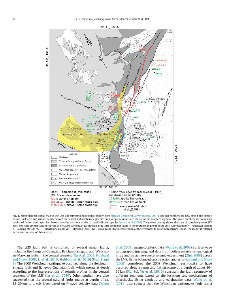
Fig. 2. Simplified geological map of the LMS and surrounding regions (modify from Sichuan Geological Survey Bureau, 2001). The red numbers are new zircon and apatitefission track ages and sample numbers from the central and northern segments; only sample numbers are shown for the southern segment. The green numbers are previouslypublished fission track ages. Red boxes show the locations of the zircon (U–Th)/He ages by Godard et al. (2009). The yellow overlay shows the zone of completely reset ZFTages. Red lines are the surface rupture of the 2008 Wenchuan earthquake. Blue lines are major faults in the southern segment of the LMS. Abbreviation: P – Pengguan Massif;B – Baoxing Massif; XSHF – Xianshuihe Fault; MJF – Minjiang Fault; HYF – Huya Fault. (For interpretation of the references to color in this figure legend, the reader is referredto the web version of this article.)
94 X.-B. Tan et al. / Journal of Asian Earth Sciences 81 (2014) 91–104
The LMS fault belt is comprised of several major faults,including the Jiangyou-Guanxian, Beichuan-Yingxiu, and Wenchu-an-Maoxian faults in the central segment (Xu et al., 2009; Hubbardand Shaw, 2009; Li et al., 2010; Hubbard et al., 2010) (Figs. 1 and2). The 2008 Wenchuan earthquake occurred along the Beichuan-Yingxiu fault and Jiangyou-Guanxian fault, which merge at depthaccording to the interpretations of seismic profiles in the centralsegment of the LMS (Lu et al., 2010). Other studies have alsosuggested that the several parallel faults merge at depths of ca.15–20 km to a soft layer based on P-wave velocity data (Wang
et al., 2003), magnetotelluric data (Wang et al., 2008), surface wavetomographic imaging, and data from both a passive seismologicalarray and an active-source seismic experiment (Zhu, 2008) acrossthe LMS. Using balanced cross-section analysis, Hubbard and Shaw(2009) considered the 2008 Wenchuan earthquake to haveoccurred along a ramp and flat structure at a depth of about 16–20 km (Fig. 1c). Yu et al. (2010) constrain the fault geometry ofdifferent segments based on the locations and mechanisms ofaftershocks. Using geodetic and earthquake data, Wang et al.(2011) also suggest that the Wenchuan earthquake fault has a

Fig. 3. Geological map, structural profile, and ZFT and AFT ages in the southern segment of the LMS. Red fault lines indicate recently active faults. The black line shows thelocation of the structural profile. AFT ages are shown in red, ZFT ages in black, and ages from Arne et al. (1997) in green. Geology is modified from the 1:500,000 Geology mapof Sichuan Province. (For interpretation of the references to color in this figure legend, the reader is referred to the web version of this article.)
X.-B. Tan et al. / Journal of Asian Earth Sciences 81 (2014) 91–104 95
ramp and flat geometry and that the epicenter was near the bound-ary of the ramp and flat. Their paper shows much more slip occur-ring at the ramp fault (Fig. 1d).
Based on a ramp-flat fault geometry and field observations fromprevious studies, we construct a structural profile of the southernsegment of the LMS (Fig. 3). From F1 to F6 all of the faults connectto the deeper detachment (depth of 15–20 km). F1 and F2 aremountain front faults, which share the same plane at a depth ofabout 10 km. The Baoxing massif has been folded and deeper rocksare exposed at the core of the fold between F2 and F3. F3 and F4 aresplay faults and share the same fault plane at depth; however, wefind that significant Cenozoic deformation only occurs on F4, asshown in Section 5.
3. Sampling strategy and methods
In order to constrain the exhumation history and the faultingactivity of the southern segment of the LMS, we collected samples
from the frontal thrust area (850 m elevation) to the inner plateau(about 4000 m elevation), passing through F1 (Shuangshi-Dachuanfault), F2, F3, F4 (Wulong-Yanjing fault), F5 and F6 (Fig. 2). Addi-tionally, samples were collected from the central and the northernsegments of the LMS for comparison. In order to minimize theinfluence of sample elevation, all samples, except some in the innerplateau, were collected in valley bottoms. The collected sampleswere analyzed and the results were combined with data from pre-vious studies to discuss exhumation along the LMS. In some sam-ples, both zircon and apatite fission track ages were used toconstrain exhumation history.
Sample preparation and experimental method were as per Liuet al. (2000, 2001). At least two pieces of standard glass, NBSSRM-610 or SRM-612, calibrated against the fission-track age stan-dard Fish Canyon Tuff (Naeser et al., 1981), were wrapped tightlyand irradiated with samples. Grain-by-grain and mica externaldetector techniques were adopted to obtain individual grain ages(Wagner and Van Den Haute, 1992). The zeta values (Green,

96 X.-B. Tan et al. / Journal of Asian Earth Sciences 81 (2014) 91–104
1985; Hurford and Green, 1983) for the standard glasses SRM-612and SRM-610 were 340 ± 12 (1r) and 27.5 ± 1.0 (1r), respectively.
4. Results
4.1. Zircon fission track ages
Fig. 4 shows the ZFT ages and age spectra, and the central agesare given in Table 1. Sample Bx110906 from an Eocene unit on thefootwall of F1 gave an age of 199.3 ± 11.4 Ma. Between F1 (Shuang-shi-Dachuan fault) and F2, two zircon fission track (ZFT) ages of ca.107.6 ± 7.3 Ma (BX-16) and 129.2 ± 8.8 Ma (BX110907) were ob-tained. Between F2 and F3, ZFT ages vary from 14.2 Ma to56.5 Ma. We obtain one age of 80.6 ± 8.5 Ma (BO-2) between F3and F4 (Wulong-Yanjing fault). Along the strike of F4, ZFT agesare consistent at ca. 10–14 Ma near the fault; however, farthernorthwest of F4, ZFT ages are ca. 25–29 Ma. Between F5 and F6,sample BX-9 has age of 14.1 ± 0.9 Ma. On the hanging wall of theF6, we obtain a ZFT age of ca. 31 Ma (Gong 85) but ages increaseto ca. 71–195 Ma to the northwest of F6 (Figs. 3 and 4) (Table 1).In the southernmost segment of F4, three ZFT ages were obtainedranging from ca. 82–136 Ma on the hanging wall. One ZFT agewas obtained for the Pengguan massif at 76.4 ± 5.7 Ma (GD-1).One ZFT age of 10 Ma (WCH-1) was obtained for the hanging wallof the Wenchuan-Maoxian fault (Fig. 2).
4.2. Apatite fission track ages
Fig. 5 shows the AFT ages and age spectra. Apatite fission track(AFT) dating yielded ages from ca. 4 to 5 Ma between F2 and F4(Wulong-Yanjing fault), and 3–4 Ma (with one sample1.9 ± 1.4 Ma from a sample size of only 3 grains) between F4 andF6. In the hanging wall of the F6 and to the northwest, the AFT agesare ca. 11–26 Ma (Figs. 3 and 4). All of these ages indicate completeresetting during Cenozoic deformation. To make comparisons withother studies of exhumation history along the LMS, samples fromthe central to northern segments of the LMS were collected. Inthe Pengguan massif, our AFT age is ca. 6.3 ± 0.7 Ma (GD-1), whichis similar to the ca. 4.8–6.5 Ma of Arne et al. (1997). On the hangingwall of the Wenchuan-Maoxian fault, one sample gives an age of2.1 ± 0.2 Ma (WCH-1). In the northern segment of the LMS, we ob-tain an age of 25.8 ± 2 Ma (PW-12) on the hanging wall of theBeichuan-Yingxiu fault, which is similar to the 33 Ma of Arneet al. (1997). On the hanging wall of the Guanxian-Jiangyou fault,we get ages of 67.3 ± 4.6 Ma (JY-1) and 83.9 ± 9.1 (JY-2) Ma(Fig. 2, Table 1).
5. Discussion
5.1. Timing of rapid Cenozoic exhumation
We measured 102 track lengths in the sample BX-3 and usedthe HeFty computer program (Ketcham, 2005) to model the ther-mal history of this sample (Fig. 6). The modeled history suggeststwo stages of rapid cooling, the first stage from ca. 30 Ma andthe second stage, with a much higher cooling rate, from ca. 3–5 Ma to the present. The timing of the first stage of rapid exhuma-tion is consistent with the oldest reset ages of zircon fission tracks,providing further support for a stage of rapid exhumation initiatedat ca. 30 Ma. Cook et al. (2013) measured zircon (U–Th)/He in theBaoxing Massif and obtained ages less than 17 Ma, indicating thatinitial Cenozoic exhumation must be older than 17 Ma, consistentwith our results. The central segment of the LMS also experienced afirst stage of rapid exhumation starting from 25 to 30 Ma (Wang
et al., 2012), indicating similar timing for this phase between thesouthern and central segments of the LMS.
The second stage of rapid exhumation began at 3–5 Ma. This isconsistent with the 3–5 Ma AFT ages we obtained between F2 andF6. Wang et al. (2012) show that the second stage of rapid exhuma-tion began at ca. 10–15 Ma in the central segment of the LMS,which is earlier than in the southern segment. The fact that thetiming of the second stage of rapid exhumation is different alongstrike may result from changes in structural style from the southto the north. During the 2008 Wenchuan earthquake the rupturedid not extend to the southern segment of the LMS. The fold andthrust belt in the southern segment of the LMS is wider than thatin the north, with multiple folds and faults developed within theSichuan basin southeast of the mountain front. The style of faultingin these foreland structures differs from that in mountain areas,indicating a difference in fault geometry and activity.
The modeled cooling rate of the second stage of exhumation ismuch higher than that of the first stage. A comparison of the ZFTand the AFT ages also shows that the second stage of rapid coolingwas much faster, lending support to the modeled rates. Assuming ageothermal gradient of 30 �C/km, mean surface temperature of15 �C, and closure temperatures for ZFT and AFT of 240 �C (Brandonet al., 1998) and 110 �C (Gleadow and Dubby, 1981), respectively,we calculate the exhumation rate of the southern segment of theLMS (Fig. 6b). On the hanging walls of F4 and F5, the exhumationrate near the faults was ca. 0.8 mm/yr between 10–14 Ma and ca.5 Ma; it increased to 0.7–1.2 mm/yr from ca. 5 Ma to the present.Farther northwest into the hanging walls, the exhumation ratewas lower, at ca. 0.2 mm/yr between 11–14 Ma and ca. 5 Ma. Inthe plateau area, the exhumation rate was ca. 0.12–0.3 mm/yr afterca. 10–27 Ma. The cooling histories and the above estimates ofexhumation rates in different areas relative to the faults are consis-tent with the exhumation rate becoming higher after ca. 5 Ma(Fig. 6c).
Wang et al. (2009) suggested that activity of the Xianshiuhefault, located to the western side of the LMS (Fig. 1), could be di-vided into two stages: from 13 to 5 Ma and from 5 Ma to the pres-ent. During the latter stage, from 5 Ma to the present, the faultzone passed through the Yushu, Ganzi, and Gongga Shan areas, off-set the LMS fault belt and reached the Kunming area (Wang et al.,2009). The timing of the rapid exhumation from 3–5 Ma to presentin the southern segment of the LMS could be related to this secondstage of activity of the Xianshuihe fault.
5.2. Controls on the distribution of zircon fission track ages
Research has shown that in convergent orogenic settings, con-sideration of lateral motion of material relative to the regionalthermal and kinematic framework is important in interpretingthermochronological data (Batt and Brandon, 2002; Huerta andRodgers, 2006; Lock and Willett, 2008).
Huerta and Rodgers (2006) present a kinematic thermal modelof a simple fold bend fault system that can be used to determinethe timing of initial thrusting, duration of thrusting, and the thrustrate using low temperature thermochronology. They found a pat-tern of nonlinear fission track (FT) ages with anomalously youngages from the leading edge to the central part of the system forhanging-wall rocks whose initial temperature (burial depth) wasmuch higher than the closure temperature of the FT system. Theages do not directly indicate the timing of initial thrusting; how-ever, the model suggests that ages measured on the hanging wallof the fault at a burial depth just slightly deeper than the partialannealing zone of the thermochronometer, can be used to ascertainthe initial timing, duration, and rate of thrusting.
As discussed in Section 2.3, The LMS has a ramp and flat faultgeometry (Xu et al., 2009; Hubbard and Shaw, 2009, 2010; Li

Fig. 4. Age histograms and radial plots for the ZFT samples. For each sample, the pooled age and the number of grains counted are indicated on the histogram.
X.-B. Tan et al. / Journal of Asian Earth Sciences 81 (2014) 91–104 97
et al., 2010; Wang et al., 2012). Fig. 7 shows the structural profile,degree of ZFT resetting, and ZFT and AFT age distribution along thesouthern segment of the LMS. We find two ZFT total annealing
zones and three partial annealing zones in the southern segmentof the LMS. The reset zircon ages fall into two groups: 10–14 Maand 25–31 Ma. The AFT ages are separated by F6 into two groups:
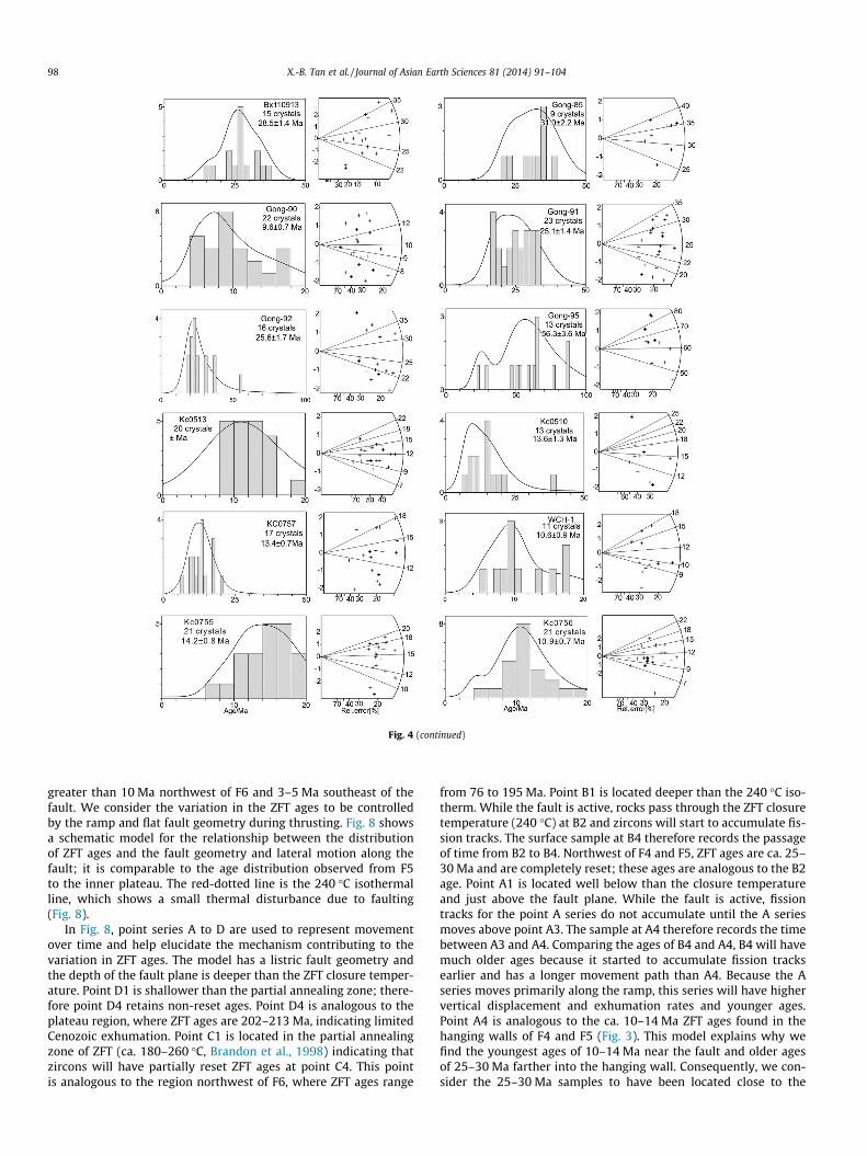
Fig. 4 (continued)
98 X.-B. Tan et al. / Journal of Asian Earth Sciences 81 (2014) 91–104
greater than 10 Ma northwest of F6 and 3–5 Ma southeast of thefault. We consider the variation in the ZFT ages to be controlledby the ramp and flat fault geometry during thrusting. Fig. 8 showsa schematic model for the relationship between the distributionof ZFT ages and the fault geometry and lateral motion along thefault; it is comparable to the age distribution observed from F5to the inner plateau. The red-dotted line is the 240 �C isothermalline, which shows a small thermal disturbance due to faulting(Fig. 8).
In Fig. 8, point series A to D are used to represent movementover time and help elucidate the mechanism contributing to thevariation in ZFT ages. The model has a listric fault geometry andthe depth of the fault plane is deeper than the ZFT closure temper-ature. Point D1 is shallower than the partial annealing zone; there-fore point D4 retains non-reset ages. Point D4 is analogous to theplateau region, where ZFT ages are 202–213 Ma, indicating limitedCenozoic exhumation. Point C1 is located in the partial annealingzone of ZFT (ca. 180–260 �C, Brandon et al., 1998) indicating thatzircons will have partially reset ZFT ages at point C4. This pointis analogous to the region northwest of F6, where ZFT ages range
from 76 to 195 Ma. Point B1 is located deeper than the 240 �C iso-therm. While the fault is active, rocks pass through the ZFT closuretemperature (240 �C) at B2 and zircons will start to accumulate fis-sion tracks. The surface sample at B4 therefore records the passageof time from B2 to B4. Northwest of F4 and F5, ZFT ages are ca. 25–30 Ma and are completely reset; these ages are analogous to the B2age. Point A1 is located well below than the closure temperatureand just above the fault plane. While the fault is active, fissiontracks for the point A series do not accumulate until the A seriesmoves above point A3. The sample at A4 therefore records the timebetween A3 and A4. Comparing the ages of B4 and A4, B4 will havemuch older ages because it started to accumulate fission tracksearlier and has a longer movement path than A4. Because the Aseries moves primarily along the ramp, this series will have highervertical displacement and exhumation rates and younger ages.Point A4 is analogous to the ca. 10–14 Ma ZFT ages found in thehanging walls of F4 and F5 (Fig. 3). This model explains why wefind the youngest ages of 10–14 Ma near the fault and older agesof 25–30 Ma farther into the hanging wall. Consequently, we con-sider the 25–30 Ma samples to have been located close to the

Table 1Zircon and apatite fission track ages.
Number Latitude Longitude Elevation Strata age Lithology Crystal RhoS (105) Ns RhoI (105) Ni P(v2) Nd RhoD Pooled age
ZirconBO-1 30.4136 102.7520 1604 Silurian Schist 20 12.492 465 12.30 459 3.36 4798 12.3 13.2 ± 1.0BO-2 30.4066 102.7700 2286 Silurian Schist 15 91.922 1164 16.98 215 0 4798 10.95 80.6 ± 8.5BO-3 30.5547 102.8994 1557 Proterozoic Schist 12 0.034 372 0.03 359 21.9 4798 9.32 13.2 ± 1.1BX-5 30.8313 102.7326 2798 Triassic Sandstone 20 120.05 1762 13.49 198 0.72 4798 8.9 108.0 ± 9.1BX-9 30.6423 102.7896 1955 Proterozoic Metaquartz 20 22.462 728 21.94 711 0.02 4798 10 14.1 ± 0.9BX-11 30.6031 120.8679 2154 Proterozoic Granite 13 22.492 434 10.832 209 33.3 4798 8.9 25.4 ± 2.4BX-13 30.5289 102.9130 1416 Proterozoic Granite 19 15.845 1036 5.89 385 8.89 4798 7.5 27.7 ± 2.0BX-14 30.4477 102.8585 1254 Proterozoic Granite 8 119.7 318 33.16 88 99.3 4798 8.8 43.6 ± 5.5BX-16 30.2317 102.8385 804 Triassic Sandstone 20 91.814 3283 10.26 366 6.71 4798 8.8 107.6 ± 7.3BX110906 30.2063 102.8609 1204 Eocene Sandstone 17 367.76 13,278 23.99 866 0 8875 9.65 199.3 ± 11.4BX110907 30.2248 102.8396 770 Triassic Sandstone 10 180.76 3006 22.07 367 0.19 4798 11.65 129.2 ± 8.8BX110913 30.4191 102.7268 1378 Silurian Sandstone 15 34.4 3048 18.05 1599 0.07 4798 10.95 28.5 ± 1.4GD-1 31.0614 103.4056 1219 Proterozoic Granite 11 73.802 1900 11.23 289 12.6 4798 8.5 76.4 ± 5.7GD-2 31.0628 103.3383 1451 Proterozoic Granite 6 57.207 434 10.28 434 37.6 4798 8.5 64.7 ± 8.4GD-3 30.8824 102.9861 2690 Triassic Sandstone 4 67.17 460 10.95 75 0 4798 8.5 71.3 ± 9.3GD-6 30.8881 102.9724 3460 Triassic Sandstone 6 49.531 814 7.606 125 0.01 4798 8.5 75.7 ± 7.8GD-10 30.9106 102.8942 4389 Triassic Sandstone 6 138.49 1072 19.64 152 16.8 4798 8.5 81.9 ± 7.8GD-11 30.9774 102.8635 3608 Triassic Sandstone 8 72.535 915 13.32 168 20.2 4798 8.6 63.3 ± 5.9DB-1 30.0403 102.1759 1430 Proterozoic Granodiorite 14 100.94 3520 8.46 295 0 4798 8.2 135.5 ± 9.7DB-2 30.2154 102.2020 1679 Proterozoic Granodiorite 14 72.841 2060 286 286 7.14 4798 8.2 82.2 ± 6.1WCH-1 31.3274 103.3987 1766 Proterozoic Granite 11 18.473 391 17.67 374 4.42 4798 7.39 10.6 ± 0.9Gong-41 30.0403 102.1759 1488 Proterozoic Granodiorite 20 107.25 4722 13.63 600 44.3 4798 8.24 90.2 ± 5.2Gong-78 30.7880 102.7292 2444 Triassic Sandstone 19 310.83 11,398 20.73 760 0 4798 9.65 195 ± 11.6Gong-83 30.3143 102.7855 956 Proterozoic Granodiorite 10 65.923 968 22.54 331 99.4 4798 8.24 33.0 ± 2.5Gong-85 30.6887 102.7513 2133 Devonian Sandstone 9 67.798 1168 22.46 387 22.9 4798 7.5 31.6 ± 2.2Gong-90 30.5572 102.8868 1513 Proterozoic Gneiss 22 13.845 552 16.08 641 0.08 4798 8.1 9.6 ± 0.7Gong-91 30.5256 102.9152 1462 Proterozoic Granite 23 23.229 2172 9.51 889 8.36 4798 7.5 25.1 ± 1.4Gong-92 30.5120 102.9151 1366 Proterozoic Granite 16 19.137 1230 7.69 494 12.4 4798 7.5 25.6 ± 1.7Gong-95 30.4093 102.8360 1066 Proterozoic Granite 13 48.048 2300 9.59 459 0 4798 8.2 56.3 ± 3.6Kc0510* 30.5059 102.8395 2045 Proterozoic Granite 13 18.434 266 16.15 233 10 4798 8.5 13.6 ± 1.3Kc0755* 30.3720 102.8210 1233 Proterozoic Granite 21 20.735 1362 15.67 1029 4.08 4798 7.8 14.2 ± 0.8Kc0513* 30.5580 102.8927 2352 Proterozoic Granite 20 7.766 200 7.426 191 100 4798 8.1 11.9 ± 1.3Kc0756* 30.4190 102.7620 1180 Proterozoic Granite 19 10.58 904 10.17 869 75.2 4798 7.5 10.9 ± 0.7Kc0757* 30.5787 102.8788 1575 Proterozoic Granite 17 21.471 810 25.45 960 10.2 4798 11.65 13.4 ± 0.7
Sample Latitude Longitude Elevation Formation Lithology Crystal RhoS (105) (Ns) RhoI (105) (Ni) P(v2) (Nd) RhoD Track length Pooled age
ApatiteBX-1 30.8776 102.6386 3519 Triassic Sandstone 23 1.585 341 4.136 890 99.5 4798 3.96 11.6 ± 0.9(2) 25.7 ± 1.9BX-2 30.8721 102.6816 4056 Triassic Sandstone 20 1.732 104 2.92 259 77.7 4798 3.96 – 27.0 ± 3.0BX-3 30.8404 102.7041 3394 Triassic Sandstone 27 3.936 336 10.694 913 11.9 4798 3.69 10.9 ± 1.7(102) 23.5 ± 2BX-6 30.8121 102.7293 2485 Triassic Sandstone 12 1.164 80 6.943 477 0 4798 3.75 – 10.7 ± 1.3BX-10 30.6363 102.8415 2203 Proterozoic Granite 3 0.09 2 2.964 66 81.5 4798 3.75 – 1.9 ± 1.4BX-11 30.6031 102.8679 2268 Proterozoic Granite 25 0.045 12 1.088 287 83.67 4798 3.96 – 2.9 ± 0.8BX-13 30.5289 102.9130 1416 Proterozoic Granite 18 0.134 22 2.706 464 92.92 4798 3.75 – 3.8 ± 0.8BX-14 30.4477 102.8585 1254 Proterozoic Granite 17 1.443 165 18.229 2084 2.47 4798 3.75 12.6 ± 0(1) 5 ± 0.4BX-15 30.3413 102.7921 976 Proterozoic Granite 16 0.435 46 10.219 1080 16.1 4798 3.75 – 2.7 ± 0.4GD-1 31.0614 103.4056 1219 Proterozoic Granite 36 0.824 731 6.927 731 100 4798 3.14 – 6.3 ± 0.7GD-9 30.9113 102.9129 4355 Triassic Sandstone 25 1.469 60 9.669 395 99.6 4798 3.69 – 8.1 ± 1.1GD-12 30.9640 102.6505 2728 Triassic Sandstone 15 1.883 60 8.964 277 100 4798 3.14 – 11.6 ± 1.7Gong-78 30.7880 102.7292 2513 Triassic Sandstone 30 0.8 332 2.666 1106 45.41 4798 3.5 – 16.8 ± 1Gong-83 30.3143 102.7855 956 Proterozoic Granodiorite 39 0.544 139 8.63 2009 29.97 4798 3.6 – 4.4 ± 0.4Gong-90 30.5572 102.8869 1513 Proterozoic Granite 40 0.572 110 6.942 1335 56.6 4798 2.8 – 3.9 ± 0.4Gong-92 30.5120 102.9150 1366 Proterozoic Granite 35 0.321 70 3.86 842 99.9 4798 2.83 – 4 ± 0.5
(continued on next page)
X.-B.Tan
etal./Journal
ofA
sianEarth
Sciences81
(2014)91–
10499

Gon
g-94
30.4
614
102.
8797
1464
Prot
eroz
oic
Gra
nit
e10
1.39
491
13.6
989
488
.847
982.
83–
5±
0.5
Gon
g-95
30.4
093
102.
8360
1066
Prot
eroz
oic
Gra
nit
e40
0.47
211
76.
643
1047
95.4
4798
2.8
–5.
3±
0.5
JY-1
31.8
559
104.
7375
584
Tria
ssic
San
dsto
ne
434.
062
616
4.33
965
882
.32
4798
4.25
9.6
±1.
7(4)
67.3
±4.
6JY
-231
.864
810
4.73
2359
5Tr
iass
icSa
nds
ton
e9
8.15
220
97.
021
180
49.9
347
984.
2511
.6±
0.3(
2)83
.3±
9.1
Kc0
511
30.4
645
102.
8772
1222
Prot
eroz
oic
Gra
nit
e32
0.53
638
5.76
840
999
.85
4798
3.38
–5.
4±
0.7
WC
H-1
31.3
273
103.
3987
1782
Prot
eroz
oic
Gra
nit
e24
0.11
594
3.46
328
270.
0947
983.
96–
2.1
±0.
2PW
-12
32.3
859
104.
7135
1121
Silu
rian
San
dsto
ne
340.
845
600
1.77
112
573.
0547
983.
0513
.89
±0.
3(2)
24.4
±1.
9
Rh
oSde
nsi
tyof
spon
tan
eou
str
acks
[105
tr/c
m2];
Ns:
nu
mbe
rof
spon
tan
eou
str
acks
;Rh
oI:d
ensi
tyof
indu
ced
trac
ks[1
05tr
/cm
2];
Ni:
nu
mbe
rof
indu
ced
trac
ks,N
d=
4789
trac
ksco
un
ted
onN
BS
610
and
612;
P(v
2):
prob
abil
ity
that
sin
gle
grai
nag
esar
eco
nsi
sten
tan
dbe
lon
gto
the
sam
epo
pula
tion
,tes
tis
pass
edif
P(v
2)
>5%
(Gal
brai
th,1
981)
.Poo
led
ages
are
calc
ula
ted
usi
ng
af-
valu
eof
340
±12
(1r
)an
d27
.5±
1.0
(1r
),re
spec
tive
ly.T
he
sam
ples
wit
h*
sym
bol
hav
ebe
enpu
blis
hed
byC
ook
etal
.(20
13).
100 X.-B. Tan et al. / Journal of Asian Earth Sciences 81 (2014) 91–104
depth of the ZFT closure isotherm, suggesting that thrusting be-gan at 25–30 Ma. This is consistent with the thermal modeling re-sult of the sample BX-3 and can be interpreted as the first stage ofrapid exhumation.
5.3. Cenozoic fault activity in the southern segment of the LongmenShan
Based on stratigraphic relationships and field observations ofshear sense indicators, Burchfiel et al., 1995 considered F3 to havefirst been a thrust fault and later a normal fault. On the hangingwall of F3, the ZFT age distribution of sample BO-2 (81 ± 8.5 Ma)ranges from 13 to 229 Ma indicating partial annealing in theCenozoic. In contrast, the ZFT ages are totally reset on the footwallof F3, indicating a lack of thrust offset in the Cenozoic. It can beinferred from this that the timing of the thrusting on this faultis Mesozoic (Fig. 3).
Based on the age differences between the hanging walls andfootwalls of each of the faults (Fig. 7), the mountain front faults(F1 and F2), F4, and F5 have been the major active faults duringthe Cenozoic. The oldest reset ages are ca. 25–31 Ma on thehanging walls of F2, F4, and F5 indicating that all of these faultswere active from ca. 25–31 Ma. In contrast, AFT ages are similaracross these faults, at ca. 3–5 Ma from F2 to F6, indicating asmall degree of offset across F3, F4, F5 and F6 after 3–5 Ma.These ZFT and AFT ages indicate that F4 and F5 probably becameactive at 25–31 Ma and stopped before ca. 3–5 Ma. Although theoldest reset ZFT ages are similar on the hanging walls of F2, F4,and F5, the zone of reset ZFT ages is much larger on the hangingwalls of F4 and F5. Additionally, younger ages of 10–14 Ma arefound near these faults, suggesting larger slip amounts for F4and F5 than for the mountain front faults (F1 and F2) (Figs. 3and 7).
The mountain front faults (F1 and F2) separate reset and par-tially reset AFT ages. This result is indicative of large amounts ofslip being consumed at the mountain front faults after 3–5 Ma(Figs. 2 and 3). In the Tianquan region east of F1, the foldingof a conformable succession of Triassic to Eocene/Oligocenestrata (Fig. 3) indicates that the formation of this fold and thrustbelt occurred post Oligocene (Burchfiel et al., 1995). Our datasuggest that the mountain front faults and the fold and thrustbelt in the Sichuan Basin may be active areas with the potentialto produce a future large earthquake. We previously proposedthat this area had a high potential for seismic hazard (Leeet al., 2012) and unfortunately a large Mw6.6 earthquake oc-curred on 20th April, 2013. The focal mechanism was thrustingand the epicenter was located beneath the mountain front faultat 12.3 km depth (Xu et al., 2013). Surface deformation was notobserved, indicating activity on a blind fault system (Xu et al.,2013). This blind fault could connect to the shallow detachmentin the Sichaun Basin (Fig. 3). Considering the short seismic gapof ca. 40 km between the 2008 Mw7.9 Wenchuan earthquakeand 2013 Mw6.6 earthquake, elastic strain energy has still notbeen completely released and therefore danger remains in thisarea.
In the central segment of the LMS, the ZFT age of the sampleWCH-1 (10.6 ± 0.9 Ma) on the hanging wall of the Wenchuan-Maoxian fault is totally reset; by contrast, the ZFT ages are par-tially reset on the hanging wall of the Beichuan-Yingxiu fault(Fig. 2). This indicates that the amount of exhumation at the hang-ing wall of the Wenchuan-Maoxian fault is larger than of theBeichuan-Yingxiu fault. The ZFT ages are similar on the hangingwall of the Wenchuan-Maoxian fault and Wulong-Yanjing fault(F4) indicating that they have similar characteristics and couldbe connected.

Fig. 5. Age histograms and radial plots for the AFT samples. For each sample, the pooled age and the number of grains counted are indicated on the histogram.
X.-B. Tan et al. / Journal of Asian Earth Sciences 81 (2014) 91–104 101

Fig. 6. (a) The results of thermal modeling for the sample BX-3. Two stages of rapid exhumation were observed. The black line is the best fit model and the blue line is theweighted mean path. Both show that there were two rapid exhumation stages. The first stage at ca. 30 Ma and the second stage at ca. 3–5 Ma. (b) Track length distribution ofthe sample BX-3. The green line shows the best fit curve from the thermal modeling. (c) Exhumation history of the southern segment of the LMS. The exhumation rate is lowerin the plateau area and higher near the faults F4 and F5. After 3–5 Ma the exhumation increases, consistent with the thermal modeling result. (For interpretation of thereferences to color in this figure legend, the reader is referred to the web version of this article.)
102 X.-B. Tan et al. / Journal of Asian Earth Sciences 81 (2014) 91–104
5.4. Variation in Cenozoic exhumation along strike of the LongmenShan
Our data and Wang et al. (2012) indicate that the first stage ofrapid exhumation took place at ca. 25–30 Ma in both the southernand central LMS; however, the degree of Cenozoic exhumation isdifferent along strike (Fig. 2). In the central segment, reset ZFT agesare found only on the hanging wall of the Wenchuan-Maoxianfault. In contrast, completely reset ZFT samples are found extend-ing from Danba southeast to the Baoxing massif (Fig. 2). Apatiteages are ca. 3–5 Ma on the hanging wall of the mountain frontfaults in the southern segment, 4.8–6.4 Ma in the Pengguan massifin the middle segment, and 26–33 Ma on the hanging wall of thenorthern segment of the Beichuan-Yingxiu fault. Since AFT ages in-
crease from southwest to the northeast, there must be a decreasein the exhumation rate from southwest to northeast.
The influence of the collision between the India and Eurasiaplates propagates from south to north, which potentially resultsin a decrease in the exhumation rate from southwest to northeast.The 2008 Wenchuan earthquake was associated with more thrust-ing in the central segment of the LMS and more right-lateral strike-slip faulting in the northern segment (Xu et al., 2009). Strike-slipfaulting with higher horizontal slip and lower vertical displace-ment could result in a lower exhumation rate in the northernsegment. Compared to the central and northern segments of theLMS, a foreland fold and thrust belt is well developed in the south-ern segment; in this belt, more displacement is being consumedand a different structural style exists than in the mountain area,

Fig. 7. Structural profile, degree of ZFT resetting, and age distribution along the southern segment of the LMS. There are two total annealing zones and three partial annealingzones in the southern segment of the LMS. There are two groupings for reset ZFT ages, 10–14 Ma and 25–31 Ma. To the south of F6, the apatite fission track ages are ca. 3–5 Ma, indicating that activity of the F4 and F5 is reduced after 3–5 Ma. After 3–5 Ma, most of the displacement was consumed by the F2 or the blind fault. To the north andsouth of the F6, the apatite fission track ages are greater than 10 Ma and 3–5 Ma, respectively. For strata located in the ramp area of F2, the apatite fission track ages are 3–5 Ma and have a higher exhumation rate than strata located above the fault flat.
Fig. 8. Schematic model to interpret the ZFT ages. On the hanging wall of F4 and F5,the ZFT ages are 10–14 Ma; ages change to ca. 25–31 Ma at a distance from thefaults before becoming partially reset to unreset ages in the plateau area. The agedistribution can be explained by strata moving along the listric fault geometry. Seethe text for a description of the particle movement paths and their relationship tothe expected ZFT ages.
X.-B. Tan et al. / Journal of Asian Earth Sciences 81 (2014) 91–104 103
indicating a potential difference in fault geometry. Different sub-surface structures may have the potential to influence the amountof exhumation.
6. Conclusion
In the southern segment of the LMS, our fission track data indi-cate two stages of rapid exhumation, with the first stage at ca.30 Ma and the second stage from ca. 3–5 Ma. The timing of the sec-ond stage of rapid exhumation is consistent with the second stageof activity of the Xianshuihe fault and may be related. The exhuma-tion rate in the second stage was higher than in the first, implyingan increased slip rate along the LMS.
Reset ZFT ages vary from 10 to 14 Ma on the hanging wall offaults F4 and F5 to ca. 25–31 Ma at distance from these faults.AFT ages are 3–5 Ma between F2 and F6 and increase to 8–26 Main the plateau area. The uniform AFT ages between F2 and F6,and the contrast with unreset ages southeast of F1 and F2 indicatethat the mountain front faults and the fold and thrust belt havebeen the most active areas in the southern segment of the LMSfrom ca. 3–5 Ma to present. Along the strike of the LMS, theamount of exhumation decreases from the southwest to northeast,which may be related to differences in fault geometry and thrustbelt architecture.
Acknowledgements
This project has been fully supported by the National ScienceCouncil, Taiwan, ROC, under Grant NSC 100-2119-M-94-002 and
104 X.-B. Tan et al. / Journal of Asian Earth Sciences 81 (2014) 91–104
National Natural Science Foundation of China (M40821160550).The authors want to thanks their colleagues from the institute ofGeology, China Earthquake Administration, China who offered sig-nificant help with field work.
References
Arne, D., Worley, B., Wilson, C., Chen, S.F., Foster, D., Luo, Z.L., Liu, S.G., Dirks, P.,1997. Differential exhumation in response to episodic thrusting along theeastern margin of the Tibetan Plateau. Tectonophysics 280, 239–256. http://dx.doi.org/10.1016/ S0040-1951(97)00040-1.
Batt, G.E., Brandon, M.T., 2002. Lateral thinking: 2-D interpretation ofthermochronology in convergent orogenic settings. Tectonophysics 349, 185–201.
Brandon, M.T., Roden-Tice, M., Garver, J.I., 1998. Late Cenozoic exhumation of theCascadia accretionary wedge in the Olympic Mountains, northwest WashingtonState. Geol. Soc. Am. Bull. 110, 985–1009.
Bucher, K., Frey, M., 2002. Petrogenesis of Metamorphic Rocks, seventh ed.Springer-Verlag, Heidelberg.
Burchfiel, B.C., Chen, Z., Liu, Y., Royden, L.H., 1995. Tectonics of the Longmen Shanand adjacent regions, central China. Intern. Geol. Rev. 37, 661–735.
Burchfiel, B.C., Royden, L.H., van der Hilst, R.D., Hager, B.H., Chen, Z., King, R.W., Li,C., Lü, J., Yao, H., Kirby, E., 2008. A geological and geophysical context for theWenchuan earthquake of 12 May 2008, Sichuan, People’s Republic of China.GSA Today (Geol. Soc. Am.) 18, 4–11.
Chen, Z., Burchfiel, B.C., Liu, Y., King, R.W., Royden, L.H., Tang, W., Wang, E., Zhao, J.,Zhang, X., 2000. Global Positioning System measurements from eastern Tibetand their implications for India/Eurasia intercontinental deformation. J.Geophys. Res. 105, 16215–16227. http://dx.doi.org/10.1029/2000JB900092.
Cook, K.L., Royden, L.H., Burcherful, B.C., Lee, Y.H., Tan, X., 2013. Constraints onCenozoic tectonics in the southwestern Longmen Shan from low-temperaturethermochronology. Lithosphere. http://dx.doi.org/10.1130/L263.1.
Enkin, R.J., Zhenyu, Y., Chen, Y., Courtillot, V., 1992. Paleomagnetic constraints onthe geodynamic history of the major blocks of China from Permian to thepresent. J. Geophys. Res. 97, 13953–13989.
Gan, W., Zhang, P., Shen, Z.K., Niu, Z., Wang, M., Wan, Y., Zhou, D., Cheng, J., 2007.Present-day crustal motion within the Tibetan Plateau. J. Geophys. Res. 112,B08416. http://dx.doi.org/10.1029/2005JB004120.
Gleadow, A.J.W., Dubby, I.R., 1981. A natural long-term track annealing experimentfor apatite. Nucl. Tracks Radiat. Meas. 5, 169–174.
Godard, V., Pik, R., Lavé, J., Cattin, R., Tibari, B., de Sigoyer, J., Pubellier, M., Zhu, J.,2009. Late Cenozoic evolution of the central Longmen Shan, eastern Tibet:insight from (U–Th)/He thermochronometry. Tectonics 28. http://dx.doi.org/10.1029/2008TC002407.
Green, P.F., 1985. Comparison of zeta calibration baselines for fission track dating ofapatite, zircon, and sphene. Chem. Geol. 58, 1–22.
Harrowfield, M.J., Wilson, C.J.L., 2005. Indosinian deformation of the Songpan-Garzefold belt, northeast Tibetan plateau. J. Struct. Geol. 27, 101–117.
Huang, M., Maas, R., Buick, I.S., Williams, I.S., 2003. Crustal response to continentalcollisions between the Tibet, Indian, South China and North China blocks:geochronological constraints from the Songpan-Garze orogenic belt, westernChina. J. Metamorph. Geol. 21 (3), 223–240.
Hubbard, J., Shaw, J.H., Klinger, Y., 2010. Structural setting of the 2008 Mw 7.9Wenchuan, China. Earthq. Bull. Seismol. Soc. Am. 100 (5B), 2713–2735. http://dx.doi.org/10.1785/0120090341.
Hubbard, J., Shaw, J.H., 2009. Uplift of the Longmen Shan and Tibetan plateau, andthe 2008 Wenchuan (M = 7.9) earthquake. Nature 458, 194–197.
Huerta, A.D., Rodgers, D.W., 2006. Constraining rates of thrusting and erosion:insights from kinematic thermal modeling. Geology 34 (7), 541–544.
Hurford, A.J., Green, P.F., 1983. The zeta calibration of fission track dating. IsotopeGeosci. 1, 285–317.
Jia, D., Wei, G., Chen, Z., Li, B., Zeng, Q., Yang, G., 2006. Longmen Shan fold-thrust beltand its relation to the western Sichuan Basin in central China: new insightsfrom hydrocarbon exploration. Am. Assoc. Petrol. Geol. (AAPG) 90 (9), 1425–1447.
Ketcham, R.A., 2005. Forward and inverse modeling of low-temperaturethermochronometry data. Rev. Mineral. Geochem. 58, 275–314.
King, R.W., Shen, F., Burchfiel, B.C., Royden, L.H., Wang, E., Chen, Z., Liu, Y.,Zhang, X.-Y., Zhao, J.-X., Li, Y., 1997. Geodetic measurements of crustal motionin southwest China. Geology 25, 179–182. http://dx.doi.org/10.1130/0091-7613, 025<0179:GMOCMi>2.3.CO;2.
Kirby, E., Reiners, P.W., Krol, M.A., Whipple, K.X., Hodges, K.V., Farley, K.A., Tang, W.,Chen, Z., 2002. Late Cenozoic evolution of the eastern margin of the TibetanPlateau: inferences from 40Ar/39Ar and (U–Th)/He thermochronology. Tectonics21. http://dx.doi.org/10.1029/2000TC001246.
Lee, Y.H., Tan, X.B., Chen, W.Y., Cook, K., Xu, X.W., 2012. Cenozoic Exhumationhistory of the southern segment of the Longmenshan fault, Eastern Tibet and ittectonic implication. In: 13th International Conference on Thermochronology.
Li, Y., Jia, D., Shaw, J.H., Hubbard, J., Lin, A., Wang, M., Luo, L., Li, H., Wu, L., 2010.Structural interpretation of the co-seismic faults of the Wenchuan earthquake:three-dimensional modeling of the Longmen Shan fold-and-thrust belt. J.Geophys. Res. 115. http://dx.doi.org/10.1029/2009JB006824.
Li, Z., Liu, S., Chen, H., Deng, B., Hou, M., Wu, W., Cao, J., 2012. Spatial variation inMeso-Cenozoic exhumation history of the Longmen Shan thrust belt (eastern
Tibetan Plateau) and the adjacent western Sichuan basin: constraints fromfission track thermochronology. J. Asian Earth Sci. 47, 185–203.
Liu, T.K., Hseih, S., Chen, Y.G., Chen, W.S., 2001. Thermo-kinematic evolution of theTaiwan oblique-collision mountain belt as revealed by zircon fission trackdating. Earth Planet. Sci. Lett. 186, 45–56.
Liu, T.K., Chen, Y.G., Chen, W.S., Jiang, S.H., 2000. Rates of cooling and denudation ofthe early Penglai Orogeny, Taiwan, as assessed by fission-track constraints.Tectonophysics 320, 69–82.
Lock, J., Willett, S., 2008. Low-temperature thermochronometric ages in fold-and-thrust belts. Tectonophysics 456, 147–162.
Lu, R.Q., He, D.F., Suppe, J., Guan, S.W., Ma, X.M., Wang, M.J., Gui, B.L., Gao, J.W.,2010. The discovery of structural wedges in the central Longmen Mountainsfront belt and its geometric and kinematic characteristics: constraints on thedynamical mechanism of uplifting in the Southeastern Margin of Qinghai-TibetPlateau. Earth Sci. Front. 17, 93–105 (in Chinese with English abstract).
Naeser, C.W., Zimmermann, R.A., Cebula, G.T., 1981. Fission track dating of apatiteand zircon: an interlaboratory comparison. Nucl. Tracks 5, 65–72.
Reid, A.J., Wilson, C.J.L., Liu, S., 2005. Structural evidence for the Permo-Triassictectonic evolution of the Yidun arc, eastern Tibetan plateau. J. Struct. Geol. 27,119–137.
Roger, F., Arnaud, N., Gilder, S., Tapponnier, P., Jolivet, M., Brunel, M., Malavieille, J.,Xu, Z., 2003. Geochronological and geochemical constraints on Mesozoicsuturing in East Central Tibet. Tectonics 22 (4), 1037. http://dx.doi.org/10.1029/2002TC001466.
Roger, F., Jolivet, M., Malavieille, J., 2010. Tectonic evolution of the Songpan-Garze(North Tibet) and adjacent areas rom Proterozoic to Present: a synthesis. J.Asian Earth Sci. 39, 254–269.
Sichuan Geological Survey Bureau, China, 2001, 1/500000 geological map.Stone, R., 2008. Geophysics: an unpredictably violent fault. Science 320, 1578–1580.Tapponnier, P., Xu, Z.Q., Roger, F., Meyer, B., Arnaud, N., Wittlinger, G., Yang, J.S.,
2001. Oblique stepwise rise and growth of the Tibet Plateau. Science 294, 1671–1677. http://dx.doi.org/10.1126/science.105978.
Wagner, G., Van den haute, P., 1992. Fission Track Dating. Kluwer, Dordrecht.Wilson, C.J.L., Harrowfield, M.J., Reid, A.J., 2006. Brittle modification of Triassic
architecture in eastern Tibet: implications for the construction of the Cenozoicplateau. J. SE Asian Earth Sci. 27, 341–357.
Wang, C.Y., Wu, J.P., Lou, H., Zhou, M.D., Bai, Z.M., 2003. P velocity structural file ofthe West Sichuan and Eastern Tibet area. Sci. China (Ser. D) 33, 181–189 (inChinese).
Wang, X., Yu, N., Zhu, Y., Xu, Q., Huang, W., Gao, S., 2008. Preliminary result ofmagnetotelluric sounding in the Longmen thrust belt of West Sichuan, China. J.Chengdu Univ. Technol. (Sci. Technol. Ed.) 35, 398–403 (in Chinese with Englishabstract).
Wang, E., Kirby, E., Furlong, K.P., van Soest, M., Xu, G., Shi, X., Kamp, P.J.J., Hodges,K.V., 2012. Two-phase growth of high topography in eastern Tibet during theCenozoic. Nat. Geosci. 5, 640–645. http://dx.doi.org/10.1038/ngeo1538.
Wang, S., Fang, X., Zheng, D., Wang, E., 2009. Initiation of slip along the Xianshuihefault zone, eastern Tibet, constrained by K/Ar and fission-track ages. Int. Geol.Rev. 51 (12), 1121–1131.
Wang, Q., Qiao, X., Lan, Q., Freymueller, J., Yang, S., Xu, C., Yang, Y., You, X., Tan, K.,Chen, G., 2011. Rupture of deep faults in the 2008Wenchuan earthquake anduplift of the Longmen Shan. Nat. Geosci. http://dx.doi.org/10.1038/NGEO1210.
Weller, O.M., St-Onge, M.R., Waters, D.J., Rayner, N., Searle, M.P., Chung, S.-L., Palin,R.M., Lee, Y.-H., Xu, X., 2013. Quantifying Barrovian metamorphism in theDanba Structural Culmination of eastern Tibet. J. Metamorph. Geol. 31 (9), 909–935.
Xu, G.Q., Kamp, P.J.J., 2000. Tectonics and denudation adjacent to the XianshuiheFault, eastern Tibetan Plateau: constraints from fission track thermochronology.J. Geophys. Res. 105, 19231–19251. http://dx.doi.org/10.1029/2000JB900159.
Xu, X., Wen, X., Yu, G., Chen, G., Klinger, Y., Hubbard, J., Shaw, J.H., 2009. Coseismicreverse- and oblique-slip surface faulting generated by the 2008 Mw 7.9Wenchuan earthquake, China. Geology 27, 515–518.
Xu, X.W., Wen, X.Z., Han, Z.J., Chen, G.H., Li, C.Y., Zheng, W.J., Zhang, S.M., Ren, Z.K.,Xu, C., Tan, X.B., Wei, Z.Y., Wang, M.M., Ren, J.J., He, Z., Liang, M.J., 2013. LushanMs 7.0 earthquake: a blind reverse-fault earthquake. Chin. Sci. Bull. 58. http://dx.doi.org/10.1007/s11434-010-0180-9.
Yan, D.-P., Zhou, M.-F., Li, S.-B., Wei, G.-Q., 2011. Structural and geochronologicalconstraints on the Mesozoic–Cenozoic tectonic evolution of the Longmen Shanthrust belt, eastern Tibetan Plateau. Tectonics 30, TC6005. http://dx.doi.org/10.1029/2011TC002867.
Yin, A., Harrison, T.M., 2000. Geologic evolution of the Himalayan-Tibetan orogen.Annu. Rev. Earth Planet. Sci. 28, 211–280.
Yu, G., Xu, X., Klinger, Y., Diao, G., Chen, G., Feng, X., Li, C., Zhu, A., Yuan, R., Guo, T.,Sun, X., Tan, X., An, Y., 2010. Fault-scarp features and Cascading rupture Modelfor the Mw 7.9 Wenchuan Earthquake, eastern Tibetan Plateau, China. Bull.Seismol. Soc. Am. 100, 2590–2614.
Zhang, Z.J., Wang, Y.H., Chen, Y., et al., 2009. Crustal structure across Longmenshanfault belt from passive source seismic profiling. Geophys. Res. Lett. 36, L17310.http://dx.doi.org/10.1029/2009GL039580.
Zhou, M.-F., Yan, D.-P., Vasconcelos, P.M., Li, J.-W., Hu, R.-Z., 2008. Structural andgeochronological constraints on the tectono-thermal evolution of the Danbadomal terrane, eastern margin of the Tibetan plateau. J. Asian Earth Sci. 33, 414–427.
Zhu, J., 2008. The Wenchuan earthquake occurrence background in deep structureand dynamics of lithosphere. J. Chengdu Univ. Technol. (Sci. Technol. Ed.) 35,348–356 (in Chinese with English abstract).