Palu IV Bridge Outline Design Report
175
APPENDIX II-3-7 Palu IV Bridge Outline Design Report
-
Upload
khangminh22 -
Category
Documents
-
view
0 -
download
0
Transcript of Palu IV Bridge Outline Design Report

APPENDIX II-3-7
Palu IV Bridge Outline Design Report

20-006
J RI M
The Preparatory Survey on the Programme for the Reconstruction of
Palu 4 Bridges in Central Sulawesi Province
OUTLINE DESIGN REPORT
May 2019
Japan International Cooperation Agency
Oriental Consultants Global Co., Ltd. Yachiyo Engineering Co., Ltd.
Directorate General of Highways Ministry of Public Works and Housing Republic of Indonesia
II-3-7-1

II-3-7-2

The Preparatory Survey on the Programme for the Reconstruction of
Palu 4 Bridges in Central Sulawesi Province
OUTLINE DESIGN REPORT
May 2019
Japan International Cooperation Agency
Oriental Consultants Global Co., Ltd. Yachiyo Engineering Co., Ltd.
Directorate General of Highways Ministry of Public Works and Housing Republic of Indonesia
II-3-7-3

II-3-7-4

The Outline Design was carried out as part of urgent projects, thus, the design
has been modified in the Detailed Design.
The tenderer shall verify the bidding document for the bid tender.
II-3-7-5

II-3-7-6

The Preparatory Survey on the Programme for the Reconstruction of Palu 4 Bridges in Central Sulawesi Province Outline Design Report
i
Table of Contens Table of Contents List of Figures and Tables Abbreviations Summary
Page
Chapter 1 Background of the Project 1-1 Background and Outline of the Project ..................................................................................... 1-1
1-1-1 Background ..................................................................................................................... 1-1
1-1-2 Agreement and Conclusion on the Substance Requested ............................................... 1-2
1-1-3 Necessity of the Project .................................................................................................. 1-2
1-2 Site Condition ........................................................................................................................... 1-3
1-2-1 Meteorological Condition ............................................................................................... 1-3
1-2-2 Hydrological Condition .................................................................................................. 1-4
1-2-3 Geological Survey .......................................................................................................... 1-6
1-3 Environmental and Social Considerations .............................................................................. 1-23
1-3-1 Environmental and Social Considerations .................................................................... 1-23
1-4 Others ...................................................................................................................................... 1-76
1-4-1 Confirmation of Tax Exemption ................................................................................... 1-76
1-4-2 Bidding System in Indonesia ........................................................................................ 1-76
1-4-3 Form of Contract in Indonesia ...................................................................................... 1-79
Chapter 2 Contents of the Project 2-1 Basic Concept of the Project ..................................................................................................... 2-1
2-2 Outline Design of the Japanese Assistance ............................................................................... 2-1
2-2-1 Design Policy .................................................................................................................. 2-1
2-2-2 Basic Plan ....................................................................................................................... 2-2
2-2-3 Outline Design Drawings ............................................................................................. 2-29
2-2-4 Implementation Plan ..................................................................................................... 2-38
2-3 Obligation of Recipient Country ............................................................................................. 2-48
2-4 Project Operation Plan ............................................................................................................ 2-49
2-4-1 Operation and Maintenance System ............................................................................. 2-49
2-4-2 Operation and Maintenance Methods ........................................................................... 2-49
2-5 Project Cost Estimation ........................................................................................................... 2-50
2-5-1 Initial Cost Estimation .................................................................................................. 2-50
2-5-2 Operation and Maintenance Cost .................................................................................. 2-51
II-3-7-7

The Preparatory Survey on the Programme for the Reconstruction of Palu 4 Bridges in Central Sulawesi Province Outline Design Report
ii
Chapter 3 Project Evaluation
3-1 Preconditions ............................................................................................................................. 3-1
3-2 Necessary Inputs by Recipient Country .................................................................................... 3-1
3-3 Important Assumptions ............................................................................................................. 3-2
3-4 Project Evaluation ..................................................................................................................... 3-2
3-4-1 Relevance ........................................................................................................................ 3-2
3-4-2 Effectiveness ................................................................................................................... 3-4
Appendix
Environmental Checklist: Bridge
II-3-7-8

The Preparatory Survey on the Programme for the Reconstruction of Palu 4 Bridges in Central Sulawesi Province Outline Design Report
iii
List of Figures Page
Figure 1-1-1 Location of Palu Earthquake (Left) and the Project Area (Right) ......................................... 1-1
Figure 1-1-2 Palu 4 Bridge before Collapse (Left) and after Collapse (Right) .......................................... 1-2
Figure 1-2-1 Monthly Rainfall at the downstream (Parome Station) and upstream (Bangga Atas) of
Palu River .............................................................................................................................. 1-3
Figure 1-2-2 Results of tidal observation conducted in May-June 2017 .................................................... 1-4
Figure 1-2-3 Design Flood Discharge ........................................................................................................ 1-5
Figure 1-2-4 Topographic map of Palu in Central Sulawesi ....................................................................... 1-7
Figure 1-2-5 Geological map of Palu in Sulawesi Island ........................................................................... 1-8
Figure 1-2-6 Topographic Survey Results .................................................................................................. 1-9
Figure 1-2-7 Boring survey position ........................................................................................................ 1-10
Figure 1-2-8 Boring survey ...................................................................................................................... 1-11
Figure 1-2-9 Boring outline column chart ................................................................................................ 1-13
Figure 1-2-10 Stratified N-value depth distribution ................................................................................... 1-15
Figure 1-2-11 Settlement study section ...................................................................................................... 1-17
Figure 1-2-12 Examination model .............................................................................................................. 1-18
Figure 1-2-13 Vertical stress influence value in ground by trapezoidal band load ..................................... 1-20
Figure 1-2-14 Clay○1 e-logP Curve (Boring GA.02、GL-23-24m)............................................................. 1-21
Figure 1-2-15 Clay○2 e-logP Curve (Boring GA.05、GL-42-43m)............................................................. 1-22
Figure 1-3-1 Outline of the Project as of April 1, 2019 ............................................................................ 1-23
Figure 1-3-2 Forest Map of Central Sulawesi .......................................................................................... 1-30
Figure 1-3-3 Coral reef and mangrove in Baiya Subdistrict ..................................................................... 1-30
Figure 1-3-4 Coral reef and mangrove in Pantoloan Boya Subdistrict ..................................................... 1-31
Figure 1-3-5 Coral reef and mangrove in West Besusu Subdistrict .......................................................... 1-31
Figure 1-3-6 Protected Area of Donggala Regency .................................................................................. 1-32
Figure 1-3-7 UPL-UKL Examination Procedure Flow ............................................................................ 1-43
Figure 1-3-8 Comparison of Alternatives of the Project ........................................................................... 1-49
Figure 1-3-9 Site Condition ...................................................................................................................... 1-61
Figure 1-3-10 Sample Monitoring Format for Land Acquisition ............................................................... 1-75
Figure 1-4-1 Procurement process in Indonesia ....................................................................................... 1-77
Figure 1-4-2 Contract process in Indonesia .............................................................................................. 1-80
Figure 2-1-1 Previous Palu 4 Bridge .......................................................................................................... 2-1
Figure 2-2-1 Alternative 1 .......................................................................................................................... 2-3
Figure 2-2-2 Alternative 2 .......................................................................................................................... 2-4
Figure 2-2-3 Alternative 3 .......................................................................................................................... 2-5
Figure 2-2-4 Alternative 4 .......................................................................................................................... 2-6
Figure 2-2-5 Typical Cross Section ............................................................................................................ 2-8
II-3-7-9

The Preparatory Survey on the Programme for the Reconstruction of Palu 4 Bridges in Central Sulawesi Province Outline Design Report
iv
Figure 2-2-6 Embedment Depth ............................................................................................................... 2-11
Figure 2-2-7 Calculation Flowchart of Requested Span Length .............................................................. 2-12
Figure 2-2-8 Distribution map of Earthquakes in Sulawesi island ........................................................... 2-15
Figure 2-2-9 Estimated Fault in the Palu Bay Area .................................................................................. 2-16
Figure 2-2-10 Flowchart for Selection Process for Bridge Type ................................................................ 2-19
Figure 2-2-11 Boring Log .......................................................................................................................... 2-24
Figure 2-2-12 Height for Installation Surface of Substructure ................................................................... 2-27
Figure 2-2-13 Plan (1) ................................................................................................................................ 2-30
Figure 2-2-14 Plan (2) ................................................................................................................................ 2-31
Figure 2-2-15 Profile (1) ............................................................................................................................ 2-32
Figure 2-2-16 Profile (2) ............................................................................................................................ 2-33
Figure 2-2-17 Typical Cross Section (1) .................................................................................................... 2-34
Figure 2-2-18 Typical Cross Section (2) .................................................................................................... 2-35
Figure 2-2-19 General View of Bridge (1) ................................................................................................. 2-36
Figure 2-2-20 General View of Bridge (2) ................................................................................................. 2-37
Figure 2-2-21 Construction for Substructure .............................................................................................. 2-38
Figure 2-2-22 Construction for Superstructure ........................................................................................... 2-39
Figure 2-2-23 Construction Period ............................................................................................................. 2-39
Figure 2-2-24 Location of Procurement ..................................................................................................... 2-46
II-3-7-10

The Preparatory Survey on the Programme for the Reconstruction of Palu 4 Bridges in Central Sulawesi Province Outline Design Report
v
List of Tables Page
Table 1-2-1 Temperature by Month in Palu City ...................................................................................... 1-4
Table 1-2-2 Outline of River Planning conditions at the Palu River mouth ............................................. 1-6
Table 1-2-3 Outline of Boring survey ..................................................................................................... 1-10
Table 1-2-4 Outline of Laboratory test.................................................................................................... 1-11
Table 1-2-5 Implementation criteria for boring surveys and laboratory test ........................................... 1-12
Table 1-2-6 Implementation criteria for boring surveys and laboratory test ........................................... 1-14
Table 1-2-7 N value and grain size characteristics for each boring ........................................................ 1-16
Table 1-2-8 Water level in borehole ........................................................................................................ 1-17
Table 1-3-1 Summary of the Project ....................................................................................................... 1-23
Table 1-3-2 River Water Quality Monitoring Results in Palu Rver ........................................................ 1-25
Table 1-3-3 Results of Groundwater Quality Monitoring in Palu City ................................................... 1-26
Table 1-3-4 Monitoring result in 2017 .................................................................................................... 1-26
Table 1-3-5 Monthly Average of temperature and humadity in Palu City 2017 ..................................... 1-27
Table 1-3-6 Monthly Average of Air Pressure, Wind Velocity and The Most of Wind Direction in
Palu City, 2017 .................................................................................................................... 1-27
Table 1-3-7 Monthly Avergae of Rainy Day, Rainfall and Length of Daylight in Palu City 2017 ......... 1-28
Table 1-3-8 Endemic species of flora in Central Sulawesi ..................................................................... 1-29
Table 1-3-9 Population in Central Sulawesi ............................................................................................ 1-32
Table 1-3-10 Population and Growth Rate of Population Based on Regency/City in Central
Sulawesi Province ............................................................................................................... 1-33
Table 1-3-11 Population Based on Age Group and Sex in Central Sulawesi Province ............................ 1-33
Table 1-3-12 Population and Population Growth Rate by Subdistrict in Palu City, 2017 ........................ 1-34
Table 1-3-13 Population and Sex Ratio by Subdistrict in Palu City, 2017 ................................................ 1-34
Table 1-3-14 Population by Age Group and Gender in Palu City, 2017 ................................................... 1-35
Table 1-3-15 Number of Earthquake Victims in Palu City, 2018 .............................................................. 1-35
Table 1-3-16 Isolated Traditional Communities in Central Sulawesi Province, 2017 .............................. 1-36
Table 1-3-17 The Number of People Aged Over 15 Who Work in a Week by The Main Work Field
and Gender in Central Sulawesi Province in 2017 .............................................................. 1-37
Table 1-3-18 Educational Background in Central Sulawesi 2017 ............................................................ 1-38
Table 1-3-19 Number of schools in Palu city, Sigi regency, and Donggala regency ................................ 1-38
Table 1-3-20 Number of Cases of the 10 Most Common Illnesses in Central Sulawesi Province,
2017 ..................................................................................................................................... 1-39
Table 1-3-21 Number of Cases of the 10 Most Common Illnesses in Palu City, 2017 ............................. 1-39
Table 1-3-22 Number of Cases of HIV, AIDS, and Sexually Transmitted Infection by Regency/City
in Central Sulawesi Province, 2017 ..................................................................................... 1-40
Table 1-3-23 Number of Health Facilities by Regency/City in Central Sulawesi Province, 2017 ........... 1-40
II-3-7-11

The Preparatory Survey on the Programme for the Reconstruction of Palu 4 Bridges in Central Sulawesi Province Outline Design Report
vi
Table 1-3-24 Number of Health Facilities by District in Palu City, 2017 ................................................. 1-41
Table 1-3-25 AMDAL Criteria for Field Public Works ............................................................................ 1-41
Table 1-3-26 Review Steps of UPL-UKL ................................................................................................. 1-42
Table 1-3-27 Categorization Criteria of JICA Guideline .......................................................................... 1-44
Table 1-3-28 GAP Analysis ...................................................................................................................... 1-44
Table 1-3-29 Project Alternatives and Comparative Evaluation ............................................................... 1-48
Table 1-3-30 Project Components and Typically Expected Environmenta and Social Impacts ............... 1-49
Table 1-3-31 Scoping ................................................................................................................................ 1-51
Table 1-3-32 Survey TOR ......................................................................................................................... 1-53
Table 1-3-33 Survey Results (including Impact Prediction) ..................................................................... 1-55
Table 1-3-34 Environmental Evaluation (Tentative) ................................................................................. 1-56
Table 1-3-35 Stakeholder meetings for JICA on Grant Aid project .......................................................... 1-59
Table 1-3-36 Contents of the planned stakeholder Meeting (Tentative) ................................................... 1-60
Table 1-3-37 Legal Framework of Indonesia on Land Acquisition for Public Interest ............................. 1-62
Table 1-3-38 Steps of Land Acquisition Following the Law No. 2, 2012 ................................................ 1-63
Table 1-3-39 Gaps between JICA Guideline and Laws in Indonesia ........................................................ 1-65
Table 1-3-40 Draft Schedule of Land Acquisition and Project Implementation ....................................... 1-72
Table 1-3-41 Comparison of Indonesian and JICA Requirement and Remaining Questions ................... 1-72
Table 2-2-1 Geometric Design Criteria ..................................................................................................... 2-7
Table 2-2-2 Comparison Table for Road Horizontal Alignment ............................................................... 2-9
Table 2-2-3 Estimated High-water Discharge Volume ............................................................................ 2-10
Table 2-2-4 Design Flow Velocity .......................................................................................................... 2-10
Table 2-2-5 Highest Water Level ............................................................................................................ 2-10
Table 2-2-6 Unit Weight .......................................................................................................................... 2-12
Table 2-2-7 Classification of Earthquakes by Magnitude (M) ................................................................ 2-16
Table 2-2-8 Relationship of Earthquake Scale and Magnitude (M) ........................................................ 2-17
Table 2-2-9 Basic Policy of Bridge Plan ................................................................................................. 2-18
Table 2-2-10 Bridge Type of Superstructure and Span Length ................................................................. 2-21
Table 2-2-11 Comparison Table for Span ................................................................................................. 2-22
Table 2-2-12 Comparison Table for Bridge Type...................................................................................... 2-23
Table 2-2-13 Comparison Table for Foundation Type .............................................................................. 2-25
Table 2-2-14 Comparison Table for Pile Type and Diameter .................................................................... 2-26
Table 2-2-15 Selection of Abutment ......................................................................................................... 2-28
Table 2-2-16 Selection of Pier .................................................................................................................. 2-28
Table 2-2-17 Study for the esthetic of the bridge ...................................................................................... 2-29
Table 2-2-18 Construction Supervision Plan ............................................................................................ 2-42
Table 2-2-19 Quality Control Plan ............................................................................................................ 2-43
Table 2-2-20 As-Built Management Plan ................................................................................................. 2-44
II-3-7-12

The Preparatory Survey on the Programme for the Reconstruction of Palu 4 Bridges in Central Sulawesi Province Outline Design Report
vii
Table 2-2-21 Procurement List of Materials ............................................................................................. 2-45
Table 2-2-22 Procurement List of Machines ............................................................................................. 2-46
Table 2-2-23 Implementation Schedule (Tentative) .................................................................................. 2-48
Table 2-5-1 Project Cost (Japanese Obligation) ...................................................................................... 2-50
Table 2-5-2 Item and Cost of Recipient Country .................................................................................... 2-51
Table 2-5-3 Operation and Maintenance ................................................................................................. 2-52
Table 3-4-1 Beneficial Population ............................................................................................................ 3-4
Table 3-4-2 Quantitative Effects of the Project ......................................................................................... 3-5
II-3-7-13

The Preparatory Survey on the Programme for the Reconstruction of Palu 4 Bridges in Central Sulawesi Province Outline Design Report
viii
Abbreviations AASHTO American Association of State Highway and Transportation Officials
ADB Asia Development Bank
Af Tropical Rainforest Climate
AIDS Acquired Immunodeficiency Syndrome
AMDAL Environmental Impact Assessment
APBN State Budget
ATR Ministry of Land and Spatial Planning
BAPPENAS National Development Planning Agency
BAPPEDA Agency for Regional Development
BPJN National Road Implementation Center
BPN National Land Agency
BWS River Basin Development Agency
DGH Directorate General of Highways (Bina Marga)
EA Executing Agency
EC Environmental Clearance
EIA Environmental Impact Assessment
E/N Exchange of Notes
G/A Grant Agreement
GDP Gross Domestic Product
HHWL Highest High Water Level
HIV Human Immunodeficiency Virus
IA Implementing Agency
IEE Initial Environment Examination
IGES Institute for Global Environmental Strategies
IMF International Monetary Fund
JETRO Japan External Trade Organization
MHWS Mean High Water Spring
MHWL Mean High Water Level
MLWL Mean Low Water Level
MLWS Mean Low Water Spring
MOD Minutes of Discussions
MSL Mean Sea Level
Nirwasita Tantra Informational Document of Regional Environmental Management Performance
PAPs Project Affected Persons
PLN National Electricity Company
PQ Pre-Qualification
PU Ministry of Public Works and Housing
II-3-7-14

The Preparatory Survey on the Programme for the Reconstruction of Palu 4 Bridges in Central Sulawesi Province Outline Design Report
ix
SNI/BSN Standard National of Indonesia
SPPL Statement of Environmental Management and Monitoring
TOR Term of Reference
TPA Final Disposal Sites
TPS3R Waste Processing Site 3R
TPST Integrated Waste Management Site
URTI Upper Respiratory Infection
UKL-UPL Environmental Management Efforts Form and Environmental Monitoring Efforts
II-3-7-15

II-3-7-16

The Preparatory Survey on the Programme for the Reconstruction of Palu 4 Bridges in Central Sulawesi Province Outline Design Report
Summary-1
SUMMARY
(1) Overview of the Country
Palu city is located in the central Sulawesi Island which is the study area of central Sulawesi province, the Republic of Indonesia (hereinafter referred to as “Indonesia”). It is adjacent to Gorontalo province, western Sulawesi province and southern Sulawesi province. The northern part of Palu city faces the bay and the mountains such as Mt.Torompupu and other mountains surrounding the city from west, east and south side.
The climate of Palu city is classified as a tropical rainforest which has high rainfall and no clear dry season throughout the year. According to the climate survey by Balai wilayah Sungai Sulawesi (hereinafter referred to as BWS-III)in 2017, the annual average temperature and humidity are 27.5 °C and 79.3%, respectively. And, according to the rainfall observation by BWS-III in 2017, there are many rainfall days such as 237 days in a year, but the annual rainfall is characterized by a low rainfall per unit times of 862 mm.
While the total population of Palu City is 336,352 in 2010 and 379,782 in 2017, of which population growth rate is 1.54%, the rate of Indonesia is 8.0% during the same period.
The population growth in Palu city is not remarkable compared to the whole country, but it is expected to increase as the same tendency with the whole country.
After the Asian financial crisis in July 1997, Indonesia implemented economic structural reform based on an agreement with the IMF in regard to the economic, social stability, financial stability, the expansion of personal consumption, and the economic growth rate from 2005 has been around 5% to 6% except in 2009 affected by the global financial and economic crisis. Nominal GDP per capita exceeded $ 3,000 in 2010 by achieved a high growth rate.
Indonesia economy has continued to grow steadily for the past 10 years, but the current account has turned into a deficit since around 2012. It is considered that the value of Rupiah has turned to be falling at the same time. Indonesia has an issue to improve balance by promoting exports.
(2) Background, Circumstances and Outlines of Requested Project
An earthquake of magnitude 7.5 occurred on September 28, 2018 and caused tremendous losses. The epicenter of the earthquake is on the Palu-Colo Fault with focal depth of 10 km deep. It paralyzed urban functions in four cities including Palu city along with the tsunami and liquefaction. The National Development Planning Agency (hereinafter referred to as “BAPPENAS”) has started formulating a master plan for the reconstruction of Central Sulawesi to respond to the situation in Palu city. JICA and BAPPENAS made a cooperation agreement to carry out the reconstruction of Central Sulawesi with Japanese advanced technology and disaster management.
The Central Sulawesi Reconstruction Project was formed for the reconstruction planning of damaged buildings and the creation of a resilient city against disasters.
II-3-7-17

The Preparatory Survey on the Programme for the Reconstruction of Palu 4 Bridges in Central Sulawesi Province Outline Design Report
Summary-2
Due to the earthquake, the Palu 4 Bridge, located at the mouth of the Palu River, collapsed, the unique shape of which was used to be an iconic landmark of Palu city. It is used by daily activities and has a role not only as a transport function, but was also commonly known as a popular place among local people. The earthquake physically destroyed Palu 4 Bridge and also emotionally affected local people. It also rise an urgent issue to secure the traffic capacities of both east-west directions as the previous bridge provided. Reconstruction of the Palu 4 Bridge, which has a significant role for affected local people and urban functions, is an urgent task to be addressed.
The Government of Indonesia requested Japan to rebuild the Palu 4 Bridge with the following grant aid in December 2018 with such background and circumstances.
Requested date: December 2018
Requested amount cost: 2.5 billion Japanese yen
Requested object: Reconstruction of the Palu Forth Bridge
(3) Outline of Survey and Substance of the Project
The period of this survey was for 5 months from January to May 2019. The field survey was conducted in the following four periods; 10th January to 24th February; from 5th to 31st March; from 10th to 27th
April; and from 14th to 25th May.
The Government of Indonesia has requested the Japan government to reconstruct Palu 4 Bridge for the purpose of improving logistics, expanding traffic volume in east-west direction, strengthening the road network, and symbolizing the reconstruction of the damaged areas with the early completion of the bridge.
The outline of the design determined by the result of the consultation with relevant organizations and the field survey is shown below.
1) Bridge Design
① Design Standards/Specifications
Bridge design shall be studied based on the Road Bridge Design Manual / Japan Road Association. And it will carry out design inspection according to Indonesia Standard / Standard National Indonesia (hereinafter "SNI"). Applied design standards are stated as below.
Road Bridge Design Manual (I~V): Japan Road Association
Bridge Management System:Directorate General of Highways (DGH)
SNI 12-2004 Perencanaan struktur beton untuk jembatan: Badan Standardisasi Nasional (BSN)
SNI 1725-2016 Pembebanan untuk jembatan: Badan Standardisasi Nasional (BSN)
II-3-7-18

The Preparatory Survey on the Programme for the Reconstruction of Palu 4 Bridges in Central Sulawesi Province Outline Design Report
Summary-3
SNI 2833-2016 Earthquake Map 2017: Badan Standardisasi Nasional (BSN)
SNI 8460-2017 Persyaratan perancangan geoteknik: Badan Standardisasi Nasional (BSN)
② Location of Bridge
The route comparison is shown in Table 1. The 1st plan was adopted as result of the joint field survey and discussions with relevant organizations. As relevant organizations have concerns about the limitation in RAP, the 1st Alternative plan has been found practical in consideration of EIA, and also considering the budget of Palu city.
II-3-7-19

The Preparatory Survey on the Programme for the Reconstruction of Palu 4 Bridges in Central Sulawesi Province Outline Design Report
Summary-4
Tabl
e 1
Rou
te C
ompa
rison
So
urce
: JIC
A St
udy
Team
II-3-7-20
The Preparatory Survey on the Programme for the Reconstruction of Palu 4 Bridges in Central Sulawesi Province Outline Design Report
Summary-5
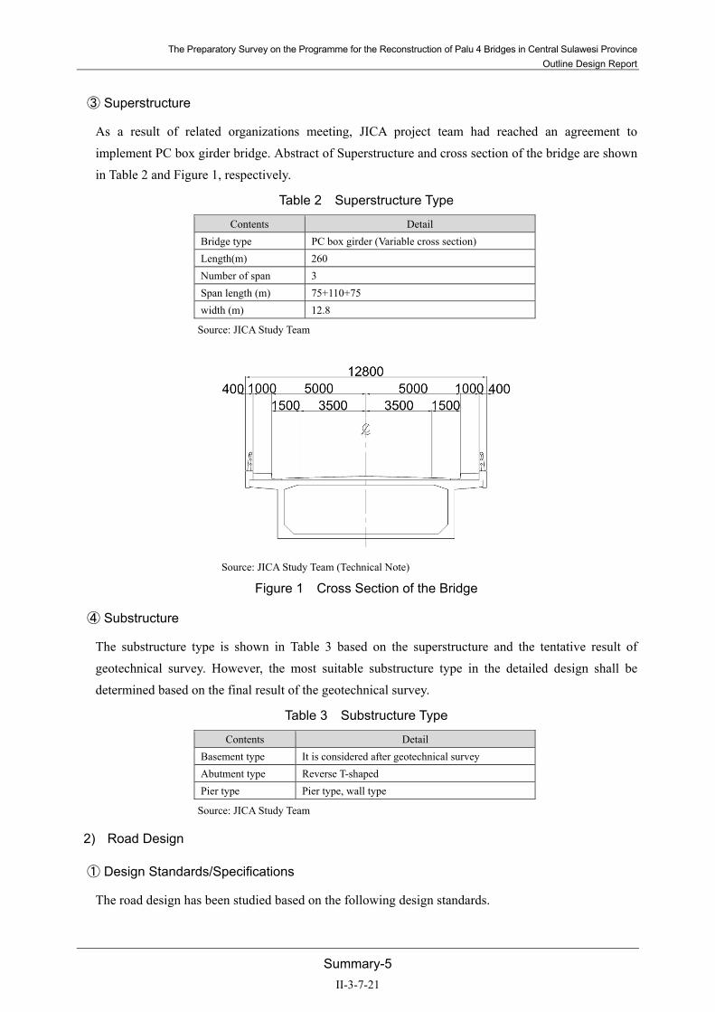
③ Superstructure
As a result of related organizations meeting, JICA project team had reached an agreement to implement PC box girder bridge. Abstract of Superstructure and cross section of the bridge are shown in Table 2 and Figure 1, respectively.
Table 2 Superstructure Type
Contents Detail Bridge type PC box girder (Variable cross section) Length(m) 260 Number of span 3 Span length (m) 75+110+75 width (m) 12.8
Source: JICA Study Team
Source: JICA Study Team (Technical Note)
Figure 1 Cross Section of the Bridge
④ Substructure
The substructure type is shown in Table 3 based on the superstructure and the tentative result of geotechnical survey. However, the most suitable substructure type in the detailed design shall be determined based on the final result of the geotechnical survey.
Table 3 Substructure Type
Contents Detail Basement type It is considered after geotechnical survey Abutment type Reverse T-shaped Pier type Pier type, wall type
Source: JICA Study Team
2) Road Design
① Design Standards/Specifications
The road design has been studied based on the following design standards.
II-3-7-21

The Preparatory Survey on the Programme for the Reconstruction of Palu 4 Bridges in Central Sulawesi Province Outline Design Report
Summary-6
Persyaratan teknis jalan dan kriteria perencanaan teknis jalan:Peraturan Menteri Pekerjaan Umum (Nomor: 19/PRT/M/2011)
SNI T-14-2004 Geometri Jalan Perkotaan:Badan Standardisasi Nasional (BSN)
Geometric Design of Highways and Streets (2018 7th Edition):AASHTO
② Typical Cross Section
The typical cross section shown in Figure 2 of the road has been determined based on the discussion with related authorities.
Source: JICA Study Team (Technical Note)
Figure 2 Typical Cross Section of the Approached Road
3) Procurement Plan
① Construction materials
The PC cable requires to be imported from Japan or other countries, but other materials such as concrete and asphalt are available to be procured locally in Indonesia. The procurement list of the materials is shown in Table 4.
Table 4 Procurement List of the Materials
Material name Domestic Japan Other Summary Steel PC Steel Steel bar (D13~D32)
Steel bar (D36~D50) △ Special request
H-shape steel Cement Asphalt concrete Ready mix concrete Sand Formwork material Steel Formwork material Support work material Hume tube
Source: JICA Study Team
II-3-7-22

The Preparatory Survey on the Programme for the Reconstruction of Palu 4 Bridges in Central Sulawesi Province
Outline Design Report
Summary-7
② Construction machines
Although the general construction machines are available in Indonesia, the pile driving machine for
the large bore requires to be procured from Japan or other countries. The procurement list for the
machines is shown in Table 5.
Table 5 Procurement List of the Machines
Construction machine name Domestic Japan Other Summary
Dump truck
Backhoe
Bulldozer
Truck crane
Asphalt finisher
Tire roller
Vibratory roller
Large breaker
Engine generator
Crawler crane
Pile driving machine (reverse methodφ1,500mm)
Vibro hammer
Source: JICA Study Team
(4) Project Period and Cost
Indonesia government requested early completion of the construction, thus it is necessary to construct
from both shore sides at once in terms of timeframe. The construction period of 20 months is expected,
yet it is to be finalized in the detailed design stage.
The total amount of the cost for the project is 2.5 billion yen has been approved by Japanese cabinet.
Allocation of expenses between Japan and Indonesia are shown in Table 6 and Table 7 based on charge
classification, however this price is not limited to the price of Exchange of Notes (E/N). In addition,
based on uncompleted EIA in this phase, the predicted cost and type shown in Table 7 is tentative.
Table 6 Project Cost (Japanese Obligation)
Confidential
Source: JICA Study Team
II-3-7-23

The Preparatory Survey on the Programme for the Reconstruction of Palu 4 Bridges in Central Sulawesi Province Outline Design Report
Summary-8
Table 7 Item and Cost of Recipient Country
Item to be borne Content Amount to be borne (million yen)
Amount to be borne (IDR) Remarks
Bank fees 2.00 300,000,000 Land acquisition cost 110.00 8,250,000,000 29,400 m2
Facility relocation cost Power pole Electric cable 5.00 750,000,000
Total 117.00 9,300,000,000
*Above items and costs will be determined after completion of environmental survey, thus, their cost will be tentative. Source: JICA Study Team
(5) Evaluation of Project
1) Relevance
① Consistency with Higher Development Plan of Indonesia
Indonesia has formulated and implemented a 5-year development plan based on the national long-term development plan which was formulated in 2004. Third planning phase (2015-2019) is ongoing at present. Sulawesi province where the subject area of survey is conducting development for each province by 5 regional road agencies (hereinafter referred to as “BPJT”). For instance, the Greater Sulawesi Corridor Project which connects between the northern capital city Manado and the southern capital city Makassar has been implemented in Sulawesi province. The Manado-Palu section has already been opened, and the development of the Palu-Makassar section is scheduled to be proceeded.
National roads in the east-west direction in Palu city are maintained, but there is only one national road crossing the Palu River through the city. Therefore, expansion of traffic capacity is required to be addressed urgently. Target of the project is expanding traffic capacity in the east-west direction. Strengthening the traffic volume in the east-west direction in Palu city is consistent with the priority plan of Indonesia to enhance the convenience of intercity transportation.
② Consistency with Japanese Aid Policy
Japanese basic aid policy is to implement high-quality infrastructure development in order to support the economic development in Indonesia. This project is to reconstruct the Palu 4 Bridge, by using Japanese design standard, on the site to replace previous Palu 4 Bridge which collapsed by the earthquake in September 2018. The previous Palu 4 Bridge was undertaking extensive part of traffic capacity in the east-west direction in Palu city, however to secure the traffic capacity in the east-west direction is now an issue due to the absence of the bridge. By reconstructing, it shall cover traffic capacity in the east-west direction as it did before the Palu 4 Bridge collapsed.
Moreover, the development and implementation of seismic standards are insufficiently introduced in Indonesia, thus promoting the seismic design based on the Japanese seismic standard shall provide
II-3-7-24

The Preparatory Survey on the Programme for the Reconstruction of Palu 4 Bridges in Central Sulawesi Province Outline Design Report
Summary-9
high-quality infrastructure development covering entire area of Indonesia. Therefore, the project is consistent with Japanese aid policies.
③ Urgency of the Project
The Palu Third Bridge which located about 800 m south from the Palu 4 Bridge is able to provide only a path east to west direction transport after Palu 4 Bridge collapsed. Similarly, Palu First Bridge which located about 1,600 m to the south from the Palu 4 Bridge is able to connect only west to east direction transport. Only the Palu second bridge which located 4,200m south from Palu 4 Bridge could provide both sides transport. Furthermore, the traffic in the coastal area has been forced to detour to the south area. Therefore securing the traffic in the east-west direction is an urgent issue in these circumstances.
Through this project, traffic will be secured in the east-west direction in Palu city. It is expected that reconstructing Palu 4 Bridge undertakes significant role to enhance the inter-city road network, improve logistics and contribute to economic recovery as a part of the implementation of the Greater Sulawesi Corridor Plan.
④ Japanese Technology Introduction
Both countries, Japan and Indonesia, are commonly located in the plate boundary and active volcanoes exist in densely populated areas. As Japanese infrastructure development and buildings are built based on Japanese seismic standards, yet there are many masonry non-engineered buildings in the rural area in Indonesia. Further implementation of anti-seismic method is recommended to be applied in Indonesia to improve vulnerability to earthquakes. In addition, there are limited number of researchers or experts specialized for earthquakes in Indonesia, and the development and implementation of seismic design standards have not been sufficiently implemented.
Japan is the country where often affected not only earthquakes but also a large number of natural disasters such as typhoons, floods, landslides, etc., Especially Japan is the only country where 20% of higher magnitude over 6.0 occur in the world. With regard to bridges in Japan, it has been taken action such as the review of standards and the installation of the anti-fall bridge structure and equipment since Great Hanshin-Awaji Earthquake in 1995.
Certainly, performing seismic design based on Japanese design standard will lead to the transfer of technology to Indonesia and also it will help in the development of their own future seismic standards in Indonesia.
⑤ Business Benefit Target
The beneficial users of this project (the direct beneficiary population) are presumed to be extensive since this road crosses the Palu River and connect the east and west. Focusing at the area of Palu city, nunber of beneficiary is expected to be appromaxitely 380,000
II-3-7-25

The Preparatory Survey on the Programme for the Reconstruction of Palu 4 Bridges in Central Sulawesi Province Outline Design Report
Summary-10
Table 8 Business Benefit Population
District Population
2016 2017 Palu Barat 61,424 62,293
Tatanga 39,369 39,997 Ulujadi 27,319 27,763
Palu Selatan 69,492 70,571 Palu Timur 70,378 71,452 Mantikulore 62,822 63,804 Palu Utara 22,834 23,196
Tawaeli 20,382 20,706 Total 374,020 379,782
Source: JICA Study Team
2) Effectiveness
Expected effect by this project is shown in Table 9.
It could be solved detour transport to Palu Third Bridge(East-West Direction)and Palu First Bridge (West-East Direction) and possible to both direction transport of itself.
Detour distance can be shortening 1.2 km in west-east direction and 1.8km in east-west direction.
Table 9 Expected Effect on this Project
Index Standard Level (value on 2019)
Target(2024) [After finish project in 3years]
Number of lane - 2 Transport method - Both direction Shorten detour distance *1 (Palu-Donggala-Munif Rahman road)
East-west 6.1km West-east 6.8km
East-west 4.9km (1.2km shorten) West-east 4.9km (1.8km shorten)
*1: Route is expected to pass Palu Third Bridge in east-west direction and Palu First Bridge in west-east direction because Palu 4 Bridge could not pass due to collapse.
Source: JICA Study Team
① Qualitative Effects
Improvement of Life and Safety of Local People By strengthening the road network, accessibility of the area and stable procurement will be improved. In addition to the road convenience, in the event of tsunami and/or natural disasters, evacuation places will be secured. Therefore, implementing this project provides quality life and improves safety of local residents.
Promotion of Regional Economic Activities By solving current traffic restrictions, traffic movements and logistics will be facilitated and boost local activities. As a symbol of regional recovery from the disaster, the reconstruction of the bridge is expected to develop and promote regional by implementing of this project.
II-3-7-26
The Preparatory Survey on the Programme for the Reconstruction of Palu 4 Bridges in Central Sulawesi Province Outline Design Report
Summary-11
Reduction of Traffic Accidents By constructing a two-lane road in accordance with the Indonesian standard, it enables to operate both direction transport and secures safe and stable road management which possibly results reduction of traffic accidents.
Reduction of Maintenance Costs By adopting seismic design by Japanese seismic standards and technology will lead resilience infrastructure development against disasters. It helps to reduce the cost of large-scale repairing works and is expected to enhance cost effectiveness within limited budget.
From above points of view, the project is effective for Indonesia.
II-3-7-27

II-3-7-28

The Preparatory Survey on the Programme for the Reconstruction of Palu 4 Bridges in Central Sulawesi Province Outline Design Report
1-1
Chapter 1 Background of the Project
1-1 Background and Outline of the Project
1-1-1 Background
On September 28, 2018, an earthquake of magnitude 7.5 occurred with the epicentre at the depth of 10 km along the Palu-Coro fault. Serious damage was caused by this earthquake. The shock of the tremors, as well as the tsunami and following soil liquefaction, paralyzed the urban function of four cities including Palu City. In response to the state of disaster in Palu, National Development Planning Agency (hereinafter referred to as BAPPENAS) formulated for the development of the master plan for the restoration of Central Sulawesi. JICA and BAPPENAS agreed to work in cooperation for the restoration of Central Sulawesi through provision of technology from Japan.
Aiming at the reconstruction of affected infrastructures and the realization of disaster-resilient cities, the Project for Development of Regional Disaster Risk Resilience Plan in Central Sulawesi Central Sulawesi was formulated.
Source: JICA Study Team
Figure 1-1-1 Location of Palu Earthquake (Left) and the Project Area (Right)
The earthquake caused the collapse of the Palu 4 Bridge located at the mouth of the Palu River. The Palu 4 Bridge had been popular among local residents as an iconic landmark with its unique form. In addition to traffic function, it had a role as a place for community activities of citizens. The collapse caused by the earthquake emotionally affected to local residents, also it rises urgent issue to re-establish the east-west traffic, which had been carried by the previous Palu 4 Bridge. The reconstruction of the Palu 4 Bridge, which had been serving essential roles for affected local residents and urban function, is an issue that needs to be addressed urgently. It was, therefore, decided to execute the reconstruction of the Palu 4 Bridge as a grant aid project, considering the need for rapid recovery.
Against this background, the Government of Indonesia requested Japan to provide the following grant aid in December 2018.
II-3-7-29

The Preparatory Survey on the Programme for the Reconstruction of Palu 4 Bridges in Central Sulawesi Province Outline Design Report
1-2
Year and month of request: December 2018
Amount requested: 2.5 billion yen
Details of request: Reconstruction of collapsed the Palu 4 Bridge
Source: Kompas.com
Figure 1-1-2 Palu 4 Bridge before Collapse (Left) and after Collapse (Right)
1-1-2 Agreement and Conclusion on the Substance Requested
The project to reconstruct the Palu 4 Bridge, which was destroyed by the earthquake, was agreed upon with the Government of Indonesia to be conducted as the Programme for the Reconstruction of Palu 4 Bridge in Central Sulawesi Province. Based on the description in M/D (Minutes of Discussion) , it has been decided to build a new bridge in the former site of the fallen Palu 4 Bridge. The location of the new bridge has been decided to be upstream of the fallen Palu 4 Bridge, avoiding the places where the landslide occurred. By means of the Technical Note, it has been agreed upon with Bina Marga that the bridge design will be developed based on the Japanese standard described in Specifications for Road Bridges, and the resultant design will be verified by Standar Nasional Indonesia (SNI), the design standard of Indonesia.
1-1-3 Necessity of the Project
The Provinces in Sulawesi have been implementing the Greater Sulawesi Corridor Programme, which is planned to connect the northern capital city Manado to the southern capital city Makassar, in the Third National Development Programme. The segment from Manado to Palu in the project area has been opened to traffic by fiscal year 2016. For the future, the programme is planned to proceed with the opening of the segment from Palu to Makassar.
In Palu City, which is the area subject to the project implementation, the Palu 3 Bridge located approximately 800 m south of the fallen Palu 4 Bridge provides only the traffic from east to west. Similarly, the Palu 1 Bridge located approximately 1,600 m to the south supports only from west to east. The only bridge that can carry two-way traffic is Palu 2 Bridge located approximately 4,200 m to the south. Furthermore, the traffic in the coastal area is forced to detour southwards in the current situation.
II-3-7-30

The Preparatory Survey on the Programme for the Reconstruction of Palu 4 Bridges in Central Sulawesi Province Outline Design Report
1-3
Thus, the reconstruction of the Palu 4 Bridge is an urgent task to be addressed for re-establishing the traffic in the east-west direction.
This project is expected to secure the traffic in the east-west direction in Palu City, to undertake an important role in the implementation of the Greater Sulawesi Corridor Programme by enhancing the inter-city road network, and also to contribute to economic recovery and development through improvement of seamless logistics.
1-2 Site Condition
1-2-1 Meteorological Condition
1-2-1-1 Climate
The climate of the area is classified as Tropical Rainforest (Af) by the Köppen-Geiger climate classification, which is characterized by a significant amount of rainfall throughout the year and a limied variation in annual temperature. However, due to its location surrounded by mountains, the rainfall amount in the downstream of the river (rain-shadow1) is relatively low varying from 60 to 100 mm per month, and the average annual rainfall amount is around 1,000 mm at Parome Station (2003-2017).
Source: Balai Wilayah Sungai –Sulawesi III (BWS-III), Rainfall data from 2002 to 2017
Figure 1-2-1 Monthly Rainfall at the downstream (Parome Station) and upstream (Bangga Atas) of Palu River
Regarding the temperature, the variation throughout the year is little; August is the warmest month with an average of 27.7°C and July is the coldest with temperature averaging 25.7°C.
1 A rain shadow is a dry area on the leeward side of a mountainous area (away from the wind). The mountains block the passage
of rain-producing weather systems and cast a "shadow" of dryness behind them.
80.2766.95
83.7390.53
76.1187.82
100.69
64.56 65.83 61.46 62.1975.17
0
20
40
60
80
100
120
140
160
Mon
tlhy
Rain
fall
(mm
)
Montlhly Rainfall at Parome Station (2003-2017)
53.766.53
83.4594.27
141.08
103.62114.26 111.01
83.12
64.08
124.99
105.91
0
20
40
60
80
100
120
140
160
Mon
tlhy
Rain
fall
(mm
)
Montlhly Rainfall at Bangga Atas (2002-2014)
II-3-7-31

The Preparatory Survey on the Programme for the Reconstruction of Palu 4 Bridges in Central Sulawesi Province Outline Design Report
1-4
Table 1-2-1 Temperature by Month in Palu City
Jan. Feb. Mar. Apr. May June July Aug. Sep. Oct. Nov. Dec.Average monthly temperature (°C) 26.6 26.7 26.9 26.9 27.4 26.6 25.7 26.8 26.7 27.7 27.2 27.0
Minimum Temperature (°C) 22.9 23.0 23.1 23.1 23.8 23.1 22.0 22.8 22.5 23.3 23.1 23.2
Maximum Temperature (°C) 30.3 30.5 30.7 30.8 31.1 30.2 29.4 30.8 30.9 32.1 31.3 30.8
Source: climate-data.org (https://en.climate-data.org/asia/indonesia/central-sulawesi/palu-3638/)
1-2-1-2 Tide
Regarding tidal observation, the river administration office (BWS: Balai Wilayah Sungai of Sulawesi III) has conducted hourly observation during one month through the “Investigation and Design Survey on the Palu River Boundary in Palu City of 2017”.
Source: BWS (2017), “Investigation and Design Survey on the Palu River Boundary in Palu City of 2017”
Figure 1-2-2 Results of tidal observation conducted in May-June 2017
1-2-2 Hydrological Condition
1-2-2-1 Past studies on Palu River Planning and Design
Due to the steep topographic conditions, high amount of rainfall and change of land use such as the conversion of forests into plantation and agricultural lands in the upstream, river flooding and flash floods occurred in the past along Palu River, especially in the upper and middle stream. On the other hand, due to the transport of sediment from the upstream and tributaries, the riverbed of Palu River is rising and the discharge capacity is decreasing.
To tackle these issues, BWS has conducted the two following studies.
Investigation and Design Survey on the Palu River Management of 2010
This study aimed to: 1) Identify the causes of flooding and sedimentation, 2) formulate the principles and concept for flood and sediment control to manage the river, and 3) design countermeasures against flood
Elevation
HHWL Highest High Water Level +2.338m
MHWS Mean High Water Spring +2.316m
MHWL Mean High Water Level +1.766m
MSL Mean Sea Level +1.199m
MLWL Mean Low Water Level +0.676m
MLWS Mean Low Water Spring +0.279m
II-3-7-32

The Preparatory Survey on the Programme for the Reconstruction of Palu 4 Bridges in Central Sulawesi Province Outline Design Report
1-5
and sedimentation. The main activities of this study were the data collection on actual situation of the river system, analysis of the characteristics of Palu River including the evaluation of existing infrastructure and facilities, considerations on short and long-term countermeasure as well as suggestions to minimize conflicts of interest between stakeholders. This study was reviewed through the “Investigation and Design Survey on the Palu River Boundary in Palu City of 2017”.
Investigation and Design Survey on the Palu River Boundary in Palu City of 2017
This study aimed to determine river boundaries and to review the river planning conditions proposed by the “Investigation and Design Survey on the Palu River Management of 2010”.
The design scale flood of this study is 25-years return period flood (Basin average rainfall of 56.558mm/day) and the calculated flood discharge in the downstream is 756.024 m3/s (Figure 1-2-3 and Table 1-2-2).
River widening in the downstream is not planned, and there is not any description on the design levee height.
1-2-2-2 River Planning Conditions at the Palu River mouth
Actually, the JICA Study Team is considering flood countermeasures consisting of river improvement works and basin countermeasures such as implementation of retention basins in the middle-upper stream of Palu River. The target flood is the 2016 floods which intensity is higher than 25 years return period flood.
Regarding the downstream, since it would be difficult to widen the river because of the number of houses and assets to relocate, the design flood discharge of the river is supposed to be set between 800 to 1,000 m3/s, depending on the scale of the retention basin implemented in the middle-upper stream.
As of April 2019, the river planning conditions at the river mouth are as follows.
Figure 1-2-3 Design Flood Discharge
Q25
=598
.111
(m
3 /s)
Q25
=756
.024
(m
3 /s)
Q25
=647
.110
(m
3 /s)
II-3-7-33

The Preparatory Survey on the Programme for the Reconstruction of Palu 4 Bridges in Central Sulawesi Province Outline Design Report
1-6
Table 1-2-2 Outline of River Planning conditions at the Palu River mouth
Description Design Flood Discharge 800 m3/s ~ 1,000 m3/s HWL +2.316m (Mean High Water Spring)
*Calculated river water level(W=1/25): +1.23m, velocity=1.21m/s Design Levee height N/A Riverbed Near the location of Palu 4 Bridge (around 100m from the river mouth)
Design riverbed elevation: -1.91m (The mean riverbed elevation was around -0.98m as of 2017) Riverbed Slope: i=1/900
River Width Actual river boundaries *According to the results of river boundaries delimitation study of 2017, widening of the river in the downstream is not planned.
Note: Factors such as levee height, width will be reviewed and finalized based on the results of the on-going consideration on the tsunami dike and flood countermeasures.
Source: JICA Study Team based on the results of BWS (2017)
1-2-3 Geological Survey
1-2-3-1 Topographical Condition of Palu City
Sulawesi Island, in eastern Indonesia, is a distinctive K – shape island, dominated by four large peninsulas (south peninsula, Minahassa peninsula in the north, east peninsula, and southeast peninsula) separated by three gulfs i.e., Tomini in the northeast, Tolo in the southeast, and Bone in the south. The terrain is mostly mountainous, with many active volcanoes. Mt. Rantemario (3,440m) in the northern part of South Sulawesi is the highest point on the island. All four peninsulas have mountains standing more than 2,500m above Mean Sea Level (MSL). Due to its topography, the island has limited plains which are mostly scattered along coastlines. These plains are separated by precipitous mountains, gulfs, and the sea. Flat lands account only for about 10% of the total land area.
The project lies within Palu city, the capital of the Central Sulawesi province, situated on a long, narrow bay in the Palu depression and the mouth of Palu River, with an elevation of less than 5m above MSL. Because of its sheltered position between mountain ridges, the climate is unusually dry. Sulawesi has two seasons; i.e., the dry season from May to October and the rainy season from November to April. Heavy downpours occur in January and February. In Central Sulawesi’s mountainous region, annual precipitation exceeds 2,500mm. Palu and its other low-lying environs on the other hand, receive less rainfall (less than 1,600mm per annum). Lesser still is the coastal region around Palu city (annual precipitation is only about 600mm) which is one of the driest regions in Sulawesi.
Since the island is located on and near the equator, temperature in the lowlands ranges from 21ºC to 35ºC, and 15ºC to 30ºC in the highlands. The average annual temperature in the lowlands is around 27ºC.
II-3-7-34

The Preparatory Survey on the Programme for the Reconstruction of Palu 4 Bridges in Central Sulawesi Province Outline Design Report
1-7
Source: https://reliefweb.int/
Figure 1-2-4 Topographic map of Palu in Central Sulawesi
1-2-3-2 Geological Condition of Palu City
Sulawesi, Eastern Indonesia lies at the junction of the Eurasian, Indo-Australian and Pacific plates, in a complex region where subduction and collision have been and still are active. The evolution of Neogene kinematics along the Palu-Koro fault has been confirmed based on microtectonics such as, the sinistral strike-slip due to E-W compression, radial extensions caused by the vertical movement of Neogene granitite, and the left lateral with normal component displacement due to the currently active N-S extension/E-W compression.
The Palu depression area is mostly filled by clayey, silty, and sandy alluvial deposits, except on the eastern and western borders which consist of gravelly sands as colluvium wedges. On the western border, the gravel material is granitic fragments mostly of schist, while to the east, the gravel consists of schist, igneous and sedimentary rocks.
Project Area
II-3-7-35

The Preparatory Survey on the Programme for the Reconstruction of Palu 4 Bridges in Central Sulawesi Province Outline Design Report
1-8
Source: https://sp.lyellcollection.org/content/355/1/157/tab-figures-data
Figure 1-2-5 Geological map of Palu in Sulawesi Island
The western escarpment consists of granite and granodiorite units to the north, while the southern part consists of schistphyllitic units. The eastern escarpment consists of molasses - shallow marine sediments and deposits such as shales, sandstones and conglomerates. The project area lies within the Palu depression as shown in Figure 1-2-5.
1-2-3-3 Survey Results
(1) Topographic Survey
Topographic survey was carried out under supervision of JICA Study Team from March 21st to April 4th in 2019, and the result of survey is shown in Figure 1-2-6.
Project Area
Project Area
II-3-7-36

The Preparatory Survey on the Programme for the Reconstruction of Palu 4 Bridges in Central Sulawesi Province Outline Design Report
1-9
(Right bank)
(Left bank)
Source: JICA Study Team Figure 1-2-6 Topographic Survey Results
II-3-7-37

The Preparatory Survey on the Programme for the Reconstruction of Palu 4 Bridges in Central Sulawesi Province Outline Design Report
1-10
(2) Geotechnical Survey
1) Survey position and survey method
Boring surveys and SPT tests were conducted under supervision of JICA Study Team to contribute to the foundation ground design of bridges and approach roads. The location of the survey is shown in Figure 1-2-7, and the survey quantity is shown in Table 1-2-3.
Source: JICA Study Team
Figure 1-2-7 Boring survey position
Table 1-2-3 Outline of Boring survey
No. Bore Hole Total Depth SPT
Co-ordinate in UTM 50 South EGM-08 Remark Easting Northing Elevation
ID# (m) (unit) E (m) N (m) Z (m) 1 GA-01 66.00 65 818,079.45 9,901,987.76 2.42 Left bank 2 GA-02 66.38 58 818,159.73 9,901,981.71 0.97 River-bed 3 GA-03 67.40 59 818,259.57 9,901,974.20 0.57 River-bed 4 GA-04 69.45 69 818,338.72 9,901,968.25 2.72 Right bank 5 GA-05 68.30 59 818,438.36 9,901,960.12 2.52 Right bank side 6 GA-06 65.45 55 818,616.83 9,901,971.53 2.54 Right bank side 7 GA-07 66.40 56 817,959.56 9,901,994.73 2.08 Left bank side
Source: JICA Study Team
Boring investigations were conducted until stable support layer confirmation, and SPT tests were conducted every 1 m except for sampling places with less disturbance.
The survey was conducted 5 on land and 2 on water. The survey status is shown in Figure 1-2-8.
N
PROJECT
LOCATION
GA-07 GA-05GA-01
GA-04
GA-03
GA-02 GA-06
II-3-7-38

The Preparatory Survey on the Programme for the Reconstruction of Palu 4 Bridges in Central Sulawesi Province Outline Design Report
1-11
Boring survey on water (GA-02、GA-03) Boring survey on land (GA-06)
Source: JICA Study Team
Figure 1-2-8 Boring survey
Laboratory soil tests were conducted using boring samples (see Table 1-2-4).
Table 1-2-4 Outline of Laboratory test
Soil Test purpose
Moisture cintent
Verification of physical characteristics
Specific Gravity
Bulk Density
Sieve
atterberg's Limits
Direct Shear
Confirmation of strength characteristics and liquefaction strength
Unconfind Compression Test
Triaxial UU
Triaxial CUB
Consolidation Test
Source: JICA Study Team
The method of conducting the boring survey and the laboratory soil test is shown in Table 1-2-5.
II-3-7-39

The Preparatory Survey on the Programme for the Reconstruction of Palu 4 Bridges in Central Sulawesi Province Outline Design Report
1-12
Table 1-2-5 Implementation criteria for boring surveys and laboratory test
ASTM Ref. TYPE OF INVESTIGATION WORKS GENERAL
D420 Standard guide for investigating and sampling soil and rock EXPLORATORY BORING, CLASSIFICATION, LOGGING AND SAMPLING
D1587 Standard practice for thin-walled tube sampling of soils D2113 Standard practice for diamond core drilling for site investigation D2487 Standard classification of soils for engineering purposes (unified soil classification system) D2488 Standard practice for description and identification of soils (visual-manual procedure) D4220 Standard practice for preserving and transporting soil samples
IN-SITU TESTING D6089 Standard method for groundwater level measurement D1586 Standard test method for penetration test and split-barrel sampling of soils
LABORATORY TESTING D422 Standard test method for particle-size analysis D854 Standard test method for specific gravity of soils
D698 Test method for laboratory compaction characteristics of soil using standard effort (12,400 ft-lbs/ft3 (600 kN-m/m3)
D2166 Standard Test Method for Unconfined Compressive Strength of Cohesive Soil D22l6 Standard test method for laboratory determination of water (moisture) content of soil and rock
D2217 Standard practice for wet preparation of soil samples for particle size analysis and determination of soil constants
D2435 Standard test method for one-dimensional consolidation properties of soils
D2850 Standard test method for unconsolidated un-drained compressive strength of cohesive soils in triaxial compression
D43l8 Standard test method for liquid limit, plastic limit, and plasticity index of soils
D4643 Standard test method for determination of water (moisture) content of soil by the microwave oven method
Source: JICA Study Team
2) Boring survey results
The results of the boring survey are shown in Figure 1-2-9. Soil quality is classified into topsoil, sandy soil and fine grained soil. The results of the SPT test conducted every 1 m were also described.
II-3-7-40

The Preparatory Survey on the Programme for the Reconstruction of Palu 4 Bridges in Central Sulawesi Province Outline Design Report
1-13
Source: JICA Study Team
Figure 1-2-9 Boring outline column chart
The soil composition and stratigraphy of the Palu river mouth are summarized in Table 1-2-6 Figure 1-2-10 is the N value-depth distribution chart of each layer, and Table 1-2-7 is the N value and particle size characteristics for each boring hole.
II-3-7-41

The Preparatory Survey on the Programme for the Reconstruction of Palu 4 Bridges in Central Sulawesi Province Outline Design Report
1-14
Table 1-2-6 Implementation criteria for boring surveys and laboratory test
Source: JICA Study Team
Stratum Overview Columnar
Layer 1: Silty SAND toGravelly SAND
As2
Layer 1 mostly consist grayish brown todark gray Silty SAND to Gravelly SANDand yellowish brown sand withconsistency loose up to very dense. Mostly the SPT value of this layer is 3up to >50, and the thickness of this layeris about 19 meters up to 35 meters.
Layer 2: Silty CLAY toClayey SILT
Ac2
Layer 2 mostly consist dark gray SiltyCLAY to Clayey SILT insertion graySandy GRAVEL, and Clayey SAND toSilty SAND with low to high plasticity andconsistency medium stiff up to hard. Mostly the SPT value of this layer is 8up to >50, and the thickness of this layeris about 21 meters up to 42 meters.
Layer 3: Silty SAND toGravelly SAND
As/Is/Ac
Layer 3 mostly consist gray Silty SANDto Gravelly SAND with consistency verystiff up to dense. Mostly the SPT value of this layer is 15up to >50, and the thickness of this layeris about 1 meters up to 12 meters.
Layer 4: Sandy SILTto Silty CLAY
Ac
Layer 4 mostly consist gray Sandy SILTto Silty CLAY with consistency hard. Mostly the SPT value of this layer is upto >50, and the thickness of this layer isabout 1 meter up to 4.5 meters.
As2
Ac2
As/Is/Ac
Ac
II-3-7-42

The Preparatory Survey on the Programme for the Reconstruction of Palu 4 Bridges in Central Sulawesi Province Outline Design Report
1-15
Layer N-Depth Layer 1: Silty SAND to Gravelly SAND
As2
Layer 2: Silty CLAY to Clayey SILT Ac2
Layer 3: Silty SAND to Gravelly SAND Layer 4: Sandy SILT to Silty CLAY
As/Is/Ac
Source: JICA Study Team
Figure 1-2-10 Stratified N-value depth distribution
II-3-7-43

The Preparatory Survey on the Programme for the Reconstruction of Palu 4 Bridges in Central Sulawesi Province Outline Design Report
1-16
Table 1-2-7 N value and grain size characteristics for each boring Boring N value and grain size characteristics for each soil type
GA-01 Depth 66.00m
GA-02 Depth 66.38m
GA-03 Depth 67.40m
GA-04 Depth 69.45m
GA-05 Depth 68.30m
GA-06 Depth 65.45m
GA-07 Depth 66.40m
Source: JICA Study Team
35 GA-01
N av N med N max N minN
counta
stdAv-
STD/2
Gravelav
Sand
SiltandClayav
As2 35.0 36.5 60.0 11.0 24 12.4 28.76 17.0 76.8 6.2
Ac2 13.1 12.0 25.0 8.0 24 4.2 11.05 0.0 6.7 93.3
As 51.5 53.6 107.1 13.0 11 28.7 37.11 0.2 75.1 24.7
Ac 40.6 40.6 68.2 13.0 2 27.6 26.8
Is 30.7 33.0 46.0 13.0 3 13.6 23.9 0.0 37.5 62.5
31 GA-02
N av N med N max N minN
counta
stdAv-
STD/2
Gravelav
Sand
SiltandClayav
wetdensit
y
As2 30.0 25.0 61.2 16.0 17 12.4 23.8 17.8 69.2 13.0
Ac2 15.3 13.0 32.0 9.0 20 5.8 12.4 0.0 8.4 91.7 1.74
As 72.0 65.2 125.0 22.0 18 29.1 57.4 0.0 81.9 18.1
Ac 20.5 20.5 25.0 16.0 2 4.5 18.3 0.0 10.4 89.6
Is 66.3 66.3 75.0 57.7 3 8.7 62.0 0.0 40.0 60.0 1.94
40 GA-03
N av N med N max N minN
counta
stdAv-
STD/2
Gravelav
Sand
SiltandClayav
wetdensit
y
As2 40.2 43.0 68.2 5.0 25 20.2 30.1 19.0 68.7 12.4
Ac2 13.4 14.0 17.0 7.0 11 2.6 12.1 0.0 14.2 85.8 1.685
As 77.7 65.7 150.0 16.0 16 44.8 55.3 0.8 81.4 17.8
Ac 53.6 35.0 93.8 32.0 3 28.4 39.4 0.0 13.3 86.7
Is 25.5 23.5 34.0 21.0 7 5.0 23.0 0.0 29.2 70.8 1.87
27 GA-4
N av N med N max N minN
counta
stdAv-
STD/2
Gravelav
Sand
SiltandClayav
As2 27.0 27.0 47.0 9.0 17 11.3 21.4 16.0 72.7 11.3
Ac2 14.6 13.0 32.0 9.0 36 4.8 12.2 0.0 7.3 92.7
As 62.4 68.2 115.4 18.0 9 28.9 48.0 0.0 47.5 52.5
Ac 45.3 45.3 53.6 37.0 2 8.3 41.1 0.0 13.1 86.9
Is 26.3 28.0 35.0 16.0 3 7.8 22.4 0.0 24.9 75.1
#N/A GA-5
N av N med N max N minN
counta
stdAv-
STD/2
Gravelav
Sand
SiltandClayav
wetdensit
y
As2 36.6 36.5 71.4 12.0 30 15.9 28.6 22.1 65.5 12.4
Ac2 14.8 13.5 21.0 12.0 6 3.2 13.2 3.5 11.3 85.2 1.74
As 104.1 100.0 187.5 11.0 9 69.2 69.5 6.3 92.9 0.8
Ac 19.0 19.0 19.0 19.0 1 0.0 19.0 0.0 8.1 91.9
Is 43.8 40.5 75.0 18.0 13 17.9 34.8 16.8 37.1 46.1 1.74
#N/A GA-6
N av N med N max N minN
counta
stdAv-
STD/2
Gravelav
Sand
SiltandClayav
wetdensit
y
As2 39.5 38.0 86.7 6.0 29 20.7 29.1 7.2 84.0 8.8
Ac2 20.6 18.0 33.0 12.0 15 6.6 17.3 0.0 6.6 93.4
As 60.6 61.2 88.5 21.0 8 19.5 50.9 0.0 63.7 36.3
Ac 29.0 29.0 29.0 29.0 1 0.0 29.0 0.0 6.6 93.4
Is 58.3 50.0 75.0 50.0 3 11.8 52.4 0.0 48.8 51.2
32 GA-7
N av N med N max N minN
counta
stdAv-
STD/2
Gravelav
Sand
SiltandClayav
wetdensit
y
As2 32.2 33.0 75.0 7.0 28 15.9 24.2 11.1 75.7 13.2
Ac2 14.5 13.0 20.0 10.0 12 3.3 12.9 0.0 6.8 93.2
As 96.9 55.6 300.0 16.0 6 103.4 45.2 48.7 48.5 2.8
Ac 50.4 55.9 75.0 15.0 5 22.1 39.4 0.0 4.6 95.5
Is 71.1 70.5 115.4 37.0 8 24.2 59.0 0.0 25.0 75.0
II-3-7-44

The Preparatory Survey on the Programme for the Reconstruction of Palu 4 Bridges in Central Sulawesi Province Outline Design Report
1-17
Groundwater level; Boring is carried out at the estuary of the Palu River, 50 to 100 m away from the coastline, and the groundwater level is distributed shallower than GL-2 m.
Table 1-2-8 Water level in borehole
No. Borehole ID# Ground Water Level (GL- m) 1 GA-01 0.52 2 GA-02 0.00 ( on river) 3 GA-03 0.00 (on river) 4 GA-04 1.1 5 GA-05 1.5 6 GA-06 0.6 7 GA-07 0.3
Source: JICA Study Team
3) Rough settlement examination of embankment
(a) Examination cross section
The study section was the east side abutment back surface embankment with the largest embankment height and thickness of cohesive soil.
Source: JICA Study Team
Figure 1-2-11 Settlement study section
II-3-7-45

The Preparatory Survey on the Programme for the Reconstruction of Palu 4 Bridges in Central Sulawesi Province Outline Design Report
1-18
(b) Examination model
Clay1 and Clay2 were targeted as main consolidation target layers.
Source: JICA Study Team
Figure 1-2-12 Examination model
(c) Study results
Consolidation settlement amount of Clay○1
The influence values of the vertical effective stress at the position of the depth z in the trapezoidal strip-shaped embankment with the road width and the slope width b is as follows from FIG. a = 26, b = 5 , z = 29 𝑎𝑧 = 0.9, 𝑏𝑧 = 0.2, Ι = 0.3 (Assuming a symmetrical embankment Ι = 0.6)
Thus, the increased vertical effective stress at depth Z is: Δρ = Ι ∙ δ = Ι ∙ Η ∙ γ = 0.6 × 13 × 20 = 156 kN m2⁄
The amount of consolidation settlement in the Δe method is as follows. Ρo = 18 × 19 + 17 × 10 = 512 kN m2⁄ Ρ𝑜 + ΔΡ = 512 + 156 = 668 𝑘𝑁 m2⁄ Δe = 0.05, 𝑒𝑜 = 0.92 𝑆 = Δe1 + e𝑜 Η = 0.051 + 0.92 × 21 = 0.55𝑚
Consolidation settlement amount of Clay ○2
Calculate like Clay1 a = 26, b = 5, z = 47
10m
13
19
21
10
2
B
San
Clay
Clay
San
II-3-7-46

The Preparatory Survey on the Programme for the Reconstruction of Palu 4 Bridges in Central Sulawesi Province Outline Design Report
1-19
𝑎𝑧 = 0.55 𝑏𝑧 = 0.11 Ι = 0.2(Assuming a symmetrical embankment Ι = 0.4)
Δρ = Ι ∙ δ = Ι ∙ Η ∙ γ = 0.4 × 13 × 20 = 104 kN m2⁄ Ρo = 18 × 19 + 17 × 21 + 18 × 2 + 17 × 5 = 820 kN m2⁄ Ρ𝑜 + ΔΡ = 820 + 104 = 924 𝑘𝑁 m2⁄ Δe = 0.03, 𝑒𝑜 = 0.88 𝑆 = Δe1 + e𝑜 Η = 0.031 + 0.88 × 10 = 0.16𝑚
Consolidation settlement amount of Clay1 + Clay2 𝑆 = 0.55 + 0.16 = 0.71𝑚
Consolidation settling time of Clay 1
t= ( ) 𝑇𝑣 = ( ). 0.848 = 18700000𝑚𝑖𝑛 = 12985𝑑𝑎𝑦 = 35𝑦𝑒𝑎𝑟
Tv: Time factor (at 90% consolidation)
From the above, the total settlement amount is about 70 cm and the consolidation period is about 35 years.
II-3-7-47

The Preparatory Survey on the Programme for the Reconstruction of Palu 4 Bridges in Central Sulawesi Province Outline Design Report
1-20
Souce: Japanese Standard
Figure 1-2-13 Vertical stress influence value in ground by trapezoidal band load
II-3-7-48

The Preparatory Survey on the Programme for the Reconstruction of Palu 4 Bridges in Central Sulawesi Province Outline Design Report
1-21
Source: JICA Study Team
Figure 1-2-14 Clay○1 e-logP Curve (Boring GA.02、GL-23-24m)
Clay①
e = 0.87
Ρ5.12 Ρ + ΔΡ6.68
Δe = 0.05e = 0.92
II-3-7-49

The Preparatory Survey on the Programme for the Reconstruction of Palu 4 Bridges in Central Sulawesi Province Outline Design Report
1-22
Source: JICA Study Team
Figure 1-2-15 Clay○2 e-logP Curve (Boring GA.05、GL-42-43m)
Clay②
e = 0.85
Ρ8.2 Ρ + ΔΡ9.2
Δe = 0.03
e = 0.88
II-3-7-50

The Preparatory Survey on the Programme for the Reconstruction of Palu 4 Bridges in Central Sulawesi Province Outline Design Report
1-23
1-3 Environmental and Social Considerations
1-3-1 Environmental and Social Considerations
1-3-1-1 Project Component
The outline of the Grant Project is summarized in Table 1-3-1. It is a reconstruction of original Palu 4 Bridge just upstream side. The length of the bridge is about 260m. The bridge will be connected to existing road Jalan Rajamoili on the right bank and Jalan Cumi Cumi on the left bank. The left bank may apply retaining wall to reduce land acquisition. Detailed design will be conducted in April and May 2019 and address further technical issues.
Table 1-3-1 Summary of the Project
* Road (1 car lane + side walk), both side * Bridge Length about 260 m, Width about 14 m * Embankment + Retaining
wall Length about 250 m, Right bank to be connected to Jalan Rajamoili Left bank to be connected to Jalan Cumi Cumi
* Necessary land area Right bank: about 7,700 m2 (including about 3,000 m2 of existing road) Left bank: about 12,620 m2, Total: about 20,320 m2
* Location Right bank: Besusu Barat village Left bank: Lere village
* Executing Agency (EA) Ministry of Public Works and Housing
Source: JICA Study Team
Source: JICA Study Team
Figure 1-3-1 Outline of the Project as of April 1, 2019
II-3-7-51

The Preparatory Survey on the Programme for the Reconstruction of Palu 4 Bridges in Central Sulawesi Province Outline Design Report
1-24
1-3-1-2 Existing environment and social conditions
(1) Pollution
1) Air Quality, Noise and Odor
In Palu City and Central Sulawesi province, detailed data on air quality, noise and odor cannot be obtained through investigation.
2) Water quality
(a) Surface water
In Central Sulawesi province, detailed data on surface water quality has not been able to be obtained.
In Palu city, regarding surface water quality, monitoring data is shown in tables below.
Palu City performed surface water quality monitoring permukaan on 24 April 2018 based on the thresholds set by the Republic of Indonesia Government Regulation No. 82 of 2001 in three locations, namely:
- River water, Kampung Lere Village, West Palu Subdistrict - Palu River water, Tatanga Village - River water under Bridge I Palu
II-3-7-52

The Preparatory Survey on the Programme for the Reconstruction of Palu 4 Bridges in Central Sulawesi Province Outline Design Report
1-25
Table 1-3-2 River Water Quality Monitoring Results in Palu Rver
No Parameters Unit Standard by Water Class Palu Palu Palu
I II III IV Lere PaluI TatangaPhysical
1 Temperature ºC Deviasi 3 Deviasi 3 Deviasi 3 Deviasi 3 30/27 30/29 30/292 Turbidity NTU - - - - 1.35 78.9 78.93 Dissolved Solid mg/L 1.000 1.000 1.000 2.000 151 135 1354 Suspended Solid mg/L 50 50 400 400 355 372 3725 DHL µS - - - - 109 98 98
Chemical 1 Iron, Fe mg/L 0.3 - - - 0.36 0.10 0.102 BOD mg/L 2 3 6 12 8.45 8.0 8.03 COD mg/L 10 25 50 100 < 25 < 25 < 254 DO mg/L 6 4 3 0 3.25 3.15 3.155 Chloride mg/L - 600 - - 6.5 10.3 10.36 Manganese mg/L 0.1 - - - 0.01 0.24 0.247 Oils and Grease mg/L 1.000 1.000 1.000 - Nihil Nihil Nihil8 Nitrate, NO3-N mg/L 10 10 20 20 0.19 0.24 0.249 Nitrite, NO2-N mg/L 0.06 0.06 0.06 - < 0.003 < 0.003 < 0.00310 pH - 6-9 6-9 6-9 5-9 6.65 5.98 5.9811 Free Ammonium,
NH3-N mg/L 0.5 - - - 0.13 0.11 0.11
12 Zinc, Zn mg/L 0.05 0.05 0.05 2 < 0.01 < 0.01 < 0.0113 Cyanide, CN# mg/L 0.02 0.02 0.02 - < 0.002 0.09 0.0914 Sulfide, H2S mg/L 400 - - - 27.0 17.5 17.515 Mercury, Hg# mg/L 0.03 0.03 0.03 1 < 0.01 < 0.01 < 0.0116 Surfactants, MBAS ug/L 200 200 200 - < 0.01 < 0.01 < 0.0117 Organic Matter mg/L - - - - 3.35 8.25 8.25
Biological 1 E. Coli MPN/100 ml 1000 5000 10000 10000 139 39 392 Coliform MPN/100 ml 100 1000 2000 2000 139 39 39
Source: Environmental Agency of Palu CitySurface water In Palu city, regarding ground water quality, monitoring data is shown in tables below.
II-3-7-53

The Preparatory Survey on the Programme for the Reconstruction of Palu 4 Bridges in Central Sulawesi Province Outline Design Report
1-26
Table 1-3-3 Results of Groundwater Quality Monitoring in Palu City
No Parameters Unit Water Class Lagarutu TPA
I II III IV Road KawatunaPhysical 1 Odor - - - - - No odor No odor2 Taste - - - - - No taste No taste3 Temperature ºC Deviasi 3 Deviasi 3 Deviasi 3 Deviasi 3 28/30 27/294 Colour TCU - - - - < 5 < 55 Turbidity NTU - - - - 0.59 0.816 Dissolved Solid mg/L 1.000 1.000 1.000 2.000 322 4997 Suspended Solid mg/L 50 50 400 400 120 98
Chemical 1 Iron, Fe mg/L 0.3 - - - 0.04 < 0.012 BOD mg/L 2 3 6 12 0.09 0.103 COD mg/L 10 25 50 100 < 0.01 < 0.014 DO mg/L 6 4 3 0 190.50 217,985 Chloride mg/L - 600 - - 4.98 6.516 Manganese mg/L 0.1 - - - < 0.01 < 0.017 Oils and Grease mg/L 1.000 1.000 1.000 - Nihil Nihil8 Nitrate, NO3-N mg/L 10 10 20 20 < 0.01 1.139 Nitrite, NO2-N mg/L 0.06 0.06 0.06 - < 0.003 < 0.003
10 pH - 6-9 6-9 6-9 5-9 6.64 6.7511 Surfactants, MBAS ug/L 200 200 200 - < 0.01 < 0.0112 Organic Matter mg/L - - - - 2.5 1.99Biological 1 E. Coli MPN/100 ml 1000 5000 10000 10000 95 762 Coliform MPN/100 ml 100 1000 2000 2000 95 76
Source: Environmental Agency of Palu City
(2) Natural Environment
1) Meteorology/Weather
In Central Sulawesi Province, regarding data of meteorology/weather, there are four monitoring station. Location of monitoring station is in Banggai Regency, Poso Regency, Tolitoli Regency, and Palu City. Monitoring result in 2017 in each monitoring station is shown table below.
Table 1-3-4 Monitoring result in 2017
Information Stastion
Palu Poso Tolitoli LuwukAnnual Maximum Temperature (ºC) 33.8 32.8 32.0 32.2Annual Minimum Temperature (ºC) 23.5 22.7 22.3 23.9Annul Average Temperature (ºC) 27.5 27.7 27.0 28.0Annual Average Humidity (percent) 79.3 83.6 83.4 77.2Annual Average Atmospheric Pressure (mb) 1,008.2 1,009.3 1,010.2 1,011.1Annual Average Wind Velocity (knot) 4.5 2.3 2.0 3.4Annual Average Precipitation (mm) 71,7 169,6 217,8 134,6Annual Average Duration of Sunshine (percent) 59.0 54.8 57.4 -
Source: Central Sulawesi Province in Figures 2018
II-3-7-54

The Preparatory Survey on the Programme for the Reconstruction of Palu 4 Bridges in Central Sulawesi Province Outline Design Report
1-27
In Palu city, monthly average of temperature and humidity 2017 is shown in table below. Minimum temperature is 21.9 ºC in January and maximum temperature is 33.8 ºC in April and the lowest monthly average temperature is 27.0 ºC in January and the highest monthly average temperature is 28.3 ºC in December. Regarding humidity, the lowest monthly average is 75.5% in April and the highest monthly average is 84.0 % in June.
Table 1-3-5 Monthly Average of temperature and humadity in Palu City 2017
Month Temperature (ºC)
Humidity (%) Minimum Maximum Average
January 21.9 32.3 27.0 79.4 February 23.9 32.7 27.4 78.8 March 23.8 32.9 27.3 78.2 April 24.2 33.8 28.1 75.5 May 24.6 33.5 28.0 80.1 June 23.7 30.9 26.7 84.0 July 23.5 31.7 26.8 82.6
August 23.7 31.8 26.9 82.3 September 23.6 32.8 27.4 80.1
October 24.0 32.9 27.9 78.8 November 24.4 33.1 28.2 77.1 December 24.2 33.2 28.3 74.9
Source: Palu City in Figures 2018
Monthly Average of Air Pressure, Wind Velocity and The Most of Wind Direction in Palu City is shown in table below. Regarding air pressure, July are the highest, 1,012.0 mb and June is the lowest, 978.1 mb. Widow velocity is stable and it’s 4 or 5 knots. The most of wind direction is North or North West.
Table 1-3-6 Monthly Average of Air Pressure, Wind Velocity and The Most of Wind Direction in Palu City, 2017
Month Air Pressure (mb) Wind Velocity (knots) The Most of Wind Direction January 1,010.9 4 North February 1,011.4 5 North March 1,011.5 5 North April 1,010.4 5 NorthWest May 1,011.0 5 NorthWest June 978.1 4 NorthWest July 1,012.0 4 NorthWest August 1,011.3 4 NorthWest September 1,011.5 4 NorthWest October 1,010.4 5 NorthWest November 1,009.3 5 NorthWest December 1,011.1 4 NorthWest
Source: Palu City in Figures 2018
Monthly Average of Rainy Day, Rainfall and Length of Daylight in Palu City Based On Month, 2017 is shown in table below. Regarding number of rainy day, period from June to November is more than
II-3-7-55

The Preparatory Survey on the Programme for the Reconstruction of Palu 4 Bridges in Central Sulawesi Province Outline Design Report
1-28
20 days. Regarding rain fall, June is the highest, 166 mm, and December is the lowest, 25 mm. Regarding length of day light, October is the highest, 67 %, and February is the lowest, 49%.
Table 1-3-7 Monthly Avergae of Rainy Day, Rainfall and Length of Daylight in Palu City 2017
Month The Number of Rain (Day)
Rain fall (mm)
Length of Daylight (%)
January 11 44 61 February 19 52 49 March 22 43 56 April 18 37 62 May 16 72 64 June 22 166 50 July 23 95 58 August 23 121 54 September 24 86 64 October 25 85 67 November 20 36 65 December 14 25 59
Source: Palu City in Figures 2018
2) Topography and geology
Topography and geology around the project area are described in the chapter 1-2-3.
3) Hydrology
In Palu city, detailed data on hydrology has not been able to be obtained through investigation.
4) Land Use
In Central Sulawesi province and Palu City, detailed data on land use has not been able to be obtained through investigation.
5) Flora and Fauna
In Central Sulawesi province including Palu city, Sigi regency anf Donggala regency, regarding data on flora and fauna, endemic species are shown in table below.
II-3-7-56

The Preparatory Survey on the Programme for the Reconstruction of Palu 4 Bridges in Central Sulawesi Province Outline Design Report
1-29
Table 1-3-8 Endemic species of flora in Central Sulawesi
No. Name No. Name Flora
Mammalia Lowland Forest
1 Mussaendopsis beccariana 1 Anoa quarlesi 2 Strychnos axillaris, 2 Anoa depressicornis 3 Celtis sp., 3 Babyrousa babyrusa 4 Pterospermum subpeltatum, 4 Sus celebensis 5 Canangium odoratum, 5 Macaca tonkeana 6 Durio zibenthinus 6 Phalanger ursinus
Low Mountains Forest 7 Phalanger celebensis 7 Castanopsis argentea 8 Tarsius spectrum 8 Lithocarpus spp., 9 Cervus timorensis 9 Dacrydium falcifolia, Aves 10 Phyllocladus hypophyllus, 10 Tanygnatus sumatrana 11 Tristania sp., 11 Loriculus exilis 12 Calophyllum spp., 12 Trichoglossus platurus 13 Garcinia spp., 13 Cacatua sulphurea
High Plateau/Forest 14 Buceros rhinoceros 14 Podcarpus neriifolia 15 Aceros cassidix 15 Podocarpus imbricatus 16 Anhinga rufa 16 Nepthenes sp. 17 Rallus platen
Glass Plant 18 Scolopax celebencis 17 Orthosiphon aristatus, 19 Tyto inexspectata 18 Curcuma longa, 20 Geomalia heinrichi 19 Pangium edule 21 Macrocephalon maleo
Reptile 22 Phyton reticulatus 23 Ophiophagus Hannah 24 Elaphe erythrura
Beaste 25 Papilio blumei 26 Graphium androcles 27 Appies spp
Source: Lore Lindu National Park
6) Protected Area
The Map of Protected Forest and Utilization Forest in Central Sulawesi Province has been drawn up based on the Regulation of Environment and Forestry Ministry Number SK.2383/ Menhut-VI /BRPUK/ 2015. The forest is categorized into five (5) as follows in Indonesia.
Conservation Forest Protected Forest Limited Production Forest Production Forest Conversion Forest
II-3-7-57

The Preparatory Survey on the Programme for the Reconstruction of Palu 4 Bridges in Central Sulawesi Province Outline Design Report
1-30
Source:Map of Protected Forest and Utilization Forest in Central Sulawesi Province 2015
Figure 1-3-2 Forest Map of Central Sulawesi
Palu City has some protected area in the form of coral reef and mangrove that can be seen in Figure 1-3-3, Figure 1-3-4, and Figure 1-3-5. Figure 1-3-5 shows 1.06 ha of mangrove near the Palu 4 Bridge. It is recommended to confirm recent condition after the earthquake.
Source: Map of Coral reef and mangrove in Baiya Subdistrict
Figure 1-3-3 Coral reef and mangrove in Baiya Subdistrict
II-3-7-58

The Preparatory Survey on the Programme for the Reconstruction of Palu 4 Bridges in Central Sulawesi Province Outline Design Report
1-31
Source: Map of Coral reef and mangrove in Pantoloan Boya Subdistrict
Figure 1-3-4 Coral reef and mangrove in Pantoloan Boya Subdistrict
Source: Map of Coral reef and mangrove in West Besusu Subdistrict
Figure 1-3-5 Coral reef and mangrove in West Besusu Subdistrict
In Donggala regecy including Palu Gulf, regarding protected is, map of protected area is shown in figures below.
II-3-7-59

The Preparatory Survey on the Programme for the Reconstruction of Palu 4 Bridges in Central Sulawesi Province Outline Design Report
1-32
Source: Map of Protected Area of Donggala Regency
Figure 1-3-6 Protected Area of Donggala Regency
(3) Social Environment
1) Population
In Central Sulawesi, regarding population, there are 2,966,325 people as of 2017 and population growth rate from 2000 to 2017 is 1.65 %. Population data of 1971 to 2017 including ratio of male and female is shown in table below.
Table 1-3-9 Population in Central Sulawesi
Population Census (years)
Sex Total
(Person)
Population Growth
(%) Male
(Person) Female (Person)
1971 467,166 446,496 913,662 2.83(1961-1971) 1980 655,285 624,350 1,289,635 3.87(1971-1980) 1990 877,039 834,288 1,711,327 2.87(1980-1990) 2000 1,113,212 1,062,781 2,175,993 2.52(1990-2000) 2010 1,350,844 1,284,165 2,635,009 1.95(2000-2010) 2017 1,514,457 1,451,868 2,966,325 1.65(2000-2017)
Source: Central Sulawesi Province in Figures 2018
Break down of population for each regency and city of Central Sulawesi is shown table below. As of 2017, Palu city has the most population, 379,800 people.
II-3-7-60

The Preparatory Survey on the Programme for the Reconstruction of Palu 4 Bridges in Central Sulawesi Province Outline Design Report
1-33
Table 1-3-10 Population and Growth Rate of Population Based on Regency/City in Central Sulawesi Province
Province/City Population (thousand) Growth Rate per Year (%)
2010 2016 2017 2010-2017 2016-2017 Palu City 338.0 374.0 379.8 1.68 1.54 Donggala 278.6 296.4 299.2 1.02 0.94 Sigi 215.8 232.2 234.6 1.20 1.04 Parigi Moutong 415.3 465.9 474.3 1.92 1,82 Banggai 325.1 360.0 365.6 1.69 1.55 Tolitoli 212.1 228.5 231.0 1.23 1.09 Poso 210.2 240.8 246.0 2.27 2.15 Tojo Una-Una 138.3 149.2 150.8 1.20 1.04 Buol 133.0 152.3 155.6 2.26 2.16 Banggai Kepulauan 109.8 116.0 116.8 0.89 0.69 Morowali Utara 104.6 120.3 123.0 2.34 2.21 Morowali 102.7 115.2 117.3 1.92 1.85 Banggai Laut 62.5 70.9 72.3 2.10 1.99
Source: Central Sulawesi Province in Figures 2018
Population characteristics is shown table below.
Table 1-3-11 Population Based on Age Group and Sex in Central Sulawesi Province
Age Group Sex (person)
Male Female Total 0-4 159,585 153,237 312,822 5-9 144,721 136,236 280,957
10-14 142,423 135,127 277,550 15-19 140,886 135,094 275,980 20-24 128,639 124,913 253,552 25-29 125,817 122,396 248,213 30-34 125,904 123,553 249,457 35-39 121,329 116,214 237,543 40-44 107,796 102,176 209,972 45-49 88,8694 83,230 171,924 50-54 70,857 65,886 136,743 55-59 54,973 50,279 105,252 60-64 39,298 36,283 75,581 65+ 63,535 67,244 130,779
Total 1,514,457 1,451,868 2,966,325
Source: Central Sulawesi Province in Figures 2018
In Palu city, regarding population, population and population and population growth is shown in table below. As of 2017, Palu Timur district has the biggest number of people in Palu city, 71,452 people, and Tatangan district is the highest population growth in Palu city, 1.60%.
II-3-7-61

The Preparatory Survey on the Programme for the Reconstruction of Palu 4 Bridges in Central Sulawesi Province Outline Design Report
1-34
Table 1-3-12 Population and Population Growth Rate by Subdistrict in Palu City, 2017
Districts Population Population Growth
(%) 2010 (people) 2016 (people) 2017 (people)Palu Barat 98,739 61,424 62,293 1.41 Tatanga - 39,369 39,997 1.60 Ulujadi - 27,319 27,763 1.63 Palu Selatan 122,752 69,492 70,571 1.55 Palu Timur 75,967 70,378 71,452 1,53 Mantikulore - 62,822 63,804 1,56 Palu Utara 39,074 22,834 23,196 1,59 Tawaeli - 20,382 20,706 1,59
Palu City 336,352 374,020 379,782 1,54
Source: Palu City in Figures 2018
Regarding population and sex ration in each district in Palu city as of 2017 is shown in table below. Excepting Palu Timur District, regarding sex ratio, people of male is more than female in Palu city.
Table 1-3-13 Population and Sex Ratio by Subdistrict in Palu City, 2017
Districts Sex
Sex ratio Male (people) Female (people) Total (people)
Palu Barat 31,194 31,099 61,293 100 Tatanga 20,265 19,732 39,997 103 Ulujadi 13,970 13,793 27,763 101 Palu Selatan 35,583 34,988 70,571 102 Palu Timur 35,409 36,043 71,452 98 Mantikulore 32,332 31,472 63,804 103 Palu Utara 11,608 11,588 23,196 100 Tawaeli 10,519 10,187 20,706 103
Palu City 190,880 188,902 379,782 101
Source: Palu City in Figures 2018
Regarding population for each age group, population by age group and gender in Palu city as of 2017 is shown in table below.
II-3-7-62

The Preparatory Survey on the Programme for the Reconstruction of Palu 4 Bridges in Central Sulawesi Province Outline Design Report
1-35
Table 1-3-14 Population by Age Group and Gender in Palu City, 2017
Age Group Gender (people)
Male Female Total 0-4 17,239 16,657 33,896 5-9 15,277 14,388 29,665
10-14 15,253 14,627 29,880 15-19 20,719 21,718 42,437 20-24 23,655 22,850 46,505 25-29 16,791 15,926 32,717 30-34 15,341 14,784 30,125 35-39 14,049 14,692 28,741 40-44 13,869 14,286 28,155 45-49 12,200 11,835 24,035 50-54 9,679 9,018 18,697 55-59 6,951 6,712 13,663 60-64 4,559 4,544 9,103 65+ 5,298 6,865 12,163
Total 190,880 188,902 379,782
Source: Palu City in Figures 2018
2) Literacy rate
In Central Sulawesi including Palu city, Sigi regency, and Donggala regency, regarding data of literacy rate, data has not been able to be obtained through investigation.
According to World Bank statistics, the adult literacy rate for all of Indonesia in 2016 is 95.377%.
3) Number of Earthquake Victims
In Palu city, regarding number of suffers, number of suffers of earthquake for each district is shown in table below.
Table 1-3-15 Number of Earthquake Victims in Palu City, 2018
Districts Number of Casualties
Victims Dead Lost
Mantikulore 319 255 64 Palu Selatan 581 427 154 Tatanga 110 65 45 Tawaeli 155 149 6 Palu Timur 306 279 27 Palu Utara 69 54 15 Palu Barat 943 780 163 Ulujadi 180 122 58
Total 2,663 2,131 532
Source: Bappeda of Palu City 2018
II-3-7-63

The Preparatory Survey on the Programme for the Reconstruction of Palu 4 Bridges in Central Sulawesi Province Outline Design Report
1-36
4) Indigenous people
In Central Sulawesi province, regarding indigenous people, Isolated Traditional Communities in Central Sulawesi Province 2017 is shown in table below. The ethnic groups in Central Sulawesi are mostly of Kaili tribe. The Kaili tribe is divided to small traditional communities spread in Central Sulawesi Province under different tribe names in each area.
Table 1-3-16 Isolated Traditional Communities in Central Sulawesi Province, 2017
No Regency Name of Tribe Population1 Banggai Kepulauan 1.Sea-sea, 2Bajo 1,155-2 Banggai 1.Loinang (saluam),2. Wana,3Balantak/Masama 5,858-3 Morowali 1.Wana(Taa) 1,19604 Poso 1.Wana 4705 Donggala 1.Tolare/Da’a, 2.Kori Rai, 3,Unde,5.Tajio, 6.Pendau, 7.Ado,8.Tado,
9.Uma, 10.Tara, 11.Ledo, 12.Lauje, 13.Kaili 5,795
6 Tolitoli 1.Lauje, 2.Pandau, 3.Dondo, 4.Pandau and Dondo, 5.Lanje, 6.Hanje,7.Bajo
17,810
7 Parigi Moutong 1.Lauje, 2.Tara, 3.Pendau 11,8858 Tojo Una-Una 1.Wana 5,7859 Sigi 1.Da’a 14,790
10 Banggai Laut 1.Banggai, 2.Banggai Bajo 4,86011 Morowali Utara 5,160
Source: Central Sulawesi Province in Figures 2018
In Palu city, regarding indigenous people, following information has been obtained through investigation.
The ethnic group in Palu City is of Kaili tribe. Each village in Palu City has a customary institution, therefore there are 46 customary institutions spread in Palu City, as many as the number of villages in the city. All members of the customary institutions are traditional societies.
Traditional societies can be categorized into three elements, i.e. traditional leaders, customary stakeholders, and customary perpetrators:
Traditional Leaders (Tokoh Adat) are also known as Indigenous Elders (Tetua Adat), or people considered to be the elders among those in the customary institutions, however not all customary institution has a traditional leader. The number of traditional leaders in Palu City would be different from one institution to another, with a maximum of five traditional leaders in one institution.
Customary Perpetrators (Pelaku Adat) are those who are known to be able to perform Traditional Rituals. The number of customary stakeholders in each customary institution would be different. Some data acquired revealed the following numbers: Balaroa 33 people, Duyu 17 people, Donggala koin 31 people, Kabonena 15 people, Silae 14 people, Tipo 23 people, Buluri 9 people, Watusampu 27 people.
II-3-7-64

The Preparatory Survey on the Programme for the Reconstruction of Palu 4 Bridges in Central Sulawesi Province Outline Design Report
1-37
Palu City Customary Stakeholders include everyone involved in a customary institution. Each customary institution would have 13 customary stakeholders. With 46 villages in Palu City, there are a total of 598 customary stakeholders (13 people x 46 villages) in Palu City.
In Sigi regency and Donggla regency, regarding indigenous people, data has not been able to be obtained through investigation.
5) Livelihood and local economy
In Central Sulawesi province, regarding livelihood and local economy, number of people for each work field is shown in table below.
The ratio of the number of employees in agriculture, forestry and fisheries is the largest. Next, there are a large number of employees in commerce, restaurants and hotels. Also, although the gender ratio of workers varies greatly depending on the field, the total number of workers is almost the same for both men and women.
Table 1-3-17 The Number of People Aged Over 15 Who Work in a Week by The Main Work Field and Gender in Central Sulawesi Province in 2017
Main Work Field Gender
Male Female Total Agriculture, Forestry, Hunting, and Fisheries 444,092 164,654 608,746 Mining and Quarrying 26,071 4,420 30,491 Manufacturing Industry 50,233 36,763 86,986 Municipal electricity, gas and water 2,424 559 2,983 Constructions 82,334 1,184 83,518 Retail, Restaurants, and Hotels 83,491 134,511 218,002 Transportation, warehousing and communication 43,393 1,520 44,913 Finance, Insurance, Real Estate, and Business Services 14,273 6,632 20,905 Personal and social services 139,771 137,899 277,670
Source: Central Sulawesi Province in Figures 2018
6) School and Education
The final educational background in Central Sulawesi as of 2017 is shown in Table 1-3-18. Regarding the final educational background, the senior high school graduates are the most in Palu City but the elementary school graduates are the most in other cities.
II-3-7-65

The Preparatory Survey on the Programme for the Reconstruction of Palu 4 Bridges in Central Sulawesi Province Outline Design Report
1-38
Table 1-3-18 Educational Background in Central Sulawesi 2017
Regency/City
Education (%) Not
Completed Elementary
School
Elementary School
Junior High
School
Senior High
School
Vocational Senior High
School
Diploma I/II
Academy/ Diploma
III
Bachelor/ Diploma
IV
Palu City 10.79 19.86 17.20 30.50 6.16 1.31 2.56 11.62Sigi 16.19 37.32 17.09 19.15 3.15 0.26 0.88 5.96Donggala 20.72 40.88 16.26 15.41 2.30 0.48 0.42 3.53Parigi Moutong 25.05 38.76 18.64 12.87 1.75 0.05 0.51 2.37Tojo Una-Una 23.41 36.04 16.15 15.31 3.29 0.58 1.23 3.99Tolitoli 19.27 34.69 18.26 14.74 3.88 0.53 1.08 7.55Buol 18.47 35.39 19.11 15.51 3.27 0.91 1.71 5.63Banggai Kepulauan
17.93 38.91 16.68 16.84 2.61 0.45 0.84 5.74
Morowali 16.65 31.22 18.65 19.99 2.12 0.45 2.46 8.46Banggai 16.13 39.19 18.08 16.49 3.57 0.76 1.14 4.64Morowali Utara 14.88 26.89 17.34 19.95 3.65 0.85 1.05 5.39Poso 14.18 34.79 19.21 19.83 3.61 0.75 1.14 6.49Banggai Laut 13.64 40.96 18.71 16.10 1.65 0.42 1.57 6.95
Source: Central Sulawesi Province in Figures 2018
In Palu city, Sigi regency, and Donggala regency, regarding school, number of school has been identified as follows. Each city and regency, there are Elementary school, Junior high school, Senior high school, and Vocational senior high school.
Table 1-3-19 Number of schools in Palu city, Sigi regency, and Donggala regency
No. School Number
Palu Sigi Donggala 1 Kindergarten 149 216 N.A. 2 Elementary school 168 272 353 3 Junior high school 47 93 95 4 Senior high school 26 32 19 5 Vocational senior high school 27 12 13
Source: JICA Study Team
7) Cultural Heritage
In Central Sulawesi province including Palu city, Sigi regency and Donggala regency, there are cultural heritage such as Caves, Megalithic Sites, The Tomb of The King, Mosques and Churches, Traditional Houses, and The Castle of The King. Detailed data is under investigation.
8) Waste and waste management
In Palu city, in 2017, the volume of waste reached 279,574 m3. To manage the vast number of waste, Palu City owns a waste management with 64 waste containers, 8 units of waste processing plants with reduce, reuse recycle waste hierarchy (TPS3R), and Kawatuna final waste deposit area (TPA).
II-3-7-66
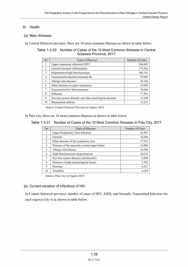
The Preparatory Survey on the Programme for the Reconstruction of Palu 4 Bridges in Central Sulawesi Province Outline Design Report
1-39
9) Health
(a) Main illnesses
In Central Sulawesi province, there are 10 most common illnesses as shown in table below.
Table 1-3-20 Number of Cases of the 10 Most Common Illnesses in Central Sulawesi Province, 2017
No Types of Illnesses Number of Cases 1 Upper respiratory infection/URTI 244,805 2 Gastritis/stomach inflammation 173,026 3 Hypertension/high blood pressure 109,765 4 Gastrointeritis/diarrhea/stomach flu 39,896 5 Allergic skin diseases 39,320 6 Other diseases on upper respiratory 19,089 7 Hypotension/low blood pressure 18,646 8 Influenza 17,361 9 Nervous system disorder and other neurological diseases 13,180 10 Rheumatoid arthritis 12,235
Source: Central Sulawesi Province in Figures 2018
In Palu city, there are 10 most common illnesses as shown in table below.
Table 1-3-21 Number of Cases of the 10 Most Common Illnesses in Palu City, 2017 No Types of Illnesses Number of Cases 1 Upper Respiratory Tract Infection 43,507 2 Gastritis 18,206 3 Other diseases of the respiratory tract 17,953 4 Diseases of the muscular system/organ binder 14,986 5 Allergic skin disease 10,540 6 High blood pressure (hypertension) 10,253 7 Nervous system diseases and disorders 9,408 8 Diseases of pulp and periapical tissues 7,382 9 Diarrhea 6,451 10 Tonsillitis 6,204
Source: Palu City in Figures 2018
(b) Current situation of infectious of HIV
In Central Sulawesi province, number of cases of HIV, AIDS, and Sexually Transmitted Infection for each regency/city is as shown in table below.
II-3-7-67

The Preparatory Survey on the Programme for the Reconstruction of Palu 4 Bridges in Central Sulawesi Province Outline Design Report
1-40
Table 1-3-22 Number of Cases of HIV, AIDS, and Sexually Transmitted Infection by Regency/City in Central Sulawesi Province, 2017
Regency/City Number
HIV AIDS Sexually Transmitted Infection Palu City 121 18 61 Sigi 25 3 1 Donggala 9 3 4 Banggai Kepulauan - - - Banggai 37 26 - Morowali 8 - - Poso 23 21 125 Tolitoli 7 - 6 Buol 7 - 12 Parigi Moutong 7 13 66 Tojo Una-Una 9 2 - Banggai Laut 2 2 1 Morowali Utara 5 5 -
Total 266 93 276
Source: Central Sulawasi Province in Figure 2018
(c) Number of hospitals
In Central Sulawesi province, there are 32 hospitals. Undata Regional Public Hospital Palu and Madani Regional Public Hospital Palu are owned by Central Sulawesi province. Number of hospital and health facilities for each regency and city in Central Sulawesi is as shown in table below.
Table 1-3-23 Number of Health Facilities by Regency/City in Central Sulawesi Province, 2017
Regency/City Hospital Maternity Hospital Public Health Center Child Health Center Banggai Kepulauan 1 - 13 173 Banggai 2 - 26 388 Morowali 1 - 9 153 Poso 2 - 21 280 Donggala 2 - 15 442 Tolitoli 1 - 14 260 Buol 1 - 11 160 Parigi Moutong 3 1 23 452 Tojo Una-Una 2 - 13 196 Sigi 1 - 19 363 Banggai Laut 1 - 5 89 Morowali Utara 1 - 12 167 Palu City 14 4 13 223
Total 32 93 194 3,346
Source: Central Sulawesi Province in Figures 2018
In Palu city, there are 9 hospitals. Number of hospital and health facilities for each district in Palu City is shown in table below.
II-3-7-68
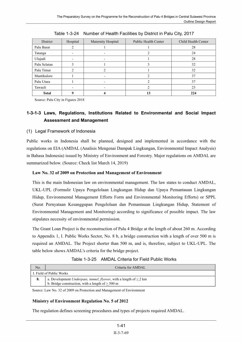
The Preparatory Survey on the Programme for the Reconstruction of Palu 4 Bridges in Central Sulawesi Province Outline Design Report
1-41
Table 1-3-24 Number of Health Facilities by District in Palu City, 2017
District Hospital Maternity Hospital Public Health Center Child Health Center Palu Barat 2 1 1 28 Tatanga - - 2 24 Ulujadi - - 1 28 Palu Selatan 3 1 3 32 Palu Timur 2 2 1 32 Mantikulore 1 - 2 37 Palu Utara 1 - 2 37 Tawaeli - - 2 23
Total 9 4 13 224
Source: Palu City in Figures 2018
1-3-1-3 Laws, Regulations, Institutions Related to Environmental and Social Impact Assessment and Management
(1) Legal Framework of Indonesia
Public works in Indonesia shall be planned, designed and implemented in accordance with the regulations on EIA (AMDAL (Analisis Mengenai Dampak Lingkungan, Environmental Impact Analysis) in Bahasa Indonesia) issued by Ministry of Environment and Forestry. Major regulations on AMDAL are summarized below. (Source: Check list March 14, 2019)
Law No. 32 of 2009 on Protection and Management of Environment
This is the main Indonesian law on environmental management. The law states to conduct AMDAL, UKL-UPL (Formulir Upaya Pengelolaan Lingkungan Hidup dan Upaya Pemantauan Lingkungan Hidup, Environmental Management Efforts Form and Environmental Monitoring Efforts) or SPPL (Surat Pernyataan Kesanggupan Pengelolaan dan Pemantauan Lingkungan Hidup, Statement of Environmental Management and Monitoring) according to significance of possible impact. The law stipulates necessity of environmental permission.
The Grant Loan Project is the reconstruction of Palu 4 Bridge at the length of about 260 m. According to Appendix 1, I. Public Works Sector, No. 8 b, a bridge construction with a length of over 500 m is required an AMDAL. The Project shorter than 500 m, and is, therefore, subject to UKL-UPL. The table below shows AMDAL's criteria for the bridge project.
Table 1-3-25 AMDAL Criteria for Field Public Works
No. Criteria for AMDAL I. Field of Public Works
8. a. Development Underpass, tunnel, flyover, with a length of > 2 km b. Bridge construction, with a length of > 500 m
Source: Law No. 32 of 2009 on Protection and Management of Environment
Ministry of Environment Regulation No. 5 of 2012
The regulation defines screening procedures and types of projects required AMDAL.
II-3-7-69

The Preparatory Survey on the Programme for the Reconstruction of Palu 4 Bridges in Central Sulawesi Province Outline Design Report
1-42
Ministry of Environment Regulation No. 8 of 2013
The regulation defines contents to be included in ANDAL, UKL-UPL and SPPL.
(2) Institutional Responsibility
1) In the Planning Stage
As this project is a project of Palu City Road, Palu City Environment Department will be the examination organization.
Implementing Agency (IA) prepares UKL-UPL report, and the Environment Department of Pal city examines and issues Environmental Clearance.
2) In the Construction Stage
IA will conduct the EMP and EMOP described in UKL-UPL. Monitoring results will be reported from IA to Indonesian government and JICA.
3) In the Operation Stage
Same as in the construction phase, IA will conduct EMP and EMOP described in UKL-UPL. Monitoring results will be reported from IA to Indonesian government and JICA.
(3) Review Steps of UPL-UKL
Table 1-3-26 explains the review steps of UPL-UKL for the Grant Project. The review process of UKL-UPL will require minimum 14 working days according to MOE Regulation No. 08/2013. According to the interview with Palu City Environment Division on March 18, 2019, the UPL-UKL of the reconstruction of Palu 4 Bridge will be reviewed by Palu City.
Coordination with IA (expected to be Provincial Balai Bina Marga at Palu) and Palu City UKL-UPL Secretariat about how and when to incorporate the above steps with the JICA-required 2 public consultations as well as the submission of IEE report to JICA.
Table 1-3-26 Review Steps of UPL-UKL
Steps Action 1 The Implementation Agency (IA, expected to be Provincial Balai Bina Marga at Palu) will prepare UKL-UPL and
submit the report to the Palu City UKL-UPL Secretariat. 2 The Palu City UKL-UPL Secretariat will check if the format of the report is according to the requirement. 3 When confirmed, Palu City Mayor will publish that the City received the report. 4 The Palu City UKL-UPL Secretariat will conduct technical review of the contents of the report within 14 working
days after the publish by the Mayor. 5 When it is found that the report passes the technical review, the Mayor will issue the Environmental Clearance (EC). 6 The Mayor will publish a notice on the review results of the UKL-UPL. The report and the review results will be
made available for public review.
Source: IGES, 2018
II-3-7-70

The Preparatory Survey on the Programme for the Reconstruction of Palu 4 Bridges in Central Sulawesi Province Outline Design Report
1-43
Figure 1-3-7 UPL-UKL Examination Procedure Flow
(4) JICA Guidelines
According to “JICA Guidelines for Environmental and Social Considerations 2010” (JICA Guidelines 2010), projects are categorized mainly depending upon the significance of the negative impacts. (Table 1-3-27) Appendix 3 of JICA Guidelines 2010 lists projects in the sector of road and bridge as ‘the sector that may cause significant negative impacts.’
The ESMF (Environmental and Social Framework) for the Project states that no sub-project under the Project shall be categorized as A.
Considering that the Project will cause no relocation of residents, and the Project is basically the reconstruction of the original Palu 4 Bridge, the Project can be categorized as B.
II-3-7-71

The Preparatory Survey on the Programme for the Reconstruction of Palu 4 Bridges in Central Sulawesi Province Outline Design Report
1-44
Table 1-3-27 Categorization Criteria of JICA Guideline Category Categorization Criteria
Category A
● Proposed projects are classified as Category A if they are likely to have significant adverse impacts on the environment and society.
● Projects with complicated or unprecedented impacts that are difficult to assess, or projects with a wide range of impacts or irreversible impacts, are also classified as Category A.
● These impacts may affect an area broader than the sites or facilities subject to physical construction. ● Category A, in principle, includes projects in sensitive sectors, projects that have characteristics that are
liable to cause adverse environmental impacts, and projects located in or near sensitive areas.
Category B
● The project may have adverse impacts on the environment or society, but these impacts are less significant than those of Category A projects.
● These impacts are site-specific; few, if any, of them are irreversible; in most cases, they can be mitigated more readily than Category A projects.
● Responsibilities of the project proponents include the planning and monitoring of necessary Environmental and Social Consideration (ESC) activities.
● ESC procedures such as Strategic Environmental Assessment for Master Plan projects and stakeholder participation may be required, depending on the scale and nature of the adverse impacts.
Source: JICA Guideline 2010
(5) GAP Analysis
Table 1-3-28 summarizes the key differences between the JICA Guidelines and Indonesian Law No. 32 of 2009 and related Ministry Regulations. The policies of the Project to bridge the gaps is also explained in Table 1-3-28.
Table 1-3-28 GAP Analysis
Target JICA Guideline Law No. 32 of 2009
Ministry Reg. No. 5 of 2012 Ministry Reg. No. 8 of 2013
Gaps Between JICA Guidelines and Indonesian Laws, Bridging
Measures Underlying Principles
● Environmental impacts that may be caused by projects must be assessed and examined in the earliest possible planning stage.
● Public works in Indonesia shall be planned, designed and implemented in accordance with the regulations on EIA issued by Ministry of Environment and Forestry.
● No gap. ● The Project will be subject to
UKL-UPL review process.
● Alternatives or mitigation measures to avoid or minimize adverse impacts must be examined and incorporated into the project plan. JICA Guidelines Appendix 1, 1.1
● Mitigation measures to avoid or minimize adverse impacts must be proposed by the Implementing Agency in both AMDAL and UKL-UPL, and incorporated into the Project Plan.
● Alternative study is not required, but the conformity of the Project with the official Spatial Plan must be explained.
● Alternative study is not required.
● JICA Mission Team will incorporate alternative plans of the Project that were studied during the preparatory design stage, and the reasons of selection of preferred plan in the Report.
Information dissemination
● EIA reports (which may be referred to differently in different systems) must be written in the official language or in a language widely used in the country in which the project is to be implemented.
● AMDAL and UKL-UPL will be written in Bahasa Indonesia.
● No gap. ● The same contents will be
provided in English for JICA review.
II-3-7-72

The Preparatory Survey on the Programme for the Reconstruction of Palu 4 Bridges in Central Sulawesi Province Outline Design Report
1-45
Target JICA Guideline Law No. 32 of 2009
Ministry Reg. No. 5 of 2012 Ministry Reg. No. 8 of 2013
Gaps Between JICA Guidelines and Indonesian Laws, Bridging
Measures ● When explaining projects to
local residents, written materials must be provided in a language and form understandable to them;
● When explaining projects to local residents, written materials will be provided in Bahasa Indonesia.
● No gap. ● Further discussion with IA
and Palu City is desirable for the Project to check if materials in local Kaili language must be considered.
● EIA reports are required to be made available to the local residents of the country in which the project is to be implemented. The EIA reports are required to be available at all times for perusal by project stakeholders such as local residents and copying must be permitted; Appendix 2 Forewords
● AMDAL-related documents are available for public throughout the review process, starting from the first step (announcement of the project by the project owner) to the final step (announcement of issuing the environmental clearance).
● UKL-UPL-related documents are available for public at two stages; the first after the official receive of UKL-UPL by the reviewing agency, and the second after the announcement of issuing the environmental clearance
● No gap ● UKL-UPL will be made
available to the local residents.
Social Acceptability
● For projects with a potentially large environmental impact, sufficient consultations with local stakeholders, such as local residents, must be conducted via disclosure of information at an early stage, at which time alternatives for project plans may be examined.
● The outcome of such consultations must be incorporated into the contents of project plans. Appendix 1, 5.1
● In preparing EIA reports, consultations with stakeholders, such as local residents, must take place after sufficient information has been disclosed. Records of such consultations must be prepared;
● Consultations with relevant stakeholders, such as local residents, should take place if necessary throughout the preparation and implementation stages of a project.
● Holding consultations is highly desirable, especially when the items to be considered in the EIA are being selected, and when the draft report is being prepared. Appendix 2 Forewords
● In the project subject to AMDAL process, the project owner must hold a public consultation before the submission of draft TOR of AMDAL to the reviewing agency. Besides the public consultation, general public may submit opinions during 10 working days after the announcement of the project by the project owner.
● After receiving the draft AMDAL from the project owner, the reviewing agency invites public opinion for 10 working days. AMDAL technical secretary will instruct the project owner for revision when necessary.
● AMDAL committee will hold public hearing during the review process.
● For the project subject to UKL-UPL, which is considered to cause smaller environmental impact, no public consultation is mandated.
● For the project subject to UKL-UPL, no public consultation is mandated.
● At least two public consultations (called socialization in local system) will be held for the Project, one at early stage of the IEE study, and one after the environmental assessment is drafted.
II-3-7-73

The Preparatory Survey on the Programme for the Reconstruction of Palu 4 Bridges in Central Sulawesi Province Outline Design Report
1-46
Target JICA Guideline Law No. 32 of 2009
Ministry Reg. No. 5 of 2012 Ministry Reg. No. 8 of 2013
Gaps Between JICA Guidelines and Indonesian Laws, Bridging
Measures Scope of Impacts to Be Assessed
● The impacts to be assessed with regard to environmental and social considerations include impacts on human health and safety, as well as on the natural environment, that are transmitted through air, water, soil, waste, accidents, water usage, climate change, ecosystems, fauna and flora, including trans-boundary or global scale impacts.
● These also include social impacts, including migration of population and involuntary resettlement, local economy such as employment and livelihood, utilization of land and local resources, social institutions such as social capital and local decision-making institutions, existing social infrastructures and services, vulnerable social groups such as poor and indigenous peoples, equality of benefits and losses and equality in the development process, gender, children’s rights, cultural heritage, local conflicts of interest, infectious diseases such as HIV/AIDS, and working conditions including occupational safety. Appendix 1, 3.1
● The impacts to be assessed in AMDAL and UKL-UPL include impacts on pollution, natural environment, and social and economic environment.
● The impacts to be assessed, however, are selected from the project activities. No such standard check list of environmental items is available.
● No standard check list of environmental items is available.
● In the impact scoping stage of the Project, the standard list of impacts will be referred to identify potential impacts.
● In addition to the direct and immediate impacts of projects, their derivative, secondary, and cumulative impacts as well as the impacts of projects that are indivisible from the project are also to be examined and assessed to a reasonable extent. It is also desirable that the impacts that can occur at any time throughout the project cycle should be considered throughout the life cycle of the project. Appendix 1. 3.2
● No clear requirement of examination and assessment of derivative, secondary, and cumulative impacts as well as the impacts of projects that are indivisible from the project.
● Derivative, secondary, and cumulative impacts as well as the impacts of projects that are indivisible from the Project will be examined and assessed to a reasonable extent.
● The impacts that can occur throughout the life cycle of the Project will also be examined and assessed to a reasonable extent.
II-3-7-74

The Preparatory Survey on the Programme for the Reconstruction of Palu 4 Bridges in Central Sulawesi Province Outline Design Report
1-47
Target JICA Guideline Law No. 32 of 2009
Ministry Reg. No. 5 of 2012 Ministry Reg. No. 8 of 2013
Gaps Between JICA Guidelines and Indonesian Laws, Bridging
Measures Monitoring and resolving problems
● Project proponents etc. should make efforts to make the results of the monitoring process available to local project stakeholders. Appendix 1, 8.3
● When third parties point out, in concrete terms, that environmental and social considerations are not being fully undertaken, forums for discussion and examination of countermeasures are established based on sufficient information disclosure, including stakeholders’ participation in relevant projects. Project proponents etc. should make efforts to reach an agreement on procedures to be adopted with a view to resolving problems. Appendix 1, 8.4.
● In Construction Stage, EMP and EMOP prepared as a part of AMDAL or UKL-UPL will be implemented, and periodic monitoring will be conducted. Monitoring result will be report to the concerned authorities in Indonesia and JICA, according to the reporting method to be stipulated in AMDAL or UKL-UPL.
● Unforeseen environmental problems and issues raised by surrounding communities or others during the construction stage can be handled by the grievance redress mechanism to be established according to ESMF.
● In Operation Stage, monitoring and reporting will be implemented in accordance with EMOP and grievance will be handled in the grievance redress mechanism to be established.
● No gap ● Environmental Management
Plan and Monitoring Plan for the Project will be reviewed and approved by Palu City. The Plans will be made available to general public.
● The IA will be responsible to implement, monitor and report the EMP and EMOP throughout the Construction and Operation Stage.
Ecosystem and Biota
● Projects must not involve significant conversion or significant degradation of critical natural habitats and critical forests. Appendix 1. 6.1.
● No specific description on the limitation of project impacts.
● In the draft Environmental and Social Management Framework (ESMF), it is declared that to be financed, the sub-projects will need to be Category B or C under the JICA Guidelines 2010.
● No gap. Indigenous Peoples
● Any adverse impacts that a project may have on indigenous peoples are to be avoided when feasible by exploring all viable alternatives. When, after such an examination, avoidance is proved unfeasible, effective measures must be taken to minimize impacts and to compensate indigenous peoples for their losses. Appendix 1, 8.1.
● No specific description on the limitation of project impacts.
● In the draft Environmental and Social Management Framework (ESMF), it is declared that to be financed, the sub-projects will need to be Category B or C under the JICA Guidelines 2010.
● Projects to be called Category B or C will not affect Sensitive Areas nationally-designated protected areas (areas for ethnic minorities or indigenous peoples designated by national governments) nor areas inhabited by ethnic minorities, indigenous peoples, or nomadic peoples with traditional ways of life, and other areas with special social value.
● No gap.
Source: JICA Study Team
II-3-7-75

The Preparatory Survey on the Programme for the Reconstruction of Palu 4 Bridges in Central Sulawesi Province Outline Design Report
1-48
1-3-1-4 Project Alternatives
In the initial phase of the Study, various projects were proposed for the grant project by Indonesia side and JICA side, including projects such as a new Palu 4 Bridge down stream of Palu I bridge, improvement of damaged existing bridges, and reconstructioning Palu 4 Bridge as a foot bridge.
After detailed discussion between both sides, both in Jakarta and Palu, the Reconstruction of Palu 4 Bridge for car and foot traffic were selected in 18 February 2019.
Then, four alternatives of the Project were developed as shown in the following table. Open discussion on-site with Mr. Arie (Chief of Task Force, PU), Chief of BPN of Palu City, and JICA Study Team on March 26, 2019, Alternative 1 was recommended mainly because of the least impact on standing structures (Table 1-3-29).
Further technical alternatives are studied in the outline design phase that continues till the end of April. After the outline design is agreed with all stakeholders, detailed design activity will take place between May and July 2019.
Table 1-3-29 Project Alternatives and Comparative Evaluation
Alternatives No Project Alternative -1 Alternative -2 Alternative -3
Outline Collapsed Palu 4 bridge will not be reconstruction.
The route of right bank side avoids the housing area.
The approach road except for access road of right bank side avoids the land slide area.
The route is planned along the ZRB according to the spatial planning.
Bridge Length * - approx. 260m approx. 260m approx. 260m Approach Road Length * 0m approx. 170m (Both
sides) approx. 170m (Both sides)
approx. 170m (Both sides)
Access Road Length*
Left bank 0m approx. 170m approx. 170m approx. 220m
Right bank 0m approx. 140m approx. 300m approx. 320m
Impact to housing * nil ( 0 ) nil ( 0 ) 3 housings 3 housings, 1 big facility
Existing (remaining) bridge portion No influence No influence No influence No influence
Recommendation
No land acquisition will be necessary. Heavy transportation vehicles, including dump trucks, chemical tankers and container trailers, that used the former Palu 4 Bridge to bypass the city, will keep using other bridges located in the city, by running through city roads.
Although the available land area is limited on the right bank, no impacts on standing structure or remaining bridge parts can be avoided.
There are impacted structures (residential structures and a futsal court) by the project.
The big facility (Police) is impacted by the project.
◎ Recommended
Source: JICA Study Team
II-3-7-76
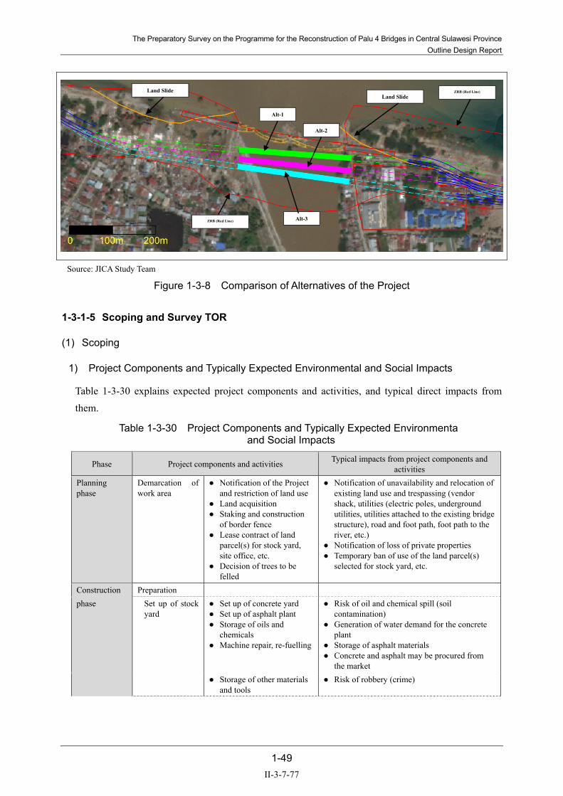
The Preparatory Survey on the Programme for the Reconstruction of Palu 4 Bridges in Central Sulawesi Province Outline Design Report
1-49
Source: JICA Study Team
Figure 1-3-8 Comparison of Alternatives of the Project
1-3-1-5 Scoping and Survey TOR
(1) Scoping
1) Project Components and Typically Expected Environmental and Social Impacts
Table 1-3-30 explains expected project components and activities, and typical direct impacts from them.
Table 1-3-30 Project Components and Typically Expected Environmenta and Social Impacts
Phase Project components and activities Typical impacts from project components and activities
Planning phase
Demarcation of work area
● Notification of the Project and restriction of land use
● Land acquisition ● Staking and construction
of border fence ● Lease contract of land
parcel(s) for stock yard, site office, etc.
● Decision of trees to be felled
● Notification of unavailability and relocation of existing land use and trespassing (vendor shack, utilities (electric poles, underground utilities, utilities attached to the existing bridge structure), road and foot path, foot path to the river, etc.)
● Notification of loss of private properties ● Temporary ban of use of the land parcel(s)
selected for stock yard, etc.
Construction Preparation phase Set up of stock
yard ● Set up of concrete yard ● Set up of asphalt plant ● Storage of oils and
chemicals ● Machine repair, re-fuelling
● Risk of oil and chemical spill (soil contamination)
● Generation of water demand for the concrete plant
● Storage of asphalt materials ● Concrete and asphalt may be procured from
the market ● Storage of other materials
and tools ● Risk of robbery (crime)
Alt-1
Alt-2
Alt-3
ZRB (Red Line)
ZRB (Red Line)
Land SlideLand Slide
II-3-7-77

The Preparatory Survey on the Programme for the Reconstruction of Palu 4 Bridges in Central Sulawesi Province Outline Design Report
1-50
Phase Project components and activities Typical impacts from project components and activities
Set up of office ● Existence of engineers and office staff
● Water demand ● Generation of waste water ● Generation of sewer ● Generation of wastes
Set up of work area
● Existence of work crew ● Water demand ● Generation of waste water ● Generation of sewer ● Generation of wastes
Removal works (existing road, bridge, etc.)
● Removal of existing structures and vegetation
● Removal and relocation of utilities in ROW
● Generation of construction waste ● Generation of needs for alternate water sources
Set up of temporal structures Removal of temporal structures (Detour road, etc.)
● Slow speed at the detour road
● Removal of existing structures and vegetation
● Increased risk of local occurrence of traffic jam
● Increased risk of occurrence of traffic accidents
● Generation of construction waste
Earth works ● Procurement of fill material
● Alteration of land form (at quarry site)
● Generation of transportation vehicle (mainly to transport road bed and pavement material)
● Generation of exhaust gas(off-site) ● Generation of noise (off-site) ● Generation of traffic jam (off-site) ● Increased risk of accidents (off-site)
Earth works on river bed
● Partial closure of river way● Digging on river bed ● Construction of bridge
footage
● Change of river cross section ● Generation of muddy water in river bed ● Activities of heavy construction machines on
river bed Construction
general ● Operation of construction
machinery and vehicles ● Use of generators
● Emission of exhaust ● Emission of noise
● Disposal of construction wastes
● Disposal of construction wastes
● Generation of employment● Procurement of materials,
etc.
● Direct and indirect positive impact to local economy
Maintenance phase
Opening of bridge and new road sections Existence of upgraded road
● Improved traffic network in Palu, Central Sulawesi, that leads to less emission of exhaust gas and noise along existing arterial road
● Increased generation of exhaust gas ● Increased generation of noise ● Existence of major bridge in tidal area
The necessity of workers camp cannot be decided at this phase of the Study. Source: JICA Study Team
2) Scoping of Impacts
Based on the Project components and existing environmental and social conditions, scoping of potential impacts were studied and summarized in Table 1-3-31.
II-3-7-78

The Preparatory Survey on the Programme for the Reconstruction of Palu 4 Bridges in Central Sulawesi Province Outline Design Report
1-51
Table 1-3-31 Scoping
Item Evaluation
Reason for evaluation BC/DC AC
1 Air quality
B- D DC: Temporary air pollution by equipment operation is expected.
AC: Passing traffic on the bridge will generate exhaust gas, but the air quality will not be significantly different from the condition with the original bridge. The structure to be built by the Project is a reconstruction of the original bridge damaged by the earthquake at the upstream-side of the original bridge.
2 Water quality B- D DC: Temporary water pollution by works in the river area is expected. AC: No additional water pollution is expected.
3 Waste
B- D DC: Wastes will be generated such as debris of removed existing structures and bags and containers of materials and paints used for the works. AC: No additional waste generation is expected.
4 Soil contamination
B- D DC: In case fuel, oil, grease, and paints used for the works are spilled on the ground, soil contamination may occur at the work area. AC: No additional waste generation is expected.
5 Noise and vibrations
B- D DC: Temporary noise pollution and vibrations by equipment operation is expected. AC: Passing traffic on the bridge will generate noise and vibration, but the condition will not be significantly different from the condition with the original bridge. The structure to be built by the Project is a reconstruction of the original bridge damaged by the earthquake at the upstream-side of the original bridge.
6 Ground subsidence
D D No significant negative impact is expected during and after the construction.
7 Offensive odor D D No significant negative impact is expected during and after the construction. 8 Bottom
Sediment D D No significant negative impact is expected during and after the construction.
Natural Environmet 9 Protected area D D The Project is not located in or near any protected areas. The structure to be built by
the Project is a reconstruction of the original bridge damaged by the earthquake at the upstream-side of the original bridge.
10 Ecosystem C D During construction, there is a risk of temporary water pollution due to turbid water by construction works.. Ecosystem survey in the downstream area will be conducted.
11 Hydrology D D No significant negative impact is expected during and after the construction. 12 Topography and
geology D D No significant negative impact is expected during and after the construction.
Social Environment 13 Involuntary
resettlement B-/C
D DC: About 2 ha of land will be used for the Project. As of April 2019, no residential structures are located in the Project area and no resettlement will be caused by the Project. The approach road on the right bank is planned to pass between the roadside buildings and the original approach road. The roadside buildings, that will not be affected by the Project, look partially destructed and unused as of April 2019. Further, repeated site survey is necessary to clarify whether there are residents in those buildings. AC: No additional negative impact is expected.
14 Poverty C B+ DC: The land owners or the owners of the structures located on the Project area are affected by the tsunami and relocated. Further study is necessary to understand their recent socio-economic condition to understand the impact of the Project on poverty. AC: With the recovery of transportation axis along the coast, local economy in the coastal area is expected to recover to the pre-earthquake condition, that will give positive impacts to the livelihood of the poor group.
15 Ethnic minority and indigenous people
D D The Project is not located in or near any protected areas. The structure to be built by the Project is a reconstruction of the original bridge damaged by the earthquake at the upstream-side of the original bridge.
II-3-7-79

The Preparatory Survey on the Programme for the Reconstruction of Palu 4 Bridges in Central Sulawesi Province Outline Design Report
1-52
Item Evaluation
Reason for evaluation BC/DC AC
16 Local economy (Employment and livelihood)
B± B+ DC: Jobs will be generated for construction workers, service for such workers, and local procurement of construction materials and equipment. AC: With the recovery of transportation axis along the coast, local economy in the coastal area is expected to recover to the pre-earthquake condition
17 Land use and utilization of local resources
D D The structure to be built by the Project is a reconstruction of the original bridge damaged by the earthquake at the upstream-side of the original bridge. No significant negative impact on use of local resource is expected.
18 Water usage D D The structure to be built by the Project is a reconstruction of the original bridge damaged by the earthquake at the upstream-side of the original bridge. No significant negative impact on local water use is expected.
19 Existing social infrastructure and service
B- B+ DC: The approach road on the right bank is planned to pass between the roadside buildings and the original approach road. There is an unused futsal court among the buildings. Access to the facility may become difficult during the construction works. The new approach road will use existing road space. With the construction works on the road space, current traffic that run on the road and make left turn along the river need to use other route. Other utilities, such as electricity and water, that may be affected will be studied and the contacts for coordination will be found during the Detailed Design Phase. AC: The through traffic along the coast will be recovered. The other major roads in Palu will be relieved from heavy transportation vehicles, such as dump trucks and container trailers, and road safety condition along such roads, especially near schools and hospitals, will be improved.
20 Social institutions such as social infrastructure and local decision-making institutions
D D The structure to be built by the Project is a reconstruction of the original bridge damaged by the earthquake at the upstream-side of the original bridge. No significant negative impact is expected.
21 Misdistribution of damage and benefit
D D The structure to be built by the Project is a reconstruction of the original bridge damaged by the earthquake at the upstream-side of the original bridge. No significant negative impact is expected.
22 Local conflict of interest
D D The structure to be built by the Project is a reconstruction of the original bridge damaged by the earthquake at the upstream-side of the original bridge. No significant negative impact is expected.
23 Cultural heritage D D The structure to be built by the Project is a reconstruction of the original bridge damaged by the earthquake at the upstream-side of the original bridge. No significant negative impact is expected.
24 Landscape D D The structure to be built by the Project is a reconstruction of the original bridge damaged by the earthquake at the upstream-side of the original bridge. No significant negative impact is expected.
25 Gender D D The structure to be built by the Project is a reconstruction of the original bridge damaged by the earthquake at the upstream-side of the original bridge. No significant negative impact is expected.
26 Children’s rights D D The structure to be built by the Project is a reconstruction of the original bridge damaged by the earthquake at the upstream-side of the original bridge. No significant negative impact is expected.
27 Infectious disease and HIV/AIDS
B- D DC: In case migrant workers are high risk group of HIV infection in Indonesia, and are used for the construction works, regional risk may become higher during the construction works. If stagnant water is left at the work areas or at the yard, and mosquitoes are bred there, the risk of infectious disease may become higher. AC: No additional risk for infectious disease is expected.
28 Occupational Health ( including work safety)
B- D DC: Work accidents may occur during the construction. AC: No additional work accident is expected.
II-3-7-80

The Preparatory Survey on the Programme for the Reconstruction of Palu 4 Bridges in Central Sulawesi Province Outline Design Report
1-53
Item Evaluation
Reason for evaluation BC/DC AC
Other 29 Accident B- D DC: General public may be involved in accidents at or near the work areas or with
transportation vehicle. AC: The Project is not located in or near any protected areas. The structure to be built by the Project is a reconstruction of the original bridge damaged by the earthquake at the upstream-side of the original bridge..
30 Cross-border impact, climate change
D D The structure to be built by the Project is a reconstruction of the original bridge damaged by the earthquake at the upstream-side of the original bridge. No significant negative impact is expected.
Evaluation: A-: Significant Negative Impact A+: Significant Positive Impact B-: Some Negative Impact B+: Some Positive Impact C: Impacts are not clear; need more investigation D: No Impact or Impacts are negligible; no further study required
Source: JICA Study Team
(2) Survey TOR
In the scoping (Table 1-3-31), environmental items that may be negatively affected by the Project were chosen. With the results of Detailed Design, further survey, including site observation and data collection must be implemented to identify the area and significance of the impacts as shown in Table 1-3-32.
Table 1-3-32 Survey TOR
Item Objectives Methods Pullution 1 Air quality 1. Clarification of standards of air quality to be
applied 2. Understanding the normal condition of air quality
without the Project, pre-quake and post-quake condition
3. Understanding of generators, construction machineries, and transportation vehicles that will be used in the Construction.
4. Identification of vulnerable facilities against air pollution
1. Literature survey. Confirmation with Environmental Office of Palu City (DLH)
2. Literature survey and field observation 3. Hearing with engineers. 4. Field observation
2 Water quality
1. Clarification of standards of water quality to be applied
2. Understanding the normal condition of water quality without the Project, and the potential impact by muddy water from the Project
3. Understanding of construction methods to be used for the Project especially for the works in the river bed, including preventive measures of generating and/or releasing muddy water
1. Literature survey. Confirmation with Environmental Office of Palu City (DLH)
2. Literature survey and field observation 3. Hearing with engineers
3 Waste 1. Listing of potential construction debris and wastes 2. Understanding standard measures handling wastes
listed above
1. Hearing with engineers 2. Discussion with IA.
4 Soil contamination
1. Listing of potential toxic substances that may be used or stored by the Project
2. Preventive measures that are used in standard construction operated by IA
1. Hearing with engineers 2. Discussion with IA.
II-3-7-81

The Preparatory Survey on the Programme for the Reconstruction of Palu 4 Bridges in Central Sulawesi Province Outline Design Report
1-54
Item Objectives Methods 5 Noise and
vibrations
1. Clarification of standards of noise and vibration to be applied
2. Measurement of distance between the Project Area and vulnerable facilities including residential area
3. Understanding of construction methods and heavy machineries to be used for the Project
1. Literature survey. Confirmation with Environmental Office of Palu City (DLH)
2. Field observation 3. Hearing with engineers.
Narural Environment 10 Ecosystem
1. Ecosystem in downstream of the project area 1. Literature survey. Confirmation with
Environmental Office of Palu City (DLH), Field observation
Social Environment 13 Involuntary
resettlement 1. Size and location of land acquisition. 2. Number and current residential location of land
owners and other affected persons 3. Coordination with stakeholder agencies about the
process, timing, and pricing of land acquisition (Palu City, Provincial BPN, Provincial Bina Marga, SATGAS, Central Bina Marga, PU, Spatial Planning, Tsunami Dike Planning)
1. Overlay of Detailed Design with the land registration data stored by Provincial BPN in Palu
2. Results of IP4T survey by Provincial BPN in Palu (to be conducted) (IP4T identifies the land owner, the asset owner, land and assets to be compensated)
3. Comments in Stakeholder meeting 14 Poverty 1. Consideration of necessity of any additional
assistances for the PAPs because of their economic conditions.
1. Understanding of pre-quake condition and post-quake condition
2. Understanding the impacts of the land acquisition for the PAPs
3. Coordination with assistances for quake-affected people to improve their economic conditions when necessary
16 Local economy (Employment and livelihood)
1. Understanding the demand and opinion of local people
2. Existence status of local economy in the site
1,2, Literature survey., SHM discussion if found necessary and suitable.
19 Existing social infrastructure and service
1. Location of Work Area boundary 2. Existence, character and number of residents and
users adjacent to the Work Area 3. Traffic plan during and after the Construction
(vulnerable facilities along the new detour route)
1, 2, 3. Discussion with engineers. On-site observation.
27 Infectious disease and HIV/AIDS
1. High risk group of HIV infection in Indonesia and Central Sulawesi Province
2. Agencies that provide awareness training in Central Sulawesi Province
3. Popular mosquito-related infectious diseases and available prevention training and materials
1, 2, 3. Information collection from UNAIDS, Central Sulawesi Province and Palu City
28 Occupational Health (including work safety)
1. Work safety plan 1. Collection of work safety plan approved by the same Implementation Agency
Other 29 Accident 1. Possibility of accidents during construction
(Location of work area, location of residents, draft plan for traffic restriction and detour, standard safety measures taken in Palu)
1. Study of detailed design and construction plan. On-site observation.
Source: JICA Study Team
1-3-1-6 Survey Results (including Impact Prediction)
Based on the results of the field survey, the environmental impact is shown in Table 1-3-33 for the items classified as B- and C in the results of scoping of ESIA. This table will be updated after the field survey.
II-3-7-82

The Preparatory Survey on the Programme for the Reconstruction of Palu 4 Bridges in Central Sulawesi Province Outline Design Report
1-55
Table 1-3-33 Survey Results (including Impact Prediction)
No Item Main Factors Affecting Environmental Impact and Estimated Potential Impact Pollution 1 Air Quality
The air quality information will be updated based on the field survey results. Passing traffic on the bridge will generate exhaust gas, but the air quality will not be significantly different from the condition with the original bridge.
2 Water Quality There is a risk of temporary induce erosion/siltation due to excavation during the rainy season at downstream of the project site.
3 Soil Contamination
Oil/fuel and waste spills from the construction area due to the repairing and maintenance works of equipment/vehicles on-site. It is necessary to prepare the well controlled management plan before construction by contractor.
4 Solid Waste Construction soil and construction waste will be generated due to the clearing of the existing site because the damaged facilities of existing bridge by the disaster still remined in site.
5 Noise and Vibration
The noise and vibration data will be updated based on the field survey results. However,
6 Ecosystem (1)Project site The new brideges will be constructed within the right of way. There is no natural fauna and fauna. (2) Downstream of the site There is a risk of temporary induce erosion/siltation due to excavation during the rainy season at downstream of the project site. There might be not sensitive biological area such as coral reef protection area. Field survey in the downstream area will be conducted to grasp the ecosystem.
7 Involuntary resettlement
About 2 ha of land will be used for the Project. As of April 2019, no residential structures are located in the Project area and no resettlement will be caused by the Project. The approach road on the right bank is planned to pass between the roadside buildings and the original approach road. The roadside buildings, that will not be affected by the Project, look partially destructed and unused as of April 2019. Further, repeated site survey is necessary to clarify whether there are residents in those buildings.
8 Poverty The land owners or the owners of the structures located on the Project area are affected by the tsunami and relocated. Further study is necessary to understand their recent socio-economic condition to understand the impact of the Project on poverty.
9 Local economy (Employment and livelihood)
Jobs will be generated for construction workers, service for such workers, and local procurement of construction materials and equipment.
10 Existing Social Infrastructure and Services
(1) Traffic Congestion in the during the construction site There is a possibility of traffic accidents caused by vehicle for transportation of construction soil and construction material near the project area. However, the impact will not significant due to the project scale. (2) Recovery of the function of the existing bridge The vertical shaft will be constructed on the existing road. Due to the reconstruction, the through traffic along the coast will be recovered. The other major roads in Palu will be relieved from heavy transportation vehicles, such as dump trucks and container trailers, and road safety condition along such roads, especially near schools and hospitals, will be improved.
11 Sanitation, infectious diseases such as HIV/AIDs
There is a possibility to increase the risks of infectious diseases due to the influx of construction workers into the project site under insanitary condition.
12 Working Conditions
Impacts on occupational health and safety are inevitable due to the construction/operation work. It is necessary to prepare the adequate mitigation measures.
13 Accidents There is a possibility of traffic accidents caused by vehicle for transportation of construction soil and construction material near the project area.
Source: JICA Study Team
1-3-1-7 Impact Assessment
The tentative environmental evaluation results are shown in Table 1-3-34. This table will be updated after the field survey.
II-3-7-83

The Preparatory Survey on the Programme for the Reconstruction of Palu 4 Bridges in Central Sulawesi Province Outline Design Report
1-56
Table 1-3-34 Environmental Evaluation (Tentative)
Item Scoping Evaluation
Reason for evaluation BC/ DC
AC
BC/ DC AC
Pollution 1 Air quality
B- D B- D DC: Temporary air pollution by equipment operation is expected.
AC: Passing traffic on the bridge will generate exhaust gas, but the air quality will not be significantly different from the condition with the original bridge. The structure to be built by the Project is a reconstruction of the original bridge damaged by the earthquake at the upstream-side of the original bridge.
2 Water quality B- D B- D DC: Temporary water pollution by construction works in the downstream of Palu river area is expected. However, the impact is not significant due to construction work scale. AC: No additional water pollution is expected.
3 Waste
B- D B- D DC: Wastes will be generated such as debris of removed existing structures and bags and containers of materials and paints used for the works. The constractor should prepare adequate waste management plan and needs to thoroughly process based on it. AC: No additional waste generation is expected.
4 Soil contamination
B- D B- D DC: In case fuel, oil, grease, and paints used for the works are spilled on the ground, soil contamination may occur at the work area. AC: No additional waste generation is expected.
5 Noise and vibrations
B- D B- D DC: Noise pollution and vibrations by construction equipment operation is expected. The impact is expected to be minor and temoporary due to the project site location. AC: Passing traffic on the bridge will generate noise and vibration, but the condition will not be significantly different from the condition with the original bridge. The structure to be built by the Project is a reconstruction of the original bridge damaged by the earthquake at the upstream-side of the original bridge.
6 Ground subsidence
D D N/A N/A There is no factor to cause negative impect by the project on the item.
7 Offensive odor
D D N/A N/A There is no factor to cause negative impect by the project on the item.
8 Bottom Sediment
D D N/A N/A There is no factor to cause negative impect by the project on the item.
Natural Environmet 9 Protected
area D D N/A N/A There is no factor to cause negative impect by the project on the item.
10 Ecosystem C D B- N/A DC: During construction, there is a risk of temporary water pollution due to turbid water by construction works. The water pollution has the possibility to give an impact on the ecosystem of the downstream area of the construction site temporality. AC: No additional impact is expected.
11 Hydrology D D N/A N/A There is no factor to cause negative impect by the project on the item. 12 Topography
and geology D D N/A N/A There is no factor to cause negative impect by the project on the item.
Social Environment 13 Involuntary
resettlement B-/C
D C N/A DC: About 2 ha of land will be used for the Project. As of April 2019, no residential structures are located in the Project area and no resettlement will be caused by the Project. The approach road on the right bank is planned to pass between the roadside buildings and the original approach road. The roadside buildings, that will not be affected by the Project, look partially destructed and unused as of April 2019. Further, repeated site survey is necessary to clarify whether there are residents in those buildings. AC: No additional negative impact is expected.
II-3-7-84

The Preparatory Survey on the Programme for the Reconstruction of Palu 4 Bridges in Central Sulawesi Province Outline Design Report
1-57
Item Scoping Evaluation
Reason for evaluation BC/ DC
AC
BC/ DC AC
14 Poverty C B+ C B+ DC: The land owners or the owners of the structures located on the Project area are affected by the tsunami and relocated. Further study is necessary to understand their recent socio-economic condition to understand the impact of the Project on poverty. AC: With the recovery of transportation axis along the coast, local economy in the coastal area is expected to recover to the pre-earthquake condition, that will give positive impacts to the livelihood of the poor group.
15 Ethnic minority and indigenous people
D D N/A N/A There is no factor to cause negative impect by the project on the item.
16 Local economy (Employment and livelihood)
B± B± B± B+ DC: Jobs will be generated for construction workers, service for such workers, and local procurement of construction materials and equipment. AC: With the recovery of transportation axis along the coast, local economy in the coastal area is expected to recover to the pre-earthquake condition
17 Land use and utilization of local resources
D D N/A N/A There is no factor to cause negative impect by the project on the item.
18 Water usage D D N/A N/A There is no factor to cause negative impect by the project on the item. 19 Existing
social infrastructure and service
B- B+ B- B+ DC: The approach road on the right bank is planned to pass between the roadside buildings and the original approach road. There is an unused futsal court among the buildings. Access to the facility may become difficult during the construction works. The new approach road will use existing road space. With the construction works on the road space, current traffic that run on the road and make left turn along the river need to use other route. Other utilities, such as electricity and water, that may be affected will be studied and the contacts for coordination will be found during the Detailed Design Phase. AC: The through traffic along the coast will be recovered. The other major roads in Palu will be relieved from heavy transportation vehicles, such as dump trucks and container trailers, and road safety condition along such roads, especially near schools and hospitals, will be improved.
20 Social institutions such as social infrastructure and local decision-making institutions
D D N/A N/A There is no factor to cause negative impect by the project on the item.
21 Misdistribution of damage and benefit
D D N/A N/A There is no factor to cause negative impect by the project on the item.
22 Local conflict of interest
D D N/A N/A There is no factor to cause negative impect by the project on the item.
23 Cultural heritage
D D N/A N/A There is no factor to cause negative impect by the project on the item.
24 Landscape D D N/A N/A There is no factor to cause negative impect by the project on the item. 25 Gender D D N/A N/A There is no factor to cause negative impect by the project on the item. 26 Children’s
rights D D N/A N/A There is no factor to cause negative impect by the project on the item.
II-3-7-85
The Preparatory Survey on the Programme for the Reconstruction of Palu 4 Bridges in Central Sulawesi Province Outline Design Report
1-58
Item Scoping Evaluation
Reason for evaluation BC/ DC
AC
BC/ DC AC
27 Infectious disease and HIV/AIDS
B- D B- N/A DC: In case migrant workers are high risk group of HIV infection in Indonesia, and are used for the construction works, regional risk may become higher during the construction works. If stagnant water is left at the work areas or at the yard, and mosquitoes are bred there, the risk of infectious disease may become higher. AC: No additional risk for infectious disease is expected.
28 Occupational Health ( including work safety)
B- D B- N/A DC: Work accidents may occur during the construction. AC: There is no factor to cause negative impect by the project on the item.
Other 29 Accident B- D B- N/
A DC: General public may be involved in accidents at or near the work areas or with transportation vehicle. AC: The Project is not located in or near any protected areas. The structure to be built by the Project is a reconstruction of the original bridge damaged by the earthquake at the upstream-side of the original bridge..
30 Cross-border impact, climate change
D D N/A N/A
There is no factor to cause negative impect by the project on the item.
Evaluation: A-: Significant Negative Impact A+: Significant Positive Impact B-: Some Negative Impact B+: Some Positive Impact C: Impacts are not clear; need more investigation D: No Impact or Impacts are negligible; no further study required
1-3-1-8 Mitigation Plan and Necessary Budget
Mitigation plan, necessary budget, and institutional coordination will be studied, discussed with stakeholders, and described after the assessment of the impacts.
1-3-1-9 Monitoring Plan and Budget
Monitoring plan, necessary budget, and institutional coordination will be studied, discussed with stakeholders, and described after the assessment of the impacts.
1-3-1-10 Stakeholder Consultation
This project is requested for the UKL-UPL procedure. Under Indonesia's laws and regulations, stakeholder consultations do not require to the project. Therefore, it is assumed that the stakeholder consultation in the JICA guidelines will be conducted as follows.
(1) Stakeholder Meeting with Related Organizations
The table below shows a list of stakeholder meeting that have been conducted on the grant aid projects so far. The target persons who have discussed are administrative staff such as countries, states and cities.
II-3-7-86

The Preparatory Survey on the Programme for the Reconstruction of Palu 4 Bridges in Central Sulawesi Province Outline Design Report
1-59
Table 1-3-35 Stakeholder meetings for JICA on Grant Aid project
Year Month Day JICA Mission Team National State City Topics
2019 1 9 X X
SATGAS (Mr. Arie)
Bina Marga
* Alternatives of Palu 4 Bridge
18 X SATGAS Bina Marga * Alternatives of Palu 4 Bridge
21 X X * Alternatives of Palu 4 Bridge 27 X X * Alternatives of Palu 4 Bridge 25 X ATR * Spatial Plan 30 X X * Project Schedule 2 1 X X Bina Marga * Alternatives of Palu 4 Bridge 4 X Ministry of
Environment * AMDAL, UKL UPL * Spatial Plan and SEA
7 X X X * JCC No.1 7 X Bina Marga Balai * Alternatives of Palu 4 Bridge
11 X X X X X
* Seminar on Accelerating Recovery and Reconstruction in Central Sulawesi ~ Experience Sharing between Indonesia and Japan ~
18 X X X X X * Alternatives of Palu 4 Bridge 22 X X Bina Marga * Alternatives of Palu 4 Bridge 3 4 X X * Project schedule 11 X X Bina Marga T/N * About the starting timing of
Outline Design 13 X Balai * Land acquisition implementation 15 X X Bina Marga * Project schedule 18 Bina Marga T/N * Contents of Technical Note 24 X SATGAS * Alternatives of Palu 4 Bridge
26 X SATGAS Balai * Site inspection * Selection of recommended alternative
4 2 X X (Palu TF) Mayor, Balai
* Land acquisition
Source: JICA Study Team
(2) Stakeholder Meeting with Public
Stakeholder meeting will be held in the following programs for residents in the project area in late June 2019.
II-3-7-87

The Preparatory Survey on the Programme for the Reconstruction of Palu 4 Bridges in Central Sulawesi Province Outline Design Report
1-60
Table 1-3-36 Contents of the planned stakeholder Meeting (Tentative)
Item Main Factors Affecting Environmental Impact and Estimated Potential Impact Purpose - The purpose of this meeting is to explain the project activities including environmental and social
important impact to local community and to collect their opinion, which should be reflected into the project adequately.
- This meeting is conducted in line with JICA guidelines for environmental and social considerations. - Indonesia regulation require to conduct the public meeting for AMDAL project, no-need for
UKL-UPL project. Palu IV bridge is categorized into UKL-UPL project in limerence to MoE Regulation No.5/2012
Date - 26 June, 2019 (BPJN and head of Palu Barat District prefer 26 June, 2019) - At 10 am
Venue of SHM - Palu Barat District office at Jalan WR. Supratman No 2 (room capacity > 50 persons) To be invited persons
(1) Local community - Village leaders (head of Besusu Barat Village, head of Lere Village) - District leaders (head of Palu Timur District and head of Palu Barat District) - Representative land owners (left-bank and right bank) (approximately 10-15 persons) - Residence along the bridge (left-bank and right bank) (approximately 10-15 persons) (2) Local government (will be decided after 18 June, 2019) - P2JN Kota Palu (Pengawasan Jalan Nasional) - Dinas Pekerjaan Umum Kota Palu (Departmen of Public Work Palu City) - Bappeda Palu
Source: JICA Study Team
1-3-2 Land Acquisition, Relocation and Resettlement
1-3-2-1 Necessity of Land Acquisition and Relocation, Resettlement
The Project aims to ‘reconstruct of Palu 4 Bridge in Central Sulawesi Province’ located south of the original Palu 4 Bridge at the mouth of Palu River. Land acquisition is necessary Since new access road of about 250 m long and about 20 m wide, including shoulders, will be necessary on the right (east) and left (west) side of the 260 m bridge.
The site photograph taken on March 26, 2019 is shown in the Figure 1-3-9.
No relocation of residents is expected by the land acquisition since the land is either road area (right bank) or vacant land after the impact of tsunami. Relocation of temporal stall(s) may be necessary on the right bank. Voluntary removal or relocation may be possible with appropriate discussion and negotiation between Palu City and the shop owner.
II-3-7-88

The Preparatory Survey on the Programme for the Reconstruction of Palu 4 Bridges in Central Sulawesi Province Outline Design Report
1-61
Existing condition on Left Bank Existing condition on Right Bank
Looking toward planned bridge from remaining Jalan Cumi Cumi. Planned road will divert left-side from the point in front of the remaining house on the right.
The existing road seen on the left in the photo will be extended straight, between the remaining original approach slope and the building on the left, to approach the planned bridge.
The approach road is planned right-side of the standing building and the reconstruction bridge will land left side of the woods in the center on the right bank (pointed by the arrow)
New approach road is planned between the original on the right and the remaining futsal court on the left
Original approach road(s) are shown by the arrows. The planned road and bridge will pass the right-side of the original route
The stall set up using the public bench and shade. Existing road in the center will be used for the planned approach road
Source: JICA Study Team, March 26, 2019
Figure 1-3-9 Site Condition
II-3-7-89

The Preparatory Survey on the Programme for the Reconstruction of Palu 4 Bridges in Central Sulawesi Province Outline Design Report
1-62
1-3-2-2 Legal Framework of Land Acquisition and Relocation, Resettlement
(1) Legal Framework of Indonesia
Legal Framework of Indonesia on Land Acquisition for Public Interest is summarised in Table 1-3-37. The Law No. 2 of 2012 stipulates that land acquisition shall be carried out by National Land Agency (BPN) involving all entitled holders and concerned stakeholders. The law states to compensate for not only physical loss but also no-physical loss such as income loss and restriction or limitation to access to natural resources.
Presidential Regulation No. 71 on Land Acquisition and its amendments, and Regulation of the Head of BPN RI No. 5 of 2012 on Technical Guidelines on the Implementation of the Land Acquisition are also to be applied.
The required land for the Project is about 20,320 m2. For land acquisition smaller than 5 ha, the Implementing Agency (IA) is allowed to negotiate directly with the affected land owner(s) according to the Presidential Decree No. 40, 2014.
The JICA Mission Team will need to consult with the Balai Bina Marga Palu (expected IA), BPN Palu and other related agencies about the steps of land acquisition for the Project to secure that the steps will be in harmony with the requirements of the JICA Guidelines. (Table 1-3-38)
Table 1-3-37 Legal Framework of Indonesia on Land Acquisition for Public Interest
Land Law 1960 Defines various rights on the land, including legal rights and customary rights Sovereign ownership resides with national government
Land Acquisition Law 2012 Law No. 2 of 2012
Defines about land acquisition for public interest. Chapter I General Chapter II Objectives Chapter III Fundamentals Chapter IV Performance of acquisition of land
(Survey, Consultation, Compensation, Monitoring) Chapter V Sources of fund for acquisition of land Chapter VI Rights, obligations, and public participation Chapter VII Transitional provisions Chapter VIII Concluding provisions
Presidential Decree No. 71, 2012 Defines details about land acquisition for public interest. Chapter I General Chapter II Land procurement planning Chapter III Land procurement preparation Chapter IV Land procurement implementation Chapter V Transfer of result of land procurement Chapter VI Monitoring and evaluation Chapter VII Fund sources of land procurement Chapter VIII Small scale land procurement Chapter IX Taxation incentive Chapter X Transfer provisions Chapter XI Closing provisions
II-3-7-90

The Preparatory Survey on the Programme for the Reconstruction of Palu 4 Bridges in Central Sulawesi Province Outline Design Report
1-63
Presidential Decree No. 40, 2014 Presidential Decree No. 71 Year 2012, Article 121 is amended as follows: In order to efficiency and effectiveness, land procurement for the Public Interest that the extent of not more than 5 (five) hectare, can be done directly by the agency requiring the land with the holders of land rights, by buying and selling of sale or exchange or any other way agreed by both parties.
Source: JICA Study Team
Table 1-3-38 Steps of Land Acquisition Following the Law No. 2, 2012 Phase Responsible Body L Action (necessary days in the law) Law
Planning phase
Institution who needs the land
1. Feasibility Study and planning document that include conformity with spatial plan and environmental and social impacts
Art. 14, 15
2. Request for land acquisition permit Preparation phase
By the Governor, can be delegated to Mayor
3. Notification of the Development Plan to community (20 days)
Art. 17
4. Forming preparation team (10 days) (Consisted of Governor, Related Mayor, Related provincial agencies, Agency who needs the land, Other related agencies)
Presidential Decree No. 71, 2012
5. Preliminary data collection (= early inventory of PAP and asset) (IP4T study) (30 days)
Art. 18
6. Public consultation to agree on project location (60 days) Art. 19 7. Collected data, the development plan, and compensation
calculation method the appraiser may apply will be explained.
Art. 19
8 If objection is raised, second consultation will be held inviting those who objected.
Art. 20
Governor 9. Location permit (14 days) Art. 19 (6) 10. Location announcement to public (17 days) Art. 26 Execution Institution who needs the
land 11. Submit the Land Acquisition Implementation Request to
the Land Administrator (Lembaga Pertanahan, BPN) Art. 27
By Head of BPN 12. Final inventory & identification of PAPs (30 days) and announcement (14 days)
Art. 28, 29
13. When objection is raised, another verification and improvement shall be made.
14. BPN confirms on the ground on which the Entitled Parties to Compensation are determined.
Art. 30
15. Stipulation of Appraiser (30 days) and Valuation (30 days)
Art. 31 - 36
16. Final negotiation with PAPs on type and amount of compensation (30 days)
Art. 37
17. Objection may be filed with the local district court regarding the amount of compensation.
Art. 38
18. Compensation payment and land title release (7 days) Art. 40, 41 19. Monitoring and evaluation of the performance of
Acquisition of Land is made by the Government Art. 51
20. Monitoring and evaluation of the results of the handover of the Acquisition of Land is made by the Land Administrator
Art. 51
Land delivery
From Head of Land Acquisition to the Institution who needs the land
21. Land delivery (7 days) Art. 48 22. Agency needing land may begin to perform the
construction activities upon the handover of the results of the Acquisition of land
23. Land Certification and Registration (30 days) Art. 50
Source: JICA Study Team
II-3-7-91

The Preparatory Survey on the Programme for the Reconstruction of Palu 4 Bridges in Central Sulawesi Province Outline Design Report
1-64
(2) GAP Analysis
If a subproject requires land acquisition and resettlement, LARAP will be prepared based on ESMF for the entire sector loan, and monitoring on LARAP will be done.A gap between JICA Guidelines and laws in Indonesia is summarized in Table 1-3-39.
Since the required land for the Project is smaller than 5 ha, the process of acquisition in the mind of Implementing Agency (IA) and other stake holder agencies are not clear as of April 2019.
The JICA Mission Team need to consult with the Balai Bina Marga Palu (expected IA), BPN Palu and other related agencies about the steps of land acquisition for the Project to secure that the steps will be in harmony with the requirements of the JICA Guidelines.
II-3-7-92

Tabl
e 1-
3-39
G
aps
betw
een
JIC
A G
uide
line
and
Law
s in
Indo
nesi
a
JICA
Gui
delin
es,
WB
OPs
La
w N
o.2
of 2
012
and
rela
ted
Pres
iden
tial D
ecre
es
Gap
Br
idgi
ng M
easu
res t
o be
take
n in
th
e Pr
ojec
t 1
Invo
lunt
ary
rese
ttlem
ent a
nd lo
ss
of m
eans
of
livel
ihoo
d ar
e to
be
avoi
ded
whe
n fe
asib
le
by
expl
orin
g al
l via
ble
alte
rnat
ives
.
In
the
Land
A
cqui
sitio
n Pl
an
and
atta
ched
Fe
asib
ility
St
udy,
en
viro
nmen
tal
impa
cts
and
soci
al i
mpa
cts
will
be
incl
uded
. (A
rticl
e 14
, 15
) A
bove
is n
ot m
anda
ted
for l
and
acqu
isitio
n sm
alle
r tha
n 5
ha.
Expl
orat
ion
of
alte
rnat
ive
and
effo
rt of
avo
idan
ce o
f im
pact
s are
not
man
date
d.
Expl
orat
ion
of a
ltern
ativ
e an
d ef
fort
of a
void
ance
of
impa
cts
will
be
expl
aine
d in
th
e Pu
blic
Co
nsul
tatio
ns a
nd w
ill b
e re
cord
ed
in th
e Re
port.
2
Whe
n po
pula
tion
disp
lace
men
t is
unav
oida
ble,
effe
ctiv
e m
easu
res
to
min
imiz
e im
pact
an
d to
co
mpe
nsat
e fo
r lo
sses
sho
uld
be
take
n.
In
the
Land
A
cqui
sitio
n Pl
an
and
atta
ched
Fe
asib
ility
St
udy,
en
viro
nmen
tal
impa
cts
and
soci
al i
mpa
cts
will
be
incl
uded
. (A
rticl
e 14
, 15
) Pr
elim
inar
y da
ta
colle
ctio
n w
ill
iden
tify
the
size
and
loca
tion
of
popu
latio
n di
spla
cem
ent.
(A
rticl
e 16
) A
bove
is n
ot m
anda
ted
for l
and
acqu
isitio
n sm
alle
r tha
n 5
ha.
Min
imiz
ing
the
popu
latio
n di
spla
cem
ent
is no
t m
anda
ted.
Min
imiz
ing
mea
sure
s of
th
e im
pact
s on
exi
sting
stru
ctur
es w
ill
be
expl
aine
d in
th
e Pu
blic
Co
nsul
tatio
ns a
nd w
ill b
e re
cord
ed
in th
e Re
port.
3 Pe
ople
w
ho
mus
t be
re
settl
ed
invo
lunt
arily
and
peo
ple
who
se
mea
ns
of
livel
ihoo
d w
ill
be
hind
ered
or
lo
st m
ust
be
suffi
cien
tly
com
pens
ated
an
d su
ppor
ted,
so
th
at
they
ca
n im
prov
e or
at
leas
t re
store
the
ir sta
ndar
d of
liv
ing,
in
com
e op
portu
nitie
s an
d pr
oduc
tion
leve
ls to
pre
- pro
ject
leve
ls.
“Com
pens
atio
n” m
eans
any
rea
sona
ble
and
fair
rew
ard
give
n to
the
en
title
d pa
rty in
exc
hang
e fo
r acq
uisit
ion
of la
nd. (
Arti
cle
1, N
o. 1
0)
Acq
uisit
ion
of L
and
in th
e Pu
blic
Int
eres
t sha
ll be
per
form
ed b
y gi
ving
re
ason
able
and
fair
Com
pens
atio
n. (A
rticl
e 9
(2))
App
raisa
l of t
he a
mou
nt o
f Com
pens
atio
n by
the
App
raise
r sha
ll be
mad
e on
a p
arce
l-by-
parc
el b
asis,
incl
udin
g:
a.la
nd;
b.ov
er g
roun
d an
d un
derg
roun
d sp
ace;
c.bu
ildin
gs;
d.pl
ants;
e.ob
ject
s rel
ated
to la
nd; a
nd/o
rf.
othe
r app
raisa
ble
loss
.“O
ther
app
raisa
ble
loss
” m
eans
non
phys
ical
los
s eq
uiva
lent
to
mon
ey
valu
e, fo
r exa
mpl
e, lo
ss d
ue to
loss
of b
usin
ess
or jo
b, c
ost o
f cha
nge
of
loca
tion,
cos
t of c
hang
e of
pro
fess
ion,
and
loss
of v
alue
of t
he re
mai
ning
pr
oper
ty. (
Arti
cle
33)
Abo
ve is
not
man
date
d fo
r lan
d ac
quisi
tion
smal
ler t
han
5 ha
.
The
law
doe
s no
t m
entio
n ab
out
that
the
PA
Ps m
ust
be a
ble
to i
mpr
ove
or a
t le
ast
resto
re t
heir
stand
ard
of
livin
g,
inco
me
oppo
rtuni
ties
and
prod
uctio
n le
vels
to
pre-
pr
ojec
t lev
els.
As
of A
pril
2019
, th
e Pr
ojec
t is
cons
ider
ed
not
to
gene
rate
in
volu
ntar
y re
settl
emen
t no
r hi
nder
ing
livel
ihoo
d.
Reas
onab
le a
nd f
air
mea
sure
s w
ill
be d
iscus
sed
with
IA
base
d on
the
re
sults
of
th
e Ce
nsus
an
d th
e So
cio-
Econ
omic
Sur
vey.
4 Co
mpe
nsat
ion
mus
t be
bas
ed o
n th
e fu
ll re
plac
emen
t cos
t as
muc
h as
pos
sible
.
Com
pens
atio
n w
ill
be
prov
ided
ba
sed
on
valu
atio
n of
ind
epen
dent
ap
prai
ser f
or a
par
cel b
y pa
rcel
of l
and
that
incl
ude
i) la
nd; i
i) ov
er g
roun
d an
d un
derg
roun
d sp
aces
; iii)
bui
ldin
g; iv
) pla
nts;
v) o
bjec
ts re
late
d to
land
an
d/or
; vi
) ot
her
appr
aisa
ble
loss
suc
h lo
ss o
f bu
sines
s, jo
bs, c
hang
e of
pr
ofes
sion,
and
mov
ing
costs
. (A
rticl
e 33
) Fo
r affe
cted
bui
ldin
gs, M
APP
I app
lies s
olat
ium
(em
otio
nal c
ompe
nsat
ion)
of
10%
- 30
% o
f the
tota
l com
pens
atio
n fo
r phy
sical
loss
. A
bove
is n
ot m
anda
ted
for l
and
acqu
isitio
n sm
alle
r tha
n 5
ha.
The
law
is
silen
t on
the
iss
ue
of
whe
ther
or
no
t de
prec
iatio
n w
ill b
e ap
plie
d w
hen
calc
ulat
ing
com
pens
atio
n fo
r af
fect
ed
land
an
d la
nd-a
ttach
ed
asse
ts.
The
prin
cipl
e of
ful
l re
plac
emen
t co
st w
ill b
e ap
plie
d.
Valu
atio
n sta
ndar
d se
t by
In
depe
nden
t ap
prai
sers
ass
ocia
tion
(MA
PPI)
indi
cate
s in
prin
cipl
es, n
o de
prec
iatio
n w
ill a
pply
for
affe
cted
str
uctu
res.
The Preparatory Survey on the Programme for the Reconstruction of Palu 4 Bridges in Central Sulawesi Province Outline Design Report
1-65II-3-7-93

JICA
Gui
delin
es,
WB
OPs
La
w N
o.2
of 2
012
and
rela
ted
Pres
iden
tial D
ecre
es
Gap
Br
idgi
ng M
easu
res t
o be
take
n in
th
e Pr
ojec
t Ta
x in
cent
ive
is pr
ovid
ed
to: a
) pe
rson
who
sup
ports
th
e pr
ojec
t; b)
doe
s no
t file
a
com
plai
nt
rela
ted
to
proj
ect
loca
tion
dete
rmin
atio
n an
d/or
co
mpe
nsat
ion.
Capi
tal
gain
s ta
x an
d th
e co
sts o
f tra
nsfe
rring
ow
ners
hip,
in
clud
ing
the
cost
of n
ew l
and
certi
ficat
es,
will
no
t be
de
duct
ed
from
th
e co
mpe
nsat
ion
of
thos
e w
ho
will
lo
se la
nds.
5 Co
mpe
nsat
ion
and
othe
r kin
ds o
f as
sista
nce
mus
t be
prov
ided
prio
r to
disp
lace
men
t.
Whe
n Co
mpe
nsat
ion
and
Rele
ase
of T
itles
hav
e be
en m
ade,
or
the
Com
pens
atio
n gi
ven
has
been
dep
osite
d w
ith th
e di
stric
t cou
rt, s
uch
land
sh
all b
e in
the
dire
ct p
osse
ssio
n of
the
state
. (A
rticl
e 43
) A
bove
is n
ot m
anda
ted
for l
and
acqu
isitio
n sm
alle
r tha
n 5
ha.
The
Law
is s
ilent
abo
ut th
e tim
ing
of d
ispla
cem
ent.
As
of A
pril
2019
, th
e Pr
ojec
t is
cons
ider
ed
not
to
gene
rate
in
volu
ntar
y re
settl
emen
t. Co
mpe
nsat
ion
and
othe
r ki
nds
of
assis
tanc
e w
ill b
e pr
ovid
ed p
rior
to
disp
lace
men
t if a
ny d
ispla
cem
ent i
s fo
und
nece
ssar
y af
ter
the
Det
aile
d D
esig
n.
6 Fo
r pr
ojec
ts th
at
enta
il la
rge-
sc
ale
invo
lunt
ary
rese
ttlem
ent,
rese
ttlem
ent a
ctio
n pl
ans
mus
t be
prep
ared
and
mad
e av
aila
ble
to
the
publ
ic.
In
the
Land
A
cqui
sitio
n Pl
an
and
atta
ched
Fe
asib
ility
St
udy,
en
viro
nmen
tal
impa
cts
and
soci
al i
mpa
cts
will
be
incl
uded
. (A
rticl
e 14
, 15
) Pr
elim
inar
y da
ta
colle
ctio
n w
ill
iden
tify
the
size
and
loca
tion
of
popu
latio
n di
spla
cem
ent.
(A
rticl
e 16
) A
bove
is n
ot m
anda
ted
for l
and
acqu
isitio
n sm
alle
r tha
n 5
ha.
The
Law
doe
s no
t req
uire
a
rese
ttlem
ent
actio
n pl
an
mad
e av
aila
ble
to
the
publ
ic.
As
of A
pril
2019
, th
e Pr
ojec
t is
cons
ider
ed
not
to
gene
rate
in
volu
ntar
y re
settl
emen
t. A
bbre
viat
ed R
AP
will
be
prep
ared
fo
llow
ing
the
JICA
G
uide
lines
be
caus
e th
e Pr
ojec
t w
ill
requ
ire
land
acq
uisit
ion.
7
In p
repa
ring
a re
settl
emen
t act
ion
plan
, co
nsul
tatio
ns m
ust
be h
eld
with
the
affe
cted
peo
ple
and
thei
r co
mm
uniti
es b
ased
on
suffi
cien
t in
form
atio
n m
ade
avai
labl
e to
th
em in
adv
ance
.
The
law
def
ines
thr
ee o
ppor
tuni
ties
of c
onsu
ltatio
ns, e
ither
in
publ
ic o
r pr
ivat
e:
1.
Not
ifica
tion
of th
e D
evel
opm
ent P
lan
to c
omm
unity
Met
hod
may
be
soci
aliz
atio
n (p
ublic
mee
ting)
, fac
e to
face
(in
pers
on),
or n
otifi
catio
nle
tter.
(Pre
s. D
ecre
e N
o. 7
1, 2
012
Art.
12)
2.Pu
blic
con
sulta
tion
to a
gree
on
proj
ect l
ocat
ion.
Res
ults
of In
vent
ory,
the
deve
lopm
ent
plan
, an
d co
mpe
nsat
ion
calc
ulat
ion
met
hod
the
appr
aise
r may
app
ly w
ill b
e ex
plai
ned.
3.Fi
nal
nego
tiatio
n w
ith P
APs
(in
priv
ate)
on
type
and
am
ount
of
com
pens
atio
n
The
Gov
erno
r app
rove
s th
e lo
catio
n of
th
e Pr
ojec
t be
fore
the
firs
t ch
ance
of
cons
ulta
tion,
and
bef
ore
the
inve
ntor
y su
rvey
.
As
of
Apr
il 20
19,
the
publ
ic
cons
ulta
tion
with
gen
eral
pub
lic o
n th
e Sp
atia
l Pla
n is
plan
ned
in Ju
ne.
JICA
Miss
ion
Team
will
pro
pose
th
e IA
to h
old
a pu
blic
con
sulta
tion
mee
ting
afte
r th
e co
nsul
tatio
n on
th
e Sp
atia
l Pla
n in
Jun
e an
d be
fore
th
e co
mm
ence
men
t of
the
offi
cial
su
rvey
of t
he P
APs
8 W
hen
cons
ulta
tions
ar
e he
ld,
expl
anat
ions
mus
t be
giv
en i
n a
form
, man
ner,
and
lang
uage
tha
t ar
e un
ders
tand
able
to th
e af
fect
ed
peop
le.
“Pub
lic C
onsu
ltatio
n” m
eans
any
com
mun
icat
ion
proc
ess
by a
dia
logu
e an
d co
nsul
tatio
n am
ong
parti
es in
int
eres
t to
ach
ieve
und
ersta
ndin
g an
d ag
reem
ent i
n th
e pl
anni
ng o
f ac
quisi
tion
of la
nd f
or d
evel
opm
ent i
n th
e pu
blic
inte
rest.
(Arti
cle
1, N
o. 8
) In
the
perfo
rman
ce o
f Acq
uisit
ion
of L
and,
the
Entit
led
Parti
es s
hall
have
th
e rig
hts t
o:
No
clea
r gu
idan
ce
abou
t th
e fo
rm,
man
ner,
and
lang
uage
in
th
e co
nsul
tatio
ns.
The
Publ
ic C
onsu
ltatio
ns w
ill b
e or
gani
zed
by th
e IA
and
the
proj
ect
expl
anat
ion
will
be
give
n in
Bah
asa
Indo
nesia
ora
lly a
nd in
slid
es a
nd in
ha
ndou
ts.
The Preparatory Survey on the Programme for the Reconstruction of Palu 4 Bridges in Central Sulawesi Province Outline Design Report
1-66II-3-7-94

JICA
Gui
delin
es,
WB
OPs
La
w N
o.2
of 2
012
and
rela
ted
Pres
iden
tial D
ecre
es
Gap
Br
idgi
ng M
easu
res t
o be
take
n in
th
e Pr
ojec
t 9
App
ropr
iate
pa
rtici
patio
n of
af
fect
ed p
eopl
e m
ust b
e pr
omot
ed
in t
he p
lann
ing,
im
plem
enta
tion,
an
d m
onito
ring
of r
eset
tlem
ent
actio
n pl
ans.
a.ha
ve k
now
ledg
e of
the
perfo
rman
ce o
f the
Acq
uisit
ion
of L
and;
and
b.re
ceiv
e in
form
atio
n ab
out t
he A
cqui
sitio
n of
Lan
d. (A
rticl
e 55
)In
the
perfo
rman
ce o
f Acq
uisit
ion
of L
and
in th
e Pu
blic
Inte
rest,
the
publ
ic
may
par
ticip
ate
to, i
nter
alia
: a.
prov
ide
inpu
ts ei
ther
in w
ritin
g or
ora
lly o
f the
Acq
uisit
ion
of L
and;
and
b.su
ppor
t the
per
form
ance
of A
cqui
sitio
n of
Lan
d. (A
rticl
e 57
)
No
clea
r gu
idan
ce
abou
t pr
omot
ion
of p
artic
ipat
ion
in
the
plan
ning
, im
plem
enta
tion
and
mon
itorin
g of
la
nd
acqu
isitio
n.
Nec
essit
y of
use
of
Kai
li la
ngua
ge
will
be
aske
d du
ring
the
Cens
us.
JICA
Miss
ion
Team
will
disc
uss
and
prop
ose
to I
A ab
out
invo
lvin
g th
e re
pres
enta
tive(
s)
of
PAPs
in
im
plem
enta
tion
and
mon
itorin
g of
la
nd a
cqui
sitio
n.
10
App
ropr
iate
an
d ac
cess
ible
gr
ieva
nce
mec
hani
sms
mus
t be
es
tabl
ished
fo
r th
e af
fect
ed
peop
le a
nd th
eir c
omm
uniti
es.
Ther
e ar
e th
ree
timin
gs o
f rai
sing
obje
ctio
ns.
1.If
with
in a
sixt
y (6
0) w
orki
ng d
ay p
erio
d of
the
Publ
ic C
onsu
ltatio
n on
a de
velo
pmen
t pla
n th
ere
is a
party
obj
ectin
g to
the
plan
ned
loca
tion
of d
evel
opm
ent,
a(no
ther
) Pu
blic
Con
sulta
tion
shal
l be
rep
eate
d by
enga
gem
ent o
f the
obj
ectin
g pa
rty w
ithin
thirt
y (3
0) w
orki
ng d
ays.
A pa
rty o
bjec
ting
to t
he p
lann
ed l
ocat
ion
of d
evel
opm
ent
shal
lpr
esen
t his/
her
obje
ctio
ns in
writ
ing
alon
g w
ith th
e re
ason
s th
eref
or.
(Arti
cle
20)
If in
the
repe
ated
Pub
lic C
onsu
ltatio
n th
ere
are
still
parti
es o
bjec
ting
to t
he p
lann
ed l
ocat
ion
of d
evel
opm
ent,
the
Age
ncy
need
ing
land
shal
l rep
ort s
uch
an o
bjec
tion
to th
e lo
cal g
over
nor.
The
gove
rnor
sha
ll fo
rm a
team
to m
ake
a stu
dy o
f the
obj
ectio
ns to
the
plan
ned
loca
tion
of d
evel
opm
ent.
(Arti
cle
21)
2.W
here
the
Entit
led
Party
doe
s no
t rec
eive
the
resu
lts o
f the
inve
ntor
yas
inte
nded
, he/
she
may
file
an
obje
ctio
n w
ith th
e La
nd A
dmin
istra
tor
with
in fo
urte
en (1
4) w
orki
ng d
ays
of th
e an
noun
cem
ent o
f the
resu
ltsof
the
inve
ntor
y.W
here
ther
e is
an o
bjec
tion
to th
e re
sults
of t
he in
vent
ory,
ver
ifica
tion
and
impr
ovem
ent t
here
of s
hall
be m
ade
with
in fo
urte
en (1
4) w
orki
ngda
ys o
f th
e re
ceip
t of
the
filin
g of
an
obje
ctio
n to
the
resu
lts o
f th
ein
vent
ory.
(Arti
cle
29)
3.W
here
th
ere
is ag
reem
ent
on
the
form
an
d/or
th
e am
ount
of
Com
pens
atio
n, T
he E
ntitl
ed P
artie
s m
ay f
ile a
n ob
ject
ion
with
the
loca
l di
stric
t co
urt
with
in
four
teen
(1
4)
wor
king
da
ys
of
the
nego
tiatio
n on
det
erm
inat
ion
of C
ompe
nsat
ion.
The
distr
ict
cour
t sh
all
deci
de t
he f
orm
and
/or
the
amou
nt o
fCo
mpe
nsat
ion
with
in th
irty
(30)
wor
king
day
s of
the
rece
ipt o
f th
efil
ing
of o
bjec
tion.
(Arti
cle
38)
Tim
ing
and
met
hod
of
filin
g gr
ieva
nce
are
clea
rly
state
d.
Thos
e w
ho
are
not
the
owne
r of l
and
or a
sset
to b
e af
fect
ed
can
not
file
grie
vanc
e in
th
e la
tter
2 tim
ings
.
JICA
Miss
ion
Team
will
stro
ngly
pr
opos
e IA
to
op
en
a co
ntac
t w
indo
w (
tele
phon
e, e
mai
l, SN
S) to
re
ceiv
e an
d re
cord
op
inio
ns
and
com
plai
nts a
bout
the
Proj
ect.
11
Affe
cted
pe
ople
ar
e to
be
id
entif
ied
and
reco
rded
as
early
as
pos
sible
in
orde
r to
esta
blish
th
eir
elig
ibili
ty th
roug
h an
initi
al
(1)
Inve
ntor
y an
d id
entif
icat
ion
of
poss
essio
n,
owne
rshi
p,
use,
an
d ut
iliza
tion
of la
nd sh
all i
nclu
de:
a.su
rvey
ing
and
map
ping
on
a pa
rcel
-by-
parc
el b
asis;
and
b.ga
ther
ing
data
on
the
Entit
led
Parti
es a
nd th
e O
bjec
ts of
the
Acq
uire
d
Alth
ough
the
term
‘Cu
t-off
date
’ is
not
used
, th
e in
vent
ory
mus
t be
finish
ed
with
in
30
wor
king
da
ys
The
offic
ial
surv
ey
of
the
land
, as
set
and
owne
rshi
p w
ill s
et t
he
Cut-o
ff da
te.
(Eith
er t
he s
tart
date
or
the
end
dat
e w
ill b
e di
scus
sed
The Preparatory Survey on the Programme for the Reconstruction of Palu 4 Bridges in Central Sulawesi Province Outline Design Report
1-67II-3-7-95

JICA
Gui
delin
es,
WB
OPs
La
w N
o.2
of 2
012
and
rela
ted
Pres
iden
tial D
ecre
es
Gap
Br
idgi
ng M
easu
res t
o be
take
n in
th
e Pr
ojec
t ba
selin
e su
rvey
(in
clud
ing
popu
latio
n ce
nsus
tha
t se
rves
as
an e
ligib
ility
cut
- off
date
, ass
et
inve
ntor
y,
and
soci
oeco
nom
ic
surv
ey),
pref
erab
ly a
t the
pro
ject
id
entif
icat
ion
stage
, to
prev
ent a
su
bseq
uent
in
flux
of
encr
oach
ers
of o
ther
s w
ho w
ish
to
take
ad
vant
age
of
such
be
nefit
s. (W
B O
P4.1
2, P
ara.
6)
Land
. (2
) In
vent
ory
and
iden
tific
atio
n of
po
sses
sion,
ow
ners
hip,
us
e,
and
utili
zatio
n of
land
shal
l be
cond
ucte
d w
ithin
thirt
y (3
0) w
orki
ng d
ays.
Inve
ntor
y an
d id
entif
icat
ion
shal
l be
con
duct
ed t
o as
certa
in t
he
Entit
led
Parti
es a
nd O
bjec
ts of
the
Acq
uire
d La
nd. T
he re
sults
of t
he
inve
ntor
y an
d id
entif
icat
ion
shal
l co
ntai
n th
e lis
t of
the
nom
inat
ed
Entit
led
Parti
es a
nd O
bjec
ts of
the
Acq
uire
d La
nd. T
he E
ntitl
ed P
artie
s sh
all
incl
ude
the
item
s of
nam
e, a
ddre
ss,
and
empl
oym
ent
of t
he
parti
es w
ho p
osse
ss/o
wn
the
land
. The
Obj
ects
of th
e A
cqui
red
Land
sh
all
incl
ude
the
item
s of
loc
atio
n, s
ize,
sta
tus,
and
type
of
use
and
utili
zatio
n of
land
. (A
rticl
e 28
) Th
e re
sults
of
th
e in
vent
ory
and
iden
tific
atio
n of
po
sses
sion,
ow
ners
hip,
use
, an
d ut
iliza
tion
of l
and
mus
t be
ann
ounc
ed a
t th
e ur
ban/
rura
l vill
age
adm
inist
ratio
n of
fice,
the
subd
istric
t offi
ce, a
nd a
t th
e pl
ace
whe
re A
cqui
sitio
n of
Lan
d is
cond
ucte
d, f
or f
ourte
en (
14)
wor
king
day
s. (A
rticl
e 29
)
afte
r the
com
men
cem
ent,
or
afte
r th
e Lo
catio
n A
nnou
ncem
ent
by
the
Gov
erno
r. It
will
be
easy
to
set
the
elig
ibili
ty c
ut-o
ff da
te a
t the
sta
rt da
te o
f the
inve
ntor
y. Th
e re
sults
of t
he in
vent
ory
that
will
be
cons
ider
ed f
or
com
pens
atio
n is
publ
ished
at
the
pub
lic o
ffice
. Th
ose
who
are
not
list
ed w
ill n
ot
be
com
pens
ated
un
less
he
/she
files
a
publ
ic
obje
ctio
n.
No
gap.
with
IA
in
la
ter
phas
e of
th
e Pr
ojec
t) Pu
blish
ing
the
surv
ey r
esul
ts at
the
publ
ic o
ffice
will
pre
vent
influ
x of
en
croa
cher
s on
the
Proj
ect A
rea.
12
Elig
ibili
ty o
f be
nefit
s in
clud
es,
the
PAPs
who
hav
e fo
rmal
leg
al
right
s to
la
nd
(incl
udin
g cu
stom
ary
and
tradi
tiona
l la
nd
right
s re
cogn
ized
und
er la
w),
the
PAPs
who
don
't ha
ve fo
rmal
lega
l rig
hts
to
land
at
th
e tim
e of
ce
nsus
but
hav
e a
clai
m t
o su
ch
land
or
asse
ts an
d th
e PA
Ps w
ho
have
no
reco
gniz
able
leg
al r
ight
to
the
lan
d th
ey a
re o
ccup
ying
. (W
B O
P4.1
2 Pa
ra. 1
5)
“Ent
itled
Par
ty”
mea
ns a
ny p
arty
by
who
m o
bjec
ts of
the
acqu
ired
land
ar
e po
sses
sed
or o
wne
d. (A
rticl
e 1,
No.
3)
The
givi
ng o
f Co
mpe
nsat
ion
mus
t in
prin
cipl
e be
giv
en d
irect
ly t
o th
e Pa
rty E
ntitl
ed to
Com
pens
atio
n. F
ailin
g hi
m/h
er, t
he E
ntitl
ed P
arty
may
by
oper
atio
n of
law
ass
ign
the
pow
ers
to o
ther
par
ty o
r su
cces
sor.
The
atto
rney
-in-fa
ct m
ay o
nly
rece
ive
the
pow
ers
from
one
per
son
entit
led
to
Com
pens
atio
n.
Thos
e en
title
d sh
all b
e, in
ter a
lia:
a.la
ndho
lder
s;b.
land
con
cess
iona
ires;
c.w
aqf o
rgan
izer
s, in
the
case
of w
aqf l
and;
d.ex
-cus
tom
ary
land
ow
ners
;e.
indi
geno
us p
eopl
e;f.
parti
es i
n po
sses
sion
of t
he s
tate
lan
d in
goo
d fa
ith (
custo
mar
yre
siden
ts/ o
ccup
ants
on p
ublic
land
with
out r
egist
ratio
n);
g.la
nd te
nure
hol
ders
; and
/or
h.ow
ners
of b
uild
ings
, pla
nts o
r oth
er o
bjec
ts re
late
d to
land
.A
s re
gula
ted,
Com
pens
atio
n sh
all b
e gi
ven
to th
e la
ndho
lder
. In
the
case
th
at th
e rig
ht to
bui
ld o
r the
righ
t to
use
over
the
land
is n
ot h
is/he
r ow
n,
Com
pens
atio
n sh
all b
e gi
ven
to th
e ho
lder
of t
he ri
ght t
o bu
ild o
r the
righ
t to
use
ove
r the
bui
ldin
g, p
lant
s or
oth
er o
bjec
ts re
late
d to
land
ow
ned
by
or b
elon
g to
the
him
/her
, whe
reas
Com
pens
atio
n fo
r his/
her l
and
shal
l be
give
n to
the
title
hol
der o
r the
con
cess
iona
ire. (
Arti
cle
40)
No
gap.
El
igib
ility
of
be
nefit
s w
ill
be
defin
ed a
ccor
ding
to th
e La
w N
o. 2
of
201
2 an
d to
the
WB
OP
4.12
.
The Preparatory Survey on the Programme for the Reconstruction of Palu 4 Bridges in Central Sulawesi Province Outline Design Report
1-68II-3-7-96

JICA
Gui
delin
es,
WB
OPs
La
w N
o.2
of 2
012
and
rela
ted
Pres
iden
tial D
ecre
es
Gap
Br
idgi
ng M
easu
res t
o be
take
n in
th
e Pr
ojec
t 13
Pr
efer
ence
sh
ould
be
gi
ven
to
land
-bas
ed re
settl
emen
t stra
tegi
es
for
disp
lace
d pe
rson
s w
hose
liv
elih
oods
are
lan
d-ba
sed.
(W
B O
P4.1
2 Pa
ra. 1
1)
The
givi
ng o
f Com
pens
atio
n m
ay b
e m
ade
in th
e fo
rm o
f: a.
mon
ey;
b.su
bstit
ute
land
;c.
rese
ttlem
ents;
“Res
ettle
men
ts” m
eans
a p
roce
ss o
f re
plac
ing
the
Entit
led
Party
’s la
nd
with
the
land
of
diffe
rent
loca
tion
as a
gree
d up
on d
urin
g th
e pr
oces
s of
A
cqui
sitio
n of
Lan
d.
d.sh
areh
oldi
ng; o
r“S
hare
hold
ing”
mea
ns p
lace
men
t of
sha
res
in t
he r
elev
ant
deve
lopm
ent
activ
ities
in th
e pu
blic
inte
rest
and/
or th
e m
anag
emen
t the
reof
is m
ade
by
agre
emen
t of t
he p
artie
s. e.
othe
r for
ms a
s agr
eed
upon
by
both
par
ties.
Oth
er
form
s as
ag
reed
up
on
by
both
pa
rties
ar
e,
for
exam
ple,
a
com
bina
tion
of tw
o (2
) or
mor
e fo
rms
of C
ompe
nsat
ion
as i
nten
ded
by
poin
t (a)
, poi
nt (b
), po
int (
c), a
nd p
oint
(d).
(Arti
cle
36)
Com
pens
atio
n fo
r ind
igen
ous
land
sha
ll be
giv
en in
the
form
of s
ubsti
tute
la
nd,
rese
ttlem
ents,
or
othe
r fo
rms
as a
gree
d up
on b
y th
e re
leva
nt
indi
geno
us p
eopl
e.
Parti
es i
n po
sses
sion
of t
he s
tate
lan
d th
at m
ay b
e gi
ven
Com
pens
atio
n sh
all
be t
he s
tate
lan
d us
ers
prov
idin
g in
com
plia
nce
with
or
not
in
viol
atio
n of
the
prov
ision
s of
law
s an
d re
gula
tions
. For
exa
mpl
e, e
x-rig
ht
hold
ers
(who
se t
enur
e ha
s ex
pire
d) s
till
usin
g or
util
izin
g th
e re
leva
nt
land
, pa
rties
in
poss
essio
n of
the
sta
te l
and
on a
lea
se b
asis,
or
othe
r pa
rties
usin
g or
util
izin
g th
e fre
e an
d un
clai
med
stat
e la
nd n
ot in
vio
latio
n of
the
prov
ision
s ofl
aws a
nd re
gula
tions
. (A
rt. 4
0)
Alth
ough
no
pref
eren
ce i
s sta
ted,
sub
stitu
te l
and
can
be
the
form
of
co
mpe
nsat
ion.
N
o ga
p.
(The
re i
s hi
gh p
ossib
ility
tha
t th
e Pr
ojec
t w
ill
not
caus
e an
y di
spla
cem
ent)
Pref
eren
ce
will
be
gi
ven
to
land
-bas
ed re
settl
emen
t stra
tegi
es if
an
y di
spla
cem
ent
of
land
-bas
ed
pers
ons
is fo
und
nece
ssar
y af
ter t
he
Det
aile
d D
esig
n.
14
Prov
ide
supp
ort f
or th
e tra
nsiti
on
perio
d (b
etw
een
disp
lace
men
t an
d liv
elih
ood
resto
ratio
n).
(WB
OP4
.12
Para
. 6)
No
prov
ision
of s
uppo
rt du
ring
the
trans
ition
per
iod.
N
o pr
ovisi
on
of
supp
ort
durin
g th
e tra
nsiti
on
perio
d.
(The
re i
s hi
gh p
ossib
ility
tha
t th
e Pr
ojec
t w
ill
not
caus
e an
y di
spla
cem
ent)
Supp
ort
for
the
trans
ition
per
iod
will
be
pr
ovid
ed
if an
y di
spla
cem
ent
is fo
und
nece
ssar
y af
ter t
he D
etai
led
Des
ign.
15
Parti
cula
r at
tent
ion
mus
t be
pai
d to
the
nee
ds o
f th
e vu
lner
able
gr
oups
am
ong
thos
e di
spla
ced,
es
peci
ally
thos
e be
low
the
pove
rty
line,
land
less
, eld
erly
, wom
en a
nd
child
ren,
et
hnic
m
inor
ities
et
c. (W
B O
P4.1
2 Pa
ra. 8
)
No
parti
cula
r des
crip
tion
abou
t han
dlin
g of
the
vuln
erab
le g
roup
s. N
o pa
rticu
lar
desc
riptio
n ab
out
hand
ling
of
the
vuln
erab
le g
roup
s.
(The
re i
s hi
gh p
ossib
ility
tha
t th
e Pr
ojec
t w
ill
not
caus
e an
y di
spla
cem
ent)
Parti
cula
r atte
ntio
n an
d as
sista
nce w
ill
be p
rovi
ded
to v
ulne
rabl
e gr
oups
if
any
disp
lace
men
t of
the
m i
s fo
und
nece
ssar
y af
ter t
he D
etaile
d D
esig
n.
Sour
ce: J
ICA
Stud
y Te
am
The Preparatory Survey on the Programme for the Reconstruction of Palu 4 Bridges in Central Sulawesi Province Outline Design Report
1-69II-3-7-97

The Preparatory Survey on the Programme for the Reconstruction of Palu 4 Bridges in Central Sulawesi Province Outline Design Report
1-70
1-3-2-3 Size and Location of Land Acquisition, Relocation and Resettlement
(1) Size and Location of Land Acquisition, Relocation and Resettlement
The Detailed Study to be implemented in May to July 2019 will clarify the boundary of land area necessary for the Project.
According to the field observation in March 26, 2019, no resident was observed in the area including the potential project site. One or two stall(s) on the right bank may be affected if these stalls did not move out voluntarily before the implementation of the Project.
Palu City Road Division is expected to be the main land owner on the right bank.
Private residential houses on the left bank were destroyed by the tsunami. The ownerships are expected to be registered with the Provincial Land Department (BPN) in Palu.
(2) Data Collection
Data of the Project PAPs will be collected after the boundary of the land area required by the Project is drafted by the JICA Mission Team.
According to the Law No. 2, 2012, the information of the land parcel to be required for public purpose will be surveyed by the Preparation Team using data available at Land Department (BPN) in Palu.
BPN has already collected land data of about 5,000 lots affected by the liquefaction in December 2018. The survey follows the standard survey method called IP4T. The results are available in GIS format.
The same survey by BPN is necessary to be done for the land necessary for the Project. The timing of the survey is shown in the Line 6 of Table 1-3-38. In parallel, JICA Mission Team will need to conduct population census and socio-economic survey of the PAPs to collect the information that will not be covered by the BPN survey.
All the PAPs of the Project is non-resident land owners. Identifying the survey target PAPs may need cooperation of local community and all other available method.
1-3-2-4 Measures of Compensations and Assistances
As a result of gap analysis, it is expected to occur no major gap in the concrete measures for compensation and support of the project compared to the JICA guidelines. On the other hand, the following points need to be coordinated with related organizations.
(1) Coordination with related organizations in the future
After discussion and agreement with the relevant organizations on the details of land acquisition, it is necessary to disclose information such as cut-off date, qualifications for compensation and support, contents and scale to PAPs
II-3-7-98

The Preparatory Survey on the Programme for the Reconstruction of Palu 4 Bridges in Central Sulawesi Province Outline Design Report
1-71
(2) Issues requiring future examination and adjustment of land in coastal areas
In an interview between the Mayor of Pal and the JICA Study Team on April 2, 2019, the Mayor clarified that the necessary land for the project would be acquired as a public works site.
As of June 2019, the relevant agencies have not sufficiently discussed the use of land in the RED zone of the coastal area and the response to purchase requests from land owners in the zone. There is a possibility that the conclusion and agreement of the discussion have not been made even when the land acquisition phase of the Project.
Land acquisition related to free projects will be implemented early among the series of support projects. Therefore, IA, relevant organizations, and the JICA Study Team need to exchange views with the local people and try to form a cooperative public opinion for the whole series of support JICA projects in the local community.
1-3-2-5 Grievance Mechanisms
There are three timings of raising objections in the Law No.2 of 2012.
1. If within a sixty (60) working day period of the Public Consultation on a development plan there is a party objecting to the planned location of development, a(nother) Public Consultation shall be repeated by engagement of the objecting party within thirty (30) working days.
A party objecting to the planned location of development shall present his/her objections in writing along with the reasons therefor. (Article 20)
If in the repeated Public Consultation there are still parties objecting to the planned location of development, the Agency needing land shall report such an objection to the local governor.
The governor shall form a team to make a study of the objections to the planned location of development. (Article 21)
2. Where the Entitled Party does not receive the results of the inventory as intended, he/she may file an objection with the Land Administrator within fourteen (14) working days of the announcement of the results of the inventory.
Where there is an objection to the results of the inventory, verification and improvement thereof shall be made within fourteen (14) working days of the receipt of the filing of an objection to the results of the inventory. (Article 29)
3. Where there is agreement on the form and/or the amount of Compensation, The Entitled Parties may file an objection with the local district court within fourteen (14) working days of the negotiation on determination of Compensation.
The district court shall decide the form and/or the amount of Compensation within thirty (30) working days of the receipt of the filing of objection. (Article 38)
1-3-2-6 Institutional Coordination and Sharing Responsibilities
As of June 2019, the Executing Agency is decided as Bina Marga (Road Department at national level). The Implementing Agency, however, and the coordination and sharing responsibilities with province and city offices are not yet decided.
II-3-7-99

The Preparatory Survey on the Programme for the Reconstruction of Palu 4 Bridges in Central Sulawesi Province Outline Design Report
1-72
1-3-2-7 Implementation Schedule
(1) Draft project schedule as of March 2019
As of March 2019, the draft project schedule proposed by the JICA Study Team is to finish the land acquisition by the end of August 2019 as shown in Table 1-3-40. In typical JICA Grant Project, registration of land to the Implementing Agency is required by the hand-over of drawings to the bidder, which is expected in October 1, 2019.
Since the required land is either road area or tsunami affected area, land clearance requirement before the commencement of the preparation work in December 2019 will not be a great issue in this Project.
Table 1-3-40 Draft Schedule of Land Acquisition and Project Implementation Start End
Design 1 Outline Design Jan. 2019 April 2019 & Tender 2 Detailed Design & Tender Document Preparation May 2019 July 2019
3 JICA Approval of Cost Estimation July 2019 August 2019 4 LARAP must be submitted to JICA and DG of Highways (IA)
before PQ to the latest (ESMF) August 2019
5 Agreement to sell must be obtained from 100 % land owners before PQ (Grant Project) August 2019
6 PQ/Tender/Contract Sep. 2019 Nov. 2019 7 Site clearance, and resettlement/relocation if any, to be
finished before Preparatory Work starts (JICA Project) Nov. 2019
Construction 8 Preparatory Work & Temporary Bridge Dec. 2019 March 2020 9 Foundation Pile & Substructure April 2020 Sep. 2020 10 Superstructure Aug. 2020 March 2021 11 Surface Work & Clearance Work April 2021 July 2021
Source: JICA Study Team
(2) Remaining works
To achieve the target schedule, further coordination and reality check of the schedule with all the stake holder agencies is necessary. A question not solved at the time of writing, April 2, 2019, is recorded in the far right column in Table 1-3-41.
Table 1-3-41 Comparison of Indonesian and JICA Requirement and Remaining Questions Law No.2, 2012 Land Acquisition for Public Purpose
JICA Guidelines Remaining Issues for
Reconstruction of Palu IV Bridge Phase Responsible
Body L Action (necessary days in the law)
Planning phase
Institution who needs the land
1 Apply to the Governor with results of Feasibility Study, and the early inventory of PAPs and assets
Do we need the FS study? Do we need to apply to the Governor?
Preparation phase
By the Governor, can be delegated to Mayor
2 Notification to
community (20 days)
May be prior to the Spatial Planning consultation with residents?
II-3-7-100

The Preparatory Survey on the Programme for the Reconstruction of Palu 4 Bridges in Central Sulawesi Province Outline Design Report
1-73
Law No.2, 2012 Land Acquisition for Public Purpose JICA Guidelines
Remaining Issues for Reconstruction of Palu IV
Bridge Phase Responsible Body L Action (necessary days
in the law) 3 Forming preparation
team (10 days) Where the preparation team
will be formed, province or city?
4 1st public consultation prior to the survey to explain the Project and purpose of the survey
5 CUT-OFF DATE: START DATE OF THE SURVEY
(preliminary cut-off date)
6 Preliminary data collection (30 days) (IP4T)
Population census including Vulnerability
recognition Asset census Socio-economic condition
of Project Affected person, household, business
Preference of measure of compensation
Opinions on the Project
About how many land owners will be affected? Do we need to share the survey between the Preparation Team and the JICA Study Team? Or the Preparation Team will have a sociologist?
7 OUTPUT: Temporary Location Plan List
Is it overlay with the design and land parcel map (cadastral map)?
8 DEVELOPMENT OF ELIGIBILITY CRITERIA
AND ENTITLEMENT
JICA Stud Team need to work together with the City and Province in this step.
9 Second public consultation TO
AGREE ON THE PROJECT
LOCATION (60 days)
Second public consultation TO AGREE ON THE
POLICY/CALCULATION OF ELIGIBILITY AND
ENTITLEMENT
Need to emphasize that this is the acquisition for the bridge reconstruction project. (differ from land use restriction because of the zoning, or land for tsunami dike project)
10 Submission of LAPRAP to JICA
Governor 11 Location stipulation (14 days)
12 Location announcement (17 days)
Execution By Head of BPN
13 Final inventory & identification of PAPs (30 days) and announcement (14 days)
JICA Study Team will conduct monitoring.
14 Stipulation of Appraiser (30 days) and Valuation (30 days)
15 Final negotiation with PAPs on type and amount of compensation (30 days)
16 Compensation payment and land title release (7 days)
II-3-7-101

The Preparatory Survey on the Programme for the Reconstruction of Palu 4 Bridges in Central Sulawesi Province Outline Design Report
1-74
Law No.2, 2012 Land Acquisition for Public Purpose JICA Guidelines
Remaining Issues for Reconstruction of Palu IV
Bridge Phase Responsible Body L Action (necessary days
in the law) Land delivery
From Head of Land Acquisition to the Institution who needs the land
17 Land delivery (7 days) 18 Land Certification and
Registration (30 days) Grant Project is usually
required Registration Certificate (or at least a proof of the process started) before distribution of bidding document (TARGET: October 1)
19 All removal of private assets is required before the start of construction works (TARGET: November 30)Which institution (village?) will be responsible to keep the land vacant, without any influx?
Source: JICA Study Team
1-3-2-8 Budget and Funding Source
Detailed design of the Project is to be conducted in June to August 2019. During the detailed design phase, following works will be implemented.
The survey results will be used to calculate the necessary budget.
Further discussions and coordination between the city, province and national stakeholders will clarify the funding sources and shared responsibilities in the Project.
1-3-2-9 Institutional Structure for Monitoring
(1) Institutional Structure
Article 51 of the Law 2012 says that;
1) Monitoring and evaluation of the performance of acquisition of land shall be made by the Government.
2) Monitoring and evaluation of the results of the handover of the acquisition of land shall be made by the Land Administrator (BPN/ATR Palu City)
At this timing of reporting, it is not clear whether the monitoring 1) is conducted by Palu City or Central Sulawesi Province.
Further clarifications and information collection is needed about the institutional structure for monitoring.
(2) Monitoring Forms
Figure 1-3-10 shows the sample format for monitoring of implementation of the land acquisition and resettlement.
II-3-7-102

The Preparatory Survey on the Programme for the Reconstruction of Palu 4 Bridges in Central Sulawesi Province Outline Design Report
1-75
Source: JICA 2017
Figure 1-3-10 Sample Monitoring Format for Land Acquisition
1-3-2-10 Public consultations
Law No. 2 and 2012, which are land acquisition related laws and regulations in Indonesia, require the implementation of consultations with local residents. However, the land acquisition range in this case is around 2 ha, and land acquisition can be carried out only in consultation with individual right holders. Palu city as responsible section is expected to carry out this procedure.
JICA Guidelines require the first consultation before the start of the land acquisition survey. At the end of June, the land acquisition department in Pal City will explain the future compensation policy and procedures in planned stakeholder meeting.
1-3-2-11 Environmental Monitoring Form
The format will be prepared after field survey and environmental evaluation.
Preparetion of Resettlement Sites (where necessary)
Public Consultation
ResponsibleOrganisation
TANESCO
Up to theQuarter
Till the LastQuarter
During theQuarter
UnitPlannedTotal
Progress in Quantity
Lot 2 ha
Resettlement Activities
Progress of Land Acquisition (All Lots)
Preparation of RAP
Employment of Consultants Man-month
ha
Progress of Asset Replacement (All Lots) No. of HHs
No. of HHs
Progress of Relocation of People (All Lots) No. of HHs
Lot 1
Lot 1 ha
Lot 3 No. of HHs
Lot 3 ha
Lot 4 ha
Lot 2 No. of HHs
Progress of Compensation Payment No. of HHs
Lot 1 No. of HHs
No. of PAPs
Implementation of Census Survey (including Socioeconomic Survey)
Date of Approval: Approval of RAP
Finalization of PAPs List
Expected Date ofCompletion
Progress in %
Till the LastQuarter
Up to theQuarter
Lot 2 No. of HHs
Lot 1 No. of HHs
Lot 2 No. of HHs
No. of HHs Lot 3
No.
No. of HHs
Lot 4 ha
Lot 3 No. of HHs
Lot 4
Lot 4 ha
2
Date Place Contents of the consultation / main comments and answeres
1
Status(Completed (date) / not
complete)
Details(e.g.Site selection, identification of candidate sites, discussion with PAPs,
Development of the site, etc.)
Expected Date ofCompletionNo.
1
2
Explanation of the site(e.g. Area, no.of resettlement HH,
etc.)
II-3-7-103

The Preparatory Survey on the Programme for the Reconstruction of Palu 4 Bridges in Central Sulawesi Province Outline Design Report
1-76
1-3-2-12 Environmental Checklist
The format will be prepared after field survey and environmental evaluation.
1-3-2-13 Other
None.
1-4 Others
1-4-1 Confirmation of Tax Exemption
Results of hearing from PU bureau of International cooperation and budgeting planning is written below.
1-4-1-1 Overseas procurement
Materials might be tax-exempted if stated in the minutes of discussion regarding the procurement list.
1-4-1-2 Domestic sourcing
There is no regulation in Indonesia for tax exemption regarding domestic sourcing. It is therefore necessary to follow the refund application method. The refund application procedure is the following:
The Contractor of a Grant aid project shall request JICA to send an official letter to the PU for notifying the refund application
JICA send an official letter to PU regarding the Contractor’s application for a tax refund in relation to a Grant Aid Project
PU report to the State secretary of Ministry regarding the Contractor’s application for a tax refund and ask for the approval of the Contractor’s application
State of ministry investigates the rightness of the Contractor’s application
State of ministry request the Ministry of Finance to refund tax to the Contractor once the application is completed
The Contractor then submits all of the required documents to the Ministry of Finance.
The Contractor is refunded at local tax office after approval of the Ministry of finance.
The refund process in Indonesia is not common procedure and it might take couple years or more to get refund.
1-4-2 Bidding System in Indonesia
The method of bidding in Indonesia is described in chapters III to VI of Peraturan Menteri PUPR Nomor 07 / PRT / M / 2019. The bidding procedure is shown in Figure 1-4-1. In case of Bidding, PUPR plans the necessary projects to achieve the target based on the national development plan. After setting various conditions such as project packages and project budget for project implementation, a draft contract will
II-3-7-104

The Preparatory Survey on the Programme for the Reconstruction of Palu 4 Bridges in Central Sulawesi Province Outline Design Report
1-77
be prepared for consulting companies and construction companies who will implement the project. Then, after organizing bidding committee and deciding on qualification screening methods and bidding evaluation methods for the participants, the bidding committee will prepare a bidding book. Once the preparation for bidding is completed, the bidding is carried out to determine the winning bidder among the eligible participants.
Source: JICA Study Team
Figure 1-4-1 Procurement process in Indonesia
1-4-2-1 Procurement plan
Procurement planning will be implemented based on the principles of sustainable development. At first, a demand analysis is conducted. Demand analysis is conducted based on the development plan defined by the ministries. In the demand analysis, it is necessary to determine the construction work based on the achievement target of the national development plan. In addition, after deciding the construction level to be implemented, plan a project that small and medium-sized company can also participate in. It is also obliged to conduct a construction feasibility study prior to implementation. Next, determine the selection conditions for the construction consulting company necessary for project implementation. When selecting a construction consulting company, it is necessary to consider the setting of service level, target setting, work execution timing, contract type (single year / multiple years), and the number of required experts. Then, plan the project implementation schedule. The project implementation schedule includes the project implementation schedule defined by the project owner and the period from the project implementation schedule proposed by the project winning bidder and also period of the delivery of the product. Then, formulate a procurement budget plan. The procurement budget includes all the costs needed to implement the project. Then, set the technical specifications / TOR. The technical specifications include the specifications of construction materials and construction methods,
procurement plan
procurement preparation
bidding preparation
bidding
determine winning bidder
II-3-7-105

The Preparatory Survey on the Programme for the Reconstruction of Palu 4 Bridges in Central Sulawesi Province Outline Design Report
1-78
implementation methods and work methods. Technical standards should be as compliant as possible to SNI. In addition, for the implementation of work, the minimum quantity necessary for the implementation of the project is stipulated. TOR includes the content of work to be performed, work execution schedule, expert performance, company performance, and work execution cost. Then we will decide the Project packages. Project “packaging” is based on the principle of efficiency, sound competition, and technical quality assurance and packaging will be conducted to enable small and medium-sized company to participate as much as possible. In case of bidding, participation qualifications differ depending on the package budget. For small packages, from Rp100 million to Rp1 billion, only small and medium companies are eligible to bid. For packages from Rp 1 billion to Rp 2.5 billion, only mid-sized companies are eligible to bid. For larger packages, only large companies are eligible to bid.
1-4-2-2 Procurement preparation
In preparation for procurement, it is necessary to review and make decisions on technical specifications and TOR. After reviewing the technical specifications and TOR based on the latest materials and information, it is necessary to receive approval from the project owner. A detailed design survey to select a construction company and calculate the construction cost will then be carried out. On the basis of the calculated construction costs, project owner defines the project implementation budget 28 days before the tender documents submission or prior examination documents submission. Then, draft the contract. The contract for construction consulting company is either a lump-sum contract or a man-month contract. Contracts for contractors are either lump-sum contracts or unit price contracts. The draft contract must include the type of contract, scope of work, deliverables, and level of work, duration of work, period of payment, payment method, work plan, subcontractor rules, and dispute resolution options.
1-4-2-3 Bidding preparation
Bid preparation and bidding will be conducted by the bidding committee. As preparation for bidding, first, review the documents created during procurement preparation. Next, determine the qualification examination method. Two qualification screening methods have been introduced: pre-qualification screening and post-qualification screening. For prequalification procedure, the prospective bidders shall apply for the qualification certificate and submit the qualification documents through the designated website. The bidding committee will issue the short list results after having evaluated the prequalification documents. At that time, the participant can make an objection to the project owner regarding the result. Subsequently, a bid evaluation method is determined. In the case of construction consulting companies, there are quality price evaluation, quality evaluation, budget upper limit and lowest price evaluation. The type of the project determines the appropriate bidding method. Also, depending on the bidding method, the selection method of participants is different. In case of a project which quality is considered important, invitations are sent to participants who have been listed as candidates in advance, and bids are made. In the case of contractors, two types of methods have been implemented: value system evaluation methods and minimum price evaluation methods when technical quality is required. A bidding book should then be established consisting of qualification certificate, construction consulting contractor
II-3-7-106

The Preparatory Survey on the Programme for the Reconstruction of Palu 4 Bridges in Central Sulawesi Province Outline Design Report
1-79
selection document, and construction bidding document. A certificate of qualification is a document that describes general instructions to participants, a qualification data sheet, and a method for evaluating qualification. The construction consulting company selection document is a document including an invitation letter, an instruction sheet for participants, a TOR, and a bid document format. The construction bid document is a document in which an invitation letter, an instruction sheet for participants, and a bidding document format are described.
1-4-2-4 Bidding
After bid preparation has been implemented, bidding for the project will be implemented. At the time of bidding, the Bid Committee announces the project. After the announcement of the project, the participants submit the qualification form to the website defined by the employer according to the schedule. Based on the submitted qualification form, the bidding committee will verify qualifications and only those who pass will qualify. An appeal period will be established within 5 business days from the announcement of the examination results. Within 3 business days after the objection period, the Bid Committee will provide a written response to these objections, as necessary. If there are less than 3 participants who are eligible for bidding, the qualification will be redone. If two participants are eligible for bidding, we will then proceed to the subsequent bidding process. If only one participant is qualified to bid, we will proceed directly to contract negotiations. The bidding committee should report the result of re-qualification to the client.
After the bidding participants have been decided, the bidding committee will convene all the eligible participants and announce how to bid. The invited participants electronically register and download the bid book through the designated website. By the deadline for submission of tender documents, participants submit tender documents on the website. The bidding committee may postponed by 1 day the deadline if the participant does not submit the bidding documents by the bidding document submission deadline. After the submission deadline, the bidding committee will evaluate the bidding documents.
1-4-3 Form of Contract in Indonesia
The contract method is described in chapters VII to X of Peraturan Menteri PUPR Nomor 07 / PRT / M / 2019. The contracting process of Indonesia is shown in Figure 1-4-2. After the successful bidder is selected by bidding, the project owner issues a notice of appointment to the successful bidder. After the notification of selection is issued, a preparatory meeting will be held to sign the contract. The contents discussed at the preparatory meeting will be recorded in the minutes. When signing a contract, it is necessary to incorporate the opinions of construction experts, but if there is no suitable person, the opinion of the team formed by the relevant ministries can be reflected. Contract signatures must be made within 14 business days after the issuance of the letter of appointment.
II-3-7-107

The Preparatory Survey on the Programme for the Reconstruction of Palu 4 Bridges in Central Sulawesi Province Outline Design Report
1-80
Source: JICA Study Team
Figure 1-4-2 Contract process in Indonesia
publish winning bidder document
hold a contract preparation
meeting
sign the contract
II-3-7-108

The Preparatory Survey on the Programme for the Reconstruction of Palu 4 Bridges in Central Sulawesi Province Outline Design Report
2-1
Chapter 2 Contents of the Project
2-1 Basic Concept of the Project
The earthquake that occurred on September 28, 2018 (epicentre: 80-km north of Palu City, the capital of Central Sulawesi Province, Indonesia; Mw 7.4) caused the collapse of the Palu 4 Bridge. The loss of the bridge at the mouth of the Palu River has been forcing west-bound traffic to detour via the Palu 3 Bridge (approximately 0.9 km south of the Palu 4 Bridge) and east-bound traffic to detour via the Palu 1 Bridge (approximately 1.6 km south of the Palu 4 Bridge). In this situation, the Government of Indonesia requested the Government of Japan for the construction of the Palu 4 Bridge for the purpose of improving physical distribution, expanding the traffic capacity in the east-west direction, enhancing the resilience of the road network, etc.
In addition, the Indonesian side has expressed its desire for early completion of the bridge as a symbol of recovery, and JICA and the Government of Indonesia have agreed that this request can be met appropriately through the implementation of a grant aid project rather than through the use of a sector loan. The present work develops the outline design of the Palu 4 Bridge in response to this request.
2-2 Outline Design of the Japanese Assistance
2-2-1 Design Policy
2-2-1-1 Basic policy
While this project essentially replaces the collapsed Palu 4 Bridge, the new bridge will be located to the south of the present bridge site in order to avoid the landslide zone produced by the earthquake. In addition, because the bridge is planned to form a segment of the tsunami dike, it must take into consideration the horizontal and vertical alignment and cross-sectional structure of the tsunami dike. As requested by the Government of Indonesia, it is important to select the bridge location so that the number of relocations of properties will be minimized, and the decision will be made based on comprehensive judgment in consideration of spatial planning.
Source: JICA Study Team
Figure 2-1-1 Previous Palu 4 Bridge
II-3-7-109

The Preparatory Survey on the Programme for the Reconstruction of Palu 4 Bridges in Central Sulawesi Province Outline Design Report
2-2
2-2-1-2 Design Conditions
(1) Bridge Design
The bridge design should be carried out in accordance with “Specifications for Highway Bridges (Part I – V)” and should be checked according to “Standard National Indonesia (hereinafter referred to as “SNI”)”. The standards for bridge design are described below.
Specifications for Highway Bridges (Part I – V): Japan Road Association (JRA)
:Bridge Management System Directorate General of Highways (DGH)
SNI 12-2004 Perencanaan struktur beton untuk jembatan: Badan Standardisasi Nasional (BSN)
SNI 1725-2016 Pembebanan untuk jembatan: Badan Standardisasi Nasional (BSN)
SNI 2833-2016 Earthquake Map 2017: Badan Standardisasi Nasional (BSN)
SNI 8460-2017 Persyaratan perancangan geoteknik: Badan Standardisasi Nasional (BSN)
(2) Road Design
The road design should be carried out in accordance with the following standards:
Persyaratan teknis jalan dan kriteria perencanaan teknis jalan: Peraturan Menteri Pekerjaan Umum (Nomor: 19/PRT/M/2011)
SNI T-14-2004 Geometri Jalan Perkotaan: Badan Standardisasi Nasional (BSN)
Geometric Design of Highways and Streets (2018 7th Edition): AASHTO
2-2-2 Basic Plan
2-2-2-1 Overall Plan
The Palu River runs through the central part of Palu City, and this river was spanned by four bridges (from the Palu 1 Bridge to the Palu 4 Bridge) constructed to provide east-west traffic. The earthquake that occurred on September 28, 2018 caused the collapse of the Palu 4 Bridge, resulting in a decrease in traffic capacity in the east-west direction. Therefore, for the purpose of securing traffic capacity in Palu City and nearby areas and also improving physical distribution, we consulted with Directorate General of Highways (Direktorat Jenderal Bina Marga; herein referred to as Bina Marga) about the objective of the grant aid project and the bridge location.
The comparison table for the objective grant project is shown in Figure 2-2-4 from Figure 2-2-1.
II-3-7-110

The Preparatory Survey on the Programme for the Reconstruction of Palu 4 Bridges in Central Sulawesi Province Outline Design Report
2-3
Sour
ce: J
ICA
Stud
y Te
am
Figu
re 2
-2-1
Al
tern
ativ
e 1
II-3-7-111

The Preparatory Survey on the Programme for the Reconstruction of Palu 4 Bridges in Central Sulawesi Province Outline Design Report
2-4
Sour
ce: J
ICA
Stud
y Te
am
Figu
re 2
-2-2
Al
tern
ativ
e 2
II-3-7-112

The Preparatory Survey on the Programme for the Reconstruction of Palu 4 Bridges in Central Sulawesi Province Outline Design Report
2-5
Sour
ce: J
ICA
Stud
y Te
am
Figu
re 2
-2-3
Al
tern
ativ
e 3
II-3-7-113

The Preparatory Survey on the Programme for the Reconstruction of Palu 4 Bridges in Central Sulawesi Province Outline Design Report
2-6
Sour
ce: J
ICA
Stud
y Te
am
Figu
re 2
-2-4
Al
tern
ativ
e 4
II-3-7-114

The Preparatory Survey on the Programme for the Reconstruction of Palu 4 Bridges in Central Sulawesi Province Outline Design Report
2-7
At the meeting of related organizations held on February 18, 2019 in Palu City, the Government of Indonesia requested the adoption of Alternative 2, and the Japanese side accepted this request. In addition, requests were also made for consideration of aesthetic aspects and early completion as a symbol of recovery from the disaster.
2-2-2-2 Road Plan
(1) Geometric Design Criteria
The geometric design criteria of road plan is shown in Table 2-2-1.
Table 2-2-1 Geometric Design Criteria
Item Unit Criteria Adopted Value Remarks
Design Speed km/hr 60 60 Cross Section - Carriageway m 3.50 3.50 - Left Shoulder m 1.50 1.50
- Sidewalk Bridge m 1.00 1.00 Road m 1.00 1.00
- Frontage Road m 4.00 4.00 If necessary - Shoulder of Frontage Road m 0.50 0.50 If necessary Horizontal Alignment - Standard Minimum Radius m 150 TBD - Desirable Minimum Radius m 200 TBD - Minimum Radius for Normal
Cross-fall (i=2.0%) m 2,000 TBD
- Minimum Curve Length m 100 TBD - Standard Minimum of Transition
Sections m 50 TBD
- Standard Minimum Radius not Requiring Transition Section m 600 TBD
- Widening of Lanes m 0.25 TBD - less than R=160 - per lane
Vertical Alignment - Maximum Grade % 5.0 4.0 as requested by Balai
- Critical Length of Grade % 6 % - 500m 7% - 400m 8% - 300m
TBD
- Standard Minimum Radius m Crest – 1,400 Sag – 1,000 TBD
- Desirable Minimum radius m Crest – 2,000 Sag – 1,500 TBD
- Standard Minimum Length m 50 TBD Super-elevation - Maximum Super-elevation % 8.0 TBD - Minimum Length of Super-elevation
Runoff - 1/175 TBD
Source: JICA Study Team
II-3-7-115

The Preparatory Survey on the Programme for the Reconstruction of Palu 4 Bridges in Central Sulawesi Province Outline Design Report
2-8
(2) Typical Cross Section
The typical cross section is shown in Figure 2-2-5.
Source: JICA Study Team
Figure 2-2-5 Typical Cross Section
(3) Road Horizontal Alignment
Because the reconstruction of the collapsed Palu 4 Bridge at the mouth of the Palu River has been agreed upon with the Government of Indonesia, as mentioned above, we examine the positioning of the route in the vicinity of the river mouth, considering spatial planning and other factors. Because there is a landslide zone near the river mouth, the route will be selected basically avoiding this zone. However, since Bina Marga and related organizations expect difficulty in relocation of properties, they requested us to include comparison with an alternative route that passes through the landslide-affected zone and requires less relocations of properties. The comparison table for road horizontal alignment is shown in Table 2-2-2.
As a result of consultation with related organizations, Alternative 1 was adopted instead of Alternative 2 recommended by the JICA Study Team. Despite of joint field surveys and a number of discussions, the Indonesian side concluded that the negotiations for the relocation of properties was difficult and within the limitation of the budget of Palu City, Alternative 1 was realistic from the viewpoint of social and environmental consideration.
II-3-7-116
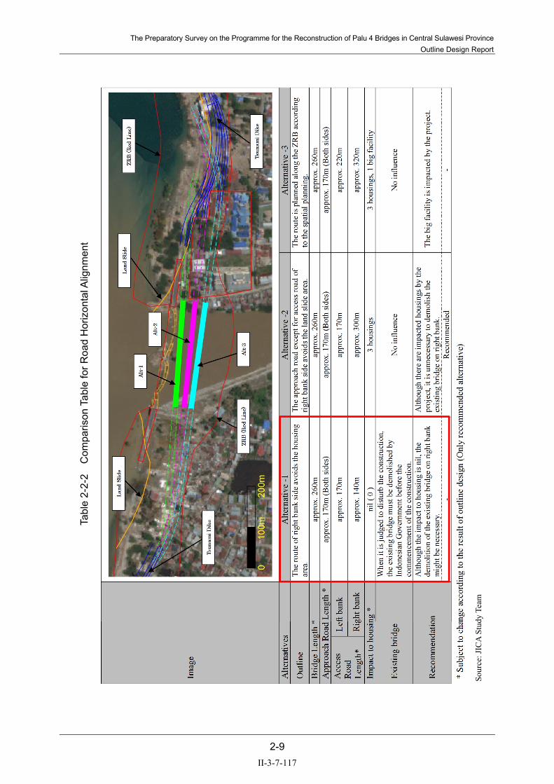
The Preparatory Survey on the Programme for the Reconstruction of Palu 4 Bridges in Central Sulawesi Province Outline Design Report
2-9
Tabl
e 2-
2-2
Com
paris
on T
able
for R
oad
Hor
izon
tal A
lignm
ent
Sour
ce: J
ICA
Stud
y Te
am
II-3-7-117

The Preparatory Survey on the Programme for the Reconstruction of Palu 4 Bridges in Central Sulawesi Province Outline Design Report
2-10
2-2-2-3 Bridge Plan
(1) Design Conditions
1) Hydrological Condition
(a) Return Period
Return period of the Palu River is instituted in a 25-year return period. According to the maximum records, the highest water level surveyed by visual observation and hearing of the previous Palu 4 Bridge area has flown several times over the existing bank so far. Therefore, a 25-return period is applied for Palu 4 Bridge.
(b) Estimated High-water Discharge Volume
Estimated high-water discharge volume of Palu 4 Bridge calculated by a 25-year return period is shown in Table 2-2-3.
Table 2-2-3 Estimated High-water Discharge Volume
Return Period Estimated Highest Water Level (m)
Estimated High-water Discharge Volume (m3/s)
1/25 EL. +1.230 1,000*
*Note: The high water discharge volume estimated by BWS in 2017 is 800 m3/s (756.024 m3/s). However, the JICA Study Team is considering river and basin countermeasures targeting the 2016 floods. Even if the considerations to determine the scale of both river and basin countermeasures are on-going, the estimated design flood discharge in the downstream of Palu River is supposed to not exceed 1,000m3/s, because of the difficulties to widen the river..
Source: JICA Study Team
(c) Design Flow Velocity
Design flow velocity in the 25-year return period for bridge planning is shown in Table 2-2-4.
Table 2-2-4 Design Flow Velocity
Return Period Design Flow Velocity (m/s) 1/25 1.210
Source: BWS (2017), “Investigation and Design Survey on the Palu River Boundary in Palu City of 2017”
(d) Highest Water Level
The highest water level should be set considering a calculation result by a 25-year return period, a record of the high tide and the maximum wave height generated by tsunami as shown in Table 2-2-5.
Table 2-2-5 Highest Water Level
Source Highest water Level (m) 25-year return period 1.230 Record of high tide (Mean High Water Spring) 2.316 Record of tsunami 6.500
Source: JICA Study Team
II-3-7-118

The Preparatory Survey on the Programme for the Reconstruction of Palu 4 Bridges in Central Sulawesi Province Outline Design Report
2-11
(e) Embedment Depth
Embedment depth of the foundation in the main stream of the river should at least be kept more than 2 m depth shown in Figure 2-2-6.
Source: MLIT (Ministry of Land, Infrastructure, Transport and Tourism)
Figure 2-2-6 Embedment Depth
(f) Blockade Ratio Caused by Structures in the River
Palu 4 Bridge is located on an important ring road connecting east and west furthermore north and south roads. The blockade rati caused by structures in the river is kept at less than 5% in the Standard of MLIT in Japan. The blockade ratio is calculated using the following formula.
Blockade Ratio= Sum of structure width × <100 (%) 5 % River Width
Accordingly, width of the Palu River is now 230m long at the point, so that sum of structure width should be kept less than 11.5m long.
(g) Requested Span Length
Requested span length is calculated using the following formula as shown in Figure 2-2-7 based on the Standard of MLIT.
L = 20 + 0.005Q
Here, L: Requested span length (m) Q: Estimated High-water Discharge Volume (m3/s) Estimated High-water Discharge Volume (m3/s): 1,000 Requested Span Length (m): more than 25.0
II-3-7-119

The Preparatory Survey on the Programme for the Reconstruction of Palu 4 Bridges in Central Sulawesi Province Outline Design Report
2-12
Source: MLIT (Ministry of Land, Infrastructure, Transport and Tourism)
Figure 2-2-7 Calculation Flowchart of Requested Span Length
2) Load Condition
(a) Dead Load
Dead load of each material is shown in Table 2-2-6 stipulated in the Japanese Standard.
Table 2-2-6 Unit Weight
Material Content Unit weight (kN/m3) Steel 77.0 Reinforced concrete 24.5 Plain (Non-reinforced) concrete 23.0 Cement mortar 21.0 Asphalt concrete 22.5 Sand, gravel 20.0 Sandy soil 19.0 Clay soil 18.0
Source: MLIT (Ministry of Land, Infrastructure, Transport and Tourism)
(b) Live Load
Live load applies two (2) types such as L type (uniform load) and T type (concentrated load) of JRA. Moreover, each element of the bridge structure shall be verified by applying D type (uniform load) and T type (concentrated load) of SNI.
II-3-7-120

The Preparatory Survey on the Programme for the Reconstruction of Palu 4 Bridges in Central Sulawesi Province Outline Design Report
2-13
(c) Impact
The impact of the live load shall be considered. Calculation of the impact shall apply the Japanese Standard. And then the impact of the live load should not be applied to the design of the sub-structure.
(d) Influence of Creep for Concrete and dry Shrinkage for Concrete
The creep strain and drying shrinkage related to the age of concrete material shall be calculated according to Specifications for Highway Bridges (Part III), and the creep coefficient after the completion of structural elements shall be 1.50 for main girder concrete. The drying shrinkage rate of main girder concrete shall be 15.00×10⁻⁵.
(e) Thermal Load
An annual average highest temperature is approximately 30.7 degrees (monthly average highest temperature: 32.1 degrees in October) and an annual average lowest temperature is approximately 23.0 degrees (monthly average lowest temperature: 22.0 degrees in July) along the objective area. As the result of each temperature, an annual average temperature is 26.8 degrees. Therefore, the thermal force shall be considered as ±15 degrees as an annual average temperature in consideration with the difference of a monthly average highest temperature and a monthly average lowest temperature.
(f) Static/Dynamic Earth Pressure
Earth pressure shall appropriately consider the type of structure and the earth conditions based on the Japanese Standard.
(g) Static/Dynamic Water Pressure
The pressure of the water shall appropriately consider the change of the water level, flow velocity, scouring, and shape/measurement size of the pier based on the Japanese Standard.
(h) Tsunami Load
The pressure of tsunami shall be the largest of the values calculated from the formulas proposed in the following standards:
Technical Standards and Commentaries for Coastal Facilities, August 2018.
The Principles of Parapet Design Considering Tsunamis (Provisional Version), November 2015.
An Experimental Study on Wave Force Acting on On-shore Structures Due to Overflowing Tsunamis (Asakura et al., Coastal Engineering Proceedings Vol. 47, 2000).
(i) Buoyancy and Uplift
Buoyancy and uplift shall appropriately consider the pore water and the change of the water level.
II-3-7-121

The Preparatory Survey on the Programme for the Reconstruction of Palu 4 Bridges in Central Sulawesi Province Outline Design Report
2-14
(j) Wind Load
Wind load shall be considered on this Project because there is influence along Palu Bay to the objective bridges.
(k) Seismic Load
Seismic load including liquefaction prediction applies JRA based on the geological result surveyed at the new location of the Palu 4 Bridge site. Moreover, the whole structure and each element of the bridge shall also be verified by applying SNI and site seismic hazard analysis. Distribution map of Earthquakes in Sulawesi island is shown in Figure 2-2-8. And the estimated fault in the Palu Bay is shown in Figure 2-2-9. Moreover, magnitude and earthquakes are classified in Table 2-2-7. Frequency of the occurrence in Japan is sampled as the relationship of the earthquake scale and the magnitude in Table 2-2-8.
II-3-7-122

The Preparatory Survey on the Programme for the Reconstruction of Palu 4 Bridges in Central Sulawesi Province Outline Design Report
2-15
Source: SNI- INDONESIA EARTHQUAKE SOURCES AND EARTHQUAKE 2017 MAP
Figure 2-2-8 Distribution map of Earthquakes in Sulawesi island
II-3-7-123

The Preparatory Survey on the Programme for the Reconstruction of Palu 4 Bridges in Central Sulawesi Province Outline Design Report
2-16
Source: JICA Study Team
Figure 2-2-9 Estimated Fault in the Palu Bay Area
Table 2-2-7 Classification of Earthquakes by Magnitude (M)
Mega Earthquake 8 ≤ M Great Earthquake 7 ≤ M Moderate Earthquake 5 ≤ M < 7 Minor Earthquake 3 ≤ M < 5 Micro Earthquake 1 ≤ M < 3 Ultra-micro Earthquake 1 < M
Source: National Research Institute for Earth Science and Disaster Prevention
Palu River
II-3-7-124

The Preparatory Survey on the Programme for the Reconstruction of Palu 4 Bridges in Central Sulawesi Province Outline Design Report
2-17
Table 2-2-8 Relationship of Earthquake Scale and Magnitude (M)
Source: National Research Institute for Earth Science and Disaster Prevention
(l) Collision Load
Since there is some possibility of collisions with the piers during flooding, a collision load shall be appropriately considered based on the Japanese Standard.
(2) Basic Plan for Bridge
1) Basic Policy
The basic policy and its contents are described in Table 2-2-9. The objective bridges shall be planned based on the basic policy. The scale and type of the objective bridges are decided in this chapter.
M Outline of Earthquake (in case of earthquakeoccurred at shallow depth)
Earthquake Occurrencein around Japan
large damage in wide area if earthquakeoccurred in land, tsunami if earthquake occurredat seabed
Meg
a Ea
rthqu
ake
Gre
at E
arth
quak
e
6
Scale
occurrence mega diastrophism in around severalhundred kilometer or 1,000 kilometer,catastrophe and/or giant tsunami in wide area
9
8
catastrophe in wide area if earthquake occurredin land, large tsunami if earthquake occurred atseabed
3
2
1
0
7
insensitive to quake to the people
Mod
erat
eEa
rthqu
ake
Min
orEa
rthqu
ake
Mic
roea
rthqu
ake
Ultr
a-m
icro
Earth
quak
e
-1
small damage around the epicenter, largedamage in case of ground condition if the area isnear M7minor damage or some damage in case ofground condition if the area is near aroundepicentermacroseismic area at the epicenter, macrodamage at the epicenter if the hypocenter isvery shallow
rarely macroseismic area at the epicenter
rarely macroseismic area if the hypocenter isvery shallow
insensitive to quake to the people
insensitive to quake to the people
insensitive to quake to the people
5
4
once a several hundredyears
around once or twice ayear
once a ten years
around 10~15 timesa year
around 10 times a month
occurrence in countless
around 10 times a hour
around 10 times a day
around several timesa day
around once or twicea minute
II-3-7-125

The Preparatory Survey on the Programme for the Reconstruction of Palu 4 Bridges in Central Sulawesi Province Outline Design Report
2-18
Table 2-2-9 Basic Policy of Bridge Plan
Policy of the Planning Contents of the Policy ① Suitable Alignment and
Bridge Location In order to keep an economical bridge length and safe and comfortable travelling, a suitable road alignment and bridge location shall be considered.
② Economy Selection of the bridge material/type shall consider not only the economy of construction costs but also the life cycle cost spent for maintenance.
③ Workability The bridge plan shall prioritize safety first and select the bridge type of exact erection method. Furthermore, the bridge plan shall consider the road users and surrounding people.
④ Scenery The bridge plan shall be considered in harmony with the surrounding environmental situation.
⑤ Aseismicity The bridge plan shall adequately consider the aseismatic design based on the past seismic records.
⑥ Clearance The bridge plan shall consider the influence of flooding and debris in the river. Therefore, clearance shall be analyzed based on rainfall and hydrological data. Furthermore, high tide and influence of tsunami should be also considered.
⑦ Seasonal Changes The bridge plan shall be studied in consideration with both rainy and dry seasons for the plan of road elevation and erection method.
⑧ Construction Space The bridge plan shall be studied in consideration with no affect to road users for the limited construction yard.
⑨ Transportation for Construction
Transportation issues restrict length, height, and weight of bridge; members and materials shall be surveyed on the bridge plan.
⑩ Traffic safety during Construction
The bridge plan shall consider road users during construction work, erection of temporary bridge, and preparation of temporary yard.
⑪ Social Vulnerability Based on the results of a social condition survey, a bridge plan shall decide the sidewalk on the bridge and bridge composition with enough discussion with Indonesian side.
Source: JICA Study Team
2) Flowchart of Bridge Plan
The selection process for the bridge type is shown in Figure 2-2-10.
II-3-7-126

The Preparatory Survey on the Programme for the Reconstruction of Palu 4 Bridges in Central Sulawesi Province Outline Design Report
2-19
Source: JICA Study Team
Figure 2-2-10 Flowchart for Selection Process for Bridge Type
II-3-7-127

The Preparatory Survey on the Programme for the Reconstruction of Palu 4 Bridges in Central Sulawesi Province Outline Design Report
2-20
3) Plan for Selection of Bridge Location
(a) Selection Policy
The plan for the bridge location shall be selected based on the following policies:
Basic item:
Location considers approach road alignment for safe and smooth traffic.
Location allows construction space that does not disturb road users.
Item considered objective area:
Location does not require the removal of residences and buildings surrounding the previous Palu 4 Bridge.
Location does not hinder ZRB area.
Location considers a future tsunami dike alignment for the approach road.
(b) Study for Bridge Location
As the result of route selection (see Table 2-2-2), the alternative 1 has been selected. Thus, the bridge plan is carried out at the location.
(c) Study for Abutment Location and Bridge Length
There are no records of overflow in the vicinity of the pre-collapse positions of bridge piers. Therefore, the positions of the new abutments that will be constructed on both banks should be in the same positions as the former bridge piers or on the landward side of these positions from a safety standpoint, and the bridge length is set at 260m.
4) Study for Bridge Material and Bridge Type
(a) Bridge Type of Superstructure and Span Length
As mentioned above, the bridge length has been planned in 260 meters and span length is necessary to ensure more than 25 meters. Regarding the span in 260 meters, it is desirable that the span length is ensured more than 40 meters considering the flood-wood, other bulk trash and span length of existing bridge during monsoon.
The applicable bridge type under conditions of the circumstances is described below.
3-span: 2 x 75.0m + 110.0m = 260.0m (Box-type/deck-box-type Steel-girder bridge, Box-type PC-girder bridge)
5-span: 5 x 52.0m = 260.0m (I-type Steel-girder bridge, Box-type/deck-box-type Steel-girder bridge, Box-type PC-girder bridge)
The bridge type of superstructure and span length are shown in Table 2-2-10.
II-3-7-128

The Preparatory Survey on the Programme for the Reconstruction of Palu 4 Bridges in Central Sulawesi Province Outline Design Report
2-21
Table 2-2-10 Bridge Type of Superstructure and Span Length
Source: Bridge Hand Manual
According to Table 2-2-10, steel I-typed girder and steel box-typed girder should be adopted the track crane or the launching girder as erection method. On the other hand, PC Bridge can be adopted the launching girder or the fixed typed support, however, the balanced cantilever method should be adopted considering erection equipment and economic efficiency.
(b) Span Type
As mentioned above, the objective bridge is studied for 3-span or 5-span. The comparison table for the span is shown in Table 2-2-11.
トラス橋
アーチ橋
20 40 60 80 100
鋼桁橋
I桁橋
箱桁橋
1/22~1/28
主桁高/支間長
1/7.0~10.0
スパンライズ比
1/5.3~76.3
1/16~1/22
1/20~1/30
Type Shape ElectionMethod
Span Ratio
Stee
l Brid
ge
Girder Type
I-typed
Box typed
Steel deck box typed
Truss Type
Arch Type
Truck Crane/ Launching
Truck Crane/Launching Launching
Truck Crane/Launching Launching
Tower Crane
Tower Crane
場所打RC
プレテン桁
T桁橋
床版橋
連結T桁橋
中空床版橋
箱桁橋 固定支保工 1/16~1/22
クレーン架設
架設桁架設1/13~1/17
クレーン架設
固定支保工 1/20~1/24
1/14~1/25
1/8~1/11
20 40 60 80 100
RC
Pre- tension
Post- tension
(site product)
Type
T-typed
Shape Election Method
Slab typed
Fixed typed support/Launching
Span
Slab typed Fix typed support
Ratio
Box typed
Fix typed support
Connected T-typed
Con
cret
e B
ridge
Truck crane
Gantry crane/ erectiongirder
II-3-7-129

The Preparatory Survey on the Programme for the Reconstruction of Palu 4 Bridges in Central Sulawesi Province Outline Design Report
2-22
Table 2-2-11 Comparison Table for Span Item 3-Span Type 5-Span Type
Span length (m) 75.0, 110.0, 75.0 5 x 52.0
Girder height (m) Steel I-type* - 3.0 (1/17)
Steel box-type* - - PC box-type* 3.0 (1/25), 72 (1/18), 3.0 3.5 (1/15)
Number of piers (No.) 2 4
Influence on the vertical road alignment
PC type is much longer than Steel type because of much higher girder height △
Steel type is much shorter than PC type
Influence on the substructure/construction period
Two large size piers, but not much influence on the construction period because of lesser piers than 5-Span Type
There are four piers and pier size is smaller than 3-Span Type, but much influence on the construction period because of more piers than 3-Span Type △
Total cost Almost similar cost with 5-Span Type
Almost similar cost with 3-Span Type
Total evaluation
: Highly effective, △: Effective, : Ineffective *: Steel I type: Ratio of Girder Height/Span Length, PC box type: Ratio of Girder Height/Span Length
As a result of comparison, 3-span and 5-span are competitive, thus, comprehensive study including bridge type should be carried out. The comparison for the span is described below.
(c) Selection of Bridge Type
The following bridge type has been selected by reference to Table 2-2-10.
Alternative 1: 3-span box-type PC-girder bridge 75.0m+110.0m+75.0m = 260.0 m Alternative 2: 5-span box-type PC-girder bridge 5 x 52.0 m = 260.0 m Alternative 3: 5-span I-type Steel-girder bridge 5 x 52.0 m = 260.0 m
(d) Comparison for Bridge Type
The comparison for selected bridge type is shown in Table 2-2-12.
As a result, alternative 1 (PC-Box Girder Bridge with variable depth) has been adopted from the viewpoint of the following reasons.
Aesthetic and symbolic views because of the wide center span and the variation of the girder height of the bridge
Separate construction work of the superstructure without approach roads
Cheapest maintenance cost
Possibility for using Japanese technology
II-3-7-130

The Preparatory Survey on the Programme for the Reconstruction of Palu 4 Bridges in Central Sulawesi Province Outline Design Report
2-23
Tabl
e 2-
2-12
C
ompa
rison
Tab
le fo
r Brid
ge T
ype
Sour
ce: J
ICA
Stud
y Te
am
II-3-7-131

The Preparatory Survey on the Programme for the Reconstruction of Palu 4 Bridges in Central Sulawesi Province Outline Design Report
2-24
5) Study for Type of Substructure and Foundation
(a) Depth of Bearing Layer
The formation level of the footing is especially important to keep from the scouring in the river. The N value of each abutment and pier is as below. The bearing layer is approximately 60m from the ground surface as shown in Figure 2-2-11.
Source: JICA Study Team
Figure 2-2-11 Boring Log
II-3-7-132

The Preparatory Survey on the Programme for the Reconstruction of Palu 4 Bridges in Central Sulawesi Province
Outline Design Report
2-25
(b) Selection of Foundation Type
The results of geological survey indicated that a type of deep foundation must be selected to reach the
bearing layer. The possible types of deep foundation include pile foundation, caisson foundation, and
steel pipe sheet pile well foundation, and all of these types are appropriate for technology transfer
from Japan.
Table 2-2-13 Comparison Table for Foundation Type
Source: JICA Study Team
The results of the comparisons, the pile foundation has been selected from the viewpoint of the
economic efficiency and construction period. The bridge type has been selected Box Girder and
center span has been planned 110m, thus, the load on the substructure is heavy.
Regarding the comparison for the pile type and diameter, the comparison tables are shown in Table
2-2-13 and Table 2-2-14.
The result of the comparison, the Cast-in-Place Concrete Pile dia.1800 is adopted considering the
conditions such as the economic efficiency and construction period.
II-3-7-133

The Preparatory Survey on the Programme for the Reconstruction of Palu 4 Bridges in Central Sulawesi Province
Outline Design Report
2-26
Table 2-2-14 Comparison Table for Pile Type and Diameter
Source: JICA Study Team
(c) Installation Surface of Abutments and Piers
The footing installation surfaces for abutments and piers shall be determined based on the results of
topographic survey, paying attention to future plans for the riverbed surface.
The height of installation surface of substructure is shown in Figure 2-2-12.
II-3-7-134

The Preparatory Survey on the Programme for the Reconstruction of Palu 4 Bridges in Central Sulawesi Province
Outline Design Report
2-27
Earth Covering Abutments (A1/A2) Earth Covering of Piers (P1/P2)
Source: JICA Study Team Figure 2-2-12 Height for Installation Surface of Substructure
A1 Abutment
The abutment height will be approximately 14.0 m, and the use of inverted T-type abutments will be
possible. The embedment in the top face of footings shall be 0.5 m below the planned ground surface.
P1Pier
The embedment in the top face of footings shall be 2.0 m below the planned riverbed surface,
considering the effect of rivered souring, and protection with wire mats shall be used.
P2 Pier
The embedment in the top face of footings shall be 2.0 m below the planned riverbed surface,
considering the effect of riverbed scouring, and protection with wire mats shall be used.
A2 Abutment
The abutment height will be approximately 13.0 m, and the use of invert T-type abutments will be
possible. The embedment in the top face of footings shall be 0.5 m below the planned ground surface.
(d) Selection of Substructure Type
The substructure type should be selected by reference to Table 2-2-15 and Table 2-2-16. For the type
of abutments, we select inverted T-type abutments because the abutment height is in the range from
10.0 to 15.0 m. For the type of piers, we select wall-type piers with little influence on water flow,
because all piers will be located within the river.
Gabion
II-3-7-135

The Preparatory Survey on the Programme for the Reconstruction of Palu 4 Bridges in Central Sulawesi Province Outline Design Report
2-28
Table 2-2-15 Selection of Abutment
Source: MLIT (Ministry of Land, Infrastructure, Transport and Tourism)
Table 2-2-16 Selection of Pier
Source: MLIT (Ministry of Land, Infrastructure, Transport and Tourism)
(3) Bridge Design
Previous Palu 4 Bridge had been as symbol of the Palu city before the disaster. However, the symbol has been lost due to the disaster. Besides, the logistics have been affected because the previous traffic mast detour the Palu I Bridge and the Palu III Bridge. Under the circumstances, Indonesian Government has requested to introduce the aesthetic of bridge as symbol of reconstruction. The study for the aesthetic of the bridge has been carried out considering the characteristics of Japanese Grant Project as shown in Table 2-2-17.
Abutment Type Height (m)
Remarks
T-Type
Rigid Frame Type
Box Type
Earth Pressure Relieved Type
Type
Height (m) Remarks
Column Type Wall Type
Rigid Frame Type (1 layer)
Rigid Frame Type (2 layers)
2 Columns Type
(Including hollow Type)
II-3-7-136

The Preparatory Survey on the Programme for the Reconstruction of Palu 4 Bridges in Central Sulawesi Province Outline Design Report
2-29
Alternative 1: The special form is proposed in order to mitigate the oppressive feeling and bring harmony with the natural environment.
Alternative 2: The statue is proposed in order to improve the bridge space as a landmark.
Alternative 3: The balcony is proposed in order to ensure the space for scenery. Besides, the design will be improved by the balcony considering the aesthetic.
Alternative 4: The light up is proposed in order to beautify the bridge for night.
Table 2-2-17 Study for the esthetic of the bridge
Source: JICA Study Team
As a result of the discussion in Japan, the alternative 3 has been selected among four alternatives. Thus, JICA Study Team will discuss the adoption of alternative 3 with Indonesian Government.
2-2-3 Outline Design Drawings
Outline design drawings including plan, profile, typical cross section, and general view of bridge are provided as below.
II-3-7-137

The Preparatory Survey on the Programme for the Reconstruction of Palu 4 Bridges in Central Sulawesi Province Outline Design Report
2-30
Figu
re 2
-2-1
3 P
lan
(1)
II-3-7-138

The Preparatory Survey on the Programme for the Reconstruction of Palu 4 Bridges in Central Sulawesi Province Outline Design Report
2-31
Figu
re 2
-2-1
4 P
lan
(2)
II-3-7-139

The Preparatory Survey on the Programme for the Reconstruction of Palu 4 Bridges in Central Sulawesi Province Outline Design Report
2-32
Figu
re 2
-2-1
5 P
rofil
e (1
)
II-3-7-140

The Preparatory Survey on the Programme for the Reconstruction of Palu 4 Bridges in Central Sulawesi Province Outline Design Report
2-33
Figu
re 2
-2-1
6 P
rofil
e (2
)
II-3-7-141

The Preparatory Survey on the Programme for the Reconstruction of Palu 4 Bridges in Central Sulawesi Province Outline Design Report
2-34
Figu
re 2
-2-1
7 T
ypic
al C
ross
Sec
tion
(1)
II-3-7-142
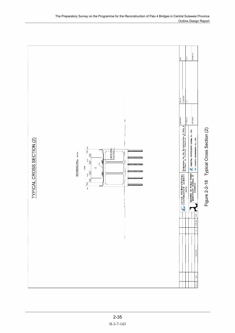
The Preparatory Survey on the Programme for the Reconstruction of Palu 4 Bridges in Central Sulawesi Province Outline Design Report
2-35
Figu
re 2
-2-1
8 T
ypic
al C
ross
Sec
tion
(2)
II-3-7-143

The Preparatory Survey on the Programme for the Reconstruction of Palu 4 Bridges in Central Sulawesi Province Outline Design Report
2-36
Figu
re 2
-2-1
9 G
ener
al V
iew
of B
ridge
(1)
II-3-7-144

The Preparatory Survey on the Programme for the Reconstruction of Palu 4 Bridges in Central Sulawesi Province Outline Design Report
2-37
Figu
re 2
-2-2
0 G
ener
al V
iew
of B
ridge
(2)
II-3-7-145

The Preparatory Survey on the Programme for the Reconstruction of Palu 4 Bridges in Central Sulawesi Province Outline Design Report
2-38
2-2-4 Implementation Plan
2-2-4-1 Implementation Policy
The Palu 4 Bridge is located in the river mouth area of the Palu River strongly affected by the tide level, and the project involves over-water work with the tidal range of approximately 2.8 m (water depth from 0.5 m to 3.3 m). The following describes the implementation policy for the bridge construction.
(1) Substructure
Because abutment construction will be performed on land, it will be general structure construction using self-standing cofferdam work or unsupported excavation. Pier construction will be performed on water, and the pile foundation and main frame construction works will be performed on temporary jetties. It should be noted that the cofferdam work for piers will be performed underwater, and it is necessary to take into consideration the impact of the water level with the daily tidal range of 2.8 m.
Source: JICA Study Team
Figure 2-2-21 Construction for Substructure
(2) Superstructure
Because the work on bridge superstructure will be performed over the water, supporting work involving the construction of gantries will be uneconomical and will require long work period, and the use of cantilevered construction making use of P1 and P2 piers will be advantageous. The supply of materials will be provided using a temporary jetty.
II-3-7-146

The Preparatory Survey on the Programme for the Reconstruction of Palu 4 Bridges in Central Sulawesi Province Outline Design Report
2-39
Source: JICA Study Team
Figure 2-2-22 Construction for Superstructure
2-2-4-2 Implementation Considerations
(1) Construction Period
Because the Government of Indonesia requests for early completion of work, it is necessary to perform work both from the right bank and the left bank simultaneously. The period of work is assumed to be 20 months at the present, as shown in Figure 2-2-23. However, because geological explorations have not been completed at the time of this assumption, it may change in the detailed design.
Source: JICA Study Team
Figure 2-2-23 Construction Period
(2) Construction on the water
It is necessary to keep in mind that the coffering work for pier construction is performed in the river mouth area of the Palu River, and the water depth changes between 0.5 m and 3.3 m.
II-3-7-147

The Preparatory Survey on the Programme for the Reconstruction of Palu 4 Bridges in Central Sulawesi Province Outline Design Report
2-40
(3) Approach Road
The approach road areas will have the banking height of 0-11 m, and they are expected to have relatively soft soil. The measures against subsidence of foundation structures and other necessary measures will be considered after the completion of geological explorations.
(4) Characteristic of Construction Site
The construction site is on Sulawesi Island, and large special construction machines must be procured from Java Island or a third country. Attention must be paid to the influence of transportation on work period. In addition, while general workers can be recruited from Sulawesi Island, special skilled workers must be procured from Java Island or a third country.
2-2-4-3 Scope of Works
When this project is conducted through Japanese grant aid, the division of responsibilities between Japan and Indonesia concerning construction work shall be as follows.
(1) Implementation by Japan
Transportation of materials and equipment from Japan or a third country to the port of discharge
Land transport from the port of discharge in Indonesia or the source of materials and equipment to the site
Construction of slope collapse countermeasures and road restoration work indicated in the design drawings
Construction and removal of work bases, work yards, and camps associated with the construction work
Procurement of materials, equipment, and workforce needed for the construction work
Work management services needed for the construction work
Consultant services needed for the implementation of the project
(2) Implementation by Indonesia
Acquisition of and compensation for the land needed for the implementation of this project, the procedures for relocation of public facilities and obstacles within the site, and the work for relocation.
Coordination with relevant authorities and obtaining permissions and authorization concerning the installation of facilities. In particular, agreement with DHR.
A/P notification and fee payment to the Japanese bank according to Banking Arrangements
Exemption from customs duties and exemption from customs clearance fees concerning the products landed at the port
II-3-7-148

The Preparatory Survey on the Programme for the Reconstruction of Palu 4 Bridges in Central Sulawesi Province Outline Design Report
2-41
Exempting Japanese persons from the payment of customs duties, domestic taxes, and value-added tax on the products and services procured within the framework of the certification contract
Relocation of electric power, water supply, drainage, and other facilities to the vicinity of the site. Coordination with relevant authorities and obtaining permission and authorization concerning installation, supply of electricity to lighting and signalling facilities, etc.
Road maintenance in the maintenance segments other than the segments to be improved by the Japanese side
As necessary, improvement work on existing roads after the completion of the construction work conducted by the Japanese side
Appropriate use and maintenance of the facilities constructed through this grant aid cooperation
Paying the expenses needed for the construction of facilities other than the expenses covered by this grant aid cooperation
2-2-4-4 Consultant Supervision
For the implementation of this project, the first steps are the Exchange of Notes (E/N) between the Governments of Japan and Indonesia and the conclusion of the Grant Agreement (G/A) between JICA and the Government of Indonesia. After the conclusion of the above, the consultant and the Ministry of Public Works and Housing (hereinafter referred to as PU), which is the implementing agency on the Indonesian side, enter into the consultant service agreement regarding the implementation design, tender assistance services, and construction supervision based on the letter of recommendation issued by JICA. The matters contained in the consultant agreement are as follows.
(1) Preparation of Bidding Documents
To prepare bidding contract documents based on the results of the present study report and obtain the approval of PU. The bidding contract includes the following matters.
Design drawings and quantities
Bidding instructions, construction contract (draft), and technical specifications
(2) Tender Assistance
The consultant assists PU in conducting the bid for the construction work. The tender assistance service includes the following matters.
Bid announcement
Prequalification examination
Bid evaluation
Contract negotiation
II-3-7-149

The Preparatory Survey on the Programme for the Reconstruction of Palu 4 Bridges in Central Sulawesi Province Outline Design Report
2-42
(3) Construction Supervision
Following the JICA’s approval of the construction contract, the consultant issues the notice to proceed to the constructor and begins construction supervision services. In the construction supervision services, the consultant provides reports on the progress of construction directly to PU, Japanese embassy in the country, etc. For the constructor, the consultant performs the official activities concerning the progress of work, product quality, safety, and payments, and makes proposals for technical improvement of work.
In addition, the consultant conducts coordination and consultation with JICA, the Japanese embassy in the country, and the Government of Indonesia as necessary. The main contents of services are as shown in Table 2-2-18.
Table 2-2-18 Construction Supervision Plan
Division Contents of Service ① Approval of work
execution plan and working drawings
To verify that the work execution plan, construction schedule, and working drawings conform to the contract, contract drawings, specifications, etc. and give approval.
② Process supervision To receive the report of work progress from the constructor and give orders necessary to ensure the timely completion of construction.
③ Quality supervision To inspect the conformity of construction materials and work execution to contract drawings and specifications and give approval.
④ Output supervision To inspect as-built cross-sections, planar shapes, etc. to verify that the as-built products conform to the supervision standard and also to confirm quantities.
⑤ Issuance of certificates To necessary certificates regarding the constructor payment, completion of work, end of warranty period, etc.
⑥ Submission of reports To inspect the monthly work reports, as-built drawings, as-built photographs, etc. prepared by the constructor and submit them to the Government of Indonesia and JICA. In addition, to produce the report of completion submit it to JICA after the completion of construction.
Source: JICA Study Team
2-2-4-5 Quality Control Plan
Quality control shall be conducted based on the specifications developed in the project. The specifications shall be in accordance to AASHTO or the Japanese standards and test methods. The quality control plan (draft) is shown in Table 2-2-19, and the as-built management plan (draft) is shown in Table 2-2-20.
II-3-7-150

The Preparatory Survey on the Programme for the Reconstruction of Palu 4 Bridges in Central Sulawesi Province Outline Design Report
2-43
Table 2-2-19 Quality Control Plan
Work Objective Inspection, Test for Supervision , etc. Frequency of Inspection and Test
Earthwork, asphalt pavement work, roadbed, subgrade, filling of structures
Materials management
CBR test, soil quality test (specific gravity, grain size, moisture content, liquidity & plastic limit, density), lubricant test (specific gravity, grain size, strength, water absorption), bituminous materials (quality certificate, component analysis table)
Before work
Routine management
Compaction density test, moisture content, bituminous materials (stability, flow value, percentage of voids, Marshall test, temperature)
Shortly after work Once daily for each layer in each work area
Concrete work Batcher plant Weighing equipment: mixing performance, static load test; batching control board: dynamic load test, mixing performance
Before work, monthly (every 3 months for loading tests)
Materials Cement, water: tests using standard conformity certificates. Fine aggregate & coarse aggregate tests, grading, specific gravity, water absorption, unit weight, durability, alkali-aggregate reaction
Before work and when a different material is used
Concrete standard tests
Test mixing to determine composition. Slump, air content, temperature, test piece strength
Before work
Routine management
Fresh concrete: air content, slump, temperature First 5 consecutive units and thereafter at 50 m3 intervals, and when test pieces are made
Placement of concrete: placement method, compacting, position of construction joint, curing method, treatment of laitance
Witness inspection at the time of placement
Concrete test piece: test for compressive strength of test piece. Preparation of concrete control chart
Test pieces are made once daily; 7 days and 28 days after placement
Rebar and prestressing steel
Materials Rebar and prestressing steel are confirmed by mill sheets from the manufacturers. Quality, tensile strength, bending tests
Before work
Installation inspection & routine management
Tests are conducted on the built assembly in terms of: material size, dimensions, allocation, lap length, cover, condition of fixation, treatment of construction joint
Before concrete work: 100% inspection for each segment of concrete placement
Tensioning of prestressing steel
Confirmation of concrete strength
Compressive strength of concrete test piece Before tensioning
Tensioning device
Calibration of jacks and pumps Before tensioning. For every 50 cables tensioned and when the combination of tensioning devices is changed
Test tensioning According to tension control chart Before final tensioning Tension control Control of individual cables
Control of groups of cables Control of transverse prestressing steel
At the time of tensioning Tension control chart
PC grout Mix design Consistency, bleeding rate, expansion rate, strength, total salt
Before use
Routine management
Consistency, temperature Once daily, for every 5 batchesBleeding rate, expansion rate, compressive strength
Once daily
Source: JICA Study Team
II-3-7-151

The Preparatory Survey on the Programme for the Reconstruction of Palu 4 Bridges in Central Sulawesi Province Outline Design Report
2-44
Table 2-2-20 As-Built Management Plan
Work Process Item Standard Value Remarks
Earthwork Roadbed Planned height 5cm At 40m intervals Width -10cm or more 〃
Base course Planned height ±4cm(±2.5cm) or more 〃
Finished thickness -4.5cm(-2.5cm)or more 〃
Width -5cm or more 〃
Pavement Asphalt pavement
Width ±4cm or more 〃
Thickness -1.5cm or more 〃 Mean of 10 data
Foundation work Crusher-run unscreened gravel, crushed stone, rubble, leveling concrete
Width Design value or more Thickness -30mm Elongation
Depends on each structure
H section steel, steel pile
Standard height ±50mm Embedment length Design value or more Eccentricity Within D/4 and within
100mm
Inclination Within 1/100 Rebar work Assembly Average interval ±Φ Φ: rebar diameter
Cover ±Φ and no less than the minimal required cover Φ: rebar diameter
Concrete structure (retaining wall work)
Standard height ±50mm For each 40m/1 place Thickness -20mm For each 40m/1 place
Width -30mm For each 40m/1 place
Height -50mm For each 40m/1 place
Elongation -200mm 40m/1 work area
Source: JICA Study Team
2-2-4-6 Procurement Plan
(1) Construction Materials
While prestressing cables will be imported from Japan or a third country, other construction materials such as concrete and asphalt materials can be procured in Indonesia. Table 2-2-21 lists the sources of main materials procured.
II-3-7-152

The Preparatory Survey on the Programme for the Reconstruction of Palu 4 Bridges in Central Sulawesi Province Outline Design Report
2-45
Table 2-2-21 Procurement List of Materials
Construction Material Local Procurement From Japan From Third
Country Remarks
Steel
Prestressing steel
Rebar (D13~D32)
Rebar (D36~D50) Custom-made locally
H section steel
Cement
Asphalt concrete
Ready-mixed concrete
Crushed stone & sand
Form materials
Steel form
Timbering & scaffolding materials
Hume pipe
Source: JICA Study Team
1) Concrete
Concrete can be supplied from the ready-mixed concrete factory “PT.UTAMA BETON,” which is located approximately 50 km northeast of the mouth of the Palu River.
2) Bitumen and Asphalt
In the vicinities of Palu City, asphalt mixtures for pavement work can be supplied without problems from “PT.Asbuton Jaya Abadi.”
3) Steel Materials
H section steel and other types of steel materials will be procured manly from Jakarta. There is no problem in supply.
4) Aggregate
There are several quarries, such as “PT.Watu Merida Jaya” located 15 km northwest of the mouth of the Palu River. There is no problem in the supply of aggregates.
5) Location of Procurement
The location of procurement is shown in Figure 2-2-24.
II-3-7-153

The Preparatory Survey on the Programme for the Reconstruction of Palu 4 Bridges in Central Sulawesi Province Outline Design Report
2-46
Source: JICA Study Team
Figure 2-2-24 Location of Procurement
(2) Construction Machines
The general-purpose machines used in this project will be procured from Indonesia as a rule. Table 2-2-22 lists the sources of main equipment procured.
Table 2-2-22 Procurement List of Machines
Construction Machine Local Procurement From Japan From Third
Country Remarks
Dump truck Backhoe Bulldozer Truck crane Asphalt finisher Tire roller Vibration roller Large breaker Engine-generator Crawler crane Pile driver (reverse method φ1,500mm) Vibro hammer
Source: JICA Study Team
(3) Labour Service
1) Outline
Subcontractors are expected to be Indonesian construction companies with offices in Jakarta. It is considered that the workforce needed for this project can be procured in Indonesia through subcontractors.
II-3-7-154

The Preparatory Survey on the Programme for the Reconstruction of Palu 4 Bridges in Central Sulawesi Province Outline Design Report
2-47
The statute concerning wages includes the revised Labour Law, as well as the Ordinance of the Minister for Labour Standards defining overtime work and overtime wages and “the Government Regulation No. 78 of 2015 on Wages” stipulating the percentage of increase in minimum wages.
The statute concerning employment conditions states that main work conditions must be defined in employment contracts according to the Labour Law. Main work conditions include wages, working hours, holidays, rest breaks, retirement payments, bonuses, etc.
2) Civil Engineers
According to the survey conducted in August 2018 by Statistics Indonesia, there are 131 million persons in the worker population in Indonesia (including approximately 7 million unemployed). Approximately 8.7 million persons (6.69% of the working population) are engaging in the construction industry. Of these workers, approximately 1 million persons are in regular employment. On the other hand, there are approximately 150,000 construction companies in Indonesia. Because there are approximately 8.7 million construction workers and 150,000 construction companies in Indonesia, it is considered it is possible to secure a sufficient workforce. While there are plenty of workers, the ratio of graduates from colleges or higher schools in the working population is low at 4.29% in the sum of men and women, and a problem may be pointed out that the human resources with specialized basic knowledge and skills are limited.
3) Labourers from Third Country
The employment of workers from a third country is stipulated in the Labour Law, Chapter VII, Articles from 42 to 49. Workers from a third country must obtain permission of the Ministry of Labour and other authorities to be employed in Indonesia. Furthermore, employment of them is limited to specific positions and periods, the relevant foreigners are required to satisfy rules on job positions and competence standards. Workers from a third country are allowed to be employed only in managerial and professional positions that cannot be filled by workers in Indonesia.
2-2-4-7 Implementation Schedule
Table 2-2-23 shows the implementation schedule (draft) based on the results of this study. After the completion of this study, the project will proceed with implementation design services, including detailed design and preparation of bidding documents, and then construction supervision services, including tender and construction.
The implementation design begins with the field survey, which is followed by work in Japan, including detailed design and the preparation of specifications and bidding documents. Subsequently, explanation is given to the Indonesian side concerning the detailed design. Construction supervision services that follow include tender assistance and the work related to constructor contract, This process will take 7 months.
On the other hand, construction work takes approximately 20 months in total. Bridge substructure work, bridge superstructure work, road civil engineering work, pavement work, etc. are executed in this period.
II-3-7-155

The Preparatory Survey on the Programme for the Reconstruction of Palu 4 Bridges in Central Sulawesi Province Outline Design Report
2-48
Table 2-2-23 Implementation Schedule (Tentative)
Source: JICA Study Team
2-3 Obligation of Recipient Country
The obligations of the Indonesian side in this project shall be as follows.
(1) General Matters
Banking arrangements
Authorization to Pay (A/P) notification and payment of fees
(2) Project Implementation
Acquisition of land for construction, leasing of land for temporary work, compensation for relocation of properties, and removal/relocation of obstacles
Coordination with relevant authorities and obtaining permissions and authorization concerning the installation of facilities
Exemption of imported products from customs duties and exemption from customs clearance fees
To provide Japanese personnel with necessary convenience concerning the transport of products
II-3-7-156

The Preparatory Survey on the Programme for the Reconstruction of Palu 4 Bridges in Central Sulawesi Province Outline Design Report
2-49
and services into the country arranged within the framework of the certification contract
To exempt Japanese personnel from the payment of customs duties, domestic taxes, and value-added tax on the products and services procured within the framework of the certification contract
Coordination with relevant authorities and obtaining permissions and authorization concerning relocation/installation of electric power, water supply, drainage, and other ancillary facilities (including the supply of electricity to lighting facilities) to the vicinity of the site
Road maintenance in the maintenance segments other than the segments to be improved by the Japanese side
As necessary, improvement work on existing roads after the completion of the construction work conducted by the Japanese side
Appropriate use and maintenance of the facilities constructed through this grant aid cooperation
Paying the expenses needed for the construction of facilities other than the expenses covered by this grant aid cooperation
(3) Other
Tender method and contract method according to the grant aid cooperation guidelines of Japan
Contract with the Japanese consultant that performs implementation design and construction supervision
Construction contract with the Japanese constructor
2-4 Project Operation Plan
2-4-1 Operation and Maintenance System
Bridge maintenance is extremely important for the prolonged stable operation of the Balu 4 Bridge. The maintenance of this bridge will be conducted by Bina Marga under PU. See Figure 1-1-1 and Figure 1-1-2 for organization charts.
2-4-2 Operation and Maintenance Methods
For bridge maintenance, the diagnosis of integrity will be conducted at 5-year intervals as follows. Based on the results of integrity diagnosis of members, necessary measures will be taken to ensure the efficient maintenance and repair of the bridge.
II-3-7-157

The Preparatory Survey on the Programme for the Reconstruction of Palu 4 Bridges in Central Sulawesi Province
Outline Design Report
2-50
a) Integrity Evaluation Criteria
Division Condition
I Healthy A condition causing no problem in the function of the structure.
II Preventive maintenance stage There is no problem in the function of the structure, but an action is desirable from the viewpoint of preventive maintenance.
III Early action stage There is a possibility of a problem in the function of the structure, and an action should be taken early.
IV Emergency action stage A problem has occurred, or very likely to occur, in the function of the structure, and an action should be taken immediately.
b) Integrity Evaluation Units
Superstructure Substructure Bearings Other
Main girder Cross beam Floor slab
c) Types of Abnormality
Type of Materials Type of Abnormality
Steel member Corrosion, fissure, breaking, other
Concrete member Cracking, floor slab cracking, other
Other Malfunction of bearings, other
2-5 Project Cost Estimation
2-5-1 Initial Cost Estimation
2-5-1-1 Obligation of Japan
The implementation of the project will require a total cost of 2.5 billion yen, and the breakdown of the
expenses to be borne by Japan is estimated to be as shown in Table 2-5-1, based on the estimation
conditions given below. However, this amount does not indicate the limit of grant as described in the
Exchange of Notes (E/N).
Table 2-5-1 Project Cost (Japanese Obligation)
Confidential
Source: JICA Study Team
II-3-7-158

The Preparatory Survey on the Programme for the Reconstruction of Palu 4 Bridges in Central Sulawesi Province Outline Design Report
2-51
2-5-1-2 Obligation of Recipient Country
The items of expenditures and amounts to be borne by Indonesia are shown in Table 2-5-2.
Table 2-5-2 Item and Cost of Recipient Country
Item to be borne Content Amount to be borne (million yen)
Amount to be borne (IDR) Remarks
Bank fees 2.00 300,000,000 Land acquisition cost 110.00 8,250,000,000 29,400 m2
Facility relocation cost Power pole Electric cable 5.00 750,000,000
Total 117.00 9,300,000,000
*Above items and costs will be determined after completion of environmental survey, thus, their cost will be tentative. Source: JICA Study Team
2-5-1-3 Conditions for Cost Estimates
Time of estimation: April 2019
Exchange rate : 1 USD (TTS rate) = 111.62 yen : IDR (TTS rate) = 0.006607 yen
Construction & procurement periods: See Table 3-2 20
Other: Estimation is conducted based on the scheme for the grant aid cooperation of the Government of Japan.
2-5-2 Operation and Maintenance Cost
The main part of the maintenance services for the bridge reconstructed through this project will involve the need for regular bridge inspection, routine inspection of retaining walls, work on slope face, weeding, cleaning and repair of draining facilities, repair of pavement, and other work. The frequency various types of inspection shall be once yearly for regular inspection, once weekly for routine inspection, and once in the 7th year for replacement of pavement as a rule.
II-3-7-159

The Preparatory Survey on the Programme for the Reconstruction of Palu 4 Bridges in Central Sulawesi Province Outline Design Report
2-52
Table 2-5-3 Operation and Maintenance
Item Frequency Inspected parts Content of work Estimated cost remarks
Routine inspection Once/week
Bridge Retaining wall structure Draining facilities Road shoulder, slope face Pavement
Visual Visual Debris removal Weeding Repair of cracks and potholes
7,500000 IDR/week
Regular inspection Once/year
Bridge Retaining wall structure Traffic safety facilities Road shoulder, slope face Pavement
Visual, hammering Visual, surveying, hammering Repainting of road markings and signs Repainting of safety fences Visual, measurement, observation
75,000,000 IDR/year
Repaving Once/7 years Pavement Replacement of pavement 4,500,000,000 IDR/7
years
Sum of maintenance cost needed every year
90,000,000 IDR/years
Sum of maintenance cost needed once in 5 years 4500,000,000 IDR/5 years
Sum of maintenance cost needed once in 7 years 4,500,000,000 IDR/7 years
Source: JICA Study Team
II-3-7-160

The Preparatory Survey on the Programme for the Reconstruction of Palu 4 Bridges in Central Sulawesi Province Outline Design Report
3-1
Chapter 3 Project Evaluation
3-1 Preconditions
The preconditions for project implementation are as follows. In addition, the relocation and removal of obstacle properties, as well as compensation and the written approval of relevant authorities, need to be started after E/N and completed before the announcement of prequalification examination of constructors as a rule.
Land acquisition is necessary for the implementation of this project. Details are described in “2-2-3-2 Land Acquisition and Relocation of Inhabitants” of this report. Land acquisition and compensation must be completed before the announcement of bid for the construction work.
The project requires assistance and cooperation in customs clearance procedures for procured materials and equipment, which may cause delay in construction work, as well as prompt implementation of tax exemption procedures. In addition, tender method and contract method according to the grant aid cooperation guidelines must be observed. These matters that should be performed by PU are described in detail in “3-3 Outline of Obligations of Recipient Country” of this report.
After the completion of the construction work in this project, the Indonesian side needs to conduct maintenance to ensure smooth traffic and the safety of the reconstructed bridge. Maintenance includes routine inspections and regular inspections, and it is important to make appropriate repair in a timely manner when any damage is found. Therefore, it is necessary to execute maintenance on an ongoing basis by securing personnel and budget needed for operation and maintenance. These matters that should be conducted by PU and Bina Marga are described in detail in “3-4 Project Operation and Maintenance Plan” of this report.
3-2 Necessary Inputs by Recipient Country
The recipient country should address the following matters to realize and sustain project effects.
For the purpose of ensuring smooth execution of this project, the Indonesian side should secure the budget in advance as described in “2-3 Outline of Obligations of Recipient Country” of this report.
For the purpose of securing the function of the facilities constructed in this project, the Indonesian side should assign personnel who take charge of annual budgeting and maintenance work after the completion of this project as described in “2-4 Project Operation and Maintenance Plan” of this report.
II-3-7-161

The Preparatory Survey on the Programme for the Reconstruction of Palu 4 Bridges in Central Sulawesi Province Outline Design Report
3-2
3-3 Important Assumptions
To realize and sustain project effects, it is necessary to ensure safe and stable traffic through appropriate operation and maintenance of roads not only on the Palu 4 Bridge reconstructed in this project but also throughout the bayside road.
3-4 Project Evaluation
3-4-1 Relevance
(1) Consistency with Upper Level Plans in Indonesia
Indonesia has been formulating 5-year development plans starting from the National Long-term Development Plan in 2004, and the proposals in these plans have been implemented. The current plan is the 3rd National Development Plan (2015-2019).
Development plans have been implemented based on their planning visions, and the 3rd National Development Plan has established three execution strategies with outputs defined for each indicator. This project takes place during the period of the 3rd National Development Plan, which includes the inter-national connectivity enhancement strategy exemplified by the implementation of the Sumatra-Java Corridor programme. It is the corridor programme to develop connections from Banda Aceh in the northern part of Sumatra and Lampung in the southern part, as well as from Merek in the western part of Java to Ketapang in the eastern part.
The Greater Sulawesi Corridor Programme, which plans to develop connection from Manado in the northern part of Sulawesi Island to Makassar in the southern part, has been implemented on Sulawesi Island, where this project is implemented. The segment from Manado to Palu was opened to traffic during the period from 2012 to 2016, and the segment from Palu to Makassar is planned to be developed in the future. Palu City, where this project is conducted, is located in the Central Sulawesi Province, which is an area forming a part of the Greater Sulawesi Corridor Programme in the framework of the 3rd National Development Plan. Although national roads are constructed to pass through Palu City in the east-west direction, there is only one national road crossing the Palu River flowing through the city, and the need for the expansion of traffic capacity is an important issue in this situation. One of the purposes of this project is to strengthen the road network for traffic in the east-west direction.
This project, therefore, is in line with the policies of the upper level plans of Indonesia.
(2) Consistency with Assistance Policy in Japan
A basic policy of Japan is to implement high-quality infrastructure development for the purpose of supporting the economic development of Indonesia. This project intends to reconstruct the Palu 4 Bridge using the design standards of Japan in the former site of the Palu 4 Bridge that collapsed during the earthquake in September 2018. The collapse of the Palu 4 Bridge, which had been essential to the traffic in the east-west direction in Palu City, made it necessary to reestablish traffic in the east-west direction.
II-3-7-162

The Preparatory Survey on the Programme for the Reconstruction of Palu 4 Bridges in Central Sulawesi Province Outline Design Report
3-3
The reconstruction will make it possible to reestablish traffic in the east-west direction as before the collapse of the Palu 4 Bridge. Although inter-city national roads are constructed in the city in the road development plan for Central Sulawesi Province, there is only one national road crossing the Palu River in the east-west direction, and the strengthening of the road network in the east-west direction is therefore important for the improvement of convenience of inter-city transport. For the future, the use of seismic design according to the Japanese standards in Indonesia, where the development and implementation of earthquake resistance standards is insufficient, will lead to the provision of high-quality infrastructure development.
This project, therefore, is in line with the assistance guidelines and policies of Japan.
(3) Urgency of the Project
The Provinces in Sulawesi have been implementing the Greater Sulawesi Corridor Programme, which is planned to connect the northern city of Manado to the southern city of Makassar, in the Third National Development Programme. The segment from Manado to Palu in the project area has been opened to traffic by fiscal year 2016. For the future, the programme is planned to proceed with the opening of the segment from Palu to Makassar.
In Palu City, which is the target area of the project implementation, the Palu 3 Bridge located approximately 800 m south of the fallen Palu 4 Bridge can be used only by the traffic from east to west. Similarly, the Palu 1 Bridge located approximately 1,600 m to the south can be travelled only from west to east. The only bridge that can carry two-way traffic is Palu 2 Bridge located approximately 4,200 m to the south. Thus, the collapse of the Palu 4 Bridge has made it an urgent issue to establish the traffic in the east-west direction, as the traffic in the coastal area is forced to detour southwards in the present situation.
This project is expected to help re-establish the traffic in the east-west direction in Palu City, to play an important role in the implementation of the Greater Sulawesi Corridor Programme by enhancing the inter-city road network, and also to contribute to economic recovery and development through improvement of physical distribution.
(4) Introduction of Japanese Advanced Technologies
Japan and Indonesia share common characteristics that they are adjacent to plate boundaries and active volcanos exist in densely populated areas. While infrastructure development and construction of housing complexes in Japan are conducted according to earthquake resistance standards, the suburban areas of Indonesia are still populated with many brick buildings without sufficient earthquake countermeasures. In addition, there are few researchers and experts specializing in earthquakes Indonesia, and the development and implementation of earthquake resistance standards have not been sufficient.
Japan is affected by many natural disasters, which include not only earthquakes but also typhoons, floods, and landslides. In particular, it is a country of many earthquakes, recording 20% of magnitude 6 or
II-3-7-163

The Preparatory Survey on the Programme for the Reconstruction of Palu 4 Bridges in Central Sulawesi Province Outline Design Report
3-4
stronger earthquakes in the world. Making use of lessons learned from previous earthquakes, bridges in Japan have been improved through various measures such as the revision of standards and installation of collapse prevention structure and equipment in response to the Great Hanshin-Awaji Earthquake that occurred in 1995. The use of seismic design according to the standards developed in Japan, which is a country with many earthquakes, will lead to technology transfer to Indonesia, which is also affected by frequent earthquakes, and is believed to contribute to the future development of earthquake resistance standards.
(5) Beneficial Population
Since this project involves the road crossing the Palu River achieving east-west connection, the users of this project (direct beneficiary population) are estimated to be extensive. However, if we limit it to the area within Palu City, where the Palu 4 Bridge is constructed, the number will be approximately 380.000 persons.
Table 3-4-1 Beneficial Population
District Population
2016 2017 Palu Barat 61,424 62,293 Tatanga 39,369 39,997 Ulujadi 27,319 27,763 Palu Selatan 69,492 70,571 Palu Timur 70,378 71,452 Mantikulore 62,822 63,804 Palu Utara 22,834 23,196 Tawaeli 20,382 20,706
Total 374,020 379,782
Source: JICA Study Team
3-4-2 Effectiveness
(1) Quantitative Effects
Quantitative effects of this Project are shown in Table 3-4-2.
The detours to Palu 3 Bridge (west-bound traffic) and Palu 1 Bridge (east-bound traffic) are eliminated, and two-way two-lane traffic will become possible.
Travel distance will be shortened by 1.2 km for west-bound traffic and by 1.8 km for east-bound traffic as compared with the detour routes.
II-3-7-164

The Preparatory Survey on the Programme for the Reconstruction of Palu 4 Bridges in Central Sulawesi Province Outline Design Report
3-5
Table 3-4-2 Quantitative Effects of the Project
Indicators Current (2016)
3 years after project completion (2024)
Lane Number - 2 lanes Operation - 2-way (1 lane for each direction)
Travel Distance (Palu-Donggala Road ~ Munif
Rahman Road) *1
Bound for West: 6.1km Bound for East: 6.8km
Bound for West: 4.9km Bound for East: 4.9km
*1: The routes in 2019 are assumed to pass the Palu 3 Bridge for west-bound traffic and the Palu 1 Bridge for east-bound traffic, because the collapsed Palu 4 Bridge is unavailable.
Source: JICA Study Team
(2) Qualitative Effects
Improvement on Living surrounding the Project Site
The implementation of this project will strengthen the road network, improve accessibility in the area, improve physical distribution, and provide places of refuge in the event of a tsunami, contributing to the improvement of the living conditions and safety of local inhabitants.
Acceleration of Economic Activities surrounding the Project Site
The implementation of this project is expected to eliminate traffic restrictions, facilitate traffic and physical distribution, and revitalize the exchange of people and goods, and the bridge reconstructed in this project will also be a symbol of recovery, contributing to the development and promotion of local economy.
Reduction of Traffic Accidents
The construction of a two-way two-lane road according to the Indonesian standards will provide safe and stable road infrastructure, contributing to the reduction of traffic accidents.
Reduction of Maintenance Cost
The use of seismic design incorporating Japanese standards and technologies is expected to improve disaster resilience, enable cost reduction in large-scale repair, and lead to the effective use of limited budget.
II-3-7-165

II-3-7-166

Directorate General of Highways Ministry of Public Works and Housing Republic of Indonesia
The Preparatory Survey on the Programme for the Reconstruction of
Palu 4 Bridges in Central Sulawesi Province
OUTLINE DESIGN REPORT
APPENDIX
May 2019
Japan International Cooperation Agency
Oriental Consultants Global Co., Ltd. Yachiyo Engineering Co., Ltd.
II-3-7-167

II-3-7-168

The Preparatory Survey on the Programme for the Reconstruction of Palu 4 Bridges in Central Sulawesi Province Outline Design Report
Appendix-1
Appendix
Environmental Checklist: Bridge
Cate
gory
Environmental Item Main Check Items
Yes: Y No: N Not
applicable:N/A
Confirmation of Environmental Considerations (Reasons, Mitigation Measures)
1.
Perm
its a
nd E
xpla
natio
n
(1) EIA and Environmental Permits
(a) Have EIA reports been already prepared in official process?
(b) Have EIA reports been approved by authorities of the host country's government?
(c) Have EIA reports been unconditionally approved? If conditions are imposed on the approval of EIA reports, are the conditions satisfied?
(d) In addition to the above approvals, have other required environmental permits been obtained from the appropriate regulatory authorities of the host country's government?
(a) N (b) N (c) N (d) N
(a) The project is required to prepare the UKL-UPL report under the Law No. 32 of 2009 on Protection and Management of Environment. The project implementation body, Balai BINA MARGA, is preparing the UKL-UPL report with the support of JST. It will be approved at the end of August 2019.
(b) Ditto (c) Incidental conditions will become apparent
upon UKL-UPL approval. (d) Not applicable.
(2) Explanation to the Local Stakeholders
(a) Have contents of the project and the potential impacts been adequately explained to the Local stakeholders based on appropriate procedures, including information disclosure? Is understanding obtained from the Local stakeholders?
(b) Have the comment from the stakeholders (such as local residents) been reflected to the project design?
(a) Y (b) Y
(a) At the end of June 2019, a stakeholder meeting will be held by Balai BINA MARGA as project implementation agency and Palu City as the land acquisition responsible agency.
(b) Comments in the stakeholder meeting will be reflected in the project contents.
(3) Examination of Alternatives
(a) Have alternative plans of the project been examined with social and environmental considerations?
(a) Y (a) From January 2019, alternatives such as the location of the target project and road structure were proposed and were compared including environmental and social items. The reconstruction of the existing broken bridge as a priority project was selected in February 2019. As a result of comparing the three plans of the bridge location and the case without the project, the existing project was selected as the best alternative.
2.
Pollu
tion
(1) Air quality
(a) Is there a possibility that air pollutants emitted from the project related sources, such as vehicles traffic will affect ambient air quality? Does ambient air quality comply with the country’s air quality standards? Are any mitigating measures taken?
(b) If air quality already exceed country s standards near the route, is there a possibility that the project will make air pollution worse?
(a) N (b) N
(a) The project is the reconstruction of the Palu IV bridge destroyed by the earthquake. Air quality condition in the project area is unlikely to degrade more than before the earthquake.
(b) Ditto
II-3-7-169

The Preparatory Survey on the Programme for the Reconstruction of Palu 4 Bridges in Central Sulawesi Province Outline Design Report
Appendix-2
Cate
gory
Environmental Item Main Check Items
Yes: Y No: N Not
applicable:N/A
Confirmation of Environmental Considerations (Reasons, Mitigation Measures)
(2) Water
Quality
(a) Is there a possibility that soil runoff from the bare lands resulting from earthmoving activities, such as cutting and filling will cause water quality degradation in downstream water areas?
(b) Is there a possibility that the project will contaminate water sources,such as well water?
(a) Y (b) N
(a) A possibility that turbid water may be generated by embankment work of access road and bridge pier work(excavation) in the riverbed. The planned location is the closest to the river mouth, and turbidity water may occur in the inner part of the Palu Bay.
(b) The planned location is the closest to the river mouth. In the project area, no impact as wells and surface water are not used as water sources.
(3) Noise and Vibration
(a) Do noise and vibrations from the vehicle and train traffic comply with the country’s standards?
(b) Do low frequency sound from the vehicle and train traffic comply with the country’s standards?
(a) Y (b) Y
(a) The project is the reconstruction of the Palu IV bridge destroyed by the earthquake. Noise and Vibration condition in the project area is unlikely to degrade more than before the earthquake.
(b) The project bridge is about 260 m long and has two girders. The impact on low frequencies is not significant by the project.
3.
Nat
ural
Env
ironm
ent
(1) Protected Areas
(a) Is the project site located in protected areas designated by the country s laws or international treaties and conventions? Is there a possibility that the project will affect the protected areas?
(a) N (a) The project area has a sufficient distance from the protected area and no negative impact on protected area is to be anticipated.
(2) Ecosystem
(a) Does the project site encompass primeval forests, tropical rain forests, ecologically valuable habitats (e.g., coral reefs, mangroves, or tidal flats)?
(b) Does the project site encompass the protected habitats of endangered species designated by the country’s laws or international treaties and conventions?
(c) If significant ecological impacts are anticipated, are adequate protection measures taken to reduce the impacts on the ecosystem?
(d) Are adequate protection measures taken to prevent impacts, such as disruption of migration routes, habitat fragmentation, and traffic accident of wildlife and livestock?
(e) Is there a possibility that installation of bridges and access roads will cause impacts, such as destruction of forest, poaching, desertification,reduction in wetland areas, and disturbance of ecosystems due to introduction of exotic (non-native invasive) species and pests? Are adequate measures for preventing such impacts considered?
(a) N (b) N (c) N (d) N (e) N
(a) Not applicable. (b) Not applicable. (c) The significant ecological impact is not to
be expected since the project is the reconstruction of the Palu IV bridge destroyed by the earthquake.
(d) The significant impact on disruption of migration routes, habitat fragmentation, and traffic accident of wildlife and livestock is not to be expected since the project is the reconstruction of the Palu IV bridge destroyed by the earthquake. It is planned to carry out the construction in the river during the construction period without changing the river. Significant impact on the sustainable survival of aquatic organisms is not expected.
(e) The project is the reconstruction of the Palu IV bridge destroyed by the earthquake. Therefore, the existence of the reconstruction bridge will not cause new deforestation and other effects.
II-3-7-170

The Preparatory Survey on the Programme for the Reconstruction of Palu 4 Bridges in Central Sulawesi Province Outline Design Report
Appendix-3
Cate
gory
Environmental Item Main Check Items
Yes: Y No: N Not
applicable:N/A
Confirmation of Environmental Considerations (Reasons, Mitigation Measures)
(3) Hydrology
(a) Is there a possibility that hydrologic changes due to the installation of structures will adversely affect surface water and groundwater flows?
(a) N (a) The significant impact on surface water and groundwater flows by hydrologic changes due to the installation of structures will is not to be expected since the project is the reconstruction of the Palu IV bridge destroyed by the earthquake.
(4) Topography
and Geology
(a) Is there any soft ground on the route that may cause slope failures or landslides? Are adequate measures considered to prevent slope failures or landslides, where needed?
(b) Is there a possibility that civil works, such as cutting and filling will cause slope failures or landslides? Are adequate measures considered to prevent slope failures or landslides?
(c) Is there a possibility that soil runoff will result from cut and fill areas, waste soil disposal sites, and borrow sites? Are adequate measures taken to prevent soil runoff?
(a) N (b) N (c) N
(a) The slope failures and landslides by the project are not to be expected since the project is the reconstruction of the Palu IV bridge destroyed by the earthquake.
(b) The slope failures and landslides by civil works are not to be expected since the project is the reconstruction of the Palu IV bridge destroyed by the earthquake.
(c) The soil runoff from cut and fill areas, waste soil disposal sites, and borrow sites are not to be expected since the project is the reconstruction of the Palu IV bridge destroyed by the earthquake.
4.
Soci
al e
nviro
nmen
t
(1) Resettlement
(a) Is involuntary resettlement caused by project implementation? If involuntary resettlement is caused, are efforts made to minimize the impacts caused by the resettlement?
(b) Is adequate explanation on compensation and resettlement assistance given to affected people prior to resettlement?
(c) Is the resettlement plan, including compensation with full replacement costs, restoration of livelihoods and living standards developed based on socioeconomic studies on resettlement?
(d) Are the compensations going to be paid prior to the resettlement?
(e) Are the compensation policies prepared in document?
(f) Does the resettlement plan pay particular attention to vulnerable groups or people, including women, children, the elderly, people below the poverty line, ethnic minorities, and indigenous people
(g) Are agreements with the affected people obtained prior to resettlement?
(h) Is the organizational framework established to properly implement resettlement? Are the capacity and budget secured to implement the plan?
(a) N (b) Y (c) Y (d) Y (e) Y (f) N/A (g) N/A (h) Y (i) Y (j) Y
(a) Right bank area will use the existing ROW, no impact on residential buildings and no involuntary resettlement will occur. Left bank area will use the affected area by the tsunami disaster as the project site. As houses located at the project site on the left bank already have been destroyed by the tsunami disaster. Therefore, removal of buildings by the project and involuntary resettlement does not occur.
(b) The project will not cause the resettlement, but small scale land acquisition will be required. Negotiation of land acquisition for the project is likely to be conducted individually due to scale by land acquisition section of Palu City. Regarding compensation and necessary support, an appropriate explanation will be implemented based on the Indonesian law and JICA guidelines in the stakeholder meeting in the site.
(c) The project will not cause the resettlement, but small scale land acquisition will be required. The land acquisition will be implemented appropriately based on Indonesian law and JICA guidelines.
(d) Based on Indonesian law, payment of compensation is expected to be made prior to the transfer of land rights.
(e) Negotiation of land acquisition for the project is likely to be conducted individually due to scale by land acquisition section of Palu City. If land acquisition plan will not be prepared, JET will recommend to Palu City preparing a written description of the individual compensation policy.
II-3-7-171

The Preparatory Survey on the Programme for the Reconstruction of Palu 4 Bridges in Central Sulawesi Province Outline Design Report
Appendix-4
Cate
gory
Environmental Item Main Check Items
Yes: Y No: N Not
applicable:N/A
Confirmation of Environmental Considerations (Reasons, Mitigation Measures)
(i) Are any plans developed to monitor the impacts of resettlement?
(j) Is the grievance redress mechanism established?
(f) The project will not cause the resettlement.(g) The project will not cause the resettlement.(h) Palu City as responsible section of land
acquisition is preparing for the set of the organization and budgetary arrangement for public work. Palu City mayor has promised to the land acquisition by Palu City, and procedures and budget arrangement will be properly implemented.
(i) Monitoring of land acquisition procedure will be implemented under Indonesian law/UKL-UPL report.
(j) Grievance redress mechanism will be established based on Indonesian law/UKL-UPL report.
(2) Living and Livelihood
(a) Where bridges and access roads are newly installed, is there a possibility that the project will affect the existing means of transportation and the associated workers? Is there a possibility that the project will cause significant impacts, such as extensive alteration of existing land uses, changes in sources of livelihood, or unemployment? Are adequate measures considered for preventing these impacts?
(b) Is there any possibility that the project will adversely affect the living conditions of the inhabitants other than the target population? Are adequate measures considered to reduce the impacts, if necessary?
(c) Is there any possibility that diseases, including infectious diseases,such as HIV will be brought due to immigration of workers associated with the project? Are adequate considerations given to public health, if necessary?
(d) Is there any possibility that the project will adversely affect road traffic in the surrounding areas (e.g., increase of traffic congestion and traffic accidents)?
(e) Is there any possibility that project will impede the movement of inhabitants?
(f) Is there any possibility that bridges will cause a sun shading and radio interference?
(a) N (b) N (c) Y (d) Y (e) Y/N (f) N
(a) Not applicable. The project is the reconstruction of the Palu IV bridge destroyed by the earthquake.
(b) The significant impact on living condition due to the project will is not to be expected since the project is the reconstruction of the Palu IV bridge destroyed by the earthquake.
(c) UKL-UPL report will propose the contents of adequate consideration for standard public health for road and bridge construction.
(d) During the construction phase, the existing roads will need to be closed and circumscribed. The closure will affect the traffic condition on the surrounding roads. During the operation phase, road traffic in the surrounding area will be improved because the bridge destroyed by the earthquake will be reconstructed.
(e) Ditto (f) The project site is located at Zero degree
south, and it is not to be expected to cause a sun shading. The bridge's structure and scale will not cause radio interference.
(3) Heritage
(a) Is there a possibility that the project will damage the local archeological, historical, cultural, and religious heritage? Are adequate measures considered to protect these sites in accordance with the country’s laws?
(g) N (a) The significant impact on the local archeological, historical, cultural, and religious heritage is not to be expected since the project is the reconstruction of the Palu IV bridge destroyed by the earthquake.
II-3-7-172

The Preparatory Survey on the Programme for the Reconstruction of Palu 4 Bridges in Central Sulawesi Province Outline Design Report
Appendix-5
Cate
gory
Environmental Item Main Check Items
Yes: Y No: N Not
applicable:N/A
Confirmation of Environmental Considerations (Reasons, Mitigation Measures)
(4) Landscape
(a) Is there a possibility that the project will adversely affect the local landscape? Are necessary measures taken?
(a) N (a) The significant impact on local landscape is not to be expected since the project is the reconstruction of the Palu IV bridge destroyed by the earthquake.
(5) Ethnic Minorities and Indigenous Peoples
(a) Are considerations given to reduce impacts on the culture and lifestyle of ethnic minorities and indigenous peoples?
(b) Are all of the rights of ethnic minorities and indigenous peoples in relation to land and resources respected?
(a) N/A (b) N/A
(a) Not applicable. The people of Palu city are mainly the local ethnic group, Kaili tribe. Since the project area is an urban area, the mixture with other ethnic groups is progressing, and the area has not been identified to have a special culture and life.
(b) Not applicable.
(6) Working condition
(a) Is the project proponent not violating any laws and ordinances associated with the working conditions of the country which the project proponent should observe in the project?
(b) Are tangible safety considerations in place for individuals involved in the project, such as the installation of safety equipment which prevents industrial accidents, and management of hazardous materials?
(c) Are intangible measures being planned and implemented for individuals involved in the project, such as the establishment of a safety and health program, and safety training (including traffic safety and public health) for workers etc.?
(d) Are appropriate measures taken to ensure that security guards involved in the project not to violate safety of other individuals involved, or local residents?
(a) Y (b) Y (c) Y (d) Y
(a) The project proponent will comply with laws and regulations related to employment conditions of the National Labor Law, IFC guidelines, EHS guidelines of World Bank, and others.
(b) For project concerned personnel, specific safety methods such as the installation of safety equipment to prevent occupational accidents and management of hazardous substances will be implemented.
(c) The project will obligate that construction contractors implement safety and environmental education programs for construction workers including security guards.
(d) Ditto
5.
Oth
ers
(1) Impacts during Construction
(a) Are adequate measures considered to reduce impacts during construction (e.g., noise, vibrations, turbid water, dust, exhaust gases, and wastes)?
(b) If construction activities adversely affect the natural environment (ecosystem), are adequate measures considered to reduce impacts?
(c) If construction activities adversely affect the social environment, are
(a) Y (b) N (c) Y
(a) Mitigation measures during the construction phase will be described in the UKL-UPL report.
(b) The site survey of the planned area downstream of the bridge is under planning. However, the natural environment (ecosystem) that should pay particular attention to the project site and the surrounding area has not been found in the current phase.
(c) The negative impact on the social environment during construction and the mitigation measures for the impact will be described in the UKL-UPL report.
(2) Monitoring
(a) Does the proponent develop and implement monitoring program for the environmental items that are considered to have potential impacts?
(b) What are the items, methods and frequencies of the monitoring program?
(a) Y (b) Y (c) Y (d) Y
(d) UKL-UPL report is EMP & EMOP document by the project proponent, and the monitoring detailed plan will be specified in the report.
(e) UKL-UPL report will consist of the EMP and EMOP, and items, methods, and frequency are specified.
II-3-7-173

The Preparatory Survey on the Programme for the Reconstruction of Palu 4 Bridges in Central Sulawesi Province Outline Design Report
Appendix-6
Cate
gory
Environmental Item Main Check Items
Yes: Y No: N Not
applicable:N/A
Confirmation of Environmental Considerations (Reasons, Mitigation Measures)
(c) Does the proponent establish an adequate monitoring framework (organization, personnel, equipment, and adequate budget to sustain the monitoring framework)?
(d) Are any regulatory requirements pertaining to the monitoring report system identified, such as the format and frequency of reports from the proponent to the regulatory authorities?
(f) UKL-UPL report will describe the proponent monitoring system.
(g) The format and frequency of the monitoring report will be specified in the UKL-UPL report.
6.
Not
e
Reference to Checklist of Other Sectors
(a) Where necessary, pertinent items described in the Roads, Railways and Forestry Projects checklist should also be checked (e.g., projects including large areas of deforestation).
(b) Where necessary, pertinent items described in the Power Transmission and Distribution Lines checklist should also be checked (e.g., projects including installation of power transmission lines and/or electric distribution facilities).
(a) N/A (b) N/A
(a) Not applicable. (b) Not applicable
Note on Using Environmental Checklist
(a) If necessary, the impacts to transboundary or global issues should beconfirmed (e.g., the project includes factors that may cause problems,such as transboundary waste treatment, acid rain, destruction of the ozone layer, or global warming).
(a) N/A (a) Not applicable.
1) Regarding the term “Country’s Standards” mentioned in the above table, in the event that environmental standards in the country where the project is located diverge significantly from international standards, appropriate environmental considerations are required to be made. In cases where local environmental regulations are yet to be established in some areas, considerations should be made based on comparisons with appropriate standards of other countries (including Japan's experience).
2) Environmental checklist provides general environmental items to be checked. It may be necessary to add or delete an item taking into account the characteristics of the project and the particular circumstances of the country and locality in which it is located.
II-3-7-174