PACIFIC NORTHWEST CLIMATE IMPACTS RESEARCH ...
48
PACIFIC NORTHWEST CLIMATE IMPACTS RESEARCH CONSORTIUM Responding to Climate Variability and Change in the Pacific Northwest United States September 2010 – August 2017 Phase 1 Final Report The Oregon Climate Change Research Institute
-
Upload
khangminh22 -
Category
Documents
-
view
0 -
download
0
Transcript of PACIFIC NORTHWEST CLIMATE IMPACTS RESEARCH ...

PACIFIC NORTHWESTCLIMATE IMPACTS RESEARCH CONSORTIUM
Responding to Climate Variability and Change in the Pacific Northwest United States
September 2010 – August 2017Phase 1 Final Report
The Oregon Climate Change Research Institute

2
CONTENTSCIRC TeamCo-Principal Investigators
• Philip Mote, Oregon State University Director, Oregon Climate Change Research Institute Professor, College of Earth, Ocean, and Atmospheric Sciences(CEOAS) Associate Dean for Strategic Initiatives, CEOAS [email protected]
• Denise Lach, Oregon State University Director, School of Public Policy, Professor, Sociology [email protected]
Lead Researchers • John Abatzoglou, University of Idaho
• Adell Amos, University of Oregon
• Dominique Bachelet, Conservation Biology Institute
• Jeffrey Bethel, Oregon State University
• John Bolte, Oregon State University
• Susan Capalbo, Oregon State University
• David Hulse, University of Oregon
• Dennis Lettenmaier, University of Washington
• Bart Nijssen, University of Washington
• Peter Ruggiero, Oregon State University
• Tim Sheehan, Conservation Biology Institute
• Venkataramana Sridhar, Boise State University
• David Turner, Oregon State University
Postdoctoral Researchers• Samantha Chisholm Hatfield, Oregon State
University
• Katherine Hegewisch, University of Idaho
• Julie Vano, Oregon State University
Graduate Students• Heather Baron, Oregon State University
• Matt Bragg, Oregon State University
• Christo Brehm, University of Oregon
• Jackie Dingfelder, Portland State University/University of Oregon
• J. Homero Flores-Cervantes, University of Washington
• Greer Harewood, Oregon State University
• John Hildreth, Boise State University
• Jennifer Koch, Oregon State University
• Sihan Li, Oregon State University
• Eva Lipiec, Oregon State University
• Abigail Lute, University of Idaho
• Allison Marshall Inouye, Oregon State University
• Danielle Moruzzi, Oregon State University
• Alexis Mills, Oregon State University
• Ashley Parker, Oregon State University
• Steven Ranzoni, Oregon State University
• Katherine Serafin, Oregon State University
• Iva Sokolovska, Oregon State University
• Matt Stumbaugh, University of Washington
• Adam Walters, University of Oregon
• Patrick Wingo, Oregon State University
• Jacob Wolfe, University of Idaho
• Chad Zanocco, Oregon State University
Project period: September 2010–September 2015, with two one-year extensions through August 2017
The work highlighted in this report was supported by the National Oceanic and Atmospheric Administration (NOAA) Climate Program Office through the Regional Integrated Sciences and Assessments (RISA) program on grant number NA10OAR4310218.
2
Contact CIRC The Pacific Northwest Climate Impacts Research Consortium at the Oregon Climate Change Research Institute
370 Strand Agricultural HallCollege of Earth, Ocean, and Atmospheric SciencesOregon State UniversityCorvallis, OR [email protected](541) 737-5705
CIRC Team 2
About CIRC 4
From the Project Leads 4
About this Report 6
Summary of Key Research Findings 8
Climate Impacts 10
Modeling & Analysis 15
Coproduction 20
Projects List 21
CIRC Partnerships and Connections 38

3
Staff• Alan Branscomb, University of Oregon, Researcher
• Meghan Dalton, Oregon State University, Researcher/Program Manager
• Kathie Dello, Oregon State University, Researcher
• Josh Foster, Oregon State University, Program Manager
• Nathan Gilles, Oregon State University, Communications Specialist
• David Rupp, Oregon State University, Researcher
• Darrin Sharp, Oregon State University, Researcher
• John Stevenson, Oregon State University, Regional Climate Extension Specialist
• Dean Vickers, Oregon State University, Researcher
CIRC Stakeholder Advisory Council (*Member in September 2015)
• *Jesse Aber, Montana Department of Natural Resources and Conservation
• *Hedia Adelsman, Washington Department of Ecology
• *Tom Byler, Oregon Water Resources Department
• *Marc Daudon, Cascadia Consulting
• *Angus Duncan, Bonneville Environmental Foundation/Oregon Global Warming Commission
• Bov Eav, US Forest Service Pacific Northwest Research Station
• *Paul Fleming, Seattle Public Utilities
• *David Hoekema, Idaho Department of Water Resources
• Tom Iseman, Western Governors Association
• Brian Kernohan, Hancock Natural Resources Group
• Michael Kreidler, Washington Insurance Commissioner
• *Nancy Lee, US Geological Survey
• *Wayne Lei, Portland General Electric
• *Paul Lumley, Columbia River Inter-Tribal Fish Commission
• *Catherine Mater, Mater Engineering
• Rick Raymondi, Idaho Department of Water Resources
• Kacy Scott, Washington State Office of the Insurance Commissioner
• Mary Sexton, Montana Department of Natural Resources and Conservation
• Greg Sieglitz, Oregon Watershed Enhancement Board
• Gary Spackman, Idaho Department of Water Resources
• *John Stein, NOAA Northwest Fisheries Science Center
• *Mark Strom, NOAA Northwest Fisheries Science Center
• Ted Sturdevant, Washington Department of Ecology
• John Tubbs, Montana Department of Natural Resources and Conservation
• *Beatrice Van Horne, US Forest Service Pacific Northwest Research Station
• *Richard Whitman, Oregon Governor’s Office
Resource: • http://pnwcirc.org/circteam
Key:
Accomplishments
Findings
Resources
Publications
Suggested Citation:
Gilles, Nathan G., Josh Foster, Meghan M. Dalton, Philip W. Mote, David E. Rupp, John Stevenson, Katherine A. Serafin, Janan Evans-Wilent, Peter Ruggiero, John T. Abatzoglou, Timothy J. Sheehan, Katherine C. Hegewisch, Denise H. Lach, Jessica Andrepont, and Kathie D. Dello. Responding to Climate Variability and Change in the Pacific Northwest United States: The Pacific Northwest Climate Impacts Research Consortium, September 2010–August 2017 Phase 1 Final Report. The Pacific Northwest Climate Impacts Research Consortium (CIRC), A NOAA RISA Team. Corvallis, Oregon: College of Earth, Ocean, and Atmospheric Sciences, Oregon State University, 2017.
Special Thanks:
Special Thanks to the College of Earth, Ocean, and Atmospheric Sciences at Oregon State University, especially Crystal Barnes for design, Abby Metzger for seeing this through, Nancy Steinberg for edits, and Dean Roberta Marinelli for her leadership.
Photos courtesy of Dudley Chelton, David Reinert, Creative Commons and others.

4
ABOUT CIRCThe Pacific Northwest Climate Impacts Research Consortium (CIRC) is a science-to-action team funded by the National Oceanic and Atmospheric Administration (NOAA) and a proud participant in NOAA’s Regional Integrated Sciences and Assessments (RISA) program, a national leader in climate science and adaptation. We are a mix of researchers from disciplines as varied as atmospheric and social sciences. Our team members include outreach specialists and communicators. Our goal is to create the best available science to help the Pacific Northwest respond to climate change and climate variability.
To do this, our NOAA RISA team works with individuals and organizations in the Pacific Northwest as part of our Community Adaptation efforts. To reach a broader audience, CIRC researchers have leveraged the results of our initial phase of funding to develop a series of Climate Tools, free online services and applications that allow users to apply the latest climate science and data in their conservation and adaptation efforts. While doing this we continue to work to improve the state of our science through our Modeling and Analysis efforts. CIRC team members regularly publish the results of our research and projects in peer-reviewed academic journals and participate in the writing and editing of both regional and national climate assessments.
CIRC is based at Oregon State University (OSU) in Corvallis, Oregon. Our researchers can be found across the Pacific Northwest, including at the University of Idaho, the University of Washington, and the University of Oregon. We are hosted at OSU by the Oregon Climate Change Research Institute (OCCRI) and the College of Earth, Ocean, and Atmospheric Sciences (CEOAS).
4
From the Project Leads This report provides a sampling of our accomplishments and findings during the first seven years of our efforts to understand and help prepare the Pacific Northwest for climate change and variability.
Our NOAA RISA team is grateful for all the time, care, and attention our region’s communities, businesses, nonprofits, and government agencies have invested with us over the years. It has been a pleasure to work with and serve you.
As project leads we are both very proud and very humbled to have worked with such a wonderful team of colleagues.
As we look to our future and work on new efforts, we offer this report as a testament to the work we have achieved together.
Sincerely,
CIRC Co-Principal Investigators
Philip W. Mote and Denise Lach
Philip Mote Oregon State University
Director, Oregon Climate Change Research Institute Professor, College of Earth, Ocean, and Atmospheric Sciences(CEOAS)
Associate Dean for Strategic Initiatives, CEOAS
Denise Lach Oregon State University
Director, School of Public Policy, Professor, Sociology

5
CIRC’s Focus Areas• Climate Impacts
• Modeling and Analysis
• Coproducing Actionable Knowledge with Communities
Climate Impacts
As our name suggests, our NOAA RISA team focuses on tracking and quantifying how climate change and variability have impacted and are projected to continue impacting the Pacific Northwest into the future. Climate impacts are effects on human communities and natural systems that result from the climate. Climate impacts can result from both anthropogenic (or human-caused) climate change (such as the notable long-term increase in average annual air temperatures) and natural variability (such as flooding connected to El Niño and La Niña events).
CIRC Focuses on Climate Impacts Related to:
• Snowpack and drought
• Wildfires and related ecological changes to vegetation
• Coastal hazards, including flooding, erosion, and sea level rise
Modeling & Analysis
To better understand climate and its many impacts, researchers frequently employ powerful analytical models. This is true of much of the work that CIRC does. In fact, it’s very much a focus of our efforts. Our NOAA RISA team’s understanding of current and projected climate impacts results in large part from our efforts to advance the state of the science in modeling and analysis. Above is a list of some of what we have done as part of CIRC 1.0.
CIRC’s Modeling & Analysis:• Evaluated global climate models
• Developed advanced downscaling methods for global climate model data
• Honed the techniques used in regional climate modeling via distributed computing
• Created a simplified approach for understanding future changes in watersheds
• Created a modeling framework to determine the cumulative impact of multiple coastal hazards
Coproducing Actionable Knowledge with Communities
Climate change is often referred to as a “wicked problem.” One reason for that name is that the uncertainties associated with future climate change make it difficult, if not impossible, for communities to make long-term decisions. At CIRC, we’ve taken on this wicked problem by employing a social science approach called the coproduction of knowledge in many of our projects. Through this process our team of climate and social scientists engage with select communities concerned about climate change and, working together, we produce climate adaptation plans tailor-made for their landscapes, needs, and concerns. These teams, made up of our regional stakeholders and CIRC scientists and outreach specialists, are called knowledge-to-action networks, or KTANs. Through the creation of KTANs, CIRC researchers have helped advance the state of science concerning how best to apply the coproduction of knowledge in climate adaptation efforts.
Resources: • http://pnwcirc.org/our-science• http://pnwcirc.org/science/socialscience • http://pnwcirc.org/science/models
5

6
CIRC’s Role in the Pacific NorthwestFrom ocean-side homeowners troubled by rising sea levels to farmers and city dwellers responding to current and projected water scarcities resulting from declining snowpack due to rising temperatures, everyone in the Pacific Northwest holds a stake—is a stakeholder—in climate change, its impacts, and its disruptions. What’s more, everyone in the Pacific Northwest holds a stake in finding solutions to the wicked problem that is climate change.
Throughout CIRC 1.0, our NOAA RISA team collaborated with Pacific Northwest stakeholders, creating networks and venues that encourage open conversations about climate change and variability. Frequently this meant having very frank conversations about climate impacts, including what declines in regional snowpack mean for the Pacific Northwest’s current and future water needs. More often than not, these conversations turned toward planning. The legacy of these efforts can be seen throughout our region.
On the Oregon coast, residents of Tillamook County have a clear idea of the type of planning they need to do to respond to sea level rise and other coastal hazards. In Idaho’s Big Wood River Basin, the stakeholders CIRC worked with are now applying lessons learned from our collaboration, helping them better manage their water resources. Our efforts can be seen in Portland, Oregon and Seattle, Washington, where CIRC helped the cities’ water utilities, with over 2 million customers, further develop their own technical capacity to prepare for projected water scarcities expected under climate change.
The legacy of our NOAA RISA team’s efforts can also be seen through CIRC projects, such as Integrated Scenarios and the Multivariate Adaptive Constructed Analogs (MACA) downscaling method, both of which have provided foundational, state-of-the-science knowledge to support climate adaptation efforts and research in our region. CIRC’s role in the Pacific Northwest can be seen in our publication of peer-reviewed research focusing on the climate concerns of our region. Through media engagement, this work has raised public awareness about local climate impacts, including the exceptionally low snowpack our region experienced in 2015 and the observed increase in the size and ferocity of wildfires across the Western United States in recent decades.
CIRC’s role in shaping the climate conversation in the Pacific Northwest can be seen in our participation in both regional and national climate assessments, including The Third National Climate Assessment, work that has become standard reference material for adaptation efforts in the Pacific Northwest. This work has continued in CIRC 2.0 with our team’s participation in the Fourth National Climate Assessment.
Our NOAA RISA team has accomplished all this though not only our close interaction with our regional stakeholders—including various city, county, and state organizations—but also through our multiple active partnerships with associated organizations involved in climate research in the Pacific Northwest. CIRC partners include: Oregon Sea Grant, the US Department of Interior Northwest Climate Science Center, the University of Washington’s Climate Impacts Group, the Conservation Biology Institute, the US Department of Agriculture Northwest Climate Hub, University of Idaho’s Northwest Knowledge Network, the North Pacific Landscape
About this ReportCIRC’s initial funding period began in September 2010 and ran until August 2017. This initial phase we refer to as CIRC 1.0. This report offers highlights from CIRC 1.0 and, where relevant, how CIRC 1.0 has influenced our second funding phase, CIRC 2.0.
In this report you will find lists of our CIRC 1.0 accomplishments, our scientific findings, descriptions of our projects, and a list of the key publications that our NOAA RISA team has written during CIRC’s first seven years. Our pursuit of the best available science and our commitment to help our Pacific Northwest stakeholders adapt to climate change and variability has driven our efforts throughout. This is how we see our role in the Pacific Northwest.
6

7
Conservation Cooperative, The Resource Innovation Group, the Regional Approaches to Climate Change for Pacific Northwest Agriculture project, our partners through the Willamette Water 2100 project, and state extension services in Idaho, Washington, and Oregon. These partnerships have allowed us to leverage CIRC’s base funding, to apply our skills where needed, and to aid our NOAA RISA team in helping forge a larger network of people and organizations researching and responding to climate change and its impacts in the Pacific Northwest.
AccomplishmentsDuring CIRC 1.0, our NOAA RISA team made significant progress on multiple fronts, including fulfilling the goals of our proposal. We
took advantage of numerous additional opportunities for building sustainable partnerships in the region while leveraging our starting resources. Here are some of the highlights:
• Helped the Pacific Northwest’s two largest water utilities, Seattle Public Utilities and Portland Water Bureau—with a combined service area of over 2 million customers—develop in-house capacity for their own climate research, and apply climate data to their watersheds in an effort to help the utilities respond to climate change impacts to their water supplies.
• Applied the coproduction of actionable knowledge process to two key CIRC-led projects: Big Wood Basin Alternative Futures and Tillamook County Coastal Futures.
• Stakeholder participants in Idaho’s Big Wood River Basin have experimented with several water-saving adaptation strategies coproduced with us as part of CIRC’s Big Wood Basin Alternative Futures project.
• Facilitated advanced discussions about planning for coastal hazards in Oregon’s Tillamook and Clatsop Counties, including the publication of Regional Framework for Climate Adaptation, Clatsop and Tillamook Counties.
• Co-led the Pacific Northwest chapter for The Third National Climate Assessment and wrote an extensive companion report, Climate Change in the Northwest: Implications for Our Landscapes, Waters, and Communities, published by Island Press.
• Advanced the state of the science by publishing over 60 peer-reviewed journal articles resulting from our NOAA RISA team’s efforts.
• Advanced the state of the science by refining a sensitivity-based approach in hydrological modeling.
• Advanced the state of the science of coastal waves by improving the modeling of total water level in our work with communities responding to coastal hazards.
• Created and refined several free online tools that compile CIRC project efforts, providing climate data for downloading, and providing important climate information. CIRC 1.0 tools include UW Drought Monitoring System for the Pacific Northwest, Integrated Scenarios, and the Big Wood Data Explorer.
• Integrated data from the UW Drought Monitoring System for the Pacific Northwest into the US Drought Monitor.
• Created two climate vulnerability assessments and climate action plans with the US Department of Agriculture Forest Service for the Blue Mountains and Northern Rocky Mountains Adaptation Partnerships.
• Undertook the first ever regional-scale use of a superensemble using a regional climate model.
• Used CIRC 1.0 research and team building to launch CIRC 2.0.

8
Climate ImpactsTemperature:
• By the year 2100 the Pacific Northwest is expected to be between 1 and 8 degrees Celsius (2–15 degrees Fahrenheit) warmer than it was during the second half of the 20th century, according to our research.
Precipitation:• Using the latest climate models and scientific analysis, CIRC 1.0 research further confirmed
previous scientific findings suggesting that under climate change, yearly precipitation totals in the Pacific Northwest are not expected to deviate significantly from their current pattern. This means natural climate variability is expected to continue to play a large role in how much precipitation the Pacific Northwest receives on a yearly basis.
• Our research also confirmed previous findings suggesting that the Pacific Northwest’s already dry summers might become slightly drier as our region’s climate continues to change, while our already wet winters might become slightly wetter.
Snowpack & Drought:• CIRC 1.0 research further confirmed and refined previous scientific analysis showing that
rising temperatures resulting from anthropogenic climate change are altering the Pacific Northwest’s hydrology, causing precipitation to fall more as rain and less as snow.
• The very warm temperatures the Pacific Northwest experienced during 2015 look similar to conditions that are projected to be “normal” by the middle of the 21st century, according to our research.
• The water year 2015 was dubbed a “snow drought” because precipitation totals were at near normal levels while abnormally high temperatures led to record low snowpack.
• Low snowfall years will become common in the Cascades by the middle of the 21st century, whereas high snowfall years will become exceedingly rare.
Wildfires & Ecological Change:• CIRC 1.0 research further confirmed and refined previous analysis showing that wildfires
have increased in size and frequency in the Western United States in recent decades.
• Over half (55%) of the increase in fuel aridity conditions (the ability of vegetation to burn given the right ignition source) in recent years (1979–2015) is due to warming resulting from anthropogenic climate change, according to our research.
• CIRC 1.0 research further confirmed and refined previous analysis suggesting that tree types now common to parts of California are expected to migrate north, transforming many Pacific Northwest forests from conifer-dominant to mixed forests of both conifer and deciduous trees. This migration will be aided in some cases by fire.
Summary of Key Research Findings
8

9
Coastal Impacts:• Along the Pacific Northwest coast, El Niño events have been linked to an increase in coastal erosion of roughly
50% over typical winters, according to our research.
• The El Niño event of the winter of 2015–2016 resulted in the highest winter beach erosion on record for the West Coast.
• Oregon’s beaches during the El Niño winter of 2015–2016 experienced erosion that surpassed by 30% the levels for the El Niño-free winter of 2014–2015.
Modeling & Analysis
Global Climate Model Evaluation:• Data from global climate models that were the best statistical fit for the Pacific Northwest—that were best able to
simulate the region’s historical climate—also projected the most warming for the region under climate change.
Multivariate Adaptive Constructed Analogs (MACA) Downscaling Method & Dataset:• MACA demonstrated its accuracy in capturing daily patterns of temperature and precipitation across the complex
terrain of the western United States.
Regional Climate Modeling & Distributed Computing:• By the middle decades of the 21st century (2030–2049), warming winter and spring temperatures are expected
to be greatest in the mountains—where mountain snowpack is already disappearing—than at the lower elevations.
Sensitivity-Based Approach to Modeling Watersheds:• The sensitivity-based approach was found to be comparable to the more computationally intensive full simulation
approach in its ability to capture projected seasonality shifts in the hydrologic cycle at the watershed level.
Coproduction:• The RISA coproduction model demonstrated new ways to develop usable information for complex or “wicked”
problems, including climate change.

Year
Tem
pera
ture
ano
mal
y °
C
1950 2000 2050 2100−2
−1
0
1
2
3
4
5
6
7
8
9
−4
−2
0
2
4
6
8
10
12
14
16
° F
Annual mean temperatureRCP4.5
RCP8.5
10
Climate ImpactsClimate impacts are effects on human communities and natural systems that result from changes in the climate. Climate impacts can result from anthropogenic (or human-caused) climate change, such as the notable long-term increase in average annual air temperatures in recent decades, or from natural climate variability, such as flooding connected to periodic El Niño and La Niña events. Climate impacts and our findings around them are listed by impact.
Temperature and Precipitation Temperature: During the 20th century the Pacific Northwest warmed by 0.7 degrees Celsius (1.3 degrees Fahrenheit), according to CIRC research. That warming has continued in recent years and is expected to continue throughout the 21st century, bringing a series of cascading effects to our landscapes, producing impacts as varied as winter flooding and raging wildfires. The growing season expanded and the coldest night of the year warmed dramatically, especially east of the Cascades, according to our research.
Findings: • By the year 2100, the Pacific Northwest could be anywhere from 1 to 8 degrees Celsius (2–15
degrees Fahrenheit) warmer than it was during the second half of the 20th century, according to our NOAA RISA team’s analysis (Rupp et al. 2016, adapted).
• The increase in temperature was a clear trend across all climate simulations used in our analysis, meaning we can say with a high degree of certainty, or confidence, that the Pacific Northwest will continue to warm under climate change (Rupp et al. 2016, adapted).
Resources: • http://climate.nkn.uidaho.edu/IntegratedScenarios• http://pnwcirc.org/science/temperature• https://www.nwclimatescience.org/mag2015_integrated_scenarios_future_climate_change_models• https://www.nwclimatescience.org/mag2015_integrated_scenarios_findings• http://pnwcirc.org/science/precipitation
Publications: • Abatzoglou, John T., David E. Rupp, and Philip W. Mote. “Seasonal Climate Variability and Change in the Pacific
Northwest of the United States.” Journal of Climate 27, no. 5 (2014): 2125-2142. https://doi.org/10.1175/JCLI-D-13-00218.1.
• Rupp, David E., John T. Abatzoglou, Katherine C. Hegewisch, and Philip W. Mote. “Evaluation of CMIP5 20th Century Climate Simulations for the Pacific Northwest USA.” Journal of Geophysical Research: Atmospheres 118, no. 19 (2013). https://doi.org/10.1002/jgrd.50843.
• Rupp, David E., John T. Abatzoglou, and Philip W. Mote. “Projections of 21st Century Climate of the Columbia River Basin.” Climate Dynamics (2016): 1-17. https://doi.org/10.1007/s00382-016-3418-7.
Projected annual temperature simulations for the Pacific Northwest to the year 2100. Projected annual temperatures are shown as measured against the historical annual average, shown as the dashed, zero line. The information here represents the output of 40 simulations, or computer-run experiments, showing what our region’s future temperatures are projected to look like under climate change. All the simulations point toward rising temperatures. The question is to what extent. This graph answers this question by representing a range of uncertainty using two greenhouse gas emissions scenarios: RCP 4.5 and RCP 8.5, a medium- and high-emissions scenario represented here by yellow and red, respectively. In the RCP 4.5 emissions scenario, growth in greenhouse gases is less than RCP 8.5, leading to a slower increase and eventually a leveling off of temperatures. In the high-emissions scenario, RCP 8.5, a steady growth in greenhouses leads to a steady upward trend in temperatures. (For more info on emission scenarios, see the brief description on our website: http://pnwcirc.org/science/pathways.) Historical simulated temperatures are represented in gray. Keep in mind, this isn’t the actual historical record taken from in-the-field instruments; instead, it represents how the computer models simulated the climate over the historic period given observed atmospheric forcings. This graph comes from CIRC’s Integrated Scenarios project. (Figure source: David E. Rupp; data source: Rupp et al. 2016, adapted.)
10

Year
Prec
ipita
tion
anom
aly
(%)
1950 2000 2050 2100−30
−20
−10
0
10
20
30
40
50Annual precipitation
RCP4.5
RCP8.5
Year
Prec
ipita
tion
anom
aly
(%)
1950 2000 2050 2100−60
−40
−20
0
20
40
60
80
100Winter precipitation
RCP4.5
RCP8.5
YearPr
ecip
itatio
n an
omal
y (%
)1950 2000 2050 2100
−100
−80
−60
−40
−20
0
20
40
60
80
100
Summer precipitationRCP4.5
RCP8.5
11
Precipitation:
Precipitation projections for the Pacific Northwest don’t share the same level of certainty, or confidence, as temperature projections. Unlike temperature projections, there isn’t a consensus that our region will become either notably wetter or drier under human-caused climate change. What the climate models do suggest, taken together, is that annual precipitation might stay about the same or increase slightly (only a small majority of models project wetter conditions). At the same time, Pacific Northwest summers might become slightly drier while our winters might become slightly wetter. For an explanation of confidence levels and precipitation projections, see our webpage: http://pnwcirc.org/science/precipitation.
Findings:• Annual Precipitation: Under climate change, total yearly precipitation in the Pacific
Northwest is not expected to deviate significantly from its current pattern, according to our RISA Team’s analysis. This means natural climate variability is expected to continue to play a large role in how much precipitation the Pacific Northwest receives on a yearly basis (Rupp et al. 2016, adapted).
• Seasonal Precipitation: The Pacific Northwest’s already wet winters might become slightly wetter and its already dry summers might become slightly drier as the region’s climate continues to change, according our analysis (Rupp et al. 2016, adapted).
Annual precipitation projections for the Pacific Northwest to the year 2100. The data show a slight increase in annual precipitation; however, this increase does not represent a large departure from the historical norm. The dashed zero line represents average annual precipitation for our region for roughly the second half of the 20th century. The gray section represents simulations of the historical period. The light and dark blue colors denote two emissions scenarios: RCP 4.5, a middle-of-the-road emissions scenario that leads to slower growth and eventually a leveling off of temperatures; and RCP 8.5, a high-emissions scenario that leads to a steady upward trend in temperatures. For more information on emission scenarios, see our brief description on our website: http://pnwcirc.org/science/pathways. Note: these precipitation projections have a low degree of confidence to them. This can be seen in how the light and blue shaded areas span both negative and positive values. Also, there isn’t a significant difference between either of the two emissions scenarios. (Figure source: David Rupp; data source: Rupp et al., 2016)
Winter precipitation projections. Note the slight upward trend in precipitation and how it deviates modestly from the historical average. Keep in mind these projections have a low degree of confidence to them. The winter simulations shown here were run using two emissions scenarios, RCP 4.5 (light blue) and RCP 8.5 (dark blue). These two scenarios represent medium and high degrees of warming respectively. Note: there isn’t a significant difference between either of the two emissions scenarios as far as winter precipitation is concerned. The gray section represents a simulation of the historical period. (Rupp et al. 2016, adapted.)
Summer precipitation projections. Note: there is a modest downward trend in summer precipitation that only slightly deviates from the historical norm. Keep in mind these projections have a low degree of confidence to them. As with the previous graph, light blue represents the medium-emissions scenario, RCP 4.5, while dark blue represents the high-emissions scenario, RCP 8.5. Note: there isn’t a significant difference between either of the two emissions scenarios. The historical period is shown in gray. (Rupp et al. 2016, adapted.)

12
Snowpack & Drought Mountain snow, or snowpack, acts as a natural water reservoir. By slowly melting over the summer months, snowpack provides water during what is typically the Pacific Northwest’s warmest and driest time of year. As with much of the American West, rising temperatures in the Pacific Northwest are making it far more likely that precipitation will fall more as rain and less as snow. This trend is expected to continue as temperatures continue to rise under human-caused climate change. Climate change-induced alterations of the Pacific Northwest’s hydrology have already led to water scarcities in our region. Probably the best example of this happened in 2015 when abnormally warm winter temperatures and near-normal precipitation resulted in record low snowpack across Oregon and Washington. A good deal of CIRC research has revolved around tracking how the loss of snowpack has affected our region’s hydrology in the near term as well as how the loss of snowpack is likely to affect our region in the future.
Findings:• Watersheds in the Pacific Northwest that receive a mix of rain and
snow and derive a substantial portion of streamflow from spring snowmelt are most sensitive to future warming expected during the winter months (Vano et al. 2015).
• The Cascade Mountains in Oregon and Washington are expected to be particularly hard hit by declines in snowpack with a projected decrease of 65%—or 37.5 km3—in April 1 snow water equivalent (SWE) storage—by the 2080s under the high emissions scenario (RCP 8.5) (Gergel et al. 2017).
• By the mid-21st century (2040–2069) under the high emissions scenario (RCP 8.5), every SNOTEL site in the West is likely to see less snowfall and that snowfall is more likely to come in extreme snowfall events (Lute et al. 2015). (SNOTEL sites are automated snow-observing stations.)
• Sites that currently experience average winter temperatures that hover just above freezing are projected to see the largest decreases in the amount of snow that falls during extreme snowfall events, declining 20–50% from historical records. These include most of the SNOTEL sites in Oregon and Washington (Lute et al. 2015).
• In the Cascade Mountains are some of the hardest hit SNOTEL sites, which are projected to experience a 35–70% reduction in snowfall from historical levels (Lute et al 2015).
• Low snowfall years will become common in the Cascades by the mid-21st century, whereas high snowfall years will become exceedingly rare (Lute et al. 2015).
• The water year 2014–2015 was dubbed a “snow drought” because precipitation was near-normal while abnormally warm temperatures led to record low snowpack. Record low spring snowpack measurements were set at 80% of mountain recording sites (or SNOTEL sites) in the Western United States (Mote et al. 2016).
• Spring snowpack in 2015 was the lowest on record for Oregon—89% below normal—and tied for lowest on record for Washington (Mote et al. 2016).
• Anthropogenic forcing added about 1° C (1.8° F) of extra warming to the water year 2014–2015 exacerbating the “snow drought” (Mote et al. 2016).
Resources: • http://pnwcirc.org/science/hydrology• https://climatecirculatororg.wordpress.
com/category/snowpack-drought/
Publications: • Gergel, Diana R., Bart Nijssen, John T.
Abatzoglou, Dennis P. Lettenmaier, and Matt R. Stumbaugh. “Effects of Climate Change on Snowpack and Fire Potential in the Western USA.” Climatic Change 141, no. 2 (2017): 287-299. https://doi.org/10.1007/s10584-017-1899-y.
• Lute, A. C., John T. Abatzoglou, and Katherine C. Hegewisch. “Projected changes in snowfall extremes and interannual variability of snowfall in the western United States.” Water Resources Research 51, no. 2 (2015): 960-972. https://doi.org/10.1002/2014WR016267.
• Mote, Philip W., David E. Rupp, Sihan Li, Darrin J. Sharp, Friederike Otto, Peter F. Uhe, Mu Xiao, Dennis P. Lettenmaier, Heidi Cullen, and Myles R. Allen. “Perspectives on the Causes of Exceptionally Low 2015 Snowpack in the Western United States.” Geophysical Research Letters 43, no. 20 (2016). https://doi.org/10.1002/2016GL069965.
• Vano, Julie A., Bart Nijssen, and Dennis P. Lettenmaier. “Seasonal Hydrologic Responses to Climate Change in the Pacific Northwest.” Water Resources Research 51, no. 4 (2015): 1959-1976. https://doi.org/10.1002/2014WR015909.

13
Wildfires & Ecological ChangeWildfires have increased in size and frequency in the Western United States in recent decades. Rising temperatures due to human-caused climate change is a significant factor. This trend is expected to continue into the future as rising temperatures make conditions ideal for larger, more destructive wildfires in the Pacific Northwest. Wildfires are expected to contribute to major ecological changes, helping to shift the composition of the Pacific Northwest’s forests.
Findings:• Over half (55%) of the increase in fuel aridity conditions (the ability of
vegetation to burn given the right ignition source) in recent years (1979–2015) is due to warming resulting from human-caused (anthropogenic) climate change in the Western United States (Abatzoglou and Williams 2016).
• Declines in spring mountain snowpack, summer soil moisture, and fuel moisture across the mountain ranges of the Western United States are projected to increase the fire potential in many forests. The greatest declines in summer soil and fuel moisture are projected for the Cascade Mountains, making it one of the most at-risk areas in the Western United States for increasing fire activity under climate change (Gergel et al. 2017).
• Climate change is expected to increase the prevalence of very large fires—defined as the top 5–10% of fires, or fires that burn more than 5,000 hectares (about 19 square miles). The largest increases are expected in the Intermountain West (Barbero et al. 2015).
• Area burned each year is expected to increase as the Pacific Northwest warms under climate change, tripling from roughly 0.5% in the 20th century to 1.5 % for the late 21st century in the region west of the Cascade Mountains’ crest. This estimate was made using the high emissions scenario (RCP 8.5) and does not include the influence of fire suppression (Sheehan et al. 2015).
• In the region west of the Cascade Mountains’ crest, the fire return interval—or average time between fires—is projected to decrease from roughly 80 years averaged over the 20th century to between 47 and 27 years averaged over the 21st century under the high emissions scenario (RCP 8.5) and no fire suppression (Sheehan et al. 2015).
• Tree types now common to parts of California are expected to migrate north, potentially transforming many Pacific Northwest forests from conifer-dominant to mixed conifer forests. This migration will be aided in some cases by fire. However, conifers will likely continue to be the predominant tree type in the region throughout the 21st century (Sheehan et al. 2015).
Resources: • http://pnwcirc.org/science/wildfires• https://climatecirculatororg.wordpress.com/category/
fire/
Publications: • Abatzoglou, John T., and Timothy J. Brown. “A
comparison of statistical downscaling methods suited for wildfire applications.” International Journal of Climatology 32, no. 5 (2012): 772-780. https://doi.org/10.1002/joc.2312.
• Abatzoglou, John T., and A. Park Williams. “Impact of Anthropogenic Climate Change on Wildfire across Western US Forests.” Proceedings of the National Academy of Sciences 113, no. 42 (2016): 11770-11775. https://doi.org/10.1073/pnas.1607171113.
• Barbero, Renaud, John T. Abatzoglou, Narasimhan Larkin, Crystal A. Kolden, and B. J. Stocks. “Climate Change Presents Increased Potential for Very Large Fires in the Contiguous United States.” International Journal of Wildland Fire 24, no. 7 (2015): 892-899. https://doi.org/10.1071/WF15083.
• Gergel, Diana R., Bart Nijssen, John T. Abatzoglou, Dennis P. Lettenmaier, and Matt R. Stumbaugh. “Effects of Climate Change on Snowpack and Fire Potential in the Western USA.” Climatic Change 141, no. 2 (2017): 287-299. https://doi.org/10.1007/s10584-017-1899-y.
• Sheehan, Timothy J., Dominique Bachelet, and Ken Ferschweiler. “Projected Major Fire and Vegetation Changes in the Pacific Northwest of the Conterminous United States under Selected CMIP5 Climate Futures.” Ecological Modeling 317 (2015): 16-29. https://doi.org/10.1016/j.ecolmodel.2015.08.023.
13

14
Findings:• Planning for coastal hazards, be it the design of coastal
defenses (such as sea walls) or zoning for floods, has tended to be based on historical records of maximum water levels reached during past floods. However, relying only on the observational record may significantly underestimate what areas of the Pacific Northwest coast are at risk (Serafin et al. 2014; Baron et al. 2015).
• It is normal for Pacific Northwest beaches and shorelines to erode during our region’s stormy winter months as waves beat down on their surface, carrying sediment out to sea. Following the winter months, natural sediment supplies help rebuild the beaches. As our planet warms, we are likely to see not only sea level rise, but also losses in some areas of the natural sediment supply that rebuilds our beaches following winter losses (Barnard et al. 2017).
• Coastal erosion across the Pacific Northwest varies widely during years with El Niño and La Niña events (Barnard et al. 2015).
• In the Pacific Northwest, El Niño events have been linked to an increase in coastal erosion of roughly 50% over typical, or El Niño Southern Oscillation-neutral (ENSO-neutral) winters (Barnard et al. 2015).
• La Niña events were linked to a 126% increase in coastal erosion as compared to non-El Niño/La Niña (ENSO-neutral) winters (Barnard et al. 2015).
• The increased wave energy observed during both El Niño and La Niña events is the key driver of this increased erosion (Barnard et al. 2015).
• The El Niño event of 2015–2016 was one of the three most powerful to date since records began in 1871 and resulted in the highest winter beach erosion on record for the West Coast (Barnard et al. 2017).
• During the extreme El Niño winter of 2015–2016, Oregon beaches experienced 30% more erosion than during the El Niño-free winter of 2014–2015, which was used in the study for comparison (Barnard et al. 2017).
Resources: • http://pnwcirc.org/science/coastal• http://envision.bioe.orst.edu/StudyAreas/
Tillamook/
Publications: • Barnard, Patrick L., Daniel Hoover, David
M. Hubbard, Alex Snyder, Bonnie C. Ludka, Jonathan Allan, George M. Kaminsky, Peter Ruggiero, Timu W. Gallien, Laura Gabel, Diana McCandless, Heather M. Weiner, Nichola Cohn, Dylan L. Anderson, and Katherine A. Serafin. “Extreme Oceanographic Forcing and Coastal Response Due to the 2015–2016 El Niño.” Nature Communications 8 (2017). https://doi.org/10.1038/ncomms14365.
• Barnard, Patrick L., Andrew D. Short, Mitchell D. Harley, Kristen D. Splinter, Sean Vitousek, Ian L. Turner, Jonathan Allan, Masayuki Banno, Karin R. Bryan, André Doria, Jeff E. Hansen, Shigeru Kato, Yoshiaki Kuriyama, Evan Randall-Goodwin, Peter Ruggiero, Ian J. Walker, and Derek K. Heathfield et al. 2015. “Coastal Vulnerability across the Pacific Dominated by El Nino/Southern Oscillation.” Nature Geoscience 8 (10): 801–7. https://doi.org/10.1038/ngeo2539.
• Baron, Heather M., Peter Ruggiero, Nathan J. Wood, Erica L. Harris, Jonathan Allan, Paul D. Komar, and Patrick Corcoran. “Incorporating climate change and morphological uncertainty into coastal change hazard assessments.” Natural Hazards 75, no. 3 (2015): 2081-2102. https://doi.org/10.1007/s11069-014-1417-8.
• Serafin, Katherine A., and Peter Ruggiero. “Simulating Extreme Total Water Levels Using a Time-Dependent, Extreme Value Approach.” Journal of Geophysical Research: Oceans 119, no. 9 (2014): 6305-6329. https://doi.org/10.1002/2014JC010093.
Coastal ImpactsAlong the Pacific Northwest coast, a combination of rising sea levels, intensifying waves, changes in storm patterns, and major El Niño and La Niña events has produced increased flooding and erosion hazards for many coastal communities. At CIRC, we are examining the impacts of numerous coastal hazards and extremes while simultaneously identifying communities along the coast that are bearing the brunt of these hazards.
14

Climate model evaluation work done for Integrated Scenarios. Models are listed at the bottom. On the left are various measures for examining temperature and precipitation. The graph depicts what’s known as relative error, in this case how well the models match historical measures for the Pacific Northwest. Here warm colors depict higher degrees of error and cooler colors less error. The models are organized from left (least error) to right (most error). (Image: David Rupp, “Evaluation of CMIP5 20th century climate simulations for the Pacific Northwest USA”, Journal of Geophysical Research: Atmospheres, VOL. 118)
15
Modeling & AnalysisOur understanding of current and projected climate impacts results from our NOAA RISA team’s efforts to advance the state of the science in modeling and analysis. This includes the model evaluation work we did for our Integrated Scenarios project, which has proven to be a key factor in creating better local climate projections. It has also contributed to the ongoing conversation in the Pacific Northwest’s climate adaption and scientific community about how best to apply data from global climate models to the modeling of local climate impacts. CIRC also developed an advanced method for downscaling climate model data to local levels, used distributed computing to hone the use of a regional climate model, created a simplified approach for understanding future changes in watersheds, and created a modeling framework to determine the cumulative impact of multiple coastal hazards.
Global Climate Model Evaluation As part of CIRC’s Integrated Scenarios project, our NOAA RISA team members, led by CIRC researcher David Rupp, performed an evaluation of data output from global climate models associated with the Fifth Phase of the Coupled Model Intercomparison Project (CMIP5). The goal of the evaluation was to determine which models produced outputs that were the best statistical fit for the Pacific Northwest. This was done by testing how well the models were able to simulate various measures of the region’s historical climate. The idea was that models that faithfully reproduced the Pacific Northwest’s past climate would also produce the highest fidelity simulations of the region’s future climate.
Accomplishment:• This model evaluation effort fed CIRC adaptation efforts, including the Piloting Utility Modeling
Applications (PUMA) and Integrated Scenarios projects, and has garnered over 100 citations in peer-reviewed studies.
Finding: • Data from global climate models (GCMs) that were the best statistical fit for the Pacific
Northwest—that were best able to simulate the region’s historical climate—also projected the most warming for the region under climate change (Rupp et al. 2013).
Resources: • http://pnwcirc.org/science/models• https://www.youtube.com/watch?v=KnG4_Cc_VL8&feature=youtu.be • https://climatecirculatororg.wordpress.com/2015/05/19/what-the-ambitious-project-says-about-the-northwest-under-
climate-change-how-do-climate-models-work-and-what-the-heck-is-downscaling-anyway/
Publications: • Rupp, David E., John T. Abatzoglou, Katherine C. Hegewisch, and Philip W. Mote. “Evaluation of CMIP5 20th Century
Climate Simulations for the Pacific Northwest USA.” Journal of Geophysical Research: Atmospheres 118, no. 19 (2013). https://doi.org/10.1002/jgrd.50843.

The MACA downscaling method translates global climate model information at a coarse resolution to a much finer resolution.
16
Multivariate Adaptive Constructed Analogs (MACA) Downscaling Method & DatasetGlobal climate models (GCMs)—also called general circulation models—are concerned with the big picture. GCMs are highly complex computer programs that model the whole of Earth’s climate system. They do this by dividing the globe into large three-dimensional, box-like cells. Inside these cells atmospheric processes, such as the formation of clouds, are simulated. GCMs tend to be very coarse in their resolution. This means that they often miss important key local features, including mountains and how they shape climate across the landscape. This is where downscaling comes in. Downscaling takes the coarse low-resolution data from GCMs and turns it into high-resolution data that accounts for local landscape features and local climate. For CIRC 1.0, University of Idaho researcher John Abatzoglou developed and honed a downscaling method called the Multivariate Adaptive Constructed Analogs, or MACA, method.
Accomplishments:• Advanced the state of the science by refining the MACA statistical
downscaling method.
• MACA data has been used in several CIRC projects, including Integrated Scenarios, Willamette Water 2100, and Piloting Utility Modeling Applications (PUMA) projects.
• As part of PUMA, MACA data is helping the Pacific Northwest’s two largest water utilities adapt to climate change and variability.
Finding:• MACA demonstrated its accuracy in capturing daily patterns of
temperature and precipitation across the complex terrain of the western US (Abatzoglou and Brown, 2012).
Resources:• https://climate.northwestknowledge.net/
MACA/• https://www.youtube.com/watch?v=8v-W-
Qgg6AU&feature=youtu.be • http://pnwcirc.org/science/models• https://climatecirculatororg.
wordpress.com/2015/05/19/what-the-ambitious-project-says-about-the-northwest-under-climate-change-how-do-climate-models-work-and-what-the-heck-is-downscaling-anyway/
Publications:• Abatzoglou, John T., and Timothy J. Brown.
“A comparison of statistical downscaling methods suited for wildfire applications.” International Journal of Climatology 32, no. 5 (2012): 772-780. https://doi.org/10.1002/joc.2312.
• Abatzoglou, John T., Renaud Barbero, Jacob W. Wolf, and Zachary A. Holden. “Tracking Interannual Streamflow Variability with Drought Indices in the US Pacific Northwest.” Journal of Hydrometeorology 15, no. 5 (2014): 1900-1912. https://doi.org/10.1175/JHM-D-13-0167.1.
• Abatzoglou, John T., David E. Rupp, and Philip W. Mote. “Seasonal Climate Variability and Change in the Pacific Northwest of the United States.” Journal of Climate 27, no. 5 (2014): 2125-2142. https://doi.org/10.1175/JCLI-D-13-00218.1.
• Bachelet, Dominique, Timothy J. Sheehan, Ken Ferschweiler, and John T. Abatzoglou. “Simulating Vegetation Change, Carbon Cycling, and Fire Over the Western United States Using CMIP5 Climate Projections.” In Natural Hazard Uncertainty Assessment: Modeling and Decision Support, Geophysical Monograph 223, First Edition, edited by Karin Riley, Peter Webly, and Matthew Thompson. Hoboken: 257-275. American Geophysical Union published by John Wiley & Sons, Inc., 2017. Print ISBN: 9781119027867. https://doi.org/10.1002/9781119028116.ch17.
• Gergel, Diana R., Bart Nijssen, John T. Abatzoglou, Dennis P. Lettenmaier, and Matt R. Stumbaugh. “Effects of Climate Change on Snowpack and Fire Potential in the Western USA.” Climatic Change 141, no. 2 (2017): 287-299. https://doi.org/10.1007/s10584-017-1899-y.
• Lute, Abigail. C., John T. Abatzoglou, and Katherine C. Hegewisch. “Projected Changes in Snowfall Extremes and Interannual Variability of Snowfall in the Western United States.” Water Resources Research 51, no. 2 (2015): 960-972. https://doi.org/10.1002/2014WR016267.

17
Regional Climate Modeling & Distributed ComputingRegional climate models (RCMs), as their name suggests, simulate climate for specific regions of the planet. Because they cover a smaller area than the entire planet, they can provide information at higher spatial resolutions (i.e., finer detail) than global climate models can using the same amount of computational resources. Finer detail alone, however, does not necessarily translate to more certainty in local projections of climate change. In fact, the opposite tends to be true: More “noise” in the form of natural climate variability frequently accompanies more detail. From basic statistics we learn that the most straightforward way to find a robust signal in noisy data is to increase our sample size. In data collection, we can increase our sample size by running an experiment many times. In modeling, we do this by running multiple simulations. Unfortunately, this kind of computing power is often beyond the resources of many research teams. Enter distributed computing.
With participation from the Oregon Climate Change Research Institute (OCCRI), CIRC researchers Philip Mote, David Rupp, and Sihan Li completed a unique RCM project that involved simulating the regional climate of the Western United States with the help of thousands of volunteers who ran the team’s climate simulations on their personal computers. The project, weather@home, employed the Hadley Centre’s regional climate model HadRM3P, and was completed through the distributed computing effort climateprediction.net. This allowed the researchers to create a superensemble, which is essentially multiple model runs employing different initial conditions (the precise state of the atmosphere and land surface at the start of a simulation) and perturbations of the RCM’s physics, creating what was, in effect, thousands of experiments.
Accomplishments:• First ever regional-scale use of a superensemble
using a regional climate model.
• The use of the weather@home platform allowed the CIRC team to vary the physical processes simulated in the RCM. This allowed for better quantification of physical uncertainties, in this case various small-scale meteorological features, such as the physics of cloud formation.
• Use of the large ensemble allowed for the detection of 0.1° Celsius (0.18° Fahrenheit) changes in temperature (with 95% confidence) at the scale of 25 x 25 kilometer (15.5 x 15.5 miles) in response to increased C02, compared to ~1 °C (1.8 ° F) from a single climate simulation. This finer detection limit meant spatial patterns of warming could be robustly mapped across the western US.
Resources:• http://www.climateprediction.net/
weatherathome/• https://www.climateprediction.net• https://climatecirculatororg.wordpress.
com/2016/11/29/record-low-snowpack/• https://climatecirculatororg.wordpress.
com/2015/11/17/improving-regional-climate-models-with-citizen-science/
• https://climatecirculatororg.wordpress.com/2017/03/03/large-storms-may-stay-cool-under-climate-change/
Publications: • Li, Sihan, Philip W. Mote, David E. Rupp, Dean
Vickers, Roberto Mera, and Myles Allen. “Evaluation of a Regional Climate Modeling Effort for the Western United States Using a Superensemble from weather@ home.” Journal of Climate 28, no. 19 (2015): 7470-7488. https://doi.org/10.1175/JCLI-D-14-00808.1.
• Mote, Philip W., Myles R. Allen, Richard G. Jones, Sihan Li, Roberto Mera, David E. Rupp, Ahmed Salahuddin, and Dean Vickers. “Superensemble Regional Climate Modeling for the Western United States.” Bulletin of the American Meteorological Society 97, no. 2 (2016): 203-215. https://doi.org/10.1175/BAMS-D-14-00090.1.
• Mote, Philip W., David E. Rupp, Sihan Li, Darrin J. Sharp, Friederike Otto, Peter F. Uhe, Mu Xiao, Dennis P. Lettenmaier, Heidi Cullen, and Myles R. Allen. “Perspectives on the Causes of Exceptionally Low 2015 Snowpack in the Western United States.” Geophysical Research Letters 43, no. 20 (2016). https://doi.org/10.1002/2016GL069965.
• Rupp, David E., Sihan Li, Philip W. Mote, Karen M. Shell, Neil Massey, Sarah N. Sparrow, David CH Wallom, and Myles R. Allen. “Seasonal Spatial Patterns of Projected Anthropogenic Warming in Complex Terrain: A Modeling Study of the Western US.” Climate Dynamics, no. 48 (2017): 2191-2213. https://doi.org/10.1007/s00382-016-3200-x.
• Rupp, David E., and Sihan Li. “Less Warming Projected During Heavy Winter Precipitation in the Cascades and Sierra Nevada.” International Journal of Climatology 37, no. 10 (2017): 3984-3990. https://doi.org/10.1002/joc.4963.
Findings:• By the middle decades of this century (2030–
2049), warming winter and spring temperatures are expected to be greatest at the tops of the Cascades and flanks of the Sierra Nevadas and Rocky Mountains—where mountain snowpack is already disappearing—than at the lower elevations. This is largely due to snow-albedo feedback, but other factors also play a role, such as changes in cloudiness (Mote et al. 2016; Rupp et al. 2017).
• Each year, roughly 30% of the Pacific Northwest’s winter precipitation falls in heavy, typically atmospheric river–fueled precipitation events. Under future climate change, the Pacific Northwest may experience less warming during major precipitation events, such as those from atmospheric rivers. This could help maintain the amount of precipitation that falls as snow in the Cascade Mountains (Rupp and Li 2017).
• Physical processes in climate models are represented by equations, some of which may have a parameter in them that must be estimated. For instance, parameter estimates related to precipitation can greatly affect precipitation simulations. The CIRC team’s research using weather@home suggested that the simulation of precipitation can be greatly improved by optimizing the parameter set (Li et al. 2015).

18
Sensitivity-Based Approach to Modeling Watersheds Rising temperatures and changing precipitation patterns are shifting when and how streamflows occur. But deciphering how climate change might affect any given watershed can be both time-consuming and expensive. Typically the modeling required to see how a given watershed is likely to respond to changes in temperature and precipitation under various climate scenarios is beyond the time, staff, and computational capacity of many.
This is where the work spearheaded by CIRC researchers Julie Vano, Bart Nijssen, and Dennis Lettenmaier comes into play. In several journal articles, the researchers describe how they applied and improved what’s called a sensitivity-based approach to determine how a given watershed is likely to respond to incremental changes in temperature and precipitation. The difference in streamflow per degree of warming or precipitation change is the watershed’s sensitivity. The sensitivity analysis honed by Vano, Nijssen, and Lettenmaier is intended as a “short cut” method that can be used in conjunction with more computationally intensive, conventional modeling. In their several papers on the subject, the researchers not only refined their approach, describing how to apply it to watershed modeling, but also compared how the sensitivity-based approach holds up against more conventional and computationally more costly, “full simulation” modeling.
Accomplishment:• Successfully applied the sensitivity-based approach in the Willamette Water 2100 project.
Finding: • The sensitivity-based approach is comparable to the more computationally expensive full
simulation approach in its ability to capture projected seasonality shifts in the hydrologic cycle at the watershed level (Vano et al. 2015).
Resources: • https://climatecirculatororg.wordpress.com/2015/10/13/putting-the-sensitivity-approach-into-practice-for-
ww2100/• https://climatecirculatororg.wordpress.com/2015/08/15/a-new-approach-to-tracking-hydrologic-responses-
to-climate-change/• https://climatecirculatororg.wordpress.com/2014/03/25/a-quick-approach-to-modeling-climate-impacts-for-
water-resource-managers/
Publications: • Vano, Julie A., Tapash Das, and Dennis P. Lettenmaier. “Hydrologic Sensitivities of Colorado River Runoff to
Changes in Precipitation and Temperature.” Journal of Hydrometeorology 13, no. 3 (2012): 932-949. https://doi.org/10.1175/JHM-D-11-069.1.
• Vano, Julie A., Bart Nijssen, and Dennis P. Lettenmaier. “Seasonal Hydrologic Responses to Climate Change in the Pacific Northwest.” Water Resources Research 51, no. 4 (2015): 1959-1976. https://doi.org/10.1002/2014WR015909.
• Vano, Julie A., John B. Kim, David E. Rupp, and Philip W. Mote. “Selecting Climate Change Scenarios Using Impact-Relevant Sensitivities.” Geophysical Research Letters 42, no. 13 (2015): 5516-5525. https://doi.org/10.1002/2015GL063208.
• Vano, Julie A. and Meghan M. Dalton. “A new way to quickly estimate climate 34 change impacts on rivers and streams” In A Launch Collection of Accessible Climate Articles. Edited by the Climanosco project. Zurich, Switzerland. https://www.climanosco.org/files/collections/Launch_Collection_Accessible_Articles_Climanosco_print.pdf October 2016.

Components of total water level displayed on a sandy, dune-backed beach. (Serafin et al. 2014.)
19
Modeling Coastal Total Water Level A combined threat of rising sea levels, intensifying waves, and major El Niño and La Niña events has led to increased flooding and erosion hazards along the Pacific Northwest coast. As part of our Tillamook County Coastal Futures project, CIRC graduate students Heather Baron and Katherine Serafin along with CIRC researcher Peter Ruggiero honed our team’s ability to model this combination of threats using the concept of total water levels (TWLs) achieved at the beach. TWLs combine factors—including projected sea level rise with increasing wave heights, projected changes in El Niño and La Niña events, the shape of local coastlines, and calculations of the tides—to determine by how much our coastal communities are likely to be inundated by the Pacific Ocean in the decades ahead. For instance, the Pacific Northwest coastline is likely to experience a rise in local sea levels from a couple of inches to roughly 1.5 meters (5 feet) by the year 2100. However, we can also expect significant differences in the extent of the inundation from location to location due to the elevation of a location’s backshore and any climate adaptation measures adopted by coastal communities, among other factors. What’s more, El Niño events and large tidal events, which temporarily raise local sea levels, can also play major roles. The combination of these factors dictates how high TWL exceeds relevant thresholds for flooding and erosion impacts.
Accomplishments:• Understanding how total water levels vary from place to place is leading to a better
understanding of how sea level rise, changes in storminess, and possible changes in the frequency of major El Niño or La Niña events may impact future coastal flooding and erosion along the Pacific Northwest coastline.
• Probabilistic total water levels calculations were employed as part of the Tillamook County Coastal Futures project via application of the full simulation total water level (TWL-FSM) model of Serafin and Ruggiero.
• Using the TWL-FSM approach developed by our team members, we were able to simulate various combinations of events, some of which do not have an analog in the observational record but are physically capable of occurring.
Findings:• Relying only on the observational record may significantly underestimate what areas of
the Pacific Northwest coast are at risk of coastal flooding and related hazards (Serafin et al., 2014; Baron et al. 2015). For instance, the 100-year event of extreme Total Water Levels (an event that has a 1 percent chance of occurring in a given year) could be as much as 90 cm (nearly 3 ft) higher and cause 30% more coastal flooding than previously estimated based on the observational record measured in Oregon’s Tillamook County (Serafin et al. 2014).
• When Total Water Levels are taken into account, twice as many homes and businesses in Tillamook County would be vulnerable to a 100-year event by the 2050s as are currently considered vulnerable under today’s climate and existing land-use policies (Baron et al. 2015).
• Changes in wave heights had the most significant influence on Total Water Levels, but sea-level rise had the most impact on shoreline erosion in Tillamook County (Baron et al. 2015).
Publications: • Baron, Heather M., Peter Ruggiero, Nathan J. Wood, Erica L. Harris, Jonathan
Allan, Paul D. Komar, and Patrick Corcoran. “Incorporating climate change and morphological uncertainty into coastal change hazard assessments.” Natural Hazards 75, no. 3 (2015): 2081-2102. https://doi.org/10.1007/s11069-014-1417-8.
• Moritz, H., Kate White, Ben Gouldby, William Sweet, Peter Ruggiero, Mark Gravens, Patrick O’Brien, Hans Moritz, Thomas Wahl, Norberto Nadal-Caraballo, Will Veatch, 2015. “USACE Approach for Future Coastal Climate Conditions.” Proceedings of the Institution of Civil Engineers – Maritime Engineering, 168, 3, 111-117. https://doi.org/10.1680/jmaen.15.00015.
• Ruggiero, Peter. “Is the Intensifying Wave Climate of the US Pacific Northwest Increasing Flooding and Erosion Risk Faster than Sea-Level Rise?.” Journal of Waterway, Port, Coastal, and Ocean Engineering 139, no. 2 (2012): 88-97. https://doi.org/10.1061/(ASCE)WW.1943-5460.0000172.
• Ruggiero, Peter, Eva Lipiec, Alexis Mills, John Bolte, Pat Corcoran, John Stevenson, Katherine A. Serafin, and Janan Evans-Wilent. The Tillamook County Coastal Futures Project: Exploring Alternative Scenarios for Tillamook County’s Coastline. Corvallis, Oregon: Pacific Northwest Climate Impacts Research Consortium, Oregon State University, 2017. http://pnwcirc.org/sites/pnwcirc.org/files/tillamookcountycoastalfutures_projectwhitepaper.pdf.
• Serafin, Katherine A., Peter Ruggiero, and Hilary F. Stockdon. “The Relative Contribution of Waves, Tides, and Nontidal Residuals to Extreme Total Water Levels on US West Coast Sandy Beaches.” Geophysical Research Letters 44, no. 4 (2017): 1839-1847. https://doi.org/10.1002/2016GL071020.
• Serafin, Katherine A., and Peter Ruggiero. “Simulating Extreme Total Water Levels Using a Time-Dependent, Extreme Value Approach.” Journal of Geophysical Research: Oceans 119, no. 9 (2014): 6305-6329. https://doi.org/10.1002/2014JC010093.

20
CoproductionThe uncertainties associated with future climate change make it difficult, if not impossible, for communities to make long-term decisions. At CIRC, we’ve taken on this wicked problem by employing a social science approach called the coproduction of knowledge in many of our projects. Through this process our team of climate and social scientists engage with select communities concerned about climate change and, working directly with them, we coproduce knowledge, creating climate change adaptation plans tailor-made for their landscapes, needs, and concerns. These teams made of stakeholders and CIRC scientists and outreach specialists are called knowledge-to-action networks. Through the creation of knowledge-to-action networks, CIRC researchers have helped advance the state of the science concerning how best to apply the coproduction of knowledge in climate adaptation efforts.
Accomplishments: • Applied the coproduction process to two key CIRC-led projects: Big Wood Basin Alternative
Futures and Tillamook County Coastal Futures.
Findings:• The RISA coproduction model demonstrated new ways to develop usable information for complex
problems, including climate change (Stevenson et al. 2016; Lach 2017).
• Coproduction processes built capacities necessary for communities to continue coproducing knowledge and incorporating climate change in discussions after the end of CIRC’s participation (Lach 2017).
• Developed and implemented agent-based integrated models to help communities understand the range of ecological, social, and infrastructure impacts under varied future climate scenarios and policy options (Lach 2017).
• Created climate decision support tools responsive to and usable by stakeholders (Lach 2017).
Resource: • http://pnwcirc.org/science/socialscience
Publications: • Inouye, Allison M., Denise H. Lach, John Stevenson, John P. Bolte, and Jennifer Koch. “Participatory Modeling to Assess
Climate Impacts on Water Resources in the Big Wood Basin, Idaho.” In Environmental Modeling with Stakeholders, edited by Steven Gray, Michael Paolisso, Rebecca Jordan, and Stefan Gray, 289-306. AG, Switzerland: Springer International Publishing, 2017. Print ISBN: 978-3-319-25051-9. Online ISBN: 978-3-319-25053-3. https://doi.org/10.1007/978-3-319-25053-3_14.
• Lach, Denise. “An Experiment in Post-Normal Science: Building a Knowledge-to-Action-Network in Idaho.” In New Strategies for Wicked Problems: Science and Solutions in the 21st Century, edited by Edward P. Weber, Denise Lach, and Brent Steel, Corvallis, Oregon: Oregon State University Press, 2017. Print ISBN: 9780870718939. http://osupress.oregonstate.edu/book/new-strategies-for-wicked-problems.
• Stevenson, John, Michael Crimmins, Jessica Whitehead, Julie Brugger, and Clyde Fraisse. “Connecting climate information with practical uses: Extension and the NOAA RISA program.” In Climate in Context: Science and Society Partnering for Adaptation, edited by Adam S. Parris, Gregg M. Garfin, Kirstin Dow, Ryan Meyer, and Sarah L. Close, 75-98. Hoboken, New Jersey: John Wiley & Sons, Ltd., 2016. Print ISBN: 9781118474792. E-book ISBN: 9781118474785. https://doi.org/10.1002/9781118474785.
• Weber, Edward P., Denise Lach, and Brent S. Steel, editors. New Strategies for Wicked Problems: Science and Solutions in the 21st Century. Corvallis, Oregon: Oregon State University Press, 2017. ISBN: 9780870718939. http://osupress.oregonstate.edu/book/new-strategies-for-wicked-problems.
20

21
Projects List• Adaptation Partners
• Big Wood Basin Alternative Futures
• Communications
• Coping with Drought
• County & Municipal Climate Adaptation
• Integrated Scenarios
• National & Regional Climate Assessments
• Piloting Utility Modeling Applications (PUMA)
• Tillamook County Coastal Futures
• Willamette Water 2100
Resources: • http://pnwcirc.org/communityadaptation• http://pnwcirc.org/climatetools• https://climatecirculatororg.wordpress.com/category/our-
research/
21

22
Adaptation PartnersThis project, led by the US Department of Agriculture Forest Service, was designed to help the Pacific Northwest’s forests adapt to climate change. The Adaptation Partners engaged with managers, stakeholders, and scientists, helping create climate vulnerability assessments and climate action plans for a series of forests across our region. CIRC team members worked on two of these efforts: the Blue Mountains Adaptation Partnership and the Northern Rockies Adaptation Partnership.
Accomplishments:• Engaged with a wide range of partners, including numerous state and federal
agencies, local governments, non-governmental organizations, and businesses. (See full list in the Partners section of this report.)
• Helped create a network of individuals at state and federal agencies that can now provide adaptation training and information to others, both in their agencies and at other organizations.
• Created venues for ongoing communication among the network (e.g., webinars, additional training, and websites, etc.).
• Compiled a set of best practices for implementing climate adaptation efforts in state and federal agencies in the Pacific Northwest through participating in research leading to the creation of the Climate Change Adaptation Library for the Western United States.
• Participated in the writing of two key reports with project leads.
Findings: • Much of the US West and Pacific Northwest rely on melting snowpack to get
through the long, dry summers. This is true of fish, farmers, and forests. The Blue Mountains and Northern Rockies are no exception.
• Declining snowpack is expected to disrupt the mountain ecosystems’ hydrologic regimes, with summer flows in the mountains expected to decline (Clifton et al. 2017; Joyce et al. 2016).
• The annual timing of steamflows will also change in both study areas, with greater flows expected during the rainy season in the winter and the spring (Clifton et al. 2017; Joyce et al. 2016).
• The increase in the magnitude of wintertime streamflows (winter is already the period of peak streamflows) is expected to overwhelm area infrastructure, leading to damaged roads near streams (Clifton et al. 2017; Joyce et al. 2016).
• Damage to infrastructure is expected to range from minor erosion to the complete loss of roads (Clifton et al. 2017; Joyce et al. 2016).
• To lessen the effects of these impacts, the project reports suggest that resource managers should respond by restoring the function of area watersheds and reducing the drainage from higher elevations where possible. To do this, the report suggests adaptation strategies, including adding wood to streams, restoring beaver populations, reconnecting floodplains, and reducing fire hazards by thinning tree stands. To shore up infrastructure, the authors recommend moving roads away from streams and strengthening and increasing the size of culverts (Clifton et al., 2017; Joyce et al. 2016).
Resources: • http://adaptationpartners.org/nrap/index.
php• http://www.adaptationpartners.org/bmap/
index.php• http://www.adaptationpartners.org• https://climatecirculatororg.wordpress.
com/2015/12/15/adapting-to-climate-change-in-the-blue-mountains/
Publications: • Clifton, Caty F., Kate T. Day, Kathie D.
Dello, Gordon E. Grant, Jessica E. Halofsky, Daniel J. Isaak, Charles H. Luce, Mohammad Safeeq, Brian P. Staab, and John Stevenson. “Climate Change and Hydrology in the Blue Mountains.” In Climate Change Vulnerability and Adaptation in the Blue Mountains Region, General Technical Report-Pacific Northwest Research Station, edited by Jessica E. Halofsky, and David Lawrence Peterson, 25-52. Fort Collins, Colorado: U.S. Department of Agriculture, Forest Service, 2017. General Technical Report: PNW-GTR-939. http://adaptationpartners.org/bmap/docs/BMAP_final.pdf.
• Joyce, Linda A., Marian Talbert, Darrin Sharp, Jeffrey Morisette, and John Stevenson, “Historical and Projected Climate in the Northern Rockies.” In Climate Change Vulnerability and Adaptation in the Northern Rockies (draft), edited by Jessica E. Halofsky, David Lawrence Peterson,S. Karen Dante-Wood, Linh Hoang, Joanne J. Ho, and Linda A. Joyce, 58-65. Fort Collins, Colorado: U.S. Department of Agriculture, Forest Service, 2016. General Technical Report: RMRS-GTR. http://adaptationpartners.org/nrap/docs/NRAPFinalDraft_2016.07.25.pdf.
22

23
Big Wood Basin Alternative FuturesThe Big Wood River Basin comprises more than 3,000 square miles in the center of the southern half of Idaho. As with much of the American West, the Big Wood is facing potential water scarcities as warming temperatures lead to less mountain snowpack, altering the region’s hydrology. In 2012, the CIRC NOAA RISA team started working with community members in the Big Wood to help them investigate and respond to changes that the basin is likely to experience as the climate changes. The result was the Big Wood Basin Alternative Futures project. Working together with local farmers, business owners, policy makers, and conservation groups, the CIRC team created an interactive and integrated model of the Big Wood Basin using the Envision computer-modeling platform developed by CIRC researcher John Bolte. The model ran a series of sophisticated simulations informed by local know-how and our team’s research, empowering local residents to glimpse how drivers of change—projected temperature increases, population growth, changes in the local economy and farming practices, and policy responses—could affect the Big Wood’s water resources in the future. By working closely with local stakeholders throughout this project, CIRC collaboratively produced usable information that has proven relevant for local decision-making.
Accomplishments: • Stakeholder participants in the Big Wood project are
experimenting with several water-saving adaptation strategies developed in this project.
• The creation of a comprehensive, interactive website containing the project’s key findings: http://explorer.bee.oregonstate.edu/StudyAreas/BigWood/Climate-Temperature.aspx.
• Partners included numerous local governments, non-governmental organizations, state and federal agencies, and businesses. (A complete list can be found in Partners section of this report.)
• Formed a network that has been instrumental for the stakeholders in the Big Wood Basin dealing with recent water shortages.
• Results from the study have allowed CIRC to expand its outreach in the region and are providing a working model for how to aid area stakeholders in adaptation efforts.
• Production of a short video describing the Big Wood project and its successes. The video’s release date is still to be determined as of November 2017.
Findings: • Temperatures have increased in the Big Wood Basin
in recent decades and are expected to continue rising through the 21st century under human-caused climate change (project website).
• Compared to past climate (1980–2010), temperatures in the Big Wood Basin are projected to increase between 2–6 degrees Celsius (4–11 degrees Fahrenheit) by the year 2070 (project website).
Resources: • http://explorer.bee.oregonstate.edu/
Topic/BigWood/• https://climatecirculatororg.wordpress.
com/2016/04/19/circs-big-wood-project/
Publications:• Inouye, Allison M., Denise H. Lach, John
Stevenson, John P. Bolte, and Jennifer Koch. “Participatory Modeling to Assess Climate Impacts on Water Resources in the Big Wood Basin, Idaho.” In Environmental Modeling with Stakeholders, edited by Steven Gray, Michael Paolisso, Rebecca Jordan, and Stefan Gray, 289-306. AG, Switzerland: Springer International Publishing, 2017. Print ISBN: 978-3-319-25051-9. Online ISBN: 978-3-319-25053-3. https://doi.org/10.1007/978-3-319-25053-3_14.
• Lach, Denise. “An Experiment in Post-Normal Science: Building a Knowledge-to-Action-Network in Idaho.” In New Strategies for Wicked Problems: Science and Solutions in the 21st Century, edited by Edward P. Weber, Denise Lach, and Brent Steel, Corvallis, Oregon: Oregon State University Press, 2017. Print ISBN: 9780870718939. http://osupress.oregonstate.edu/book/new-strategies-for-wicked-problems.
• Stevenson, John, Michael Crimmins, Jessica Whitehead, Julie Brugger, and Clyde Fraisse. “Connecting climate information with practical uses: Extension and the NOAA RISA program.” In Climate in Context: Science and Society Partnering for Adaptation, edited by Adam S. Parris, Gregg M. Garfin, Kirstin Dow, Ryan Meyer, and Sarah L. Close, 75-98. Hoboken, New Jersey: John Wiley & Sons, Ltd., 2016. Print ISBN: 9781118474792. E-book ISBN: 9781118474785. https://doi.org/10.1002/9781118474785.
• Extreme heat events are projected to increase in frequency across all climate scenarios reviewed (project website).
• Snowpack—an important storage mechanism in the Big Wood Basin, satisfying water demand during the late spring and early summer—has declined in the basin in recent decades (project website).
• With warming temperatures, the Big Wood Basin is increasingly likely to receive more of its precipitation as rain and less as snow (project website).
• All future climate scenarios employed in this project suggest that the timing of the peak seasonal snow—historically occurring near April 1st of each year—will shift up to 6 weeks earlier in the season by 2070 (project website).
• Streamflow peaks in the Big Wood Basin are expected to occur earlier in the year with reduced peak flows as warming continues in the 21st century (project website).
• Adopting policies that address water efficiency and land use were shown to make a difference in water demand, especially regarding agricultural water use in the Big Wood Basin (project website).
• Our study recommended two management scenarios for our stakeholders to consider with regard to agriculture and water demand: a less managed and a more managed scenario. We found marked differences between the two scenarios (project website).
• In the less managed scenarios, agricultural water demand increased by 50%, while under the more managed scenario, agricultural water demand stayed roughly constant, despite increasing temperatures and a robust agricultural sector (project website).

24
CommunicationsCIRC communicates by being active and involved on social media, cooperating with our regional partners in the dissemination of stories about our projects, illuminating the complexities of climate science for a general and specialist readership, working with communications outlets at our affiliated universities, finding news outlets for CIRC content, and engaging our regional stakeholders via our newsletter, The Climate CIRCulator.
Accomplishments:• Since 2012, CIRC has published The Climate CIRCulator, a periodic email and website-based
newsletter highlighting our NOAA RISA team’s projects and acting as a clearinghouse for the latest climate science relevant to the Pacific Northwest.
• The CIRCulator has maintained a subscribed readership of around 1,600 since 2012.
• Launched in fall 2016, the CIRCulator website contains every post written by our team archived and backdated to January 2014.
• The site averages about 530 visitors per issue, with visitors typically reading more than one story per visit.
• The CIRCulator content has been reposted, most notably by the non-profit Climate Central’s blog WXShift.
• In collaboration with communications leads at the US Department of Interior Northwest Climate Science Center and the North Pacific Landscape Conservation Cooperative, CIRC communications produced two issues of the Northwest Climate Magazine, a magazine-style joint newsletter written and designed to highlight our adaptation efforts and to explain climate science to a general readership of Pacific Northwest stakeholders.
Resources: • pnwcirc.org • https://climatecirculatororg.wordpress.com• https://www.nwclimatescience.org/nw-climate-magazine• https://twitter.com/pnwclimate• https://www.facebook.com/PNWClimate/
24

2525

26
Coping with DroughtStarting in the fall of 2011 and lasting through the winter of 2016, much of the Pacific Northwest experienced an historic drought. As our region continues to warm under climate change, droughts and other extreme hydrologic events, including floods, are expected to severely impact the Pacific Northwest’s economy. The National Integrated Drought Information System (NIDIS) is a groundbreaking, inter-agency effort aimed at making our nation more resilient to droughts, floods, and related climate impacts on a region-by-region basis. Functioning as a kind of scientific and policy think tank for all things drought-related, NIDIS is housed in NOAA. Under the guidance of NIDIS and its funding mechanism, the Coping With Drought Initiative, CIRC team members led by researcher Kathie Dello have aided our region’s response to drought and related hazards by developing online drought monitoring tools, hosting webinars, widespread media engagement, and extensive local outreach, including collaborations with state, county, and municipal governments.
Accomplishments:• During CIRC 1.0 and with financial support from NIDIS’s Coping With Drought
Initiative, CIRC researchers Bart Nijssen and Dennis Lettenmaier at University of Washington developed the UW Drought Monitoring System for the Pacific Northwest, a near real-time monitor of surface hydrologic conditions in the Pacific Northwest. The Drought Monitoring System tracks total moisture percentile (TMP). TMP measures current moisture conditions—accounting for both soil moisture and water stored as snow—against past conditions for the same time of year. From this comparison the Drought Monitoring System can place given conditions in a percentile, giving them a sense of how current conditions stack up against historical averages.
• Data from the UW Drought Monitoring System for the Pacific Northwest has been integrated into the US Drought Monitor.
• The UW Drought Monitoring System for the Pacific Northwest was used during drought briefings to water managers in Washington and Oregon.
• As part of CIRC 2.0, UW Drought Monitoring System for the Pacific Northwest is being integrated into the Northwest Climate Toolbox, a suite of free online applications designed by CIRC researchers and intended to help foresters, farmers, and water managers respond to and prepare for climate variability and change.
• In coordination with the Natural Resources Conservation Service and the Idaho Department of Water Resources, we re-launched the popular Idaho Water Year Outlook in October 2013. The meeting has been held annually in Boise at the start of each water year.
• CIRC researchers Kathie Dello and CIRC Regional Climate Extension Specialist John Stevenson conducted a drought “mini-road trip” in 2014 with the Oregon Water Resources Department to connect with Oregon State University Extension offices in eastern Oregon counties on drought and climate.
• CIRC helped to scope the PNW Drought Early Warning System by organizing a meeting in Boise, Idaho in early 2015 at the National Interagency Fire Center.
• Through regular webinars and consistent media engagement, including with national media outlets, CIRC helped increased awareness of drought impacts in the Pacific Northwest.
26
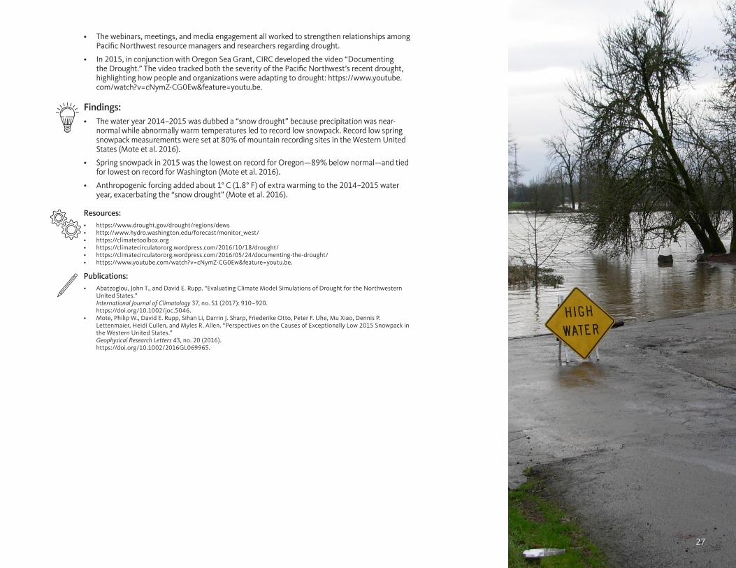
27
• The webinars, meetings, and media engagement all worked to strengthen relationships among Pacific Northwest resource managers and researchers regarding drought.
• In 2015, in conjunction with Oregon Sea Grant, CIRC developed the video “Documenting the Drought.” The video tracked both the severity of the Pacific Northwest’s recent drought, highlighting how people and organizations were adapting to drought: https://www.youtube.com/watch?v=cNymZ-CG0Ew&feature=youtu.be.
Findings: • The water year 2014–2015 was dubbed a “snow drought” because precipitation was near-
normal while abnormally warm temperatures led to record low snowpack. Record low spring snowpack measurements were set at 80% of mountain recording sites in the Western United States (Mote et al. 2016).
• Spring snowpack in 2015 was the lowest on record for Oregon—89% below normal—and tied for lowest on record for Washington (Mote et al. 2016).
• Anthropogenic forcing added about 1° C (1.8° F) of extra warming to the 2014–2015 water year, exacerbating the “snow drought” (Mote et al. 2016).
Resources: • https://www.drought.gov/drought/regions/dews• http://www.hydro.washington.edu/forecast/monitor_west/• https://climatetoolbox.org• https://climatecirculatororg.wordpress.com/2016/10/18/drought/• https://climatecirculatororg.wordpress.com/2016/05/24/documenting-the-drought/• https://www.youtube.com/watch?v=cNymZ-CG0Ew&feature=youtu.be.
Publications: • Abatzoglou, John T., and David E. Rupp. “Evaluating Climate Model Simulations of Drought for the Northwestern
United States.” International Journal of Climatology 37, no. S1 (2017): 910–920. https://doi.org/10.1002/joc.5046.
• Mote, Philip W., David E. Rupp, Sihan Li, Darrin J. Sharp, Friederike Otto, Peter F. Uhe, Mu Xiao, Dennis P. Lettenmaier, Heidi Cullen, and Myles R. Allen. “Perspectives on the Causes of Exceptionally Low 2015 Snowpack in the Western United States.” Geophysical Research Letters 43, no. 20 (2016). https://doi.org/10.1002/2016GL069965.
27

28
County & Municipal Climate AdaptationAs part of CIRC 1.0 our NOAA RISA team participated in several climate adaptation efforts with our Pacific Northwest stakeholders in city and county governments. These efforts included:
Benton County, Oregon, Climate and Public Health Adaptation Planning
From 2012 to 2014, Benton County Health Services was selected as one of five counties in Oregon to participate in the development of a local Climate Health Adaptation Plan. Funding was provided by grants from the Oregon Health Authority and the Climate Ready States and Cities Initiative at the US Centers for Disease Control and Prevention to pilot their Building Resilience Against Climate Effects (BRACE) Framework. CIRC and the Oregon Climate Change Research Institute (OCCRI) provided input to a Climate Change Health Risk Model for Benton County.
Eugene & Springfield Hazard Mitigation Plan
We provided climate information and scenarios to help develop a risk assessment tool for the Oregon cities of Eugene and Springfield.
City of Portland Adaptation Plan
We provided climate scenarios and adaptation information for a climate assessment for the city of Portland and Multnomah County, Oregon.
The North Coast Climate Adaptation
Starting in 2013, the North Coast Climate Adaptation project was a joint effort between CIRC, Oregon Sea Grant, Oregon State University Extension Service, and the Oregon Department of Land Conservation and Development to create an adaptation project built on the state of Oregon’s 2010 Climate Change Adaptation Framework. Working with federal, state, and local decision makers, the North Coast Climate Adaptation project categorized and prioritized climate risks identified for the northern coast of Oregon.
Accomplishments:• Since working with CIRC, Benton County, Oregon has made adapting for the health impacts of
climate change a top priority in its long term planning.
• Publication of the “Benton County Health Department Climate Change Health Adaptation Plan” as part of Climate and Health Adaptation Plans for Benton, Crook, Jackson, Multnomah Counties, and North Central Public Health District.
• Use of CIRC research in the publication of Eugene-Springfield Multi-Jurisdictional Natural Hazards Mitigation Plan—Report for The Cities of Eugene and Springfield, Oregon.
• Use of CIRC research in the publication of Climate Action Plan City of Portland and Multnomah County.
• Publication of the report Regional Framework for Climate Adaptation, Clatsop and Tillamook Counties as well as a companion report detailing the North Coast Climate Adaptation project’s processes and outcomes.
28

29
Findings:• Drought, reduced summer water supply, extreme heat events, wildfire, extreme precipitation
and flooding are climate impacts identified as having potentially negative health impacts on Benton County residents. (Benton County Climate Change Health Adaptation Plan.)
• Alterations to local hydrology due to climate change are expected to impact drinking water supplies, electricity production, and public health (Eugene-Springfield Multi-Jurisdictional Natural Hazards Mitigation Plan).
• Flood risks in the Willamette River Basin may increase under climate change (Eugene-Springfield Multi-Jurisdictional Natural Hazards Mitigation Plan.)
• Extreme heat events are likely to have major negative heath impacts (heat strokes, heat rash, and possibly death) especially for vulnerable populations, a list that includes the elderly, the young, the homeless, outdoor workers, low income people, pregnant women, and people with chronic diseases (Eugene-Springfield Multi-Jurisdictional Natural Hazards Mitigation Plan, Benton County Climate Change Health Adaptation Plan, and City of Portland, Oregon and Multnomah County Climate Action Plan).
• A survey found a lack of agreement among participants in the North Coast Climate Adaptation project over the importance of climate change due in part to a “lack of urgency” regarding climate impacts (Cone et al. 2015).
Resources:• https://www.co.benton.or.us/boc/page/climate-adaptation-priority-county • https://www.cdc.gov/climateandhealth/BRACE.htm• http://www.oregon.gov/oha/PH/HEALTHYENVIRONMENTS/CLIMATECHANGE/Pages/Publications-Training.aspx
Publications: • Benton County Health Department. “Benton County Health Department Climate Change Health Adaptation Plan”
in Climate and Health Adaptation Plans for Benton, Crook, Jackson, Multnomah Counties, and North Central Public Health District, prepared by the Oregon Health Authority.Salem, Oregon. Oreghon Health Authority, 2013. http://www.oregon.gov/oha/PH/HEALTHYENVIRONMENTS/CLIMATECHANGE/Documents/AdaptationPlans/adaptation-plan-benton.pdf.
• Cone, Joe, Monty Johnson, Miriah Kelly, Colin Duncan, Kirsten Winters, and John Stevenson. Some Research Perspective on the Regional Framework for Climate Adaptation Project. Companion Report to Regional Framework for Climate Adaptation, Clatsop and Tillamook Counties. Corvallis, Oregon: Oregon Sea Grant, 2015. http://pnwcirc.org/sites/pnwcirc.org/files/regional_framework_for_climate_adaptation_clatsop_and_tillamook_counties.pdf.
• City of Portland. Bureau of Planning and Sustainability, City of Portland, Oregon and Multnomah County Climate Action Plan. Portland, Oregon. City of Portland and Multnomah County, 2015. https://www.portlandoregon.gov/bps/article/531984.
• Oregon Partnership for Disaster Resilience. Eugene-Springfield Multi-Jurisdictional Natural Hazards Mitigation Plan- Report for The Cities of Eugene and Springfield, Oregon. City of Eugene and City of Springfield. Eugene and Springfield, Oregon, 2014. https://www.eugene-or.gov/DocumentCenter/View/20573.
• Weber, Jeffrey A., Miriah R. Kelly, Joe Cone, and John Stevenson. Regional Framework for Climate Adaptation, Clatsop and Tillamook Counties. Corvallis, Oregon: Oregon Sea Grant, 2015. http://pnwcirc.org/sites/pnwcirc.org/files/regional_framework_adapt_clat_till.pdf.
29

30
Integrated ScenariosIntegrated Scenarios of the Future Northwest Environment (Integrated Scenarios) employed the latest climate science to understand what the Pacific Northwest will look like under climate change throughout the 21st century. Our NOAA RISA team made the project’s findings and data available through a series of free, web-based tools that allow users to visualize changes in climate, hydrology, and vegetation across the Pacific Northwest’s many and varied landscapes. The project was a joint venture between CIRC and the US Department of Interior Northwest Climate Science Center and was carried out as a working partnership by Oregon State University, the University of Washington, the University of Idaho, and the Conservation Biology Institute.
Accomplishments:• Created free, online tools to help researchers and managers utilize the results of the
Integrated Scenarios project and download its data.
• Advanced the state of the science by evaluating global climate model output from the Fifth Phase of the Coupled Model Intercomparison Project (CMIP5).
• On April 17, 2014, results from the Integrated Scenarios project were presented at a daylong workshop in Portland, Oregon. In addition, participants were asked to provide input about how to make the data and outputs more usable, which led to additional work in processing and presenting the data. Around 75 attended with an additional 150 viewing the live webinar of the event online.
• Data from the Integrated Scenarios project have been used by over twenty research teams and adaptation planning efforts, including by the US Fish and Wildlife Service, the US Forest Service, the US Geological Survey, Seattle Public Utilities, Portland Water Bureau, and the Environmental Protection Agency.
• The project research has led to multiple studies being published in peer-reviewed journals.
• Integrated Scenarios provided much of the background work for CIRC’s second phase of funding, CIRC 2.0, and our development of free, online Climate Tools (http://pnwcirc.org/climatetools), including the Northwest Climate Toolbox (https://climatetoolbox.org).
Findings: • By the year 2100, the Pacific Northwest could be anywhere from 1 to 8 degrees Celsius (2–15
degrees Fahrenheit) warmer than it was during the second half of the 20th century (Rupp et al. 2016, adapted).
• Because of warming temperatures, future precipitation in the Pacific Northwest is far more likely to fall as rain instead of as snow (Mote et al. 2014).
• Warming in spring was also clearly associated with greater decreases in the April snowpack (Mote et al. 2014).
• The Pacific Northwest’s already dry summers might become slightly drier as our region’s climate continues to change, while our already wet winters might become slightly wetter (Rupp et al. 2016, adapted).
• However, precipitation projections in our modeling did not share the same level of confidence as temperature projections (Rupp et al. 2016, adapted).
30

31
Resources: • https://climate.northwestknowledge.net/IntegratedScenarios/index.php.• http://consbio.webfactional.com/integratedscenarios/• https://www.youtube.com/watch?v=3Nm17DjTdZ0&feature=youtu.be• https://climatecirculatororg.wordpress.com/2015/05/19/what-the-
ambitious-project-says-about-the-northwest-under-climate-change-how-do-climate-models-work-and-what-the-heck-is-downscaling-anyway/
Publications: • Abatzoglou, John T. “Development of Gridded Surface Meteorological
Data for Ecological Applications and Modeling.” International Journal of Climatology 33, no. 1 (2013): 121-131. https://doi.org/10.1002/joc.3413.
• Abatzoglou, John T., David E. Rupp, and Philip W. Mote. “Seasonal Climate Variability and Change in the Pacific Northwest of the United States.” Journal of Climate 27, no. 5 (2014): 2125-2142. https://doi.org/10.1175/JCLI-D-13-00218.1.
• Abatzoglou, John T., Renaud Barbero, Jacob W. Wolf, and Zachary A. Holden. “Tracking Interannual Streamflow Variability with Drought Indices in the US Pacific Northwest.” Journal of Hydrometeorology 15, no. 5 (2014): 1900-1912. https://doi.org/10.1175/JHM-D-13-0167.1.
• Bachelet, Dominique, Ken Ferschweiler, Timothy J. Sheehan, and James Strittholt. “Climate Change Effects on Southern California Deserts.” Journal of Arid Environments 127 (2016): 17-29. https://doi.org/10.1016/j.jaridenv.2015.10.003.
• Bachelet, Dominique, Ken Ferschweiler, Timothy J. Sheehan, Benjamin M. Sleeter, and Zhiliang Zhu. “Projected Carbon Stocks in the Conterminous USA with Land Use and Variable Fire Regimes.” Global Change Biology 21, no. 12 (2015): 4548-4560. https://doi.org/10.1111/gcb.13048.
• Bachelet, Dominique, Timothy J. Sheehan, Ken Ferschweiler, and John T. Abatzoglou. “Simulating Vegetation Change, Carbon Cycling, and Fire Over the Western United States Using CMIP5 Climate Projections.” In Natural Hazard Uncertainty Assessment: Modeling and Decision Support, Geophysical Monograph 223, First Edition, edited by Karin Riley, Peter Webly, and Matthew Thompson. Hoboken: 257-275. American Geophysical Union published by John Wiley & Sons, Inc., 2017. Print ISBN: 9781119027867.
• Barbero, Renaud, John T. Abatzoglou, and Katherine C. Hegewisch. “Evaluation of Statistical Downscaling of North American Multimodel Ensemble Forecasts over the Western United States.” Weather and Forecasting 32, no. 1 (2017): 327-341. https://doi.org/10.1175/WAF-D-16-0117.1.
• Mote, Philip W., John T. Abatzoglou, Dennis P. Lettenmaier, Dave P. Turner, David E. Rupp, Dominique Bachelet, and David R. Conklin. Integrated Scenarios of Climate, Hydrology, and Vegetation for the Northwest, Final Report. Corvallis, Oregon: Pacific Northwest Climate Impacts Research Consortium, College of Earth, Ocean, and Atmospheric Sciences, Oregon State University, 2014. http://pnwcirc.org/sites/pnwcirc.org/files/integrated_scenarios_final_report_2014-10-07.pdf.
• Rupp, David E., John T. Abatzoglou, Katherine C. Hegewisch, and Philip W. Mote. “Evaluation of CMIP5 20th Century Climate Simulations for the Pacific Northwest USA.” Journal of Geophysical Research: Atmospheres 118, no. 19 (2013). https://doi.org/10.1002/jgrd.50843.
• Rupp, David E., John T. Abatzoglou, and Philip W. Mote. “Projections of 21st Century Climate of the Columbia River Basin.” Climate Dynamics (2016): 1-17. https://doi.org/10.1007/s00382-016-3418-7.
• Sheehan, Timothy J., Dominique Bachelet, and Ken Ferschweiler. “Projected Major Fire and Vegetation Changes in the Pacific Northwest of the Conterminous United States under Selected CMIP5 Climate Futures.” Ecological Modeling 317 (2015): 16-29. https://doi.org/10.1016/j.ecolmodel.2015.08.023.
• Losses in April snow water equivalent (SWE) in the Pacific Northwest are expected to intensify in the 21st century, with decreases of nearly 30% by mid-century and by 40–50% by late-century (Mote et al., 2014). SWE is a measure of the depth of water that would result if a given amount of snow melts.
• Future losses of April SWE will be substantially greater than losses in colder winter months (Mote et al. 2014).
• Losses in April SWE are expected to be more severe in lower-elevation/transient-snow zones, with large losses in the Oregon Cascades and mountain ranges of central and northeastern Oregon (Mote et al. 2014).
• With earlier initiation of snowpack melt, water that was previously stored over the winter as snowpack will increasingly flow as river discharge in the winter and spring months. Diminished summer streamflow will result (Mote et al. 2014).
• Resource management and allocation challenges are expected to arise from these changes to hydrology (Mote et al., 2014).
• Larger, more destructive, and more frequent forest fires are projected for the Pacific Northwest under climate change (Sheehan et al. 2015).
• As temperatures rise, the climate in much of the Pacific Northwest’s coastal rainforests will no longer be the best fit for the now-dominant evergreens, such as the Sitka spruce (Sheehan et al. 2015).
• Deciduous and subtropical trees now common along the California coast may migrate into evergreens’ current territory as the climate warms throughout the 21st century (Sheehan et al. 2015).

32
National and Regional Climate AssessmentsClimate assessments aggregate, weigh, and judge the myriad climate reports and studies available, collating them into a whole that helps us glimpse the many ways climate change is likely to impact our lives. Because these impacts are expected to vary from region to region, climate assessments tend to highlight regional impacts. This was true of The Third National Climate Assessment, which covered in detail the impacts expected in several US regions. CIRC researchers, led by CIRC Co-Principal Investigator Philip Mote through his role in the National Climate Assessment Development and Advisory Committee, participated in writing and editing the assessment’s chapter covering the Pacific Northwest. Our team, led by CIRC researcher Meghan Dalton, then extended the information in the chapter into a full-length book covering the Pacific Northwest: “Climate Change in the Northwest: Implications for Our Landscapes, Waters, and Communities.”
Accomplishments: • Led the Pacific Northwest chapter for The Third National Climate Assessment.
• Published “Climate Change in the Northwest: Implications for Our Landscapes, Waters, and Communities,” which received a print publication through Island Press.
• These reports have become standard reference material for adaptation in the Pacific Northwest and are frequently cited in peer-reviewed and gray literature.
• Helped raise local awareness of climate change issues via press releases, talks, and interviews surrounding the release of the Third National Climate Assessment and “Climate Change in the Northwest: Implications for Our Landscapes, Waters, and Communities.”
Findings: • Water: Rising temperatures resulting from anthropogenic climate change are causing precipitation to fall more as rain and
less as snow, altering the timing of streamflow in many Pacific Northwest’s basins potentially leading to water scarcities that are expected to impact the Pacific Northwest’s economies and ecologies (Mote et al. 2014).
• Forests: Increasing forest disturbances, including wildfires, drought, and insect infestations are have become more prevalent as the region’s climate continues to warm and are “virtually certain to cause additional forest mortality” by the middle decades of the 21st century. The largest transformations to our forests are expected from the added warming projected under high emissions scenario (RCP 8.5), which is expected to extensively convert many subalpine forests to other forest types (Mote et al. 2014).
• Coastal: The Pacific Northwest’s coastal communities and ecosystems face major threats from ocean acidity, sea level rise, erosion, inundation, and impacts to infrastructure and habitats (Mote et al. 2014).
• Agriculture: The Pacific Northwest’s agriculture sector is expected to face challenges due to changes in the availability and timing of water. These impacts could be addressed by the adaptation of “climate resilient technologies” and new management practices (Mote et al. 2014).
Resources: • http://nca2014.globalchange.gov/highlights/regions/northwest• http://nca2014.globalchange.gov
Publications: • Dalton, Meghan M., Philip W. Mote, Amy K. Snover, eds. “Climate Change in the Northwest: Implications for Our Landscapes, Waters, and
Communities.” Washington, DC: Island Press, 2013. Print ISBN: 9781610914284. E-Book ISBN: 9781610915120. http://pnwcirc.org/sites/pnwcirc.org/files/climatechangeinthenorthwest.pdf.
• Mote, Philip W., Amy K. Snover, Susan Capalbo, Sanford D. Eigenbrode, Patty Glick, Jeremy Littell, Richard Raymondi, and Spencer Reeder. “Chapter 21: Northwest.” In Climate Change Impacts in the United States: The Third National Climate Assessment, edited by Jerry M. Melillo, Terese (TC) Richmond, and Gary W. Yohe, 487-513. Washington, D.C.: US Global Change Research Program, 2014. http://nca2014.globalchange.gov/highlights/regions/northwest.
32

33
Piloting Utility Modeling Applications (PUMA)The Piloting Utility Modeling Applications (PUMA) project is a first-of-its-kind climate adaptation effort spearheaded by members of the Water Utility Climate Alliance (WUCA), a coalition of ten of the nation’s largest water providers, including the Pacific Northwest’s Portland Water Bureau (PWB) and Seattle Public Utilities (SPU). PUMA has a simple but ambitious goal: help municipal water providers plan for climate change by putting climate science into action at the local level. CIRC participated in national PUMA/WUCA activities over a period of years, as well as two research projects in the region. Both PWB and SPU had PUMA projects, partnering with CIRC to help them understand how climate changes—from a loss of snow to wildfires—might affect their ability to provide water to their customers. CIRC’s PUMA participants, made up of hydrologic and atmospheric scientists, aided teams of engineers at the two water providers by furnishing them with climate and hydrologic data tailored for their watersheds. Through this effort, we discovered that our CIRC researchers and the utilities’ engineers spoke very different technical languages. But working together, our NOAA RISA team and the PWB and SPU teams figured out how to overcome this obstacle. The result: both utilities are now incorporating climate change science into both their short- and long-term planning and have achieved greater internal capacity for adapting to climate change.
Accomplishments:• Aided the Pacific Northwest’s two largest water utilities, Seattle Public Utilities and Portland Water Bureau, in developing
in-house capacity for their own climate research, and in applying climate data to their watersheds in an effort to help the utilities, with over two million customers, respond to climate change impacts to their water supplies.
• Both Seattle Public Utilities and the Portland Water Bureau are developing adaptation strategies based on our NOAA RISA Team’s input.
• CIRC has earned significant goodwill and interest in the region due to the success of this project.
• Applied results from the climate model evaluation study that was part of the Integrated Scenarios project and used downscaled climate data from the MACA dataset.
Findings: • Multiple approaches were needed and “one size did not fit all” from utility to utility (Vogel et al. 2015).
• Both the scientists and utility-managers working on this effort learned to view the project’s process as a “two-way street” that prized open communication (Vogel et al. 2015).
• Understanding local hydrology and the internal working at the utility level were critical for success (Vogel et al. 2015).
Resources: • https://climatecirculatororg.wordpress.com/2016/10/18/drought/• https://climatecirculatororg.wordpress.com/2015/06/15/puma-helps-water-utilities-innovate-and-adapt/
Publication: • Vogel, Jason M., Joel B. Smith, Megan O’Grady, Paul Fleming, Kavita Heyn, Alison Adams, Don Pierson, Keely Brooks, and David Behar. Actionable
Science in Practice: Co-producing Climate Change Information for Water Utility Vulnerability Assessments. Final Report of the Piloting Utility Modeling Applications (PUMA) Project. Water Utility Climate Alliance, 2015. http://www.wucaonline.org/assets/pdf/pubs-puma-white-paper-20150427.pdf.
33

34
Tillamook County Coastal FuturesInitially funded by NOAA’s Coastal and Ocean Climate Applications (COCA) program, Tillamook County Coastal Futures joined CIRC’s portfolio in 2011. Using the Envision computer-modeling platform developed by CIRC researcher John Bolte, CIRC worked with homeowners, planners, and government officials in Tillamook County, Oregon organized under Tillamook County knowledge-to-action network. Through our knowledge-to-action network, we developed a series of high-tech thought experiments, empowering community members to visualize how climate change and local planning could affect their natural and human landscapes. During these meetings our NOAA RISA team identified key stakeholder desires, concerns, and outcomes, such as having access to the beach, creating resilient infrastructure, and protecting homes and businesses. With these end points in mind, the CIRC team then worked with community members, developing a series of probable future scenarios that mixed policy choices with future climate and sea level rise projections that extended throughout the 21st century. By combining multiple drivers of change and policy options in differing combinations, residents in Tillamook County were able to glimpse how their choices could help them adapt to their landscape’s coastal hazards now and into the future.
Accomplishments:• CIRC research and stakeholder engagement received praise from county commissioners and provided leverage for the
passage of the Neskowin Coastal Erosion Adaptation Plan, a community-driven coastal adaptation effort that predates CIRC’s involvement on the coast but builds on earlier NOAA efforts.
• The Envision platform allowed for the creation of multiple alternative future scenarios by integrating physical drivers as well as the human drivers into a landscape-specific model.
• CIRC research and presentations have jump-started important conversations about planning for the future that have bridged connections between researchers, decision makers, and area homeowners.
• Lessons learned from this project have been applied by our NOAA RISA team to a similar effort in Grays Harbor, Washington as part of CIRC 2.0.
• The Tillamook County Coastal Futures project provided a platform to improve the modeling of total water levels. (See Modeling Coastal Total Water Level in the Research Findings section of this report.)
Findings:• During the last few decades, over 65% of Tillamook County’s coastline has experienced shoreline erosion.
• Approximately 40% of Tillamook County’s recent shoreline erosion exceeded 1 meter (over 3 feet) per year (Ruggiero et al. 2013).
• Land use has as significant an impact on community exposure to coastal hazards as projected climate change impacts, including in the most severe climate scenarios (Ruggiero et al. 2017).
• Relying only on the observational record may significantly underestimate what areas of the Pacific Northwest coast are at risk of coastal flooding and related hazards (Serafin et al. 2014; Baron et al. 2015).
• The 100-year event of extreme total water levels (an event that has a 1% chance of occurring in a given year) could be as much as 90 cm (nearly 3 feet) higher and cause 30% more coastal flooding than previously estimated based on the observational record for the shoreline for Oregon’s Tillamook County (Serafin et al. 2014).
• When total water levels are taken into account, twice as many homes and businesses in Tillamook County would be vulnerable to a 100-year event by the 2050s as are currently considered vulnerable under today’s climate and existing land-use policies (Baron et al. 2015).
• Probabilistic simulations of extreme total water levels, long-term coastal change, and storm-induced dune erosion along the shoreline allowed us to represent the variable impacts of seal level rise, wave climate, and the El Niño Southern
34

35
Oscillation in a range of climate change scenarios through the end of the 21st century. Additionally, we explored a range of alternative futures related to policy decisions and socioeconomic trends using input from our knowledge-to-action network participants. In general, human decisions introduced greater variability and uncertainty to the impacts to the landscape by coastal hazards than did climate change uncertainty. In other words, the Tillamook County Coastal Futures has helped to determine the relative impact of policy and management decisions on the adaptive capacity of Tillamook County, Oregon under a range of future climate scenarios (Ruggiero et al. 2017).
Resources: • http://explorer.bee.oregonstate.edu• https://climatecirculatororg.wordpress.com/2015/05/19/shoring-up-for-climate-change/
Publications: • Baron, Heather M., Peter Ruggiero, Nathan J. Wood, Erica L. Harris, Jonathan Allan, Paul D. Komar, and Patrick Corcoran. “Incorporating climate
change and morphological uncertainty into coastal change hazard assessments.” Natural Hazards 75, no. 3 (2015): 2081-2102. https://doi.org/10.1007/s11069-014-1417-8.
• Lipiec, Eva, Peter Ruggiero, Alexis K. Mills, Katherine A. Serafin, John Bolte, Pat Corcoran, John Stevenson, and Chad J. Zanocco. “Mapping out Climate Change: Assessing How Coastal Communities Adapt Using Alternative Future Scenarios.” Journal of Coastal Research. (Accepted and in press as of November 2017).
• Mills, Alexis K., John Bolte. Peter Ruggiero, Katherine A. Serafin, Eva Lipiec, Pat Corcoran, John Stevenson, Chad J. Zanocco, and Denise Lach, “Exploring the Impacts of Climate and Management on Coastal Community Vulnerability through Alternative Future Scenarios.” Submitted to Environmental Modeling and Software (In review as of November 2017).
• Ruggiero, Peter, Eva Lipiec, Alexis K. Mills, John Bolte, Pat Corcoran, John Stevenson, Katherine A. Serafin, and Janan Evans-Wilent. The Tillamook County Coastal Futures Project: Exploring Alternative Scenarios for Tillamook County’s Coastline. Corvallis, Oregon: Pacific Northwest Climate Impacts Research Consortium, Oregon State University, 2017. http://pnwcirc.org/sites/pnwcirc.org/files/tillamookcountycoastalfutures_projectwhitepaper.pdf
• Ruggiero, Peter, Meredith G. Kratzmann, Emily A. Himmelstoss, David Reid, Jonathan Allan, and George Kaminsky. “National Assessment of Shoreline Change: Historical Shoreline Change Along the Pacific Northwest Coast.” US Geological Survey, no. 2012-1007 (2013). https://doi.org/10.3133/ofr20121007.
• Serafin, Katherine A., Peter Ruggiero, and Hilary F. Stockdon. “The Relative Contribution of Waves, Tides, and Nontidal Residuals to Extreme Total Water Levels on US West Coast Sandy Beaches.” Geophysical Research Letters 44, no. 4 (2017): 1839-1847. https://doi.org/10.1002/2016GL071020.
• Serafin, Katherine A., and Peter Ruggiero. “Simulating Extreme Total Water Levels Using a Time-Dependent, Extreme Value Approach.” Journal of Geophysical Research: Oceans 119, no. 9 (2014): 6305-6329. https://doi.org/10.1002/2014JC010093.
35

3636

37
Willamette Water 2100Oregon’s fertile Willamette River Basin is the state’s most populous as well as one of its most important forest and agricultural regions. Anticipating how water supply, land use, and water scarcity in the basin are expected to change in the 21st century under the drivers of climate change, population, and economic growth is the subject of the Willamette Water 2100 (WW2100) project. Like many places in the West, the Willamette River Basin faces water scarcity resulting from declining snowpack. Among the project’s key findings, researchers learned that under climate change, rising temperatures are expected to reduce snowpack, creating less than favorable conditions for existing forests while increasing the frequency of wildfires. Urban water demand could double as the basin’s urban populations rise throughout the 21st century. However, water demand for agriculture could stay about the same or even slightly decline as farmlands near high-growth urban areas are converted for urban use. Primarily funded by the National Science Foundation, WW2100 employed the Envision modeling platform used by CIRC researchers in the Big Wood Basin and Tillamook County.
Accomplishments: • Partners included numerous state and federal agencies, extension services, local governments, non-governmental
organizations, educators, and others.
• Effectively modeled Willamette River Basin under multiple climate change, land use, and demographic scenarios to the year 2100.
• Project has resulted in roughly twenty-eight publications.
Findings: • By the year 2100, the Willamette River Basin is projected to be between 1 to 7 degrees Celsius (2 to 13 degrees
Fahrenheit) warmer than the historical baseline (Project Website: http://inr.oregonstate.edu/ww2100/).
• Human-caused climate change (anthropogenic forcing) shows up as a clear signal in the temperature data. Anthropogenic forcing, the result of increasing human-caused greenhouse gas concentrations, dominates the long-term variability in temperature throughout the 21st century (Project Website).
• Due to rising temperatures, precipitation in the Willamette River Basin is increasingly likely to fall as rain instead of as snow, resulting in a decreased snowpack for the basin.
• For every 1 degree Celsius (2 degrees Fahrenheit) increase in annual mean temperature, there is a roughly 15 % decrease in summer flow in the lower Willamette River Basin. However, as temperatures get significantly higher than the historical average, the spring snowpack is essentially absent. Thus, additional temperature increases have only a marginal effect on streamflow.
• Among the key changes for water availability is the transformation of upland forests (Project Website).
• The snowpack—measured as snow water equivalent as a proportion of cumulative water-year precipitation—is expected to decline markedly across the Willamette River Basin as the climate warms. Declines are expected to vary greatly across the Basin (Project Website).
• By the middle of the 21st century, Willamette River sub-basins with little snow historically, such as the middle Willamette, are projected to receive virtually no snow in the future (Project Website).
• By the middle of the 21st century, Willamette River sub-basins that historically have receive the most snow, such as North Santiam, are projected to experience winter snowpack declines of one-quarter to two-thirds (Project Website).
• The majority of climate scenarios employed showed a general trend of wetter winters and drier summers in the Willamette River Basin. However, there was not a unanimous agreement between models and scenarios simulating either a drier or wetter future (Project Website).
• The small projected increases in total winter precipitation did not significantly offset snowpack losses resulting from increased warming (Project Website).
Resources: • http://inr.oregonstate.edu/ww2100/• http://inr.oregonstate.edu/ww2100/analysis-topic/
future-climate• https://climatecirculatororg.wordpress.
com/2015/11/17/changes-ahead-for-oregons-willamette-river-basin/
• https://climatecirculatororg.wordpress.com/2015/12/15/carbon-balance-and-forest-disturbance-in-the-west-cascades/
• https://climatecirculatororg.wordpress.com/2015/10/13/putting-the-sensitivity-approach-into-practice-for-ww2100/
Publications: • Jaeger, William K., Andrew J. Plantinga, Heejun
Chang, Kathie Dello, Gordon Grant, David Hulse, J. J. McDonnell et al. “Toward a formal definition of water scarcity in natural-human systems.” Water Resources Research 49, no. 7 (2013): 4506-4517. https://doi.org/10.1002/wrcr.20249.
• Turner, David P., David R. Conklin, Kellie B. Vache, Cynthia Schwartz, Anne W. Nolin, Heejun Chang, Eric Watson, and John P. Bolte. “Assessing Mechanisms of Climate Change Impact on the Upland Forest Water Balance of the Willamette River Basin, Oregon.” Ecohydrology 10, no. 1 (2017). https://doi.org/10.1002/eco.1776.
• Turner, David P., William D. Ritts, Robert E. Kennedy, Andrew N. Gray, and Zhiqiang Yang. “Effects of Harvest, Fire, and Pest/Pathogen Disturbances on the West Cascades Ecoregion Carbon Balance.” Carbon Balance and Management 10, no. 1 (2015): 12. https://doi.org/10.1186/s13021-015-0022-9.
• Turner, David P., David R. Conklin, and John P. Bolte. “Projected climate change impacts on forest land cover and land use over the Willamette River Basin, Oregon, USA.” Climatic Change 133, no. 2 (2015): 335-348. https://doi.org/10.1007/s10584-015-1465-4.
• Vano, Julie A., Tapash Das, and Dennis P. Lettenmaier. “Hydrologic Sensitivities of Colorado River Runoff to Changes in Precipitation and Temperature.” Journal of Hydrometeorology 13, no. 3 (2012): 932-949. https://doi.org/10.1175/JHM-D-11-069.1.
• Vano, Julie A., Bart Nijssen, and Dennis P. Lettenmaier. “Seasonal Hydrologic Responses to Climate Change in the Pacific Northwest.” Water Resources Research 51, no. 4 (2015): 1959-1976. https://doi.org/10.1002/2014WR015909.
• Vano, Julie A., John B. Kim, David E. Rupp, and Philip W. Mote. “Selecting Climate Change Scenarios Using Impact-Relevant Sensitivities.” Geophysical Research Letters 42, no. 13 (2015): 5516-5525. https://doi.org/10.1002/2015GL063208.
• Vano, Julie A., John B. Kim, David E. Rupp, and Philip W. Mote. “Selecting Climate Change Scenarios Using Impact-Relevant Sensitivities.” Geophysical Research Letters 42, no. 13 (2015): 5516-5525. https://doi.org/10.1002/2015GL063208.

38
CIRC Partnerships and Connections
Working with Related NOAA Programs
Organization/Agency/Division Project Description
NOAA Coastal and Ocean Climate Applications (COCA) and NOAA Oregon Sea Grant (OSG)
Tillamook County Coastal Futures
Helped Oregon coast stakeholders in Tillamook County develop a series of tools to craft policies addressing the effects of climate change.
National Integrated Drought Information System (NIDIS) Coping with Drought
Worked with NIDIS to develop the UW Drought Monitoring System for the Pacific Northwest and integrate it into the US Drought Monitor.
Oregon Sea Grant (OSG) North Coast Climate Adaptation
Worked with OSG and Oregon Department of Land Conservation and Development to build resilience to climate change on the northern Oregon Coast as part of the Oregon Adaptation Framework.
Oregon Sea Grant CIRC Extension
Oregon Sea Grant aided CIRC in funding our Regional Extension Climate Specialist position. Our extension officer aided the development of stakeholder involvement and project management on the following CIRC projects: Big Wood Alternative Futures, Tillamook County Coastal Futures, the North Coast Alignment Project, and Coping with Drought.
38

39
Other Partnerships
Organization/Agency/Division Project Description Role of RISA/Partner
National Science Foundation, Straub Environmental Center, Vitality Farms, Oregon Department of Environmental Quality, City of Salem, Columbia River Inter-Tribal Fish Commission, USDA Forest Service, City of Hillsboro, Pacific Northwest Pollution Prevention Resource Center, Oregon Department of Agriculture, City of Eugene, Tualatin Valley Water District, Benton County, Eugene Water and Electric Board, Oregon Water Resources Department, US Army Corps of Engineers, Greenberry Irrigation District, Multnomah County, Clackamas Water Providers, Clean Water Services
Willamette Water 2100
Evaluated climate impacts and population growth on water use and availability in Oregon’s Willamette River Basin to the year 2100.
CIRC
Provided climate modeling, general development of Envision planning tool, shaped planning scenarios, and facilitated some stakeholder engagement.
WW2100
Conducted the majority of the five-year project funded by the National Science Foundation.
Department of the Interior Northwest Climate Science Center (NWCSC)
Integrated Scenarios
Evaluated the performance of 41 global climate models for the Pacific Northwest, downscaled a subset, and produced coordinated simulations of hydrology and vegetation for the region.
CIRC
Performed all dimensions of climate, hydrological, and vegetation modeling and scenario development.
NWCSC
Provided funding.
Water Utility Climate Alliance (WUCA), Portland Water Bureau (PWB), Seattle Public Utilities (SPU)
Piloting Utility Modeling Applications
As part of WUCA’s Piloting Utility Modeling Applications (PUMA) project, CIRC researchers helped the Pacific Northwest’s two largest utilities (PWB and SPU) create climate and hydrological projections of their watersheds under future conditions of climate change.
CIRC
Provided climate data, tailored analysis, hydrologic model evaluation; facilitated stakeholder engagement.
WUCA partner utilities
Upgraded in-house systems models incorporating CIRC modeling output and analysis.
US Forest Service (USFS) Pacific Northwest Research Station
US Forest Service Adaptation Partnerships
CIRC worked with researchers from the USFS Pacific Northwest Research Station on two vulnerability assessments, the Northern Rockies Adaptation Partnership and the Blue Mountains Adaptation Partnership, helping produce a climate assessment and adaptation plan for two regional forests.
CIRC
Helped facilitate vulnerability assessments, adaptation planning, and stakeholder engagement and interactions.
USFS
Provided engaged stakeholders and insider knowledge of resource management and climate questions and challenges.

40
National Science Foundation, US Forest Service, US Bureau of Reclamation, Idaho Department of Water Resources, University of Idaho Cooperative Extension, Big Wood Canal Company, Twin Falls Canal Company, Northside Canal Company, The Nature Conservancy, Wood River Land Trust, Trout Unlimited, Idaho Conservation League, City of Ketchum, Blaine County, US Geological Survey, USDA Natural Resources Conservation Service, and Idaho Power.
Big Wood Basin Alternative Futures
This CIRC-led project explored interactions among agriculture, urban land use practices, and recreational activities under future conditions of climate and water supply in the Big Wood Basin of central Idaho.
CIRC
Provided system model; Envision planning tool; climate scenarios; climate adaptation guidance; facilitated stakeholder engagement and interactions; and developed a Knowledge to Action Network (KTAN).
Stakeholder partners
Provided engaged stakeholders and knowledge of upper basin recreation, lower basin agricultural, water resources and irrigation management, climate science and adaptation questions and challenges.
City of Portland, Oregon City of Portland Adaptation Plan
CIRC worked with the City of Portland on a climate adaptation plan for the city.
CIRC
Provided climate scenario and adaptation information.
City of Portland
Provided questions and framework for adaptation.
Benton County, Oregon Benton County Public Health Adaptation Plan
CIRC assisted Benton County, Oregon, in developing its climate change and public health adaptation plan by providing climate impacts information pertinent to the county; co-creating a climate health assessment tool used to prioritize risks; and providing on-going guidance in the development of a framework for public health and climate change monitoring in Benton County.
CIRC
Provided climate information and scenarios to develop risk assessment tool; provided guidance on tool development
Benton County Health
Developed health risk assessment tool; populated tool via meetings and interviews; wrote Climate and Health Adaptation Plan.
Cities of Eugene and Springfield, Oregon Eugene and Springfield Hazard Mitigation Plan Update
CIRC advised two local governments on a first ever update to their city’s hazard mitigation plan to include climate change impacts.
CIRC
Provided climate information and scenarios to develop risk assessment tool; provided guidance on tool development.
Eugene/Springfield
Organized and developed the process.
Department of the Interior Northwest Climate Science Center (NWCSC), North Pacific Landscape Conservation Cooperative (NPLCC)
Communications/Northwest Climate Magazine
In collaboration with communications leads at the NWCSC and NPLCC, CIRC communications created a magazine-style, joint newsletter to highlight our adaptation efforts and to explain climate science to a general readership of Pacific Northwest stakeholders.
CIRC
Managing editor; editing; writing articles.
NWCSC/NPLCC
Editorial board; article writing; platform; dissemination.

41
Oregon Climate Service (OCS) Coping with Drought
CIRC and the OCS provided a series of updates on precipitation conditions in the Pacific Northwest to regional resource managers and policy makers.
CIRC
Provided climate and drought science experience, and stakeholder engagement.
OCS
Provided climate data and information.
Oregon Department of Land Conservation, Oregon Department of Transportation, Tillamook County, Nestucca Valley Community Alliance, Oregon Department of Geology and Mineral Industries, Neskowin Coastal Hazards Committee
Envision Tillamook County Coastal Futures
Helped Oregon coast stakeholders in Tillamook County develop a series of tools that helped them craft policies to address the effects of climate change.
CIRC
Provided climate change, coastal wave climatology, and erosion science; Envision planning tool; climate and policy scenarios and narratives; facilitated stakeholder engagement; and developed a Knowledge to Action Network (KTAN).
Stakeholder partners
Provided engaged stakeholders, knowledge of coastal management, insider understanding of local planning and policy issues, and climate questions and challenges.

42
Publications (Extended List) Climate Assessments:
• Dalton, Meghan M., Philip W. Mote, Amy K. Snover, eds. “Climate Change in the Northwest: Implications for Our Landscapes, Waters, and Communities.” Washington, DC: Island Press, 2013. Print ISBN: 9781610914284. E-Book ISBN: 9781610915120. http://pnwcirc.org/sites/pnwcirc.org/files/climatechangeinthenorthwest.pdf.
• Mote, Philip W., Amy K. Snover, Susan Capalbo, Sanford D. Eigenbrode, Patty Glick, Jeremy Littell, Richard Raymondi, and Spencer Reeder. “Chapter 21: Northwest.” In Climate Change Impacts in the United States: The Third National Climate Assessment, edited by Jerry M. Melillo, Terese (TC) Richmond, and Gary W. Yohe, 487-513. Washington, D.C.: US Global Change Research Program, 2014. http://nca2014.globalchange.gov/highlights/regions/northwest.
• Melillo, Jerry M., Terese (T.C.) Richmond, and Gary W. Yohe, eds. Climate Change Impacts in the United States: The Third National Climate Assessment. Washington, D.C.: U.S. Global Change Research Program. ISBN: 9780160924026. http://nca2014.globalchange.gov.
Reports and other Assessments:• Clifton, Caty F., Kate T. Day, Kathie D. Dello, Gordon E. Grant, Jessica E. Halofsky,
Daniel J. Isaak, Charles H. Luce, Mohammad Safeeq, Brian P. Staab, and John Stevenson. “Climate change and hydrology in the Blue Mountains.” In Climate Change Vulnerability and Adaptation in the Blue Mountains Region, General Technical Report-Pacific Northwest Research Station, edited by Jessica E. Halofsky, and David Lawrence Peterson, 25-52. Fort Collins, Colorado: U.S. Department of Agriculture, Forest Service, 2017. General Technical Report: PNW-GTR-939. http://adaptationpartners.org/bmap/docs/BMAP_final.pdf.
• Cone, Joe, Monty Johnson, Miriah Kelly, Colin Duncan, Kirsten Winters, and John Stevenson. Some Research Perspective on the Regional Framework for Climate Adaptation Project, companion report to Regional Framework for Climate Adaptation, Clatsop and Tillamook Counties. Corvallis, Oregon: Oregon Sea Grant, 2015. http://pnwcirc.org/sites/pnwcirc.org/files/regional_framework_for_climate_adaptation_clatsop_and_tillamook_counties.pdf.
• Joyce, Linda A., Marian Talbert, Darrin Sharp, Jeffrey Morisette, and John Stevenson, “Historical and Projected Climate in the Northern Rockies.” In Climate Change Vulnerability and Adaptation in the Northern Rockies (draft), edited by Jessica E. Halofsky, David Lawrence Peterson,S. Karen Dante-Wood, Linh Hoang, Joanne J. Ho, and Linda A. Joyce, 58-65. Fort Collins, Colorado: U.S. Department of Agriculture, Forest Service, 2016. General Technical Report: RMRS-GTR. http://adaptationpartners.org/nrap/docs/NRAPFinalDraft_2016.07.25.pdf.
• Ruggiero, Peter, Eva Lipiec, Alexis Mills, John Bolte, Pat Corcoran, John Stevenson, Katherine A. Serafin, and Janan Evans-Wilent. The Tillamook County Coastal Futures Project: Exploring Alternative Scenarios for Tillamook County’s Coastline. Corvallis, Oregon: Pacific Northwest Climate Impacts Research Consortium, Oregon State University, 2017. http://pnwcirc.org/sites/pnwcirc.org/files/tillamookcountycoastalfutures_projectwhitepaper.pdf.
• Vano, Julie A. and Meghan M. Dalton. “A new way to quickly estimate climate 34 change impacts on rivers and streams” In A Launch Collection of Accessible Climate Articles. Edited by the Climanosco project. Zurich, Switzerland. https://www.climanosco.org/files/collections/Launch_Collection_Accessible_Articles_Climanosco_print.pdf October 2016.
• Vogel, Jason M., Joel B. Smith, Megan O’Grady, Paul Fleming, Kavita Heyn, Alison Adams, Don Pierson, Keely Brooks, and David Behar. Actionable Science in Practice: Co-producing Climate Change Information for Water Utility Vulnerability Assessments. Final Report of the Piloting Utility Modeling Applications (PUMA) Project. Water Utility Climate Alliance, 2015. http://www.wucaonline.org/assets/pdf/pubs-puma-white-paper-20150427.pdf.
• Weber, Jeffrey A., Miriah R. Kelly, Joe Cone, and John Stevenson. Regional Framework for Climate Adaptation, Clatsop and Tillamook Counties. Corvallis, Oregon: Oregon Sea Grant, 2015. http://pnwcirc.org/sites/pnwcirc.org/files/regional_framework_adapt_clat_till.pdf.
Peer-Reviewed Publications: • Abatzoglou, John T., and Timothy J. Brown. “A comparison of statistical downscaling
methods suited for wildfire applications.” International Journal of Climatology 32, no. 5 (2012): 772-780. https://doi.org/10.1002/joc.2312.
• Abatzoglou, John T., Daniel J. McEvoy, and Kelly T. Redmond. “The West Wide Drought Tracker: Drought Monitoring at Fine Spatial Scales.” Bulletin of the American Meteorological Society (2017). https://doi.org/10.1175/BAMS-D-16-0193.1.
• Abatzoglou, John T., and David E. Rupp. “Evaluating Climate Model Simulations of Drought for the Northwestern United States.” International Journal of Climatology 37, no. S1 (2017): 910–920. https://doi.org/10.1002/joc.5046.

43
• Abatzoglou, John T., Renaud Barbero, Jacob W. Wolf, and Zachary A. Holden. “Tracking Interannual Streamflow Variability with Drought Indices in the US Pacific Northwest.” Journal of Hydrometeorology 15, no. 5 (2014): 1900-1912. https://doi.org/10.1175/JHM-D-13-0167.1.
• Abatzoglou, John T., and A. Park Williams. “Impact of Anthropogenic Climate Change on Wildfire across Western US Forests.” Proceedings of the National Academy of Sciences 113, no. 42 (2016): 11770-11775. https://doi.org/10.1073/pnas.1607171113.
• Abatzoglou, John T., and Timothy J. Brown. “A Comparison of Statistical Downscaling Methods Suited for Wildfire Applications.” International Journal of Climatology 32, no. 5 (2012): 772-780. https://doi.org/10.1002/joc.2312.
• Abatzoglou, John T. “Development of Gridded Surface Meteorological Data for Ecological Applications and Modelling.” International Journal of Climatology 33, no. 1 (2013): 121-131. https://doi.org/10.1002/joc.3413.
• Abatzoglou, John T., David E. Rupp, and Philip W. Mote. “Questionable Evidence of Natural Warming of the Northwestern United States.” Proceedings of the National Academy of Sciences 111, no. 52 (2014): E5605-E5606. https://doi.org/10.1073/pnas.1421311112.
• Abatzoglou, John T., David E. Rupp, and Philip W. Mote. “Seasonal Climate Variability and Change in the Pacific Northwest of the United States.” Journal of Climate 27, no. 5 (2014): 2125-2142. https://doi.org/10.1175/JCLI-D-13-00218.1.
• Abatzoglou, John T., Renaud Barbero, Jacob W. Wolf, and Zachary A. Holden. “Tracking Interannual Streamflow Variability with Drought Indices in the US Pacific Northwest.” Journal of Hydrometeorology 15, no. 5 (2014): 1900-1912. https://doi.org/10.1175/JHM-D-13-0167.1.
• Amos, Adell L. “Developing the Law of the River: The Integration of Law and Policy into Hydrologic and Socio-Economic Modeling Efforts in the Willamette River Basin.” University of Kansas Law Review, 62 (2014): 1091-1139. https://doi.org/10.17161/1808.20266.
• Ashfaq, Moetasim, Subimal Ghosh, Shih-Chieh Kao, Laura C. Bowling, Philip W. Mote, Danielle Touma, Sara A. Rauscher, and Noah S. Diffenbaugh. “Near-Term Acceleration of Hydroclimatic Change in the Western US.” Journal of Geophysical Research: Atmospheres 118, no. 19 (2013). https://doi.org/10.1002/jgrd.50816.
• Bachelet, Dominique, Ken Ferschweiler, Timothy J. Sheehan, and James Strittholt. “Climate Change Effects on Southern California Deserts.” Journal of Arid Environments 127 (2016): 17-29. https://doi.org/10.1016/j.jaridenv.2015.10.003.
• Bachelet, Dominique, Brendan M. Rogers, and David R. Conklin. “Challenges and Limitations of Using a DGVM for Local to Regional Applications.” In Global Vegetation Dynamics: Concepts and Applications in the MC1 Model, Geophysical Monograph 213, First Edition, edited by Dominique Bachelet and David Turner. Hoboken: 31-40. American Geophysical Union published by John Wiley & Sons, Inc., 2015. Print ISBN: 978-1-119-01169-9. https://doi.org/10.1002/9781119011705.ch3.
• Bachelet, Dominique, Ken Ferschweiler, Timothy J. Sheehan, Benjamin M. Sleeter, and Zhiliang Zhu. “Projected Carbon Stocks in the Conterminous USA with Land Use and Variable Fire Regimes.” Global Change Biology 21, no. 12 (2015): 4548-4560. https://doi.org/10.1111/gcb.13048.
• Bachelet, Dominique, Timothy J. Sheehan, Ken Ferschweiler, and John T. Abatzoglou. “Simulating Vegetation Change, Carbon Cycling, and Fire Over the Western United States Using CMIP5 Climate Projections.” In Natural Hazard Uncertainty Assessment: Modeling and Decision Support, Geophysical Monograph 223, First Edition, edited by Karin Riley, Peter Webly, and Matthew Thompson. Hoboken: 257-275. American Geophysical Union published by John Wiley & Sons, Inc., 2017. Print ISBN: 9781119027867. https://doi.org/10.1002/9781119028116.ch17.
• Barbero, Renaud, John T. Abatzoglou, and Katherine C. Hegewisch. “Evaluation of Statistical Downscaling of North American Multimodel Ensemble Forecasts over the Western United States.” Weather and Forecasting 32, no. 1 (2017): 327-341. https://doi.org/10.1175/WAF-D-16-0117.1.
• Barbero, Renaud, John T. Abatzoglou, Narasimhan Larkin, Crystal A. Kolden, and B. J. Stocks. “Climate Change Presents Increased Potential for Very Large Fires in the Contiguous United States.” International Journal of Wildland Fire 24, no. 7 (2015): 892-899. https://doi.org/10.1071/WF15083.

44
• Barnard, Patrick L., Daniel Hoover, David M. Hubbard, Alex Snyder, Bonnie C. Ludka, Jonathan Allan, George M. Kaminsky, Peter Ruggiero, Timu W. Gallien, Laura Gabel, Diana McCandless, Heather M. Weiner, Nichola Cohn, Dylan L. Anderson, and Katherine A. Serafin. “Extreme Oceanographic Forcing and Coastal Response Due to the 2015–2016 El Niño.” Nature Communications 8 (2017). https://doi.org/10.1038/ncomms14365.
• Barnard, Patrick L., Andrew D. Short, Mitchell D. Harley, Kristen D. Splinter, Sean Vitousek, Ian L. Turner, Jonathan Allan, Masayuki Banno, Karin R. Bryan, André Doria, Jeff E. Hansen, Shigeru Kato, Yoshiaki Kuriyama, Evan Randall-Goodwin, Peter Ruggiero, Ian J. Walker, and Derek K. Heathfield. “Coastal Vulnerability across the Pacific Dominated by El Nino/Southern Oscillation.” Nature Geoscience 8 (10):801–7. https://doi.org/10.1038/ngeo2539.
• Barnard, Patrick L., Jonathan Allan, Jeff E. Hansen, George M. Kaminsky, Peter Ruggiero, and André Doria. “The impact of the 2009–10 El Niño Modoki on US West Coast beaches.” Geophysical Research Letters 38, no. 13 (2011). https://doi.org/10.1029/2011GL047707.
• Baron, Heather M., Peter Ruggiero, Nathan J. Wood, Erica L. Harris, Jonathan Allan, Paul D. Komar, and Patrick Corcoran. “Incorporating climate change and morphological uncertainty into coastal change hazard assessments.” Natural Hazards 75, no. 3 (2015): 2081-2102. https://doi.org/10.1007/s11069-014-1417-8.
• Biel, Reuben G., Sally D. Hacker, Peter Ruggiero, Nicholas Cohn, and Eric W. Seabloom. “Coastal Protection and Conservation on Sandy Beaches and Dunes: Context-Dependent Tradeoffs in Ecosystem Service Supply.” Ecosphere 8, no. 4 (2017). https://doi.org/10.1002/ecs2.1791.
• Bumbaco, Karin A., Kathie D. Dello, and Nicholas A. Bond. “History of Pacific Northwest Heat Waves: Synoptic Pattern and Trends.” Journal of Applied Meteorology and Climatology 52, no. 7 (2013): 1618-1631. https://doi.org/10.1175/JAMC-D-12-094.1.
• Cohn, Nicholas, and Peter Ruggiero. “The Influence of Seasonal to Interannual Nearshore Profile Variability on Extreme Water Levels: Modeling Wave Runup on Dissipative Beaches.” Coastal Engineering 115 (2016): 79-92. 9 https://doi.org/10.1016/j.coastaleng.2016.01.006.
• Das, Tapash, David W. Pierce, Daniel R. Cayan, Julie A. Vano, and Dennis P. Lettenmaier. “The Importance of Warm Season Warming to Western US Streamflow Changes.” Geophysical Research Letters 38, no. 23 (2011). https://doi.org/10.1029/2011GL049660.
• Gergel, Diana R., Bart Nijssen, John T. Abatzoglou, Dennis P. Lettenmaier, and Matt R. Stumbaugh. “Effects of Climate Change on Snowpack and Fire Potential in the Western USA.” Climatic Change 141, no. 2 (2017): 287-299. https://doi.org/10.1007/s10584-017-1899-y.
• Inouye, Allison M., Denise H. Lach, John Stevenson, John P. Bolte, and Jennifer Koch. “Participatory Modeling to Assess Climate Impacts on Water Resources in the Big Wood Basin, Idaho.” In Environmental Modeling with Stakeholders, edited by Steven Gray, Michael Paolisso, Rebecca Jordan, and Stefan Gray, 289-306. AG, Switzerland: Springer International Publishing, 2017. Print ISBN: 978-3-319-25051-9. Online ISBN: 978-3-319-25053-3. https://doi.org/10.1007/978-3-319-25053-3_14.
• Jaeger, William K., Andrew J. Plantinga, Heejun Chang, Kathie Dello, Gordon Grant, David Hulse, J. J. McDonnell et al. “Toward a Formal Definition of Water Scarcity in Natural-Human Systems.” Water Resources Research 49, no. 7 (2013): 4506-4517. https://doi.org/10.1002/wrcr.20249.
• Komar, Paul D., Jonathan C. Allan, and Peter Ruggiero. “US Pacific Northwest Coastal Hazards: Tectonic and Climate Controls.” In Coastal Hazards, edited by by Charles W. Finkl,pp. 587-674. Dordrecht, Netherlands: Springer Netherlands, 2013. Print ISBN: 978-94-007-5233-7. Online ISBN: 978-94-007-5234-4. https://doi.org/10.1007/978-94-007-5234-4_21.
• Kruk, Michael C., John J. Marra, Peter Ruggiero, David Atkinson, Mark Merrifield, David Levinson, and Mark Lander. “Pacific Storms Climatology Products (PSCP): Understanding Extreme Events.” Bulletin of the American Meteorological Society 94, no. 1 (2013): 13-18. https://doi.org/10.1175/BAMS-D-11-00075.1.
• Lach, Denise. “An Experiment in Post-Normal Science: Building a Knowledge-to-Action-Network in Idaho.” In New Strategies for Wicked Problems: Science and Solutions in the 21st Century, edited by Edward P. Weber, Denise Lach, and Brent Steel, Corvallis, Oregon: Oregon State University Press, 2017. Print ISBN: 9780870718939. http://osupress.oregonstate.edu/book/new-strategies-for-wicked-problems.
• Li, Sihan, Philip W. Mote, David E. Rupp, Dean Vickers, Roberto Mera, and Myles Allen. “Evaluation of a Regional Climate Modeling Effort for the Western United States Using a Superensemble from weather@ home.” Journal of Climate 28, no. 19 (2015): 7470-7488. https://doi.org/10.1175/JCLI-D-14-00808.1.
• Lipiec, Eva, Peter Ruggiero, Alexis K. Mills, Katherine A. Serafin, John Bolte, Pat Corcoran, John Stevenson, and Chad J. Zanocco. “Mapping out Climate Change: Assessing How Coastal Communities Adapt Using Alternative Future Scenarios.” Journal of Coastal Research. (Accepted and In Press as of November 2017).

45
• Luce, Charles H., John T. Abatzoglou, and Zachary A. Holden. “The Missing Mountain Water: Slower Westerlies Decrease Orographic Enhancement in the Pacific Northwest USA.” Science 342, no. 6164 (2013): 1360-1364. https://doi.org/10.1126/science.1242335.
• Lute, A. C., John T. Abatzoglou, and Katherine C. Hegewisch. “Projected Changes in Snowfall Extremes and Interannual Variability of Snowfall in the Western United States.” Water Resources Research 51, no. 2 (2015): 960-972. https://doi.org/10.1002/2014WR016267.
• Mao, Yixin, Bart Nijssen, and Dennis P. Lettenmaier. “Is Climate Change Implicated in the 2013–2014 California Drought? A Hydrologic Perspective.” Geophysical Research Letters 42, no. 8 (2015): 2805-2813. https://doi.org/10.1002/2015GL063456.
• Marlier, Miriam E., Mu Xiao, Ruth Engel, Ben Livneh, John T. Abatzoglou, and Dennis P. Lettenmaier. 2017. “The 2015 Drought in Washington State: A Harbinger of Things to Come?” Environmental Research Letters 12 (11):114008. https://doi.org/10.1088/1748-9326/aa8fde.
• Mills, Alexis K., John Bolte, Peter Ruggiero, Katherine A. Serafin, Eva Lipiec, Pat Corcoran, John Stevenson, Chad J. Zanocco, and Denise Lach, “Exploring the Impacts of Climate and Management on Coastal Community Vulnerability through Alternative Future Scenarios.” submitted to Environmental Modeling and Software (In review as of November 2017).
• Moritz, H., Kate White, Ben Gouldby, William Sweet, Peter Ruggiero, Mark Gravens, Patrick O’Brien, Hans Moritz, Thomas Wahl, Norberto Nadal-Caraballo, Will Veatch, 2015. “USACE Approach for Future Coastal Climate Conditions.” Proceedings of the Institution of Civil Engineers – Maritime Engineering, 168, 3, 111-117. https://doi.org/10.1680/jmaen.15.00015.
• Mote, Philip W., David E. Rupp, Sihan Li, Darrin J. Sharp, Friederike Otto, Peter F. Uhe, Mu Xiao, Dennis P. Lettenmaier, Heidi Cullen, and Myles R. Allen. “Perspectives on the Causes of Exceptionally Low 2015 Snowpack in the Western United States.” Geophysical Research Letters 43, no. 20 (2016). https://doi.org/10.1002/2016GL069965.
• Ruggiero, Peter, Heather Baron, Erica Harris, Jonathan Allan, Paul D. Komar, and Patrick Corcoran. “Incorporating Uncertainty Associated with Climate Change into Coastal Vulnerability Assessments.” In Solutions to Coastal Disasters, edited by Bilal M. Ayyub and Michael S. Kearney, 602-613. Reston, Virginia: American Society of Civil Engineers, 2011. Print ISBN 9780784412008. E-book ISBN 9780784476512. https://doi.org/10.1061/41185(417)52.
• Ruggiero, Peter, Heather Baron, Erica Harris, Jonathan Allan, Paul D. Komar, and Patrick Corcoran. “Incorporating Uncertainty Associated with Climate Change into Coastal Vulnerability Assessments.” In Solutions to Coastal Disasters 2011 Proceedings of the 2011 Solutions to Coastal Disasters Conference, June 25-29, 2011 Anchorage, Alaska, edited by Louise A. Wallendorf, Chris Jones, Lesley Ewing, and Bob Battalio, 602-613. American Society of Civil Engineers, 2011. Print ISBN: 9780784411858. https://doi.org/10.1061/41185(417)52.
• Ruggiero, Peter, Paul D. Komar, and Jonathan C. Allan. “Increasing Wave Heights and Extreme Value Projections: The Wave Climate of the US Pacific Northwest.” Coastal Engineering 57, no. 5 (2010): 539-552. https://doi.org/10.1016/j.coastaleng.2009.12.005.
• Ruggiero, Peter, M. G. Kratzmann, E. A. Himmelstoss, David Reid, John Allan, and George Kaminsky. National assessment of shoreline change—Historical shoreline change along the Pacific Northwest coast: U.S. Geological Survey Open-File Report 2012–1007. Reston, VA, US Geological Survey, 2012. http://dx.doi.org/10.3133/ofr20121007.
• Ruggiero, Peter. “Is the Intensifying Wave Climate of the US Pacific Northwest Increasing Flooding and Erosion Risk Faster than Sea-Level Rise?.” Journal of Waterway, Port, Coastal, and Ocean Engineering 139, no. 2 (2012): 88-97. https://doi.org/10.1061/(ASCE)WW.1943-5460.0000172.
• Ruggiero, Peter, George M. Kaminsky, Guy Gelfenbaum, and Nicholas Cohn. “Morphodynamics of Prograding Beaches: A Synthesis of Seasonal-to Century-Scale Observations of the Columbia River Littoral Cell.” Marine Geology 376 (2016): 51-68. https://doi.org/10.1016/j.margeo.2016.03.012.
• Ruggiero, Peter, Meredith G. Kratzmann, Emily A. Himmelstoss, David Reid, Jonathan Allan, and George Kaminsky. “National Assessment of Shoreline Change: Historical Shoreline Change Along the Pacific Northwest Coast.” US Geological Survey, no. 2012-1007 (2013). https://doi.org/10.3133/ofr20121007.
• Rupp, David E., Sihan Li, Philip W. Mote, Neil Massey, Sarah N. Sparrow, and David CH Wallom. “Influence of the Ocean and Greenhouse Gases on Severe Drought Likelihood in the Central United States in 2012.” Journal of Climate 30, no. 5 (2017): 1789-1806. https://doi.org/10.1175/JCLI-D-16-0294.1.
• Rupp, David E., and Sihan Li. “Less Warming Projected During Heavy Winter Precipitation in the Cascades and Sierra Nevada.” International Journal of Climatology 37, no. 10 (2017): 3984-3990. https://doi.org/10.1002/joc.4963.

46
• Rupp, David E., John T. Abatzoglou, and Philip W. Mote. “Projections of 21st Century Climate of the Columbia River Basin.” Climate Dynamics (2016): 1-17. https://doi.org/10.1007/s00382-016-3418-7.
• Rupp, David E., John T. Abatzoglou, Katherine C. Hegewisch, and Philip W. Mote. “Evaluation of CMIP5 20th Century Climate Simulations for the Pacific Northwest USA.” Journal of Geophysical Research: Atmospheres 118, no. 19 (2013). https://doi.org/10.1002/jgrd.50843.
• Rupp, David E., Sihan Li, Philip W. Mote, Karen M. Shell, Neil Massey, Sarah N. Sparrow, David CH Wallom, and Myles R. Allen. “Seasonal Spatial Patterns of Projected Anthropogenic Warming in Complex Terrain: A Modeling Study of the Western US.” Climate Dynamics (2016): 1-23. https://doi.org/10.1007/s00382-016-3200-x.
• Rupp, David E., Sihan Li, Philip W. Mote, Karen M. Shell, Neil Massey, Sarah N. Sparrow, David CH Wallom, and Myles R. Allen. “Seasonal Spatial Patterns of Projected Anthropogenic Warming in Complex Terrain: a Modeling Study of the Western US.” Climate Dynamics 48, no. 7-8 (2017): 2191-2213. https://doi.org/10.1007/s00382-016-3200-x.
• Serafin, Katherine A., Peter Ruggiero, and Hilary F. Stockdon. “The Relative Contribution of Waves, Tides, and Nontidal Residuals to Extreme Total Water Levels on US West Coast Sandy Beaches.” Geophysical Research Letters 44, no. 4 (2017): 1839-1847. https://doi.org/10.1002/2016GL071020.
• Serafin, Katherine A., and Peter Ruggiero. “Simulating Extreme Total Water Levels Using a Time-Dependent, Extreme Value Approach.” Journal of Geophysical Research: Oceans 119, no. 9 (2014): 6305-6329. https://doi.org/10.1002/2014JC010093.
• Stevenson, John, Michael Crimmins, Jessica Whitehead, Julie Brugger, and Clyde Fraisse. “Connecting climate information with practical uses: Extension and the NOAA RISA program.” In Climate in Context: Science and Society Partnering for Adaptation, edited by Adam S. Parris, Gregg M. Garfin, Kirstin Dow, Ryan Meyer, and Sarah L. Close, 75-98. Hoboken, New Jersey: John Wiley & Sons, Ltd., 2016. Print ISBN: 9781118474792. E-book ISBN: 9781118474785. https://doi.org/10.1002/9781118474785.
• Sun, Ning, John Yearsley, Marisa Baptiste, Qian Cao, Dennis P. Lettenmaier, and Bart Nijssen. “A Spatially Distributed Model for Assessment of the Effects of Changing Land Use and Climate on Urban Stream Quality.” Hydrological Processes 30, no. 25 (2016): 4779-4798. https://doi.org/10.1002/hyp.10964.
• Sheehan, Timothy J., Dominique Bachelet, and Ken Ferschweiler. “Projected Major Fire and Vegetation Changes in the Pacific Northwest of the Conterminous United States under Selected CMIP5 Climate Futures.” Ecological Modeling 317 (2015): 16-29. https://doi.org/10.1016/j.ecolmodel.2015.08.023.
• Turner, David P., David R. Conklin, Kellie B. Vache, Cynthia Schwartz, Anne W. Nolin, Heejun Chang, Eric Watson, and John P. Bolte. “Assessing Mechanisms of Climate Change Impact on the Upland Forest Water Balance of the Willamette River Basin, Oregon.” Ecohydrology 10, no. 1 (2017). https://doi.org/10.1002/eco.1776.
• Turner, David P., William D. Ritts, Robert E. Kennedy, Andrew N. Gray, and Zhiqiang Yang. “Effects of Harvest, Fire, and Pest/Pathogen Disturbances on the West Cascades Ecoregion Carbon Balance.” Carbon Balance and Management 10, no. 1 (2015): 12. https://doi.org/10.1186/s13021-015-0022-9.
• Turner, David P., David R. Conklin, and John P. Bolte. “Projected climate change impacts on forest land cover and land use over the Willamette River Basin, Oregon, USA.” Climatic Change 133, no. 2 (2015): 335-348. https://doi.org/10.1007/s10584-015-1465-4.
• Vano, Julie A., Tapash Das, and Dennis P. Lettenmaier. “Hydrologic Sensitivities of Colorado River Runoff to Changes in Precipitation and Temperature.” Journal of Hydrometeorology 13, no. 3 (2012): 932-949. https://doi.org/10.1175/JHM-D-11-069.1.
• Vano, Julie A., Bart Nijssen, and Dennis P. Lettenmaier. “Seasonal Hydrologic Responses to Climate Change in the Pacific Northwest.” Water Resources Research 51, no. 4 (2015): 1959-1976. https://doi.org/10.1002/2014WR015909.
• Vano, Julie A., John B. Kim, David E. Rupp, and Philip W. Mote. “Selecting Climate Change Scenarios Using Impact-Relevant Sensitivities.” Geophysical Research Letters 42, no. 13 (2015): 5516-5525. https://doi.org/10.1002/2015GL063208.
• Weber, Edward P., Denise Lach, and Brent S. Steel, editors. New Strategies for Wicked Problems: Science and Solutions in the 21st Century. Corvallis, Oregon: Oregon State University Press, 2017. Print ISBN: 9780870718939. http://osupress.oregonstate.edu/book/new-strategies-for-wicked-problems.
• Williams, A. Park, Richard Seager, John T. Abatzoglou, Benjamin I. Cook, Jason E. Smerdon, and Edward R. Cook. “Contribution of Anthropogenic Warming to California Drought During 2012–2014.” Geophysical Research Letters 42, no. 16 (2015): 6819-6828. https://doi.org/10.1002/2015GL064924.
• Wolters, Erika Allen, Brent S. Steel, Denise Lach, and Daniel Kloepfer. “What is the Best Available Science? A Comparison of Marine Scientists, Managers, and Interest Groups in the United States.” Ocean & Coastal Management 122 (2016): 95-102. https://doi.org/10.1016/j.ocecoaman.2016.01.011.
• Xiao, Mu, Bart Nijssen, and Dennis P. Lettenmaier. “Drought in the Pacific Northwest, 1920–2013.” Journal of Hydrometeorology 17, no. 9 (2016): 2391-2404. https://doi.org/10.1175/JHM-D-15-0142.1.

47

College of Earth, Ocean, and Atmospheric SciencesOregon State University104 CEOAS Admininstration BuildingCorvallis, OR 97331-5503541-737-3504ceoas.oregonstate.edu