Northwest Benton County Route
21
1 Northwest Benton County Route This tour travels on well-maintained hard surface or gravel roads and covers 60 miles. This leisurely country drive will require several hours. You are encouraged to bring water and a picnic.
-
Upload
khangminh22 -
Category
Documents
-
view
0 -
download
0
Transcript of Northwest Benton County Route

1
Northwest Benton County Route This tour travels on well-maintained hard surface or gravel roads and covers 60 miles. This leisurely country drive will require several hours. You are encouraged to bring water and a picnic.

2
Oregon Donation Land Claim Act of 1850 Congress enacted the Donation Land Claim Act of 1850 to promote homestead settlement in the Oregon Territory. The law, a forerunner of the later Homestead Act, brought thousands of settlers into the new territory. Before the law expired on December 1, 1855, 7,437 land patents were issued. The act granted 320 acres to every unmarried white male citizen 21 years or older and 640 acres to every married couple arriving in the Oregon Territory. In the case of a married couple, the husband and wife each owned half in his/her own right. The law was one of the first that allowed married women in the United States to hold property under their own name. Soon the legal age of marriage for women in the Oregon Territory was twelve. Claimants were required to live on the land and cultivate it for four years to own it outright. Begin at the intersection of Hwy 99W and Lewisburg Road, about 2.5 miles north of Walnut Blvd. Proceed west 0.3 mile and turn left (south) into the cemetery driveway. 1. Locke Cemetery Located on A. N. Locke’s Donation Land Claim, the Locke Cemetery is open!5 from 8 a.m. to dusk daily and is one of the oldest cemeteries in Benton County. In 1855, Locke deeded two acres for this burial ground to the citizens of Benton County. The earliest burial is Anna Hugart, 1846, moved here from Philomath. Mrs. Hugart is believed to have been the first Oregon Trail immigrant to die in the current limits of Benton County. Continue on Lewisburg Road approximately 1 mile to Sulphur Springs Rd and bear right. Cross Lewisburg Saddle at the top of the ridge and continue 2.6 miles to the intersection with Soap Creek Rd. Continue west (straight) 0.2 mile to an interpretive marker for Sulphur Springs on your left, past the bridge and trail signage at Baker Creek Trail. 2. Sulphur Springs Soap Creek Road For more than 100 years, people gathered socially at Sulphur Springs. They arrived by carriages, wagons, bicycles, or early automobiles. During the 1870s or 80s, a two-story hotel stood here. Abandoned during the early part of the 20th century, it was allegedly destroyed by arson in 1920. The spring itself was surrounded by a wooden floor with benches. A concrete fountain provided an opportunity to drink the mineral spring waters. Families came here to play ball, camp, hunt, and picnic. During the 1930s, the Civilian Conservation Corps (CCC) quartered at Peavy Arboretum built benches and tables here. Trees cover the place where the hotel once stood. All that remains of this memorable site is a mossy concrete slab marked “Sulphur Spring,” where water bubbles from the earth. Follow the short trail; the slab and spring are on your left, just before the creek. Return to the intersection with Sulphur Springs Rd and turn left (northeast) to continue on Soap Creek Rd; travel 2.1 miles from the intersection. The red school house is on your right. Pull into the parking lot. 3. Soap Creek School 37465 Soap Creek Road Pete Johansen, a Soap Creek resident, built this school in 1935. It was the third school to serve valley children. The school operated until the end of the 1946 academic year, when the Corvallis School District consolidated one-room schools. The Soap Creek School is typical of one-room facilities and features a covered entry porch, central bell tower, and boys' and girls' cloak rooms on either side of the entry. Some of the building elements, notably window casings, appear older than the 1930s and suggest that they were reused from an earlier building. After closure, the building stood empty for 26 years until dedicated valley residents reclaimed it in 1972. In 1993, Soap Creek School was enrolled in the National Register of Historic Places. Operated by a non-profit foundation, the school and grounds are available for public gatherings. www.soapcreekschoolhouse.org/ Continue northeast 2.8 miles on Soap Creek Road. At the stop sign, cross the intersection with Tampico Road and
3
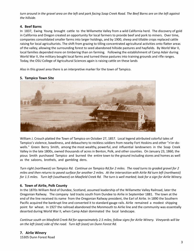
turn around in the gravel area on the left and park facing Soap Creek Road. The Beef Barns are on the left against the hillside. 4. Beef Barns In 1837, Ewing Young brought cattle to the Willamette Valley from a wild California herd. The discovery of gold in California and Oregon created an opportunity for local farmers to provide beef and pork to miners. Over time, companies consolidated smaller farms into larger holdings, and by 1900, sheep and tillable crops replaced cattle raising for local agriculturists. The shift from grazing to tilling concentrated agricultural activities onto flatter areas of the valley, allowing the surrounding forest to seed abandoned hillside pastures and hayfields. By World War II, local families depended more on timbering than on farming. Following the establishment of Camp Adair during World War II, the military bought local farms and turned these pastures into training grounds and rifle ranges. Today, the OSU College of Agricultural Sciences again is raising cattle on these lands Also in this gravel area there is an interpretive marker for the town of Tampico. 5. Tampico Town Site
William J. Crouch platted the Town of Tampico on October 27, 1857. Local legend attributed colorful tales of Tampico’s violence, bawdiness, and debauchery to reckless soldiers from nearby Fort Hoskins and other "n’er-do-wells." Green Berry Smith, among the most wealthy, powerful, and influential landowners in the Soap Creek Valley in the late 1800s, owned thousands of acres in Benton, Polk, and other counties. On January 23, 1860, the pious Smith purchased Tampico and burned the entire town to the ground including stores and homes as well as the saloons, brothels, and gambling dens. Turn right (northwest) on Tampico Rd. Continue on Tampico Rd for 2 miles. The road turns to graded gravel for 2 miles and then returns to paved surface for another 2 miles. At the intersection with Airlie Rd turn left (northwest) for 1.5 miles. Turn left (southwest) on Maxfield Creek Rd. The turn is well marked; look for a sign for Airlie Winery. 6. Town of Airlie, Polk County In the 1870s William Reid of Dundee, Scotland, assumed leadership of the Willamette Valley Railroad, later the Oregonian Railway. The company laid tracks south from Dundee to Airlie in September 1881. The town at the end of the line received its name from the Oregonian Railway president, the Earl of Airlie. In 1890 the Southern Pacific acquired the bankrupt line and converted it to standard gauge rails. Airlie remained a modest shipping point for wheat. In 1927 the railroad abandoned the Monmouth to Airlie line and the community was essentially deserted during World War II, when Camp Adair dominated the local landscape. Continue south on Maxfield Creek Rd for approximately 2.5 miles; follow signs for Airlie Winery. Vineyards will be on the left (east) side of the road. Turn left (east) on Dunn Forest Rd. 7. Airlie Winery 15305 Dunn Forest Road

4
Established in 1986, the 34 acre vineyard produces award winning Pinot Noir, Pinot Gris, Chardonnay, Maréchal Foch, Müller Thurgau, Riesling and Gewürztraminer. The winery is open March through December on Saturdays and Sundays, noon to 5 p.m. or by appointment. www.airliewinery.com/ Return to Maxfield Creek Rd; turn left (southwest). Continue 4.7 miles to 24008. Continue about 50 yards past the driveway; find a safe place to park on the right and look back. 8. Rodgers-Ayers House 24008 Maxfield Creek Road Private residence. Not open to the public. Built in 1898 for John D. Rodgers and his wife, Matilda, this late Italianate farmhouse, although altered, retains much of its original fabric. The house is sited on the original Norton Donation Land Claim. Rodgers sold the house to the Ayers Family in 1910. Ayers was a partner in the Kings Valley general merchandise store and assisted in construction of some of the area’s covered bridges. Continue west along Maxfield Creek Road for 0.25 mile to the intersection with Highway 223, the Kings Valley Highway. At the intersection turn right (north) into the driveway in front of the church building. 9. United Evangelical Church of Kings Valley 23803 Maxfield Creek Road The United Evangelical Church of Kings Valley is one of the best examples of a rural Gothic Revival style Benton County church built during the late 19th century. The building continues to play an important role in the Kings Valley community. The first Kings Valley Church, built in 1877, stood on the Lucius Norton Donation Land Claim to the south. In 1895, the Rowland Chambers family deeded part of their Donation Land Claim for a second church, the United Evangelical Church of King’s Valley, following a split within the congregation. Preacher Yost and community members built this church. By 1913, differences resolved and the churches reunited. Recently, the church is enjoying new life as the Kings Valley Community Chapel and a community center. Kings Valley In 1845 Sarepta and Nahum King and 26 members of their family, including daughter Sarah and her husband Rowland Chambers, emigrated in one of the early Oregon Trail wagon trains from St. Joseph, Missouri. Unfortunately, they followed the ill-chosen Meek Cut-off on which their party suffered fatality and privation before arriving in The Dalles. Sarah perished in eastern Oregon. The family settled here, and by 1854 the area was known as Kings Valley. The Kings Valley post office opened in 1855 and served the community until the 1960s. The town grew to include sawmills, a cemetery, three stores, a saloon and grocery, a hotel, and a smithy. The first recorded gristmill in rural Benton County was built in 1853 by Rowland Chambers at the site where the Luckiamute River naturally dropped four feet and provided a good source of power. From locally grown wheat, the mill produced top quality flour for more than fifty years. French grinding stones were “shipped around the Horn” for use in the mill. Turn right (north) on Hwy 223 (Kings Valley Hwy) to the top of the next rise; park on the right. On the west (left) side of the highway is a farmhouse with white horizontal fencing.

5
10. Chambers-Miller Farm 38970 Kings Valley Hwy Private residence. Not open to the public.
The farm’s location, setting, some of the outbuildings, and much of the landscaping date to an earlier period when the Rowland Chambers family farmed this land. Chambers immigrated to Kings Valley with his father- in-law, Nahum King. His wife, Sarah, perished on the Oregon Trail. Chambers subsequently married his sister-in-law, Lovisa. Here they raised his two children by Sarah, and 14 of their own children. The farm represents a connection to the earliest settlement of this area. The current farmhouse is an intact example of a late 1800s Gothic Vernacular farmhouse and is notable for the porch’s Eastlake details. The house is also named for A. C. Miller who immigrated to Oregon in 1879 and played an important role in agriculture and commerce in Kings Valley. Continue north on Hwy 223 for 0.2 mile. On the left (west) side of the highway pull into the store parking area and turn around. 11. Kings Valley Store 39088 Kings Valley Hwy In 1868 the early Kings Valley Store stood in the parking area of the current store. In 1884 W.L. Price and Sarepta Norton, granddaughter of Nahum and Sarepta King, operated a store here. Historically, the store sold hardware, dry goods, livestock, feed, groceries, and gasoline and housed the telephone exchange. The Odd Fellows fraternal society gathered for meetings on the store’s second floor, and country dances, socials, medicine shows, wedding receptions and high school parties were also held there. The store served as a community center as people stopped to talk or play checkers. Turn right (south) on Hwy 223 and continue 2 miles. Turn right (west) on Hoskins Road. Continue past 23380 Hoskins Road on the left (south) side of the road about 0.4 mile. Find a safe place to park on the right. 12. Watson House & Barn 23380 Hoskins Road Private residence. Not open to the public. The James Watson House and Barn with their intact design, materials, workmanship, location, and setting are Benton County’s oldest extant structures in good physical condition. The Watson House is the only structure in Benton County to be recorded by the National Park Service’s Historic American Buildings Survey in 1934, and the Survey identified the house as one of the best designed and preserved in the state of Oregon. In the survey it is described as "probably the oldest plastered house in Willamette Valley." William Pittman built the house from 1851 to 1853 for early pioneers James and Mary Ridgeway Watson. The house is an excellent and rare example of a simple Classical Revival style found throughout the Willamette Valley in the 1850s. In addition to farming, Watson served as Benton County Precinct Judge and County Commissioner. The

6
Watson Barn, built in 1848, is the oldest known extant structure in Benton County. It is also significant for early construction techniques and materials, and boasts the widest hand-hewn timber section found in the Willamette Valley. Continue west on Hoskins Rd for 0.8 mile and look for a split-rail fenced parking area on the right (north) side of the road. The Frantz-Dunn House is visible from here, or can be approached via a short walk. 13. Frantz-Dunn House 22953 Hoskins Road
The Samuel Frantz Family purchased the decommissioned Fort Hoskins site in 1866 and constructed a home next to the former military hospital. Samuel’s son E.O. Frantz and his wife lived here later. The circa 1869 Frantz-Dunn House is a fine, intact example of local Gothic Revival style, one of only several examples in Benton County. Continue west 0.5 mile and bear right at the T-intersection. Follow signs for Fort Hoskins Historic Park. 14. Fort Hoskins Historic Park Accessible restrooms, reservable picnic shelter, hiking and interpretive trails are available. On July 26, 1856, the U.S. military established Fort Hoskins on the western edge of the Coast Range Indian Reservation on the Luckiamute River overlooking Kings Valley. The Fort honors lieutenant Charles Hoskins who died in the battle of Monterey, Mexico, ten years earlier. Fort Hoskins guarded the pass through the Coast Range to the Willamette Valley and protected the native people at the Siletz Indian Agency. The fort also provided Union presence in Oregon during the Civil War. The archeological site of the fort and Frantz-Dunn house was one of the first in Oregon to be listed in the National Register of Historic Places. During state-funded excavations by the Oregon State University Department of Anthropology in 1976-1977, thousands of artifacts were recovered providing critical information about frontier fort life. In 2012 the former Commander’s House was re-located back to its original footprint within the park. The house had been moved to the vicinity of Peedee in 1869 four years after the Fort was decommissioned. Planning efforts are underway to return the house to the 1856-65 active Fort era with the intent of making it available for public enjoyment. See Benton County’s Parks website: www.co.benton.or.us/parks/park_info/hoskins.php Return to Hwy 223; turn south (right). Travel 0.65 mile and follow signs for Beazell Memorial Forest. 15. Beazell Memorial Forest & Plunkett House

7
Accessible restrooms and trails available. In 1886 James and Ashnah Norton Plunkett purchased this property, part of the Jobs Haworth Donation Land Claim. James Plunkett served as a drummer boy at Fort Hoskins, and Ashnah was the daughter of early Kings Valley settler Lucius Norton. Shortly after acquiring the property, the Plunketts constructed this 1870s Gothic vernacular farmhouse, the best example of the style in Kings Valley. The Plunketts lived and farmed in this location for the remainder of their lives, as did one of their five sons, Henry Plunkett. The 586 acres that make up this property were donated to Benton County for a demonstration forest and open space managed with progressive ecosystem practices. It includes hiking trails and picnicking. The barn, constructed in 1930 from lumber milled on the site, has been reconstructed for a new use, and includes a classroom, assembly room, and caterer’s kitchen. It is now known as Beazell Forest Education Center, available for events by reservation: Benton County, 541-766-6871. www.co.benton.or.us/parks/park_info/forest_education_center.php Return to Hwy 223; turn south (left) for 3.7 miles to the Wren Community Club on the east (left) side of the roadway. 16. Wren Community Club Members of the Wren community built the Community Club in the late 1930s for dances, basketball, meetings, and parties. During World War II, soldiers from Camp Adair frequented the Wren Community Club for social activities. Later the building housed indoor horseshoe courts where enthusiasts statewide competed in tournaments. The building is located in a narrow valley with Read Creek, a tributary of the Marys River, flowing behind it. Recognized by the Benton County Register of Historic Resources, the Club displays historic integrity in its location, setting, design, workmanship, and materials and is significant for the role it continues to play in the Wren community. The Community Hall is available for events by reservation: www.wrenditions.org/ Return to Hwy 223, proceed south 0.1 mile to Cardwell Hill road, turn left (east) and in 0.2 mile turn right at the Lumos Winery sign during the open hours. 17. H Bar H Ranch, now Lumos Vineyards 2400 Cardwell Hill Road, Philomath The current 100-acre farm is what’s left of the one square mile ranch operated as the H Bar H Dude Ranch in the 1940s. The ranch offered trail riding, fishing, lodging, dining, and entertainment. The barn and two small cabins remain, and are part of Lumos Vineyards today. The vineyard tasting room is open to visitors on specific dates from March through November. Visit the website for dates: www.lumoswine.com/index.htm Continue south on Highway 223 for 1 mile to the town of Wren. 18. Wren This community is named for George P. Wrenn, pioneer settler, though the town's name is spelled differently. In 1886, the Oregon Pacific Railroad identified the station here as "Wrens." The Wren post office was established July 12, 1887, and operated until February 29, 1968. Follow signs for the covered bridge, approximately 2.5 miles west of Wren on Harris Rd. About 1.5 miles from the stop sign the road surface becomes graded gravel. 19. Railroad along Harris Road This rail line served the Willamette Valley & Coast Railroad line to Yaquina Bay. The railroad was known later as the Coast Railroad, the Oregon Pacific Railroad, and the Southern Pacific Railroad. Some early community leaders envisioned Corvallis as a rail shipping point. They invested in this rail line anticipating that cargo ships bound for Portland from ports south along the west coast would prefer to dock at Yaquina Bay since it was not as far north.

8
Freight then shipped by rail to Corvallis would save shipping companies great expense and promote Corvallis’ industrial development. Unfortunately, these entrepreneurs built the railroad before learning that Yaquina Bay is not deep enough to accommodate the oceangoing vessels they hoped to attract. 20. Harris Covered Bridge on Harris Road The 75-foot Harris Bridge, built 1929, spans the Marys River near the former community of Harris. The Harris Bridge is one of 43 Oregon Covered Bridges enrolled in the National Register of Historic Places in June 1979. All use timber truss spans, mostly Howe trusses, the first trusses designed using mathematical stress analysis. Howe trusses are suitable for heavy duty bridge spans and widely used for railroad bridges. The limited height clearance is not recommended for motor homes. Adjacent to the covered bridge is Harris Bridge Vineyards, operating since 1999, this small family-operated winery is open weekends May through November. Contact for hours. www.harrisbridgevineyard.com/ Travel through the bridge, turn around, go back through the bridge, and pause on the right (west) side of the road. 21. Charles King House 22930 Harris Road Private residence. Not open to the public. Charles King, a member of the King family of Kings Valley, purchased this property in 1869. The house was probably constructed shortly thereafter, c. 1870, and is an intact example of a vernacular farmhouse. It sits on a portion of the original George Mason Donation Land Claim secured in 1855. The rear addition of the house was built to board railroad workers. Later, in the early 20th century, loggers and workers at the Harris sawmill also boarded here. Charles King later served on the school board and operated the store and post office at Elam, the earliest name for Harris. Recently the house was carefully restored and was listed in the National Register of Historic Places in 1990. Return to Hwy 223 and turn left (south). At Hwy 20 turn left (east) toward Philomath. Continue 5.2 miles to Philomath. Follow signs for the Museum. 22. Benton County Historical Museum 1101 Main Street, Philomath The Benton County Historical Museum is housed in what was originally the Philomath College building. In 1865 local subscribers pledged $17,500 to the United Brethren in exchange for their development of an institution of learning that became Philomath College. Leaders composed the name from two Greek words to mean “a lover of learning, a scholar.” Built in 1867 the original two-story brick school building included classrooms on the first floor and a chapel on the second. The west and east wings of brick veneer over wood frames were completed in 1905 and 1907, respectively, using student labor. The town of Philomath grew up around the school and took its name. After Philomath College closed in 1929, church services continued until 1968. In 1978 Benton County voters approved a levy that provided initial funds for the operation of a county museum in the Philomath College building. The Benton County Historical Museum collection includes approximately 65,000 items that illustrate the diverse themes of our heritage. The museum offers exhibits, contemporary art exhibits, and a research library. Hours are Tuesday - Saturday 10:00 a.m. to 4:30 p.m. Admission is free; donations accepted. www.bentoncountymuseum.org/

9
South Benton County Route Begin this tour at the Applegate Interpretive Center at Avery Park, reached by entering the park on 14th Street south from Philomath Blvd. Turn left on SW Avery Park Rd. and the parking area is on the left near the Marys River. Accessible restrooms available in the park.

10
1. Applegate Trail Oregon Trail immigrants met a formidable challenge at the rugged Cascade Mountains near Mount Hood and had to complete the 80-mile trip from The Dalles to Fort Vancouver through the dangerous Columbia River Gorge in crude rafts. Many lost their lives on this part of their journey. An alternative route for pioneers was needed, and in 1846, the Applegate brothers and others scouted for a less perilous path. Branching off the main route of the Oregon Trail at Fort Hall, Idaho, this new route provided a southern entrance to the Willamette Valley and avoided the treacherous Columbia River Gorge. In Benton County the Applegate Trail followed ancient Kalapuyan trails and portions of the Oregon-California Pack Trail used by fur traders and trappers from the Hudson Bay Company. The Applegate Trail became a wagon road around 1848. It wound along the foothills of the Coast Range and avoided brushy, swampy lowlands. The California Gold Rush further defined the route for stage coaches and wagons. Today Highway 99W generally follows the trail. Congress designated the Applegate Trail a National Historic Trail in 1992. Proceed left (southeast) along Avery Park Rd to the stop sign; turn left (east) on Avery Ave to the stoplight. At stoplight turn left (north) on Hwy 99W (3rd Street); make the first right (east) turn on SE Chapman Pl, just past the food Co-op. Find a safe place to turn around and park; walk back towards the highway and look to your right (north). 2. Marys River Bridge 4th Street (Hwy 99W north) The Marys River Bridge is located on the northbound section of Highway 99 just south of downtown Corvallis. The bridge, built in 1934, was designed by a team led by the state’s pre-eminent bridge designer, Conde B. McCullough. McCullough also designed many of the coastal bridges on the U.S. 101 corridor. Earlier bridges across the Marys River were built in 1856, 1890, and 1910. Return to Hwy 99W (3rd St) and turn left (south); proceed 0.2 mile south on Hwy 99W (3rd St) to the stoplight and turn left (east) onto Crystal Lake Drive. Proceed 0.1 mile. 3. Mill Race, Crystal Lake Drive The Mill Race ran from a dammed section of the Marys River to the Willamette River. It provided water power for Fischers’ Flouring Mill, located on the current site of the Evanite industrial plant. The mill race was a popular place for tug-of-war contests between the freshman and sophomore classes at Oregon Agricultural College (now OSU), Proceed 0.7 mile on Crystal Lake Drive and turn left (east) at the sign for CoHo Ecovillage, then left into the cemetery. 4. Crystal Lake Cemetery 1945 SE Crystal Lake Drive Interpretive signs and brochures are available in the cemetery. Crystal Lake Cemetery was established in 1860 when Joseph Alexander deeded 5.31 acres of his 1849 Donation Land Claim to the Masons’ Corvallis Lodge #14 for a cemetery. The Crystal Lake name was adopted in 1866. Among those buried at Crystal Lake are Joseph C. Avery, one of the founders of Corvallis; OSU presidents Benjamin Arnold and William Jasper Kerr; the Wong Family, one of the early Chinese families in Corvallis; and Louis and Maria Southworth, an early African-American couple in Benton County. The cemetery was listed in the National Register of Historic Places in 2004. Active burials and interments still take place within Crystal Lake Cemetery which is now managed by the Benton County Natural Areas and Parks Department. The rich history associated with the Cemetery is presented at an interpretive kiosk located near the cemetery entrance. Additionally, cemetery informational brochures may be viewed at: www.co.benton.or.us/parks/park_ info/Crystal Lake

11
Proceed 0.5 mile south on Crystal Lake Dr. Turn left (east) on Park Ave and proceed 0.2 mile. 5. Willamette Park, SE Goodnight Avenue Restrooms available. An early 20th century ferry crossed the Willamette River to Stahlbush Island here. According to an early 20th century topographic map, this city park was also the terminus of a railroad spur that ran from the Southern Pacific line just west of Hwy 99W. Upon leaving Willamette Park, proceed west on Goodnight Ave for 0.6 mile to Hwy 99W. Turn left (south) onto Hwy 99W and proceed 0.8 mile to Kiger Island Dr. Turn left (east) on Kiger Island Dr. and park or explore by auto. 6. Kiger Island Kiger Island is one of the most productive agricultural areas in Benton County. Many long-time farm families still live in the area. The island was known in the early 20th century as the site of activities of notorious cult leader Franz Creffield, who proclaimed himself Joshua the Prophet, and his “holy rollers.” The Creffield story, rife with assassination, suicide, and adultery, has been the subject of films and books. Return to Hwy 99W, turn left (south) and proceed 0.4 mile to Herbert Rd on your right (west) and at approximately milepost 87. Proceed 0.8 mile to the parking lot for Herbert Open Space, affording an excellent view of Marys Peak. 7. Corvallis’ second airfield This site served as Corvallis’ second airfield in the late 1920s and 1930s. The city’s first airfield was located northwest of downtown on Grant Avenue. Proceed 0.8 mile to Airport Rd. Turn right (west) and proceed another 0.8 mile. 8. Corvallis Airport 5695 SW Airport Avenue
Established just prior to World War II, the current Corvallis Airport served as an Army air base during the war. It was returned to the city after the war. One of the World War II era hangars remains. Today the airport offers private and corporate aircraft service to the area. Return to Hwy 99W via Airport Rd. Turn right (south) on Hwy 99W. Proceed 0.3 mile. Find a safe place to park.

12
9. Smith-Rickard House 5570 SW 3rd Street (Hwy 99W) Private residence. Not open to the public.
Built around 1890, this Italianate farmhouse was owned by two of Benton County’s prominent 19th century families. It was constructed about 1890 for Ned Smith, grandson of Green Berry Smith. John Rickard, who already owned considerable land in the area, purchased the home and surrounding farm land from Smith in 1895. The Rickard Family owned it until 1945. The house was listed on the Benton County Register of Historic Resources in 2005. Continue south on Hwy 99W for 3.3 miles to its intersection with Greenberry Road; pull into the parking area 10. Willamette Community and Grange Hall 27555 Greenberry Road Constructed in 1923, the current Willamette Grange Hall was the third building to house the grange, established in 1873. This Georgian style structure is the most stylized grange hall in Benton County, and was listed on the National Register in 2009. Proceed 1.8 miles south on Hwy 99W (mile marker 93.) Turn right (west) onto Finley Refuge Rd; follow refuge signs for 1.3 miles. 11. Finley National Wildlife Refuge 26208 Finely Refuge Road Accessible restrooms available. Some trails closed seasonally to protect wildlife. Some buildings are not open to the public. Established 1964 by the U.S. Fish & Wildlife Service the refuge provides winter habitat for Dusky Canada Geese. It also protects many of the historic habitats of the valley, particularly the largest remaining tract of native Willamette Valley wet prairie. www.fws.gov/willamettevalley/finley/ Travel 1.5 miles from the refuge entrance to the 1857 Classical Revival style Fiechter House, one of the oldest houses in Benton County, located on John Fiechter’s original Donation Land Claim and listed in the National Register of Historic Places. The nearby Cabell Barn was exceptionally well built in the early 20th century. Just south of the Fiechter House is the 1912 Cabell Lodge. The lodge is a two-story wood frame structure with a bell-cast gable roof, two brick chimneys, and an expansive veranda on the east side which overlooks Cabell Marsh. Elsewhere on the refuge are the Big Barn and Cheadle Barn. The refuge is named for William L. Finley, an early

13
wildlife conservationist who persuaded President Theodore Roosevelt to set aside the first national wildlife refuge west of the Mississippi River. Return to Hwy 99W and turn right (south). Proceed 1.6 miles, on the right will be: 12. James Bruce Barn 28168-28170 Highway 99W Private residence. Not open to the public. The Bruce Barn was constructed about 1905 on the farmstead established by James Bruce in 1868. The barn is an excellent, intact example of an early 20th century livestock barn and is notable for its prominent cupola. Proceed 1.6 miles south on Hwy 99W to Old River Road. Turn left (east) onto Old River Rd and proceed 0.3 mile. 13. Mary Barclay House 27264 Old River Road Private residence. Not open to the public. Built in 1896 for $1,200, this is one of the best examples of an Eastlake Stick style farmhouse in Benton County, complete with stick paneling, sunbursts in the gables, and stained glass windows. Mary Wallace Neill (Herron) Barclay came to Oregon in 1861 with her first husband, Robert Herron. She married James Barclay in 1877; the house was built after his death. The Barclay Family planted the hawthorn tree in the front yard around the time the house was constructed. The farmstead remains in the Barclay Family and is a Century Farm. Return to Hwy 99W and turn left (south) for 1.3 miles. Turn right (west) onto Dawson Rd and proceed 0.3 mile. 14. Albert Zierolf Farm 26861 Dawson Road Private residence. Not open to the public. Casper and Mary Zierolf established this farmstead in 1871. Their son Albert had the existing house and barn built about 1899. The house includes Queen Anne, Stick, and Eastlake elements. The barn features a decorative hay hood on its south end and a cupola with wood louvered vents in the center of the roof. Return to Hwy 99W, turn right (south), and proceed 0.2 mile to milepost 98. 15. Benton County Flax Cooperative 26510-26560 Hwy 99W
On the west side of the highway are buildings that remain from the Benton County Flax Cooperative. This was one of several flax cooperatives located throughout the Willamette Valley, developed during World War II to process flax being grown for linen thread to be used by the Army and Navy for parachute harnesses, fire hoses, and

14
sewing thread for leather shoes. Proceed 2.5 miles and turn right (west) on Monroe Cemetery Road, and find a safe place to park. 16. Monroe Cemetery On the right (west) 0.1 mile from the highway is the Monroe Cemetery. Established about 1850 on the Hinton Donation Land Claim, the first burial was a family child. The cemetery is still active and may have as many as 500 interments. Continue 0.3 mile south on Hwy 99W. Park at the Monroe Community Library, 380 N. 5th St. 17. Corvallis & Alsea Railroad Depot, now part of Monroe Community Library. Restrooms available
Located on the west side of the highway, this depot was moved to its current location from a block farther south. Functioning as the freight service portion of the depot built in 1913 to serve Monroe; it remained active until about 1960. The passenger building was demolished in the 1970s. In 2013 the freight depot became an important part of the new Monroe Community Library built on this site, and many features of the depot have been preserved. If you visit during the library’s open hours, go inside and view this structure blending old and new. www.thebestlibrary.net/monroe-locations-67 Look across Hwy 99 to the east. 18. Monroe Union High School
365 N 5th Street (Hwy 99W)

15
Constructed in 1928 the Monroe Union High School is an excellent example of Georgian Revival architecture and is the oldest high school building in Benton County. The brick for the building was manufactured at the nearby Monroe Brick Works, which began making brick, drain tile, and building blocks around 1912. After extensive fires destroyed commercial areas in nearby towns, brick was more widely used for commercial buildings, and occasionally for residential buildings Turn right (south) on Hwy 99 and in 3 blocks turn right (west) on Commercial St. Explore downtown Monroe. 19. Monroe Downtown
Monroe became the commercial center for the Bellfountain, Alpine, and Willamette communities. By 1911, Monroe was reported to have a bank, a department store, two hotels, liveries, a machine shop, as well as several orchards and a mill. Much of this growth occurred due to the efforts of prominent business man and entrepreneur Adam Wilhelm. Other historic points of interest in Monroe include the 1905 Adam Wilhelm Mansion/Baker House, 220 6th St (6th and Commercial, one block west of Hwy 99W); the 1911 Monroe State Bank, 190 S. 5th St (Hwy 99W), the Monroe United Methodist Church, 657 Orchard St (two blocks west of Hwy 99W), and St. Rose Catholic Church (now its memorial hall), 460 S 5th St. After exploring downtown Monroe, return to Hwy 99W/5th St and proceed north approximately 0.8 mile. Turn left (west) on Alpine Cutoff Road and proceed 0.8 mile. Turn left at the stop sign, continuing west on Alpine Road for 2.4 miles to the town of Alpine. 20. Alpine
Named for an early local school, the town was settled in the mid- to late1800s. Alpine’s post office was established in 1912, during a surge of optimism for the future of south Benton County. The farmland surrounding
16
downtown Alpine was subdivided into hundreds of small acreages sold as fertile fruit orchard land. Names of the subdivisions describe the area’s hopes: “Orchard View”, “Orchard Park”, “Orchard Heights”, “Applehurst”, “Hanshew Orchards”, and “Fairview Orchards”. Trees were planted, and in 1923 the Corvallis Gazette Times reported that the apple yield was expected to top out at 500,000 boxes. Alpine was known as a center of culture and boasted two opera houses, two general stores, churches, a hotel, school, pool hall, train depot and apple-packing plant. Summer circuit Chatauqua assemblies were held in a tent, providing education and entertainment to rural dwellers. A few miles west, Glenbrook was a thriving mill town, employing 400 and founding their own school. As it turned out, the land was not suited to sustained fruit production without the application of costly inputs, and as the market for apples fell, disastrous fires swept the community in 1918 and again in 1924, virtually leveling the town. The Glenbrook mill closed in 1925, and Alpine’s fruit orchards were cut down and plowed under. Turn right (north) on Bellfountain Road; at one mile you will pass through the site of the former settlement of Belknap. 21. Belknap Community In 1847 the Belknap family established one of Benton County’s earliest settlements. In that same year, the community built the Ebenezer School. On a knoll east of Bellfountain Road was the circa 1860 Simpson Chapel, one of the most noted of Oregon’s pioneer churches. The Belknap settlement was the nucleus of the largest and most active Methodist church south of Salem. Continue north on Bellfountain Rd. At 2.4 miles you will arrive in the town of Bellfountain, at the intersection of Dawson Rd. Turn right (east) on Dawson Rd and proceed 0.5 mile to a gravel drive on the right (north). 22. Bellfountain Cemetery Established c. 1855 on the south slope of a hill in the alluvial lowlands of the Willamette Valley, this cemetery’s location provides a panoramic view to the south, east, and west. Established on land donated by H. G. Buckingham, the oldest marked grave dates from 1859; however it is likely that this location was used as a cemetery earlier in the century. Bordering the cemetery are rows of large Douglas fir trees planted soon after the cemetery was established. Return to the town of Bellfountain and find a safe place to park. 23. Bellfountain School 25398 Dawson Road
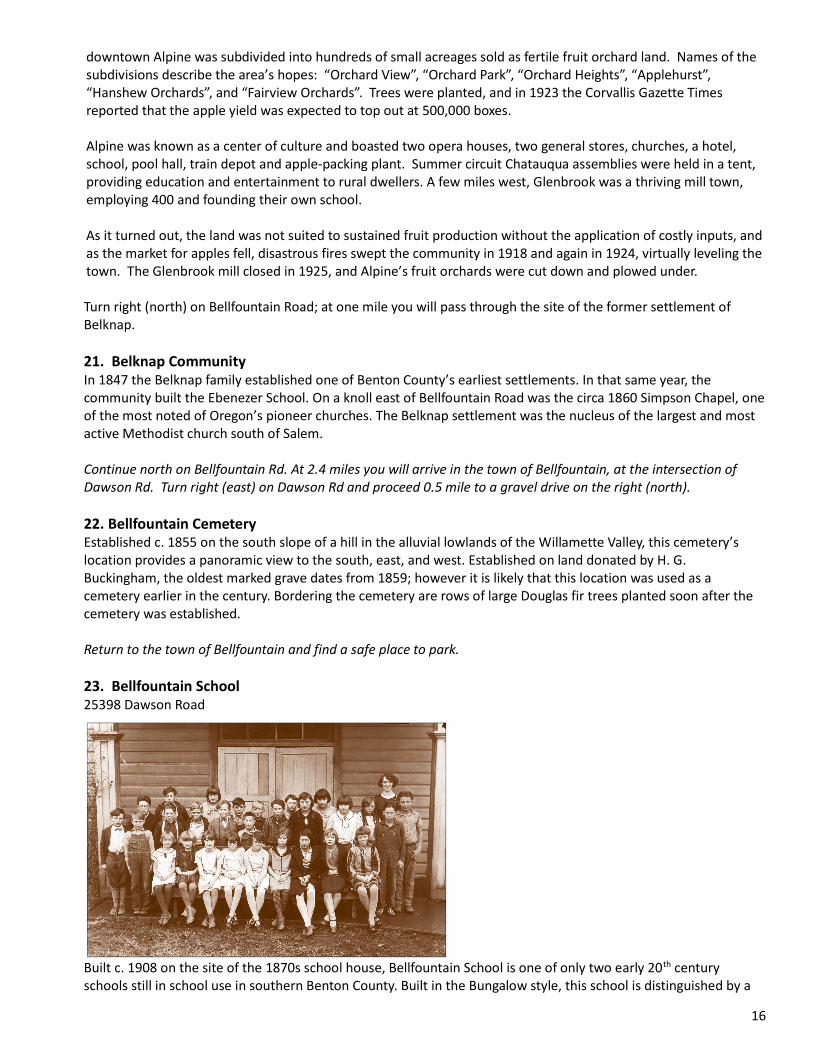
Built c. 1908 on the site of the 1870s school house, Bellfountain School is one of only two early 20th century schools still in school use in southern Benton County. Built in the Bungalow style, this school is distinguished by a

17
hipped roof bell tower on its older portion. The gymnasium (1913) is architecturally unique in Benton County. In the 1930s the Bellfountain high school basketball team achieved distinction as the only Class B basketball team in state history to win the Class A state championship – with a team of 8 boys, none over 6 feet tall. “The Giant Killers” is a book and feature film that documents their feat. Just west of Bellfountain School is the Bellfountain Community Church. 24. Union Church at Dusty 25397 Dawson Road Constructed in 1899, the Bellfountain Community Church, with its intact design, location, setting, workmanship, and materials is architecturally significant as the county’s finest example of a 19th century Queen Anne style church. The Bellfountain church and school were the center of social gatherings in the community. Originally built as a non-denominational church, services rotated each Sunday among the Methodists, Baptists and United Brethren. Every fifth Sunday, the church held services known as The World At Large and invited everyone to attend. Continue west of the intersection of Dawson and Bellfountain Roads for 1 mile; turn right (north) into the park. 25. Bellfountain Campground Accessible restrooms available. Camping is no longer offered. Significant as Benton County’s oldest park, the historic Bellfountain Campground is part of the Orin Belknap Donation Land Claim, and offered a large cold water spring, a natural amphitheater, and flat areas for tents and stabling of horses. Beginning in 1851, Methodists held camp meetings here each year between the last Sunday in June and the first Sunday in July between haying and harvesting. The meetings were a time to renew old acquaintances and also provided a venue for religious ceremonies such as baptisms and weddings. Camp meetings were discontinued in 1904; for years later descendants of pioneer families held reunions here. Benton County acquired the park in 1970. Today the park features one of the longest picnic tables in the United States. The 85-foot table was a gift from Ralph Hull and was cut from a single log milled at nearby Hull-Oakes Lumber Company. www.co.benton.or.us/parks/park_info/bellfountain Return to Dawson Rd, turn right (west), and continue 3.0 miles. 26. Hull-Oakes Lumber Company & Wigwam Burner 23837 Dawson Road Tours by appointment only; phone 541-424-3112.
The Hull-Oakes Lumber Company is one of the last steam-powered sawmills in the nation, processing large-diameter Douglas fir. A lumber mill has operated on this site since at least 1913. Ralph Hull purchased the mill and began operation on this site in 1939. Hull and Chester Oakes organized the current mill in 1955. The historic mill

18
complex includes a sawmill building, a log pond, boiler and fuel storage houses, a large planing shed, a lumber storage area, a train depot, a garage, and railroad spurs. A wood chip storage bin, water reservoirs, a debarking shed, and conveyor are also active parts of the mill. Two steam boilers from the early 20th century power the head rig, band saw, edger, and a number of smaller saws. Sawdust is used as fuel. The wigwam burner operated on site from the 1950s until 1967. Wigwam burners were a common sight in the Willamette Valley in the late 1940s and early 50s but were prohibited by the Air Quality Act around 1970. Hull-Oakes’ large-dimension products, shipped worldwide, have been used in the restoration of national heritage properties such as the USS Constitution and National Parks lodges constructed of rare old-growth lumber. Hull-Oakes Lumber Company is listed in the National Register of Historic Places and the Historic American Engineering Record (HAER). www.hulloakes.com/ Turn around; return to Bellfountain. Turn left (north) on Bellfountain Rd and proceed 7.2 miles to Starr Creek Road. Turn left (west) for 0.2 mile. 27. Currier-Thompson House 25821 Starr Creek Road Private residence. Not open to the public. Situated on a terrace on Beaver Creek, the 1911 Currier-Thompson House fronts east. This house is the only example of a Villa style house in Benton County, and has a Craftsman style interior. The trees surrounding the edge of the yard predate the house and mark the boundary of the yard that surrounded J.M. Currier’s 19th century log home on this site. Currier, born in Vermont in 1827, arrived in Corvallis in 1846 and was one of Benton County’s earliest settlers and prominent citizens. He served for six months in the Cayuse War of 1848, one of his duties was to help bury the dead of the Whitman Massacre. In 1911 the family of eight built the current house. Continue west approximately 0.7 mile on Starr Creek Road. 28. Peter Rickard Farmstead 25450 Starr Creek Road Private residence. Not open to the public. Peter Rickard established this farm on 320 acres in 1875. Today the five acre property includes an 1870s apple orchard, the circa 1875 barn, the farmhouse and smokehouse from 1890, and some of the original plantings. The farmhouse, the second built on the property, was constructed in the Queen Anne style with Eastlake ornamentation. Rickard’s nearby timber stand and sawmill provided lumber for construction. Rickard’s primary crops were wheat and oats. He also raised horses, cattle, hogs, and chickens. Active in local government, he served as County Commissioner twice – 1892-96 and 1902-08 – and as sheriff for two terms beginning in 1896. He moved to Corvallis in 1916. The farmstead was listed in the National Register of Historic Places in 1982. Return to Bellfountain Rd. Turn left (north) and proceed approximately 2.0 miles. The cemetery is located on the east side of Bellfountain Rd. There is parking just north of the cemetery and along Bellfountain Rd. This is a busy route - park safely off the road. 29. Oakridge Cemetery A metal gate located in the SW corner of the cemetery facing the road frames a concrete arch inscribed ”Oakridge Cemetery”. The cemetery was associated with the Oakridge Presbyterian Church, located north of the cemetery until 1938. Mature Douglas firs have overtaken the oaks, and ground covers obscure some graves and markers. Although the cemetery was dedicated in 1890, the earliest grave discernible today dates from 1881. The cemetery has not been used since about 1935. Return to Bellfountain Rd. Turn left (north) and proceed 3.1 miles to Airport Rd. Turn left (west) and continue 1.1 miles to the intersection of Airport and Fern Rds.

19
30. Independent School 25318 SW Airport Road Built in 1919, the Independent School is one of a few one-room school houses remaining in Benton County, and was listed on the National Register in 2013. The Craftsman style school features overhanging eaves, exposed rafters, and eave brackets. At the roof peak is a louvered belfry, holding a bell that still rings. In 1952 the school district was consolidated and Independent School was closed. It has been given new life by the Independent Community Club, a local organization that hosts events in the school building, and makes it available to the public by reservation. www.independentcommunityclub.org Return to Bellfountain Rd. Turn left (north) and proceed to the intersection of Bellfountain and Plymouth Rds, approximately 2.5 miles. Continue north, on Mt. Union Dr, approximately 0.25 mile. 31. Mt. Union Cemetery Reuben Shipley, a slave and early black Benton County pioneer, drove a team of oxen to Oregon in the 1850s in exchange for his freedom. He was employed in the neighboring Plymouth community and managed to save $1,500 which he used to purchase 80 acres of land. Mt. Union Cemetery was established and deeded to Benton County in 1861 on two acres of land donated by Reuben Shipley from the northwest corner of his 80-acre farm on condition that black people could be buried here. It is situated on the east-facing slope of Mt. Union. In 1857 Reuben Shipley married Mary Jane Holmes. Though a long court battle had granted her freedom, Shipley paid $700 for permission to marry her. Reuben and Mary Jane Shipley are buried in Mt. Union Cemetery. Return to Plymouth Rd and proceed south 0.25 mile to Chapel Rd, turn right (west). Proceed approximately 1.7 miles to Fern Rd and turn left (south). Proceed 0.25 mile on Fern Rd to Grange Hall Rd, immediately after the small bridge. Turn right (west) on Grange Hall Rd and continue approximately 0.25 mile. 32. Gathering Together Farm 25159 Grange Hall Road Established 1987, Gathering Together Farm produces certified organic vegetables and fruit. The farm stand/cafe is open seasonally, Tuesday through Saturday. www.gatheringtogetherfarm.com Continue west on Grange Hall Road for 0.9 mile. 33. Thomsen-Shroyer House 24689 Grange Hall Road Built in 1930, the Thomsen-Shroyer House is the only example of a 20th century rural Norman Farmhouse style. The one and one half story house has a steeply pitched gabled roof clad with slate. The tower with its conical roof is faced with stucco and the main façade with Arizona flagstone. Several greenhouses and barns dot the property. There are many rock gardens, bridges, and two concrete pools. J. Thomsen, the builder and original resident, also built the Corvallis Library and Post Office. In 1945 the Shroyers bought the property. Greengable Gardens now owns the house and gardens, and operates a flower farm, florist, and gift shop. There is a modest admission fee to tour the gardens. www.greengable.com Continue west on Grange Hall Rd 0.1 mile to Hwy 34. Turn right (north) and proceed 0.25 mile to Hwy 20. Turn right (east) and proceed approximately 1 mile into Philomath 34. Benton County Historical Museum 1101 Main Street For more information on the museum, please see the Northwest Benton County Route, #22.

20
Bibliography and References for Further Information Albany Democrat-Herald Albright, Mary Jo, Mary Ellen Weishaar, ed. When the Bells Rang, a history and drawings of old school houses in Linn and Benton Counties. White Rabbit Publishing Co., Philomath, Oregon, 1983. Oregon Inventory of Historic Properties. Baker, John H. Camp Adair: The story of a World War II cantonment; Today: Oregon's largest ghost town, Fifth Ed., LAZERQUICK, Newport, Oregon, 2004. Benton County Register of Historic Resources. Benton County Cultural and Historic Resource Survey, 1983. Benton County Historical Society & Museum. Bishop, Ellen Morris. In Search of Ancient Oregon, Timber Press, Inc., Portland, Oregon, 2003. Dennis, Michelle and Elizabeth Carter. Benton County Historic Context Statement, prepared for Benton County Historic Resources Commission, Benton County, Oregon, 1996; and references therein. End of the Oregon Trail Interpretive Center, Biographical - 20 - Sketches of Black Pioneers and Settlers of the Pacific Northwest: Reuben Shipley and Mary Jane Holmes, Oregon City, Oregon. http://www.endoftheoregontrail.org/ Engeman, Richard. Railroad station at Airlie, 1909, Oregon Historical Society, Portland, Oregon, 2005. http://www.ohs.org/education/oregonhistory/historical_records/ Fagan, David D., History of Benton County, Oregon. Portland, Oregon, A. G. Walling, 1885. McDonald, Marlene, When School Bells Rang, Schools of Benton County, Oregon. Mac Publications, Philomath, Oregon, 1983. Munford, Kenneth. Many Kings have been here before, Corvallis Gazette-Times, Corvallis, Oregon, February 4, 1985. Munford, Kenneth and Charlotte Wirfs. Back When in Benton County, Corvallis Gazette-Times, Corvallis, Oregon. Oregon Inventory of Historic Properties. Oregon State University Archives. Salem (Oregon) Online History. http://www.salemhistory.net Wisner, George. Trees to Lumber; McDonald-Dunn Forest: A Historic Look at Sawmilling, Oregon State University Research Forests, Corvallis, Oregon, 1992. Zybach, Robert. Historic Soap Creek Valley Auto Tour, Oregon State University Research Forests, Corvallis, Oregon, 1991. This publication has been funded with the assistance of a matching grant-in-aid from the Oregon State Historic Preservation Office and the National Park Service. Regulation of the U.S. Department of the Interior strictly prohibit unlawful discrimination on the basis of race, color, national origin, age or handicap. Any person who believes he or she has been discriminated against in any program, activity, or facility operated by a recipient of the federal assistance should write to: Office of Equal Opportunity, National Park Service, 1849 C Street, NW, Washington, D.C. 20240
Second Addition 2014

21
Cautionary Notes Please respect private property. Many of the resources described in this publication are private property and are not open to the public; other are accessible by appointment only. Poison oak and other hazards are present in some of the described locations. Take caution and be aware of your surroundings. Please be aware of other vehicle traffic when looking for resources or for a place to park. Acknowledgements Special thanks to: Mary Gallagher and the Benton County Historic Museum; Lawrence Landis, University Archivist and Oregon State University Archives; Benton County GIS Mapping Department specialists. This project is the product of many hours contributed by dedicated volunteers.
Historic Preservation Staff Benton County Community Development Department
360 SW Avery Ave. Corvallis, OR 97333
541.766.6819