
OSM-GB: Using Open Source Geospatial Tools to Create OSM Web Services for Great Britain
20
1 OSM-GB: Using Open Source Geospatial Tools to Create OSM Web Services for Great Britain Abstract A use case of integrating a variety of open-source geospatial tools is presented in this paper to process and openly redeliver open data in open standards. Through a software engineering approach, we have focused on the potential usability of OpenStreetMap in authoritative and professional contexts in Great Britain. Our system comprises open source components from OSGeo projects, the Open Street Map (OSM) community and proprietary components. We present how the open data flows among those components and is delivered to the Web with open standards. Apart from the cost issues, utilizing the open-source tools has offered some distinct advantages compared to the proprietary alternatives, if any was available. At the same time, some technical limitations of utilizing current open- source tools are described. Finally a case study is shown for the usability of the developed solution. Keywords OpenStreetMap, open source, open data, open standards 1. Introduction Since its inception in 2004, OpenStreetMap (OSM) has become the main free source of digital maps made by the crowd. Although OSM is rapidly growing in both contents and contributors, the belief that it is made by amateurs is perceived to limit trust in the value of this free data source within the traditional GIS community. The quality aspects of OSM have been investigated by different researchers and with different tools (Girres and Touya 2010; Haklay 2010; Zielstra and Zipf 2010; Mooney and Corcoran 2011). We contend that to encourage uptake of data, not only must the OSM community produce better maps but the authoritative and professional use cases of OSM shall be facilitated.
-
Upload
nottingham -
Category
Documents
-
view
2 -
download
0
Transcript of OSM-GB: Using Open Source Geospatial Tools to Create OSM Web Services for Great Britain
1
OSM-GB: Using Open Source Geospatial Tools to
Create OSM Web Services for Great Britain
Abstract
A use case of integrating a variety of open-source geospatial tools is presented in
this paper to process and openly redeliver open data in open standards. Through a
software engineering approach, we have focused on the potential usability of
OpenStreetMap in authoritative and professional contexts in Great Britain. Our
system comprises open source components from OSGeo projects, the Open Street
Map (OSM) community and proprietary components. We present how the open
data flows among those components and is delivered to the Web with open
standards. Apart from the cost issues, utilizing the open-source tools has offered
some distinct advantages compared to the proprietary alternatives, if any was
available. At the same time, some technical limitations of utilizing current open-
source tools are described. Finally a case study is shown for the usability of the
developed solution.
Keywords
OpenStreetMap, open source, open data, open standards
1. Introduction
Since its inception in 2004, OpenStreetMap (OSM) has become the main free
source of digital maps made by the crowd. Although OSM is rapidly growing in
both contents and contributors, the belief that it is made by amateurs is perceived
to limit trust in the value of this free data source within the traditional GIS
community. The quality aspects of OSM have been investigated by different
researchers and with different tools (Girres and Touya 2010; Haklay 2010;
Zielstra and Zipf 2010; Mooney and Corcoran 2011). We contend that to
encourage uptake of data, not only must the OSM community produce better
maps but the authoritative and professional use cases of OSM shall be facilitated.
2
Because of the volunteer nature of the community, many open-source geospatial
tools have been developed around OSM in the recent years, ranging from data
handling and data analysis to cartography and presentation. There are a number
of core open-source tools that are used by the OSM developers, e.g. Mapnik
(Pavlenko 2011) for rendering, while some other open-source tools have been
developed for users and contributors e. g. JOSM (JOSM 2012) and the OSM
plug-in for Quantum GIS (QuantumGIS n.d.).
Although those open-source tools generally fit the purposes of core OSM users
and contributors, they may not necessarily fit for the purposes of professional
map consumers, authoritative users and national agencies. If OSM is not
effectively usable by this group, the gap between professional and amateur map
producers/consumers may never be filled and a sense of trust in OSM may never
happen among those users. On the other hand, if OSM can be used effectively by
authorities, there will be a big chance that those users become active contributors,
leading to even more usability and reliability.
Having observed this research gap, this paper presents a system with a strong
reliance on open source geospatial components that can fit the British
authoritative user’s requirements. The solution is developed within the
framework of a project called OSM-GB (OSMGB 2012).
In the rest of this paper, a software engineering approach is taken to analyze the
specific requirements of authoritative users in Britain. Based on those
requirements, the conceptual and detailed designs of our system are presented.
The solution developed also benefits from open standards and open data
initiatives as will be explained later.
2. Users’ Requirements
In the Great Britain context, the following requirements were collected from
authoritative users in the first stages of the project, particularly through steering
group meetings and direct contacts. The requirements are a combination of
general and GB-specific functionalities, as will be explained in this section.
It is however noticeable that gathering the users’ requirements is done within the
open-source/open-data contexts and implications, i. e. the users are generally
willing to use the free software, data and standards as opposed to the licensed
products (for many reasons including the known cost and updatedness issues) but
they are looking for the best possible solution that fits their specific purposes.
3
Otherwise, the designed system may not address the requirements from the users
that wish to benefit from the contractual or the quality-guaranteed services
offered by the available licensed products, e. g. the licensed map data from
Ordnance Survey.
2.1 Coordinate Reference System
In the context of Great Britain, one of the main concerns in using a map in
authorities is the availability of the map in the British National Grid (BNG or
EPSG:27700) coordinate system. The OpenStreetMap website shows the map in
Google Mercator (also called EPSG:900913), as is common in other public maps
(e. g. Google and Bing maps). The OpenStreetMap tile service which can be used
as the background in desktop GIS applications, is also only in Google Mercator.
The export facility of OpenStreetMap website, as well as the OSM “planet files”
and replications use OSM-XML format, in which the coordinates are encoded in
Lat/Lon (EPSG:4326). There is other no free public service, at the time of this
paper, which can deliver OSM data in the BNG coordinate system.
2.2 Multiplicity of Layers
Unlike public users, the authorities are specialized and need to have more
flexibility in selecting the map features they require. They need the map to be
thematically separated in layers, so the users do their job by superimposing the
required layers. For vector maps, thematic filtering of the features is commonly
feasible in GIS applications, but for raster maps such filtering is usually
impossible. Although the features of OpenStreetMap are tagged and the tags can
be used to separate them into multiple layers, the OSM website renders them all
into a flat map. At the time of this paper, there is no free public service offering
multi-layered raster map for OSM. It is however possible to use the filtering
functionality of the OSM API, subject to knowing the required tag combination
for the specified thematic map, which produces raw text output.
2.3 Raster and Vector Maps
Raster maps are necessary but not enough if detailed map analysis is required in
the authoritative use cases. Querying and filtering by geometry or by attributes,
applying routing algorithms, customized rendering and labeling are examples of
the functionalities that can only be achieved in vector maps. OSM-XML is not a
known format in our target authorities. At the time of this paper, there is no other
free public web service of vector OSM data for the GB area, particularly in BNG.
4
2.4 OGC Compliance
The standards established by Open Geospatial Consortium are the most widely
accepted standards for map delivery via the Web. The availability of OGC
compliant Web Services is a major advantage, if not a necessity, for a map
service to be used by the authorities. The main OGC standards for map delivery
are WMS (Web Map Service), WMTS (Web Map Tile Service), WMSC (Web
Map Service, Cached) and WFS (Web Features Service). The first three standards
are for raster map delivery and the last makes the vector text based output in a
number of established OGC standards including GML (Geographical Markup
Language) and KML (Keyhole Markup Language).
WMTS is currently run by the OpenStreetMap and some other mirrors in limited
CRSs. Besides that, at the time of this paper, the only available world-wide WMS
service is run by the University of Heidelberg called World OSM-WMS
(GIScience 2010), which is single-layer and is updated weekly. No other WFS
based on OpenStreetMap has been found for the GB area.
2.5 Consistent Access to National Open Maps
In Britain, Ordnance Survey provides a set of open data (OS 2013) in different
formats and resolutions. The authorities may have full access to the Ordnance
Survey’s open and non-open maps, however if they are willing to work with
OSM they prefer to have an integrated access to those national maps in the same
platform, particularly for superimposing the maps from different sources. The
project’s focus has been on open data sets, thus integrating some parts of the OS
Open Data with OSM and delivering them in a single platform can enhance the
usability of the final product. Among the OS Open Data products, VectorMap
District (VMD) is the most comparable to OSM and so was selected to be
delivered via the OGC Web Services (WFS in this case) together with OSM. At
the time of this paper, no free WFS access to the VMD is found (although the
University of Edinburgh’s Digimap OpenStream service offers WMS access to
OS Open Data, free for UK academic use).
2.6 Frequent Updates
The other main concern of the authoritative users is the frequency of updating the
map information. A main advantage of crowd-sourced maps like OSM is the
near-instant reflection of changes, in contrast to the long bureaucratic process of
5
map updates in authority-sourced maps. After a user adds or changes data in
OSM, the system is able to update its output in a very short time difference,
perhaps in a few minutes. Any OSM redelivery service should therefore also
update its content very frequently.
2.7 Quality Check and Fix
As a value-added feature, the OSM quality can also be checked in a defined geo-
processing algorithm. Although the project has an extensive subsystem for data
quality check and fix, this paper is not going to cover this subsystem in details.
Particularly we do not cover the details of the user’s requirements in this
subsystem. It is however, an integrated part of the system design and the
interactions of this subsystem with the rest of components are briefly mentioned.
Briefly, this functionality can benefit both the authoritative and public OSM
contributors. The authoritative users can then have a gauge of OSM reliability,
and the OSM contributors (including the authoritative users) can have guides to
correct the map errors. The main requirement is to have a “rule-based” checking
and fixing algorithm. It is not desired to have a closed hardcoded set of rules;
instead, they shall be defined as openly and as flexibly as possible. The results of
the quality checks and fixes are also desired to be delivered by some integrated
and consistent Web Services.
It should also be noted that we are not claiming OSM to be a direct alternative to
national mapping data such as that from the Ordnance Survey. The different
sources have different characteristics: prime amongst these is the more precise
(but closed) data capture & production specifications of the Ordnance Survey
which guarantee certain levels of data quality in their data, particularly for
example in completeness of coverage.
2.8 Summary
According to the items above, the current OSM website, its replications and
redelivery mirrors are not likely to be effectively used by the authoritative map
users in GB. A system is required that can deliver the OSM data in BNG
reference system, in vector and in thematic raster layers, by OGC-compliant
means and with frequent updates. Finally it is desired to have consistent access to
the OS Open Data and to have a quality checking subsystem.
6
3. The Conceptual Design
In order to fulfill the above requirements, a set of software components, including
data sources, tools, databases and standards shall put together. Use of open-
source tools has been a preference but not an absolute necessity in this project.
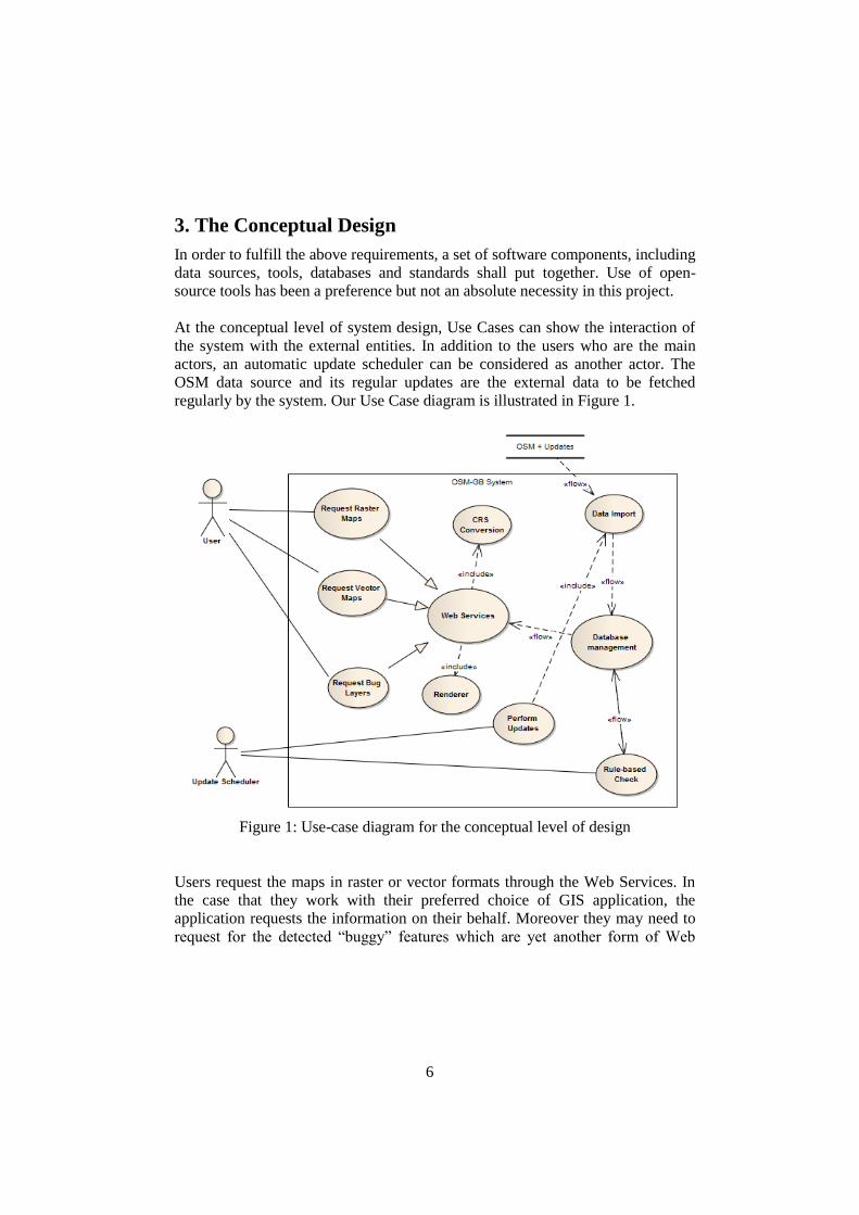
At the conceptual level of system design, Use Cases can show the interaction of
the system with the external entities. In addition to the users who are the main
actors, an automatic update scheduler can be considered as another actor. The
OSM data source and its regular updates are the external data to be fetched
regularly by the system. Our Use Case diagram is illustrated in Figure 1.
Figure 1: Use-case diagram for the conceptual level of design
Users request the maps in raster or vector formats through the Web Services. In
the case that they work with their preferred choice of GIS application, the
application requests the information on their behalf. Moreover they may need to
request for the detected “buggy” features which are yet another form of Web

7
Service interaction. The Web Service provider takes its data from the central
database management system, and also includes a CRS conversion activity. In
addition, it needs to include a renderer component that can make cartographical
outputs for the incoming raster map requests.
The “Update Scheduler” actor frequently triggers an update signal. This signal
primarily causes a new data import activity that updates the database with the
new OSM replication; secondly it starts the checking algorithm that detects the
“buggy” features. The rule-based check activity the necessary data is fetched
from the database, checked against a set of quality checking rules; some fix on
the data is applied and exported back to the database.
The Use Case diagram of figure 1, helps to identify the necessary software
components for each system’s feature. In summary, we need:
- A very flexible database management component that can effectively
deal with spatial information
- Set of tools to efficiently import OSM and its updates into the database
- A powerful OGC compliant Web Service engine equipped with graphical
renderer and the necessary CRS conversion means
- A rule-based quality check engine
- A workflow engine to orchestrate the frequent updating activities .
4. The Detailed Design
3.1 Data and Tools Diagram
Figure 2 shows the current configuration of the tools and the data flow inside the
designed system.
As shown in figure 2, the current system mostly comprises open-source tools for
its primary databasing and web services provision. It also shows that the data
flow starts from the sources of open data and ends with the delivery in open
standards and formats.
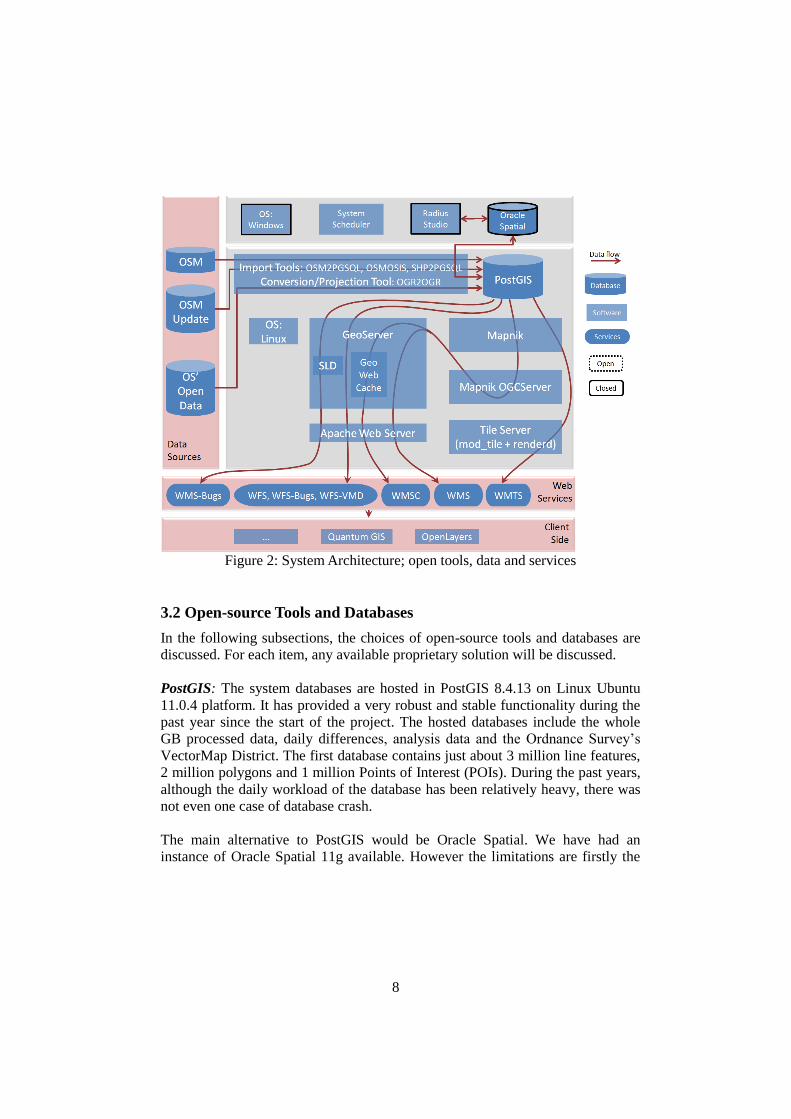
8
Figure 2: System Architecture; open tools, data and services
3.2 Open-source Tools and Databases
In the following subsections, the choices of open-source tools and databases are
discussed. For each item, any available proprietary solution will be discussed.
PostGIS: The system databases are hosted in PostGIS 8.4.13 on Linux Ubuntu
11.0.4 platform. It has provided a very robust and stable functionality during the
past year since the start of the project. The hosted databases include the whole
GB processed data, daily differences, analysis data and the Ordnance Survey’s
VectorMap District. The first database contains just about 3 million line features,
2 million polygons and 1 million Points of Interest (POIs). During the past years,
although the daily workload of the database has been relatively heavy, there was
not even one case of database crash.
The main alternative to PostGIS would be Oracle Spatial. We have had an
instance of Oracle Spatial 11g available. However the limitations are firstly the

9
efficiency of importing data from OSM-XML (using either open or proprietary
tools), and secondly the efficiency of running spatial queries. In both cases,
PostGIS has shown a very much better efficiency when tested. Moreover, the
other limitation in adopting Oracle Spatial lies in the available OSM renderers.
OSM2PGSQL: The whole OpenStreetMap data file (also called the planet file)
are available in OSM-XML format through a number of OSM mirror sites around
the globe including Geofabrik (Geofabrik 2012). The data in this format includes
all nodes, ways (a term used for lines and polygons in OSM) and relation features
together with all of the associated attributes for each feature. On the other hand,
the minutely, hourly and daily updates of the planet file are available in OSC
(OpenStreetMap Changes) format via the OSM replication website (PlanetOSM
n.d.). The OSC format is very similar to OSM-XML but excludes unchanged
features, and the changed features are separated by the update type (create,
change or delete). Each OSC file includes the change from its last replication
time, whether a minute, an hour or a day ago.
OSM2PGSQL (OSM-Wiki 2012) is an open-source tool that can import OSM-
XML files into PostGIS database. It is also used to do the database update using
OSC files. Its usability via the command line has made the simple documentation
for the utility sufficient. In addition, the command-line usability has made this
tool suitable to fit into workflows execution, compared with GUI-based
alternatives.
There are some other tools that can import OSM-XML files into databases.
OSMOSIS is an open-source tool that can do the import from OSM-XML to
PostGIS but the database it produces is not directly usable by Mapnik.
Go Loader (Snowflake 2013) has been a non-open alternative. This tool has a
recently added functionality that can import OSM-XML into Oracle Spatial
database. However the process time is more than double of what is required by
OSM2PGSQL. Moreover, it cannot work with OSC files so far. OSM2PGSQL
has shown a very good performance compared with the alternative means studied
for importing OSM-XML and OSC files.
Mapnik Library and OGCServer: Mapnik is the open-source tool for rendering
the OSM data and is the default tool used by the OSM website. It uses the data
stored in PostGIS and produces graphical output using a defined stylesheet.
OGCServer is another open-source tool based on the core Mapnik library. It can
make a server in order to wrap the graphics rendered by Mapnik in standard Web
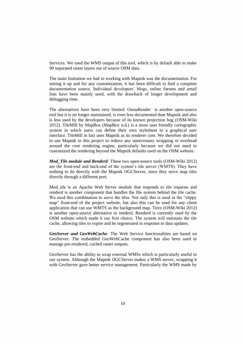
10
Services. We used the WMS output of this tool, which is by default able to make
90 separated raster layers out of source OSM data.
The main limitation we had in working with Mapnik was the documentation. For
setting it up and for any customization, it has been difficult to find a complete
documentation source. Individual developers’ blogs, online forums and email
lists have been mainly used, with the drawback of longer development and
debugging time.
The alternatives have been very limited. OsmaRender is another open-source
tool but it is no longer maintained, is even less documented than Mapnik and also
is less used by the developers because of its known projection bug (OSM-Wiki
2012). TileMill by MapBox (MapBox n.d.) is a more user friendly cartographic
system in which users can define their own stylesheet in a graphical user
interface. TileMill in fact uses Mapnik as its renderer core. We therefore decided
to use Mapnik in this project to reduce any unnecessary wrapping or overhead
around the core rendering engine, particularly because we did not need to
customized the rendering beyond the Mapnik defaults used on the OSM website.
Mod_Tile module and Renderd: These two open-source tools (OSM-Wiki 2012)
are the front-end and back-end of the system’s tile server (WMTS). They have
nothing to do directly with the Mapnik OGCServer, since they serve map tiles
directly through a different port.
Mod_tile is an Apache Web Server module that responds to tile requests and
renderd is another component that handles the file system behind the tile cache.
We used this combination to serve the tiles. Not only this is used in the “slippy
map” front-end of the project website, but also this can be used for any client
application that can use WMTS as the background map. Tirex (OSM-Wiki 2012)
is another open-source alternative to renderd. Renderd is currently used by the
OSM website which made it our first choice. The system will maintain the tile
cache, allowing tiles to expire and be regenerated in response to data updates.
GeoServer and GeoWebCache: The Web Service functionalities are based on
GeoServer. The embedded GeoWebCache component has also been used to
manage pre-rendered, cached raster outputs.
GeoServer has the ability to wrap external WMSs which is particularly useful in
our system. Although the Mapnik OGCServer makes a WMS server, wrapping it
with GeoServer gave better service management. Particularly the WMS made by
11
Mapnik OGCServer includes 91 layers (90 thematic layers plus a merged one)
but by wrapping in GeoServer we could grouping layers and use custom
projections. As a result, the 91 layers have been organized in 8 thematic groups:
each has a number of sub-layers and are served in a customized list of
projections. For example, “transportation” is a WMS layer group consisting of 40
sub-layers (different road types, bridges, tunnels, ferry routes, etc.). A user can
then load any combination of the sub-layers or load the whole transportation
layer in one.
Moreover, GeoServer can directly access the PostGIS database. As the result, a
number of other Web Services have been created including raster and vector
services for OSM, the OSM detected bugs and OS VMD. In total, the services
produced by GeoServer include 2 WMSs, 1 WMSC, 1 WMTS and 3 WFSs.
We have started with GeoServer version 2.1.2 and later upgraded it to version
2.2.3. The issues we had in the older version was frequent crashes and memory
leaks, limited projections and some bugs in GeoWebCache. Upgrading to 2.2.3
has shown a better stability, more integration and full support of the BNG
coordinate system in GeoWebCache. There are other open-source alternative for
Web Services e. g. MapServer. GeoServer has been chosen for the ease of access
and customization through its Web interface.
OSMOSIS: This open-source tool is a very general processing tool for OSM data
(OSM-Wiki 2012). The pipe-line design of this command-line tool can do a
variety of different jobs in importing, exporting, querying and filtering OSM
data. In our system, this tool is used as a part of database updating process.
OSMOSIS extracts and integrates the OSC (change files) from the
OpenStreetMap replication website and makes it available to be used by
OSM2PGSQL. This tool has also shown a stable performance during the project
lifetime.
OGR2OGR and GDAL Library: This is an open-source command-line program
that uses the GDAL library to import and export between different spatial file
formats and coordinate systems (GDAL n.d.). We have used this to convert the
coordinate reference systems when doing the import/export jobs for the PostGIS
databases.
SHP2PGSQL: This is another open-source command-line program that comes
with PostGIS installation. It converts ESRI’s shape files into PostGIS database.
This tool is used to import the Ordnance Survey’s VMD into the database. VMD
12
is openly published on CD-ROM as a series of shape files separated by the
National Grids. SHP2PGSQL together with OGR2OGR is used to make a single
database of the VMD in PostGIS that is used to serve the data through WFS.
Client Side Applications; OpenLayers and Quantum GIS: Although the
standard outputs can be used by any OGC compliant client application, the focus
of our system testing has been on two open-source tools: OpenLayers as the web
interface tool and Quantum GIS as the desktop application. Both applications are
able to work with WMS, WMTS, WMSC and WFS outputs. However, we mainly
recommend OpenLayers for the light-weight services (WMTS and WMSC) and
Quantum GIS for the heavier jobs (WMS and WFS).
We found a couple of issues in adopting these two applications with the other
system’s components: firstly in order to work with WMSC, OpenLayers uses the
default value of 72 dpi for resolution (OpenLayers n.d.), while GeoServer uses
OGC’s 90dpi standard (GeoServer 2013). This shall be resolved by enforcing
90dpi in OpenLayers, otherwise the maps are not shown in the right position.
Secondly, requesting large vector maps can easily be very resource consuming. It
is then useful to have an option of geometrically limiting the bounding box in a
WFS request. In the WFS plug-in of Quantum GIS version 1.7 there is a
checkbox for “Only request features overlapping the current view extend”.
However we found this option disappeared in the integrated WFS in version 1.8
which makes it impossible to work with large WFS datasets, unless the bounding
box values are entered manually in the “WFS Filters” section.
3.3 Non-open-source Tools and Databases
As mentioned before, open-source tools have been a preferred but not a necessity
when there is no better alternative. The sub-system of quality check and fix has a
number of proprietary pieces of software. This has been because of the
limitations in existing open-source software.
Radius Studio (1Spatial 2012) from 1Spatial is a powerful spatial information
handling tool that has started its development since mid 90’s. The established
geo-processing power of this tool, especially on high computing power platforms,
has been largely accepted within the community of professional spatial data users
and it is used by a number of national mapping agencies, for example. Radius
Studio internally uses a powerful object-oriented database that gives it the high
performance in heavy geo-processing workloads. Moreover, all the system
13
functionalities are web based and can be invoked by Web Services. In our view,
there is a corresponding gap in the open source ecosystem, something that might
be of interest to the open-source community.
Consequently, using a proprietary tool usually forces the utilization of some other
proprietary tools. In this case, the Radius Studio’s preferred OS is Windows and
its preferred database is Oracle Spatial. As the result, we have been forced to
have a separated server and database for the quality checking subsystem. Some
parts of the two databases need to be synchronized and the proper conversion
tools need to be used. The open-source OGR2OGR tool (mentioned earlier) can
push the appropriate data between the two databases.
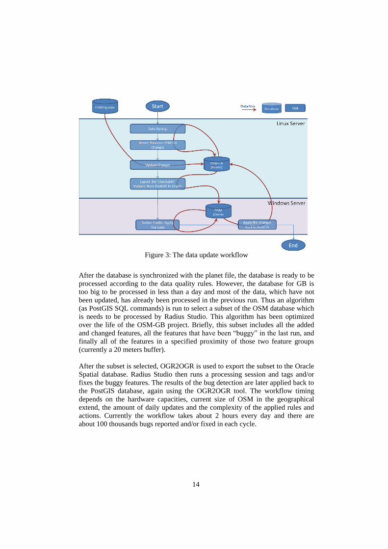
3.4 The Update Workflow
An interesting lesson learnt is in the central management of the two server sides
(open-source and proprietary). We have Windows Server with proprietary tools
and database on one side, and a set of open-source OS, tools and databases on the
other side. On which system should the system orchestrator be located?
This component shall be able to invoke different processes on the two sides. In
our experience, external invocation of the open-source components is much
easier than for the proprietary ones, at least for the tools we have used on the two
sides. Thus our solution has been to locate the system scheduler on the Windows
server. PostGIS, the importing and conversion tools installed on the Linux Server
as well as Radius Studio sessions are all called from Windows Server. The
System Scheduler is in fact a series of batch scripts that are controlled by
Windows’ Scheduled Task application. The details of the updating workflow are
illustrated in figure 3, below.
As shown in figure 3, the data update workflow, which is currently run every day,
invokes a series of database tasks on both servers. In each cycle, firstly the
current status of database changes from the last run is backed up and then
reverted back to what is was before the last round of quality fixes. Secondly the
OSM changes (in OSC format) is downloaded from the OSM replication site and
applied to the PostGIS database (using OSMOSIS and OSM2PGSQL tools).
14
Figure 3: The data update workflow
After the database is synchronized with the planet file, the database is ready to be
processed according to the data quality rules. However, the database for GB is
too big to be processed in less than a day and most of the data, which have not
been updated, has already been processed in the previous run. Thus an algorithm
(as PostGIS SQL commands) is run to select a subset of the OSM database which
is needs to be processed by Radius Studio. This algorithm has been optimized
over the life of the OSM-GB project. Briefly, this subset includes all the added
and changed features, all the features that have been “buggy” in the last run, and
finally all of the features in a specified proximity of those two feature groups
(currently a 20 meters buffer).
After the subset is selected, OGR2OGR is used to export the subset to the Oracle
Spatial database. Radius Studio then runs a processing session and tags and/or
fixes the buggy features. The results of the bug detection are later applied back to
the PostGIS database, again using the OGR2OGR tool. The workflow timing
depends on the hardware capacities, current size of OSM in the geographical
extend, the amount of daily updates and the complexity of the applied rules and
actions. Currently the workflow takes about 2 hours every day and there are
about 100 thousands bugs reported and/or fixed in each cycle.
15
3.5 Open Data
The system is an example of both using and delivering data under open licenses.
The data sources and the output data of the system are generally fit under the
“open” term: the OpenStreetMap data and its regular updates are licensed under
Open Data Commons Open Database License (ODbL), the Ordnance Survey’s
Open Data (OS 2013), of which VectorMap District is a part, is licensed under
the UK’s Open Government License for Public Sector Information. Finally the
project shares its output under Creative Common’s (CC BY-SA 2.0) license.
3.6 Open Standards
The system is also a use-case of adopting the open standards from the Open
Geospatial Consortium (OGC 2012). All the Web Services standards are
provided in all three of the EPSG:4326, EPSG: 900913 and EPSG:27700
coordinate systems, in order to satisfy the user’s requirements described in
section 2. The full list of open standards used for the Web Services are:
WMS (Web Map Service): 90 transparent raster layers are categorized in 8
thematic groups and are served individually or in groups. The thematic groups are
Land (5 sub-layers), Water (12 sub-layers), Buildings (7 sub-layers), Power (3
sub-layers), Boundaries (4 sub-layers), Transportation (38 sub-layers), Places (11
sub-layers) and Amenities (6 sub-layers). Besides the main WMS service,
another WMS (called WMS-for-bugs) serves the detected errors during the
quality checking. The bugs are rendered and labeled according to the type of the
detected bug. An issue in WMS was the compatibility between 1.1.1. vs 1.3.0
versions. The two versions specify the x and y coordinates in opposite order, so
in our experience it is better the clients specify version 1.1.1 in the WMS request
in order to get the right map positions.
WMSC (Web Map Service – Cached): This is a cached and single-layer version
of the above WMS that optimizes the map delivery performance by keeping the
pre-rendering tiles in a web cache.
WMTS (Web Map Tile Service): The single-layer 256 x 256 pixel tiles are served
in OGC’s WMTS standard request/response. The URL of getting a single tile
contains z for zoom level and x, y for the tile’s relative positions in the specified
zoom level (e. g. http://www.osmgb.org.uk/osm_tiles/8/126/87.png).
16
WFS (Web Feature Service): This service makes the comprehensive vector
information of OpenStreetMap in three layers (line, polygons, POIs). All the
OSM key-value pairs for each feature are also included in the WFS response,
which makes free filtering and querying possible. In addition to serving OSM,
two other vector services exist: a WFS-for-Bugs which specifically serves the
buggy features attributed with a description of each bugs, and a WFS-for-VMD
which serves the imported OS VectorMap District data (for comparison
purposes).
SLD (Styled Layer Descriptor): This OGC standard is used to compose the
“Style” files in XML, used in rendering the buggy features in WMS-for-Bugs.
GML (Geography Markup Language) and KML (Keyhole Markup Language):
These two OGC standards are among the variety of file formats used to encode
the Web Services output, when applicable.
5. A Case Study
In this section a sample application of the usage of the developed service in an
authoritative context is presented.
Surrey Heath Borough Council (http://www.surreyheath.gov.uk) uses a
combination of Web mappings to manage its service delivery in the borough. The
internal web mapping portal superimposes various map layers in British National
Grid, including the maps sourced from Ordnance Survey. The WMS explained in
this paper is readily used in this portal, particularly because it is available in
BNG. Apart from being free, the benefit of using this layer is the “immediate”
and “updateable” natures of OpenStreetMap. When new constructions are
developed in the area they can be immediately reflected in OSM and updated in
less than a day. Moreover, the portal users can actively contribute to this update
process, because they have access to other sources of information about the
county’s development projects.
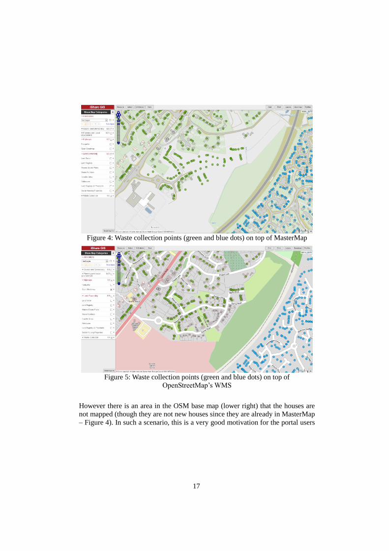
Figure 4 shows overlaying the “waste collection points” on top of a national
Ordnance Survey’s MasterMap layer. As can be seen, many waste collection
points are not associated with any house because the base map layer is not current
with local house construction. Figure 5 on the other hand, shows the OSM-GB
WMS layer used as the base map where the new houses are already mapped
(centre and upper left). Thus the waste management team is using this map base
to digitize new waste collection points.
17
Figure 4: Waste collection points (green and blue dots) on top of MasterMap
Figure 5: Waste collection points (green and blue dots) on top of
OpenStreetMap’s WMS
However there is an area in the OSM base map (lower right) that the houses are
not mapped (though they are not new houses since they are already in MasterMap
– Figure 4). In such a scenario, this is a very good motivation for the portal users
18
to voluntarily contribute to OSM and map those houses.
Benefiting from the OSM short updating cycle is the core of what this case study
can demonstrate. Particularly integrating the bug layers to the GIS application,
can flag up the potential errors which can be fixed manually on the OSM if
necessary, so the background maps can be easily updated. Moreover, it also
demonstrates addressing the other requirements described in section 2: In terms
of the data adaptation, OSM data is projected in the British National Grid so it
can be easily integrated to the rest of the map sources in the system, either in
raster or in vector. As far as OGC compliance concerns, the WMS/WFS services
have made the OSM maps one of the many layers in the employed GIS
application. Finally, the multiplicity of layers in WMS allows the user to focus on
the required one (e. g. buildings or transportation here).
More details of this case study can be found in (Rutter 2012).
6. Conclusion and the Future Works
In this paper we have presented an integrated open-source, open-data and open-
standards solution for OpenStreetMap utilization in a professional context. A
software engineering approach has been taken to gather the professionals’
requirements from OpenStreetMap and to develop the solution having as much
open-source components as possible. As evidenced by case studies, it has been
shown that the current open-source tools that are already developed around
OpenStreetMap can put together and configured to satisfy the professional’s
requirements. Apart from a few practical difficulties, the open-source tools has
well been integrated, however there have been certain components like quality
check and improvement that a non-open-source tool has been the only available
choice.
The system has many rooms to expand as the future works. As with many other
software life cycles, the requirements are dynamic and the system shall address
them. Optimizing the performance, expanding the quality checking rules/actions
and working closer with national map agencies are examples of those future
works. Another future work is for the open-source geospatial community as
suggested in the paper, to consider work on a rule-based geo-processing tool for
large-scale quality check/fix purposes. We also plan further work to promote the
use of the bug reporting services in the OSM community for data quality
checking.
19
Acknowledgement
This research is based at the Nottingham Geospatial Institute at the University of
Nottingham, and is funded and supported by 1Spatial and KnowWhere. We also
wish to acknowledge the collaborations from Ordnance Survey GB, Snowflake
Software and Pitney Bowes. The inputs and helps from James Rutter in Surrey
Heath Borough Council are also highly appreciated.
References
1Spatial. (2012). "1Spatial Website." Retrieved December 2012, from
http://www.1spatial.com.
GDAL. (n.d.). "ogr2ogr." Retrieved January 2013, from
http://www.gdal.org/ogr2ogr.html.
Geofabrik. (2012). "Geofabrik." Retrieved January 2013, from
http://www.geofabrik.de/.
GeoServer. (2013). "GeoServer 2.4.x User Manual - WMS Vendor Parameters."
Retrieved January 2013, from
http://docs.geoserver.org/latest/en/user/services/wms/vendor.html.
Girres, J. F. and G. Touya (2010). "Quality assessment of the French
OpenStreetMap dataset." Transactions in GIS 14(4): 435-459.
GIScience, U. o. H. (2010). "WebMapService of World with OpenStreetMap-
Data." Retrieved January 2013, from http://www.osm-wms.de/.
Haklay, M. (2010). "How good is volunteered geographical information? A
comparative study of OpenStreetMap and Ordnance Survey datasets."
Environment and planning. B, Planning & design 37(4): 682.
JOSM. (2012). "Java OSM editor " Retrieved December 2012, from
http://josm.openstreetmap.de
MapBox. (n.d.). "TileMill." Retrieved December 2012, from
http://mapbox.com/tilemill/.
Mooney, P. and P. Corcoran (2011). Integrating volunteered geographic
information into pervasive health computing applications. Pervasive
Computing Technologies for Healthcare (PervasiveHealth), 2011 5th
International Conference on, IEEE.
OGC. (2012). "Open Geospatial Consortium Web page " Retrieved December
2012, from http://www.opengeospatial.org/
OpenLayers. (n.d.). "OpenLayers JavaScript Mapping Library Documentation."
Retrieved January 2013, from
http://dev.openlayers.org/releases/OpenLayers-
2.12/doc/devdocs/files/OpenLayers-js.html.
20
OS. (2013). "Ordnance Survey OpenData." Retrieved January 2013, from
http://www.ordnancesurvey.co.uk/oswebsite/products/os-opendata.html.
OSM-Wiki. (2012). "OpenStreetMap Project Wiki." Retrieved December 2012,
from http://wiki.openstreetmap.org/wiki/
OSMGB. (2012). "OSM-GB Project Homepage - Measuring and Improving the
Quality of OpenStreetMap for Great Britain." Retrieved December
2012, from http://www.osmgb.org.uk
Pavlenko, A. (2011). "Mapnik." Retrieved December 2012, from
http://mapnik.org/.
PlanetOSM. (n.d.). "Planet OSM." Retrieved January 2013, from
http://planet.osm.org.
QuantumGIS. (n.d.). "Quantum GIS Desktop Project." Retrieved December
2012, from http://www.qgis.org/.
Rutter, J. (2012). "Is OpenStreetMapGB Useful? Damn Right it is!" Retrieved
January 2013, from http://jamesrutter.posterous.com/is-openstreetmapgb-
useful-damn-right-it-is.
Snowflake. (2013). "Go Loader." Retrieved January 2013, from
http://www.snowflakesoftware.com/products/goloader/.
Zielstra, D. and A. Zipf (2010). A comparative study of proprietary geodata and
volunteered geographic information for germany. 13th AGILE
International Conference on Geographic Information Science.