OGC Portal - Open Geospatial Consortium
61
1 Copyright © 2021 Open Geospatial Consortium Open Geospatial Consortium Submission Date: 2020-12-07 Approval Date: 2020-11-26 Publication Date: 2021-02-25 External identifier of this OGC ® document: http://www.opengis.net/doc/BP/DGIWG-WMS/1.3 Internal reference number of this OGC ® document: 09-102r3 Version: 1.3 Category: OGC ® Best Practice Editor: DGIWG Defence Profile of OGC Web Map Service 1.3 Revision Copyright notice Copyright © 2021 Open Geospatial Consortium To obtain additional rights of use, visit http://www.opengeospatial.org/legal/. Warning This document defines an OGC Best Practice on a particular technology or approach related to an OGC standard. This document is not an OGC Standard and may not be referred to as an OGC Standard. It is subject to change without notice. However, this document is an official position of the OGC membership on this particular technology topic. Recipients of this document are invited to submit, with their comments, notification of any relevant patent rights of which they are aware and to provide supporting documentation. Document type: OGC ® Best Practice Document subtype: Document stage: Approved Document language: English
-
Upload
khangminh22 -
Category
Documents
-
view
0 -
download
0
Transcript of OGC Portal - Open Geospatial Consortium

1 Copyright © 2021 Open Geospatial Consortium
Open Geospatial Consortium Submission Date: 2020-12-07
Approval Date: 2020-11-26
Publication Date: 2021-02-25
External identifier of this OGC® document: http://www.opengis.net/doc/BP/DGIWG-WMS/1.3
Internal reference number of this OGC® document: 09-102r3
Version: 1.3
Category: OGC® Best Practice
Editor: DGIWG
Defence Profile of OGC Web Map Service 1.3 Revision
Copyright notice
Copyright © 2021 Open Geospatial Consortium To obtain additional rights of use, visit http://www.opengeospatial.org/legal/.
Warning
This document defines an OGC Best Practice on a particular technology or approach related to an OGC standard. This document is not an OGC Standard and may not be referred to as an OGC Standard. It is subject to change without notice. However, this document is an official position of the OGC membership on this particular technology topic.
Recipients of this document are invited to submit, with their comments, notification of any relevant patent rights of which they are aware and to provide supporting documentation.
Document type: OGC® Best Practice Document subtype: Document stage: Approved Document language: English

2 Copyright © 2021 Open Geospatial Consortium
License Agreement
Permission is hereby granted by the Open Geospatial Consortium, ("Licensor"), free of charge and subject to the terms set forth below, to any person obtaining a copy of this Intellectual Property and any associated documentation, to deal in the Intellectual Property without restriction (except as set forth below), including without limitation the rights to implement, use, copy, modify, merge, publish, distribute, and/or sublicense copies of the Intellectual Property, and to permit persons to whom the Intellectual Property is furnished to do so, provided that all copyright notices on the intellectual property are retained intact and that each person to whom the Intellectual Property is furnished agrees to the terms of this Agreement.
If you modify the Intellectual Property, all copies of the modified Intellectual Property must include, in addition to the above copyright notice, a notice that the Intellectual Property includes modifications that have not been approved or adopted by LICENSOR.
THIS LICENSE IS A COPYRIGHT LICENSE ONLY, AND DOES NOT CONVEY ANY RIGHTS UNDER ANY PATENTS THAT MAY BE IN FORCE ANYWHERE IN THE WORLD.
THE INTELLECTUAL PROPERTY IS PROVIDED "AS IS", WITHOUT WARRANTY OF ANY KIND, EXPRESS OR IMPLIED, INCLUDING BUT NOT LIMITED TO THE WARRANTIES OF MERCHANTABILITY, FITNESS FOR A PARTICULAR PURPOSE, AND NONINFRINGEMENT OF THIRD PARTY RIGHTS. THE COPYRIGHT HOLDER OR HOLDERS INCLUDED IN THIS NOTICE DO NOT WARRANT THAT THE FUNCTIONS CONTAINED IN THE INTELLECTUAL PROPERTY WILL MEET YOUR REQUIREMENTS OR THAT THE OPERATION OF THE INTELLECTUAL PROPERTY WILL BE UNINTERRUPTED OR ERROR FREE. ANY USE OF THE INTELLECTUAL PROPERTY SHALL BE MADE ENTIRELY AT THE USER’S OWN RISK. IN NO EVENT SHALL THE COPYRIGHT HOLDER OR ANY CONTRIBUTOR OF INTELLECTUAL PROPERTY RIGHTS TO THE INTELLECTUAL PROPERTY BE LIABLE FOR ANY CLAIM, OR ANY DIRECT, SPECIAL, INDIRECT OR CONSEQUENTIAL DAMAGES, OR ANY DAMAGES WHATSOEVER RESULTING FROM ANY ALLEGED INFRINGEMENT OR ANY LOSS OF USE, DATA OR PROFITS, WHETHER IN AN ACTION OF CONTRACT, NEGLIGENCE OR UNDER ANY OTHER LEGAL THEORY, ARISING OUT OF OR IN CONNECTION WITH THE IMPLEMENTATION, USE, COMMERCIALIZATION OR PERFORMANCE OF THIS INTELLECTUAL PROPERTY.
This license is effective until terminated. You may terminate it at any time by destroying the Intellectual Property together with all copies in any form. The license will also terminate if you fail to comply with any term or condition of this Agreement. Except as provided in the following sentence, no such termination of this license shall require the termination of any third party end-user sublicense to the Intellectual Property which is in force as of the date of notice of such termination. In addition, should the Intellectual Property, or the operation of the Intellectual Property, infringe, or in LICENSOR’s sole opinion be likely to infringe, any patent, copyright, trademark or other right of a third party, you agree that LICENSOR, in its sole discretion, may terminate this license without any compensation or liability to you, your licensees or any other party. You agree upon termination of any kind to destroy or cause to be destroyed the Intellectual Property together with all copies in any form, whether held by you or by any third party.
Except as contained in this notice, the name of LICENSOR or of any other holder of a copyright in all or part of the Intellectual Property shall not be used in advertising or otherwise to promote the sale, use or other dealings in this Intellectual Property without prior written authorization of LICENSOR or such copyright holder. LICENSOR is and shall at all times be the sole entity that may authorize you or any third party to use certification marks, trademarks or other special designations to indicate compliance with any LICENSOR standards or specifications. This Agreement is governed by the laws of the Commonwealth of Massachusetts. The application to this Agreement of the United Nations Convention on Contracts for the International Sale of Goods is hereby expressly excluded. In the event any provision of this Agreement shall be deemed unenforceable, void or invalid, such provision shall be modified so as to make it valid and enforceable, and as so modified the entire Agreement shall remain in full force and effect. No decision, action or inaction by LICENSOR shall be construed to be a waiver of any rights or remedies available to it.

DGIWG 112
Defence Profile of OGC’s Web Map Service 1.3 – Revision
Document type: Standard
Document subtype: Implementation Profile
Profile of WMS 1.3.0 (OGC 06-042)
Document date: 28 November 2017
Edition number: 3.0
Supersedes: This document supersedes DGIWG – 112 Ed. 2.1.0, Web Map
Service (WMS) Profile, dated 16 November 2015.
Responsible Party: Defence Geospatial Information Working Group (DGIWG)
Audience: This document is approved for public release and is available
on the DGIWG website, http://www.dgiwg.org/dgiwg/.
Abstract: This document defines specific DGIWG requirements,
recommendations and guidelines for implementations of the
ISO and OGC Web Map Service standards; ISO 19128:2005
Web Map Server Interface and the OpenGIS Web Map Server
Implementation Specification 1.3.0.
Copyright: (C) Copyright DGIWG, some rights reserved - (CC) (By:)
Attribution
You are free: - to copy, distribute, display, and perform/execute the work - to make derivative works - to make commercial use of the work Under the following conditions: - (By:) Attribution. You must give the original author (DGIWG) credit. - For any reuse or distribution, you must make clear to others the license terms of this work. Any of these conditions can be waived if you get permission from the copyright holder DGIWG. Your fair use and other rights are in no way affected by the above. This is a human-readable summary of the Legal Code (the full license is available from Creative Commons <http://creativecommons.org/licenses/by/2.0/ >).

STD-DP-14-013r2 28 November 2017
i
Table of Contents
Executive Summary .............................................................................................................. iii
i. Submitting organizations ................................................................................................ iv
ii. Revision history .............................................................................................................. iv
iii. Future work .................................................................................................................... iv
1. Introduction ..................................................................................................................... 1
2. Scope ............................................................................................................................. 2
3. Conformance .................................................................................................................. 2
3.1. Conformance classes............................................................................................................. 2
3.2. Backward compatibility .......................................................................................................... 2
4. Normative and informative References ........................................................................... 4
4.1. Normative references ............................................................................................................. 4
4.2. Informative References .......................................................................................................... 4
5. Terms, definitions, and abbreviations ............................................................................. 5
5.1. Definitions ................................................................................................................................ 5
5.2. Abbreviations ........................................................................................................................... 5
6. Presentation (informative) ............................................................................................... 6
7. DGIWG Basic WMS (normative) ..................................................................................... 7
7.1. Normative Requirements ....................................................................................................... 7
7.2. Non-Normative Recommendations for Implementation .................................................... 8
7.3. Service Type ............................................................................................................................ 9
7.4. Basic service elements .......................................................................................................... 9
7.4.1. Version number ................................................................................................... 9
7.4.2. Binding ................................................................................................................ 9
7.4.3. Language .......................................................................................................... 10
7.4.4. Output Formats ................................................................................................. 10
7.4.5. Coordinate Systems .......................................................................................... 10
7.4.6. Request Parameter Rules ................................................................................. 12
7.5. Operations ............................................................................................................................. 12
7.5.1. GetCapabilities Operation Request ................................................................... 12
7.5.2. GetCapabilities Operation Response ................................................................ 13
7.5.3. GetMap Operation Request .............................................................................. 18
7.5.4. GetMap Response ............................................................................................ 21
8. DGIWG Queryable WMS (normative) ........................................................................... 22
8.1. Normative Requirements ..................................................................................................... 22
8.2. Non-Normative Recommendations for Implementation .................................................. 22
8.3. Service Type .......................................................................................................................... 22
8.4. Basic Service elements ....................................................................................................... 23
8.4.1. Output Formats ................................................................................................. 23
8.5. Operations ............................................................................................................................. 23
8.5.1. GetCapabilities Operation Response ................................................................ 23
8.5.2. GetFeatureInfo Operation Request ................................................................... 23

STD-DP-14-013r2 28 November 2017
ii
8.5.3. GetFeatureInfo response .................................................................................. 25
9. Quality of Service ......................................................................................................... 26
9.1. Non-Normative Recommendations for Implementation .................................................. 26
9.2. Performance .......................................................................................................................... 26
9.3. Capacity ................................................................................................................................. 26
9.4. Availability .............................................................................................................................. 26
Annex A – Abstract Test Suite ............................................................................................ 27
A.1 DGIWG Basic WMS ............................................................................................................. 27
A.1.1 DGIWG Service Type ........................................................................................ 27
A.1.2 DGIWG Basic Service elements ........................................................................ 27
A.1.3 DGIWG WMS CRS ............................................................................................ 28
A.1.4 DGIWG WMS Request Parameters - Exceptions .............................................. 28
A.1.5 DGIWG WMS Operations .................................................................................. 28
A.2 DGIWG Queryable WMS..................................................................................................... 30
A.2.1 DGIWG WMS Basic .......................................................................................... 30
A.2.2 DGIWG Service Type ........................................................................................ 30
A.2.3 DGIWG Basic Service elements ........................................................................ 30
A.2.4 DGIWG WMS operations ................................................................................... 30
Annex B – Use cases .......................................................................................................... 32
Annex C – Examples........................................................................................................... 35
Annex D – Client Requirements and Recommendations ..................................................... 42
Annex E – UTM Grid and MGRS Grid System Handling in WMS Clients and Portals ......... 44
Annex F – DGIM groups and subgroups in baseline 2016-2.0 ............................................ 46
Annex G – Changes from v2.1 and 3.0 of the DGWIG WMS profile .................................... 49
List of Tables
Table 1: DGIWG Basic WMS Normative Server Requirements ............................................. 7
Table 2:DGIWG WMS Profile Non-normative Recommendations for DGIWG Basic
WMS Server Implementation .................................................................................. 8
Table 3: The parameters of a GetCapabilities request URL as per Normative
Reference [1] ........................................................................................................ 13
Table 4: GetCapabilities response – general service metadata ........................................... 14
Table 5: Layer attributes ..................................................................................................... 18
Table 6: GetMap request parameters .................................................................................. 19
Table 7: DGIWG Queryable WMS Normative Server Requirements ................................... 22
Table 8: DGIWG WMS Profile Non-normative Recommendations for DGIWG Queryable
WMS Server Implementation ................................................................................ 22
Table 9: GetFeatureInfo Request parameters ..................................................................... 24
Table 10: DGIWG WMS Profile Non-normative Recommendations about quality for
DGIWG WMS Server Implementation ................................................................. 26
Table 11: Normative client requirements ............................................................................. 42
Table 12: DGIWG WMS Profile Non-normative Recommandations for Client
Implementation ................................................................................................... 43

STD-DP-14-013r2 28 November 2017
iii
Executive Summary
This document defines specific Defence requirements for a WMS, and provides
recommendations and guidelines for implementations of the ISO 19128:2005 Web Map
Server Interface and the OpenGIS Web Map Server Implementation Specification 1.3.0.
ISO 19128: 2005 defines a Web Map Service as:
"A Web Map Service (WMS) produces maps of spatially referenced data dynamically from
geographic information. This International Standard defines a “map” to be a portrayal of
geographic information as a digital image file suitable for display on a computer screen. A
map is not the data itself. WMS-produced maps are generally rendered in a pictorial format
such as PNG, GIF or JPEG, or occasionally as vector-based graphical elements in Scalable
Vector Graphics (SVG) or Web Computer Graphics Metafile (WebCGM) formats."
Previous versions of the WMS standard have not been considered in this profile.
The WMS Interface offers 3 Operations:
GetCapabilities (mandatory): Allows for obtaining Service Metadata
GetMap (mandatory): Returns a map
GetFeatureInfo (optional): Provides additional information about features in the
pictures of maps that were returned by previous GetMap requests
The WMS Implementation Specification defines two conformance classes, “Basic WMS” and
“Queryable WMS”. The Basic WMS supports the mandatory GetCapabilities and GetMap
operations (requests and responses) whereas the Queryable WMS supports all Basic WMS
operations and the GetFeatureInfo operation. The DGIWG WMS profile mandates the
implementation of the Basic WMS.
Software implementations that claim to be conformant with the DGIWG WMS shall support
all mandatory operations, parameters and elements of the base standard, as well as the
specifically defined requirements in this document.
The DGIWG WMS profile references the different operations and parameters of the base
standard and subsequently defines specific DGIWG requirements and
recommendations for software implementations to foster interoperability and use in the
military domain.

STD-DP-14-013r2 28 November 2017
iv
i. Submitting organizations
For the Defence Geospatial Information Working Group (DGIWG):
Nation Parent organization
Germany Bundeswehr Geoinformation Centre (BGIC)
France Institut Géographique National (IGN)
United States National Geospatial-Intelligence Agency (NGA)
United Kingdom Defence Science and Technology Laboratory (DSTL)
ii. Revision history
This document is a revision of OGC Best Practice 09-102 DGIWG WMS 1.3 Profile and
systems requirements for interoperability for use within a military environment (2.1.0 from
November 2015).
iii. Future work
A revision of OGC’s WMS 1.3 is in progress. The revision will produce a version 1.4. WMS
standard. This DGIWG WMS profile will be updated accordingly. Currently the WMS 2.0
Standards Working Group is working off several Change Requests including support for
JavaScript Object Notation (JSON) encoded GetFeatureInfo responses. This profile will be
updated to the new base standard version as requirements dictate.
STD-DP-14-013r2 28 November 2017
1
1. Introduction
A Web Map Service (WMS) produces maps of spatially referenced data dynamically from
geographic information.
The OpenGIS Web Map Server Implementation Specification 1.3 offers 3 Operations:
• GetCapabilities (mandatory): Allows for obtaining Service Metadata
• GetMap (mandatory): Returns a map
• GetFeatureInfo (optional): Provides additional information about features in the
pictures of maps that were returned by previous GetMap requests
The WMS Implementation Specification defines two conformance classes, “Basic WMS” and
“Queryable WMS”.
The Basic WMS supports the mandatory GetCapabilities and GetMap operations (requests
and responses) whereas the Queryable WMS supports all Basic WMS operations and the
GetFeatureInfo operation.
Software implementations that claim to be conformant with the DGIWG WMS profile
shall support the Basic WMS, as well as the specifically defined requirements in this
document.
The DGIWG WMS profile is written in such a way that it references the different operations
and parameters of the base standard and then defines specific requirements for software
implementation.

STD-DP-14-013r2 28 November 2017
2
2. Scope
This document defines specific Defence requirements for a WMS, and provides
recommendations and guidelines for implementations of the ISO 19128:2005 Web Map
Server Interface and the OpenGIS Web Map Server Implementation Specification 1.3.0.
3. Conformance
3.1. Conformance classes
This document establishes two conformance classes:
DGIWG Basic WMS,
DGIWG Queryable WMS, which extends the DGIWG basic WMS.
Annex A lists the conformance abstract tests which shall be exercised on any software
artefact claiming to implement a DGIWG WMS profile.
DGIWG WMS Profile conformance class defines requirements for WMS servers allowing
distribution of geographic data in a military environment.
Conformance class name
Operation or behavior OGC WMS Conformance
Test
DGIWG WMS Conformance
Test
OGC WMS Basic
The server shall implement the
Basic WMS conformance class
A.1 Basic WMS
OGC WMS
Queryable
The server shall implement the
Basic WMS conformance class
DGIWG Requirement 1
A.2 Queryable
WMS
DGIWG Basic
WMS
http://www.dgiwg.or
g/std/wms/3.0/conf/
basic
DGIWG requirements
DGIWG Basic WMS (normative)
Requirement 1 to Requirement 23
Annex A.1
DGIWG Queryable
WMS
http://www.dgiwg.or
g/std/wms/3.0/conf/
queryable
DGIWG requirements
DGIWG Queryable WMS
(normative)
All requirements from DGIWG
Basic WMS and Requirement 24 to
Requirement 27
Annex A.2
3.2. Backward compatibility
From a high level point of view, the following process has been used for moving from version
2.1 to version 3.0 of the DGIWG WMS profile:
Requirements have been broken into two conformances classes; "DGIWG Basic
WMS" defines then the minimum DGIWG implementation;

STD-DP-14-013r2 28 November 2017
3
Some requirements have been clarified based on comments from NATO/NCIA or
comments from testbeds;
Some requirements have been relaxed or simplified (meaning they are easier to
implement with version 3.0); some have been completely deleted.
This means the DGIWG WMS profile 3.0 is easier to implement; all WMS servers
compliant with DGIWG WMS profile v2.1 are compliant with the v3.0, "DGIWG
Queryable WMS" conformance class.
DGIWG WMS profile v2.1 DGIWG WMS profile v3.0
Only one single conformance class "DGIWG Basic WMS"
"DGIWG Queryable WMS"
More details are provided in ANNEX F.
STD-DP-14-013r2 28 November 2017
4
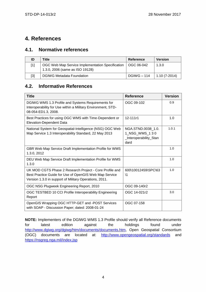
4. References
4.1. Normative references
ID Title Reference Version
[1] OGC Web Map Service Implementation Specification
1.3.0, 2006 (same as ISO 19128)
OGC 06-042 1.3.0
[3] DGIWG Metadata Foundation DGIWG – 114 1.10 (7-2014)
4.2. Informative References
Title Reference Version
DGIWG WMS 1.3 Profile and Systems Requirements for
Interoperability for Use within a Military Environment, STD-
08-054-ED1.3, 2008.
OGC 09-102 0.9
Best Practices for using OGC WMS with Time-Dependent or
Elevation-Dependent Data
12-111r1 1.0
National System for Geospatial-Intelligence (NSG) OGC Web
Map Service 1.3 Interoperability Standard, 22 May 2013
NGA.STND.0038_1.0.
1_NSG_WMS_1 3 0
_Interoperability_Stan
dard
1.0.1
GBR Web Map Service Draft Implementation Profile for WMS
1.3.0, 2012
1.0
DEU Web Map Service Draft Implementation Profile for WMS
1.3.0
1.0
UK MOD CGTS Phase 2 Research Project - Core Profile and
Best Practice Guide for Use of OpenGIS Web Map Service
Version 1.3.0 in support of Military Operations, 2011.
600\10012459\SPC\63
\1
1.0
OGC NSG Plugweek Engineering Report, 2010 OGC 09-140r2
OGC TESTBED 10 CCI Profile Interoperability Engineering
Report
OGC 14-021r2 3.0
OpenGIS Wrapping OGC HTTP-GET and -POST Services
with SOAP - Discussion Paper; dated: 2008-01-24
OGC 07-158
NOTE: Implementers of the DGIWG WMS 1.3 Profile should verify all Reference documents
for latest edition against the holdings found under
http://www.dgiwg.org/dgiwg/htm/documents/documents.htm, Open Geospatial Consortium
(OGC) documents are located at: http://www.opengeospatial.org/standards and
https://nsgreg.nga.mil/index.jsp

STD-DP-14-013r2 28 November 2017
5
5. Terms, definitions, and abbreviations
5.1. Definitions
For the purposes of this document, terms and definitions found in WMS 1.3, ISO
19128:2005 / [OGC 06-042] apply.
5.2. Abbreviations
BBox Bounding Box
CRS Coordinate Reference System
CS Coordinate System
CSW Catalogue Service for the Web
DGIWG Defence Geospatial Information Working Group
DFDD DGIWG Feature Data Dictionary
DMF DGIWG Metadata Framework
EPSG European Petroleum Survey Group
FES Filter Encoding Specification
FGDC Federal Geographic Data Committee
GI Georeferenced Information
GIF Graphics Interchange Format
GeoInf Geospatial Information
GeoInt Geospatial Intelligence
GML Geography Markup Language
GZIP GNU Zip File format
HTTP Hypertext Transfer Protocol
IETF Internet Engineering Task Force
ISO International Organization for Standardization
ISO/DIS ISO Draft International Standard
JPEG Joint Photographics Expert Group
JSON JavaScript Object Notation
KVP Keyword Value Pairs
LAN Local Area Network
MIME Multipurpose Internet Mail Extension
NATO North Atlantic Treaty Organization
NGIF NATO Geospatial Information Framework
NSG National System for Geospatial-Intelligence
OGC Open Geospatial Consortium
OWS OGC Web Service
PNG Portable Network Graphics
SDI Spatial Data Infrastructure
SOAP Simple Object Access Protocol
SQL Structured Query Language

STD-DP-14-013r2 28 November 2017
6
SVG Scalable Vector Graphics
UML Unified Modelling Language
UPS Universal polar stereographic coordinate system
URI Uniform Resource Identifier
URL Uniform Resource Locator
URN Uniform Resource Name
UTM Universal Transverse Mercator
VSP Vendor Specific Parameter
WFS Web Feature Service
WMS Web Map Service
WMTS Web Map Tile Service
WAN Wide Area Network
WFS Web Feature Service
WSDL Web Services Description Language
XML Extensible Markup Language
XPath XML Path Language
XQuery XML Query
6. Presentation (informative)
A WMS that complies with the DGIWG WMS profile will
a) satisfy all requirements stipulated in the OGC WMS 1.3.0 Specification;
b) satisfy all requirements stipulated in this document.
These profiles provide advice on the implementation of the WMS so that tests can be
provided to ensure objective compliance to the profile. The profiles provide “Normative
Clauses” to describe how each component shall be implemented. The Normative Clauses
define requirements where mandatory compliance is required for attainment of
conformance. However, the profile also includes optional Recommendations which may
require a subjective test.
The following syntax is used to indicate the compliance requirement within the profile:
• Mandatory (M) – The requirement shall be implemented
• Conditional (C) – Mandatory when “If” statement applies
• Optional (O) – Should be implemented
NOTE: All Requirements and Recommendations presented within this document are the
result of information gathered during the DGIWG Nations questionnaire/survey process.
These requirements have also been reviewed and discussed with NCIA (NATO
Communications and Information Agency). Implementers should be aware that certain
requirements are unique to a national profile such as the metadata requirements for the US
shall include conformance with the NSG Metadata Framework while the DGIWG requires
conformance with the DGIWG Metadata Framework. These two metadata profiles have
been synchronized to the fullest extent possible.

STD-DP-14-013r2 28 November 2017
7
7. DGIWG Basic WMS (normative)
7.1. Normative Requirements
The Normative requirements requested by this conformance class are summarized in Table
1.
Precondition to all requirements.
PRECONDITION 1: the environment has to provide the location identified by a URL
which can be used by the WMS server to make artefacts available to clients. This
precondition ensures that any URL provided by the server can be resolved by the
client.
Table 1: DGIWG Basic WMS Normative Server Requirements
No. Requirement Compliance
1 A DGIWG Basic WMS server shall be compliant to the Basic WMS conformance class.
M
2 A DGIWG Basic WMS server shall support HTTP GET for all operations provided by the server, with parameters encoded in KVP.
M
3 A DGIWG Basic WMS server shall provide metadata content in a response to a "GetCapabilities" or “GetFeatureInfo” (if supported) request in English language.
M
4 A DGIWG Basic WMS server shall support the following raster formats for the GetMap operation:
• image/png (Portable Network Graphics)
• image/gif (Graphics Interchange Format)
• image/jpeg (Joint Photographics Expert Group)
M
5 A DGIWG Basic WMS server shall support the following coordinate reference systems:
• CRS:84 WGS84 geographic longitude, then latitude, expressed in decimal degrees
• EPSG:4326 WGS84 geographic latitude, then longitude, expressed in decimal degrees
• EPSG:3395 World Mercator projection
Among the following Coordinate Reference Systems, the service shall support all those which validity zone overlaps data published by the service:
• UTM projections over WGS84 (north zones)… EPSG:32601 to EPSG:32660
• UTM projections over WGS84 (south zones)… EPSG:32701 to EPSG:32760
• UPS projection over WGS84 (north zone)… EPSG: 5041
UPS projection over WGS84 (south zone)… EPSG: 5042
M
6 A DGIWG Basic WMS server shall provide service exceptions in English language.
M
7 A DGIWG Basic WMS server shall provide all mandatory service metadata elements according to Table 4.
M
8 If content provided by a WMS server is classified, a DGIWG WMS server shall identify the highest classification level of the content accessible through the WMS service by populating the wms:AccessConstraints element.
C
9 A DGIWG basic WMS server shall include the following information in the M
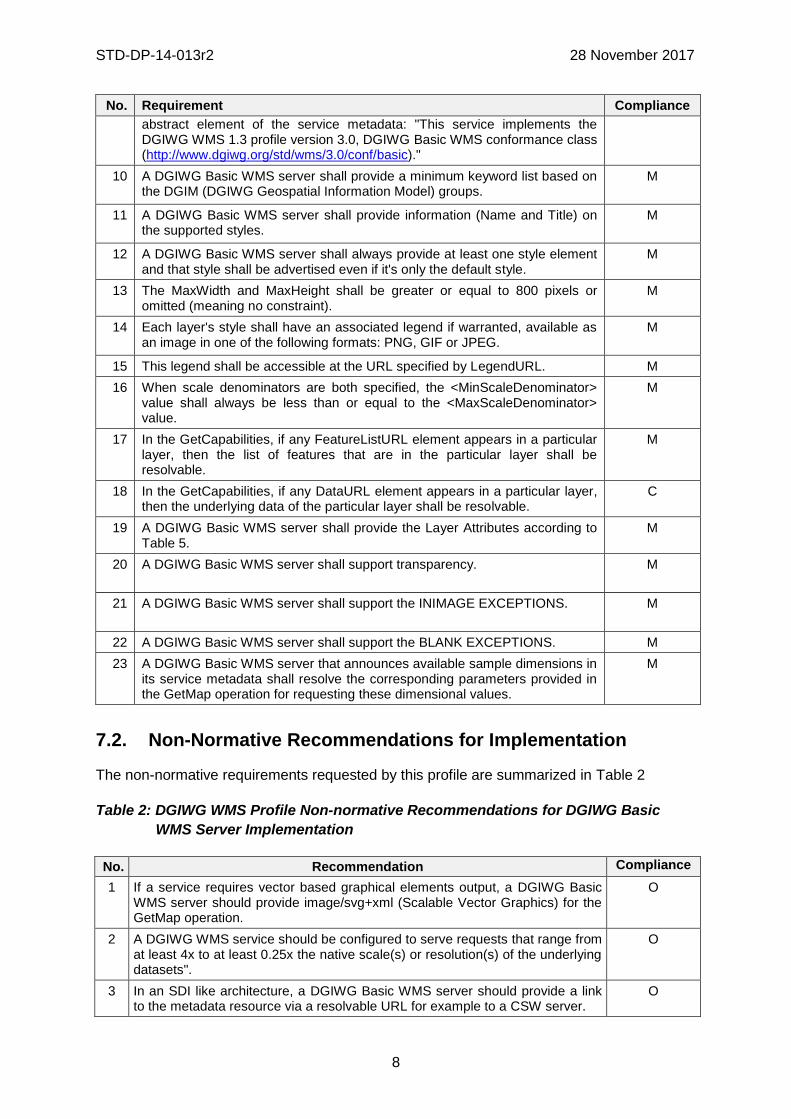
STD-DP-14-013r2 28 November 2017
8
No. Requirement Compliance
abstract element of the service metadata: "This service implements the DGIWG WMS 1.3 profile version 3.0, DGIWG Basic WMS conformance class (http://www.dgiwg.org/std/wms/3.0/conf/basic)."
10 A DGIWG Basic WMS server shall provide a minimum keyword list based on the DGIM (DGIWG Geospatial Information Model) groups.
M
11 A DGIWG Basic WMS server shall provide information (Name and Title) on the supported styles.
M
12 A DGIWG Basic WMS server shall always provide at least one style element and that style shall be advertised even if it's only the default style.
M
13 The MaxWidth and MaxHeight shall be greater or equal to 800 pixels or omitted (meaning no constraint).
M
14 Each layer's style shall have an associated legend if warranted, available as an image in one of the following formats: PNG, GIF or JPEG.
M
15 This legend shall be accessible at the URL specified by LegendURL. M
16 When scale denominators are both specified, the <MinScaleDenominator> value shall always be less than or equal to the <MaxScaleDenominator> value.
M
17 In the GetCapabilities, if any FeatureListURL element appears in a particular layer, then the list of features that are in the particular layer shall be resolvable.
M
18 In the GetCapabilities, if any DataURL element appears in a particular layer, then the underlying data of the particular layer shall be resolvable.
C
19 A DGIWG Basic WMS server shall provide the Layer Attributes according to Table 5.
M
20 A DGIWG Basic WMS server shall support transparency. M
21 A DGIWG Basic WMS server shall support the INIMAGE EXCEPTIONS. M
22 A DGIWG Basic WMS server shall support the BLANK EXCEPTIONS. M
23 A DGIWG Basic WMS server that announces available sample dimensions in its service metadata shall resolve the corresponding parameters provided in the GetMap operation for requesting these dimensional values.
M
7.2. Non-Normative Recommendations for Implementation
The non-normative requirements requested by this profile are summarized in Table 2
Table 2: DGIWG WMS Profile Non-normative Recommendations for DGIWG Basic
WMS Server Implementation
No. Recommendation Compliance
1 If a service requires vector based graphical elements output, a DGIWG Basic WMS server should provide image/svg+xml (Scalable Vector Graphics) for the GetMap operation.
O
2 A DGIWG WMS service should be configured to serve requests that range from at least 4x to at least 0.25x the native scale(s) or resolution(s) of the underlying datasets".
O
3 In an SDI like architecture, a DGIWG Basic WMS server should provide a link to the metadata resource via a resolvable URL for example to a CSW server.
O

STD-DP-14-013r2 28 November 2017
9
No. Recommendation Compliance
4 A DGIWG Basic WMS server offering vector layers should be queryable.. O
5 If a DGIWG Basic WMS server provides layers with an elevation parameter, it should support the vertical "ELEVATION" parameter. This parameter should be used in accordance with the "OGC Best Practices for using OGC WMS with Time-Dependent or Elevation-Dependent Data [2]".
O
6 If a DGIWG Basic WMS server provides layers with an time parameter, it should support the temporal "time" parameter. This parameter should be used in accordance with the "OGC Best Practices for using OGC WMS with Time-Dependent or Elevation-Dependent Data [2]".
O
6 For a 470 Kilobytes image, the response time for sending the initial response to a Get Map Request to a view service shall be maximum 5 seconds in normal situation.
O
7 The number of simultaneous service requests that a DGIWG Basic WMS server should be able to support is at least 20 per second.
O
8 A DGIWG Basic WMS server should be available 99.9% of the time. O
7.3. Service Type
The OGC WMS Implementation Specification defines two conformance classes, “Basic
WMS” and “Queryable WMS”. A Basic WMS supports the GetCapabilities and GetMap
operations (requests and responses); a Queryable WMS includes all Basic WMS operations
and an additional GetFeatureInfo operation.
Requirement 1 : A DGIWG Basic WMS server shall be compliant to the Basic WMS
conformance class.
According to this requirement a DGIWG Basic WMS server shall support the GetCapabilities
and GetMap operations. This requirement ensures compatibility with the base standard.
7.4. Basic service elements
The Basic service elements specify aspects of Web Map Server behavior that are
independent of particular operations or are common to several operations.
7.4.1. Version number
The VERSION parameter is mandatory in GetMap and GetFeatureInfo requests. The
version number is 1.3.0.
7.4.2. Binding
The OGC WMS 1.3.0 standard requires support for HTTP Get. Support for HTTP Post is
optional. A SOAP binding is not defined in the standard.
Requirement 2: A DGIWG Basic WMS server shall support HTTP GET for all
operations provided by the server, with parameters encoded in KVP.
This requirement means that a DGIWG Basic WMS server supports HTTP GET for at least GetCapabilities and GetMap operations. If another operation is provided (i.e. GetFeatureInfo), then HTTP GET has to be supported by this operation as well.

STD-DP-14-013r2 28 November 2017
10
7.4.3. Language
Requirement 3: A DGIWG Basic WMS server shall provide metadata content in a
response to a "GetCapabilities" or “GetFeatureInfo” (if supported) request in English
language.
English is required to support interoperability in a coalition environment.
NOTE: Services can also be provided using alternative languages to English: This profile
does not specify the details for implementation of multilingual services.
7.4.4. Output Formats
The response to a Web Map Service request is always a computer file. The file may contain
text, or the file may represent a map image depending on the operation. For the particular
operations a DGIWG Basic WMS server shall support the following output formats.
7.4.4.1. Output formats for GetCapabilities request
The response to a GetCapabilities request is always a text file. Base standard require support of the default text/xml.
7.4.4.2. Output formats for GetMap request
The response to a GetMap request is either a raster or vector file.
Requirement 4: A DGIWG Basic WMS server shall support the following raster formats
for the GetMap operation:
• image/png (Portable Network Graphics)
• image/gif (Graphics Interchange Format)
• image/jpeg (Joint Photographics Expert Group)
NOTE: GIF is always 8 bits which can be used for limited bandwidth scenario, PNG can be eiter 8, 24 or 32 bits (depending on how it is configured).
Recommendation 1: If a service requires vector based graphical elements output, a
DGIWG Basic WMS server should provide image/svg+xml (Scalable Vector Graphics)
for the GetMap operation.
NOTE: Users should be aware that only the output formats GIF and PNG support
transparency.
7.4.5. Coordinate Systems
The Web Map Service standard uses two principal classes of Coordinate Systems: a Map
CS applicable to the map portrayal generated by the WMS, and a Layer CRS for a Bounding
Box applied to the source data. During a portrayal operation, a WMS converts or transforms
geographic information from a Layer CRS into a Map CS. In addition, a Layer may have an
associated vertical, temporal or other coordinate system.
7.4.5.1. Map CS
A Map CS is a coordinate reference system for a map produced by a WMS. A WMS map is
a rectangular grid of pixels displayed on a computer screen (or a digital file that could be so
displayed). The Map CS has a horizontal axis denoted i, and a vertical axis denoted j. i and j

STD-DP-14-013r2 28 November 2017
11
shall have only nonnegative integer values. The origin (i,j) =(0,0) is the pixel in the upper left
corner of the map; i increases to the right and j increases downward.
7.4.5.2. Layer CRS
A Layer CRS is a horizontal coordinate reference system for the geographic information that
serves as the source for a map. A WMS must support at least one CRS, and maps from
multiple servers may be overlaid only if all the selected servers support at least one CRS in
common.
Requirement 5: A DGIWG Basic WMS server shall support the following coordinate
reference systems:
• CRS:84 WGS84 geographic longitude, then latitude, expressed in decimal
degrees
• EPSG:4326 WGS84 geographic latitude, then longitude, expressed in decimal
degrees
• EPSG:3395 World Mercator projection
Among the following Coordinate Reference Systems, the service shall support all
those which validity zone overlaps data published by the service:
• UTM projections over WGS84 (north zones)… EPSG:32601 to EPSG:32660
• UTM projections over WGS84 (south zones)… EPSG:32701 to EPSG:32760
• UPS projection over WGS84 (north zone)… EPSG: 5041
• UPS projection over WGS84 (south zone)… EPSG: 5042
Implementation guidance:
NOTE 1: OGC provides implementation guidance about axis order
http://www.ogcnetwork.net/axisorder.
NOTE 2: Normative Reference 1, Section 7.2.4.6.6 states that: "Every named Layer shall
have exactly one <EX_GeographicBoundingBox> element that is either stated explicitly or
inherited from a parent Layer”. This is unclear in the base standard. Chapter 7.2.4.6.8
BoundingBox in the base standard states that: The <EX_GeographicBoundingBox> element
(7.2.4.6.6) is conceptually similar to a BoundingBox in which the attribute CRS="CRS:84" is
implicit. However, <EX_GeographicBoundingBox> shall not be used as a substitute for
<BoundingBox CRS="CRS:84">. If the server wishes to provide bounding box information in
the CRS:84 CRS, then a separate BoundingBox element explicitly naming CRS:84 shall be
included in the service metadata.
This means that Ex_GeographicBoundingBox within a DGIWG server shall always be in
CRS="CRS:84".
Some geographic information may be available at other dimensions like for instance
elevation or time (3D / 4D). For example, in the case of elevation, atmospheric information
like ozone concentrations, may be available at different altitudes. Similarly, geographic
information may be available at multiple times, like hourly tidal information.
NOTE 3: Appropriate vertical and temporal coordinate systems have to be defined in the
context of the particular application.

STD-DP-14-013r2 28 November 2017
12
The verticalCRSid “CRS:88” refers to the vertical CRS defined in B.6 (elevation in meters in
the North American Vertical Datum 1988). The unitSymbol “m” would be used. See
Normative Reference 1, Annex C “Handling multi-dimensional data” for more information.
7.4.6. Request Parameter Rules
Parameter names shall not be case sensitive, but parameter values shall be. Parameters in
a request may be specified in any order.
7.4.6.1. Common Request Parameters
There are three common request parameters:
• Version: The VERSION parameter specifies the protocol version number.
• Request: The REQUEST parameter indicates which service operation is being
invoked.
• Format: The FORMAT parameter specifies the output format of the response to an
operation.
7.4.6.2. Exceptions
The EXCEPTIONS request parameter states the format in which to report errors.
Requirement 6: A DGIWG Basic WMS server shall provide service exceptions in
English language.
NOTE 1: English is justified in the context of coalitions such as NATO.
NOTE 2: This requirement applies for all provided operations by the server.
7.4.6.3. Extended capabilities and operations
The Web Map Service allows for optional extended capabilities and operations. Extended
capabilities or operations shall be defined when necessary by providing instances of the
abstract <_ExtendedCapabilities> or <_ExtendedOperations> elements in the service
metadata schema.
7.5. Operations
The WMS Interface offers 3 Operations.
• GetCapabilities (mandatory): Allows for obtaining Service Metadata
• GetMap (mandatory): Returns a map
• GetFeatureInfo (optional): Provides additional information about features in the
pictures of maps that were returned by previous GetMap requests
7.5.1. GetCapabilities Operation Request
The purpose of the mandatory GetCapabilities operation is to obtain service metadata, which
is a machine readable (and human-readable) description of the server’s information content
and acceptable request parameter values. Table 3 lists the GetCapabilities request
parameters.

STD-DP-14-013r2 28 November 2017
13
Table 3: The parameters of a GetCapabilities request URL as per Normative
Reference [1]
Request Parameter OGC Mandatory/Optional
Description
VERSION=version O Request version
SERVICE=WMS M Service type (WMS)
REQUEST=GetCapabilities M Request name (GetCapabilities)
FORMAT=MIME_type O Output format of service metadata (text/xml)
UPDATESEQUENCE=string O Sequence number or string for cache control
A DGIWG Basic WMS server supports all GetCapabilities parameters which can be in a
GetCapabilities request.
7.5.2. GetCapabilities Operation Response
When invoked on a WMS, the response to a GetCapabilities request shall be an XML
document containing service metadata formatted according to the XML Schema in annex
E.1 of the OGC WMS 1.3 standard Normative Reference [1].
7.5.2.1. Names and titles
A number of elements have both a <Name> and a <Title>. The Name is a text string used
for machine-to-machine communication while the Title is for the benefit of humans.
7.5.2.2. General service metadata
The first part of the service metadata is a <Service> element providing general metadata for
the server as a whole. It shall include a Name, Title, and Online Resource URL. Optional
service metadata includes Abstract, Keyword List, Contact Information, Fees, Access
Constraints, and limits the number of layers in a request or the output size of maps.
Requirement 7: A DGIWG Basic WMS server shall provide all mandatory service
metadata elements according to Table 4.

STD-DP-14-013r2 28 November 2017
14
Table 4: GetCapabilities response – general service metadata
Element name O/M1
OGC 06-
042
O/R/M1
DGIWG
Basic
WMS
Description
Name M M The Name is typically for machine-to-
machine communication
Title M M The Title is for informative display to a
human.
For coalition interoperability an English title
is mandatory.
NOTE: For national use the title can be
provided in the national language.
Abstract O M See Requirement 9
If the abstract element is provided in a
coalition environment an English abstract is
mandatory.
NOTE: For national use the abstract can be
provided in the national language.
KeywordList O M List of keywords or keyword phrases to help
catalog searching.
Onlineresource M M An OnlineResource is typically an HTTP
URL. The URL is placed in the xlink:href
attribute, and the value "simple" is placed in
the xlink:type attribute.
ContactInformation O M
Fees O O
AccessConstraints O M See Requirement 8
LayerLimit Ot" O The optional <LayerLimit> element in the
service metadata is a positive integer
indicating the maximum number of layers a
client is permitted to include in a single
GetMap request. If this element is absent,
the server imposes no limit.
MaxWidth O O
MaxHeight O O
1 O = Optional, R = Recommended, M = Mandatory, C = Conditional
The elements <Fees> and <AccessConstraints> may be omitted in an OGC WMS if they do
not apply to the server. If either of those elements is present, the reserved word "none"

STD-DP-14-013r2 28 November 2017
15
(case-insensitive) has to be used if there are no fees or access constraints, as follows:
<Fees>none</Fees>, <AccessConstraints>none</AccessConstraints>.
Requirement 8: If content provided by a WMS server is classified, a DGIWG Basic
WMS server shall identify the highest classification level of the content accessible
through the WMS service by populating the wms:AccessConstraints element.
In a DGIWG Basic WMS server the AccessConstraints element has always to be used;
depending on the context, applicable classification scheme has to be used. For example, in
a NATO environment, the common NATO classification scheme has to be applied (see
Normative Reference [3] DMF chapter 5.6.1.4 Classification Level Codelist).
Testbed-12 OWS Common Security Extension ER
(https://portal.opengeospatial.org/files/?artifact_id=71729) provides guidance on how to
advertise security constraints that apply to OGC Web Services and data.
7.5.2.3. Capability metadata
The <Capability> element of the service metadata names the actual operations that are
supported by the server, the output formats offered for those operations, and the URL prefix
for each operation. The XML schema includes placeholders for Distributed Computing
Platforms other than HTTP, but currently only the HTTP platform is defined.
• Layers and styles: Each available map is advertised by a <Layer> element in the
service metadata. A server shall include at least one <Layer> element for each map
layer offered.
• Layer properties: The <Layer> element can enclose child elements providing
metadata about the Layer. The values of some of these elements can be inherited by
subsidiary layers. The following metadata elements are available:
o Title: A <Title> is mandatory for all layers; it is a human-readable string for
presentation in a menu. The Title is not inherited by child Layers.
o Name: If, and only if, a layer has a <Name>, then it is a map layer that can be
requested by using that Name in the LAYERS parameter of a GetMap request. If
the layer has a Title but no Name, then that layer is only a category title for all
the layers nested within. A containing category itself may include a Name by
which a map portraying all of the nested layers can be requested at once. For
example, a parent layer "Roads" may have children “Interstates” and “State
Highways” and allow the user to request either child individually or both together.
o The elements <Abstract> and <KeywordList> are optional in the base
standard. Abstract is a narrative description of the map layer. KeywordList
contains zero or more <Keyword> elements to aid in catalogue searches.
Requirement 9: A DGIWG basic WMS server shall include the following information in
the abstract element of the service metadata: "This service implements the DGIWG
WMS 1.3 profile version 3.0, DGIWG Basic WMS conformance class
(http://www.dgiwg.org/std/wms/3.0/conf/basic)."
Requirement 10: A DGIWG Basic WMS server shall provide a minimum keyword list
based on the DGIM (DGIWG Geospatial Information Model) groups.
NOTE 1: Annex F presents groups and subgroups for DGIM 2016-2.0.

STD-DP-14-013r2 28 November 2017
16
NOTE 2: Additional keywords may be added to the list as appropriate to support data
discovery.
o Zero or more Styles may be advertised for a Layer or collection of layers using
<Style> elements, each of which shall have <Name> and <Title> elements.
The style's Name is used in the Map request STYLES parameter.
The Title is a human-readable string. If only a single style is available, that
style is known as the “default” style and need not be advertised by the
server.
Requirement 11: A DGIWG Basic WMS server shall provide information (Name and
Title) on the supported styles.
Requirement 12: A DGIWG Basic WMS server shall always provide at least one style
element and that style shall be advertised even if it's only the default style.
It is considered here that all layers (even raster, scanned maps or imagery data have a style). See below some examples: - in case of orthoimagerydata, this should be NAME: RGB, TITLE: RGB style for orthoimagery data - in case of a scanned paper map, this should be NAME: MGCP, TITLE: MGCP style for paper maps
Requirement 13: The MaxWidth and MaxHeight shall be greater or equal to 800 pixels
or omitted (meaning no constraint).
When MaxWidth and MaxHeight are provided, that means that the client can request any
image smaller than these two dimensions (this prevents requests for too big images). If not
provided, there is no restriction for the size of the image requested.
o <LegendURL> contains the location of an image of a map legend appropriate to
the enclosing style.
Requirement 14: Each layer's style shall have an associated legend if warranted,
available as an image in one of the following formats: PNG, GIF or JPEG.
Following examples would require a legend:
Quantitative layers (for instance elevation, temperature …) would require a legend to
better understand the content returned by the WMS service;
Topographic layers (either scanned maps or feature based layers);
…
Imagery data may not require legend to be properly understood.
Requirement 15: This legend shall be accessible at the URL specified by LegendURL.
o Scale denominators: The <MinScaleDenominator> and
<MaxScaleDenominator> elements define the range of scales for which it is
appropriate to generate a map of a Layer.
Requirement 16: When scale denominators are both specified, the
<MinScaleDenominator> value shall always be less than or equal to the
<MaxScaleDenominator> value.

STD-DP-14-013r2 28 November 2017
17
Recommendation 2: A DGIWG WMS service should be configured to serve requests
that range from at least 4x to at least 0.25x the native scale(s) or resolution(s) of the
underlying datasets".
NOTE: Users should be aware that changing the resolution at a range of 4 times to 0.25
times effects the accuracy of the displayed data significantly and will influence the usability
of the data for certain use cases (e.g. measurements in the map).
o Sample dimensions: Some geographic information may be available at other
dimensions (for example, satellite images in different wavelength bands). The
dimensions other than the four space-time dimensions are referred to as “sample
dimensions. A DGIWG Basic WMS server may allow for requesting a particular
layer along one or more dimensional axes other than time or elevation.
o MetadataURL: A server should use one or more <MetadataURL> elements to
offer detailed, standardized metadata about the data corresponding to a
particular layer. The “type” attribute indicates the standard to which the metadata
complies. Two “type” attribute values are defined in ISO 19128:2005, "ISO
19115:2003" and “FGDC:1998”. The enclosed <Format> element indicates the
file format MIME type of the metadata record.
Recommendation 3: In an SDI like architecture, a DGIWG Basic WMS server should
provide a link to the metadata resource via a resolvable URL for example to a CSW
server.
o FeatureListURL: A server may use a <FeatureListURL> element to point to a
list of the features represented in a Layer. The enclosed Format element
indicates the file format MIME type of the feature list.
Requirement 17: In the GetCapabilities, if any FeatureListURL element appears in a
particular layer, then the list of features that are in the particular layer shall be
resolvable.
o DataURL: A server may use DataURL to offer a link to the underlying data
represented by a particular layer. The enclosed Format element indicates the file
format MIME type of the data file.
Requirement 18: In the GetCapabilities, if any DataURL element appears in a particular
layer, then the underlying data of the particular layer shall be resolvable.
• Layer attributes: A <Layer> may have zero or more of the following XML attributes:
queryable, cascaded, opaque, noSubsets, fixedWidth, and fixedHeight. All of these
attributes are optional and default to 0. The meaning of each attribute is summarized in
Table 5.

STD-DP-14-013r2 28 November 2017
18
Table 5: Layer attributes
Attribute OGC
allowed values
DGIWG
allowed values
Meaning (0 is default value)
queryable 0, false,
1, true
0, false,
1, true
0, false: layer is not queryable.
1, true: layer is queryable.
cascaded 0, positive integer
0, positive integer
0: layer has not been retransmitted by a Cascading Map Server.
n: layer has been retransmitted n times.
Opaque 0, false,
1, true
0, false,
1, true
0, false: map data represents vector features that probably do not completely fill space.
1, true: map data are mostly or completely opaque.
noSubsets 0, false,
1, true
0, false, 0, false: WMS can map a subset of the full bounding box.
1, true: WMS can only map the entire bounding box.
fixedWidth 0, positive integer
0, 0: WMS can produce map of arbitrary width.
nonzero: value is fixed map width that cannot be changed by the WMS.
fixedHeight 0, positive integer
0, 0: WMS can produce map of arbitrary height.
nonzero: value is fixed map height that cannot be changed by the WMS.
Requirement 19: A DGIWG Basic WMS server shall provide the Layer Attributes
according to Table 5.
When set to a true value, noSubsets indicates that the server is not able to make a map of
a geographic area other than the layer's bounding box.
When present and nonzero, fixedWidth and fixedHeight indicate that the server is not able
to produce a map of the layer at a width and height different from the fixed sizes indicated.
According to Table 5 a DGIWG Basic WMS server provides only subsettable (nosubsets=0)
and resizable (fixedWidth=0 and fixedHeight=0) layers. As the 0 values are the default
values, they do not have to be included explicitly for all layers.
Recommendation 4: A DGIWG Basic WMS server offering vector layers should be
queryable.
The Layer metadata may also include three optional attributes that indicate a map server
that is less functional than a normal WMS, because it is not able to extract a subset of a
larger dataset or because it only serves maps of a fixed size and cannot resize them.
7.5.3. GetMap Operation Request
The GetMap operation returns a map. Upon receiving a GetMap request, a WMS shall either
satisfy the request or issue a service exception. Table 6 lists the parameters of a GetMap
request.

STD-DP-14-013r2 28 November 2017
19
Table 6: GetMap request parameters
Request Parameter OGC Mandatory/Optional
DGIWG Mandatory/ Optional/ Conditional
Description
VERSION=1.3.0 M M Request version.
REQUEST=GetMap M M Request name.
LAYERS=layer_list M M Comma-separated list of one or more map layers.
STYLES=style_list M M Comma-separated list of one rendering style per requested layer.
CRS=namespace:identifier M M Coordinate reference system.
BBOX=minx,miny,maxx,maxy M M Bounding box corners (lower left, upper right) in CRS units.
WIDTH=output_width M M Width in pixels of map picture.
HEIGHT=output_height M M Height in pixels of map picture.
FORMAT=output_format M M Output format of map.
TRANSPARENT=TRUE|FALSE O C Background transparency of map (default=FALSE).
BGCOLOR=color_value O O Hexadecimal red-green-blue color value for the background color (default=0xFFFFFF).
EXCEPTIONS=exception_format
O M The format in which exceptions are to be reported by the WMS (default=XML).
TIME=time O C Time value of layer desired.
ELEVATION=elevation O C Elevation of layer desired.
Other sample dimension(s) O C Value of other dimensions as appropriate.
A DGIWG Basic WMS server support all GetMap request parameters.
• Styles: The mandatory STYLES parameter lists the style in which each layer is to be
rendered.
• Width, Height: The mandatory WIDTH and HEIGHT parameters specify the size in
integer pixels of the map to be produced.
• TRANSPARENT: The optional TRANSPARENT parameter specifies whether the map
background is to be made transparent or not. TRANSPARENT can take on two values,
"TRUE" or "FALSE". The default value is FALSE if this parameter is absent from the
request.
Requirement 20: A DGIWG Basic WMS server shall support transparency.
• EXCEPTIONS: The optional EXCEPTIONS parameter defines the format of an error
message. XML is mandatory and the default format for exceptions.
o INIMAGE: If the EXCEPTIONS parameter is set to INIMAGE, the WMS shall,
upon detecting an error, return an object of the MIME type specified in the

STD-DP-14-013r2 28 November 2017
20
FORMAT parameter whose content includes text describing the nature of the
error. In the case of a picture format, the error message shall be drawn on the
returned picture. In the case of a graphic element format, the text of the error
message shall be rendered in the manner that text is normally represented in
that format.
Requirement 21: A DGIWG Basic WMS server shall support the INIMAGE
EXCEPTIONS.
o BLANK: If the EXCEPTIONS parameter is set to BLANK, the WMS shall, upon
detecting an error, return an object of the type specified in FORMAT whose
content is uniformly “off”. In the case of a picture format, that response shall be
an image containing only pixels of one color (the background color). In the case
of a picture format supporting transparency, if TRANSPARENT=TRUE is
specified the pixels shall all be transparent. In the case of a graphic element
output format, no visible graphic elements shall be included in the response
output.
Requirement 22: A DGIWG Basic WMS server shall support the BLANK EXCEPTIONS.
• Time, Elevation, Other sample dimensions: An example would be the request for a
single ozone map at specified time and height:
Example
http://ageobwserver.org/...?VERSION=1.3.0&REQUEST=GetMap&CRS=CRS:84&BBOX=-180,-90,180,90&WIDTH=600&HEIGHT=300&LAYERS=ozone&TIME=2000-08-03&ELEVATION=1000&FORMAT=image/gif
Recommendation 5: If a DGIWG Basic WMS server provides layers with an elevation
parameter, it should support the vertical "ELEVATION" parameter. This parameter
should be used in accordance with the "OGC Best Practices for using OGC WMS with
Time-Dependent or Elevation-Dependent Data [2]".
Recommendation 6: If a DGIWG Basic WMS server provides layers with an time
parameter, it should support the temporal "time" parameter. This parameter should
be used in accordance with the "OGC Best Practices for using OGC WMS with Time-
Dependent or Elevation-Dependent Data [2]".
NOTE: Conformant WMS servers should express the values of the time dimension either
as one time interval with non-zero resolution when the temporal dependency of the data is
time instants or as a comma separated list of timestamps.
The WMS 1.3 specification allows the possibility to define multiple times as several triplets:
start/end/interval. The triplets define sets of time instants that may overlap. It is difficult for a
human reader to determine the allowed times of the time dimension. Hence, the time
dimension should not be specified as a list of triplets, except if the time instants are regularly
spaced with a unique interval of time. If not the time instance should be specified as a
comma separated list.
Requirement 23: A DGIWG Basic WMS server that announces available sample
dimensions in its service metadata shall resolve the corresponding parameters
provided in the GetMap operation for requesting these dimensional values.
STD-DP-14-013r2 28 November 2017
21
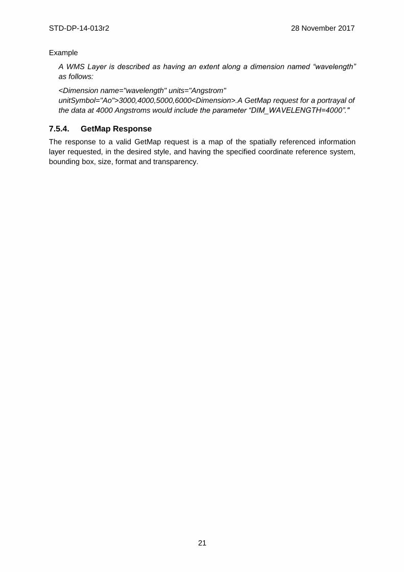
Example
A WMS Layer is described as having an extent along a dimension named “wavelength”
as follows:
<Dimension name="wavelength" units="Angstrom"
unitSymbol="Ao">3000,4000,5000,6000<Dimension>.A GetMap request for a portrayal of
the data at 4000 Angstroms would include the parameter “DIM_WAVELENGTH=4000”."
7.5.4. GetMap Response
The response to a valid GetMap request is a map of the spatially referenced information
layer requested, in the desired style, and having the specified coordinate reference system,
bounding box, size, format and transparency.

STD-DP-14-013r2 28 November 2017
22
8. DGIWG Queryable WMS (normative)
8.1. Normative Requirements The Normative requirements requested by this conformance class are summarized in Table 7.
Precondition to all requirements.
PRECONDITION 1: the environment has to provide the location identified by a URL
which can be used by the WMS server to make artefacts available to clients. This
precondition ensure that any URL provided by the server can be resolvable by the
client.
Table 7: DGIWG Queryable WMS Normative Server Requirements
No. Requirement Compliance
24 A DGIWG Queryable WMS server shall be compliant to the DGIWG WMS Basic and the Queryable WMS conformance class.
M
25 A DGIWG Queryable WMS server shall support text/xml and text/html as output format for the GetFeatureInfo operation.
M
26 A DGIWG Queryable WMS server shall include the following information in the abstract element of the service metadata: "This service implements the DGIWG WMS 1.3 profile version 3.0, DGIWG Queryable WMS conformance class (http://www.dgiwg.org/std/wms/3.0/conf/queryable)."
M
27 A DGIWG Queryable WMS server shall support XML for the EXCEPTIONS parameter of the GetFeatureInfo operation.
M
8.2. Non-Normative Recommendations for Implementation
The non-normative requirements requested by this profile are summarized in Table 8.
Table 8: DGIWG WMS Profile Non-normative Recommendations for DGIWG Queryable
WMS Server Implementation
No. Recommendation Compliance
7 A DGIWG Queryable WMS server should return the units of measure for dimensional values returned in a GetFeatureInfo response.
O
8.3. Service Type
The OGC WMS Implementation Specification defines two conformance classes, “Basic
WMS” and “Queryable WMS”. A Basic WMS supports the GetCapabilities and GetMap
operations (requests and responses); a Queryable WMS includes all Basic WMS operations
and an additional GetFeatureInfo operation.
Requirement 24: A DGIWG Queryable WMS server shall be compliant to the DGIWG
WMS Basic and the Queryable WMS conformance classes.

STD-DP-14-013r2 28 November 2017
23
According to this requirement a DGIWG Queryable WMS server shall support the GetCapabilities, GetMap and GetFeatureInfo operations. This requirement ensures compatibility with the base standard
8.4. Basic Service elements
8.4.1. Output Formats
The response to a Web Map Service request is always a computer file. The file may contain
text, or the file may represent a map image depending on the operation. For the particular
operations a DGIWG WMS server shall support the following output formats.
8.4.1.1. Output formats for GetFeatureInfo requests
The response to a GetFeatureInfo request is always a text file.
Requirement 25: A DGIWG Queryable WMS server shall support text/xml and text/html
as output format for the GetFeatureInfo operation.
8.5. Operations
8.5.1. GetCapabilities Operation Response
Requirement 26: A DGIWG Queryable WMS server shall include the following information in the abstract element of the service metadata: "This service implements the DGIWG WMS 1.3 profile version 3.0, DGIWG Queryable WMS conformance class (http://www.dgiwg.org/std/wms/3.0/conf/queryable)." NOTE: this requirement is in addition to requirement 9 that advertises for support of the DGIWG Basic conformance class. The two conformance classes are then advertises.
8.5.2. GetFeatureInfo Operation Request
GetFeatureInfo is an optional operation. It is only supported for those Layers for which the
attribute queryable="1" (true) has been defined or inherited. A client shall not issue a
GetFeatureInfo request for other layers. A WMS shall respond with a properly formatted
service exception (XML) response (code = OperationNotSupported) if it receives a
GetFeatureInfo request but does not support it.
The GetFeatureInfo operation is designed to provide clients of a WMS with more information
about features in the pictures of maps that were returned by previous Map requests. The
canonical use case for GetFeatureInfo is that a user sees the response of a Map request
and chooses a point (I,J) on that map for which to obtain more information. The basic
operation provides the ability for a client to specify which pixel is being asked about, which
layer(s) should be investigated, and what format the information should be returned in.
Because the WMS protocol is stateless, the GetFeatureInfo request indicates to the WMS
what map the user is viewing by including most of the original GetMap request parameters
(all but VERSION and REQUEST). From the spatial context information (BBOX, CRS,
WIDTH, HEIGHT) in that GetMap request, along with the I,J position the user chose, the
WMS can (possibly) return additional information about that position.
The parameters of a GetFeatureInfo request are listed in Table 9.

STD-DP-14-013r2 28 November 2017
24
Table 9: GetFeatureInfo Request parameters
Request Parameter OGC Mandatory/ Optional
Description
VERSION=1.3.0 M Request version.
REQUEST=GetFeatureInfo M Request name.
map request part M Partial copy of the Map request parameters that generated the map for which information is desired.
QUERY_LAYERS=layer_list M Comma-separated list of one or more layers to be queried.
INFO_FORMAT=output_format M Return format of feature information (MIME type).
FEATURE_COUNT=number O Number of features about which to return information (default=1).
I=pixel_column M i coordinate in pixels of feature in Map CS.
J=pixel_row M j coordinate in pixels of feature in Map CS.
EXCEPTIONS=exception_format O The format in which exceptions are to be reported by the WMS (default= XML). Support of text/xml and text/html is mandatory.
A DGIWG Queryable WMS server supports all GetFeatureInfo request parameters.
8.5.2.1. Version
The VERSION parameter is mandatory. The value “1.3.0” shall be used for GetFeatureInfo
requests that comply with ISO 19128:2005.
8.5.2.2. Request
The REQUEST parameter is mandatory. For GetFeatureInfo, the value “GetFeatureInfo”
shall be used.
8.5.2.3. Map request part
The mandatory “map request part” represents a sequence of parameters from the GetMap
request that generated the original map. Two of the GetMap parameters are omitted
because GetFeatureInfo provides its own values: VERSION and REQUEST. The remainder
of the GetMap request shall be embedded contiguously in the GetFeatureInfo request.
8.5.2.4. Query_Layers
The mandatory QUERY_LAYERS parameter states the map layer(s) from which feature
information is desired to be retrieved. Its value is a comma-separated list of one or more
map layers. This parameter shall contain at least one layer name, but may contain fewer
layers than the original GetMap request. If any layer in the QUERY_LAYERS parameter is
not defined in the service metadata of the WMS, the server shall issue a service exception
(code = LayerNotDefined).

STD-DP-14-013r2 28 November 2017
25
8.5.2.5. INFO_FORMAT
The mandatory INFO_FORMAT parameter indicates what format to use when returning the
feature information.
8.5.2.6. Feature_COUNT
The optional FEATURE_COUNT parameter states the maximum number of features per
layer for which feature information has to be returned. Its value is a positive integer. The
default value is 1 if this parameter is omitted or is other than a positive integer.
NOTE: Using a high value for the Feature_COUNT parameter may affect server
performance. A server might restrict the number of features for which information is
retrievable. This limitation has to be advertised in the capabilities document.
8.5.2.7. I, J
The mandatory I and J request parameters are integers that indicate a point of interest on the map that was produced by the embedded GetMap request (the “map request part” described in 7.4.3.3). The point (I,J) is a point in the (i,j) space defined by the Map CS (see 6.7.2). Therefore:
• the value of I shall be between 0 and the maximum value of the i axis;
• the value of J shall be between 0 and the maximum value of the j axis;
• the point I=0, J=0 indicates the pixel at the upper left corner of the map;
• I increases to the right and J increases downward.
The point (I,J) represents the centre of the indicated pixel.
If the value of I or of J is invalid, the server shall issue a service exception (code =
InvalidPoint).
8.5.2.8. EXCEPTIONS
The EXCEPTIONS parameter is optional. If this parameter is absent from the request, the
default value is "XML". No other v alues are defined by ISO 19128:2005 for the WMS
GetFeatureInfo request. Use of text/html is for the benefit of human readable content.
Requirement 27: A DGIWG Queryable WMS server shall support XML for the
EXCEPTIONS parameter of the GetFeatureInfo operation.
8.5.3. GetFeatureInfo response
The server shall return a response according to the requested INFO_FORMAT if the request
is valid, or issue a service exception otherwise. The nature of the response is at the
discretion of the service provider, but it shall pertain to the feature(s) nearest to (I,J).
Recommendation 7: A DGIWG Queryable WMS server should return the units of
measure for dimensional values returned in a GetFeatureInfo response.

STD-DP-14-013r2 28 November 2017
26
9. Quality of Service
Quality of service comprises requirements on all the aspects of a connection. A DGIWG
WMS server should meet the following guidelines for performance, availability and capacity.
9.1. Non-Normative Recommendations for Implementation
The non-normative requirements requested by this profile are summarized in Table 8.
Table 10: DGIWG WMS Profile Non-normative Recommendations about quality for
DGIWG WMS Server Implementation
No. Recommendation Compliance
8 For a 470 Kilobytes image, the response time for sending the initial response to a Get Map Request to a view service shall be maximum 5 seconds in normal situation.
O
9 The number of simultaneous service requests that a DGIWG WMS server should be able to support is at least 20 per second.
O
10 A DGIWG WMS server should be available 99.9% of the time. O
9.2. Performance
Recommendation 8: For a 470 Kilobytes image, the response time for sending the
initial response to a Get Map Request to a view service shall be maximum 5 seconds
in normal situation.
NOTE: Normal situation represents periods out of peak load. It is set at 90% of the time.
9.3. Capacity
Recommendation 9: The number of simultaneous service requests that a DGIWG
WMS server should be able to support is at least 20 per second.
9.4. Availability
Recommendation 10: A DGIWG WMS server should be available 99.9% of the time.
NOTE: This relates to 10 minutes downtime per week, 0.73 hours per month and 8.73 hours
per year.

STD-DP-14-013r2 28 November 2017
27
Annex A – Abstract Test Suite
(Normative)
A.1 DGIWG Basic WMS
A.1.1 DGIWG Service Type
a) Test Purpose: Verify that a DGIWG Basic WMS server satisfies all requirements for a
OGC Basic WMS conformance class (DGIWG Requirement 1)
b) Test Method: Submit a GeCapabilities and a GetMap requests to the server and
verify that it is providing proper responses.
c) References: Clauses 7.3
d) Test Type: Capability
A.1.2 DGIWG Basic Service elements
A.1.2.a DGIWG WMS Binding
a) Test Purpose: Verify that a DGIWG Basic WMS server supports HTTP Get requests
(DGIWG Requirement 2).
b) Test Methods:
1. Submit HTTP Get GetCapabilities request and verify that the server is providing a
proper response.
2. Submit HTTP Get GetMap request and verify that the server is providing a proper
response.
c) References: Clauses 7.4.2
d) Test Type: Capability
A.1.2.b DGIWG WMS language
a) Test Purpose: Verify that a DGIWG Basic WMS server content is in English (DGIWG
Requirement 3).
b) Test Methods: Submit HTTP Get GetCapabilities (and GetFeatureInfo if supported)
request and verify that text content of the response is in English language.
c) References: Clauses 7.4.3
d) Test Type: Capability
A.1.2.c DGIWG WMS Output format
a) Test Purpose: Verify that a DGIWG Basic WMS server satisfies all the requirements
for supported outputs (DGIWG Requirement 4).
b) Test Method: Submit requests and verify that the server implements support for:
1. Submit a GetMap request (FORMAT = image/png) and verify that the response is
image/png

STD-DP-14-013r2 28 November 2017
28
2. Submit a GetMap request (FORMAT = image/gif) and verify that the response is
image/gif
3. Submit a GetMap request (FORMAT = image/jpeg) and verify that the response
is image/jpeg
c) References: Clauses 7.4.4
d) Test Type: Capability
A.1.3 DGIWG WMS CRS
a) Test Purpose: Verify that a DGIWG Basic WMS server satisfies all the requirements
for handling CRS’s (DGIWG Requirement 5).
b) Test Method:
1. Submit requests and verify that all supported CRS are advertised for all available
data in the XML response (Capabilities document) to a valid GetCapabilities
request.
2. Submit GetMap requests and verify that maps are provided in the mandatory
CRSs and the appropriate projections for each validity zone.
c) References: Clauses 7.4.5
d) Test Type: Capability
A.1.4 DGIWG WMS Request Parameters - Exceptions
a) Test Purpose: Verify that a DGIWG Basic WMS server satisfies all the requirements
for the exceptions request parameter rule (DGIWG Requirement 6).
b) Test Method: Generate a sample of invalid requests from a client. Verify that the
server provides an appropriate response in English.
c) References: Clauses 7.4.6.2
d) Test Type: Capability
A.1.5 DGIWG WMS Operations
A.1.5.a DGIWG WMS GetCapabilites Response
a) Test Purpose: Verify that a DGIWG Basic WMS server satisfies all the requirements
for a GetCapabilities operation request (DGIWG Requirements 7 -19).
b) Test Method:
1. Submit a GetCapabilities request and verify that the response has all required
service metadata elements.
2. Submit a GetCapabilities request and verify that the response uses
<AccessContraints> to identify classification levels for the service.
3. Submit a GetCapabilities request and verify that the response in the Abstract
element contains the following information: " shall include the following
information in the abstract element of the service metadata: "This service

STD-DP-14-013r2 28 November 2017
29
implements the DGIWG WMS 1.3 profile version 3.0, DGIWG Basic WMS
conformance class (http://www.dgiwg.org/std/wms/3.0/conf/basic)."
4. Submit a GetCapabilities request and verify that the response provides a
keywordlist that is based on the DGIM groups.
5. Submit a GetCapabilities request and verify that the response provides
information (Name and Title) on the supported styles.
6. Submit a GetCapabilities request and verify that the response provides a defined
style for the default style.
7. Submit a GetCapabilities request and verify that the values for MaxWidth and
MaxHeight, when used, are greater than or equal to 800 pixels.
8. Submit a GetCapabilities request and verify that the response provides an
associated legend in at least one of the following formats: PNG, GIF, JPEG.
9. Submit a GetCapabilities request and verify that the provided LegendURL is
accessible.
10. Submit a GetCapabilities request and verify that the provided
<MinScaleDenominator> value is less than or equal to the
<MaxScaleDenominator>.
11. Submit a GetCapabilities request and verify that for all provided FeatureListURLs
the list of features is resolvable through the provided URL.
12. Submit a GetCapabilities request and verify that for all provided DatURLs the
data is resolvable through the provided URL.
13. Submit a GetCapabilities request and verify that all XML attributes for layers are
provided according to Table 5.
c) References: Clauses 7.5.2.3
d) Test Type: Capability
A.1.5.b DGIWG WMS GetMap Request
a) Test Purpose: Verify that a basic WMS client satisfies all requirements for a GetMap
request (DGIWG Requirements 20 - 23).
b) Test Method:
1. Submit a GetMap request and verify support for transparency.
2. Submit a GetMap request and verify support for INIMAGE_EXCEPTIONS.
3. Submit a GetMap request and verify support for BLANK_EXCEPTIONS.
4. Submit a GetMap request and verify that for WMS servers that advertise sample
dimensions resolve corresponding parameters correctly.
c) References: Clauses 7.5.3
d) Test Type: Capability

STD-DP-14-013r2 28 November 2017
30
A.2 DGIWG Queryable WMS
A.2.1 DGIWG WMS Basic
a) Test Purpose: Verify that a DGIWG Queryable WMS server satisfies all requirements
for a DGIWG Basic WMS (DGIWG Requirement 1 to 23)
b) Test Method: see Annex A.1
c) References: Clauses 7
d) Test Type: Capability
NOTE: Requirement 9 shall be replaced by corresponding requirement 26.
A.2.2 DGIWG Service Type
a) Test Purpose: Verify that a DGIWG Basic WMS server satisfies all requirements for a
OGC Queryable WMS conformance class (DGIWG Requirement 24)
b) Test Method: Submit a GetFeatureInfo requests to the server and verify that it is
providing proper response.
c) References: Clauses 8.3
d) Test Type: Capability
A.2.3 DGIWG Basic Service elements
A.2.3.a DGIWG WMS Output format
a) Test Purpose: Verify that a DGIWG Basic WMS server satisfies all the requirements
for supported outputs (DGIWG Requirement 25).
b) Test Method: Submit requests and verify that the server implements support for:
1. Submit a GetFeatureInfo request (FORMAT = text/xml) and verify that the
response is text/xml.
2. Submit a GetFeatureInfo request (FORMAT = text/html) and verify that the
response is text/html.
c) References: Clauses 8.4.1
d) Test Type: Capability
A.2.4 DGIWG WMS operations
A.2.4.a DGIWG WMS GetCapabilites Response
a) Test Purpose: Verify that a DGIWG Basic WMS server satisfies requirement 26.
b) Test Method: Submit a GetCapabilities request and verify that the response in the
Abstract element contains the following information: " shall include the following
information in the abstract element of the service metadata: "This service implements
the DGIWG WMS 1.3 profile version 3.0, DGIWG Basic WMS conformance class
(http://www.dgiwg.org/std/wms/3.0/conf/basic)."
c) References: Clauses 8.5.1
d) Test Type: Capability

STD-DP-14-013r2 28 November 2017
31
A.2.4.b GetFeature Operation request
a) Test Purpose: Verify that a DGIWG Basic WMS server satisfies requirement 27.
b) Test Method: Submit a GetFeatureInfo request (EXEPTIONS = XML) and verify that
the response is text/xml.
c) References: Clauses 8.5.1.7
d) Test Type: Capability
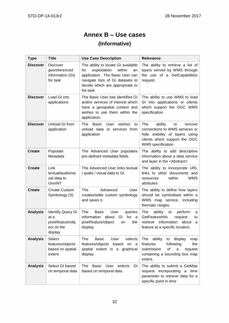
STD-DP-14-013r2 28 November 2017
32
Annex B – Use cases
(Informative)
Type Title Use Case Description Relevance
Discover Discover
georeferenced
information (GI)
for task
The ability to locate GI available
for exploitation within an
application. The Basic User can
navigate lists of GI datasets to
decide which are appropriate to
his task.
The ability to retrieve a list of
layers served by WMS through
the use of a GetCapabilities
request.
Discover Load GI into
applications
The Basic User has identified GI
and/or services of interest which
have a geospatial context and
wishes to use them within the
application.
The ability to use WMS to load
GI into applications or clients
which support the OGC WMS
specification.
Discover Unload GI from
application
The Basic User wishes to
unload data or services from
application
The ability to remove
connections to WMS services or
hide visibility of layers using
clients which support the OGC
WMS specification
Create Populate
Metadata
The Advanced User populates
pre-defined metadata fields.
The ability to add descriptive
information about a data service
and layer in the <Abstract>
Create Link
textual/audio/vis
ual data to
GeoINT
The Advanced User links textual
/ audio / visual data to GI.
The ability to incorporate URL
links to other documents and
resources within WMS
attributes.
Create Create Custom
Symbology (S)
The Advanced User
creates/edits custom symbology
and saves it.
The ability to define how layers
should be symbolised within a
WMS map service, including
thematic ranges.
Analysis Identify Query GI
at a
pixel/feature/obj
ect on the
display
The Basic User queries
information about GI for a
pixel/feature/object on the
display.
The ability to perform a
GetFeatureInfo request to
retrieve information about a
feature at a specific location.
Analysis Select
features/objects
based on spatial
extent
The Basic User selects
features/objects based on a
spatial extent in a graphical
display.
The ability to display map
features following the
submission of a request
containing a bounding box map
extent.
Analysis Select GI based
on temporal data
The Basic User selects GI
based on temporal data.
The ability to submit a GetMap
request incorporating a time
parameter to retrieve data for a
specific point in time

STD-DP-14-013r2 28 November 2017
33
Type Title Use Case Description Relevance
Analysis Select Raster or
Grid Cells
The Advanced User selects
raster or grid cells based on cell
or cell values
The ability to query raster data
values in WMS layers and
display them thematically based
on their value
Display View 2D and/or
3D GI
The Basic User views 2D and/or
3D GI (including GeoINF (base
mapping), GeoINT and other
geo-referenced information)
rendered in an appropriate
manner vector and/or raster in a
single coherent view.
The ability to view 2D data
presented as a map image
Display View the quality,
accuracy or
confidence level
of the GI
The Basic User views the
quality, accuracy or confidence
level of the GI.
The ability to view additional
information about the accuracy
of a layer as part of its metadata
Display Set the scale
threshold at
which data shall
be displayed (for
user created
data)
The Advanced User sets the
scale threshold at which user
created data shall be displayed.
The ability to define zoom scale
thresholds for the appearance of
layers
Display Display Legend The Basic User views a display
legend and the corresponding
real-world objects.
The ability to view a legend
containing representations of
each layer’s symbology
Display Projections and
Datums Views
The Basic User views GI
displayed using a pre-defined
operational datum and views
GeoINF in the approved
projection for the area and the
data provided.
The ability to display data in
defined projections
Display Projections and
Datums
Changes (S)
The Advanced User changes
the projection of the display or
the datum to another approved
projection/datum.
The ability to modify projections
used to display data
Display View Temporal
sequences of
environmental
events
The Basic User views temporal
sequences of environmental
events.
The ability to submit a GetMap
request incorporating a time
parameter to retrieve data for a
specific point in time
Display Layer Display
and
Management
The Basic User performs layer
display and management
functions
The ability to define layer
ordering within a map service
and define which layers to
request for display.
Display View GI Labels The Basic User views the GI
labels and turns off the label
display.
The ability to present labels as
layers within the WMS

STD-DP-14-013r2 28 November 2017
34
Type Title Use Case Description Relevance
Display View GI
Attributes
The Basic User view the
attributes or metadata of the GI.
The ability to query a feature
within a WMS layer to retrieve
associated information or view
related metadata
Share or
Export
Share User
Created GI
(Advanced User)
The Advanced User shares user
created GI to LAN or WAN or
other users cross domain.
The ability to share access to
data through WMS services.
Share or
Export
Publish to Web
Service
The Advanced User can publish
to a Web Service to support the
sharing of GI to other users and
applications.
The ability to publish data via
WMS services.
Share or
Export
Unpublish from a
Web Service
The Advanced User can
unpublish GI from a web service
which has been previously been
published.
The ability to remove data from
being published via the WMS.

STD-DP-14-013r2 28 November 2017
35
Annex C – Examples
(Informative)
Example of a Profile Compliant GetCapabilities Response (Does not include Best
Practice Below)
This response is compliant with the profile and can be objectively tested.
The parts of the GetCapabilities, highlighted in yellow and contained within remarks <!--
"Remarks" -->, if omitted would still provide a compliant GetCapabilities Response.
This GetCapabilites Response returns a Category Layer “MGCP” and 3 Named Layers:
“MGCP_Transportation”
“MGCP_Boundaries”
“MGCP_Administration”
<?xml version="1.0" encoding="UTF-8"?>
<WMS_Capabilities
version="1.3.0"
xmlns="http://www.opengis.net/wms"
xmlns:xsi="http://www.w3.org/2001/XMLSchema-instance"
xmlns:xlink="http://www.w3.org/1999/xlink"
xsi:schemaLocation="http://www.opengis.net/wms
http://schemas.opengis.net/wms/1.3.0/capabilities_1_3_0.xsd">
<Service>
<Name>WMS</Name>
<Title>DGIWG test implementation of DGIWG WMS profile</Title>
<Abstract>This is provided to test the development of a profile for WMS, This service
implements the DGIWG WMS 1.3 profile version 1.0. </Abstract>
<KeywordList>
<Keyword vocabulary="https://www.dgiwg.org/FAD/">Transportation</Keyword>
<Keyword vocabulary="https://www.dgiwg.org/FAD/">Military</Keyword>
<Keyword
vocabulary="https://www.dgiwg.org/FAD/">SocioEconomicGeography</Keyword>
<Keyword vocabulary="ISO 19115:2003”">transportation</Keyword>
<Keyword vocabulary="ISO 19115:2003”">society</Keyword>
<Keyword vocabulary="ISO 19115:2003”">intelligenceMilitary</Keyword>
<Keyword>DGIWG</Keyword>
</KeywordList>
<OnlineResource xlink:type="simple" xlink:href="https://www.dgiwg.org"/>
<!--No requirement on LayerLimit value. If omitted would still produce a compliant
GetCapabilities -->
<LayerLimit>25</LayerLimit>
<!--MaxWidth and MaxHeight if omitted would still produce a compliant GetCapabilities --
>
<MaxWidth>800</MaxWidth>
<MaxHeight>800</MaxHeight>
</Service>
<Capability>

STD-DP-14-013r2 28 November 2017
36
<Request>
<GetCapabilities>
<Format>text/xml</Format>
<Format>text/html</Format>
<DCPType>
<HTTP>
<Get>
<OnlineResource xlink:type="simple"
xlink:href="https://myServer.com/WMS"/>
</Get>
</HTTP>
</DCPType>
</GetCapabilities>
<GetMap>
<Format>image/jpeg</Format>
<Format>image/png</Format>
<Format>image/gif</Format>
<DCPType>
<HTTP>
<Get>
<OnlineResource xlink:type="simple"
xlink:href="https://myServer.com/WMS"/>
</Get>
</HTTP>
</DCPType>
</GetMap>
<GetFeatureInfo>
<Format>text/xml</Format>
<Format>text/html</Format>
<DCPType>
<HTTP>
<Get>
<OnlineResource xlink:type="simple"
xlink:href="https://myServer.com/WMS"/>
</Get>
</HTTP>
</DCPType>
</GetFeatureInfo>
</Request>
<Exception>
<Format>INIMAGE</Format>
<Format>XML</Format>
<Format>BLANK</Format>
</Exception>
<!-- this is a hierarchical layer -->
<Layer>
<Name>MGCP</Name>
<Title>MGCP layer</Title>

STD-DP-14-013r2 28 November 2017
37
<Abstract>This layer has been generated from MGCP data at 1/50K scale.
</Abstract>
<KeywordList>
<Keyword vocabulary="https://www.dgiwg.org/FAD/">Railways</Keyword>
<Keyword
vocabulary="https://www.dgiwg.org/FAD/">RoadsTracks</Keyword>
<Keyword
vocabulary="https://www.dgiwg.org/FAD/">AirTransportation</Keyword>
<Keyword vocabulary="https://www.dgiwg.org/FAD/">Restricted Areas
and/or Boundaries</Keyword>
<Keyword vocabulary="https://www.dgiwg.org/FAD/">Politics and/or
Administration</Keyword>
</KeywordList>
<CRS>CRS:84</CRS>
<CRS>EPSG:4326</CRS>
<CRS>EPSG:3395</CRS>
<EX_GeographicBoundingBox>
<westBoundLongitude>-10.1535960995563</westBoundLongitude>
<eastBoundLongitude>4.28847853801868</eastBoundLongitude>
<southBoundLatitude>49.1760995690644</southBoundLatitude>
<northBoundLatitude>62.1716681019098</northBoundLatitude>
</EX_GeographicBoundingBox>
<BoundingBox CRS="CRS:84" minx="-10.1535960995563"
miny="49.1760995690644" maxx="4.28847853801868" maxy="62.1716681019098"/>
<BoundingBox CRS="EPSG:4326" minx="49.1760995690644" miny="-
10.1535960995563" maxx="62.1716681019098" maxy="4.28847853801868"/>
<BoundingBox CRS="EPSG:3395" minx="-1130293.14752318"
miny="6255875.09329192" maxx="477391.247130122" maxy="8840315.18828581"/>
<!-- This is layer 1 with transportation features -->
<Layer queryable="1" noSubsets="0" fixedWidth="0" fixedHeight="0" opaque="0">
<!-- Layer queryable=”0” would also be valid -->
<Name>MGCP_Transportation</Name>
<Title>MGCP transportation layer</Title>
<Abstract>This layer contains transportation features from MGCP
data.</Abstract>
<KeywordList>
<Keyword
vocabulary="https://www.dgiwg.org/FAD/">Railways</Keyword>
<Keyword
vocabulary="https://www.dgiwg.org/FAD/">RoadsTracks</Keyword>
<Keyword
vocabulary="https://www.dgiwg.org/FAD/">AirTransportation</Keyword>
</KeywordList>
<CRS>CRS:84</CRS>
<CRS>EPSG:4326</CRS>
<CRS>EPSG:3395</CRS>
<CRS>EPSG:32628</CRS>
<!-- Following CRS are UTM zones -->
<CRS>EPSG:32629</CRS>

STD-DP-14-013r2 28 November 2017
38
<CRS>EPSG:32630</CRS>
<CRS>EPSG:32631</CRS>
<EX_GeographicBoundingBox>
<westBoundLongitude>-9.49713815455354</westBoundLongitude>
<eastBoundLongitude>3.6320205928561</eastBoundLongitude>
<southBoundLatitude>49.7668072354576</southBoundLatitude>
<northBoundLatitude>61.4645902255622</northBoundLatitude>
</EX_GeographicBoundingBox>
<BoundingBox CRS="CRS:84" minx="-9.49713815455354"
miny="49.7668072354576" maxx="3.6320205928561" maxy="61.4645902255622"/>
<BoundingBox CRS="EPSG:4326" minx="49.7668072354576" miny="-
9.49713815455354" maxx="61.4645902255622" maxy="3.6320205928561"/>
<BoundingBox CRS="EPSG:3395" minx="-1057216.58335827"
miny="6373349.64406279" maxx="404314.682947424" maxy="8695713.5043031"/>
<BoundingBox CRS="EPSG:32628" minx="793024.68315553"
miny="5527248.51711237" maxx="1837454.99286334" maxy="6956813.88497105"/>
<BoundingBox CRS="EPSG:32629" minx="464199.601699745"
miny="5512703.78924251" maxx="1408401.65601044" maxy="6879829.43013705"/>
<BoundingBox CRS="EPSG:32630" minx="32287.7441544105"
miny="5512703.78916081" maxx="977414.853119147" maxy="6832515.66692919"/>
<BoundingBox CRS="EPSG:32631" minx="-398729.782539505"
miny="5512703.78912287" maxx="545513.62628886" maxy="6878440.59046608"/>
<MetadataURL type="urn:dgiwg:metadata:dmf:1.0:profile:all">
<Format>text/xml</Format>
<OnlineResource xlink:type="simple"
xlink:href="http://myServer.com/cswservice/csw?service=CSW&version=2.0.2&Request=G
etRecordById&id=123456"/>
</MetadataURL>
<DataURL>
<Format></Format>
<OnlineResource></OnlineResource>
</DataURL>
<FeatureListURL>
<Format>text/xml</Format>
<OnlineResource xlink:type="simple"
xlink:href="http://myServer.com/MGCPFeatureList.xml"/>
</FeatureListURL>
<Style>
<Name>default</Name>
<Title>default MGCP style</Title>
<LegendURL width="200" height="600">
<Format>image/png</Format>
<OnlineResource
xlink:href="http://myServer.com/MGCPLegend.png" xlink:type="simple"/>
</LegendURL>
</Style>
<MinScaleDenominator>12500</MinScaleDenominator>
<MaxScaleDenominator>200000</MaxScaleDenominator>
</Layer>

STD-DP-14-013r2 28 November 2017
39
<!-- This is layer 2 with boundaries features -->
<Layer queryable="1" noSubsets="0" fixedWidth="0" fixedHeight="0" opaque="0">
<!-- Layer queryable=”0” would also be valid -->
<Name>MGCP_Boundaries</Name>
<Title>MGCP boundaries layer</Title>
<Abstract>This layer contains boundaries and administration features from
MGCP data.</Abstract>
<KeywordList>
<Keyword vocabulary="https://www.dgiwg.org/FAD/">Restricted
Areas and/or Boundaries</Keyword>
</KeywordList>
<CRS>CRS:84</CRS>
<CRS>EPSG:4326</CRS>
<CRS>EPSG:3395</CRS>
<!-- Following CRS are UTM zones -->
<CRS>EPSG:32628</CRS>
<CRS>EPSG:32629</CRS>
<CRS>EPSG:32630</CRS>
<CRS>EPSG:32631</CRS>
<EX_GeographicBoundingBox>
<westBoundLongitude>-9.49713815455354</westBoundLongitude>
<eastBoundLongitude>3.6320205928561</eastBoundLongitude>
<southBoundLatitude>49.7668072354576</southBoundLatitude>
<northBoundLatitude>61.4645902255622</northBoundLatitude>
</EX_GeographicBoundingBox>
<BoundingBox CRS="CRS:84" minx="-9.49713815455354"
miny="49.7668072354576" maxx="3.6320205928561" maxy="61.4645902255622"/>
<BoundingBox CRS="EPSG:4326" minx="49.7668072354576" miny="-
9.49713815455354" maxx="61.4645902255622" maxy="3.6320205928561"/>
<BoundingBox CRS="EPSG:3395" minx="-1057216.58335827"
miny="6373349.64406279" maxx="404314.682947424" maxy="8695713.5043031"/>
<BoundingBox CRS="EPSG:32628" minx="793024.68315553"
miny="5527248.51711237" maxx="1837454.99286334" maxy="6956813.88497105"/>
<BoundingBox CRS="EPSG:32629" minx="464199.601699745"
miny="5512703.78924251" maxx="1408401.65601044" maxy="6879829.43013705"/>
<BoundingBox CRS="EPSG:32630" minx="32287.7441544105"
miny="5512703.78916081" maxx="977414.853119147" maxy="6832515.66692919"/>
<BoundingBox CRS="EPSG:32631" minx="-398729.782539505"
miny="5512703.78912287" maxx="545513.62628886" maxy="6878440.59046608"/>
<MetadataURL type="urn:dgiwg:metadata:dmf:1.0:profile:all">
<Format>text/xml</Format>
<OnlineResource xlink:type="simple"
xlink:href="http://myServer.com/cswservice/csw?service=CSW&version=2.0.2&Request=G
etRecordById&id=123456"/>
</MetadataURL>
<DataURL>
<Format></Format>
<OnlineResource></OnlineResource>
</DataURL>
<FeatureListURL>

STD-DP-14-013r2 28 November 2017
40
<Format>text/xml</Format>
<OnlineResource xlink:type="simple"
xlink:href="http://myServer.com/MGCPFeatureList.xml"/>
</FeatureListURL>
<Style>
<Name>default</Name>
<Title>default MGCP style</Title>
<LegendURL width="200" height="600">
<Format>image/png</Format>
<OnlineResource
xlink:href="http://myServer.com/MGCPLegend.png" xlink:type="simple"/>
</LegendURL>
</Style>
<MinScaleDenominator>125000</MinScaleDenominator>
<MaxScaleDenominator>200000</MaxScaleDenominator>
</Layer>
<!-- This is layer 3 with administration features -->
<Layer queryable="1" noSubsets="0" fixedWidth="0" fixedHeight="0" opaque="0">
<!-- Layer queryable=”0” would also be valid -->
<Name>MGCP_Administration</Name>
<Title>MGCP administration layer</Title>
<Abstract>This layer contains administration features from MGCP
data.</Abstract>
<KeywordList>
<Keyword vocabulary="https://www.dgiwg.org/FAD/">Politics and/or
Administration</Keyword>
</KeywordList>
<CRS>CRS:84</CRS>
<CRS>EPSG:4326</CRS>
<CRS>EPSG:3395</CRS>
<!-- Following CRS are UTM zones -->
<CRS>EPSG:32628</CRS>
<CRS>EPSG:32629</CRS>
<CRS>EPSG:32630</CRS>
<CRS>EPSG:32631</CRS>
<EX_GeographicBoundingBox>
<westBoundLongitude>-9.49713815455354</westBoundLongitude>
<eastBoundLongitude>3.6320205928561</eastBoundLongitude>
<southBoundLatitude>49.7668072354576</southBoundLatitude>
<northBoundLatitude>61.4645902255622</northBoundLatitude>
</EX_GeographicBoundingBox>
<BoundingBox CRS="CRS:84" minx="-9.49713815455354"
miny="49.7668072354576" maxx="3.6320205928561" maxy="61.4645902255622"/>
<BoundingBox CRS="EPSG:4326" minx="49.7668072354576" miny="-
9.49713815455354" maxx="61.4645902255622" maxy="3.6320205928561"/>
<BoundingBox CRS="EPSG:3395" minx="-1057216.58335827"
miny="6373349.64406279" maxx="404314.682947424" maxy="8695713.5043031"/>
<BoundingBox CRS="EPSG:32628" minx="793024.68315553"
miny="5527248.51711237" maxx="1837454.99286334" maxy="6956813.88497105"/>

STD-DP-14-013r2 28 November 2017
41
<BoundingBox CRS="EPSG:32629" minx="464199.601699745"
miny="5512703.78924251" maxx="1408401.65601044" maxy="6879829.43013705"/>
<BoundingBox CRS="EPSG:32630" minx="32287.7441544105"
miny="5512703.78916081" maxx="977414.853119147" maxy="6832515.66692919"/>
<BoundingBox CRS="EPSG:32631" minx="-398729.782539505"
miny="5512703.78912287" maxx="545513.62628886" maxy="6878440.59046608"/>
<MetadataURL type="urn:dgiwg:metadata:dmf:1.0:profile:all">
<Format>text/xml</Format>
<OnlineResource xlink:type="simple"
xlink:href="http://myServer.com/cswservice/csw?service=CSW&version=2.0.2&Request=G
etRecordById&id=123456"/>
</MetadataURL>
<DataURL>
<Format></Format>
<OnlineResource></OnlineResource>
</DataURL>
<FeatureListURL>
<Format>text/xml</Format>
<OnlineResource xlink:type="simple"
xlink:href="http://myServer.com/MGCPFeatureList.xml"/>
</FeatureListURL>
<Style>
<Name>default</Name>
<Title>default MGCP style</Title>
<LegendURL width="200" height="600">
<Format>image/png</Format>
<OnlineResource
xlink:href="http://myServer.com/MGCPLegend.png" xlink:type="simple"/>
</LegendURL>
</Style>
<MinScaleDenominator>125000</MinScaleDenominator>
<MaxScaleDenominator>200000</MaxScaleDenominator>
</Layer>
</Layer>
</Capability>
</WMS_Capabilities>

STD-DP-14-013r2 28 November 2017
42
Annex D – Client Requirements and Recommendations
The Normative client requirements requested by this profile are summarized in Table 11
Table 11: Normative client requirements
No. Requirement Compliance
1 A DGIWG WMS client shall support access to a Queryable WMS by supporting the GetFeatureInfo request to enable the querying of all layers.
M
2 A DGIWG WMS client shall support HTTP GET. M
3 A DGIWG WMS client shall support text/xml and text/html output formats of the GetCapabilities and the GetFeatureInfo Operations.
M
4 A DGIWG WMS client shall provide metadata content in a response to a "GetCapabilities" or “GetFeatureInfo” request in English language.
M
5 A DGIWG WMS client shall support the following raster formats for the GetMap operation:
• image/png (Portable Network Graphics)
• image/gif (Graphics Interchange Format)
• image/jpeg (Joint Photographics Expert Group)
M
6 A DGIWG WMS client shall support the following coordinate reference systems:
• CRS:84 WGS84 geographic longitude, then latitude, expressed in decimal degrees
• EPSG:4326 WGS84 geographic latitude, then longitude, expressed in decimal degrees
• EPSG:3395 World Mercator projection
• UTM projections over WGS84 (north zones)… EPSG:32601 to EPSG:32660
• UTM projections over WGS84 (south zones)… EPSG:32701 to EPSG:32760
• UPS projection over WGS84 (north zone)…… EPSG:32661
• UPS projection over WGS84 (south zone)…… EPSG:32761
M
7 A DGIWG WMS client shall support service exceptions in English language. M
8 A DGIWG WMS client shall support all GetCapabilities request parameters. M
9 A DGIWG WMS client shall support all mandatory and optional service metadata elements.
M
10 A DGIWG WMS client shall be able to utilize classification levels of the content accessible through the WMS service by the wms:AccessConstraints element.
M
13 A DGIWG WMS client shall use style information to display the given information.
M
14 A DGIWG WMS server requirement only; normative requirements (mandatory) for a WMS 1.3 server implementation are found in Table 1. DGIWG WMS Profile Normative Requirements
N.A.
15 A DGIWG WMS client shall support MaxWidth and MaxHeight elements. M
16 A DGIWG WMS client shall support associated legends for vector data layers available as an image in one of the following formats: PNG, GIF or JPEG.
M
17 A DGIWG WMS client shall support LegendURL. M
18 A DGIWG WMS client shall support scale denominators for all layers. M
19 A DGIWG WMS server requirement only; normative requirements (mandatory) for a WMS 1.3 server implementation are found in Table 1.
N.A.

STD-DP-14-013r2 28 November 2017
43
No. Requirement Compliance
DGIWG WMS Profile Normative Requirements
20 A DGIWG WMS client shall support FeatureListURL to list and display the features provided through the given URL.
C
21 A DGIWG WMS server requirement only; normative requirements (mandatory) for a WMS 1.3 server implementation are found in Table 1. DGIWG WMS Profile Normative Requirements
N.A.
22 A DGIWG WMS server requirement only; normative requirements (mandatory) for a WMS 1.3 server implementation are found in Table 1. DGIWG WMS Profile Normative Requirements
N.A.
23 A DGIWG WMS client shall support all GetMap request parameters. M
24 A DGIWG WMS client shall support transparency. M
25 A DGIWG WMS client shall support the INIMAGE EXCEPTIONS. M
26 A DGIWG WMS client shall support the BLANK EXCEPTIONS. M
27 A DGIWG WMS client shall support multi-dimensional data by supporting the vertical Elevation and temporal Time request parameters in accordance with the "OGC Best Practices for using OGC WMS with Time-Dependent or Elevation-Dependent Data [2]"
M
28 A DGIWG WMS client shall resolve sample dimensions by adding additional parameters to the GetMap request.
M
29 A DGIWG WMS client shall support the FEATURE_COUNT parameter. M
30 A DGIWG WMS client shall support the EXCEPTIONS parameter support of text/xml and text/html. Use of text/html is for the benefit of human readable content.
M
31 A DGIWG WMS client shall support the INFO_Format parameter. M
32 A DGIWG WMS client shall display the units of measure for dimensional values returned in a GetFeatureInfo response.
M
33 A DGIWG WMS client shall provide a user interface to hide and show individual layers in the service.
M
The non-normative client recommendations requested by this profile are summarized in
Table 12
Table 12: DGIWG WMS Profile Non-normative Recommandations for Client Implementation
No. Recommendation Compliance
1 If a service requires vector based graphical elements output, A DGIWG WMS client should provide image/svg+xml (Scalable Vector Graphics) for the GetMap operation.
O
2 A DGIWG WMS client should be able to display legends also for raster layers representing numeric data like for instance elevation or temperature data.
O
3 A DGIWG WMS client should provide a link to the metadata resource via a resolvable URL for example to a CSW server.
O
4 A DGIWG WMS client should be able to connect to, display and overlay multiple services at the same time.
O
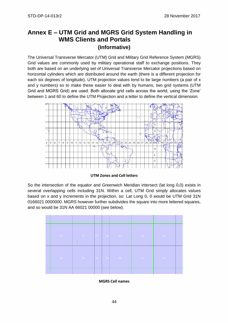
STD-DP-14-013r2 28 November 2017
44
Annex E – UTM Grid and MGRS Grid System Handling in WMS Clients and Portals
(Informative)
The Universal Transverse Mercator (UTM) Grid and Military Grid Reference System (MGRS)
Grid values are commonly used by military operational staff to exchange positions. They
both are based on an underlying set of Universal Transverse Mercator projections based on
horizontal cylinders which are distributed around the earth (there is a different projection for
each six degrees of longitude). UTM projection values tend to be large numbers (a pair of x
and y numbers) so to make these easier to deal with by humans, two grid systems (UTM
Grid and MGRS Grid) are used. Both allocate grid cells across the world, using the ‘Zone’
between 1 and 60 to define the UTM Projection and a letter to define the vertical dimension.
UTM Zones and Cell letters
So the intersection of the equator and Greenwich Meridian intersect (lat long 0,0) exists in
several overlapping cells including 31N. Within a cell, UTM Grid simply allocates values
based on x and y increments in the projection, so: Lat Long 0, 0 would be UTM Grid 31N
0166021 0000000. MGRS however further subdivides the square into more lettered squares,
and so would be 31N AA 66021 00000 (see below).
MGRS Cell names

STD-DP-14-013r2 28 November 2017
45
Issues associated with UTM Grid and MGRS Grid Values in WMS Services
Firstly, there is the issue of using UTM Grid and MGRS Grid Coordinates. It is unlikely that
client applications will want to request WMS display areas using either of these grid values,
as client applications are unlikely to internally use these Grids. Most client applications
convert the grid values to numeric Universal Transverse Mercator values using a table
(associating the cell with an X/Y coordinate in UTM projection) and then work in UTM
coordinates.
Additionally there is an issue with treating a UTM Grid or MGRS Grid as a coordinate
reference system as there is no defined separation between ordinates (the Cell names of AA
etc. embody both X and Y) and therefore it is impossible to define individual ordinates or an
axis order which is mandatory for a CRS. Most common is for dialogs or entry methods that
support the grids to be included, and a conversion applied (which is as stated a simple table
look up). This is also true for querying where clicking on the map generates a grid value.
While it is quite possible to implement this in JavaScript another approach is to have a web
service (maybe WPS or a simple Restful service) which takes a Lat/Long or UTM value and
generates a UTM grid or MGRS grid value and vice versa.
Displaying UTM Grid and MGRS Grid
A typical approach here is to have a Web Map Service which simply displays the relevant
UTM Grid or MGRS Grid at the correct resolution (see the examples above). This can then
be simply added as a layer to the client over the background WMSs. Configuration of level of
detail, colour style etc. is also potentially a requirement but this is a fairly simple service to
produce and is really unrelated to the coordinate system issues. However it would be
possible for it to provide a ‘GetFeatureInfo’ service which returned the coordinate values in
one or more grid systems that it is presenting.
It is not uncommon for most military focused client software packages (example below)
which in many cases exploit WMS to provide all of the above capabilities (including a UTM
Grid and MGRS Grid Helper, and Visualisation of the grids).
MapLink Pro MGRS/UTM Entry/Conversion and WMS Grid display (Lat Long/MGRS)

STD-DP-14-013r2 28 November 2017
46
Annex F – DGIM groups and subgroups in baseline 2016-2.0
This annex shows the groups and subgroups in the DGFCD, as in DGIF baseline 2016-2.0. Each group and each subgroup is uniquely identified by either one of these two fields: alphaCode (name) and 531-Code (alias).
Each subgroup belongs to exactly one group. One group (Abstract – G22) is not related to any subgroup.
Group G01: IndustriesServices
- Subgroup SG0101: Extraction
- Subgroup SG0102: FabricationProcessing
- Subgroup SG0103: Agriculture
- Subgroup SG0104: PowerSupplies
- Subgroup SG0105: Communication
- Subgroup SG0106: AssociatedSupportStruct
- Subgroup SG0107: StorageProvision
- Subgroup SG0108: WasteManagement
Group G02: SocioEconomicGeography
- Subgroup SG0201: Habitats
- Subgroup SG0202: SettlementsAssociated
- Subgroup SG0203: EconomicCommercial
- Subgroup SG0204: Leisure
- Subgroup SG0205: PoliticsAdministration
- Subgroup SG0206: SciencesEducation
- Subgroup SG0207: CulturalContext
Group G03: Transportation - Subgroup SG0301: Railways
- Subgroup SG0302: RoadsTracks
- Subgroup SG0303: GuidedTransportation
- Subgroup SG0304: WaterBorneTransportation
- Subgroup SG0305: AirTransportation
- Subgroup SG0306: Restrictions
- Subgroup SG0307: CrossingsLinks
- Subgroup SG0308: TransportationAssociated
- Subgroup SG0309: SpaceTransportation
- Subgroup SG0310: DistributionNetworks
Group G04: HydrographyOceanography - Subgroup SG0401: CoastalLittoralZones
- Subgroup SG0402: PortsHarbours
- Subgroup SG0403: Depths
- Subgroup SG0404: NatureOfSeabed
- Subgroup SG0405: OffshoreConstructInstall
- Subgroup SG0406: TidesCurrents
- Subgroup SG0407: RoutesNavigation

STD-DP-14-013r2 28 November 2017
47
- Subgroup SG0408: HazardsObstructions
- Subgroup SG0409: SeaIce
- Subgroup SG0410: RegulatedRestrictedZones
- Subgroup SG0411: InlandWaters
- Subgroup SG0412: PhysicsOfWater
Group G05: Physiography - Subgroup SG0501: Hypsography
- Subgroup SG0502: Geomorphology
- Subgroup SG0503: Rocks
- Subgroup SG0504: Soils
- Subgroup SG0505: NaturalResources
- Subgroup SG0506: SeismologyVolcanology
- Subgroup SG0507: Glaciers
- Subgroup SG0508: Anomalies
- Subgroup SG0509: GlobalEarthCover
Group G06: Biota
- Subgroup SG0601: CultivatedLand
- Subgroup SG0602: Rangeland
- Subgroup SG0603: Woodland
- Subgroup SG0604: Wetland
- Subgroup SG0605: AridAreas
- Subgroup SG0606: RegionsRestrictedAreas
- Subgroup SG0607: Fauna
- Subgroup SG0608: Flora
Group G07: Demarcation
- Subgroup SG0701: BoundariesLimits
- Subgroup SG0702: LandSurveyRealEstate
Group G08: Aeronautical - Subgroup SG0801: AerodromesMoveSurfLighting
- Subgroup SG0802: AirspaceRoutes
- Subgroup SG0803: NavaidsLandAidsPointsObst
- Subgroup SG0804: ServicesOrgsTimetables
- Subgroup SG0805: TerminalProcedures
Group G09: Military
- Subgroup SG0901: DefensiveOperationalStruct
- Subgroup SG0902: RestrictedAreasBoundaries
- Subgroup SG0903: OperationsEvents
Group G12: WeatherClimate - Subgroup SG1001: WeatherPhenomena
- Subgroup SG1002: ClimateConditions
- Subgroup SG1003: ClimateZonesRegions
Group G11: Characteristics - Subgroup SG2001: Position

STD-DP-14-013r2 28 November 2017
48
- Subgroup SG2002: MeasurableValues
- Subgroup SG2003: DatesDurations
- Subgroup SG2004: Appearance
- Subgroup SG2005: FunctionStatus
Group G20: NamesDesignations
- Subgroup SG2101: Names
- Subgroup SG2102: Designations
Group G21: MetadataReferences
- Subgroup SG2201: Annotation
- Subgroup SG2202: Portrayal
- Subgroup SG2203: DateCurrency
- Subgroup SG2204: Quality
- Subgroup SG2205: ReferencesSources
- Subgroup SG2206: SystemsOfClassification
Group G22: Abstract
STD-DP-14-013r2 28 November 2017
49
Annex G – Changes from v2.1 and 3.0 of the DGWIG WMS profile
(Informative)
Req. # In
v2.1
Requirement from DGIWG WMS profile v 2.1
Mandatory /Conditional
Req # in v3.0
DGIWG Basic
(version3.0)
DGIWG Queryable
(version 3.0)
Modifications
1 A DGIWG WMS server shall be compliant to the Queryable WMS conformance class.
M 1 24
X (see
modification)
X (see
modification)
*Req 1 splited into 2 : - Req 1 (WMS Basic) - Req 24 (WMS Queryable)
2 A DGIWG WMS server shall support HTTP GET.
M 2 X (see
modification)
*HTTP Get for all operations & KVP encoded added
3 A DGIWG WMS server shall support text/xml and text/html as output formats for the GetCapabilities and the GetFeatureInfo Operations.
M 25 X (see
modification)
* no more text/html for GetCapabilities response * text/xml and text/html only kept for DGIWG WMS queryable (see Req. 29)
4 A DGIWG WMS server shall provide metadata content in a response to a "GetCapabilities" or “GetFeatureInfo” request in English language.
M 3 X (see
modification)
* reworded for all operations * moved to a subsection language instead being part of the output format

STD-DP-14-013r2 28 November 2017
50
Req. # In
v2.1
Requirement from DGIWG WMS profile v 2.1
Mandatory /Conditional
Req # in v3.0
DGIWG Basic
(version3.0)
DGIWG Queryable
(version 3.0)
Modifications
5 A DGIWG WMS server shall support the following raster formats for the GetMap operation: • image/png (Portable Network Graphics) • image/gif (Graphics Interchange Format) • image/jpeg (Joint Photographics Expert Group)
M 4 X *Kept as previously
6 A DGIWG WMS server shall support the following coordinate reference systems: • CRS:84 WGS84 geographic longitude, then latitude, expressed in decimal degrees • EPSG:4326 WGS84 geographic latitude, then longitude, expressed in decimal degrees • EPSG:3395 World Mercator projection Among the following Coordinate Reference Systems, the service shall support all those which validity zone overlaps data published by the service: • UTM projections over WGS84 (north zones)… EPSG:32601 to EPSG:32660 • UTM projections over WGS84 (south zones)… EPSG:32701 to EPSG:32760 • UPS projection over WGS84 (north zone)…… EPSG:32661 • UPS projection over WGS84 (south zone)…… EPSG:32761
M 5 X * EPSG codes modified for UPS projection (EPS:5041 and EPSG:5042, replacing EPSG:32661 and EPSG:32761) *CRS are in line with STANAG 2211 * reference to OGC web page providing guidance for axis order added

STD-DP-14-013r2 28 November 2017
51
Req. # In
v2.1
Requirement from DGIWG WMS profile v 2.1
Mandatory /Conditional
Req # in v3.0
DGIWG Basic
(version3.0)
DGIWG Queryable
(version 3.0)
Modifications
7 A DGIWG WMS server shall provide service exceptions in English language.
M 6 X * explanation added
8 A DGIWG WMS server shall support all GetCapabilities request parameters.
M * requirement deleted (obvious) * kept as a general sentence
9 A DGIWG WMS server shall provide all mandatory and optional service metadata elements.
M 7 X (see
modification)
* clarifications added for each element
10 A DGIWG WMS server shall identify the highest classification level of the content accessible through the WMS service by populating the wms:AccessConstraints element.
M 8 X (see
modification)
* condition added (when underlying data are classified) * generic sentence for the classification scheme dependant of the context added
11 A DGIWG WMS server shall include the following information in the abstract element of the service metadata: "This service implements the DGIWG WMS 1.3 profile version 1.0."
M 9 and 26 X (see
modification)
* version of the profile updated (v3.0) * reference to the conference class supported (either DGIWG Basic or DGIWG Queryable) added
12 A DGIWG WMS server shall provide a minimum keyword list based on the DFDD groups.
M 10 X (see
modification)
* semantic reference changed from DFDD to DGIM groups * groups for baseline 2016-02 kept as an
STD-DP-14-013r2 28 November 2017
52
Req. # In
v2.1
Requirement from DGIWG WMS profile v 2.1
Mandatory /Conditional
Req # in v3.0
DGIWG Basic
(version3.0)
DGIWG Queryable
(version 3.0)
Modifications
example
13 A DGIWG WMS server shall provide information on the supported styles.
M 11 X (see
modification)
* clarification added (Name and Title)
14 A DGIWG WMS server shall always provide at least one style element and that style shall be advertised even if it's only the default style.
M 12 X * examples added, to be validated
15 The MaxWidth and MaxHeight shall be greater or equal to 800 pixels.
M 13 X (see
modification)
* clarification added (or omitted)
16 Each vector data layer's style shall have an associated legend, available as an image in one of the following formats: PNG, GIF or JPEG.
M 14 X (see
modification)
* generalized to all layers but conditional (if warranted)
17 This legend shall be accessible online at the URL specified by LegendURL.
M 15 X (see
modification)
* online deleted
18 A DGIWG WMS server shall provide scale denominators for all layers it provides.
M - * deleted

STD-DP-14-013r2 28 November 2017
53
Req. # In
v2.1
Requirement from DGIWG WMS profile v 2.1
Mandatory /Conditional
Req # in v3.0
DGIWG Basic
(version3.0)
DGIWG Queryable
(version 3.0)
Modifications
19 The <MinScaleDenominator> value shall always be less than or equal to the <MaxScaleDenominator> value.
M 16 X (see
modification)
* condition added (when provided)
20 If the GetCapabilities document identifies support for FeatureListURL then the list of features that are in the particular layer shall be resolvable through the provided URL.
C 17 X (see
modification)
* precondition added before the list of all requirements * reworded
21 If the GetCapabilities document identifies support for DataURL then the underlying data of the particular layer shall be resolvable through the provided URL.
C 18 X (see
modification)
* reworded as previous requirement
22 A DGIWG WMS server shall provide the XML Attributes according to Table 4.
M 19 X
23 A DGIWG WMS server shall support all GetMap request parameters.
M - * deleted (obvious), kept as a general sentence
24 A DGIWG WMS Service shall support transparency
M 20 X (see
modification)
* service => server
25 A DGIWG WMS server shall support the INIMAGE EXCEPTIONS.
M 21 X
26 A DGIWG WMS server shall support the BLANK EXCEPTIONS.
M 22 X
27 If a DGIWG WMS server provides multi-dimensional data then it shall: • Support the vertical Elevation and temporal Time request parameters. • Handle data utilized in these
C - *moved as a recommendations 5 and 6

STD-DP-14-013r2 28 November 2017
54
Req. # In
v2.1
Requirement from DGIWG WMS profile v 2.1
Mandatory /Conditional
Req # in v3.0
DGIWG Basic
(version3.0)
DGIWG Queryable
(version 3.0)
Modifications
parameters in accordance with the "OGC Best Practices for using OGC WMS with Time-Dependent or Elevation-Dependent Data [2]"
28 A DGIWG WMS server that announces available sample dimensions in its service metadata shall resolve the corresponding parameters provided in the GetMap operation for requesting these dimensional values.
M 23 X
29 A DGIWG WMS server shall support the FEATURE_COUNT parameter to enable the increase of the number of features per layer for which the server returns information.
M - X *ok deleted, generic requirement added
30 A DGIWG WMS server shall support the EXCEPTIONS parameter support of text/xml and text/html.
M 27 X (see
modification)
*only XML kept and reworded
31 A DGIWG WMS server shall provide a response according to the INFO_Format.
M - *obvious (deleted)
32 A DGIWG WMS server shall return the units of measure for dimensional values returned in a GetFeatureInfo response.
M - *deleted, moved as recommendation 7