OGC India Plugfest - 2017 (OIP-2017) Engineering Report
31
1 Copyright © 2020 Open Geospatial Consortium Open Geospatial Consortium Submission Date: 2018-02-28 Approval Date: 2018-03-22 Publication Date: 2020-02-24 External identifier of this OGC ® document: http://www.opengis.net/doc/PER/oip-2017 Internal reference number of this OGC ® document: 18-009 Category: OGC ® Engineering Report Editors: P S Acharya, Scott Simmons, A Kaushal, M K Munshi OGC India Plugfest - 2017 (OIP-2017) Engineering Report Copyright notice Copyright © 2020 Open Geospatial Consortium To obtain additional rights of use, visit http://www.opengeospatial.org/legal/. Warning This document is not an OGC Standard. This document is an OGC Public Engineering Report created as a deliverable in an OGC Interoperability Initiative and is not an official position of the OGC membership. It is distributed for review and comment. It is subject to change without notice and may not be referred to as an OGC Standard. Further, any OGC Engineering Report should not be referenced as required or mandatory technology in procurements. However, the discussions in this document could very well lead to the definition of an OGC Standard . Document type: OGC ® Engineering Report Document subtype: Document stage: Approved Document language: English
-
Upload
khangminh22 -
Category
Documents
-
view
6 -
download
0
Transcript of OGC India Plugfest - 2017 (OIP-2017) Engineering Report
1 Copyright © 2020 Open Geospatial Consortium
Open Geospatial Consortium Submission Date: 2018-02-28
Approval Date: 2018-03-22
Publication Date: 2020-02-24
External identifier of this OGC® document: http://www.opengis.net/doc/PER/oip-2017
Internal reference number of this OGC® document: 18-009
Category: OGC® Engineering Report
Editors: P S Acharya, Scott Simmons, A Kaushal, M K Munshi
OGC India Plugfest - 2017 (OIP-2017) Engineering Report
Copyright notice
Copyright © 2020 Open Geospatial Consortium To obtain additional rights of use, visit http://www.opengeospatial.org/legal/.
Warning
This document is not an OGC Standard. This document is an OGC Public Engineering Report created as a deliverable in an OGC Interoperability Initiative and is not an official position of the OGC membership. It is distributed for review and comment. It is subject to change without notice and may not be referred to as an OGC Standard. Further, any OGC Engineering Report should not be referenced as required or mandatory technology in procurements. However, the discussions in this document could very well lead to the definition of an OGC Standard .
Document type: OGC® Engineering Report Document subtype: Document stage: Approved Document language: English

2 Copyright © 2020 Open Geospatial Consortium
License Agreement
Permission is hereby granted by the Open Geospatial Consortium, ("Licensor"), free of charge and subject to the terms set forth below, to any person obtaining a copy of this Intellectual Property and any associated documentation, to deal in the Intellectual Property without restriction (except as set forth below), including without limitation the rights to implement, use, copy, modify, merge, publish, distribute, and/or sublicense copies of the Intellectual Property, and to permit persons to whom the Intellectual Property is furnished to do so, provided that all copyright notices on the intellectual property are retained intact and that each person to whom the Intellectual Property is furnished agrees to the terms of this Agreement.
If you modify the Intellectual Property, all copies of the modified Intellectual Property must include, in addition to the above copyright notice, a notice that the Intellectual Property includes modifications that have not been approved or adopted by LICENSOR.
THIS LICENSE IS A COPYRIGHT LICENSE ONLY, AND DOES NOT CONVEY ANY RIGHTS UNDER ANY PATENTS THAT MAY BE IN FORCE ANYWHERE IN THE WORLD.
THE INTELLECTUAL PROPERTY IS PROVIDED "AS IS", WITHOUT WARRANTY OF ANY KIND, EXPRESS OR IMPLIED, INCLUDING BUT NOT LIMITED TO THE WARRANTIES OF MERCHANTABILITY, FITNESS FOR A PARTICULAR PURPOSE, AND NONINFRINGEMENT OF THIRD PARTY RIGHTS. THE COPYRIGHT HOLDER OR HOLDERS INCLUDED IN THIS NOTICE DO NOT WARRANT THAT THE FUNCTIONS CONTAINED IN THE INTELLECTUAL PROPERTY WILL MEET YOUR REQUIREMENTS OR THAT THE OPERATION OF THE INTELLECTUAL PROPERTY WILL BE UNINTERRUPTED OR ERROR FREE. ANY USE OF THE INTELLECTUAL PROPERTY SHALL BE MADE ENTIRELY AT THE USER’S OWN RISK. IN NO EVENT SHALL THE COPYRIGHT HOLDER OR ANY CONTRIBUTOR OF INTELLECTUAL PROPERTY RIGHTS TO THE INTELLECTUAL PROPERTY BE LIABLE FOR ANY CLAIM, OR ANY DIRECT, SPECIAL, INDIRECT OR CONSEQUENTIAL DAMAGES, OR ANY DAMAGES WHATSOEVER RESULTING FROM ANY ALLEGED INFRINGEMENT OR ANY LOSS OF USE, DATA OR PROFITS, WHETHER IN AN ACTION OF CONTRACT, NEGLIGENCE OR UNDER ANY OTHER LEGAL THEORY, ARISING OUT OF OR IN CONNECTION WITH THE IMPLEMENTATION, USE, COMMERCIALIZATION OR PERFORMANCE OF THIS INTELLECTUAL PROPERTY.
This license is effective until terminated. You may terminate it at any time by destroying the Intellectual Property together with all copies in any form. The license will also terminate if you fail to comply with any term or condition of this Agreement. Except as provided in the following sentence, no such termination of this license shall require the termination of any third party end-user sublicense to the Intellectual Property which is in force as of the date of notice of such termination. In addition, should the Intellectual Property, or the operation of the Intellectual Property, infringe, or in LICENSOR’s sole opinion be likely to infringe, any patent, copyright, trademark or other right of a third party, you agree that LICENSOR, in its sole discretion, may terminate this license without any compensation or liability to you, your licensees or any other party. You agree upon termination of any kind to destroy or cause to be destroyed the Intellectual Property together with all copies in any form, whether held by you or by any third party.
Except as contained in this notice, the name of LICENSOR or of any other holder of a copyright in all or part of the Intellectual Property shall not be used in advertising or otherwise to promote the sale, use or other dealings in this Intellectual Property without prior written authorization of LICENSOR or such copyright holder. LICENSOR is and shall at all times be the sole entity that may authorize you or any third party to use certification marks, trademarks or other special designations to indicate compliance with any LICENSOR standards or specifications. This Agreement is governed by the laws of the Commonwealth of Massachusetts. The application to this Agreement of the United Nations Convention on Contracts for the International Sale of Goods is hereby expressly excluded. In the event any provision of this Agreement shall be deemed unenforceable, void or invalid, such provision shall be modified so as to make it valid and enforceable, and as so modified the entire Agreement shall remain in full force and effect. No decision, action or inaction by LICENSOR shall be construed to be a waiver of any rights or remedies available to it.

3 Copyright © 2020 Open Geospatial Consortium
Contents1. Scope ........................................................................................................................... 7
1.1 Department of Science & Technology ................................................................ 7
1.1.1 National Spatial Data Infrastructure ........................................................... 7
1.1.2 Smart Cities Mission ................................................................................... 8
2. References ................................................................................................................... 8
3. Terms and Definitions ................................................................................................. 9
4. Overview ................................................................................................................... 10
4.1 Objectives of the Plugfest ................................................................................. 10
4.2 Plugfest Participation ........................................................................................ 11
4.3 Data and Security Clearance ............................................................................. 12
4.4 Plugfest Process, Activities, Procedures, and Artifacts .................................... 13
5. Scenarios and Use Cases ........................................................................................... 14
5.1 Overview ........................................................................................................... 14
5.2 Scenario 1 .......................................................................................................... 14
5.3 Scenario 2 .......................................................................................................... 16
5.4 Scenario 3 .......................................................................................................... 17
5.5 Scenario 4 .......................................................................................................... 18
5.6 Use Case 1: Water Supply / Wastewater Management .................................... 19
5.6.1 Demonstrated Capabilities ........................................................................ 20
5.7 Use Case 2: Watershed Management ............................................................... 22
5.7.1 Demonstrated Capabilities ........................................................................ 22
5.8 Use Case 3: Air Quality .................................................................................... 24
5.8.1 Demonstrated Capabilities ........................................................................ 24
5.9 Use Case 4: Health ............................................................................................ 27

4 Copyright © 2020 Open Geospatial Consortium
5.9.1 Demonstrated Capabilities ........................................................................ 27
6. Summary of Recommendations and Conclusions .................................................... 29
6.1 Overview ........................................................................................................... 29
6.2 WFS/GML ........................................................................................................ 29
6.3 CityGML ........................................................................................................... 30
6.4 WFS, WMS and WMTS ................................................................................... 30
6.5 WPS .................................................................................................................. 30
6.6 Conclusions ....................................................................................................... 30
5 Copyright © 2020 Open Geospatial Consortium
i. Abstract The Open Geospatial Consortium (OGC) and the Department of Science & Technology (DST) under the Government of India conducted the OGC India Plugfest 2017 (OIP-2017). The OIP-2017 was targeted at enhancing the interoperability among geospatial products and web services based on OGC standards within the Indian Geospatial Information (GI) community. The successful conclusion of OIP-2017 will assist National Spatial Data Infrastructure (NSDI) under DST to provide guidance on best practices using OGC standards for development of applications in several important & flagship schemes/programmes of the Government such as Smart Cities, Atal Mission for Rejuvenation through Urban Trasnformation (AMRUT); National Land Records Moderinisation Programme (NLRMP); Clean India (Swatchh Bharat – Urban & Rural); National Mission on Clean Ganga; Compensatory Afforestation Fund Management & Planning Authority (CAMPA); State SDIs; Digital India, and others.
This engineering report written jointly by OGC and DST is addressed to both the domestic (Indian) and international audiences.
OIP-2017 was funded by the OGC India Foundation with supporting OGC staff resources from the OGC Innovation Program.
ii. Keywords The following are keywords to be used by search engines and document catalogues.
OGC documents, Sprint, Plugfest, Smart Cities, DST, NSDI, OGC, GML, CityGML, WFS, WMS, WMTS, WCS
iii. Preface OGC operates Plugfests to demonstrate interoperability in the geospatial community. OGC states that a “…Plugfest is an event or series of events executed by OGC members or non-members and facilitated by OGC staff, which is intended to achieve dual technical and market objectives that furthers the adoption and use OGC Standards. Plugfests can be internal (with Members only) or public (with Members and non-member participants). Plugfests may address some distinct set of elements of the OGC Reference Model and/or Standards baseline with a testing approach with products that contain OGC Standards, or may address the use of products that implement OGC Standards with tests targeted for a domain community.”

6 Copyright © 2020 Open Geospatial Consortium
Figure 1 Components and methods to demonstrate interoperability
Attention is drawn to the possibility that some of the elements of this document may be the subject of patent rights. The Open Geospatial Consortium shall not be held responsible for identifying any or all such patent rights.
Recipients of this document are requested to submit, with their comments, notification of any relevant patent claims or other intellectual property rights of which they may be aware that might be infringed by any implementation of the standard set forth in this document, and to provide supporting documentation.
iv. Submitting organizations The following organizations submitted this Document to the Open Geospatial Consortium (OGC):
• Department of Science and Technology, National Spatial Data Infrastructure, Government of India (DST-NSDI); and
• Open Geospatial Consortium (OGC)
v. Submitters All questions regarding this submission should be directed to the editor or the submitters:
Name Affiliation P S Acharya DST-NSDI Scott Simmons OGC A Kaushal OGC M K Munshi OGC

7 Copyright © 2020 Open Geospatial Consortium
1. Scope
This OGC Engineering Report (ER) describes a Plugfest organized around scenarios demonstrating interoperability across disparate data types, platforms/servers and software products, and use cases. These scenarios were developed to demonstrate the relevance of the data and software for India’s national programs on the Smart Cities Mission and National Spatial Data Infrastructure. These scenarios were addressed in the OGC India Plugfest 2017 (OIP-2017) conducted under two Sprints. Recommendations and conclusions provided in this ER are based on the industry participant feedback from both Sprints, with more emphasis on the work accomplished in Sprint 2.
1.1 Department of Science & Technology The DST under the Ministry of Science & Technology, Government of India, was established in May 1971 with the objective of promoting new areas of Science & Technology (S&T) and to play the role of a nodal department for organizing, coordinating, and promoting S&T activities in the country. It has major responsibilities for specific projects and programs. Some of them are as follows.
1. Formulation of policies relating to S&T. 2. Matters relating to the Scientific Advisory Committee of the Cabinet (SACC). 3. Promotion of new areas of Science and Technology with special emphasis on
emerging areas. 4. Coordination and integration of areas of S&T having cross-sectoral linkages
in which a number of institutions and departments have interest and capabilities.
5. Undertaking or financially sponsoring S&T surveys, research design and development, where necessary.
6. Support and Grants-in-aid to Scientific Research Institutions, Scientific Associations and Bodies.
7. All matters concerning: a. The Survey of India, and National Atlas and Thematic Mapping
Organisation; and b. National Spatial Data Infrastructure and promotion of GIS.
8. Matters relating to institutional S&T capacity building including setting up of new institutions and institutional infrastructure.
9. Promotion of S&T at the State, District, and Village levels for grass- roots development through State Science and Technology Councils and other mechanisms.
10. Application of S&T for weaker sections, women and other disadvantaged sections of Society.
1.1.1 National Spatial Data Infrastructure The NSDI of DST was established with a vision to create National infrastructure for the availability of and access to organized geospatial data and use of the infrastructure at Community, Local, State, Regional and National levels for sustained economic growth.

8 Copyright © 2020 Open Geospatial Consortium
The present thrust of NSDI has been on provision of web-based geospatial services (e.g., Web Map Service (WMS), Web Feature Service (WFS); Web Processing Service (WPS); Catalogue Services on Web (CSW), etc.) to address geospatial information needs of the National level Schemes and Programmes such as Smart Cities (https://india.gov.in/spotlight/smart-cities-mission-step-towards-smart-india), Atal Mission for Rejuvenation through Urban Trasnformation (AMRUT) (http://amrut.gov.in/); Digital India Land Records Moderinisation Programme (DILRMP) (http://nlrmp.nic.in/); Clean India (Swatchh Bharat Mission - http://swachhbharatmission.gov.in/sbmcms/index.htm); National Mission on Clean Ganga (http://nmcg.nic.in/); Compensatory Afforestation Fund Management & Planning Authority (CAMPA) (http://www.moef.nic.in/major-initiatives/compensatory-afforestation-fund-management-and-planning-authority-campa); State SDIs (https://nsdiindia.gov.in); Digital India (http://www.digitalindia.gov.in/); and others.
1.1.2 Smart Cities Mission Among other schemes/programmes, the Smart Cities Mission assumes importance considering the density of India’s population residing in towns and cities, the investments being made by the Government in their improvement, and the alarmingly deteriorating environmental conditions influencing the health of citizens. The Smart Cities Mission thus requires urgent attention to the problems of management of geospatial data generated by various departments and sources for location-based decision support systems. The Smart Cities Mission of the Ministry of Housing and Urban Affairs is an urban renewal and retrofitting program by the Government of India with a mission to develop 100 cities spread across the country and making those cities citizen-friendly and sustainable.
Smart Cities focus on the most pressing needs and on the greatest opportunities to improve lives. They tap a range of approaches - digital and information technologies including GIS, urban planning best practices, public-private partnerships, and policy change - to make a difference. The objective is to promote cities that provide core infrastructure and give a decent quality of life to its citizens, a clean and sustainable environment, and application of 'Smart' Solutions. The focus is on sustainable and inclusive development and the idea is to look at compact areas and create a replicable model which will be an example to other aspiring cities.
The Smart Cities Mission is meant to set examples that can be replicated both within and outside the Smart City, catalyzing the creation of similar Smart Cities in various regions of the country.
2. References
The following documents are referenced in this document. For dated references, subsequent amendments to, or revisions of, any of these publications do not apply. For undated references, the latest edition of the normative document referred to applies.

9 Copyright © 2020 Open Geospatial Consortium
OGC: OGC 01-068r3, OpenGIS® Web Map Service (WMS) Implementation Specification, version 1.1.1, 2002
OGC: OGC 03-105r1, OpenGIS® Geography Markup Language (GML) Encoding Specification, version 3.2.1, 2007
OGC: OGC 04-094, OpenGIS® Web Feature Server (WFS) Implementation Specification, version 1.1.0, 2005
OGC: OGC 06-042, OpenGIS® Web Map Server Implementation Specification, version 1.3.0, 2006
OGC: OGC 07-057r7, OpenGIS® Web Map Tile Service Implementation Standard, Version 1.0.0, 2010
OGC: OGC 09-110r4, OGC® WCS 2.0 Interface Standard- Core: Corrigendum, version 2.0.1, 2012
OGC: OGC 12-019, OGC City Geography Markup Language (CityGML) Encoding Standard, version 2.0.0, 2012
3. Terms and Definitions
AMRUT Atal Mission for Rejuvenation and Urban Transformation
CityGML City Geography Markup Language
CSW Catalogue Services (for the Web)
DST Department of Science and Technology
ER Engineering Report
GI Geospatial Information
GML Geography Markup Language
KPI Key Performance Indicator
LOD Level of Details
NRSC National Remote Sensing Center
NSDI National Spatial Data Infrastructure
OGC Open Geospatial Consortium

10 Copyright © 2020 Open Geospatial Consortium
OIP OGC India Plugfest
ORSAC Odisha Remote Sensing Applications Center
OWS OGC Web Services
PPP Public Private Partnership
SDI Spatial Data Infrastructure
URL Universal Resource Locator
WCS Web Coverage Service
WFS Web Feature Service
WMTS Web Map Transport Service
WMS Web Map Service
WPS Web Processing Service
4. Overview
4.1 Objectives of the Plugfest This Plugfest was developed to prove the value of the standardization efforts of NSDI at DST and demonstrate application of standards in the utilization of geospatial data in various schemes and programmes in general, and for the Smart Cities Mission, in particular. Specifically, this interoperability initiative included the following objectives.
• To create an environment for Public Private Partnership (PPP) for applying the benefits of OGC standards in improving the ability and efficiency of accessing, sharing, and processing various types of government geospatial data/information via OGC Web Services.
• To actively test the ability and governance for seamless exchange of information among various stakeholders using different technology platforms in support of the Smart Cities Mission.
• To learn from local industry participants’ experiences and knowledge in collaboration – an effort that has been well proven for geospatial information interoperability in other locations and applied successfully to software development, application challenges, and programs.
• To identify areas of improvement in the content and use of specific OGC standards.
These objectives were highlighted through four use cases for demonstration.
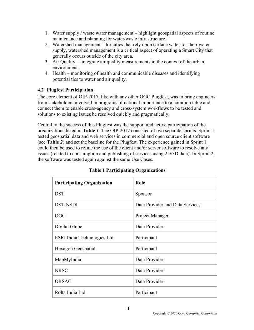
11 Copyright © 2020 Open Geospatial Consortium
1. Water supply / waste water management – highlight geospatial aspects of routine maintenance and planning for water/waste infrastructure.
2. Watershed management – for cities that rely upon surface water for their water supply, watershed management is a critical aspect of operating a Smart City that generally occurs outside of the city area.
3. Air Quality – integrate air quality measurements in the context of the urban environment.
4. Health – monitoring of health and communicable diseases and identifying potential ties to water and air quality.
4.2 Plugfest Participation The core element of OIP-2017, like with any other OGC Plugfest, was to bring engineers from stakeholders involved in programs of national importance to a common table and connect them to enable cross-agency and cross-system workflows to be tested and solutions to existing issues be resolved quickly and pragmatically.
Central to the success of this Plugfest was the support and active participation of the organizations listed in Table 1. The OIP-2017 consisted of two separate sprints. Sprint 1 tested geospatial data and web services in commercial and open source client software (see Table 2) and set the baseline for the Plugfest. The experience gained in Sprint 1 could then be used to refine the use of the client and/or server software to resolve any issues (related to consumption and publishing of services using 2D/3D data). In Sprint 2, the software was tested again against the same Use Cases.
Table 1 Participating Organizations
Participating Organization Role
DST Sponsor
DST-NSDI Data Provider and Data Services
OGC Project Manager
Digital Globe Data Provider
ESRI India Technologies Ltd Participant
Hexagon Geospatial Participant
MapMyIndia Data Provider
NRSC Data Provider
ORSAC Data Provider
Rolta India Ltd Participant

12 Copyright © 2020 Open Geospatial Consortium
SkyMap Global India Private Ltd Participant
Table 2 Client Applications
Application Name Participating Organization
ArcGIS ESRI India Technologies Ltd
Erdas Apollo, Intergraph GeoMedia Hexagon Geospatial
OnPoint Rolta India Ltd
Imagetrekk 2D, 3D SkyMap Global India Private Ltd
4.3 Data and Security Clearance While ‘feature rich’ data is a key requirement of a Plugfest, the importance of conforming to the Government of India policies with regard to distribution/access of geospatial data cannot be overemphasized. With this in view, it was decided to utilize 2D data of a small town in Odisha, namely Boudh Town, for which urban cadastral data, street map data, and multispectral satellite data was available through various providers. As clearance of Indian 3D data was not available, it was decided to use non-Indian data over The Hague Netherlands: a LOD1 city model data in CityGML 2.0.
Table 3 describes the data made available for this Plugfest and how those data were provided. Urban cadastral data of Boudh Town, provided by ORSAC, was hosted on a NSDI clearinghouse, along with street map data provided by MapMyIndia. In addition, Cartosat-2 data of the town was hosted on Bhuvan, courtesy NRSC (via WMS and WMTS). Worldview-3 satellite data of the town was provided by DigitalGlobe after due screening by NRSC (as per the Indian Remote Sensing Data Policy) and was hosted on NSDI clearinghouse (via WMS, WCS). Terrain and watershed data of the Boudh Town area provided by ORSAC was also hosted on NSDI clearinghouse for exercising the Watershed Management Use case.
Table 3 Data services
Service Content Service Type Service Provider
Cadastral and streets (government source) WFS ORSAC/ NSDI
Watershed boundaries WFS ORSAC/ NSDI
Streets (commercial source) WFS MapMyIndia/ NSDI
Cartosat-2 imagery WMS NRSC
WorldView-3 imagery WMS, WCS Digital Globe/ NSDI

13 Copyright © 2020 Open Geospatial Consortium
Den Haag CityGML data CityGML, LOD1, LOD2
OGC
Water distribution network WFS ESRI India
Watershed WFS ESRI India
Hospital locations WFS ESRI India
Air quality monitoring data WMS, WFS Rolta India
4.4 Plugfest Process, Activities, Procedures, and Artifacts The sponsors of the OIP-2017 – OGC and DST - released a Call for Participation (CFP) on 22 November 2016 and a meeting with responders was held on 25 January 2017 in Hyderabad, India during the Geospatial World Forum (GWF-17). The responses from the Industry were evaluated in March 2017 after which ESRI India Technologies Ltd, Hexagon Geospatial, Rolta India Ltd, and SkyMap Global were invited on 3 April 2017 to participate in OIP-2017.
A kick-off meeting over GoToMeeting was held on 11 April 2017, wherein the participants were briefed on sponsors, participants, and data providers. This meeting emphasized that the NSDI had expressed interest in testing industry-government partnership and capabilities for data interoperability to support the National Programs on Smart Cities and NSDI.
As per the mission of NSDI, the current focus was limited to the OGC web services WMS 1.1.1, WMS 1.3, WMTS 1.0, WFS 1.1.0, City GML 2.0 and GML 3.2.1.
Participants were asked to consume data/ services (Table 3) from servers at NSDI, NRSC, and OGC and demonstrate compliance with standards listed above by consuming data under four scenarios and then showcasing the four Use Cases.
The kick-off meeting was followed by three teleconferences up to Sprint 1 and one more teleconference before Sprint 2 to address any queries on demonstration by the industry participants.
The OIP-2017 was conducted at NSDI in New Delhi. Sprint 1 was conducted on 23 May 2017. Sprint 2 was conducted on 20 June 2017 followed by a meeting of the OGC India Forum wherein the participants each provided a 10-minute presentation on their findings from the Plugfest. Sprint 2 was conducted to allow participants from Sprint 1 to test, validate, and demonstrate any changes made to their offerings as a result of lessons-learned from the Sprint 1. This allowed NSDI to address issues identified by the industry participants in accessing OGC web services and data sets installed on NSDI server infrastructure on a platform of ERDAS Apollo from Hexagon Geospatial.
OIP-2017 provided technology providers the opportunity to validate the ability of their applications to properly access and exploit geospatial information served from different sites implementing OGC-compliant services.

14 Copyright © 2020 Open Geospatial Consortium
The published agenda for both Sprints was as follows:
09:00 - 10:30 Skymap Global India Private Ltd
10:30 – 11:00 Tea Break
11:00 - 12:30 ESRI India Technologies Ltd
12:30 - 13:30 Lunch
13:30 – 15:00 Rolta India Ltd
15:00 – 15:30 Tea Break
15:30 - 17:00 Hexagon Geospatial
17:00 - 18:00 Review by Sponsors
Each participant was asked to make a 10-minute presentation on their Company Profile, followed by demonstration of accessing various services listed in Table 3, and finally demonstration of use of the provided data and services to address the Use Cases.
5. Scenarios and Use Cases
5.1 Overview Four scenarios of demonstration were prepared to illustrate basic data interoperability using OGC standards. These scenarios collectively highlight the content necessary to demonstrate the four use cases. Because the use cases are, in part, interrelated, DST and OGC decided to use a scenario-based approach to (1) allow comparative assessment of access to and interoperability between select data sources/types and (2) facilitate sharing of secondary data amongst participants. The participants were then self-directed in how to demonstrate the use cases so that each could highlight the applicability of their solutions to the typical work elements in the use cases.
5.2 Scenario 1 Scope:
1. Consume the OGC services of type WFS, WMS, and WMTS listed in Table 3 and published on NSDI Clearinghouse and NRSC Bhuvan servers.
2. Demonstrate data interoperability using real-world representative geospatial data comprising urban cadastral data, street map data, and satellite imagery of Boudh Town.
Observations:

15 Copyright © 2020 Open Geospatial Consortium
1. OGC services published in different platforms including services shared from NSDI Clearinghouse and NRSC Bhuvan using disparate data types shared by NRSC, ORSAC, MapMyIndia, and DigitalGlobe were consumed in an integrated environment and seamlessly displayed over each other.
2. OGC WMS was demonstrated; see examples from Esri India and Rolta India in Figure 2 and Figure 3, respectively. However, not all participants were able to demonstrate OGC WMTS successfully. Special emphasis was placed on the use of portrayal styles to visualize data.
Figure 2 Esri India display of Scenario 1 content
16 Copyright © 2020 Open Geospatial Consortium
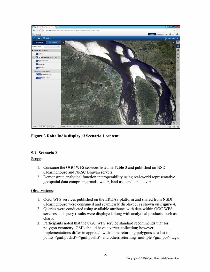
Figure 3 Rolta India display of Scenario 1 content
5.3 Scenario 2 Scope:
1. Consume the OGC WFS services listed in Table 3 and published on NSDI Clearinghouse and NRSC Bhuvan servers.
2. Demonstrate analytical function interoperability using real-world representative geospatial data comprising roads, water, land use, and land cover.
Observations:
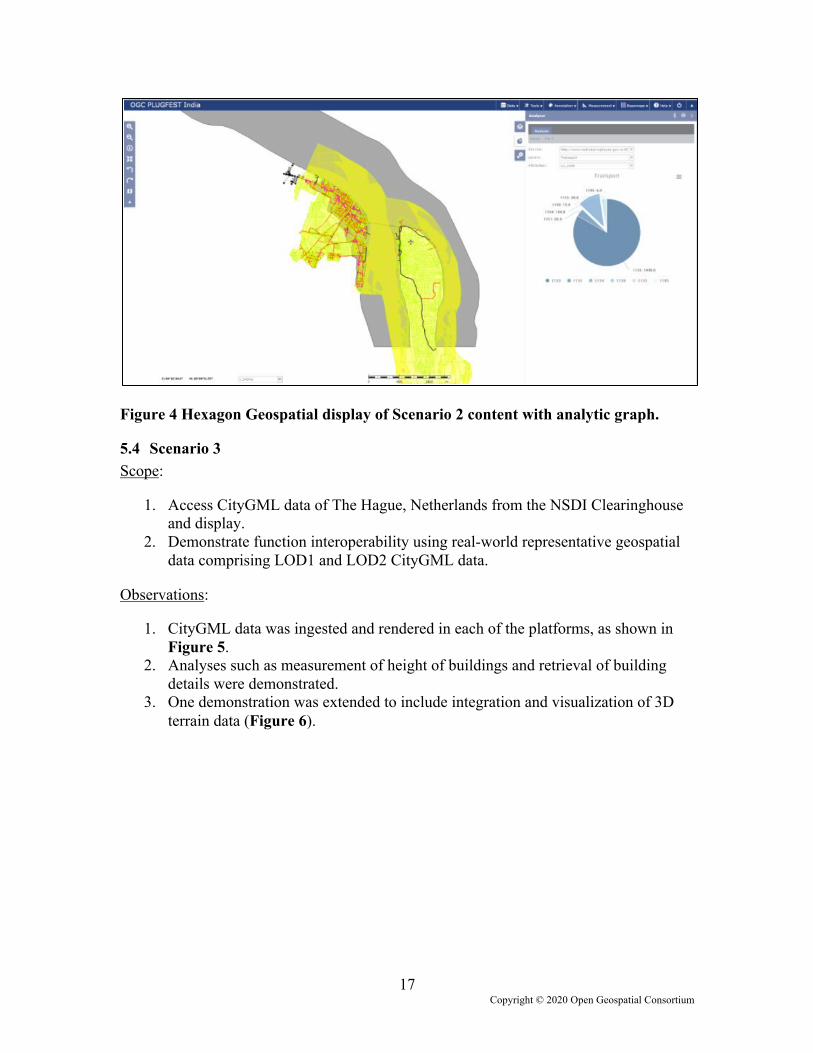
1. OGC WFS services published on the ERDAS platform and shared from NSDI Clearinghouse were consumed and seamlessly displayed, as shown on Figure 4.
2. Queries were conducted using available attributes with data within OGC WFS services and query results were displayed along with analytical products, such as charts.
3. Participants noted that the OGC WFS service standard recommends that for polygon geometry, GML should have a vertex collection; however, implementations differ in approach with some returning polygons as a list of points <gml:poslist></gml:poslist> and others returning multiple <gml:pos> tags.
17 Copyright © 2020 Open Geospatial Consortium
Figure 4 Hexagon Geospatial display of Scenario 2 content with analytic graph.
5.4 Scenario 3 Scope:
1. Access CityGML data of The Hague, Netherlands from the NSDI Clearinghouse and display.
2. Demonstrate function interoperability using real-world representative geospatial data comprising LOD1 and LOD2 CityGML data.
Observations:
1. CityGML data was ingested and rendered in each of the platforms, as shown in Figure 5.
2. Analyses such as measurement of height of buildings and retrieval of building details were demonstrated.
3. One demonstration was extended to include integration and visualization of 3D terrain data (Figure 6).

18 Copyright © 2020 Open Geospatial Consortium
Figure 5 Esri India display of CityGML data synchronized with display of 2D data
Figure 6 Skymap Global depiction of CityGML, terrain, and terrain-draped WMS data
5.5 Scenario 4 Scope:
1. Consume OGC WFS services published by industry participants ESRI India and Rolta India (Table 3).
2. Demonstrate data interoperability using synthetic data comprising water supply, air quality, health services, and others of Boudh Town.
Observations:

19 Copyright © 2020 Open Geospatial Consortium
1. OGC services published in different platforms were consumed in an integrated environment and seamlessly displayed.
Figure 7 Esri India display of Scenario 4 content
Figure 8 Rolta India display of Scenario 4 content
5.6 Use Case 1: Water Supply / Wastewater Management Water is one of the most essential elements of nature to sustain life. However, with the growth in the size and number of cities, the supply of water has fallen short of demand. Today, practically no city in India gets sufficient water to meet the needs of city dwellers.

20 Copyright © 2020 Open Geospatial Consortium
One of the requirements of a Smart City is a reliable 24x7 water supply to each household.
Considering that the water collection and distribution infrastructure is often inadequate, it is important to analyze demographic and land use data to propose infrastructure improvements. Where there is infrastructure, there is a need to map and improve the quality of maintenance of existing infrastructure for water supply within the city.
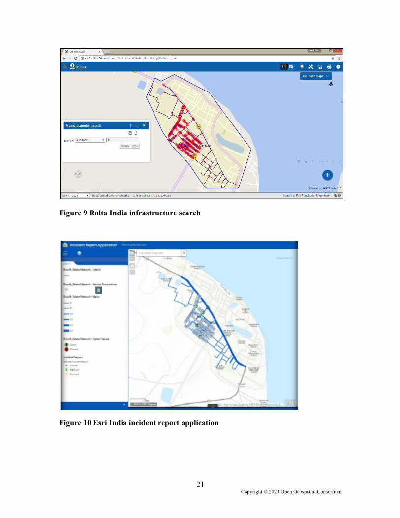
5.6.1 Demonstrated Capabilities The participants developed synthetic water supply and wastewater infrastructure data for Boudh Town to demonstrate use of the data for maintenance and modernization planning. The synthetic data included assets such as pipelines, sewers, valves, and fittings as well as attribute data regarding pressure and blockages. Esri India also made its data available to the other participants via WFS.
The following operations were demonstrated.
• Query water mains, diameter, repair Date, lateral lines, last edit date, current meter reading report (Figure 9).
• Highlight various Key Performance Indicators (KPIs) like consumption, number of incidents, hotspots, etc.
• Demonstrate central office users to update, monitor, and task required actions. • Direct field teams to report incidents and execute work orders (Figure 10). • Divide the entire area into 20 wards, each with the following attribute
information: o Number of consumers; and o Water supply in liters.
• Published the ward data as WMS and WFS services and execute following dynamic queries:
o Demand/ supply analysis (Figure 11); and o Future demand analysis for planning purposes.
21 Copyright © 2020 Open Geospatial Consortium
Figure 9 Rolta India infrastructure search
Figure 10 Esri India incident report application

22 Copyright © 2020 Open Geospatial Consortium
Figure 11 Hexagon Geospatial ward-based analysis
5.7 Use Case 2: Watershed Management The Government of India has implemented an Integrated Watershed Management Program (IWDP) for sustainable development of Water Resources. The key parameter required for watershed management is terrain information (DEM – Digital Elevation Model). GIS tools allow sub-surface and surface hydrologic analysis including catchment analysis, flow accumulation, flow direction, drainage pattern, etc. for micro watershed analysis, reservoir planning, and other uses.
5.7.1 Demonstrated Capabilities The participants utilized public-domain terrain data based on the SRTM collection.
The following operations were demonstrated.
• Calculate water availability over a catchment at various times of the year and assess if the region would benefit from the water in the catchment (Figure 12).
• Overlay the catchment water availability with parameters such as available sanitation facilities and treated drinking water in the area, and analyze using geospatial modeling tools.
• Conduct site suitability analysis for the construction of a reservoir by creating a virtual dam across a drainage channel. Then perform automatic catchment area identification, calculate the impounded volume of water, and visualize the submerged area (Figure 13).
• Develop spatial models to run on temporal data to identify pre- and post-monsoon changes in the watershed.

23 Copyright © 2020 Open Geospatial Consortium
Figure 12 Esri India watershed catchment analysis
Figure 13 Hexagon Geospatial reservoir modeling
24 Copyright © 2020 Open Geospatial Consortium
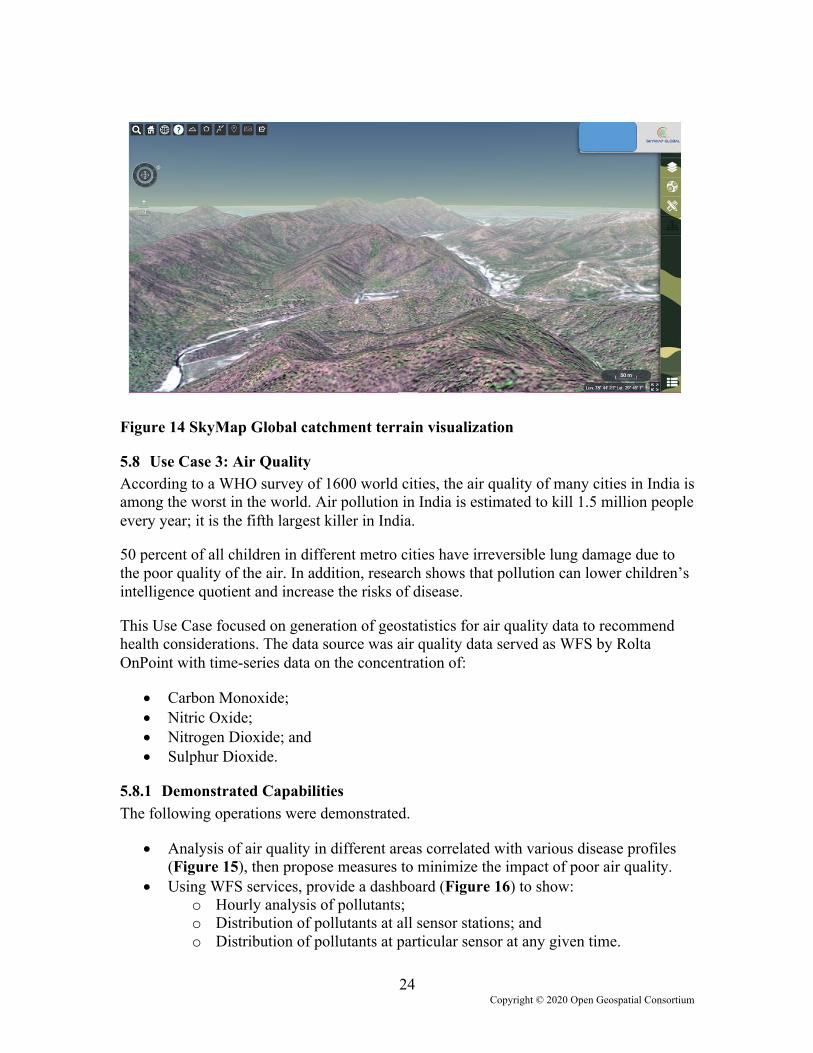
Figure 14 SkyMap Global catchment terrain visualization
5.8 Use Case 3: Air Quality According to a WHO survey of 1600 world cities, the air quality of many cities in India is among the worst in the world. Air pollution in India is estimated to kill 1.5 million people every year; it is the fifth largest killer in India.
50 percent of all children in different metro cities have irreversible lung damage due to the poor quality of the air. In addition, research shows that pollution can lower children’s intelligence quotient and increase the risks of disease.
This Use Case focused on generation of geostatistics for air quality data to recommend health considerations. The data source was air quality data served as WFS by Rolta OnPoint with time-series data on the concentration of:
• Carbon Monoxide; • Nitric Oxide; • Nitrogen Dioxide; and • Sulphur Dioxide.
5.8.1 Demonstrated Capabilities The following operations were demonstrated.
• Analysis of air quality in different areas correlated with various disease profiles (Figure 15), then propose measures to minimize the impact of poor air quality.
• Using WFS services, provide a dashboard (Figure 16) to show: o Hourly analysis of pollutants; o Distribution of pollutants at all sensor stations; and o Distribution of pollutants at particular sensor at any given time.

25 Copyright © 2020 Open Geospatial Consortium
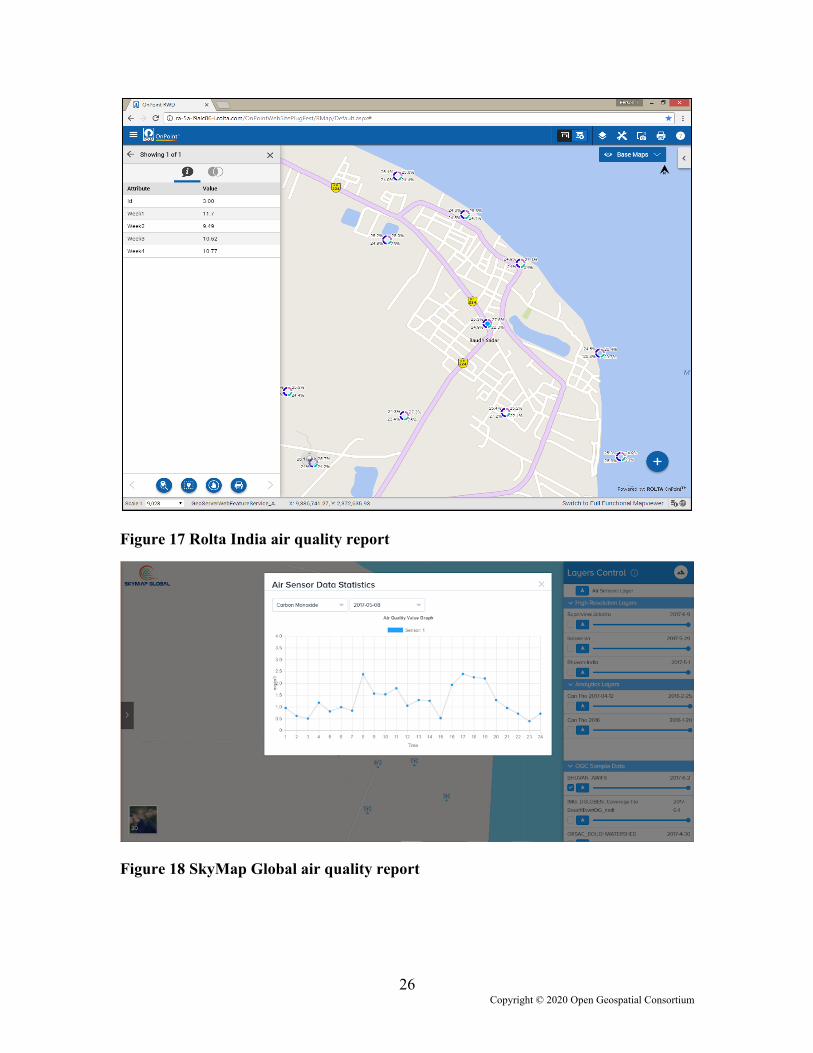
• Using WFS services, display charts indicating air quality: o Show weekly average of nitrogen dioxide as charts on the map; o Show detailed chart for the weekly report by selecting a sensor from a
map (Figure 17 and Figure 18).
Figure 15 Esri India correlation of air quality and disease profiles
Figure 16 Hexagon Geospatial dashboard for air pollutants
26 Copyright © 2020 Open Geospatial Consortium
Figure 17 Rolta India air quality report
Figure 18 SkyMap Global air quality report

27 Copyright © 2020 Open Geospatial Consortium
5.9 Use Case 4: Health This Use Case focused on generation of geostatistical measures to identify trends in illness or disease spread and to answer the question: “are these trends tied to water/wastewater infrastructure?”
The Constitution of India makes health in India the responsibility of the state governments. Every state is responsible for "raising the level of nutrition and the standard of living of its people and the improvement of public health as among its primary duties."
With increase in population and poor availability of sufficient health infrastructure, it is becoming a challenging to manage and plan effective utilization of available resources.
In the recent past, an increase in the number of instances of health issues and spread of various communicable and non-communicable diseases has created a major challenge for Health Agencies to manage and implement effective control measures.
5.9.1 Demonstrated Capabilities The following operations were demonstrated.
• Prepare synthetic data of health infrastructure, health data, and statistical units (wards) and publish synthetic data via WFS.
• Using multiple WFS Services, search for nearby health facilities and calculate an optimum route for transportation to the nearest facility (Figure 19).
• Using WFS Services, provide a dashboard showing: o Distribution of communicable diseases across all of the wards (Figure
20); and o Identification of wards which have a larger number of cases for a specific
disease. • Provide analytics for various diseases over a period of time for selected
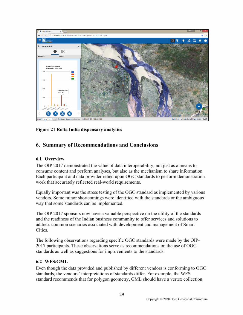
dispensaries (Figure 21).

28 Copyright © 2020 Open Geospatial Consortium
Figure 19 Esri India facility search and routing
Figure 20 Hexagon Geospatial ward-based statistics
29 Copyright © 2020 Open Geospatial Consortium
Figure 21 Rolta India dispensary analytics
6. Summary of Recommendations and Conclusions
6.1 Overview The OIP 2017 demonstrated the value of data interoperability, not just as a means to consume content and perform analyses, but also as the mechanism to share information. Each participant and data provider relied upon OGC standards to perform demonstration work that accurately reflected real-world requirements.
Equally important was the stress testing of the OGC standard as implemented by various vendors. Some minor shortcomings were identified with the standards or the ambiguous way that some standards can be implemented.
The OIP 2017 sponsors now have a valuable perspective on the utility of the standards and the readiness of the Indian business community to offer services and solutions to address common scenarios associated with development and management of Smart Cities.
The following observations regarding specific OGC standards were made by the OIP-2017 participants. These observations serve as recommendations on the use of OGC standards as well as suggestions for improvements to the standards.
6.2 WFS/GML Even though the data provided and published by different vendors is conforming to OGC standards, the vendors’ interpretations of standards differ. For example, the WFS standard recommends that for polygon geometry, GML should have a vertex collection.

30 Copyright © 2020 Open Geospatial Consortium
However, in different implementations, some return a list of points as list of points <gml:poslist></gml:poslist>while others return multiple <gml:pos> tags.
Recommendation: Remove ambiguity in a future version WFS to clarify exact GML structure required.
6.3 CityGML There is still significant variability in the level of integration of CityGML into software products. CityGML is a complex standard, is evolving, but is increasingly gaining acceptance for applications in Smart Cities. Maturity of implementations and the standard will facilitate uptake.
Recommendation: The CityGML (LOD 1 & 2) used during OIP-2017 was very suitable for an operational environment.
6.4 WFS, WMS and WMTS All industry participants demonstrated consumption of services listed in using WFS and WMS. All applications were able to execute the scenarios without difficulty and the queries resulted in the expected results from the services. In select scenarios, there was difficulty in demonstrating the full potential of WMTS.
Recommendation: WFS and WMS have reached maturity in the marketplace such that interoperability of data amongst software platforms can be consistently realized. There is a need to raise awareness in use of WMTS.
6.5 WPS OIP-2017 did not formally include demonstration of compliance with WPS. However, some participants extended their demonstration to show WPS, in particular, for change detection.
Recommendation: Include and promote WPS in future a Plugfest.
6.6 Conclusions The Plugfest demonstrated that geospatial interoperability works. Using OGC open standards with existing off-the-shelf and open source software tools, the industry participants could consume data published by NSDI from its clearinghouse. Experience gained during OIP-2017 will be useful for development of data and applications in collaboration for the Smart Cities Mission and other Programs of national importance to the Government of India.
OGC open standards GML and WFS are mature enough to be deployed in an operational environment. There is a need to raise more awareness in the use and potential benefits of WMTS in India.
CityGML is getting due attention. LOD1 data has wide acceptance. LOD2, LOD3 and LOD4 data need further attention for demonstrating applications (rooftop solar, noise pollution, air pollution, disaster management, etc.) in Smart Cities and other scenarios.

31 Copyright © 2020 Open Geospatial Consortium
Industry participants acknowledged the efficacy of conducting a Plugfest for data standardization and collaboration in building datasets and analytical output. This Plugfest provided an opportunity for NSDI/ DST to appreciate the value of participation of industries in building SDI through partnership.