NOT FOR REPRODUCTION - OGC Portal
9
Introduction - The Interoperability Challenge Digital ocean observation systems serve many purposes, such as ocean research, engineering, resource exploitation and management, transportation, recreation, weather forecasting and disaster management. In all these domains, the transition from analog to digital ocean observation systems was motivated largely by two benefits: digital devices offer the potential to be efficiently connected with other digital devices, and digital communication enables flexible one-way, two-way, one- to-many and many-to-one exchanges of information. Satellites, monitoring buoys, research vessels, and autonomous underwater vehicles carry a wide range of sensors. Though some sensors are application-specific, in many cases sensors measure phenomena that are useful to a wide variety of research and user communities. Some parameters of general interest include surface water temperature, atmospheric pressure, cloud cover, salinity, wind speed, wave height, plankton count, and ocean current speed and direction. There is great value in sharing ocean sensor data, because ocean sensors are expensive. The sensors themselves are sometimes inexpensive, but because the oceans are huge and inhospitable to electronics, the cost of fielding, maintaining and communicating with sensors makes sharing ocean observation data an attractive proposition. Due to the diversity of sensor types and the phenomena they measure, developing standards has required considerable thought and effort. There are multiple schemes for controlling sensors, and the universe of legacy systems for collecting, storing and using atmospheric, ocean and biological data is very broad. “Sharing” in the context of the modern Internet computing environment is not a matter of sharing data by Mark Reichardt An Eye on Poseidon, Vol. 3, No. 3, 2008 41 NOT FOR REPRODUCTION Copyright Journal of Ocean Technology 2008
-
Upload
khangminh22 -
Category
Documents
-
view
0 -
download
0
Transcript of NOT FOR REPRODUCTION - OGC Portal

Introduction - The Interoperability ChallengeDigital ocean observation systems serve many purposes,such as ocean research, engineering, resourceexploitation and management, transportation, recreation,weather forecasting and disaster management. In allthese domains, the transition from analog to digital oceanobservation systems was motivated largely by twobenefits: digital devices offer the potential to be efficientlyconnected with other digital devices, and digitalcommunication enables flexible one-way, two-way, one-to-many and many-to-one exchanges of information.
Satellites, monitoring buoys, research vessels, andautonomous underwater vehicles carry a wide range ofsensors. Though some sensors are application-specific,in many cases sensors measure phenomena that areuseful to a wide variety of research and usercommunities. Some parameters of general interestinclude surface water temperature, atmospheric
pressure, cloud cover, salinity, wind speed, wave height,plankton count, and ocean current speed and direction.There is great value in sharing ocean sensor data,because ocean sensors are expensive. The sensorsthemselves are sometimes inexpensive, but because theoceans are huge and inhospitable to electronics, the costof fielding, maintaining and communicating with sensorsmakes sharing ocean observation data an attractiveproposition.
Due to the diversity of sensor types and the phenomenathey measure, developing standards has requiredconsiderable thought and effort. There are multipleschemes for controlling sensors, and the universe oflegacy systems for collecting, storing and usingatmospheric, ocean and biological data is very broad.
“Sharing” in the context of the modern Internetcomputing environment is not a matter of sharing data
by Mark Reichardt
An Eye on Poseidon, Vol. 3, No. 3, 2008 41
NOT FOR REPRODUCTION
Copyright Journal of Ocean Technology 2008

files, but instead usingWeb Services, consistentinterfaces, and communitycontent models. Evenscientists, who in manycases are comfortablemanaging bits and bytes,are beginning to expecttools and data sharingpolicies that do not requirefile management tasks. Nofiles are managed directlyby users of MapQuest orGoogle Earth; usersinstead use mouse clicksto invoke Web Servicesthat automatically query remote Web-resident databasesand deliver results. The standards described in this paperare specifications for software interfaces (applicationprogramming interfaces, or APIs), XML encodings andbest practices that work with the Web’s underlying WebServices infrastructure to provide scientists with similareconomy of effort.
Open Standards for Ocean SensorsSince 2000, the Open Geospatial Consortium (OGC)membership has had a domain community, the SensorWeb Enablement Working Group (SWE WG), focused onstandards for sensor description and Web access. TheSWE WG Charter states: “OGC members are specifyinginteroperability interfaces and metadata encodings thatenable real time integration of heterogeneous sensorwebs into the information infrastructure. Developers willuse these specifications in creating applications,platforms, and products involving Web-connected devicessuch as flood gauges, air pollution monitors, stress gaugeson bridges, mobile heart monitors, Webcams, and robotsas well as space and airborne earth imaging devices.”
SensorML (Sensor Markup Language), a specificationinitially developed under a NASA Advanced InformationSystems Technology (AIST) Program, was brought into theOGC in 2000 as candidate OGC standard. SensorML isused to describe sensor models and collection processes
using XML schema. SensorML became the first focus ofthe SWE WG. Member-approved OGC OpenGIS®standards (http://www.opengeospatial.org/standards) andOGC Best Practices (http://www.opengeospatial.org/standards/bp) that relate specifically to sensors nowinclude:
�Sensor Model Language (SensorML) EncodingStandard – Used to define the general models andXML encodings for sensors.
�Observations & Measurements (O&M) EncodingStandard – Used to define the general models andXML encodings for sensor observations andmeasurements.
�Sensor Observation Service (SOS) InterfaceStandard – Provides an open applicationprogramming interface (API) for managingdeployed sensors and retrieving sensor data andspecifically “observation” data.
�OpenGIS Sensor Planning Service (SPS) InterfaceStandard – Provides an open API for a service bywhich a client can 1) determine the feasibility ofcollecting data from one or more mobilesensors/platforms and 2) submit collection requeststo these sensors/platforms.
�Web Notification Service (WNS) (OGC BestPractice) – Provides an open API for a service bywhich a client may conduct asynchronous dialogues
Figure 1: Standards make it possible for ocean sensors to become part of the World Wide Web.
OGC
42 THE JOURNAL OF OCEAN TECHNOLOGY • Essays
NOT FOR REPRODUCTION
Copyright Journal of Ocean Technology 2008

(message interchanges) with one or more otherservices.
�Sensor Alert Service (SAS) (OGC Best Practice) canbe compared with an event notification system. Thesensor node is the object of interest.
�Transducer Markup Language (TML) EncodingStandard – Used to define an application andpresentation layer communication protocol forexchanging live streaming or archived data(including control data) to and/or from any sensorsystem.
All of these except WNS and SAS have now been formallyadopted by the membership as OGC standards. Togetherwith the other OGC standards, they comprise an openframework for exploiting Web-connected sensors andsensor systems of all types. The SWE standards alsosupport improved management and discovery of storedsensor data and improved use of Web services forprocessing data.
SWE standards have been and continue to bedeveloped in cooperation with other standardsorganizations such as IEEE Technical Committee 9(Smart Sensor 1451 standard), the World Wide Web
Consortium (W3C), OASIS, and the Internet EngineeringTask Force (IETF).
IEEE 1451 is “A Standard for Smart Transducer Interfacefor Sensors and Actuators.” “Smart sensors” are sensorsthat handle their own acquisition and conversion of datainto a calibrated result in the units of the physicalattribute being measured. The OGC-IEEE collaborationfocused on finding a universal way of connecting twobasic interface types – transducer interfaces andapplication interfaces. Specifications for transducerinterfaces typically mirror hardware specifications, whilespecifications for service interfaces mirror applicationrequirements. The sensor interfaces and applicationservices may need to interoperate and may need to bebridged at any of many locations in the deploymenthierarchy. As a result of the OGC’s collaboration with theIEEE 1451 standards working group, many legacy sensornetworks and sensor control systems can now beintegrated with other Web-based sensor networks thatuse OGC standards to interface to the Web and, inparticular, the “geospatial Web” enabled by the OGC’sother standards. The standards can be used together toincrease the utility, reuse and mobilization of new sensorsinto programs, systems and enterprises.
Figure 2: OGC SWE and IEEE 1451 sensor standards are complementary.
OGC
An Eye on Poseidon, Vol. 3, No. 3, 2008 43
NOT FOR REPRODUCTION
Copyright Journal of Ocean Technology 2008

At the application level, developers of Web-based oceansensor systems can use OGC standards to make sensorsdiscoverable, accessible, and controllable. They can spendless time custom coding and focus instead on userrequirements and deploying operation applications thatmeet community needs. Further, standards-basedapproaches ensure that systems can be easily expandedand integrated with other current and future systems(future proofing). Standards-based software componentsare more reusable and can more easily be integrated withtools and components from different technology providers.Standards-based products have greater market reach.
Users of ocean standards-based sensor systems canexploit new or extended application capabilities. Forexample, using the OGC SPS and SOS interfacestandards, water temperature sensors in an ocean regioncan be sampled at frequent intervals and those readingscan then be aggregated as a map layer in any number ofclient applications, fed into a modeling workflow, orprovided as RSS feeds into a news aggregator – all withno changes to the sensor description or the interfaceused to access the sensors.
The OpenGIS Catalogue Service (Web) Interface Standard(CS-W) provides a standard mechanism for interfacingand accessing metadata on resources and services.CS-W enabled repositories can provide online access tosensor descriptions, sensor observation archives and/orWeb accessible sensor assets. For example, SensorMLcan be used to describe a sensor and the processesassociated with that sensor. The SensorML descriptionscan be stored in a registry of sensor descriptions. ACS-W enabled application can then be used to ask thequestion, “Find all sensors that measure surfacetemperature in the Indian Ocean and return the sensordescriptions.” Another example is the ability to describe acollection of archived sensor observations using the ISO19115 metadata standard. Again, such metadata can bemade discoverable and accessible using an OGCCatalogue interface. The ability to describe sensor assetsand resources in a standard way as XML schemas, usingstandard metadata tools, enables communities ofpractice to more easily derive and use pared-downcommon “application schemas” that meet communityneeds.
Figure 3: This figure depicts OGC SWE and IEEE 1451 standards used in ocean applications. Various kinds of sensors, some in IEEE 1451configurations, are discoverable and Web-accessible via SWE interfaces, in diverse architectures and applications, with geospatial context.
OGC
44 THE JOURNAL OF OCEAN TECHNOLOGY • Essays
NOT FOR REPRODUCTION
Copyright Journal of Ocean Technology 2008
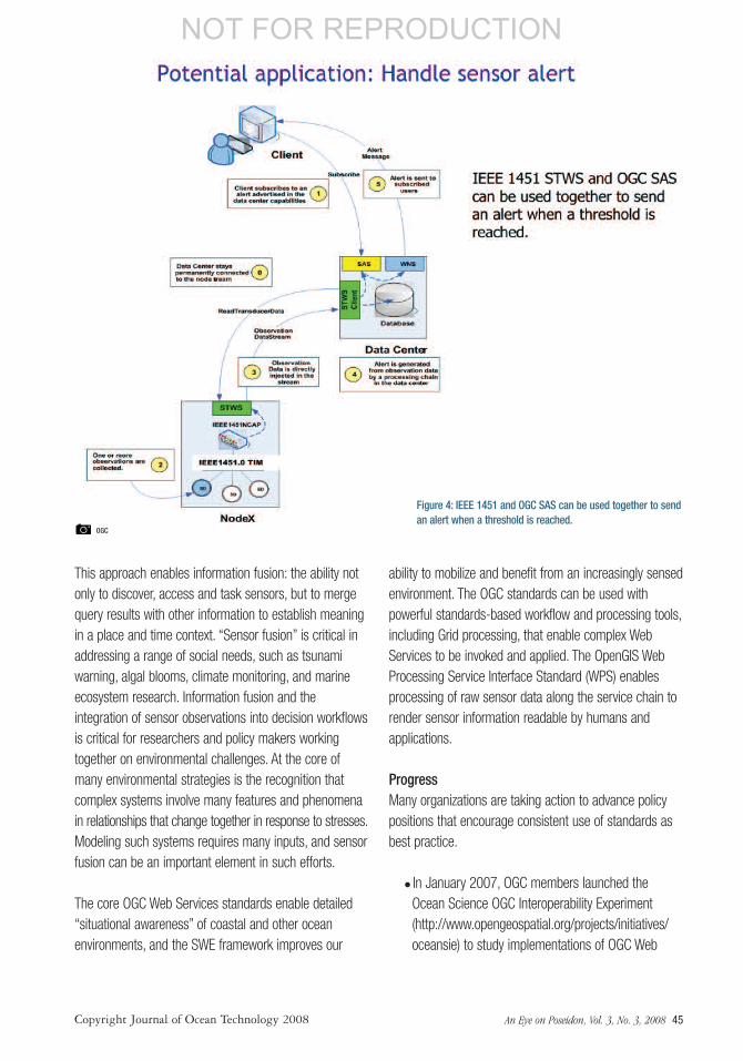
This approach enables information fusion: the ability notonly to discover, access and task sensors, but to mergequery results with other information to establish meaningin a place and time context. “Sensor fusion” is critical inaddressing a range of social needs, such as tsunamiwarning, algal blooms, climate monitoring, and marineecosystem research. Information fusion and theintegration of sensor observations into decision workflowsis critical for researchers and policy makers workingtogether on environmental challenges. At the core ofmany environmental strategies is the recognition thatcomplex systems involve many features and phenomenain relationships that change together in response to stresses.Modeling such systems requires many inputs, and sensorfusion can be an important element in such efforts.
The core OGC Web Services standards enable detailed“situational awareness” of coastal and other oceanenvironments, and the SWE framework improves our
ability to mobilize and benefit from an increasingly sensedenvironment. The OGC standards can be used withpowerful standards-based workflow and processing tools,including Grid processing, that enable complex WebServices to be invoked and applied. The OpenGIS WebProcessing Service Interface Standard (WPS) enablesprocessing of raw sensor data along the service chain torender sensor information readable by humans andapplications.
ProgressMany organizations are taking action to advance policypositions that encourage consistent use of standards asbest practice.
� In January 2007, OGC members launched theOcean Science OGC Interoperability Experiment(http://www.opengeospatial.org/projects/initiatives/oceansie) to study implementations of OGC Web
Figure 4: IEEE 1451 and OGC SAS can be used together to sendan alert when a threshold is reached.
OGC
An Eye on Poseidon, Vol. 3, No. 3, 2008 45
NOT FOR REPRODUCTION
Copyright Journal of Ocean Technology 2008
Service (OWS) standards being used by the ocean-observing community and to recommend bestpractices.
�One of these OGC members, the Gulf of MaineOcean Observing System (GoMOOS)(www.gomoos.org/), aims to predict coastal events,promote understanding of natural systems, and solveproblems that affect commerce and public safety inthe coastal waters of the Northeastern US
�GoMOOS is also an active partner in the IntegratedOcean Observing System (OpenIOSS) project(http://www.openioos.org/). OpenIOSS is ademonstration portal application for visualizingprovisional information products produced by theSoutheastern Universities Research Association (SURA)Coastal Ocean Observing and Prediction (SCOOP)system (http://scoop.sura.org/). SCOOP partnersinclude federal agencies and US research universities.
�Another active partner in such activities is the MarineMetadata Interoperability (MMI) project(http://marinemetadata.org/), which seeks to promotecollaborative research in the marine sciences bysimplifying the complex world of metadata.
�The OOSTethys (http://www.oostethys.org/)program is developing cookbooks, referencematerials, and software to enable a “system-of-systems” of linked data providers in the marinedomain based on OGC standards, with a focus onsensors. Participants from this effort are involved inand are sharing their knowledge with participants ofthe OGC Ocean Interoperability Experiment. Theirwebsite is the community portal for the OGC OceansScience Interoperability Experiment.
�GMES is the EU Global Monitoring for Environmentand Security program (http://www.gmes.info). TheEU’s InterRisk project (Interoperable GMES Servicesfor Environmental Risk Management in Marine andCoastal Areas of Europe) (http://interrisk.nersc.no/) isdeveloping a pilot system for environmentalmanagement. Also, the European Sea Floor ObservatoryNetwork (ESONET) (http://www.oceanlab.abdn.ac.uk/research/esonet.php) is a proposed 10-region sub-sea GMES project to provide strategic long termmonitoring capability in multiple sciences.
InterRisk and ESONET will utilize SWE and IEEEstandards.
�SeaDataNet, a Pan-European project to provideInfrastructure for Ocean and Marine Data Management(http://www.seadatanet.org/) and the UK Met(Meteorology) Office’s DEWS (DeliveringEnvironmental Web Services) project (http://www.dews.org.uk) are using OGC standards. The EUCC(EU Coastal Union) (http://www.eucc.nl/) promotesstandards-based interoperability and facilitatesstakeholder involvement in MOTIIVE (the EU MarineOverlays on Topography for Annex II Valuation andExploitation) (http://www.motiive.net).
�MOTIIVE and the Australian Oceans Portal project(http://www.aodc.gov.au/index.php?id=34) arecollaborating on a registry to deliver OGC standards-driven query models, presentation resources andprocessing chains.
�A global effort that touches these programs is theGlobal Earth Observing System of Systems (GEOSS).Development of GEOSS interoperability is led by theGEO Architecture and Data Committee of the Groupon Earth Observations (GEO). Several of the GEOSSdemonstrations that OGC has supported with ISPRSand IEEE have had an oceans focus. OGC is leadingthe GEOSS Architecture Implementation Pilot, whichinvolves over 120 organizations.
� In the US, the NOAA IOOS program made a recentdecision to leverage SWE as the basis forinteroperability of sensors. Also the US Departmentof Defense and coalition partners have adopted OGCand ISO standards for interoperability across militaryoperations, including naval operations.
Work RemainsEven with the great strides made in the last few years,there is still work to be done in developing technicalstandards and there is even more work to be done at theinstitutional policy level.
Though this framework of sensor standards is fullycapable of addressing a wide range of requirements incommunities such as the oceans community, furtherstandards work is ongoing in a number of areas:
46 THE JOURNAL OF OCEAN TECHNOLOGY • Essays
NOT FOR REPRODUCTION
Copyright Journal of Ocean Technology 2008

�Collaboration with the Open Grid Forum (OGF)(www.ogf.org/) to address improved standardsharmonization, tools and best practices for grid-based processing that could be used with live andstored sensor data.
�The standards that govern how geospatial digitalrights management will operate in a Web servicesenvironment are working their way forward in theOGC’s Geospatial Rights Management (GeoRM)Working Group (http://www.opengeospatial.org/projects/groups/geormwg). GeoRM standards mustaddress a wide range of inescapable real worldrequirements that are not addressed by simplepermissive/restrictive, open/closed approaches. Thestandards must make it possible to provide data —including oceans data — under different terms fordifferent circumstances. GeoRM will help institutionsresolve many of the non-technical issues thatimpede wider use of SWE standards.
�Concerted effort is needed to apply metadatastandards, frameworks and associated applicationsto processes involving information semantics. TheOGC’s Geosemantics Working Group(http://www.opengeospatial.org/projects/groups/semantics) is playing a role in this as they elaboratethe concepts of the Semantic Web (http://www.w3.org/2001/sw) and of spatial data infrastructures intothe Geosemantic Web (http://colab.cim3.net/file/work/Expedition_Workshop/2006-02-21_GeoSpatialandDRMCoPs/JLieberman02212006.ppt).
The ocean community of researchers, scientists, decisionmakers, sensor manufacturers and software technologyvendors need to work toward a common set of bestpractices regarding the use of standards. Also, institutionsand communities that are dissatisfied with the existingstandards need to get involved in the standards process.Only through such collaborative efforts can the oceancommunity accelerate their ability to:
Figure 5: Geospatial Rights Management (GeoRM) standards will make it easier for organizations to establish data access policies.
OGC
An Eye on Poseidon, Vol. 3, No. 3, 2008 47
NOT FOR REPRODUCTION
Copyright Journal of Ocean Technology 2008

�Rapidly mobilize new Web services as needed�Reduce integration and systems operational costs� Improve the competitive market environment forvendors offering relevant technologies
�Enhance the ability to share information rapidly, andapply this information for enhanced decision making.
Next StepsScience today is much more focused than before onstudying relationships in systems — ecosystems, socialsystems, complex adaptive systems, and theenvironmental and social “externalities” of economicactivities. The need for oceans data increases with thecomplexity of such analysis and also with the urgency ofthe problems that ocean research seeks to address. Theefforts described above are creating a web accessible,shared information environment that enables
researchers, scientists, and policy makers to betteraddress the critical ecological and political issuesinvolving humans and the world’s oceans. The nextimportant milestones involve leveraging the significantstandards work in the sensor area by evolving a set ofstandards-related best practices and policy guidance thatcan be readily adopted by the vendor and user communitiesto accelerate the pace toward greater plug and playinteroperability of sensors and sensor networks. �
Mark Reichardt is President and CEO of theOpen Geospatial Consortium (OGC), aconsensus standards organization foundedin 1994 to make geospatial informationresources, including sensors, an integral
part of the world’s information and communicationstechnology infrastructure.
View live data at www.axystechnologies.comEmail: [email protected] T: 1+250-655-5860 F: 1+250-655-5856
NOAA: AXYS’ WatchKeeper™ buoy collects data using the WatchMan500™.Data is sent to shore using Verizon’s CDMA cellular network. This dynamic yet flexible payload provides system operators the ability to manage and control a specific sensor or entire buoy system from their office. NOAA has created acustomized data display website for the benefit of K-12 students, teachers andrecreational enthusiasts, mariners and oceanographers.
Marine Institute of Memorial University of Newfoundland:The AXYS 3 Metre ‘Smart’ buoy is part of SmartBay a marine scientifi c observing network located at Placentia Bay along Newfoundland’s
southern coast. Smart Bay links in several buoys along the Newfoundland coastline, providing real time access to a variety
of marine and oceanographic data.
48 THE JOURNAL OF OCEAN TECHNOLOGY • Essays
NOT FOR REPRODUCTION
Copyright Journal of Ocean Technology 2008

PublishingThe Journal of Ocean Technology is designed tocater to all segments of the global ocean technologycommunity. Its mission is to expand global knowledgeand understanding of ocean technologies, to serve asthe medium for publishing world-leading research andto promote innovation that contributes to responsibleocean exploitation and management. To do this weseek out and publish (1) essays by acknowledgedleaders that highlight selected themes and (2) peerreviewed technical papers that describe cutting edgeresearch in ocean engineering, science and technology.
Essays on a ThemeThe JOT publishes essays that describe key issuesfor the oceans community in a concise manner, usingeasily understandable language. Submitted essaysshould be both educational and thought provoking.Essay topics should align with a theme that has beenidentified in the publication schedule. Essays shouldbe 3,000 words or less in length.
Reviews and PapersEach issue of the JOT features approximately threepeer review papers. While the JOT prefers papersbased on the theme for a particular issue, unsolicitedthemes and papers are also welcome. Abstracts shouldbe 500 words or less in length. Papers for reviewshould be 7,500 words or less in length. The lead-timefrom initial expression of interest through to publicationcan be as short as three months.
How to SubmitAuthors interested in publishing reviews or papers in theJOT should send their enquiries to [email protected]. Essays should be sent [email protected].
What to SubmitPapers must be submitted in MS Word format.Please do not embed photos or illustrations in theWord document. Photos and illustrations mustbe submitted separately in JPEG format with aminimum resolution of 300 dpi in the final dimension.
When to SubmitAbstracts for peer review papers must be submittedfor consideration at least three months prior to thepublication date. Essays must be submitted nolater than one month prior to the publication date.
SubscribingIssues of the JOT are only available by prepaidsubscription. The JOT is published quarterly inJanuary, April, July and October. For furtherinformation and to subscribe, visit our website atwww.journalofoceantechnology.com/subscribe.asp.
Publishing and Subscribing
An Eye on Poseidon, Vol. 3, No. 3, 2008 49
NOT FOR REPRODUCTION
Copyright Journal of Ocean Technology 2008