The Open Geospatial Consortium OGC Reference Model
72
The Open Geospatial Consortium Date: 2011-12-19 Document Type: Informative/Educational Reference number: OGC 08-062r7 http://www.opengis.net/doc/orm/2.1 Version: 2.1 OGC Reference Model Copyright notice Copyright © 2011 Open Geospatial Consortium To obtain additional rights of use, visit http://www.opengeospatial.org/legal/. Warning
-
Upload
independent -
Category
Documents
-
view
0 -
download
0
Transcript of The Open Geospatial Consortium OGC Reference Model
The Open Geospatial ConsortiumDate: 2011-12-19
Document Type: Informative/Educational
Reference number: OGC 08-062r7http://www.opengis.net/doc/orm/2.1
Version: 2.1
OGC Reference Model
Copyright notice
Copyright © 2011 Open Geospatial Consortium To obtain additional rights of use, visithttp://www.opengeospatial.org/legal/.
Warning

OGC 08-062r7 OGC Reference Model
This document is not an OGC Standard. This document isprovided as an educational description of the standards workof the OGC. This document is subject to change without noticeand may not be referred to as an OGC Standard. Please do notspecify this document as mandatory or normative inprocurements or policy. This is an informative document.
Recipients of this document are invited to submit, with theircomments, notification of any relevant patent rights of whichthey are aware and to provide supporting documentation.
Copyright © 2011 Open Geospatial Consortiumii
OGC 08-062r7 OGC Reference Model
License AgreementPermission is hereby granted by the Open Geospatial Consortium, Inc. ("Licensor"), free ofcharge and subject to the terms set forth below, to any person obtaining a copy of thisIntellectual Property and any associated documentation, to deal in the IntellectualProperty without restriction (except as set forth below), including without limitation therights to implement, use, copy, modify, merge, publish, distribute, and/or sublicensecopies of the Intellectual Property, and to permit persons to whom the IntellectualProperty is furnished to do so, provided that all copyright notices on the intellectualproperty are retained intact and that each person to whom the Intellectual Property isfurnished agrees to the terms of this Agreement.
If you modify the Intellectual Property, all copies of the modified Intellectual Propertymust include, in addition to the above copyright notice, a notice that the IntellectualProperty includes modifications that have not been approved or adopted by LICENSOR.
THIS LICENSE IS A COPYRIGHT LICENSE ONLY, AND DOES NOT CONVEY ANY RIGHTS UNDER ANY PATENTSTHAT MAY BE IN FORCE ANYWHERE IN THE WORLD.
THE INTELLECTUAL PROPERTY IS PROVIDED "AS IS", WITHOUT WARRANTY OF ANY KIND, EXPRESS ORIMPLIED, INCLUDING BUT NOT LIMITED TO THE WARRANTIES OF MERCHANTABILITY, FITNESS FOR APARTICULAR PURPOSE, AND NONINFRINGEMENT OF THIRD PARTY RIGHTS. THE COPYRIGHT HOLDER ORHOLDERS INCLUDED IN THIS NOTICE DO NOT WARRANT THAT THE FUNCTIONS CONTAINED IN THEINTELLECTUAL PROPERTY WILL MEET YOUR REQUIREMENTS OR THAT THE OPERATION OF THEINTELLECTUAL PROPERTY WILL BE UNINTERRUPTED OR ERROR FREE. ANY USE OF THE INTELLECTUALPROPERTY SHALL BE MADE ENTIRELY AT THE USER’S OWN RISK. IN NO EVENT SHALL THE COPYRIGHTHOLDER OR ANY CONTRIBUTOR OF INTELLECTUAL PROPERTY RIGHTS TO THE INTELLECTUAL PROPERTY BELIABLE FOR ANY CLAIM, OR ANY DIRECT, SPECIAL, INDIRECT OR CONSEQUENTIAL DAMAGES, OR ANYDAMAGES WHATSOEVER RESULTING FROM ANY ALLEGED INFRINGEMENT OR ANY LOSS OF USE, DATA ORPROFITS, WHETHER IN AN ACTION OF CONTRACT, NEGLIGENCE OR UNDER ANY OTHER LEGAL THEORY,ARISING OUT OF OR IN CONNECTION WITH THE IMPLEMENTATION, USE, COMMERCIALIZATION ORPERFORMANCE OF THIS INTELLECTUAL PROPERTY.
This license is effective until terminated. You may terminate it at any time by destroyingthe Intellectual Property together with all copies in any form. The license will alsoterminate if you fail to comply with any term or condition of this Agreement. Except asprovided in the following sentence, no such termination of this license shall require thetermination of any third party end-user sublicense to the Intellectual Property which isin force as of the date of notice of such termination. In addition, should theIntellectual Property, or the operation of the Intellectual Property, infringe, or inLICENSOR’s sole opinion be likely to infringe, any patent, copyright, trademark or otherright of a third party, you agree that LICENSOR, in its sole discretion, may terminatethis license without any compensation or liability to you, your licensees or any otherparty. You agree upon termination of any kind to destroy or cause to be destroyed theIntellectual Property together with all copies in any form, whether held by you or by anythird party.
Except as contained in this notice, the name of LICENSOR or of any other holder of acopyright in all or part of the Intellectual Property shall not be used in advertising orotherwise to promote the sale, use or other dealings in this Intellectual Property withoutprior written authorization of LICENSOR or such copyright holder. LICENSOR is and shall atall times be the sole entity that may authorize you or any third party to use
Copyright © 2011 Open GeospatialConsortium
iii

OGC 08-062r7 OGC Reference Model
certification marks, trademarks or other special designations to indicate compliance withany LICENSOR standards or specifications.
This Agreement is governed by the laws of the Commonwealth of Massachusetts. Theapplication to this Agreement of the United Nations Convention on Contracts for theInternational Sale of Goods is hereby expressly excluded. In the event any provision ofthis Agreement shall be deemed unenforceable, void or invalid, such provision shall bemodified so as to make it valid and enforceable, and as so modified the entire Agreementshall remain in full force and effect. No decision, action or inaction by LICENSOR shallbe construed to be a waiver of any rights or remedies available to it.
None of the Intellectual Property or underlying information or technology may bedownloaded or otherwise exported or reexported in violation of U.S. export laws andregulations. In addition, you are responsible for complying with any local laws in yourjurisdiction which may impact your right to import, export or use the IntellectualProperty, and you represent that you have complied with any regulations or registrationprocedures required by applicable law to make this license enforceable.
Copyright © 2011 Open Geospatial Consortiumiv

OGC 08-062r7 OGC Reference Model
Introduction
The OGC Reference Model (ORM) describes the OGC StandardsBaseline focusing on relationships between the baselinedocuments. The OGC Standards Baseline (SB) consists of theapproved OGC Abstract and Implementation Standards(Interface, Encoding, Profile, and Application Schema –normative documents) and OGC Best Practice documents(informative documents).
What is the purpose of the ORM?
To provide an overview of OGC Standards Baseline; To provide insight into the current state of the work
of the OGC; As a basis for coordination and understanding of the
documents in the OGC SB; To provide a useful resource for defining
architectures for specific applications.
Why Read This Document?
To better understand the OGC Standards Baseline; To better understand the ongoing work of the OGC; To gain an understanding necessary to make
contributions to the OGC process; To aid in implementing one or more of the OpenGIS
Standards.
How to read this document
Interested in an overview of the consortium? – SeeSection 1.
Interested in the geospatial information standards? –See Section 2.
Copyright © 2011 Open GeospatialConsortium
v

OGC 08-062r7 OGC Reference Model
Interested in geospatial service standards? – SeeSection 3.
Interested in OGC-based development patterns? – SeeSection 4.
Interested in implementations of OGC-based systems? –See Section 5.
The ORM contains numerous links to OGC resources. For moredetail on any topic be sure to select the link and accessthe detailed information. For example, definitions of termsused in the ORM are available in the on-line OGC Glossary
The ORM provides just an overview of the results ofextensive development by hundreds of OGC MemberOrganizations and tens of thousands of individuals who havecontributed to the development of the OGC StandardsBaseline. A revision history of the ORM is provided at theend for the document.
Copyright © 2011 Open Geospatial Consortiumvi

OGC 08-062r7 OGC Reference Model
Contents
1 The Enterprise View of OGC 61.1 Interoperability Is Essential 61.2 An Example: Web Map Service 71.3 Business Processes Benefit from Geospatial
Standards 71.4 The OGC Programs 81.5 OGC Standards and Other Documents 92 Geospatial Information 102.1 Geospatial Information Is Fundamental or
“Everything is somewhere” 102.2 Information Specifications 102.3 Spatial Referencing 102.4 Maps, KML, and PDFs 122.5 Geographic Features 132.6 Geometry and Topology 142.7 Geography Markup Language 152.8 Sensor Web Enablement Information 182.9 NetCDF192.10 Units of Measure 192.11 Geographic Metadata 202.12 GeoDRM 202.13 GeoXACML 202.14 OGC Schema Repositories 212.15 OGC Naming Authority 213 Geospatial Services 223.1 Services Architecture 223.2 OGC Web Services 233.3 OWS Web Mapping Services 233.4 OWS Data Access services 253.5 Catalogue Service for the Web 27
Copyright © 2011 Open GeospatialConsortium
vii
OGC 08-062r7 OGC Reference Model
3.6 Processing Services and Service Chaining 283.7 Sensor Web Enablement (SWE) Services 293.8 Location-Based Mobile Services 293.9 Fine-Grained Services 30
Copyright © 2011 Open Geospatial Consortiumviii
OGC 08-062r7 OGC Reference Model
4 Reusable Patterns for Deployment 324.1 Publish, Find and Bind Pattern 324.2 Geospatial Portal and Clients 334.3 Multi-Tier Architectures 354.4 Spatial Data Infrastructures 354.5 Sensor Webs 374.6 Earth Observation 384.7 Geoprocessing Workflows 384.8 Data Fusion 394.9 Building Information Modeling and Services 394.10 Events Architecture: publish/subscribe 404.11 Securing OGC Web Services 405 Implementations of OGC Standards 415.1 OGC Compliance Test Program 415.2 Registered Implementations 415.3 OGC Network, Cookbooks and Demos 425.4 Strategic implementations of OGC Standards 42Revision history 44
Copyright © 2011 Open GeospatialConsortium
ix

OGC 08-062r7 OGC Reference Model
OGC Reference Model
1 The Enterprise View of OGC1.1 Interoperability Is Essential
Standards are the basis for the success of the Internet andthe World Wide Web. The Net has reshaped how we view andshare information. Standards are a fundamental enablingtechnology of the Net. Standards allow thousands ofapplications, vendor solutions, and technologies to beinteroperable. The Net, via standards, is vendor andcontent-neutral. A standard describes requirements andrecommendations that have been agreed to in a consensusforum, such as the Internet Engineering Task Force (IETF),the International Organization for Standardization (ISO), orthe OGC. To be useful, standards should represent the "bestengineering practices" providing technical value, both inenhancement of individual products, and the multiplicativefactor of providing inter-application operability,communication and cooperation.
As described in The Importance of Going Open White Paper,non-interoperability impedes the sharing of data and thesharing of computing resources, causing organizations tospend much more than necessary on geospatial informationtechnology development. At its best, the Web works in a nearfrictionless environment, allowing data and processes toflow and interact with a minimal number of barriers.Standards tear down barriers and obstacles to the flow ofinformation and services – they make the Web as we know itpossible. OGC plays the particular role of making spatialinformation open and seamless on the Web.
The Havoc of Non-Interoperability White Paper identifiesrisks associated with non-interoperability. Today, lives andproperty depend on digital information flowing smoothly from
Copyright © 2011 Open Geospatial Consortium10

OGC 08-062r7 OGC Reference Model
one information system to another. Public safety, disastermanagement, and military applications increasingly depend oncommunication between dissimilar systems. No singleorganization produces all the data (so it's inconsistent)and no single vendor provides all the systems (so thesystems use different system architectures, which areusually based on different proprietary interfaces).
Organizations like the OGC, the IETF, the World Wide WebConsortium (W3C) and others are open organizations in thesense that any individual or organization can participate,the topics of debate are largely public, decisions aredemocratic (usually by consensus), and specifications arefree and readily available. An “open” process is necessaryto arrive at an “open” standard. The openness that OGCpromotes is part of this general progress.
Often the terms “open standards” and “open source” areconfused or incorrectly taken to mean the same thing. TheOGC standards are specifications developed in an openprocess. Open source is software made freely available undera license that allows the program to run for any purpose, tostudy how the program works, to adapt it, and toredistribute copies, including modifications. As a matter ofpolicy, the OGC Board of Directors and staff don't favoreither proprietary software or open source software. Fromthe OGC perspective, any developer who implements OGCstandards in software or online services is doing the rightthing. OGC cares about interoperability – the ability toshare geospatial information.
1.2 An Example: Web Map Service
OGC’s Web Map Service standard is an example ofinteroperability achieved through open standards. It is ofparticular importance since the "map" is a potent userinterface tool for conveying spatial information in acompact, useful and meaningful form. The Web Map Servicestandard began as discussion in the OGC Specification
Copyright © 2011 Open Geospatial Consortium 11

OGC 08-062r7 OGC Reference Model
Program that became the first OGC Interoperability Programinitiative, the Web Mapping Testbed, in 1998. The WMScandidate interface standard that was developed in the WMSTestbed was adopted as an OpenGIS ImplementationSpecification in 2000 (WMS version 1.0). Since then, WMS hasprogressed in maturity with implementations numbering in thethousands. WMS is now also published as ISO 19128.
WMS provides a simple example of how topics are discussed inthis reference model:
Section 2.3 Spatial Referencing describes coordinatereference systems (CRSs) used in WMS. CRSs are vital togeospatial interoperability;
Section 3.2 OGC Web Services describes several OGCgeospatial web services, including WMS, as acoordinated service architecture implemented withcommon elements across services;
Section 4.4 Spatial Data Infrastructures describes theuse of WMS and other OGC Web Services in a reusablepattern for deployment for worldwide SDIs.
Section 5.1 OGC Compliance Test Program describes theautomated testing resources available for all approvedOGC services; these resources allow implementers todetermine compliance with the OGC specifications.
WMS has dramatically increased the use of on-line mapping.One issue of OGC User describes the use of the WMS standardin helping with disaster response to hurricane Katrina,soils data distribution in Europe, a statewide data center,and access via mobile phones. In another OGC User article,the number of WMS servers on the Internet is seen to riseeach week as more organizations realize the power of usingopen standards. At the same time, the number of WMS clients– designed for use in a browser, or on the desktop or on amobile device – is growing.
Copyright © 2011 Open Geospatial Consortium12

OGC 08-062r7 OGC Reference Model
1.3 Business Processes Benefit from Geospatial Standards
Integrating Geospatial Standards and Standards Strategiesinto Business Process – an OGC White Paper – identified manybusiness processes that could benefit from the integrationof geospatial information and services currently do not.This is because geospatial information has been locked innon-standard systems using different information models andstorage structures – often referred to as “stove pipes.” Acommitment to interoperability and to implementing openstandards unlocks this foundational information type...
For over a decade, the OGC has been promoting the benefitsof open geoprocessing specifications. In the last severalyears, we have seen an increase in the number of policystatements regarding the use of OGC standards. The federaland national agencies involved are endorsing OGC standards.OGC members and users of OGC standards offer testimonials inan endorsements section of OGC website.
Several studies document the benefits of developing andimplementing standards. Examples of such studies include:"The Economic Benefits of Standardization," published by theDIN German Institute for Standardization, e. V. BeuthVerlag, in April, 2000; "The Value of Standards: A DelphiStudy" published in June, 2003; "Geospatial InteroperabilityReturn on Investment Study," prepared by Booz AllenHamilton, Inc. for the National Aeronautics and SpaceAdministration (NASA) in April 2005; and the Socio-EconomicImpact of the Spatial Data Infrastructure of Catalonia bythe European Commission in 2008. These reports document inROI terms the value that accrues for users, technologyproviders, and society when open standards are used. Theenterprise "return on investment" in open interfaces isunquestionable today.
Copyright © 2011 Open Geospatial Consortium 13

OGC 08-062r7 OGC Reference Model
1.4 The OGC Programs
The OGC is an international industry consortium ofcompanies, government agencies and universitiesparticipating in a consensus process to develop publiclyavailable interface standards. The OGC is organized intofour operational business areas.
In the OGC Standards Program, the OGC TechnicalCommittee and OGC Planning Committee work in a formalconsensus process to create and revise member-adoptedOpenGIS Standards.
The OGC Interoperability Program is a series ofengineering initiatives to accelerate the developmentand acceptance of OGC Standards and that OGC technologymeets user environments and needs.
The OGC Marketing and Communication Program leadsoutreach and education efforts; nurtures strategicpartnerships and alliances; and develops and supportsregional and sector programs.
The OGC Compliance Program provides a process wherebycompliance can be tested and certified - indicatingthat compliance with OGC Implementation Specificationshas been achieved.
Policies and Procedures guide the work of the OGC programs. These policies assure the openness of the OGC process, outlining how change requests and dissents are to be treatedand adjudicated so the all technically legitimate issues aretreated fairly, without prejudice and in a timely manner. OGC Policies also standardized quality control mechanisms toassure structure and relevance of OGC standards to their avowed purpose.
1.5 OGC Standards and Other Documents
The OGC technical documents have been developed by themembership to address specific interoperability challenges
Copyright © 2011 Open Geospatial Consortium14

OGC 08-062r7 OGC Reference Model
and opportunities. OGC documents are available to everyoneat no cost.
OGC publishes several different types of documents (Table1). Sections 2 and 3 of the ORM contain exclusivelyStandards, Abstract Specifications and to a lesser extentBest Practices. Other ORM sections may include other OGCDocument Types.
Copyright © 2011 Open Geospatial Consortium 15

OGC 08-062r7 OGC Reference Model
Table 1 - OGC Document TypesOGC Document Type Description OpenGISImplementationStandard
A document containing an OGC consensus,technology dependent standard for applicationprogramming interfaces and related standardsbased on the Abstract Specification or domain-specific extensions to the AbstractSpecification. There are five subtypes:Interface, Encoding, Profile, ApplicationProfile, and Application Schema.
AbstractSpecification
A document (or set of documents) containing anOGC consensus, technology-independent standardfor application programming interfaces andrelated standards based on object-oriented orother IT accepted concepts. It describes and/ormodels an application environment forinteroperable geoprocessing and geospatial dataand services products.
Best Practices A document containing discussion related to theuse and/or implementation of an adopted OGCdocument. Best Practices Documents are anofficial position of the OGC and thus representan endorsement of the content of the paper.
EngineeringReports
Documents that are a primary output of OGCInteroperability Program Initiatives (testbeds,pilot projects and interoperability experiments).ERs represent consensus positions of theinitiative participants and sponsors only. ERsbecome a publicly available document by consensusmotion of the Standards Program. An ER does notrepresent the official position of the OGC nor ofthe OGC Technical Committee.
Discussion Papers A document containing discussion of sometechnology or standard area for release to thepublic. Discussion Papers are not the officialposition of the OGC and contain a statement tothat effect.
White Papers A publication released by the OGC to the Publicthat states a position on a social, political,technical or other subject, often including ahigh-level explanation of an architecture orframework of a solution.
Copyright © 2011 Open Geospatial Consortium16
OGC 08-062r7 OGC Reference Model
OGC develops information models, usually in the form of XMLSchema documents. The general process for disseminating amodel is to publish a specification (or standard) document,and publish the XML schema to a schema repository. Basedupon the status of the specification or documentation, theschemas will be posted to one of several OGC Schemarepositories.
Copyright © 2011 Open Geospatial Consortium 17

OGC 08-062r7 OGC Reference Model
2 Geospatial Information2.1 Geospatial Information Is Fundamental or “Everything is
somewhere”
Geospatial information is a ubiquitous element of almost alldata. Whether represented as a map or an image, encoded asan address, zip code, or phone number, described in a textpassage as a landmark or event, or any of the many otherways of representing Earth features and their properties;geography is pervasive.
Geospatial location and time are integral to all aspects ofthe work in the OGC and OGC standards. Geography is afoundational property for modeling the world in a coherent,intuitive way. Location and time can be exploited as aunifying theme to better understand the context of most realand abstract phenomena.
2.2 Information Specifications
The OGC Standards Development Process creates Abstract andImplementation specifications. The purpose of the AbstractSpecification is to create and document a conceptual modelto support the creation of Implementation Specifications.Implementation Specifications are unambiguous technologyplatform specifications for implementation of industry-standard, software application programming interfaces.Geospatial domain semantics defined in the AbstractSpecifications are to be consistent across multipletechnology platforms as defined in ImplementationSpecifications.
The Information Viewpoint section of the ORM describes bothAbstract and Implementation specifications for geospatialinformation. For example, the key concepts used by GeographyMarkup Language (GML) to model the world are drawn from theOpenGIS Abstract Specification and the ISO 19100 series ofInternational Standards.
Copyright © 2011 Open Geospatial Consortium18
OGC 08-062r7 OGC Reference Model
OGC Information Specifications are used in conjunction withother information technology standards. The OGC AbstractSpecifications are used to bring geospatial semantics tomore general IT specifications, for example using the OGCCoverage specification with grid encoding formats. Elementsof the OGC GML Implementation Specification are embedded inother specifications.
2.3 Spatial Referencing
Location is contextually simple and intuitive to mostpeople. For example, people can relate to where they are ona map, follow directions to a place, readily grasping thespatial context of their local environment, and so forth.For computers to exchange geospatial data, clear definitionof the location and the spatial referencing system isrequired.
Locations can be described by using different types of spatial referencing systems:
1. Civic locations using geographic terms or identifiers;2. Coordinates as numeric values in a coordinate
reference system. 3. Linear referencing for linearly located events and
linear segments.
Civic locations may be unique identifiers or place names.Spatial referencing with identifiers occurs when theidentifier uniquely indicates a location, such as a postalcode. Place names may be ambiguous, such as “Springfield”,requiring additional information so that this place name canbe resolved into a specific location identified bycoordinates. Gazetteers and geocoding are geospatialoperations or processes used to convert a place name into ageographic coordinate. The OGC Gazetteer Service BestPractice utilizes a gazetteer data model defined inISO 19112 : “Spatial referencing by geographic identifiers.”Turn to Section 3.2 for more about the OGC GazetteerService.
Copyright © 2011 Open Geospatial Consortium 19

OGC 08-062r7 OGC Reference Model
Coordinates are a sequence of N numbers designating theposition of a point in N-dimensional space. Coordinates arealways expressed using some coordinate reference system(CRS). A coordinate reference system is a coordinate systemthat has a reference to the Earth. CRSs are defined in theOGC Abstract Specification: Topic 2 - Spatial Referencing byCoordinates, also published as ISO 19111. This document alsodescribes coordinate transformations and coordinateconversions between two different coordinate referencesystems. With such information, geographic data referred todifferent coordinate reference systems can be mergedtogether for integrated manipulation. A map projection is acoordinate conversion from a geodetic coordinate system to aplanar surface, converting geodetic latitude and longitudeto plane (map) coordinates. The result is a two-dimensionalcoordinate system called a projected coordinate referencesystem.
OGC has defined several methods for encoding CoordinateReference Systems:
The OpenGIS® Implementation Specification forGeographic Information - Simple feature access - Part1: Common architecture, also published as ISO 19125-1,defines “Well-known Text Representation of SpatialReference Systems.” The specification provides a non-exhaustive list of Geodetic Codes and Parameters fordefining the objects in the Well-Known TextRepresentation.
The OGC Best Practices Paper for Definition identifierURNs in OGC namespace specifies Universal ResourceNames (URNs) in the OGC URN namespace to be used foridentifying definitions, including definitions ofCoordinate Reference Systems (CRSs) and relatedobjects, as specified in OGC Abstract SpecificationTopic 2: Spatial referencing by coordinates. Thisdocument specifies the formats used by these URNs,including formats that can reference definitionsrecorded in the EPSG database and by other authorities.
Copyright © 2011 Open Geospatial Consortium20

OGC 08-062r7 OGC Reference Model
There are a variety of practices, specifications, andstandards for how spatial geometry coordinates (axes) areordered. Geodesy, computational geometry, graphicsprocessing, and computer-aided design – all have differentrules for specifying or encoding axis order. The OGCdeveloped an Axis Order Policy and Recommendationssummarized as “in all cases, honesty is the key”. Inother words, any documentation, encoding, payload, orservice interface must state how the coordinate axisorder is actually encoded in the coordinate strings.
The OGC Abstract Specification: Topic - Linear Referencing System (to be published) defines a conceptual schema forlocations relative to a one-dimensional object asmeasurement along (and optionally offset from) that object.It defines a description of the data and operations neededto use and support linear referencing.
2.4 Maps, KML, and PDFs
A map is a visualization of geographic information. Figure 1shows how maps differ from other types of geospatialinformation. A map may be a digital image file suitable fordisplay on a computer screen; a map is not the data itself.Examples of map encodings include jpg, gif and other filetypes.
The OGC KML Standard is an XML grammar to encode andtransport representations of geographic data for display inan earth browser, such as a 3D virtual globe, 2D web browserapplication, or 2D mobile application. Put simply: KMLencodes what to show in an earth browser, and how to showit. Geographic visualization includes not only thepresentation of graphical data on the globe, but also thecontrol of the user's navigation in the sense of where to goand where to look. The OGC KML Standard Development BestPractice provides guidelines for developing the OGC KMLstandard.
Copyright © 2011 Open Geospatial Consortium 21

OGC 08-062r7 OGC Reference Model
The OGC PDF Georegistration Encoding Best Practice describesan extension to the Adobe® Portable Document Format (PDF)for creating PDF objects that identify a region of the PDFpage as a map and describe the map’s coordinate systems. Theintent of this specification is to codify existing practice.The intent is not to make this specification an OGCstandard. An OGC Best Practice should not be referred to asa standard.
Figure 1 - Maps, Display, Features and Data (Source: WMS 1.0,OGC document 00-028)
2.5 Geographic Features
A feature is an abstraction of a real world phenomenon. Ageographic feature is a feature associated with a locationrelative to the Earth. A digital representation of the realworld can be thought of as a set of features.
The OGC approach to feature modeling follows the principlesspecified in ISO 19109:2005, “Geographic information - Rulesfor application schema.” As shown in Figure 2, Conceptualschemas define abstract feature types and provide theprocess for domain experts to develop application schemas
Copyright © 2011 Open Geospatial Consortium22

OGC 08-062r7 OGC Reference Model
that are used to encode content describing featureinstances. The developer of an application schema may usefeature definitions from feature catalogues that alreadyexist. The process for defining an application schema isdescribed in Section 2.7.3.
Figure 2 - Modeling Geographic Information (Source: ISO19109:2005)
Any feature may have a number of properties. Theseproperties may be operations, attributes or associations.Any feature may also have a number of attributes: Spatial,Temporal, Quality, Location, Metadata, Thematic. A featurecollection is a feature that represents a collection offeatures that have common metadata and formal relationships.Collections possess all the characteristics of a feature.
Geographic phenomena fall into two broad categories,discrete and continuous. Discrete phenomena are recognizableobjects that have relatively well-defined boundaries orspatial extent. Examples include buildings, streams, andmeasurement stations. Continuous phenomena vary over spaceand have no specific extent. Examples include temperature,
Copyright © 2011 Open Geospatial Consortium 23

OGC 08-062r7 OGC Reference Model
soil composition, and elevation. A value or description of acontinuous phenomenon is only meaningful at a particularposition in space (and possibly time). Temperature, forexample, takes on specific values only at defined locations,whether measured or interpolated from other locations. Theseconcepts are not mutually exclusive. In fact, manycomponents of the landscape may be viewed alternatively asdiscrete or continuous. Historically, geographic informationhas been treated in terms of two fundamental types calledvector data and raster data.
“Vector data” typically deals with discrete phenomena, eachof which is conceived of as a feature. “Raster data,” on theother hand, deals with real world phenomena that varycontinuously over space. Raster is included in the OGC the“coverage” concept. A coverage defines a data model thatassociates spatio-temporal positions to data values. Thedata attributes of a coverage vary across its spatio-temporal extent.
2.6 Geometry and Topology
Geometry provides the means for quantitative description ofthe spatial characteristics of features, includingdimension, position, size, shape, and orientation. Topologyis useful for characterizing relationships between geometricobjects without concern for the size or exact shape of theobjects.
The conceptual model for geometry and topology is containedin OGC Abstract Specification Topic 1 - Feature Geometry,also published as ISO 19107:2003 Geographic information --Spatial schema. OGC has implemented the conceptual model ofISO 19107 in the OGC Geography Markup Language as describedin Section 2.7.
A geometric object is a combination of a coordinate geometryand a coordinate reference system. In general a geometricobject is a set of geometric points, represented by directpositions. A direct position holds the coordinates for a
Copyright © 2011 Open Geospatial Consortium24

OGC 08-062r7 OGC Reference Model
position within some coordinate reference system. Typicalgeometric objects are points, lines, and polygons.
Geometric calculations such as containment (point-in-polygon), adjacency, boundary, and network tracking can becomputationally intensive. A productive use of topology isto accelerate computational geometry. Another purpose is,within the geographic information domain, to relate featureinstances independently of their geometry.
Spatial query operators are a mechanism for characterizingtopological relations between different features. Theoperators are meant mainly for query evaluation and aredefined in such a manner as to allow a variety ofimplementations to be assured of equivalent results againstdatasets with equivalent information content. The SimpleFeatures Access and the OGC Filter Encoding Implementationstandards provide typical names for spatial query operators(See Figure 3). OGC Abstract Specification Topic 1 –Geometry provides a more exhaustive standardization ofspatial operators.
Figure 3 – Spatial query operator examples
Copyright © 2011 Open Geospatial Consortium 25

OGC 08-062r7 OGC Reference Model
2.7 Geography Markup Language
2.7.1 The GML Standard
The OpenGIS® Geography Markup Language (GML) EncodingImplementation Standard is an XML grammar to expressgeographical features. GML serves as a modeling language forgeographic systems as well as an open interchange format forgeographic transactions on the Internet. The GML informationmodel is based on the ISO 19100 series of InternationalStandards and the OGC Abstract Specification. In addition,GML provides XML encodings for additional concepts not yetmodeled in the ISO 19100 series of International Standardsor the OpenGIS Abstract Specification, for example, dynamicfeatures, simple observations or value objects.
GML defines the XML Schema syntax, mechanisms andconventions that:
Provide an open, vendor-neutral framework fordescription of geospatial application schemas for thetransport and storage of geographic information inXML;
Allow profiles that support proper subsets of GMLframework descriptive capabilities;
Support the description of geospatial applicationschemas for specialized domains and informationcommunities;
Enable the creation and maintenance of linkedgeographic application schemas and datasets;
Support the storage and transport of geospatialapplication schemas and datasets;
Increase the ability of organizations to sharegeographic application schemas and the informationthey describe.
Implementers may decide to store geographic applicationschemas and information in GML, or they may decide toconvert from some other storage format on demand and use GMLonly for schema and data transport.
Copyright © 2011 Open Geospatial Consortium26

OGC 08-062r7 OGC Reference Model
The requirements of an application schema determine the XMLSchema components from the GML schema to be included in aGML profile. GML defines a variety of conformance classesthat apply depending upon the content of a specific profile.Examples of GML Conformance Classes for GML Profiles areshown in Table 2. See the GML standard for the full list.
Table 2 – Examples of Conformance Classes for GML ProfilesGeometric primitives: 0, 1, 2or 3 dimensions
Coordinate reference systems
Topologic complexes: 0, 1, 2 or3 dimensions
Coordinate operations
Temporal geometry — 0 or 1dimensions
Temporal reference systems
Temporal topology Dictionaries Dynamic features Units dictionariesObservations Abstract coverageDiscrete point coverage Discrete curve coverageDiscrete surface coverage Discrete solid coverageGrid coverage Continuous coverage
2.7.2 Profiles of GML
To promote broad use of GML, the OGC has defined severalprofiles of GML. In the OGC, a GML profile is a restrictedsubset of the full GML standard.
GML Profile Document TypeGML Simple Features profile StandardGML Common CRSs profile StandardGML CRS support profile StandardGML Grid CRSs profile StandardGML Simple dictionary profile Standard
Copyright © 2011 Open Geospatial Consortium 27

OGC 08-062r7 OGC Reference Model
2.7.3 GML Application Schemas
Designers of GML application schemas may extend or restrictthe types defined in the GML schema to define appropriatetypes for an application domain. GML application schemas useapplicable GML schema components, either directly or byspecialization, and are valid in accordance with the rulesfor XML Schema. The OGC membership has approved a number ofGML Application Schema as Standards and Best Practices:
GML Application Schema Document Type
CityGML StandardGML Application Schema - Coverages (1.0) StandardMoving Object Snapshot (adoption pending) StandardGML Application schema for Earth Observation products
Standard
GML PIDF-LO Geometry Shape Application Schema for use in the IETF
Best Practice
GML Encoding of Discrete Coverages (interleaved pattern)
Best Practice
OGC maintains an informal list of all known GML ApplicationSchemas. These schemas are not necessarily approved orendorsed by the OGC.
2.7.4 CityGML
The OpenGIS City Geography Markup Language (CityGML)Encoding Standard provides for the representation, storageand exchange of virtual 3D city and landscape models.CityGML models both complex and georeferenced 3D vector dataalong with the semantics associated with the data. Incontrast to other 3D vector formats, CityGML is based on arich, general-purpose information model in addition togeometry and appearance information. For specific domainareas, CityGML also provides an extension mechanism toenrich the data with identifiable features underpreservation of semantic interoperability.
Copyright © 2011 Open Geospatial Consortium28

OGC 08-062r7 OGC Reference Model
Targeted application areas explicitly include urban andlandscape planning; architectural design; tourist andleisure activities; 3D cadastres; environmental simulations;mobile telecommunications; disaster management; homelandsecurity; vehicle and pedestrian navigation; trainingsimulators and mobile robotics.
2.7.5 Binary encoding of XML
The Binary Extensible Markup Language (BXML) EncodingSpecification Best Practice specifies a binary encodingformat for the efficient representation of XML data,especially scientific data that is characterized by arraysof numbers. This encoding format is applicable to anyapplication that uses XML format.
Copyright © 2011 Open Geospatial Consortium 29

OGC 08-062r7 OGC Reference Model
2.8 Sensor Web Enablement Information
2.8.1 OGC SWE Standards
With sensors of all types becoming part of the globalinformation infrastructure, the OGC has approved Standardsand Best Practices designed to enable sensors to betterinteroperate with the Web and other information technologyassets. The OGC Sensor Web Enablement (SWE) is a set ofinterfaces and protocols that enable a “Sensor Web” throughwhich applications and services will be able to accesssensors of all types over the Web. Foundational componentsfor Sensor Web Enablement have defined, prototyped andtested:
Observations & Measurements (O&M) Standard Sensor Model Language (SensorML) Standard SWE Common Data Model Standard Sensor Observation Service (SOS) Standard Sensor Planning Service (SPS) Standard Sensor Alert Service (SAS) Best Practice Web Notification Service (WNS) Best Practice
The first three standards are described immediatelyfollowing. The SWE service standards are described inSection 3.7.
2.8.2 Observations and Measurements
The OGC Observations & Measurements (O&M) standard, alsopublished as ISO 19156, defines a conceptual schema forobservations, and for features involved in sampling whenmaking observations. An observation is an act at a discreteinstant or period, through which a number or term isassigned to a phenomenon using a procedure, such as asensor, instrument, or algorithm. Observations commonlyinvolve sampling of an ultimate feature of interest. The O&MStandard defines a set of sampling feature types classifiedprimarily by topological dimension.
Copyright © 2011 Open Geospatial Consortium30
OGC 08-062r7 OGC Reference Model
OGC Observations and Measurements - XML Implementationprovides an XML implementation for the OGC Observations andMeasurements (O&M) conceptual model including a schema forSampling Features. This encoding is an essential dependencyfor the OGC Sensor Observation Service (SOS) InterfaceStandard. More specifically, this standard defines XMLschemas for observations, and for features involved insampling when making observations. These provide documentmodels for the exchange of information describingobservation acts and their results, both within and betweendifferent scientific and technical communities.
2.8.3 SensorML
The OGC Sensor Model Language (SensorML) ImplementationStandard provides a framework within which the geometric,dynamic, and observational characteristics of sensors andsensor systems can be defined. SensorML enables robustdefinitions of sensor models for providing geolocation ofobservations from remote sensors. Different mathematicalmodels can be designed to define a sample location within avariety of coordinate systems, including the local sensorframe, the local frame for the associated platform, or ageographic coordinate reference frame. These can all besupported through the definition of atomic process modelsand process chains. Within SensorML, all processes andcomponents are encoded as application schema of the Featuremodel in the Geographic Markup Language (GML) Version 3.1.1.
2.8.4 SWE Common Data Model
The OGC SWE Common Data Model Encoding Standard defines low-level data models for exchanging sensor related data betweennodes of the SWE framework. These models allow applicationsand/or servers to structure, encode and transmit sensordatasets in a self-describing and semantically enabled way.The SWE Common Data Model is intended for describing staticdata (files) as well as dynamically generated datasets. Allcategories of sensor observations are in scope ranging from
Copyright © 2011 Open Geospatial Consortium 31

OGC 08-062r7 OGC Reference Model
simple in-situ temperature data to satellite imagery andfull motion video streamed out of an aircraft.
2.9 NetCDF
The OGC Network Common Data Form (NetCDF) Core EncodingStandard defines an encoding for geospatial data,specifically digital geospatial information representingspace and time-varying phenomena. NetCDF is a data model forarray-oriented scientific data. The CF-netCDF Core andExtensions Primer provides an overview of the OGC CF-netCDFstandards suite by describing the CF-netCDF core andextensions. The NetCDF Binary Encoding Extension Standard:NetCDF Classic and 64-bit Offset Format defines binaryrepresentations of space-time varying geo-referenced data.Specifically, this standard specifies the netCDF classic and64-bit offset file binary encoding formats.
2.10 Units of Measure
The Units of Measure Recommendation Best Practice providesrecommendations for use and definition of the units ofmeasure used for numerical quantities. These recommendationsare more widespread than OGC only, and are being proposed atother organizations, including POSC, W3C, CSIRO, PIDX, andOASIS.
The recommendations are stated for a single, measure value.However, many of the same structures apply to arrays andtuples of values. XML Schema and documents that capturearrays of values, and tuples of values, should consider thepatterns of these recommendations, and follow them whereappropriate.
Many of these recommendations are stated using XML and XMLSchema. These recommendations should be followed even whenXML is not being used.
Copyright © 2011 Open Geospatial Consortium32

OGC 08-062r7 OGC Reference Model
2.11 Geographic Metadata
OGC adopted ISO 19115 as the OGC Abstract Specification –Topic 11: Metadata. ISO 19115:2003, Geographic information –Metadata defines the schema for the identification, extent,quality, spatial and temporal schema, spatial reference, anddistribution of digital geographic data. These schemas areuseful for the cataloguing of datasets, clearinghouseactivities, and the full description of datasets; geographicdatasets, dataset series, and individual geographic featuresand feature properties.
The OGC Abstract Specification Topic 12 - The OpenGISService Architecture, also published as ISO 19119:2005,defines a service metadata schema for use in a catalogueservice as is done for dataset metadata.
2.12 GeoDRM
The OGC Geospatial Digital Rights Management Reference Model(GeoDRM RM) defines a conceptual model for digital rights management of geospatial resources. The GeoDRM RM provides ametadata model for the expression of rights that associate users to the acts that they can perform against a particulargeospatial resource, and associated information used in the enforcement and granting of those rights, such as owner metadata, available rights and issuer of those rights. The GeoDRM RM also defines requirements that are placed on rights management systems for the enforcement of those rights. Finally the GeoDRM RM defines how this is to work conceptually in the larger DRM context to assure the ubiquity of geospatial resources in the general services market.
2.13 GeoXACML
OGC GeoXACML is a policy language that defines a geo-specific extension to the OASIS standard eXtensible AccessControl Markup Language (XACML). GeoXACML defines anextension to XACML for spatial data types and spatial
Copyright © 2011 Open Geospatial Consortium 33

OGC 08-062r7 OGC Reference Model
authorization decision functions. Those data types andfunctions can be used to define additional spatialconstraints for XACML-based policies. GML encodings forgeometric data types are defined in GeoXACML extensions. Byusing the GeoXACML Policy Language, an interoperable accesscontrol system for geospatial applications, such as SpatialData Infrastructures, can be implemented. It is important tohighlight that GeoXACML is not designed to be a RightsExpression Language.
Copyright © 2011 Open Geospatial Consortium34

OGC 08-062r7 OGC Reference Model
2.14 OGC Schema Repositories
Many OGC specifications include XML Schemas. The schemasappear in the specification document and are published inthe OGC schema repository. Based upon the status of thespecification or documentation, the schema will be posted toone of several repositories.
OGC XML schema repository for Adopted Technology, i.e.,Implementation Standards, such as OGC's GML, SensorML,or WMS
Repository for XML schema documents related to OGC BestPractice documents.
Repository for XML schema documents related to OGCDiscussion Papers documents. Discussion Papers are notintended to be targets of acquisition descriptions.These papers do not represent the official position ofthe Open Geospatial Consortium nor of the OGC TechnicalCommittee.
Repository for experimental XML instance and schemadocuments. Documents posted here do not represent anofficial position of the OGC. This repository is forthe convenience of developers in the OGC community, andis not necessarily on track for adoption as a standard.
2.15 OGC Naming Authority
The OGC Naming Authority (OGC-NA) controls the assignment ofOGC Names to resources of interest in geographic informationinfrastructures. The scope of the resources that may beidentified with OGC Names is indicated by the set of itemsin the register http://www.opengis.net/register/ogc-na/type.A URN namespace for the Open Geospatial Consortium (OGC)Best Practice describes a URN (Uniform Resource Name)namespace for naming persistent resources published by theOGC. In June 2010, an OGC policy was approved that http
Copyright © 2011 Open Geospatial Consortium 35

OGC 08-062r7 OGC Reference Model
URIs be used to persistently identify OGC resources insteadof URNs.
Copyright © 2011 Open Geospatial Consortium36

OGC 08-062r7 OGC Reference Model
3 Geospatial Services3.1 Services Architecture
The widespread application of computers and use ofinformation systems have led to the increased analysis ofgeospatial data within multiple disciplines. Geospatialdatasets are increasingly being shared, exchanged, and usedfor purposes other than their producers’ intended ones.Geographic information systems, sensors systems, automatedmapping, facilities management, traffic analysis,geopositioning systems, and other technologies forgeospatial information are entering a period of radicalintegration.
The OGC Abstract Specification Topic 12 - The OpenGISService Architecture provides a framework for developers tocreate software that enables users to access and processgeospatial data from a variety of sources across genericcomputing interfaces within an open information technologyenvironment.
"a framework for developers" means that the OGC Standards are based on a comprehensive, common (i.e., formed by consensus for general use) plan for interoperable geoprocessing.
"access and process" means that geodata users can queryremote databases and control remote processing resources, for example in information systems using service oriented architecture.
"from a variety of sources" means that users will have access to data acquired in a variety of ways and storedin a wide variety databases and knowledge bases.
"across generic computing interfaces" means that OGC services enable reliable communication between otherwise disparate software resources that are equipped to use these interfaces.
Copyright © 2011 Open Geospatial Consortium 37

OGC 08-062r7 OGC Reference Model
"within an open information technology environment"means that this OGC standard enables geoprocessing totake place outside of the closed environment ofmonolithic GIS, remote sensing, and automated systemsthat constrain access based on proprietary interfaces.
There are multiple choices of information technology fordefining, developing and deploying service networks, i.e.,distributed computing platforms. OGC standards are definedfor multiple distributed computing platforms whilemaintaining common geospatial semantics across theunderlying technology. OGC defines one conceptualspecification as the basis for multiple platform-specificimplementation specifications.
Development of standards may proceed from conceptual toimplementation or from implementation to conceptual. Ineither case, a specification is not considered completeuntil it has a conceptual model and at least oneimplementation.
OGC services are defined using fundamental principles ofservice-oriented architecture:
A Service is a distinct part of the functionality that is provided by an entity through interfaces,
An Interface is a named set of operations that characterize the behavior of an entity,
An Operation is a specification of a transformation orquery that an object may be called to execute. Eachoperation has a name and a list of parameters.
Application and extension of the OGC Service Architecture isdescribed in The Reference Model for the ORCHESTRAArchitecture available as an OGC Best Practice.
3.2 OGC Web Services
OGC Web Services (OWS) are defined using open non-proprietary Internet standards; in particular the World Wide
Copyright © 2011 Open Geospatial Consortium38

OGC 08-062r7 OGC Reference Model
Web (WWW) standards of HTTP, Uniform Resource Locators(URLs), Multipurpose Internet Mail Extensions (MIME) typesand the Extensible Markup Language (XML).
The OGC Web Services Architecture Description Best PracticeDocument summarizes significant aspects of the OGC webservices architecture. This architecture is a service-oriented architecture, with all components providing one ormore services to other services or to clients.
The OpenGIS Web Service Common Implementation Standardprovides specifics that are common to OWS interfaceImplementation Standards. These common aspects are primarilysome of the parameters and data structures used in operationrequests and responses. Each Implementation Standard detailsadditional aspects of that interface, including specifyingall additional parameters and data structures needed in alloperation requests and responses.
OGC recognizes the need to accommodate multiple architecturestyles and patterns, e.g., SOAP and REST. By a motion in theTC meeting of December 2008, the OGC promoted “developmentof service oriented architecture standards using platform-independent abstract specifications and platform-dependentimplementation specifications for all OGC service standardsthat support both procedure-oriented and resource-orientedservice styles or patterns.” It was recognized that thisrequirement could be dropped for service standards for whichmultiple bindings or patterns are not appropriate. While OGCstandards have been developed and adopted with bindings ofseveral styles, development of bindings to new architecturalpatterns continues.
3.3 OWS Web Mapping Services
The OpenGIS Web Map Service (WMS) ImplementationSpecification, also published as ISO 19128, provides threeoperations (GetCapabilities, GetMap, and GetFeatureInfo) insupport of the creation and display of registered and
Copyright © 2011 Open Geospatial Consortium 39

OGC 08-062r7 OGC Reference Model
superimposed map-like views of information that comesimultaneously from multiple remote and heterogeneoussources.
The OpenGIS Web Map Tile Service (WMTS) provides for servingspatially referenced data using tile images with predefinedcontent, extent, and resolution. WMTS trades the flexibilityof custom map rendering – as provided by WMS – for thescalability possible by serving a fixed set of tiles. Thefixed set of tiles also enables the use of standard networkmechanisms for scalability such as distributed cachesystems. WMTS includes both resource (REST) and procedureoriented architectural styles (KVP and SOAP).
The OGC has defined profiles of WMS:WMS Profiles Document Type
Styled Layer Descriptor Profile of WMS Standard
Web Map Service - Application Profile forEO Products
Best Practice
DGIWG WMS 1.3 Profile and systemsrequirements for interoperability for usewithin a military environment
Best Practice
The OpenGIS Styled Layer Descriptor (SLD) Profile of WMS,explains how WMS can be extended to allow user-definedsymbolization of feature and coverage data. This profiledefines how the Symbology Encoding standard can be used withWMS. SLD is used in combination with SE Standard. SLD allowsfor user-defined layers and named or user-defined styling inWMS. If a WMS is to symbolize features using a user-definedsymbolization, the source of the feature data must beidentified. The features may be in a remote WFS or WCS, orfrom a specific default feature/coverage store. WMS serversusing remote feature data are also called Feature PortrayalServices (FPS), while those using remote coverage data areCoverage Portrayal Services (CPS).
Copyright © 2011 Open Geospatial Consortium40

OGC 08-062r7 OGC Reference Model
The OpenGIS Symbology Encoding (SE) Implementation Standardspecifies the format of a map-styling language for producinggeoreferenced maps with user-defined styling. SE is an XMLlanguage for styling information used to portray Feature andCoverage data. SE may be used together with SLD. As SE is agrammar for styling map data independent of any serviceinterface specification it can be used flexibly by a numberof services that style georeferenced information or storestyling information that can be used by other services.The OpenGIS Web Map Context Documents ImplementationStandard defines how a specific grouping of one or more mapsfrom one or more WMS servers can be described in a portable,platform-independent format for storage in a repository orfor transmission between clients. A Context Documentcontains sufficient information for Client software toreproduce the map, and ancillary metadata used to annotateor describe the maps and their provenance for the benefit ofhuman viewers. (Based on the success of the Web Map Context,an OGC Standards Working Group is currently developing anOGC OWS Context Document standard.)The OGC KML Standard defines an XML grammar used to encodeand transport representations of geographic data for displayin an earth browser. Put simply: KML encodes what to show inan earth browser, and how to show it. (See also Section 2.4)3.4 OWS Data Access services
3.4.1 Web Feature Service
The OpenGIS Web Feature Service (WFS) ImplementationSpecification, also published as ISO 19142, allows a clientto retrieve and update geospatial data encoded in GeographyMarkup Language (GML) from multiple Web Feature Services.The specification defines interfaces for data access andmanipulation operations on geographic features. Via theseinterfaces, a Web user or service can combine, use andmanage geodata from different sources. A Transactional WFS
Copyright © 2011 Open Geospatial Consortium 41

OGC 08-062r7 OGC Reference Model
(WFS-T) includes an optional Transaction operation toinsert, update, or delete a feature.
The OGC Gazetteer Service Best Practices Document defines anApplication Profile of the WFS Implementation Standard byspecifying a minimum set of Feature Types and operationsrequired to support an instance of a gazetteer service. Theinformation model of the standard is a GML applicationschema that defines a general feature type to be served by aGazetteer Service.
3.4.2 Web Coverage Service
The OpenGIS Web Coverage Service (WCS) Implementation Specification supports electronic retrieval of geospatial dataas "coverages" – that is, digital geospatial information representing space/time-varying phenomena. WCS provides accessto coverage data in forms that are useful for client-side rendering, as input into scientific models, and for other clients.
Similar to WMS and WFS, WCS allows clients to choose portions of a server's information holdings based on spatial constraints and other query criteria. Unlike WMS, WCS defines a rich syntax for requests against Coverages; and returns datawith its original semantics (instead of pictures) that may be interpreted, extrapolated, etc., and not just portrayed. Unlike WFS, WCS focuses on coverages as a specialized class offeatures with correspondingly streamlined functionality.
As described in the WCS 2.0: Core and Extensions Best Practice, WCS 2.0 consists of a set of normative specifications, collectively referred to as “the WCS suite”:
WCS 2.0 Interface Standard - Core GML 3.2 Application Schema for WCS A set of extensions to the WCS Core:
o KVP Protocol Binding Extension o XML/SOAP Protocol Binding Extension o XML/POST Protocol Binding Extension
Copyright © 2011 Open Geospatial Consortium42
OGC 08-062r7 OGC Reference Model
3.4.3 Web Coverage Processing ServiceThe OpenGIS Web Coverage Processing Service (WCPS) defines a language for retrieval and processing of multi-dimensional geospatial coverages representing sensor, image, or statisticsdata. The WCPS language is independent from any particular service. In a separate document, WCPS has been defined as an extension of the WCS adding a ProcessCoverages operation to form requests of arbitrary complexity allowing, e.g., multi-valued coverage results.
3.4.4 Filter Encoding
The OpenGIS Filter Encoding (FE) Implementation Standard,also published as ISO 19143, describes an XML and KVPencoding of a system neutral syntax for expressingprojections, selection and sorting clauses collectivelycalled a query expression. FE can be used with a number ofOGC web services. For example, WFS may use FE in aGetFeature operation.
3.4.5 Table Joining Service
The OpenGIS Georeferenced Table Joining Service (TJS)Implementation Standard offers a way to expose data thatcontains geographic identifiers but does not containgeographic referencing by coordinates. The geographicidentifiers are defined in a spatial framework thatpartitions the surface of the earth into a set of managementunits, e.g., postal codes. TJS allows the data to beaccessed and merged with spatial coordinates from theframework, in order to enable mapping or geospatialanalysis.
3.4.6 GeoRSS
GeoRSS (Geographically Encoded Objects for RSS feeds) is aproposal for geo-enabling, or tagging, "really simplesyndication" (RSS) feeds with location information. Thereare two GeoRSS serializations: GeoRSS GML and GeoRSS Simple.
Copyright © 2011 Open Geospatial Consortium 43
OGC 08-062r7 OGC Reference Model
GeoRSS GML is a formal GML Profile, and supports a greaterrange of features than GeoRSS Simple, notably coordinatereference systems other than WGS84 latitude/longitude.Additional information can be found in the OGC White Paper:An Introduction to GeoRSS.
Copyright © 2011 Open Geospatial Consortium44
OGC 08-062r7 OGC Reference Model
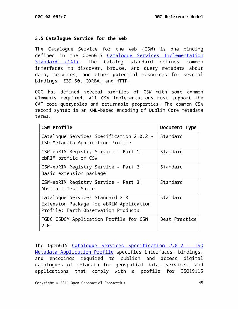
3.5 Catalogue Service for the Web
The Catalogue Service for the Web (CSW) is one bindingdefined in the OpenGIS Catalogue Services ImplementationStandard (CAT). The Catalog standard defines commoninterfaces to discover, browse, and query metadata aboutdata, services, and other potential resources for severalbindings: Z39.50, CORBA, and HTTP.
OGC has defined several profiles of CSW with some commonelements required. All CSW implementations must support theCAT core queryables and returnable properties. The common CSWrecord syntax is an XML-based encoding of Dublin Core metadataterms.
CSW Profile Document TypeCatalogue Services Specification 2.0.2 -ISO Metadata Application Profile
Standard
CSW-ebRIM Registry Service - Part 1: ebRIM profile of CSW
Standard
CSW-ebRIM Registry Service – Part 2: Basic extension package
Standard
CSW-ebRIM Registry Service – Part 3: Abstract Test Suite
Standard
Catalogue Services Standard 2.0 Extension Package for ebRIM Application Profile: Earth Observation Products
Standard
FGDC CSDGM Application Profile for CSW 2.0
Best Practice
The OpenGIS Catalogue Services Specification 2.0.2 - ISOMetadata Application Profile specifies interfaces, bindings,and encodings required to publish and access digitalcatalogues of metadata for geospatial data, services, andapplications that comply with a profile for ISO19115
Copyright © 2011 Open Geospatial Consortium 45

OGC 08-062r7 OGC Reference Model
metadata for geodata/geospatial applications and ISO19119-based metadata for tightly and loosely-coupled geospatialservices.
The several parts of the CSW-ebRIM Registry Service applyCSW to the OASIS ebXML registry information model (ebRIM3.0) providing a general and flexible web-based registryservice (WRS). WRS enables users—human or software agents—tolocate, access, and make use of resources in an open,distributed system. WRS provides facilities for retrieving,storing, and managing many kinds of resource descriptions.An extension mechanism (called Extension Packages) permitsregistry content to be tailored for more specializedapplication domains.
The Catalogue Services Standard 2.0 Extension Package forebRIM Application Profile: Earth Observation Productsstandard specifies an Extension Package for ebRIMApplication Profile of CSW 2.0. This application profileenables CSW-ebRIM catalogues to handle a variety of metadatapertaining to earth observation, like EO Products defined inthe OGC GML Application Schema for EO Products.3.6 Processing Services and Service Chaining
The OpenGIS Web Processing Service (WPS) ImplementationStandard defines an interface that facilitates thepublishing of geospatial processes, and the discovery of andbinding to those processes by clients. Processes include anyalgorithm, calculation or model that operates on spatiallyreferenced data. A WPS may offer calculations as simple assubtracting one set of spatially referenced numbers fromanother (e.g., determining the difference in influenza casesbetween two different seasons), or as complicated as aglobal climate change model. The data required by the WPScan be delivered across a network using OGC Web Services.
A WPS process may be an atomic function that performs a specific geospatial calculation. Chaining of WPS processes facilitates the creation of repeatable workflows.
Copyright © 2011 Open Geospatial Consortium46

OGC 08-062r7 OGC Reference Model
WPS processes can be incorporated into service chains in a number of ways: A BPEL engine can be used to orchestrate a service chain
that includes one or more WPS processes. BusinessProcessing Execution Language is a standard issued byOASIS.
A WPS process can be designed to call a sequence of webservices including other WPS processes, thus acting asthe service-chaining engine.
Simple service chains can be encoded as part of theexecute query. Such cascading service chains can beexecuted via the GET interface.
OGC Abstract Specification Topic 12: OpenGIS ServiceArchitecture defines service chaining as the combination ofservices in a dependent series to achieve larger tasks.Topic 12 addresses the syntactic concepts of servicechaining, e.g., data structure of a chain, and the semanticconcepts, e.g., does a specific chain produce a validresult? Service chaining enables users to combine data andservices in ways that are not pre-defined by the data orservice providers.
Copyright © 2011 Open Geospatial Consortium 47
OGC 08-062r7 OGC Reference Model
3.7 Sensor Web Enablement (SWE) Services
The goal of OGC’s Sensor Web Enablement (SWE) is to enableall types of Web and/or Internet-accessible sensors,instruments, and imaging devices to be accessible and, whereapplicable, controllable via the Web. The vision is todefine and approve the standards foundation for "plug-and-play" Web-based sensor networks.
OGC had established Web Service standards for geospatialdata:
The OpenGIS Sensor Observation Service (SOS)Implementation Standard defines a web service interfacefor requesting, filtering, and retrieving observationsand sensor system information. Observations may be fromin-situ sensors (e.g., water monitoring devices) ordynamic sensors (e.g., imagers on Earth-observationsatellites).
The OpenGIS Sensor Planning Service (SPS) ImplementationStandard defines an interface to task sensors or models.Using SPS, sensors can be reprogrammed or calibrated,sensor missions can be started or changed, simulationmodels executed and controlled. The feasibility of atasking request can be checked and alternatives may beprovided. The OGC SPS Earth Observation Satellite TaskingExtension supports the programming process of EarthObservation (EO) sensor systems used by many satellitedata providers.
The OGC Sensor Alert Service (SAS) Best Practice Documentdefines a web service interface for publishing andsubscribing to alerts from sensors. Sensor nodesadvertise with an SAS. If an event occurs the node willsend it to the SAS via the publish operation. A consumer(interested party) may subscribe to events disseminatedby the SAS. If an event occurs the SAS will alert allclients subscribed to this event type.
Copyright © 2011 Open Geospatial Consortium48

OGC 08-062r7 OGC Reference Model
The OpenGIS SWE Service Model Implementation Standardprovides data types and mechanisms reused by other SWEstandards.
3.8 Location-Based Mobile Services
3.8.1 Open GeoSMS
The OpenGIS Open GeoSMS standard defines an encoding forlocation enabling the Short Message Service. SMS is acommunication service for phone, web or mobile communicationsystems that provides exchange of short text messagesbetween fixed line or mobile phone devices. The OGC OpenGeoSMS encoding standard facilitates communication oflocation content using the extended SMS devices orapplications for achieving interoperable communicationswhile still maintaining human readability of the content.
3.8.2 OpenLS
The OpenGIS Location Services (OpenLS) standards define anopen platform for position access and location-basedapplications targeting Mobile Terminals. The OpenLS CoreServices exchange content in the form of Abstract Data Typesshown in Figure 4. The five Core OpenLS services are definedin a single document, the OpenGIS Location Services(OpenLS): Core Services Implementation Standard:
1. Directory Service. Provides access to an online directory(e.g. Yellow Pages) enabling an application to find thelocation of a specific or nearest place, product, or service.2. Gateway Service. Retrieves the position of a known MobileTerminal from the network. This interface is modelled afterthe LIF/OMA Mobile Location Protocol (MLP), StandardLocation Immediate Service, specified in Open MobileAlliance MLP.
Copyright © 2011 Open Geospatial Consortium 49

OGC 08-062r7 OGC Reference Model
3. Location Utility Service (Geocoder/Reverse Geocoder)Geocoding converts a text description of a location, such asa place name, street address, or postal code to a positionstructured as Point geometry. Reverse Geocoding converts aposition into a feature (Address with Point), where theaddress may be a street address, intersection address, placename, or postal code.4. Presentation Service. Creates maps and other graphicdepictions of selected geospatial data, with a set of ADTsas logical layers.5. Route Service. Determines travel routes and navigationinformation between two or more points.The OpenLS: Part 6-Navigation Service ImplementationStandard is an enhanced version of the Route Service thatdetermines travel routes and navigation information betweentwo or more points. The OpenLS Tracking Service Interface Standard supports avery simple functionality allowing a collection of movableobjects to be tracked as they move and change orientation.
Figure 4 – OpenLS Information Model
3.9 Fine-Grained Services
OGC specifications apply to environments as diverse as theInternet and to workgroup clusters. For web services, theclient and server have very little knowledge of one another.Specifications designed for this environment are classifiedas coarse-grained profiles. At the other extreme, theinterface between a client and server is fine-grained
Copyright © 2011 Open Geospatial Consortium50

OGC 08-062r7 OGC Reference Model
exposing greater detail on the server’s holdings. OGC hasstandardized several fine-grained specifications:
The OpenGIS® Implementation Specification forGeographic information - Simple feature access - Part1: Common architecture, also published as ISO 19125-1,describes the common architecture for simple featuregeometry. The simple feature geometry object model isDistributed-Computing-Platform neutral and uses UnifiedModeling Language (UML) notation. The base Geometryclass has subclasses for point, curve, surface andgeometry collection. Each geometric object isassociated with a coordinate reference system, whichdescribes the coordinate space in which the geometricobject is defined.
The OpenGIS Implementation Specification for Geographicinformation - Simple feature access - Part 2: SQLoption, also published as ISO 19125-2, defines aStructured Query Language (SQL) schema that supportsstorage, retrieval, query and update of features. Thisstandard is dependent on components defined in Part 1of this standard. In an SQL-implementation, acollection of features of a single type is stored as a"feature table" usually with some geometric-valuedattributes (columns). Each feature is primarilyrepresented as a row in this feature table.
The OpenGIS Coordinate Transformation ServiceImplementation Specification defines interfaces forgeneral positioning, coordinate systems, and coordinatetransformations. The specification provides an abstractmodel in UML along with profiles for Java and InterfaceDescription Language (IDL).
The OGC GeoAPI Implementation Standard defines, throughthe GeoAPI library, a Java language API including a setof types and methods that can be used for themanipulation of geographic information structuredfollowing OGC specifications. This standard
Copyright © 2011 Open Geospatial Consortium 51
OGC 08-062r7 OGC Reference Model
standardizes the informatics contract between theclient code which manipulates normalized datastructures of geographic information based on thepublished API and the library code able both toinstantiate and operate on these data structuresaccording to the rules required by the published APIand by OGC standards.
Copyright © 2011 Open Geospatial Consortium52
OGC 08-062r7 OGC Reference Model
4 Reusable Patterns for DeploymentPrevious sections defined the information and servicesstandards that serve as building blocks for deployments. Tosupport reusable deployments several patterns are definedthat use the OGC standards in ways that accomplish manytypical tasks.
4.1 Publish, Find and Bind Pattern
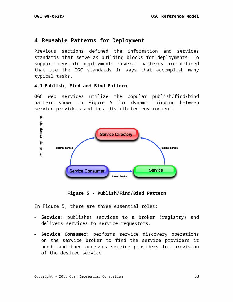
OGC web services utilize the popular publish/find/bindpattern shown in Figure 5 for dynamic binding betweenservice providers and in a distributed environment.
Figure 5 - Publish/Find/Bind Pattern
In Figure 5, there are three essential roles:
Service: publishes services to a broker (registry) anddelivers services to service requestors.
Service Consumer: performs service discovery operationson the service broker to find the service providers itneeds and then accesses service providers for provisionof the desired service.
Copyright © 2011 Open Geospatial Consortium 53
Provider
Bind
Publish
Chain

OGC 08-062r7 OGC Reference Model
Service Directory: helps service providers and servicerequestors to find each other by acting as a registry orclearinghouse of services.
As shown, there are three essential kinds of operationsperformed by services:
Publish: used to register data and services to adirectory (such as registry, catalog or clearinghouse). Aservice provider contacts the service directory topublish (or unpublish) a service. A service providertypically publishes service metadata describing itscapabilities and network address.
Find: used by service consumers to discover specificservice types or instances. Service consumers describethe kinds of services they’re looking for to thedirectory and the directory responds by delivering theresults that match the request. Service consumerstypically use metadata published to find services ofinterest.
Bind: used when a service consumer invokes a services. Aservice consumer typically uses service metadata providedby the registry to bind to a service provider. Theservice consumers can either use a proxy generator togenerate the code that can bind to the service, or canuse the service description to implement the bindingbefore accessing that service.
OGC has developed a framework for defining specializedcatalogues that support registration processes such as thosedescribed in ISO 19135: establishing, maintaining, andpublishing registers of identifiers and meanings that areassigned to items of geographic information. The CatalogService for the Web (CSW) – as defined in the OGC CatalogueSpecification (CAT) – has been augmented by an ebRIMInformation Model to establish an OGC framework forregistration of geospatial information.
Copyright © 2011 Open Geospatial Consortium54

OGC 08-062r7 OGC Reference Model
4.2 Geospatial Portal and Clients
For users to achieve the value of geospatial data andservices, user interfaces must exist that allow access.Portals have become a regular and familiar user interface toweb-based users. Client applications hosted on user hardwarecontinue to serve a large portion of the user community.Portal and application clients are discussed in thissection.
The OGC Geospatial Portal Reference Architecture DiscussionPaper was developed to assist the global geospatialtechnology community in implementing standards-basedgeospatial portal solutions. The document is a resource forrapid development and informed acquisition of portals andportal-exploiting applications that can plug and play withgeospatial data and services in your organization and otherorganizations in your community and around the world.
A Web portal is a single point of access to information,which is linked from various logically related Internet-based applications and is of interest to various types ofusers. Portals present information from diverse sources in aunified way; they provide a consistent look and feel withaccess control and procedures for multiple applications,which otherwise would have been different entitiesaltogether. Since all the applications share informationthrough portals, there is better communication betweenvarious types of users. Another advantage of portals is thatthey can make event-driven campaigns.
The OWS Integrated Client Discussion Paper describes thecore concept of providing a unified environment that allowsa user to visualize, analyze, and/or edit data from numerousOGC Web Services simultaneously. An Integrated Clientunifies common service discovery, feature production,imagery exploitation, portrayal management, processing, andsensor web enablement functionalities, and provides an
Copyright © 2011 Open Geospatial Consortium 55

OGC 08-062r7 OGC Reference Model
environment for visualizing, analyzing and/or editing datafrom these sources/services.
Portals and application clients represent just the tip ofgeospatial Decision Support Services (DSS) which aim toprovide interoperable access to distributed geospatial webservices to aid decision makers in forming, analyzing, andselecting alternatives, see Figure 7. GeoDSS includesworkflow management to produce context-specific results frominformation and knowledge from multiple communities. Oneobjective of geospatial web services is to allow decisionmakers to access and use information that may have beencollected for other purposes.
Figure 6 – GeoDSS Integrated OWS Client
Copyright © 2011 Open Geospatial Consortium56
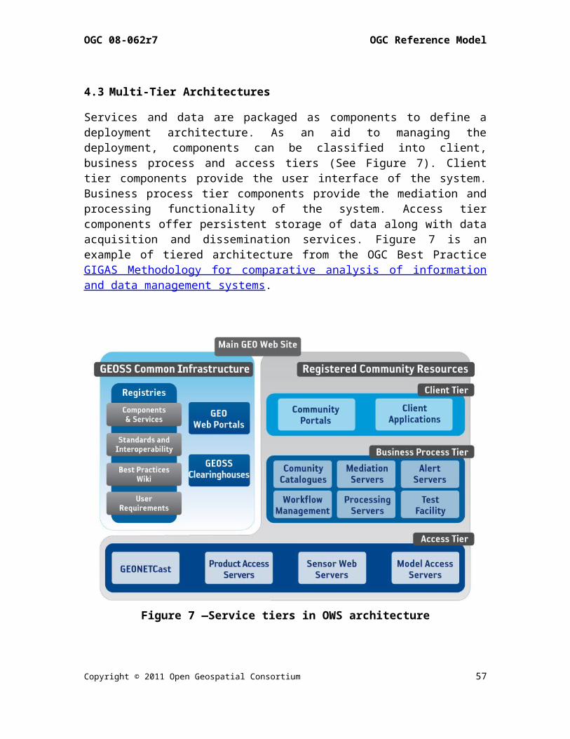
OGC 08-062r7 OGC Reference Model
4.3 Multi-Tier Architectures
Services and data are packaged as components to define adeployment architecture. As an aid to managing thedeployment, components can be classified into client,business process and access tiers (See Figure 7). Clienttier components provide the user interface of the system.Business process tier components provide the mediation andprocessing functionality of the system. Access tiercomponents offer persistent storage of data along with dataacquisition and dissemination services. Figure 7 is anexample of tiered architecture from the OGC Best PracticeGIGAS Methodology for comparative analysis of informationand data management systems.
Figure 7 —Service tiers in OWS architecture
Copyright © 2011 Open Geospatial Consortium 57

OGC 08-062r7 OGC Reference Model
4.4 Spatial Data Infrastructures
OGC standards are key elements of the interoperabilitystrategy of several Spatial Data Infrastructures (SDIs).
The SDI Cookbook, published by the GSDI, remarks that “SDI”is often used to denote the relevant base collection oftechnologies, policies and institutional arrangements thatfacilitate the availability of and access to spatial data.An SDI must be more than a single data set or database: anSDI hosts geographic data and attributes; sufficientdocumentation (metadata); a means to discover, visualize,and evaluate the data (catalogues and Web mapping); and somemethod to provide access to the geographic data.
The OGC Web Services Architectural Profile for the NSGdescribes how the various OGC specifications relate to theweb service architecture implementation at the US NationalGeospatial-Intelligence Agency and the National System forGeospatial-Intelligence (NSG). The document enablesorganizations that interface with the NSG to understand howto produce and consume data and services in an interoperableenvironment.
GeoConnections helps decision-makers “use online location-based (or "geospatial") information, such as maps andsatellite images, to tackle some of Canada's most pressingchallenges.” GeoConnections strongly advocates the use ofstandards endorsed for the Canadian Geospatial DataInfrastructure (CGDI) to achieve interoperability for richerand more useful information than a single data set canprovide. GeoConnections was an early supporter of WMSdevelopment and was an early adopter of the WMS standard.Recently the OGC Canadian Geospatial Data Infrastructure WFSand GML gives guidelines and recommendations foradministrators, users and implementers of WFS serving GML-encoded response documents. This OGC document is applicableto the design, implementation and operation of Web FeatureService networks.
Copyright © 2011 Open Geospatial Consortium58

OGC 08-062r7 OGC Reference Model
The Directive of the European Parliament and Councilestablishing an Infrastructure for Spatial Information inthe European Community (INSPIRE) directs Member States toestablish and operate a network of services for discovery,viewing, and transformation. The services are to be easy touse, available to the public and accessible via theInternet. Implementation of the directives by the EuropeanCommission is proceeding with significant uptake of OGCstandards envisioned.
The GEOSS 10 Year Plan, published by the Group on EarthObservations, states that to enable implementation of theGEOSS architecture, GEOSS will draw on existing Spatial DataInfrastructure (SDI) components as institutional andtechnical precedents in areas such as geodetic referenceframes, common geographic data, and standard protocols. TheGEO Architecture Implementation Pilot is defining anddeploying the GEOSS Core Architecture for exchange anddissemination of observations including considerable uptakeof OGC web services.
The OGC Federated Earth Observation Missions (FedEO) PilotDiscussion Paper describes the application of OGC servicesto Earth Observation. The FedEO Pilot was conducted inconjunction with and in support of the GEOSS ArchitectureImplementation Pilot. The FedEO pilot used and extended theGEOSS Architecture with additional services, e.g., ProductProgramming, Service Orchestration, Processing Services,Orthorectification and Reprojection Services and OrderService.
4.5 Sensor Webs
The OGC Sensor Web Enablement Architecture Best Practiceprovides a description of the general architecture thatapplies to SWE. The Sensor Web is a revolutionary concepttowards achieving a collaborative, coherent, consistent, andconsolidated sensor data collection, fusion and distributionsystem. It can be viewed as a new breed of Internet for
Copyright © 2011 Open Geospatial Consortium 59

OGC 08-062r7 OGC Reference Model
monitoring spatio-temporal phenomena appearing in thephysical environment in real time.
The Sensor Web represents a meta-platform that integratesarbitrary sensors and sensor networks; each maintained andoperated by individual institutions (Figure 8). Thearchitectural design of the Sensor Web allows theintegration of individual sensors as much as the integrationof complete sensor systems without the need of fundamentalchanges to the legacy systems.
Figure 8 – Sensor Web: Aggregation of Sensor Networks
The retrieval and processing of sensor data, but also themanagement of sensor devices (i.e. tasking), is oftencarried out by means of distributed software entities thatinteroperate via the Internet. At its stage of completion,billions of sensors will be connected and producegeoreferenced observation data. Every single sensor providesa small mosaic stone that helps us to generate aconsolidated view of the world, to get a betterunderstanding of the past, present, and future situation ofour planet as well as active processes and correlations.
The Specification of the Sensor Service Architecture(SensorSA) – OGC Discussion Paper – presents specifies theSWE-based architecture used in the Sensors Anywhere (SANY)Project. The document describes a generic service-orientedarchitecture integrating the access to, the management andthe processing of sensor-related information based on OGCstandards and resulting from the requirements analysis of
Copyright © 2011 Open Geospatial Consortium60
OGC 08-062r7 OGC Reference Model
diverse application domains such as maritime riskmanagement, observation of geo-hazards and monitoring of airquality.
Copyright © 2011 Open Geospatial Consortium 61

OGC 08-062r7 OGC Reference Model
4.6 Earth Observation
Profiles of multiple OGC standards have been developed tosupport Earth Observations:
Catalogue Services 2.0 EP for ebRIM Application Profile: EO Products Standard
GML 3.1.1 Application Schema for EO products BestPractice
Web Map Services - Application Profile for EO Products Best Practice
Ordering Services for Earth Observation Products BestPractice
User Management for Earth Observation Services BestPractice
Sensor Planning Service Application Profile for EO Sensors Best Practice
(WCS Earth Observations Profile – currently underdevelopment)
Several of these documents were developed within ESA'sHeterogeneous Mission Accessibility (HMA) project. For moreinformation see for example, the OGC Federated EarthObservations (FedEO) Pilot Engineering Report.
4.7 Geoprocessing Workflows
OGC has implemented workflow and service chaining beginningwith the first OGC Web Services Testbed. The OWS-6Geoprocessing Workflow Architecture Engineering Reportprovides a summary of past Geoprocessing Workflowimplementations and methods in SOA environments from OWStestbeds and other implementations. The ER also summarizesthe key developed concepts for deploying GeoprocessingWorkflows using OGC and other standards.
Geoprocessing Workflows integrate data and services in aninteroperable way, where each part of the workflow isresponsible for only a specific task, without being aware ofthe general purpose of the workflow. Due to the distributednature of geographic data, geoprocessing workflows provideflexible means of processing highly distributed and complex
Copyright © 2011 Open Geospatial Consortium62
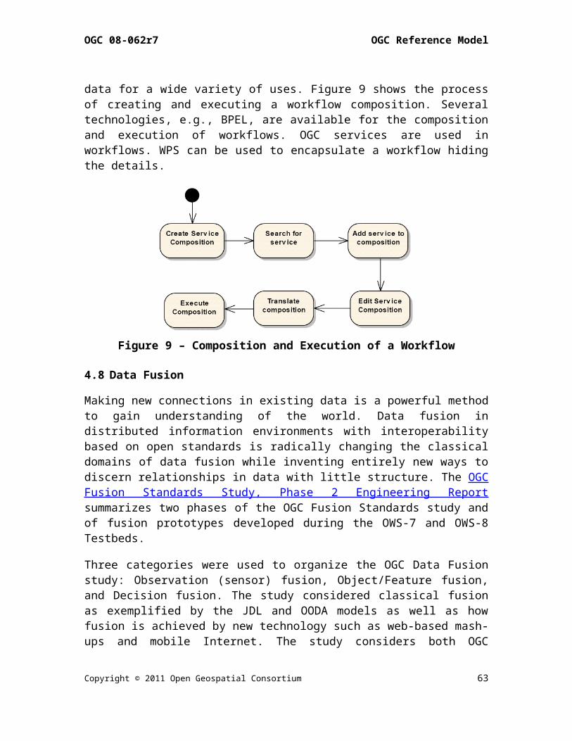
OGC 08-062r7 OGC Reference Model
data for a wide variety of uses. Figure 9 shows the processof creating and executing a workflow composition. Severaltechnologies, e.g., BPEL, are available for the compositionand execution of workflows. OGC services are used inworkflows. WPS can be used to encapsulate a workflow hidingthe details.
Figure 9 – Composition and Execution of a Workflow
4.8 Data Fusion
Making new connections in existing data is a powerful methodto gain understanding of the world. Data fusion indistributed information environments with interoperabilitybased on open standards is radically changing the classicaldomains of data fusion while inventing entirely new ways todiscern relationships in data with little structure. The OGCFusion Standards Study, Phase 2 Engineering Reportsummarizes two phases of the OGC Fusion Standards study andof fusion prototypes developed during the OWS-7 and OWS-8Testbeds.
Three categories were used to organize the OGC Data Fusionstudy: Observation (sensor) fusion, Object/Feature fusion,and Decision fusion. The study considered classical fusionas exemplified by the JDL and OODA models as well as howfusion is achieved by new technology such as web-based mash-ups and mobile Internet. The study considers both OGC
Copyright © 2011 Open Geospatial Consortium 63
OGC 08-062r7 OGC Reference Model
standards, e.g., WPS, as well open standards from otherstandards organizations.
The SANY Fusion and Modelling Architecture – an OGCDiscussion Paper – reports the SANY project’s best practicefor using OGC standards to provide generic fusion processingservices. Concrete case studies are documented and adetailed appendix is provided with example of XML requestand responses.
4.9 Building Information Modeling and Services
The Architecture, Engineering, Construction, Owner,Operator, Phase 1 (AECOO-1) Testbed developed andimplemented methods to streamline communications betweenparties in the conceptual design phase to get an earlyunderstanding of the tradeoffs between construction cost andenergy efficiency. To that end, the project developed theinteroperability components required for these analyses incollaborative team settings. These were Information DeliveryManuals (IDMs) for quantity takeoffs and energy analysisbusiness processes, and used these to define Model ViewDefinitions (MVDs)—standards-based subsets of IndustryFoundation Classes (IFCs). AECOO-1 was conducted in responsethe felt need that overall productivity loss andfragmentation in the capital facilities developmentindustries is no longer tolerable. All stakeholders need topractice the best way they know, and practice profitably;software interoperability problems must not hold them back.Non-interoperable software and data is cause for loss ofcompetition across the market. For more information see:Summary of the Architecture, Engineering, Construction,Owner, Operator Phase 1 (AECOO-1) Joint Testbed
Copyright © 2011 Open Geospatial Consortium64
OGC 08-062r7 OGC Reference Model
4.10 Events Architecture: publish/subscribe
The OWS-7 Event Architecture Engineering Report addressesrealization of an Event-Driven Spatial Data Infrastructure(ED-SDI). An ED-SDI is a traditional SDI where services andclients also communicate by means of events. This leads toimproved activity of the whole infrastructure which isimportant if timely communication of information is critical– which is the case for example in aviation and emergencyresponse scenarios. A major part of this report is concernedwith a common approach on publish/subscribe for OGC WebServices. [Note: a Pub/Sub Standards Working Group iscurrently in process in OGC based on this ER and otheractivities.] The ER provides an abstract model for pubsub inOWS. Then functional requirements are developed based upon themodel. Finally, a mapping is performed for a given publish /subscribe technology which shows how well the technologysupports the requirements.
4.11 Securing OGC Web Services
OGC Web Services can be secured with information technologystandards developed by other standards organizations. Thefollowing reports describe several implementations.
The OWS-4 Trusted Geo Services Interoperability Program Reportdescribes the exchange of trusted messages between OGC WebServices and clients for these services. The documentaddresses the service protocol, service request, chaining withother services and service response required to form acomplete trusted services chain.The OWS-6 Security Engineering Report describes workaccomplished during the OWS-6 Testbed to investigate andimplement security measures for OGC web services. The documentoffers insight into ways to apply existing security standardsfrom W3C, OASIS, and others with the architecture of OGC webservices and standards.The OWS-6 Secure Sensor Web Engineering Report appliesstandards-based security solutions for making the OGC SWE
Copyright © 2011 Open Geospatial Consortium 65
OGC 08-062r7 OGC Reference Model
services ready for handling of sensors in the intelligencedomain. This brings in the requirement for handling sensorsthat eventually produce classified information and the mainobjective of accreditation. The OGC Authentication Interoperability Engineering Reportpresents results as guidance to both implementers andorganizations deploying solutions that involve basicauthentication. The OGC Authentication InteroperabilityExperiment (Auth IE) tested and documented ways oftransferring basic authentication information between OGCclients and OGC services.The OWS-7 Towards secure interconnection of OGC Web Serviceswith SWIM Engineering Report provides guidance to properlyenable security in the near future such that a seamless,interoperable but secure interconnection between OGC WebServices and FUSE ESB technology stack as selected by use inthe System Wide Information Management (SWIM) System of the USFederal Aviation Administration (FAA) can be achieved.
Copyright © 2011 Open Geospatial Consortium66
OGC 08-062r7 OGC Reference Model
5 Implementations of OGC StandardsOGC standards have been implemented through severalactivities as described below.
5.1 OGC Compliance Test Program
The purpose of the OGC Compliance Testing Program is topermit vendors and users to take advantage of the standardsthat OGC has created. The program provides a process fortesting compliance of products to OpenGIS® ImplementationSpecifications.
When a vendor has completed compliance testing and OGC hasconfirmed its successful completion, vendors who agree tothe terms of the OGC Trademark License Agreement thataccompanies this program, and who have paid their trademarklicense fees, may use OGC's marks (trademarks orcertification marks) to indicate to their customers thatthey have achieved compliance with OpenGIS ImplementationSpecifications.
The OGC Compliance Testing Portal is the home of the OGC’son-line compliance testing resources. The portal providestest scripts in an automated test environment for theadopted OGC Standards for OGC web services. In addition, theOGC provides a tool to validate Geography Markup Language(GML). If you want to try out compliant software, take alook at the Reference Implementations as open-sourceapplications.
The Compliance Test engine is an open-source applicationallowing integrators and software developers to host thecompliance test tools in their own development laboratories.Although only tests performed at the OGC compliance site canbe used as the basis for certification, organizations findit valuable to perform the same tests in their labs tosupport development and integration. Compliance TestLanguage (CTL) Best Practice is an XML grammar for
Copyright © 2011 Open Geospatial Consortium 67

OGC 08-062r7 OGC Reference Model
documenting and scripting suites of tests for verifying thatan implementation of a specification complies with thespecification.
Previously developed off-line Compliance Test Suites fordownload include: Catalog Service Interface 1.0, CoordinateTransformation 1.0, Gridded Coverages 1.0, Simple FeaturesSQL 1.1, Simple Features COM 1.1, Simple Features CORBA 1.0.Those suites are hosted on the OGC site.
In addition, OGC provides on-line tools for GeoRSS,Geography Markup Language (GML) 2.1.2, and Web Map Context(WMC) 1.1.0 validation. These validation tools are notassociated with official OGC Compliance Certification andare simply provided as a community resource.
5.2 Registered Implementations
Implementations of OGC Specifications can be registered onthe OGC website including those that have been certified OGCCompliant. The lists of Compliant and Implementing Productsidentify publicly available products and services thateither implement or have been tested Compliant to OpenGISSpecifications. You may also Register Your Products at thissite.
5.3 OGC Network, Cookbooks and Demos
The OGC Network™ is a window onto the dynamic, constantlychanging geospatial web. Here you will find the latestinformation on OGC-compatible software, services, andinformation models (e.g. GML profiles, SLD examples, etc.).From this site you can quickly locate OGC-compatiblegeospatial web services, the latest XML schema documents,discussion forums, conformance testing resources, and GMLprofile working areas. OGC Cookbooks are free, online, easy-to-use technical documents for developers. On-linedemonstrations of OGC specifications and interoperablesoftware are available from previous OGC InteroperabilityProgram initiatives.
Copyright © 2011 Open Geospatial Consortium68
OGC 08-062r7 OGC Reference Model
5.4 Strategic implementations of OGC Standards
5.4.1 GEOINT Standards managed by NGA
The US National System for Geospatial Intelligence (NSG) isthe combination of technologies, policies, capabilities,doctrine, activities, people, data and communities needed toproduce geospatial intelligence (GEOINT) in an integrated,multi-intelligence, multidomain environment. GEOINT isdefined as the exploitation and analysis of imagery andgeospatial information to describe, assess, and visuallydepict physical features and geographically referencedactivities on the Earth. GEOINT consists of imagery, imageryintelligence, and geospatial information.
The GEOINT Standards Working Group (GWG) provides the forumfor the coordination of GEOINT standard activities. The GWGis led by the National Geospatial-Intelligence Agency’s(NGA) National Center for Geospatial Intelligence Standards(NCGIS). Through the GWG, NGA has collaboratively defined acommon baseline of standards including many OGC as describedin “Enabling a Common Vision.”
The GWG manages GEOINT standards lifecycle recommendationsfor developing and promoting standards interoperability insupport of net-centricity. NGA and the geospatial communityare well positioned to achieve coordinated implementation ofthese standards – the result will not only be enhancedinteroperability, but also the ability to, at the lowesttactical level, return value-added content from the warriorson the front lines for re-use by others.
5.4.2 FGDC/USGS
The US Federal Geographic Data Committee (FGDC) is aninteragency committee that promotes the coordinateddevelopment, use, sharing, and dissemination of geospatialdata on a national basis. FGDC activities are administered
Copyright © 2011 Open Geospatial Consortium 69

OGC 08-062r7 OGC Reference Model
through the FGDC Secretariat, hosted by the U.S. GeologicalSurvey (USGS).
The partner agencies of FGDC are developing the GeospatialPlatform to more effectively provide place-based productsand services to the American public. Through the FGDC, theGeospatial Platform will adopt and enforce open andinteroperable standards to leverage the work alreadyaccomplished by national and international standardsorganizations including OGC Web Services (features, map,processing, coverage, etc.), Location Services, Metadata,Registries, Data Quality and other applicable standardsspecifically dealing with geospatial data.
5.4.3 NASA
The US National Aeronautics and Space Agency’s Earth ScienceTechnology Office (ESTO) demonstrates and providestechnologies that can be reliably and confidently applied toa broad range of science measurements and missions as wellas facilitate practical applications that benefit society atlarge. ESTO developments in advanced information systems areused to process, archive, access, visualize, and communicatescience data. ESTO has sponsored several implementations ofOGC standards including the following.
The NASA SensorWeb is an interoperable environment for adiverse set of satellite sensors via the use of software andthe Internet. This capability can be used to betterunderstand physical phenomena, such as volcanic eruptions,fires and floods. Furthermore, it facilitates scienceinvestigation since it becomes much easier to enlistexisting satellite, airborne and ground sensors for requiredobservations. The NASA SensorWeb Architecture implementsmultiple OGC Standards.
Copyright © 2011 Open Geospatial Consortium70

OGC 08-062r7 OGC Reference Model
Revision history
Date VersionDoc.
Editor Description
1996-05-09 0. Kurt Buehler OpenGIS Guide2002-08-30 0.1
02-077Kurt Buehler Initial version of ORM. Doc OGC
George Percivall, Sam Bacharach, Carl Reed, Cliff Kottman, Chuck Heazel, John Davidson, Yaser Bisher, Harry Niedzwiadek, John Evans, Jeffrey Simon
2003-09-16 0.1.303-040
George Percivall
Approved and published in public OGC baseline
2007 (1.0) Unpublished HTML versionhttp://ormdev.opengeospatial.org/Contributors: Chuck Heazel, Carl Reed, Ron Fresne, Phillip Dibner,Josh Lieberman, John Davidson, Lew Leinenweber, Raj Singh
2008-11-11 2.008-062r4
George Percivall
Approved by OAB and published in public OGC baseline Contributors: Carl Reed, Lew Leinenweber, Chris Tucker, Tina Cary
2011-10-13 2.1 (draft)08-062r5
George Percivall
Final draft of version 2.1 including all changes to the OGCBaseline since version 2.0.
2011-12-15 2.108-062r7
George Percivall
Implemented comments by the OGC Architecture Board (OAB) members including: F. Houbie, M. Botts, A. Matheus, J. Herring.Approved by OAB for release.
Copyright © 2011 Open Geospatial Consortium 71

OGC 08-062r7 OGC Reference Model
“We are so bound together that no man can labor for himselfalone.
Each blow he strikes in his own behalf helps to mold theUniverse.”
Jerome K Jerome, 1886
“Wisdom is knowing what to leave out” William James, 1890
Copyright © 2011 Open Geospatial Consortium72