OGC Testbed 12 Architecture
133
O PEN G EOSPATIAL C ONSORTIUM (OGC) A NNEX B OGC Testbed 12 Architecture version: November 6, 2015
-
Upload
khangminh22 -
Category
Documents
-
view
2 -
download
0
Transcript of OGC Testbed 12 Architecture

OPEN GEOSPATIAL CONSORTIUM (OGC)
ANNEX B
OGC Testbed 12 Architecture
version: November 6, 2015

CorrigendaThe following table identifies all corrections that have been applied to Annex Bcompared to the original release (version October 21, 2015).
Section Description
8.11 Entire section has been revised. Ambiguous and partly missingrequirements have been resolved.
8.12 Figure 8.10 has been updated to reflect changes in section 8.118.6 Figure 8.4 has been updated to reflect changes in section 8.118.6 Table 8.1 has been updated to reflect changes in section 8.118.20 Third paragraph, reference to (A016) removed.8.23.1 Description of work items A050 and A051 updated to reflect
changes in section 8.117.4.2 Description of work items A103 and A104 updated to reflect
changes in section 8.11All The Consolidation thread abbreviation has changed from CON
to CNSAll The Compliance thread abbreviation has hanged from COM to
CMP8.23.2 References corrected for A0668.17.1 First paragraph, last sentence removed.
TABLE 1: Overview of all corrections
i

Contents
Corrigenda i
1 Introduction 11.1 Aviation . . . . . . . . . . . . . . . . . . . . . . . . . . . . . . . . . 11.2 Geospatial Imagery Quality Framework . . . . . . . . . . . . . . . 21.3 Coverage Access and Visualization . . . . . . . . . . . . . . . . . . 21.4 GFM, Catalogs, and Semantics . . . . . . . . . . . . . . . . . . . . 31.5 OGC Baseline Enhancements . . . . . . . . . . . . . . . . . . . . . 31.6 Compression and Generalization . . . . . . . . . . . . . . . . . . . 31.7 ArcticSDI and GeoPackage . . . . . . . . . . . . . . . . . . . . . . . 3
2 Testbed Baseline 52.1 Types of Deliverables . . . . . . . . . . . . . . . . . . . . . . . . . . 52.2 OGC Reference Model . . . . . . . . . . . . . . . . . . . . . . . . . 62.3 OGC Standards Baseline . . . . . . . . . . . . . . . . . . . . . . . . 82.4 Data . . . . . . . . . . . . . . . . . . . . . . . . . . . . . . . . . . . . 82.5 Services in the Cloud . . . . . . . . . . . . . . . . . . . . . . . . . . 9
3 Testbed Threads 103.1 Background . . . . . . . . . . . . . . . . . . . . . . . . . . . . . . . 103.2 Field Operations (FO) Thread . . . . . . . . . . . . . . . . . . . . . 123.3 Large Scale Analytics (LSA) Thread . . . . . . . . . . . . . . . . . . 123.4 Linked Data and Advanced Semantics for Data Discovery and
Dynamic Integration (LDS) Thread . . . . . . . . . . . . . . . . . . 133.5 Command Center (CMD) Thread . . . . . . . . . . . . . . . . . . . 133.6 Consolidation (CNS) Thread . . . . . . . . . . . . . . . . . . . . . . 143.7 Aviation (AVI) Thread . . . . . . . . . . . . . . . . . . . . . . . . . 143.8 Compliance Testing (CMP) Thread . . . . . . . . . . . . . . . . . . 15
4 Aviation 164.1 Background . . . . . . . . . . . . . . . . . . . . . . . . . . . . . . . 164.2 Requirements and Work Items . . . . . . . . . . . . . . . . . . . . . 184.3 Aviation Architecture . . . . . . . . . . . . . . . . . . . . . . . . . . 184.4 Advance use of Data Broker . . . . . . . . . . . . . . . . . . . . . . 204.5 Advance Use of Catalog Service for Web (CSW) . . . . . . . . . . 224.6 Asynchronous Messaging for Geospatial Queries of Aviation Data 244.7 Advance use of Semantics for Aviation . . . . . . . . . . . . . . . . 25
ii

4.8 Advanced use of Semantic Business Vocabulary and BusinessRules (SBVR) . . . . . . . . . . . . . . . . . . . . . . . . . . . . . . . 26
4.9 Aviation OGC Web Service Security . . . . . . . . . . . . . . . . . 274.10 Flight Information Exchange Model (FIXM) . . . . . . . . . . . . . 284.11 Summary . . . . . . . . . . . . . . . . . . . . . . . . . . . . . . . . . 29
5 Geospatial Imagery Quality Framework 315.1 Background . . . . . . . . . . . . . . . . . . . . . . . . . . . . . . . 315.2 Requirements and Work Items . . . . . . . . . . . . . . . . . . . . . 325.3 Accuracy, Currency, Completeness, Consistency . . . . . . . . . . 325.4 Summary . . . . . . . . . . . . . . . . . . . . . . . . . . . . . . . . . 35
6 Coverage Access and Visualization 376.1 Background . . . . . . . . . . . . . . . . . . . . . . . . . . . . . . . 376.2 Requirements and Work Items . . . . . . . . . . . . . . . . . . . . . 416.3 Visualization of Earth Observation (EO) Data . . . . . . . . . . . . 416.4 WCS: Merging with NetCDF/OPeNDAP . . . . . . . . . . . . . . 436.5 Summary . . . . . . . . . . . . . . . . . . . . . . . . . . . . . . . . . 47
7 GFM, Catalogs, and Semantics 497.1 Background . . . . . . . . . . . . . . . . . . . . . . . . . . . . . . . 497.2 Requirements and Work Items . . . . . . . . . . . . . . . . . . . . . 497.3 General Feature Model . . . . . . . . . . . . . . . . . . . . . . . . . 507.4 Prototype Implementations . . . . . . . . . . . . . . . . . . . . . . 537.5 Clients . . . . . . . . . . . . . . . . . . . . . . . . . . . . . . . . . . 587.6 Summary . . . . . . . . . . . . . . . . . . . . . . . . . . . . . . . . . 59
8 OGC Baseline Enhancements 608.1 Background . . . . . . . . . . . . . . . . . . . . . . . . . . . . . . . 608.2 Requirements and Work Items . . . . . . . . . . . . . . . . . . . . . 618.3 Security and SOAP . . . . . . . . . . . . . . . . . . . . . . . . . . . 618.4 REST, JSON, and GeoJSON . . . . . . . . . . . . . . . . . . . . . . 658.5 Semantic Enablement . . . . . . . . . . . . . . . . . . . . . . . . . . 688.6 Asynchronous Service Interaction . . . . . . . . . . . . . . . . . . . 708.7 Tiling . . . . . . . . . . . . . . . . . . . . . . . . . . . . . . . . . . . 738.8 Compression . . . . . . . . . . . . . . . . . . . . . . . . . . . . . . . 748.9 SWE for LiDAR and Streaming . . . . . . . . . . . . . . . . . . . . 768.10 WFS Synchronization . . . . . . . . . . . . . . . . . . . . . . . . . . 778.11 Catalog . . . . . . . . . . . . . . . . . . . . . . . . . . . . . . . . . . 788.12 Capabilities Document and Alternatives . . . . . . . . . . . . . . . 808.13 Big Data and Tile Stores . . . . . . . . . . . . . . . . . . . . . . . . 818.14 Web Integration Service . . . . . . . . . . . . . . . . . . . . . . . . 828.15 Conflation . . . . . . . . . . . . . . . . . . . . . . . . . . . . . . . . 838.16 Data Quality . . . . . . . . . . . . . . . . . . . . . . . . . . . . . . . 858.17 GeoPackage . . . . . . . . . . . . . . . . . . . . . . . . . . . . . . . 868.18 OGC Web Services (OWS) Context . . . . . . . . . . . . . . . . . . 918.19 UML Shape Change . . . . . . . . . . . . . . . . . . . . . . . . . . . 93
iii

8.20 Data . . . . . . . . . . . . . . . . . . . . . . . . . . . . . . . . . . . . 948.21 User Guides . . . . . . . . . . . . . . . . . . . . . . . . . . . . . . . 958.22 Compliance Testing . . . . . . . . . . . . . . . . . . . . . . . . . . . 968.23 Summary . . . . . . . . . . . . . . . . . . . . . . . . . . . . . . . . . 100
9 Compression and Generalization 1129.1 Background . . . . . . . . . . . . . . . . . . . . . . . . . . . . . . . 1129.2 Requirements and Work Items . . . . . . . . . . . . . . . . . . . . . 1139.3 Bandwidth Constraints . . . . . . . . . . . . . . . . . . . . . . . . . 1139.4 Summary . . . . . . . . . . . . . . . . . . . . . . . . . . . . . . . . . 114
10 ArcticSDI and GeoPackage 11610.1 Background . . . . . . . . . . . . . . . . . . . . . . . . . . . . . . . 11610.2 Requirements and Work Items . . . . . . . . . . . . . . . . . . . . . 11810.3 ArcticSDI . . . . . . . . . . . . . . . . . . . . . . . . . . . . . . . . . 11810.4 GeoPackage . . . . . . . . . . . . . . . . . . . . . . . . . . . . . . . 12010.5 Summary . . . . . . . . . . . . . . . . . . . . . . . . . . . . . . . . . 122
iv

List of Figures
2.1 RM-ODP . . . . . . . . . . . . . . . . . . . . . . . . . . . . . . . . . 7
3.1 Assignment of Work Items to Threads . . . . . . . . . . . . . . . . 11
4.1 Requirements Aviation . . . . . . . . . . . . . . . . . . . . . . . . . 19
5.1 Requirements Geospatial Data Quality . . . . . . . . . . . . . . . . 32
6.1 Requirements Aviation . . . . . . . . . . . . . . . . . . . . . . . . . 386.2 Requirements Coverage Access and Visualization . . . . . . . . . 416.3 WCS DAP Comparison . . . . . . . . . . . . . . . . . . . . . . . . . 44
7.1 Requirements Data Access and Visualization . . . . . . . . . . . . 517.2 Requirements DCAT detail, part 1 . . . . . . . . . . . . . . . . . . 557.3 Requirements DCAT detail, part 2 . . . . . . . . . . . . . . . . . . 56
8.1 Requirements OGC Baseline Enhancements: Security and SOAP . 628.2 Requirements OGC Baseline Enhancements: REST and JSON . . . 668.3 Requirements OGC Baseline Enhancements: Semantic Enablement 698.4 Requirements OGC Baseline Enhancements: Asynchronous Ser-
vice Interaction . . . . . . . . . . . . . . . . . . . . . . . . . . . . . 718.5 Requirements OGC Baseline Enhancements: Tiling . . . . . . . . . 748.6 Requirements OGC Baseline Enhancements: Compression . . . . 758.7 Requirements OGC Baseline Enhancements: SWE for LiDAR and
Streaming . . . . . . . . . . . . . . . . . . . . . . . . . . . . . . . . 768.8 Requirements OGC Baseline Enhancements: WFS Synchronization 778.9 Requirements OGC Baseline Enhancements: Catalog . . . . . . . 798.10 Requirements OGC Baseline Enhancements: Capabilities Docu-
ment and Alternatives . . . . . . . . . . . . . . . . . . . . . . . . . 808.11 Requirements OGC Baseline Enhancements: Big Data and Tile
Stores . . . . . . . . . . . . . . . . . . . . . . . . . . . . . . . . . . . 818.12 Requirements OGC Baseline Enhancements: Web Integration Ser-
vice . . . . . . . . . . . . . . . . . . . . . . . . . . . . . . . . . . . . 828.13 Requirements OGC Baseline Enhancements: Conflation . . . . . . 848.14 Requirements OGC Baseline Enhancements: Data Quality . . . . 858.15 Requirements OGC Baseline Enhancements: GeoPackage . . . . . 878.16 Requirements OGC Baseline Enhancements: OWS Context . . . . 928.17 Requirements OGC Baseline Enhancements: UML Shape Change 938.18 Requirements OGC Baseline Enhancements: Data and Portal . . . 94
v

8.19 Requirements OGC Baseline Enhancements: User Guides . . . . . 968.20 Requirements OGC Baseline Enhancements: Compliance Testing 97
9.1 Requirements Compression and Generalization . . . . . . . . . . 113
10.1 Requirements ArcticSDI and GeoPackage . . . . . . . . . . . . . . 118
vi

List of Tables
1 Overview of all corrections . . . . . . . . . . . . . . . . . . . . . . i
3.1 Overview of the Testbed-12 work items . . . . . . . . . . . . . . . 103.2 Overview of the Field Operations Thread . . . . . . . . . . . . . . 123.3 Overview of the Large Scale Analytics Thread . . . . . . . . . . . 123.4 Overview of the Linked Data and Advanced Semantics . . . . . . 133.5 Overview of the Command Center (CMD) Thread . . . . . . . . . 143.6 Overview of the Consolidation (CNS) Thread . . . . . . . . . . . . 143.7 Overview of the Aviation (AVI) Thread . . . . . . . . . . . . . . . 153.8 Overview of the Compliance Testing (CMP) Thread . . . . . . . . 15
4.1 Aviation Architecture deliverables . . . . . . . . . . . . . . . . . . 184.2 Advance use of Data Broker deliverables . . . . . . . . . . . . . . 224.3 Advance Use of Catalog Service for Web deliverables . . . . . . . 234.4 Asynchronous Messaging for Geospatial Queries of Aviation Data
deliverables . . . . . . . . . . . . . . . . . . . . . . . . . . . . . . . 254.5 Advance use of Semantics for Aviation deliverables . . . . . . . . 264.6 Advanced use of Semantic Business Vocabulary and Business
Rules deliverables . . . . . . . . . . . . . . . . . . . . . . . . . . . . 274.7 Aviation OGC Web Service Security deliverables . . . . . . . . . . 284.8 Flight Information Exchange Model deliverables . . . . . . . . . . 294.9 Aviation work package deliverables summary . . . . . . . . . . . 30
5.1 Geospatial Imagery Quality Framework work package deliver-ables summary . . . . . . . . . . . . . . . . . . . . . . . . . . . . . 36
6.1 Data Access and Visualization work package deliverables sum-mary . . . . . . . . . . . . . . . . . . . . . . . . . . . . . . . . . . . 48
7.1 Data Access and Visualization work package deliverables sum-mary . . . . . . . . . . . . . . . . . . . . . . . . . . . . . . . . . . . 59
8.1 Asynchronous services and ER overview . . . . . . . . . . . . . . 728.2 OGC Baseline Enhancements work package deliverables sum-
mary, part 1 . . . . . . . . . . . . . . . . . . . . . . . . . . . . . . . 1098.3 OGC Baseline Enhancements work package deliverables sum-
mary, part 2 . . . . . . . . . . . . . . . . . . . . . . . . . . . . . . . 1108.4 OGC Baseline Enhancements work package deliverables sum-
mary, part 3 . . . . . . . . . . . . . . . . . . . . . . . . . . . . . . . 111
vii

9.1 Compression and Generalization work package deliverables sum-mary . . . . . . . . . . . . . . . . . . . . . . . . . . . . . . . . . . . 115
10.1 ArcticSDI and GeoPackage work package deliverables summary 122
viii

List of Abbreviations
ABI Activity Based Intel- ligenceAMQP Advanced Message Queuing ProtocolAtomPub Atom Publishing ProtocolAVI Aviation (thread name)BBOX Bounding BoxCDR Content Discovery and RetrievalCITE Compliance Interoperability and TestingCMD Command CenterCMP Compliance (thread name)CNS Consolidation (thread name)CSMW Community Sensor Model Working GroupCSW Catalog Service WebCTL Compliance Testing LanguageDAP Data Access ProtocolDCAT Data Catalog VocabularyDGIWG Defence Geospatial Information Working GroupDISA Defense Information System AgencyDWG Domain Working GroupEO Earth ObservationEOWCS Earth Obseration Profile Web Coverage ServiceEXI Efficient XML Interchange formatFGDC Federal Geographic Data CommitteeFIXM Flight Information Exchange ModelFO Field OperationsGDAL Geospatial Data Abstraction LibraryGEOINT Geospatial intelligenceGeoXACML Geospatial XACMLGIBS Global Imagery Browse ServicesGML Geography Markup LanguageHDF Hierarchical Data FormatHTTP Hypertext Transfer ProtocolISO International Organization for StandardizationJSON JavaScript Object NotationJSON-LD JSON Linked DataKML Keyhole Markup LanguageLDS Linked Data and Advanced Semantics (thread name)LiDAR Light detection and rangingLSA Large Scale Analytics (thread name)MTOM Message Transmission Optimization Mechanism
ix

NASA National Aeronautics and Space AdministrationnetCDF network Common Data FormNetCDF-CF NETCDF Climate ForecastingNSG National System for Geospatial IntelligenceOBP Object Based ProductionOGC Open Geospatial ConsortiumOPeNDAP Open-source Project for a Network Data Access ProtocolPOI Points-of-interestPubSub Publication SubscriptionRDF Resource Description FrameworkSOS Sensor Observation ServiceSPARQL SPARQL Protocol and RDF Query LanguageSWE Sensor Web EnablementSWG Standards Working GroupTEAM Test, Evaluation, And Measurement EngineTSPI Time-Space-Position-Information StandardTWMS Tiled Web Mapping ServiceU.S. United StatesUML Unified Modeling LanguageUSGS U.S. Geological SurveyW3C World Wide Web ConsortiumWCPS Web Coverage Processing ServiceWCS Web Catalog ServiceWFS Web Feature ServiceWIS Web Integration ServiceWKT Well Known TextWMS Web Mapping ServiceWMTS Web Mapping Tile ServiceWPS Web Processing ServiceWS Web ServiceWSDL Web Services Description LanguageXACML eXtensible Access Control Markup LanguageXOP XML-binary Optimized PackagingXXE XML External Entity Injection
x

Chapter 1
Introduction
This Annex B provides background information on the OGC baseline, describesthe Testbed-12 architecture and thread-based organization, and identifies all re-quirements and corresponding work items. For general information on Testbed-12, including deadlines, funding requirements and opportunities, please be re-ferred to the Testbed-12 RFQ Main Body, which is available on the OGC Website.
Each thread aggregates a number of requirements, work items and correspond-ing deliverables, which are funded by different sponsors. The work items areorganized in bundles that correspond to one or more related requirements. Fororganizational reasons, the work items have been aggregated to work packagesthat are described in the following and reflected by chapters 4 to 10. The or-ganization of work items in work packages serves organizational requirementsonly! The OGC Testbed-12 threads are defined in chapter 3 and briefly intro-duced in the following sub-chapters.
1.1 Aviation
The Aviation work package seeks to implement CCI components such as se-mantics, ontology, and linked data to improve interoperability of services pro-vided by System Wide Information Management (SWIM) within FAA and Eu-rocontrol. Among these include the Data Broker, Catalog Service for Web (CSW),GeoSPARQL (Ontology), Semantics and Linked Data. Additionally, the Avia-tion thread is interested in integration of publish-subscribe messaging patternsfor the exchange and request of geospatial information as well as the integra-tion of FIXM with GML elements for compatibility with OGC web services.
1

Chapter 1. Introduction 2
1.2 Geospatial Imagery Quality Framework
The Geospatial Imagery Quality Framework work package addresses a qualityframe work that includes quality parameters such as accuracy, currency, com-pleteness, and consistency. The quality framework shall be used to compareimagery from multiple sources. Accuracy refers to spatial accuracy of a loca-tion derived from the pixel in X,Y dimensions and potentially in Z dimension.Currency refers to the temporal extent of the imagery products used to coverthe associated area, since multiple overpasses are typically required to covera large area. Completeness of imagery products refers to quality metrics in-cluding cloud cover, sensor specs on collection geometry, temporal range of thedata, other spectral bands if any, radiometric depth of the pixels, etc. Finally theConsistency metric describes the consistency of colors, relative accuracy overtime and over different sensors, spectral and spatial error propagation fromcollection to production, etc.
1.3 Coverage Access and Visualization
The Coverage Access and Visualization work package addresses several inter-operability requirements in the context of coverage data access and enhancedvisualization of earth observation data. The goal is to enhance the currentlyavailable WCS Earth observation profile to reflect new requirements comingfrom both the data provider and consumer communities. These involve newindexing mechanisms, support for data encodings such as HDF, NetCDF, andDAP, and coverage processing mechanisms. Further on, this package shall im-prove OGC service and encoding specifications to optimize its usage with GIBS.GIBS, the Global Imagery Browse Services system is a core EOSDIS componentwhich provides a scalable, responsive, highly available, and community stan-dards based set of imagery services. These services are designed with the goalof advancing user interactions with EOSDIS’ inter-disciplinary data throughenhanced visual representation and discovery.

Chapter 1. Introduction 3
1.4 GFM, Catalogs, and Semantics
The GFM, Catalogs, and Semantics work package addresses a number of top-ics that require further research, as non is currently supported by an endorsedOGC standard. The package reviews the baseline of the OGC view of the world,the General Feature Model (GFM), experiments with DCAT as an RDF vocabu-lary to facilitate interoperability between data catalogs, and addresses semanticaspects such as automated rendering of linked data and semantic mediation tosupport heterogeneous environments.
1.5 OGC Baseline Enhancements
The OGC Baseline Enhancement work package addresses a large number ofservices and information and exchange models that are already established andapproved OGC Standards; or services that are ready for operational implemen-tation based on previous research and evaluation. Work items in this pack-age include topics such as REST and (Geo)JSON, catalogs, security and SOAP,data and data portals, data quality, GeoPackage, tiling, OWSContext, confla-tion, asynchronous service interaction, and ontologies for portrayal, semanticmediation, and compliance.
1.6 Compression and Generalization
The Compression and Generalization work package addresses aspects resultingfrom the unprecedented volumes of data that are generated continuously. Themechanisms for sharing and processing that data need to keep pace in orderto continue to meet requirements. Therefore, this work package analyzes datacompression and generalization techniques that shall help to effectively reducethe amount of processed and transferred data at minimal information loss.
1.7 ArcticSDI and GeoPackage
The Arctic SDI provides an infrastructure to improved access to geospatial datathat can help us better to predict, understand and react to changes in the Arctic.

Chapter 1. Introduction 4
Its development is facilitated by the National Mapping Agencies of the eightArctic countries. The OGC together with its collaborators Natural ResourcesCanada, the USGS, territories and states that are part of the Arctic, Arctic Coun-cil working groups, Arctic SDI member countries, and a number of OGC mem-ber organizations are currently engaged in a OGC Pilot project with the goalto articulate the value of interoperability and to demonstrate the usefulness ofstandards within the ArcticSDI domain. In its first phase, the ArcticSDI Pilotproject develops an inventory of available geospatial Web services across theArctic, which can be used to reflect a broad range of thematic data layers. Inparallel, Phase 1 defines the core components of the ArcticSDI architecture thatshall, at least partly, be developed in the context of this testbed.
The work package is concluded by an investigation of the OGC GeoPackage asa single alternative delivery format for the USGS Topo Combined Vector Prod-uct and the Topo TNM Style Template. The GeoPackage contents of the TopoCombined Vector Product shall be extended to include imagery and hillshadedata. It shall be evaluated whether the point, multi-point, line, and polygoncontents in the Geopackage can be tied directly to a predefined symbology setvia the Symbology Encoding Implementation Specification.

Chapter 2
Testbed Baseline
2.1 Types of Deliverables
The OGC Testbed 12 threads require several types of deliverables. It is em-phasized that deliverable indications "funded" or "unfunded" in this AnnexB are informative only. Please be referred to Testbed-12 RFQ Main Body forbinding definitions.
2.1.1 Documents
Engineering Reports (ER), Information Models (IM), Encodings (EN), and ChangeRequests (CR) will be prepared in accordance with OGC published templates.Engineering Reports will be delivered by posting on the OGC Portal PendingDocuments list when complete and the document has achieved a satisfactorylevel of consensus among interested participants, contributors and editors. En-gineering Reports are the formal mechanism used to deliver results of the In-teroperability Program to sponsors and to the OGC Standards Program andOGC Standards Working Groups for consideration. It is emphasized that par-ticipants delivering engineering reports must also deliver Change Requeststhat arise from the documented work.
2.1.2 Implementations
Services, Clients, Datasets and Tools will be provided by methods suitable to itstype and stated requirements. For example, services and components (ex. WFS)are delivered by deployment of the service or component for use in the testbedvia an accessible URL. A Client software application or component may be used
5

Chapter 2. Testbed Baseline 6
during the testbed to exercise services and components to test and demonstrateinteroperability; however, it is most often not delivered as a license for follow-on usage. Implementations of services, clients and data instances will be devel-oped and deployed in the Aviation thread for integration and interoperabilitytesting, in support of the agreed-up thread scenario(s) and technical architec-ture. The services, clients and tools may be invoked for cross-thread scenariosin demonstration events.
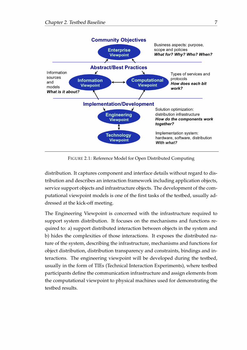
2.2 OGC Reference Model
The OGC Reference Model (ORM) OGC Reference Model version 2.1,
document OGC 08-062r7 provides an architecture framework for the ongo-ing work of the OGC. Further, the ORM provides a framework for the OGCStandards Baseline. The OGC Standards Baseline consists of the member-approvedImplementation/Abstract Specifications as well as for a number of candidatespecifications that are currently in progress.
The structure of the ORM is based on the Reference Model for Open DistributedProcessing (RM-ODP), also identified as ISO 10746. This is a multi-dimensionalapproach well suited to describing complex information systems.
The ORM is a living document that is revised on a regular basis to continuallyand accurately reflect the ongoing work of the Consortium. We encourage re-spondents to this RFQ to learn and understand the concepts that are presentedin the ORM.
This Annex B refers to the RM-ODP approach and will provide information onsome of the viewpoints, in particular the Enterprise Viewpoint, which is usedhere to provide the general characterization of work items in the context ofthe OGC Standards portfolio and standardization process, i.e. the enterpriseperspective from an OGC insider.
The Information Viewpoint considers the information models and encodingsthat will make up the content of the services and exchanges to be extended ordeveloped to support this testbed. Here, we mainly refer to the OGC StandardsBaseline, see section 2.3.
The Computational Viewpoint is concerned with the functional decompositionof the system into a set of objects that interact at interfaces – enabling system
Chapter 2. Testbed Baseline 7
FIGURE 2.1: Reference Model for Open Distributed Computing
distribution. It captures component and interface details without regard to dis-tribution and describes an interaction framework including application objects,service support objects and infrastructure objects. The development of the com-putational viewpoint models is one of the first tasks of the testbed, usually ad-dressed at the kick-off meeting.
The Engineering Viewpoint is concerned with the infrastructure required tosupport system distribution. It focuses on the mechanisms and functions re-quired to: a) support distributed interaction between objects in the system andb) hides the complexities of those interactions. It exposes the distributed na-ture of the system, describing the infrastructure, mechanisms and functions forobject distribution, distribution transparency and constraints, bindings and in-teractions. The engineering viewpoint will be developed during the testbed,usually in the form of TIEs (Technical Interaction Experiments), where testbedparticipants define the communication infrastructure and assign elements fromthe computational viewpoint to physical machines used for demonstrating thetestbed results.

Chapter 2. Testbed Baseline 8
2.3 OGC Standards Baseline
The OCG Standards Baseline is the currently approved set of OGC standardsand other approved supporting documents, such as the OGC abstract speci-fications and Best Practice Documents. OGC also maintains other documentsrelevant to the Interoperability Program including Engineering Reports, Dis-cussion Papers, and White Papers.
OGC standards are technical documents that detail interfaces or encodings.Software developers use these documents to build open interfaces and encod-ings into their products and services. These standards are the main "products"of the Open Geospatial Consortium and have been developed by the member-ship to address specific interoperability challenges. Ideally, when OGC stan-dards are implemented in products or online services by two different softwareengineers working independently, the resulting components plug and play, thatis, they work together without further debugging. OGC standards and support-ing documents are available to the public at no cost. OGC Web Services (OWS)are OGC standards created for use in World Wide Web applications. For thistestbed, it is emphasized that all OGC members have access to the latest ver-sions of all standards. If not otherwise agreed with the testbed architects, theseshall be used in conjunction with - in particular - engineering reports resultingfrom previous testbeds.
Any documents and Schemas (xsd, xslt, etc) that support an approved (that is,approved by the OGC membership) OGC standard can be found in the officialOGC Schema Repository.
The OGC Testing Facility web page provides online executable tests for someOGC standards. The facility helps organizations better implement service in-terfaces, encodings and clients that adhere to OGC standards.
2.4 Data
All participants are encouraged to provide data that can used to implementthe various scenarios that will be developed during the testbed. A number oftestbed sponsors will provide data, but it might be necessary to complementthese with additional data sets. Please provide detailed information if you planto contribute data to this testbed.

Chapter 2. Testbed Baseline 9
2.5 Services in the Cloud
Participants are encouraged to provide data or services hosted in the cloud.There is an overarching work item to provide cloud-hosting capabilities to al-low thread participants to move services and/or data to the cloud.

Chapter 3
Testbed Threads
3.1 Background
Testbed-12 is organized in a number of threads. Each thread combines a num-ber of work packages that are further defined in chapters 4 to 10. The threadsare built around a master scenario and integrate both an architectural and athematic view. Those two pillars allow to keep related work items closely to-gether, which helps understanding how the various aspects interact and partlyeven depend on each other. Table 3.1 lists all Testbed-12 work items:
Work-Item Work-Item
Aviation Geospatial Imagery Quality FrameworkCoverage Data Access Visualization of Earth Observation DataGeneral Feature Model Web Feature Service and TopoJSONSemantic Portrayal Semantic MediationClients Security and SOAPREST,JSON,and GeoJSON Semantic EnablementAsync. Service Interaction TilingCompression and Generalization SWE for LiDAR and StreamingWFS Synchronization CatalogCapabilities Big Data and Tile StoresWeb Integration Service ConflationData Quality GeoPackageOGC WebServices Context UML Shape ChangeData and Portal User GuidesCompliance Testing ArcticSDIGeneralization
TABLE 3.1: Overview of the Testbed-12 work items
10

Chapter 3. Testbed Threads 11
Testbed-12 identifies seven threads in total, the field operations thread (FO),the large scale analytics thread (LSA), the linked data and advanced seman-tics thread (LDS), the command center thread (CMD), the OGC consolidationthread (CNS), the compliance thread (CMP), and the aviation thread (AVI).Each thread is defined in further detail below. Each thread will be guided by athread architect. The close cooperation between all thread architects ensures anefficient and consistent development across all threads that leads – among allindividual results – into a final joint demonstration event. The assignment ofthe various work items to threads is further outlined in the following sectionsand illustrated in figure 3.1.
FIGURE 3.1: Assignment of Work Items to Threads

Chapter 3. Testbed Threads 12
3.2 Field Operations (FO) Thread
In many large scale operations, such as wild fire fighting, evacuation and res-cue, flooding, or earth quakes, response teams operate under sub-optimal con-ditions in terms of Internet connectivity and bandwidth. Therefore, responseteams need to take data into the field for offline usage. Compression techniquesand data generalization patterns become important when live data streamsfrom servers are required.
Work-Item Section
GeoPackage 8.17, 10.4Compression and Generalization 8.8, 9.3Tiling 8.7Clients 7.5
TABLE 3.2: Overview of the Field Operations Thread
3.3 Large Scale Analytics (LSA) Thread
The large scale analytics thread addresses short and long term planning andanalysis of geospatial topics, domains, and questions. It includes elements thathelp the investigator to discover, retrieve, process, and visualize data in an op-timal way. It is complemented by data provision aspects, which include theconversion of conceptual models into application models.
Work-Item Section
Visualization of Earth Observation Data 6.3Big Data and Tile Stores 8.13Coverage Data Access and Analysis 6.4Geospatial Imagery Quality Framework 5Data Quality 8.16Async. Service Interaction 8.6Conflation 8.15UML Shape Change 8.19Clients 7.5
TABLE 3.3: Overview of the Large Scale Analytics Thread

Chapter 3. Testbed Threads 13
3.4 Linked Data and Advanced Semantics for Data
Discovery and Dynamic Integration (LDS) Thread
The Linked Data and Advanced Semantics for Data Discovery and Dynamic In-tegration (LDS) Thread integrates all elements that go beyond traditional clientserver interaction with powerful query languages and complex Web service in-terfaces. It includes all aspects that allow semantic enrichment and mediation,and approaches such as JSON-LD, REST, and DCAT.
Work-Item Section
Semantic Enablement 8.5REST,JSON,and GeoJSON 8.4Semantic Portrayal 7.4.3Semantic Mediation 7.4.4Catalog 8.11 , 7.4.2ArcticSDI 10.3Clients 7.5
TABLE 3.4: Overview of the Linked Data and Advanced Seman-tics
3.5 Command Center (CMD) Thread
The Command Center Thread aggregates all activities and work items relatedto incident management operations. During the course of an event, comman-ders require a common operational picture in order to take important decisionsin an optimal way. The thread includes items that contribute to this commonoperational picture by using context documents to share common views, secu-rity settings to allow handling sensitive data, improvements to the capabilitiesdocuments to allow quick discovery of service and data offerings, and synchro-nization and streaming aspects.

Chapter 3. Testbed Threads 14
Work-Item Section
OGC WebServices Context 8.18Security and SOAP 8.3SWE for LiDAR and Streaming 8.9Web Feature Service and TopoJSON 7.4.1WFS Synchronization 8.10Capabilities 8.12Web Integration Service 8.14Clients 7.5
TABLE 3.5: Overview of the Command Center (CMD) Thread
3.6 Consolidation (CNS) Thread
The Consolidation Thread includes activities that help improving the currenttechnical baseline and its implementation by developing a set of user guides,analyses on how to handle and integrate traditionally non-geospatial data withthe General Feature Model, and develops an environment of data that will bemade available for future testbeds.
Work-Item Section
General Feature Model 7.3User Guides 8.21Data and Portal 8.20Clients 7.5
TABLE 3.6: Overview of the Consolidation (CNS) Thread
3.7 Aviation (AVI) Thread
The Aviation Thread includes all work items that contribute to the improve-ment of air traffic control. It addresses aspects such as advanced use of catalogsfor aviation, brokering of information across services, asynchronous messag-ing, aviation specific security needs, aviation semantics and business rules, andaeronautical and flight information models.

Chapter 3. Testbed Threads 15
Work-Item Section
Aviation 4
TABLE 3.7: Overview of the Aviation (AVI) Thread
3.8 Compliance Testing (CMP) Thread
The compliance testing thread includes all improvements to the OGC compli-ance test and certification program, such as improvements to the test engineand tests, development of virtual machines to facilitate testing, and the devel-opment of reference implementations.
Work-Item Section
Compliance Testing 8.22
TABLE 3.8: Overview of the Compliance Testing (CMP) Thread

Chapter 4
Aviation
4.1 Background
The Federal Aviation Administration (FAA) and EUROCONTROL have devel-oped the Aeronautical Information Exchange Model (AIXM) as a global stan-dard for the representation and exchange of aeronautical information. AIXMwas developed using the OGC Geography Markup Language (GML) tailoredto the specific requirements for the representation of aeronautical objects, in-cluding the temporality feature that allows for time dependent changes affect-ing AIXM features. The overall objectives of the FAA and EUROCONTROLare to use AIXM as a basis for modernizing their aeronautical information pro-cedures and transitioning to a net-centric, global aeronautical management ca-pability. The FAA and EUROCONTROL plan to use AIXM in the net-centric(System Wide) Information Management (SWIM) related components of theUS NextGen and EU SESAR programs.
The Weather Information Exchange Model (WXXM) is the proposed standardfor the exchange of aeronautical weather information in the context of a net-centric and global interoperable Air Transport System. It is currently underdevelopment by FAA and EUROCONTROL in support of the NextGen andSESAR programs. WXXM uses the OGC Geography Markup Language (GML)tailored to the specific requirements for aeronautical meteorology and is basedon the OGC Observation & Measurement Model. Within the context of globalharmonization, the WXXM is harmonized and coordinated with the World Me-teorological Organization (WMO), the organization traditionally responsiblefor standards in meteorology. The OGC’s Meteorology and Oceanography Do-main Working Group has set up the appropriate mechanisms and interfaces
16

Chapter 4. Aviation 17
between OGC and WMO to support this global harmonization and coordina-tion effort.
The Flight Information Exchange Model (FIXM) is an exchange model captur-ing Flight and Flow information that is globally standardized. The need forFIXM was identified by the International Civil Aviation Organization (ICAO)Air Traffic Management Requirements and Performance Panel (ATMRPP) inorder to support the exchange of flight information as prescribed in Flight andFlow Information for a Collaborative Environment (FF-ICE). FIXM is the equiv-alent, for the Flight domain, of AIXM (Aeronautical Information Exchange Model)and WXXM (Weather Information Exchange Model), both of which were de-veloped in order to achieve global interoperability for, respectively, AIS andMET information exchange. FIXM is therefore part of a family of technologyindependent, harmonized and interoperable information exchange models de-signed to cover the information needs of Air Traffic Management.
By sponsoring the OGC Testbed-12, EUROCONTROL aims to increase industryadoption of these formats and to support the operational use and validation ofthese emerging standards. The Agency is particularly interested in the Testbed-12 deliverables which will help to enhance the OGC/ISO standards (WFS, Pub-lication/Subscribe mechanisms, etc.) so that they meet SESAR SWIM require-ments. EUROCONTROL also intends to use the Testbed as a SWIM verificationplatform that will help to further challenge the SWIM requirements. The resultsof Testbed-12 will be delivered to several SESAR WP13/14 projects, as contri-butions to the definition and implementation of SWIM-enabled services andsystems.
The Aviation thread seeks to implement CCI components such as semantics,ontology, and linked data to improve interoperability of services provided bySystem Wide Information Management (SWIM) within FAA and Eurocontrol.Among these include the Data Broker, Catalog Service for Web (CSW), GeoSPARQL(Ontology), Semantics and Linked Data. Additionally, the Aviation thread isinterested in integration of publish-subscribe messaging patterns for the ex-change and request of geospatial information.

Chapter 4. Aviation 18
4.2 Requirements and Work Items
Figure 4.1 illustrates all work items that shall be addressed in this work pack-age. They are described in further detail in the following sections. All fundedwork items are shaded in green, unfunded in blue. Each work item may im-plement several requirements, i.e. components need to fulfill various require-ments, or engineering reports need to address and summarize the results fromvarious requirements. Arrows indicate the associations between work itemsand requirements.
The aviation work package contains in total seven requirements. These require-ments are further refined in the following sections. The aviation architecturedefinition complements this list as an overarching requirement that helps un-derstanding the architectural classification and integration of the various workitems.
4.3 Aviation Architecture
OGC and Testbed-12 participants will develop a technical architecture describ-ing the arrangements of the service applications that satisfy the overall objec-tives for the project. The technical architecture will be reviewed and approvedby the Testbed-12 sponsors.
Flight, aeronautical, and meteorological information necessary for the execu-tion of OGC Testbed-12 scenarios should use as much as possible existing datasources. EUROCONTROL and the FAA may provide an AIXM, WXXM, FIXM,or AMXM set of files that contain static aeronautical data as needed for testingand for supporting the scenario.
Deliverables of the Aviation Architecture work item
ID Funding Name
E005 unfunded Aviation Architecture ER
TABLE 4.1: Aviation Architecture deliverables

Chapter 4. Aviation 19
FIGURE 4.1: Aviation work package: Requirements and workitems

Chapter 4. Aviation 20
4.4 Advance use of Data Broker
An important principle of SOA is the notion of composing capabilities pro-vided by individual services into complex behavior. A requester should be ableto compose a solution using functionality or data offered by multiple serviceswithout worrying about underlying differences in those services.
Each OGC service is designed to offer a specific type of data product (e.g. anXML document by WFS, a map by WMS, etc.) via a service-specific interface.This task seeks to establish a single service interface that would allow access tomultiple data sources, possibly heterogeneous with respect to the types of dataprovided.
For example: A client may request data related to a specific air navigation route.The data may consist of a set of aeronautical and an associated set of mapsserved by a WFS or WMS component, respectively. Currently, the Data Broker,as developed in Testbed-11, is capable of combining multiple WFS responsesinto a single homogeneous response.
For this task, a Data Broker must combine two separate service request typesfrom heterogeneous responses. The Data Broker task shall also utilize the CSWcatalog service if possible. Additionally, the participant shall demonstrate theuse of a data broker to discover services, discover related data using semanticlinked data, and conflate the heterogeneous response. The participant shalldemonstrate two approaches:
1. A request to separate WFS with heterogeneous data using AMXM andAIXM to demonstrate the conflation of two heterogeneous data sets fromthe same type of web service;
2. A request to a WFS and another type of service (e.g. WMS or WCS) witha heterogeneous response. In this second approach, the participant shalldetermine and propose a suitable secondary service type prior to imple-mentation according to the available data provided.
Regarding the AIXM/AMXM transformation, the idea is that (i) the client usesan AMXM WFS to fetch AMXM data, and (ii) that the AMXM WFS issues arequest to the AIXM WFS thus instantiating a data transformation chain fromgeneric Airport Mapping Data (AIXM) into specific AMDB data (AMXM) asspecified in the related EUROCAE/RTCA Standards. Eurocontrol will provide

Chapter 4. Aviation 21
access to the existing EUROCAE/RTCA AMXM UML & XML Schema and sam-ples of AMXM data. The AMXM UML and AMXM XML Schema are in a ma-ture state of development and ready for publication. Depending on the usecase envisaged it should be possible to share AIXM (source) data. It is to benoted that the testbed will not intend to achieve completeness in terms of datacoverage.
The focus is on the demonstration/feasibility of a data chain by coupling WFSinstances. Therefore the selection of a few relevant features should be suffi-cient ideally spread over some point/line/polygon types. EUROCONTROLwill make available the earlier AMDB to AIXM5.1 mapping which can be usedto get some insight in the transformation. Finally, the AIRM can also be used tobridge the semantics between the two WFS instances. Eurocontrol can providethe necessary insights if required. Although the EUROCAE/RTCA standardscome with specific requirements regarding features (geometrical constraints &functional constraints) it is considered that these are not a key aspect of thetestbed. Yet chaining feature geometry checking services would constitute anexcellent bonus to demonstrate the power of the OGC approach, leveraging theend-goal of SWIM information services towards quality and trust. Upon re-quest Eurocontrol will share any relevant AMDB insights the testbed membersmay require to perform their work.
Input documents for consideration include the following OGC documents butshould not be limited to:
• OGC Testbed-11 – Data Broker Engineering Report
• Any OGC services standards for WFS, WMS, WCS, etc as applicable forthe use case in heterogeneous OGC service request via Data Broker
• Current standards for Catalog Service for Web (CSW) for use of Catalogservice with Data Broker for service and data discovery
• Engineering Reports from CCI thread regarding Catalog service and linkeddata for conflation.
• OWS-9 Data Transmission Management Engineering Report for the useof conflation of data
Deliverables Advance use of Data Broker

Chapter 4. Aviation 22
ID Funding Name
E002 funded Brokering ERE005 unfunded Aviation Architecture ERE006 unfunded WFS-TE AIXMF004 funded Aviation Client Data Broker + CSWF005 funded WFS AMXMF006 funded Data BrokerF007 unfunded OGC Web Service AviationF010 unfunded WFS AIXM
TABLE 4.2: Advance use of Data Broker deliverables
4.5 Advance Use of Catalog Service for Web (CSW)
A service registry is an important component of SOA and a key building blockin the context of the SWIM information infrastructure. Both FAA and EU-ROCONTROL implementations of SWIM have established their own registries(FAA’s NAS Service Registry/Repository (NSRR) and EUROCONTROL’s Eu-ropean SWIM Registry respectively). And although these registries were de-veloped independently, they share the same conceptual model (SDCM) and arevery similar in terms of basic functionalities. In much the same way, OGC Cat-alogue services support the ability to publish and search collections of descrip-tive information (metadata) for data, services, and related information objects.
However, because existing SWIM registries do not store spatial information(e.g. BoundingBox, CRS, etc.) and therefore lack abilities to support geospatialqueries, the developers of SWIM OGC-compliant services are looking to estab-lish OGC-compliant Catalogue services in parallel to the existing registries.
This task shall demonstrate a registry solution using Catalog Service for Web(CSW) with integration to the FAA NSRR as a single entry point for all SWIMservice discovery support. Secondly, the task shall analyze and report on thecurrent state of the FAA and Eurocontrol SWIM registries to determine whichmodifications may be required in order to harmonize the implementations.
The catalog/registry solution shall consider the functionality for content andservice discovery while providing the following features:
• Simple user interface for searching for content via geospatial queries (e.g.

Chapter 4. Aviation 23
bounding box). Specifically, a RESTful service interface for semantic query-ing of geospatial data
• Provide discoverable content for both web services and publish/subscribecontent (i.e. JMS data feeds)
• Provide capability to search across multiple SWIM domain registries suchas FAA NSRR and Eurocontrol SWIM Registry
• Provide a harmonized service description conceptual model (SDCM)
• Cost effective approach to supporting the governance of service metadataincluding quality and integrity.
Input documents for consideration include the following OGC documents butshould not be limited to:
• OGC Testbed-11 Implementing Linked Data and Semantically EnablingOGC Services Engineering Report
• Any FAA documentation on FAA SWIM registry and NSRR FAA SWIMregistry and NSRR
• Any Eurocontrol documentation on European SWIM Registry
• Utilization of Faceted Classification in the Context of the SWIM ServiceRegistry
• FAA/SESAR JU Service Description Conceptual Model (SDCM) 1.0
• Data.gov has a registry for their data that was originally not supportinggeospatial data. Parts of the OGC Catalog Service for Web (CSW) wereadded to the Data.gov registry
Deliverables
ID Funding Name
E001 funded Catalog ERE005 unfunded Aviation Architecture ERF003 funded CSWF004 funded Aviation Client Data Broker + CSW
TABLE 4.3: Advance Use of Catalog Service for Web deliverables

Chapter 4. Aviation 24
4.6 Asynchronous Messaging for Geospatial Queries
of Aviation Data
JMS and AMQP are used in ATM for publish-subscribe messaging of avia-tion data. Currently, OGC Web Services only support synchronous web ser-vice request-response query capabilities. This task shall investigate the meansto incorporate publish-subscribe messaging patterns for the retrieval of avia-tion data (i.e. AIXM, WXXM, FIXM, or AMXM) information using geospatialqueries through a JMS interface and AMQP interface. This task shall demon-strate a capability using the recommended approach. Suggested solutions mayconsider, but are not limited to, the following:
• XML or JSON standard for the name-value pairs used in JMS/AMQPheaders
• Standard data model using GML profiles (e.g. AIXM profile metadataheader format for AIXM messages)
• SOAP over JMS
The results of this demonstration shall be reported in the Asynchronous re-sponse ER (A067, described in chapter 8.6) recommending a method for man-aging message JMS metadata in publish-subscribe models. The results shallcontain the detailed architecture for the components developed for this activ-ity.
References The following deliverables have been defined based on the scopeof the requirement for this task:
• NEMS Interface Control Document (ICD) V6.0 (not available on-line) – Tobe provided by FAA upon request.
• SWIM NEMS User Guide
• OGC Event Service Specification
Deliverables

Chapter 4. Aviation 25
ID Funding Name
E003 funded Asynchronous Messaging ERE005 unfunded Aviation Architecture ERF005 funded WFS AMXMF007 unfunded Aviation Web Service (WMS/WCS)F008 unfunded Aviation Client JMS + AMQPF009 unfunded JMS + AMQP Server
TABLE 4.4: Asynchronous Messaging for Geospatial Queries ofAviation Data deliverables
4.7 Advance use of Semantics for Aviation
The current service description standards, including WSDL, OWS and XMLSchema, operate almost entirely at the syntactic level. They focus only on de-scribing a service’s exposed functionality (e.g. methods signatures, input/outputtypes, etc.) while failing to capture enough semantic data (e.g. service capabili-ties, qualities of service, etc.). Service implementations often work around thislimitation by augmenting the service descriptions with an external semanticlayer. In FAA, this semantic layer has been implemented mostly through de-veloping human-readable regulating documents like FAA-STD-065 and FAA-STD-073. Effort was also invested in developing an ontology (WSDOM) thatdescribes all aspects of a service using formal languages like OWL and SKOS.
However, the increased demand for service interoperability has only been par-tially met by these activities. To take full advantage of the capabilities providedby OGC services, it is necessary to introduce semantic service descriptions thatare suitable for use by both humans and machines. Semantic enrichment ofservice descriptions (and of related artifacts like data models) should be ableto address service discovery, composition and interoperability to a significantlyhigher degree than occurs today.
This effort builds upon the work completed in OWS-9 Semantic Query Media-tion, Testbed 10 Ontology, and Testbed-11 Advance use of a common symbol-ogy. For Testbed-12, this task shall evaluate the FAA Web Service DescriptionOntological Model (WSDOM) to determine how it can be improved for use withOGC Web Services and easily integrated to the SWIM registry with the Catalogservice.

Chapter 4. Aviation 26
This task shall provide a demonstration of Semantic ontology based on the FAAWSDOM ontology, while demonstrating interoperability with OGC semanticcapabilities. The task should include concepts from OGC Testbed-11 - CatalogRecommendation ER in which ontology URIs are embedded in metadata andservice descriptions. The implementation should also consider RDF/RDFS,OWL, SKOS, and other open standards. The results and ontology implementa-tion shall be recorded in a Semantic Ontology for Aviation Engineering Report.
References
• OGC Testbed 10 Cross Community Interoperability (CCI) Ontology En-gineering Report FAA Web Service Description Ontological Model (WS-DOM) OGC 14-049
Deliverables
ID Funding Name
E005 unfunded Aviation Architecture ERF002 funded Aviation Semantics ER
TABLE 4.5: Advance use of Semantics for Aviation deliverables
4.8 Advanced use of Semantic Business Vocabulary
and Business Rules (SBVR)
Semantics Of Business Vocabulary And Rules (SBVR) defines the vocabularyand rules for documenting business vocabularies, business facts, and businessrules. It defines structural and operative rules. AIXM 5, following SBVR, hasidentified AIXM Structural rules and AIXM Operative rules. Some of the struc-tural rules can be captured in the AIXM schemas. The ones that cannot becaptured in a schema can be formalized in to Schematron or other similar rules-engine language.
• SBVR allows provision of rules in a friendly way. For example:
• Each [...].lowerLevel that has an uom equal to ’FL’ should have 2 or 3 digits
• Each AirportHeliport.ARP must have horizontalAccuracy and AirportHeli-port.ARP.horizontalAccuracy should be at most 1sec

Chapter 4. Aviation 27
This task will advance using SBVR at the data content level. An initial step wasmade in OGC Testbed-11, where an initial SBVR vocabulary for GML elementswas developed, together with a tool prototype that converts SBVR into exe-cutable Schematron code. For OGC Testbed-12, the participant shall investigatethe use of semantic vocabularies (SBVR) at the next level, trying to capture rulesthat identify operational constraints based on aircraft characteristics and the in-frastructure characteristics, including the actual status. For example, expressSBVR rules that relate:
• the aircraft type to the possibility to operate on a given runway, takinginto consideration landing distances, risk of overshooting the last exittaxiway and limitations in turning radius of the aircraft, etc.
• the possibility to land on a given runway considering the actual weatherdata (RVR/visibility, availability of non-precision/precision approachesand of critical navaids, etc.)
Then, use such rules in order to identify airports along the trajectory that couldbe used in case of an emergency landing (less rules would apply) or as addi-tional alternates (more rules would apply).
Deliverables
ID Funding Name
E004 unfunded SBVR ERE005 unfunded Aviation Architecture ER
TABLE 4.6: Advanced use of Semantic Business Vocabulary andBusiness Rules deliverables
4.9 Aviation OGC Web Service Security
OGC Testbed-11 established a security framework for use with OGC web ser-vices. The need for cyber security measures within the Aviation community iscritical for the safety of future operations with SWIM services. This task shall in-vestigate the use of the security framework in OGC Testbed-11 and recommendbest practices for the implementation with OGC services in OGC Testbed-12.
Deliverables

Chapter 4. Aviation 28
ID Funding Name
E005 unfunded Aviation Architecture ERF001 funded Aviation Security ER
TABLE 4.7: Aviation OGC Web Service Security deliverables
4.10 Flight Information Exchange Model (FIXM)
The FAA and EUROCONTROL, in conjunction with multiple other interna-tional partners as well, are currently in the process of developing the FlightInformation Exchange Model (FIXM). FIXM is an exchange model capturingFlight and Flow information that is globally standardized. The need for FIXMwas identified by the International Civil Aviation Organization (ICAO) Air Traf-fic Management Requirements and Performance Panel (ATMRPP) in order tosupport the exchange of flight information as prescribed in Flight and FlowInformation for a Collaborative Environment (FF-ICE).
FIXM is the equivalent, for the Flight domain, of AIXM (Aeronautical Infor-mation Exchange Model) and WXXM (Weather Information Exchange Model),both of which were developed in order to achieve global interoperability for,respectively, AIS and MET information exchange. FIXM is therefore part of afamily of technology independent, harmonized and interoperable informationexchange models designed to cover the information needs of Air Traffic Man-agement. Previous OGC IP initiatives developed an architecture that supportsthe exchange of AIXM and WXXM data. This task shall demonstrate the in-tegration of GML profile elements into FIXM, specifically, the Feature, Time,Point, UOM, CharacterString, Integer, and Decimal types, into FIXM version3.0.1 or an alpha release of FIXM version 4.0. The purpose of this task is toensure that the implementation of GML elements is usable by the FIXM devel-opment community.
The participant shall:
• Describe the integration of GML into the FIXM UML model provided byFAA, and generate a FIXM XML schema from the FIXM UML model
• Provide an updated UML and XML Schema for the modified FIXM
• Demonstrate a WFS FIXM with support for queries on FIXM feature data

Chapter 4. Aviation 29
• Verify and validate (through tests and demonstrations)
1. the FIXM design and
2. the capability of the OGC Aviation Architecture to support interop-erable exchange of FIXM data, and document the results (especiallyany improvements for FIXM)
• Document potential enhancements and identified issues for relevant doc-uments and references. For OGC documents, change requests (especiallyfor Standard and Best Practice documents) will be created.
Deliverables
ID Funding Name
E005 unfunded Aviation Architecture ERF011 funded FIXM GML ERF012 funded WFS FIXM
TABLE 4.8: Flight Information Exchange Model deliverables
4.11 Summary
The following tables summarizes all work items that shall be delivered as partof this work package.

Chapter 4. Aviation 30
ID Funding Name
E001 funded Catalog ERE002 funded Brokering ERE003 funded Asynchronous Messaging ERE004 unfunded SBVR ERE005 unfunded Aviation Architecture ERE006 unfunded WFS-TE AIXMF001 funded Aviation Security ERF002 funded Aviation Semantics ERF003 funded CSWF004 funded Aviation Client Data Broker + CSWF005 funded WFS AMXMF006 funded Data BrokerF007 unfunded Aviation Web Service (WMS/WCS)F008 unfunded Aviation Client JMS + AMQPF009 unfunded JMS + AMQP ServerF010 unfunded WFS AIXMF011 funded FIXM GML ERF012 funded WFS FIXM
TABLE 4.9: Aviation work package deliverables summary

Chapter 5
Geospatial Imagery QualityFramework
5.1 Background
The last decade has seen proliferation of sensors on various platforms (satel-lites, aerial, UAV’s) that collect imagery at multiple scales/resolutions. It isestimated that several hundred small satellites and UAV’s will be added tothis asset base in the next 5-10 years. Currently there is no consistent qualityframework that will allow end users to compare imagery from multiple sourcesacross the different quality attributes in order to have a holistic view of imageryvalue as it may apply to particular set of requirements.
Testbed-12 shall develop a quality frame work called “A3C” (Accuracy, Cur-rency, Completeness, and Consistency) that can be used to compare imageryfrom multiple sources. Accuracy refers to spatial accuracy of a location derivedfrom the pixel in X,Y dimensions and potentially in Z dimension. Currencyrefers to the temporal extent of the imagery products used to cover the associ-ated area, since multiple dates of collects are typically required to cover a largearea. Completeness of imagery products refers to quality metrics includingcloud cover, sensor specs on collection geometry, temporal range of the data,other spectral bands if any, radiometric depth of the pixels, etc. Finally, theConsistency metric describes the consistency of colors, relative accuracy overtime and over different sensors, spectral and spatial error propagation fromcollection to production, etc.
31

Chapter 5. Geospatial Imagery Quality Framework 32
5.2 Requirements and Work Items
The following figure illustrates all work items that shall be addressed in thiswork package. They are described in further detail in figure 5.1. All fundedwork items are shaded in green, unfunded in blue. Each work item may im-plement several requirements, i.e. components need to fulfill various require-ments, or engineering reports need to address and summarize the results fromvarious requirements.
FIGURE 5.1: Geospatial Data Quality work package: Require-ments and work items
5.3 Accuracy, Currency, Completeness, Consistency
The detailed image quality framework to be developed in Testbed-12 shall sup-port comparing multiple sources of imagery. A framework of this nature, vettedby the OGC experts, improves interoperability of multiple imagery sources andprovides users a much more consistent mechanism to assess imagery products.

Chapter 5. Geospatial Imagery Quality Framework 33
5.3.1 Desired Output
The goal of this work package is to develop the image quality framework thataddresses all aspects mentioned below. Its functionality shall be demonstratedusing at least a WMTS implementation that supports temporal accuracy infor-mation. If funding allows, a WCS shall be implemented that supports all A3Cdata. Independent of the available services to demonstrate its functionality,the image quality framework shall be documented with all detail in the ImageQuality and Accuracy Engineering Report. The report shall support at least thefollowing aspects:
• Creation of use cases to show how different missions could use A3C met-rics to assess the applicability of imagery to their goals
• Analysis of use cases to derive the set of metrics that can best support A3Cgoals of the use cases
• Definition of a data model which allows a source system to capture A3Cmetrics
• Specifications of data elements within the model to insure consistent, ap-propriate interpretation across a variety of sensors based on spatial resolu-tion, spectral resolution, radiometric resolution and temporal resolution.
• Demonstration of use of the model to show how A3C metrics can distin-guish value across several different use cases (can be same missions asdefined above), for example:
– Mapping Mission
– Disaster Response
– Monitoring Mission
• Proposed A3C Specification
5.3.2 Example Use Cases
As an example of the need for A3C metrics, consider two use cases: A LandUse analysis and a Mapping mission. In both cases the users may desire mosaicimagery, but there will be differences in the metrics for the intended purpose:
The Land Use analysis requires:

Chapter 5. Geospatial Imagery Quality Framework 34
• Similar currency of the imagery, consistency across the mosaic
• Atmospherically corrected, consistent known color balancing
• Any color enhancements
The Mapping Mission is more concerned with:
• Horizontal accuracy
• Extent of collection dates
• DEMs and GCPs used
• Any seam line alteration
5.3.3 Proposed Example Metrics
• Accuracy
– Accuracy of products:
∗ Horizontal Accuracy CE90
∗ Vertical Accuracy LE90
– Accuracy of Raw Satellite Imagery (basically reflects satellite point-ing accuracy)
∗ Horizontal Accuracy CE90 based on observed locations on ground
• Currency of products
– Raw imagery
∗ Times of collection, seasonality, leaf-on or leaf-off
– Finished products
∗ Earliest collection date, Latest collection date, Average age, sea-sonality, leaf-on or leaf-off
• Completeness
– Single scene/strip imagery
∗ Metadata on sensor, orbit, spatial resolution, spectral resolution,radiometric resolution, collection geometry, resampling technique,data compression, DEM used, GCP’s used, geometric alteration

Chapter 5. Geospatial Imagery Quality Framework 35
(e.g. photoshop), color enhancements, image enhancements (e.g.sharpening)
– Finished Products
∗ Metadata on sensors, orbits, spatial resolution(s), spectral res-olution(s), radiometric resolution(s), collection geometries, re-sampling technique, data compression, DEM used, GCP’s used,Seamlines, geometric alteration (e.g. photoshop), color enhance-ments, image enhancements
• Consistency
– Atmospherically corrected or not
– Atmospheric correction based on in scene data or ancillary data
– Cross sensor calibration (constellation sensors)
– Ground based spectral calibration
– Color balancing technique (local color balancing or global color bal-ancing)
– NIIRS for imagery quality from sensor
– Standard deviation of collection dates
5.4 Summary
The following tables summarizes all work items that shall be delivered as partof this work package. The client application is supposed to interact with theservices and to display A3C information. The services shall support A3C infor-mation as described, the engineering report shall capture all results and may becomplemented by change requests against existing services.

Chapter 5. Geospatial Imagery Quality Framework 36
ID Funding Name
DG001 unfunded WCS Server for Data Quality andSpherical Accuracy
DG002 funded Generic Client to interact with the ser-vices
DG003 funded Imagery Quality and Accuracy ERDG004 funded WMTS Server for Temporal Accuracy
TABLE 5.1: Geospatial Imagery Quality Framework work packagedeliverables summary

Chapter 6
Coverage Access and Visualization
6.1 Background
The National Aeronautics and Space Administration (NASA) has identified ini-tial interoperability requirements in the context of coverage data access andenhanced visualization of earth observation data. The goal is to enhance thecurrently available WCS Earth Observation profile to reflect new requirementscoming from both the data provider and consumer communities. These involvenew indexing mechanisms, support for data encodings such as HDF, NetCDF,and DAP, and coverage processing mechanisms. Further on, NASA is inter-ested in improving OGC service and encoding specifications to optimize itsusage with GIBS. GIBS, the Global Imagery Browse Services system is a coreEOSDIS component which provides a scalable, responsive, highly available, and com-munity standards based set of imagery services. These services are designed with thegoal of advancing user interactions with EOSDIS’ inter-disciplinary data through en-hanced visual representation and discovery. [...] The GIBS imagery archive includesapproximately 90 imagery products representing 35 visualized science parameters fromthe NASA Earth Observing System. Each imagery product is generated at the na-tive resolution of the source data to provide "full resolution" visualizations of a scienceparameter (NASA).
Figure 6.1 illustrates GIBS’ architecture. GIBS is composed of two major func-tional areas:
• Ingest & Archival - GIBS servers regularly ingest and archive imageryfrom imagery providers into full-resolution, mosaicked layers; these lay-ers are then chopped into imagery tiles stored at predefined zoom levelsfor access.
37

Chapter 6. Coverage Access and Visualization 38
• Distribution - GIBS servers serve the archived imagery tiles created abovethrough standard imagery access services.
FIGURE 6.1: Global Imagery Browse Services (GIBS) system archi-tecture (image by NASA)
The goal in Testbed-12 is to improve the second of these two aspects, the distri-bution of imagery data through standard interfaces. According to NASA, GIBSimagery is accessed through the following standards-based web services andformats:
• Web Map Tile Service (WMTS) - The WMTS implementation standardprovides a standards-based solution for serving digital maps using pre-defined image tiles. Through the constructs of the specification, a WMTSservice advertises imagery layers (e.g. imagery product) and defines thecoordinate reference system, scale, and tiling grid available for access. TheWMTS standard complements the existing Web Map Service (WMS) OGCstandard by providing a less flexible but higher performing image requestmechanism.

Chapter 6. Coverage Access and Visualization 39
• Tiled Web Mapping Service (TWMS) - The TWMS specification is a cus-tom extension to the OGS WMS standard developed by the NASA JetPropulsion Laboratory. Similar to the OGC WMTS specification, TWMSintroduces a "tiled" approach to imagery requests so that tiles may be pre-generated and cached for fast response. Unlike WMTS, the TWMS stan-dard retains the usage of requests containing geographic coordinates forimagery. However, it only responds to a limited number of predefinedgeographic regions, creating a gridded access pattern.
• Keyhole Markup Language (KML) - The KML documentation standardprovides a solution for imagery integration into mapping tools that uti-lize support the KML standard, specifically Google Earth. Using the con-structs of the KML standard, GIBS infuses links to the TWMS web serviceendpoints to facilitate imagery viewing within supporting tools. A cus-tom KML generation endpoint is provided by GIBS to dynamically gen-erate KML documents.
• Geospatial Data Abstraction Library (GDAL) - GDAL is an open sourcetranslator library for raster geospatial data formats that presents a singleabstract data model to the calling application for all supported formats.By providing integration into the GDAL command line utilities, GIBS im-agery can be easily included in imagery processing work flows, includingbulk access.
Ideally, work items in this work package consider additional computing op-timization and corresponding interoperability aspects through the use of Dis-crete Global Grid Systems (DGGS). A DGGS is a spatial reference system thatuses a hierarchical tessellation of cells to partition and address the globe. DGGSare characterized by the properties of their cell structure, geo-encoding, quan-tization strategy and associated mathematical functions.
The DGGS standards working group in OGC has recently submitted the OGCDiscrete Global Grid System (DGGS) Core Standard, OGC 15-104. The OGCDGGS standard supports the specification of standardized DGGS infrastruc-tures that enable the integrated analysis of very large, multi-source, multi-resolution,multi-dimensional, distributed geospatial data. Interoperability between OGCDGGS implementations is anticipated through extension interface encodings ofOGC Web Services (OWS). Considering DGGS complements data fusion andconflation aspects as described in chapter 8.15, as described by the followingexcerpt from OGC 15-104:

Chapter 6. Coverage Access and Visualization 40
As each cell in a DGGS is fixed in location, and the location provides an ex-plicit area representation, basic geospatial enquiry – “Where is it?”, “What ishere?”, and “How has it changed?” - are simplified into set theory operations.As any data values referenced to a particular DGGS are, by the nature of thegrid, aligned, the high costs of integrating data in traditional systems are dra-matically reduced.
A DGGS can even be designed for lossless encoding of vector geometry suchthat cells, and their integer addressing, converge monotonically to the Realnumber coordinate pairs of each observation with each successive refinement –an essential property of a conventional coordinate system.
DGGS are designed to eliminate requirements for complex data fusion pro-cesses. Reducing the reliance on an intermediary integrator or analyst is akey requirement for distributed participatory digital-Earth information system.“[Digital-Earth] can clearly benefit from developments in discrete global grid,which can provide the georeferencing, the indexing, and the discretization neededfor geospatial data sets. They have properties, in particular hierarchical struc-ture, uniqueness, explicit representation of spatial resolution, and consistency,that make them superior to any single alternative.” Goodchild. A DGGS pro-vides a uniform environment to integrate and visualize both vector geometryand raster-based geospatial data sources in much the same way that informa-tion within a computer graphics pipeline becomes the pixels on a computerscreen. Efficiencies are gained through implementing the Dimensionally Ex-tended nine-Intersection Model (DE 9IM) set of fundamental spatial operations[3-6] directly on the DGGS cell structure. This allows for higher order alge-braic algorithms (via bindings to external analytic libraries) to be created on theDGGS structure itself, independent of the data sources. CyberGIS benefit fromDGGS use. By conversion of traditional Earth observation data archives intostandardized DGGS, massive amounts of data are made available to scientistsas timely decision-support products in a transparent and repeatable fashion.Very large multi-resolution and multi-domain datasets are aligned and readyfor distributed and/or high-performance parallel-processing computer envi-ronments.

Chapter 6. Coverage Access and Visualization 41
6.2 Requirements and Work Items
The following figure 6.2 illustrates all work items that shall be addressed in thiswork package. They are described in further detail in the following sections.All funded work items are shaded in green, unfunded in blue. Each work itemmay implement several requirements, i.e. components need to fulfill various re-quirements, or engineering reports need to address and summarize the resultsfrom various requirements.
FIGURE 6.2: Coverage Access and Visualization work package:Requirements and work items
6.3 Visualization of Earth Observation (EO) Data
Many EO data sets have been stored in HDF4, HDF5 or NetCDF format, whichtraditionally have been difficult to analyze and visualize with geospatial tools.With the rising demand from the diverse end-user communities for geospa-tial tools to handle multidimensional products, many geospatial applications

Chapter 6. Coverage Access and Visualization 42
now have new functionalities that enable the end user to store, access, ana-lyze, and visualize these EO data sets. One such visualization approach ofNetCDF files uses the ncWMS. ncWMS extends WMS slightly to support fea-tures that are useful for scientific data, such as the selection of colour scales.Though ncWMS is fully backward-compatible with the WMS spec, extensionsto the WMS specification shall be supported in Testbed-12 to better supportNetCDF-CF data visualization and exploration. Testbed-12 shall create a WMSthat requires minimal configuration to serve CF-compliant NetCDF files: thesource data files should already contain most of the necessary metadata. Theservice shall implement the new extensions to WMS in order to support thenon-standard WMS-behavior provided by ncWMS. In addition, the number oflayers served by GIBS is foreseen to get into the hundreds if not thousands andwill need a way for clients to intelligently filter them to find the most relevantones. Testbed-12 shall develop a solution for this issue, e.g. by providing theability to filter results of GetCapabilities requests, possibly using XPath.
Further on, visualization of EO data using WMTS needs to consider tile assem-bly with temporal considerations. This is an ongoing work item in OGC andthere has been some discussion on this topic in the OGC Web Mapping Ser-vice 1.4 SWG. The WMTS/WMS SWG is considering facilitating dynamic tileassembly through a WMTS server and if so, whether the servers will likely seemuch value in request/result caching. Testbed-12 shall investigate if the sameresult could be achieved (vertical assembly, reduced bandwidth, etc.) througha WMS request that leverages pre-generated tiles. The work shall be based onresults from the ESDIS Visualization Working Group (ESDSWG-Visualization),which evaluated leverage ncWMS services for publishing level2 (swath) andlevel 3 (gridded) satellite imagery for harvest by the Global Image Browse Ser-vice (GIBS). Participants interested in this work item are requested to consultwith the OGC WMS SWG to discuss the latest details. The goal is to extend theWMTS specification to handle time-varying layers more robustly.
Additionally, if granule and swath imagery is served via WMTS, any givengranule or swath often covers only a small fraction of the globe. This meansthat there can be many unnecessary requests for empty tiles in the areas wherethere is no imagery. Testbed-12 shall develop a solution that help clients makingtheir requests, possibly by providing a bitmap of where there is valid imageryon the globe so a client knows which requests to make.
As those work items use current work performed in the OGC WMS SWG and

Chapter 6. Coverage Access and Visualization 43
within GIBS, Testbed-12 shall use all input available from the OGC WMS SWGand from NASA GIBS at the time of the Testbed-12 kick-off and shall workclosely with these groups throughout the testbed.
References
• OGC 13-082r2: OGC Web Map Tile Service (WMTS) Simple Profile
• OGC 14-028r1: Performance of OGC Services in the Cloud
Deliverables
• The WMS/WMTS Enhanced engineering report, NA005, shall captureall discussions and results of the work items described in this section.
• The WMTS for time-varying layers, NA006, shall implement all require-ments discussed in this section.
• The WMS for NetCDF, NA007, shall implement the additional featuresdescribed above on top of a current WMS.
• The WMS/WMTS client, NA008, shall support the enhanced versions ofWMS and WMTS as provided as NA005 and NA006. It can be imple-mented either desktop or browser-based.
6.4 WCS: Merging with NetCDF/OPeNDAP
The WCS Core standard allows for access to nearly unlimited varieties of cover-ages, i.e., WCS Core is not limited to quadrilateral grids. The current EO WCSprofile as originally developed and tested in OWS-8 constrains WCS beyondwhat is needed to meet full Earth Observation needs. The activity in this sec-tion would result in either an expansion of existing EO WCS profile or a newprofile in part by considering the DAP protocol (in particular DAP v4.0). WCSand DAP protocols provide access to Earth Observation data typically repre-sented in OGC as Coverages. DAP4 is the current version as last revised on04 July 2014. OPeNDAP is the most widely used implementation of the DAPProtocol. A useful comparison of WCS and DAP/OPeNDAP was provided ina 2012 paper by Baart et al, published in Transactions in GIS. Figure 6.3 fromBaart provides a comparison summary.
Previously OPeNDAP was tested in OGC Testbed 9 with results presented tothe OGC TC meeting in Austin, TX in March 2012. The DAP profile was posted

Chapter 6. Coverage Access and Visualization 44
FIGURE 6.3: Overview of different levels for providing resultsfrom numerical models (from Baart et al, 2012)
as a pending document for the March meeting. It was discussed in the Archi-tecture DWG and the Architecture Board meetings. The relevant documentsare:
• OGC 12-095: OWS-9 Innovation - Coverages: Coverage Access (OPeN-DAP) Study
• OGC 12-009: The Data Access Protocol — DAP 2.0
Recently NASA ESDIS commissioned a study that compared OPeNDAP andWCS. The study states that the WCS and OPeNDAP parallels are remarkable andclose, especially at the mathematical level. Most aspects of WCS have been consid-ered in developing the latest OPeNDAP protocol (DAP4), though parts of Core WCS2.0 (such as for polygonally-meshed domains) are handled only via DAP4 extensions.The same is not true with WCS application profiles. EOWCS, like OPeNDAP, offersnetCDF encoding, but in other respects its capabilities are sometimes greater (as forCRS-based interpolation/re-projection) and sometimes less (as for higher dimensionsand polygonally-meshed domains) than those presently available with OPeNDAP. Infact, WCS profiles and extensions embody key distinctions between WCS and OPeN-DAP, thus representing areas where interoperability may be most challenging. In par-ticular, some aspects of the EOWCS profile may enhance WCS-OPeNDAP consistency,whereas the profile’s treatment (or exclusion) of higher dimensions, non-geographic co-ordinates and aggregation may impede interoperability. The study developed recom-mendations on WCS, Interoperability and OPeNDAP that shall be addressed inTestbed-12:
Recommendation 1: OGC should consider making mandatory at least one

Chapter 6. Coverage Access and Visualization 45
form of response encoding for WCS. From the foregoing analysis, it appearsthat netCDF should be among the mandatory forms. Furthermore, the pres-ence of netCDF libraries in multiple languages lowers the burden of this changeon developers of WCS-compliant servers and clients, such as ESRI (author ofArcGIS packages that already exhibit netCDF compatibility). This recommen-dation is consistent with conclusions drawn in the aforementioned paper byBaart et al. In parallel, NASA [...] should help OGC adopt a new or improvedWCS Application Profile. In particular, this profile should fully embrace theconcept of Coverage as a function of time and other coordinates alongside thegeospatial ones. Ideally, this profile should aim to for alignment with DAP4specifications (or extensions).
Recommendation 2: OGC should consider placing greater emphasis on multi-lingual, open-source libraries as tools for promulgating use of its standards.Such tools seem especially important for standards with complex semantics,such as WCS, with its extensions and profiles. We suggest a specific step to thisend, namely, formal OGC adoption of DAP4 – modified or extended, if neces-sary – as a standard (or standards). The form of such standardization remainsto be defined, but it might include DAP4 as a Coverage encoding as well as aWCS interface protocol and implementation. Because such standardization willrequire significant effort, due in part to differences in the styles and formalitiesof OGC and OPeNDAP specifications, we recommend that NASA commit tothe provision of the needed resources.
Based on the previously listed recommendations and the current baseline forWCS, Testbed 12 will conduct the following activities:
• WCS-EO profile update. Update or create a new profile that is betteraligned with the specific needs of the EO data user community follow-ing recommendations of Baart et al. and the NASA study cited above.
• EO Data encoding for WCS. Specify and test access to EO Data using WCSin order to identify a recommended mandatory encoding for WCS accessto EO data. The form of such standardization remains to be defined, butit might include DAP4 as a Coverage encoding as well as a WCS interfaceprotocol and implementation.
• N-D Arrays. Building on the EO-WCS Application Profile, specify andtest WCS access to EO data as a function of 3D space and 1D time alongwith operations for subsetting the range of the coverage, e.g., query data

Chapter 6. Coverage Access and Visualization 46
using an index-based approach along arbitrary domain and range dimen-sions. Consider OGC Web Coverage Processing Service (WCPS) Lan-guage and DAP4 in this task.
• Aim for for alignment with DAP4 specifications.
• Developing of multi-lingual, open-source libraries as tools for promulgat-ing use of its standards
• Consideration of formal adoption of DAPv4.0 with modifications/extensionsas necessary
• Specify and test WCS access to EO data as a function of 3D space and1D time along with operations for subsetting the range of the coverage,e.g., query data using an index-based approach along arbitrary domainand range dimensions. Consider OGC Web Coverage Processing Service(WCPS) Language and DAP4 in this task.
References
• OGC 10-140r1: OGC Web Coverage Service 2.0 Interface Standard - EarthObservation Application Profile
• OGC 08-059r4: OGC Web Coverage Service WCS - Interface Standard -Processing Extension
• OGC 12-039: OGC R© Web Coverage Service Interface Standard - ScalingExtension
• OGC 12-040: OGC R© Web Coverage Service Interface Standard - RangeSubsetting Extension
• OGC 12-049: OGC R© Web Coverage Service Interface Standard - Interpo-lation Extension
• OGC 13-057r1: OGC R© Web Coverage Service Interface Standard - Trans-action Extension
• OGC 14-110r1: OGC R© Web Coverage Service Interface Standard - JP2KJPIPExtension
• OGC 14-121: OGC R© Web Coverage Service Interface Standard – Xpath
• OGC 15-045r1: A MetOcean metadata profile for WCS2.0
• DAP v2.0: The Data Access Protocol, DAP 2.0

Chapter 6. Coverage Access and Visualization 47
• DAP v4.0: DAP Specification
• DAP v4.0: Essential Features
• DAP v4.0: Design
• Baart et al (2015): A comparison between WCS and OPeNDAP for makingmodel results available through the internet
• OGC 12-095: OWS-9 Innovation - Coverages: Coverage Access (OPeN-DAP) Study
• OGC 12-009: The Data Access Protocol, DAP 2.0
• OGC 14-100r2: CF-netCDF 3.0 encoding using GML 3.2.1 Coverage Ap-plication Schema
• Fulker, D. and A. Schuster (2015): WCS, Interoperability and OPeNDAP.White paper. Availability under negotiation.
Deliverables
• The WCS server with new profile 1, NA001, shall capture all discussionsand results of the work items described in this section.
• The WCS server with new profile 2, NA002, shall capture all discussionsand results of the work items described in this section.
• The WCS Client, NA003, shall interact with the WCS implementationsresulting from NA001 and NA002.
• The WCS profile update ER, NA004, shall support the enhanced versionsof WMS and WMTS as provided as NA005 and NA006. It can be imple-mented either desktop or browser-based.
6.5 Summary
The following tables summarizes all work items that shall be delivered as partof this work package.

Chapter 6. Coverage Access and Visualization 48
ID Funding Name
NA001 funded WCS new profile 1NA002 funded WCS new profile 2NA003 funded WCS ClientNA004 funded WCS profile update ERNA005 funded WMS/WMTS enhanced ERNA006 funded WMTS for time-varying layersNA007 funded WMS for NetCDFNA008 funded WMS/WMTS client
TABLE 6.1: Data Access and Visualization work package deliver-ables summary

Chapter 7
GFM, Catalogs, and Semantics
7.1 Background
The GFM, Catalogs, and Semantics work package addresses a number of as-pects that are critical to meet new challenging requirements in the context ofgeneral data handling, semantics, catalogs, and clients.
The General Feature Model (GFM) was originally developed to support theCartographic discipline. OGC being the Open GIS Consortium at the time, thedocumentation has a strong cartographic flavor. Today, the GFM is the founda-tion for OGC Web services and data models. It is widely implemented in SQL-based relational database systems. A similar capability is needed for Big-Dataplatforms. The goal is to review the General Feature Model and to researchnecessary modifications to broaden its scope. It shall allow to be re-used fornon-geospatial centric applications and extended as necessary into a generalmodel for all object types.
Other work items in this work package address new prototype OGC DraftStandards or recommendations. These implementations require additional re-search, development, testing and evaluation. Implementations shall informand support the development of future OGC standards based solutions. Theseefforts will provide guidance and direction on future implementation to opera-tional capabilities.
7.2 Requirements and Work Items
The following figure illustrates all work items that shall be addressed in thiswork package. They are described in further detail in figure 7.1. All funded
49

Chapter 7. GFM, Catalogs, and Semantics 50
work items are shaded in green. Each work item may implement several re-quirements, i.e. components need to fulfill various requirements, or engineer-ing reports need to address and summarize the results from various require-ments. Some of the work items address requirements that are further detailedin chapter 8.
7.3 General Feature Model
A continuously growing volume of data in being stored in Big-Data Clouds.These are very large collections of multi-disciplinary heterogeneous data. TheBig-Data Clouds’ goal is to perform complex analytics across these heteroge-neous collections. The analytics require a means to extract equivalent informa-tion from dissimilar content. The more we can normalize that information, theeasier it will be to correlate it. It has long been argued that almost all data has aspatial-temporal component. Therefore, a spatial-temporal model common toall data types would be a great benefit.
The General Feature Model is formally defined in ISO 19101 and ISO 19109.Today, the GFM is the foundation for OGC Web services and data models. Itis widely implemented in SQL-based relational database systems. A similarcapability is needed for Big-Data platforms.
OGC Simple Features: The OGC Simple Features standards were the first stan-dards created by the OGC. They provide a common set of geometries and oper-ators for dealing with spatial-temporal data. This implementation of the Gen-eral Feature Model is the set of baseline requirements which must be supported.
BigTable: Google published their "BigTable" paper in 2004. The paper de-scribes a storage architecture based on a sparse, distributed multi-dimensionalsorted map. The Open Source community has implemented this architecturein Hadoop, Accumulo, and other Big Data platforms. Key characteristics ofBigTable systems are:
1. It is a key-value store where the keys are built up from a row number,column name, and timestamp.
2. The keys are sorted, allowing rapid look-up.

Chapter 7. GFM, Catalogs, and Semantics 51
FIGURE 7.1: Data Access and Visualization work package: Re-quirements and work items

Chapter 7. GFM, Catalogs, and Semantics 52
3. The key-value pairs are distributed over a large number of servers. Thisfacilitates massively parallel processing. Since the data has been paral-lelized, the processing can come to the data.
4. It has no concept of spatial-temporal data or operations.
GeoWave: The GeoWave project is a spatial-temporal extension to Google’sBigTable architecture. It is commonly implemented on Apache Hadoop and Ac-cumulo although other BigTable platforms can be supported. GeoWave bringsOGC Simple Features geometries (encoded as Well Known Text) and operationsto these platforms. It also provides rapid and scaleable indexing through an n-dimensional Space Filling curve (see GeoWave and BigTable presentation).
TSPI: TSPI, the Time-Space-Position-Information Standard (current version 2.0),“provides a single means of encoding spatiotemporal information for the storage, ma-nipulation, interchange, and exploitation of spatiotemporal data. [. . . ] The TSPIVersion 2.0 standard is a robust mechanism for expressing "Where" and "When"spatiotemporal data in various core and extended XML-based information schematathroughout the US Federal Sector. Spatial information includes position, extent (shape),size, orientation, and rates of change in these characteristics, while temporal informa-tion includes position (instant), extent (duration), and periodic recurrence characteris-tics. The TSPI standard should be employed any time a standard eXtensible MarkupLanguage (XML) encoding of spatiotemporal geospatial data is required. It is designedas a set of reusable data components upon which both Geography Markup Language(GML)-based application schemas and non-GML-based XML schemas may be devel-oped. It specifies a registry-based extension mechanism enabling the development andreuse of additional spatiotemporal XML Schema components. It integrates the XMLSchema for the United States Thoroughfare, Landmark, and Postal Address Data Stan-dard, FGDC-STD-016-2011, including the necessary updates to work with the OGCGML 3.3, Extended schemas and encoding rules.” (FGDC).
Tasking: Testbed-12 postulates the Spatial-Temporal Platform as a Service (ST-PaaS). The collection of data types, operations, and architecture patterns neces-sary to spatial-temporal enable any content. The task for Testbed-12 is to definethe ST-PaaS:
1. Starting with the General Feature Model and WFS, what changes are nec-essary to make them applicable to any content type (i.e. replace Featurewith Object)? Are they sufficient to support all spatial-temporal capabili-ties, which a content community may want to implement?

Chapter 7. GFM, Catalogs, and Semantics 53
2. OGC Filter Encoding and OGC Simple Features – these define the funda-mental geometries and operators, which characterize spatial-data content.How can these be applied to arbitrary data formats? How can this valuebe brought to other domains?
As a starting point, Testbed-12 can go back to OOA/OOD basics and considerobjects, attributes, operations, associations (aggregation, composition, associa-tion), as well as the association Feature (object) from the GFM. These primitivesshould be sufficient to model most content types. If it is possible to expressspatial-temporal as components of this general model, then it will be easier tosee how they can be re-used for non-geospatial centric applications.
Testbed-12 shall use a collection of data and data formats that may benefit froma consistent representation of space and time. Existing work, such as TSPI,GeoWAVE, and others shall be taken into account to develop the OGC Core,which defines the fundamental spatial and temporal concepts and operationsneeded for heterogeneous spatial-temporal processing.
Deliverables
The following list identifies the following work items assignment to require-ments. All work items are listed in the summary table 7.1 at the end of thechapter.
• WOS 1 (Web Object Service) as a potential modification of WFS to handleall types of objects, not only features (A107)
• WOS 2 (Web Object Service) as a potential modification of WFS to handleall types of objects, not only features (A108)
• Client to interact with the WOS service implementations (A109, A110)
• ER shall describe how the General Feature Model can be re-used for non-geospatial centric applications, how it can be extended into a generalmodel for all object types. (A101)
7.4 Prototype Implementations
This workpackages identifies a number of prototype implementations that shallbe implemented in support of requirements identified in chapter 8.

Chapter 7. GFM, Catalogs, and Semantics 54
7.4.1 WFS 2.5 TopoJSON
The TopoJSON WFS shall support the evaluation of
1. TopoJSON as a model to create a JSON encoding that is different (notjust an extension) but can be mapped and automatically converted into aGeoJSON file, see chapter 8 section 8.4.
2. work in previous testbeds about a WPS profiles for topological applica-tions with the TopoJSON to study the applicability and interoperability ofTopoJSON in OGC standards such as WPS and WFS.
Deliverables
The following list identifies the following work items assignment to require-ments. All work items are listed in the summary table 7.1 at the end of thechapter.
• Prototype WFS 2.5 (A102)
7.4.2 DCAT and Catalog CSW v3.0
There are three general requirements on the DCAT as a service implementation.
First, the catalog services DCAT and CSW version 3.0 complement work itemsdescribed in chapter 8 section 8.11 (Catalogs CSW 2.0.2 and CSW ebRIM) withfurther reference to sections 8.12 (enhanced capabilities) and 8.6 (asynchronousinteraction patterns). For DCAT and CSW 3.0, no approved standard is in place.It shall be evaluated how DCAT can describe the same service and data sets inRDF as the other catalog services do using XML Schema instance documentscompliant to ISO 19115. The CSW v3.0 server shall support OpenSearch, pro-vide a SOAP binding, consider the recommendations on pycsw referenced anddiscussed in Testbed-11, and implement the NSG Metadata framework. For anoverview see figure 7.2. In addition, both servers shall if possible support en-hanced capabilities and asynchronous interactions as described in sections 8.12and 8.6.
Second, the DCAT implementation shall serve as a Semantic Portrayal Catalog.The Semantic Portrayal Catalog uses an ontology model for managing stylesand provides interfaces to access, create, read, update, and delete styles. For anoverview see figure 7.3.

Chapter 7. GFM, Catalogs, and Semantics 55
FIGURE 7.2: DCAT work item details: Requirements and workitems, part 1

Chapter 7. GFM, Catalogs, and Semantics 56
Third, the DCAT as a service shall interface with the Schema Registry describedin chapter 8 section 8.5. The Schema Registry enables the discovery of XMLSchemas, tranformation logic, and ontologies. These items shall be served bythe DCAT as a service implementation.
FIGURE 7.3: DCAT work item details: Requirements and workitems, part 2
Deliverables
The following list identifies the following work items assignment to require-ments. All work items are listed in the summary table 7.1 at the end of thechapter.
• DCAT REST service (A103)
• CSW v3.0 with OpenSearch, SOAP (104)
7.4.3 Semantic Portrayal Service
The Semantic Portrayal Service (implemented as a RESTful API) completeswork from Testbed-11 by providing endpoints to access and create, update anddelete styles, rules, graphics information. The portrayal ontologies need to becompleted by formalizing further the graphics ontology by defining graphicobjects and attributes for lines and areas. The Symbology ontology needs to berefined further to accommodate line and area-based symbols and well as com-position of multiple symbols and their bindings with the geometric propertiesof features. Further on, the Semantic Portrayal Service shall be extended by

Chapter 7. GFM, Catalogs, and Semantics 57
providing a rendering endpoint to convert a Linked Data Model to a symbolicrepresentation in well-known formats such as SVG or KML.
Deliverables
The following list identifies the following work items assignment to require-ments. All work items are listed in the summary table 7.1 at the end of thechapter.
• Semantic Portrayal Service (A105)
7.4.4 Semantic Mediation Service
The Semantic Mediation Service supports query rewriting and supports JSON-LD and RDF serializations for interaction. The SPARQL Extension ontologyneeds to be further refined and documented and be exercised on a variety of usecases to reach a level of maturity and robustness needed to become a standard.More implementations leveraging this ontology should be pursued to validatethe feasibility of using this standard to extend SPARQL endpoint capabilities.
The REST API for Semantic Mediation Service needs to be tested further and theserialization in JSON-LD needs to be improved to lower the bar of integrationwith web clients. Other use cases for the use the Semantic Mediation Serviceneed to be investigated, such as query rewriting service (a SPARQL query forone source ontology to be converted to one or more SPARQL queries for thetarget ontology). Furthermore, the Semantic Mediation Service shall
1. leverage the Schema registry to translate messages and content from oneschema to another.
2. support transformation chains: where the rules for a direct transformationare not defined but a sequence of transformations can fill the need.
3. leverage ontologies to not only perform syntactic transformation, but se-mantic as well
4. Validate the accuracy and correctness of the transformation
Deliverables
The following list identifies the following work items assignment to require-ments. All work items are listed in the summary table 7.1 at the end of thechapter.

Chapter 7. GFM, Catalogs, and Semantics 58
• Semantic Mediation Service (A106)
7.5 Clients
Client Applications: Testbed-11 identified a number of client application short-falls especially in the area of support for standard mainstream IT security frame-works. Testbed-12 client implementations shall support SOAP, REST and Con-ventional OGC service communications. Client implementations may be eitherbrowser based, commercial based and/or open source. Not all clients are ex-pected to support every aspect of the requirements below but all clients shalldemonstrate interoperability between other clients in support of the Testbed-12scenario:
• The client shall interface with OGC web services implementing a commonmethod for integrating main stream IT security
• The client shall interface with SOAP, REST and Conventional OGC ser-vices
• The client shall interface with prototype OGC service implementations(WOS, WFS 2.5, etc.)
• The client shall interface with the services offering 3D/4D data
• The client shall interface with the different catalog types
• The client shall interface with Semantic Portrayal, Semantic Mediationservices
• The client shall interface with the Conflation service (Hootenanny façade)
• The client shall support Pub/Sub for Asynchronous actions.
• The client shall interface with GeoPackage Web Processing Service
• The client shall support read/write OWS Context JSON
• The client shall interface with the Geopackage with symbology WPS
• The client shall interface with the Geopackage with terrain WPS
• The client shall interface with the Reprojection
• The client shall support the analysis of performance testing of the variouscompression techniques

Chapter 7. GFM, Catalogs, and Semantics 59
• The client shall interface with the services offering LiDAR streams
Deliverables
The following list identifies the following work items assignment to require-ments. All work items are listed in the summary table 7.1 at the end of thechapter.
• Client 1, browser based (A109)
• Client 2, GIS based (A110)
• Client 3, GIS based (A111)
7.6 Summary
The following tables summarizes all work items that shall be delivered as partof this work package.
ID Funding Name
A101 funded General Feature Model ERA102 funded Prototype WFS 2.5A103 funded DCAT REST serviceA104 funded CSW v3.0 with OpenSearch, SOAPA105 funded Semantic Portrayal ServiceA106 funded Semantic Mediation ServiceA107 funded WOS 1A108 funded WOS 2A109 funded Client 1, browser basedA110 funded Client 2, GIS basedA111 funded Client 3, GIS based
TABLE 7.1: Data Access and Visualization work package deliver-ables summary

Chapter 8
OGC Baseline Enhancements
8.1 Background
This work package includes work items that enhance the existing OGC technol-ogy baseline. These are established in approved interface or encoding specifi-cations that shall be revised in order to meet altering requirements and servicedemands. These maintenance cycle activities are complemented with specifi-cation enhancements to interface and encoding specifications that are ready foroperational implementation based on previous research and evaluation. Mostof the work items are based on results from previous testbeds, in particularTestbed-11. Those efforts pertained to OGC standards support for REST basedservices, services that output data using the (Geo)JSON encoding, services thatimplement a Semantic Level of Interoperability and services that could imple-ment a Common Layer of Security. Support for JSON, REST, Linked Data andSemantic Web technologies will be an integral piece to the Testbed-12 scenarioutilizing multiple data types from multiple sources. Support for a multiplesets of operational service implementations will be required. Some of theseservices shall implement the RESTful architecture and some shall implement anon-RESTful OGC Web service architecture. Some service operational imple-mentations shall implement the recommendation guidelines for a Common Se-curity Layer from Testbed-11 in order to demonstrate interoperability betweensecured and non-secured services. Testbed-12 participants are strongly advisedto review all Testbed-11 results.
Testbed-11 evaluated 5 different but interrelated architectural designs, mean-ing their implementation crossed over several individual standards and ser-vices. These evaluations were documented in Testbed-11 Engineering Reports.Testbed-12 will consider and operationally implement those recommendations
60

Chapter 8. OGC Baseline Enhancements 61
as defined below. The 5 activities were: a Common Security Layer across allOGC Web Services, a Common Implementation of REST and SOAP across allOGC Web Services, a Common use of JSON/GeoJSON across all OGC Web Ser-vices and a Common set of guidelines for Implementing Semantically EnabledOGC Web Services. Testbed-12 shall in its first phase evaluate and resolve thoserecommendations from Testbed-11 in order to operationally implement serviceand client instances as part of the second phase.
8.2 Requirements and Work Items
The OGC Baseline Enhancements work package identifies a huge amount ofwork items. The corresponding overview figures that illustrate all work itemsthat shall be addressed in this work package have been removed due to read-ability issues. Instead, this chapter will use a number of figures that show partsof the overall work load. All figures use the same style. All funded work itemsare shaded in green, unfunded in blue. Each work item may implement severalrequirements, i.e. components need to fulfill various requirements, or engi-neering reports need to address and summarize the results from various re-quirements.
The work items overview has been split to improve readability of all elements.Each subsection contains an overview diagram that identifies requirements andcorresponding work items.
Important: It is emphasized that organizations interested in proposing for oneor more components need to read the entire chapter. A single component mayimplement many deliverables and is therefore named and extended throughoutthis chapter! There are correlation matrices given at the end of this chapter tobetter understand the relationship between requirements, and components orengineering reports.
8.3 Security and SOAP
Testbed-11 evaluated the current suite of OGC service standards to determinetheir level of support for interoperable fine-grained access control. A number

Chapter 8. OGC Baseline Enhancements 62
of Change Requests are being drafted as a result. Testbed-12 would implementthose recommendations.
Testbed-11 identified several disconnects between the current suite of OGC webservices and the ability to support a common integrated layer of security atthe Web service itself. Testbed-12 would implement the recommendations ofTestbed-11.
The common security layer shall be implemented as an extension to the OGCOWS Common or OGC service standards as appropriate to allow for very fine-grained access control mechanisms. Those mechanisms could be performed bythe service itself instead of in subsequent processing steps further down theprocessing chain. Testbed-12 shall evaluate the Security requirements includ-ing SOAP to build an OWS Common Security Extension. All work items areillustrated in figure 8.1.
FIGURE 8.1: OGC Baseline Enhancements: Security and SOAPrequirements and work items
Deliverables
The following list identifies the Security and SOAP work items assignment torequirements. All work items are further defined in section 8.23.1 and section8.23.2 as well as listed in the summary tables 8.2, 8.3, and 8.4 at the end of thechapter.

Chapter 8. OGC Baseline Enhancements 63
• All elements related to Common Security shall be addressed as part of aOWS Common Security Extension (A004, A065)
• Define a Common Security Architecture for OGC Web Services and Clients(A004, A065)
• Define a OGC Common security model that can be implemented by OGCWeb Services (A004, A065)
• Define requirements for a common set of normative mainstream IT refer-ences for implementing the ISO frameworks on OGC Web Services (A065)
• Define a Common Security Capabilities extension, WSDL documents in-cluding guidance how to embed WS-* and WS-Policy when using SOAPas well as defining a common approach to the OGC Publish / Find /Bind paradigm for protected services. (A004, A065). WS-* is a prefixused to indicate specifications associated with Web Services and there exist manyWS* standards including WS-Addressing, WS-Discovery, WS-Federation, WS-Policy, WS-Security, and WS-Trust.
• Define options for making the GetCapabilities operation publicly accessibleor protected and accessible as a Capabilities instance document hosted ona web server that contains the <Operations> section including the securitydescription. (A004, A065)
• Define and describe Common Security in Capabilities document; ows:Constraintshall be included for each operation. (A004, A065)
• Define the available names for ows:Constraint for: authentication, accesscontrol, Integrity, Confidentiality (A004, A065)
• Define a Codelist for supported Authentication options (A065)
• Define a GeoXACML and XACML policy based codelist for Authorization(A065)
• Relax the option to use protocol scheme HTTPS as a service operationdescription (A065)
• Define guidance on how to outline support for the HTTP GET and POSTmethod in a capabilities document, referring to the same operation. Asan example, GetCapabilities using HTTP GET and for GetFeature onlyHTTP POST, because the security framework is only available for POSTbut not for GET. Disallow a service to jump from one protocol verb to

Chapter 8. OGC Baseline Enhancements 64
another for the same operation once a session is established to relax theimplementation of another security framework. (A065)
Testbed-12 identified a need for SOAP OGC Service bindings, particularly CSW.The SOAP subtask shall be worked in conjunction with the Security subtask.The main driver is the standardized, descriptive (policy-based) security thatcan be applied to SOAP bindings via WS-Security and related standards. WSDLexamples are required to assist developers in building client applications.
Implementation is required to support the Distributed Common Ground Sys-tem (DCGS) Integration Backbone, championing the adoption of CSW acrossthe 7 DCGS Programs of Record.
The following list identifies the SOAP work items assignment to requirements.All work items are listed in section 8.23.1 and 8.23.2 as well as the summarytables 8.2, 8.3 and 8.4 at the end of the chapter.
• Define a common mechanism that any service can use to declare supportfor SOAP encoding and for each operation by means of the Operations-Metadata section of its ServiceMetadata document. (A004, A061, A065,A104)
• Define a consistent mechanism to transport binary or XML Schema data,e.g. SOAP with attachment, inline base64 encoding, or Message Transmis-sion Optimization Mechanism (MTOM) in combination with XML-binaryOptimized Packaging (XOP). (A004, A061, A065, A104)
• Develop mechanism for reporting all errors following the SOAP 1.2 rec-ommendation of embedding a soap:Fault element in the soap:Body of ansoap:Envelop. The value of the soap:Code/soap:Value shall be bound to“soap:Sender”. Optionally, the type of error message may be indicated aspart of the soap:SubCode element. (A034, A039, A043, A046, A061, A065,A104)
• Define how detailed error messages shall be part of the ows:ExceptionReportand follow the rules provided in OWSCommon, OGC06-121r9 and/ormake recommendations for new OWSCommon extension. (A034, A039,A043, A046, A061, A065, A104)
• Define a consistent mechanism for WSDL files. (A034, A039, A043, A046,A061, A065, A104)

Chapter 8. OGC Baseline Enhancements 65
• Develop mechanism on how to organize support for SOAP in confor-mance classes. (A061, A065)
• Develop recommendations on the usage of the “action" attribute on theapplication/soap+xml media type typically provided as part of the HTTPheader. (A061, A065)
8.4 REST, JSON, and GeoJSON
Testbed-11 evaluated and made recommendation for following a REST basedbest practice. Testbed-12 would require operational implementation of thoserecommendations for final analysis before including them in the OGC stan-dards baseline.
REST has gained widespread acceptance across the Web as a simpler alternativeto SOAP and WSDL-based Web services. The key word in that statement is sim-pler. While REST based services can be simpler for the developer to build andsimpler for the end user it is still to be determined when simpler is the appro-priate approach depending on the use case and the data being served. CurrentREST is almost always tied to JSON. Testbed-12 shall evaluate the requirementsto implement REST and JSON for OGC Services.
Deliverables
The following list identifies the REST, JSON, and GeoJSON work items assign-ment to requirements. All work items are further defined in section 8.23.1 andsection 8.23.2 as well as listed in the summary tables 8.2, 8.3, and 8.4 at the endof the chapter.
• Evaluate and recommend a Common Security Architecture for RESTfulimplementations (A005-1, A040, A044, A060)
• Define a common set of RESTful operations for; Get, Put, Post, Head, andDelete (A005-1, A040, A044, A060)
The JSON Subtask shall be worked in conjunction with the REST Subtask above.The following list identifies the JSON/GeoJSON work items assignment to re-quirements. All work items are listed in section 8.23.1 and 8.23.2 as well as thesummary tables 8.2, 8.3 and 8.4 at the end of the chapter.

Chapter 8. OGC Baseline Enhancements 66
FIGURE 8.2: OGC Baseline Enhancements: REST andJSON/GeoJSON requirements and work items

Chapter 8. OGC Baseline Enhancements 67
• Identify and define any security related issues with the JavaScript inter-preter to execute JSON text dynamically as embedded JavaScript. (A005-2, A060, A062)
• Extend JSON schema to fully describe the properties of a feature type,including units in alphanumeric properties and CRS in the geometric at-tributes instead of having to repeat them in each instance. (A005-2, A035,A060, A062)
• Evaluate the use of JSON schema and the @context section of a JSON-LD file (in combination with the ontologies linked to it) as a means forvalidating a JSON file. (A005-2, A035, A060, A062)
• Evaluate using the namespace URIs in @context section of a JSON-LD fileas a means to connect to formal ontologies structured in OWL SKOS orother RDF encoding as a way to validate complex types in JSON files inthe OGC. (A005-2, A035, A060, A062)
• Evaluate TopoJSON as a model to create a JSON encoding that is different(not just an extension) but can be mapped and automatically convertedinto a GeoJSON file. (A005-3, A047, A060, A062)
• Evaluate work in previous testbeds about a WPS profile for topologicalapplications with the TopoJSON to study the applicability and interoper-ability of TopoJSON in OGC standards such as WPS and WFS. (A005-3,A047, A060, A062)
• Evaluate adding "@type" keys to JSON objects as a good practice to makethe transition to JSON-LD and RDF easier. It is also good practice thattype names are qualified with an abbreviated namespaces (e.g. ows: Servi-ceIdentification) that could be later dereferenced using JSON-LD @context.(A005-2, A035, A060, A062)
• Evaluate JSON-LD as an alternative for creating GML application schemasas a means of defining feature types and as a mean for validation. (A005-3,A035, A060, A062)
• Evaluate how to provide service metadata in JSON derived from the UMLmodels. Include as part of the OWS Common Schemas @context docu-ments for independent validation of the 4 main sections of the ServiceMetadata. A JSON schema can also be provided. (A005-2, A060, A062)

Chapter 8. OGC Baseline Enhancements 68
• Evaluate JSON-LD context as the Contents section of service metadatadocument. (A005-2, A035, A060, A062, A063)
• Define the OWS Common minimum set of parameters in a request as a@context fragment. A JSON schema can also be provided. (A005-2, A060,A062, A073)
• Define specific JSON schema documents as a means of defining featuretypes and as a means for feature instance validation (as the equivalent ofGML application schema). (A005-3, A060, A062)
• For a WFS serving GeoJSON, force the features to have a property thatcontains the feature type. (A005-2, A060, A062)
• For a WFS DescribeFeatureType returns a @context section describing theFeature type in GeoJSON. (A005-2, A060, A062)
• Evaluate using either JSON Pointer or JSON Path in places where a XPathis required. (A005-2, A060, A062)
• Evaluate the unsolved issue where GeoJSON coordinates prevent a wayto apply JSON-LD to GeoJSON and an automatic conversion to RDF. (A005-3, A060, A062)
• Evaluate as a solution to the bullet point above to respect the originalformat of GeoJSON and apply a piece of code to transform GeoJSON intoWKT JSON for simple features on the fly to obtain RDF notation fromGeoJSON. (A003, A060, A062)
• Evaluate the need to add a BBOX element in the WKT standard. (A005-3,A060, A062)
• Best practices using JSON and JSON-LD for OWS Context files. (A086)
8.5 Semantic Enablement
Testbed-11 defined the requirements for OGC support for Semantics includingontologies, taxonomies and Linked Data. Testbed-12 shall evaluate the require-ments for implementing a suite of Semantic capabilities into the OGC architec-ture (A006 will define the common requirements on semantics using real worlduse cases). Testbed-12 will implement those recommendations specifically to

Chapter 8. OGC Baseline Enhancements 69
demonstrate support for Object Based Production (OBP) and Activity Based Intel-ligence (ABI) concepts.
Operational Use Case: The requirement for capabilities supporting semanticunderstanding and reasoning in GEOINT is an all-encompassing paradigmshift from the past. Standards play a critical role in ensuring this is accom-plished in a consistent and repeatable manner. Semantic standards and ser-vices supporting semantic capabilities are at a relatively early stage of devel-opment. Interoperability between semantic standards for encoding relation-ships and web based services for discovery, access, retrieval and visualizationof those relationships requires more testing and evaluation.
FIGURE 8.3: OGC Baseline Enhancements: Semantic Enablementrequirements and work items
Deliverables
The following list identifies the Semantic Enablement work items assignment torequirements. All work items are further defined in section 8.23.1 and section8.23.2 as well as listed in the summary tables 8.2, 8.3, and 8.4 at the end of thechapter.
• Evaluate providing endpoints to access and create, update and deletestyles, rules, graphics information to the REST API of Semantic PortrayalService. (A066, A105)
• Evaluate extending the Semantic Portrayal Service by providing a render-ing endpoint to convert a Linked Data Model to a symbolic representationin well-known formats such as SVG or KML. (A066, A105)

Chapter 8. OGC Baseline Enhancements 70
• Formalize Portrayal Ontologies (Graphics) by defining graphic objectsand attributes for lines and areas. (A066, A105)
• Refine the Symbology ontology to accommodate line and area-based sym-bols and well as composition of multiple symbols and their bindings withthe geometric properties of features. (A066, A105)
• Refine the Portrayal Catalog ontology to get a model for managing reg-istry of styles. (A053, A066)
• Refine the SPARQL Extension ontology as a result of efforts in a throughe above with the intent to become a standard. (A052, A066)
• Define a RESTful API for semantically enabled services with support forLinked Data (A052, A066)
• Define the serialization in JSON-LD requirements for the REST API forSemantic Mediation Service (A066, A105)
• Evaluate the use of a Semantic Mediation Service for query rewriting (aSPARQL query for one source ontology to be converted to one or moreSPARQL queries for the target ontology). (A066, A106)
8.6 Asynchronous Service Interaction
The Asynchronous Service Interaction subtask is part of the subtasks that concen-trate on extending OGC architectural designs through efforts that cross overseveral individual standards and services and are applied in a much widerscope.
There are different approaches to handle asynchronous interaction with OGCWeb services. The first approach (1) uses WPS facades; the second approach(2) extends each OGC Web service with asynchronous request/response capa-bilities. The third approach (3) refers to the OGC PubSub work, which servesas an overarching model to extend services with publish-subscribe capabilitiesand defines a publisher role that shall support a set of delivery methods suchas e.g. ATOM, AMQP, or SOAP over HTTP. Testbed-12 shall compare, eval-uate, and clarify the best approach to handle asynchronous response and data

Chapter 8. OGC Baseline Enhancements 71
FIGURE 8.4: OGC Baseline Enhancements: Asynchronous ServiceInteraction requirements and work items

Chapter 8. OGC Baseline Enhancements 72
delivery for situations where big chunks of data. Testbed-12 shall develop asyn-chronous request/response for Web Feature Service Transactional (WFS-T) andWeb Coverage Service (WCS).
The solution shall compare the different approaches and develop recommen-dations on asynchronous data delivery for OGC Web services. In order to com-pare the different approaches, a number of services need to be developed (WFS,WCS, CSW).
In terms of catalogs, it becomes evident that, given the volume of data, whichwill be available in the near future, it is important to provide methods thatsupport notification (push) of new data as opposed to search (pull). Testbed-12shall evaluate the use of PubSub with Catalog such that an analyst can registerwith PubSub to be notified when new data becomes available. PubSub shall becapable of implementing based on area of interest and/or keywords.
The following table provides an overview of the various tests that shall be im-plemented and evaluated:
Server Approach Components ER
WFS 1 A036, A046 A067WFS 2 A007 A067WFS 3 A034 A067WCS 1 A045, A046 A067, A074WCS 2 A007 A067WCS 3 A043 A067, A074Cat 3 A016, A050, A051, A103, A104 A074
TABLE 8.1: Asynchronous services and ER overview
Deliverables
The following list identifies the Asynchronous Service Interaction work items as-signment to requirements. All work items are further defined in section 8.23.1and section 8.23.2 as well as listed in the summary tables 8.2, 8.3, and 8.4 at theend of the chapter.
• Extensions to existing WFS and WCS to deliver big chunks of data asyn-chronously according to the WPS-based approach described above as firstapproach (A036, A045, A046)
• WFS or WCS asynchronous server according to the second approach de-scribed above (A007)

Chapter 8. OGC Baseline Enhancements 73
• Extensions to existing WFS/WCS to deliver big chunks of data asynchronouslyaccording to the PubSub-based (third) approach described above (A034,A043)
• Asynchronous Service Response ER describing the comparison results ofthe various approaches to handle asynchronous response and data deliv-ery for situations where big chunks of data which require asynchronousdelivery (A067)
• PubSub / Catalog ER to describe how the OGC PubSub standard can beused as a mechanism to automatically notify analysts of data availabilityfor WFS, WCS, and CSW (A074)
• CSW 2.0.2 with PubSub Core support to evaluate the use of PubSub withCatalog such that an analyst can register with PubSub to be notified whennew data becomes available. PubSub shall be capable of implementingbased on area of interest and/or keywords (A016)
8.7 Tiling
There are several major advantages to tiling. Each time the user pans, most ofthe tiles are still relevant, and can be kept displayed, while new tiles are fetched.This greatly improves the user experience, compared to fetching a single im-age for the whole viewport. It also allows individual tiles to be pre-computed.Testbed-12 shall evaluate a consistent method for tiling across where Raster tilesand Vector tiles can be overlaid utilizing the same tile pyramid structure.
Vector tiles are packets of geographic data, packaged into pre-defined roughly-square shaped "tiles" for transfer over the web. This is an emerging method fordelivering styled web maps, combining certain benefits of pre-rendered rastermap tiles with vector map data. As with the widely used raster tiled web maps,map data is requested by a client as a set of "tiles" corresponding to square ar-eas of land of a pre-defined size and location. Unlike raster tiled web maps,however, the server returns vector map data, which has been clipped to theboundaries of each tile, instead of a pre-rendered map image. Testbed-12 shalldevelop a consistent tiling scheme to support both raster and vector tiling, in-cluding storage in the tile container database.
Deliverables

Chapter 8. OGC Baseline Enhancements 74
FIGURE 8.5: OGC Baseline Enhancements: Tiling requirementsand work items
The following list identifies the Tiling work items assignment to requirements.All work items are further defined in section 8.23.1 and section 8.23.2 as well aslisted in the summary tables 8.2, 8.3, and 8.4 at the end of the chapter.
• Testbed-12 shall develop a consistent tiling scheme to support both rasterand vector tiling. Testbed-12 shall demonstrate this in support of GeoPack-age tasks. (A008)
• Discusses all aspect relevant to vector tiling. Related to A008, the Engi-neering report on the vector and raster tiling scheme, but focuses on theimplementation of vector tiles within GeoPackages. (A068)
• Multi-Tile Retrieval ER describe options considered and recommenda-tions for delivery of large amounts of tiled data in support of GeoPackage.(A077)
8.8 Compression
The Army Geospatial Center has recommended U.S. Department of Defenseadoption of EXI compression, however the OGC has defined the Well-KnownBinary format (WKB) as part of the Simple Feature Specification as an optionfor XML compression.
EXI, the Efficient XML Interchange format, is a W3C recommendation, adoptedFebruary 2014: “EXI is a very compact representation for the Extensible Markup Lan-guage (XML) Information Set that is intended to simultaneously optimize performance

Chapter 8. OGC Baseline Enhancements 75
and the utilization of computational resources. The EXI format uses a hybrid approachdrawn from the information and formal language theories, plus practical techniquesverified by measurements, for entropy encoding XML information. Using a relativelysimple algorithm, which is amenable to fast and compact implementation, and a smallset of datatype representations, it reliably produces efficient encodings of XML eventstreams. The grammar production system and format definition of EXI are presented.”(W3C)
Testbed-12 shall evaluate the advantages and disadvantages of each methodand make a recommendation for NSG adoption. Key to this will be the avail-ability of commercial support for compression and decompression without userinteraction.
FIGURE 8.6: OGC Baseline Enhancements: Compression require-ments and work items
Deliverables
The following list identifies the Compression work items assignment to require-ments. All work items are further defined in section 8.23.1 and section 8.23.2 aswell as listed in the summary tables 8.2, 8.3, and 8.4 at the end of the chapter.
• The Compression Techniques ER shall document the various approaches,highlight pros and cons of the different approaches and compare perfor-mance aspects. (A069)
• Compression Tests WFS Server to send compressed data (A009-1)
• Compression Client to analyze compression performance (A009-2)

Chapter 8. OGC Baseline Enhancements 76
8.9 SWE for LiDAR and Streaming
LiDAR support is being developed in conjunction with the Community Sen-sor Model Working Group (CSMW). The Defense Information System Agency(DISA) has an established requirement for LiDAR to be compliant with OGCSensor Web Enablement suite of standards. Testbed-12 shall compare the Li-DAR recommendations of the CSMW and past OGC SWE recommendationson LiDAR. Testbed-12 shall define common ground and enable interoperabilityif possible between the CSMW recommendations and the OGC SWE suite ofservices. Testbed-12 shall determine the optimal method to deliver LiDAR datathrough a OGC Sensor Observation Service. The LiDAR SOS shall provide astreaming mechanism, similar to JPIP.
FIGURE 8.7: OGC Baseline Enhancements: SWE for LiDAR andStreaming requirements and work items
Deliverables
The following list identifies the SWE for LiDAR and Streaming work items as-signment to requirements. All work items are further defined in section 8.23.1and section 8.23.2 as well as listed in the summary tables 8.2, 8.3, and 8.4 at theend of the chapter.
• The LiDAR Streaming ER shall describe how LiDAR streaming can berealized using the OGC Sensor Web Enablement suite of standards andhow the Community Sensor Model and SWE LiDAR can be harmonized.(A071)
• SOS server supporting LiDAR streaming and EXI and WKB and potentialother solutions for compressing of LiDAR data streams (A012)

Chapter 8. OGC Baseline Enhancements 77
• A010 LiDAR streaming client that interacts with the two SOS servers de-fined above (A010)
8.10 WFS Synchronization
Testbed-12 seeks an evaluation of modeling the SyncResource operation as anextension of the WFS GetFeature request as discussed in Testbed-11 report OGC15-010, OGC Testbed-11 Summary Report of Findings for WFS-T InformationExchange Architecture. SyncResource only allows filtering on the Feature Type.Extending GetFeature would add support for:
1. query – support the full query expression, not just the Feature Types
2. resultType – do I really want all of the changes since the last sync? Let’sget the hit count first.
3. resolveWithPath – Without this element the data set may be incomplete.
SyncResource then becomes an extension of GetFeature with additional elementsfor checkpoint and serviceID. These elements serve to identify the scope of thesynchronization.
FIGURE 8.8: OGC Baseline Enhancements: WFS Synchronizationrequirements and work items
Deliverables
The following list identifies the WFS Synchronization work items assignment torequirements. All work items are further defined in section 8.23.1 and section8.23.2 as well as listed in the summary tables 8.2, 8.3, and 8.4 at the end of thechapter.

Chapter 8. OGC Baseline Enhancements 78
• WFS Synchronization Server 1 (A011-1)
• WFS Synchronization Server 2 (A011-2)
• WFS Synchronization ER (A011-3)
8.11 Catalog
Current Catalog solutions are highly dependent upon the metadata model em-ployed for the service and data descriptions. Many of today’s service instancesand data holdings are based on an ISO metadata model.
Established U.S. Dept. of Defense catalogs are often accessed under a securityconstrained architecture implementing SOAP and WS-Security.
The W3C has released the DCAT recommendation in early 2014. “DCAT is anRDF vocabulary designed to facilitate interoperability between data catalogs publishedon the Web. By using DCAT to describe datasets in data catalogs, publishers increasediscoverability and enable applications easily to consume metadata from multiple cat-alogs. It further enables decentralized publishing of catalogs and facilitates federateddataset search across sites.” (W3C). Thus, DCAT defines a standard way to publishmachine-readable metadata about a dataset. It does not make any assumptionsabout the format of the datasets described in a catalog.
Testbed-12 shall evaluate interoperability aspects in multi-catalog type environ-ments, including CSW featuring ISO based metadata and OpenSearch, a secondCSW offering a SOAP binding, and a third DCAT implementation, describingthe same services and data sets using RDF.
Deliverables
The following list identifies the Catalog work items assignment to requirements.All work items are further defined in section 8.23.1 and section 8.23.2 as well aslisted in the summary tables 8.2, 8.3, and 8.4 at the end of the chapter.
• Implement four different catalogs (CSW 3.0, CSW 2.0.2, CSW ebRIM, DCAT)and show how they can interact. Demonstrate what role DCAT can playas a heterogeneous catalog integration mechanism and as a possible sim-plification of the setup and use of catalogs. (A050, A051, A072, A103,A104).

Chapter 8. OGC Baseline Enhancements 79
FIGURE 8.9: OGC Baseline Enhancements: Catalog requirementsand work items
• All four catalogs (CSW 3.0, CSW 2.0.2, CSW ebRIM, DCAT) shall con-tribute to the discussion on optimized capabilities for catalogs and im-plement the discussion results. See section 8.12 for further details (A050,A051, A072, A103, A104).
• All four catalogs (CSW 3.0, CSW 2.0.2, CSW ebRIM, DCAT) shall con-tribute to the discussion on publish-subscribe interactions as described insection 8.6 and implement the discussion results if pub-sub functionalitycan be added (A050, A051, A072, A103, A104).
• Testbed-12 shall consider Testbed-11 recommendations related to pycswCSW.
• Essential semantic aspects shall be summarized in the Semantic SummaryER (A006), see section 8.5 for further details.
• All aspects addressing SPARQL and catalogs shall be discussed as part ofthe Catalog SPARQL ER, A072.

Chapter 8. OGC Baseline Enhancements 80
8.12 Capabilities Document and Alternatives
Testbed-12 shall evaluate the current Capabilities document. With the intro-duction of Big Data extremely large amounts of data holding may be availableon a service or in a Cloud environment which may be scattered across multipleservers. Servers may offer lots of data sets that are advertised in the Capabilitiesdocument traditionally.
FIGURE 8.10: OGC Baseline Enhancements: Capabilities Docu-ment and Alternatives requirements and work items
In addition, Testbed-12 shall evaluate the potential of OWS Context or otherstandards working in conjunction with Catalog as support to the Cataloging oflarge data holdings. Evaluate using OWS Context as an index or container todescribe the data contents of a web service. Consider the impact of a Cloudbased architecture and describe how a OWS Context based approach relates tothe Capabilities document approach and provide input for harmonization orchange requests as appropriate.
Deliverables

Chapter 8. OGC Baseline Enhancements 81
The following list identifies the Capabilities Document work items assignment torequirements. All work items are further defined in section 8.23.1 and section8.23.2 as well as listed in the summary tables 8.2, 8.3, and 8.4 at the end of thechapter.
• Engineering report on Capabilities documents and OWS Context as alter-native solutions that explains how very large data offerings by servicescan be handled efficiently (A073)
8.13 Big Data and Tile Stores
Assessment of a file format (database format) for exchange of a large (global/Regional)tile store. Evaluate solutions such as simple reuse of what is defined for rastertiling in GeoPackage and applying it to a postGRESql database instead of aSqlite DB.
Assessment of approach to an online Service to access multiple tiles at a time (aset of tiles by a bounding box) that possibly could be a tile access Web Process-ing Service (WPS) extension to WMTS.
FIGURE 8.11: OGC Baseline Enhancements: Big Data and TileStores requirements and work items
Deliverables
The following list identifies the Big Data and Tile Stores work items assignmentto requirements. All work items are further defined in section 8.23.1 and section8.23.2 as well as listed in the summary tables 8.2, 8.3, and 8.4 at the end of thechapter.

Chapter 8. OGC Baseline Enhancements 82
• Big Data Tile DB implementation. (A017)
• Big Data Database ER describes options considered and recommenda-tions for delivery of large amounts of data as a database delivery. (A076)
• Multi-Tile Retrieval ER describe options considered and recommenda-tions for delivery of large amounts of tiled data in support of GeoPackage.(A077)
• WPS server that provides tiles access (A018)
• WMTS server to serve image tiles (A042)
8.14 Web Integration Service
Testbed-12 shall evaluate the Testbed-10 Service Integration Engineering Re-port OGC 14-031r1 and determine the need for a new service or whether thesefunctions can be applied in the current architecture. Consider the work beingdone in Testbed-12 on the Capabilities document and where this service con-cepts may support better discovery of relevant data and services. This docu-ment specifies technical changes to the OGC web service architecture baselineto support better integration among the services. Although integration may beachieve in a number of ways and using a number of other technologies, thegoal of this document is to achieve this integration within the current OGC ser-vice framework in order to leverage existing investments in OGC web servicesinfrastructure.
FIGURE 8.12: OGC Baseline Enhancements: Web Integration Ser-vice requirements and work items
Deliverables

Chapter 8. OGC Baseline Enhancements 83
The following list identifies the Web Integration Service work items assignmentto requirements. All work items are further defined in section 8.23.1 and section8.23.2 as well as listed in the summary tables 8.2, 8.3, and 8.4 at the end of thechapter.
• Web Integration Service server (A019)
• Web Integration Service Recommendations ER (A078)
8.15 Conflation
Hootenanny was developed to provide an open source, standards-based ap-proach to geospatial vector data conflation. Hootenanny is designed to facili-tate automated and semi-automated conflation of critical foundation GEOINTfeatures in the topographic domain, namely roads (polylines), buildings (poly-gons), and points-of-interest (POI’s) (points). Conflation happens at the datasetlevel, where the user’s workflow determines the best reference dataset andsource content, geometry and attributes, to transfer to the output map.
Hootenanny is an open library of conflation algorithms applies various tech-niques to unify the geometry and metadata of topographic features. Conflictscan be visualized and resolved through an interactive application built on theiD Editor, an open source map-editing tool developed by Mapbox. Conflateddatasets can be exported in a variety of GIS formats including ESRI Shapefile,File Geodatabase, Web Feature Service, and native OpenStreetMapTM formats.Hootenanny also enables Geospatial Extract Transform Load (ETL) capabilitiessupporting various schemas such as Topographic Data Store (TDS), and Multi-National Geospatial Co-Production Program (MGCP). Hootenanny leveragesthe open architecture of OpenStreetMapTM to facilitate integration of diversegeospatial datasets into a common key value data structure.
Testbed-12 shall evaluate and develop solutions to integrate the Hootenannytool with enhancements if identified into standardized spatial data infrastruc-tures. Hootenanny modifications shall be made available through the currentGitHub location. The following aspects shall be addressed: How can data pro-vided by OGC Web services such as WFS, WCS, or SOS together with other datasources such as crowd-sourced information or social media activity streams areconflated in an efficient manner using Hootenanny? How can Hootenanny be

Chapter 8. OGC Baseline Enhancements 84
best operationalized, given that it integrates functionality to edit and conflatedata and to resolve conflicts?
FIGURE 8.13: OGC Baseline Enhancements: Conflation require-ments and work items
Deliverables
The following list identifies the Conflation work items assignment to require-ments. All work items are further defined in section 8.23.1 and section 8.23.2 aswell as listed in the summary tables 8.2, 8.3, and 8.4 at the end of the chapter.
• RESTful WPS server facading an Hootenanny implementation to demon-strate efficient conflation of data provided by OGC Web services suchas WFS, WCS, or SOS together with other data sources such as crowd-sourced information or social media activity streams (A047)
• WFS server serving data (A036)
• WCS server serving data (A045)
• The engineering report shall describe ho Hootenanny can be best opera-tionalized, given that it integrates functionality to edit and conflate dataand to resolve conflicts? (A079)

Chapter 8. OGC Baseline Enhancements 85
8.16 Data Quality
The Citizen Observatory WEB (COBWEB) project recently completed work on aworkflow Orchestration for Quality Assurance of crowd-sourced Data. Testbed-12 requires a follow on to this work to include not only crowd-sourced data butall feature data. Testbed-12 shall evaluate and operationally implement the ar-chitecture as identified in the COBWEB project in support of a Data Qualityanalysis of all feature data sources used within the Testbed-12. The WPS ser-vices shall enable analysis of data and metadata content based on the ISO 19139Data Quality elements. The results shall be automatically reported as confor-mant to the NSG Metadata Framework.
This work item is strongly linked to chapter 5. A solution shall be developedfor both vector and coverage data.
FIGURE 8.14: OGC Baseline Enhancements: Data Quality require-ments and work items
Deliverables
The following list identifies the Data Quality work items assignment to require-ments. All work items are further defined in section 8.23.1 and section 8.23.2 aswell as listed in the summary table 8.2 and 8.3 at the end of the chapter.
• WPS service implementation that shall enable analysis of data and meta-data content based on the ISO 19139 Data Quality elements. The resultsshall be automatically reported as conformant to the NSG Metadata Frame-work. (A049)
• WFS server to serve data (A036)

Chapter 8. OGC Baseline Enhancements 86
• Engineering report that captures all results from the the data quality WPSwork (A080).
8.17 GeoPackage
The OGC GeoPackage standard supports the ability for the military (and oth-ers) to load tiled map/image data and vector data onto a handheld device andutilize that data in a disconnected or limited connectivity environment. Thestandard has been incrementally improved through the efforts of the Testbedactivities each year. Current Testbed-11 efforts have enabled in-the-field datacollections to update the database with the most current information. Testbed-11 also developed a peer-to-peer in-the-field update via Bluetooth connection.Testbed-12 shall evaluate and implement the NSG GeoPackage Profile with sup-port for the requirements identified in the following subsections. NSG GeoPack-age Profile defines and tailors the implementable provisions prescribed for theNational System for Geospatial-Intelligence (NSG) for a GeoPackage based onthe Open Geospatial Consortium GeoPackage Encoding Standard. It providesdetailed direction on how to use the clauses, options, and parameters of thebase standard GeoPackage standard. The guidance is designed to be specificenough for any two independent and compliant software implementations to‘plug and play’ with each other.
The following subsections describe all GeoPackage work items assignment torequirements. All work items are further defined in section 8.23.1 and section8.23.2 as well as listed in the summary table 8.2 and 8.3 at the end of the chapter.
8.17.1 GeoPackage: Vector Tiling
Testbed-12 shall utilize the GeoPackage as the implementation of Vector Tilingrequirements stated above in section 8.7. Those include the development of aconsistent tiling scheme to support both raster and vector tiling. Here, GeoPack-ages shall be created that implement that tiling scheme.
Deliverables:
• GeoPackage NSG Profile with Vector Tiles Implementation. (A022)

Chapter 8. OGC Baseline Enhancements 87
FIGURE 8.15: OGC Baseline Enhancements: GeoPackage require-ments and work items

Chapter 8. OGC Baseline Enhancements 88
• Tiling ER describing both the Raster and Vector Tiling solutions and theirimplementation in GeoPackage. (A068)
• NSG GeoPackage Profile Assessment ER describes any concerns with al-ternative options considered and recommendations for implementationof the NSG GeoPackage Profile. (A081)
8.17.2 GeoPackage: Routing and Symbology
Testbed-12 shall expand on the recommendations and work accomplished inTestbed-11 for enhanced capabilities for symbology and routing. Testbed-12shall implement the recommendations of the GeoPackage Interoperability Ex-periment for Terrain data. Testbed-11 provided a method for on road rout-ing. Testbed-12 shall provide a method for the dismounted off road routing(cross country). This will require elevation data, cached/tiled map backgroundand georeferenced imagery Testbed-12 shall define a mechanism for providinguser defined map symbology of GeoPackage feature content. See SemanticallyEnabled section above for symbology requirements. Reference to figure 8.15:GeoPackage routing, terrain, and symbology.
Deliverables
• GeoPackage implementation with data for off road routing calculation(A024)
• GeoPackage implementation with symbology and styles in support of theoff road routing GeoPackge (A025)
• Mobile App supporting off road routing calculation based on GeoPackagedata (A026)
• WFS serving data for GeoPackage generation (A037)
• WMTS serving data for GeoPackage generation (A042)
• WPS server producing GeoPackages A024 (off road data) and A025 (sym-bology and styles) (A048)
• GeoPackage ER describing symbology and routing information solutions(A082)

Chapter 8. OGC Baseline Enhancements 89
8.17.3 GeoPackage: Mobile App Tools
Testbed-11 demonstrated the ability to use GeoPackage as the data container toreport back updates from the field. It also demonstrated the ability to synchro-nize between mobile devices in the field (as developed during using Bluetoothad hoc connections). Testbed-12 shall now evaluate the interoperability of theCommon Map API tool with commercial vendor tools supporting GeoPack-age. The goal is to understand how data can be exchanged between apps us-ing GeoPackage as a shared memory space, potentially enriched with directinterprocess-communication or shared memory as supported by the host oper-ating system.
As an example, consider an extension to the routing app described above (8.17.2that stores all network data in a GeoPackage and calculates best routes based ona variety of aspects on the mobile device. A person follows a calculated routebut decides at some stage to leave the vehicle behind to continue the journeyby foot. Now, additional information is required, such as terrain, vegetation,hydrography, closed areas etc. This additional information is stored in otherGeoPackage and maintained by other apps. How can these apps exchangeinformation efficiently? How can GeoPackage be used efficiently? Testbed-12 shall evaluate the contents of the NSG Application Schema feature and at-tribute content and make recommendations on the suitable level of detail re-quired to support GeoPackage on a handheld device. For example what are thefeature/attribute data requirements needed to support a GeoPackage routingscenario, including aspects such as:
• Transportation (e.g., roads, railroads, and bridges)
• Hydrography (e.g., bodies of water, coastlines)
• Cultural (e.g., buildings, facilities, landmarks)
• Terrain (e.g., vegetation and soils)
• Administrative areas and boundaries
Reference to figure 8.15: GeoPackage Mobile App Tools.
Deliverables
• Mobile App supporting off road routing calculation based on GeoPackagedata (A026)

Chapter 8. OGC Baseline Enhancements 90
• GeoPackages with the data types defined above (A027)
• Mobile Device GeoPackage Common Map API Implementation (A054)
• Mobile Device GeoPackage Commercial APPs with data as defined above(A055)
• GeoPackage Mobile Apps Integration ER (A083)
8.17.4 GeoPackage: Contents
As described in sections 8.7 and 8.18, Testbed-12 shall agree upon method todescribe the contents of a GeoPackage. The GeoPackage and OWS ContextSWGs have jointly worked to develop a potential solution using OWS Context.It has been agreed in principle that OWS Context could be used to describe thecontents of the GeoPackage containing it or one or more external GeoPackages.Testbed-12 shall develop a consistent approach to using OWS Context (8.18) asan index descriptor for the content of GeoPackage files. The description shallinclude the indexing of multiple tiles of raster and vector content as requiredin the section Tiling (8.7) as well as be linked to the OWS Context discussion aspart of 8.18.
Reference to figure 8.15: GeoPackage Contents.
Deliverables
• GeoPackage / OWS Context indexing implementation (A027)
• Tiling ER describing both the Raster and Vector Tiling solutions and theirimplementation in GeoPackage (A068)
• OWS Context ER describing how OWS Context can be used as an indexdescriptor for the content of GeoPackages (A086)
8.17.5 GeoPackage: Evaluations
Several Change Requests have been submitted against the current GeoPackagestandard. These change requests require further evaluation to determine thepath forward. Testbed-12 shall evaluate the following issues and provide rec-ommended solutions to the GeoPackage standard.
Reference to figure 8.15: GeoPackage Evaluation.

Chapter 8. OGC Baseline Enhancements 91
1. Demoting metadata and schema sections in GeoPackage standard to anextension to the core standard
2. Evaluate Vertical CRS requirements as part of the Elevation Extension toGeoPackage alignment with SWE
Deliverables
• GeoPackage change request evaluations ER (A085)
8.18 OGC Web Services (OWS) Context
The OGC Web Services Context Document (OWS Context) was created to allowa set of configured information resources (service set) to be passed between ap-plications primarily as a collection of services. OWS Context is developed tosupport in-line content as well. The goal is to support use cases such as thedistribution of search results, the exchange of a set of resources such as OGCWeb Feature Service (WFS), Web Map Service (WMS), Web Map Tile Service(WMTS), Web Coverage Service (WCS) and others in a ‘common operating pic-ture’. Additionally OWS Context can deliver a set of configured processingservices (Web Processing Service (WPS)) parameters to allow the processing tobe reproduced on different nodes.
Testbed-11 identified a number of recommendations for the OWS Context stan-dard. Testbed-12 shall evaluate and implement those recommendations anddevelop test OWS Context documents conformant with those efforts.
Deliverables
The following list identifies the OGC Web Services (OWS) Context work itemsassignment to requirements. All work items are further defined in section 8.23.1and section 8.23.2 as well as listed in the summary table 8.2 and 8.3 at the endof the chapter.
• Develop an OWS Context Document Production client that can produceOWS Context documents for various services. (A030)
• Evaluate and implement recommendations from Testbed-11 and developconformant OWS Context documents using the OWS Context client. (A030,documented in A086)

Chapter 8. OGC Baseline Enhancements 92
FIGURE 8.16: OGC Baseline Enhancements: OWS Context re-quirements and work items
• Develop an index descriptor for the content of GeoPackage files, takingrecommendations from Testbed-11 into account (A027 (GeoPackage), A086(documentation))
• Evaluate the need to create an extension of OWS Context JSON for illus-trating how to reference GeoJSON data both embedded or linked. (A062,A063, A086)
• Consider the HTML Microdata approach as a new encoding for OWSContext as a way to improve auto-discovery of OGC services and geospa-tial resources. (A062, A063, A086)
• Consider the benefits and drawbacks of extending schema.org vocabu-laries with a new type for “geospatial resource” that completely matcheswith OWS Context conceptual model. (A062, A063, A086)
• Consider JSON-LD encodings for HTML structured data to create anotherencoding for OWS Context. (A030, A062, A063, A086)
• Develop an OWS Context User Guide that describes best practices onOWS Context taking all Testbed-12 developments into account. (A063)

Chapter 8. OGC Baseline Enhancements 93
8.19 UML Shape Change
Significant updates and enhancements to the NSG Application Schema havebeen made. Testbed-12 shall evaluate and extend the capabilities of the UGASShapeChange tool in order to address the following:
1. Extend the ShapeChange profiler transformation to support restrictionson property multiplicities and OCL constraints, and enable restrictionsto be specified by an external configuration file/API rather than beingcarried exclusively as UML tag-values in the application schema itself.
2. Extend the ShapeChange output target for RDF/OWL based on TBD ad-ditional/alternative rules from those specified in ISO 19150-2 to improveinteroperability with, and reuse of, ontologies from outside of the geospa-tial community. Add support for N-triples format.
3. Add ShapeChange output target for RDF/SKOS to support specificationof Controlled Vocabularies and Taxonomies, including support for N-triplesformat.
4. Review and extend ShapeChange output target for JSON/GeoJSON inlight of the evolving W3C and OGC standards and application softwarelandscape. Enhance and extend the flattener transformation, as necessary,to support derivation of JSON/GeoJSON schemas from complex applica-tion schemas (e.g., the NAS).
FIGURE 8.17: OGC Baseline Enhancements: UML Shape Changerequirements and work items

Chapter 8. OGC Baseline Enhancements 94
Deliverables
The following list identifies the UML Shape Change work items assignment torequirements. All work items are further defined in section 8.23.1 and section8.23.2 as well as listed in the summary table 8.2 and 8.3 at the end of the chapter.
• Implementation of the ShapeChange tool to support all elements identi-fied above. (A031)
• Engineering report capturing all discussions and results from the ShapeChangeimplementation work. (A087)
8.20 Data
Testbed-12 shall continue to use the Testbed-11 “area of interest” (San FranciscoBay area) as defined by that scenario in order to make the most efficient useof data resources already available. Testbed-12 will supplement the Testbed-11data with additional data content and service requirements.
FIGURE 8.18: OGC Baseline Enhancements: Data and Portal re-quirements and work items
Testbed-12 requires the extraction of a 2D test dataset to support demo sce-narios at the start of next testbed. Data shall be extracted over the Testbed-11“area of interest” (San Francisco Bay area). Testbed-12 shall extract 2D dataconformant with the feature, attribute and metadata requirements in the NSGApplication Schema 7.0. This data shall be convertible to conform to the NSGEntity Ontology (NEO). Final delivery shall be 2 datasets, one encoded as GML(NAS 7.0) and a second encoded using RDF/OWL (NEO). These datasets shallbe provided to OGC for future use on a royalty-free basis.

Chapter 8. OGC Baseline Enhancements 95
Testbed-12 shall evaluate and develop Symbol Encodings and Styled Layer De-scriptors supporting the 2D data extraction requirements above. These symbolencodings and style layer descriptors shall support 3D/4D data conformant tothe NAS descriptions as well.
Deliverables
The following list identifies the Data work items assignment to requirements.All work items are further defined in section 8.23.1 and section 8.23.2 as well aslisted in the summary table 8.2 and 8.3 at the end of the chapter.
• Data sets and data sets descriptions (A032)
• Styles and symbols with descriptions (A033)
8.21 User Guides
Testbed-12 requires the development of a practical set of User Guides providingnot only Web service implementer instructions but more specific guidance fora user of those services. The following User Guides are required to contain anExecutive Summary for overall management level review and understanding,a User Guidance section complete with service discovery and access/retrievalof data guidance with a final section devoted to programmer/implementer in-structions:
1. Implementing a REST based architecture for OGC service types User Guide
2. Implementing a OGC SOAP based WFS, WMS and WCS User Guide
3. OGC (Geo)JSON User Guide
(a) The User Guide shall include examples and guidance on convertingXML documents into (Geo)JSON.
(b) Consider OGC 14-009r1 recommendations.
(c) Include a subclause for linking to other objects in JSON, using thenatural approaches that JSON-LD provides for both simple links andatom links.
(d) Include a subclause for describing the process for if a fragment of aXML document contains a geospatial object then when converting toJSON, consider using the GeoJSON equivalent type.

Chapter 8. OGC Baseline Enhancements 96
4. OWS Context User Guide including descriptions of use with the GeoPack-age standard
5. CITE Virtual Machine Installation and Execution User Guide (see section8.22 for further details.
FIGURE 8.19: OGC Baseline Enhancements: User Guides require-ments and work items
Deliverables
The following list identifies the User Guides work items assignment to require-ments. All work items are further defined in section 8.23.1 and section 8.23.2 aswell as listed in the summary table 8.2 and 8.3 at the end of the chapter.
• REST architecture user guide (A060)
• SOAP implementation user guide (A061)
• (Geo)JSON user guide (A062)
• OWS Context user guide (A063)
• CITE VM installation user guide (A064)
• CITE User Guide with Profile Testing (A088)
8.22 Compliance Testing
The goal of the OGC Compliance Program is to increase systems interoperabil-ity while reducing technology risks. It accomplishes this by providing a processwhereby compliance for OGC standards can be tested. This program providesa mechanism by which users and buyers of software that implements OGC
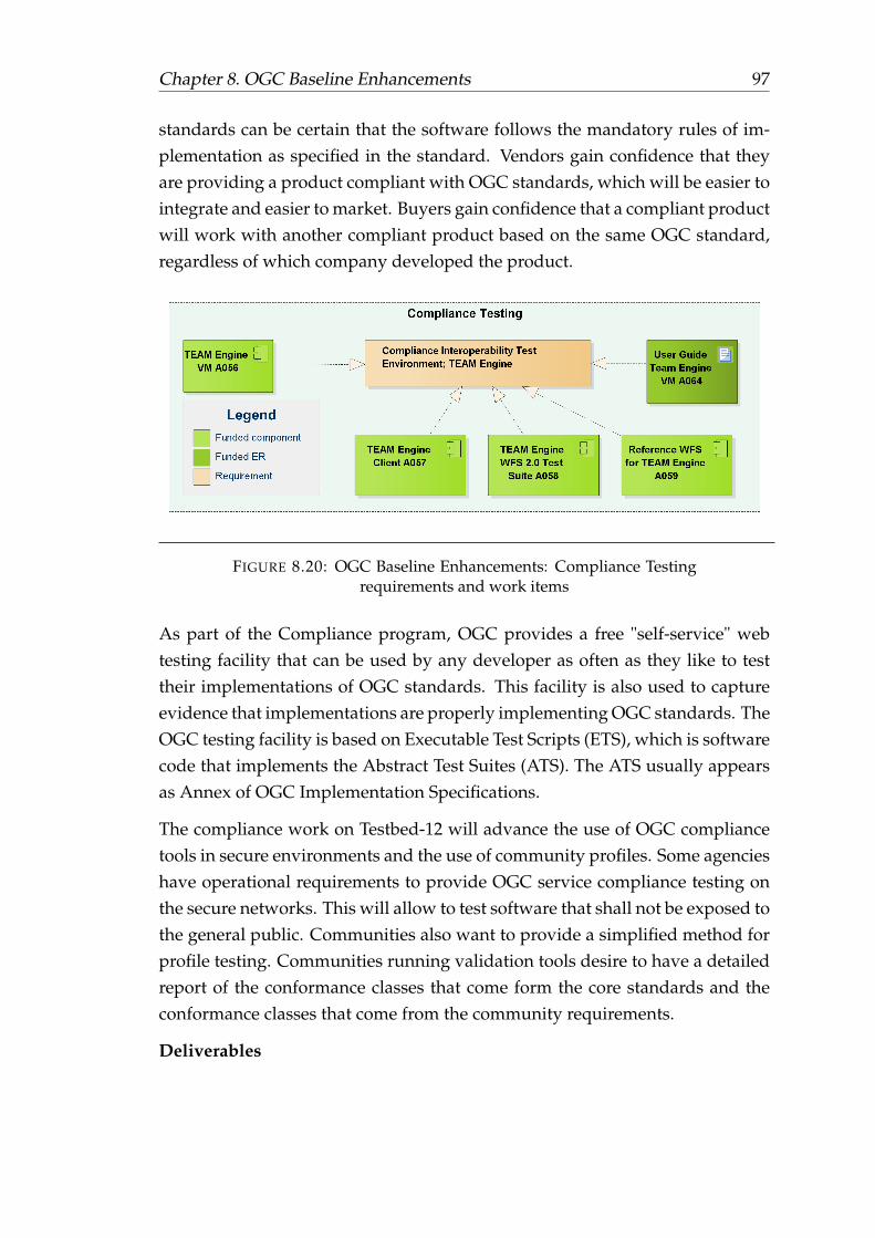
Chapter 8. OGC Baseline Enhancements 97
standards can be certain that the software follows the mandatory rules of im-plementation as specified in the standard. Vendors gain confidence that theyare providing a product compliant with OGC standards, which will be easier tointegrate and easier to market. Buyers gain confidence that a compliant productwill work with another compliant product based on the same OGC standard,regardless of which company developed the product.
FIGURE 8.20: OGC Baseline Enhancements: Compliance Testingrequirements and work items
As part of the Compliance program, OGC provides a free "self-service" webtesting facility that can be used by any developer as often as they like to testtheir implementations of OGC standards. This facility is also used to captureevidence that implementations are properly implementing OGC standards. TheOGC testing facility is based on Executable Test Scripts (ETS), which is softwarecode that implements the Abstract Test Suites (ATS). The ATS usually appearsas Annex of OGC Implementation Specifications.
The compliance work on Testbed-12 will advance the use of OGC compliancetools in secure environments and the use of community profiles. Some agencieshave operational requirements to provide OGC service compliance testing onthe secure networks. This will allow to test software that shall not be exposed tothe general public. Communities also want to provide a simplified method forprofile testing. Communities running validation tools desire to have a detailedreport of the conformance classes that come form the core standards and theconformance classes that come from the community requirements.
Deliverables

Chapter 8. OGC Baseline Enhancements 98
The following list identifies the Compliance Testing work items assignment torequirements. All work items are further defined in section 8.23.1 and section8.23.2 as well as listed in the summary table 8.2 and 8.3 at the end of the chapter.
• Provide a TEAM Engine Virtual Machine free of critical errors after ithas been evaluated with the HP software evaluation tool, which requireschanges to the current code base. The current implementation of TEAMEngine has been run with the HP Fortify Software Evaluation Tool. About80 occurrences of "Dead Code" were flagged in the TEAM Engine codebase and 50 "XML External Entity Injection" (XXE) vulnerabilities weredepicted. The TEAM Engine code shall be fixed to address these issues.Then it shall be delivered as a virtual machine using either VMware vSphereor VirtualBox. The operating system needs to be defined during Testbed-12, it can be either Windows or Unix. Eventually, the TEAM Engine Vir-tual Machine’s deployment in a virtual private cloud, such as AmazonVirtual Private cloud, shall be demonstrated. (A056)
• Advance the architecture of Team Engine and a user interface that allowsfor the selection of arbitrary combinations of conformance classes, exe-cutes the tests and provides test results in an effective way (A057). Inaddition, the following requirements shall be fulfilled (A057):
– The application allows for storage (management) of test profiles forconsistent repeatable tests.
– The solution allows to clearly select and report what conformanceclasses where run, and which ones pass. The information also in-cludes the standard or profile the conformance classes belong to.
– The solution should work with CTL and TestNG based tests.
– At least it should be demonstrated for
∗ DGIWG WMS 1.3 Profile
∗ NSG WMS 1.3 Profile
∗ DGIWG WFS 1.1.0 profile
∗ DGIWG WFS 2.0.0 profile
• Advance the WFS 2.0 Test Suite (A058)

Chapter 8. OGC Baseline Enhancements 99
– Transactional WFS – Document the extend of this operation and theability to create and update capabilities. The current test already sup-ports transactions, which is restricted to features.
– Locking WFS – Document the process for allowing multiple users toupdate simultaneously. The current test already supports locking.
– Response Paging – Paging is supported in CSW and Content Discov-ery and Retrieval (CDR) applications. The test should be advanceto be consistent with the WFS 2.0 standard and as much as possiblecompatible and consistent with CDR. It should also include transac-tional consistency checking.
– Standard Joins – The test and reference implementation shall includethe case of multi-source integration
– Spatial Joins – The test and reference implementation shall includethe case of multi-source integration.
– Temporal Joins – The test and reference implementation shall includemulti-source integration
– Feature Versions – The test and reference implementation should testObject Based Production, which is producing feature objects and ver-sioning them.
– Manage Stored Queries.
• WFS 2.0 Reference Implementation (A059): The WFS 2.0 implementationshall comply with all of the conformance classes and functionality docu-mented above. A reference implementation is an implementation that isfully functional, licensed copy of a tested, branded software that:
– has passed the test for an associated conformance class in a versionof an Implementation Standard and that
– is free and publicly available for testing via a web service or down-load.
• WFS 2.0 CITE and Reference Implementation Installation ER (A089)
• Virtual Machine Installation User Guide (A064)
• CITE User Guide with Profile Testing (A088)

Chapter 8. OGC Baseline Enhancements 100
8.23 Summary
This section provides an overview over all components, engineering reports,and guides. Most of the components and their corresponding requirements aredescribed in the sections 8.3 to 8.22 above.
8.23.1 Components
The following overview helps understanding all requirements for a given com-ponent. In some rare cases, additional requirements are added.
• A004, Evaluate Security and SOAP, common security extension WFSserver: Common Security Extension, demonstrated by implementing itas part of a WFS server, see 8.3
• A007, WFS/WCS server: OGC Web service implementation of a WFS orWCS interface to support the asynchronous service interaction work item,see 8.6.
• A009-1, Compression Tests WFS Server: WFS server supporting com-pression techniques as described in 8.8
• A009-2, Compression Client: Client application to interact with the WFSserver supporting compression techniques as described in 8.8
• A010, LiDAR Streaming Client: Client implementation to support Li-DAR data streaming from SOS as described in 8.9
• A011-1, WFS Synchronization Server 1: WFS server supporting WFS toWFS synchronization operations as described in 8.10
• A011-2, WFS Synchronization Server 2: WFS server supporting WFS toWFS synchronization operations as described in 8.10
• A012, SOS Compression (LiDAR) Server: SOS server for LiDAR stream-ing; supports EXI and WKB and potential other solutions for compressingof LiDAR data streams, see 8.9
• A016, CSW 2.0.2 with PubSub Core Support Server, see 8.6
• A017, Big Data Tile Database Implementation, see 8.13
• A018, WPS for Tile Access Server, see 8.13

Chapter 8. OGC Baseline Enhancements 101
• A019, Web Integration Server, see 8.14
• A022, GeoPackage NSG Profile with Vector Tiles Implementation: GeoPack-age with vector tiles, see 8.17
• A024, GeoPackage Off-Road Routing Data Implementation: GeoPackgewith data for off-road routing apps, see 8.17
• A025, GeoPackage Symbology Implementation: GeoPackge with sym-bols and styles of off-road routing apps, see 8.17
• A026, Mobile Off-Road Routing App based on GeoPackage Implemen-tation: Android or iOS based application that propvides off-road routingbased on GeoPackge data, see 8.17
• A027, GeoPackages Mobile App Data Implementation: GeoPackage withhandheld data, includes transportation, hydrography, cultural, terrain,administrative data. The GeoPackage(s) shall support indexed data suit-able for OWSContext content descriptors, see 8.17 and 8.18
• A030, OWS Context Document Production Client Implementation: clientapplication that produces OWS Context documents that describe amongothers the content in GeoPackages, see 8.18
• A031, UGAS support for NAS RDF/OWL/SKOS Implementation: ShapeChangeimplementation to support requirements defined in section 8.19
• A032, 2D Test Dataset Implementation with Documentation: data setand corresponding documentation to allow reuse of data from Testbed-12in future testbed activities. Data shall be made available in most appro-priate formats (formats to be discussed), see 8.20
• A033, 2D Test Dataset Symbols and Styles Implementation with Docu-mentation: symbols and styles set supporting data defined in A032. In-cludes corresponding documentation to allow reuse in future testbed ac-tivities. Symbols and styles shall be made available in most appropriateformats (formats to be discussed), see 8.20
• A034, WFS SOAP Server: WFS server supporting SOAP service, imple-menting the NSG WFS 2.0 Profile, and supporting a pub-sub based solu-tion using the latest draft of OGC Publish/Subscribe Interface Standard1.0 - Core, see 8.4 and 8.6

Chapter 8. OGC Baseline Enhancements 102
• A035, WFS REST Server: RESTful WFS Server that leverages existingspatial RDBMS infrastructure to serve geospatial information as LinkedData without loss of performance using the RESTful API and GeoSPARQLquery language in designing RESTful service APIs. The use of resolvableURIs for Linked Data and ontologies should be used as best practices inorder to facilitate linking and integration of different resources. Furtheron, the WFS shall support the use of JSON-LD to bridge Linked Data withmainstream web development, see 8.4
• A036, WFS Server: supporting data quality, implementing the DGIWGWFS 2.0 Profile and the WFS server v2.5 NSG Application Schema featurespecification encoded in GML and in JSON, see 8.6, 8.15, and 8.16
• A037, WFS-T Server: WFS-T 2.0, implementing the DGIWG WFS 2.0 Pro-file. The server shall support (see 8.17.2):
– Integration in GeoPackage
– Annotated Imagery
– Expand the WFS-11 work on multi-media enabling the WFS. Maturethe use of GetPropertyValue to retrieve multi-media properties. In-vestigate options for extracting metadata properties from the mediaitself. Exif and SMPTE 336M-2007 are standards of particular inter-est.
∗ Multiple codestreams
∗ Video encoding (Motion JPEG2000 based)
• A039, WMS SOAP Server: WMS supporting SOAP and implementingthe NSG WMS 1.3 Profile: 8.3
• A040, WMS REST Server: WMS service 1.4, include an encoding for Get-FeatureInfo responses based on GeoJSON but replacing the geometry partby the location of the position of the query and the position of the returnedfeature. If returned objects correspond to simple features, return an “id”that allows recovering the geometry using an additional WFS query. Seerecommendation 7 in OGC 15-053 Implementing JSON/GeoJSON in anOGC Standard ER for further details.
• A041, WMS Server: implementing the DGIWG WMS 1.3 Profile

Chapter 8. OGC Baseline Enhancements 103
• A042, WMTS REST Server: Implement TileJSON for the WMTS Simpleprofile; implement the WMTS Simple profile to support the two tile ma-trix sets discussed in section 8.7; and support the tiling Requirements forGeoPackage in section 8.17.2.
• A043, WCS SOAP Server: WCS 2.0.1 supporting SOAP and a pub-subbased solution using the latest draft of OGC Publish/Subscribe InterfaceStandard 1.0 - Core, see 8.3 and 8.6.
• A044, WCS REST Server: Elaborate a coverage JSON as a new standardencoding for GMLCov, and implements the requirements to implementREST and JSON for OGC Services as discussed in section 8.4.
• A045, WCS Conventional Server: Implementing the DGIWG WCS 2.0Profile; supports the work on asynchronous service interaction (see 8.6)and conflation (see 8.15).
• A046, WPS SOAP (asynchronous) Server: Supporting Web Feature Ser-vice Transactional (WFS-T) asynchronous request/response and support-ing Web Coverage Service (WCS) asynchronous request/response, see 8.3and 8.6.
• A047, WPS REST (conflation) Server: supporting Social Media, Topo-JSON, and interface to/façade Hootenanny to allow for conflation andconflation conflict resolution (see 8.4 and 8.15).
• A048, WPS Conventional (GeoPackage) Server: WPS to produce GeoPack-age with symbology information and GeoPackage with terrain informa-tion, see 8.17.2.
• A049, WPS Conventional (Data Quality) Server: WPS supporting ISOData Quality as discussed in 8.16.
• A050, CSW 2.0.2 Server: CSW 2.0.2 ISO Profile, implementing DGIWGMetadata Framework, and supporting enhanced Capabilities (see section8.12) and asynchronous interaction (see section 8.6. For further details,see section 8.11.
• A051, CSW ebRIM Server: implementing semantic mapping betweenNSG Metadata Framework, DGIWG Metadata Framework, and the De-partment of Defense (DoD) Discovery Metadata Standard (DDMS) as nec-essary; and supporting enhanced Capabilities (see section 8.12) and asyn-chronous interaction (see section 8.6. For further details, see section 8.11.

Chapter 8. OGC Baseline Enhancements 104
• A052, SPARQL / GeoSPARQL Server: SPARQL Ontology Extension forPortrayal, serves geospatial information as Linked Data without loss ofperformance using the RESTful API and GeoSPARQL query language(RESTful service APIs), see 8.5.
• A053, Schema Registry Server: enables discovery of Schema, Transfor-mation logic, and Ontologies. Initial capability should focus on XMLSchema and XSLT transformation logic; see 8.5.
• A054, Mobile Device GeoPackage Common Map API Implementation:Mobile device application implementing the Common Map API, shallsupport GeoPackages from different providers, see 8.17.3
• A055, Mobile Device GeoPackage Commercial APPs: Mobile device ap-plication that supports the maintenance of GeoPackages, see 8.17.3
• A056, TEAM Engine – Virtual Machine Implementation: TEAM EngineVirtual Machine free of critical errors (as identified by HP Fortify softwareevaluation), see 8.22
• A057, CITE User Interface Implementation, see 8.22
• A058, WFS Test update Implementation, see 8.22
• A059, WFS Reference Implementation, see 8.22
8.23.2 Engineering Report and User Guides
The following overview helps understanding all requirements for a given en-gineering report or user guide. In some rare cases, additional requirements areadded.
• A005-1, REST Architecture ER: captures all REST-related discussions, see8.4
• A005-2, Javascript, JSON, JSON-LD ER: captures all discussions aroundthe use of Javascript and JSON-LD, see 8.4
• A005-3, TopoJSON and GML ER: captures all REST discussions on datamodels and geospatial encodings, see 8.4
• A006, Semantic Summary ER: aggregates all semantics discussions fromother Testbed-12 reports, see 8.4, 8.11, 8.5

Chapter 8. OGC Baseline Enhancements 105
• A008, Vector and Raster Tiling Scheme: Tiling scheme to support rasterand vector tiles, see 8.7
• A011-3, WFS Synchronization ER: captures the discussion about serviceto service synchronization as described in section 8.10
• A060, REST User Guide: Implementing a REST based architecture forOGC service types User Guide, see 8.4 and address aspects form the archi-tecture perspective, i.e. focus on REST in contrast to A062, which focuseson JSON
• A061, SOAP User Guide: Implementing a OGC SOAP based WFS, WMSand WCS User Guide 8.3, 8.6
• A062, (Geo)JSON User Guide: OGC (Geo)JSON User Guide: and addressaspects form the architecture perspective, though there is overlap withA060, focus on JSON (in contrast to A060, which focuses on REST fromthe architectural perspective), see 8.4, 8.18:
– The User Guide shall include examples and guidance on convertingXML documents into (Geo)JSON.
– Consider OGC 14-009r1 recommendations.
– Include a subclause for linking to other objects in JSON, using thenatural approaches that JSON-LD provides for both simple links andatom links.
– Include a subclause for describing the process for if a fragment of aXML document contains a geospatial object then when converting toJSON, consider using the GeoJSON equivalent type.
• A063, OWS Context User Guide: OWS Context User Guide includingdescriptions of use with the GeoPackage standard, see 8.4, 8.17.4, 8.18
• A064, Team Engine VM Installation Guide: see 8.22
• A065, OWS Common Security Extension ER, see 8.3
• A066, Semantic Portrayal, Registry, Mediation Services ER: see 8.5 andresults from A105, A106 (7.4.3 and 7.4.4), and A053
• A067, Implementing Asynchronous Service Response ER: Describingthe comparison results of the various approaches to handle asynchronous

Chapter 8. OGC Baseline Enhancements 106
response and data delivery for situations where big chunks of data whichrequire asynchronous delivery 8.6
• A068, Vector Tiling ER: Discusses all aspect relevant to vector tiling. Re-lated to A008, the Engineering report on the vector and raster tiling scheme,but focuses on the implementation of vector tiles within GeoPackages, see8.7 and 8.17.1
• A069, Compression ER: The Compression Techniques ER shall documentthe various approaches, highlight pros and cons of the different approachesand compare performance aspects, see 8.8
• A071, LiDAR Streaming ER: The ER shall describe the harmonizationof the Community Sensor Model with SWE LiDAR. In addition, it shalldescribe how LiDAR streaming can be realized using the OGC SensorWeb Enablement suite of standards, see 8.9
• A072, Catalog/SPARQL ER: Evaluate Catalog Interoperability: catalogcomparison, this work item shall load the same data set to a set of cat-alogs (A050, A051, A103, A104) and test using a multi-catalog client theinteraction which each service to better understand interoperability as-pects in multi-catalog environments. It shall evaluate the various DCATcontexts including RDF accessible via SPARQL endpoints, embedded inHTML pages as RDFa, or serialized as e.g. RDF/XML or Turtle and com-pare functionality, expressiveness and usability of CSW and DCAT, see8.11. In addition, it shall capture all discussion related to the implementa-tion of the SPARQL / GeoSPARQL Server (A052).
• A073, OWS Context / Capabilities ER: to describe how OWS Context canbe used to supplement the OGC Capabilities document, see 8.4 and 8.12.
• A074, PubSub / Catalog ER: describe how the OGC PubSub standard canbe used as a mechanism to automatically notify analysts of data availabil-ity, see 8.11 and 8.6
• A075, General Feature Model ER: describe how the GFM can be re-usedfor non-geospatial centric applications and/or how it should be extendedinto a general model for all object types, see 7.3
• A076, Big Data Database ER: describes options considered and recom-mendations for delivery of large amounts of data as a database delivery,see 8.13

Chapter 8. OGC Baseline Enhancements 107
• A077, Multi-Tile Retrieval ER: to describe options considered and rec-ommendations for delivery of large amounts of tiled data in support ofGeoPackage, see 8.7
• A078, Web Integration Service Recommendations ER: discusses the re-sults from A107 and A108, see 7.3.
• A079, WPS Conflation Service Profile ER: describing the integration oftools such as Hootenanny into spatial data infrastructures. The ER shalldescribe the developed approach, issues that came up during the integra-tion together with applied solutions and rationales, and suggest futurework items to enhance and facilitate the integration of conflation toolsinto SDIs. This ER shall be written such that it can be nominated as aWPS Conflation Service Profile, see 8.15.
• A080, Data Quality ER, Data Quality ER describing data quality handlingrequirements, challenges and solutions. This ER shall focus on data qual-ity in general that needs to be communicated from one service to another.In addition, it shall discuss WPS data quality solutions. A080 ER shall bewritten such that it can be nominated as a WPS ISO Data Quality ServiceProfile, see 8.16.
• A081, NSG GeoPackage Profile Assessment ER: describes any concernswith alternative options considered and recommendations for implemen-tation of the NSG GeoPackage Profile, see 8.17.
• A082, GeoPackage Routing and Symbology ER: describing symbologyand Routing information solutions, see 8.17.2.
• A083, GeoPackage Mobil Apps Integration ER: describing all aspectsaround GeoPackages on mobile clients, such as mobile app integration,GeoPackage shared access, data optimized and suitable for handheldsetc., see 8.17
• A085, GeoPackage change request evaluations ER: evaluates existingchange requests and determines the way forward 8.17.5.
• A086, OWS Context: JSON, JSON-LD and HTML5 ER, describing JSON,JSON-LD and HTML5 solutions as well as how OWS Context can be usedas an index descriptor for the content of GeoPackages, see 8.4, 8.17.4 and8.18.

Chapter 8. OGC Baseline Enhancements 108
• A087, UGAS Shapechange ER: describes all results from the ShapeChangeextensions and tests executed with respect to A031, see 8.19
• A088, CITE User Guide with Profile Testing ER, see 8.22
• A089, WFS 2.0 CITE and Reference Implementation Installation ER, see8.22
• A090, Testbed-12 Web Service Implementations ER, this engineering re-port describes and issues recommendations based on the web service im-plementations in Testbed 12 to include SOAP, REST, Conventional imple-mentations, Profile based implementations, requirement specific imple-mentations. This work item needs to integrate discussions, results, andbest practices from multiple threads!
The following tables summarizes all work items that shall be delivered as partof this work package.

Chapter 8. OGC Baseline Enhancements 109
ID Funding Name
A004 funded Evaluate Security and SOAP, Common Se-curity Extension WFS server
A005-1 funded REST Architecture ERA005-2 funded Javascript, JSON, JSON-LD ERA005-3 funded TopoJSON, GML ERA006 funded Evaluate Semantic Enablement ERA007 funded WCS/WFS Async ServerA008 funded Vector and Raster Tiling Scheme ERA009-1 funded Compression Tests WFS ServerA009-2 funded Compression ClientA010 funded LiDAR Streaming ClientA011-1 funded WFS Synchronization Server 1A011-2 funded WFS Synchronization Server 2A011-3 funded WFS Synchronization ERA012 funded SOS Compression (LiDAR) ServerA016 funded CSW 2.0.2 with PubSub Core Support
ServerA017 funded Big Data Tile Database ImplementationA018 funded WPS for Tile Access ServerA019 funded Web Integration ServerA022 funded GeoPackage NSG Profile with Vector Tiles
Implementation 1A024 funded GeoPackage Off-Road Routing Data Imple-
mentationA025 funded GeoPackage Symbology ImplementationA026 funded Mobile Off-Road Routing App based on
GeoPackage ImplementationA027 funded GeoPackages Mobile App Data Implemen-
tationA030 funded OWS Context Document Production Client
ImplementationA031 funded UGAS support for NAS RDF/OWL/SKOS
ImplementationA032 funded 2D Test Dataset Implementation with Doc-
umentationA033 funded 2D Test Dataset Symbols and Styles Imple-
mentation with Documentation
TABLE 8.2: OGC Baseline Enhancements work package deliver-ables summary, part 1

Chapter 8. OGC Baseline Enhancements 110
ID Funding Name
A034 funded WFS SOAP ServerA035 funded WFS REST ServerA036 funded WFS Conventional ServerA037 funded WFS-T ServerA039 funded WMS SOAP ServerA040 funded WMS REST ServerA041 funded WMS ServerA042 funded WMTS REST ServerA043 funded WCS SOAP ServerA044 funded WCS REST ServerA045 funded WCS Conventional ServerA046 funded WPS SOAP (asynchronous) ServerA047 funded WPS REST (conflation) ServerA048 funded WPS Conventional (GeoPackage) ServerA049 funded WPS Conventional (Data Quality) ServerA050 funded CSW 2.0.2 ServerA051 funded CSW ebRIM ServerA052 funded SPARQL / GeoSPARQL ServerA053 funded Schema Registry ServerA054 funded Mobile Device GeoPackage Common Map
API ImplementationA055 funded Mobile Device GeoPackage Commercial
APPsA056 funded TEAM Engine – Virtual Machine Imple-
mentationA057 funded CITE User Interface ImplementationA058 funded WFS Test update ImplementationA059 funded WFS Reference ImplementationA060 funded REST User GuideA061 funded SOAP User GuideA062 funded (Geo)JSON User GuideA063 funded OWS Context User GuideA064 funded Team Engine VM Installation GuideA065 funded OWS Common Security Extension ERA066 funded Semantic Portrayal, Registry, Mediation
Services ERA067 funded Implementing Asynchronous Service Re-
sponse ERA068 funded Vector Tiling ERA069 funded Compression ERA071 funded LiDAR Streaming ER
TABLE 8.3: OGC Baseline Enhancements work package deliver-ables summary, part 2

Chapter 8. OGC Baseline Enhancements 111
ID Funding Name
A072 funded Catalogue, SPARQL ERA073 funded OWS Context / Capabilities ERA074 funded PubSub / Catalog ERA075 funded General Feature Model ERA076 funded Big Data Database ERA077 funded Multi-Tile Retrieval ERA078 funded Web Integration Service ERA079 funded WPS Conflation Service Profile ERA080 funded WPS ISO Data Quality Service Profile ERA081 funded NSG GeoPackage Profile Assessment ERA082 funded GeoPackage Routing and Symbology ERA083 funded GeoPackage Mobil Apps Integration ERA085 funded GeoPackage change request evaluations ERA086 funded OWS Context:JSON, JSON-LD and HTML5
ERA087 funded UGAS Shape Change ERA088 funded CITE User Guide with Profile Testing ERA089 funded WFS 2.0 CITE and Reference Implementa-
tion Installation ERA090 funded Testbed-12 Web Service Implementations
ER
TABLE 8.4: OGC Baseline Enhancements work package deliver-ables summary, part 3

Chapter 9
Compression and Generalization
9.1 Background
In today’s developing digital world, data is created and processed at unprece-dented volumes. Mechanisms for sharing data need to keep pace if they areto continue to meet requirements. This is particularly evident in the geospatialsector where the increase in big data from a multitude of sensors is combinedwith the need to share data quickly, potentially over low bandwidth connec-tions. Rather static data sets such as street networks or buildings needs to beintegrated with highly dynamic data stemming from real time observation sys-tems such as e.g. traffic monitoring.
As a consequence the delivery of data could be delayed resulting in potentiallypoor or incorrect decisions being made. For example, in humanitarian disastersituations the delay in sharing data is potentially hindering the success of theoperation. As such it is important to optimize the delivery of geospatial data asservices.
Optimizing the dissemination of OGC Services across low/very low bandwidthsto enable the delivery of faster, lighter and more robust geospatial services isan important part of efficient communication that shall be addressed. In thistestbed, it is complemented by generalization techniques that prevent the po-tentially unaware client from requesting large amounts of data from a service.If the maximum data transfer capacities are known or can be guessed at thetime of request reception, generalization algorithms help to balance the trade-off between transferred data volume and information content.
112

Chapter 9. Compression and Generalization 113
9.2 Requirements and Work Items
The following figure illustrates all work items that shall be addressed in thiswork package. They are described in further detail in figure 9.1. All fundedwork items are shaded in green, unfunded in blue. Each work item may im-plement several requirements, i.e. components need to fulfill various require-ments, or engineering reports need to address and summarize the results fromvarious requirements.
FIGURE 9.1: Compression and Generalization work package: Re-quirements and work items
9.3 Bandwidth Constraints
The Compression and Generalization work package identifies a single require-ment, which includes the optimization of data transfer under bandwidth-constraintconditions using compression techniques, specific data serializations, and server-side applied generalization techniques. The goal is to test bandwidth constraintoptimization following two approaches: First, set up a set of dummy servicesto test and experiment with data size reduction and compression techniquessuch as the use of JSON over GML, BinaryXML, zipped XML etc. The secondapproach shall develop techniques to use generalization mechanisms to reducethe amount of data that needs to be transferred from the server to the client;and the other way round, to collect data at one scale only on the client side but

Chapter 9. Compression and Generalization 114
serve it at many on the server side. The work package has identified three workitems to address these aspects:
• Optimizing the configuration of OGC services to determine the best prac-tice for the efficient delivery of services over low (56kps)/very low (5kbit/s) bandwidth. Also incorporating the efficient dissemination of com-plex 3D data.
• Optimizing OGC Services using novel binary compression techniques anddata generalization
• Optimizing the dissemination of geospatial feature data by enabling thegeneralization of geospatial data e.g. collect data at one scale display it atmany.
Deliverables
• Low bandwidth and generalization engineering report (U001) describ-ing the sample services, outlined the best practice for configuring DGIWGprofiles of key OGC services for delivery of both standard data and com-plex 3D data over very low bandwidths. The report shall further discussTestbed-12 WFS/WPS implementations and comparing the advantagesand disadvantages of disseminating geospatial data using compressiontechniques Binary XML and GeoJSON.
• WFS DGIWG low bandwidth (U002) service demonstrating the com-pression techniques and low bandwidth performance tests. A dummyservice is sufficient to test performances. A client needs to be used tomeasure performance.
• WPS service (U003) demonstrating the generalization of geospatial dataservices
9.4 Summary
The following tables summarizes all work items that shall be delivered as partof this work package.
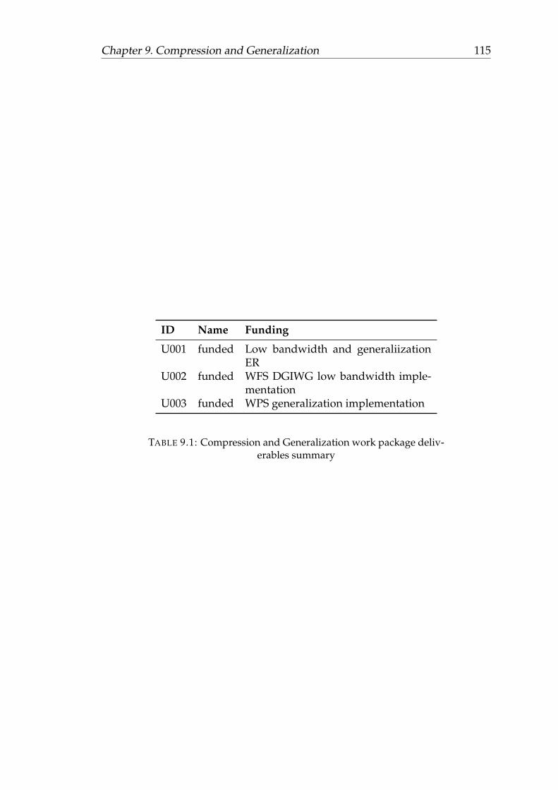
Chapter 9. Compression and Generalization 115
ID Name Funding
U001 funded Low bandwidth and generaliizationER
U002 funded WFS DGIWG low bandwidth imple-mentation
U003 funded WPS generalization implementation
TABLE 9.1: Compression and Generalization work package deliv-erables summary

Chapter 10
ArcticSDI and GeoPackage
10.1 Background
Testbed-12 has identified interoperability requirements in the context of theArcticSDI and the conversion of US Topo Maps to GeoPackage.
National Spatial Data Infratructures (NSDI), such as the US-NSDI or the Cana-dian Geospatial Data Infrastructure (CGDI) help to gain new perspectives intosocial, economic, and environmental issues by providing an online network ofresources that improves the sharing, use, and integration of information tiedto geographic locations. The ArcticSDI complements these perspectives and al-lows pan-Arctic science; monitoring; and societal, economic, and environmen-tal decision support. In a reciprocal process, developing the ArcticSDI helps togenerate a better understanding of how NSDIs can be developed and appliedto support Arctic priorities.
By implementing consistent means to share geographic data among all users,costs for collecting and using data can be significantly reduced while decision-making is enhanced. Based on the same design principles, it is the goal toshare service interfaces and information models across the various SDI typesto ensure maximum interoperability on all scales from local to national to Arc-tic region to global. To be successful, the ArcticSDI has to take particular re-quirements into account; such as the unique environment it is located in withzero/low bandwidth at some places, the specific situation of the frontier econ-omy, or the requirement to be expanded to the entire arctic community.
The Arctic SDI provides such an infrastructure and its development is facil-itated by the National Mapping Agencies of the eight Arctic countries. The
116

Chapter 10. ArcticSDI and GeoPackage 117
OGC together with its collaborators Natural Resources Canada, the USGS, ter-ritories and states that are part of the Arctic, Arctic Council working groups,Arctic SDI member countries, and a number of OGC member organizations arecurrently engaged in a OGC Pilot project with the goal to articulate the valueof interoperability and to demonstrate the usefulness of standards within theArcticSDI domain. In its first phase, the ArcticSDI Pilot project develops aninventory of available geospatial Web services across the Arctic, which can beused to reflect a broad range of thematic data layers. In parallel, Phase 1 definesthe core components of the ArcticSDI architecture. Both activities serve as thebasis for the definition of use cases that shall be implemented to articulate thevalue of interoperability and to demonstrate the usefulness of standards.
Testbed-12 will use this architecture definition, which in fact is implementing asystem of systems approach, and test a number of components and correspond-ing information models. This activity will further support the architecture im-plementation tests that are planned for 2016 and beyond.
Further on, Testbed-12 shall investigate the OGC GeoPackage as a single al-ternative delivery format for the USGS Topo Combined Vector Product andthe Topo TNM Style Template. The Topo Combined Vector Product includespoint, multi-point, line, and polygon vector feature classes across The NationalMap (TNM) data themes of Hydrography, Governmental Units (Boundaries),Geographic Names, Elevation Contours, Land Cover polygons, Structures andTransportation. It is delivered in a 7.5-minute footprint in an Esri filegeodatabase(v10.x).
The Topo TNM Style Template is provided by the U.S. Geological Survey (USGS)National Geospatial Technical Operations Center (NGTOC). It has been devel-oped according to the 24,000-scale, 7.5-minute layout and cartographic designof published US Topo Maps and is intended for use in any geographic locationwhere data is available for download from The National Map (TNM). The tem-plate provides base topographic map symbology, links to Web Map Services,labeling rules, grids, standard map layout, and marginalia information that aGIS expert can use for advanced analysis and/or for developing tailored maps.The template is formatted as an Esri ArcGIS map document (MXD) and labelingrules are built using the Esri Maplex labeling engine.

Chapter 10. ArcticSDI and GeoPackage 118
10.2 Requirements and Work Items
The following figure illustrates all work items that shall be addressed in thiswork package. They are described in further detail in figure 10.1. All fundedwork items are shaded in green, unfunded in blue. Each work item may im-plement several requirements, i.e. components need to fulfill various require-ments, or engineering reports need to address and summarize the results fromvarious requirements.
FIGURE 10.1: ArcticSDI and GeoPackage work package: Require-ments and work items
10.3 ArcticSDI
Improved access to geospatial data can help us better to predict, understandand react to changes in the Arctic. Responses to the impact of climate changeand human activities in the Arctic require accessible and reliable data to facili-tate monitoring, management, emergency preparedness and decision-making.

Chapter 10. ArcticSDI and GeoPackage 119
Important data sets are produced and distributed by many stakeholders – pub-lic and private sector – and most of it can be geographically referenced. A spa-tial data infrastructure provides tools for data distributors to ensure that theirgeospatial data is easier for users to access, validate, and combine with otherdata.
All those aspects are currently addressed in the “Arctic Spatial Data Infrastruc-ture Standards and Communication Pilot” (short: ArcticSDI Pilot). The goal ofthe ArcticSDI Pilot is to demonstrate the diversity, richness and value of SpatialData Infrastructure (SDI) Web services to Arctic SDI stakeholders.
Phase 1 of the ArcticSDI defines the core components of the ArcticSDI architec-ture, complemented by an inventory of available geospatial Web services acrossthe Arctic. Both activities serve as the basis for the definition of use cases thatshall be implemented to articulate the value of interoperability and to demon-strate the usefulness of standards.
Testbed-12 will use this architecture definition, which in fact is implementing asystem of systems approach, and test a number of components and correspond-ing information models. This activity will further support the architecture im-plementation tests that are planned for 2016 and beyond.
Testbed-12 shall address the following work items:
• Provision of Arctic data that is currently served at WMS interfaces as im-ages only. The data shall be made available using WCS
• Implementation of a client application that can demonstrate the usage ofArcticSDI data, including data that is served at WMS and WCS interfaces
• Analyze if the current Earth Observation profile serves all needs to accessArcticSDI data
• Analyze how data served at OPeNDAP can be integrated
• Analyze how netCDF data can be served efficiently
• Discuss interoperability issues that are specific to the ArcticSDI
Deliverables
• WCS ArcticSDI (B001): A WCS serving Arctic data
• Client WCS/WMS ArcticSDI (B002): Client application supporting WCSand WMS with Arctic data

Chapter 10. ArcticSDI and GeoPackage 120
• ArcticSDI ER: Engineering report capturing discussions and results ofthis task
It is emphasized that all service and client components developed as part ofTestbed-12 shall be made available for the entire lifetime of the ArcticSDI pilot,which ends April 2017.
10.4 GeoPackage
Testbed-12 shall investigate the OGC GeoPackage as a single alternative deliv-ery format for the USGS Topo Combined Vector Product and the Topo TNMStyle Template. The GeoPackage contents of the Topo Combined Vector Prod-uct shall be extended to include imagery and hillshade data. It shall be evaluatewhether the point, multi-point, line, and polygon contents in the GeoPackagecan be tied directly to a pre-defined symbology set via the Symbology EncodingImplementation Specification.
Symbolized layers within the Topo TNM Style Template can be linked to datadownloaded from TNM (the Topo Combined Vector Product). Web Map Ser-vice layers in the template include orthoimagery and shaded relief services pro-duced by the USGS, as well as a National Wetlands Inventory (NWI) Web MapService produced by the US Fish and Wildlife Service. This standard USGSUS Topo Map symbology as defined in the Topo TNM Style Template shall bepreserved in the GeoPackage container.
The U.S. Geological Survey (USGS) will provide a number of data and productsto conduct the Testbed-12 experiments. These include:
1. Topo TNM Style Template
(a) Esri ArcMap v10.x
(b) Layer files that are symbolized per US Topo Map specifications
2. One or more Topo Combined Vector Product samples
(a) Esri File Geodb v10.x
(b) Vector data layers clipped to 7.5-minute map cell
3. Links to imagery and hillshade services and/or clipped datasets

Chapter 10. ArcticSDI and GeoPackage 121
The following two use cases define the necessary functionality that shall besupported in Testbed-12:
1. State Geologist intends to produce a 24,000-scale map using base mapdata and symbology in a US Topo Map design and layout. The Geologistwill use ArcGIS to create the map add will add her own geologic datalayers to the base data. The base data will be downloaded in the OGCGeoPackage and the US Topo Map specified symbology will be encodedwith the GeoPpackage.
2. County Emergency Manager would like to obtain symbolized base mapdata in a US Topo Map design to support an evacuation exercise. TheEmergency Manager does not have any sophisticated GIS software. Hehas an iPad that he takes into the field with him and would like to beable to use a map-like display and query the attributes of the data. Inaddition, he would like to be able to display a hillshade and local imageryalong with the map display.
References
• OGC 15-039 Envisioning a Tiled Elevation Extension for GeoPackage
• OGC 15-012r2 OGC GeoPackage Plugfest
• OGC 12-128r12 GeoPackage Encoding Standard – With Corrigendum #2
• OGC 15-067 Testbed-11 Multi-dimensional GeoPackage Supporting Ter-rain and Routes Engineering Report
Deliverables
• GeoPackage US Topo Engineering Report (B004): The engineering re-port shall capture
– all problems and obstacles with using the USGS USGS Topo Com-bined Vector Product to create the GeoPackage.
– all problems and obstacles with encoding the GeoPackage with stan-dard USGS US Topo Map symbology as defined in the Topo TNMStyle Template
– the process used to convert the USGS Topo Combined Vector Productdata to GeoPackage format (so that USGS can reproduce the GeoPack-age format)

Chapter 10. ArcticSDI and GeoPackage 122
– the process used to encode GeoPackage data with US Topo Map sym-bology as defined in the Topo TNM Style Template (so that USGS canreproduce the encoded symbolized GeoPackage format)
– the process for end users using the Use Cases described. Include anyobstacles or limitations to the end users.
• GeoPackage Converter (B005): The GeoPackage converter shall
– convert the USGS Topo Combined Vector Product data to GeoPack-age format (so that USGS can reproduce the GeoPackage format.
– encode GeoPackage data with US Topo Map symbology as definedin the Topo TNM Style Template (so that USGS can reproduce theencoded symbolized GeoPackage format)
10.5 Summary
The following tables summarizes all work items that shall be delivered as partof this work package.
ID Name Funding
B001 funded WCS ArcticSDIB002 funded Client WMS/WCS ArcticSDIB003 funded ArcticSDI ERB004 funded GeoPackage US TopoB005 funded GeoPackage converter
TABLE 10.1: ArcticSDI and GeoPackage work package deliver-ables summary