OPTIMIZATION MODEL FOR THE PROJECT OF THE THIRD METRODIAMETER IN SOFIA, ACCORDING TO ITS MAXIMUM...
8
OPTIMIZATION MODEL FOR THE PROJECT OF THE THIRD METRODIAMETER IN SOFIA, ACCORDING TO ITS MAXIMUM SOCIAL-ECONOMIC EFFICIENCY Authors: Kaloyan Tsvetkov &Viktor Chaushev 1 ABSTRACT In 2009 Sofia Metropolitan became the main means of mass transportation of passengers in the capital. After building the second metrodiameter over half of the inhabitants of the capital will have access to rapid transportation. The purpose of this study is to optimize existing project through a complex of geographical and interdisciplinary methods, including GIS (Geographic Information System), to its maximum social-economic efficiency. Keywords: Sofia Metropolitan, metrodiameter, buffering, passenger traffic, social-economic efficiency Introduction The theme of the Sofia metro has become extremely popular in the recent years. After the completion of the first metroradius (Obelya - Serdika) and especially after connecting it with the newly built second metroradius (Mladost 1 - SU) on the first metrodiameter, the residents and the visitors of the city felt the advantages of the underground rail. Through it the two largest living areas of Sofia, Lyulin and Mladost, has been linked together and with the center. Thus, the traffic intensity in Sofia appeared to have decreased, especially on the transport junctions with “Tsarigradsko shosse” blvd. With the release of the second metro diameter rapid transportation will finally be available to over half of the inhabitants of the capital. The topic of further steps in the subway extension will become very obsolete. On the other hand, much criticism will appear on the existing proposal for a route for the third metrodiameter and the possible development of the fourth circular metrodiameter. Parallel to this process, the question about the effectiveness of the existing scheme of mass urban ground transport will rise, following the operation of the new metrodiameters. The subject of this study, in view of the foregoing, is the spatial analysis, related to the optimization possibilities of the third metrodiameter, in order to help make informed management decisions, using GIS. The study object is the territory of Sofia municipality, its population and transport system, which connects them, particularly, the subway. The goal of the study is to propose a model that has greater social and economic efficiency to the currently accepted route but not by much higher costs for construction. To achieve this goal, the following tasks have to be completed: To examine in detail Sofia’s General Development Plan, in particular, its communication and transportation system concerning the electrical transport. To clarify the structural differences between different types of urban rail - speed tram, LRT and classic metro. To obtain a detailed database about the population and infrastructure of the capital. Spatial analysis: a) To compare the current plan for the third metrodiameter and the authors’ proposed project, using GIS; b) To perform buffering in GIS for all metrodiameters and authors’ project, to detect potential passenger traffic; c) To draw conclusions, according to the results for potential passenger traffic, as to which plan has better social-economic efficiency. To prepare visualization materials: a) A scheme of routes and stations of the current plan and authors’ proposal; b) A scheme of current plan’s buffering; c) A scheme of authors’ proposal buffering; 1 Students, Sofia University “St. Kliment Ohridski”, Tsar Osvoboditel blvd, Sofia 1504.
Transcript of OPTIMIZATION MODEL FOR THE PROJECT OF THE THIRD METRODIAMETER IN SOFIA, ACCORDING TO ITS MAXIMUM...
OPTIMIZATION MODEL FOR THE PROJECT OF THE THIRD
METRODIAMETER IN SOFIA, ACCORDING TO ITS MAXIMUM
SOCIAL-ECONOMIC EFFICIENCY
Authors: Kaloyan Tsvetkov &Viktor Chaushev 1
ABSTRACT In 2009 Sofia Metropolitan became the main means of mass transportation of passengers in the capital. After
building the second metrodiameter over half of the inhabitants of the capital will have access to rapid
transportation. The purpose of this study is to optimize existing project through a complex of geographical and
interdisciplinary methods, including GIS (Geographic Information System), to its maximum social-economic
efficiency.
Keywords: Sofia Metropolitan, metrodiameter, buffering, passenger traffic, social-economic efficiency
Introduction The theme of the Sofia metro has become extremely popular in the recent years. After the
completion of the first metroradius (Obelya - Serdika) and especially after connecting it with the
newly built second metroradius (Mladost 1 - SU) on the first metrodiameter, the residents and the
visitors of the city felt the advantages of the underground rail. Through it the two largest living areas
of Sofia, Lyulin and Mladost, has been linked together and with the center. Thus, the traffic intensity
in Sofia appeared to have decreased, especially on the transport junctions with “Tsarigradsko shosse”
blvd. With the release of the second metro diameter rapid transportation will finally be available to
over half of the inhabitants of the capital. The topic of further steps in the subway extension will
become very obsolete. On the other hand, much criticism will appear on the existing proposal for a
route for the third metrodiameter and the possible development of the fourth circular metrodiameter.
Parallel to this process, the question about the effectiveness of the existing scheme of mass urban
ground transport will rise, following the operation of the new metrodiameters.
The subject of this study, in view of the foregoing, is the spatial analysis, related to the
optimization possibilities of the third metrodiameter, in order to help make informed management
decisions, using GIS. The study object is the territory of Sofia municipality, its population and
transport system, which connects them, particularly, the subway. The goal of the study is to propose a
model that has greater social and economic efficiency to the currently accepted route but not by much
higher costs for construction. To achieve this goal, the following tasks have to be completed:
To examine in detail Sofia’s General Development Plan, in particular, its communication and
transportation system concerning the electrical transport.
To clarify the structural differences between different types of urban rail - speed tram, LRT
and classic metro.
To obtain a detailed database about the population and infrastructure of the capital.
Spatial analysis:
a) To compare the current plan for the third metrodiameter and the authors’ proposed
project, using GIS;
b) To perform buffering in GIS for all metrodiameters and authors’ project, to detect
potential passenger traffic;
c) To draw conclusions, according to the results for potential passenger traffic, as to which
plan has better social-economic efficiency.
To prepare visualization materials:
a) A scheme of routes and stations of the current plan and authors’ proposal;
b) A scheme of current plan’s buffering;
c) A scheme of authors’ proposal buffering;
1Students, Sofia University “St. Kliment Ohridski”, Tsar Osvoboditel blvd, Sofia 1504.

d) A scheme of all metrodiameters (including this proposal) and possible future extensions
of the metro and the urban transport.
Data and methods To perform a GIS analysis very detailed information about the spatial distribution of population
is needed. Due to the fact that there is not any detailed annual statistics, the authors have used the data
for the control regions (total 1503) of the population from the last Census in 2001. We believe that this
is a serious obstacle in order to achieve the goal of this study, because Sofia has positive natural and
mechanical increase (NSI 2009) and experts estimate that the population already exceeds 1.5 million
people. However, there are no new data.
Sofia became a capital on April 4, 1879 with a population of 12 thousand and had not
increased significantly until 1946 (population in 1946 - 367 thousand people). Therefore, in no way
we can compare Sofia’s subway system to others subway systems of the Western European capitals.
Vienna, which is often compared to our capital, had obtained a subway by 1898 when there were 1.77
million people living.
For the reason that this problem is an object of study by other authors from different scientific
fields such as architecture, geodesy, surveying, computing, spatial statistics and more, (Kotsev 2008),
the authors want to prove to the public that, with the help of modern geographical knowledge,
effective solutions in the field of spatial planning and solving problems of modern cities can be
offered. In the course of work, the authors have understood that GIS is an integral part of the modern
geographical science and it is not a concept of the above scientific fields!
Development and territorial extension of the third metrodiameter’s adopted plan The third diameter, according to the current master
plan will connect the southwest with the northeast part of the
city. Some parts of this route have already been built near to
Poduyane train station. Generally, the route passes through
Knyazhevo quarter - Tsar Boris III Blvd – Patriarh Evtimii
Blvd. – Vasil Levski Blvd – Yanko Sakazov Blvd – Madrid
Blvd – Botevgradsko Blvd. (Fig 1). In connection with the
amendment of Sofia’s Master Plan, Sofia Municipality stated
that it will be built 80% ground as "Speed tram or LRT", and
only in downtown center the route will go underground.
According to Thompson (2003), LRT is designed for
“light traffic and fast movement”. It must have the ability to
carry many passengers, but to stop much more quickly if
needed. It has no different type of intersection on different
levels with the other parts of the transport system, compared
to classic subway. It should be built above ground and in
exceptional cases - underground, only where ground
transition is impossible. The main purpose of this type of
metro is the carriage of quantity of passengers, similar to the
classical subway passenger traffic, but with much less initial
investment in the construction of the infrastructure.
The speed tram is a mode similar to the LRT, but
traffic is much less and the intersection with the other parts
of the transport system is not necessarily taking place at
different levels. A typical example is the speed tram in
Budapest – Line № 4, which connects the northern to the
southern part of Buda, going through Pest. The daily
passenger traffic is about 20 thousand people per hour and in "rush hour" trams move in intervals -
from 1 to 3 minutes. The line is served by tram carriages “Siemens” with total length of 52 meters and
total capacity – around 300 passengers.
The classic type of subway, compared to the three types, is the most expensive to implement,
but is extremely efficient for the transport of large numbers of passengers to medium distances. It must
Fig. 1 Proposed metrostation names for
the adopted plan
run underground, but it is allowed to pass only above ground, where it is possible, and do not impede
the average speed. This is done to reduce the high costs of construction of underground infrastructure
(Cervero 1998).
The main reasons to build the third metrodiameter following the adopted plan are entirely
financial - since already about 70% of the route has been built - these are the routes of trams № 5 and
22, respectively- from Knyazhevo to Ruski Pametnik Sq. and from Poduyane train station to "Iztok"
transfer station. The only part left to be built is the underground central part, which, according to the
Master Plan goes near to the Court House and Vasil Levski Sq., but according to the website of the
Sofia Metropolitan (www.metropolitain.bg) - through the NPC and Sofia University.
The disadvantages of the adopted plan are obvious. Densely populated residential complexes,
such as Levski and, especially, Ovcha Kupel, remain outside of the route. It takes at least 30 – 40
minutes to travel downtown from this living complex in regular traffic (Table 1).
Table 1
Travel Duration from Ovcha Kupel quarter to downtown centre
(Source: www.sumc.bg) l.q. Ovcha Kupel – metrostation Serdika
line and stop Workdays Weekends
Bus line № 11 – l.q. Ovcha Kupel 8:02 8:03
Bus line № 11 – Metrost. “K.Velitchkov” 8:26 8:26
Metrostation “K.Velitchkov” 8:30 8:34
Metrostation “Serdika” 8:34 8:37
Duration 32 min. 34 min.
Price (valid 01.04.10) 1,60 BGN. 1,60 BGN.
In addition, l.q. Ovcha Kupel is extremely bad linked by environmentally clean transport. This
is the only residential complex in Sofia, which is not served by any option of the electrical transport!
If the plan is implemented in this version, Sofia will finally be devoid of any lasting solution for
the transportation of Sofia residents from one point to another without losing more than 20 to 30
minutes in traffic. And at this time the travel from Knyazhevo and Levski to the center does not last
more than 31 minutes, at a price of 1 lv. (Table 2), even in rush hour (8:00 to 9:00 pm)!
Table 2
Travel duration from the last stops of tram lines № 5 and 22 to downtown centre
(Source: www.sumc.bg)
As it is apparent, by reason of the tram routes being separated into a specific part of the
boulevard, the travel duration in workdays and weekends is not changed.
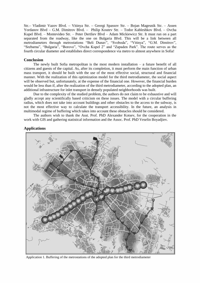
After the comparison the data for the density of the population in Sofia and the adopted route in
GIS environment and by applying the operation "buffering" with radius 500 meters around each
metrostation (application № 1), the following data has been obtained:
People living in 500 m radius around each metrostation - 173 000.
Average passengers per station, per day - 7,500 people.
Length of track - 16 km.
Comparison with the other two metrodiameters is shown in Table 3.
From the foregoing it is clear that the existing route of the Third metrodiameter no longer meets
the recent needs of the capital’s population. The great quantity of stops will significantly slow down
the transportation itself, but more alarming is the fact that the potential traffic is bigger than that of the
second metrodiameter which is determined as classic metro! The fact that it passes through arteries,
Line № 5 Line № 22
stop Workdays Weekends stop Workdays Weekends
„Knyazhevo” 7:59 8:00 „Iztok” transfer st. 8:02 8:07
„Court House” 8:30 8:30 „San Stefano” 8:17 8:22
Duration 31 min. 30 min. Duration 15 min. 15 min.
Price (valid 01.04.10) 1 BGN. 1 BGN. Price (valid 01.04.10) 1 BGN. 1 BGN.
which are considered as border for quarters and even for whole districts in places, but not inside the
quarters, is condemning him to be less used, making it an economically unsound initiative! In other
words, its realization will not really improve noticeably the mobility of Sofia citizens, because they
will lose additional time to reach the station itself, and will not meet the goal of the designers of the
subway - to serve about 70 to 80% of passengers carried in the capital for one day (i.e. about 800
thousand - 1 million daily)! Therefore, the authors will put hereinafter their vision for the development
of the metrodiameter.
Table 3
Comparison between all three metrodiameters
Metrodiameter1 First Second Third
Length 29 km 17 km 16 km2
Number of stations 24 17 23
Population13 285 000 155 000 173 000
Population24 338 000 180 000 184 000
Population1/station 12 000 9 000 7 500
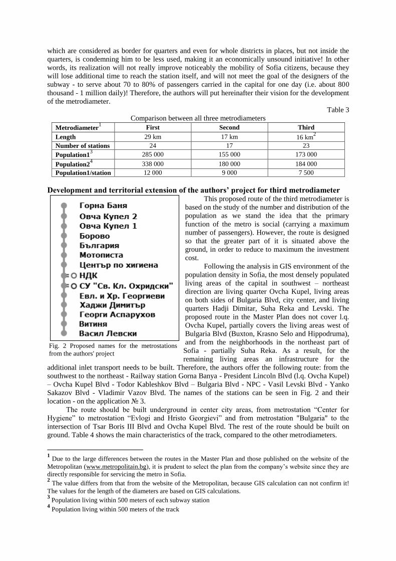
Development and territorial extension of the authors’ project for third metrodiameter This proposed route of the third metrodiameter is
based on the study of the number and distribution of the
population as we stand the idea that the primary
function of the metro is social (carrying a maximum
number of passengers). However, the route is designed
so that the greater part of it is situated above the
ground, in order to reduce to maximum the investment
cost.
Following the analysis in GIS environment of the
population density in Sofia, the most densely populated
living areas of the capital in southwest – northeast
direction are living quarter Ovcha Kupel, living areas
on both sides of Bulgaria Blvd, city center, and living
quarters Hadji Dimitar, Suha Reka and Levski. The
proposed route in the Master Plan does not cover l.q.
Ovcha Kupel, partially covers the living areas west of
Bulgaria Blvd (Buxton, Krasno Selo and Hippodruma),
and from the neighborhoods in the northeast part of
Sofia - partially Suha Reka. As a result, for the
remaining living areas an infrastructure for the
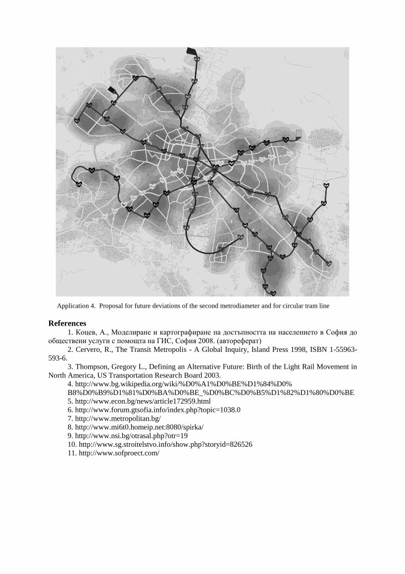
additional inlet transport needs to be built. Therefore, the authors offer the following route: from the
southwest to the northeast - Railway station Gorna Banya - President Lincoln Blvd (l.q. Ovcha Kupel)
– Ovcha Kupel Blvd - Todor Kableshkov Blvd – Bulgaria Blvd - NPC - Vasil Levski Blvd - Yanko
Sakazov Blvd - Vladimir Vazov Blvd. The names of the stations can be seen in Fig. 2 and their
location - on the application № 3.
The route should be built underground in center city areas, from metrostation “Center for
Hygiene” to metrostation “Evlogi and Hristo Georgievi” and from metrostation "Bulgaria" to the
intersection of Tsar Boris III Blvd and Ovcha Kupel Blvd. The rest of the route should be built on
ground. Table 4 shows the main characteristics of the track, compared to the other metrodiameters.
1 Due to the large differences between the routes in the Master Plan and those published on the website of the
Metropolitan (www.metropolitain.bg), it is prudent to select the plan from the company’s website since they are
directly responsible for servicing the metro in Sofia. 2 The value differs from that from the website of the Metropolitan, because GIS calculation can not confirm it!
The values for the length of the diameters are based on GIS calculations. 3 Population living within 500 meters of each subway station
4 Population living within 500 meters of the track
Fig. 2 Proposed names for the metrostations
from the authors' project

This proposal takes into account the decision of the municipality committee on transport,
infrastructure and road safety from October 7, 2009, which states that the third metrodiameter will be
deviated to the l.q. Ovcha Kupel, the main reason - more population served. We take into account also
the remarks of Mr. Stoyan Bratoev – the director of "Metropolitan Ltd., who foresees further deviation
of the second metrodiameter on Bulgaria Blvd.
Table 4
Comparison between all three metrodiameters and authors’ project
The advantages of the proposed project are as follows:
Serves 29% more population, compare to the adopted plan;
After its possible realization, over 69% of the population will have an access to the subway;
Satisfies the need for additional branch of the second metrodiameter onto Bulgaria Blvd and
heads up to the opportunity to consider its eventual split from metrostation "Central Railway Station"
in direction l.q. Slatina and l.q. Druzhba. (See application № 4);
Provides the ability to serve passengers, who are coming every day from Pernik to work in
Sofia, whose amount is more than 14 000 people (Kotsev 2008), without building a new railway
station (railway station “Vardar” on line “Sofia – Pernik”);
The route is served by 14 stations - 9 less than the adopted plan;
There is suitable municipal land to build a train depot to serve the metrodiameter - located
between l.q. Levski-G and l.q. Vrazhdebna, currently occupied by lawns and illegal dumps, as
opposed to the adopted plan, which does not have any suggested land for this purpose.
The project provides a convenient connection with the other two metrodiameters
(metrostations "NPC" and "St. Kliment. Ohridski");
Dismisses the need to deviate the third metrodiameter outside city center;
The realization of this project will also support the realization of the expansions of Todor
Kableshkov Blvd in l.q. Borovo and Ovcha Kupel Blvd in l.q. Slavia, according to the Master Plan and
will serve to avoid the closure of all the busy intersections of Tsar Boris III Blvd., except for that with
Ovcha Kupel Blvd;
Does not fully duplicate any existing tram route (tram № 5 and 22).
However, there are some disadvantages of the proposed project as follows:
The route is longer, compare to the adopted plan. According to GIS calculation – about 1
kilometer more;
GIS analysis shows that the underground part of this project is 0.9 km longer than the
adopted plan (6 km against 5.1 km).
Of course, there are some improvements to be made in the ground public transport. Some parts
of its lines can be used by presenting a valid ticket from the subway (i.e. parts of the lines can be used
as an inlet transport). Through that, there will be a cheap way for more people to use the subway
system, after its completion.
In order to avoid compulsory travel through the center using the subway in order to reach two
outside quarters, the authors are proposing a circular tram route to be built as follows: Adam
Mickiewicz Str. – Beli Dunav Str. – Nicola Zhekov Str. – First Bulgarian Army Blvd. – Rezbarska
1 please, refer to the previous page
2 there again
3 there again
4 there again
Metrodiameter1 First Second Third (authors’
project)
Third
Length 29 km 17 km 17,5 km 16 km2
Number of stations 24 17 14 23
Population13 285 000 155 000 199 000 173 000
Population24 338 000 180 000 238 000 184 000
Population1/station 12 000 9 000 14 000 7 500
Str.– Vladimir Vazov Blvd. – Vitinya Str. – Georgi Spassov Str. – Bojan Magesnik Str. – Assen
Yordanov Blvd – G.M. Dimitrov Blvd. – Philip Koutev Str. – Todor Kableshkov Blvd. – Ovcha
Kupel Blvd. – Montevideo Str. – Peter Dertliev Blvd – Adam Mickiewicz Str. It must run on a part
separated from the roadway, like the one on Bulgaria Blvd. This will be a link between all
metrodiameters through metrostations “Beli Dunav”, “Svoboda”, “Vitinya”, “G.M. Dimitrov”,
“Srebarna”, “Bulgaria”, “Borovo”, “Ovcha Kupel 2” and “Zapaden Park”. The route serves as the
fourth circular diameter and establishes direct correspondence via metro to almost anywhere in Sofia!
Conclusion The newly built Sofia metropolitan is the most modern installation – a future benefit of all
citizens and guests of the capital. As, after its completion, it must perform the main function of urban
mass transport, it should be built with the use of the most effective social, structural and financial
manner. With the realization of this optimization model for the third metrodiameter, the social aspect
will be observed but, unfortunately, at the expense of the financial one. However, the financial burden
would be less than if, after the realization of the third metrodiameter, according to the adopted plan, an
additional infrastructure for inlet transport in densely populated neighborhoods was built.
Due to the complexity of the studied problem, the authors do not claim to be exhaustive and will
gladly accept any scientifically based criticism on these issues. The model with a circular buffering
radius, which does not take into account buildings and other obstacles to the access to the subway, is
not the most effective way to calculate the transport accessibility. In the future, an analysis in
multimodal regime of buffering which takes into account these obstacles should be considered.
The authors wish to thank the Asst. Prof. PhD Alexander Kotsev, for the cooperation in the
work with GIS and gathering statistical information and the Assoc. Prof. PhD Veselin Boyadjiev.
Applications
Application 1. Buffering of the metrostations of the adopted plan for the third metrodiameter
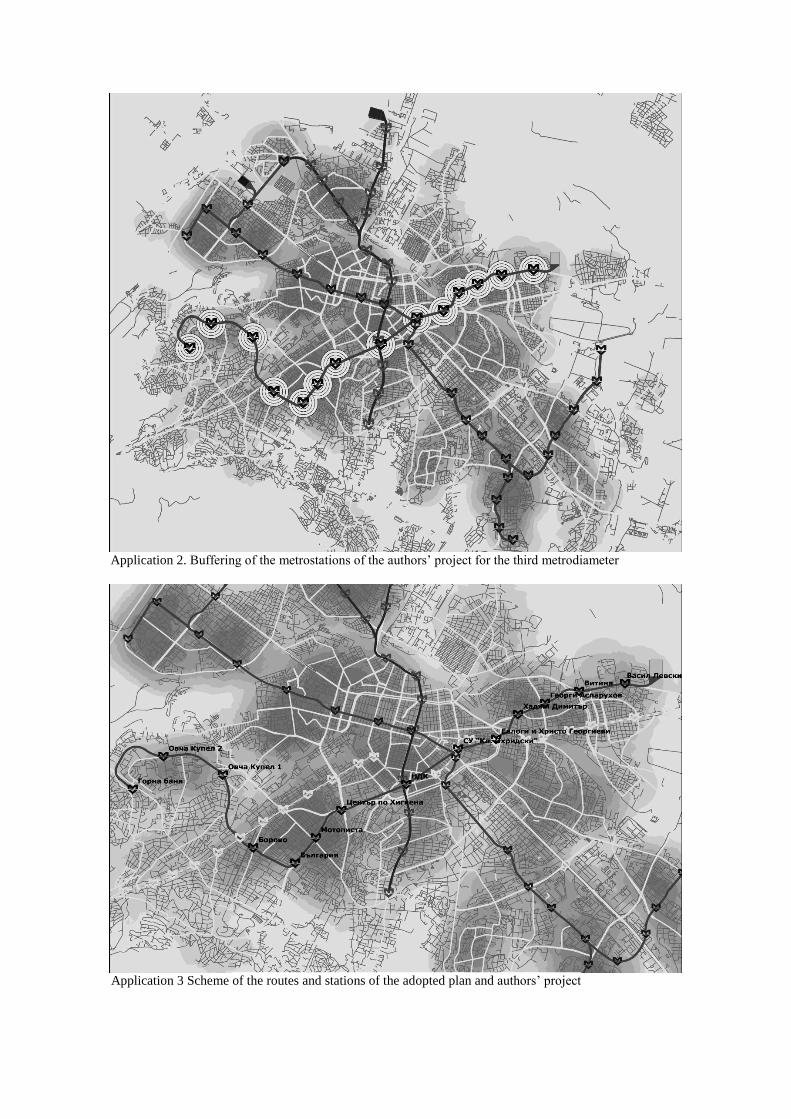
Application 2. Buffering of the metrostations of the authors’ project for the third metrodiameter
Application 3 Scheme of the routes and stations of the adopted plan and authors’ project
Application 4. Proposal for future deviations of the second metrodiameter and for circular tram line
References 1. Коцев, А., Моделиране и картографиране на достъпността на населението в София до
обществени услуги с помощта на ГИС, София 2008. (автореферат)
2. Cervero, R., The Transit Metropolis - A Global Inquiry, Island Press 1998, ISBN 1-55963-
593-6.
3. Thompson, Gregory L., Defining an Alternative Future: Birth of the Light Rail Movement in
North America, US Transportation Research Board 2003.
4. http://www.bg.wikipedia.org/wiki/%D0%A1%D0%BE%D1%84%D0%
B8%D0%B9%D1%81%D0%BA%D0%BE_%D0%BC%D0%B5%D1%82%D1%80%D0%BE
5. http://www.econ.bg/news/article172959.html
6. http://www.forum.gtsofia.info/index.php?topic=1038.0
7. http://www.metropolitan.bg/
8. http://www.mi6t0.homeip.net:8080/spirka/
9. http://www.nsi.bg/otrasal.php?otr=19
10. http://www.sg.stroitelstvo.info/show.php?storyid=826526
11. http://www.sofproect.com/