NEW YORK STATE SUPERFUND CONTRACT, IMMEDIATE ...
53
iW-t mi SDMS Document V _1Q3403_. NEW YORK STATE SUPERFUND CONTRACT IMMEDIATE INVESTIGATION WORK ASSIGNMENT DATA REPORT Mohonk Road Industrial Plant / Immediate Investigation Work Assignment No 2 ^ Site No. 356023 Work Assignment No. D002676-22 September 1997 Prepared for: New York State Department of Environmental Conservation 50 Wolf Road, Albany, New York 12233 John Cahill, Commissioner Division of Hazardous Waste Remediation Michael J. O'Toole, Jr., P.E., Director LMSE-97/0361&650/221 LAWLER, MATUSKY & SKELLY ENGINEERS LLP Environmental Science and Engineering Consultants One Blue Hill Plaza Pearl River, NY 10965 , n>t»-17-97 4:31pmmsi0893/6JO-22I/Covcr 2 00213 mi
-
Upload
khangminh22 -
Category
Documents
-
view
1 -
download
0
Transcript of NEW YORK STATE SUPERFUND CONTRACT, IMMEDIATE ...

iW-t
mi
SDMS Document
V _1Q3403_.
NEW YORK STATE SUPERFUND CONTRACT
IMMEDIATE INVESTIGATION WORK ASSIGNMENT
DATA REPORT
Mohonk Road Industrial Plant /
Immediate Investigation Work Assignment No 2 ^
Site No. 356023
Work Assignment No. D002676-22
September 1997
Prepared for:
New York State Department of Environmental Conservation 50 Wolf Road, Albany, New York 12233
John Cahill, Commissioner
Division of Hazardous Waste Remediation Michael J. O'Toole, Jr., P.E., Director
LMSE-97/0361&650/221
LAWLER, MATUSKY & SKELLY ENGINEERS LLP Environmental Science and Engineering Consultants
One Blue Hill Plaza Pearl River, NY 10965
, n>t»-17-97 4:31pmmsi0893/6JO-22I/Covcr 2 0 0 2 1 3
m i

•i
I
Bo
TABLE OF CONTENTS
LIST OF FIGURES
UST OF TABLES
1 INTRODUCTION
1.1 Overview and Objectives 1.2 Site Location and Description 1.3 Site Background
1.3.1 Site History
1.3.2 Previous Investigations
2 FIELD INVESTIGATION PROCEDURES
2.1 Monitoring Well Installation 2.2 Groundwater Samples
3 RESULTS
4 CONCLUSIONS
APPENDICES
A - Boring Logs and Well Construction Diagrams B - Well Development Logs C - Well Sampling Forms
Page No.
ii
ii
l-I
1-1 1-1 1-2
1-2 1-3
2-1
2-1 2-2
3-1
4-1
" ' ^ " «
M
ipf/8-14-97 10:35am/HSI0893/650-221/TK>f.C
s i i M A i a s ^ S ^ S B S ^ S S S K S s s i SSSSK^^SSESgsjijgj J.^--U..^.£,<,id£i'i..
200214
Lawler, Matusky & SkeUy Engineers L i p j p

Figure No.
1
2
LIST OF nGURES
Title
Site Location
Monitoring Well Locations
Following Page
1-1
1-1
M Table No.
1
LIST OF TABLES
Title
Monitoring Well Groundwater Data Summary
Following Page
3-1
:9^^*li:€''v
f T ? . , ' _ ' / ! • ; ; , ; . • • . • « • • -
= 2 ^ S I • • -- l" ' : !" i-- '
• A - m m t ' - ' ; • » • .
i^^&i-^
. , ' : • . •- 'P"*"l'*-'7 10:35am/HS10893/65O-221/L-F-T
2 0 0 2 1 5
Lawler, Matusky & Skelly Engineers LLP
..awi.iiJliWIMWW

CHAPTER 1
INTRODUCTION
1.1 OVERVIEW AND OBJECTIVES
Lawler, Matusky & Skelly Engineers LLP (LMS), under a New York State Superfiind Contract with the New York State Department of Environmental Conservation (NYSDEC), has been assigned a second Immediate Investigation Work Assignment (IIWA) at the former Mohonk Road Industrial Plant (MRIP) (NYSDEC Site I.D. No. 356023) in the Town of Marbletown, Hamlet of High Falls, Ulster County. This site is designated as a Class 2 site on the New York State Regisuy of Inactive Hazardous Waste Sites. A previous IIWA conducted between October and December 1996 identified two potential source areas that may be contributing to the groundwater contamination plume affecting numerous residential wells in the vicinity ofthe site. The objectives of this IIWA project are to:
• Install and develop up to five bedrock monitoring wells at locations on and off site as part of the Expanded Site Investigation (ESI).
• Purge and sample the five existing interface wells and the new bedrock wells as part of the ESI field work.
1.2 SITE LOCATION AND DESCRIPTION
The MRIP site is located at 186 Mohonk Road outside the Hamlet of High Falls, New York
(Figure 1). The site is approximately 14.5 acres, most of which is undeveloped property
(Figure 2). The site is bounded on the southeast by Mohonk Road and to the northeast,
northwest, and southwest by residential properties on large wooded lots. The property located
to the southwest is currently used to store machinery and trucks used for paving operations.
The MRIP property is mostly undeveloped except for the southern corner of the site, which is
occupied by an approximately 43,000-ft^ building (Figure 2). The area south of the building
consists of a large lawn and gravel driveway. The gravel drive also wraps around the side of
the building, providing access to loading docks along the western end ofthe building. The lawn
and driveway slopes gently down to a culvert that passes beneath Mohonk Road (Mountain Rest
Road). A row of shrubs exists along the building and a row of mamre trees is along the
southwest property line.
The small open area immediately west of the building is level to the edge of the driveway. At
the edge of the driveway, the fill that was placed to bring the driveway to grade drops down
f 'S
i
. N . i ,-O 1 V'
o 1 to j ^ H ! 1
, OS
\ 1 -J
mb/rr/8-14-97 I0:3O»m/HS10893/65O-221/Chap-l 1-1 Lawler, Matusky & Skelly Engineers LLP
w:-7^ smmmimhmiiMdM^7?'jm&mmmm^m s ssi t..-.-.- ...;.^,vaa>,!i.„i.,wri»f.Jgi|gj=|

2000 ft 1000 ft 2000 ft
Map source: USGS 7.5-minute Quadrangle Map, Mohonk Lake, NY, 1964.
APPROXIMATE SCALE 1 in. = 2000 ft \650\171USGS.ds4
| | . T , N ) Lawler, Matusky & Skelly Engineers LLP * ~ ' ' ~ ' 0 " e Blue Hill Plaza • Pearl River, New Yort< 10965
ENVIRONMENTAL SCIENCE 4 ENGINEERING CONSULTANTS
Site Location
Mohonk Road Industr ial Plant NYSDEC I.D. No. 356023
200217

. ' X
^
MRMW-07
MRMW-03
Legend e ESI bedrock wells (IIWA#2 wells) © ESI interface wells (IIWA#1 wells) o Existing production wells
(01 in use, 02 abandoned)
200 ft 200 ft
APPROXIMATE SCALE IN FEET Map source: Richard T. Sherman. P.C. 19?''--
200218 \650171site.ds4
Figure 2
Monitor ing Well Locat ions
MOHONK ROAD INDUSTRIAL PLANT NYSDEC I.D. No. 356023
LAWLER, MATUSKY & SKELLY ENGINEERS LLP Pearl River, New York

to a wooded section, which makes up most of the extreme western section of the property. The
wooded area slopes gendy to the north. Small piles of debris are present along the westem
M fringes of the driveway. Large piles of discarded fumimre mixed with other debris are located
just nortii of the end of the drive, as are several large piles of gravel.
The area east of the building is grass lawn with several mamre trees. The area slopes down toward Mohonk Road to a small retaining wall approximately 2 ft high along Mohonk Road. A set of stairs is located near the center of the of the retaining wall. Based on the arrangement of the trees and retaining wall with steps, it is likely that at one time this area (when it was a farm) contained a residence that was associated with the existing building. '
A separate gravel drive provides access to a loading dock on the north side of the building. The steep slope along the perimeter of the building indicates that a substantial amount of fill was placed beneath the building prior to its construction. At the base of the fill, the ground surface slopes gendy to the north. The slope steepens sharply as it approaches the northem property boundary. Most of the area is open except for small wooded areas that occur along some of the steeper slopes and along what were probably old propeny lines (based on the remnants of stone walls). An abandoned mobile home is located north of the northeast building corner.
Two tanks with concrete access covers believed to be associated with an abandoned industrial
wastewater system are located just over 100 ft north ofthe building in one ofthe wooded areas.
An iron discharge pipe is located in an embankment north of the mobile home. Two PVC
discharge pipes were also observed: one at the west end of building in line with the eastern
edge of the garage, and one in some brush just south of the mobile home. Bedrock was
observed outcropping north of the discharge point of the iron pipe on an adjacent property.
1.3 SITE BACKGROUND
1.3.1 Site History
The on-site stmcmre was originally constructed as a chicken coop around 1940. The building may have also been a motel prior to being converted to a manufacturing facility in the early 1960s, when a metal finisher moved into the building from the Rosendale area. A full description of the former occupants and uses of the building are found in the previous IIWA Report.
In 1994 a resident on Mohonk Road contacted the New York State Department of Health
(NYSDOH) concerning the quality of her drinking water. A water sample collected firom the
ml>/JT/8-I4-97 9:O8ain;HS10893/6JO^221/Chap-l 1-2 L a w l C F , M a t U S k y & S k c l l y E o g l n e e r S L L P
200219
resident's well in April 1994 contained the following volatile organic compounds (VOCs): 1,1,1-trichloroethane; trichloroethene; 1,1-dichloroethene; and I, I-dichloroethane. Over one hundred residences and businesses were then sampled by NYSDOH and the Ulster County Department of Health (UCDOH). A large number of these wells were also contaminated. NYSDEC is providing granular activated carbon filtration systems to the residents and businesses whose water contains contaminants exceeding the NYSDOH drinking water standard of 5 micrograms per liter (jig/l). NYSDEC identified the MRIP site as the source of contamination, and in August of 1994 the site was designated as Class 2 site on the New York State Registry of Inactive Hazardous Waste Sites. The Class 2 designation indicates that the site poses a significant threat to the public health and the environment (NYSDEC 1996).
1.3.2 Previous Investigations
A full description of a previous Phase I and Phase II investigations at the site in the early 1990s is found in the previous IIWA report.
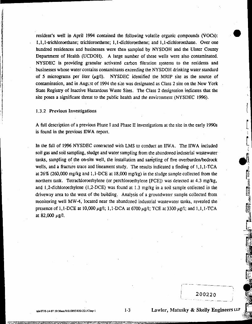
In the fall of 1996 NYSDEC contracted with LMS to conduct an IIWA. The IIWA included
soil gas and soil sampling, sludge and water sampling firom the abandoned industrial wastewater
tanks, sampling of the on-site well, the installation and sampling of five overburden/bedrock
wells, and a fracture trace and lineament smdy. The results indicated a finding of 1,1,1-TCA
at 26% (260,000 mg/kg and 1,1-DCE at 18,000 mg/kg) in the sludge sample collected from the
northern tank. Tetrachloroethylene (or perchloroethylene [PCE]) was detected at 4.3 mg/kg,
and 1,2-dichloroethylene (1,2-DCE) was found at 1.3 mg/kg in a soil sample collected in the
driveway area to the west of the building. Analysis of a groundwater sample collected from
monitoring well MW-4, located near the abandoned industrial wastewater tanks, revealed the
presence of 1,1-DCE at 10,000/ig/1; 1,1-DCA at6700/ig/l; TCE at3300;ig/l; and 1,1,1-TCA
at 82,000 /ig/1.
[
[
mb/rr/8-14-97 10:30am/HS 10893/650-22 l/Ctiap-1 1-3
j 200220 ;
Lawler, Matusky & Skelly Engineers LLP
vggyfeSi&sMSg^iitasaMSfeaggigaai^'as^

CHAPTER 2
n E L D INVESTIGATION PROCEDURES
One of the objectives of this IIWA is to show the connection of the potential on-site sources to
the recognized chlorinated solvent plume affecting numerous residential drinking water wells
in the High Falls area. Five bedrock monitoring wells were proposed for installation to
determine whether the potential on-site source areas were indeed contributing to the
groundwater contamination plume. These wells and the five interface wells installed during the
first nWA were also purged and sampled to obtain data required for the ESI. All field
investigation and screening procedures were conducted following NYSDEC protocols and
guidelines. Detailed descriptions of the procedures used are found below.
2.1 MONITORING WELL INSTALLATION
From 25 March through 8 April 1997 LMS and its subcontractor, American Auger, completed
the installation of four monitoring wells at the MRIP off-site (Figure 2). Drill rig access at the
fifth proposed well location, which was to serve as an upgradient well, was extremely limited
due to the presence of overhead utilities, trees, and topography. Upon observing the proposed
site location, NYSDEC elected not to install the upgradient bedrock well.
Four open-hole bedrock wells were completed on the site. Three extended to depths of 100 ft
below grade, and one was constructed at 34 ft below grade. The well placed at 34 ft below
grade was terminated at that depth because the driller felt that the borehole was producing water
based on the reaction of the drilling fluid. The drill rig's pump was reversed and water was
pumped out of the borehole. The well was pumped for approximately 20 min at a flow of about
2.5 gpm. Based on the yield and after conferring with the NYSDEC project officer, the
decision was made to terminate the well at 34 ft below grade.
Wells accessible by a tmck-mounted drill rig were installed with a Foremost tmck-mounted
drillmg rig. Locations not tmck accessible were installed using a Mobile B-57 drill rig mounted
on an all-terrain skid rig. The scope of work originally called for drilling down to bedrock
using 6.25-in. hollow-stem augers. This method was changed to advancing 4-in.-diameter spin
casing when a boulder was encountered at the first well location. Shallow boulders had also
been encountered in several of interface well borings. Upon reaching bedrock, HQ coring was
used to advance 10 ft into bedrock. A 3-in. PVC casing was then grouted into place. NX
coring was used to advance the boring to the desired termination depth. A locking protective
casing was placed over the well and secured by concrete.
2 0 0 2 2 1
ipf/8-i4-97io:3iainmsio893/65o.22i/ciiai>-2 2-1 LawIcH, Matusky & Skelly Englnecrs LLP

Lithology, flame ionization detector (FID) readings, well constmction, and other observations were recorded on the boring logs, which are presented as Appendix A. The boring logs also include a description of the bedrock and the rock quality index (RQD). Soil cuttings were distributed around the well. Drilling fluid, well development water, and purge water were discharged to the ground surface downgradient of the well.
Monitoring well development was initiated by American Auger on 4 April 1997 at MRMW-IB
using small submersible Whale pumps connected in series. The Whale pumps did not produce
enough flow to overpump the well to develop the well. A standard 1.5-in. by 3-ft bailer was
used to partially develop the well. The well development was later completed using a
submersible Gmnfos pump. MW-06 was developed using a 20-ft section of 2-in. PVC pipe
modified with a check valve attached to one end to fij.nction as a large bailer. MRMW-7 was
developed using a submersible Gmnfos pump. MRMW-5B was developed by pumping from
the surface using the drill rig mono pump and tremie rods. Water chemistries, including
temperamre, pH, conductivity, and mrbidity, were recorded during development and the
measurements were recorded on well development logs, which are presented in Appendix B.
2.2 GROUNDWATER SAMPLES
On 5 May 1997 the interface wells were purged by bailing them dry with a dedicated,
disposable PVC bailer. The wells were allowed to recover and then purged dry a second time.
The bedrock wells were purged between 5 and 7 May 1997. MRMW-IB, -6, and -7 were
purged using a submersible Gmnfos pump. The shallower bedrock well (MRMW-5B) was
purged by bailing using a dedicated PVC bailer. Groundwater chemistries (temperamre, pH,
conductivity, and mrbidity) were recorded before and after bailing. Static water level
measurements were also taken prior to purging each well. Groundwater purging information
is recorded on the well sampling forms presented in Appendix C.
m
Groundwater samples were collected from each of the bedrock and interface wells using dedicated, disposable Teflon bailers. The interface wells and MRMW-lb were sampled after recovering ovemight. The remaining bedrock wells were sampled immediately after purging. Each well was sampled for target compound list (TCL) VOCs and target analyte list (TAL) metals. Groundwater chemistries (temperamre, pH, conductivity, and mrbidity) were recorded prior to and after sampling. Water level measurements were also recorded prior to and after sampling. Groundwater sampling data are documented on the well sampling forms presented in Appendix C.
rpf/8-14-97 10:31iim/HS10893/6.S)-221/Chap-2 2-2
2 0 0 2 2 2
Lawler, Matusky & Skelly Engineers LLP

• ^ 1
11
'"* Quality assurance/quality control (QA/QC) samples consisting of a duplicate (MRMW-5C) and an MS/MSD were collected from MRMW-5B. MRMW-5B was selected as it is immediately downgradient of the tank. The sample containers were provided by the NYSDEC contract laboratory and were prepreserved when necessary. The samples were shipped to the NYSDEC contract laboratory following the proper chain-of-custody protocols.
ipf/8-14-97 9:21»myHSI0893/6JO-221/Chai>-2 2-3
2 0 0 2 2 3
Lawler, Matusky & Skelly Engineers LLP

RESULTS
The groundwater sampling results for the TAL metals analysis from the IIWA monitoring wells
are also presented in Table 1. Iron, magnesium, manganese, and sodium were detected above
the NYSDEC Class GA groundwater standard (Table 1). However, the concentrations found
were in some cases only slightiy elevated over namral ambient groundwater ranges (Table I).
It is believed that the concentration i found can be attributed to the highly mineralized namre
of the groundwater in this area.
200224
: • • ' ¥&
.-m
CHAPTER 3
The groundwater sampling results for the VOC analysis from the IIWA monitoring wells are presented in Table 1. VOCs above the quantitation limit were detected in all the wells sampled with the exception of the upgradient well cluster (MRMW-1 cluster). The primary contaminant in die groundwater is 1,1,1-TCA. 1,1-DCE, 1,1-DCA, 1,2-DCA, carbon tetrachloride, TCE, 1,1,2-TCA, and toluene were also detected above the NYSDEC Class GA groundwater standards.
[i
ipf/8-14-97 I0:32amfflS10893/6iO-221/Chap-3 3-1 Lawler, Matusky & Skelly Engineers LLP J m

0Mi^ m^is-
DRAFT
TABLE 1 (Page 1 of 3)
MONITORING WELL GROUNDWATER DATA SUMMARY
Mohonk Road Industrial Plant SKe No. 356023 11 WA #2 Sampling Event
8/14/97
— —,
IO o o IO t o Ol
MONITORING WELL NO.: SAMPLE NO.: WELL DEPTH (ft):
VOLATILE ORGANICS (MQ/I) Methylene chloride Acetone 1,1-Dichloroethylene 1,1-Dichloroethane 1,1,1-Trichloroethane 1,2-Dichloroethane Carbon tetrachloride Benzene 1,2-Dichloroethylene (total) Chloroform Trichloroethylene 1,1,2-Trichloroethane Toluene 1,1,2-Trichloro-1,2,2 trifluoroethane
Total Volatile Organics*
Numbers in bo ld exceed standard.
MRMW-1 MRMW-IB 83601 16.5
7 j b ND ND ND ND ND ND ND ND ND ND ND ND ND
ND
83601B 100
5.0 j b ND ND ND ND ND ND ND ND ND ND ND ND ND
ND
a - Total = Summation of volatiles other than those found in blank. b - Found in associated blanl<8. e - Estimated concentration; exceeds GC/MS calibration range. j - Estimated concentration; compound present below quantitati on limit.
MRMW.2 83602
23
6 j b ND ND ND 18 ND ND I.Oj ND ND ND ND ND ND
19
MRMW-3 83603 24.5
7.0 j b ND 10j ND
220 e ND ND
7.0 j 13 ND 45 ND ND ND
295
MRMW-3DL 83603 24.5
[DL: 2:1]
11 j b ND ND 10 j 210 ND ND l O j 13 j ND 43 ND ND ND
691
MRMW-4 83604 19.5
IDL:5:1I
49 j b ND
5,100 e 690
4,100 e 31 j 27 j ND 18 j 11 j
2.300 e 18 j 25 j ND
12,331
DL ND NS
MRMW-4DL 83604 19.5
[DL: 200:1]
990 b j 3,330 b 3,700 580]
28,000 ND ND ND ND ND
2,400 ND ND ND
34,680
MRMW-5 83605 14.5
5.0 j b ND ND ND 22 ND ND ND ND ND
4.0 j ND ND ND
26
- Diluted sample analysis. -Not detected a - No standard.
MRMW-5B 8360SB
34
6.0 b j ND
500 e 50
700 e 6.0 j 17
5.0 j 3.0 j 4.0 j 180 5.0 j ND ND
1.470
analytical detection limit.
NYSDEC CLASS GA
STANDARDS
5.0 NS 5.0 5.0 5.0 5.0 0.7 5.0 5.0 7.0 5.0 5.0 5.0 5.0
NS
+Disk No.: H144S3 B:\6S0221.XLS MRMW 6/14/97 11:12:07 AM*

DRAFT
TABLE1(Page2of3)
MONITORING WELL GROUNDWATER DATA SUMMARY
Mohonk Road Industrial Plant Site No. 356023 11 WA #2 Sampling Event
8/14/97
a b e
MONITORING WELLNO,: SAMPLE NO.: WELL DEPTH (ft):
34 34 .,00 ^ ^ ' ^ ^ S ^ ^ _____^__ ^ ^ ; " " STANDARDS
VOLATILE ORGANICS (fjg/I) Methylene chloride Acetone 1,1-Dichloroethylene 1,1-Dichloroethane 1,1,1-Trichloroethane 1,2-Dichloroethane Carbon tetrachloride Benzene 1,2-Dichloroethylene (total) Chloroform Trichloroethylene 1,1,2-Trichloroethane Toluene 1,1,2-Trichloro-1,2,2 trifluoroethane
Total Volatile Organics*
Numbers in bold exceed standard. - Total = Summation of volatiles other than those found in blank. - Found in associated blanks. - Estimated concentration; exceeds GC/MS calibration range. - Estimated concentration; compound present below quantitation limit.
[DL: 25:1]
330 b ND 380 43 j
3,900 ND ND ND ND ND
140 j ND ND ND
4,463
6.0 b j ND
520 e 52
720 e 6.0 j 18 ND 3.0 j 4.0 j 180 5.0] ND ND
1,508
[DL: 25:1]
260 b j ND 360 42] 3.800 ND ND ND ND ND
140] ND ND ND
4,342
5.0 j b ND
7.0] 2.0 j 40 ND ND I.Oj ND ND ND ND ND ND
5.0 j b ND 1.0j ND 28 ND ND I.Oj ND ND ND ND ND ND
5b j 10b 21 23 180 ND ND ND 3.0 j ND
9 ] ND ND ND
7 b j ND ND ND ND ND ND ND ND ND ND ND ND ND
5.0 NS 5.0 5.0 5.0 5.0 0.7 5.0 5.0 7.0 5.0 5.0 5.0 5.0
DL - Diluted sample analysis. NO - Not detected at analytteal detection limit. wc -Nostandard. NS
L.
93Z003
•Disk No.-. H14483 B.\65CI221.XtS MRMW 8/14/97 11:12:07 AM*
' ^ E * ^ ' 4 l ^ ^ 3 H ^ ^ J ' = > < i B ' ^ - <• Jin.... 1.11 i^ i^3\" . Il't.. .S3

•^Ji ^ i , i M i
TABLE 1 (Page 3 of 3)
MONITORING WELL GROUNDWATER DATA SUMMARY
Mohonk Road Industrial Plant Site No. 356023 11 WA KZ Sampling Event
8/14«7
MONITORING WELL NO.: SAMPLE NO.: WELL DEPTH (ft):
METALS (|ig/l| . Aluminum Artimony Arsenic Banum Beryllium Cadmium Calcium Chromium Cobalt Copper Iron Lead Magnesium Manganese Mercury Nickel Potassium Selenium Silver Sodium Thallium Vanadium Zinc
MRMW-1 3601 16.6
5,050 NO
3 3 8 145 B 0 78B
ND 215.000
SOB 154B 28 8
10.200 9 7
•4,300 2,090 ND 585
1,890 B 1 6 B ND
17,000 ND
2 3 1 B 55.8
MRMW-IB MRMW.2 MRMW-3 361B 100
ND ND ND
79 6 B ND
3 5 B 179,000
ND ND
3 3 B 138
1 8 B 20.700 1 3 7 B
ND 13 6 B
ND 1 9 B ND
14,700 ND
1 2 0 8 1 4 2 8
3602 23
87 6 8 ND ND 261 ND ND
104,000 ND ND ND 269
0 40B 7,860 9 2 8 NO ND ND
1 8 8 ND
7.370 N D W 8 0 8 6 1 B
3603 24.6
3 5 5 8 NO
N D W 1308 0 79 8
ND 261.000
ND ND ND 419
O.SOB 51,900 2,800 ND
1 2 0 8 1.1908 3 2 8 ND
203.000 N D W 2 0 2 8 9 5 8
MRMW-4 MRMW-6 MRMW-6B MRMW-6B DUP 3604 19.5
ND ND
1 8 8 41 6 B 1 2 B ND
149,000 ND
11.98 3 3 B 5 4 3 8
3 6 13,000 1.940 ND
32.18 NO NO ND
28,400 1 4 B W 1 1 3 B 223
3605 14.6
1,090 ND ND
168B 0 818
ND 47,100
ND ND
6 5 8 1,6«0 1 8 B
3.940 8 552 ND
16 8 8 ND
1 8 8 ND
7,670 N D W 6 7 B 290
8365B 34
ND ND ND
147 8 1 2 B NO
117.000 ND NO
23B 346 ND
6,850 9 2 8 NDN ND ND ND 13 9
6,570 NDW 8 8 8 6.18
8365C 34
6 0 3 8 ND NO
1308 1 2 8 ND
113.000 ND NO
2 2 9 8 353 1 5 B 6.550 1 3 8 8 NDN ND NO
NDW 109
6.260 NDW 9 5 B 6 1 8
i i i i i i l : MRMW-6 MRMW-7 MRPW-1 NATURAL AMBIENT
3606 100
292 ND
2 3 8 1518 ND ND
109,000 ND
6 9 8 2 2 5 8
810 6 1
16,000 21.5 NO ND
4,320 8 3 7 8 5 4 8
16,900 N D W 8 2 8 52 7
3607 100
348 ND
2.18 173 8 ND ND
65,700 5 5 8 ND 550 1,710 2 8 8
17,000 38.4 ND
27.3 8 3,420 8
2 8 B 9 3 8
4,460 B NDW
NO 21.6
83P6G1
•
NO 3 6 6 8
ND 294
1.2 B NO
99.200 • ND ND NO
16.700 0 70 8 15,400
168 NDN 17.6 8
ND 1 5 8 ND
10.700 ND
6 2 8 13.7 B
GROUNDWATER RANGES (n)
<5 0-1,000 N/A
«1.0-30 10-500
<10 <1.0
1.000-150,000 <1.0.-5.0
<10 <1.0-30
10-10,000 <15
1,000-50,000 "11.0-1,000
<1.0 <10 .50
1,000-10,000 <1.0-10
<5.0 SOO-120,000
N/A <1.0-10
<10.2.000
NYSDEC CLASS GA
STANDARDS
NS 3.0 GV
25 1,000
3 0 G V 10 NS 50 NS 200 .
300 (m) 25
35,000 GV 300 (m)
2.0 NS NS 10 50 1
20,000 4.0 GV
NS 300
(m) (n) B
N W
GV
to o o to to -J
Numbers In bold exceed standard. - Iron and manganese not to exceed 500 (jg/l. - Dragun, J., The Soil Chemistry of Hazardous Materials. - Value is less than the contract-required detection limit but
greater than the instrument detection limit - Spiked sample recovery is not within control limits. - Post-digestion spike out of control limits; sample absortiance
is less than 50% of spike absort>ance. - Guidance value.
N/A - Not available. NO - Not detected at analytical detection limit. NS - No standard. DUP - Duplicate sample analysis.
«DI>k No.: H144al B:VS5022I.XLS S)m(4 H H I i l t l :1}:07 AM«

CHAPTER 4
CONCLUSIONS
Analytical results from the groundwater sampling and analysis indicate the presence of site-related contamination in the groundwater at the bedrock interface and in the bedrock aquifer. The concentrations in the monitoring well clusters downgradient ofthe source areas (MRMW-3, MRMW-4, MRMW-5 cluster, MRMW-6, and MRMW-7) are significantly elevated over the concentrations found in the upgradient well cluster (MRMW-1 cluster). The primary contaminant found in both the on-site industrial wastewater tank and in the groundwater is 1,1,1-TCA. Based on the available data it appears that past disposal practices at the MRIP (NYSDEC Site No. 356023) have resulted in significant groundwater contamination of the bedrock aquifer in the High Falls area.
• j ^ i '
200228
ipf/8-14-91 9:28ani/HS10893/6»-221/Chap.4 4-1 Lawler, Matusky & Skelly Engineers LLF i j

M
-'-ll
i
,i
APPENDIX A
BORING LOGS AND WELL CONSTRUCTION DIAGRAMS
2 0 0 2 2 9

. ^ . ^ - ^ ^ . g ^ Y m T - ^ ^ ^ " ^ " •
^SNG/MONUORINQ WELL CONSTRUCTION LOG
^ i j e c t Name: Mohonk Road IIHA#2
Page 1 of 4
Boring L O J M R N N - B
M i loea U«l^^HlatL£2!!LNL Orillif>g Co.: American Auger
^ ^ ^ ^ ^ I ^ ^ S e e plan
i^^Ttg^hburg
DriHing Method: 4" Spin casing/NX Core
Date Begin/End: 3/25/97 - 3/28/97
Surface Elevatior>:
Depth to Water:
Total Depth: 100
SEDLOBIC DESCHIPTIDM
a r d - 3 5 - S O X f - fir^e some = 20-35X m = medium
little » I0-20X c » coarse trace - 0-tOX
i P i niABRAM
locl(ing standpipe
well cap
OVERBURDEN CONSISTS OF GLACIAL TILL
DRILLED TO 12" WITH 4 " SPIN CASING
BEDROCK AT 12'
DRILLED TO 22" WITH HQ CORE (3.8" dia)
3" Sch 40 PVC OUTER CASING SET AT 22" ANO PRESSURE GROUTED TO SURFACE
NX CORE BARREL WAS USED TO COLLECT ROCK CORES
\ > concrete
12' - 13.5' Bedrock - Shawangunk formation White orthoquartzite (metaconglomerate)
13.5' - 18.5' Bedrock - Shawangunk formation White orthoquartzite (metaconglomerate)
18.5' - 22' Bedrock - Shawangunk formation White orthoquartzite (metaconglomerate) Features of 18.5' - 22' run: Greater than ten (10) horizontal fractures.
22' - 24' Bedrock - Shawangunk formation White orthoquartzite (metaconglomerate) Features of 22' - 24 ' run: Four (4) horizontal fractures.
24' - 29' Bedrock - Shawangunk formation White orthoquartzite (metaconglomerate) Features of 24 ' - 29' run: Solid - no fractures.
f
-I 'I
-I ''I ''I D.
* y
P-:i<i
l».-.iC
P-:i4
I
I
I
I'' I"'
1;
grout
3.0" sch 40 PVC inner casing
bedrock surface
i'.O 0 ' e>.-.i< I'.Oo - " • • • i t : O.O
•.o 0 '
'.0 0'
c>.o P.:iA
^:!< •O.O
'.oo: ^• • . i<
P-i< . » . . . n r * i . ^ i t .
bedrock I 5
I to
I w o

TEST BORINe/MONITORINe HELL CONSTRUCTION LOG Page 2 of 4
Proiect Nane: Hohonk Road UMA#2 Boring L O J HRMH-fi
Site inrAUnn- -High Falls. NY
Job Number: 650-221
Client: NYSDEC
Drilling Co.: American Auger
NYSDEC Site I.D. ^56023
Boring Location: See plan
Geologist: John Thomburg
Drilling Method: 4" Spin casing/NX Core
Date Begin/End: 3/25/97 - 3/28/97
Surface Elevation:
Depth to Water:
Total Depth:. .'00
§
BEOLOSIC DESCnPTION and » 35-50X f « fine
some » 20-35X m = mecSum little » I0-20X c « coarse
trace » 0-IOX
MEa OZASRAN
31-
33-
35-
37-
39-
41-
43-
45-
47-
49-
51-
53-
55-
57-
99
100 IOO
IOO 100
IOO 94
too 95
4.5 90 78
• o
r.o.o'.
>'.O0'
f'.o Q:
f-.O.O'.
\'.O0
l.OO
i.OQ
K O Q :
i:o_o:
>'.0 Q. 0..oO >'.o 0'. o . : ^ o
K O Q :
i-o.ov
>.o 0"-
\'.0 0'.
>'.O.0'-O.-.oO >.O.0'.
>'.oo . o . : ^ o
f-.O.O O.-.oO >-o.o'-o. : oO
•'.oo 0 . - - O .
29' - 34' Bedrock - Shawangunk formation White orthoquartzite (metaconglomerate) Features of 29' - 34' run: Six (e) iron stained, clay lined horizontal fractures.
34' - 39" Bedrock - Shawangunk formation White orthoquartzite (metaconglomerate) Features of 34' - 39'run: Two (2) horizontal fractures; one filled with fines. 2" of small solution cavities at 36.5'.
39" - 44" Bedrock - Shawangunk formation While orthoquartzite (metaconglomerate) Features of 39' - 44'run: Four (4) fractures. 0.25" slate layer at 39.3'.
44" - 49' Bedrock - Shawangunk formation While orthoquartzite (metaconglomerate) Features of 44' - 49' run: Four (4) horizontal fractures.
49" - 54' Bedrock - Shawangunk formation While orthoquartzite (metaconglomerate) Features of 49' - 54' run: Five (5) horizontal fractures. One (1) vertical fracture 51' - 52'.
54' - 59' Bedrock - Shawangunk formation While orthoquartzite (metaconglomerate) Features of 54' - 59'run: Six (6) horizontal fractures. 2.5" slate layer at 56.6".
O o
'.O 0
O.O
O.O
P.:i< •Oo '
JO.O. p-.iA
p.-i<A
P-:i<
' - • • i<
?3 ^^
O.O.:,
P.:i<i t>.0 ' - • - i<
O.O
! oo ' • • • i< O.O
O.O
O O ^
L i " *
P-:i< O.O
OO
' y O.O
•O.O
P.\i4
O.O ?:;*' ^o.o
O.O
y
•O.O
oo
iO.o:
o.
o'o
•O.O
'.O 0 '
O.O
• .oo
•.O.O > /oo P.:i< oo
o.oj
. .L^o; ,
P.:i<i .-O.o;,
O.O •0 . 0 S-.iC
oo 0 0
• O O .
O.O
» = . • • * <
P-.iir • 0 . 0
-•••.<;< O.O ' • • • i<
•'.Oo'. p.-:i<?
p - i '
?:!< ' .Oo '
.0 .0 31, •0 .0 •O.O' .' '
>'.O,0'
•.O 0
'.oo
- O . 0 _ |0.-.i<1
•O.O ».-.iC
QO > ' i ^
' • • » *
0
bedrock
to o o to OJ
S K :
Zaw'e/; A/5/(/5A'y <P 5 M y Engineers i

- 1 uS-"'-' 5 ' '--
1
]
f .Ml
; TEST BORING/MONITORING WELL CONSTRUCTION LOG
. . i f-. Proiect Nane: Mohonk Road IIHA#2
Page 3 of 4
Boring LOJ MRMM-B
Site Location.
Job Number. _
Client7 '*
Hiflh Falls. NY.
650-221
Drilling Co.: American Auger
Drilling Method: 4" Spin casing/NX Core
NYSDEC Dale Begin/End: 3/25/97 - 3/28/97
356023 NYSOEC Site 10..
Boring Location. _
Geologist. - ' '° '^" Thomburg
See plan
Surface Elevation:
Depth to Water: _
Total Depth: 100
GEOLOGIC IIHflrHIPI H!W and >= 35-50X f >• fine
some » 20-35X m = medium little = I0-20X c » coarse
trace » O-KDX
MFii DiABmH
'€1
SI
60-
62-
64-
2. t .
4
100
;f-:s
66-1
68-
100
TO-i
72-100 too
74-
78
78-
100 90
80-
82-100 90
84-
86-100 90
59' - 64' Bedrock - Shawangunk formation White orthoquartzite (metaconglomerate) Features of 59' - 64'run: Six (6) horizontal fractures.
64' - 69' Bedrock - Shawangunk formation White orthoquartzite (metaconglomerate) Features of 64' - 69' run: 4' of competent rock. Two. (2) fractures. Solution cavity zone from 66.7' - 66.9'.
69" - 74" Bedrock - Shawangunk formation White orthoquartzite (metaconglomerate) Features of 69' - 74' run: Two (2) horizontal fractures.
74' - 79" Bedrock - Shawangunk formation White orthoquartzite (metaconglomerate) Features of 74' - 79' run: FOIST (4) horizontal fractures: 2 iron stained.
79' - 84' Bedrock - Shawangunk formation White orthoquartzite (metaconglomerate) Features of 79' - 84'run: Five (5) fractures. 4" of rock column iron stained.
84' - 89' Bedrock - Shawangunk formation White orthoquartzite (metaconglomerate) Features of 84' - 69'run:
Ofl ».-.i« oo 9.-.iC
•Ofl ».-.i<= Ofl
>.-.iO •Oft >..i< on >.i< oo >'.i<
•Ofl '••.i< oo
a.^c Ofl
».-.i< • o n : » . ; < •oo ' • • • i < •Ofl » ' i< oo
' • • • i < • o n t>.-i< • o o ; o.:i< •on O.-iC •-on o.-i< '.on a.»< •Ofl o.-.i<
^ ! t r.o (J o.-.i< •Ofl > i < • o n » • • » <
• o n : ».•;< •On: =>.-,i< •Ofl: o.-.i' i-.Ofl o.-i< •on-a.-i< •on
0.-i< • o n ° i< •.on: o.:i< i.Ofl o.-.Jt • o n o.-.i< r.ofl c.-i<: I.Ofl £>.•:<
•.oV 0.^i< •on
!>.-.i« •O.O-
i .on O.-.iC
r.Ofl »•.*< oo
o.-ic :ofl ' • • • " ' =
•.on a-.ic on » . j «
•.on >•.*« Ofl
':oo o.:i< •Ofl »••..< •Ofl a-.i«
on o.-.i« • o o ' • • • i < •Ofl '•••i< Ofl
'•.i< oo
>-:i<
oo '••.i< Ofl
>..i< Ofl
>.•!< •on o.:i<
Ofl la-.i< on ft-.i<
•on o.:i< on
o.:i< • o n
" > • • . • <
•oo a-.ic o o
a-.i< • o n o.:i<
bV. aiS< •OO
o.-.i< •Ofl «•.»<
OO •>•••*< :oo: ».:i< •oo: > • • . * <
•Ofl-».-.i< •on ».•,-< •oo: ».:i< •on: >. i< •oo ».-.*< . 0 0 ».-.<< •Oft a-.i< • 0 0 » • • . * <
•on »••.<< •.oo ft-.i< •on o.-.iO I .on a-. i« i-.oo
l.OO
l.OO ft-.ic •O.O
-On »:*« •oo >••*« oo
>••.»= •on »••-<« oo
k
/'
1 M
1 O
o t o w
-..i . ;
•
t o
' I

TEST BORING/MONITORING NELL CONSTRUCTION LOG Page 4 of 4
Protect Nane: Hohonk Road nMA#2 Boring L O J HRMM-e
Site Location: High Falls. NY
Job Number: 650-221
Client:
Drilling Co.: American Auger
Drilling Method: 4" Spin casing/NX Core
NYSDEC
NYSDEC Site I.D. 356023
Date Begin/End: 3/25/97 - 3/28/97
Boring Location: See plan
Geologist: John Thomburg
Surface Elevation:
Depth lo Waler: _
Total Depth: 100
S and » 3S-50X f - fine
some « 20-35X m » medium
little - 10-20X c " coarse trace - 0-10X
MPTi 0IA8RAN
89-
91-
93-
100 90 ' I
IOO
95-
97-100
99- iS
101-
103-
105-
107-
109-
II I-
113-
115-
98
100
j ^
• o
f'.oo
>'.o 0' ^ • • o O
I'Oo
l.OO-
>-O0-
f'.o 0'.
"'.oo'.
' • O . O ' '
Seven (7) horizontal fractures. One (1) vertical fracture 87' - 87.5'. Iron stained fracture zone 84' - 84.4'.
89' - 94 ' Bedrock - Shawangunk formation White orthoquartzite (metaconglomerate) Features of 69 ' - 94 ' run : Four (4) horizontal fractures. 0.5" slate layer a l 93.4'.
94' - 99' Bedrock - Shawangunk formation White orthoquartzite (metaconglomerate) Features o f 94 ' - 99 ' run: One (1) hor izonta l f r ac tu re .
99" - 100' Bedrock - Shawangunk format ion
•\^ White o r t hoqua r t z i t e (metaconglomerate) / " •
:o.o: > ' . i< •o.o:
•^oo
, ° o
u°o..:, P.:i.<\ •o.n
•on
•o:o •O.O .0.0 9. ' OO
P.:i<
a:i< •O.O
jo.o
J 'o >••.«« •O.O
» . : i< ' •O.O
oo;
o.o:
END OF BORING 100 FT
•.Oo' ' • ' • i '
'.o n '>- ' i< '.O 0 '
^ ! < •O.O
•0.0
jo.o:,
p " -
'% ' .On ' ' • • • i <
-Oo;,
O.O
J'O', » • • • » <
•O 0
^y (a-.ic >'.i<.
.lo.o:. to.-id
.0 O'O o:o ( '^• i0..^^o. • '.o O'O o:o •'••.io.^'.io.^:, O.O'-O.O'.O. ^-•••^•'.#o. Oo:oo:o
p •.;'>••.;« •.oo.oo:o " .o. ' o o:o o:o ' . • : iO. : iO. : , O0'.O0'.t>.\ ». '.J>. -O.O'.O.o'.O.
iO. ' . i '
^ ^
O'O.O jt>.:i<
O'O.o^ i^^ • • ^ o:o.o:
,o-o.o
b t d r o c k
U
200233
Lawler. Matusky S Skelly Engineers LLP I
'•ii'iii

'yy;^y?y.' :
^ y y TEST BORING/MONITORING WELL CONSTRUCTION LOG
S i i i t e . Project Name: Mohonk Road IIHA#2
Page t of 2
Boring L O J HRHN-5B
Job}4umber: . 65^-22j ; ^ ; i ' " NYSDEc"
Drilling Co.: American Auger
Drilling Method: 4" Spin casing/NX Core
Date Begin/End: 4/3/97 - 4/7/97
NYSDEC Site I.D. 356023_
B w ^ l l S t i o n : See plan.
Geologist: John Thomburg
Surface Elevation:
Depth to Water:
Total Depth: 34
KOLOeiC t£SCRIPTION and •= 35-50X • f = fine
some = 20-35X m = medium little = 10-20X c = coarse
trace = 0-lOX
MEU. OUGRAN flush mounted curb box
locking well cap
2-
4 -
•36-1
10-
12-
14-
16-
18-
0VER8URDEN CONSISTS OF GLACIAL TILL
DRILLED TO 9' WITH 4" SPIN CASING
BEDROCK AT 9'
DRILLED TO 19" WITH HQ CORE (3.8" dia)
3" Sch 40 PVC OUTER CASING SET AT 19' AND PRESSURE GROUTED TO SURFACE
NX CORE BARREL WAS USED TO COLLECT ROCK CORES
100 90
•O.o:
r.o.o'.
o.o.
•O.o:
i.O.o".
9' - 14' Bedrock - Shawangunk formation White orthoquartzite (metaconglomerate) Features of 9' - 14'run: Nine (9) horizontal fractures. One (1) vertical fracture at 12'.
IOO
Y I Y I t
r.oo'.
r.o 0". o.:60 • ".O 0'.
>:o_o: o.:^o kO.o'. o.-.^o >-O.0'.
14' - 19' Bedrock - Shawangunk formation White orthoquartzite (metaconglomerate) Features of 14' - 19' run: Five (5) horizontal fractures.
!
1 ''I 'I 'I 'I -I -I 'I 'I 'I
rV
I I
\
¥
¥ ¥ ¥ ¥ ¥ ¥.
I'
I
concrete
grout
3.0" sch 40 PVC inner casing
bedrock surface.
; O \ O j to
U>
lawler. MaluskvS Skelly Enaineers LLP

•
j'
• •
•
TEST BORING/MONITORING HELL CONSTRUCTION LOG
. Proiect Name: Mohonk Road IIWA#2
ciitP 1 orAiinr^- High Falls. NY
.Inh N„mhPr- 650-221
^.,iP,^*• NYSDEC
NY<;nFr R I I P T n 356023
Boring 1 ocation; See plan
Rpningi^j- John Thomburg
1.
Q
21-
•
23-
25 -
27 -
0 Q «
31-
•
J J -
3 5 -
37-
g
1 9 z s
. '
.
1
1
t
' (
1
'
I
s
>
3
r
H
1 S u
.
4
1
i
C
' '
1
i
.3
•
L
>
r
g s i
E M
^
8
1
'
10
' .
10
.
6
0
f
...
0
'
i
>
7
1
-
8
' .
IQ
1
2
' 1
0
r I
0
'
fc
S
•.Oo' 0 •' - o I'.O o'
•.o 0'. ^••."o<^ •.o 0
l.o 0 .
r.o.o'.
yo o: o : 6 ^ yo.o-
yo.o o.-.«o >'.0 0' o.- -o • o
>O.0
r.o.o'. ^ • • . o O >:o 0'. o.-.-^o
>:o 0'. o.'.^o r-o.o'
'•.O 0 •
>".0 0'. o • • - o • - £)
l.OO-o.-.^o
nriiHngr.o- American Augei
Page 2 of 2
Boring L D J M R H N -
nmiinQ uiiknrt^ 4" Spin casing/NX Core
na tP RpQin/Pnrt- 4 / 3 / 9 7 -
c i i i r fa rp PlP«a»ir.r>-
_, , Depth to Water: . . . .
Tn(a l npp th - 34
BE0L06IC E£SOUPTI0N and = 35-50X"^- f i fine
some •= 20-35X m = medium little = I0-20X c = coarse
trace = 0-lOX
19' - 24' Bedrock - Shawangunk formation White orthoquartzite (metaconglomerate) Features of 19' - 24' run: Eight (3) horizontal fractures; several iron stained.
'
'
24' - 29' Bedrock - Shawangunk formation White orthoquartzite (metaconglomerate) Features of 24' - 29' run: Greater than ten (10) fractures (breakage).
•
29" - 34" Bedrock - Shawangunk formation White orthoquartzite (metaconglomerate) Features of 29' - 34'run: Six (6) fractures: several stained and filled wilh fines.
•
4/7 /97
MBl DIASRAM
•o.o ' • • • » < =
:o .o ' ' i < =
:o .o > • • . • =
:o .o >.'.2c on o o
-'-.°, o.o o.o
'•••i< o o
a-.i<: :o.o ' • . • <
v. i« o.o on
-Ofl'
-on ' • • i < : oo
> • ; < :
• o n
^':!< o.o
on • A ' "
•O.o:
•O.O
:o .o :
o .o :
' A ^ •o .o :
i'^'^c
^%
•O.o = • • . . «
' •O^
•Of l a'.i« O.O
»:i« :oo
' ^ !< on
^ A ^ •O.o
' • ^ • ^ '
b . V .0 .0
:o.o o. : i<
on •OO
O.O
a-*. c :oo : a-.^< :o.o: 0..-C -0.0
o.-.i<. 'on o.-.ii. ©.••^<
•00
Oft
:oo
:o,o:
on ' • - i < •OO ? • •< :o.o a.iC •O.o
:o,o a .^O. .;w .,;« .^^ : o o : o o . o o : o o >'.iO.:iO::iO.:^c •.oo'.oo:oo'.oo a-.^o-.^o-.^o.-.^d .oo.oo ' .oo:oo a-.^c-.'^a-J^o.-.^ia .oo'.oo'.oo:oo '•.<,o..iO.-.-<>..;c :oo:oo:oo:o .o
• Deorocn
•
—.-.
6B
Lawler. Matusky S Skelly Engineers L L P ^
200235

TEST BORING/HONITORING NELL CONSTRUCTION LOG
Protect Nane: Mohonk Road UHA#2
Page 1 of 4
Boring L O J MRMN-Ce
Site Location: _ High Falls. NY
Job Number: _. e50-2_21 .
Client: NYSDEC
NYSOEC Site 1.0..
Drilling Co.: American Auger
Drilling Method: 4" Spin casing/NX Core
Dale Begin/End: 3/26/97 - 4/3/97
358023
Boring Location: . See plan
. Surface Elevation:.
Depth to Water:
Geologist: >>°h" Thomburg Total Depth: - '00
BEOLOBIC DbSOUITION
and » 35-50X f - fine some - 20-35X m = medium little « 10-20X c " coarse
trace = 0-lOX
HELL DTABRAH
r locking standpipe
— well cap
2 -
4 -
8-
10-
12-
14-
16-
18-
20-
22-
24-
26-
28-
^
OVERBURDEN CONSISTS OF GLACIAL TILL
DRILLED TO 28' WITH 4" SPIN CASING
BEDROCK AT 28'
DRILLED TO 39' WITH HQ CORE (3.8" dia)
3" Sch 40 PVC OUTER CASING SET AT 39' AND PRESSURE GROUTED TO SURFACE
NX CORE BARREL WAS USED TO CaLECT ROCK CORES
200236
1 ^ K
H I I
ii •^ I
I i
I I
IS i°t^ §*;
concrete
grout
3.0" sch 40 PVC inner casing
bedrock surface
Lawler. Mafusky S Skelly Engineers LLP
TEST BORING/MONITORING WELL CONSTRUCTION LOG
Proiect Nane: Mohonk Road nHA#2
Page 2 of 4
Boring LOJ MRMW-08 [
[
[
[
c
t i
Site Location: High Falls. NY
Job Number: 650-22 '
Client: NYSDEC
Drilling Co.: American Auger
Drilling Method: 4" Spin casing/NX Core
NYSDEC Site I.D. 356023
Boring Location: See plan
Geologist: John Thomburg
Date Begin/End:.
Surface Elevation
Depth to Water: _
Total Depth:
3/26/97 - 4/3/97
100
I BEOLOaiC DfeSOUPTiOM
and « 35-50X f - fine some •• 20-35X m = medium
little " 10-20X c " coarse trace » 0-10X
NELL.. DUeRAN
1° | f c
I ' ' | f c
l f < ^ ! • ' Ifi
if< oo
> • • • . < 0.0 » . ic
- " o fa-.i* :oo^
a<t" OoJ ' - • • i <
a-.ic
. 1 ' " ' : , a-.^c 0.0 >-'-i' o.o 0 0
* • • « *
.ioo P.'.i< . . 0 0 ^ a-.ic
P - i < o.o a -..o.o;, i . : i t \ •O.o a'.i« :oo: a J 'o a "
>' . i< o.o '.'.*<
LOO a :oo a-.i« :oo a'.i<: :oo a'.i« ^o.o: a o.o 0 0
• ' • i < ^
a:i t •O.o
31-
3 3 -
100 74
35-
3 7 -100 94
39-
100 87 4 1 -
4 3 -
4 5 -
.0.0 lo.-.^o
.0.0. o.:^ol i - O . O '
I'.O.O \P.:^o
o.o: lo.-.^o '.O.O'.
O.O. lo.-.^o
•O.o: lo.-.oO
:o.o:
O.O'.
o.o'.'
29' - 34' Bedrock - Shawangunk formation White and gray orthoquartzite (metaconglomerate) Features of 29' - 34 ' run: Ten (10) horizontal fractures.
34' - 39' Bedrock - Shawangunk formation White and gray orthoquartzite (metaconglomerate) Features of 18.5' - 23.5'run: Ten (10) horizontal fractures. One (1) vertical fracture from 36.1" - 38'.
39' - 42' Bedrock - Shawangunk formation White and gray orthoquartzite (metaconglomerate)
- ' \o.-o >
100 87
47-
49-
5 1 -
1.5 Y
4.5
1.5 100 V
90 t
4.5 100 100
53-
5 5 -
5 7 -
100 98
• O . o : \ lo.-.^o
O.o: lo.-.oO
o.o: lo.-.^o
o.o ^ • • • 6 0
o.o O.- .oO
f'.O.O'
o.o: P :60 yo.o: o.:^o >.O 0'. o.:oO y.oo o.-.oO. 1 . 0 , 0 : O . o O
yo,o
42' - 47" Bedrock - Shawangunk formation While and fray orthoquartzite (metaconglomerate) Features of 42' - 47' run: ^ Seven (7) horizontal fractures: several filled with fines
47" - 48.5" Bedrock - Shawangunk formation While and gray orthoquartzite (metaconglomerate)
48.5' - 53' Bedrock - Shawangunk formation While and gray orthoquartzite (metaconglomerate) Features of 48.5' - S3' run: Two (2) horizontal fractures (breakage).
53' - 58" Bedrock - Shawangunk formation White and gray orthoquartzite (raetaconglomerate) Features of 53' - 58'run: Three (3) horizontal fractures (breakage).
_L
i • 1
a ' l 1 ^1 ''I • ' I
''I 0 0
00 '• '- i<-
JO.O.^
' • • • i <
^ ^ 0.0 ••••iC
00
0.0 > • ' . ; < :
0.0 >...iC •0.0 >.'.iC 0.0.:,
a.iC)
t J ' O ^ Ip.'.if 0.0 ' • i «
p ^ i <
|a:i<
•O.O'
0.0 ••••i<
•o.'o o.:iC
P.:i<i •0.0 a..i< ^0.0:
P.'.iA :o.o a-.i< •0.0 » • * <
•0.0 >'.i<^ .OA
bedrock
#1
Lawler. Matusky S Skelly Engineers LLP 200237 m

TEST BORING/MONITORING WELL CONSTRUCTION LOG
Project Nane: Mohonk Road IIWA#2
Page 3 of 4
Boring L O J MRMW-Oe
Site Location: . High Falls. NY
Job Number: . 650-221
Client: _NYSDEC
NYSOEC Site I.D
Boring Location:
Geologist:
Drilling Co.: American Auger
Drilling Method: 4" Spin casing/NX Core
Dale Begin/End: 3/26/97 - 4/3/97
356023
See plan
John Thomburg
Surface Elevation:.
Depth to Waler:
Total Depth: 100
S
BEOLOBIC DE8CMPT10M
and - 35-50X f - fine some « 20-35X m = medium little » 10-20X c » coarse
trace - O-WX
MBL DIAGRAN
. s g
60-
62-
64-
66-
68-
70-
72-
74-
76-
78-
80-
82-
84-
86-
5
100
3.5 70
100
yo.o: O.-.oO yo.o:
100 o.:^o yo.o'
•O.o:
•OO'. K>..oO
•O.o: lo.-.^o • o 0'.
lo.-.^oj •O.O'.
•O.o: lo.-.oO
O.O'. ^ ' . o O
•O.o: O.-.aO yo.o: b.-^o
74
100 too
too 100
100 100
yo 0'.
yo Q:
yo 0 o -.ao >'.o 0
y.o o: o.-.^o yo 0'.
yo o:
> .O 0'.
y.o 0' o.-.^o
y.o 0"
yo.o:
58" - 63' Bedrock - Shawangunk formation While and gray orthoquartzite (metaconglomerate) Features of 58' - 63' run: Four (4) horizontal fractures.
63' - 68' Bedrock - Shawangunk formation While and gray orthoquartzite (metaconglomerate) Rock core fell out of barrel down hole.
68' - 73' Bedrock - Shawangunk formation White and gray orthoquartzite (metaconglomerate) Features of 68' - 73' run: Five (5) fractures (breakage).
73' - 78' Bedrock - Shawangunk formation White and gray orthoquartzite (metaconglomerate) Features of 73' - 78'run: Four (4) fractures (breakage).
78" - 83' Bedrock - Shawangunk formation White and gray orthocjuartzite (metaconglomerate) Features of 78' - 83'run: Three (3) fractures (breakage).
83' - 88" Bedrock - Shawangunk formation White and gray orthoquartzite (metaconglomerate) Features of 83' - 88'run: Two (2) fractures; one iron S managanese stained.
^ ^ J>o P:i< on ' -• . i<^
•o.n o.o >'.i<r o.o
o.o:
o.n *•'•' o.o
"••ll *.'i< o.o: >.'.i<^
J>.0 P.:i< P'.i<< J'o^ a ' i * oo ' 'A^
P.:i<i on • • • i '
.-O.OJ,
P'.iA o.o '-'•i<
tl°-0
O.o " • • • • i ' o.o
a.iC o o <.'.i<
?!<\ ,.00 p - i <
P : i <
f>..i<1 •O.o ' • • i <
ipo
P:i<^
•o.o a..i< •O.o o.:i< o.o
' • • • i < •o.o a-.ic ^o.o:
p - . i ' o.o o.o
o.o
p ' . i ' :o.o a'.i< :o.o: ' • • • i « ^ :on
'.o o:
'.O 0
?:!<
|a.i< O.O i:i< 0.0 ' • •• i< o.o ' • •• i<
•O.n
P.:i<i
o.o ta-.i«
^o.n a _ •O.O^
".o.o '»<
o.e a.ic :o.o a-.i< :o o: oo: o.o
p' . i< 0.0
' • ' • ^
•o.o '•••i<
P.:i<i .10.0'. a..i< '.o o: ».'.i« .00
o.o '••.*« 0.0 '••.<*
'.Oo
'.o.o: .00'
P : i <
a..i<J o.o
' • ' . < ' •
o.o '•'.<< '.O 0' » • • . * «
'.Oo' a..i< .0 0 a..i<1 '.Oo' a.i^ '.o.o a ' 'O.o
I
bedrock
l O
o o to CO 00
Zaiv/f/; A/<3/(/5^y <? Skelly Engineers LLP

TEST BORING/MONITORING WELL CONSTRUCTION LOG Page 4 of 4
Project Nane: Mohor* Road nWA#2 Boring L O J MRMW-Oa
Site Location: H i ^ Falls. NY
Job Number: 650-221
Client: NYSDEC
Drilling Coj American Auger
Drilling Method 4" Spin casing/NX Core
Dale Begin/End: 3/26/97 - 4/3/97
356023 NYSOEC Site I.D.
Boring Locat ion: .
Geologist: John Thomburg
See plan
Surface Elevation:
Depth to Waler: _
Total Depth: 100
BEOLOGg UESCHU'TIOM
and » 35-50X f « fine some = 20-35X m = medium
little « 10-20X c » coarse trace « 0-IOX
y n i DIAGRAM'
IOO
89-
91-
100
100 100
93-
95-
97-
4.8 96 78
99- 2.3
JL IOO 73
JL
•o
yoo 0 . .60 yo.o
O.O"
yo.o:
y.o 0'. o.-.oO y o Q:
yo.o:
o.o
yo.o
yo.o: o. • -o
101-
103-
105-
107-
109-
111-
113-
115-
88' - 93' Bedrock - Shawangunk formation White and gray orthoquartzite (metaconglomerate) Features of 68 ' - 93 ' run: 0.5" Shale / slate layer a l 89.8 Three (3) fractures (breakage)
93' - 98' Bedrock - Shawangunk formation White and gray orthoquartzite (metaconglomerate) Features of 93' - 98' run: Iron staining 93.5" - 95'. Eight (8) fractures: several iron stained.
\
98' - 100" Bedrock - Shawangunk formation While and gray orthoquartzite (metaconglomerate) Features of 98' - tOO' run: Three (3) iron stained fractures.
/ •
END OF BORING 100 FT
•Ofl >.'.iC on >...iC
•on >.'.iO • o o ' • • • i '
.on a ' i< :on: ' • • i '
'.on >..i ' • on >:i<: . 0 0 >'.i« :Ofl >.'.i« • 0 0 : » ' . i ' •Ofl a'.i< . 0 0 a-.i< •Ofl > i < •on a-.i< •.Ofl: ' • • • i <
•00 >.i< •On > i < :on: .00: >..i< 0.0
•Oft >.-.i<: Ofl
> • . . • <
•Ofl »..i<= '.Oft ' • • i < •00 : »•;< •Ofl ^ • • i <
•on ' • ' • i ' •Oft >'-i< 0 0
> ' . i ' on
>-.i< 0 0
>. iC •on ' • i < Oft
»•..< •Oft >'i< '.on: b..i< :on: a-.i* .00: » • : , <
.00: a.ic :oo «•.< •9h a-ic Oft
'.0 O'.O O'-O Q'.O 0' a..iO.:i0...iO...;c ••0.0:0.0.0.0:0.0 >.:iO.:iO.:iO.:i< ;o.o.o.o:o.o-.o.o >:iO.'.iO.:iO.:i< •o.o.o.e'.o.o.o.o a..i0...i0.-.i0...ic • . 0 0 : 0 0 : 0 0 : 0 0 >'.iO.:iO.':iO.^:i< •o.o'-o.o'.o.o'.o.n >.:iO.:iO.'.iO.:i<
•o.o'.o.o'.o.o'.o.n >.:iO.:iO.:i<^:,< :o.o^o.o:o.o:o.o_
bedrock
200239 Lawler. Matusky S Skelly Engineers LLPM
' m

Ml
m
•Ml
! T E S T BORING/MONITORING WEU CONSTRUCTION LOG
- • ' - '>**:- ' ' . ' ^*»e*^ ' - - -' - Project Nane: Mohonk Road nWAf 2
Page I of 4
Boring L O J MRMW-07
Site Location: High Falls. NY_
Job Number: 650-221
Client: NYSDEC
NYSDEC Site I.D.
Drilling Co.: American Auger
Drilling Method: 4" Spin casing/NX Core
Dale Begin/End: 4/1/97 - 4/3/97 356023
Boring Location: See plan
Geologist: :Lj!2tILl!2°ID^H£a_
Surface Elevation:.
Depth to Water:
Total Depth: 100
2-
4 -
6-
10-
20-
22-
26-
28-
& s
1.5
3.5
14-
16- 5 5 IOO 72
18-
1.5
2.7
5 5 100 66
too
77
33
51
i.O.O'.
GEOLOGIC DE8CBIPTI0M
and » 35-50X f - fine some » 20-35X m » medium little - 10-20X c - coarse
trace = O-WX
i f f i i DIAGRAM
OVERBURDEN CONSISTS OF GLACIAL TILL
DRILLED TO 13.5' WITH 4" SPIN CASING
BEDROCK AT 13.5'
DRILLED TO 23.5' WITH HQ CORE (3.8" dia)
3" Sch 40 PVC OUTER CASING SET AT 23.5" AND PRESSURE GROUTED TO'SURFACE
NX CORE BARREL WAS USED TO COLLECT ROCK CORES
13.5' - 18.5' Bedrock - Shawangunk formation While and gray orthoquartzite (metaconglomerate) Features of 13.5' - 18.5' run: Ten (10) slightly weathered horizontal fractures.
18.5" - 23.5' Bedrock - Shawangunk formation While and gray orthoquartzite (metaconglomerate) Features of 18.5' - 23.5' run: Seven (7) horizontal fractures.
23.5' - 25' Bedrock - Shawangunk formation White and gray orthoquartzite (metaconglomerate) Features of 23.5' - 25' run: Three (3) horizontal fractures.
25' - 26.5' Bedrock - Shawangunk formation While and gray orthoquartzite (metaconglomerate) Features of 25'
1 Highly fractured. 26.5'run:
I I
.1 • ' I >^l > ' l a ^ l .'I .'I .*| .'I a ^ l "'I
o.o.
I».'.i<l
l»...i<l
P.:i<\
|a.'.i<t
^-•- i<\
P-.it i P.:i<i
P.:i<^ oo
I I i i
locking standpipe
well cap
|f^
Soj
l » I '.Oo a..i<4 '.Oo' a..i<< .00
P-Ii!^
•O.n a _"
P % ^ • : ^
.-O.o.:, a.^c :o.o
concrete
grout
3.0" sch 40 PVC inner casing
bedrock surface
to o o to > ( ^ o
casing set at 23.5'
bedrock
/ pw/p/- M; lii<;kv iC Skpllv Fnnineers LLP

•
• . - ' I '
•
•
T E S T BORING/MONITORING W E U CONSTRUCTION LOG
. Protect Nane: Mohonk Road nWA#2
c i i f p 1 n r a f i n n - H i g h F a l l s . NY
. I n h N. in ihPr- 6 5 0 - 2 2 1
n i ^ n , . N Y S D E C
NY<;nFn sn*. T n 356023
R o r i n g 1 o r a t i o n - S e e p l a n
f?Pf.iogi<!»- John Thomburg
1
31-
33 -
35-
37-
3 9 -
4 1 -
4 3 -
4 5 -
4 7 -
49 -
51-
53-
5 5 -
5 7 -
i ?
I
^
' 1
1
1
,
i
3
1
5
g
\
4
c
1
7 1
)
2
f
[
1
)
5
5
g >-
1 M
I •
10
10
i
10
•
10
IC
1
9
'
0
1
0
•
L
0
i
0
r
1
10
8
i
V
6
8
)
9
9
1
6
6
4
1
8
0 I
0
1
0
2
I
0
1
>o.o'.
r.o.o. o.-.^o >.o.o". o.'.^o >'.oo. o.;^o >'.oo o..^o >'.o 0'. o . . „o >'.o 0'. o..^o >'.0 0'. 0 . ' . o O >'.0 0". o.-.-,o >'.o 0'. o.'.bO >'.o 0". O'^.O •O 0'.
©•••oO
>'o.o^ O ' . o O
>'.o.o. O ^ ' o O
>o.o' P 'oO l.o 0' O-.^O f'.O.O'. o-.^o f'.o 0'. o.-.^o f'.o 0'. o-.bO f'.o 0'. o .^o '•.O 0'. o-.^o f'.o 0'. O-.oO y.o 0'. o .^o
Page 2 of 4
B o r i n g L O J MRMW-07
nrii i innr'"- American Auger
nriiiinn H f t h " ^ 4" Spin casing/NX Core
n;,.p Rpoin/FM- 4/1/97 - 4 /3 /97
npoth to w=itpf:
T n f a l n o p f h - " ^ °
G E U L U e i C U k S C K l P l i U N and = 35-50X f = fine
some « 20-35X m = medium lill le = 10-20X c •= coarse
trace = 0-10X
26.5' - 30' Bedrock - Shawangunk formation - . While and gray orthoquartzite (metaconglomerate) i-
\ Features of 26.5' - 30 ' run: 1 \ Eight (8) horizontal fractures. /
30' - 35' Bedrock - Shawangunk formation White and gray orthoquartzite (metaconglomerate) Features of 30' - 35' run: Greater than ten (10) horizontal fractures, mainly at lop and bottom of run.
35' - 39' Bedrock - Shawangunk formation White and gray orthoquartzite (metaconglomerate) Features of 35' - 39 ' run: Six (6) fractures.
39" - 40" Bedrock - Shawangunk formation -v^ While and gray orthoquartzite (metaconglomerate) y~
40' - 45" Bedrock - Shawangunk formation White and gray orthoquartzite (metaconglomerate) Features of 40' - 45' run: Three (3) fractures.
45' - 50' Bedrock - Shawangunk formation White and gray orthoquartzite (metaconglomerate) Features of 45' - 50 ' run: Six (6) horizontal fractures.
50' - 55' Bedrock - Shawangunk formation While and gray orthoquartzite (metaconglomerate) Features of 50' - 55'run: Greater than ten (10) fractures.
55' - 60' Bedrock - Shawangunk formation White and gray orthoquartzite (metaconglomerate) Features of 55' - 60'run: Greater than ten (10) fractures. L5" of clay ..{filled fracture?) at 59.4'.
—
HELL OIAGRAN
'fi!c fi!< e:!c
'fill fiU 'OO >-:Z< •o.o a-.ic o.o
a-.i< •Oo >•'.•<:
fi^ fife fi:!< fi:!< fi:!< fi:!' fi:!'
P fi:!' fi:!< o.o
' A ' "
fi:!<
? '.o.o: 0.0
•O.o 'J' •O.o '•'•i< •O.o
O.o >'.i< o.o:
a..i< •o.o
>'.*< o.o
>'.i< oo fi:!< •O.o >•.*<: O.O
^y o.n
a-^c
fi!c o o
a . ic o.o
>.:iC O.O
>...iC Ofl
•o.o
•o.o
-O.o
^oii o.:i< .0 0
o.:i< '.oo:
.0 0
.0.0 o.'i< '.oo a.'." .0 0
on a.'.i« '.Oo l>.-i< •O.o a-.i< .0 0
fi:!< fi:!< •O.n
•0.0
.Oft
'•!S'-
fi!< fi!' fi:!< fi!c fi:!< •O.o •O.o
0.0 D'.il
•O.o
o.o
•O.o ' A * ' ;oo
fi:!<
0.0
0.0
fi:!c •o.o
' A ^ o.o
'•A'"
fi:!c
fi:!'
fi:!' l O i
' t o , o : o
t o i >
"jSS
4 ' i
I 1
Lawler, Matusky S Skelly Engineers V

""niMfinniTirmiiffBi!
TEST BORING/HONITORING WELL CONSTRUCTION LOG
Project Nane: Mohonk Road nWA#2
Page 3 of 4
Boring LOJ MRMW-07
sjteYoMtjon;-H'q>' l^^"^- ^ y
J9b..N.u'nt>er: . e50-22J
Clienti ' NYSDEC
NYSDEC Site I.D.
Drilling Co.: American Auger
Drilling Method: 4" Spin casing/NX Core
Dale Begin/End: 4/1/97 - 4/3/97 356023
See plan Boring Location: Geologist: •- •John Thomburg
Surface Elevation:
Depth to Waler: _
Total Depth: 100
S
GEOLOGIC DESCRIPTION
and » 35-50X f » fine some - 20-35X m » medium lillle - t0-20X c - coarse
trace - O-WX
j g i i DlABRAH
60-
62-
6 4 -
6 6 -
68-
70-
72-
74-
76-
78-
80-
82-
84-
86-
98 60
4.9 100
f '.oo'. o-.^o l .o 0'. o-.^o f'.O.O'. O ' . ^O
94 I'.O.O'.
f '.oo'.
b.-^o :-L;^-o-
100 76
too 90
f'.o 0'. o.-.^o f'.o 0'. o.-.^o y.o 0' o .^o f'.O.O'. o-.^o y.o 0'. O.-.cO yo 0'. o.-.^o l.o 0' o-.^o f'.O.O'.
100 72
100 96
. t
too 72
l .o 0'.
y.o 0'. o-.^o l .o 0 O-.^O f'.o 0'. o-.^o l .o 0'. o.^o f'.O.O'. O.^O y.o 0'. o.^o. • '.Oo' o-.^o i.oo: O-.^o
60" - 65' Bedrock - Shawangunk formation While and gray orthoquartzite (metaconglomerate) Features of 60' - 65'run: Six (6) horizontal fractures.
65' - 70' Bedrock - Shawangunk formation White and gray orthoquartzite (metaconglomerate) Features of 65' - 70'run: Last 0.6' and top 1' fractured. One fracture at top and one al bottom filled with fines.
70' - 75" Bedrock - Shawangunk formation White and gray orthoquartzite (metaconglomerate) Features of 70' - 75' run: Six (6) fractures in bottom L5': several stained.
75" - 80' Bedrock - Shawangunk formation White and gray orthoquartzite (metaconglomerate) Features of 75' - 80' run: Greater than ten (10) fractures; several stained.
80' - 85" Bedrock - Shawangunk formation White and gray orthoquartzite (metaconglomerate) Features of 80' - 85' run: Five (5) horizontal fractures; 2 stained and filled wilh fines.
85' - 90' Bedrock - Shawangunk formation White and gray orthoquartzite (metaconglomerate)
•Ofl: a'.i< oo
a-.i< o o
>:i< •on >'i< on
> ' . i ' -on >'.i< •Ofl ' • • • i <
Ofl >'.i< Ofl »'.iC .0 0 >.'.i< o o
>.:i< on
a'.i< Ofl
>\i< •On >:i< •on a'.i< o o
>'.i< 'Oft a i< '.o'o: a.i< on
'•'»< •oo >.:i<
i ^ ' l ' • ' • *
••on ' • • • i '
•oo > • • • » <
o n >'.i< •OO >'i< •Ofl ' • • i '
Ofl >'.i< •Oft a'i< •Ofl: x-i< •on >-i< '.Ofl >-i< • .on > - i ' •on a..i« •Ofl a-.<e •Ofl >••.<«
y p o >••*« •oo >.:i' •Ofl >.-i< on
»-.i< •Ofl >.-i< •on > • • » <
•Oft
>•*< •Ofl >-i< •Ofl ' • • i <
Oft »•«< 'Ofl >'.,< '<?fl
•Oft a.'.i< Oft
».: .< o o
a-.i< o o
ft..i< o o
' • • • i <
'Oft a..i< Oft
>.i< Oft
a'.i< o o
a'.i< o o
a-.i< Ofl
' • • • i '
o o »-.i< Oft
»'.i< Oft
'•'./ oo >.:i< o n
»'.i< oo » ' i< 0 0
> ' . i ' o o
»•'*< •oo ' • • • i <
.0 0 ' • V Ofl
" • ' . i '
Oft o.:i< •oo a..i< o o
o...i< •on
o.:i< o o
P...i< Ofl
>•*< •oo >...i< •.Oft >.i< •Ofl >-i< •on a:i< o o
a..i< .00 >...i« o o
»••.<< •oo >•.<<= •oo >••.<* •oo > : / , ' •oo ':*' o o
»•.<« •oo ' • .*< •oo >•••*< •oo »'.*< .00 ' . < < o o
>'.i< 'Oft >.:i< :2Ji.
bedrock
/ au/tor A/3///c;-i/ X? CZ ^ /Zi/ FnntnPPn; IIP

TEST BORING/HONITORING WEU CONSTRUCTION LOG
Project Nane: Mohonk Road nWA#2
Page 4 of 4
Boring L O J MRMW-07
Site Location: High Falls. NY
Job Number: 650-221
Client: NYSDEC
Drilling Co.: American Auger
Drilling Method: 4" Spin casing/NX Core
NYSOEC Site 1.0. 356023
Boring Location: See plan
Geologist: John Thomburg
Dale Begin/End: 4/1/97 - 4 /3 /97
Surface Elevation:
Depth to Water: _
Total Depth: 100
g and - 35-50X f - fine
some « 20-35X ra • medum
lill le - t0-20X c - coa rse trace - 0-lOX
NELL 07AGRAN
69' 100 72
91-
93-100 94
95-
97-
99-
100 100
• • o
yo 0' o.-.oO f'.o 0'. O.-.oO f'.oo'.
y o o ' o.-.oO f ' .oo ' O.'.cO
f'.O.O-O' .^O
r.o 0". o.'.oO. f'.O.O' O.-.oO f ' .oo ' O.-.oO
f'.Oo^ lo.;oO
Features o f 65' - 90 ' run: Greater than ten (10) fractures; a l least three filled with fines.
101-
103-
105-
107-
109-
111-
•
113-
115-
90' - 95' Bedrock - Shawangunk formation White and gray orthoquartzite (metaconglomerate) Features of 90' - 95' run: Two (2) fractures filled with fines and stained.
95' - too' Bedrock - Shawangunk formation While and gray orthoquartzite (metaconglomerate) Features of 95' - IOO' run: No fractures.
END OF BORING 100 FT
oo >.-.i< •OO >';< Ofl
>.'.i« Ofl' >.:iC OO
>.'.i« •OOj >• . . i<
oo >...i<
oo >'.i< •Ofl »'.i< •.oo: >:i< Oo
>'.i< Ofl
>..i< on
>'.i< • o o »'.i« oo
> • ' . * <
oo > - i ' ••on >-i< •on > - • * <
• o n
O.o:
. 0 0 a-.i<l .0.0 >.....<l . 0 0 »:i<= :oo >.:.« . 0 0 >.:i<i • o e X'i< :oo »'.i< • 0 0 a:i< • 0 0 ».:i< :oo >-'-i< • o n > - i ' on
>-:i< . 0 0
ft..iC :oo >'.i< 0 0
».:i< • o n >...i< • o n a..i« •.on. >...i« : o o : 9 ^ <
:<W > . i ' P : i < OO KOO
••0.0:0.0:0.0:0.0
:o .o:o O'O 0 : 0 0 a..i0...^o...^a..^c '•O.o'0.o^o.o:o.o a..iO.-i0..^o..^< :o.o'0.o:o.o:o.o
•o.oo.o.o.o.o.o a..iO...i0...^o.../
i"?-?i°.?i<?Oo'??, 3.:iO.:iO.:^o.:i< •0.0.0.0:0 0 :0 0 a' . i0.. . i0.. . i«.. ,< :o.o'.o.o'.o.o:o.o
bedrock
200243 L Lawler. Matusky S Skel/y Eiigineers LLP

"; :-ii
•;- § j : ^ . .
~M
•• • ' . - C i ? - ^ ' • •
• , r - " ' • j . . . * % > ' . - ^ i ' _ - ^ ' ' . -' V S J - . t v - X ? • ' • • • ' •
.^i--^:
li
APPENDIX B
WELL DEVELOPMENT LOGS
200244

,' t-. ft'' v a ISi :?•*. dtV -. :'.'-t': :^:c. . . . ..... •ifi,-.f.ll.i35^ • .f^-. - i - V .
yywyyyy-'-:
m vyMk/.
Satf§f-.e8 •'^i
iJdb^^c:
lil^ Vionoo Vl M
LAWLER, MATUSKY & SKELLY ENGINEERS
WELL DEVELOPMENT LOG
WELLNo.fAV\l'l
pH Meter: ^ V^ DCc Oi
Cond. Meter:b{3C65)^
Therm: D b C ^ ^ O
Turb. Meter:bEC
T " I T ;
j ;v 51=*
13
-Jl
—JI •' t ^ /..
i J
it \ « J M t t ' t A . t . . . t ^
nfi'^z
TIME
M^_ ^Mi /1g30-'
UB: II a c ) ^ ^ y k
i i i i ^ |(ec
/ • * 2
yoz
/ i . £ „ ^ „
SJ*~-
SWL
6 (r4
\im
i2.4g
11.1^
gin
te • L
GAL PURGED
0 "L A-Xz.
kl C',a.\
H 1.0 1.0
IX AH
pH
] 1
1 r - \
r.i 7 2
U. M.
li. 1 6
TEMP C°C)
r /o
^ . ( . '
e.7
iiiL f.^
vr
SP COMD (/i mhos/cm)
1.175 i.z-^r l .^co 1.3.0
I.Hi \M\
M l l i t
TURB. (NTUs)
7(00 > I O O
7 ( 0 0 7 ( G 5
^[(JV
yiiW
y {(K;
y lilt''
COMMENTS
l\j&'h:t''" j rc^ '^ jc ' PrX>-K i / - -f-Ui^loid .
fcVy-nniAj te cjt, c f f ' y
WbLL IS - ^ ^ ^
WCLtt*' v/"- n/r*3t<r^
I ' l (
IM^LL 15 I>g.y
lOt ttr -sf. U'bici i. il ^drv^ d i ^
ivj^u^i^ b ^
Depth of Well: Start: End: i M ^ '
200245

Dale; 4-1^-c^-^
Crew: t i \ iT
Job No: USo-^.'^V
Site: (V\ik lc ( U
LAWLER, MATUSKY & SKELLY ENGINEERS
WELL DEVELOPMENT LOG
WELL No. p U - \ VJ
pH Meter:
Cond. Meter:
Therm: j
Turb. Meter:
• TIME
< y ^ ^
o i i u
0^0^
H ^ ^
fM5-i
f^o^
K ^ l ] U 0 \
W2\
S W L .
34.11
5•0-^5
l o . ' ^ C
35. CV
•71 6
21.i
U\<^
- 7 ^ . X
7 ? - / v
. ;,
CAL. PURGED'
0
1 0
l o
3 0
i{C>
«
46
Bo ^ 55 0
. pU
" 7 - 0
1.0
L.«t <<.-2
G . T
0 1
i .n
c» 0 L.U
1
,......,
TEMP. CO
\ - ^ . l
n.n V-A.O
; ^ *i
n.(^ \ x . X -
I tJl
i 7 *
H-^
SP. co^ fD. Oimhos/cm)
^ ' i t /
^ T b
1^2
1-?-:-
' JO •=1^3
^ ^ 5 1^3
2 o O
TURB. (NTUs)
;,o > Stoo 7; :LCA=^
\ X 5 •
;?tpo ./-
> o V
i c e .f-
T^s?o-r<-
X«?<2= 1 -
,
, - .
COMMENTS
^ - ^ - 7 - ?
3- tSf'^ r ^ ^ ^ 1 f^vtrt in f ^ ~ ^ / ' r
>:rft( VAJ- . .W J ^ ^ ^ V'
^^-vt-^U^J^JC 1*?^*^^ • i-l' !
Aw>w ^ ^ tf-as* frj
i 1
i
1 1
1
1
I
1 •§
•'i
Si
^ *
s i S i
[ ^
%
i Depth of Well: Stan:.
b 3 b l A ^ S ^ \
End:
5 ^ ^ S 'tb'
20 02^6
..'!7'^

"''"iiifrimn'"Tf?ff"^'**'-~'*'^°
• i a 9 i < ^ y ^ y ' ' > • * ' -. >'
a
' V - , . ^fj.r!.
LDat^i4^ 91
JoKNo: >
,sifEKbYX)nt?ci
LAWLER, MATUSKY & SKELLY ENGINEERS
WELL DEVELOPMENT LOG
WELL No.iAVvhZ
pH Meter: t^tCO)
Cond. Meter: i ^ C ^ O
Therm: b e e OlgQ
Turb. Meter:
.<; >.i i -
.< . . . J i ,
3
3
o'^46
^VriME
C04O
^&
/ / ^ ^
SWL
/ ^ 14
^4./^
V4-<
n Vs
l(^'.06 /^Vp 1( /1
i ( ^ i ^
m.
GAL. PURGED
o z 4-
pH
I k 7.'^ 7.C.
4 - -^1
i2 • 1 * 7 J, ' -
im
iM
1
^
0 t
Al.
J^e
TEMP. CC)
1 1 1-5
q.G:
SP. COND. Ot mhos/cm)
0.^^^
O-^"?"^
^>T<^^ v,/
7 ^ 1 . V
Ik Z J ^ 7-6
^ 7 ^ •
i ^ i^:uL 10 I
TURB. (NTUs)
-t< •a l y
7101}
COMMENTS
f ^ i v ja+crc l fc^
IA>' K/^ ^f '/ C ( ' r - a ^
VVeil ^ i f\ cirxA
C y ^ y ^ [ r ' ^
0.5 bio
0-^lh O.SIZ^
^l '•>
1 .7;,
^ S O
• f; ; tfO
i, ' ^ '' c\(;'ar
\Rih:/\s clf<^r, .Si>< ill)
1\J(3{1 y ^ dn4
Depth of Well: Start: End: -"^ • V '
1 200247

LAWLER, MATUSKY & SKELLY ENGINEERS
WELL DEVELOPMENT LOG
WELL N o . f M l
pH Meter: ^ t C O j _
Cond. Meter: D( (; 5^^^
Turb. Meter:

Yf.^j0..^''yy^
%
^DaTe<4^ Z ? H 7 _ _
fy^J^!dM-T i •"J'" i~
pob%o^
£Siti^fWiLM_
LAWLER, MATUSKY & SKELLY ENGINEERS
WELL DEVELOPMENT LOG
WELL No.f:Al\j-^
pH Meter: Ot ( Q j
Cond. Meter:l\tC % 0
Therm: D^CSZ;0
Turb. Meter:
il lr-r-7 i ^ ^
- J » *
,^ ' tX
' ' 1 ^ ' •t''S..f.rt>it
m -^ .tr- r
1 ^
1
1}
^ ;;
>^-TIME /•*- ir #1 * ^ * *
wa^ < r w?>r
Of] 14-0^17^ 0^9^^ 0^24
ji4V fl-f.2.
1^1-5
laa.
-1 1
m
^ \
•Mff'
SWL
^ - 5
2051
liJI
? X ' <">
i
ZoS4
GAL. PURGED
^ 2_
^
b
0 /.0 f a
H 2-
pH
ii 7/3 1.1 lA .
• ' • T
1. i lit-
TEMP. C°C)
<5 ZL
B.L S.b
^ y ^
s ^ u • ^ 6 . ^
M
%S.
SP. COND (;j mhos/cm)
o.^iz. 0. ^72-
I .c^3 6''.^^4
0.^2 V
Oyni
.03^
TURB. (NTUs)
^S-0 '
•7 ICO
71 or)
7 1(77)
>io- ;
; ( c ; ^
> (OX)
7100
COMMENTS
V. s'rroA^ orior
^^-t' Dgv/
^•ra.tT-«j t d c > ^
V >|V-YV) c / t ^O / '
lv£I^/.5 pg^v/
\r >'nrofv "y 0 cio>^
I '^g^ i3 C>Cvj
"?e '•'••-Depth of Well: Start: : ^ 1 . ^ ' End:^!-^'^
2 0 0 2 4 9

Date: 4' 28 '\ 7
Crew: J"e( ^ 3&M
Job No:
Site: MOnCAIC Q QI
LAWLER, MATUSKY & SKELLY ENGINEERS
WELL DEVELOPMENT LOG
WELL No.MlVi-^
pH Meter: Qg^C'O / 1
Cond. Meter: DfcC^^
Therm: OtCbZfO
Turb. Meter:
TIME SWL GAL.
PURGED pH TEMP.
CC) SP. COND. (ficnhos/cm)
TURB. (NTUs)- COMMENTS m
I b%l k-y^ 0 1.0 iii u±. A, \(Sb tA C ^ i ^ 2_
0 1 ^H 4 1 1 S.Z 34 i T coctftsr cl'^a'^' r jj- ^•0 3-4(^- 7ioC' (I<LX ccityr
(^^cr$r 0 7 Z 6|.3 ^ • c ^ 4 7 ICD AO o d o r
IOO r? t'l V
7 WtLuf^e.' ^
2r-iV > v L /vitrfc:^ sfitdc
lOS-1 1 ^
^ ^ J ^ ( M l J l 7.Z ^ . t ^ .(>7 iZ-s:
rZcG 2. 7>\ 8 ^ S t l ^ 1 ^T' U .5li.jU\.T a^ft"^
1^08 il M ^ ; M. 4./,^ 7 t o o t l //
|2|o rR. ^ . ^ ^. le 7/6^ (( / '
r
h^^ ^ ^
2vl4
tC cZ^ /5 ^ ^ /
?i-'
i k l l i^ 0 11 • 7 ^>>)1 tl^ ^aelc4or ,l5SI 2. VI- y± 2 . ' U ^ 2 ^ (i ((
i i i l l ^ ?.( i t iJl i ^ 7H5D C/ '<
i i ^ 5" 1_L q.:? 4-'CO 7(0D
U3^ iiJt cucZX /-s OiZ ¥-
Depth of Well: Start:. End:Z-7-lc-
200250

/
• v ' ? i
JobNo:^ i . < i O ' y i . \
'site.-ii\i:.v r a
LAWLER, MATUSKY & SKELLY ENGINEERS
WELL DEVELOPMENT LOG
WELL N o . J V \ k l ^ b
pH Meter: 4-5
Cond, Meter: d£<r-5^<5
Therm • OiCC- S'o c?
Turb. M&tsv:/)/lT-iSQ
J ^ f - ^
1 i 1
1 , V
-^TIME 7
\ j ^ ^ EA. / : - ' 3*
& 6 -f
tf t / 'Ht
ni^s. • e 5 H
I . . ^ 5 M _ 1* -K
rfo i£_
Qa fo
t iPJ / t
UTv-c
i l^ t f . * . - :? . ^
SWL
I c O
2 L "I
Tt. (
^6> g
t t i ZCr «i
'17 u
L2J_ '2.<^ c^
i£i
GAL. PURGED pH
TE.MP CO
SP COND. (;* mhos/cm)
TURB (NTUJ)
Q
Oc=>
3 ^
VO
7 o •a o
l o
/(.?0>
A2_ i \<o
n
7 .2 , ^ .1
7 .x
• ' - /
f . I
JLZ.
7 . \
7.<^
7-D
: 2J2 .
7.0 7.0
2 ^
/ 5 1 3 - ^
/ • ^ - ^
P.x ^ . s ^
A2. ;x .o
,!(.
' /,7
/ / • L
/ / • t '
ii_Z. ' / > ^
U J
M±4-Mc^n
>JL.oO
COMMENTS
> 7 . - ^
yz:^
^o< ;
S ' i t
5 3 1
SHc 5 5 ^
^ ^ " ^
5C^L
^ 7 o
^ i S
SlQ. 5 1 0
> TLot i
> 7.'.
>:2.'
^ z < ^Z .c
l lo_ I.CO
•CO
v o
5vO
^ 5
m . / JAFV
^ .J)ip-''' mm^-
44*-
Depth of Well Stan:
\\x \j.ys CiYce
E.nd:
L.' 2 0 0 2 5 1

Date: lA-^-^-^
Crew: 3 £ ' \
Job No: ^.g^o-^j.^
Site: .(VloVo^\^ (U^-
LAWLER, MATUSKY & SKELLY ENGINEERS
WELL DEVELOPMENT LOG
WELL No.JAW->
pH Meter: / ^ ^
Cond. Meter:^^^-/^^
Therm: C ^ j c - S U J
Turb. Meter: T)rij~,y
TJME
( A : ^
SWL
Mi
CAL. PURGED
.O.
^' pH
iii
TEMP.:'.;
i lA
.rsp..x:pND.; :: (jimhoiicm)
. i , U 3_L
;>.TURB. (NTUi)
•? Z c ? ^
COMMENTS
< t 3.-^ I T ^ S ^ ^ l i ^ T ^ t^ 0~ (^ \ ' ^ -:>X<^x:>
' n ^ 3^ M5 J ^ Vs. i i a . HT/:^ ' 2 ^ ^ i I \ ^ 5 o 55J- Jlc. -7.5 u-< i:rLc, > 2.«->o
•1 C O ^ ^ ^ l ^ ^ Mc 1 - ^ \x.-x S1^ 7 1 . 0 0
:£!k. Hi.\ s o 2i ^x.\ S7^ 72c •^•^ tAt ; . , - f..' > t \ . c
C-g^"^ i i ^ s.^ 7 . ^ I L " ! •!;l ^-"7 7 -X G/»/m
^^H ^iTi LJ>' ILL i ^ . l XJ-1 ;7 x - ' ^ '
: ; ^ i » im n i JU. -LUL 21. l/t ^y ('L.'fl^ iU - \ i S l . c i S JO. i i-t:) •icA-> r
:>-?>^ I'd <. 22l l ' -7 • ^ 2 . • 3 - - r » «,.^ J <../<: • ^
r / 4t .v
C n o - i / X 5 JL l LL-a. ^•7( .
0^1 IH 54,C l l L 7-1 11.^^ i i - IWO
O ' l u± <M.\ u ^ 7.1 U.S i,zo IO
iLJOiL 5V. ^ • h f r l ILL JUJ 5 5 ^
C^JM r .5 ^ • 6 ^.l i \ . U l ' \ 1 5
' ^54 li2 21± 7.i iM. C-J 2. Mm 10 t?M IL i L ^ • 1 . \ M ± V ^ < -
-^ m Depth of Well: Stan: End:.
2 0 0 2 5 2 uiiBe-

J , •s
J " J ^
--Date: - - l -^ -^ l
Crew: 3:\zT ^^
^JorNo: ^6c>-3La-A_
'sitl:^fv\!ho^k ^
LAWLER, MATUSKY & SKELLY ENGINEERS
WELL DEVELOPMENT LOG
WELL No. p UJ " 7
pH Meter:
Cond. Meter: =f Therm:
Turb. Meter:
:3
3
1
]
'"•"'" ^ - ^ < - 1
** 1
-
'
^ ' . " ' 1
• t ~ ^
' "TIME J
•^\v.^4
(I'^vf
Uo^
UH , 2\\X^
rn,M
j II5-^
L -\X0H
\y\x<\A 1 ""^ **r». -,,
!•> J . "
. -
~ '*"'
1 ^
-
1 • 1 r
"
1
SWL
3 l i ; ^
i l uS
- i o - ^
ic.U'
'b\.o
^ 1 , ^
• b \ . < .
^\i 3\>'\ 1 31.1. 1
•
'
GAL. PURGED '
0
l o
Ho
Co
i o ifcC>
IV.:,
iHo
\uo
l l o
. pH
"^--^
•n.--
1 . L
n . L ,
7.-X
1.1.
1 . 1
y \
1 . - ^
^ • \ '
I
TEMP. CC)
I c i
\ ^ '^
\ ^ . ^
\ ^ c\
" 1. u
' D . ^
)0 <«
W.o \i' ..Q7 1
lo-c, 1
SP. COND. (;(mhos/cm)
^ V
M i l
H i t
4 i t
H1 l
Mi\
M«( 1 M^o
H-]c 1 i<iM 1
1- 1
' TURB. (NTUs)
'1,0 0 .^
I J ; O t
2o\i-^
X_>v-> .^
TV.O T
Mo'^
7^
i ^
«-0 1
1 COMMENTS
. i - v j - -1 IX >—» 1 '
^ y ' \ f ^ . 'N^--,*
1 1
1
I
1 1
1
i 1 1
1
"
•
1
[ ^
a W
Depth of Well: Stan: E.nd:
200253
APPENDIX C
WELL SAMPLING FORMS
m
.:vm
• m t
'"^V ^
1 200254

jJ 1
a
T +•
WELLSAMPLING LOG
Date
Job No S ^ - ^ • N > . ^ ' : ' ^ Project M0i4a/Uk:i £!t;^
Project Site^
eCWelllDNo (P l 6^?'E><^"«'> (fBS'-^^Cl)
15 _fLWen Condition
"" ""Well Depth/Diameter
Well"Casing Type: -
-"Screened Interval: —
Causing Ht/Lock No: -
_. „.,;;rReferehce Pt: ^
. D e p t h to Water (DTW):
.Water' Column; Ht/Vol:
Purge Est: _ •.. - r ; , t? . ; . . .
ts'^V-*^'-;", - - .
..Purjge Date/Time(s): — ' Ev' Purge Method:
'c ':a: '^'::: ' ' f •
Depth(s):
.._-. „Rates ;(gpm):
; ,•; Purged iVolume: —
• - .-'iDi-vV After Purging: —-
Yield Rate: L-M-H
Purge Observations:
PURGE CHEMISTRIES
' /A/frp£ 777P.
Foi l
VOL.
TEMP.
C O pH
SP.
COND. TITRB.
Temp:
pH:
Cond:
Turb:
METERS USED
^tc tf'^i^ CP2. t>l<s*^5^^ . ^(^rr-i^a
DTW Before Sampling: —
Sample Date/Time(s): iT ' " 7 - ^ 7 O * iYS^
Sampling Method: —
Sampling Depth(s): '
DTW After Sampling: —
Sampling Observations: —
Chain-of-Custody No(s): —
Analytical Lab(s): / 2 ^ f / ^ U S f ^ J S ^
SAMPLE CHEMISTRIES
Start
End
Temp.
C O
Sp.
pH Cond.
n.<^ -7,^ ^6 1 l^ '^ 1.1 G^S
SAMPLE ANALYSES
Parameters Inv. Pres. No. Meth.
Turb.
/O^ c
Filt. CY/N)
•r^L
i Comments: Air Temp: Y ^
Weather Conditions: cmAH:
2 0 0 2 5 5

WELLSAMPLING LOG
Date:_il5lli2_ C r e w : _ P i r r
Job No: Q ^ V
Project /M^A/aA;kf ^
Project Site:
Well ID No: r ^ d i A ^ t ^ " ^ ' (T I^SG^OI )
Well Condition: Q.<X>i>
Well Depth/Diameter: IH.Oi/2 "
Well Casing Type: ^\JC
Screened Inter/al: T j o - n ^ ^ /&>''
Casing Ht/Lock No:
Reference Pt: f o C
Depth to V'/ater (DTW): .7C?<tJiO^ l U l [ S < ^
Water Column; Ht/Vol: / > . Z * A 5^
Purge Est: ^ Z . ^ ^ . ^ ,
Purge Date/Time(s): ^ - ^ ' ^ 1 iffO
Purge Method: ?y»»^f/2
Depth(s):
Rates (gpni):
Purged Volume: ^ / C » t '.•
DTW After Purging:
Yield Rate: L-?vI-H
Purge Observatioiis: f^ ' ^ \ ^
PURGE CHEMISTRIES
VOL.
0
^
4 4
Con-uner S5"o 0
TEMP. f°C)
% 3
%1 S ^
Its:
pH
- l . ' i -
T.l
•7.\ ^ 0
7.*-
SP. CDND.
/3.»c \2--Ll
UHC l^c.
/53T
TURB.
;'5o > i . 0 Q
^ . f tOO
5» a.«c7
ISS'f Or' a^« c^^ l .
Crew Chief Signature;_
METERS USED
Temp: bC6 -^.^(P
pH:. C P ^
Cond:_
Turb:
h^.^ j ^ 5 ^ g
U r ^ i ^ c
DTW Before Sampling: 1 . 7 5 ^
Sample Date/Time(s): ^ - ^ - 4 7 O'Soo
Sampling Method: '!*'*» "t•'
Sampling Depth(s): T2?P c-»6*4.^i^
DPA' After Sampling: t O . S ' S ^
Sampling Observations: "Ti oA- ^ tii, cc .^1
Chain-of-Custody No(s):
Analytical Lab(s): 2 o Y F- i^ iS 'T^^j^
•it L
y y
SAMPLE CHEMISTRIES
Start
End
Pa ram sters
Temp.
rc)
^ . 2 -
^ . )
Sp.
D.: Cond. Turb.
"7,3 / 2 7 3 5c>
' 7 , 0 / 2 S V >Z4S>ci
SAMPLE ANALYSES
Inv. Pres. Filt. No. Meth. (XIN)
l/OA.^'F/Z^to^ ll-Z,
Air Temp: ' ^ S We.ather Conditions: ^ A \AJ
200256
Dale:

^'•'>'*'''»°'~«»''™''«°°*'''«'™'''™"
J ^ ^ % WELLSAMPLING LOG
-s' " i- « V. )»-
, Date ^• r . -7 - r Ctew _ £ i _ y L L -
' 1 Job No (y '^O
X ^ ^ •JIM ^ ' » . . ^ .«>•»« —
' : Project Site
1
Well ID No ^
iWell Condition: C-OOt^ 101-' i 'l .-.iWeil'Depth/Di ameter: / M ^ / g "
^ ""'welLCasing Type: fVC
~~ - ' T ^Screenea Interval:
Casing Ht/Lock No:
^ Refer_ence Pt TOC
- '\\VatVr Column; Ht/Vol: 6 2 . % / ^ J tfA^
,..^, Piiige^Est 7 ^ CAL -v'-'VsJt- "
n
]>.'-^Purgf:Date/Time(!;):.5',s'.<^-7 / / ^ ^
D.epih(s)^/.
" i ? Rates:'(cpm)
i - v2l?urged^yolumc: (
. ^ fyf tDTW/After Purging:
^ -•"'^.'Yield-.Rlte L-M-H
" "- ""*' |tPurgV"'pbservations: * 1 .... . fC-J-e i
iS»-v.^:yi'
W ^ ^ S y i i R G E _ C H E M I S X E l f ^ S
^.<j-p^f .y,^ ilCL
^ .>£W .J -.,j
-ElL SP.
COND. TURB.
. r ^ r " /^fc 7 . ; L
' " ' " ^ i ^ ^ ^ f : ^ ^ r v ^ <f u . -; gB?Gomments
•• W v t >.il . c
T , '
^ 0 6
3t>
METERS USED
Temp:
pH: 1
Cond:
Turb:
DTW Before Sampling: "SfC^O
Sample Date/Time(s): ^ - ^ - ^ 7 0*t^tST
Sampling Method: 13,<i/(.l^
Sampling Depth(s): T<>»P Ccnx*.,^,^^
DTW After Sam.pling: ' h ^ - ^ 3
Sampling Observations:
Chain-of-Custody No(s):
Analytical Lab(s): S OH fx U / I S T O ^
SAMPLE CHEMISTRIES Temp. Sp.
C O DH Cond.
s.,, / ^ . r 7-^ /£?/r End ^Z?'^ 7 . 1 A?/<r
Turb.
^
^
SAMPLE ANALYSES
Inv. Pres. Parameters No.- Meth.
Filt. (Y/N)
Po\U^ U ^*»'
Air Temp: 6>$ Weather Conditions: S'^^'^i, H- lf-€<\<.
\ v i '
J r ^ r
.JBI C (
r 2 0 0 2 5 7
TlT fc

WELLSAMPLING LOG
Date:
Crew:
Job No
Project:
^ ' 9 " ' ? - 7 PI -TT & ^
MOMt>/
Project Site:
- ^
\C f t i '
Temp:_
p H : _
Cond:.
Turb:
METERS USED
PBC : ^ ^ o
cp>z t > e c :t^S2c>
i>/2r^ / r 'c
n»r$
WelllD No: /1 /?n^/ -^^ {^^^^0^)
Well Condition: P5tS>t>
Well Deptli/Diameter:2X5V2'
Well Casing Type: P i / c
Screened Interval: "i Tn***,
Casing Ht/Lock No:
Reference Pt: f o C
(/f.'ifi") Depth to Y'/ater (Dl'vV): l^-'h^/tfi^ )1.^7
Water Column; Ht/Vol: / / . « ' / ^ <j:^^
Purge Est: / ^ ^ ^ c
Purge Date/Time(s): r - r - "^7 loot)
Purge Method: ^/HC-i/^
Depth (s):
Rates (gpm):
Purged Volume: / o . 5"^
DTW After Purging: AZY/<r2>t ]>^'i/,oSML
( 0 5 0
l$-to
DTW-Before Sampling: /5 .« l /
S.imple Date/Time(s): r - ^ - ? 7 O 9 / 0
Sampling Method: ^ /^ ILX£ ( p T f t t) C$
Sampling Depth(s); -TJ?/* C^LotvHvO
DTW After Sampling: / ^ . 5 3 ^
Sampling Observations:
Chain-of-Custody No(s):
Analytica! Lab(s): P o Y F t U ; £ 5 - r ^ t * 0
1
SAMPLE CHEMISTRIES
p)
Tcr.ip. Sp.
(°C) pH Cond.
s.rt ^ . 7 7 . ^ S-*?^ End Z ^ / -7-3 S-^5
Turb.
z ?
SAMPLE ANALYSES
Inv. Pres. Parameters No. "- Meth.
Flit. fY/N)
Yield Rate: L-M-H
Purge Observations:
PURGE CHEMISTRIES TEMP. SP.
VOL (°C-\ pH COND.
0 ll.o 1 ^ GLQ 2- lo.i 7,6 5 ^ 7 V ^^-5 7 .5 ' ^ ^ ^ r ^^Y 5- "-5 " ^ ri5$
(^imSents:'*-^ ^ ' 2 . V z S
4
TURB.
Z ^ H^ ^
H\ H^ S^i.
MOf\ +• r a ^ 11
Air Temp: oO V/eather Conditions: ^ti^i/f^
[
Iffit
200258
•iH
•'• '^kt'^
-v^?^
•'*mm
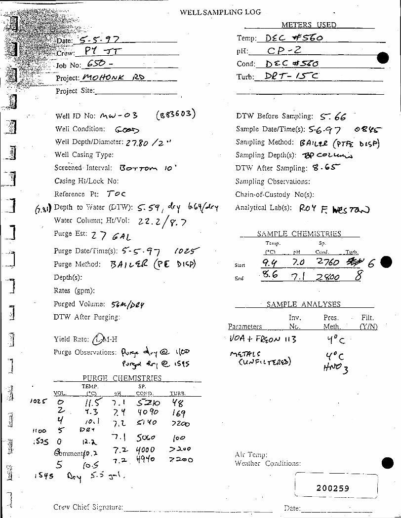
1
WELLSAMPLING LOG
3^jf. 4 - " , . f ' * - ^
.<,<f|
J 2
.• '«M:
.1
I
Date Crew r t
Job No
^y^y^yi-
as^ -Project t ^ o H C N k . 1 ^
Project Site
Well ID No: / K W - O S ( s S ^ ^ O S )
Well Condition: Q-C3e>
\yell Depth/Diameter: ^ 7 ^ ^ / 2 , "'
Well Casing Type:
Screened Interval: B O T T - O V ^ /© '
Casing Ht/Lock No:
Reference Pt: T(PC
^,^,) Depth to VY'ater (DTW): ^ , $-f ^ 4.c^ ls.(o\(<Ar
Water Column; PIt/Vol: 2 . 2 . z / f , 7
Purge Est: Z 7 ^ ^ ( ,
Purge Date/'rime(s): ^ - 5 ' . ^ 7 ( O Z ^ ^
Purge Method: l ^ A ] ! . ^ ( ? t y > \ ^ ^
DepLh(s):
Rates (gpm):
Purged Volume: 5^<»t^/^f
DTW After Purging:
Yield Rate; ( ^ I - H
Purge Observations: ^ t ^ A«-^ <S- (•IC**?
PURGE CMEMISTRIES
I Q Z C
i sys
VOL.
o ^
V r 0
TEMP. f°C1
/ r ^ 1.5 /(?x 1
P i Z f
li-?^
W)mment P. > z-
pH
7 .1 7.1 I X
-7-1 7 . ^ 7 . ^
SP. COND.
5':2AD Ho'io ^ I H O
So(,^ ^000
H^io
TURB.
YS; 16^ -?Zoo
{o^
P-JLtfO
y / = ^ o
^ • ^ Z ' y
METERS USED
Temp: D^C ^ S t o
pH: (ZP-Z
Cond:_
Turb: b e e ^sTc ^2T- fS^d
DTW Before Sam.pling: ST ^ ^
Sam.ple Date/Time(s): S " - 6 . ^ 7 a-g^^;-
Sanipling Metiiod: ^AiLZZ (^TH bt<>F»)
Sampling Depth(s): -0P Os ' t^u-s^
DTW After Sampling: ^ . ^ S "
Sampling Observations:
Chain-of-Custody No(s):
Analytical Lab(s): Ro Y p | ^ $ 7 3 ^
SA.MPLE CHEMISTRIES Temp. Sp.
r c - ) rH ConJ. Turl).
St.. 9 . ^ 7.0 -2.140 : ^ ^
End '^•^ l . \ 2,^^00 8
SAMPLE ANALYSES
Inv. Pres. Parameters No. .Meth.
Filt. (^7N)
1/^4-f- Vde^oJ^ ««3
.Air len-ip:
Weather Conditions
2 0 0 2 5 9
Crew Chief Si' nature Date:

WELLSAMPLING LOG
METERS USED
Date: S " ^ - ^ 7
C r e w : _ 5 e r X £ Z _ Job No: ^ 5 Q - ^ S ^ /
Project: /HaJjOnli ^ -
Project Site:
YSX Tenip:_
pH: OBC'OI
4 "3
\ •ii
Cond: ViS
Turb: O / l t - / 5 ^
Well ID No: ITliO ' OH (%ZK>o^) Well Condition: (^ooc/
Well Depth/Diameter: 2 / - ^ 2 - / ? ' '
Well Casing Type: Pi/C
Screened Interval: 5<?r70i*\ / o '
Casing Ht/Lock No:
Reference Pt: ' f ^ C
(63J) Depth to'-vater (DTW): ^ ^ ^ 5 / ^ / .OO
Water Column; Ht/Vol: / 6 - ' ? ? / ^ ^ A /
Purge Est: Z-H G^U
Purge Date/Time(s): ^ ,^ , <*-7
Purge Method: SA'ttJi
Depth(s):
Rates (gpm):
Purged Volume:
DTW Before Sampling: 6 - Id
Sample Date/Time(s): ^ - 6 - ^ 1
Sampling Method: % ^ U i J l ( > r P ^ h l C ^
Sampling Depch(s): ^ ^ C O ^ M / ^ ^
DTW After Sampling: ^ . / "7
Sampling Observations:
Chai.n-of-Custody No(.s):
Analytical Lab(s): g_oH F. Ui-STlf^-yi
SAMPLE CHEMISTRIES
DTW After Purging
S:3rt
En-d
Param
Temp. Sp.
r C ) pH Cond.
q.] -?j % ^ Y f.Z 7 / ^ 7 f
SAMPLE ANALYSES
Inv. Pres. :ters No. Meth.
Turb.
7.0 € 7
Flit (Y/N}
l/MH'Fi2t<'A; //3 Yield Rate: L-M-H
Purge Observations: pu^C<U> i ftY liO fr*^(Jqoo) Pu/i^iX' v>{iH fic^^i^ •(^i^d\ n\(ir7ki.S
PITRGECHEMISTRTES
VOL
0
C ^
r 5-
6
TEMP.
rc-) %Z %o
/o . \ -vf^
*?-! Comments:
Dll
a 1.0 7.0 V% 7.2.
Si'. COKD.
I.Xo-i-^%(a
iioz-H«"'»5-»
/^^7
TURB.
7 yQ.&^ izoo 77x0
> r
A.ir Temp: Wcadier Conditions.
Crew Chief Signature:

WELLS-\MPLING LOG
METcRS USED
yyyDztQ:' '^y^ i'S*^iS f7
1 ::.yy:iy''''^- Q'i - f i
I 1'
=:: 23vJpb N o : _ ^ l ^ S l ^ Z
- - .>.;Project Site:. .
^ j
1
4
1 "1
. - ^ w S l D N o : / V ) ^ / - i r {^ '^ l^ '^S ' )
-B^i'iWeirCondition: C a o x : ,
=^S;^^^iVe|l^epth/Diameter: / ^ y^
' ' - iv^ l l Casing Type: P ^ C
/•'" ??:Screened Inter%'al: "SWTTOK*! / C '
" "•-Casing Ht/'Lcck No:
Reference Pt: "T^^ ^
^o.i8)|Depth'ito Water (DTW): '?.7<^ / U . ?.7«
. ;:•.JtWaterXoIumn; Ht/Vol: r . '^-'i/ A ^ ^ I
' ' "J|Purg?JEst:'^^/^^ ""•Jfias.'wfj'.f'-.M. -
,,.:^ ;,|gPurge';:Date/Time(s): 5 ^ ^T- *? 7 /)/W • • ; - ' « « i s s ; i f < K . ; v •- ' .
' /5^='^-M^^e|^ethod: ^ /q/^S/2
,1 Rates (gpm)
"j Purged VoluTie: ^ ^ C
'''' '*'IDTW-''After Purging: ^<^Y/y<^^
yreld Rate (LAI-H
^ T-iPurge Obseivhtions: fufiCi^t^fL^ 0< oO f\C^\i^ 1 ^ / ^
" i 'S f . ' - . j t
•PURGE CHEMISTRIES SP.
V O L
T E M P .
' : :
- tH. COND. T U R B .
-7 .1
7.0 1.0
11)00 (prs" ? 8
.•',;'if^¥|;si^5i^.'^'A'^ •
•• , - ; * j * ? i i c s . * ' i S M > ^ J - • •'•-i--;
• ' - . -^^. ' - / . -^ '^f . ' l i iP^^ A- ' •'
^•y&$i^s3'y:-'-'-^ ^ : - | | ^ ^ P i e f Signature:,
3% Y77
Y7
Temp:_
p H : _
D^.c: •if:sr^<::>
C^2-Cond:_
Turb:
1 ) ^ ^ ^ ^
bCr- ' iS 'C
DTW Before Sampling: ^ , S '
Sample Date/Time(s): . $ ^ ^ . *?^
Sampling Method: l^f^luUl (pTl%. D/^p)
Sampling Depth(s): 7Z)^ C<?c«.<^^-'^
DTW After Sampling: / ^ ^ (S Z
Sam pling Observations:
Chain-of-Custody No(s):
Analytical Lab(s): QoY R lJi<,-rS>y>
S A MPLE CHEMISTRIES r"
Slart
End
Paramete
Tcm.p. Sp.
C O pH Cond.
"^n 7.0- z r^ ^ / 7-0 s/3
SAMPLE ANALYSES
Inv. Pres. L-s No. Meth.
Turb.
: i 30
Filt. (Y/N)
V'^:
W"^ /M^>
Ail" Temp: Weather Conditions:
200261
Date:

Date: S ' t - I V
Crew:
Job No
Project:
Project
PW - : r ^
•• 6 ^ -
/n^^cjAjfcr Site:
R.oAi>
Well ID No: / ^ \ ; - 5^3 ^bfmw (fs 2 3 ^ r G )
Well Condition: C^o't>
Well Depth/Diameter: >^ '"^^/^ '*
Well Casing Type: ?VC
Screened Interval:
Casing Hi/Lock No:
Reference Pt: "TdC
Depth to Water (DT *V): ZC?,W3
Water Column; Ht/Vol: ; 4f Sk/6 l^ / ^CficL^
Purge Est: [% Q^\^
Purge Date/Time(s): < ' l A l
Purge Method: %P)\\JUl
Depth(s): A U L
Rates (gpm): -^ yo
Purged Volume:
DTW After Purging: ^ , \ j ^
Yield Rate: L-M-H
Purge Observations:
PURGE CHEMISTRIES
fooo ^ (^^Q
VOL. TEMP.
pH SP.
COND. TURB.
^A 5.0 ^.?,
' ^ . o 9.^ 1 5 . ^ ^ . ^
^3-0 :?.2' Comments:
n . \ 55?, 7 . "5^ h \ ' \
T . 3 5%S 7-1 5 ^ ^' 4 5^^
/
a 35-50
J o
IS
M y ^ ^ -nvfc^
Temp:
pH: .
Co.nd:
METERS USED
l ^ r . c dir^C^O • [
t^<iC ^ s ^ c >
Turb:
DTW Before Sampling: XI . \0
Sample Daten^ime(s): ST- 7 - f ' 7 H C ^
Sampling Method: B ' ^ ' i - ^ {'PT'F t bt^p^)
Sampling Depth(s): TDp> C o C U t ^
DTW After Sampling: j5.o.^7
Sampling Observations:
Chain-of-Custody No(s):
Analytical Lab(s): (^O'f f^Ut^T^^y^
Slirt
End
SAMPLE TCiiip.
r°o
ia 1.*
CHEMISTRIES Sp.
nH Cond. Turb.
7«/ .f«2 /3>
7z s«?6 : i s
SAMPLE ANALYSES
Parameters Inv. No.
Pres. Meth.
Filt. i'Y/N)
Vc
Air Temp: VS'' Weather Conditions: CL fiR
[
[
[
[
I
^51
Crew Chief Signature:
200262

,r»..^,r«..»g.MM»«aia..«...,~. '--TirfcriiTir
' - C ^
' •1 WELLSAMPLING LOG
* *-Date:^ ^ - • 7 . f 7
Job No?
, Pro jwt :»Al5i i5^^^/^—^
,' Proj^f S i t e : _ _
weireioVo: pa/znw-^c (^sg-i r*^) WeU'Condition:
WelI)Depth/Diameter:
WelUCasing Type:
''Screened Interval:
'-, ' Casing Ht/Lock No:
;*'/'Reference Pt
' \ ^^Depth to Water (DTW):
-"::i Water Column; Ht/Vol:
X I
f - y - ^iPurge^Est:
•J i ;i:|urg|lDate/Time(s):
:; ' 'S I Pu^e-'Method-
. .Vbepth(s):
Jl"" -.'/Rates ,(gpm): > 7 " . * ' : ; \ _f-
\ - - ""pu'rged JVoIume:
1 .1.
Dl'vV After Purging:
Yield Rate L-M-H
Purge Observations:
V
PURGE CHEMISTRIES
VOL TEMP
-EH. SP.
COND. TURB.
M
METERS USED Temp: ^ ^ C P ^ S ^ ^
pH:_ C / > 2 ^
Cond:_
Turb:
fc>^c t^t^sr^c^
bar-- i s~^
DTW Before Sampling:
Sample Date/Time(s): • ^ 7 - ? 7
Sampling Method:
Sampling Depth(s):
DTW After Sampling:
Sampling Observations:
Chain-of-Custody No(s):
Analytical Lab(s):
SAMPLE CHEMISTRIES
IIZO
Start
Temp.
rc\ pH
Sp.
Cond. Turb
End
Parameters
SAMPLE
Inv. No.
ANALYSES
Pres. Meth.
Filt. (Y/N)
1/0A + p/2ea*o /15
Curjpn.rttzi.iy)
'.,.,ijg|
9Mi
Comments: Air Temp: Weather Conditions:
2 0 0 2 6 3

IT i ^ L . , ! - / k,».* i . i i .• *. »_>* »
Date: r"-^.?7 Crew: ^ " t J r - J -
Job No: G ^ -
Project: /HOt^rJ/^^ ^ >
Project Site:
Well !D No: ' ^ f g _ o ^ fe ^ S 6 0 ^
Wei! Condition: ^oc? t>
Well Depth/Diameter: / ^ / . "?C> / z - "
Vv'. il Casir:g Type: P\ / ( l
ScreenrJ Interval;
Ca.sing Ht/Lcuk No: 'ht^Z
Referei'.ce vw " fdc
Depth to V/'j;:er (DTW): 3 3 . 0 5
Water Co! ;m :: Ht/Vol; ^ % , 1 ^ / ' ^ ^ • ' S '
P...rge .Pst; <g iO ( ^ ( ^
Purge Date/T;ma(?): S^ ^ • <? 7 / S ^ o
Purge Med'od: ( ^ 9 ~ [ M ^ 9 f ^ S
D.-?p!h(s); A^t-
Rates (gpm);
Piirg.-:d Vo'u.'.-c;
DTW After Pur-in^; r^C.. l O
Yii'kl •r •:•. L-M-H
^ ; ;; ; Oiiscvvutinn:;;
Jii-JRGiZ CHEMISTRIES TE:V!;'. SP.
.(°C'i pH COND. TURB. vol \St)<i
Co.Tim'fnti:;
/Z j«_7 j£__£?0_ "^7:7 7 y I^^~~
7?-
"73" iX—2:i_^££_.__^^
Temp: 1>£,C "*^S^O
pH: r , P Z
Cond; b>CC :t!kS^O
Turb; 0/2-r--/-^^Cl
DTW Belore Sampiiivv:: 3 ^ , 7 >
k J —T
D r . -
i
Sample Date/T;mH(s): S'-fO' 7 7 . "Z^lP /^^
Sainpiing Method: ^ l u t / ^ (PTf^€ t>/rP,}
Sa.mnling Depth(s): I b F C o H ^ ^ " * ^
Ur^V After Sampling: ^ ^ - Y k
S;'n;p!ing Observulion^:
Ch:-;n--f-Ci:;;tody r-;o(:;):
Anaiyiical !.:-h:';-}' (2c? Y R c J C ^ T S ? ' ^
SAMPLE CHEM!ST^•^;;•:^
S!.-.n
ifm!
ii-i l .H 7C0 3 ^
/f.( 7.3 tt^S VO
SAMPLE A [ V M L Y S 1 7 S
Piiranicfeis Ir;v.
Vc
Fiit. CY/NM
.- ir .-mp; . / o >> iat;! ' j ;^ C.c.ii(iKU'ir..''
• ^
L
• • p l i fe.
fZA\y>
(..r-.'.Vt L-nioi j!u;!;;;i;i'o;
2 0 0 2 6 4

WELLSAMPLING LUG v.A ^c
u *'^I^tt'' ^ Daie C 'Cyr
I '' Xtew :?•/__ ^ r L ^ . ^ j > .
,yM^H£f-S^-
^ .%.<L i - - i . * ^ ; » ? < ) j e c t % >
wK,,
3 -^" WellDSnth'Diameter: /(?/. A •'
^Well Condit or 6:oo5>
XC-<WelV Casing Tvpe: Pl/C
^ y:z-^y' '• ""Screened )r erv'al;
. ^ t ; C ^ i n g Hi Lo^k No:
" "Reference Pt ' T ^ C
-^Depth to Wdter (DTW): :>- 1.3*^ , / y S
^-^*%Water Column Ht/Vol: ^ / 3 ^ tfV»^
n /, Purge Est 9-^ ^fi^u P u r s e ' D i ' e n i n e ( s ) : ^ . ^ ' 1 7 i l o o - \HOO
] 1
Purge""Method ^ I L a / J b p O $
" ' ' ^ D e p t h ( s r / » ' t L -
Rates>(g[>i 1") 2 S ' •r ^ s ^
Purged Vo'i n .,
DTW Tiftcr Purging;
Yield ^ ne ] S-I-H
Purge 0*'<;i,- a' on:;:
•PURGE CHEMISTRIES
r;;RH
l'.1"??.,SComments:
I Crew Chief Signature:
METERS USED
Tem.p: b £ . c A - S Z o
pH: C.9 Z
Cond; i > C C t i ^ - X O
Turb; PfZ-T- / r ^ l .
DTW Before Sampiini:: 2 . f - g ' 2 _
Sa.mnle i:)a:e/Time(s): S ' - ^ 9 1 l ^ / ^
Sampling Method; ^^hWJjl C^Tft i n i P ^
Sn.mplir.g DL*nth(.s); T^P c c u u c ^ / O
DTW After .Sampling: 2 .1 ^ 3
Sampling Observaiions;
Chain-of-Custody No(s);
Analytical Lab(s); Ro Y T. f ^ € ^ r S > ^
.SAMPLFI CHF.N-iiSTRliiS. I c n i p
rc) - p -
r l ( Ccnd . T u r t .
St.irl
End
7.^ 7.r fe3 /^6 r . r 7-:^Yri //a
SAMPLE ANALYSitS
Param.eters I:i'/. Pros. Filt. N'o. Meib. (Y/N')
U6A 4 F £ G o ' ^ I I I
.Air lem.p; S 3 Weather Conditions: / ^ / J I/O /
-r-57^>exv,.
200265
Dati - _ j