five-year review report atlas asbestos mine superfund site and ...
290
FIVE-YEAR REVIEW REPORT ATLAS ASBESTOS MINE SUPERFUND SITE AND COALINGA ASBESTOS MINE SUPERFUND SITE FRESNO COUNTY, CALIFORNIA August 3, 2011 PREPARED BY: US ENVIRONMENTAL PROTECTION AGENCY REGION 9 SAN FRANCISCO, CA g/ KATHLEEN SALYER DATE' ASSISTANT' DIRECTOR, SUPERFUND DIVISION CA SITE CLEANUP BRANCH
-
Upload
khangminh22 -
Category
Documents
-
view
4 -
download
0
Transcript of five-year review report atlas asbestos mine superfund site and ...

FIVE-YEAR REVIEW REPORT
ATLAS ASBESTOS MINE SUPERFUND SITE AND
COALINGA ASBESTOS MINE SUPERFUND SITE FRESNO COUNTY, CALIFORNIA
August 3, 2011
PREPARED BY: US ENVIRONMENTAL PROTECTION AGENCY
REGION 9 SAN FRANCISCO, CA
lZ1~ g/ 3l~I'-KATHLEEN SALYER ~ DATE' ASSISTANT' DIRECTOR, SUPERFUND DIVISION CA SITE CLEANUP BRANCH

TABLE OF CONTENTS
Section Page List of Acronyms.................................................................................................. iv
Executive Summary.............................................................................................v
Five-Year Review Summary Form ....................................................................viii
1.0 Introduction..........................................................................................................1-1
2.0 Site Chronology....................................................................................................2-1
3.0 Site Background...................................................................................................3-1 3.1 Physical Characteristics.............................................................................3-1 3.2 Land and Resource Use.............................................................................3-2
3.2.1 Atlas Mine Area OU .....................................................................3-2 3.2.2 Johns-Manville Mill OU...............................................................3-2 3.2.3 City OU.........................................................................................3-2 3.2.4 Ponding Basin ...............................................................................3-3 3.2.5 Clear Creek Management Area ....................................................3-3
3.3 History of Contamination..........................................................................3-3 3.3.1 Atlas Mine Area OU .....................................................................3-4 3.3.2 Johns-Manville Mill OU...............................................................3-4 3.3.3 City OU.........................................................................................3-5
3.4 Initial Response .........................................................................................3-5 3.5 Basis for Taking Action ............................................................................3-6
4.0 Remedial Actions .................................................................................................4-1 4.1 Remedy Selection......................................................................................4-1
4.1.1 Atlas Mine Area OU.....................................................................4-1 4.1.2 Johns-Manville Mill OU...............................................................4-1 4.1 3 City OU.........................................................................................4-2 4.1.4 CCMA and Ponding Basin ...........................................................4-2
4.2 Remedial Action Implementation .............................................................4-3 4.2.1 Atlas Mine Area OU.....................................................................4-3 4.2.2 Johns-Manville Mill OU...............................................................4-5 4.2.3 City OU.........................................................................................4-6 4.2.4 CCMA and Ponding Basin ...........................................................4-6
4.3 Operation and Maintenance ......................................................................4-7 4.3.1 Atlas Mine Area OU.....................................................................4-7 4.3.2 Johns-Manville Mill OU...............................................................4-9 4.3.3 City OU.........................................................................................4-10
5.0 Progress Since Last Five-Year Review ..............................................................5-1 5.1 Protectiveness Statement from Last Review .............................................5-1
5.1.1 Atlas Mine Area OU .....................................................................5-1 5.1.2 Johns-Manville Mill OU...............................................................5-1 5.1.3 City OU.........................................................................................5-1
5.2 Status of Recommendations and Follow-Up Actions from Last Review .5-1
6.0 Five-Year Review Process ...................................................................................6-1
i

6.1 Administrative Components......................................................................6-1 6.2 Community Involvement...........................................................................6-1 6.3 Document Review .....................................................................................6-1 6.4 Data Review ..............................................................................................6-1 6.5 Site Inspection ...........................................................................................6-2
6.5.1 Atlas Mine Area OU .....................................................................6-2 6.5.2 Johns-Manville Mill OU...............................................................6-3 6.5.3 City OU.........................................................................................6-3 6.5.4 Ponding Basin and CCMA ...........................................................6-4
6.6 Interviews ..................................................................................................6-4
7.0 Technical Assessment ..........................................................................................7-1 7.1 Question A: Is the remedy functioning as intended by the decision
documents? 7.1.1 Atlas Mine Area OU .....................................................................7-1 7.1.2 Johns-Manville Mill OU...............................................................7-2 7.1.3 City OU.........................................................................................7-3
7.2 Question B: Are the exposure assumptions, toxicity data, cleanup levels, and remedial action objectives (RAOs) used at the time of the remedy selection still valid? ......................................................................7-4
7.3 Question C: Has any other information come to light that could call into question the protectiveness of the remedy? 7.3.1 Atlas Mine Area OU .....................................................................7-6 7.3.2 Johns-Manville Mill OU...............................................................7-6 7.3.3 City OU.........................................................................................7-6
7.4 Technical Assessment Summary...............................................................7-6
8.0 Issues .....................................................................................................................8-1
9.0 Recommendations and Follow-Up Actions .......................................................9-1
10.0 Protectiveness Statements ...................................................................................10-1
11.0 Next Five-Year Review........................................................................................11-1
12.0 References.............................................................................................................12-1
ii

Tables
Table 4-1 Annual O&M Costs at the Atlas Mine Area OU
Table 4-2 Annual O&M Costs at the JMM OU
Table 4-3 Annual O&M Costs at the City of Coalinga OU
Table 5-1 Status of Issues and Recommendations from Previous Five-Year Review
Table 7-1 Issues
Table 9-1 Issues, Recommendations, and Follow-Up Actions
Figures
Figure 3-1 Atlas and Coalinga Superfund Sites Location Map
Figure 4-1 Atlas Mine Area OU Remedial Components
Figure 4-2 Johns-Manville Mill OU Remedial Components
Figure 4-3 City of Coalinga OU Remedial Components
Appendixes
A Geographic Areas of Atlas Mine OU
A1 Arroyo Pasajero Ponding Basin
A2 Clear Creek Management Area
B Institutional Controls Technical Memorandum
B1 Atlas Mine Area OU
B2 Johns-Manville Mill OU
B3 City OU
C 2007 - 2009 City OU Protectiveness Evaluation
D Community Involvement
E List of Documents Reviewed
F ARARs Analysis Technical Memorandum
G Site Inspection Checklists and Photographs
G1 Atlas Mine Area OU
G2 Johns-Manville Mill OU
G3 City OU
H Five-Year Review Interview Summary Form
iii

LIST OF ACRONYMS AND ABBREVIATIONS
ABS activity-based sampling
ARARs applicable or relevant and appropriate requirements
BLM Bureau of Land Management
CCMA Clear Creek Management Area
CERCLA Comprehensive Environmental Response, Compensation, and Liability Act
DTSC Department of Toxic Substances Control
DWR California Department of Water Resources
JMM Johns-Manville Mill
LFR Levine-Fricke Rincon
LUC land use covenant
MFL million fibers per liter
MWD Metropolitan Water District of Southern California
NCP National Contingency Plan
NPL National Priorities List
O&M operations and maintenance
OU operable unit
PCLC Pine Canyon Land Company
PLM polarized light microscope
PRP potentially responsible party
RI/FS remedial investigation/ feasibility study
RACR Remedial Action Completion Report
RAO Remedial Action Objective
ROD Record of Decision
SDWA Safe Drinking Water Act
SPLC Southern Pacific Land Company
SPTC Southern Pacific Transportation Company
UPRC Union Pacific Railroad Company
USBR United States Bureau of Reclamation
US EPA United States Environmental Protection Agency
WMU waste management unit
iv

EXECUTIVE SUMMARY
The US Environmental Protection Agency (US EPA) has conducted a Five-Year Review of the Atlas and Coalinga Asbestos Mine Superfund Sites in Fresno County, California. This review was conducted by the US EPA Remedial Project Manager between September 2010 and February 2011. The Five-Year Review was required by statute because hazardous substances, pollutants, or contaminants remain at the site above levels that allow for unrestricted use and unlimited exposure. This is the third Five-Year Review for the Atlas Asbestos Mine Superfund Site and the fourth Five-Year Review for the Coalinga Asbestos Mine Superfund Site. The triggering action for this statutory review is the dates of the previous Five-Year Review, September 28, 2006.
The Atlas Asbestos Mine Superfund Site consists of two operable units (OUs): the Atlas Mine Area OU and City of Coalinga OU. In addition, two areas of interest were identified in the Record of Decision (ROD): the Clear Creek Management Area (CCMA) and Arroyo Pasajero Ponding Basin (Ponding Basin). The CCMA and Ponding Basin were discussed in the ROD because of concerns that asbestos mining and milling waste from the Atlas Mine Area were being transported to these areas by water or wind. The Coalinga Asbestos Mine Superfund Site consists of two OUs: the Johns-Manville Mill OU (JMM) and the previously mentioned City OU.
The Atlas Mine Area is an abandoned asbestos mine within the New Idria formation, a region of naturally-occurring asbestos minerals. The Atlas Mine Area included surface stockpiles of asbestos waste material generated from three open-pit asbestos mines, an abandoned mill building, a settling pond, and debris. The area is drained by intermittent streams, which drain into a tributary to the Ponding Basin. During historic heavy flooding, asbestos-laden water has filled the Ponding Basin and been released into the California Aqueduct. The JMM OU consists of a former asbestos mine, former processing mill, former support buildings, and asbestos tailings. The area is drained by Pine Canyon Creek, which flows into the Los Gatos Creek, a tributary to the Ponding Basin. Asbestos product from both the Atlas Mine Area OU and the JMM OU was transported offsite to the City OU, where it was stored prior to handling and shipment.
Based on concentrations of asbestos that were detected at these sites, risk assessments concluded that the levels of asbestos present at the Atlas and Coalinga Sites presented an elevated risk of lung cancer due to the potential for exposure to airborne asbestos. The Atlas and Coalinga Asbestos Mines were placed on the National Priorities list on September 21, 1984. Subsequently, Records of Decision (RODs) were published to select the preferred remedial action for cleanup of the Sites.
The selected remedies for the Atlas Mine Area OU and the JMM OU included the removal of contaminated material, stabilization of erosion-prone areas, structural improvements and additions, access control, and institutional controls. The remedy for the City OU included the removal and burial of contaminated soils and materials beneath an onsite cap and institutional controls. The Coalinga Asbestos Mine Site (JMM OU and City OU) was removed from the Superfund National Priorities List on April 24, 1998. The Atlas Mine Area OU remains on the list.
v
This Five-Year Review included a review of site documents, a review of applicable or relevant and appropriate requirements (ARARs), site inspections, and an interview. The review resulted in a set of issues, as well as recommendations and follow-up actions that should be taken before the next Five-Year Review.
The review of each operable unit resulted in a determination of protectiveness, both in terms of short-term and long-term protectiveness of human health and the environment. The protectiveness statement is as follows:
The remedial actions at the Atlas Asbestos Mine Superfund Site and the Coalinga Asbestos Mine Superfund Site are protective of human health and the environment in the short term.
The remedy at the Atlas Mine Area OU is protective of human health and the environment due to the removal of contaminated material, stabilization of erosion prone areas, structural improvements and additions, the installation of access controls and warning signs, and regular inspections and maintenance. However, in order for the remedy to be protective in the long-term, aerial inspections of the Atlas Mine Area should be conducted previous to each Five-Year Review to determine whether migration of asbestos-laden sediments has occurred.
The remedy at the Johns-Manville Mill OU currently protects human health and the environment because of the remedy in place: removal of contaminated material, diversion of water around erosion prone surfaces/materials, stabilization of erosion prone areas, structural improvements and additions, the installation of access controls and warning signs, and regular inspections and maintenance. However, in order for the remedy to be protective in the long-term, institutional controls, in the form of an enforceable deed restriction, must be placed on the property.
The remedy at the City of Coalinga OU is protective of human health and the environment due to the removal and consolidation of contaminated soils and other materials beneath an on-site cap (the Waste Management Unit), restriction of future uses through a deed restriction, the installation of access controls and warning signs, and regular inspections and maintenance.
vi

FIVE-YEAR REVIEW SUMMARY FORM
SITE IDENTIFICATION Site name (from WasteLAN): Atlas Asbestos Mine Superfund Site and Coalinga Asbestos Mine Superfund Site EPA ID (from WasteLAN): CAD980496863 (Atlas) and CAD980817217 (Coalinga) CERCLIS ID: 0934 (Atlas) and 0935 (Coalinga) Region: 9 State: CA City/County: Coalinga/Fresno
SITE STATUS NPL status: Final Deleted Other (specify) Coalinga Site (Johns-Manville Mine, JMM or OU-1) and City OU (OU-2) deleted from NPL April 24, 1998. Atlas Mine Area OU (OU-1) on Final NPL Remediation status (choose all that apply): Under Construction Operating Complete Multiple OUs?* YES NO Construction completion date: Coalinga City OU (OU-2) May 1993, Atlas Mine Area OU (OU1) September 1999, Johns-Manville Mill (JMM OU or OU-1) March 1995 Has site been put into reuse? YES NO Portions of the site have been reused
REVIEW STATUS Lead agency: EPA State Tribe Other Federal Agency ______________________ Author name: Lily Tavassoli Author title: Remedial Project Manager Author affiliation: US EPA Region 9 Review period:** September 1, 2010 to February 8, 2011 Date(s) of site inspection: October 18-21, 2010 Type of review:
Statutory Policy Post-SARA NPL-Removal only NPL State/Tribe-lead
Pre-SARA Non-NPL Remedial Action Site Regional Discretion
Review number: 1 (first) 2 (second) 3 (third) Other (specify): 4th (fourth) review for City OU and JMM OU, 3rd (third) review for Atlas Mine Area OU Triggering action:
Actual RA Onsite Construction at OU #____ Actual RA Start at OU#____ Construction Completion Previous Five-Year Review Report Other (specify)
Triggering action date (from WasteLAN): September 28, 2006 Due date (five years after triggering action date): September 28, 2011
vii

FIVE-YEAR REVIEW SUMMARY FORM (CONTINUED)
ISSUES Currently, visual inspections of the Atlas Mine Area are conducted annually to verify the remedy is functioning as intended. Since a large portion of the boundary of the Atlas Mine Area in inaccessible by foot or by car, these annual visual inspections are unable to thoroughly identify potential for migration of asbestos. A deed restriction was recorded for the JMM OU, but it is not legally enforceable and does not run with the land.
RECOMMENDATIONS AND FOLLOW-UP ACTIONS The Operation and Maintenance (O&M) manual for the Atlas Mine Area OU should be revised to include a requirement for a minimum of one aerial inspection to be conducted during each Five-Year Review period. At least one aerial inspection should be performed no later than one year prior to the completion of the next Five-Year Review. Aerial inspections would allow for thorough examination of the site boundary to determine whether migration of asbestos-laden materials is occurring. In order to provide a baseline for the next Five-Year Review, the first aerial inspection should be conducted one year from the completion of this report. Record an enforceable deed restriction between the Pine Canyon Land Company and DTSC with the Fresno County Recorder’s Office. The deed restriction should be consistent with current DTSC regulations for ICs, be enforceable by DTSC (with EPA listed as a third-part beneficiary) and should run with the land. Parties responsible for O&M of the deed restriction should also be identified.
viii

PROTECTIVENESS STATEMENTS The remedial actions at the Atlas Asbestos Mine Superfund Site and the Coalinga Asbestos Mine Superfund Site are protective of human health and the environment in the short term.
The remedy at the Atlas Mine Area OU is protective of human health and the environment due to the removal of contaminated material, stabilization of erosion prone areas, structural improvements and additions, the installation of access controls and warning signs, and regular inspections and maintenance. However, in order for the remedy to be protective in the longterm, aerial inspections of the Atlas Mine Area should be conducted previous to each Five-Year Review to determine whether migration of asbestos-laden sediments has occurred.
The remedy at the Johns-Manville Mill OU currently protects human health and the environment because of the remedy in place: removal of contaminated material, diversion of water around erosion prone surfaces/materials, stabilization of erosion prone areas, structural improvements and additions, the installation of access controls and warning signs, and regular inspections and maintenance. However, in order for the remedy to be protective in the longterm, institutional controls, in the form of an enforceable deed restriction, must be placed on the property.
The remedy at the City of Coalinga OU is protective of human health and the environment due to the removal and consolidation of contaminated soils and other materials beneath an on-site cap (the Waste Management Unit), restriction of future uses through a deed restriction, the installation of access controls and warning signs, and regular inspections and maintenance.
ix

1.0 INTRODUCTION
The United States Environmental Protection Agency, Region 9 (US EPA) has conducted a Five-Year Review of the Atlas Asbestos Mine Superfund Site and the Coalinga Asbestos Mine Superfund Site, located in Fresno County, California. This report documents the results of the review. This review was conducted by the US EPA between September 2010, and February 2011. Limited technical support was provided by Innovative Technical Solutions, Incorporated (ITSI) during the review period, including assistance with the site inspections, which were conducted by EPA.
The purpose of the Five-Year Review process is to evaluate whether the remedial measures implemented at the sites are protective of human health and the environment. The methods, findings, and conclusions of reviews are documented in the Five-Year Review report. In addition, Five-Year Review reports identify issues found during the review, if any, and provide recommendations for addressing these deficiencies.
The Agency is preparing this Five-Year Review pursuant to CERCLA §121 and the National Contingency Plan (NCP). CERCLA §121 states:
If the President selects a remedial action that results in any hazardous substances, pollutants, or contaminants remaining at the site, the President shall review such remedial action no less often than each five years after the initiation of such remedial action to assure that human health and the environment are being protected by the remedial action being implemented.
The agency interpreted this requirement further in the National Contingency Plan (NCP); CFR §300.430(f)(4)(ii) states:
If a remedial action is selected that results in hazardous substances, pollutants, or contaminants remaining at the site above levels that allow for unlimited use and unrestricted exposure, the lead agency shall review such action no less often than every five years after the initiation of the selected remedial action.
The current Five-Year Review for the Atlas and Coalinga Asbestos Mine Superfund Sites has been performed because hazardous substances, pollutants, or contaminants remain at the site above levels that allow for unrestricted use and unlimited exposure. This is the third Five-Year Review for the Atlas Asbestos Mine Superfund Site and the fourth Five-Year Review report for the Coalinga Asbestos Mine Superfund Site. The triggering actions for these statutory reviews are the dates of the previous Five-Year Reviews (September 28, 2006) (CH2MHill 2006).
The Atlas Asbestos Mine Superfund Site consists of two geographically district Operable Units (OUs): the Atlas Mine Area OU (OU-1) and the City of Coalinga OU (City OU or OU2). In addition, two areas of interest were identified in the ROD: the Clear Creek Management Area (CCMA) and the Arroyo Pasajero Ponding Basin (Ponding Basin). The Coalinga Asbestos Mine Site consists of the Johns-Manville Mill (JMM) Operable Unit (OU
1-1

1) and the previously-mentioned City OU (OU-2), which is considered part of the Coalinga Asbestos Mine Site due to historic operations.
1-2

2.0 SITE CHRONOLOGY
This section lists the chronology of events for the Atlas and Coalinga Superfund Sites.
Date Event Operable Unit / Area
1962 - 1974 JMM was constructed and used to process asbestos JMM 1967 - 1979 Atlas Mine was used for active asbestos mining and milling Atlas Mine Dec 3, 1976; Feb 15, 1980
Atlas Asbestos Company and Wheeler properties cited for violating the National Emissions Standards for Hazardous Air Pollutants regulations regarding control of asbestos emissions
Atlas Mine
1980 The Metropolitan Water District of Southern California detected elevated levels of asbestos in California Aqueduct water samples. Subsequent sampling suggested that the JMM and Atlas Mine Area were probable sources of asbestos
JMM, Atlas Mine
Oct 17, 1980 Central Valley Regional Water Quality Control Board (Water Board) and California Department of Health Services inspected the Atlas Mine Area and the JMM and concluded additional corrective measures should be taken
JMM, Atlas Mine
March and June 1983
Water Board collected surface water samples in the Arroyo Pasajero watershed and results were rated using the hazard ranking system
JMM, Atlas Mine
Aug 18, 1983 Southern Pacific Land Company (SPLC) submitted a remediation plan to the Water Board
JMM
Sep 21, 1984 Atlas and Coalinga Sites placed on National Priorities List (NPL) JMM, Atlas Mine 1985 US EPA initiated remedial investigation/feasibility study (RI/FS)
activities at JMM and Atlas Mine Area JMM, Atlas Mine
1986 - 1987 US EPA performed sampling and studies at the Atlas and Coalinga Sites as part of the remedial investigation (Rl). High levels of airborne asbestos were measured in the City of Coalinga. Subsequently, the 107-acre City OU of the Atlas and Coalinga Sites was created
City OU
Aug 1987 US EPA issued an Administrative Order on Consent (AOC) pursuant to CERCLA Section 106 to Southern Pacific Transportation Company (SPTC) to perform an RI
City OU
Nov 16, 1987 SPLC signed Administrative Order on Consent (AOC) and agreed to conduct an RI/FS for the JMM
JMM
Nov 1988 Agency for Toxic Substances and Disease Registry issued a health assessment for the Atlas/Coalinga Mine sites, concluding that these sites were a potential public health concern
City OU
Feb 9, 1989 US EPA released the City OU Feasibility Study (FS) and Hazardous Substance Containment Report
City OU
July 19, 1989 Record of Decision (ROD) for City OU was signed City OU July 27, 1989 SPTC entered into a Consent Decree with US EPA and agreed
to implement the remedies specified in the ROD City OU
Oct 1989 Remedial action began at the City OU City OU Jan 17, 1990 RI Report for JMM OU submitted to US EPA JMM May 3, 1990 FS for JMM OU submitted to US EPA JMM May 17, 1990 Consent Decree with SPTC for City OU was amended to include the
City of Coalinga as a signatory City OU
June 22, 1990 Deed restriction recorded with the Fresno County Recorder’s Office prohibiting anyone in possession of property from interfering with maintenance and operation of the waste management unit (WMU)
City OU
2-1

Date Event Operable Unit / Area
Sep 21, 1990 ROD for JMM OU signed JMM October 1990 Remedial activities began at the City OU City OU Feb 14, 1991 ROD for Atlas Mine Area OU signed Atlas Mine April 1992 US EPA accepted the Final Remedial Action Report and Operation
and Maintenance Plan for City OU JMM
Aug 13, 1992 Atlas Corporation and Vinnell Mining and Minerals Corporation entered into a Consent Decree with US EPA at Atlas Mine Area
Atlas Mine
Sep 24, 1992 Deed restriction amendment recorded for City OU City OU Dec 1992 US EPA published Public Notice with status update and
determination on CCMA and the Ponding Basin CCMA, Ponding
Basin Aug 13, 1992 Atlas Corporation and Vinnell Mining and Minerals Corporation
entered into a Consent Decree with US EPA at Atlas Mine Area Atlas Mine
Apr 1, 1993 US EPA approved the Remedial Design Work Plan for JMM OU JMM May 17,1993 Remedial activities began at JMM OU JMM July 2, 1993 Deed restriction was recorded with the Recorder's Office,
Fresno, County, prohibiting anyone in possession of property from interfering with the implementation of remedy at JMM OU
JMM
Jun 22, 1994 Remedial Action Design Plan approved for Atlas Mine Area Atlas Mine Oct 20, 1994 Remedial activities began at Atlas Mine Area OU Atlas Mine March 1995 Five-Year Review conducted: first review for City OU City OU March 1995 Preliminary Closeout Report (PCOR) documented completion of all
construction activities at JMM JMM
Aug 1997 Final Closeout Report (FCOR) prepared for Coalinga Site JMM, City OU Dec 1997 Five-Year Review conducted: first review for JMM JMM Apr 24, 1998 Coalinga Site removed from National Priorities List JMM, City OU Dec 31, 1999 O&M Plan and Remedial Action Completion Report prepared for
Atlas Mine Area Atlas Mine
Jan 18, 2000 Preliminary Closeout Report (PCOR) documented completion of all construction activities at Atlas Mine Area OU
Atlas Mine
Sept 2001 Five-Year Review conducted: second review for JMM and City OU, first review for Atlas Mine Area
JMM, Atlas Mine, City OU
2004 - 2005 US EPA conducted air sampling at Clear Creek Management Area CCMA Sept 2006 Five-Year Review conducted: third review for JMM and City OU,
second review for Atlas Mine Area JMM, City OU,
Atlas Mine May 16, 2007 Northrop Grumman submitted Revised Construction Completion
Report to detail construction activities associated with Maintenance Repairs completed in 2004
Atlas Mine
Nov 2007 US EPA conducted several sampling events in and around the City OU subsequent to the Five-Year Review recommendation to reevaluate the protectiveness of the asbestos cleanup level
City OU
May 1, 2008 EPA published Clear Creek Management Area Asbestos Exposure and Human Health Risk Assessment. BLM ordered temporary closure of CCMA
CCMA
Feb 4, 2009 US EPA published memorandum making final protectiveness determination at the City OU after Fall 2007 sampling event. Cleanup level remains protective of human health and the environment
City OU
Sept 15, 2010 An Explanation of Significant Differences signed to document the status of Institutional Controls at the Atlas Mine Area
Atlas Mine
Sept 24, 2010 DTSC and City of Coalinga lodged a deed restriction for the City of Coalinga Waste Management Unit (WMU) with the Fresno County Recorder’s Office
City OU
2-2

3.0 SITE BACKGROUND
This section provides information on the background of the Sites, including the physical setting, land and resource use, history of contamination, initial response, and the basis for taking cleanup action.
3.1 Physical Characteristics The Atlas and Coalinga Superfund Sites are located near the City of Coalinga in Fresno County, California. They are on the western margin of the central San Joaquin Valley in an area that includes the foothills of the Southern Diablo Range Mountains. In 2007, the population of the City of Coalinga was estimated to be 19,000 (City of Coalinga, 2011). The New Idria Formation is located approximately 20 miles northwest of Coalinga in the Diablo Range and is the largest known serpentine deposit in the Coalinga region. The formation consists of a 30,000-acre outcrop of naturally-occurring chrysotile asbestos, as well as other minerals associated with serpentine. Extensive mining has been conducted in the southeastern third of the New Idria Formation for chromite ore, chrysotile asbestos ore, and other serpentine-related minerals. Refer to Figure 3-1 for more detail on the location of all operable units and areas of interest.
The Atlas Mine Area is an abandoned asbestos mine within the New Idria Formation. It is approximately 20 miles northwest of Coalinga in Fresno County, California. The mine area is approximately 140 acres and between 4,000 and 5,000 feet above sea level. The Atlas Mine Area is also located within the Bureau of Land Management's (BLM's) Clear Creek Management Area (CCMA), which includes approximately 75,000 acres of public land. The portion of the CCMA located within the New Idria Formation is designated a Hazardous Asbestos Area, and is managed by BLM.
The Arroyo Pasajero Ponding Basin (Ponding Basin) is approximately 30 miles east of the Atlas Mine Area. It is located between State Highway 198 and Gale Avenue west of the California Aqueduct. Intermittent streams in the Atlas Mine and JMM Area drain into Los Gatos Creek, a tributary to the Ponding Basin. The Ponding Basin is designed to hold floodwaters from the Arroyo Pasajero alluvial fan.
The JMM is a privately-owned, 120-acre tract of land in upper Pine Canyon on the southern flank of Joaquin Ridge in the Diablo Range in western Fresno County, California. The site is approximately 0.5 miles downslope from the main outcrop of the New Idria Formation. The City of Coalinga is the nearest population center and is 16 miles to the southeast.
The City OU is located along Highway 198 at the southwestern end of the City of Coalinga in Fresno County, California. The City OU consists of approximately 107 acres situated between Fourth Street and the intersection of Lucille Avenue and Highway 198. The nearest population center is an apartment complex and housing development located just northeast of the WMU and within the boundaries of the OU. In addition, a retail center is located within the OU.
3-1

3.2 Land and Resource Use This section discusses the former, current, and projected future land use and ecological resources of the Atlas Mine Area OU, Johns-Manville Mill OU, and City OU and their surrounding areas.
3.2.1 Atlas Mine Area OU As presented in the previous section, the Atlas Mine Area OU lies within the New Idria Formation, which contains large amounts of naturally-occurring chrysotile asbestos. It included surface stockpiles of asbestos waste material from three open-pit asbestos mines, an abandoned mill building, a settling pond, and debris. The area is drained by intermittent streams, which drain into the White Creek Watershed and into Los Gatos Creek, a tributary to the Ponding Basin. Access to the Atlas Mine Area is prevented by fencing and locked gates, as any disturbance of the mine wastes poses a risk to human health. The site is accessed by either a BLM dirt road north of the site or from a private dirt road located north of Los Gatos Road. Both access roads to the site contain locked gates, with keys managed by BLM.
The Atlas Mine Area is not suitable for any recreational, commercial, or residential uses at this point or at any time in the future. The only use for the site is open space and ecological habitat. Adjacent land uses at the Atlas Mine Area include mining, ranching, farming, and recreation (camping, hiking, hunting, and mineral collection).
3.2.2 Johns-Manville Mill OU The abandoned JMM OU consists of a former asbestos mine, former processing mill, former support buildings, and asbestos tailings. The area is drained by Pine Canyon Creek, which flows into the Los Gatos Creek, a tributary to the Ponding Basin. Areas adjacent to the JMM OU are rural. Adjacent land uses include mining, ranching, farming, and recreation (camping, hunting, hiking, mineral collecting, and riding off-highway vehicles). The JMM is currently in an access-restricted area, achieved through fencing and signage, and is not suitable for residential, recreational, or commercial uses.
3.2.3 City OU The Southern Pacific Railroad property within the 107-acre City OU consisted partly of a portion of the original operating right-of-way acquired by Southern Pacific Railroad Company (a predecessor of the Southern Pacific Transportation Company [SPTC]) pursuant to the July 27, 1866, Act of Congress, and partly of ancillary lands acquired pursuant to the same Act patented July 10, 1894. During SPTC's ownership, several properties were leased to various entities active in the milling, manufacture, storage and/or transportation of asbestos materials from the mid-1950s until approximately 1980. Over time, most of SPTC's holdings were sold. The land that contains the City OU Waste Management Unit (WMU) is currently owned by the City of Coalinga pursuant to a "Stipulated Judgment Quieting Title, APN: 900700-12 (formerly APN 083-020-59SU)", issued by the United States District Court for the Eastern District of California on October 21, 2005 (Case: 1:05-CV-00210-OWW-SMS). The WMU is restricted by a 2010 deed restriction signed between the California Department of Toxic Substances Control (DTSC) and the City of Coalinga, with US EPA listed as a thirdparty beneficiary.
3-2

Currently, commercial and residential redevelopment has occurred or is in progress on portions of the City OU where there is no deed restriction. Redevelopment in the area has included the construction of a K-Mart store and a residential development.
3.2.4 Ponding Basin A location map of the Arroyo Pasajero Ponding Basin is provided as Figure 3-2. The Ponding Basin was designed to hold floodwaters from the Arroyo Pasajero alluvial fan. During rainy seasons, the California State Department of Water Resources (DWR) historically drained the water from the Ponding Basin to the California Aqueduct. The water in the California Aqueduct supplies municipalities with drinking water and farmers with water for agricultural purposes such as irrigation. Because water in the California Aqueduct historically contained high levels of dispersed asbestos fibers, municipalities are required to treat drinking water to a maximum contaminant level of less than 7 million fibers per liter (MFL) of asbestos under the Safe Drinking Water Act (SDWA).
The Ponding Basin has been expanded several times to create more holding capacity for heavy rain events. The most recent expansion took place in 2005. As part of the basin expansion, US EPA requested that soil samples be taken and analyzed for asbestos fiber content. The results of this sampling were included in the 2006 Five-Year Review, and generally indicated that 98% of samples had a reported asbestos content of one percent or less. To prevent exposure to asbestos, disturbed soils used to construct roads and dikes were covered with a 4-6 inch gravel layer.
DWR continues to manage the Ponding Basin. They perform routine and annual operation and maintenance activities. More information about the Arroyo Pasajero Ponding Basin is provided in Appendix A1.
3.2.5 Clear Creek Management Area A location map of the Clear Creek Management Area is provided in Figure 3-1. The designated Hazardous Asbestos Area in BLM's CCMA has been mined for mercury, chromite, asbestos, and other minerals since the mid-1800s, and contains numerous mines and exploration cuts, as well as hundreds of roads and trails.
The San Benito Mountain Research Natural Area, which is approximately 4,082 acres, is located within the Hazardous Asbestos Area. This area was designated because of the unique vegetative communities associated with the serpentine soils. Its primary purpose is to provide research and educational opportunities while protecting this unique assemblage of vegetation.
Until 2008, it was also used by off-highway vehicle enthusiasts, hikers, campers, hunters, and rock-collectors. In May of 2008, the EPA published an Asbestos Exposure and Human Health Risk Assessment for the CCMA. Subsequently, BLM issued a temporary closure order for the CCMA based on the results of the Exposure and Risk Assessment. An update on the status of the CCMA is provided in Appendix A2.
3.3 History of Contamination This section discusses the historical activities that caused the contamination at the Atlas Mine Area OU, Johns-Manville Mill OU, and City OU. The section also discusses how contamination was brought to the attention of the Regional Water Board and US EPA.
3-3

3.3.1 Atlas Mine Area OU In the mid-1950s, an investigation by the California Division of Mines and Geology indicated that the serpentine matrix of the New Idria Formation was mainly chrysotile asbestos. Subsequent investigation in the southeastern third of the New Idria Formation demonstrated that the asbestos ore could be mined and milled to produce a marketable short-fiber asbestos product. From 1959 through 1962, the Coalinga and Los Gatos Creek areas experienced an intensive land rush for asbestos mining claims. In 1962, the Atlas Minerals Division of the Atlas Corporation acquired title to a large block of claims and began construction of an asbestos mill at the Atlas Mine Area. Asbestos mining and milling at the Atlas Mine Area occurred from 1967 to 1979. The Vinnell Mining and Minerals Corporation (Vinnell), in a joint venture with California Minerals Corporation, owned and operated the mining and milling operation from 1967 until 1974, when they sold it to Wheeler Properties. Wheeler Properties operated the facility until 1979 and filed for bankruptcy shortly thereafter.
The mining activity included digging the asbestos ore out of surface pits and then milling the ore. The byproducts of the milling process (mill tailings) were bulldozed into piles near the mill building. Approximately 3 million cubic yards of asbestos ore and asbestos tailings remain at the Atlas Mine Area OU.
On December 3, 1976 and on February 15, 1980, Atlas Asbestos Company and Wheeler Properties were cited for violating the National Emissions Standards for Hazardous Air Pollutants regulation regarding control of asbestos emissions.
In early 1980, the Metropolitan Water District of Southern California (MWD) detected elevated levels of asbestos in water samples collected from the California Aqueduct near Los Angeles. An extensive sampling program along the aqueduct, conducted by the MWD in August through September of 1980, suggested that the Atlas Mine was one probable source of asbestos in the California Aqueduct. Asbestos levels up to 2,500 MFL were measured. In March of 1983, four surface water samples were collected during a period of high run-off in the Arroyo Pasajero watershed. Asbestos fiber concentrations in these samples ranged from 80,000 to 240,000 MFL.
On October 17, 1980, the Central Valley Regional Water Quality Control Board (Water Board) and the California Department of Health Services inspected the Atlas Mine Area to determine if waste discharges from these facilities were in compliance with state regulations. The Water Board concluded that additional corrective measures should be taken to prevent mine- and mill-generated asbestos from entering the drainage basins.
3.3.2 Johns-Manville Mill OU The Southern Pacific Railroad originally acquired this tract from the federal government as part of a land grant under the 1871 Railway Act. From 1959 through 1962, extensive mining and milling of asbestos was conducted in the Coalinga and Los Gatos Creek areas. For a 25-year period, SPLC leased part of the property to the Coalinga Asbestos Company. The Coalinga Asbestos Company, a joint venture between the Johns-Manville Corporation, the Kern County Land Company and private investors, constructed and operated an asbestos milling operation at the site from approximately 1962 to mid-1974. During this period, ore from local open-pit mines was processed and sorted, and product was transported offsite by tractor trailers. Tailings and other wastes from the operation were bulldozed into the eastern
3-4
fork of Pine Canyon Creek. The local open pit mines supplying ore to the mill included the Jensen Mine and the Christy Mine (which are not part of the JMM OU). An estimated 450,000 cubic yards of ore and tailings remain at the site.
In November 1975, the Coalinga Asbestos Company assigned the lease to the Marmac Resource Company/Mareco (Marmac), which used the JMM to conduct a chromite milling operation. Though milling operations are thought to have ceased in October 1977, Marmac retained a lease on the property until July 31, 1981.
In early 1980, the MWD detected elevated levels of asbestos in water samples collected from the California Aqueduct near Los Angeles. An extensive sampling program along the aqueduct, conducted by the MWD in August through September of 1980, determined that drainage flowing from the JMM Area contained asbestos that ultimately entered the aqueduct during periods of high surface water runoff.
3.3.3 City OU During investigation of the Atlas Mine Area and the JMM in 1986 and 1987, US EPA conducted an airborne asbestos sampling program in which high asbestos levels were measured in the City of Coalinga. A limited soil/waste material sampling and analytical program performed in June 1987 indicated chrysotile asbestos levels ranging from less than 1 area-percent to 50 area-percent in the Coalinga area. Further investigation revealed that asbestos had been transported from the mines and mills to storage areas within the City of Coalinga for handling and shipment. Contamination in the northern portion of this area was associated with the storage, handling, and shipping operations conducted at the Atlas Mine Area, while contamination in the southern portion was associated with storage, handling, and shipping operations conducted at the JMM. Although cleanup could have proceeded as two separate OUs, US EPA decided it would be more expeditious to combine the cleanup of the entire 107-acre area into a single OU, designating it the City OU, which is part of both the Atlas and Coalinga Sites.
3.4 Initial Response On June 14, 1983, the risks presented by asbestos at the Atlas and Coalinga Sites were rated using the Hazard Ranking System. The Atlas and Coalinga Sites were then placed on the National Priorities List (NPL) in September 1984. Remedial Investigation / Feasibility Study (RI/FS) activities were initiated by the US EPA in 1985.
In August of 1987, US EPA issued an administrative order pursuant to CERCLA Section 106 (Order No. 87-04) to SPTC, a landowner in the contaminated area, requiring them to conduct an RI at the City OU. Soil sampling performed as part of the RI confirmed the presence of elevated levels of asbestos and nickel in the City OU. SPTC was also ordered to perform an FS to develop and evaluate remedial alternatives to address the contamination. US EPA released the FS and information concerning the proposed US EPA plan for cleanup of the City OU on February 9, 1989.
In response to Order No. 87-04, SPTC also performed interim measures to stabilize the waste materials at the City OU during the more detailed investigation. These tasks included: (1) limiting access to contaminated areas with fencing, (2) posting warning signs, (3) spraying biodegradable sealant to control dust emissions, and (4) covering waste ore piles with plastic
3-5
sheeting. These interim measures were performed in fall 1987. A second spraying of sealant took place in spring 1988, and a third spraying took place in June 1989.
Atlas Minerals Division of the Atlas Corporation, Vinnell, Wheeler Properties Inc., the California Mineral Corporation, and the BLM were identified as potentially responsible parties (PRPs) at the Atlas Mine OU. General notice letters were sent on October 13, 1987 and June 23, 1988, notifying the PRPs of their potential liability.
The Santa Fe Pacific Railroad Company (formerly known as SPLC), the Marmac Resources Company, Kern County Land Company, and the Manville Sales Corporation were identified as PRPs at the JMM OU. General notice letters were sent on June 26, 1986 and June 23, 1988, notifying the PRPs of their potential liability for cleanup. On November 16, 1987, US EPA and SPLC entered into a Consent Order that called for SPLC to complete the RI/FS for the site. These were completed and submitted to US EPA in 1990.
3.5 Basis for Taking Action The primary contaminant of concern for the Atlas and Coalinga Superfund Sites is asbestos. Asbestos has been released to soil, water, and air. Asbestos was first detected in the California Aqueduct, which is a primary drinking water conveyance for Southern California. Elevated concentrations of nickel have also been detected in soil and ore waste at the City OU. Asbestos is considered a known carcinogen, Group 1 human carcinogen, and Group A human carcinogen by the United States Department of Health and Human Services, the International Agency for Research on Cancer, and the US EPA, respectively. Uncontrolled asbestos can be transported by erosion, wind, and water to populated areas where exposure can occur via inhalation or ingestion.
Asbestos comes in many different forms, including fibers, bundles, matrices, and clusters. Fiber is the structure with the greatest toxicological significance. It is believed that fibers, especially long fibers, when inhaled, can be permanently lodged in the lungs creating a chronic source of irritation. The longer the exposure and the greater the number of fibers inhaled, the greater the potential for developing lung cancer, mesothelioma, or asbestosis (Health Consultation, 1995). Some epidemiology studies have also associated larynx, pharynx, gastrointestinal tract, kidney, ovarian cancer, and certain respiratory diseases such as pneumonia with asbestos exposure.
The two general routes of exposure to asbestos at the Atlas and Coalinga Sites are inhalation and ingestion. The potentially-exposed populations include: (1) individuals who trespass onto the Atlas Mine Area or the JMM (2) individuals who use public areas in the CCMA for recreational off-highway vehicle driving, camping, hunting, ranching, and other public uses and (3) individuals who live in proximity to the Atlas Mine Area, the JMM, and the CCMA. Based on concentrations of airborne asbestos detected in the area, risk assessments concluded that the levels of asbestos at the Atlas and Coalinga Sites presented an elevated risk of lung cancer, triggering the need for a response action.
3-6

Figure 3-1 Atlas and Coalinga Superfund Sites Location Map
3-7

4.0 REMEDIAL ACTIONS
The following section summarizes the remedial actions selected and implemented at the Atlas and Coalinga Superfund Sites. Operation and maintenance activities for the selected remedies are also discussed.
4.1 Remedy Selection The following section discusses the remedial action objectives and the selected remedy for each operable unit and area of interest. The relationship between the Atlas Mine Area, Johns-Manville Mill Area, City of Coalinga OU, Clear Creek Management Area, and Arroyo Pasajero Ponding Basin is discussed in Chapter 3, Site Location.
4.1.1 Atlas Mine Area OU The Record of Decision (ROD) for the Atlas Mine Area OU was signed on February 14, 1991 (US EPA 1991). Asbestos waste at the Atlas Mine Area OU presented three major problems: vehicular or other human disturbance generated airborne asbestos on-site, transport of asbestos from the Atlas Mine Area to external areas by vehicles that traveled through the Atlas Mine Area, and release of asbestos from the Atlas Mine Area into local creeks during heavy rains, which created potential for this asbestos to become airborne or contaminate water supplies at downstream locations.
The Remedial Action Objective (RAO) of the remedy was to control the release of asbestos into air and local streams from the Atlas Mine Area and restrict access to the Atlas Mine Area using engineering and institutional controls to provide long-term protection of human health and the environment. The selected remedy entails (US EPA 1991):
• Fencing or other appropriate controls to restrict access to the Atlas Mine Area. • Paving the road through the Atlas Mine Area or implementing an appropriate road
maintenance alternative. • Constructing stream diversions and sediment trapping dams to minimize the release of
asbestos into local creeks. • Conducting a revegetation pilot project to determine whether revegetation is an appropriate
means of increasing stability and minimizing erosion of the disturbed areas, and implementing revegetation if it is found to be appropriate.
• Dismantling the mill building and disposing of debris. • Filing deed restrictions on privately held lands at Atlas Mine Area OU. • Implementing an O&M program.
Stabilization and control of asbestos waste were to minimize the release of asbestos, to provide longterm protection of human health and the environment. The ROD included implementation of an O&M program to ensure the effectiveness of the response action.
4.1.2 Johns-Manville Mill OU The ROD for the JMM OU was signed on September 21, 1990 (US EPA 1990). The RAO was to maintain the effectiveness of the sediment trapping dam by minimizing the hydraulic transport rate of asbestos waste material into Pine Canyon Creek and restricting access to the JMM to prevent exposure to asbestos. The major components of the remedy selected in the ROD include (US EPA 1990):
4-1

• Constructing a cross-canyon stream diversion to divert water flow away from the tailings pile.
• Improving the existing sediment trapping dam to minimize the release of asbestos into Pine Canyon Creek.
• Conducting a revegetation pilot project to determine whether revegetation is a practical means of increasing stability and minimizing erosion of the disturbed areas.
• Dismantling the mill building and disposing debris. • Performing road paving or an appropriate engineering alternative. • Filing deed restrictions.
4.1.3 City OU The ROD for the City OU was signed on July 19, 1989 (US EPA 1989). The RAO was to minimize the release of asbestos fibers to the air from the asbestos- and nickel-contaminated. The major components of the remedy selected in the ROD include the following (US EPA 1989):
• Removing and consolidating the asbestos- and nickel-contaminated soils that: (1) exceed 1 area-percent asbestos using polarized light microscopy (PLM), (2) display the light-grey coloring characteristics of asbestos-contaminated soils, and/or (3) contain nickel at levels in excess of background.
• Removing and consolidating waste materials and equipment that exceed the levels set forth in the bullet above.
• Decontaminating buildings to less than or equal to 1 area-percent by PLM. • Constructing an underground, onsite WMU to permanently bury the consolidated
contaminated substances under an impermeable cap. The impermeable cap was to consist of a compacted soil foundation layer overlain by an impermeable clay mat, covered by a second soil layer.
• Using strict dust control measures to limit the release of asbestos fibers from the site during implementation of the remedy.
• Performing confirmation sampling to ensure achievement of the cleanup standards. • Performing groundwater monitoring and continuous monitoring of soil moisture content
using neutron probes. • Regrading areas where contaminated soils were removed. • Filing a deed restriction on the property to prevent disturbance of the WMU and cap
4.1.4 CCMA and Ponding Basin The Atlas Mine Area ROD included a discussion of the Clear Creek Management Area (CCMA) and Arroyo Pasajero Ponding Basin (Ponding Basin). Their inclusion as areas of interest in the ROD was based on their potential relationship to the contamination at the Atlas Mine Area. For both areas, it was decided that immediate action would not be taken by EPA because other agencies were addressing the potential risks posed by asbestos located in these areas.
At the CCMA, US EPA explained that it was not taking any action because BLM was planning to revise its land use plan to minimize airborne asbestos emissions created by recreational uses.
Similarly, at the Arroyo Pasajero Ponding Basin, EPA determined that it would not take any further action because the United States Bureau of Reclamation (USBR) and the California Department of Water Resources (DWR) were considering actions to minimize the generation of asbestos-laden dust and to prevent releases of asbestos-laden water into the aqueduct.
At both the CCMA and Ponding Basin, the ROD provided that US EPA would evaluate the effectiveness of the management activities implemented by the BLM, USBR, and DWR in protecting
4-2
human health and the environment. At that time, EPA would publish a public notice to announce the results of this evaluation and any plans to pursue further CERCLA action in each of the areas.
4.2 Remedial Action Implementation This section describes the implementation of the remedies for the three OUs, including any deviations from the remedies selected in the RODs.
4.2.1 Atlas Mine Area OU Atlas Corporation and Vinnell entered into the Consent Decree with the US EPA on August 13, 1992 and agreed to implement the remedy selected in the ROD. The BLM subsequently entered into a separate agreement with the Atlas Corporation and Vinnell to perform the operation, maintenance, and revegetation pilot study at the site. The Remedial Action Design Plan was approved by EPA on June 22, 1994 (HLA 1993).
Remedial activities began on October 20, 1994 and continued until May 5, 1995, when rain and surface-water accumulation forced suspension of construction activities. Activities resumed on September 11, 1995 and were completed on November 14, 1996. The remedial action consisted of construction of stream diversions and sediment trapping dams, grading and other slope stabilization elements, performing a revegetation pilot study, road paving, mill dismantling, disposal of debris, implementation of access restrictions, and development of an O&M plan.
EPA and their representative from E&E were formally informed of deviations that occurred during construction during onsite meetings and monthly conference calls. Design modifications from approved construction documents were approved by US EPA in their February 1, 1996 letter.
An inspection was conducted on December 13, 1995. A prefinal inspection of the Altas Mine Area OU was subsequently conducted by US EPA on August 22, 1996. Based upon this inspection, US EPA issued a letter to the PRPs, dated November 14, 1996, confirming that the construction phase of the remedy was completed and operating properly, and subsequently issued a preliminary closeout report for the Atlas Mine Area on September 2, 1999 (US EPA 1999).
The remedial features at the Atlas Mine Area OU are presented in Figure 4-1. A summary of the remedial components of the Atlas Mine Area is provided below:
Surface Impoundments Ponds A, B, D, E, and G were designed and constructed to retain sediment from stormwater runoff. The impoundments were constructed to pass the flow from a 100-year storm event through a piped spillway or outlet structure and discharge into the existing channels downstream.
Two sediment storage areas were constructed. One near Ponds A and B that has at least a one-year pond capacity and one near Pond E that has at least a six-year site capacity. These storage areas are located adjacent, or as near as possible, to the impoundments so as not to interfere with runoff or contribute to sediment deposition within the impoundments.
Water Diversion Channels Channels were constructed to prevent further erosion by diverting water from tailings piles. The two channels are Channel A and Channel B, located on the west and northeast areas of the site, respectively.
4-3
The graded channels are protected with rock-filled gabions with filter fabric beneath the gabions to prevent fine grained underlying soil from migrating through the gabions. Channel A is approximately 1,500 feet in length with slopes ranging from approximately 10 percent to 41 percent. Channel B cuts through native soil and rock adjacent to tailings on the east side of the site. The channel is approximately 1,400 feet in length with slopes ranging from approximately 1 percent to 26 percent. Sideslopes are nearly vertical where the channel was constructed into existing rock. The lower end of Channel B was shortened by approximately 30 feet due to groundwater seeps and narrowed by approximately 3 feet in areas with steep, rocky side slopes.
Other Diversions and Site Improvements The roadside ditch along the Pond A access road was constructed to intercept surface water flow and divert the water away from the site toward Diversion Channel B. The Pond A access road was realigned along the cutslope above Pond B in order to maintain access to Pond A during substantial storm events. Storm water diversion berms were constructed north of Pond B area to divert runoff from upland areas around disturbed areas toward Diversion Channel A and to divert runoff from within the disturbed area to surface impoundments.
Mill Site Area Two steel storage tanks containing asbestos and miscellaneous scrap metal were demolished from the former Mill Site area. The scrap metal and material were buried in the disposal area shown on the Record Drawings (which can be found in the 1999 Remedial Action Completion Report). Although not a part of the approved remedial design, a pool of oil located near the Mill Site area was mixed with chemical nutrients to encourage bioremediation and buried in the disposal area.
Supplemental Site Modifications Supplemental site modifications were constructed at the Rover Pit area and the Pond access road in response to an US EPA request (June 13, 1995). The final revised design modifications were submitted to the US EPA in a letter from the PRPs dated October 19, 1995. Supplemental design modifications were approved by US EPA on February 1, 1996.
Revegetation Pilot Study The selected remedy specified by the ROD required that a revegetation study be conducted to evaluate whether native vegetation could be established on disturbed areas of the Atlas Mine Area OU. Consequently, in 1994 the BLM contracted with Bitterroot Native Growers (BNG) of Corvallis, Montana to conduct a revegetation project for the site. The project involved a pilot study followed by three phases of planting. During the planting phases, 3,100 cubic yards of soil amendment were applied to 18.5 treatment acres, over 10,000 individual plants were planted, and 9.26 acres of the treated area were hydroseeded.
Field trials were conducted in late 1994 and 1995 with the planting of a Pilot Project study area, located within the perimeter of Pond D, to test the species and soil amendments at the site and to determine effective field techniques for conducting full-scale revegetation. A revegetation pilot program was implemented in the southwest section of Pond D above the high-water line, as required in the Consent Decree. The pilot study was designed to evaluate whether native vegetation could be established on disturbed areas.
During the following years, full-scale planting was implemented to reduce wind and water erosion through the application of soil amendment with organic composts, slow-release fertilizer, and gypsum; contour strip planting of live shrubs inoculated with site-specific mycorrhizal inoculum, and grass/forb seed applied as a hydroseeded slurry The work was conducted in three phases, with BNG conducting annual planting and monitoring of the previous year's efforts.
4-4

In June 1999, US EPA's contractor, CH2M HILL, conducted a brief visual survey to determine the relative success, up to that point of time, of the revegetation efforts at the site. At the time of the survey, much of the vegetation from the three phases of planting was living and appeared to be potentially viable. Overall, each successive phase of planting appeared to be increasingly successful.
Access Roads and Controls A double bituminous paved cap was constructed on the main access road through the site to minimize dust emissions and provide improved access for future maintenance activities. The cap was constructed with two layers of imported chipped and cleaned rock and bituminous material conforming to American Society for Testing and Materials Standard D2397. The gates on the main access road were relocated as shown on the Record Drawings in the Remedial Action Completion Report (RACR). A soil stabilizer was applied to ponds access roads to minimize dust emissions.
Portions of the perimeter of the site have been fenced, and berms along White Creek road have been constructed by the BLM to discourage access to the Atlas Mine Area. The site is routinely inspected by BLM to discourage trespassing and to identify activities of vandalism. In addition, access to the site is further limited by two locked gates on White Creek Road above the site and two locked gates on the same road below the site. Signs are clearly posted and maintained by BLM. The locks are managed by BLM.
Deed restrictions The deed restriction called for in the ROD was not filed as due to a conflict between the ROD and the Consent Decree. An Explanation of Significant Differences was published by US EPA in 2010 to fully explain why a deed restriction is no longer required, and the measures in place that ensure protectiveness of the Atlas Mine Area. A discussion of the implementation of institutional controls at the Atlas Mine Area OU can be found in Appendix B1.
4.2.2 Johns-Manville Mill OU Pine Canyon Land Company, Santa Fe Pacific Corporation, and Catellus Development Corporation, the responsible parties for the JMM OU, agreed to implement the selected remedy as defined in the ROD by entering into a Consent Decree with the US EPA (U.S.A. v. Pine Canyon Land Co., el al, No. F-92-5734 (OWW) U.S. District Court, Eastern District of California, Fresno Division, August 11, 1992). A Remedial Design Work Plan provided the overall management strategy for performing the design, construction, O&M, and monitoring of the remedial action at the JMM OU. The US EPA approved the Remedial Design Work Plan on April 1, 1993.
Remedial action at the JMM commenced on May 17, 1993. The remedial action consisted of mill dismantling, grading, cross-canyon stream diversion, improvements to an existing sediment trapping dam, implementing access restrictions, performing a revegetation pilot study, and road paving. The PRPs also carried out a program to revegetate disturbed areas of the site with native plants even though the Consent Decree required only a pilot study. Remedial features at the JMM are presented in Figure 4-2. The remedy was certified as operational and the prefinal inspection performed on April 28, 1994. US EPA issued a preliminary closeout report for the JMM OU in March 1995 confirming that the construction phase of the remedy was completed and operating properly.
A deed restriction was recorded on July 2, 1993, prohibiting interference with the implementation of the remedy at JMM OU. A more detailed status of institutional controls at the JMM OU is provided in Appendix B2.
4-5
As of 1998, US EPA determined that all appropriate response actions had been taken at the Coalinga Superfund Site (the JMM OU and City OU). On April 24, 1998, the Coalinga Site was removed from the NPL. After the delisting of the site, DTSC took oversight responsibilities for the two OUs.
4.2.3 City OU SPTC agreed to implement the selected remedy for the City OU by entering into a Consent Decree with US EPA on July 27, 1989. A first Amended Consent Decree, which included the City of Coalinga as a signatory, was filed on May 17, 1990. The contaminated structures and areas at the site were divided into four areas based on geography:
• The Marmac Warehouse located on Elm Avenue (Highway 198). • The storage yard located approximately 1 mile south of the Marmac Warehouse on Elm
Avenue. • The Atlas shipping yard located in the vicinity of Glenn Avenue and Sixth Street. • The U.S. Asbestos Company at the southern border of the site that contained piles of raw
asbestos ore.
Remedial activities began in October 1989 (US EPA 1997). Cleanup of the site included the removal and consolidation of contaminated soils that exceeded one area-percent asbestos using PLM, soils that contained nickel at levels in excess of background, and any soils that displayed light-grey coloring characteristics of asbestos contamination. These consolidated soils, equipment and other waste materials were permanently buried in the onsite WMU. Two buildings known as the Marmac Warehouse and the Echo Transport Building were partially dismantled, and the contaminated material was also placed in the WMU. The remaining steel superstructures of the buildings were left onsite after being decontaminated by steam cleaning and application of an encapsulant. Figure 4-3 presents the location of the WMU in the City OU.
After the construction of the WMU, confirmation sampling indicated that the cleanup levels had been met, and a final inspection was conducted in October 1991. The final Remedial Action Report and an O&M Plan for the WMU were approved by EPA in April 1992, and a certificate of completion was issued to the City OU on May 18, 1993 (US EPA 1993).
A deed restriction was originally recorded on June 22, 1990 for WMU. On September 24, 1992, an amended deed restriction was recorded, which provided a legal description of the area restricted under the original deed restriction. In 2006, US EPA determined that the deed restriction and amended deed restriction were not legally enforceable documents because they were not consistent with DTSC regulations. On September 24, 2010, an updated deed restriction was lodged with the Fresno County Recorder’s Office. Appendix B3 further evaluates the institutional controls implemented at the City OU.
As mentioned in the previous sub-section, the Coalinga Asbestos Mine Superfund Site, including the JMM OU and City OU, was removed from the NPL on April 24, 1998.
4.2.4 CCMA and Ponding Basin As specified by the ROD for the Atlas Mine Area OU, US EPA published a public notice in 1992 regarding the status of the CCMA and Ponding Basin (US EPA 1992). At the CCMA, US EPA stated it would remain involved in BLM's planning and analysis process for the CCMA in order to help ensure protection of public health and the environment from the asbestos in the area. For the Ponding Basin, US EPA determined that the administration of the Basin, performed by DWR and USBR, was adequate to address the threat from asbestos in the Ponding Basin. These plans included (1) planting cover crops to reduce exposure to airborne asbestos and (2) expanding the Ponding Basin to reduce
4-6

chances of asbestos run-off from entering the Aqueduct. US EPA stated it would take no further action regarding the Ponding Basin under CERCLA.
Although US EPA will not take action under CERCLA at either the Ponding Basin or CCMA, EPA will continue to conduct informal inspections of these areas during Five-Year Reviews, and will continue to be available as a resource to both BLM and DWR for issues related to asbestos exposure. A discussion of the current status of the Ponding Basin, along with a summary of the October 2010 informal site inspection, is included in Appendix A1.
At the CCMA, US EPA collaborated with BLM in assessing the risk posed to humans working and performing recreational activities within the CCMA. US EPA conducted a human health risk assessment, which was released on May 1, 2008 (US EPA 2008). A discussion of this assessment and the subsequent temporary emergency closure of the CCMA by BLM is provided in Appendix A2.
4.3 Operation and Maintenance
This section summarizes the operation and maintenance (O&M) activities required at the Atlas and Coalinga Superfund Sites. O&M activities are performed to protect the public health, welfare, and environment from the release of asbestos by ensuring the effectiveness of engineering and institutional controls.
4.3.1 Atlas Mine Area OU PRPs have conducted routine site inspections and O&M activities at the Atlas Mine Area since 1996, when construction of the remedy was completed. An O&M Plan, dated November 15, 1999, was developed for engineered systems at the site and was included in the Remedial Action Completion Report (ESC 1999). BLM is the designated O&M manager for the site and has been administering the O&M Plan. US EPA is the regulatory agency responsible for oversight of the O&M work at the site.
The O&M Plan originally specified that routine inspections of the engineering systems and access restrictions occur quarterly for the first two years and thereafter be conducted semiannually for the remaining 28 years of the implementation period. However, in a letter dated January 2000, US EPA approved a reduction in the inspection frequency to annually. Inspections typically occur in the fall.
In addition to routine inspections, emergency inspections are to be conducted when precipitation greater than 2 inches falls on the site within a 24-hour period, as measured at the Spanish Lake Meteorological Station, or if seismic activity of magnitude 4.8 or greater on the Richter Scale occurs within 50 miles of the site. Inspections triggered by rainfall or seismic events should occur within one week of the triggering event. There have been no emergency inspections conducted in the past five years.
In addition to routine maintenance activities, major repairs were completed in 2005. These are documented in the final Revised Construction Completion Report, submitted to US EPA in 2007 by CDM (contractor to the Atlas Mine Site Committee) (CDM 2007). The 2005 maintenance activities consisted of:
• Repair four gullies on the outboard slope of the tailings pile south of the Regional Sediment Storage Area (RSSA)
• Repair the eroded area near the culvert on the road to Rover Pit • Stabilize the Channel A terminus
4-7

• Repair a section of the road to Pond A, including construction improvements to an existing diversion channel
• Remove material from Channel B that has sloughed from the adjacent cut slope.
Other maintenance activities performed occurred in 2008. Maintenance recommendations were made in the 2007 annual site inspection report (CDM 2007) and are as follows:
• Sediment Removal from Pond B: Because of sediment accumulation over the years, the storage capacity of Pond B has been reduced. As a result, it was recommended that accumulated sediments be removed from Pond B.
• Pond D: The outlet channel was partially blocked by sediments deposited by runoff. It was recommended that the sediments be removed
• Road to Rover Pit: During the site inspection, a large drop-off in the road was observed. It was recommended that the road be regraded to smooth the road.
• Road to Pond A: The high-wall slop above Pond B continues to slough. To reduce the potential for high-wall slope failure, it was recommended that measures be undertaken to prevent runoff on the Road to Pond A from flowing over the Pond B high-wall. Also, it was recommended that debris in the adjacent drainage ditch be removed to prevent ponding in the vicinity of the high-wall.
• Road to Pond A: Minor erosion on the outboard side of the road was observed. It was recommended that the roadway and shoulder by regarded to redirect sotrm water runoff to a gully on the south side of the road. In addition, sediments should be cleaned from the culvert at the base of the road to Pond A near its intersection with the paved roadway west of Pond D.
• Regional Sediment Storage Area: The geofabric within the top of Gully #3 has ripped and should be replaced.
The 2008 annual inspection report (ID 2009) confirmed that the above repairs had been made in August 2008. The report also confirmed that the repairs were completed and adequate.
Since the last Five-Year Review, O&M inspections have been performed annually by BLM, Northrop Grumman, US EPA, and DTSC. Northrop Grumman subsequently completes and distributes an inspection report. The most recent regularly-scheduled O&M inspection was performed in conjunction with the Five-Year Review site inspection on October 19, 2010. Several issues were noted for follow-up maintenance. These issues can be found in Section 8 of this report. The site inspection checklist is provided in Appendix G1, and a summary of the site inspection is provided in Section 6.5.1.
According to estimates from BLM (Moore 2011), BLM annual O&M costs for the site are approximately $178,000, which is consistent with the estimate identified in the ROD for annual O&M of the remedy. This number includes costs for EPA and DTSC oversight, maintenance/construction activities, administration of a medical monitoring program, decontamination costs associated with site inspections and visits, as well as BLM indirect overhead costs. Of this $890,000 total over five years, maintenance work in the Atlas Mine Area has cost roughly $63,000 over the last five years.
4-8

Table 4-1 Annual O&M Costs at the Atlas Mine Area OU Year Approximate O&M Oversight
Cost (rounded to the nearest $1,000)
Total Approximate Cost of O&M During 2006-2010 Five-Year
Review Period 2006 $178,000
$890,000 2007 $178,000 2008 $178,000 2009 $178,000 2010 $178,000
Source: March 2011, E-mail correspondence with Mr. Tim Moore, BLM
4.3.2 Johns-Manville Mill OU As specified in the Consent Decree, the PRPs implemented an O&M Plan in January 1995 to ensure the integrity of the stream diversions and sediment retention structures for a minimum of 30 years. Periodic inspections of the engineering systems were conducted by contractors to the PRPs every six months for the first three years after completion of remedial action construction and annually after the third year. In 2002, a revised O&M Plan was created by Levine-Fricke Rincon (LFR), a contractor to the Pine Canyon Land Company (PCLC), the current PRP (LFR 2002). According to the new O&M plan, annual inspections are to be performed by the owners of the ranch located adjacent to the site. They are also responsible for making minor repairs to the site access gates.
In addition to periodic inspections, inspections are to be conducted when precipitation greater than 3 inches falls on the site within a 24-hour period, as measured at the Birdwell Ranch rain gauge, or if seismic activity of magnitude 5 or greater occurs within 50 miles of the site, as measured by the seismograph at West Hills College in Coalinga. Inspections triggered by rainfall or seismic events should occur within one week of the triggering event. Since the last Five-Year Review, there have been no seismic/rain events that have triggered an inspection of the OU.
Inspections of the site include several components. The engineering systems that require inspection include the cross-canyon diversion channel and spillway, fencing, gates, signs, sediment trapping dam, graded slopes, and the tailings pile drainage system. Maintenance items discovered during these inspections are repaired by the PRP, as necessary, to maintain the integrity of the remedial action.
The most recent regularly-scheduled O&M inspection was performed on April 13, 2010. The inspection was performed by LFR, a contractor to PCLC. More recently, however, the Five-Year Review site inspection took place on October 18, 2010. Other than some faded signs that will require replacement, no deficiencies or other issues were noted at that time. The site inspection checklist is provided in Appendix G2, and a summary of the site inspection is provided in Section 6.5.2.
Table 4-2, shown below, summarizes the annual O&M costs expended by the PRP at the JMM OU over the past five years (Clark 2011). This cost also includes EPA and DTSC oversight costs. The total cost of $85,000 over the past five years is consistent with the estimate identified in the ROD for annual O&M of the remedy.
4-9
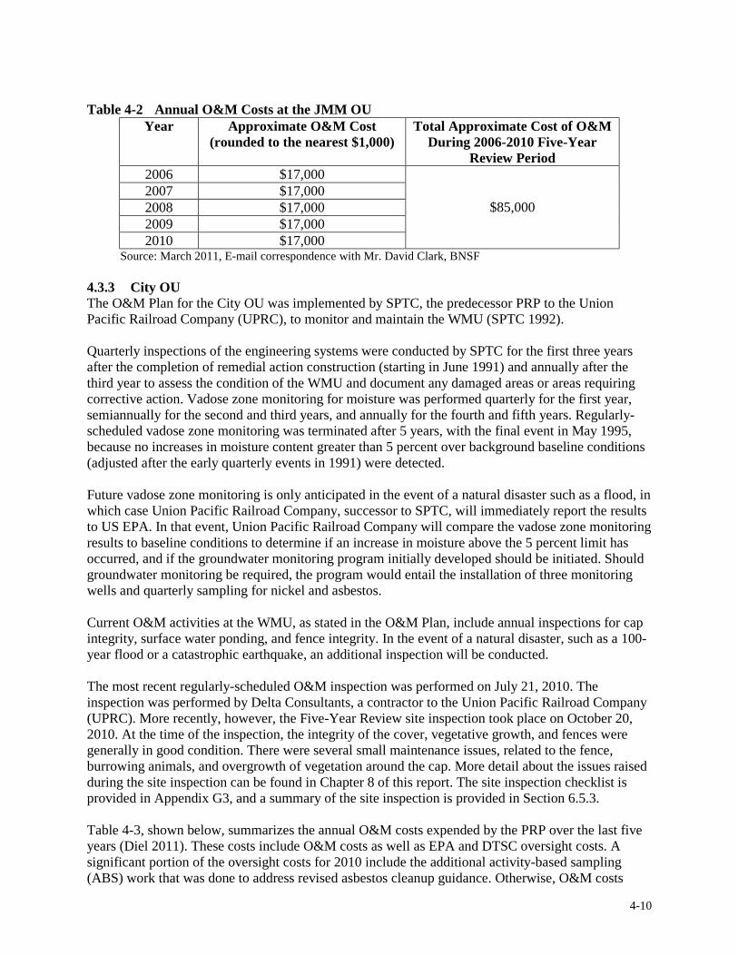
Table 4-2 Annual O&M Costs at the JMM OU Year Approximate O&M Cost
(rounded to the nearest $1,000) Total Approximate Cost of O&M
During 2006-2010 Five-Year Review Period
2006 $17,000
$85,000 2007 $17,000 2008 $17,000 2009 $17,000 2010 $17,000
Source: March 2011, E-mail correspondence with Mr. David Clark, BNSF
4.3.3 City OU The O&M Plan for the City OU was implemented by SPTC, the predecessor PRP to the Union Pacific Railroad Company (UPRC), to monitor and maintain the WMU (SPTC 1992).
Quarterly inspections of the engineering systems were conducted by SPTC for the first three years after the completion of remedial action construction (starting in June 1991) and annually after the third year to assess the condition of the WMU and document any damaged areas or areas requiring corrective action. Vadose zone monitoring for moisture was performed quarterly for the first year, semiannually for the second and third years, and annually for the fourth and fifth years. Regularlyscheduled vadose zone monitoring was terminated after 5 years, with the final event in May 1995, because no increases in moisture content greater than 5 percent over background baseline conditions (adjusted after the early quarterly events in 1991) were detected.
Future vadose zone monitoring is only anticipated in the event of a natural disaster such as a flood, in which case Union Pacific Railroad Company, successor to SPTC, will immediately report the results to US EPA. In that event, Union Pacific Railroad Company will compare the vadose zone monitoring results to baseline conditions to determine if an increase in moisture above the 5 percent limit has occurred, and if the groundwater monitoring program initially developed should be initiated. Should groundwater monitoring be required, the program would entail the installation of three monitoring wells and quarterly sampling for nickel and asbestos.
Current O&M activities at the WMU, as stated in the O&M Plan, include annual inspections for cap integrity, surface water ponding, and fence integrity. In the event of a natural disaster, such as a 100year flood or a catastrophic earthquake, an additional inspection will be conducted.
The most recent regularly-scheduled O&M inspection was performed on July 21, 2010. The inspection was performed by Delta Consultants, a contractor to the Union Pacific Railroad Company (UPRC). More recently, however, the Five-Year Review site inspection took place on October 20, 2010. At the time of the inspection, the integrity of the cover, vegetative growth, and fences were generally in good condition. There were several small maintenance issues, related to the fence, burrowing animals, and overgrowth of vegetation around the cap. More detail about the issues raised during the site inspection can be found in Chapter 8 of this report. The site inspection checklist is provided in Appendix G3, and a summary of the site inspection is provided in Section 6.5.3.
Table 4-3, shown below, summarizes the annual O&M costs expended by the PRP over the last five years (Diel 2011). These costs include O&M costs as well as EPA and DTSC oversight costs. A significant portion of the oversight costs for 2010 include the additional activity-based sampling (ABS) work that was done to address revised asbestos cleanup guidance. Otherwise, O&M costs
4-10

were consistent with the ROD over the past five years.
Table 4-3 Annual O&M Costs at the City of Coalinga OU Year Approximate O&M Cost
(rounded to the nearest $1,000) Total Approximate Cost of O&M
During 2006-2010 Five-Year Review Period
2006 $11,000
$277,000 2007 $51,00 2008 $26,00 2009 $21,000 2010 $168,000
Source: March 2011, E-mail correspondence with Mr. James Diel, Union Pacific Railroad Company
4-11

Figure 4-1 Atlas Mine Area OU Remedial Components
Source: 2006 Five-Year Review for the Atlas Asbestos Mine and Coalinga Asbestos Mine Superfund Sites, Coalinga, California. CH2MHill figure, revised from Harding Lawsom Associates Plate 1. Modified May 1, 2006.
4-12

Figure 4-2 Johns-Manville Mill OU Remedial Components
Source: 2006 Five-Year Review for the Atlas Asbestos Mine and Coalinga Asbestos Mine Superfund Sites, Coalinga, California. CH2MHill figure, modified from Levine Fricke’s 2002 Revised Operations and Maintenance Plan, Johns-Manville Coalinga Mill Area Operation Unit.
4-13

Figure 4-3 City of Coalinga OU Remedial Components
Source: 2006 Five-Year Review for the Atlas Asbestos Mine and Coalinga Asbestos Mine Superfund Sites, Coalinga, California. CH2MHill figure, modified from Mapquest
4-14
2006
5.0 PROGRESS SINCE LAST FIVE-YEAR REVIEW
The last Five-Year Review conducted at the Atlas Asbestos Mine and Coalinga Asbestos Mine Superfund Sites was prepared by US EPA Region 9 and signed on September 28, 2006. This is the third Five-Year Review for the Atlas Asbestos Mine Superfund Site and the fourth Five-Year Review for the Coalinga Asbestos Mine Superfund Site.
5.1 Protectiveness Statement from Last Review The protectiveness statements identified for the Atlas Mine Area OU, the JMM OU, and the City OU in the last Five-Year Review reports are presented in this section. Due to the deferral of the protectiveness statement for the City OU, the site-wide protectiveness statement was also deferred until the additional information required for the City OU determination was obtained.
5.1.1 Atlas Mine Area OU The protectiveness statement for the Atlas Mine Area, as determined in the 2006 Five-Year Review, is as follows:
The remedial action at the Atlas Mine Area OU is protective of human health and the environment due to the removal of contaminated material, stabilization of erosion prone areas, structural improvements and additions, the installation of access controls and warning signs, and regular maintenance of the Atlas Mine Area OU.
5.1.2 Johns-Manville Mill OU The protectiveness statement for the JMM OU, as determined in the 2006 Five-Year Review, is as follows:
The remedial action at the JMM OU is protective of human health and the environment due to the removal of contaminated material, diversion of water around erosion prone surfaces/materials, stabilization of erosion prone areas, structural improvements and additions, the installation of access controls and warning signs, and regular maintenance of the JMM OU.
5.1.3 City OU The protectiveness statement for the City OU, as determined in the 2006 Five-Year Review, is as follows:
The protectiveness of the remedial action for the City OU is deferred until further information is obtained regarding potential human health risks of residual (< 1 percent) asbestos in soils that may be present in the unrestricted portion of the OU.
5.2 Status of Recommendations and Follow-Up Actions from Last Review
Table 5-1 provides a summary of the issues and recommendations made during the last Five-Year Review. It also discusses the status and effectiveness of the follow-up actions taken to implement the recommendations.
5-1
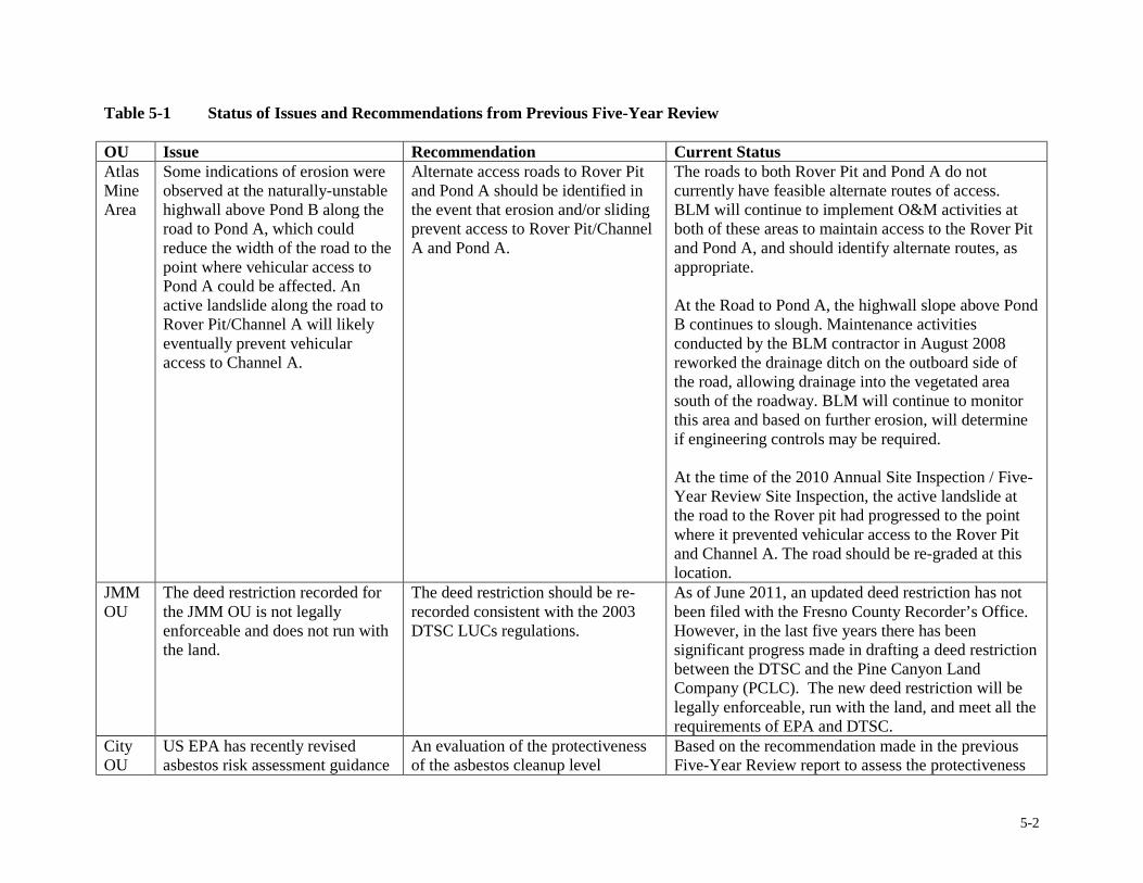
Table 5-1 Status of Issues and Recommendations from Previous Five-Year Review
OU Issue Recommendation Current Status Atlas Some indications of erosion were Alternate access roads to Rover Pit The roads to both Rover Pit and Pond A do not Mine observed at the naturally-unstable and Pond A should be identified in currently have feasible alternate routes of access. Area highwall above Pond B along the
road to Pond A, which could reduce the width of the road to the point where vehicular access to Pond A could be affected. An active landslide along the road to Rover Pit/Channel A will likely eventually prevent vehicular access to Channel A.
the event that erosion and/or sliding prevent access to Rover Pit/Channel A and Pond A.
BLM will continue to implement O&M activities at both of these areas to maintain access to the Rover Pit and Pond A, and should identify alternate routes, as appropriate.
At the Road to Pond A, the highwall slope above Pond B continues to slough. Maintenance activities conducted by the BLM contractor in August 2008 reworked the drainage ditch on the outboard side of the road, allowing drainage into the vegetated area south of the roadway. BLM will continue to monitor this area and based on further erosion, will determine if engineering controls may be required.
At the time of the 2010 Annual Site Inspection / Five-Year Review Site Inspection, the active landslide at the road to the Rover pit had progressed to the point where it prevented vehicular access to the Rover Pit and Channel A. The road should be re-graded at this location.
JMM The deed restriction recorded for The deed restriction should be re- As of June 2011, an updated deed restriction has not OU the JMM OU is not legally
enforceable and does not run with the land.
recorded consistent with the 2003 DTSC LUCs regulations.
been filed with the Fresno County Recorder’s Office. However, in the last five years there has been significant progress made in drafting a deed restriction between the DTSC and the Pine Canyon Land Company (PCLC). The new deed restriction will be legally enforceable, run with the land, and meet all the requirements of EPA and DTSC.
City OU
US EPA has recently revised asbestos risk assessment guidance
An evaluation of the protectiveness of the asbestos cleanup level
Based on the recommendation made in the previous Five-Year Review report to assess the protectiveness
5-2
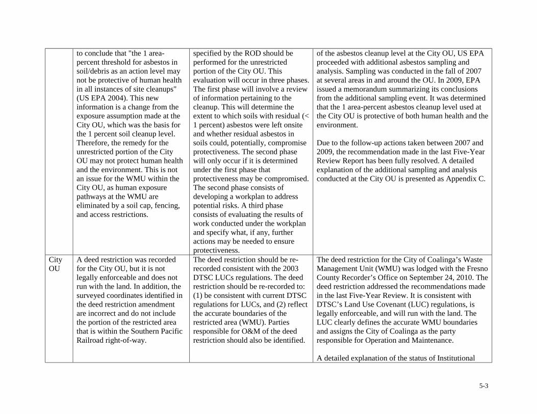
to conclude that "the 1 areapercent threshold for asbestos in soil/debris as an action level may not be protective of human health in all instances of site cleanups" (US EPA 2004). This new information is a change from the exposure assumption made at the City OU, which was the basis for the 1 percent soil cleanup level. Therefore, the remedy for the unrestricted portion of the City OU may not protect human health and the environment. This is not an issue for the WMU within the City OU, as human exposure pathways at the WMU are eliminated by a soil cap, fencing, and access restrictions.
specified by the ROD should be performed for the unrestricted portion of the City OU. This evaluation will occur in three phases. The first phase will involve a review of information pertaining to the cleanup. This will determine the extent to which soils with residual (< 1 percent) asbestos were left onsite and whether residual asbestos in soils could, potentially, compromise protectiveness. The second phase will only occur if it is determined under the first phase that protectiveness may be compromised. The second phase consists of developing a workplan to address potential risks. A third phase consists of evaluating the results of work conducted under the workplan and specify what, if any, further actions may be needed to ensure protectiveness.
of the asbestos cleanup level at the City OU, US EPA proceeded with additional asbestos sampling and analysis. Sampling was conducted in the fall of 2007 at several areas in and around the OU. In 2009, EPA issued a memorandum summarizing its conclusions from the additional sampling event. It was determined that the 1 area-percent asbestos cleanup level used at the City OU is protective of both human health and the environment.
Due to the follow-up actions taken between 2007 and 2009, the recommendation made in the last Five-Year Review Report has been fully resolved. A detailed explanation of the additional sampling and analysis conducted at the City OU is presented as Appendix C.
City A deed restriction was recorded The deed restriction should be re- The deed restriction for the City of Coalinga’s Waste OU for the City OU, but it is not
legally enforceable and does not run with the land. In addition, the surveyed coordinates identified in the deed restriction amendment are incorrect and do not include the portion of the restricted area that is within the Southern Pacific Railroad right-of-way.
recorded consistent with the 2003 DTSC LUCs regulations. The deed restriction should be re-recorded to: (1) be consistent with current DTSC regulations for LUCs, and (2) reflect the accurate boundaries of the restricted area (WMU). Parties responsible for O&M of the deed restriction should also be identified.
Management Unit (WMU) was lodged with the Fresno County Recorder’s Office on September 24, 2010. The deed restriction addressed the recommendations made in the last Five-Year Review. It is consistent with DTSC’s Land Use Covenant (LUC) regulations, is legally enforceable, and will run with the land. The LUC clearly defines the accurate WMU boundaries and assigns the City of Coalinga as the party responsible for Operation and Maintenance.
A detailed explanation of the status of Institutional
5-3
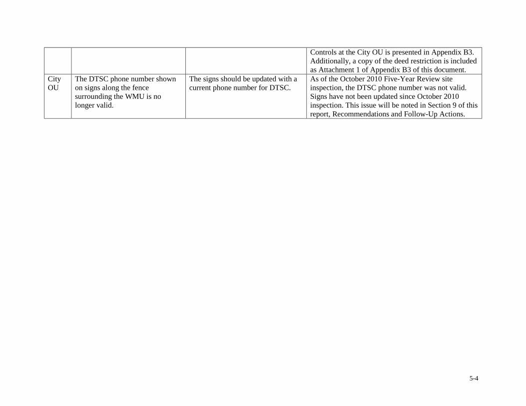
Controls at the City OU is presented in Appendix B3. Additionally, a copy of the deed restriction is included as Attachment 1 of Appendix B3 of this document.
City OU
The DTSC phone number shown on signs along the fence surrounding the WMU is no longer valid.
The signs should be updated with a current phone number for DTSC.
As of the October 2010 Five-Year Review site inspection, the DTSC phone number was not valid. Signs have not been updated since October 2010 inspection. This issue will be noted in Section 9 of this report, Recommendations and Follow-Up Actions.
5-4
6.0 FIVE-YEAR REVIEW PROCESS
6.1 Administrative Components The Five-Year Review was led by Lily Tavassoli, US EPA Remedial Project Manager. Innovative Technical Solutions, Incorporated (ITSI) provided limited technical support. Jackie Lane led community involvement issues as the US EPA Community Involvement Coordinator.
Potentially interested parties were notified at the initiation of the Five-Year Review, and consisted of the PRPs, their contractors, and the State of California. The following is the list of parties notified: Pine Canyon Land Company (PCLC), Union Pacific Railroad Company, the United States Bureau of Land Management (BLM), Northrop Grumman, Delta Consultants, the State of California Department of Water Resources (DWR), and the State of California Department of Toxic Substances Control (DTSC).
The Five-Year Review of the Atlas and Coalinga sites involved: • Reviewing relevant documents, including routine operations, monitoring, and analytical data. • Reviewing federal and state Applicable or Relevant and Appropriate requirements (ARARs)
cited in the RODs for each of the OUs. • Reviewing implementation of institutional controls. • Conducting an interview. • Performing site inspections of each of the OUs. • Informing the public of the findings of this Five-Year Review.
6.2 Community Involvement US EPA published a public notice in the Fresno Bee on May 19, 2011. The text of the public notice is included as Appendix D. The notice described the site background, gave the history of contamination at each OU, outlined the Five-Year Review process, provided the location of local site repositories where selected site documents can be found, and gave instructions for how to get involved with the review process. No inquiries were received from the public regarding the Five-Year Review.
Following the release of this document, another public notice will be published. The notice will summarize the findings of the Five-Year Review and provide information on how the report can be obtained electronically or in-person.
6.3 Document Review As a part of the Five-Year Review process, a review of numerous documents related to site activities were reviewed. The documents chosen for review ranged in publication date from 1989 to 2011. Documents reviewed include RODs, annual inspection reports, and O&M Plans. Appendix E provides a list of these documents.
A review of the Applicable or Relevant and Appropriate Requirements (ARARs) was also conducted to determine if any regulatory changes had occurred since the last Five-Year Review that would impact the protectiveness of the remedy. The ARARs Analysis is provided as Appendix F.
6.4 Data Review The Atlas Mine Area OU, JMM OU, and City OU do not require routine sampling and data analysis as part of their O&M activities. There were no data to review within the 2006 – 2011 period covered in this Five-Year Review.
6-1

Field analytical data were only collected from the City Operable Unit, where in 2007 additional sampling was performed to follow up on a 2006 Five-Year Review recommendation. The recommendation was to evaluate the protectiveness of the 1 area-percent soil-asbestos cleanup level chosen in the City OU ROD. This evaluation consisted of two sampling events: a soil sampling effort and activity-based sampling (ABS) effort. Data were used to determine exposure risk for the City OU. It was determined that the 1 area-percent cleanup level at the City OU is protective. There is an explanation of the sampling methodology, results, and conclusions provided in Appendix C.
6.5 Site Inspection The site inspection checklist is used as a guide for collecting and reviewing information that is relevant to the Five-Year Review site inspection portion. Site inspections were performed at the Atlas Mine Area OU, the JMM OU, City OU, CCMA, and Ponding Basin. All site inspections took place between October 18 and 21, 2010. A brief summary of each site inspection is presented below, with full site inspection checklists and photos included as Appendix G.
6.5.1 Atlas Mine Area OU The site inspection of the Atlas Mine Area OU was performed on October 19, 2010. Representatives from US EPA, ITSI, DTSC, BLM, and Northrop Grumman were in attendance during the site inspection.
During the site inspection, the ponds, paved road, and diversion channels were generally noted to be in good condition, with a few exceptions.
Erosional features on and around the mine waste areas have changed little in recent years. Much of the erosion across the site has been mitigated by installation of drain rock, berms, subsurface piping for conveying surface water, surface water diversion structures, and vegetation. Active erosion is occurring on the site access road leading to Pond A (the highwall slope above Pond B) and the site access road to the Rover Pit. Since the last inspection, the road to the Rover Pit has collapsed, preventing vehicle traffic from passing this point and creating a safety hazard. This area should be regraded to create access for site inspections, and alternate routes of access should be identified.
Not all surfaces within the OU drain directly into a settlement pond. Some surfaces, notably the outward slopes of the Regional Sediment Storage area, and the outward slopes of areas to the west of Pond B drain directly into one of the surface runoff diversion channels. Siltation has occurred in both of the surface runoff diversion channels (Channel A and Channel B). In some areas, this siltation has completely filled the rock mattresses in the channel bed, leaving a smooth surface on the channel bottom. Though the siltation is not likely to fill the channels or obstruct flow, the smooth bottom surface of the channels facilitate faster current flow in the channels, which could, in turn, lead to release of asbestos-laden sediments from the site. The scope of the role of Channel A and Channel B in the remedial design should be expanded to include sediment capture. Accumulated sediments should be periodically removed from the channels and deposited at the Regional Sediment Storage Area.
Runoff from the Rover Pit is not intercepted by a settlement pond and the outlet structure of the Rover Pit, as well as most of the ground surface of the pit cannot be directly inspected because there is no way to access these areas safely by vehicle. Site roadway infrastructure should be expanded to allow access to all areas of the Rover Pit for inspection. Access to the outlet structure, revegetation areas, and areas most prone to erosion should be prioritized.
6-2
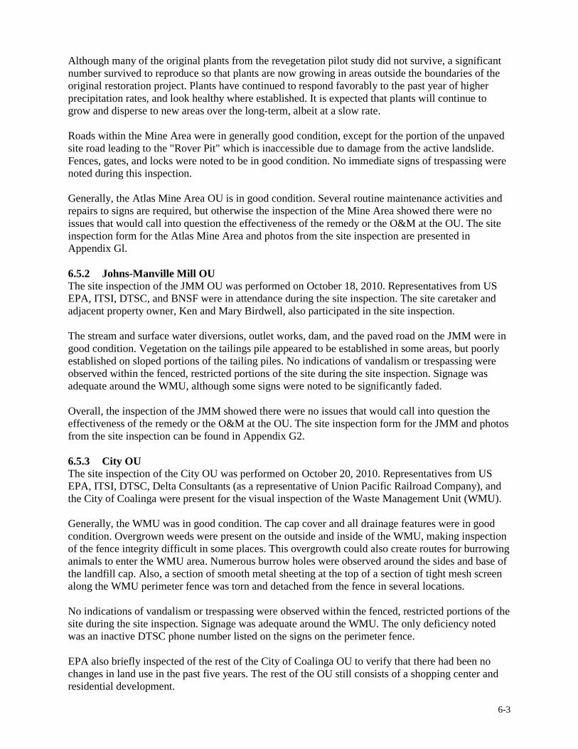
Although many of the original plants from the revegetation pilot study did not survive, a significant number survived to reproduce so that plants are now growing in areas outside the boundaries of the original restoration project. Plants have continued to respond favorably to the past year of higher precipitation rates, and look healthy where established. It is expected that plants will continue to grow and disperse to new areas over the long-term, albeit at a slow rate.
Roads within the Mine Area were in generally good condition, except for the portion of the unpaved site road leading to the "Rover Pit" which is inaccessible due to damage from the active landslide. Fences, gates, and locks were noted to be in good condition. No immediate signs of trespassing were noted during this inspection.
Generally, the Atlas Mine Area OU is in good condition. Several routine maintenance activities and repairs to signs are required, but otherwise the inspection of the Mine Area showed there were no issues that would call into question the effectiveness of the remedy or the O&M at the OU. The site inspection form for the Atlas Mine Area and photos from the site inspection are presented in Appendix Gl.
6.5.2 Johns-Manville Mill OU The site inspection of the JMM OU was performed on October 18, 2010. Representatives from US EPA, ITSI, DTSC, and BNSF were in attendance during the site inspection. The site caretaker and adjacent property owner, Ken and Mary Birdwell, also participated in the site inspection.
The stream and surface water diversions, outlet works, dam, and the paved road on the JMM were in good condition. Vegetation on the tailings pile appeared to be established in some areas, but poorly established on sloped portions of the tailing piles. No indications of vandalism or trespassing were observed within the fenced, restricted portions of the site during the site inspection. Signage was adequate around the WMU, although some signs were noted to be significantly faded.
Overall, the inspection of the JMM showed there were no issues that would call into question the effectiveness of the remedy or the O&M at the OU. The site inspection form for the JMM and photos from the site inspection can be found in Appendix G2.
6.5.3 City OU The site inspection of the City OU was performed on October 20, 2010. Representatives from US EPA, ITSI, DTSC, Delta Consultants (as a representative of Union Pacific Railroad Company), and the City of Coalinga were present for the visual inspection of the Waste Management Unit (WMU).
Generally, the WMU was in good condition. The cap cover and all drainage features were in good condition. Overgrown weeds were present on the outside and inside of the WMU, making inspection of the fence integrity difficult in some places. This overgrowth could also create routes for burrowing animals to enter the WMU area. Numerous burrow holes were observed around the sides and base of the landfill cap. Also, a section of smooth metal sheeting at the top of a section of tight mesh screen along the WMU perimeter fence was torn and detached from the fence in several locations.
No indications of vandalism or trespassing were observed within the fenced, restricted portions of the site during the site inspection. Signage was adequate around the WMU. The only deficiency noted was an inactive DTSC phone number listed on the signs on the perimeter fence.
EPA also briefly inspected of the rest of the City of Coalinga OU to verify that there had been no changes in land use in the past five years. The rest of the OU still consists of a shopping center and residential development.
6-3

The inspection of the WMU showed there were no issues that would call into question the effectiveness of the remedy or the O&M at the OU. The site inspection form for the City OU and photos from the site inspection can be found in Appendix G3.
6.5.4 Ponding Basin and CCMA During the October 2010 Five-Year Review site inspections, US EPA conducted informal inspections of both the Arroyo Pasajero Ponding Basin and the Clear Creek Management Area.
On October 19, 2010, during a brief visual inspection of the CCMA, EPA verified that adequate signage was in place updating the public on the temporary closure status of the CCMA. EPA also observed signs of trespassing by off-road bicycle/vehicle users in some areas of the CCMA.
On October 21, 2010, EPA met with three DWR employees involved with oversight of the Arroyo Pasajero Ponding Basin. They provided a thorough tour of the Ponding Basin, including levee roads around the northern, eastern, and southern perimeter of the Basin. Additionally, EPA and DWR traversed central Huron to the crossing of the Arroyo Pasajero Creek and Lassen Avenue, where there are concerns about the control of floodwaters during heavy rain events.
Further information about the inspections, as well as photographs, are included as Appendix A.
6.6 Interviews One interview was conducted as part of the Five-Year Review process. It is summarized below and the Interview Summary Forms is included as Appendix H.
The interview was conducted with Mr. Steven Ross, Project Manager with the California Department of Toxic Substances Control, Brownfields and Environmental Restoration Program. Mr. Ross is the state project manager responsible for the oversight of all Operation and Maintenance (O&M) activities at the Coalinga Site. The interview was conducted via telephone conference on February 8, 2011.
Mr. Ross expressed that the remedies in place at the Atlas Mine Area, JMM, and City OU are successfully controlling the release of asbestos. He noted that there have been no significant operations and maintenance related issues, vandalism or trespassing, or other issues requiring the attention of DTSC. He is pleased with the maintenance activities conducted at the Atlas Mine Area OU. He also noted that DTSC is pleased with the temporary closure of the Clear Creek Management Area (CCMA), and he sees the CCMA as the only area of concern to the community. This concern is related to the emergency closure of the CCMA to off-highway recreational use. Mr. Ross noted that DTSC inspects the JMM and Atlas Mine Area on an annual basis, as well as the City’s waste management unit on a more informal basis.
Mr. Ross also discussed institutional controls implementation at the sites. DTSC has not been able to proceed with recording an enforceable environment covenant on the Atlas Mine OU because of the language in the consent decree. There were no concerns about institutional controls at other operable units.
Mr. Ross made several practical suggestions related to project management functions between DTSC and EPA. One such recommendation was to create an FTP (file transfer protocol) site to store site documents. Another recommendation was to request hard copies of deliverables from site PRPs.
6-4

7.0 TECHNICAL ASSESSMENT
The following section is a technical assessment of the remedies at the Atlas Mine Area OU, Johns-Manville Mill OU, and City OU. The assessment is made by answering the three questions in the following sections.
7.1 Question A: Is the remedy functioning as intended by the decision documents?
7.1.1 Atlas Mine Area OU
Remedial Action Performance The purpose of the remedy at the Atlas Mine Area OU is to prevent asbestos-containing material from leaving the site by air or surface water discharge. The remedy is functioning as intended by the ROD based on observations made during the annual site inspections, the Five-Year Review site inspection, and a review of relevant documents and ARARs.
Asbestos-containing sediments are collected in several sedimentation ponds that have been constructed across the site, resulting in a decrease in loadings of asbestos to surface water downstream of the site. Fencing and signage prevent access to the site. Paved roads at the entrance of the site and within the site are maintained to further mitigate the potential for generation of airborne asbestos.
Operations and Maintenance O&M of the Atlas Mine Area OU has been effective. Annual inspections are performed to identify any need for maintenance activities at the site. The remedy is expected to be protective in the future if routine inspections continue and maintenance activities are performed as necessary.
There are several O&M-related issues that were noted during the Five-Year Review site inspection of the Atlas Mine Area, which are addressed in the O&M recommendations listed in Chapter 9 (Recommendations and Follow-Up Actions.) These issues should be addressed through maintenance activities by the PRPs.
Opportunities for Optimization There were no opportunities for system optimization identified during this review.
Early Indicators of Potential Issues There are currently no indicators of potential remedy failure at the Atlas Mine Area OU.
Implementation of Institutional Controls and Other Measures The requirement for deed restrictions originally called for in the Atlas Mine Area ROD cannot be implemented as intended. First, the language in the 1992 Consent Decree entered into with the Atlas Corp. and Vinnell does not require the PRPs to place deed restrictions on the site, and the Consent Decree also voids the requirement in the 1990 ROD. Additionally, two parcels within the Atlas Mine Area, previously owned by Wheeler Properties, Inc., deed restrictions cannot be placed on because the owner (Wheeler) defaulted on the property and there is now no discernable property owner with whom to file the restrictions.
On September 15, 2010, EPA issued an Explanation of Significant Differences from the ROD to
7-1

explain the status of institutional controls at the Atlas Mine Area and to clarify measures in place that ensure the Atlas Mine Area remains protective of human healthy and the environment. A comprehensive update on the background and status of institutional controls at the Atlas Mine Area OU is provided as Appendix B1.
Access controls at the Atlas Mine Area effectively prevent exposure to asbestos. Fences, gates, and locks at the site are intact and in good condition. In the last five years, site inspections conducted by EPA and BLM have noted signs of trespassing, such as motorcycle tracks within the Mine Area OU. BLM should continue to patrol the site.
7.1.2 Johns-Manville Mill OU
Remedial Action Performance The remedy at the Johns-Manville Mill OU is to divert surface water in Pine Canyon Creek away from the tailings pile, minimize the release of asbestos to the creek, pave the road through the Mill Area to suppress dust, dismantle the mill building and dispose of the debris, and restrict access to the site.
The remedy appears to be functioning as intended by the ROD based on observations made during the annual site inspection reports, the Five-Year Review site inspection, and on a review of relevant documents and ARARs. The remedial activities and subsequent monitoring have achieved the remedial objectives.
Operations and Maintenance O&M at the JMM OU has been effective. The maintenance contractor regularly inspects the OU and makes minor repairs to the site. There are no indications of any difficulties with O&M of the remedy.
Opportunities for Optimization There were no opportunities for system optimization identified during this review.
Early Indicators of Potential Issues There are no indicators of potential issues identified at this time.
Implementation of Institutional Controls and Other Measures It was discovered in the previous Five-Year Review that the deed restriction recorded for the JMM on July 2, 1993 was not consistent with DTSC LUC regulations. A new deed restriction needs to be recorded with the Fresno County Recorder’s Office by Pine Canyon Land Company and DTSC. The new deed restriction will be legally enforceable, run with the land, and meet all DTSC regulations for LUCs. A comprehensive update on the status of institutional controls at the JMM OU is provided as Appendix B2.
Access controls at the JMM continue to effectively prevent exposure to asbestos. The fence and signage are generally in good condition. It was noted in the Five-Year Review inspection that several of the signs have faded considerably. All warning signs having a noticeable degree of fading should be replaced with new, weather and sunlight-resistant signs. In addition, comparable warning signs printed in Spanish should be posted. The JMM OU and surrounding area appeared to be undisturbed and secure during the site inspection, with no evident signs of trespassing.
7-2
7.1.3 City OU
Remedial Action Performance The purpose of the remedy at the City of Coalinga OU is to prevent exposure to asbestos-laden materials that were present at the OU as a result of the transport of asbestos and asbestoscontaminated materials from the Atlas Mine Area and JMM OU to the City OU.
Asbestos waste is capped at the Waste Management Unit and is effectively preventing exposure to asbestos. The WMU is functioning as intended by the ROD based on observations made during the annual site inspection reports, the Five-Year Review inspection, and a review of relevant documents and ARARs. The City OU has achieved the remedial objectives to reduce exposure to asbestos.
Operations and Maintenance Operation and maintenance (O&M) of the WMU has been effective in maintaining the remedy at the City OU. The UPRC’s contractor conducts annual inspections of the WMU, notes any deficiencies at the site, and then performs routine maintenance activities to correct problems. There are no indications of any difficulties with O&M of the remedy.
There are several O&M-related issues that were noted during the Five-Year Review site inspection of the WMU, which are noted in the O&M recommendations section of Chapter 9 (Recommendations and Follow-Up Actions.)
Opportunities for Optimization There were no opportunities for system optimization identified during this review.
Early Indicators of Potential Issues There are no indicators of potential issues identified at this time.
Implementation of Institutional Controls and Other Measures A deed restriction between the owner of the Waste Management Unit (WMU), the City of Coalinga (as per “Stipulated Judgment Quieting Title, APN: 900-700-12 [formerly APN 083-020-59SU]”) and the California Department of Toxic Substances Control (DTSC) was filed with the Fresno County Recorder’s Office on September 24, 2010. The deed restriction prevents disturbance to the cap at the WMU, which will prevent the release of asbestos and nickel contaminants from the Site. This deed restriction is consistent with DTSC regulations for LUCs. The restriction is both enforceable and runs with the land. All of the ROD-required institutional controls for the WMU have been implemented successfully. A comprehensive update on the status of institutional controls at the City OU is provided as Appendix B3. A copy of the deed restriction is also included in the appendix as an attachment.
Access controls at the WMU continue to prevent access to the cap. Fencing and signage are generally in good condition, but require some maintenance to prevent access to the site. Specifically, the signs around the WMU should include the correct DTSC phone number. Also, the smooth metal sheeting installed at the top of a section of tight mesh screen along the WMU perimeter fence to prevent animals from climbing over the fence into the site should be repaired, as it is torn and detached from the fence in several locations. Yearly inspections of the WMU should continue to note deficiencies to access controls, which should then be corrected through routine maintenance activities.
7-3
7.2 Question B: Are the exposure assumptions, toxicity data, cleanup levels, and remedial action objectives (RAOs) used at the time of the remedy selection still valid?
The purpose of this applicable or relevant and appropriate requirements (ARARs) evaluation is to determine whether laws, regulations, or guidance promulgated since approval of site decision documents alter the remedy’s protectiveness of human health and the environment.
ARARs for the Atlas and Coalinga Superfund Sites were initially established in their respective Records of Decision (RODs). The contaminants of concern include asbestos, heavy metals including nickel, mining waste, and particulate matter less than 10 microns in diameter (PM10). The complete results and evaluation of ARARs is presented in Appendix F and are summarized below.
Changes in Standards and TBCs There are no new action-, chemical-, or location-specific ARARs for the Atlas Mine Area OU, JMM, or City OU identified during this Five-Year Review period. However, the previous Five-Year Review identified two chemical-specific ARARs and one location-specific ARAR promulgated during that period of review that have been amended during the current Five-Year Review period.
Chemical-specific ARAR 40 CFR 61.152 that established air cleaning requirements for asbestos control equipment was amended on July 1, 2010 and chemical-specific ARAR 40 CFR 61.153 that established reporting requirements for asbestos waste producers was also amended on July 1, 2010. There is no impact on the protectiveness of the remedy as a result of either amendment.
A location-specific ARAR related to the recording of ICs was signed in 2003 and was acknowledged as a relevant and appropriate to all OUs of the Atlas and Coalinga Sites in the 2006 Five-Year Review. This regulation is Title 22, CCR, Division 4.5, Chapter 39, Section 67391(a), (d), (g), and (i) requires all land-use covenants to be signed by the California Department of Toxic Substance Control and the landowner and to be recorded in the county where the land is located (April 19, 2003). On November 17, 2007, Title 22, CCR, Division 4.5, Chapter 39, Section 67391 (a)(b)(d)(g)(i) was amended. There is no impact on the protectiveness of the remedy as a result of the amendment.
None of the ARARs amended since the previous Five-Year Review have altered the remedies’ protectiveness of human health and the environment at the Atlas Mine Area, JMM, and City OU. The complete ARARs Technical Memo is included as Appendix F of this document.
Changes in Exposure Pathways There have been no changes that could potentially impact human or ecological exposure to the site contaminants. There have been no changes in the land-use in and around the Atlas Mine Area, JMM, or City OU since the last Five-Year Review. Future changes in land use are not anticipated at this time. There are no new contaminants, sources of contaminants, or newly identified routes of exposure to the site contaminants. The physical site conditions have not changed in a way that has the potential to affect the protectiveness of the remedy at the Atlas Mine Area, JMM, and City OU.
Changes in Toxicity and Other Contaminant Characteristics No other information was identified as part of this Five-Year Review that calls into question the assumptions made during selection of the remedies at the sites. There have been no new contaminants or contaminant sources identified at the Atlas Mine Area, JMM, or City OU. There also have been no changes in the physical conditions at the sites that would affect the protectiveness of the selected remedies.
7-4
Changes in Risk Assessment Methods Since the previous Five-Year Review, there have been no changes to the US EPA Risk Assessment guidance, including changes to risk assessment methodology. There is no impact on the protectiveness of the remedies at the Atlas Mine Area, JMM, and City OU.
Expected Progress towards Meeting Remedial Action Objectives According to the documents reviewed, site inspections, and interview, the remedial activities and subsequent inspections at the Atlas Mine Area OU, JMM OU, and City OU have achieved the remedial action objectives of reducing the exposure to asbestos.
7.3 Question C: Has any other information come to light that could call into question the protectiveness of the remedy?
7.3.1 Atlas Mine Area OU In 1991, an ecological risk assessment was performed as part of the Remedial Investigation for the Atlas Mine Area OU (US EPA 1991b). In the last five years, there have been no changes to the land use of the site or the areas surrounding the site. It is not necessary to update the ecological risk assessment during this Five-Year Review.
There have been no impacts from natural disasters that have impacted the protectiveness of the remedy at the Atlas Mine Area OU. There is no other information that has come to light which could potentially affect the protectiveness of the remedy.
7.3.2 Johns-Manville Mill OU The 1991 RI report for the JMM OU included an ecological risk assessment (US EPA 1991 b). In the last five years, there have been no changes to the land use of the site or the areas surrounding the site. It is not necessary to update the ecological risk assessment during this Five-Year Review.
There have been no impacts from natural disasters that have impacted the protectiveness of the remedy at the JMM OU. There is no other information that has come to light which could potentially affect the protectiveness of the remedy.
7.3.3 City OU There have been no impacts from natural disasters that have impacted the protectiveness of the remedy at the City OU. There is no other information that has come to light which could potentially affect the protectiveness of the remedy.
7.4 Technical Assessment Summary Questions A, B, and C as a whole address three aspects of the protectiveness of human health and the environment at each of the three Operable Units: the Atlas Mine Area, JMM, and City OU.
Question A addresses the functionality of the remedies implemented at each OU. According to the documents and ARARs reviewed, annual site inspections at each OU between 2007 and 2010, the Five-Year Review site inspections, and interviews, the remedies implemented at the Atlas Mine Area OU, JMM OU, and City OU are functioning as intended by their respective RODs. There have been no changes in the physical conditions at the sites or the surrounding land uses that would affect the protectiveness of the remedies or change potential exposure to the site contaminants.
Overall, O&M has been effective at the three OUs. At the Atlas Mine Area, several issues were
7-5
raised that should be addressed by the PRPs. They are discussed again in Chapter 9, Recommendations and Follow-Up Actions. At the City OU, weed abatement and pest control should continue to prevent potential damage to the cap.
Access control and signage should be repaired as necessary at all three OUs. At the City OU, minor repairs should be made to the fence surrounding the WMU. Additionally, the DTSC phone number on the signs should be updated. At the Atlas Mine Area and JMM, signs that have faded over time should be replaced. Updated signs should include messages in both English and Spanish.
Question B addresses the validity of the exposure assumptions, cleanup levels, and remedial action objectives used at the time the remedy was selected. This evaluation showed that there has not been a significant change in standards. No new ARARs were identified. Three regulations were amended, but there is no impact on the ARARs for the Atlas and Coalinga Sites. Additionally, there have been no changes in the land use of the sites or their surrounding areas, or changes in the toxicity of contaminants and how they are assessed using EPA risk assessment methodology.
Question C addresses any other information that has come to light since the last Five-Year Review that may affect the protectiveness of the remedy at any of the OUs. There has been no such new information, and no events (such as natural disasters) that could potentially impact the protectiveness of the remedies at the sites.
7-6

8.0 ISSUES
Issues related to current site conditions that may impact the effectiveness of the remedies at the Sites are summarized below.
Table 7-1 Issues
OU Issue Affects Protectiveness Current Future
Atlas Mine Area OU
Currently, visual inspections of the Atlas Mine Area are conducted annually to verify the remedy is functioning as intended. Since a large portion of the boundary of the Atlas Mine Area in inaccessible by foot or by car, these annual visual inspections are unable to thoroughly identify potential for migration of asbestos.
No Yes
Johns-Manville Mill OU
A deed restriction was recorded for the JMM OU, but it is not legally enforceable and does not run with the land.
No Yes
8-1

9.0 RECOMMENDATIONS AND FOLLOW-UP ACTIONS
Table 9-1 Issues, Recommendations, and Follow-Up Actions
OU Issue Recommendation / Follow-Up Action Party Responsible
Oversight Agency
Milestone Date
Affects Protectiveness
Current Future Atlas Currently, visual The Operation and Maintenance (O&M) Northrop US EPA 9/2012 No Yes Mine inspections of the Atlas manual for the Atlas Mine Area OU should Grumman OU Mine Area are conducted
annually to verify the remedy is functioning as intended. Since a large portion of the boundary of the Atlas Mine Area in inaccessible by foot or by car, these annual visual inspections are unable to thoroughly identify potential for migration of asbestos.
be revised to include a requirement for a minimum of one aerial inspection to be conducted during each Five-Year Review period. At least one aerial inspection should be performed no later than one year prior to the completion of the next Five-Year Review. Aerial inspections would allow for thorough examination of the site boundary to determine whether migration of asbestosladen materials is occurring. In order to provide a baseline for the next Five-Year Review, the first aerial inspection should be conducted one year from the completion of this report.
and BLM
JMM A deed restriction was Record an enforceable deed restriction Pine Canyon DTSC 10/2011 No Yes OU recorded for the JMM
OU, but it is not legally enforceable and does not run with the land.
between the Pine Canyon Land Company and DTSC with the Fresno County Recorder’s Office. The deed restriction should be consistent with current DTSC regulations for ICs, be enforceable by DTSC (with EPA listed as a third-part beneficiary) and should run with the land. Parties responsible for O&M of the deed restriction should also be identified.
Land Company
9-1

In addition to the Issues and Recommendations, the following are suggested areas of improvement which do not affect protectiveness but were identified during the Five-Year Review.
• Atlas Mine Area: Small signs affixed to site fencing within the OU at regular intervals read, "ASBESTOS - Cancer and Lung Disease Hazard, Authorized Personnel Only, Respirators and Protective Clothing Required in this Area." Many of these signs are faded and disintegrating as to be illegible or partly illegible. Newer signs have been posted near the entrance to the OU via the site access road. These signs contain a warning message in English only and may not be comprehensible to non-English speakers. Additional signs should be posted at the entry point to the OU, preferably on or near the entry gate with an equivalent warning message printed in Spanish. Faded or incomplete signs within the OU should be replaced and augmented with equivalent Spanish language signs.
• Atlas Mine Area: Runoff from the Rover Pit is not intercepted by a settlement pond and the outlet structure of the Rover Pit, as well as most of the ground surface of the pit cannot be directly inspected because there is no way to access these areas safely by vehicle. Site roadway infrastructure should be expanded to allow access to all areas of the Rover Pit for inspection. Access to the outlet structure, revegetation areas, and areas most prone to erosion should be prioritized.
• Atlas Mine Area: A portion of the unpaved site road leading to the "Rover Pit" area has dropped due to an active landslide leaving a vertical offset of approximately two feet across the roadway, preventing vehicle traffic from passing this point and creating a safety hazard. The road to Rover Pit should be re-graded at the location of the landslide and alternate routes to Rover Pit should be identified or constructed.
• JMM: Warning signs affixed at regular intervals to the barbed-wire site perimeter fence and cable fences along the site access road were observed to have faded significantly in some areas when compared to photographs taken during the previous five-year review. Many of these signs are expected to become completely illegible at the current rate of fading before the next five-year review inspection. All warning signs having a noticeable degree of fading should be replaced with new, weather and sunlight-resistant signs. In addition, comparable warning signs printed in Spanish should be posted.
• City OU: Warning signs are posted at regular intervals and affixed to the Waste Management Unit perimeter fence. The signs provide an incorrect or out-of-date telephone contact number for the Department of Toxic Substances Control. The signs should be replaced with new signs containing the correct/current contact telephone number at the DTSC, or the existing signs should be updated to show the correct/current number.
• City OU: Numerous and pervasive burrow holes of approximately two to three inches in diameter were observed around the sides and base of the landfill cap. Pest eradication, burrow filling/destruction and repair to the pest exclusion infrastructure should be performed to protect the cap from burrowing animals.
• City OU: Dense shrub growth has occurred around the perimeter fence which obscures inspection of the fence and provided a potential route for burrowing animals to enter the site over the exclusion infrastructure. Weed abatement should be conducted to remove any shrubs or tall weed growth around the Waste Management Unit perimeter fence.
9-2

• City OU: A section of smooth metal sheeting was installed at the top of a section of tight mesh screen along the Waste Management Unit perimeter fence to prevent animals from climbing over the fence into the site. The smooth metal sheeting has torn and detached from the fence in several locations. Maintenance should be performed to restore the smooth sheeting.
9-3
10.0 PROTECTIVENESS STATEMENTS
The remedial actions at the Atlas Asbestos Mine Superfund Site and the Coalinga Asbestos Mine Superfund Site are protective of human health and the environment in the short term.
The remedy at the Atlas Mine Area OU is protective of human health and the environment due to the removal of contaminated material, stabilization of erosion prone areas, structural improvements and additions, the installation of access controls and warning signs, and regular inspections and maintenance. However, in order for the remedy to be protective in the long-term, aerial inspections of the Atlas Mine Area should be conducted previous to each Five-Year Review to determine whether migration of asbestos-laden sediments has occurred.
The remedy at the Johns-Manville Mill OU currently protects human health and the environment because of the remedy in place: removal of contaminated material, diversion of water around erosion prone surfaces/materials, stabilization of erosion prone areas, structural improvements and additions, the installation of access controls and warning signs, and regular inspections and maintenance. However, in order for the remedy to be protective in the long-term, institutional controls, in the form of an enforceable deed restriction, must be placed on the property.
The remedy at the City of Coalinga OU is protective of human health and the environment due to the removal and consolidation of contaminated soils and other materials beneath an on-site cap (the Waste Management Unit), restriction of future uses through a deed restriction, the installation of access controls and warning signs, and regular inspections and maintenance.
10-1

11.0 NEXT FIVE-YEAR REIVEW
The next Five-Year Review for the Atlas Asbestos Mine Superfund Site and Coalinga Asbestos Mine Superfund Site will be conducted in 2016, five years from the date of this review.
11-1
12.0 REFERENCES
California Department of Health Services 1995 Health Consultation Atlas/Coalinga Asbestos Mines City of Coalinga Operable Unit
CDM. 2007 Annual Site Inspection Report Atlas Mine Operable Unit. Atlas Asbestos Mine Superfund Site Fresno County, California. April 2007
CH2MHill, Inc., 2006. Five-Year Review Report For Atlas Asbestos Mine Superfund Site and Coalinga Asbestos Mine (Johns-Manville Mill) Superfund Sites, Fresno County, California. 28 September 2006
City of Coalinga, 2011. City of Coalinga website, About Our Community page. <http://www.coalinga.com/?pg=1>. Last accessed February 28, 2011.
Clark, David. 2011. “Johns-Manville Mill Area O&M Costs.” Email correspondence. March 14
Diel, James. 2011. “City of Coalinga OU O&M Costs.” Email correspondence. March 14
Environmental Strategies Corporation (ESC). 1999. Remedial Action Completion Report For the Atlas Mine Superfund Site. November 15
Harding Lawson Associates (HLA). 1993. Remedial Action Design Plan for Atlas Mine Superfund Site. December
ID Environmental Associates. Final 2008 Annual Site Inspection Report, Atlas Mine Operable Unit. Atlas Asbestos Mine Site, Fresno County, California. October 2009.
Levine-Fricke Rincon (LFR) 2002. Revised Operations and Maintenance Plan, Johns-Manville Coalinga Mill Area Operable Unit. May 2.
Moore, Tim. 2011. "Atlas Mine O&M Costs." email correspondence. March 14
South Pacific Transportation Company (SPTC) 1992. Operations and Maintenance Plan Southern Pacific Transportation Company Waste Management Unit Coalinga Operable Unit. January.
US Environmental Protection Agency (US EPA) 1989. EPA Superfund Record of Decision: Coalinga Asbestos Mine, OU -2 Coalinga, CA. 19 July 1989
US Environmental Protection Agency (US EPA) 1990. EPA Superfund Record of Decision: Coalinga Asbestos Mine ,OU -1 Coalinga, CA. 21 September 1990
US Environmental Protection Agency (US EPA) 1991. EPA Superfund Record of Decision: Atlas Asbestos Mine, OU-1 Coalinga, CA. 14 February 1991
12-1

US Environmental Protection Agency (US EPA) 1992. "Public Notice - Status of Clear Creek Management Area and Arroyo Pasajero Ponding Basin". December
US Environmental Protection Agency (US EPA) 1993. Certificate of Completion for City of Coalinga. May 18.
US Environmental Protection Agency (US EPA) 1995. Preliminary Closeout Report for Coalinga Asbestos Mine Site. March.
US Environmental Protection Agency (US EPA) 1997. Superfund Closeout Report for Coalinga Asbestos Mine Site. August
US Environmental Protection Agency (US EPA) 1999. Preliminary Closeout Report for Atlas. September 2.
US Environmental Protection Agency (US EPA) 2008. Clear Creek Management Area Asbestos Exposure and Human Health Risk Assessment. May
12-2

§
C&&1(2-! C
>1'/%5&.-3 C%15$ '0 C#*5$ =-(1 ;7
Appendix A

C&&1(2-! CG
C%%' ' :5$5,1%' :'(2-(/ B5$-(
This section provides an update on the status of the Arroyo Pasajero Ponding Basin (Ponding Basin).
Background The Arroyo Pasajero Ponding Basin is located between the City of Huron and the San Luis Canal (also known as the California Aqueduct). Both the Atlas Mine Area and the Johns-Manville Mill Area, which are approximately 30 miles west of the Ponding Basin, are located near intermittent streams that drain to Los Gatos Creek, a tributary to Arroyo Pasajero Creek. The Ponding Basin is designed to hold floodwaters from the Arroyo Pasajero alluvial fan.
The Ponding Basin was included as an area of interest of the Atlas Mine Area Operable Unit because of concerns that asbestos-laden sediments from the Mine Area could have contributed mine wastes to the Ponding Basin via the water in Los Gatos Creek. The San Luis Canal is one of the largest drinking-water conveyance structures in the state, serving many southern California municipalities. In 1992, EPA published a fact sheet that verified that the United States Bureau of Reclamation (USBR) and the California Department of Water Resources (DWR) had taken the lead on managing the risks associated with naturallyoccurring asbestos and asbestos waste at the Ponding Basin. The fact sheet also stated that EPA was satisfied that these agencies' plans to adequately address the threat from asbestos waste in the Ponding Basin.
Currently, discharges to the California Aqueduct are successfully controlled by the Ponding Basin. Controlled releases are only made when necessary for flood control purposes, and samples are collected prior to such releases to ensure elevated constituent concentrations are not released to the aqueduct.
Activities Since Last Review The last major expansion effort at the Ponding Basin, in 2005, was addressed in the previous Five-Year Review. Since 2005, DWR has conducted regular operation and maintenance activities at the Ponding Basin. A copy of the Operation and Maintenance guide for the Ponding Basin, obtained from DWR, is included as Attachment 1.
2010 Site Inspection Summary On October 21, 2010, US EPA conducted an informal inspection of the Ponding Basin. US EPA met with three individuals from DWR. Teodoro Alvarez is the Supervising Engineer for the Ponding Basin in the State Water Project Analysis Office of DWR. Mr. Alvarez is the primary point of contact for the Ponding Basin. Jim Thomas is chief of the San Luis Field Division, which oversees Operation and Maintenance of the San Luis Canal and all off-canal projects. Paul Romero is a DWR employee based in the Fresno Office. He is involved in Operation and Maintenance activities at the Ponding Basin. Selected photographs from this inspection are included as Attachment 2.
DWR provided EPA with a comprehensive tour of the Ponding Basin and the surrounding areas. All major engineering features and access controls (roads, locked gates, and signage) were pointed out and discussed.
Appendix A1-1

Issues and Recommendations There were two main issues for the Ponding Basin related to asbestos exposure: 1) trespassing and 2) flooding of Lassen road with asbestos-laden sediments. EPA advised DWR to address these issues as part of their operations and maintenance activities.
First, there were multiple signs of trespassing and dumping within the Ponding Basin. Although signage is adequately placed along the perimeter of the outer fence, evidence of trespassing is clear at most entrances of the Basin, as well as within the Basin. During the site inspection, DWR and EPA witnessed a car driving in the Basin. Trespassing by foot or driving creates airborne dust containing asbestos. DWR should post signs in both English and Spanish specifically warning the public about hazardous material/asbestos exposure within the Basin. DWR should also take steps to patrol the Ponding Basin more frequently for trespassing.
Second, flooding where the Arroyo Pasajero Creek Crosses Lassen Road creates potential exposure to asbestos to the community. Floods occur approximately once per year during heavy rain periods, when the undercrossing becomes inundated with water and flow channels can no longer hold floodwaters. As a result, asbestos-laden soils wash out over Lassen Road. According to DWR, Lassen Road is closed during flood events just north of the City of Huron. Lassen Road is the main access road to the City of Huron, and detours during road closures can take approximately 40 minutes. The road remains closed until Caltrans plows deposed soils and sediments to the side of the road. The last flooding event at Lassen Road took place in late 2009.
Since the Arroyo Pasajero Creek carries sediments that contain naturally-occurring asbestos, extra precautions should be taken by DWR and Caltrans to ensure that washed out roads are free of sediments before being re-opened to the public to ensure minimization of potential asbestos exposure. Additionally, smaller flood events that do not merit closing of Lassen Road should be monitored for impact to Lassen Road in terms of asbestos-laden sediment deposition. During the site inspection, DWR discussed the possibility of constructing of a bridge to overcross Lassen Road. DWR should further pursue current plans with Caltrans to build an overcrossing at the intersection of Lassen Road and Arroyo Pasajero Creek. This bridge would greatly reduce exposure to dust containing naturally-occurring asbestos and eliminate maintenance activities associated with closures of Lassen Road.
Future EPA Involvement EPA is not involved with the management of the Ponding Basin. Additionally, releases of asbestos from the Atlas Mine Area and JMM are controlled through the remedies implemented at the respective sites. EPA is not concerned that asbestos mine waste from the Atlas Mine Area and JMM are impacting the San Luis Canal. However, since the Arroyo Pasajero Ponding Basin is an area of interest in the Atlas Mine Area ROD, EPA will continue to check on the status of the Ponding Basin in subsequent Five-Year Reviews. This will be done by conducting informal interviews with the current DWR project manager for the Ponding Basin, and/or by conducting an informal visual inspection of the Ponding Basin to ensure that naturally-occurring asbestos and asbestos waste are being adequately addressed through proper signage and access controls.
Appendix A1-2
C&&1(2-! CGH C##53.)1(# G
@69 :'(2-(/ B5$-( ;I= >"-21
Appendix A1-3
STATE OF CALIFORNIA DEPARTMENT OF WATER RESOURCES
DIVISION OF OPERATIONS AND MAINTENANCE SAN LUIS FIELD DIVISION
March 2010
STANDING ORDER NO. SLFD-OP-06-8I
Supersedes Standing Order No. SLFD-OP-97-8H
Subject: Operation of Arroyo Pasajero Impounding Basin
Purpose:
With the primary purpose of protecting the Aqueduct, substantial reliance on the judgment of field division personnel is necessary in implementing action responsive to particular circumstances. Flexibility is necessary to ensure the appropriate action is taken as the conditions require.
The following interim operating criteria shall be used when operating the Arroyo Pasajero area facilities until a final standard operating procedure is adopted after completion of the required environmental documentation.
A. During August Precise Surveys shall observe current elevations of the Arroyo Pasajero area facilities, including Gale Ave Stilling Well, Gale Ave Staff, Gale Ave Gabbions, Gale Ave Dike, Gale Ave Inlet Structure Deck, Rubber Dam, Gale Ave Road, Evacuation Culvert, Evacuation Culvert Dike and Evacuation Culvert East Side Discharge Area.
B. During October all slide gates on the evacuation culvert near the railroad crossing and on the inlet structures near Gale Avenue shall be exercised by operating them through full travel to assure they will be operable if needed. Precipitation gages, stage recorders and telemetry stations shall be inspected and place inservice. The flood gates at the railroad track shall be exercised to full closure and reopened by Utility Craft. The San Joaquin Valley Railroad will be notified in advance of the time and date of the exercise by ACC. The rubber dam shall be cleaned of debris, inspected, fully inflated, and deflated by Water Operations. All dikes, levees, and embankments shall be inspected by Water Operations. Necessary maintenance and repairs shall be performed.
C. All gated structures, culverts, and pipelines shall be inspected shortly before floodwaters enter the pounding basin to insure that all slide gates are closed and locked and pipes are free of debris. The rubber dam equipment and railroad flood gates shall be inspected and cleaned of debris.
Appendix A1-4

Standing Order No. SLFD-OP-06-8I March 2010 Page 2
D. During the periods when floodwater is flowing or impounded in the pounding basin(s), all dikes, levees, rubber dam equipment, railroad flood gates, and embankments shall be inspected daily by Water Operations. Temporary erosion control measures shall be installed if needed.
E. POC to familiarize themselves with the operating procedures. ACC & POC to coordinate target pool elevation 322.10, and monitor pool 20 and 21 for possible drawdown if release become necessary.
F. If the Gale Avenue water surface elevation is forecasted to exceed elevation 321.7 (top of gabion), the ACC shall notify the POC (the POC will notify the appropriate headquarters per information and keep both the POC and Field Division supervision updated. All flood information and applicable documents will be retained.
G. The existing retention basin between the training dike and Gale Avenue shall be used to store the initial basin inflow. When the water surface elevation reaches 322.0, Water Operations will monitor Gale Avenue on a 24 hour basis. The Rubber Dam shall be inflated when the water surface elevation reaches 325.5.
Flood water above elevation 322.1 that has been impounded for several days may be considered for release into the aqueduct as a source of available water of acceptable water quality. Field Division personnel will coordinate with the POC to determine if impounded water of acceptable water quality will be released into the aqueduct.
H. When the water surface elevation at the evacuation culvert near Check 19 reaches 325.5, or 12 hours prior to the water surface elevation reaching 326.0, the ACC shall notify San Joaquin Valley Railroad (559-592-1857) that the water in the basin is rising and the flood gates will be closed across the railroad tracks when the water surface elevation reaches 326.0. Field Division personnel will close and seal the flood gates across the railroad tracks at water surface elevation 326.0. The San Joaquin Valley Railroad will be notified when the gates are closed and reopened.
If the floodwater is predicted to rise above elevation 325.5 at the Gale Avenue gage (low point on Gale Avenue weir is 327.00), the inlet structure gates shall be opened and flood water released into the Aqueduct. The ACC will make the
Appendix A1-5
Standing Order No. SLFD-OP-06-8I March 2010 Page 3
I. The water entering the Aqueduct will be used per Project O&M Instruction OP13.
J. Flow shall be allowed south across Gale Avenue, by deflating the Rubber Dam, and fill the proposed pounding basin expansion between Gale Avenue and Avenal Cutoff Road. The ACC will make required notifications. See attachment,
K. If the water surface elevation at the Gale Avenue gage is predicted to rise after the basin to the south is filled to elevation 330.0, the gates to the evacuation culvert shall be opened and floodwater permitted to flow toward the east beneath the canal. The ACC will make required notifications. See attachment,
L. Precipitation forecasts and the progress of flood flows, flood stages, and other hydrologic conditions, will be monitored closely, and may necessitate a request to the POC to accelerate opening of the evacuation culvert gates and the Gale Avenue inlet structure gates with the approval of appropriate headquarters personnel.
M. Hydrologic conditions will be monitored closely until the floodwater level recedes to elevation 320.0 at the Gale Avenue gage and forecasted precipitation is minimal.
Dan Erreca James J. Thomas, Chief HEP Operations Superintendent San Luis Field Division
Attachment A Flows Past Gale Avenue Emergency Notification List 2 Pages Attachment B Evacuation Culvert Emergency Notification List 2 Pages Attachment C Minor and Major Floodwater Inflow Emergency Notification List 4 Pages
Appendix A1-6
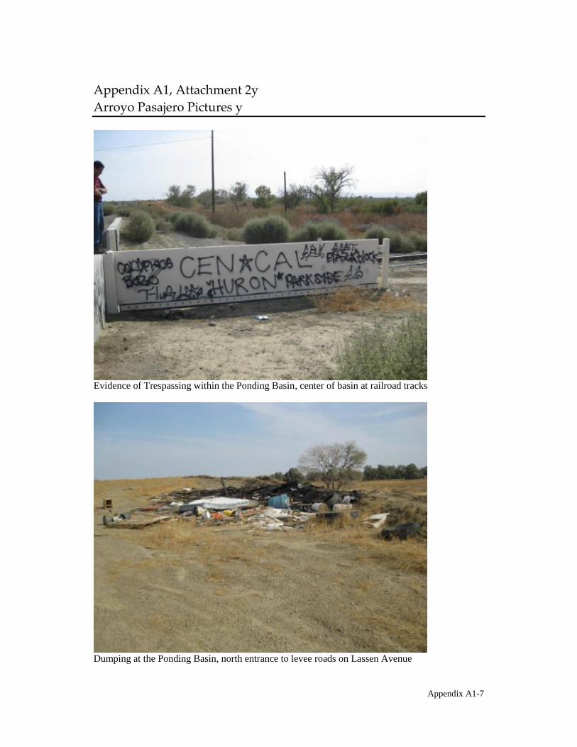
C&&1(2-! CGH C##53.)1(# F
C%%' ' :5$5,1%' :-3#"%1$
Evidence of Trespassing within the Ponding Basin, center of basin at railroad tracks
Dumping at the Ponding Basin, north entrance to levee roads on Lassen Avenue
Appendix A1-7

Evidence of driving within the Ponding Basin, north entrance to levee roads on Lassen Avenue
Standard DWR placed on all access gates throughout the perimeter of the Ponding Basin
Appendix A1-8

Standard DWR placed on all access gates throughout the perimeter of the Ponding Basin
West-facing view of the intersection of Lassen Road and Arroyo Pasajero Creek
Appendix A1-9
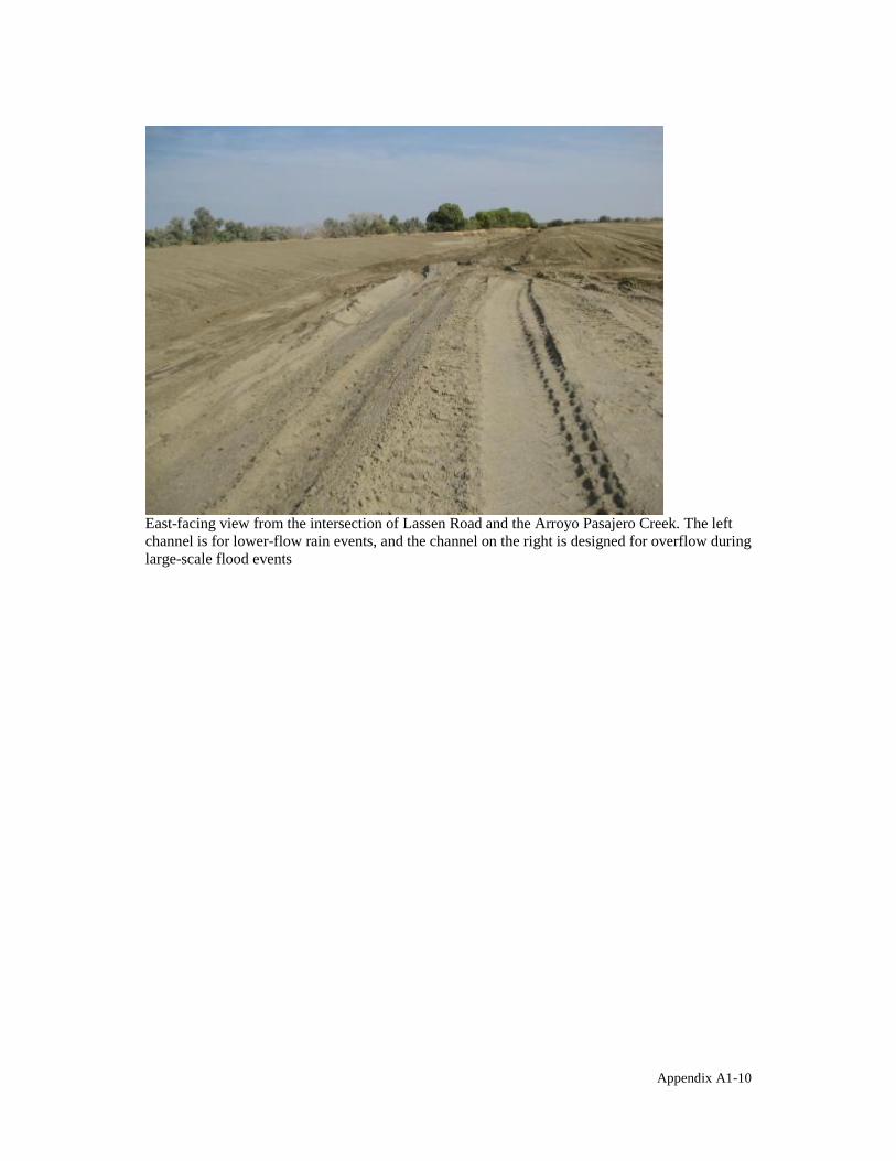
East-facing view from the intersection of Lassen Road and the Arroyo Pasajero Creek. The left channel is for lower-flow rain events, and the channel on the right is designed for overflow during large-scale flood events
Appendix A1-10
C&&1(2-! CF
A*15% A%11+ =5(5/1)1(# C%15
at the CCMA. T
This section provides an update on the status of the Clear Creek Management Area (CCMA). The CCMA was included as an area of interest of the Atlas Mine Area Operable Unit because of concerns that asbestos from the Mine Area could have potentially been transported to the CCMA via wind. In 1992, EPA published a fact sheet that verified that the United States Department of the Interior, Bureau of Land Management (BLM) had taken the lead on managing the risks associated with naturally-occurring asbestos and asbestos-laden sediments
planning and analysis process at the CCMA.
On May 1, 2008, US EPA Region 9 released the Clear Creek Management Area Asbestos Exposure and Human Health Risk Assessment. The Exposure and Risk Assessment reported the results of the activity-based sampling that EPA conducted in 2004 and 2005 to measure the breathing-zone exposures to asbestos of individuals participating in typical CCMA recreational activities. The risk assessment also estimated the lifetime excess cancer risks associated with the activities. EPA released a public notice to inform the public of the completion of the CCMA Asbestos Exposure and Human Health Risk Assessment, which is included as Attachment 1.
Exposure Assessment Activities included in the exposure assessment were off-highway motorcycle and ATV riding, SUV driving/riding, hiking, camping, vehicle washing and vacuuming, and fence building. The exposure assessment found that motorcycle riding, ATV riding, and on-road SUV driving/riding had the highest exposure concentrations, in some cases exceeding even the U.S. Occupational Safety and Health Administration (OSHA) 30-minute Excursion Limit for asbestos. Only hiking was near ambient asbestos concentrations. For overall off-highway vehicle riding, combining motorcycling, ATV driving/riding, and SUV driving/riding, trailing riders had significantly higher exposures than lead riders.
Risk Assessment Importing the exposure data into typical use scenarios, excess lifetime cancer risk was estimated using both the U.S. EPA Integrated Risk Information System (IRIS) and the California EPA Office of Environmental Health Hazard Assessment (OEHHA) cancer toxicity values for asbestos. Calculations were prepared for 30-year adult exposures, as recommended by the Superfund risk assessment guidance. In addition, 30-year combined child and adult exposures (12 years as a child and then 18 years as an adult) and 12-year child exposures (a population which recreates with families from ages 6 to 18) were also evaluated. Risks were calculated for 1 visit to CCMA per year, 5 visits per year (Reasonable Maximum Exposure), and 12 visits per year (High Estimate) for recreational scenarios, and 1 visit per year, 60 visits per year, and 120 visits per year for the worker scenarios for Bureau of Land Management employees. The risks were compared to the EPA Superfund program acceptable risk range for exposure to a carcinogen, of 10-4 (1 in 10,000) to 10-6 (1 in 1,000,000) excess lifetime cancer risk. Exposures which are estimated to cause more than 1 in 10,000 excess cancers are considered by EPA to be of concern and may require action to reduce the exposure and resulting risk.
Appendix A2-1

There was no combination of use scenario, toxicity value, or visits per year that was below
Day Use Hiking scenario had risk calculations within the acceptable range. Using the IRIS king five or more visits to CCMA per
year over a 30-year period to participate in Weekend Riding, Day Use Riding, Weekend Hunting, and Combined Riding and Fence Building could put recreational users at an excess
risk range of 1x10⁻⁴ (1 in 10,000) to 1 in 10-6 (1 in 1,000,000). The highest IRIS risk estimations, 2 in 1,000 (2 x10⁻³), were based on the 95% Upper Confidence Limit (UCL) exposure concentration for 12 visits per year for Weekend Riding and 120 visits per year for worker SUV Patrol.
Using the OEHHA toxicity value, even one visit per year for Weekend Riding, Day Use
acceptable risk range. The higher risks reflect the fact that the OEHHA asbestos toxicity value is 8 times larger than the value in IRIS. At the high end of the risk range, excess lifetime cancer risk estimations using the OEHHA toxicity value and the 95% UCL concentration indicate that recreational users riding motorcycles 12 weekends per year could have as much as a 1 in 100 (1 x 10⁻²) lifetime chance of developing asbestosrelated cancer. Worker populations performing SUV patrol duties at CCMA for 120 days per year are estimated to have the same risk. It should be noted that neither the IRIS nor OEHHA values are designed for very high exposure levels, so the number calculated for the high-end risk has a higher degree of uncertainty than the numbers calculated for the lower exposure scenarios. However, the risks are still extremely high.
Current Status As a result of the EPA Exposure and Risk Assessment, the Bureau of Land Management Hollister Field Office issued a Temporary Closure effective May 1, 2008, to all forms of entry and public use of public lands in the CCMA to protect public health and safety. BLM announced the closure of the CCMA in a public memorandum/fact sheet (Attachment 2). They also provided opportunity for public input by holding three public meetings after the announcement of the temporary closure of the CCMA.
findings and it is expected that the Proposed RMP and Final Environmental Impact Statement (FEIS) will be available for public comment in March/April 2011. BLM will announce release of the PRMP/FEIS once a Notice of Availability is published in the Federal Register. A 30-day public protest period begins upon release of the PRMP/FEIS. Following the 30day public protest period, BLM must resolve protests before approving any changes to the CCMA's land use decisions. This usually takes 3-6 months. The final Record of Decision (ROD) for the CCM PRMP/FEIS will replace the current Temporary Closure Order.
EPA Involvement Since the release of the Clear Creek Management Area Asbestos Exposure and Human Health Risk Assessment, US EPA has had limited involvement at the CCMA. EPA has participated, and will participate, in public meetings held by BLM. Additionally, EPA will continue to support BLM with technical issues, such as responding to technical comments received on the pending RMP or inquiries from interest groups.
Appendix A2-2

During the October 2010 Five-Year Review site inspections for the Atlas Mine Area OU, City of Coalinga OU, and Johns-Manville Mill Area OU, EPA did an informal visual inspection of the Clear Creek Management Area. This inspection verified that adequate signage was in place to warn the public of the closure of the CCMA. Pictures from this informal inspection are included as Attachment 3.
Appendix A2-3

C&&1(2-! CFH C##53.)1(# G
?:C :"4*-3 <'#-31D 91*15$1 '0 AA=C ?!&'$"%1 5(2 9-$+ C$$1$$)1(#
Appendix A2-4

t l' . L J" .
u.s. EPA Releases Exposure and Risk Assessment for Clear Creek Management Area
:1
ii 'II, I
Background In 1991, U.S. EPA signed the Record of Decision (ROD) selecting the cleanup remedy for the Atlas Asbestos Mine Superfund site in San Benito and Fresno counties, California. In the ROD, EPA noted that it was not proposing any action for the Clear Creek Management Area (CCMA), one of the Atlas site's four geographic areas. Instead, EPA stated that it would evaluate whether the United States Department of Interior Bureau of Land Management's (BLM) plans for management of CCMA were adequate to protect public health from exposure to asbestos found in the Area's soil and air. The BLM is the agency responsible for administering the public lands of CCMA.
Photo 1
The CCMA contains the largest natural deposit of asbestos in the United States. Commercial asbestos mines operated in the deposit, including the Atlas Mine and the Coalinga Mine, which were addressed by the federal Superfund program. Dust-generating activities, like riding motorcycles on the roads and trails of the CCMA, can release asbestos into the air where it can be breathed into the lungs. Asbestos is a known human carcinogen, causing lung cancer and mesotheliomtl', as well as chronic and debilitating non-cancer respiratory disease.
*Words in italic are defined in the Glossary on page 9.
In 2004, as part of the process of evaluating the completeness of the Atlas Mine cleanup for possible delisting from the federal Superfund list, EPA Region 9 initiated an asbestos exposure and human health risk assessment for the CCMA. The goal of the assessment was to use current asbestos sampling and analytical techniques to update a 1992 BLM Human Health Risk Assessment and provide more robust informa
. tion to BLM on the asbestos exposures 'from typical CCMA recreational activities and the excess lifetime cancer risks associated with those exposures. BLM will use the information to evaluate management and use alternatives in an upcoming environmental impact statement for managing the CCMA. The assessment was conductep consistent with U.S. EPA policy and guidance, including the Risk Assessment Guidance for Superfund (RAGS) (EPA/540/1-89/002), and with the encouragement of the California Air Resources Board (CARB) and the California Department ofToxic·Slibstances Control (DTSC).
Exposure Assessment Asbestos Air Sampling In 2004 and 2005, Region 9 collected air samples while EPA employees and contractors participated in typical recreational activities at the Clear Creek Management Area. The samples ~ere collected from the breathing zone of individuals riding motorcycles and all-terrain vehicles (ATV), driving and riding in sports utility vehicles (SUV), hiking, camping, sleeping in a tent, fence-building, and washing and vacuuming vehicles after use at CCMA. Sample cassettes were placed to collect air samples representing the breathing zone heights of both adults and children (Photo 1), and samples were collected for both lead riders and those trailing behind them (Photo 2). These activitybased air samples were then analyzed .for asbestos.
Photo 2

.,
Results It is important to note that the asbestos concentrations used by EPA in the exposure and risk assessment and discussed in this fact sheet are for longer fibers known as phase contrast microscopy equivalent, or PCME, fibers. PCME fibers are those fibers whose shape and size have been most closely linked to asbestos disease.
The Activity Drives the Exposure - Figure 1 shows the individual sample results for each activity and for measurements of CCMA ambient air. The data shows that the activities which typically create the most soil disturbance and dust, motorcycling, ATV drivinglriding, and SUV drivinglriding, also release the most asbestos into the breathing zone. In some instances, the con
Figure 1: Comparison of Ambient Concentration and Activities
2.5 o Ambient
l> Moto~cyclist
• ATV DriverlRider
~ E • SUV DriverlRider ~
CI> u 1.5 x Hiker .!:! J:l
U:J .. o Camper CI> Co
. ;. Powerspray Wash l!! 1
1: i ,'Hose'WaSh""
~ .(.)
.C' HEPAVacuum•II. 0.5
o Regulaivacuum- "
• Felice"Buill!e.r .
Activities
centration of asbestos measured in the EPA samples even exceeded what the U.S. Occupational Safety and Health Administration (OSHA) sets for workers as a 30minute limit for asbestos.
Position Is Important - Figure 2 shows the results for motorcycle riders in the lead and trailing behind and for ATV and SUV drivers/riders. First trailing drivers/ riders encountered higher asbestos air concentrations than lead drivers/riders and second trailing driverslriders typically encountered higher levels than first trailing. This means that the asbestos levels in the air incteased with the larger dust clouds encountered by those riders following one or more riders ahead of them.
Figure 2: Comparison of Different Riding Positions for Adults
2.5
.. 2 • ~ .5 1: [J Ambient GI u u :c
1.5 ~ Lead
::::I u • ~ c. l!! GI ;g GI :E
• •
x
x
• x
x First Trailing
• Second Trailing
U II. 0.5 x ~
x' : ~.
a ~
x·•:x· •
(.
"lI! 3~ ~x ~
. Ambient Motorcyclist ATV Driverl SUV Driverl Hiker Rider Rider
Page 2 Atlas Asbestos Mine Superfund Site
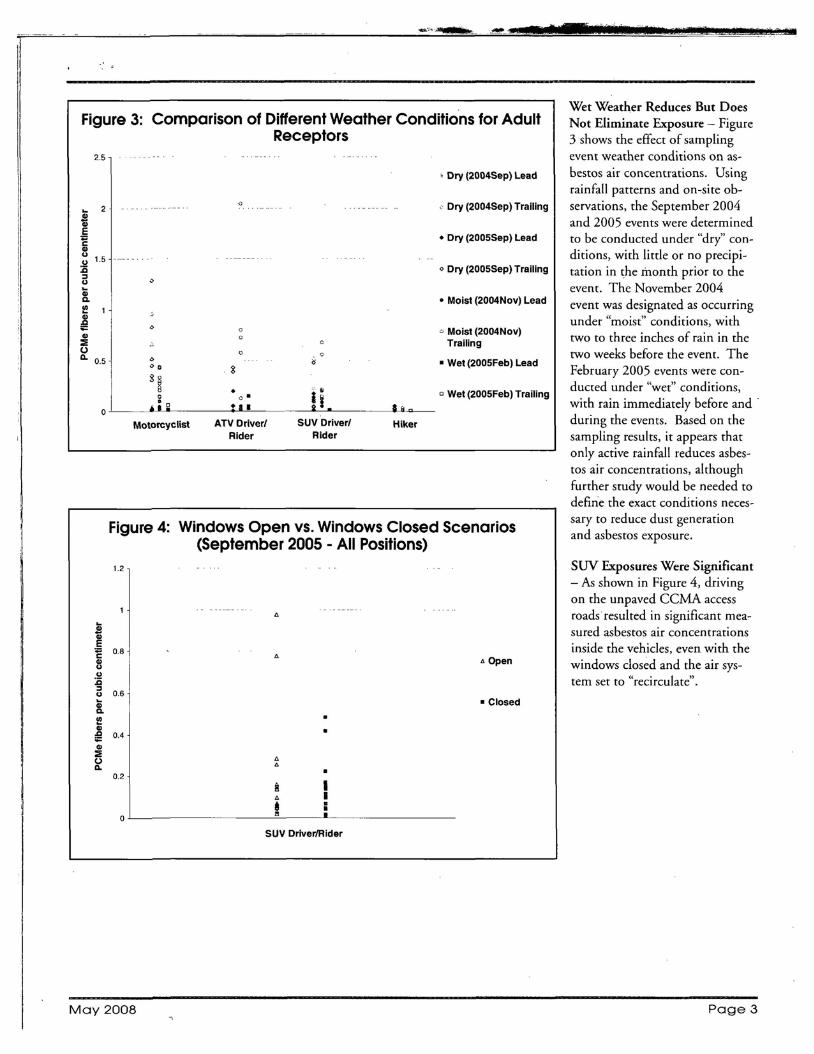
2.5
,
Figure 3: Comparison of Different Weather Conditions for Adult
... S Ql E ~ Ql U
1.5 :cu:::l u Gi Q.
l!! Ql
~ Ql :E (J Q. 0.5
0
Receptors
"
"
",,@ 8 6
S§ • Ii
o • .. : 0
0
••• a!.
, Dry (2004Sep) Lead
. Dry (2004Sep) Trailing
• Dry (2005Sep) Lead
<> Dry (2005Sep) Trailing
• Moist (2004Nov) Lead
o Moist (2004Nov) Trailing
• Wet (2005Feb) Lead
o Wet (2005Feb) Trailing
Motorcyclist ATV Driver' SUV Driver' Hiker Rider Rider
Figure 4: Windows Open vs. Windows Closed Scenarios
1.2
... S Ql
.5 0.8E
Ql u
:cu:::l u 0.6
Gi Q.
l!! Ql
0.4~ Ql :E (J Q.
0.2
(September 2005 - All Positions)
" Open
• Closed
•
" " ~ I
I" .t : SUV DriverfRider
Wet Weather Reduces But Does Not Eliminate Exposure - Figure 3 shows the effect of sampling event weather conditions on asbestos air concentrations. Using rainfall patterns and on-site observations, the September 2004 and 2005 events were determined to be conducted under "dry" conditions, with little or no precipitation in the month prior to the event. The November 2004 event was designated as occurring under "moist" conditions, with two to three inches of rain in the two weeks before the event. The February 2005 events were conducted under "wet" conditions, with rain immediately before and . during the events. Based on the sampling results, it appears that only active rainfall reduces asbestos air concentrations, although further study would be needed to define the exact conditions necessary to reduce dust generation and asbestos exposure.
SOY Exposures Were Significant - As shown in Figure 4, driving on the unpaved CCMA access roads resulted in significant measured asbestos air concentrations inside the vehicles, even with the windows closed and the air system set to "recirculate".
May 2008 Page 3
0

It §
Child Exposures Tend to Be Higher - Figure 5 shows the ratio between the child and adult samples collected at the same time on the same sampler i.e. the ratio between the child and adult sample cassettes shown in Photo 1. With the exception of the camping activity, the majority of child exposures exceeded the exposure recorded for the paited adult sample. In total, the asbestos concentration in the child sample exceeded the concentration in the adult sample 64% of the time.
Amphibole Asbestos was Detected in the Air Samples While chrysotile asbestos was the predominant asbestos mineral type found in the EPA air samples, almost 8% of the
Figure 5: Ratio of Child to Adult Exp'os~re ,t~y~lsfor Each
8
w ::iii
'U Q. 3
:2 :c g .2 'i II:
Activity for Each Sampling D.ate,"
i.
••••••••••• :·i;.
• c
Motorcyclist .. •
• ATV DriverJRider
• x o SUV DriverJRider
• Hiker •
" .g : • &~
x Camper
• • - • Ratio =1 .~.
• - • ,,"••x· ••••••••••• : •• - - . .0 • x
0-'-------------"---------------
Nov 2004 Feb 2005 Sep 2005
PCME fibers were identified as tremolite, actinolite, or an • Scenario 5 Combined Rider/Workday: Drive in, other amphibole asbestos mineral. There is an emerging con stage, ATV or motorcycle riding, fence building/resensus in the scientific community that amphibole asbestos pair, stage, drive out, vehicle wash, vehicle vacuum. may present an even greater health risk.
The typical worker scenarios are:
Risk Assessment • Scenario 6 Patrol: Stage at Section 8 outside of CCMA, drive in and stage at CCMA (lead driver/ Scenarios rider SUV; ATV or motorcycle patrolling), stage andSeven typical CCMA use scenarios were created from the indrive out, vehicle wash, vehicle vacuum, unpacking dividual activities for which EPA collected air samples. Risk at Section 8. estimate calculations were then conducted for the scenarios.
The scenarios were designed to make the risk estimations bet • Scenario 7 SUV/Truck Patrol: SUV/truck patrol (lead SUV only), vehicle wash, vehicle vacuum. ter reflect typical CCMA use patterns and provide more
useable information to BLM and the public. The scenarios Risk Assessment Methods - Excess Lifetime Cancer Risk eswere developed with input from BLM and DTSC. Five of timates were calculated for the scenarios using both the U.S. the seven scenarios represent recreational/volunteer use of EPA Integrated Risk Information System (IRIS) and theCCMA, and two represent typical worker use. The five recCalifornia EPA Office of Environmental Health Hazard Asreational scenarios are: sessment (OEHHA) toxicity values for asbestos. These are
• Scenario 1 Weekend Rider: Drive in, motorcycle on standard methods for estimating risk. Saturday, camp on Saturday, sleep in tent, camp on Sunday, motorcycle on Sunday, drive out, vehicle Adult, Child, and Child/Adult Risk Estimates - Consistent wash, vehicle vacuum. with the EPA Risk Assessment Guidance for Superfund
• Scenario 2 Day Use Rider: Drive in, stage (prepare (RAGS), a 30-year exposure duration was used for estimating for riding), ATV or motorcycle riding, stage, drive excess cancer risks from the CCMA adult recreational and out, vehicle wash, vehicle vacuum. worker exposures. The risk assessment estimates risks for an 'I
• Scenario 3 Day Use Hiker: Drive in, stage, hike, adult who visits CCMA for 30 years, a child who visits for stage, drive out. 12 years (ages 6 to 18) with his/her parents and then contin
• Scenario 4 Weekend Hunter: Drive in, hike/hunt ues to visit for an additional 18 years as an adult (30 years on Saturday, camp on Saturday, sleep in tent, camp total exposure), and a child who visits for 12 years from ages on Sunday, hike/hunt on Sunday, drive out, vehicle 6 to 18. wash, vehicle vacuum.
Page4 Atlas Asbestos Mine Superfund Site
I
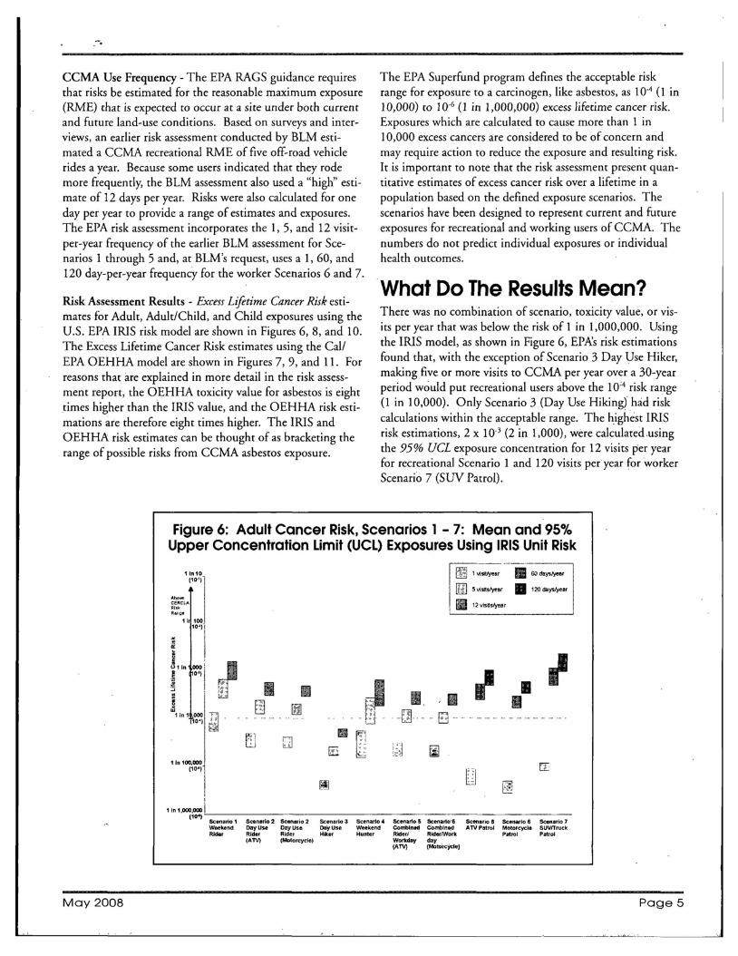
-.
CCMA Use Frequency - The EPA RAGS guidance requires The EPA Superfund program defines the acceptable risk that risks be estimated for the reasonable maximum exposure range for exposure to a carcinogen, like asbestos, as 10-4 (1 in (RME) that is expected to occur at a site under both current 10,000) to 10-6 (l in 1,000,000) excess lifetime cancer risk. and future land-use conditions. Based on surveys and inter Exposures which are calculated to cause more than 1 in views, an earlier risk assessment conducted by BLM esti 10,000 excess cancers are considered to be of concern and mated a CCMA recreational RME of five off-road vehicle may require action to reduce the exposure and resulting risk. rides a year. Because some users indicated that they rode It is important to note that the risk assessment present quanmore frequently, the BLM assessment also used a "high" esti titative estimates of excess cancer risk over a lifetime in a mate of 12 days per year. Risks were also calculated for one population based on the defined exposure scenarios. The day per year to provide a range of estimates and exposures. scenarios have been designed to represent current and future The EPA risk assessment incorporates the 1,5, and 12 visit exposures for recreational and working users of CCMA. The per-year frequency of the earlier BLM assessment for Sce numbers do not predict individual exposures or individual narios 1 through 5 and, at BLM's request, uses aI, 60, and health outcomes. 120 day-per-year frequency for the worker Scenarios 6 and 7.
What Do The Results Mean? Risk Assessment Results - Excess Lifetime Cancer Risk esti
There was no combination of scenario, toxicity value, or vismates for Adult, Adult/Child, and Child exposures using the its per year that was below the risk of 1 in 1,000,000. Using U.S. EPA IRIS risk model are shown in Figures 6, 8, and 10. the IRIS model, as shown in Figure 6, EPA's risk estimations The Excess Lifetime Cancer Risk estimates using the Call found that, with the exception of Scenario 3 Day Use Hiker, EPA OEHHA model are shown in Figures 7,9, and 11. For making five or more visits to CCMA per year over a 30-year reasons that are explained in more detail in the risk assessperiod would put recreational users above the 10'4 risk range ment report, the OEHHA toxicity value for asbestos is eight (l in 10,000). Only Scenario 3 (Day Use Hiking) had risk times higher than the IRIS value, and the OEHHA risk esticalculations within the acceptable range. The highest IRIS mations are therefore eight times higher. The IRIS and risk estimations, 2 x 10⁻³ (2 in 1,000), were calculated ,using OEHHA risk estimates can be thought of as bracketing the the 95% UCL exposure concentration for 12 visits per year range of possible risks from CCMA asbestos exposure. for recreational Scenario 1 and 120 visits peryear for worker Scenario 7 (SUV Patrol).
Figure 6: Adult Cancer Risk, Scenarios 1 - 7: Mean and 95% Upper Concentration Limit (UCL) Exposures Using IRIS Unit Risk
-_.. _------_._._-11n10 IlZi 1 Visitft.ar II 60 daystyear
(11)')
[tIl 5 vi.sff.slyear II 120 daysfyear
'M"CERe.LA Rl3k II 12 visits1)'ear R""11l8
1i 100
" ~ '~I B Ii 011n 000,
! 0') I l!.
!:::;
~ 1 in 1 000
10'1
I[, I
E?] •[B]
Q
JfilL:J
• [E : ;~ .z:,
I []]
II B
[iJ
I I• I
11n 100,000 (10')
I~I [I
~
EI
I
1 in 1,000,000 i "
(10') Scenario 1 W8@kend
Sc:en.rio2 CayUse
Scenario 2 OayUse
Scenario 3 QayUse
Scenario 4 Weekend
Scenarlo 5 Combined
Scenario'S Combined
Scenario lS ATV Patrol
Scenario 6 Motorcycle
Scenario 7 SUVtTruck
Rider Rider Rider Hiker Hunter Riderl RiderlWork Patrol Patrol (ATV) (Motorcycle) Workday day
(ATV) (Mol<ircYcIeJ
May 2008 Page 5

".-.,;,\...,.... -.,
Using the OEHHA model, even one visit per year for recreational Scenarios 1, 2, 4, and 5, creates a risk that exceeds EPA's acceptable range (Figure 7). The higher risks reflect the fact that the OEHHA asbestos toxicity value is eight tithes higher than the value in IRIS. At the high end of the risk range, excess lifetime cancer risk estimations using the OEHHA model and the 95% UCL concentration level indicate that recreational users riding motorcycles 12 weekends per year (Scenario 1), and workers performing SUV patrol duties at CCMA (Scenario 7) for 120 days per year during a 30-year career, could have as much as a 1 in 100 (1 x 10⁻²) chance of developing asbestos-related cancer. It should be noted that neither the IRIS nor OEHHA models are designed for very high exposure levels, so the absolute number calculated for the high-end risk has a
Figure 7: Adult Cancer Risk, Scenarios 1 - 7: Mean and 95% UCL Exposures Using OEHHA Unit Risk
[2] 1 visit!ycar 11II .50 daystyea,
[2] 5 v1sltslyea, • 120 daystye.,11n 10 (10'q II 12vrslslyear
I ~~~'ZLA I
=~"'11~j .. I I •• ~ rn I
\1 • I~11n ,0001 I ~ 10:') ~
~ IJ • B~ ;"~l "<: ,~
[·':.1~ ::j ~ [:d ~I,,", ':;1 . _.. - - - - - - -- - - - - - - - - - - - - - - F:':::l- -
'-"-'
I
""'~I 1 In 1,000,000,.1.1-:-~ _
(10") Scenario 1 Scenario 2 SCenario 2 SCenario 3 Scenario .c Seenalio 5 Scenario 5 scenario 8 Scenario 8 ,Scenario 7 Weekend Day Use CayUse Day Usa Weekend Conmlned Combined AN Patrol MotorcyCle SUVITruck RIder Rider Rkter Hiker Hunter Rlderl RI<JerlWork Patrol Patrol
(ATV) (Motorcycle) Workda~ day (ATV) (Moto'rcyde)
higher degree of uncertainty than the numbers calculated for the lower exposure scenarios. However, the risks are still extremely high.
The Child/Adult estimations using the IRIS model found that five or more visits per year for Scenarios 1 through 4 was above the 10-4 risk range (Figure 8) and all visits were above the acceptable range using the OEHHA model (Figure 9).
Figure 8: ChildlAdult Cancer Risk, Scenarios 1 - 4: Mean and 95% UCL Exposures Using IRIS Unit Risk
.
~ 1visittYear11n 10
(10') [f3SV;SI,*"
II 12 VlSltstyearAhQ"$ CERCLA ~ RI1''' .~ ...
I 11 100
10:1)
0:
; U ~ 11n ,0001l 10:') II:i
! ~
1 in 1 ,000 (10<r
I E r:B:l ~ ~:.'.:-....:.:)! ~ [llij
1In100,000•.1.I _ (10")
Scenario 1 Scenario 2 Scenario 2 Scenario 3 Scenario 4 Weekend Rider Day Use Rider Day Use Rider Day Use Hiker Weekend Hunter
(AlV) (Motorcycle)
Page 6 Atlas Asbestos Mine Superfund Site

t
Figure 9: ChildlAdult Cancer Risk, Scenarios 1 - 4: Mean and 95% UCL Exposures Using OEHHA Unit Risk
1 in 10 [J 1Vlsltlyear(1~'1'
[£j 5 visltstycar lob,.",'" CERClA II 12 Vlsll:sJyearR::'\~
A.ll'l'.;l.
1 i 100 ( 0')
ill
] (ill]• • • .1101000 .E 0")! ::l '-'J>..:..~...:! w
1 in 1 000 . ~ ~ _ 0'1
11n 1~;o;;:.L-sc-e-na-riO-1-----sc-en-.-riQ-2----s-ce-na-n-'0-2----SC-en-.r-;o-a----s-ce-n-.n-.o-4---Weekend Rider Day Use Rider Day Use Rider Day Use Hiker Weekend Hunter
(ATV) (Motorcycle)
Figure 10: Child Cancer Risk, Scenarios 1 - 4: Mean and 95% UCL Exposures Using IRIS Unit Risk
1 in 100 1 visitfyear(10')
rI:l 5 viSj~ear"bo",", CERCLA fll':Jc. II 12 visislyearR.m~
II 000c.. •
(10');
II 8."._L:..::.::..J
1 in 100,00(1110')
1 in 1,OO~;~:-'-----sc-en-.-riO-l----s-c-en-.-riO-2----s-c-ena-r-;0-2----SC-e-n.-'-'o-a ----5-ce-n-.r-;0-4---
Weekend Rider Day Use Rider Day Use Rider Day Use Hiker Weekend Hunter (ATV) (Motorcycle)
For the Child risks, which were calculated for a 12-year exposure from ages 6 to 18, less than five visits per year for Scenarios 1 and 2; one, five, and twelve visits for Scenario 3; and one and five visits per year for Scenario 4 were within the acceptable risk range using IRIS (Figure 10). Using the OEHHA model, only less than five visits per year for Scenario 3 Day Use Hiker was within the acceptable range (Figure 11).
May 2008 Page 7
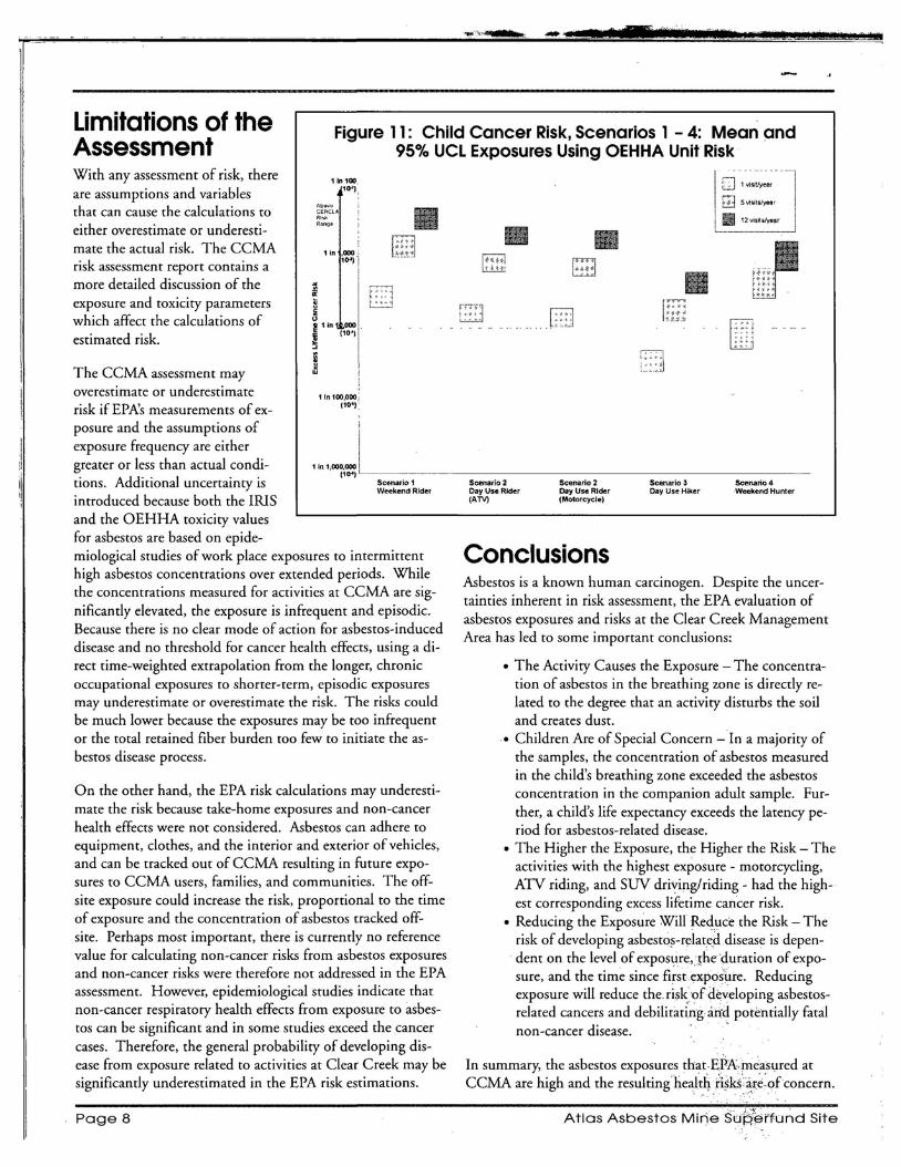
• •
!It
Limitations of the Figure 11: Child Cancer Risk, Scenarios 1 - 4: Mean andAssessment 95% UCL Exposures Using OEHHA Unit Risk
With any assessment of risk, there lin '00 111'1,are assumptions and variables
Au'!).... '.> CE::RCLAthat can cause the calculations to .,""Range
either overestimate or underestimate the acrual risk. The CCMA 1 in ,000-2
10·) Irisk assessment report contains a I
more detailed discussion of the i I
exposure and toxicity parameters ~ I'which affect the calculations of ~'in 000
(10')1estimated risk. ~ I ,The CCMA assessment may
overestimate or underestimate lin 100,000, (10")risk if EPA's measurements of ex
posure and the assumptions of iexposure frequency are either i Igreater or less than actual condi lIn"oo~;~LI
Scenario 1 Weekend Rider
tions. Additional uncertainty is introduced because both the IRIS and the OEHHA toxicity values for asbestos are based on epidemiological studies of work place exposures to intermittent high asbestos concentrations over extended periods. While the concentrations measured for activities at CCMA are significantlyelevated, the exposure is infrequent and episodic. Because there is no clear mode of action for asbestos-induced disease and no threshold for cancer health effects, using a direct time-weighted extrapolation from the longer, chronic occupational exposures to shorter-term, episodic exposures may underestimate or overestimate the risk. The risks could be much lower because the exposures may be too infrequent or the total retained fiber burden too few to initiate the asbestos disease process.
On the other hand, the EPA risk calculations may underestimate the risk because take-home exposures and non-cancer health effects were not considered. Asbestos can adhere to equipment, clothes, and the interior and exterior of vehicles, and can be tracked out of CCMA resulting in future exposures to CCMA users, families, and communities. The offsite exposure could increase the risk, proportional to the time of exposure and the concentration of asbestos tracked offsite. Perhaps most important, there is currently no reference value for calculating non-cancer risks from asbestos exposures and non-cancer risks were therefore not addressed in the EPA assessment. However, epidemiological studies indicate that non-cancer respiratory health effects from exposure to asbestos can be significant and in some studies exceed the cancer cases. Therefore, the general probability of developing disease from exposure related to activities at Clear Creek may be significantly underestimated in the EPA risk estimations.
~~] 1 "';sitfjear
m5V1sitslyesr
II 12 vis~s/ye8r
_ Scenario 2 Scenario 2 Scenario 3 Scenario 4 Day Use Rider Day Use Rider Cay Use Hiker Weekend Hunter (ATV) (Motorcycle)
Conclusions Asbestos is a known human carcinogen. Despite the uncertainties inherent in risk assessment, the EPA evaluation of asbestos exposures and risks at the Clear Creek Management Area has led to some important conclusions:
• The Activity Causes the Exposure - The concentration of asbestos in the breathing zone is directly related to the degree that an activity disturbs the soil and creates dust.
• Children Are of Special Concern - In a majority of the samples, the concentration of asbestos measured in the child's breathing zone exceeded the asbestos concentration in the companion adult sample. Further, a child's life expectancy exceeds the latency period for asbestos-related disease.
• The Higher the Exposure, the Higher the Risk - The activities with the highest exposure - motorcycling, ATV riding, and SUV driving/riding - had the highest corresponding excess lifetime cancer risk.
• Reducing the Exposure Will Reduce the Risk - The risk of developing asbestos-relate,ddisease is dependent on the level of exposure,Sheduration of exposure, and the time since firsrexposure. Reducing exposure will reduce the risk,ofdeveloping asbestosrelated cancers and debilitaxingarfd potentially fatal non-cancer disease. -
In summary, the asbestos exposures that,EPA,measl,lred at CCMA are high and the resultinghe~lt4/isks'a.t.:~:ofconcern.
Page 8 Atlas Asbestos MineStJ~~rfundSite

_It
Activity~bmetlstlmplin£;~<:ti~ity-:base~,'siJ11pHng,ofthe 'PCME or; Phase:c:01Ztf'fSf Mii:roscofJYEgyivlltent :-, Phase
': ',::~i.r:~~: !h~ );r~~,\~}!1%,'~'#€S9{:~~:i,~~i~i~~~~~:~,~9'~'Jhat; in'- ; :' ' ': Com~,asrMisrpscqpy,JfJ~MU~,thf:' ;tna.!yriCai :nietho4':: .,dlvlduaI·par.t19lJatesln:typ1~al",ork:or recrc:atmnalac-:' '"tor'asbestos used.in :oc<:llpati91aLe~Yironmeilts:' :C;:llr~
, ': :tivities'.;It has,?eeh:us~d;£9J;',·'d¢<;~d.es.bYAnpti~ti-i~1~y-:; ren:t:healths't~dards forasbestos~are'based' on studies " .j; ':gienists: to:rhea~~ie·pers'0n.·al·~~p6s~h:s 'in:w.9,rIipfa,c;~: : : ."~~hic;h.dOPf~~.~!·:~lJ~ .~av~~~~:he~.~~~·i~~t~jio.m.~S?~s,tos .' : .. ~eI{vi·r9~rh'e~ts/?t:is,mori>iipres'entative';(l'astualindH: ,. exposure· in worker,s. ,Since th:e worker exposures used' ,
·'~idll<I)·expos.llre~, than: f\~~~l,' stationar}"m~nitors :and soil.'. :;..:.PCMi ,the:he~thst~ni:iati:is a.iej;as.~d~i~;l}:the·hb.ers :w.hich: :sa:mpling,: alid is· beirigus~d by: EPA :to's,~n;,pleexp~sures:' ::'ar.e,<:oluite'd: inJ;)C::M:;<1,'oday,'i:11~:r:P;Vuses)n :analytical.. , ,at asbestos' sit~s across :the colintry. ."...' ::techniqu~; >1hqsll1issioiI'E.I~~d~Qn'Mi.er6~'t()py, ~r' TEM" •, ' ,
, "" ", .' . ~hich can see: muchs~all~rand;tli1n·~~r;Jibers. <in ,order; , :;A~.~ien! 'flr -:-: ~~ien~ ~i~ is:s~rro~~~ing;aii ~that. ~s ,~ot , ' :~o,.~~kly:th~,·ctiHerft.:heal;h':;~~~4~_kd~?i?fibe;s.~~hich': . ,' :. : ,imine,diately affected by a disturbance or ~ctivitf ' werec9unted'usihg'~:'FEM:arfiJysi~~',:th~:BPA~~ed!o~Iy' ' ,! j
..···c ,:-:,thos'e fibers,whi~h;wbuld~ha~~been:s~ii1inthe'PCM: . " ;: :A~phiboie~,:':-: OJle:6t::rWb-:mih~ral:fan1illes::which':cbntain,:; '''me~i-i~a, '~hJ t}{is:~qui~ale~t' c6~n(0£fiber~ 'is' called the: ~:, ',' as;bestos.~IleraIs::. A?i:~h!~~ie.~s~~~t~~~~~d·~}~d~r~: l~'::' ,'Phase·¢,6~iris.t·~i,=fO.~(;opyE,qtiiv,a}eri~·or PCME.: :por:: . , : ,n~edle."~lke ..shap~s, and, 1~c1u~es .. tremoll~e; :a~t~n~lIt~, ~, : .. ,:. :;':th,is:ris~.~ss~§stllerit·;:Oqly,i:~osefib~rs'~h1diare· consid~ : " . ~1~~,~lte, nc~tent,e, ant~ophylllte, croCl~~Jlte,.. an~ •'-t.i t:·,~'f:,. ::ere~~q:)be o:f P.CM~~~i.riferisiC!ri"s; great~~ than 5 microns'
'~oS1te as~estos. , : , . , . , > ,.;':;",:; ·!,::,:,,··~~~!:;;:·.i'ii·IebgtH,;with"atteast.a:3:1Ieri.gth to,wioth ratio, a~d a , y ~ / < y / ~ y Y h .. Y < v",~ •• ~ r ~ \ ... ~ ) ".' . .,"\ ,h ~ ~.1':"..•• : ~ y.... .. ... _"h.. :, ~ #" ~ ~ ~ , < 'Y
,,.' :';' : ", . '., . ' :.~' . "'... . '. ' \. :': ;:; ,: diamdei'hefureenl O.25'microns and 3 microns inclusive, . . ,C.hrysfJttle ~ AsbestosJrom t4~ serpentme .f~n)Jly of nllneE;-.i; :.; -:: ..<7:'~," 'd':~;r ':' ,,;~ ;', ''':d ' :, f' ,h' .' f PCME' fi .
:1 Cli '1 b"" fl 'bI 'd'L";'" 011 '. ",," •. k • •w.ere use. '10 gIVe some I ea·o t: e sIze 0 a 1, . a.lS; rysotl e as es~os l~..eXI. e an 'Il1S,tP!lCil,l.Y, ~~7't;~':': :: ' .•'.- -.: . " '. I"" " ;;"', :. ' :. :...'.. ••
" ... 9?~t1t~ f9.r apo~t: ??% :6ft~~ '~sbestos' u~~,~\q<?~·~er~~iaI_IY:t·:.,~~~;,:t?:e~.~~.~~~e w~1t~ ..~f a h~r,~~ h~~r /s 80.m.l~rons... : . ' ,.,
, ' ,in:!he·y~~te4:?,t,~(~s:., .. : ''''. , L;i{~ !;:';'.;.\ ~,:~:<:},~{:::;:·:.~';?J,f/g:~Vc.L:·o'r:9t/Y/:;,lfPP~~'(;Jrl}j~nC~'Lj",i~:6ithe' Me;'~ ,~ · . , Lift' ,,: . C' ' ,; Ris'k A··'· :~ :£' '(h : b" b:I' , ... ; 'K statisti.~al calculation 'of t.q:e mean 'concentration so' .
" Excess tettme ancer •
.. ~ n estlmat~ ~ ,t e pro a 1 - ~ " 'h . 11 ' '1" '11 b 1 .. h 'h' al 95 0L : :f' , .......... ·h:' 'd "'1 '. :.' . ·'c.· •. ··" f' b"'k '-, .. ,", t attt::actua meanWI .. e'esstant ISV ue ,10.0
:- Jere Joltnson, SFD-Z':2' ,. ~erhedial' project Manag~~: : :cr.,s,EPi\ :~egibri·.9:,'
" :75 HaWthorneStreer' .. Sar(Francist6;Ca:~i4i'of" ';. ". ,',
! :, ; : (4:r5)' 972j0946r; (800)23i~30i~:::~::;:~ :::>:_ " .. h.;:'>":~~ "'";V "-;-".< ~'<"<,>'.'~ ".; :<~<!..><
,>!;
;j~tki~ -Lane) SFD~3 . .;Cbmni~rii,ty Inv6lvem¢iW ·C().o'f~iI1a.t~; .: :-U:S.:EPARegiori:9;::::?,~ . ,,'
," ,,: :75:Hawtho~ne:Streh'" .-. :San FranciscQ; C~'94105:;":' : '(41:5 ):972~.32:36 'or (8:()0):23'1-307'S'
~ :':::, : <: .... h.;, ~h' ,.': ..". ;~;" :',>:,\":"h"'-' h"h", ".: ,',
~',' Ity:t at;!, pers0f'l·ll1ay. eve 0pcancer l~.e~c~ss:o :,ac-,."':: '.h""" . . . ,: ,:: grpurl(;lj~t~~'SPll1~'tiine;in:his' or ;herlifetim~'following' '" t e ~~~t;." ; :, ; ::eJClJosure to a:p~rticular:~o,ntaminarit:';'< .'
: :':~ei~~h~l~o~~~' A: rdre ;~~b~~~:Whi~h' ~'~y' ~#~~~t·th~·Ii~iJg·.:· ., .;;; ::ofthe'lungs' (pleura)' qc :~he: ap~oinilla,l;~,of1t~'nts: (pet~t6~: :.:
. :n,euritX. Mos,t'rit'eso~eIiorhas are caused :by exposure ,to•. ; , . ' :;asbestos:; :Most 'cases of mesothelioma.arej:liagrlOsed: 3.0 :,:: y~ts'9r:n1()r~.aft~nh~:first,eiposu're to asbestos; .. ' " , i ~ , :., ." '.' h;'" h' • , y : y " ". , ; ,.,' ' .;: ", ;:~ ~
May 2008 Page 9

,: ......
" ~ , ~ , .... .,>
... '~ ;y: 4",~",,'lj , .. ~~.~<~
. .:'
; '; : :,'1~~t.,,6tiOn~~~bsit~rj~s> h • ~<
"'.;' .: .':~ :';: ~ ~;:~·;"',{:~!~:~~'t'~;:;~;:~'rn:(~::}~\::':~:;:~',:i>:. F~~i:~;:";;: :':;":<':;;:;"}" i ~::'?:::5:~!"'~?,'.:~m1>,
::,:U>S::E:PA:/ReleaseS~iExpcisu'[e·:'Qrn:dJtAiSJ· ,~
:~.);); ;ii "il .~":,)~!J;~~fi(~~~~t'~~~~~lf{~~~~i~ll~l~~
_printed on 30% Postconsumer R~CYClecJ/ReCYClable Paper """
United States Environmental Protection Agency Region 9 75 Hawthorne Street (SFD-3) San Francisco, CA 94105 Attn: Jackie Lane (Atlas 5/08)
FIRST-CLASS MAIL POSTAGE &'FEES
PAID U.S. EPA
Permit No. G-35
Official Business Penalty for Private Use, $300
Address Service Requested

C&&1(2-! CFH C##53.)1(# F
AA=C 81)&'%5% A*'$"%1 =1)'%5(2")
Appendix A2-15

BUREAU OF LAND MANAGEMENT Hollister Field Office 20 Hamilton Court
SFUND RECORDS CTR
2175394 , _ .._. . ''\;,J'" - . .. -
Hollister, CA 95023 Atkt) IWLw, Phone (831) 630-5000 Fax (831) 630-5055 www.ca.blm.govlhollister
\ ~eLt f!J'uLIn Reply Refer to: May 1, 2008 8364(P) CA-190.00 n~rd NUl-Dear Interested Parties:
The Bureau of Land Management (BLM) is issuing an immediate temporary closure of 31 ,000 i acres in the Clear Creek Management Area (CCMA), known as the Serpentine Area of Critical
Environmental Concern (ACEC.) This closure toprotect public health and safety from exposure to asbestos is effective May 1,2008. The closure isin response to the release of the U. S. Environmental Protection Agency's (EPA) Human Health Risk Assessment Final Report that concludes that exposures to asbestos measured by EPA for many p}lblic use activities at CCMA are above the EPA acceptable risk range -for excess lifetime cancer.
Public health and safety is always the top priority for BLM. The primary goal of these temporary public use restrictions is to reduce public exposure to airborne asbestos while BLM develops an Environmental Impact Statement (ElS) and Resource Management Plan (RMP) that considers these risks to detennine long-tenn management objectives for the CCMA. BLM will continue public scoping started last year for the RMP for 30 days beginning in mid-May. BLM has also scheduled two public workshops (May 19 in Hollister and May 21 in San Jose) to discuss the planning process and take public:coJ!lIl1ents,,: BLM: is-also hosting an infonnational meeting May 8 at the Convention Center in S.anta Clara for EPA representatives to present health risk assessment findings to the public. Dates and times for these meetings are identified in the enclosed News Releases.
This temporary closure restricts all public use and access within the 31,000 acre area identified on the enclosed map. The closure will remain in effect until BLM signs a Record ofDecision for the CCMA RMP and is pursuant to 43 Code of Federal Regulations 43 CFR 8364.1, which specifies penalties for violation of the order. BLM's Closure Order is attached and the EPA assessment is available online at www.epa.gov/region09/toxic/noaiclearcreek.
Please contact the Hollister Field Office at (831) 630-5000 for additional infonnation.
s~~ .. , Rick C<?oper -: .. '., .
:..:: ""'; ,,:~(,; ,.'';: ,:<.,:Field ,Office .Man~ger~::;,'.., .' ;,. : ~ " :.. , l:f ".' " ;':(00"<:'; , . .
- . ~.
j •. .', '" ~; ,J •. ,/,;

u.s. Depart~ent of Interior Bureau orLand Management
CLOSURE ORDER
Notice is hereby given that effective on this date and pursuant to 43 CFR 8364.1 the public lands as described
below are closed to all forms of entry and public use. This closure affects approximately 31,000 acres of . .
public lands in the Clear Creek Management Area (CCMA) referred to as the Serpentine Area of Environmental
Concern (ACEC) and portions. of adjacent BLM-administered lands located in southern San Benito County and
western Fresno County, California. The lands· include portions of Mount Diablo'Principal Meridian: Township 17
South, Ranges 11 and i2 East; Township 18 South, Ranges 11, 12 and.13 East, and Township 19 South, Range 13
East.
This closure is necessary to protect public land users from human hea~th risks associated with exposure to airborne
asbestos in the CCMA based upon a fmal report issued by the Environmental "Protection Agency that concludes that
public use activities could expose an individual to excess lifetime cancer risks. The order will remain in effect
while the BLM completes a Resource Management Plan for the CCMA to detennine if and how visitor use QIl
occur without associated excess health risks.
The following persons are exempt from the identified restrictions:
I) Federal; State, or local law enforcement officers, while engaged in' the execution of their official duties.
_. 2) BLM personnel or their representatives while engaged in the execution of their offiCial duties. 3) Any member of an orgariized rescue, fife-fighting force, or emergency medical services organization
while in the performance of their official duties. 4) Any member of federal, state, or local government agencies while in the performance of an official
dUty. " 1... S) Any pefSon in receipt of a written authorization ofexemption obtained from the authorized officer.
Private landowners within the restricted area and persons With valid existing rights-of-way, mining claims,
or leases must request in writing access pennission from Hollister Field Manager at the address listed below.
During the closure period the area will be clearly posted. Informational signs will be posted at main entry . - .
points to locations affected by this Order. Maps of the closed area will be posted with the Order at key locations
that provide access to the closed area, and may also be obtained at the Hollister Field Off~e, 20 Hamilto~ Court,
Hollister, California 95023.
Failure to comply with.!ris order is puni~hable by 'a fme not to exceed $1,000 and/or imprisonment not to
exceed 12 months Pursuant to 43 CFR, subpart 8360;0-7.
BLM
HO~?m... 20 HamUton Conrt, Hollister CA. 95023. 831 638'5000
Approved By: --=-:f~~~-:----:~....;;;...,;~=-==~~-: Date: ~~, ~~tt3 BLM Authorized Officer, Rick Cooper, ---vr Field Manager, Hollister Field Office

United States Department of the Interior BUREAU OF LAND MANAGEMENT
Hollister Field Office 20 Hamilton Court
Hollister, CA 95023 Phone (831) 630-5000 Fax (831) 630-5055
www.blm.gov/calhollister
EMERGENCY CLOSURE EFFECTIVE MAY 1,2008 OF 31,000 ACRES WITHIN THE CLEAR CREEK MANAGEMENT AREA
INFORMATION FACT SHEET
The U.S. Environmental Protection Agency (EPA) began conducting a study in 2004 on asbestos exposures experienced by CCMA users during typical r~creational activities. The study was conducted to provide BLM with informatIon to manage and min-imize human health risks at the CCMA and to update a similar study conducted by the BLM in 1992.
On May 1, 2008 the EPA released the report, "CCMA Asbestos Exposure and Human Health Risk Assessment." The report stated the exposures measured by EPA for many recreational activities at CCMA are "above the EPA acceptable risk range of lifetime cancers." It also notes that children "have greater risk than adults due to higher exposure measurements [and] are of special concern because their exposures occur earlier in their lives.
Based on the findings in the report, BLM simultaneously enacted an immediate temporary closure on May 1, 2008 of 31,000 acres of the area to all public access/entry upon release of the EPA report while a Resource Management Plan (RMP) to determine the long-telm management of the area is underway. The BLM's number one priority is to protect the public's health and safety.
Oyer the next two years, BLM will be preparing a Resource Management Plan and Environmental_ Impact Statement to guide the long-term management of public lands within the CCMA. EPA and BLM will host a public meeting to discuss the results of the EPA Human Health Risk Assessment and BLM will discuss the need for the temporary emergency closure on May 8, 2008. -
The Fee Program has been suspended and partial refunds will be issued to all persons who purchased a Season Pass.
Public Meetings
May 8, Santa Clara Convention Center, 5001 Great America Parkway, Santa Clara, EPA and BLM, open house from 3:00 - 5:00 pm, meeting from 6:00 - 9:00 pm
May 19, Veteran's Memorial Hall, 649 San Benito St., Hollister, 6:00 - 8:00 pm
May 21, Martin Luther King Jr. Library Room 225, 150 E. San Fernando St., San Jose, 6:00 c.... 8:00 pm
For More Information
Contact the Hollister Field Office at (831) 630·5000 or visit our website at http://www.blm.gov/calsUen/fo/hollister/clear_creek_managemenCarea.html

C&&1(2-! CFH C##53.)1(# E
AA=C :-3#"%1$
Picture confirming temporary closure of the CCMA
Naturally-occurring asbestos warning sign in both English and Spanish
Appendix A2-19
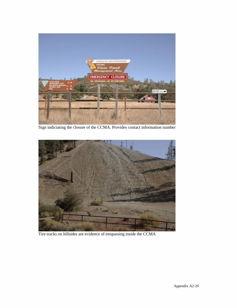
Sign indiciating the closure of the CCMA. Provides contact information number
Tire tracks on hillsides are evidence of trespassing inside the CCMA
Appendix A2-20

Picture of area along road inside the CCMA
Appendix A2-21

§
A''0)1,! @
<)%$,$#$,()3+ ?()$&(+% 502-),23+ 90*(&3)1#*
Appendix B

A''0)1,! @D
A$+3% 9,)0 A&03 84 <)%$,$#$,()3+ ?()$&(+% 90*(&3)1#*
This memorandum summarizes the results of an assessment of the status of institutional controls at the Atlas Mine Area Operable Unit 1 (Atlas Mine Area) of the Atlas Asbestos Mine Superfund Site. Institutional controls are non-engineered instruments, such as administrative and legal controls, that help to minimize the potential for human exposure to contamination and/or protect the integrity of a response action.
A Record of Decision (ROD) was issued for the Atlas Mine Area on September 21, 1990. A component of the remedy selected in the ROD included filing deed restrictions on privately held lands to limit future land use and prevent disturbance of the contaminated material at the site. For the reasons below, the deed restrictions called for in the ROD could not be filed as originally intended. In Section VI1(A)(6) of the 1992 Consent Decree for the Atlas Mine Area OU, the United States specifically provided that "the Defendants (Atlas Corp. and Vinnell) are not required to implement the deed restriction requirement of the Consent Decree other than as provided in Section VI (Notice of Obligations to Successors-in-Title)." Section VI only required the Defendants to file a copy of the Consent Decree with the Fresno County Recorder's Office, which the Defendants have done. Since Northrop Grumman Space & Mission System Corporation (Northrop) is the successor to Vinnell, it is also bound by the terms of the 1992 Consent Decree and is not required to file deed restrictions.
Accordingly, if Northrop sells its Atlas Mine Area OU property (San Benito and Fresno Counties Parcel No. 030-250-004-0) to another entity, US EPA should ensure that such future owner file a deed restriction that runs with the land for this privately-owned portion of the site to prevent future disturbance of the contaminated material left onsite.
Two additional privately-owned parcels (Fresno County Parcel Nos. 45-240-09 and 45-24012) that are part of the Atlas Mine Area OU list Wheeler Properties, Inc. (Wheeler), as the title owner. However, since Wheeler filed for bankruptcy in 1980, and was administratively dissolved in 1991, there is no discernible property owner for these parcels who could record a deed restriction. The State has not recorded any tax liens or initiated a tax sale to recover any, presumably, delinquent property taxes.
In place of the deed restrictions originally called for in the ROD, US EPA issued an Explanation of Significant Differences (ESD) on September 15, 2010, in order to clarify the measures in place that ensure the Atlas Mine Area OU remains protective of human health and the environment. The ESD explained measures being implemented to ensure protectiveness while remaining consistent with the Consent Decree language. A copy of this ESD is included as Attachment 1 of this sub-appendix.
Another component of the examination of institutional controls in this memorandum is a limited title search. The purpose of the title search is to verify that there have been no changes in ownership of the Atlas Mine Area, and that there are no other documents recorded in association with these privately owned parcels that would impact the effectiveness of institutional controls at the Atlas Mine Area. A limited title search was run on the Atlas Mine Area for Fresno County parcel Nos. 45-240-09 and 45-240-12.). The title search corresponds
Appendix B1-1

to the review period for this Five-Year Review (2006- February 2011). The results of the limited title search are included as Attachment 2 of this sub-appendix.
Institutional controls have been implemented at the Atlas Mine Area to the fullest extent practicable. There are no deficiencies or recommendations to be made with respect to institutional controls at the Atlas Mine Area OU.
Appendix B1-2

A''0)1,! @DG A$$32-*0)$ D
CEDE =!'+3)3$,() (/ 6,.),/,23)$ >,//0&0)20%
Appendix B1-3
Explanation of Significant Differences
To the 1991 Record of Decision for the
Atlas Asbestos Mine Superfund Site Atlas Mine Area Operable Unit EPA ID No. CAD980496863
August 2010
I. Introduction
The United States Environmental Protection Agency (U.S. EPA or EPA) is completing this
Explanation of Significant Differences (ESD) in order to document a significant post-Record
of Decision (ROD) change to the selected remedy for the Atlas Mine Operable Unit (OU) of
the Atlas Asbestos Mine Superfund Site. This change is being made in accordance with
Chapter 7 of the guidance "A Guide to Preparing Superfun~ Proposed Plans, Records of
Decision, and Other Remedy Selection Decision Documents" (OSWER Directive 9200.1
23P, July 1999).
The purpose of the 2010 ESD is to clarify the measures in pl&ce that ensure the Atlas Mine
Area OU remains protective of human health and the environment, and that institutional
controls have been implemented to the fullest extent possible while still remaining consistent
with the ROD and Consent Decree language.
EPA is the lead agency for oversight of the Atlas Asbestos Mine Superfund Site. The
California Department of Toxic Substances Control (OTSC) is the supporting oversight
agency. EPA is issuing this 2010 ESD to satisfy its responsibilities under the Comprehensive
Environmental Response, Compensation and Liability Act ("CERCLA") Section 117(c) and
the National Contingency Plan ("NCP") Section 300.435(c)(2)(i)~ This 2010 ESD and any
comments regarding this 2010 ESD will become part of the Administrative Record for this
- 1
site pursuant to NCP Section 300.825(a)(2). Copies of the Administrative Record are
available for review at the following locations:
EPA Region 9 Superfund Records Center Coalinga District Library 95 Hawthorne Street - Suite 403S 305 N. 4th Street San Francisco, CA 94105 Coalinga, CA 93210 (415) 536-2000 (209) 935-1676
Contact Information for any questions related to the Atlas Asbestos Mine Superfund Site:
Lily Tavassoli Jackie Lane Superfund Project Manager Community Involvement Coordinator 75 Hawthorne Street (SFD-7-2) 75 Hawthorne Street (SFD-6-3) San Francisco, CA 94105 San Francisco, CA 94105 Telephone: (415) 972-3146 Telephone: (415) 972-3236 or (800) 231-3075 Fax: (415) 947-3526 Fax: (415) 947-3526 E-mail: [email protected] E-mail: [email protected]
ll. Site Background
The Atlas Mine Area au is an abandoned asbestos mine within the New Idria Formation
located in Central California. It is approximately 20 miles northwest of the City of Coalinga
in Fresno County, California. The mine area is approximately 140 acres and is located within
the Bureau of Land Management's (BLM's) Clear Creek Management Area (CCMA), which
includes approximately 75,000 acres of public land. See the figure below for location
information of CCMA, Atlas Mine Area au, and other areas associated with the Atlas
Asbestos Mine Superfund Site.
.Asbestos mining and milling at the Atlas Mine Area occurred from 1967 to 1979. The
Vinnell Mining and Minerais Corporation (Vinnell), in a joint venture with California
Minerals Corporation, owned and operated the mining and milling operation from 1967 until
1974, when they sold it to Wheeler Properties. Wheeler Properties operated the facility until
1979 and filed for bankruptcy shortly thereafter. The mining activity included digging the
asbestos ore out of surface pits and then milling the ore. The byproducts of the milling
process (mill tailings) were bulldozed into piles near the mill building. Approximately 3
million cubic yards of asbestos ore and asbestos tailings remain at the Atlas Mine Area au.
- 2

Legend
! j
: "" '* .. flo 'N, UNITS Damn FROM ~ ••••~ llUPEllFUllliH.lllT
ITI. Enforcement History and Selected Remedy
In 1976 and 1980, Atlas Asbestos Company and Wheeler Properties were cited for violating
the National Emissions Standards for Hazardous Air Pollutants regulation regarding control
of asbestos emissions. In 1980, the Metropolitan Water District of Southern California
(MWD) determined that the Atlas Mine was one probable, source of asbestos found in the
California Aqueduct.
In October 1980, the Central Valley Regional Water Quality Control Board (Water Board)
and the California Department ofHealth Services inspected the Atlas Mine Area to determine
if waste discharges from these facilities were in compliahce with state regulations. The Water
Board concluded that additional corrective measures should be taken to prevent mine- and
mill-generated asbestos from entering the drainage basins. The site was listed on the National
Priorities List (NPL) in September 1984. Remedial Investigation / Feasibility Study (RIfFS)
activities were initiated by the U.S. EPA in 1985.
- 3

The Record of Decision was signed on February 14, 1991. The ROD outlined the selected
remedy, which aimed to control the release of asbestos into the air and local streams from the
Atlas Mine Area and restrict access to the Atlas Mine Area using a combination of
engineering and institutional controls. Specifically, the following measures were discussed in
the ROD:
• Fencing or other appropriate controls to restrict access to the Atlas Mine Area.
• Paving the road through the Atlas Mine Area or implementing an appropriate road
maintenance alternative.
• Constructing stream diversions and sediment trapping dams. to minimize the release of
asbestos into local creeks.
• Conducting a revegetation pilot project to determine whether revegetation is an
appropriate means of increasing stability and minimizing erosion of the disturbed areas
and implementing revegetation if it is found to be appropriate.
• Dismantling of the mill building and disposing of debris.
• Filing deed restrictions on privately held lands at Atlas Mine Area OU.
• Implementing an O&M program.
Atlas Minerals Division of the Atlas Corporation, Vinnell, Wheeler Properties Inc., the
California Mineral Corporation, and the BLM were identified as potentially responsible
parties (PRPs) at the Atlas Mine OU. General notice letters were sent on October 13, 1987
and June 23, 1988, notifying the PRPs of their potential liability.
IV. Cleanup and Operation and Maintenance
Remedial activities began on October 20, 1994, and were completed on November 14, 1996.
The remedial action consisted of construction of stream diversions and sediment trapping
dams, grading and other slope stabilization elements, performing a revegetation pilot study,
road paving, mill dismantling, disposal of debris, implementing access restrictions, and
implementing an O&M plan.
The Atlas Mine Area OU PRPs have conducted routine site inspections and Operation and
Maintenance (O&M) activities at the Atlas Mine Area since 1996, when construction of the
- 4

remedy was completed. BLM entered into an agreement with Atlas Corporation and Vinnell
to perform the operation, maintenance, and revegetation pilot study at the site. BLM is the
designated O&M manager for the site and has been administering the O&M Plan. U.S. EPA
is the regulatory agency responsible for oversight of the O&M work at the site.
v. 2010 Changes to the Selected Remedy
Although the 1991 ROD called for deed restrictions to be placed on the three privately owned
parcels that comprise part of the Atlas Mine Area OU, the Consent Decree required only that
the Defendants (Potentially Responsible Parties or PRPs) provide notice to successors-in-title
by filing a copy of the Consent Decree with the Fresno County Recorder's Office. The
Consent Decree further states at page 15 that "[i]n the event of any conflict between the ROD
and the Decree, the Decree shall control." This ESD therefore aims to address this
discrepancy between the ROD and Consent Decree and clarifythe measures that are in place
to maintain the site's current and future protectiveness of human health and the environment.
Current Status
On August 13, 1992, the U.S. District Court entered the Partial Consent Decree ("CD")
between Defendants, Atlas Corporation and Vinnell, and the United States for
implementation of the selected remedy from the 1991 ROD. Among other response actions,
the selected remedy required deed restrictions on private parcels in order to "limit use of the
privately held land and prevent disturbance of the contaminated material left at the Mine
Area OU." In Section VIl(A)(6) of the 1992 Consent Decree, however, the United States
specifically provided that "the Defendants are not required to implement the deed restriction
requirement of the Consent Decree other than as provided in Section VI (Notice of
Obligations to Successors-in-Title)." Section VI only required,the Defendants to file a copy
of the Consent Decree with the Fresno County Recorder's Office, which was done.
Specifically, an online search of the Fresno County Recorder's website reveals that the
Consent Decree has been recorded with Vinnell and Atlas listed as the Grantors and the USA
listed as the Grantee. As discussed below, the other two privately held parcels are ostensibly
owned by Wheeler Properties, Inc., which no longer exists as acorporate entity. Moreover,
Wheeler was not a party to the Consent Decree, so its name does not appear when searching
the County Recorder's office for a recorded Consent Decree.
- 5

There are three privately held parcels within the Mine Area OU. The first is Assessor Parcel
Number (APN) 030-250-004-0, which consists of 200 acres that span both Fresno and San
Benito Counties. However, only 39.4 acres of the parcel are within the Mine Area OU and
within the fence-line of the Site and thus subjectto land use restrictions. Northrop Grumman
Space & Mission System Corporation (Northrop), the successor to Vinnell, is the current
owner of this Parcel. As the successor to Vinnell, Northrop is a party to the 1992 Consent
Decree and thus already fulfilled the deed restriction terms under the Consent Decree and is
not obligated to do more. If Northrop sells this Parcel, EPA will ensure that the future owner
records a land use covenant ("LUC") that prevents disturbance of the contaminated material
left onsite, consistent with the ROD. As detailed below, any future owner would be
obligated to record an LUG in order to maintain its status as a Bona Fide Prospective
Purchaser ("BFPP") and avoid liability as a PRP. If the new owner refused, it would lose its
BFPP status and EPA could then order the owner to record the deed restriction, as the new
owner would not be a party to the Consent Decree that currently circumvents this ROD
requirement.
The other two privately-owned parcels that comprise the Atlas Mine Area OU include Fresno
County APNs 45-240-09 and 45-240-12, and list Wheeler Properties, Inc. as the record
owner. Each parcel is appFoximately 5 acres. Because Wheeler filed for bankruptcy in
1980, and was administratively dissolved in 1991, there is no discernible property owner for
these parcels who could record a deed restriction. Essentially these parcels have been
abandoned and there is no owner available to record the LUC.
Given the explicit deed restriction requirements in the 1992 Consent Decree and the two
abandoned Wheeler properties, EPA is presently unable to implement the deed restriction
provisions of the ROD. If new owners take title to these parcels, however, EPA will
implement the ROD's deed restriction requirement. The new owners would either
voluntarily implement deed restrictions as a "reasonable step" to obtain BFPP status
(discussed below), or they would be considered a Responsible Party and would be subject to
Superfund enforcement authority. In the interim, however, EPA believes that the existing
institutional and engineering controls sufficiently protect human health and the environment.
As noted, while there is no mechanism to require Northrop Grumman, the remaining viable
Defendant to the Consent Decree, to record a deed restrictions at this time, the existing deed
- 6

notice, i.e., the recorded Consent Decree in the Fresno Coul1lty Recorder's Office, already
provides notice to potential buyers regarding the remaining cQIltamination at the Mine Area
OU. Engineering controls, such as fencing and sign posting, also limit human exposure to
the site contamination.
The privately owned parcels are further limited from human exposure given their location
within the Clear Creek Management Area (CCMA), an approximate 63,000-acre recreational
area managed by the Bureau of Land Management (BLM). As of May 1, 2008, BLM
temporarily closed the CCMA to all forms of public use and eJ;ltry due to increased concerns
about asbestos exposure in the CCMA. Subsequently, BLM issued a Draft Resource
Management Plan (RMP) and Draft Environmental Impact Statement (ElS) in December
2009 recommending the permanent closure of approximately 30,000 acres of serpentine soils
high in asbestos fibers that has been designated as the Clear Creek Serpentine Area of
Critical Environmental Concern within the CCMA. This closed area includes the Atlas Mine
. Area OU and, consequently, the three private parcels at issue: The public comment period
for the Draft RMP and EIS ended April 19, 2010 and BLM is currently drafting a Proposed
RMP/Final EIS for the CCMA, which will ultimately be followed by a final Record of
Decision for the Approved RMP. Given the temporary closure and BLM's Draft RPM, it is
likely the designated area will be permanently closed to the public due to unacceptably high
asbestos levels. Physical exposure to the site contaminants at the Atlas Mine Area OU is, for
these reasons, very unlikely.
Future Ownership
If in the future any of the private parcels on or within the site are transferred or sold to a new
owner, a deed restriction would be required for the property. The purchaser would be
obligated to meet the CERCLA requirements of a Bona Fide Prospective Purchaser
("BFPP"), or a party who knowingly purchases contaminated ,property but does not acquire
CERCLA PRP responsibility for the cleanup of that site. In order to be a BFPP, the
purchaser would have to establish the following as set forth in 42 U.S.C. §101 (40)(A)
through (H):
(A) Disposal at the facility occurred prior to acquisition
- 7

(B) The person made all appropriate inquiry into previous ownership and uses of the
facility in accordance with generally accepted practices and in accordance with the
new standards contained in section 101(35)(B)
(C) The person provides all legally required notices with respect to hazardous substances
found at the facility
(D) The person exercises "appropriate care" with respect to the hazardous substances
found at the facility by taking "reasonable steps" to:
1. Stop any continuing releases
ii. Prevent any threatened future release
iii. Prevent or limit human, environmental or natural resource exposure to any
previously released hazardous substance
(E) The person provides full cooperation and access to the facility to those authorized to
conduct response
(F) The person is in compliance with any land use restrictions and does not impede the
effectiveness or integrity of any institutional control
(G) The person complies with any information request or administrative subpoena under
CERCLA; and
(H) The person· is not potentially liable for response costs at the facility or "affiliated"
with any such person through
i. Direct or indirect familial relationship or
ii. Any contractual, corporate or financial relationship (excluding relationships
created by instruments conveying or financing title or by contracts for sale of
goods or services)
The most pertinent of these provisions is Subpart (D), where the BFPP is required to exercise
"appropriate care" to prevent both current exposure to existing releases, e.g., the managed
waste piles, as well as prevent future releases, e.g., by using the land in a manner inconsistent
with the selected remedy. EPA believes that recording the deed restriction requirement from
the 1992 ROD would constitute a "reasonable step" and thus necessary to maintain BFPP
status. Subpart (F) further supports implementation of the LUC, as it requires the BFPP to
comply with any land use restrictions, including in this instance the deed restriction provision
of the selected Remedy.
- 8

Since any future property owner would need to carry out the "reasonable step" of placing a
deed restriction on the property in order to prevent CERCLA liability, it can be assumed that
the site will remain protective in a situation where some or all of the private parcels in the
Atlas Mine Area au are transferred. In order to ensure that lBFPP requirements have been
met (i.e., a deed restriction will be implemented at the time of change in land ownership), the
EPA will take steps to check on the ownership of the properties during its annual inspections
of the site.
Conclusion
At this time, the EPA has implemented the full extent of available measures to ensure
protectiveness at the site, consistent with the Record of Decision and Consent Decree. Future
changes in property ownership will continue to be protective as any new owner will either be
a BFPP required to record the LUC as a reasonable step, or a PRP subject to EPA's authority
to unilaterally order the party to record an LUC.
VI. Supporting Agency Comments
The supporting agency for the Atlas Asbestos Mine Superfund Site is the California
Department of Toxic Substances Control (DTSC). As required by 40 C.F.R. 300.515(h)(3),
EPA has provided DTSC an opportunity to review and comment on the changes in the 2010
ESD. DTSC verified on August 25,2010, that they would not be providing formal comments
on the ESD.
VII. Statutory Determinations
The selected remedy for the site, as modified by the issuance of this ESD, satisfies CERCLA
§121. The remedy remains protective of human health and the environment and complies
with all applicable or relevant and appropriate requirements (ARARs) identified from
federal and state laws and regulations. The remedy is cost effective and utilizes
permanent solutions and alternative treatment technologies to the maximum extent
possible.
- 9

VIII. Public Participation Activities
Pursuant to 40 C.F.R. Section 300.435(c)(2)(i), a formal public comment period is not
required for anESD to a ROD when the difference does not fundamentally alter the remedial
actions with respect to scope, performance or cost. This ESD does not propose a fundamental
change to the remedies in the 1991 ROD with respect to scope, performance or cost, and
therefore, no formal public comment period is required. EPA will make this ESD and
supporting information available for public review through the Administrative Record and
information repository for the Atlas Asbestos Mine Superfund Site. Additionally, EPA will
publish a notice that briefly summarizes this ESD in a newspaper of general circulation in the
Site community.
Kathleen Salyer q Us 110
Date Assistant Director, Superfund Division CA Site Cleanup Branch
- 10

A''0)1,! @DG A$$32-*0)$ C§:,*,$01 5,$+0 603&2- 70%#+$% §
Appendix B1-14

PROPERTY AND OWNERSHIP INFORMATION Current Owner's Name WHEELER PROPERTIES INC Order # 26809-1 Property Address Completed Date 3/11/11 City/State Effective Date 3/7/11 APN/Parcel/PIN 045-240-09 DEED/VESTING INFORMATION Grantee(s) NO CHAIN OF TITLE FROM 2006
FORWARD
County
Deed Date
FRESNO COUNTY, CA
Grantor/Prior Owner Recorded Date Consideration Amount Instrument |Book/Page Sale Price Deed Type Notes: TAX INFORMATION
Year Property Tax Status Due Date Amount EXEMPT STATUS
Notes: Land Value Building/Improvements TOTAL ASSESSED VALUE
$135 $0
$135 OPEN MORTGAGE/DEED OF TRUST INFORMATION Mortgagor NO OPEN MORTGAGES FOUND Date Signed Mortgagee Date Recorded Trustee Instrument |Book/Page Mortgage Type Original Amount Assignment |Related Doc Related Doc Book/Page Related Doc Date Related Doc Recorded RELATED JUDGMENTS, UCC AND LIENS AGAINST OWNER
Instrument # Description Date Recorded Amount NO JUDGMENTS OR LIENS FOUND FOR CURRENT OWNER FOR SUBJECT PROPERTY
EASEMENTS AND RESTRICTIONS FOR CURRENT OWNER AGAINST PROPERTY Instrument # Description Date Recorded
NO EASEMENTS OR RESTRICTIONS FOUND FOR CURRENT OWNER FOR SUBJECT PROPERTY
Matters affecting the above real estate which do not directly appear among the land records, or are not indexed to the exact listed names and legal descriptions above are not included in this report. This is not a commitment for insurance nor is it an opinion on marketability of title. Subject to terms and conditions at TitleSearch.com
www.afxc.com 877-TITLE-37 || (877) 848-5337

e ea ch,co 50 $tate Ceverage - Servi g e Rea Estate I dustry since 1995
" CA Owner Information: Owner Name: WHEELER PROPERTIES INC Mailing Address PO BOX 11496, RENO NV89510-1496 B022 CIO MR MOORE Phone Number: Vesting Codes: II Location Information: Legal Description: 500X435.6 FT PAR IN NW1/4 SEC 32 T18R13 County: FRESNO, CA APN: 045-240-09 Census Tract / Block: 82.00 16 Alternate APN: Township-Range-Sect: 18-13-32 Subdivision: Legal Book/Page: Map Reference: Legal Lot: Tract #: Legal Block: School District: COALINGA HURON Market Area: MuniclTownship: Neighbor Code: Owner Transfer Information: Recording/Sale Date: I Deed Type: Sale Price: 1st Mtg Docu ment #: Document#: Last Market Sale Information: Recording/Sale Date: I 1st Mtg AmountlType: Sale Price: 1st Mtg Int. RatelType: Sale Type: 1st Mtg Docu ment #: Document#: 2nd Mtg AmountlType: Deed Type: 2nd Mtg Int. RatelType: Transfer Document #: Price Per SqFt: New Construction: Multi/Split Sale: Title Company: Lender: Seller Name: Prior Sale Information: Prior Rec/Sale Date: I Prior Lender: Prior Sale Price: Prior 1st Mtg AmtlType: Prior Doc Number: Prior 1st Mtg RatelType Prior Deed Type: Property Characteristics: Year Bu iIt! Eff: I 1962 Total Rooms/Offices: Garage Area: Gross Area: 11,976 Total Restrooms: Garage Capacity: Building Area: 11,976 Roof Type: Parking Spaces: Tot Adj Area Roof Material: Heat Type Above Grade: Construction: SPECIAL Air Cond: # of Stories: 1.00 Foundation: Pool: POOL Other Improvements: Exterior wall: Quality:
Basement Area: Condition: Site Information:
INDUST Zoning: AE40 Acres: 5.00 County Use: MISC
(IXXX) Flood Zone: Lot Area: 217,800 State Use: Flood Panel: Lot Width/Depth: x Site Influence: Flood Panel Date: Commercial Units: Sewer Type:
Land Use: INDUSTRIAL (NEC) Building Class: S111 P Water Type:
Tax Information: Total Value: $135 Assessed Year: 2010 Property Tax: Land Value: $135 Improved 'Yo: Tax Area: 077001 Improvement Value: Tax Year: Tax Exemption: MISC Total Taxable Value: $135
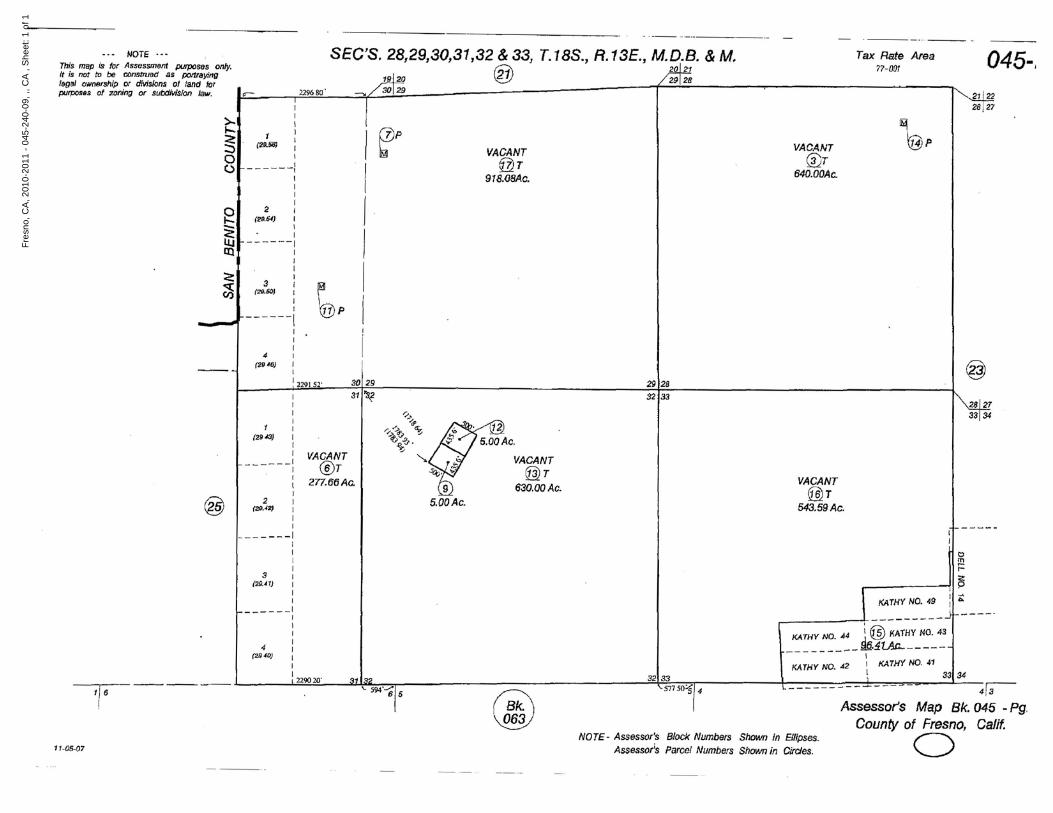
- .._-- ..._._----_.
045-,£!.l.?g28127
@
~
~P
Tax Rate Area77-007
VACANT@T
640.00Ac.
29128
VACANT@r
918.<JaAc.
I ~PIIIII
i30129
~p<:~
I
>--1 I
...... I
§-:~--iIII
o~ 2 :..... (29.54) I:::;;; I<;.' IlJ.J -------,III I
JI
3 :(20.50) I
II
---"'" ------1Ir1
4 I(2946) ,
I
I 2291 52'
NOTE .•• SEC'S. 28,29,30,31,32 & 33, T.18S., R.13E., M.D.B. & M.This map ;s for Assessment purposes only. ~21 F21It is not to be construed as poItIIJyill9 ~ ~ 29 28
legal ownership .Of divisions o./.Iand for II ==---,.3~~--=;.:./~*3~O~2~9__- __----_-----_--- :...-----......,.---------------"purpos.s of zonmg or SubdiVISion Jaw. I£""" I 2296 SO ---,_ I
MW33134
::
33134
KATHY NO. 49
~• <!:liP
VACANT@2r
543.59Ac.
I
._~=H::~._4~_ ~~i:~;:~~I
KATHY NO. 42 I KATHY NO. 411
32133
NOTE - Assessor's Block Numbers Shown In Blipses.Assessor;s Parcel Numbers Shown in Ci/des.
1.5.5.00Ac.
VACANT@r
630.00Ac.
'/~~ ~a'~'t;.o ~
-"".~
311~
VACANT@T
2n.f5f5 Ac.
IIII
1 I(2943) I,
I______ 1
IIII
2 I(21M2) I
Ir
-------1
@
III
3 I(2b.41) I
II
------,I
III
4 I(21"0) I
: 32133 l ± _ I r-I ,229020' 31132 .... S7750i /4
l_ - 413
'is ------ '- 594'-;;1 5 W Assessor's Map Bk. 045 _Pg.
~ County of Fresno, Calif.o11-05-07
Fres
no, C
A, 2
010-
2011
-04
5-24
0-09
, ,, C
A , S
heet
: 1 o
f 1
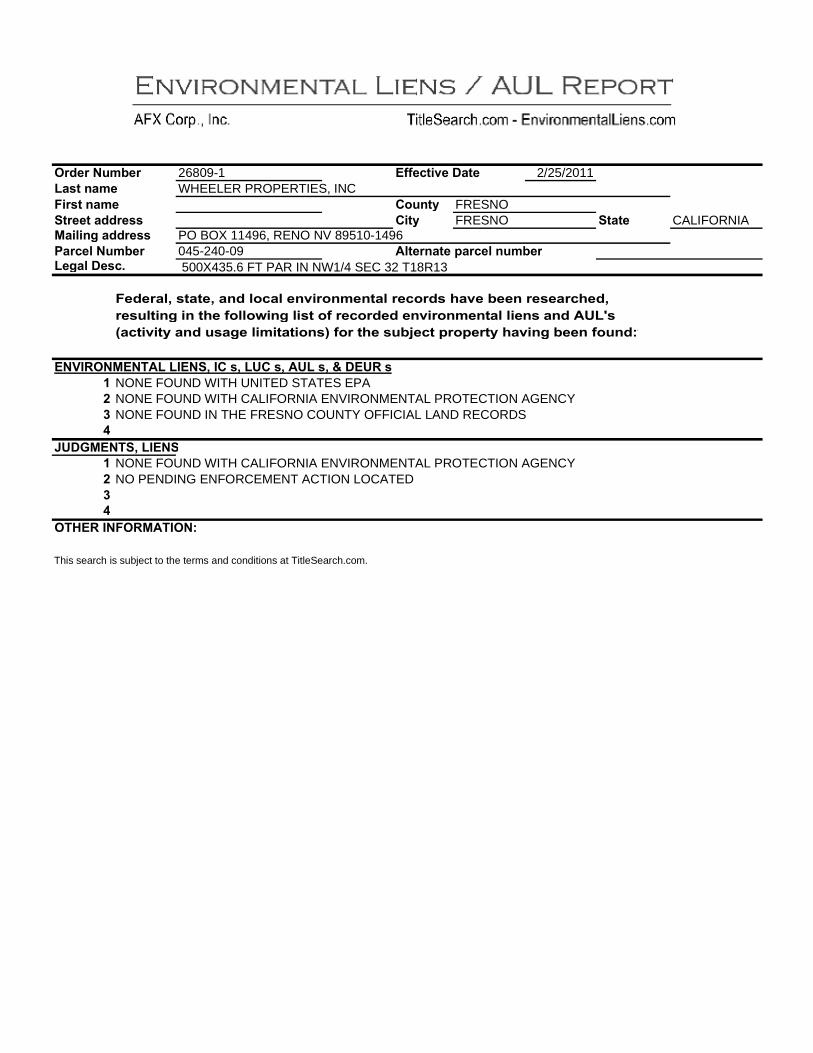
=&32& >#*52& @6%$ )6*2 E.&%$ )6*2 :$&22$ 633&2%%
26809-1 WHEELER PROPERTIES, INC
F1124$."2 G6$2
H(#)$ FRESNO H.$ FRESNO
2/25/2011
:$6$2 CALIFORNIA ?6.+.)0 633&2%% PO BOX 11496, RENO NV 89510-1496 <6&42+ >#*52& 045-240-09 J+$2&)6$2 '6&42+ )#*52& @206+ G2%4Q 500X435.6 FT PAR IN NW1/4 SEC 32 T18R13
E232&6+R %$6$2R 6)3 +(46+ 2)".&()*2)$6+ &24(&3% /6"2 522) &2%26&4/23R &2%#+$.)0 .) $/2 1(++(!.)0 +.%$ (1 &24(&323 2)".&()*2)$6+ +.2)% 6)3 J8@U% T64$.".$ 6)3 #%602 +.*.$6$.()%S 1(& $/2 %#5-24$ '&('2&$ /6".)0 522) 1(#)3K
F>7B;=>?F>9J@ @BF>:R BH %R @8H %R J8@ %R V GF8; % O NONE FOUND WITH UNITED STATES EPA N NONE FOUND WITH CALIFORNIA ENVIRONMENTAL PROTECTION AGENCY M NONE FOUND IN THE FRESNO COUNTY OFFICIAL LAND RECORDS L
A8GD?F>9:R @BF>: O NONE FOUND WITH CALIFORNIA ENVIRONMENTAL PROTECTION AGENCY N NO PENDING ENFORCEMENT ACTION LOCATED M L
=9CF; B>E=;?J9B=>K
This search is subject to the terms and conditions at TitleSearch.com.

PROPERTY AND OWNERSHIP INFORMATION Current Owner's Name WHEELER PROPERTIES INC Order # 26809-2 Property Address Completed Date 3/11/11 City/State Effective Date 3/7/11 APN/Parcel/PIN 045-240-12 DEED/VESTING INFORMATION Grantee(s) NO CHAIN OF TITLE FROM 2006
FORWARD
County
Deed Date
FRESNO COUNTY, CA
Grantor/Prior Owner Recorded Date Consideration Amount Instrument |Book/Page Sale Price Deed Type Notes: TAX INFORMATION
Year Property Tax Status Due Date Amount EXEMPT STATUS
Notes: Land Value Building/Improvements TOTAL ASSESSED VALUE
$139 $0
$139 OPEN MORTGAGE/DEED OF TRUST INFORMATION Mortgagor NO OPEN MORTGAGES FOUND Date Signed Mortgagee Date Recorded Trustee Instrument |Book/Page Mortgage Type Original Amount Assignment |Related Doc Related Doc Book/Page Related Doc Date Related Doc Recorded RELATED JUDGMENTS, UCC AND LIENS AGAINST OWNER
Instrument # Description Date Recorded Amount NO JUDGMENTS OR LIENS FOUND FOR CURRENT OWNER FOR SUBJECT PROPERTY
EASEMENTS AND RESTRICTIONS FOR CURRENT OWNER AGAINST PROPERTY Instrument # Description Date Recorded
NO EASEMENTS OR RESTRICTIONS FOUND FOR CURRENT OWNER FOR SUBJECT PROPERTY
Matters affecting the above real estate which do not directly appear among the land records, or are not indexed to the exact listed names and legal descriptions above are not included in this report. This is not a commitment for insurance nor is it an opinion on marketability of title. Subject to terms and conditions at TitleSearch.com
www.afxc.com 877-TITLE-37 || (877) 848-5337

ea ch,CQIe SO $tate Co:verage - Serving e Real Estate I dustry since :1.995
" CA Owner Information: Owner Name: WHEELER PROPERTIES INC Mailing Address 575 FOREST ST #201, RENO NV 89509-1689 C005 Phone Number: Vesting Codes: /I
Location Information: Legal Description: 5 AC SAN JOAQUIN MILLSITE IN SEC 32 T18R13 County: FRESNO, CA APN: 045-240-12 Census Tract / Block: 82.00 /6 Alternate APN: Township-Range-Sect: 18-13-32 Subdivision: Legal Book/Page: Map Reference: Legal Lot: Tract #:
COALINGALegal Block: School District: HURON Market Area: MuniclTownship: Neighbor Code: CC00001 Owner Transfer Information: Recording/Sale Date: / Deed Type Sale Price: 1st Mtg Document #: Document#: Last Market Sale Information: Recording/Sale Date: / 1st Mtg AmountlType: Sale Price: 1st Mtg Int. RatelType: Sale Type: 1st Mtg Document #: Document#: 2nd Mtg AmountlType: Deed Type: 2nd Mtg Int. RatelType: Transfer Document #: Price Per SqFt: New Construction: Multi/Split Sale: Title Company: Lender: Seller Name: Prior Sale Information: Prior Rec/Sale Date: Prior Lender: Prior Sale Price: Prior 1st Mtg AmtlType: Prior Doc Number: Prior 1st Mtg RatelType Prior Deed Type: Property Characteristics: Year Bu iIt! Eff: / Total Rooms/Offices: Garage Area: Gross Area: Total Restrooms: Garage Capacity: Building Area: Roof Type: Parking Spaces: Tot Adj Area Roof Material: Heat Type: Above Grade: Construction: Air Cond: # of Stories: Foundation: Pool: Other Improvements: Exterior wall: Quality:
Basement Area: Condition: Site Information:
VACANT Zoning: AE40 Acres: 4.99 County Use: INDUSTRIAL
(1000) Flood Zone: Lot Area: 217,500 State Use: Flood Panel: Lot Width/Depth 435 x 500 Site Influence: Flood Panel Date: Commercial Units: Sewer Type:
Land Use: INDUSTRIAL ACREAGE Building Class: Water Type:
Tax Information: Total Value: $139 Assessed Year: 2010 Property Tax: Land Value: $139 Improved %: Tax Area: 077001 Improvement Value: Tax Year: Tax Exemption: MISC Total Taxable Value: $139

- .._-- ..._._----_.
045-,£!.l.?g28127
@
~
~P
Tax Rate Area77-007
VACANT@T
640.00Ac.
29128
VACANT@r
918.<JaAc.
I ~PIIIII
i30129
~p<:~
I
>--1 I
...... I
§-:~--iIII
o~ 2 :..... (29.54) I:::;;; I<;.' IlJ.J -------,III I
JI
3 :(20.50) I
II
---"'" ------1Ir1
4 I(2946) ,
I
I 2291 52'
NOTE .•• SEC'S. 28,29,30,31,32 & 33, T.18S., R.13E., M.D.B. & M.This map ;s for Assessment purposes only. ~21 F21It is not to be construed as poItIIJyill9 ~ ~ 29 28
legal ownership .Of divisions o./.Iand for II ==---,.3~~--=;.:./~*3~O~2~9__- __----_-----_--- :...-----......,.---------------"purpos.s of zonmg or SubdiVISion Jaw. I£""" I 2296 SO ---,_ I
MW33134
::
33134
KATHY NO. 49
~• <!:liP
VACANT@2r
543.59Ac.
I
._~=H::~._4~_ ~~i:~;:~~I
KATHY NO. 42 I KATHY NO. 411
32133
NOTE - Assessor's Block Numbers Shown In Blipses.Assessor;s Parcel Numbers Shown in Ci/des.
1.5.5.00Ac.
VACANT@r
630.00Ac.
'/~~ ~a'~'t;.o ~
-"".~
311~
VACANT@T
2n.f5f5 Ac.
IIII
1 I(2943) I,
I______ 1
IIII
2 I(21M2) I
Ir
-------1
@
III
3 I(2b.41) I
II
------,I
III
4 I(21"0) I
: 32133 l ± _ I r-I ,229020' 31132 .... S7750i /4
l_ - 413
'is ------ '- 594'-;;1 5 W Assessor's Map Bk. 045 _Pg.
~ County of Fresno, Calif.o11-05-07
Fres
no, C
A, 2
010-
2011
-04
5-24
0-12
, ,, C
A , S
heet
: 1 o
f 1

=&32& >#*52& @6%$ )6*2 E.&%$ )6*2 :$&22$ 633&2%%
26809-2 WHEELER PROPERTIES, INC
F1124$."2 G6$2
H(#)$ FRESNO H.$ FRESNO
2/25/2011
:$6$2 CALIFORNIA ?6.+.)0 633&2%% 575 FOREST ST #201, RENO NV 89509-1689 <6&42+ >#*52& 045-240-12 J+$2&)6$2 '6&42+ )#*52& @206+ G2%4Q 5 AC SAN JOAQUIN MILLSITE IN SEC 32 T18R13
E232&6+R %$6$2R 6)3 +(46+ 2)".&()*2)$6+ &24(&3% /6"2 522) &2%26&4/23R &2%#+$.)0 .) $/2 1(++(!.)0 +.%$ (1 &24(&323 2)".&()*2)$6+ +.2)% 6)3 J8@U% T64$.".$ 6)3 #%602 +.*.$6$.()%S 1(& $/2 %#5-24$ '&('2&$ /6".)0 522) 1(#)3K
F>7B;=>?F>9J@ @BF>:R BH %R @8H %R J8@ %R V GF8; % O NONE FOUND WITH UNITED STATES EPA N NONE FOUND WITH CALIFORNIA ENVIRONMENTAL PROTECTION AGENCY M NONE FOUND IN THE FRESNO COUNTY OFFICIAL LAND RECORDS L
A8GD?F>9:R @BF>: O NONE FOUND WITH CALIFORNIA ENVIRONMENTAL PROTECTION AGENCY N NO PENDING ENFORCEMENT ACTION LOCATED M L
=9CF; B>E=;?J9B=>K
This search is subject to the terms and conditions at TitleSearch.com.

A''0)1,! @C
;(-)%F93)",++0 9,++ 84 <)%$,$#$,()3+ ?()$&(+% 90*(&3)1#*
This memorandum summarizes the results of an assessment of the status of institutional controls at the Johns-Manville Mill Operable Unit (JMM) of the Coalinga Asbestos Mine Superfund Site. Institutional controls are non-engineered instruments, such as administrative and legal controls, that help to minimize the potential for human exposure to contamination and/or protect the integrity of a response action. A Record of Decision (ROD) was issued for the JMM on September 21, 1990. A component of the remedy selected in the ROD included filing a deed restriction to restrict future land uses and to prevent disturbance of the contaminated material remaining at the site. A deed restriction was in fact recorded on July 2, 1993 and included a County Recorder office stamp. The 1996 and 2001 Five-Year Review reports found this deed restriction to be sufficient. However, as part of the 2006 Five-Year Review, a title search was run on the pertinent JMM
-030-035), and it revealed that no
The deed restriction, which was signed in 1993 and is included in the Revised Operations and Maintenance Plan for the JMM OU was filed unilaterally by the property owner in the Fresno
Review, concluded that the since the deed restriction did not convey a property interest to a grantee, it was not a legally enforceable agreement and did not run with the land. In the 2006 Five-Year Review, the recommendation was made to file a new deed restriction consistent with California land use covenant statutory and regulatory authorities.
Another component of the examination of institutional controls in this memorandum is a limited title search. The purpose of the title search is to verify that there have been no changes in ownership of the JMM, and that there are no other documents recorded with the
that would impact the effectiveness of institutional controls at the JMM. A limited title search was run on the JMM area (Fresno County, parcel No 063-03003S). The title search corresponds to the review period for this Five-Year Review (2006- February 2011). The results of the limited title search are included as Attachment 1 of this sub-appendix. Deficiencies and Recommendations The deed restriction signed in 1993 is not legally enforceable and does not run with the land. It is recommended that a new land use covenant be drafted between the property owner and DTSC, with US EPA assigned as a third-party beneficiary. The new deed restriction should be consistent with Title 22 of the California Code of Regulations (CCR) Section 67391.1 and any other DTSC regulations on land use covenants.
Since 2006, EPA and DTSC have negotiated draft language. It is anticipated that the deed restriction for the JMM will be finalized, signed, and recorded with the Fresno County
of the 2011 calendar year
parcel environmental restrictions on the parcel.
-Year
Appendix B2-1
A''0)1,! @CG A$$32-*0)$ D§:,*,$01 5,$+0 603&2- 70%#+$% §
Appendix B2-2

MMiinneerraall RRiigghhttss RReeppoorrtt PROPERTY AND OWNERSHIP INFORMATION Current Owner's Name SFP RAILROAD COMPANY Order # 26809-5 Property Address City/State
APN/Parcel/PIN 063-030-03S MINERAL DEEDS, LEASES | RELATED DOCUMENTS Document Type GRANT DEED Grantee(s) SFP RAILROAD COMPANY Grantor SANTA FE PACIFIC REALTY
Start Date Effective Date
County
Document Date Recorded Date
2006 3/4/11
FRESNO COUNTY, CA
12/29/89 1/5/90
Note: CORPORATION Instrument |Book/Page 90001922
Document Type Grantee(s) Grantor Note:
Document Date Recorded Date Instrument |Book/Page
Document Type Grantee(s) Grantor Note:
Document Date Recorded Date Instrument |Book/Page
Document Type Grantee(s) Grantor Note:
Document Date Recorded Date Instrument |Book/Page
Document Type Grantee(s) Grantor Note:
Document Date Recorded Date Instrument |Book/Page
Document Type Document Date Grantee(s) Recorded Date Grantor Instrument |Book/Page Note: ADDITIONAL COMMENTS/INFORMATION
SUPPORTING COPIES ENCLOSED Matters affecting the above real estate which do not directly appear among the land records, or are not indexed to the exact listed names and legal descriptions above are not included in this report. This is not a commitment for insurance nor is it an opinion on marketability of title. Subject to terms and conditions at TitleSearch.com
www.afxc.com 877-TITLE-37 || (877) 848-5337

~:? Colli
~ ~ ._- rro>£--- Tax Ratf! Area" .... SECrS. 1,2.3.10, JI. 8 12. T. 195.• R /3 E. MO.8. aM. 63-03Tft.., IItIM ;, J" ~t IJU~ ."r.,.o'g. rl .i!I .t1r11 h::l bc!I C1utSr,. ...d or lI"Of"~t"IlY.i.av
0 ...· ~lGJ ICIIRCW'S"'~ iJI' tNllifi,;lJM d'1 IIII:Irtlf 1'X o lIlIfTri»lS ~~ a IlUDd.I~l'!;ron nrcr.l t:I +Cl " I ~ ~ ;s;.'34 ,..,~~
4 3 L 1 2'~ ~ .3 I " I' ..,l't fII (I.,4....J (.-tel, I (r:r.:lJ I I ~[f'I5~J fl&l:I'Ql" ~ o --i--.--- ........ ---- ----,
~ tfI.~..cnc L ~ ~., - ~
• ~ '-_~ I 6:... • {""'OI ~ • "." . ~ ("'OCI~III \_-'- I
~"t ... \ Itil
~ I-_~.~~®~~\-_ 1__________ _.;..P;Io (15"'311 ~ ...
\ . ~ \ ,
~ @r s~ t38.00Ac.• """""r (flT USA.
548-58Ac.~ U. S.A.0o @ -l.c-"'o;
l ~
r) ; ... ~:}:!I.~~·i .....L..,r?b '1I,
""""" III 41 '3 ~ I : I
'HIO ~ ..., III tq"" III
l7'(f{)/
(ID.L.;
le. ~;45
306 'Gb,. ~ I Iii i I fr T .,S
:1 I Z I I 4 [ 3 , Z I I "'-I.o4a\l r fl1L."Jo I l'I':I!.Ia:- m.~ Ii t..,.n.~ I rJl.I:5J I .. ~J
~~_----.l----- -------..!------:.-------!---- ; I
3 I.
6 5 I ..
l'8D.QDI I r-lO.IlOJ UIIIOC:lj • .mAO'J
I ,;_ __ _ IL _ ~ l._ _
~,.m6 ~ @s @S
4I&4Qllc. 55S.60Ac.
ll6
{217~
\!V
" ~ N
~ .....
@;iT @T @T 64Q. OO<:lc. S40.OQac. S40.00Ac
US-A US.A. U.S.A.
S I'D -M>T~
~I" ~r14
11112.
J~' '3
'Zl7 13 Iiii
@ A5S63Sl7S Mop Bk. 63 - Pg. 03
Agriculturor Prese,.ver CauMy uf Ff8~. Calif.
Yl" 1:979
NOlE'-~ SSock ~ S"-'rl In £11q,._ A-..n ~I ~ SI>Cl..,., ill Cirr:les. o .IAN 1 820El2

·"F.~IJi"· "''''','Id "11' -_•.-••m....· ..':..t!::
•• - , 9000:1922 f'1 ~LAWYERS TITLEAppro....d .., to form by Qeneral Counsel
on Dece.oer J. 19B9
After record1 ng. ~1 eue maO to: S.nta Ft Paclftc Realty corporatton JAN 51990ZOl "'Si'CO Street San FrlBehco, CA 94105 Attention: Janette- L~ns
Proparty Tax Bt11$ to: Santa. F, Pac'fh: Rel'llty corponttonr;lo PTOIl',rty Tilx Department2Ql H1~$'o~ Street San Franchc:o, CA 94105
Nu transfer ta~ 1$ due. Thts transfer does not constttuts & transfer Q1 realty sOld wttMn tha m~ll.nlng: of l;v.HfQrnh, ReVell\lll & button Code (IIR$lTC") Stetlon 11911 becaU1e Grantor r.~e1ved no r:onstderatton and there ts no d,bt On the property subject to th,s Gr«nt D~ed. FurthGrmcre. bGeause Grantol. a whol1YH own&d substdh...,y of Grv.ntor. h a ml:llIbe, of an lIafftliated groupll under R&TC Sect'on 64(h). this tranSfer does not const'tut! a change of own~r$hlp and does not requ're r81,pr~~51' of t~& property $ub3ect to thfs Grant Deed.
GRANT DEED
S~MTA FE PACIrIC ~E~LlY CORPORATION. a Delaware corporatton, Grantor, heraby GRANTS to SF~ ~IL~OAD COMPANY, a Delaware corpor&tlo~. Grante~. that certain real pn.~perty sttuatlld fn the coufltyor Fresno, State 0' C~T1'o..nf&. and more particularly de!ictlblld 1n ElIh1blt A. attac:hlld and hl1reby made a put llltrGof.
Th'5 gr~nl 15 made ~u~jer.t to thos~ 1tem~ ~~t forth on ExhIbIt B .ttacha~ heret() and I'.eraby IIHl.de 5. pa.rt l1er@'of.
IN WITN~SS HHtREOF. Grlntor has c&u~ed these prtsent! to be e~ecuted th i s _~~?!...!l-...- day Q1' .....JJ!:crm /t"r. 1~
SANTA FE PACIFIC REALTY CORPORATION
'lv. D. ~ By: REmON DIRECroft' n t1 ~ : &Jlr,.£5 AND l.J\.ND lolANAQt:tt'N I
Attest: 1\!..:l<Sftnb.MLr ·
11 tle:..MS tSTI\NT SECRETAtr!:_
WPPI~12f;.9
• , ~ • I
Description: Fr~~llo,CA Docwnltn!: - Year.DocID 1990.1922 P<J.ge: 1 cf 4 . "'~_ ".. ", ,,~•." .·i:,.,~,: Order: DD CO.mmejlt: .. .: '" ". ..... ....... "'. '-.·~~J~~I' ,I.: .~"!I,.'. ~I·'''''' .~~(~I.> ..t,~~.~"'f~_',ir ..:

'.r eo :~. ~
FI k-, ds1 lNiINtrm 0'
.. 90002922
STAU OF CAUfOOHII' ) ) 5$.
C,ty .nd County of san Fr."c'~~ )
0" ttl I'li _;;Jt3.....f..¥... d.y of ~~fr.':'~T".io'=c unders 1gned. l Mtii'YPiiSn l;"'1ii'""and f'or e Stat" of Clt1fof'I,'a. persooillly ;Jp~ared .,per$'ona.l1,y known to 1St! <or proved to M on~t~"~e:-:-t!~.$~'~S~o~~a.b-h:-::f'~a~c"lt":::'o~rY:-:-::I:;7v7,:r.e:-::n:-::c~e~)""'lt:::'Q b!! th. p'f"iGn Jfho 'Il~Cl,lt@cf the with'n fl'lHrulWftt Ui the~~rc¢bt=.~o~ ~~.-4 .nd ...:!:r!..:£.,;:>\g;ce.. personally know to ."'Tciir"prov9d to I'lIt on tM \~ bost;-of s,~attorl ~~1~9nte) to be the orrson wbo executed the ~fthJn , nstrUllJent as the As:>"sA'!;.(\+: S~cretary or on beh:al1" of' the Corporation therein n~ ~nd ~~knoMl&dged to -e that such corpor~tlQn .K.~uted the ",Uti," f nstr-UlDellt pllrsuant to It~ byl.W5 or a resolution (If its boilrd of dfrflctors.
W1TKESS my h~nd and o~f'clal seal.
0Fll'1ClAJ,. S~I.
ItA.TmllIHil D. STUUGJI9l NOTMY PUaUC·Cl\UfUimA (lW • (OIInY aI' _....-rA .. e-II*Ile.- w ilL"""•
~;t.~DHOtaryu ic
HPP1MA1269
.......... , .. _-.. ~
".. ---,.. \ ... ". ~ . ~.
_, I. '. tJescriptiont FresnO,CA Document - Yea.r.Docr!! 1990.1.922 Page: 2 ox 4 Order: DD C01lltrl6nt: ~ . .,... • ", "T.r... ",

\",l.. .. lIl111i111i'\M!_"Mi"iIIIIlMliMII..'l!illNMIill!lllij~.".IIII.~ III_.=.".lIIlilllJlt __ _IIIII_....I•• ·~.,.e..I!Ii.lilJ_II•• •• __ __Ih_IO"'I'IfJ'''rri!"iw_ij~!iior_~IIIIIlIIi'Zlijt...._'_i...I~ ...... ·III·...ii1~,U"
.. 9001)1922
EXHIBIT A
Sorted ey Merldt.an j Range, TOllnsh'p. Sect10n
Statt: California
County: fresno
"S~I'ISo!or'~
CUI\lPlflV P~rl;;f! 1 ·M~B-SC- TWP-R(;E Oesc:-rtptio!} TAlC PaTcel
CA019OQOiI MDJo!..Ol - US-13E "11
W~PIMAJ269

.. -'I.
(California OutlyIng) 900010= i EMMblt B I
f1. Any mortgage. dead of trust. plflldge. ~ecurlty Interest. assIgnment, lr
dallos 1t arrMgemsnt, cMrqe, enClJmbtilncii. 11 on (st&tutory or other). or other I preferential I'rrangemlJnt \Including a.ny condltiona.l 5&le or other tHle retention I a;retment. any financing lease hiving substantially the nme economic: effec:t ~li qf ilJ1y of' the foregoIng or ..ny agreement to t,lhe any securIty Interest> (eacn, a. "Llen") In effect as of' the date hereof •
. 2. LIens far ta~es, assessments or othsr governmental charges which are not dsllnquent. or tha validity of whtch I. being contested 1n good falth by appropr late proceed 1ngs.
3. Stl,ttutory l..~el]s of mater'almen. lIIechanlc:s. warehousemen, vendors, c;:a.rrlen Qr tmpl(jyaes or othiotl& llk.e LhflS arlstng 10 the ordlnary coune of bust ness and ~ecurtng obl1qatlons wh1ch are e,ther not dellnquent or th9 valld,ty Qrll'hic:~!s lu:dn"l~ont~~t:~d ln good faith by approprIate pt"oclled"l~S,
4. UII'IlS (other t~all Lhns IIII~OSl!d by the EMployee Ret1rernent IneoMe SecurHy Act Of 1974. as amended) to secure the payment of worker' $ compens~tlQn, uflGmployment Insurance or other soc1a.l security benefits or obll gatfQn'll , or to secure the performance of b1d!!. trade contracts. ll:llsn. publlc Or stilotutory obflgatloml, surety Qr appeal bond.. or oth~r obllg:atlons of a. I Ike nature 'incurred 11'1 the I)rdtrtll"Y COln"Sf of I>u~ 1ne~s .
5. lon11lIJ T!5 tr~ ctlon, easements. 11 tensu. reur'latlons, prov1s tons. cO'Jemmts. conrJHloos, watvol'S or other restr~ctlons on the USe of reaJ property or lrrequhrttfet of title thereto (lnc:hll:nnj t1tle to hue-held inbre$ts),
6. Any judg!ll~lit L1lln U) filed not more than 60 dilYS prior to the date hereof. U f) the elt~I;\lt'QIl of whh::h hM been 'ihyed or (1' 1) 11'1 th respect to wh1 Ch any sl,Ieh 'Sby Qf I'l(~cutlo!l has e~ptred not more than 60 da.ys prlor' to the date hereof.
1. R1ghts of the ~tlbllc 1n and to any road~ or hlghw,ys that mo\)' cross or be located lJpcn the Property.
8. l.oa.~c~. ~&1c~ cOI'Itracts and purcna!:c op..ttons, If any. whether or not of publ ,(; record.
9. Any state of fi\C~S iln accurah surveyor physl.;al 1nspect'on of the Properly would shQlt.
10. R1partan r1ghts of third parties In any to any body of water which mayeros!> or be located U;Jon the Property.
11. Any rtghl. title and 1nterest In and to any of the m1nerals and mlnera.l 01"1lS \IJHhtn or un~l!rly1n9 the Propttrty. Irll::lud1nq. without limitation, 011, nAtural ~u and hydrocarbon ~ubstAn(:u, geothlitl1tAI '\tUM. brIMS and mtnerah in solution. and sand grlvel ~n~ a9grigat~5. and products dQrfved therefrom. together"11th My rt~htl; of 'ntress lind ~g ..&$.S In. upon or Ol/flr thlt Property lind to m.tkt 'S,IIl;n use of tht Proptl't'y ..ncl the 5urh~e thereof as 1$ nel;essllry Qr uUflll In connectIon th.rewlth. which RII1ll.'l haye been r&surved by other part 1es at the time that the Property 1'145 COfiy&y,d to Grantor or whl ch JI14\Y have beef) corweyed by Gr;;ll'ltor to dlly third pal"tllj~.
I4?P["fJ\12€9 I, 'I
D8~criptiOrt: Fre§nO,CA Document - Year.Do~~D 1990.1922 Page: 4 of 4 ~I -."1 order: DD COIllljlent; - ,: '
I

ch,-co 50 $tate C&verage - Serving e Rea Estate I dustry since 1.995
" CA Owner Information: Owner Name: SFP RAILROAD COMPANY Mailing Address PO BOX 961034, FORT WORTH TX 76161-0034 B099 Phone Number: Vesting Codes: /I
Location Information: Legal Description: SUR RTS 556.8 AC IN SEC 1 T19R13 County: FRESNO, CA APN: 063-030-035 Census Tract / Block: 78.00 /1 Alternate APN: Township-Range-Sect: 19-13-01 Subdivision: Legal Book/Page: Map Reference: Legal Lot: Tract #:
COALINGALegal Block: School District: HURON Market Area: MuniclTownship: Neighbor Code: GRW0001 Owner Transfer Information: Recording/Sale Date: / Deed Type: Sale Price: 1st Mtg Docu ment #: Document#: Last Market Sale Information: Recording/Sale Date: 01/05/1990/ 1st Mtg AmountlType: Sale Price: 1st Mtg Int RatelType: Sale Type: FULL 1st Mtg Docu ment #: Document#: 1922 2nd Mtg AmountlType: Deed Type: GRANT DEED 2nd Mtg Int RatelType: Transfer Document #: Price Per SqFt: New Construction: Multi/Split Sale Title Company: LAWYERS TITLE INSURANCE CORP. Lender: Seller Name: SANTA FE PACIFIC REALTY CORP Prior Sale Information: Prior Rec/Sale Date: / Prior Lender: Prior Sale Price: Prior 1st Mtg AmtlType: Prior Doc Number: Prior 1st Mtg RatelType: Prior Deed Type: Property Characteristics: Year Bu iIt! Eff: / Total Rooms/Offices: Garage Area: Gross Area: Total Restrooms: Garage Capacity Building Area: Roof Type: Parking Spaces: Tot Adj Area Roof Material: Heat Type: Above Grade: Construction: Air Cond: # of Stories: Foundation: Pool: Other Improvements: Exterior wall: Quality:
Basement Area: Condition: Site Information:
NATURAL Zoning: AE40 Acres: 556.80 County Use: PASTURE
(OPAS) Flood Zone: Lot Area: 24,254,208 State Use: Flood Panel: Lot VVidth/Depth: x Site Influence: Flood Panel Date: Commercial Units: Sewer Type: Land Use PASTURE Building Class: Water Type: Tax Information: Total Value: $15,059 Assessed Year: 2010 Property Tax: $190.06 Land Value: $12,615 Improved %: 16% Tax Area: 077001 Improvement Value $2,444 Tax Year: 2010 Tax Exemption: Total Taxable Value: $15,059

=&32& >#*52& 26809-5 F1124$."2 G6$2 2/25/2011 @6%$ )6*2 SFP RAILROAD COMPANY E.&%$ )6*2 H(#)$ FRESNO :$&22$ 633&2%% H.$ FRESNO :$6$2 CALIFORNIA ?6.+.)0 633&2%% PO BOX 961034, FORT WORTH TX 76161-0034 <6&42+ >#*52& 063-030-03S J+$2&)6$2 '6&42+ )#*52& @206+ G2%4Q SUR RTS 556.8 AC IN SEC 1 T19R13 G223P72%$.)0 B)1(&*6$.() D&6)$22 SFP RAILROAD COMPANY G223 G6$2 12/29/1989 D&6)$(& SANTA FE PACIFIC REALTY CO G6$2 ;24(&323 1/5/1990 G223 9 '2 GRANT DEED I((, P <602 90001922
E232&6+R %$6$2R 6)3 +(46+ 2)".&()*2)$6+ &24(&3% /6"2 522) &2%26&4/23R &2%#+$.)0 .) $/2 1(++(!.)0 +.%$ (1 &24(&323 2)".&()*2)$6+ +.2)% 6)3 J8@U% T64$.".$ 6)3 #%602 +.*.$6$.()%S 1(& $/2 %#5-24$ '&('2&$ /6".)0 522) 1(#)3K
F>7B;=>?F>9J@ @BF>:R BH %R @8H %R J8@ %R V GF8; % O NONE FOUND WITH UNITED STATES EPA N NONE FOUND WITH CALIFORNIA ENVIRONMENTAL PROTECTION AGENCY M NONE FOUND IN THE FRESNO COUNTY OFFICIAL LAND RECORDS L
A8GD?F>9:R @BF>: O NONE FOUND WITH CALIFORNIA ENVIRONMENTAL PROTECTION AGENCY N NO PENDING ENFORCEMENT ACTION LOCATED M L
=9CF; B>E=;?J9B=>K
This search is subject to the terms and conditions at TitleSearch.com.
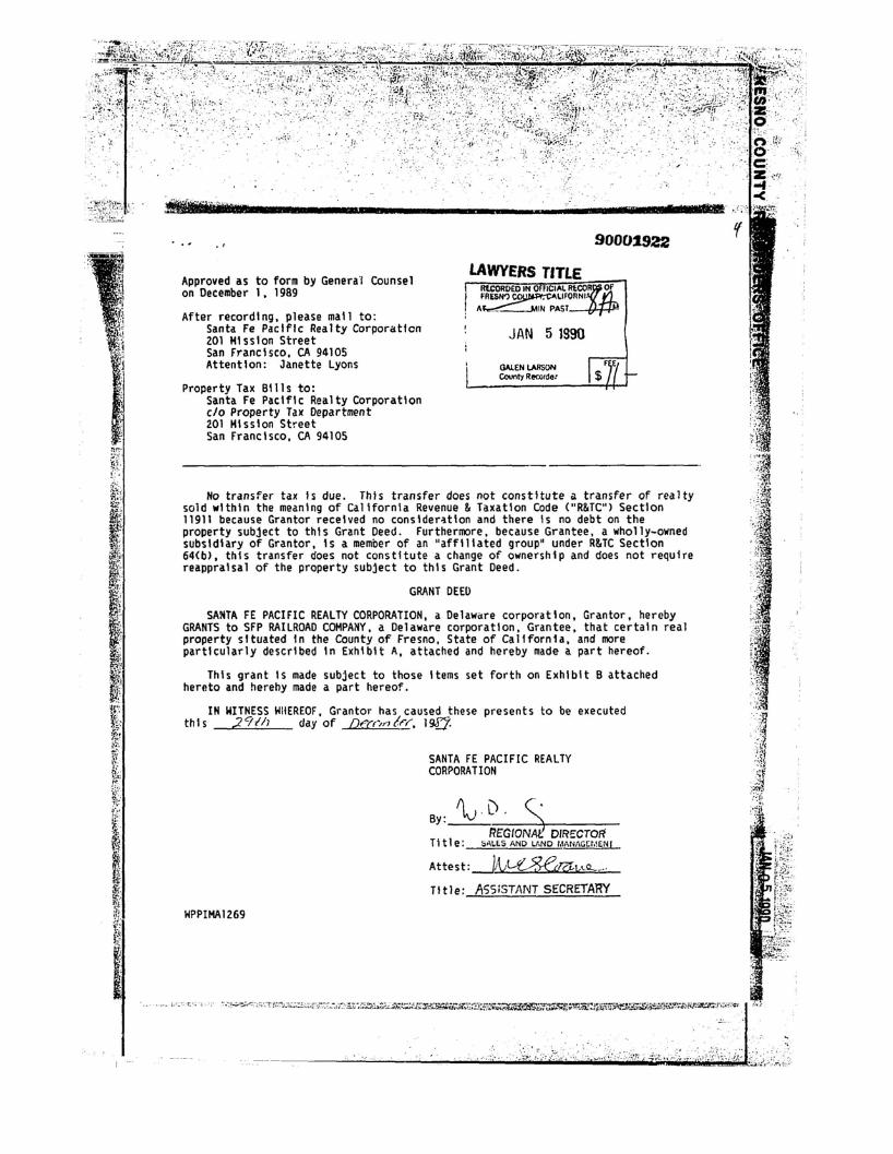
.. '.; .
••··'T· 7 ".:';
r.. , . ' 90001922
Approved as to form by General Counsel on December 1, 1989
After recording, please mall to: Santa Fe PacifIc Realty Corporation 201 Mission Street San Francisco, CA 94105 Attention: Janette Lyons
Property Tax Bills to: Santa Fe Pacific Realty Corporation c/o Property Tax Department201 Mission Street San Francisco, CA 94105
LAWYERS TITLE RtCORO£D IN 0 lelA!. Rt:~Of FRESH') ~llrORNI
"~INPAST
JAN 5 1990
' GAlEN LAllSON F E ~~R~~ct $L -------'--f+-J
No transfer tax Is due. This transfer does not constitute a transfer of realtysold within the meaning of California Revenue & Taxation Code ("RIHC") Section 11911 because Grantor received no conslder~tlon and there Is no debt on the property subject to this Grant Deed. Furthermore, because Grantee, a wholly-ownedsubsidiary of Grantor, Is a member of an "affiliated group" under R&TC Section 64(b}, this transfer does not constitute a change of ownership and does not require reappraisal of the property subject to this Grant Deed.
GRANT DEED
SAHTA FE PACIFIC REALTY CORPORATION, a Delaware corporation, Grantor, hereby GRANTS to SFP RAILROAD COMPANY, a Delaware corporation, Grantee, that certain real property situated In the County of Fresno, State of California, and more partIcularly descrIbed In Exhibit A, attached and hereby made a part hereof.
This grant Is made subject to those Items set forth on Exhibit B attached hereto and herehy made a part hereof.
IN WITNESS WHEREOF, Grantor has caused these presents to be executed th I s .2 9//) day of Df"(r':N? If"r, 19.fJ.
SANTA FE PACIFIC REALTY CORPORATION
AD. ~ By: I.V REGION D'RECTO~
TI tIe: ~AllS AND LAND I.IANII(;WEN I
Attest:--lA.J~!,l..O-_.
Tl tie; ASSiSTANT SE'CRETARY
HPPIHAl269
.•.••. j,,-:';.;:'C:;'),-.'. .:::~.;.. I

· .. ' ,.~:
.::::: .
......
:, . 146..
90001922
STATE OF CALIFORNIA ss.
CIty and County of San Francisco
On thIs ,;;29:!-b day of(\°c.embec . 1989. before me. the undersigned. a ~otary Public In and for ~ e1~and County of San Francisco. State of California. personally appeared LA)~.CCG\S,-personally ~nown to me (or proved to me o-n~t~hLe~ba~s~I~~S.L'of~~~a~l~sf~a-c:~t~or~y~e~v~l~de~n~c~e~)~t~o be the person I!ho executed the wlt." n Instrument as thel<:¥v'D.,cJJ'>m:c!nc- :5des : tp,c\ ("'I~-1-and m .s:. S \oc...c <:.. per sona11 y ~nOl/n to me-m proved to me on the '-0 basis of satisfactory ev'Qencel to be the per~on Who executed the l/Ithln Instrument as the ~\.~~±: Secr~tary or on behalf of the CorporatIon therein named and ac~nowledged to me that such corporation executed the wIthIn Instrument pursuant to Its bylal/s or a resolution of Its board of directors.
WInlESS my hand and officIal seal.
II lIJ'nIIUlIIUhl"'DI~ ~,..;;, ,D~tcl~OFFICIAL SBAL Notary Publl c
KATHERINE D. STRAUGHN NOTARY PUBLIC· CALIFORNIA 01Y .. (0IIIfTY Of WlIU/lClSCO ., e-daio. bo'" A,riI 1J. 1990Am ....UW...llIIIIWUl..-
HPPlMA1269

.'.
CA0190004
Company Parcel
90001922
A5se~sor' 5 Tax Parcel
063-030-035All
Oescrl ptlon
EXHIBIT A
MDH-01-19S-13E
*MER-SC-THP-RGE
Sorted By MerIdIan. Range, TownshIp, SectIon
Fresno
CalIfornIa
County:
State: .-:,
, ....
.':;
HPPlHA1269
..... ,;:
.......:~(
~i~t~i ..,..... '/;/~i,:;1~;'Li;~~~~~:it~;: ,;~ .....

,'. " ""- ~~~.~
,~'I' "}" '
{ ....
ei\$lll:llI1Ciel!l':lrr:w.lilm......llq.III!I!Il·~IilIIlIil!lli!i'lZIll!lll_ a!·IIII.IIio·"'. • .... __... ............. • •... m""'........
(California OutlyIng) 90001922
Exhl bit B
J. Any mortgage, deed of trust. pledge. security Interest, assIgnment,deposit arrangement, charge, encumbrance, lien (statutory or other), or other preferential arra~gement (Including any conditional sale or other title retention agreement. any financing lease having substantIally the same economic effect as of any of the foregoIng or any agreement to give any security Interest) (each, a "LIen") In effect as of the date hereof.
2. Liens for taxes, assessments or other governmental charges which are not delInquent, or the valIdity of willch Is beIng contested In good faIth by :l
approprIate proceedlng5.
3. Statutory LIens of materialmen, mechanics. warehousemen, vendors, carrIers or employees or other like Liens arising In the ordinary course of business and securing oblIgations which are eIther not delinquent or the validityof whIch Is beIng contested In good faIth by appropriate proceedings.
4. Liens (other than Liens Imposed by the Employee Retirement Income Security Act of 1974, as amended) to secure the payment of worker's compensatIon, unemployment Insurance or other social security benefits or oblIgatIons, or to secure the performance of bIds, trade contracts, leases, publIc or statutoryoblIgations, surety or appeal bonds or other obligatIons of a like nature Incurred In the ordinary course of Quslness.
5. ZonIng restrIctIon, easements, lIcenses, reservations, provIsions, covenants, conditIons, waIvers or other restrictIons on the use of real property or IrregularitIes of title thereto (Incl~dlng title to leasehold Interests).
6. Any judgment Lien (I) filed not more than 60 days prior to the date hereof. (II) the axecutlon of whIch has been stayed or (III) with respect to which any such stay of execution has expired not more than 60 days prIor to the date hereof.
7. RIghts of the public In and to any roads or highways that may cross or be located upon the Property.
8. Leases, sales contracts and purchase optIons, If any, whether or not of publIc record.
9. Any state of facts an accurate surveyor physical Inspection of the Property would show.
11. Any right, title and Interest In and to any of the mInerals and mineral ores wIthin or underlying the Property, Including, wIthout lImItation, 011, natural gas and hydrocarbon substances, geothermal steam, brines and mInerals In solutIon, and sand gravel and aggregates, and products derived therefrom, together wIth any rIghts of Ingress and egress In, upon or over the Property and to make such use of the Property and the surface thereof as Is necassary or useful In connectIon therewith, which may have been reserved by other parties at the time that the Property was conveyed to Grantor or whIch may have heen conveyed byGrantor to any third parties.
HPPlMA1269
10. RiparIan rIghts of third partIes In any to any body of water which may cross or be located upon the Property.

A''0)1,! @B
?,$ 84 <)%$,$#$,()3+ ?()$&(+% 90*(&3)1#*
This memorandum summarizes the results of an assessment of the status of institutional controls at the City of Coalinga Operable Unit 2 (City OU or OU-2) of the Atlas Asbestos Mine Superfund Site and Coalinga Asbestos Mine Superfund Site. Institutional controls are non-engineered instruments, such as administrative and legal controls, that help to minimize the potential for human exposure to contamination and/or protect the integrity of a response action.
A Record of Decision (ROD) for the City OU was signed on July 19, 1989. One component of the remedy selected in the ROD included placement of a deed restriction at the location of the waste management unit (WMU). The purpose of the deed restriction is to prevent disturbance of the cap at the WMU. Such disturbance would potentially release asbestos fibers and nickel contaminants from the Site.
A deed restriction was recorded June 22, 1990, which was applicable to the WMU that was to be constructed as part of the remedy. On September 24, 1992, an amended deed restriction was recorded and provided a legal description of the area restricted under the June 22, 1990 deed restriction. The 1996 and 2001 Five-Year Review reports found this deed restriction to be sufficient. However, the 2006 Five-Year Review made the recommendation to file a new land use covenant (LUC) for the WMU. The report pointed out that the owner of the property unilaterally recorded the deed restriction, so there was no grantee designated with a legal interest in the property or power to enforce the provisions of the deed restriction and the deed restriction was not legally enforceable. The lack of an expressed property interest to a grantee also prevented the restriction from running with the land (did not legally bind future owners of the property to the restrictions). The deed restriction was not consistent with California's statutory and regulatory authority to impose land use restrictions to protect human health or safety or the environment as the result of the presence of hazardous materials on the land.
To correct these deficiencies, a new deed restriction was filed on the WMU with the Fresno on September 24, 2010. An updated survey of the WMU was
conducted in 2006 and used in the legal description of the property for the 2010 deed restriction. The property survey was included as an attachment in the 2006 Five-Year Review. The signatories to this deed restriction were the City of Coalinga, owner of the WMU pursuant to a "Stipulated Judgment Quieting Title, APN 900-700-12 (formerly APN 083-020-59SU)", issued by the United States District Court for the Eastern District of California on October 21, 2005 (Case: 1:05-CV-00210-OWW-SMS) and the California Department of Toxic Substances Control (DTSC), who is the agency responsible for oversight of the City of Coalinga OU. US EPA is listed as a third-party beneficiary of this agreement. A copy of the deed restriction is included as Attachment 1 of this sub-appendix.
Another component of the examination of institutional controls in this memorandum is a limited title search. The purpose of the title search is to verify that there have been no changes in ownership of the WMU, and that there are no other documents recorded with the
that would impact the effectiveness of institutional controls at the
Appendix B3-1

WMU. A limited title search was run on the WMU area (Fresno County, parcel Nos. 083020-58 and 083-020-59). The title search corresponds to the review period for this Five-Year Review (2006- February 2011). The results of the limited title search are included as Attachment 2 of this sub-appendix.
The 2010 deed restriction is consistent with Title 22 of the California Code of Regulations (CCR) Section 67391.1, runs with the land, and corrected all other insufficiencies pointed out in the last Five-Year Review report. There are no deficiencies or recommendations to be made with respect to institutional controls at the City OU.
Appendix B3-2
A''0)1,! @BG A$$32-*0)$ D
CEDE >001 70%$&,2$,()
Appendix B3-3

fCP RECORDING REQUESTED BY:
The Redevelopment Agency of the City of Coalinga 155 West Durian Avenue Coalinga, California 93210
, Attention: William Skinner City Manager
WHEN RECORDED, MAIL TO: ADDRESS ABOVE, and also to:
State of California Department of Toxic Substances Control 8800 Cal Center Drive Sacramento, California 95826 Attn: Richard Hume, P.E. National Priority List Unit Brownfields and Environmental Restoration Program
I. . . \111111111111111 II 1111111111111111111111111111111
FRESNO County Recorder Robert C. Werner DOC- 2010-0126541 Friday, SEP 24, 2010 10:22:07 Ttl Pd $0,00 Nbr-0003295532
DJG/RS/1-1S
SPACE ABOVE THIS LINE RESERVED FOR RECORDER'S USE
COVENANT TO RESTRICT USE OF PROPERTY
ENVIRONMENTAL RESTRICTION
(Re: Fresno County Assessor Parcel Numbers 083-020-58 and 083-020-59) . DTSC Site Code 100289
This Covenant and Agreement ("Covenant") is made by and between The Redevelopment Agency of the City of Coalinga (the "Covenantor"), the current owner of property situated in Coalinga, Cbunty of Fresno, State of California, described in Exhibit "A", attached hereto and incorporated herein by this reference (the "Property"), and the Department of Toxic Substances Control (the "Department"). Pursuant to Civil Code section 1471, the Department has determined that this Covenant is reasonably necessary to protect present or future human health, safety or the environment as a result of the presence on the land of hazardous materials as defined in Health and Safety Code section 25260. The Covenantor and Department, collectively referred to as the "Parties", hereby agree, pursuant to Civil Code section 1471 and Health arid Safety Code section 25355,5, that the use of the Property be restricted as set forth in this Covenant. The Parties further agree that the Covenant shall conform to the requirements of California Code of Regulations, title 22, section 67391.1. The provisions
. of this Covenant shall be for the benefit of, and shall be enforceable by, the United States Environmental ProtectionAgency (the ''U.? EPN) as a third party beneficiary
Page 1 of 9
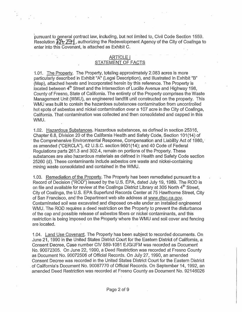
pursuant toi?Aneral contract law, including, but not limited to, Civil Code Section 1559. Resolution • at. authorizing the Redevelopment Agency of the City of Coalinga to enter into this Covenant, is attached as Exhibit C.
Al=nrCLE I STATEMENT OF FACTS
1.01. The Propertv. The Property, totaling approximately 2.083 acres is more particularly described in Exhibit "A" (Legal Description), and illustrated in Exhibit "B" (Map), attached hereto and incorporated herein by this reference. The Property is located between 4th Street and the intersection of Lucille Avenue and Highway 198, County of Fresno, State of California. The entirety of the Property comprises the Waste Management Unit (WMU), an engineered landfill unit constructed on the property. This WMU was built to contain the hazardous substances contamination from uncontrolled hot spots of asbestos and nickel contamination over a 107 acre in the City of Coalinga, California. That contamination was collected and then consolidated and capped in this WMU.
1.02. Hazardous Substances. Hazardous substances, as defined in section 25316, Chapter 6.8, Division 20 of the California Health and Safety Code, Section 101 (14) of
, the Comprehensive Environmental Response, Compensation and Liability Act of 1980,' as amended ("CERCLA"), 42 U.S.C. section 9601 (14); and 40 Code of Federal Regulations'parts 261.3 and 302.4, remain on portions of the Property. These substances are also hazardous materials as defined in Health and Safety Code section 25260 (d). These contaminants include asbestos ore waste and nickel-containing mining waste consolidated and contained in the WMU.
1.03. Remediation of the Property. The Property has been remediated pursuant to a Record of Decision ("ROD") issued by the U.S. EPA, dated July 19,1989. The ROD is on file and available for review at the Coa,linga District Library at 305 North 4th Street, City of Coalinga, the U.S. EPA Superfund Records Center at 75 Hawthorne Street, City of San Francisco, and the Department web site address at www.dtsc.ca.gov. Contaminated soil was excavated and disposed on-site under an installed engineered WMU. The ROD requires a deed restriction on the Property to prevent the disturbance of the cap and possible release of asbestos fibers or nickel contaminants, and this restriction is being imposed on the Property where the WMU and soil cover and fencing are located.
1.04. Land Use Covenant. The Property has been subject to recorded documents. On June 21, 1990 in the United States District Court for the Eastern District of California, a Consent Decree, Case number CIV S89-1081 EJG/JFM was recorded as Document No. 90072305. On June 22,1990, a Deed Restriction was recorded at Fresno County as Document No. 90072506 of Official Records. On Ju'ly 27, 1990, an amended Consent Decree was recorded in the United States District Court for the Eastern District
,of California's Document No. 90087770 of Official Records. On September 14, 1992, an amended Deed Restriction was recorded at Fresno County as Document No. 92146026
Page 2 of9

'of Official Records. On January 17, 2008, the Covenantor acquired assessor's parcel number (APN) 083-020-59 that contains the Property pursuant to a Grant Deed that was recorded at Fresno County as Document No. 2008-0006487. A land use covenant is necessary to preclude potential residential user's exposure tohazardous substances which remaIn af the-ProperlY, and to preclude disruption of the response actions. U. S. EPA, with the concurrence of the Department, has concluded that the Property, remedied to the goals presented in the ROD, and subject to the restrictions of this Covenant, and when used in compliance with such restrictions, does not present an unacceptable threat to human safety or the environment. .
ARTICLE II DEFINITIONS
2.01. Department. "Department" means the California Department of Toxic Substances Control and includes its successor agencies, if any.
2.02. U.S. EPA. "U.S. EPA" means the United States Environmental Protection Agency and includes its successor agencies, if any.
. 2.03. Owner. "Owner" means the Covenantor, its successors in interest, and their . successors in interest, inclUding heirs and assigns, which at any time hold title or an ownership interest to all or any portion of the Property.
2.04. Occupant. "Occupant" means Owner and any person or entity entitled by ownership, leasehold, or other legal relationship to the right to occupy any portion of the Property.
. 2.05. CERCLA Lead Agency. "CERCLA Lead Agency" means the governmental entity having the designated lead respom~ibility to implement response action under the National Contingency Plan ("NCP"), 40 C.F.R. Part 300. U.S. EPA or a state agency acting pursuant to a confract or cooperative agreement executed under CERCLA section 104(d)(1), 42 U.S.C. 9604(d)(1), or designated pursuant to a CERCLA Memorandum o"t Agreement entered into under subpart F of the NCP (40 C.F.R. 300.505) may be designated CERCLA Lead Agency. Because this site has already been delisted from the NPL, and the Department has agreed to perform oversight of the operations and maintenance activities for this operable unit, the Department shall be the "CERCLA Lead Agency" unless the site is re-Iisted. However, at any time, the Department and U.S. EPA may mutually agree in writing that either the Department or U.S. EPA may be selected as "CERCLA Lead Agency''' for purposes of this Covenant.
2.06. Environmental Restrictions. "Environmental Restrictions" means all protective provisions, covenants, restrictions, prohibitions, and terms and conditions as set forth in any section of this Covenant.
2.07. Improvements. "Improvements" include, but are not limited to: buildings, structures, roads, driveways, improved parking areas, wells, pipelines, or other utilities.
Page 3 of 9

'2.08. Lease. "Lease" means lease, rental agreement, or any other document that creates a right to use or occupy any portion of the Property.
2.Q9._Remedial Systems. "Remedial Syste.ms" shaU me_an the r~medial equipment and systems located on the Property, including equipment and systems installed as part of the construction and operation of the WMU and any devices that may be installed in the future. The WMU as currently constructed includes a fenced in engineered landfill unit. The landfill unit itself is approximately 20 feet deep and was engineered with an impermeable cap. Over the cap is.approximately three feet of clean fill, and this is landscapedwith natural vegetation to prevent erosion and deterioration of the engineered cap. The top surface area of the raised landscaped area measures approximately 220 by 270 feet. Each of these items are components of the remedial system that sits within another component of the remedial system, the fence that protects the entire area (approximately 300 feet on each side, see Exhibits A & B for 'details).
ARTICLE III GENERAL PROVISIONS
3.01. Restrictions to Run with the Land. This Covenant sets forth Environmental Restrictions, that apply to and encumber the Property and every portion thereof no matter how it is improved, held, used, occupied, leased, sold, hypothecated, encumbered, and/or conveyed. This Covenant: (a) Runs with the land pursuant to Health and Safety Code section ~5355.5(a) and Civil Code section 1471; (b) Inures to the benefit of and passes with each and every portion of the Property; (c) Is for the benefit of, and is enforceable by the Department: and, (d) Is imposed upon the entire Property unless expressly stated as applicable only t6 a specific portion thereof.
3.02. Binding upon Owners/Occupants. Pursuant to the Health and Safety Code, this Covenant binds all Owners and Occupants of the Property. Pursuant to Civil Code section 1471, all successive owners of the Property are expressly bound hereby for the benefit of the Department.
3.03. Written Notice of the Presence of Hazardous Substances. Prior to the sale, lease, assignment, or other transfer of the Property, or any portion thereof, the Owner, lessor, or sublessor shall give the buyer, iessee, or sublessee written notice of the existence of this Covenant I;lnd its Environmental Restrictions.
3.04. Incorporation into Deeds and Leases. The Covenant and its Environmental Restrictions shall be incorporated by reference in each and every deed and lease for any portion of the Property.
3.05. Conveyance of Property. The Owner shall provide notice to the Department not later than thirty (30) days after any conveyance of any ownership interest in the Property (excluding mortgages, liens, and other non-possessory encumbrances). The written notice shall include the name and mailing address of the new owner of the
Page 4 of 9

Property and shall reference DTSC site code 100289. The notice.shall also include the APN listed in Section 1.01. If the new owner's property has been assigned a different APN, each such APN that covers the Property must be provided. The Department shall not, by reason of this Covenant, have authorityto apprQye,disapprove, or otherwise affect proposed conveyance, except as otherwise provided by law or by administrative order.
3.06. Costs of Administering the Covenant to be paid by Owner. The Department has already incurred and will in the future incur costs associated with the administration of this Covenant. Therefore, the Covenantor hereby covenants for Covenantor and for all .subsequent Owners that, pursuant to California Code of Regulations, title 22 section 67391.1 (h), the Owner will pay the Department's cost in administering the Covenant.
ARTICLE IV RESTRICTIONS
4.01. Prohibited Uses. The Property shall not be used for any of the following purposes:
(a) A residence, including any mobile home or factory built housing, constructed or installed for use as residential human habitation.
(b) A hospital for humans. . (c) A pUblic or private school for persons under 21 years of age. (d) A day care center for children.
4.02. Soil Management. Any contaminated soils brought to the surface by grading, excavation, trenching or backfilling shall be managed in accordance with all applicable provisions of state and federal law and will not be removed from the Property without a Soil Management Plan approved by the CERCLA Lead Agency, such approval not to be unreasonably withheld.
4.03. Prohibited Activities. The following activities are specifically prohibited without prior written approval from the CERCLA Lead Agency:
(a) Drilling for drinking water, oil, or gas. (b) Extraction of groundwater for purposes or uses other than site
remediation. (c) Alteration of existing drainage patterns as anticipated or constructed
as part of the Remedial System. (d) Creation of significant topographic low areas where water may pond,
including accessory structures, swimming pools and spas.
4.04. Non-Interference with Remedial Systems. In addition to the non-interference covenant dated June 22, 1990, recorded in Fresno County records as document number 90072506, amended on September 24,1992 as document number 92146026, agreed to and placed on land pursuant to the Consent Decree under Case number CIV
Page 5 of9

889-1081 EJG/JFM in the United States District Court for the Eastern District of California, the Covenantor agrees:
(a) The Owner and O_ccupant shall refrain from, and shalLnot permit, any , activity that would interfere with the operation of the Remedial Systems or other Site-wide response activities at the Property without prior written approval from the CERCLA Lead Agency, such approval not to be unreasonably withheld.
(b) All-uses and devebpment of the Property shall preserve the integrity of the Remedial Systems or other Site-wide response activities.
(c) Owner shall provide a copy of this Covenant to all easement holders for all or any portion of the Site.
4.05. Access for Department and the U.S. EPA. The Department shall have reasonable right of entry and access to the Property for inspection, monitoring, and other activities for the Remedial Systems on the' Property consistent with the purposes of this Covenant as deemed necessary by the Department in order to protect the public health or safety, or the environment subject to the requirement that all such persons with access to the Property shall comply with all safety rules and requirements in place for Owner's or Occupant's own personnel, and that such persons provide their own personal protective equipment as required by those safety rules. Nothing in this instrument shall limit or otherwise affect U.S. EPA's right of entry and access, or U.S. EPA's authority to take response actions, under CERCLA; the National Contingency Plan ("NCP"), 40 Code of Federal Regulations Part 300; or federal law. Nothing in this instrument shall limit or otherwise effect the Department's right of entry and access, or authority to take resPOnse actions, under CERCLA; the NCP, 40 Code of Federal Regulations Part 300; Chapter 6.8, Division 20 of the California Health and Safety Code; California Civil Code; or other applicable State Law.
4.06. Access for Implementing Operation and Maintenance. The entity, person or persons responsible for implementing the operation and maintenance activities related to the Remedial Systems shall have reasonable right of entry and access to the Property for the purpose of implementing these operation and maintenance activities. Such right of entry and access shall continue until such time as the CERCLA Lead Agency determines that such activities are no longer required.
4.07. Inspection and Reporting Requirements. The Owner shall conduct an annual inspection and submit an Annual Inspection Report to the Department for its approval by January 15th of each year. The annual report shall describe how all requirements outlined in this Covenant have been met. The annual report, filed under penalty 'of perjury, shall certify that the Property is being used in a manner consistent with this Covenant. The annual report must include the dates, times, and names of those who conducted and reviewed the annual inspection report. It also shall describe how the observations were performed that were the basis for the statements and conclusions in the annual report (e.g. drive by, fly over, walk in, etc.) If violations are noted, the annual report must detail the steps taken to return to compliance. If the Owner identifies any
Page 6 of9

violations of this Covenant during the annual inspections or at any other time, the Owner must, within ten (10) days of identifying the violation: determine the identity of the party in violation; send a letter advising the party of the violation of the Covenant; and demand that the violation cease immediately. Additionally, copies of any correspondence related to tne enforcementof this Covenaril shalf be sent to the Department and U.S. EPA within ten (10) days of its original transmission.
ARTICLE V ENFORCEMENT
5.01. Enforcement. Failure of the Covenantor, Owner or Occupant to comply with any of the Restrictions shall be grounds for the Department to require modification or removal of any Improvements constructed or placed upon any portion of the Property in violation of this Covenant. Violation of this Covenant, including but not limited to, failure to submit, or the submission of any false statement, record or report to the Department shall be grounds for the Department to pursue administrative, civil or criminal actions. 5.02 Enforcement Rights of U.S. EPA as a Third Party Beneficiarv. U.S. EPA, as a third party. beneficiary, has the right to enforce the Environmental Restrictions contained herein.
ARTICLE VI VARIANCE, TERMINATION, AND TERM
6.01. Variance. Owner, or any other aggrieved person, may apply to the Department for a written variance from the provisions of this Covenant. Such application shall be made in accordance with Health and Safety Code section 25233 and a copy of the application shall be submitted to U.S. EPA simultaneously with the application submitted to the Department. No variance may be granted under this paragraph without prior notice to and an opportunity to comment by U.S. EPA.
6.02. Termination. Owner, or any other aggrieved person, may apply to the Department for a termination or modification of one or more terms of this Covenant as they apply to all or any portion of the Property. Such application shall be made in accordance with Health and Safety Code section 25234 and a copy of the application shall be submitted to U.S. EPA simultaneously with the application submitted to the Department. No termination may be granted under this paragraph without prior notice to and opportunity to comment by U.S. EPA.
6.03. Term. Unless ended in accordance with paragraph 6.02, by law, or by the Department in the exercise of its discretion, after providing notice to and an opportunity to comment by U.S. EPA, this Covenant shall continue in effect in perpetuity.
ARTICLE VII MISCELLANEOUS
7.01. No Dedication or Taking Intended. Nothing set forth in this Covenant shall be construed to be a gift or dedication, or offer of a gift or dedication, of the Property, or
Page 7 of9

any portion thereof to the general public or anyone else for any purpose whatsoever. , Further, nothing in this Covenant shall be construed to effect a taking under state or federal law, ' ,
7.02.'Recordalion. The Covenantor shall record this Covenant, with all referenced Exhibits, in the County of Fresno within ten (10) days of receipt of a fully executed original.
7.03. Notices. Whenever any person gives or serves any Notice ("Notice" as used herein includes any demand or other communication with respect to this Covenant), each such Notice shall be in writing and shall be deemed effective: (1) when delivered, if personally delivered to the person being served or to an officer of a corporate party , being served, or (2) three (3) business days after deposit in the mail, if mailed by United States mail, postage paid, 'certified, return receipt requested:
To Owner:
The Redevelopment Agency of the City of Coalinga c/o Craig M. Mortensen Attorney At Law Bacigalupi, Neufeld & Rowley 1111 E. Herndon Avenue, Suite 219 Fresno, California 93720
and also to
The City of Coalinga 155 West Durian Avenue Coalinga, California 93210 Attention: Coqlinga City Manager
To Department:
Department of Toxic Substances Control 8800 Cal Center Drive Sacramento, California 95826·3200 Richard Hume, P.E. Supervising Hazardous Substances Engineer I National Priority List Unit Brownfields and Environmental Restoration Program
To U.S. EPA:
U.S. EPA, Region 9 75 Hawthorne Street San Francisco, California 94105-3901 Attn: City of Coalinga Asbestos Project Manager
Page 8 of9

Any party may change its address or the individual to whose attention a Notice is to be sent by giving written Notice in compliance with this paragraph.
7.04. Partial Invalidity. If this Covenant or any of its terms are determined by a court of competent jurisdiction to be invalid fQr any reason, the surviving portions of this Covenant, or the application' of it to any person or circumstance, shall remain in full force and effect as if such portion found invalid had not been included herein.
7.05. Statutory and Regulatory References. All statutory and regulatory references include successor provisions.
7.06. Incorporation of Attachments. All attachments and exhibits to this Covenant are incorporated herein by reference.
7.07. California Law. This Covenant shall be governed, performed and interpreted under the laws of the State of California. 7.08 No Delegation ..Nothing set forth in this Covenant shall be construed to be a delegation of any authorities of the Department under any statute or regulation.
IN WITNESS WHEREOF, the Parties execute this Covenant.
The Redevelopment Agency of the City of Coalinga
.;' .' ~<:~ ~-- 7 ~.'i""i >
By: /c-"'- ~ Date: 7-ti-1() William Skinner City Manager City of Coalinga
Department of Toxic Substances Control
Date:BY.~~RichaHUlll €:, ~ Supervising Hazardous Substance Engineer I National Priority List Unit Brownfields and Environmental Restoration Program Department of Toxic Substances Control
Page 90f9

ACKNOWLEDGMENT
State of California
County of fii i~I\lc..::O::..:... -.=. ~)
On Yvl,\ \q I ~~\() before me,
co\<'vy~.s",.\ l'-\.c.V\ot~~, N~I'"'i- l1JblaL.-. (insert name and titlefthe officer) personally appeared
lVi\\ 'pM. ~~V\V\ev . who proved to me on the basis.of satisfactory evidence to be the perso$) whose nam~) is/ou:e subscribed to the within instrument and acknowledged to me that he/s~o,LtR8" execllted the same in hisf.~gr;ftR8i!"authorized capacity(~ and that by his/l:lorAAeif signature~ on the instrument the persont&j. or the entity upon behalf of which the person(ej-tlcted, executed the instrument.
I certify under PENALTY OF PERJURY under the laws of the State of California that the foregoing paragraph is true and correct.
WITNESS my hand and official seal.
Signatur
\~
NOTARY SEAL CLARIFICATION
I certifY under penalty of peljury that the "Notary Seal" on the document to which this statement is attached reads as follows:
Name ofNotary: Krystal N. Chojnacki
Commission Number: 1785443--.::..:..::::::...:..:=-----------Date commission expires: December 16. 2011
State and County of Commission: Fresno. California
Date: -~";::;"l~~t""""-""7~-;r-~~------
Govt. Code, Sec. 27361.7
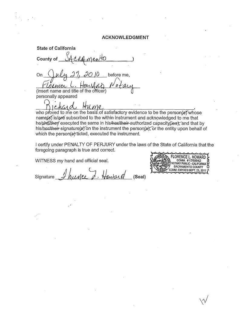
ACKNOWLEDGMENT
State of California
County of '~~«4:LLd]J-"'~~~~-
On -;[tuba d I; dO J{) before me,
/' l!.A..- L. . (insert name and title of the 0
personally appeared
-;---L.f~~~.L....,;-~..L.4~-:-;--;--:----;-:-----'-"'------'::-----;--=-:-'who p ved to me on the basis.of satisfactory evidence to be the person.(gfwhose nameksfis/~subscribed to the within instrument and acknowledged to me that he/~exec!1ted the same in hisfl:l~rJtl:l8iF authorized capacity.(iesj;"and that by his/b.e~!theirsignature(,9JOn the instrument the personisJ,Or the entity upon behalf of which the person~·cted, executed the instrument.
I certify under PENALTY OF PERJURY under the laws of the State of California that the foregoing paragraph is true and correct.
FLORENCE l. HOWARD, COMM. # 1769942 "WITNESS my hand and official seal.
NOTARY POBlIC· CAUFORNIA Gl SACRAMENTO COUNTY 0
COI.IM. EXPIRES SEPt 23, 2011 ..
Signature ) (Seal)h,JM1tg J. ~d
\rJ

EXHIBIT A Coalinga City Operable Unit
Legal Description ,
That certain parcel of ICind situated in the South Half of Section 6, Township 21 South, Range 15 East, Mount Diablo Base and Meridian, in the City of Coalinga, County of Fresno, State of California, the North line of said South Half of Section 5 being the Basis of Bearings for this description and taken as North 89 42' 30" East per Book 27 of Record of Surveys at Page 55, Fresno County Records, being more particularly described as follows:
Commencing at the most easterly corner of Parcel 2 as shown on Parcel Map No. 006, recorded in Book 29 of Parcel Maps at Pages 19 and 20, Fresno County of Records; said corner being on the westerly right-of-way line of the 200 foot wide railroad strip of Southern Pacific Transportation Company as abandoned on November 6,1986, by Public Law 99-614; said corner also being South 72 41' 08" East a distance of 2807.00 feet from the West Quarter Corner of said Section 5; thence North 37 38' 42" East along the said westerly right-of-way line a distance of 122.95 feet to the TRUE POINT OF BEGINNING; thence the following courses;
1) thence North 54 20'52" West leaving said westeriy right-of-way line a distance of 276.25 feet;
2) thence North 37 06'18" East a distance of 327.26 feet; 3) thence South 51 38'34" East a distance of 25,72 feet; 4) thence South 37 37'15" West a distance of 22.83 feet; 5) thence South 51 40'43" East a distance of 253.46 feet to said westerly
right-of-way line of Southern Pacific Transportation Company, 6) thence South 51 40'43" East leaving said westerly right-of-way a
distance of 27,15 feet; 7) thence South 38 15'28" West a distance of 290.36 feet; 8) thence North 54 20'52" West a distance of 24.06 feet to the said westerly
right-of-way line of Southern Pacific Transportation Company and TRUE POINT OF BEGINNING.
Said parcel contains 2.083 acres, more or less.
End Description.
\fYJ
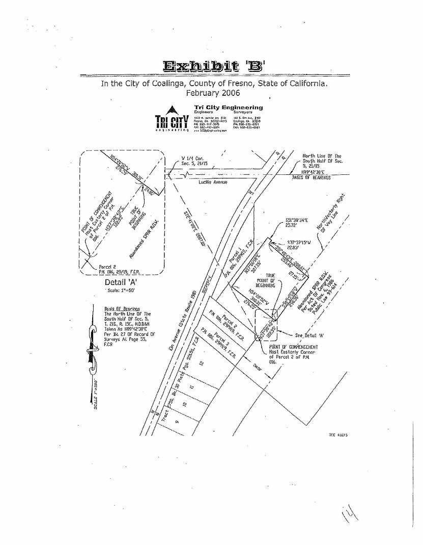
In the City of Coalinga, County of Fresno, State of California. February 2006
A Tr,i City Engineering ErlglnCW'll S\.ltV~yorg
It}) t. ~ ..." ...... (f" ('CS",," '" $.)1n-Gl\STDI CITVH,-lM_~j,7.:lOJi1111111 r,t 5*'0-$01.
tllt"••• r1 ft 'l •• , l<e>,b?'« .....lUr>
-------- ,/
'~•. .... , I ) 1J IIi Cor.I , 6So<. 5, 21/15
C'.>..'~~ II 6~Sr "47 I: -,/'- _.I U/o I
...... I Ludl.te Averut>I I ~ 1)~1%,.'\ I \ I ~;! , I \II l<o~.Y' ;,<-I e.~Q< .0. ~~~ I ~\ I <!l .;. '" ",""Ji' 8 jf I <>;
q <!,' ". ",.~"~! 0-3' .{Y' ~I ff~ ~ ~ ~ IC( !Ht"" 0"I ~~. I' .t I<; 't\.t£!.
I \I~
II
.~
I '/
I IPornl 2 '- _.::. ~.!JI!>...?-2!..l'!tJY'-. __ /
Detail 'A' . SCi3le; 1u.,.SO·
Basis or Be6!'"!r'.9s The- North lbr Of Till! South Holt Dt Scc. S. T. 11~. R. IS(., H.flaw T4ke(l'As t"S9'~2'30'E ~r Bk. 27 or Record or Sur"'~)'!> At Page 55. F,CR
Hodh t,ie'll!" Of Ow S""jh ...,t Ot S"" s. Ii/IS
»B9'-1Z'JO't: .MSIS Ilf B):A.~-
le( ~16'3

EXHIBIT C
RESOLUTION NUMBER RA·271
RESOLUTION AUTHORIZING THE REDEVELOPMENT AGENCY OF THE CITY OF COALINGA TO COVENANT AND CONTRACT WITH THE CALIFORNIA DEPARTMENT
OF TOXIC SUBSTANCES CONTROL (DTSC) AND THE UNITED STATES ENVIRONMENTAL PROTECTION AGENCY (U.S. EPA), AUTHORIZE THE EXECUTIVE
DIRECTOR TO ENTER INTO AND EXECUTE ALL ASSOCIATED ENVIRONMENTAL RESTRICTIONS/COVENANTS AND CONTRACTS, AND ASSIGN RESPONSIBILITY
FOR DTSC OVERSIGHT COSTS FOR THE COVENANT/RESTRICTIONS IN PERPETUITY UNTIL TERMINATION OF SUCH COVENAT.
WHEREAS, the Redevelopment Agency of the City of Coalinga determines and declares that it may enter into agreements with State and Federal agencies for 2010 and subsequent years as necessary; and
WHEREAS, the Redevelopment Agency of the City of Coalinga may take any actions that the Redevelopment Agency of the City of Coalinga determines are necessary and that are consistent with state and federal laws to remedy or remove a release of hazardous substances on, under, or from a property located in a Redevelopment Project Area if certain conditions are met.
THEREFORE, BE IT RESOLVED BY the Redevelopment Agency of the City of Coalinga that the Executive Director is hereby authorized to enter into and execute ENVIRONMENTAL RESTRICTIONS/COVENANTS and contracts for the Redevelopment Agency of the City of Coalinga, with the California Department of Toxic Substances Control and the U.S. EPA, subject to all conditions.
BE IT FURTHER RESOLVED THAT the Redevelopment Agency of the City of Coalinga, as Owner and Covenantor, will be responsible for DTSC oversight costs for the Covenant/Restrictions in perpetuity unless DTSC authorizes the termination of such Covenant.
PASSED AND ADOPTED by the City Council of the City of Coalinga on the 15th day of July 2010, by the following vote:
AYES: Garcia, Bourdeau, Oxborrow, Ramsey, Lander NOES: None ABSENT: Non ABSTAIN: - ofV'
~'~ZI'~:'-~:;.-:;~" (L~ c~~. _RON LANDER, MAYOR
I HEREBY CERTIFY that the foregoing is a true and correct copy of a Resolution introduced and passed at a noticed meeting of the Redevelopment Agency of the City of Coalinga held on July 15, 2010.
\\9

A''0)1,! @BG A$$32-*0)$ C §:,*,$01 5,$+0 603&2- 70%#+$% §
Appendix B3-20
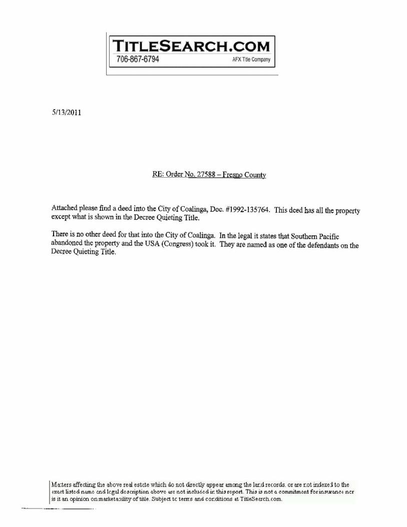
,TLES,EARCH.COM 706-867-6794 AfX TlIs Company
5/13/2011
RE: Order No. 27588 - Fresno County
Attached please find a deed into the City of Coalinga, Doc. #1992-135764. This deed has all the property except what is shown in the Decree Quieting Title.
There is no other deed for that into the City of Coalinga. In the legal it states that Southern Pacific abandoned the property and the USA (Congress) took it. They are named as one of the defendants on the Decree Quieting Title.
Ma~ters affe ct.ing the ab ave re at estcte which do not dire cUv apll ear illliong the lar.d re (ords. or are f.ot indexd to the ¢XCLct li3te d no.me cndl~ gcJ de 3~ription CLhove (U'e t"J.Ot mcluc.e d 1r. thi3 report. Thi3 t:l not CL cornmitmeflt for ID.3U1'CLnC ¢ncr is it an opinion onmarketaJility oftille. Subject tc tem.s and cOf.ditions at TitleSeuch.com.
"~_."...._" .." ..._-

•
921.35764 CH:V of CQIl; linqa
/3
ANOw..... At(;QAQtOMAIL TO
SEP 031992 '
. --~-------------
'I'hi q remrdfncr is requested by and far City of Coalil19a.
""'~llLJ' ~ wIOINKP'VP lo'liJ -'5~ , ,
-~O- O~/1. i 1
I FOR A 6000 AND VALUABLE CONSIDERATION, receIpt of which ts hereby ackno~'adged.
SOUTHERN PACIFIC TllANSPORTA710t: CDtIPANV, 8 Del awaril corporati on. ("Grantor").
hereby rami SlII$. rel ellSes and quitc::l atmg unto CITY OF COAliNGA, II municipal
corporatton (If the State of California, ("Grantee"); that certain real property
situated in the City of Coaling., County of Fresno. State of California, as more
particularly described in the Exhibit "A" attached and hereby mada a part hel"$of,
(the "PropertyW), subject to all covenants. condttions, restrictions. exceptions,
easements, rights-of-way, rlghts-of-a~cess. agreements, reservatlcns,
encumbrances, liens and other m~tters as tha S8me may be of record; any Matters
which ~/ould be dlsclosod by survey. invBlItiglltlcm (If inqutrYi and any taK,
assessment or other governmental lien aga1nst the Property,
This Grant Is made without covenant~ Qr warranties of any kind. Grantee, by
5ignlng below. expressly acknowledges that Grantee Is buying the Property 1n an
"AS IS" condition and that Grintea has relied upon its own independent
Investigation of the physical condition of the Property. Grantee hereby r8lea.~es
I • Grantor and Grantor's Shareholders. officers, directors, agents and employees
from 11.11 responsibility and l1abnHy regarding the condition (including, but not
limited to. the physical condlthm or presence of hanrdous materhhl, valuation
or utility of the Property. !.[
DDCUDlllnt 0003B Page 1 Bf 3
Description: Fr6sno,C~ Document· Order; Dz Comment:
Year.DocID 1992.135754 P&g~: 1 or 13

•• J
. . This Deed ts made subject to that certaln Consent Dstrem CIV. S89-1081-EJQIJFM.
Unftud State, Dlstrtct Court, Eastern Dtstrlct of Califol'nia, rolattng to
hazerdoull waste, II certified COpy thftreof r't!eordlld June 21. 199O 115 Doc::ument No.
90071!{)Ii, Offtct.l Recdrds Ind as set forth 1n thlt cerh1n F1rst Amended Consllnt
o.er'l, .. ctrtlf1ed cop)' thereof recorded July 27. 1990. as D~nt No.
~087710. Official Records and by documentation and matters IlS referenced
there1n.
I" WITH5S WHEREOF, Grarttor' has caused these prBlllnts to be executed ill dup1 tcate
thts fler du' of ..rVt.....Y. t 19 'Lo:"•
GJIAilTDRt
SOUTHERlJ ~
8Y:_--f~-":;P"-~---~-
Tt tl t :/-.-_--l.t:LY.:l.ala:l.1!lJ!Di~
~ ;;..t'~' •/ Attest : . _._~1(......:::;)..;.,·:t1~MJ.'-'-"-",,-'_'~__
Tnle:__--=•...:.:~.::.=.,.'-=A~RV:........ ~~
STATE OF CALIFORNIA
, in the year 19~1 before me. ~~~~~~~~~~~~r~~~~~~~~~.~~_-:.~~~_-_-~~~-_- __--, ft. notary pub11c 1n and for the
personally appeared __ .. _ ~
My Commtsslon Exptr8s: ~ \995
Dacumen t 00038 PagG 2 of 3
..... Description: Fresno,CA Document • Year.DocID 199~.135764 Pag8: 2 o£ 13 Order! DZ Comment:
,.C ~ (
C ( ( ~
.. r ~
(
c..,. c r :0: ,(,
. ~ .,t
"
:.. ~
!I I
i
11 'I I
.1

t
GrentH hlrabV .cCep1S this dMd CMt aor-a for ltHIf. ttl lUOMI.ora and ."I&nl, to
be bound by the condltlcm, and covenants eet forth hen:"" lind to perform all
obllgatlan, of Orant" .81 forth herein_
Dated thl. 18th day of Augult. 1992.
GRANTEEt
CITY OF COAUNGA ! By: =~lik~ Tltlo: Mavo;..
::ri~f!1_~:: -
Oacumem 00038 Pege 3 of 3
, I
Description; Fresno,CA Doc~ent
Order: DZ Comment: - Y~ar.DocrD J992.135764 Page: 3 of 13
-----_. - --- - --_._._...._---

·r 52306 CDaling~, Ca. wast Elm Avenue and Pacific St~$at
EXHIBIT "A"
All those pare.Is of land sl~u~te and lytn~ in Section 5, ~wnship 21 South, ~nge 15 E~~t, H.D.B. & M. In the City ot COAl!nge, county o{Freeno, State of california, being mora p• .ticularly described as followsf .
PAACSX. 1
Belnq a strip of land 10 feet wi~e lying adjacent to the SQuthe••~8rly ri~ht-of-line of Weet Elm Avenue be1n; bounded, on the north by the Co~linga City Limit Lina BS shown on thAt certain map reco~dcd 1n Book 27 of ~e~otd of 5urveys at P~9. ~" Fresno County Records, on the Bouth by the Northeasterly 11ne of ~ar~Bl 2 sa said paresl is delineated on Parcel ~p No. n06, recor~ed in Book 2~ of Parcel Mapa at PsOas 19 and 20, Fresno County Records, on the East by G line parallel and concentric with and 10.00 feet ~Qu~he4sterly Qt, measured 4Adially and at ~19ht angles to. the southeast~rly line of wast ~lm Avenue dS eaid Avanua 18 d9l1n~ated on said Parcel Map 006, ~nd on th~ we8~ by th~ SovtheaBterlyline ot saId wast Elm Av~nue, said Southeasterly line of West Elm Avenue bslnq descrIbed ftS follows I
aeglnnln9 at thB point of intBrsQction Of &Qld City Ll~tB l1ne with e41d South88~terly l~nw ae West Elm Street, gald point bear. " 89; 42' 30 " til , 3B .04 feat f.i;om the point of intersection of t!'l.A center line at said West Slm Avenue with said City Limit Line, thence ~lDng said southBaatB~ly linG of WQat Elm Avenue, being the westerly 11n~ of said 10.00 toot WiQ8 strip, ~he following courses and distances;
1) S 3711 38· 00" W a o:UstancEI of 38.07 fElet;
2) along the arc of a curve concmVQ 8outhe~atarly 8 dlstanc8 at 439.64 tRet. sald curva having a radius of 1770.00 fee~ and a central ~nqla ot' 1411 13 I 53";
3) S 23 11 .24' 00" W d distance of 254.46 feet ta t.he nQrt.heelilte;r;ly line of said ~arcel 2 of Parc~l Map 006 and the terminus of said weuterlyline of s~!d 10.00 loot stripl
The Southeasterly line of said 10 foot wide strip to pO lengthened o~ ~hortened to meet at all angle points and to terminatQ On the north in the aaid City Limit Lin$ and on th~ south in the nQrtheaatarly line of said Parcel 2 of Parcel Map 006.
PARC~r.. :I
B8Qinninq at the Inter"ection Q' the Southeasterly R19ht-~f-way of Elm Avenue end ths center line of pa~iflQ streat oS dhown on PGtcel Map No. DJJ. recorded in Book 51 of Parcel Mapa a~ pages 67 ~nd 88. Fr~snO Co~mt.y Records; 't'h"nge S 52V 20' 14" Ii: alan; the said c.nt.e~ U.no of Pacific St&Q$C a distance ot 449.33 teet to a p01nt Qn ~he Northweste~ly Right-of-WQY line of Bouthe~n Pacific ~al1ro~d 4S abandon~Q by Act of Congress on November 6, 1986, a public law, 99·',il4, t.h.nce S 37; 38' 43" W along the aa1~ abAndoned r19ht~of way l1ns a distance of 42.00 feets
~eBcription: F~e6no1CA Docume~t - Year.DocID 1~92.135764 p~ge: 4 or 13 Ordf9r: DZ COllllllent:
I

Thence 1'1 5251 20' 14" W ilArs11$1 wi tb and 42. 00 tG~t distance, measured at right engles, f~o~ the conte~ l1ne of .aid pacif1c Street 0 dlstongeof 429,31 feet to the ~Bginn1ng of • curve cDncave to the South-.aet having a r~c:u..us of 20.00 f.et •• delt.a Imgle of gQ8 01' 46", thenc::~ along the ere of said curve _ length af 31.43 ~.et tQ a point on the sout.hllastt:lrl.y right-of-way line of rUm AV~"uu, thence N 37 Q JB' 00" £ alQnq .aid right-ot-way l1ne of a~1d DIm Avenue II di_tance af 62.01 feet ~o the Point ot BeginnLng.
PARCEL 3
CO~Qncinq at tho interseotion of the eou~heastarly Right-ot-Way of RIm Avenue «nd the Cfitnt&~ lina of pacific Street a~ ahown Qn farcel Map Nc. 032, recorded in Book 51 of Percel Map~ 4~ 'aquD 87 and B8# FresnO County Records J 'l"henca a 52\11 20' 14" I': along the said canter ling of Pacific St~ee~ a distance of 649.33 feee ~g a point on the Northeasterly Right-of~W~y 11na of southern P~c1fic R~ilroad as abandoned ~y Act of congress on November 6, 1986, a pUblic law, 99-614, gaid point baing th~ "True Point. of Beginninq" o! the pIII:'C$l Qt llm<1 t.o Lie c1tl18Crib_di thence B 52 11 20' 14" I!: along t.he said center :l..lnQ of PaclUl;l 8treet iii dlst/ilnceor )00.72 feat to the most southerly carner of tha ~emalndo~ Pa~c9l as shown on aald parcel Map No. 0321 thencs S 31e 38' 07 M W along the Southwesterly p~olon9atlon of the southeasterly 11ne Qf said Remainder Parcel a distance of 50.00 feot to Q point on & curvs concave to the Northeast h~vin9 a r4dlua of ~O.OO feet and a delta anqle Of 23W 06' O~1I1 thence along the arc of sllld curve Q distanciiI of 20.16 fget to a point of reverse curve conc~ve to tha Southwest hav~n9 a radius of 50.00 feet and ~ delta angle of 23 11 04' 26"1 thencG along the arc of StUd curve 0 diBtance o{ 20.14 feet; thence N sag 20' 14" Wparallel with and 42.00 feet dlstant, measured at s r~qht angle, from the center line of a~lQ Pacific Strest a dist&nce of 2~1.S2 teet to a pQint on the SA~d abandoned Northeasterly riqht-of-way line of Southern poc1flc Ral1ro$~1 thence N 37 v 38' 43" E: along the said abandoned rJ.qht-of-w~y lJ.ne a dlatanco of 42.00 feet ~o the "True Point ot Beginn,inq".
5
i; Description: Fresno,CA Documene - Year.DocID 199J.Z3576~ Pav~: 5 of 13 Order: DZ Comment:

LU
l;ITy
TRl-CfTY ENGINEERING 390 COALINGA PLAZA
P.O. lOX 3118 COAliNGA. CA. 93210
CILLE
LIMJTS LINe: •.07'
"'-100'
IlnIOi &-11)- 92 D)': C.R.
GoaII:
120S>1 1315- 8Q61
OWIJ. No.
EXHIBIT uall
~tv. i
1-24- ~2 C.R.
~
~
ig ~__---' --='==B~~RC~~~b :::...L=-- --1.....:..I..::of:..-:;2=--1
Des~ription: Fresno,CA Document - Year.DocID 1992.135754 Pag6: 5 or 13 order: DZ COIlllll611t: I' .,

FOREST
AVEN
-TAU!! POINt 01 ftP!GfNNllfOTO PARCEL. MO. at
PARCEl. NO. 3
A d~O.OO' I • to"OI'441" L .51.451
M. ~Q.OO· 4- 2SCl Oa'QO' 1.1110.10'
I:~
l~ 200 FEET WIlJ[I; SOUTHERN ~&~57"11l.''''II''W 42.00" ;;-i RAILROAD RIGHT- OF - WAY Aa ABMl ~ HI DONllD PUj ACT 01' CONORE!U ON 0, P MOVI!MQIlM &,198e. PUBLIC LAW ~ 91H1I4. QZ.Oo' -.
-,1I"oIoo!i--J---"rflUI!; POINT 0' BI!GINNING" N&7038'4l;1"f;; TO PAAC!L NO. a
AEV. :
7-24-'. C.R.
~ lRl-CITY
Ov!lJ: 5- 18*92ctva lfuglt\tin By: CR
B\l68NEEmNG U:-I lIroIlW,eN Bee&.; 390 COALINGA PlAZA 1" • 200'
P.O. (lOX 388 C1lOBt.3lS-6001 COALINGA, CA. 93210
:I ;:\I·
,.
Deecr~ptton: Fresno,CA Docum8nt Year.DocID 1992.135764 Pag8: 7 of 13w
Order: DZ COJllment:

I,
1iB1IClLllrJOH JIg. un RBSOUITION OF ~ C:ID' COWCIL
OP 'D£ et'n' OF CON-!MCIA ACC:ln"'nMO 2IIB DDJaerCM ap
.Aatr%e &%aaft ~ TR IOIl'HDX PACUXC TUIlllPDll'l'4~lalf CO.
WIIBlUlA8, it La to t.h.. b".t. in~.r8.t af l:I\e CJ.~y ot OOaHnQ& ~o accept Ute QUit: Clai/ll o.ad for d_,Uoat1nljl .. port.ion of rlvht""Of__y en ~J.tla Si;r.llt. too t~
CQallnQa nedeYslopment AgBn~y, Roce partl~Yllrly d••arlb&d O~ a~~..~od Exhiblt ~~" And,
Mow ~~~ ••• IT KBS~VZD that thlO Kayor and t.he C!\y ~QunaLl Df the c~~y ot coallnqa herllby author12B t~l~ ee'olution.
BY TH~ ORDER or THIl: CITY (;OUNCIL Oll' rH& CITY or COALUIOII.
DAtsP' ThLs 2n~ day IIf ~uno, 1992.
Hayor
r~"OfLOf""''' fo • '", '" <e'U', 'he< 'he 'opy or R••olutlon ~o. 2298 QdOPt.B~ by the City counoil Of the Oity of Coal!nga at t.he
_,",u --"•••• f ... <e. , ....y .r ';q, <it ~( (
{
(.,., t
"
•i. (
Description, Fresno,CA Document - Ye~r.DocID 1992.1j5764 Page: 8 or 1j order, DZ Comment:
c

I! AV ;,N.Us _
-----rn-usa""cio"i! .,.I.
ELM ••.m' I RTMlI POUlT OF BEOINNING"
R ~ 20.00' TO PARCEl. MO, IA • 90 1ll0,'04S" L ~ :'1.4:1' 4.-o+---PAIICEl NO. I
"TRUe: f10INT Of' BEOI"NIHQ" TO PAlteR NO.2.
PANCfl. NO. 2
FORES,. AVENUE
Ito 60.00' 6' 25'06'0$" L. ~O.I11·
lRi-CITY Cld et.elllMq 0010: ~·11l-92fl,: ell
ENGINEfj~NG Lw 8~rli!.r4 !katJ: :190 COAllNO~ PI,AZA 1" • 200·
P.O. eox 388 (20e)9SII-GOIilI ~ C.. ...l;..I... ~RI"J-__.=.:....__... O;..A N~G..:..A;..;.,_C,;oA;.;.,;.. _9;..;:J;..-::!;..;,';.O~ ~
.. ~ l 2 t "~---""""-------- --lL....-__-.t
DescriptiQ~: Fresno,CA Document - Y8ar.DQcID 1992.13,76i Page: 9 of 13 qOrdt!lr: DZ CQlMlent:
-----,-----

LEGAL OESCRlPTlON
All ~hat, port!on lying in the E~st Half of 50ctlo" 5, To~n3hip 21 South. Ra"se LS EGU~, M.O.B. & M,"ln tho Cl~y Qf Coalinga. County of Pro~no. State of Califotnia. being mOr~ P&\"t,i':",lal'ly deIlCY'.\.Ded 11$ f01l0WlS:
PARC£h 1 ee~lnnln9 a~ the intersection of the $o~the&ut.rly rlsh~-Qf
way of tiM AVQnyo Gnd ~hd conterline of P.clflc ~~ro.t aa shawn on PaTc~l Hap No. 032, recordod 1n Book 61 of Parcel Haps a~ pag@s &1 an~ ee. ~r~sno Coun~y Recorda: ~n.nc. 552°20'14-£ along ~h& said cent~rllne of Pdcific Street a dl.~anao Qf 449,~3 fee~ to a poLn~ on th~ NQrthw~~te~ly ~l~h~-of-~ay I1ne of &ou~hern Paclfic Railro~~ a& abAndoned b~ Ao~ of consroe8 on Nov.mb~r 6, 1966, ~ public law, 99~614: thence 537b~8'43'W along tho said GbQndonod r!BhL·of-w~~ lin~ ~ d1atAOQ. Q1 42.00 fgot~ tnonc. N~2g ~O·14·W parallel with and 42.00 feo~ d1$~Gnt from tn. cen~orlin~ of sa!d Pa~iflc SLr~et a di5t~nc~ of ~~"31 f ••t ~o tho beginningof a ~urvo concave to thd Southeast hovina ~ radL~~ ot 20.00 fB~t: d Qolta angl~ of 9oP01'46" ond an ar~ le"8th of 31.43 fQu~ to • point on tho sQ~theasterly rlo~t-of-way of ~~ld Elm AVonU6; Ch~nCe N3703a·oo·E QlonQ ~he ~did right-of-way line Qf ~lm Avonu~ d diatan~~ of 62.01 fe@~ to th~ pQlnc of aeglnnlng.
Said parcel contains 0.435 aeres.
PARCEL 2 . aeglnn1n~ a~ the lnterse~r.iQn of tho $ou~h@aBtvrly ri~h~-of'~dY of Elm Stru_~ and the centerline of PQcif10 Stroot as shown On Parcol MQP No. 032, recorded 1n Book 61 of p~rool MAPS a~ P80es Q? an~ ea, Fre5no County Record§: theneo SS20 20'l4"E 41on~ t~e ~Aid con~@rLino af Pacific 5treot e di~~anQ. of 649.3~ f~~t co .Ii point On tohe North~e.~~~rly l-ight-of-way )'in. of Sowt.hojrn Pile"" f.i.e Railr"ad .:.~ a.bandon",d I:JV Act. Qf CongreulS on 1'10""1111)111" (>,
t~a6. a public law 99-614: seid point a18Q b8Lng th~ 'Ttuo po~nt of aeginnlog": then~~ S$2020'14"E, alone tho aa!d conter!lne of PQ~ific Stt$bt a di~tance of ~OO.7~ TGet ~o the ~08t south~rly Corn6f of th~ remainder pe.~col a$ Dho~n on ~aid Parcel MAp No. O~2; ~h.nce 5370 38'07"W alono tho Southw8s~erlv prolonQation Qf th.. $oLlt.h"/.Isc ..rly lin.,) of toh.. ~.<Il<1 fh'ffiolnd"r parco! A diSl;.AnCo of 60,00 f~ot. t.o d ~oin~ on a eurv~ qoncav~ t~ 'h$ Northwest h~vino a ~~d!y~ of 50.00 fe8ti a d~lt~ bnola of 2~o06'OS" and 8n 6tc dlS:La.n¢~ of ~O.16 f~v~ LO a point of a reller,sa ¢~rY(l ooncll"~ to th/'t $Ot.lt.h....05t IHiVing .a radius: of ~IO.OO fe",t: a deltLl 80s1@ of 2:P 04'26·, and lin al"e d.i.S~anC:d of ::i.O.14 fu't.; theno~ N52 0 20'14"104 parall~l with and ~2.00 f60t dls~~n~ from th@ cen~etlin8 Qf saId pac~Tic St.raQ~ 0 d'stanc~ of ;'~1.~~ feet. to a poin~ on the said abAndoned Northa~sterly riQh~-of-way 4in~ of sou~horn Pacif~u R."Uro8Q; thanCG N:J7° J13'4:l"r. along the ~Qid abandQnQd r!ght-ofway lin~ a difi~Ance of 42.00 feet to the "TrYe PQ~nt of BeQi.nnlno,"
Said par~el eont~ln5 O.29a acr~8,
De~criptjon: Fr~~no,CA Docum~~t - ~e~r.DccXD 1992.135764 Page: 10 of 13 Ie Orcl~r, DZ Comm~~l;:
----_ _-_ .

I' , t I I
USOLtr.rlmt tICJ. :12n • lUlSm.sn:10ll 01' !l!d GIn COUMCIIt ! ~ OF 'HII CI'R 0' c:ou.%1tOa
AC!I;!~INCI 'I'D I;tJDl:eA'UOM 0.. • I n •., a.M tDIaft ·· Inoli 'I!D ~ 'ACJI't:Cl ~ICIM co. . I'
~, it ill to toll. M.t. int.ell'••lt 0' !:1'I11 C1.tl' ot Coalinga t.O .Qc;l*P'" the Q"lt OlaJ.m D..d tv&' d.cU.oat1ng 4 portion of ri9ht.-ot:-way art _at. iilla A"'onllll t.CI the CQa11"g_ RlIlcl.lilvelopnen\ 1\9""Oy, AlOa:08 part.lc:lll=ly d'lIlIod.bl'lI:1 011 Cl~hlO'h~ BxhlUlt. RAM al1d,.
NOIf 'ZURlIII'QU. BS I!I: U50LWD that. thQ Hayor and the CU.), C:o"nol1 of th~ City of Coalln;a h.~.~y authorl~a thia r8.o1u~10n.
BY THE OflDEl' or THE CJ:TY COUNCIL 0" TU CITY or C01I1.INQA.
,\
DeBcription: Fresno,CA Document - Year.DocID 1992.135764 pagel 11 of 13 'rder: DZ Comment:

t
""I'flUl f'OINT Of' 81011.,.."0"
LUCIL1.~. __~=::,;::..
CITY LIMfTS LtN2
lRI-CITY Clvft tnellnGOnl. !)gill .s-18-92Dr: C.R.
ENGINEERING L.... IlI,..... 8~: J90 COALll\IOA PLAZA ,1,1 ~ laO'
P.O. BOX 3QO 120~1 9~D·.J(llU t--_.~-.;:;;;.;; ""C;,;O:;;A:;;:.L.:.:,IN;.;O:::.:A:.::.:..,...;C:::;A~ '.• ..:9~1~2,:,:'0~__ ......__..,lft.\L
Ih'lI, No.
EXHIBIT IIAu
Description: P~e~no,CA Document - Year.DocID 1992.135764 page: l2 or 13 II: ,'\'1(J, ._JIII
Order: DZ COllU1lent: w
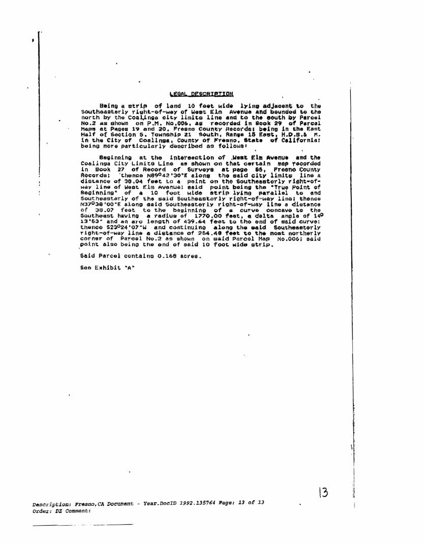
LEGeL pgfiCRIRIXP~
0.ln9 a Btrlp of land 10 fe.~ wide 1~1ng adJag8nt to thu 50~theaat.rly rL8hL-of~w.y of Wo.~ Elm ~v.nue and bounded ~Q ~he ngrth by th~ Coa~n~G aLLy limlts lLne and to ~h. eouth by Parcel No.2 &8 shown on P.M. NQ.006, a~ recorded in Sook 29 of P.r~01 MGP~ at P~gea 1~ and 20. Fresno Coun~y Recorde. beine In Cha East Half o~ 6oction S. TownB~lp 21 SOuth, Ran,. 16 e~.t. H.D.B.& M. In th~ City of CoalInga, count~ of FreBno, .~.t. of Col1fornla; bein9 mOT~ particularlY de~~Tlbed as fol1oWQI
B8~inning at the Int.Yeec~lon of ,Wast Elm Avenu. and the CO~!i094 ci~y Limi~a ~ine a~ shown on tha~ oertain ~ap reo~rded in aogh 27 of Record of Survoya at paQO &6, Freeno Coun~y RO~QrdB; 't.honce N890 42 '30"! alone t;.ho said cit)" l1m1t~ line a dls~Bnce gf 30.04 feet to G point 0" th~ $outh~a&terly right-ofWay line of Woe~ Elm Avenu~~ said poin~ bein& ~hD MTr~o point of Beginning" of • 10 foot wldo serip lvlna ~.~allDl ~o end 50uthe8st~rl~ of ~h$ 5aid sQ~theast~rlY right-of-way line; then~e N370 3e'OO"E .10"9 sald south~asL~tlY right-of-way 11ne a di~~_nee of ~e.01 feet to the b$sinnlng Q1 8 curve coneave to tho 50utheQst having a radius of 1770.00 feet. e delta angle of 140 13'&3" and &0 «ro length of 439.64 fe0~ to the and of said curve: thence 5230 24'O'"W and contlnuing a10"9 the ~aLd Southeasterly rlgh~-of~way line e di8tance of 264.4$ feet ~o tn. momt north~rlv corner of P~reel No.2 ~a 5hQwn on 5&ld Parcel Map No.OOQt said ,point also being tne end of said 10 foot Nlde strip.
Said Parcel cQntalne 0.16S acree.
See Ellhibit. "A"
l3 Description: Fresno,CA Docum~nt - Year.DocID 1992.135764 Page: 13 or 13 ord",~; DZ Comment:
.... . --_..._... _--

ot:!
a~ ~ ~ .. ....
'0t:!n~ ....
o t f),tlo '. ~ ":I ~ .,tl fa ... III
~ ~ 1lI fa
K o ....
] ~
III o
i ~
b.J '-l
'.Il
"" 'i? lq l_ III
"""' () .... I-<
~ =.~- ~~, ~" I1=P""'-=-~:=::::;;~~~-::.'"0::; -_.~=-="]..:r.~--.:-.....=. ~ ...... ~ ....... "_~~IT n"T EII-'I: ~
~ - ::;:.::==..::::':.. --'Wi &C. -...-..nII~ .... ~ U> ....... .;:::=~ - :..:.-.=... i ..,., ..... ~~~ &ftI' wo _
~_ ..-.. ............ .-.-JI:_ _"I-II"I;I;II.~..e-:._.
II'.!I.U1IIIr.D«nt -::::.:: :,-;;:"..::-.: ~.~
:0 IURVEYotn C'E ~ TIFfC,!,TE ~1iIiI"~~III.....-..rt1lo'.DE
I:1
/ if' . ~ /
~f-IL
1~;
_ ............. ~, ......-.
_OP,.,r .. -_ ... _.. _-~
'flIJI ..". H.U M!:!rt I!:I.I-MMt1I P'QII ~ ... ITtt1'llE1IKh't'III~
....,..alT.....,-ULLU:IIL~~
Il.'lIleTEfJ~~~E""nT.!
~~iI'~.I"""
1IT.., ... ..-:vIIIIIIT~ .. ~
~·THI!:l'IEI:ILn!IfDfTil1lIfI ... 1ItIll~ .KT \11 II< ~[.'11' I;II'"~_~
o)ftM:.~.JICI, lin-.
tM~~ COUNl"t SURV£"f01(s CE!frIF1C'" THS .., KII~ 'ltD! na:.m. I"CIt ~ .-lT1i ~ II'fta.IIIbI:fV1'5 ~ TKf U110 iI:u'ntraI!!I .IIC't •
1lI:!J.....!..I..t:t"'"""'~.~~7I:L-
~Q.LJ~
w C4A.o:=!::To-..,,, ~
,21S l'l16E
SEC 5
RECDRDEFtll CERTIFICATE :=-..: ml'JZ.!Dn ~ ~ 11ft!, ..,.~ ~ _..iZ.-OP "!ffKI 0
:'~~af~~~· "'[ ~
,(}...., o RECOIiD SIJRVEI'
:-;:;ee-r~
OF
"
'~-=:;''''IiS:::.~-V!J
~tfj~~"<~._" "'1I:IIaII'IIEP'TiIII!:IInI1t""'¥~"lLa'I.,
"'1.lI~ .•IL ..... ~ ~t'( e.II~.....'I'M -...:n'1)I"'lHll:E~""~lIl'oII1'I!:"'_ 1&1I ..... .-£!IT DII' ~ .,.GtI!== TIUII!;Io~
.~Jol .. El.l.!!13 Of' IiIEIIJIIQI'ii"S
!!IDS OtI:JlllElll._ ........... 'i""YIl!I1f
03lII"""1UIR!I:I''''-::'::
-j
i I
j
i I
,I ,.-1

-11111111111111111111111111111111111 111I111-IJllfl Recorded at the Request of: FRESNO County Recorder
I Robert C, Werner City of Coalinga I DOC- 2005-0256821
I Monday, OCT 31, 2005 10:58:52 WHEN RECORDED MAIL TO: I Ttl Pd $0.00 Nbr-0002001198
City of Coalinga III
JZG/R2/1-S clo BACIGALUPI, NEUFELD & ROWLEY 1111 E. Herndon Ave., Ste. 219 Fresno, California 93720 1---------- -----
II (Exempt from fees pursuant to Gov. C. §6\ 03)
(Space above tillS hne tor Recorder S Use only)
STIPULATED JUDGMENT QUIETING TITLE APN 900-700-12 (FORMERLY APN 083-020-59SU
United States District Court Case #1:05-CV-0021O-0WW-SMS

1
2
3
4
5
6
7
8
9
10
11
12
13
14
15
16
1 7
18
19
20
21
22
23
24
25
26
27
28
Bacigalupi,
Neufeld & Rowley II ) I E. Herndon A\'C.
Suile 219 Fresoo. CA 93120
I hereby attest and certify on /0 1 ~f that the foregoing docume~t IS f~1 ~rue
and correct copy of the original on file In myBacigalupi, Neufeld & Rowley office and In my legal custody. Craig M. Mortensen (95683) JACKL. WAGNER 1111 E. Herndon Ave., Sle. 219 l<'UlL--1,~.-s. ISTR Fresno, California 93720 Tel 559.431.6850 Fax 559.431.4216 Deputy
Attorneys for Plaintiff
UNITED STATES DISTRICT COURT FOR THE
EASTERN DISTRICT OF CALIFORNIA
* * * * * * * * *
City of Coalinga, ) Case: I :05-CV-0021 O-OWW) SMS
Plaintiff, ) v. )
) Union Pacific Railroad Company, a Delaware ) Corporation, fonnerly known as Southern Pacific ) STIPULATED JUDGMENT Transportation Company; County of Fresno; ) QUIETING TITLE Pleasant Valley Water District; Coalinga-Huron ) Recreation and Park District; State of California; ) APN 900-700-12 Southern Pacific Railroad Company, a California ) (formerly APN 083-020-59SU) Corporation; Southern Pacific Land Company, a ) Corporation; Southern Pacific Company, a ) Delaware Corporation; Standard Oil Company of ) California, a Delaware Corporation; Pacific Gas ) & Electric; Southern Pacific Transportation ) Company; the United States ofAmerica; All ) Persons Unknown, Claiming Any Legal or ) Equitable Right, Title, Estate, Lien, or Interest in ) the Property Described in the Complaint Adverse ) to Plaintiffs Title, or any Cloud on Plaintiff's ) Title Thereto; and DOES I through 100, ) inclusive, )
) Defun~n~. )
)
The court having determined that all Defendants except Defendants Coalinga-Huron
Recreation and Park District, Standard Oil Company of California, and County of Fresno
have either disclaimed any interest in the subject real property, or have defaulted, and further
having determined that the Defendants against whom the case is at issue and Plaintiffhereby
stipulate to the entry ofjudgment as set forth herein, the court therefore enters judgement in
favor ofPlaintiff as follows:
Stipulated Judgment Quieting Tille
-1
--------------------
1
2
3
4
5
6
7
8
9
10
11
12
13
14
15
16
17
18
19
20
21
22
23
24
25
26
27
28 Bacigalupi, Neufeld &
Rowley 1111 E.. Herndon Me. Suite 219 Fresno, CA 93120
IT IS ADJUDGED, ORDERED AND DECREED that:
1. As of October 1,2005, Plaintiff City of Coalinga was the sole owner of the title
in fee simple absolute to the real property which is the subject ofthis action, known as APN
900-700-12, formerly known as APN 083-020-59SU, which parcel ofreal property is more
particularly described in Exhibit "A" attached hereto and incOIporated herein as though fully
set forth hereafter.
2. Plaintiff's title is subject to the following exceptions:
As to Defendant County of Fresno: Property taxes, including any personal
property taxes and any assessments collected with taxes, for the fiscal year 2004-2005.
As to Defendant Coalinga-Huron Recreation and Park District: Any and all
levied and unpaid assessments under the Coalinga-Huron Recreation and Park District
Landscape & Lighting Maintenance District 1993-1 A.
As to Defendant Standard Oil ofCalifornia: Plaintiffhas not made a claim for
nor does Plaintiffclaim any right, title or interest in the oil, gas and other minerals, including
the right to mine and remove same from the subject property.
3. Defendants Union Pacific Railroad Company, a Delaware Corporation, formerly
known as Southern Pacific Transportation Company; Pleasant Valley Water District; State
of California; Southern Pacific Railroad Company, a California Corporation; Southern
Pacific Land Company, a Corporation; Southern Pacific Company, a Delaware Corporation;
Pacific Gas & Electric; Southern Pacific Transportation Company; the United States of
America; and "All Persons Unknown, Claiming Any Legal or Equitable Right, Title, Estate,
Lien, or Interest in the Property Described in the Complaint Adverse to Plaintiff's Title, or
any Cloud on Plaintiffs Title Thereto", own no right, title, estate, interest, or lien,
whatsoever in the subject property.
4. Plaintiff shall not recover its costs from Defendants.
(The remainder of this page, page 2, is intentionally left blank.)
Stipulated Judgment Quieting Title
-2

Dennis A. Marshall, County Counsel
By lsi Bruce B. Johnson
Bruce B. Johnson, Jr., Senior Deputy County Counsel, Attorneys for Defendant County of Fresno
Emerich & Fike
By lsi David A. Fike
David A. Fike, Attorneys for Defendant Coalinga-Huron Recreation and Park District
lsi Ralph E. Mayo
Ralph E. Mayo, Senior Counsel, ChevronTexaco, successor in interest to Defendant Standard Oil Company of California
Bacigalupi, Neufeld & Rowley
By lsI Craig M. Mortensen
Craig M. Mortensen, Attorneys for Plaintiff
lsi OLIVER W. WANGER
Oliver W. Wanger United States District Judge
Stipulatcd Judgmcnt Quicting Tillc
-3

~· .~:~.. '.~..:.. ~-.. " .. I ."
All that portion of that strip of land as abandoned by Southern P~cific Railroad Company per Act of Congress on November 6, 1986, Pu,Qlic Law 99-614:--.lying in the '",~ Southeast quarter of Section 5, Township 21 South, Range 15 East, 'Mqunt Diablo Ba~e and Meridian, and lying 100.00 feet equally on each side of the folio~ir.g descrfbe~~~ center line: ' - ,,-.', '
COMMENCING at the intersection of the Southeasterly right-of-way line of Elm Avenue and the center line of Pacific Street as shown on Parcel Map No. 032, recorded in Book S1 of ,Parcel Maps at Pages 87 and 88, Fresno County Records; th~~ce South 52° 20' 14" East along said center line of Pacific Street a distance of 549.33 feet to the point of intersection with t~e center line of said,abandoned strip of land; thence South 37° 38' 43" West along said center line a distance of 610.00 feet to the "True Point of Beginning" of the center line to be described; thence South 37° 38' 43" West along said center line a distance of 1059.16 ,feet to Point B as shown on map recorded in Beak 27 of Record of Surveys at Page 55, Fresno County Records and the terminus of the center line herein described.
The side lines of said 200.QO foot strip of land to be lengthened or shortened to terminate, on the North, in a line projected Northwesterly and Southeasterly at 90° to said herei:l above described C~'1ter line at said "True Point of Beginni:lg" and on the South by the Southeasterly prolongation of the Southeasterly line of Parcel 3'0= Parcel Map 006 filed in Sook 29 of Parcel Maps at Pages 19 and 20, Fresno County Records.
ALSO EXC~~TING TrlEREFROM all oil, gas and other minerals, with the right to prospec~
for, mine, and remove same as reserved by the Ur~ted States of America pursuant to Act of Congress annroved March S, 1922 (43 U.S. 9l2) i~ that certain Ac~ entitled, "An Act to Confi~-a Conveyance of Certain Real Property by the Sout~er:l Pacific Transportation'Company to ~est Pritchett and his 'wife, Diana Pritc~ec~, and for other pu=?oses", approved Novembe::- 6, 1986 (Public Law 99-614) .
'. APN: 900-700-12 .
. EXHIBITtk ,,-_ - --_ -.. - .. "'-' ._" .. '', .. _. -: '," .. ,.,,~ ----- -' .. ,'~"~--,.- ,- ',-'- ,-------.·_··,d
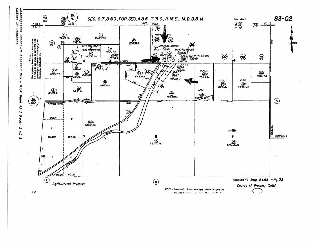
~li'------------------------------='------------Q,lLl la fl "'1" (BIr~11 l'l•• lot. ~; ~~~ SEC. 6,7.889.POR.SEC.48S, T.21 S.• R.15E.. M.D.8.8M. t:I~ T. 20 S. Q [ JIJlffl£ AV~. POLll:lI IJ.~ ..Qg
o " ®.
SO. 90 At.I ~ fll : @<t III (8K',•• .. ti.? t:I
=tl 206.32k. ~
1l!3!&: I'l';!)~t III ~IUi ~ '~niIII
~':::'ls~ {lls RA.C.C.iit, 32.00Ac. @)sC:~N
73.44Ac.! ~:n
f /IP-96J
8 14I;.9OAc.~
~ @. I[
el t[ tI tI I~ I ,I ,I
i4L601 I----------,I 7 r
I I : @s~
" , : 628.61 k., .... 2 I I I I
o I;I ,t1l
_~_!.:.§~gL __ ...! __ J~f!·W J 7 8 ~ I I I
I I , I 627~Ac,
3:II I
rut: $I I
" :I
I I
.41 leO,OOI
~ It) o'- Agricultutol Preserve
AVE
@ f/9.00Ac.
-s..l6'_
@ 56.GIOAc.
""'1 '" I I
@s 46.00Ac::
TolC Area 2'0IJj
11'6f)( 11' orfj
'" ~ 83-02
!~ l
,--.... ~} i @ 1'39)
~
,I l~
Af·w @s
8QGIOAc.
4 ~
@s 40.00 At.
jP·983
~ 120.00Ac.
o
jp.JUO iLOSTIf/U.S9
~ 640.00Ac.
Assessor's Map Bk.83 -Pg.02
County of Fresno, Calif. NOTE: - Assessor's B/ock Num/lel$ Shown in EllipUs. C)1961
AJI:!'I"~~Dr'~ Pn,r,fI/Il NUM/'''" C:MlUn in rir,.rllllr
mt 111 '"1111"illllll' II" lllll\\ tlillII'"1\ II FRESNO County Recorder Robert C. Werner 06487
RECORDING REQUESTED BY DOC- 2008-00 City of Coalinga Thursday JAN 17, 2008 15:21:24
Til Pd '$0.00 Nbr-0002683306A1~ WHEN RECORDED MAlL TO: APR/Rl/1-4Craig M. Monensen, Esq. Bacigalupi, Neufeld & Rowley 1111 E. Herndon Ave., Suite 219 Fresno, CA 93720
____________....;.. ----'Space Above This Une rorRuorder's UseOnly _
A.P.N.: 083-020-59 Chicago Title Co. Title No.: 07-45016179·J8
GRANT DEED
The Undersigned Granlor(s) Declare(s): DOCUMENTARYTRANSFER TAX $33.00; CITY TRANSFER TAX $0.00; SURVEY MONUMENT FEE $
[ X ) compUted OD the toIlSidenllioo or full value oCproperty CIln~d, OR
ccmputcd on the tomidenllion or full value less value oflicns Mdlor cnaunbrances rcmllining at lime of sale,
unincorpolllkd area; {X ] City of COALINGA, and
FORVALUABLE CONSIDERATION, receipt ofwhich is hereby acknowledged,
CITY OF COALINGA, a Municipal Corporation ofthe State ofClaifornia,
hereby GRANTS to the REDEVEWPMENT AGENCY OF THE CITY OF COALINGA,
the following described property in the City ofCOALINGA, County ofFRESNO, State ofCALIFORNIA:
SEE EXHIBIT"A" FOR COMPLETE LEGAL DESCRIPTION
Dated: December ~ 2007. ICITY OF COALINGA
I By:~~~~~~~~~~-::."""'2.....:
Stephen • Julian, City of Coalinga
REDEVELOPMENT AGENCY OF THE CITY OF COALINGA
By: ~,"",,£, ...._/Z2&~'StePhe~~~tive Director Coalinga Redevelopment Agency
Description: Fresno,CA Document - Year.DocID 2008,6487 Page: 1 of 4 Order: DS Comment:

EXHIBIT "A"
AD that portIoR of that strip of land as abandoned by Southern Padffc RallJcad CompanvperH.tofCongressOn November 6, 1986, Public Law 99-614 Mng In the Southeast quarter of sectton 5, Township 21 South, Range 15 t:ast, Mount Diablo Base and Merldran,·and lying 100.00 feet equally on each side af the following described C8lter line:
Commencing at the Intersection ofthe Southeastet1Y right-of-way One of Elm Avenue ~nd the center line of PaciflcStreet8sshown on Parcel Map No. 032, recorded In BookSlor Parte! Maps at Pages 87and 88, Fresno CountyRecords; thenceSouth 520 20' 14" Eastaro~ said centerIne ofPadflcStreetadtstanceof549.33feet to the pointofIntersection with the cent2rnne ofsaid abandoned strip of land; thence South 370 38'43"West along said center line a distance of 610,00 feet to the "True Poltlt of 8eQlnnfng" cf the ~ ilne tD be described; thence South 370 38' 43~ Westalong said center Ii~ adistance oll059.16 reet to PoInt Bas shown on map recorded In Book 27 ofRecord ofSurveyut Page 55, fresno County 'Records and thetermtnusoftf'le center Dne hereto described. .
The side lines ofsaId 200.00 foot strip of land to be lengthened or ~ortened to tennJnate, on the Northt,.1n a line prajec:txld Northwesterly and Southeasterlyat 900 tosaid herein above descrlbed cenrer I1neatsatd I,t rue Poblt of Beginnlngn and on the South by the SOutheBsterfy prolongation of the Southeasterly line of Parcel 3 of Parcel Map 006 fIfed In Book 29 of.Parcel Maps at Pages 19 and 20, freslJO County Records. .
ALSO EXCEP1lNGlllEREFROM all oil, gas and otherminerals, with the right to prosPectfDr, mine,. andnmove same as reserved by the United States of Amerfca pursuant to Act of Congress approved Marth 8, 1922 (43 u.s. 912) In that certain Act. entitled, "An Act. to Omflnn a CQnveyance of Certain Real Property by the Southern Pacific Transportation Company to Emest Pritchett and his wife, Diana Prltthett, and for other purposes", approved November 6, 1986 (Public Law 99-614).
Said parte) contains 4.86 gross acres, more or less. APN: 083·020-59
_.- __.._.- _.- -~- -.. _._--_.~...... - .... -... ~._._ ...- __.__...-......__.- - - - - - - - - - - -- ~ - -- - - - - - - - - ..... -
Description: Fresno,CA Document - Year.DocID 2008.6487 Page: 2 of 4 Order: DS Conunent:

Certificate of Acceptance
In accordance with Section 27281 of the Government Code, this is to certify that the interest in real property ofAPN # 083-020-59 from the City ofCoalinga., California., a municipal government. conveyed by this instrument to the Coalinga Redevelopment Agency, is hereby accepted by the Board ofthe Coalinga Redevelopment Agency of the City of Coalinga as duly adopted by a Joint Resolution No. 3227 and RA-248 during their regular meeting December 20, 2007 and the grantee consents to the recordation thereof by its duly authorized officer.
Dated: December 20, 2007
Attest: ~d.Nr ~ Cindy Johnson, Deputy City Clerk City of Coalinga
Description: Fresno,CA Document - Year.DocID 2008.6487 Page: 3 of 4 Order: DS Comment:

CALIFORNIA ALL-PURPOSE ACKNOWLEDGMENT ~~~~~
State of California }
Co~?~on~<l~Rbetoreme.~~ / IlIIle It Nam& Mel TII10 0 0Iflc0r
pe""nallyappeared ~Ar~)Names) S e s)
who proved to me on the basis of satisfactory evidence to be the person""'> whose name..£s1 is/.¢subscribed to the within instrument and acknowledged to me that he/§be1tJ;lefexecuted the same in his.!PeffU;lejt authorized capacily(jD8), and that by his/,be11tj)eit signature~ on the instrument the pers,9n($y,' or the entity upon behalf of which the perso~ acted, executed the instrument.
I certify under PENALTY OF PERJURY under the laws of the State of California that the foregoing paragraph is true and correct.
WITNESS m~/~nd and o~tal fia~.
SigneIUre~~~Place Notary Seal Above
----------- OPTIONAL ---------J-:--li----Though the informstion below is nol required by Jaw, it may prove valuable 10 persons relying on /he document
and CtJuld prevent fraudulent removal snd reattachment of this form to another document.
Description of Attached Document
Title or Type of Document: _~
Document Date:
Signer(s} OtherThan Named Above:
Capaclty(ies) Claimed by Signer(s)
Signer's Name:
o Individual o Corporate Officer - TiUe(s):
o Partner - 0 Limited 0 General o Attorney in Fact o Trustee
o Guardian or Conservator o Other: _
Signer Is Representing: _
_
• Top 01 thumb here
_
Number of Pages: _
Signer's Name: _
o IndMdual o Corporate Officer - Tltle(s): _
o Partner - 0 Limited 0 General o Attorney in Fact •
Top 01 thumb hereo Trustee o Guardian or Conservator o Other: _
Signer Is Representing: _
02007 Natlooal NOtary Assoclation- 9350 De SolO Aw., RO.Box 2402 ·cnatsworth,CA 91313-2402'www.NationalNo\aJy.org hem *5907 Fleolder.CalIToIl·FreeHlOO087lKlll27
Description: Fresno,CA Document - Year.DocID 2008.6487 Page: 4 of 4 Order: DB Comment:

"
RECORDING REQUESTED BY
The Redevelopment Agency of the City of Coalinga 155 West Dunan Avenue Coalinga, Callforma 93210 Attention William Skinner City Manager
WHEN RECORDED, MAIL TO ADDRESS ABOVE, and also to
State of Callforn la Department of ToxIc Substances Control 8800 Cal Center Dnve Sacramento, California 95826 Attn Richard Hume, P E National Pnonty List Unit Brownflelds and Environmental Restoration Program
{lp I
111\1111111111111111111111111111111111111\1111111 FRESNO County Recorder Robert C. Uerner DOC- 2010-0126541 Friday. SEP 24. 2010 1~ 22'07 Tt l Pd $0 .00 Nbr-0003295532
D.JG/R6/1-16
SPACE ABOVE THIS LINE RESERVED FOR RECORDER'S USE
COVENANT TO RESTRICT USE OF PROPERTY
ENVIRONMENTAL RESTRICTION
(Re Fresno County Assessor Parcel Numbers 083-020-58 and 083-020-59) DTSC Site Code 100289
This Covenant and Agreement ("Covenant") IS made by and between The Redevelopment Agency of the City of Coalinga (the "Covenantor"), the current owner of property situated In Coalinga, County of Fresno, State of Callforma, descnbed In ExhIbit "A", attached hereto and Incorporated herein by thiS reference (the "Property"), and the Department of TOXIC Substances Control (the "Department") Pursuant to CIVIl Code section 1471, the Department has determined that thiS Covenant IS reasonably necessary to protect present or future human health, safety or the environment as a result of the presence on the land of hazardous' matenals as defIned In Health and Safety Code section 25260 The Covenantor and Department, collectively referred to as the "Parties", hereby agree, pursuant to CIVil Code section 1471 and Health and Safety Code section 25355 5, that the use of the Property be restncted as set forth In thiS Covenant The PartIes further agree that the Covenant shall conform to the requirements of Callforma Code of Regulations, title 22, section 67391 1 The prOVISions of thiS Covenant shall be for the benefit of. and shall be enforceable by, the Umted States EnVironmental ProtectIon Agency (the "U S EPA") as a thIrd party benefiCiary
Page 1 of 9
Description: Fresno,CA DocUlllent - Year.DocID 2010.126541 Page: 1 of 16 Order: DB Conunent:

pursuant tomeral contract law, including, but not limited to, CIvil Code Section 1559 Resolution • 231, authonzlng the Redevelopment Agency of the City of Coalinga to enter Into this Covenant, IS attached as Exhibit C
ARTICLE I STATEMENT OF FACTS
1 01 The Prooertv The Property, totaling approximately 2 083 acres IS more particularly descnbed In Exhibit "A" (Legal Descrrptlon), and Illustrated In Exhibit "8" (Map), attached hereto and Incorporated herein by thiS reference The Property IS located between 4th Street and the mtersectlon of Lucille Avenue and Highway 198, County of Fresno, State of California The entirety of the Property compnses the Waste Management Unit (WMU). an engineered landfill Unit constructed on the property ThiS WMU was bUilt to contain the hazardous substances contamination from uncontrolled hot spots of asbestos and nickel contammatlon over a 107 acre 10 the City of Coalinga, Callfomla That contammatlon was collected and then consolidated and capped In thiS WMU
1 02 Hazardous Substances Hazardous substances, as defIned 10 section 25316, Chapter 6 8, DIVISIon 20 of the Callforma Health and Safety Code, Sectlon 101 (14) of the Comprehensive EnVironmental Response, Compensation and Liability Act of 1980, as amended ("CERCLA"), 42 USC section 9601(14), and 40 Code of Federal RegUlations parts 261 3 and 302 4, remain on portions of the Property These substances are also hazardous matenals as defined In Health and Safety Code sectIon 25260 (d) These contaminants Include asbestos ore waste and nrckel-contalnlng mining waste consolidated and contained In the WMU
1 03 Remediation of the Property The Property has been remedlated pursuant to a Record of DeCISion ("ROD") Issued by the US EPA, dated July 19,1989 The ROD IS
on file and available for review at the Coahnga Dlstnct library at 305 North 4th Street, City of Coalinga, the U S EPA Superfund Records Center at 75 Hawthorne Street, City of San Francisco, and the Department web site address at w.NW dtsc ca gov Contaminated sOil was excavated and disposed on-site under an Installed engineered WMU The ROD requires a deed restnctlon on the Property to prevent the disturbance of the cap and pOSSible release of asbestos fibers or nickel contaminants, and thIS restrictIon IS being Imposed on the Property where the WMU and 5011 cover and fenCing are located
1 04 Land Use Covenant The Property has been subject to recorded documents On June 21, 1990 In the United States District Court for the Eastern Dlstnct of CalifornIa, a Consent Decree, Case number elV S89-1081 EJG/JFM was recorded as Document No 90072305 On June 22, 1990, a Deed Restnctlon was recorded at Fresno County as Document No 90072506 of OffICial Records On July 27, 1990, an amended Consent Decree was recorded In the United States District Court for the Eastern Dlstnct of California's Document No 90087770 of OffiCial Records On September 14, 1992, an amended Deed Restnctlon was recorded at Fresno County as Document No 92146026
Page 2 of 9
Description: Fresno,CA Document - Year.DocID 2010.126541 Page: 2 of 16 Order: DB Comment:

of Official Records On January 17, 2008, the Covenantor acquired assessor's parcel number (APN) 083-020-59 that contains the Property pursuant to a Grant Deed that was recorded at Fresno County as Document No 2008-0006487 A land use covenant IS necessary to preclude potential reSidentIal user's exposure to hazardous substances which remain at the Property, and to preclude disruption of the response actions U S EPA, with the concurrence of the Department, has concluded that the Property, remedied to the goals presented In the ROD, and subject to the restnctlons of thIs Covenant, and when used In compliance with such restrictions, does not present an unacceptable threat to human safety or the envIronment
ARTICLE II DEFINITIONS
2 01 Department "Department" means the Callforma Department of TOXIC Substances Control and Includes Its successor agencies, If any
202 US EPA "U S EPA" means the Umted States EnVironmental Protectlon Agency and Includes Its successor agencies, If any
2.03 Owner "Owner" means the Covenantor, Its successors In rnterest, and their successors In Interest, mcludlng heirs and assigns, which at any time hold title or an ownership Interest to all or any portion of the Property
204 Occupant "Occupant" means Owner and any person or entity entitled by ownership, leasehold, or other legal relationship to the nght to occupy any portion of the Property
,2.05 CERCLA Lead Agency "CERCLA Lead Agency" means the governmental entity haVing the deSignated lead responsibility to Implement response action under the National ContIngency Plan ("NCP"), 40 C F R Part 300 U S EPA or a state agency acting pursuant to a contract or cooperative agreement executed under CERCLA sectIon 104{d)(1), 42 USC 9604(d){1), or deSignated pursuant to a CERCLA Memorandum of Agreement entered mto under SUbpart F of the NCP (40 C F R 300505) may be deSignated CERCLA Lead Agency. Because thiS site has already been dehsted from the NPL, and the Department has agreed to perform oversight of the operations and mamtenance activities for thiS operable unit, the Department shall be the KCERCLA Lead Agency" unless the site is re-listed However, at any time, the Department and US EPA may mutually agree In wntrng that either the Department or U S EPA may be selected as "CERCLA Lead Agency" for purposes of thiS Covenant
2 06 EnVironmental Restrictions KEnvlronmental Restrictions" means all protective provISions, covenants, restnctlons, prohibitions, and terms and conditions as set forth In any sectIon of this Covenant
207 Improvements "Improvements" Include, but are not hmlted to bUlldmgs, structures, roads, driveways, Improved parking areas, wells, pIpelines, or other utilities
Page 3 of9
Description: 1!'resno,CA Document - Year.DocID 2010.126541 Page: 3 of 16 Order: DB Conunent:
-------------------------------------_..._--_...

208 Lease "Lease" means lease, rental agreement, or any other document that creates a nght to use or occupy any portion of the Property
2 09 RemedIal Systems "Remedial Systems" shall mean the remedial equipment and systems located on the Property, including equipment and systems Installed as part of the construction and operation of the WMU and any deVices that may be Installed In the future The WMU as currently constructed Includes a fenced In engineered landfill unrt The landfill Unit Itself IS approximately 20 feet deep and was engineered With an Impermeable cap Over the cap IS approximately three feet of clean fill, and this IS
landscaped With natural vegetatIon to prevent erosion and deterioration of the engineered cap The top surface area of the raised landscaped area measures approximately 220 by 270 feet Each of these items are components of the remedial system that Sits wlthm another component of the remedial system, the fence that protects the entire area (approximately 300 feet on each side, see Exhibits A & B for bdetalls)
ARTICLE 111 GENERAL PROVISIONS
3 01 Restrictions to Run With the Land ThiS Covenant sets forth EnVironmental Restrictions, that apply to and encumber the Property and every portion thereof no matter how It IS Improved, held, used, occupied, leased, sold, hypothecated, encumbered, and/or conveyed ThiS Covenant (a) Runs WIth the land pursuant to Health and Safety Code section 25355 5(a) and CIVil Code section 1471, (b) Inures to the benefit of and passes With each and every portion of the Property, (c) Is for the benefit of, and IS enforceable by the Department and, (d) Is Imposed upon the entire Property unless expressly stated as applicable only to a specific portion thereof
302 Blndmg upon Owners/Occupants Pursuant to the Health and Safety Code, thiS Covenant binds all Owners and Occupants of the Property Pursuant to CIVIl Code section 1471, all successive owners of the Property are expressly bound hereby for the benefIt of the Department
3 03 Wntten Notice of the Presence of Hazardous Substances Prior to the sale, lease, assignment. or other transfer of the Property. or any portion thereof, the Owner, lessor, or sublessor shall give the buyer, lessee. or sublessee written notice of the eXistence of thiS Covenant and Its EnVironmental Restrictions
304 Incorporation mto Deeds and Leases The Covenant and Its EnVIronmental Restrictions shall be Incorporated by reference In each and every deed and lease for any portion of the Property
3 05 Conveyance of Property The Owner shall provIde notIce to the Department not later than thirty (30) days after any conveyance of any ownership Interest In the Property (excluding mortgages, liens, and other non-possessory encumbrances) The written notice shall include the name and mailing address of the new owner of the
Page 4 of9
Description: Fresno,CA Docwnent - Year.DocID 2010.126541 Page: 4 of 16 Order: DB Comment:
, Property and shall reference DTSC site code 100289 The notice shall also Include the APN Irsted In SectIon 1 01 If the new owner's property has been assigned a different APN. each such APN that covers the Property must be prOVided The Department shall not, by reason of this Covenant, have authonty to approve, disapprove, or otherwise affect proposed conveyance, except as othelWise prOVided by law or by administrative order
306 Costs of Administering the Covenant to be paid by Owner The Department has already Incurred and will In the future Incur costs associated with the administration of this Covenant Therefore. the Covenantor hereby covenants for Covenantor and for all subsequent Owners that, pursuant to California Code of RegUlatIons, title 22 section 67391 1(h), the Owner will pay the Department's cost In administering the Covenant
ARTICLE IV RESTRICTIONS
401 ProhibIted Uses The Property shall not be used for any of the following purposes
(a) A reSIdence. Includmg any mobile home or factory bUIlt housmg, constructed or Installed for use as reSidential human habitation
(b) A hospital for humans (c) A public or private school for persons under 21 years of age (d) A day care center for children
402 SOil Management Any contaminated sOils brought to the surface by grading, excavation, trenching or backfilling shall be managed In accordance with all applicable provISions of state and federal law and will not be removed from the Property without a Soli Management Plan approved by the CERCLA Lead Agency, such approval not to be unreasonably withheld
403 Prohibited ActivIties The following actIVIties are speCIfically prohibited without pnor written approval from the CERCLA Lead Agency
(a) Dnillng for drlnkmg water, 011, or gas (b) Extraction of groundwater for purposes or uses other than sIte
remediation (c) Alteration of eXlstrng dramage patterns as anticipated or constructed
as part of the Remedial System (d) Creation of SIgnIficant topographic low areas where water may pond,
Including accessory structures, sWimming pools and spas
404. Non-Interference with RemedIal Systems In addition to the non-Interference covenant dated June 22,1990, recorded In Fresno County records as document number 90072506, amended on September 24,1992 as document number 92146026, agreed to and placed on land pursuant to the Consent Decree under Case number CIV
,
Page 5 of 9
Description: FresnO,CA Docwnent - Year.DocID 2010.126541 Page: 5 of 16 Order: DS Comment:
889-1081 EJG/JFM In the United States Dlstnct Court for the Eastern District of Callforma, the Covenantor agrees
(a) The Owner and Occupant shall refrain from, and shall not permit, any . activity that would Interfere with the operation of the Remedial Systems or other SIte-wide response actIVIties at the Property without prior written approval from the CERCLA Lead Agency, such approval not to be unreasonably withheld
(b) All-uses and development of the Property shall preserve the integrity of the Remedial Systems or other Site-wide response activIties
(c) Owner shall provide a copy of thiS Covenant to all easement holders for all or any portion of the Site
405 Access for Department and the U S EPA The Department shall have reasonable nght of entry and access to the Property for Inspection, momtorlng, and other actIVities for the Remedial Systems on the Property consistent With the purposes of thIS Covenant as deemed necessary by the Department In order to protect the public health or safety, or the enVIronment subject to the reqUirement that all such persons WIth access to the Property shall comply With all safety rules and requirements In place for Owner's or Occupant's own personnel, and that such persons proVide their own personal protectIVe equIpment as reqUired by those safety rules Nothmg In thIS Instrument shall limit or otherwise affect U S EPA's right of entry and access, or US EPA's authority to take response actions, under CERCLA, the Nattonal Contingency Plan ("NCP"). 40 Code of Federal Regulations Part 300, or federal law Nothing In thiS Instrument shall limit or otherwise effect the Departmenfs nght of entry and access, or authonty to take response actions, under CERCLA, the NCP, 40 Code of Federal Regulations Part 300, Chapter 6 8, DIVISion 20 of the Callfomla Health and Safety Code, Callforma CIVil Code, or other applicable State Law
406 Access for Implementing Operation and Maintenance The entity, person or persons responsible for Implementing the operation and maintenance activities related to the Remedial Systems shall have reasonable nght of entry and access to the Property for the purpose of Implementing these operation and maintenance actiVities Such rrght of entry and access shall contmue until such time as the CERCLA Lead Agency determines that such actlvrtles are no longer reqUired
4 07 Inspectron and Reportmg ReqUirements The Owner shall conduct an annual inspection and submIt an Annual Inspection Report to the Department for Jts approval by January 15th of each year The annual report shall descnbe how all reqUirements outlined In thiS Covenant have been met The annual report, flied under penalty of pel]ury, shall certify that the Property IS bemg used In a manner consistent With thiS Covenant The annual report must Include the dates. times, and names of those who conducted and revIewed the annual inspection report It also shall deSCribe how the observations were performed that were the baSIS for the statements and conclUSions rn the annual report (e 9 drive by, fly over, walk In, etc) If ViolatIons are noted, the annual report must detail the steps taken to return to compliance If the Owner Identifies any
Page 6 of9
Description: Fresno,CA Document - Year.DocID 2010.126541 p~ge: 6 of 16 Order: DS Comment:
violations of this Covenant dUring the annuallnspectrons or at any other time, the Owner must, wIthin ten (10) days of Identifying the vIolatIon' determine the Identity of the party In vIolatIon, send a letter advIsing the party of the violation of the Covenant, and demand that the vIolation cease Immediately AdditIonally, copies of any correspondence related to the enforcement of this Covenant shall be sent to the Department and US EPA wlthm ten (10) days of Its onglnal transmiSSion
ARTICLE V ENFORCEMENT
5 01 Enforcement Failure of the Covenantor, Owner or Occupant to comply with any of the Restnctlons shall be grounds for the Department to require modification or removal of any Improvements constructed or placed upon any portion of the Property In violation of this Covenant Violation of this Covenant, including but not limited to, failure to submit, or the submiSSion of any false statement, record or report to the Department shall be grounds for the Department to pursue administrative, CIVil or criminal actions 502 Enforcement Rights of U S EPA as a Third Party BeneflcraN US EPA, as a third party benefIcIary, has the right to enforce the EnVironmental Restnctlons contained herem
ARTICLE VI VARIANCE. TERMINATION, AND TERM
601 Variance Owner, or any other aggneved person, may apply to the Department for a written vanance from the proVIsions of thiS Covenant Such application shall be made In accordance With Health and Safety Code section 25233 and a copy of the application shall be submitted to U S EPA Simultaneously With the application submitted to the Department No vanance may be granted under thiS paragraph WithOut pnor notice to and an opportUnity to comment by U S EPA
602 Termination Owner, or any other aggneved person, may apply to the Department for a termination or modification of one or more terms of thiS Covenant as they apply to all or any portion of the Property Such application shall be made In accordance With Health and Safety Code section 25234 and a copy of the application shall be submitted to US EPA Simultaneously With the application submitted to the Department No termination may be granted under thiS paragraph Without prior notice to and OPPortUnlty to comment by US EPA
6 03 Term Unless ended In accordance With paragraph 6 02, by law, or by the Department In the exercIse of Its discretion, after proVidIng notice to and an opportUnity to comment by U S EPA, thiS Covenant shall continue In effect In perpetuity
ARTICLE VII MISCELLANEOUS
701 No Dedication or Taking Intended Nothing set forth In thiS Covenant shall be construed to be a gIft or dedIcation, or offer of a gift or dedication, of the Property, or
Page 70f9
Description: Fresno,CA Document - Yellr.DocID 2010.126541 Page: 7 of 16 Order: DS Comment:

any portion thereof to the general public or anyone else for any purpose whatsoever Further, nothing In this Covenant shall be construed to effect a taking under state or federal law
7 02 Recordation The Covenantor shall record this Covenant, With all referenced Exhibits, In the County of Fresno Within ten (10) days of receipt of a fully executed ongmal
7 03 Notices Whenever any person gives or serves any Notice f'Nobce" as used herem Includes any demand or other communrcatlon With respect to this Covenant). each such Notice shall be In wntmg and shall be deemed effective (1) when delivered, If personally delivered to the person being served or to an officer of a corporate party being served, or (2) three (3) busmess days after depOSit In the mall, If marled by Umted States mall, postage paId. certified, return receipt requested
To Owner
The Redevelopment Agency of the City of Coalinga clo Craig M Mortensen Attorney At Law BaCigalupI, Neufeld & Rowley 1111 E Herndon Avenue, Suite 219 Fresno, California 93720
and also to
The City of Coalinga 155 West Dunan Avenue Coalinga, Calrfornla 93210 Attention Coa.llnga City Manager
To Department
Department of TOXIC Substances Control 8800 Cal Center Dnve Sacramento, Callforma 95826-3200 Richard Hume, P E Supervlsmg Hazardous Substances Engineer I NatlOnal Pnonty List Umt Brownflelds and EnVironmental Restoration Program
To U S EPA
US EPA, Region 9 75 Hawthorne Street San FranCISco, Callforma 94105-3901 Attn City of Coalinga Asbestos Project Manager
Page 80f9
Description: Fresno,CA Document - Year.DocID 2010.126541 Page: 8 of 16 Order: DS Comment:

Any party may change Its address or the Indwldual to whose attention a Notice IS to be sent by giVing wntten Notice In compliance with this paragraph
704 Partrallnvalldlt'1 If this Covenant or any of Its terms are determined by a court of competent JUrlsdlctton to be Invalid for any reason, the surviVing portions of this Covenant, or the application of It to any person or circumstance, shall remam In full force and effect as If such portion found Invalid had not been Included herein
705 Statutory and Regulatory References All statutory and regulatory references mclude successor provIsions
706 Incorporation of Attachments All attachments and exhibits to this Covenant are Incorporated herein by reference
7 07 California law This Covenant shall be governed, performed and mterpreted under the laws of the State of CalifornIa 7 08 No Delegation Nothrng set forth In thiS Covenant shall be construed to be a delegation of any authontles of the Department under any statute or regulatron
IN WITNESS WHEREOF, the Parties execute this Covenant
The Redevelopment Agency of the City of Coalinga
By.....:!!.2~--2-~~~~ Wilham Skinner City Manager City of Coalinga
Date J.-fl-fD
Department of ToXIC Substances Control
~c3ZB,~ p-~~ IV)Date
Supervising Hazardous Substance Engineer I National Prlonty List Umt Brownflelds and EnVironmental Restoration Program Department of TOXIC Substances Control
Page 9 of9
Description: Fresno,CA Document - Year.DocID 2010.126541 Page: 9 of 16 Order: DS Conunent:

ACKNOWLEDGMENT
State of California
County of ~c..:O::;;.... )
On J\JI~ Itt [19\0 before me,
~YS"\ ~.C\1o~~~N~Y~~'z.-Clnsert name and title fthe aIcer) personally appeared
lUi\\\pM StAnnec . who proved to me on the basIs of satisfactory eVldence to be the perso$) whose nam~) ls/al=& subscnbed to the wlthm Instrument and acknowledged to me that he/~/:I9UR8~executedthe same in hlstbQF/#l9tf'authonzed capaclty~ and that by hISJI::II~#tAetr signature~ on the Instrument the person~, or the entity upon behalf of which the person{et-scted. executed the Instrument
I certify under PENALTY OF PERJURY under the laws of the State of California that the foregoing paragraph IS true and correct
WITNESS my hand and official seal jfl~··'·t~~
NoIGfy MIIc • CCIIIfomIa I Ftwno CounIj
i I p
1tfQIml==....nJ·······.....D.Signatur
Description: Fresno,CA Docwnent - Year.DocID 2010.126541 Page: 10 of 16 Order: DB Comment:

NOTARY SEAL CLARIFICATION
I certify under penalty of perjury that the "Notary Sealn on the document to which this statement is attached reads as follows:
Name ofNotary: Krystal M. ChOJU8Ch
Commission Number: 1785443--'--...;.;;,...;...;.;..------------Date commission expires: December 16, 2011
State and County ofCommission: Fresno! CahfQrm.a
Govt. Code, Sec. 27361.7
.... __..... . ~_· .........._r .. ...._. .__~ ~·
Description: Fresno,CA Document - Year.DocID 2010.126541 Page: 11 of 16 Order: DB Comment:

ACKNOWLEDGMENT
State of California
~YJ-..c...d:--,1~).......:d~O'-l.)=D_before me,
L. (Insert name and title of the 0
personally appeared
AA t
who p ved to me on the basI of satisfactory eVidence to be the person.<.srwhose nameMls/9!'€"subscnbed to the within Instrument and acknowledged to me that hef~executed the same In hls~rJtR81F-authonzed capaclt}!~and that by hfs/be.r4holF-Slgnature,(.81On the Instrument the personM;Or the entity upon behalf of which the person.(81'acted, executed the IOstrument
I certify under PENALTY OF PERJURY under the laws of the State of Callfornra that the foregOing paragraph IS true and correct
68°teo FlORENcEl:HowARD f WITNESS my hand and official seal ~ NOT=uei:J?~Gl
~ SACRAMENTO COUNlY 0 A J ~ II J Jo~~~tSV,J3}OU
SIgnature (Seal)J/{JJ1A1f! 1- frhWtMtL
\tJ Description: Fresno,CA Docum"nt - Year.DocID 2010.126541 Page: 12 of 16 Order: DS COllllllent:

EXHIBIT A Coalinga City Operable Unit
Legal Description
That certain parcel of land situated In the South Half of Section 5, TownshIp 21 South, Range 15 East. Mount Diablo Base and Mendlan, In the City of Coalinga, County of Fresno, State of CalifornIa, the North hne of said South Half of Section 5 being the BasIs of Bearings for this description and taken as North 8942' 30" East per Book 27 of Record of Surveys at Page 55, Fresno County Records, bemg more particularly descnbed as follows
Commencing at the most easterly comer of Parcel 2 as shown on Parcel Map No 006, recorded In Book 29 of Parcel Maps at Pages 19 and 20, Fresno County of Records, said corner being on the westerly right-of-way line of the 200 foot wIde railroad stnp of Southern PacifiC Transportation Company as abandoned on November 6, 1986, by PubliC Law 99-614, said corner also bemg South 7241' 08" East a distance of 2807 00 feet from the West Quarter Corner of said SectIon 5, thence North 37 38' 42~ East along the said westerly nght-af-way line a dIstance of 122 95 feet to the TRUE POINT OF BEGINNING, thence the follOWing courses,
1) thence North 54 20'52" West leaVing said westerly right-of-way hne a distance of 276 25 feet,
2) thence North 37 06'18" East a distance of 327 26 feet, 3) thence South 51 38'34" East a distance of 2572 teet, 4) thence South 37 37'15" West a distance of 22 83 feet, 5) thence South 51 40'43" East a dIstance of 25346 feet to said westerly
nght-of-way Ime of Southern PacifiC Transportation Company, 6) thence South 51 40'43" East leavmg said westerly rrght-of-way a
dIstance of 27.15 feet, 7) thence South 38 15'28" West a distance of 290 36 feet, 8) thence North 5420'52" West a dIstance of 2406 feet to the said westerly
nght-ot-way hne of Southern PaCifIC Transportatlon Company and TRUE POINT OF BEGINNING
Said parcel contams 2.083 acres, more or less
End Descrrptlon
\fYJ Description: Fresno,CA Document - Year.DooID 2010.126541 Page: 13 of 16 Order: DB Comment:

In the CIty of Coalinga, County of Fresno, State of Callfomla. February 2006
A Trl City Engineering Lr\t;:lnl!lolU'Q S:UrvilYDII,.
l.loG. "."'10""" 1111 '~I: c.... ...,. 'l~' "~\1lI tA ~'u·rHS ~<;t.1fIlgQ (,10 U11t) ht. fI~~"~'·~~ P- 5~.'J:I ICG!IBI CITY•• , &, 1M ")ioo.U"01' r4.~W-"~ Jl ... %le')J,..,~,.•• ~
!!?9~ or Peo~ lhr tb-th Inr Of' TIlV Sou1h IMF OF S~C 5, 1 21S., R 15E.,IlDBI.'i Taken As 1iS'r4Z'3J'r Per Ek 27 or R~C(ll"d Dr SIlrv~}'~ M PC(ll! 55. 1"1'.R
" ::l'.
tb-th l.'n Of T~ S""ih Holf Of S.o 5. 21115 ~8'3'42'3Q'C
DA~IS Dr BEf,.qIKGS-
/
\~ Description: Fresno,CA Docwnent - Year.DocID 2010.126541 Page: 14 of 16 Order: DS Conunent:
Description: Fresno,CA Document - Year.DocID 2010.126541 Page: 15 of 16 Order: DS Comment:
~ . . RESOLUTION NUMBER RA-271 ..
RESOLUTION AUTHORIZING THE REDEVELOPMENT AGENCY OF THE CITY OF COALINGA TO COVENANT AND CONTRACT WITH THE CALIFORNIA DEPARTMENT
OF TOXIC SUBSTANCES CONTROL (DTSC) AND THE UNITED STATES ENVIRONMENTAL PROTECTION AGENCY (U.S. EPA), AUTHORIZE THE EXECUTIVE
DIRECTOR TO ENTER INTO AND EXECUTE ALL ASSOCIATED ENVIRONMENTAL RESTRICTIONS/COVENANTS AND CONTRACTS, AND ASSIGN RESPONSIBILITY
FOR DTSC OVERSIGHT COSTS FOR THE COVENANT/RESTRICTIONS IN PERPETUITY UNTIL TERMINATION OF SUCH COVENAT.
WHEREAS, the Redevelopment Agency of the City of Coalinga determines and declares that It may enter Into agreements with State and Federal agencies for 2010 and subsequent years as necessary, and
WHEREAS. the Redevelopment Agency of the City of Coalinga may take any actions that the Redevelopment Agency of the City of Coalinga determines are necessary and that are consistent with state and federal laws to remedy or remove a release of hazardous substances on, under. or from a property located In a Redevelopment Project Area If certain conditions are met
THEREFORE. BE IT RESOLVED BY the Redevelopment Agency of the City of Coalinga that the Executive Director IS hereby authorIZed to enter Into and execute ENVIRONMENTAL RESTRICTIONS/COVENANTS and contracts for the Redevelopment Agency of the City of Coalinga. with the California Department of TOXIC Substances Control and the U S EPA, subject to all conditions
BE IT FURTHER RESOLVED THAT the Redevelopment Agency of the City of Coalinga, as Owner and Covenantor, Will be responsible for DTSC overSIght costs for the CovenanURestnctlons In perpetuity unless DTSC authorIZes the terrmnatlon of such Covenant
PASSED AND ADOPTED by the City Council of the City of Coalinga on the 15th day of July 2010, by the follOWing vote
AYES NOES ABSENT ABSTAIN
I HEREBY CERTIFY that the foregoing IS a true and correct copy of a Resolution mtroduced and passed at a noticed meeting of the Redevelopment Agency of the City of Coalinga held on July 15, 2010
\~ Description: Fresno,CA Document - Year.DocID 20l0.l2654l Page: l6 of l6 Order: DB Comment:

§
=''0)1,! <
@BB? C @BB> <,$ 85 7&($02$,"0)0%% ;"4+#4$,()
§
Appendix C

This section will summarize the activities performed between 2007 and 2009 to determine -asbestos cleanup level, as advised in the
previous Five-Year Review.
Background During the 2006 Five-Year Review, a recommendation was made to evaluate the protectiveness of the cleanup level selected in the ROD for the City of Coalinga OU. This recommendation was made based on new information included in a US EPA revised asbestos risk assessment guidance document, which indicated that the 1 area-percent asbestos cleanup level for soil may not necessarily be protective of human health at a site. The guidance also suggested that protectiveness should be determined by using risk-based, site-specific cleanup goals at sites where the 1 area-percent asbestos cleanup level was previously applied. The Five-Year Review issue and recommendation were written as follows:
Issue: USEPA has recently revised asbestos risk assessment guidance to conclude that "the 1 area-percent threshold for asbestos in soil/debris as an action level may not be protective of human health in all instances of site cleanups" (USEPA 2004). This new information is a change from the exposure assumption made at the City OU, which was the basis for the 1 percent soil cleanup level. Therefore, the remedy for the unrestricted portion of the City OU may not protect human health and the environment. This is not an issue for the WMU within the City OU, as human exposure pathways at the WMU are eliminated by a soil cap, fencing, and access restrictions.
Recommendation: An evaluation of the protectiveness of the asbestos cleanup level specified by the ROD should be performed for the unrestricted portion of the City OU. This evaluation will occur in three phases. The first phase will involve a review of information pertaining to the cleanup. This will determine the extent to which soils with residual (< 1 percent) asbestos were left onsite and whether residual asbestos in soils could, potentially, compromise protectiveness. The second phase will only occur if it is determined under the first phase that protectiveness may be compromised. The second phase consists of developing a workplan to address potential risks. A third phase consists of evaluating the results of work conducted under the workplan and specify what, if any, further actions may be needed to ensure protectiveness.
Since additional investigation needed to be performed at the City OU to ensure the remedy was protective of human health and the environment, the protectiveness statement for the City OU was deferred in the Five-Year Review report. As a result, the site-wide protectiveness statement was also deferred. The Five-Year Review recommendation prescribed a three-step plan to determine protectiveness of the remedy at the City of Coalinga OU. After these three steps were performed, US EPA could make a final determination on
Methodology EPA closely followed the three steps outlined in the Five-Year Review recommendation. A thorough explanation of the methodology of the sampling, results, and analysis can be found in Attachment 1. An overview of the activities performed is provided below.
n health.
Appendix C-1
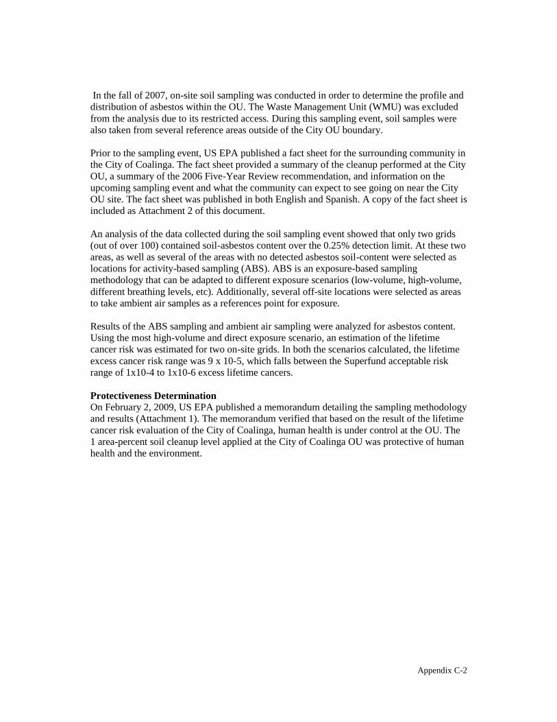
In the fall of 2007, on-site soil sampling was conducted in order to determine the profile and distribution of asbestos within the OU. The Waste Management Unit (WMU) was excluded from the analysis due to its restricted access. During this sampling event, soil samples were also taken from several reference areas outside of the City OU boundary.
Prior to the sampling event, US EPA published a fact sheet for the surrounding community in the City of Coalinga. The fact sheet provided a summary of the cleanup performed at the City OU, a summary of the 2006 Five-Year Review recommendation, and information on the upcoming sampling event and what the community can expect to see going on near the City OU site. The fact sheet was published in both English and Spanish. A copy of the fact sheet is included as Attachment 2 of this document.
An analysis of the data collected during the soil sampling event showed that only two grids (out of over 100) contained soil-asbestos content over the 0.25% detection limit. At these two areas, as well as several of the areas with no detected asbestos soil-content were selected as locations for activity-based sampling (ABS). ABS is an exposure-based sampling methodology that can be adapted to different exposure scenarios (low-volume, high-volume, different breathing levels, etc). Additionally, several off-site locations were selected as areas to take ambient air samples as a references point for exposure.
Results of the ABS sampling and ambient air sampling were analyzed for asbestos content. Using the most high-volume and direct exposure scenario, an estimation of the lifetime cancer risk was estimated for two on-site grids. In both the scenarios calculated, the lifetime excess cancer risk range was 9 x 10⁻⁵, which falls between the Superfund acceptable risk range of 1x10⁻⁴ to 1x10⁻⁶ excess lifetime cancers.
Protectiveness Determination On February 2, 2009, US EPA published a memorandum detailing the sampling methodology and results (Attachment 1). The memorandum verified that based on the result of the lifetime cancer risk evaluation of the City of Coalinga, human health is under control at the OU. The 1 area-percent soil cleanup level applied at the City of Coalinga OU was protective of human health and the environment.
Appendix C-2

=''0)1,! <D =$$42-*0)$ A
:03& @BB> <,$ (/ <(4+,).4 7&($02$,"0)0%% ;"4+#4$,()
90*(&4)1#*
Appendix C-3

SFUND RECORDS CTR
2182442UNITED STATES ENVIRONMENTAL PROTECTION AGENCY
REGION IX 75 Hawthorne Street
San Francisco, CA 94105
MEMORANDUM
Date: February 4, 2009
To: Lynn Suer, Chief California Site Cleanup Se~tion II (SFD 7-2)
From: Jere Johnson. fM. W,/~ Remedial pro~r~~n'~g~(SFD 7-2)
Thru: Daniel Stralka /7.,4/ Toxicologist (SFD 8-4~~
Arnold Den ~r§:b-Senior Science Advisor (AIR 6)
Re: Atlas Asbestos Site - Coalinga City Site OU2 Protectiveness Evaluation Sampling Results, and Discussion and Recommendation
Background
The September 2006 Five Year Review for the Atlas/Coalinga Asbestos sites recommended that EPA evaluate the effectiveness of the 1993 cleanup of the Coalinga City OU (OU2), because the site was remediated using the 1% asbestos in soil cleanup level. In 2004, OSRTI clarified that risk-based, site-specific action levels should be used for sites with asbestos soillevets of 1% or less. Data from Libby, Montana and other sites had shown that soils· containing asbestos at levels less than I%could still generate significant asbestos air concentrations when disturbed. The re-evaluation of the Coa),inga City OU was conducted consistent with EPA's recently released Asbestos Framework. l .
Soil Sampling
Methodology - In November 2007, field personnel from the EPA Las Vegas Environmental Response Team collected approximately 110 soil samples from 100' grids within· three designated subareas covering the 107-acre Coalinga OU2 and adjacent properties to the
. south which may have been influenced by asbestos processing activities at the site (Figure 1). In addition, grab samples were collected from five reference locations in Coalinga. In each grid, five locations were sampled and the soil was composited into a single sample representing the 10,000 square foot area. The purpose of the soil sampling was to provide screening information
I Framework for Investigating Asbestos-Contaminated Superfund Sites (PDF1, OSWER Directive 9200.0-68, September 2008.
1
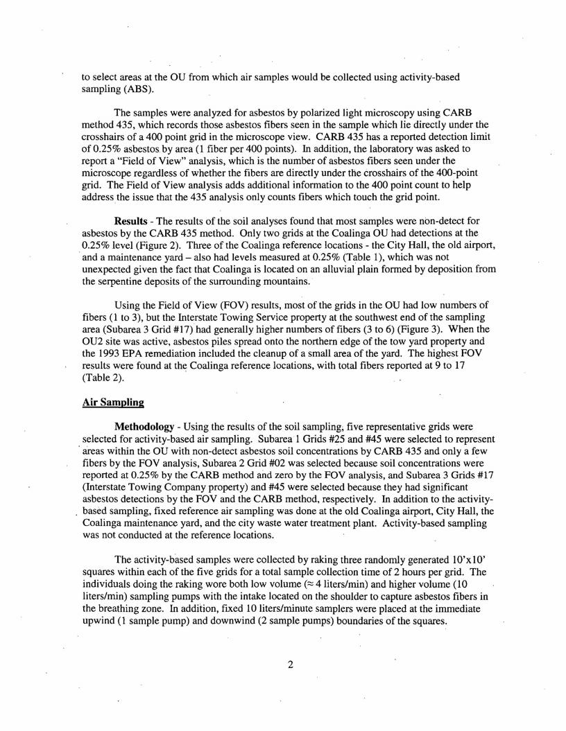
to select areas at the au from which air samples would be collected using activity-based sampling (ABS).
The samples were analyzed for asbestos by polarized light microscopy using CARB method 435, which records those asbestos fibers seen in the sample which lie directly under the crosshairs of a 400 point grid in the microscope view. CARB 435 has a reported detection limit of 0.25% asbestos. by area (1 fiber per 400 points). In addition, the laboratory was asked to report a "Field of View" analysis, which is the number of asbestos fibers seen under the microscope regardless of whether the fibers are directly under the crosshairs of the 400-point grid. The Field of View analysis adds additional information to the 400 point count to help address the issue that the 435 analysis only counts fibers which touch the grid point.
Results - The results of the soil analyses found that most samples were non-detect for asbestos by the CARB 435 method. Only two grids at the Coalinga au had detections at the 0.25% level (Figure 2). Three of the Coalinga reference locations - the City Hall, the old airport, and a maintenance yard - also had levels measured at 0.25% (Table 1), which was not unexpected given the fact that Coalinga is located on an alluvialplain formed by deposition from the serpentine deposits of the surrounding mountains.
Using the Field of View (FOV) results, most of the grids in the au had low numbers of fibers (1 to 3), but the Interstate Towing Service property at the southwest end of the sampling area (Subarea 3 Grid #17) had generally higher numbers of fibers (3 to 6) (Figure 3). When the OU2 site was active, asbestos piles spread onto the northern edge of the tow yard property and the 1993 EPA remediation included the cleanup of a small area of the yard. The highest FOV results were found at the Coalinga reference locations, with total fibers reported at 9 to 17 (Table 2).
Air Sampling
Methodology - Using the results of the soil sampling; five representative grids were selected for activity-based air sampling. Subarea 1 Grids #25 and #45 were selected to represent areas within the au with non-detect asbestos soil concentrations by CARB 435 and only a few fibers by the FOV analysis, Subarea 2 Grid #02 was selected because soil concentrations were reported at 0.25% by the CARB method and zero by the FOV analysis, and Subarea 3 Grids #17 (Interstate Towing Company property) and #45 were selected because they had significant asbestos detections by the FOV and the CARB method, respectively. In addition to the activitybased sampling, fixed reference air sampling was done at the old Coalinga airport, City Hall, the Coalinga maintenance yard, and the city waste water treatment plant. Activity-based sampling was not conducted at the reference locations.
The activity-based samples were collected by raking three randomly generated lO'x 10' squares within each of the five grids for a total sample collection time of 2 hours per grid. The individuals doing the raking wore both low volume (::::: 4 liters/min) and higher volume (10 liters/min) sampling pumps with the intake located on the shoulder to capture asbestos fibers in the breathing zone. In addition, fixed 10 liters/minute samplers were placed at the immediate upwind (1 sample pump) and downwind (2 sample pumps) boundaries of the squares.
2

Most of the air samples were analyzed by TEM direct method 10312. Some sample filters which were determined to be too heavily loaded for direct analysis were analyzed by TEM indirect method 13794. For EPA risk assessment purposes, the Phase Contrast Microscopy equivalent (PCME) classification is the most important reporting classification. PCME is the fiber size which has been most closely linked to asbestos disease and is the fiber size used in this evaluation.
Results - The significant air sample results are summarized in Table 1. The majority of asbestos fibers detected in the reference and activity-based air samples were chrysotile, although some amphibole asbestos fibers were also identified. PCME asbestos fiber concentrations in the reference air samples by direct analysis ranged from non-detect «.00029) to 0.00144 fibers per cubic centimeter (flee). If the non-detects are assumed to represent zero fibers, as recommended in the Asbestos Framework, the average reference sample concentration is 0.00028 f/cc.
The activity-based sampling (ABS) PCME asbestos concentrations were more varied. There were no asbestos fibers detected in the air samples from the personal or perimeter samples analyzed by the direct method from Subarea I Grid #25, Subarea 2 Grid #2, or Subarea 1 Grid #45.
Generally higher concentrations were found in the ABS air samples from the grids with more asbestos detected in the soil samples. Subarea 3 Grid #17 had an asbestos PCME fiber concentration of 0.00696 in the low volume personal sample analyzed by the direct method. All the air samples other than the upwind sample for Subarea 3 Grid #45 were overloaded and had to be analyzed by the indirect method. The reported concentration for the high volume personal sample was 0.007 flee.
Estimation of Risk
The ris~ of developing asbestos-related disease is dependent on the frequency, duration, and level of asbestos exposure. To make a determination whether the fiber concentrations measured in the samples at the Coalinga OU present a human health risk based on current and future land uses, it is necessary to calculate the risks posed by the concentrations of concern and the expected frequency and duration of the exposures. Only the results from Grids 3-17 and 3-45 are considered to be significant enough to require risk calculation.
For the Coalinga OU, the hierarchy to determine which samples from the two grids to use in the risk calculation is: 1) ABS samples over upwind or downwind samples because ABS more closely represents personal exposure, 2) Hi-volume ABS samples over low-volume samples because of the greater sensitivity, 3) Direct analysis samples over indirect analysis samples because the additional handling and processing (sonification) to prepare a sample for indirect analysis introduces additional uncertainty in the result. This is especially true for chrysotile asbestos samples because the chrysotile bundles and complex structures frequently found in environmental air samples tend to break into hundreds or even thousands of individual fibrils and bundles when sonicated. The purpose of using two personal activity flow rates (4 11m and 10 11m) was to reduce the likelihood of sample overloading and minimize the need for
3

indirect analysis. The Asbestos Framework assumes the use of direct analysis results, but in this case, use of indirect analyses was necessary for Subarea 3 Grid #45.
Subarea 3 - Grid#17 is the grid at the Interstate Towing Company yard that is directly adjacent to the on-site residential mobile hoine. A child of elementary school age lives there. To calculate the risk posed by exposure to the air concentration measured during the raking activity, which is considered to be a fairly aggressive dust generating activity, standard EPA exposure parameters were used to assume that a child generated dust at this level during play for 3 hours per day on average, 350 days per year, for30 years. Using the high-volume, direct sample result of 0.00497 flcc, the time-weighted excess lifetime cancer risk is estimated to be approximately 9 x 10⁻⁵
. '
Subarea 3 - Grid #45 is located adjacent to West Elm Avenue and just north of the waste management unit (WMU) which contains the material removed from the surface of the au during the EPA remedial action. The area is currently vacant land, but the City is interested in developing it for light industry. Using a standard industrial exposure scenario for the risk calculation, it was assumed that a worker could be exposed to dust at the location for 8 hours per day on average, 250 days per year, for 25 years. Using the high volume personal sample of 0,007 asbestos flcc, which was analyzed by the indirect method because all Grid 3-45 samples were overloaded, the excess lifetime cancer risk is estimated to be approximately 1 x 10⁻⁴
• If the property were developed for residential use and the same child exposure scenario used above were applied, the lifetime excess cancer risk would be approximately 9 x 10⁻⁵
.
Discussion and Recommendation
The raking activity used for the air sampling at Coalinga aU2 was a fairly aggressive dust generating method in terms of the typical existing and anticipated uses of the property. In addition, the risk calculations used conservative health-protective assumptions regarding the duration and extent of the exposures. For Grid 3-45, overloading of all the ABS samples necessitated use of an indirect analysis sample result. The use of the indirect concentration probably made the risk estimation even more conservative in terms of the impact to human health. Even with the health protective assumptions, the risk estimations for Subarea 3 Grids #17 and #45 showed personal exposures within the Superfund acceptable risk range of 10-4 to 10-6 excess lifetime cancers.
The purpose of the sampling at the Coalinga au was to determine whether the remedy is still protective, given the change in cleanup metrics for asbestos sites. Based on the results, I believe that the remedy continues to be protective of human health and the environment and that no further action is currently necessary.
4

I recommend that the current CERCUS determination of Insufficient Data to Determine Human Exposure Control Status be changed to Human Exposure Under Control.
% Concur
D Do Not Concur
LYn~L CA Site Cleanup Section II
5

. -u_. __ ~_.
• • •- • ,.-

_...••• • • • "" to •--
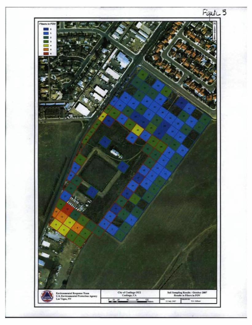
F <-3
• • • • • .. - .

Table 1 - CoalinQa OU2 Soil and Air Results
PCME Fiber PCME TotalPCME SampleSample Soil PCME Fibers Subarea Soil % Sample Type NotesStructure Structures Total Cone. Cone NumberLocation FOV Structures
NOTE:indirect results NOTE:indirect results South of Pacific Avenue 1-25 0 <.0003 <.00030% 2 UpWind 0 0 <0.0003 19699 Direct
DownWind 1 0 <.0003 <.00030 0 <0.0003 19700 Direct Down Wind 2 <.00030 <.0003 0 2 0.0006 19701 Direct
Hioh Vol 19702 Overloaded/Not Analvzed Low Vol <.001 o <.00099 0 <0.001 19703 Direct0
Property Adjacent Pacific Avenue 0.0047 0.00473 2 0.00628 19719 Indirect
DownWind 1 2 1-45 0% UpWind 1 10
0.0063 2 0.00628 0.007733 19720 Indirect DownWind 2 0 <.00097 o <.00097 0 <.00097 19721 Direct DownWind 2
(Duplicate) 0 <.00097 o <.00097 0 <.00097 19722 Direct Hioh Vol 9 0.016120.0108 52 0.09316 19723 Indirect Low Vol
6 <.00098 o <.00098 19724 Direct0 0 <.00098
Adjacerrtto WMU 0 <.001 o <.00097 0 <0.0012-02 0.25 1 UpWind 19704 Direct
DownWind 1 0 <.001 o <.00097 <0.0010 19705 Direct DownWind 2 <.001 o <.00097 <0.0010 0 19706 Direct
High Vol <.001 o <.00097 0 <0.001 19707 Direct Low Vol
0 19708 Not Analyzed
4 0.003950.0049 11 0.01086 19709 Indirect /1 actinolite / During analysis, smaller chrysotile fibers observed DownWind 1 1 0.00097
Tow Yard 3-17 0% 6 UpWind 5 0<.00097 1 0.00097 19710 Direct
DownWind 2 1 0.00097 0<.00097 0 <.00097 19711 Direct High Vol 0.01750.012 17 36 0.03705 19712 Indirect / 3 actinolite Low Vol
12 0.00696 5 0.00497 12 0.012 19713 Direct /2 crocidolite, 2 winchite, 3 actinolite 7
properly Adja.cerrt to Elm Street <.00097 o <.000973-45 0.25% 0 <.00097 19714 Direct
DownWind 1 5 UpWind 0
0.0149 0.01091 28 0.02778 Indirect / 3 actinolite DownWind 2
15 11 19715 0.007 0.008 44 0.043987 19716 Indirect
Hioh Vol 8
0.007 0.01137 51 0.05271 Indirect /1 actinolite Low Vol
11 197177 19718 Overloaded/Not Analyzed

Sample
Location . Subarea
Soil Soil %
FOV
PCME Fiber Sample Type PCME Fibers
Cone
PCME
Structures
PCME
Cone
Total
Fibers Total Cone.
Sample Notes
Number Reference Locations Airport 2 0.00058 1 0.00029 2 0.00058 18889
0 <0.00025 01<0.00025 0 <0.00025 18889 Indirect o . <0.00075 0<0.00075 '0 <0.00075 18885 2 0.00536 1 0.00403 2 0.00536 18885 Indirect 5 0.00144 3 0.00087 6 0.00173 18881 5 0.00126 6 0.00152 8 0.002022 18881 Indirect 2 0.00059 2 0.00059 2 0.00059 19691 0 <0.0003 0<0.0003 0 <0.0003 19695
CitvHall 0 <0.00098 0<0.00098 0 <0.00098 18890 0 <0.0003 o <0.0003 0 <0.0003 18886 0 <0.00088 0<0.00088 0 <0.00088 18882 0 <0.0003 0<0.0003 0 <0.0003 19694 0 <0.0003 0<0.00029 0 <0.0003 19696
Yard 1 0.00028 1 0.00028 2 0.00057 18891 0 <0.0003 0<0.00029 0 <0.0003 18887 -4 0.00117 1 0.00029 4 0.00117 18883 0 <0.00029 0<0.00029 1 0.00029 19692 0 <0.0003 0<0.00029 0 <0.0003 19698
POTW 3 0.001 2 0.00059 8 0.00238 18892 0 <0.0003 o <0.0003 0 <0.0003 18888 1 0.0003 1 0.0003 1 0.0003 18884 1 0.0003 o 0.00029 1 0.00029 19693 0 <0.0003 0<0.00019 1 0.00019 19697

=''0)1,! <D =$$42-*0)$ @
82$(30& @BB? <,$ (/ <(4+,).4 :42$ 6-00$
Appendix C-14
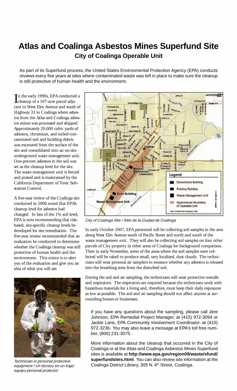
"
1'\ '!\q:J
\
/ • Demolished Building
-:r • &isUng Buildiflll
t• Wasle Managlilfnent Una
• ApproxirMle Boundaryof Operable Unit---_.....
United States Environmental Protection Agency Region 9 $$$$$ October 2007
Atlas and Coalinga Asbestos Mines Superfund Site City of Coalinga Operable Unit
As part of its Superfund process, the United States Environmental Protection Agency (EPA) conducts reviews every five years at sites where contaminated waste was left in place to make sure the cleanup is still protective of human health and the environment.
In the early 1990s, EPA conducted a cleanup of a 107-acre parcel adja
cent to West Elm Avenue and south of Highway 33 in Coalinga where asbestos from the Atlas and Coalinga asbestos mines was processed and shipped. Approximately 20,000 cubic yards of asbestos, chromium, and nickel-contaminated soil and building debris was excavated from the surface of the site and consolidated into an on-site underground waste management unit. One-percent asbestos in the soil was set as the cleanup level for the site. The waste management unit is fenced and posted and is maintained by the California Department of Toxic Substances Control.
A five-year review of the Coalinga site conducted in 2006 noted that EPA’s cleanup level for asbestos had changed. In lieu of the 1% soil level, EPA is now recommending that risk- City of Coalinga Site / Sitio de la Ciudad de Coalinga based, site-specific cleanup levels be
In early October 2007, EPA personnel will be collecting soil samples in the areadeveloped for site remediation. The along West Elm Avenue south of Pacific Street and north and south of thefive-year review recommended that an waste management unit. They will also be collecting soil samples on four otherevaluation be conducted to determine parcels of City property in other areas of Coalinga for background comparison.whether the Coalinga cleanup was still Then in early November, some of the areas where the soil samples were colprotective of human health and the lected will be raked to produce small, very localized, dust clouds. The technienvironment. This notice is to alert cians will wear personal air samplers to measure whether any asbestos is releasedyou of the evaluation and give you an into the breathing zone from the disturbed soil.idea of what you will see.
During the soil and air sampling, the technicians will wear protective overalls and respirators. The respirators are required because the technicians work with hazardous materials for a living and, therefore, must keep their daily exposures as low as possible. The soil and air sampling should not affect anyone at surrounding homes or businesses.
If you have any questions about the sampling, please call Jere Johnson, EPA Remedial Project Manager, at (415) 972-3094 or Jackie Lane, EPA Community Involvement Coordinator, at (415) 972-3236. You may also leave a message at EPA’s toll free number, (800) 231-3075.
More information about the cleanup that occurred in the City of Coalinga or at the Atlas and Coalinga Asbestos Mines Superfund sites is available at http://www.epa.gov/region09/waste/sfund/ superfundsites.html. You can also review site information at theTechnician in personal protective
equipment / Un técnico en un traje/ Coalinga District Library, 305 N. 4th Street, Coalinga. equipo personal protector

Agencia de Protección Ambiental de los EE.UU. Región 9 $$$$$ Octubre 2007
Sitio Superfund de las Minas de Asbestos de Atlas y Coalinga Unidad Operable de la Ciudad de Coalinga
Como parte de su proceso Superfund, la Agencia de Protección Ambiental de los Estados Unidos (EPA, por sus siglas en inglés) lleva a cabo un repaso cada cinco años de las limpiezas donde haya quedado contaminación en el lugar para asegurar que la limpieza continua protegiendo la salud humana y el ambiente.
Si usted tiene preguntas sobre el muestreo, por favor llame a Jere Johnson, Gerente del Proyecto de Remediación de la EPA, al (415) 972-3094 o a Jackie Lane, Coordinadora de Relaciones Comunitarias al (415) 972-3236. Usted también puede dejar un mensaje al numero gratuito (800) 231-3075.
Más información sobre la limpieza que ocurrió en la Ciudad de Coalinga o en los sitios Superfund de las Minas de Asbestos de Atlas y Coalinga, está disponible en la página de Internet: http://www.epa.gov/ r e g i o n 0 9 / w a s t e / s f u n d / superfundsites.html. También puede repasar información del sitio en la Biblioteca del Distrito de Coalinga en el 305 N. 4th
Street, Coalinga.
Aprincipios de los años 90s, la EPA llevó a cabo una limpieza en
una parcela de 107 acres, adyacente a West Elm Avenue, y al sur de la Carretera 33 en Coalinga donde los asbestos de las minas de asbestos de Atlas y Coalinga eran procesados y enviados. Aproximadamente 20,000 yardas cúbicas de asbestos, cromo, suelo contaminado con níquel y escombros del edificio fueron excavados de la superficie del sitio y consolidados en una unidad de gestión de desechos bajo tierra. Un por ciento de asbestos en el suelo fue fijado como el nivel de limpieza en el sitio. La unidad de gestión de desechos está cercada y señalada y es mantenida por el Departamento de Control de Substancias Toxicas de California.
Un repaso de cinco años del sito de Coalinga que se llevó a cabo en el 2006 determinó que el nivel de limpieza de la EPA para los asbestos había cambiado. En lugar del 1% del nivel del suelo, la EPA ahora está recomendando que niveles de limpieza basada en riesgo y específicos al sitio se desarrollen para la remediación del sitio. El repaso de cinco años recomendó
United States Environmental Protection Agency Region 9 75 Hawthorne Street (SFD-3) San Francisco, CA 94105 Attn: Jackie Lane (Atlas/CAM 10/07)
que se llevará a cabo una evaluación para determinar si la limpieza en Coalinga seguía protegiendo la salud humana y el ambiente. Este aviso es para alertarle a usted de la evaluación y darle una idea de lo usted verá.
A principios de Octubre del 2007, el personal de la EPA estará colectando muestras del suelo en el área, a lo largo de West Elm Avenue al sur de Pacific Street y al norte y sur de la unidad de gestión de desechos. También estarán colectando muestras de otras cuatro parcelas que son propiedad de la ciudad en otras áreas de Coalinga para propósitos de comparación. Ala principios de Noviembre, algunas de las áreas de donde muestras fueron colectadas serán rastrilladas para producir pequeñas y localizadas nubes de polvo. Los técnicos usarán muestras de aire personales para medir si asbesto es lanzado del suelo disturbado ala zona de respiración.
Durante los muestreos del suelo y del aire, los técnicos usarán overoles protectores y respiradores. Los respirados son requeridos porque los técnicos ganan la vida trabajando con
materiales peligrosos y por lo tanto deben mantener sus exposiciones diarias lo más bajo posible. Los muestreos del suelo y el aire no afectarán a nadie en los hogares o negocios vecinos.
FIRST-CLASS MAIL POSTAGE & FEES
PAID U.S. EPA
Permit No. G-35
Official Business Penalty for Private Use, $300
Address Service Requested

§
0%%+',*! .
/&((#'*$ -'"&)"+(+'$
Appendix D

""",1;f.O S''lJ':';::F ~U'
i ~.1.,
~~a~o 'C
\ ~~ "'{)
-1{ PRO~c.
ATLAS AND COALINGA ASBESTOS MINESSUPERFUND SITES FIVE-YEAR REVIEW
As part of its Superfund prooess, the United States EnvironmentalProtection Agency (EPA) is required to conduct a review every five yearsat sites where contaminated waste was left in place that does not allowfor unrestricted use and limited exposure. The Five-Year Review (FYR)makes the determination whether the implemented remedy is functioningas intended and is still protective of human health and the environment. Thereview can include the review of site documents, an inspection, review ofrelevant laws and regulations and conducting interviews, and if necessarysampling at the Site.
EPA is beginning its FYR process for both Atlas and Coalinga AsbestosMines Superfund Sites. These two Sites were further divided early on intoareas and operable units to better manage the original cleanup efforts. Thefi nal report is due September 30, 2011 and will be ava ilable to pu bli c in theSite's Information Repositories listed below.
The Atlas Asbestos Mine Superfund Site consists of tvvo operable units(OUs) and tvvo geographic areas: the Atlas Mine Area (OU-1), City ofCoalinga (City-OU-2), the Clear Creek Management Area (CCMA), and theArroyo Pasajero Ponding Basin (Ponding Basin). The CCMA and PondingBasin were included in the Site because of concerns that asbestos miningand milling waste from the Atlas MineArea were being transported to theseareas by water or wind. The Atlas Mine Area is an abandoned asbestosmine within a region of naturally-occurring asbestos minerals (the CCMA).
Th e Coalin~ Asbestos Mi ne S~erfund Site consists of tvvo opera ble un its:the Johns- anville Mill (JMM~ U-1) and the previously-mentioned CityOU-2, which is considered part of the Coalinga Asbestos Mine SuperfundSite due to historic operations. The abandoned JMM-OU-1 consists of aformer asbestos mine, former prooessing mill, former support buildings,and asbestos tailings. The area is drained by Pine Canyon Creek, whichflows into the Los Gatos Creek, a tributary to the Ponding Basin. This Sitewas deleted from EPA National Priorities List in April 24, 1998.
The City of Coalinga Operable Unit 2 (City-OU-2) is where asbestosfrom both the Atlas and Coalinga Mines was transported, processed andshipped. Approximately 20,000 cubic yards of asbestos, chromium andnickekontaminated soil and building debris was removed from the surfaceand oonsolid ated into a 107 acre und ergrou nd waste man agement unitadjacent to West Elm in Coalinga. The waste management unit is secureand maintained by the California Department of Toxic Substanoes Control.
To beoome involved in the process, please call Jackie Lane at toll~free (800)231-3075 leave message or direct at (415) 972-3236 before to July 28,2011. Your involvement would in elude an intervi ew to gather oon oem s aboutthe Site c1eanu p which will be responded to as part of the final report. If youhave any questions about the Sites, please call Lily Tavassoli, RemedialProject Manager, at (415) 972-3146. You may also leave a message atEPA's toll free number at (800) 231-3075.
Site Information Reoositories v'Jhere more information is housed are located atCoalinga District Library305 North 41h St., Coalinga, CA, 93210
EPA Reg ion 9 Superfund Reoords Center95 Hawthorne St., Suite 403S, San Francisco, CA94105(415) 536-2000
Site information is on~line is at:wvvvv.epa.gov/region09/AtlasAsbestos and wvvw.epa.gov/region09/Coa ling aAsbestos
Appendix D-1

¨
3&&,(-* 1
0*%$ '+ 2'.#),($% /,"*,!,-
Appendix E

California Department of Health Services 1995. Health Consultation Atlas/Coalinga Asbestos Mines City of Coalinga Operable Unit
CDM 2007a. Final 2007 Annual Site Inspection Report, Atlas Mine Operable Unit, Atlas Asbestos Mine Site, Fresno County, California. April 2007
CDM 2007b. Revised Construction Completion Report: 2004 Maintenance Repairs, Atlas Mine Area Operable Unit, Atlas Asbestos Mine Superfund Site, Fresno County, California. 16 May 2007
CH2MHill, Inc., 2006. Five-Year Review Report For Atlas Asbestos Mine Superfund Site and Coalinga Asbestos Mine (Johns-Manville Mill) Superfund Sites, Fresno County, California. 28 September 2006
Delta Consultants 2007. 2007 Annual Visual Inspection Report, Waste Management Unit, Coalinga Asbestos Mine Landfill. 26 July 2007
Delta Consultants 2008. 2008 Annual Visual Inspection Report, Waste Management Unit, Coalinga Asbestos Mine Landfill. 15 July 2008
Delta Consultants 2009. 2009 Annual Visual Inspection Report, Waste Management Unit, Coalinga Asbestos Mine Landfill. 20 August 2009
Delta Consultants 2010. 2010 Annual Visual Inspection Report, Waste Management Unit, Coalinga Asbestos Mine Landfill. 27 July 2010
Department of Water Resources (DWR) 2004. Sampling of Designated Borrow Areas For Naturally-Occurring Asbestos Sampling Report. May
Ecology & Environment, Inc., (E&E) 1996. Five-Year Review for the City of Coalinga Oil of the Atlas and Coalinga Superfund Sites, Coalinga, CA. 26 April
Environmental Strategies Corporation (ESC) 1999 Remedial Action Completion Report For the Atlas Mine Superfund Site November 15
ID Environmental Associates, Inc. 2009. Final 2008 Annual Site Inspection Report, Atlas Mine Operable Unit, Atlas Asbestos Mine Site, Fresno County, California. October 2009
ID Environmental Associates, Inc. 2010. Final 2009 Annual Site Inspection Report, Atlas Mine Operable Unit, Atlas Asbestos Mine Site, Fresno County, California. August 2010
Levine Fricke (LFR) 2007. Inspection Report for Engineering Systems, Johns-Manville Coalinga Mill Area Operable Unit, Fresno County, Califomia. 16 April 2007
Levine Fricke (LFR) 2008. Inspection Report for Engineering Systems, Johns-Manville Coalinga Mill Area Operable Unit, Fresno County, Califomia. 10 April 2008
Levine Fricke (LFR) 2009. Inspection Report for Engineering Systems, Johns-Manville Coalinga Mill Area Operable Unit, Fresno County, Califomia. 29 May 2009
Appendix E-1
US Environmental Protection Agency (US EPA) 2010. Explanation of Significant Differences to the 1991 Record of Decision for the Atlas Asbestos Mine Superfund Site, Atlas Mine Area Operable Unit. 15 September 2010
US Environmental Protection Agency (US EPA) 2008. Fact Sheet: U.S. EPA Releases Exposure and Risk Assessment for Clear Creek Management Area. May 2008
U.S. Department of Interior, Bureau of Land Management (BLM), 2008. Closure Order and Fact Sheet: Emergency Closure Effective May 1, 2008 of 31,000 Acres Within The Clear Creek Management Area, Information Fact Sheet. 1 May 2008
US Environmental Protection Agency (US EPA) 2007. Fact Sheet: Atlas and Coalinga Asbestos Mines Superfund Site City of Coalinga Operable Unit. October 2007
US Environmental Protection Agency (US EPA) 1992. Public Notice - Status of Clear Creek Management Area and Arroyo Pasajero Ponding Basin. December
US Environmental Protection Agency (US EPA) 1989. EPA Superfund Record of Decision: Coalinga Asbestos Mine, OU -2 Coalinga, CA. 19 July 1989
US Environmental Protection Agency (US EPA) 1990. EPA Superfund Record of Decision: Coalinga Asbestos Mine ,OU -1 Coalinga, CA. 21 September 1990
US Environmental Protection Agency (US EPA) 1991. EPA Superfund Record of Decision: Atlas Asbestos Mine, OU-1 Coalinga, CA. 14 February 1991
US Environmental Protection Agency (US EPA) 2001a. Final Second Five-Year Review Report for Coalinga Asbestos Mine Site. September 2001
US Environmental Protection Agency (US EPA) 2001b. Five-Year Review Report for Atlas Asbestos Mine Site. September 2001
US Environmental Protection Agency (US EPA) 1999. Preliminary Closeout Report for Atlas. September
_______ 1997a. Superfund Closeout Report for Coalinga Asbestos Mine Site. August
_______ 1997b. Fact Sheet: EPA Announces Intent to Remove Coalinga Asbestos Mine from Superfund List. November
__________2006b. 2006 Clear Creek Management Area Resource Management Plan Amendment and Route Designation Record of Decision. January 2006
Appendix E-2

§
4%%,'-*! 3
4141# 4'/) #*# 0,.+'*./) 2,(&$/'-"(
Appendix F

Technical Memorandum
To: Lily Tavassoli, US Environmental Protection Agency, USEPA Region IX, San Francisco, CA
From: Don Gruber, Innovative Technical Solutions, Inc.
Date: February 4, 2011
Subject: Atlas Asbestos Mine and Coalinga Asbestos Mine (Johns-Manville Mill) Superfund Sites, Applicable or Relevant and Appropriate Requirements Evaluation, 2011 Five-Year Review Report
Contract /TO: EP-S9-08-03 / Task Order # 0051 ITSI DCN: 07163.0052.0003
promulgated sinc human health and the environment.
1.0 INTRODUCTION This technical memorandum presents an evaluation of applicable or relevant and appropriate requirements (ARAR) at the Atlas Asbestos Mine and Coalinga Asbestos Mine (Johns-Manville Mill) Superfund sites.
The purpose of this ARARs evaluation is to determine whether laws, regulations, or guidance
ARARs are established in site decision documents or Records of Decision (RODs). Where necessary, changes to ARARs can be documented in ROD Amendments or an Explanation of Significant Differences depending on the significance or degree of change to the selected remedy.
The National Oil and Hazardous Substances Pollution Contingency Plan (NCP) documented in 40 C.F.R. §300.430(f)(1)(B)(1), provides that ARARs are fixed at ROD issuance unless USEPA determines that a new requirement is an ARAR and necessary to ensure that the remedy is protective of human health and the environment.
2.0 ARARs BACKGROUND Section 121(d) of the Comprehensive Environmental Response, Compensation, and Liability Act (CERCLA) requires that remedial actions implemented at CERCLA sites are administered in compliance with any federal or more stringent state environmental standards, requirements, criteria, or limitations that are determined to be ARARs.
CERCLA response actions are exempted by law from the requirement to obtain federal, state, or local permits related to any activities conducted completely within the Superfund site. However, substantive provisions of permitting regulations that are ARARs must be met.
- -8998 fax Appendix F-1

Technical Memorandum (Continued) Atlas Asbestos Mine and Coalinga Asbestos Mine (Johns-Manville Mill) Superfund Sites Applicable or Relevant and Appropriate Requirements Evaluation, OU 2011 Five-Year Review
Applicable Requirements
Applicable requirements are cleanup standards, criteria, or limitations promulgated under federal or state law that specifically address the situation at a CERCLA site. A requirement is applicable if the jurisdictional prerequisites (55 FR 8741) of the environmental standard show a direct correspondence when objectively compared with conditions at the site.
Relevant and Appropriate Requirements
that is similar to the CERCLA site (i.e., relevant) and must be well-suited to the particular site (i.e., appropriate). As such, relevant and appropriate requirements are those cleanup standards, standards of control, and other substantive environmental protection requirements, criteria, or limitations promulgated under federal or state laws that, while not applicable, address problems or situations sufficiently similar to the circumstances of the proposed response action and are suited to the conditions of the site. The criteria for determining relevance and appropriateness are listed in 40 CFR 300.400(g)(2).
To be Considered Requirements (TBC)
TBC criteria are requirements that may not meet the definition of an ARAR, but still may be useful in determining whether to take action at a site or to what degree action is necessary. As defined in 40 CFR 300.400(g)(3), TBC criteria are non-promulgated or legally binding advisories or guidance issued by federal or state governments that may provide useful information or recommended procedures for remedial action. TBCs are intended to ensure the protection of human health and the environment for the site.
ARAR Classification
As defined by USEPA guidance, ARARs generally are classified into three categories: chemicalspecific; location-specific; and, action-specific. Further definition of these categories is presented below.
Action-specific ARARs are requirements that apply to specific actions that may be associated with the site remediation. Action-specific ARARs often define acceptable handling, treatment, and disposal procedures for hazardous substances. These requirements are triggered by the particular remedial activities that are selected to accomplish a remedy. Examples of action-specific ARARs include requirements applicable to landfill closure, wastewater discharge, hazardous waste disposal and emissions of air pollutants.
Chemical-specific ARARs include those laws and regulations that regulate the release to the environment of materials possessing certain chemical or physical characteristics or containing specified chemical compounds. These requirements generally set health-or risk-based concentration limits or discharge limits for specific hazardous substances.
Page 2 of 13 Appendix F-2

Technical Memorandum (Continued) Atlas Asbestos Mine and Coalinga Asbestos Mine (Johns-Manville Mill) Superfund Sites Applicable or Relevant and Appropriate Requirements Evaluation, OU 2011 Five-Year Review
Location-specific ARARs are those requirements that relate to the geographical or physical location of the site, rather than the nature of the contaminants or the proposed site remedial actions. These requirements may limit the placement of remedial action and may impose additional constraints on the cleanup action. For example, location-specific ARARs may refer to activities in the vicinity of wetlands, floodplains, endangered species habitat and areas of historical or cultural significance.
3.0 SITE BACKGROUND
The Atlas and Coalinga Asbestos Mine Sites are located Fresno County, California. Operable Unit 1 (Atlas Mine Area [OU1] of the Atlas Asbestos Mine Site is located approximately 17 miles northwest of Coalinga, California on a roughly 140-acre abandoned asbestos mine situated within a larger, naturally-occurring asbestos mineral region. The Atlas Mine Area also includes two geographic areas (the Clear Creek Management Area [CCMA] and the Arroyo Pasajero Ponding Basin). Operable Unit 2 (the City of Coalinga OU [City OU2]) of the Atlas Asbestos Mine Site is located on 107 acres of property between 4th Street and the intersection of Lucille Avenue and Highway 198 in Coalinga. The Atlas Asbestos Mine Site is a CERCLA Superfund Site and was placed on the National Priority List (NPL) in 1984. Because the RODs only selected remedies for the Atlas Mine Area OU and City OU2, this ARARs evaluation is limited to these OUs and does not address the two geographic areas of the Atlas Asbestos Mine Site.
The Coalinga Asbestos Mine Site consists of the Johns-Manville Mill (JMM) OU (OU1) and the previously identified City OU2. The JMM OU is also located approximately 17 miles northwest of Coalinga on a 120-acre abandoned asbestos mine within the CCMA. The Coalinga Asbestos Mine Site was placed on the NPL in 1984 and de-listed in 1998.
The remedial objective for both sites is to control the release of asbestos fibers to minimize direct or indirect exposure of humans and the environment. Asbestos is classified as a known human carcinogen by state, federal, and international agencies. Asbestos was identified as a toxic air contaminant in 1986 but he California Air Resources Board.
4.0 ATLAS MINE AND COALINGA MINE SITES ARARS EVALUATION
The following documents were utilized during this ARARs evaluation:
Coalinga Asbestos Mine OU2 (City OU2) ROD, 1989 Atlas Asbestos Mine OU2 (City OU2) ROD, 1989 Coalinga Asbestos Mine OU1 (JMM OU1) ROD, 1990 Atlas Asbestos Mine OU1 ROD, 1991 Five-year Review Report for City OU2, April 1996 Five-year Review Report for Atlas Asbestos Mine Superfund Site, September 2001 Five-year Review Report for Coalinga Asbestos Mine Superfund Site, September 2001 Five-year Review Report for Atlas Asbestos Mine and Coalinga Asbestos Mine (Johns-Manville Mill) Superfund Sites, September 2006.
Page 3 of 13 Appendix F-3

Technical Memorandum (Continued) Atlas Asbestos Mine and Coalinga Asbestos Mine (Johns-Manville Mill) Superfund Sites Applicable or Relevant and Appropriate Requirements Evaluation, OU 2011 Five-Year Review
In addition, the following internet websites were used to evaluate the current status of ARARs cited in each ROD and five-year review:
GPOaccess.gov (Code of Federal Regulations and Federal Register) calregs.com (California Code of Regulations) valleyair.org (San Joaquin Valley Air Pollution Control District) swrcb.ca.gov (State Water Resources Control Board).
The contaminants of concern listed in the RODs include asbestos, heavy metals (including nickel), mining waste, and particulate matter less than 10 microns in diameter (PM10). The following remedies were selected for each OU:
Atlas Mine Area OU1 The 1991 ROD specified the following remedial actions: revegetating to deter erosion, constructing surface impoundments and drainage channels to capture and divert eroded tailings, constructing fencing to restrict access, paving roads through the main area to prevent dust generation, demolishing the mill building, disposing debris, implementation of an operation and maintenance plan, and recording deed restrictions on privately held land. Approximately 2.3 million cubic meters of asbestos ore and asbestos tailings remain at the site. An inspection and maintenance program is ongoing.
JMM OU 1 The 1990 ROD specified the following remedial actions: constructing fencing to prevent access, demolishing the mill buildings, diverting the stream to channel water away from the tailings pile, constructing a sediment retention dam, revegetating to deter erosion, developing an operation and maintenance plan and recording a deed restriction. An estimated 450,000 cubic yards of ore and tailings remain at the site.
City OU2 (OU2 for Atlas and Coalinga Asbestos Mine Sites) The 1989 RODs for the City OU2 required contaminated soils, equipment, and other wastes to be removed and buried in the onsite waste management unit (WMU). The RODs specified the following remedial actions: removing and consolidating the asbestos- and nickelcontaminated soils at the site, removing and consolidating contaminated waste materials and equipment, decontaminating buildings to less than or equal to 1 area-percent, constructing a WMU to permanently bury the consolidated contaminated substances, performing groundwater monitoring and continuous monitoring of soil moisture content using neutron probes, and filing a deed restriction on the property where the WMU and soil cover exist to prevent disturbance of the cap and prevent possible release of asbestos fibers or nickel contaminants.
5.0 ARAR REVIEW TABLES
The tables presented in this section list the ARARs that have been established in the abovereferenced RODs. The tables also summarize the requirement for each ARAR, cite the regulatory basis for each ARAR, state the evaluated status of each ARAR, comment on any pertinent information or regulatory changes for each ARAR since the previous 5-year review,
Page 4 of 13 Appendix F-4
Technical Memorandum (Continued) Atlas Asbestos Mine and Coalinga Asbestos Mine (Johns-Manville Mill) Superfund Sites Applicable or Relevant and Appropriate Requirements Evaluation, OU 2011 Five-Year Review
show the applicable OU, citations, requirements, and the applicable decision document that established the ARAR.
Action-specific ARARs are presented in Table 1, chemical-specific ARARs are contained in Table 2 and location-specific ARARs are listed in Table 3.
Page 5 of 13 Appendix F-5

III ~
~~"
~.
~~t J~~!
1t ~.
~
.. ~"~
~,.:'~
I~~ il~~
II £t!h d!h
• I t
~ • •
• •
•

•••
--
.. ;tImlJ
t JI ~
.
3 8t
.~ H
n.
h!"I"
u I - j" I I ,I
It HI
g
III'I' th
~~
~,.r,,;,
J!Hl sdI.;i<lIi.
i :tl
t <
88
UH
-:i
~ ~ ~.<r saa
li t1Uj, bllt,
hlbuflh ~-
g8 n , ]
~~
~<f;;:
J~!fjSd<'I~.
tti~..
i z
"
i -
8 8
~§ U
.;;::i--:
ilL
sai~
Iii)Uin gg
u
I
i•
i ~ ,
~ ! ~
1
IJII ,,
u~
it =:1:
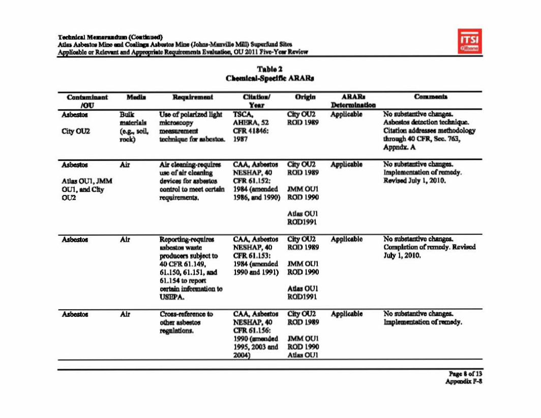
ImlJ Jlh
lIU~.£uu
~ i t
§~ 8§
.L~ ~!
n~
h.!~
a-gi~!i
v
j" I
j I -
I!Iii,IH
1 i in
f III h "j'
hl Jt d~dl
i §~ Il~
Ill! 8§ U
~§
hl~
~._1
a~~~!
~Hl
~
~8I III!g§
Jlf r~~h
I • §~ 8~
§!i 8~ U
!~
jo·li:.. ~~U
.~.o
:::1
~!:
•1
• i
. ·11ii~~B jIS~~dJ
$;;;
J! .~
it
U
I §~ m
8~ m
joP
.• il m~u
• iII

ImlJ 1 -•~•~ t
n.-I!!"I" - j. I I ,IH
! III 1
"j' I~h
Jhf;:(~
i~H~hi
J §~ 6~
"1,jS"ifad,;
lUh idH f! I
~B{
~1h
i h§
IiJ J~(j~
;:(~
i~i5~h~
J nu~ II ,jS!i~ad,;.
lilltn~JH "
AI tl~ t
HfhH !h f! I
h(
~1h
i !~§
.~
Ii .!, .. it
j~(j~",j
1~H.11~z
,,~
•'1 J i•
11hiUHHh Il~Js+. a;:;,;~ .
! 1 ~B
"1-81
hJ !~§

.~ tUn
I~ II i~
!>
1 r i !
tj h,.I
H!
1) 1
h

••ImlJ 1
IJI
!Ii ~
JHJ
I
iiJht
•I
II
I ~
I~li.~
h it
;~w
~~
n.-I!tf!"
j.i
I" - j" It•
,I I
H!
III 1
"j' I~h
~
JillJhd. Jt!~~! IW
U IIIIII
Ih~~~g
IU]
1]1J 1~1h
~I I ~~
§
Il 1l~
t 8! U ~~
u rl~u~ I~ t ... o
~_
• itiU!lhunlilu J~~!i.5
50
nh
== IU
] t1
ib 1~1h
• t ~
~
§a
8! U
dH~ {I Ifd q
!§
.a a€
Btl
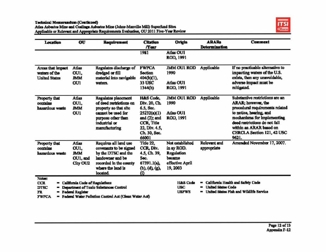

Technical Memorandum (Continued) Atlas Asbestos Mine and Coalinga Asbestos Mine (Johns-Manville Mill) Superfund Sites Applicable or Relevant and Appropriate Requirements Evaluation, OU 2011 Five-Year Review
6.0 SUMMARY
ARARs for the Atlas Asbestos Mine and Coalinga Asbestos Mines sites that have been established in each site-specific ROD (and evaluated in previous 5-year review reports) were evaluated and detailed in Tables 1 through 3. The basis for ARARs is the laws and regulations
contaminants of concern include asbestos, heavy metals including nickel, mining waste, and particulate matter less than 10 microns in diameter (PM10).
There were no changes to existing action-specific ARARs for the Atlas Asbestos Mine OU1, the JMM OU1, or the City OU2 since the last 5-year review completed in 2006. However, the previous 5-year review identified two regulations promulgated during that period of review that were identified as ARARs.
Specifically, the California Air Resources Board (CARB) issued the Asbestos Airborne Toxic Control Measure (ATCM) for Construction, Grading, Quarrying, and Surface Mining Operations (July 29, 2002). All road construction and maintenance activities must be conducted in compliance with CARB ATCM, Section 93105(d) pursuant to the California Health and Safety Code, Section 39666(d) and the CARB ATCM for construction and surfacing applications. This is a chemical-specific ARAR because it requires each Air Pollution Control District in California to implement and enforce this regulation. This ARAR is applicable to the Atlas Mine Area OU1, JMM OU1, and the City OU2.
In addition to the above cited chemical-specific ARAR, a new location-specific ARAR was also recommended in the 2006, 5-year review. Title 22, CCR, Division 4.5, Chapter 39, Section 67391(a), (d), (g), and (i) requires all land-use covenants to be signed by the California Department of Toxic Substance Control and the landowner and to be recorded in the county where the land is located (April 19, 2003). It was acknowledged in the 2006, 5-year review that his new relevant and appropriate ARAR applied to Atlas OU1, JMM OU1 and the City OU2.
Changes to ARARs Two chemical-specific and one location-specific ARARs were amended during this review period.
Chemical-specific ARAR 40 CFR 61.152 that established air cleaning requirements for asbestos control equipment was amended on July 1, 2010 and chemical-specific ARAR 40 CFR 61.153 that established reporting requirements for asbestos waste producers was also amended on July 1, 2010.
The above cited location-specific ARAR Title 22, CCR, Division 4.5, Chapter 39, Section 67391 (a)(b)(d)(g)(i) was amended on November 17, 2007.
None of the ARARs amended since the previous 5protectiveness of human health and the environment.
Page 13 of 13 Appendix F-13
¨
8$$,&-) 6
1)!, 5&"$,.!)%& 7*,.(')"!" /&- 2*%!%+#/$*"
Appendix G

8$$,&-) 69
8!'/" 4)&, 8#,/ 30 1)!, 5&"$,.!)%& 7*,.(')"! /&- 2*%!%+#/$*"
Below is the team roster for the Atlas Mine Area OU site inspection, conducted October 19, 2010. Name Title Affiliation Lily Tavassoli Remedial Project Manager U.S. EPA Tim Moore Project Manager/Site Manager Bureau of Land Management Steven Ross, P.E. Hazardous Substance DTSC
Engineer Don Gruber Senior Hydrogeologist/Project ITSI (contractor to U.S.EPA)
Manager Jonathan Partsch Geologist ITSI (contractor to U.S.EPA) Steve Mulligan Principal Associate ID Environmental Associates
(contractor to Northrop Grumman Corp.)
Gary Riley, P.E. Remedial Project Manager U.S. EPA
Five-Year Review Site Inspection Checklist Atlas Mine Area, Atlas Mine Superfund Site
I. SITE INFORMATION
Site name: Date of inspection: Atlas Mine Area OU 19 October 2010 Atlas Asbestos Mine Superfund Site
Location and Region: EPA ID: Coalinga, CA, Region IX 0934, CAD980496863
Agency, office, or company leading the five-year Weather/temperature: review: Clear, approximately 60 ºF USEPA, Region IX
Remedy Includes: (Check all that apply) Mine waste containment Monitored natural attenuation
Access controls Groundwater containment Institutional controls Vertical barrier walls Groundwater pump and treatment Surface water collection and treatment Other Surface water runoff diversion, sediment trapping, road paving, revegetation (pilot project
only), site building dismantling, O&M program implementation.
Attachments: Inspection team roster attached Site map attached
II. INTERVIEWS (Check all that apply)
Appendix G1-1
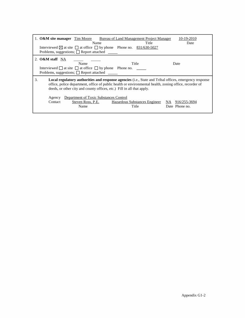
1. O&M site manager Tim Moore Bureau of Land Management Project Manager 10-19-2010 Name Title Date
Interviewed at site at office by phone Phone no. 831/630-5027 Problems, suggestions; Report attached
2. O&M staff NA Name Title Date
Interviewed at site at office by phone Phone no. Problems, suggestions; Report attached
3. Local regulatory authorities and response agencies (i.e., State and Tribal offices, emergency response office, police department, office of public health or environmental health, zoning office, recorder of deeds, or other city and county offices, etc.) Fill in all that apply.
Agency Department of Toxic Substances Control Contact Steven Ross, P.E. Hazardous Substances Engineer NA 916/255-3694
Name Title Date Phone no.
Appendix G1-2

III. ON-SITE DOCUMENTS & RECORDS VERIFIED (Check all that apply)
1. O&M Documents O&M manual Readily available Up to date N/A As-built drawings Readily available Up to date N/A Maintenance logs Readily available Up to date N/A
Remarks The USEPA has received relevant O&M documents for the site, including annual inspection reports and documentation of construction and maintenance activities.
2. Site-Specific Health and Safety Plan Readily available Up to date N/A Contingency plan/emergency response plan Readily available Up to date N/A
Remarks Not available for review during the site visit.
3. O&M and OSHA Training Records Readily available Up to date N/A Remarks OSHA training records were not available during the site visit.
4. Permits and Service Agreements Air discharge permit Readily available Up to date N/A Effluent discharge Readily available Up to date N/A Waste disposal, POTW Readily available Up to date N/A Other permits Readily available Up to date N/A
Remarks Not applicable to the remedy.
5. Gas Generation Records Readily available Up to date N/A Remarks Not applicable to the remedy.
6. Settlement Monument Records Readily available Up to date N/A Remarks Not applicable to the remedy.
7. Groundwater Monitoring Records Readily available Up to date N/A Remarks Not applicable to the remedy.
8. Leachate Extraction Records Readily available Up to date N/A Remarks Not applicable to the remedy.
9. Discharge Compliance Records Air Readily available Up to date N/A Water (effluent) Readily available Up to date N/A
Remarks Not applicable to the remedy.
10. Daily Access/Security Logs Readily available Up to date N/A Remarks Access logs were not available during the site visit.
Appendix G1-3

IV. O&M COSTS
1. O&M Organization State in-house Contractor for State PRP in-house Contractor for PRP Federal Facility in-house Contractor for Federal Facility
Other Bureau of Land Management, Northrop Grumman for the Altas Mine Site Committee
2. O&M Cost Records Readily available Up to date Not Available Funding mechanism/agreement in place
Original O&M cost estimate Breakdown attached
Total annual cost by year for review period if available
From To Breakdown attached Date Date Total cost
From To Breakdown attached Date Date Total cost
From To Breakdown attached Date Date Total cost
From To Breakdown attached Date Date Total cost
From To Breakdown attached Date Date Total cost
3. Unanticipated or Unusually High O&M Costs During Review Period Describe costs and reasons N/A
V. ACCESS AND INSTITUTIONAL CONTROLS Applicable N/A
A. Fencing
1. Fencing damaged Location shown on site map Gates secured N/A Remarks Access to the site via the main access road is blocked by fences and locked gates. The site is located in a portion of the Bureau of Land Management-controlled Clear Creek Management Area (CCMA) that is currently closed to recreational use. Numerous off-highway vehicle trails traverse the CCMA, including in the closed areas. Vehicle tracks have been observed on or near these trails, and these trails could provide alternate means of access to the site, but no direct evidence of trespassing has been observed within the OU in recent years.
B. Other Access Restrictions
1. Signs and other security measures Location shown on site map N/A Remarks Small signs affixed to site fencing at regular intervals read, "ASBESTOS - Cancer and Lung Disease Hazard, Authorized Personnel Only, Respirators and Protective Clothing Required in this Area." Many of these signs are faded and disintegrating as to be illegible or partly illegible. Newer signs near the entrance to the OU via the site access road read, "DANGER/Asbestos Hazard/Closed Area - Do Not Enter/This abandoned open pit mine is an EPA Superfund Site and contains high concentrations of asbestos dust. Breathing this dust increases the risk of lung cancer and other respiratory diseases./For information call: Bureau of Land Management, Hollister Field Office (831) 630 5000." This telephone number remains an active and valid number for site information. The PRP should consider adding similar signs in Spanish.
Appendix G1-4

C. Institutional Controls (ICs)
1. Implementation and enforcement Site conditions imply ICs not properly implemented Yes No N/A Site conditions imply ICs not being fully enforced Yes No N/A
Type of monitoring (e.g., self-reporting, drive by) Self-reporting Frequency Monthly Responsible party/agency Northrup Grumman/Atlas Mine Site Committee Contact Steve Mulligan Principal Associate ID Environ.Associates Inc. NA 714/231-7781
Name Title Date Phone no.
Reporting is up-to-date Yes No N/A Reports are verified by the lead agency Yes No N/A
Specific requirements in deed or decision documents have been met Yes No N/A Violations have been reported Yes No N/A Other problems or suggestions: Report attached
Deed restrictions, as called for in the ROD, cannot be placed on the property due to the language in the Consent Decree and also because of a lack of a discernable property owner of two smaller properties within the OU. EPA explained the status of ICs at the OU in a 2010 Explanation of Significant Differences from the ROD. This ESD acts as an IC until the status of the property changes.
2. Adequacy ICs are adequate ICs are inadequate N/A Remarks Institutional controls have been implemented to the fullest extent possible, consistent with the ROD and Consent Decree.
D. General
1. Vandalism/trespassing Location shown on site map No vandalism evident Remarks
2. Land use changes on site N/A Remarks
3. Land use changes off site N/A Remarks The area of the CCMA surrounding the OU has been closed to recreational use.
VI. GENERAL SITE CONDITIONS
A. Roads Applicable N/A
1. Roads damaged Location shown on site map Roads adequate N/A Remarks Chip-seal on the main portion of the access road entering the OU that was installed as a fugitive dust control is beginning to deteriorate; however, immediate maintenance is probably not required. Other site roads are unpaved. Small scale erosion (rills) were observed on site roads along the eastern edge of Pond E and near the southwest corner of Pond E. Roads at these locations should be regraded and engineering controls constructed to limit erosion. A portion of the unpaved site road leading to the "Rover Pit" area has dropped due to an active landslide creating a vertical offset of approximately two feet perpendicular to the roadway and preventing vehicle traffic from passing this point. The road should be re-graded at this location
B. Other Site Conditions Remarks Road maintenance and signage enhancement are needed at the site.
Appendix G1-5

VII. LANDFILL COVERS (MINE WASTE CONTAINMENT) Applicable N/A
A. Landfill Surface
1. Settlement (Low spots) Location shown on site map Settlement not evident Areal extent Depth Remarks
2. Cracks Location shown on site map Cracking not evident Lengths Widths Depths Remarks
3. Erosion Location shown on site map Erosion not evident Areal extent Depth Remarks Erosional features on and around the mine waste areas appear little changed in recent years. Much of the erosion across the site has been mitigated by installation of drain rock, berms, subsurface piping for conveying surface runoff, surface runoff diversion structures, and vegetation. Active erosion is known to occur on the site access road leading to Pond A (the highwall slope above Pond B) and the site access road to the Rover Pit (discussed in Section VI, Item A1).
4. Holes Location shown on site map Holes not evident Areal extent Depth Remarks
5. Vegetative Cover Grass Cover properly established No signs of stress Trees/Shrubs (indicate size and locations on a diagram)
Remarks Local flora were grown in nurseries and later planted in transects on tailings and asbestosladen soils. Although many of the original plants did not survive, a significant number survived to reproduce so that plants are now growing in areas outside the boundaries of the original restoration project. Due to the inherent difficulty in establishing plant growth on asbestos/serpentine-rich soils, likely coupled with three years of drought, colonization of barren areas has been minimal since the time of the last five-year review. However, the vegetative cover appears to have responded favorably to the past year of higher precipitation rates, and looks healthy in areas where it is established. It is expected that plants will continue to grow and disperse to new areas over the long-term, albeit at a slow rate.
6. Alternative Cover (armored rock, concrete, etc.) N/A Remarks
7. Bulges Location shown on site map Bulges not evident Areal extent Height Remarks
8. Wet Areas/Water Damage Wet areas/water damage not evident Wet areas Location shown on site map Areal extent Ponding Location shown on site map Areal extent Seeps Location shown on site map Areal extent Soft subgrade Location shown on site map Areal extent
Remarks
9. Slope Instability Slides Location shown on site map No evidence of slope instability Areal extent Remarks A landslide continues to progress at the site access road to the Rover Pit. The landslide has progressed to the point where it prevents vehicular access to the Rover Pit and Channel A. The road should be re-graded at this location.
Appendix G1-6

B. Benches Applicable N/A (Horizontally constructed mounds of earth placed across a steep landfill side slope to interrupt the slope in order to slow down the velocity of surface runoff and intercept and convey the runoff to a lined channel.)
1. Flows Bypass Bench Location shown on site map N/A or okay Remarks
2. Bench Breached Location shown on site map N/A or okay Remarks
3. Bench Overtopped Location shown on site map N/A or okay Remarks
C. Letdown Channels Applicable N/A (Channel lined with erosion control mats, riprap, grout bags, or gabions that descend down the steep side slope of the cover and will allow the runoff water collected by the benches to move off of the landfill cover without creating erosion gullies.)
1. Settlement Location shown on site map No evidence of settlement Areal extent Depth Remarks
2. Material Degradation Location shown on site map No evidence of degradation Material type Areal extent Remarks
3. Erosion Location shown on site map No evidence of erosion Areal extent Depth Remarks
4. Undercutting Location shown on site map No evidence of undercutting Areal extent Depth Remarks
5. Obstructions Type No obstructions Location shown on site map Areal extent
Size Remarks
6. Excessive Vegetative Growth Type No evidence of excessive growth Vegetation in channels does not obstruct flow Location shown on site map Areal extent
Remarks
Appendix G1-7

D. Cover Penetrations Applicable N/A
1. Gas Vents Active Passive Properly secured/locked Functioning Routinely sampled Evidence of leakage at penetration Needs Maintenance N/A
Remarks
Good condition
2. Gas Monitoring Probes Properly secured/locked Functioning Routinely sampled Evidence of leakage at penetration Needs Maintenance
Remarks
Good condition N/A
3. Monitoring Wells (within surface area of landfill) Properly secured/locked Functioning Routinely sampled Evidence of leakage at penetration Needs Maintenance
Remarks
Good condition N/A
4. Leachate Extraction Wells Properly secured/locked Functioning Routinely sampled Evidence of leakage at penetration Needs Maintenance
Remarks
Good condition N/A
5. Settlement Monuments Located Routinely surveyed Remarks
N/A
E. Gas Collection and Treatment Applicable N/A
1. Gas Treatment Facilities Flaring Thermal destruction Collection for reuse Good condition Needs Maintenance
Remarks
2. Gas Collection Wells, Manifolds and Piping Good condition Needs Maintenance
Remarks
3. Gas Monitoring Facilities (e.g., gas monitoring of adjacent homes or buildings) Good condition Needs Maintenance N/A
Remarks
F. Cover Drainage Layer Applicable N/A
1. Outlet Pipes Inspected Functioning N/A Remarks
2. Outlet Rock Inspected Functioning N/A Remarks
Appendix G1-8

G. Detention/Sedimentation Ponds Applicable N/A
1. Siltation Areal extent Pond B Depth N/A Siltation not evident
Remarks Sediment continues to accumulate in Pond B due to erosion of the highwall slope above Pond B. However, the rate of accumulation of sediments in the pond is lower than in years past, likely due to three years of drought recorded since the time of the previous five-year review.
2. Erosion Areal extent Pond B Depth Erosion not evident
Remarks Some erosion is occurring at the highwall slope above Pond B.
3. Outlet Works Functioning N/A Remarks
4. Dam Functioning N/A Remarks
H. Retaining Walls Applicable N/A
1. Deformations Location shown on site map Deformation not evident Horizontal displacement Vertical displacement Rotational displacement Remarks
2. Degradation Location shown on site map Degradation not evident Remarks
I. Perimeter Ditches/Off-Site Discharge Applicable N/A
1. Siltation Location shown on site map Siltation not evident Areal extent Upper portion of Channel B and along length of Channel A. Depth inches Remarks Siltation has occurred in both of the surface runoff diversion channels. In some areas, this siltation has completely filled the rock mattresses in the channel bed, leaving a smooth surface on the channel bottom. Though the siltation is not likely to fill the channels or obstruct flow, the smooth bottom surface of the channels facilitates faster current flow in the channels, which could, in turn, lead to release of asbestos-laden sediments from the site.
2. Vegetative Growth Location shown on site map N/A Vegetation does not impede flow
Areal extent Type Remarks
3. Erosion Location shown on site map Erosion not evident Areal extent Depth Remarks
4. Discharge Structure Functioning N/A Remarks
Appendix G1-9

VIII. VERTICAL BARRIER WALLS Applicable N/A
1. Settlement Location shown on site map Settlement not evident Areal extent Depth Remarks
2. Performance Monitoring Type of monitoring Performance not monitored
Frequency Evidence of breaching Head differential Remarks
IX. GROUNDWATER/SURFACE WATER REMEDIES Applicable N/A
A. Groundwater Extraction Wells, Pumps, and Pipelines Applicable N/A
1. Pumps, Wellhead Plumbing, and Electrical Good condition All required wells properly operating Needs Maintenance N/A
Remarks
2. Extraction System Pipelines, Valves, Valve Boxes, and Other Appurtenances Good condition Needs Maintenance
Remarks
3. Spare Parts and Equipment Readily available Good condition Requires upgrade Needs to be provided
Remarks
B. Surface Water Collection Structures, Pumps, and Pipelines Applicable N/A
1. Collection Structures, Pumps, and Electrical Good condition Needs Maintenance
Remarks
2. Surface Water Collection System Pipelines, Valves, Valve Boxes, and Other Appurtenances Good condition Needs Maintenance
Remarks
3. Spare Parts and Equipment Readily available Good condition Requires upgrade Needs to be provided
Remarks
Appendix G1-10
C. Treatment System Applicable N/A
1. Treatment Train (Check components that apply) Metals removal Oil/water separation Bioremediation Air stripping Carbon adsorbers Filters Additive (e.g., chelation agent, flocculent) Others Good condition Needs Maintenance Sampling ports properly marked and functional Sampling/maintenance log displayed and up to date Equipment properly identified Quantity of groundwater treated annually Quantity of surface water treated annually
Remarks
2. Electrical Enclosures and Panels (properly rated and functional) N/A Good condition Needs Maintenance
Remarks
3. Tanks, Vaults, Storage Vessels N/A Good condition Proper secondary containment Needs Maintenance
Remarks
4. Discharge Structure and Appurtenances N/A Good condition Needs Maintenance
Remarks
5. Treatment Building(s) N/A Good condition (esp. roof and doorways) Needs repair
Chemicals and equipment properly stored Remarks
6. Monitoring Wells (pump and treatment remedy) Properly secured/locked Functioning Routinely sampled Good condition All required wells located Needs Maintenance N/A
Remarks
D. Monitoring Data 1. Monitoring Data
Is routinely submitted on time Is of acceptable quality 2. Monitoring data suggests:
Groundwater plume is effectively contained Contaminant concentrations are declining
Appendix G1-11

E. Monitored Natural Attenuation
1. Monitoring Wells (natural attenuation remedy) Properly secured/locked Functioning Routinely sampled Good condition All required wells located Needs Maintenance N/A
Remarks
X. OTHER REMEDIES
Not Applicable.
XI. OVERALL OBSERVATIONS
A. Implementation of the Remedy
Describe issues and observations relating to whether the remedy is effective and functioning as designed. Begin with a brief statement of what the remedy is to accomplish (i.e., to contain contaminant plume, minimize infiltration and gas emission, etc.).
The remedy at the Atlas Mine Area OU was designed to prevent migration of asbestos-laden sediment away from the OU via air (wind-blown fugitive dust emissions) and water (fluvial erosion). The remedy is functioning as designed with some exceptions. Not all surfaces within the OU drain directly into a settlement pond. Some surfaces, notably the outward slopes of the Regional Sediment Storage Area, and the outward slopes of areas to the west of Pond B drain directly into one of the surface runoff diversion channels. Though these channels were designed to intercept overland flow from areas offsite, they may additionally receive runoff and sediments from the OU. It has been noted that the rock mattresses lining these channels have gradually filled with sediment in some areas, The smooth bottom surface of these channels could facilitate fast currents that could transport asbestos-laden sediment off-site. The runoff diversion channels should be reimagined as sediment trapping devices rather than purely as water runoff interception devices and treated similarly to the settlement ponds in the future by removing accumulated sediments from them.
Additionally, the runoff from the Rover Pit is not intercepted by a settlement pond and the outlet structure of the Rover Pit, as well as most of the ground surface of the pit, cannot be directly inspected because there is no way to access these areas safely by vehicle. Site roadway infrastructure should be expanded to allow access to all areas of the Rover Pit for inspection.
B. Adequacy of O&M
Describe issues and observations related to the implementation and scope of O&M procedures. In particular, discuss their relationship to the current and long-term protectiveness of the remedy.
Annual inspections are performed to identify any need for maintenance activities at the site. Many previously identified concerns regarding erosion were mitigated as a result of repairs made in 2005, but some new areas of concern have been identified. It is not clear that the current remedy is adequately protective due to the concerns raised in this review. The remedial design should be examined and amended if necessary.
C. Early Indicators of Potential Remedy Problems
Describe issues and observations such as unexpected changes in the cost or scope of O&M or a high frequency of unscheduled repairs, that suggest that the protectiveness of the remedy may be compromised in the future.
No issues or observations made suggest a potential failure of the current remedy, as designed, should potential inspection and maintenance activities continue.
D. Opportunities for Optimization
Describe possible opportunities for optimization in monitoring tasks or the operation of the remedy. The following optimization and maintenance activities should be performed: Signage replacement and
augmentation, roadway maintenance, and runoff diversion.
Appendix G1-12

Access road from the south of the site, extending along Pond C.
Cancer and lung disease hazard, authorized
weathered signs on the site.
Appendix G1-13

Pond C.
Culvert extending beneath the access road to Pond C.
Appendix G1-14
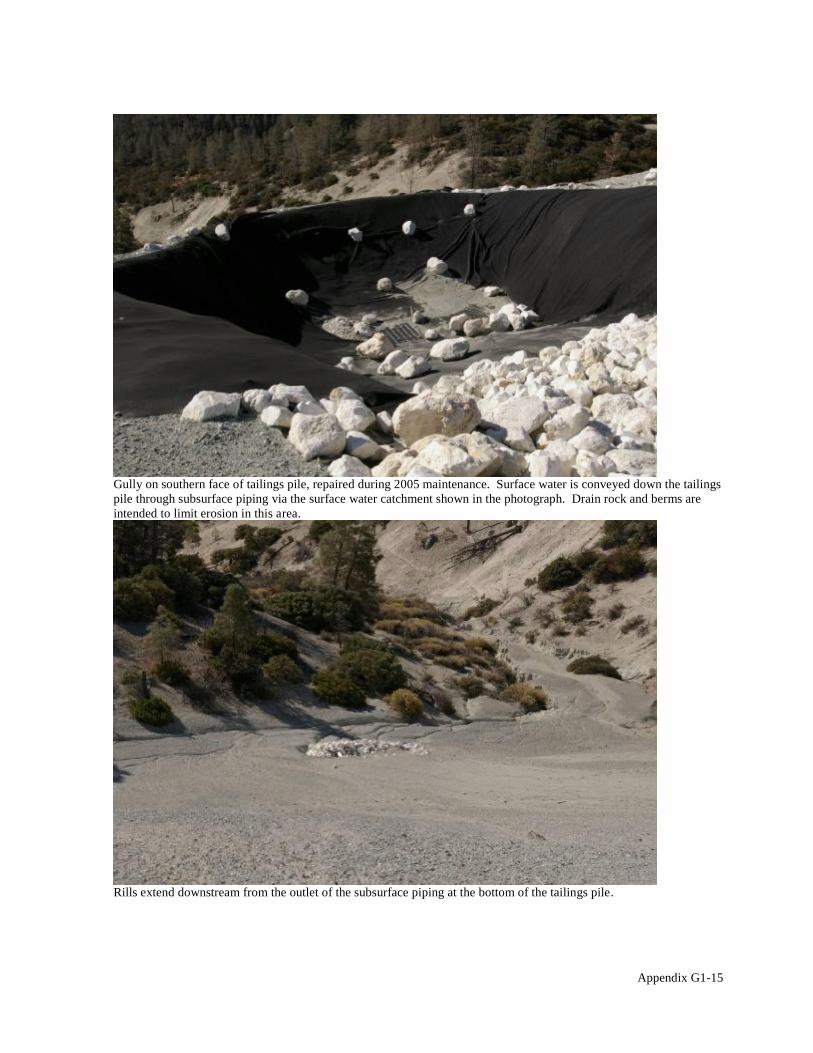
Gully on southern face of tailings pile, repaired during 2005 maintenance. Surface water is conveyed down the tailings pile through subsurface piping via the surface water catchment shown in the photograph. Drain rock and berms are intended to limit erosion in this area.
Rills extend downstream from the outlet of the subsurface piping at the bottom of the tailings pile.
Appendix G1-15

Drain rock installed during 2005 maintenance to prevent erosion from occurring on the southern face of the tailings pile.
Berm (behind vehicle) installed south of the Regional Sediment Storage Area to limit erosion.
Appendix G1-16
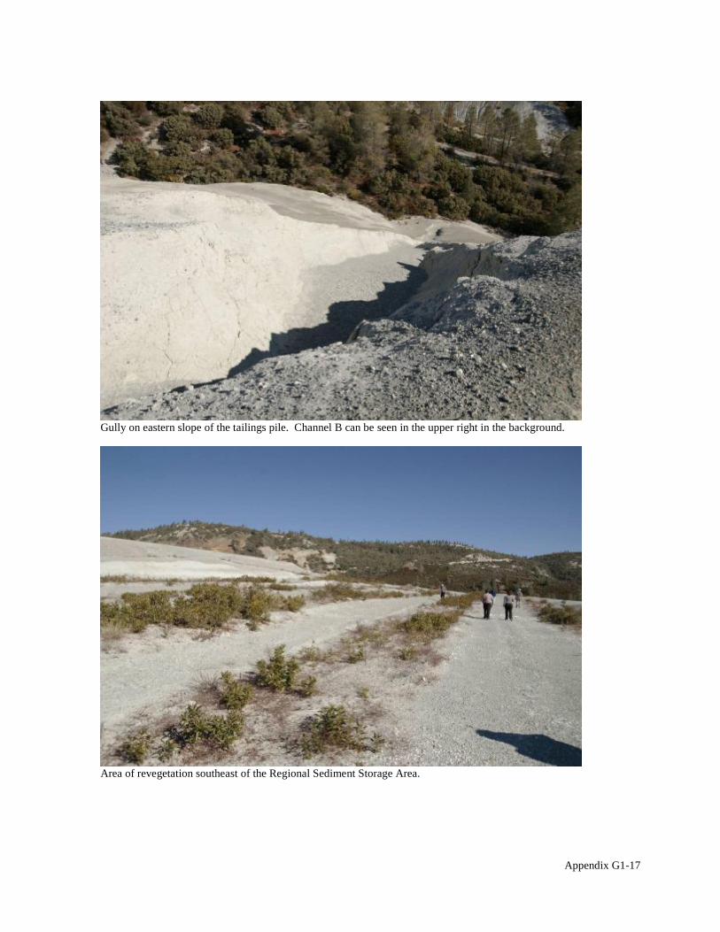
Gully on eastern slope of the tailings pile. Channel B can be seen in the upper right in the background.
Area of revegetation southeast of the Regional Sediment Storage Area.
Appendix G1-17

Sediment trap area at the discharge outlet of Pond G, upstream of Channel B. No sediment buildup was observed in the outlet.
Start of Channel B as it extends from the sediment trap area.
Appendix G1-18
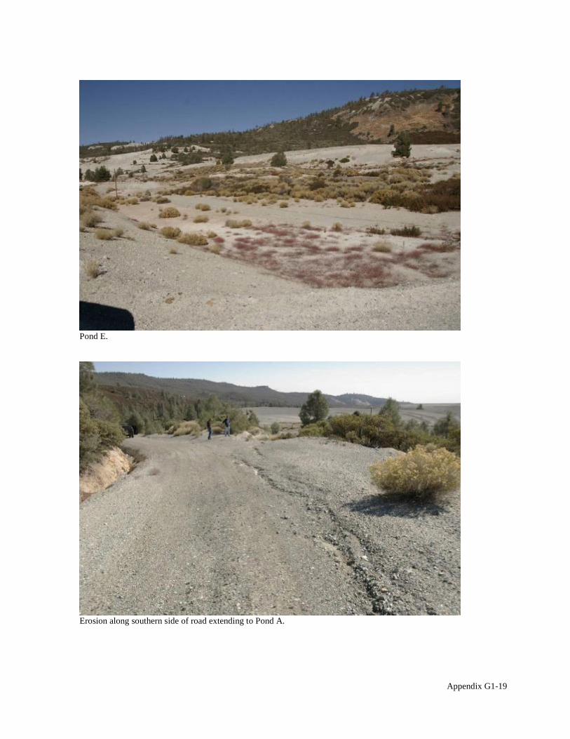
Pond E.
Erosion along southern side of road extending to Pond A.
Appendix G1-19

Culvert at the end of the drainage channel along access road to Pond A. The inlet was cleared of sediment and vegetation after the previous five-year review and has not re-accumulated.
Berm installed along the access road to Pond A to limit erosion on the highwall slope above Pond B.
Appendix G1-20
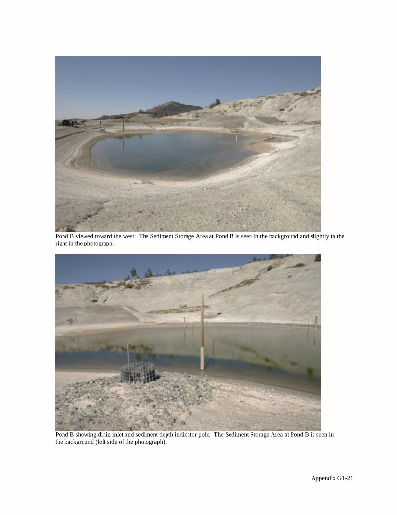
Pond B viewed toward the west. The Sediment Storage Area at Pond B is seen in the background and slightly to the right in the photograph.
Pond B showing drain inlet and sediment depth indicator pole. The Sediment Storage Area at Pond B is seen in the background (left side of the photograph).
Appendix G1-21

Diversion channel on the road to Pond A to limit erosion.
Channel A. Sedimentation has filled the rock mattresses in the channel bottom, creating a smooth surface.
Appendix G1-22

Channel A terminus. Drain rock was installed during 2005 maintenance activities.
Area of active landslide on the road to Rover Pit.
Appendix G1-23

:%%-'.* 8;
6&+'#<50'!*((- 5*(( 41 2*"- 7'#%-/"*&' 9+-/)(*#" 0'. 3+&"&,$0%+#
Below is the team roster for the Johns-Manville Mill OU site inspection, conducted on October 18, 2010.
Name Title Affiliation Lily Tavassoli Remedial Project Manager U.S. EPA Steven Ross, P.E. Hazardous Substance DTSC
Engineer Don Gruber Senior Hydrogeologist/Project ITSI (contractor to U.S.EPA)
Manager Jonathan Partsch Geologist ITSI (contractor to U.S.EPA) David Clark Director of Remediation BNSF Railway Company
Five-Year Review Site Inspection Checklist Johns-Manville Mill OU, Coalinga Asbestos Mine Superfund Site
I. SITE INFORMATION
Site name: Johns-Manville Mill OU Coalinga Asbestos Mine Superfund Site
Date of inspection: 18 October 2010
Location and Region: Coalinga, CA, Region IX
EPA ID: 0935, CAD980817217
Agency, office, or company leading the five-year review: USEPA, Region IX
Weather/temperature: Overcast to mostly cloudy, approximately 60 ºF
Remedy Includes: (Check all that apply) Landfill cover/containment Monitored natural attenuation Access controls Groundwater containment Institutional controls Vertical barrier walls
Groundwater pump and treatment Surface water collection and treatment Other Surface water diversion, erosion controls including contouring and re-vegetation, sediment
trapping dam emplacement, mill building dismantling, road paving.
Attachments: Inspection team roster attached Site map attached
II. INTERVIEWS (Check all that apply)
1. O&M site manager David Clark. Director of Remediation, BNSF Railway Company 10-18-2010 Name Title Date
Interviewed at site at office by phone Phone no. NA Problems, suggestions; Report attached
Appendix G2-1

2. O&M staff NA Name Title Date
Interviewed at site at office by phone Phone no. Problems, suggestions; Report attached
3. Local regulatory authorities and response agencies (i.e., State and Tribal offices, emergency response office, police department, office of public health or environmental health, zoning office, recorder of deeds, or other city and county offices, etc.) Fill in all that apply.
Agency Department of Toxic Substances Control Contact Steven Ross, P.E. Hazardous Substances Engineer NA 916/255-3694
Name Title Date Phone no.
Appendix G2-2
III. ON-SITE DOCUMENTS & RECORDS VERIFIED (Check all that apply)
1. O&M Documents O&M manual Readily available Up to date N/A As-built drawings Readily available Up to date N/A Maintenance logs Readily available Up to date N/A
Remarks No maintenance has been performed at the site since the time of the previous five-year review. The O&M manual was last updated in 2003. As-built drawings were not provided at the time of the site visit.
2. Site-Specific Health and Safety Plan Readily available Up to date N/A Contingency plan/emergency response plan Readily available Up to date N/A
Remarks Not available for review during the site visit.
3. O&M and OSHA Training Records Readily available Up to date N/A Remarks OSHA Training records were not available during the site visit.
4. Permits and Service Agreements Air discharge permit Readily available Up to date N/A Effluent discharge Readily available Up to date N/A Waste disposal, POTW Readily available Up to date N/A Other permits Readily available Up to date N/A
Remarks Not applicable to the remedy.
5. Gas Generation Records Readily available Up to date N/A Remarks Not applicable to the remedy.
6. Settlement Monument Records Readily available Up to date N/A Remarks Not applicable to the remedy.
7. Groundwater Monitoring Records Readily available Up to date N/A Remarks Not applicable to the remedy.
8. Leachate Extraction Records Readily available Up to date N/A Remarks Not applicable to the remedy.
9. Discharge Compliance Records Air Readily available Up to date N/A Water (effluent) Readily available Up to date N/A
Remarks Not applicable to the remedy.
10. Daily Access/Security Logs Readily available Up to date N/A Remarks The site is located at a remote location, accessable only through private property, and is enclosed in a low, barbed-wire perimeter fence to which warning signs are affixed at regular intervals. The site is infrequently visited by the PRP and regulatory agency personnel.
Appendix G2-3

IV. O&M COSTS
1. O&M Organization State in-house Contractor for State PRP in-house Contractor for PRP Federal Facility in-house Contractor for Federal Facility
Other
2. O&M Cost Records Readily available Up to date Not Available Funding mechanism/agreement in place
Original O&M cost estimate Breakdown attached
Total annual cost by year for review period if available
From To Breakdown attached Date Date Total cost
From To Breakdown attached Date Date Total cost
From To Breakdown attached Date Date Total cost
From To Breakdown attached Date Date Total cost
From To Breakdown attached Date Date Total cost
3. Unanticipated or Unusually High O&M Costs During Review Period Describe costs and reasons N/A
V. ACCESS AND INSTITUTIONAL CONTROLS Applicable N/A
A. Fencing
1. Fencing damaged Location shown on site map Gates secured N/A Remarks The site is enclosed in a low barbed-wire perimeter fence which encloses areas of the site with restricted access, including the tailings piles and the site of the former mill building. In addition, a cable fence lines the access road to the site, preventing access to the maintenance road that leads to the site.
B. Other Access Restrictions
1. Signs and other security measures Location shown on site map N/A Remarks Signs are posted at regular intervals and affixed to the perimeter fence. The signs read, "WARNING, Hazardous Substance Area, No entry permitted, Asbestos Present". A USEPA telephone number is printed on the signs. The telephone number connects callers to a bilingual USEPA Region IX community involvement service for community questions regarding hazardous waste sites. This information line remains active, and the telephone number is valid. Warning signs were observed to have faded significantly in some areas when compared to photographs taken during the previous five-year review. These signs should be replaced to ensure that the pertinant information they contain remains legible until the next five-year review.
Appendix G2-4

C. Institutional Controls (ICs)
1. Implementation and enforcement Site conditions imply ICs not properly implemented Yes No N/A Site conditions imply ICs not being fully enforced Yes No N/A
Type of monitoring (e.g., self-reporting, drive by) Self-reporting Frequency Annual Responsible party/agency Arcadis-US on behalf of BNSF Railway Company Contact David Parks P.E. Senior Associate Civil NA 714/444-0111
Name Title Date Phone no.
Reporting is up-to-date Yes No N/A Reports are verified by the lead agency Yes No N/A
Specific requirements in deed or decision documents have been met Yes No N/A Violations have been reported Yes No N/A Other problems or suggestions: Report attached
The title commitment for this site is provided as an attachment to the five-year review report.
2. Adequacy ICs are adequate ICs are inadequate N/A Remarks Institutional controls should be implemented, consistent with DTSC LUC regulations.
D. General
1. Vandalism/trespassing Location shown on site map No vandalism evident Remarks No evidence of vandalism or tresspassing were observed within the fenced area of the site during the site visit.
2. Land use changes on site N/A Remarks
3. Land use changes off site N/A Remarks The private property abutting the site contains a small farming and ranching operation and remains controlled by the same private owner since the time of the previous five-year review. There have been no significant changes in this land use since 2006.
VI. GENERAL SITE CONDITIONS
A. Roads Applicable N/A
1. Roads damaged Location shown on site map Roads adequate N/A Remarks A protion of the site access road infrastructure was paved as part of the remedy at the site while other portions remain unpaved. Roads are uneven in some areas, but remain easily traversible.
B. Other Site Conditions Remarks Faded warning signs on the site perimeter fence and cable fence along the access road should be replaced.
Appendix G2-5
VII. LANDFILL COVERS Applicable N/A
A. Landfill Surface
1. Settlement (Low spots) Location shown on site map Settlement not evident Areal extent Depth Remarks
2. Cracks Location shown on site map Cracking not evident Lengths 1-10 feet Widths to 1 foot Depths to approximately 2 feet Remarks Large, deep cracks were observed in the forward slope and toe of the main tailings pile. These cracks appear to be the result of repeated seasonal dessication of the tailings pile during dry periods. These cracks may also have been widened and deepened by surface erosion during rain events. These cracks do not appear to present an immediate threat to any portion of the constructed remedy at the site. The contouring, drainage ditches and drain inlets on the tailings pile appear to be in good condition.
3. Erosion Location shown on site map Erosion not evident Areal extent Forward slope and toe of the main tailings pile Depth to approximately 2 feet Remarks Some evidence of benign surface erosion was noted around the large surface cracks identified in item A2 above.
4. Holes Location shown on site map Holes not evident Areal extent Depth Remarks
5. Vegetative Cover Grass Cover properly established No signs of stress Trees/Shrubs (indicate size and locations on a diagram)
Remarks The leveled top of the main tailings pile (former pond area) has well-established vegetative cover of shrubs and herbacious plants as a continuing result of revegetation efforts during remedy construction. Revegetation plantings are more poorly establihed on the sloped portion of the tailings pile, but occasional conifer trees to 20 feet high continue to grow here, mainly along the edges and toe of the slope.
6. Alternative Cover (armored rock, concrete, etc.) N/A Remarks
7. Bulges Location shown on site map Bulges not evident Areal extent Height Remarks
8. Wet Areas/Water Damage Wet areas/water damage not evident Wet areas Location shown on site map Areal extent Ponding Location shown on site map Areal extent Seeps Location shown on site map Areal extent Soft subgrade Location shown on site map Areal extent
Remarks
9. Slope Instability Slides Location shown on site map No evidence of slope instability Areal extent Remarks Signs of slope instability were not observed during the site visit, but refer to remarks for section VII, item A2.
Appendix G2-6
B. Benches Applicable N/A (Horizontally constructed mounds of earth placed across a steep landfill side slope to interrupt the slope in order to slow down the velocity of surface runoff and intercept and convey the runoff to a lined channel.) Benches constructed as part of the remidy on the sloping face of the main tailings pile are referred to V-ditches or ditches here and in other documents.
1. Flows Bypass Bench Location shown on site map N/A or okay Remarks
2. Bench Breached Location shown on site map N/A or okay Remarks
3. Bench Overtopped Location shown on site map N/A or okay Remarks
C. Letdown Channels Applicable N/A (Channel lined with erosion control mats, riprap, grout bags, or gabions that descend down the steep side slope of the cover and will allow the runoff water collected by the benches to move off of the landfill cover without creating erosion gullies.) Runoff from the main tailings pile is conveyed to a settling/energy dissapation pond via subsurface drains as part of the constructed remedy. Drain inlets appear to be in good condition.
1. Settlement Location shown on site map No evidence of settlement Areal extent Depth Remarks
2. Material Degradation Location shown on site map No evidence of degradation Material type Areal extent Remarks
3. Erosion Location shown on site map No evidence of erosion Areal extent Depth Remarks
4. Undercutting Location shown on site map No evidence of undercutting Areal extent Depth Remarks
5. Obstructions Type No obstructions Location shown on site map Areal extent
Size Remarks
6. Excessive Vegetative Growth Type No evidence of excessive growth Vegetation in channels does not obstruct flow Location shown on site map Areal extent
Remarks
Appendix G2-7

D. Cover Penetrations Applicable N/A
1. Gas Vents Active Passive Properly secured/locked Functioning Routinely sampled Good condition Evidence of leakage at penetration Needs Maintenance N/A
Remarks
2. Gas Monitoring Probes Properly secured/locked Functioning Routinely sampled Good condition Evidence of leakage at penetration Needs Maintenance N/A
Remarks
3. Monitoring Wells (within surface area of landfill) Properly secured/locked Functioning Routinely sampled Good condition Evidence of leakage at penetration Needs Maintenance N/A
Remarks
4. Leachate Extraction Wells Properly secured/locked Functioning Routinely sampled Good condition Evidence of leakage at penetration Needs Maintenance N/A
Remarks
5. Settlement Monuments Located Routinely surveyed N/A Remarks
E. Gas Collection and Treatment Applicable N/A
1. Gas Treatment Facilities Flaring Thermal destruction Collection for reuse Good condition Needs Maintenance
Remarks
2. Gas Collection Wells, Manifolds and Piping Good condition Needs Maintenance
Remarks
3. Gas Monitoring Facilities (e.g., gas monitoring of adjacent homes or buildings) Good condition Needs Maintenance N/A
Remarks
F. Cover Drainage Layer Applicable N/A
1. Outlet Pipes Inspected Functioning N/A Remarks Observations of of V-ditches (benches), drain inlets and outlet pipes indicate that only minor, insignificant erosion is affecting the main tailings pile.
2. Outlet Rock Inspected Functioning N/A Remarks Observations of outlet rock/riprap indicate it is stable and functioning properly.
Appendix G2-8

G. Detention/Sedimentation Ponds Applicable N/A
1. Siltation Areal extent few square yards Depth shallow N/A Siltation not evident
Remarks
2. Erosion Areal extent Depth Erosion not evident
Remarks
3. Outlet Works Functioning N/A Remarks Large rocks are used to dissapate energy at the outlet of the pond before runnoff flows downslope toward the sediment trapping dam. These rocks have collected little sediment and appear to be stable.
4. Dam Functioning N/A Remarks The sediment trapping dam appears to be working as designed. No maintanace issues, such as burrow holes or erosion were noted.
H. Retaining Walls Applicable N/A
1. Deformations Location shown on site map Deformation not evident Horizontal displacement Vertical displacement Rotational displacement Remarks
2. Degradation Location shown on site map Degradation not evident Remarks
I. Perimeter Ditches/Off-Site Discharge Applicable N/A
1. Siltation Location shown on site map Siltation not evident Areal extent Depth Remarks
2. Vegetative Growth Location shown on site map N/A Vegetation does not impede flow
Areal extent minimal Type Remarks Establishing vegetaion in the area of surface runnoff diversion infrastructure is a desired part of the remedial design but is slow to establish due to the inheriant problems of plant growth on serpentine-derrived soils. Vegetation growth does not appear likely to impede drainage.
3. Erosion Location shown on site map Erosion not evident Areal extent minimal Depth to approximately 2 feet Remarks Observations of V-ditches (benches) indicate that only minor, insignificant erosion is affecting the main tailings pile
4. Discharge Structure Functioning N/A Remarks Runoff from the main tailings pile is conveyed via the V-ditches to subsurface drains which, in turn, convey runoff to an energy dissapation pond. Drain inlets and outlets appear to be in good condition, and are free of obstructions.
Appendix G2-9

VIII. VERTICAL BARRIER WALLS Applicable N/A
1. Settlement Location shown on site map Settlement not evident Areal extent Depth Remarks
2. Performance Monitoring Type of monitoring Performance not monitored
Frequency Evidence of breaching Head differential Remarks
IX. GROUNDWATER/SURFACE WATER REMEDIES Applicable N/A
A. Groundwater Extraction Wells, Pumps, and Pipelines Applicable N/A
1. Pumps, Wellhead Plumbing, and Electrical Good condition All required wells properly operating Needs Maintenance N/A
Remarks
2. Extraction System Pipelines, Valves, Valve Boxes, and Other Appurtenances Good condition Needs Maintenance
Remarks
3. Spare Parts and Equipment Readily available Good condition Requires upgrade Needs to be provided
Remarks
B. Surface Water Collection Structures, Pumps, and Pipelines Applicable N/A
1. Collection Structures, Pumps, and Electrical Good condition Needs Maintenance
Remarks
2. Surface Water Collection System Pipelines, Valves, Valve Boxes, and Other Appurtenances Good condition Needs Maintenance
Remarks
3. Spare Parts and Equipment Readily available Good condition Requires upgrade Needs to be provided
Remarks
Appendix G2-10

C. Treatment System Applicable N/A
1. Treatment Train (Check components that apply) Metals removal Oil/water separation Bioremediation Air stripping Carbon adsorbers Filters Additive (e.g., chelation agent, flocculent) Others Good condition Needs Maintenance Sampling ports properly marked and functional Sampling/maintenance log displayed and up to date Equipment properly identified Quantity of groundwater treated annually Quantity of surface water treated annually
Remarks
2. Electrical Enclosures and Panels (properly rated and functional) N/A Good condition Needs Maintenance
Remarks
3. Tanks, Vaults, Storage Vessels N/A Good condition Proper secondary containment Needs Maintenance
Remarks
4. Discharge Structure and Appurtenances N/A Good condition Needs Maintenance
Remarks
5. Treatment Building(s) N/A Good condition (esp. roof and doorways) Needs repair
Chemicals and equipment properly stored Remarks
6. Monitoring Wells (pump and treatment remedy) Properly secured/locked Functioning Routinely sampled Good condition All required wells located Needs Maintenance N/A
Remarks
D. Monitoring Data 1. Monitoring Data
Is routinely submitted on time Is of acceptable quality 2. Monitoring data suggests:
Groundwater plume is effectively contained Contaminant concentrations are declining
Appendix G2-11

E. Monitored Natural Attenuation
1. Monitoring Wells (natural attenuation remedy) Properly secured/locked Functioning Routinely sampled Good condition All required wells located Needs Maintenance N/A
Remarks
X. OTHER REMEDIES
Surface Water Diversion No indications of erosion were observed in the Cross-Canyon Stream Diversion, or in the Diversion Spillway. The riprap appeared to be in good condition and free of significaint sediment buildup. Grassy vegetaion covers the diversion channel, but is not expected to impede the flow of runoff significantly. An area where ponded water was observed during the previous five-year review site visit was dry.
XI. OVERALL OBSERVATIONS
A. Implementation of the Remedy
Describe issues and observations relating to whether the remedy is effective and functioning as designed. Begin with a brief statement of what the remedy is to accomplish (i.e., to contain contaminant plume, minimize infiltration and gas emission, etc.).
The remedy at the Johns-Manville Mill OU is designed to prevent the migration of asbestos-laden sediment away from the site via Pine Canyon Creek. This was accomplished by diverting Pine Canyon Creek away from the tailings material, minimizing the release of asbestos into the creek through the construction of erosion controls and revegetation, paving the road through the Mill Area to supress fugitave dust emmissions, dismantling the mill building and disposing of the debris, and restricting access to the site. The remedy appears to be functioning as designed with the exception of the fading warning signs in some locations.
B. Adequacy of O&M
Describe issues and observations related to the implementation and scope of O&M procedures. In particular, discuss their relationship to the current and long-term protectiveness of the remedy. Comment on the adequacy of institutional controls here.
C. Early Indicators of Potential Remedy Problems
Describe issues and observations such as unexpected changes in the cost or scope of O&M or a high frequency of unscheduled repairs, that suggest that the protectiveness of the remedy may be compromised in the future.
No issues or observations made suggest a potential remedy failure in the foreseeable future.
D. Opportunities for Optimization
Describe possible opportunities for optimization in monitoring tasks or the operation of the remedy. The following optimization and maintenance activities should be performed: Replace faded warning
signs around the site.
Appendix G2-12
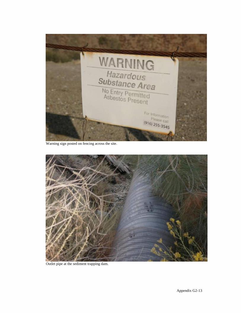
Warning sign posted on fencing across the site.
Outlet pipe at the sediment trapping dam.
Appendix G2-13
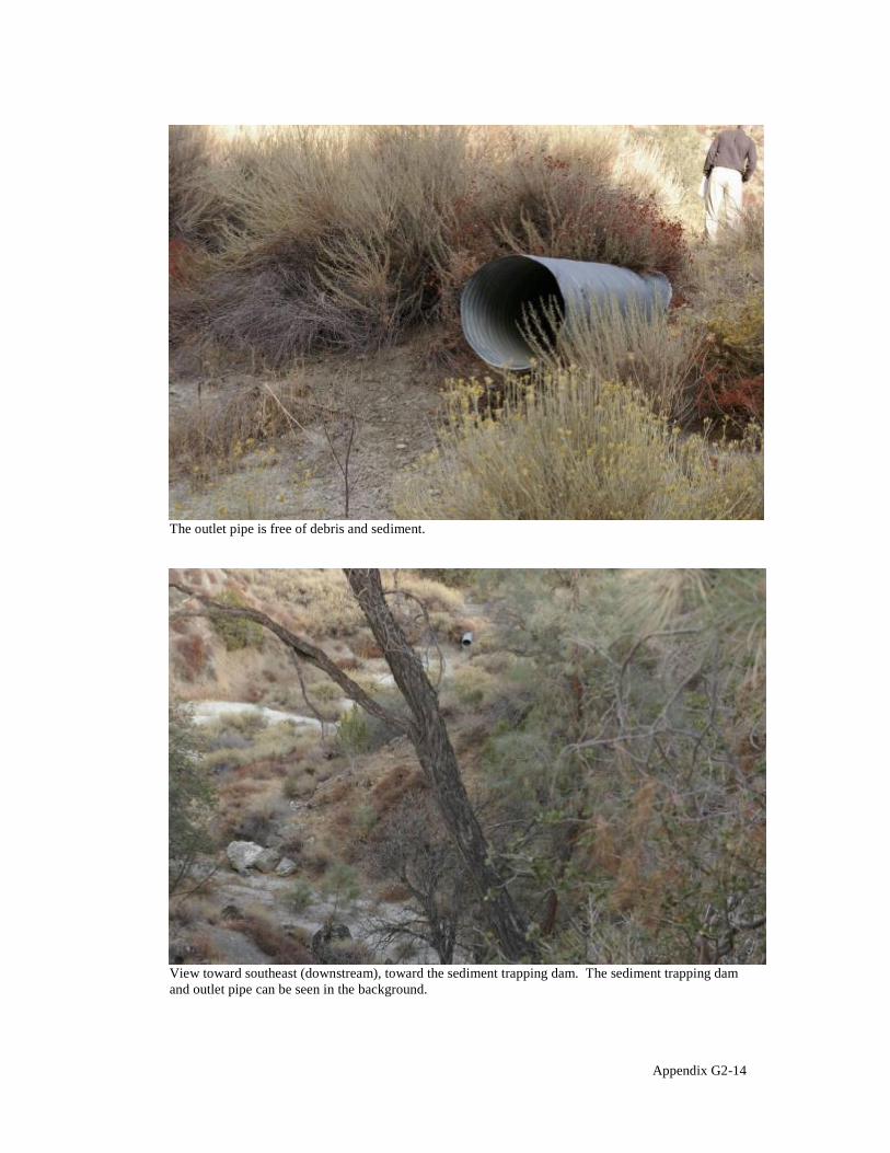
The outlet pipe is free of debris and sediment.
View toward southeast (downstream), toward the sediment trapping dam. The sediment trapping dam and outlet pipe can be seen in the background.
Appendix G2-14

View toward northeast from the sediment trapping area.
Tailings pile drainage outlets at the Energy Dissipation Pond showing minor debris accumulation in pipe outlet.
Appendix G2-15
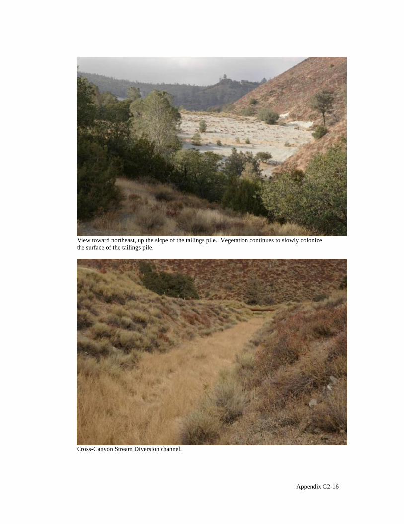
View toward northeast, up the slope of the tailings pile. Vegetation continues to slowly colonize the surface of the tailings pile.
Cross-Canyon Stream Diversion channel.
Appendix G2-16

Bridge across the Cross-Canyon Stream Diversion channel.
Western side of the bridge that crossed the Cross-Canyon Stream Diversion channel.
Appendix G2-17

Diversion channel spillway.
Area in the Cross-Canyon Stream Diversion channel where standing water was observed during 2006 inspection. The area is now dry.
Appendix G2-18

Vegetation at the location of the former ponds.
Example of large desiccation cracks on the tailings pile.
Appendix G2-19

Close-up view of a large desiccation crack on the tailings pile.
Tree and herbaceous plant growth on the tailings pile.
Appendix G2-20

V-ditches on the tailings pile for collecting surface water runoff. Runoff drains through subsurface piping to the Energy Dissipation Pond via drainage inlets.
Drainage inlet.
Appendix G2-21
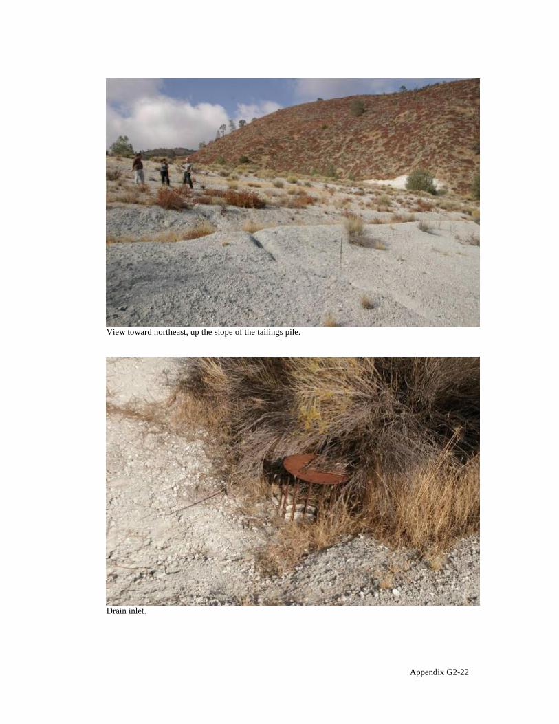
View toward northeast, up the slope of the tailings pile.
Drain inlet.
Appendix G2-22

8%%-'.*! 69
7*" 41 2*"- 5'#%-/"*&' 7+-/)(*#" 0'. 3+&"&,$0%+#
Below is the team roster for the City OU site inspection, conducted October 20, 2010.
Name Title Affiliation Lily Tavassoli Remedial Project Manager U.S. EPA Steven Ross, P.E. Hazardous Substance DTSC
Engineer Don Gruber Senior Hydrogeologist/Project ITSI (contractor to U.S.EPA)
Manager Jonathan Partsch Geologist ITSI (contractor to U.S.EPA) Jay Badiei, P.G. Senior Project Manager Delta Environmental
(contractor to Union Pacific Railroad Company)
Joey Ransey Code Enforcement Officer City of Coalinga
Five-Year Review Site Inspection Checklist Coalinga City OU, Coalinga Asbestos Mine Superfund Site
I. SITE INFORMATION
Site name: Coalinga City OU Coalinga Asbestos Mine Superfund Site
Date of inspection: 20 October 2010
Location and Region: Coalinga, CA, Region IX
EPA ID: 0935, CAD980817217 0934, CAD980496863
Agency, office, or company leading the five-year review: USEPA, Region IX
Weather/temperature: Clear, approximately 65 ºF
Remedy Includes: (Check all that apply) Landfill cover/containment Monitored natural attenuation Access controls Groundwater containment Institutional controls Vertical barrier walls
Groundwater pump and treatment Surface water collection and treatment Other
Attachments: Inspection team roster attached Site map attached
II. INTERVIEWS (Check all that apply)
1. O&M site manager Jay Biedel P.G. Senior Project Manager October 20, 2010 Name Title Date
Interviewed at site at office by phone Phone no. 626/256-6662 Problems, suggestions; Report attached
Appendix G3-1
2. O&M staff NA Name Title Date
Interviewed at site at office by phone Phone no. Problems, suggestions; Report attached
3. Local regulatory authorities and response agencies (i.e., State and Tribal offices, emergency response office, police department, office of public health or environmental health, zoning office, recorder of deeds, or other city and county offices, etc.) Fill in all that apply.
Agency Department of Toxic Substances Control Contact Steven Ross, P.E. Hazardous Substances Engineer NA 916/255-3694
Name Title Date Phone no.
Appendix G3-2
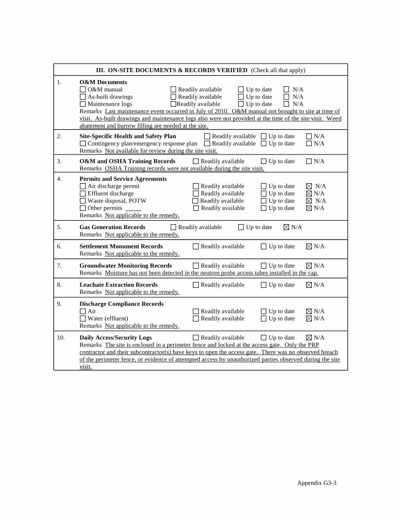
III. ON-SITE DOCUMENTS & RECORDS VERIFIED (Check all that apply)
1. O&M Documents O&M manual Readily available Up to date N/A As-built drawings Readily available Up to date N/A Maintenance logs Readily available Up to date N/A
Remarks Last maintenance event occurred in July of 2010. O&M manual not brought to site at time of visit. As-built drawings and maintenance logs also were not provided at the time of the site visit. Weed abatement and burrow filling are needed at the site.
2. Site-Specific Health and Safety Plan Readily available Up to date N/A Contingency plan/emergency response plan Readily available Up to date N/A
Remarks Not available for review during the site visit.
3. O&M and OSHA Training Records Readily available Up to date N/A Remarks OSHA Training records were not available during the site visit.
4. Permits and Service Agreements Air discharge permit Readily available Up to date N/A Effluent discharge Readily available Up to date N/A Waste disposal, POTW Readily available Up to date N/A Other permits Readily available Up to date N/A
Remarks Not applicable to the remedy.
5. Gas Generation Records Readily available Up to date N/A Remarks Not applicable to the remedy.
6. Settlement Monument Records Readily available Up to date N/A Remarks Not applicable to the remedy.
7. Groundwater Monitoring Records Readily available Up to date N/A Remarks Moisture has not been detected in the neutron probe access tubes installed in the cap.
8. Leachate Extraction Records Readily available Up to date N/A Remarks Not applicable to the remedy.
9. Discharge Compliance Records Air Readily available Up to date N/A Water (effluent) Readily available Up to date N/A
Remarks Not applicable to the remedy.
10. Daily Access/Security Logs Readily available Up to date N/A Remarks The site is enclosed in a perimeter fence and locked at the access gate. Only the PRP contractor and their subcontractor(s) have keys to open the access gate. There was no observed breach of the perimeter fence, or evidence of attempted access by unauthorized parties observed during the site visit.
Appendix G3-3

IV. O&M COSTS
1. O&M Organization State in-house Contractor for State PRP in-house Contractor for PRP Federal Facility in-house Contractor for Federal Facility
Other
2. O&M Cost Records Readily available Up to date Not Available Funding mechanism/agreement in place
Original O&M cost estimate Breakdown attached
Total annual cost by year for review period if available
From To Breakdown attached Date Date Total cost
From To Breakdown attached Date Date Total cost
From To Breakdown attached Date Date Total cost
From To Breakdown attached Date Date Total cost
From To Breakdown attached Date Date Total cost
3. Unanticipated or Unusually High O&M Costs During Review Period Describe costs and reasons N/A
V. ACCESS AND INSTITUTIONAL CONTROLS Applicable N/A
A. Fencing
1. Fencing damaged Location shown on site map Gates secured N/A Remarks The site is enclosed in a perimeter fence and locked at the access gate. Only the PRP contractor and their subcontractor(s) have keys to open the access gate. Fencing with a tighter mesh was installed from approximately three feet above ground to approximately three feet below ground to prevent the entry of tunneling animals into the site. A section of smooth metal sheeting was installed at the top of this interval to prevent animals from climbing over the fence into the site. These modifications were made in October 2005. The smooth metal sheeting has torn and detached from the fence in several locations. Maintenance is required to restore the sheeting.
B. Other Access Restrictions
1. Signs and other security measures Location shown on site map N/A Remarks Signs are posted at regular intervals and affixed to the perimeter fence. The signs read (in English and Spanish) "Caution! Hazardous substance area/Unauthorized persons keep out". The signs also read, "Department of Toxic Substances Control", and provide the telephone number (916) 8557700. The telephone number provided on the sign is incorrect/out-of-date. The signs should be replaced with new signs containing the correct/current contact telephone number at the Department of Toxic Substances Control, or the existing signs should be updated to show the correct/current telephone number.
Appendix G3-4

C. Institutional Controls (ICs)
1. Implementation and enforcement Site conditions imply ICs not properly implemented Yes No N/A Site conditions imply ICs not being fully enforced Yes No N/A
Type of monitoring (e.g., self-reporting, drive by) Self-reporting Frequency Annual Responsible party/agency Delta Environmental on behalf of Union Pacific Railroad Contact Jay Biedel P.G. Senior Project Manager NA 626/256-6662
Name Title Date Phone no.
Reporting is up-to-date Yes No N/A Reports are verified by the lead agency Yes No N/A
Specific requirements in deed or decision documents have been met Yes No N/A Violations have been reported Yes No N/A Other problems or suggestions: Report attached
The title commitment for this site is provided as an attachment to the five-year review report.
2. Adequacy ICs are adequate ICs are inadequate N/A Remarks Assumes IC s Adequate Office on September 24, 2010. All ICs have been fully implemented
D. General
1. Vandalism/trespassing Location shown on site map No vandalism evident Remarks
2. Land use changes on site N/A Remarks
3. Land use changes off site N/A Remarks No major land use changes/development have occurred within the historical extent of the OU since the time the previous five-year review report was issued.
VI. GENERAL SITE CONDITIONS
A. Roads Applicable N/A
1. Roads damaged Location shown on site map Roads adequate N/A Remarks
B. Other Site Conditions Remarks Weed abatement, fence/small animal exclusion infrastructure repair and signage
update/replacement is needed at the site.
Appendix G3-5
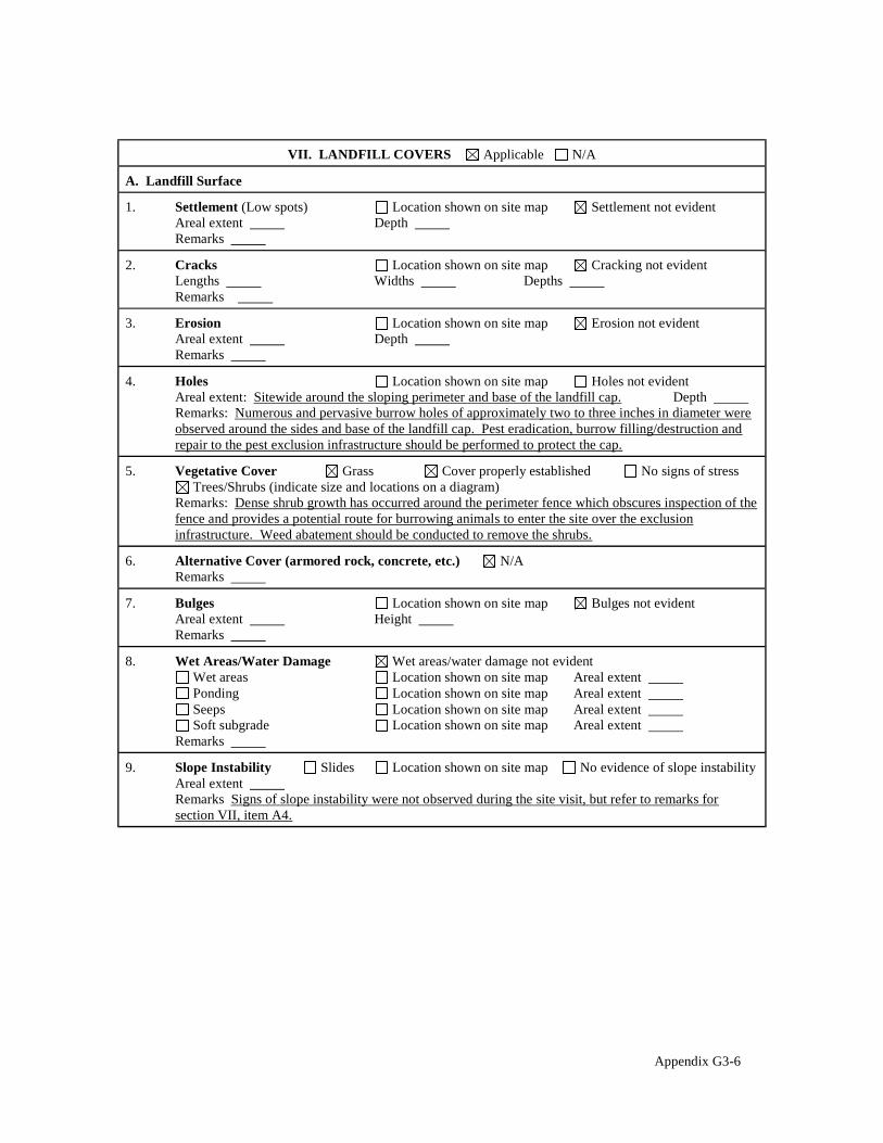
VII. LANDFILL COVERS Applicable N/A
A. Landfill Surface
1. Settlement (Low spots) Location shown on site map Settlement not evident Areal extent Depth Remarks
2. Cracks Location shown on site map Cracking not evident Lengths Widths Depths Remarks
3. Erosion Location shown on site map Erosion not evident Areal extent Depth Remarks
4. Holes Location shown on site map Holes not evident Areal extent: Sitewide around the sloping perimeter and base of the landfill cap. Depth Remarks: Numerous and pervasive burrow holes of approximately two to three inches in diameter were observed around the sides and base of the landfill cap. Pest eradication, burrow filling/destruction and repair to the pest exclusion infrastructure should be performed to protect the cap.
5. Vegetative Cover Grass Cover properly established No signs of stress Trees/Shrubs (indicate size and locations on a diagram)
Remarks: Dense shrub growth has occurred around the perimeter fence which obscures inspection of the fence and provides a potential route for burrowing animals to enter the site over the exclusion infrastructure. Weed abatement should be conducted to remove the shrubs.
6. Alternative Cover (armored rock, concrete, etc.) N/A Remarks
7. Bulges Location shown on site map Bulges not evident Areal extent Height Remarks
8. Wet Areas/Water Damage Wet areas/water damage not evident Wet areas Location shown on site map Areal extent Ponding Location shown on site map Areal extent Seeps Location shown on site map Areal extent Soft subgrade Location shown on site map Areal extent
Remarks
9. Slope Instability Slides Location shown on site map No evidence of slope instability Areal extent Remarks Signs of slope instability were not observed during the site visit, but refer to remarks for section VII, item A4.
Appendix G3-6
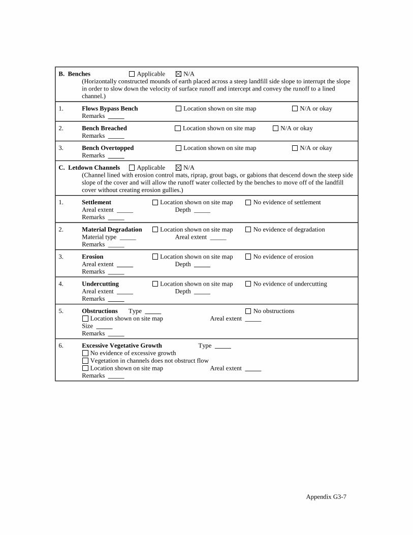
B. Benches Applicable N/A (Horizontally constructed mounds of earth placed across a steep landfill side slope to interrupt the slope in order to slow down the velocity of surface runoff and intercept and convey the runoff to a lined channel.)
1. Flows Bypass Bench Location shown on site map N/A or okay Remarks
2. Bench Breached Location shown on site map N/A or okay Remarks
3. Bench Overtopped Location shown on site map N/A or okay Remarks
C. Letdown Channels Applicable N/A (Channel lined with erosion control mats, riprap, grout bags, or gabions that descend down the steep side slope of the cover and will allow the runoff water collected by the benches to move off of the landfill cover without creating erosion gullies.)
1. Settlement Location shown on site map No evidence of settlement Areal extent Depth Remarks
2. Material Degradation Location shown on site map No evidence of degradation Material type Areal extent Remarks
3. Erosion Location shown on site map No evidence of erosion Areal extent Depth Remarks
4. Undercutting Location shown on site map No evidence of undercutting Areal extent Depth Remarks
5. Obstructions Type No obstructions Location shown on site map Areal extent
Size Remarks
6. Excessive Vegetative Growth Type No evidence of excessive growth Vegetation in channels does not obstruct flow Location shown on site map Areal extent
Remarks
Appendix G3-7
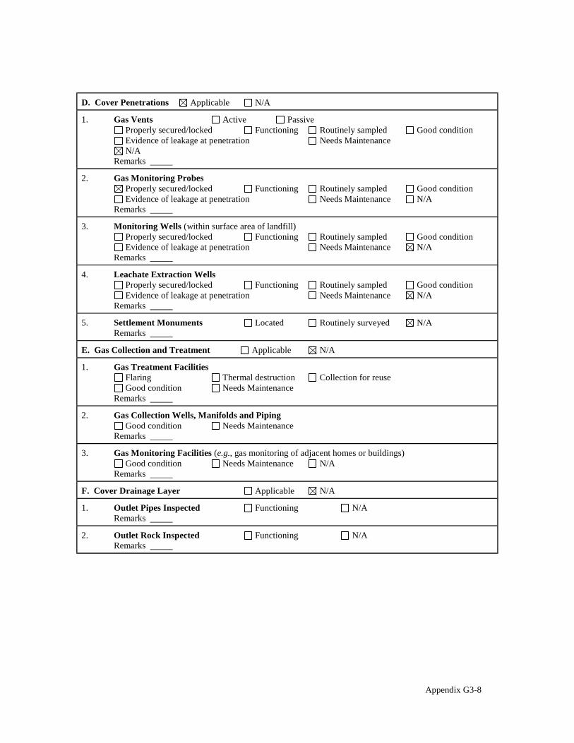
D. Cover Penetrations Applicable N/A
1. Gas Vents Active Passive Properly secured/locked Functioning Routinely sampled Evidence of leakage at penetration Needs Maintenance N/A
Remarks
Good condition
2. Gas Monitoring Probes Properly secured/locked Functioning Routinely sampled Evidence of leakage at penetration Needs Maintenance
Remarks
Good condition N/A
3. Monitoring Wells (within surface area of landfill) Properly secured/locked Functioning Routinely sampled Evidence of leakage at penetration Needs Maintenance
Remarks
Good condition N/A
4. Leachate Extraction Wells Properly secured/locked Functioning Routinely sampled Evidence of leakage at penetration Needs Maintenance
Remarks
Good condition N/A
5. Settlement Monuments Located Routinely surveyed Remarks
N/A
E. Gas Collection and Treatment Applicable N/A
1. Gas Treatment Facilities Flaring Thermal destruction Collection for reuse Good condition Needs Maintenance
Remarks
2. Gas Collection Wells, Manifolds and Piping Good condition Needs Maintenance
Remarks
3. Gas Monitoring Facilities (e.g., gas monitoring of adjacent homes or buildings) Good condition Needs Maintenance N/A
Remarks
F. Cover Drainage Layer Applicable N/A
1. Outlet Pipes Inspected Functioning N/A Remarks
2. Outlet Rock Inspected Functioning N/A Remarks
Appendix G3-8

G. Detention/Sedimentation Ponds Applicable N/A
1. Siltation Areal extent Depth N/A Siltation not evident
Remarks
2. Erosion Areal extent Depth Erosion not evident
Remarks
3. Outlet Works Functioning N/A Remarks
4. Dam Functioning N/A Remarks
H. Retaining Walls Applicable N/A
1. Deformations Location shown on site map Deformation not evident Horizontal displacement Vertical displacement Rotational displacement Remarks
2. Degradation Location shown on site map Degradation not evident Remarks
I. Perimeter Ditches/Off-Site Discharge Applicable N/A
1. Siltation Location shown on site map Siltation not evident Areal extent Depth Remarks
2. Vegetative Growth Location shown on site map N/A Vegetation does not impede flow
Areal extent Type Remarks
3. Erosion Location shown on site map Erosion not evident Areal extent Depth Remarks
4. Discharge Structure Functioning N/A Remarks
Appendix G3-9

VIII. VERTICAL BARRIER WALLS Applicable N/A
1. Settlement Location shown on site map Settlement not evident Areal extent Depth Remarks
2. Performance Monitoring Type of monitoring Performance not monitored
Frequency Evidence of breaching Head differential Remarks
IX. GROUNDWATER/SURFACE WATER REMEDIES Applicable N/A
A. Groundwater Extraction Wells, Pumps, and Pipelines Applicable N/A
1. Pumps, Wellhead Plumbing, and Electrical Good condition All required wells properly operating Needs Maintenance N/A
Remarks
2. Extraction System Pipelines, Valves, Valve Boxes, and Other Appurtenances Good condition Needs Maintenance
Remarks
3. Spare Parts and Equipment Readily available Good condition Requires upgrade Needs to be provided
Remarks
B. Surface Water Collection Structures, Pumps, and Pipelines Applicable N/A
1. Collection Structures, Pumps, and Electrical Good condition Needs Maintenance
Remarks
2. Surface Water Collection System Pipelines, Valves, Valve Boxes, and Other Appurtenances Good condition Needs Maintenance
Remarks
3. Spare Parts and Equipment Readily available Good condition Requires upgrade Needs to be provided
Remarks
Appendix G3-10

C. Treatment System Applicable N/A
1. Treatment Train (Check components that apply) Metals removal Oil/water separation Bioremediation Air stripping Carbon adsorbers Filters Additive (e.g., chelation agent, flocculent) Others Good condition Needs Maintenance Sampling ports properly marked and functional Sampling/maintenance log displayed and up to date Equipment properly identified Quantity of groundwater treated annually Quantity of surface water treated annually
Remarks
2. Electrical Enclosures and Panels (properly rated and functional) N/A Good condition Needs Maintenance
Remarks
3. Tanks, Vaults, Storage Vessels N/A Good condition Proper secondary containment Needs Maintenance
Remarks
4. Discharge Structure and Appurtenances N/A Good condition Needs Maintenance
Remarks
5. Treatment Building(s) N/A Good condition (esp. roof and doorways) Needs repair
Chemicals and equipment properly stored Remarks
6. Monitoring Wells (pump and treatment remedy) Properly secured/locked Functioning Routinely sampled Good condition All required wells located Needs Maintenance N/A
Remarks
D. Monitoring Data 1. Monitoring Data
Is routinely submitted on time Is of acceptable quality 2. Monitoring data suggests:
Groundwater plume is effectively contained Contaminant concentrations are declining
Appendix G3-11

E. Monitored Natural Attenuation
1. Monitoring Wells (natural attenuation remedy) Properly secured/locked Functioning Routinely sampled Good condition All required wells located Needs Maintenance N/A
Remarks
X. OTHER REMEDIES
Not Applicable.
XI. OVERALL OBSERVATIONS
A. Implementation of the Remedy
Describe issues and observations relating to whether the remedy is effective and functioning as designed. Begin with a brief statement of what the remedy is to accomplish (i.e., to contain contaminant plume, minimize infiltration and gas emission, etc.).
The remedy at the Coalinga City OU was designed to be protective of human health with regard to asbestos exposure from materials originating at the Atlas Mine Area OU and Johns-Manville Mill OU. The remedy appears to be functioning as designed with the exception of the maintenance issues identified above.
B. Adequacy of O&M
Describe issues and observations related to the implementation and scope of O&M procedures. In particular, discuss their relationship to the current and long-term protectiveness of the remedy. Comment on the adequacy of institutional controls here.
C. Early Indicators of Potential Remedy Problems
Describe issues and observations such as unexpected changes in the cost or scope of O&M or a high frequency of unscheduled repairs, that suggest that the protectiveness of the remedy may be compromised in the future.
No issues or observations were identified that suggest a potential remedy failure in the foreseeable future.
D. Opportunities for Optimization
Describe possible opportunities for optimization in monitoring tasks or the operation of the remedy. The following optimization and maintenance activities should be performed: Signage update or
replacement, pest and burrow eradication, pest exclusion structure repair, and weed abatement.
Appendix G3-12
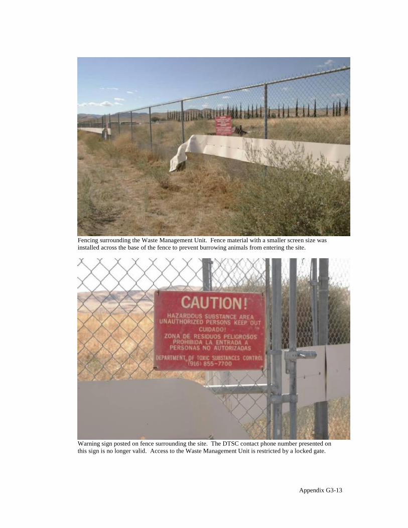
Fencing surrounding the Waste Management Unit. Fence material with a smaller screen size was installed across the base of the fence to prevent burrowing animals from entering the site.
Warning sign posted on fence surrounding the site. The DTSC contact phone number presented on this sign is no longer valid. Access to the Waste Management Unit is restricted by a locked gate.
Appendix G3-13

Vegetative cover on the cap at the Waste Management Unit.
Vegetation surrounding the cap.
Appendix G3-14

Neutron probe access tube previously monitored to assess moisture content in soil vapor beneath the cap.
Rodenticide placed near a neutron probe access tube at the base of the cap.
Appendix G3-15

Hole in cap created by burrowing animals.
Hole near base of cap created by burrowing animals. The lens cap included for scale is 67mm in diameter.
Appendix G3-16
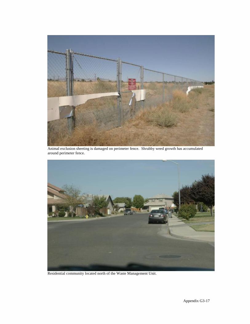
Animal exclusion sheeting is damaged on perimeter fence. Shrubby weed growth has accumulated around perimeter fence.
Residential community located north of the Waste Management Unit.
Appendix G3-17
§
5'',)-+! 3
4+#,6/,.& 1,#+," 2)%,&#+," 0$**.& 4(&*
Appendix H
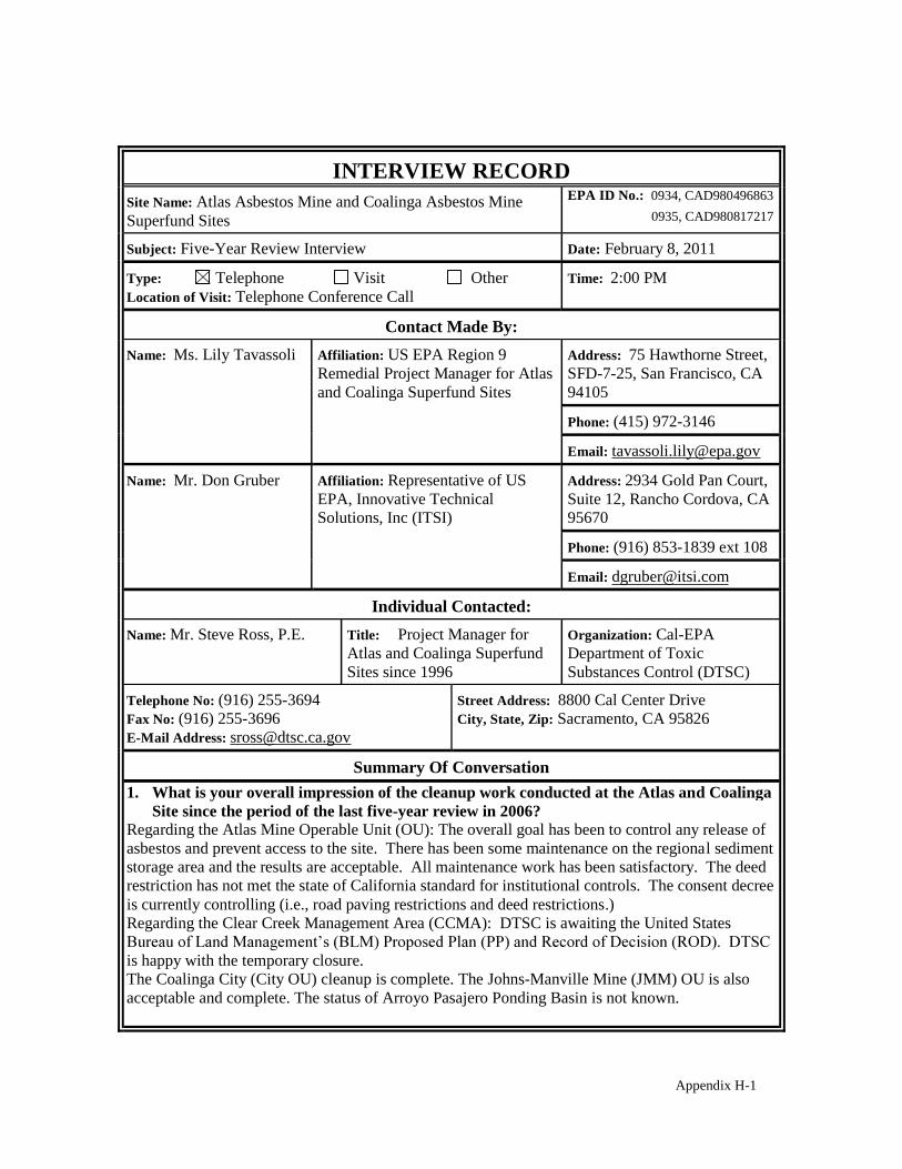
INTERVIEW RECORD Site Name: Atlas Asbestos Mine and Coalinga Asbestos Mine Superfund Sites
EPA ID No.: 0934, CAD980496863 0935, CAD980817217
Subject: Five-Year Review Interview Date: February 8, 2011
Type: Telephone Visit Other Location of Visit: Telephone Conference Call
Time: 2:00 PM
Contact Made By: Name: Ms. Lily Tavassoli Affiliation: US EPA Region 9
Remedial Project Manager for Atlas and Coalinga Superfund Sites
Address: 75 Hawthorne Street, SFD-7-25, San Francisco, CA 94105
Phone: (415) 972-3146
Email: [email protected]
Name: Mr. Don Gruber Affiliation: Representative of US EPA, Innovative Technical Solutions, Inc (ITSI)
Address: 2934 Gold Pan Court, Suite 12, Rancho Cordova, CA 95670
Phone: (916) 853-1839 ext 108
Email: [email protected]
Individual Contacted: Name: Mr. Steve Ross, P.E. Title: Project Manager for
Atlas and Coalinga Superfund Sites since 1996
Organization: Cal-EPA Department of Toxic Substances Control (DTSC)
Telephone No: (916) 255-3694 Fax No: (916) 255-3696 E-Mail Address: [email protected]
Street Address: 8800 Cal Center Drive City, State, Zip: Sacramento, CA 95826
Summary Of Conversation 1. What is your overall impression of the cleanup work conducted at the Atlas and Coalinga
Site since the period of the last five-year review in 2006? Regarding the Atlas Mine Operable Unit (OU): The overall goal has been to control any release of asbestos and prevent access to the site. There has been some maintenance on the regional sediment storage area and the results are acceptable. All maintenance work has been satisfactory. The deed restriction has not met the state of California standard for institutional controls. The consent decree is currently controlling (i.e., road paving restrictions and deed restrictions.) Regarding the Clear Creek Management Area (CCMA): DTSC is awaiting the United States
is happy with the temporary closure. The Coalinga City (City OU) cleanup is complete. The Johns-Manville Mine (JMM) OU is also acceptable and complete. The status of Arroyo Pasajero Ponding Basin is not known.
Appendix H-1

2. From your perspective, what effect has continued cleanup operations at the site had on the surrounding community? Are you aware of any ongoing community concerns regarding the site or its operation and maintenance?
The only concerns are with the CCMA. The community is upset with temporary closure and the results of the risk assessment. The BLM is looking at alternatives for public access to the CCMA that may not be satisfactory. Not aware of any comments/concerns from community regarding the Atlas Mine OU, the JMM OU and the City OU. The city of Coalinga did contact Mr. Ross about installing solar panels with in the City OU Waste Management Unit (WMU).
3. Have there been routine communications or activities (site visits, inspections, reporting activities, etc.) conducted by your office regarding the site? If so, please describe purpose and results.
Yes there have been site inspections on an annual basis. The JMM OU annual inspections verify that the remedy is functioning. Inspections on the City OU have been performed by Mr. Ross on an informal basis on 2 of the last 5 years. For the Atlas OU, Mr. Ross has accompanied EPA, BLM, and Northrop-Grumman when they conduct any operation and maintenance. Delta Environment performs the City OU inspections at their discretion and provides a report to all parties. Arcadis-US coordinates the inspections on the JMM OU.
4. Are you aware of any events, incidents, or activities that have occurred at the site, such as dumping, vandalism or anything that required emergency response from local authorities? If so, please give details.
Mr. Ross is not aware of any events, incident, or activities at any of the OUs that needed an emergency response during this review period.
5. Have there been any complaints, violations, or other incidents related to the site that required a response by your office? If so, please summarize the events and result.
There were no complaints, violations or incidents that required a response during this review period.
6. Are you aware of any problems or difficulties encountered since the last five-year review period which have impacted progress or resulted in a change in operations and maintenance procedures? Please describe changes and impacts.
The only problem is with the institutional controls component. DTSC has not been able to proceed with recording an enforceable environment covenant on the Atlas Mine OU. There have not been any problems at other OUs.
7. Have there been any changes in state environmental standards since the previous fiveyear review period which may call into question the current protectiveness or effectiveness of the remedial action?
Mr. Ross is not aware of any changes in state environment standards since the 2006 Five-Year Review.
8. Do you know of opportunities to optimize the operation, maintenance, or sampling efforts at the site, and have such changes been adopted?
Mr. Ross is not aware of any opportunities to optimize the operation, maintenance or sampling.
Appendix H-2

9. Do you feel well-informed about the activities and progress at each site? Yes, I do.
10. Do you have any comments, suggestions, or recommendations regarding the sites? Yes, when time comes for BLM to recommend the PP and ROD, Mr. Ross would like EPA to include the CCMA into the multi-site cooperative agreement grant (MSCA) to cover costs for oversight. DTSC would like an FTP (file transfer on computers) site for Atlas site documents. DTSC does not currently host an FTP site. DTSC would like to also receive electronic copies with any hard copy deliverables.
Appendix H-3