fourth five-year review report for chemtronics, inc. superfund ...
90
FOURTH FIVE-YEAR REVIEW REPORT FOR CHEMTRONICS, INC. SUPERFUND SITE BUNCOMBE COUNTY, NORTH CAROLINA 5 3 \ & PRO'^^^ UJ O SEPTEMBER 2017 Prepared by U.S. Environmental Protection Agency Region 4 Atlanta, Georgia Franklin E. Hill, Director Superfund Division Date 11070116
-
Upload
khangminh22 -
Category
Documents
-
view
0 -
download
0
Transcript of fourth five-year review report for chemtronics, inc. superfund ...

FOURTH FIVE-YEAR REVIEW REPORT FOR CHEMTRONICS, INC. SUPERFUND SITE
BUNCOMBE COUNTY, NORTH CAROLINA
5 3\
&
PRO'^^^
UJO
SEPTEMBER 2017
Prepared by
U.S. Environmental Protection Agency Region 4
Atlanta, Georgia
Franklin E. Hill, Director Superfund Division
Date
11070116

Table of Contents
LIST OF ABBREVIATIONS & ACRONYMS..........................................................................................................il. INTRODUCTION................................................................................................................................................... 1
Site Background..................................................................................................................................................... 1FIVE-YEAR REVIEW SUMMARY FORM........................................................................................................2
n. RESPONSE ACTION SUMMARY......................................................................................................................3Basis for Taking Action.........................................................................................................................................3Response Actions...................................................................................................................................................6Status of Implementation....................................................................................................................................... 8Systems Operations/Operation & Maintenance.....................................................................................................9
m. PROGRESS SINCE THE LAST REVIEW....................................................................................................... 13IV. FIVE-YEAR REVIEW PROCESS............................................................................... 15
Community Notification, Involvement & Site Interviews................................................................................... 15Data Review......................................................................................................................................................... 16Site Inspection........................................ 28
V. TECHNICAL ASSESSMENT............................................................................................................................29QUESTION A: Is the remedy fimctioning as intended by the decision documents?........... ..............................29QUESTION B: Are the exposure assumptions, toxicity data, cleanup levels and RAOs used atthe time of the remedy selection still valid?.........................................................................................................30QUESTION C: Has any other information come to light that could call into question theprotectiveness of the remedy?..............................................................................................................................32
VI. ISSUES/RECOMMENDATIONS.....................................................................................................................32OTHER FINDINGS.................................................................................. :........................................................33
Vn. PROTECTIVENESS STATEMENT................................................................................................................34VIII. NEXT REVIEW..........................................................................................................................................34
Appendices
APPENDIX A - REFERENCE LIST..................................................................................................................A-1APPENDIX B - CURRENT SITE STATUS.............................................................................................. .........B-1APPENDIX C - SITE CHRONOLOGY.............................................................................................................C-1APPENDIX D - SOIL AND GROUNDWATER COCS AND CLEANUP LEVELS ESTABLISHED
IN THE 2016 ROD AMENDMENT.........................................................................................D-1APPENDIX E - SITE VICINITY MAP............................................................................................................... E-1APPENDIX F - SITE INSPECTION CHECKLIST.............................................................................................F-1APPENDIX G - PRESS NOTICE........................................................................................................................G-1APPENDIX H - SITE INSPECTION PHOTOS................................................................................................. H-1APPENDIX I - INTERVIEW FORMS................................................................................................................. I-lAPPENDIX J - EXAMPLE OF OFF-SITE RESTRICTIVE COVENANT.........................................................J-1APPENDIX K - DETAILED DATA REVIEW..................................................................................................K-1

Tables
Table 1: Soil COCs Identified in the 2015 Sitewide RI........................................................................................... 4Table 2: Groundwater Areas and COCs Identified in the 2015 Sitewide RI............................................................ 4Table 3: Summary of Institutional Controls (ICs) to be Considered............................... ;......................................10Table 4: Declaration of Restrictive Covenants for Off-Site Properties.................................................................. 11Table 5: O&M Costs Over the FYR Period (2012-2016)....................................................................................... 13Table 6: Protectiveness Determinations/Statements from the 2012 FYR.............................................................. 14Table 7: Status of Recommendations from the 2012 FYR.......................... ...........................................................14Table 8: COC Detections in Bee Tree Creek Surface Water (2012-2016)............................................................. 25Table C-1: Site Chronology......................................................................... .........................................................C-1Table D-1: Soil COC Cleanup Levels Established in the 2016 ROD Amendment.............................................. D-1Table D-2: Grovmdwater COC Cleanup Levels Established in the 2016 ROD Amendment............................... D-2
Figures
Figure 1: Detailed Site Map...................................................................................................................................... 5Figure 2: Institutional Control Map........................................................................................................................ 12Figure 3: Extent of TCE in FV Surfrcial Aquifer Wells in 2016............................................................................ 18Figure 4: Extent of TCE in FV Transition Zone Aquifer Wells in 2016................................................................ 19Figure 5: Extent of TCE in BV Surfrcial Aquifer Wells in 2016........................................................................... 20Figure 6: Extent of TCE in BV Transition Zone Aquifer Wells in 2016................................................................ 21Figure 7: Extent of RDX in FV Transition Zone Aquifer in 2016......................................................................... 23Figure 8: Extent of TBA in BV Transition Zone Aquifer in 2016......................................................................... 24Figure 9: Select COCs in FV Surface Water in 2016............................................................................................. 26Figure 10: Select COCs in BV Surface Water in 2016........................................................................................... 27Figure E-1: Site Vicinity Map............................................................................................................................... E-1
LIST OF ABBREVIATIONS & ACRONYMS
1,2-DCA 1,2-DichloroethaneAOC Administrative Order on ConsentAPA Acid Pit AreaARAR Applicable or Relevant and Appropriate RequirementB BuildingBV Back ValleyBZ 3-Quinuclidinyl benzilatecDCE Cis-1,2-dichloroetheneCERCLA Comprehensive Environmental Response, Compensation, and Liability ActCFR Code of Federal RegulationsCOC Chemicals of ConcernCS Ortho-chlorobenzylidene malononitrileDA Disposal AreaDCM DichloromethaneDPLUR Declaration of Perpetual Land Use RestrictionsEISB Enhanced In-Situ BioremediationEPA United States Environmental Protection AgencyFV Front ValleyFYR Five-Year ReviewIC Institutional ControlMCL Maximum Contaminant LevelMNA Monitored Natural AttenuationMSD Municipal Sewerage DistrictNCAC North Carolina Administrative CodeNC DENR North Carolina Department of Environment and Natural ResourcesNCDEQ North Carolina Department of Environmental QualityNCP National Contingency PlanNPL National Priorities Listpg/L Micrograms per LiterO&M Operation and MaintenanceOU Operable UnitPCE TetrachloroethylenePRP Potentially Responsible PartyRAO Remedial Action ObjectiveRCRA Resource Conservation and Recovery ActRDX Research Department ExplosivesRI/FS Remedial Investigation and Feasibility StudyROD Record of DecisionRPM Remedial Project ManagerTBA Tert-Butyl AlcoholTCE TrichloroethyleneUUAJE Unlimited UseAJnrestricted ExposureVOC Volatile Organic Compound
I. INTRODUCTIONThe purpose of a five-year review (FYR) is to evaluate the implementation and performance of a remedy to determine if the remedy is and will continue to be protective of human health and the environment. The methods, findings and conclusions of reviews are documented in FYR reports such as this one. In addition, FYR reports identify issues found during the review, if any, and document recommendations to address them.
The U.S. Environmental Protection Agency has prepared this FYR pursuant to the Comprehensive Environmental Response, Compensation, and Liability Act (CERCLA) Section 121, consistent with the National Contingency Plan (NCP) (40) Code of Federal Regulations (CFR) Section 300.430(f)(4)(ii)), and considering EPA policy.
This is the fourth FYR for the Chemtronics, Inc. Superfund site (the Site). The triggering action for this statutory review is the completion date of the previous FYR. The FYR has been prepared due to the fact that haz^dous substances, pollutants or contaminants remain at the site above levels that allow for unlimited use and unrestricted exposure (UU/UE).
The Site consists of one operable unit (OU), which is addressed in this FYR. The OU addresses contaminated soil and groundwater.
EPA remedial project manager (RPM) Jon Bornholm led the FYR. Participants included project manager Beth Hartzell firom the North Carolina Department of Environmental Quality (NCDEQ), Stuart Ryman, Robert Cork and Jonathan Ivey from potentially responsible parties’ (PRPs’) contractor Anchor QEA of North Carolina PLLC (Anchor QEA), and Melissa Oakley and Jill Billus from EPA contractor Skeo. The review began on 10/24/2016.
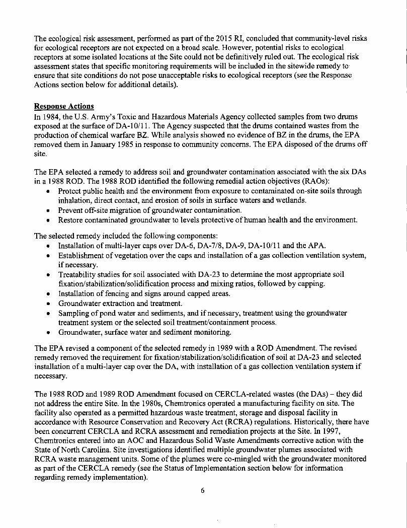
Site BackgroundThe 535-acre Superfund Site is located in a semi-rural area about eight miles east of Asheville, in the Town of Swannanoa in Buncombe County, North Carolina (Figure E-1). The Site is divided into two distinct geographical areas known as the Front Valley (FV) and Back Valley (BV) (Figure 1). A prominent ridge separates the FV and the BV. Different companies manufactured explosives, incapacitating agents and chemical intermediates at the Site between 1952 and 1994. During facility operations, manufacturing occurred primarily in the FV. Material testing and waste disposal occurred primarily in the BV. Manufacturing, testing and waste disposal occurred on about 200 acres of the 535- acre Site. This included 23 individual disposal areas which were grouped into six discrete waste disposal areas (DAs). These areas are designated as DA-10/11 and DA-23 (located in the FV) and DA-6, DA-7/8, DA-9 and the Acid Pit Area (APA) (located in the BV). Together, these DAs occupy less than 10 acres of the Site. Solid waste material and possibly solvents were reportedly incinerated in the APA. Chemical waste and spent acid were also disposed in trenches in the APA. Chemical wastes fi*om the manufacturing of ortho-chlorobenzylidene malononitrile (CS) and agent 3-quinuclidinyl benzilate (BZ) were placed in metal 5 5-gallon drums and reportedly neutralized with a kill solution. These drums were buried in DA-6, DA-7/8, DA-9, and DA-10/11 along with other process wastes and solid wastes. DA-23 is a former wastewater treatment biolagoon associated with Building 113 (B113). This biolagoon was built on top of an abandoned leach field also associated with B113. The leach field was in use during the years CS and BZ were generated. B113 was the building where the majority of production/ manufacturing occurred.

The Site is not currently in use and the owner of the property, Chemtronics, Inc., has no current plans for reuse, other than potential, sustainable forestry practices. Most of the Site is heavily wooded. Current site features include concrete former building pads, ponds, fenced and capped disposal areas, remedial components, a security guard hut and a maintenance shed (Figures 1 and 2). The Site’s 2016 Record of Decision (ROD) Amendment split the originally established site into the Chemtronics Superfund site and the Chemtronics property (Figures 1 and E-1). The Chemtronics Superfund site is located within the larger Chemtronics property. The Chemtronics property outside of the Chemtronics Superfimd site is not considered part of the Superfund site. There are plans underway to establish a conservation easement on those portions of the Chemtronics property outside of the Chemtronics Superfund site in the future.Once established, the conservation easement area will be used for sustainable forestry and conservation practices. The site property is bordered to the north, northeast, and northwest by sparsely populated woodlands, primarily national forests or State game lands. Unincorporated residential neighborhoods are located immediately east, west, and south of the Site and include the Bee Tree Road community, Dillingham Circle, and the Old Bee Tree/Rainbow Ridge community, respectively. An industrial facility (the former RadioShack Swannanoa property), located immediately south of the Site, has recently been returned to active use and was being investigated/remediated imder the North Carolina Registered Environmental Consultant Program.
Groundwater is not used for any purpose at the Site. The City of Asheville’s public water supply system provides potable water for most of the area. However, some residences near the Site rely on private wells for water.
Surface water bodies on site include three ponds. Bee Tree Creek and two tributaries - Gregg Branch and Unnamed Branch (Figure 1). The Unnamed Branch drains the FV. Gregg Branch drains the BV. Both tributaries discharge to Bee Tree Creek. Groundwater at the Site is present in a three-part aquifer system consisting of the Surficial Aquifer, the Transition Zone Aquifer and the Bedrock Aquifer. Groundwater flows vertically from the Surficial Aquifer down to the deeper aquifers, and horizontally toward the southeast within all aquifers. Some groundwater discharges to Bee Tree Creek, Gregg Branch and Unnamed Branch. Soil at the Site is generally less than 3 feet deep and consists primarily of clay, silt and sand-sized particles. Saprolite underlies the soil and is of varying thickness and approaches 100 feet thick at several locations. The surface of the Site is moderately sloping to steep.
For reference. Appendix A includes a list of documents reviewed during this FYR. Appendix B includes current site status indicators. Appendix C includes a timeline of site events.
FIVE-YEAR REVIEW SUMMARY FORM
Site Name: Chemtronics, Inc.EPA ID: NCD095459392
City/County: Swannanoa/BuncombeRegion: 4 State: North Carolina
SITF IDFNTineATION
snt: s TA rusNPL Status: FinalMultiple OUs?No
Has the site achieved construction completion?Yes

Lead agency: EPAAuthor name: Jon Bornholm (EPA) and Melissa Oakley (Skeo)
Author affiliation: EPA and SkeoReview period: 10/24/2016 - 9/26/2017Date of site inspection: 1/19/2017Type of review: StatutoryReview number: 4Triggering action date: 9/26/2012Due date (fiveyears after triggering action date): 9/26/2017
II. RESPONSE ACTION SUMMARY
Basis for Taking ActionRupture of a wastewater treatment lagoon liner in 1979 resulted in a release of wastewater at a disposal area (DA) later referred to as DA-23. In 1980, the State ordered Chemtronics, Inc. (Chemtronics) to stop discharging wastes to disposal trenches. The EPA added the Site to the Superfund program’s National Priorities List (NPL) on September 8, 1983.
Under a 1985 Administrative Order on Consent (AOC), two PRPs - Chemtronics and Northrop Grumman - performed the Site’s first remedial investigation and feasibility study (RI/FS) between 1985 and 1988. The RI focused on known waste disposal areas associated with past site operations, including the 23 individual disposal areas, which were grouped into six discrete waste DAs. The DAs included DA-10/11 and DA-23 in the FV and DA-6, DA-7/8, DA-9 and the APA in the BV. Together, the six DAs cover less than 10 acres of the Site. Soil contaminemts identified during the RI included volatile organics such as 1,2-dichloroethane (1,2-DCA) and trichloroethylene (TCE). The human health risk assessment identified unacceptable risks associated with exposure to surface soil at DA-9. Groundwater contaminants identified by the 1988 RI included volatile organics, non-volatile organics and metals. The RI determined that concentrations of those groundwater constituents exceeded drinking water and/or groundwater quality criteria within the Surficial Aquifer and the Bedrock Aquifer.
Following a North Carolina Department of Environment and Natural Resources (NC DENR - now the NCDEQ) request in 2007 for the EPA to consolidate oversight of all site-related remediation efforts under its CERCLA authority (see the “Response Actions” section below for additional details), the EPA entered into an AOC in 2008 with the Site’s three PRPs to conduct a new sitewide RTFS. The PRPs - Chemtronics, Northrop Grumman Systems Corporation and CNA Holdings LLC - performed the sitewide RI/FS between 2009 and 2016. They completed the RI in 2015 and the FS in 2016.
Under current site conditions, the baseline risk assessment, performed as part of the 2015 RI, did not identify any current, unacceptable risks to human health associated with hazardous substances at the Site. Under potential future conditions, the RI identified unacceptable risks for on-site workers and on-

site residents. The future risk scenarios resulting in unacceptable risk included future industrial worker exposure to chemicals of concern (COCs) via direct contact with surface soil and vapors from subsurface soil, vapor intrusion, and potable/non-potable groundwater use; future maintenance worker/construction worker exposure to COCs via direct contact with groundwater; and future on-site resident exposure to COCs via direct contact with surface soil and vapors from subsurface soil, vapor intrusion, and potable use of groundwater.
Implementation of the soil remedy selected in the Site’s 1988 ROD adequately addressed soil-related risks for the BV (see the “Response Actions” section below for information regarding the 1988 remedy). The 2015 RI identified two areas in the FV where soil remediation is necessary. Remaining soil contamination associated with a concrete sump previously located at the back (east) of Building 116 (B116) poses an unacceptable future risk due to vapor intrusion of volatile organic compounds (VOCs) (Table 1 and Figure 2). Remaining soil contamination associated with a former underground storage tank at Building 109-137 (B109-137) also poses an unacceptable future risk due to vapor intrusion of VOCs (Table 1 and Figure 2).
Table 1: Soil COCs Identified in the 2015 Sitewide RI
coc Media1,2-DCA, vinyl chloride, benzene, 1,1,2- trichloroethane, cyclohexane, methylene chloride B116 Soil
1,2,4-trimethyl-benzene, 1,3,5-trimethyl-benzene B109-137 Soil
The baseline risk assessment identified unacceptable future risk associated with site groundwater within all three site aquifers. The RI identified 11 areas that were considered in the FS. Following the FS, five FV locations and two BV locations were retained for remediation. Table 2 lists the groundwater areas of concern and the groundwater contaminants associated with each area. Figure 2 shows the site locations selected for remediation in the 2015 Sitewide RI.
Table 2: Groundwater Areas and COCs Identified in the 2015 Sitewide RIArea Name Groundwater COC Aquifer
FVB104 Chloroform Bedrock
B105andB147 Perchlorate, RDX, TCE Surficial and Transition Zone
B139 1,2-DCA, perchlorate, RDX, TCE, vinyl chloride Bedrock
DA-23/B116 1,2-DCA, PCE, perchlorate, RDX, TCE Surficial, Transition Zone and Bedrock
BV
APA 1,2-DCA, PCE, perchlorate, RDX, tert-butyl alcohol (TBA), TCE
Surficial, Transition Zone and Bedrock
DA-9 1,2-DCA perchlorate, RDX, TCE Surficial, Transition Zone and Bedrock
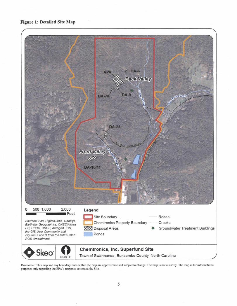
Figure 1: Detailed Site Map
sSffiSi
v'r ^....
Himm
m
OA-9DA-7/
5- ^f-.'.
MMBy-S-g'y.
I S'■Z‘
DA-10/11
m :i»-"
0 500 1,000 2,000 iFeet
Sources: Esri, DigitalGlobe, GeoEye, Earthstar Geographies, CNES/Airbus DS, USDA, USGS, Aeroghd, IGN, the GIS User Community and Figures 2 and 3 from the Site's 2016 ROD Amendmeht.
LegendSite BoundaryChemtronics Property Boundary
I Disposal Areas 1 Ponds
RoadsCreeksGroundwater Treatment Buildings
NORTH
Chemtronics, Inc. Superfund SiteTown of Swannanoa, Buncombe County, North Carolina
Oisdaimer: This map and any boundary lines within the map are approximate and subject to change. The map is not a survey. The map is for informational purposes only regarding the EPA’s response actions at the Site.
The ecological risk assessment, performed as part of the 2015 RI, concluded that community-level risks for ecological receptors are not expected on a broad scale. However, potential risks to ecological receptors at some isolated locations at the Site could not be definitively ruled out. The ecological risk assessment states that specific monitoring requirements will be included in the sitewide remedy to ensure that site conditions do not pose unacceptable risks to ecological receptors (see the Response Actions section below for additional details).
Response ActionsIn 1984, the U.S. Army’s Toxic and Hazardous Materials Agency collected samples from two drums exposed at the surface of DA-10/11. The Agency suspected that the drums contained wastes from the production of chemical warfare BZ. While analysis showed no evidence of BZ in the drums, the EPA removed them in January 1985 in response to community concerns. The EPA disposed of the drums off site.
The EPA selected a remedy to address soil and groundwater contamination associated with the six DAs in a 1988 ROD. The 1988 ROD identified the following remedial action objectives (RAOs):
• Protect public health and the environment from exposure to contaminated on-site soils through inhalation, direct contact, and erosion of soils in surface waters and wetlands.
• Prevent off-site migration of groundwater contamination.• Restore contaminated groundwater to levels protective of human health and the environment.
The selected remedy included the following components:• Installation of multi-layer caps over DA-6, DA-7/8, DA-9, DA-10/11 and the APA.• Establishment of vegetation over the caps and installation of a gas collection ventilation system,
if necessary.• Treatability studies for soil associated with DA-23 to determine the most appropriate soil
fixation/stabilization/solidification process and mixing ratios, followed by capping.• Installation of fencing and signs around capped areas.• Groundwater extraction and treatment.• Sampling of pond water and sediments, and if necessary, treatment using the groundwater
treatment system or the selected soil treatment/containment process.• Groundwater, surface water and sediment monitoring.
The EPA revised a component of the selected remedy in 1989 with a ROD Amendment. The revised remedy removed the requirement for fixation/stabilization/solidification of soil at DA-23 and selected installation of a multi-layer cap over the DA, with installation of a gas collection ventilation system if
necessary.
The 1988 ROD and 1989 ROD Amendment focused on CERCLA-related wastes (the DAs) - they did not address the entire Site. In the 1980s, Chemtronics operated a manufacturing facility on site. The facility also operated as a permitted hazardous waste treatment, storage and disposal facility in accordance with Resource Conservation and Recovery Act (RCRA) regulations. Historically, there have been concurrent CERCLA and RCRA assessment and remediation projects at the Site. In 1997, Chemtronics entered into an AOC and Hazardous Solid Waste Amendments corrective action with the State of North Carolina. Site investigations identified multiple groundwater plumes associated with RCRA waste management units. Some of the plumes were co-mingled with the groxmdwater monitored as part of the CERCLA remedy (see the Status of Implementation section below for information regarding remedy implementation).
In March 2007, the NC DENR Hazardous Waste Seetion requested that the EPA consolidate oversight of all site environmental remediation activities imder its CERCLA authority. In October 2008, the EPA agreed to the request and signed an AOC with the PRPs for the performance of the Site’s new sitewide RI/FS.
Following the completion of the sitewide RI/FS in 2016, the EPA selected a remedy to address remaining sitewide contamination in the Site’s September 2016 ROD Amendment.
The 2016 ROD Amendment identified the following RAOs for soil:• Prevent dermal contaet and inhalation by human receptors of carcinogenic and non-carcinogenic
contaminants from subsurface soil at concentrations that pose an unacceptable risk.• Prevent COC migration from impacted soil to groundwater that may result in concentrations
above levels that are protective for drinking water use.
The 2016 ROD Amendment identified the following RAOs for groundwater:• Restore impacted groundwater to levels acceptable for future beneficial use as a drinking water
resouree.• Prevent exposure to groundwater with COC concentrations above levels that are protective for
drinking water use.• Prevent migration of contaminated groundwater to on-site surface water and sediments at
concentrations that pose an unacceptable human health or ecological risk.• Prevent migration of contaminated groundwater to off-site surface water and sediments at
concentrations that pose an unacceptable human health or ecological risk.
The selected remedy included the following components:• Excavation and off-site disposal at an EPA-approved landfill of contaminated soil at the
following FV areas: B109-137 and B116.• Enhanced in-situ bioremediation (EISB) with long-term groundwater monitoring and monitored
natural attenuation (MNA) for contaminated groundwater for the following areas in the FV:B104, BIOS, B139, B147, and DA 23/Bl 16.
• EISB with long-term groundwater monitoring and MNA for contaminated groundwater in the following areas in the BV: downgradient of DA-9 and the APA.
• Placement of institutional controls on the Superfund site portion of the Chemtronics property using the State of North Carolina Declaration of Perpetual Land Use Restrictions (DPLURs). These institutional controls will limit land uses at the Site to commereial/industrial purposes, restrict groundwater use, and prevent use of on-site groundwater for potable purposes. The DPLUR process requires the generation of a plat map that defines the Site’s boundaries. NCDEQ or its successor will enforce the DPLURs.
• Maintenance of the caps and engineering eontrols for the six DAs required by the 1988 ROD and its assoeiated doeuments.
• Performance monitoring and evaluation as outlined in the 2011 Proposed Assessment Monitoring Plan and the 2016 FS Report, which is to be finalized as part of a Performance Monitoring Plan in the Site’s Remedial Design Report.
• Elimination of the requirement for pumping and treating groimdwater in both valleys as specified in the 1988 ROD, abandonment of unnecessary structures assoeiated with these pump-and-treat systems, and elimination of the trigger deseribed in Seetion 6.5 - “Future Actions” - in the 1988 ROD.
• Continued evaluation of the remedy consistent with the FYR process.
The 2016 ROD Amendment based soil cleanup levels on the protection of future construction/industrial workers from direct contact and vapor inhalation. The EPA established risk-based soil cleanup levels under the assumption that the Site will remain in commercial/industrial use. The 2016 ROD Amendment based groundwater cleanup levels on North Carolina 2L standards. In cases where 2L standards are not available, cleanup levels were based on health-based limits calculated during the Site’s baseline human health risk assessment. COCs and cleanup levels listed in the 2016 ROD Amendment supersede COCs and cleanup levels established by the 1988 ROD. Tables D-1 and D-2 in Appendix D include soil and groundwater COCs and cleanup levels, as established by the 2016 ROD Amendment.
The Site’s ecological risk assessment states that specific monitoring requirements will be included in the sitewide remedy to ensure that site conditions do not pose unacceptable risks to ecological receptors. Section 7.2 of the 2016 ROD Amendment establishes the following monitoring requirements:
• Soil sampling for ortho-chlorobenzylidene malononitrile at one location in the on-site bear pit during the next FYR process;
• Surface water and sediment sampling for pesticides during the FYR process;• Sampling of one surface water location downstream from the confluence of Bee Tree Creek for
pesticides in the annual monitoring program; and• Continued surface water sampling for VOCs, particularly TCE, as part of the annual monitoring
programs.
Status of ImplementationSite PRPs implemented the remedy selected in the 1988 ROD and 1989 ROD Amendment between December 1991 and January 1993. Cleanup included capping and fencing all DAs and the installation and operation of two groundwater extraction and treatment systems - one in the FV and one in the BV. The FV extraction system included two extraction wells downgradient of DA-23; the treatment system included an equalization tank, air stripping and activated carbon filtration. The BV extraction system included 12 extraction wells downgradient of DA-9 and the APA; the treatment system included an equalization/setting tank, air stripping and pH adjustment. Remedy construction also included the installation of a passive gas venting system within the APA’s cap. The vents have been sampled twice to determine if the disposal area beneath the cap emits gases. Gases have never been detected. The vents are no longer monitored.
Between 2004 and 2006, outside of the scope of CERCLA, the PRPs demolished all buildings and structures on site down to the building slab, except for those associated with environmental assessment and remediation efforts. The demolition included the collection and off-site disposal and/or recycling of building debris, scrap metal, asbestos-containing wastes and various hazardous and non-hazardous wastes.
Data collected during the 2015 RI confirmed the presence of groundwater plumes in the FV, including downgradient of the influence of the FV groundwater extraction system. The 2016 ROD Amendment identified that the existing FV pump and treat system had limitations and is approaching the end of its functional lifespan. This issue was also identified during the Site’s 2012 FYR. In 2014, the EPA approved the shutdown of the Site’s two extraction and treatment systems to allow for collection of groundwater and surface water data under non-pumping conditions for the purpose of evaluating various remedial alternatives. The systems remain off. According to the Site’s September 2014 Monthly Status Report, the two treatment systems had treated 100.8 million gallons of groundwater as of September 2014.

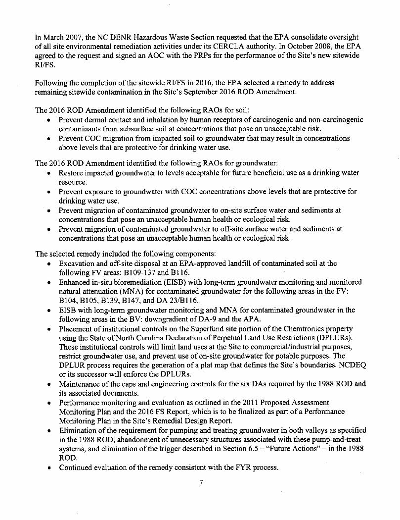
EISB pilot-scale treatability studies are currently underway across the Site. The sitewide remedy selected by the 2016 ROD Amendment requires implementation of institutional controls for the Chemtronics Superfund site part of the larger Chemtronics parcel (parcel number 9780045253) to, at a minimum, limit land uses to commercial/industrial uses, restrict groundwater use and prevent the use of on-site groundwater for potable purposes. The DPLUR process also requires the generation of a plat map to identify the boundaries of the Superfimd site. The institutional controls required by the 2016 ROD Amendment do not specifically prohibit digging at the DAs established by the 1988 ROD to prevent disturbance of the caps or unacceptable exposure to contaminated subsurface soil. However, access to the DAs is restricted by fencing and neither the property owner nor the PRP contractor perform any activities on the DA caps that could potentially impact the integrity of the caps or result in direct exposure to contaminated subsurface soil. The PRPs have submitted draft institutional control language to NCDEQ for review and approval. Following approval, the PRPs will file and record the final institutional controls with Buncombe County. Restrictions to prohibit material disturbance, excavation or removal of material at the DAs should be considered in the final institutional controls.
In 2014, the PRPs voluntarily paid to upgrade the public water supply line serving Old Bee Tree Road (south of the Site) so that it could accommodate additional connections. The PRPs also paid to connect four downgradient residents to the new water line (one connection along Old Bee Tree Road in 2014 and three connections to residents along Lauren Ridge Way in 2016). While not required by the Site’s 2016 remedy, the PRPs also paid to prepare and record restrictive covenants for 11 off-site addresses (14 property parcels) located south of the Site between 2014 and 2016 (Table 4). The restrictive covenants prevent the use or extraction of groundwater from the subject properties, and required the closure of any existing wells. The PRPs paid to decommission three wells that had been used for potable water supply. The restrictive covenants listed in Table 4 have been filed and recorded with the Buncombe County Register of Deeds. The purpose of the water line extension and hookups and restrictive covenants is to eliminate the possibility of private off-site wells potentially impacting the location of site-related groundwater contamination. These voluntary actions by the PRPs aim to further eliminate the potential for future off-site exposure to groundwater contamination.
Table 3 below summarizes planned eind implemented institutional controls for the Site. Table 4 below summarizes implemented institutional controls for off-site properties. Appendix J includes an example of a Restrictive Covenant filed for one of the off-site downgradient properties.
Systems Operations/Operation & MaintenancePer the EPA’s approval, PRP contractor Anchor QEA (operating as Altamont Environmental Inc. until January 2017) shut down the FV and BV groundwater extraction and treatment systems on September 25, 2014. Anchor QEA currently performs groundwater and surface water monitoring at the Site in accordance with the Site’s 1997 Operations and Maintenance (O&M) Plan, the 2008 AOC, the 2011 Proposed Assessment Monitoring Plan and the November 2014 Revised Work Plan for Temporary Shutdown of the Front and Back Valley Extraction Wells and Treatment Systems. Since the shutdown of the systems. Anchor QEA has monitored groundwater and surface water semi-annually. Monitoring also includes quarterly surface water sampling, active sampling of EISB pilot test study areas and annual monitoring of an additional 18 (CERCLA) wells. Anchor QEA currently operates the FV groundwater treatment system in a limited capacity, primarily to treat purge water generated during sampling activities or extracted groundwater generated during pilot test studies. Currently, some injection and extraction wells are operated as part of pilot tests for areas identified in the 2016 ROD Amendment as needing active remediation.
In September 2015, the Metropolitan Sewerage District (MSD) of Buncombe County reduced the required monitoring frequency for each discharge pipe to once a year. Anchor QEA currently submits annual sampling results for discharge pipes 01 and 03 (in separate reports), and two monthly reports (titled Monthly MSD Sewer Discharge Billing Report and Monthly MSD Sewer Discharge Compliance Report), to the MSD. The reports verify that water discharged to the MSD meets site permit limits. Additional site O&M activities include mowing, inspection and general maintenance of capped areas, and maintenance of wells, fencing, signs and roads. Anchor QEA submitted monthly O&M status reports to the EPA in 2012, 2013 and 2014, and began submitting quarterly O&M reports to the EPA starting in 2015. No significant O&M issues have been noted since the previous FYR. Anchor QEA contracts a licensed surveyor to perform cap settlement surveys every five years. The last survey was performed in 2017. No evidence of excessive settlement was observed. The next settlement survey is scheduled to take place in 2022.
Media, Engineered
Controls and Areas That Do Not Support
UU/UE Based on Current Conditions
Soil
Soil
On-SiteGroundwater
Table 3: Summary of Institutional Controls (ICs) to be Considered
ICsNeeded
ICs CaUed for in the Decision
Documents
Yes'*
AffectedArea
SuperflindSite
DAs located
within the Superfund
Site
SuperfundSite
ICObjective
At a minimum, restrict land use to commercial/industrial
use, and, through the creation of a plat map,
identify the boundaries of the Superfund site.
Prohibit digging at the DAs established by the 1988
ROD to prevent disturbance of the caps and unacceptable
exposure to contaminated subsurface soil.
Prohibit the use of groundwater for potable
purposes.
Title of IC Instrument
Implemented or Planned
Draft institutional control language has
been submitted to NCDEQ for review
and approval.
None. Restrictions to prohibit material
disturbance, excavation, or
removal of material at the DAs
established by the 1988 ROD should be
considered in the final institutional
controls.Draft institutional
control language has been submitted to
NCDEQ for review and approval.
Notes:The 2016 ROD Amendment requires institutional controls for only the Chemtronics Superflind site part of property parcel. “ The 2016 ROD Amendment does not specifically require institutional controls to prohibit digging at the DAs; however, the language used in the decision document establishes the minimum institutional requirements (i.e. “at a minimum”), allowing for the requirement of additional institutional controls as needed.
Table 4: Declaration of Restrictive Covenants for Off-Site Properties
; Affected Media ICsICs CaUed for in the IC Impacted Filing Date and Deed Book
and Page Numbers (example: 5265/974)and Location Needed Decision
DocumentsObjective Parcel(s)
9679961573 Filed 12/01/2014, 5265/974
9679962708 Filed 12/1/2014, 5265/935
9679961696 Filed 12/1/2014, 5265/947
9679962661 Filed 12/1/2014, 5265/953
9679972491 Filed 12/1/2014, 5265/941
Prevent the use 9679963934 Filed 12/1/2014, 5265/982
or extraction of 9679972036 Filed 3/4/2014,Off-Site No No groundwater and 5189/1823
Groundwater require the closure of any 9679972241 Filed 12/23/2014,
5272/222existing wells. 9679879763 Filed 12/1/2014,
5265/967
9679973940 Filed 8/27/2015, 5347/1619
9679873956 Filed 12/1/2014, 5265/959
9679879368 Filed 11/8/2016, 5488/1832
9679970429 Filed 11/7/2016, 5488/693
9679970539 Filed 11/7/2016, 5488/702
Notes:Parcel numbers above provided by Anchor QEA in March 2017.All restrictive covenants listed above can be viewed online at the Buncombe County Register of Deeds website; http://reEisterofdeeds.buncombecountv.org/Extemal/LandRecords/protected/v4/SrchBookPage.aspx .
Figure 2: Institutional Control Map
A:-ilf
li®3" "'Ssr#..
ylFS5 J
m
^=f')£’^''*S^' Z*
DAr6
BacK>VaUey■ '
DA^7/8
B109<1 DA<2
fValle
BIOS
104v?DAi10/11
■I'af
500 1,000 2,000■■Feet
Sources: Esri, DigitalGlobe, GeoEye, Earthstar Geographies, CNES/Airbus OS, USDA, USGS, Aerogrld, IGN, the 6/S User Community and Figures 2 and 3 from the Site's 2016 ROD Amendment.
Legend[^3 Site Boundary i IChemtronics Property Boundary b<X] Institutional Controls Needed, But Not Yet In Place I I Disposal Areas• Former Building Locations Selected For Remediation
Approximate Direction of Groundwater Flow
ItA
]Ponds ■ Roads • Creeks
FV Maintentenance Shed Security Guard Hut
NORTH
Chemtronics, Inc. Superfund SiteTown of Swannanoa, Buncombe County, North Carolina
Disclaimer This map and any boundary lines within the map are approximate and subject to change. The map is not a survey. The map is for informational purposes only regarding the EPA’s response actions at the Site.

Anchor QEA has established a pollinator habitat pilot project on site. The PRP contractor is experimenting with different pollinator plant species in test plots to determine if it would be possible to establish pollinator-supportive habitats as vegetative cover over the capped DAs.
As the groundwater component of the original 1988 remedy is no longer in place, it is not appropriate to compare the original estimates of O&M costs associated with the groundwater remedy to current annual O&M costs associated with groundwater monitoring. The 1989 ROD Amendment estimated annual O&M costs associated with cap maintenance of about $12,080.
Actual annual sitewide O&M costs for the current remedy from 2012 to 2016 are listed below in Table 5. The costs include those associated with routine O&M of the two pump and treat systems, compliance sampling, cap maintenance, and general Site maintenance. These costs do not include extensive pilot testing and other non-routine work associated with the development of the 2016 RI/FS.
Upon implementation of the new sitewide remedy, the 2016 ROD Amendment estimates annual O&M costs of about $510,900 associated with the FV groundwater remedial components, and estimated average annual O&M costs of about $365,000 associated with the BV groundwater remedial components. These estimates include the cost for all monitoring required by the Site’s revised remedy. The 2016 ROD Amendment indicates that these estimates are for the initial remedy period and are expected to decrease over time as the extent of groundwater contamination decreases. The 2016 ROD Amendment does not include O&M cost estimates associated with the revised soil remedy (other than maintenance of the caps on the DAs), as the revised soil remedy for areas outside of the DAs will not require O&M. Following implementation of the new sitewide remedy, it is expected that new O&M requirements will be established in an updated O&M Plan.
Table 5: O&M Costs Over the FYR Period (2012-2016)Year Total Cost2012 $424,0002013 $315,0002014 $312,0002015 $197,0002016 $164,000
III. PROGRESS SINCE THE LAST REVIEW
This section includes the protectiveness determinations and statements from the last FYR as well as the recommendations from the last FYR and the current status of those recommendations.
Table 6: Protectiveness Determinations/Statements from the 2012 FYR
OU#
Sitewide
ProtectivenessDetermination
Short-termProtective
Protectiveness StatementThe remedy at the Chemtronics Site protects human health and the
environment in the short-term because the areas of soil contamination at the Site, where known waste disposal activity occurred, have been capped and
fenced, which limits direct contact exposure, and there is no current exposure to contaminated groundwater. However, in order for the remedy to be protective in the long-term, the following actions need to be taken:
determine source of solids and develop procedure/process to eliminate/remove solids before effluent from groundwater treatment system
is discharged; conduct a capture zone analysis for both groundwater extraction systems; re-evaluate the current groundwater remediation levels
in light of current potential applicable or relevant and appropriate requirements (ARARs); evaluate the need for the "trigger" (i.e.,
contingency) in the 1988 ROD and if warranted, better describe/explain the contingency; place Perpetual Land Use Restrictions (Institutional Controls)
on the property; and assess the potential for a vapor intrusion pathway.
Table 7: Status of Recommendations from the 2012 FYR
OU# Issue Recommendations CurrentStatus
Current Implementation Status Description
Completion Date (if
applicable)Sitewide Accumulation of
solids in the Back Valley discharge
line and in the Municipal
Sewerage District (MSD) sewer
downstream of the metering manhole.
Determine source of solids and develop
procedure/process to eliminate/remove solids
before effluent is discharged into discharge line.
Completed The BV groundwater extraction and treatment system is no longer in operation.
The remedy selected in the 2016 ROD Amendment eliminated the requirement for pumping and treating groundwater in
both valleys as specified in the 1988 ROD, and required abandonment of
unnecessary structures associated with the pump-and-treat systems.
9/29/2016
Sitewide Adequacy of groundwater
extraction systems.
Conduct a capture zone analysis for each
groundwater extraction system and make
recommendations along with a time-frame to
address any identified data gaps.
Completed In September 2014, the FV and BV groundwater treatment systems were taken
out of operation to allow for the evaluation of the ongoing pilot scale
treatability studies under natural hydraulic conditions. The remedy selected in the 2016 ROD Amendment eliminated the requirement for pumping and treating
groundwater in both valleys. Once implemented, the revised groundwater
remedy is expected to address remaining groundwater contamination at the Site.
9/29/2016
Site wide Adequacy of identified
chemical-specific ARARs.
Re-evaluate the current groundwater remediation levels in light of current
potential ARARs.
Completed The 2016 ROD Amendment estabhshed chemical-specific groundwater ARARs
based on current (September 2016) standards. These standards include the
National Primary Drinking Water Standards (Maximum Contaminant
Levels, or MCLs) and North Carolina 2L standards.'
9/29/2016

Table 7: Status of Recommendations from the 2012 FYR
OU# Issue Recommendations CurrentStatus
Current Implementation Status Description
Completion Date (if
applicable)Sitewide Confusion about
"Trigger" (i.e., contingency)
language in 1988 ROD.
Evaluate the need for the "trigger" (i.e.,
contingency) as specified in the 1988
ROD. If deemed necessary to be
incorporated into the forthcoming sitewide ROD, the contingency
will be more thoroughly explained/described.
Completed The 2016 ROD Amendment eliminated the groundwater remedy contingency “trigger” described in the 1988 ROD.
9/29/2016
Site wide Lack of Institutional
Controls at the Site.
Place Perpetual Land Use Restrictions
(Institutional Controls) on the Property in accordance to the
requirements specified in the 2008 AOC.
Ongoing The 2016 ROD Amendment required implementation of institutional controls
to, at a minimum, limit land uses to commercial/industrial uses, restrict
groundwater use and prevent the use of on-site groundwater for potable purposes. It also requires the creation of a plat map
to identify the boundaries of the Superfiind site. The PRPs have submitted
draft institutional control language to NCDEQ for review and approval.
Following approval, the PRPs will file and record the final institutional controls with
Buncombe County. Restrictions to prohibit digging at the DAs should also be
considered in the final institutional controls.
NotApplicable
Sitewide Potential risks associated with
soil vapor intrusion.
Assess the potential for a vapor intrusion pathway.
Completed The baseline risk assessment, performed as part of the 2015 RI, evaluated risks
associated with vapor intrusion from site soil. The soil component of the revised 2016 remedy addresses that exposure
pathway. See the “Technical Assessment” section of this FYR Report for additional
information.
9/29/2016
IV. FIVE-YEAR REVIEW PROCESS
Community Notification. Involvement & Site InterviewsA public notice was made available by newspaper posting in the Asheville Times Newspaper, on 7/11/2017. It stated that the FYR was underway and invited the public to submit any comments to EPA. A copy of the press notice is included in Appendix G. The results of the review and the report will be made available at the Site’s information repository, Warren Wilson College Library, located at 701 Warren Wilson Road in Swannanoa.
During the FYR process, interviews were conducted to document any perceived problems or successes with the remedy that has been implemented to date. The results of these interviews are summarized below. Completed interview forms are included in Appendix I.

In general, the Site’s EPA RPM has a positive impression of the Site. While the original groundwater extraction and treatment systems were marginally effective, the EPA expects that implementation of the sitewide remedy selected in the 2016 ROD Amendment will adequately address remaining contamination. The EPA addressed community questions that came up during the public comment period for the Proposed Plan in the Responsiveness Summary of the 2016 ROD Amendment. The EPA and the PRPs have also been active participants in the Swannanoa Superfund Community Advisory Group meetings by giving presentations and conducting question-and-answer sessions.
The Site’s NCDEQ project manager also has a positive impression of the project, especially given the selection of the revised remedy in the new ROD Amendment. The NCDEQ has been involved with the Site throughout the development of the new RI/FS and ROD Amendment and is currently reviewing the draft institutional control language submitted by the PRPs. The NCDEQ project manager is not aware of any complaints or inquiries regarding the Site in the past five years, nor is she aware of any changes to state laws that might affect the protectiveness of the Site’s remedy.
In general, the local residents interviewed have a positive impression of the current site status and feel well-informed regarding the Site. Interviewees indicated that EPA could best provide site-related information via email and web updates.Data ReviewThe selection of the new remedy in the 2016 ROD Amendment and the associated establishment of new COCs and cleanup levels is expected to address any previously identified issues related to groundwater and surface water contamination at the Site. Therefore, this data review summarizes current site conditions based on information presented in the 2016 ROD Amendment and the monitoring reports routinely submitted by Anchor QEA. This data review confirms that there are no complete exposure pathways associated with surface water or groundwater at the Site. As discussed in the Basis for Taking Action section, under current site conditions there are no unacceptable risks to human health associated with site soil.
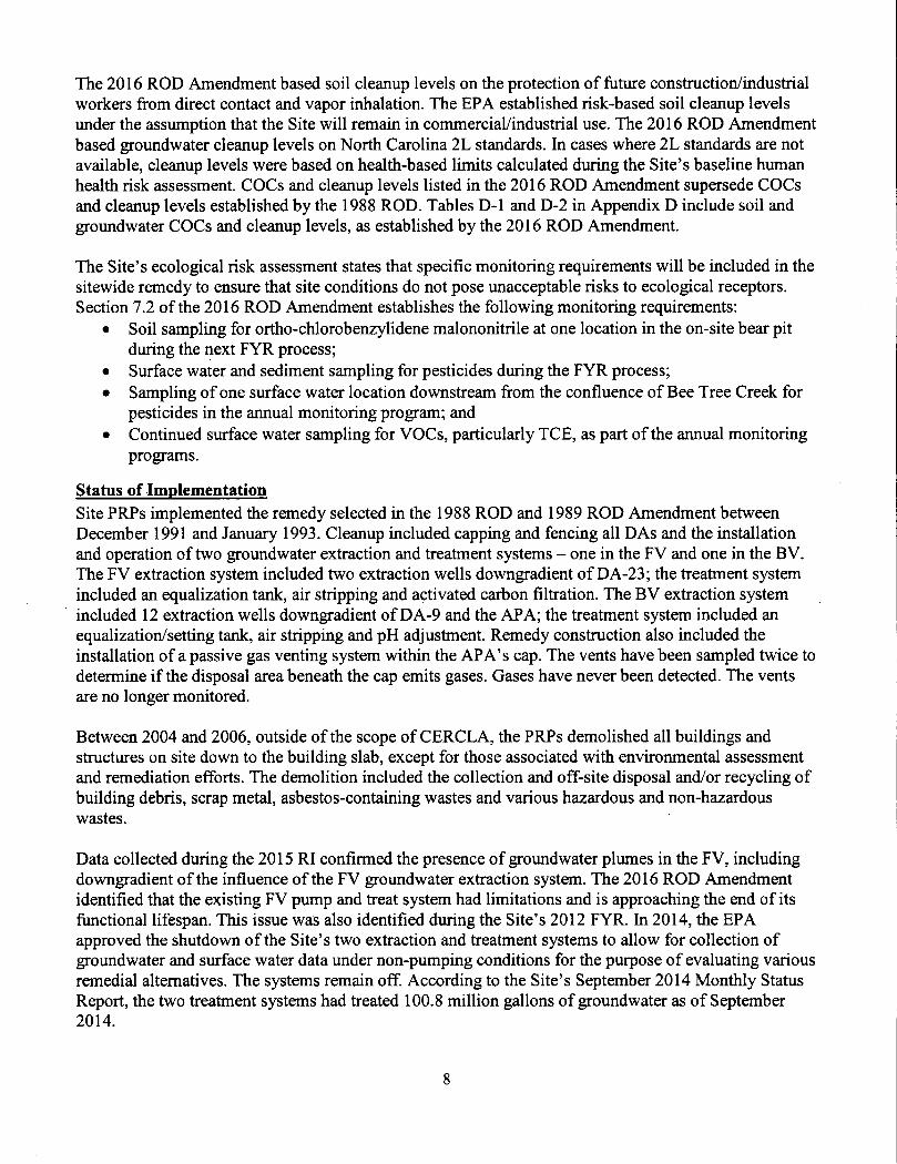
GroundwaterSite-related groundwater contamination is present within all three aquifers underlying the Site - the Surficial Aquifer, the Transition Zone Aquifer and the Bedrock Aquifer. Groundwater COCs consist primarily of VOCs, nitroaromatic compounds and perchlorate. Groundwater monitoring reports show isoconcentration contours for indicator COCs. Indicator COCs have been selected based on the firequency of constituent detections, the concentrations of constituents and the frequency of groundwater criteria exceedances. The indicator COCs selected to define the primary groundwater isoconcentration contours for the FV are TCE, tetrachloroethylene (PCE), chloroform, 1,2-DCA, research department explosives (RDX) and perchlorate. Indicator COCs selected to define the primary groundwater isoconcentration contours for the BV include TCE, tert-butyl alcohol (TBA), chloroform, 1,2-DCA, RDX and perchlorate.
According to the 2016 ROD Amendment and data included in the 2016 Annual Assessment Monitoring Report, groundwater data do not indicate off-site migration of site-related COCs at concentrations that exceed the groundwater cleanup levels established by the 2016 ROD Amendment (Table D-2). Figures in this section and Appendix K show COC plume locations for the Surficial Aquifer and the Transition Zone Aquifer, and COC concentrations within the Bedrock Aquifer as of October 2016. As shown on the plume maps, there are discrete plumes associated with the different indicator COCs throughout the different aquifers. The 2016 ROD Amendment used TCE isopleth maps as a good depiction of the extent of groundwater contamination in both valleys. Figures 3 through 6 on the following pages show

the extent of TCE in groundwater in the Surficial and Transition Zone Aquifers in both the FV and BV as of October 2016.
In general, groundwater data indicate that the most heavily contaminated site groundwater is present within the Surficial Aquifer in the BV, located primarily at and downgradient from the BV DAs. In general, COC concentrations within the FV tend to be lower than those observed in the BV. The extent of groundwater contamination within the Bedrock Aquifer covers a much smaller area than what is observed in the shallower, overlaying aquifers. While COCs within the Bedrock Aquifer exceed cleanup levels, in general, COC concentrations are much lower within the Bedrock Aquifer than in the shallower aquifers. Appendix K includes detailed information about concentrations and the extent of indicator COCs.
RDX within the Front Valley Transition Zone Aquifer extends in a long narrow pathway toward the Site’s southeastern boundary to well MW154-044C. In August 2015, RDX concentrations at that location exceeded the cleanup level of 0.3 micrograms per liter (pg/L) with a result of 0.5 pg/L. In September 2016, RDX was not detected at well MW154-044C with a reported detection limit of 0.7 pg/L. However, that result does not confirm whether the COC was present at or slightly above the cleanup level of 0.3 pg/L (Figure 7). In spring 2017, MW154-044C showed an estimated RDX concentration of 0.23 pg/L, which is below the cleanup level.* The most recent data show that RDX contamination appears to be confined within the site boimdary. However, continued close monitoring of RDX concentrations at that location is warranted. RDX was not detected in spring 2017 at five wells located near well MW154-044C (BW-13, MW158-N44A, MW167-044A, MW156-P44A and MW155- P43C). The off-site property immediately south of well MWl 54-044C, at 111 Old Bee Tree Road, is an industrial property. According to the City of Asheville’s Water Resources Department, the property is connected to the public water supply.
In August 2015, TBA concentrations at BV Transition Zone Aquifer monitoring well MW172-T32D exceeded its cleanup level of 10 pg/L, with a result of 11 pg/L. In September 2016, at that same well, routine groundwater analysis detected a TBA concentration of 120 pg/L. Resampling efforts at the same well in October 2016 verified the elevated concentration observed in September 2016 (Figure 8). The groundwater sample collected from this well in the spring 2017 had a TBA concentration of 130 pg/L. The well is screened between 32 and 42 feet below ground surface and is located near the Site’s eastern boundary at the BV (Figure 8). The well is located near the downgradient residential area. Response to the result included EPA notification, a mail-out survey to property owners within 1,500 feet to the east and south of the Site, sampling of eight off-site residential wells adjacent to the BV, and the addition of the well to an interim quarterly sampling schedule. The residential well sampling indicated that detected chemicals in these residential wells were below the North Carolina 2L groundwater standards. Anchor QEA sent letters to the owners of the eight private wells sampled, informing them of the results.
The off-site water well survey in 2010 and the above-mentioned off-site residential well sampling activities in 2016 have found no COCs attributable to the Site in off-site groundwater at concentrations that exceed the 2L standards.
‘ Spring 2017 sampling results for well MW154-044C and the five surrounding wells were provided by Anchor QEA for inclusion in this FYR; they were not submitted as part of an Annual Assessment Monitoring Report.
Figure 3: Extent of TCE in FV Surficial Aquifer Wells in 2016^
WCWi lJlW o ’'SC! , .. . - !,f,:-..O'
o.
W-47-iKf'
WSNMJ.-.aSAe/s, • - . — I“rjf'“irr~
r^.‘-
I *r.v^;
vW-” V
f'" .■'
, y--
“1
/'■ - f......
I \s\
\ T*"4)'W5*'VCJSA6
NOTES:
1. U ■ Not cMccted 8l or greater Ihan Itie value ImScated
2. JsEttimttedVMue3 NS > Not Sampled4 Isoconcet^tion contours, at so mete locaticns where two reeuRsocair nedtoeech other, reflect the magnlude ot die hgher resuH
qWiHIP fty 1-5W CoosWuefta TrtcMoroethene - 3 PO'L
Ad retuiH ere in mcrograms per tiler (pgl) Theconcentrclion ranges shownocrespondloflie cleanup level. I0x. lOOx. and lOOQx the cleanup level. Anaiydcal resufls are from samptes »Mectad (torn Augu^ through October 2016. unless noted.
7one AD Mnni«v<ng Wells# Non-CMect (Method Detectkn Limit Shoen)• <3 pgA (Cleanup Level)• 3to<30M04.• 30 le <300 ggO.# 300to<3000|ig/L# 3000 pg4. or moreO Menlienng Well Location • Not Sampled (NS)_ ^ Ectimaied Trlctrtofoetfiene isoconcantretton
Contour (ug4.)Site reatiees
^ , Chemirerwe* Propany BoundaryDtsposal Are* (DA)Road
Formar Building Location Treatmmi Buicing Pond
htarmKIeM Streten etream
Topographic Contour (20-foot inlervH)250-foot by 250-toot Reference Old (Row wd Cdumn Reference Shown In I4ap>Apffl 20l6ZcneA6 Groundwater Bevahon Contour (iCMoot Contour Interval)
REFERENCES:
1 Coordinate System: NAO t083StMePlane North Carolina FiPS 3200 Feel2 Topographic conloura Horn ttieNC Flood Plain Mapping Program (2(X)7).3 Cleanup levels are presented in the Record of Oedsion Amendment No 2, September 2016
Orvwn By COP Pro|«c1 Msnegw: SAR C»*rt; Chameoncs 0ate:V7/20r7
, ANCHOR ,QEAtt^
Anchor Q£A ho.'Th Carolina, PtlC
FRONT VALLEY ZONEAB TRICHLOROETHENE CONCENTRATIONS
2016CHEMTRONICSSITE
SWANNANOA, NORTH CAROLINA
^ Figures 3 through 10 in this section are from the 2016 Aimual Assessment Monitoring Report, Anchor QEA. March 31,2017.18

Figure 4: Extent of TCE in FV Transition Zone Aquifer Wells in 2016
WV2«-v36CC
Nbe-iB
VX^' /
NS
MW234 >3AX.-0
oT^
\ A \ ~■ A •
V V ' \
''M3
/X!S^r*,,|y✓ •'^^»- -
DW151-2 /*’=
r)«Vrl'i^7 A
kMU!-MK \ US
WVSiMLASC O UV<mS4.«?C
VWTT«*40
-c??2
I ^Mwi6l-J\4ec &.,"&’„U,
NOTES:
1. U s Not detec(«d ft or (KMttf than •)« v»tu* IncticateO
2 J s Estimated \Ab»3 NS s Not Sampled4 Isoconcentration contours, at sample locations where two results occur next to each other, relect the magntude of the higher result
Cleanuo Levels ter Listed ConsMuertfs TrtcNofoethene - 3AJI results are In iricrograms per liter (pgAi The concentration rengm shown conespondtothe cleanup le««l, 10i. tOOx, and 1000x thedeanup level. Anatyteal results are from samples colected from August through October 2016. unless noted
LEGEND:
/one CD Monitoring Weds
• Non-Oetect (Method Detection Limt Shorn)• <3 ugA. {Cleenup Level)• 3to<30ygA• 30to<300Mg^• 300 to <3000 moA.• 3000 |jgA a moreO Monitoring Vt^i Location-Not Sampled (NS) ^ ^ Esttraled Trtchkxoethene Isoconcentration
Contour «p(^)Sue features
Chemfronics Property Boundwv|[^2I ONposai Area (DA)
Road
Former Building Location Treatment Adcfeng Pond
Stream
Topo^aphic Conlcuf 120-foot Interval)250-foot by 250-foot Reference Grid (Row and Column Reference Shown m Map)April 2016 Zone CO Groundwater Bevation Contour (10-foot Contour Interval)
REFERENCES:
1 Coordhaie System; NAD 1983 StalePiane North Cerottia FIPS 3200 Feet2 Topographic contours from the NC Flood Plain Mapping Ftogram (2W7)3. Cleanup levels are presented in the Record of Decision Amendment No 2 September 2016
Drawn fty CGP PioitclM»fl«9«.$AR dent ChsmeorScs Date V7/2D17
400
Sfmi
. ANCHOR \UQEA£ii?
Anthot QEA of North Carolina, PtLC
FRONT VALLEY ZONE CD TRiCHLOROETHENE CONCENTRATIONS
2016
CHEMTRONteS SITE SWANNANOA, NORTH CAROLINA

Figure 5: Extent of TCE in BV Surflcial Aquifer Wells in 2016
usviasA,
W X- »"/iL-- <rf
PJ
NOTES:
1 U • Nd detected at or grMMrtti arm* value ifvdtc«ad
2 J>E<(rnaladViiiut Not Sempiad
4 l$oco^c«f^tra»o^ oonteura, at tampia f«caeon« «<terc two remits oc«or fta« to each other, reieci we nttonluda of the hgher retuH
^oiiQ AB Muiiitofing WoH* (Only Sampled I or-oiiom Have Pn<Mftd n»la)• Non-Oe(ec( (Method Detection LMI Shown)• <3MoA(Cle«u^)Uvol)• StoOOpoA.• 30toOOOpoA• 3(X)tD<3000MQA• 3000pgAormoreO Monitonng VMM LocMion - Not Senpied (NS) ^ _ Edimatad TrUMoroathena isoconcontradon
Contour tpgrt.)Site reatiHRs
Chontrofllcs Property Boundary P^DiioaaalAeaa (OA)
Read
Fomier BuddiAg LocaUen TteaPnant BtMrrg Pend
» Wtermttant Stream Strasn
RpograpNc Ciontour (20loot tettfval)TSO-foot by 2SO>fool Reterenoe Odd (Roe and Column Raterenee Shewn w Map)April 2016 Zone AS Groun<»water Bevttion Contour (10-foot Contour Intarval)
AD results ara in mcrograrrts pet Mar (poll.The conccfHTation ranges shown correspond to We eteenup love*. 10* 100*. end IDOO* the eteanup tevel Analytical resuns are (r«m sampws eoiectad trom AugiisUhrou$yi Octobar 2016 uniass nctad
LEGEND:
REFERENCES: _ _____
Df«wn 3t COPPreset Mtnsgw 8AR Ct*ni ChemaofSt*D*» 3/7/2017 ____. ^ ANCHOR
VwQEAttt^Areno'QFA of Nor tt” Ca-oi na. PILC
BACK VALLEY ZONE AB TRiCHLOROETHENE (XJNCENTRATIONS
2016
CHEMTRONiCS SITE SWANNANOA, NORTH CAROLINA
Figure 6: Extent of TCE in BV Transition Zone Aquifer Wells in 2016
'“t O^W'SIMJCO
{{'<^0'I UVfX^
OIL
j ,'^' (|li4WI4fK)i^C '^'
04 J ,
MWI9ri^29CO',
-4
NOTES:-'uliu-hs.
1. U - Not detoctod St 01 (F«il«r ttivi tha value indtcated
2. J-EKimatedWkja3. NS a Not Saiopiad
P^nw 1.^$ iQf Lisiatf CqnsMtfttB Tnchloroettiene • 3 pg/l
At resuB« are in microorams per Her (^gA)The cofwentrrtion ranges shown correspond to the deanup level, lOx. lOOx, end lOOOx the cleanup level. Anstyhcai r^its are from samples cdected from Ai^iust through October 2018. unless noted
LEGEND;
?on© CD Wonilofing WeHs (Only Sampled ncAltor^ Have FVasiad Dam)• NofvDelecMMedtod Detection UrrM Shown)• <3|jgLiClMnupLevati• 3 to <30 pgA• 30to<300M9i• 300 to <3.000 pgA• 3,000 pg/L a moreO Moniloring Wei Locahon - Nd Sampled (NS) ^ __ Estimated Trtchkroethene Isoccncentrahcn **"" Contour (pg/U
Sue featuresChemuonics Property Boundary r^OtsposalABa(DA)
Road
Former Suidng Location Treatment Buldmg Pond
- - Htermieenl Stream v»T sbeam
Topoyaphte Contour (20-loot Interval)250-fod by 250-foot Reference Grid (Row and Column Raference Shown in Map)April 2016 Zone CO Groundwater Elevation Contour (10-foot Contour Interval)
REFERENCES;
1 Coordnate System NAD 1983 StatePlane North CaromaFiPS 3200 Feet2 Topographic contours from the NC Flood Plain Mapping Program (2(X)7).3. Oeanup levels are presented m the Record ol Decision Anwidment No. 2. Septwnber 2018
Drawn By CGP Pna*ci Managw. SAft Clwm. CtianWonca Data 0V30r20l7
400BFeet
. 'f, ANCHOR NUQEAtirt:?
Anchoi UEA o' Ncr'.h C<hu( ra. PllC
BACK VALLEY ZONE CD TRICHLOROETHENE CONCENTRATIONS
2016
CHEMTRONICS SITE SWANNANOA, NORTH CAROLINA
Typically, the TBA plume within the BV Transition Zone Aquifer is confined to the area immediately downgradient of the APA (Figure 8). The recent cleanup level exceedances observed at the isolated location of MW172-T32D are not representative of typical site conditions. While the sampling performed in response to these atypical results confirmed that TBA concentrations in groundwater above the TBA cleanup level are not present in the off-site residential wells, continued close monitoring of that location is warranted to make sure that the COC does not migrate beyond the site boundary at that location. Additionally, a pilot test has been initiated in 2017 in the area between well BW-14 and well MW172-T32D. The results of this pilot test will be used to evaluate potential groundwater treatment options utilizing EISB. It is expected that the groundwater treatment will mitigate the potential for contaminant migration beyond the site boundary.
As part of the 2016 FS, contractor Geosyntec Consultants, Inc. confirmed that MNA is occurring at the Site using a multiple lines of evidence approach. The evaluation of both spatial and temporal trends in groundwater showed that COC concentrations in the FV and BV generally decrease with distance in each aquifer zone along the direction of groundwater flow, and that COC concentrations at most locations have declined over time throughout the BV and FV plumes. These observations are indicative of mass reduction and ongoing natural attenuation in FV and BV groundwater. For example, the concentration of TCE at Area B149 has steadily decreased due to natural attenuation, from 4,600 pg/L in October 2001 to 260 pg/L in November 2012, before the initiation of a EISB pilot test in the area. Following the initiation of the EISB pilot test in the area, the TCE concentration decreased further, to 19 pg/L as of September 2015. Based on these groundwater conditions, the revised groundwater remedy of targeted EISB and MNA is expected to address remaining site-related groundwater contamination.
Surface WaterThe headwaters for the Unnamed Branch and Gregg Branch are located on the Chemtronics property. Both streams are perennial and discharge to Bee Tree Creek. TCE and perchlorate are among the most frequently detected site analytes in surface water. The results shown in Figures 9 and 10 (on pages 28 and 29) include the most recent results from each sampling point in 2016. While perchlorate concentrations and, at a lesser frequency, TCE concentrations exceed their respective North Carolina 2B surface water standards at on-site sampling locations along Gregg Branch and the Unnamed Branch, between 2012 and 2016, no site-related analytes were detected above the NC 2B standards at any of the five surface water sampling locations along Bee Tree Creek. Surface water monitoring location BTW 1- P45 is located just south of the site boundary along Bee Tree Creek (Figure 9). The lack of COC concentrations above the NC 2B standard at that farthest downgradient, off-site surface water sampling location supports the 2015 RI conclusion that transport of contaminants to off-site receptors via surface water is not a significant route of migration. However, the increased concentrations of perchlorate and RDX at sampling location BTW 1-P45 observed in August 2015 (Table 8) warrant close monitoring to make sure that COC concentrations at that location remain below the NC 2B standards. Table 8 below shows detections of COCs in surface water in Bee Tree Creek between 2012 and August 2016.
Surface water sampling point BTW 1-P45 is located downgradient of groundwater monitoring well MW154-044C. RDX concentrations showed a slight increase in August in 2015 at MW154-044C. The increase in RDX at surface water sampling point BTW 1-P45 in August 2015 may indicate that the elevated RDX concentrations observed in groundwater were discharging to Bee Tree Creek.

Figure 7: Extent of RDX in FV Transition Zone Aquifer in 2016
W3
UA«-i
»«Vi26-GJ7a)0' . -0^ •MWWPHS^J* i \
mr7^o;c
^-w3M-j»rn yki__ iMm-JiTTl
QWfcVi?>4.J/t4j
0*Mr31
q^V3VW*OJ MW.US-' ^ —^
y .' /><s i )/•*S // /
.MiWTA
^MWir-jircix \
■ Vf‘'v>ri;«f.-, \'"
VW-T+4IHJC Iv^f! ^02U# \ \ '
'. O ®WWU5-l«-'\ \ S' ■ \ 'v \
’ll- 'B.^i ^,:*,.....„,..„,i,,„,„ .^.,,,......
Lst^:
•C3U' t
LEGEND;
Zon® CD Monoof mg Wells
NOTES:
1 U = Noi<Mec(ed at or greeter than the value Indicated
2. J = Estimated veiue3. NS = Not Sampled4. Isoconcentralton contours, at sempie locations v«twretwores(4ls occur nextto each other retodthe magniude c4 the higher resut
Ctwf^ levels tor listed Qotvsiliuohis Research OepartmenI Ezploseres (RDX) - 0.3 pgfl.
AH results are in mkfogrems per liter (piyL)The concentration ranges shown correspond to the ctean«4) levd lOi tOOx. and 100(k( the deenup levAl Analytical results are from serrrpies coleded from August thrcwgh Octoher 2016, unless noted
Non-Deteei (Method Detecticn LImrt Shown) <0.3 pgl (Cleanup Level)
0.3 to <3 M94.3to<30pgiL 30 to <300 pgA 300 ugA or more
Monitoring Wed Location • Not Sampled (NS) — — Estimated RDX (soconceotralion Contour (pg/L)
Sne Featuresy Chemtrcnics Prcperty Boundary
Disposal Area (DA)Road
Former Building Location Treatment Buiidng Pond
™ intemitteot Sdeam — Sdeam
TopogratTitc Ccntour (204oo( interval)
250-foot by 250-foot Reference Grid (Row andnee Shown in Map)
AprH 2016 Zone CD Groundwater B Ccntour <10-tod Contour Interval)
rvation
REFERENCES;
1 Coatfnale System: NA01963 StatePlane North Carolina FIPS 3200 Fael2 Topographic contours tom the NC Flood Plain Mapping F^o(^am (2007)3 Cleanup levels are presented In the Record of Oeosioo Amerxlment No 2. September 2016
Drawn By CGP Prota<tUaM9W SAR esani Chamaoncs
400
■3 Feet
. ANCHOR VwQEAtti:?
Anchor QEA of horth Cs^clna, PLLC
FRONT VALLEY ZONE CD RDX CONCENTRATIONS 2016
CHEMTRONICSSITE SWANNANOA NORTH CAROLINA

Figure 8: Extent of TEA in BV Transition Zone Aquifer in 2016
o rt i i A'
ILJKD
And
MW«M.-V.r.
VTA»5=Kwiei12000
WsSlvO^vAti^iTC
#»^/vT«MJ7CC
^A¥13&RJ«CD
NOTES:MW172-T32D
J?
1. U = Notd9lectedetorgreeterthanthevalu« mdcated.
2. J» Estimated Vbye3. NS = Not Sampled
Cleanup Levels fof Listed Conslituerts ted-BuMAcotK)l-10 pg/L
Ml results are in micro^^a pe' Kief ipgAi.The concentration ranges shown correspond to the cleanup level, 10« 100x, and 1000x the cleanup level Analytical results are from samples ct^ected from August through Octc^ 2016, unless noted.
LEGEND;
Zone CD NkuHtwifrg Wells (Orriy Sampled I ocatiorts Have Rnsted Data)
• Non-Oetect (Method OelecUon UmH Shown)
• <l0M9/L(CleanupLevel)
• 10lo<100p9/L
• 100to<'l000pgA.
• I.OOOtoclO.OOOpgA
0 10.CHX) M9/Lormore
O Monaortng WeR Location - Not Sampled (NS)
^ ^ Estimated tart-ButylAtcohoi Isoconcentralron “* ■" Contour qjg/L)
Sitehealures
Chwntrooics Property Boundary f**1 Disposal »rea IDA)
Road
Former Bulking Location Treatment Buileing Pwd
- IntertnUtent Stream A— Stream
TcHiograpnic C^ontour (20-loot intarval)
250-fool by 250-foot R^erence Grid (Row and ColL«rn Reference Shown In Map)
April 2016 Zone CD (Sroundwaler Bei Contour (10-foot Contour tnterval)
REFERENCES:. . _______________1 Coordnate System; NAD 1963 StatePlane Nofth Caroina PIPS 3200 Feet2 Topo^aphic contours from the NC Flood Plain Mapping Program (2007)3 Cleanup levels are presented in the Record of Decision Amendment No 2. September 2016
E^wn By. COP Profeci Manager: SAP Clant' ChanWoncs Data.03/30/2017
Scale
:30 400
, ANCHOR
Archoi QEA North Carolina, PILC
BACK VALLEY ZONE CD TERT-BUTYL ALCOHOL CONCENTRATIONS
2016
CHEMTRONICS SITE SWANNANOA NORTH CAROLINA

Table 8: COC Detections in Bee Tree Creek Surface Water (2012-2016)
coc2B
Standard Sampling Dates and Results (pg/L)
10/12/2012 10/30/2013 9/8/2014 8/20/2015 6/9/2016 8/29/2016 4/25/2017BTW 2-S35
Perchlorate 2.8 0.2 U 0.69 J 0.2 U 0.2 U NS 0.2 U NS1,2-DCA 0.1 U 0.2 J 0.1 u 0.1 u NS 0.1 u NS
BTW 1-P44Perchlorate 2.8 0.2 U 0.27 J 0.2 U 0.24 J 0.32 J 0.31J 0.26 J
BTW 1-P45Perchlorate 2.8 0.33 J 0.5 J 0.2 U 1.9 0.67 J 0.51J 1.3
RDX 0.2 U 0.25 J 0.2 U 0.77 0.49 J 0.2 Um,p-xylenes 670 0.1 U 0.1 U 0.1 U 0.1 U 0.1 U O.IJ 0.1 uNotes:Bold results indicate that the constituent was detected.U = the constituent was not detected at a level greater than or equal to the level of the sample quantitation limit for the methodJ = estimated result |ig/L = micrograms per literNS = not sampled _____________________________________________________________________
In August 2016, an isolated, estimated detection of 4-nitrotoluene (0.74 pg/L) was observed at surface water sampling location BTW 2A-T35. The 2B standard for that constituent is 18 pg/L. Also in August 2016, isolated, estimated detections of 1-nitronaphthalene were observed at sampling locations BTW 2- S35 (0.38 pg/L) and BTW 2A-T35 (0.52 pg/L). There is no 2B standard for 1-nitronaphthalene. These two wells are located along Bee Tree Creek.
The North Carolina 2B surface water standards are protective of human health; they are not applicable to ecological receptors. To evaluate potential risk to ecological receptors in Bee Tree Creek, the Unnamed Branch and Gregg Branch, this FYR compared concentrations of constituents detected in surface water between 2012 and 2016 to EPA Region 4 chronic freshwater screening values.^ Screening values are not available for all detected surface water constituents, including perchlorate and TBA. Between 2012 and 2016, no constituent concentrations observed in Bee Tree Creek, the Unnamed Branch or Gregg Branch exceeded Region 4 chronic freshwater screening values. These findings indicate that surface water at the Site does not currently pose an unacceptable risk to ecological receptors.
During the RI, Anchor QEA collected surface water and sediment samples from the Unnamed Branch and Gregg Branch. Where possible, surface water and sediment samples were collected together at each sampling location. Anchor QEA collected surface water and sediment samples during low-stream-flow conditions and a high-stream-flow event. Under low-flow conditions, any detected contamination would be coming from groundwater discharging into the stream. The purpose of collecting samples under high-
^ EPA Region 4 Surface Water Screening Values for Hazardous Waste Sites, included in EPA’s 2015 Region 4 Ecological Risk Assessment Supplemental Guidance, accessed 3/14/2017: https://www.epa.gov/sites/production/files/2Q 15- 09/documents/r4 era guidance document draft final 8-25-2Q15.pdf
25
Figure 9: Select COCs in FV Surface Water in 2016
LEGEND:
• SulK»VMt*rMoM«Mno(.ocMOPMomonrtg LocWoi
' Ctwntrantot Oeperty Baunittry
ROKtP«wl
Feimef 6ui«v« Location rraummi BuMng DiapOM>A^*« (OAJ TopoBraphic Cortour (20e inlarval) 250-1 by Ratermce and
!a-t3k»«onMMM-4JCMwotorffl-tliU
NOTES:
1. U > Ma <m*tM tl or grvatar than tha vaM
3 NS = Nd Swnptad
29 WMf r Stanotfite1 7 Dicttforodhana 3? (igd.Oiwrcfcm - iro PwsNoraJa • 2»p®^R*«ear<h Oapartmant Explosim • It U9i Tdrad^tv<Mhar>t • 3 3 uiyi rnttnaoelhtn* ■ 30 pgA.
Chtafdwm-OtU
idrMNoiaatfww • 0 1 U
12-OUNcrodhana-ftlU ChtoMloFmOiU Panttflitf Q.3U
REFERENCES:
CoorOrLM* 9ydam two mi Stai^wta NothTriehtaroittawfOtUcatcana FtPS 3200 Faat2 TopcvaptacccnkMrakomihaNCFioaijnaaiMating Progrwn (2007)TamMcMbant* OAi
SA»
■0 'U
An<^oi- Ofc-A ’5’ North Ca^of ?>.*, FtLC
FRONl VALLEY SURFACE WATER SELECT CONSTITUENT CONCENTRATIONS
2016
CH6MTRONIC8 SITE SWANNANOA, KK3RTH CAROLINA

Figure 10: Select COCs in BV Surface Water in 2016
LEGEMP;
NS
r""'"lOno<aa<A<»«iQA)
TepegnpMc Ccnieur i2m teMnw) »01 by 2S0 I Rttareac* Grw
NOTES
O • Net (ttt*G(«d M or 0rMMr the v«u* tnSKmH
I N3«NaSifivMB«ru«M< 011/ CNorakrai • 01 UP«r«tMnlt • ;RDX-03U
28 dttfiacftMMttedltdi t.M:»eii(cro*tft*ne • 3? m»4.Bennnt • »1 Mp4.CMoratarm -1 ro ugA.P«cr*or«tf
Rmoarch Otmbn»ffi Ejtptomvt - 11 u(K t*n*euM A)c<4<o( - Mel-SOufl^
V20«
1 UOtoralam'OlUP*rcNDr«»-24RDX-QMJ Tfi<h»»wilh«B* OIUSannn* 01U CMordIwn-OlUi
REFERENCES;0TWMI30DUP V30I30»
V2 0ictilor(Mlhm-0«U e4ni«n«>01U CMaroform • 0.1 U Pv6Nem«-02URox-oaoM BbtyfAteehM 4U T^ncNotMOwwi ■ 0 I U
1 CoofdinMa Syftam MAD 1»S3 QUNPt^eNcrth cweira f IPS 32002 Toftopr^MUc ccnioura bom rti« MC Flood Pi«r taipnBD Faaam [3007i
• 01UCNMtaFDnn-O.IU PvcNo^o-OSU R0X-02U
D-**ng, COP Pwr»clU«ni9« SM Clwtt C.^•n«onK« I>t» 0i-3>3)H
TncOionMthoiO'OlU
8nv?A-Tao ftraaooie i>Okh S«v«>* ■ 0 1 Uaooreiem 0.1 uPtrc«or*l*-023U
DX ' 0 ? U wt-autyl MaM
* ^ANCHOR \UQEA
•01U
8•fW^S» OtAll' Pim•0.1W
Bantono'OiUCMenabnu-dluThcWgotfwno.OlU
MTunn* • 0 I U CNorofom-OlU PonNorato 03U ROX.02U
t«rt-ei^AleehQt-4U OlU
•0 I Ut
BACK VALLEY SURFACE WATER SELECT CONSTITLCNT CONCENTRATIONS
2016
P«6B|«w..-_2.S ROX 04U
0.1 UCHEMTRONICS SITE
SWANNANOA. NORTH CAROLINA

flow conditions was to determine if there were any unacceptable levels of contamination coming from surface runoff. According to the 2016 ROD Amendment, diese data confirmed that neither surface water nor sediment is a source of contamination. The 2016 ROD Amendment concluded that the contaminants detected in the streams are either from the discharge of groundwater into the stream or surface runoff during storm events.
Site InspectionThe site inspection took place on 1/19/2017. In attendance were Jon Bornholm (EPA Region 4 RPM), Beth Hartzell (NCDEQ), Stuart Ryman, Robert Cork and Jonathan Ivey (Anchor QEA), and Melissa Oakley and Jill Billus (Skeo). The purpose of the inspection was to assess the protectiveness of the remedy. The site inspection checklist is included in Appendix F. Site inspection photographs are included in Appendix H.
The site inspection began at the FV maintenance shed with a safety and site information briefing. It included a tour of the following FV areas; Bee Tree Creek, the Unnamed Branch that drains to Bee Tree Creek, site ponds, signage, and disposal areas DA-10/11 and DA-23. It also included a tour of areas established in the 2016 ROD Amendment as needing active remediation, including Areas B104, BIOS, B109, B116 and B147. The site inspection included a tour of the following BV areas: Gregg Branch and surface water monitoring locations, disposal areas DA-6, DA-7/8, DA-9 and the APA, and the area downgradient of DA-9 and the APA, established in the 2016 ROD Amendment as needing active remediation.
Six-foot chain linked fences clearly marked with warning signage and secured with locked gates surround each of the six disposal areas. All fences were in good condition. The caps on the six disposal areas appeared to be in good condition, with no evidence of subsidence, cracking or burrowing within the caps observed. Vegetation on all capped areas appeared to be well-established, healthy and well- maintained. Site inspection participants observed a small area under the fence surrounding DA-10/11 where an animal has dug under the fence to access the capped area. However, no evidence of digging was observed on the actual cap. All monitoring wells were secured with locks and clearly labeled and appeared to be in good condition. All injection and extraction wells observed in pilot test areas were also secured and clearly labeled and appeared to be in good condition.
Site inspection participants also observed the inactive BV groundwater treatment system building, the metering manhole where samples of treated water are collected for analysis before the water is discharged to the MSD, the FV groundwater treatment system building, a pollinator habitat pilot project plot, and the off-site residential area along Old Bee Tree Road. The system components of the FV groundwater treatment system were clearly labeled and appeared to be in good condition. The groimdwater treatment system building remains locked when not in use.
A PRP-led pollinator habitat pilot project near the main site entrance is currently exploring the possibility of establishing pollinator species on top of the disposal area caps. The pilot project test plot was partially covered with plastic sheeting to help prepare the soil for the next planting.
Access to parts of the Site are restricted by fencing and a secured front and back gate. The front gate and on-site access is monitored by a security guard stationed in a guard hut at the site entrance. The front gate is clearly posted with warning signage. Signs to deter trespassing and himting are posted across the Site. No issues were observed during the site inspection that could potentially affect the protectiveness of the remedy.
Following the site inspection, EPA and Skeo staff visited the Site’s local information repository, Warren Wilson College Library, located at 701 Warren Wilson Road in Swannanoa. A records review verified that a large collection of older printed site-related documents is available for public viewing. All site- related documents dated 2006 and later, including the 2012 FYR and the 2016 ROD Amendment, are available in disk form for public viewing.
V. TECHNICAL ASSESSMENT
QUESTION A: Is the remedy fimctioning as intended by the decision documents?
Question A Summary:The review of relevant documents, ARARs and risk assumptions and the site inspection indicate that once implemented, the new sitewide remedy selected in the 2016 ROD Amendment is expected to function as designed and address remaining site-related contamination. The soil component of the 1988 ROD is functioning as designed. There are no complete exposure pathways to contaminated media at the Site.
The capping and fencing of the DAs addressed soil that posed unacceptable risks to human health. Locked gates, fences and security personnel prevent unauthorized site entry. While performed outside of the scope of CERCLA, the demolition and off-site disposal of site structures and associated wastes further eliminated the potential for unacceptable risks to human health posed by the Site. While in operation, the FV and BV groundwater extraction and treatment systems prevented off-site migration of groundwater contamination and, to a certain extent, reduced COC concentrations in site groundwater.
Site groundwater is not used for any purpose. According to the 2016 ROD Amendment and the 2016 Aimual Assessment Monitoring Report, groundwater data do not indicate off-site migration of site- related COCs at concentrations that exceed applicable groundwater criteria. In August 2015, RDX was present slightly above its cleanup level within the FV Transition Zone Aquifer near the Site’s southeastern boundary (at well MW154-044C). However, in spring of 2017, RDX at that same location was below the cleanup level of 0.3 pg/L. The most recent data show that RDX contamination appears to be confined within the site boundary. However, continued close monitoring of RDX concentrations at that location is warranted. It should be noted that the off-site property immediately south of well MW154-044C, at 111 Old Bee Tree Road, is industrial and connected to the public water supply. Also, BV well MW172-T32D, which is located just inside of the Site’s southeastern boundary, showed exceedances of the TBA cleanup level of 10 pg/L in 2015 and 2016. The sampling performed in response to these atypical results confirmed that TBA is not present in the residential wells located beyond the site boundary. However, continued close monitoring of that location is warranted to make sure that the COC does not migrate beyond the site boundary at that location. If TBA concentrations continue to increase at that location, sampling may be needed at locations downgradient of the well, beyond the site boundary, to fully delineate the extent of TBA in groundwater near well MW172-T32D. A pilot test was initiated between well BW-14 and well MW172-T32D. This results of this pilot test will be used to evaluate the potential for treating this contaminated groundwater utilizing EISB. It is expected that the groundwater treatment will mitigate the potential for contaminant migration beyond the site boundary.
Surface water data collected between 2012 and 2016 support the 2015 RI conclusion that transport of contaminants to off-site receptors via surface water is not a significant route of migration. In August 2015, an increase in perchlorate and RDX concentrations was observed at the farthest downstream

surface water sampling location (BTW 1-P45) in Bee Tree Creek. However, concentrations decreased at that location in 2016. The increase of RDX concentrations in surface water downgradient of well MW154-044C (at BTW 1-P45) in August 2015 may indicate that the elevated RDX concentrations observed in groundwater at well MW154-044C at that time were discharging to Bee Tree Creek. While the COC concentrations at that location remain below their respective North Carolina 2B standards, close monitoring is needed to make sure that COC concentrations remain below applicable standards at that location.
The 2016 ROD Amendment requires implementation of institutional controls to, at a minimum, limit land uses to commercial/industrial uses, restrict groundwater use and prevent the use of on-site groundwater for potable purposes. It also requires the creation of a plat map to identify the boundaries of the Superfund site. The PRPs have submitted draft institutional control language to NCDEQ for review and approval. Following approval, the PRPs will file and record the final institutional controls with Buncombe County.
The institutional controls required by the 2016 ROD Amendment do not specifically prohibit digging at the DAs established by the 1988 ROD. However, access to the DAs is restricted by fencing and neither the property owner nor the PRP contractor perform any activities on the DA caps that could potentially impact the integrity of the caps or result in direct exposure to contaminated subsurface soil. Restrictions to prohibit material disturbance, excavation or removal of material at the DAs should be considered in the final institutional controls.
While not required by the Site’s 2016 remedy, the PRPs paid to extend the public water supply line to areas southeast and south of the Site and established restrictive covenants with several off-site property owners located downgradient of the Site between 2014 and 2016. The restrictive covenants prevent the use or extraction of groundwater from the subject properties, and require the closure of any existing wells. These actions further reduce the potential for future off-site exposure to groundwater contamination. They also help reduce the potential for off-site water wells to impact migration of groundwater contamination on site.
O&M activities are adequate and ensure the continued protectiveness of the remedy. Anchor QEA performs groundwater and surface water monitoring as required, cap settlement surveys indicate no evidence of cap subsidence at any of the DAs, and routine cap inspections and maintenance ensure the continued integrity of the DA caps. Upon implementation of the new sitewide remedy, it is expected that new O&M requirements will be established in an updated O&M Plan.
QUESTION B: Are the exposure assumptions, toxicity data, cleanup levels and RAOs used at the time of the remedy selection still valid?
Question B Summary:Reviews of ARARs and toxicity changes as they might relate to the validity of cleanup goals were not needed during this FYR. Based on site information gathered during the 2015 RI, the September 2016 ROD Amendment identified new COCs based on current site conditions and established new cleanup levels based on current standards. The 2016 ROD Amendment established National Primary Drinking Water Standards (MCLs) and North Carolina 2L standards as chemical-specific groundwater ARARs and the North Carolina 2B standards as surface water ARARs.

The 2015 RI evaluated risks associated with vapor intrusion from site soil and groundwater. The 2015 RI identified two areas in the FV in need of additional soil remediation due to an unacceptable future risk associated with vapor intrusion of VOCs. The 2016 ROD Amendment established new risk-based soil cleanup levels for those two FV areas to specifically address the potential for future vapor intrusion. The 2015 RI also identified an unacceptable future risk due to vapor intrusion associated with site groundwater. The 2016 ROD Amendment established groundwater cleanup levels to address this future potential risk.
Shallow groundwater at parts of the Site is currently contaminated with concentrations of VOCs above the newly established cleanup levels. However, there are no routinely occupied enclosed structures on site, so there is no complete vapor intrusion exposure pathway under current conditions. The FV maintenance shed is located immediately northwest of building 152, just west of the pond (Figure 2).The security guard hut is located along the Site’s southern boundary (Figure 2). Based on the current extent of groundwater contamination within the Surficial Aquifer, VOC-impacted groundwater is not present beneath, or within 100 lateral feet of the FV maintenance shed or the guard hut. Therefore, vapor intrusion does not pose a risk to workers in the shed or security personnel who use the guard hut. VOC contamination in shallow groundwater is not present within 100 lateral feet of downgradient residents; therefore, vapor intrusion does not pose a risk to off-site receptors.
Exposure assumptions at the Site remain valid. The EPA based the original 1988 soil cleanup goals and the new 2016 soil cleanup levels on commercial/industrial site use. The Site remains vacant and the PRPs have submitted draft institutional control language to NCDEQ for review and approval that will restrict site land uses to commercial/industrial use.
The ecological risk assessment, performed as part of the 2015 RI, concluded that community-level risks for ecological receptors are not expected on a broad scale. However, potential risks to ecological receptors at some isolated site locations could not be definitively ruled out. Section 7.2 of the 2016 ROD Amendment establishes specific monitoring requirements to ensure that site conditions do not pose unacceptable risks to ecological receptors. The 2016 ROD Amendment indicates that performance monitoring requirements will be finalized as part of the Performance Monitoring Plan during the remedial design. To evaluate potential risk to ecological receptors in Bee Tree Creek, the Unnamed Branch and Gregg Branch, this FYR compared concentrations of constituents detected in surface water between 2012 and 2015 to EPA Region 4 chronic freshwater screening values. Between 2012 and 2016, no constituent concentrations observed in Bee Tree Creek, the Unnamed Branch or Gregg Branch exceeded R4 chronic freshwater screening values. These findings indicate that surface water at the Site does not currently pose an unacceptable risk to ecological receptors.
The EPA has identified 1,4-dioxane as an emerging COC at Superfiind sites. 1,4-Dioxane is a solvent used primarily in manufacturing operations. It is highly soluble in water, does not readily bind to soils and readily leaches to groundwater. It is also resistant to naturally occurring biodegradation processes. Due to these properties, a 1,4-dioxane plume is often much larger (and further downgradient) than the associated solventA^OC plume. This FYR reviewed information regarding previous 1,4-dioxane sampling at the Site to determine if the constituent warrants additional consideration. During Phase I, II, and III of the Site’s 2015 RI, the PRP contractor analyzed 512 soil samples and 63 groundwater samples for 1,4-dioxane. The constituent was not detected in any of those samples. Additional non-RI sampling efforts performed in 2003, 2004, 2007 and 2008, included analysis for 1,4-dioxane from both on-site locations and off-site domestic wells. The constituent was not detected in any of those samples. Based on this information, 1,4-dioxane has not been selected as a site COC and has been determined not to pose a risk to human health or the environment at the Site.
31
It is anticipated that the implementation of the new sitewide remedy will meet the RAOs established in the 2016 ROD Amendment.
QUESTION C: Has any other information come to light that could call into question the protectiveness of the remedy?
No other information has come to light that could call into question the protectiveness of the remedy.
VI. ISSUES/RECOMMENDATIONS
Issiies/Rccommendations
OU(s) without Issues/Recommendations Identified in the FYR:None.
Issues and Recommendations Identified in the FYR:
OU(s): Issue Category: Institutional ControlsOUl (Sitewide) Issue: The 2016 ROD Amendment requires implementation of institutional controls to, at
a minimum, limit land uses to commercial/industrial uses, restrict groundwater use and prevent the use of on-site groundwater for potable purposes. The institutional controls have not yet been finalized.
Recommendation: Finalize institutional controls and record final institutional control documents with the Buncombe County Register of Deeds Office. The final institutional controls should prohibit material disturbance, excavation, or removal of material, and any other activities at the DAs that could potentially impact the integrity of the caps or result in unacceptable exposure to contaminated subsurface soil without the prior written permission of EPA and/or NC DEQ.
Affect Current Protectiveness
Affect Future Protectiveness
Party Responsible Oversight Party Milestone Date
No Yes PRP EPA/NCDEQ 9/26/2018
I Issues and Recommendations Identified in the FYR:
OU(s): Issue Category: MonitoringOUl (Sitewide) Issue: BV well MW172-T32D, which is located along the Site’s southeastern boundary,
recently showed exceedances of the TBA cleanup level of 10 pg/L. Due to the close proximity of well MW172-T32D to a residential area on the other side of Bee Tree Creek, there is a potential for TBA to migrate beyond Bee Tree Creek at concentrations above the cleanup level. However, it should be noted that the PRPs sampled eight private wells in this residential area in 2017 and TBA was not detected at any of those private wells.
Recommendation: Continue to closely monitor TBA concentrations at MW172-T32D and surrounding monitoring wells. Implement the work plan submitted by the PRPs to EPA/NCDEQ in May 2017 to conduct an EISB pilot scale treatability study in the vicinity of monitoring well BW-14, which is located upgradient of well MW172-T32D. This treatabiUty study will be similar in size and scope to the other treatability studies initiated by the PRPs during the RI/FS process. Implement work plan upon EPA approval.
Affect Current Protectiveness
Affect Future Protectiveness
Party Responsible Oversight Party Milestone Date
No Yes PRP EPA/NCDEQ 9/26/2020
OTHER FINDINGSIn addition, the following recommendations were identified during the FYR. They do not affect current and/or future protectiveness:
• Figures currently included with routine monitoring reports typically show well locations and analytical results in relation to the larger Chemtronics property boimdary. In order to more easily determine the extent of groundwater contamination as it relates to the boundaries of the Superfimd site, the Site’s boundaries should be added to future monitoring report figures.
• Concentrations of perchlorate and RDX in surface water in Bee Tree Creek at sampling location BTW 1-P45 increased in August 2015. While concentrations of those COCs at that location are below their respective North Carolina 2B standards, continue to closely monitor COC concentrations at that farthest downgradient surface water sampling location to make sure that COC concentrations do not increase to levels above the North Carolina 2B standards.
• Include the monitoring requirements established in Section 7.2 of the 2016 ROD Amendment in the Site’s forthcoming Performance Monitoring Plan to ensure that site conditions do not pose unacceptable risks to ecological receptors.
• In September 2016, RDX was not detected at well MW 154-044C, however the laboratory method detection limit (0.7 pg/L) was higher than the RDX cleanup level of 0.3 pg/L. Work with the analytical laboratory to ensure that method detection limits are able to achieve site cleanup levels.

VII. PROTECTIVENESS STATEMENT
Sitcwidc Protectiveness Statement
Protectiveness Determination: Will be ProtectiveProtectiveness Statement:The sitewide remedy is expected to be protective of human health and the environment upon completion of the implementation of the 2016 ROD Amendment. In the interim, exposure pathways that could result in unacceptable risks are being controlled. The capping and fencing of the DAs addressed soil that posed unacceptable risks to human health, and site groundwater is not used for any purpose. A review of monitoring data and current site conditions confirm that there are no complete exposure pathways associated with surface water, groundwater or soil at the Site. However, in addition to the implementation of the new sitewide remedy selected by the 2016 ROD Amendment, the following actions are needed for the remedy to be protective over the long term:
• Finalize institutional controls and record final institutional control documents with the Buncombe County Register of Deeds Office. The final institutional controls should prohibit material disturbance, excavation, or removal of material, and any other activities at the DAs that could potentially impact the integrity of the caps or result in imacceptable exposure to contaminated subsurface soil without the prior written permission of EPA and/or NCDEQ.
• Continue to closely monitor TBA concentrations at MWl72-T32D and surrounding monitoring wells. Implement the work plan submitted by the PRPs to EPA/NCDEQ in May 2017 to conduct an EISB pilot scale treatability study in the vicinity of monitoring well BW-14, which is located upgradient of well MW172-T32D. This treatability study will be similar in size and scope to the other treatability studies initiated by the PRPs during the RI/FS process. Implement work plan upon EPA approval.
VIII. NEXT REVIEWThe next FYR report for the Chemtronics, Inc. Superfund site is required five years from the completion date of this review.

APPENDIX A - REFERENCE LIST
2012 Annual Assessment Monitoring Report, Chemtronics Site, Swannanoa, Buncombe County, North Carolina. Prepared by Altamont Environmental, Inc. for Chemtronics, Inc., Northrop Grumman Systems Corporation and CNA Holdings LLC. May 13, 2013.
2013 Annual Assessment Monitoring Report, Chemtronics Site, Swannanoa, Buncombe County, North Carolina. Prepared by Altamont Environmental, Inc. for Chemtronics, Inc., Northrop Grumman Systems Corporation and CNA Holdings LLC. May 28, 2014.
2014 Annual Assessment Monitoring Report, Chemtronics Site, Swannanoa, Buncombe County, North Carolina. Prepared by Altamont Environmental, Inc. for Chemtronics, Inc., Northrop Grumman Systems Corporation and CNA Holdings LLC. April 8, 2015.
2015 Annual Assessment Monitoring Report, Chemtronics Site, Swannanoa, Buncombe County, North Carolina. Prepared by Altamont Environmental, Inc. for Chemtronics, Inc., Northrop Grumman Systems Corporation and CNA Holdings LLC. April 4, 2016.
2016 Annual Assessment Monitoring Report, Chemtronics Site, Swannanoa, Buncombe County, North Carolina. Prepared by Anchor QEA for Chemtronics, Inc., Northrop Grumman Systems Corporation and CNA Holdings LLC. March 31, 2017.
Chemtronics CERCLA Site Quarterly Status Report for March through May 2015. Altamont Environmental, Inc. June 10, 2015.
Chemtronics CERCLA Site Quarterly Status Report for June through August 2015. Altamont Environmental, Inc. September 10, 2015.
Chemtronics CERCLA Site Quarterly Status Report for January through March 2016. Altamont Environmental, Inc. April 10, 2016.
Chemtronics CERCLA Site Quarterly Status Report for July through September 2016. Altamont Environmental, Inc. October 10, 2016.
Chemtronics CERCLA Site Quarterly Status Report for October through December 2016. Anchor QEA of North Carolina, PLLC. January 10, 2017.
Front Valley and Back Valley Extraction Well and Treatment System Temporary Shutdown Report. Prepared by Altamont Environmental, Inc. for Chemtronics, Inc., Northrop Grumman Systems Corporation and CNA Holdings LLC. January 15, 2016.
Monitoring Report for Temporary Shutdown of the Front and Back Valley Extraction Wells and Treatment Systems. Prepared by Altamont Environmental, Inc. for Chemtronics, Inc., Northrop Grumman Systems Corporation and CNA Holdings LLC. June 15, 2015.
Monthly MSD Sewer Discharge Compliance Report - July 2015, Chemtronics CERCLA Site, Swannanoa, North Carolina. August 7, 2015.
A-1
Record of Decision Amendment, Chemtronics Superflind Site, Swannanoa, Buncombe County, North Carolina. U.S. Environmental Protection Agency. September 29, 2016.
Superfund Record of Decision: Chemtronics, NC. United States Environmental Protection Agency. Aprils, 1988.
Superfund Record of Decision Amendment: Chemtronics, NC. United States Environmental Protection Agency. April 26, 1989.
Third Five-Year Review Report, Chemtronics Superflind Site, Swannanoa, Buncombe County, North Carolina. U.S. Environmental Protection Agency. September 26, 2012.
A-2

APPENDIX B - CURRENT SITE STATUS
Envirunnu'iil:il Iiiclicaloi N
- Current human exposures at the Site are under control.- There are insufficient data to determine if current groundwater migration is under control.
Arc Necessary Institutional Controls in IMacc'I □ All □ Some ^ None
Has El’A Designated the Site as Sitenide Reads lor Anticipated Use?I □ Yes ^ No
Has the Site lleeii I’nt into Reuse?I □ Yes lEI No
B-1

APPENDIX C - SITE CHRONOLOGY
Table C-1: Site Chronology
Event DateIndustrial operations began at the Site 1952State ordered Chemtronics to stop discharges to all disposal trenches 1980The EPA added the Site to the NPL Septembers, 1983U.S. Army’s Toxic and Hazardous Materials Agency collected samples from two drums exposed at surface of DA 10/11 1984
PRPs began the Site’s RI/FS January 2, 1985PRPs, Chemtronics and Northrop Grumman Systems Corporation entered AOC to perform Site’s RI/FS October 21, 1985
PRPs completed Site’s RI/FS. The EPA signed Site’s ROD April 5, 1988EPA issues Unilateral Administrative Order to the PRPs,Chemtronics, Northrop Grumman Systems Corporation and CNA Holdings, Inc., to perform remedial action
March 22, 1989
PRPs began Site’s remedial design March 23, 1989The EPA signed ROD Amendment April 26, 1989PRPs completed Site’s remedial design and began remedial action June 10, 1991PRPs completed Site’s remedial action. The EPA issued Site’s Preliminary Close-Out Report March 25,1993
PRP contractor RUST Environmental finalized Site’s O&M Manual December 1997The EPA completed Site’s first FYR Report September 27, 2002PRPs completed Holistic Site Management Plan to provide direction regarding future investigation and remediation efforts January 2003
North Carolina Division of Natural Resources Hazardous WasteSection requested that the EPA consolidate oversight of all site environmental remediation activities under CERCLA authority
March 9, 2007
The EPA completed Site’s second FYR Report September 27, 2007PRPs Chemtronics, Northrop Grumman Systems Corporation andCNA Holdings, Inc. entered AOC to perform the sitewide RI/FS and started sitewide RI/FS
October 25, 2008
PRPs completed Building Demolition and Waste Removal Report documenting non-CERCLA building demolition and waste removal performed between 2004 and 2006
2009
PRPs voluntarily upgrade public water supply line serving Old BeeTree Road and connect one resident. 2014
The EPA completed Site’s third FYR Report September 26, 2012PRPs shut down FV and BV groundwater extraction and treatment systems to allow for collection of data under non-pumping conditions September 25, 2014
PRPs completed sitewide RI December 21, 2015PRPs voluntarily connect three residents along Lauren Ridge Way to public water supply line. 2016
C-1

Event DatePRPs completed sitewide FS, including implementation of pilot tests at B104, BIOS, B139, B147, B149, DA-23/B116, and downgradient of DA-9 and the APA.
July 11,2016
The EPA approved the FS July 25, 2016The EPA signed ROD Amendment September 29,2016

APPENDIX D - SOIL AND GROUNDWATER COCS AND CLEANUP LEVELS ESTABLISHED IN THE 2016 ROD AMENDMENT
Table D-1: Soil COC Cleanup Levels Established in the 2016 ROD AmendmentTABLE 14 CLEANUP LEVELS FOR CHEMICALS OF CONCERN IN SOILChetoicals of Coacera (COC5) Associated with Soil at Area B109-B137, Chemjronics StperfimdSitei Swannanoa, NC
Chemica]Group Chemical
CleanupLevel
(pe/ke)Source of Cleanup Level
Associated Routine Worker Vapor Intrnsion
Risk at this Level
Associated Routine Worker Vapor Intrusion
HQ at this Level
VolatileOrganicCompounds
Naphthalene 7,600 Max detects HI for respiratory system 1.9 X 10⁻⁵ 0.521,2,4-Trimethyl-benzene 12,000 in for blood N/A 0.571,3,5-Trimethyl-benzene 8,300 HI for blood N/A 0.37
Xylenes (total) 7.600 Max detect; IB for nervous system N/A 0.29Chemicals of Concern (COGs) Associated with Soil at Area B116, Chemtronics Sqpcrfiind Site, Swannanoa, NC
Benzene 6,300 Max detect; HI for immune system 3.6 X 10-’ 0.43
VolatileOrganicCompounds
Cyclohexane 1,300,000 HI for developmental effects NA* 0.451,2-Dichloroethane 1,500 HI for nervous system 3.0 X 10⁻⁵ 0.45Mahylene chloride 4,800 Max detect 3.5 X lOr* 0.016
1,1,2-Trichloroethane 2,900 Max detect
oX
NA*Vinyl chloride 4,000 Max detect; HI for liver 1.3 X 10⁻⁵ 0.082
KeyN/A - COC is not a carcinogenNA* - COC has no inhalation toxicity value of the relevant (cancer or noncancer) type.Cleanup levels include the segregation of HQs by target organ/effeci. The cleanup level is defined so that the total HI for a given target organ (including the HQ for all COCs with that target organ and the combined HQ of all non-COC chemicals) is no greater than 1.
D-1

Table D-2: Groundwater COC Cleanup Levels Established in the 2016 ROD Amendment
TABLE 15 CLEANUP LEVELS FOR CHEMICALS OF CONCERN IN GROUNDWATER
ChemicalGroup Chemical NC 2L
Health-BasedLimit
CleanupLevel
Source of Cleanup
Level
VolatileOrganic
Compounds
Acetone 6,000 pg/L — 6,000 pg/L NC2LBoizene 1 1 p^ NC2LBromoform (THM -Trihalomethane) 4pg/L — 4 pg/L NC2LChloroform (THM) 70pg/L — 70 pg/L NC 2LCarbon Tetrachloride 0.3 pg/L 0.3 pg/L NC2LDibromochloromethane (THM) * 0.4 pg/L — 0.4 pg/L NC2L1,2-Dichloroethane 0.4 pg/L ~ 0.4 pg/L NC2Lcis-1,2-Dichloroethene 70 pg/L — 70pg/L NC2L1 ^-Dichloropropane 0.6 pg/L — 0.6 pg/L NC2LMethyl acetate * — 7,000 pg/L 7,000 pg/L HB-NCMethyl-tert-butyl ether 20 pg/L — 20pgA. NC2LMethylene chloride 5 pg/L — 5 pg/L NC 2L
t-Butyl alcohol 10 pg/L* ~ lOpg/L* NC2L(IMAC)
T etrachloroethylene 0.7 pg/L — 0.7 pg/L NC2LTetrahydrofuran — 6000 pg/L 6,000 pg/L HB-NC
1,1,2-Trichloroethane 0.6 pg/L * ~ 0.6 pg/L ♦ NC 2L riMACl
Trichloroethylene 3 pg/L — 3 pg/L NC 2LVinyl chloride 0.03 pg/L 0.03 pg/L NC 2L2,4-DinitrophenoI — lOpg/L 10 pg/L HB-NC1,2-Diphenylhydrazine * ~ 0.04 pg/L 0.04 pg/L HB-CBenzophenone^ — 30pg/L 30 pg/L HB-NCN-nitrosodimethylamine 0.0007 pg/L — 0.0007 pg/L NC 2LBZ (3-Quinuclidinyl benzilate) — 0.8 pg/L 0.8 pg/L HB-NC
PCB PCBs (total)* 0.09 pg/L * “ 0.09 pg/L * NC2L(MAC)
NonhalogenatedOrganics
1,2-Diaminoethane — 600 pg/L 600 pg/L HB-NCMethanol 4,000 pg/l. — 4,000 pg/L NC 2L
Nitroaromatics
2-Amino-4,6-dinitrotoluene — 0.05 pg/L 0.05 pg/L HB-C4-Araino-2,6-dinitrotoluene — 0.05 pg/L 0.05 pg/L HB-C1,3-Dinitrobenzenc — 0.7 pg/L 0.7 pg/L HB-NC
2,4-Dinitrotoluene 0.1 pg/L 0.1 pg/L NC 2L (MAC)
2,6-DinitrotoIuene — O.I pg/L O.I pg/L HB-CRDX — 0.3 pg/L 0.3 pg/L HB-C3-Nitrotoluene — 7 pg/L 7 pg/L HB-NC2-Nit rotoluene — 0.2pg/L 0.2 pg/L HB-C4-Nitrotoluene" - 2pg/L 2pg/L HB-CPETN — lOpg/L 10 pg/L HB-NCNitroglycerin ~ 0.7 pg/L 0.7 pg/L HB-NC2,4,6-Trinitrotoluene — 1 pg/L 1 pg/L HB-C
Perchlorate 2pg/L * 2pg/L* NC 2L (MAC)
D-2

TABLE 15 CLEANUP LEVELS FOR CHEMICALS OF CONCERN IN GROUNDWATERNotes:
Where available for a compound, the promulgated NC 2L standards are, in all instances, equal to or lower (i.e., more protective) than MCLs.Health-based limits are provided if promulgated NC 2L standards are not available. Health-based limits were calculated during the baseline risk assessment. Health-based limits have been rounded to one significant figure to represent the level of precision.Cleanup levels are based upon the North Carolina health-based NC 2L standards or health-based (HB) limits calculated using the formulas specified under the NC 2L regulations at 15 NC AC 02L.0202(d)(I) and (2) for those COCs without a NC 2L standard. Note that the COCs for which a NC 2L standard is not available also do not have Federal MCLs.
HB-C: Health-based limit that is based on a target cancer risk of 1 x lO"*.HB-NC: Health-based limit that is based on non-cancer effects at a target hazard quotient of 1.♦ Value is an Interim Maximum Allowable Concentration (IM AC) established under 15A NCAC 02L .0202." A COC only under the residential potable groudwater exposure scenario. COC may be removed from list
once institutional controls are in place limiting groundwater exposure to industrial workers
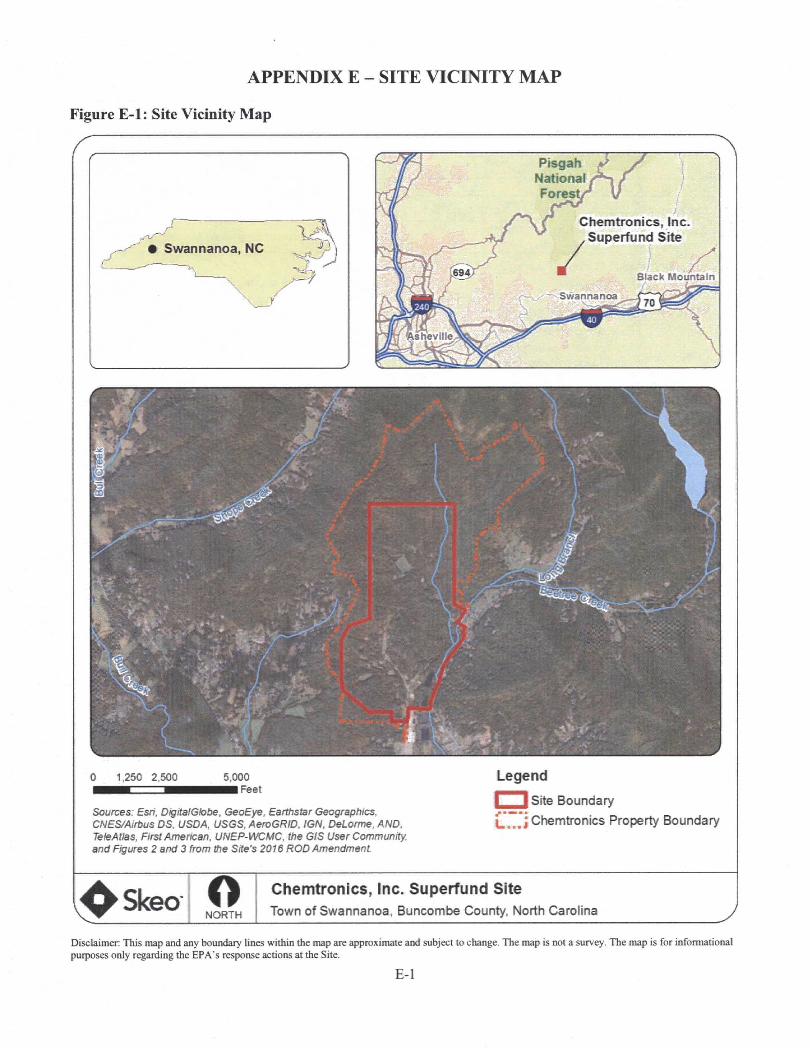
APPENDIX E - SITE VICINITY MAP
Figure E-1: Site Vicinity Map
PisgahNationalFores
Chemtronics, Inc. Superfund Site
/• Swannanoa, NC
Black MountainSwannanoa
hev lie
0 1,250 2,500 5,000■■Feet
Sources: Esri, DigitalGlobe, GeoEye. Earthstar Geographies, CNES/Airbus DS. USDA, USGS, AeroGRID, IGN, DeLorme, AND. TeleAtlas, First Arrmhcan, UNEP-WCMC. the 6/S User Community, and Figures 2 and 3 from the Site's 2016 ROD Amendment
LegendSite Boundary
[J”’] Chemtronics Property Boundary
;^SkeoNORTH
Chemtronics, Inc. Superfund SiteTown of Swannanoa, Buncombe County, North Carolina
Disclaimer: This map and any boundary lines within the map are approximate and subject to change. The map is not a survey. The map is for informational purposes only regarding the EPA’s response actions at the Site.
E-I
APPENDIX F - SITE INSPECTION CHECKLIST
FIVE-YEAR REVIEW SITE INSPECTION CHECKLIST
I. SITE INFORMATIONSite Name: Chemtronics, Inc. Date of Inspection: 01/19/2017
Location and Region: Swannanoa, North Carolina 4 EPA ID: NCD095459392Agency, Office or Company Leading the Five-Year Review: EPA Weather/Temperature: Sunny and 60 degrees
Remedy Includes: (Check all that apply)Rl Landfill cover/containment ^ Access controls ^ Institutional controls r~l Groundwater pump and treatment □ Surface water collection and treatment
^ Monitored natural attenuation □ Groundwater containment l~l Vertical barrier walls
^ Other: The original groundwater remedy, as established by the Site’s 1988 ROD, included the extraction and treatment of contaminated groundwater and the capping of six former disposal areas! The reyised remedy, as established by the 2016 ROD Amendment, includes enhanced in-situ bioremediation, long-term monitoring and MNA to address groundwater contamination at specific silli areas: excayation and off-site disposal of contaminated soil at two FV locations: and institutional controls to restrict site land uses to commercial/industrial use only and to prohibit the use of site groundwater.
Attachments: Kl Inspection team roster attached I~1 Site map attached
II. INTERVIEWS (check all that apply)1. O&M Site Manager
NameInteryiewed □ at site □ at office ^ by email Problems, suggestions Q Report attached:
TitlePhone:
Date
2. O&M StaffName
Interviewed Q at site Q at office Q by phone Problems/suggestions □ Report attached:
TitlePhone:
Date
3. Local Regulatory Authorities and Response Agencies (i.e., state and tribal offices, emergency response office, police department, office of public health or enyironmental health, zoning office, recorder of deeds, or other city and county offices). Fill in all that apply.
Agency NCDEO Contact Beth Hartzell
NameProject 03/20/2017 919-707-8335Manager Date Phone No.Title
Problems/suggestions □ Report attached: Interyiew question responses can be found in Appendix I and summarized in Section IV.
Agency. Contact Name
Title Date Phone No.Problems/suggestions □ Report attached:.
AgencyContact _____ ____
Name TitleProblems/suggestions [~l Report attached:
Date Phone No.
F-1
AgencyContact ____ ____
Name TitleProblems/suggestions Q Report attached:
Agency. Contact
Date Phone No.
Name TitleProblems/suggestions l~~l Report attached:
Date Phone No.
4. Other Interviews (optional) dl Report attached: Intert'iew question responses can be found in Appendi.x I and are summarized in Section IV.
Jon Bornholm, EPA RPM
Residents and Swannanoa Superfund Conmiunity Advisory Group Members
III. ON-SITEDOCUMENTS AND RECORDS VERIFIED (check all that apply)
O&M Documents
^ O&M manual ^ Readily available ^ Up to date □ n/a^ As-built drawings ^ Readily available ^ Up to date □ n/a^ Maintenance logs ^ Readily available ^ Up to date □ N/A
Remarks: PRP contractor maintains hard copies of the Site’s O&M Plan and site-related maintenance logs and inspection forms on site in the FV maintenance shed. As-build drawings can be found in remedial design documents.
2. Site-Specific Health and Safety Plan
^ Contingency plan/emergency response plan
^ Readily available
1^ Readily available
^ Up to date
^ Up to date□ n/a□ N/A
Renmrks: PRP contractor maintains hard copies of the Site’s site-specific health and safety plan and emergency response plan on site in the FV maintenance shed. The Site’s health and safety plan was last updated in August 2015.'
O&M and OSHA Training Records ^ Readily available ^ Up to date CD N/A
Remarks: PRP contractor maintains hard copies of O&M and OSHA training records and certifications on site in the FV maintenance shed.
Permits and Service Agreements
CD Air discharge permit
^ Effluent discharge
CD Waste disposal, POTW
CD Other permits:
Remarks: The Site discharges any treated water from the FV groundwater treatment system to the MSP under an active MSP permit (permit #G-006-13).
□ Readily available □ Up to date □ n/a□ Readily available □ Up to date □ n/a□ Readily available □ Up to date □ n/a□ Readily available □ Up to date □ n/a
5. Gas Generation Records
Remarks:
□ Readily available □ Up to date □ n/a
6. Settlement Monument Records □ Readily available □ Up to date □ N/A
Remarks: PRP contractor performs cap settlement surveys every five years. The last survey took placein 2017. No evidence of e.xcessive settlement was observed. The ne.xt settlement survey is scheduled
F-2

1.
2.
3.
to take place in 2022.
7. Groundwater Monitoring Records ^ Readily available ^ Up to date D N/A
Remarks: Since the shutdown of the Site’s groundwater extraction and treatment system in 2014; groundwater and surface water has been monitored semi-annuallv. Monitoring also includes quarterly surface water sampling, active sampling of pilot test areas, and atmual monitoring of an additional 18 wells, as required by the Site’s current Q«feM Plan. All monitoring records are readily available and are submitted to the EPA for review.
8. Leachate Extraction Records
Remarks;
□ Readily available □ Up to date ^ N/A
9. Discharge Compliance Records□ Air □ Readily available □ Up to date IZI N/A
^ Water (effluent) ^ Readily available ^ Up to date EH N/A
Remarks: PRP contractor submits discharge compliance records to the MSP as required.
Daily Access/Security Logs ^ Readily available ^ Up to date EH N/A
Remarks: Daily access/securitv logs are maintained at the security guard hut at the site entrance. Ali individuals who enter the Site are required to sign in at the guard gateJ
IV. O&M COSTS
O&M Organization□ State in-house
O PRP in-house
□ Federal facility in-house
EH Contractor for state
^ Contractor for PRP
EH Contractor for Federal facility
^ PRP contractor. Anchor OEA of North Carolina PLLC. performs all site-related O&M activities.
O&M Cost Records^ Readily available ^ Up to date
EH Funding mechanism/agreement in place EH Unavailable
Original O&M cost estim^e: See the Systems Operations/Operation & Maintenance section in the main F~^ for detail regarding the original O&M cost estimates. ^ Breakdown attached
Total annual cost by year for review period if available
Year; 2012 Total cost: $424.000
Year: 2013
Year; 2014.
Year: 2015
Year: 2016
Total cost: $315.000
Total cost: $312.000
Total cost; $197.000
Total cost: $164.000
Unanticipated or Unusually High O&M Costs during Review Period

Describe costs and reasons:
V. ACCESS AND INSTITUTIONAL CONTROLS M Applicable □ N/A
A. Fencing
1. Fencing Damaged ^ Location shown on site map ^ Gates secured □ N/A
Remarks: All site fencing appears to be in good condition. Gates are secured with locks.
B. Other Access Restrictions
1. Signs and Other Security Measures □ Location shown on site map □ N/A
Remarks: The front gate and.on-site access are monitored by a security guard stationed in a guard hut at the site entrance. The front gate is clearly posted with wariiihg signage. Signs to deter trespassing and hunting are posted throughout the Site. The Site is marmed by security personnel 24 hours a day. Security personnel perform routine site security inspections.
C. Institutional Controls (ICs)
1.□ Yes S No □ N/A
□ Yes ^ No □ N/A
Implementation and EnforcementSite conditions imply ICs not properly implemented Site conditions imply ICs not being fully enforced Type of monitoring (e.g., self-reporting, drive by): Not applicable.
Frequency:Responsible party/agency: The PRP is responsible for, implementing institutional controls.
Contact ____ _____ _____
Name Title Date Phone no.Reporting is up to date D Yes O No ^N/A
Reports are verified by the lead agency [UYes ONo ^ N/A
Specific requirements in deed or decision documents have been met Q Yes ^ No □ N/A
Violations have been reported Q Yes ONo ^ N/A
Other problems or suggestions: Q Report attached
2. Adequacy □ ICs are adequate ^ ICs are inadequate □ N/A
Remarks: The 2016 ROD Amendment requires the implementation of institutional controls to restrict site land uses to commercial/industrial uses only and to prevent the potable use of site groundwater. The PRP' has submitted proposed restrictive covenant language to NCDEO for review, and approval. Following: approval of the institutional control language, the restrictions will be finalized and recorded with Buncombe County. While not required bv any site decision documents, the PRP paid to prepare and record restrictive covenants with several off-site property owners located east of the Site. The restrictive covenants prevent the use or extraction of groimdwater from the subject properties, and require the closure of any existing wells. The purpose of the restrictive covenants is to prevent the possibility of private offsite wells to potentially impact the location of Site-related groundwater contamination. These voluntary actions bv the PRP aim to further eliminate the potential for future off-site exposure to groundwater contamination. The in.stimtional controls required bv the 2016 ROD Amendment do not specifically prohibit digging at the DAs established bv the 1988 ROD. However, access to the DAs is restricted bv fencing and neither the property owner nor the PRP contractor perform any activities on the DA caps that could potentially impact the integrity of the caps or result in direct exposure to contaminated subsurface soil. Restrictions to prohibit digging at the DAs should be considered in the final institutional controls.
D. General
1. Vandalism/Trespassing □ Location shown on site map □ No vandalism evident

Remarks: Durine the orevious five years, vandalism has not taken nlace at the Site. Tresnassine occurs rarelv. Routine security natrols and sianaee heln deter tresnassine.
2. Land Use Changes On Site □ N/A
Remarks: The site nronertv remains vacant. However, since the orevious FYR. Ae PRP contractor has beeun a nollinator habitat nilot nroiect near the main site entrance to exnlore the nossibilitv of establishinapollinator snecies on ton of the disnosal area cans.
3. Land Use Changes Off Site ^ N/ARemarks: JiV^e there has been some growth of the surroundina residential areas, off-site land use has remained the same since the orevious FYR. There are olans underway to establish a conservation easement area on the Chemtronics orooertv that is not oart of the designated Suoerfimd site in the future. Once established, the conservation easement area will.be used for sustainable forestry oractices.
VI. GENERAL SITE CONDITIONS
A. Roads ^ Applicable □ N/A
1. Roads Damaged O Location shown on site map ^ Roads adequate Q N/A
Remarks: Site roads seem adeauate. They are insoected and maintained as oart of routine site O&M activities.
B. Other Site Conditions
Remarks:
VII. LANDFILL COVERS ^ Applicable □ N/A
A. Landfill Surface
1. Settlement (low spots) Q Location shown on site map ^ Settlement not evident
Area extent: Depth:
Remarks: Settlement was not observed on anv of the six disoosal area cans.
2. Cracks O Location shown on site map ^ Cracking not evident
Lengths: Widths: Depths:
Remarks:
3. Erosion [~~1 Location shown on site mao ^ Erosion not evident
Area extent: Depth:
Remarks:
4. Holes □ Location shown on site map ^ Holes not evident
Area extent: Depth:
Remarks:
5. Vegetative Cover ^ Grass Cover properly established
^ No signs of stress □ Trees/shrubs (indicate size and locations on a diagram)
Remarks: Vegetation on all canned areas annearedto be well-established, healthy and well-! maintained; Site insnection narticinanls observed a small area under the fence surrounding DA-10/1 li where an animal has dug under the fence, to access the canoed area. However, no evidence of digging was observed on the actual can.
6. Alternative Cover (e.g., armored rock, concrete) ^ N/A
Remarks:

7. Bulges
Area extent:
Remarks:
l~l Location shown on site map ^ Bulges not evident
Height:
8. Wet Areas/Water Damage
□ Wet areas
□ Ponding
r~l Seeps
I I Soft subgrade
Remarks:
^ Wet areas/water damage not evident
I I Location shown on site map Area extent:
n Location shown on site map Area extent:
□ Location shown on site map Area extent:
r~1 Location shown on site map Area extent:
9. Slope Instability O Slides
^ No evidence of slope instability
Area extent:
Remarks:
□ Location shown on site map
B. Benches □ Applicable ^ N/A
(Horizontally constructed mounds of earth placed across a steep landfill side slope to interrupt the slope in order to slow down the velocity of surface runoff and intercept and convey the runoff to a lined channel.)
1. Flows Bypass Bench
Remarks:
r~l Location shown on site map n N/A or okay
2. Bench Breached
Remarks:
1 1 Location shown on site map [~~l N/A or okay
3. Bench Overtopped
Remarks:
1 1 Location shown on site map r~l N/A or okay
C. Letdown Channels □ Apphcable ^ N/A
(Chaimel lined with erosion control mats, riprap, grout bags or gabions that descend down the steep sideslope of the cover and will allow the runoff water collected by the benches to move off of the landfill cover without creating erosion gullies.)
1. Settlement (Low spots)
Area extent:
Remarks:
□ Location shown on site map l~l No evidence of settlement
Depth:
2. Material Degradation
Material tvne:
Remarks:
r~l Location shown on site map □ No evidence of degradation
Area extent:
3. Erosion
Area extent:
Remarks:
r~l Location shown on site map n No evidence of erosion
Denth:
4. Undercutting
Area extent:
□ Location shown on site map r~l No evidence of undercutting
Depth:
Remarks;
5. Obstructions Type:
□ Location shown on site map
Size;
Remarks:
□ No obstructions
Area extent:
6. Excessive Vegetative Growth Type:
|~| No evidence of excessive growth
□ Vegetation in channels does not obstruct flow
|~1 Location shown on site map Area extent;
Remarks:
D. Cover Penetrations ^ Applicable □ N/A
1. Gas Vents □ Active ^Passive
□ Properly secured/locked □ Functioning □ Routinely sampled ^ Good condition
□ Evidence of leakage at penetration □ Needs maintenance □ N/A
Remarks: There are passive gas vents located in the APA cap: -The vents.have iTeen sampled' twice to determine-if tfafedisposal area beneath the can emits gases. Gases have never been.detected. The vents are no longer monitored;
Gas Monitoring Probes I I Properly secured/locked HH Functioning
O Evidence of leakage at penetration
Remarks:
□ Routinely sampled
r~l Needs maintenance
□ Good condition
^N/A
3. Monitoring Wells (within surface area of landfill)
□ Properly secured/locked □ Functioning □ Routinely sampled
□ Evidence of leakage at penetration □ Needs maintenance
Remarks: With the exception pf two wells locajed on the outer edge of DA-23, monitoring wells are hot located within the surface of the canned waste disposal areas^
n Good condition
^N/A
4. Extraction Wells LeachateQ Properly secured/locked O Functioning
□ Evidence of leakage at penetration
Remarks:
□ Routinely sampled □ Good condition
I I Needs maintenance ^ N/A
5. Settlement Monuments O Located Routinely surveyed O N/A
Remarks: PRP contractor oerforms can settlement surveys everv five vears. The last survey took niacein 2017. No evidenee of excessive settlement was observed. The next settlement survey is scheduled totake niace in 2022.'
E. Gas Collection and Treatment □ Applicable ^ N/A
1. Gas Treatment Facilities
□ Flaring □ Thermal destruction □ Collection for reuse
□ Good condition 1 1 Needs maintenance
F-7

Remarks:
2. Gas Collection Wells, Manifolds and Piping1 1 Good condition HH Needs maintenance
Remarks:
3. Gas Monitoring Facilities (e.g., gas monitoring of adjacent homes or buildings)O Good condition O Needs maintenance H] N/A
Remarks:
F. Cover Drainage Layer □ Applicable ^ N/A
1. Outlet Pipes Inspected □ Functioning □ N/A
Remarks:
2. Outlet Rock Inspected O Functioning O N/A
Remarks:
G. Detention/Sedimentation Ponds □ Applicable ^ N/A
1. Siltation Area extent: Depth: l~l N/A
1 1 Siltation not evident
Remarks:
2. Erosion Area extent: Depth:
1 1 Erosion not evident
Remarks:
3. Outlet Works l~l Functioning Q N/A
Remarks:
4. Dam HH Functioning N/A
Remarks:
H. Retaining Walls O Applicable ^ N/A
1. Deformations
Horizontal displacement:.
Rotational displacement: _
Remarks:
O Location shown on site map Q Deformation not evident
_ Vertical displacement:
2. Degradation
Remarks:
r~l Location shown on site map □ Degradation not evident
I. Perimeter Ditches/Off-Site Discharge □ Applicable ^N/A
1. Siltation r~l Location shown on site map □ Siltation not evident
Area extent: Denth:
Remarks:
2. Vegetative Growth □ Location shown on site map □ n/ar~l Vegetation does not impede flow
F-8
Area extent; Type:
Remarks:
3. Erosion O Location shown on site map l~l Erosion not evident
Area extent; Depth:
Remarks:
4. Discharge Structure □ Functioning □ N/A
Remarks:
Vm. VERTICAL BARRIER WALLS □ Applicable ^ N/A
1. Settlement Q Location shown on site map Q Settlement not evident
Area extent: Depth:
Remarks:
2. Performance Monitorinn Tvpe of monitorine:
□ Performance not monitored
Freauencv: FI Evidence of breaching
Head differential:
Remarks:
IX. GROUNDWATER/SURFACE WATER REMEDIES ^ Applicable □ N/A
A. Groundwater Extraction Wells, Pumps and Pipelines ^ Applicable □ N/A
1. Pumps, Wellhead Plumbing and Electrical^ Good condition □ All required wells properly operating dl Needs maintenance Q N/A
Remarks: Per the EPA’s anoroVal. the original FV and BV groundwater extraction and treatment systems are no longer in ooeration. Currently, injection and extraction wells are ouerated as nart of oilot tests for areas identified in the 2016 ROD Amendment as needing active remediation.
2. Extraction System Pipelines, Valves, Valve Boxes and Other Appurtenances^ Good condition O Needs maintenance
Remarks:
3. Spare Parts and Equipment^ Readily available ^ Good condition □ Requires upgrade □ Needs to be provided
Remarks:
B. Surface Water Collection Structures, Pumps and Pipelines □ Applicable ^ N/A
1, Collection Structures, Pumps and ElectricalQ Good condition O Needs maintenance
Remarks;
2. Surface Water Collection System Pipelines, Valves, Valve Boxes and Other Appurtenances□ Good condition □ Needs maintenance
Remarks:
3. Spare Parts and Equipment

3 Readily available
Remarks:
3 Good condition 3 Requires upgrade 3 Needs to be provided
C. Treatment System 3 Applicable 3 N/A
1. Treatment Train (check components that apply)
□ Metals removal □ Oil/water separation
13 Air stripping ^ Carbon adsorbers
r~l Filters;□ Additive (e.g., chelation agent, flocculent):
r~l Others:3 Good condition Q Needs maintenance
□ Sampling ports properly marked and functional
□ Sampling/maintenance log displayed and up to date
3 Equipment properly identified
□ Quantity of groundwater treated annually:
I I Quantity of surface water treated annually:
I I Bioremediation
Remarks: PRP contractor currently operates the FV groundwater treatment system in a limited capacity, primarilv to treat purge water generated dtirinp samplinf> activities. The two on-site gmundwater treatment systems are no longer used to treat groundwater from the groundwater extraction systems.
Electrical Enclosures and Panels (properly rated and functional)
□ N/A 3 Good condition □ Needs maintenance
Remarks;
Tanks, Vaults, Storage Vessels□ N/A ^ Good condition ^ Proper secondary containment □ Needs maintenance
Remark: The tanks and storage vessels in the FV groundwater treatment system buildings are clearly labeled and appear to be in good condition. The floor of the building is coated and designed to serve as secondary containment for the system.
Discharge Structure and Appurtenances
3 N/A n Good conditionRemarks:
□ Needs maintenance
Treatment Building(s)□ N/A 3 Good condition (esp. roof and doorways)
3 Chemicals and equipment properly stored
Remarks:
I I Needs repair
6. Monitoring Wells (pump and treatment remedy)n Properly secured/locked (3 Functioning Q Routinely sampled
r~l All required wells located [3 Needs maintenance
3 Good condition
□ n/aRemarks: Site groundwater is no longer being extracted and treated. See below, under Section E. for well condition information related to MNAJ
D. Monitoring Data
F-10
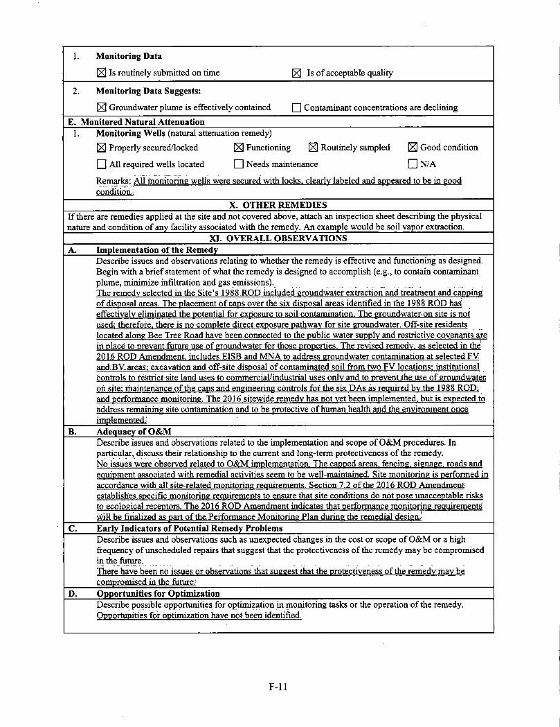
1. Monitoring Data^ Is routinely submitted on time ^ Is of acceptable quality
2. Monitoring Data Suggests:^ Groundwater plume is effectively contained □ Contaminant concentrations are declining
E. Monitored Natural Attenuation1. Monitoring Wells (natural attenuation remedy)
^ Properly secured/locked ^ Functioning ^ Routinely sampled Good condition
r~l All required wells located O Needs maintenance O N/A
Remarks; All monitorine wells were secured with locks, clearlv labeled and anneared to be in eood condition.,
X. OTHER REMEDIESIf there are remedies applied at the site and not covered above, attach an inspection sheet describing the physical nature and condition of any facility associated with the remedy. An example would be soil vapor extraction.
XI. OVERALL OBSERVATIONSA. Implementation of the Remedy
Describe issues and observations relating to whether the remedy is effective and functioning as designed. Begin with a brief statement of what the remedy is designed to accomplish (e.g., to contain contaminantplume, minimize infiltration and gas emissions). __ ____The remedv selected in the Site’s 1988 .ROD included eroundwater extraction and treatment and cannihe; of disDosal areas. The nlacement of cans over the six disposal areas identified in the 1988 ROD has effectivelv eliminated the notential for exposure to soil contamination. The eroundwater on site is not used; therefore, there is no complete direct, exposure oath wav for site eroundwater. Off-site residents located alone Bee Tree Road have been connected to the public water supply and restrictive covenants arein place to prevent future use of eroundwater for those properties. The revised remedv. as selected in the 2016 ROD Amendment includes.EISB and MNA to address eroundwater contamination at selected FV and:BV.areas; excavation and off-site disposal of contaminated soil from two FV locations; institutional controls, to. restrict site land uses to commercial/industrial, uses only and to prevent the use of eroundwater oh site; rhaintenance of the caps;and eneineerine controls for the six DAs as reauired bv.the 1988 ROD; and performance monitorine. The 2016 sitewide remedv has not vet been implemented, biit is expected to address remainine site contamination and to be protective of human health and the environment once implemented.;
B. Adequacy of O&MDescribe issues and observations related to the implementation and scope of O&M procedures. In particular, discuss their relationship to the current and long-term protectiveness of the remedy.No issues were observed related to O&M implementation. The canoed areas, fencina. sienaee. roads and eauipment associated with remedial activities seem to be well-maintained. Site monitorine is performed inaccordance with all site-related monitorine reauirements. Section 7.2 of the 2016 ROD Amendment establishes.soecific monitorine reauirements to ensure that site conditions do not nose unacceptable risks to ecolocical receotors; The 2016 ROD Amendment indicates that performance monitorine reauirements will be finalized as part of the. Performance Monitorine Plan durine the remedial desien.'
C. Early Indicators of Potential Remedy ProblemsDescribe issues and observations such as unexpected changes in the cost or scope of O&M or a high fi'equency of unscheduled repairs that suggest that the protectiveness of the remedy may be compromised in the future.There have been no issues or observations that sueeest that the protectiveness of the remedv mav be compromised in the future.'
D. Opportunities for OptimizationDescribe possible opportunities for optimization in monitoring tasks or the operation of the remedy. Opportunities for optimization have not been identified.
F-11

APPENDIX G - PRESS NOTICEfAGCtA 3 MONDAY. lUlY 11. 201« 1 ASHCVliLI CITIZEN-TIMES
STAIFRlFOrn
wow vf pubkjHion.
Cwtom Ofi tta QwM; fMturaig Mh> liMv •Or « /(MTi at UHC Asiwvrto Frw S2K-2SV »74 Of unta #ao««*m.
IkaosMon AatwwUto Sodafc SJM p m. St MaryT Epncopal Owc^ S7 Owtooe %. AtttMite Topic n iMdato $■: A Corwmathsn aboto IK)p* fraoTH Entycttca* Nd Karan Bch- WiixHc Ounrv
Pottwy CMip for kMK iuV n' TS. Transyi wru Communny Arts CMocd. »«1 CaliKwO ScNawarP Sajvi ^toontot agwS^IOand tJO- 430pm foragsmiS.UX LawnvxIprK- tkv baMC baofHMkting 82MS427S70»1^HkCMWwBo*ECiw>iM»)uNW-
mOa-m Spm.bm«MnEccM«a9e.SCDn»rv uOKlABUcKIt
our piML S70S hRp;M
local OWmq* 6 p.m. Mondays. Attv<la N«atf Ccmp«iy. S2J Memmoo Aw. Aitw«We. Learn % piay crAbagc AH tarab and ages EnioyaUla(arylMnctiAowt1IMngttwbartMfatwtaatand«ft nrlTimr ttnimnlgmui ritmTi>rrairnutiTirr 14atHmMnca CoMBty PiAAcUbr^ 301N. Watlwt«tan SL. H Contact OonaM Darum at 40ASa&?»« or Ad»
MyU
AMtCnna; 7 jO p.m. trfMKd Muik Cantar. 3*9 Afldantv Larte. 8i«wd. A bras-imian9ar»- u nnS) facuffy and itudanb. iZS. larm (IS vvww.brivardmwMcarG.
Shay iMMMaral dbncinv: Ewry Aandair at SSO TavtMn 4 Gri»e. SSD Airpcrt Road. Retcn- m. Free lewan 6J0-7 p m. No pwtner needed Rotatmp Dl>\ 7 tO pjn ST coimr dt*9« 82S 196S3S2 or wwfw.mguntonrnapciubr om.
CUfh Cour^ Oub. Cadran. Fcattaad grraltw it Si4>remc Giuct ;wlKa Sob Ednuxft For mianra- ttora. Wonnatiar and » ud S3 743-1&B or email nitnr«publicatciMim«n9yaboo.cam
Satie Dag EaWhurtair 7 8 pm tetdayi. Fwnpemd Pms kin 4 Spa. 1318 Oada NomeNnad. Aahewlie LadbyAppataLManTaADogliainirtg. Thneoune wo for wXHWora. Cartbejeanedarv ILmdar wtn no need to «wot tar ttaiT dam. S13S 428-338 9K2 or *ma*avldo^a>m
evmy Wednraday to Aug. K Nature orient ed program for ago 4-12. tkplotet topics re Utad to orientaortng, forestry and forett fwattb. Saper ctifid. S2.SOfor accomparrt'trrg adultv 828 877 3130 or http/Awww.crodte- ofiomtry.ccm/everttv.
Wptarlalta G IMm t«yn: Noon 4 p m Wedneadayt unbl Aug. 31. Meet m perking tat at 190 C Mam St. Steward Pitgah Field School will guide you Co off the beaten path wateHalh Erxl me trip m downtown Sr#
• taiUng ar hnp;//
pngafthetd comSoesi opart mIc 8 pm. The Aitamont
Thene, 18 Ctairch St, Mhewife NobN Kawa
IMeray Lunch with KeeSi Ad—, outdoor auOter and pbcMgrapNer MetidetkooCounlvPub(*.Ubrafy.301N WKCw.gwnSt.Herr dartnrwiB# About flndtagthebvtMKteiteliiand wildf)r>wentnWNC Free 82G897-472$.
Rcnamance Hotel. 31 Woodfin St. di N.C. board oi nantportatrem member Oamf Down wiU dheuK the tX Connecter popet hRpAWww.nitaiyeitieUlle.org.
Woodin. SSdonalion.Sringyaurpupandmirt wrth fedow dog lowert. wwwaihe«iaehu- nveie.org.
PMwMwg SUS SNmw 4^730 pm. UUng WebrKnp176IGm«»1toed.WfcSNer.tNBwifl corer preparation and tweiBng of coppn ppi with idi«i Miidef. where «id wby Co loedVercni typer of copper Other optmoKtidevae of PEX
Friday. «o Pug. (9. Ntattart Cantw. 201 S Mam SUHendtiWiWie. Henderwnwne AnthpreCai
tit.im jham.ntm.M SIgM; An SeanSiB M MM NaaMpg: A*N
IVC. 7je pm. Nor» Carcirw Stage Company, IS Staga Lane. Adwak. Michael Spremuffi ttta tae
ita Fair iuV IS 23. Gacagia k.(3l1M«iiHaflitoad.Ha
anttch Ltarwy. 11 FenrsyNana denng Wk to tevn to <jae kochen 1mp^ MMB
Broad Awe. AchevPIe. latmo tamOev dam to eat more hMittai andparbdpete e. tan pFqvcai actMty. Ttai progrvn if lad MMy d tha SpwHh
braa.andShar
« pipe, tubing, and ft»r»-lm«ng. $10 fupgmeddonatiorvS2M81-44S7artatadSMng-
enrirh yourml. Free 82»«a-2924.
Junior ForoUar Srckpam-1030 am. 1230 VMCA.277SI pm.OadleolFore«ry.OW7SS.P«gahForett aweiylhuTd
B3S2S4-72Q4. e«t. 212. AAo freegym i •hip eaei week you enand.JN^M
ftatary CM- 710 am. FMctmr
member 4-8 pm. luncambe Coratty Oei
wanee. Geaorg*. $12. <reeagal2andyamg«.
Square darwe: 4 pm. Ufhibnira Actirrty Center. 301 L>^ Fond Road. HmderfamaPeHod edby Southern ligho Square and Round Dance
h. 951 Od Fmrvicw Itaad, MhewWe. To dhtuH poklicaf iisuet perlinent to lenlort
arty Oub. FM ua on FacebooK. V
urychtao^
ngheid 7-9pm.ewery1^KidBya(ihebfwetk)n Army Gym. North Grove Street
<aenoe ruwnlon; Noon at Paaveidun Com- munrty Center. IQO North Canton Road. Cat^ ton Ding a dhh lo ihere. hRp*3Nivww iac*- book camwvm-itvT(K60312444(B23Sf'
Officers search for
missing Candler teeneyes. 'Hayum wgp last ,«en mating u blue jtascy-iypvTebiitwdhiai 'A'andtatgipa' leftdMliMi Uwchecfc«red{}Riam»l>-pe pants wiSi a echile jpiwmpe and btrrwn worn wort hoota. Mrkr ww tan ami Mving ti» rentteini m .StaiKB Owe Rond OR Md osy be in ttta EflfchCmdlurarw.«uGudb««P8 rdeeoe on ibe dieri^ offioefbcMMiii^
AiTMW who M aecB Hayam or huK my MlsmsbaR ref^nteit bis wbm-dboica. ttcaae notify ibe Buacnnibe Comty iktentTi OO'tce at .SdSfl.
ASliEVIiJj-: Bwi-enmbe COonty sbenfra
^ deputies are aertiOR to- » ■ foraudinn to locate a Caa-
Mj M dler (eenatier wbo to ■f ^ been munne aiat-e Pri-
Of CABbllirr. b: a ISindi. UDfittflid ututi: nude, with brown hair Mel taromi
Asheville police arrest man on burglary charges
A.S^1U£ Mice bne dM«ed an
UTAtoysaJndieU
w Ue CoaiBit«9. .39. of Rock HiU Cirde. w» charged wRh braabaR Md entehiNi a tHukliLnft oo Rock Hill RokI onSaiurdav- steatuig a&Mwted riardnin*.
aoth|ues.e{«cTruckic:i Mhl ulhttr items. ac con^ to wsmuita fitad at the Bun corab* Ownr)' MRSismte's Court He waaaliodunted wirhtloraaeetapniTwr ty. mdathitg a bidBea nnk. cmimtx WNtbanddmin Hr ww beii« bdd in the BoKoenb* Comty Drtoitiiiii Fadliiy with a araved boib art at $2t}J)0i.l.
Cimmtto ta adMulad to make b» fint apmamnev Mumfoy m Buncooibe Cotewylhjitna Court
Black Mountain man arrested on meth charges
SWANNANOA BupuMie Comfy filainlT'Bili^iuiMsarreatedal&^MrNiR- totaianSanirday cniRm
___________ dmrtes. warraiBs abua'.XlitxwdU ^tenIBn Ada
Mnnu 24. ti W&tonrt Drive, ww amtod in the H» toll and andchBfUHl wdh poRwsm <der^UwdUelld^accnnS mg to EtaBmenabeauMv Shehirs Dei^MS.
County Detertion Facility wtth a s« cwvd btNMl set at SSO.OOO un all charoeK. He was ecbrdidoil to make Iw find ap- msrance kfooda)' in Buncombe County uitrict Court
hi other drug armtts • Ihmdia Nlctrfr CamMh'. 24. of (intiw)-
ra Bouies-ard. Aabevifle. was cbarjted with piwesKNin of RM!th»RpbKaiBDM'. a glww BWlh pipe and (tobcbtisKHS Sbewaiibe ins hM uniter SS.'IW wcwrd bond
» Jessica FatlecK-Mod. X of DU Stmaih Kml. Antes, ww chained wdb puBwnwn itfDwttiHniiMnDemdaiitoiaMbpIpe 2a» wa» heiDg heU with huod .«C at (Uno
S>EPAThe United States Em irorni^tal Protection Aj^cncy Announces a Public Meeting and Public Comment
PerkMt for the Chemtronks Superfund Site located in Swannanoa. North Caro&ia
The United States Ejivironmenuti Protection Agency (EPA) ha.s issued a Proposed Plan u> amend the 1W8 Record of Decision (ROD) for the Chcmtronics Superfund Stic Uxated in Swannanoa. North Carolina.A puMic meeting to present the details of the Proposed Plan w ill be held on Thursday, July ! A 2016, from 6:30p.m. to K:30p.ni. at the Swannan<»a Fire Department located at SIO Bee Tree Road in Swannanoa.
EPA Is conducting a 60-day public comment period from July 14,2016, thru September 12,2016, lo seek public input on the Proposed Plan. During the coramcTU period, the public is encouraged to review the Chcmtronics Administrative Record and offer comments on all site-related documents. You can find these documents located ai the liifotmatton Rqxisitory housed at the EiUson Library on the campus of Warren Wilson College. 701 Warren Wilson Road in Swannanoa.
Written comments lki the Proposed Plan should be submitted oo later than September 12,2016. to Jon Bondiolm, EPA Remedial Project Manager. US>EPA Region 4. Superfund Division - I Ith Floor, 61 Forsyth Street. SW. Atlanta. Georgia 30303. or via email [email protected].
For farther infomiation please contact Angela Miller, EPA Cfunmunity Involvement Coordinator, directly (6781575-8132 or via email millef;.awieli@epa4wv.
G-l

APPENDIX H - SITE INSPECTION PHOTOS
'■'■7 5^=:'^
m~r~. I^ m - •'' m-- L
A locking gate, marked clearly with warning signage, restricts access to the Site.
fii^? 11 P^*i**^—I
Nm
mliiiili*
Upon site entry, all visitors must sign in with the security guard at this hut at the front gate.
H-1

. - " .'•■■I
Exterior of the FV maintenance sh^.
'mmmM
PSPRP contractor Anchor QEA maintains training records, O&M inspection records and
manuals, monitoring reports, and the site-specific health and safety plan on site at the FV maintenanceshed.
H-2

4 mmMmrn,4, ' ; ••'. ^'“v-v-*,.
P •' *’ •■*r«'U-;r f .
1»%FV groundwater monitoring well MW-202, secured with a lock, clearly labeled and in good condition
1^mi-:
it
TReSPASSiNGhunting
FISHING
m■^m
mmmi/i\i
hazardous
M'W-4II«\
Examples of signs posted across the Site.

■• o*" ".' : .i^VviSfW-Area B104: pilot study location and one of the FV areas selected in the 2016 ROD Amendment for
active remediation.
m'-L- ■ r, ..r-!
siste 'V-lp.ciMl-
A locking gate and tall fence topped with barbed wire restrict access to FV disposal area DA-10/11 Warning signage is clearly posted on the fence that surrounds the cap.
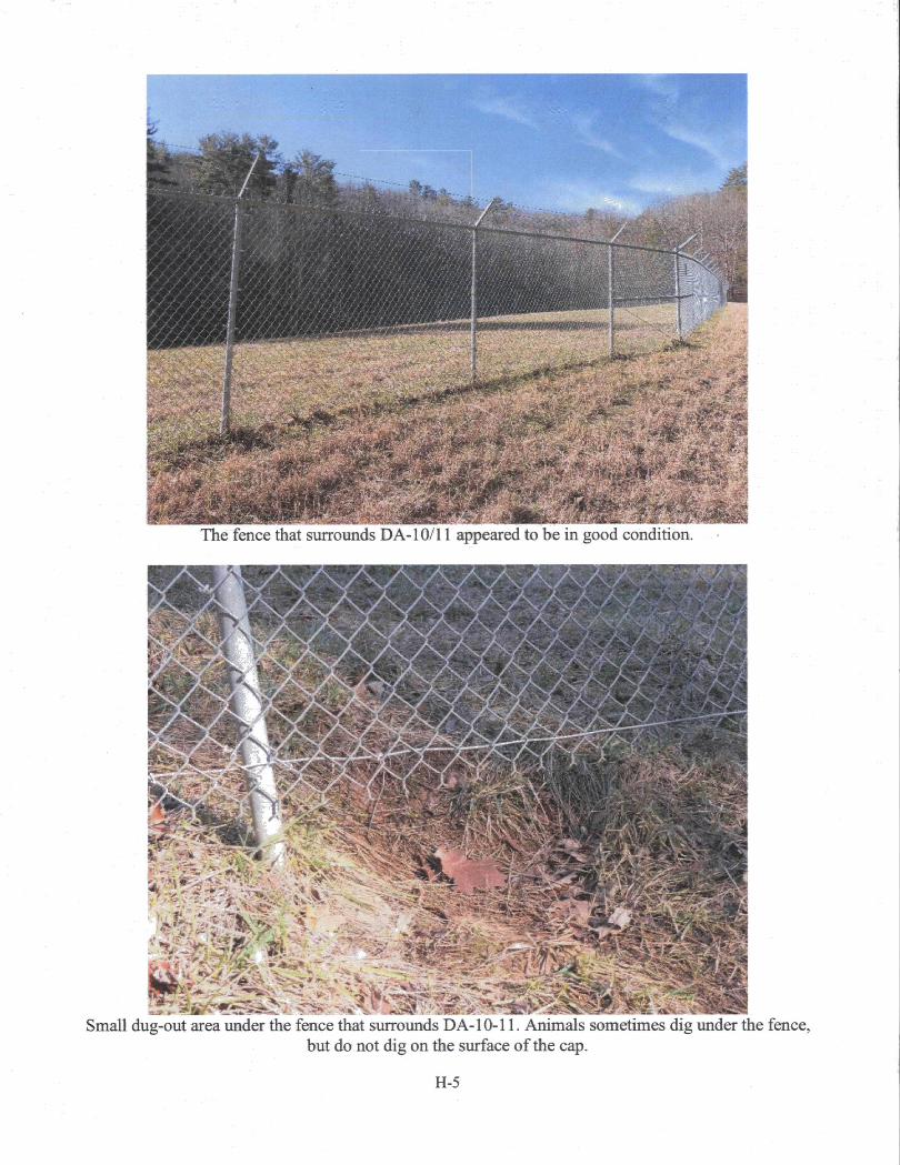
kbst-K
///~Xy^‘y ■. i //■/':////. Ill
pfc*lpi:«sw m
I,.. -
f"-" ■ -; '.ii
®ll«"
W^'‘
ilTSTtf
Smm-MmmmwM m:^M
The fence that surrounds DA-10/11 appeared to be in good condition.
—^1
vv lirsirv;
,' '■' '.‘'5^ '.‘S' Jfi
Small dug-out area under the fence that surrounds DA-10-11. Animals sometimes dig under the fence,but do not dig on the surface of the cap.
H-5
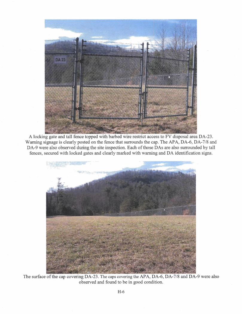
\ "ffaj■ll
'4;ii:''f:■M 4 ;4-'ir
"i-sMi.:. ' jffl^iM I sa#; i&: -^
IP' mmmsm
■Min-■#>■.■ ' ;^-
A locking gate and tall fence topped with barbed wire restrict access to FV disposal area DA-23. Warning signage is clearly posted on the fence that surrounds the cap. The APA, DA-6, DA-7/8 and DA-9 were also observed during the site inspection. Each of those DAs are also surrounded by tall
fences, secured with locked gates and clearly marked with warning and DA identification signs.
wm
m'mm
The surface of the cap covering DA-23. The caps covering the APA, DA-6, DA-7/8 and DA-9 were alsoobserved and found to be in good condition.
H-6

BiSMBwaai I
Wr^
.i-:-
f#Area B109, shown above, is one of the FV areas selected in the 2016 ROD Amendment for active soil
remediation.
. 'J.- . .j. E.
The area shown above is downgradient of the APA in the BV. It is one of the BV eireas selected in the 2016 ROD Amendment for active groundwater remediation.
H-7
liMi^
The BV groundwater treatment system is no longer in operation.
W'-'F'^A: k
■.'» „..;.KM^'A/ts»5:-
ii ''rN
i®SfW
•^■'-'rr^^j^'’5jA;rvti,e~.-.' -.,■ ■•T:«jfc. w-i; - ,-',i .-^aa,. ri
mmm3sg^:i-^MSurface water sampling location in Gregg Branch Creek.
H-8

mm. wmiimm 11i-,:'■'" v% ' -J'
"mmt«»S5«S^^ 1 E. S S
■s' 1
W'wmKsSS
^msmmBee Tree Creek along the eastern edge of the Site, near MW172-T32D.mm
r\M#7: = i si;£
■ i'.v ■ IIImmm^.mm
mn■ .r .:.»:f"i^
The FV groundwater treatment system building.
H-9

L'itui
:.r.':9?;*
si
Groundwater treatment system components inside the FV groundwater treatment system building.
'V‘
Wl""■■■■■■ . . -
W-
Pollinator habitat test plot near the site entrance.
H-10

APPENDIX I - INTERVIEW FORMS
Chemtronics, Inc. Superfund Site Five-Year Review Interview FormSite Name: Chemtronics. Inc. EPAIDNo.: NCD095459392
Interviewer Name: Subject Name:
Affiliation:Affiliation:Jon Bornholm __
Subject Contact Information: [email protected]: ___________ Date: 1/27/2017Interview Location: ______________________
EPA RPM
Interview Format (underline one): In Person Phone MaU Other: Email
Interview Category: EPA Remedial Project Manager
1. What is your overall impression of the project, including cleanup, maintenance and reuse activities (as appropriate)?
The effectiveness of the pump-and-treat systems, one in each valley, required by the 1988 ROD was moderate. The following capped disposal areas have not adversely impacted groundwater quality: DA 6, DA 7/8 and DA 10/11. Contaminants continue to migrate/leach into the groundwater from the other three capped DAs: DA 9/DA 23 and the APA. The site-wide Rl/FS successfully led to the issuance of the 2016 ROD Amendment No. 2. The site-wide Rl/FS identified some additional groundwater contamination in areas of the Site that were not investigated as part of the earlier Rl/FS. As part of the site-wide Rl/FS, numerous EISB pilot-scale treatability studies were initiated - five studies in the FV and one study in the BV. The PRPs are continuing four of the EISB pilot-scale treatability studies in the FV as well as the one BV study. The fifth EISB study in the FV successfully treated the levels and is now being monitored.
PRPs are maintaining the property and there is a 24-hour, seven-day-a-week guard on site. Since the pump-and-treat systems were shut down in 2014, site personnel conduct the following activities: EISB study monitoring, routine maintenance of capped areas/roads and annual monitoring. The 2016 ROD Amendment No. 2 split the Chemtronics property into the Chemtronics Superfund site portion (the Site) and the Chemtronics property portion. All known contamination in the soil and groundwater are contained within the Site’s boundaries, which encompasses 535 acres. The Chemtronics property portion encompasses 530 acres. Chemtronics, the owner of the property, has been working with the Southern Appalachian Highlands Conservancy to place a conservation easement on the property. Land use restrictions will also be placed on the Site through the State’s DPLURprocess. Model DPLUR language was included in the 2008 AOC negotiated between the EPA and the PRPs.
2. What have been the effects of the Site on the surrounding community, if any?
None that 1 have been made aware of.
3. Are you aware of any complaints or inquiries regarding site-related environmental issues or remedial activities since the implementation of the cleanup?

The following concerns/questions were expressed by the community during the 60-day public comment period on the Proposed Plan:
• Past disposal practices/disposal areas.• Past manufacturing activities.• Areas of concern/contamination.• Size/stability of identified plumes and defining extent of contamination.• Length of remedial action/monitoring.• Institutional controls/site boundary/redevelopment of Site and/or property.• Truck traffic/wear and tear on roads.
These were addressed in the Responsiveness Summary of the 2016 ROD Amendment #2.
The EPA and the PRPs have been active participants in Swannanoa Superfund Community Advisory Group meetings by giving presentations and conducting question-and-answer sessions.
4. What is your assessment of the current performance of the remedy in place at the Site?
As stated above, the pump-and-treat systems were marginally successful. Data collected on the EISB studies shows that EISB should successfully treat the contaminants in the groundwater. The primary drawback of this technology is the length of time to achieve cleanup levels. The Rl/FS estimated a timeframe of 30 to 70years to achieve RAOs (i.e., groundwater cleanup levels) for all areas being addressed.
5. Are you comfortable with the status of the institutional controls at the Site? If not, what are the associated outstanding issues?
The 1988 ROD did not require institutional controls. The 2008 AOC and the 2016 ROD Amendment #2 require placement of DPLURs on the Superfund portion of the Site.
6. Are you aware of any community concerns regarding the Site or the operation and management of its remedy? If so, please provide details.
Refer to question #3 above.
1. Do you have any comments, suggestions or recommendations regarding the management or operation of the Site’s remedy?
No.
8. Do you consent to have your name included along with your responses to this questionnaire in the FYR report?
Yes.
Site Name: Chemtronics. Inc. EPAIDNo.: NCD095459392
Interviewer Name: Subject Name:
Affiliation:Beth Hartzell Affiliation: Project Manager, NCDEQ
Subject Contact Information: [email protected]: ___________ Date: 3/20/2017Interview Location: ________
Interview Format (underline one): In Person Phone MaU Other: Email
Interview Category: State Agency
1. What is your overall impression of the project, including cleanup, maintenance and reuse activities (as appropriate)?
The project seems to be progressing smoothly, especially with the signing of the ROD Amendment #2.
2. What is your assessment of the current performance of the remedy in place at the Site?
The remedy chosen under the ROD Amendment #2 looks like a very good remedy. The remedial design has not been completed.
3. Are you aware of any complaints or inquiries regarding site-related environmental issues or remedial activities from residents in the past five years?
No.
4. Has your office conducted any site-related activities or communications in the past five years? If so, please describe the purpose and results of these activities.
Working on the RI, FS and ROD. The result is the ROD Amendment.
5. Are you aware of any changes to state laws that might affect the protectiveness of the Site’s remedy?
No.
6. Are you comfortable with the status of the institutional controls at the Site? If not, what are the associated outstanding issues?
The State is currently reviewing the land use restriction language that will be put in place at the site as a result of the ROD Amendment.
7. Are you aware of any changes in projected land use(s) at the Site?
No.
8. Do you have any comments, suggestions or recommendations regarding the management or operation of the Site’s remedy?
No.
9. Do you consent to have your name included along with your responses to this questionnaire in the FYR report?
Yes.

ChemtronicsASiiperfiutd.SlpySite ChemtroaicsName:Interviewer __________Name:Subject Name:Subject Contact Information:Time:Interview Location:
Five-Year Review Interview Form EPA ID No.:
Affiliation:
I.
g>2^ io{.
Interview Format (circle one):
In Person Phone Other:
Interview Category:
I. Are you aware of the former environmental issues at the Site and the cleanup activities that have taken place to date? V-fs
2. What is your overall impression of t^^ojec^indudi^cl^up, maintenance and reuse ~y'*
?lSiy?ml”45aS'Sj2-4. Have there been any problems with unusual or unexpected activities at the Site, such as i j_ l___
emergency re^xmse, vandalism or trespasang? X fiv*. cJo&«
5. Has EPA kept involved parties and surrounding neighbors informed of activities at the Sitc?|.«s- How can EPA b^ provide site-related information in the fiiture?X'm. % noa-wJix- V ‘Ht*. Susn***.***.Step*r-iuMi \n^ rjL<Lfc^.%\\n. vIol
6. Do you own a private well in addition to or instead of axessing city/municipal water supplies? If so, for what puipose(s) is your private well used?
7. Do you have any comments, suggestions or recommendations regarding any aspects of the project? CLw.f
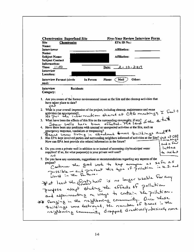
Chemtronics Superfund Site Five-Year Review Interview FormSite ChemtronicsName:Interviewer _____Name:Subject Name:Subject Contact Information:Time: I *. JOInterview Location:Interview Format (circle one):
EPA ID No.:
Affiliation:
Affiliation:
Date: J2.- IO--20l'7
In Person Phone (^^aU^ Other:
InterviewCategory:
Residents
1. Are you aware of the former environmental issues at the Site and the cleanup activities that have taken place to date?
2. What is your overall impression of the project, including cleanup, maintenance and reuse ^ i
3. What have been the effects of this Site on the sunounding commimty, if any’ rjfl.Ux-i\s 'T^®- loory. ®
4. Have there been any problems with unusual or unexpected activities at the Site, such as emergency response, vandalism or trespassing?
L.>.4-rUL.> iTyr*-. ^ O-Vs t'-r.Auvvi.5. Has EPA kept involved parties and surrounding nei^bors informed of activities at the Site? oi c^tCAQ
How can EPA best provide site-related information in the future?
-Itj ii—6. Do you own a private well in addition to or instead of accessing city/municipal water
supplies? If so, for what purpose(s) is your private well used?no
7. Do you have any comments, suggestions or recommendations regarding any aspects of the
_L 4, k-f-pcss-.\o\^ - V r
^ ^ V^L-5<_
tA.,5.
O-r-A
-K^4> uw'.\A?'<-^ ^
o-r\<n ^ c.e>sv»^
'W- -------- ''Ct, o>-(x^
^ cir«.Aro&.lly^l>ab\ce.iV.j

C '41a. ^V4n(aTI - —^^oCASS 0^ ^^£TV^
s a. ^Ii>.i- -„r . X 'S-''-'^^ <5 -r. e \^■' ^ ■< ‘Tv4i *~ “ ^
c,

Chemtronics Superfund Site Site ChemtronicsName:Interviewer ___________Name:Subject Name:Subject Contact Information:Time: 7-.3C)Interview Location:Interview Format (circle one):______' _____
Five-Year Review Interview Form EPA ID No.:
Affiliation:
Affiliation:
Date; c3/^//7
PhoneIn Person Other
InterviewCategory;
Residents
1. Are you aware of the’ former environmental issues at the Site and the cleanup activities that have taken place to date? yiS- S
2. What is your overall impression of the project, including cleanup, maintenance and reuse activities (as appropriate)?
3. What have been the effects of this Site on the surrounding community, if any?A /.oTtCRjS.ST'
4. Have there been any problems with unusual or unexpected activities at the Site, suet as ^ emergency response, vandalism or ttespassing? AJ
5. Has EPA kept involved parties and surrounding neighbors informed of activities at the Site?How can EPA best provide site-related information in the future? V'S-S. i^e,^
ts/Oji-0 HC- (So3 O /
6. Do you own a private well in addition to or instead of accessing city/municipal water supplies? If so, for what purpose(s) is your private well used?
7. Do you have any coniments, suggestions or recommendations regarding any aspects of theproject? 774-4-yK-pojt- t"W2- of' ,'/vy
l<eeJ^ "'-e- !
gr - I ^ / 3 S'
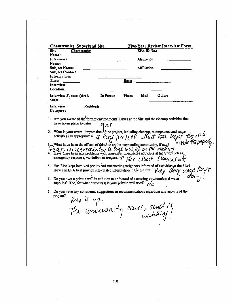
Chemtronics Superfund Site Five-Year Review Interview FormSite __Name:InterviewerName;Subject Name: Subject Contact Information: Time: _____ Interview Location:
Chemtronics EPA ID No.:
Affiliation:
Affiliation:
Patei
Interview Format (circle one):______
In Person Phone Mail Other:
InterviewCategory:
Residents
1. Are you aware of the former environmental issues at the Site and the cleanup activities that have taken place to date?
^ Liai iidivc UK ui Uii:> OIK vu uic 5uiiuuiiuuig <rUiiuiiuiui.jry u ^1/
4. Have mere been any problems unusualSor unexpected activities at the Site, such asemergency response, vandalism or trespassing? (JUjjJ- [^QuJaT
5. Has EPA kept involved parties and surrounding neighbors informed of activities at the Site? ^How can EPA best provide site-related information in the future? ^ ^'u Y
6. Do you own a private well in addition to or instead of accessing city/municipal water ^ -supplies? If so, for what purpose(s) is your private well used?
7. Do you have any comments, suggestions or recommendations regarding any aspects of the
?' y V

Site Name: Chemtronics. Inc. EPAIDNo.: NCD095459392
Interviewer Name: Subject Name:
Affiliation: Affiliation: Swannanoa Sunerfund
Community Advisory Group
Subject Contact Information: Time: Interview Location: _____
Date: 5/16/2017
Interview Format (underline one): In Person Phone MaU Other: Email
Interview Category: Questions submitted to EPA by members of the SwannanoaSuperfund Community Advisory Group
1. Page 5 of the FYR (draft) indicates at the bottom paragraph that "the site is not currently in use and there are no current plans for reuse." My question is: at previous CAG meetings, the PRP's representatives have indicated they mi^t want to do something with the land (i.e. sell timber), is that just speculation/hope instead of "a plan?"
The Agency does not know if the conservation easement with the Southern Appalachian Highlands Conservancy will allow for light timbering. The Agency is not a participant in this agreement. The Agency does anticipate that the language in the forthcoming North Carolina's DPLUR (Declaration of Perpetual Land Use Restrictions) will include language that allows Chemtronics, Inc. to conduct some type of light timbering on the Superfund portion of their property.
2. At last week's CAG meeting, Jon, you offered speculation on why a contaminate was spreading when in previous years it was not. The speculation was that now that the pump and treat has been discontinued the contaminate is now in an anatomical condition and is moving with ground water. My question is: can pump and treat be resumed in that area?
Instead of turning on the pump and treat system in the Back Valley which may have a negative impact on the ongoing pilot scale treatability study downgradient of the Acid Pit Area and Disposal Area 9, the PRPs are planning to implement another pilot scale treatability study in the vicinity of BW-I4 to address this newly detected groundwater contamination. BW-I4 is located approximately 500feet from the property boundary. EPA and NCDEQ is currently reviewing the plans for implementing this pilot scale treatability study. The PRPs are hoping to begin work on this study in
June/July of this year (2017).
I-IO

APPENDIX J - EXAMPLE OF OFF-SITE RESTRICTIVE COVENANT1 of 7
Workflow Mo, 0000384209-0001 Dr-Doc 10: 030671820007 TvDC CAPRscordad: 11/08/2016 at 04:09:12 PM Fee Ant: 828.00 Peae 1 of 7 Workflow* 0000384200-0001 Bunconbe Countv. NC Draw Relelnoer Realster of Oeede
-5488-1832-1838
Prepared by and return to: Jillian W. Ballard of Roberts & Stevens, P.A., Post Office Box 7647, Asheville, NC 28802 (Box 39)
STATE OF NORTH CAROLINA
COL-NTY OF BUNCOMBE
DECLARATION OF RESTRICTIVE COVENANTS
THIS DECLARATION OF RESTRICTIVE COVENANTS (hereinafter referred to as th^^DeclaratioiO^n^e this ,0 day of ^^20^. by and between
unmarried (hereinafter ref^red toas^^^^H or "Owner"), and CHEMTRONICS, INC., CNA HOLDINGS LLC, and NORTHOP GRUMMAN SYSTEMS CORPORATION (hereinafter referred to as "Performing Parties"). The Owner and Performing Parties may collectively be referred to as the "Parties" or individually as a "Party".
WITNESSETH:
WHEREAS, Meador is the owner of that property described in a deed recorded in Book 3994 at Page 730, Buncombe County Registry, with Buncombe County Tax Identification Number 9679-87-9368-00000; and,
WHEREAS, Performing Parties arc managing enviroiunental response actions at that property described in a deed recorded in Book 1206 at Page 121, Buncombe County Registry, with Buncombe County Tax Identification Number 9780-04-5253-00000 which is in close proximity to the Property; and,
WHEREAS, Performing Parties have requested Owner restrict his properly described above (hereinafter collectively the "Restricted Property"), prohibiting the use of groundwater located thereon, and Owner has agreed as set forth herein.
NOW, THEREFORE, Owner hereby declares that the Restricted Property, as defined above, shall be held, conveyed, encumbered, leased, rented, used, occupied and improved subject to the following restrictive covenant:
1. Restriction on Groundwater. Owner shall not use, extract, or otherwise access any groundwater located on the Restricted Property for any purpose. The Restricted Property is served by a water supply line running along Old Bee Tree Road, and therefore wells are not
RiS isn074_l
Page 2 of 7L.
required or permitted on the Restricted Property. Any existing wells shall be closed and prohibited from any further usage.
2. Binding. This Declaration is to be a covenant and restriction runnmg with the Restricted Property and shall be binding upon Owner, his heirs, assigns, and successors in interest, and all parties, firms and corporations, claiming by, through or under him or otherwise acquiring any right, title or interest in and to the Restricted Property or any part or parts thereof.
3. Waiver. No provision contained in this Agreement shall be deemed to have been waived, abandoned, or abrogated by reason of failure to enforce them on the part of any person as to the same or similar future violations, no matter how often the failure to enforce is repeated.
4. Amendment. This Declaration may be modified or amended by a properly recorded and executed instrument signed by all the Parties hereto.
5. Enforcement. If Owner shall violate, or attempt to violate, any provision contained herein, it shall be lawful for any Performing Party to prosecute any proceeding at law or in equity against the person or persons violating or attempting to violate any such provision, and to either enjoin such breach and/or to recover damages for such violation, including all costs, expense.?, and reasonable attorney’s fees incurred in prosecuting said action.
6. Severability. Invalidation of any provision contained herein by judgment or Court order shall in no way affect any of the other provisions which shall remain in full force and effect.
IN WITNESS WHEREOF, the undersigned have executed this instrument as of the day and year first above written.
OWNER:
EAL)
R&S 1553074J

Page 3o1T
7vSTATE OFCOUNTY OF \>».tir/Twctoe^
execution of the foregoing instrument
a Notary Public of the County and State aforesaid, inally appeared before me this day and acknowledged the
2016
[SEAL]
WITNESS my hand and official stamp or seal this r^nAdav of AmJMSAt
I y noia/j^■ • *
My Commission ExpirSi^*^*...........****'«IH**»’'*
R&SIS53074_1
to •ARY PUBLIC

Pane 4 ol 7
CHEMTRONICS, INC.
"LPrint Name: Ti»*\
Title: ^irtdw- HEC^D LEGALpit. □ATE __
******i,***ii******ii****i-******it*irJt**-k***
STATE OF "T’eW>COUNTY OF V^ .c< tS
a Notary Public of the County and State aforesaid,certify who is the T>\rec=W>rofChemtronics, Inc^ NorthCarolina corporation, personally appeared before me this day and acknowledged tire execution of the foregoing instrument on behalf of the company.
WITNESS my hand and official stamp or seal this l5 day of ivIT .2016.
[SEAT.]VALORIE CASEY
Nsliiy Public, Slate e> Tixai Mv CenmiliUan Eapiria OetBbar 16,2018
NOTARY PUBLICMy Commission Expires:
_ 1
R&S I553074J
b
Page 5 of 7
CNA HOLDINGS LLC
STATE OFCOUNTY OF OeU 1^
I, -tCotA(<e«. 6 .aNolary Public of the County and State aforesaid,certify that 3^ewv>/ *. ft. Pea.fe- A7TL_____, who is the _______________ofCNA HoMings LLC, personally appeared before me this day and acknowledged the execution of the foregoing instrument on behalf of the company.
2016.
[SE
WITNESS my hand and official stamp or seal this ^ day of
jT" "IWHLEBIC. TALLEY I ^to«arylO#823W.5 1
N^Pubte, Slate ofThxasI MyCormniseionEmiies I NOTARY PUBLIC
R4S liJ3074_l

Page 6 ot 7
NORTHOP GRUMMAN SYSTEMS CORPORATION
Print Name: P. ■klAiAiA
Tide:G@SlgEl£la^E£,3i\Ji<?ai4CT^'(a&fl^l<SKrDKi
STATE OF _ COUNTY OF
a Notary Public of ibe County and State aforesaid,, who is theofcertify that__________________
Nortl^op Grumman Systems Corporation, personally appeared before me this day and acknowlrfged the execution of the foregoing instrument on behalf of the company.
WITNESS my hand and ofiBcial stamp or seal this day of2016.
[SEAL]
My Commission Expires;NOTARY PUBLIC
RAS ISO074J

Page 7 of 7
7
CAUFOmilA ALL-PURPOSE ACKHOWLEDOMENT avn.cooE§iie9
A notary public or other officer completing this cerWeate verifies only the identty of the Individual wfw signed the document to which this cotificate is attached, and not the tnithfulness, accuracy; or vatiefity of that document
Slate of California County of
Date.before meA
persortally appeared ^, Here InsertNarm and 77f/d of the Officer
Name(fi of Signerffi
who proved to me on the basis of satisfactory evidence to be the whose name(^ is/^
I certify under PENALTY OF PERJURY under the laws of the State of California that the foregoing paragraph
im\JUAN MEI VAN
Commission # 2030440 Notary Puailc - California z
a Sacramento Courtty 2* ?T!!' T
Rface Notary Seal Above
is true and co WITNESS my and official seal.
SignatureSignature of Notary PubSc
• OPTIONAL ■Though this section is optional, completing this information can deter alteration of the document or
fraudulent reattachment of this form to an unintended document.Description of Attached Document . . , \ \Title or Type of DoeumenL^ of□ocumenf Datcitkd^'^ Number of Pages: (pSignerfs) Other Than Named Above:
CapacityCies) Claimed by Signer(s)Signer’s Name:.□ Corporate Officer — Tille(s);,□ Partner — □ Limited □ General□ Individual □ Attorney in Fact□ Trustee □ Guardian or Conservator□ OtherSigner Is Representing:
Signer's Name:□ Corporate Officer — Trt!e(s):_____________□ Partner — □ Limited □ General□ Individual □ Attorney in Fact□ Trustee □ Guardian or Conservator□ OtherSigner Is Representing:__________________
©2016 National Notary Association • www.NationalNotaiy.org • 1 -800-US NOTARY (1-80M7M827) Bern #5907
APPENDIX K - DETAILED DATA REVIEW
This appendix supplements the data review found in Section IV of this FYR. Specific groundwater COCs are discussed in detail below. The COC-specific sections below discuss contamination in the Surficial Aquifer Zone and Transition Aquifer Zone; the Bedrock Aquifer Zone is discussed separately at the end of this appendix. The plume maps that accompany this data review section are fi-om the Site’s 2016 Annual Assessment Monitoring Report. The plume maps refer to the Surficial Aquifer System as Zone AB, to the Transition Aquifer System as Zone CD and to the Bedrock Aquifer System as Zone EF.
ICEThe highest TCE concentrations observed within the Surficial Aquifer Zone are present in the BV, downgradient of DA-9 and the APA, around wells MW-268 and MW-223 (Figure 19 in this appendix). The groundwater cleanup goal for TCE is 3 pg/L. In August 2015, MW-268 had a TCE concentration of 62,000 pg/L and MW-223 had a TCE concentration of 27,000 pg/L. In September 2016, MW-268 had a TCE concentration of 12,000 pg/L and MW-223 had a TCE concentration of 20,000 pg/L (Figure 19 in this appendix). TCE concentrations in that same area, within the deeper Transition Aquifer Zone are significantly lower. For example, in 2016, Transition Aquifer Zone well MW-256 had a TCE concentration of 4,500 pg/L (Figure 20 in this appendix).
PCEWithin the Surficial Aquifer Zone in the FV, the highest PCE concentrations are typically observed around well MWl 13-2, which had a PCE concentration of 80 pg/L in 2015. The well was not sampled in 2016. The PCE plume within the FV Transition Aquifer Zone has migrated farther downgradient (southeast) than the overlaying shallow plume (Figure 8 in this appendix). PCE is not considered an indicator COC for the BV.
ChloroformChloroform concentrations are highest within the Surficial Aquifer Zone in the BV. The highest chloroform concentrations are found around well M85L-9, immediately east of the APA and south of DA-6. The cleanup goal for chloroform is 70 pg/L. In September 2016, well M85L-9 had a chloroform concentration of 10,000 pg/L (Figure 23 in this appendix). Chloroform concentrations at that same area within the deeper Transition Aquifer Zone are significantly lower than concentrations in the overlaying Surficial Aquifer Zone. For example, in September 2016, Transition Aquifer Zone well MW-259 had a chloroform concentration of 1,000 pg/L (Figure 24 in this appendix);
Chloroform concentrations within the Surficial Aquifer Zone in the FV typically do not exceed the cleanup goal of 70 pg/L (Figure 10 in this appendix). Chloroform within ^e Transition Aquifer Zone
exceeds the cleanup goal along a narrow area between wells MW-253 and MW-147. The highest chloroform concentration observed in April 2016 was 170 pg/L at well MW-253 (Figure 11 in this appendix).
1.2- DCA1.2- DCA concentrations are highest within the Surficial Aquifer Zone in the BV, immediately east of the APA. The cleanup goal for 1,2-DCA is 0.4 pg/L. In August 2016, well M85L-9 showed a 1,2-DCA concentration of 20,000 pg/L (Figure 25 in this appendix). The 1,2-DCA plume in the underlying Transition Aquifer Zone occupies the same approximate footprint as the shallow plume, with concentrations relatively consistent with those found in the Surficial Aquifer Zone (Figure 26 in this appendix).
K-1

1,2-DCA concentrations within the FV are much lower than those observed in the BV. The highest 1,2- DCA concentrations are found within the Transition Aquifer Zone near well BW-4, south of DA-23. In August 2016, well BW-4 showed a 1,2-DCA concentration of 2,200 gg/L (Figure 13 in this appendix).
TBASignificant concentrations of TBA are foimd in both the Surficial Aquifer Zone and Transition Aquifer Zone. The highest concentrations of TBA are found within the Transition Aquifer Zone in the BV, immediately downgradient of the APA (Figure 22 in this appendix). The TBA cleanup goal is 10 pg/L. In September 2016, Transition Aquifer Zone BV well MW-257 showed a TBA concentration of 310,000 pg/L. TBA concentrations at that same area within the Surficial Aquifer Zone are typically much lower than those observed in the Transition Zone Aquifer (Figure 21 in this appendix).
In August 2015, TBA concentrations at monitoring well MW172-T32D exceeded its cleanup goal of 10 pg/L, with a result of 11 pg/L. In September 2016, at that same well, routine groundwater analysis detected a concentration of TBA that exceeded the cleanup goal by more than 10 times (120 pg/L). The well is screened between 32 and 42 feet below ground surface and is located near the Site’s eastern boundary at the BV (Figure 22 in this appendix). The well is located near the downgradient residential area. Response to the result included EPA notification, a mail-out survey to property owners within 1,500 feet to the east and south of the Site, sampling of eight off-site residential wells adjacent to the BV, and the addition of the well to an interim quarterly sampling schedule. The residential well sampling indicated that detected chemicals in these residential wells were below the North Carolina 2L groundwater standards. Anchor QEA sent letters to the owners of the eight private wells sampled, informing them of the results. Additionally, a pilot test has been planned for the area near well BW-14 (which is upgradient of well MW172-T32D) and further downgradient of the property boundary that will evaluate potential groundwater treatment options utilizing EISB. It is expected that the groundwater treatment will mitigate the potential for contaminant migration beyond the site boundary.
The off-site water well survey in 2010 and the above-mentioned off-site water well sampling activities in 2016 have found no COCs attributable to the Site in off-site groundwater at concentrations that exceed the 2L standard.
Typically, the TBA plume within the BV Transition Aquifer Zone is confined to the area immediately downgradient of the APA (Figure 22 in this appendix). The recent cleanup goal exceedances observed at the isolated location of MW172-T32D are not representative of typical site conditions. While the sampling performed in response to these atypical results confirmed that TBA concentrations in groundwater above the TBA cleanup goal are not present in the off-site residential wells, continued close monitoring of that location is warranted to make sure that the COC does not migrate beyond the site boundary at that location.
TBA is not considered an indicator COC for the FV.
RDXThe highest RDX concentrations are found within the Surficial Aquifer Zone in the BV, downgradient (southeast) of DA-9 (Figure 29 in this appendix). The RDX cleanup goal is 0.3 pg/L. In September 2016, well P-7D showed an RDX concentration of 82 pg/L. RDX concentrations at the same area, within the deeper Transition Aquifer Zone are much lower. For example, in September 2016, RDX was not detected at Transition Aquifer Zone well P-7B (Figure 30 in this appendix).

High RDX concentrations are also present within the Surficial Aquifer Zone in the FV, with the highest concentrations observed north of DA-23 (Figure 14 in this appendix). In 2012, well MWl 13-1 showed an RDX concentration of 120 pg/L. RDX concentrations within the underlying Transition Aquifer Zone in the FV are much lower than those found in the Surficial Aquifer Zone. For example, in 2016, the highest RDX concentration observed within the Transition Aquifer Zone in the FV was 28 pg/L at well DW151-2 (Figure 15 in this appendix).
However, RDX within the FV Transition Aquifer Zone extends in a long narrow pathway toward the Site’s southeastern boundary to well MW154-044C. In August 2015, RDX concentrations at that location slightly exceeded the cleanup level with a result of 0.5 pg/L. In September 2016, RDX was not detected at well MW154-044C with a reported detection limit of 0.7 pg/L. However, that result does not confirm whether the COC was present at or slightly above the cleanup level of 0.3 pg/L (Figure 15 in this appendix). In spring of 2017, MW154-044C showed an estimated RDX concentration of 0.23 pg/L, which is below the cleanup level.'* The most recent data show that RDX contamination appears to be confined within the site boundary. However, continued close monitoring of RDX concentrations at that location is warranted. RDX was not detected in spring 2017 at five wells located near well MW 154- 044C (BW-13, MW158-N44A, MW167-044A, MW156-P44A, and MW155-P43C). The off-site property immediately south of well MWl 54-044C, at 111 Old Bee Tree Road, is an industrial property. According to the City of Asheville’s Water Resources Department, the property is connected to the public water supply.
PerchlorateThe highest perchlorate concentrations are found within both the Surficial and Transition Aquifer Zones in the BV, immediately downgradient (southeast) of the APA and DA-9 (Figures 31 and 32 in this appendix). The cleanup goal for perchlorate is 2 pg/L. In September 2016, Surficial Aquifer Zone BV well P-7D showed a perchlorate concentration of 6,200 pg/L, and Transition Aquifer Zone BV well MW-265 showed a perchlorate concentration of 6,700 pg/L.
Perchlorate concentrations in the FV routinely exceed the cleanup goal, but are significantly lower than concentrations found in the BV. For example, in 2016, the highest perchlorate concentration observed within the Surficial Aquifer Zone in the FV was 240 pg/L at well IW151-2 (Figure 16 in this appendix).
Bedrock Aquifer ZoneThe extent of groundwater contamination within the Bedrock Aquifer Zone covers a much smaller area than what is observed in the shallower, overlaying aquifers. While COCs within the Bedrock Aquifer Zone exceed cleanup levels, in general, COC concentrations are much lower within the Bedrock Aquifer Zone than in the shallower aquifer zones (Figures 18 and 33 in this appendix). The highest VOC concentrations within the Bedrock Aquifer Zone are observed south of the BV DAs, around wells MW269-M26EF, MW272-M27EF, MW272-M27F, MW273-026EF, and MW273-026F (Figure 33 in this appendix). For example, in 2016, BV Bedrock Aquifer Zone well MW272-M27F showed a 1,2- DCA result of 4,000 pg/L and a TBA result of 46,000 pg/L. VOCs also exceed cleanup levels in the FV within the Bedrock Aquifer Zone, but at typically lower concentrations than those found in the BV.
According to Figure 30, included in the 2015 Annual Assessment Monitoring Report, between 2007 and 2015, exceedances of the perchlorate and RDX cleanup levels within the Bedrock Aquifer Zone have been observed at FV wells MW252-J39EF, MW251-K39EF and MW176-L41E and BV well BW-11. In
“ Spring 2017 sampling results for well MW-154-044C and the five surrounding wells were provided by Anchor QEA for inclusion in this FYR; they were not submitted as part of an Aimual Assessment Monitoring Report.
K-3

2016, 1,2-DCA concentrations at wells BW-5 (2,900 |ag/L) and MW-IBD (4.8 ^ig/L) exceeded the 1,2- DCA cleanup level of 0.4 pg/L. Those two wells are located between DA-23 and DA-10/11. Also in 2016, TCE (7.5 pg/L) and PCE (2.4 pg/L) concentrations at well MW229-L41EF exceeded their respective cleanup levels of 3 pg/L and 0.7 pg/L (Figure 18. in this appendix).