mv *svgi *pmklx 8iwx 'irxiv - Defense Technical Information ...
300
%MV *SVGI *PMKLX 8IWX 'IRXIV )RZMVSRQIRXEP 1EREKIQIRX (MVIGXSVEXI *MREP Environmental Assessment for Low-level Flight Testing, Evaluation, and Training )H[EVHW %MV *SVGI &EWI 'EPMJSVRME 1E]
-
Upload
khangminh22 -
Category
Documents
-
view
3 -
download
0
Transcript of mv *svgi *pmklx 8iwx 'irxiv - Defense Technical Information ...

Environmental Assessment forLow-level Flight Testing, Evaluation,and Training

Report Documentation Page Form ApprovedOMB No. 0704-0188
Public reporting burden for the collection of information is estimated to average 1 hour per response, including the time for reviewing instructions, searching existing data sources, gathering andmaintaining the data needed, and completing and reviewing the collection of information. Send comments regarding this burden estimate or any other aspect of this collection of information,including suggestions for reducing this burden, to Washington Headquarters Services, Directorate for Information Operations and Reports, 1215 Jefferson Davis Highway, Suite 1204, ArlingtonVA 22202-4302. Respondents should be aware that notwithstanding any other provision of law, no person shall be subject to a penalty for failing to comply with a collection of information if itdoes not display a currently valid OMB control number.
1. REPORT DATE MAY 2005 2. REPORT TYPE
3. DATES COVERED 00-00-2005 to 00-00-2005
4. TITLE AND SUBTITLE Final Environmental Assessment for Low-Level Flight Testing,Evaluation, and Training, Edwards Air Force Base
5a. CONTRACT NUMBER
5b. GRANT NUMBER
5c. PROGRAM ELEMENT NUMBER
6. AUTHOR(S) 5d. PROJECT NUMBER
5e. TASK NUMBER
5f. WORK UNIT NUMBER
7. PERFORMING ORGANIZATION NAME(S) AND ADDRESS(ES) Air Force Flight Test Center,Environmental ManagementDirectorate,Edwards AFB,CA,93524
8. PERFORMING ORGANIZATIONREPORT NUMBER
9. SPONSORING/MONITORING AGENCY NAME(S) AND ADDRESS(ES) 10. SPONSOR/MONITOR’S ACRONYM(S)
11. SPONSOR/MONITOR’S REPORT NUMBER(S)
12. DISTRIBUTION/AVAILABILITY STATEMENT Approved for public release; distribution unlimited
13. SUPPLEMENTARY NOTES
14. ABSTRACT The U.S. Air Force Flight Test Center (AFFTC) proposes to modify use of its low-level routes toaccommodate changes in projected use and aircraft types likely to use those routes through 2007. Theproposed change in the mix of aircraft recognizes the changes in the types of aircraft that test, train, andoperate within the AFFTC low-level routes. This Environmental Assessment evaluates the potential effectsof the proposed action, as well as the no action alternative, to continue use of the 30 low-level routes basedon the mix of aircraft and average annual sorties rate as established in 1997-2000. The proposed action,Alternative A, represents a change in aircraft mix resulting in an overall 7 percent decrease in use (withsome routes projected to increase up to 138 percent and some projected to decrease as much as a 54percent), while the no-action alternative, Alternative B, is the historic mix and usage for the base years1997-2000. The proposed decrease in use is not evenly distributed among the 30 low-level routes. Theeffects of these alternatives are discussed in regard to airspace management, land jurisdiction and use,noise, air quality, biological resources, cultural resources, public health and safety, socioeconomics, andenvironmental justice. No significant impacts were identified during the impact assessment.
15. SUBJECT TERMS
16. SECURITY CLASSIFICATION OF: 17. LIMITATION OF ABSTRACT Same as
Report (SAR)
18. NUMBEROF PAGES
300
19a. NAME OFRESPONSIBLE PERSON
a. REPORT unclassified
b. ABSTRACT unclassified
c. THIS PAGE unclassified
Standard Form 298 (Rev. 8-98) Prescribed by ANSI Std Z39-18

FINAL
ENVIRONMENTAL ASSESSMENT FOR LOW-LEVELFLIGHT TESTING, EVALUATION, AND TRAINING
EDWARDS AIR FORCE BASE, CALIFORNIA
May 2005
95th Air Base Wing Civil Engineer Directorate
Environmental Management Division Edwards Air Force Base, California

FINDING OF NO SIGNIFICANT IMPACT (FONSI) FOR LOW-LEVEL FLIGHT TESTING, EVALUATION, AND TRAINING,
EDWARDS AIR FORCE BASE, CA
1.0 INTRODUCTION
The Air Force Flight Test Center (AFFTC) at Edwards Air Force Base (AFB), California proposes to continue use of low-level flight test and training routes to conduct developmental testing and evaluation of aircraft and aircraft-related avionics and to operate the Air Force Test Pilot School and train flight test aircrews. The AFFTC proposes to use a different mix of aircraft types based on projected operational needs through 2007. The proposed change in the mix of aircraft is a reflection of the normal changes in the types of aircraft used to test, train, and operate on these routes. The routes, collectively known as the Colored Routes, Terrain Following Routes, and Military Training Routes, are typically flown at altitudes below 1,500feet above ground level at high subsonic airspeeds with some limited supersonic operations.
2.0 DESCRIPTION OF THE PROPOSED ACTION AND ALTERNATIVES CONSIDERED
Two alternatives-the proposed action and no-action alternative-were considered in the environmental assessment (EA). The proposed action alternative is to fly on 30 previously established low-level routes using a new mix of aircraft types based on projected operational needs through 2007. The frequency with which the routes would be used is expected to be similar to, but overall about 7 percent lower than the average annual operational tempo that occurred during the period from 1997-2000. The no action alternative proposes to continue use of the 30 low-level aircraft training routes at a status quo level of aircraft type and operational tempo as established during the base years of 1997-2000.
3.0 ENVIRONMENTAL CONSEQUENCES
The components of the human environment analyzed for potentially significant impacts include: airspace management, land use, noise, air quality, biological resources, cultural resources, public health and safety, socioeconomics, and environmental justice. No potentially significant impacts were identified to any of these areas. Specifically, the components of the environment with the potentially greatest impact are air quality and noise. There would be a decrease in annual total emissions from the proposed action for nitrogen oxides, carbon monoxide, volatile organic compounds, and sulfur oxides. Emissions increase slightly (0.47 tons/year) for particulate matter (PM10) which is considered to be de minimis under the General Conformity Regulations for areas in the ROI. Therefore the proposed action would have no significant impacts on air quality. Noise levels at all locations of the proposed action would be below the Environmental Protection Agency (EPA) level of significance of 55 dB DNL for outdoor areas where quiet is a basis for use. Therefore the proposed action would have no significant impact on sound levels.

The above findings were based primarily on several characteristics of the proposed action:
• The proposed action is an overall decrease of 7 percent in flight activity on routes that have existed for many years and have not resulted in any significant impacts.
• While the proposed action extends over a broad area, this mitigates impacts because the flights are spread over a vast space and not concentrated at any particular location.
• The AFFfC maintains a continuous liaison at the agency level with county, state, and federal land managers whose mission may be affected by flight operations. This close relationship has, over the years, resulted in both temporary and permanent additional measures to minimize impacts.
Cumulative Effects
Alternatives A orB would not be expected to have any cumulative impacts on land use, noise, or on any other issue analyzed in this EA. Analysis was completed by combining the impacts of multiple routes where routes overlie the same geographic area. The accepted EPA level of significance for noise in areas that underlie the proposed action is 55 dB DNL. At no point in the ROI does sound from the proposed action reach this level. Air emissions have been calculated for all air management districts affected by the proposed action and are below de minimis levels.
Unavoidable Adverse Effects
The unavoidable adverse effects for the proposed action are that aircraft operations will cause noise and air pollutants from aircraft emissions and may result in bird-aircraft strikes. These effects cannot be avoided if these mission-essential flights are to be conducted. However, none of these effects are significant, as documented in the EA.
Short-term Use of the Environment Versus Long-term Biological Productivity
The use of the low-level routes involves aircraft overflights and does not involve contact with or consumption of any biological resource. Noise is the primary impact that reaches the ground, however, there are no known noise impacts to plants or published reports that document significant impacts to wildlife at these noise levels. Studies directly related to low-level operations do note limited impact, such as startle reactions, but do not indicate reductions in the size of wildlife populations. Aircraft operations may also result in bird strikes; however, management techniques minimize the potential for bird strikes. Historically bird strikes (over a fourteen years period, 1985-1998) on the low-level routes have averaged 3.4 bird strikes per year.
Irreversible and Irretrievable Commitments of Resources
The proposed action does not involve any physical commitment or consumption of resources. While the proposed action would continue to use airspace while active, it immediately returns to pubic availability when released from military use.

4.0 CONCLUSION
A Finding of No Significant Impact (FONSI) for the proposed action has been determined based on the absence of significant impacts to the human environment. Therefore no environmental impact statement will be prepared. Background information that supports the research and development of this FONSI and the EA are on file at Edwards AFB and may be obtained by contacting:
95 ABW/CEV Environmental Management Division
Attn: Mr. Gary Hatch 5 East Popson A venue, Building 2650A
Edwards AFB CA 93524-8060 (661) 277-1454
a)1y Date -

FINAL
ENVIRONMENTAL ASSESSMENT FOR LOW-LEVEL FLIGHT TESTING, EVALUATION, AND TRAINING
EDWARDS AIR FORCE BASE, CALIFORNIA
Lead Agency: U.S. Air Force, Edwards Air Force Base
Title of the Proposed Action: Low-Level Flight Testing, Evaluation, and Training, Edwards Air Force Base
Affected Jurisdictions: Tulare County, California Kern County, California Los Angeles County, California San Bernardino County, California Inyo County, California Nye County, Nevada Eureka County, Nevada White Pine County, Nevada Esmeralda County, Nevada
Prepared by: Air Force Flight Test Center Environmental Management Directorate Edwards Air Force Base
Contact Person for EA: Gary Hatch 95 ABW/CEV 5 East Popson Avenue, Building 2650A Edwards AFB, CA 93524-1130 661.277.1454
ABSTRACT
The U.S. Air Force Flight Test Center (AFFTC) proposes to modify use of its low-level routes to accommodate changes in projected use and aircraft types likely to use those routes through 2007. The proposed change in the mix of aircraft recognizes the changes in the types of aircraft that test, train, and operate within the AFFTC low-level routes. This Environmental Assessment evaluates the potential effects of the proposed action, as well as the no action alternative, to continue use of the 30 low-level routes based on the mix of aircraft and average annual sorties rate as established in 1997-2000. The proposed action, Alternative A, represents a change in aircraft mix resulting in an overall 7 percent decrease in use (with some routes projected to increase up to 138 percent and some projected to decrease as much as a 54 percent), while the no-action alternative, Alternative B, is the historic mix and usage for the base years 1997�2000. The proposed decrease in use is not evenly distributed among the 30 low-level routes.
The effects of these alternatives are discussed in regard to airspace management, land jurisdiction and use, noise, air quality, biological resources, cultural resources, public health and safety, socioeconomics, and environmental justice. No significant impacts were identified during the impact assessment.

This Page intentionally left blank.

i Final EA May 2005
TABLE OF CONTENTS 1.0 PURPOSE OF AND NEED FOR PROPOSED ACTION .............................................. 1-1 1.1 Introduction............................................................................................................... 1-1 1.2 AFFTC Mission Background ................................................................................... 1-2 1.3 Airspace Background................................................................................................ 1-3 1.4 Purpose of and Need for the Proposed Action.......................................................... 1-4 1.5 Location of the Proposed Action .............................................................................. 1-7 1.6 Related Environmental Documents .......................................................................... 1-7 1.7 Regulatory Requirements and Permits ..................................................................... 1-7 1.8 Future Use of EA...................................................................................................... 1-8 2.0 DESCRIPTION OF THE PROPOSED ACTION AND ALTERNATIVES .................. 2-1 2.1 Background on the Low-level Routes ...................................................................... 2-1 2.2 Proposed Action........................................................................................................ 2-9 2.3 No Action Alternative............................................................................................. 2-16 2.4 Alternatives Considered But Eliminated from Further Consideration .................. 2-16 2.5 Comparison of Proposed Action and No-Action Alternative................................. 2-17 3.0 AFFECTED ENVIRONMENT ....................................................................................... 3-1
3.1 Introduction............................................................................................................... 3-1 3.2 Airspace Management .............................................................................................. 3-2
3.2.1 Flight Information Component ...................................................................... 3-2 3.2.2 Airspace Structural and Procedural Components .......................................... 3-5
3.2.2.1 MTR Structure and Procedures....................................................... 3-5 3.2.2.2 Colored Route and TFR Airspace Structure and Procedures.......... 3-9
3.3 Land Jurisdiction And Use ..................................................................................... 3-10 3.3.1 Introduction ................................................................................................ 3-10 3.3.2 Regulatory Requirements/Guidance........................................................... 3-13 3.3.3 National Forests.......................................................................................... 3-22 3.3.4 National Parks, Preserves and Wildlife Refuges........................................ 3-23 3.3.5 Bureau of Land Management Lands .......................................................... 3-23 3.3.5.1 California Field Offices ................................................................ 3-24 3.3.5.2 Nevada Field Offices .................................................................... 3-25 3.3.6 Wilderness Areas and ACECs.................................................................... 3-25 3.3.7 Native American Reservations ................................................................... 3-25 3.3.8 Highways.................................................................................................... 3-27 3.3.9 Utilities ....................................................................................................... 3-28 3.3.10 City/County Lands ..................................................................................... 3-28 3.3.11 Private Lands.............................................................................................. 3-32 3.3.12 Airports....................................................................................................... 3-32 3.3.13 Military Installations .................................................................................. 3-33
3.4 Noise ................................................................................................................ 3-343.4.1 Noise Characteristics and Noise Metrics ..................................................... 3-35 3.4.2 Noise Control Act and Federal Interagency Committee on Noise .............. 3-36 3.4.3 Community Response to Exposure to Aircraft-Generated Noise ................ 3-36

ii Final EA May 2005
3.4.4 Noise Sensitive Locations............................................................................ 3-37 3.4.5 Noise Complaints......................................................................................... 3-37 3.4.6 Ambient Noise Levels.................................................................................. 3-38 3.4.7 Aircraft Noise Levels................................................................................... 3-39
3.4.7.1 Single Event Levels ...................................................................... 3-39 3.4.7.2 Average Noise Levels ................................................................... 3-40
3.5 Air Quality .............................................................................................................. 3-40 3.5.1 Regulatory Requirements/Guidance ............................................................ 3-41 3.5.2 National Ambient Air Quality Standards..................................................... 3-41 3.5.3 Local District Control .................................................................................. 3-43 3.5.4 Conformity Requirements............................................................................ 3-44
3.6 Biological Resources .............................................................................................. 3-53 3.6.1 Vegetation .................................................................................................... 3-53 3.6.2 Wildlife ........................................................................................................ 3-56 3.6.2.1 Bird/Aircraft Strike Hazard........................................................... 3-57 3.6.2.2 Migratory Bird Treaty Act ............................................................ 3-58 3.6.3 Sensitive Species and Habitats..................................................................... 3-58
3.7 Cultural Resources.................................................................................................. 3-68 3.7.1 Regulatory Setting ....................................................................................... 3-68 3.7.2 Cultural Context........................................................................................... 3-70
3.7.2.1 Prehistoric Resources.................................................................... 3-71 3.7.2.2 Historic Resources ........................................................................ 3-71 3.7.2.3 Native American Concerns ........................................................... 3-74
3.8 Public Health and Safety ........................................................................................ 3-74 3.8.1 Introduction.................................................................................................. 3-74 3.8.2 Areas of Concentrated Air Traffic ............................................................... 3-75 3.8.3 Other Potential Safety Concerns.................................................................. 3-75
3.9 Socioeconomics ...................................................................................................... 3-78 3.9.1 Introduction.................................................................................................. 3-78 3.9.2 Population .................................................................................................... 3-78 3.9.3 Population Composition............................................................................... 3-81 3.9.4 Employment and Labor Force ..................................................................... 3-83 3.9.5 Income and Poverty....................................................................................... 3-87
3.10 Environmental Justice........................................................................................... 3-88
4.0 ENVIRONMENTAL CONSEQUENCES ...................................................................... 4-1 4.1 Introduction............................................................................................................. 4-1 4.2 Airspace Management ............................................................................................ 4-1
4.2.1 Alternative A � Proposed Action................................................................ 4-1 4.2.2 Alternative B � No-Action Alternative....................................................... 4-1
4.3 Land Use ................................................................................................................. 4-2 4.3.1 Alternative A � Proposed Action................................................................ 4-2 4.3.2 Alternative B � No-Action Alternative....................................................... 4-3
4.4 Noise .................................................................................................................. 4-44.4.1 Significant Criteria...................................................................................... 4-4 4.4.2 Noise Analysis Methodology...................................................................... 4-4

iii Final EA May 2005
4.4.3 Alternative A � Proposed Action................................................................ 4-4 4.4.4 Alternative B � No-Action Alternative....................................................... 4-6 4.4.5 Mitigation/Environmental Measures .......................................................... 4-7
4.5 Air Quality .............................................................................................................. 4-7 4.5.1 Methodology ............................................................................................... 4-7 4.5.2 Alternative A � Proposed Action................................................................ 4-8 4.5.3 Alternative B � No-Action Alternative....................................................... 4-8
4.6 Biological Resources .............................................................................................. 4-8 4.6.1 Methodology ............................................................................................. 4-10 4.6.2 Potential Impacts....................................................................................... 4-10
4.6.2.1 Alternative A � Proposed Action.................................................. 4-11 4.6.2.2 Alternative B � No-Action Alternative......................................... 4-15 4.6.2.3 Mitigation/Environmental Measures ............................................ 4-15
4.7 Cultural Resources ................................................................................................ 4-154.7.1 Methodology ............................................................................................. 4-15 4.7.2 Potential Impacts....................................................................................... 4-15
4.7.2.1 Alternative A � Proposed Action.................................................. 4-17 4.7.2.2 Alternative B � No-Action Alternative......................................... 4-18
4.7.3 Mitigation/Environmental Measures ........................................................ 4-18 4.8 Public Health and Safety....................................................................................... 4-19
4.8.1 Alternative A � Proposed Action.............................................................. 4-19 4.8.2 Alternative B � No-Action Alternative..................................................... 4-19
4.9 Socioeconomics .................................................................................................... 4-19 4.9.1 Alternative A � Proposed Action.............................................................. 4-19 4.9.2 Alternative B � No-Action Alternative..................................................... 4-20
4.10 Environmental Justice........................................................................................... 4-20 4.10.1 Alternative A � Proposed Action.............................................................. 4-20 4.10.2 Alternative B � No-Action Alternative..................................................... 4-21
4.11 Cumulative Effects................................................................................................ 4-21 4.11.1 Introduction............................................................................................ 4-21 4.11.2 Actions with Potential Cumulative Effects............................................ 4-21
4.11.2.1 Joint Strike Fighter..................................................................... 4-21 4.11.2.2 Expansion Plan for the National Training Center at Ft. Irwin... 4-21 4.11.2.3 Airborne Laser Test Activities................................................... 4-22 4.11.2.4 Continued Use of the Black Mountain Supersonic Corridor and Alpha Corridor/Precision Impact Range Area (PIRA).............................................................. 4-23 4.11.2.5 F-22 Initial Operational Test and Evaluation Program.............. 4-23 4.11.2.6 Relocation of the 4950th Test Wing to Edwards AFB ............... 4-24 4.11.2.7 Oak Creek Energy Systems, Inc. Turbine Construction............ 4-25
4.11.3 Cumulative Effects Associated with the Proposed Action .................... 4-25 4.12 Conflicts With Land Use Plans, Policies, And Controls ...................................... 4-27 4.13 Unavoidable Adverse Effects ............................................................................... 4-28 4.14 Irreversible and Irretrievable Commitment of Resources..................................... 4-28 4.15 Relationship Between Local Short-term Use of the Environment and Long-term
Biological Productivity ...................................................................................... 4-28

iv Final EA May 2005
5.0 REFERENCES ................................................................................................................ 5-1
6.0 LIST OF PREPARERS.................................................................................................... 6-1
APPENDIX A Operations Tables, December 2003 ...................................................................A1 APPENDIX B Controlled and Uncontrolled Airspace Classes..................................................B1 APPENDIX C Area Planning Military Training Routes North and South America ..................C1 APPENDIX D Sound Basics ......................................................................................................D1 APPENDIX E Noise Complaint for Edwards AFFTC 2000-2002 ............................................ E1 APPENDIX F Conformity Letter and Emissions Calculations.................................................. F1 APPENDIX G Comments and Responses ..................................................................................G1 LIST OF FIGURES Figure 1-1 R-2508 Airspace Complex ....................................................................................... 1-5 Figure 2-1 Amber and Brown Routes ........................................................................................ 2-3 Figure 2-2 Green, Orange and Purple Routes ............................................................................ 2-4 Figure 2-3 Blue, Red and Black Routes ..................................................................................... 2-5 Figure 2-4 Terrain Following Routes ......................................................................................... 2-6 Figure 2-5 IR-VR Military Training Routes .............................................................................. 2-7 Figure 3-1 Colored Routes � Land Use.................................................................................... 3-29 Figure 3-2 Terrain Following Routes � Land Use.................................................................... 3-30 Figure 3-3 IR/VR Military Training Routes � Land Use ......................................................... 3-31 Figure 3-4 50 dB DNL Noise Contours Alternative B............................................................. 3-42 Figure 3-5 California Air District............................................................................................. 3-45 Figure 3-6 Relationship of AFFTC Low-level Routes to Ozone Nonattainment Areas .......... 3-46 Figure 3-7 Relationship of AFFTC Low-level Routes to PM10 Nonattainment Areas ............ 3-47 Figure 4-1 50 dB DNL Noise Contours Alternative A............................................................... 4-5 LIST OF TABLES Table 1-1 Low-Level Routes Addressed In This Environmental Assessment ......................... 1-1 Table 2-1 Low-Level Flight Route Parameters....................................................................... 2-10 Table 2-2 Average Annual Low-Level Route Utilization Under Alternatives A (Proposed Action) And B (No-Action Alternative) ......................................................... 2-12 Table 2-3 Comparison Of Annual Sortie Rates For Projected Aircraft and Historic Aircraft Mixes................................................................................................. 2-15 Table 2-4 Comparison of the Alternatives .............................................................................. 2-18

v Final EA May 2005
LIST OF TABLES (continued) Table 3-1 Designated Avoidance And Coordination Requirements For Operations On AFFTC MTRs............................................................................................. 3-6 Table 3-2 Identified Avoidance And Coordination Requirements For Operations On AFFTC Colored Routes ............................................................................ 3-11 Table 3-3 Land Use By Flight Path......................................................................................... 3-15 Table 3-4 National Forests, Wilderness Areas, and ACECS Underlying Low-Level Routes ............................................................................................................. 3-26 Table 3-5 Airports in the Vicinity of the Low-Level Routes.................................................. 3-32 Table 3-6 Recommended Criteria for Assessing Impacts of Subsonic Military Aircraft Operations ....................................................................................................... 3-38 Table 3-7 Maximum Sound Levels (LMAX) for Aircraft Overflight at Selected Slant Distances ......................................................................................................... 3-40 Table 3-8 Ambient Air Standards For Criteria Pollutants ...................................................... 3-43 Table 3-9 Nonattainment Pollutants And General Conformity De Minimis Levels For Air Districts With Low-Level Routes............................................................. 3-48 Table 3-10 Relationship Of AFFTC Low-Level Routes To Ozone And Pm10 Nonattainment Areas ............................................................................................................... 3-49 Table 3-11 1990 Baseline And 10-Percent Threshold Values .................................................. 3-53 Table 3-12 Vegetation Associated With Land Underlying And Near Low-Level Routes ....... 3-54 Table 3-13 Federal And California Definitions Of Listed Species........................................... 3-58 Table 3-14 Federal And State Listed Wildlife Species............................................................. 3-59 Table 3-15 Federal And State Listed Plant Species .................................................................. 3-62 Table 3-16 Environmental and Cultural Resources Underlying AFFTC MTRs, Colored Routes, and TFRs............................................................................................ 3-72 Table 3-17 Population Data for Communities Located Beneath and Nearby the MTRs.......... 3-80 Table 3-18 Racial Composition (by Percentage) of Cities and CDPS Beneath and Nearby the Low-level Routes ......................................................................... 3-82 Table 3-19 Age And Gender Profiles By Community Within The Affected Area................... 3-84 Table 3-20 Employment in the Communities Underlying the Low-Level Routes ................... 3-85 Table 3-21 Percent Employment Mix By Industry Category ................................................... 3-86 Table 3-22 Military Installation Employment In The Affected Environment (approximate numbers) ................................................................................... 3-87 Table 3-23 Income And Poverty Rate By County In The Affected Area................................. 3-87 Table 4-1 Modeled Aircraft Profiles ......................................................................................... 4-6 Table 4-2 Estimated Changes In Air Emissions Associated With The Proposed Action Alternative A On AFFTC Low-Level Routes ................................................... 4-9

Environmental Assessment for Low-level Flight Testing, Evaluation, and Training, Edwards AFB
vi Final EA May 2005
LIST OF ACRONYMS
ACEC Area of Critical Environmental Concern ACHP Advisory Council on Historic Preservation AFB Air Force Base AFFTC Air Force Flight Test Center AFTI Advanced Fighter Technology Integration AGL Above Ground Level APCD Air Pollution Control District ATC Air Traffic Control ATCAA Air Traffic Control Assigned Airspace AVAPCD Antelope Valley Air Pollution Control District BAM Bird Avoidance Model BASH Bird Aircraft Strike Hazard BLM Bureau of Land Management CA California CAA Clean Air Act CAAA Clean Air Act Amendments CARB California Air Resources Board CATEX Categorical Exclusions CC Call Control CDP Census Designated Place CEQ Council on Environmental Quality CEQA California Environmental Quality Act CERES California Environmental Resources Evaluation System CFR Code of Federal Regulations CNDDB California Natural Diversity Database CNEL Community Noise Equivalent Level CO Carbon Monoxide dB Decibel DNL Day-Night Average Noise Level DoD Department of Defense DOI Department of the Interior E.O. Executive Order EA Environmental Assessment EIS Environmental Impact Statement EM Environmental Management EPA Environmental Protection Agency FAA Federal Aviation Administration FICON Federal Interagency Committee on Noise FLIP Flight Information Publication FLPMA Federal Land Policy and Management Act FONSI Finding of No Significant Impact FSS Flight Service Stations GBUAPCD Great Basin Unified Air Pollution Control District HCP Habitat Conservation Plan

Environmental Assessment for Low-level Flight Testing, Evaluation, and Training, Edwards AFB
vii Final EA May 2005
IFR Instrument Flight Rule IMC Instrument Meteorological Conditions IOT&E Initial Operational Test and Evaluation IR Instrument Route JSF Joint Strike Fighter KCAPCD Kern County Air Pollution Control District LANTIRN Low Altitude Navigation and Targeting Infrared for Night DNL Day-Night Average Noise Level LMAX Maximum sound Level LTO Landings and Takeoffs MACA Mid Air Collision Avoidance MARSA Military Authority Assumes Responsibility for Separation of Aircraft MBTA Migratory Bird Treaty Act MCAGCC Marine Corps Air Ground Combat Center MDAQMD Mojave Desert Air Quality Management District MOA Military Operations Area MSL Mean Sea Level MTR Military Training Route N/A Not Available NAA Nonattainment Area NAAQS National Ambient Air Quality Standards NASA National Aeronautics and Space Administration NAWC Naval Air Weapons Center NAWS Naval Air Weapons Station NCA Noise Control Act ND No Data NDEP Nevada Division of Environmental Protection NECO Northern and Eastern Colorado Desert Coordinated Management Plan NEMO Eastern Mojave Planning Effort NEPA National Environmental Policy Act NHL National Historic Landmark NHPA National Historic Preservation Act NM Nautical Miles NOTAMS Notices to Airmen NOx Nitrogen Oxides NPS National Park Service NTTR Nevada Test and Training Range NRHP National Register of Historic Places NSRHP Nevada State Register of Historic Places NTC National Training Center NV Nevada NWR National Wildlife Refuge OHV Off Highway Vehicle OSS Operations Support Systems PIRA Precision Impact Range Area PM10 Particulate Matter with a diameter of 10 microns or less

Environmental Assessment for Low-level Flight Testing, Evaluation, and Training, Edwards AFB
viii Final EA May 2005
ROD Record of Decision SANDAG San Diego Association of Governments SEIS Supplemental Environmental Impact Statement SEL Sound Exposure Level SHPO State Historic Preservation Office SIP State Implementation Plan SJVUAPCD San Joaquin Valley Unified Air Pollution Control District SOx Sulfur Oxide STOVL Short Takeoff and Vertical Landing TFR Terrain Following Route tpy tons per year U.S.C. United States Code USACOE U.S. Army Corps of Engineers USAF U.S. Air Force USDA U.S. Department of Agriculture USFS U.S. Forest Service USFWS U.S. Fish and Wildlife Service UTTR Utah Test and Training Range VFR Visual Flight Rule VHF Very High Frequency VOC Volatile Organic Compounds VORTAC Very High Frequency Omni-directional Range/Tactical Air Navigation VR Visual Route WEMO Western Mojave Coordinated Management Plan WSMR White Sands Missile Range

Environmental Assessment for Low-level Flight Testing, Evaluation, and Training, Edwards AFB
ix Final EA May 2005
GLOSSARY
Air Traffic Control Assigned Airspace (ATCAA)
A block of airspace similar to a Military Operations Area (MOA), but with a floor at or above 18,000 feet MSL and a ceiling at some higher altitude. ATCAAs are often, but not always, placed directly over a MOA so that they share the same lateral boundaries. An overlying ATCAA can serve as an extension of MOA airspace when scheduled concurrently. ATCAAs are not depicted on aeronautical charts because they are located entirely within Class A airspace (which extends upward from 18,000 feet above mean sea level [MSL]) where Air Traffic Control (ATC) has positive control over all airspace activities.
Area Planning AP/1B (Department of Defense [DoD] Flight Information Publication � FLIP)
A publication describing military training activities such as Instrument Route (IR), Visual Route (VR), MOA, restricted area, warning area, and alert area information.
Criteria Pollutants Air pollutants for which primary standards for the protection of human health and secondary standards for the protection of human welfare have been established.
Cultural Resources Archaeological and historic resources that could potentially be affected by a given project. Cultural resources include buildings, sites, districts, structures, or objects having historical, architectural, archaeological, cultural, or scientific importance.
Cumulative Impacts The impact on the environment that results from the incremental impact of the action when added to other past, present, and reasonably foreseeable future actions regardless of what agency (federal or non-federal) or person undertakes such actions. Cumulative impacts can result from individually minor but collectively significant actions taking place over a period of time (40 Code of Federal Regulations [CFR] 1508.7).
Direct effects Effects, which are caused by the action and occur at the same time and same place (40 CFR 1508.8(a)).
Endangered species Any species which is in danger of extinction throughout all or a significant portion of its range other than a species of the Class Insecta determined by the Secretary [of the Interior] to constitute a pest whose protection under the provisions of [the Endangered Species] Act would present an overwhelming risk to man (The Endangered Species Act of 1973, as amended; Section 3(6)).

Environmental Assessment for Low-level Flight Testing, Evaluation, and Training, Edwards AFB
x Final EA May 2005
Indirect effects Effects that are caused by the action and are later in time or farther removed in distance, but are still reasonably foreseeable. Indirect effects may include growth inducing effects and other effects related to induced changes in the pattern of land use, population density or growth rate, and related effects on air and water and other natural systems, including ecosystems (40 CFR 1508.8(b)).
Instrument Meteorological Conditions (IMC)
A condition encountered in Military Training Route (MTR) operations where the flight visibility is less than 5 miles or there is a cloud ceiling of less than 3,000 feet above ground level (AGL).
IR/VR route Types of MTRs that are developed by the DoD based on requirements needed to support high-speed, low-level, military flight. IR corridors are flown using Instrument Flight Rules (IFR), regardless of meteorological conditions, and VR corridors must be flown under visual meteorological conditions using Visual Flight Rules (VFR).
Military Operations Area (MOA)
Defined airspace areas established by the Federal Aviation Administration (FAA) to separate/segregate certain military aviation activities from IFR traffic and to identify where these activities are conducted for VFR traffic. The lateral boundaries and altitude floors and ceilings of a MOA are published on Sectional, VFR Terminal Area, and En Route Low Altitude aeronautical charts. The ceiling of a MOA may extend up to, but cannot include, 18,000 feet MSL (also Flight Level [FL] 180).
Military Training Routes (MTR)
Routes established generally below 10,000 feet MSL for use by military aircraft to conduct low-altitude, high-speed navigation, and tactical training at airspeeds in excess of 250 knots. An MTR is made up of several route segments with each individual segment having a designated route width and vertical altitude block within which the aircraft using the route must remain.
Mitigation Measures taken to minimize adverse environmental impacts. Mitigation could reduce the magnitude and extent of an impact from a level of significance to insignificance.
PM10 Particulate matter less than 10 microns in diameter. (One micron is equal to one-millionth of a meter.)
Restricted Area A block of regulatory special use airspace with a defined altitude floor and ceiling (the assigned altitudes can vary, depending on the use, from a floor at the ground surface to an unlimited ceiling) and lateral boundaries designed within the National Airspace System by the FAA through the federal rulemaking process. The purpose of a restricted area is to contain or segregate activities that would be hazardous to nonparticipating aircraft. Examples of hazardous activities include firing of aircraft cannons, rockets, or missiles; aircraft delivery of aerial

Environmental Assessment for Low-level Flight Testing, Evaluation, and Training, Edwards AFB
xi Final EA May 2005
bombs; firing artillery; surface-to-air or surface missile launches; or training aircrews at night in the use of night vision goggles with the external lights of the participating aircraft extinguished. No aircraft may enter an active restricted area without prior permission of the Using or Controlling Agency. Nonparticipating aircraft are restricted from entering active restricted airspace.
Special Use Airspace
Airspace of defined dimensions wherein activities must be confined because of their nature, and/or wherein limitations may be imposed upon non-participating aircraft.
Terrain Following Route (TFR)
A single-leg low-level route used for straight ahead flight relative to terrain without lateral maneuvers or turns. These routes are used for flight test missions only.
Threatened Species Any species that is likely to become an endangered species within the foreseeable future throughout all or a significant portion of its range (The Endangered Species Act, as amended; Section 3(19)).

Environmental Assessment for Low-level Flight Testing, Evaluation, and Training, Edwards AFB
xii Final EA May 2005
This Page intentionally left blank.

Environmental Assessment for Low-level Flight Testing, Evaluation, and Training, Edwards AFB
1-1 Final EA May 2005
1.0 PURPOSE OF AND NEED FOR PROPOSED ACTION
1.1 Introduction
The U.S. Air Force Flight Test Center (AFFTC) at Edwards Air Force Base (EAFB), California has two long-standing primary missions. The first is to conduct developmental testing and evaluation of aircraft and aircraft related avionics, flight control, and weapons systems. The second is to host the Air Force Test Pilot School and train test pilots. Some of the testing and training is conducted on flight routes on which aircraft are typically flown at altitudes below 1,500 feet Above Ground Level (AGL). These routes are generally flown at high subsonic airspeeds. Limited supersonic operations are permitted on two of the routes. In support of these ongoing missions, the AFFTC will continue to use 11 low-level routes collectively known as the Colored Routes, seven routes collectively known as the Terrain Following Routes (TFRs), and 12 Visual Routes (VR) and Instrument Routes (IR). The AFFTC is the originating and scheduling activity for each of these 30 low-level routes (Table 1-1).
Terrain Following Routes
Black Mountain Supersonic tests permitted Desert Butte Underlies Cords Road Test Area Harper Runs NW to SE, mostly within R-2515 Haystack Supersonic tests permitted Rough One Runs from south to north along the eastern slopes of the Sierra Nevada Mountains Rough Two A short, south to north route Saltdale Runs NW to SW, lies totally within R-2515
TABLE 1-1 LOW-LEVEL ROUTES ADDRESSED IN THIS ENVIRONMENTAL ASSESSMENT
Colored Routes
Designation Brief Description/Comments
Amber Original LANTIRN #4 Black Alternate extension for Red or Blue routes Blue Original LANTIRN VIP #2 route; counterclockwise route Blue Night An extension of the Blue having two additional fixes into the Alpha Corridor/PIRA Blue-Black A combination of the southern portion of Blue and the northern portion of Black Red-Black A combination of the southern portion of Red and the northern portion of Black Brown Original AFTI F-16 VIP route Green Route designed to be a continuation of Red route, or can be flown alone Orange Restricted to Test Pilot School use only Purple Original F-16 #1; counterclockwise route Red Original LANTIRN #1 route

Environmental Assessment for Low-level Flight Testing, Evaluation, and Training, Edwards AFB
1-2 Final EA May 2005
The annual level of flight use on these low-level routes routinely fluctuates in response to changes in flight test and training requirements. The current operational tempo is best represented by the average operational tempo taken from 1997-2000 data on the use of these routes. The AFFTC does not currently anticipate that annual average use of these routes will change significantly from this tempo in the reasonably foreseeable future, but there will be fluctuations in both the operational tempo and the mix of aircraft flown.
The AFFTC proposes to respond to the changing needs in the types of aircraft tested and the routine fluctuations in test and training requirements by evaluating the environmental effects associated with the forecasted aircraft mix and operational tempo anticipated through 2007.
This Environmental Assessment (EA) evaluates the environment affected by the AFFTC low-level routes and the potential environmental effects associated with their continued use based on the forecasted mix of aircraft through 2007 (Alternative A) and based on current conditions (Alternative B).
1.2 AFFTC Mission Background
The AFFTC missions are performed in support of the broader national defense responsibilities of the USAF. The flight test and evaluation mission has been carried out at Edwards AFB (Muroc Army Airfield prior to 1949) since 1942. The center conducts flight tests
TABLE 1-1 (concluded) LOW-LEVEL ROUTES ADDRESSED IN THIS ENVIRONMENTAL ASSESSMENT
Military Training Routes � IR/VR
VR-1205 Low-level route from near Coaldale VORTAC through Panamint Valley, R-2524 into R-2515 VR-1206 Low-level route from near Gorman through the Alpha Corridor to the Precision Impact Range VR-1214 Low-level route from Lucerne Valley, past Beatty VORTAC to R-4807 VR-1215 Low-level route from Lucerne Valley, circling east and north of R-2502 into R-2524 VR-1217 Low-level route from Silverwood Lake, past Hector VORTAC, through the Barstow MOA into
R-2515 VR-1218 Low-level route from Silverwood Lake, north of R-2501 and return to R-2515 through Barstow VR-1293 Low-level route from near Gorman to Isabella MOA IR-234 Cruise missile route from Desert MOA to Utah Test and Training Range (UTTR) IR-235 Reversal of IR-234 IR-236 Used only for missions when route is Instrument Meteorological Conditions IR-237 Cruise missile route from Desert MOA near Tonopah and return to Desert MOA IR-238 Reversal of IR-237 Source: AFFTC Instruction 11-1, 14 January 2004 AFTI = Advanced Fighter Technology Integration LANTIRN = Low Altitude Navigation and Targeting Infrared for Night MOA = Military Operations Area PIRA = Precisions Impact Range Area VORTAC = VHF (very high frequency) Omni-directional Range/Tactical Air Navigation

Environmental Assessment for Low-level Flight Testing, Evaluation, and Training, Edwards AFB
1-3 Final EA May 2005
for all manner of experimental research aircraft and prototypes of fighter, strike, bomber, heavy-lift, and reconnaissance aircraft.
The ongoing need for testing aircraft and pilot training at Edwards AFB extends into the foreseeable future. Low-level flight corridors were established for flight safety, air traffic control, test communications, flight performance monitoring, and noise management. Continued use of these low-level corridors is needed to meet ongoing and future flight test of aircraft and aircraft systems as well as requirements for aircrew training.
1.3 Airspace Background
The majority of the low-level corridors are located within or adjacent to the R-2508 Complex (Figure 1-1). The R-2508 Complex is a major range and test facility overlying a surface area of 19,732 square miles. This airspace complex is jointly managed and used by the AFFTC, Naval Air Warfare Center Weapons Division at Naval Air Weapons Station (NAWS) China Lake, and Fort Irwin National Training Center (NTC) (U.S. Army).
The R-2508 Complex is comprised of airspace designated by the FAA to support military use. Complex airspace includes six restricted areas, 10 Military Operations Areas (MOAs), and 10 air traffic control assigned airspace areas (ATCAAs). Restricted areas and MOAs are classified by the FAA as special use airspace (SUA) and overlie a specifically defined area of the surface of the Earth. Special use airspace is depicted prominently on aeronautical charts used by both civil and military aircrews for navigation, and has a specified altitude floor and ceiling. The floors and ceilings of restricted airspace may be designated at any altitude from the ground surface to an unlimited height. MOAs may be designated from floors at or near the surface up to ceilings that are up to, but not including, 18,000 feet MSL. The lowest possible floor of an ATCAA is 18,000 feet MSL; therefore, ATCAAs are not discussed in this EA. The basic purpose of restricted areas is to contain or segregate activities that would be hazardous to nonparticipating aircraft. MOAs are defined airspace areas established by the FAA to separate/segregate certain military aviation activities from IFR traffic and to identify where theses activities are conducted for VFR traffic.
Airspace descriptions, including latitude and longitude coordinates are provided in Department of Transportation, FAA Publication 7400.8, Special Use Airspace.
These major airspace areas collectively define the basic structure of range complexes and provide the fundamental airspace requirements needed to support most air operations. Additional airspace structures, both internal and external to the basic complex airspace, have been developed to support specific types of missions. The MTRs are mission-specific airspace structures that generally exceed the boundaries of individual restricted areas, MOAs, and ATCAAs. The Colored Routes and TFRs are described in AFFTC Instruction 11-1. The MTRs are described in detail in DoD FLIP Area Planning AP/1B, Military Training Routes, North and South America (Department of Defense 2004a).

Environmental Assessment for Low-level Flight Testing, Evaluation, and Training, Edwards AFB
1-4 Final EA May 2005
1.4 Purpose of and Need for the Proposed Action
The proposed action is to continue to fly the low-level routes, but to account for the different mix of aircraft that are expected to test, train, or operate on these routes. This EA is intended to support the NEPA objective of considering cumulative effects of separate actions by combining the analysis of all low-level operations even though they are spread over a large area and only result in cumulative impacts in a few individual locations.
The AFFTC is the originating and scheduling activity for several Military Training Routes (MTRs) and other low-level flight test and training routes. See section 2.1 for a complete description of different types of routes. The MTRs have been variously established over many years through FAA promulgation processes. FAA Order 7610.4 (Special Military Operations) contains specific guidance on MTRs. IR and VR MTRs are mutually developed by DoD and the FAA to provide for military training/RDT&E requirements and incorporate appropriate planning under the National Environmental Policy Act (NEPA) when established during the development process. Other low-level routes are contained within a military operations area (MOA) and thus require no additional FAA coordination or publication. Operating within a MOA, they operate within the FAA approved flight parameters associated with this type of airspace. These routes have been previously assessed in accordance with NEPA in various EAs resulting in FONSIs. These EAs include:
EA for the Continued Use of Nine AFFTC Low-level Military Training Routes and Two AFFTC Low-level Terrain Following Routes (1997), which addresses the Colored Route corridors as well as Rough 1 and Rough 2
EA for the Continued Use of Restricted Area R-2515 (1998), which addresses at least portions of IR-236, VR-1205, VR-1206, several Colored Routes, and the following TFRs: Desert Butte, Saltdale, Harper, Black Mountain, and Haystack
EA to Extend the Supersonic Speed Waiver for Continued Operations in the Black Mountain Supersonic Corridor and Alpha Corridor/Precision Impact Range Area (PIRA) (2001), which addresses supersonic flight operations on the Black Mountain TFR and the Alpha Corridor/PIRA.
Each of these EAs addressed the annual flight operations on a selected subset of the AFFTC low-level routes for a given period of time leading up to the EA preparation year. These EAs examined average annual levels of flight operations. Fluctuations in operations are, however, normal and expected and vary from year to year as mission requirements change. The aircraft used, the number of flights, and the types of tests conducted vary depending on what needs to be accomplished. Similarly, training use of the AFFTC routes fluctuates depending on the suitability and availability of flight routes to support particular training missions as well as changing training syllabi that reflect current war-fighting expectations. The AFFTC periodically reviews the operational tempos on its low-level routes.
Included in the proposed action would be the occasional operation of other existing or future flight vehicles, including unmanned aerial vehicles (UAVs) that could have military utility for the various services within DOD. These operations would be on a very limited basis and would have signature characteristics and environmental impacts similar to the aircraft currently being


Environmental Assessment for Low-level Flight Testing, Evaluation, and Training, Edwards AFB
1-6 Final EA May 2005
flown. The limited numbers of operations by these or other similar aircraft have been included in the impact analysis (i.e. emissions, noise, airspace, etc.) for the proposed action by increasing the total operations by a small planning factor. This EA is intended to further support the NEPA objective of considering cumulative effects of separate actions by combining the analysis of all low-level operations even though they are spread over a large area and only result in cumulative impacts in a few individual locations.
The proposed action includes a projection of the anticipated mix of aircraft through 2007 with operations continuing at approximately the same average annual operational tempo that occurred from 1997 through 2000. The lowest and highest historical levels of use from 1997-2000 were used to project an estimated low and high level of operations, but using the new anticipated mix of aircraft. The trend during 1997-2000 was for annual operations to be relatively stable. A similar pattern is expected to represent operational trends in the reasonably foreseeable future.
The need for this proposed action is to ensure that operations on existing low-level routes are able to continue without interruptions resulting from potential environmental effects associated with operating a different mix of aircraft on the flight corridors. Evaluating the environmental effects of changes in the mix of aircraft serves as a guide for management decisions concerning low-level route activities and AFFTC/Edwards AFB strategic planning.
Continued use of the low-level routes is required because the AFFTC must perform flight test of aircraft systems on an ongoing basis. The USAF must also support advanced training requirements that include low-level flight. The low-level routes for which AFFTC is the originating and scheduling activity are essential components of the larger R-2508 Complex. The use of these routes to support the AFFTC missions is critical to advance aerospace science and technology, adapt these advances into the development and improvement of operational systems, and acquire superior air power for the national defense of the United States. Specifically, the AFFTC needs the low-level routes to:
1. Operate and train pilots through the USAF Test Pilot School
2. Conduct and support the tests of aerospace vehicles
3. Provide low-level entry and exit for the R-2508 Complex
4. Support test and evaluation programs by other DoD and governmental agencies, foreign operators and contractors
5. Operate a fleet of test bed aircraft for the early development and testing of new avionics (AFFTC 1998b)
6. Support DoD egress to the various ranges in support of strike missions

Environmental Assessment for Low-level Flight Testing, Evaluation, and Training, Edwards AFB
1-7 Final EA May 2005
1.5 Location of the Proposed Action
Edwards AFB is located at the western edge of the Mojave Desert in Southern California, approximately 100 miles northeast of Los Angeles and 90 miles northwest of the City of San Bernardino. Most of the installation lies within Kern County.
The flight paths of the proposed action follow routes (approximately 4 to 20 NMs wide) extending through several counties in California and into Nevada. Four routes lie entirely within the state of Nevada. The flight paths pass through the following California counties: Tulare, Kern, Los Angeles, San Bernardino, and Inyo. In Nevada, the flight paths cross Nye, Eureka, White Pine, and Esmeralda counties.
1.6 Related Environmental Documents
The R-2508 Complex Environmental Baseline Study provides details concerning the environmental setting for the component areas of the R-2508 Complex. These include land use, socioeconomics, noise, air quality, safety, biological resources, cultural resources, infrastructure, and water resources (USACOE 1997).
As mentioned, three previously completed EAs addressed some of the flight routes included in this EA:
1. EA for the Continued Use of Nine AFFTC Low-level Military Training Routes and Two AFFTC Low-level Terrain Following Routes (1997)
2. EA for the Continued Use of Restricted Area R-2515 (1998)
3. EA to Extend the Supersonic Speed Waiver for Continued Operations in the Black Mountain Supersonic Corridor and Alpha Corridor/Precision Impact Range Area (2001)
1.7 Regulatory Requirements and Permits
Under NEPA, federal agencies are required to consider the environmental consequences of proposed actions using a systematic, interdisciplinary approach to ensure well-informed federal decisions. The President�s Council on Environmental Quality (CEQ) was established under NEPA to implement and oversee federal policy in this process. To this end, the CEQ has issued Regulations for Implementing the Procedural Provisions of the NEPA (40 CFR 1500-1508). Air Force Instruction 32-7061, �Environmental Impact Analysis Process,� directs the Air Force�s process for compliance with the NEPA and the CEQ regulations.
This documentation is prepared in compliance with NEPA and the CEQ regulations governing the preparation of EAs as well as DoD and Air Force Regulations and Instructions. The CEQ regulations require that the EA list all federal permits, licenses, or other entitlements that must be obtained in implementing the proposed action or alternatives. The proposed action would not result in the creation of additional routes or changes to the existing routes. As a result, no new permits, licenses, or entitlements should be required.

Environmental Assessment for Low-level Flight Testing, Evaluation, and Training, Edwards AFB
1-8 Final EA May 2005
1.8 Future Use of EA
This EA will be used as the primary environmental impact analysis documentation for the routes described in Section 1.1. The primary value of this document is that it serves as a basis for preparing NEPA categorical exclusions (CATEXs) for those airspace use actions that fit within the parameters of this EA.
In the future, AFFTC may be able to use this document to address new proposals for operations or missions or future routine changes in operations. Proposed actions for new operations are submitted to AFFTC/Environmental Management (EM) on Air Force Form 813 (Request for Environmental Analysis). These forms will be reviewed and, when a proposal for the use of the AFFTC low-level routes falls within the parameters of this EA and does not �... either individually or cumulatively result in potentially significant environmental effects� (USAF 1995), the proposal generally should qualify for a CATEX. If the proposal does not fall within these parameters or could potentially cause result in a significant environmental effect, then that action would be subject to new environmental documentation to comply with NEPA.

Environmental Assessment for Low-level Flight Testing, Evaluation, and Training, Edwards AFB
1-9 Final EA May 2005
This Page intentionally left blank.

Environmental Assessment for Low-level Flight Testing, Evaluation, and Training, Edwards AFB
2-1 Final EA May 2005
2.0 DESCRIPTION OF THE PROPOSED ACTION AND ALTERNATIVES
This chapter provides information about the low-level routes and describes the alternatives considered in this EA. These include the proposed action to change the mix of aircraft using the low-level routes (Alternative A), taking no action (Alternative B) and alternatives eliminated from further consideration.
2.1 Background on the Low-level Routes
The 11 Colored Routes (shown in Figures 2-1, 2-2, and 2-3) are located entirely within restricted airspace or MOAs within the R-2508 Complex. The R-2508 Complex has unique characteristics that allow the U.S. Air Force (USAF), U.S. Navy, U.S. Marine Corps, U.S. Army, National Aeronautics and Space Administration (NASA), and other federal and commercial testing entities to conduct safe, large-scale testing and training activities for aircraft, spacecraft, and advanced weapon systems. Restricted airspace is established by the FAA to contain or segregate activities, such as ordnance delivery or air-to-air gunnery that would be hazardous to non-participating aircraft. MOAs are defined airspace areas established by the FAA to separate/segregate certain military aviation activities from Instrument Flight Rules (IFR) traffic and to identify where these activities are conducted for Visual Flight Rules (VFR) traffic.
The Colored Routes provide flight corridors for low-level flight test and training (see Figures 2-1 to 2-3). These flight corridors are not published on standard aeronautical charts because they are within restricted airspace or MOAs. These special use airspace designations help to isolate the Colored Routes from VFR civilian traffic. This isolation of the Colored Routes from most civil air-traffic provides a reduced potential for mid-air collisions with VFR civilian traffic.
Some of the Colored Routes include segments of other routes. The Blue route and the Black route cross at two points in the north end of R-2508. At these points, a pilot can elect to transition from the Blue route to the Black route, then later transition back to the Blue route. When flown in this combined manner, the route is called the Blue-Black route. The same applies for the Red route, which also crosses the Black route to form the Red-Black route. In addition, there is a Blue Night route that is similar to the Blue route used during the day, but with some alterations. With regard to the MTRs, IR-234 and IR-235 have the same flight centerline and corridor, but are flown in reverse direction of each other. This is also true to IR-237 and IR-238.
The seven TFRs are considered �unpublished� because they are not depicted on standard aeronautical charts used by most pilots and are all located within R-2515 and/or the Isabella MOA (Figure 2-4). Each of the TFRs is a single-leg route defined by a centerline. The width of the route is described as centerline navigation, meaning that TFRs are used for straight-ahead flight relative to terrain, but without lateral maneuvers or turns. Two of the seven TFRs, Black Mountain and Haystack Range, are each located within a supersonic corridor and can be used for low-level, terrain-following, supersonic flight. The TFRs are primarily used for flight test missions, but may also be used for pilot proficiency. The colored routes and terrain following routes (TFRs) were initially established by individual flight test programs to satisfy specific flight test requirements. The terrain-following and low altitude avionics/navigation systems being tested in the late 1970s and early 1980s required testing while flying over all possible variations of ground surface. In order to obtain accurate test results during certain phases of flight testing, it is essential that flights be conducted over consistent terrain to achieve test repeatability. Keeping the terrain constant as the system is tested allows engineers to understand

Environmental Assessment for Low-level Flight Testing, Evaluation, and Training, Edwards AFB
2-2 Final EA May 2005
how system changes affect performance. By knowing the exact character of the flight test route engineers are able to observe and measure performance problems that might not be noticed on unfamiliar terrain. The colored routes and TFRs that had been developed and flown for many years by individual test forces were first collectively published in AFFTC Regulation 55-2, 29 November 1988.
All but four of the 12 Military Training Routes (MTRs) addressed in this EA lie within or originate in the R-2508 Complex (Figure 2-5). Two of the remaining MTRs outside of the R-2508 Complex�IR-234 and IR-235�provide access between the Nevada Test and Training Range (NTTR) and the Utah Test and Training Range (UTTR). Two other MTRs�IR-237 and IR-238�are located in Nevada and provide cruise missile test capability.
IR and VR routes are types of Military Training Routes (MTRs) that are developed by the DoD based on requirements needed to support high-speed, low-level, military flight. DoD then coordinates with the Federal Aviation Administration (FAA), which assigns route numbers and publishes the routes on applicable aeronautical charts and flight information publications (FLIP). IR corridors are flown using IFR, regardless of meteorological conditions, whereas VR corridors must be flown under visual meteorological conditions using VFR. MTR centerlines are published on standard aeronautical charts to warn pilots using the same airspace of the potential for low-flying, high-speed, military aircraft.
The 12 IR/VR MTRs provide flight corridors for low-level flight test and training. All seven of the VR routes support flight operations that are performed below 1,500 feet AGL. The five IR routes include one or more segments with floors above 1,500 feet AGL. The surface features (meaning topography and developed structures) and land use patterns underlying these low-level routes have been surveyed and found to be compatible with the low-level test and training missions flown on the route (U.S. Army Corps of Engineers [USACOE] 1997). The alignments selected for the routes were designed to offer the best conditions for ensuring the safety of all airspace users to the greatest extent practicable.
MTRs are flight corridors established within the National Airspace System under a joint FAA and DoD program to provide one-way routes at altitudes below 10,000 feet mean sea level (MSL) where high-speed, subsonic, low-level flight test and training activities can occur at altitudes where most other air traffic is limited to a speed of no more that 250 knots. However, because FAA recognizes that DoD�s aircraft performance requirements may exceed 250 knots, a permanent waiver was issued in May 1978 to allow for faster speeds. In general, the nation�s airspace below 10,000 feet MSL serves a mix of aircraft representing enormous variations in airspeed capabilities and flight paths. To limit the potential for mid-air collisions between aircraft traveling at widely differing speeds on converging or over taking flight paths, the FAA has set a 250 knot speed limit on aircraft operations below 10,000 feet MSL unless a higher airspeed is otherwise authorized for either the operation or aircraft (14 Code of Federal Regulations [CFR] 91.117). MTRs promote the safety interests of all airspace users by confining high-speed, low-level military aviation to defined routes away from congested areas, including Class B, C, or D airspace that is designated to support air traffic control services at and around airports. MTRs may be depicted on various aeronautical charts (such as Sectional, IFR En-route Low Altitude, and VFR Terminal Area charts) to alert all airspace users as to the locations of these routes.

• Clles and Populllled-
• Civilian Altpo<l$
• Mlltery Altpo<l$
--- BrownRoole
Ambe<Roote
- Restricted Alrs~OA
Fresno
County State
!. -~·-----------------.!..-.~
\ '\
\ l \ " \ ....
\ \ \
\ 0 '
.......... ::.'!.. ... -
.. \ Kem
LOS Angeles
• •
• ......., Pol'"';!'!'::.": Ai9ht ..... Alr F<>«e Planl 42
® .... "'ff-'-. 0 .................
' -v-;
Figure 2-1 Amber and Brown Routes
... -... ~ 0 / l.otlletlcea-
a...t-
" + 5 0 5 10 15 Mile$

• Cllle$ 8lld f>op<llated PI8CO$
• Civilian AOporiB
• Miliary Airpo<ts
- G'"" Route Orange Route
--- Purple Route
- Reolri:led Ahpooe/MOA
Fresno
', ., 1,
\ ,---• ..,.l... •• ,
'\ .. '•
Tulare
Los Angeles
(
County State
• !. f, '·
.. .. '· ...
~ ...... · .. ··, •• Esmera ·· . ..,,
··.
...............
Figure2-2 Green, Orange and Purple Routes
/ /
' 0 5
"""l-
...,.. __ -
0
~ ..... . --c...,. - 0 -........... -a.m-
+ 5 10 15 Miles

e Cllleo and f"opuloled Plaoos
• CMIIanNrpollll
• Mlltery NtpOIIll - --- Blue Day Route
~ Blue Night Route
~ Black Route
- R$$tricte<1 Alrspece/MOA
Fresno
Tulare
~ ~-.. :t\
\ •• \ Ke
~ T~\
\
Los Angeles
•
Paindale Production F5it( Teotlnelollallon
Alr Fo""' Plonl42 0 •
Figure2-3
I
0 ~- '
""'"" I
Blue, Red and Black Routes
, _ ... eo.,. ....,...., __ ·-+

• Cities and Populalad Places • CMilan Airports
• Mlitaty Airports
TeiTiinFcllowi'll~
i ~,,.,
OWENSMOA -'
\ \ ~ --Tulare (
i l
--~ l ' t . '·'
... _ County State
1 f r --·------ ;--------'·r--··-r-~--
01. ~I :z: Cl ::I 0 a:
/SABBJ..A MOA
w z 01
s~ ::I t
~ I I I
IAojove. -
• Kern R-2506
•
• l.a'lcallol
BUCKHORN MOA
Los Angeles e QwttzHlll
• P-lePIOC1ocllonfllgtol TMttr.blllation
AkFCW"c:eP-._.2
• l..alool.oo~oo
Inyo
PANAMINT MOA
BlACK MOUNTAIN · -------------'
San /~
Bernardino/ I
I
0 I
Figure 2-4 Terrain Following Routes
+

• Cities and Populated Plaoes • CMHan Airports
-l • Mlltary Airports
D UTRCctrlcm lto,,~:;.,j MIUT...., ~ I IISTALLATION
'; t:l
,-------- ____ j\
I \
" ' \ ----'--;;-\ . , -· \.,~
\ \
tJ-
' ,
County state
R$$IJ1cted Alrspace/M~
I ·~--~-~- --
\ ~.
•,
l '\ j
I' I l
',! _____ _ l l
\ r _______ _;
i
-10 0
Figure2-5 IRIVR Military Training Routes
/ /
/
- '-NFcn.a.. ~MID
.,..,~ -... ... . ...... .. ,. ~~ ("'
~ ..,.., I \
.... - 0 -
N
+ 10 20 30 Mile$

Environmental Assessment for Low-level Flight Testing, Evaluation, and Training, Edwards AFB
2-8 Final EA May 2005
The principal purpose of six of the 12 MTRs is to provide high-speed, low-level entry to and exit from the R-2508 Complex for locations outside of the R-2508 Complex airspace. These six MTRs include VR-1205, VR-1206, VR-1215, VR-1217, VR-1218, and VR-1293.
The primary purpose of VR-1214 is to provide low-level access to the NTTR Complex in southeastern Nevada from the R-2508 Complex. MTRs IR-234 and IR-235 share the same corridor, but are reversals of each other. Routes IR-234 and IR-235 are cruise missile routes that provide high-speed, low-level access between the NTTR Complex and the UTTR Complex for cruise missile activities. Similarly, IR-237 and IR-238 share the same corridor, but in reverse directions, and also serve as cruise missile routes. These shared flight corridors are always scheduled concurrently so that only one direction of flight is active at any given time. The remaining MTR, IR-236, is located entirely within R-2508 Complex airspace.
Five of the MTRs � IR-234, IR-235, IR-237, IR-238, and VR-1293 � are available only for AFFTC flight test purposes. The other seven MTRs may be used for test and/or training purposes. The MTRs have a varied history. Routes VR-1205 and VR-1206 were established 28 December 1978, being renamed from pre-existing routes, respectively TR-385 and TR-358. Management of routes VR-1214, VR-1215, VR-1217, and VR-1218 were assumed by the AFFTC in 1992 from George AFB, CA when that installation was closed. They had been flown for many years by fighter aircraft based at George AFB for tactical aircrew training. VR-1293 was established on 16 January 1986 from a single segment of a pre-existing route named VR-236, which was being redesigned. The single leg, which became VR-1293, was being removed from the VR-236 routing. Route IR-235 and its reversal IR-234 were established for cruise missile testing by redesignation of a pre-existing route named IR-283. The Tactical Air Command at Mt. Home AFB had used the ID IR-283 for many years. IR-236 (no connection to the previously mentioned VR-236) was not a new routing but rather the designation of the pre-existing Green Route as an MTR. Route IR-237 was established some time prior to 1980 in support of cruise missile testing. Route IR-238 is the reversal of IR-237 on the same ground track and was established in 1990.
While TFRs are defined by a centerline, the MTRs and Colored Routes are flight corridors with specified lateral limits as well as lower and upper altitude limits (also referenced respectively as an altitude floor and ceiling). Aircrews may fly anywhere within the defined MTR or Colored Route corridor. Some of the corridors (such as VR-1205, VR-1206, and VR-1293) are four nautical miles (NMs) wide, with two NMs on either side of the centerline. Others are wider (such as VR-1215 and portions of VR-1217 and VR-1218) with five NMs on either side of the centerline. Many MTRs have widths that vary based on the segment of route and, in some cases, the width of the corridor may not be symmetrically distributed on either side of the centerline (for example, 5 NM left and 15 NM right of the centerline). Portions of two MTRs (VR-1205 and VR-1214) lie in both California and Nevada and four MTRs (IR-234, IR-235, IR-237, and IR-238) lie entirely within the state of Nevada. The remaining six MTRs, all the TFRs, and all the Colored Routes considered in this EA lie entirely within the state of California (see Figures 2-1 to 2-5). Most of the routes either cross or share common airspace with other published routes scheduled by other USAF, USN, or USMC organizations.

Environmental Assessment for Low-level Flight Testing, Evaluation, and Training, Edwards AFB
2-9 Final EA May 2005
2.2 Proposed Action
The AFFTC 412th Operational Support Squadron Airspace Management Office (412 OSS/OSAA) proposes to continue flying its low-level routes using a new mix of aircraft types based on projected operational needs through 2007. The proposed change in the mix of aircraft is a reflection of the changes in the types of aircraft that test, train, and operate within the AFFTC low-level routes. The frequency that the routes are used is expected to be similar to, but overall about 7 percent lower than the average annual operational tempo that occurred during the period from 1997-2000. The use frequency is expected to vary, with some of the routes projected to increase in use (up to 138 percent) and some projected to decrease in use (as much as 54 percent). The low-level routes include 11 unpublished routes collectively known as the Colored Routes after the color name identifiers used to signify the different routes, seven unpublished TFRs, and 12 MTRs.
The routes are located within the states of California and Nevada and are used for flight tests of aircraft and missiles. The routes vary in length from 20 to 321 NMs and vary in width from a defined centerline to 20 NMs. Table 2-1 includes the length, width, floor, ceiling, and other information about each route. Low-level military routes generally avoid:
a. Following highways and/or valleys b. Uncontrolled airports by keeping the route centerlines at least 3 NM away or 1,500 feet
AGL vertically
c. Controlled airports by keeping the route centerlines at least 5 NM away laterally or 2,500 feet AGL vertically
d. Overflight of Sequoia Kings Canyon National Park, John Muir Wilderness Area, area within the 1977 contour of Domeland Wilderness and area within the 1977 contour of former Death Valley National Monument below 3,000 feet AGL within 3,000 feet laterally
e. Known major bird flyways and habitats
f. Heavily populated areas
As noted in Section 1.4, fluctuations in operations are normal and expected. For example, IR-234 and IR-235 serve as a single low-level flight corridor for cruise missiles or cruise missile activities flown in different directions. Fluctuations in the number of cruise missile tests conducted could vary considerably from year to year. In general, there are no restrictions on the operational tempo of the low-level flight corridors, although flight safety is always a consideration in determining operational usage of the low-level corridors. Additionally, use of the corridors occasionally may be yielded to land management agencies for certain activities such as fire suppression and fire management.
The 412 OSS/OSAA maintains data on when each low-level corridor is used and the type of aircraft using the flight corridors. Data for the years 1997 through 2000 were tabulated to establish the average annual use of each low-level corridor (Table 2-2, Alternative B) and the total annual average number of sorties flown by each aircraft type (Table 2-3, Alternative B). The lowest and highest annual use by aircraft type was also tabulated and is included in

Environmental Assessment for Low-level Flight Testing, Training, and Evaluation, Edwards AFB
2-10 Final EAMay 2005
TABLE 2-1 LOW-LEVEL FLIGHT ROUTE PARAMETERS
Name of Route/Area Length in NM Floor1 Ceiling1 Width1 Hours of
Operation Terrain Following
Operations Comments
Colored Routes
Amber Route 358 NM 200� AGL 1,500� AGL 4 NM Continuous Authorized with specific route restrictions2
Route is entirely within R-2508 Complex airspace. The first four segments of the route are for night use only. Day use of the Amber Route begins at turning point 5. Aircraft must climb to 3,000 feet AGL to over fly Sequoia National Park and John Muir Wilderness underlying the eighth route segment.
Black Route Adds 84 NM to Blue Route
Adds 93 NM to Red Route
200� AGL 1,500� AGL 4 NM Continuous Authorized with specific route restrictions2
Black Route is an extension for either the Blue Route, which flows counterclockwise from R-2515 around R-2505 to the Isabella MOA, or Red Route, which flows clockwise from R-2515 around R-2505 and returns to R-2515. The three Black Route segments replace the fifth segment of both the Blue and Red Routes. Route is entirely in R-2508 Complex airspace.
Blue Night Route
234 NM Night Only
200� AGL 1,500� AGL 4 NM Sunrise-Sunset Authorized with specific route restrictions2
The night only alternative includes two additional segments.
Blue Route 200 NM Day Only
200� AGL 1,500� AGL 4 NM Sunrise-Sunset Authorized with specific route restrictions2
Day use of this route is limited to first nine segments. Route is entirely in R-2508 Complex airspace.
Blue-Black Route
284 NM 200� AGL 1,500� AGL 4 NM Continuous Authorized with specific route restrictions2
Black Route alternative replaces fifth Blue Route segment and adds 84 NM to the Blue Route.
Brown Route 118 NM 200� AGL 1,500� AGL 4 NM Continuous Authorized with specific route restrictions2
Route starts in Isabella MOA and ends in R-2515.
Green Route 317 NM 200� AGL 1,500� AGL 4 NM Continuous Authorized with specific route restrictions2
Route is designed to provide a continuation of Red Route (562 NM route when Red and Green are flown sequentially), but may be flown alone. Green Route is also to be used in lieu of IR-236 during visual meteorological conditions. Route is entirely in R-2508 Complex airspace.
Orange Route
273 NM 200� AGL 1,500� AGL 4 NM Continuous Authorized with specific route restrictions2
Air Force Test Pilot School has priority for scheduling Orange Route. Route is entirely in R-2508 Complex airspace.
Purple Route 311 NM 200� AGL 1,500� AGL 4 NM Continuous Authorized with specific route restrictions2
Route begins in R-2515, follows a course counterclockwise around R-2505, and ends in Isabella MOA. Route is entirely in R-2508 Complex airspace.
Red Route 245 NM
Black Alt. Adds 93 NM
200� AGL 1,500� AGL 4 NM Continuous Authorized with specific route restrictions2
Route is entirely in R-2508 Complex airspace.
Red-Black Route
338 NM 200� AGL 1,500� AGL 4 NM Continuous Authorized with specific route restrictions2
Black Route alternative replaces fifth Red Route segment and adds 93 NM.
Terrain Following Routes
Black Mountain TFR
19 NM 200� AGL 1,500� AGL Centerline Navigation
Continuous Authorized for entire route Supersonic test permitted. Test use only. Located in R-2515 in Black Mountain Supersonic Corridor.
Desert Butte TFR
45 NM 200� AGL 1,500� AGL Centerline Navigation
Continuous Authorized for entire route Subsonic test use only. Located in R-2515 underlying Cords Road Test Area and Isabella MOA.
Harper TFR 32 NM 200� AGL 1,500� AGL Centerline Navigation
Continuous Authorized for entire route Subsonic test use only. Located in R-2515 underlying Cords Road Test Area and Isabella MOA.
Haystack Range TFR
26 NM 200� AGL 1,500� AGL Centerline Navigation
Continuous Authorized for entire route Supersonic tests permitted. Test use only. Located in R-2515 in Alpha/PIRA Supersonic Corridor.
Rough One TFR
40 MM 200� AGL 1,500� AGL Centerline Navigation
Continuous Authorized for entire route Subsonic test use only. Located in Isabella MOA.
Rough Two TFR
11 NM 200� AGL 1,500� AGL Centerline Navigation
Continuous Authorized for entire route Subsonic test use only. Located in Isabella MOA.
Saltdale TFR 41 NM 200� AGL 1,500� AGL Centerline Navigation
Continuous Authorized for entire route Subsonic test use only. Located in Isabella MOA.

Environmental Assessment for Low-level Flight Testing, Training, and Evaluation, Edwards AFB
2-11 Final EAMay 2005
TABLE 2-1 (concluded) LOW-LEVEL FLIGHT ROUTE PARAMETERS
Name of Route/Area Length in NM Floor1 Ceiling1 Width1 Hours of
Operation Terrain Following
Operations Comments
Military Training Routes
VR-1205 193 NM 200� AGL 1,500� AGL 4 NM Sunrise-Sunset by NOTAM
Authorized for entire route Route begins north of the R-2508 Complex near Coaldale VORTAC, passes through Saline MOA, Panamint MOA, R-2524, and ends in R-2515.
VR-1206 45 NM 200� AGL 1,500� AGL 4 NM Continuous Authorized for entire route Route provides short, straight run-in to Alpha subsonic/supersonic corridor in R-2515 to Precision Impact Range Area (PIRA).
VR-1214 225 NM 100-1,500� AGL
1,500� AGL 10-20 NM Sunrise-Sunset, Daily
Authorized for entire route Route begins south of R-2508 Complex, passes through Shoshone MOA and out of Complex on the way to R-4807 in the NTTR Complex, NV. No alternative entries or exits in R-2508 Complex. There is an alternative exit prior to entering Shoshone MOA.
VR-1215 118 NM 100-1,500� AGL
1,500� AGL 10 NM Sunrise-Sunset, Daily
Authorized for entire route Route begins south of R-2508 Complex and passes through Shoshone and Panamint MOA to enter R-2524. Alternative exits authorized once route enters Complex airspace.
VR-1217 111 NM 100-1,500� AGL
1,500� AGL 4-10 NM Sunrise-Sunset, Daily
Authorized for entire route Route begins south of R-2508 Complex and north of San Bernadino, CA, enters Complex through Barstow MOA, and ends at R-2515. Alternative exit permitted after entering Complex airspace.
VR-1218 207 NM 200-1,500� AGL
1,500� AGL 4-10 NM Sunrise-Sunset, Daily
Authorized for entire route 10 NM after first turning point
Route begins south of R-2508 Complex and north of San Bernadino, CA, enters Complex through Barstow MOA, and ends at R-2515.
VR-1293 20 NM Sfc-1, 500� AGL
1,500 AGL 4 NM Continuous Authorized for entire route Route begins north of Lake Hughes VORTAC and ends in Isabella MOA. Route is for flight test only.
IR-234 165 NM Surface 10,500-11,500� MSL
8-20 NM Daylight hours by NOTAM
Authorized for entire route Route is outside of R-2508 Complex airspace and serves as a cruise missile route from Desert MOA in the NTTR Complex to the UTTR. The route is a reversal of IR-235.
IR-235 165 NM Surface 10,500-11,500� MSL
8-10 NM Daylight hours by NOTAM
Authorized for entire route Route is outside of R-2508 Complex airspace and serves as a cruise missile route from the UTTR to Desert MOA in the NTTR Complex. The route is a reversal of IR-234.
IR-236 321 NM 200� AGL 5,000-14,500� MSL
4-5 NM 0600 to 2200 local, daily
Authorized for entire route Route is entirely within R-2508 Complex airspace. Route begins in R-2515 and traverses Isabella, Owens, and Panamint MOAs and R-2524 before ending at R-2515. Route is to be used only when IMC.2 Green Route is used during visual meteorological conditions.
IR-237 130 NM 500� AGL 11,500-14,000� MSL
8 NM Daylight hours by NOTAM
Authorized for entire route Route serves as a cruise missile route from Desert MOA and return to Desert MOA in support of AFFTC�s test program. The route is a reversal of IR �238. Route serves as a cruise missile route from Desert MOA and return to Desert MOA in support of AFFTC�s test program. The route is a reversal of IR �238.
IR-238 130 NM 500� AGL 12,000-14,000� MSL
8 NM Daylight hours by NOTAM
Authorized for entire route Route serves as a cruise missile route from Desert MOA and return to Desert MOA in support of AFFTC�s test program. The route is a reversal of IR �237. Route serves as a cruise missile route from Desert MOA and return to Desert MOA in support of AFFTC�s test program. The route is a reversal of IR �237.
1 The floor, ceiling, and width of a low-level corridor may vary from segment to segment. The range of variation in each route is shown here. 2 Additional restrictions on the use of Colored Routes are identified in Table 3-2. 3 IMC = Instrument Meteorological Conditions, meaning that for MTR operations the flight visibility is less than 5 miles or there is a cloud ceiling of less than 3,000 feet AGL.

Environmental Assessment for Low-level Flight Testing, Training, and Evaluation, Edwards AFB
2-12 Final EAMay 2005
TABLE 2-2
AVERAGE ANNUAL LOW-LEVEL ROUTE UTILIZATION UNDER ALTERNATIVES A (PROPOSED ACTION) AND B (NO-ACTION ALTERNATIVE)
Amber Black Blue Blue Night Blue-Black Brown Green Orange Purple Red Red-Black AIRCRAFT TYPE
Alt. A Alt. B Alt. A Alt. B Alt. A Alt. B Alt. A Alt. B Alt. A Alt. B Alt. A Alt. B Alt. A Alt. B Alt. A Alt. B Alt. A Alt. B Alt. A Alt. B Alt. A Alt. B A-10 AV-8 B-1 1 1 1 1 76 38 B-2 1 1 1 B-52 23 18 1 1 1 1 BAC-111 2 BELL-46 C-12 1 1 1 1 1 1 1 1 1 1 1 1 1 1 1 1 1 1 1 1 1 1 C-130 1 1 24 17 1 1 C-141 7 1 C-17 1 3 4 C-21 1 1 C-23 1 EA-6 EA-7 ECR F-117 F-4 2 1 F-15 2 3 1 1 15 19 27 34 15 19 1 1 3 4 2 3 2 2 F-16 6 8 1 1 34 49 66 94 1 1 14 20 8 12 1 1 1 2 1 2 F-18 1 1 1 1 5 3 8 5 1 1 2 2 4 3 F-22 1 1 1 1 1 1 1 1 1 X-35 (JSF) 1 1 1 1 1 1 1 1 1 GR-1 6 6 HA-200 6 HUSKY 1 LR-39 MH-53 MIG 2 1 1 1 1 1 MRCA NT-39 P-3 1 1 PA-200 QF-4 1 1 S-3 S-500 1 SK-35 3 3 T-1 1 1 2 2 1 1 1 1 1 1 T-38 24 24 28 29 22 23 5 6 4 4 1 T-39 1 1 1 T-45 TORNADO VP-22 Cruise Missiles 1 1 TOTALS: 13 14 6 4 110 136 1 1 138 178 3 3 168 134 19 23 12 11 9 11 10 8
Percent Change in
Projected Use -7% 50% -19% 0% -24% 0% 25% -17% 9% -18% 25%

Environmental Assessment for Low-level Flight Testing, Training, and Evaluation, Edwards AFB
2-13 Final EAMay 2005
TABLE 2-2 (continued)
AVERAGE ANNUAL LOW-LEVEL ROUTE UTILIZATION UNDER ALTERNATIVES A (PROPOSED ACTION) AND B (NO-ACTION ALTERNATIVE)
Black Mountain TFR Desert Butte TFR Harpers TFR Haystack TFR Rough I TFR Rough II TFR Saltdale TFR AIRCRAFT
TYPE Alt. A Alt. B Alt. A Alt. B Alt. A Alt. B Alt. A Alt. B Alt. A Alt. B Alt. A Alt. B Alt. A Alt. B
A-10 AV-8 B-1 21 11 13 6 B-2 20 40 9 18 1 1 B-52 12 10 BAC-111 3 BELL-46 C-12 1 1 1 1 1 1 1 1 3 3 3 3 3 3 C-130 6 5 10 7 9 6 1 1 8 6 C-141 C-17 C-21 1 1 1 1 C-23 EA-6 EA-7 ECR F-117 F-4 1 F-15 1 1 1 1 17 21 F-16 9 13 11 15 1 1 2 3 6 9 F-18 F-22 1 1 1 X-35 (JSF) 1 1 1 GR-1 HA-200 HUSKY LR-39 MH-53 MIG MRCA 1 NT-39 P-3 PA-200 QF-4 S-3 S-500 SK-35 1 1 T-1 2 2 1 1 1 1 T-38 2 2 1 1 1 1 T-39 T-45 TORNADO VP-22 Cruise Missiles TOTALS: 64 79 15 18 13 10 38 39 34 34 5 5 18 20 Percent Change in Projected Use -19% -17% 30% -3% 0% 0% -10%

Environmental Assessment for Low-level Flight Testing, Training, and Evaluation, Edwards AFB
2-14 Final EAMay 2005
TABLE 2-2 (concluded)
AVERAGE ANNUAL LOW-LEVEL ROUTE UTILIZATION UNDER ALTERNATIVES A (PROPOSED ACTION) AND B (NO-ACTION ALTERNATIVE)
VR-1205 VR-1206 VR-1214 VR-1215 VR-1217 VR-1218 VR-1293 IR-234 IR-235 IR-236 IR-237 IR-238 AIRCRAFT TYPE
Alt. A Alt. B Alt. A Alt. B Alt. A Alt. B Alt. A Alt. B Alt. A Alt. B Alt. A Alt. B Alt. A Alt. B Alt. A Alt. B Alt. A Alt. B Alt. A Alt. B Alt. A Alt. B Alt. A Alt. B A-10 1 AV-8 2 3 2 1 5 B-1 40 20 40 20 2 1 B-2 24 48 25 50 B-52 BAC-111 6 6 BELL-46 2 2 C-12 4 4 1 1 1 1 1 1 1 1 1 1 1 1 1 1 1 1 1 1 1 1 1 1 C-130 1 1 3 2 1 1 3 2 1 1 3 2 C-141 C-17 5 6 C-21 C-23 1 1 EA-6 1 1 6 EA-7 ECR 4 F-117 1 1 F-4 F-15 2 2 1 1 3 4 1 1 3 4 F-16 19 27 1 1 22 31 8 11 1 1 F-18 9 6 15 10 2 1 2 1 3 2 1 1 F-22 1 1 1 1 X-35 (JSF) 1 1 1 1 GR-1 1 1 HA-200 HUSKY 1 1 LR-39 MH-53 1 1 MIG MRCA 1 NT-39 P-3 PA-200 3 QF-4 S-3 S-500 4 4 SK-35 T-1 T-38 1 1 1 1 1 1 1 T-39 T-45 2 1 TORNADO 3 3 VP-22 30 10 30 10 Cruise Missiles 1 1 15 12 13 10 TOTALS: 101 120 6 5 115 143 5 6 13 17 12 26 4 3 31 13 41 24 4 4 16 14 14 12 Percent Change in Projected Use
-16% 20% -20% -17% -24% -54% 33% 138% 71% 0% 14% 17%

Environmental Assessment for Low-level Flight Testing, Training, and Evaluation, Edwards AFB
2-15 Final EA May 2005
TABLE 2-3 COMPARISON OF ANNUAL SORTIE RATES FOR
PROJECTED AIRCRAFT AND HISTORIC AIRCRAFT MIXES
AIRCRAFT TYPE
Alternative A: Projected Total Annual Sorties By Each Aircraft Type On All Routes Combined
Alternative B: Historic Total Annual Sorties By Each Aircraft Type On All Routes Combined
Numerical Difference in Projected Use of Low-Level Routes by Each
Aircraft Type Compared to Historic Use
Percentage Difference from the Historical
Total By Each Aircraft Type On All Routes Combined*
A-10 1 -1 -100% AV-8 13 -13 -100% B-1 194 98 96 98% B-2 80 159 -79 -50% B-52 37 30 7 23% BAC-111 17 -17 -100% BELL-46 4 -4 -100% C-12 39 39 0 0% C-130 72 53 19 37% C-141 8 -8 -100% C-17 8 11 -3 -27% C-21 3 3 0 0% C-23 3 -3 -100% EA-6 9 -9 -100% EA-7 ECR 4 -4 -100% F-117 1 1 0 0% F-4 4 -4 -100% F-15 97 121 -24 -20% F-16 213 302 -89 -29% F-18 54 37 17 46% F-22 16 16 100% X-35 (JSF) 16 16 100% GR-1 7 7 0 0% HA-200 6 -6 -100% HUSKY 3 -3 -100% LR-39 MH-53 1 1 0 0% MIG 3 2 1 50% MRCA 2 -2 -100% NT-39 P-3 1 1 0 0% PA-200 3 -3 -100% QF-4 2 -2 -100% S-3 S-500 9 -9 -100% SK-35 4 4 0 0% T-1 10 10 0 0% T-38 89 96 -7 -7% T-39 2 -2 -100% T-45 3 -3 -100% TORNADO 3 3 0 0% V-22 60 20 40 200% Cruise Missiles 30 24 6 25% TOTALS: 1,038 1,115 -77 -7% * Percentage change = (Numerical Difference / Historic Total) 100

Environmental Assessment for Low-level Flight Testing, Training, and Evaluation, Edwards AFB
2-16 Final EA May 2005
Appendix A. The average number of operations, as presented in Table 2-2 Alternative B, reflects the current use trend. This trend is generally expected to continue, although normal operational fluctuation would continue to be expected.
However, because of ever changing advances in technology and training needs, new aircraft may potentially be introduced for use on the low-level routes while other aircraft types may discontinue their use of these routes. The AFFTC proposes to evaluate the environmental effects of a projected new mix of aircraft. The proposed action would result in a small decrease in the average frequency of flight operations consistent with the number and type of aircraft projected to use the low-level routes in through 2007. While Alternative A on Table 2-2 shows the average number of operations anticipated on each route and Alternative A on Table 2-3 shows the average total number of sorties by aircraft type, operations could be lower or higher. The low, average, and high use tempos are included in Appendix A to provide a context of the variations in operational use that might be expected.
2.3 No Action Alternative
The no action alternative (Alternative B) is to continue use of the 30 low-level flight corridors at essentially the same operational tempo as established during the 1997 to 2000 time period and with the same mix of aircraft. Therefore, the no-action alternative evaluates the average use tempos as presented in Table 2-2 with the current mix of aircraft, as these data best represent the current environmental baseline even though aircraft types and operational tempos may fluctuate from year to year.
2.4 Alternatives Considered But Eliminated from Further Consideration
A number of alternatives were considered in this environmental analysis process but were eliminated from detailed study because they could not satisfy technical and operational performance criteria required to meet the purpose of or need for test and training corridors to support the AFFTC mission. Other alternatives that were considered but eliminated from further consideration include:
No operations or testing alternative: This alternative is inconsistent with DoD and USAF policy, funding, mission, and directives for Edwards AFB and Edwards AFB controlled airspace.
a. Incremental reduction in operations and testing alternative: This alternative does not provide the flexibility needed to accommodate changes in the demand for use of Edwards AFB and its airspace assessments. The capability of Edwards AFB to support the overall USAF mission needs in the event of a crisis would suffer should reductions occur that are at levels outside the parameters of current DoD downsizing efforts.
b. Relocate the operational unit requiring the airspace alternative: This alternative would require that AFFTC users conduct their testing or training on some other low-level route other than those addressed in this EA. This would require major changes in allocation of USAF resources and programs. Additionally, there are few USAF facilities that have the required support personnel or the availability of airspace to handle any significant change in the number of operations flown on other low-level routes.

Environmental Assessment for Low-level Flight Testing, Training, and Evaluation, Edwards AFB
2-17 Final EA May 2005
Edwards AFB and the airspace routes described in Section 1.1 are unique because they offer the opportunity to conduct testing operations over relatively sparsely populated land.
2.5 Comparison of Proposed Action and No-Action Alternative
Table 2-4 lists environmental issues, resources, values, and factors along with the environmental effects associated with implementation of a new mix of aircraft at the historical average tempo of training, as evaluated as part of the proposed action, versus the effects associated with the current mix of aircraft at the recent historic average tempo of training, as evaluated for the no-action alternative.
The analysis determined that there would be no adverse effects with either the proposed action or the no-action alternative. While some procedures are already in place to minimize the potential effects, no additional mitigation measures are necessary.

Environmental Assessment for Low-level Testing, Training, and Evaluation, Edwards AFB
2-18 Final EA May 2005
TABLE 2-4 COMPARISON OF THE ALTERNATIVES
Resource Alternative A (Proposed Action) Alternative B (No Action) Airspace Management Only 21 of the 38 types of aircraft used under the 1997
to 2000 baseline historic use period would be utilized, which is a 45 percent decrease in the number of aircraft types. Two new types of aircraft would be introduced. The total average number of annual sorties on all 30 low-level routes combined during the projected use period would be approximately 1,038 sorties, resulting in an overall 7 percent decrease over the baseline use period, although the change in sorties would not be evenly distributed among the low-level routes. When dispersed over 30 routes and over the course of a year, the aggregate volume of use under the proposed action does not represent a significant change in low-level traffic. However, several specific routes would experience a notable (more than 50 percent) increase or decrease in their use compared to historical use patterns. No changes in the flight information or the airspace structural or procedural components of the AFFTC low-level routes would be necessary to support the changes in the mix of aircraft types or the variations in traffic volume projected for these routes. No changes would be necessary to accommodate the flight characteristics of new types of aircraft.
The mix of 38 types of aircraft flown during the 1997-2000-baseline year would continue to be used. The total average number of annual sorties on all 30 low-level routes combined would continue to be approximately 1,115 sorties. The flight information and the airspace structural and procedural components of the AFFTC low-level routes would remain unchanged.
Land Jurisdiction and Use Aircraft operations on the low-level routes would continue to be compatible with the underlying land uses, particularly with continuation of Special Operating Procedures to minimize noise in noise sensitive areas. Noise and visual intrusion would slightly decrease on certain routes in light of the approximately 7 percent overall decrease in the number of sorties. The noise and visual intrusions would be intermittent and non-repetitive, and are not viewed as a significant impact particularly because the routes are over sparsely populated areas where few people would be affected and, overall, the number of such intrusions would decrease. Noise sensitive areas such as hospitals, churches, and schools would continue to be avoided by the low-level over flights.
Special Operating Procedures would remain in effect for the lands underlying the low-level routes as they were during the 1997-2000 baseline year, thus continuing to minimize noise over certain national parks and wilderness areas. The types of aircraft, number of sorties, and route alignments would remain the same as they were during the baseline years, resulting in no change in the land use effects. Aircraft operations would continue to be compatible with the underlying land uses. Under the no action alternative, the noise and visual intrusion of the low-level flights would continue to exist as it currently occurs, creating no change in impact. Most of the low-level routes (18 of the 30 routes) would be used infrequently with an average of fewer than 20 sorties per year.

Environmental Assessment for Low-level Testing, Training, and Evaluation, Edwards AFB
2-19 Final EA May 2005
TABLE 2-4 (continued) COMPARISON OF THE ALTERNATIVES
Resource Alternative A (Proposed Action) Alternative B (No Action) Land Jurisdiction and Use (continued)
Over flights that would disrupt natural quiet in national parks and wilderness areas would be limited to the close vicinities of the paths and times of over flights. Only minimal impact, if any, would be experienced particularly because special procedures would require the route floor to be higher over noise-sensitive areas in most cases. Most of the low-level routes (20 of the 30 routes) would be used infrequently with an average of fewer than 20 sorties per year.
.
Noise Forecast noise levels for the average number of operations would not exceed 55 dB DNL, so no significant impacts to the compatibility of current and reasonably foreseeable future land uses, including recreation and wilderness areas, would be expected. Calculations for the proposed action indicate that because of the B-1 and B-2 operations conducted in the Haystack and Black Mountain TFRs, these low-level routes have the highest noise levels (approximately 53 dB DNL and 52 dB DNL respectively). However, no increased impact is anticipated because these levels are below the federal guidelines of 55 dB DNL used when assessing the significance of noise impacts in noise sensitive wilderness and recreational areas.
Noise levels would continue to be under 55 dB DNL , complying with federal guidelines within noise sensitive and wilderness areas. No change in the effects of noise on either wilderness and recreational areas or residential and other noise sensitive land uses would be experienced.
Air Quality Total annual emissions are projected to be approximately 80 tons of nitrogen oxides, 36.5 tons of carbon monoxide, 10 tons of volatile organic compounds, 10.5 tons of particulate matter, and 2 tons of sulfur oxides. This equates to a decrease from existing conditions of approximately 11 tons of nitrogen oxides, 1 ton of carbon monoxide, and .5 tons of volatile organic compounds; an increase of .5 tons of particulate matter; and no change in the amount of sulfur oxides. These amounts are considered to be de minimis under the General Conformity Regulations.
Emission levels within the de minimus range under the General Conformity Regulations would continue to be experienced. Total annual emissions would continue to be approximately 91 tons of nitrogen oxides, 37.5 tons of carbon monoxide, 10.5 tons of volatile organic compounds, 10 tons of particulate matter, and 2 tons of sulfur oxides.

Environmental Assessment for Low-level Testing, Training, and Evaluation, Edwards AFB
2-20 Final EA May 2005
TABLE 2-4 (continued) COMPARISON OF THE ALTERNATIVES
Resource Alternative A (Proposed Action) Alternative B (No Action) Air Quality (continued) The emissions identified are less than the 10-percent
threshold values for all of the air districts in the affected area, so the proposed project would not be regionally significant.
Biological Resources Although some reports of behavioral responses as a result of aircraft over flight noise have been documented, no significant effects on wildlife are anticipated with the decreased number of sorties under the proposed action. Generally, wildlife are affected by being startled from the aircraft noise or by modification of their behavior patterns in some way, but the noise from aircraft is of brief duration and even low-level flights affect only a narrow area that is temporally variable between flights. No adverse effects of aircraft noise on vegetation are expected since noise is not a known stress factor for vegetation. No impact to migratory bird species is expected under Alternative A because the over flights do not directly cause the loss of nests or their contents.
As with the proposed action, wildlife responses to aircraft over flights and noise would continue to include startle effects or other short-term behavioral modifications such as temporary interruptions in foraging. CNEL noise levels would not exceed 50 dB and no significant effects are expected. No adverse effects on vegetation or migratory bird species would be expected.
Cultural Resources There is a potential for a slight decrease in wake turbulence and noise (low-frequency vibrations), which would create a lessened effect on cultural sites from the existing circumstances.This is due to an overall average decrease in sorties over the no action alternative of about 7 percent. Downwash and noise from heavy helicopter use is projected to decrease slightly, minimizing the potential for effects. Use of heavy aircraft such as the B-1, B-2, B-52 would increase somewhat, but these types of aircraft are rarely flown at the lowest altitudes authorized for the low-level routes, thus minimizing the damage that can occur from low-altitude flights of heavy aircraft.
While there is some risk of visual intrusion or subsonic noise, sonic boom noise and vibration, and the rare potential for an aircraft crash under the no action alternative, no change from the 1997-2000 baseline impact would be experienced. Specific damage to cultural resources has not be documented for the AFFTC low-level flights, although damage from repeat vibrations associated with wake turbulence and noise is capable of damaging resources. Downwash and noise from heavy helicopters would continue to be very minimal as the routes are not typically used for hovering maneuvers and the number of helicopters flown would average less than 10 sorties per year. There would continue to be no ground-disturbing activities associated with the use of the low-level routes.

Environmental Assessment for Low-level Testing, Training, and Evaluation, Edwards AFB
2-21 Final EA May 2005
TABLE 2-4 (concluded) COMPARISON OF THE ALTERNATIVES
Resource Alternative A (Proposed Action) Alternative B (No Action) Cultural Resources (continued)
Observable physical effects such as visible motion, vibration, audible re-radiated sound, and particularly permanent displacement would decrease because the number of aircraft capable of flying at supersonic speeds are projected to be used less frequently than the average annual use from 1997 to 2000. There would continue to be no ground-disturbing activities associated with the use of the low-level routes. Over flight noise would continue to pose potential conflicts with Indian traditional ceremonies, but such conflicts have not been identified.
Public Health and Safety Because of the slight decrease (7 percent overall, with some routes experiencing as much as a 138 percent increase and some experiencing as much as a 54 percent decrease) in the number of sorties under the proposed action, there is less potential for aircraft crashes and BASH strikes.
The potential for aircraft crashes or BASH strikes would continue to be minimal.
Socioeconomics Based on the overall average 7 percent decrease in the number of sorties under the proposed action, less workload to maintain and monitor the additional flights would be required. This modest fluctuation in workload would not result in a change in employment or the associated socioeconomic effects. No overall increase in local population numbers would occur with the use of the new mix of aircraft, nor would racial, income, or other demographics be affected. The aircraft operations would not be expected to influence community growth or economic development in the communities underlying or near the low-level routes.
No change in workload would be anticipated, thus employment for positions associated with execution of the low-level flight missions would not change. No change in community growth, economic development, or population demographics would be expected to be associated with continued operations of the low-level routes.
Environmental Justice Because the proposed action was not found to result in any significant adverse effects and no low-income or minority populations would be disproportionately impacted, there are no environmental justice impacts.
Under the no action alternative, there would continue to be no adverse effects on minority or low-income communities.

Environmental Assessment for Low-level Testing, Training, and Evaluation, Edwards AFB
2-22 Final EA May 2005
This Page intentionally left blank.

Environmental Assessment for Low-level Flight Testing, Training, and Evaluation, Edwards AFB
3-1 Final EA May 2005
3.0 AFFECTED ENVIRONMENT
3.1 Introduction
This chapter provides a description of the existing conditions of the environment potentially affected by the proposed action and the no-action alternative. Components of the human and natural environment identified as relevant to this assessment are discussed at a level of detail commensurate with the potential for impact. The inventory of the affected environment was compiled from existing published and unpublished literature and agency consultation.
The 30 low-level routes evaluated in this EA extend over parts of southern California and Nevada. The affected area, therefore, includes the area underlying the 30 route centerlines, flight corridors, and the associated buffer areas for each route. In the case of the Colored Routes, the underlying land area is the linear space over which the routes are located with a two NM corridor on each side of the centerlines. The buffer area for each of these routes consists of an additional two NM zone on either side of the corridor. The TFRs consist only of single-leg routes defined by a centerline and have no extended corridor. As with the Colored Routes, a two NM buffer area on either side of the routes is included in the affected underlying land area. The IR/VR routes are also defined by their linear routes and associated corridors. Unlike the Colored Routes, the corridor widths for the IR/VR routes vary and some individual MTRs have variable widths based on the route segment. In some cases, the corridor width is asymmetrically distributed on either side of the centerline, extending further on one side of the centerline than on the other. As with the other routes, the affected area includes a two NM buffer on each side of the route corridor. In all, the total area underlying and within two NMs of these flight corridors is approximately 27,700 square miles.
The review of the affected environment begins with a discussion of the airspace management issues affecting the area of the MTRs. This section outlines the various flight information and airspace structural and procedural components. Following this is a discussion of land jurisdiction and use of the area underlying the low-level training routes, noise and air quality as affected by the military aircraft over flights, and the biological affects of the species located on the lands underlying the flight paths. Also discussed are the effects on the cultural resources of the areas, and safety practices employed for the low-level training routes. Finally, socioeconomic resources affected by the over flights and personnel employed to support the missions are discussed, leading into a presentation of environmental justice issues.
Although the low-level routes overlie a wide expanse of land, the resources primarily affected by the alternatives are the airspace in which they are located and the associated land uses beneath them. For this reason, earth resources including geology and soils, water resources, and energy resources, as well as the use of hazardous materials and generation of hazardous and solid waste are unlikely to be affected by this project. These resources would only be affected in the unlikely event of an airline crash, wherein established crash response protocols would mitigate any resulting effects.

Environmental Assessment for Low-level Flight Testing, Training, and Evaluation, Edwards AFB
3-2 Final EA May 2005
3.2 Airspace Management
Airspace management issues are discussed in this EA under two broad categories that pertain to components of the National Airspace System1. These categories include the flight information and airspace structural and procedural components.
3.2.1 Flight Information Component
MTRs, special use airspace, published aeronautical charts, and flight information publications are all part of the National Airspace System. All military and civilian aircrews are responsible for being fully aware of all National Airspace System information that is pertinent to the safe conduct of their flight. This section provides a summary of key information that pertains to the MTRs, Colored Routes, and TFRs that are addressed in this EA.
As noted in Section 1.1, MTRs are published routes that are shown on standard aeronautical charts. Colored Routes and TFRs are unpublished routes that are unique to the R-2508 Complex and are not depicted on standard aeronautical charts. As also previously noted, MTR corridors are designated under a program involving both the DoD and FAA. This program was established in recognition that:
National security depends largely on the deterrent effect of our airborne military forces. To be proficient, the military services must train in a wide range of airborne tactics. One phase of this training involves "low-level" combat tactics. The required maneuvers and high-speed are such that they may occasionally make the see-and-avoid aspect of visual flight rules (VFR) flight more difficult without increased [aircrew] vigilance in areas containing such operations. In an effort to insure the greatest practical level of safety for all flight operations, the MTR program was conceived (U.S. Department of Transportation, Federal Aviation Administration 2002).
As indicated in the preceding FAA/DoD policy statement, MTR corridors often occupy airspace that from a regulatory viewpoint is simultaneously available to both military and civilian users. From a flight safety perspective, however, the great speed and maneuverability differential between most low-level military and civilian flight operations creates an obvious risk when such operations occur concurrently within the same airspace corridor. The FAA/DoD policy statement acknowledges that the maneuver and high-speed requirements of low-level military flight are such that the see-and-avoid aspects of VFR flight is made more difficult for both military and civilian aircrews. Consequently, MTRs are not designated to promote simultaneous airspace use, but rather to separate low-level military and civilian air traffic. MTRs promote segregation of military and civilian air traffic by confining military aircrews to MTR corridors while at the same time alerting civilian aircrews�through published aeronautical
1 The National Airspace System is defined as "�the common network of U.S. airspace; air navigation facilities,
equipment and services, airports or landing areas; aeronautical charts, information and services; rules, regulations, and procedures; technical information; and manpower and material. Included are system components shared jointly with the military� (U.S. Department of Transportation, Federal Aviation Administration 2002).

Environmental Assessment for Low-level Flight Testing, Training, and Evaluation, Edwards AFB
3-3 Final EA May 2005
charts, DoD FLIP, and Flight Service Stations (FSS), as to the locations of MTR corridors, standard hours of operation, and the times of military flight activity.
Aeronautical charts depicting MTR centerlines include:
1. Sectional Aeronautical Charts for VFR flight navigation that show all MTR centerlines
2. VFR Terminal Area Charts
3. IFR En-route Low Altitude Charts, which show the centerlines of only those MTRs with the route segments that extend above 1,500 feet AGL2
The DoD FLIP titled Area Planning AP/1B Military Training Routes North and South America provides information on each MTR including its originating and scheduling activities, hours of operation, route description (including segment altitudes, radio navigation [navaid] references to turning point locations, and turning point latitude and longitude coordinates), approval for terrain following operations, special operational procedures, and FSSs that are within 100 NM of the route. The Aeronautical Information Manual, an FAA FLIP that provides basic flight information to both military and civilian aircrews operating within the National Airspace System, provides information on how the general public may obtain a single copy of or subscription to FLIP AP/1B (Aeronautical Information Manual, Paragraph 3-62e). AP/1B is also available at FSSs and the pilot briefing areas at many airports. Civilian aircrews that are planning a low-level flight on or near a MTR centerline depicted on aeronautical charts are encouraged to contact a FSS within 100 NM of the MTR to obtain the times of scheduled military activity, altitudes of use on each route segment, and the actual route width (Aeronautical Information Manual, Paragraph 3-62f).
The Colored Routes and TFRs are unpublished; consequently, there is no flight information component specific to these low-level routes that is readily available to civilian and military aircrews. The location of these routes within the MOAs and/or restricted airspace of the R-2508 Complex, however, provides important published information with which all civilian and military aircrews are required to be familiar and that is intended to enhance the safety of all airspace users.
A MOA is a block of special use airspace, with a defined altitude floor and ceiling and lateral boundaries, designated by the FAA to separate or segregate certain nonhazardous military activities, such as flight test or aerial combat training maneuvers. Within the R-2508 Complex, the participating aircraft are typically high-performance prototypes or existing operational aircraft such as the F-15, F-16, or F-18. Flight test or training activities often necessitate aerobatic or abrupt flight maneuvers including vertical ascents and descents that often measure in the tens of thousand of feet per minute even in a sustained vertical climb. As provided by FAA Order 7610.4, participating DoD aircraft flying within an active MOA at altitudes below 10,000 feet MSL may also exceed the 250-knot speed limit typically imposed, as provided by 14
2 MTRs, such as VR-1205, that are identified by four number characters have no segments that extend above 1,500 feet AGL. MTRs with the three number characters, such as IR-234, have segments that extend above 1,500 feet AGL.

Environmental Assessment for Low-level Flight Testing, Training, and Evaluation, Edwards AFB
3-4 Final EA May 2005
CFR 91.117 (Aircraft Speed), on aircraft operating at these altitudes. The lateral boundaries and altitude floors and ceilings of a MOA are published on Sectional, VFR Terminal Area, and En-route Low Altitude aeronautical charts.
The basic purpose of a MOA is to separate/segregate aircraft participating in military training activities from nonparticipating aircraft. Traffic on IFR plans may be cleared through a MOA if Air Traffic Control (ATC) can provide safe separation from participating aircraft. Otherwise, ATC will restrict IFR traffic from entering an active MOA.
VFR and IFR aircrews are required to be aware of the presence of published MOAs within the National Airspace System and the important information published about these MOAs. Pilots flying VFR may fly within a MOA but they must exercise extreme caution as ATC�s ability to provide separation and reliance on a standard see and avoid scan are tenuous at best (Aeronautical Information Manual, Paragraph 3-45). VFR pilots must not assume that military aircrews will be alerted to their presence by ground-based or airborne radar surveillance. In most cases, such surveillance either is not adequate or is not present. VFR pilots are urged to contact any FSS within 100 miles of a MOA to obtain accurate real-time information concerning the MOA's hours of operation and activity schedule. Pilots should exercise extreme caution when flying within an active MOA.
A restricted area is a block of special use airspace, with a defined altitude floor and ceiling and lateral boundaries, designed by the FAA to contain or segregate activities that would be hazardous to nonparticipating aircraft. Examples of hazardous activities that occur within the various restricted areas of the R-2508 Complex include firing of aircraft cannons, rockets, or missiles; aircraft delivery of aerial bombs; firing artillery; surface-to-air or surface missile launches; or training aircrews in the use of night vision goggles at night with the external lights of the participating aircraft extinguished3. As provided by FAA Order 7610.4, DoD aircraft operating within restricted airspace may exceed the 250-knot speed limit that is applicable to most aircraft operations at altitudes below 10,000 ft. MSL. The restricted areas within the R-2508 Complex may also be used for a wide variety of flight test and training maneuvers similar to those performed in MOAs. Low-level supersonic flight is authorized on two TFRs�Black Mountain and Haystack�under FAA Supersonic Waiver 75-12 (see Table 2-1). The segments of the MTRs, Colored Routes, and TFRs that are located within restricted airspace are isolated from conflicts with nonparticipating civil airspace traffic.
No aircraft may enter an active restricted area without prior ATC authorization. Nonparticipating aircraft are restricted from entering active restricted airspace. The lateral boundaries and altitude floors and ceilings of a restricted area are published on Sectional, VFR Terminal Area, and En-route Low Altitude aeronautical charts.
3 Lights out training has also been approved in some ATCAAs. The USAF has submitted a proposal for lights
out training in some MOAs, but this proposal has not yet been approved by the FAA.

Environmental Assessment for Low-level Flight Testing, Training, and Evaluation, Edwards AFB
3-5 Final EA May 2005
3.2.2 Airspace Structural and Procedural Components 3.2.2.1 MTR Airspace Structure and Procedures
Many factors influence the alignments selected for MTR corridors including, but not limited to, terrain and the locations of:
1. Class B, C, or D airspace areas at airports or other areas with high concentrations of low-level air traffic
2. Special use airspace 3. Noise sensitive areas such as parks, recreation areas, wildernesses, wildlife refuges
communities, or rural habitations 4. Highway alignments
To the extent practicable, MTRs are located to promote the safety of all airspace users by avoiding or minimizing the potential for air traffic conflicts and to minimize the effects that over flights may have on surface land uses. MTRs are generally located in Class E or G airspace, which constitutes most of the controlled and uncontrolled airspace in the United States below 18,000 feet MSL that lies between the Class B, C, and D airspace areas at airports that are generally located in or near cities (Appendix B). Class E and G airspace is relatively uncongested in contrast to the relatively congested air traffic that occurs in the Class B, C, or D airspace (Appendix B). Class E and G airspace is used extensively by the general aviation community for various operations including aerial survey, surveillance, taxi operations, personal business, and pleasure flying. IR routes must be located outside of a Class B and D airspace and VR routes must be located outside of a Class B airspace (FAA Order 7610.4).
Although VR routes may intersect Class D and E airspace, the widths of the intersecting segments must be designed to avoid Class D and E surface areas below 3,000 feet AGL. The AFFTC MTRs have been aligned to avoid conflicts with Class B, C, and D airspace. Where these MTRs intersect Class D airspace, the Class D airspace is excluded from the corridor through the Special Operating Procedures that have been established for each MTR (Table 3-1 and Appendix C).
To the extent practicable, MTRs are located away from noise sensitive areas, communities and rural habitations. Where it is not possible to align the MTR corridor such that it does not overlie these types of locations, Special Operating Procedures are often developed to avoid or reduce over flight effects on the underlying land use. In some cases, MTR alignments over parks, recreation areas, wildernesses, and wildlife refuges cannot be avoided. Low-level over flights of these noise sensitive locations on MTRs is an authorized activity.
MTRs are also located to the extent practicable so that their alignments do not closely parallel highways for any appreciable distance. Extended military over flights of highways are to be avoided for two reasons: (1) civil air traffic, if present, is most likely to be concentrated along highways and (2) high-speed over flights by military aircraft may be disruptive to highway users.
Although the speed waiver granted for MTR operations authorized airspeeds in excess of 250 knots, flights on MTRs must nevertheless be conducted at the minimum speed compatible with

Environmental Assessment for Low-level Flight Testing, Training, and Evaluation, Edwards AFB
3-6 Final EA May 2005
TABLE 3-1 DESIGNATED AVOIDANCE AND COORDINATION REQUIREMENTS FOR OPERATIONS ON AFFTC MTRs
MTR Airport Traffic Area Avoidance Requirements
Airspace Coordination Requirements
Requirements To Avoid Noise
Sensitive Areas
Community Avoidance Areas
Other Avoidance/Caution Requirements
VR-1205 None Designated Schedule R-2508 Complex Airspace before entering
None Designated None Designated None Designated
VR-1206 Rosamond Airport by 3 NM, General Fox Airport Class D airspace; Edwards AFB Class D airspace without ATC approval
Schedule R-2508 Complex Airspace before entering; see & avoid conflicts with IRs 200, 211, & 425 and VRs 1257, 1265, & 1293
None Designated None Designated None Designated
VR-1214 Rabbit, Holiday, Barstow-Daggett, Harvard, Baker, Shoshone, Jackass, & Beatty airports by 3 NM or 1,500 feet AGL & Desert Rock by 7 NM
Receive prior approval to transit Silver & Shoshone MOAs; schedule R-2508 or NTTR Complex Airspace before entering; see & avoid conflicts with VRs 1217, 1218, & 1265 and IRs 212, 425, & 286
Point A Lucerne Valley and Newberry Springs between points B and C. Avoid town of Tecopa between points E and F, by 1 NM horizontally or 1,500 feet AGL
Town of Tecopa by 1 NM or 1,500 feet AGL; Town of Lucern Valley at Point A; Newberry Springs near Troy Lake
Maintain 1,500 feet AGL until 5 NM past Point B; cross I-40 & I-15 at or above 500 feet AGL
Horse Ranch ENE of Tecopa by 1 NM or 1,500 feet AGL & Ash Meadows NWR by 2 NM or 1,500 feet AGL
VR-1215 Rabbit, Holiday, Barstow-Daggett, Harvard, & Baker airports by 3 NM or 1,500 feet AGL
Receive prior approval to transit Silver MOA; schedule R-2508 Compex Airspace before entering; see & avoid conflicts with VRs 1217, 1218, & 1265 and IR-212
Point A Lucerne Valley and Newberry Springs between points B and C
Town of Lucern Valley at Point A; Newberry Springs near Troy Lake
Maintain 1,500 feet AGL until 5 NM past Point B; cross I-40 & I-15 at or above 500 feet AGL
VR-1217 Hesperia, Big Bear City, Abraham, B & E, Kelly, & Harvard airports by 3 NM or 1,500 feet AGL
Avoid MCAGCC Twentynine Palms Complex Airspace; schedule R-2508 Complex Airspace before entering; see & avoid conflicts with VRs 1257 & 1265, and IRs 212, 213, & 217
None Designated None Designated Maintain 1,500 feet AGL until past Point B; cross I-40 & I-15 at or above 500 feet AGL; ultra light activity within 10 NM of Rabbit Airport/Dry Lake; helicopters at or below 3,000 feet AGL in Barstow MOA
Harvard Recreation Area NE of Harvard Airport by 2 NM and 1,000 feet AGL

Environmental Assessment for Low-level Flight Testing, Training, and Evaluation, Edwards AFB
3-7 Final EA May 2005
TABLE 3-1 (continued)
DESIGNATED AVOIDANCE AND COORDINATION REQUIREMENTS FOR OPERATIONS ON AFFTC MTRs
MTR Airport Traffic Area Avoidance Requirements
Airspace Coordination Requirements
Requirements To Avoid Noise
Sensitive Areas
Community Avoidance Areas
Other Avoidance/Caution Requirements
VR-1218 Hesperia, Big Bear City, Ludow, & Taylor airports by 3 NM or 1,500 feet AGL
Avoid MCAGCC Twentynine Palms Complex Airspace; receive prior approval to transit Silver MOA; schedule R-2508 Complex Airspace before entering; see & avoid conflicts with VRs 1257, 289, & 1265 and IRs 212, 213, 217, & 252
State recreation area at N34-52 W115-31 by 2 NM; ranch at N35-06 W115-24; & Clipper Mountain 3 NM east of Point E
None Designated Maintain 1,500 feet AGL until past Point B; cross I-40 & I-15 at or above 500 Feet AGL; avoid open pit mine blasting at N34-45 W116-20 by 1 NM; & helicopters at or below 3,000 feet AGL in Barstow MOA
VR-1293 Mountain Valley & Tehachapi airports by 3 NM or 1,500 feet AGL & Mojave Airport Class D Airspace
Schedule R-2508 Complex Airspace/Ranges before entering; see & avoid conflicts with VRs 425 & 1257, SR-390, and IR-200; air carrier operations at Inyokern Airport (Inyokern Transition) may deny Isabella MOA to MTR users
None Designated None Designated None Designated
IR-234 None Designated Schedule NTTR & UTTR Complex Airspace before entering; MARSA operations established by coordinated scheduling; coordinate scheduling with IRs 200, 235, 237, 238, 286, 290, 290A, 293, & 425; see & avoid conflicts with VRs 209, 1253, 1260, & 1406
None Designated None Designated None Designated
IR-235 None Designated Schedule NTTR & UTTR Complex Airspace before entering; MARSA operations established by coordinated scheduling; coordinate scheduling with IRs 200, 234, 237, 238, 286, 290, 290A, 293, & 425; see & avoid conflicts with VRs 209, 1253, 1260, & 1406
None Designated None Designated None Designated

Environmental Assessment for Low-level Flight Testing, Training, and Evaluation, Edwards AFB
3-8 Final EA May 2005
TABLE 3-1 (concluded) DESIGNATED AVOIDANCE AND COORDINATION REQUIREMENTS FOR OPERATIONS ON AFFTC MTRs
MTR Airport Traffic Area Avoidance Requirements
Airspace Coordination Requirements
Requirements To Avoid Noise
Sensitive Areas
Community Avoidance Areas
Other Avoidance/Caution Requirements
IR-236 Mojave Airport Class D Airspace, California City Airport by 3 NM, Kelso Valley Airport by 3 NM or 1,500 feet AGL, & Kern Valley Airport by flying 2 NM left of centerline
Available only when IMC exist along portions of route; schedule R-2508 Complex Airspace/Ranges before entering; avoid Bishop MOA; MARSA operations established by coordinated scheduling
None Designated Communities of Lake Isabella, Wofford Heights, & Kernville
None Designated
IR-237 None Designated Schedule NTTR Complex Airspace before entering; MARSA operations established by coordinated scheduling; coordinate scheduling with IRs 200, 234, 235, 238, 262, 264, 275, 286, & 425; see & avoid conflicts with VRs 1253, 1260, & 1406
None Designated None Designated None Designated
IR-238 None Designated Schedule NTTR Complex Airspace before entering; MARSA operations established by coordinated scheduling; coordinate scheduling with IRs 200, 234, 235, 237, 262, 264, 275, 286, & 425; see & avoid conflicts with VRs 1253, 1260, & 1406
None Designated None Designated None Designated
Sources: DoD 2004a; AFFTC 2004
IMC = Instrument Meteorological Conditions MARSA = Military Authority Assumes Responsibility for Separation of Aircraft MCAGCC = Marine Corps Air Ground Combat Center NWR = National Wildlife Refuge

Environmental Assessment for Low-level Flight Testing, Training, and Evaluation, Edwards AFB
3-9 Final EA May 2005
mission requirements. This speed will vary considerably depending on the type of aircraft flown and mission requirements, but subsonic airspeeds in excess of 550 knots may be expected for fighter aircraft such as the F-16. When aircraft are flying at altitudes below 10,000 feet MSL but are not on a published MTR, either prior to route entry or after exiting the route, they must be flown at or below the 250-knot speed limit or at the current higher airspeed exemption granted to DoD for the specific aircraft type unless the flight is occurring within a MOA or restricted airspace. All flight operations on IR routes must be conducted on IFR flight plans regardless of weather conditions; however, aircrews on IR routes must maintain visual separation from other traffic when visual meteorological conditions exist. Flight operations on VR routes can only be conducted when the weather is at or above VFR minima, which, for VR routes, include a flight visibility of 5 miles or more and a cloud ceiling, if present, of no less than 3000 feet AGL. Notices to Airmen (NOTAMS) are used to alert aircrews of special flight safety conditions, such as forest fire fighting operations, which may affect their flight on an MTR. Aircrews are required to review applicable NOTAMS during their preflight planning, which is also required of aircrews flying on the Colored Routes and TFRs.
3.2.2.2 Colored Route and TFR Airspace Structure and Procedures
The AFFTC developed the Colored Routes and TFRs to support its test missions, test mission preparation, and proficiency training. AFFTC aircrews may schedule VR and IR routes for test and training missions when required, but the AFFTC routes are to be used in preference to MTRs to the maximum extent practical. This preference is provided to the AFFTC routes because they are located in R-2508 Complex airspace and avoid known areas of high mid-air collision accident potential.
As previously noted, the width of each Colored Route is 2 NM either side of its centerline and TFRs are restricted to centerline navigation only. For each Colored Route and TFR, the standard floor and ceiling are 200 feet AGL and 1,500 feet AGL, respectively. Flight operations on these routes are typically restricted to 500 feet AGL or above unless a lower altitude is approved for a specific test or training mission. An altitude below the standard floor of 200 feet AGL can also be approved on a case-by-case basis to meet specific test mission requirements.
Black Mountain, Desert Butte, Harper, Haystack, and Saltdale TFRs are all located almost entirely within the R-2515 restricted airspace (see Figure 2-4). Rough One and Rough Two TFRs are located within the Isabella MOA. None of the TFRs overlie communities or other designated noise sensitive areas. With the exception of Haystack TFR, the centerlines of the TFRs are located away from charted airports. Haystack TFR penetrates the Edwards AFB Class D airspace. Aircrews must have clearance from the Edwards Tower before proceeding on the Haystack TFR.
Four of the seven Colored Routes (Red, Green, Amber, and Orange) are regarded as clockwise routes in that they began in the vicinity of Edwards AFB in the southern portion of the R-2508 Complex and provide clockwise low-level routing through the Isabella, Owens, Saline, and Panamint MOAs around the R-2505 airspace (see Figures 2-1 to 2-3). The Blue and Purple routes support low-level flights around R-2505 in the opposite direction and are regarded as counterclockwise routes. The seventh Colored Route (Brown) is located entirely within R-2515 and nearby adjacent portions of the Isabella MOA.

Environmental Assessment for Low-level Flight Testing, Training, and Evaluation, Edwards AFB
3-10 Final EA May 2005
Procedures developed by the AFFTC for the use of the Colored Routes are designed to promote flight safety and to avoid or minimize conflicts with airport traffic areas, other areas of known concentrated aircraft traffic, communities, and noise sensitive national park and wilderness areas (Table 3-2). Operations on these routes are deconflicted from other users of these routes and other AFFTC operations during the scheduling process. This process does not deconflict the Colored Routes from routes that other users have within the R-2508 Complex. The Colored Routes are available for use only during VFR conditions. Aircrews using the Colored Routes are responsible for seeing and avoiding other air traffic.
Among the other standard procedures for the use of the Colored Routes is a requirement that they are to be flown at the minimum airspeed compatible with the requirements of the test or training mission. The airspace surrounding controlled airports and charted uncontrolled airports is excluded from the MOAs of the R-2508 Complex. Controlled airports (i.e., those with Class D airspace) are to be avoided by 5 NM or 2,500 feet AGL. Charted uncontrolled airports are to be avoided by 3 NM or 1,500 feet AGL. Over flight of certain national parks and wilderness areas are also to be avoided�by 3,000 feet AGL or 3,000 feet laterally�where the floor of the MOA in which the Colored Route is located is above the ceiling of the route.
3.3 Land Jurisdiction And Use
3.3.1 Introduction
Land may be used for a variety of purposes including residential, industrial, commercial, agricultural, recreational, and military. Specialized land uses may include radio transmission areas, bombing/missile ranges, wildlife preserves, explosive ordnance ranges, and airfields. The land area considered in this EA is represented by the area beneath the flight corridors (or beneath the TFR centerlines), and within two nautical miles of the corridors of the 11 Colored Routes, seven TFRs, and 12 VR/IR routes. The proposed action of this EA occurs in the airspace overlying these lands, so the primary consideration is the potential effect of the aircraft over flights. Although the primary potential effects in these areas are the noise and visual presence associated with aircraft operations, other impacts on communities and special use land areas must also be considered. This discussion provides an overview of the existing land jurisdiction and land uses within the area.
Land jurisdiction is defined as the administrative responsibility and control associated with management of a particular area of land. This control is not necessarily based on ownership of the land. The responsibility for land management can fall under any one of a number of groups, including the BLM, U.S. Forest Service (USFS), National Park Service, military installations, states, cities, counties, Native American tribes, or private individuals. Land jurisdiction is frequently regulated by management plans, policies, ordinances, and regulations that determine the types of uses that are allowed within the areas.

Environmental Assessment for Low-level Flight Testing, Training, and Evaluation, Edwards AFB
3-11 Final EA May 2005
TABLE 3-2 IDENTIFIED AVOIDANCE AND COORDINATION REQUIREMENTS FOR OPERATIONS ON AFFTC COLORED ROUTES
Colored Route
Airport Traffic Area Procedures and Avoidance Requirements
Airspace Coordination Requirements Or Restrictions
Requirements To Avoid Noise Sensitive Areas
Requirements To Avoid Communities/Other Areas
Red Sacatar Meadows Airport by 3 NM or 1,500 feet AGL
Confirm scheduling for R-2524 or exit Red Route prior to entering R-2524; receive specific clearance to enter Inyokern Transition Area Bridge when active
None Identified No direct over flight of gold mine in Panamint Valley 7 NM south of Ballarat to avoid hazard from daily blasting between 1600 & 1730
Black Alternate To Red & Blue
Lone Pine Airport by 3 NM or 1,500 feet AGL
None Identified None Identified None Identified
Blue & Blue Night Alternate
Trona Airport by 3 NM or 1,500 feet AGL & receive specific clearance to end route within Edwards Class D Airspace
Blue Night Alternate users must receive specific clearance to enter Inyokern Transition Area Windmill when active
Avoid Isabella Dam and settlement
Town of Trona by 3 NM or 1,500 feet AGL and Isabella Dam & settlements
Green Mojave Airport by 5 NM or 5,300 feet MSL & California City, Kelso Valley, Isabella, & Trona airports by 3 NM or 1,500 feet AGL
Receive specific clearance to enter Inyokern Transition Area Red Rock when active
Avoid Isabella Dam and settlement
Isabella Dam & settlements and Town of Trona by 3 NM or 1,500 feet AGL
Purple
Receive specific clearance to initiate route within Edwards Class D Airspace and Trona & Sacatar Meadows airports by 3 NM or 1,500 feet AGL
None Identified None identified None Identified
Amber & Amber Alternate
Flying B Airport by 3 NM or 1,500 feet AGL
Avoid Inyokern Transition Area Windmill by crossing initial entry point at or above 15,000 feet MSL to descend & enter route 5 NM past initial entry point; caution required within Segment 10 crossing Saline Valley Saddle to avoid other aircraft
Minimum altitude of 3,000 feet AGL within 3,000 feet laterally over Sequoia Kings Canyon National Park and John Muir Wilderness
Isabella Dam & settlements and no direct over flight of gold mine in Panamint Valley 7 NM south of Ballarat to avoid hazard from daily blasting between 1600 & 1730

Environmental Assessment for Low-level Flight Testing, Training, and Evaluation, Edwards AFB
3-12 Final EA May 2005
TABLE 3-2 (concluded) IDENTIFIED AVOIDANCE AND COORDINATION REQUIREMENTS FOR OPERATIONS ON AFFTC COLORED ROUTES
Brown Avoid Edwards Class D Airspace without specific clearance to enter
Over fly Air Force research laboratory at 5,300 feet MSL unless a lower altitude is precoordinated
None Identified None Identified
Orange Avoid Mojave Airport by 5 NM or 5,300 feet MSL and Kern, Independence, & Trona airports by 3 NM or 1,500 feet AGL
Receive specific clearance to enter Inyokern Transition Areas Bridge & Red Rock when active; Segment 3 requires flight through PIRA
Minimum altitude of 3,000 feet AGL within 3,000 feet laterally over Sequoia Kings Canyon National Park and John Muir Wilderness
Isabella Dam & settlements and Town of Trona by 3 NM or 1,500 feet AGL
Sources: AFFTC 2004; Sectional aeronautical charts

Environmental Assessment for Low-level Flight Testing, Training, and Evaluation, Edwards AFB
3-13 Final EA May 2005
Land use beneath and nearby the flight paths is varied and includes military installations; land preservation through national parks, forests, and wilderness areas; recreation, grazing, mining, range land, timber production, watershed management and preservation on BLM-managed lands; Native American reservations; recreation; and community and private developments including residences. In some cases, the land is modified to meet economic or residential needs, while in other cases, land is preserved to protect natural resources or provide recreational pursuits. Because of the environmentally sensitive nature, some special land uses, such as wilderness areas and wild and scenic rivers, are afforded greater protection. Land use densities vary from developed to sparsely populated areas. Table 3-3 presents many of the land uses occurring beneath the flight path corridors of each of the low level routes, as well as within two miles of each.
3.3.2 Regulatory Requirements/Guidance
Several land use planning laws affect land management agency administration of the land within the affected environment. These laws include the Wilderness Act, the Federal Land Policy and Management Act (FLPMA), and the California Desert Protection Act. Regional plans pertaining to the study area include the California Desert Conservation Area Plan (CDCA), the West Mojave Land Tenure Adjustment, the West Mojave Coordinated Management Plan (WEMO), the Northern and Eastern Mojave Planning Effort (NEMO), and Northern and Eastern Colorado Desert Coordinated Management Plan (NECO).
Land use activities underlying the routes in the study area have intensified consistent with the growth of economic activity, population, and outdoor recreation nation-wide. General and specific avoidance measures applied to these areas are described in this section and in Tables 3-2 and 3-3. The demand for additional avoidance measures can be expected in the future. To retain the ability to conduct effective low-level flight test and training, it is important to monitor regulatory requirements and guidance and to apply avoidance measures only as absolutely necessary. Future special land use areas, which are often designated through resource management plans prepared for the lands underlying the airspace, must be continually reviewed for their potential to have negative impacts on the effectiveness of these routes.
The Wilderness Act
The Wilderness Act (16 United States Code [U.S.C.] 1131 et seq.), enacted in 1964, established a National Wilderness Preservation System composed of federally owned areas to be administered for the use and enjoyment of the American people. In accordance with the directives of the Wilderness Act, the lands are to be left in their natural condition.
Federal Land Policy And Management Act
FLPMA, enacted in 1976 (43 U.S.C. 1701 et seq.), established Congressional policy relating to the use and management of public lands. Specific requirements of FLPMA have had an influence on the management of BLM administered lands in California. Under this Act, the BLM was required to inventory, study, and review all 17 million acres of public land in California for wilderness characteristics as described in the Wilderness Act of 1964. In addition, approximately 25 million acres of California desert covering portions of Inyo, Kern, Los Angeles, Riverside,

Environmental Assessment for Low-level Flight Testing, Training, and Evaluation, Edwards AFB
3-14 Final EA May 2005
and San Diego counties and all of San Bernardino and Imperial counties were designated as the �California Desert Conservation Area.� Another result of the implementation of FLPMA was the definition of the concept of Areas of Critical Environmental Concern (ACECs). These ACECs are designated as areas within public lands where special management attention is required.
California Desert Conservation Area Plan
Under FLPMA, the BLM was required to develop a plan for long-term protection and administration of public lands in the California desert area. The CDCA Plan takes into account multiple use management and sustained yield principles in providing for resource use and development. The CDCA Plan was finalized in 1980, and establishes general guidance for management of BLM-administered lands in the California deserts (Gey 2001).
West Mojave Land Tenure Adjustment
Since 1982, amendments to the CDCA Plan have been made annually to clarify site-specific planning decisions. Under the West Mojave Land Tenure Adjustment, private lands are acquired in areas where resource protection should occur and the property rights of BLM-managed lands are transferred to other public land managers or private parties in areas more suitable for future development. The project is a voluntary land exchange program based on the value, rather than the size of the property (BLM 2001).
West Mojave Habitat Conservation Plan
The West Mojave Habitat Conservation Plan (HCP), formerly known as the West Mojave Coordinated Management Plan (WEMO) was implemented to provide a comprehensive, interagency planning effort for the conservation of biological resources in the West Mojave region. The goal of the West Mojave HCP is to conserve and protect the desert tortoise and nearly 100 other sensitive plants and animals, as well as the ecosystems on which they depend. The final HCP and Environmental Impact Statement (EIS) was completed in January 2005 (BLM 2005). Concurrent to preparation of the West Mojave HCP, San Bernardino County is preparing a separate EIS under the California Environmental Quality Act (CEQA) to study the impact of the planning effort on private lands (Seehafer 2003).
Northern And Eastern Mojave Planning Effort
The Northern and Eastern Mojave (NEMO) planning effort is intended to provide a regional perspective for the management of Federal lands and will update agency-specific management plans to reflect the changes made by the California Desert Protection Act of 1994. The planning team consists of representatives from the National Park Service (NPS), BLM, and USFWS. The NEMO plan outlines the conservation strategy to manage sensitive species and habitats on public lands administered by the BLM. A Record of Decision approving the NEMO Plan was issued by the BLM on 20 December 2002 (BLM 2003). Concurrently, abbreviated Final EISs and General Management Plans for Mojave National Preserve and Death Valley National Park were prepared by the National Park Service (NPS) and were issued in June 2001 (NPS 2003).

Environmental Assessment for Low-level Flight Testing, Training, and Evaluation, Edwards AFB
3-15 Final EA May 2005
TABLE 3�3
LAND USE BY FLIGHT PATH
Public Lands Route Counties Towns and
Cities Airports Military Installations Tribal Lands Parks, Forests, Refuges,
Wilderness, Preserves ACECs and Other
Landmarks
Colored Routes
Amber Kern Tulare Inyo San Bernardino Los Angeles
Wofford Heights Lake Isabella Bodfish Alta Sierra California City Hinkley
Flying S Shadow Mountain Barnes Airfield Pontius Airport Mojave Chicken Strip
Edwards AFB China Lake NAWS
None Death Valley National Park Sequoia National Forest Inyo National Forest Manzanar National Forest Golden Trout National Forest Wilderness John Muir National Forest Wilderness Argus Range Wilderness Manly Peak Wilderness Golden Valley Wilderness Grass Valley Wilderness
Desert Tortoise Research Natural Area ACEC Western Rand Mountains ACEC Squaw Spring ACEC Steam Well ACEC Black Mountain ACEC Harper Dry Lake ACEC Horse Canyon ACEC Piute Cypress ACEC Keynot Peak ACEC Saline Valley ACEC Warm Sulfur Springs ACEC Inyo Mountains Surprise Canyon ACEC
Black1 Inyo
None Lone Pine None None Inyo National Forest Death Valley National Park Malpais Mesa Wilderness Argus Range Wilderness Coso Range Wilderness
Cerro Gorde ACEC Western Rand Mountains ACEC Fossil Falls Rose Spring ACEC Keynot Peak ACEC Saline Valley ACEC Crater Mountain ACEC El Paso Mountains Inyo Mountains

Environmental Assessment for Low-level Flight Testing, Training, and Evaluation, Edwards AFB
3-16 Final EA May 2005
TABLE 3�3 (continued) LAND USE BY FLIGHT PATH
Public Lands Route Counties Towns and
Cities Airports Military Installations Tribal Lands Parks, Forests, Refuges,
Wilderness, Preserves ACECs and Other
Landmarks
Blue Kern Tulare Inyo San Bernardino
Alta Sierra Bodfish Lake Isabella Trona Searles Valley California City
Trona Tera Skypark
China Lake NAWS
None Sequoia National Forest Death Valley National Park Inyo National Forest Golden Trout National Forest Wilderness Malpais Mesa Wilderness
Horse Canyon ACEC Piute Cypress ACEC Cerro Gorde ACEC Warm Sulfur Springs ACEC Great Falls Basin/Argus Range ACEC Trona Pinnacles ACEC Western Rand Mtns ACEC Desert Tortoise Research Natural Area ACEC Surprise Canyon ACEC
Brown Kern San Bernardino
North Edwards California City
Borax Edwards AFB
None Grass Valley Wilderness Golden Valley Wilderness
Barstow Woolly Sunflower ACEC Harper Dry Lake ACEC Black Mountain ACEC Desert Tortoise Research Natural Area ACEC Western Rand Mountains ACEC Bedrock Spring ACEC Steam Well ACEC Squaw Springs ACEC

Environmental Assessment for Low-level Flight Testing, Training, and Evaluation, Edwards AFB
3-17 Final EA May 2005
TABLE 3�3 (continued)
LAND USE BY FLIGHT PATH
Public Lands Route Counties Towns and
Cities Airports Military Installations Tribal Lands Parks, Forests, Refuges,
Wilderness, Preserves ACECs and Other
Landmarks
Green Kern Tulare Inyo San Bernardino
Cartago North Edwards Bodfish Lake Isabella Wofford Heights Kernville Searles Valley Trona Alta Sierra
Kelso Valley Kern Valley Trona California City Municipal Mojave Borax Chicken Strip Kern County Airport
Edwards AFB China Lake NAWS
None Death Valley National Park Inyo National Forest Sequoia National Forest Golden Trout National Forest Malpais Mesa Wilderness
Jawbone/Butterbread ACEC Piute Cypress ACEC Cerro Gorde ACEC Keynot Peak ACEC Crater Mountain ACEC Saline Valley ACEC Great Falls Basin/Argus Range ACEC Trona Pinnacles ACEC Christmas Canyon ACEC Bedrock Spring ACEC Bright Star Inyo Mountains Golden Valley
Orange Kern Tulare Inyo San Bernardino
Mojave Bodfish Lake Isabella Mountain Mesa Wofford Heights Kernville Searles Valley Trona Independence
Trona Mojave Kern Valley Independence Kelso Valley Kern County Chicken Strip
China Lake NAWS
None Sequoia National Forest Inyo National Forest Death Valley National Park Manzanar National Historic Site Domeland National Forest Wilderness South Sierra John Muir National Forest Wilderness Golden Trout National Forest Wilderness
Horse Canyon ACEC Piute Cypress ACEC Saline Valley ACEC Cerro Gorde ACEC Warm Sulfur Springs ACEC Surprise Canyon ACEC Great Falls Basin/Argus Range ACEC Inyo Mountains

Environmental Assessment for Low-level Flight Testing, Training, and Evaluation, Edwards AFB
3-18 Final EA May 2005
TABLE 3�3 (continued) LAND USE BY FLIGHT PATH
Public Lands Route Counties Towns and
Cities Airports Military Installations Tribal Lands Parks, Forests, Refuges,
Wilderness, Preserves ACECs and Other
Landmarks
Purple Kern Tulare Inyo San Bernardino
Searles Valley California City North Edwards Trona
Sacatar Meadows Trona Adamson Landing Field
Edwards AFB China Lake NAWS
None Sequoia National Forest Inyo National Forest Death Valley National Park Golden Trout National Forest Wilderness Domeland National Forest Wilderness South Sierra Kiavah Wilderness Domeland Wilderness Sacatar Trail Wilderness Owens Peak Wilderness Golden Valley Wilderness
Jawubone/Butterbread ACEC Keynot Peak ACEC Saline Valley ACEC Cerro Gorde ACEC Great Falls Basin/Argus Range ACEC Trona Pinnacles ACEC Christmas Canyon ACEC Bedrock Spring ACEC Steam Well ACEC Squaw Spring ACEC Western Rand Mtns ACEC Bright Star Chimney Peak Inyo Mountains
Red Kern Tulare Inyo San Bernardino
Haiwee Hinkley
Sacatar Meadows Porter Ranch
Edwards AFB China Lake NAWS Cuddleback Lake Air Force Range
None Sequoia National Forest Inyo National Forest Death Valley National Park Red Rock Canyon SRA Domeland National Forest Wilderness Argus Range Wilderness Manly Peak Wilderness Kiavah Wilderness Domeland Wilderness Sacatar Trail Wilderness Owens Peak Wilderness Coso Range Wilderness Malpais Mesa Wilderness Grass Valley Wilderness Golden Valley Wilderness
Western Rand Mts. ACEC Desert Tortoise Research Natural Area ACEC Harper Dry Lake ACEC Black Mountain ACEC Last Chance Canyon ACEC El Paso Mountains Jawbone/Butterbread ACEC Rose Spring ACEC Warm Sulfur Springs ACEC Surprise Canyon ACEC
Chimney Peak

Environmental Assessment for Low-level Flight Testing, Training, and Evaluation, Edwards AFB
3-19 Final EA May 2005
TABLE 3�3 (continued) LAND USE BY FLIGHT PATH
Public Lands Route Counties Towns and
Cities Airports Military Installations Tribal Lands Parks, Forests, Refuges,
Wilderness, Preserves ACECs and Other
Landmarks
Blue Night
Kern Los Angeles
Bodfish Alta Sierra Lake Isabella
Barns Airfield Pontius Airport Shadow Mountain Airstrip Flying S Ranch Mountain Valley Airport Tehachapi Municipal
Edwards AFB None Sequoia National Forest None
Terrain Following Routes
Haystack Kern San Bernardino Los Angeles
None None Edwards AFB None None None
Desert Butte
Kern San Bernardino
None
None None None None Black Mountain ACEC Rainbow Basin/Owl Canyon ACEC
Harper Kern San Bernardino
None None None None None Desert Tortoise Natural Area ACEC Harper Dry Lake ACEC
Saltdale Kern San Bernardino
None
None None None None Western Rand Mnts ACEC Black Mountain ACEC Rainbow Basin/Owl Canyon ACEC
Black Mountain
San Bernardino
None None None None None Black Mountain ACEC

Environmental Assessment for Low-level Flight Testing, Training, and Evaluation, Edwards AFB
3-20 Final EA May 2005
TABLE 3�3 (continued) LAND USE BY FLIGHT PATH
Public Lands Route Counties Towns and
Cities Airports Military Installations Tribal Lands Parks, Forests, Refuges,
Wilderness, Preserves ACECs and Other
Landmarks
Rough One
Kern Tulare
None None None None Sequoia National Forest Kiavah Wilderness Domeland Wilderness Owens Peak Wilderness
Jawbone/Butterbread ACEC Chimney Peak
Rough Two
Kern Tulare Inyo
None None None None Domeland Wilderness Owens Peak Wilderness Sacatar Trail Wilderness
Sand Canyon ACEC Chimney Peak
IR/VR Military Training Routes
VR-1205 Inyo San Bernardino Esmeralda
Hinkley Barstow
None None None The Grand Stand (Sand Arena, Unique Natural Feature) Fort Independence Death Valley Area
None
VR-1206 Kern Los Angeles
None Jack Ass Aeropark Rosemond Airport Fox Airport
Edwards AFB None None High tension power lines Rogers Dry Lake Rosamond Dry Lake Piute Ponds
VR-1214 San Bernardino Inyo Nye Esmeralda
Goldpoint
Beatty Airport 29 Palms MCAGCC Nellis AFB
NTTR
None Death Valley National Park Ash Meadow National Wildlife Refuge
Amaragosa Canyon Silurian Lake Lucerne Valley
VR-1215 San Bernardino Inyo
None None 29 Palms MCAGCC
None Death Valley National Park Mojave National Preserve Grapevine Canyon Rec Lands
None
VR-1217 San Bernardino
None None 29 Palms MCAGCC
None Mojave National Preserve None

Environmental Assessment for Low-level Flight Testing, Training, and Evaluation, Edwards AFB
3-21 Final EA May 2005
TABLE 3�3 (concluded) LAND USE BY FLIGHT PATH
Public Lands Route Counties Towns and
Cities Airports Military Installations Tribal Lands Parks, Forests, Refuges,
Wilderness, Preserves ACECs and Other
Landmarks
VR-1218 San Bernardino
None None 29 Palms MCAGCC
None Mojave National Preserve Amboy Crater
VR-1293 Kern None North Mojave Air Park
None None California Corrections Institute Tehachapi Mountains Fort Tejon State Historic Park
IR-234/235
Nye White Pine Eureka
Eureka None Department of Energy
None
Lunar Crater Volcanic Field Eureka Historic Desert Eureka Sentinel Museum
IR-236 Kern Tulare San Bernardino Inyo
California City
Mojave California City Kelso Valley Lone Pine Fort Independence
None None
The Grand Stand (Sand Arena, Unique Natural Feature) Inyo National Forest Sequoia National Forest Death Valley National Park
Owens Dry Lake Isabella Lake Inyo Mountains
IR-237/238
Nye None None Nellis AFB NTTR
None Toiyabe National Forest None
1 The Blue/Black and Red/Black routes are a combination of the Black Route with the southern portions of the Blue and Red routes, respectively (See Figure 2-3). Information for these routes is not addressed separately in this table.

Environmental Assessment for Low-level Flight Testing, Training, and Evaluation, Edwards AFB
3-22 Final EAMay 2005
Northern And Eastern Colorado Desert Coordinated Management Plan
The NECO Management Plan seeks to protect and conserve natural resources while simultaneously balancing human uses of the California portion of the Sonoran Desert ecosystem. Bounded by Interstate 40 on the north and the area encompassed by the WEMO on the west, the lands within this planning area are popular recreation spots for hikers, campers, and hunters. A Record of Decision approving the NECO Management Plan was signed on 19 December 2002 (BLM 2002, Crowe 2002).
California Desert Protection Act
The California Desert Protection Act, enacted in 1994, significantly changed the status of over 7 million acres in the California deserts. Under this Act, Death Valley National Monument was enlarged to 3.3 million acres and given national park status. Sixty-nine wilderness areas were created on public lands managed by the BLM and the Joshua Tree National Monument was enlarged. In addition, the East Mojave National Scenic Area was transferred to the NPS as the Mojave National Preserve. Language in the Act states that nothing in the Act shall restrict or preclude continuation of low-level military overflights, including those on existing flight training routes, over the lands designated in the Act. The language further clarifies that nothing in the Act shall be construed as requiring revision of existing policies or procedures applicable to the designation of units of special airspace or the establishment of flight training routes over any Federal lands affected by the Act.
3.3.3 National Forests
National forests, managed by the USFS and the BLM, are used for recreation, preservation, timber harvesting, mining, rangeland, and hydroelectric energy production. Although the heaviest recreational use occurs in the developed areas and major roadway corridors, the most sensitive uses are those in the backcountry and wilderness. Two national forests, Inyo and Sequoia national forests, are located beneath or adjacent to the various MTRs. Approximately 9 percent of lands underlying the low-level route corridors and the two mile buffer located on either side of the routes are national forest lands (see Table 3-4 and Figures 3-1 through 3-3).
The Inyo National Forest is located in southwest Mono and west Inyo counties in California. It includes approximately 1.9 million acres of lakes, streams, and meadows, as well as the rugged Sierra Nevada peaks, and arid Great Basin Mountains (USFS 2002b). A portion of the Inyo National Forest lies beneath the IR-236 corridor, as do portions of several of the Colored Routes. Recreation is the most significant resource in the Inyo National Forest. Recreational opportunities within the area are both developed and dispersed. Developed recreational opportunities include all public and private recreation facilities and are located in concentrated recreation areas, largely centered near water. Dispersed recreational opportunities include all recreational activities that occur outside of developed sites, such as hiking, fishing, hunting, boating, and off-highway vehicle use. Most recreational activities occur during the summer months. In addition to recreational opportunities, the forest provides grazing allotments for cattle, sheep, and horses, as well as mining and timber harvesting.

Environmental Assessment for Low-level Flight Testing, Training, and Evaluation, Edwards AFB
3-23 Final EAMay 2005
Sequoia National Forest is located in western Tulare and western Kern counties in the southernmost end of the Sierra Nevada range. The forest contains approximately 1.14 million acres of land (USFS 2002a). It is located beneath IR-236 and VR-1293 as well as several of the Colored Routes. As with Inyo National Forest, recreation is a significant land use; however, in the Sequoia National Forest, most recreation is disbursed. Recreation occurs mostly during the summer months. Private land uses are agricultural, industrial, public information, transportation, utilities, communications, and water uses. Livestock grazing, timber harvesting, and mining activities also occur in the Sequoia National Forest. More information about these two national forests is contained in R-2508 Complex Environmental Baseline Study (USACOE 1997).
3.3.4 National Parks, Preserves and Wildlife Refuges
National parks exist to preserve unique national and cultural features. Sequoia and Death Valley national parks are located beneath and near the flight paths of several of the routes. Death Valley National Park is located beneath IR-236, VR-1205, VR-1214, and VR-1215 and all of the Colored Routes except the Brown route, while Sequoia National Park is located near IR-236. Approximately 15 percent of the underlying the test and training routes and their two-mile buffer are under the jurisdiction of the National Park Service.
Sequoia National Park covers 402,500 acres to preserve the natural features of the southern Sierra Nevada Mountains, specifically the remaining groves of the giant sequoia (Sequioadendron giganteum). The park is adjoined on the north by Kings Canyon National Park, and the two parks share miles of boundary. While both were created by separate acts of Congress, they are managed as one park (California Area Park Services 2002, National Park Service 2002a).
Death Valley National Park covers approximately 3.3 million acres. Over 95 percent of the park is designated to protect wilderness. This park was established to protect geological features and natural and cultural resources in the Mojave and Great Basin deserts of California and Nevada (National Park Service 2002b).
The Mojave National Preserve is located in southeastern California and encompasses 1.6 million acres of the area known as the �Lonesome Triangle,� between Interstates 15 and 40. The preserve begins about 60 miles west of Barstow and borders the Nevada state line in the east. The Mojave National Preserve lies beneath VR-1214, VR-1215, VR-1217, and VR-1218. Recreational activities such as hiking, camping, hunting, and four-wheel drive travel are predominant during the fall, winter, and spring (National Park Service 2002b).
Ash Meadows National Wildlife Refuge (NWR) is located approximately 90 miles northwest of Las Vegas in southern Nye County, Nevada near VR-1214. The U.S. Fish and Wildlife Service manages approximately 22,117 acres of spring-fed wetlands and alkaline desert uplands. The refuge area provides habitat for at least 24 plants and animals found nowhere else in the world (Audubon Society 2002).
3.3.5 Bureau of Land Management Lands
The BLM is responsible for the management of public lands and resources using the principles of multiple use and sustained yield. BLM lands are used for recreation, grazing,

Environmental Assessment for Low-level Flight Testing, Training, and Evaluation, Edwards AFB
3-24 Final EAMay 2005
mining, range land, timber production, watershed management, fish and wildlife, and preservation of wilderness and other natural, scenic, scientific and cultural resources. Some areas within the jurisdiction of the BLM are designated as Wilderness or Areas of Critical Environmental Concern (ACECs). These special designations are discussed in further detail in this document under section 3.3.7.
BLM-managed lands underlying the flight paths of the low-level routes extend over several planning areas managed by field offices in California and Nevada. In California, five field offices manage the land beneath the low-level flight paths. These field offices are the Ridgecrest, Barstow, Needles, Bakersfield and Bishop offices. Along with two other field offices outside of the study area, the Ridgecrest, Barstow, and Bishop field offices are managed under the Riverside District. All other field offices in California report directly to the State BLM Director in Sacramento. In Nevada, the Tonopah Field Office is responsible for management of areas underlying the flight paths in Nye County. Also in Nevada, the Ely Field Office manages the White Pine County portions of the lands underlying the flight paths.
3.3.5.1 California Field Offices
The Ridgecrest Field Office manages lands beneath a number of the low-level routes. The area is primarily used for grazing, mining, designated wilderness area, and recreation. The public lands in the Ridgecrest Resource Area are situated between the West Mojave and Sierra, Great Basin and San Joaquin Valley bioregions. Segments of nineteen distinct mountain ranges are located within the Ridgecrest Planning Area, with the highest elevations reaching over 11,000 feet above sea level (BLM 2002a). A number of Wilderness Areas and ACECs are located within this management area (Smith 2002, BLM 2002b).
Lands underlying the low-level routes within the area managed by the Barstow Field Office are primarily used for off-highway vehicle (OHV) recreation, grazing, mining, designated wilderness recreation, and other forms of recreation. There are several ACECs within the management area set aside to protect and prevent irreparable damage to important prehistoric, historic, Native American, wildlife habitat, geologic and paleontologic resources, and scenic resources (Read 2002).
Only the western portion of the area managed by the Needles Field Office underlies two of the low-level routes. Several wilderness areas are located within the management jurisdiction of the field office. The majority of the lands are used for recreational purposes, with grazing allotments throughout the area (Meckfessel 2002).
Low-level routes over the Bakersfield Field Office management area occur along the east side of the jurisdiction. No ACECs are located in the portion of the Bakersfield Field Office lands underlying the low-level routes, but a number of wilderness areas have been designated. Lands in this area are primarily used for recreational purposes, although some grazing and cultural sites occur (Fellows 2002).
Low-level flights occur over the southern portion of the Bishop Field Office management area. Land uses in the Bishop Field Office management area include grazing, mining, designated wilderness, and recreation (Primosch 2002).

Environmental Assessment for Low-level Flight Testing, Training, and Evaluation, Edwards AFB
3-25 Final EAMay 2005
3.3.5.2 Nevada Field Offices
The Tonopah Field Office manages BLM lands located within the Nye County portion of the military training routes. They are primarily used for cattle grazing and dispersed recreation. Historically, mining has occurred in the area, and sporadic exploration and prospecting continues. There are many existing unpatented mining claims, along with several historical mining districts. There is a moderate potential for geothermal development, and moderate potential for oil and gas exploration. The Tonopah Planning Area has no BLM-developed recreation facilities, and recreational emphasis is on dispersed recreation. These recreational activities include hunting, OHV use, camping, observing wild horses and rock hounding (Lee 2002).
The Ely Field Office manages the White Pine County lands underlying the low-level flight paths. This land area is generally undeveloped, with a number of wilderness areas scattered throughout. The Goshute Canyon Wilderness located near the northern border of White Pine County underlies the IR-234/235 routes. The lands managed by the Ely Field Office are used primarily for recreation.
3.3.6 Wilderness Areas and ACECs
Wilderness areas are federal lands that have been designated by Congress as part of the National Wilderness Preservation System. Land use in wilderness areas is undeveloped open space and primitive recreational uses. ACECs are BLM lands given special designation in order to protect their unusual or unique natural or cultural values. ACEC designations highlight areas where special management attention is needed to protect and prevent irreparable damage to important historic, cultural and scenic values, fish and wildlife resources, or other natural systems and processes. Wilderness areas and ACECs located beneath and nearby the various low level flight paths are listed in table Table 3-4 and shown on Figures 3-1 through 3-3. Approximately 2 percent of the area underlying the low-level routes and surrounding buffer areas are comprised of wilderness lands. The ACEC lands underlying the MTRs and buffers comprise approximately 1.5 percent of the total area.
3.3.7 Native American Reservations
While none of the MTR and TFR route corridors is located directly over Native American reservations, the Duckwater Indian Reservation is located within two miles of IR-234/235. This reservation, home to the Duckwater Shoshone Tribe, is located 19 miles northwest of State Route 379 in Nye County, Nevada. The reservation consists of 3,814 acres of tribal land (Native Americans 2002).
Several other Native American tribes are located within the general vicinity of the low-level Colored Routes. The Lone Pine Reservation covers approximately 500 acres and is located south of the town of Lone Pine. The Paiute and Shoshone tribal groups reside on the Lone Pine Reservation. The Fort Independence Reservation Nation covers approximately 700 acres and is located north of the town of Independence (South of Bishop in the Owens Valley). The Paiute tribal group resides on this reservation (Inter-tribal Council of Nevada 2002).

Environmental Assessment for Low-level Flight Testing, Training, and Evaluation, Edwards AFB
3-26 Final EAMay 2005
TABLE 3-4 NATIONAL FORESTS, WILDERNESS AREAS, AND ACECS UNDERLYING LOW-LEVEL ROUTES
National Forest Over Flight Route
Inyo National Forest Amber, Black, Green, Orange, Purple, Red, IR-236
Sequoia National Forest Amber, Black, Green, Orange, Purple, Red, Blue-Night, Rough One TFR, IR-236
Manzanar National Forest Amber
Golden Trout National Forest Amber, Black, Green, Purple
John Muir National Forest Amber
Domeland National Forest Purple, Red
Toiyabe National Forest IR-237/238
Wilderness Area Over Flight Route
Argus Range Wilderness Area Amber, Black, Red
Manly Peak Wilderness Area Amber, Red
Malpais Mesa Wilderness Area Black, Blue, Green, Red
Kiavah Wilderness Area Purple, Red, Rough One
Domeland Wilderness Area Purple, Red, Rough One TFR, Rough Two TFR
Sacatar Trail Wilderness Area Purple, Red, Rough Two TFR
Coso Range Wilderness Area Black, Red
Owens Peak Wilderness Area Purple, Red, Rough One TFR, Rough Two TFR
Grass Valley Wilderness Area Amber, Brown, Red
Golden Valley Wilderness Area Amber, Brown, Purple, Red
ACEC Over Flight Route
Western Rand Mountains Amber, Black, Red, Blue-Day, Brown, Purple, Saltdale TFR
Saline Valley Amber, Orange, Purple, Green, Black
Cerro Gordo Black, Blue-Day, Green, Purple, Orange
Rose Spring Black, Red
Sand Canyon Rough Two TFR
Jawbone/Butterbread Green, Purple, Red, Rough One TFR
Last Chance Canyon Red
Desert Tortoise Research Natural Area Amber, Red, Blue-Day, Brown, Harper TFR,
Surprise Canyon Amber, Blue-Day, Orange, Red
Great Falls Basin/Argus Range Blue-Day, Orange, Purple, Green

Environmental Assessment for Low-level Flight Testing, Training, and Evaluation, Edwards AFB
3-27 Final EAMay 2005
TABLE 3-4 (concluded) NATIONAL FORESTS, WILDERNESS AREAS, AND ACECS UNDERLYING LOW-LEVEL ROUTES
ACEC Over Flight Route
Trona Pinnacles Blue-Day, Purple, Green
Christmas Canyon Green, Purple
Bedrock Spring Purple, Brown, Green
Steam Well Amber, Brown, Purple
Squaw Spring Amber, Brown, Purple
Harper Dry Lake Amber, Red, Brown, Harper TFR
Black Mountain Amber, Red, Brown, Desert Butte TFR, Saltdale TFR, Black Mountain TFR
Rainbow Basin/Owl Canyon Desert Butte TFR, Saltdale TFR,
Warm Sulfur Springs Amber, Blue-Day, Orange, Red
Crater Mountains Black, Green
Piute Cypress Amber, Blue-Day, Orange, Green
Keynot Peak Amber, Black, Green, Purple
Horse Canyon Blue-Day, Amber, Orange
Barstow Woolly Sunflower Brown
National Parks/Preserves/Historic Sites/Special Recreation Areas/Unique
Natural Features/Refuges
Over Flight Route
Death Valley National Park Amber, Black, Blue, Green, Orange, Purple, Red, Blue-Black, Red-Black, VR-1205, VR-1214, VR-1215, IR-236
Manazanar National Historic Site Orange
Red Rock Canyon Special Recreation Area Red
The Grand Stand (Sand Arena, Unique Natural Feature)
VR-1205, IR-236
Ash Meadow National Wildlife Refuge VR-1214
Mojave National Preserve VR-1215, VR-1217, VR-1218
Grapevine Canyon Recreational Lands VR-1215
3.3.8 Highways
The paths of the low-level training routes pass over or near a number of highways in California and Nevada. In California, the main highway corridor extending in a north-south direction consists of State Highway 14 and U.S. Highway 395, over which most of the training

Environmental Assessment for Low-level Flight Testing, Training, and Evaluation, Edwards AFB
3-28 Final EAMay 2005
routes pass at some point. State Highway 58, a major transportation route underlying the portions of the low-level routes, provides access within California in an east-west direction. A number of additional state highways provide transportation access to the major highways.
In Nevada, flight routes IR-234/235 and VR-1214 pass over several federal and state highways. The path of VR-1214 is located over and next to U.S. Highway 95, which extends along the California-Nevada border in Nye County. Several smaller state highways feed into U.S. 95. IR-234/235, originating at NTTR and extending north northwesterly to the UTTR, first passes over Nevada State Highway 6 in Nye County. It then traverses U.S. Highway 50 near the Eureka County border and extends across U.S. Highway 93 along the northernmost boundary of White Pine County. Some smaller state highways connect with these major routes.
3.3.9 Utilities
The City of Los Angeles Department of Water and Power is a major landholder in the eastern Sierra Nevada Mountains. Land held by this entity is located along U.S. Interstate 395 from just north of Bishop to south of Lone Pine.
Electrical transmission lines supported on lattice towers and woodpole support structures are located throughout California and Nevada. While DoD�s AP/1B flight information publication, �Area Planning, Military Training Routes, North and South America� (DoD 2004a) typically provides instructions on areas of obstruction and avoidance, no specific caution statement for avoidance of transmission lines is documented for the IR/VR MTRs in this study (see Appendix C). No comparable publication is available for the unpublished Colored Routes and TFRs, so approval to erect transmission lines that would interfere with the military mission would be reviewed by the appropriate local authority. In addition, the AFFTC conducts a visual flight survey annually of each colored route and TFR using a slow-moving aircraft to confirm proper documentation of all route obstructions.
3.3.10 City/County Lands
The majority of the land beneath the flight paths is sparsely developed with most of the cities and towns located along the corridors of the major transportation routes. City and census designated place (CDP) populations range from under 100 to approximately 62,500 residents. Most of the cities and CDPs have populations averaging about 3,500 residents. Some of the California cities located beneath or nearby the low-level flight paths are Ridgecrest, California City, Lone Pine, Boron, Barstow, Kernville, Mojave, Tehachapi, Rosamond, Searles Valley, Hesperia, Big Bear City and Lake Isabella. In Nevada, the cities of Pahrump and Beatty are situated beneath or nearby the low-level routes (U.S. Census Bureau 2002a). However, while the land area annexed by these communities may underlie the low-level flight corridors, this does not mean that the annexed limits have been developed. Overall, the areas underlying the flight corridors are unpopulated or sparsely populated.

• -Kern
•
Esmeralda
.,.
Figure3-1 Colored Routes - Land Use
•
Legend
Mlllory Alrpotta
1-H~
USH!g-~
s-~
Mlllory lno1olloeono
Routes AMber
Blo<:l<
BI""Day
BIUGH!glt
a,.,... Grwn

• Cities and Populaled Plaoes -.. • CMDanAirports U$1!1prjo
• Mlltaly Airports County
- - - Tooaln Following Routes State
... • Polmdala f'tecludjon Fig~
T$8ll.,.tele6on Air Fome PIMt 42
.. Los Angeles
~ . Ullllalylnotollotiono mB NoUonoiPor!c -
D AIW4 dCtltcal BWIIOM>OIUI ca-n. - StoloP .... ondAoctNIJon
D lndJan AMetWtlons WlldamaM AteM
R-2515
' - . ........ -~----------- ---~ - --,, '
0 I
Figure3-2
• San Bernardino ... • + Terrain Following Routes - Land Use

• Cities and PO!>Uiated Places • CMIIan Airports
• Miliary Alrpor1s
IFR Ctnterllne
D IITR Cor•dot>
D MlllatyOpetolloN-(MOAt)
g Mlllatyl-lldon&
~ AohOildWIIdllfe
I
us-
County State
D HelM <:A Oltctl erwtontnentll COnoama
0 lndan~
Figure3-3 IRIVR Military Training Routes -Land Use
" + 10 0 10 20 30 Mllee

Environmental Assessment for Low-level Flight Testing, Training, and Evaluation, Edwards AFB
3-32 Final EA May 2005
3.3.11 Private Lands
Lands under the flight paths include only a small patchwork of privately owned lands. The predominant private land uses include residential, agricultural, ranching, and mining. In California, residential development is concentrated mainly in the southern portion of the study area and along major thoroughfares. The cities of Beatty and Pahrump, located south and west of Nellis AFB, are the major concentrations of private lands in Nevada beneath and nearby the low-level routes.
3.3.12 Airports
There are several charted airports beneath and near some of the MTR corridors. While their locations appear to be in potential conflict with the routes under analysis, the military instructions published in the DoD AP/1B flight information publication and other flight instructions dictate avoidance of charted airports underlying the flight corridors (see Airspace Management, Section 3.1). Table 3-5 identifies the airports and the associated low-level routes within the affected area. The FAA is responsible for development and enforcement of rules for aircraft flights and the safe and efficient use of airspace. Full consideration is given to the needs of both national defense and civilian aviation. Both the military and general aviation must take precautions in designated airspace.
TABLE 3-5 AIRPORTS IN THE VICINITY OF THE LOW-LEVEL ROUTES
Airport Type of Facility County Low-level Routes in Area
Sacatar Meadows Private Tulare Red, Purple Trona Public (1 runway) Inyo Orange, Purple, Green, Blue Independence Public (3 runways) Inyo Orange, IR-236 Lone Pine Public (2 runways) Inyo Black, IR-236 Adamson Landing Field Private (Historical) Inyo Purple Chicken Strip Private Inyo Amber, Green, Orange Kern Valley Public (1 runway) Kern Orange, Green Mojave Public (3 runways) Kern Orange, Amber, Green, IR-236 Kelso Valley Private Kern Green, Orange, IR-236 Flying S Private Kern Amber, Blue Night Borax Private Kern Brown, Green Shadow Mountain Private Kern Amber, Blue Night California City Municipal (1 runway) Kern Green, IR-236 Rosamond Public (1 runway) Kern VR-1206 TeraPark Private Kern Blue Mountain Valley Public (1 runway) Kern Blue Night Tehachapi Municipal (1 runway) Kern Blue Night Pontius Private Kern Amber, Blue Night

Environmental Assessment for Low-level Flight Testing, Training, and Evaluation, Edwards AFB
3-33 Final EA May 2005
TABLE 3-5 (concluded) AIRPORTS IN THE VICINITY OF THE LOW-LEVEL ROUTES
Airport Type of Facility County Low-level Routes in Area
General William J. Fox Airfield
Public (1 runway) Los Angeles VR-1206
Barnes Private Los Angeles Amber, Blue Night Porter Ranch Private Tulare Red Beatty Public (2 runways) Nye VR-1214
Jackass Aeropark Private Nye VR-1214
3.3.13 Military Installations
There are five military installations that underlie or are within two miles of the flight path corridors in the study area. These include Edwards AFB, Naval Air Weapons Station (NAWS) China Lake (which encompasses the Naval Air Weapons Center or NAWC), Fort Irwin National Training Center (NTC), Twenty-nine Palms Marine Corps Air Ground Combat Center (MCAGCC), and the Nevada Test and Training Range (NTTR) managed under the authority of Nellis Air Force Base.
Edwards AFB is located in the Antelope Valley portion of the Mojave Desert, approximately 100 miles northeast of the City of Los Angeles, 90 miles northwest of the City of San Bernardino, and 80 miles southeast of the City of Bakersfield. It encompasses 470 square miles of land. Edwards AFB lies partially within Los Angeles, San Bernardino, and Kern counties, with the major portion of the installation located within Kern County. The primary activity at Edwards AFB is aircraft testing and evaluation. Portions of the flight paths of several Colored Routes (Amber, Brown, Red, Purple, Red-Black, and Blue-Night), and two MTRs (IR-236 and VR-1206) overlie some sections of Edwards AFB. In addition, the Haystack Butte TFR is contained entirely within the Edwards AFB boundary.
NAWS China Lake includes 1.1 million acres approximately 120 miles northeast of Los Angeles, California, and adjacent to the City of Ridgecrest. The Naval Air Warfare Center Weapons Division operates NAWS China Lake. Sections of the Red and Amber Colored Routes along with VR-1205 and IR-236 MTRs overlie NAWS China Lake.
Fort Irwin consists of approximately 642,000 acres in San Bernardino County near Barstow, California. Portions of VR-1214, VR-1215, VR-1217, and VR-1218 surround Fort Irwin on the north, south and east. Fort Irwin is used for anti-aircraft, armored, and mechanized training for regular Army and National Guard units and is the National Training Center (NTC) for the Army. Approximately 315,000 acres are currently available for training at the NTC. Due to a need for increased space to allow for training to meet a new generation of sophisticated equipment, tactics, and technology employed on 21st century battlefields, the NTC plans to expand its training area by approximately 132,000 acres. A Supplemental Draft Environmental Impact Statement (EIS) for the proposed expansion plan was released to the public on April 9, 2004.

Environmental Assessment for Low-level Flight Testing, Training, and Evaluation, Edwards AFB
3-34 Final EA May 2005
Public hearings were held in April and May 2004 (Department of the Interior [DOI] 2002, Garner 2004, U.S. Army Public Affairs 2004).
The Twenty-nine Palms Marine Corps Air Ground Combat Center (MCAGCC) is situated in the southern Mojave Desert 5 miles outside of the town of Twenty-nine Palms and 60 miles from the city of Palm Springs. The Combat Center at Twenty-nine Palms is the world�s largest Marine Corps base, containing some 932 square miles of land where the Marine Corps conducts air/ground combat training exercises and hosts the largest Marine Corps Communication-Electronics School. Portions of VR-1217 and VR-1218 cross over the northwest corner of the Twenty-nine Palms MCAGCC.
The Air Warfare Center, established in October 1995 and located at Nellis Air Force Base, Nevada, manages advanced pilot training and integrates many of the Air Force�s test and evaluation requirements. The Air Warfare Center uses lands on the NTTR, which occupies about three million acres of land, the largest such range in the United States, and another five-million-acre military operating area, which is shared with civilian aircraft. IR-237 and IR-238 are reversing cruise missile routes that originate from and return to the NTTR Complex. In addition, the VR-1214 flight corridor overlies a portion of the western side of the range.
Two published NEPA documents and one other in draft at the time of this study address federal activities at other military installations. In 1998 the US Navy published Final Environmental Impact Statement for Development of Facilities to Support Basing US Pacific Fleet F/A-18E/F Aircraft on the West Coast of the United States. In February 2004 the US Navy also published Environmental Impact Statement for Proposed Military Operational Increases and Implementation of Associated Comprehensive Land Use and Integrated Natural Resources Management Plans, Naval Air Weapons Station, China Lake, CA. In April 2004 the US Army distributed Supplemental Draft Environmental Impact Statement (SDEIS) for the National Training Center (NTC) Land Expansion Proposal, Fort Irwin, CA. The activities addressed by these documents have been conducted for many years in coordination with the low-level flight test and training conducted on the routes in this study. Neither the activities nor associated mitigations have an impact on these routes.
3.4 Noise
Noise represents the most identifiable concern associated with aircraft operations. Although communities and even isolated areas receive more consistent noise from other sources (e.g., cars, trains, construction equipment, stereos, wind), the noise generated by aircraft over flights often receives the greatest attention. General patterns concerning the perception and effect of aircraft noise has been identified, but attitudes of individuals toward noise are subjective and depend on their situation when exposed to noise. Annoyance is the primary consequence of aircraft noise. The subjective impression of noise and the disturbance of activities are believed to contribute significantly to the general annoyance response. A number of non-noise related factors have been identified that may influence the annoyance response of an individual. These factors include both physical and emotional variables.

Environmental Assessment for Low-level Flight Testing, Training, and Evaluation, Edwards AFB
3-35 Final EA May 2005
3.4.1 Noise Characteristics and Noise Metrics
Factors of concern in the noise environment are the potential for physiological effects (e.g., hearing loss and no auditory effects), behavioral effects (e.g., speech interference and performance impairment), and subjective effects (e.g., annoyance and �startle� from rapid onset noises). These effects are discussed further in Appendix D, Sound Basics. A brief introduction to key terms and concepts is provided here.
Noise is generally defined as loud, unpleasant, unexpected or undesired sound that is typically associated with human activity and which interferes with or disrupts normal activities. Although exposure to high noise levels has been demonstrated to cause hearing loss, the principal human response to environmental noise is annoyance. The response of individuals to similar noise events is diverse and influenced by the type of noise, the perceived importance of the noise and its appropriateness in the setting, the time of day and the type of activity during which the noise occurs, and the sensitivity of the individual.
Sound is a physical phenomenon consisting of minute vibrations, which travel through a medium, such as air, and are sensed by the human ear. Sound is generally characterized by a number of variables including frequency and intensity. Frequency describes the sound's pitch and is measured in Hertz (Hz), while intensity describes the sound's loudness and is measured in decibels (dB). Decibels are measured using a logarithmic scale. A sound level of 0 dB is approximately the threshold of human hearing and is barely audible under extremely quiet listening conditions. Normal speech has a sound level of approximately 60 dB. Sound levels above about 120 dB begin to be felt inside the human ear as discomfort and eventually pain at still higher levels. The minimum change in the sound level of individual events that an average human ear can detect is about 3 dB. The average person usually perceives a change in sound level of about 10 dB as a doubling (or halving) of the sound�s loudness, and this relation holds true for loud sounds and for quieter sounds.
Because of the logarithmic nature of the decibel unit, sound levels cannot be added or subtracted directly and are somewhat cumbersome to handle mathematically. However, some simple rules of thumb are useful in dealing with sound levels. First, if a sound�s intensity is doubled, the sound level increases by 3 dB, regardless of the initial sound level. Thus, for example: 60 dB + 60 dB = 63 dB, and
80 dB + 80 dB = 83 dB.
The normal human ear can detect sounds that range in frequency from about 20 Hz to 20,000 Hz. However, all sounds in this wide range of frequencies are not heard equally well by the human ear, which is most sensitive to frequencies in the range of 1,000 Hz to 4,000 Hz. In measuring community noise, this frequency dependence is taken into account by adjusting the very high and very low frequencies to approximate the human ear�s lower sensitivity to those frequencies. This is called A-weighting and is commonly used in measurements of community environmental noise. Sound levels measured with the A-weighted scale are expressed as A-weighted decibels (dBA).

Environmental Assessment for Low-level Flight Testing, Training, and Evaluation, Edwards AFB
3-36 Final EA May 2005
Individual time-varying noise events have two main characteristics: (1) a sound level which changes throughout the event and (2) a period of time during which the event is heard. Although the maximum sound level provides some measure of the intrusiveness of the event, it alone does not completely describe the total event. The period of time during which the sound is heard is also significant. The Sound Exposure Level (SEL) combines both of these characteristics into a single metric. SEL is a logarithmic measure of the total acoustic energy transmitted to the listener during the event. Mathematically, it represents the sound level of the constant sound that would, in one second, generate the same acoustic energy, as did the actual time-varying noise event. Since aircraft over flight usually last longer than one second, the SEL of an over flight is usually greater than the maximum sound level of the over flight.
Many local communities use 24-hour noise descriptors to regulate environmental noise; 24-hour descriptors take into account human sensitivity to nighttime noise by weighting average hourly nighttime sound levels prior to averaging all 24 hours of noise data. The day-night average noise level (DNL) is such a descriptor. DNL is determined by adding a 10 dBA penalty to noise generated between 10:00 p.m. and 7:00 a.m. In California, another noise metric, Community Noise Equivalent Level (CNEL) is used. The CNEL is computed in the same manner as the DNL with the addition of a 5 dB penalty for aircraft operations that occur between the hours of 7:00 p.m. and 10:00 p.m.
3.4.2 Noise Control Act and Federal Interagency Committee on Noise
Several agencies have developed guidance for assessing aircraft noise in NEPA documents. In 1972, Congress enacted the Noise Control Act (NCA), Public Law 92-574. Among the requirements of the NCA was a directive to the Environmental Protection Agency (EPA), to �� publish information on the levels of environmental noise, the attainment and maintenance of which in defined areas under various conditions are requisite to protect the public health and welfare with an adequate margin of safety.�
The Federal Interagency Committee on Noise (FICON) has evaluated the compatibility of various land uses and noise. The FICON report concluded that: (1) under NEPA, environmental degradation might have to be assessed around airports even if there is no clear effect on public health and welfare; and (2) a 3 dB increase in the DNL environment represents a doubling of sound energy and is an indicator of the need for further analysis, although smaller increases may indicate similar need. In other words, the impact of an incremental change in noise level depends, in part, on the existing level of the noise environment. FICON policy recommendations included: (1) continue use of the DNL metric as the principal means for describing long-term noise exposure to civil and military aircraft operations; and (2) if screening analysis shows that noise-sensitive areas (i.e., schools, hospitals, churches, etc.) will be at or above DNL 65 dB and will have an increase of DNL 1.5 dB or more, further analysis should be conducted of noise-sensitive areas between DNL 60 to 65 dB having an increase of DNL 3 dB or more due to the proposed noise exposure.
3.4.3 Community Response to Exposure to Aircraft-Generated Noise
Noise is �adverse� in the degree to which it interferes with activities such as speech, sleep, listening to radio or television, and the degree to which human health may be impaired (e.g.,

Environmental Assessment for Low-level Flight Testing, Training, and Evaluation, Edwards AFB
3-37 Final EA May 2005
hearing loss). Adverse effects remain fairly low in the DNL 55 to 64 dB range and increase rapidly above the 65 dB level. Noise can have both physiological and psychological impacts. Long-term (i.e., 40 years), continuous exposure to DNL 70 dB or greater can induce hearing damage. This would be typical in an industrial setting where noise levels are continuous throughout the day. However, average noise levels due to aircraft operations do not fit this profile as they are more transient in nature. The real impact from the transient nature of aircraft-generated noise is psychological and is characterized as annoyance.
Table 3-6 shows the potential consequences and community response to aircraft-generated noise in the vicinity of an Air Force installation and in lands underlying special use airspace (such as MOAs and Restricted Areas) or along low-altitude, high-speed training routes.
3.4.4 Noise-Sensitive Locations
Noise-sensitive locations include communities, national forests and parks, wilderness areas, and areas of critical environmental concern (ACECs). Figures 3-1 to 3-3 shows the location of identified noise-sensitive receptors near the AFFTC low-level routes.
3.4.5 Noise Complaints
Edwards AFB, along with each installation that uses the R-2508 Complex, has an extensive program to process noise complaints received from the general population. Complaints are processed by the Public Affairs Office and compiled by the R-2508 Complex Central Coordinating Facility at Edwards AFB. The complaints are categorized into one of three groups; low-level noise, sonic booms, or noise. In addition, an important restriction governs the over flight by IR-1214 and IR-1215 of Death Valley National Park. Aircrews must maintain a minimum altitude of 3,000 feet AGL over the 1977 boundary of the former Death Valley National Monument, which was substantially enlarged and designated as the Death Valley National Park by the 1994 California Desert Protection Act. Following an investigation, the complaint is categorized in one of three ways:
1. Deviation (Probable): Verified, identified violation of the 3,000 foot AGL altitude restriction.
2. Unverifiable: No verifiable data that are available consistent with the complaint report. Presumed violation due to lack of deniable argument.
3. No Deviation (Questionable): Verified, observed (radar) and identified aircraft above 3,000 foot AGL restriction, at the complaint location at the time of the complaint or within a reasonable time frame.

Environmental Assessment for Low-level Flight Testing, Training, and Evaluation, Edwards AFB
3-38 Final EA May 2005
TABLE 3-6 RECOMMENDED CRITERIA FOR ASSESSING IMPACTS OF
SUBSONIC MILITARY AIRCRAFT OPERATIONS
Noise Level Potential Consequences
DNL (CNEL) 60 dB Less than 7 percent of the population expected to be highly annoyed. Average community reaction none to slight. (USAF 1984; EPA 1982)
DNL (CNEL) 60 and 65 dB Seven to 12 percent of population expected to be highly annoyed. Average community reaction expected to be slight to moderate. Noise may be considered an adverse impact of the community environment. (USAF 1993; EPA 1982)
No special insulation is required for residences, classrooms, libraries, churches, hospitals, or nursing homes. (USAF 1978)
Noise exposure may be of some concern, but common building construction practices make the indoor environment acceptable and the outdoor environment will be reasonably pleasant for recreation and play. (U.S. Department of Housing and Urban Development 1985)
DNL (CNEL) 65 dB More than 12 percent of population expected to be highly annoyed. Average community reaction expected to be significant to severe (DNL 70 dB). Noise is considered an important aspect of the community environment. (USAF 1993; EPA 1982)
DNL (CNEL) 75 dB Average community reaction is expected to be very severe. Noise is likely to be the most important of all adverse aspects of the community environment. Very significant disturbance of normal voice or relaxed conversation would be likely outdoors. Hearing loss may begin to occur in sensitive individuals depending on actual noise levels received at the ear. (USAF 1984; EPA 1982)
Complaint data for the year 2000 - 2002 are provided in Appendix E of this document. Of the total complaints received by the various organizations for the whole general area of R-2508 and the studied routes, only a portion can be potentially attributed to the low-level routes themselves. The listed complaints are those that resulted from flight on the low-level routes in the study area.
3.4.6 Ambient Noise Levels
Ambient noise levels in the areas underlying the AFFTC low-level routes originate principally from vehicle traffic on highways, off-road recreational vehicles, trains, and construction activities. On- and off-road traffic in much of the area underlying the R-2508 Complex and the area underlying IR-234/235 in Nevada is generally low except along major roadways. Traffic along U.S. Highway 395, State Highway 58, and Interstate Highways 10, 15, and 40 is always heavy. Outside of the R-2508 Complex, routes VR-1214, VR-1215, VR-1217, and VR-1218 cross Interstate Highways 15 and 40 and the segment of VR-1218 from point D to point E roughly parallels Interstate 40. Typical A-weighted noise levels for traffic on the

Environmental Assessment for Low-level Flight Testing, Training, and Evaluation, Edwards AFB
3-39 Final EA May 2005
highways range from 60 to 90 dB (USACOE 1997). Levels near the interstate highways would be expected to be near the upper end of this range, and levels near most of the other roads in the areas underlying the AFFTC low-level routes would be expected to be at the lower end.
Normal A-weighted noise levels at 50 feet can range from 71 to 96 dB for earth-moving construction equipment, from 70 to 95 dB for materials-handling equipment, and from 67 to 92 dB for construction tools (AFFTC 1996). An infrequent addition to ambient noise levels is high explosive blasting at U.S. Borax�s open-pit mine, located near Boron.
Most of the area underlying the low-level routes is sparsely developed and includes rural areas, public and privately owned grazing lands, national forests, and agricultural lands (see Figures 3-1 to 3-3). The area also includes portions of the Death Valley National Park, Mojave National Wildlife Preserve, Golden Trout Wilderness, Inyo Mountain Wilderness, Grapevine Canyon Recreation Lands, and several USFS and BLM recreational, resource protection, and wilderness areas. Ambient noise in rural residential areas ranges from DNL 30 to 50 dB, and in urban residential areas the average is 60 to 70 dB. In the absence of human activity and natural sources such as wind, rain, thunder, river rapids, or waterfalls, ambient sound in a wilderness setting is typically in the DNL range of 20 to 30 dB (FICON 1992).
3.4.7 Aircraft Noise Levels
Because the low-level routes were established to avoid populated areas, military aircraft operations on the flight routes and traffic on highways are generally the most significant noise sources in the areas underlying the low-level routes. With the exception of operations near airports, commercial and general civil aviation operations do not contribute substantially to the existing noise environment (USACOE 1997).
3.4.7.1 Single Event Levels
To provide an indication of the sound levels associated with single aircraft over flights, an Air Force developed computer program (OMEGA 10R) was used to predict the maximum instantaneous sound levels (Lmax) and SELs produced by aircraft flyovers. This program utilizes a database of aircraft noise data obtained under standardized conditions and adjusts them based on the aircraft speed and power settings to produce a tabulation of the expected values at various distances from the aircraft. The results of these calculations for various aircraft operating at speeds and power settings typical of low-level flight operations are summarized in Table 3-7.
In reviewing the data in these tables, it should be noted that the levels are expressed in terms of the �slant distance� between the observer and the aircraft. For an observer immediately below the aircraft, the slant distance is equal to the altitude of the aircraft. For an observer off to the side of the flight track, the slant distance is equal to the hypotenuse of a triangle formed by a vertical line from the aircraft to a point on the ground directly below the aircraft at its point of closest approach and a line from that point to the observer. For example, for an observer located 1,000 feet from the flight track of an aircraft operating at 500 feet AGL, the slant distance would be approximately 1,180 feet.

Environmental Assessment for Low-level Flight Testing, Training, and Evaluation, Edwards AFB
3-40 Final EA May 2005
TABLE 3-7 MAXIMUM SOUND LEVELS (LMAX) FOR AIRCRAFT OVER FLIGHT AT
SELECTED SLANT DISTANCES Maximum sound level (dB) at indicated slant distance Aircraft
(Engine) 200 ft 500 ft 1,000 ft 2,000 ft 5,000 ft 10,000 ft
AV-8B 113.4 103.9 95.9 87.1 74.0 60.0
B-1B 128.9 119.1 111.1 102.3 88.7 77.3
B-2A 118.7 109.7 102.3 94.2 81.7 71.1 B-52H 120.5 111.0 102.7 92.7 75.3 62.8
C-130H 100.2 91.5 84.6 77.2 66.3 56.9
C-141 114.3 104.9 96.7 86.8 71.5 60.5
C-17 105.5 95.7 87.1 77.1 62.7 51.8 F-15A 101.7 93.1 86.2 78.7 67.5 57.8
F-16 (G100) 110.7 101.6 94.2 86.3 74.3 63.8
F-18 116.9 107.1 99.3 90.8 77.7 66.2
T-38 97.2 88.3 81.1 73.1 60.7 49.4
Source: Omega10.R data file (USAF undated, NOISEMAP)
It should also be noted that Table 3-7 is based on �air-to-ground� sound propagation (i.e., for
propagation through the air without absorption or reflection by terrain or vegetation). For angles between the observer and the aircraft of less than approximately seven degrees (i.e., for aircraft at low altitudes and large distances from the observer), attenuation of the sound by ground features becomes increasingly important and actual levels would be lower than those indicated in the tables.
3.4.7.2 Average Noise Levels
The MR_NMAP (MILITARY OPERATING AREA AND RANGE NOISE MODEL) model (U.S. Department of Defense 1999) was used to estimate existing noise levels from subsonic flight operations in the areas underlying the low-level routes based on the current operations data. The model calculates sound levels at points on a regularly spaced grid in the area surrounding the MTR. This grid of predicted levels can be used by the program NMPLOT (Wasner Consulting Group 1999) to produce contours depicting the location of points with specified levels, typically in increments of 5 dB. Figure 3-4 depicts the cumulative noise levels produced by aircraft operating on the AFFTC low-level routes. These contours were produced by combining the output from the analysis of operations on each individual route. In reviewing the contours depicted on Figure 3-4, it should be noted that because existing noise levels do not exceed 55 dB, only the 50 dB DNL contour is depicted in this figure. A more detailed discussion of the modeling methodology is presented in Section 4.4.
3.5 Air Quality
Air quality in a given location is described by the concentration of various pollutants in the atmosphere. The type and amount of pollutants emitted into the atmosphere, the size and

Environmental Assessment for Low-level Flight Testing, Training, and Evaluation, Edwards AFB
3-41 Final EA May 2005
topography of the air basin, and the prevailing weather conditions, determine air quality. The significance of the pollutant concentration is determined by comparing it to the Federal and State ambient air quality standards. These standards represent the maximum allowable atmospheric concentrations that may occur while ensuring protection of public health and welfare, with a reasonable margin of safety.
3.5.1 Regulatory Requirements/Guidance
The 1970 Federal Clean Air Act (CAA) and the 1990 Clean Air Act Amendments (CAAA) regulate air pollution emissions from stationary and mobile sources to protect public health and welfare. Air quality regulations were first promulgated with the CAA and revised with the CAAA. Stationary sources at Edwards AFB typically include fixed sources such as internal combustion engine generators, external combustion boilers, and spray paint booths. Mobile sources typically include motor vehicles, construction equipment, and aircraft.
3.5.2 National Ambient Air Quality Standards
The CAA and CAAA established the National Ambient Air Quality Standards (NAAQS) for the regulation of criteria pollutants. Criteria pollutants are chemical compounds that are known to have serious public health impacts, as well as cause damage to the environment in general. Designated state and local agencies have the primary authority and responsibility to implement rules and regulations to control sources of criteria pollutants. Within the state of California, the authority to regulate sources of air emissions resides with the California Air Resources Board (CARB) and is delegated to local air pollution control and air quality management districts. The criteria pollutants include ozone (O3), carbon monoxide (CO), nitrogen oxides (NOx), sulfur oxides (SOx), and particulate matter equal to or less than 10 microns (PM10). In addition, volatile organic compounds (VOCs) and nitrogen oxides pollutants are classified as ozone precursors, and are subject to further regulations.
Based on measured ambient criteria pollutant data, the U.S. EPA designates all areas of the United States as having air quality better than (attainment) or worse than (nonattainment) the NAAQS. An area is often designated as unclassified when there are insufficient ambient criteria pollutant data for the EPA to form a basis for attainment status. Once an area is classified as nonattainment, the degree of nonattainment is divided into categories of marginal, moderate, serious, severe, or extreme. The assignment of a nonattainment category is based on measured criteria pollutant concentrations in a given location and varies according to the criteria pollutant of concern.
The measurement of existing ambient criteria pollutant concentrations is accomplished using air quality monitoring stations. The closest CARB air quality monitoring station to Edwards AFB is located in Mojave, California. The location of the Mojave Air Station can be seen in Figure 3-5. Table 3-8 shows the 2002 and 2003 data received at the monitoring station for criteria pollutants as they related to NAAQS. Table 3-8 also shows the number of times the criteria pollutants measured at the Mojave Air Station equaled or exceeded the NAAQS for a given year. For the purpose of this EA, these data are provided as information only. It illustrates the current ambient air quality in the Edwards AFB area.

,.J..._,.· '.1
•
' ' '
50 Ldn Noise Contours Alte""t"-BC~Actlon)
County Slate CJ7Y
Mllllary()pera~Jon~
MM(MOAa) lOUT MY
IJIIITM&ATJON
•
'
)
0
b
Figure 3-4
Big BeorCiy •
50 Ldn Noise Contours Alternative B
-

Environmental Assessment for Low-level Flight Testing, Training, and Evaluation, Edwards AFB
3-43 Final EA May 2005
TABLE 3-8
AMBIENT AIR STANDARDS FOR CRITERIA POLLUTANTS
Criteria Pollutant
National Ambient Air Quality Standard (NAAQS)
Number Of Times And Year That Mojave Air Station Was Equal To Or Exceeded NAAQS
Ozone 0.12 ppm (2) � hourly average 0 (2002) 0 (2003)
Particulate Matter <10 µm (1)
150 µg/m3 (3) � annual average
0 (2002) 0 (2003)
Nitrogen Oxides 0.053 ppm � annual average 0 (2002) 0 (2003)
Notes: 1. 1.µm � 1 x 10⁻⁶ meters 2. ppm � parts per million 3. µg/m3 � 1 x 10⁻⁶ grams per cubic meter
States are required to develop a State Implementation Plan (SIP) that sets forth how the CAAA provisions will be implemented within the state. The SIP is the primary means for the implementation, maintenance, and enforcement of the measures needed to attain and maintain the NAAQS within each state. The purpose of the SIP is twofold. First, it must provide a control strategy that will result in the attainment and maintenance of the NAAQS. Second, it must demonstrate that progress is being made in attaining the standards in each nonattainment area. The California ozone SIP was approved by the EPA in September 1996 and codified as law in 40 CFR 52, Subpart F.
3.5.3 Local District Control
Within the state of California, the authority to regulate sources of air emissions resides with the CARB and is delegated to local air pollution control and air quality management districts. Local districts enact rules and regulations to achieve SIP requirements. As shown in Figure 3-5, the MTRs and TFRs are located within the jurisdiction of five California air districts: Kern County Air Pollution Control District (KCAPCD), Mojave Desert Air Quality Management District (MDAQMD), Antelope Valley Air Quality Management District (AVAQMD), San Joaquin Valley Air Pollution Control District (SJVAPCD), and Great Basin Unified Air Pollution Control District (GBUAPCD). The Nevada Division of Environmental Protection (NDEP) Bureau of Air Quality regulates the Nevada portion of the MTRs.
The nonattainment status for ozone and PM10 of each of the five California air districts is shown in Figures 3-6 and 3-7. The KCAPCD is designated as being in serious ozone nonattainment and in attainment or unclassified for all other pollutants. The MDAQMD is designated as being severe ozone nonattainment, moderate PM10 nonattainment, and in attainment or unclassified for all other pollutants. The AVAQMD is designated as being in severe ozone nonattainment and in attainment or unclassified for all other pollutants. The SJVAPCD is designated as being extreme ozone nonattainment, serious nonattainment for PM10, and in attainment or unclassified for all other pollutants. The GBUAPCD is designated as being in attainment for ozone, serious (northern portion) or moderate (southern portion) nonattainment

Environmental Assessment for Low-level Flight Testing, Training, and Evaluation, Edwards AFB
3-44 Final EA May 2005
for PM10, and in attainment or unclassified for all other pollutants. All areas in the state of Nevada that might be affected by the MTRs are in attainment or unclassified for all pollutants.
3.5.4 Conformity Requirements
Federal facilities located in a NAAQS nonattainment area are required to comply with Federal Air Conformity rules and regulations of 40 CFR 51/93. Under Air Conformity, a facility (such as Edwards AFB) that initiates a new action (such as the proposed action) must quantify air emissions from stationary and mobile sources associated with that action. Calculated emissions are first compared to established de minimis emission levels (based on the nonattainment status for each applicable criteria pollutant in the area of concern) to determine the relevant compliance requirements. If the calculated emissions are equal to or greater than de minimis levels, then the requirements of air conformity apply to the action.
The quality of air between ground level and 3,000 feet AGL is the region of most concern to the human environment. The EPA generally uses 3,000 feet AGL as the default-mixing height (or depth) across the United States. Below 3,000 feet, there is less mixing of the atmosphere, resulting in stagnation of airflow, and emissions are not as easily dispersed into the upper atmosphere. Pollutants emitted above the mixing height (3,000 feet AGL) become diluted in the very large volume or air in the troposphere before they are slowly transported down to ground level. These emissions have little or no effect on ambient air quality. Therefore, the air quality section of this EA focuses on emissions below 3,000 feet AGL.
The proposed project includes low-level routes throughout most of the R-2508 Complex airspace as well as some MTRs that extend beyond the R-2508 airspace. Thus, the NAAQS nonattainment and regional planning emission inventories for KCAPCD, MDAQMD, AVAQMD, SJVAPCD, and GBUAPCD would be used to determine the applicability of air conformity requirements to the proposed action.
The de minimis levels are determined in accordance with the air conformity requirements of 40 CFR 51.853/93.153 (b)(1) and the appropriate local rules. Table 3-9 shows the affected nonattainment pollutants and de minimis levels for each air district. Table 3-10 lists the MTRs and TFRs, indicating the affected air pollution control districts and summarizing the approximate percentage of each route that lies in each district.

D Colored Routes
D IRI\IR Routes
- - - Temlln F<lllowlng County Route State
ffi CARS Monlb"fng Station i"n"""'l lOUT~ 1~fJON
Fresno
Ventura
Mono
Tulare
'\
\
Esmeralda
Nevada Department of Environmental Protection,
Bureau of AJr Quality
0 ,..--
Figure3-5 California Air Districts
Inyo
GreatBaaln Unified APCD
Nye
I!.II.D.A. -Teet e ..
·•········ ... ~ ....

Environmental Assessment for Low-level Flight Testing, Training, and Evaluation, Edwards AFB
3-48 Final EA May 2005
TABLE 3-9 NONATTAINMENT POLLUTANTS AND GENERAL CONFORMITY
DE MINIMIS LEVELS FOR AIR DISTRICTS WITH LOW-LEVEL ROUTES
Air District Pollutant1
Conformity de minimis Level
(tons per year per action)
Local Rule
KCAPCD O3 50 Rule 210.7
PM10 70
MDAQMD O3 25 Rule 2002
PM10 100
AVAQMD O3 25 Regulation XIX
SJVAPCD O3 10 Rule 9110
PM10 100
GBUAPCD PM10 100 (NW)/ 70 (SW) Regulation XIII 1 O3 precursor pollutants include NOx and VOC; de minimis levels are per pollutant.

Environmental Assessment for Low-level Flight Testing, Training, and Evaluation, Edwards AFB
3-49 Final EA May 2005
TABLE 3-10
RELATIONSHIP OF AFFTC LOW-LEVEL ROUTES TO OZONE AND PM10 NONATTAINMENT AREAS
Route Percent of Route in Nonattainment
Areas
Air Pollution Control District (APCD) or Nonattainment Area
(NAA) [County]
Nonattainment Classification
Ozone
Amber 30 10 <1 10
KCAPCD [Kern] MDAQMD [San Bernardino] AVAQMD [Los Angeles] SJVAPCD [Tulare]
Serious Severe Severe Extreme
Black 0
Blue 25 20
KCAPCD [Kern] SJVAPCD [Tulare]
Serious Extreme
Blue Night 45 15 <1
KCAPCD [Kern] SJVAPCD [Tulare] AVAQMD [Los Angeles]
Serious Extreme Severe
Blue-Black 20 15
KCAPCD [Kern] SJVAPCD [Tulare]
Serious Extreme
Brown 60 25
KCAPCD [Kern] MDAQMD [San Bernardino]
Serious Severe
Green 25 <1 15
KCAPCD [Kern] MDAQMD [San Bernardino] SJVAPCD [Tulare]
Serious Severe Extreme
Orange 20 20
KCAPCD [Kern] SJVAPCD [Tulare]
Serious Extreme
Purple 30 20
KCAPCD [Kern] SJVAPCD [Tulare]
Serious Extreme
Red 20 25
5
KCAPCD [Kern] MDAQMD [San Bernardino] SJVAPCD [Tulare]
Serious Severe Extreme
Red-Black 20 25
5
KCAPCD [Kern] MDAQMD [San Bernardino] SJVAPCD [Tulare]
Serious Severe Extreme
Black Mountain TFR 0
Desert Butte TFR 30 70
KCAPCD [Kern] MDAQMD [San Bernardino]
Serious Severe
Harpers TFR 40 60
KCAPCD [Kern] MDAQMD [San Bernardino]
Serious Severe
Haystack TFR 50 25 25
KCAPCD [Kern] MDAQMD [San Bernardino] AVAPCD AVAQMD [Los Angeles]
Serious Severe Severe
Rough I TFR 80 20
KCAPCD [Kern] SJVAPCD [Tulare]
Serious Extreme
Rough II TFR 40 KCAPCD [Kern] Serious
Saltdale TFR 15 85
KCAPCD [Kern] MDAQMD [San Bernardino]
Serious Severe
VR-1205 15 MDAQMD [San Bernardino] Severe

Environmental Assessment for Low-level Flight Testing, Training, and Evaluation, Edwards AFB
3-50 Final EA May 2005
TABLE 3-10 (continued) RELATIONSHIP OF AFFTC LOW-LEVEL ROUTES TO OZONE AND PM10
NONATTAINMENT AREAS
Route Percent of Route in Nonattainment
Areas
Air Pollution Control District (APCD) or Nonattainment Area
(NAA) [County]
Nonattainment Classification
VR-1214 30 MDAQMD [San Bernardino] Severe
VR-1215 60 MDAQMD [San Bernardino] Severe
VR-1217 100 MDAQMD [San Bernardino] Severe
VR-1218 80 MDAQMD [San Bernardino] Severe
VR-1293 95 5
KCAPCD [Kern] AVAQMD [Los Angeles]
Serious Severe
IR-234/235 0 KCAPCD [Kern]
IR-236 25 10 <1
KCAPCD [Kern] SJVAPCD [Kern, Tulare] MDAQMD [San Bernardino]
Serious Extreme Severe
IR-237/238 0
PM10
Amber 10 10 15
5
10
KCAPCD [Kern] MDAQMD [San Bernardino] MDAQMD � Searles Valley NAA [San
Bernardino] GBUAPCD [Inyo] SJVAPCD [Tulare]
Serious Moderate Moderate Serious Serious
Black 45 GBUAPCD [Inyo] Serious
Blue 15 10
10
2 20
KCAPCD [Kern] MDAQMD � Searles Valley NAA [San
Bernardino] GBUAPCD [Inyo] GBUAPCD [Inyo] SJVAPCD [Tulare]
Serious Moderate Serious Moderate Serious
Blue Night 45 KCAPCD [Kern] Serious
Blue-Black 15 10
20
2 20
KCAPCD [Kern] MDAQMD � Searles Valley NAA [San
Bernardino] GBUAPCD [Inyo] GBUAPCD [Inyo] SJVAPCD [Tulare]
Serious Moderate Serious Moderate Serious
Brown 25 20
MDAQMD [San Bernardino] MDAQMD � Searles Valley NAA
[San Bernardino]
Moderate Moderate
Green 10 <1 10
5
20 15
KCAPCD [Kern] MDAQMD [San Bernardino] MDAQMD � Searles Valley NAA [San
Bernardino] GBUAPCD [Inyo] GBUAPCD [Inyo] SJVAPCD [Tulare]
Serious Moderate Moderate Moderate Serious Serious

Environmental Assessment for Low-level Flight Testing, Training, and Evaluation, Edwards AFB
3-51 Final EA May 2005
TABLE 3-10 (continued) RELATIONSHIP OF AFFTC LOW-LEVEL ROUTES TO OZONE AND PM10
NONATTAINMENT AREAS
Route Percent of Route in Nonattainment
Areas
Air Pollution Control District (APCD) or Nonattainment Area
(NAA) [County]
Nonattainment Classification
Orange 15 3
20
3 20
KCAPCD [Kern] MDAQMD � Searles Valley NAA [San
Bernardino] GBUAPCD [Inyo] GBUAPCD [Inyo] SJVAPCD [Tulare]
Serious Moderate Serious Moderate Serious
Purple 10 15
10
5 20 <1
KCAPCD [Kern] MDAQMD � Searles Valley NAA [San
Bernardino] GBUAPCD [Inyo] GBUAPCD [Inyo] SJVAPCD [Tulare] SJVAPCD [Tulare]
Serious Moderate Serious Moderate Serious Moderate
Red 5 5
25 20
10
5
KCAPCD [Kern] KCAPCD [Kern] MDAQMD [San Bernardino] MDAQMD � Searles Valley NAA [San
Bernardino] GBUAPCD [Inyo] SJVAPCD [Tulare]
Serious Serious Moderate Moderate Serious Serious
Red-Black 5 5
25 20
20
5
KCAPCD [Kern] KCAPCD [Kern] MDAQMD [San Bernardino] MDAQMD � Searles Valley NAA [San
Bernardino] GBUAPCD [Inyo] SJVAPCD [Tulare]
Serious Moderate Moderate Moderate Serious Serious
Black Mountain TFR 100 MDAQMD � Searles Valley NAA [San Bernardino]
Moderate
Desert Butte TFR 70 MDAQMD [San Bernardino] Moderate
Harpers TFR 60 MDAQMD [San Bernardino] Moderate
Haystack TFR 20 MDAQMD [San Bernardino] Moderate
Rough I TFR 40 20
KCAPCD [Kern] SJVAPCD [Tulare]
Serious Serious
Rough II TFR 0
Saltdale TFR 45 35
MDAQMD [San Bernardino] MDAQMD � Searles Valley NAA [San
Bernardino]
Moderate Moderate
VR-1205 20
10
MDAQMD � Searles Valley NAA [San Bernardino]
MDAQMD [San Bernardino]
Moderate Moderate
VR-1206 0VR-1214 25
20 MDAQMD [San Bernardino] MDAQMD � Searles Valley NAA [San
Bernardino]
Moderate Moderate

Environmental Assessment for Low-level Flight Testing, Training, and Evaluation, Edwards AFB
3-52 Final EA May 2005
TABLE 3-10 (concluded) RELATIONSHIP OF AFFTC LOW-LEVEL ROUTES TO OZONE AND PM10
NONATTAINMENT AREAS
Route Percent of Route in Nonattainment
Areas
Air Pollution Control District (APCD) or Nonattainment Area
(NAA) [County]
Nonattainment Classification
VR-1215 50 50
MDAQMD [San Bernardino] MDAQMD � Searles Valley NAA [San
Bernardino]
Moderate Moderate
VR-1217 100 MDAQMD [San Bernardino] Moderate
VR-1218 80 20
MDAQMD [San Bernardino] MDAQMD � Searles Valley NAA [San
Bernardino]
Moderate Moderate
VR-1293 0
IR-234/235 0
IR-236 20 20 10
<1
SJVAPCD [Kern, Tulare] GBUAPCD [Inyo] MDAQMD � Searles Valley NAA [San
Bernardino] MDAQMD [San Bernardino]
Serious Serious Moderate Moderate
IR-237/238 0
Notes: 1. AVAQMD � Antelope Valley Air Quality Management District 2. GBUAPCD � Great Basin Unified Air Pollution Control District 3. KCAPCD � Kern County Air Pollution Control District 4. MDAQMD � Mojave Desert Air Quality Management District 5. SJVAPCD � San Joaquin Valley Air Pollution Control District
Ozone classification by district: AVAQMD Severe � 17 years KCAPCD Serious � 9 years
MDAQMD Severe � 17 years SJVAPCD Extreme � 15 years
In addition, even if calculated emissions are less than de minimis levels, a subsequent
comparison must be made. Specifically, the calculated project emissions must be compared to the regional planning emission inventories for each applicable criteria pollutant in the nonattainment area of concern. If the calculated emissions are equal to or greater than 10 percent of the regional planning emission inventory, then the action is considered to be regionally significant and the requirements of air conformity apply. Otherwise, if the calculated emissions are less than both de minimis levels and 10 percent of the regional planning emissions inventories, then the requirements of air conformity do not apply to the action. Table 3-11 shows the 1990 baseline values and the 10-percent threshold values.
For KCAPCD, MDAQMD, AVAQMD, and SJVAPCD, the regional planning emission inventories for each district for ozone precursor pollutant (NOx and VOC) emissions are included in the 1994 California ozone SIP. In the California ozone SIP, the regional planning baseline year is 1990 for each of the three districts. For MDAQMD, the regional planning emission

Environmental Assessment for Low-level Flight Testing, Training, and Evaluation, Edwards AFB
3-53 Final EA May 2005
inventory for PM10 pollutant emissions is from the 1990 baseline year. CARB�s 2000 estimated average annual emissions are used for SJVAPCD PM10 emissions and GBUAPCD ozone and PM10 emissions.
TABLE 3-11 1990 BASELINE AND 10-PERCENT THRESHOLD VALUES
1990 Baseline Values (tons/year)
10-Percent Threshold (tons/year)
District NOx VOC PM10 NOx VOC PM10
AVAQMD 10,220 12,775 N/A 1,022 1,277.5 N/A
KCAPCD 14,965 6,205 N/A 1,496.5 620.5 N/A
MDAQMD 41,610 16,790 34,310 4,161 1,679 3,431
SJVAPCD 259,150 211,700 54,510 25,915 21,170 5,451
GBUAPCD 1,310 1,750 10,520 131 175 1,052 Source: 1994 California Ozone SIP and CARB 2000 Estimated Average Annual Emissions (www.arb.ca.gov)
Applicability of 1990 Baseline Emissions and KCAPCD Allowed Growth confirmed by Dr. Hans Beutelman (Beutelman 2003)
Notes: 1. AVAQMD � Antelope Valley Air Quality Management District 2. GBUAPCD � Great Basin Unified Air Pollution Control District 3. KCAPCD � Kern County Air Pollution Control District 4. MDAQMD � Mojave Desert Air Quality Management District 5. N/A � Not applicable 6. ND � No data 7. NOx � oxides of nitrogen 8. PM10 � particulate matter less than or equal to 10 microns 9. SJVAPCD � San Joaquin Valley Air Pollution Control District 10. VOC � volatile organic compound
3.6 Biological Resources
3.6.1 Vegetation
Flight paths discussed in this EA overlie varying terrain in California and Nevada. This area contains the highest (Mount Whitney) and lowest (Death Valley) terrestrial elevations in the continental United States (USACOE 1997). Table 3-12 presents the vegetation occurring within the lands underlying the low-level flight path corridors plus a 2 NM buffer areas. The vegetation types listed are defined by the Holland (1986) classification system, which was used to merge the regional vegetation maps obtained for California and Nevada. The following sections describe the vegetation types that lie in the vicinity of the flight paths.

Environmental Assessment for Low-level Flight Testing, Training, and Evaluation, Edwards AFB
3-54 Final EA May 2005
TABLE 3-12 VEGETATION ASSOCIATED WITH LAND UNDERLYING AND NEAR
LOW-LEVEL ROUTES
Vegetation Type Holland Code
Urban 12000
Unvegetated Habitat 13000
Water 13100
Active Desert Dunes 22100
Coastal Sage Scrub 32300
Mojave Creosote Bush Scrub 34100
Chamise Chaparral 37200
Mixed Montane Chaparral 37510
Grasslands/Meadows 40000
Riparian & Bottomland Habitat 60000
Black Oak Woodland 71120
Oregon Oak Woodland 71110
Great Basin Piñon - Juniper Woodland 72121
Joshua Tree Woodland 73000
Lower Montane Coniferous Forest 84000
Coulter Pine Forest 84140
Upper Montane Coniferous Forest 85000
Jeffrey Pine Forest 85100
Red Fir Forest 85310
Lodgepole Pine Forest 86100
Bristlecone Pine Forest 86400
Active Desert Dunes (22100): Essentially barren expanses of actively moving sand whose size and shape are determined by abiotic site factors rather than by stabilizing vegetation. Surface temperatures become extremely high during the summer.
Coastal Sage Scrub (32300): A low, often prostrate, scrub 2-feet high, forming continuous mats. Dwarf shrubs, herbaceous perennials, and annuals are represented. Varying degrees of succulents are also present. Most growth and flowering occur in late spring and early summer, but can occur almost year-round. Coastal scrub is exposed to nearly constant winds with high salt content. Characteristic species include but are not limited to California sagebrush (Artemisia californica), buckwheat (Eriogonum fasciculatum), lemonade berry (Rhus integrifolia), black sage (Salvia mellifera), and white sage (Salvia apiana).
Environmental Assessment for Low-level Flight Testing, Training, and Evaluation, Edwards AFB
3-55 Final EA May 2005
Mojave Creosote Bush Scrub (34100): This vegetation type typically has shrubs that are widely spaced, usually with bare ground in between. Growth occurs during spring (or rarely in summer or fall) if rainfall is sufficient. Growth is prevented by cold in the winter and limited by drought in other seasons. This is the basic creosote scrub of the Mojave Desert, dominated by creosote (Larrea tridentata) and bursage (Ambrosia dumosa).
Chamise Chaparral (37200): This vegetation type is typically 3- to 9-feet tall dominated by chamise (Adenostoma fasciculatum). Mature stands of chamise are densely interwoven with very little herbaceous under story. Other characteristic species include manzanita (Arctostaphylos sp.), lilac (Ceanothus sp.), buckwheat, deerweed (Lotus scoparius), black sage, white sage, and yucca (Yucca sp.).
Mixed Montane Chaparral (37510): This vegetation type is characterized by a dense, heterogeneous thicket dominated by lilac and manzanita. Understories typically are very sparse except in the few years immediately following fire. Most plants are under 5-feet tall and canopies are not quite closed. It is usually found on steep slopes in the coniferous forest zones.
Grasslands/Meadows (40000): This general vegetation type is characterized by perennial grasses and typically is unevenly distributed.
Riparian & Bottomland Habitat (60000): This habitat is a relatively open, broad-leafed, winter-deciduous forest dominated by cottonwood (Populus fremontii) and willows (Salix sp.). It is located along rivers or perennial water sources.
Black Oak Woodland (71120): This woodland varies from open to dense woodlands dominated by California black oak (Quercus keloggii) with Ponderosa pine (Pinus ponderosa) as a common associate. Most stands are evenly aged and younger than 125 years. It is best developed between 1,500 and 3,000 feet in areas receiving 30 to 50 inches of rain.
Oregon Oak Woodland (71110): This woodland varies from pure, closed-canopy stands of Oregon oak (Quercus garryana) to mixtures with conifers and broadleaf trees to open savannas. It is typically found on drier, warmer slopes and canyon bottoms.
Great Basin Piñon - Juniper Woodland (72121): An open woodland dominated by western juniper (Juniperus occidentalis) and piñon pine (Pinus monophylla). Densely stocked stands often have grassy under stories, while open stands have more shrubs.
Joshua Tree Woodland (73000): This vegetation type is an open woodlands with yucca (Yucca brevifolia) and numerous shrub species with little or no herbaceous under story during most of the year. The main growing season is spring, with most growth limited by cold in winter and drought in the summer and fall.
Lower Montane Coniferous Forest (84000): This broad category consists of coniferous forests found at elevations below 6,000 feet. An essentially closed forest 150- to 200-feet tall dominated by Ponderosa pine and Douglas fir (Pseudotsuga menziesii) with sugar pine (Pinus lambertiana), cedar (Calocedrus decurrens), and several broadleaf trees. Stands are usually

Environmental Assessment for Low-level Flight Testing, Training, and Evaluation, Edwards AFB
3-56 Final EA May 2005
unevenly aged with sparse under stories. Most growth occurs in late spring and early summer. It is typically found on steep, rocky slopes with little soil development.
Coulter Pine Forest (84140): An open forest of scattered Coulter pine (Pinus coultieri) and California black oak over shrubs typically associated with Upper Sonoran Mixed Chaparral (37100). Some stands are dense enough to suppress the shrubby layer. Most growth occurs in spring and early summer. It is found in elevations varying from 2,500 to 5,000 feet in the north to 4,000 to 6,500 feet in the south.
Upper Montane Coniferous Forest (85000): This general vegetation type consists of coniferous forests found above the lower montane type (typically below 6,000 feet) but lower than the Subalpine Coniferous Forest (86000). Similar to Lower Montane Coniferous Forest but typically found at higher elevations with sparse scrub and chaparral under stories. It is typically found on steep, rocky slopes with little soil development.
Jeffrey Pine Forest (85100): A tall, open forest dominated by Jeffrey pine (Pinus jeffreyi) with sparse under stories. Dominated by chaparral and scrub species. Pure stands are best developed on desert-facing slopes. It is found in elevations usually 6,000 to 8,000 feet in the north and 7,000 to 8,000 feet in the south.
Red Fir Forest (85310): Typically consists of essentially pure stands of California red fir (Abies magnifica). The under story is nearly absent, but needle litter and downed branches are abundant. The growing is concentrated in midsummer and limited by low temperatures and summer drought. It is typically found in elevations 5,500 to 7,000 feet in the north and 7,500 to 9,000 feet in the south.
Lodgepole Pine Forest (86100): Typically forms a dense forest of slender trees often in nearly pure stands of lodgepole pine (Pinus contorta var. murrayana). More open stands occur on dry sites near the timberline. The under story is normally sparse in dense stands, but low shrubs and perennial herbs occur in forest openings. Flowering of most plants is concentrated in the early summer and most plants are dormant from fall through spring. It typically occurs at elevations with long, snowy winters and cool, dry summers.
Bristlecone Pine Forest (86400): This forest is dominated by western bristlecone pine (Pinus longaeva) or limber pine (Pinus flexilis). It is open and often occurs in patches rather than dominating extensive areas. The under story is made up of scattered low shrubs dominated by sagebrush and buckwheat. Growth and flowering is concentrated in early midsummer, limited by drought in the summer and low temperatures the rest of the year. It is typically is found at elevations of 9,500 to 11,500 feet.
3.6.2 Wildlife
The diversity of wildlife species within a given area is dependent on the availability of different habitats and the number of habitat specialists associated with each habitat type. There are a large number of habitat generalists that commonly use a wide variety of habitats; these habitat generalists include the mountain lion (Felis concolor), coyote (Canis latrans), bobcat

Environmental Assessment for Low-level Flight Testing, Training, and Evaluation, Edwards AFB
3-57 Final EA May 2005
(Felis rufus), red-tailed hawk (Buteo jamaicensis), golden eagle (Aquila chrysaetos), American kestrel (Falco sparverius), and turkey vulture (Cathartes aura).
In the desert environment, where water is a rare commodity, riparian and wetland habitats are a focal point for animals. Characteristic (but not all-inclusive) wildlife species of desert habitats include kit fox (Vulpes macrotis), badger (Taxidea taxus), bighorn sheep (Ovis canadensis), pronghorn antelope (Antilocapra americana), black-tailed jack rabbit (Lepus californicus), desert cottontail rabbit (Sylvilagus auduboni), desert woodrat (Neotoma lepida), Mohave ground squirrel (Spermophilus mohavensis), several species of kangaroo rat (Dipodomys sp.) and pocket mouse (Perognathus sp.), various bat species, Gambel�s quail (Callipepla gambelii), greater roadrunner (Geococcyx californianus), mourning dove (Zenaida macroura), various raptor species [prairie falcon (Falco mexicanus), northern harrier (Circus cyaneus), Cooper�s hawk (Accipiter cooperii)], common raven (Corvus corax), songbirds [e.g., verdin (Auriparus flaviceps), ash-throated flycatcher (Myiarchus cinerascens), black-throated sparrow (Amphispiza bilineata), sage sparrow (Amphispiza belli), sage thrasher (Oreoscoptes montanus), western meadowlark (Sturnella neglecta), Scott�s oriole (Icterus parisorum), Say�s phoebe (Sayornis saya), piñon jay (Gymnorhinus cyanocephalus), cactus wren (Campylorhynchus brunneicapillus)], desert iguana (Diposaurus dorsalis), desert tortoise (Gopherus agassizii), zebra-tailed lizard (Callisaurus draconoides), leopard lizard (Gambelia wislizenii), sagebrush lizard (Sceloporus graciosus), desert night lizard (Xantusia vigilis), western rattlesnake (Crotalus viridis), and sidewinder (Crotalus cerastes).
Wildlife species characteristic of chaparral, pine forests, and oak woodlands include mule deer (Odocoileus hemionus), various bat species, beaver (Castor canadensis), chipmunks (Tamius sp.), tree squirrels (Sciurus sp.), red fox (Vulpes vulpes), marmot (Marmota sp.), fisher (Martes pennanti), pine marten (Martes martes), ringtail (Bassariscus astutus), weasels (Mustela nivalis), raccoon (Procyon lotor), skunks (Mephitis mephitis), peregrine falcon (Falco peregrinus), bald eagle (Haliaeetus leucocephalus), osprey (Pandion haliaetus), goshawk (Accipiter gentiles), sharp-shinned hawk (Accipiter striatus), great-horned owl (Bubo virginianus), spotted owl (Strix occidentalis), salamanders (Ambystoma sp.), yellow-legged frog (Rana boylii), tree frogs (Family Hylidae), western toad (Bufo boreas), alligator lizard (Elgaria coerulea), whiptail lizard (Cnemidophorus velox), horned lizard (Phrynosoma cornutum), western rattlesnake, gopher snake (Pituophis melanoleucus), mountain kingsnake (Lampropeltis alterna), rubber boa (Charina bottae), and skinks (Family Scincidae) (list not all-inclusive).
Wildlife characteristic (but not all-inclusive) of major riparian and wetland habitat, such as freshwater marshes, include river otter (Lutra canadensis), beaver, muskrat (Ondatra zibethicus), herons and egrets (Family Ardeidae), ducks and geese (Family Anatidae), blackbirds (Family Icteridae), yellow warbler (Dendroica petechia), willow flycatcher (Empidonax traillii), common yellowthroat (Geothlypis trichas), various shorebirds, gulls (Family Laridae), rails (Family Rallidae), frogs and toads, salamanders, and a variety of freshwater fish.
3.6.2.1 Bird/Aircraft Strike Hazard
Because military aircraft using the low-level routes commonly fly at low levels and high speeds, there is a greater risk of bird strikes. Bird Strikes may result in minor damage to an

Environmental Assessment for Low-level Flight Testing, Training, and Evaluation, Edwards AFB
3-58 Final EA May 2005
aircraft or severe damage resulting in an aircraft accident and aircrew fatalities. Further discussion on bird strikes associated with the proposed project is included in Section 3.8, Safety.
3.6.2.2 Migratory Bird Treaty Act
The Migratory Bird Treaty Act of 1918 (16 U.S.C. 703-712), as amended, provides for Federal protection of all migratory bird species, their active nests, eggs, etc. Permits are required to remove these birds from their roosting and nesting areas.
3.6.3 Sensitive Species and Habitats
The state of California and the federal government use a variety of definitions for classifying sensitive species and habitats. These terms are presented in Table 3-13. Table 3-14 presents federal and state listed animal species underlying the low level routes. Table 3-15 presents the special plants inventoried by the Department of Fish and Game�s California Natural Diversity Database (CNDDB) that fall within the low-level route flight complex.
TABLE 3-13 FEDERAL AND CALIFORNIA DEFINITIONS OF LISTED SPECIES
Term Definition
Federala Terms Endangered Any species that is in danger of extinction throughout all or a significant portion
of its range. Threatened Any species which is likely to become an endangered species within the
foreseeable future throughout all or a significant portion of its range. Species of Concern (C2) Former Category 2 Candidate, now considered a "Species of Concern." Taxa that
should be given consideration during planning for projects. Proposed Taxa for which a general notice has been published in a local newspaper and a
proposed rule for listing has been published in the Federal Register. Federal Sensitive Species Taxa designated by the BLM or the U.S. Forest Service as sensitive species. California Terms Endangered A native species or subspecies of a bird, mammal, fish, amphibian, reptile, or
plant which is in serious danger of becoming extinct throughout all, or a significant portion, of its range due to one or more causes, including loss of habitat, change in habitat, overexploitation, predation, competition, or disease.
Threatened A native species or subspecies of a bird, mammal, fish, amphibian, reptile, or plant that, although not presently threatened with extinction, is likely to become an endangered species in the foreseeable future in the absence of the special protection and management efforts required by Chapter 1.5 of the California Fish and Game Code.
Rare A species, subspecies, or variety is rare when, although not presently threatened with extinction, it is in such small numbers throughout its range that it may become endangered if its present environment worsens.
Species of Special Concern Native species or subspecies that have become vulnerable to extinction because of declining population levels, limited ranges, or rarity. The goal is to prevent these animals from becoming endangered by addressing the issues of concern early enough to secure long-term viability for these species.
a The State of Nevada follows the Federal Endangered Species Act provisions.

Environmental Assessmentfor Low-level Flight Testing, Training, and Evaluation, Edwards AFB
3-59 Final EA May 2005
TABLE 3-14 FEDERAL AND STATE LISTED WILDLIFE SPECIES
Common Name Scientific name Federal Status State Status Other Amphibians Arroyo Toad Bufo microscaphus californicus Endangered Special Concern Black Toad Bufo exsul Sensitive Threatened California Red-Legged Frog Rana aurora draytonii Threatened Special Concern Inyo Mountains Slender Salamander Batrachoseps campi Sensitive Sensitive Kern Canyon Slender Salamander Batrachoseps simatus Special Concern Threatened Mountain Yellow-Legged Frog Rana muscosa Proposed Endangered Special Concern Tehachapi Slender Salamander Batrachoseps stebbinsi Special Concern Threatened Yellow-Blotched Salamander Ensatina eschscholtzii croceator Special Concern Special Concern Yosemite Toad Bufo canorus Special Concern Special Concern Fish Amargosa Canyon Speckled Dace Rhinichthys osculus ssp 1 NA Sensitive Amargosa Pupfish Cyprinodon nevadensis amargosae NA Sensitive Mohave Tui Chub Gila bicolor mohavensis Endangered Endangered Owens Pupfish Cyprinodon radiosus Endangered Endangered Owens Speckled Dace Rhinichthys osculus ssp 2 NA Sensitive Owens Tui Chub Gila bicolor snyderi Endangered Endangered Saratoga Springs Pupfish Cyprinodon nevadensis nevadensis NA Sensitive Shoshone Pupfish Cyprinodon nevadensis shoshone NA Special Concern Volcano Creek Golden Trout Oncorhynchus mykiss aguabonita Special Concern Special Concern Invertebrates Owens Valley Springsnail Pyrgulopsis owensensis NA NA USFS: Sensitive Shoshone Cave Whip-Scorpion Trithyreus shoshonensis NA NA BLM: Sensitive Valley Elderberry Longhorn Beetle Desmocerus californicus dimorphus Threatened NA Wong's Springsnail Pyrgulopsis wongi NA NA USFS: Sensitive Source: CNDDB 2002
BLM: Bureau of Land Management USFS: Forest Service NA: No Status

Environmental Assessmentfor Low-level Flight Testing, Training, and Evaluation, Edwards AFB
3-60 Final EA May 2005
TABLE 3-14 (continued) FEDERAL AND STATE LISTED WILDLIFE SPECIES
Common Name Scientific name Federal Status State Status Other Mammals Amargosa Vole Microtus californicus scirpensis Endangered Endangered California Bighorn Sheep Ovis canadensis californiana Endangered Endangered USFS: Sensitive California Mastiff Bat Eumops perotis californicus Special Concern Special Concern BLM: Sensitive California Wolverine Gulo gulo luteus Special Concern Threatened USFS: Sensitive Long-Eared Myotis Myotis evotis Special Concern NA BLM: Sensitive Long-Legged Myotis Myotis volans Special Concern NA BLM: Sensitive Mohave Ground Squirrel Spermophilus mohavensis Special Concern Threatened Mohave River Vole Microtus californicus mohavensis Special Concern Special Concern Nelson's Bighorn Sheep Ovis canadensis nelsoni NA NA BLM: Sensitive Owens Valley Vole Microtus californicus vallicola NA Special Concern Pacific Fisher Martes pennanti pacifica Special Concern Special Concern BLM & USFS: Sensitive Pale Big-Eared Bat Corynorhinus townsendii pallescens Special Concern Special Concern BLM & USFS: Sensitive Pallid Bat Antrozous pallidus NA Special Concern BLM & USFS: Sensitive Panamint Kangaroo Rat Dipodomys panamintinus panamintinus NA NA BLM: Sensitive Pine Marten Martes americana Special Concern NA USFS: Sensitive San Joaquin Pocket Mouse Perognathus inornatus inornatus Special Concern NA BLM: Sensitive Sierra Nevada Red Fox Vulpes vulpes necator Special Concern Threatened USFS: Sensitive Small-Footed Myotis Myotis ciliolabrum Special Concern NA BLM: Sensitive Tehachapi Pocket Mouse Perognathus alticola inexpectatus Special Concern Special Concern BLM & USFS: Sensitive Yuma Myotis Myotis yumanensis Special Concern NA BLM: Sensitive Birds Bald Eagle Haliaeetus leucocephalus Threatened Endangered Bendire's Thrasher Toxostoma bendirei NA Special Concern BLM: Sensitive Black Swift Cypseloides niger Special Concern Special Concern Brown-Crested Flycatcher Myiarchus tyrannulus NA Special Concern Burrowing Owl Athene cunicularia Special Concern NA BLM: Sensitive California Horned Lark Eremophila alpestris actia NA Special Concern Cooper's Hawk Accipiter cooperii NA Special Concern Crissal Thrasher Toxostoma crissale NA Special Concern Golden Eagle Aquila chrysaetos NA Special Concern

Environmental Assessmentfor Low-level Flight Testing, Training, and Evaluation, Edwards AFB
3-61 Final EA May 2005
TABLE 3-14 (concluded) FEDERAL AND STATE LISTED WILDLIFE SPECIES
Common Name Scientific name Federal Status State Status Other Gray Vireo Vireo vicinior NA Special Concern BLM: Sensitive Inyo California Towhee Pipilo crissalis eremophilus Threatened Endangered Le Conte's Thrasher Toxostoma lecontei Special Concern Special Concern BLM: Sensitive Least Bell's Vireo Vireo bellii pusillus Endangered Endangered Long-Eared Owl Asio otus NA Special Concern Mountain Plover Charadrius montanus Proposed Threatened Special Concern Northern Harrier Circus cyaneus NA Special Concern Short-Eared Owl Asio flammeus NA Special Concern Summer Tanager Piranga rubra NA Special Concern Swainson's Hawk Buteo swainsoni Special Concern Threatened Tricolored Blackbird Agelaius tricolor Special Concern Special Concern BLM: Sensitive Vermilion Flycatcher Pyrocephalus rubinus NA Special Concern Western Least Bittern Ixobrychus exilis hesperis Special Concern Special Concern Western Snowy Plover Charadrius alexandrinus nivosus NA Special Concern Western Yellow-Billed Cuckoo Coccyzus americanus occidentalis Candidate Endangered Willow Flycatcher Empidonax traillii NA Endangered BLM: Sensitive Yellow Warbler Dendroica petechia brewsteri NA Special Concern Yellow-Breasted Chat Icteria virens NA Special Concern Yuma Clapper Rail Rallus longirostris yumanensis Endangered Threatened Reptiles Chuckwalla Sauromalus obesus Endangered NA BLM: Sensitive Desert Tortoise Xerobates agassizii Threatened Threatened Panamint Alligator Lizard Gerrhonotus panamintinus NA Special Concern BLM & USFS: Sensitive San Bernardino Mountain Kingsnake Lampropeltis zonata parvirubra NA Special Concern USFS: Sensitive San Diego Horned Lizard Phrynosoma coronatum blainvillei NA Special Concern

Environmental Assessmentfor Low-level Flight Testing, Training, and Evaluation, Edwards AFB
3-62 Final EA May 2005
TABLE 3-15 FEDERAL AND STATE LISTED PLANT SPECIES
Common Name Scientific name Federal Status State Status Other Ramshaw Meadows Abronia Abronia alpina Candidate NA CNDDB Special Dwarf Indian-Mallow Abutilon parvulum NA NA CNDDB Special Ivory-Spined Agave Agave utahensis var eborispina NA NA CNDDB Special Desert Ageratina Ageratina herbacea NA NA CNDDB Special Nevada Onion Allium nevadense NA NA CNDDB Special Spanish Needle Onion Allium shevockii NA NA CNDDB Special Small-Flowered Androstephium Androstephium breviflorum NA NA CNDDB Special Bodie Hills Rock Cress Arabis bodiensis NA NA CNDDB Special Pinyon Rock Cress Arabis dispar NA NA CNDDB Special Parish's Rock Cress Arabis parishii NA NA CNDDB Special Darwin Rock Cress Arabis pulchra var munciensis NA NA CNDDB Special White Bear Poppy Arctomecon merriamii NA NA CNDDB Special Big Bear Valley Sandwort Arenaria ursina Threatened NA CNDDB Special Darwin Mesa Milk vetch Astragalus atratus var mensanus NA NA CNDDB Special Cima Milk vetch Astragalus cimae var cimae NA NA CNDDB Special Walker Pass Milk vetch Astragalus ertterae NA NA CNDDB Special Black Milk vetch Astragalus funereus NA NA CNDDB Special Geyer's Milk vetch Astragalus geyeri var geyeri NA NA CNDDB Special Lane Mountain Milk vetch Astragalus jaegerianus Endangered NA CNDDB Special Spiny-Leaved Milk vetch Astragalus kentrophyta var elatus NA NA CNDDB Special Kern Plateau Milk vetch Astragalus lentiginosus var kernensis NA NA CNDDB Special Shining Milk vetch Astragalus lentiginosus var micans NA NA CNDDB Special Big Bear Valley Milk vetch Astragalus lentiginosus var sierrae NA NA CNDDB Special Broad-Keeled Milk vetch Astragalus platytropis NA NA CNDDB Special Preuss's Milk vetch Astragalus preussii var preussii NA NA CNDDB Special Source: CNDDB 2002 Notes: CNDDB: California Natural Diversity Database
NA: No Status

Environmental Assessmentfor Low-level Flight Testing, Training, and Evaluation, Edwards AFB
3-63 Final EA May 2005
TABLE 3-15 (continued) FEDERAL AND STATE LISTED PLANT SPECIES
Common Name Scientific name Federal Status State Status Other Naked Milk vetch Astragalus serenoi var shockleyi NA NA CNDDB Special Shevock's Milk vetch Astragalus shevockii NA NA CNDDB Special Parish's Brittlescale Atriplex parishii NA NA CNDDB Special Ayenia Ayenia compacta NA NA CNDDB Special King's Eyelash Grass Blepharidachne kingii NA NA CNDDB Special Scalloped Moonwort Botrychium crenulatum NA NA CNDDB Special Red Grama Bouteloua trifida NA NA CNDDB Special Inyo County Star-Tulip Calochortus excavatus NA NA CNDDB Special Palmer's Mariposa Lily Calochortus palmeri var palmeri NA NA CNDDB Special Plummer's Mariposa Lily Calochortus plummerae NA NA CNDDB Special Alkali Mariposa Lily Calochortus striatus NA NA CNDDB Special Shirley Meadows Star-Tulip Calochortus westonii NA NA CNDDB Special Kern River Evening-Primrose Camissonia integrifolia NA NA CNDDB Special Northern Clustered Sedge Carex arcta NA NA CNDDB Special Muir's Tarplant Carlquistia muirii NA NA CNDDB Special Crucifixion Thorn Castela emoryi NA NA CNDDB Special Ash-Gray Indian Paintbrush Castilleja cinerea Threatened NA CNDDB Special San Bernardino Mountains Owl's-Clover Castilleja lasiorhyncha NA NA CNDDB Special Jaeger's Caulostramina Caulostramina jaegeri NA NA CNDDB Special Flat-Seeded Spurge Chamaesyce platysperma NA NA CNDDB Special Greene's Rabbitbrush Chrysothamnus greenei NA NA CNDDB Special Kern Canyon Clarkia Clarkia xantiana ssp parviflora NA NA CNDDB Special Purple Bird's-Beak Cordylanthus parviflorus NA NA CNDDB Special Tecopa Bird's-Beak Cordylanthus tecopensis NA NA CNDDB Special Viviparous Foxtail Cactus Coryphantha vivipara var rosea NA NA CNDDB Special Clokey's Cryptantha Cryptantha clokeyi NA NA CNDDB Special Tulare Cryptantha Cryptantha incana NA NA CNDDB Special Bristlecone Cryptantha Cryptantha roosiorum NA Rare CNDDB Special Piute Cypress Cupressus arizonica ssp nevadensis NA NA CNDDB Special Desert Cymopterus Cymopterus deserticola NA NA CNDDB Special

Environmental Assessmentfor Low-level Flight Testing, Training, and Evaluation, Edwards AFB
3-64 Final EA May 2005
TABLE 3-15 (continued) FEDERAL AND STATE LISTED PLANT SPECIES
Common Name Scientific name Federal Status State Status Other Gilman's Cymopterus Cymopterus gilmanii NA NA CNDDB Special Sanicle Cymopterus Cymopterus ripleyi var saniculoides NA NA CNDDB Special July Gold Dedeckera eurekensis NA Rare CNDDB Special Red Rock Tarplant Deinandra arida NA Rare CNDDB Special Mojave Tarplant Deinandra mohavensis NA Endangered CNDDB Special Mt. Whitney Draba Draba sharsmithii NA NA CNDDB Special San Bernardino Mountains Dudleya Dudleya abramsii ssp affinis NA NA CNDDB Special Panamint Daisy Enceliopsis covillei NA NA CNDDB Special Nine-Awned Pappus Grass Enneapogon desvauxii NA NA CNDDB Special Gilman's Goldenbush Ericameria gilmanii NA NA CNDDB Special Hall's Daisy Erigeron aequifolius NA NA CNDDB Special Bald Daisy Erigeron calvus NA NA CNDDB Special Kern River Daisy Erigeron multiceps NA NA CNDDB Special Limestone Daisy Erigeron uncialis var uncialis NA NA CNDDB Special Forked Buckwheat Eriogonum bifurcatum NA NA CNDDB Special Breedlove's Buckwheat Eriogonum breedlovei var breedlovei NA NA CNDDB Special Reveal's Buckwheat Eriogonum contiguum NA NA CNDDB Special Wildrose Canyon Buckwheat Eriogonum eremicola NA NA CNDDB Special Southern Mountain Buckwheat Eriogonum kennedyi var austromontanum Threatened NA CNDDB Special Kern Buckwheat Eriogonum kennedyi var pinicola NA NA CNDDB Special Panamint Mountains Buckwheat Eriogonum microthecum var panamintense NA NA CNDDB Special Twisselmann's Buckwheat Eriogonum twisselmannii NA Rare CNDDB Special Olancha Peak Buckwheat Eriogonum wrightii var olanchense NA NA CNDDB Special Barstow Woolly Sunflower Eriophyllum mohavense NA NA CNDDB Special Kaweah Fawn Lily Erythronium pusaterii NA NA CNDDB Special Red Rock Poppy Eschscholzia minutiflora ssp twisselmannii NA NA CNDDB Special Greenhorn Fritillary Fritillaria brandegeei NA NA CNDDB Special Ripley's Gilia Gilia ripleyi NA NA CNDDB Special Ash Meadows Gumplant Grindelia fraxino-pratensis Threatened NA CNDDB Special Sharsmith's Stickseed Hackelia sharsmithii NA NA CNDDB Special

Environmental Assessmentfor Low-level Flight Testing, Training, and Evaluation, Edwards AFB
3-65 Final EA May 2005
TABLE 3-15 (continued) FEDERAL AND STATE LISTED PLANT SPECIES
Common Name Scientific name Federal Status State Status Other Shevock's Golden-Aster Heterotheca shevockii NA NA CNDDB Special Parish's Alumroot Heuchera parishii NA NA CNDDB Special Kern Plateau Horkelia Horkelia tularensis NA NA CNDDB Special Inyo Hulsea Hulsea vestita ssp inyoensis NA NA CNDDB Special Silver-Haired Ivesia Ivesia argyrocoma NA NA CNDDB Special Pale-Yellow Layia Layia heterotricha NA NA CNDDB Special Yosemite Lewisia Lewisia disepala NA NA CNDDB Special Baldwin Lake Linanthus Linanthus killipii NA NA CNDDB Special Sagebrush Loeflingia Loeflingia squarrosa var artemisiarum NA NA CNDDB Special Providence Mountains Lotus Lotus argyraeus var notitius NA NA CNDDB Special Panamint Mountains Lupine Lupinus magnificus var magnificus NA NA CNDDB Special Father Crowley's Lupine Lupinus padre-crowleyi NA Rare CNDDB Special Violet Twining Snapdragon Maurandya antirrhiniflora ssp antirrhiniflora NA NA CNDDB Special San Bernardino Mountains Monkeyflower Mimulus exiguus NA NA CNDDB Special Utah Monkeyflower Mimulus glabratus ssp utahensis NA NA CNDDB Special Mojave Monkeyflower Mimulus mohavensis NA NA CNDDB Special Calico Monkeyflower Mimulus pictus NA NA CNDDB Special Purple Monkeyflower Mimulus purpureus NA NA CNDDB Special Kelso Creek Monkeyflower Mimulus shevockii NA NA CNDDB Special Sweet-Smelling Monardella Monardella beneolens NA NA CNDDB Special Flax-Like Monardella Monardella linoides ssp oblonga NA NA CNDDB Special Appressed Muhly Muhlenbergia appressa NA NA CNDDB Special Baja Navarretia Navarretia peninsularis NA NA CNDDB Special Piute Mountains Navarretia Navarretia setiloba NA NA CNDDB Special Slender Woolly-Heads Nemacaulis denudata var gracilis NA NA CNDDB Special Twisselmann's Nemacladus Nemacladus twisselmannii NA NA CNDDB Special Eureka Dunes Evening-Primrose Oenothera californica ssp eurekensis Endangered Rare CNDDB Special Short-Joint Beavertail Opuntia basilaris var brachyclada NA NA CNDDB Special Curved-Spine Beavertail Opuntia curvospina NA NA CNDDB Special Purple Mountain-Parsley Oreonana purpurascens NA NA CNDDB Special

Environmental Assessmentfor Low-level Flight Testing, Training, and Evaluation, Edwards AFB
3-66 Final EA May 2005
TABLE 3-15 (continued) FEDERAL AND STATE LISTED PLANT SPECIES
Common Name Scientific name Federal Status State Status Other Nevada Oryctes Oryctes nevadensis NA NA CNDDB Special Watson's Oxytheca Oxytheca watsonii NA NA CNDDB Special White-Margined Beardtongue Penstemon albomarginatus NA NA CNDDB Special Limestone Beardtongue Penstemon calcareus NA NA CNDDB Special Stephens's Beardtongue Penstemon stephensii NA NA CNDDB Special Parish's Yampah Perideridia parishii ssp parishii NA NA CNDDB Special Inyo Rock Daisy Perityle inyoensis NA NA CNDDB Special Death Valley Sandpaper-Plant Petalonyx thurberi ssp gilmanii NA NA CNDDB Special Spine-Noded Milk vetch Peteria thompsoniae NA NA CNDDB Special Saline Valley Phacelia Phacelia amabilis NA NA CNDDB Special Aven Nelson's Phacelia Phacelia anelsonii NA NA CNDDB Special Death Valley Round-Leaved Phacelia Phacelia mustelina NA NA CNDDB Special Charlotte's Phacelia Phacelia nashiana NA NA CNDDB Special Nine Mile Canyon Phacelia Phacelia novenmillensis NA NA CNDDB Special Parish's Phacelia Phacelia parishii NA NA CNDDB Special Big Bear Valley Phlox Phlox dolichantha NA NA CNDDB Special Frosted Mint Poliomintha incana NA NA CNDDB Special Notch-Beaked Milkwort Polygala heterorhyncha NA NA CNDDB Special Narrow-Leaved Cottonwood Populus angustifolia NA NA CNDDB Special Parish's Alkali Grass Puccinellia parishii NA NA CNDDB Special Frog's-Bit Buttercup Ranunculus hydrocharoides NA NA CNDDB Special Bee-Hive Cactus Sclerocactus johnsonii NA NA CNDDB Special Blue Skullcap Scutellaria lateriflora NA NA CNDDB Special San Bernardino Ragwort Senecio bernardinus NA NA CNDDB Special Owens Valley Checkerbloom Sidalcea covillei NA Endangered CNDDB Special Salt Spring Checkerbloom Sidalcea neomexicana NA NA CNDDB Special Bird-Foot Checkerbloom Sidalcea pedata Endangered Endangered CNDDB Special Prairie Wedge Grass Sphenopholis obtusata NA NA CNDDB Special Piute Mountains Jewel-Flower Streptanthus cordatus var piutensis NA NA CNDDB Special Mason's Neststraw Stylocline masonii NA NA CNDDB Special

Environmental Assessmentfor Low-level Flight Testing, Training, and Evaluation, Edwards AFB
3-67 Final EA May 2005
TABLE 3-15 (concluded) FEDERAL AND STATE LISTED PLANT SPECIES
Common Name Scientific name Federal Status State Status Other Eureka Valley Dune Grass Swallenia alexandrae Endangered Rare CNDDB Special California Dandelion Taraxacum californicum Endangered NA CNDDB Special Dedecker's Clover Trifolium dedeckerae NA NA CNDDB Special Small-Flowered Sand-Verbena Tripterocalyx micranthus NA NA CNDDB Special Golden Violet Viola aurea NA NA CNDDB Special Grey-Leaved Violet Viola pinetorum ssp grisea NA NA CNDDB Special

Environmental Assessmentfor Low-level Flight Testing, Training, and Evaluation, Edwards AFB
3-68 Final EA May 2005
The low-level routes in Nevada pass through areas where the following threatened and endangered wildlife species could occur:
1. Peregrine Falcon (Falco peregrinus anatum)
2. Bald Eagle (Haliaeetus leucocephalus)
3. Desert Tortoise (Gopherus agassizii) 4. Pahrump Poolfish (=killifish) (Empetrichthys latos) 5. Lahontan cutthroat trout (Oncorhynchus (=Salmo) clarki hanshawi) 6. Ash Meadows speckled dace (Rhinichthys osculus nevadensis) 7. Devils Hole pupfish (Cyprinodon diabolis) 8. Rail Road Valley spring fish (Crenichthys nevadae) 9. White River springfish (Crenichthys baileyi baileyi)
The low-level routes in Nevada pass through areas where the following threatened and endangered plant species could occur:
1. Ash Meadows milk vetch (Astragalus phoenix)
2. Spring-loving centaury (Centaurium namophilum) 3. Ash Meadows sunray (Enceliopsis nudicaulis var. corrugata)
4. Steamboat buckwheat (Eriogonum ovalifolium var. williamsiae) 5. Ash Meadows gumplant (Grindelia fraxino-pratensis)
6. Ash Meadows ivesia (Ivesia kingii var. eremica) 7. Ash Meadows blazing-star (Mentzelia leucophylla)
8. Amargosa niterwort (Nitrophila mohavensis)
3.7 Cultural Resources
Cultural resources are defined as buildings, sites, structures, or objects, each of which may have historical, architectural, archaeological, cultural, and/or scientific importance. Such resources include prehistoric and historic archaeological sites; historic buildings and linear features such as roads, railroads, aqueducts, and power lines; and places of special Native American concern such as places of traditional cultural or religious importance for various social or cultural groups. These resources consist of the physical evidence of past cultural activity, including artifacts, features, sites, and/or landscapes which through association and context can be identified as important to the understanding of human history within a regional or national context.
3.7.1 Regulatory Setting
Numerous laws, regulations, and statutes, on both the federal and state levels, seek to protect and promote the management of cultural resources. These include:

Environmental Assessmentfor Low-level Flight Testing, Training, and Evaluation, Edwards AFB
3-69 Final EA May 2005
1. Antiquities Act of 1906 2. Historic Sites Act of 1935
3. National Historic Preservation Act of 1966 (NHPA)
4. NEPA
5. Executive Order 11593, Protection and Enhancement of the Cultural Environment, 13 May 1971
6. 36 CFR Part 800 and CFR 60, Advisory Council on Historic Preservation (ACHP): Protection of Historic and Cultural Properties, Amendments to Existing Regulations, 30 January 1979, National Register of Historic Places (NRHP), Nominations by States and Federal Agencies, Rules and Regulations, 9 January 1976
7. Revisions to 36 CFR Part 800, Protection of Historic Properties, 10 January 1986 8. Archaeological and Historical Preservation Act of 1974
9. American Indian Religious Freedom Joint Resolution of 1978 10. Archaeological Resources Protection Act of 1979
11. 43 CFR Part 10, Native American Graves Protection and Repatriation Act of 1990 12. Final Rule and Revisions to 43 CFR Part 10, Native American Graves Protection and
Repatriation Act of 1990, 4 December 1995
13. Final Rule and Revisions to 36 CFR Part 800, Protection of Historic Properties, 18 May 1999
Collectively these regulations and guidelines establish a comprehensive program for the identification, evaluation, and treatment of cultural resources.
The NHPA requires that federal agencies inventory, evaluate, and make an effort to preserve cultural resources of local, regional, or national significance on federal lands and on lands over which federal agencies have permit authority. The lead agency, in consultation with the State Historic Preservation Office(r) (SHPO), determines the type and intensity of cultural resources investigations required. The lead agency in coordination with the SHPO, and if necessary the ACHP, reviews reports summarizing the results of these investigations. Using the information presented in the reports, the lead agency, in consultation with the SHPO, provides requirements and recommendations to provide a �cultural resource clearance� that enables the proposed action to proceed.
As this undertaking is proposed by the DoD, and some of the underlying lands are administered by several federal agencies including the U.S. Department of Agriculture (USDA), BLM, USFS, and DoD, Section 106 of the NHPA, as amended, is the regulation of most consequence. Section 106 requires federal agencies to identify cultural resources that may be affected by any undertaking involving federal lands, funds, or permitting. In addition, the significance of the resources that may be affected by that action must be addressed using established criteria (36 CFR 60.4) for the NRHP. The criteria for NRHP eligibility are listed in 36 CFR 60 as follows:

Environmental Assessmentfor Low-level Flight Testing, Training, and Evaluation, Edwards AFB
3-70 Final EA May 2005
The quality of significance in American history, architecture, archaeology, and culture is present in districts, sites, buildings, structures, and objects of state and local importance that possess integrity of location, design, setting, materials, workmanship, feeling and association, and
a. That are associated with events that have made significant contributions to the broad pattern of our history; or
b. That are associated with the lives of persons significant in our past; or c. That embody the distinctive characteristics of a type, period, or method of
construction, or that represent the work of a master, or that possess high artistic values, or that represent a significant and distinguishable entity whose components may lack individual distinction; or
d. That have yielded, or may be likely to yield, information important in prehistory or history.
If a resource is determined eligible to the NRHP, Section 106 of the NHPA (80 Stat. 915; 16 U.S.C. 470) and its implementing regulations (36 CFR 800) require that effects of the proposed project to that resource be determined. If NRHP eligible resources are identified, which will be adversely affected by the implementation of the project, then prudent and feasible measures to avoid or reduce these adverse impacts must be taken. In addition, the ACHP and the SHPO must be provided an opportunity to review and comment on these measures. The ACHP has adopted regulations (36 CFR 800) that implement this commenting authority.
The NEPA also calls for the assessment of impacts to cultural resources as a component of the NEPA review process. In most cases, the criteria for assessing the significance of potential impacts are based on NRHP guidelines (above), used to evaluate the resource, combined with analyses to determine the type and intensity of impact.
3.7.2 Cultural Context
The proposed action affects airspace and involves no ground surface activities. Conducting a formal and in-depth cultural resource study or a standard records review and literature search for known cultural resources of all the lands underlying the affected airspace was impractical due to the vast territory involved. The total area for evaluation under the proposed action includes more than 10,000 square miles within portions of nine counties across two states. Much of the area associated with the proposed action has received little or no previous archaeological investigations. To facilitate the investigation of the potential for impacts to cultural resources, a broad line approach was adopted to investigate the potential of impacts to national or state recognized significant cultural resources. These resources are listed on the National Register of Historic Places, National Historic Landmarks, and State Registers of Historic Places.
To protect these resources from looting, specific site locations are protected and exempt from Freedom of Information Act requests. Site location information is made available to the public on a need-to-know basis. Information for the following section was obtained from the R-2508 Complex Environmental Baseline Study (USACOE 1997); several National Park Service websites, including the National Register Information System and the National Historic

Environmental Assessmentfor Low-level Flight Testing, Training, and Evaluation, Edwards AFB
3-71 Final EA May 2005
Landmark databases; California Environmental Resources Agency database (CERES); and the Nevada SHPO website. The R-2508 Complex and the Edwards Air Force Base Cultural Resource Management Plan provide a complete cultural chronology of the area (Earle et. al. 1997, Earle et. al. 1998) and will not be repeated herein.
3.7.2.1 Prehistoric Resources
Prehistoric resources are the physical remnants resulting from human activities that predate written records. Such prehistoric resource or site types include villages, temporary camps, rock shelters or cave features, lithic scatters, ceramic scatters, bone scatters, stone features, quarry features, milling features, petroglyphs, pictographs, cremations, caches, hearths, and linear features. Prehistoric sites most sensitive to airspace operations include those manifestations with aboveground structural features susceptible to shock waves and vibrations, including but not limited to rock shelters and rock art.
A number of significant prehistoric sites or districts listed on the NRHP are located beneath, adjacent, or near the proposed flight paths. These include the Squaw Springs Archaeological District, Pothunter Springs Archaeological District, Black Canyon-Inscription Canyon-Black Canyon Rock Art District (for prehistoric and Native American values), Big and Little Petroglyph Canyon National Historic Landmark (for prehistoric and Native American values), and the Newberry Cave Site. Table 3-16 identifies the relationship of the proposed flight paths to the significant resources. Because existing information related to prehistoric resources is far from comprehensive, it is likely that additional prehistoric sites will be identified in the future that may be listed on the NRHP.
The BLM has identified a number of Areas of Environmental Concern (ACECs) in the area of the low-level routes. Areas sensitive for prehistoric sites include the Rainbow Basin/Owl Canyon ACEC (near Desert Butte and Saltdale TFRs and the VR-1217 corridor), Rose Spring ACEC (beneath the Red Route), Fossil Falls ACEC (near the Black Route), Bedrock Springs ACEC (beneath Purple, Green and Blue routes). Six additional areas are also identified for joint resource issues. These include the Denning Springs ACEC (near VR-1215), Last Chance Canyon ACEC (beneath the Red Route), Saline Valley ACEC (beneath Orange, Green, Amber, Purple, and Black routes) and the Salt Creek/Salt Spring Hills ACEC (beneath VR-1214 and VR-1215) for prehistoric and historic sites. Black Mountain/Inscription and Black Canyon (beneath Black Mountain and Saltdale TFRs, and near VR-1205 corridor and Desert Butte TFR) are sensitive for prehistoric and Native American issues. Saline Valley/Hunter Canyon ACEC (beneath IR-236) is sensitive for prehistoric and historic sites as well as Native American issues.
3.7.2.2 Historic Resources
Historic resources are the physical remnants resulting from human activities that postdate written records, and in the United States are usually related to Euro-American expansion and occupation. Such historic resource or site types include architectural structures (buildings or constructed features) archaeological features (foundations, trails, or refuse deposits) or objects typically more than 50 years of age. Historic sites most sensitive to airspace operations include those manifestations with aboveground structural features susceptible to shock waves and vibrations, including but not limited to standing architecture and mines.

Environmental Assessmentfor Low-level Flight Testing, Training, and Evaluation, Edwards AFB
3-72 Final EA May 2005
TABLE 3-16
ENVIRONMENTAL AND CULTURAL RESOURCES UNDERLYING AFFTC MTRS, COLORED ROUTES, AND TFRS
IR/VR Corridors Terrain Following Routes Terrain Following Routes
Name and Type of Resource
Salt Creek/Salt Spring Hills ACEC, P, H B B Denning Springs ACEC, P, H N Rainbow Basin/Owl Canyon ACEC, P N B, N B, NSaline Valley/Hunter Canyon ACEC, P, H, NA B Jawbone/Butterbread ACEC, NA B, N B, N B, N B, N B, N B, N Black Mountain/Inscription and Black Canyon ACEC/Rock Art District, NRHP, P, NA
N B, N N B, N
Fossil Falls ACEC, P N Last Chance Canyon ACEC, NRHP, P, H B, N B, N Rose Spring ACEC, P B B Saline Valley ACEC, P, H B B B B B B B Squaw Spring ACEC, P N N Horse Canyon ACEC, P, NA N B B B B B Bedrock Springs ACEC, P B B B B B Big and Little Petroglyph Canyon, NRHP, NHL, P, NA
B, N
Saline Valley Salt Tram, H, NRHP B, N N B, N B, N N B, N B, N Swansea, H B B N B B Cerro Gordo Tramway, H B, N B, N B, N B, N N B B Keller, H B N N B B N N B Keysville, H N B B B B B B Ballarat, H B B B B N N B N N Twenty Mule Team Borax Wagon Road, H B, N B, N B, N B, N B, N B, N B, N B, N Tom Kelly Bottle House, H, NSRHP B Newberry Cave Site, NRHP, P N B Rogers Dry Lake, NRHP, NHL, H B B B, N Squaw Springs Archaeological District, NRHP, P B B B Manzanar War Relocation Center, NRHP, NHL, H
B B
Inyo County Courthouse, NRHP, H N
Pothunter Springs Archaeological District, NRHP, P
B B B
P Prehistoric B Beneath: Underlying the route centerline or corridor H Historic N Near: Within 2 NM of each side of the boundaries of the route corridor NA Native American
ACEC Area of Critical Environmental Concern NRHP National Register of Historic
Places
NSRHP Nevada State Register of Historic Places NHL National Historic Landmark

Environmental Assessment for Low-level Flight Testing, Training, and Evaluation, Edwards AFB
3-73 Final EA May 2005
Three significant historic sites listed on the NRHP are located beneath the centerline or the boundaries of the route corridor or near (within two NM of the route boundary) the low-level flight paths. These include the Saline Valley Salt Tram used to haul salt from Saline Valley to the Owens Valley between 1913 and 1935. This site consists of a 13.4-mile long aerial wire rope tramway that is separated into five sections. This property is listed on the NRHP (12-31-1974) and is beneath and near IR-236 and the Green and Blue routes, as well as being near the Red Route. The Inyo County Courthouse is located in the town of Independence, California. This property is also listed on the NRHP (01-23-1998) and is near the Orange Route.
In addition to the properties listed on the NRHP, two properties have been listed as National Historic Landmarks�the Rogers Dry Lake and the Manzanar War Relocation Center. The Rogers Dry Lake located within Edwards AFB (beneath the Purple, Orange, and Brown routes) became the focus of flight testing of experimental aircraft for the development of aerospace and aviation technology. The dry lakebed was the primary resource for the establishment of Edwards AFB and was designated a National Historic Landmark on 3 October 1985. The Manzanar War Relocation Center is located six miles south of Independence, California (beneath the Orange and Amber routes). This center was developed as a result of the 19 February 1942 Executive Order 9066 signed by President Franklin D. Roosevelt that authorized the Secretary of War to exclude citizens and aliens from certain designated areas as a security measure against sabotage and espionage. Through this authorization, approximately 110,000 people of Japanese descent (most of them American citizens) were removed from their homes in California, Oregon, Washington, and Alaska, and relocated to camps inland. Manzanar was the first of the camps, which held 10,000 people who were not accused of any crime or given any hearing or trial. The camp officially closed on 21 November 1945. It was listed on the NRHP on 30 July 1976 and listed as a National Historic Landmark on 4 February 1985.
Seven additional significant cultural properties present, but not listed on the NRHP, also underlie the low-level routes. These include the towns of Swansea, Keeler, Keysville, and Ballarat; the Tom Kelly Bottle House within the town of Rhyolite; and linear sites including the Cerro Gordo Tramway and portions of the Twenty Mule Team Borax Wagon Road.
Swansea (beneath IR-236, Purple and Black routes; near Green Route) was the transportation center for salt from Saline Valley and ore from the Cerro Gordo. Remains of a brick smelter and a stone building are present. Keller (beneath IR-236, Green and Blue routes, near Red and Purple routes) was a mining center associated with the Cerro Gordo Salt Tramway and included mining, milling, shipping, and charcoal burning activities. Current remains include the railroad depot and water towers, residences, and a cemetery. The Cerro Gordo Tramway (a linear site beneath IR-236, Orange, Purple, Green, and Black routes, and near the Amber Route) was an aerial tramway connecting Keller and Cerro Gordo. It was constructed to transport zinc in 1907 and used to transport limestone between 1920 and 1930. Keysville (beneath Orange, Green, Amber, and Blue routes, and near IR-236) was a gold mining community established in the 1850s. An earthen fortification was excavated here in 1856 as protection from Indian attack. Ballarat (beneath IR-236, VR-1205, and Red and Orange routes, and near to Amber and Blue routes) was a supply center for the regional mining operations from 1897 to 1917. Several walls and foundations of adobe are all that remain of the partially standing structures. Portions of the

Environmental Assessment for Low-level Flight Testing, Training, and Evaluation, Edwards AFB
3-74 Final EA May 2005
Twenty Mule Team Borax Wagon Road is also present (a linear site beneath IR-236, VR-1205, and Red Amber, and Blue routes) was a route used by Borax Smith to transport Borax from Death Valley to Mojave prior to the construction of the railroad into Death Valley. The Tom Kelly Bottle House (beneath VR-1214) at Rhyolite, Nevada is an additional historic building that is listed on the Nevada State Register of Historic Places but has not been listed on the NRHP.
As previously noted, the Denning Springs, Last Chance Canyon, Saline Valley, Salt Creek/Salt Spring Hills, and Saline Valley/Hunter Canyon ACECs all include historic sites within their boundaries.
3.7.2.3 Native American Concerns
Sensitive Native American prehistoric and ethnographic sites may include, but are not limited to, burial sites and graves, rock art, rock structures, and topographic features of sacred or ritual significance. Native American groups may consider many prehistoric resources, certain mountaintops, springs, and other natural features in the region for which there exist traditional linkages in belief systems and religious values. These may be associated with myths and ceremonies important to Native American groups indigenous to the region, as well as traditional use areas used for the gathering of plant and animal resources. Many Native American sensitive areas are typically not identified except to the groups for which they are important and through agency consultations with those groups.
ACECs in the area that are sensitive for Native American issues include the Jawbone/Butterbredt (beneath and near IR-236), the Black Mountain/Inscription and Black Canyon (beneath Black Mountain and Saltdale TFRs, and near VR-1205 corridor and Desert Butte TFR), and Saline Valley/Hunter Canyon (beneath IR-236). In addition to the ACEC areas, a number of valleys and canyons related to the low-level routes are known to contain Native American sensitive resources. These include the Kern River Valley (crossed by the Amber, Blue, Green, and Orange Colored Routes); Saline Valley (Orange, Green, Amber, Purple and Black Colored Routes travel through various areas of this valley); and the Panamint Valley (Red, Amber, Orange, Blue, Green, and Purple Colored Routes travel through various areas of this valley).
3.8 Public Heath And Safety
3.8.1 Introduction
Public health and safety in the affected area is primarily related to the potential for midair collisions and aircraft crashes that then affect the underlying lands. Other safety issues include bird aircraft strike hazards (BASH), wind hazards, and other safety hazards such as blasting and firing ranges where applicable.
Flight safety is greatly enhanced in the affected area because the flight activity is occurring in special use airspace including Restricted Areas and MOAs. Flight within Restricted Areas is strictly controlled to deconflict incompatible flight activities and aircrews flying within MOAs are also segregated and informed of flight risks to help ensure safe operations within the airspace.

Environmental Assessment for Low-level Flight Testing, Training, and Evaluation, Edwards AFB
3-75 Final EA May 2005
For the most part, service-wide aircraft losses on MTRs are rare because of the top quality and capabilities of the equipment flown, excellent aircraft maintenance, and superior aircrew training. While flight training on MTRs certainly carries some risk, by far the most aircraft losses in training, away from airfield take-off and landing operations, occur in restricted airspace or MOAs. More accidents occur in special use airspace as a result of the high performance and high stress missions flown for training in air combat maneuvering (i.e., air-to-air combat) and air-to-ground attack, including actual ordnance delivery.
3.8.2 Areas of Concentrated Air Traffic
Concentrated air traffic, other than around Edwards AFB, typically occurs close to Mojave Airport (northwest of Edwards AFB), along State Highway 58 and U.S. Highway 395, south of China Lake South Range, and near Fort Irwin where helicopters from that base cross the airspace enroute to and from China Lake.
Another area of concentrated air traffic occurs east of Edwards AFB where several of the flight paths intersect. Flight paths VR-1215, VR-1214, VR-1217, and VR-1218 are all located in this area and intersect in several places. Although this congestion may increase the chance of a midair collision and near misses, an active midair collision avoidance program is in place in California and Nevada that is designed to inform civilian pilots of flight operations.
Civilian light aircraft are permitted to fly along State Highway 58 enroute to Boron Airport, North Edwards, and Kramer Junction airports by letter of agreement with individual pilots based on valid access requirements. Conditions and procedures are also addressed in letters of agreement that allow law enforcement and utility company aircraft to fly along the Highway 58 and U.S. Highway 395 or utility lines (AFFTC 2004). These civilian flights are conducted at or below 1,000 feet AGL to separate military operations from the non-military flight operations for safety reasons. There are several parachute drop, glider, hang-glider, and ultralight aircraft operations near some of the MTRs. The parachute drop zones are located at California City (near IR-236) and the Pahrump Valley (near VR-1214). The glider flight zones are located at Tera private airport (near IR-236), Rosamond (near IR-236 and VR-1206), and California City (near IR-236). The hang-glider flight operation is located over Owens Lake (near IR-236), and the ultralight flights extend within 10 NM of Rabbit Airport/Dry Lake (near VR-1217). U.S. Army helicopter operations occurring in the northeast corner of R-2515, as well as most other helicopter operations, are normally conducted at low-altitude and pose little interference with most high-speed flight activity. Aircraft in holding patterns south of China Lake are part of the Air Warrior training program and operate in the airspace north and east of R-2515. The aircraft fly in holding patterns and at altitudes that keep them away from most of the testing and training originating from Edwards AFB. All of these established flight zones have been established to ensure safe operations by removing the conflicts that could occur if different types of flight operations were in the same airspace.
3.8.3 Other Potential Safety Concerns
The velocity of an aircraft moving through the air and the weight of large birds makes a bird-aircraft impact (bird strike) a serious event especially for low-level flights. Bird strikes may result in minor damage to an aircraft or severe damage resulting in an aircraft accident and

Environmental Assessment for Low-level Flight Testing, Training, and Evaluation, Edwards AFB
3-76 Final EA May 2005
aircrew fatalities. Guidance for bird strike issues at Edwards AFB and R-2508 exists with the 1997 Air Force Pamphlet 91-212, Bird Aircraft Strike Hazard (BASH) Management Techniquesas well as the 1998 Bird Aircraft Strike Hazard (BASH) Plan, prepared by AFFTC for Edwards AFB.
Collisions between birds and aircraft have occurred since early flight. However, pilot deaths due to bird collisions are considered a very remote possibility. Although there have been, and continue to be, serious accidents caused by bird strikes, the occurrence of bird-related accidents that take human life has been relatively isolated and minimal when compared to the number of aircraft flights (Blokpoel 1976). However, the amount of damage caused has been and continues to be substantial. Bird strikes have resulted in costly repairs, replacement of damaged parts, delays to scheduled services, loss of operational use, reduction in aircraft efficiency, and the cost of various bird control schemes for reducing the risk of bird impacts (Blokpoel 1976). The extent of damage to aircraft depends of factors such as speed, the size of bird, and the location of the strike on the aircraft. With continued advancements in technology, the cost per strike continually rises. To counteract this increased cost to human safety and equipment, new canopies designed to withstand strikes from birds at speeds up to 575 miles per hour are being created (Rolfsen 2000).
Most civilian bird/aircraft strikes occur at low altitudes, generally during the takeoff-climb and approach-landing phases. The majority of bird strikes reported occur at less than 500 feet above the ground. Because military aircraft using the low-level routes commonly fly at low levels and high speeds, there is a greater risk of bird strikes.
The Air Force has active BASH programs to assist pilots in preventing bird strikes. Acting as the point of contact for worldwide onsite technical operations, the BASH team located at Kirtland AFB, New Mexico, is responsible for developing research programs to reduce bird strike potential around airfields and during low-level flight operations. Beginning in the 1970s, the BASH team visited each Air Force facility and developed an individual BASH plan for each base (U.S. Air Force 2002a). At Edwards AFB, the program calls for modifications to operations according to bird watch threat conditions. During low threat conditions, normal operations prevail. Under moderate threat conditions, some restrictions apply, such as limiting takeoffs, increasing altitude, and decreasing speed on low-level training routes. During severe bird strike threat conditions, all flying activity is either stopped, or greatly curtailed, until the threat is reduced.
Bird strike threat conditions are included in the BASH program and defined by the DoD procedures (DoD 1997) as follows:
1. Condition SEVERE: Heavy concentration of birds on or immediately above the active runway or other specific location that represents an immediate hazard to safe flying operations. Aircrews must thoroughly evaluate mission need before operating in areas under condition SEVERE.
2. Condition MODERATE: Concentration of birds observable in locations that represent a probable hazard to safe flying operations. This condition requires increased vigilance by all agencies and extreme caution by aircrews.

Environmental Assessment for Low-level Flight Testing, Training, and Evaluation, Edwards AFB
3-77 Final EA May 2005
3. Condition LOW: Normal bird activity on and above the airfield with a low probability of hazard.
In 1998, the Air Force released the GIS-based Bird Avoidance Model (BAM). Based on the most recent BAM predictions for Edwards AFB, there is a caution level or period of moderate bird activity and moderate threat of bird strike during the periods of one hour before and one hour after sunrise and sunset from October through March (Edwards AFB 2002a). Consequently, no low-level training sorties are scheduled during these times. Test missions scheduled during those time frames are instructed to avoid low-level flights unless they are required to meet test objectives. In that case, Squadron CC review and approval are required (AFFTC 2004).
No water supplies large enough to attract large ducks and geese are located at Edwards AFB. Generally, birds fly down California's central valley and onto the southern coastline or travel well east down the Lake Powell waterways. However, many birds transition through the Isabella and Owens MOAs during autumn and spring (Edwards AFB 2002b). The landfills at Edwards AFB Main Base, the wastewater treatment plants at South Base, and the Air Force Research Laboratory are potential sites of bird strike activity. Beyond Edwards AFB, Rosamond, Rogers, and Cuddeback Dry Lakes can be areas of bird strike activity during the wet season. Harper Dry Lake is an important stopover point for migrant waterfowl and is a potential bird strike area year round. Large numbers of birds also congregate in the Piute Ponds area. The landfill at Boron is also a potential site of bird strike activity.
Edwards AFB has established procedures in AFFTC Instruction 11-1, Aircrew Operations, to reduce the potential for accidents and to promote pilot safety. These procedures include:
1. Maximum crosswind limits for formation takeoffs and practice landings on the lakebed runways;
2. Victorville, Palmdale, Apple Valley, Lancaster, Mojave, Tehachapi, Adelanto, Boron, Rosamond, and other residential communities will not be over flown lower than 3,000 feet AGL at any time except in an emergency;
3. Minimum altitude over the Air Force Research Laboratory is 5,300 feet MSL unless prior coordination for lower flight has occurred;
4. Minimum altitude over the Borax mine (located just north of the town of Boron) is 4,500 feet MSL; and
5. Minimum altitude over the Edwards AFB small arms firing range is 6,800 feet MSL (AFFTC 2004).
To reduce the threat to flight operations, Edwards AFB has letters of agreement with various agencies asking them to advise base officials when any new towers, or other vertical obstructions, are planned. Tall power lines, such as those that parallel U.S. Highway 395 along the eastern border of the Edwards AFB installation, can also pose a threat to very low flying aircraft. However, most flight operations normally occur above the nominal 100 to 150 foot heights of these towers and power lines.

Environmental Assessment for Low-level Flight Testing, Training, and Evaluation, Edwards AFB
3-78 Final EA May 2005
Other potential hazards include reduced visibility from blowing dust and sand originating off the dry lakebeds and projectiles from blasting at mines. Strong surface winds experienced on the Rosamond, Rogers, and Owens Dry Lake beds blow particulates (i.e., dust and sand) thousands of feet into the air and pose a hazard to low-level aircraft operations due to the reduced visibility or aircraft equipment damage. Reduced visibility and aircraft damage are also of concern to aircraft following the IR-236 flight path near the Boron borax mine and several other mines located in the Inyo Mountains. Blasting from these mines sends dust and debris as high as 400 feet into the air (AFFTC 1997). There are several mines located along the flight paths just outside the R-2508 Complex to the east as well. These mines pose a potential threat to flight paths VR-1214, VR-1215, VR-1217, and VR-1218 if blasting occurs.
In addition, the Air Force requires low-level routes to be flown and re-certified every one to two years, usually at the lowest altitude for that route segment. Certified pilots traverse a route in a slow flying aircraft in order to observe any new obstacles. As a further precaution, when new aeronautical charts are published, they are normally updated with new obstacles.
The potential for midair collisions between military aircraft and civilian aircraft is very high. As a result, the Air Force developed the Mid-Air Collision Avoidance (MACA) program to increase mid-air conflict awareness for military aircrews in the Edwards AFB (R-2508) complex, and the civilian aircrews that transit the area VFR. This program was designed to encourage proper education and cooperation between the military test teams and the civilian fliers to keep the airspace around the Edwards AFB complex safe for all flight operations. The Mid-Air Collision Avoidance Handbook (Edwards AFB 2000) was developed to provide information on R-2508 Restricted Areas, Military Operating Areas, and Low-level Training Routes.
3.9 Socioeconomics
3.9.1 Introduction
Socioeconomic resources are the economic, demographic, and social aspects of the communities and individuals that live and work within an area. Key socioeconomic elements include population size and composition, fiscal growth, employment, housing, and schools. Other factors, including social institutions and lifestyles influence the way individuals and communities view their quality of life.
The flight paths of the low-level routes are located over portions of Inyo, Tulare, Kern, Los Angeles, and San Bernardino counties in California and White Pine, Eureka, Nye, and Esmeralda counties in Nevada. Other than in areas where population centers exist, little socioeconomic effect is experienced in the areas underlying the flight paths. Although the corridors of some flight paths pass over the incorporated areas of larger population centers, specific instructions are provided in the AP/1B Flight Information Publication, Area Planning, that direct pilots to avoid inhabited areas within the designated routes (DoD 2004a). Specific information on flight operations can be found in Section 3.1, Airspace Management.
3.9.2 Population
Population concentrations within the affected area are largely centered around Edwards AFB, NAWC China Lake, and in the Lake Isabella area in California, and along the California-Nevada

Environmental Assessment for Low-level Flight Testing, Training, and Evaluation, Edwards AFB
3-79 Final EA May 2005
border near the NTTR in Nevada. Population centers are comprised of incorporated cities, census designated places (CDPs) (communities with a population of at least 1,000 people), and some small scattered communities with less that 1,000 people. Cities and CDPs surrounding Edwards AFB on the west and north include Mojave, Tehachapi, California City, Boron, and North Edwards. In the Antelope Valley area located south and southwest of Edwards AFB are the cities of Lake Los Angeles, Lancaster, Palmdale, Quartz Hill, and Rosamond. The cities of Barstow, Adelanto, Apple Valley, and Hesperia, Crestline, Big Bear City, Running Springs, and Lake Arrowhead are located southeast of Edwards AFB. Cities situated west of NAWS China Lake within the Lake Isabella area include South Lake, Bodfish, Kernville, Lake Isabella, Mountain Mesa, and Wofford Heights. North of that are the cities of Lone Pine and Big Pine. Searles Valley and Ridgecrest are located near NAWC China Lake to the south and east. In Nevada, the cities of Beatty and Pahrump are located south and southwest of the NTTR, respectively. While some of the incorporated areas of these population centers are located in the vicinity of the flight paths, many other cities are beyond the two nautical mile buffer extending from the corridor perimeter.
Population figures under and near the flight paths of the low-level routes are generally low and the area underlying the flight paths is predominantly undeveloped. However, some population concentrations are located beneath the centerline or the boundaries of the route corridor, or nearby (within two NM of the route boundary) the low-level routes. As previously mentioned, specific instructions are provided in the AP/1B Flight Information Publication, Area Planning, to avoid direct over flight of homes and businesses (DoD 2004a).
Population density refers to the ratio of land area within a community to the total population residing in that community. Although most of the land beneath and nearby the majority of the low-level flight paths is generally sparsely inhabited, some communities do lie within the affected area. The populations of the majority of the cities and CDPs beneath the low-level routes are generally under 3,000 people with only a couple of communities having more than 20,000 people. Densities average approximately 2,300 in the smaller, more remote cities, while the densities in the larger cities are approximately 5,600 per square mile. The TFRs are generally located in undeveloped, unpopulated areas, although several of the routes pass over some of the incorporated area of California City. However, these incorporated areas are currently undeveloped. The incorporated areas of a few cities and CDPs are also located beneath and within two miles of the flight paths of the IR/VR routes. Populations in the these cities and CDPs range from approximately 2,300 in Wofford Heights to 21,000 in the city of Barstow, averaging approximately 10,500. The average population density in these areas is approximately 350 people per square mile. A list of the affected cities, their population, the population densities per square mile, and the overlying or nearby low-level route are included in Table 3-17.

Environmental Assessment for Low-level Flight Testing, Training, and Evaluation, Edwards AFB
3-80 Final EA May 2005
TABLE 3-17 POPULATION DATA FOR COMMUNITIES LOCATED BENEATH AND NEARBY THE MTRS
City Population 2000
Population Density per
Square Mile of Land Area
Low-level Route and Location
California Alta Sierra - CDP 6,522 779.0 Blue Night (N); Green (N); Amber (B); Blue Day
(B) Baker N/A N/A VR-1214 (N); VR-1215 (N) Barstow � city 21,119 628.8 Red (B); VR-1205 (B) Bodfish � CDP 1,823 229.0 Orange (B); Green (B); Amber (B); Blue Day (B);
Blue Night (B); IR-236 (B) Boron � CDP 2,025 146.2 Brown (N); Black (B) California City � city 8,385 41.2 Red (B); Purple (B); Green (B); Brown (B),
Amber (B); Blue (B); Black (B); Desert Butte TFR (B); Harper TFR (B); Saltdale TFR (B); IR-236 (N)
Cartago � CDP 109 68.7 Purple (B); Green (B); IR-236 (B) Edwards AFB � CDP 5,909 344.1 Purple (N); Amber (N); Blue Night (N) Fairview � CDP 9,470 3,421.2 Green (B); Amber (B); Blue Day (B) Haiwee N/A N/A Red (B) Hinkley N/A N/A Red (B); Amber (N); VR-1205 (N) Independence � CDP 574 143.6 Orange (B) Kernville � CDP 1,736 137.5 Orange (B); Green (B) Lake Isabella � CDP 3,315 150.0 Orange (B); Green (B); Amber (N), Blue Night
(B); Blue Day (N); IR-236 (B) Lone Pine - CDP 1,655 88.9 Orange (B); Amber (N); Black (N); Blue/Black
(N), Red/Black (N) Ludlow N/A N/A VR-1218 (N) Miracle Hot Springs N/A N/A IR-236 (N) Mojave � CDP 3,836 65.6 Orange (B); Green (N); Amber (N); Blue Day (B) Mountain Mesa - CDP 716 31.9 Orange (B); Green (N), Blue (N) North Edwards - CDP 1,227 96.0 Purple (B); Brown (B); Green (B), IR-236 (N) Olancha � CDP 134 18.4 Purple (N) ONYX � CDP 476 41.2 Purple (N) Ridgecrest - city 24,927 1,179.9 Blue Day (N); Black (B) River Kern N/A N/A IR-236 (B) Rosamond - CDP 14,349 274.7 Blue Day (N), VR-1206 (N) Searles Valley - CDP 1,885 160.5 Orange (B); Purple (B); Green (B); Blue Day (B) South Lake N/A N/A Orange (N); Green (N) Tehachapi - city 10,957 1,144.0 Amber (N) Trona N/A N/A Orange (B); Purple (B); Green (B); Blue Day (N) Wofford Heights - CDP 2,276 375.4 Orange (B); Amber (B); Blue Day (B); Green (B);
IR-236 (N) Nevada Armagosa Valley N/A N/A VR-1214 (N) Beatty 1,154 6.6 VR-1214 (N) Eureka N/A N/A IR-234/235 (N) Goldfield N/A N/A VR-1214 (N) Gold Point N/A N/A VR-1214 (B)

Environmental Assessment for Low-level Flight Testing, Training, and Evaluation, Edwards AFB
3-81 Final EA May 2005
TABLE 3-17 (concluded) POPULATION DATA FOR COMMUNITIES LOCATED BENEATH AND NEARBY THE MTRS
City Population 2000
Population Density per
Square Mile of Land Area
Low-level Route and Location
Pahrump 24,631 82.7 VR-1214 (B) Scotty�s Junction N/A N/A VR-1214 (B) Silverlake N/A N/A VR-1214 (B) Source: U.S. Census Bureau 2000a 1. (B) - Beneath �beneath the centerline of a TFR or within the boundaries of the corridor for Colored Routes and
MTRs 2. (N) - Near � within 2 NM of the route boundary 3. CDP - Census Designated Place (population of at least 1,000 people) 4. N/A - No information available (non-incorporated communities with populations of less than 1000 residents)
Much of the land throughout the affected area is comprised of national parks, national forests, wildernesses, preserves, wildlife refuges, or other recreational areas. Although some of these areas have very small or no permanent populations, seasonally related visitor populations are present. Located within some of these recreational areas are privately owned resorts, which, while not major developed populated areas, do host campers and tourists year round. Approximately 13 million people visit the Sequoia and Inyo National Forests in California annually (Carpenter 2002). In 1999, Sequoia and Kings Canyon National Parks had approximately 1.4 million visitors (California Area Park Services 2002) and Death Valley National Park had approximately 1.2 million visitors during that year (NPS 2002).
3.9.3 Population Composition
Population composition refers to the mix of racial groups, gender, and ages of the people within any community. Data summarizing the racial composition of the communities and CDPs beneath and nearby the low-level routes is presented in Table 3-18. Because the data presents results from the 2000 Census where persons identified themselves as being only one race, the totals do not necessarily total 100 percent of the population. Some individuals consider themselves to be of two or more races. Also included on this table is the percentage of individuals identified as Hispanic. The Hispanic designation refers to a place of origin instead of a race, so generally people who are identified on the table as being of Hispanic origin are also counted in one of the race categories. Based on the information obtained, the predominant race within the communities in the area of influence is White. Other races�including Black, American Indian and Alaskan Native, Asian, or others races�are represented in the area in smaller percentages (U.S. Census Bureau 2002b).

Environmental Assessment for Low-level Flight Testing, Training, and Evaluation, Edwards AFB
3-82 Final EA May 2005
TABLE 3-18 RACIAL COMPOSITION (BY PERCENTAGE) OF CITIES AND CDPS
BENEATH AND NEARBY THE LOW-LEVEL ROUTES
Race (2000 data)
Community1 White Black
American Indian and
Alaskan Native
Asian or Other Pacific
Islander
Other Race
Hispanic Origin2
(1990 data)
California Alta Sierra � CDP 95.9 0.3 0.6 0.8 0.6 4.1
Barstow - city 57.1 11.6 2.4 3.1 18.4 36.5 Bodfish - CDP 91.3 0.2 2.2 0.6 1.6 5.4 Boron - CDP 85.0 2.2 2.9 1.6 4.7 9.0 California City - city
68.2 12.8 1.6 3.7 7.4 17.0
Cartago � CDP 76.1 0.0 2.8 0.0 20.2 38.5 Edwards AFB � CDP
72.7 10.4 0.8 4.8 5.4 11.7
Fairview CDP 55.3 20.5 0.6 10.9 6.1 15.1 Independence CDP
88.9 0.0 3.5 1.6 3.3 7.1
Kernville - CDP 90.6 1.2 2.1 0.7 2.2 8.2 Lake Isabella - CDP
90.4 0.1 1.9 0.8 2.5 6.8
Lone Pine - CDP 83.2 0.1 2.7 1.0 8.1 26.8 Mojave - CDP 67.5 5.6 1.3 2.0 18.1 28.3 Mountain Mesa - CDP
95.1 0.3 0.3 0.0 1.0 3.8
North Edwards - CDP
86.0 2.0 2.7 2.1 2.8 7.4
Olancha �CDP 83.6 0.0 0.7 0.0 6.0 37.3 Onyx - CDP 93.5 0.2 1.9 0.0 0.6 4.6 Ridgecrest - city 82.0 3.5 1.1 3.9 4.9 12.0 Rosamond - CDP 72.0 6.6 1.3 3.0 11.6 25.7 Searles Valley - CDP
86.3 1.5 2.4 0.7 5.0 16.2
Tehachapi - city 57.2 13.8 1.4 0.7 23.8 32.7 Wofford Heights - CDP
93.3 0.1 1.2 0.7 1.4 6.2
Nevada Beatty - CDP 90.9 0.1 1.5 1.2 3.1 8.9
Pahrump - CDP 91.0 1.3 1.3 0.9 2.3 7.6 Sources: U.S. Census Bureau 2002b
Notes:
1. Communities in the affected are that have no Census data were not included. 2. The Hispanic designation refers to a place of origin, not a race. People who are identified as Hispanic
origin are also counted in one of the race categories.

Environmental Assessment for Low-level Flight Testing, Training and Evaluation, Edwards AFB
3-83 Final EA May 2005
Table 3-19 outlines the total population, the ages and sexes of the population mix. As seen in Table 3-19, gender statistics are generally evenly distributed within the communities in the affected area. Gender distribution in almost all of the population centers are within 1 to 2 percentage points of each other. Only one community, the city of Tehachapi, had significantly more males than females (U.S. Census Bureau 2002b).
Generally, the median age of the smaller communities is somewhat older than that of the larger cities. This discrepancy is most likely the result of more retired persons living in the smaller, more recreationally focused communities. With more business and industrial activity occurring in the larger, more metropolitan communities, the age demographic would tend to be somewhat younger. According to the data from the U.S. Census Bureau, the median age in the smaller communities is approximately 47.7 years while the median age in the larger communities is approximately 35.7 years.
3.9.4 Employment and Labor Force
As previously mentioned, most of the area underlying the low-level routes and buffer area is undeveloped and sparsely populated. While the smaller communities are generally located in the outlying areas, the majority of the larger communities are located in Antelope Valley, the area surrounding Edwards AFB where many of the low-level routes originate. Overall, employment underlying the low-level routes is dominated by construction, retail trade, manufacturing, mining, public administration and other professional and related services. Table 3-20 shows the number of employed persons over the age of 16 in selected industries within the communities underlying the low-level routes. Also shown is the percentage of these persons employed in each of these industry categories. Because industry calculations have not yet been released for the 2000 census data, this information is based on information gathered for the 1990 census (U.S. Census Bureau 2002c).
The resident population of Antelope Valley is estimated to be approximately 400,300 persons based on results of a survey conducted by Gobar Associates in 2000. Of these, the total Antelope Valley labor force, including both employed and unemployed workers, totaled 194,985 in 2000 with approximately 15.2 percent of the resident labor force reported as unemployed. Industry sectors with the largest share of full time employees include government; transportation, communication, and utilities; mining and construction; agriculture; and manufacturing (Gobar Associates 2000). Table 3-21 identifies the employment mix by category of industry in the Antelope Valley region over the past 10 years.
Consistent with national trends, the proportion of persons working in the manufacturing sector, including the aerospace industry, has declined over the past ten years, largely due to cutbacks in defense spending leading to declines in related manufacturing employment. According to the Gobar survey, employment in the services sector is generally on the rise, also consistent with national trends. The number of persons working in the transportation, communication, and utilities sectors as well as the wholesale trade sectors has also increased slightly, reflecting the increased logistics opportunities for distributors in the area.

Environmental Assessment for Low-level Flight Testing, Training and Evaluation, Edwards AFB
3-84 Final EA May 2005
TABLE 3-19 AGE AND GENDER PROFILES BY COMMUNITY WITHIN THE AFFECTED AREA
Age Gender
Community 2000 Total Population 21 Years and
Over (percentage)
62 Years and Over
(percentage)
Median Age (years)
Male (percentage)
Female (percentage)
California Alta Sierra 6,552 75.6 27.8 47.2 49.4 50.6 Barstow - city 21,119 64.6 14.2 32.1 49.9 50.1 Bodfish - CDP 1,823 78.7 33.9 49.8 49.6 50.4 Boron - CDP 2,025 69.2 16.0 39.1 50.0 50.0 California City - city 8,385 65.6 13.2 36.1 49.9 50.1 Cartago - CDP 109 62.4 15.6 28.3 58.7 41.3 Edwards AFB � CDP 5,909 58.3 0.2 23.3 54.9 45.1 Fairview - CDP 9,470 72.5 13.9 39.0 49.3 50.5 Independence � CDP 574 75.8 24.4 46.5 46.9 53.1 Kernville � CDP 1,736 77.8 34.9 52.1 52.8 47.2 Lake Isabella - CDP 3,315 74.3 31.2 46.0 47.1 52.9 Lone Pine - CDP 1,655 72.0 22.8 42.7 47.6 52.4 Mojave � CDP 3,836 63.2 13.5 32.4 50.8 49.2 Mountain Mesa - CDP 716 80.0 39.4 51.8 45.8 54.2 North Edwards - CDP 1,227 68.7 15.9 40.2 51.6 48.4 Olancha � CDP 134 64.9 15.7 36.6 46.3 53.7 Onyx - CDP 476 72.9 31.7 47.3 49.4 50.6 Ridgecrest - city 24,927 66.8 13.8 35.5 49.9 50.1 Rosamond - CDP 14,349 63.2 9.8 32.7 50.6 49.4 Searles Valley - CDP 1,885 64.6 13.4 35.6 51.0 49.0 South Lake Tehachapi - city 10,957 77.2 10.8 33.2 69.2 30.8 Wofford Heights - CDP 2,276 83.9 44.4 58.3 49.6 50.4 Nevada Beatty - CDP 1,154 71.1 17.2 40.5 54.4 45.6 Pahrump - CDP 24,631 75.2 26.1 45.1 50.6 49.4 Source: U.S. Census Bureau 2002b

Environmental Assessment for Low-level Flight Testing, Training and Evaluation, Edwards AFB
3-85 Final EA May 2005
TABLE 3-20 EMPLOYMENT IN THE COMMUNITIES UNDERLYING THE LOW-LEVEL ROUTES
Industry
Community
Employed Persons 16 Years and
Older
California Alta Sierra � CDP 2,266 790 228 292 459 140 161 79 56 61 Barstow - city 8,364 2,396 290 738 1,926 1,315 344 1,140 70 145 Bodfish - CDP 366 106 24 40 110 8 0 60 8 10 Boron - CDP 999 317 39 415 119 60 0 49 0 0 California City - city 2,508 606 300 275 315 622 130 211 17 32 Edwards AFB - CDP 1,499 457 51 55 276 523 46 60 8 23 Fairview � CDP 4,956 1,765 627 378 621 279 307 537 51 391 Kernville - CDP 650 199 46 102 111 59 29 50 41 13 Lake Isabella - CDP 863 240 60 119 248 86 30 46 28 6 Lone Pine - CDP 727 276 0 73 158 70 16 67 51 16 Mojave - CDP 1,645 365 330 206 395 91 28 204 11 15 Mountain Mesa - CDP 333 152 6 33 68 32 21 12 3 6 North Edwards - CDP 539 69 37 108 126 144 38 17 0 0 Ridgecrest - city 13,710 4,606 1,095 1,216 1,782 3,679 493 621 102 116 Rosamond - CDP 3,096 830 541 501 404 313 106 257 95 49 Searles Valley - CDP 883 202 290 183 86 68 0 34 11 9 South Lake 217 113 0 38 7 9 0 21 14 15 Tehachapi - city 2,386 744 137 253 420 419 102 148 66 97 Wofford Heights - CDP 608 149 59 96 158 31 49 24 34 8 Nevada Beatty - CDP 774 190 75 286 98 82 0 35 0 8 Pahrump - CDP 2,659 1,098 164 543 354 169 109 119 79 24 Total 50,048 15,670 4,399 5,722 8,241 8,199 2,009 3,791 745 1,044 Percent of total 100% 31.3 8.8 11.9 16.5 16.4 4.0 7.6 1.5 2.0 Source: U.S. Census Bureau 2002c
1. 1 Includes business and repair services; personal services; entertainment and recreation services; health services; educational services; other professional and related services

Environmental Assessment for Low-level Flight Testing, Training and Evaluation, Edwards AFB
3-86 Final EA May 2005
TABLE 3-21 PERCENT EMPLOYMENT MIX BY INDUSTRY CATEGORY
Employment Category 1990 1993 1997 2000
Services 28 28 46 46 Manufacturing/Aerospace 22 24 14 8
Construction/Mining 11 7 7 6
Retail 10 12 10 11
Government/Public Administration/ Military 11 13 8 8
Finance, Insurance, and Real Estate 8 6 2 5
Transportation, Communication, and Utilities 8 9 10 12
Agriculture 2 1 1 1
Wholesale 1 2 1 2
Total 100 100 100 100
Source: Gobar Associates 2000
The increased proportion of those persons working in the finance, insurance, and real estate sector most likely reflects a response to the sustained economic growth in southern California. The construction and mining sector has declined slightly over the last decade, although the industry continues to capture a significant share of growth. Retail trade as an employment sector has increased, reflecting the rising population and associated demand for retail goods and services. The general decline in numbers for the government, public administration, and military sectors reflects the declining trend in the industry sector (Gobar Associates 2000).
With the exception of the manufacturing/aerospace sector and the government/public administration sector, the proportion of persons working in the various industry sectors in Antelope Valley is generally similar to that of the overall affected area of the low-level routes. The exception to these numbers most likely is due to the proximity of the Antelope Valley communities to Edwards AFB and the employment opportunities related to these industries.
Edwards AFB is one of the largest employers in the Antelope Valley area and generates more economic activity than any other commercial or government agency. In fiscal year 2000, military employees earned a payroll of more than $103 million. The defense department�s civilian personnel who work at Edwards AFB include NASA, FAA, and Air Force Research Laboratory employees. Together with the military employees, payroll totals in fiscal year 2000 were approximately $71 million (U.S. Air Force 2000).
In addition to Edwards AFB, four other military bases are located in the affected area. These military bases represent a significant economic impact on the region in which they are located and are generally the largest employers in the area. Table 3-22 summarizes the military and civilian employment associated with each of the bases. The numbers are necessarily approximate, since the number of personnel fluctuates based on periodic training classes (military personnel) and seasonal employment (civilian personnel).

Environmental Assessment for Low-level Flight Testing, Training and Evaluation, Edwards AFB
3-87 Final EA May 2005
TABLE 3-22 MILITARY INSTALLATION EMPLOYMENT IN THE AFFECTED ENVIRONMENT
(APPROXIMATE NUMBERS)
Installation Military Personnel Civilian Personnel Total Personnel
Edward AFB 3,900 7,800 11,700
NAWC China Lake 400 4,400 4,8001
Fort Irwin 4,800 5,000 9,800
Twentynine Palms 11,000 1,600 12,600
Nellis 7,100 2,700 9,800
Sources: Mathys 2002, Lance 2002, Ali 2002, Carter 2002, Buckland 2002, Walker 2002, Nellis AFB 2002 1Does not include an additional 700 persons employed at the base outside of the Weapons Division
3.9.5 Income and Poverty
The most recent available income statistics are tabulated by county and represent model-based findings for 1997. Table 3-23 shows the median household income, as reported by the March 1998 Current Population Survey, for each county in the project region. The 1997 poverty rate by percentage for each county is also shown.
TABLE 3-23 INCOME AND POVERTY RATE BY COUNTY IN THE AFFECTED AREA
County 1997 Median Household Income
1997 Poverty Rate by Percentage
Inyo County, CA $32,871 14.0 Kern County, CA $32,359 21.0
Los Angeles County, CA $36,441 20.5
San Bernardino County, CA $36,876 17.9
Tulare County, CA $27,622 27.9
Esmeralda County, NV $33,366 15.2
Eureka County, NV $45,572 8.2
Nye County, NV $36,580 12.7
White Pine County, NV $39,026 13.4
Source: National Association of Counties 2002, U.S. Census Bureau 2002d
Household income is the sum of money income received in the previous calendar year by all household members 15 years old and older, including household members not related to the householder, people living alone, and others in nonfamily households. Families and persons are classified as below poverty level if their total family income or unrelated individual income was less than the threshold specified for the applicable family size, age of householder, and number

Environmental Assessment for Low-level Flight Testing, Training and Evaluation, Edwards AFB
3-88 Final EA May 2005
of related children under 18 present. Poverty status is determined for all families (and, by implication, all family members). For persons not in families, poverty status is determined by their income in relation to the appropriate poverty threshold. Thus, two unrelated individuals living together may not have the same poverty status (U.S. Census Bureau 2002e).
According to the data on Table 3-22, the counties in California over which the low-level routes traverse have an average median household income of $33,233, which is somewhat less than the median household income rate of $39,595 for all of California. The average unemployment rate in the affected counties is 20.3 percent, which is higher than the statewide poverty figure of 16 percent. In Nevada, the average median household income in the affected area of $38,636 is comparable to the state average of $39,280. The average unemployment rate for the affected area is 12.4 percent, which is slightly higher than the 10.7 percent state average.
3.10 Environmental Justice
Environmental justice refers to the right to a safe and healthy environment for all and the conditions in which such a right can be freely exercised regardless of race, ethnicity, and socioeconomic status. Federal agencies most commonly use the definition for environmental justice offered by the Environmental Protection Agency:
The fair treatment and meaningful involvement of all people regardless of race, color, national origin, or income, with respect to the development, implementation, and enforcement of environmental laws, regulations, and policies. Fair treatment means that no group of people, including racial, ethnic, or socioeconomic group, would bear a disproportionate share of the negative environmental consequences resulting from industrial, municipal, and commercial operations or the execution of federal, state, local, and tribal programs and policies.
Environmental justice is concerned with identifying and eliminating disparate impacts of environmental problems geographically, nationally and internationally, as well as on gender and/or age groups.
On 11 February 1994, President Clinton issued Executive Order (E.O.) 12898 addressing environmental justice with an accompanying memorandum to the heads of all federal departments and agencies. The memorandum states:
[The order] is designed to focus federal attention on the environmental and human health conditions in minority and low-income communities with the goal of achieving environmental justice. [The order] is also intended to promote nondiscrimination in Federal programs substantially affecting human health and the environment and to provide minority and low-income communities access to public information on, and opportunity for public participation in, matters relating to human health and the environment.
The E.O. charged each federal agency with making the achievement of environmental justice part of its mission by �identifying and addressing, as appropriate, disproportionately high and

Environmental Assessment for Low-level Flight Testing, Training and Evaluation, Edwards AFB
3-89 Final EA May 2005
adverse human health or environmental effects of its programs, policies, and activities on minority populations and low-income populations.�
Specific actions of the E.O. were directed at NEPA-related activities and included:
1. When NEPA requires an analysis of environmental effects, each federal agency must analyze the health, economic, and social effects of a proposed action on minority populations and low income populations;
2. Mitigation measures outlined in NEPA documents should, whenever feasible, address significant and adverse effects of proposed federal actions of a proposed action on minority populations and low-income populations; and
3. The public participation component of NEPA must include identifying potential effects and mitigation measurers in consultation with affected communities and improving the accessibility of public meetings, official documents, and notices to affected communities.

Environmental Assessment for Low-level Flight Testing, Training and Evaluation, Edwards AFB
3-90 Final EA May 2005
This Page intentionally left blank.

Environmental Assessment for Low-level Flight Testing, Training and Evaluation, Edwards AFB
4-1 Final EA May 2005
4.0 ENVIRONMENTAL CONSEQUENCES
4.1 Introduction
Environmental impacts, or modifications to the environment that are brought about by an outside action, can be beneficial or adverse. This chapter contains the scientific and analytical basis for the predicted environmental consequences of the no action alternative and the proposed alternative. The significance of the impact is evaluated in consideration of both context and intensity as required by CEQ regulations (40 CFR 1508.27). Impacts can be described as direct (effects that are caused by the action or occur at the same time and place) or indirect (effects that are caused by the action and occur later in time or are farther removed in distance, but are still reasonably foreseeable). The following subsections address the direct and indirect impacts of the proposed action and the no-action alternative on the resources in the same order as they were discussed in Chapter 3.0. This chapter concludes with an analysis of cumulative effects and irreversible and irretrievable resource commitments predicted with the proposed action and no-action alternative.
4.2 Airspace Management
4.2.1 Alternative A � Proposed Action
Under the proposed action, 24 types of aircraft would use the AFFTC low-level routes in the time period through 2007, which is a 37 percent decrease from the 38 types of aircraft that were flown on these routes during the 1997 to 2000 baseline historic use period (see Table 2-3). This decrease arises from the discontinued use of 16 types of aircraft that were flown during the baseline historic use period. Additionally, two new types of aircraft would be flown on all but two of the Colored Routes, three of the TFRs, three of the visual routes and one of the instrument routes during the projected use period. Since the total average number of annual sorties on all 30 low-level routes combined, 1,038 sorties, during the projected use period would be an overall 7 percent average decrease over the baseline use period, the aggregate volume of use does not represent a significant change in low-level traffic when dispersed over this number of routes and over the course of a year as projected (see Table 2-3).
No changes in either the flight information or the airspace structural or procedural components of the AFFTC low-level routes would be necessary to support the changes in the mix of aircraft types or the variations in traffic volume projected for these routes. No changes would be necessary to accommodate the flight characteristics of new types of aircraft. The existing flight information and airspace structural and procedural components of these routes meet all requirements for supporting the operation of all existing aircraft types with an adequate margin of safety for all airspace users. The operation of the AFFTC low-level routes with the projected mix of aircraft types and traffic volumes would have no effect on airspace management requirements.
4.2.2 Alternative B � No-Action Alternative
The existing flight information and airspace structural and procedural components of the AFFTC low-level routes supported the use of these routes during the baseline historic use period with an adequate margin of safety for all airspace users. The continued operation of these routes

Environmental Assessment for Low-level Flight Testing, Training and Evaluation, Edwards AFB
4-2 Final EA May 2005
with the mix of aircraft types and traffic volumes experienced during the historic use period would have no effect on airspace management requirements.
4.3 Land Use
4.3.1 Alternative A � Proposed Action
As a result of anticipated changes in test and training requirements, the proposed action would result in a reduction in the number of aircraft types flown, and would potentially decrease the overall average number of sorties flown by approximately 7 percent. Although the overall sortie rate would decrease, 11 of the low-level routes are projected to have an increase in sortie rates compared to their historic use. On these routes there is a potential for more noise and visual intrusions. However, even with the increased useage on these routes, at no point on any route does the resulting sound level reach 55 dB DNL, the level of acceptability by the EPA for areas where quiet is a basis for use (Section 4.4.1). It can be further noted that no sound level above 50 dB DNL would occur over any noise sensitive areas (Figure 4.1).
The majority of the lands underlying the low-level flight routes consist of sparsely populated areas and most of the area is public land used for a variety of wild land and open space purposes. Some of the low-level routes overlie areas incorporated within city limits, but the routes generally avoid inhabited locations. Where necessary, special operating procedures are in place for each route to avoid over flights of noise sensitive locations such as schools, hospitals, churches and residences. As a consequence, little change in effect would be experienced under the proposed action at these types of noise sensitive areas.
National parks, preserves, and wilderness areas are managed to protect and preserve natural and cultural resources. National wildlife refuges are managed for the benefit of wildlife as the first priority. All of these areas typically provide recreational opportunities that may attract people to these areas. Non-wilderness lands under the jurisdiction of the USFS or the BLM are managed as multiple uses, which may include timber production, livestock grazing, mining, watershed protection, and recreation. The presence and use of the AFFTC MTRs and other low-level routes overlying any of these various public land areas does not impair the long-term protection, conservation, or access to the environmental resources of these lands, nor are the routes, as structured, in conflict with some of the affected public lands. While the noise associated with some low-level route use is not always consistent with the objectives to manage national parks and wildernesses for natural quiet, the extent to which over flights on these low-level routes would disrupt natural quiet is limited to the close vicinities of the paths and times of over flights. Even under the flight routes, the sound levels would remain below 50 dB DNL and would remain well below the EPA reference of 55 dB DNL for outdoor areas where quiet is a basis for use. These areas are very limited and the times are infrequent. As a result, most visitors would be unlikely to hear the noise and the anticipated change in sorties is small enough that few people would be unaware of any change.
Most of the low-level routes are used infrequently. Twenty of the 30 routes being evaluated are projected to have an average of fewer than 20 sorties per year. Only five routes�the Blue, Blue/Black, and Green Colored Routes; and VR-1205 and VR-1214�are expected to average more than 100 sorties per year.

Environmental Assessment for Low-level Flight Testing, Training and Evaluation, Edwards AFB
4-3 Final EA May 2005
Black Mountain TFR entirely overlies BLM land, including the Black Mountain ACEC, which was established primarily to protect sensitive prehistoric cultural resources and Native American issues. Use of the Black Mountain TFR, which is not near any communities, is projected to decrease by approximately 19 percent.
The Blue, Blue/Black, and Green routes primarily overlie BLM and USFS land but pass over the new western portion of Death Valley National Park which was added by the Desert Protection Act of 1997. They also pass over the Golden Trout and Malpais Mesa wildernesses. In these areas the sound levels would be under 50 dB DNL, well below the EPA reference of 55 dB DNL for outdoor areas where quiet is a basis for use. Use of the Blue and the Blue-Black Routes is expected to be slightly less than it has been in the recent past, decreasing by approximately 19 and 22 percent respectively, while use of the Green Route is projected to increase approximately 25 percent.
VR-1205 and VR-1214 are subject to this same procedure as the Colored Routes where they pass over the portion of Death Valley National Park, where a 3,000-foot AGL floor is required. Use of these MTRs is projected to decrease by approximately 16 and 20 percent, respectively.
These Colored Route and MTR corridors pass over or near several communities as noted in Table 3-3. Residents in these communities are the most likely to be affected by continued use of the low-level routes as they live in locations where the over flights may be heard. Efforts are made to avoid populated areas of communities, and where such avoidance is not possible, Special Operating Procedures are often developed to avoid or reduce over flight effects on the underlying land use. On the low-level routes where sortie use is projected to exceed a 25 percent increase, no communities would be overflown. Sorties are projected to increase 138 percent on the IR-234, 71 percent on the IR-235, and 33 percent on the VR-1293 route. Sorties are projected to increase by 25 percent on the Green Route, which overlies the communities of Cartago, North Edwards, Bodfish, Lake Isabella, Wofford Heights, Kernville, Searles Valley, Trona, and Alta Sierra. Special procedures to overfly the communities in the Isabella Dam area and Kernville by 3,000 feet AGL would continue to limit the impact to these communities. Even with the increase in sorties, sound levels would remain below 50 dB DNL (Firgure 4-1), which is well below the EPA level of significance of 65 dB DNL for residential and other noise sensitive land uses (Section 4.4.1). In the case of the other routes that are proposed to have a sortie increase of 25 percent or more, no other communities are overflown. Other routes that overlie communities are projected to have a decrease in sorties and would therefore reduce visual and auditory intrusions in these communities. In remote areas, only those persons in the area at the time of the over flights would be affected because the over flights occur infrequently and their duration is brief.
4.3.2 Alternative B � No Action
Under the no action alternative, the noise and visual intrusion of the low-level flights would continue to exist as it currently occurs. No significant change would be experienced as a result of the no-action alternative. The effects would be similar to those described for the proposed action, although with the no-action alternative, the frequency of use on the various routes would not be expected to change beyond the normal fluctuations.

Environmental Assessment for Low-level Flight Testing, Training and Evaluation, Edwards AFB
4-4 Final EA May 2005
4.4 Noise
The following analysis describes noise impacts and mitigation measures associated with the proposed action (Alternative A) and the no-action alternative (Alternative B).
4.4.1 Significance Criteria
Several agencies have developed guidance for assessing aircraft noise in NEPA documents. In 1972, Congress enacted the Noise Control Act, Public Law 92-574. Among the requirements of the Noise Control Act was a directive to the EPA, to �� publish information on the levels of environmental noise, the attainment and maintenance of which in defined areas under various conditions are requisite to protect the public health and welfare with an adequate margin of safety.� The resulting report, Information on Levels of Environmental Noise Requisite to Protect Public Health and Welfare with an Adequate Margin of Safety (U.S. EPA 1974), is commonly referred to as the Levels Document. In the Levels Document, the EPA notes that in outdoor areas where quiet is a basis for use there is no reason to suspect that the general population will be at risk from the effects of noise (i.e., activity interference or annoyance) when sound levels are 55 dB DNL or less. Because the USAF does not have specific standards for assessing noise within a MOA or MTR, the Levels Document requirement of 55 dB DNL is used as the basis for determining the significance of noise impacts in noise sensitive wilderness and recreational areas.
In terms of noise-related effects to residential and other noise sensitive land uses, levels of 65 dB DNL and higher are considered significant, and levels below 65 dB DNL are considered moderate to slight. �Noise levels at 65 dB DNL will not cause hearing loss, but noise would be one of the important aspects of the community environment� (USACOE 1997, AFFTC 1997).
4.4.2 Noise Analysis Methodology
Predicting noise levels for this EA involved the use of the Air Force�s MR_NMAP noise model for activities in MTRs. MR_NMAP calculates the noise levels based on aircraft operations data, as well as patterns measured from radar data for the full inventory of aircraft flown by the U.S. military. These data include airspeed, duration of flight, altitudes of flight, distribution of aircraft in the airspace, and frequency of flight activities. Verification of these data comes from training requirements and from thousands of hours of radar data tracking aircraft operations. Aircraft operations for Alternatives A and B were obtained from operations compiled by Edwards AFB and are summarized in Table 2-2 with the low, high and average levels of operations presented in Appendix A. The modeled aircraft flight profiles (altitude, power, airspeed) were obtained from Edward AFB and the MR_NMAP database and are summarized in Table 4-1. The number of nighttime operations was one percent of the total operations for each route.
4.4.3 Alternative A � Proposed Action
Predicted dB DNL levels associated with forecast levels of cumulative operations for Alternative A on the AFFTC low-level routes are depicted in Figure 4-1. In reviewing the contours on Figure 4-1, it should be noted that because forecast noise levels do not exceed 55 dB, only the 50 dB DNL contour is depicted in this figure. MR_NMAP noise contours place the

•
50 l..dn Noise Contours
County Slate CJ7Y
1- - ----~--_J
.----_j
' ' ' ' '
\ ---· ) 1
I l
\ l
R""'KMn j ___ ._ ____________ ,_
.w-~
•
Figure 4-1
i-----·---
... -/
D - ....
BlgBeorCiy • 12.5 0
!ljjjjjjjjjii
.-- ----------·----·
50 Ldn Noise Contours Alternative A

Environmental Assessment for Low-level Flight Testing, Training and Evaluation, Edwards AFB
4-6 Final EA May 2005
highest noise levels approximately 10 miles north of the communities of Barstow and Hinkley, and in the wilderness areas to the north and east of Naval Air Weapons Center China Lake. Because forecast noise levels would not exceed 55 dB DNL at any noise sensitive land use, no significant impacts to the compatibility of current and reasonably foreseeable future land uses, including recreation and wilderness areas, would be expected to result. Single event noise levels would continue to be similar to those discussed in Table 3-7.
Figures 3-1 to 3-3 and Table 3-3 identify which routes fly over portions of wilderness areas. The proposed action would not generate significant new noise impacts and there should be no adverse effect to health for humans or wildlife.
TABLE 4-1 MODELED AIRCRAFT PROFILES
Altitude Distribution - feet (percent) Aircraft Modeled
Aircraft* Modeled Speeds 200-300 300-500 500-750 750-1k 1k-1.5k 1.5k-2k 975-1025
AV-8 AV-8B 300 30 50 10 5 5
B-1 B-1B 550 5 5 75 5 5 5
B-2 B-2A 230 10 60 10 15 5
B-52 B-52H 350 50 30 10 10
C-130 C-130 H/N/P 140 50 50
C-141 C-141A 300 10 40 10 30 10
C-17 C-17 230 10 40 10 30 10
F-15 F-15A 550 30 50 10 5 5
F-16 F-16 (G100) 540 30 50 10 5 5
F-18 F-18 500 30 50 10 5 5
MH-53 CH-53E 120 100
NT-39 T-39A 250 10 40 10 30 10
* MR_NMAP Database
4.4.4 Alternative B � No-action Alternative
Alternative B is to continue use of the low-level routes based on the average number of aircraft operations and the aircraft mix that occurred between 1997 and 2000 and is, therefore; the same as the existing condition. Noise contours depicted in Figure 3-4 represent the cumulative noise level generated by aircraft operations for Alternative B.
In reviewing the contours, it should be noted that because forecast noise levels do not exceed 55 dB, only the 50 dB DNL contour is depicted in this figure. The MR_NMAP noise contours for

Environmental Assessment for Low-level Flight Testing, Training and Evaluation, Edwards AFB
4-7 Final EA May 2005
Alternative B place the highest noise levels in the wilderness areas to the northeast and east of Naval Air Weapons Center China Lake and in the Sequoia National Forest approximately 8 miles north of Kernville. Because noise levels for Alternative B would not exceed 55 dB DNL at any noise sensitive land use, no significant impacts to the compatibility of current and reasonably foreseeable future land uses, including recreation and wilderness areas, would be expected to result. Single event noise levels would continue to be similar to those discussed in Table 3-7.
Figures 3-1 to 3-3 and Table 3-3 identify which routes fly over portions of wilderness areas. Continuing flight operations on the basis of the no-action alternative would not generate significant noise impacts and there should be no adverse effect to health for humans or wildlife.
4.4.5 Mitigation/Environmental Measures
No significant noise impacts were identified; therefore, no mitigation is required. However, some mitigation measures are already in place for flying operations in the R-2508 Complex and apply to flying operations on the AFFTC low-level routes. These are documented in the R-2508 Complex User�s Handbook (Edwards AFB, Joint Policy and Planning Board 2001). The existing mitigation measures are summarized below:
1. Aircrews must adhere to Federal Air Regulations and DoD rules pertaining to endangering private property and annoyance to civilians.
2. A minimum altitude of 3,000 feet AGL and lateral distance of 3,000 feet (approximately ½ NM) shall be maintained over and from the Death Valley National Monument, and the Domeland and John Muir wilderness areas. Aircrews are encouraged to avoid these areas to the maximum extent possible. Missions requiring over flight of these areas should take extra precaution to abide by the over flight altitudes. Exclusion of MOA airspace above Death Valley National Park and Domeland Wilderness Area applies to the 1977 boundaries of the former National Monument and Wilderness Area. The Desert Protection Act rendered military flight exempt from similar restrictions in new or expanded areas.
3. Aircrews should avoid over flight below 3,000 feet AGL over inhabited areas and communities. Avoid low-level over flight of any obviously inhabited area.
4. Aircrews should avoid low-altitude flight directly over paved roads.
4.5 Air Quality
4.5.1 Methodology Air emissions from aircraft were estimated using emission factors and times in mode
information from the Air Force�s guidance for mobile source emission inventories (USAF 2001) and aircraft-specific memorandum reports prepared by the Navy�s Aircraft Environmental Support Office (AESO). The average number of sorties on each low-level route by aircraft type are presented for the proposed action (Alternative A) and no-action alternative (Alternative B) operations in Table 2-2. The estimated changes in emissions were compared with the de minimis levels specified in the General Conformity Regulations under 40 CFR 51.853/93.153 (b)(1) (see Table 4-3).

Environmental Assessment for Low-level Flight Testing, Training and Evaluation, Edwards AFB
4-8 Final EA May 2005
4.5.2 Alternative A � Proposed Action
Alternative A presents the change in emissions from the current activity level to the proposed level of activity for the low-level routes. Air emissions from flight operations occurring above 3,000 feet AGL are above the mixing layer discussed in Section 3.5.4 and have little or no effect on ambient air quality. Flight operations occurring below 3,000 feet AGL would generate air emissions as a result of landings and takeoffs (LTOs), touch-and-go operations, and low-level flying. The proposed action would involve 23 aircraft types for a total of 1,038 sorties within the KCAPCD, MDAQMD, AVAQMD, GBUAPCD, and SJVAPCD. It is estimated that 100 percent of the operations would occur below 3,000 feet AGL. It was assumed that all flights originate from Edwards AFB, thus one LTO cycle and one touch-and-go operation were assumed for each sortie (Gries 2002). Emission estimates have been based on these assumptions.
The air emissions associated with the proposed action for the AFFTC low-level routes and the changes relevant to the current emissions are summarized in Table 4-2. The total change in air emissions for the proposed action from all aircraft operations using the low-level routes are estimated to be reduced by 10.6 tons of nitrogen oxides (i.e., the proposed action has less total emissions than the current operational level), reduced by 0.5 tons of VOCs, and increased by 0.5 tons of PM10. The changes in emissions are considered to be de minimis under the General Conformity Regulations. A copy of the conformity letter and emission calculations can be found in Appendix F. The proposed action would comply with all applicable federal, state, and local laws and regulations. Therefore, no significant impacts are expected.
The relevant and applicable de minimis levels for criteria pollutant emissions in all air districts are less than 50 tons per year for all criteria pollutants. These emissions are also less than the 10-percent threshold values for all districts identified in Section 3.5, and therefore the proposed project would not be regionally significant in these air districts.
4.5.3 Alternative B � No-Action Alternative
Alternative B presents a no-action alternative that maintains the current activity level and aircraft types for the low-level routes. Since there are no changes in air emissions, no impacts are expected.
4.6 Biological Resources
Because both alternatives involve aircraft over flights, but do not include new construction or land surface use, noise is the primary factor that is evaluated for potential impact. In summary, Alternative A, a change in the aircraft mix with a slight decrease in flight operations, would not pose a significant effect to federally protected species in the vicinity of the flight paths due to the infrequent and spatially variable use of the airspace of low altitude flights. Alternative B also would not pose a significant effect to federally protected species in the vicinity of the flight paths. No mitigation measures are required.

Environmental Assessment for Low-level Flight Testing, Training and Evaluation, Edwards AFB
4-9 Final EA May 2005
1
Proposed CurrentEstimated Current Annual Emissions (tpy) Estimated Proposed Annual Emissions (tpy) Change in Emissions (tpy) Total Total
Route NOx CO VOC PM10 SOx NOx CO VOC PM10 SOx NOx CO VOC PM10 SOx Sorties SortiesBlack Mountain TFR 2.20 1.77 0.18 0.41 0.07 1.67 1.46 0.10 0.36 0.06 -0.53 -0.31 -0.09 -0.05 -0.01 64 79Desert Butte TFR 0.37 0.22 0.03 0.02 0.01 0.32 0.18 0.03 0.02 0.01 -0.06 -0.04 0.00 0.00 0.00 15 18Harpers TFR 0.13 0.07 0.03 0.03 0.01 0.17 0.10 0.03 0.05 0.01 0.05 0.02 0.01 0.02 0.00 13 10Haystack TFR 1.52 2.50 1.73 0.46 0.06 1.45 2.83 2.05 0.51 0.06 -0.06 0.33 0.33 0.05 0.00 38 39Rough I TFR 1.19 0.56 0.16 0.12 0.02 1.06 0.55 0.15 0.12 0.02 -0.13 -0.01 -0.01 0.01 0.00 34 34Rough II TFR 0.02 0.09 0.03 0.01 0.00 0.02 0.09 0.03 0.01 0.00 0.00 0.00 0.00 0.00 0.00 5 5Saltdale TFR 0.29 0.23 0.06 0.04 0.01 0.26 0.15 0.06 0.05 0.01 -0.03 -0.07 0.00 0.01 0.00 18 20LL Amber 1.85 0.28 0.08 0.08 0.03 1.44 0.29 0.08 0.08 0.02 -0.41 0.01 0.00 0.00 0.00 13 14LL Black 0.14 0.04 0.02 0.01 0.00 0.18 0.10 0.02 0.02 0.00 0.04 0.06 0.01 0.01 0.00 6 4LL Blue 13.77 8.37 4.69 2.27 0.34 11.39 7.68 4.46 2.21 0.31 -2.38 -0.68 -0.23 -0.06 -0.03 110 136LL Blue/Black 17.73 6.28 0.83 0.78 0.28 13.59 5.71 0.77 0.72 0.23 -4.13 -0.57 -0.06 -0.06 -0.06 138 178LL Blue Night 0.01 0.01 0.01 0.00 0.00 0.01 0.01 0.01 0.00 0.00 0.00 0.00 0.00 0.00 0.00 1 1LL Brown 0.08 0.03 0.01 0.01 0.00 0.08 0.03 0.01 0.01 0.00 0.00 0.00 0.00 0.00 0.00 3 3LL Green 17.91 6.46 0.91 2.04 0.43 21.01 7.59 0.86 2.84 0.59 3.10 1.13 -0.05 0.80 0.16 168 134LL Orange 1.26 0.94 0.10 0.07 0.03 1.00 0.83 0.10 0.07 0.02 -0.26 -0.10 0.00 0.00 0.00 19 23LL Purple 0.83 0.57 0.07 0.05 0.01 0.72 0.61 0.07 0.06 0.01 -0.11 0.04 0.00 0.00 0.00 12 11LL Red 0.91 0.34 0.08 0.08 0.02 0.70 0.25 0.08 0.08 0.01 -0.22 -0.09 0.00 0.00 0.00 9 11LL Red/Black 0.93 0.24 0.09 0.10 0.02 0.97 0.34 0.11 0.13 0.02 0.04 0.10 0.03 0.04 0.00 10 8IR-234 0.18 0.04 0.01 0.03 0.01 0.53 0.08 0.01 0.07 0.02 0.35 0.04 0.00 0.05 0.01 31 13IR-235 0.81 0.15 0.02 0.04 0.02 1.05 0.23 0.03 0.09 0.03 0.24 0.07 0.01 0.05 0.01 41 24IR-236 0.17 0.08 0.03 0.03 0.00 0.17 0.08 0.03 0.03 0.00 0.00 0.00 0.00 0.00 0.00 4 4IR-237 0.00 0.01 0.01 0.00 0.00 0.00 0.01 0.01 0.00 0.00 0.00 0.00 0.00 0.00 0.00 16 14IR-238 0.00 0.01 0.01 0.00 0.00 0.00 0.01 0.01 0.00 0.00 0.00 0.00 0.00 0.00 0.00 14 12VR-1205 10.46 3.30 0.49 1.27 0.27 8.61 2.84 0.32 1.23 0.25 -1.85 -0.45 -0.16 -0.04 -0.02 101 120VR-1206 0.11 0.06 0.02 0.02 0.00 0.13 0.06 0.02 0.02 0.00 0.02 0.01 0.00 0.01 0.00 6 5VR-1214 14.30 3.76 0.64 1.55 0.34 11.11 3.38 0.47 1.51 0.30 -3.19 -0.39 -0.16 -0.05 -0.04 115 143VR-1215 0.22 0.19 0.05 0.07 0.01 0.18 0.16 0.05 0.05 0.01 -0.04 -0.03 -0.01 -0.02 0.00 5 6VR-1217 2.32 0.41 0.08 0.30 0.04 1.99 0.39 0.09 0.26 0.03 -0.34 -0.01 0.01 -0.03 0.00 13 17VR-1218 1.60 0.74 0.24 0.36 0.04 0.84 0.45 0.12 0.11 0.02 -0.76 -0.29 -0.12 -0.25 -0.02 12 26VR-1293 0.03 0.02 0.01 0.01 0.00 0.04 0.03 0.01 0.01 0.00 0.01 0.01 0.00 0.00 0.00 4 3Totals 91.31 37.76 10.69 10.25 2.05 80.67 36.54 10.19 10.73 2.06 -10.63 -1.21 -0.50 0.47 0.00 1038 1115
TABLE 4-2ESTIMATED CHANGES IN AIR EMISSIONS ASSOCIATED WITH THE PROPOSED ACTION
ALTERNATIVE A ON AFFTC LOW LEVEL ROUTES

Environmental Assessment for Low-level Flight Testing, Training and Evaluation, Edwards AFB
4-10 Final EA May 2005
4.6.1 Methodology
Analyses of effects on biological resources resulting from flight path usage were based on data derived from published sources, from the files of the California Parks and Recreation Department, Department of Fish and Game, the U.S. Fish and Wildlife Service, and from information provided by the CERES and Department of Fish and Game databases. No primary data collection (field investigation) was performed.
4.6.2 Potential Impacts
A wide range of impacts to wildlife due to aircraft over flights has been reported in the literature. There are many reports of behavioral responses in animals, but these responses are highly variable depending on the study methodology, the species in question, spatial and temporal parameters, and other broad characteristics. Indirect effects on wildlife such as accidental injury, energy losses, and offspring survival have been documented.
Despite several years of study on the effects of noise on natural resources, findings are inconclusive. The limited information available does not support the contention that noise generated by aircraft harms biological resources. In an attempt to gather objective data on the impact of aircraft noise, several comprehensive literature reviews have been conducted (Glaswin et al. 1988; Bowles et al. 1991). Only in the last 25 years have the impacts of aircraft noise on wildlife been studied, originally by wildlife management biologists concerned about the effects of their aerial surveys on species under investigation, and more recently by researchers focusing directly on impacts due to military, agency, commercial, and general aviation over flights of refuges, preserves, parks, and other wildlife habitats. The research has focused on specific short-term responses of wildlife species to aircraft noise, and only a few species have been studied. The reviews, in general, conclude that adverse impacts have not been documented and these reviews cite the need to expand the scope of research to examine longer time horizons and the responses of populations and ecosystems rather than selected individuals within one species (USAF 1995).
Regarding the effects of military over flights, the following summarizes the current findings:
· Insufficient evidence exists to make conclusive statements regarding the effects of aircraft noise and sonic booms on populations of wild animals associated with any military flight training activities. Relationships between aircraft noise and wild animal responses have been observed (e.g., startle, short-term behavior change); however, the character of this relationship has only recently begun to be documented with scientifically designed studies. The studies by Stockwell et al. (1991) and Belanger and Bedard (1989) suggest that energy losses and habitat avoidance are occurring in bighorn sheep and snow geese in response to over flights. Unfortunately, these studies cannot be used to determine impacts in other species or from other over flight regimes.
· Habituation to aircraft noise occurs with most species. If subjected to a �disturbing� noise, some species will leave the vicinity of the noise and may or may not return to that area in the near future. No scientific evidence was found to support the contention of individual or population harm from exposure to noise generated by Air Force aircraft.

Environmental Assessment for Low-level Flight Testing, Training and Evaluation, Edwards AFB
4-11 Final EA May 2005
· As cited in the Report to Congress: Potential Impacts of Aircraft Overflights of National Forest System Wildernesses (USFS 1992), �Perhaps the greatest deficiencies of the existing literature are its lack of quantification of noise exposure and its focus on behavioral measures that are rarely, if ever related to population impacts. These behavioral measures quantify animals� short-term aversive responses, but do not describe habituation or any long-term consequences of exposure to aircraft over flights.�
· Recent behavior studies of bighorn sheep in Idaho and least Bell�s vireo and California gnatcatcher in southern California suggest an appropriate threshold of impact may be at the 60 dB CNEL contour (San Diego Association of Governments [SANDAG] 1991).
4.6.2.1 Alternative A � Proposed Action
The biological resource topics of concern in this EA are vegetation, wildlife, and sensitive species and habitats.
Vegetation
Adverse effects of aircraft noise on vegetation are not expected. Noise is not a known stress factor for vegetation. The probability of an aircraft crash is low and because the area that would potentially be impacted by a crash is limited, and no impact on the vegetation is expected under the proposed action (Alternative A) or the no-action alternative (Alternative B).
Wildlife
In general, wild animals do respond to low-altitude aircraft over flights. The manner in which they do so depends on life-history characteristics of the species, characteristics of the aircraft and flight activities, and a variety of other factors such as habitat and previous exposure to aircraft. The startle response to noise or a passing shadow is the most readily observed and best documented response of animals to aircraft, but the adverse effect of this response is considered to be of a short term (minutes) and this short-term response will not influence the demographic characteristics or spatial distribution of any wildlife species.
Of more potential concern than an immediate startle response is the potential for modification of behavior patterns in animals as a result of human intervention. There is concern that noise may alter the ability to detect and escape predators, mask communication, disrupt feeding patterns, or lower reproductive potential. Any of these could compromise the viability of a wildlife population, but these results have been demonstrated only under frequent and chronic conditions for a limited number of species (e.g., least Bell�s vireo), when the CNEL exceeds 60 dB hourly Leq (SANDAG 1991).
Birds and mammals have been frequently observed to habituate to noise. That is, they may startle briefly and then resume their previous activity or may show no response at all after a short time. Animals do not appear to associate the noise of over flights with a source in the same way that they do with other human disturbances, such as the noise from snowmobiles or motorcycles (NPS 1991). In addition, at a given location, the noise from aircraft is of brief duration and even low-level flights affect only a narrow area that is temporally variable between flights (see Appendix D).

Environmental Assessment for Low-level Flight Testing, Training and Evaluation, Edwards AFB
4-12 Final EA May 2005
The USFS study (1992) concludes that although invertebrate responses to aircraft over flights have rarely been studied, general observations do not suggest that further studies are necessary and no significant impact is expected on invertebrate populations. Fish, birds, and mammals show a startle response to noise. Literature on the effects of noise on fish is confined almost exclusively to the effects of waterborne noise. Airborne noise on fish may be limited since the sound of an over flight would be greatly attenuated at the air-water surface. Although fish may startle in response to aircraft noise and probably to the shadows of an aircraft as well, no adverse effects from the startle responses were reported in the short-term studies reviewed (USFS 1992), and there was evidence that fish habituated.
Studies of geese, swans, herons, ducks, and various raptors generally conclude that all birds startle in response to close approach by aircraft. Potential damage from the startle effect is probably greater in birds than in other animals because of the possibility of broken eggs or abandoned nests. However, the typical response is that the incubating bird remains still on the nest.
Most documentation of startle responses in mammals has been of that demonstrated by grazing or browsing herds of elk, deer, and bighorn sheep. Alteration in movement and activity patterns of mountain sheep (Bleich et al. 1990), decreased foraging efficiency of desert bighorn sheep (Stockwell et al. 1991), panic running by barren ground caribou (Calef et al. 1976), and decreased calf survival of woodland caribou (Harrington and Veitch 1992) suggest the presence of a potential impact by low-level flights. A study by Weisenberger et al. (1996) determined that jet aircraft noise did not impact the heart rate or behavior of desert ungulates.
Neither amphibians nor reptiles have been shown to have a well-developed acoustic startle response (USFS 1992). Some amphibians have been shown to startle readily in response to vibration and have been observed to emerge from burrows when exposed to motorcycle noise. Because motorcycle noise differs from aircraft noise in spectral composition and duration, these findings cannot be directly applied to the effects. A study on the impact of low-level aircraft flights and sonic booms on desert tortoises determined that they experienced a temporary threshold shift in hearing, but recovered rapidly (Bowles et al. 1999). Furthermore, the study determined that over flights resulted in a slight �freeze� response with no long-term effects or changes in metabolic rates.
There are no studies that indicate significant disruption of feeding behaviors from aircraft noise. Herbivores have been observed to startle, but quickly resume feeding. Loud noises have failed to deter large carnivores in pursuit of food; and birds that startle tend to quickly resume their previous activities (USFS 1992). Both avian and mammalian species frequently show rapid habituation to aircraft presence and exhibit minimal response after a short time.
There is concern that aircraft may interfere with other behaviors, such as predator avoidance and intraspecies communication, if low-level flights or sonic booms temporarily alter hearing thresholds or mask normal animal sounds. Although it is assumed that small mammals would be particularly vulnerable to these effects, no systematic studies have been carried out (USFS 1992). A preliminary study on the effects of low-level over flights on small mammals suggested that the effects are likely to be small and difficult to detect (McClenaghan and Bowles 1995).

Environmental Assessment for Low-level Flight Testing, Training and Evaluation, Edwards AFB
4-13 Final EA May 2005
Behavioral responses that are potentially most significant to population survival are those that affect reproductive success. Responses to human activities, including aircraft noise, have been best studied in avian populations. Reduced reproductive success has been reported in one study of small territorial passerine species after exposure to chronic low-altitude over flights. Data from older studies frequently fail to reflect natural mortality rates or do not consider other environmental stresses coincidental to noise, and cannot reliably be used to evaluate potential impacts (USFS 1992).
Waterfowl have been the subject of numerous studies, several of which considered the effects of aircraft over flight. Although human intrusion can cause a decline of as much as one-third in the number of waterfowl eggs laid, aircraft noise seems to be less detrimental than other human interventions because it is perceived to be of nonspecific origin (USFS 1992). Some conclusions can be drawn from the literature to date:
1. Concerns about losses of eggs or young due to over flight noise have not been validated
2. Only a few studies that have measured nest success related to presence and absence of frequent chronic over flight have documented any measurable effect on reproduction
3. Migratory waterfowl respond to disturbances more readily than other species of waterbirds
Raptors are the other avian group that has been extensively studied. Effects of human disturbance, particularly aircraft over flights, on raptor breeding are relatively well understood and have been examined over reasonably long periods of time. Potential effects may be summarized as follows:
1. Most accounts suggest that aircraft passes do not modify raptor behavior in more than a short-term manner (Ellis 1991). Severe reactions, such as taking flight, were recorded when aircraft passed within 500 to 1,500 feet of the nest at altitudes below 1,000 feet AGL. Lamp (1989) observed only minor reactions to low-altitude military over flights from a variety of raptors, including bald eagles, golden eagles, northern goshawks, and other species (USAF 1995).
2. Aircraft activities associated with low-altitude military training operations do have the potential to disturb nesting raptors (USAF 1995). The sudden appearance of an aircraft near a raptor nest can cause an incubating or brooding bird to flush quickly and to possibly destroy the eggs or nestlings.
3. Military aircraft over flew several raptor species during the nestling phase (USAF 1995) during a study in the southwestern United States. Red-tailed hawks and prairie falcons usually tolerated jet aircraft passing with 100 yards and level to the nest. The birds observed were noticeably alarmed by noise stimuli from 82 to 114 dB SEL, but the negative responses were brief and never limited productivity (i.e., the production of young).
4. Osprey behavior did not differ between pre- and post-over flight periods and did not appear agitated or startled when over flown (Trimper et al. 1998). Ospreys were more affected by other osprey or raptors and observers.

Environmental Assessment for Low-level Flight Testing, Training and Evaluation, Edwards AFB
4-14 Final EA May 2005
While short-term responses are easily documented, long-term responses are more difficult to verify. The long-term effects are unlikely to be investigated because of the magnitude of the effort required. Although there is conflicting evidence that low-level flights significantly impact wildlife species, no adverse effects (short- or long-term) of over flights are expected because the CNEL contours do not exceed 50 dB.
No impact to migratory bird species are expected under Alternatives A and B because the over flights do not directly cause the loss of nests or their contents. Furthermore, because the CNEL noise levels will not exceed 50 dB, significant effects are not expected.
BASH incidents may occur, particularly during low-level flights. Although this is an adverse impact to birds, the impact is less than significant because of the low possibility of causing a measurable effect on the demographics of a given species of bird. Avoidance of high bird use areas is the only mitigation measure possible to preclude high BASH incidents. This issue is further discussed under Public Health and Safety, Sections 3.8.3 and 4.8.1.
Sensitive Species and Habitats
In any desert environment, water is a limiting factor and important to all species that inhabit the area. In the area underlying the flight paths, several lakes and reservoirs are present.
Harper Dry Lake and the associated marsh, which lies approximately 2 miles from the 2 NM buffer zone on VR-1205, provide feeding and nesting habitat for two of the three endangered avian resident species (i.e., Yuma clapper rail and western snowy plover), as well as numerous other waterfowl. The bald eagle has occasionally been observed at the marsh at Harper Dry Lake, but does not nest there. Bald eagle and western snowy plover are considered transient species. Ash Meadows National Wildlife Refuge underlies VR-1214, which aircrews are encouraged to avoid by 2 NM horizontally and 1,500 feet vertically. Ash Meadows is home to several fish species of concern, including the Ash Meadows Amargosa Pupfish and the Ash Meadows Speckled Dace, as well as plant species that include Ash Meadows Milk vetch. Lake Isabella, which underlies IR-236, is located just outside the Sequoia National Forest and is a haven for several species of waterfowl, fish, mammals, raptors, and southwestern willow flycatcher. Ruby Lake is located in eastern Nevada, 3.5 miles from flight paths IR 234/235. Ruby Lake National Wildlife Refuge and the Ruby Lake Marsh are an important haven for several species of wildlife, especially waterfowl. Ruby Lake National Wildlife Refuge/Ruby Lake Marsh is a national natural landmark with natural swamp features such as bulrush and pondweed. Effects of flights on waterfowl are explained above and are not expected to impact the waterfowl in this area. Since the frequency and duration of the over flight events will not produce CNEL contours exceeding 50 dB, no adverse impact to sensitive species is expected.
No adverse effects are anticipated on the Mohave tui chub and other fish species because noise has not been shown to adversely affect fish populations and the main pressures on the chub population are from habitat destruction and hybridization with introduced species. Similarly, the Lane Mountain and Ash Meadows milk vetch should not be affected because none of the proposed activities should impact plants. No adverse impacts are expected on the Mohave ground squirrel as no ground disturbance is anticipated.

Environmental Assessment for Low-level Flight Testing, Training and Evaluation, Edwards AFB
4-15 Final EA May 2005
A preliminary impact study on the desert tortoise indicates no substantial impact (Bowles et al. 1999). Since reptiles, in general, show little startle response and may in fact not depend greatly on hearing, their behavior should not be greatly impacted by aircraft noise. In addition, the tortoise typically feeds in the early morning and late evening and remains in burrows during the hottest part of the day, when aircraft would be most active. Recent studies of bighorn sheep indicate that over flight activities do not adversely affect bighorn sheep behavior (Weisenberger et al. 1996). Based on these studies, impacts to tortoise and bighorn sheep are considered to be less than significant. Furthermore, no adverse effects (short- or long-term) of over flights are expected because the CNEL contours do not exceed 50 dB.
4.6.2.2 Alternative B � No-action Alternative
Under Alternative B, the CNEL noise levels would not exceed 50 dB and no significant effects are expected.
4.6.2.3 Mitigation/Environmental Measures
Aircrews are already encouraged to avoid Lake Isabella (Edwards AFB, R-2508 Joint Policy and Planning Board 2001), and the Ash Meadows National Wildlife Refuge (DoD 2004a). In the case of Lake Isabella, IR-236 is designed for use only when weather closes down flight operations in other areas, which happens infrequently. No significant effects on wildlife and other natural resources are expected because the CNEL noise levels will not exceed 50 dB.
4.7 Cultural Resources
4.7.1 Methodology
While the proposed action does not involve ground surface activities, the lands underlying the low-level routes cover more than 10,000 square miles of land within portions of nine counties across two states. Consequently, a formal and in-depth cultural resource study incorporating commonly used cultural resource databases is impractical because of the vast territory involved and the limited potential for direct effects. As a result, existing data reviews of records retained at the various state information centers as well as the Native American Heritage Commission were not conducted. To facilitate the investigation of the potential for impacts to cultural resources, a broad line approach was adopted to investigate the potential of impacts to national or state recognized significant cultural resources.
4.7.2 Potential Impacts
The types of effects that could occur with the military operations on low-level flight paths include visual or subsonic noise intrusions, sonic boom noise and vibrations, and the rare potential for an aircraft crash. No ground-disturbing activities are associated with the proposed actions and, therefore, stipulations under the Native American Graves Protection and Repatriation Act are not relevant to this assessment. The American Indian Religious Freedom Act should also not be an issue except for impacts of noise during traditional ceremonies. If complaints are issued due to noise during traditional ceremonies, coordination between the Native American community and Edwards AFB should be conducted to minimize impacts to both the training missions as well as the religious freedom of the parties concerned.

Environmental Assessment for Low-level Flight Testing, Training and Evaluation, Edwards AFB
4-16 Final EA May 2005
Due to the presence of prehistoric, ethnographic, and historic cultural resources located beneath the centerline or flight corridors as well as those near the proposed flight paths (within 2 NM of the TFR centerlines or the Colored Route and MTRs corridor boundaries), sites may be routinely exposed to subsonic noise. Pursuant to Section 5, Public Law 100-91, National Park Overflights Act of 1987, the USFS prepared a report in 1992 to Congress known as the Potential Impacts of Aircraft Overflights of National Forest System Wildernesses. The USFS concluded that resonant vibrations of building elements might be experienced during some types of aircraft over flights, causing walls to vibrate, windows to shake, and hanging bric-a-brac to rattle. The effects of aircraft noise on a building or structure may result in a number of observable physical effects: permanent displacement, visible motion, vibration, and audible re-radiated sound. Of these effects, permanent displacement, a failure of a structural element, is the potentially long-lasting effect (USFS 1992).
Prehistoric site types known to be sensitive to airspace operations are sites with above-surface structural resources such as rockshelters, caves, and rock art panels on geological outcrops (USACOE 1997). Historic site types known to be sensitive to airspace operations are sites with above-surface structural resources such as homesteads, mines, and historic towns (USACOE 1997).
Noise exposures could affect structures and may result in damage by initiating or accelerating the deterioration process. It is believed that this long-term effect could result from fatigue effects in walls and other structural elements, moisture damage initiated by cosmetic cracks in the exterior surfaces, or gradual erosion of surface materials from the physical impacts of repeated events.
Threshold damage has also been suggested by various researchers in the field as a potential impact to structures. The general consensus has been that the frequency ranges of 30 Hz or below may be an appropriate threshold for such potential damage. This frequency is not in the general range of aircraft generated pressure levels, but more in the range corresponding to a helicopter rotor frequency.
There is no specific information available on the response of structures to subsonic aircraft operations. Previous studies conducted by USFS conclude that there is minimal potential for damage due to low-altitude damage by subsonic aircraft or light helicopters. However, a recently developed predictive model places a risk of damage to prehistoric structures by low-level over flight (i.e., 200 feet AGL) of heavy bombers and low-altitude operations (i.e., 50 feet AGL) of heavy helicopter (USFS 1992). The anticipated altitude of the flights addressed in the proposed action and no-action alternative is generally between 200 and 1,500 ft AGL (or higher with some IR MTRs) so the potential for adverse effects on structures is not significant.
Several areas considered sensitive to the Native American community underlie the low-level routes. Not all Native American traditional sites or Traditional Cultural Properties have been identified and inventoried within the area of potential effects. The locations of Native American traditional resources are generally not mapped or revealed to the public. Most Native American groups restrict information on sacred matters and traditional practices.
While numerous cultural resources site types are present that may be potentially affected by over flights, the anticipated altitude of the military operations is above the predicted level of

Environmental Assessment for Low-level Flight Testing, Training and Evaluation, Edwards AFB
4-17 Final EA May 2005
damaging low-level over flights. The noise levels are also thought to not be within the frequency ranges that would have the potential to adversely affect cultural resources. No adverse effects to cultural sites caused by noise and vibrations from subsonic flight operations have been identified within the areas of potential effect.
Aircraft accidents do, however, have the potential to affect cultural sites of all types. In addition to the potential for effects from the crash itself, recovery operations, investigation, and cleanup efforts also have the potential to affect cultural resource sites. The probability of occurrence of aircraft accidents is statistically very small. Therefore, there is only a very small possibility that cultural sites might be affected by aircraft accidents and crash recovery activities. Recovery and cleanup efforts are dictated by established procedures, including notification of land management agencies if the crash occurs off of DoD managed lands.
4.7.2.1 Alternative A � Proposed Action
Under Alternative A, the mix of aircraft using the low-level routes would change. The average number of operations would reflect the test and training mission needs of the new aircraft types, but are expected to decrease an overall average of about 7 percent from the current number of annual operations. Although certain routes would have a projected increase up to 138 percent, the change in the aircraft mix would not be expected to substantially change the frequency of flights in the vicinity of the historic sites that may underly the flight paths.
Heavy aircraft, such as the B-52, flown at low altitudes and subsonic speeds may cause wake turbulence and noise (low-frequency vibrations) that could potential affect cultural sites in the vicinity of the flight paths. Although downwash and noise from heavy helicopters, particularly hovering helicopters, has been noted to adversely affect cultural resources in some situations, helicopter use on the low-level routes are for cross-country operations and would not include hovering. In general, the number of heavy helicopters flown on the low-level routes is very small (averaging less than 10 sorties in recent years) and is projected to decrease with the proposed action. However, the number of large aircraft using the low-level routes is projected to increase slightly with the proposed action. Heavy aircraft using the routes include the B-1, B-2, B-52, BAC-111, C-130, C-141, and C-17. As noted in Table 2-3, the proposed action would result in an approximately 7 percent aggregate increase in operations of these types of heavy aircraft. Because of the large size and wingspan for these types of aircraft, they are rarely flown at the lowest altitudes authorized for the low-level routes. This helps to reduce the potential effects of over flights on cultural sites.
Potential impacts to cultural resources may occur from vibrations caused by sonic booms resulting from supersonic tests on the Black Mountain and Haystack TFRs. Resonant vibrations of building elements may be experienced during some types of aircraft over flights, such as supersonic flight, causing walls to vibrate, windows to shake, and hanging bric-a-brac to rattle (USFS 1992). Aircraft noise on a building, structure, or artifact may result in a number of observable physical effects: permanent displacement, visible motion, feelable vibration, and audible re-radiated sound. Of these effects, permanent displacement�a failure of a structural element is the potentially long lasting effect. Structural damage to cultural resources may be cumulative; that is, sonic boom induced vibrations may contribute to damage caused by other factors including especially earthquakes and vandalism. Although supersonic flights on these TFRs may affect cultural resources, the number of aircraft capable of flying at supersonic speeds

Environmental Assessment for Low-level Flight Testing, Training and Evaluation, Edwards AFB
4-18 Final EA May 2005
are projected to be used less frequently on these routes with the proposed action than the average annual use from 1997 to 2000.
In general, low-level subsonic operations should not have an adverse effect on cultural sites in the vicinity of the flight paths. While some operations are authorized for altitudes as low as 200 feet AGL, most over flights are typically between 500 and 1,500 feet AGL; therefore, the potential of adverse effects to cultural resources is negligible. Over flight of Native American sites poses a potential impact if the noise produced disrupts a ceremony. However, no noise complaints of this type have been registered. If such complaints were received, coordination between the responsible agency (land management agency of the location where the complaint is registered and the Air Force BHPO) and the concerned Native American group would mitigate this impact to a level of non-significance.
4.7.2.2 Alternative B � No-Action Alternative
Under Alternative B, operations would remain at the same frequency and include the same types of aircraft historically used on the AFFTC low-level routes. These flight operations would not increase the frequency of flights in the vicinity of the historic sites that may underlie the flight paths and potential impacts would remain at the same level.
4.7.3 Mitigation/Environmental Measures
No mitigation/environmental measures related to military aircraft operations are currently in place for the protection of cultural resources along the flight paths. Subsonic low-altitude operations by large aircraft should avoid routine operations in the vicinity of sites of the type susceptible to this type of effect, or maintain a higher AGL similar to that required for over flights in wilderness area (i.e. over 3,000 feet AGL).
All flight operations should attempt to avoid Native American sites in known areas where documentation indicates ceremonies have been disrupted by aircraft noise in the past. If complaints are issued due to noise during traditional ceremonies, coordination between the Native American community and Edwards AFB BHPO should be conducted to minimize impacts to both the mission of the proposed action as well as the religious freedom of the parties concerned. Mitigation of impacts to identified Native American ceremonies will be incorporated into the R-2508 Users Handbook and the AP/1B, as well as being included in the mandatory annual user pilots� briefing for R-2508. This coordination and scheduling would mitigate potential impacts to an acceptable level. No mitigation of potential impacts to historic structures is warranted because no potentially significant impacts resulting from the proposed action could be identified.
However, most of the areas under each low-level route have not been surveyed for cultural resources. As new sensitive cultural resources are found or discovered, then the new information should be reported to the land managing agency and the USAF BHPO for consideration, be it prehistoric, ethnographic, historic, or traditional cultural property.

Environmental Assessment for Low-level Flight Testing, Training and Evaluation, Edwards AFB
4-19 Final EA May 2005
4.8 Public Health And Safety
4.8.1 Alternative A � Proposed Action
With the proposed change in aircraft mix, the frequency at which various types of aircraft are flown on the low-level routes would continue to change as some types would be used with less frequency and some types would be used with increasing frequency depending on evolving test and training requirements. As a result, the projected change in the aircraft mix is expected to decrease overall average annual operations by about 7 percent. This decrease, although slight, would present some minor decrease in the possibility of aircraft crashes along the flight routes. In addition, the BASH potential would also decrease slightly.
This incremental decrease in both hazards is considered to be slight. No Class A mishaps (aircraft accidents resulting in the loss of the aircraft or more than $1 million of damage) have occurred along the low-level routes since 1997 (Gries 2002). In the rare event of a crash, established crash response procedures are implemented which include rescuing aircrews, securing the crash site, controlling fire, containing fuel or other spilled materials, coordinating with land management agencies, and cleaning up and restoring the crash site. The potential for an aircraft to hit developed property or an inhabited area is very remote as the low-level flight routes are located to avoid populated areas to the extent possible.
From 1985 to 1998, 168 incidents of a bird strike (or about 12 strikes per year) were reported for Edwards AFB operations. About 28 percent of these strikes occurred during low-level flight (Edwards AFB 2002a). While bird strikes are lethal to the bird and may result in aircraft damage, they rarely result in an aircraft crash or other event that could affect public health and safety.
Based on the safety record along the low-level routes, established rescue and emergency response protocols, and the overall lack of public use underlying the routes, the potential decrease in an aircraft crash from a slight decrease in sorties is unlikely to result in a change in risk to public health and safety.
4.8.2 Alternative B � No Action
Under Alternative B, the no-action alternative, no change in the current impacts to public health and safety would occur. Without a change in the number of sorties or aircraft type, safety risks would remain unchanged and would continue to be extremely slight.
4.9 Socioeconomics
4.9.1 Alternative A � Proposed Action
With the proposed action alternative, the average annual number of sorties anticipated to be flown through 2007 would decrease by an overall annual average of approximately 7 percent over the recent historical annual average. This decrease could potentially result in adecreased workload to maintain and monitor the additional flights. Support functions that could experience a decreased workload include control tower, aircrew, scheduling, aircraft maintenance, safety, and flight communications. The fluctuations are so small that no change in employment and the associated socioeconomic effects would be expected. However, if it were determined that the
Environmental Assessment for Low-level Flight Testing, Training and Evaluation, Edwards AFB
4-20 Final EA May 2005
existing number of positions were not needed to support either the changed mix in aircraft or the slight decrease in operations, adverse socioeconomic effects would result from any decrease in employment.
The area underlying the low-level routes consists primarily of sparsely populated lands. When considered in the context of the overall number of flights for the study period, the decreased amount of sorties would not impact socioeconomic factors in the region. No overall decrease in local population numbers would occur with the use of the new mix of aircraft, nor would racial, income, or other demographics be affected. The aircraft operations would not be expected to influence community growth or economic development in the communities underlying or near the low-level routes.
4.9.2 Alternative B � No Action
Under the no action alternative, the existing socioeconomic conditions of the communities beneath and near the low-level flight routes would remain unchanged. Specifically, the routes would continue to fly over sparsely populated rural and recreational areas. Operations would continue to be intermittent and infrequent, with only minimal effect experienced by residents and recreationists. It would not be expected that population levels and other demographic factors woul be influenced by the flight operations. Likewise, employment levels, particularly at Edwards AFB, would stay constant in relation to the use and maintenance of the low-level routes, and income for those employed would only be affected by general economic trends.
4.10 Environmental Justice
4.10.1 Alternative A � Proposed Action
Implementation of the proposed action would result in a change in the mix of aircraft that fly the low-level routes and would decrease the average number of sorties flown by an overall average of about 7 percent (with some routes projected to increase up to 138 percent and some projected to decrease as much as 54 percent). Because the individual route increases generally overfly sparsely populated areas, the proposed action was not found to result in any significant adverse effects.
The concept of environmental justice focuses on ensuring that when a proposed action results in adverse effects, those effects are not disproportionately affecting low-income and minority populations. Although the low-level routes extend over a vast area of land extending from southern California into Nevada, the flight paths are designed to avoid populated areas. The majority of the lands underlying the flight paths are located over lands that are primarily managed by the BLM, USFS, or NPS and are used for agriculture, livestock grazing, recreation, or mining uses. While the routes generally originate from Edwards AFB near some population centers such as Boron, North Edwards, and Rosamond, these communities do not consist of a disproportionate number of low-income or minority residents compared to other communities in the region. Because the proposed action (1) results in no adverse effects and (2) does not disproportionately affect low income or minority populations, there is no environmental justice effect.

Environmental Assessment for Low-level Flight Testing, Training and Evaluation, Edwards AFB
4-21 Final EA May 2005
4.10.2 Alternative B � No Action
Under the no-action alternative, there would be no change in the aircraft mix or in the average number of sorties that would be flown. Consequently, there would continue to be no adverse effects on minority or low-income communities.
4.11 Cumulative Effects
4.11.1 Introduction
Cumulative impacts are those additive or interactive effects that would result from the incremental impact of the proposed action when added to other past, present, and reasonably foreseeable future actions regardless of what agency (federal or non-federal) or person undertakes such other actions. Cumulative impacts can result from individually minor but collectively significant actions taking place over a period of time. Interactive effects may be either countervailing�where the net adverse cumulative effect is less than the sum of the individual effects�or synergistic�where the net adverse cumulative effect is greater than the sum of the individual effects. Cumulative impacts can result from individually minor but collectively significant actions taking place over a period of time (40 CFR 1508.7).
4.11.2 Actions with Potential Cumulative Effects
The following descriptions identify actions occurring in the vicinity of the affected area that may have the potential to contribute to cumulative effects when combined with the proposed action.
4.11.2.1 Joint Strike Fighter
The Joint Strike Fighter (JSF) program was developed to create a next-generation, multi-role fighter aircraft to meet the future demands of the U.S. Air Force, U.S. Navy, and U.S. Marine Corps, as well as the British military. The JSF will replace the F-16 Fighting Falcon and A-10 Thunderbolt II fighter and attack aircraft in the Air Force, the early model F/A-18s in the Navy, and the AV-8B short takeoff and vertical landing (STOVL) strike fighter in the Marine Corps. Specifically configured but highly similar variants of the JSF will be built for each of those services. The JSF is designed to carry up to two 2,000-pound bombs and tow advanced medium-range air-to-air missiles.
To secure the contract for the fighters, two contractors, Boeing and Lockheed Martin Corporation, built concept demonstration models and conducted flight test missions, some of which were flown out of the Edwards AFB Flight Test Center. On 26 October 2001, Lockheed Martin was selected by the Pentagon to produce the aircraft. Fourteen flying test jets and seven test jets for ground evaluation are currently being built, and production of operational jets will begin in 2006. Flight testing and training will be conducted at Edwards AFB when the first war-ready fighters are delivered in 2008 (Rolfsen 2001, Tirpak 2002).
4.11.2.2 Expansion Plan for the National Training Center at Ft. Irwin
The Department of the Army and the Department of the Interior have submitted to Congress a proposed plan for expanding maneuver training lands at the National Training Center (NTC) at

Environmental Assessment for Low-level Flight Testing, Training and Evaluation, Edwards AFB
4-22 Final EA May 2005
Fort Irwin, California while protecting endangered and threatened species and their critical habitats. The plan, titled the Proposed Expansion Plan for Fort Irwin and the National Training Center (DOI 2002), proposes to expand the NTC lands by approximately 118,000 acres. (DOI 2002). The plan was submitted along with a draft of proposed legislation providing for the withdrawal and reservation of public lands known as the Fort Irwin Military Lands Withdrawal Act of 2001. Submittal of both documents to Congress was required in legislation signed by President Clinton on 21 December 2000. Based on readily available information, the proposed expansion would not include changes to the associated airspace structure. A draft Environmental Impact Statement (EIS) for the proposed expansion plan was released to the public on April 9, 2004 with public meetings held beginning in May 2004 (Garner 2004).
In the mid-1980s, the need for additional training land at the NTC was identified because of changes in doctrine, equipment, and tactics. In the past, U.S. Army training tactics were focused on equipment that could effectively engage an enemy at ranges of 1 to 12 miles. Modern Army equipment effectively engages an enemy at ranges up to 60 miles away. In addition, the pace of tactical operations has increased from 10 miles per hour to more than 25 miles per hour. As a result, it was determined that the existing lands at the NTC were inadequate to realistically support the distance and pace of equipment, along with the training needs of the current brigade-sized units. Land Use Requirements Studies completed in 1985 and 1993 validated and quantified the need for additional training land.
4.11.2.3 Airborne Laser Test Activities
To provide a more accurate and effective defense against mobile threat ballistic missiles, the Air Force�s Airborne Laser (ABL) system has been designed to locate and track enemy missiles in the boost phase of their flight. By accurately pointing and firing the high-energy laser, the ABL is intended to destroy enemy missiles near their launch areas (Airborne Laser Team 2002). In October 2001, the Air Force issued a Draft Supplemental Environmental Impact Statement (SEIS) to conduct ABL test activities at Kirtland AFB and White Sands Missile Range (WSMR) in New Mexico, and Edwards AFB and Vandenberg AFB in California (U.S. Air Force 2001a). The proposed action involves both ground level and flight-testing of the ABL systems. Ground level testing is proposed for Kirtland AFB and Edwards AFB within the installations� boundaries and on existing test ranges. Flight test activities are proposed for WSMR, the R-2508 Airspace Complex utilized by Edwards AFB, and the Western Range over the Pacific Ocean off the coast of Vandenberg AFB.
Potential impacts identified in the SEIS included temporary employment increases, airspace conflicts, management of additional hazardous wastes and hazardous materials, increased air pollutant emissions, increased noise, and disturbance of biological resources (U.S. Air Force 2001a). The SEIS reported that short-term employment increases would not be expected to adversely affect the communities near the proposed test locations. Although flight test activities would be conducted within controlled airspace, some human health and safety risks would potentially occur as a result of laser energy emitted during test activities. Laser test activities would be conducted in accordance with applicable safety standards and would implement appropriate administrative controls to prevent exposure. Hazardous materials and hazardous waste would be managed in accordance with applicable regulations and established plans. Air emissions associated with additional personnel and test activities would not affect the regional attainment status at any of the installations, and noise from the ground test activities would be

Environmental Assessment for Low-level Flight Testing, Training and Evaluation, Edwards AFB
4-23 Final EA May 2005
less than the active runways adjacent to the test locations. Compliance with Sections 7 and 9 of the Endangered Species Act would minimize potential impacts to sensitive species (U.S. Air Force 2001a).
Successful test firing of the first flight laser module (LM-1), the first of six such laser modules, was completed in January 2002 at Capistrano Test Site in southern California. Development of the ABL demonstrator is scheduled to shift to the ABL System Integration Laboratory, a new facility at Edwards AFB in early 2002 (Airborne Laser Team 2002).
4.11.2.4 Continued Use of the Black Mountain Supersonic Corridor and Alpha Corridor/Precision Impact Range Area (PIRA)
An environmental assessment was prepared in April 2001 to extend the supersonic speed
waiver for continued operations in the Black Mountain Corridor and Alpha Corridor/Precision Impact Range Area, Edwards AFB for the period from January 2002 through December 2004 (U.S. Air Force 2001b). Prior to this EA, both the Black Mountain and the Alpha/PIRA supersonic corridors had been granted five previous waiver extensions. However, Air Force Instruction 13-201 requires that continuing need and the environmental impacts of the supersonic operations be reevaluated every three years through an environmental impact analysis process prepared in accordance with the National Environmental Policy Act (NEPA).
The purpose of the waiver extension is to support the continuing AFFTC flight test and training missions that require supersonic flight. Among the types of supersonic test missions to continue in the Black Mountain and Alpha/PIRA corridors are evaluations of aircraft control and stability; control surface and wing flutter; and climb, dive, and maneuverability performance. The Alpha/PIRA Corridor, which overlies Edwards AFB property and the PIRA, is also used for precision bombing tests and for evaluating releases of stores (such as external fuel tanks) or ordnance in jettison tests. Training missions may require student test pilots to demonstrate proficiency in performing any of the preceding types of tests at supersonic airspeeds.
Based on the analysis of environmental issues in the Environmental Assessment, the AFFTC proposal to continue to use the Black Mountain Supersonic Corridor and the Alpha Corridor/PIRA for supersonic flight operations below 30,000 feet MSL was determined not to constitute a major federal action significantly affecting the quality of the human environment. A Finding of No Significant Impact (FONSI) was completed as a result of this review.
4.11.2.5 F-22 Initial Operational Test and Evaluation Program
The F-22 aircraft was chosen as a major Air Force acquisition program to provide air dominance with improved capability over current Air Force aircraft. Use of the aircraft is necessary for defeating the future threat presented by foreign-built aircraft employed by air forces worldwide. The F-22 was designed to provide a balance of stealth, super cruise, and integrated avionics to meet those threats.
An environmental assessment (EA) analyzing the potential environmental consequences of conducting the F-22 Initial Operational Test and Evaluation (IOT&E) program was prepared in September 2001 (U.S. Air Force 2001c). The F-22 IOT&E EA analyzes the potential environmental impacts from basing four F-22 aircraft at Edwards AFB, conducting pilot training

Environmental Assessment for Low-level Flight Testing, Training and Evaluation, Edwards AFB
4-24 Final EA May 2005
flights in R-2508 Complex airspace in California and the NTTR Complex in Nevada and Utah, and performing test flights in representative combat scenarios in NTTR airspace.
According to the analysis, the testing program would not affect any aspects of socioeconomics, transportation, utilities, geology and soils, or water resources. There would be no changes in existing land use at Edwards AFB nor would land use beneath the airspace complexes be appreciably affected because there would be no changes in airspace usage. F-22 over flight and sonic booms would not result in a significant change in noise levels or sonic boom intensity or frequency. Airspace usage would remain below recent historic use levels and would occur within existing areas and use restrictions. Hazardous materials used and hazardous waste generated would be handled in accordance with established procedures. No significant change to the noise environment that could affect wildlife would be experienced and cultural resources would not be expected to be significantly affected because noise vibration levels would not significantly change from existing levels experienced in over flight areas. Accordingly, a FONSI was issued indicating that no environmental impact statement would be required.
4.11.2.6 Relocation of the 4950th Test Wing to Edwards AFB
As a result of the Defense Base Closure and Realignment Act of 1990 (Public Law 101-510), the Defense Base Closure and Realignment Commission examined the issue of military realignments and closures and recommended the consolidation of the 4950th Test Wing located at Wright-Patterson AFB, Ohio and the 412th Test Wing located at Edwards AFB, California. The consolidation required the relocation of the 4950th Test Wing to Edwards AFB. The mission of the 4950th Test Wing includes testing aircraft electronic systems (guidance, communications, etc.), and providing support of unmanned space launches, cruise missile test, Army and Navy ballistic missile tests, and the Space Shuttle Program.
The 4950th Test Wing is generally composed of large cargo-type aircraft like the C-141A and various military versions based on the Boeing 707 airframe; most of these aircraft are part of the Edwards AFB inventory but in smaller numbers. A total of 27 aircraft in the 4950th Test Wing were relocated to Edwards AFB:
1. Seven EC-135E/EC-18B Advanced Radar Instrumentation Aircraft
2. Two EC-18D Cruise Missile Mission Control Aircraft 3. Seven C-135/C-18B Test-bed Aircraft
4. Four C-141A Test-bed Aircraft 5. Six T-39 Test-bed Aircraft
6. One C-135 Speckled Trout
The final EA prepared in January 1993 for the realignment estimated that the 4950th Test Wing would log approximately 7,000 hours in fiscal year 1994 with approximately 2,000 hours in the R-2508 airspace, which was a 12 percent increase over the hours flown in 1991 at the AFFTC. The EA reports that relocation of the 4950th Test Wing to Edwards AFB would not result in long-term impacts to airspace utilization. The EA also found that the proposed consolidation would not significantly impact the natural or manmade environment (AFFTC 1993).

Environmental Assessment for Low-level Flight Testing, Training and Evaluation, Edwards AFB
4-25 Final EA May 2005
4.11.2.7 Oak Creek Energy Systems, Inc. Turbine Construction
In 1997, Oak Creek Energy Systems initiated a project to generate electrical power using wind-propelled turbines. The project, consisting of construction of 40 wind turbine towers and associated obstruction lighting poles, is located near the city of Tehachapi in Kern County, California. The project boundary is approximately 4.5 NM southeast of the Mountain Valley Airport in Tehachapi, the closest public-use landing area. This is beneath the Amber and Blue Night flight corridors.
The first seven wind turbines were constructed in 1997 along with three tall towers for the placement of obstruction lighting in accordance with Aeronautical Study Number 97-AWP-1229-0E. Construction of the additional 33 wind turbines and one additional light tower began in early 1999 and was completed by July of that year (Eckland 2002). The obstruction light poles are located so that the obstruction light extends above the tip of the blade of the adjacent wind turbines, providing adequate obstruction lighting for the project. In accordance with turbine height requirements, the top of the blade tips, when extended vertically, are no higher than 260 feet AGL. The hub height of the turbines is approximately 180 feet AGL.
The strobe lights used minimize ground level impacts while providing superior lighting for aviation. The lights were installed in accordance with FAA requirements (Oak Creek Energy Systems, undated).
4.11.3 Cumulative Effects Associated with the Proposed Action
The most significant cumulative effects of the proposed action are those of the various routes themselves. One purpose of this EA is to assess the potential for cumulative effects of all AFFTC low-level routes that had previously been assessed in previous NEPA actions. This is accomplished in the EA by combining the impacts of multiple routes where routes overlie the same geographic area. No significant impacts were determined to occur to any of the potentially affected resources considered. The incremental contribution of the proposed action, in combination with these other actions evaluated, could also potentially result in effects to airspace use and management, noise, air quality, and public health and safety. However, as summarized below, the operations of the other actions have been considered in the projections for the proposed action and have been included in the analysis of those resources most affected. None of these would result in significant adverse impacts to resources. Since current conditions are the result of past and present projects, then cumulative impacts represent current conditions added to reasonably foreseeable future projects (a 7% decrease in flight activity). Because the current conditions contain no significant impacts, then obviously a 7% reduction of flight activity will add no significant impacts.
Airspace Use and Management � The low-level flight routes were established to segregate certain military low-altitude flight operations from other airspace operations to provide for the maximum practicable level of safety and access for all users. The low-level routes do not conflict with or affect military or civil flight operations at altitudes above the ceilings of these routes or at low altitudes outside of the route corridors. Those segments of the MTRs that extend outside of the lateral limits of MOAs or restricted areas occur within airspace that may be used more regularly for general aviation. The presence of these published routes, however, alerts civilian pilots as to the location of high-speed, low-altitude military operations. The schedule of

Environmental Assessment for Low-level Flight Testing, Training and Evaluation, Edwards AFB
4-26 Final EA May 2005
activity for MTRs is also readily available to civil aircrews, thus providing them with adequate information to avoid hazards associated with these routes. Because of these parameters to segregate different types of operations in time and airspace, neither Alternative A nor B, when considered together with past, present, and reasonably foreseeable future actions affecting airspace, would result in adverse cumulative effects on airspace management or use.
Air Quality � Aircraft emissions contribute to degradation of air quality. However, the characteristics of air allow the emissions to both disperse, thus diluting their concentration, and migrate with air currents so that pollutants emitted from any given source rarely accumulate in a given area. The proposed action itself would not result in any significant impact on air emissions in the affected area. Any operations that the would occur within the low-level flight routes from the 4950th Test Wing, ABL tests, F-22 tests, or in the low-level portions of the Black Mountain corridor are accounted for in the projections developed for the proposed action. Tests conducted at higher altitudes, particularly those above 3,000 feet AGL, quickly become diluted in the very large volume or air in the troposphere before they are slowly transported down to ground level; these emissions tend to have little or no effect on ambient air quality. Other sources of pollutants below 3,000 feet AGL, such as vehicular operations on highways underlying the low-level routes, are accounted for in the background levels of air quality.
Because established sources of air pollutants are part of the air quality baseline and most aircraft operations from recently implemented or proposed projects occurring in the region have been accounted for in the projection addressed by the Alternative A, only a few actions are not accounted for in the proposed action analysis. The quantity of emissions from actions such as the Ft. Irwin land expansion and JSF cannot be quantified at this time, but are expected to have little if any effect on regional air quality.
The proposed land expansion of Ft. Irwin is not currently expected to affect airspace operations. Details regarding the specific activities that would occur at the National Training Center if the Ft. Irwin land expansion occurs are not available. However, it is assumed that ground activities in these areas would result in some ground disturbances that could increase levels of PM10, although any such increase in combination with PM10 emissions from the proposed and other actions in the region are not expected approach or exceed de minimum levels for this pollutant.
Emissions associated with the joint strike fighter have not yet been established. While test and training operations for the JSF could potentially affect air quality, this aircraft would replace other aircraft so the increase or decrease in emissions is not expected to be substantial.
When considered with other past, present, and reasonably foreseeable future actions, neither Alternative A nor B would result in an adverse cumulative effect on air quality.
Noise � As described in the cumulative effects for air quality, some of the operations for proposed actions are accounted for in the aircraft operations projection through 2007, which is the proposed action for this EA. The JSF is not accounted for in the noise calculation since the noise signature for this new aircraft type has not yet been determined. However, as the JSF replaces other aircraft types, there would be some degree of offset in the amount of noise. While the proposed action and no action alternative would not result in a significant noise impact, a significant increase in the number of aircraft operating within the R-2508 complex may have a

Environmental Assessment for Low-level Flight Testing, Training and Evaluation, Edwards AFB
4-27 Final EA May 2005
cumulative effect on the noise environment. However, for the reasonably foreseeable future, there are no actions that would sufficiently increase the number of aircraft operations to result in a significant noise impact.
Public Health and Safety � The proposed action to continue use of the AFFTC low-level routes based on flight operations projected through 2007 would not change the existing airspace structure or the parameters that control the use of this structure. The low-level routes would continue to serve a purpose of segregating different types of aircraft operations, which is done to maximize flight safety for all users. This helps to decrease the potential for mid-air mishaps between aircraft and thereby minimizes aircrew as well as public health and safety risks. Other ongoing and proposed military flight activities are designed to operate either within the established low-level flight corridors, or in other types of specially designated airspace such as restricted areas and MOAs. Ongoing and proposed actions on the lands underlying the airspace also are part of the public health and safety equation. The wind turbine project developed by Oak Creek Energy Systems was required to include lighting to warn aircrews of obstructions in their flight paths; such obstructions are also published in Air Force instructions for flight on the Colored Routes and in the Special Operating Procedures for MTRs.
In addition, the low-level flight routes as well as much of the airspace controlled by DoD in the region is located over sparsely-populated, rural areas, to avoid areas where noise and potential safety risks may not be compatible with mission-essential military operations. The excellent safety record for the low-level route program demonstrates that the protocols in place are working effectively. Neither Alternatives A nor B, when considered together with other past, present, or reasonably foreseeable future actions, would result in an adverse cumulative effects on public health and safety.
4.12 Conflicts With Land Use Plans, Policies, And Controls
No significant conflicts with land use plans, policies, and controls are anticipated as a result of the proposed or no-action alternatives. Under the proposed action, only the mix of aircraft used for low-level flight training would be changed from that used during the baseline years of 1997-2000. This operational change would have no effect on the flight paths themselves. The number of routes and their locations would remain the same.
The low-level flight paths were designed to avoid areas of conflict with existing land uses when they were first established. Over the years, a number of laws and area land use plans have been developed to preserve and protect the public lands. Laws developed for this purpose include the Wilderness Act, FLPMA, and the California Desert Protection Act. Regional plans pertaining to the study area include the California Desert Conservation Area Plan, the West Mojave Land Tenure Adjustment, the West Mojave Coordinated Management Plan, the Northern and Eastern Mojave Planning Effort, and Northern and Eastern Colorado Desert Coordinated Management Plan. As these plans were implemented, efforts were made to coordinate the operations of the low-level routes with the terms of these plans.
Periodic over flights of the routes are performed to update the status of the underlying lands in order to ensure that conflicts with new land uses can be avoided if possible. The flight corridors are structured so that the pilots can maneuver within them, and Special Operating Procedures are developed to avoid over flight of particularly noise sensitive areas such as schools

Environmental Assessment for Low-level Flight Testing, Training and Evaluation, Edwards AFB
4-28 Final EA May 2005
and parks by creating no-fly zones or raising the corridor floor to a higher altitude. In some cases, MTR alignments over parks, recreation areas, wildernesses, and wildlife refuges cannot be avoided. While the low-level over flights of these noise sensitive locations are an authorized activity, efforts are made to avoid noise and visual intrusions to the extent possible.
As previously mentioned, most of the lands underlying the low-level routes are sparsely populated and much of the land is under federal jurisdiction. In accordance with existing land use plans, over flight of certain national parks and wilderness areas are avoided by 3,000 feet AGL or 3,000 feet laterally under both the proposed and no-action alternatives. In addition, predicted noise levels under the proposed action on the routes fall within established federal guidelines in compliance with the Noise Control Act, Public Law 92-574. Under these requirements, noise levels in noise sensitive wilderness and recreational areas should not exceed 55 dB DNL; the average operating levels on the low-level routes would not exceed 55 dB DNL with either the proposed action or the no-action alternative. Air quality emissions within the affected area are also within the requirements of the General Conformity Regulations.
4.13 Unavoidable Adverse Effects
The unavoidable adverse effects for the proposed action are that aircraft operations will cause noise, air pollutants from aircraft emissions, and introduce the potential for an aircraft crash. These effects cannot be avoided if these mission-essential flights are to be conducted. However, none of these effects is significant, as documented earlier in this chapter. The forecast noise levels do not exceed 55 dB DNL and the air emissions are below de minimum levels. Aircraft crashes are very rare and the effects on the land would be expected to be confined to a small area. Consequently, there are no adverse effects to mitigate.
4.14 Irreversible and Irretrievable Commitment of Resources
Irreversible commitment of resources is commonly interpreted to mean that resources, once committed or consumed by the proposed action, will continue to be committed or consumed throughout the life of the project. The proposed action to continue use of the low-level routes does not involve any physical commitment or consumption of resources. The proposed action would continue to encumber a volume of airspace rendering it not available for IFR flight and unadvisable for VFR flight during times of flight operations for the life of the low-level routes.
Irretrievable commitment of resources may be interpreted to mean that resources used, degraded, or lost during the maintenance of the proposed action could not be retrieved or replaced for the life of the project or beyond. There is no irretrievable commitment or loss of airspace to a low-level route because the airspace can be immediately redesignated for other use at such time that a need for change is determined.
4.15 Relationship Between Local Short-term Use of the Environment and Long-term Biological Productivity
The use of the low-level routes involves aircraft over flights only. There are no contacts with or uses or consumption of aquatic plant or animal life as a result of low-level routes use (except in the very rare event of an aircraft crash). Therefore, effects on these resources or their long-

Environmental Assessment for Low-level Flight Testing, Training and Evaluation, Edwards AFB
4-29 Final EA May 2005
term productivity are not anticipated as a result of implementing the proposed action or no-action alternative addressed in this EA.
Terrestrial plant and animal life is also regarded as generally non-affected by flight operations, although there may be impacts on wildlife resources and their productivity. As noted in Section 4.6.2.1, the noise of aircraft over flights may result in some disturbances of biological resources. The existence of short-term effects of low flying aircraft, such as startle reactions, are well documented. There is no evidence, however, that links low-level aircraft flight and long-term effects. Studies directly related to low-level operations do not indicate reductions in the size of wildlife populations, although there may be a tendency of some animals to avoid areas with continuing noise exposure. However, most of the AFFTC low-level routes receive relatively infrequent use and would not routinely expose wildlife to noise.
Aircraft operations may also result in bird strikes. However, as noted in Section 3.6.2.1, BASH management techniques minimize the potential for bird strikes. While such incidents cannot be entirely avoided, the fatality of a few individual birds would not have any lasting effects on bird populations.

Environmental Assessment for Low-level Flight Testing, Training, and Evaluation, Edwards AFB
5-1 Final EA May 2005
5.0 REFERENCES
Purpose and Need/Description of the Proposed Action and Alternatives Air Force Flight Test Center (AFFTC). 1997. Environmental Assessment for Continued Use of
Nine Low-Level Military Training Routes and Two AFFTC Low-Level Terrain Following Routes, Edwards Air Force Base, California. December.
_____. 1998a. Environmental Assessment for the Continued Use of Restricted Area R-2515, Edwards Air Force Base, California. April.
_____. 1998b. Test Capabilities and Facilities, Air Force Flight Test Center, Edwards Air Force Base, California.
_____. 2004. Air Force Flight Test Center Instruction 11-1, Aircrew Operations, 14 January.
Council of Environmental Quality (CEQ). 1986. Regulations for Implementing the Procedural Revisions of the National Environmental Policy Act (NEPA) (40 Code of Federal Regulations [CFR] 1500-1508 (reprint, as of 1 July 1986).
Department of Defense. 2004a. AP/1B, DoD Flight Information Publication, Area Planning, Military Training Routes, North and South America. Published by the National Imagery and Mapping Agency. 25 November.
_____. 2004b. AP/1A, DoD Flight Information Publication, Area Planning, Special Use Airspace, North and South America. Published by the National Imagery and Mapping Agency. 25November.
Department of Transportation 2002. FAA Publication 7400.8, Aeronautical Information Manual, Chapter 3, Section 4, Special Use Airspace. Published 12 July 2001. http://www.faa.gov/atpubs/aim/Chap3/aim0304.html.
Edwards Air Force Base. 1997-2000. Edwards Scheduling System (ESS) data for calendar years 1997, 1998, 1999, and 2000, as provided by Bill Gries, Airspace Manager.
Federal Aviation Administration (FAA). 2001. AIM/FAR 2001 Aeronautical Information Manual/Federal Aviation Regulations, Regulation 91.117, Aircraft Speed.
U.S. Air Force. 1995. Air Force Instruction 32-7061, Environmental Impact Analysis Process. 24 January.
_____. 2001b. Final Environmental Assessment To Extend the Supersonic Speed Waiver for Continued Operations in the Black Mountain Corridor and Alpha Corridor/Precision Impact Range Area. April.
U.S. Army Corps of Engineers (USACOE). 1997. R-2508 Complex Environmental Baseline Study, Prepared for USACOE, Sacramento District and the Air Force Flight Test Center,

Environmental Assessment for Low-level Flight Testing, Training, and Evaluation, Edwards AFB
5-2 Final EA May 2005
Environmental Management Office, Edwards Air Force Base, CA. Prepared by GRW Engineers and Tetra Tech, Inc. August.
Airspace Management AFFTC. 2004. Air Force Flight Test Center Instruction 11-1, Aircrew Operations, 14 January.
Department of Defense. 2004a. AP/1B, DoD Flight Information Publication, Area Planning, Military Training Routes, North and South America. 25 November.
EAFB. 2001. R-2508 Complex User�s Handbook, published by the R-2508 Joint Policy and Planning Board. 7 June.
U.S. Department of Transportation, Federal Aviation Administration. 2002. Aeronautical Information Manual.
Land Jurisdiction And Use AFFTC. 2004. Air Force Flight Test Center Instruction 11-1, Aircrew Operations, 14 January.
Audubon Society (online). 2002. http://www.audubon.org/campaign/refuge/refuges/nevada.html. Accessed 13 February.
BLM (online). 2002a. Recreation, Ridgecrest Field Office. http://www.ca.blm.gov/ridgecrest/recreation.html. Accessed 25 February.
_____ (online). 2002b. Wilderness Areas. http://www.ca.blm.gov/caso/wild_blm_ca.html.
Accessed 13 May. _____. 2002c. Record of Decision for Approved Northern & Eastern Colorado Desert
Coordinated Management Plan. 19 December. _____. 2003. NEMO Plan: Record of Decision, proposed plan, final EIS.
http://www.ca.blm.gov/news/pdfs/nemo2002/. Accessed 30 January. _____. 2005. Final Environmental Impact Report and Statement, West Mojave Plan, A Habitat
Conservation Plan and California Desert Conservation Area Plan Amendment. January.
Crowe, Richard. 2002. Personal communication between Richard Crowe, NECO Project Manager, Bureau of Land Management, and Sunny Bush, URS. 11 February.
Department of Defense. 2004a. AP/1B Flight Information Publication, Area Planning, Military Training Routes, North and South America, 1 November.
Department of the Interior (online). 2002. Expansion Plan for the National Training Center. http://www.doi.gov/new/010716b.html. Accessed 12 April.

Environmental Assessment for Low-level Flight Testing, Training, and Evaluation, Edwards AFB
5-3 Final EA May 2005
Fellows, Ron. 2002. Personal communication between Ron Fellows, Bureau of Land Management Field Manager, Bakersfield Field Office, and Sunny Bush, URS. 26 February.
Forest Service (online). 2002. http://www.r5.fs.fed.us/inyo/intro.htm. Accessed 7 February.
_____. 2002a. http://www.fs.fed.us/recreation/forest_descr/ca_r5_sequioa.html. Accessed 12 February.
_____. 2002b. http://www.r5.fs.fed.us/inyo/intro.htm. Accessed 7 February.
_____. 2002c. http://www.fs.fed.us/recreation/forest_descr/ca_r5_humbolt.htm. Accessed 12 February.
Gey, Thomas. 2001. Personal communication between Thomas Gey, Realty Specialist, Bureau of Land Management, and Lesley Johnson, URS. 6 November.
Garner, William. 2004. Personal communication between William Garner, Charis Corporation, and Sunny Bush, URS. 22 April.
Lee, Rusty. 2002. Personal communication between Rusty Lee, Bureau of Land Management Planning and Environmental Coordinator, Tonopah Field Station, and Sunny Bush, URS. 15 February.
Meckfessel, George. 2002. Personal communication between George Meckfessel, Bureau of Land Management Planning and Environmental Coordinator, Needles Field Office, and Sunny Bush, URS. 25 February.
National Park Service (online). 2002. http://www.nps.gov.seki/. Accessed 13 February.
_____. 2002a. Sequoia & Kings Canyon National Parks. http://www.nps.gov.seki/. Accessed 13 February.
_____. 2002b. http://www.nps.gov.moja/. Accessed 13 February.
_____. 2003. NEMO Update. http://www.nps.gov/moja/planning/nemo.htm. Accessed 24 January.
Native Americans (online). 2002. http://www.native americanonline.com/western.htm. Accessed 25 February.
Primosch, Larry. 2002. Personal communication between Larry Primosch, Bureau of Land Management Realty Specialist, Bishop Field office, and Sunny Bush, URS. 21 February.
Read, Tim. 2002. Personal communication between Tim Read, Bureau of Land Management Field Manager, Barstow Field Office, and Sunny Bush, URS. 15 February.
Seehafer, Edythe. 2003. Personal communication between Edythe Seehafer, Project Manager, Bureau of Land Management, and Sunny Bush, URS. 30 January.

Environmental Assessment for Low-level Flight Testing, Training, and Evaluation, Edwards AFB
5-4 Final EA May 2005
Smith, Steve. 2002. Personal communication between Steve Smith, Bureau of Land Management Recreation/Wilderness Supervisor, Ridgecrest Field Office, and Sunny Bush, URS. 14 February.
U.S. Army Public Affairs (online). 2004. Supplemental Draft Environmental Impact Statement (SDEIS) for Proposed Addition of Maneuver Training Land of Fort Irwin, California. http://www4.army.mil/ocpa/read.php?story_id_key=5835, published 9 April 2004. Accessed 16 June.
U.S. Census Bureau (online). 2002. http://factfinder.census.gov/servlet/GCTTable?ds_name=DEC_2000_SF1+U&geo_id=040. Accessed 22 February.
Noise Air Force Flight Test Center (AFFTC). 1996. Environmental Assessment for the Continued Use
of the Precision Impact Range Area (PIRA), Edwards Air Force Base, California. February 1996.
_____. 1997. Environmental Assessment for Continued Use of Nine Low-Level Military Training Routes and Two AFFTC Low-Level Terrain Following Routes, Edwards Air Force Base, California. December 1997.
Edwards AFB, Joint Policy and Planning Board. 2001. 2001 R-2508 Complex User�s Handbook. 7 June.
Federal Interagency Committee On Noise (FICON). 1992. Federal Agency Review of Selected Airport Noise Analysis Issues. August 1992.
URS Corporation. 2002. MR_NMAP Maximum dB DNL Levels for Current and Forecast Operations on AFFTC Low-Level Routes. May.
U.S. Air Force (USAF). 1978. Environmental Protection: Planning in the Noise Environment. AFM-19-10. Washington, D.C.: U.S. Government Printing Office.
______. 1993. Assessing Noise Impact of Air Force Flying Operations, Washington, D.C.: HQ/USAF. 30 December.
______. Noise Exposure Model (NOISEMAP), AAMRL-TR-90-011 Air Force Procedure for Predicting ADA223162 Aircraft Noise Around Airbases.
U.S. Army Corps of Engineers (COE). 1997. R-2508 Complex Environmental Baseline Study, COE, Sacramento District and the Air Force Flight Test Center, Environmental Management Office, August 1997.
U.S. Department of Defense. 1999. Military Operating Area and Range Model (MR_NMAP) Version 2.2. 7 August.

Environmental Assessment for Low-level Flight Testing, Training, and Evaluation, Edwards AFB
5-5 Final EA May 2005
U.S. Department of Housing and Urban Development (HUD). 1985. The Noise Guidebook. HUD-953-CPD. Washington, D.C.: U.S. Government Printing Office.
U.S. Environmental Protection Agency (EPA). 1974. Information on Levels of Environmental Noise Requisite to Protect Public Health and Welfare With an Adequate Margin of Safety. EPA-ONAC-550/9-74-004. Washington DC: U.S. Government Printing Office.
_______. 1982. Guidelines for Noise Impact Analysis. EPA-550/9-82-001. Washington, D.C.: U.S. Government Printing Office.
Wasmer Consulting Group. 1999. NMPLOT Version. 4.3
Air Quality Aircraft Environmental Support Office (AESO). 1999. Aircraft Emission Estimates: AV-8B
Landing and Takeoff Cycle and Maintenance Testing Using JP-5. Report No. 9913A. August.
_____. 2000a. Aircraft Emission Estimates: P-3 Landing and Takeoff Cycle and In-Frame, Maintenance Testing Using JP-5. Report No. 9911B. April.
_____. 2000b. Aircraft Emission Estimates: S-3 Landing and Takeoff Cycle and In-Frame, Maintenance Testing Using JP-5. Report No. 9915A. March.
_____. 2000c. Aircraft Emission Estimates: H-53 Landing and Takeoff Cycle and In-Frame, Maintenance Testing Using JP-5. Report No. 9822C. February.
_____. 2001a. Aircraft Emission Estimates: V-22 Landing and Takeoff Cycle and In-Frame, Maintenance Testing Using JP-5. Report No. 9946E. January.
_____. 2001b. Aircraft Emission Estimates: F/A-18 Landing and Takeoff Cycle and In-Frame, Maintenance Testing Using JP-5. Report No. 9815E. November.
_____. 1990. Summary Tables of Gaseous and Particulate Emissions from Aircraft Engines. Report No. 6-90. June.
Beutelman, Dr. Hans. 2003. E-mail communication from Dr. Hans Beutelman, Edwards AFB contractor for Tybrin Corporation, 15 January.
California Air Resources Board (online). 2002. Air Resources Board 2000 Estimated Average Annual Emissions. www.arb.ca.gov.
Gries, William. Airspace Manager, 412th OSS/OSAA. 2002. Personal communication with James Dill, URS Corporation. 6 May.
International Civil Aviation Organization (ICAO). 1995. ICAO Engine Exhaust Emissions Data Bank. Doc 9646-AN/943. 1995.

Environmental Assessment for Low-level Flight Testing, Training, and Evaluation, Edwards AFB
5-6 Final EA May 2005
Naval Air Warfare Center � Atlantic Division. 1995. F405-RR-401 Engine Emission Test. Contract No. N00140-93-C-BD11. Prepared by Alpha-Gamma Technologies, Inc. July 1995.
U.S. Air Force (USAF). 2001. Air Emissions Inventory Guidance Document for Mobile Sources at Air Force Installations. IERA-RS-BR-SR-2001. July 2001.
Biological Resources Belanger, L. and J. Bedard. 1989. Responses Of Staging Greater Snow Geese To Human
Disturbance. Journal of Wildlife Management 53:713-719.
Bleich, V.C., R.T. Bowyer, A.M. Pauli, R.L. Vernoy, and R.W. Anthes. 1990. Responses of Mountain Sheep to Helicopter Surveys. California Department of Fish and Game 76:197-204.
Bowles, A.E., B. Tabachnick, and S. Fidell. 1991. Review of the Effects of Aircraft Overflights on Wildlife (Draft). Report No. 7500. Denver, Colo.: U.S. National Park Service. Prepared by BBS Systems and Technologies.
Bowles, A.E., S. Eckert, L. Starke, E. Berg, L. Wolski, and J. Matesic. 1999. Effects of Flight Noise From Jet Aircraft and Sonic Booms on Hearing, Behavior, Heart Rate, and Oxygen Consumption of Desert Tortoises. Report by Hubbs-Sea World Research Institute for the U.S. Air Force.
Calef, G.W., E.A. DeBock, and G.M. Lortie. 1976. The Reaction of Barren-Ground Caribou to Aircraft. Arctic 29:201-212.
California Natural Diversity Database (CNNDB). 2002. California Department of Fish and Game. Wildlife and Habitat Data Analysis Branch. February 2002 Edition.
Edwards AFB, R-2508 Joint Policy and Planning Board. 2001. R-2508 User�s Handbook. 7 June.
Ellis, D.H., C. Ellis, and D. Mindell. 1991. Raptor Responses to Low-Level Jet Aircraft and Sonic Booms. Environmental Pollution 74:53-83.
Glaswin, D.N., K.M. Manci, and R. Villella. 1988. Effects of Aircraft Noise and Sonic Booms on Domestic Animals and Wildlife; Bibliographic Abstract. NERC-88/32. Ft. Collins, Colo.: USFWS, National Ecology Research Center.
Harrington, F.H. and A.M. Veitch. 1992. Calving Success of Woodland Caribou Exposed to Low-Level Jet Fighter Overflights. Arctic 45:213-218.
Holland, R.F. 1986. Preliminary Descriptions of the Terrestrial Natural Communities of California. California Department of Fish and Game.
Lamp, R.E. 1989. Monitoring the Effects of Military Air Operations at Fallon Naval Air Station on the Biota of Nevada. Report by Nevada Department of Wildlife for the U.S. Navy.

Environmental Assessment for Low-level Flight Testing, Training, and Evaluation, Edwards AFB
5-7 Final EA May 2005
McClenaghan, L. and A.E. Bowles. 1995. Effects of Low-Altitude Overflights on Populations of Small Mammals on the Barry M. Goldwater Range. Proceedings of the Inter-Noise 95. Pp.985-990.
National Park Service (NPS). 1991. Review of the Effects of Aircraft Overflights on Wildlife, Volumes II of III. April 1991.
San Diego Association of Governments (SANDAG). 1991. Comprehensive Species Management Plan for the Least Bell�s Vireo. May 1991.
Stockwell, C.A., G.C. Bateman, and J. Berger. 1991. Conflicts in National Parks: A Case Study of Helicopters and Bighorn Sheep Time Budgets in the Grand Canyon. Biological Conservation 56:317-328.
Trimper, P.G., N.M. Standen, L.M. Lye, D. Lemon, T.E. Chubbs, and G.W. Humphries. 1998. Effects of Low-Level Jet Aircraft Noise on the Behaviour of Nesting Osprey. Journal of Applied Ecology 35:122-130.
U.S. Air Force (online). 2002a. www.afsc.saia.af.mil. Accessed 17 April.
U.S. Army Corps of Engineers (COE). 1997. R-2508 Complex Environmental Baseline Study, COE, Sacramento District and the Air Force Flight Test Center, Environmental Management Office, August 1997.
USAF. 1995. Environmental Impact Statement, Alaska Military Operations Areas, Volumes I, II, III, and IV. Elmendorf AFB, Alaska: Pacific Air Forces. Prepared by Spectrum Sciences and Software, Inc.
USFS. 1992. Report to Congress: Potential Impacts of Aircraft Overflights of National Forest System Wildernesses. Prepared Pursuant to Public Law 100-91: The National Park Overlights Act of 1987. Washington, D.C.: U.S. Government Printing Office.
Weisenberger, M.E., P.R. Krausman, M.C. Wallace, D.W. DeYoung, and E.O. Maughan. 1996. The Effects of Simulated Jet Aircraft Noise on Heart Rate and Behavior of Desert Ungulates. Journal of Wildlife Management 60:52-61.
Cultural Resources Earle, David D., Barry Boyer, Reid A. Bryson, Ph.D., Robert U. Bryson, Ph.D., Mark M.
Campbell, James D. Johannesmeyer, Kelly A. Lark, Cole J. Parker, Mathew D. Pittman, Luz M. Rameriez, Margaret R. Ronning, and Jackson Underwood, Ph.D. 1997a Cultural Resources Overview and Management Plan for Edwards AFB, California, Volume 1: Overview of Prehistoric Cultural Resources. Report on file at AFFTC/EM, Edwards AFB, California.
Earle, David D., Kelly A. Lark, Cole J. Parker, Margaret R. Ronning, and Jackson Underwood, Ph.D. 1997b Cultural Resources Overview and Management Plan for Edwards AFB,

Environmental Assessment for Low-level Flight Testing, Training, and Evaluation, Edwards AFB
5-8 Final EA May 2005
California, Volume 2: Overview of Historic Cultural Resources. Report on file at AFFTC/EM, Edwards AFB, California.
U.S. Army Corps of Engineers (USACEO). 1997. R-2508 Complex Environmental Baseline Study, Prepared for USACOE, Sacramento District and the Air Force Flight Test Center, Environmental Management Office, Edwards Air Force Base, CA. Prepared by GRW Engineers and Tetra Tech, Inc. August.
USAF. 1992. Potential Impacts of Aircraft Overflights of National Forest System Wilderness. Report to congress. Prepared pursuant to Section 5, Public Law 100-91, National Parks Overflights Act of 1987.
Public Health and Safety AFFTC. 1997. Final Environmental Assessment for Continued Use of Nine AFFTC Low-Level
Military Training Routes and Two AFFTC Low-Level Terrain Following Routes, Edwards Air Force Base, California. December.
_____. 2004. Instruction 11-1, Aircrew Operations. 14 January.
Blokpoel, H. 1976. Bird Hazards to Aircraft. Books Canada, Inc., Buffalo, New York. 236 pp. in Final Environmental Impact Statement to Construct and Operate a Golf Course, Luke Air Force Base. August 1996.
Edwards AFB. 2000. Midair Collision Avoidance Handbook. April.
Edwards AFB (online). 2002a. Updated Threat Summary for Bird Strikes. www.edwards.af.mil/psafety/docs/flight_safety/bashdata/sld008.htm. Accessed 17 April.
_____. 2002b. Bird Flyaways. www.edwards.af.mil/psafety/docs/flight_safety/bird.htm. Accessed 17 April.
Gries, William. 2002. Email communication between William Gries, Airspace Manager, Edwards AFB, and Katherine Bush, URS. 6 May.
Rolfsen, Bruce. 2000. Bird strike like caused deadly F-16C crash in Air Force Times. p. 8. 31 January.
U.S. Department of Defense. 1997. AFPAM 91-212, Bird Aircraft Strike Hazard (BASH) Management Techniques. 1 April.
Socioeconomics Ali, Major Robert. 2002. Personal communication between Major Robert Ali, Public Affairs
Information Officer, Fort Irwin NTC, and Katherine Bush, URS. 10 April.
Buckland, Doris. 2002. Personal communication between Doris Buckland, Community Services Personnel Officer, 29 Palms MCAG, U.S. Air Force and Katherine Bush, URS. 11 April.

Environmental Assessment for Low-level Flight Testing, Training, and Evaluation, Edwards AFB
5-9 Final EA May 2005
California Area Park Services (online). 2002. Sequoia & Kings Canyon Facts. http://sequoia.areaparks.com/parkinformation.html?content=facts. Accessed 13 February.
Carpenter, Norman. 2002. Personal communication between Norman Carpenter, Recreation Officer, Sequoia National Forest and Katherine Bush, URS. 10 May.
Carter, Donald. 2002. Personal communication between Donald Carter, Human Resources Director, 29 Palms MCAG, U.S. Air Force and Katherine Bush, URS. 11 April.
Department of Defense. 2004a. AP/1B DoDFlight Information Publication, Area Planning, Military Training Routes, North and South America. Published by the National Imagery and Mapping Agency. 25 November.
Gobar Associates. 2000. Greater Antelope Valley Economic Alliance 2000 Antelope Valley Labor Base Analysis. November.
Lance, Doris. 2002. Personal communication between Doris Lance, Public Relations Spokesman, China Lake, and Katherine Bush, URS. 11 April.
Mathys, Jennifer. 2002. Personal communication between Jennifer Mathys, Public Affairs Secretary, Edwards AFB, and Katherine Bush, URS. 8 April.
National Association of Counties (online). 2002. About Counties. http://www.naco.org/counties. Accessed 4 April.
National Park Service (online). 2002. http://www.nps.gov/deva/pphtml/facts.html. Accessed 7 March.
Nellis Air Force Base (online). 2002. Economic Resources Impact Statement, Fiscal Year 00. http://www.nellis.af.mil/pa/EconomicImpact/FY2000EI.pdf. Accessed 10 April.
U.S. Census Bureau (online). 2002a. Population, Housing Units, Area, and Density: 2000. http://factfinder.census.gov. Accessed 22 February.
_____. 2002b. Profile of General Demographic Characteristics: 2000. http://factfinder.census.gov. Accessed 8 March.
_____. 2002c. Labor Force Status and Employment Characteristics: 1990. http://factfinder.census.gov. Accessed 2 April.
_____. 2002d. State and County QuickFacts (People and Business). http://www.census.gov. Accessed 4 April.
_____. 2002e. Household Income and People Below Poverty Level, 1997. http://www.census.gov/qfd/meta/long_63537.htm. Accessed 3 April.
Walker, Corporal. 2000. AFFTC Summary Booklet. 30 September.

Environmental Assessment for Low-level Flight Testing, Training, and Evaluation, Edwards AFB
5-10 Final EA May 2005
_____. 2002. Personal communication between Corporal Walker, Press Chief, Public Affairs Office, 29 Palms MCAG, U.S. Air Force and Katherine Bush, URS. 16 April.
Cumulative Impacts AFFTC. 1993. Environmental Assessment for the Relocation of the 4950th Test Wing to
Edwards AFB, California. January.
Airborne Laser Team (online). 2002. News Release, Airborne Laser Team Completes Successful Tests of High-Power Laser, Prepares to Deliver First Flight Laser Module. 29 March. http://www.airbornelaser.com. Accessed 22 April.
Council on Environmental Quality (CEQ). 1981. Forty Most Asked Questions Concerning CEQ�s National Environmental Policy Act Regulations (40 CRF 1500-1508). Printed in the Federal Register Volume 46, No. 55, 18026-18038. 23 March.
DOI (online). 2002. Department of Army and Department of the Interior Announce Expansion Plan for National Training Center, July 16, 2001. http://www.doi.gov/news/010716b.html. Accessed 12 April.
Eckland, Nancy. 2002. Personal communication between Nancy Eckland, Office Coordinator, Oak Creek Energy Systems, Inc. and Katherine Bush, URS. 13 May.
Oak Creek Energy Systems. Undated. Notification of Ongoing Operation of Prior Construction Under Aeronautical Study Number 97-AWP-1229-0E and Notification of New Wind Turbine and Tower Construction Identified in Aeronautical Study Number 97-AWP-1229-0E Project Location, Sections 16, 21, and 22, T11N, R14W, SBBM, Kern County, California in Notice of Proposed Construction or Alteration for Installation of Wind Turbines submitted to the U.S. Department of Transportation and The Federal Aviation Administration. 8 March 1999.
Rolfsen, Bruce. 2001. JSF program taking off. Air Force Times. p. 42. 12 November.
Tirpak, John A. 2002. A Strike Fighter for the Future. Air Force Magazine. pp. 24-31. January.
U.S. Air Force. 2001a. Draft Supplemental Environmental Impact Statement for the Airborne Laser Program at Kirtland Air Force Base (AFB) and White Sands Missile Range, New Mexico, and Edwards AFB and Vandenberg AFB, California. October.
_____. 2001b. Final Environmental Assessment To Extend the Supersonic Speed Waiver for Continued Operations in the Black Mountain Corridor and Alpha Corridor/Precision Impact Range Area. April.
_____. 2001c. Draft Final Environmental Assessment. F-22 Initial Operation and Test and Evaluation. September.

Environmental Assessment for Low-level Flight Testing, Training, and Evaluation, Edwards AFB
6-1 Final EA May 2005
6.0 LIST OF PREPARERS
URS
Katherine (Sunny) Bush Socioeconomics Environmental Justice Land Use Safety
MT in Hazardous Materials Management with 12 years of experience in environmental consulting.
Jeff A. Davis Air Quality
BS and MS in Atmospheric Science with 14 years of experience in air quality analysis including Conformity determinations.
Beth Defend Project Management Purpose and Need Description of the Proposed Action
and Alternatives
BA in Technical Journalism with 21 years of experience in environmental planning and NEPA compliance.
Joe Devoy Geographic Information Systems
BS in Mechanical Engineering and PE in Industrial Engineering with 23 years of experience in computer system design and geographic information system development.
Jim Dill Air Quality
MS and PE registration in Mechanical Engineering with 11 years of experience in air emissions including annual inventories, estimation and control techniques, and the federal conformity rule.
Jeff Fuller Noise
BS Environmental Health with 23 years of experience in environmental acoustics
Christopher L. Harper, RPA Cultural Resources
M.A. in Anthropology, emphasis in Archaeology with 20 years of experience in cultural resource management and National Historic Preservation Act (NHPA) Section 106 and 110 compliance

Environmental Assessment for Low-level Flight Testing, Training, and Evaluation, Edwards AFB
6-2 Final EA May 2005
Michael S. Kelly, RPA Cultural Resources
M.A in Anthropology, with emphasis on Archaeology; 25 years of experience in cultural resources management and NHPA compliance.
William Manker Project Management
M.E. in Civil/Environmental Engineering, B.S. in Zoology and 18 years in environmental compliance experience.
Patrick J. Mock Biology
PhD in Biology and 25 years of experience in biology and NEPA/ESA compliance.
Chris Quinn Geographic Information Systems
BA in Geography and MS in Geography in progress with 6 years experience in geographic information system operation and analysis.
Sheyna Wisdom Noise Biology
MS in Marine Science, BS in Biology, with 8 years experience in biological and acoustical assessments.
RESOURCE PERSPECTIVES, INC. Brock Tunnicliff Airspace Management
PhD in Natural Resource Management and Planning with 19 years of experience in military environmental management and planning and 24 years of experience in natural resource planning.

APPENDIX A Operations Tables
May 2005

IR-VR/Low Level Operations TableURS Corporation
Instructions
The No Action Alternative is average operations of 1997-2000 data withprieviously approved or "old" mix. The low and high are also shown from same dataset.
Additional alternatives are operations of 1997-2000 data with low, high, and average multiplied by a factor ("new" mix).
The factor was created using projected sorties for years 2003-2004 divided by 2002 provided by Bob Shirley. No additional changes to operations were completed.
Aircraft indicated to be no longer flying/testing at AFFTC were not analyzed for the Proposed Action, but were left in as part of the No Action.
If cells are left blank, the aircraft does not use that particular route.

1997-2000 Distribution - Old Mix
Low High Average Low High Average Low High Average Low High Average Low High Average Low High AverageA-10AV-8B-1 5 20 11 7 18 6B-2 13 76 40 0 24 18 0 2 1B-52 0 8 10
BAC-111 0 6 3BELL-46
C-12 1 1 1 1 1 1 1 1 1 1 1 1 1 5 3 1 5 3C-130 0 9 5 0 11 7 0 11 6 0 2 1C-141C-17C-21 1 1C-23EA-6EA-7ECRF-117
F-4 0 2 1F-15 0 1 1 0 1 1 11 36 21F-16 0 44 13 8 26 15 0 5 1 0 8 3F-18F-22GR-1
HA-200HUSKYLR-39MH-53
MIGMRCA 0 1 1NT-39
P-3PA-200
QF-4S-3
S-500SK-35 0 1 1
T-1 0 4 2 0 1 0 0 1 1T-38 0 5 2 0 1 1 0 1 0 0 1 0 0 1 1T-39T-45
TORNADOVP-22
Cruise MissilesTOTALS: 19 167 77 9 29 17 1 19 11 8 60 39 12 58 34 1 8 5
Low Total: 321High Total: 2008
Average Total: 1106
AIRCRAFT TYPERough II TFRRough I TFRBlack Mountain TFR Desert Butte TFR Harpers TFR Haystack TFR
A-1

1997-2000 Distribution - Old Mix
A-10AV-8B-1B-2B-52
BAC-111BELL-46
C-12C-130C-141C-17C-21C-23EA-6EA-7ECRF-117F-4F-15F-16F-18F-22GR-1
HA-200HUSKYLR-39MH-53MIG
MRCANT-39
P-3PA-200QF-4S-3
S-500SK-35
T-1T-38T-39T-45
TORNADOVP-22
Cruise MissilesTOTALS:
Low Total:High Total:
Average Total:
AIRCRAFT TYPE Low High Average Low High Average Low High Average Low High Average Low High Average Low High Average
0 1 1 0 1 10 1 1 0 1 18 27 18 0 1 10 4 2
1 5 3 1 1 1 1 1 1 1 1 1 1 1 1 1 1 10 11 6
0 13 70 1 1
0 1 1
0 2 20 4 3 0 1 1 11 37 19 23 46 34
6 12 9 0 18 8 0 2 1 27 87 49 42 140 940 1 1 0 1 1 0 4 3
0 12 60 10 6
0 1 1
0 1 1
0 1 1
0 1 1
0 1 10 5 3
0 1 1 0 2 1 0 1 0 4 20 1 1 7 44 24 8 50 29
0 1 1
17 30 18 1 26 14 1 5 4 54 237 133 74 264 175 1 1 1
Saltdale TFR LL Blue NightLL Amber LL Black LL Blue LL Blue/Black
A-2

1997-2000 Distribution - Old Mix
A-10AV-8B-1B-2B-52
BAC-111BELL-46
C-12C-130C-141C-17C-21C-23EA-6EA-7ECRF-117
F-4F-15F-16F-18F-22GR-1
HA-200HUSKYLR-39MH-53
MIGMRCANT-39
P-3PA-200
QF-4S-3
S-500SK-35
T-1T-38T-39T-45
TORNADOVP-22
Cruise MissilesTOTALS:
Low Total:High Total:
Average Total:
AIRCRAFT TYPE Low High Average Low High Average Low High Average Low High Average Low High Average Low High Average
9 72 38
0 1 1
1 1 1 1 1 1 1 1 1 1 1 1 1 1 1 1 1 10 1 1 13 22 17 0 2 1
0 1 10 7 4
0 1 1
0 2 16 27 19 0 3 1 0 9 4 2 7 3 0 5 2
0 1 1 8 35 20 1 34 12 0 1 1 1 4 2 0 3 20 11 5 0 1 1 0 1 2 0 5 3
0 1 1
0 1 1
0 2 1 0 1 1 0 1 10 69 23 2 12 6 1 10 4 0 1 10 1 1 0 1 1
1 3 2 37 253 132 4 53 21 2 22 10 4 17 9 1 14 7
LL Purple LL Red LL Red/BlackLL Brown LL Green LL Orange
A-3

1997-2000 Distribution - Old Mix
A-10AV-8B-1B-2B-52
BAC-111BELL-46
C-12C-130C-141C-17C-21C-23EA-6EA-7ECRF-117F-4F-15F-16F-18F-22GR-1
HA-200HUSKYLR-39MH-53MIG
MRCANT-39
P-3PA-200QF-4S-3
S-500SK-35
T-1T-38T-39T-45
TORNADOVP-22
Cruise MissilesTOTALS:
Low Total:High Total:
Average Total:
AIRCRAFT TYPE Low High Average Low High Average Low High Average Low High Average Low High Average Low High Average Low High Average
1 2 20 5 4 6 31 200 1 1 11 106 480 12 10
1 11 60 4 2 0 4 21 1 1 1 1 1 0 1 1 1 1 1 1 1 1 1 1 1 1 7 4
0 1 1
0 2 1
0 4 20 21 11 0 1 1 0 1 1 7 52 27
0 1 1 1 12 6
0 2 1 0 2 1
0 1 1
0 4 2
0 20 10 0 20 10 0 1 00 1 1 0 24 12 0 20 10
1 25 13 1 46 24 0 4 2 1 27 14 1 23 12 1 20 16 28 234 118
VR-1205IR-236 IR-237 IR-238 IR-425IR-234 IR-235
A-4

1997-2000 Distribution - Old Mix
A-10AV-8B-1B-2B-52
BAC-111BELL-46
C-12C-130C-141C-17C-21C-23EA-6EA-7ECRF-117
F-4F-15F-16F-18F-22GR-1
HA-200HUSKYLR-39MH-53
MIGMRCANT-39
P-3PA-200
QF-4S-3
S-500SK-35
T-1T-38T-39T-45
TORNADOVP-22
Cruise MissilesTOTALS:
Low Total:High Total:
Average Total:
AIRCRAFT TYPE Low High Average Low High Average Low High Average Low High Average Low High Average Low High Average0 1 1 A-10 11 3 3 0 4 2 0 1 1 0 12 5 AV-8 127 31 20 0 1 1 B-1 10111 109 50 B-2 159
B-52 390 12 6 BAC-111 17
BELL-46 41 1 1 1 1 1 1 1 1 1 2 1 1 1 1 1 1 1 C-12 392 2 2 0 1 1 0 3 2 0 2 1 2 2 2 C-130 51
C-141 70 11 6 C-17 11
C-21 30 2 1 0 2 1 C-23 3
0 1 1 0 11 6 EA-6 8EA-7 0
0 8 4 ECR 40 1 1 F-117 1
F-4 41 1 1 2 5 4 0 1 1 2 6 4 F-15 1201 1 1 9 64 31 F-16 300
7 15 10 0 2 1 0 1 1 0 3 2 F-18 35F-22 0
0 1 1 GR-1 7HA-200 6HUSKY 3LR-39 0
0 1 1 MH-53 1MIG 2
0 1 1 MRCA 2NT-39 0
P-3 10 6 3 PA-200 3
QF-4 1S-3 0
0 8 4 0 8 4 S-500 9SK-35 4
T-1 90 1 1 0 1 1 0 2 1 T-38 94
T-39 20 1 1 T-45 30 7 3 TORNADO 3
VP-22 20Cruise Missiles 24
5 5 5 38 270 143 1 9 6 1 28 17 3 48 26 3 3 3 Totals: 1106
AIRCRAFT TYPE Average TotalVR-1293VR-1214 VR-1215 VR-1217 VR-1218VR-1206
A-5

1997-2000 Distribution - New Mix
Low High Average Low High Average Low High Average Low High Average Low High Average Low High AverageA-10AV-8B-1 0.50 2 10 5 0 0 0 0 0 0 3 9 3 0 0 0 0 0 0B-2 2.75 36 209 109 0 0 0 0 0 0 0 66 51 0 6 3 0 0 0
B-52 2.92 0 0 0 0 0 0 0 0 0 0 23 28 0 0 0 0 0 0BAC-111 0 0 0 0 0 0 0 0 0 0 0 0 0 0 0 0 0 0BELL-46 0 0 0 0 0 0 0 0 0 0 0 0 0 0 0 0 0 0
C-12 1.02 1 1 1 1 1 1 1 1 1 1 1 1 1 5 3 1 5 3C-130 1.43 0 13 6 0 0 0 0 16 10 0 0 0 0 16 9 0 3 1C-141 0.00 0 0 0 0 0 0 0 0 0 0 0 0 0 0 0 0 0 0C-17 0.87 0 0 0 0 0 0 0 0 0 0 0 0 0 0 0 0 0 0C-21 1.00 0 0 0 0 0 0 0 0 1 0 0 1 0 0 0 0 0 0C-23 0 0 0 0 0 0 0 0 0 0 0 0 0 0 0 0 0 0EA-6 0 0 0 0 0 0 0 0 0 0 0 0 0 0 0 0 0 0EA-7 0 0 0 0 0 0 0 0 0 0 0 0 0 0 0 0 0 0ECR 0 0 0 0 0 0 0 0 0 0 0 0 0 0 0 0 0 0F-117 1.09 0 0 0 0 0 0 0 0 0 0 0 0 0 0 0 0 0 0F-4 0 0 0 0 0 0 0 0 0 0 0 0 0 0 0 0 0 0F-15 0.82 0 1 0 0 1 0 0 0 0 0 0 0 9 30 17 0 0 0F-16 0.70 0 31 9 6 18 11 0 3 1 0 6 2 0 0 0 0 0 0F-18 0.50 0 0 0 0 0 0 0 0 0 0 0 0 0 0 0 0 0 0F-22 12.00 0 0 0 0 0 0 0 0 0 0 0 0 0 0 0 0 0 0GR-1 1.00 0 0 0 0 0 0 0 0 0 0 0 0 0 0 0 0 0 0
HA-200 0 0 0 0 0 0 0 0 0 0 0 0 0 0 0 0 0 0HUSKY 0 0 0 0 0 0 0 0 0 0 0 0 0 0 0 0 0 0LR-39 0 0 0 0 0 0 0 0 0 0 0 0 0 0 0 0 0 0MH-53 1.00 0 0 0 0 0 0 0 0 0 0 0 0 0 0 0 0 0 0MIG 2.00 0 0 0 0 0 0 0 0 0 0 0 0 0 0 0 0 0 0
MRCA 0 0 0 0 0 0 0 0 0 0 0 0 0 0 0 0 0 0NT-39 1.00 0 0 0 0 0 0 0 0 0 0 0 0 0 0 0 0 0 0
P-3 1.00 0 0 0 0 0 0 0 0 0 0 0 0 0 0 0 0 0 0PA-200 0 0 0 0 0 0 0 0 0 0 0 0 0 0 0 0 0 0
QF-4 0 0 0 0 0 0 0 0 0 0 0 0 0 0 0 0 0 0S-3 0 0 0 0 0 0 0 0 0 0 0 0 0 0 0 0 0 0
S-500 0 0 0 0 0 0 0 0 0 0 0 0 0 0 0 0 0 0SK-35 1.00 0 0 0 0 0 0 0 0 0 0 0 0 0 1 1 0 0 0
T-1 1.00 0 4 2 0 0 0 0 1 0 0 0 0 0 1 1 0 0 0T-38 0.98 0 5 2 0 1 0 0 1 0 0 1 0 0 0 0 0 1 1T-39 0.77 0 0 0 0 0 0 0 0 0 0 0 0 0 0 0 0 0 0T-45 0 0 0 0 0 0 0 0 0 0 0 0 0 0 0 0 0 0
TORNADO 1.00 0 0 0 0 0 0 0 0 0 0 0 0 0 0 0 0 0 0VP-22 3.00 0 0 0 0 0 0 0 0 0 0 0 0 0 0 0 0 0 0
Cruise Missiles 1.27 0 0 0 0 0 0 0 0 0 0 0 0 0 0 0 0 0 0TOTALS: 39 273 135 7 21 13 1 22 14 4 106 86 10 58 34 1 9 5
Low Totals: 337.77High Totals: 2306.27
Average Totals: 1262.59
Haystack TFR Rough I TFR Rough II TFRAIRCRAFT TYPE
Black Mountain TFR Desert Butte TFR Harpers TFRFactor
A-6

1997-2000 Distribution - New Mix
A-10AV-8B-1 0.50B-2 2.75
B-52 2.92BAC-111BELL-46
C-12 1.02C-130 1.43C-141 0.00C-17 0.87C-21 1.00C-23EA-6EA-7ECRF-117 1.09F-4
F-15 0.82F-16 0.70F-18 0.50F-22 12.00GR-1 1.00
HA-200HUSKYLR-39MH-53 1.00
MIG 2.00MRCANT-39 1.00
P-3 1.00PA-200
QF-4S-3
S-500SK-35 1.00
T-1 1.00T-38 0.98T-39 0.77T-45
TORNADO 1.00VP-22 3.00
Cruise Missiles 1.27TOTALS:
Low Totals: 337.77High Totals: 2306.27
Average Totals: 1262.59
AIRCRAFT TYPE Factor Low High Average Low High Average Low High Average Low High Average Low High Average Low High Average
0 0 0 0 0 0 0 0 0 0 0 0 0 0 0 0 0 00 0 0 0 0 0 0 0 0 0 3 1 0 3 3 0 0 00 0 0 0 0 0 0 0 0 23 79 53 0 3 1 0 0 00 0 0 0 0 0 0 0 0 0 0 0 0 0 0 0 0 00 0 0 0 0 0 0 0 0 0 0 0 0 0 0 0 0 01 5 3 1 1 1 1 1 1 1 1 1 1 1 1 1 1 10 16 8 0 0 0 0 0 0 0 0 0 0 0 0 0 0 00 0 0 0 0 0 0 0 0 0 0 0 0 0 0 0 0 00 0 0 0 0 0 0 0 0 0 1 0 0 0 0 0 0 00 0 0 0 0 0 0 0 0 0 0 0 0 1 1 0 0 00 0 0 0 0 0 0 0 0 0 0 0 0 0 0 0 0 00 0 0 0 0 0 0 0 0 0 0 0 0 0 0 0 0 00 0 0 0 0 0 0 0 0 0 0 0 0 0 0 0 0 00 0 0 0 0 0 0 0 0 0 0 0 0 0 0 0 0 00 0 0 0 0 0 0 0 0 0 0 0 0 0 0 0 0 00 0 0 0 0 0 0 0 0 0 0 0 0 0 0 0 0 00 0 0 0 3 2 0 1 1 9 31 16 19 38 28 0 0 04 8 6 0 13 6 0 1 1 19 61 34 29 98 66 0 0 00 0 0 0 1 0 0 0 0 0 1 0 0 2 2 0 0 00 0 0 0 0 0 0 0 0 0 0 0 0 0 0 0 0 00 0 0 0 0 0 0 0 0 0 12 6 0 0 0 0 0 00 0 0 0 0 0 0 0 0 0 0 0 0 0 0 0 0 00 0 0 0 0 0 0 0 0 0 0 0 0 0 0 0 0 00 0 0 0 0 0 0 0 0 0 0 0 0 0 0 0 0 00 0 0 0 0 0 0 0 0 0 0 0 0 0 0 0 0 00 0 0 0 0 0 0 0 0 0 0 0 0 2 2 0 0 00 0 0 0 0 0 0 0 0 0 0 0 0 0 0 0 0 00 0 0 0 0 0 0 0 0 0 0 0 0 0 0 0 0 00 0 0 0 0 0 0 0 0 0 1 1 0 0 0 0 0 00 0 0 0 0 0 0 0 0 0 0 0 0 0 0 0 0 00 0 0 0 0 0 0 0 0 0 0 0 0 0 0 0 0 00 0 0 0 0 0 0 0 0 0 0 0 0 0 0 0 0 00 0 0 0 0 0 0 0 0 0 0 0 0 0 0 0 0 00 0 0 0 0 0 0 0 0 0 0 0 0 5 3 0 0 00 1 1 0 2 1 0 1 0 0 4 2 0 0 0 0 0 00 1 0 0 0 0 0 0 0 7 43 24 8 49 28 0 0 00 0 0 0 0 0 0 0 0 0 0 0 0 1 0 0 0 00 0 0 0 0 0 0 0 0 0 0 0 0 0 0 0 0 00 0 0 0 0 0 0 0 0 0 0 0 0 0 0 0 0 00 0 0 0 0 0 0 0 0 0 0 0 0 0 0 0 0 00 0 0 0 0 0 0 0 1 0 0 0 0 0 0 0 0 05 31 17 1 19 10 1 4 4 59 236 139 57 203 135 1 1 1
Saltdale TFR LL Black LL Blue LL Blue/Black LL Blue NightLL Amber
A-7

1997-2000 Distribution - New Mix
A-10AV-8B-1 0.50B-2 2.75
B-52 2.92BAC-111BELL-46
C-12 1.02C-130 1.43C-141 0.00C-17 0.87C-21 1.00C-23EA-6EA-7ECRF-117 1.09F-4
F-15 0.82F-16 0.70F-18 0.50F-22 12.00GR-1 1.00
HA-200HUSKYLR-39MH-53 1.00
MIG 2.00MRCANT-39 1.00
P-3 1.00PA-200
QF-4S-3
S-500SK-35 1.00
T-1 1.00T-38 0.98T-39 0.77T-45
TORNADO 1.00VP-22 3.00
Cruise Missiles 1.27TOTALS:
Low Totals: 337.77High Totals: 2306.27
Average Totals: 1262.59
AIRCRAFT TYPE Factor Low High Average Low High Average Low High Average Low High Average Low High Average Low High Average
0 0 0 4 36 19 0 0 0 0 0 0 0 0 0 0 0 00 0 0 0 0 0 0 0 0 0 0 0 0 0 0 0 0 00 0 0 0 3 2 0 0 0 0 0 0 0 0 0 0 0 00 0 0 0 0 0 0 0 0 0 0 0 0 0 0 0 0 00 0 0 0 0 0 0 0 0 0 0 0 0 0 0 0 0 01 1 1 1 1 1 1 1 1 1 1 1 1 1 1 1 1 10 1 1 19 31 24 0 0 0 0 0 0 0 3 1 0 0 00 0 0 0 0 0 0 0 0 0 0 0 0 0 0 0 0 00 0 0 0 6 3 0 0 0 0 0 0 0 0 0 0 0 00 0 0 0 0 0 0 0 0 0 0 0 0 0 0 0 0 00 0 0 0 0 0 0 0 0 0 0 0 0 0 0 0 0 00 0 0 0 0 0 0 0 0 0 0 0 0 0 0 0 0 00 0 0 0 0 0 0 0 0 0 0 0 0 0 0 0 0 00 0 0 0 0 0 0 0 0 0 0 0 0 0 0 0 0 00 0 0 0 0 0 0 0 0 0 0 0 0 0 0 0 0 00 0 0 0 0 0 0 0 0 0 0 0 0 0 0 0 0 00 0 0 5 22 16 0 2 1 0 7 3 2 6 2 0 4 10 1 0 6 24 14 1 24 8 0 1 1 1 3 1 0 2 10 0 0 0 6 3 0 1 0 0 0 0 0 1 1 0 3 10 0 0 0 0 0 0 0 0 0 0 0 0 0 0 0 0 00 0 0 0 0 0 0 0 0 0 0 0 0 0 0 0 0 00 0 0 0 0 0 0 0 0 0 0 0 0 0 0 0 0 00 0 0 0 0 0 0 0 0 0 0 0 0 0 0 0 0 00 0 0 0 0 0 0 0 0 0 0 0 0 0 0 0 0 00 0 0 0 0 0 0 0 0 0 0 0 0 0 0 0 0 00 0 0 0 2 1 0 0 0 0 0 0 0 0 0 0 0 00 0 0 0 0 0 0 0 0 0 0 0 0 0 0 0 0 00 0 0 0 0 0 0 0 0 0 0 0 0 0 0 0 0 00 0 0 0 0 0 0 0 0 0 0 0 0 0 0 0 0 00 0 0 0 0 0 0 0 0 0 0 0 0 0 0 0 0 00 0 0 0 0 0 0 0 0 0 0 0 0 0 0 0 0 00 0 0 0 0 0 0 0 0 0 0 0 0 0 0 0 0 00 0 0 0 0 0 0 0 0 0 0 0 0 0 0 0 0 00 0 0 0 0 0 0 0 0 0 0 0 0 0 0 0 0 00 0 0 0 2 1 0 1 1 0 1 1 0 0 0 0 0 00 0 0 0 68 22 2 12 5 1 10 4 0 1 0 0 0 00 0 0 0 1 0 0 0 0 0 0 0 0 1 0 0 0 00 0 0 0 0 0 0 0 0 0 0 0 0 0 0 0 0 00 0 0 0 0 0 0 0 0 0 0 0 0 0 0 0 0 00 0 0 0 0 0 0 0 0 0 0 0 0 0 0 0 0 00 0 0 0 0 0 0 0 0 0 0 0 0 0 0 0 0 01 3 2 35 202 107 4 41 16 2 20 9 3 15 8 1 10 5
LL Red LL Red/BlackLL Orange LL PurpleLL Brown LL Green
A-8

1997-2000 Distribution - New Mix
A-10AV-8B-1 0.50B-2 2.75
B-52 2.92BAC-111BELL-46
C-12 1.02C-130 1.43C-141 0.00C-17 0.87C-21 1.00C-23EA-6EA-7ECRF-117 1.09F-4
F-15 0.82F-16 0.70F-18 0.50F-22 12.00GR-1 1.00
HA-200HUSKYLR-39MH-53 1.00
MIG 2.00MRCANT-39 1.00
P-3 1.00PA-200
QF-4S-3
S-500SK-35 1.00
T-1 1.00T-38 0.98T-39 0.77T-45
TORNADO 1.00VP-22 3.00
Cruise Missiles 1.27TOTALS:
Low Totals: 337.77High Totals: 2306.27
Average Totals: 1262.59
AIRCRAFT TYPE Factor Low High Average Low High Average Low High Average Low High Average Low High Average Low High Average
0 0 0 0 0 0 0 0 0 0 0 0 0 0 0 0 2 20 0 0 0 0 0 0 0 0 0 0 0 0 0 0 0 3 10 0 0 0 0 0 0 0 0 0 0 0 0 0 0 0 35 290 0 0 0 0 0 0 0 0 0 0 0 0 0 0 0 0 00 0 0 0 0 0 0 0 0 0 0 0 0 0 0 0 0 01 1 1 1 1 1 0 1 1 1 1 1 1 1 1 1 1 10 0 0 0 0 0 0 0 0 0 0 0 0 0 0 0 0 00 0 0 0 0 0 0 0 0 0 0 0 0 0 0 0 0 00 0 0 0 0 0 0 0 0 0 0 0 0 0 0 0 0 00 0 0 0 0 0 0 0 0 0 0 0 0 0 0 0 0 00 0 0 0 0 0 0 0 0 0 0 0 0 0 0 0 0 00 0 0 0 0 0 0 0 0 0 0 0 0 0 0 0 0 00 0 0 0 0 0 0 0 0 0 0 0 0 0 0 0 0 00 0 0 0 0 0 0 0 0 0 0 0 0 0 0 0 0 00 0 0 0 0 0 0 0 0 0 0 0 0 0 0 0 0 00 0 0 0 0 0 0 0 0 0 0 0 0 0 0 0 0 00 0 0 0 0 0 0 0 0 0 0 0 0 0 0 0 0 00 0 0 0 15 8 0 1 0 0 0 0 0 0 0 0 1 00 0 0 0 0 0 0 0 0 0 0 0 0 0 0 0 0 00 0 0 0 0 0 0 0 0 0 0 0 0 0 0 0 0 00 0 0 0 0 0 0 0 0 0 0 0 0 0 0 0 0 00 0 0 0 0 0 0 0 0 0 0 0 0 0 0 0 0 00 0 0 0 0 0 0 0 0 0 0 0 0 0 0 0 0 00 0 0 0 0 0 0 0 0 0 0 0 0 0 0 0 0 00 0 0 0 0 0 0 0 0 0 0 0 0 0 0 0 0 00 0 0 0 0 0 0 0 0 0 0 0 0 0 0 0 0 00 0 0 0 0 0 0 0 0 0 0 0 0 0 0 0 0 00 0 0 0 0 0 0 0 0 0 0 0 0 0 0 0 0 00 0 0 0 0 0 0 0 0 0 0 0 0 0 0 0 0 00 0 0 0 0 0 0 0 0 0 0 0 0 0 0 0 0 00 0 0 0 0 0 0 0 0 0 0 0 0 0 0 0 0 00 0 0 0 0 0 0 0 0 0 0 0 0 0 0 0 0 00 0 0 0 0 0 0 0 0 0 0 0 0 0 0 0 0 00 0 0 0 0 0 0 0 0 0 0 0 0 0 0 0 0 00 0 0 0 0 0 0 0 0 0 0 0 0 0 0 0 0 00 0 0 0 0 0 0 0 0 0 0 0 0 0 0 0 0 00 0 0 0 0 0 0 0 0 0 0 0 0 0 0 0 0 00 0 0 0 0 0 0 0 0 0 0 0 0 0 0 0 0 00 0 0 0 0 0 0 0 0 0 0 0 0 0 0 0 0 00 60 30 0 60 30 0 0 0 0 0 0 0 0 0 0 0 00 0 0 0 0 0 0 1 1 0 30 15 0 25 13 0 0 01 61 31 1 76 39 0 3 2 1 31 16 1 26 14 1 42 34
IR-237 IR-238 IR-425IR-234 IR-235 IR-236
A-9

1997-2000 Distribution - New Mix
A-10AV-8B-1 0.50B-2 2.75
B-52 2.92BAC-111BELL-46
C-12 1.02C-130 1.43C-141 0.00C-17 0.87C-21 1.00C-23EA-6EA-7ECRF-117 1.09F-4F-15 0.82F-16 0.70F-18 0.50F-22 12.00GR-1 1.00
HA-200HUSKYLR-39MH-53 1.00MIG 2.00
MRCANT-39 1.00
P-3 1.00PA-200
QF-4S-3
S-500SK-35 1.00
T-1 1.00T-38 0.98T-39 0.77T-45
TORNADO 1.00VP-22 3.00
Cruise Missiles 1.27TOTALS:
Low Totals: 337.77High Totals: 2306.27
Average Totals: 1262.59
AIRCRAFT TYPE Factor Low High Average Low High Average Low High Average Low High Average Low High Average Low High Average
3 15 10 0 0 0 3 15 10 0 0 0 0 0 0 0 0 030 292 133 0 0 0 30 300 138 0 0 0 0 0 0 0 0 00 0 0 0 0 0 0 0 0 0 0 0 0 0 0 0 0 00 0 0 0 0 0 0 0 0 0 0 0 0 0 0 0 0 00 0 0 0 0 0 0 0 0 0 0 0 0 0 0 0 0 01 7 4 1 1 1 1 1 1 1 1 1 1 2 1 1 1 10 1 1 3 3 3 0 1 1 0 0 0 0 4 3 0 3 10 0 0 0 0 0 0 0 0 0 0 0 0 0 0 0 0 00 0 0 0 0 0 0 0 0 0 0 0 0 10 5 0 0 00 0 0 0 0 0 0 0 0 0 0 0 0 0 0 0 0 00 0 0 0 0 0 0 0 0 0 0 0 0 0 0 0 0 00 0 0 0 0 0 0 0 0 0 0 0 0 0 0 0 0 00 0 0 0 0 0 0 0 0 0 0 0 0 0 0 0 0 00 0 0 0 0 0 0 0 0 0 0 0 0 0 0 0 0 00 0 0 0 0 0 0 0 0 0 0 0 0 0 0 0 1 10 0 0 0 0 0 0 0 0 0 0 0 0 0 0 0 0 00 3 2 1 1 1 2 4 3 0 0 0 0 1 1 2 5 35 36 19 1 1 1 6 45 22 0 0 0 0 0 0 0 0 01 6 3 0 0 0 4 8 5 0 1 1 0 1 1 0 2 10 0 0 0 0 0 0 0 0 0 0 0 0 0 0 0 0 00 0 0 0 0 0 0 1 1 0 0 0 0 0 0 0 0 00 0 0 0 0 0 0 0 0 0 0 0 0 0 0 0 0 00 0 0 0 0 0 0 0 0 0 0 0 0 0 0 0 0 00 0 0 0 0 0 0 0 0 0 0 0 0 0 0 0 0 00 0 0 0 0 0 0 1 1 0 0 0 0 0 0 0 0 00 0 0 0 0 0 0 0 0 0 0 0 0 0 0 0 0 00 0 0 0 0 0 0 0 0 0 0 0 0 0 0 0 0 00 0 0 0 0 0 0 0 0 0 0 0 0 0 0 0 0 00 0 0 0 0 0 0 0 0 0 0 0 0 0 0 0 0 00 0 0 0 0 0 0 0 0 0 0 0 0 0 0 0 0 00 0 0 0 0 0 0 0 0 0 0 0 0 0 0 0 0 00 0 0 0 0 0 0 0 0 0 0 0 0 0 0 0 0 00 0 0 0 0 0 0 0 0 0 0 0 0 0 0 0 0 00 0 0 0 0 0 0 0 0 0 0 0 0 0 0 0 0 00 0 0 0 0 0 0 0 0 0 0 0 0 0 0 0 0 00 1 0 0 0 0 0 1 1 0 0 0 0 1 1 0 2 10 0 0 0 0 0 0 0 0 0 0 0 0 0 0 0 0 00 0 0 0 0 0 0 0 0 0 0 0 0 0 0 0 0 00 0 0 0 0 0 0 7 3 0 0 0 0 0 0 0 0 00 3 0 0 0 0 0 0 0 0 0 0 0 0 0 0 0 00 0 0 0 0 0 0 0 0 0 0 0 0 0 0 0 0 0
40 365 171 5 5 5 46 384 186 1 3 2 1 18 11 3 13 9
VR-1215 VR-1217 VR-1218VR-1205 VR-1206 VR-1214
A-10

1997-2000 Distribution - New Mix
A-10AV-8B-1 0.50B-2 2.75
B-52 2.92BAC-111BELL-46
C-12 1.02C-130 1.43C-141 0.00C-17 0.87C-21 1.00C-23EA-6EA-7ECR
F-117 1.09F-4
F-15 0.82F-16 0.70F-18 0.50F-22 12.00GR-1 1.00
HA-200HUSKYLR-39MH-53 1.00
MIG 2.00MRCANT-39 1.00
P-3 1.00PA-200QF-4S-3
S-500SK-35 1.00
T-1 1.00T-38 0.98T-39 0.77T-45
TORNADO 1.00VP-22 3.00
Cruise Missiles 1.27TOTALS:
Low Totals: 337.77High Totals: 2306.27
Average Totals: 1262.59
AIRCRAFT TYPE Factor Low High Average
0 0 00 0 00 0 00 0 00 0 01 1 13 3 30 0 00 0 00 0 00 0 00 0 00 0 00 0 00 0 00 0 00 0 00 0 00 0 00 0 00 0 00 0 00 0 00 0 00 0 00 0 00 0 00 0 00 0 00 0 00 0 00 0 00 0 00 0 00 0 00 0 00 0 00 0 00 0 00 0 00 0 04 4 4
VR-1293
A-11

Comparison of No Action (Old Mix) with Proposed Action (New Mix)
No ActionProposed
Action No ActionProposed
Action No ActionProposed
ActionLow Low High High Average Average
A-10 0 1 1AV-8 2 22 12B-1 34 17 180 89 101 50B-2 35 96 320 880 159 438B-52 8 23 49 143 39 113
BAC-111 1 33 17BELL-46 0 8 4
C-12 30 31 50 51 39 40C-130 17 24 80 115 51 73C-141 0 14 7C-17 0 0 19 16 11 9C-21 0 0 1 1 3 3C-23 0 5 3EA-6 0 14 8EA-7 0 0 0ECR 0 8 4F-117 0 0 1 1 1 1F-4 0 6 4F-15 58 48 194 160 120 99F-16 110 77 560 392 300 210F-18 8 4 58 29 35 17F-22 0 0 0 0 0 0GR-1 0 0 13 13 7 7
HA-200 0 10 6HUSKY 0 0 5 0 3 0LR-39 0 0 0 0 0 0MH-53 0 0 1 1 1 1MIG 0 0 2 4 2 3
MRCA 0 0 2 0 2 0NT-39 0 0 0 0 0 0
P-3 0 0 1 1 1 1PA-200 0 6 3QF-4 0 2 1S-3 0 0 0
S-500 0 17 9SK-35 0 0 6 6 4 4
T-1 0 0 18 18 9 9T-38 18 18 201 197 94 92T-39 0 0 3 2 2 1T-45 0 0 5 0 3 0
TORNADO 0 0 7 7 3 3VP-22 0 0 41 123 20 60
Cruise Missiles 0 0 45 57 24 30TOTALS: 321 338 2008 2306 1106 1263
AIRCRAFT TYPE
A-12

APPENDIX B Controlled and Uncontrolled Airspace Classes
May 2005

B-1
Appendix B Controlled and Uncontrolled Airspace Classes
(The material in Appendix B is excerpted from the Aeronautical Information Manual, dated
February 21, 2002,at http://www.faa.gov/ATPUBS/AIM/index.htm)
Section 2. Controlled Airspace 3-2-1. General a. Controlled Airspace. A generic term that covers the different classification of airspace (Class A, Class B, Class C, Class D, and Class E airspace) and defined dimensions within which air traffic control service is provided to IFR flights and to VFR flights in accordance with the airspace classification. (See FIG 3-2-1.�Not Shown in this Appendix) b. IFR Requirements. IFR operations in any class of controlled airspace requires that a pilot must file an IFR flight plan and receive an appropriate ATC clearance. c. IFR Separation. Standard IFR separation is provided to all aircraft operating under IFR in controlled airspace. d. VFR Requirements. It is the responsibility of the pilot to insure that ATC clearance or radio communication requirements are met prior to entry into Class B, Class C, or Class D airspace. The pilot retains this responsibility when receiving ATC radar advisories. (See 14 CFR Part 91.) e. Traffic Advisories. Traffic advisories will be provided to all aircraft as the controller's work situation permits. f. Safety Alerts. Safety Alerts are mandatory services and are provided to ALL aircraft. There are two types of Safety Alerts:
1. Terrain/Obstruction Alert. A Terrain/Obstruction Alert is issued when, in the controller's judgment, an aircraft's altitude places it in unsafe proximity to terrain and/or obstructions; and
2. Aircraft Conflict/Mode C Intruder Alert. An Aircraft Conflict/Mode C Intruder Alert is issued
if the controller observes another aircraft which places it in an unsafe proximity. When feasible, the controller will offer the pilot an alternative course of action.
g. Ultralight Vehicles. No person may operate an ultralight vehicle within Class A, Class B, Class C, or Class D airspace or within the lateral boundaries of the surface area of Class E airspace designated for an airport unless that person has prior authorization from the ATC facility having jurisdiction over that airspace. (See 14 CFR Part 103.) h. Unmanned Free Balloons. Unless otherwise authorized by ATC, no person may operate an unmanned free balloon below 2,000 feet above the surface within the lateral boundaries of Class B, Class C, Class D, or Class E airspace designated for an airport. (See 14 CFR Part 101.) i. Parachute Jumps. No person may make a parachute jump, and no pilot-in-command may allow a parachute jump to be made from that aircraft, in or into Class A, Class B, Class C, or Class D airspace without, or in violation of, the terms of an ATC authorization issued by the ATC facility having jurisdiction over the airspace. (See 14 CFR Part 105.)

B-2
3-2-2. Class A Airspace a. Definition. Generally, that airspace from 18,000 feet MSL up to and including FL 600, including the airspace overlying the waters within 12 nautical miles of the coast of the 48 contiguous States and Alaska; and designated international airspace beyond 12 nautical miles of the coast of the 48 contiguous States and Alaska within areas of domestic radio navigational signal or ATC radar coverage, and within which domestic procedures are applied. b. Operating Rules and Pilot/Equipment Requirements. Unless otherwise authorized, all persons must operate their aircraft under IFR. (See 14 CFR Section 71.33 and 14 CFR Section 91.167 through 14 CFR Section 91.193.) c. Charts. Class A airspace is not specifically charted. 3-2-3. Class B Airspace a. Definition. Generally, that airspace from the surface to 10,000 feet MSL surrounding the nation's busiest airports in terms of IFR operations or passenger enplanements. The configuration of each Class B airspace area is individually tailored and consists of a surface area and two or more layers (some Class B airspace areas resemble upside-down wedding cakes), and is designed to contain all published instrument procedures once an aircraft enters the airspace. An ATC clearance is required for all aircraft to operate in the area, and all aircraft that are so cleared receive separation services within the airspace. The cloud clearance requirement for VFR operations is "clear of clouds." b. Operating Rules and Pilot/Equipment Requirements for VFR Operations. Regardless of weather conditions, an ATC clearance is required prior to operating within Class B airspace. Pilots should not request a clearance to operate within Class B airspace unless the requirements of 14 CFR Section 91.215 and 14 CFR Section 91.131 are met. Included among these requirements are:
1. Unless otherwise authorized by ATC, aircraft must be equipped with an operable two-way radio capable of communicating with ATC on appropriate frequencies for that Class B airspace.
2. No person may take off or land a civil aircraft at the following primary airports within Class B
airspace unless the pilot-in-command holds at least a private pilot certificate:
(a-e) Not applicable (f) Los Angeles Intl. Airport, CA
(g-k) Not applicable (l) San Francisco Intl. Airport, CA
3. No person may take off or land a civil aircraft at an airport within Class B airspace or operate a
civil aircraft within Class B airspace unless:
(a) The pilot-in-command holds at least a private pilot certificate; or (b) The aircraft is operated by a student pilot or recreational pilot who seeks private pilot
certification and has met the requirements of 14 CFR Section 61.95.
4. Unless otherwise authorized by ATC, each person operating a large turbine engine-powered airplane to or from a primary airport shall operate at or above the designated floors while within the lateral limits of Class B airspace.
5. Unless otherwise authorized by ATC, each aircraft must be equipped as follows:
(a) For IFR operations, an operable VOR or TACAN receiver; and (b) For all operations, a two-way radio capable of communications with ATC on appropriate
frequencies for that area; and

B-3
(c) Unless otherwise authorized by ATC, an operable radar beacon transponder with automatic altitude reporting equipment.
NOTE- ATC may, upon notification, immediately authorize a deviation from the altitude reporting equipment requirement; however, a request for a deviation from the 4096 transponder equipment requirement must be submitted to the controlling ATC facility at least one hour before the proposed operation. REFERENCE- AIM, Transponder Operation, Paragraph 4-1-19.
6. Mode C Veil. The airspace within 30 nautical miles of an airport listed in Appendix D, Section 1
of 14 CFR Part 91 (generally primary airports within Class B airspace areas), from the surface upward to 10,000 feet MSL. Unless otherwise authorized by ATC, aircraft operating within this airspace must be equipped with automatic pressure altitude reporting equipment having Mode C capability.
However, an aircraft that was not originally certificated with an engine-driven electrical system or which has not subsequently been certified with a system installed may conduct operations within a Mode C veil provided the aircraft remains outside Class A, B or C airspace; and below the altitude of the ceiling of a Class B or Class C airspace area designated for an airport or 10,000 feet MSL, whichever is lower.
c. Charts. Class B airspace is charted on Sectional Charts, IFR En Route Low Altitude, and Terminal Area Charts. d. Flight Procedures.
1. Flights. Aircraft within Class B airspace are required to operate in accordance with current IFR procedures. A clearance for a visual approach to a primary airport is not authorization for turbine- powered airplanes to operate below the designated floors of the Class B airspace.
2. VFR Flights.
(a) Arriving aircraft must obtain an ATC clearance prior to entering Class B airspace and must
contact ATC on the appropriate frequency, and in relation to geographical fixes shown on local charts. Although a pilot may be operating beneath the floor of the Class B airspace on initial contact, communications with ATC should be established in relation to the points indicated for spacing and sequencing purposes.
(b) Departing aircraft require a clearance to depart Class B airspace and should advise the
clearance delivery position of their intended altitude and route of flight. ATC will normally advise VFR aircraft when leaving the geographical limits of the Class B airspace. Radar service is not automatically terminated with this advisory unless specifically stated by the controller.
(c) Aircraft not landing or departing the primary airport may obtain an ATC clearance to transit
the Class B airspace when traffic conditions permit and provided the requirements of 14 CFR Section 91.131 are met. Such VFR aircraft are encouraged, to the extent possible, to operate at altitudes above or below the Class B airspace or transit through established VFR corridors. Pilots operating in VFR corridors are urged to use frequency 122.750 MHz for the exchange of aircraft position information.

B-4
e. ATC Clearances and Separation. An ATC clearance is required to enter and operate within Class B airspace. VFR pilots are provided sequencing and separation from other aircraft while operating within Class B airspace. REFERENCE- AIM, Terminal Radar Services for VFR Aircraft, Paragraph 4-1-17.
NOTE- 1. Separation and sequencing of VFR aircraft will be suspended in the event of a radar outage as this
service is dependent on radar. The pilot will be advised that the service is not available and issued wind, runway information and the time or place to contact the tower.
2. Separation of VFR aircraft will be suspended during CENRAP operations. Traffic advisories and
sequencing to the primary airport will be provided on a workload permitting basis. The pilot will be advised when center radar presentation (CENRAP) is in use.
1. VFR aircraft are separated from all VFR/IFR aircraft that weigh 19,000 pounds or less by a
minimum of:
(a) Target resolution, or (b) 500 feet vertical separation, or (c) Visual separation.
2. VFR aircraft are separated from all VFR/IFR aircraft which weigh more than 19,000 and
turbojets by no less than:
(a) 1 1/2 miles lateral separation, or (b) 500 feet vertical separation, or (c) Visual separation.
3. This program is not to be interpreted as relieving pilots of their responsibilities to see and
avoid other traffic operating in basic VFR weather conditions, to adjust their operations and flight path as necessary to preclude serious wake encounters, to maintain appropriate terrain and obstruction clearance or to remain in weather conditions equal to or better than the minimums required by 14 CFR Section 91.155. Approach control should be advised and a revised clearance or instruction obtained when compliance with an assigned route, heading and/or altitude is likely to compromise pilot responsibility with respect to terrain and obstruction clearance, vortex exposure, and weather minimums.
4. ATC may assign altitudes to VFR aircraft that do not conform to 14 CFR Section 91.159.
"RESUME APPROPRIATE VFR ALTITUDES" will be broadcast when the altitude assignment is no longer needed for separation or when leaving Class B airspace. Pilots must return to an altitude that conforms to 14 CFR Section 91.159.
f. Proximity operations. VFR aircraft operating in proximity to Class B airspace are cautioned against operating too closely to the boundaries, especially where the floor of the Class B airspace is 3,000 feet or less or where VFR cruise altitudes are at or near the floor of higher levels. Observance of this precaution will reduce the potential for encountering an aircraft operating at the altitudes of Class B floors. Additionally, VFR aircraft are encouraged to utilize the VFR Planning Chart as a tool for planning flight in proximity to Class B airspace. Charted VFR Flyway Planning Charts are published on the back of the existing VFR Terminal Area Charts. 3-2-4. Class C Airspace a. Definition. Generally, that airspace from the surface to 4,000 feet above the airport elevation (charted in MSL) surrounding those airports that have an operational control tower, are serviced by a radar approach control, and that have a certain number of IFR operations or passenger enplanements. Although the

B-5
configuration of each Class C airspace area is individually tailored, the airspace usually consists of a 5 NM radius core surface area that extends from the surface up to 4,000 feet above the airport elevation, and a 10 NM radius shelf area that extends from 1,200 feet to 4,000 feet above the airport elevation. b. Outer Area. The normal radius will be 20NM, with some variations based on site specific requirements. The outer area extends outward from the primary airport and extends from the lower limits of radar/radio coverage up to the ceiling of the approach control's delegated airspace, excluding the Class C airspace and other airspace as appropriate. c. Charts. Class C airspace is charted on Sectional Charts, IFR En Route Low Altitude, and Terminal Area Charts where appropriate. d. Operating Rules and Pilot/Equipment Requirements:
1. Pilot Certification. No specific certification required. 2. Equipment.
(a) Two-way radio; and (b) Unless otherwise authorized by ATC, an operable radar beacon transponder with automatic
altitude reporting equipment.
NOTE- See paragraph 4-1-19, Transponder Operation, subparagraph f2(c) for Mode C transponder
requirements for operating above Class C airspace.
3. Arrival or Through Flight Entry Requirements. Two-way radio communication must be established with the ATC facility providing ATC services prior to entry and thereafter maintain those communications while in Class C airspace. Pilots of arriving aircraft should contact the Class C airspace ATC facility on the publicized frequency and give their position, altitude, radar beacon code, destination, and request Class C service. Radio contact should be initiated far enough from the Class C airspace boundary to preclude entering Class C airspace before two-way radio communications are established. NOTE- 1. If the controller responds to a radio call with, "(aircraft callsign) standby," radio
communications have been established and the pilot can enter the Class C airspace. 2. If workload or traffic conditions prevent immediate provision of Class C services, the
controller will inform the pilot to remain outside the Class C airspace until conditions permit the services to be provided.
3. It is important to understand that if the controller responds to the initial radio call without
using the aircraft identification, radio communications have not been established and the pilot may not enter the Class C airspace.
EXAMPLE-1. [Aircraft callsign] "remain outside the Class Charlie airspace and standby." 2. "Aircraft calling Dulles approach control, standby."

B-6
4. Departures from:
(a) A primary or satellite airport with an operating control tower. Two-way radio communications must be established and maintained with the control tower, and thereafter as instructed by ATC while operating in Class C airspace.
(b) A satellite airport without an operating control tower. Two-way radio communications must
be established as soon as practicable after departing with the ATC facility having jurisdiction over the Class C airspace.
5. Aircraft Speed. Unless otherwise authorized or required by ATC, no person may operate an
aircraft at or below 2,500 feet above the surface within 4 nautical miles of the primary airport of a Class C airspace area at an indicated airspeed of more than 200 knots (230 mph).
e. Air Traffic Services. When two-way radio communications and radar contact are established, all participating VFR aircraft are:
1. Sequenced to the primary airport. 2. Provided Class C services within the Class C airspace and the outer area. 3. Provided basic radar services beyond the outer area on a workload permitting basis. This can be
terminated by the controller if workload dictates. f. Aircraft Separation. Separation is provided within the Class C airspace and the outer area after two-way radio communications and radar contact are established. VFR aircraft are separated from IFR aircraft within the Class C airspace by any of the following:
1. Visual separation. 2. 500 feet vertical; except when operating beneath a heavy jet. 3. Target resolution. NOTE- 1. Separation and sequencing of VFR aircraft will be suspended in the event of a radar outage as
this service is dependent on radar. The pilot will be advised that the service is not available and issued wind, runway information and the time or place to contact the tower.
2. Separation of VFR aircraft will be suspended during CENRAP operations. Traffic advisories and
sequencing to the primary airport will be provided on a workload permitting basis. The pilot will be advised when CENRAP is in use.
3. Pilot participation is voluntary within the outer area and can be discontinued, within the outer
area, at the pilot's request. Class C services will be provided in the outer area unless the pilot requests termination of the service.
4. Some facilities provide Class C services only during published hours. At other times, terminal IFR
radar service will be provided. It is important to note that the communications and transponder requirements are dependent of the class of airspace established outside of the published hours.
g. Secondary Airports
1. In some locations Class C airspace may overlie the Class D surface area of a secondary airport. In order to allow that control tower to provide service to aircraft, portions of the overlapping Class C airspace may be procedurally excluded when the secondary airport tower is in operation. Aircraft

B-7
operating in these procedurally excluded areas will only be provided airport traffic control services when in communication with the secondary airport tower.
2. Aircraft proceeding inbound to a satellite airport will be terminated at a sufficient distance to
allow time to change to the appropriate tower or advisory frequency. Class C services to these aircraft will be discontinued when the aircraft is instructed to contact the tower or change to advisory frequency.
3. Aircraft departing secondary controlled airports will not receive Class C services until they have
been radar identified and two-way communications have been established with the Class C airspace facility.
4. This program is not to be interpreted as relieving pilots of their responsibilities to see and avoid
other traffic operating in basic VFR weather conditions, to adjust their operations and flight path as necessary to preclude serious wake encounters, to maintain appropriate terrain and obstruction clearance or to remain in weather conditions equal to or better than the minimums required by 14 CFR Section 91.155. Approach control should be advised and a revised clearance or instruction obtained when compliance with an assigned route, heading and/or altitude is likely to compromise pilot responsibility with respect to terrain and obstruction clearance, vortex exposure, and weather minimums. (See TBL 3-2-1.)
Class C Airspace Areas by State These states currently have designated Class C airspace areas that are depicted on sectional charts. Pilots should consult current sectional charts and NOTAM's for the latest information on services available. Pilots should be aware that some Class C airspace underlies or is adjacent to Class B airspace.
TBL 3-2-1 Class C Airspace Areas by State
State/City Airport
CALIFORNIA Beale AFB Sacramento: International Burbank: Burbank-Glendale-Pasadena Sacramento: McClellan AFB Fresno: Air Terminal San Jose: International Monterey: Peninsula Santa Ana: El Toro MCAS, Oakland: Metropolitan Oakland International John Wayne/OrangeCounty Ontario: International Santa Barbara: Municipal Riverside: March AFB
NEVADA Reno: Cannon International 3-2-5. Class D Airspace a. Definition. Generally, that airspace from the surface to 2,500 feet above the airport elevation (charted in MSL) surrounding those airports that have an operational control tower. The configuration of each Class D airspace area is individually tailored and when instrument procedures are published, the airspace will normally be designed to contain the procedures. b. Operating Rules and Pilot/Equipment Requirements:
1. Pilot Certification. No specific certification required. 2. Equipment. Unless otherwise authorized by ATC, an operable two-way radio is required.

B-8
3. Arrival or Through Flight Entry Requirements. Two-way radio communication must be established with the ATC facility providing ATC services prior to entry and thereafter maintain those communications while in the Class D airspace. Pilots of arriving aircraft should contact the control tower on the publicized frequency and give their position, altitude, destination, and any request(s). Radio contact should be initiated far enough from the Class D airspace boundary to preclude entering the Class D airspace before two-way radio communications are established.
NOTE- 1. If the controller responds to a radio call with, "[aircraft callsign] standby," radio communications
have been established and the pilot can enter the Class D airspace. 2. If workload or traffic conditions prevent immediate entry into Class D airspace, the controller will
inform the pilot to remain outside the Class D airspace until conditions permit entry. EXAMPLE- 1. "[Aircraft callsign] remain outside the Class Delta airspace and standby." It is important to understand that if the controller responds to the initial radio call without using the
aircraft callsign, radio communications have not been established and the pilot may not enter the Class D airspace.
2. "Aircraft calling Manassas tower standby."
At those airports where the control tower does not operate 24 hours a day, the operating hours of the tower will be listed on the appropriate charts and in the A/FD. During the hours the tower is not in operation, the Class E surface area rules or a combination of Class E rules to 700 feet above ground level and Class G rules to the surface will become applicable. Check the A/FD for specifics.
4. Departures from:
(a) A primary or satellite airport with an operating control tower. Two-way radio communications must be established and maintained with the control tower, and thereafter as instructed by ATC while operating in the Class D airspace.
(b) A satellite airport without an operating control tower. Two-way radio communications must
be established as soon as practicable after departing with the ATC facility having jurisdiction over the Class D airspace as soon as practicable after departing.
5. Aircraft Speed. Unless otherwise authorized or required by ATC, no person may operate an
aircraft at or below 2,500 feet above the surface within 4 nautical miles of the primary airport of a Class D airspace area at an indicated airspeed of more than 200 knots (230 mph).
c. Class D airspace areas are depicted on Sectional and Terminal charts with blue segmented lines, and on IFR En Route Lows with a boxed [D]. d. Arrival extensions for instrument approach procedures may be Class D or Class E airspace. As a general rule, if all extensions are 2 miles or less, they remain part of the Class D surface area. However, if any one extension is greater than 2 miles, then all extensions become Class E. e. Separation for VFR Aircraft. No separation services are provided to VFR aircraft. 3-2-6. Class E Airspace a. Definition. Generally, if the airspace is not Class A, Class B, Class C, or Class D, and it is controlled airspace, it is Class E airspace.

B-9
b. Operating Rules and Pilot/Equipment Requirements:
1. Pilot Certification. No specific certification required. 2. Equipment. No specific equipment required by the airspace. 3. Arrival or Through Flight Entry Requirements. No specific requirements.
c. Charts. Class E airspace below 14,500 feet MSL is charted on Sectional, Terminal, and IFR Enroute Low Altitude charts. d. Vertical limits. Except for 18,000 feet MSL, Class E airspace has no defined vertical limit but rather it extends upward from either the surface or a designated altitude to the overlying or adjacent controlled airspace. e. Types of Class E Airspace:
1. Surface area designated for an airport. When designated as a surface area for an airport, the airspace will be configured to contain all instrument procedures.
2. Extension to a surface area. There are Class E airspace areas that serve as extensions to Class B,
Class C, and Class D surface areas designated for an airport. Such airspace provides controlled airspace to contain standard instrument approach procedures without imposing a communications requirement on pilots operating under VFR.
3. Airspace used for transition. There are Class E airspace areas beginning at either 700 or 1,200
feet AGL used to transition to/from the terminal or en route environment. 4. En Route Domestic Areas. There are Class E airspace areas that extend upward from a specified
altitude and are en route domestic airspace areas that provide controlled airspace in those areas where there is a requirement to provide IFR en route ATC services but the Federal airway system is inadequate.
5. Federal Airways. The Federal airways are Class E airspace areas and, unless otherwise specified,
extend upward from 1,200 feet to, but not including, 18,000 feet MSL. The colored airways are green, red, amber, and blue. The VOR airways are classified as Domestic, Alaskan, and Hawaiian.
6. Offshore Airspace Areas. There are Class E airspace areas that extend upward from a specified
altitude to, but not including, 18,000 feet MSL and are designated as offshore airspace areas. These areas provide controlled airspace beyond 12 miles from the coast of the U.S. in those areas where there is a requirement to provide IFR en route ATC services and within which the U.S. is applying domestic procedures.
7. Unless designated at a lower altitude, Class E airspace begins at 14,500 feet MSL to, but not
including, 18,000 feet MSL overlying: the 48 contiguous States including the waters within 12 miles from the coast of the 48 contiguous States; the District of Columbia; Alaska, including the waters within 12 miles from the coast of Alaska, and that airspace above FL 600; excluding the Alaska peninsula west of long. 160°00'00''W, and the airspace below 1,500 feet above the surface of the earth unless specifically so designated.
f. Separation for VFR Aircraft. No separation services are provided to VFR aircraft.

B-10
Section 3. Class G Airspace 3-3-1. General Class G airspace (uncontrolled) is that portion of the airspace that has not been designated as Class A, Class B, Class C, Class D, or Class E airspace. 3-3-2. VFR Requirements Rules governing VFR flight have been adopted to assist the pilot in meeting the responsibility to see and avoid other aircraft. Minimum flight visibility and distance from clouds required for VFR flight are contained in 14 CFR Section 91.155. (See TBL 3-3-1.) 3-3-3. IFR Requirements
a. The CFR's specify the pilot and aircraft equipment requirements for IFR flight. Pilots are reminded that in addition to altitude or flight level requirements, 14 CFR Section 91.177 includes a requirement to remain at least 1,000 feet (2,000 feet in designated mountainous terrain) above the highest obstacle within a horizontal distance of 4 nautical miles from the course to be flown.
b. IFR Altitudes and Flight Levels. (See TBL 3-3-1.)
TBL 3-3-1
IFR Altitudes and Flight Levels Class G Airspace
If your magnetic course (ground track) is:
And you are below 18,000 feet MSL, fly:
And you are at or above 18,000 feet MSL but below FL 290, fly:
And you are at or above FL 290, fly 4,000 foot intervals:
0°to 179° Odd thousands MSL, (3,000; 5,000; 7,000, etc.)
Odd Flight Levels (FL 190; 210; 230, etc.)
Beginning at FL 290; (FL 290; 330; 370, etc.)
180° to 359° Even thousands MSL, (2,000; 4,000; 6,000, etc.)
Even Flight Levels (FL 180; 200; 220, etc.)
Beginning at FL 310; (FL 310; 350; 390, etc.)

APPENDIX C Area Planning Military Training Routes North and South America
May 2005

C-1
Appendix C
AP/1B DoD
FLIGHT INFORMATION PUBLICATION AREA PLANNING
MILITARY TRAINING ROUTES NORTH AND SOUTH
AMERICA 25 NOV 2004
NEXT ISSUE 20 JAN 2005
Consult NOTAMS for latest information.
Published by NATIONAL GEOSPATIAL-INTELLIGENCE AGENCY
ST. LOUIS, MISSOURI
©Copyright 2004 by the United States Government No copyright claimed under Title 17 U.S.C.
NSN 7641014109670
NGA REF. NO. PLANXAP1BBOOK
EFF. DATE 04330

C-2
IR-234 ORIGINATING ACTIVITY: Commander AFFTC, 412 OSS/OSAA, 235 S. Fightline Rd, Edwards AFB, CA 93524-6460 DSN 527-2446, C661-277-2446. SCHEDULING ACTIVITY: Commander AFFTC, 412 OSS/OSR, 300 East Yeager Blvd, Edwards AFB, CA 93524 DSN 527-4110, C661-277-4110. HOURS OF OPERATION: Daylight hours by NOTAM
ROUTE DESCRIPTION: Altitude Data Pt Fac/Rad/Dist Lat/Long As assigned to A TPH 068/46 N38°06'00.00" W116°04'00.00" SFC B 105 MSL to B TPH 052/43 N38°17'00.00" W116°11'00.00" SFC B 115 MSL to C TPH 044/48 N38°25'00.00" W116°08'00.00" SFC B 115 MSL to D TPH 025/78 N39°00'00.00" W115°55'00.00" SFC B 115 MSL to E BQU 137/51 N40°00'00.00" W115°17'00.00" SFC B 115 MSL to F BVL 199/50 N40°03'00.00" W114°24'00.00" TERRAIN FOLLOWING OPERATIONS: Authorized for the entire route. ROUTE WIDTH - 7 NM either side of centerline from A to B; 10 NM either side of centerline from B to D; 8 NM either side of centerline D to E; 4 NM either side of centerline from E to F. Special Operating Procedures: (1) This route authorized in direct support of AFFTC's test program. (2) Aircrew entering at A shall schedule the Reveille MOA with the Range Management Office at Nellis AFB, NV (DSN 682-3710). If within 2 days of scheduled operation, contact Blackjack (DSN 682-3537). (3) Approaching the Reveille MOA, aircrew shall contact Nellis Control 343.0 for clearance into the MOA. (4) Aircrew exiting at F shall schedule the Gandy MOA with the 388th Ranges Range Control Office at Hill AFB, UT (DSN 777-9385 for future use or 777-9386 for same day operations). (5) Aircrew shall contact Clover 339.0, 301.7, 118.45, or 134.1 prior to entering the Gandy MOA. (6) Alternate Entry/Exit: C. (7) Route is designated for MARSA operations established by coordinated scheduling. (8) Special Coordination Instructions: Route conflicts with IRs 200-235-237-238-286-425, VRs 1253-1259-1260-1406 between A and B, IRs 235-237-238 between B and C, IRs 235-237-238 between C and D, IRs 235-290-290A-293, VRs 209-1253-1260 between D and E. Scheduling coordination required by user for MOA entry and IR conflicts and see and avoid for VR conflicts.
(9) Aircrew will obtain a copy of the Cruise Missile Routes and Procedures Letter of Agreement from Edwards AFB Center Scheduling and follow these procedures. FSS�s Within 100 NM Radius: CDC, RNO
IR-235 ORIGINATING ACTIVITY: Commander AFFTC, 412 OSS/OSAA, 235 S. Fightline Rd, Edwards AFB, CA 93524-6460 DSN 527-2446, C661-277-2446. SCHEDULING ACTIVITY: Commander AFFTC, 412 OSS/OSR, 300 East Yeager Blvd, Edwards AFB, CA 93524 DSN 527-4110, C661-277-4110. HOURS OF OPERATION: Daylight hours by NOTAM
ROUTE DESCRIPTION: Altitude Data Pt Fac/Rad/Dist Lat/Long As assigned to A BVL 199/50 N40°03'00.00" W114°24'00.00" SFC B 115 MSL to B B QU 137/51 N40°00'00.00" W115°17'00.00" SFC B 115 MSL to C TPH 025/78 N39°00'00.00" W115°55'00.00" SFC B 115 MSL to D TPH 044/48 N38°25'00.00" W116°08'00.00" SFC B 115 MSL to E TPH 052/43 N38°17'00.00" W116°11'00.00" SFC B 105 MSL to F TPH 068/46 N38°06'00.00" W116°04'00.00" TERRAIN FOLLOWING OPERATIONS: Authorized for the entire route. ROUTE WIDTH - 4 NM either side of centerline from A to B; 8 NM either side of centerline from B to C; 10 NM either side of centerline from C to E; 7 NM either side of centerline from E to F. Special Operating Procedures: (1) This route authorized in direct support of AFFTC test program. (2) Aircrew entering at A shall schedule the Gandy MOA with the 388th Ranges Range Control Office at Hill AFB, UT (DSN 777-9385 for future use or 777-9386 for same day operations). (3) Approaching the Gandy MOA, aircrew shall contact Clover on 339.0, 301.7, 118.45, or 134.1 prior to entry for clearance into the MOA. (4) Aircrew exiting at F shall schedule the Reveille MOA with the Range Management Office at Nellis AFB, NV (DSN 682-3710). If within 2 days of scheduled operation, contact Blackjack (DSN 682-3537). (5) Aircrew shall contact Nellis Control on 343.0 for clearance into the Reveille MOA. (6) Alternate Entry/Exit: Point D.

C-3
(7) Route is designated for MARSA operations established by coordinated scheduling. (8) Special Coordination Instructions: Route conflicts with IR-234 at A, IRs 234-290-290A-293, VRs 1253-1260 between B and C, IRs 234-237-238 between C and D, IRs 234-237-238 between D and E, IRs 200-234-237-238-286-425, VRs 1253-1260-1406 between E and F. Scheduling coordination by user for MOA entry and IR conflicts and See and Avoid for VR conflicts. (9) Aircrew will obtain a copy of the Cruise Missile Routes and Procedures Letter of Agreement from Edwards AFB Center Scheduling and follow these procedures. FSS�s Within 100 NM Radius: CDC, RNO IR-236 ORIGINATING ACTIVITY: Commander AFFTC, 412 OSS/OSAA, 235 S. Fightline Rd, Edwards AFB, CA 93524-6460 DSN 527-2446, C805-277-2446. SCHEDULING ACTIVITY: Commander AFFTC, 412 OSS/OSR, 300 East Yeager Blvd, Edwards AFB, CA 93524 DSN 527-4110, C661-277-4110. HOURS OF OPERATION: 0600-2200 local, daily
ROUTE DESCRIPTION: Altitude Data Pt Fac/Rad/Dist Lat/Long As assigned to A EDW 021/11 N35°07'30.00" W117°36'18.00" 02 AGL B 50 MSL to B EDW 264/14 N35°01'18.00" W118°01'18.00" 02 AGL B 55 MSL to C EDW 285/23 N35°10'30.00" W118°08'30.00" 02 AGL B 105 MSL to D EHF 072/34 N35°31'18.00" W118°23'48.00" 02 AGL B 100 MSL to E EHF 058/32 N35°38'48.00" W118°28'48.00" 02 AGL B 100 MSL to F EHF 045/35 N35°47'24.00" W118°28'48.00" 02 AGL B 105 MSL to G TTE 049/30 N36°07'36.00" W118°27'18.00" 02 AGL B 145 MSL to H BIH 139/61 N36°28'00.00" W117°49'18.00" 02 AGL B 135 MSL to I BIH 142/29 N36°56'12.00" W118°08'00.00" 02 AGL B 130 MSL to J BIH 144/21 N37°03'00.00" W118°12'30.00" 02 AGL B 130 MSL to K BIH 116/26 N37°05'36.00" W117°57'18.00" 02 AGL B 90 MSL to L BIH 101/34 N37°07'18.00" W117°43'24.00" 02 AGL B 100 MSL to M BTY 247/52 N36°41'48.00" W117°48'42.00" 02 AGL B 100 MSL to N BTY 217/40 N36°24'06.00" W117°24'30.00"
02 AGL B 75 MSL to O NID 029/29 N36°02'00.00" W117°16'06.00" 02 AGL B 80 MSL to P NID 079/30 N35°38'30.00" W117°04'30.00" 02 AGL B 75 MSL to Q EDW 035/26 N35°15'48.00" W117°19'48.00" TERRAIN FOLLOWING OPERATIONS: Authorized for entire route. ROUTE WIDTH - 2 NM either side of centerline from A to D; 3 NM left and 1 NM right of centerline from D to F; 2 NM either side of centerline from F to I; 1 NM left and 4 NM right of centerline from I to K; 2 NM either side of centerline from K to Q. Special Operating Procedures: (1) Route available only when IMC exists along portions of the route. (2) Aircrews transiting R-2508 complex airspace are required to see FLIP, Area Planning, AP/1, California, Flight Hazards, R-2508. Users must schedule into complex MOAs/restricted areas when these areas are active. (a) R-2508 MOAs-Contact CCF at DSN 527-2508. (b) R-2515 MOAs-Contact AFFTC scheduling DSN 527-4110. (c) R-2524 MOAs-Contact NAWC Echo Range scheduling DSN 437-9128/9131. (3) Points B to C: Avoid Mojave Airport Class D airspace. Avoid California City Airport by 3 miles lateral. (4) In R-2515, prior to Point A, contact Sport 343.7 for route entry. (5) Point C, Alternate Entry. Contact Joshua Approach 348.7 for IFR clearance if using this as initial entry point. (6) Point C to D, avoid Kelso Valley Airport by 3 miles lateral or 1500' vertical. (7) Point D to F, fly 2 NM miles left of centerline to avoid Isabella Dam, surrounding communities and Kernville. (8) Point I to K, start right turn at Point I to avoid Bishop MOA. (9) Point N, Alternate Exit. If R-2524 not available, start climb on course to arrive at NID 030/29 at 13,000' MSL. Hold NE inbound on the 030 radial between 40 to 30 DME. Contact Joshua Approach 291.6 for further instructions. (10) Point O, Alternate Exit only when in VFR conditions. (11) Point Q: Exit route, contact Sport 373.7 and proceed to Mites (EDW043/20) at 11,000' MSL. Hold NE of the EDW043/20 as published. (12) Route designated for MARSA operations established by coordinated scheduling. (13) Points G and M are mandatory reporting points. Contact Joshua Approach on assigned mission frequency. Mission frequencies will be assigned by the scheduling activity. FSS�s Within 100 NM Radius: HHR, RAL, SAN IR-237 ORIGINATING ACTIVITY: Commander AFFTC, 412 OSS/OSAA, 235 S. Fightline Rd, Edwards AFB, CA 93524-6460 DSN 527-2446, C661-277-2446. SCHEDULING ACTIVITY: Commander AFFTC, 412 OSS/OSR, 300 East Yeager Blvd, Edwards AFB, CA 93524 DSN 527-4110, C661-277-4110.

C-4
HOURS OF OPERATION: Daylight hours by NOTAM
ROUTE DESCRIPTION: Altitude Data Pt Fac/Rad/Dist Lat/Long As assigned to A TPH 111/13 N37°54'00.00" W116°49'30.00" 05 AGL B 115 MSL to B TPH 016/19 N38°17'24.00" W116°49'12.00" 05 AGL B 140 MSL to C TPH 008/53 N38°50'06.00" W116°32'18.00" 05 AGL B 120 MSL to D TPH 015/69 N39°00'00.00" W116°15'00.00" 05 AGL B 120 MSL to E TPH 068/46 N38°06'00.00" W116°04'00.00" TERRAIN FOLLOWING OPERATIONS: Authorized for the entire route. ROUTE WIDTH - 4 NM either side of centerline.
Special Operating Procedures: (1) This route authorized in direct support of AFFTC's test program. (2) Aircrew shall schedule the Reveille MOA with the Range Management Office at Nellis AFB, NV (DSN 682-3710). If within 2 days of scheduled operation, contact Blackjack (DSN 682-3537). If required, schedule R-4809. (3) Route is designated for MARSA operations established by coordinated scheduling. (4) Special Coordination Instructions: Route conflicts with IRs 200-238-282-286-425 between A and B, IRs 238-262-264-275 and VR-1253 between B and C, IRs 238-264-275 between C and D, IRs 200-234-235-286-425 and VRs 1253-1260-1406 between D and E. Scheduling coordination by user for MOA entry and IR conflicts and See and Avoid for VR conflicts. (5) Approaching the Reveille MOA, aircrew shall contact Nellis Control 343.0 for clearance into the MOA. (6) Aircrew will obtain a copy of the Cruise Missile Routes and Procedures Letter of Agreement from Edwards AFB Center Scheduling and follow these procedures. FSS�s Within 100 NM Radius: CDC, RNO IR-238 ORIGINATING ACTIVITY: Commander AFFTC, 412 OSS/OSAA, 235 S. Fightline Rd, Edwards AFB, CA 93524-6460 DSN 527-2446, C661-277-2446. SCHEDULING ACTIVITY: Commander AFFTC, 412 OSS/OSCS, 306 E. Popson, Edwards AFB, CA 93524-6680 DSN 527-4110, C661-277-4110. HOURS OF OPERATION: Daylight hours by NOTAM
ROUTE DESCRIPTION: Altitude Data Pt Fac/Rad/Dist Lat/Long As assigned to A TPH 068/46 N38°06'00.00" W116°04'00.00" 05 AGL B 120 MSL to B TPH 015/69 N39°00'00.00" W116°15'00.00" 05 AGL B 120 MSL to C TPH 008/53 N38°50'06.00" W116°32'36.00" 05 AGL B 140 MSL to D TPH 016/19 N38°17'24.00" W116°49'12.00" 05 AGL B 115 MSL to E TPH 111/13 N37°54'00.00" W116°49'30.00" TERRAIN FOLLOWING OPERATIONS: Authorized for the entire route. ROUTE WIDTH - 4 NM either side of centerline.
Special Operating Procedures: (1) This route authorized in direct support of AFFTC's test program. (2) Aircrew shall schedule the Reveille MOA with the Range Management Office at Nellis AFB, NV (DSN 682-3710). If within 2 days of scheduled operation, contact Blackjack (DSN 682-3537). (3) Approaching the Reveille MOA, aircrew shall contact Nellis Control 343.0 for clearance into the MOA. (4) Route is designated for MARSA operations established by coordinated scheduling. (5) Special Coordination Instructions: Route conflicts with IRs 200-234-235-286-425 and VRs 1253-1260-1406 between A and B, IRs 238-264-275 between B and C, IRs 238-262-264-275 and VR-1253 between C and D, IRs 200-238-282-286-425 between D and E. Scheduling coordination by user for IR conflicts and See and Avoid for VR conflicts. (6) Aircrew will obtain a copy of the Cruise Missile Routes and Procedures Letter of Agreement from Edwards AFB Center Scheduling and follow these procedures. FSS�s Within 100 NM Radius: CDC, RNO VR-1205 ORIGINATING ACTIVITY: 412 OSS/OSAA, 235 S. Flightline Rd, Edwards AFB, CA 93524-6460 DSN 527-2446, C805-277-2446. SCHEDULING ACTIVITY: 412 OSS/OSR, 300 E. Yeager Blvd, Edwards AFB, CA 93524 DSN 527-4110, C661-277-4110. HOURS OF OPERATION: Continuous

C-5
ROUTE DESCRIPTION: Altitude Data Pt Fac/Rad/Dist Lat/Long As assigned to A OAL 222/10 N37°55'00.00" W117°57'00.00" 02 AGL B 15 AGL to B BTY 244/46 N36°40'00.00" W117°41'00.00" 02 AGL B 15 AGL to C NID 010/38 N36°15'00.00" W117°21'00.00" 02 AGL B 15 AGL to D NID 031/34 N36°04'00.00" W117°11'00.00" 02 AGL B 15 AGL to E NID 069/30 N35°44'00.00" W117°05'00.00" 02 AGL B 15 AGL to F EDW 050/35 N35°14'00.00" W117°05'00.00" 02 AGL B 15 AGL to G EDW 082/23 N34°56'00.00" W117°16'00.00" 02 AGL B 15 AGL to H DAG 247/34 N34°53'00.00" W117°16'00.00" TERRAIN FOLLOWING OPERATIONS: Authorized entire route. ROUTE WIDTH - 2 NM either side of centerline.
Special Operating Procedures: (1) Alternate Entry: C. (2) Alternate Exit: G. (3) Monitor 315.9 (R-2508 low level frequency) passing Point B. (4) Users must schedule into complex MOA's/Restricted Areas when these areas are active: (a) R-2508 MOA's-Contact CCF at DSN 527-2508. (b) R-2524-Contact NAWC Echo Range scheduling at DSN 437-9128/9131. (c) R-2515-Contact AFFTC scheduling at DSN 527-2446. (5) Crossing 36 degrees North attempt contact with either China Control 301.1 or Echo Control 381.9 for entry into R2524. If no contact, do not enter ever if you have scheduled this airspace. (6) Route conflicts: Between Point A and B conflicts with IR-236/IR-200/IR-425/VR-208/VR-1264/VR-1255. FSS�s Within 100 NM Radius: HHR, RAL, RNO, SAN VR-1206 ORIGINATING ACTIVITY: Commander AFFTC, 412 OSS/OSAA, 235 S. Flightline Rd, Edwards AFB, CA 93524-6460 DSN 527-2446, C661-277-2446. SCHEDULING ACTIVITY: Commander AFFTC, 412 OSS/OSR, 300 E. Yeager Blvd, Edwards AFB, CA 93524 DSN 527-4110, C661-277-4110. HOURS OF OPERATION: Continuous
ROUTE DESCRIPTION: Altitude Data Pt Fac/Rad/Dist Lat/Long As assigned to A GMN 081/10 N34°47'00.00" W118°40'00.00"
02 AGL B 15 AGL to B PMD 035/20 N34°51'00.00" W117°45'00.00" TERRAIN FOLLOWING OPERATIONS: Authorized entire route. ROUTE WIDTH - 2 NM either side of centerline.
Special Operating Procedures: (1) Avoid Rosamond Airport by 3 miles. (2) Avoid General Fox Airport Class D Airspace. (3) Do not enter Edwards Class D airspace without ATC approval. (4) Aircrews transiting R-2508 complex airspace are required to see FLIP, Area Planning, AP/1, California, Flt Haz, R-2508. (5) Special Coordination Procedures-Route conflicts with IR-200, IR-211, IR-425, VR-1257, VR-1265, and VR-1293. See and Avoid for all conflicts. (6) Point A within 3 NM of two Victor Airways lowest MEA 9000� MSL. (7) CAUTION: Bird attractant areas located at N34-46.94 W118-09.92, N34-49.6 W118-08.04 and N34-47.58 W118-08.05 sewage disposal ponds. )8) CAUTION: Rosemond, Buckhorn and Rogers Lake Beds attract large flocks of birds when flooded during winter months. (9) Uncharted obstructions: (a) Tower 100� at N34-52.3 W118-07.0 (b) Tower 100� at N34-52.16 W117-45.43 (c) Lite tower aprx 200� at N34-49.6 W118-10.5 (10) Route conflictions: VR-1206/1265/1257 and IR-200-211 are coincidental tehn exit north. IR-425 has same ground track but is opposite direction. FSS�s Within 100 NM Radius: HHR, RAL, SAN VR-1214 ORIGINATING ACTIVITY: 412 OSS/OSAA, 235 S. Flightline Rd, Edwards AFB, CA 93524-6460 DSN 527-2446, C6615-277-2446. SCHEDULING ACTIVITY: 412 OSS/OSR, 300 E. Yeager Blvd, Edwards AFB, CA 93524 DSN 527-4110, C661-277-4110. HOURS OF OPERATION: Continuous
ROUTE DESCRIPTION: Altitude Data Pt Fac/Rad/Dist Lat/Long As assigned to A DAG 199/37 N34°27'00.00" W117°00'00.00" 15 AGL to B DAG 198/31 N34°32'00.00" W116°55'00.00" 05 AGL B 15 AGL to C DAG 161/7 N34°51'00.00" W116°34'00.00" 01 AGL B 15 AGL to D DAG 026/32 N35°22'00.00" W116°09'00.00" 01 AGL B 15 AGL to E DAG 008/56 N35°49'00.00" W116°08'00.00"

C-6
01 AGL B 10 AGL to F BTY 130/48 N36°08'00.00" W116°11'00.00" 01 AGL B 10 AGL to G BTY 111/30 N36°30'00.00" W116°15'00.00" 01 AGL B 10 AGL to H BTY 135/11 N36°38'00.00" W116°38'00.00" 01 AGL B 15 AGL to I BTY 288/9 N36°53'00.00" W116°54'00.00" 01 AGL B 15 AGL to J BTY 304/43 N37°21'00.00" W117°19'00.00" 01 AGL B 15 AGL to K BTY 322/40 N37°25'00.00" W117°04'00.00" TERRAIN FOLLOWING OPERATIONS: Authorized for entire route. ROUTE WIDTH - 5 NM either side of centerline from A to I (excluding restricted airspace); 5 NM left and 15 NM right of centerline from I to K (excluding restricted airspace). Special Operating Procedures: (1) Route terminates at the R-4807 boundary. (2) Between I and K, right side of route is coincident with the R-4807 boundary, exit authorized anywhere between the points if meeting authorized range time. (3) Aircrews must be aware of airports within or near route corridor limits. Avoid flight within 1500' vertical or 3 NM horizontal of these airports when practical. Particular vigilance must be given to the following airports: N34-27.4 W117-01.7; N34-33.7 W117-04.7; N34-51.2 W116-47.2; N34-57.8 W116-40.4; N35-17.1 W116-05.0; N35-58.1W116-16.2; N36-51.7 W116-47.2; N37-17.4 W117-03.3. (4) Cross I-40 in vicinity of Point C and I-15 between C and D at or above 500' AGL. (5) Aircrews transiting the Silver MOA located between Points C and E shall contact the 57 Wing/OSOS, Nellis AFB, NV (DSN 682-2040) to deconflict from other air activities. Aircrews will pass the Entry Point and Point E crossing times and any revisions or updates. (6) Aircrews will broadcast in the blind on 399.85 when crossing the southern boundary of the Silver MOA the following (SUNDANCE, call sign, number and type aircraft, crossing Silver MOA boundary) (7) Aircrews transiting R-2508 complex airspace are required to see FLIP, Area Planning, AP/1, California, Flt Haz, R-2508. Contact R-2508 Central Coordinating Facility (CCF) (DSN 527-2508) for authorization to enter/operate in R-2508 complex. (8) Alternate Exit: Points G and I. Caution exiting Point G for traffic arrival/departure to Desert Rock Airport. Exit to west between I and J authorized to enter R-2508 Saline work area. (9) Alternate Entry: Points B, C, E and G. (10) Noise Sensitive Areas: Point A Lucerne Valley and Newberry Springs between B and C. Avoid by flying as far east of the western border of Troy Lake as possible within the route corridor. Avoid town of Tecopa, N35-51.0 W116-13.0 between Points E and F by 1 NM horizontally or 1500' vertically. Approaching Point H remain East of the centerline until 3 NM North of Point H. (11) Maintain 1500' AGL until 5 NM past Point B on leg B to C. (12) Avoid horse ranch and buildings between E and F located at N35-53.0 W116-09.0 by 1 NM laterally or 1500' vertically. Avoid Ash Meadows National Wildlife Refuge at N36-23-00 W116-17-00 by 2 NM or 1500' vertically. (13) Avoid Desert Rock Airport N36-37.0 W116-02.0 by not less than 7 NM to the southwest. (14) Check NOTAMS for Model Rocket Firings. This activity occurs from SFC to 8000' MSL at the VCV088R022 (Southern California Logistics - Victorville) located between Points A and B.
(15) Route Conflicts:VR-1265 is coincidental until C the diverges east; Point B to C VR-1218 route width overlays from the east, IR-212/213/217 route width overlaps from the south and turns eastward; Point C VR-1265 diverges east; Point C to D VR-1217/1218 cross east to west; approaching N35-06 to N35-27 see SOP notes 6 & 7 for Silver MOA procedures; North of Point D IR-212 crosses SE to NW; South of Point F VR-222 crosses SE to NW; at Point G IR-286 merges from the east and is coincidental until H; at Point H VR-222 crosses south to north. (16) Obstructions: 4 unlit microwave towers (100�) at N35-04 W116-23. (17) Numerous Victor Airways within 5 NM of Point A lowest MEA 9000� MSL. Numerous Victor Airways above entire route MEA between Point B and C 7500� MSL, Between C and D 100000� MSL, between Point E and K 11000� MSL. FSS�s Within 100 NM Radius: HHR, RAL, RNO, SAN VR-1215 ORIGINATING ACTIVITY: 412 OSS/OSAA, 235 S. Flightline Rd, Edwards AFB, CA 93524-6460 DSN 527-2446, C661-277-2446. SCHEDULING ACTIVITY: 412 OSS/OSR, 300 E. Yeager Blvd, Edwards AFB, CA 93524 DSN 527-4110, C661-277-4110. HOURS OF OPERATION: Sunrise-sunset daily
ROUTE DESCRIPTION: Altitude Data Pt Fac/Rad/Dist Lat/Long As assigned to A DAG 199/37 N34°27'00.00" W117°00'00.00" 15 AGL to B DAG 198/31 N34°32'00.00" W116°55'00.00" 05 AGL B 15 AGL to C DAG 161/7 N34°51'00.00" W116°34'00.00" 01 AGL B 15 AGL to D DAG 026/32 N35°22'00.00" W116°09'00.00" 01 AGL B 15 AGL to E DAG 005/43 N35°38'00.00" W116°17'00.00" 01 AGL B 15 AGL to F DAG 339/46 N35°44'00.00" W116°41'00.00" 01 AGL B 15 AGL to G DAG 325/48 N35°43'00.00" W116°55'00.00" TERRAIN FOLLOWING OPERATIONS: Authorized for entire route. ROUTE WIDTH - 5 NM either side of centerline (excluding restricted airspace). Special Operating Procedures: (1) Route terminates at the R-2524 restricted area boundary. Clearance to fly the route does not constitute clearance into restricted area. This clearance must be obtained from the appropriate Scheduling Agency.

C-7
(2) Avoid R-2502 (include Leach Lake Tactical Range) unless you are scheduled. (3) Alternate Exit: Exit authorized at Point E and beyond. Contact High Desert TRACON (Joshua Approach) for clearance into MOA/Ranges. (4) Aircrews transiting R-2508 complex airspace are required to see FLIP, Area Planning, AP/1, California, Flt Haz, R-2508. Schedule MOA, Ranges or Restricted Areas through the R-2508 Central Coordinating Facility (CCF) DSN 527-2508. (5) Aircrews transiting the Silver MOA located between Points C and E shall contact the 57 Wing/OSOS, Nellis AFB, NV (DSN 682-2040) to deconflict from other air activities. Aircrews will pass the entry point and Point E crossing times and any revisions or updates. (6) Aircrews will broadcast in the blind on 399.85 when crossing the southern boundary of the Silver MOA the following (SUNDANCE, call sign, number and type aircraft, crossing Silver MOA boundary) (7) Aircrews must be aware of airports within or near route corridor limits. Avoid flight within 1500' vertical or 3 NM horizontal of these airports when practical. Particular vigilance must be given to the following airports: N34-27.4W117-01.7; N34-33.7 W117-04.7; N34-51.2 W116-47.2; N34-57.8 W116-40.4; N35-17.1 W116-05.0. (8) Cross I-40 in vicinity of Point C and I-15 between C and D at or above 500' AGL. (9) Noise Sensitive Areas: Point A Lucerne Valley and Newberry Springs between B and C. Avoid by flying as far east of the western border of Troy Lake as possible within the route corridor. (10) Maintain 1500' AGL until 5 NM past Point B on leg B to C. (11) Alternate Entry: B, C and E. (12) Monitor 315.9 (R-2508 low level frequency) passing Point D. (13) Check NOTAMS for Model Rocket Firings. This activity occures from the surface to 8000' AGL at the VCV (Victorville-Southern California International) 08 8022 located between Points A and B. (14) Numerous Vector Airways within 5 NM of Point A lowest MEA 9000� MSL. Numerous Victor Airways above entire route lowest MEA between Point B and C 7500� MSL, and between C and D 7500� MSL, and between C and D 10000� MSL. (15) Obstructions: Between Points C and D, a grouping of four 100� unlit microwave towers (N35-04 W116-23). (16) Route Conflicts:VR-1265 is coincidental until C the diverges east; Point B to C VR-1218 route width overlays from the east, IR-212/213/217 route width overlaps from the south and turns eastward; Point C VR-1265 diverges east; Point C to D VR-1217/1218 cross east to west; approaching N35-06 to N35-27 see SOP notes 6 & 7 for Silver MOA procedures; At Point E IR-212 merges from southeast and is coincidental until Point G. FSS�s Within 100 NM Radius: HHR, RAL, RNO, SAN VR-1217 ORIGINATING ACTIVITY: 412 OSS/OSAA, 235 S. Flightline Rd, Edwards AFB ,CA 93524 DSN 527-2446, C661-277-2446. SCHEDULING ACTIVITY: 412 OSS/OSR, 300 E. Yeager Blvd, Edwards AFB, CA 93524 DSN527-4110, C661-277-4110. HOURS OF OPERATION: Sunrise-sunset daily
ROUTE DESCRIPTION: Altitude Data Pt Fac/Rad/Dist Lat/Long As assigned to A DAG 209/53 N34°19'00.00" W117°19'00.00" 15 AGL to B DAG 187/38 N34°22'00.00" W116°52'00.00" 05 AGL B 15 AGL to C DAG 123/13 N34°48'00.00" W116°24'00.00" 01 AGL B 15 AGL to D DAG 083/20 N34°55'00.00" W116°11'00.00" 01 AGL B 15 AGL to E DAG 282/10 N35°02'00.00" W116°45'00.00" 01 AGL B 15 AGL to F DAG 272/22 N35°04'00.00" W117°00'00.00" TERRAIN FOLLOWING OPERATIONS: Authorized for entire route. ROUTE WIDTH - 2 NM either side of centerline from A to B; 5 NM either side of centerline from B to F. Special Operating Procedures: (1) Maintain 1500' AGL until past Point B on leg B to C. (2) Aircrews must be aware of airports within or near route corridor limits. Avoid flight within 1500' vertical or 3 NM horizontal of these airports when practical. Particular vigilance must be given to the following airports: N34-22.6 W117-18.7; N34-15.8 W116-51.3; N34-25.1 W116-37.1; N34-57.7 W116-40.3. (3) Cross I-40 in vicinity of C and I-15 between D and E at or above 500' AGL. (4) Avoid R-2501 between B and C. (5) Exit anywhere beyond E. (6) Alternate Entry: B. (7) Aircrews transiting R-2508 complex airspace are required to see FLIP, Area Planning, AP/1, California, Flt Haz, R-2508. Schedule R-2508 MOA/Ranges/Restricted Areas through the R-2508 Central Coordinating Facility (CCF) DSN 527-2508. (8) Avoid Harvard Recreation Area by 1000' AGL and 2 NM, N34-58.0 W116-40.0. (9) Ultralight activity within 10 NM Rabbit Dry Lake (N34-27.0 W117-00.0) up to 10000' MSL; Most active on weekends and holidays. (10) Crossing the Barstow MOA eastern boundary, contact either SPORT (272.0/132.75) or JOSHUA (335.6/133.65). (11) Use caution in the Barstow MOA for helicopters at or below 3,000' AGL crossing Coyote Drylake between Barstow and the National Training Center at Ft. Irwin. (12) Obstructions: Four 100� unlit microwave towers located at: (N35-02.5 W116-39.8; N45-59.3 W116-44.5; N35-01.9 W116-48.6; N3502.7 W116-53.4; N35-03.3 @116-55.6; N34-58.9 W117-02.1) between points D-F. (13) Numerous Victor Airways within 5 NM of Point A lowest MEA 9000� MSL. Numerous Victor Airways above entire route with MEA�s of Point A-D MEA 9000� MSL, Point D-E 7500� MSL. (14) Route Conflicts: At Point A VR-1265 merges from northwest and diverges to the northeast. VR-1257 is coincidental from Point A-B and then exits east. Point A-D VR-1214/1215 route width overlaps. Points A-F VR-1218 route width overlaps entire route. Point C-D VR-1265 merges from the west then transitions northeast of Point D. Point B-D IR-212/213/217 merges from the south, overlap and diverge northeast of Point D. Point D-E VR-1214/1215/1265 cross south to north. Point E to F VR-1218 route width overlaps. FSS�s Within 100 NM Radius: HHR, RAL, RNO, SAN

C-8
VR-1218 ORIGINATING ACTIVITY: 412 OSS/OSAA, 235 S. Flightline Rd, Edwards AFB, CA 93523 DSN 527-2446, C661-277-2446. SCHEDULING ACTIVITY: 412 OSS/OSR, 300 E. Yeager Blvd, Edwards AFB, CA 93524 DSN 527-4110, C661-277-4110. HOURS OF OPERATION: Sunrise-sunset daily
ROUTE DESCRIPTION: Altitude Data Pt Fac/Rad/Dist Lat/Long As assigned to A DAG 209/53 N34°19'00.00" W117°19'00.00" 15 AGL to B DAG 186/38 N34°22'00.00" W116°51'30.00" 02 AGL B 15 AGL to C DAG 190/21 N34°38'30.00" W116°45'30.00" 02 AGL B 15 AGL to D DAG 099/22 N34°49'00.00" W116°10'30.00" 02 AGL B 15 AGL to E GFS 199/27 N34°45'00.00" W115°29'00.00" 02 AGL B 15 AGL to F GFS 280/22 N35°17'00.00" W115°35'00.00" 02 AGL B 15 AGL to G DAG 056/14 N35°02'30.00" W116°18'00.00" 02 AGL B 15 AGL to H DAG 279/19 N35°05'30.00" W116°56'00.00" TERRAIN FOLLOWING OPERATIONS: Authorized 10 NM after B, for remainder of route. ROUTE WIDTH - 2 NM either side of centerline from A to B. 5 NM either side of centerline from B to H except for R-2501N airspace on leg C to D and R-2502E on leg G to H. Special Operating Procedures: (1) Maintain 1500' AGL until past Point B on leg B to C. (2) Cross I-40 between C and D and D to F and I-15 between G and H at or above 500' AGL. (3) Avoid R-2501 between C and D. (4) Aircrews transiting R-2508 complex airspace are required to see FLIP, Area Planning, AP/1, California, Flt Haz, R-2508. Schedule R-2508 complex MOAs/Ranges/Restricted Areas through the R-2508 Central Coordinating Facility (CCF) DSN 527-2508. (5) Aircrews transiting the Silver MOA located between Points F and G shall contact the 57 FWW/DOOS, Nellis AFB, NV (DSN 682-2040) for authorization to transit. Aircrews will pass the entry point, Point F and Point G crossing times and any revisions or updates. (6) Aircrews will broadcast in the blind on 399.85 when crossing the eastern boundary of the Silver MOA the following (SUNDANCE, call sign, number and type aircraft, crossing Silver MOA boundary). (7) On leg E to F, avoid state recreation left of centerline at N34-52-00 W115-31-00 by 2 NM (Noise Sensitive Area) and ranching operation right of centerline at N35-06-00 W115-24-00. Do not overfly Clipper Mountain 3 NM past Point E.
(8) Open pit mining operation located on leg C-D at N34-45 W116-20.0 (approximately 1 NM left of centerline and 7 NM before Point D. Avoid overflight by 1 NM. Open pit blasting occures on an unscheduled basis. (9) Crossing the Barstow MOA eastern boundary, contact either SPORT (272.0/132.75) or JOSHUA (335.6/133.65). (10) Use caution in the Barstow MOA for helicopters at or below 3000' AGL crossing Coyote Drylake between Barstow and the National Training Center at Ft. Irwin. (11) Aircrews must be aware of airports within or near route corridor limits. Avoid flight within 1500' vertical or 3 NM horizontal of these airports when practical. Particular vigilance must be given to the following airports: N34-22.6 W117-18.7; N34-15.8 W116-51.3; N34-43.7 W116-09.2;N34-57.7 W116-40.3. (12) Obstructions: Point D-E single unlit 100� unlit microwave tower just south of the interstate N34-43 W115-39.6 and a single lite 125� tower at N34-46.1 W115-38.0. Point F four unlit microwave towers south of centerline N35-02.5 W116-54.8. 300� powerlines south side of route (N34-59.3 W116-39.8; N34-59.3 W116-44.5; N35-01.9 W116-48.6; N35-02.7 W116-50.8; N35-03.2 W116-53.4; N35-03.3 W116-55.6; N34-58.9 W117.02.1) between Points G-H. (13) Numerous Victor Airways within 5 NM of Point A lowest MEA 9000� MSL from Point A to E. Numerous Victor Airways above entire route with 1000� MSL MEA�s from Point E-F. (14) Route Conflicts: At Point A VR-1265 merges from northwest and overlaps until Point D then merges between Point F-G. VR-1214/1215 route width overlaps from Point A-D diverges to the northeast to cross route S-N between Point G-HVR-1257 is coincidental from Point A-B and then exits east. VR-1217 route overlaps Point A-D and Point G-H. Point C-D IR-212/213/217 merge from the south, overlap and diverge northeast of Point D and merge between Point F-G from S-N. Point D-F IR-252 crosses S-N. Point F VR-222 crosses S-NW. CAUTION: At Point E VR-289 is opposite direction from NE-S. FSS�s Within 100 NM Radius: HHR, RAL, RNO, SAN VR-1293 ORIGINATING ACTIVITY:412 OSS/OSAA, 235 S. Flightline Rd, Edwards AFB, CA 93524-6460 DSN 527-2446, C661-277-2446. SCHEDULING ACTIVITY: 412 OSS/OSR, 300 E. Yeager Blvd, Edwards AFB, CA 93524 DSN 527-4110, C661-277-4110. HOURS OF OPERATION: Continuous
ROUTE DESCRIPTION: Altitude Data Pt Fac/Rad/Dist Lat/Long As assigned to A LHS 011/9 N34°48'42.00" W118°30'00.00" SFC B 15 AGL to B EDW 270/32 N35°07'00.00" W118°21'00.00" TERRAIN FOLLOWING OPERATIONS: Authorized entire route.

C-9
ROUTE WIDTH - 2 NM either side of centerline.
Special Operating Procedures: (1) This route authorized only in direct support of AFFTC's test program. (2) Aircrews must be aware of airports within or near route corridor limits. Avoid flight within 1500' vertical or 3 NM horizontal of these airports when practical. Particular vigilance must be given to the following airports: N35-06.1W118-25.4; N35-08.1 W118-26.4. (3) Special Coordination Procedures-Route conflicts with VR-1257 between points G-H, VR-1262 between F-H, SR-390 between A-B, IR-200 between E-I, and IR-425 between AD-AH. (4) Segregation of air carrier operations in the Isabella MOA may result in denial of MOA airspace to MTR users. (5) Users must schedule into complex MOA/Restricted Areas when these areas are active. (a) R-2508 MOAs-Contact CCF at DSN 527-2508. (b) R-2515-Contact AFFTC scheduling at DSN 527-4110/3940. (6) Contact Joshua Approach on 335.6/134.05 immediately upon entering the Isabella MOA. (7) Avoid Mojave Airport (N35-03.6 W118-09.1) Class D airspace when exiting at point B. (8) Victor Airways crosses route 7 NM northeast of Point A MEA 10,000 MSL. (9) Route Conflictions: VR-1206/VR-1265/VR-1257 all cross west to east at the Entry Point; IR-200/IR-211/IR-425 being opposite direction. (10) Obstructions: Use caution crossing the R-2508 boundary, numerous windmills of various heights with some in excess of 350� AGL. FSS�s Within 100 NM Radius: HHR, RAL, RNO, SAN

APPENDIX D Sound Basics
May 2005

EA for Low-level Flight Testing, Evaluation, and Training Edwards AFB, California
D-1
SOUND BASICS
PROPERTIES OF SOUND
Sound Wave Properties
To gain an understanding of the principles applied to the analysis of sound effects, it may first be beneficial to examine the characteristics of "sound" and how they relate to "noise." The definitions of sound and noise are bound up in human perceptions of each. Sound is a complex vibration transmitted through the air that, upon reaching the ears, may be perceived as desirable or unwanted. Noise can be defined simply as unwanted sound or, more specifically, as any sound that is undesirable because it interferes with speech and hearing, is intense enough to damage hearing, or is otherwise annoying (U.S. EPA 1976). Sound can be defined as an auditory sensation evoked by an oscillation (vibratory disturbance) in the pressure and density of a fluid, such as air, or in the elastic strain of a solid, with the frequency in the approximate range of 20 to 20,000 Hz. In air, sound propagation occurs as momentum is transferred through molecular displacement from the displaced molecule to an adjacent one. An object's vibrations stimulate the air surrounding it, and cause a series of compression and rarefaction cycles as it moves outward and inward. The number of times per second the wave passes from a period of compression, through a period of rarefaction, and back to the start of another compression is referred to as the frequency of the wave and is expressed in cycles per second, or hertz (Hz). The distance traveled by the wave through one complete cycle is referred to as the wavelength. The higher the frequency, the shorter the wavelength and vice versa. Sound Intensity and Loudness
As sound propagates from a single source, it radiates more or less uniformly in all directions, forming a sphere of acoustic energy. Although the total amount of acoustic energy remains constant as the spherical wave expands, the intensity of the energy [amount of energy per unit of area on the surface of the sphere, normally expressed in watts per square meter (watts/m2)] decreases in proportion to the square of the distance (because the same amount of energy must be distributed over the surface area of the sphere which increases in proportion to the square of the distance from the source). The intensity of the acoustic energy cannot be measured conveniently; however, as the sound waves propagate through the air, they create changes in pressure which can be measured conveniently and provide a meaningful measure of the acoustic power intensity (loudness). The sound intensity is proportional to the square of the fluctuations of the pressure above and below normal atmospheric pressure. Measurement of sound pressure (defined as the root mean square of the fluctuations in pressure relative to atmospheric pressure) is the most common measure of the strength of sound or noise. The Decibel
The faintest sound audible to the normal human ear has an intensity of approximately 10-12 watts/m2. In contrast, the sound intensity produced by a Saturn rocket at liftoff is approximately 108 watts/m2.

EA for Low-level Flight Testing, Evaluation, and Training Edwards AFB, California
D-2
The ratio of these two sound intensities is 1020 (1 followed by 20 zeros), a range that is difficult to comprehend or use. To permit comparison of values that vary so greatly in magnitude, it is most convenient to express them in terms of their logarithms - the power to which 10 must be raised to equal the number. The logarithms of the sound intensities indicated above would vary from -12 to 8, a range of 20 units. To avoid the use of negative numbers, it is convenient to express the values in terms of the logarithm of their ratio to a standardized reference value, most frequently the lowest value expected to be encountered. On this logarithmic scale, an increase of 1 unit represents a ten-fold increase in the ratio. On this scale, the values for the sound intensities would vary from 0 to 20. The unit of measurement on a logarithmic scale is the Bel, named in honor of Alexander Graham Bell. The bel is a rather large unit and since each unit represents a 10-fold increase relative to the previous value, it is convenient to divide each unit into 10 subunits known as decibels and abbreviated as dB. Using the decibel scale, our range of intensity ratios now expands to 0.0 to 200.0 rather than 0 to 20. The decibel scale is commonly used for the measurement of values that vary over extremely large ranges. Because the values are the logarithms of ratios, they are dimensionless (they have no units of measurement such as length, mass or time) and are normally referred to as levels. By definition:
L MeasuredQuantityQuantity
10 logReferenced
(Eq. A-1)
Because decibels are logarithmic, they are not arithmetically additive. If two similar sound sources produce the same amount of sound (for example 100 dB each), the total sound level will be 103 dB, not 200 dB. The greater the difference between the two sound levels, the less impact the smaller number will have on the larger. As an example, if 70 dB and 50 dB are logarithmically added, the result is less than 0.05 of a decibel increase, to 70.04 dB. Likewise, when summing multiple events of the same magnitude, the heaviest penalty is paid for the first two or three events, with each successive event having a lesser impact. For example, if five 100 dB events are added, the result is approximately 107 dB. Sound levels can be added using the following equation:
10 1010
1
logx
i
n i
(Eq. A-2)
Measurement of Sound Intensity
As stated previously, sound pressure can be measured more conveniently and accurately than sound intensity (although measurement techniques are available for measuring sound intensity directly). The sound intensity (power per unit area) varies in proportion to the square of the sound pressure. For example in a plane progressive wave in air, the sound intensity (I) is defined by the equation:
I PdC
2
(Eq. A-3)
Where: d=Density of the air C=Velocity of sound in air

EA for Low-level Flight Testing, Evaluation, and Training Edwards AFB, California
D-3
The change in sound intensity can be measured in terms of the change in sound pressure level (SPL) expressed in decibels:
SPL SPSP
Meas
f
102
2logRe
(Eq. A-4)
Sound Propagation and Attenuation
As stated previously, sound intensity decreases with increasing distance from the source due to the dissipation of the sound energy over an increasing area. The sound intensity varies inversely with the square of distance from the source. For each time the distance from the source doubles, the sound pressure is reduced by a factor of two, and the sound level, which is proportional to the square of the pressure, is reduced by a factor of 4. As illustrated by the equation below (Eq. A-5), this is equivalent to a decrease of approximately 6 dB in the sound pressure level for each doubling of distance.
In addition to the decrease in sound level that results from the spreading of the sound waves and distribution of the sound energy over an increasingly large area, interaction with the molecules of the atmosphere results in absorption of some of the sound energy. The amount of energy absorbed is dependent on the atmospheric conditions (temperature and humidity) and on the frequency characteristics of the sound. For complex noise signals with a significant high frequency component, such as aircraft noise, atmospheric attenuation can result in significant reduction in sound levels as the distance from the source increases. The effect of atmospheric attenuation is significant for high frequency sound (1000 Hz and above) at essentially all distance and becomes significant for mid-frequency sound (around 500 Hz) at large distances. In addition to molecular absorption, there are a variety of atmospheric phenomena, such as wind and temperature gradients, which affect the propagation of sound through the air. Sound propagating from sources on or near the ground (such as aircraft ground runups and flight at low altitudes) is also influenced by terrain, vegetation, and structures which may either absorb or reflect sound, depending upon their characteristics and location and orientation relative to the source. Sound Energy Dose Response
Observations that attempt to describe the environmental consequences of discrete events must weigh the characteristics of the individual sound events by the number of those events. These measurements
Where: SPMeas = Measured sound pressure SPRef = Reference pressure (20 P)
L PP
PP
PPf f f
10 0 5 10 0 5 10 6 102
22
2
2
2
2log ( . log( . ) log logRe Re Re
(Eq. A-5)

EA for Low-level Flight Testing, Evaluation, and Training Edwards AFB, California
D-4
describe an empirical dosage-effect relationship, and are one of the few quantitative tools available for predicting sound-induced annoyance. These metrics are often referred to as dose-response metrics, and will be discussed later in this appendix.
HUMAN HEARING
How the Human Ear Works
Sound waves entering the ear are enhanced by the resonant characteristics of the auditory canal. Sound waves travel up the ear canal and set up vibrations in the eardrum. Behind the eardrum is a cavity called the middle ear. The middle ear functions as an impedance matcher. It is comprised of three tiny bones that provide frictional resistance, mass, and stiffness, and thus act in opposition to the incoming sound wave and transmit vibrations to the inner ear. More specifically, sound pressure from waves traveling through the air (low impedance) is amplified about 21 times so that it may efficiently travel into the high impedance fluid medium in the inner ear. This is accomplished by the leverage action of the three middle ear bones. The footplate of the stapes, the bone closest to the inner ear, in turn moves in and out of the oval window in the inner ear. The movement of the oval window sets up motion in the fluid that fills the inner ear. The movement of this fluid causes the hairs immersed in the fluid to move. The movement of these hairs stimulates the cells attached to them to send impulses along the fibers of the auditory nerve to the brain. The brain translates these impulses into the sensation of sound. Human Response to Sounds
Human Hearing Thresholds
Laboratory experiments have found that the "absolute" threshold of hearing in young adults corresponds to a pressure of about 0.0002 dyne/centimeter2 (cm2) or 0.00002 Pascal. This reference level was determined in a quiet noise environment and at the most acute frequency range of human hearing, between 1,000 and 4,000 Hz. The general range of human hearing is usually defined as being between 20 and 20,000 Hz. Frequencies below 20 Hz are called infrasonic, while those above 20,000 Hz are called ultrasonic. Frequencies in the range of 20 to 20,000 Hz are called sonic, and are referred to as the audible frequency area. Loudness
On the decibel scale, an increase in Sound Pressure Level (SPL) of 3 dB represents a doubling of sound energy, but an increase in SPL on the order of 10 dB represents a subjective doubling of "loudness" (U.S. DoD 1978). Table A-1 depicts the sound levels of typical noise sources and noise environments. The loudness of sound (sensation) depends on its intensity, and on the frequency of the sound and the characteristics of the human ear. The intensity of sound is a purely physical property, whereas the loudness depends also upon the characteristics of the receptor ear. In other words, the intensity of a given sound striking the ear of a normal hearing person and of a hard-of-hearing person might be the same, but the perceived loudness would be quite different.

EA for Low-level Flight Testing, Evaluation, and Training Edwards AFB, California
D-5
Table A-1 Sound Levels Of Typical Noise Sources And Noise Environments
(A-Weighted Sound Levels)
Example Noise Source
(at a Given Distance)
Scale of A-Weighted
Sound Level in Decibels
Example Noise Environment
Human Judgment of Noise Loudness (Relative to a
Reference Loudness of 70 Decibels*)
Military Jet Take-off with After-burner (50 ft) 140 Carrier Flight Deck
Civil Defense Siren (100 ft) 130 Commercial Jet Take-off (200 ft) 120 Threshold of Pain
*32 times as loud Pile Driver (50 ft) 110 Rock Music Concert *16 times as loud
Ambulance Siren (100 ft) 100 Very Loud Newspaper Press (5 ft) *8 times as loud
Power Lawn Mower (3 ft) Motorcycle (25 ft) 90 Boiler Room *4 times as loud
Propeller Plane Flyover (1,000 ft) Printing Press Plant Diesel Truck, 40 mph (50 ft
Garbage Disposal (3 ft) 80 High Urban Ambient Sound
*2 times as loud
Passenger Car, 65 mph (25 ft) Moderately Loud Living Room Stereo (15 ft) *70 decibels
Vacuum Cleaner (3 ft) 70 (Reference Loudness) Electronic Typewriter (10 ft)
Normal Conversation (5 ft) 60 Data Processing Center *1/2 as loud Air Conditioning Unit (100 ft) Department Store
Light Traffic (100 ft) 50 Private Business Office *1/4 as loud Bird Calls (distant) 40 Lower Limit of Urban Quiet
Ambient Sound *1/8 as loud Soft Whisper (5 ft) 30 Quiet Bedroom
20 Recording Studio Just Audible 10 Threshold of Hearing
Source: Compiled by URS Corporation. * Reference Sound Level
Frequency weighted sound levels
Because the human ear does not respond to sounds of varying frequency and intensity in a linear fashion, various "weighting" factors are applied to noise measurements in an effort to produce results that correspond to human response. These weighting factors are applied to the levels of sound in specific frequency intervals and added or subtracted based on the average human response to sounds in that frequency range; the resultant values are then summed to determine the overall "weighted" level. The most commonly used weighting systems are the "A" and "C" scales. The A-scale de-emphasizes the low- and high-frequency portions of the sound spectrum. This weighting provides a good approximation of the response of the average human ear and correlates well with the average person's judgment of the relative loudness of a noise event. In contrast, the

EA for Low-level Flight Testing, Evaluation, and Training Edwards AFB, California
D-6
C-weighting scale gives nearly equal emphasis to sounds of all frequencies and approximates the actual (unweighted) sound level. The C-weighted sound level is used for large amplitude impulse sounds such as sonic booms, explosions, and weapons noise in which the total amount of energy is an important factor
Supersonic Aircraft and Sonic Booms
An aircraft in supersonic flight (faster than the speed of sound) creates a wave of compressed air out in front of the aircraft. This wave is known as a "sonic boom" and is heard, and felt, as a sudden, loud impulse noise. A sonic boom may be defined as "an acoustic phenomenon heard when an object exceeds the speed of sound" (U.S. DoD AF 1986a). Individuals on the ground experiencing a sonic boom actually hear the change in pressure when air molecules are first compressed and then returned to a more normal state. This pressure differential across the shock wave is relatively large and is very sudden. The human ear perceives this rapid change in pressure as an impulsive sound not unlike a firecracker, a rifle shot, or the crack of a whip. Supersonic aircraft create two categories of sonic booms: the carpet boom and the focused (or super) boom. An aircraft traveling straight and level at supersonic speeds would create a continuous boom that can be likened to a moving carpet across the ground. Focused booms, on the other hand, are a result of maneuvering flight and most often occur during rapid acceleration, tight turns, and pushover operations with a small curvature or arc of the flight track. The surface area affected by focused booms is usually substantially smaller than that impacted by a carpet boom. The intensity and overpressures created by a focused boom may be two to five times higher, while the duration would be about the same. Not all booms created by aircraft are heard at ground level. Variations in atmospheric temperature (decreasing temperature gradients as altitude increases) tend to bend the sound waves upward. Depending on the altitude and Mach number of an aircraft, the paths of many sonic booms are deflected upward and never reach the earth. Likewise, the width of the area impacted by a sonic boom can also be decreased. Of those sonic booms that reach the surface, the intensity of the sound overpressure is largely dependent on the aircraft altitude, airspeed, size (length), and attitude (straight and level, turning, climbing, diving, etc.). This peak sound overpressure is expressed in terms of dBC (C-weighted decibel) or pounds per square foot (psf) of pressure. Maximum peak overpressure (Lpk) normally occurs directly under the flight track of the aircraft and decreases laterally at a rate proportional to -(3/4) power of the slant range between the aircraft and the observer. As an example, if an F-16 aircraft flying at supersonic speed and at 15,000 feet above the ground produced a sonic boom that generated an overpressure of 2.4 psf directly beneath the aircraft, the overpressure would decay laterally from the flight path. At 1 mile laterally, Lpk would equal 2.30 psf; at 2 miles, Lpk would equal 2.06 psf, at 3 miles, Lpk would equal 1.81 psf, and by about 4.25 miles, Lpk would equal 0.50 psf.

EA for Low-level Flight Testing, Evaluation, and Training Edwards AFB, California
D-7
SOUND METRICS
To assess the impacts of sound on a diverse spectrum of receptors, a variety of metrics may be used. Depending on the specific situation, appropriate metrics may include instantaneous levels, single event, or cumulative metrics. Single event metrics are used to assess the potential impacts of sound on structures and animals, and may be employed for informational purposes in the assessment of some human effects. Cumulative metrics are most useful in characterizing the overall noise environment and are the primary metrics used in development of community (exposed population) dose-response relationships. Single Event Metrics
Metrics used to characterize a single sound event include the instantaneous sound level as a function of time, the maximum sound level, the equivalent (average) level, and the Sound Exposure Level (SEL), a single number metric that incorporates both level and duration.
Single Event Instantaneous Sound Levels
The Sound Pressure Level (SPL) and the A-weighted sound level, both expressed in decibels (dB), may be used to characterize single event maximum sound levels for general audible noise.
Single Event Maximum Sound Level (Lmax)
The single event maximum value is the most easily understood descriptor for a noise event, but it provides no information concerning either the duration of the event or the amount of sound energy. This metric is currently used for noise certification of small propeller-driven aircraft and to assess potential effects on animals. Duration
The "duration" of a sound event can be determined in terms of the total time during which the sound level exceeds some specified threshold value. Major limitations on the usefulness of this metric are the absence of a standardized threshold value and the inability to quantify the amount of sound energy associated with the event. Equivalent Level (Leq)
For any specified period, the equivalent sound level, i.e., the level of a steady tone that provides an equivalent amount of sound energy, may be calculated using the relationship:
Where: Leq(T) is the equivalent sound level for the period T
LT
dteq T
L tT A
( )
( )
log10 1 10 10
0
(Eq. A-6)

EA for Low-level Flight Testing, Evaluation, and Training Edwards AFB, California
D-8
T is the length of the time interval during which the average is taken, and LA(t) is the time varying value of the A-weighted sound level in the interval 0 to T. Although the equivalent sound level metric includes all of the sound energy during an event, the absence of a standardized averaging period makes it difficult to compare data for events of different duration. Single Event Energy (Sound Exposure Level)
Subjective tests indicate that human response to noise is a function not only of the maximum level, but also of the duration of the event and its variation with respect to time. Evidence indicates that two noise events with equal sound energy will produce the same response. For example, a noise with a constant level of SPL 85 dB lasting for 10 seconds would be judged to be equally as annoying as a noise event with an SPL 82 dB and a duration of 20 seconds. (i.e., one-half the energy lasting twice as long). This is known as the "equal energy principle." The Sound Exposure Level (SEL) is a measure of the physical energy of the noise event which takes into account both intensity and duration. The SEL is based on the integral of the A-weighted sound level during the period it is above a specified threshold (that is at least 10 dB below the maximum value measured during the noise event) with reference to a standardized duration of 1 second. Thus, the SEL is the level of a constant sound with a duration of 1 second which would provide an amount of sound energy equal to the energy of the event under consideration. It may be calculated using the equation for the equivalent level Eq. A-7 with the duration (T) replaced by the referenced time (Tref) of 1 second.
Where: TRef is equal to 1 second t1 is the time at which the level exceeds 10 dB below the maximum value; and t2 is the time at which the level drops below 10 dB below the maximum value. The value of considering both total energy and duration is illustrated by comparison of the calculated SEL values based on the time above 65 dB and the time above 91 dB (10 dB less than the maximum recorded value of 101 dB). The SEL calculated on the basis of the levels during the approximately 17.5 seconds when the sound level is above 65 dB is 105.3 dB; based on the approximately 6 seconds when the level exceeds 91 dB, the calculated SEL is 105.0 dB, a difference of only 0.3 dB. By comparison, the Leq values for the same periods were 92.8 and 97.0 dB, respectively, a difference of 4.2 dB. This comparison illustrates the value of SEL as a single number metric that considers both total energy and duration.
SEL = 10 1T
10 10Ref t
tL (t)
10t
tL (t)
10
1
2A
1
2Adt = 10 dtlog log (Eq. A-7)

EA for Low-level Flight Testing, Evaluation, and Training Edwards AFB, California
D-9
Table A�2 Sound Exposure Level (SEL) and Maximum A-Weighted Level (Lmax) Data for Military Aircraft
Aircraft Type Sound Exposure Level (SEL)a
Maximum Sound Level
(Lmax) Jet Bomber/Tanker/Transport
B-1B 123.5 118.3 B-52G 121.5 113.9 B-52H 112.2 105.2 C-17 100.0 94.5 C-5 113.5 106.3
C-135B 106.6 101.9 C-141 105.8 99.7
KC-135A 117.8 109.1 KC-135R 92.2 87.1
Other Jet Aircraft with Afterburners F-4 115.7 109.7
F-14 109.7 106.4 F-15 112.0 104.3 F-16 106.7 101.0 F-18 116.9 108.0
FB-111 108.1 102.3 T-38 105.5 98.3
Other Jet Aircraft without Afterburners A-6 112.5 108.3 A-7 111.3 107.7 A-10 96.9 93.2 C-21 91.1 84.6 T-1A 99.4 90.3 T-37 97.7 91.0 T-39 103.3 96.8 T-43 100.8 94.1
Propeller Aircraft C-12 79.3 73.2 C-130 90.5 83.7
P-3 96.8 91.0 a At nominal takeoff thrust and airspeed and at a slant distance of 1,000 ft from the aircraft. Source: U.S. Air Force, AL/OEBN 1992.

EA for Low-level Flight Testing, Evaluation, and Training Edwards AFB, California
D-10
SEL is a measure of the total energy associated with a single noise event, and is useful for making calculations involving aircraft flyovers. The frequency characteristics, sound level, and duration of aircraft flyover noise events vary according to aircraft type and model (engine type), aircraft configuration (i.e., flaps, landing gear, etc.), engine power setting, aircraft speed, and the distance between the observer and the aircraft flight track. SEL versus slant range values are derived from noise measurements made according to a source noise data acquisition plan developed by Bolt, Beranek, and Newman, Inc., in conjunction with the U.S. Air Force's Armstrong Laboratory1 (AL) and carried out by AL. Extensive noise data were collected for various types of aircraft/engines at different power settings and phases of flight. This extensive database of aircraft noise data provides the basis for calculating average individual-event sound descriptors for specific aircraft operations at any location under varying meteorological conditions. These reference values are adjusted to a location by correcting for temperature, humidity, altitude, and variations from standard aircraft operating conditions (power settings and speed). Application of Single Event Metrics
Single event analysis is sometimes conducted to evaluate sleep disturbances at nighttime and less frequently, some speech interference issues, primarily at locations where the cumulative, A-weighted sound is below DNL 65 dB. However, there is no accepted methodology for aggregating effects into some form of cumulative impact metric; and single event metrics do not describe the overall noise environment. As described below, the day-night cumulative methodology includes a 10 dB nighttime penalty that reflects the potential for added annoyance due to sleep disturbance, speech interference, and other effects (U.S. Air Force, AAMRL 1991).
1 The U.S. Air Force Armstrong Laboratory was formerly known as the Armstrong Aerospace Medical Research Laboratory (AAMRL) and the majority of the work discussed in this section was conducted under that designation
Table A�3 Sound Exposure Level (SEL) and Maximum A-Weighted Level (Lmax) Data for Civilian Aircraft
Aircraft Type Sound Exposure Level (SEL)a
Maximum Sound Level
(Lmax) Civil Jet Aircraft
707, DC-8 113.5 104.4 727 112.5 106.5
737, DC-9 110.0 104.0 747 102.5 96.3 757 97.0 91.5 767 96.7 91.2
DC-10, L-1011 100.0 92.3 Learjet 97.1 89.4
a At nominal takeoff thrust and airspeed and at a slant distance of 1,000 ft from the aircraft. Source: U.S. Air Force, AL/OEBN 1992.

EA for Low-level Flight Testing, Evaluation, and Training Edwards AFB, California
D-11
Single event prediction methods have limited application to land use planning. One should not infer that an area is simultaneously exposed to a given noise level, since sound decays with increasing distance from the flight track. The databases used in noise models are based on the average of numerous SEL values collected under carefully controlled conditions and normalized to standard acoustic conditions and aircraft operating parameters. Although these values may be adjusted to reflect specific meteorological conditions (temperature and humidity) and aircraft operating parameters (power setting and speed), they represent average values for that type of aircraft operating under the specified conditions. However, for a variety of reasons including daily/seasonal weather changes, wind speed and direction, variations in aircraft power settings and speed due to weight or weather conditions, etc., SEL values measured for specific events under field conditions may vary significantly from the average values predicted on the basis of the standardized values. Consequently, the single event metric has limited use in evaluating sound impacts. When SEL is used to supplement cumulative metrics, it serves only to provide additional information. SEL has been used to evaluate sleep interference, but does not predict long-term human health effects. Sleep interference evaluation using SEL does not presently account for human habituation. Cumulative energy average metrics
Urban traffic is by far the most pervasive outdoor residential sound source, although aircraft sound is a significant source as well. Over 96 million persons are estimated to be exposed, in and around their homes, to high traffic noise levels. Cumulative energy average metrics correlate well with aggregate community response to the sound environment. They may be derived from single event sound levels or computed from measured data. Although they were not designed as single event measures, they use single event data averaged over a specified time period. Thus single event measures or cumulative measures can relate to speech and sleep disturbance, although the relationship with sleep disturbance is not clearly established (Dean 1992). Equivalent Sound Level
The Equivalent Sound Level (Leq) is the Energy-Averaged Sound Level (usually A-weighted) integrated over a specified time period. The term "equivalent" indicates that the total acoustical energy associated with a varying sound (measured during the specified period) is equal to the acoustical energy of a steady state level of Leq for the same period of time. The purpose of the Leq is to provide a single number measure of sound averaged over a specified time period (Newman and Beattie 1985). Day-Night Average Sound Level
The Day-Night Average Sound Level (DNL) is the Energy-Averaged Sound Level (Leq) measured over a period of 24 hours, with a 10 dB penalty applied to nighttime (10 p.m. to 7 a.m.) sound levels to account for increased annoyance by sound during the night hours. The annual average DNL (DNL y-avg.) is the value specified in the FAA Federal Aviation Regulation (FAR) Part 150 noise compatibility planning process, and provides the basis for the land use compatibility planning guidelines in the Air Force Air Installation Compatible Use Zone (AICUZ) program (Newman and Beattie 1985; U.S. Air Force 1984).

EA for Low-level Flight Testing, Evaluation, and Training Edwards AFB, California
D-12
Basis for Use of DNL as the Single Environmental Descriptor DNL (Leq with a 10 dB penalty for nighttime exposure) was selected by EPA as the uniform descriptor of cumulative sound exposure to correlate with health and welfare effects (U.S. EPA 1974, 1982). Subsequently, all Federal agencies adopted YDNL (Ldny) as the basis for describing community noise exposure. DNL methodology has given consistent results in the national and international literature under a wide range of noise conditions (including loud and soft noise levels, and frequent and infrequent numbers of discrete aircraft events). Although seasonal corrections are not included in the definition of the DNL metric, the methodology does not preclude its use in any analysis of a special, well-defined noise exposure scenario. Sound predictions are less reliable at lower levels (as low as 2 events per day) and at increasing distances from the airport, where the ability to determine the contribution of different sound sources is diminished. Since public health and welfare effects have not been established at these lower levels, there are problems in interpreting predictions below DNL 60 dB (DNL 55 dB plus a 5 dB margin of safety). Much of the criticism of the use of YDNL for community annoyance and land use compatibility around airports may stem from a failure to understand the metric. Another factor may be that some persons exposed to aircraft noise do not accept DNL 65 dB as the appropriate lower limit of noise exposure for noise impact. However, an average sound metric such as DNL takes into account the sound levels of all individual events that occur during a 24-hour period, and the number of times those events occur. The averaging of sound over a 24-hour period does not ignore the louder single events, but actually tends to emphasize both the sound level and number of those events. This is the basic concept of a time-averaged sound metric, and specifically DNL. The logarithmic nature of the dB unit causes sound levels of the loudest events to control the 24-hour average. Day-Night Average Sound Level (C-Weighted)
While peak sound pressure level may be satisfactory for assessing impulses in a restricted range of peak pressures and durations, it is not sufficient as a general descriptor for use in measurement or prediction of the combined environmental effects of impulses having different pressure-time characteristics (U.S. Air Force 1984). The noise measures recommended for assessing these impulsive sound events is the C-Weighted Day-Night Average Sound Level, symbolized Lcdn. C-weighting does not discount the low frequency components of the sound event which are a major part of impulsive noise, estimates of impulsive noise magnitude conform with magnitude estimates of other noises when the high-energy impulsive noise is measured by C-weighting. Lcdn is computed in the same manner as Ldn, except the Energy Averaged Sound Level used would be referenced to the C-weighting scale rather than the A-weighting. Lcdn has been found to correlate well with average human responses to impulsive noise and is the acoustical measure recommended by the National Research Council and the Environmental Protection Agency for assessing the environmental impacts of impulsive noise (U.S. Air Force 1984). Onset Rate Adjusted Monthly Day-Night Average A-Weighted Sound Level (Ldnmr)
Aircraft operations along low-altitude military training routes (MTRs) create noise effects that are not described well using the metrics that have been identified so far in this appendix. Most MTRs are used intermittently, from five to ten times per day along the most heavily traveled routes to less than ten times per one or two weeks. Average usage is in the range of two to five times per day. MTRs are

EA for Low-level Flight Testing, Evaluation, and Training Edwards AFB, California
D-13
typically several miles wide and aircraft can use any portion of the route, thus even points under the centerline of the route will probably not be directly overflown by each sortie. Use of MTRs results in noise exposure that is "well below threshold limits for hearing damage or other physiological effects" (U.S. Air Force, AAMRL 1987). However, aircraft flying at maneuvering speeds and at a minimum of 500 feet above ground level generate high level, short duration noise events that tend to create annoyance due to a startling effect on people overflown by these aircraft. Ldnmr modifies the DNL metric with a penalty for the onset rate of an aircraft, based on its airspeed, altitude, and number and type of engines. The penalty is a logarithmic ratio of onset rates with the following equation: Onset Penalty = 16.6 log [Onset Rate (dB/sec)/(15 dB/sec)] The onset penalty is applied to DNL values computed for low-altitude flight operations. This metric applies for onset rates from 15 dB per second to 30 dB per second. Onset rates below the threshold of 15 dB do not require adjustments to the DNL, while onset rates greater than 30 dB per second are assigned a maximum penalty of a 5 dB increase to the computed DNL. Supplemental Sound Metrics
DNL is sometimes supplemented by other metrics to characterize specific effects. These analyses are accomplished on a case-by-case basis, as required, and may include Leq (Equivalent Sound Level), composite one-third octave band SPL (Sound Pressure Level), SEL (Sound Exposure Level), and Lmax (Maximum Sound Level). Sound pressure levels are the starting points for all other metrics. Composite one-third octave band SPL is used to analyze sound impacts on structures; Lmax is used to assess impacts on animals. SPL and Lmax are expressed in units of decibels (dB).
SOUND ANALYSIS METHODOLOGY
MRNMAP Computer Program
MRNAMP is a noise model used to calculate distributed aircraft operations under Military Operations Areas (MOAs), along Military Training Routes (MTRs), and Ranges. The program begins by calculating a table of SEL values versus ground distance based on the aircraft operating at an equivalent acoustical altitude. Then the distance separating noise contours is multiplied by time spent in the airspace and the actual speed of the aircraft. The result is the area of noise contours swept out under the airspace. The energy-average is calculated by normalizing this area with respect to the total airspace area and summing over all contours. The model is based on measurements made in actual MOAs and aircraft trajectory data collected from aircraft training in MOAs and on ranges. MRNMAP can generate several metrics including Leq, Ldn, and Ldnmr. The Ldnmr calculations are accomplished using the validated Air Force algorithm. All the raster files created by MRNMAP can be displayed on a standard VGA computer screen, output to an ASCII file containing a grid of equally spaced numbers, and output to a Geographic Information System compatible raster file.

EA for Low-level Flight Testing, Evaluation, and Training Edwards AFB, California
D-14
SEL and Lmax Information
for Selected Aircraft Used in the Analysis
(Source: US AF OMEGA10R model, 31 Jul 92)
This addendum to Appendix A depicts the Sound Exposure Level (SEL) and the Single Event Maximum A-weighted Sound Level (Lmax) as a function of slant range for selected aircraft that operate in the R-2515 Airspace, Edwards AFB, CA.
SINGLE EVENT NOISE AS A FUNCTION OF SLANT RANGE A-10A B-1 B-52G
Slant Distance
5333 NF 325 Knots
98% RPM 540 Knots
88% RPM 340 Knots
(feet) SEL (dB) Lmax (dB) SEL (dB) Lmax (dB) SEL (dB) Lmax (dB) 100 107.1 110.5 125.8 131.5 117.8 120.1 200 102.3 104.0 121.3 125.2 113.2 113.7 500 95.2 94.5 115.1 116.5 106.6 104.6
1,000 89.1 86.6 110.0 109.7 101.0 97.3 2,000 82.2 < 85 104.4 102.2 94.7 89.2 5,000 71.7 < 85 95.2 90.7 84.8 < 85 10,000 < 65 < 85 86.1 < 85 75.6 < 85 20,000 < 65 < 85 73.4 < 85 < 65 < 85 25,000 < 65 < 85 68.1 < 85 < 65 < 85
SINGLE EVENT NOISE AS A FUNCTION OF SLANT RANGE C-17 C-130 C-141
Slant Distance
20,000 lbs/hr 250 Knots
850 TIT 210 Knots
85% RPM 300 Knots
(feet) SEL (dB) Lmax (dB) SEL (dB) Lmax (dB) SEL (dB) Lmax (dB) 100 110.5 112.3 105.5 106.1 109.3 109.9 200 105.8 105.8 101.0 99.8 104.5 103.4 500 98.9 96.6 94.7 91.1 97.3 93.8
1,000 93.1 88.9 89.5 < 85 90.9 85.6 2,000 86.5 < 85 83.8 < 85 83.3 < 85 5,000 77.0 < 85 75.0 < 85 71.1 < 85 10,000 68.8 < 85 67.2 < 85 < 65 < 85 20,000 < 65 < 85 < 65 < 85 < 65 < 85 25,000 < 65 < 85 < 65 < 85 < 65 < 85

EA for Low-level Flight Testing, Evaluation, and Training Edwards AFB, California
D-15
SINGLE EVENT NOISE AS A FUNCTION OF SLANT RANGE F-4 F-5 F-14
Slant Distance
90% RPM 420 Knots
90% RPM 420 Knots
85% RPM 420 Knots
(feet) SEL (dB) Lmax (dB) SEL (dB) Lmax (dB) SEL (dB) Lmax (dB) 100 123.5 125.1 109.5 110.9 114.2 118.5 200 118.7 118.5 104.9 104.5 109.0 111.5 500 111.8 109.2 98.3 95.5 100.7 100.8
1,000 106.3 102.0 92.7 88.1 92.4 90.7 2,000 100.4 94.2 86.1 < 85 82.1 < 85 5,000 90.7 < 85 74.8 < 85 68.4 < 85 10,000 81.3 < 85 < 65 < 85 < 65 < 85 20,000 69.4 < 85 < 65 < 85 < 65 < 85 25,000 65.0 < 85 < 65 < 85 < 65 < 85
SINGLE EVENT NOISE AS A FUNCTION OF SLANT RANGE F-15 F-16 F-18 & F-22 Surrogate
Slant Distance
85% RPM 450 Knots
84% RPM 500 Knots
86% RPM 450 Knots
(feet) SEL (dB) Lmax (dB) SEL (dB) Lmax (dB) SEL (dB) Lmax (dB) 100 121.4 120.5 113.4 118.2 122.4 125.2 200 116.3 113.7 108.8 111.8 117.7 118.7 500 109.1 104.1 102.2 102.9 110.9 109.5
1,000 103.7 96.9 96.7 95.5 105.4 102.2 2,000 97.9 89.2 90.3 87.4 99.4 94.4 5,000 88.8 < 85 79.7 < 85 89.9 < 85 10,000 80.6 < 85 69.1 < 85 81.1 < 85 20,000 70.7 < 85 < 65 < 85 70.4 < 85 25,000 66.8 < 85 < 65 < 85 66.3 < 85
SINGLE EVENT NOISE AS A FUNCTION OF SLANT RANGE F-111F F-117 HH-53
Slant Distance
95% RPM 450 Knots
92% RPM 425 Knots
100% RPM 100 Knots
(feet) SEL (dB) Lmax (dB) SEL (dB) Lmax (dB) SEL (dB) Lmax (dB) 100 124.6 125.2 125.8 129.9 105.9 98.5 200 119.9 118.7 119.6 121.9 101.4 92.2 500 113.0 109.4 111.1 111.0 95.2 < 85
1,000 107.1 101.7 104.7 102.8 90.2 < 85 2,000 100.4 93.2 97.5 93.8 84.7 < 85 5,000 89.6 < 85 85.4 < 85 76.4 < 85 10,000 79.9 < 85 72.9 < 85 68.8 < 85 20,000 68.2 < 85 < 65 < 85 < 65 < 85 25,000 < 65 < 85 < 65 < 85 < 65 < 85

EA for Low-level Flight Testing, Evaluation, and Training Edwards AFB, California
D-16
SINGLE EVENT NOISE AS A FUNCTION OF SLANT RANGE
UH-60A OH-58 KC-135E Slant Distance
LFO Lite2 140 Knots
LFO Lite1 80 Knots
76% RPM 300 Knots
(feet) SEL (dB) Lmax (dB) SEL (dB) Lmax (dB) SEL (dB) Lmax (dB) 100 101.8 100.2 100.9 90.9 116.4 122.2 200 97.4 94.1 96.5 < 85 111.7 115.7 500 91.4 85.7 90.5 < 85 104.7 106.3
1,000 86.6 < 85 85.8 < 85 98.4 98.2 2,000 81.2 < 85 80.6 < 85 90.1 88.1 5,000 72.8 < 85 72.5 < 85 73.2 < 85 10,000 < 65 < 85 65.0 < 85 < 65 < 85 20,000 < 65 < 85 < 65 < 85 < 65 < 85 25,000 < 65 < 85 < 65 < 85 < 65 < 85
SINGLE EVENT NOISE AS A FUNCTION OF SLANT RANGE T-38 T-39 UH-1N
Slant Distance
90% RPM 300 Knots
100% RPM 80 Knots
(feet) SEL (dB) Lmax (dB) SEL (dB) Lmax (dB) SEL (dB) Lmax (dB) 100 102.2 103.5 106.1 97.1 200 97.7 97.2 101.8 91.0 500 91.2 88.3 96.0 < 85
1,000 85.8 < 85 91.4 < 85 2,000 79.6 < 85 86.6 < 85 5,000 69.6 < 85 79.4 < 85 10,000 < 65 < 85 73.1 < 85 20,000 < 65 < 85 65.3 < 85 25,000 < 65 < 85 < 65 < 85
SINGLE EVENT NOISE AS A FUNCTION OF SLANT RANGE B-52H KC-135R S-3A
Slant Distance
4500 lbs/hr 350 Knots
85% NC 300 Knots
60% NC 250 Knots
(feet) SEL (dB) Lmax (dB) SEL (dB) Lmax (dB) SEL (dB) Lmax (dB) 100 119.5 121.4 106.8 108.1 105.3 106.9 200 114.6 114.6 102.3 101.8 100.4 100.2 500 107.1 104.7 96.0 93.1 92.9 90.3
1,000 100.3 96.2 90.9 86.2 86.1 < 85 2,000 92.1 86.1 85.4 < 85 78.0 < 85 5,000 78.3 < 85 76.7 < 85 65.0 < 85 10,000 67.6 < 85 68.4 < 85 < 65 < 85
20,000 < 65 < 85 < 65 < 85 < 65 < 85 25,000 < 65 < 85 < 65 < 85 < 65 < 85
2 LFO Lite equates to Level Flight Operations, Light Weight

EA for Low-level Flight Testing, Evaluation, and Training Edwards AFB, California
D-17
REFERENCES Babish, W., and J. Gallacher, 1990. "Traffic Noise, Blood Pressure and Other Risk Factors - The
Caephilly and Speedwell Collaborative Heart Disease Studies." Noise '88: New Advances in Noise Research. Council for Building Research Stockholm, Sweden, Swedish. pp. 315-326
Bedard, A.J., and R.K. Cook. 1987. "Pressure Fields from Aircraft and Localized Severe Weather as Building Design Parameters." J. Wind Eng. and Ind. Aerodynm. 25:355-363.
Carden, H.D., et al. 1969. "Building Variations Due to Aircraft Noise and Sonic Boom Excitation." Sym. Mach. Noise, ASME Paper 69-WA/GT-8.
Clarkson, Brian L., and William M. Mayes. 1972. Sonic Boom Building Structure Responses Including Damages. Journal of Acoustical Society of America 51 (Feb): 742-757.
Cook, Brenda W., and M.J. Lucas. N.d. A Review of Air Force Policy and Noise Models Pertaining to the Noise Environment Under Low-Altitude, High-Speed Training Areas.
Dean, Herb. 1992. Personal Communication. Washington, D.C.: AFCEE/ESE-W, Dept. of the Air Force.
Fidell, S., and David M. Green. 1989. "A Systematic Interpretation of a Dosage-Effect Relationship for the Prevalence of Noise-Induced Annoyance." In: U.S. Air Force, Noise and Sonic Boom Impact Technology. HSD-TR-89-008. Wright-Patterson AFB, Ohio: U.S. Dept. of Defense.
Fields, James M., and Frederick L. Hall. 1987. "Community Effects of Noise." P.M. Nelson, ed. In: Transportation Noise Reference Book. Cambridge, GB: Butterworth Co. Ltd. pp. 3.1-3.27.
Fields, J.M., and C.A. Powell. 1987. "Community Reactions to Helicopter Noise: Results from an Experimental Study." Journal of Acoustical Society of America 82(2):479-492.
Finegold, L.S., S. Fidell, N.H. Reddingius, and B.A Kugler. 1990. "NSBIT Program: Development of Assessment System for Aircraft Noise (ASAN) and Research on Human Impacts of Aircraft Overflight Noise." Published in Proceedings of Inter-Noise 90. Gothenburg, Sweden. pp. 1115-1120
Finegold, L.S., C.S. Harris, and H.E. von Gierke. 1992. "Applied Acoustical Report: Criteria for Assessment of Noise Impacts on People." Submitted to Journal of Acoustical Society of America. June 1992.
Frankel, Marvin. 1986. "Regulating Noise from Illinois Airports." Illinois Business Review 43:3-9. Frerichs, R.R., B.L. Beeman, and A. H. Coulson. 1980. "Los Angles Airport Noise and Mortality -
Faulty Analysis and Public Policy." American Journal of Public Health, 70:357-362. Galloway, William. 1991. Personal communication with Herb Dean, Larry McGlothlin, Jerry
Speakman, Jim Hegland, and Dr. Henning von Gierke. Washington, D.C. Griefahn, B., and A. Muzet. 1978. "Noise-Induced Sleep Disturbances and Their Effect on Health."
Journal of Sound and Vibration 59(1):99-106.

EA for Low-level Flight Testing, Evaluation, and Training Edwards AFB, California
D-18
Harris, Stan, Henning von Gierke, and Jerry Speakman. 1991. Personal Communication with Larry McGlothlin. Wright-Patterson AFB, Ohio: U.S. Air Force, American Aerospace Medical Research Laboratory.
Hattis, D., B. Richardson, and N. Ashford. 1980. Noise, General Stress Responses, and Cardiovascular Disease Processes: Review and Reassessment of Hypothesized Relationships. EPA Report No. 550/9-80-101. Washington, D.C.: U.S. EPA.
Horonjeff, R., R. Bennett, and S. Teffeteller. 1978. Sleep Interference. BBN Rpt. No. 3710. Palo Alto, Calif.: Electric Power Research Institute.
International Organization for Standardization. 1959. Expression of the Physical and Subjective Magnitude of Sound or Noise. ISOR 131. Geneva, Switzerland: ISO.
Ising, H., and M. Spreng. 1988. "Effects of Noise From Military Low Level Flights on Humans." Proceedings of "Noise as a Public Health Problem." Swedish Council for Building Research. Stockholm, Sweden 1988. Editors: B. Berglund; U. Berglund; J. Karlsson; T. Lindzall. Volumes I - III.
Ising, H., K. Rebentisch., I. Curio., H. Otten, and W. Schulte. 1991. "Health Effects of Military Low-Altitude Flight Noise." Environmental Research Plan of the Federal Minister for the Environment, Protection of Nature and Reactor Security. Noise Abatement Research Report No. 91-105 01 116. Berlin, Germany: Institute of Water, Soil and Air Hygiene of the Federal Health Office.
Karagodina, I.L, S.A. Soldatkina, I.L. Vinokur, and A.A. Klimukhin. 1969. "Effect of Aircraft Noise on the Population Near Airports." Hygiene and Sanitation 34: 182-187.
Lukas, J. 1975. "Noise and Sleep: A Literature Review and a Proposed Criterion for Assessing Effect." Journal of the American Acoustical Society 58(6).
Lukas, J. 1977. Measures of Noise Level: Their Relative Accuracy In Predicting Objective and Subjective Responses to Noise During Sleep. EPA-600/1-77-010. Washington, D.C.: U.S. Environmental Protection Agency.
Luz, G.A., R. Raspet, and P.D. Shomer. 1985. "An Analysis of Community Complaints to Army Aircraft and Weapons Noise." Community Reaction to Impulsive Noise: A Final 10-Year Research Summary. Tech. Rpt. N-167. Champaign, Illinois: U.S. Army Construction Research Laboratory.
Meechem, W.C., and N.A. Shaw. 1988. "Increase in Disease Mortality Rates Due to Aircraft Noise." Proceedings of the International Congress of Noise as a Public Health Problem. Swedish Council for Building Research, Stockholm, Sweden, 21-25 August.
National Research Council (NRC). Committee on Hearing, Bioacoustics and Biomechanics (CHABA). 1977. Guidelines for Preparing Environmental Impact Statements on Noise. Report of Working Group 69 on Evaluation of Environmental Impact of Noise. Washington, D.C.: National Academy of Sciences.
_______. 1981. The Effects on Human Health From Long-Term Exposures to Noise. Report of Working Group 81. Washington, D.C.: National Academy Press.

EA for Low-level Flight Testing, Evaluation, and Training Edwards AFB, California
D-19
_______. 1982. Prenatal Effects of Exposure to High-Level Noise. Report of Working Group 85. Washington, D.C.: National Research Council.
Newman, T.S., and K.R. Beattie. 1985. Aviation Noise Effects. Report No. FAA-EE-85-2. Washington, D.C.: U.S. Department of Transportation, Federal Aviation Administration, Office of Environment and Energy
Ollerhead, J.B., et al. 1992. Report of a Field Study of Aircraft Noise and Sleep Disturbance. A study commissioned by the Department of Transport from the Department of Safety, Environment and Engineering Civil Aviation Authority. Department of Transport, Civil Aviation Authority, London, England.
Pearson, K. April. 1974. Handbook of Noise Ratings. NASA CR-2376. Washington, D.C.: Bolt, Beranek and Newman.
Pearson, K., D. Barber, and B. Tabachnik. 1989. Analysis of the Predictability of Noise-Induced Sleep Disturbance. NSBIT Report No. HAD-TR-89-029. Brooks AFB, Texas: Human Systems Division, Noise and Sonic Boom Impact Technology, Advanced Development Program Office.
Peterson, E.A., J.S. Augenstein, and C.L. Hazelton. 1984. "Some Cardiovascular Effects of Noise." Journal of Auditory Research 24:35-62.
Schomer, P.D. 1981. "The Growth of Community Annoyance with Loudness and Frequency of Occurrence of Events." Noise Control Engineering July-August 1981.
Shultz, T.J. 1978. "Synthesis of Social Surveys on Noise Annoyance." Journal of the Acoustical Society of America 64(2):377-405.
Society of Aeronautical Engineers. 1985. "Estimation of One-Third-Octave Band Lateral Attenuation of Sound from Jet-Propelled Airplanes." SAE Aerospace Information Report; AIR 1906.
Speakman, J. 1992. Personal Communication. Wright-Patterson AFB, Ohio: Air Force, Systems Command, Armstrong Laboratory.
Talbott, E., J. Helmkamp, K. Matthews, L Kuller, E. Cottington, and G. Redmond. 1985. "Occupational Noise Exposure, Noise-Induced Hearing Loss, and the Epidemiology of High Blood Pressure." American Journal of Epidemiology. 121:501-515.
Thompson, S.J. 1981. Epidemiology Feasibility Study: Effects of Noise on the Cardiovascular System. EPA Report No. 550/9-81-103. Washington, D.C.: EPA
Thompson, S., S. Fidell, and B. Tabachnick. 1989. "Feasibility of Epidemiologic Research on Nonauditory Health Effects of Residential Aircraft Noise Exposure, Volumes I, II & III." NSBIT Report No. HSD-TR-89-007. Brooks AFB, Texas: U.S. Air Force, Human Systems Division, Noise and Sonic Boom Impact Technology, Advanced Development Program Office (HQ HSD/YA-NSBIT).
U.S. Department of Defense, Air Force. 1984. Air Installation Compatible Use Zone (AICUZ) Handbook. Washington, D.C.: U.S. Air Force.

EA for Low-level Flight Testing, Evaluation, and Training Edwards AFB, California
D-20
_______. 1984. Guidelines: Assessing Noise Impact of Air Force Flying Operations. Washington, D.C.: U.S. Air Force, Headquarters, Directorate of Engineering and Services.
U.S. Department of Defense, Air Force. Armstrong Aerospace Medical Research Laboratory. 1987. Environmental Noise Assessment for Military Aircraft Training Routes, Volume 2: Recommended Noise Metric. AAMRL-TR-87-001. Wright-Patterson Air Force Base, Ohio: Air Force Systems Command, Human Systems Division.
_______. Armstrong Aerospace Medical Research Laboratory. 1991. Personal Communication with Dr. Stan Harris, Dr. Henning von Gierke, and Mr. Jerry Speakman.
U.S. Department of Defense, Air Force. Headquarters. 1984. Assessing Noise Impact of Air Force Flying Operations. Washington, DC: Dept. of the Air Force.
U.S. Departments of the Air Force, the Army, and the Navy. 1978. Planning in the Noise Environment. AFM 19-10, TM 5-803-2, and NAVFAC P-970. Washington, D.C.: U.S. Department of Defense.
U.S. Department of Transportation, Federal Aviation Administration. 1973. Statistical Prediction Model for Glass Breakage From Nominal Sonic Boom Loads. FAA-RD-73-79. Washington, D.C.: Federal Aviation Administration.
U.S. Environmental Protection Agency (EPA). 1976. About Sound. Washington, D.C.: U.S. Environmental Protection Agency, Office of Noise Abatement and Control.
_______. Noise Effects Handbook. Fort Walton Beach, Florida: Prepared by National Association of Noise Control Officials for U.S EPA, Office of Noise Abatement and Control.
U.S. Environmental Protection Agency Office of Noise Abatement and Control. 1974. Information on Levels of Environmental Noise Requisite to Protect Public Health and Welfare with an Adequate Margin of Safety. EPA-550/9-74-004. Washington, D.C.: U.S. EPA.
_______. 1976. Office of Noise Abatement and Control. About Sound. Washington, D.C.: U.S. EPA. _______. 1981. Office of Noise Abatement and Control. Noise Effects Handbook: A Desk Reference to
Health and Welfare Effects of Noise. EPA Report No. 550/9-82-106. Fort Walton Beach Fl.: National Assoc. of Noise Control.
_______. 1982. Office of Noise Abatement and Control. Guidelines for Noise Impact Analysis. EPA-550/9-82-1. Washington, D.C.: U.S. EPA.
van Dijk, F.J.H., A.M Souman, and F.F. de Fries. 1987. "Nonauditory Effects of Noise in Industry, Volume I: A Final Field Study in Industry." International Archives of Occupational and Environmental Health. 59:133-145.
Source: Air Force Flight Test Center, Draft Environmental Assessment for the Continued Use of IR/VR Military Training Routes, prepared by Radian International, 21 November 2000, with revisions by Jeff Fuller, URS 2003.

APPENDIX E Low Level Route Noise Complaint Data for Edwards AFFTC
May 2005

E-1
APPENDIX E LOW LEVEL ROUTE NOISE COMPLAINT DATA
FOR EDWARDS AFFTC 2000 - 2002
DATE DESCRIPTION OF INCIDENT LOCATION AREA
2/1/2000 Low aircraft Lone Pine Owens 4/14/2000 Very low flying aircraft I-15 & Cima Rd. N/A
5/9/2000 Low flying aircraft across north end of property. Haiwee Reservoir Owens
5/15/2000 Low aircraft, very loud noise. It lasts a short time. Lone Pine Owens
6/19/2000 Low across the lake. Lake Isabella Isabella
6/21/2000 A few incidents of flyovers - assumed to be low because they were loud. Lone Pine Owens
6/21/2000 Very low and very loud. Lone Pine Owens
6/25/2000 Low aircraft on Hwy 14 near Jawbone Canyon Jawbone Canyon Isabella
7/13/2000 Sounded like a very low flyer Lone Pine Owens
7/18/2000 Jet fighter observed very low - judged to be under 500 ft. Inyokern Isabella
7/24/2000 F-18 at 500 ft near Panamint Springs Unknown (temp heliport) Panamint
8/9/2000 Aircraft observed flying over the top of the car three times and circled. Lake Tinemaha Owens
8/30/2000 A plane came in very low and very fast. Lone Pine Owens 9/1/2000 Single plane, very low and very fast. Lone Pine Owens 9/5/2000 A single aircraft flew low and fast. Lone Pine Owens
9/19/2000 Jets flying 200 ft over Owens Valley W of Haiwee Reservoir Owens
9/21/2000 Flew over the lake very low, 500 feet over the water Lake Isabella Isabella
9/21/2000 Very low, load fly over. Lone Pine Owens
9/22/2000 Plane observed flying right over the top of the observer. Alabama Hills, Lone Pine Owens
9/22/2000 Low-level flight, too low, but scary, not a sonic boom. Alabama Hills, Lone Pine Owens
9/22/2000 An aircraft went over Lone Pine at 12:12pm. Lone Pine Owens
9/22/2000 Jet observed around noon. It was really loud. Lone Pine Owens
9/25/2000 Plane flew over very low and was very disturbing. Caliente Isabella
11/15/2000 Two jets observed over Sand Canyon flying really low. Sand Canyon (Tehachapi) Isabella

E-2
DATE DESCRIPTION OF INCIDENT LOCATION AREA
3/22/2001 Jet observed flying low over the lake headed east Lake Isabella, CA Isabella
3/22/2001
Observer desired to make a formal complaint for low-flying aircraft, no supersonic noise. Lake Isabella, CA Isabella
12/11/2001 Aircraft observed flying low and directly over the schools. Weldon, CA Isabella
12/11/2001
Low flying aircraft cracked window, times: 12:40pm, 12:50pm, 1:30pm, 2:15pm, 3:10pm Mojave, CA Isabella
12/18/2001
Low flying aircraft made a loud boom, windows rattled more than customary during overflights. Oakhills, CA N/A
1/23/2001 Plane observed low and very loud, no air combat maneuvers. Lone Pine, CA Owens
3/19/2001 Aircraft flew low over Highway 178 at 2:35pm. 12 Miles North of Trona Panamint
4/12/2001
Low aircraft observed over caller's ranch at the junction of Hwy 14 and Hwy 395 near the mountains. Inyokern, CA Isabella
8/1/2001 Plan observed "not 2,000 feet off the ground". Lone Pine, CA Owens
10/31/2001 Aircraft observed west to east, approximately 1:00 PM flying low. Three Sisters Lake area R-2515
2/5/2002
Aircraft observed by driver on Trona Road (Hwy 178) between Trona and Laurel Mt between 3:15pm and 3:30pm. Trona - Red Mtn. Isabella
3/7/2002
Two helicopters observed behind a C-130, appeared to be preparing to refuel over California City. Cal City Isabella
3/20/2002 Loud noise from two low-flying aircraft over a residence in the evening. Cal City Isabella
3/22/2002 Low aircraft overhead, approached from south to north, then turned west. Weldon Isabella
5/2/2002
Low flying aircraft up the lower Kern River Canyon from the west, then made an abrupt turn over Keyesville. Lake Isabella Isabella
8/13/2002
Red & white, single vertical tail, bulbous nose aircraft west to east through Mineral King Valley over Franklin Gap. Timber Gap Owens
9/17/2002 Low flying aircraft overflight directly over the town of Keeler. Keeler, Owens Lake Owens

E-3
DATE DESCRIPTION OF INCIDENT LOCATION AREA
10/24/2002
Two aircraft, four minutes apart, observed very low over a residence between 11:00am and 11:30am. Inyokern Isabella
11/4/2002 Aircraft observed heading NE toward Mojave flying very low. Mojave Isabella
12/18/2002 Planes observed flying pretty low, loud noise. Trona Panamint
12/19/2002
For two-week period aircraft observed flying low. One observed on day of complaint shook the house. Trona Panamint

APPENDIX F Conformity Letter And Air Emissions Calculations
May 2005

Estimated Changes in Air Emissions Associated with the Proposed Action Alternative A on AFFTC MTRs/TFRs
Estimated Current Annual Emissions (tpy) Estimated Proposed Annual Emissions (tpy) Change in Emissions (tpy)Route NOx CO VOC PM10 SOx NOx CO VOC PM10 SOx NOx CO VOC PM10 SOx
Black Mountain TFR 2.20 1.77 0.18 0.41 0.07 1.67 1.46 0.10 0.36 0.06 -0.53 -0.31 -0.09 -0.05 -0.01Desert Butte TFR 0.37 0.22 0.03 0.02 0.01 0.32 0.18 0.03 0.02 0.01 -0.06 -0.04 0.00 0.00 0.00Harpers TFR 0.13 0.07 0.03 0.03 0.01 0.17 0.10 0.03 0.05 0.01 0.05 0.02 0.01 0.02 0.00Haystack TFR 1.52 2.50 1.73 0.46 0.06 1.45 2.83 2.05 0.51 0.06 -0.06 0.33 0.33 0.05 0.00Rough I TFR 1.19 0.56 0.16 0.12 0.02 1.06 0.55 0.15 0.12 0.02 -0.13 -0.01 -0.01 0.01 0.00Rough II TFR 0.02 0.09 0.03 0.01 0.00 0.02 0.09 0.03 0.01 0.00 0.00 0.00 0.00 0.00 0.00Saltdale TFR 0.29 0.23 0.06 0.04 0.01 0.26 0.15 0.06 0.05 0.01 -0.03 -0.07 0.00 0.01 0.00LL Amber 1.85 0.28 0.08 0.08 0.03 1.44 0.29 0.08 0.08 0.02 -0.41 0.01 0.00 0.00 0.00LL Black 0.14 0.04 0.02 0.01 0.00 0.18 0.10 0.02 0.02 0.00 0.04 0.06 0.01 0.01 0.00LL Blue 13.77 8.37 4.69 2.27 0.34 11.39 7.68 4.46 2.21 0.31 -2.38 -0.68 -0.23 -0.06 -0.03LL Blue/Black 17.73 6.28 0.83 0.78 0.28 13.59 5.71 0.77 0.72 0.23 -4.13 -0.57 -0.06 -0.06 -0.06LL Blue Night 0.01 0.01 0.01 0.00 0.00 0.01 0.01 0.01 0.00 0.00 0.00 0.00 0.00 0.00 0.00LL Brown 0.08 0.03 0.01 0.01 0.00 0.08 0.03 0.01 0.01 0.00 0.00 0.00 0.00 0.00 0.00LL Green 17.91 6.46 0.91 2.04 0.43 21.01 7.59 0.86 2.84 0.59 3.10 1.13 -0.05 0.80 0.16LL Orange 1.26 0.94 0.10 0.07 0.03 1.00 0.83 0.10 0.07 0.02 -0.26 -0.10 0.00 0.00 0.00LL Purple 0.83 0.57 0.07 0.05 0.01 0.72 0.61 0.07 0.06 0.01 -0.11 0.04 0.00 0.00 0.00LL Red 0.91 0.34 0.08 0.08 0.02 0.70 0.25 0.08 0.08 0.01 -0.22 -0.09 0.00 0.00 0.00LL Red/Black 0.93 0.24 0.09 0.10 0.02 0.97 0.34 0.11 0.13 0.02 0.04 0.10 0.03 0.04 0.00IR-234 0.18 0.04 0.01 0.03 0.01 0.53 0.08 0.01 0.07 0.02 0.35 0.04 0.00 0.05 0.01IR-235 0.81 0.15 0.02 0.04 0.02 1.05 0.23 0.03 0.09 0.03 0.24 0.07 0.01 0.05 0.01IR-236 0.17 0.08 0.03 0.03 0.00 0.17 0.08 0.03 0.03 0.00 0.00 0.00 0.00 0.00 0.00IR-237 0.00 0.01 0.01 0.00 0.00 0.00 0.01 0.01 0.00 0.00 0.00 0.00 0.00 0.00 0.00IR-238 0.00 0.01 0.01 0.00 0.00 0.00 0.01 0.01 0.00 0.00 0.00 0.00 0.00 0.00 0.00VR-1205 10.46 3.30 0.49 1.27 0.27 8.61 2.84 0.32 1.23 0.25 -1.85 -0.45 -0.16 -0.04 -0.02VR-1206 0.11 0.06 0.02 0.02 0.00 0.13 0.06 0.02 0.02 0.00 0.02 0.01 0.00 0.01 0.00VR-1214 14.30 3.76 0.64 1.55 0.34 11.11 3.38 0.47 1.51 0.30 -3.19 -0.39 -0.16 -0.05 -0.04VR-1215 0.22 0.19 0.05 0.07 0.01 0.18 0.16 0.05 0.05 0.01 -0.04 -0.03 -0.01 -0.02 0.00VR-1217 2.32 0.41 0.08 0.30 0.04 1.99 0.39 0.09 0.26 0.03 -0.34 -0.01 0.01 -0.03 0.00VR-1218 1.60 0.74 0.24 0.36 0.04 0.84 0.45 0.12 0.11 0.02 -0.76 -0.29 -0.12 -0.25 -0.02VR-1293 0.03 0.02 0.01 0.01 0.00 0.04 0.03 0.01 0.01 0.00 0.01 0.01 0.00 0.00 0.00Totals 91.31 37.76 10.69 10.25 2.05 80.67 36.54 10.19 10.73 2.06 -10.63 -1.21 -0.50 0.47 0.00
F-1

Environmental Assessment for Low-Level Flight Testing, Evaluation, and TrainingEdwards Air Force Base, California
Alternate A "Proposed Action" Alternate B "No Action"Route: Black Mountain TFR Route: Black Mountain TFR
Length: 18.92 NM Length: 18.92 NMEstimated Annual Emissions (tpy) Estimated Annual Emissions (tpy)
Aircraft Sortie Level NOx CO HC PM SOx Aircraft Sortie
Level NOx CO HC PM SOxA-10 0.00 0.00 0.00 0.00 0.00 A-10 0.00 0.00 0.00 0.00 0.00AV-8 0.00 0.00 0.00 0.00 0.00 AV-8 0.00 0.00 0.00 0.00 0.00B-1 21 0.63 0.62 0.01 0.17 0.03 B-1 11 0.33 0.32 0.00 0.09 0.01B-2 20 0.78 0.51 0.03 0.14 0.03 B-2 40 1.57 1.02 0.05 0.28 0.05B-52 0.00 0.00 0.00 0.00 0.00 B-52 0.00 0.00 0.00 0.00 0.00
BAC-111 0.00 0.00 0.00 0.00 0.00 BAC-111 3 0.02 0.12 0.07 0.00 0.00BELL-46 0.00 0.00 0.00 0.00 0.00 BELL-46 0.00 0.00 0.00 0.00 0.00
C-12 1 0.00 0.01 0.01 0.00 0.00 C-12 1 0.00 0.01 0.01 0.00 0.00C-130 6 0.07 0.04 0.01 0.03 0.00 C-130 5 0.06 0.03 0.01 0.02 0.00C-141 0.00 0.00 0.00 0.00 0.00 C-141 0.00 0.00 0.00 0.00 0.00C-17 0.00 0.00 0.00 0.00 0.00 C-17 0.00 0.00 0.00 0.00 0.00C-21 0.00 0.00 0.00 0.00 0.00 C-21 0.00 0.00 0.00 0.00 0.00C-23 0.00 0.00 0.00 0.00 0.00 C-23 0.00 0.00 0.00 0.00 0.00EA-6 0.00 0.00 0.00 0.00 0.00 EA-6 0.00 0.00 0.00 0.00 0.00EA-7 0.00 0.00 0.00 0.00 0.00 EA-7 0.00 0.00 0.00 0.00 0.00ECR 0.00 0.00 0.00 0.00 0.00 ECR 0.00 0.00 0.00 0.00 0.00F-117 0.00 0.00 0.00 0.00 0.00 F-117 0.00 0.00 0.00 0.00 0.00
F-4 0.00 0.00 0.00 0.00 0.00 F-4 0.00 0.00 0.00 0.00 0.00F-15 1 0.03 0.02 0.00 0.00 0.00 F-15 1 0.03 0.02 0.00 0.00 0.00F-16 9 0.12 0.07 0.00 0.01 0.00 F-16 13 0.17 0.10 0.01 0.01 0.00F-18 0.00 0.00 0.00 0.00 0.00 F-18 0.00 0.00 0.00 0.00 0.00F-22 1 0.02 0.04 0.01 0.00 0.00 F-22 0.00 0.00 0.00 0.00 0.00
X-35 (JSF) 1 0.01 0.02 0.00 0.00 0.00 X-35 (JSF) 0.00 0.00 0.00 0.00 0.00GR-1 0.00 0.00 0.00 0.00 0.00 GR-1 0.00 0.00 0.00 0.00 0.00
HA-200 0.00 0.00 0.00 0.00 0.00 HA-200 0.00 0.00 0.00 0.00 0.00HUSKY 0.00 0.00 0.00 0.00 0.00 HUSKY 0.00 0.00 0.00 0.00 0.00LR-39 0.00 0.00 0.00 0.00 0.00 LR-39 0.00 0.00 0.00 0.00 0.00MH-53 0.00 0.00 0.00 0.00 0.00 MH-53 0.00 0.00 0.00 0.00 0.00MIG 0.00 0.00 0.00 0.00 0.00 MIG 0.00 0.00 0.00 0.00 0.00
MRCA 0.00 0.00 0.00 0.00 0.00 MRCA 1 0.01 0.00 0.00 0.00 0.00NT-39 0.00 0.00 0.00 0.00 0.00 NT-39 0.00 0.00 0.00 0.00 0.00
P-3 0.00 0.00 0.00 0.00 0.00 P-3 0.00 0.00 0.00 0.00 0.00PA-200 0.00 0.00 0.00 0.00 0.00 PA-200 0.00 0.00 0.00 0.00 0.00QF-4 0.00 0.00 0.00 0.00 0.00 QF-4 0.00 0.00 0.00 0.00 0.00S-3 0.00 0.00 0.00 0.00 0.00 S-3 0.00 0.00 0.00 0.00 0.00
S-500 0.00 0.00 0.00 0.00 0.00 S-500 0.00 0.00 0.00 0.00 0.00SK-35 0.00 0.00 0.00 0.00 0.00 SK-35 0.00 0.00 0.00 0.00 0.00
T-1 2 0.00 0.03 0.02 0.00 0.00 T-1 2 0.00 0.03 0.02 0.00 0.00T-38 2 0.00 0.11 0.01 0.00 0.00 T-38 2 0.00 0.11 0.01 0.00 0.00T-39 0.00 0.00 0.00 0.00 0.00 T-39 0.00 0.00 0.00 0.00 0.00T-45 0.00 0.00 0.00 0.00 0.00 T-45 0.00 0.00 0.00 0.00 0.00
TORNADO 0.00 0.00 0.00 0.00 0.00 TORNADO 0.00 0.00 0.00 0.00 0.00V-22 0.00 0.00 0.00 0.00 0.00 V-22 0.00 0.00 0.00 0.00 0.00
Cruise Missiles 0.00 0.00 0.00 0.00 0.00 Cruise Missiles 0.00 0.00 0.00 0.00 0.00TOTALS: 64 1.67 1.46 0.10 0.36 0.06 TOTALS: 79 2.20 1.77 0.18 0.41 0.07
Differential (A-B) -0.53 -0.31 -0.09 -0.05 -0.01
F-2

Edwards MTR/TFR Environmental Assessment
Alternate A "Proposed Action" Alternate B "No Action"Route: Desert Butte TFR Route: Desert Butte TFR
Length: 45.39 NM Length: 45.39 NMEstimated Annual Emissions (tpy) Estimated Annual Emissions (tpy)
Aircraft Sortie Level NOx CO HC PM SOx Aircraft Sortie
Level NOx CO HC PM SOxA-10 0.00 0.00 0.00 0.00 0.00 A-10 0.00 0.00 0.00 0.00 0.00AV-8 0.00 0.00 0.00 0.00 0.00 AV-8 0.00 0.00 0.00 0.00 0.00B-1 0.00 0.00 0.00 0.00 0.00 B-1 0.00 0.00 0.00 0.00 0.00B-2 0.00 0.00 0.00 0.00 0.00 B-2 0.00 0.00 0.00 0.00 0.00B-52 0.00 0.00 0.00 0.00 0.00 B-52 0.00 0.00 0.00 0.00 0.00
BAC-111 0.00 0.00 0.00 0.00 0.00 BAC-111 0.00 0.00 0.00 0.00 0.00BELL-46 0.00 0.00 0.00 0.00 0.00 BELL-46 0.00 0.00 0.00 0.00 0.00
C-12 1 0.00 0.01 0.01 0.00 0.00 C-12 1 0.00 0.01 0.01 0.00 0.00C-130 0.00 0.00 0.00 0.00 0.00 C-130 0.00 0.00 0.00 0.00 0.00C-141 0.00 0.00 0.00 0.00 0.00 C-141 0.00 0.00 0.00 0.00 0.00C-17 0.00 0.00 0.00 0.00 0.00 C-17 0.00 0.00 0.00 0.00 0.00C-21 0.00 0.00 0.00 0.00 0.00 C-21 0.00 0.00 0.00 0.00 0.00C-23 0.00 0.00 0.00 0.00 0.00 C-23 0.00 0.00 0.00 0.00 0.00EA-6 0.00 0.00 0.00 0.00 0.00 EA-6 0.00 0.00 0.00 0.00 0.00EA-7 0.00 0.00 0.00 0.00 0.00 EA-7 0.00 0.00 0.00 0.00 0.00ECR 0.00 0.00 0.00 0.00 0.00 ECR 0.00 0.00 0.00 0.00 0.00F-117 0.00 0.00 0.00 0.00 0.00 F-117 0.00 0.00 0.00 0.00 0.00
F-4 0.00 0.00 0.00 0.00 0.00 F-4 0.00 0.00 0.00 0.00 0.00F-15 1 0.05 0.02 0.01 0.00 0.00 F-15 1 0.05 0.02 0.01 0.00 0.00F-16 11 0.23 0.09 0.01 0.01 0.00 F-16 15 0.32 0.12 0.01 0.01 0.01F-18 0.00 0.00 0.00 0.00 0.00 F-18 0.00 0.00 0.00 0.00 0.00F-22 1 0.02 0.04 0.01 0.00 0.00 F-22 0.00 0.00 0.00 0.00 0.00
X-35 (JSF) 1 0.01 0.02 0.00 0.00 0.00 X-35 (JSF) 0.00 0.00 0.00 0.00 0.00GR-1 0.00 0.00 0.00 0.00 0.00 GR-1 0.00 0.00 0.00 0.00 0.00
HA-200 0.00 0.00 0.00 0.00 0.00 HA-200 0.00 0.00 0.00 0.00 0.00HUSKY 0.00 0.00 0.00 0.00 0.00 HUSKY 0.00 0.00 0.00 0.00 0.00LR-39 0.00 0.00 0.00 0.00 0.00 LR-39 0.00 0.00 0.00 0.00 0.00MH-53 0.00 0.00 0.00 0.00 0.00 MH-53 0.00 0.00 0.00 0.00 0.00MIG 0.00 0.00 0.00 0.00 0.00 MIG 0.00 0.00 0.00 0.00 0.00
MRCA 0.00 0.00 0.00 0.00 0.00 MRCA 0.00 0.00 0.00 0.00 0.00NT-39 0.00 0.00 0.00 0.00 0.00 NT-39 0.00 0.00 0.00 0.00 0.00
P-3 0.00 0.00 0.00 0.00 0.00 P-3 0.00 0.00 0.00 0.00 0.00PA-200 0.00 0.00 0.00 0.00 0.00 PA-200 0.00 0.00 0.00 0.00 0.00QF-4 0.00 0.00 0.00 0.00 0.00 QF-4 0.00 0.00 0.00 0.00 0.00S-3 0.00 0.00 0.00 0.00 0.00 S-3 0.00 0.00 0.00 0.00 0.00
S-500 0.00 0.00 0.00 0.00 0.00 S-500 0.00 0.00 0.00 0.00 0.00SK-35 0.00 0.00 0.00 0.00 0.00 SK-35 0.00 0.00 0.00 0.00 0.00
T-1 0.00 0.00 0.00 0.00 0.00 T-1 0.00 0.00 0.00 0.00 0.00T-38 0.00 0.00 0.00 0.00 0.00 T-38 1 0.00 0.06 0.00 0.00 0.00T-39 0.00 0.00 0.00 0.00 0.00 T-39 0.00 0.00 0.00 0.00 0.00T-45 0.00 0.00 0.00 0.00 0.00 T-45 0.00 0.00 0.00 0.00 0.00
TORNADO 0.00 0.00 0.00 0.00 0.00 TORNADO 0.00 0.00 0.00 0.00 0.00V-22 0.00 0.00 0.00 0.00 0.00 V-22 0.00 0.00 0.00 0.00 0.00
Cruise Missiles 0.00 0.00 0.00 0.00 0.00 Cruise Missiles 0.00 0.00 0.00 0.00 0.00TOTALS: 15 0.32 0.18 0.03 0.02 0.01 TOTALS: 18 0.37 0.22 0.03 0.02 0.01
Differential (A-B) -0.06 -0.04 0.00 0.00 0.00
F-3

Edwards MTR/TFR Environmental Assessment
Alternate A "Proposed Action" Alternate B "No Action"Route: Harpers TFR Route: Harpers TFR
Length: 32.03 NM Length: 32.03 NMEstimated Annual Emissions (tpy) Estimated Annual Emissions (tpy)
Aircraft Sortie Level NOx CO HC PM SOx Aircraft Sortie
Level NOx CO HC PM SOxA-10 0.00 0.00 0.00 0.00 0.00 A-10 0.00 0.00 0.00 0.00 0.00AV-8 0.00 0.00 0.00 0.00 0.00 AV-8 0.00 0.00 0.00 0.00 0.00B-1 0.00 0.00 0.00 0.00 0.00 B-1 0.00 0.00 0.00 0.00 0.00B-2 0.00 0.00 0.00 0.00 0.00 B-2 0.00 0.00 0.00 0.00 0.00B-52 0.00 0.00 0.00 0.00 0.00 B-52 0.00 0.00 0.00 0.00 0.00
BAC-111 0.00 0.00 0.00 0.00 0.00 BAC-111 0.00 0.00 0.00 0.00 0.00BELL-46 0.00 0.00 0.00 0.00 0.00 BELL-46 0.00 0.00 0.00 0.00 0.00
C-12 1 0.00 0.01 0.01 0.00 0.00 C-12 1 0.00 0.01 0.01 0.00 0.00C-130 10 0.15 0.07 0.02 0.05 0.01 C-130 7 0.10 0.05 0.02 0.03 0.00C-141 0.00 0.00 0.00 0.00 0.00 C-141 0.00 0.00 0.00 0.00 0.00C-17 0.00 0.00 0.00 0.00 0.00 C-17 0.00 0.00 0.00 0.00 0.00C-21 1 0.00 0.01 0.00 0.00 0.00 C-21 1 0.00 0.01 0.00 0.00 0.00C-23 0.00 0.00 0.00 0.00 0.00 C-23 0.00 0.00 0.00 0.00 0.00EA-6 0.00 0.00 0.00 0.00 0.00 EA-6 0.00 0.00 0.00 0.00 0.00EA-7 0.00 0.00 0.00 0.00 0.00 EA-7 0.00 0.00 0.00 0.00 0.00ECR 0.00 0.00 0.00 0.00 0.00 ECR 0.00 0.00 0.00 0.00 0.00F-117 0.00 0.00 0.00 0.00 0.00 F-117 0.00 0.00 0.00 0.00 0.00
F-4 0.00 0.00 0.00 0.00 0.00 F-4 0.00 0.00 0.00 0.00 0.00F-15 0.00 0.00 0.00 0.00 0.00 F-15 0.00 0.00 0.00 0.00 0.00F-16 1 0.01 0.01 0.00 0.00 0.00 F-16 1 0.02 0.01 0.00 0.00 0.00F-18 0.00 0.00 0.00 0.00 0.00 F-18 0.00 0.00 0.00 0.00 0.00F-22 0.00 0.00 0.00 0.00 0.00 F-22 0.00 0.00 0.00 0.00 0.00
X-35 (JSF) 0.00 0.00 0.00 0.00 0.00 X-35 (JSF) 0.00 0.00 0.00 0.00 0.00GR-1 0.00 0.00 0.00 0.00 0.00 GR-1 0.00 0.00 0.00 0.00 0.00
HA-200 0.00 0.00 0.00 0.00 0.00 HA-200 0.00 0.00 0.00 0.00 0.00HUSKY 0.00 0.00 0.00 0.00 0.00 HUSKY 0.00 0.00 0.00 0.00 0.00LR-39 0.00 0.00 0.00 0.00 0.00 LR-39 0.00 0.00 0.00 0.00 0.00MH-53 0.00 0.00 0.00 0.00 0.00 MH-53 0.00 0.00 0.00 0.00 0.00MIG 0.00 0.00 0.00 0.00 0.00 MIG 0.00 0.00 0.00 0.00 0.00
MRCA 0.00 0.00 0.00 0.00 0.00 MRCA 0.00 0.00 0.00 0.00 0.00NT-39 0.00 0.00 0.00 0.00 0.00 NT-39 0.00 0.00 0.00 0.00 0.00
P-3 0.00 0.00 0.00 0.00 0.00 P-3 0.00 0.00 0.00 0.00 0.00PA-200 0.00 0.00 0.00 0.00 0.00 PA-200 0.00 0.00 0.00 0.00 0.00QF-4 0.00 0.00 0.00 0.00 0.00 QF-4 0.00 0.00 0.00 0.00 0.00S-3 0.00 0.00 0.00 0.00 0.00 S-3 0.00 0.00 0.00 0.00 0.00
S-500 0.00 0.00 0.00 0.00 0.00 S-500 0.00 0.00 0.00 0.00 0.00SK-35 0.00 0.00 0.00 0.00 0.00 SK-35 0.00 0.00 0.00 0.00 0.00
T-1 0.00 0.00 0.00 0.00 0.00 T-1 0.00 0.00 0.00 0.00 0.00T-38 0.00 0.00 0.00 0.00 0.00 T-38 0.00 0.00 0.00 0.00 0.00T-39 0.00 0.00 0.00 0.00 0.00 T-39 0.00 0.00 0.00 0.00 0.00T-45 0.00 0.00 0.00 0.00 0.00 T-45 0.00 0.00 0.00 0.00 0.00
TORNADO 0.00 0.00 0.00 0.00 0.00 TORNADO 0.00 0.00 0.00 0.00 0.00V-22 0.00 0.00 0.00 0.00 0.00 V-22 0.00 0.00 0.00 0.00 0.00
Cruise Missiles 0.00 0.00 0.00 0.00 0.00 Cruise Missiles 0.00 0.00 0.00 0.00 0.00TOTALS: 13 0.17 0.10 0.03 0.05 0.01 TOTALS: 10 0.13 0.07 0.03 0.03 0.01
Differential (A-B) 0.05 0.02 0.01 0.02 0.00
F-4

Edwards MTR/TFR Environmental Assessment
Alternate A "Proposed Action" Alternate B "No Action"Route: Haystack TFR Route: Haystack TFR
Length: 25.59 NM Length: 25.59 NMEstimated Annual Emissions (tpy) Estimated Annual Emissions (tpy)
Aircraft Sortie Level NOx CO HC PM SOx Aircraft Sortie
Level NOx CO HC PM SOxA-10 0.00 0.00 0.00 0.00 0.00 A-10 0.00 0.00 0.00 0.00 0.00AV-8 0.00 0.00 0.00 0.00 0.00 AV-8 0.00 0.00 0.00 0.00 0.00B-1 13 0.42 0.38 0.00 0.11 0.02 B-1 6 0.20 0.18 0.00 0.05 0.01B-2 9 0.38 0.23 0.01 0.07 0.01 B-2 18 0.76 0.46 0.02 0.13 0.02B-52 12 0.62 2.18 2.03 0.33 0.03 B-52 10 0.51 1.82 1.69 0.27 0.03
BAC-111 0.00 0.00 0.00 0.00 0.00 BAC-111 0.00 0.00 0.00 0.00 0.00BELL-46 0.00 0.00 0.00 0.00 0.00 BELL-46 0.00 0.00 0.00 0.00 0.00
C-12 1 0.00 0.01 0.01 0.00 0.00 C-12 1 0.00 0.01 0.01 0.00 0.00C-130 0.00 0.00 0.00 0.00 0.00 C-130 0.00 0.00 0.00 0.00 0.00C-141 0.00 0.00 0.00 0.00 0.00 C-141 0.00 0.00 0.00 0.00 0.00C-17 0.00 0.00 0.00 0.00 0.00 C-17 0.00 0.00 0.00 0.00 0.00C-21 1 0.00 0.01 0.00 0.00 0.00 C-21 1 0.00 0.01 0.00 0.00 0.00C-23 0.00 0.00 0.00 0.00 0.00 C-23 0.00 0.00 0.00 0.00 0.00EA-6 0.00 0.00 0.00 0.00 0.00 EA-6 0.00 0.00 0.00 0.00 0.00EA-7 0.00 0.00 0.00 0.00 0.00 EA-7 0.00 0.00 0.00 0.00 0.00ECR 0.00 0.00 0.00 0.00 0.00 ECR 0.00 0.00 0.00 0.00 0.00F-117 0.00 0.00 0.00 0.00 0.00 F-117 0.00 0.00 0.00 0.00 0.00
F-4 0.00 0.00 0.00 0.00 0.00 F-4 0.00 0.00 0.00 0.00 0.00F-15 0.00 0.00 0.00 0.00 0.00 F-15 0.00 0.00 0.00 0.00 0.00F-16 2 0.03 0.02 0.00 0.00 0.00 F-16 3 0.05 0.02 0.00 0.00 0.00F-18 0.00 0.00 0.00 0.00 0.00 F-18 0.00 0.00 0.00 0.00 0.00F-22 0.00 0.00 0.00 0.00 0.00 F-22 0.00 0.00 0.00 0.00 0.00
X-35 (JSF) 0.00 0.00 0.00 0.00 0.00 X-35 (JSF) 0.00 0.00 0.00 0.00 0.00GR-1 0.00 0.00 0.00 0.00 0.00 GR-1 0.00 0.00 0.00 0.00 0.00
HA-200 0.00 0.00 0.00 0.00 0.00 HA-200 0.00 0.00 0.00 0.00 0.00HUSKY 0.00 0.00 0.00 0.00 0.00 HUSKY 0.00 0.00 0.00 0.00 0.00LR-39 0.00 0.00 0.00 0.00 0.00 LR-39 0.00 0.00 0.00 0.00 0.00MH-53 0.00 0.00 0.00 0.00 0.00 MH-53 0.00 0.00 0.00 0.00 0.00MIG 0.00 0.00 0.00 0.00 0.00 MIG 0.00 0.00 0.00 0.00 0.00
MRCA 0.00 0.00 0.00 0.00 0.00 MRCA 0.00 0.00 0.00 0.00 0.00NT-39 0.00 0.00 0.00 0.00 0.00 NT-39 0.00 0.00 0.00 0.00 0.00
P-3 0.00 0.00 0.00 0.00 0.00 P-3 0.00 0.00 0.00 0.00 0.00PA-200 0.00 0.00 0.00 0.00 0.00 PA-200 0.00 0.00 0.00 0.00 0.00QF-4 0.00 0.00 0.00 0.00 0.00 QF-4 0.00 0.00 0.00 0.00 0.00S-3 0.00 0.00 0.00 0.00 0.00 S-3 0.00 0.00 0.00 0.00 0.00
S-500 0.00 0.00 0.00 0.00 0.00 S-500 0.00 0.00 0.00 0.00 0.00SK-35 0.00 0.00 0.00 0.00 0.00 SK-35 0.00 0.00 0.00 0.00 0.00
T-1 0.00 0.00 0.00 0.00 0.00 T-1 0.00 0.00 0.00 0.00 0.00T-38 0.00 0.00 0.00 0.00 0.00 T-38 0.00 0.00 0.00 0.00 0.00T-39 0.00 0.00 0.00 0.00 0.00 T-39 0.00 0.00 0.00 0.00 0.00T-45 0.00 0.00 0.00 0.00 0.00 T-45 0.00 0.00 0.00 0.00 0.00
TORNADO 0.00 0.00 0.00 0.00 0.00 TORNADO 0.00 0.00 0.00 0.00 0.00V-22 0.00 0.00 0.00 0.00 0.00 V-22 0.00 0.00 0.00 0.00 0.00
Cruise Missiles 0.00 0.00 0.00 0.00 0.00 Cruise Missiles 0.00 0.00 0.00 0.00 0.00TOTALS: 38 1.45 2.83 2.05 0.51 0.06 TOTALS: 39 1.52 2.50 1.73 0.46 0.06
Differential (A-B) -0.06 0.33 0.33 0.05 0.00
F-5 ]

Edwards MTR/TFR Environmental Assessment
Alternate A "Proposed Action" Alternate B "No Action"Route: Rough I TFR Route: Rough I TFR
Length: 39.64 NM Length: 39.64 NMEstimated Annual Emissions (tpy) Estimated Annual Emissions (tpy)
Aircraft Sortie Level NOx CO HC PM SOx Aircraft Sortie
Level NOx CO HC PM SOxA-10 0.00 0.00 0.00 0.00 0.00 A-10 0.00 0.00 0.00 0.00 0.00AV-8 0.00 0.00 0.00 0.00 0.00 AV-8 0.00 0.00 0.00 0.00 0.00B-1 0.00 0.00 0.00 0.00 0.00 B-1 0.00 0.00 0.00 0.00 0.00B-2 1 0.05 0.03 0.00 0.01 0.00 B-2 1 0.05 0.03 0.00 0.01 0.00B-52 0.00 0.00 0.00 0.00 0.00 B-52 0.00 0.00 0.00 0.00 0.00
BAC-111 0.00 0.00 0.00 0.00 0.00 BAC-111 0.00 0.00 0.00 0.00 0.00BELL-46 0.00 0.00 0.00 0.00 0.00 BELL-46 0.00 0.00 0.00 0.00 0.00
C-12 3 0.00 0.03 0.03 0.00 0.00 C-12 3 0.00 0.03 0.03 0.00 0.00C-130 9 0.15 0.07 0.02 0.04 0.01 C-130 6 0.10 0.04 0.01 0.03 0.00C-141 0.00 0.00 0.00 0.00 0.00 C-141 0.00 0.00 0.00 0.00 0.00C-17 0.00 0.00 0.00 0.00 0.00 C-17 0.00 0.00 0.00 0.00 0.00C-21 0.00 0.00 0.00 0.00 0.00 C-21 0.00 0.00 0.00 0.00 0.00C-23 0.00 0.00 0.00 0.00 0.00 C-23 0.00 0.00 0.00 0.00 0.00EA-6 0.00 0.00 0.00 0.00 0.00 EA-6 0.00 0.00 0.00 0.00 0.00EA-7 0.00 0.00 0.00 0.00 0.00 EA-7 0.00 0.00 0.00 0.00 0.00ECR 0.00 0.00 0.00 0.00 0.00 ECR 0.00 0.00 0.00 0.00 0.00F-117 0.00 0.00 0.00 0.00 0.00 F-117 0.00 0.00 0.00 0.00 0.00
F-4 0.00 0.00 0.00 0.00 0.00 F-4 1 0.01 0.00 0.00 0.00 0.00F-15 17 0.83 0.36 0.09 0.06 0.01 F-15 21 1.02 0.44 0.11 0.07 0.02F-16 0.00 0.00 0.00 0.00 0.00 F-16 0.00 0.00 0.00 0.00 0.00F-18 0.00 0.00 0.00 0.00 0.00 F-18 0.00 0.00 0.00 0.00 0.00F-22 1 0.02 0.04 0.01 0.00 0.00 F-22 0.00 0.00 0.00 0.00 0.00
X-35 (JSF) 1 0.01 0.02 0.00 0.00 0.00 X-35 (JSF) 0.00 0.00 0.00 0.00 0.00GR-1 0.00 0.00 0.00 0.00 0.00 GR-1 0.00 0.00 0.00 0.00 0.00
HA-200 0.00 0.00 0.00 0.00 0.00 HA-200 0.00 0.00 0.00 0.00 0.00HUSKY 0.00 0.00 0.00 0.00 0.00 HUSKY 0.00 0.00 0.00 0.00 0.00LR-39 0.00 0.00 0.00 0.00 0.00 LR-39 0.00 0.00 0.00 0.00 0.00MH-53 0.00 0.00 0.00 0.00 0.00 MH-53 0.00 0.00 0.00 0.00 0.00MIG 0.00 0.00 0.00 0.00 0.00 MIG 0.00 0.00 0.00 0.00 0.00
MRCA 0.00 0.00 0.00 0.00 0.00 MRCA 0.00 0.00 0.00 0.00 0.00NT-39 0.00 0.00 0.00 0.00 0.00 NT-39 0.00 0.00 0.00 0.00 0.00
P-3 0.00 0.00 0.00 0.00 0.00 P-3 0.00 0.00 0.00 0.00 0.00PA-200 0.00 0.00 0.00 0.00 0.00 PA-200 0.00 0.00 0.00 0.00 0.00QF-4 0.00 0.00 0.00 0.00 0.00 QF-4 0.00 0.00 0.00 0.00 0.00S-3 0.00 0.00 0.00 0.00 0.00 S-3 0.00 0.00 0.00 0.00 0.00
S-500 0.00 0.00 0.00 0.00 0.00 S-500 0.00 0.00 0.00 0.00 0.00SK-35 1 0.00 0.00 0.00 0.00 0.00 SK-35 1 0.00 0.00 0.00 0.00 0.00
T-1 1 0.00 0.01 0.01 0.00 0.00 T-1 1 0.00 0.01 0.01 0.00 0.00T-38 0.00 0.00 0.00 0.00 0.00 T-38 0.00 0.00 0.00 0.00 0.00T-39 0.00 0.00 0.00 0.00 0.00 T-39 0.00 0.00 0.00 0.00 0.00T-45 0.00 0.00 0.00 0.00 0.00 T-45 0.00 0.00 0.00 0.00 0.00
TORNADO 0.00 0.00 0.00 0.00 0.00 TORNADO 0.00 0.00 0.00 0.00 0.00V-22 0.00 0.00 0.00 0.00 0.00 V-22 0.00 0.00 0.00 0.00 0.00
Cruise Missiles 0.00 0.00 0.00 0.00 0.00 Cruise Missiles 0.00 0.00 0.00 0.00 0.00TOTALS: 34 1.06 0.55 0.15 0.12 0.02 TOTALS: 34 1.19 0.56 0.16 0.12 0.02
Differential (A-B) -0.13 -0.01 -0.01 0.01 0.00
F-6

Edwards MTR/TFR Environmental Assessment
Alternate A "Proposed Action" Alternate B "No Action"Route: Rough II TFR Route: Rough II TFR
Length: 10.93 NM Length: 10.93 NMEstimated Annual Emissions (tpy) Estimated Annual Emissions (tpy)
Aircraft Sortie Level NOx CO HC PM SOx Aircraft Sortie
Level NOx CO HC PM SOxA-10 0.00 0.00 0.00 0.00 0.00 A-10 0.00 0.00 0.00 0.00 0.00AV-8 0.00 0.00 0.00 0.00 0.00 AV-8 0.00 0.00 0.00 0.00 0.00B-1 0.00 0.00 0.00 0.00 0.00 B-1 0.00 0.00 0.00 0.00 0.00B-2 0.00 0.00 0.00 0.00 0.00 B-2 0.00 0.00 0.00 0.00 0.00B-52 0.00 0.00 0.00 0.00 0.00 B-52 0.00 0.00 0.00 0.00 0.00
BAC-111 0.00 0.00 0.00 0.00 0.00 BAC-111 0.00 0.00 0.00 0.00 0.00BELL-46 0.00 0.00 0.00 0.00 0.00 BELL-46 0.00 0.00 0.00 0.00 0.00
C-12 3 0.00 0.03 0.02 0.00 0.00 C-12 3 0.00 0.03 0.02 0.00 0.00C-130 1 0.01 0.01 0.00 0.00 0.00 C-130 1 0.01 0.01 0.00 0.00 0.00C-141 0.00 0.00 0.00 0.00 0.00 C-141 0.00 0.00 0.00 0.00 0.00C-17 0.00 0.00 0.00 0.00 0.00 C-17 0.00 0.00 0.00 0.00 0.00C-21 0.00 0.00 0.00 0.00 0.00 C-21 0.00 0.00 0.00 0.00 0.00C-23 0.00 0.00 0.00 0.00 0.00 C-23 0.00 0.00 0.00 0.00 0.00EA-6 0.00 0.00 0.00 0.00 0.00 EA-6 0.00 0.00 0.00 0.00 0.00EA-7 0.00 0.00 0.00 0.00 0.00 EA-7 0.00 0.00 0.00 0.00 0.00ECR 0.00 0.00 0.00 0.00 0.00 ECR 0.00 0.00 0.00 0.00 0.00F-117 0.00 0.00 0.00 0.00 0.00 F-117 0.00 0.00 0.00 0.00 0.00
F-4 0.00 0.00 0.00 0.00 0.00 F-4 0.00 0.00 0.00 0.00 0.00F-15 0.00 0.00 0.00 0.00 0.00 F-15 0.00 0.00 0.00 0.00 0.00F-16 0.00 0.00 0.00 0.00 0.00 F-16 0.00 0.00 0.00 0.00 0.00F-18 0.00 0.00 0.00 0.00 0.00 F-18 0.00 0.00 0.00 0.00 0.00F-22 0.00 0.00 0.00 0.00 0.00 F-22 0.00 0.00 0.00 0.00 0.00
X-35 (JSF) 0.00 0.00 0.00 0.00 0.00 X-35 (JSF) 0.00 0.00 0.00 0.00 0.00GR-1 0.00 0.00 0.00 0.00 0.00 GR-1 0.00 0.00 0.00 0.00 0.00
HA-200 0.00 0.00 0.00 0.00 0.00 HA-200 0.00 0.00 0.00 0.00 0.00HUSKY 0.00 0.00 0.00 0.00 0.00 HUSKY 0.00 0.00 0.00 0.00 0.00LR-39 0.00 0.00 0.00 0.00 0.00 LR-39 0.00 0.00 0.00 0.00 0.00MH-53 0.00 0.00 0.00 0.00 0.00 MH-53 0.00 0.00 0.00 0.00 0.00MIG 0.00 0.00 0.00 0.00 0.00 MIG 0.00 0.00 0.00 0.00 0.00
MRCA 0.00 0.00 0.00 0.00 0.00 MRCA 0.00 0.00 0.00 0.00 0.00NT-39 0.00 0.00 0.00 0.00 0.00 NT-39 0.00 0.00 0.00 0.00 0.00
P-3 0.00 0.00 0.00 0.00 0.00 P-3 0.00 0.00 0.00 0.00 0.00PA-200 0.00 0.00 0.00 0.00 0.00 PA-200 0.00 0.00 0.00 0.00 0.00QF-4 0.00 0.00 0.00 0.00 0.00 QF-4 0.00 0.00 0.00 0.00 0.00S-3 0.00 0.00 0.00 0.00 0.00 S-3 0.00 0.00 0.00 0.00 0.00
S-500 0.00 0.00 0.00 0.00 0.00 S-500 0.00 0.00 0.00 0.00 0.00SK-35 0.00 0.00 0.00 0.00 0.00 SK-35 0.00 0.00 0.00 0.00 0.00
T-1 0.00 0.00 0.00 0.00 0.00 T-1 0.00 0.00 0.00 0.00 0.00T-38 1 0.00 0.05 0.00 0.00 0.00 T-38 1 0.00 0.05 0.00 0.00 0.00T-39 0.00 0.00 0.00 0.00 0.00 T-39 0.00 0.00 0.00 0.00 0.00T-45 0.00 0.00 0.00 0.00 0.00 T-45 0.00 0.00 0.00 0.00 0.00
TORNADO 0.00 0.00 0.00 0.00 0.00 TORNADO 0.00 0.00 0.00 0.00 0.00V-22 0.00 0.00 0.00 0.00 0.00 V-22 0.00 0.00 0.00 0.00 0.00
Cruise Missiles 0.00 0.00 0.00 0.00 0.00 Cruise Missiles 0.00 0.00 0.00 0.00 0.00TOTALS: 5 0.02 0.09 0.03 0.01 0.00 TOTALS: 5 0.02 0.09 0.03 0.01 0.00
Differential (A-B) 0.00 0.00 0.00 0.00 0.00
F-7

Edwards MTR/TFR Environmental Assessment
Alternate A "Proposed Action" Alternate B "No Action"Route: Saltdale TFR Route: Saltdale TFR
Length: 41.3 NM Length: 41.3 NMEstimated Annual Emissions (tpy) Estimated Annual Emissions (tpy)
Aircraft Sortie Level NOx CO HC PM SOx Aircraft Sortie
Level NOx CO HC PM SOxA-10 0.00 0.00 0.00 0.00 0.00 A-10 0.00 0.00 0.00 0.00 0.00AV-8 0.00 0.00 0.00 0.00 0.00 AV-8 0.00 0.00 0.00 0.00 0.00B-1 0.00 0.00 0.00 0.00 0.00 B-1 0.00 0.00 0.00 0.00 0.00B-2 0.00 0.00 0.00 0.00 0.00 B-2 0.00 0.00 0.00 0.00 0.00B-52 0.00 0.00 0.00 0.00 0.00 B-52 0.00 0.00 0.00 0.00 0.00
BAC-111 0.00 0.00 0.00 0.00 0.00 BAC-111 0.00 0.00 0.00 0.00 0.00BELL-46 0.00 0.00 0.00 0.00 0.00 BELL-46 0.00 0.00 0.00 0.00 0.00
C-12 3 0.00 0.03 0.03 0.00 0.00 C-12 3 0.00 0.03 0.03 0.00 0.00C-130 8 0.13 0.06 0.02 0.04 0.01 C-130 6 0.10 0.04 0.01 0.03 0.00C-141 0.00 0.00 0.00 0.00 0.00 C-141 0.00 0.00 0.00 0.00 0.00C-17 0.00 0.00 0.00 0.00 0.00 C-17 0.00 0.00 0.00 0.00 0.00C-21 0.00 0.00 0.00 0.00 0.00 C-21 0.00 0.00 0.00 0.00 0.00C-23 0.00 0.00 0.00 0.00 0.00 C-23 0.00 0.00 0.00 0.00 0.00EA-6 0.00 0.00 0.00 0.00 0.00 EA-6 0.00 0.00 0.00 0.00 0.00EA-7 0.00 0.00 0.00 0.00 0.00 EA-7 0.00 0.00 0.00 0.00 0.00ECR 0.00 0.00 0.00 0.00 0.00 ECR 0.00 0.00 0.00 0.00 0.00F-117 0.00 0.00 0.00 0.00 0.00 F-117 0.00 0.00 0.00 0.00 0.00
F-4 0.00 0.00 0.00 0.00 0.00 F-4 0.00 0.00 0.00 0.00 0.00F-15 0.00 0.00 0.00 0.00 0.00 F-15 0.00 0.00 0.00 0.00 0.00F-16 6 0.12 0.05 0.00 0.00 0.00 F-16 9 0.18 0.07 0.01 0.01 0.00F-18 0.00 0.00 0.00 0.00 0.00 F-18 0.00 0.00 0.00 0.00 0.00F-22 0.00 0.00 0.00 0.00 0.00 F-22 0.00 0.00 0.00 0.00 0.00
X-35 (JSF) 0.00 0.00 0.00 0.00 0.00 X-35 (JSF) 0.00 0.00 0.00 0.00 0.00GR-1 0.00 0.00 0.00 0.00 0.00 GR-1 0.00 0.00 0.00 0.00 0.00
HA-200 0.00 0.00 0.00 0.00 0.00 HA-200 0.00 0.00 0.00 0.00 0.00HUSKY 0.00 0.00 0.00 0.00 0.00 HUSKY 0.00 0.00 0.00 0.00 0.00LR-39 0.00 0.00 0.00 0.00 0.00 LR-39 0.00 0.00 0.00 0.00 0.00MH-53 0.00 0.00 0.00 0.00 0.00 MH-53 0.00 0.00 0.00 0.00 0.00MIG 0.00 0.00 0.00 0.00 0.00 MIG 0.00 0.00 0.00 0.00 0.00
MRCA 0.00 0.00 0.00 0.00 0.00 MRCA 0.00 0.00 0.00 0.00 0.00NT-39 0.00 0.00 0.00 0.00 0.00 NT-39 0.00 0.00 0.00 0.00 0.00
P-3 0.00 0.00 0.00 0.00 0.00 P-3 0.00 0.00 0.00 0.00 0.00PA-200 0.00 0.00 0.00 0.00 0.00 PA-200 0.00 0.00 0.00 0.00 0.00QF-4 0.00 0.00 0.00 0.00 0.00 QF-4 0.00 0.00 0.00 0.00 0.00S-3 0.00 0.00 0.00 0.00 0.00 S-3 0.00 0.00 0.00 0.00 0.00
S-500 0.00 0.00 0.00 0.00 0.00 S-500 0.00 0.00 0.00 0.00 0.00SK-35 0.00 0.00 0.00 0.00 0.00 SK-35 0.00 0.00 0.00 0.00 0.00
T-1 1 0.00 0.01 0.01 0.00 0.00 T-1 1 0.00 0.01 0.01 0.00 0.00T-38 0.00 0.00 0.00 0.00 0.00 T-38 1 0.00 0.06 0.00 0.00 0.00T-39 0.00 0.00 0.00 0.00 0.00 T-39 0.00 0.00 0.00 0.00 0.00T-45 0.00 0.00 0.00 0.00 0.00 T-45 0.00 0.00 0.00 0.00 0.00
TORNADO 0.00 0.00 0.00 0.00 0.00 TORNADO 0.00 0.00 0.00 0.00 0.00V-22 0.00 0.00 0.00 0.00 0.00 V-22 0.00 0.00 0.00 0.00 0.00
Cruise Missiles 0.00 0.00 0.00 0.00 0.00 Cruise Missiles 0.00 0.00 0.00 0.00 0.00TOTALS: 18 0.26 0.15 0.06 0.05 0.01 TOTALS: 20 0.29 0.23 0.06 0.04 0.01
Differential (A-B) -0.03 -0.07 0.00 0.01 0.00
F-8

Edwards MTR/TFR Environmental Assessment
Alternate A "Proposed Action" Alternate B "No Action"Route: LL Amber Route: LL Amber
Length: 358 NM Length: 358 NMEstimated Annual Emissions (tpy) Estimated Annual Emissions (tpy)
Aircraft Sortie Level NOx CO HC PM SOx Aircraft Sortie
Level NOx CO HC PM SOxA-10 0.00 0.00 0.00 0.00 0.00 A-10 0.00 0.00 0.00 0.00 0.00AV-8 0.00 0.00 0.00 0.00 0.00 AV-8 0.00 0.00 0.00 0.00 0.00B-1 0.00 0.00 0.00 0.00 0.00 B-1 0.00 0.00 0.00 0.00 0.00B-2 0.00 0.00 0.00 0.00 0.00 B-2 0.00 0.00 0.00 0.00 0.00B-52 0.00 0.00 0.00 0.00 0.00 B-52 0.00 0.00 0.00 0.00 0.00
BAC-111 0.00 0.00 0.00 0.00 0.00 BAC-111 0.00 0.00 0.00 0.00 0.00BELL-46 0.00 0.00 0.00 0.00 0.00 BELL-46 0.00 0.00 0.00 0.00 0.00
C-12 1 0.01 0.02 0.01 0.00 0.00 C-12 1 0.01 0.02 0.01 0.00 0.00C-130 0.00 0.00 0.00 0.00 0.00 C-130 0.00 0.00 0.00 0.00 0.00C-141 0.00 0.00 0.00 0.00 0.00 C-141 0.00 0.00 0.00 0.00 0.00C-17 0.00 0.00 0.00 0.00 0.00 C-17 0.00 0.00 0.00 0.00 0.00C-21 0.00 0.00 0.00 0.00 0.00 C-21 0.00 0.00 0.00 0.00 0.00C-23 0.00 0.00 0.00 0.00 0.00 C-23 0.00 0.00 0.00 0.00 0.00EA-6 0.00 0.00 0.00 0.00 0.00 EA-6 0.00 0.00 0.00 0.00 0.00EA-7 0.00 0.00 0.00 0.00 0.00 EA-7 0.00 0.00 0.00 0.00 0.00ECR 0.00 0.00 0.00 0.00 0.00 ECR 0.00 0.00 0.00 0.00 0.00F-117 0.00 0.00 0.00 0.00 0.00 F-117 0.00 0.00 0.00 0.00 0.00
F-4 0.00 0.00 0.00 0.00 0.00 F-4 0.00 0.00 0.00 0.00 0.00F-15 2 0.56 0.05 0.01 0.02 0.01 F-15 3 0.84 0.08 0.02 0.03 0.01F-16 6 0.69 0.09 0.02 0.01 0.01 F-16 8 0.93 0.12 0.02 0.01 0.01F-18 1 0.06 0.05 0.02 0.02 0.00 F-18 1 0.06 0.05 0.02 0.02 0.00F-22 1 0.09 0.05 0.01 0.01 0.00 F-22 0.00 0.00 0.00 0.00 0.00
X-35 (JSF) 1 0.01 0.02 0.00 0.00 0.00 X-35 (JSF) 0.00 0.00 0.00 0.00 0.00GR-1 0.00 0.00 0.00 0.00 0.00 GR-1 0.00 0.00 0.00 0.00 0.00
HA-200 0.00 0.00 0.00 0.00 0.00 HA-200 0.00 0.00 0.00 0.00 0.00HUSKY 0.00 0.00 0.00 0.00 0.00 HUSKY 0.00 0.00 0.00 0.00 0.00LR-39 0.00 0.00 0.00 0.00 0.00 LR-39 0.00 0.00 0.00 0.00 0.00MH-53 0.00 0.00 0.00 0.00 0.00 MH-53 0.00 0.00 0.00 0.00 0.00MIG 0.00 0.00 0.00 0.00 0.00 MIG 0.00 0.00 0.00 0.00 0.00
MRCA 0.00 0.00 0.00 0.00 0.00 MRCA 0.00 0.00 0.00 0.00 0.00NT-39 0.00 0.00 0.00 0.00 0.00 NT-39 0.00 0.00 0.00 0.00 0.00
P-3 0.00 0.00 0.00 0.00 0.00 P-3 0.00 0.00 0.00 0.00 0.00PA-200 0.00 0.00 0.00 0.00 0.00 PA-200 0.00 0.00 0.00 0.00 0.00QF-4 0.00 0.00 0.00 0.00 0.00 QF-4 0.00 0.00 0.00 0.00 0.00S-3 0.00 0.00 0.00 0.00 0.00 S-3 0.00 0.00 0.00 0.00 0.00
S-500 0.00 0.00 0.00 0.00 0.00 S-500 0.00 0.00 0.00 0.00 0.00SK-35 0.00 0.00 0.00 0.00 0.00 SK-35 0.00 0.00 0.00 0.00 0.00
T-1 1 0.02 0.02 0.01 0.01 0.00 T-1 1 0.02 0.02 0.01 0.01 0.00T-38 0.00 0.00 0.00 0.00 0.00 T-38 0.00 0.00 0.00 0.00 0.00T-39 0.00 0.00 0.00 0.00 0.00 T-39 0.00 0.00 0.00 0.00 0.00T-45 0.00 0.00 0.00 0.00 0.00 T-45 0.00 0.00 0.00 0.00 0.00
TORNADO 0.00 0.00 0.00 0.00 0.00 TORNADO 0.00 0.00 0.00 0.00 0.00V-22 0.00 0.00 0.00 0.00 0.00 V-22 0.00 0.00 0.00 0.00 0.00
Cruise Missiles 0.00 0.00 0.00 0.00 0.00 Cruise Missiles 0.00 0.00 0.00 0.00 0.00TOTALS: 13 1.44 0.29 0.08 0.08 0.02 TOTALS: 14 1.85 0.28 0.08 0.08 0.03
Differential (A-B) -0.41 0.01 0.00 0.00 0.00
F-9

Edwards MTR/TFR Environmental Assessment
Alternate A "Proposed Action" Alternate B "No Action"Route: LL Black Route: LL Black
Length: 104.46 NM Length: 104.46 NMEstimated Annual Emissions (tpy) Estimated Annual Emissions (tpy)
Aircraft Sortie Level NOx CO HC PM SOx Aircraft Sortie
Level NOx CO HC PM SOxA-10 0.00 0.00 0.00 0.00 0.00 A-10 0.00 0.00 0.00 0.00 0.00AV-8 0.00 0.00 0.00 0.00 0.00 AV-8 0.00 0.00 0.00 0.00 0.00B-1 0.00 0.00 0.00 0.00 0.00 B-1 0.00 0.00 0.00 0.00 0.00B-2 0.00 0.00 0.00 0.00 0.00 B-2 0.00 0.00 0.00 0.00 0.00B-52 0.00 0.00 0.00 0.00 0.00 B-52 0.00 0.00 0.00 0.00 0.00
BAC-111 0.00 0.00 0.00 0.00 0.00 BAC-111 0.00 0.00 0.00 0.00 0.00BELL-46 0.00 0.00 0.00 0.00 0.00 BELL-46 0.00 0.00 0.00 0.00 0.00
C-12 1 0.00 0.01 0.01 0.00 0.00 C-12 1 0.00 0.01 0.01 0.00 0.00C-130 0.00 0.00 0.00 0.00 0.00 C-130 0.00 0.00 0.00 0.00 0.00C-141 0.00 0.00 0.00 0.00 0.00 C-141 0.00 0.00 0.00 0.00 0.00C-17 0.00 0.00 0.00 0.00 0.00 C-17 0.00 0.00 0.00 0.00 0.00C-21 0.00 0.00 0.00 0.00 0.00 C-21 0.00 0.00 0.00 0.00 0.00C-23 0.00 0.00 0.00 0.00 0.00 C-23 0.00 0.00 0.00 0.00 0.00EA-6 0.00 0.00 0.00 0.00 0.00 EA-6 0.00 0.00 0.00 0.00 0.00EA-7 0.00 0.00 0.00 0.00 0.00 EA-7 0.00 0.00 0.00 0.00 0.00ECR 0.00 0.00 0.00 0.00 0.00 ECR 0.00 0.00 0.00 0.00 0.00F-117 0.00 0.00 0.00 0.00 0.00 F-117 0.00 0.00 0.00 0.00 0.00
F-4 0.00 0.00 0.00 0.00 0.00 F-4 0.00 0.00 0.00 0.00 0.00F-15 1 0.10 0.02 0.01 0.01 0.00 F-15 1 0.10 0.02 0.01 0.01 0.00F-16 1 0.04 0.01 0.00 0.00 0.00 F-16 1 0.04 0.01 0.00 0.00 0.00F-18 0.00 0.00 0.00 0.00 0.00 F-18 0.00 0.00 0.00 0.00 0.00F-22 1 0.04 0.04 0.01 0.01 0.00 F-22 0.00 0.00 0.00 0.00 0.00
X-35 (JSF) 1 0.01 0.02 0.00 0.00 0.00 X-35 (JSF) 0.00 0.00 0.00 0.00 0.00GR-1 0.00 0.00 0.00 0.00 0.00 GR-1 0.00 0.00 0.00 0.00 0.00
HA-200 0.00 0.00 0.00 0.00 0.00 HA-200 0.00 0.00 0.00 0.00 0.00HUSKY 0.00 0.00 0.00 0.00 0.00 HUSKY 0.00 0.00 0.00 0.00 0.00LR-39 0.00 0.00 0.00 0.00 0.00 LR-39 0.00 0.00 0.00 0.00 0.00MH-53 0.00 0.00 0.00 0.00 0.00 MH-53 0.00 0.00 0.00 0.00 0.00MIG 0.00 0.00 0.00 0.00 0.00 MIG 0.00 0.00 0.00 0.00 0.00
MRCA 0.00 0.00 0.00 0.00 0.00 MRCA 0.00 0.00 0.00 0.00 0.00NT-39 0.00 0.00 0.00 0.00 0.00 NT-39 0.00 0.00 0.00 0.00 0.00
P-3 0.00 0.00 0.00 0.00 0.00 P-3 0.00 0.00 0.00 0.00 0.00PA-200 0.00 0.00 0.00 0.00 0.00 PA-200 0.00 0.00 0.00 0.00 0.00QF-4 0.00 0.00 0.00 0.00 0.00 QF-4 0.00 0.00 0.00 0.00 0.00S-3 0.00 0.00 0.00 0.00 0.00 S-3 0.00 0.00 0.00 0.00 0.00
S-500 0.00 0.00 0.00 0.00 0.00 S-500 0.00 0.00 0.00 0.00 0.00SK-35 0.00 0.00 0.00 0.00 0.00 SK-35 0.00 0.00 0.00 0.00 0.00
T-1 0.00 0.00 0.00 0.00 0.00 T-1 0.00 0.00 0.00 0.00 0.00T-38 0.00 0.00 0.00 0.00 0.00 T-38 0.00 0.00 0.00 0.00 0.00T-39 0.00 0.00 0.00 0.00 0.00 T-39 0.00 0.00 0.00 0.00 0.00T-45 0.00 0.00 0.00 0.00 0.00 T-45 0.00 0.00 0.00 0.00 0.00
TORNADO 0.00 0.00 0.00 0.00 0.00 TORNADO 0.00 0.00 0.00 0.00 0.00V-22 0.00 0.00 0.00 0.00 0.00 V-22 0.00 0.00 0.00 0.00 0.00
Cruise Missiles 1 0.00 0.00 0.00 0.00 0.00 Cruise Missiles 1 0.00 0.00 0.00 0.00 0.00TOTALS: 6 0.18 0.10 0.02 0.02 0.00 TOTALS: 4 0.14 0.04 0.02 0.01 0.00
Differential (A-B) 0.04 0.06 0.01 0.01 0.00
F-10

Edwards MTR/TFR Environmental Assessment
Alternate A "Proposed Action" Alternate B "No Action"Route: LL Blue Route: LL Blue
Length: 200 NM Length: 200 NMEstimated Annual Emissions (tpy) Estimated Annual Emissions (tpy)
Aircraft Sortie Level NOx CO HC PM SOx Aircraft Sortie
Level NOx CO HC PM SOxA-10 0.00 0.00 0.00 0.00 0.00 A-10 0.00 0.00 0.00 0.00 0.00AV-8 0.00 0.00 0.00 0.00 0.00 AV-8 0.00 0.00 0.00 0.00 0.00B-1 1 0.10 0.03 0.00 0.02 0.00 B-1 1 0.10 0.03 0.00 0.02 0.00B-2 0.00 0.00 0.00 0.00 0.00 B-2 1 0.12 0.03 0.00 0.02 0.00B-52 23 5.30 4.18 4.07 1.88 0.20 B-52 18 4.15 3.27 3.19 1.47 0.16
BAC-111 0.00 0.00 0.00 0.00 0.00 BAC-111 2 0.10 0.09 0.05 0.00 0.00BELL-46 0.00 0.00 0.00 0.00 0.00 BELL-46 0.00 0.00 0.00 0.00 0.00
C-12 1 0.00 0.01 0.01 0.00 0.00 C-12 1 0.00 0.01 0.01 0.00 0.00C-130 0.00 0.00 0.00 0.00 0.00 C-130 0.00 0.00 0.00 0.00 0.00C-141 0.00 0.00 0.00 0.00 0.00 C-141 7 1.08 1.21 1.01 0.36 0.04C-17 0.00 0.00 0.00 0.00 0.00 C-17 1 0.58 0.03 0.01 0.06 0.01C-21 0.00 0.00 0.00 0.00 0.00 C-21 0.00 0.00 0.00 0.00 0.00C-23 0.00 0.00 0.00 0.00 0.00 C-23 0.00 0.00 0.00 0.00 0.00EA-6 0.00 0.00 0.00 0.00 0.00 EA-6 0.00 0.00 0.00 0.00 0.00EA-7 0.00 0.00 0.00 0.00 0.00 EA-7 0.00 0.00 0.00 0.00 0.00ECR 0.00 0.00 0.00 0.00 0.00 ECR 0.00 0.00 0.00 0.00 0.00F-117 0.00 0.00 0.00 0.00 0.00 F-117 0.00 0.00 0.00 0.00 0.00
F-4 0.00 0.00 0.00 0.00 0.00 F-4 0.00 0.00 0.00 0.00 0.00F-15 15 2.47 0.36 0.09 0.11 0.03 F-15 19 3.13 0.45 0.11 0.14 0.04F-16 34 2.31 0.39 0.05 0.03 0.04 F-16 49 3.32 0.56 0.08 0.05 0.05F-18 1 0.04 0.05 0.02 0.02 0.00 F-18 1 0.04 0.05 0.02 0.02 0.00F-22 1 0.06 0.04 0.01 0.01 0.00 F-22 0.00 0.00 0.00 0.00 0.00
X-35 (JSF) 1 0.01 0.02 0.00 0.00 0.00 X-35 (JSF) 0.00 0.00 0.00 0.00 0.00GR-1 6 0.81 0.02 0.05 0.04 0.01 GR-1 6 0.81 0.02 0.05 0.04 0.01
HA-200 0.00 0.00 0.00 0.00 0.00 HA-200 0.00 0.00 0.00 0.00 0.00HUSKY 0.00 0.00 0.00 0.00 0.00 HUSKY 1 0.00 0.00 0.00 0.00 0.00LR-39 0.00 0.00 0.00 0.00 0.00 LR-39 0.00 0.00 0.00 0.00 0.00MH-53 0.00 0.00 0.00 0.00 0.00 MH-53 0.00 0.00 0.00 0.00 0.00MIG 0.00 0.00 0.00 0.00 0.00 MIG 0.00 0.00 0.00 0.00 0.00
MRCA 0.00 0.00 0.00 0.00 0.00 MRCA 0.00 0.00 0.00 0.00 0.00NT-39 0.00 0.00 0.00 0.00 0.00 NT-39 0.00 0.00 0.00 0.00 0.00
P-3 1 0.03 0.02 0.01 0.01 0.00 P-3 1 0.03 0.02 0.01 0.01 0.00PA-200 0.00 0.00 0.00 0.00 0.00 PA-200 0.00 0.00 0.00 0.00 0.00QF-4 0.00 0.00 0.00 0.00 0.00 QF-4 1 0.04 0.02 0.00 0.00 0.00S-3 0.00 0.00 0.00 0.00 0.00 S-3 0.00 0.00 0.00 0.00 0.00
S-500 0.00 0.00 0.00 0.00 0.00 S-500 1 0.00 0.00 0.00 0.00 0.00SK-35 0.00 0.00 0.00 0.00 0.00 SK-35 0.00 0.00 0.00 0.00 0.00
T-1 2 0.02 0.03 0.02 0.01 0.00 T-1 2 0.02 0.03 0.02 0.01 0.00T-38 24 0.24 2.53 0.12 0.09 0.02 T-38 24 0.24 2.53 0.12 0.09 0.02T-39 0.00 0.00 0.00 0.00 0.00 T-39 0.00 0.00 0.00 0.00 0.00T-45 0.00 0.00 0.00 0.00 0.00 T-45 0.00 0.00 0.00 0.00 0.00
TORNADO 0.00 0.00 0.00 0.00 0.00 TORNADO 0.00 0.00 0.00 0.00 0.00V-22 0.00 0.00 0.00 0.00 0.00 V-22 0.00 0.00 0.00 0.00 0.00
Cruise Missiles 0.00 0.00 0.00 0.00 0.00 Cruise Missiles 0.00 0.00 0.00 0.00 0.00TOTALS: 110 11.39 7.68 4.46 2.21 0.31 TOTALS: 136 13.77 8.37 4.69 2.27 0.34
Differential (A-B) -2.38 -0.68 -0.23 -0.06 -0.03
F-11

Edwards MTR/TFR Environmental Assessment
Alternate A "Proposed Action" Alternate B "No Action"Route: LL Blue/Black Route: LL Blue/Black
Length: 284 NM Length: 284 NMEstimated Annual Emissions (tpy) Estimated Annual Emissions (tpy)
Aircraft Sortie Level NOx CO HC PM SOx Aircraft Sortie
Level NOx CO HC PM SOxA-10 0.00 0.00 0.00 0.00 0.00 A-10 0.00 0.00 0.00 0.00 0.00AV-8 0.00 0.00 0.00 0.00 0.00 AV-8 0.00 0.00 0.00 0.00 0.00B-1 1 0.13 0.04 0.00 0.02 0.00 B-1 1 0.13 0.04 0.00 0.02 0.00B-2 1 0.16 0.03 0.00 0.02 0.00 B-2 1 0.16 0.03 0.00 0.02 0.00B-52 1 0.32 0.18 0.18 0.11 0.01 B-52 1 0.32 0.18 0.18 0.11 0.01
BAC-111 0.00 0.00 0.00 0.00 0.00 BAC-111 0.00 0.00 0.00 0.00 0.00BELL-46 0.00 0.00 0.00 0.00 0.00 BELL-46 0.00 0.00 0.00 0.00 0.00
C-12 1 0.01 0.02 0.01 0.00 0.00 C-12 1 0.01 0.02 0.01 0.00 0.00C-130 0.00 0.00 0.00 0.00 0.00 C-130 0.00 0.00 0.00 0.00 0.00C-141 0.00 0.00 0.00 0.00 0.00 C-141 0.00 0.00 0.00 0.00 0.00C-17 0.00 0.00 0.00 0.00 0.00 C-17 0.00 0.00 0.00 0.00 0.00C-21 1 0.02 0.01 0.00 0.00 0.00 C-21 1 0.02 0.01 0.00 0.00 0.00C-23 0.00 0.00 0.00 0.00 0.00 C-23 0.00 0.00 0.00 0.00 0.00EA-6 0.00 0.00 0.00 0.00 0.00 EA-6 0.00 0.00 0.00 0.00 0.00EA-7 0.00 0.00 0.00 0.00 0.00 EA-7 0.00 0.00 0.00 0.00 0.00ECR 0.00 0.00 0.00 0.00 0.00 ECR 0.00 0.00 0.00 0.00 0.00F-117 0.00 0.00 0.00 0.00 0.00 F-117 0.00 0.00 0.00 0.00 0.00
F-4 0.00 0.00 0.00 0.00 0.00 F-4 2 0.11 0.05 0.00 0.01 0.00F-15 27 6.10 0.68 0.17 0.26 0.07 F-15 34 7.68 0.86 0.21 0.32 0.09F-16 66 6.16 0.87 0.14 0.07 0.09 F-16 94 8.77 1.24 0.20 0.11 0.13F-18 5 0.24 0.23 0.09 0.10 0.01 F-18 3 0.14 0.14 0.06 0.06 0.00F-22 1 0.08 0.05 0.01 0.01 0.00 F-22 0.00 0.00 0.00 0.00 0.00
X-35 (JSF) 1 0.01 0.02 0.00 0.00 0.00 X-35 (JSF) 0.00 0.00 0.00 0.00 0.00GR-1 0.00 0.00 0.00 0.00 0.00 GR-1 0.00 0.00 0.00 0.00 0.00
HA-200 0.00 0.00 0.00 0.00 0.00 HA-200 6 0.00 0.00 0.00 0.00 0.00HUSKY 0.00 0.00 0.00 0.00 0.00 HUSKY 0.00 0.00 0.00 0.00 0.00LR-39 0.00 0.00 0.00 0.00 0.00 LR-39 0.00 0.00 0.00 0.00 0.00MH-53 0.00 0.00 0.00 0.00 0.00 MH-53 0.00 0.00 0.00 0.00 0.00MIG 2 0.00 0.00 0.00 0.00 0.00 MIG 1 0.00 0.00 0.00 0.00 0.00
MRCA 0.00 0.00 0.00 0.00 0.00 MRCA 0.00 0.00 0.00 0.00 0.00NT-39 0.00 0.00 0.00 0.00 0.00 NT-39 0.00 0.00 0.00 0.00 0.00
P-3 0.00 0.00 0.00 0.00 0.00 P-3 0.00 0.00 0.00 0.00 0.00PA-200 0.00 0.00 0.00 0.00 0.00 PA-200 0.00 0.00 0.00 0.00 0.00QF-4 0.00 0.00 0.00 0.00 0.00 QF-4 0.00 0.00 0.00 0.00 0.00S-3 0.00 0.00 0.00 0.00 0.00 S-3 0.00 0.00 0.00 0.00 0.00
S-500 0.00 0.00 0.00 0.00 0.00 S-500 0.00 0.00 0.00 0.00 0.00SK-35 3 0.00 0.00 0.00 0.00 0.00 SK-35 3 0.00 0.00 0.00 0.00 0.00
T-1 0.00 0.00 0.00 0.00 0.00 T-1 0.00 0.00 0.00 0.00 0.00T-38 28 0.39 3.59 0.16 0.13 0.03 T-38 29 0.40 3.72 0.16 0.13 0.04T-39 0.00 0.00 0.00 0.00 0.00 T-39 1 0.00 0.00 0.00 0.00 0.00T-45 0.00 0.00 0.00 0.00 0.00 T-45 0.00 0.00 0.00 0.00 0.00
TORNADO 0.00 0.00 0.00 0.00 0.00 TORNADO 0.00 0.00 0.00 0.00 0.00V-22 0.00 0.00 0.00 0.00 0.00 V-22 0.00 0.00 0.00 0.00 0.00
Cruise Missiles 0.00 0.00 0.00 0.00 0.00 Cruise Missiles 0.00 0.00 0.00 0.00 0.00TOTALS: 138 13.59 5.71 0.77 0.72 0.23 TOTALS: 178 17.73 6.28 0.83 0.78 0.28
Differential (A-B) -4.13 -0.57 -0.06 -0.06 -0.06
F-12

Edwards MTR/TFR Environmental Assessment
Alternate A "Proposed Action" Alternate B "No Action"Route: LL Blue Night Route: LL Blue Night
Length: 232 NM Length: 232 NMEstimated Annual Emissions (tpy) Estimated Annual Emissions (tpy)
Aircraft Sortie Level NOx CO HC PM SOx Aircraft Sortie
Level NOx CO HC PM SOxA-10 0.00 0.00 0.00 0.00 0.00 A-10 0.00 0.00 0.00 0.00 0.00AV-8 0.00 0.00 0.00 0.00 0.00 AV-8 0.00 0.00 0.00 0.00 0.00B-1 0.00 0.00 0.00 0.00 0.00 B-1 0.00 0.00 0.00 0.00 0.00B-2 0.00 0.00 0.00 0.00 0.00 B-2 0.00 0.00 0.00 0.00 0.00B-52 0.00 0.00 0.00 0.00 0.00 B-52 0.00 0.00 0.00 0.00 0.00
BAC-111 0.00 0.00 0.00 0.00 0.00 BAC-111 0.00 0.00 0.00 0.00 0.00BELL-46 0.00 0.00 0.00 0.00 0.00 BELL-46 0.00 0.00 0.00 0.00 0.00
C-12 1 0.01 0.01 0.01 0.00 0.00 C-12 1 0.01 0.01 0.01 0.00 0.00C-130 0.00 0.00 0.00 0.00 0.00 C-130 0.00 0.00 0.00 0.00 0.00C-141 0.00 0.00 0.00 0.00 0.00 C-141 0.00 0.00 0.00 0.00 0.00C-17 0.00 0.00 0.00 0.00 0.00 C-17 0.00 0.00 0.00 0.00 0.00C-21 0.00 0.00 0.00 0.00 0.00 C-21 0.00 0.00 0.00 0.00 0.00C-23 0.00 0.00 0.00 0.00 0.00 C-23 0.00 0.00 0.00 0.00 0.00EA-6 0.00 0.00 0.00 0.00 0.00 EA-6 0.00 0.00 0.00 0.00 0.00EA-7 0.00 0.00 0.00 0.00 0.00 EA-7 0.00 0.00 0.00 0.00 0.00ECR 0.00 0.00 0.00 0.00 0.00 ECR 0.00 0.00 0.00 0.00 0.00F-117 0.00 0.00 0.00 0.00 0.00 F-117 0.00 0.00 0.00 0.00 0.00
F-4 0.00 0.00 0.00 0.00 0.00 F-4 0.00 0.00 0.00 0.00 0.00F-15 0.00 0.00 0.00 0.00 0.00 F-15 0.00 0.00 0.00 0.00 0.00F-16 0.00 0.00 0.00 0.00 0.00 F-16 0.00 0.00 0.00 0.00 0.00F-18 0.00 0.00 0.00 0.00 0.00 F-18 0.00 0.00 0.00 0.00 0.00F-22 0.00 0.00 0.00 0.00 0.00 F-22 0.00 0.00 0.00 0.00 0.00
X-35 (JSF) 0.00 0.00 0.00 0.00 0.00 X-35 (JSF) 0.00 0.00 0.00 0.00 0.00GR-1 0.00 0.00 0.00 0.00 0.00 GR-1 0.00 0.00 0.00 0.00 0.00
HA-200 0.00 0.00 0.00 0.00 0.00 HA-200 0.00 0.00 0.00 0.00 0.00HUSKY 0.00 0.00 0.00 0.00 0.00 HUSKY 0.00 0.00 0.00 0.00 0.00LR-39 0.00 0.00 0.00 0.00 0.00 LR-39 0.00 0.00 0.00 0.00 0.00MH-53 0.00 0.00 0.00 0.00 0.00 MH-53 0.00 0.00 0.00 0.00 0.00MIG 0.00 0.00 0.00 0.00 0.00 MIG 0.00 0.00 0.00 0.00 0.00
MRCA 0.00 0.00 0.00 0.00 0.00 MRCA 0.00 0.00 0.00 0.00 0.00NT-39 0.00 0.00 0.00 0.00 0.00 NT-39 0.00 0.00 0.00 0.00 0.00
P-3 0.00 0.00 0.00 0.00 0.00 P-3 0.00 0.00 0.00 0.00 0.00PA-200 0.00 0.00 0.00 0.00 0.00 PA-200 0.00 0.00 0.00 0.00 0.00QF-4 0.00 0.00 0.00 0.00 0.00 QF-4 0.00 0.00 0.00 0.00 0.00S-3 0.00 0.00 0.00 0.00 0.00 S-3 0.00 0.00 0.00 0.00 0.00
S-500 0.00 0.00 0.00 0.00 0.00 S-500 0.00 0.00 0.00 0.00 0.00SK-35 0.00 0.00 0.00 0.00 0.00 SK-35 0.00 0.00 0.00 0.00 0.00
T-1 0.00 0.00 0.00 0.00 0.00 T-1 0.00 0.00 0.00 0.00 0.00T-38 0.00 0.00 0.00 0.00 0.00 T-38 0.00 0.00 0.00 0.00 0.00T-39 0.00 0.00 0.00 0.00 0.00 T-39 0.00 0.00 0.00 0.00 0.00T-45 0.00 0.00 0.00 0.00 0.00 T-45 0.00 0.00 0.00 0.00 0.00
TORNADO 0.00 0.00 0.00 0.00 0.00 TORNADO 0.00 0.00 0.00 0.00 0.00V-22 0.00 0.00 0.00 0.00 0.00 V-22 0.00 0.00 0.00 0.00 0.00
Cruise Missiles 0.00 0.00 0.00 0.00 0.00 Cruise Missiles 0.00 0.00 0.00 0.00 0.00TOTALS: 1 0.01 0.01 0.01 0.00 0.00 TOTALS: 1 0.01 0.01 0.01 0.00 0.00
Differential (A-B) 0.00 0.00 0.00 0.00 0.00
F-13

Edwards MTR/TFR Environmental Assessment
Alternate A "Proposed Action" Alternate B "No Action"Route: LL Brown Route: LL Brown
Length: 117.15 NM Length: 117.15 NMEstimated Annual Emissions (tpy) Estimated Annual Emissions (tpy)
Aircraft Sortie Level NOx CO HC PM SOx Aircraft Sortie
Level NOx CO HC PM SOxA-10 0.00 0.00 0.00 0.00 0.00 A-10 0.00 0.00 0.00 0.00 0.00AV-8 0.00 0.00 0.00 0.00 0.00 AV-8 0.00 0.00 0.00 0.00 0.00B-1 0.00 0.00 0.00 0.00 0.00 B-1 0.00 0.00 0.00 0.00 0.00B-2 0.00 0.00 0.00 0.00 0.00 B-2 0.00 0.00 0.00 0.00 0.00B-52 0.00 0.00 0.00 0.00 0.00 B-52 0.00 0.00 0.00 0.00 0.00
BAC-111 0.00 0.00 0.00 0.00 0.00 BAC-111 0.00 0.00 0.00 0.00 0.00BELL-46 0.00 0.00 0.00 0.00 0.00 BELL-46 0.00 0.00 0.00 0.00 0.00
C-12 1 0.00 0.01 0.01 0.00 0.00 C-12 1 0.00 0.01 0.01 0.00 0.00C-130 1 0.03 0.01 0.00 0.01 0.00 C-130 1 0.03 0.01 0.00 0.01 0.00C-141 0.00 0.00 0.00 0.00 0.00 C-141 0.00 0.00 0.00 0.00 0.00C-17 0.00 0.00 0.00 0.00 0.00 C-17 0.00 0.00 0.00 0.00 0.00C-21 0.00 0.00 0.00 0.00 0.00 C-21 0.00 0.00 0.00 0.00 0.00C-23 0.00 0.00 0.00 0.00 0.00 C-23 0.00 0.00 0.00 0.00 0.00EA-6 0.00 0.00 0.00 0.00 0.00 EA-6 0.00 0.00 0.00 0.00 0.00EA-7 0.00 0.00 0.00 0.00 0.00 EA-7 0.00 0.00 0.00 0.00 0.00ECR 0.00 0.00 0.00 0.00 0.00 ECR 0.00 0.00 0.00 0.00 0.00F-117 0.00 0.00 0.00 0.00 0.00 F-117 0.00 0.00 0.00 0.00 0.00
F-4 0.00 0.00 0.00 0.00 0.00 F-4 0.00 0.00 0.00 0.00 0.00F-15 0.00 0.00 0.00 0.00 0.00 F-15 0.00 0.00 0.00 0.00 0.00F-16 1 0.04 0.01 0.00 0.00 0.00 F-16 1 0.04 0.01 0.00 0.00 0.00F-18 0.00 0.00 0.00 0.00 0.00 F-18 0.00 0.00 0.00 0.00 0.00F-22 0.00 0.00 0.00 0.00 0.00 F-22 0.00 0.00 0.00 0.00 0.00
X-35 (JSF) 0.00 0.00 0.00 0.00 0.00 X-35 (JSF) 0.00 0.00 0.00 0.00 0.00GR-1 0.00 0.00 0.00 0.00 0.00 GR-1 0.00 0.00 0.00 0.00 0.00
HA-200 0.00 0.00 0.00 0.00 0.00 HA-200 0.00 0.00 0.00 0.00 0.00HUSKY 0.00 0.00 0.00 0.00 0.00 HUSKY 0.00 0.00 0.00 0.00 0.00LR-39 0.00 0.00 0.00 0.00 0.00 LR-39 0.00 0.00 0.00 0.00 0.00MH-53 0.00 0.00 0.00 0.00 0.00 MH-53 0.00 0.00 0.00 0.00 0.00MIG 0.00 0.00 0.00 0.00 0.00 MIG 0.00 0.00 0.00 0.00 0.00
MRCA 0.00 0.00 0.00 0.00 0.00 MRCA 0.00 0.00 0.00 0.00 0.00NT-39 0.00 0.00 0.00 0.00 0.00 NT-39 0.00 0.00 0.00 0.00 0.00
P-3 0.00 0.00 0.00 0.00 0.00 P-3 0.00 0.00 0.00 0.00 0.00PA-200 0.00 0.00 0.00 0.00 0.00 PA-200 0.00 0.00 0.00 0.00 0.00QF-4 0.00 0.00 0.00 0.00 0.00 QF-4 0.00 0.00 0.00 0.00 0.00S-3 0.00 0.00 0.00 0.00 0.00 S-3 0.00 0.00 0.00 0.00 0.00
S-500 0.00 0.00 0.00 0.00 0.00 S-500 0.00 0.00 0.00 0.00 0.00SK-35 0.00 0.00 0.00 0.00 0.00 SK-35 0.00 0.00 0.00 0.00 0.00
T-1 0.00 0.00 0.00 0.00 0.00 T-1 0.00 0.00 0.00 0.00 0.00T-38 0.00 0.00 0.00 0.00 0.00 T-38 0.00 0.00 0.00 0.00 0.00T-39 0.00 0.00 0.00 0.00 0.00 T-39 0.00 0.00 0.00 0.00 0.00T-45 0.00 0.00 0.00 0.00 0.00 T-45 0.00 0.00 0.00 0.00 0.00
TORNADO 0.00 0.00 0.00 0.00 0.00 TORNADO 0.00 0.00 0.00 0.00 0.00V-22 0.00 0.00 0.00 0.00 0.00 V-22 0.00 0.00 0.00 0.00 0.00
Cruise Missiles 0.00 0.00 0.00 0.00 0.00 Cruise Missiles 0.00 0.00 0.00 0.00 0.00TOTALS: 3 0.08 0.03 0.01 0.01 0.00 TOTALS: 3 0.08 0.03 0.01 0.01 0.00
Differential (A-B) 0.00 0.00 0.00 0.00 0.00
F-14

Edwards MTR/TFR Environmental Assessment
Alternate A "Proposed Action" Alternate B "No Action"Route: LL Green Route: LL Green
Length: 312.05 NM Length: 312.05 NMEstimated Annual Emissions (tpy) Estimated Annual Emissions (tpy)
Aircraft Sortie Level NOx CO HC PM SOx Aircraft Sortie
Level NOx CO HC PM SOxA-10 0.00 0.00 0.00 0.00 0.00 A-10 0.00 0.00 0.00 0.00 0.00AV-8 0.00 0.00 0.00 0.00 0.00 AV-8 0.00 0.00 0.00 0.00 0.00B-1 76 10.42 2.76 0.09 1.69 0.36 B-1 38 5.21 1.38 0.05 0.85 0.18B-2 0.00 0.00 0.00 0.00 0.00 B-2 0.00 0.00 0.00 0.00 0.00B-52 1 0.35 0.18 0.18 0.12 0.01 B-52 1 0.35 0.18 0.18 0.12 0.01
BAC-111 0.00 0.00 0.00 0.00 0.00 BAC-111 0.00 0.00 0.00 0.00 0.00BELL-46 0.00 0.00 0.00 0.00 0.00 BELL-46 0.00 0.00 0.00 0.00 0.00
C-12 1 0.01 0.02 0.01 0.00 0.00 C-12 1 0.01 0.02 0.01 0.00 0.00C-130 24 1.64 0.50 0.12 0.31 0.07 C-130 17 1.16 0.35 0.09 0.22 0.05C-141 0.00 0.00 0.00 0.00 0.00 C-141 1 0.23 0.18 0.15 0.07 0.01C-17 3 2.62 0.11 0.03 0.25 0.04 C-17 4 3.50 0.15 0.03 0.33 0.05C-21 0.00 0.00 0.00 0.00 0.00 C-21 0.00 0.00 0.00 0.00 0.00C-23 0.00 0.00 0.00 0.00 0.00 C-23 0.00 0.00 0.00 0.00 0.00EA-6 0.00 0.00 0.00 0.00 0.00 EA-6 0.00 0.00 0.00 0.00 0.00EA-7 0.00 0.00 0.00 0.00 0.00 EA-7 0.00 0.00 0.00 0.00 0.00ECR 0.00 0.00 0.00 0.00 0.00 ECR 0.00 0.00 0.00 0.00 0.00F-117 0.00 0.00 0.00 0.00 0.00 F-117 0.00 0.00 0.00 0.00 0.00
F-4 0.00 0.00 0.00 0.00 0.00 F-4 1 0.06 0.03 0.00 0.01 0.00F-15 15 3.69 0.38 0.10 0.15 0.04 F-15 19 4.68 0.49 0.12 0.19 0.05F-16 14 1.42 0.19 0.03 0.02 0.02 F-16 20 2.04 0.27 0.05 0.02 0.03F-18 8 0.42 0.38 0.15 0.18 0.01 F-18 5 0.26 0.24 0.10 0.11 0.01F-22 1 0.08 0.05 0.01 0.01 0.00 F-22 0.00 0.00 0.00 0.00 0.00
X-35 (JSF) 1 0.01 0.02 0.00 0.00 0.00 X-35 (JSF) 0.00 0.00 0.00 0.00 0.00GR-1 0.00 0.00 0.00 0.00 0.00 GR-1 0.00 0.00 0.00 0.00 0.00
HA-200 0.00 0.00 0.00 0.00 0.00 HA-200 0.00 0.00 0.00 0.00 0.00HUSKY 0.00 0.00 0.00 0.00 0.00 HUSKY 0.00 0.00 0.00 0.00 0.00LR-39 0.00 0.00 0.00 0.00 0.00 LR-39 0.00 0.00 0.00 0.00 0.00MH-53 0.00 0.00 0.00 0.00 0.00 MH-53 0.00 0.00 0.00 0.00 0.00MIG 1 0.00 0.00 0.00 0.00 0.00 MIG 1 0.00 0.00 0.00 0.00 0.00
MRCA 0.00 0.00 0.00 0.00 0.00 MRCA 0.00 0.00 0.00 0.00 0.00NT-39 0.00 0.00 0.00 0.00 0.00 NT-39 0.00 0.00 0.00 0.00 0.00
P-3 0.00 0.00 0.00 0.00 0.00 P-3 0.00 0.00 0.00 0.00 0.00PA-200 0.00 0.00 0.00 0.00 0.00 PA-200 0.00 0.00 0.00 0.00 0.00QF-4 0.00 0.00 0.00 0.00 0.00 QF-4 1 0.06 0.03 0.00 0.01 0.00S-3 0.00 0.00 0.00 0.00 0.00 S-3 0.00 0.00 0.00 0.00 0.00
S-500 0.00 0.00 0.00 0.00 0.00 S-500 0.00 0.00 0.00 0.00 0.00SK-35 0.00 0.00 0.00 0.00 0.00 SK-35 0.00 0.00 0.00 0.00 0.00
T-1 1 0.01 0.02 0.01 0.01 0.00 T-1 1 0.01 0.02 0.01 0.01 0.00T-38 22 0.33 2.99 0.13 0.11 0.03 T-38 23 0.35 3.12 0.13 0.11 0.03T-39 0.00 0.00 0.00 0.00 0.00 T-39 1 0.00 0.00 0.00 0.00 0.00T-45 0.00 0.00 0.00 0.00 0.00 T-45 0.00 0.00 0.00 0.00 0.00
TORNADO 0.00 0.00 0.00 0.00 0.00 TORNADO 0.00 0.00 0.00 0.00 0.00V-22 0.00 0.00 0.00 0.00 0.00 V-22 0.00 0.00 0.00 0.00 0.00
Cruise Missiles 0.00 0.00 0.00 0.00 0.00 Cruise Missiles 0.00 0.00 0.00 0.00 0.00TOTALS: 168 21.01 7.59 0.86 2.84 0.59 TOTALS: 134 17.91 6.46 0.91 2.04 0.43
Differential (A-B) 3.10 1.13 -0.05 0.80 0.16
F-15

Edwards MTR/TFR Environmental Assessment
Alternate A "Proposed Action" Alternate B "No Action"Route: LL Orange Route: LL Orange
Length: 233.79 NM Length: 233.79 NMEstimated Annual Emissions (tpy) Estimated Annual Emissions (tpy)
Aircraft Sortie Level NOx CO HC PM SOx Aircraft Sortie
Level NOx CO HC PM SOxA-10 0.00 0.00 0.00 0.00 0.00 A-10 0.00 0.00 0.00 0.00 0.00AV-8 0.00 0.00 0.00 0.00 0.00 AV-8 0.00 0.00 0.00 0.00 0.00B-1 0.00 0.00 0.00 0.00 0.00 B-1 0.00 0.00 0.00 0.00 0.00B-2 0.00 0.00 0.00 0.00 0.00 B-2 0.00 0.00 0.00 0.00 0.00B-52 0.00 0.00 0.00 0.00 0.00 B-52 0.00 0.00 0.00 0.00 0.00
BAC-111 0.00 0.00 0.00 0.00 0.00 BAC-111 0.00 0.00 0.00 0.00 0.00BELL-46 0.00 0.00 0.00 0.00 0.00 BELL-46 0.00 0.00 0.00 0.00 0.00
C-12 1 0.01 0.01 0.01 0.00 0.00 C-12 1 0.01 0.01 0.01 0.00 0.00C-130 0.00 0.00 0.00 0.00 0.00 C-130 0.00 0.00 0.00 0.00 0.00C-141 0.00 0.00 0.00 0.00 0.00 C-141 0.00 0.00 0.00 0.00 0.00C-17 0.00 0.00 0.00 0.00 0.00 C-17 0.00 0.00 0.00 0.00 0.00C-21 0.00 0.00 0.00 0.00 0.00 C-21 0.00 0.00 0.00 0.00 0.00C-23 0.00 0.00 0.00 0.00 0.00 C-23 1 0.01 0.00 0.00 0.00 0.00EA-6 0.00 0.00 0.00 0.00 0.00 EA-6 0.00 0.00 0.00 0.00 0.00EA-7 0.00 0.00 0.00 0.00 0.00 EA-7 0.00 0.00 0.00 0.00 0.00ECR 0.00 0.00 0.00 0.00 0.00 ECR 0.00 0.00 0.00 0.00 0.00F-117 0.00 0.00 0.00 0.00 0.00 F-117 0.00 0.00 0.00 0.00 0.00
F-4 0.00 0.00 0.00 0.00 0.00 F-4 0.00 0.00 0.00 0.00 0.00F-15 1 0.19 0.02 0.01 0.01 0.00 F-15 1 0.19 0.02 0.01 0.01 0.00F-16 8 0.62 0.10 0.01 0.01 0.01 F-16 12 0.94 0.15 0.02 0.01 0.01F-18 1 0.04 0.05 0.02 0.02 0.00 F-18 1 0.04 0.05 0.02 0.02 0.00F-22 1 0.07 0.05 0.01 0.01 0.00 F-22 0.00 0.00 0.00 0.00 0.00
X-35 (JSF) 1 0.01 0.02 0.00 0.00 0.00 X-35 (JSF) 0.00 0.00 0.00 0.00 0.00GR-1 0.00 0.00 0.00 0.00 0.00 GR-1 0.00 0.00 0.00 0.00 0.00
HA-200 0.00 0.00 0.00 0.00 0.00 HA-200 0.00 0.00 0.00 0.00 0.00HUSKY 0.00 0.00 0.00 0.00 0.00 HUSKY 0.00 0.00 0.00 0.00 0.00LR-39 0.00 0.00 0.00 0.00 0.00 LR-39 0.00 0.00 0.00 0.00 0.00MH-53 0.00 0.00 0.00 0.00 0.00 MH-53 0.00 0.00 0.00 0.00 0.00MIG 0.00 0.00 0.00 0.00 0.00 MIG 0.00 0.00 0.00 0.00 0.00
MRCA 0.00 0.00 0.00 0.00 0.00 MRCA 0.00 0.00 0.00 0.00 0.00NT-39 0.00 0.00 0.00 0.00 0.00 NT-39 0.00 0.00 0.00 0.00 0.00
P-3 0.00 0.00 0.00 0.00 0.00 P-3 0.00 0.00 0.00 0.00 0.00PA-200 0.00 0.00 0.00 0.00 0.00 PA-200 0.00 0.00 0.00 0.00 0.00QF-4 0.00 0.00 0.00 0.00 0.00 QF-4 0.00 0.00 0.00 0.00 0.00S-3 0.00 0.00 0.00 0.00 0.00 S-3 0.00 0.00 0.00 0.00 0.00
S-500 0.00 0.00 0.00 0.00 0.00 S-500 0.00 0.00 0.00 0.00 0.00SK-35 0.00 0.00 0.00 0.00 0.00 SK-35 0.00 0.00 0.00 0.00 0.00
T-1 1 0.01 0.02 0.01 0.00 0.00 T-1 1 0.01 0.02 0.01 0.00 0.00T-38 5 0.06 0.57 0.03 0.02 0.01 T-38 6 0.07 0.69 0.03 0.02 0.01T-39 0.00 0.00 0.00 0.00 0.00 T-39 0.00 0.00 0.00 0.00 0.00T-45 0.00 0.00 0.00 0.00 0.00 T-45 0.00 0.00 0.00 0.00 0.00
TORNADO 0.00 0.00 0.00 0.00 0.00 TORNADO 0.00 0.00 0.00 0.00 0.00V-22 0.00 0.00 0.00 0.00 0.00 V-22 0.00 0.00 0.00 0.00 0.00
Cruise Missiles 0.00 0.00 0.00 0.00 0.00 Cruise Missiles 0.00 0.00 0.00 0.00 0.00TOTALS: 19 1.00 0.83 0.10 0.07 0.02 TOTALS: 23 1.26 0.94 0.10 0.07 0.03
Differential (A-B) -0.26 -0.10 0.00 0.00 0.00
F-16
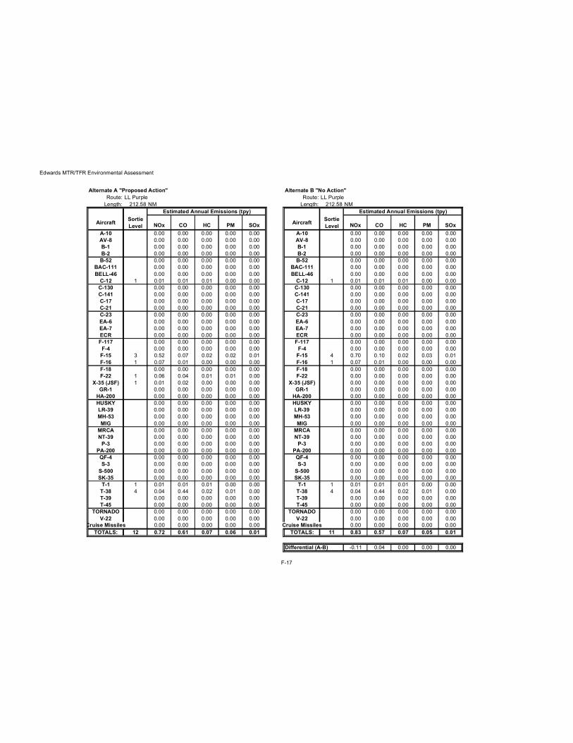
Edwards MTR/TFR Environmental Assessment
Alternate A "Proposed Action" Alternate B "No Action"Route: LL Purple Route: LL Purple
Length: 212.58 NM Length: 212.58 NMEstimated Annual Emissions (tpy) Estimated Annual Emissions (tpy)
Aircraft Sortie Level NOx CO HC PM SOx Aircraft Sortie
Level NOx CO HC PM SOxA-10 0.00 0.00 0.00 0.00 0.00 A-10 0.00 0.00 0.00 0.00 0.00AV-8 0.00 0.00 0.00 0.00 0.00 AV-8 0.00 0.00 0.00 0.00 0.00B-1 0.00 0.00 0.00 0.00 0.00 B-1 0.00 0.00 0.00 0.00 0.00B-2 0.00 0.00 0.00 0.00 0.00 B-2 0.00 0.00 0.00 0.00 0.00B-52 0.00 0.00 0.00 0.00 0.00 B-52 0.00 0.00 0.00 0.00 0.00
BAC-111 0.00 0.00 0.00 0.00 0.00 BAC-111 0.00 0.00 0.00 0.00 0.00BELL-46 0.00 0.00 0.00 0.00 0.00 BELL-46 0.00 0.00 0.00 0.00 0.00
C-12 1 0.01 0.01 0.01 0.00 0.00 C-12 1 0.01 0.01 0.01 0.00 0.00C-130 0.00 0.00 0.00 0.00 0.00 C-130 0.00 0.00 0.00 0.00 0.00C-141 0.00 0.00 0.00 0.00 0.00 C-141 0.00 0.00 0.00 0.00 0.00C-17 0.00 0.00 0.00 0.00 0.00 C-17 0.00 0.00 0.00 0.00 0.00C-21 0.00 0.00 0.00 0.00 0.00 C-21 0.00 0.00 0.00 0.00 0.00C-23 0.00 0.00 0.00 0.00 0.00 C-23 0.00 0.00 0.00 0.00 0.00EA-6 0.00 0.00 0.00 0.00 0.00 EA-6 0.00 0.00 0.00 0.00 0.00EA-7 0.00 0.00 0.00 0.00 0.00 EA-7 0.00 0.00 0.00 0.00 0.00ECR 0.00 0.00 0.00 0.00 0.00 ECR 0.00 0.00 0.00 0.00 0.00F-117 0.00 0.00 0.00 0.00 0.00 F-117 0.00 0.00 0.00 0.00 0.00
F-4 0.00 0.00 0.00 0.00 0.00 F-4 0.00 0.00 0.00 0.00 0.00F-15 3 0.52 0.07 0.02 0.02 0.01 F-15 4 0.70 0.10 0.02 0.03 0.01F-16 1 0.07 0.01 0.00 0.00 0.00 F-16 1 0.07 0.01 0.00 0.00 0.00F-18 0.00 0.00 0.00 0.00 0.00 F-18 0.00 0.00 0.00 0.00 0.00F-22 1 0.06 0.04 0.01 0.01 0.00 F-22 0.00 0.00 0.00 0.00 0.00
X-35 (JSF) 1 0.01 0.02 0.00 0.00 0.00 X-35 (JSF) 0.00 0.00 0.00 0.00 0.00GR-1 0.00 0.00 0.00 0.00 0.00 GR-1 0.00 0.00 0.00 0.00 0.00
HA-200 0.00 0.00 0.00 0.00 0.00 HA-200 0.00 0.00 0.00 0.00 0.00HUSKY 0.00 0.00 0.00 0.00 0.00 HUSKY 0.00 0.00 0.00 0.00 0.00LR-39 0.00 0.00 0.00 0.00 0.00 LR-39 0.00 0.00 0.00 0.00 0.00MH-53 0.00 0.00 0.00 0.00 0.00 MH-53 0.00 0.00 0.00 0.00 0.00MIG 0.00 0.00 0.00 0.00 0.00 MIG 0.00 0.00 0.00 0.00 0.00
MRCA 0.00 0.00 0.00 0.00 0.00 MRCA 0.00 0.00 0.00 0.00 0.00NT-39 0.00 0.00 0.00 0.00 0.00 NT-39 0.00 0.00 0.00 0.00 0.00
P-3 0.00 0.00 0.00 0.00 0.00 P-3 0.00 0.00 0.00 0.00 0.00PA-200 0.00 0.00 0.00 0.00 0.00 PA-200 0.00 0.00 0.00 0.00 0.00QF-4 0.00 0.00 0.00 0.00 0.00 QF-4 0.00 0.00 0.00 0.00 0.00S-3 0.00 0.00 0.00 0.00 0.00 S-3 0.00 0.00 0.00 0.00 0.00
S-500 0.00 0.00 0.00 0.00 0.00 S-500 0.00 0.00 0.00 0.00 0.00SK-35 0.00 0.00 0.00 0.00 0.00 SK-35 0.00 0.00 0.00 0.00 0.00
T-1 1 0.01 0.01 0.01 0.00 0.00 T-1 1 0.01 0.01 0.01 0.00 0.00T-38 4 0.04 0.44 0.02 0.01 0.00 T-38 4 0.04 0.44 0.02 0.01 0.00T-39 0.00 0.00 0.00 0.00 0.00 T-39 0.00 0.00 0.00 0.00 0.00T-45 0.00 0.00 0.00 0.00 0.00 T-45 0.00 0.00 0.00 0.00 0.00
TORNADO 0.00 0.00 0.00 0.00 0.00 TORNADO 0.00 0.00 0.00 0.00 0.00V-22 0.00 0.00 0.00 0.00 0.00 V-22 0.00 0.00 0.00 0.00 0.00
Cruise Missiles 0.00 0.00 0.00 0.00 0.00 Cruise Missiles 0.00 0.00 0.00 0.00 0.00TOTALS: 12 0.72 0.61 0.07 0.06 0.01 TOTALS: 11 0.83 0.57 0.07 0.05 0.01
Differential (A-B) -0.11 0.04 0.00 0.00 0.00
F-17

Edwards MTR/TFR Environmental Assessment
Alternate A "Proposed Action" Alternate B "No Action"Route: LL Red Route: LL Red
Length: 244.08 NM Length: 244.08 NMEstimated Annual Emissions (tpy) Estimated Annual Emissions (tpy)
Aircraft Sortie Level NOx CO HC PM SOx Aircraft Sortie
Level NOx CO HC PM SOxA-10 0.00 0.00 0.00 0.00 0.00 A-10 0.00 0.00 0.00 0.00 0.00AV-8 0.00 0.00 0.00 0.00 0.00 AV-8 0.00 0.00 0.00 0.00 0.00B-1 0.00 0.00 0.00 0.00 0.00 B-1 0.00 0.00 0.00 0.00 0.00B-2 0.00 0.00 0.00 0.00 0.00 B-2 0.00 0.00 0.00 0.00 0.00B-52 0.00 0.00 0.00 0.00 0.00 B-52 0.00 0.00 0.00 0.00 0.00
BAC-111 0.00 0.00 0.00 0.00 0.00 BAC-111 0.00 0.00 0.00 0.00 0.00BELL-46 0.00 0.00 0.00 0.00 0.00 BELL-46 0.00 0.00 0.00 0.00 0.00
C-12 1 0.01 0.01 0.01 0.00 0.00 C-12 1 0.01 0.01 0.01 0.00 0.00C-130 1 0.06 0.02 0.00 0.01 0.00 C-130 1 0.06 0.02 0.00 0.01 0.00C-141 0.00 0.00 0.00 0.00 0.00 C-141 0.00 0.00 0.00 0.00 0.00C-17 0.00 0.00 0.00 0.00 0.00 C-17 0.00 0.00 0.00 0.00 0.00C-21 0.00 0.00 0.00 0.00 0.00 C-21 0.00 0.00 0.00 0.00 0.00C-23 0.00 0.00 0.00 0.00 0.00 C-23 0.00 0.00 0.00 0.00 0.00EA-6 0.00 0.00 0.00 0.00 0.00 EA-6 0.00 0.00 0.00 0.00 0.00EA-7 0.00 0.00 0.00 0.00 0.00 EA-7 0.00 0.00 0.00 0.00 0.00ECR 0.00 0.00 0.00 0.00 0.00 ECR 0.00 0.00 0.00 0.00 0.00F-117 0.00 0.00 0.00 0.00 0.00 F-117 0.00 0.00 0.00 0.00 0.00
F-4 0.00 0.00 0.00 0.00 0.00 F-4 0.00 0.00 0.00 0.00 0.00F-15 2 0.39 0.05 0.01 0.02 0.00 F-15 3 0.59 0.07 0.02 0.03 0.01F-16 1 0.08 0.01 0.00 0.00 0.00 F-16 2 0.16 0.02 0.00 0.00 0.00F-18 2 0.08 0.09 0.04 0.04 0.00 F-18 2 0.08 0.09 0.04 0.04 0.00F-22 1 0.07 0.05 0.01 0.01 0.00 F-22 0.00 0.00 0.00 0.00 0.00
X-35 (JSF) 1 0.01 0.02 0.00 0.00 0.00 X-35 (JSF) 0.00 0.00 0.00 0.00 0.00GR-1 0.00 0.00 0.00 0.00 0.00 GR-1 0.00 0.00 0.00 0.00 0.00
HA-200 0.00 0.00 0.00 0.00 0.00 HA-200 0.00 0.00 0.00 0.00 0.00HUSKY 0.00 0.00 0.00 0.00 0.00 HUSKY 0.00 0.00 0.00 0.00 0.00LR-39 0.00 0.00 0.00 0.00 0.00 LR-39 0.00 0.00 0.00 0.00 0.00MH-53 0.00 0.00 0.00 0.00 0.00 MH-53 0.00 0.00 0.00 0.00 0.00MIG 0.00 0.00 0.00 0.00 0.00 MIG 0.00 0.00 0.00 0.00 0.00
MRCA 0.00 0.00 0.00 0.00 0.00 MRCA 0.00 0.00 0.00 0.00 0.00NT-39 0.00 0.00 0.00 0.00 0.00 NT-39 0.00 0.00 0.00 0.00 0.00
P-3 0.00 0.00 0.00 0.00 0.00 P-3 0.00 0.00 0.00 0.00 0.00PA-200 0.00 0.00 0.00 0.00 0.00 PA-200 0.00 0.00 0.00 0.00 0.00QF-4 0.00 0.00 0.00 0.00 0.00 QF-4 0.00 0.00 0.00 0.00 0.00S-3 0.00 0.00 0.00 0.00 0.00 S-3 0.00 0.00 0.00 0.00 0.00
S-500 0.00 0.00 0.00 0.00 0.00 S-500 0.00 0.00 0.00 0.00 0.00SK-35 0.00 0.00 0.00 0.00 0.00 SK-35 0.00 0.00 0.00 0.00 0.00
T-1 0.00 0.00 0.00 0.00 0.00 T-1 0.00 0.00 0.00 0.00 0.00T-38 0.00 0.00 0.00 0.00 0.00 T-38 1 0.01 0.12 0.01 0.00 0.00T-39 0.00 0.00 0.00 0.00 0.00 T-39 1 0.00 0.00 0.00 0.00 0.00T-45 0.00 0.00 0.00 0.00 0.00 T-45 0.00 0.00 0.00 0.00 0.00
TORNADO 0.00 0.00 0.00 0.00 0.00 TORNADO 0.00 0.00 0.00 0.00 0.00V-22 0.00 0.00 0.00 0.00 0.00 V-22 0.00 0.00 0.00 0.00 0.00
Cruise Missiles 0.00 0.00 0.00 0.00 0.00 Cruise Missiles 0.00 0.00 0.00 0.00 0.00TOTALS: 9 0.70 0.25 0.08 0.08 0.01 TOTALS: 11 0.91 0.34 0.08 0.08 0.02
Differential (A-B) -0.22 -0.09 0.00 0.00 0.00
F-18

Edwards MTR/TFR Environmental Assessment
Alternate A "Proposed Action" Alternate B "No Action"Route: LL Red/Black Route: LL Red/Black
Length: 338 NM Length: 338 NMEstimated Annual Emissions (tpy) Estimated Annual Emissions (tpy)
Aircraft Sortie Level NOx CO HC PM SOx Aircraft Sortie
Level NOx CO HC PM SOxA-10 0.00 0.00 0.00 0.00 0.00 A-10 0.00 0.00 0.00 0.00 0.00AV-8 0.00 0.00 0.00 0.00 0.00 AV-8 0.00 0.00 0.00 0.00 0.00B-1 0.00 0.00 0.00 0.00 0.00 B-1 0.00 0.00 0.00 0.00 0.00B-2 0.00 0.00 0.00 0.00 0.00 B-2 0.00 0.00 0.00 0.00 0.00B-52 0.00 0.00 0.00 0.00 0.00 B-52 0.00 0.00 0.00 0.00 0.00
BAC-111 0.00 0.00 0.00 0.00 0.00 BAC-111 0.00 0.00 0.00 0.00 0.00BELL-46 0.00 0.00 0.00 0.00 0.00 BELL-46 0.00 0.00 0.00 0.00 0.00
C-12 1 0.01 0.02 0.01 0.00 0.00 C-12 1 0.01 0.02 0.01 0.00 0.00C-130 0.00 0.00 0.00 0.00 0.00 C-130 0.00 0.00 0.00 0.00 0.00C-141 0.00 0.00 0.00 0.00 0.00 C-141 0.00 0.00 0.00 0.00 0.00C-17 0.00 0.00 0.00 0.00 0.00 C-17 0.00 0.00 0.00 0.00 0.00C-21 0.00 0.00 0.00 0.00 0.00 C-21 0.00 0.00 0.00 0.00 0.00C-23 0.00 0.00 0.00 0.00 0.00 C-23 0.00 0.00 0.00 0.00 0.00EA-6 0.00 0.00 0.00 0.00 0.00 EA-6 0.00 0.00 0.00 0.00 0.00EA-7 0.00 0.00 0.00 0.00 0.00 EA-7 0.00 0.00 0.00 0.00 0.00ECR 0.00 0.00 0.00 0.00 0.00 ECR 0.00 0.00 0.00 0.00 0.00F-117 0.00 0.00 0.00 0.00 0.00 F-117 0.00 0.00 0.00 0.00 0.00
F-4 0.00 0.00 0.00 0.00 0.00 F-4 0.00 0.00 0.00 0.00 0.00F-15 2 0.53 0.05 0.01 0.02 0.01 F-15 2 0.53 0.05 0.01 0.02 0.01F-16 1 0.11 0.01 0.00 0.00 0.00 F-16 2 0.22 0.03 0.00 0.00 0.00F-18 4 0.22 0.19 0.08 0.09 0.01 F-18 3 0.17 0.14 0.06 0.07 0.01F-22 1 0.09 0.05 0.01 0.01 0.00 F-22 0.00 0.00 0.00 0.00 0.00
X-35 (JSF) 1 0.01 0.02 0.00 0.00 0.00 X-35 (JSF) 0.00 0.00 0.00 0.00 0.00GR-1 0.00 0.00 0.00 0.00 0.00 GR-1 0.00 0.00 0.00 0.00 0.00
HA-200 0.00 0.00 0.00 0.00 0.00 HA-200 0.00 0.00 0.00 0.00 0.00HUSKY 0.00 0.00 0.00 0.00 0.00 HUSKY 0.00 0.00 0.00 0.00 0.00LR-39 0.00 0.00 0.00 0.00 0.00 LR-39 0.00 0.00 0.00 0.00 0.00MH-53 0.00 0.00 0.00 0.00 0.00 MH-53 0.00 0.00 0.00 0.00 0.00MIG 0.00 0.00 0.00 0.00 0.00 MIG 0.00 0.00 0.00 0.00 0.00
MRCA 0.00 0.00 0.00 0.00 0.00 MRCA 0.00 0.00 0.00 0.00 0.00NT-39 0.00 0.00 0.00 0.00 0.00 NT-39 0.00 0.00 0.00 0.00 0.00
P-3 0.00 0.00 0.00 0.00 0.00 P-3 0.00 0.00 0.00 0.00 0.00PA-200 0.00 0.00 0.00 0.00 0.00 PA-200 0.00 0.00 0.00 0.00 0.00QF-4 0.00 0.00 0.00 0.00 0.00 QF-4 0.00 0.00 0.00 0.00 0.00S-3 0.00 0.00 0.00 0.00 0.00 S-3 0.00 0.00 0.00 0.00 0.00
S-500 0.00 0.00 0.00 0.00 0.00 S-500 0.00 0.00 0.00 0.00 0.00SK-35 0.00 0.00 0.00 0.00 0.00 SK-35 0.00 0.00 0.00 0.00 0.00
T-1 0.00 0.00 0.00 0.00 0.00 T-1 0.00 0.00 0.00 0.00 0.00T-38 0.00 0.00 0.00 0.00 0.00 T-38 0.00 0.00 0.00 0.00 0.00T-39 0.00 0.00 0.00 0.00 0.00 T-39 0.00 0.00 0.00 0.00 0.00T-45 0.00 0.00 0.00 0.00 0.00 T-45 0.00 0.00 0.00 0.00 0.00
TORNADO 0.00 0.00 0.00 0.00 0.00 TORNADO 0.00 0.00 0.00 0.00 0.00V-22 0.00 0.00 0.00 0.00 0.00 V-22 0.00 0.00 0.00 0.00 0.00
Cruise Missiles 0.00 0.00 0.00 0.00 0.00 Cruise Missiles 0.00 0.00 0.00 0.00 0.00TOTALS: 10 0.97 0.34 0.11 0.13 0.02 TOTALS: 8 0.93 0.24 0.09 0.10 0.02
Differential (A-B) 0.04 0.10 0.03 0.04 0.00
F-19

Edwards MTR/TFR Environmental Assessment
Alternate A "Proposed Action" Alternate B "No Action"Route: IR-234 Route: IR-234
Length: 165.17 NM Length: 165.17 NMEstimated Annual Emissions (tpy) Estimated Annual Emissions (tpy)
Aircraft Sortie Level NOx CO HC PM SOx Aircraft Sortie
Level NOx CO HC PM SOxA-10 0.00 0.00 0.00 0.00 0.00 A-10 0.00 0.00 0.00 0.00 0.00AV-8 0.00 0.00 0.00 0.00 0.00 AV-8 0.00 0.00 0.00 0.00 0.00B-1 0.00 0.00 0.00 0.00 0.00 B-1 0.00 0.00 0.00 0.00 0.00B-2 0.00 0.00 0.00 0.00 0.00 B-2 0.00 0.00 0.00 0.00 0.00B-52 0.00 0.00 0.00 0.00 0.00 B-52 0.00 0.00 0.00 0.00 0.00
BAC-111 0.00 0.00 0.00 0.00 0.00 BAC-111 0.00 0.00 0.00 0.00 0.00BELL-46 0.00 0.00 0.00 0.00 0.00 BELL-46 2 0.00 0.00 0.00 0.00 0.00
C-12 1 0.00 0.01 0.01 0.00 0.00 C-12 1 0.00 0.01 0.01 0.00 0.00C-130 0.00 0.00 0.00 0.00 0.00 C-130 0.00 0.00 0.00 0.00 0.00C-141 0.00 0.00 0.00 0.00 0.00 C-141 0.00 0.00 0.00 0.00 0.00C-17 0.00 0.00 0.00 0.00 0.00 C-17 0.00 0.00 0.00 0.00 0.00C-21 0.00 0.00 0.00 0.00 0.00 C-21 0.00 0.00 0.00 0.00 0.00C-23 0.00 0.00 0.00 0.00 0.00 C-23 0.00 0.00 0.00 0.00 0.00EA-6 0.00 0.00 0.00 0.00 0.00 EA-6 0.00 0.00 0.00 0.00 0.00EA-7 0.00 0.00 0.00 0.00 0.00 EA-7 0.00 0.00 0.00 0.00 0.00ECR 0.00 0.00 0.00 0.00 0.00 ECR 0.00 0.00 0.00 0.00 0.00F-117 0.00 0.00 0.00 0.00 0.00 F-117 0.00 0.00 0.00 0.00 0.00
F-4 0.00 0.00 0.00 0.00 0.00 F-4 0.00 0.00 0.00 0.00 0.00F-15 0.00 0.00 0.00 0.00 0.00 F-15 0.00 0.00 0.00 0.00 0.00F-16 0.00 0.00 0.00 0.00 0.00 F-16 0.00 0.00 0.00 0.00 0.00F-18 0.00 0.00 0.00 0.00 0.00 F-18 0.00 0.00 0.00 0.00 0.00F-22 0.00 0.00 0.00 0.00 0.00 F-22 0.00 0.00 0.00 0.00 0.00
X-35 (JSF) 0.00 0.00 0.00 0.00 0.00 X-35 (JSF) 0.00 0.00 0.00 0.00 0.00GR-1 0.00 0.00 0.00 0.00 0.00 GR-1 0.00 0.00 0.00 0.00 0.00
HA-200 0.00 0.00 0.00 0.00 0.00 HA-200 0.00 0.00 0.00 0.00 0.00HUSKY 0.00 0.00 0.00 0.00 0.00 HUSKY 0.00 0.00 0.00 0.00 0.00LR-39 0.00 0.00 0.00 0.00 0.00 LR-39 0.00 0.00 0.00 0.00 0.00MH-53 0.00 0.00 0.00 0.00 0.00 MH-53 0.00 0.00 0.00 0.00 0.00MIG 0.00 0.00 0.00 0.00 0.00 MIG 0.00 0.00 0.00 0.00 0.00
MRCA 0.00 0.00 0.00 0.00 0.00 MRCA 0.00 0.00 0.00 0.00 0.00NT-39 0.00 0.00 0.00 0.00 0.00 NT-39 0.00 0.00 0.00 0.00 0.00
P-3 0.00 0.00 0.00 0.00 0.00 P-3 0.00 0.00 0.00 0.00 0.00PA-200 0.00 0.00 0.00 0.00 0.00 PA-200 0.00 0.00 0.00 0.00 0.00QF-4 0.00 0.00 0.00 0.00 0.00 QF-4 0.00 0.00 0.00 0.00 0.00S-3 0.00 0.00 0.00 0.00 0.00 S-3 0.00 0.00 0.00 0.00 0.00
S-500 0.00 0.00 0.00 0.00 0.00 S-500 0.00 0.00 0.00 0.00 0.00SK-35 0.00 0.00 0.00 0.00 0.00 SK-35 0.00 0.00 0.00 0.00 0.00
T-1 0.00 0.00 0.00 0.00 0.00 T-1 0.00 0.00 0.00 0.00 0.00T-38 0.00 0.00 0.00 0.00 0.00 T-38 0.00 0.00 0.00 0.00 0.00T-39 0.00 0.00 0.00 0.00 0.00 T-39 0.00 0.00 0.00 0.00 0.00T-45 0.00 0.00 0.00 0.00 0.00 T-45 0.00 0.00 0.00 0.00 0.00
TORNADO 0.00 0.00 0.00 0.00 0.00 TORNADO 0.00 0.00 0.00 0.00 0.00V-22 30 0.53 0.07 0.00 0.07 0.02 V-22 10 0.18 0.02 0.00 0.02 0.01
Cruise Missiles 0.00 0.00 0.00 0.00 0.00 Cruise Missiles 0.00 0.00 0.00 0.00 0.00TOTALS: 31 0.53 0.08 0.01 0.07 0.02 TOTALS: 13 0.18 0.04 0.01 0.03 0.01
Differential (A-B) 0.35 0.04 0.00 0.05 0.01
F-20

Edwards MTR/TFR Environmental Assessment
Alternate A "Proposed Action" Alternate B "No Action"Route: IR-235 Route: IR-235
Length: 165.17 NM Length: 165.17 NMEstimated Annual Emissions (tpy) Estimated Annual Emissions (tpy)
Aircraft Sortie Level NOx CO HC PM SOx Aircraft Sortie
Level NOx CO HC PM SOxA-10 0.00 0.00 0.00 0.00 0.00 A-10 0.00 0.00 0.00 0.00 0.00AV-8 0.00 0.00 0.00 0.00 0.00 AV-8 0.00 0.00 0.00 0.00 0.00B-1 0.00 0.00 0.00 0.00 0.00 B-1 0.00 0.00 0.00 0.00 0.00B-2 0.00 0.00 0.00 0.00 0.00 B-2 0.00 0.00 0.00 0.00 0.00B-52 0.00 0.00 0.00 0.00 0.00 B-52 0.00 0.00 0.00 0.00 0.00
BAC-111 0.00 0.00 0.00 0.00 0.00 BAC-111 0.00 0.00 0.00 0.00 0.00BELL-46 0.00 0.00 0.00 0.00 0.00 BELL-46 2 0.00 0.00 0.00 0.00 0.00
C-12 1 0.00 0.01 0.01 0.00 0.00 C-12 1 0.00 0.01 0.01 0.00 0.00C-130 0.00 0.00 0.00 0.00 0.00 C-130 0.00 0.00 0.00 0.00 0.00C-141 0.00 0.00 0.00 0.00 0.00 C-141 0.00 0.00 0.00 0.00 0.00C-17 0.00 0.00 0.00 0.00 0.00 C-17 0.00 0.00 0.00 0.00 0.00C-21 0.00 0.00 0.00 0.00 0.00 C-21 0.00 0.00 0.00 0.00 0.00C-23 0.00 0.00 0.00 0.00 0.00 C-23 0.00 0.00 0.00 0.00 0.00EA-6 0.00 0.00 0.00 0.00 0.00 EA-6 0.00 0.00 0.00 0.00 0.00EA-7 0.00 0.00 0.00 0.00 0.00 EA-7 0.00 0.00 0.00 0.00 0.00ECR 0.00 0.00 0.00 0.00 0.00 ECR 0.00 0.00 0.00 0.00 0.00F-117 0.00 0.00 0.00 0.00 0.00 F-117 0.00 0.00 0.00 0.00 0.00
F-4 0.00 0.00 0.00 0.00 0.00 F-4 0.00 0.00 0.00 0.00 0.00F-15 0.00 0.00 0.00 0.00 0.00 F-15 0.00 0.00 0.00 0.00 0.00F-16 8 0.46 0.09 0.01 0.01 0.01 F-16 11 0.63 0.12 0.02 0.01 0.01F-18 0.00 0.00 0.00 0.00 0.00 F-18 0.00 0.00 0.00 0.00 0.00F-22 1 0.05 0.04 0.01 0.01 0.00 F-22 0.00 0.00 0.00 0.00 0.00
X-35 (JSF) 1 0.01 0.02 0.00 0.00 0.00 X-35 (JSF) 0.00 0.00 0.00 0.00 0.00GR-1 0.00 0.00 0.00 0.00 0.00 GR-1 0.00 0.00 0.00 0.00 0.00
HA-200 0.00 0.00 0.00 0.00 0.00 HA-200 0.00 0.00 0.00 0.00 0.00HUSKY 0.00 0.00 0.00 0.00 0.00 HUSKY 0.00 0.00 0.00 0.00 0.00LR-39 0.00 0.00 0.00 0.00 0.00 LR-39 0.00 0.00 0.00 0.00 0.00MH-53 0.00 0.00 0.00 0.00 0.00 MH-53 0.00 0.00 0.00 0.00 0.00MIG 0.00 0.00 0.00 0.00 0.00 MIG 0.00 0.00 0.00 0.00 0.00
MRCA 0.00 0.00 0.00 0.00 0.00 MRCA 0.00 0.00 0.00 0.00 0.00NT-39 0.00 0.00 0.00 0.00 0.00 NT-39 0.00 0.00 0.00 0.00 0.00
P-3 0.00 0.00 0.00 0.00 0.00 P-3 0.00 0.00 0.00 0.00 0.00PA-200 0.00 0.00 0.00 0.00 0.00 PA-200 0.00 0.00 0.00 0.00 0.00QF-4 0.00 0.00 0.00 0.00 0.00 QF-4 0.00 0.00 0.00 0.00 0.00S-3 0.00 0.00 0.00 0.00 0.00 S-3 0.00 0.00 0.00 0.00 0.00
S-500 0.00 0.00 0.00 0.00 0.00 S-500 0.00 0.00 0.00 0.00 0.00SK-35 0.00 0.00 0.00 0.00 0.00 SK-35 0.00 0.00 0.00 0.00 0.00
T-1 0.00 0.00 0.00 0.00 0.00 T-1 0.00 0.00 0.00 0.00 0.00T-38 0.00 0.00 0.00 0.00 0.00 T-38 0.00 0.00 0.00 0.00 0.00T-39 0.00 0.00 0.00 0.00 0.00 T-39 0.00 0.00 0.00 0.00 0.00T-45 0.00 0.00 0.00 0.00 0.00 T-45 0.00 0.00 0.00 0.00 0.00
TORNADO 0.00 0.00 0.00 0.00 0.00 TORNADO 0.00 0.00 0.00 0.00 0.00V-22 30 0.53 0.07 0.00 0.07 0.02 V-22 10 0.18 0.02 0.00 0.02 0.01
Cruise Missiles 0.00 0.00 0.00 0.00 0.00 Cruise Missiles 0.00 0.00 0.00 0.00 0.00TOTALS: 41 1.05 0.23 0.03 0.09 0.03 TOTALS: 24 0.81 0.15 0.02 0.04 0.02
Differential (A-B) 0.24 0.07 0.01 0.05 0.01
F-21

Edwards MTR/TFR Environmental Assessment
Alternate A "Proposed Action" Alternate B "No Action"Route: IR-236 Route: IR-236
Length: 320.57 NM Length: 320.57 NMEstimated Annual Emissions (tpy) Estimated Annual Emissions (tpy)
Aircraft Sortie Level NOx CO HC PM SOx Aircraft Sortie
Level NOx CO HC PM SOxA-10 0.00 0.00 0.00 0.00 0.00 A-10 0.00 0.00 0.00 0.00 0.00AV-8 0.00 0.00 0.00 0.00 0.00 AV-8 0.00 0.00 0.00 0.00 0.00B-1 0.00 0.00 0.00 0.00 0.00 B-1 0.00 0.00 0.00 0.00 0.00B-2 0.00 0.00 0.00 0.00 0.00 B-2 0.00 0.00 0.00 0.00 0.00B-52 0.00 0.00 0.00 0.00 0.00 B-52 0.00 0.00 0.00 0.00 0.00
BAC-111 0.00 0.00 0.00 0.00 0.00 BAC-111 0.00 0.00 0.00 0.00 0.00BELL-46 0.00 0.00 0.00 0.00 0.00 BELL-46 0.00 0.00 0.00 0.00 0.00
C-12 1 0.01 0.02 0.01 0.00 0.00 C-12 1 0.01 0.02 0.01 0.00 0.00C-130 0.00 0.00 0.00 0.00 0.00 C-130 0.00 0.00 0.00 0.00 0.00C-141 0.00 0.00 0.00 0.00 0.00 C-141 0.00 0.00 0.00 0.00 0.00C-17 0.00 0.00 0.00 0.00 0.00 C-17 0.00 0.00 0.00 0.00 0.00C-21 0.00 0.00 0.00 0.00 0.00 C-21 0.00 0.00 0.00 0.00 0.00C-23 0.00 0.00 0.00 0.00 0.00 C-23 0.00 0.00 0.00 0.00 0.00EA-6 0.00 0.00 0.00 0.00 0.00 EA-6 0.00 0.00 0.00 0.00 0.00EA-7 0.00 0.00 0.00 0.00 0.00 EA-7 0.00 0.00 0.00 0.00 0.00ECR 0.00 0.00 0.00 0.00 0.00 ECR 0.00 0.00 0.00 0.00 0.00F-117 0.00 0.00 0.00 0.00 0.00 F-117 0.00 0.00 0.00 0.00 0.00
F-4 0.00 0.00 0.00 0.00 0.00 F-4 0.00 0.00 0.00 0.00 0.00F-15 0.00 0.00 0.00 0.00 0.00 F-15 0.00 0.00 0.00 0.00 0.00F-16 1 0.10 0.01 0.00 0.00 0.00 F-16 1 0.10 0.01 0.00 0.00 0.00F-18 1 0.05 0.05 0.02 0.02 0.00 F-18 1 0.05 0.05 0.02 0.02 0.00F-22 0.00 0.00 0.00 0.00 0.00 F-22 0.00 0.00 0.00 0.00 0.00
X-35 (JSF) 0.00 0.00 0.00 0.00 0.00 X-35 (JSF) 0.00 0.00 0.00 0.00 0.00GR-1 0.00 0.00 0.00 0.00 0.00 GR-1 0.00 0.00 0.00 0.00 0.00
HA-200 0.00 0.00 0.00 0.00 0.00 HA-200 0.00 0.00 0.00 0.00 0.00HUSKY 0.00 0.00 0.00 0.00 0.00 HUSKY 0.00 0.00 0.00 0.00 0.00LR-39 0.00 0.00 0.00 0.00 0.00 LR-39 0.00 0.00 0.00 0.00 0.00MH-53 0.00 0.00 0.00 0.00 0.00 MH-53 0.00 0.00 0.00 0.00 0.00MIG 0.00 0.00 0.00 0.00 0.00 MIG 0.00 0.00 0.00 0.00 0.00
MRCA 0.00 0.00 0.00 0.00 0.00 MRCA 0.00 0.00 0.00 0.00 0.00NT-39 0.00 0.00 0.00 0.00 0.00 NT-39 0.00 0.00 0.00 0.00 0.00
P-3 0.00 0.00 0.00 0.00 0.00 P-3 0.00 0.00 0.00 0.00 0.00PA-200 0.00 0.00 0.00 0.00 0.00 PA-200 0.00 0.00 0.00 0.00 0.00QF-4 0.00 0.00 0.00 0.00 0.00 QF-4 0.00 0.00 0.00 0.00 0.00S-3 0.00 0.00 0.00 0.00 0.00 S-3 0.00 0.00 0.00 0.00 0.00
S-500 0.00 0.00 0.00 0.00 0.00 S-500 0.00 0.00 0.00 0.00 0.00SK-35 0.00 0.00 0.00 0.00 0.00 SK-35 0.00 0.00 0.00 0.00 0.00
T-1 0.00 0.00 0.00 0.00 0.00 T-1 0.00 0.00 0.00 0.00 0.00T-38 0.00 0.00 0.00 0.00 0.00 T-38 0.00 0.00 0.00 0.00 0.00T-39 0.00 0.00 0.00 0.00 0.00 T-39 0.00 0.00 0.00 0.00 0.00T-45 0.00 0.00 0.00 0.00 0.00 T-45 0.00 0.00 0.00 0.00 0.00
TORNADO 0.00 0.00 0.00 0.00 0.00 TORNADO 0.00 0.00 0.00 0.00 0.00V-22 0.00 0.00 0.00 0.00 0.00 V-22 0.00 0.00 0.00 0.00 0.00
Cruise Missiles 1 0.00 0.00 0.00 0.00 0.00 Cruise Missiles 1 0.00 0.00 0.00 0.00 0.00TOTALS: 4 0.17 0.08 0.03 0.03 0.00 TOTALS: 4 0.17 0.08 0.03 0.03 0.00
Differential (A-B) 0.00 0.00 0.00 0.00 0.00
F-22

Edwards MTR/TFR Environmental Assessment
Alternate A "Proposed Action" Alternate B "No Action"Route: IR-237 Route: IR-237
Length: 130.27 NM Length: 130.27 NMEstimated Annual Emissions (tpy) Estimated Annual Emissions (tpy)
Aircraft Sortie Level NOx CO HC PM SOx Aircraft Sortie
Level NOx CO HC PM SOxA-10 0.00 0.00 0.00 0.00 0.00 A-10 0.00 0.00 0.00 0.00 0.00AV-8 0.00 0.00 0.00 0.00 0.00 AV-8 0.00 0.00 0.00 0.00 0.00B-1 0.00 0.00 0.00 0.00 0.00 B-1 0.00 0.00 0.00 0.00 0.00B-2 0.00 0.00 0.00 0.00 0.00 B-2 0.00 0.00 0.00 0.00 0.00B-52 0.00 0.00 0.00 0.00 0.00 B-52 0.00 0.00 0.00 0.00 0.00
BAC-111 0.00 0.00 0.00 0.00 0.00 BAC-111 0.00 0.00 0.00 0.00 0.00BELL-46 0.00 0.00 0.00 0.00 0.00 BELL-46 0.00 0.00 0.00 0.00 0.00
C-12 1 0.00 0.01 0.01 0.00 0.00 C-12 1 0.00 0.01 0.01 0.00 0.00C-130 0.00 0.00 0.00 0.00 0.00 C-130 0.00 0.00 0.00 0.00 0.00C-141 0.00 0.00 0.00 0.00 0.00 C-141 0.00 0.00 0.00 0.00 0.00C-17 0.00 0.00 0.00 0.00 0.00 C-17 0.00 0.00 0.00 0.00 0.00C-21 0.00 0.00 0.00 0.00 0.00 C-21 0.00 0.00 0.00 0.00 0.00C-23 0.00 0.00 0.00 0.00 0.00 C-23 0.00 0.00 0.00 0.00 0.00EA-6 0.00 0.00 0.00 0.00 0.00 EA-6 0.00 0.00 0.00 0.00 0.00EA-7 0.00 0.00 0.00 0.00 0.00 EA-7 0.00 0.00 0.00 0.00 0.00ECR 0.00 0.00 0.00 0.00 0.00 ECR 0.00 0.00 0.00 0.00 0.00F-117 0.00 0.00 0.00 0.00 0.00 F-117 0.00 0.00 0.00 0.00 0.00
F-4 0.00 0.00 0.00 0.00 0.00 F-4 0.00 0.00 0.00 0.00 0.00F-15 0.00 0.00 0.00 0.00 0.00 F-15 0.00 0.00 0.00 0.00 0.00F-16 0.00 0.00 0.00 0.00 0.00 F-16 0.00 0.00 0.00 0.00 0.00F-18 0.00 0.00 0.00 0.00 0.00 F-18 0.00 0.00 0.00 0.00 0.00F-22 0.00 0.00 0.00 0.00 0.00 F-22 0.00 0.00 0.00 0.00 0.00
X-35 (JSF) 0.00 0.00 0.00 0.00 0.00 X-35 (JSF) 0.00 0.00 0.00 0.00 0.00GR-1 0.00 0.00 0.00 0.00 0.00 GR-1 0.00 0.00 0.00 0.00 0.00
HA-200 0.00 0.00 0.00 0.00 0.00 HA-200 0.00 0.00 0.00 0.00 0.00HUSKY 0.00 0.00 0.00 0.00 0.00 HUSKY 1 0.00 0.00 0.00 0.00 0.00LR-39 0.00 0.00 0.00 0.00 0.00 LR-39 0.00 0.00 0.00 0.00 0.00MH-53 0.00 0.00 0.00 0.00 0.00 MH-53 0.00 0.00 0.00 0.00 0.00MIG 0.00 0.00 0.00 0.00 0.00 MIG 0.00 0.00 0.00 0.00 0.00
MRCA 0.00 0.00 0.00 0.00 0.00 MRCA 0.00 0.00 0.00 0.00 0.00NT-39 0.00 0.00 0.00 0.00 0.00 NT-39 0.00 0.00 0.00 0.00 0.00
P-3 0.00 0.00 0.00 0.00 0.00 P-3 0.00 0.00 0.00 0.00 0.00PA-200 0.00 0.00 0.00 0.00 0.00 PA-200 0.00 0.00 0.00 0.00 0.00QF-4 0.00 0.00 0.00 0.00 0.00 QF-4 0.00 0.00 0.00 0.00 0.00S-3 0.00 0.00 0.00 0.00 0.00 S-3 0.00 0.00 0.00 0.00 0.00
S-500 0.00 0.00 0.00 0.00 0.00 S-500 0.00 0.00 0.00 0.00 0.00SK-35 0.00 0.00 0.00 0.00 0.00 SK-35 0.00 0.00 0.00 0.00 0.00
T-1 0.00 0.00 0.00 0.00 0.00 T-1 0.00 0.00 0.00 0.00 0.00T-38 0.00 0.00 0.00 0.00 0.00 T-38 0.00 0.00 0.00 0.00 0.00T-39 0.00 0.00 0.00 0.00 0.00 T-39 0.00 0.00 0.00 0.00 0.00T-45 0.00 0.00 0.00 0.00 0.00 T-45 0.00 0.00 0.00 0.00 0.00
TORNADO 0.00 0.00 0.00 0.00 0.00 TORNADO 0.00 0.00 0.00 0.00 0.00V-22 0.00 0.00 0.00 0.00 0.00 V-22 0.00 0.00 0.00 0.00 0.00
Cruise Missiles 15 0.00 0.00 0.00 0.00 0.00 Cruise Missiles 12 0.00 0.00 0.00 0.00 0.00TOTALS: 16 0.00 0.01 0.01 0.00 0.00 TOTALS: 14 0.00 0.01 0.01 0.00 0.00
Differential (A-B) 0.00 0.00 0.00 0.00 0.00
F-23

Edwards MTR/TFR Environmental Assessment
Alternate A "Proposed Action" Alternate B "No Action"Route: IR-238 Route: IR-238
Length: 130.27 NM Length: 130.27 NMEstimated Annual Emissions (tpy) Estimated Annual Emissions (tpy)
Aircraft Sortie Level NOx CO HC PM SOx Aircraft Sortie
Level NOx CO HC PM SOxA-10 0.00 0.00 0.00 0.00 0.00 A-10 0.00 0.00 0.00 0.00 0.00AV-8 0.00 0.00 0.00 0.00 0.00 AV-8 0.00 0.00 0.00 0.00 0.00B-1 0.00 0.00 0.00 0.00 0.00 B-1 0.00 0.00 0.00 0.00 0.00B-2 0.00 0.00 0.00 0.00 0.00 B-2 0.00 0.00 0.00 0.00 0.00B-52 0.00 0.00 0.00 0.00 0.00 B-52 0.00 0.00 0.00 0.00 0.00
BAC-111 0.00 0.00 0.00 0.00 0.00 BAC-111 0.00 0.00 0.00 0.00 0.00BELL-46 0.00 0.00 0.00 0.00 0.00 BELL-46 0.00 0.00 0.00 0.00 0.00
C-12 1 0.00 0.01 0.01 0.00 0.00 C-12 1 0.00 0.01 0.01 0.00 0.00C-130 0.00 0.00 0.00 0.00 0.00 C-130 0.00 0.00 0.00 0.00 0.00C-141 0.00 0.00 0.00 0.00 0.00 C-141 0.00 0.00 0.00 0.00 0.00C-17 0.00 0.00 0.00 0.00 0.00 C-17 0.00 0.00 0.00 0.00 0.00C-21 0.00 0.00 0.00 0.00 0.00 C-21 0.00 0.00 0.00 0.00 0.00C-23 0.00 0.00 0.00 0.00 0.00 C-23 0.00 0.00 0.00 0.00 0.00EA-6 0.00 0.00 0.00 0.00 0.00 EA-6 0.00 0.00 0.00 0.00 0.00EA-7 0.00 0.00 0.00 0.00 0.00 EA-7 0.00 0.00 0.00 0.00 0.00ECR 0.00 0.00 0.00 0.00 0.00 ECR 0.00 0.00 0.00 0.00 0.00F-117 0.00 0.00 0.00 0.00 0.00 F-117 0.00 0.00 0.00 0.00 0.00
F-4 0.00 0.00 0.00 0.00 0.00 F-4 0.00 0.00 0.00 0.00 0.00F-15 0.00 0.00 0.00 0.00 0.00 F-15 0.00 0.00 0.00 0.00 0.00F-16 0.00 0.00 0.00 0.00 0.00 F-16 0.00 0.00 0.00 0.00 0.00F-18 0.00 0.00 0.00 0.00 0.00 F-18 0.00 0.00 0.00 0.00 0.00F-22 0.00 0.00 0.00 0.00 0.00 F-22 0.00 0.00 0.00 0.00 0.00
X-35 (JSF) 0.00 0.00 0.00 0.00 0.00 X-35 (JSF) 0.00 0.00 0.00 0.00 0.00GR-1 0.00 0.00 0.00 0.00 0.00 GR-1 0.00 0.00 0.00 0.00 0.00
HA-200 0.00 0.00 0.00 0.00 0.00 HA-200 0.00 0.00 0.00 0.00 0.00HUSKY 0.00 0.00 0.00 0.00 0.00 HUSKY 1 0.00 0.00 0.00 0.00 0.00LR-39 0.00 0.00 0.00 0.00 0.00 LR-39 0.00 0.00 0.00 0.00 0.00MH-53 0.00 0.00 0.00 0.00 0.00 MH-53 0.00 0.00 0.00 0.00 0.00MIG 0.00 0.00 0.00 0.00 0.00 MIG 0.00 0.00 0.00 0.00 0.00
MRCA 0.00 0.00 0.00 0.00 0.00 MRCA 0.00 0.00 0.00 0.00 0.00NT-39 0.00 0.00 0.00 0.00 0.00 NT-39 0.00 0.00 0.00 0.00 0.00
P-3 0.00 0.00 0.00 0.00 0.00 P-3 0.00 0.00 0.00 0.00 0.00PA-200 0.00 0.00 0.00 0.00 0.00 PA-200 0.00 0.00 0.00 0.00 0.00QF-4 0.00 0.00 0.00 0.00 0.00 QF-4 0.00 0.00 0.00 0.00 0.00S-3 0.00 0.00 0.00 0.00 0.00 S-3 0.00 0.00 0.00 0.00 0.00
S-500 0.00 0.00 0.00 0.00 0.00 S-500 0.00 0.00 0.00 0.00 0.00SK-35 0.00 0.00 0.00 0.00 0.00 SK-35 0.00 0.00 0.00 0.00 0.00
T-1 0.00 0.00 0.00 0.00 0.00 T-1 0.00 0.00 0.00 0.00 0.00T-38 0.00 0.00 0.00 0.00 0.00 T-38 0.00 0.00 0.00 0.00 0.00T-39 0.00 0.00 0.00 0.00 0.00 T-39 0.00 0.00 0.00 0.00 0.00T-45 0.00 0.00 0.00 0.00 0.00 T-45 0.00 0.00 0.00 0.00 0.00
TORNADO 0.00 0.00 0.00 0.00 0.00 TORNADO 0.00 0.00 0.00 0.00 0.00V-22 0.00 0.00 0.00 0.00 0.00 V-22 0.00 0.00 0.00 0.00 0.00
Cruise Missiles 13 0.00 0.00 0.00 0.00 0.00 Cruise Missiles 10 0.00 0.00 0.00 0.00 0.00TOTALS: 14 0.00 0.01 0.01 0.00 0.00 TOTALS: 12 0.00 0.01 0.01 0.00 0.00
Differential (A-B) 0.00 0.00 0.00 0.00 0.00
F-24

Edwards MTR/TFR Environmental Assessment
Alternate A "Proposed Action" Alternate B "No Action"Route: VR-1205 Route: VR-1205
Length: 193.06 NM Length: 193.06 NMEstimated Annual Emissions (tpy) Estimated Annual Emissions (tpy)
Aircraft Sortie Level NOx CO HC PM SOx Aircraft Sortie
Level NOx CO HC PM SOxA-10 0.00 0.00 0.00 0.00 0.00 A-10 0.00 0.00 0.00 0.00 0.00AV-8 0.00 0.00 0.00 0.00 0.00 AV-8 2 0.13 0.08 0.01 0.02 0.00B-1 40 3.75 1.34 0.03 0.66 0.13 B-1 20 1.87 0.67 0.02 0.33 0.07B-2 24 2.85 0.70 0.03 0.36 0.07 B-2 48 5.70 1.41 0.06 0.72 0.15B-52 0.00 0.00 0.00 0.00 0.00 B-52 0.00 0.00 0.00 0.00 0.00
BAC-111 0.00 0.00 0.00 0.00 0.00 BAC-111 6 0.30 0.27 0.16 0.00 0.01BELL-46 0.00 0.00 0.00 0.00 0.00 BELL-46 0.00 0.00 0.00 0.00 0.00
C-12 4 0.02 0.05 0.04 0.01 0.00 C-12 4 0.02 0.05 0.04 0.01 0.00C-130 1 0.05 0.01 0.00 0.01 0.00 C-130 1 0.05 0.01 0.00 0.01 0.00C-141 0.00 0.00 0.00 0.00 0.00 C-141 0.00 0.00 0.00 0.00 0.00C-17 0.00 0.00 0.00 0.00 0.00 C-17 0.00 0.00 0.00 0.00 0.00C-21 0.00 0.00 0.00 0.00 0.00 C-21 0.00 0.00 0.00 0.00 0.00C-23 0.00 0.00 0.00 0.00 0.00 C-23 0.00 0.00 0.00 0.00 0.00EA-6 0.00 0.00 0.00 0.00 0.00 EA-6 1 0.05 0.03 0.02 0.03 0.00EA-7 0.00 0.00 0.00 0.00 0.00 EA-7 0.00 0.00 0.00 0.00 0.00ECR 0.00 0.00 0.00 0.00 0.00 ECR 0.00 0.00 0.00 0.00 0.00F-117 0.00 0.00 0.00 0.00 0.00 F-117 0.00 0.00 0.00 0.00 0.00
F-4 0.00 0.00 0.00 0.00 0.00 F-4 0.00 0.00 0.00 0.00 0.00F-15 2 0.32 0.05 0.01 0.01 0.00 F-15 2 0.32 0.05 0.01 0.01 0.00F-16 19 1.25 0.21 0.03 0.02 0.02 F-16 27 1.78 0.31 0.04 0.03 0.03F-18 9 0.31 0.41 0.17 0.14 0.01 F-18 6 0.21 0.27 0.11 0.10 0.01F-22 1 0.06 0.04 0.01 0.01 0.00 F-22 0.00 0.00 0.00 0.00 0.00
X-35 (JSF) 1 0.01 0.02 0.00 0.00 0.00 X-35 (JSF) 0.00 0.00 0.00 0.00 0.00GR-1 0.00 0.00 0.00 0.00 0.00 GR-1 0.00 0.00 0.00 0.00 0.00
HA-200 0.00 0.00 0.00 0.00 0.00 HA-200 0.00 0.00 0.00 0.00 0.00HUSKY 0.00 0.00 0.00 0.00 0.00 HUSKY 0.00 0.00 0.00 0.00 0.00LR-39 0.00 0.00 0.00 0.00 0.00 LR-39 0.00 0.00 0.00 0.00 0.00MH-53 0.00 0.00 0.00 0.00 0.00 MH-53 0.00 0.00 0.00 0.00 0.00MIG 0.00 0.00 0.00 0.00 0.00 MIG 0.00 0.00 0.00 0.00 0.00
MRCA 0.00 0.00 0.00 0.00 0.00 MRCA 0.00 0.00 0.00 0.00 0.00NT-39 0.00 0.00 0.00 0.00 0.00 NT-39 0.00 0.00 0.00 0.00 0.00
P-3 0.00 0.00 0.00 0.00 0.00 P-3 0.00 0.00 0.00 0.00 0.00PA-200 0.00 0.00 0.00 0.00 0.00 PA-200 0.00 0.00 0.00 0.00 0.00QF-4 0.00 0.00 0.00 0.00 0.00 QF-4 0.00 0.00 0.00 0.00 0.00S-3 0.00 0.00 0.00 0.00 0.00 S-3 0.00 0.00 0.00 0.00 0.00
S-500 0.00 0.00 0.00 0.00 0.00 S-500 0.00 0.00 0.00 0.00 0.00SK-35 0.00 0.00 0.00 0.00 0.00 SK-35 0.00 0.00 0.00 0.00 0.00
T-1 0.00 0.00 0.00 0.00 0.00 T-1 0.00 0.00 0.00 0.00 0.00T-38 0.00 0.00 0.00 0.00 0.00 T-38 1 0.01 0.10 0.01 0.00 0.00T-39 0.00 0.00 0.00 0.00 0.00 T-39 0.00 0.00 0.00 0.00 0.00T-45 0.00 0.00 0.00 0.00 0.00 T-45 2 0.02 0.04 0.01 0.00 0.00
TORNADO 0.00 0.00 0.00 0.00 0.00 TORNADO 0.00 0.00 0.00 0.00 0.00V-22 0.00 0.00 0.00 0.00 0.00 V-22 0.00 0.00 0.00 0.00 0.00
Cruise Missiles 0.00 0.00 0.00 0.00 0.00 Cruise Missiles 0.00 0.00 0.00 0.00 0.00TOTALS: 101 8.61 2.84 0.32 1.23 0.25 TOTALS: 120 10.46 3.30 0.49 1.27 0.27
Differential (A-B) -1.85 -0.45 -0.16 -0.04 -0.02
F-25

Edwards MTR/TFR Environmental Assessment
Alternate A "Proposed Action" Alternate B "No Action"Route: VR-1206 Route: VR-1206
Length: 45.45 NM Length: 45.45 NMEstimated Annual Emissions (tpy) Estimated Annual Emissions (tpy)
Aircraft Sortie Level NOx CO HC PM SOx Aircraft Sortie
Level NOx CO HC PM SOxA-10 0.00 0.00 0.00 0.00 0.00 A-10 0.00 0.00 0.00 0.00 0.00AV-8 0.00 0.00 0.00 0.00 0.00 AV-8 0.00 0.00 0.00 0.00 0.00B-1 0.00 0.00 0.00 0.00 0.00 B-1 0.00 0.00 0.00 0.00 0.00B-2 0.00 0.00 0.00 0.00 0.00 B-2 0.00 0.00 0.00 0.00 0.00B-52 0.00 0.00 0.00 0.00 0.00 B-52 0.00 0.00 0.00 0.00 0.00
BAC-111 0.00 0.00 0.00 0.00 0.00 BAC-111 0.00 0.00 0.00 0.00 0.00BELL-46 0.00 0.00 0.00 0.00 0.00 BELL-46 0.00 0.00 0.00 0.00 0.00
C-12 1 0.00 0.01 0.01 0.00 0.00 C-12 1 0.00 0.01 0.01 0.00 0.00C-130 3 0.05 0.02 0.01 0.02 0.00 C-130 2 0.03 0.02 0.00 0.01 0.00C-141 0.00 0.00 0.00 0.00 0.00 C-141 0.00 0.00 0.00 0.00 0.00C-17 0.00 0.00 0.00 0.00 0.00 C-17 0.00 0.00 0.00 0.00 0.00C-21 0.00 0.00 0.00 0.00 0.00 C-21 0.00 0.00 0.00 0.00 0.00C-23 0.00 0.00 0.00 0.00 0.00 C-23 0.00 0.00 0.00 0.00 0.00EA-6 0.00 0.00 0.00 0.00 0.00 EA-6 0.00 0.00 0.00 0.00 0.00EA-7 0.00 0.00 0.00 0.00 0.00 EA-7 0.00 0.00 0.00 0.00 0.00ECR 0.00 0.00 0.00 0.00 0.00 ECR 0.00 0.00 0.00 0.00 0.00F-117 0.00 0.00 0.00 0.00 0.00 F-117 0.00 0.00 0.00 0.00 0.00
F-4 0.00 0.00 0.00 0.00 0.00 F-4 0.00 0.00 0.00 0.00 0.00F-15 1 0.05 0.02 0.01 0.00 0.00 F-15 1 0.05 0.02 0.01 0.00 0.00F-16 1 0.02 0.01 0.00 0.00 0.00 F-16 1 0.02 0.01 0.00 0.00 0.00F-18 0.00 0.00 0.00 0.00 0.00 F-18 0.00 0.00 0.00 0.00 0.00F-22 0.00 0.00 0.00 0.00 0.00 F-22 0.00 0.00 0.00 0.00 0.00
X-35 (JSF) 0.00 0.00 0.00 0.00 0.00 X-35 (JSF) 0.00 0.00 0.00 0.00 0.00GR-1 0.00 0.00 0.00 0.00 0.00 GR-1 0.00 0.00 0.00 0.00 0.00
HA-200 0.00 0.00 0.00 0.00 0.00 HA-200 0.00 0.00 0.00 0.00 0.00HUSKY 0.00 0.00 0.00 0.00 0.00 HUSKY 0.00 0.00 0.00 0.00 0.00LR-39 0.00 0.00 0.00 0.00 0.00 LR-39 0.00 0.00 0.00 0.00 0.00MH-53 0.00 0.00 0.00 0.00 0.00 MH-53 0.00 0.00 0.00 0.00 0.00MIG 0.00 0.00 0.00 0.00 0.00 MIG 0.00 0.00 0.00 0.00 0.00
MRCA 0.00 0.00 0.00 0.00 0.00 MRCA 0.00 0.00 0.00 0.00 0.00NT-39 0.00 0.00 0.00 0.00 0.00 NT-39 0.00 0.00 0.00 0.00 0.00
P-3 0.00 0.00 0.00 0.00 0.00 P-3 0.00 0.00 0.00 0.00 0.00PA-200 0.00 0.00 0.00 0.00 0.00 PA-200 0.00 0.00 0.00 0.00 0.00QF-4 0.00 0.00 0.00 0.00 0.00 QF-4 0.00 0.00 0.00 0.00 0.00S-3 0.00 0.00 0.00 0.00 0.00 S-3 0.00 0.00 0.00 0.00 0.00
S-500 0.00 0.00 0.00 0.00 0.00 S-500 0.00 0.00 0.00 0.00 0.00SK-35 0.00 0.00 0.00 0.00 0.00 SK-35 0.00 0.00 0.00 0.00 0.00
T-1 0.00 0.00 0.00 0.00 0.00 T-1 0.00 0.00 0.00 0.00 0.00T-38 0.00 0.00 0.00 0.00 0.00 T-38 0.00 0.00 0.00 0.00 0.00T-39 0.00 0.00 0.00 0.00 0.00 T-39 0.00 0.00 0.00 0.00 0.00T-45 0.00 0.00 0.00 0.00 0.00 T-45 0.00 0.00 0.00 0.00 0.00
TORNADO 0.00 0.00 0.00 0.00 0.00 TORNADO 0.00 0.00 0.00 0.00 0.00V-22 0.00 0.00 0.00 0.00 0.00 V-22 0.00 0.00 0.00 0.00 0.00
Cruise Missiles 0.00 0.00 0.00 0.00 0.00 Cruise Missiles 0.00 0.00 0.00 0.00 0.00TOTALS: 6 0.13 0.06 0.02 0.02 0.00 TOTALS: 5 0.11 0.06 0.02 0.02 0.00
Differential (A-B) 0.02 0.01 0.00 0.01 0.00
F-26

Edwards MTR/TFR Environmental Assessment
Alternate A "Proposed Action" Alternate B "No Action"Route: VR-1214 Route: VR-1214
Length: 224.56 NM Length: 224.56 NMEstimated Annual Emissions (tpy) Estimated Annual Emissions (tpy)
Aircraft Sortie Level NOx CO HC PM SOx Aircraft Sortie
Level NOx CO HC PM SOxA-10 0.00 0.00 0.00 0.00 0.00 A-10 1 0.02 0.03 0.01 0.01 0.00AV-8 0.00 0.00 0.00 0.00 0.00 AV-8 3 0.22 0.13 0.01 0.04 0.01B-1 40 4.21 1.37 0.04 0.72 0.15 B-1 20 2.10 0.68 0.02 0.36 0.07B-2 25 3.33 0.75 0.03 0.41 0.08 B-2 50 6.66 1.50 0.07 0.82 0.17B-52 0.00 0.00 0.00 0.00 0.00 B-52 0.00 0.00 0.00 0.00 0.00
BAC-111 0.00 0.00 0.00 0.00 0.00 BAC-111 6 0.35 0.28 0.16 0.00 0.01BELL-46 0.00 0.00 0.00 0.00 0.00 BELL-46 0.00 0.00 0.00 0.00 0.00
C-12 1 0.01 0.01 0.01 0.00 0.00 C-12 1 0.01 0.01 0.01 0.00 0.00C-130 1 0.05 0.02 0.00 0.01 0.00 C-130 1 0.05 0.02 0.00 0.01 0.00C-141 0.00 0.00 0.00 0.00 0.00 C-141 0.00 0.00 0.00 0.00 0.00C-17 0.00 0.00 0.00 0.00 0.00 C-17 0.00 0.00 0.00 0.00 0.00C-21 0.00 0.00 0.00 0.00 0.00 C-21 0.00 0.00 0.00 0.00 0.00C-23 0.00 0.00 0.00 0.00 0.00 C-23 1 0.01 0.00 0.00 0.00 0.00EA-6 0.00 0.00 0.00 0.00 0.00 EA-6 0.00 0.00 0.00 0.00 0.00EA-7 0.00 0.00 0.00 0.00 0.00 EA-7 0.00 0.00 0.00 0.00 0.00ECR 0.00 0.00 0.00 0.00 0.00 ECR 4 0.61 0.02 0.04 0.03 0.01F-117 0.00 0.00 0.00 0.00 0.00 F-117 0.00 0.00 0.00 0.00 0.00
F-4 0.00 0.00 0.00 0.00 0.00 F-4 0.00 0.00 0.00 0.00 0.00F-15 3 0.55 0.07 0.02 0.02 0.01 F-15 4 0.73 0.10 0.02 0.03 0.01F-16 22 1.66 0.26 0.04 0.02 0.03 F-16 31 2.33 0.37 0.05 0.03 0.04F-18 15 0.59 0.69 0.28 0.26 0.02 F-18 10 0.39 0.46 0.19 0.18 0.01F-22 1 0.06 0.04 0.01 0.01 0.00 F-22 0.00 0.00 0.00 0.00 0.00
X-35 (JSF) 1 0.01 0.02 0.00 0.00 0.00 X-35 (JSF) 0.00 0.00 0.00 0.00 0.00GR-1 1 0.15 0.00 0.01 0.01 0.00 GR-1 1 0.15 0.00 0.01 0.01 0.00
HA-200 0.00 0.00 0.00 0.00 0.00 HA-200 0.00 0.00 0.00 0.00 0.00HUSKY 0.00 0.00 0.00 0.00 0.00 HUSKY 0.00 0.00 0.00 0.00 0.00LR-39 0.00 0.00 0.00 0.00 0.00 LR-39 0.00 0.00 0.00 0.00 0.00MH-53 1 0.03 0.01 0.00 0.01 0.00 MH-53 1 0.03 0.01 0.00 0.01 0.00MIG 0.00 0.00 0.00 0.00 0.00 MIG 0.00 0.00 0.00 0.00 0.00
MRCA 0.00 0.00 0.00 0.00 0.00 MRCA 1 0.15 0.00 0.01 0.01 0.00NT-39 0.00 0.00 0.00 0.00 0.00 NT-39 0.00 0.00 0.00 0.00 0.00
P-3 0.00 0.00 0.00 0.00 0.00 P-3 0.00 0.00 0.00 0.00 0.00PA-200 0.00 0.00 0.00 0.00 0.00 PA-200 3 0.00 0.00 0.00 0.00 0.00QF-4 0.00 0.00 0.00 0.00 0.00 QF-4 0.00 0.00 0.00 0.00 0.00S-3 0.00 0.00 0.00 0.00 0.00 S-3 0.00 0.00 0.00 0.00 0.00
S-500 0.00 0.00 0.00 0.00 0.00 S-500 0.00 0.00 0.00 0.00 0.00SK-35 0.00 0.00 0.00 0.00 0.00 SK-35 0.00 0.00 0.00 0.00 0.00
T-1 0.00 0.00 0.00 0.00 0.00 T-1 0.00 0.00 0.00 0.00 0.00T-38 1 0.01 0.11 0.01 0.00 0.00 T-38 1 0.01 0.11 0.01 0.00 0.00T-39 0.00 0.00 0.00 0.00 0.00 T-39 0.00 0.00 0.00 0.00 0.00T-45 0.00 0.00 0.00 0.00 0.00 T-45 1 0.01 0.02 0.00 0.00 0.00
TORNADO 3 0.46 0.01 0.03 0.02 0.01 TORNADO 3 0.46 0.01 0.03 0.02 0.01V-22 0.00 0.00 0.00 0.00 0.00 V-22 0.00 0.00 0.00 0.00 0.00
Cruise Missiles 0.00 0.00 0.00 0.00 0.00 Cruise Missiles 0.00 0.00 0.00 0.00 0.00TOTALS: 115 11.11 3.38 0.47 1.51 0.30 TOTALS: 143 14.30 3.76 0.64 1.55 0.34
Differential (A-B) -3.19 -0.39 -0.16 -0.05 -0.04
F-27

Edwards MTR/TFR Environmental Assessment
Alternate A "Proposed Action" Alternate B "No Action"Route: VR-1215 Route: VR-1215
Length: 118.44 NM Length: 118.44 NMEstimated Annual Emissions (tpy) Estimated Annual Emissions (tpy)
Aircraft Sortie Level NOx CO HC PM SOx Aircraft Sortie
Level NOx CO HC PM SOxA-10 0.00 0.00 0.00 0.00 0.00 A-10 0.00 0.00 0.00 0.00 0.00AV-8 0.00 0.00 0.00 0.00 0.00 AV-8 2 0.09 0.08 0.01 0.02 0.00B-1 2 0.13 0.06 0.00 0.03 0.00 B-1 1 0.07 0.03 0.00 0.01 0.00B-2 0.00 0.00 0.00 0.00 0.00 B-2 0.00 0.00 0.00 0.00 0.00B-52 0.00 0.00 0.00 0.00 0.00 B-52 0.00 0.00 0.00 0.00 0.00
BAC-111 0.00 0.00 0.00 0.00 0.00 BAC-111 0.00 0.00 0.00 0.00 0.00BELL-46 0.00 0.00 0.00 0.00 0.00 BELL-46 0.00 0.00 0.00 0.00 0.00
C-12 1 0.00 0.01 0.01 0.00 0.00 C-12 1 0.00 0.01 0.01 0.00 0.00C-130 0.00 0.00 0.00 0.00 0.00 C-130 0.00 0.00 0.00 0.00 0.00C-141 0.00 0.00 0.00 0.00 0.00 C-141 0.00 0.00 0.00 0.00 0.00C-17 0.00 0.00 0.00 0.00 0.00 C-17 0.00 0.00 0.00 0.00 0.00C-21 0.00 0.00 0.00 0.00 0.00 C-21 0.00 0.00 0.00 0.00 0.00C-23 0.00 0.00 0.00 0.00 0.00 C-23 0.00 0.00 0.00 0.00 0.00EA-6 0.00 0.00 0.00 0.00 0.00 EA-6 1 0.04 0.03 0.02 0.03 0.00EA-7 0.00 0.00 0.00 0.00 0.00 EA-7 0.00 0.00 0.00 0.00 0.00ECR 0.00 0.00 0.00 0.00 0.00 ECR 0.00 0.00 0.00 0.00 0.00F-117 0.00 0.00 0.00 0.00 0.00 F-117 0.00 0.00 0.00 0.00 0.00
F-4 0.00 0.00 0.00 0.00 0.00 F-4 0.00 0.00 0.00 0.00 0.00F-15 0.00 0.00 0.00 0.00 0.00 F-15 0.00 0.00 0.00 0.00 0.00F-16 0.00 0.00 0.00 0.00 0.00 F-16 0.00 0.00 0.00 0.00 0.00F-18 2 0.05 0.09 0.04 0.02 0.00 F-18 1 0.02 0.04 0.02 0.01 0.00F-22 0.00 0.00 0.00 0.00 0.00 F-22 0.00 0.00 0.00 0.00 0.00
X-35 (JSF) 0.00 0.00 0.00 0.00 0.00 X-35 (JSF) 0.00 0.00 0.00 0.00 0.00GR-1 0.00 0.00 0.00 0.00 0.00 GR-1 0.00 0.00 0.00 0.00 0.00
HA-200 0.00 0.00 0.00 0.00 0.00 HA-200 0.00 0.00 0.00 0.00 0.00HUSKY 0.00 0.00 0.00 0.00 0.00 HUSKY 0.00 0.00 0.00 0.00 0.00LR-39 0.00 0.00 0.00 0.00 0.00 LR-39 0.00 0.00 0.00 0.00 0.00MH-53 0.00 0.00 0.00 0.00 0.00 MH-53 0.00 0.00 0.00 0.00 0.00MIG 0.00 0.00 0.00 0.00 0.00 MIG 0.00 0.00 0.00 0.00 0.00
MRCA 0.00 0.00 0.00 0.00 0.00 MRCA 0.00 0.00 0.00 0.00 0.00NT-39 0.00 0.00 0.00 0.00 0.00 NT-39 0.00 0.00 0.00 0.00 0.00
P-3 0.00 0.00 0.00 0.00 0.00 P-3 0.00 0.00 0.00 0.00 0.00PA-200 0.00 0.00 0.00 0.00 0.00 PA-200 0.00 0.00 0.00 0.00 0.00QF-4 0.00 0.00 0.00 0.00 0.00 QF-4 0.00 0.00 0.00 0.00 0.00S-3 0.00 0.00 0.00 0.00 0.00 S-3 0.00 0.00 0.00 0.00 0.00
S-500 0.00 0.00 0.00 0.00 0.00 S-500 0.00 0.00 0.00 0.00 0.00SK-35 0.00 0.00 0.00 0.00 0.00 SK-35 0.00 0.00 0.00 0.00 0.00
T-1 0.00 0.00 0.00 0.00 0.00 T-1 0.00 0.00 0.00 0.00 0.00T-38 0.00 0.00 0.00 0.00 0.00 T-38 0.00 0.00 0.00 0.00 0.00T-39 0.00 0.00 0.00 0.00 0.00 T-39 0.00 0.00 0.00 0.00 0.00T-45 0.00 0.00 0.00 0.00 0.00 T-45 0.00 0.00 0.00 0.00 0.00
TORNADO 0.00 0.00 0.00 0.00 0.00 TORNADO 0.00 0.00 0.00 0.00 0.00V-22 0.00 0.00 0.00 0.00 0.00 V-22 0.00 0.00 0.00 0.00 0.00
Cruise Missiles 0.00 0.00 0.00 0.00 0.00 Cruise Missiles 0.00 0.00 0.00 0.00 0.00TOTALS: 5 0.18 0.16 0.05 0.05 0.01 TOTALS: 6 0.22 0.19 0.05 0.07 0.01
Differential (A-B) -0.04 -0.03 -0.01 -0.02 0.00
F-28

Edwards MTR/TFR Environmental Assessment
Alternate A "Proposed Action" Alternate B "No Action"Route: VR-1217 Route: VR-1217
Length: 111.36 NM Length: 111.36 NMEstimated Annual Emissions (tpy) Estimated Annual Emissions (tpy)
Aircraft Sortie Level NOx CO HC PM SOx Aircraft Sortie
Level NOx CO HC PM SOxA-10 0.00 0.00 0.00 0.00 0.00 A-10 0.00 0.00 0.00 0.00 0.00AV-8 0.00 0.00 0.00 0.00 0.00 AV-8 1 0.04 0.04 0.00 0.01 0.00B-1 0.00 0.00 0.00 0.00 0.00 B-1 0.00 0.00 0.00 0.00 0.00B-2 0.00 0.00 0.00 0.00 0.00 B-2 0.00 0.00 0.00 0.00 0.00B-52 0.00 0.00 0.00 0.00 0.00 B-52 0.00 0.00 0.00 0.00 0.00
BAC-111 0.00 0.00 0.00 0.00 0.00 BAC-111 0.00 0.00 0.00 0.00 0.00BELL-46 0.00 0.00 0.00 0.00 0.00 BELL-46 0.00 0.00 0.00 0.00 0.00
C-12 1 0.00 0.01 0.01 0.00 0.00 C-12 1 0.00 0.01 0.01 0.00 0.00C-130 3 0.09 0.03 0.01 0.02 0.00 C-130 2 0.06 0.02 0.01 0.01 0.00C-141 0.00 0.00 0.00 0.00 0.00 C-141 0.00 0.00 0.00 0.00 0.00C-17 5 1.74 0.16 0.02 0.21 0.03 C-17 6 2.09 0.19 0.03 0.25 0.03C-21 0.00 0.00 0.00 0.00 0.00 C-21 0.00 0.00 0.00 0.00 0.00C-23 0.00 0.00 0.00 0.00 0.00 C-23 0.00 0.00 0.00 0.00 0.00EA-6 0.00 0.00 0.00 0.00 0.00 EA-6 0.00 0.00 0.00 0.00 0.00EA-7 0.00 0.00 0.00 0.00 0.00 EA-7 0.00 0.00 0.00 0.00 0.00ECR 0.00 0.00 0.00 0.00 0.00 ECR 0.00 0.00 0.00 0.00 0.00F-117 0.00 0.00 0.00 0.00 0.00 F-117 0.00 0.00 0.00 0.00 0.00
F-4 0.00 0.00 0.00 0.00 0.00 F-4 0.00 0.00 0.00 0.00 0.00F-15 1 0.10 0.02 0.01 0.01 0.00 F-15 1 0.10 0.02 0.01 0.01 0.00F-16 0.00 0.00 0.00 0.00 0.00 F-16 0.00 0.00 0.00 0.00 0.00F-18 2 0.04 0.09 0.04 0.02 0.00 F-18 1 0.02 0.04 0.02 0.01 0.00F-22 0.00 0.00 0.00 0.00 0.00 F-22 0.00 0.00 0.00 0.00 0.00
X-35 (JSF) 0.00 0.00 0.00 0.00 0.00 X-35 (JSF) 0.00 0.00 0.00 0.00 0.00GR-1 0.00 0.00 0.00 0.00 0.00 GR-1 0.00 0.00 0.00 0.00 0.00
HA-200 0.00 0.00 0.00 0.00 0.00 HA-200 0.00 0.00 0.00 0.00 0.00HUSKY 0.00 0.00 0.00 0.00 0.00 HUSKY 0.00 0.00 0.00 0.00 0.00LR-39 0.00 0.00 0.00 0.00 0.00 LR-39 0.00 0.00 0.00 0.00 0.00MH-53 0.00 0.00 0.00 0.00 0.00 MH-53 0.00 0.00 0.00 0.00 0.00MIG 0.00 0.00 0.00 0.00 0.00 MIG 0.00 0.00 0.00 0.00 0.00
MRCA 0.00 0.00 0.00 0.00 0.00 MRCA 0.00 0.00 0.00 0.00 0.00NT-39 0.00 0.00 0.00 0.00 0.00 NT-39 0.00 0.00 0.00 0.00 0.00
P-3 0.00 0.00 0.00 0.00 0.00 P-3 0.00 0.00 0.00 0.00 0.00PA-200 0.00 0.00 0.00 0.00 0.00 PA-200 0.00 0.00 0.00 0.00 0.00QF-4 0.00 0.00 0.00 0.00 0.00 QF-4 0.00 0.00 0.00 0.00 0.00S-3 0.00 0.00 0.00 0.00 0.00 S-3 0.00 0.00 0.00 0.00 0.00
S-500 0.00 0.00 0.00 0.00 0.00 S-500 4 0.00 0.00 0.00 0.00 0.00SK-35 0.00 0.00 0.00 0.00 0.00 SK-35 0.00 0.00 0.00 0.00 0.00
T-1 0.00 0.00 0.00 0.00 0.00 T-1 0.00 0.00 0.00 0.00 0.00T-38 1 0.01 0.08 0.00 0.00 0.00 T-38 1 0.01 0.08 0.00 0.00 0.00T-39 0.00 0.00 0.00 0.00 0.00 T-39 0.00 0.00 0.00 0.00 0.00T-45 0.00 0.00 0.00 0.00 0.00 T-45 0.00 0.00 0.00 0.00 0.00
TORNADO 0.00 0.00 0.00 0.00 0.00 TORNADO 0.00 0.00 0.00 0.00 0.00V-22 0.00 0.00 0.00 0.00 0.00 V-22 0.00 0.00 0.00 0.00 0.00
Cruise Missiles 0.00 0.00 0.00 0.00 0.00 Cruise Missiles 0.00 0.00 0.00 0.00 0.00TOTALS: 13 1.99 0.39 0.09 0.26 0.03 TOTALS: 17 2.32 0.41 0.08 0.30 0.04
Differential (A-B) -0.34 -0.01 0.01 -0.03 0.00
F-29

Edwards MTR/TFR Environmental Assessment
Alternate A "Proposed Action" Alternate B "No Action"Route: VR-1218 Route: VR-1218
Length: 207.03 NM Length: 207.03 NMEstimated Annual Emissions (tpy) Estimated Annual Emissions (tpy)
Aircraft Sortie Level NOx CO HC PM SOx Aircraft Sortie
Level NOx CO HC PM SOxA-10 0.00 0.00 0.00 0.00 0.00 A-10 0.00 0.00 0.00 0.00 0.00AV-8 0.00 0.00 0.00 0.00 0.00 AV-8 5 0.34 0.21 0.02 0.06 0.01B-1 0.00 0.00 0.00 0.00 0.00 B-1 0.00 0.00 0.00 0.00 0.00B-2 0.00 0.00 0.00 0.00 0.00 B-2 0.00 0.00 0.00 0.00 0.00B-52 0.00 0.00 0.00 0.00 0.00 B-52 0.00 0.00 0.00 0.00 0.00
BAC-111 0.00 0.00 0.00 0.00 0.00 BAC-111 0.00 0.00 0.00 0.00 0.00BELL-46 0.00 0.00 0.00 0.00 0.00 BELL-46 0.00 0.00 0.00 0.00 0.00
C-12 1 0.01 0.01 0.01 0.00 0.00 C-12 1 0.01 0.01 0.01 0.00 0.00C-130 1 0.05 0.02 0.00 0.01 0.00 C-130 1 0.05 0.02 0.00 0.01 0.00C-141 0.00 0.00 0.00 0.00 0.00 C-141 0.00 0.00 0.00 0.00 0.00C-17 0.00 0.00 0.00 0.00 0.00 C-17 0.00 0.00 0.00 0.00 0.00C-21 0.00 0.00 0.00 0.00 0.00 C-21 0.00 0.00 0.00 0.00 0.00C-23 0.00 0.00 0.00 0.00 0.00 C-23 1 0.01 0.00 0.00 0.00 0.00EA-6 0.00 0.00 0.00 0.00 0.00 EA-6 6 0.34 0.16 0.12 0.21 0.01EA-7 0.00 0.00 0.00 0.00 0.00 EA-7 0.00 0.00 0.00 0.00 0.00ECR 0.00 0.00 0.00 0.00 0.00 ECR 0.00 0.00 0.00 0.00 0.00F-117 1 0.09 0.05 0.02 0.01 0.00 F-117 1 0.09 0.05 0.02 0.01 0.00
F-4 0.00 0.00 0.00 0.00 0.00 F-4 0.00 0.00 0.00 0.00 0.00F-15 3 0.51 0.07 0.02 0.02 0.01 F-15 4 0.68 0.10 0.02 0.03 0.01F-16 0.00 0.00 0.00 0.00 0.00 F-16 0.00 0.00 0.00 0.00 0.00F-18 3 0.11 0.14 0.06 0.05 0.00 F-18 2 0.07 0.09 0.04 0.03 0.00F-22 1 0.06 0.04 0.01 0.01 0.00 F-22 0.00 0.00 0.00 0.00 0.00
X-35 (JSF) 1 0.01 0.02 0.00 0.00 0.00 X-35 (JSF) 0.00 0.00 0.00 0.00 0.00GR-1 0.00 0.00 0.00 0.00 0.00 GR-1 0.00 0.00 0.00 0.00 0.00
HA-200 0.00 0.00 0.00 0.00 0.00 HA-200 0.00 0.00 0.00 0.00 0.00HUSKY 0.00 0.00 0.00 0.00 0.00 HUSKY 0.00 0.00 0.00 0.00 0.00LR-39 0.00 0.00 0.00 0.00 0.00 LR-39 0.00 0.00 0.00 0.00 0.00MH-53 0.00 0.00 0.00 0.00 0.00 MH-53 0.00 0.00 0.00 0.00 0.00MIG 0.00 0.00 0.00 0.00 0.00 MIG 0.00 0.00 0.00 0.00 0.00
MRCA 0.00 0.00 0.00 0.00 0.00 MRCA 0.00 0.00 0.00 0.00 0.00NT-39 0.00 0.00 0.00 0.00 0.00 NT-39 0.00 0.00 0.00 0.00 0.00
P-3 0.00 0.00 0.00 0.00 0.00 P-3 0.00 0.00 0.00 0.00 0.00PA-200 0.00 0.00 0.00 0.00 0.00 PA-200 0.00 0.00 0.00 0.00 0.00QF-4 0.00 0.00 0.00 0.00 0.00 QF-4 0.00 0.00 0.00 0.00 0.00S-3 0.00 0.00 0.00 0.00 0.00 S-3 0.00 0.00 0.00 0.00 0.00
S-500 0.00 0.00 0.00 0.00 0.00 S-500 4 0.00 0.00 0.00 0.00 0.00SK-35 0.00 0.00 0.00 0.00 0.00 SK-35 0.00 0.00 0.00 0.00 0.00
T-1 0.00 0.00 0.00 0.00 0.00 T-1 0.00 0.00 0.00 0.00 0.00T-38 1 0.01 0.11 0.01 0.00 0.00 T-38 1 0.01 0.11 0.01 0.00 0.00T-39 0.00 0.00 0.00 0.00 0.00 T-39 0.00 0.00 0.00 0.00 0.00T-45 0.00 0.00 0.00 0.00 0.00 T-45 0.00 0.00 0.00 0.00 0.00
TORNADO 0.00 0.00 0.00 0.00 0.00 TORNADO 0.00 0.00 0.00 0.00 0.00V-22 0.00 0.00 0.00 0.00 0.00 V-22 0.00 0.00 0.00 0.00 0.00
Cruise Missiles 0.00 0.00 0.00 0.00 0.00 Cruise Missiles 0.00 0.00 0.00 0.00 0.00TOTALS: 12 0.84 0.45 0.12 0.11 0.02 TOTALS: 26 1.60 0.74 0.24 0.36 0.04
Differential (A-B) -0.76 -0.29 -0.12 -0.25 -0.02
F-30

Edwards MTR/TFR Environmental Assessment
Alternate A "Proposed Action" Alternate B "No Action"Route: VR-1293 Route: VR-1293
Length: 19.7 NM Length: 19.7 NMEstimated Annual Emissions (tpy) Estimated Annual Emissions (tpy)
Aircraft Sortie Level NOx CO HC PM SOx Aircraft Sortie
Level NOx CO HC PM SOxA-10 0.00 0.00 0.00 0.00 0.00 A-10 0.00 0.00 0.00 0.00 0.00AV-8 0.00 0.00 0.00 0.00 0.00 AV-8 0.00 0.00 0.00 0.00 0.00B-1 0.00 0.00 0.00 0.00 0.00 B-1 0.00 0.00 0.00 0.00 0.00B-2 0.00 0.00 0.00 0.00 0.00 B-2 0.00 0.00 0.00 0.00 0.00B-52 0.00 0.00 0.00 0.00 0.00 B-52 0.00 0.00 0.00 0.00 0.00
BAC-111 0.00 0.00 0.00 0.00 0.00 BAC-111 0.00 0.00 0.00 0.00 0.00BELL-46 0.00 0.00 0.00 0.00 0.00 BELL-46 0.00 0.00 0.00 0.00 0.00
C-12 1 0.00 0.01 0.01 0.00 0.00 C-12 1 0.00 0.01 0.01 0.00 0.00C-130 3 0.04 0.02 0.01 0.01 0.00 C-130 2 0.03 0.01 0.00 0.01 0.00C-141 0.00 0.00 0.00 0.00 0.00 C-141 0.00 0.00 0.00 0.00 0.00C-17 0.00 0.00 0.00 0.00 0.00 C-17 0.00 0.00 0.00 0.00 0.00C-21 0.00 0.00 0.00 0.00 0.00 C-21 0.00 0.00 0.00 0.00 0.00C-23 0.00 0.00 0.00 0.00 0.00 C-23 0.00 0.00 0.00 0.00 0.00EA-6 0.00 0.00 0.00 0.00 0.00 EA-6 0.00 0.00 0.00 0.00 0.00EA-7 0.00 0.00 0.00 0.00 0.00 EA-7 0.00 0.00 0.00 0.00 0.00ECR 0.00 0.00 0.00 0.00 0.00 ECR 0.00 0.00 0.00 0.00 0.00F-117 0.00 0.00 0.00 0.00 0.00 F-117 0.00 0.00 0.00 0.00 0.00
F-4 0.00 0.00 0.00 0.00 0.00 F-4 0.00 0.00 0.00 0.00 0.00F-15 0.00 0.00 0.00 0.00 0.00 F-15 0.00 0.00 0.00 0.00 0.00F-16 0.00 0.00 0.00 0.00 0.00 F-16 0.00 0.00 0.00 0.00 0.00F-18 0.00 0.00 0.00 0.00 0.00 F-18 0.00 0.00 0.00 0.00 0.00F-22 0.00 0.00 0.00 0.00 0.00 F-22 0.00 0.00 0.00 0.00 0.00
X-35 (JSF) 0.00 0.00 0.00 0.00 0.00 X-35 (JSF) 0.00 0.00 0.00 0.00 0.00GR-1 0.00 0.00 0.00 0.00 0.00 GR-1 0.00 0.00 0.00 0.00 0.00
HA-200 0.00 0.00 0.00 0.00 0.00 HA-200 0.00 0.00 0.00 0.00 0.00HUSKY 0.00 0.00 0.00 0.00 0.00 HUSKY 0.00 0.00 0.00 0.00 0.00LR-39 0.00 0.00 0.00 0.00 0.00 LR-39 0.00 0.00 0.00 0.00 0.00MH-53 0.00 0.00 0.00 0.00 0.00 MH-53 0.00 0.00 0.00 0.00 0.00MIG 0.00 0.00 0.00 0.00 0.00 MIG 0.00 0.00 0.00 0.00 0.00
MRCA 0.00 0.00 0.00 0.00 0.00 MRCA 0.00 0.00 0.00 0.00 0.00NT-39 0.00 0.00 0.00 0.00 0.00 NT-39 0.00 0.00 0.00 0.00 0.00
P-3 0.00 0.00 0.00 0.00 0.00 P-3 0.00 0.00 0.00 0.00 0.00PA-200 0.00 0.00 0.00 0.00 0.00 PA-200 0.00 0.00 0.00 0.00 0.00QF-4 0.00 0.00 0.00 0.00 0.00 QF-4 0.00 0.00 0.00 0.00 0.00S-3 0.00 0.00 0.00 0.00 0.00 S-3 0.00 0.00 0.00 0.00 0.00
S-500 0.00 0.00 0.00 0.00 0.00 S-500 0.00 0.00 0.00 0.00 0.00SK-35 0.00 0.00 0.00 0.00 0.00 SK-35 0.00 0.00 0.00 0.00 0.00
T-1 0.00 0.00 0.00 0.00 0.00 T-1 0.00 0.00 0.00 0.00 0.00T-38 0.00 0.00 0.00 0.00 0.00 T-38 0.00 0.00 0.00 0.00 0.00T-39 0.00 0.00 0.00 0.00 0.00 T-39 0.00 0.00 0.00 0.00 0.00T-45 0.00 0.00 0.00 0.00 0.00 T-45 0.00 0.00 0.00 0.00 0.00
TORNADO 0.00 0.00 0.00 0.00 0.00 TORNADO 0.00 0.00 0.00 0.00 0.00V-22 0.00 0.00 0.00 0.00 0.00 V-22 0.00 0.00 0.00 0.00 0.00
Cruise Missiles 0.00 0.00 0.00 0.00 0.00 Cruise Missiles 0.00 0.00 0.00 0.00 0.00TOTALS: 4 0.04 0.03 0.01 0.01 0.00 TOTALS: 3 0.03 0.02 0.01 0.01 0.00
Differential (A-B) 0.01 0.01 0.00 0.00 0.00
F-31

F-32
DEPARTMENT OF THE AIR FORCE HEADQUARTERS 95TH AIR BASE WING (AFMC)
EDWARDS AIR FORCE BASE, CALIFORNIA
MEMORANDUM FOR AFFTC/CV
FROM: 95 ABW/EM 5 East Popson Avenue, Building 2650A Edwards AFB CA 93524-1130
NOV - 9 2004
SUBJECT: Clean Air Act General Conformity Statement for Control No. 98-0715, Environmental Assessment for Low-level Flight Testing, Evaluation, and Training
1. The following finding is made regarding the need for a general conformity demonstration under the Clean Air Act with respect to the Proposed Action.
a. Pursuant to Section 176(c) of the Clean Air Act, as amended (1990), and the General Conformity Rule at 40 CFR Parts 51 and 93 (58 FR 63214, 30 November 1993), the Department of the Air Force determined that the proposed action for low-level routes and terrain following routes throughout the R-2508 Complex airspace as well as some military training routes that extend beyond the R-2508 airspace is exempt from conformity determination. The finding is based on 40 CFR §51.853(c)(l), which states that a conformity determination is not required for "actions where the totals of direct and indirect emissions are below the emission levels specified in paragraph (b) of this section." The routes specified above lie in several California air districts and in the state of Nevada, many of which are in nonattainment for ozone precursors (i.e., oxides of nitrogen [NOx] and volatile organic compounds [VOCs]) and/or particulate matter less than 10 microns (PM! 0). A review of total pollutants emitted in each of the air districts involved shows the pollutant emission levels from the proposed action within each affected district are below thresholds.
b. A summary of total annual pollutants (tons/year) resulting from the proposed action for each air district/area is attached.
c. Analysis of the proposed action has demonstrated that uncontrolled direct and indirect emissions ofNOx, VOC, and PMlO, when totaled, are less than the de minimis amounts specified in 40 CFR §51.853/93.153 (b)(l). Further, the proposed project would not be regionally significant because these emissions are less than the 1 0-percent threshold values for all affected air districts. Therefore, a conformity determination is not required.

F-33
2. Should you have any questions with respect to this finding, please direct them to Mr. Keith Dyas, (661( 277- 1413.
Attached: Pollutant summary by air district/area.
~;co / /-~eA.-?.Z-<-<t-/....-c-: Cp~;.~J'-·~ GERALD E. CALLAHAN, Chief Environmental Quality Division

Route NOx %Amount
(tpy)% In District
Amount(tpy)
% In District
Amount(tpy)
% In District
Amount(tpy) % In District
Amount(tpy)
Black Mountain TFR 1.67Desert Butte TFR 0.32 70% 0.22
Harpers TFR 0.17 60% 0.10Haystack TFR 1.45 25% 0.36 25% 0.36Rough I TFR 1.06 38% 0.40 20% 0.21
Rough II TFR 0.02Saltdale TFR 0.26 85% 0.22
LL Amber 1.44 12% 0.17 10% 0.14 1% 0.01 10% 0.14LL Black 0.18LL Blue 11.39 23% 2.62 20% 2.28
LL Blue/Black 13.59 19% 2.58 15% 2.04LL Blue Night 0.01 22% 0.00 1% 0.00 15% 0.00
LL Brown 0.08 25% 0.02LL Green 21.01 10% 2.10 1% 0.21 15% 3.15
LL Orange 1.00 14% 0.14 20% 0.20LL Purple 0.72 14% 0.10 20% 0.14
LL Red 0.70 5% 0.03 25% 0.17 5% 0.03LL Red/Black 0.97 5% 0.05 25% 0.24 5% 0.05
IR-234 0.53IR-235 1.05IR-236 0.17 11% 0.02 1% 0.00 10% 0.02IR-237 0.00IR-238 0.00
VR-1205 8.61 15% 1.29VR-1206 0.13VR-1214 11.11 30% 3.33VR-1215 0.18 60% 0.11VR-1217 1.99 100% 1.99VR-1218 0.84 80% 0.67VR-1293 0.04 5% 0.00 5% 0.00
Total (tpy) 80.67 8.22 9.09 0.38 8.27
Total NOx/Year/Air DistrictEnvironmental Assessment for Low-level Flight Testing,
Evaluation, and TrainingAlternative A - Proposed Action
GBUAPCDKCAPCD (west) MDAQMD AVAPCD SJVUAPCD
F-34

Route VOC% In
DistrictAmount
(tpy)% In District
Amount(tpy)
% In District
Amount(tpy)
% In District
Amount(tpy) % In District
Amount(tpy)
Black Mountain TFR 0.10Desert Butte TFR 0.03 70% 0.02
Harpers TFR 0.03 60% 0.02Haystack TFR 2.05 25% 0.51 25% 0.51Rough I TFR 0.15 38% 0.06 20% 0.03
Rough II TFR 0.03Saltdale TFR 0.06 85% 0.05
LL Amber 0.08 12% 0.01 10% 0.01 1% 0.00 10% 0.01LL Black 0.02LL Blue 4.46 23% 1.03 20% 0.89
LL Blue/Black 0.77 19% 0.15 15% 0.11LL Blue Night 0.01 22% 0.00 1% 0.00 15% 0.00
LL Brown 0.01 25% 0.00LL Green 0.86 10% 0.09 1% 0.01 15% 0.13
LL Orange 0.10 14% 0.01 20% 0.02LL Purple 0.07 14% 0.01 20% 0.01
LL Red 0.08 5% 0.00 25% 0.02 5% 0.00LL Red/Black 0.11 5% 0.01 25% 0.03 5% 0.01
IR-234 0.01IR-235 0.03IR-236 0.03 11% 0.00 1% 0.00 10% 0.00IR-237 0.01IR-238 0.01
VR-1205 0.32 15% 0.05VR-1206 0.02VR-1214 0.47 30% 0.14VR-1215 0.05 60% 0.03VR-1217 0.09 100% 0.09VR-1218 0.12 80% 0.10VR-1293 0.01 5% 0.00 5% 0.00
Total (tpy) 10.19 1.36 1.07 0.51 1.22
Total VOC/Year/Air DistrictEnvironmental Assessment for Low-level Flight Testing,
Evaluation, and TrainingAlternative A - Proposed Action
GBUAPCDKCAPCD MDAQMD AVAPCD SJVUAPCD
F-35

Route PM10% In
DistrictAmount
(tpy)% In District
Amount(tpy)
% In District
Amount(tpy)
% In District
Amount(tpy)
% In District
Amount(tpy)
% In District
Amount(tpy)
Black Mountain TFR 0.36 100% 0.36Desert Butte TFR 0.02 70% 0.01Harpers TFR 0.05 60% 0.03Haystack TFR 0.51 20% 0.10Rough I TFR 0.12 40% 0.05 20% 0.02Rough II TFR 0.01Saltdale TFR 0.05 45% 0.02 35% 0.02LL Amber 0.08 10% 0.01 10% 0.01 15% 0.01 10% 0.01 5% 0.00LL Black 0.02 15% 0.00 45% 0.01LL Blue 2.21 15% 0.33 10% 0.22 20% 0.44 12% 0.27LL Blue/Black 0.72 15% 0.11 10% 0.07 20% 0.14 22% 0.16LL Blue Night 0.00 45% 0.00LL Brown 0.01 25% 0.00 20% 0.00LL Green 2.84 10% 0.28 1% 0.03 10% 0.28 15% 0.43 25% 0.71LL Orange 0.07 15% 0.01 3% 0.00 20% 0.01 23% 0.02LL Purple 0.06 10% 0.01 15% 0.01 20% 0.01 21% 0.01LL Red 0.08 10% 0.01 25% 0.02 20% 0.02 5% 0.00 10% 0.01LL Red/Black 0.13 10% 0.01 25% 0.03 20% 0.03 5% 0.01 20% 0.03IR-234 0.07IR-235 0.09 1% 0.00 10% 0.01 20% 0.02 20% 0.02IR-236 0.03IR-237 0.00IR-238 0.00VR-1205 1.23 10% 0.12 20% 0.25VR-1206 0.02VR-1214 1.51 25% 0.38 20% 0.30VR-1215 0.05 50% 0.03 50% 0.03VR-1217 0.26 100% 0.26VR-1218 0.11 80% 0.09 20% 0.02VR-1293 0.01
Total (tpy) 10.73 0.77 1.18 1.63 1.10 1.23
Total PM10/Year/Air DistrictEnvironmental Assessment for Low-level Flight
Testing, Evaluation, and TrainingAlternative A - Proposed Action
SJVUAPCD GBUAPCDKCAPCD MDAQMD(San Bernardino Co)
MDAQMD(Searles Valley) AVAPCD
F-36

APPENDIX G Comments and Responses
May 2005

The Following Comments Required No Response

From: Hatch Gary L Civ AFFTC/PAE Sent: Wednesday, February 23, 2005 12:22 PM To: Hagenauer Larry Contr 95 ABW/CEVi Dyas Keith Civ 95 ABW/CEV Subject: Overflight voicemail
I received a voicemail on or about Dec. 17 from Walter Morrison .-. ~
He said, "You guys can fly over my house anytime you want. Makes me feel good -- secure. These days we need all of that. So you guys keep up the good work and God bless. You have a merry Christmas. Bye.
The voicemail was in reference to a newspaper article he had read.

From:-[mailto-Sent: Monday, December 27, 2004 8:30AM To: gary.hatch®edwards.af.mil Subject: Jets flying
Dear Mr. Hatch: Read in our local paper about the jets. I LOVE them---have been here
29 1/2 years and they fly over the hill above me. I can remember when it was always 10 and 3 in the afternoon and then at night. I put my thump out or wave when outside and see them.
I even have had my house shake and could see the numbers on the plane once when they were so low---I would love to be up there with them. Last week 2 huge gray plane were flying low (not jets) and I was walking and waved and the 2nd plane dipped its wing to me. If I had the money I would go up in one of those jet rides they have in Mettler or down in Riverside. I even loved the sonic booms you use to do---darn.
I have no complaints and would love to see them everyday and more of them---! would be your best promoter of customer relations for you if could.
Thank You. Donna M. Jackson

From: ·[mail to=••········ Sent: Tuesday, December 28, 2004 7:38 PM To: Gary.Hatch®edwards.af.mil. Subject: Draft Environmental Assessmant, etc.
Att: Gary Hatch Ref: Draft Environmental Assessment for Low-Level Flight Testing, etc. I live in Bodfish, CA. near Isabella Lake and we have high-level fly overs
daily, day and night and I am all for the low level flights to be held in the same area.
As far ass I am concerned "It is the sound of freedom." when I hear them. I work for the local newspaper. The Kern Valley Sun and I can help you with
news releases. http://kvsun.com/ Don Tolle, ••••• ., ................ Phone •••••
~E-mail Kern Valley Sun, c/o Cooks Corner/ P.O. Box 3074, Lake Isabella, CA 93240.

From: Bonnie Gates [mailto Sent: Friday, January 21, 2005 1:06 PM To: [email protected] Subject: Jets
January 21, 2005
Dear Mr. Hatch
Our country has forgotten the cost of FREEDOM! I feel ashamed by what the people of this state and town do in relation to the SOUND OF FREEDOM. My dad was a Marine, not a letter writer, and the only time I knew of him writing a letter was in regard to the jets. I agree with him, our pilots need to fly 24/7 if necessary to get themselves ready to protect our country and if that means making a little noise then so be it. I love the sound it is the sound of freedom to anyone who remembers the past. If I can do anything to keep them flying any time they feel the need, just let me know and I will do my best.
Bonnie Gates
c w H

The Following Is The Response to a Letter of Comment

Mr. Gary L. Hatch Public Affairs Officer
DEPARTMENT OF THE AIR FORCE HEADQUARTERS 95TH AIR BASE WING (AFMC)
EDWARDS AIR FORCE BASE CALIFORNIA
5 East Pop son A venue, Building 2650A Edwards Air Force Base, California 93524-8060
J anill L. Richards State of California, Department of Justice 1515 Clay Street, 20th Floor P.O. Box 70550 Oakland, CA 94612-0550
Dear Ms. Richards
MAY 9 2005
Thank you for your comments on the draft Environmental Assessment (EA) and Finding ofNo Significant Impact (FONSI) for the project entitled Low-Level Flight Testing, Evaluation, and Training prepared by the Air Force Flight Test Center (AFFTC) at Edwards Air Force Base, CA. We appreciate your support for the mission of the AFFTC. We have carefully considered the issues you addressed and reviewed the document, its analysis approach, and the assessment of impact significance. As a result of our detailed review we have supplemented the draft EA by adding information and clarification to portions of the document. We believe the analysis strongly supports a FONSI for the proposed action which is to continue flying the specified lowlevel routes using a new mix of aircraft types based on projected operational needs through 2007.
The AFFTC has fully supported the public disclosure and analysis requirements of the National Environmental Policy Act (NEPA). As you point out this project extends over a large geographic area so our public disclosure program has been very robust. The review process for the draft EA was broad and inclusive. The draft document was reviewed by over twenty-five federal/state agencies and native american tribes from throughout the region of influence (ROI). Notices of publication were posted in eleven local newspapers throughout the ROI for maximum exposure to local populations who would be most affected by the proposed action. In addition the document was made available in twenty-four local libraries and on the internet to provide maximum public access. Public notice of the proposed action was concentrated in areas of the most used routes to insure those most impacted would have the greatest opportunity to comment.
It should be noted no comments were received from any of the federal and state agencies to which the documented was submitted. These agencies included public land managers of areas within the ROI as well as federal and state wildlife managers. Only positive email and telephone comments were received from members of the public with no comments on the significance of

any impacts. In addition the EA was coordinated through the California State Clearinghouse to comply with NEPA for draft environmental documents and has completed their review requirements (letter attached). No state agencies submitted comments through the Clearinghouse review process.
We would like to address your specific comments individually.
"First, like the Hypersonic Corridors project, this project is quite large. The 30 routes each range from approximately 4 to 20 nautical miles wide, and from 11 to 358 nautical miles long. Collectively, the routes pass through Tulare, Kern, Los Angeles, San Bernadino [sic] and Inyo Counties in California, and four additional counties in Nevada. (EA at pp. 1-6, 3-1.)"
As you point out the total area of the proposed action is quite large. However, the proposed action itself is limited in terms of flight operations. It actually represents a 7% decrease from the activity of the current conditions. Consequently, the effects of the proposed action are diluted by the vast space involved.
"Second, as with the Hypersonic Corridors project, the 30 low-level flight routes overlie areas of significant natural resources - park lands and forests, wildlife refuges, and areas used by migrating birds. Individual routes will take high-speed aircraft flying at low levels over unique and sensitive areas such as Death Valley National Park, Sequoia National Park, Inyo National Forest, John Muir National Forest, Sequoia National Forest and Mojave National Preserve (see EA at Tables 3-3 and 3-4 and Figures 3-1 through 3-3) and various wildlife areas and migratory bird flyways. The impact of these individual routes to these unique natural resources is not specifically analyzed in the EA despite the potential adverse impacts, including those caused by aircraft noise. Noise can interfere with visitors' quiet enjoyment of these isolated, wild areas and potentially could affect the endangered and threatened species residing there. (See 12/23/04 comment letter at pp. 4-5.) The potential impacts of these individual routes must be adequately addressed before the project is approved."
Our analysis of the biological resources identified no significant issues. Noise is the primary impact that reaches the ground, however, there are no known noise impacts to plants and there are no published reports that document significant impacts to wildlife at these noise levels (see also section 3.6.3 for a complete list of sensitive and listed species in the ROI). Our consideration of migratory birds was combined with the Bird-Aircraft Strike Hazard program description in section 4.8 under flight safety. Historically, less than 10 birds per year are struck by aircraft on the low level routes. Squadron commanders are required by regulation (AFFTC Instruction 11-1) to consider the risk of bird strikes and are advised that normally low level missions should be avoided during times of increased migratory bird activity. Sections 3.3 through 3.4 provide a complete listing of all land jurisdictions that are overflown to include wilderness and wildlife refuges. The noise analysis for these areas is similar to noise impact in general and is found below.
2

A complete discussion of the noise analysis methodology used in the EA is in section 3.4 with specific descriptions of the modeling techniques used in section 3.4.7. These methods are used throughout the Department of Defense and are based on both FAA and EPA methodologies. The level of significance to evaluate noise impacts on persons on the ground is derived from EPA guidance and is described in Section 4.4.1. The level of significance used in this EA as taken from the EPA "Levels Document" is 55 dB DNL. At no point beneath any of the low level routes does the noise level from the proposed action reach the applicable EPA defined level of significance. More importantly, the noise level is significantly below this level (under 50 dB DNL) except at a very few isolated locations where several routes converge (Fig 4-1 ).
Even though predicted noise does not exceed the accepted standard for significance, routes have been planned to avoid areas such as Sequoia-Kings Canyon National Park, Domeland Wilderness, the area of Death Valley National Park that was formerly the National Monument, populated areas, airports and other sensitive areas. Additionally, procedures are in place, and operational measures are implemented, to minimize impacts where the routes are near or pass over other sensitive areas or specific communities (Tables 3-1 and 3-2, section 4.4.5).
The Air Force has worked closely with various county land use planning functions to assure land development is compatible with flight operations resulting in limitations on development and preservation of the natural state of that land. Consequently, the Air Force use of this airspace has resulted in underlying land use that has been highly protective of natural and cultural-resources and has resulted in the preservation of these resources for the enjoyment of human visitors. In addition, we maintain a continuous liaison at the agency level with federal and state land managers whose mission may be affected by flight operations. The most recent of these regular meetings occurred in February ofthis year when the military commanders of Edwards AFB, China Lake Naval Air Station and Ft Irwin National Training Center met with the senior managers of public lands which underlie various flight areas. This meeting was hosted by the Superintendent of Death Valley National Park. This close relationship has, over the years resulted in additional measures such as those described above that minimize impacts on these areas.
"Third, like the Hypersonic Corridors project EA, the low-level flight route EA provides estimates ofthe number of flights in the near future (1,038 annual "sorties" through 2007), but contains no mechanism to limit the number of actual flights. The EA makes no projections beyond 2007, even though of the routes will extend far beyond this date. As AFFTC acknowledges, '[t]he ongoing need for testing aircraft and pilot training ... extends into the foreseeable future.' (EA at p. 1-3.)"
The impacts of the proposed action are only analyzed through the year 2007 purposely to insure an accurate prediction of future use to evaluate potential impacts. As explained in section 1.1, the character of flight operations at the AFFTC evolves on a regular basis as test programs are completed and new ones initiated. In the near term, the mix of aircraft types and use rates changes slowly, but over a period of years it is prudent to update planning factors and reevaluate impacts. Flight operations will be evaluated regularly and appropriate NEP A action will be accomplished for continued operations beyond the planning period for this EA. Records of route
3

usage by aircraft type and total sorties are maintained by the aircraft operating unit at Edwards AFB with a formal report for military training route (MTR) operations submitted annually to the FAA. This process of record keeping and reporting will insure operations consistent with the proposed action and will be used to determine appropriate NEP A action beyond the planning period.
"In addition, the baseline against which the EA measures all potential impacts is AFFIC's current use of the 30 low-level routes. (See EA at p. 4-1 .) AFFTC has not, however, established in the EA why this baseline is appropriate. Since only some, but not all, of the routes currently in use have been analyzed under NEPA (see EA at p. 1-4), existing use of all routes does not appear to be the correct baseline. If, in fact, the EA must use a baseline in which no flights occur, or in which substantially fewer flights occur, the relative increases in impacts over this adjusted baseline are much more likely to be significant."
Information was left out of the EA and will be corrected. All routes have previously complied with legislative requirements for their establishment and operation. This has been done in Air Force BAs resulting in FONSis as cited in section 1.4 and through the FAA promulgation process for MTRs. The EA will be supplemented to fully describe these prior actions.
Since the various routes have been established and assessed at various times in the past, there was need to identity a common baseline as the "no action" alternative. The "status quo" is the most typically used form of the no action alternative for a plan. In this case it represents a "best fit" of collective current operations that had been separately assessed in past NEP A actions. Furthermore, the status quo provides the very best baseline against which to measure potential environmental effects, precisely because current conditions are measurable. Any other condition would not be measurable and would be speculative at best. The period 1997 - 2000 was selected to represent current conditions because accurate operations data is available for this period. Records kept in recent years have been determined to be more accurate than earlier and also best represent current types of aircraft and usage practices. Finally, this period represents current land use and resource status, and provides an accurate baseline of impacts of operations on those existing land management areas and resources. It should be pointed out however, no matter what baseline is selected, the result of the analysis of noise from the proposed action would remain well below the EPA recognized level of significance for noise of 55 dB DNL because the noise analysis for the proposed action was completed on the total flights proposed, not just on the relative change in flights from the baseline.
"It is also not clear that AFFTC has adequately addressed potential cumulative impacts from past, present and reasonably foreseeable future projects. (See 12/23/04 comment letter at p. 5 .) For example, the analysis does not even mention the Hypersonic Corridors project, ostensibly a relevant probable future project that should be part of this project's cumulative impacts analysis. In sum, the EA, as written, raises a substantial question whether the project will have significant incremental and cumulative impacts."
4

One of the goals of this EA is a good faith effort to comply with the requirements of NEP A for an analysis of cumulative impacts. This is accomplished in the EA by combining the impacts of multiple routes where routes overlie the same geographic area. The result of this methodology is shown on Figure 4-1. Even in the areas of multiple route overlaps the resulting noise levels are still below the 55 dB DNL level of significance
You are correct in stating that cumulative impacts include past, present and reasonably foreseeable future projects. Since current conditions are the result of past and present projects, then cumulative impacts represent current conditions added to reasonably foreseeable future projects (a 7% decrease in flight activity). Because the current conditions contain no significant impacts, then obviously a 7% reduction of flight activity will add no significant impacts.
Potential cumulative impacts of aircraft flight operations within hypersonic corridors at Edwards AFB were not included in this document primarily because hypersonic flights will not occur until 2008 at the earliest which is after the EA period of analysis. In addition, the proposed hypersonic corridor action is not "ripe for consideration" as it is being reviewed for changes in location and operating parameters. Any analysis completed now would be speculative at best because at this stage of change it is not possible to predict either the location or the frequency of use of the hypersonic corridors. Therefore this EA has been completed with the best known information on cumulative impacts. When the hypersonic corridor project is again analyzed in a future NEP A action it will be evaluated for cumulative impacts, including low-level flight operations.
We again thank you for you assistance in helping us clarify specific issues. As requested in your final paragraph, we have chosen to supplement the EA to clarify several aspects of the document and to demonstrate why significant incremental and cumulative effects will not occur under the proposed action. With the changes made in response to your comments we believe the conclusion that the project will have no significant impact on the environment is fully supported.
Atch:
Sincerely
Gary L. Hatch, Public Affairs Officer Environmental Management Division
CA State Clearing House ltr, February 17, 2005
5

Arnold Schwarzenegger
Governor
S T AT E OF C A L I F 0 R N I A
Governor's Office of Planning and Research
State Clearinghouse and Planning Unit Sean Walsh
Director
February 17,2005
Gary Hatch U.S. Air Force 5 E. Popson A venue Building 2650A Edwards AFB, CA 93524-8060
Subject: Low-Level Flight Testing, Evaluation, and Training SCH#: 2005014007
Dear Gary Hatch:
The State Clearinghouse submitted the above named Joint Document to selected state agencies for review. The review period closed on February 16, 2005, and no state agencies submitted comments by that date. This letter acknowledges that you have complied with the State Clearinghouse review requirements for draft enviromnental documents, pursuant to the California Environmental Quality Act.
Please call the State Clearinghouse at (916) 445-0613 if you have any questions regarding the enviromnental review process. If you have a question about the above-named project, please refer to the ten-digit State Clearinghouse number when contacting this office.
Ten)' Roberts Director, State Clearinghouse
1400 TENTH STREET P.O. BOX 3044 SACRAMENTO, CALIFORNIA 95812-3044 TEL (916) 445-0613 FAX (916) 323-3018 www.opr.ca.gov Aich 1

SCH# Project Title
Lead Agency
2005014007
Document Details Report State Clearinghouse Data Base
Low-Level Flight Testing, Evaluation, and Training U.S. Air Force
Type JD Joint Document
Description The proposed action is to continue use of flight test and training routes as they have been used in the
past. Future continued use represents an overall 7% decrease with the proposed changes distributed
on the various routes on the basis of future flight needs and updated aircraft types.
Lead Agency Contact Name
Agency Phone email
Gary Hatch U.S. Air Force (661) 277-1454
Address 5 E. Popson Avenue Building 2650A
City Edwards AFB_
Project Location County Kern, lnyo, San Bernardino
City Region
Cross Streets N/A Parcel No. N/A Township N/A
Proximity to: Highways NIA
Airports NIA Railways NJA
Waterways N/A Schools NIA
Range N/A
Land Use Existing Flight Routes
Fax
State CA Zip 93524-8060
Section N/A Base N/A
Project Issues Air Quality; Archaeologic-Historic; Cumulative Effects; Economics/Jobs; Land use; Noise
Reviewing Resources Agency; Department of Parks and Recreation; Native American Heritage Commission;
Agencies Department of Health Services: Office of Historic Preservation; Department of Fish and Game,
Headquarters; Departmentof Water Resuurces; California Highway Patrol; Caltrans;-Division of Aeronautics; Air Resources Board, Airport Projects; Caltrans, Division of Transportation Planning;
Department of Toxic Substances Control; State Water Resources Control Board, Division of Water Quality
Date Received 01/18/2005 Start of Review 01/18/2005 End of Review 02/16/2005
Note: Blanks in data fields result from insufficient information provided by lead agency.

BILL LOCKYER Attorney General
State of California DEPARTMENT OF JUSTICE
1515 CLAY STREET, 20TH FLOOR P.O. BOX 70550
OAKLAND, CA 94612-0550
Public: (510) 622-2100 Telephone: (510) 622-2130 Facsimile: (51 0) 622-2270
E-Mail: [email protected]
February 16, 2005
Via Facsimile and U.S. Mail
Gary Hatch 95 ABW/CEV 5 East Pop son A venue, Building 2650A Edwards Air Force Base, California 93524-1130 (661) 277-6145
RE: Draft Environmental Assessment for Low-Level Flight Testing, Evaluation, and Training, Edwards Air Force Base SCH# 2005014007
Dear Mr. Hatch:
The California Attorney General's Office has reviewed the draft Environmental Assessment ("EA'') and Finding of No Significant Impact ("FONSI") for the project entitled "Low-Level Flight Testing, Evaluation, and Training prepared by the Air Force Flight Test Center ("AFFTC") at Edwards Air Force Base. The documents discuss the potential environmental impacts of 30 low-level flight corridors emanating from Edwards Air Force Base, "typically flown at altitudes below 1,500 feet above ground level and at high subsonic airspeeds with some limited supersonic operations." (Draft FONSI.) The routes will be used for training pilots and testing developmental aircraft. According to AFTTC, the documents will "serve as a basis for preparing NEP A categorical exclusions ... for those airspace use actions that fit within the parameters of this EA." (EA at p. 1-7.) The documents state that " [ n ]o potentially significant impacts were identified .... " (Draft FONSI.)
While the Attorney General's Office whole-heartedly supports pilot training and development and testing of new technology, a federal statute, the National Environmental Policy Act ("NEP A"), requires AFFTC to disclose to the public and adequately analyze the potential environmental impacts of such activities before approval. As discussed below, we have concerns about the environmental documents for this project similar to those expressed in our letter of December 23, 2004, commenting on the EA for a related project at Edwards Air Force Base, the proposed Hypersonic Corridors project, SCH# 2004114004. A copy of our letter on the

Gary Hatch February 16, 2005 Page 2
Hypersonic Corridors project EA is attached. 1
First, like the Hypersonic Corridors project, this project is quite large. The 30 routes each range from approximately 4 to 20 nautical miles wide, and from 11 to 358 nautical miles long.2
Collectively, the routes pass through Tulare, Kern, Los Angeles, San Bernadino and Inyo Counties in California, and four additional counties in Nevada. (EA at pp. 1-6, 3-1.) Accordingly, the area on the ground potentially impacted by overflight is immense.
Second, as with the Hypersonic Corridors project, the 30 low-level flight routes overlie areas of significant natural resources - park lands and forests, wildlife refuges, and areas used by migrating birds. Individual routes3 will take high-speed aircraft flying at low levels over unique and sensitive areas such as Death Valley National Park, Sequoia National Park, Inyo National Forest, John Muir National Forest, Sequoia National Forest and Mojave National Preserve (see EA at Tables 3-3 and 3-4 and Figures 3-1 through 3-3) and various wildlife areas and migratory bird flyways. The impact of these individual routes to these unique natural resources is not specifically analyzed in the EA despite the potential adverse impacts, including those caused by aircraft noise. Noise can interfere with visitors' quiet enjoyment of these isolated, wild areas and potentially could affect the endangered and threatened species residing there. (See 12/23/04 comment letter at pp. 4-5.) The potential impacts of these individual routes must be adequately addressed before the project is approved.
Third, like the Hypersonic Corridors project EA, the low-level flight route EA provides estimates of the number of flights in the near future (1,038 annual "sorties" through 2007), but contains no mechanism to limit the number of actual flights. The EA makes no projections beyond 2007, even though of the routes will extend far beyond this date. As AFFTC acknowledges, "[t]he ongoing need for testing aircraft and pilot training ... extends into the foreseeable future." (EA at p. 1-3.)
In addition, the baseline against which the EA measures all potential impacts is AFFTC's current use of the 30 low-level routes. (See EA at p. 4-1.) AFFTC has not, however, established
1 The comments contained in this letter are made pursuant to the Attorney General's independent constitutional, common law, and statutory authority to represent the public interest. (See Cal. Const., art. V, § 13; Cal. Gov. Code, § § 12511, 12600-12; D 'Amico v. Board of Medical Examiners (1974) 11 Cal.3d 1, 14-15.) They are, accordingly, made on behalfofthe Attorney General and not on behalf of any other California office or any state agency.
2 A nautical mile is approximately 1.15 standard miles.
3The EA states that flight activity on some routes is expected to increase over current levels in the near term. (EA at Table 2-2; see also EA at p. 4-2.)

Gary Hatch February 16, 2005 Page 3
in the EA why this baseline is appropriate.4 Since only some, but not all, of the routes currently in use have been analyzed under NEP A (see EA at p. 1-4 ), 5 existing use of all routes does not appear to be the correct baseline. If, in fact, the EA must use a baseline in which no flights occur, or in which substantially fewer flights occur, the relative increases in impacts over this adjusted baseline are much more likely to be significant.
It is also not clear that AFFTC has adequately addressed potential cumulative impacts from past, present and reasonably foreseeable future projects. (See 12/23/04 comment letter at p. 5.) For example, the analysis does not even mention the Hypersonic Corridors project, ostensibly a relevant probable future project that should be part of this project's cumulative impacts analysis. 6
In sum, the EA, as written, raises a substantial question whether the project will have significant incremental and cumulative impacts. Accordingly, a FONSI based on the existing EA would be improper under NEP A. We request that AFFTC either supplement the EA to make clear why, in light of the appropriate baseline, significant incremental and cumulative effects are not possible or, alternatively, prepare an EIS for the project.
SincereyY,
l~(~ ~ L. RICHARDS Deputy Attorney General
For BILL LOCKYER Attorney General
cc: Diane Johnson, Chief Counsel, California Air Resources Board
NEPA.
Michael Valentine, Chief Counsel, California Department of Fish and Game Chief Ranger, Death Valley National Park
4 There is no indication that the routes as a set previously have been reviewed under
5It appears that 9 of the routes have never been analyzed under NEP A, and an additional 3 routes have been analyzed only in part. (See EA at pp. 1-4, 1-6 to 1-7 and Table 1-1.)
6 We have not attempted to assess whether other relevant projects may also have been omitted.

BILL LOCKYER Attorney General
State of California DEPARTMENT OF JUSTICE
1515 CLAY STREET, 20TH FLOOR P.O. BOX 70550
OAKLAND, CA 94612-0550
Public: (510) 622-2100 Telephone: (510) 622-2130 Facsimile: (510) 622-2270
E-Mail: janill.richards@doj .ca.gov
December 23,2004
Keith Dyas United States Air Force 95ABWfCEV 5 East Popson Avenue, Building 2650A Edwards Air Force, California 93524
RE: Environmental Assessment, Hypersonic Corridors for Edwards Air Force Base SCH# 2004114004
Dear Mr. Dyas:
The California Attorney General's Office has reviewed the Environmental Assessment ("EA'') for the proposed Hypersonic Corridors at Edwards Air Force Base ("hypersonic corridors"). 1 The EA concludes that the project will "not result individually or cumulatively in significant impacts on the quality of the human or natural environment." (EA, Summary,§ 4.0.) The EA was prepared by the U.S. Air Force Flight Test Center, representing the U.S. Department of Defense ("DOD") as lead agency.
The size of the project-. encompassing the air space above tens of thousands of square miles - is immense. There is no apparent limit on the use of the corridors by government and private entities. And the hypersonic vehicles using the corridors will create impacts, including noise in the form of sonic booms, over a project area comprised largely of undeveloped, public lands such as Death Valley National Park and Wildlife Area. Accordingly, we have substantial concerns about the adequacy of the EA under the National Environmental Policy Act ("NEPA"), 42 U.S.C. § 4321-4345 and the potential for the project to cause significant impacts. We therefore request that DOD cure the defects identified in this letter and reassess whether an Environmental Impact Statement ("EIS") should be prepared for this project.
The comments contained in this letter are made pursuant to the Attorney General's independent constitutional, common law, and statutory authority to represent the public interest.
1"Hypersonic flight is arbitrarily defined as flight at speeds beyond Mach 5." (EA, Ch. 1, § 1.3.)

Keith Dyas December 23, 2004 Page 2
(See Cal. Const., art. V, § 13; Cal. Gov. Code,§§ 12511, 12600-12; D'Amico v. Board of Medical Examiners (1974) 11 Cal.3d 1, 14-15.) They are, accordingly, made on behalfofthe Attorney General and not on behalf of any other California office or any state agency.
COMMENTS
I. Project Description
The U.S. Air Force and DOD intend to create two air corridors for testing hypersonic vehicles. The corridors form the shape of a "V" emanating from Edwards Air Force Base ("Edwards AFB"), one leg proceeding north, and one leg proceeding northeast. Each proposed corridor is approximately 400 nautical miles long and 40-60 nautical miles wide. 2 (EA, Ch. 1, § 1.2.) Together, the two corridors cover huge areas over California, Nevada and Utah- 51,376 square miles in total. (EA, Ch. 2, Figure 2-6; Ch. 3, § 3.3.2.1.) The corridors would be used by Edwards AFB and the National Aeronautics and Space Administration ("NASA") and, in addition, civilian and commercial entities. The EA provides no end date for testing of hypersonic vehicles in the corridors and no specific mitigation measures.
II. Summary of Law
One of NEP A's primary goals is to integrate environmental amenities and values with more typical economic and technical considerations in the federal government's decision making. (42 U.S.C., § 4332(2)(B).) To promote environmentally sensitive governmental decision making, NEPA requires that agencies prepare an EIS for all "major Federal actions significantly affecting the ... environment .... " (42 U.S.C. § 4332(2)(C).)
In this Circuit, there is a "a relatively low threshold for preparation of an EIS." (Natural Resources Defense Council v. Duvall (E.D. Cal. 1991) 777 F. Supp. 1533, 1537; see also Save the Yaak (9th Cir. 1988) 840 F.2d 714, 717.) Ifthere is a substantial question whether the proposed project may have a significant effect on the environment, the agency must prepare an EIS. (Nat'[ Parks & Conservation Ass'n v. Rabbit (9th Cir. 2001) 241 F.3d 722, 730; Bill Lockyer, ex rel. People ofthe State of California v. US. Dept. of Transportation (N.D. Cal. 2003) 260 F. Supp. 2d 969, 972.) "An agency's decision not to prepare an EIS is unreasonable if the agency fails to supply a convincing statement of reasons why potential impacts are insignificant .... " (People v. US Dept. of Transportation, 260 F. Supp. 2d at p. 972 [internal citations omitted].) The lack of a convincing statement of reasons shows that the agency failed to take "a 'hard look' at the potential environmental impact of a project as required by NEP A." (ld.
2 A nautical mile is approximately 1.15 standard miles.

Keith Dyas December 23, 2004 Page 3
[internal citations omitted].)
III. The Environmental Assessment Raises A Substantial Question Whether the · Hypersonic Corridors Will Have Significant Effects On The Environment.
A. The Project As Described Would Allow A Potentially Unlimited Number of Flights Over An Extremely Large Area.
DOD's argument that the project will have no significant impacts is based entirely on the assumption that the number of flights will be "relatively few" - "less than 0.1 percent of the normal flight activity at Edwards AFB." (EA, Ch. 4, § 4.0.) According to the document, DOD currently estimates that there will be approximately 24 annual flights when use commences in 2008, and that annual flights will reach an estimated "maximum" of 48 by 2013.
There are several problems with the EA's estimated use of the corridors. First, on our review of the EA, we did not see any end date for use ofthe hypersonic corridors. Presumably, the corridors, once established, would continue to exist as long as they are deemed necessary or useful - well beyond 2013. There is, however, no estimate of the number of annual flights beyond the first five years. Second, while the figure for the year 2013 is cited as an estimated "maximum," (see EA, Ch. 1, § 1.4), there is no discussion ofhow this estimate was calculated or why it should be considered a reasonable estimated ceiling on the use of the corridors. In the EA, there is in fact no stated mechanism to limit the number of flights using the tens of thousands of square miles encompassed by the corridors. The actual maximum number of annual flights could very well exceed 48, and likely will exceed 48 if hypersonic vehicle technology advances at a rapid rate. Third, use of the corridors will not be limited to the U.S. Air Force, NASA and other government agencies, but will be open to civilian and commercial programs as well. (EA, Ch. 1, § 1.5 .)
Over time, the number of annual flights in these perpetual corridors - and the associated environmental impacts associated with these flights- could far surpass the current estimates, especially if non-government use is heavy. Taking impacts to air quality as an example, DOD acknowledges that the project will generate nitrogen oxides, volatile organic compounds, and ozone precursors.3 (See EA, Ch. 4, at Table 4-1.) The document relies heavily on the fact that at 48 annual operations, emissions are below various thresholds established pursuant to the Clean Air Act. If, however, the actual number of annual flights is twice or three times DOD's estimate of 48, then the associated impacts could also be doubled or tripled, and these thresholds would be
3lt appears that most of the emissions are caused by ground support equipment. (EA, Ch. 4, at Table 4-1.) Potential mitigation for these emissions, and other emissions, is not discussed.

Keith Dyas December 23, 2004 Page 4
approached or surpassed. Viewed in context, such increases in emissions would be significant. The relevant California air basins are currently in nonattainment for ozone. (EA, Ch. 3, 3.1.1., § Table 3-3.) And, taking a more specific example, poor air quality is a significant problem for Death Valley National Park, particularly in the summer months. (See National Park's website at http://www .nps. gov/ deva/pphtml/subenvironmentalfactors23 .html.)
In sum, because there are no limits on the duration of the corridors or the number of annual flights, and because there are no stated mitigation measures, we are concerned that project as described in the EA will constitute an environmental "blank check" if the hypersonic vehicle program proves suceessful.
B. The Project May Have Significant Impacts to Important Natural Resources, Including Death Valley
Pursuant to l\ffiPA's implementing regulations, an agency must consider whether a project may have significant impacts in light of the "unique characteristics of the geographic area[.]" (40 C.F.R., § 1508.27(b)(3).) These characteristics include proximity to ecologically critical areas, park lands, and wild and scenic rivers. (!d.)
The EA discloses that the hypersonic corridors will overlie huge areas owned or operated by the State and federal governments that currently are used for outdoor recreation and wildlife habitat. These areas include wildlife breeding areas, migration paths and migratory bird routes. Specifically, the corridors will cover 16,529,206 acres of land under the Bureau of Land Management's jurisdiction; 281,820 acres under the Forest Service's jurisdiction; 1,160,380 acres under U.S. Fish and Wildlife's jurisdiction; and 1,148,740 acres under the National Park Service's jurisdiction. (EA, Ch. 3, Table 3-12.) Taking but one example important to California, the two corridors appear to overlie substantially all of Death Valley National Park and Death Valley Wilderness Area. (See EA, Ch. 3, Figure 3-10.) Death Valley National Park is visited annually by some 800,000 to 1,000,000 visitors who come to the area to experience, in the National Park Service's words, "colorful badlands, snow-covered peaks, beautiful sand dunes, rugged canyons, and the hottest driest spot in North America." (See National Park's website at http://www.nps.gov/devalpphtml/nature.html.)
The EA raises concerns that the project could substantially impact visitors' experience of wild areas like Death Valley. For example, hypersonic flights will generate sonic booms over great areas; "the width of the area where the sonic boom can be heard is approximately the width ofthe corridor." (EA, Ch. 4, § 4.10; see also Noise and Sonic Boom Analysis, p. 1-1 ("a sonic boom would be heard over a significant region.")) Increases in noise levels at park and wilderness areas such as Death Valley, especially unexpected, percussive noises such as sonic

Keith Dyas December 23, 2004 Page 5
booms, could have significant negative impacts on visitors' use and enjoyment of these important natural areas. The EA, however, analyzes noise only in terms of a generalized "community annoyance" and the probability of structural damage; it does not take into account the unique characteristics of wild areas such as Death Valley- namely, that they are relatively quiet. This failure violates NEPA. (See Allison v. Department of Transportation, 908 F.2d 1024, 1029 (D.C. Cir. 1990) [holding that FAA failed adequately to consider the cumulative impact of replacement airport on the natural quiet of Grand Canyon National Park].)
Increases in noise may impact not only human users of areas like Death Valley, but wildlife as well. Taking Death Valley as an example, the area is home to a number of sensitive, threatened and endangered species such as Swainson's hawk, the southwestern willow flycatcher and the desert tortoise. The EA acknowledges summarily that noise can have physiological or behavioral impacts to wildlife. In the document's words, the more severe effects of noise include "effects on metabolism and hormone balance" aild "nest abandonment." (EA, Ch. 4, § 4.9.) But the document does not attempt to analyze whether and how often these impacts are expected to occur, where they might occur, how they might affect wildlife habitat, migration or reproduction, and how they could be mitigated. The project's potential to affect significant natural resources such as Death Valley and other wilderness and wildlife areas warrants full analysis of potential impacts in an EIS. (See Nat'! Parks & Conservation, 241 F.3d at 731 [holding that Glacier Bay's "natural setting, its variegated non-human inhabitants and its pure but fragile air quality" weighed in favor of requiring an EIS]; see also Natural Resources Defense Council v. Evans (N.D. Cal. 2003) 279 F. Supp. 2d 1129, 1188-1192 [holding that injunction on use of sonar appropriate to prevent harassment and possible injury to marine mammals and other sea creatures].)
C. The EA Does Not Adequately Examine Whether the Project May Have Significant Cumulative Impacts
The EA focuses on the impacts of the hypersonic corridors project, viewed in isolation. But NEP A requires assessment not only of that a project's incremental impacts, but its cumulative impacts as well, in light of other past, present and reasonably foreseeable future actions. (40 C.F.R., §§ 1508.7, 1508.27(b)(7).) Taking noise, for example, as the document acknowledges, supersonic aircraft such as the F-15, F-16, F-18 and F-22 currently operate in the area and generate sonic booms. (EA, Ch. 4, § 4.15.1.2.) The document states summarily that sonic booms of the magnitude generated by existing aircraft "do not result in adverse impacts" (!d.) There is no discussion, however, of the current baseline of noise and sonic boom activity over the 50,000+ square miles encompassed by the project, or how noise and sonic booms caused by the project, viewed cumulatively, will impact the use of parks, forests, refuges and other sensitive, undeveloped areas by people and wildlife. DOD must adequately address potential cumulative impacts before approving the project.

Keith Dyas December 23, 2004 Page 6
IV. Conclusion
For the reasons stated above, the EA, as written, raises a substantial question whether the hypersonic corridors will have significant incremental and cumulative impacts. Accordingly, a FONSI based on the existing EA would be improper under NEP A. DOD should either supplement the EA to make clear why significant effects are not possible (e.g., because of planned mitigation) or prepare an EIS for the project.
Ill
We appreciate this opportunity to comment on the EA for the proposed hypersonic corridors and trust that the issues identified by our office, as well as those identified by any other commenting State or federal agencies, will be addressed.
Deputy Attorney General
For BILL LOCKYER Attorney General
cc: Diane Johnson, Chief Counsel, California Air Resources Board Michael Valentine, Chief Counsel, California Department ofFish and Game Chief Ranger, Death Valley National Park