MSc Thesis by Sabita Giri August 2010 - WUR eDepot
80
The Effect of Rural Land Registration and Certification Programme on Farmers’ Investments in Soil C onservation and Land Management In The Central Rift Valley of Ethiopia MSc Thesis by Sabita Giri August 2010
-
Upload
khangminh22 -
Category
Documents
-
view
1 -
download
0
Transcript of MSc Thesis by Sabita Giri August 2010 - WUR eDepot

The Effect of Rural Land Registration and Certi fication
Programme on Farmers’ Investments in Soil Conservation and
Land Management
In
The Central Rift Valley of Ethiopia
MSc Thesis by Sabita Giri
August 2010

ii
The Effect of Rural Land Registration and Certification Programme on Farmers’
Investments in Soil Conservation and Land Management
In The Central Rift Valley of Ethiopia
Master thesis Land Degradation and Development Group submitted in partial
fulfillment of the degree of Master of Science in International Land and Water
Management at Wageningen University, the Netherlands
Study program:
MSc International Land and Water Management (MIL)
Student registration number:
840116-265-040
LDD 80336
Supervisor(s):
Dr. Aad Kessler, Wageningen University, The Netherlands
Iben Nathan, Copenhagen University, Denmark
Examinator:
Prof. Dr. Ir. L. Stroosnijder
Date: 26th August 2010
Wageningen University, Land Degradation and Development Group
Holetta Agriculture Research Center, Holetta, Ethiopia

iii
Declaration
I hereby certify that the study entitled: “The Effect of Rural Land Registration and
Certification Programme on Farmers’ investments in Soil conservation and Land
Management in The Central Rift Valley of Ethiopia” has been submitted as a partial
fulfillment of the requirements for the Agris Mundus Course in Sustainable Agriculture
Development, training track Water Management: Operation and Design. The Joint
programme / Double Degree leads to the fulfillment of Master Degree in International Land
and Water management, Land Degradation and Development group, Wageningen University,
The Netherlands and a master degree in Agriculture Development, Faculty of Life
Sciences , University of Copenhagen, Denmark.
Date 26th
Aug 2010
Student Sabita Giri
Supervisors Iben Nathan (Senior Researcher, PhD)
Aad Kessler (PhD)

iv
Abstract
Land degradation is a major problem in almost all the countries. In most of the developing
countries, population pressure and small farm sizes, land tenure insecurity, land redistribution,
limited access to credits and limited education are the factors leading to unsustainable land
management. In Ethiopia, among many factors, tenure insecurity is considered as a main
problem for land degradation. The frequent land redistribution and the changing pattern of
land ownership with the change in Government made the farmers insecure of their land
resulting in not making land related investments. Considering this fact, the Government of
Ethiopia started the Rural Land Registration and Certification Programme (RLRCP) since
1998/99 to provide land titling and tenure security to the farmers. The studies conducted to
show the relation between tenure security and investments on land management show mixed
results. There are cases where tenure security plays role in making investments on land
management and there are also cases where tenure security has no any role in making such
investments which made it difficult to draw a conclusion. In Ethiopia, even though most of
the studies showed a positive influence of certificates in providing tenure security and
investments on land management, most studies are concentrated only in Amhara and Tigaray
regions. So this study was carried out in SNNP and Oromia region where RLRCP has been
implemented since 2004 to analyse its the initial impacts on investments in soil and land
management and also to assess the perceptions of farmers about tenure security after getting
land certificates. The main source of this study was primary data collected from eighty HHs,
forty from each study area and the quantitative and qualitative data were gathered from the
respondents using questionnaires, group discussion and interviews.
The results of the study indicate that the farmers perceive the importance of certificates in
providing tenure security and land ownership. About the investments, it shows two different
results for two study area. In Worja, where majority of the farmers acquired their land through
redistribution, farmers feel more secure of their land after getting land certificates which
motivated them to make land related investments. Generally when tenure security is
concerned, more focus is given on long term investments on land and short- term investments
are linked with insecure land tenure. But here tenure security is affecting not only long term
investments but also short term investments like traditional ditches and soil bunds. In case of
Beressa, the case is different where even though farmers perceive the importance of
certificates, majority of them are not practicing soil and land management due to certificates.
They were managing land before getting certificates and seemed to be more motivated by the
extension services. Tree plantation which is considered as a long term investment on land is
not affected by tenure security in both study areas. In Worja, even deforestation is considered
as a main reason for erosion, very rare tree plantation has been found except for the naturally
grown ones. The main reason for not planting trees is the lack of water. Other land practice
such as crop rotation and intercropping are not influenced by tenure security and fallowing is
not practiced due to shortage of land. Besides, certificates, there are certain other factors like
land characteristics (slope of the plot, erosion and erosion extent) and household characteristic
(education) that are affecting investments on land management. Farmers generally construct
soil conservation practices in those plots where they feel erosion is a problem. In overall the
influence of tenure security in making investments on land for soil conservation is found to be
very less in Beressa whereas the influence is more in Worja.
Key words: Ethiopia, tenure security, RLRCP, investments, land management and soil
conservation.

v
Acknowledgement
I owe my deepest gratitude to my supervisors Iben Nathan and Aad Kessler for their scientific
guidance, continued encouragement and competent supervision during the entire process of
this thesis without which this thesis would not have been possible. I would further like to
extend my gratitude to Aad Kessler for providing me chance to contact with a host institute
and a co-supervisor in Ethiopia. I would also like to thank Professor Andreas de Neegaard, the
Agris Munds course coordinator (University of Copenhagen) for helping me to contact with
the supervisor in Copenhagen University.
I am grateful to Holeta Agriculture Research Center (HARC) for providing me opportunity to
work in Ethiopia and a special word of thanks to Zenebe Adimassu (PhD student and a local
supervisor) for his active role in linking me to HARC, arranging logistics, helping in refining
my questionnaires and linking me with the wereda offices in the working place. I would like
to thank Mr. Mulugeta Zerihun ( Butijira District officer) and Mr. Boleta (Zuway district
office) for their strong facilitation at the district level. I would also like to take opportunity to
extend my thanks to my interpreters Yenenew Suleman, Fikado and the development agents
of the village offices for their active involvement in all aspects during my field data collection
period.. I take this opportunity to thank all the farmers who participated in my survey work
and all the friends who helped and supported me during my stay in Ethiopia. Finally, my
sincere and deepest gratitude goes to Agris mundus program coordinators for funding the
entire master‟s study program at Wageningen Universtity and Research Center, The
Netherlands and University of Copenhagen, Denmark.

vi
Dedication
This work is dedicated to my parents and family whose encouragement during my study
abroad for two years has contributed to the successful accomplishment of this study.

vii
Table of contents
Declaration ........................................................................................................................... iii
Abstract ................................................................................................................................ iv
Acknowledgement ..................................................................................................................v
Dedication ............................................................................................................................ vi
Table of contents ................................................................................................................. vii
Abbreviations .........................................................................................................................x
List of tables ......................................................................................................................... xi
List of Figures ..................................................................................................................... xii
List of Appendices ............................................................................................................... xii
1. Introduction .......................................................................................................................1
1.1 Introduction and Justification of the problem ................................................................1
1.2 Objective of the study and Research Questions .............................................................3
1.2.1 General Objective ..................................................................................................3
1.2.2 Research Questions ................................................................................................3
1.3 Outline of the report .....................................................................................................4
2. Literature Review and Theoretical Framework...................................................................5
2.1 Literature Review .........................................................................................................5
2.1.1 Overview of land tenure system in Ethiopia ...........................................................5
2.1.2 Rural Land Registration and Certification Programme (RLRCP) in Ethiopia..........9
2.2 Theoretical Framework .............................................................................................. 11
2.2.1 Soil Conservation and Investments in Soil and Land Management (SLM) ............... 11
2.2.2 Tenure security and Soil and Land Management Practices ................................... 11
3. Materials and Methods ..................................................................................................... 17
3.1 Selection of the study area .......................................................................................... 17
3.2 Description of the study area ...................................................................................... 17

viii
3.2.1 Location and Topography .................................................................................... 17
3.2.2 Soils .................................................................................................................... 20
3.2.3 Vegetation cover .................................................................................................. 20
3.2.4 Farming system and socio- economic conditions .................................................. 20
3.2 Data Collection Methods ............................................................................................. 21
3.2.1 Sampling .............................................................................................................. 21
3.2.2 Primary data collection methods ........................................................................... 22
5.2.3 Secondary data collection ..................................................................................... 23
3.3 Data Management, Analysis and Information Processing ............................................ 24
4. Results and Discussion .................................................................................................... 25
4.1 General Characteristics of the sampled households ..................................................... 25
4.2 Land Characteristics ................................................................................................... 27
4.3 Perceptions of farmers about erosion .......................................................................... 28
4.4 Land Registration and Certification ............................................................................ 30
4.5 Perceptions of farmers after getting certificates .......................................................... 31
4.5.1 Certificates help to inherit land to the children ..................................................... 31
4.5.2 Certificates reduce border conflicts ...................................................................... 31
4.5.3 Certificates help in getting credits for farm inputs ................................................ 33
4.5.3 Certificates increase tenure security ..................................................................... 33
4.5.4 Certificates increase investments in land management ......................................... 34
4.5.5 Certificates help to receive compensation if the land is taken away ...................... 35
4.5.6 Certificates promotes gender equality and female willingness to work ................. 36
4.6 Farmers‟ perceptions about the redistribution in future ............................................... 36
4.7 Perception about security of land before and after certificates ..................................... 37
4.8 Perceptions about the current land holding system ...................................................... 38
4.9 Impact of certificates (tenure security) on Investments in Soil and land management
(SLM) practices ................................................................................................................ 38

ix
4.9.1 Traditional Ditches ............................................................................................... 39
4.9.2 Construction of Bunds ......................................................................................... 42
4.9.3 Organic fertilizers (Compost) ................................................................................ 46
4.9.4 Application of inorganic fertilizers ....................................................................... 48
4.9.5 Tree Plantation..................................................................................................... 49
4.9.6 Crop rotation, Intercropping and Fallowing .......................................................... 50
4.10 Future planning for soil and land management practices ........................................... 51
5. Conclusions and Recommendations .................................................................................. 52
5.1 Conclusions................................................................................................................ 52
5.1 Recommendations ...................................................................................................... 54
References ............................................................................................................................ 55
Appendices ........................................................................................................................... 59

x
Abbreviations
RLRCP Rural Land Registration and Certification Programme
HARC Holeta Agriculture Research Center
SNNP Southern Nations, Nationalities and Peoples
CRV Central Rift Valley
AJK Adamitullu Jidokombolcha
SLM Soil and land management
HH Household
TLU Tropical Livestock Unit
CC Contingency Coefficient

xi
List of tables
Table 1. Basic characteristics of registration system in four regions of Ethiopia .................... 10
Table 2. General Characteristics of the sampled HHs ............................................................ 25
Table 3. Land acquired by the HHs ....................................................................................... 27
Table 4. Land holding size in two kebeles............................................................................. 28
Table 5. Indicators of soil erosion in two kebeles .................................................................. 29
Table 6. Certificates reduce border conflicts ......................................................................... 32
Table 7. Certificates help in getting credits for farm inputs ................................................... 33
Table 8. Certificates increase tenure security ........................................................................ 34
Table 9. Certificates increase investments in land management............................................. 34
Table 10. Certificates help to receive compensation if the land is taken away ....................... 35
Table 11. Security of land before and after certificates in two study kebeles ......................... 37
Table 12. Number of respondents making different land management practices .................... 39

xii
List of Figures
Figure 1. Systematic representation of relation between land titling and investments on land
management ......................................................................................................................... 16
Figure 2. Map of Ethiopia showing the study area ................................................................ 19
Figure 3. Marital and education status of respondents in two kebeles ................................... 26
Figure 4. Traditional ditches (left) and Oxen plough (right) .................................................. 40
Figure 5. Soil bund (left) and Stone bund (right) in farmers‟ plot .......................................... 42
Figure 6 . Compost making in farmers‟ homestead ............................................................... 46
List of Appendices
Appendix 1. Household Survery Form .................................................................................. 59
Appendix 2. TLU (Tropical Livestock Unit ) values for Ethiopia .......................................... 64
Appendix 3. Pair sample t-test for the difference in animals before 7 years and now ............. 64
Appendix 4. Pair sample t-test to show the difference of some household characteristics
between two kebeles ............................................................................................................. 65
Appendix 5. Contingency coefficient (CC) between land acquired and perception of farmers
after getting certificates. ....................................................................................................... 65
Appendix 6. Contingency coefficient of perception of certificates with investments on land . 66
Appendix 7. Contingency coefficient of investments on land with HH and land characteristics
............................................................................................................................................. 67
Appendix 8. List of trees in the study area ............................................................................ 68

1
1. Introduction
1.1 Introduction and Justification of the problem
Land is one of the most important assets of the people throughout the whole world especially
for the rural and urban poor whose life basically relies on agriculture (USAID, 2007). But this
valuable property is being degraded due to soil erosion and nutrition depletion (Amsalu and
Graaff, 2007). In most of the developing countries, the major factor for land degradation is the
improper and unsustainable land management due to population pressure and small farm
sizes, land tenure insecurity, land redistribution, limited access to credit and limited education
(IFPRI et al., 2005). Land degradation is considered as a major global issue due to its adverse
impact on agricultural productivity and sustainability which is a key source of the “poverty
trap” (Hagos and Holden, 2006).
As in most of the countries, land degradation is a major problem in Ethiopia. In this country,
agriculture is the predominant sector of the economy accounting for approximately 45% of
the GDP, 85% of the employment and the major share of the export earnings ( Abegaz and
Bekure, 2009). However, the productivity of this economy is being a serious threat due to
unsustainable land management practices. The main causes of these problems include a
historical and changing pattern of land ownership, government control and low levels of
investment in agriculture due to land insecurity (Berry, 2003). In Ethiopia, there is a frequent
change in land tenure system with the change in Government causing tenure insecurity among
farmers. According to Gebreselassie (2006), Ethiopia is one of the few countries in Africa
where for over three decades no significant changes in its basic land policy have been made;
except for some occasional land redistributions so as to cope with the growing population.
The allocation of land to individuals was often used as a political instrument and sudden
reallocations of land were common (Gebreselassie (2006).
The matter of land tenure has been a critical and sensitive political issue in the history of
Ethiopia (Jemma, 2004). The frequent land redistribution especially during the Derge period
and change in tenure system with the change in Government made the farmers insecure of
their land resulting in not making land management and soil conservation practiced leading to
land degradation. The tenure system is quite unstable and due to the general belief that the
next land redistribution will take place at any time, the incentive to invest on land
improvement is often minimal (Gebreselassie, 2006). Many lands were underutilized due to

2
insecurity of land which even leads farmers to mine their land resource by cutting, but not
planting trees and not investing in soil and water conservation practices. ELTAP (Ethiopia
Land Tenure and Administration Programme), a programme being executed by USAID and
the Ministry of Agriculture and Rural Development, concluded that such actions were the
major contributing factors leading to degradation of the rural landscape and declining farm
productivity (ELTAP, 2007). So the Government started the process of Rural Land
Registration and Certification Programme (RLRCP) since 1998-99 which is regarded as a
milestone in providing land tenure security through land titling (Teshome, 2006). Land titling
and legal enforcement of title are fundamental for the widespread adoption and sustainable
use of conservation practices (Gebremedhin and Swinton, 2003).
One of the issues related to the land tenure is the extent to which the tenure arrangements
encourage or discourage sustainable farm practices and land management. The general belief
is that the more secure the farmers are about their land, the more they are interested in making
investments for land management (EEA/EEPRI, 2002). Several researches had been
conducted to show the relation between land security and investments on land management
and soil conservation. The research conducted by Deininger et al., 2009, Placea, 2009,
Gebremedhin and Swinton, 2003, Holden et al., 2009 etc showed that more secure land tenure
and land rights enhance the farmers to make investments on land. However, there are also
cases where tenure security has no influence on investments on land management. The study
done by Holden and Yohannes, 2000, Zikhali, 2008 and Migot- Adholla, 1991 showed that
tenure security is not always the reason to make land related investments.
This shows that there are different results about tenure security which makes it difficult to
draw a conclusion about the influence of land title and tenure security on soil and land
management (SLM) practices. In Ethiopia, even though many researches are conducted to see
the influence of RLRCP in providing tenure security and investments on land management,
most of them are done in Amhara and Tigray regions. So considering this fact, this study is
done in two kebeles1 which are located in Oromia and Southern Nations, Nationalities and
Peoples (SNNP) regions.
1 Kebele- lowest administrative unit in Ethiopia

3
1.2 Objective of the study and Research Questions
1.2.1 General Objective
To analyze the impact of RLRCP on farmers‟ investments in Soil and Land
Management (SLM).
In order to know the influence of RLRCP on investments in SLM, first of all it is necessary to
know the perception of farmers about this programme. Unless and until, farmers do not
perceive this program as a means of providing land title and tenure security, it is not easy to
see whether they are making land related investments due to land security or not. So the first
research question is based on the perception of farmers about RLRCP in providing tenure
security. The second question is formulated to see the different kinds on investments that the
farmers are making on their land to conserve soil. When investment is concerned, it is divided
into long term and short term investments. Generally long term investment is associated with
secure land tenure whereas a short term investment is linked with insecure tenure
(Gebremedhin and Swinton, 2003). Finally the third question is formulated to show a link
between the tenure security after getting certificates and investments on land and soil
conservation and to see whether this tenure security is really influencing in making long term
investments in SLM.
1.2.2 Research Questions
What is the perception of the farmers about the RLRCP and what is its impact on
perceived land tenure security?
What are the different kinds of investments (long term or short term) that the farmers
are actually making and planning to make in their land to increase its sustainable use?
What is the influence of the RLRCP on farmers‟ investments in SLM and which
recommendations can be given to increase its impact?
If all of these research questions can be answered, then it leads to the main objective of this
study showing the influence of RLRCP in making land related investments.

4
1.3 Outline of the report
The above mentioned section has given a general overview of the research topic focusing on
the problem statement which leads to the study objectives and research questions. The second
chapter reviews the literature focusing on the changing land tenure system, RLRCP, soil
conservation, tenure security and its impact on investments in SLM in Ethiopia as well as in
other countries. The third chapter presents the methodology adopted for this study with a short
description of the study area. The fourth chapter deals with the results which is the central part
of the thesis followed by the discussion of the results. Finally, chapter five concludes the
findings of the research with some recommendations.

5
2. Literature Review and Theoretical Framework
2.1 Literature Review
2.1.1 Overview of land tenure system in Ethiopia
This chapter gives the general overview of the land tenure system in the different time period
of Ethiopia which provides the information about the changing land tenure system with the
change in Government.
Land Tenure during the pre 1975 Period/Imperial time upto 1974
According to Deininger (2008), before 1975, the land tenure system in Ethiopia was complex
and semi-feudal. Tenure was highly insecure and many tracts of lands were underutilized due
to insecurity in land ownership issues. The geographical, ethnical, cultural diversity and
historical background of the country were considered as those factors that produced highly
differential forms of land utilization and ownership. Such complexity of the tenure system is a
major hindrance in the progress towards a meaningful reform of the system and also resulted
in variety of classifications and approaches in order to describe the land tenure system of the
country (Aredo and Adal, 2001). The most common tenure types are described as follows:
Rist/ Kiship System
This was the most dominant tenure system in the northern part of the country in the provinces
of Tigray, Gojjam, Gondar and some parts of Shoa and Wollo. Under this system, there were
two variants of land rights- rist and gult. Rist is a right to claim to ancestral land based on
kinship and customary laws require that rist rights be honored if proof of kinship can be
established (Aredo and Adal, 2001). The acceptance or rejection for the claims to land was
done by the representative of the Rist Corporation by consulting other members of the kinship
group. Rist rights were inheritable and tradable in the form of rent but could not be sold or
mortgaged as land was a common property of the village community and not a private
property of an individual (Crewett, et al., 2008). Gult is not a right on the land like Rist but it
is the right to tax the benefit on the land and is not transferable. It is an ownership right
acquired from the monarch or from provincial rulers who had a power to make land grants
(Adenew and Abdi, 2005).

6
Private Tenure
This tenure system was generally found in the Southern and Southwestern parts of the country
which was the most dominant system during the last period of the Imperial regimes affecting
about 60% of the peasants and 65% of the country‟s population (EEA/EEPRI, 2002). It was
the way of land granting by the crown to the soldiers, northern civil servants who came to
administer new areas, peasants moving to the south due to the land pressure in the north, local
tribes that didn‟t resist the conquest, local villages and clan chiefs to gain their support,
church officials and institutions to facilitate the expansion of religion and a host of central and
provincial elites close to the crown. Under this system, land was sold or exchanged without
any restrictions if there were no any legal related issues. But the Ethiopian private ownership
was different from the western concept of freehold system as all the land was state property
originally and private holders had no absolute right (EEA/EEPRI, 2002 and Adenew and
Abdi, 2005).
Church Tenure
During the pre-revolution period, the Ethiopian Orthodox Church used to be an important
land holding entity. The Samon or Church land was the land granted to the Orthodox Church
by the Government ( Adenew and Abdi, 2005). This church holdings were found both in the
South and North parts of the country; majority being on the South. But the exact amount of
land holdings for the church was never determined. It was due to the complexity of the forms
of the church ownership, the decentralized nature of ownership of church lands and the
secrecy of the church‟s property (Aredo and Adal, 2001).
Government Tenure
This tenure reflected the predatory nature of the Imperial regime as it was established o those
lands which were taken by force from the people in the pastoral and other areas of the
country. Even though the exact land holding size under government tenure was not known, it
was estimated to be nearly 47% of all the land of the country and about 12% of the
agricultural land. Under this tenure, land was given as a reward to the political allies
(EEA/EEPRI, 2002).

7
The tenure system of the Imperial system was considered as major obstacle for the overall
development of the country. The tenure system was highly dominated by an imbalance
between landlords and peasantry. The land policy was used as an instrument of “divide and
rule” (Crewett et al., 2008). Lack of necessary legal frameworks, absolute arbitrary control of
the land rights and lack of well organized land administration were the characteristics of the
regime which finally led to the overthrown of the regime.
Land Tenure during the Derge Period (1975-1990)
After the overthrown of imperial regime in1974, the Marxist-oriented government (the Derg)
came into power. The land reform program which was launched in 1975 was a major step that
eliminated large holdings, landlordism and landlessness. Under this reform, all customary and
preexisting land rights were demolished and all lands were declared as a public property.
Lands were redistributed among the peasant communities on a relatively equitable manner.
Under the Proclamation 31, 1975, "Public Owner-ship of Rural Lands", there was a strict
restriction on the private ownership of land, transfers of land by sale, lease and mortgage, and
also the hiring of labor. Each individual HH could farm up to 10 hectares of land. The
previous landlords had no rights over their lands and the lands were distributed among the
individual HH, with HH size being the main criterion for land allocation. As the HH sizes
change over time and new HHs appear, the land was redistributed so as to provide land to new
landless HH. The former landlords could also own some land if they were interested to
cultivate the land by themselves. But there was no compensation for their losses and tenants
were also set free from all their obligations to their previous landlords (Hoben, 1995). Thus
the reform implemented “land to the tiller approach” (Crewett et al., 2008). The major
changes during this regime were “agrarian socialism” which includes the individual small
scale farms and the state farms (Islam and Parviainen, 2009).
Even though the proclamation had solved the problem of land inequality and the exploitation
of the farmers who were under tenant –landlord relations during the imperial regime, there
were many shortcomings of this reform. There was a problem of frequent land redistribution
because of increase in population size and the growing number of HHs needed more land for
cultivation (Alemu, no date). The fragmentation and the reduction of the land due to this
frequent redistribution created a sense of tenure insecurity among the peasants which resulted
in loss of incentives for investments towards SLM and agricultural production (Aredo and

8
Adal, 2001). Also, due to the restriction of hiring of the labor and renting of the land, the
landless HHs had to suffer a lot (Holden and Yohannes, 2002. In the same way, while
allocating the land, only the family size was considered. Other factors such as quality of land,
size of family workforce and ownership of assets were not taken into account which can have
major influence on the ability to use the land (EEA/EEPRI, 2002). In overall, the Derg regime
failed to increase agricultural production due to its agrarian reforms (Islam and Parviainen,
2009).
Land Tenure under the current Government since 1991
The civil war that led to the fall of the Derge regime in 1991 caused a period of uncertainty
about the future of land rights of Ethiopia. The transitional Government of Ethiopia
announced the continuation of the land policy of the Derge regime and declared that the issue
of private versus public ownership of land would be settled during the process of developing
the new federal constitution (Crewett and Korf, 2008). The new government decided to adopt
the free market economy but the land remained as a public property. Article 40 of the new
constitution that was adopted in 1995 states that “The right of ownership of rural land and
urban land, as well as of all natural resources, is exclusively vested in the state and the
peoples of Ethiopia. Land is a common property of the nations, nationalities and peoples of
Ethiopia and shall not be subject to sale or to other means of transfer” (Ahmed et al., 2002).
Sub Article 4 also states that "Ethiopian peasants have the right to obtain land without
payment and the protection against eviction from their possession." Another important
provision regarding property rights (Sub Article 7) states that "Every Ethiopian shall have the
full right to the immovable property he builds and to the permanent improvements he brings
about on the land by his labor or capital. This right shall include the right to alienate, to
bequeath, and, where the right of use expires, to remove his property, transfer his title, or
claim compensation for it"(Nega et al., 2003). Even though land remained as a state property,
farmers are allowed to rent their land for short term and also to hire labor. Land
redistributions were restricted except for one land redistribution that occurred in the Amhara
Region in 1997. This was politically motivated so as to punish those that had official positions
under the previous regime, and some more limited local redistributions. In 1997, a new land
law was developed which allocated legislative power to the Federal government and
delegated implementation to the Regional States (Holden et al., no date).

9
2.1.2 Rural Land Registration and Certification Programme (RLRCP) in Ethiopia
This section gives the background of necessity of RLRCP and the registration process in the
four main regions of Ethiopia so as to understand the basic concept of this programme.
In Ethiopia, policy makers had been facing a problem of balancing the demand for the
continued redistribution of land to the young landless families and ensuring the farmers that
their land rights are secured so as to encourage them in making long-term investments in the
land (Marquardt, no date). A large number of land redistribution that occurred in the previous
time created a great sense of tenure insecurity. So the Ethiopian Government, in its Poverty
Reduction Strategy, recognized the importance of tenure security as a necessary component of
a plan to increase land productivity and had begun the process of RLRCP since 1998/99 in
order to provide land title to the farmers (Teshome, 2006). In the case of Ethiopian land
policy, registration refers to “a process of recording rights on land which provides safe and
certain foundation of acquisition and disposal of rights in land, where disposition includes
transfer, leasing and mortgage (investors) of the holding rights (Kanji et al., 2005).
Land Registration System in the Four Regions:
Based on the Federal Proclamation (Proc.89/1997), four regional states (Amhara, Oromia,
Tigray and SNNP) have issued region-specific land administration and use proclamations and
commenced with land registration system. For land administration and registration, the
Environmental Protection, Land Administration and Use Authority (Amhara and Tigray) and
Natural Resource Sector within the Bureau of Agriculture (Oromia and SNNP) were
delegated. “Title registration” is the registration system that works in the four regions which
involves recording the right itself (title) with the name of rightful owner and object of that
right. The general characteristics of the registration system in the four regions are more or less
similar (see table 1). In the four regions, the process is handled by the lowest level of local
government (Kebele and sub-Kebele). In Tigray region, high school graduates were trained in
land registration techniques and traditional land allocators elected by the local community,
who were involved in the original land redistribution process, are engaged in the registration
process. Unlike in Tigray region, in the other three regions, Kebele and sub-Kebele land
administration committees were elected by the local community and trained as land registrars.
A local consultation process takes place before registration (Abebe, no date). Once
registration has been completed and results have been discussed in public, HHs receive a
preliminary registration certificate identifying their holdings. Once all the information for a

10
kebele is entered into the registry book, an official certificate is issued with holders‟ pictures
and space for maps (Deininger, 2008).
The Ethiopian land certification provides only limited rights to the farmers. They can have
user rights, rights to inherit, rights to obtain compensation for investments on land in the case
of loss of land and rights to rent their land for a limited time period. However, in a country
like Ethiopia where there is a history of changing tenure system and tenure insecurity, the
provision of land certificates is s step towards improvement. Selling and mortgaging of land is
prohibited (Holden et al., 2009).
Table 1. Basic characteristics of registration system in four regions of Ethiopia
Amhara Oromia Tigray SNPP
Recording Manual and computer- Manual Manual Manual
format based in pilot
Registration Low-tech. traditional Low tech. Low tech. Low tech.
system title registration system tradtional tradtional tradtional
and GIS-based title
registration in pilot area title registration title registration title registration
Right being Use Right Use Right Use Right Use Right
registered
Registered Single or joint titling Single or joint titling Single or joint titling Single or joint titling
right holder (spouse), local govt. (spouse), local govt. (spouse), local govt. (spouse), local govt. and
and communities for and communities for and communities for communities for
communal land communal land communal land communal land
Registration Joint titling with one All wives are registered Joint titling with one Joint titling with one
of polygamy one wife and get joint wife wife
title
(Source: Abebe, no date. Land Registration System in Ethiopia)

11
2.2 Theoretical Framework
2.2.1 Soil Conservation and Investments in Soil and Land Management (SLM)
Here the terms like soil erosion and conservation, proper land management and long and short
term investments on land will be discussed in brief.
Soil erosion is basically washing away of soil leading to soil degradation which is a key factor
for the low and declining levels of agricultural productivity and conservation is any activity to
prevent such erosion and degradation (Antle et al., 2006). The investments on SLM deals with
the combination of the appropriate land use and management practices that promotes the
productive and sustainable use of soils and, in the process, minimizes soil erosion and other
forms of land degradation (Sanders, 2004). The investments on SLM are categorized as long
term and short term investments according to the time duration those investments benefits
farmers and land as well. Short term investments refer to investments in land for short term
benefit usually for one to two year that include crop rotation, fallowing, construction of soil
bunds, application of inorganic fertilizers and construction of traditional ditches whereas long
term investments include construction of stone bunds, terraces planting of perennial trees and
application of organic manures whose benefit last for more than two years (Kaliba and
Rabele, no date).
Ethiopia has been described as one of the most serious soil erosion areas in the world. Due to
the population pressure, land has been utilized intensively and due to the insecurity of land
holding, not much have been done in terms of SLM (Hagos and Holden, 2006).
2.2.2 Tenure security and Soil and Land Management Practices
This section attempts to build a conceptual analysis of the linkage between land tenure
security due to land titling and investments on SLM practices. Land tenure security is “the
individual‟s perception of his/her rights to a piece of land on a continual basis, free from
imposition or interference from outside sources, as well as the ability to reap the benefits of
labor or capital invested in land, either in use or upon alienation”(Roth and Haase, 1998).
Land tenure system is often considered as a milestone for the adoption of sustainable land
management practices and for shaping of the farmers‟ land use decisions. That is why the
policy makers, government and non-government officers, the private sector, the donor
agencies, researchers and public have given a major attention on this issue of tenure security

12
(EEA/EEPRI, 2002). When there is tenure insecurity, the risk of losing land will obstruct
famers from making investments in the field even though these investments provide higher
benefit in their productivity (Deininger and Jin, 2006).
Conceptually tenure insecurity is associated with the lack of well defined property rights.
Property rights in terms of land is defined as “the right to occupy, enjoy and use; to restrict
others from entry/use; to dispose, buy, or inherit; to develop or improve; to cultivate; to
sublet; to realize financial benefits; and to access services in association with land”. Property
right helps to resolve conflicts, defend rights, administer and manage land resources which are
considered as a foundation for economic growth (USAID, 2007).
According to Deininger (2003), secure property rights will increase the incentives to invest on
land and also provide them with better credit access which will help them make such kind of
investments. There are many evidences to show that the secure and easily transferable
property right are major factors to make higher level of investments in terms of SLM, access
to credits and allow economic diversification and growth. Land rights also enhance the gender
equality and bargaining power by women, improve governance, reduce conflict potential, and
lower transaction costs for productivity-enhancing land transfers through either rental or sale
(Deininger et al., 2008).
The lack of property rights and insecurity of tenure often made farmers not to care much
about the land use, investments on SLM and use of input efficiently and focus mainly on the
short term profit which may result in land degradation (Tenaw et al., 2009). Many studies are
carried out to show the link between tenure security and investments in terms of land
management. A study carried out in China, Thailand, Latin America and Eastern Europe
showed that more secure land tenure had a positive impact on investments and land values in
rural areas (Deininger et al., 2009). A study made by Deininger and Jin (2006) also revealed
that transfer rights to land tenure security enhanced farmers to make investments on land.
Similarly, results of studies in African countries about the effects of tenure security, land
rights, land disputes, and land titling showed that stronger land rights and presence of land
titles are often linked with a positive impact in making certain types of investment, for
example, tree planting, fencing, and manuring (Placea, 2009).

13
Perceived tenure security plays an important role for making investments in land
management, land improvements and adopting best cropping system which is possible
through land titling. In Amhara region of Ethiopia, land titling due to distribution of
certificates has increased the perception of tenure security among farmers which improved
tree plantation and other SLM activities and also the incidence of land disputes has declined
due to the proper land demarcation (Palm, 2010 and Deininger et. al., 2009). Gebremedhin
and Swinton (2003) found that in Northern Ethiopia, farmers‟ perceived tenure security was
positively linked with investments on long term durable soil conservation structures like stone
terraces. Long-term investments in stone terraces are associated with secure land tenure,
whereas short-term investments in soil bunds are strongly linked to insecure land tenure.
In the same way, study made by Holden et al, (2009) to know the HHs‟ perceptions about the
low cost land certification program, which was implemented on a broad scale in the Tigray
region of Ethiopia in the late 1990s, also showed that this program contributed to increasing
tenure security and reducing land disputes among the households. The results from the farm
plot panel data set covering the year before implementation of certification and upto 8 years
after certification also showed that land certification has contributed to increased investments
in trees, better management of soil conservation structures and enhancement of land
productivity. Another study made in Tigray region of Ethiopia also showed that people having
certificates are more interested in making long term land-related investments and also the high
use of chemical as well as organic fertilizers (Ghebru and Holden, 2008). Similar is the case
for Kenya where tenure security plays an important role for the adoption of soil conservation
practices (Kabubo-Mariara, 2007).
In contrast to these findings, there are certain other results which do not show the positive link
between tenure security and land related investments. The study carried by Zikhali, 2008 in
Mashonaland central province in Zimbabwe to investigate the impact of Zimbabwe‟s fast
track land reform program on perceptions of tenure security and investments on land
management showed that the program had created some tenurial insecurities among the
beneficiaries and had an adverse impacts on soil conservation practices. It is assumed that this
program might have failed to provide tenure security to the farmers who had got land under
reform program (Zikhali, 2008). Holden and Yohannes (2002) found no evidence of tenure
insecurity having a negative effect on investment in trees in southern Ethiopia, whereas
poverty had a significant negative impact on such investments. In the same way, the survey

14
conducted in Ghana, Rwanda and Kenya also showed that land registration didn‟t play a
major role on productivity, land improvements or access to credits. Rather physical
infrastructures, effective credit systems and marketing institutions had a greater impact
(Migot-Adholla, 1991).
There are also some cases in which investments are made to increase tenure security rather
than a result of higher level of tenure security. A study made by Neef (2001) in four countries
(Niger, Benin, Thailand and Vietnam) suggested that tenure insecurity does not always led to
decreasing investments in land. The uncertainty of land rights can also enhance tree planting
and adoption of soil conservation practices. The main reason behind this is farmers‟ belief that
if they make these types of investments, then it will help to obtain tenure rights and as such
increase long term tenure security (Neef, 2001). The same case is also found in Burkina faso
where land- related investments are made to increase tenure security rather than as a
consequence of more secure rights (Brasselle et al., 2002). However, in context of Ethiopia, it
is more likely that land security promotes investments rather than investments are made to
increase tenure security (Negatu, 2005).
The above explanation shows that the existing literature on the empirical analysis of the link
between land tenure and investment on SLM has mixed results. In Ethiopia, most of the
studies done in Amhara and Tigray regions showed that land titling due to certificates provide
tenure security among farmers which motivate them to make different kinds of SLM
practices. But as this study is done in SNNP and Oromia regions, where not much studies
have been done, it is necessary to know whether land titling has really influenced on
increasing tenure security among farmers and their investments on land in these two regions
also. So considering this fact, the conceptual frame is formulated.
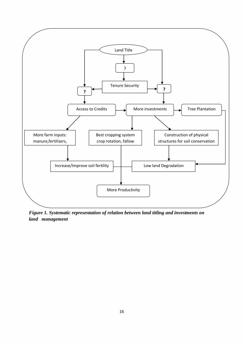
As a part of conceptual frame, a systematic representation of a relation between land titling
and investments on SLM is formulated (figure1). From the literature, it is known that there are
different views regarding tenure security and investments. So in this study, it is first tried to
know whether land titling through certificates really provides tenure security among farmers
or not as the perception of farmers in the study area is unknown. Then the second thing that is
considered is the effect of this tenure security on access to credits and investments on SLM.
Do farmers really consider that increase in tenure security improves access to credits and their

15
investment on SLM is a big question. If this question is solved, then it can be known that
whether tenure security is motivating farmers to make land related investments and use of the
farm inputs through an easy access to credits. The issue of access of credits will be discussed
only briefly to see how farmers perceive of getting access to credits by using certificates.
Investments in terms of SLM include tree plantation, construction of some physical structures,
adopting the best cropping system, fallowing, crop rotation and intercropping which helps to
reduce land degradation and the use of the farm inputs such as manure and fertilizers to
improve soil fertility finally leading to the better productivity. But in this research, this
productivity aspect is not going to be discussed as it is a long term process and time is the
limiting factor for this study.
Apart from the land tenure, other factors which influence directly or indirect ly to the farmers‟
investments in land management are also taken into consideration which includes household
characteristics, livestock characteristics, land characteristics and perception of farmers about
the erosion and soil degradation even though those factors are not shown in the framework.
16
Figure 1. Systematic representation of relation between land titling and investments on
land management
Land Title
?
Tenure Security
Access to Credits
More investments
Tree Plantation
More farm inputs:
manure,fertilizers,
Best cropping system
crop rotation, fallow
Construction of physical
structures for soil conservation
Increase/Improve soil fertility
Low land Degradation
More Productivity
? ?

17
3. Materials and Methods
This chapter gives a description of the study area followed by the methods used for data
collection.
3.1 Selection of the study area
The study was carried out in two different wereda2: Meskan and Adamitullu Jidokombolcha
(AJK) which are located in SNNP and Oromia regional state of Ethiopia. The selection of the
study area was done with the help of Zenebe Adimassu, a local advisor who is working in
HARC, Holetta, Ethiopia. The two regional states are selected because RLRCP was
implemented in these states since 2004 and not much study regarding its initial impact has
been done. In Meskan wereda, there are forty kebeles and in AJK, there are forty three
kebeles. The particular kebeles (Beressa in Meskan and Worja in AJK) were selected because
almost all the people in these kebeles had already received certificates. Also a local supervisor
is working in the same kebeles for his PHD which makes it easy to contact with other
personnel especially the development agents and the Government officers at the wereda level.
3.2 Description of the study area
The description of the study area provides the general information about the area where the
research has been conducted. Some of the information like soil, vegetation cover, farming
system and socio-economic conditions are based on the survey, group discussion and transect
walk during the field visit.
3.2.1 Location and Topography
Meskan and AJK are located in the Central Rift Valley (CRV). The CRV is situated between
approximately 38o15‟E and 39
o15‟East and 7
o10‟S and 8
o30‟S at 150 km South of Addis
Ababa in the administrative regions Oromiya and the SNNP covering an area of
approximately 10000km2 with the total population of around 1.5 million. It is a closed basin
consisting of chains of lakes and streams. CRV is one of the very vulnerable areas in terms of
soil erosion in Ethiopia (Jansen et al., 2007).
2 Wereda: District (Administrative unit above kebele)

18
Meskan wereda is found in Gurage zone of SNNP regional state. The area is located 130 km
South of Addis Ababa and 50 km to the west of Ziway town in the Rift Valley, 8.2o North
latitude and 38.5o East longitude. The topography ranges between dry lowlands at altitudes
around 1,500 m (tropical climate) to cool mountainous areas of up to 3,500 m above mean sea
level (temperate climate). The main wet season occurs between June and October, with the
remaining months predominantly dry. Daytime temperatures are typically 20–30°C, with
nighttime temperatures falling close to freezing at higher altitudes. The average annual
rainfall (1996-2005) is 1233 mm according to Butajira station (Jansen et al., 2007).
AJK is found in Misraq Shewa Zone of Oromiya Regional State. The area is located 167 km
from Addis Ababa, 7o37‟-04‟North latitude and 38
o32‟-39
o04‟East longitude. The topography
ranges between altitudes around 1,500m to 2,300 m above mean sea level. The monthly
maximum temperature varies from 25–30°C and the minimum temperature ranges between
10-20°C. According to Ziway station, the average annual rainfall (1996-2005) is 734 mm
(Jansen et al., 2007).

19
Figure 2. Map of Ethiopia showing the study area
Source: UNDP Emergencies Unit for Ethiopia, 2003
Meskan
Adami Tullu Jido Kombolcha

20
3.2.2 Soils
Farmers in the study area have a good knowledge of the soil in their area and also the
difference among the major soil types. According to the farmers, Merere is a dominant soil in
both of the study areas (92% in Beressa and 69% in Worja) which is followed by Gurraacha
(31%) in Worja kebele. Merere (Vertisols) is characterized by its vertic nature and water
logging property. This soil is too hard when dry and too heavy when wet. This soil has two
classes: tikur Merere which is black vertic soil and key Merere which is red vertic soil. Tikur
Merere is highly vertic and also water logging is high than key Merere. Gurraacha (Mollisols)
is a dark top soil with high organic matter content. This soil is more fertile and suitable for
almost all the crops (Erkossa and Ayele, 2003).
3.2.3 Vegetation cover
From the transect walk and key informant interviews, different types of trees/shrubs species
are identified. In Worja, most of the trees are Acacia species which are naturally grown. In
Beressa, Eucalyptus trees are grown near the homestead generally for the household purposes
and also for economic purposes. Naturally grown trees consist of Wanza (Cordia Africana),
Girar (Acacia bussei), Gishita (Annona senegalensis), Gesho (Rhamnus prinoides), Bisana
(Croton macrostachyus), Baddane (Balanites aegyptiaca) etc. Other tree species which are
grown by farmers mainly in Beressa are Avocado (Persea Americana), Birtukam (Citrus
sinensis), Mango (Mangifera indica), Chat (Catha edulis), Zeitona (Psidium guajava), Papaya
(Carica papaya) etc. Fruit tress are not common in Worja. The visual observation shows that
the vegetation cover is low in Worja than in Beressa.
3.2.4 Farming system and socio- economic conditions
The study areas have a mix farming system consisting of both livestock and crops.
Agriculture is rainfed and the main agricultural crops grown are Tef (Eragrostis tef), wheat
(Triticum aestivum), barley (Hordeum vulgare), maize (Zea mays), horse bean (Vicia faba)
and field pea (Pisum sativum). Other crops include tomato, onion and cabbage mainly in
Beressa. Most of the farmers in Worja donot cultivate vegetables due to the lack of water. In
Beressa, chat (Catha edulis) and coffee are grown as cash crops to their field near homestead.
Livestock is an important part of the farming system with the main animals being cow, oxen,
goat, sheep and donkey. Donkey is mainly used as a draft animal. Other animals include bull,
horses, mules and chicken. From the survey and group discussion, it is found the number of

21
animals have been decreased now that they used to be before seven years. The main reason
for this reduction is due to the livelihood problem which forces them to sell their animals.
This is also due to the lack of the grazing land as most of the community area is now under
the closure area where grazing is not allowed especially in the case of Worja.
Most of the farmers in the study areas are small scale farmers whose life basically depends on
subsistence farming. The family size is in the range between 2/3 to 14. Maximum ages of the
household heads are 22 and 92 year in Beresa and 28 and 95 years in Worja with mean ages
of 45 and 51 respectively. The minimum and the maximum number of economically active
family members are 1 and 11 respectively in Beresa and 1 and 10 respectively in Worja. The
illiteracy rate is high in Worja.
In Beressa, average land holding for cultivated land is 2.62 timad3. The majority of the
sampled households do not have grazing land 60% (24 farmers) while the remaining 40% has
the grazing land in the range between 0.20 to 2 timad. In Worja, the average land holding size
is 7.34 timad which is almost three times more than that of Beressa. In this kebele, 90% of the
households do not have grazing land and the remaining 10% has in the range between 0.50 to
4 timad.
3.2 Data Collection Methods
3.2.1 Sampling
Initially, random selection was tried for the selection of the HHs but there was a problem with
a kebele registry. The names of the farmers mentioned in the registry were not found on the
village anymore.4 So with the help of the development agents in the kebele and interpreters, a
visit to the kebele was done and a simple map was developed. HHs were represented by a dot
in a map in such a way that they cover the whole map. From there, the sampled HHs were
selected in such a way that they will almost cover the whole kebele. In Beressa and Worja,
according to the office of development agent and kebele administration, there are 695 HHs
and 575 HHs respectively. As per the suggestion of a local supervisor, forty HHs from each
kebele was selected considering a time limitation.
3 1 timad =0.25 hactare
4 Some of the people were already dead and his land is divided among the sons in the home which are not
found to be registered in the kebele register.

22
3.2.2 Primary data collection methods
Transect walks
Transect walks were done in both of the study area before conducting the main survey to
understand the topography, soil types, shrubs and trees types, the extent of soil erosion, the
different SLM practices that the farmers are adopting for preventing soil erosion, livestock
types, the HH types and the living condition of the farmers in the area. Informal talk with the
farmers on the way was also done to have some general information of the topic.
Questionnaire survey
Structured questionnaires with some open-ended questions were used to collect the primary
data from the sampled HHs. The questionnaires were designed to fit into the objectives of the
study (Appendix 1). Before finalizing a questionnaire, discussion was done with a local
supervisor so as to refine them. Data collection was done from the end of February to the
second week of May with the help of the interpreters. Due to the difficulty in finding a local
interpreter in Beressa, an interpreter was hired from Addis Ababa who is good in both English
and Amharic language. But he was unable to work in another kebele due to the language
problem as in Worja kebele, farmers speak Oromic language. In Worja kebele, a local
interpreter was available. It was easier to conduct survey with the help of a local interpreter as
he is familiar among the farmers. In Beressa, sometimes, farmers did not feel comfortable to
speak with a stranger. But there is also a drawback of having local interpreter as farmers
hesitate to speak about some critical issue related to Government which is experienced during
this study. Before starting the survey, the interpreters were briefed about the purpose of the
study and made them familiar with the questionnaires.
The questionnaires include information regarding the HH characteristics, livestock
characteristics, land characteristics, details of the field (plot size, distance, soil type, slope
class, fertility status, erosion and the extent of the erosion) land registration and certification,
farmers‟ perceptions after getting certificates, investments that the farmers are making in their
field for SLM and the relation between the investments and the land certificates. Pre-testing of
the questionnaire was conducted before conducting a real survey in order to check its
reliability and validity and as an exercise to introduce the questionnaire to local interpreter
and assistant. Afterwards, some of the questions were modified and refined. The survey was
conducted with a time period of 60 to 90 minutes. Sometimes, it even took more than two

23
hours as the farmers just raise their own personal issues and spent lots of time. Also due to the
ploughing season, it was difficult to get farmers as most of them went to the field.
Field Observation
Farmers‟ fields were also visited after conducting the survey so as to see the different kinds of
SLM that they are practicing in their fields. In some of the cases, even though farmers
mentioned about the different conservation practices and tree plantation during survey but in
field, such practices could not be seen. So this visual observation acts as a triangulation to
cross check the data obtained from the survey regarding the SLM that the farmers are
adopting on their fields.
Group discussion
A focus group discussion with open- ended questions was done in both of the kebeles who
includes young, old and both males and females. Discussion was done after conducting the
survey so that the issues related to tenure security and SLM which were not clear during the
formal survey were raised to get the better understanding of the issues
Key informant interview
Semi- structured interviews were conducted with a certain number of key informants in the
study area. Such key informants included the experts from the bureau of Agriculture and
Rural Development of the wereda, members of the land use and land use management
committee including the head of the committee at the kebele level who were dealing with land
issues for a long time. These interviewees were selected through snowball method after
reaching the field. The questions included some information regarding the problems in the
area associated with land management and how the land security (land certification and
registration) are helping them to solve these problems.
5.2.3 Secondary data collection
In order to understand the study area, subject matter and background of the research,
secondary data were collected from the beginning since the formulation of research proposal.
Such secondary data include study reports, manuals, survey reports, officially published data
and other related published papers. Also some of the local literature and some unpublished
papers were obtained from the offices at the local and national level. From these studies, it

24
helped to get a better insight of the topic regarding the evolution of land tenure system in
Ethiopia and SLM practices that the farmers are adopting. The previous findings related to the
similar researches even help to compare and contrast the findings from this study.
3.3 Data Management, Analysis and Information Processing
Secondary data including the data collected during survey, group discussions and interviews
were organized and tabulated. Data coding was done for questions that were not pre-coded.
Texts recorded during the interviews were condensed and compiled into short forms and
categorized into different themes. Statistical package for the Social Sciences (SPSS) was used
for data analysis. Descriptive statistical analysis was carried through cross tabulation where
by percentage, means, median and standard deviation were computed. Frequency analysis was
used to list out each variable and to tabulate the number of times each value of a variable
occurs and also to show the distribution of the responses of a variable. Contingency
coefficient (CC) through cross tabulation was done to compare the qualitative data whereas t-
test and correlation (r) was done to see the difference and the relation between the quantitative
variables. Comparisons of the data obtained from the literature and the field work was done
whenever needed. Finally, all the related information obtained from literature review and
other methods were managed, examined and analyzed to get the final report.

25
4. Results and Discussion
This chapter deals with the results obtained by the analysis of the questionnaire survey and the
qualitative information of the focus group discussion, other informal talks and interviews.
These results are further discussed in detail.
4.1 General Characteristics of the sampled households
The sampled HHs include small scale farmers whose life basically depends on the subsistence
farming. As the study was done in two different kebeles of two different regional states, the
analysis is done separately for each one so that comparisons can be done whenever necessary.
The given table 2 presents the general HH and livestock characteristics of the two kebeles in
two different regional states. Majority of the respondents in both of the kebels are male
(82.5% in Beressa and 87.5% in Worja). As shown in table, the minimum and the maximum
ages of the HH heads are 22 and 92 year in Beresa and 28 and 95 years in Worja with mean
ages of 45 and 51 respectively. The family size is in the range between 2-3 and 14 in both of
the kebeles. The minimum and the maximum number of economically active family members
are 1 and 11 respectively in Beresa and 1 and 10 respectively in Worja. The farming
experience ranges in between 7 and 75 years in Beresa and 11 and 57 years in Worja.
Table 2. General Characteristics of the sampled HHs
Beressa Worja
Characteristics Minimum Maximum Mean Std.Deviation Minimum Maximum Mean Std.Deviation
Age of the HH head (yr) 22 92 45 14.5 28 95 51 16
familiy size 2 14 7 2.7 3 14 7 2.5
Number of EAFM 1 11 4 2.7 1 10 3.5 2
Number of EDFM 0 6 2.5 1.7 0 8 3.8 2
Farm experience in years 7 75 30 15.1 11 57 29.5 13.5
TLU_1 0 40 6 7 0 34 10 9.2
TLU_2 0 7 2.1 1.6 0 12 4.3 2.6
where, EAFM (Economically active family members >14 and <65 years)
EDFM (Economically dependent family members <14 and >65 years)
TLU_1 (Tropical Livestock Unit before 7 years)
TLU_2 (Tropical Livestock Unit now)
Livestock is an important part of the farming system in both of the study areas with the main
animals being cow, oxen, goat, sheep and donkey. Donkey is mainly used as a draft animal.

26
Other animals include bull, horses, mules and chicken. In the table, livestock is converted
into Tropical Livestock (TLU) unit which is a convenient method for quantifying a wide
range of different livestock types and sizes in a standardized manner (For conversion factor
see Appendix 2). In both of the study area, the numbers of animals have been found to be
decreased in recent days than before 7 years mostly. The results of T- test analysis also
showed that there is a significant difference (p=0.00) between the number of animals before 7
years and now in both of the kebeles especially for cows and oxen (Appendix 3). Also there is
a significant difference in two kebeles in the number of economically dependent family
members and economically independent family members (Appendix 4). The main reason for
the reduction of these animals is found to be due to livelihood problem which forces them to
sell their animals. This is also due to the lack of grazing land as most of the community area is
now under the closure area where grazing is not allowed especially in the case of Worja.
Figure 3. Marital and education status of respondents in two kebeles
The given figure 3 shows marital and education status of the HH heads in both of the kebeles.
Majority of them are married in both Beressa and Worja (85% and 92.5% respectively). 2.5%
of them are single and 2.5% are divorced in Beressa whereas there is no single and divorced
in Worja. About the education level, it can be seen from the graph that the illiteracy rate of the
HH head is higher in Beressa with 45% whereas in Worja, it is 17.5%. In case of Worja,
majority of the people (45%) has the education level ranging from grade 1 to 4.

27
4.2 Land Characteristics
Physical and environmental characteristics of land such as farm size, slope and degree of
erosion affect the adoption of conservation practices (Bayard et al., 2006). Here land
characteristics basically deal with the ownership of the land, how the land is being acquired
and also the perceptions of the farmers about erosion in their field. Until farmers do not
perceive erosion as a problem in their field, then they may not be conscious about making soil
conservation practices and other land management practices in their fields.
In both of the study areas, farmers have their own land. None of the farmers have been found
renting their land to others and others land being rented. The land has been acquired through
inheritance, purchase (Imperial period) and got through redistribution. The following table
gives an overview of how the farmers acquired their land.
Table 3. Land acquired by the HHs
Land acquired Beressa(N=40) Worja(N=40)
Frequency Percent Frequency Percent
inherited 18 45 13 32.5
redistribution 10 25 26 65
inherited and purchased 2 5 0 0
inherited and redistribution 10 25 1 2.5
Total 40 100 40 100
Source: Own survey
From the given table 3, it is seen that there is a variation in the method of land acquired by the
farmers in two kebeles. In Beressa, majority of the farmers inherited their land (45%), 25% of
them got the land through redistribution, 5% of them got their land by both purchasing and
inheritance and 25% got their land through both inheritance and redistribution. Purchasing
and selling of the land is not allowed in the current Government system but during the
Imperial period, it was possible if there were no any legal related issues (EEEA/EEPRI,
2002). So only the minority of the farmers, who were from the imperial period, bought the
land. In case of Worja, majority of the farmers got their land through redistribution (65%),
32.5% of them inherited their land and 2.5% of them got their land through both inheritance
and redistribution but there is no one buying the land.

28
Table 4. Land holding size in two kebeles
Kebeles Land size N Minimum Maximum Mean Std. Deviation
Beresa cultivated 40 1 9 2.6 1.7
grazing 40 0 2 0.2 0.4
Worja cultivated 40 2 16 7.3 3.1
grazing 40 0 4 0.2 0.7
Source: Own survey
The land holding size also varies in two kebeles. The maximum and minimum land holding
size in Beresa is 9 and 1 timad for cultivated land with the average being 2.6 timad. Majority
of the sampled HHs in Beresa (60% i.e. 24 farmers) do not have the grazing land while the
remaining 40% has the grazing land with an average of 0.2 timad. In comparison to Beresa,
the land holding size in Worja is high for cultivated land with maximum 16 timad and
minimum 2, average being 7.3 timad. In this kebele, 90% of the HHs do not have grazing
land and the remaining 10% has grazing land with an average of 0.2 timad. T- test analysis for
the difference in land holding size between two kebeles shows a significant difference (t=-14,
p=0.00) for cultivated land whereas there is no significant difference for grazing land.
The total cultivated land is divided into different plots. Even though the cultivated land size in
Beressa is low, the numbers of plots are more in Beressa than in Worja. This means that the
land is more scattered in Beressa than in Worja . From the survey, it is found that the
minimum and maximum numbers of plots in Beressa are 1 and 7 respectively with the
average of 2.27whereas in Worja, it is 1 and 4 respectively with the mean of 1.72.
4.3 Perceptions of farmers about erosion
Soil erosion is a slow process. So it is necessary to understand farmers‟ perception of soil
erosion and its impact in order to see SLM practices that farmers are implementing in their
field (Chizana et al., 2007). Here it is tried to see how farmers perceive soil erosion in their
plots. 100% of the respondents in Beressa and 85% in Worja mentioned that they have
erosion problem either in some or in all of their plots. Soil erosion is also determined at the
plot level as some plots are not susceptible to erosion. Out of 156 plots in Beresa, majority of
the plots (78%) are affected by erosion 22% of the plots do not have erosion problem whereas
in Worja, 67% of the total fields are affected by erosion. Not only the erosion matters for soil
conservation but also the extent of erosion is important. According to farmers, if the erosion

29
rate is low, then most of the time they ignore it and do not give much emphasis on the
conservation measures.
Erosion is more severe in Beressa affecting 26% of the total plots. In Worja, only 2% of the
plots are prone to severe erosion. 40% of the total plots are moderately affected and 12% are
affected by low erosion in Beresa whereas majority of the plots (53%) in Worja are
moderately affected and 12% of the plots have low erosion rate. One of the reasons that the
less number of plots in Worja are affected by severe erosion is due to the slope of the land.
In Worja, very few plots (4.65%) are located in steep slope and the remaining plots are
located either in medium slope or in flat to gentle slope and there is no plot located in very
steep slope whereas in case of Beresa, about 28% of the plots are located in steep slope which
are more severe to soil erosion. The remaining plots are located in moderate and flat slope and
1.9% of the plots are located in a very steep slope. Statistically significant positive correlation
(r= 0.60, p=0.00 for both kebeles) has been found between extent of erosion and slope of the
plot. The steeper the slope, the higher will be the erosion extent.
Farmers perceive erosion as a problem in both of the kebeles either in all or in some of their
plots even though the rate and susceptibility varies. In both of the kebeles, majority of the
farmers (42.5% in Beressa and 60% in Worja) perceive decrease in soil depth and
productivity as a main indicator of the erosion. In Worja, the formation of visible gulley and
rills does not seem as a big problem in comparison to Beresa where 40% farmers perceive it
as an indicator including decrease in soil depth. In case of Worja, decrease in soil depth alone
is perceived as an indicator by 32.5% of the farmers (Table 5).
Table 5. Indicators of soil erosion in two kebeles
Indicators Beressa Worja
Frequency Percent Frequency Percent
Decrease in soil depth 1 2.5 13 32.5
Decrease in soil depth and productivity 17 42.5 24 60
Decrease in soil depth, productivity and visible gulley
and rills formation 16 40 1 2.5
Decrease in soil depth and visible gulley and rills formation 6 15 2 5
Total (N) 40 100 40 100
Source: Own survey

30
There are different opinions of farmers about the reasons of erosion in two kebeles. Majority
of the farmers (55%) in Worja revealed that deforestation is the main reason of erosion
whereas this reason is not mentioned by the farmers in Beresa. In Beresa, erratic rainfall,
steepness of land and improper land management are that main reasons of erosion which is
mentioned by 50% of the sampled population. The other reasons are in minority which affect
either singly or in combination with other reasons. Heavy or erratic rain has not much impact
on erosion in Worja as farmers mentioned that rainfall is too low to cause erosion. Although
some of the farmers did not perceive erosion as a major problem in their field, they just
mentioned the reasons considering the surroundings and their neighbours.
The trend of erosion i.e. increasing or decreasing and the reasons behind it is also necessary to
know in order to see how farmers perceive erosion and what kind of management practices
they are doing in order to conserve soil. From the analysis, it is seen that majority of farmers
in Beresa (77.5%) mentioned that erosion extent is increasing and remaining 22.5% feel that it
is in decreasing order since 10 years whereas in Worja, the case is opposite. 72.5% farmers
feel that the erosion rate is in decreasing order and 27.5 perceive there is decrease in erosion
rate. According to the farmers, the reason for this decreasing trend is due to low rainfall.
In overall, it is seen that erosion is susceptible in Beressa than in Worja due to the slope of the
land and also the trend of erosion is increasing Beressa.
4.4 Land Registration and Certification
This section gives a short description about the distribution of land certificates. In Beressa,
out of the sampled HHs, 32.5% got certificates in 2005, 20% in 2006, 27.5% in 2007, 17.5%
in 2008 and 2.5% in 2009. In Worja, 35% got certificates in 2007, 32.5% in 2008, 20% in
2009 and 12.5% in 2010. In both kebeles, certificates are issued jointly by the name of
husband and wife mentioning the name of other family members and also the plot size. In the
case of death of husband or wife, certificate is issued in the name of a single person. In
Beressa, in case of polygamy, one certificate is issued in the name of husband and wife who
are living together and another in the name of other wife mentioning the name of her husband
and separate land is given to her whereas in Worja, all wives are registered and get joint
titling. Certificates are not issued to those people whose age is below 18 years.
All the sampled HHs feel the importance of the certificates and keep them in a safe place and
even ready to pay for the replacement in case they loss their certificates. They also mentioned

31
that their lands had been measured properly but there was some conflict during land
demarcation especially with the neighbors whose plot is adjacent to theirs. In Beressa, 97.5%
of the sample mentioned that there was no any conflict during land demarcation while 2.5%
had conflicts with neighbours whereas in Worja, 90% has no any conflicts and remaining 10%
had conflicts. Such kind of conflict is solved by discussion with the elder members of the
kebele including the officers from the kebele office (development agent). If the problem
cannot be solved by such kind of mutual understanding, then the case goes to court and until it
is not solved, the certificates are not issued. While asking about the rights and responsbilites
of farmers after getting certificates, most of them mentioned legal ownership of land as their
rights and paying tax and conserving their land as their responsibilities which shows that
almost all the farmers have some kind of awareness about the importance of certificates.
4.5 Perceptions of farmers after getting certificates
Perception of the farmers about the certification programme plays an important role on their
investments in SLM (Deininger et al., 2009). So before knowing the conservation practices
that they are making in their field, it is necessary to see their perception about this
programme. Perception is generally difficult to predict as it is very subjective and not directly
measurable matter. So here, perception is tried to see from different views and is categorized
into inheritance of land, reduction of border conflict, getting credits for farm inputs, increase
tenure security and investments in SLM, receiving compensation if land is taken away,
promotes gender equality and increasing female willingness to work. The perception is
described in 5 scale categories individually for two kebeles.
4.5.1 Certificates help to inherit land to the children
From the survey, it is found that in both of the kebeles, farmers are quite confident that the
certificates will help them to inherit their land to their children as they have a proof of their
land ownership. There is not even a single negative view against this opinion. 100% of the
farmers in Worja and 97.5% in Beressa completely agree that they will inherit their land and
2.5% of them just agree in this matter which also shows the positive response of the farmers.
4.5.2 Certificates reduce border conflicts
One of the problems associated with land conflict in the study kebeles is about the border
conflict. Some of the farmers mentioned that their neighbors used to plough some part of their
plot at the border and there is no any proof for the ownership of land. But after the distribution

32
of these certificates, farmers are quite confident that nobody can claim their land and in case
of some conflicts, the certificates can be used as a proof of their holdings.
Table 6. Certificates reduce border conflicts
Beressa Worja
Frequency Percent Frequency Percent
completely disagree 2 5 0 0
slightly disagree 1 2.5 0 0
slightly agree 0 0 1 2.5
completely agree 37 92.5 39 97.5
Total 40 100 40 100
Source: Own survey
In Worja, 97.5% of farmers completely agree and 2.5% of them slightly agree that their land
certificates will help to reduce border conflict with their neighbors and there is no any
disagreement on this matter. In case of Beresa, majority of the farmers (92.5%) believe that
certificates will help to reduce border conflict but there are also few cases where 5% of the
farmers completely disagree and 2.5% of them slightly disagree. The very few case of
disagreement in Beressa is due to the fact that few people are still in problem of this border
conflict and is on the process of solving with the help of the elder members of the kebele.
The study made by Tefera and Holden (no date) in Tigray region found that certificates
reduce border conflicts especially due to good plot border demarcation and plot size
measurement which are the same reasons mentioned by the respondents in the study area.
According to Tefera and Holden, there is more conflict on redistributed land which is solved
by certification programe. From this survey also, it is found that the perception of the farmers
about certification is affected by the way in which they acquire their land. In Worja, a
significant relation has been found between the way of land acquired and certificates reduce
border conflicts (CC= 0.71, p=0.00) (Appendix 6). 68% of the farmers who obtained their
land by redistribution completely agree that certificates help to reduce border. The focus
group discussion and interview with land management committee also revealed that after
getting certificates, the border conflict has been solved especially for the redistributed land as
the plot is demarcated in all four sides mentioning the total area of each plot. But in Beressa,
statistically no any significant relation has been found.

33
4.5.3 Certificates help in getting credits for farm inputs
Most of the time farmers do not apply fertilizers, pesticides and other inputs to their field due
to the financial problem which is also the main case in the study area. As most of the farmers
are subsistence farmers and due to the financial problem, they are not being able to use these
farm inputs. One of the benefits of having certificates is that they can use certificates as
collateral to the financial institute and can get credits to buy farm inputs (Deininger, 2003).
Table 7. Certificates help in getting credits for farm inputs
Beressa Worja
Frequency Percent Frequency Percent
completely disagree 4 10 4 10
slightly disagree 1 2.5 1 2.5
slightly agree 1 2.5 2 5
Agree 1 2.5 0 0
completely agree 33 82.5 33 82.5
Total 40 100 40 100
Source: Own survey
The table shows that in both of the kebeles, majority of the farmers( 82.5% in both)
completely agree on getting credits by using certificates as a collateral whereas 10% of them
completely disagree on this matter. The remaining 7.5% of the sampled farmers are little bit
confused and were not being able to completely agree or disagree as they were not aware of
this thing and had not applied for credits till now. So here it seems to be the lack of awareness
among the farmers about using certificates as a means of getting credits for farm inputs.
4.5.3 Certificates increase tenure security
Does the provision of certificates for land titling really increase tenure security among the
small scale farmers is a matter of discussion. Land tenure is the system of rights and
institutions that governs access to and use of land and other resources (Maxwell and Weibe,
1998). Here it is tried to know the how farmers perceive about tenure security after getting
certificates.

34
Table 8. Certificates increase tenure security
Beressa Worja
Frequency Percent Frequency Percent
slightly disagree 2 5 0 0
slightly agree 1 2.5 0 0
Agree 1 2.5 0 0
completely agree 36 90 40 100
Total 100 40 40 100
Source: Own survey
Table 8 shows that in Worja kebele, 100% farmers completely agree that the certificates
increase tenure security whereas in case of Beressa, 90% of them completely agree and 5% of
them slightly disagree. So in both kebeles, almost all the farmers perceive that this certificate
will help to increase land tenure security. This finding is similar to the finding of the study
made by Holden and Tefera (2008) in Southern Ethiopia which showed that the land reform
has contributed to increase perceptions of tenure security among small scale farmers. The
reason behind the disagreement of 5% of people in Beressa is that there were secured before
also as they are paying land tax.
4.5.4 Certificates increase investments in land management
One of the main motives of providing certificates is to increase land related investments for
SLM (Deininger et al., 2009). So, here it is tried to see whether perception of farmers about
tenure security affect their perception on investments on land management or not.
Table 9. Certificates increase investments in land management
Beressa Worja
Frequency Percent Frequency Percent
completely disagree 9 22.5 0 0
slightly agree 3 7.5 9 22.5
completely agree 28 70 31 77.5
Total 40 100 40 100
Source: Own survey
The survey results (table 9) shows that in Worja, 77.5% farmers completely agree that
certificates increase investments in SLM and 22.5% slightly agree and there is no any case of
disagreement. In Beresa, even though majority (70%) of farmers completely agrees that
certificates will increase investments in SLM, there are also cases where 22.5% of them

35
completely disagree and 7.5% slightly agree. The reason behind the disagreement of 22.5% of
farmers in Beressa is that they are not making soil conservation practices and other land
management because of certificates. They mentioned that land is a basic source of their
livelihood and it is their duty to protect the land from extremities in order to have better
production for themselves and for their family whether they have certificates or not.
4.5.5 Certificates help to receive compensation if the land is taken away
From the informal talks with farmers before conducting the formal survey and from the focus
group discussion, it was found that before getting certificates, they have some kind of fear that
their land will be taken away without any compensation if there is any work for urban
expansion and there are also few cases where they had not got any compensation. Now the
farmers are more confident that they will get compensation if their land is taken away as thay
a proof of their land ownership. The confidence level is more in Beressa where 97.5%
mentioned that they agree whereas in Worja, 85% of them agree on this. Some farmers do not
think that they will get compensation as they believe that land still belongs to Government
and it is difficult to say on the issue of Government. Majority of the farmers (80.8%) who got
land by redistribution (N=26) perceive that they will get compensation now if their land is
taken away for any purposes. The informal talks with the farmers and the focus group
discussion also revealed the same fact that those farmers who got their land through
redistribution were uncertain about getting compensation before getting certificates but now
they are completely sure of getting compensation in any case. So it can be said the
redistributed land are more secure after getting certificates than before. Megeleta Oromia,
2009 and Debub Negarit Gazeta, 2007 SNNP have also mentioned about the provision of
giving compensation in case farmers are evicted from their land holding for public purpose.
Table 10. Certificates help to receive compensation if the land is taken away
Beresa Worja
Frequency Percent Frequency Percent
completely disagree 1 2.5 5 12.5
slightly disagree 0 0 1 2.5
slightly agree 1 2.5 0 0
Agree 2 5 0 0
completely agree 36 90 34 85
Total 40 100 40 100
Source: Own survey

36
4.5.6 Certificates promotes gender equality and female willingness to work
One of the basic fundamental of certification program is women empowerment and gender
equality. Traditionally, in Ethiopia, women have less power and weak position in HH and in
society than male. They are less involved in farming activities and males are always
responsible for those activities. Now certificates help them to have land rights (Holden and
Tefera, 2008). The result shows that majority of the respondent in both kebeles (100% in
Worja and 90% in Worja) agree that certification program promotes gender equality. Out of 5
female respondents in Beressa, all mentioned that as their names are mentioned on the
certificates, they believe that they will get the land in case of death or divorce to their husband
which also makes them strong and motivate to work in field. The result also shows that
female are more willing to work more in the field (100% in Worja and 80% in Beressa). 20%
of the respondents who are men believe that there is no difference in the contribution of
female in field before and after certificates as they are always motivated to work in the field
for the benefit of the family and are always ready to help male members of the family.
4.6 Farmers’ perceptions about the redistribution in future
There was frequent land redistribution in past days in Ethiopia so it also necessary to know
the perception of farmers about the redistribution in future as this may also affects their
investment in land management. The survey result showed that in Beresa, majority of the
respondents (62.5%) mentioned that they do not know what will happen in future. According
to them, it all depends on Government and their policy which is difficult to predict. 17.5% of
them think that there will be redistribution in future and 20% think that there will not be any
redistribution. So it seems that people are still quite unsure about what will happen in future.
About the land holding size in case if there will be redistribution, 42.5% of respondents feel
their land size will be decreased, 27.5% feel their land size will increase and 15% respond as
they do not know and 15% mentioned that their land size will remain same.
In case of Worja, 15% respondents responded as they don‟t know, 60% think there will not
be redistribution and 25% think there will be redistribution again in future. Most of the
respondents (82.5%) in Worja feel that their land holding size will be decreased in case if
there will be redistribution as they feel that their land holding size is more. The reason behind
saying that there will be redistribution again in future is due to the change in family size. As
the land was distributed according to the family size and now as the family size has been

37
changed, they feel that there will be redistribution as the low family size has more land and
vice versa.
4.7 Perception about security of land before and after certificates
There is a difference in perception of farmers about the security of the land before and after
getting land certificates. Certificates provide them land titling and land rights and they can use
their certificates as a proof of their land ownership.
Table 11. Security of land before and after certificates in two study kebeles
Beressa Worja
Frequency Percent Frequency Percent
Security of your land after getting certificates slightly secure 1 2.5 0 0
secure 2 5 0 0
completely secure 37 92.5 40 100
Total N 40 100 40 100
Security of your land before getting certificates completely insecure 6 15 16 40
slightly insecure 28 70 18 45
slightly secure 2 5 4 10
completely secure 4 10 2 5
Total N 40 100 40 100
Source: Own survey
While asking about the security of land before and after getting certificates, only 10% of the
respondents in Beressa mentioned that they were completely secure of their land before
getting certificates but now 92.5% mentioned that they are completely secure due to
certificates. In case of Worja, after getting certificates, 100% of the respondents feel full
confident about the security of their land whereas before getting certificates, only 5% of them
were completely secure. So it is seen that there is a quite change in the perception of farmers
before and after getting certificates. In both of the kebeles, almost all the respondents are
completely secure about their land now after getting certificates where before they were
insecure. But during the focus group discussion in Beressa, farmers mentioned that they will
never be completely secure of their land just due to certificate as certificate is not a “Bible” or
“Qur‟an” and it can be changed anytime if there is change in Government. They are not sure
about what will happen in future as they already experienced a frequent land redistribution
and change in Government with the change in land system in past days in Ethiopia.

38
4.8 Perceptions about the current land holding system
Here it is tried to know whether the farmers like the current land holding system or not and
what kind of land holding system do they prefer. The survey results showed that 95% of the
respondents in Beressa mentioned that the current land holding system is good for them and
5% of them mentioned as they do not know about such kind of issue. About the land holding
system, 67.5% prefer public ownership but secure rights and whereas 32.5% prefer freehold
or private ownership so that they can sell and mortage their land. In Worja, 100% of the
respondents mentioned that they like the current land holding system and 100% of them
prefer public ownership but secure rights. There is no respondent found who prefer private
ownership of land. The belief of the respondents for preferring public ownership is that if the
land is allowed to sell then at the time of emergencies, the land will be sold and afterwards
they will be in a great problem as land is the only source of their livelihood. In case of
Beressa, even majority of people supports the current system of land holding, there are also
people (32.5%) of people preferring private land ownership. As the issue of land holding is a
matter of a political debate in Ethiopia and also as the election was coming near during ths
study time, farmers do not feel more comfortable to talk about this issue.
The above description shows that majority of the respondents in the surveyed HHs have a
positive response towards RLRCP, especially in Worja even though there are minority of
farmers who do not consider this. In both kebeles, above 80% of the respondents agree that
certificates will help them in providing tenure security through different perspectives. The
only exceptional is in Beressa where even though majority of the farmers (77.5%) perceive
that certificates help in increasing investments, there are also cases of complete disagreement.
During focus group discussion also, it is found that in Beressa, few farmers do not care about
whether they have certificates or not and mentioned that are always secure about their land as
they are paying land tax and always willing for SLM practices as land is the only source of
their livelihood.
4.9 Impact of certificates (tenure security) on Investments in Soil and land management
(SLM) practices
The previous explanation already shows the perception of the farmers. Now it is necessary to
see whether this perception really has any role in making investments in SLM practices or
there are some other factors which are affecting in making those investments.

39
The investments have been distinguished as public and private investments. Public
investments in conservation are done in a group by mobilizing people through the Safety Net
program and food for work incentives especially for the construction of bunds. Only private
investments at the famers‟ plot level are taken into consideration. The SLM practices that the
farmers are practicing in the study area include construction of traditional ditches, application
of inorganic and organic manure, construction of bunds, tree plantation, crop rotation and
intercropping.
Table 12. Number of respondents making different land management practices
Beressa Worja
Frequency Percent Frequency Percent
Traditional ditches No 24 60 3 7.5
Yes 16 40 37 92.5
Total 40 100 40 100
Organic fertilizers No 2 5 1 2.5
Yes 38 95 39 97.5
Total 40 100 40 100
Inorganic fertilizers No 8 20 36 90
Yes 32 80 4 10
Total 40 100 40 100
Soil bunds No 19 47.5 7 17.5
Yes 21 52.5 33 82.5
Total 40 100 40 100
Stone bunds No 33 82.5 36 90
Yes 7 17.5 4 10
Total 40 100 40 100
Stone-soil bunds No 32 80 0 0
Yes 8 20 0 0
Total 40 100 40 100
Treeplantation No 1 2.5 26 65
Yes 39 97.5 14 35
Total 40 100 40 100
Source: Own survey
4.9.1 Traditional Ditches
Traditional ditches (Boi) are the short term investments that the farmers are making in their
plots during the time of ploughing. These ditches are constructed using a Maresha (wooden

40
plow) and plough pull by oxen to allow excess water to infiltrate easily and drain out of
cultivated land acting as a cut off drain. It helps to protect soil from being washed away by
runoff and reduce surface runoff generated within a cultivated land. The spacing, depth,
length and gradient of these ditches depend on the types of crops grown, erosion extent, water
logging condition, depth of the soil and length of the field (Erkossa and Ayele, 2003).
Figure 4. Traditional ditches (left) and Oxen plough (right)
The number of respondents using traditional ditches varies in two kebeles. Table 12 shows
that 60% of the respondents do not construct and 40% of them construct ditches on their plots
in Beressa whereas in Worja, majority of the farmers (92.5%) construct ditches. The farmers
do not construct ditches in all of their plots. Even though the total number of plots in Beressa
is higher than in Worja, more ditches are constructed in Worja than in Beressa. In Beresa,
only 16% (N=156) of the plots have traditional ditches whereas 84% donot have those
ditches. In case of Worja, 86% (N=86) of the plots have ditches whereas 14% of plots do not
have ditches. While asking the farmers whether they are making those ditches due to
certificates, then, in Beresa, only 3% of the respondents mentioned that they are making those
ditches due to certificates and 97% of them are not making due to certificates. In case of
Worja, the case is different. Majority of them (70%) mentioned that are making ditches due to
certificates for having secure land and 30% mentioned that it is not due to certificates.
Traditional ditches in Beressa
In Beressa, statistically no significant relation is found between the perception of farmers5
after getting certificates and the construction of traditional ditches which is also proved by the
5 Perception of farmers after getting certificates include certificates help to inherent land to children, reduces
border conflicts, helps in getting credits for farm inputs, increase tenure security, increase investments in land
management and receives compensation if the land is taken away.

41
fact that majority of farmers (97%) mentioned that they are not making ditches due to
certificates. Rather, they consider it as their duty and responsibilities to protect their land
whether they have certificates or not as land is the only basic source of their livelihood. So
here it shows that perception about tenure security is not always the reason to make
investments. There are certain other factors which have some impact on the construction of
ditches. Contingency coefficient (CC) shows that there is a significant association of
construction of ditches with the education level of the HH head (CC= 0.3, p=0.03) in Beressa
(Appendix 7). Even though, the relation is not strong, 72% of the total ditches (N=25) are
found to be constructed by the literate farmers whose education ranges from read to write to
grade 9 to 12. They also mentioned that they are getting some information about the benefits
of making these ditches by the development officers whereas illiterate farmers donot mention
those things.
Traditional ditches in Worja
In Worja, a significant relation of the construction of traditional ditches has been found with
the perception of the farmers that certificates reduce border conflicts (CC= 0.36, p=0.00),
perception of the farmers that certificates help to get credits for farm inputs (CC= 0.3, p=0.04)
and compensation for land (CC= 0.3, p=0.01) (Appendix 7). 86% of the total plots which
have ditches are on the plots of the farmers who completely agree that certificates reduce
border conflicts, 85% of the total plots which have ditches are in the plots of the farmers who
completely agree that certificates helps in getting credits and 89% of the total plots which
have ditches are in the plots of the farmers who completely agree that certificates helps in
getting compensation. Although the relation is significant, it is not strong enough. But the
response of 70% of the sampled HHs that they are making those ditches because of land
security after getting certificates shows that they are influenced by certificates. Generally
when tenure security is concerned, more emphasis is given on long term investments. But the
case found in Worja is different where tenure security is even influencing short term
investments on SLM which is in contrast of the findings obtained by Gebremedhin and
Swinton (2003) in Northern Ethiopia. Another reason is that in Worja, majority of the farmers
obtained land through redistribution and after getting certificates, they become secure about
the land which motivates them to make these ditches. There are certain other factors which
also have influence on the construction of ditches. Contingency coefficient (CC) through
cross tabulation shows that there is a significant association of construction of ditches with

42
erosion (CC= 0.25, p=0.04), extent of erosion (CC= 0.31, p=0.03) and the way land is
acquired (CC= 0.4, p=0.00) [Appendix 7]. More ditches (68%) are found in those plots which
are obtained through redistribution. More ditches are constructed in such plots where there is
erosion problem but the rate of erosion is moderate to low as these traditional ditches cannot
withstand the heavy erosion.
4.9.2 Construction of Bunds
Bunds are the physical structures which are constructed across the contour lines in order to
reduce the steepness of the land (Gebrernichael et al., 2005). Soil and stone bunds are the
dominant types of conservation structures in the study areas. Stone bunds are more durable
than soil bunds. Also, a combination of stone and soil bund has been found in some plots in
Beressa. According to the farmers, they construct such bunds when the erosion is high but
there is lack of stones to construct the full stone bunds. Soil bunds are considered as short
term investments on SLM whereas stone and combination of stone and soil are the long term
investments for SLM (Kaliba and Rabele, no date).
Figure 5. Soil bund (left) and Stone bund (right) in farmers’ plot
Soil bunds are common in Worja than in Beressa whereas stone bunds are more in Beressa
than in Worja and combination of stone and soil bunds are found only in Beressa. In overall,
at the plot level, bunds are constructed more in Worja than in Beressa. The construction of
soil bunds is more than other bunds in both kebeles. As erosion is not much severe in Worja
as in Beressa and also due to the lack of stones, farmers are making more soil bunds in Worja
than other bunds. Farmers also mention that they don‟t construct bunds when the plot is in flat
land and erosion is not much severe. Another reason for not constructing bunds especially in
Beressa is that they are waiting for the group mobilization program to make such bunds. In

43
the kebele, if any plots of farmers have severe erosion, then with the help of the development
agent, the farmers are mobilized for the construction of bunds and farmers help each other.
Bunds in Beressa
From the survey, it is found that in Beressa, 52.5% of the respondents constructed soil bunds,
17.5% constructed stone bunds and 20% constructed combination of soil and stone bunds. At
the plot level, 23% of the total plots (N=156) have soil bunds, 6.4% have stone bunds and
8.3% have combination of soil sand stone bunds. In this kebele, all the respondents start
getting certificates from 2005 onwards. While comparing the date of getting certificates with
the date of construction of soil bunds, then 45% of the total soil bunds (N=36) were
constructed before 2005, 36% after 2005 and 19% in 2005. So it is difficult to generalize
whether they are making more soil bunds after getting certificates or not as the bunds that are
constructed on year 2005 (19%) is difficult to consider the one made after getting certificates
due to the quick response. In the case of stone bunds, 50% (N=10) are made before 2005,
10% in 2005 and 40% after 2005. Only for the combination of stone and soil bunds, majority
of them are constructed after 2005 (83%) which can be considered as an influence of
certificates but again while asking farmers whether they are making those bunds after getting
certificates, 97% of them mentioned that that are not making those bunds due to certificates
which shows that there is no influence of certificates on either soil bund or stone bund
construction in Beressa..
In Beressa, the construction of soil bunds has a significant relation with the perception of
farmers that certificates reduce border conflicts (CC= 0.2, p=0.01) (Appendix 7). Even though
this relation is not strong, 98% of the plots which have soil bunds are constructed by those
farmers who believe that certificates reduce border conflicts. For stone bund, no any relation
has been found with the perception of farmers after getting certificates and the construction of
stone-soil bunds has a significant relation with the perception of farmers that certificates
increase tenure security (CC= 0.4, p=0.00) (Appendix 6). 100% of the plots which have stone
bunds are constructed by the farmers who agree that certificates increase tenure security and
this relation is moderate (CC=4). Even though statistically some significant relation has been
found between the construction of bunds and perception of farmers after getting certificates,
the comparison of date of construction of bunds and date of getting certificates and also the

44
response of farmers for not making bunds due to certificates reveal that there is no impact of
certificates for construction of bunds in Beressa.
There are other HH and land characteristics which are affecting the construction of bunds in
Beressa. CC shows a significant relation of construction of soil bund with erosion (CC= 0.2,
p=0.03) and erosion extent (CC= 0.32, p=0.01) (Appendix 7). Even though the relation is not
so strong relation, 91% of the plots which have erosion had constructed soil bunds where the
extent of erosion is low to moderate as soil bunds cannot withstand severe erosion. A
significant relation of construction of stone is found with education level (CC= 0.3, p=0.01)
and slope class (CC= 0.25, p=0.02) [Appendix 7]. 90% of the total plots which have stone
bunds are constructed by the literate farmers. Stone bunds are mainly constructed in the plots
having moderate to steep slopes. About the combination of soil and stone bund, a significant
relation is found with the education status of the HH head (CC= 0.3, p=0.01) [Appendix 7]
with more bunds constructed by the literate farmers.
Bunds in Worja
In Worja, 82.5% of the respondents construct soil bunds, 10% constructed stone bunds and
there are no farmers using the combination of stone and soil bunds. At the plot level, 57% of
the total plots (N=86) have soil bunds and 2% have stone bunds. In this kebele, respondents
start getting certificates from 2007 onwards. While comparing the date of construction of
bunds with the date of certificates, it is found that most of the soil bunds (66%) and all the
stone bunds that are constructed are after 2007 which shows that there is influence of
certificates on bunds construction in Worja. Also, majority of them (70%) mentioned that they
construct those bunds due to certificates for having land secured and sense of belongingness
which also shows the influence of certificates.
The construction of soil bunds has no any significant relation with the perception of farmers
after getting certificates but the construction of stone bunds has a significant relation with the
perception of farmers that certificates increase investments (CC= 0.2, p=0.03) (Appendix 6).
100% of the plots which have stone bunds are on the plots of those farmers who agree that
certificates increase investments. Even though, statistically the relation is not strong, there are
proof from the date of certificates and construction of bunds which verify that in Worja, the
construction of bunds are influenced by certificates. Also majority of the respondents (70%)
mentioned that they are making bunds after getting certificates due to land security.

45
In case of Worja, even though more respondents are educated than in Beressa, no any
significant relation has been found between the construction of bunds and the education level.
CC shows a significant relation of construction of soil bund with the slope class (CC= 0.6,
p=0.00), erosion (CC= 0.6, p=0.00) and erosion extent (CC= 0.6, p=0.00) (Appendix 7). Most
of the soil bunds are constructed in a moderate slope plot where the erosion rate is medium.
According to farmers also, they donot construct soil bunds in a steep slope where erosion is
high as soil bund cannot withstand such erosion. Statistically no any relation of the
construction of stone bund has been found with the land characteristics.
Maintenance of bunds
Maintenance of the bunds also shows the effect of getting certificates. In Worja, 100% of the
respondents who made bunds in their fields mentioned that they maintain bunds in their field
and majority of them (70%) also mentioned that they are doing this maintenance due to
security of land after getting certificates. According to them, before getting certificates, they
were not much interested in doing such activities but now they are more conscious about their
land and are motivated to implement SLM practices. But the case in Beressa is again
different. Even though 97% of the respondents mentioned that they maintain bunds in their
plots, only 37.5% of them mention that they are maintaining these bunds due to security of
their land after getting certificates whereas other 62.5% mention that it is not due to
certificates. They do the regular construction especially during ploughing time in to conserve
soil from erosion and for this, it does not matter them whether they have certificates or not.
Thus it shows that in Worja, the construction of traditional of ditches and bunds are
influenced by both land characteristics and tenure security after getting certificates whereas in
Beressa, it is only influenced by the HH and land characteristics. Even though the erosion rate
is high in Beressa than in Worja, not much soil conservation structures have been found
constructed in Beressa. It seems like farmers in Beressa are waiting for the group mobilization
to construct those structures. Also the distance of the plot from the home and the plot size
which are considered as a major factor for determining the adoption of conservation practices
(Featherstone and Goodwin, 1993) have no affect on the construction of these structures. No
relation has been found between the perception about future redistribution and the
construction of those structures even though it is mentioned that the fear of future
redistribution will obstruct farmers in making investments on SLM (Gebreselassie, 2006).

46
4.9.3 Organic fertilizers (Compost)
Loss of soil organic matter is one of the important factors for soil degradation. So it is
necessary to maintain a satisfactory level of organic matter in soils as it plays a major role in
soil functions and quality such as a source of nutrients, promotion of favorable soil physical
condition, soil biotic population and plant nutrients absorption (Budhaka and Srikajorn,
2002). Application of organic manure is considered as a long term investments in SLM.
Figure 6 . Compost making in farmers’ homestead
Organic manure in the form of compost is being used in the study areas in order to improve
and maintain the fertility and productivity of soil. Composting is the product which is
obtained by the process of decomposition of waste products from farmlands and byproducts
of agro - industry microbial activities (Budhaka and Srikajorn, 2002).As shown in the Table
12, in both of the kebeles, there is a high response of the farmers for the application of organic
fertilizers. 95% of the respondents in Beresa and 97.5% of the respondents in Worja applied
manure on their plots. But when considering the number of plots receiving manure, the case
is different. In Beressa, only 37% of the total plots (N=156) received organic manure and
63% did not receive any manure whereas in Worja, 93% of the total plots (N=86) received
organic manure. Here, only the application of manure is not a big concern. It is necessary to
know whether they are applying this due to certificates or not.
Organic manure in Beressa
In Beressa, by the statistical analysis, no any significant relation has been found between the
perception of farmers about certification and the application of manure. Also, a very few
respondents (3%) mentioned that they are applying manures due to certificates while the rest

47
97% mentioned that they are not applying this manure due to certificates. This weak response
is due to the trainings that the farmers are getting on compost making at the local scale which
motivates them to apply rather than due to certificates. A significant relation has been found
with other factors such as slope class (CC= 0.25, p=0.02), soil fertility (CC= 0.3, p=0.00) and
erosion extent (CC= 0.3, p=0.01) (Appendix 7). From the survey result and as per mentioned
by the farmers, it is found that more manures are applied in moderate to flat and gentle slope
where the erosion rate is low or there is no erosion. Also, manure is applied more in the soil
with medium fertility as they found no response of applying manure in low fertility soil. In
Beressa, the low application of organic manure at the plot level is due to the lack of
transportation. From the survey also, it is found that distance matters for the manure
application as most of the manure applied (93% of the total plots getting manure) are near to
the homestead (upto 10 min walking distance from home).
Organic manure in Worja
In Worja, statistical analysis shows a significant relation of application of organic manure
with the perception of farmers that certificates reduce border conflicts (CC= 0.5, p=0.00),
helps to get credits for farm inputs (CC= 0.3, p=0.02) and can get compensation for land
(CC= 0.4, p=0.01)[Appendix 6]. 100% of the plots which have applied organic manure are on
the plots of those farmers who believe that certificates reduce border conflict, 85% of the
plots which have applied organic manure are on the plots of those farmers who believe that
certificates help to get credits and 89%.of the plots which have applied organic manure are on
the plots of those farmers who believe that certificates help to get compensation. This relation
is not very strong except for the certificates reduce border conflict which is moderate but the
response of 70% of the respondents that they are applying organic manure due to certificates
verify the fact that in this kebele, certificates play an important role. In Worja, no any
significant relation of application of manure has been found with the HH and livestock
characteristics but a significant relation is found with the method of land acquired (CC= 0.5,
p=0.00) (Appendix 7). 67% of the plots which are applied with organic manure are on the
plots of those farmers who acquired by redistribution. Even though statistical analysis does
not show any relation between the application of manure with the distance of the plot, farmers
mentioned that it is difficult to apply manure to the far plots due to the lack of transportation.
In such cases, they used to hire animals from neighbor and used to transport manures.

48
4.9.4 Application of inorganic fertilizers
Inorganic fertilizers are considered as a short term investment on land which is applied for a
quick response and better production in a short time period. Even it is short term investment
on land, it is more influenced by an access to credits which is, in turn, influenced by the
certificates as certificate can be used as collateral to get access to credits for farm inputs. In
the study areas, Urea and DAP has been found to be applied by farmers in their fields.
Inorganic fertilizers in Beressa
The application of inorganic fertilizers is found to be more in Beressa. 80% of the respondents
apply fertilizers in their plots and 51% of the total plots receive fertilizers (N=156). Even
though the use of fertilizers is higher in Beressa, they are not applying it due to certificates.
No any significant relation has been found between the perception of farmers after getting
certificates and the application of inorganic fertilizers. This is also verified by the fact that
none of the farmers mentioned that they are applying fertilizers due to certificates. Rather a
significant relation has been found with the extent of erosion (CC= 0.2, p= 0.02) (Appendix
7). According to farmers, they usually apply fertilizers in those plot where they have low to
medium erosion rate. The use of fertilizers in plot having severe erosion is of no use as they
don‟t see any response of fertilizers.
Inorganic fertilizers in Worja
In Worja, only 10% of the respondents apply fertilizers and 7% of the total plots (N=56)
receive inorganic fertilizers. A significant relation of application of inorganic fertilizer has
been found with the perception of farmers that certificates reduce border conflicts (CC= 0.5,
p= 0.00) and certificates helps in getting compensation (CC= 0.5 p=0.00) [Appendix 6]. But
this does not seem to have a major implication as the factor like certificates help to get credits
for inputs, which mainly affect the application of fertilizers, has no any relation with the
application of fertilizers. Also the use of fertilizers is in minority in Worja and all the farmers
have already mentioned that they are applying fertilizers not due to certificates. Farmers
prefer more organic manures than inorganic fertilizers. Farmers mentioned that their crops are
burnt when they apply fertilizers due to lack of rainfall and they even lost their whole crops.
They also don‟t want their fields to be used to for such fertilizers as they noticed that once the
fields are applied with inorganic fertilizers and next time if they are not able to apply, then the
crop yield is reduced drastically.

49
In Beressa, even though farmers are applying fertilizers, it is not as per the recommended
proportion which is mainly due to high price of fertilizers. Price is the major hindrance for not
applying fertilizers which is mentioned by all the respondents in both kebeles. As the farmers
are the small scale farmers, they cannot afford to buy fertilizers. Even though, majority of
farmers (82.5%) perceive that certificates helps in getting credits for farm inputs, later on they
mentioned that they have never applied for this credit and nobody has told them about this. So
it also seems to be due to the lack of knowledge.
The application of organic manure is not affected by tenure security in Beressa. Even though
farmers mentioned that they are getting training in compost making which motivate them to
apply compost, at the plot level, the application is low due to lack of transportation. In case of
Worja, farmers are influenced by tenure security and the application rate is also high at the
plot level. For fertilizers, in both kebeles, the main problem is high price and there is no
relation with tenure security.
4.9.5 Tree Plantation
The investments in tree plantation are considered as a long term investment in land
management. So it is expected to be influenced by the certification programme.
In the case of Beressa, 97.5% of the respondents mention that they planted trees in their fields
whereas in case of Worja, only 35% mentioned that they plant tree in their fields while 65%
do not plant trees. But they have trees grown on their field naturally long time before and they
maintain them. No fruit trees have been found planting in Worja.
In Beressa, no any statistically significant relation has found between the perception of
farmers after getting certificates and the tree plantation. Also, no any significant relation has
been found with the HH and land characteristics. Even though majority of the farmers (85%)
planted trees, they revealed the fact that they are not planting due to certificates. Most of the
trees planted are chat (cash crop) which are grown nearby to home. Fruit trees such as mango,
papaya, avocado, kazmir are also found near the homestead. Farmers mentioned that they
plant more trees near home but statistically no significant correlation has been found between
the distance of the plot and the amount of tree planted. Some other types of trees are also
found in their fields which are planted long time before (List of trees in Appendix 8). These
trees are mainly planted for construction, firewood and also for economic purposes. Some

50
farmers even mentioned they are planting trees to conserve soil but the effect is not due to
certificates even though they plant some trees after getting certificates.
Like in Beressa, in Worja also, no any statistically significant relation has found between the
perception of farmers after getting certificates and the tree plantation. But a significant
relation has been found with the education level of the HH head (CC= 0.6, p=0.02), slope
class (CC= 0.5, p=0.01) and erosion extent (CC= 0.6, p= 0.00) (Appendix 7). In Worja, even
though not much trees have been planted, the trees which are planted are by the literate
farmers. Also more trees are found in medium to flat slope plot where the extent of erosion is
medium. Here according to the farmers, the main reason for not planting trees is due to lack of
water and also due to animal problems. According to them, if they plant trees near homestead,
animals destroy them and in the distant field, it is difficult to manage trees and some people
even cut their trees especially at night for charcoal making.
The results show that tree plantation does not seem to be influenced by certificates even there
are studies showing that certification and tenure security motivates in making long term SLM
practices like tree plantation (Palm, 2010 and Deininger et al., 2009). In both of the kebeles,
farmers also mentioned that they are not getting seedlings for free and when they buy
seedlings and plant, these seedlings get wilted within few days. According to them, this is
mainly due to soil problem. The other problem in both study area is the lack of water. The
farmers mentioned that if they have irrigation facility, then they are always motivated for tree
plantation.
4.9.6 Crop rotation, Intercropping and Fallowing
Crop rotation is a “planned order of specific crops planted on the same field” in order to
improve or maintain soil fertility, reduce erosion, destroys the pest and weed life cycle,
reduce risk of weather damage, reduce the application of chemical fertilizers and pesticides
and in overall increase net profits (Peel, 1998).
Crop rotation is a common and simple practice in both of the study areas. All the respondents
in both areas are practicing crop rotation as a traditional way of SLM practices and aware of
the fact that it helps to improve the soil fertility and replenish the exploited nutrients. Farmers
choose which crops to grow in rotation according to how they adapt to the soil and the rainfall

51
pattern. The main crop rotation practiced by the farmers in the study areas include Barley –
wheat – barley, Teff – barely/wheat – teff, Barley – pea – barley. In both of the study area,
farmers mention that this crop rotation has nothing to do with the certificates. They are doing
this since a long time for better production of their crops.
Intercropping is growing two or more crops on the same piece of land either at the same time
or within some intervals. This is also a common practice in both of the study area which is
done by all farmers in order to utilize the spaces between the crops, to improve soil fertility
and to diversify the crop production from the same piece of land almost at the same time. In
the study intercropping of maize with pea and sorghum is common. According to the farmers,
when sorghum is grown with maize, then the production is also high. This practice is also not
influenced by certificates and tenure security like crop rotation.
Fallowing is a traditional method of restoring soil fertility where the field is left empty for
some duration. According to the farmers, many years ago, it used to be the most common
method of improving the soil fertility but now none of the farmers in the study area follow
this practice due to the shortage of land and they can‟t afford to keep their land fallow due to
their livelihood problem.
4.10 Future planning for soil and land management practices
In both of the kebeles, all the farmers mentioned that they are planning to make SLM
practices like the construction of soil bunds, stone bunds, check dams, proper method of land
ploughing, tree plantation etc in future. While asking farmers whether they are planning to
make these investments due to certificates, then only 17.5% respondents mention it‟s due to
certificates and majority of them 82.5% mention it‟s not due to certificates in Beressa whereas
in Worja, 75% of them mention that they are planning due to certificates. According to them,
now they become more conscious about their land due to the ownership of land after getting
certificates and want to protect their land for better production.

52
5. Conclusions and Recommendations
5.1 Conclusions
Land degradation is a main problem in Ethiopia. One of the major factors related to this is the
insecurity of land tenure among farmers (Gebreselassie, 2006). So this study deals with the
effect of RLRCP in providing tenure security among farmers and their investments on SLM.
The main source of this study was primary data collected through HH survey from two
kebeles which are located in two different regional states Oromia and SNNP in Ethiopia.
In both of the study kebeles, almost all the farmers perceive the importance of certificates in
providing tenure security through different perspectives. They feel secure of their land after
getting certificates as they have a proof of their land ownership. Especially, in Worja, where
most of the farmers got their land through redistribution, seemed to be more influenced by
certificates because before getting certificates, they were insecure of their land and now all of
them are completely secure of their land.
Even though farmers perceive the importance of tenure security after getting certificates, this
positive perception is not always the reason to make SLM practices. Similar to the most of the
studies done previously, which showed the mix result of the relation between tenure security
and SLM practices, this study also shows two different results for two kebeles. Erosion is
considered as a problem in both of the study areas either in all or in some of their plots and
farmers also constructed some SLM practices such as construction of ditches, bunds,
application of organic and inorganic manures, practicing crop rotation and intercropping but
these SLM practices are not always the consequences of tenure security.
In Beressa, majority of the respondents mentioned that they are not making conservation
practices due to certificates which is in contrast of the study made by Palm (2010), Deininger
et al. (2009) and Gebremedhin and Swinton (2003) in other parts of Ethiopia. Most of the
bunds were found to be constructed before getting certificates and farmers are motivated by
group mobilization and extension services in making such structures and also the application
of organic manure is due to the training that the farmers are getting in compost making. Here,
farmers seem to be more influenced by the extension services that are given to them by the
development workers in making such investments. Even the tree plantation, which is
considered as a long-term investment on land, is not influenced by tenure security after
getting certificates. They are planting trees mainly for the construction, economic and other

53
HH purposes. According to the farmers, it is their responsibilities to conserve soil whether
they have certificates or not for the better production and support their family. This shows
quite weak and unclear effects of land tenure security in making not only long term
investments but also for short term investments. There are other HH and land characteristics
that are influencing the construction of conservation practices and the application of organic
manure and fertilizers which includes education level, slope class, erosion and erosion extent
and soil fertility. Even though fertilizers are applied to the field, it is not as per the
recommended dose due to the price being high. The erosion is higher in Beressa but the
adoption of SLM practices is not found to be as per the requirement. So it can be concluded
that farmers are still waiting for the group mobilization to implement such activities.
In case of Worja, mix results have been found. Farmers seemed to be more influenced in
making SLM practices due to certificates. Even though it is said that tenure security influence
more in making long term investments, the case found in Worja is different. Traditional
ditches and soil bunds which are considered as short term investments are also influenced by
the certificate which is in contrast of the result obtained by Gebremedhin and Swinton (2003)
in Northern Ethiopia. Most of the respondents in this kebele acquired their land through
redistribution and before getting certificates they were insecure of their land due to the lack of
proof for the ownership of their land. But now as they have certificates, they are motivated in
making SLM practices. But again tree plantation is not influenced by tenure security. They
are not planting trees even after getting certificates which is mainly due to the problem of
managing tress and lack of water. As in Beressa, there are other HH and land characteristics
that are influencing the construction of ditches, bunds and the application of organic manure
and fertilizers which includes education level, slope class, erosion and erosion extent and soil
fertility.
In both kebeles, other land management practices such as crop rotation and intercropping are
also not influenced by tenure security as they are practicing this since a very long time as a
traditional practice of SLM and fallowing is not practiced due to lack of sufficient land for
cultivation and their livelihood problem. Also about the future planning of land management
practices, in both kebeles, they are motivated in making such practices but again the
motivation is only due to certificates in Worja whereas in Beressa, it is not due to certificates.
So in overall, this study confirms the complexity of investments in SLM practices making it
difficult to draw a clear conclusion about the impact of tenure security on SLM.

54
5.1 Recommendations
Based on the study, following recommendations are given.
1. Only tenure security is not enough to motivate farmers for making SLM practices. As
SLM practices are knowledge and skill intensive, role of extension service and
farmers‟ training plays an important role.
2. Community mobilization should also be encouraged which seems to have more
influence on making SLM as seen from the case of Beressa.
3. Before distributing certificates, farmers should be given information about the uses of
certificates as it is seen that there is lack awareness among farmers about using
certificates as collateral for getting credits for farm inputs.
4. Irrigation should be more focused as water scarcity is the main problem for not
planting trees.
5. Free distribution of some farm inputs such as seedlings should be provided to motivate
farmers for tree plantation.
6. The study addressed mainly the relation between tenure security and SLM practices.
Hence, to have a comprehensive analysis, further empirical study focusing on
biophysical potential of the land and income of the HH which affect the construction
of the physical structures is important.

55
References
Abebe, S., no date. Land Registration System in Ethiopia. Comparative Analysis of Amhara, Oromia, SNPP and
Tigray Regional States.
Abegaz G. and Bekure S., 2009. Rural land transactions and Agricultural Investments. Proceedings of a
consultative meeting Adama, 15-17 June 2009. Strengthening Land Administration Program (ELAP), USAID
(United States Agency for International Development) and Ministry of Agriculture and Rural Development.
Adenew B. and Abdi F., 2005. A Research Report 3 on Land registration in Amhara Region Ethiopia. Securing
Land Rights in Africa.
Ahmed, M.M., Ehui, S.K., Gebremedhin, B., Benin, S. and Teklu, A., 2002. Evolution and technical efficiency
of land tenure systems in Ethiopia. Socio-economics and Policy Research Working Paper 39.
Alemu, T., no date. Insecure land tenure regimes and soil conservation. Department of Economics, Göteborg
University.
Amsalu, A. and Graaff, J., 2007. Determinants of adoption and continued use of stone terraces for soil and water
conservation in an Ethiopian highland Watershed. Ecological Economics 61, 294-302.
Antle, J.M., Stooevogel, J.J. and Valdivia, R.O., 2006. Multiple Equilibria, Soil conservation Investments and
The resilience of Agricultural Systems. Environment and Development Economics, 11(4), 477-492.
Aredo D. and Adal Y., 2001. The Economics of land tenure and review of the landholding Systems and policies
in Ethiopia under Different regimes. Ethiopian Economic Association/Ethiopian Economic Policy Research
Institute.
Bayard,B., Jolly, C.M. and Dennis A. Shannon, D.A., 2006. The Adoption and Management of Soil
Conservation Practicesin Haiti: The Case of Rock Walls. Agricultural Economics Review 7(2), 28-39.
Berkes, F., 1997. CPR forum presentation: New and not-so-new directions in the use of commons. The Common
Property Digest 42, 3-7.
Berry L., 2003. Land degradation in Ethiopia: its extent and impact.
Brasselle,A.S., Gaspart, F. and Platteau J.P., 2002. Land tenure Security and Investment Incentives: Puzzling
Evidence from Burkina Faso. Development Economics 67(2) 373-418.
Budhaka,B. and Srikajorn,M., 2002. Investment in land development in Thailand.
Chizana, C.T., Mapfumo, P., Albrecht, A., Van Wijk, M. and Giller, K., 2007. Smallholder farmers‟ perceptions
on land degradation and soil erosion in Zimbabwe. African Crop Science Conference Proceedings 5, 1485-1490.
Crewett, W., Bogale, A. and Korf, B., 2008. Land Tenure in Ethiopia. Continuity and Change, Shifting Rulers
and the Quest for State Control. CAPRi (Collective Action and Property Right) Working Paper No. 91.
Crewett, W., and Korf, B., (2008) 'Ethiopia: Reforming Land Tenure', Review of African Political Economy
35(116), 203-220.
Daniel W. and Bromley, D.W., 1989. Property Relations and Economic Development: The Other Land Reform.
World Development, 17 (6), 867-877.

56
Debub Negarit Gazeta, 2007. 7th year No. 66. Hawassa 24 December, Ethiopia.
Deininger, K., 2008. Implementing Low-Cost Rural Land Certification: The Case of Ethiopia. The World Bank.
Viewed from: http://siteresources.worldbank.org/EXTARD/Resources/Note34.pdf on 17/09/2009.
Deininger , K. and Jin, S., 2006. "Tenure Security and Land-related Investment: Evidence from Ethiopia."
European Economic Review 50, 1245-1277.
Deininger, K., Ayalew Ali, D., Holden, S. and Zevenbergen, J., 2008. Rural land certification in Ethiopia:
Process, initial impact, and implications for other African countries. World Development, 36(10), 1786–1812.
Deininger, K., Ayalew Ali, D. and Alemu, T., 2009. Impacts of Land Certification on Tenure Security,
Investment and Land Markets: Evidence from Ethiopia. Environment for Development, Discussion Paper Series,
1-36.
Deininger, K., 2003. Land Policies for growth and poverty reduction. A World bank Policy Research Report.
Dercon, S., and Aylew,D., 2007. Land Rights, Power and Trees in Rural Ethiopia.
EEA ( Ethiopian Economic Association)/EEPRI (Ethiopian Economic Policy Research Institute), 2002. A
Research Report on Land Tenure and Agricultural Development in Ethiopia.
ETLAP (Ethiopia Land Tenure and Administration Programme) , 2007. Ethiopia: land tenure and administration
program. Viewed from: http://eltap.net on 20/09/2009.
Erkossa, T. and Ayele,G., 2003. Indigenous Knowledge and Practices for Soil and Water Management in East
Wollega, Ethiopia. Conference on International Agricultural Research for Development.
Featherstone, A.M. and Goodwin, B.K., 1993. Factors Influencing a Farmer's Decision to Invest in Long-Term
Conservation Improvements. Land Economics 69 ( 1) 67-81.
Gebremedhin, B. and Swinton, S.M., 2003. Investment in soil conservation in northern Ethiopia: the role of land
tenure security and public programs. Agricultural Economics, 29, 69–84.
Gebrernichael, D., Nyssen, J., Poesen, J., Deckers, J., Haile, M., Govers, G. and J. Moeyersons, J., 2005.
Effectiveness of stone bunds in controlling soil erosion on cropland in the Tigray Highlands, northern Ethiopia.
Soil Use and Management 21, 287-297.
Gebreselassie, S., 2006. Land, land Policy and smallholder Agriculture Agriculture in Ethiopia: Options and
Scenario. Paper prepared for the Future Agriculture Consoritum meeting at the Institute of development Studies.
Ghebru, H. and Holden,S., 2008. Land Certification in Ethiopia: An Illusion or a Solution?
Hagos, F. and Holden, S., 2006. Tenure security, resource poverty, public programs, and household plot-level
conservation investments in the highlands of northern Ethiopia. Agricultural Economics 34, 183–196.
Hoben, A., 1995. Paradigms and Politics: The Cultural Construction of Environmental Policy in Ethiopia. World
Development, 23(6), 1007-1021.
Holden, S.T. and Yohannes, H., 2002. Land Redistribution, Tenure Insecurity, and Intensity of Production: A
Study of Farm Households in Southern Ethiopia. Land Economics, 78(4), 573-590.

57
Holden, S.T., Deininger,K., and Ghebru,H. H., no date. Impact of land registration and certification on land
border conflicts in Ethiopia.
Holden, S T., Deininger, K. and Ghebru, H.H., 2007. Impact of Land Certification on Land Rental Market
Participation in Tigray Region, Northern Ethiopia. Paper presented at the Nordic Development Economics
Conference in Copenhagen.
Holden, S. T., Deininger, K., and Ghebru, H.H., 2009. Impacts of Low-Cost Land Certification on Investment
and Productivity. Agricultural Economics, 91, (2), 359-373.
Holden, S. and Tefera, T., 2008, Land Certifcation in Ethiopia. Early Impacts on Women. United Nations
Human Settlements Programme (UN-HABITAT).
IFPRI (International Food Policy Research Institute), WUR (Wageningen University and Research Center) and
EEPFE (Environmental Economics Policy Forum of Ethiopia), 2005. Poverty and Land Degradation in Ethiopia:
How to Reverse the Spiral?
Islam, S.T.K.M.Z and Parviainen, T., 2009. Effects of land tenure and property rights on agricultural
productivity in Ethiopia, Namibia and Bangladesh. Department of Economics and Management Discussion
Papers no. 33, University of Helsinki.
Jansen, H., Hengsdijk, H., Legesse, D., Ayenew, T., Hellegers, T. and Spliethoff, P. 2007. Land and water
Resources Assessment in the Ethiopian Central Rift Valley. Project: Ecosystem for Water, Food and Economic
Development in the Ethiopian Central Rift Valley, Alterra, Wageningen.
Jemma H., 2004. The politics of land tenure in Ethiopian history: Experience from the south. Paper prepared for
11 World Congress of Rural Sociology, Trondheim, Norway.
Kabubo-Mariara, J., 2007. Land conservation and tenure security in Kenya: Boserup‟s hypothesis revisited.
School of Economics, University of Nairobi, Kenya.
Kaliba, A.R.M. and Rabele,T., no date. Impact of Adopting Soil Conservation Practices on Wheat in Lesotho.
Kanji, N., Cotula, L., Hilhorst, T., Toulmin, C. and Witten, W., 2005. Can Land Registration Serve Poor and
Marginalized Groups? Research Report 1.
Marquardt, M.A., no date. Global Experiences in Land Registration and Titling. Viewed from
http://eltap.net/download/proceeding/T1P1%20Marquardt.pdf on 14/06/2010.
Maxwell D. and Weibe, K.., 1998. Land tenure and Food security: A review of concepts, evidence and methods.
LCT Discussion Paper 129. Land Tenure center, University of Wisconsin-Madison.
Migot-Adholla, S., Hazell,P., Blarel,B. and Place,F.,1991. Indigenous Land Rights Systems in Sub-Saharan
Africa: A Constraint on Productivity? The World Bank Economic Review, 5(1), 55-175.
Megeleta Oromiya, 2009. No. 5. Finfine, Ethiopia.
Neef, A., 2001. Land Tenure and Soil Conservation Practices- Evidence from West Africa and South East Asia.
Viewed from: http://www.tucson.ars.ag.gov/isco/isco10/SustainingTheGlobalFarm/P238-Neef.pdf on
01/10/2009.

58
Nega, B., Adenew,B. and Sellasie S.G., 2003. Current land policy issues in Ethiopia. Viewed from:
http://www.fao.org/docrep/006/y5026e/y5026e08.htm on 2010/06/13.
Negatu, W., 2005. Land Tenure and Technological Improvement in Smallholder Agriculture of Ethiopia. Paper
prepared for presentation at conference on „Land and the challenge of sustainable development: a public dialog,
co-hosted by Forum of for Social Studies (FSS), the Ethiopian Economic Association (EEA) and the
Agricultural Economics Society of Ethiopia (AESE), Addis Ababa.
Palm, L., 2010. Quick and cheap mass Land Registration and Computerization in Ethiopia.
Peel, M.D.,1998. Crop Rotations for Increased Productivity .Viewed from
http://www.ag.ndsu.edu/pubs/plantsci/crops/eb48-1.htm#intro on 2010-07-08.
Placea, F., 2009. Land Tenure and Agricultural Productivity in Africa: A Comparative Analysis of the
Economics Literature and Recent Policy Strategies and Reforms. World Development, 37(8), 1326-1336.
Sanders, D., 2004, Land Use ,Land Cover and Soil Sciences- Soil conservation. Viewed from
http://www.eolss.net on 2010/07/30.
Sharp, K., 2003. Measuring destitution: intergrating qualitative and quantitative approaches in the analysis of
survey data. Institute of development studies, Brighton, Sussex BNI 9RE, England.
Tefera, T. and Holden, S., no date. Ethiopian Recent land certification: Polygamy and property right.
Tenaw, S., Islam, K.M.Z. and Parviainen, T., 2009. Effects of land tenure and property rights on agricultural
productivity in Ethiopia, Namibia and Bangladesh. Discussion Papers no 33. Department of Economics and
Management, University of Helsinki, Helsinki.
Teshome, A., 2006. Agriculture, Growth and Poverty Reduction in Ethiopia: Policy Processes around the New
PRSP (PASDEP). A paper for the Future Agricultures Consortium workshop, Institute of Development Studies,
March 2006.
USAID (United states Agency for international development), 2007. Land Tenure and Property Rights
Framework.
UNDP (United Nations Development Program) Emergiencies unit of Ethiopia. Viewed from
<http://www.reliefweb.int/> on 20/07/2010.
Zikhali, P., 2008. Fast Track Land Reform, Tenure Security and Investments in Zimbabwe. Environmental
Economics Unit .Göteborg University, Sweden.

59
Appendices
Appendix 1. Household Survery Form
1. Code.......................................... 2. Date of interview 3. Kebele…………………………
A. Household characteristics
1) a) Name of the respondent: ………………………………….
b) Sex of the respondent: 1) Male 2) Female c) Age of the respondent: ……………………….
d) Position of respondent in household: 1) Husband 2) Wife 3) Son 4) Daughter
e) Marital status: 1) Single 2) Married 3) Divorced 4) Widow
f) Education: 1) Illiterate 2) Read and Write 3) Grade 1-4th 4) Grade 5-8th 5) Grade 9- 12th 6) Collage
g) Head of the household: 1) Male 2) Female
h) Age of the household head: ………………. i) Family number (family size): ……………
j) Number of male and female members: Male……… Female……………
k) Age of the male members: …………… …………… ………………. ……
l) Age of the female members: ………….. ………………… …………………
m) Farming experience: Number of farming years: …………………………………
2) Livestock characteristics:
Animal
Category
Quantity Remarks
Before 7 years Now
Oxen
Cows
Bulls
Heifer
Calves
Sheep
Goats
Mules
Horses
Donkey
Chicken
others
B) Land Characteristics:
3) Do you have your own land? 1) Yes 2) No
If no, then please give reasons……………………………
4) If yes, then please specify how you acquired your land?

60
1) Inherited 2) Purchased 3) (re)distribution 4) Others, specify…………………………
5) How many hectares of land do you have? 1) Cultivated……….. 2) Grazing……….
6) Details of the field:
Field No 1 2 3 4 5 6 7 8 9 10
Plot size
Distance in walking
minutes
Soil type
Slope class
Fertility status
Erosion a
Extent of erosion
Description:
Soil type (Local name): 1) Ashawama/sancha/, 2) Merere Tikur , 3) Merere key 4) Key 5) Giracha 6)
other(specify)…………..
Slope class: 1) Very steep 2) Steep 3) Medium 4) Flat to gentle slope Fertility status: 1) Low 2) Medium
3) high
Extent of Erosion: 1) Severe/High 2) Medium 3) Low 4) No erosion a= 1 if Yes or a=0 if No
7) If there is soil erosion in your plot, then what are the indications of soil erosion?
1) Decrease in soil depth 2) Decrease in productivity 3) Both decrease in soil depth and productivity 4)
visible gulley and rills formation 5) All 6) Others, specify……………………………..
8) What are the reasons for soil erosion in your field? 1) Overgrazing 2) Deforestation 3) Improper plough 4)
Heavy rain 5) Steepness of the land 6) Improper land management 7) Others,
specify……………………………………………………..
9) What is the trend of soil erosion in your farm over the last 10 years? 1) Increasing 2) Decreasing 3)
Remain same 4) Do not know
10) If increasing/decreasing, specify the reasons……………………………………..
D) Land Registration and Certification:
11) Is your land measured /registered? 1) Yes 2) No 3) Do not know
12) Did you already have your land certificates? 1) Yes 2) No 3) Do not know
13) If you have land certificates, when did you get that? Please mention the date…………………………………
14) How is the certificate issued?
a. By the name of the husband
b. By the name of the wife
c. Jointly by husband and wife
15) Who is handling the certificate? 1) Husband 2) Wife 3) Both

61
16) Where do you keep your certificate? ………………………………….
17) Do you think your land has been measured properly? 1=Yes 0= No
18) If no, reasons………………….
19) Was there any conflict with someone during demarcation/ land registration? 1=yes 0= No
20) If yes, with whom? ……………………………………………………….
21) If yes, why? .............................................................................................
22) If yes, how did you manage the conflict? .......................................
23) What are the responsibilities and rights of farmers which are written on the land certificate?
……………………………………………………………………
24) Perception of farmers after getting land certificates:
S. N. Farmer`s
perceptions
1=Completely
disagree
2= Slightly
disagree
3=Slightly
agree
4=Agree 5= completely
agree
On LRCP
1 Helps to inherent
my land to my
children
2 Reduces border
conflict
3 Helps in getting credits for farm
inputs
5 Increases tenure
security
6 Increase
investments in land
management
7 Receives
compensation if the land is taken away
8 Promotes gender
equality
9 Increases female
willingness to work
in field
25) Do you think that there will be land redistribution again in future? 1) Yes 2) No 3) Do not know
26) If yes/no, please mention the reasons………………………………………………..
27) What do you feel about your land holding size in case if there will be land redistribution in future?
1) Increase in land holding size 2) Decrease in land holding size 3) Remain same 4) Do not know
28) How you feel about the security of your land now after getting land certificates?
1) Completely insecure 2) Slightly insecure 3) Slightly secure 4) Secure 5) Completely secure

62
29) How you feel about your land security before getting land certificates?
1) Completely insecure 2) Slightly insecure 3) Slightly secure 4) Secure 5) Completely secure
30) Do you think that the current land holding system is good for you?
1) Yes 2) No 3) Do not know 4) No response
31) Are there any other alternatives that you think would be better than the current land holding system? Please rank in order of priority starting from the most favorable one.
1) Freehold/private ownership so that you can sell and mortgage your land 2) System that allows for better
security (e.g. leasing for a long time) 3) Public ownership but secure rights 4) others, specify……
32) If you lose your land certificates, then are you ready to pay for a replacement certificate?
1) Completely not ready 2) Slightly not ready 3) Slightly ready 4) Ready 5) Completely ready
33) Investment that farmers are making in their field:
Field No 1 2 3 4 5 6 7 8
Plot size
Cut off drain a (Golena)
Length of cut off drain
Manure a
Amount of manure
Fertilizer a
Amount of Urea (kg)
Amount of DAP (Kg)
Soil bund a
Length of soil bund
Year of construction
Stone bund a
Length of stone bund
Year of construction
Trees
Name of tree 1
Year of planting
Amount of tree 1
Name of tree 2
Year of planting
Amount of tree 2
Name of tree 3
Year of planting
Amount of tree 3

63
Description:: Tree name: 1. Key bahirzaf, 2. Kawa/buna , 3. Avocado, 4.Wanza, 5. Girar, 6. Birtukan, 7.Gishta,
8. Kazmir, 9. Mango, 10. Gesho, 11. Kindo berbere, 12. Bisana/Mekenissa/, 13. Yehabesha Tsid , 14.
Yeferenji Tsid , 15. Zigiba, 16. Giravillea, 17. Chat
34) If you apply fertilizers only in some of the plots, then why? .................................................................
35) If you are not applying fertilizers in any of the plot then why?........................................................................
36) If you do not apply manure in any of your plots, then why?
37) If you apply manure only in some of your plots, why?
38) If you are not making any stone/soil bund in any of your field, then why?
39) If you make stone/soil bunds, do you maintain them? 1=Yes , 0= No
40) If yes, how often you maintain? ......................................
41) If No, then why?
1) High maintenance cost 2) Others, specify…………………………
42) Do you maintain stone/soil bunds in all of your fields? 1) yes 2) No
If yes/no then why? .............................................................................................................
43) Are you maintaining these stone and soil terraces after getting your certificates? 1) Yes 0= No
44) If you are not making any tree plantation, why? ......................................................................
45) If you are making tree plantation only in some of the plots, then why?
........................................................................
46) Do you practice crop rotation? 1=Yes 2=No
47) If yes/no then why? Please
specify………………………………………………………………………………………
48) Do you practice intercropping? 1= Yes 2= No
49) If yes, which crops do you
mix?..........................................................................................................................................
50) If Yes/No, Why? Please specify……………………………………………………………………………
51) Do you practice fallowing? 1= Yes 0= no
52) If no, then why? ......................................................................................................
53) If yes, then for how long ?...........................................................
54) If you made the above mentioned investments (only in case if they made) in land management, then is it due
to land security after getting certificates?
1) Yes 2) No 3) Do not know 4) Others, specify………………………
55) If you are not making any soil conservation practices now, are you planning to make in future? 1= yes
0 =No
56) If no, why? .......................................................................................................

64
57) If yes, what kind of soil management practices will you make? Please specify………..
58) Do you feel that you will make these investments due to security of land after getting certificates for your
land? 1=yes 0=no
Appendix 2. TLU (Tropical Livestock Unit ) values for Ethiopia
Animal Type TLU value
Oxen/Bull 1.1
Cow 0.8
Horse 0.8
Mule 0.8
Donkey 0.65
Heifer 0.36
Calf 0.2
Sheep/Goat 0.09
Chicken 0.01
Source: Sharp, 2003
Appendix 3. Pair sample t-test for the difference in animals before 7 years and now
Pair Samples Test
Mean Std. Deviation t df
Sig. (2-
tailed)
Beressa Pair 1 cow1 - cow2 1.18 1.72 4.31 39.00 0.00
Pair 2 Bulls1 - Bulls2 0.88 1.49 3.72 39.00 0.00
Pair 3 heifer1 - heifer2 0.40 1.45 1.75 39.00 0.09
Pair 4 Calves1 - Calves2 2.60 8.04 2.04 39.00 0.05
Pair 5 sheepgoat1 - sheepgoat2 0.08 0.62 0.77 39.00 0.45
Pair 6 Mule1 - Mule2 0.13 0.33 2.36 39.00 0.02
Pair 7 HORSE1 - HORSE2 0.25 1.10 1.43 39.00 0.16
Pair 8 donkey1 - donkey2 2.80 11.36 1.56 39.00 0.13
Pair 9 chiken1 - ckiken2 3.65 6.30 3.67 39.00 0.00
Pair10 TLU_1 - TLU_2 5.68 8.52 4.52 39.00 0.00
Pair 1 cow1 - cow2 3.8 5.32 4.52 39.00 0.00
Worja Pair 2 Bulls1 - Bulls2 0.3 0.72 2.62 39.00 0.01
Pair 3 heifer1 - heifer2 0.83 2.95 1.77 39.00 0.08
Pair 4 Calves1 - Calves2 1.15 2.78 2.62 39.00 0.01
Pair 5 sheepgoat1 - sheepgoat2 5.03 12.63 2.52 39.00 0.02
Pair 6 Mule1 - Mule2 -0.08 0.47 -1 39.00 0.32
Pair 7 HORSE1 - HORSE2 0.18 0.5 2.21 39.00 0.03
Pair 8 donkey1 - donkey2 0.58 1.75 2.08 39.00 0.04
Pair 9 chiken1 - ckiken2 2.03 7.33 1.75 39.00 0.09
Pair10 TLU_1 - TLU_2 5.68 8.52 4.21 39.00 0.00

65
Appendix 4. Pair sample t-test to show the difference of some household characteristics
between two kebeles
Where 1= Beressa, 2=Worja
Appendix 5. Contingency coefficient (CC) between land acquired and perception of
farmers after getting certificates.
Beressa
Worja
CC value
Approx.
Sig. CC value
Approx.
Sig.
Land acquired*Certificates help to inherent land to the children 0.17 0.74 40c
Land acquired*Certificates reduce border conflicts 0.43 0.16 0.71 0.00
Land acquired*Certificates help in getting credit for farm inputs 0.39 0.83 0.33 0.54
Land acquired*Certificates help in increasing tenure security 0.39 0.61 40c
Land acquired*Certificates help in increasing investments 0.29 0.70 0.15 0.62
Land acquired*Certificates help in getting compensation 0.29 0.93 0.44 0.05
Land acquired*Certificates help to promote gender equality 0.23 0.53 40c
Land acquired*Certificates increases female willingness to work 0.41 0.52 0.22 0.34
c: No statistics are computed because variable being constant
Household Characteristics Paired Differences
df
Sig. (2-
tailed)
Mean
Std.
Deviation t
Pair 1 Age of household head 1_AgeHHH 2 -3.43 23.52 -1.35 85 0.18
Pair 2 Familiy size 1 - Famsize 2 0.17 2.98 0.54 85 0.59
Pair 3 Number of male family members 1 - malemembr2 0.16 1.98 0.76 85 0.45
Pair 4 Number of female members 1 - femalemembr2 0.01 1.77 0.06 85 0.95
Pair 5 Number of EAFM 1- NEAFM 2 1.33 3.17 3.88 85 0.00
Pair 6 Number of EDFM 1 - NEDFM 2 -1.15 2.57 -4.15 85 0.00
Pair 7 Farm experience 1 - Experience 2 4.43 20.72 1.98 85 0.05
Pair 8 TLU now 1 - TLU now 2 -2.53 2.88 -8.15 85 0.00
Pair 9 landsizecultivated 1 - landsizecultivated 2 -4.58 3.03 -14 85 0.00

66
Appendix 6. Contingency coefficient of perception of certificates with investments on
land
Beressa
Worja
CC Approx. Sig CC Approx. Sig
Reduce border conflict
Traditional ditches 0.12 0.32 0.36 0.00
Organic manure 0.11 0.37 0.50 0.00
Inorg. Fertilizers 0.17 0.94 0.50 0.00
Soil bunds 0.24 0.01 0.02 0.84
Stone bunds 0.08 0.61 0.24 0.82
soil-stone bunds 0.08 0.58 86c
Credits for farm inputs
Traditional ditches 0.16 0.40 0.30 0.04
Organic manure 0.13 0.57 0.32 0.02
Inorg. Fertilizers 0.18 0.25 0.12 0.71
Soil bunds 0.17 0.30 0.15 0.56
Stone bunds 0.80 0.90 0.71 0.93
soil-stone bunds 0.15 0.48 86c
Tenure security
Traditional ditches 0.15 0.30 86c
Organic manure 0.20 0.08 86c
Inorg. Fertilizers 0.14 0.40 86c
Soil bunds 0.21 0.61 86c
Stone bunds 0.10 0.67 86c
Soil-stone bunds 0.40 0.00 86c
Investment in land management
Traditional ditches 0.10 0.44 0.11 0.31
Organic manure 0.33 0.92 0.12 0.24
Inorg. Fertilizers 0.13 0.25 0.12 0.24
Soil bunds 0.06 0.78 0.04 0.71
Stone bunds 0.14 0.23 0.24 0.25
Soil-stone bunds 0.12 0.29 86c
Getting compensation
Traditional ditches 0.13 0.42 0.31 0.01
Organic manure 0.13 0.43 0.40 0.01
Inorg. Fertilizers 0.20 0.11 0.50 0.00
Soil bunds 0.13 0.44 0.14 0.41
Stone bunds 0.09 0.75 0.65 0.83
soil-stone bunds 0.10 0.65 86c
c: No statistics are computed because variable being constant

67
Appendix 7. Contingency coefficient of investments on land with HH and land characteristics
Beressa Worja
CC Approx. Sig CC Approx. Sig
Education
Traditional ditches 0.25 0.03 0.21 0.38
Organic manure 0.94 0.85 0.30 0.65
Inorg. Fertilizers 0.11 0.73 0.24 0.25
Soil bunds 0.20 0.20 0.18 0.55
Stone bunds 0.31 0.01 0.10 0.92
soil-stone bunds 0.30 0.01 86c 86c
Acquire land
Traditional ditches 0.20 0.15 0.40 0.02
Organic manure 0.70 0.87 0.50 0.00
Slope class
Traditional ditches 0.25 0.70 0.14 0.43
Organic manure 0.25 0.02 0.80 0.82
Inorg. Fertilizers 0.20 0.27 0.70 0.82
Soil bunds 0.22 0.05 0.60 0.00
Stone bunds 0.25 0.02 0.13 0.48
Soil-stone bunds 0.17 0.10 86c 86c
Fertility status
Traditional ditches 0.07 0.68 0.16 0.32
Organic manure 0.30 0.00 0.25 0.06
Inorg. Fertilizers 0.11 0.41 0.14 0.40
Soil bunds 0.16 0.13 0.85 0.73
Stone bunds 0.90 0.53 0.82 0.75
Soil-stone bunds 0.12 0.31 86c 86c
Erosion
Traditional ditches 0.10 0.19 0.25 0.04
Organic manure 0.44 0.60 0.01 0.90
Inorg. Fertilizers 0.10 0.20 0.92 0.39
Soil bunds 0.18 0.26 0.62 0.00
Stone bunds 0.75 0.35 0.17 0.32
soil-stone bunds 0.10 0.20 86c 86c
Erosion extent
Traditional ditches 0.13 0.45 0.30 0.30
Organic manure 0.26 0.01 0.60 0.95
Inorg. Fertilizers 0.24 0.02 0.17 0.48
Soil bunds 0.32 0.00 0.62 0.00
Stone bunds 0.14 0.35 0.14 0.62
soil-stone bunds 0.24 0.03 86c 86
c
c: No statistics are computed because variable being constant.

68
Appendix 8. List of trees in the study area
Local Name Scientific Name Local Name Scientific Name
Kaiye Bahirzaf Eucalyptus grandis Warka/Shola/oda Ficus sycomorus
Kawa/Bunna Coffea robusta Zeitona Psidium guajava
Avocado Persea americana Papaya Carica papaya
Wanza Cordia africana Turmantree Schuneous mule
Girar/Garbi Acacia bussei Korch Eruthrina brucei
Birtukan Citrus sinensis Akash Acacia decurrens
Gishita Annona senegalensis Neem Azadirachta indica
Mango Mangifera indica Wodesa Cordia africana
Gesho Rhamnus prinoides Baddanne Balanites aegyptiaca
Bisanna/Mekenissa Croton macrostachyus Amlaka Celtis africana
Gravillea Gravillea robusta Kurkura Ziziphus spina-christi
Chat Catha edulis Kartafa Acacia sp.