MNISIKLIS:Indoor Location Based Services for All
15
MNISIKLIS: Indoor Location Based Services for All Vassilis Papataxiarhis, Vivi Riga, Vangelis Nomikos, Odysseas Sekkas, Kostas Kolomvatsos, Vassileios Tsetsos, Panagiotis Papageorgas * , Stelios Vourakis, Vasileios Xouris, Stathes Hadjiefthymiades, and Georgios Kouroupetroglou Department of Informatics and Telecommunications, National and Kapodistrian University of Athens, Panepistimiopolis, Ilissia, GR-15784, Athens, Greece, {vpap, std02073, grad0917, sekkas, kostasks, b.tsetsos, ea04504, std02193, shadj, koupe}@di.uoa.gr, *[email protected] Abstract. MNISIKLIS is an integrated system aiming to provide universal, indoor location-based services focusing on navigation. This paper presents the overall MNISIKLIS architecture and certain implementation details. In the context of the Design for All approach, the system targets to the support of several types of users, including persons with disabilities as well as elderly, by exploiting multimodal interaction. Moreover, the system implements efficient path finding algorithms and provides advanced user experience through highly personalized services. MNISIKLIS adopts Semantic Web technologies (e.g., ontologies and reasoning methods) for representing and managing application models. Furthermore, MNISIKLIS exploits modern positioning techniques in order to achieve high quality positioning. The paper discusses the algorithms and the models that accommodate the services provided by the system. Additionally, an analysis of the positioning subsystem, the user interaction subsystem and the peripheral infrastructure is given. Hence, a new paradigm in the area of location-based systems is presented. Keywords: indoor navigation, ontology, RFID, dead reckoning, multimodal interaction 1. Introduction Nowadays, the increasing demand for advanced, personalized, context-aware, intelligent and “always available” applications has led to the convergence of information technology and telecommunication domains. As a result, concepts like pervasive computing, context-awareness and artificial intelligence started to play an essential role to the application development community and researchers, thus, leading to the so-called ambient intelligence paradigm (Aarts et al 2001). Location-based services (LBS) constitute a popular domain of context-aware applications. Indoor pedestrian way-finding, in particular, is a very challenging area, mainly due to the unsuitability of the mature and widely established outdoor positioning technologies for use inside buildings. The Global Positioning System (GPS) is an excellent technology that can be used for the determination of absolute location in outdoor environments, but is almost useless indoors. Furthermore, the vision of Design for All (Stephanidis 2001), which targets at enabling people of all ages and abilities to access services and environments in order to improve their quality of life, becomes more and more popular. The adoption of multimodal interfaces is central to this vision, since Ambient Intelligence aims to enhance human-machine interaction by placing the user at the centre of the computing environment. This paper presents the MNISIKLIS system that provides real-time, indoor LBS to a wide range of users. The main novelties of the implemented system are listed below:
Transcript of MNISIKLIS:Indoor Location Based Services for All
MNISIKLIS: Indoor Location Based Services for All
Vassilis Papataxiarhis, Vivi Riga, Vangelis Nomikos, Odysseas Sekkas, Kostas Kolomvatsos,
Vassileios Tsetsos, Panagiotis Papageorgas*, Stelios Vourakis, Vasileios Xouris, Stathes
Hadjiefthymiades, and Georgios Kouroupetroglou
Department of Informatics and Telecommunications, National and Kapodistrian University of
Athens, Panepistimiopolis, Ilissia, GR-15784, Athens, Greece,
{vpap, std02073, grad0917, sekkas, kostasks, b.tsetsos, ea04504, std02193, shadj,
koupe}@di.uoa.gr, *[email protected]
Abstract. MNISIKLIS is an integrated system aiming to provide universal, indoor
location-based services focusing on navigation. This paper presents the overall MNISIKLIS architecture and certain implementation details. In the context of the Design for All
approach, the system targets to the support of several types of users, including persons with
disabilities as well as elderly, by exploiting multimodal interaction. Moreover, the system
implements efficient path finding algorithms and provides advanced user experience
through highly personalized services. MNISIKLIS adopts Semantic Web technologies (e.g.,
ontologies and reasoning methods) for representing and managing application models.
Furthermore, MNISIKLIS exploits modern positioning techniques in order to achieve high
quality positioning. The paper discusses the algorithms and the models that accommodate
the services provided by the system. Additionally, an analysis of the positioning subsystem,
the user interaction subsystem and the peripheral infrastructure is given. Hence, a new
paradigm in the area of location-based systems is presented.
Keywords: indoor navigation, ontology, RFID, dead reckoning, multimodal interaction
1. Introduction Nowadays, the increasing demand for advanced, personalized, context-aware, intelligent and
“always available” applications has led to the convergence of information technology and
telecommunication domains. As a result, concepts like pervasive computing, context-awareness
and artificial intelligence started to play an essential role to the application development community and researchers, thus, leading to the so-called ambient intelligence paradigm (Aarts
et al 2001).
Location-based services (LBS) constitute a popular domain of context-aware applications.
Indoor pedestrian way-finding, in particular, is a very challenging area, mainly due to the
unsuitability of the mature and widely established outdoor positioning technologies for use
inside buildings. The Global Positioning System (GPS) is an excellent technology that can be
used for the determination of absolute location in outdoor environments, but is almost useless
indoors.
Furthermore, the vision of Design for All (Stephanidis 2001), which targets at enabling people
of all ages and abilities to access services and environments in order to improve their quality of
life, becomes more and more popular. The adoption of multimodal interfaces is central to this vision, since Ambient Intelligence aims to enhance human-machine interaction by placing the
user at the centre of the computing environment.
This paper presents the MNISIKLIS system that provides real-time, indoor LBS to a wide range
of users. The main novelties of the implemented system are listed below:
1. For the first time, to our knowledge, passive UHF Radio Frequency Identification
(RFID) technology is used for proximity sensing.
2. Positioning is based on a multi-sensor fusion process, involving Wi-Fi positioning and
the Dead Reckoning technique.
3. The system provides a multimodal user interface, thus implementing the Design for All
paradigm.
4. The implemented services heavily rely on semantic models and knowledge reasoning
techniques. Hence, the overall service logic is highly human-centered.
The rest of this paper is organized as follows. Section 2 discusses related work in the area of
indoor location-based systems. A generic architecture of the system and the description of the
services supported are provided in Section 3. Sections 4-6 present the main subsystems of
MNISIKLIS and give some implementation details. Finally, some concluding remarks are
provided in the last section of the paper.
2. Related Work In this section, we present some indicative systems for location-aware applications. Most of
them mainly focus on navigation services for either indoor or outdoor environments and, thus,
do not support the full spectrum of LBS services as MNISKLIS does. For example, most of them either just implement a navigation service without providing multimodal interaction or do
not exploit efficient positioning methods.
iNAV (Kargl et al 2007) is a navigation framework aiming to providing guidance in indoor
environments. It exploits the COMPASS (Kargl & Bernauer 2005) middleware in order to
achieve localization and facilitate service discovery. Nevertheless, iNAV mainly targets at
typical users, since it does not provide any advanced user interaction features. CoINS (Lyardet
et al 2006) is a context-aware indoor navigation system that involves a complex mechanism for
spatial modeling and room detection. With regard to the route selection process, the system
exploits an optimized version of the Dijkstra algorithm. However, CoINS does not currently
support any multimodal interfaces to support diverse user classes. Another pedestrian
navigation and exploration system is presented in (Wasinger et al 2003). The system exploits
GPS, infrared beacons and a magnetic compass as positioning technologies and emphasizes on
supporting different modalities. Although, the system involves multimodal interaction, it does
not investigate the concept of interaction with multiple devices and it implements only a core
navigation service.
IRREAL (Baus et al 2002) is another indoor navigation system, based on infrared beacons, that
adapts the presentation of route directions to the specific device capabilities. The application
does not fully support interaction with disabled users. A pedestrian navigation system that
investigates complex aspects like multi-criteria path selection and integrated positioning for
both indoor and outdoor environments is described in (Gartner et al 2004). Although the system
supports audio guidance, it is not targeting to disabled users. In (Bikakis et al 2006), the authors
exploit Semantic Web technologies in order to develop a context ontology for supporting indoor
navigation services. However, this approach does not examine in detail the efficiency of
positioning techniques and the presentation of path instructions to the user.
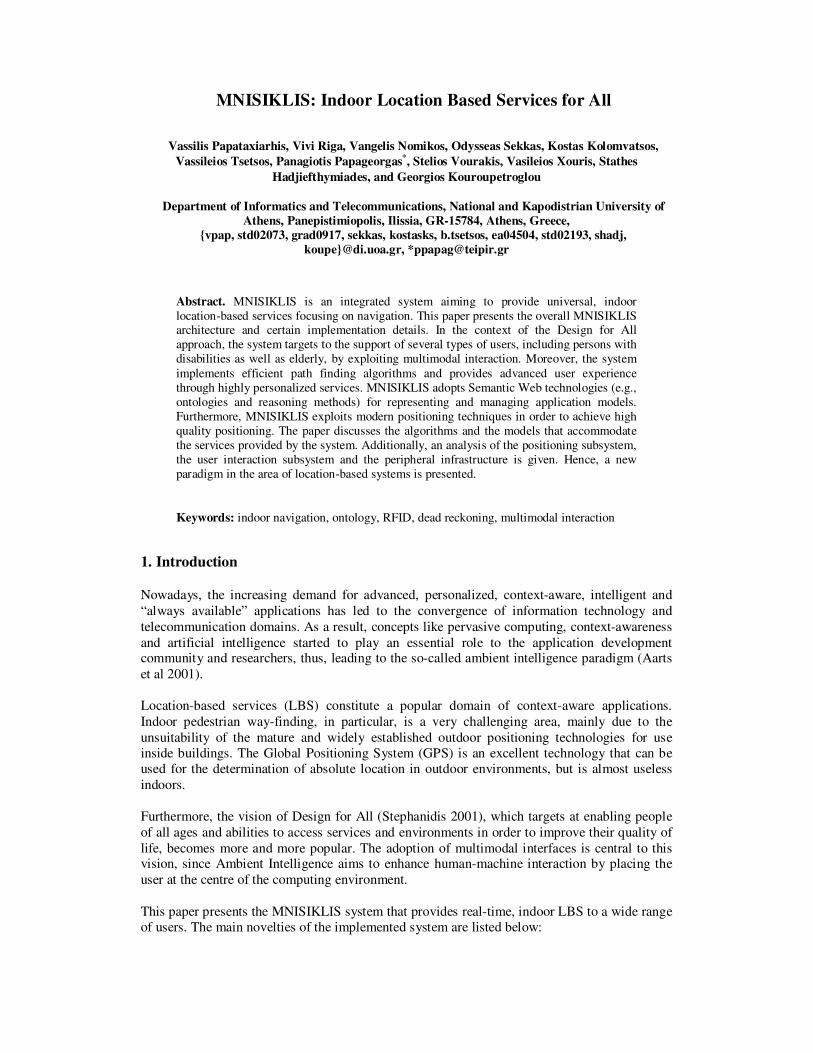
3. System Architecture and Implemented Services
The MNISIKLIS platform includes three main subsystems (as shown in Fig. 1):
Positioning Subsystem. It comprises the overall equipment and the algorithms used to estimate
the user’s position. Specifically, it consists of the sensors and the positioning techniques, the
location fusion component and the interfaces between them.
Middleware. The middleware consists of the services and the navigation algorithms developed
as well as the application models. It is also responsible for gluing together the other subsystems.
User Interaction Subsystem. The user interaction subsystem involves the user device (hardware
and software), the input/output interfaces and the content selection and representation
algorithms.
Apart from these core platform ingredients, a peripheral infrastructure for LBS content
provisioning and management has been developed. Such infrastructure includes a GIS system
and a Semantic Content Management System (SCMS). In the following sections, we elaborate
on the main components of each subsystem.
Locatio
n F
usi
on
Sensors and positioningtechniques
Positioning Interface
User
model
Spatial
model
UserDevice
Location ServiceAlgorithms
User InteractionAlgorithms
Middleware
Content description
model GIS
SCMS
Device
model
Positioning Subsystem
Application
Models
Peripheral Systems
Input/Output Equipment
LBS
Content RepresentationInterfaces
InteractionSoftware
User Interaction Subsystem
Positio
nin
gE
quip
ment
Fig. 1. MNISIKLIS Architecture.
In the context of the MNISIKLIS project, the following services have been implemented:
• Static Navigation. The user asks the system to determine a “suitable” route to a certain
destination. The service takes into consideration the application models (e.g., user
profile) in order to compute the “best” path and guide the user with the most suitable
landmarks.
• Dynamic Navigation. An extension of static navigation that periodically traces the user
position. In case it detects a significant deviation of the user from the predetermined
path, it helps her to find her way by providing more detailed information.
• Where-Am-I. The user asks for her current position inside a building. The system
responds by providing details about the last known user position. The information about
a specific location is organized and presented in different levels of detail.
• Exploration. While the user is moving inside the building, the system provides
(“pushes”) information about the nearest locations that she may be interested in. Such
Points Of Interest (POIs) may have been explicitly stated by the user or not (e.g.,
significant exhibits in a museum).
• Nearest POIs. The system computes the POIs that are closer to the user. The main
difference from the exploration service is the push-based nature of the latter. Hence, the
system may always return points that are not located close to the user.
4. Positioning Subsystem
4.1 Sensing Technologies Accurate indoor positioning can be achieved through two main technology approaches. The first
approach is based on radio technology (WLAN, Bluetooth) as well as infrared and ultrasound
beacons (Schiller & Voisard 2004). The second approach exploits inertial sensors (accelerometers and gyroscopes) and non-inertial sensors (magnetic compasses) along with
appropriate dead reckoning algorithms. Proximity sensing, based on RFID technology has been
recently introduced (Koide & Kato 2006) as an alternative. In the MNISIKLIS platform we
have adopted three technologies: UHF RFIDs, Dead Reckoning (DR) for pedestrian users (Fang
et al 2005; Dippold 2006) and WLAN Received Signal Strength Indicator (RSSI). This section
describes the main sensing technologies that compose the proposed positioning subsystem.
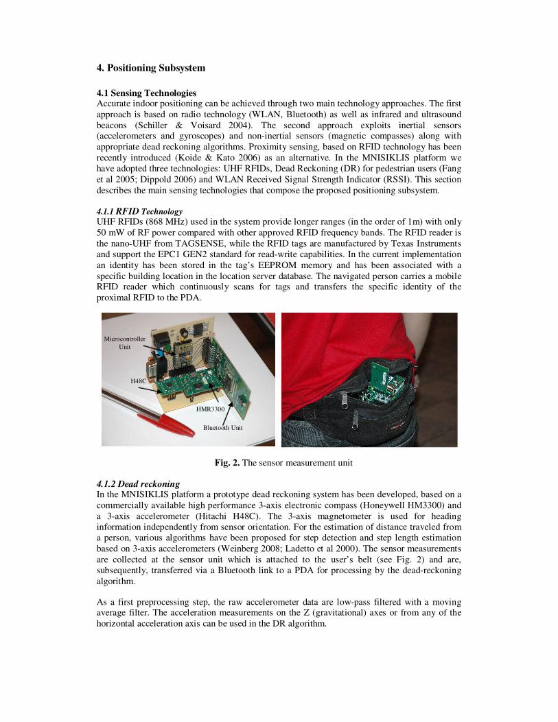
4.1.1 RFID Technology
UHF RFIDs (868 MHz) used in the system provide longer ranges (in the order of 1m) with only
50 mW of RF power compared with other approved RFID frequency bands. The RFID reader is
the nano-UHF from TAGSENSE, while the RFID tags are manufactured by Texas Instruments
and support the EPC1 GEN2 standard for read-write capabilities. In the current implementation
an identity has been stored in the tag’s EEPROM memory and has been associated with a
specific building location in the location server database. The navigated person carries a mobile RFID reader which continuously scans for tags and transfers the specific identity of the
proximal RFID to the PDA.
HMR3300
H48C
Microcontroller
Unit
Bluetooth Unit
HMR3300
H48C
Microcontroller
Unit
Bluetooth Unit
Fig. 2. The sensor measurement unit
4.1.2 Dead reckoning In the MNISIKLIS platform a prototype dead reckoning system has been developed, based on a
commercially available high performance 3-axis electronic compass (Honeywell ΗΜ3300) and
a 3-axis accelerometer (Hitachi H48C). The 3-axis magnetometer is used for heading
information independently from sensor orientation. For the estimation of distance traveled from
a person, various algorithms have been proposed for step detection and step length estimation
based on 3-axis accelerometers (Weinberg 2008; Ladetto et al 2000). The sensor measurements
are collected at the sensor unit which is attached to the user’s belt (see Fig. 2) and are,
subsequently, transferred via a Bluetooth link to a PDA for processing by the dead-reckoning
algorithm.
As a first preprocessing step, the raw accelerometer data are low-pass filtered with a moving average filter. The acceleration measurements on the Z (gravitational) axes or from any of the
horizontal acceleration axis can be used in the DR algorithm.
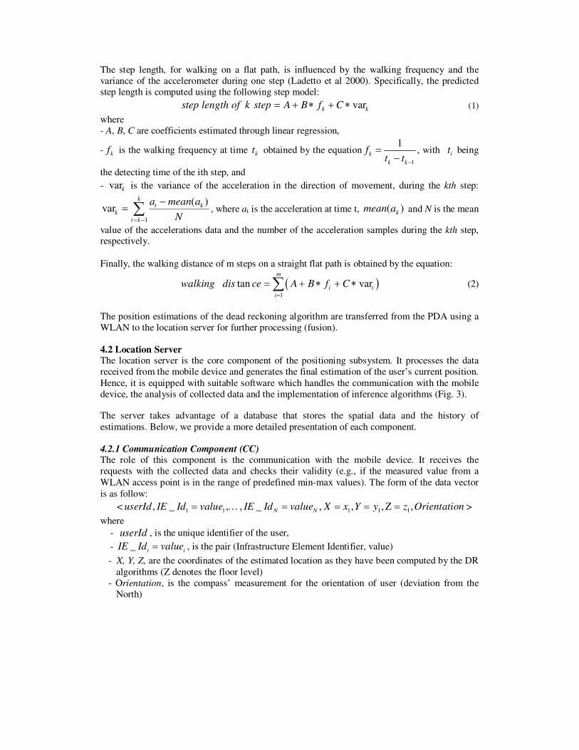
The step length, for walking on a flat path, is influenced by the walking frequency and the
variance of the accelerometer during one step (Ladetto et al 2000). Specifically, the predicted
step length is computed using the following step model:
kk CfBAstepkoflengthstep var∗+∗+= (1)
where
- A, B, C are coefficients estimated through linear regression,
- kf is the walking frequency at time kt obtained by the equation
1
1k
k k
ft t −
=−
, with it being
the detecting time of the ith step, and
- kvar is the variance of the acceleration in the direction of movement, during the kth step:
∑−=
−=
k
kt
kt
kN
ameana
1
)(var , where at is the acceleration at time t, )( kamean and N is the mean
value of the accelerations data and the number of the acceleration samples during the kth step, respectively.
Finally, the walking distance of m steps on a straight flat path is obtained by the equation:
( )1
tan varm
i i
i
walking dis ce A B f C=
= + ∗ + ∗∑ (2)
The position estimations of the dead reckoning algorithm are transferred from the PDA using a
WLAN to the location server for further processing (fusion).
4.2 Location Server The location server is the core component of the positioning subsystem. It processes the data
received from the mobile device and generates the final estimation of the user’s current position.
Hence, it is equipped with suitable software which handles the communication with the mobile
device, the analysis of collected data and the implementation of inference algorithms (Fig. 3).
The server takes advantage of a database that stores the spatial data and the history of
estimations. Below, we provide a more detailed presentation of each component.
4.2.1 Communication Component (CC) The role of this component is the communication with the mobile device. It receives the
requests with the collected data and checks their validity (e.g., if the measured value from a
WLAN access point is in the range of predefined min-max values). The form of the data vector
is as follow:
< 1 1 1 1 1, _ , , _ , , , ,N NuserId IE Id value IE Id value X x Y y z Orientation= … = = = Ζ = >
where
- userId , is the unique identifier of the user,
- _ i iIE Id value= , is the pair (Infrastructure Element Identifier, value)
- X, Y, Z, are the coordinates of the estimated location as they have been computed by the DR
algorithms (Z denotes the floor level)
- Orientation, is the compass’ measurement for the orientation of user (deviation from the
North)
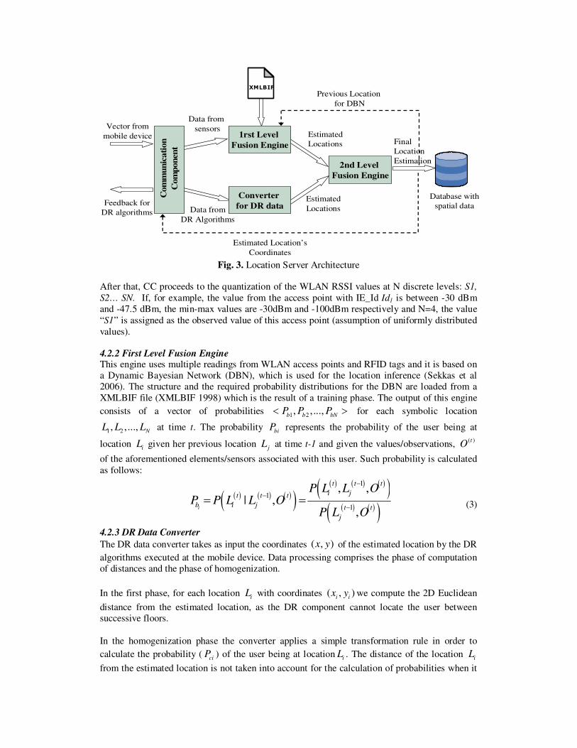
1rst Level
Fusion Engine
Converter
for DR data
2nd Level
Fusion Engine
XMLBIF
Vector from
mobile device
Feedback for
DR algorithms
Data from
sensors
Data from
DR Algorithms
Estimated
Locations Final
Location
Estimation
Estimated Location’s
Coordinates
Database with
spatial dataEstimated
Locations
Com
mu
nic
ati
on
Com
pon
ent
Previous Location
for DBN
Fig. 3. Location Server Architecture
After that, CC proceeds to the quantization of the WLAN RSSI values at N discrete levels: S1,
S2… SN. If, for example, the value from the access point with IE_Id Id1 is between -30 dBm
and -47.5 dBm, the min-max values are -30dBm and -100dBm respectively and N=4, the value
“S1” is assigned as the observed value of this access point (assumption of uniformly distributed
values).
4.2.2 First Level Fusion Engine This engine uses multiple readings from WLAN access points and RFID tags and it is based on
a Dynamic Bayesian Network (DBN), which is used for the location inference (Sekkas et al
2006). The structure and the required probability distributions for the DBN are loaded from a
XMLBIF file (XMLBIF 1998) which is the result of a training phase. The output of this engine
consists of a vector of probabilities 1 2, ,...,
b b bNP P P< > for each symbolic location
1 2, ,..., NL L L at time t. The probability biP represents the probability of the user being at
location iL given her previous location jL at time t-1 and given the values/observations, ( )tO
of the aforementioned elements/sensors associated with this user. Such probability is calculated
as follows:
( ) ( ) ( )( )( ) ( ) ( )( )
( ) ( )( )
1
1
1
, ,| ,
,i
t t t
i jt t t
b i j t t
j
P L L OP P L L O
P L O
−
−
−= = (3)
4.2.3 DR Data Converter
The DR data converter takes as input the coordinates ( , )x y of the estimated location by the DR
algorithms executed at the mobile device. Data processing comprises the phase of computation
of distances and the phase of homogenization.
In the first phase, for each location iL with coordinates ( , )i ix y we compute the 2D Euclidean
distance from the estimated location, as the DR component cannot locate the user between
successive floors.
In the homogenization phase the converter applies a simple transformation rule in order to
calculate the probability ( ciP ) of the user being at location iL . The distance of the location iL
from the estimated location is not taken into account for the calculation of probabilities when it
exceeds a predetermined threshold td . For locations of distance id greater than td or locations
found in a different floor than the estimated ( , )x y coordinates, we assign zero probability. For
the remaining locations we compute the probability '
ciP according to the equation:
'
2
1ci
i
Pd
= , 1, 2,...,i N= (4)
which indicates that this probability is reversely proportional to the square distance. The final
value of the probability ci
P is calculated after the normalization procedure so that the sum of
probabilities equals unity: '
'
1
, 1, 2,...,cici N
ci
i
PP i N
P=
= =
∑ (5)
Thus, the converter produces as output the vector of probabilities 1 2, ,...,c c cNP P P< > which
feed the 2nd
level fusion engine.
4.2.4 Second Level Fusion Engine
The second level fusion engine takes as input the probabilities calculated for each symbolic
location by the first level fusion engine and the DR converter and produces the final estimation
of the current position of the user. Specifically, it uses the probability vectors
1 2, ,...,b b bNP P P< > and 1 2, ,...,c c cNP P P< > and combines them appropriately so that it
calculates the final probability i
P for locationi
L . The contribution of probabilities bi
P and ci
P
is determined by the corresponding weights bw and cw ( 1b cw w+ = ) according to the
following combination rule
* *i b bi c ciP w P w P= + , 1, 2,...,i N= (6)
The final estimated location is calculated as the location with the highest probability and is
stored in the database. Moreover, it is sent to the mobile device as feedback for the DR
algorithms and updates the DBN in the first level fusion engine.
5. Middleware
5.1 Application Models Four ontologies are the basis for MNISIKLIS: i) the spatial ontology (Indoor Navigation
Ontology – INO), ii) the User Navigation Ontology (UNO), iii) the Device Ontology (DO), and
iv) the Content Ontology (CO). The instances of the aforementioned ontologies are connected
through semantic relationships in order to provide more intelligent location services.
Indoor Navigation Ontology (INO): The spatial ontology is an extended version of the INO
(Tsetsos et al 2006; INO 2008), based on the OWL-DL language (OWL 2004). Specifically, it
describes concepts and relationships that correspond to every basic spatial element typically
found in indoor environments.
User Navigation Ontology (UNO): UNO (Kikiras et al 2006) is an ontology that contains the
necessary concepts and relations to define the main characteristics and abilities of users,
facilitating the provision of highly personalized services. Additionally, UNO design is based on
the international standard defined by the World Health Organization (WHO) (ICF 2001).
Device Ontology (DO): Our approach adopts a device ontology in order to represent basic
features and the functionality supported by various user devices (e.g., mobile phones, PDAs,
headphones). The knowledge captured by the ontology refers to hardware capabilities (e.g.,
display size, resolution) as well as device supported modalities (e.g., input/output modes).
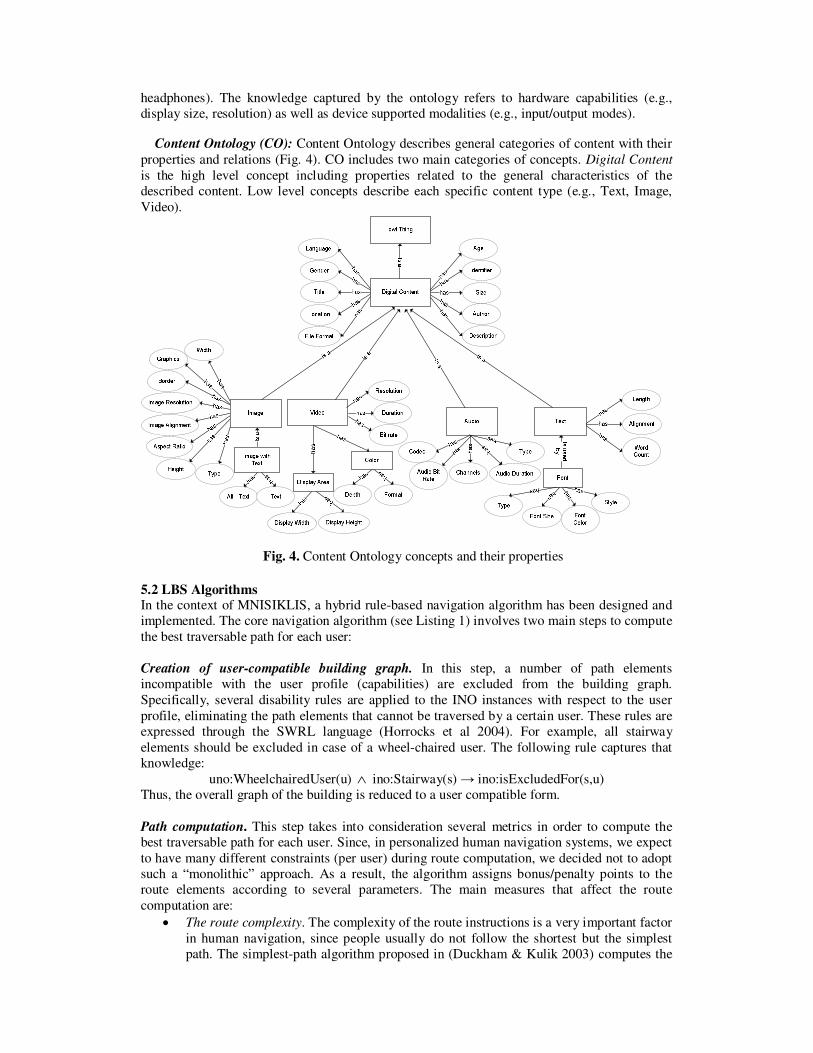
Content Ontology (CO): Content Ontology describes general categories of content with their
properties and relations (Fig. 4). CO includes two main categories of concepts. Digital Content
is the high level concept including properties related to the general characteristics of the
described content. Low level concepts describe each specific content type (e.g., Text, Image,
Video).
Fig. 4. Content Ontology concepts and their properties
5.2 LBS Algorithms In the context of MNISIKLIS, a hybrid rule-based navigation algorithm has been designed and
implemented. The core navigation algorithm (see Listing 1) involves two main steps to compute
the best traversable path for each user:
Creation of user-compatible building graph. In this step, a number of path elements
incompatible with the user profile (capabilities) are excluded from the building graph.
Specifically, several disability rules are applied to the INO instances with respect to the user
profile, eliminating the path elements that cannot be traversed by a certain user. These rules are
expressed through the SWRL language (Horrocks et al 2004). For example, all stairway
elements should be excluded in case of a wheel-chaired user. The following rule captures that
knowledge:
uno:WheelchairedUser(u) ∧ ino:Stairway(s) → ino:isExcludedFor(s,u)
Thus, the overall graph of the building is reduced to a user compatible form.
Path computation. This step takes into consideration several metrics in order to compute the
best traversable path for each user. Since, in personalized human navigation systems, we expect
to have many different constraints (per user) during route computation, we decided not to adopt
such a “monolithic” approach. As a result, the algorithm assigns bonus/penalty points to the
route elements according to several parameters. The main measures that affect the route
computation are:
• The route complexity. The complexity of the route instructions is a very important factor
in human navigation, since people usually do not follow the shortest but the simplest
path. The simplest-path algorithm proposed in (Duckham & Kulik 2003) computes the
“easiest-to-describe” path in a graph and has similar computational complexity with a
shortest path algorithm.
• The Euclidean route distance. Since the distance of a route is usually the main criterion
in human navigation, we also take into account the Euclidean distance of a path.
• The user profile. User capabilities and preferences play significant role during the path
computation process. For example, in the case of a user that prefers to use stairs, the
system would penalize paths including the elevator.
Navigation(INO, origin, destination, user profile)
Begin
Exclude Path_Points incompatible to the user profile by applying disability rules Create user compatible building graph from remaining INO instances
Compute the k-Simplest Paths from origin to destination
Foreach of the k-Simplest Paths
Foreach Path Element PE
Assign bonus/penalty value to PE, according to perceptual rules
and user preferences
Endfor
Compute the total path length
TotalPathRank = f(path length, bonus vector, penalty vector)
Endfor Return the path with the maximum TotalPathRank
End Listing 1. Outline of the core navigation algorithm
The aforementioned core navigation algorithm was developed for the static navigation service.
The rest of the services (see Section 3) were implemented as extensions/modifications of this
core algorithm. In this section, we describe in detail the most challenging implementation parts
of these services.
Dynamic navigation was the most computationally-hard service since it should spontaneously
provide a new route description to user in case the system detects her “far enough” from the
initially computed path. It also imposes strict deadlines, since it has to provide useful
information to the user at minimal response times. Specifically, the extended algorithm of
dynamic navigation does not guide the user back to the initial path, but it computes a totally
new path description given the current user trace.
Exploration was also a time critical service, since it had to inform user about nearby location
points or regions before she passes them. To achieve acceptable response times, the
implemented algorithm takes advantage of the graph structure of the building by examining only the locations that are close to the user position.
Finally, the “K-Nearest POIs” was a memory consuming service, as it computes and manages
paths for all POIs of the user. Once again, the graph structure of the building facilitated the
service implementation.
5.3 Peripheral Systems
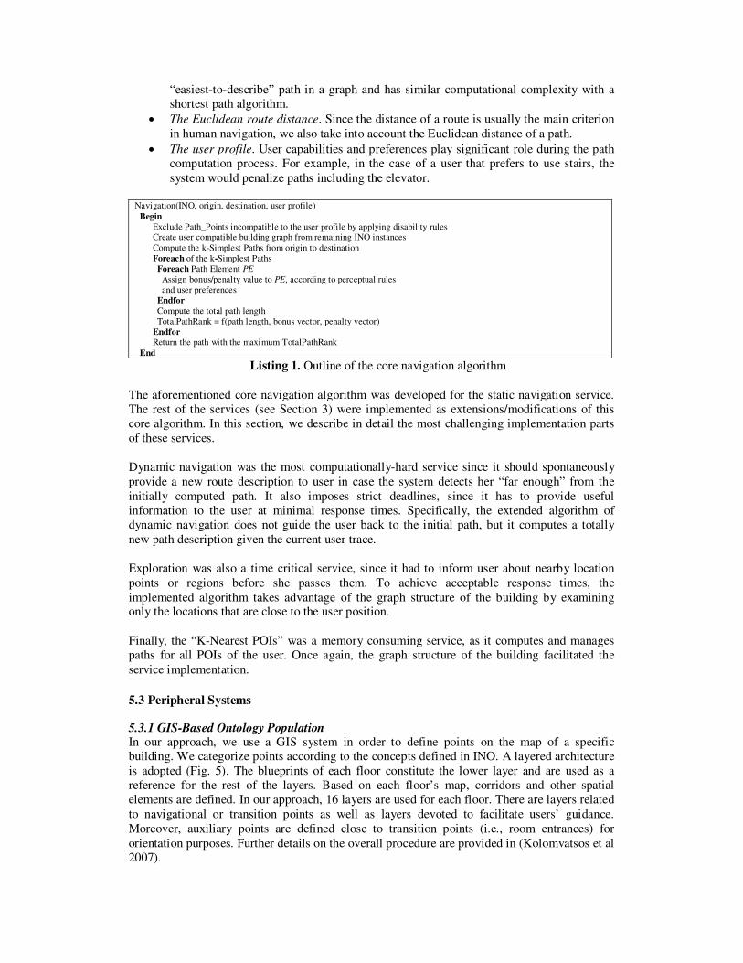
5.3.1 GIS-Based Ontology Population In our approach, we use a GIS system in order to define points on the map of a specific
building. We categorize points according to the concepts defined in INO. A layered architecture
is adopted (Fig. 5). The blueprints of each floor constitute the lower layer and are used as a
reference for the rest of the layers. Based on each floor’s map, corridors and other spatial
elements are defined. In our approach, 16 layers are used for each floor. There are layers related
to navigational or transition points as well as layers devoted to facilitate users’ guidance.
Moreover, auxiliary points are defined close to transition points (i.e., room entrances) for
orientation purposes. Further details on the overall procedure are provided in (Kolomvatsos et al
2007).
.. ... .
..
. . . . .
. . . .
.. ..
Floor Map
Corridors
Navigation Points
Room Entrances
Stairways
...
Fig. 5. GIS Layers
Once the GIS data are in place, one can proceed with the actual ontology population. Each of
the aforementioned layers is exported as a shape file (i.e., a popular GIS data storage format)
which is subsequently imported in a table of a spatial database. Subsequently, a series of
algorithms are used to create the instances based on INO concepts.
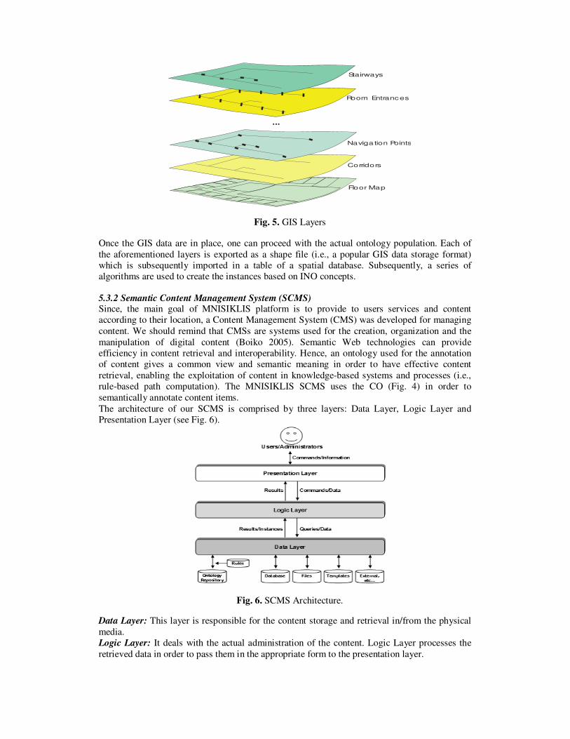
5.3.2 Semantic Content Management System (SCMS) Since, the main goal of MNISIKLIS platform is to provide to users services and content
according to their location, a Content Management System (CMS) was developed for managing
content. We should remind that CMSs are systems used for the creation, organization and the
manipulation of digital content (Boiko 2005). Semantic Web technologies can provide
efficiency in content retrieval and interoperability. Hence, an ontology used for the annotation
of content gives a common view and semantic meaning in order to have effective content
retrieval, enabling the exploitation of content in knowledge-based systems and processes (i.e.,
rule-based path computation). The MNISIKLIS SCMS uses the CO (Fig. 4) in order to
semantically annotate content items.
The architecture of our SCMS is comprised by three layers: Data Layer, Logic Layer and
Presentation Layer (see Fig. 6).
Fig. 6. SCMS Architecture.
Data Layer: This layer is responsible for the content storage and retrieval in/from the physical
media.
Logic Layer: It deals with the actual administration of the content. Logic Layer processes the
retrieved data in order to pass them in the appropriate form to the presentation layer.

Presentation Layer: This layer is used by users in order to retrieve information and by the
administrators of the SCMS in order to insert, retrieve and update content and the associated
metadata. Content entities can be linked with INO elements through a graphical user interface.
6. User Interaction Subsystem
MNISIKLIS, in contrast to other indoor location based systems, targets a wide range of user
population. The main user groups include:
1. Non-disabled users. This group is comprised of the typical users that do not have any
impairment.
2. Elderly people (older than 65 years old). Some special features of this group are that they
are not fully acquainted with modern technologies. They may also present some degree of
disability in perception, memory, vision, hearing and physical movement. Hence, the User
Interface (UI) should be as simple and tangible as possible.
3. People with partial or total vision loss. If the UI is visual, then it should be as
distinguishable as possible (colors, fonts etc). In the case of audio or tactile UI there are
no constraints except for the quantity of information given.
4. People with locomotive disabilities. Users that use a wheelchair or have very limited ability to walk.
6.1 Building an Accessible to All System One of the main tasks of MNISIKLIS was to create a system Accessible to All. In order to
achieve this goal, the design of the UI was based on Design for All principles (Stephanidis
2001). Hence, an analysis of the user groups and their needs was performed from the early
stages of the project implementation, mainly based on the analysis of the existing scientific
literature. To better define those groups, the International Classification of Functioning,
Disability and Health (ICF 2001) was used.
6.2 MNISIKLIS Devices In the context of the MNISIKLIS system, four types of user terminal devices are used by the
target groups for accessing the LBS: Tablet PC, Smart Phone, PDA (Personal Digital Assistant)
and Mobile Phone. The basic criteria for the selection of those devices were ergonomy and
economy. Of high importance was also their compatibility to some assistive technology and
their characteristics, such as processor speed, screen size and networking. Depending on the
user profile, some input/output peripherals may be connected wirelessly (e.g., Bluetooth) or
through cables to some devices, such as earphones, head-mounted screens and Braille displays.
Table 1 presents the possible combinations of peripheral devices with the user device.
Table 1: Combinations of portable terminals with peripheral
devices
Head-mounted
LCD screen
Braille
Display
Bluetooth
Earphones
Tablet PC √
Smart Phone √ √
PDA √ √ √
Mobile Phone √
6.3 Multimodal User Interfaces The UI of MNISIKLIS is multimodal. It adopts three modalities for input / output: visual, audio
and haptic. In the haptic mode the user can interact using the keyboard, special buttons, the
touch-screen, or the Braille display. The user can also interact orally, through a speech-based
dialogue subsystem (Fellbaum & Kouroupetroglou 2008) using a Mobile Phone. In the visual
mode, the output is presented through a common graphical UI (GUI). Combinations of the
above described modalities are also supported.
Visual Modality: In the case of a GUI, the output data may be in the form of text, image and
map. Specifically, the user has at her disposal a textual menu consisting of buttons and selection
lists to make a service choice. When the user has requested a specific navigational service, she
receives an output consisting of textual instructions, images of the nearby POIs, landmarks and
corridors and a map depicting the current floor (see Fig. 7). The user is navigated on a turn-by-
turn basis using textual instructions that are given dynamically according to her position and
notifications, whenever necessary. The map, in this case, depicts the segment of the
path/itinerary that is already covered by the user and the remaining part left to travel. When the
user asks for an informational service such as Nearest POIs, Where-Am-I or Exploration, then
she obtains three layers of proliferating information in the textual instructions. She also obtains
the current map depicting her position and the position of the Nearest POIs.
Fig. 7: Screenshot of the graphical UI
The user can choose among five different text font sizes, two font colors (black or white) and
five colors for the drawing on the maps. The maps are represented in Scalable Vector Graphics
(SVG) format and can be transposed and zoomed-in and -out by the user without any loss of
detail.
Audio Modality: A person without hearing loss is able to obtain audio output in the form of
synthetic speech or in combination with the visual output. The design of the GUI ensures
support of traditional Interactive Voice Response (IVR) mode. For the case of the blind users
full spoken-based dialogue interaction (Speech-only User Interface) is supported (Freitas &
Kouroupetroglou 2008).
Haptic Modality: In the case of haptic interaction, the user makes use of her hands to provide
input (touch screen, buttons) or/and obtain output (Braille display). The output on the Braille
display is just the same as if the user was using audio output.
6.4 Architecture of User Interaction Subsystem The User Interaction subsystem of MNISIKLIS adopts a client/server architecture. The client
part is installed on the users’ terminal. It constitutes a cross-platform software component
compliant with a variety of devices. Specifically, the client was installed on a Tablet PC, a
PDA, a Smart Phone and a speech interaction server. The server side of the subsystem, on the
other hand, receives the requests of the client and, in collaboration with the subsystems of
Positioning Services, Content Management and GIS, composes and returns the output to the
user, regardless of the device used.
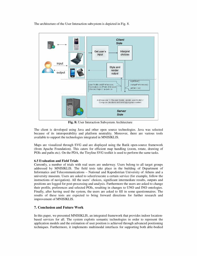
The architecture of the User Interaction subsystem is depicted in Fig. 8.
Fig. 8: User Interaction Subsystem Architecture
The client is developed using Java and other open source technologies. Java was selected because of its interoperability and platform neutrality. Moreover, there are various tools
available to support the technologies integrated in MNISIKLIS.
Maps are visualized through SVG and are displayed using the Batik open-source framework
(from Apache Foundation). This caters for efficient map handling (zoom, rotate, drawing of
POIs and paths etc). On the PDA, the Tinyline SVG toolkit is used to perform the same tasks.
6.5 Evaluation and Field Trials Currently, a number of trials with real users are underway. Users belong to all target groups
addressed by MNISIKLIS. The field tests take place in the building of Department of
Informatics and Telecommunications – National and Kapodistrian University of Athens and a
university museum. Users are asked to select/execute a certain service (for example, follow the
instructions of navigation). All the users’ choices, significant intermediate results, outputs and
positions are logged for post-processing and analysis. Furthermore the users are asked to change
their profile, preferences and selected POIs, resulting in changes to UNO and INO ontologies.
Finally, after having used the system, the users are asked to fill in some questionnaires. The
results of these tests are expected to bring forward directions for further research and
improvement of MNISIKLIS.
7. Conclusion and Future Work
In this paper, we presented MNISIKLIS, an integrated framework that provides indoor location-
based services for all. The system exploits semantic technologies in order to represent the
application models and the estimation of user position is achieved through advanced positioning
techniques. Furthermore, it implements multimodal interfaces for supporting both able-bodied
and disabled users. As already mentioned, currently, we are working on the validation of
MNISIKLIS through a set of trials.
However, a number of issues remain open for further research in the area of indoor location-
based services. The path generation methodology could be enhanced by taking advantage of
path prediction techniques and historical information. Moreover, the incorporation of landmarks
during the navigation process could substantially facilitate comprehension of route directions by
the user. Another issue that we are working on is the incorporation of other technologies and
elements (infrared beacons, ultrasound sensors) in the positioning system, thus enhancing its
accuracy and robustness. Furthermore, different methods and techniques (e.g., Evidential
Reasoning) will be examined in order to improve the results of the second level fusion.
Additionally, Kalman and particle filtering will be utilized for improving the dead-reckoning
and the sensor fusion position estimations (Evennou & Marx 2006), as well.
Acknowledgement This work has been partially funded by the Greek General Secretariat for Research and
Technology (GSRT) under grant PABET 2005 – Project Code: 282.
References
Aarts, E., Harwig, R. & Schuurmans, M., 2001. Ambient intelligence. In The Invisible Future:
The Seamless Integration of Technology into Everyday Life, McGraw-Hill Professional.
Baus, J., Krüger, A. & Wahlster, W., 2002. A Resource - Adaptive Mobile Navigation
System, International Conference on Intelligent User Interfaces IUI02, San Francisco, USA.
Bikakis, A., Patkos, T., Antoniou, G., Papadopouli, M. & Plexousakis, D., 2006. A Semantic-
based Framework for Context-aware Pedestrian Guiding Services, 2nd International Workshop
on Semantic Web Technology For Ubiquitous and Mobile Applications (SWUMA), Riva del
Garda, Trentino, Italy.
Boiko B., 2005. Content Management Bible, 2nd Edition, Wiley Publishing Inc., 2005. Dippold M., 2006. Personal Dead Reckoning with Accelerometers, Third International Forum
on Applied Wearable Computing, IFAWC2006, Bremen, Germany.
Duckham, M. & Kulik, L., 2003. “Simplest” Paths: Automated route selection for navigation,
in: W. Kuhn, M.F. Worboys, S. Timpf (Eds.), Spatial Information Theory: Foundations of
Geographic Information Science, Lecture Notes in Computer Science, vol. 2825, Springer,
Berlin, 2003, pp. 182–199.
Evennou, F. & Marx, F., 2006. Advanced Integration ofWiFi and Inertial Navigation Systems
for Indoor Mobile Positioning, EURASIP Journal on Applied Signal Processing, Volume 2006,
Article ID 86706, Pages 1–11.
Fang, L., Antsaklis, P.J., Montestruque, L.A., McMickell, M.B., Lemmon, M., Sun, Y., Fang,
H., Koutroulis, I., Haenggi, M., Xie, M. & Xie, X., 2005. Design of a Wireless Assisted
Pedestrian Dead Reckoning System - The NavMote Experience, IEEE Transactions on
Instrumentation and Measurement, vol. 54, pp. 2342- 2358.
Fellbaum, K. & Kouroupetroglou, G., 2008. Principles of Electronic Speech Processing with
Applications for People with Disabilities, Journal Technology and Disability, Vol. 20, No 2, pp.
55-85.
Freitas, D. & Kouroupetroglou, G., 2008. Speech Technologies for Blind and Low Vision
Persons, Journal Technology and Disability, Vol. 20, No 2, pp. 135-156.
Gartner, G., Frank, A. & Retscher, G., 2004. Pedestrian Navigation System for Mixed
Indoor/Outdoor Environments - The NAVIO Project. In: Schrenk, M. (Ed.): Proceedings of the
CORP 2004 and Geomultimedia04 Symposium (pp. 165-171). Vienna, Austria.
Horrocks, I., Patel-Schneider, P.F., Boley, H., Tabet, S., Grosof, B. & Dean, M., 2004.
SWRL: A Semantic Web Rule Language Combining OWL and RuleML W3C Member
Submission. [Online]. Available from http://www.w3.org/Submission/SWRL/ [Accessed: 6th
June 2008].
ICF, International Classification of Functioning, Disability and Health, 2001. World Health
Organization, Geneva. [Online]. Available from http://www3.who.int/icf/icftemplate.cfm
[Accessed: 6th June 2008].
INO (Indoor Navigation Ontology), 2008. [Online]. Available from http://p-
comp.di.uoa.gr/ont/INO.owl [Accessed: 6th
June 2008].
Kargl, F. & Bernauer, A., 2005. The compass location system. In: Strang, T., Linnhoff-
Popien, C. (eds.) LoCA 2005. LNCS, vol. 3479, Springer, Heidelberg.
Kargl, F., Gessler, S. & Flerlage, F., 2007. The iNAV Indoor Navigation System, Lecture
Notes In Computer Science, Springer.
Kikiras P., Tsetsos V. & Hadjiefthymiades S., 2006. Ontology-based User Modeling for
Pedestrian Navigation Systems, ECAI 2006 Workshop on Ubiquitous User Modeling
(UbiqUM), Riva del Garda, Italy.
Koide, S. & Kato, M., 2006. 3-D Human Navigation System with Consideration of
Neighboring Space Information, 2006 IEEE International Conference on Systems, Man, and
Cybernetics, (pp. 1693-11698), October 8-11, 2006, Taipei, Taiwan.
Kolomvatsos K., Papataxiarhis V. & Tsetsos V., 2007. Semantic Location Based Services for
Smart Spaces, in Proc. of the 2nd International Conference on Metadata and Semantics
Research (MTSR), Corfu, Greece.
Ladetto Q., Gabaglio V., Merminod B., Terrier Ph. & Schutz Y., 2000. “Human Walking
Analysis Assisted by DGPS”, GNSS, Ediburgh, 1-4 May.
Lyardet, F., Grimmer, J. & Muhlhauser, M., 2006. CoINS: Context Sensitive Indoor
Navigation System, Proceedings of the Eighth IEEE International Symposium on Multimedia,
pp. 209-218, 2006, IEEE Computer Society Washington, DC, USA.
OWL (Web Ontology Language) Guide, 2004. [Online]. Available from
http://www.w3.org/TR/owl-guide [Accessed: 6th
June 2008].
Schiller, J. & Voisard, A., 2004. Location-Based Services, Morgan-Kaufmann Publications.
Sekkas O., Hadjiefthymiades S. & Zervas E., 2006. Enhancing location estimation through
data fusion, in Proceedings of the 17th
IEEE International Symposium on Personal, Indoor and
Mobile Radio Communications (PIMRC '06), pp.1-5, Helsinki, Finland.
Stephanidis, C., 2001. User Interfaces for All - Concepts, Methods, and Tools, Mahwah, NJ:
Lawrence Erlbaum Associates.
Tsetsos V., Anagnostopoulos C., Kikiras P. & Hadjieftymiades S., 2006. Semantically
Enriched Navigation for Indoor Environments, International Journal of Web and Grid Services
(IJWGS), Vol.4, No.2,Inderscience Publ.
Wasinger, R., Stahl, C. & Krüger, A., 2003. M3I in a Pedestrian Navigation & Exploration
System, Proc. of the Fourth International Symposium on Human Computer Interaction with
Mobile Devices, pp. 481-485, Pisa, Italy.
Weinberg, H., 2008. Using the ADXL202 in Pedometer and Personal Navigation
Applications, Application Notes AN-602, Analog Devices, [Online]. Available from
http://www.analog.com/UploadedFiles/Application_Notes/513772624AN602.pdf , [Accessed:
6th
June 2008].
XMLBIF, The Interchange Format for Bayesian Networks (1998). [Online]. Available from
http://www.cs.cmu.edu/afs/cs/user/fgcozman/www/Research/InterchangeFormat/ [Accessed: 6th
June 2008]