
The Nahda paradigm, a 'Zeitgeist' for Opposite forces in Egypt
O. De Troyer et al. (Eds.): ER 2011 Workshops, LNCS 6999, pp. 231–240, 2011. © Springer-Verlag Berlin Heidelberg 2011
Referring Expressions in Location Based Services: The Case of the ‘Opposite’ Relation
Phil Bartie1, Femke Reitsma1, Eliseo Clementini2, and Simon Kingham1
1 Geography Department, University of Canterbury, Christchurch, New Zealand 2 Department of Electrical and Information Engineering, University of L'Aquila, L’Aquila, Italy
Abstract. Mobile devices and location based services enable digital and real worlds to be integrated within our daily lives. The handling of natural language dialogue raises several research challenges, including the ability to direct the user’s attention to a particular feature in the field of view through the use of suitable descriptions. To mimic natural language these referring expressions should use attributes which include factors of the building’s appearance, and descriptions of its location with reference to the observer or other known buildings in view. This research focuses on one particular positional case used in describing features in a field of view, that of the “opposite” spatial relation, and discusses how this referring expression may be generated by modelling the view from the observer’s location to the surrounding features.
Keywords: location based services, visibility modelling, spatial relations.
1 Introduction
Increasingly, digital and real worlds are becoming integrated within our daily lives, with mobile devices and location based services being among the tools that enable this to happen. One of the drawbacks has been that graphical interfaces distract the user from their environment, and alternative interaction experiences are being researched. Augmented Reality [1, 2] is one such innovation whereby digital information is superimposed onto real world views. Speech interfaces are another solution, whereby information may be retrieved using voice commands and speech prompts [3, 4]. The work presented here discusses how speech interfaces may reference items in the current view using natural language terms, with particular focus on the use of the spatial preposition “opposite” as in “we’re the house opposite the bakery”.
People use language to describe and share experiences about space and the objects which occupy it [5]. These object descriptions are known in natural language research as “referring expressions” and are used, for example, to draw someone’s attention to a particular building in a cityscape [6]. Typically, the descriptions include a number of physical attributes relating to the feature, such as its position relative to the observer or other surrounding objects, so that the listener may identify the intended target. The research area has particular relevance for the future of speech based interfaces for Location Based Services (LBS), in both the generation of phrases to direct the user’s
232 P. Bartie et al.
attention, and in the parsing of phrases to determine which object is being interrogated.
This paper discusses the positional case of “opposite”, and how a LBS may make use of the term when forming referring expressions. To be able to define the case whereby two buildings are considered opposite, the visibility from the observer to each building needs to be determined, as does the view of a common reference point between the two target buildings, for example a road. A model is proposed which makes use of an urban Digital Surface Model (DSM) to estimate visibility, along with a number of examples of how the term may be calculated and used when generating spatial descriptions. Consideration is also given to the relations with surrounding entities to find the most suitable reference candidates, and minimise the risk of confusion in cluttered environments. Two models are presented which may be used to determine opposite entities with respect to a linear feature and a regional feature. The research shows that linear feature cases may be more easily modelled than regional cases.
2 Background
The range of LBS applications has diversified from basic navigational support into areas of social networking and virtual city guides [4, 7]. User interfaces have tended to have a graphical focus, but mobile speech recognition tools are improving to the point where devices in the near future may incorporate a speech based mode allowing users to operate in a hands-free and eyes-free way discretely, without the need to re-focus attention from their environment [8]. Earlier research has shown that users are able to carry out multiple tasks more easily if they are using a number of sensory modalities [9].
System usability is very important for the success of LBS applications, and great efforts are made to reduce the seam between the application and the user by closely modelling the user’s viewpoint [10]. The ultimate goal would be for an LBS to pass the ‘spatial Turing test’ [11], whereby its instructions are indistinguishable from those generated by a human. Steps towards this goal require that the LBS filter and translate digital information into appropriate forms which match the user’s frame of reference [12, 13].
2.1 Positional Information
The position of any feature in the urban landscape can be described relative to the observer, or a secondary reference object. Relations are rarely described in metric space (e.g. 123.7m at 54 degrees) but instead usually refer to topological space [14, 15] or projective space [16]. For example a paddling pool may be described as being “inside the park” using a topological relations, or “in front of the swings” using a projective relations. Equally a house may be described as “on your left” by referencing the view experienced by an observer at a given location and orientation.
The topological relations between static features are permanent, which in urban areas may include containment within a region (e.g. in a park), topographic feature (e.g. on a hill, a slope, or in a valley), or adjacency to a linear feature (e.g. road, river, rail). In contrast, projective relations are ternary comparisons between the primary
Referring Expressions in Location Based Services: The Case of the ‘Opposite’ Relation 233
object, a reference object, and the observer [17]. This means that they are dynamic as the user’s viewpoint is considered in each relations, therefore an ability to model which Features of Interest (FOI) are in view is required to ensure only visible items are referenced.
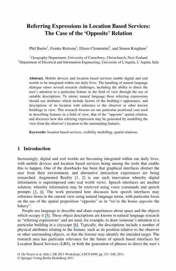
Fig. 1. Visual Exposure in Urban Environments
2.2 Visibility Modelling
Most Geographic Information Systems (GIS) offer the functionality to carry out visibility modelling [18], with a catalogue of research including siting radio masts [19], locating the most scenic or most hidden routes [20], landscape planning [21], as a weapon surrogate in military exercises [22], and in examining spatial openness in built environments [23].
Studies in the urban landscape have tended to be based on isovists [24], using in particular Benedikt’s [25] interpretation and definitions. Essentially isovists describe the space which is visible from a vantage point considering the form of the built environment through the use of architectural plans which denote the building footprint and position. However this model ignores building height, the topography of the land surface, and the continuation of the lines of sight beyond the first intersection with a building footprint. Therefore isovists depict lines which when traversed from the vantage point offer a continuous view of the target, and disregard more distant features.
Recently, 3D isovists [26] and visual exposure models [27, 28] using DSMs built from LiDAR sources have been introduced for urban visibility modelling. These DSMs include building and topographical form and may be used to determine how much of a feature can be viewed from the surrounding space, enabling the creation of surfaces to show in which direction an observer would need to move to view the target more, or less, clearly. These techniques can be used to find visual corridors, or visual ridges, and form a useful basis for considering feature visibility in the context of LBS. The urban visual exposure model calculates the vertical extents visible for each building cell of the DSM, by calculating the lowest visible point on the façade from the intersection of foreground objects, as shown in Fig. 1.
From this the visible façade area, and the percentage of a feature on the skyline may be deduced, along with other metrics. Once the model is able to determine which
234 P. Bartie et al.
features are visible, it is possible to then relate these to construct the positional part of a referring expression. To translate the positional information into the user’s frame of reference requires an egocentric projective spatial model as discussed in the next section.
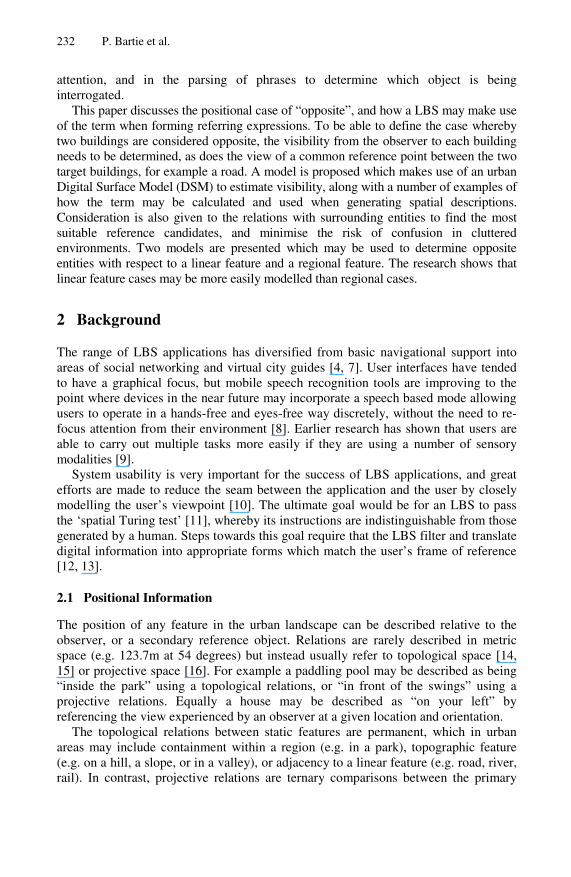
Fig. 2. A combined model of space using relative and intrinsic frames of reference
2.3 Egocentric Spatial Model
Natural language terminology relates space according to the observer’s frame of reference, or that of other features in view. This involves turning the relations from metric space into projective space using terms such as ‘left of’, ‘right of’, ‘ before’, ‘after’ and ‘between’ as presented by the 5-intersection model [16]. In addition a quaternary projective relation model is required to include terms for ‘above’, ‘below’, and ‘coplanar’ [29].
Fig. 2 shows a combined model which uses these projective models for the space in front of an observer, and a simplified intrinsic frame of reference for items behind the user [30]. For two items to be considered opposite one another reference is inferred to a common central space, or object. For example, “the library is opposite the park” determines that from some viewing point both the library and park are visible and facing towards each other from a common central region. The following section explores these concepts of the inter-relationship between visibility and projective relations with respect to the “opposite” relation.
3 The ‘Opposite’ Relation
The spatial relation “opposite” is defined in Merriam-Webster’s dictionary as, “set over against something that is at the other end or side of an intervening line or
Referring Expressions in Location Based Services: The Case of the ‘Opposite’ Relation 235
space” [31]. Hence the interrelated visibility of three related physical entities are required, such as the library, park and street of the previous example. For this reason visual exposure modelling is required to report which objects may be used in the relation. Two cases are examined here, firstly where the entity is represented as a one-dimensional feature, such as a road or river, and secondly where it is represented as a two-dimensional region, such as a park.
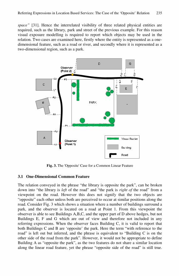
Fig. 3. The 'Opposite' Case for a Common Linear Feature
3.1 One-Dimensional Common Feature
The relation conveyed in the phrase “the library is opposite the park”, can be broken down into “the library is left of the road” and “the park is right of the road” from a viewpoint on the road. However this does not signify that the two objects are “opposite” each other unless both are perceived to occur at similar positions along the road. Consider Fig. 3 which shows a situation where a number of buildings surround a park, and the observer is located on a road at Point 1. From this viewpoint the observer is able to see Buildings A,B,C, and the upper part of D above hedges, but not Buildings E, F and G which are out of view and therefore not included in any referring expressions. When the observer faces Building C, it is valid to report that both Buildings C and B are ‘opposite’ the park. Here the term “with reference to the road” is left out but inferred, and the phrase is equivalent to “Building C is on the other side of the road from the park”. However, it would not be appropriate to define Building A as “opposite the park”, as the two features do not share a similar location along the linear road feature, yet the phrase “opposite side of the road” is still true.

236 P. Bartie et al.
The segments of the road labelled A1-A2, B1-B2 indicate the start and end of the entity along the road’s length, computed at the first and last intersections of a line perpendicular to the direction of travel with the entity. To satisfy the “opposite” condition the following must apply:
• the observer must be able to view both entities from a single point (e.g., C and Park);
• the entities must occur at overlapping sections of the linear entity (e.g., C1-C2 and P1-P2);
• the observer must also be able to view the common linear entity in the overlap region (e.g., road);
• the entities must occupy beside left/right space when viewed from the overlapping region.
Table 1. Calculating the Opposite relation for Entities and the Park from Observer Point 1
Entity Visible Overlap View Common Overlap
Beside Left/Right
Result
A True False True True False B True True True True True C True True True True True D True True False True False E False False False False False F False False False False False G False False False True False
Following these rules Table 1 may be generated, indicating that B and C are
opposite the park when viewed from Point 1. Although part of D is visible above hedges, the section of roadway between the building and the park is out of view behind bushes, rendering the use of “opposite” as less appropriate to assist the user’s visual search from the current location. However, the term could be used if instructions considered the case as the user approaches, such as “when you get to Point 2 you’ll see D opposite the park”.
When multiple features satisfy the ‘opposite’ relation further consideration is necessary to establish which would form the most suitable candidate. So from Point 2 buildings E, F and G come into view and may be considered as candidates for describing the location of building D. A function is required to establish which of these is most suitable, requiring knowledge of the candidates and consideration of the overlap extent. In this case the overlap between D and E is minimal, and although F has a larger overlap it would still make more sense to describe D as “opposite the Park”, as these features share the greatest overlap and the Park is a very recognisable feature.
As a further example, when the observer is at Point 2 looking for building G then the park can no longer be considered opposite, however either building E or F could be used. Factors including the saliency of the building, its visibility, distance from the target, and the number of items between each should be considered. Assuming the visibility of both E and F were high (clear views) then E would form the most logical
Referring Expressions in Location Based Services: The Case of the ‘Opposite’ Relation 237
choice as it is the first item viewed from the roadside and most readily identifiable. However if F was a visually prominent landmark, such as a church, then it would take precedence despite being further from the target as its saliency allows it to form a more useful descriptor.
Saliency is a measure of the prominence of a feature in the neighbourhood, and there are methods to quantify such distinctiveness [32, 33]. Typically factors including visual appearance and semantic interest are considered by comparing items in the neighbourhood to establish the most easily recognisable and rare features. It is of particular importance in choosing candidates for forming referring expressions, as when targeting a building by describing it as opposite a ‘tree’ it may be logically true, but worthless if the entire street is filled with trees and all houses are opposite a tree. Therefore, when constructing a referring expression, the number of other entities which share a similar relation need to be considered, to minimise the confusion caused by the statement.
Fuzzy classes may be used to establish the most attractive entity in an ‘opposite’ relation, by considering all alternatives and awarding class memberships between 0 and 1 according to a number of factors. The weighting between factors may be adjusted according to the current task, for example car drivers may favour number of items between as scanning opportunities are more limited while driving, whereas pedestrians may favour saliency as they have more freedom to view the surroundings and wish to locate the most prominent landmarks in a wider field of view.
Most suitable entity = f (V,S,N,D,O), where:
V – visibility (degree of visibility of all items from a single observation point) S – saliency (prominent, minimise confusability) N – number of items between (measure of separation by entity count) D – distance apart (close items preferred) O – degree of overlap
A slightly modified set of rules are necessary when considering two-dimensional common features as discussed next.
3.2 Two-Dimensional Common Features
For linear common features the entity overlaps, used to identify whether features are opposite, were determined by considering the first and last intersections of a line perpendicular to the linear feature with each entity (as shown in Fig. 3, e.g., A1-A2). In cases where the common feature is a region, an alternative rule is required to determine overlap, and consequently opposition.
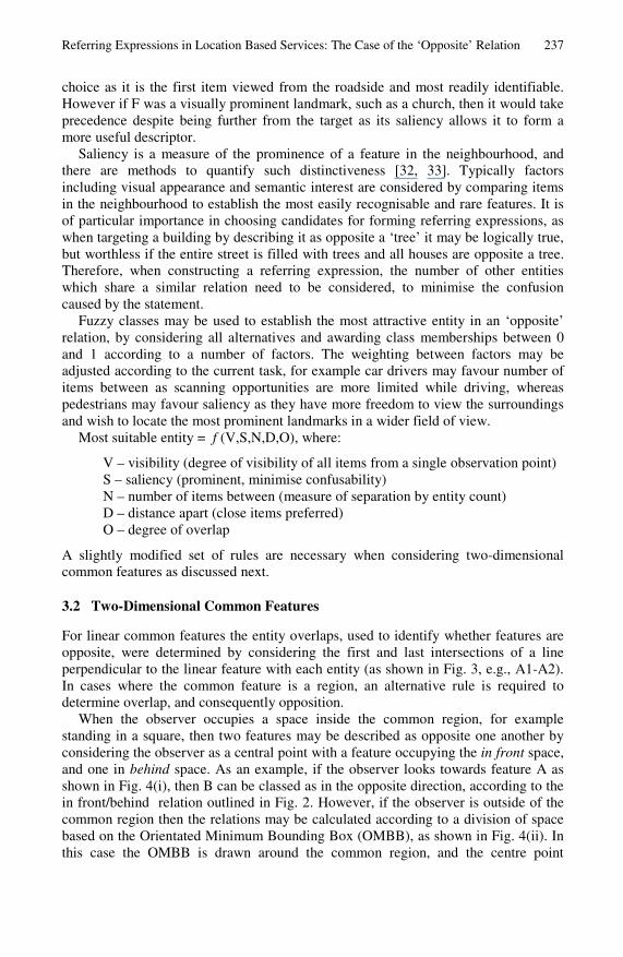
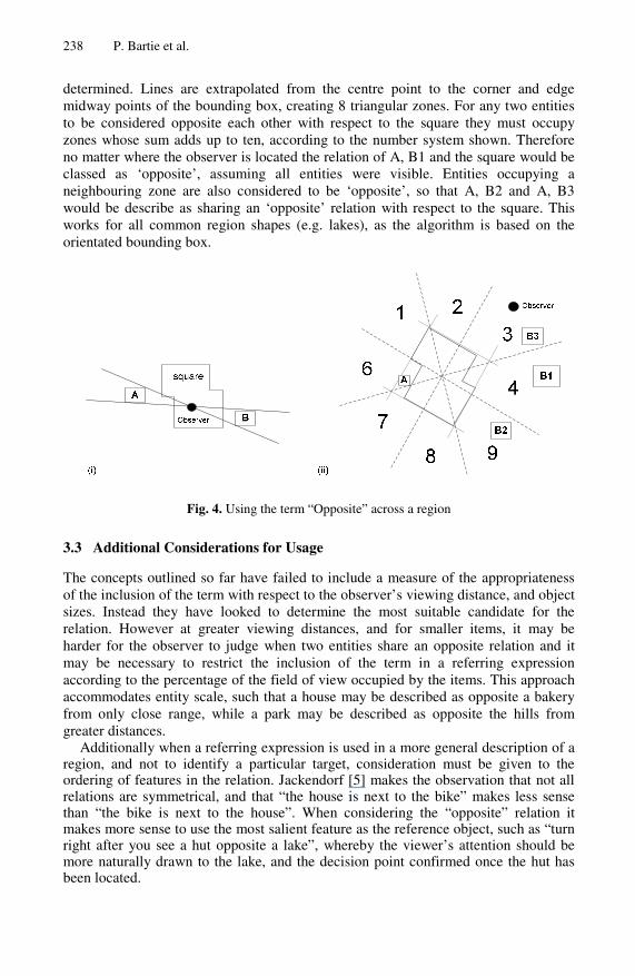
When the observer occupies a space inside the common region, for example standing in a square, then two features may be described as opposite one another by considering the observer as a central point with a feature occupying the in front space, and one in behind space. As an example, if the observer looks towards feature A as shown in Fig. 4(i), then B can be classed as in the opposite direction, according to the in front/behind relation outlined in Fig. 2. However, if the observer is outside of the common region then the relations may be calculated according to a division of space based on the Orientated Minimum Bounding Box (OMBB), as shown in Fig. 4(ii). In this case the OMBB is drawn around the common region, and the centre point
238 P. Bartie et al.
determined. Lines are extrapolated from the centre point to the corner and edge midway points of the bounding box, creating 8 triangular zones. For any two entities to be considered opposite each other with respect to the square they must occupy zones whose sum adds up to ten, according to the number system shown. Therefore no matter where the observer is located the relation of A, B1 and the square would be classed as ‘opposite’, assuming all entities were visible. Entities occupying a neighbouring zone are also considered to be ‘opposite’, so that A, B2 and A, B3 would be describe as sharing an ‘opposite’ relation with respect to the square. This works for all common region shapes (e.g. lakes), as the algorithm is based on the orientated bounding box.
Fig. 4. Using the term “Opposite” across a region
3.3 Additional Considerations for Usage
The concepts outlined so far have failed to include a measure of the appropriateness of the inclusion of the term with respect to the observer’s viewing distance, and object sizes. Instead they have looked to determine the most suitable candidate for the relation. However at greater viewing distances, and for smaller items, it may be harder for the observer to judge when two entities share an opposite relation and it may be necessary to restrict the inclusion of the term in a referring expression according to the percentage of the field of view occupied by the items. This approach accommodates entity scale, such that a house may be described as opposite a bakery from only close range, while a park may be described as opposite the hills from greater distances.
Additionally when a referring expression is used in a more general description of a region, and not to identify a particular target, consideration must be given to the ordering of features in the relation. Jackendorf [5] makes the observation that not all relations are symmetrical, and that “the house is next to the bike” makes less sense than “the bike is next to the house”. When considering the “opposite” relation it makes more sense to use the most salient feature as the reference object, such as “turn right after you see a hut opposite a lake”, whereby the viewer’s attention should be more naturally drawn to the lake, and the decision point confirmed once the hut has been located.

Referring Expressions in Location Based Services: The Case of the ‘Opposite’ Relation 239
4 Conclusions and Future Work
When constructing descriptions of a feature it is useful to include spatial prepositions to guide the user’s attention. This is particularly relevant when forming referring expressions for use in speech based LBSs while exploring a city. The case of spatially ‘opposite’ an entity has been considered in this paper raising a number of observations about how it may be determined and constructed from GIS datasets. The research has shown that to ensure meaningful descriptions it is necessary to determine whether features are visible to the user by calculating their visual exposure and establish a common reference entity to define their relation. One-dimensional and two-dimensional features have been examined for this purpose. Three-dimensional entities have not yet been explored, but could be included in future work. They may be of particular use when constructing descriptions for features on the side of a building, such as “the window opposite the balcony“, to limit the vertical scan region.
When a number of possible candidates are found it is necessary to select the most useful by determining its saliency and recognisability, to assist in guiding the user’s attention and minimise risk of target confusion. Factors including its visibility, distance, and the number of other similar items in the scene are considered. Future work should examine the weighting of these inputs, to determine the most suitable values for particular tasks. The models presented should be developed further through user trials, and may then be adopted as part of a wider set of defined spatial relations for use in urban LBS, and the geosemantic web.
References
1. Narzt, W., et al.: Augmented reality navigation systems. Universal Access in the Information Society, 1–11 (2006)
2. Hollerer, T., et al.: Exploring MARS: Developing indoor and outdoor user interfaces to a mobile augmented reality system. Computers and Graphics (Pergamon) 23(6), 779–785 (1999)
3. Goose, S., Sudarsky, S., Zhang, X., Navab, N.: Speech-Enabled Augmented Reality Supporting Mobile Industrial Maintenance. In: PERVASIVE Computing (2004)
4. Bartie, P.J., Mackaness, W.A.: Development of a speech-based augmented reality system to support exploration of cityscape. Transactions in GIS 10(1), 63–86 (2006)
5. Jackendoff, R.: Languages of the Mind. MIT Press, Cambridge (1992) 6. Dale, R., Reiter, E.: Computational interpretations of the Gricean maxims in the generation
of referring expressions. Cognitive Science 19(2), 233–263 (1995) 7. Espinoza, F., et al.: GeoNotes: Social and Navigational Aspects of Location-Based
Information Systems. In: Abowd, G.D., Brumitt, B., Shafer, S. (eds.) UbiComp 2001. LNCS, vol. 2201, pp. 2–17. Springer, Heidelberg (2001)
8. Francioni, J.M., Jackson, J.A., Albright, L.: The sounds of parallel programs: IEEE (2002) 9. Allport, D., Antonis, B., Reynolds, P.: On the Division of Attention: a Disproof of the Single
Channel Hypothesis. Quarterly Journal of Experimental Psychology 24, 225–235 (1972) 10. Ishii, H., Kobayashi, M., Arita, K.: Iterative design of seamless collaboration media.
Communications of the ACM 37(8), 83–97 (1994) 11. Winter, S., Wu, Y.: The “spatial Turing test”. In: Colloquium for Andrew U. Frank’s 60th
Birthday. Geoinfo Series, Department for Geoinformation and Cartography, Technical University Vienna, Vienna (2008)
240 P. Bartie et al.
12. Meng, L.: Ego centres of mobile users and egocentric map design. In: Meng, L., Zipf, A., Reichenbacher, T. (eds.) Map-based Mobile Services, pp. 87–105. Springer, Berlin (2005)
13. Reichenbacher, T.: Adaptive egocentric maps for mobile users. In: Meng, L., Zipf, A., Reichenbacher, T. (eds.) Map-based Mobile Services, pp. 143–162. Springer, Berlin (2005)
14. Egenhofer, M.J., Herring, J.: A mathematical framework for the definition of topological relationships (1990)
15. Clementini, E., Di Felice, P.: A comparison of methods for representing topological relationships. Information Sciences-Applications 3(3), 149–178 (1995)
16. Clementini, E., Billen, R.: Modeling and computing ternary projective relations between regions. IEEE Transactions on Knowledge and Data Engineering 18, 799–814 (2006)
17. Hernández, D.: Relative representation of spatial knowledge: The 2-D case. In: Mark, D.M., Frank, A.U. (eds.) Cognitive and linguistic aspects of geographic space, pp. 373–385. Kluwer Academic Publishers, Netherlands (1991)
18. De Smith, M.J., Goodchild, M.F., Longley, P.: Geospatial Analysis: A Comprehensive Guide to Principles, Techniques and Software Tools. Troubador Publishing (2007)
19. De Floriani, L., Marzano, P., Puppo, E.: Line-of-sight communication on terrain models. International Journal of Geographical Information Systems 8(4), 329–342 (1994)
20. Stucky, J.L.D.: On applying viewshed analysis for determining least-cost paths on Digital Elevation Models. International Journal of Geographical Information Science 12(8), 891–905 (1998)
21. Fisher, P.F.: Extending the applicability of viewsheds in landscape planning. Photogrammetric Engineering and Remote Sensing 62(11), 1297–1302 (1996)
22. Baer, W., et al.: Advances in Terrain Augmented Geometric Pairing Algorithms for Operational Test. In: ITEA Modelling and Simulation Workshop, Las Cruces, NM (2005)
23. Fisher-Gewirtzman, D., Wagner, I.A.: Spatial openness as a practical metric for evaluating built-up environments. Environment and Planning B: Planning and Design 30(1), 37–49 (2003)
24. Tandy, C.R.V.: The isovist method of landscape. In: Symposium: Methods of Landscape Analysis. Landscape Research Group, London (1967)
25. Benedikt, M.L.: To take hold of space: isovists and isovist fields. Environment and Planning B 6(1), 47–65 (1979)
26. Morello, E., Ratti, C.: A digital image of the city: 3D isovists in Lynch’s urban analysis. Environment and Planning B 36, 837–853 (2009)
27. Llobera, M.: Extending GIS-based visual analysis: the concept of visualscapes. International Journal of Geographical Information Science 17(1), 25–48 (2003)
28. Bartie, P.J., et al.: Advancing Visibility Modelling Algorithms for Urban Environments. Computers Environment and Urban Systems (2010); doi:10.1016/j.compenvurbsys.2010.06.002
29. Billen, R., Clementini, E.: Projective relations in a 3D environment. In: Raubal, M., Miller, H.J., Frank, A.U., Goodchild, M.F. (eds.) GIScience 2006. LNCS, vol. 4197, pp. 18–32. Springer, Heidelberg (2006)
30. Bartie, P., et al.: A Model for Egocentric Projective Spatial Reasoning based on Visual Exposure of Features of Interest (forthcoming)
31. Merriam-Webster: Opposite (2010) 32. Raubal, M., Winter, S.: Enriching wayfinding instructions with local landmarks. In:
Egenhofer, M.J., Mark, D.M. (eds.) GIScience 2002. LNCS, vol. 2478, pp. 243–259. Springer, Heidelberg (2002)
33. Elias, B.: Determination of landmarks and reliability criteria for landmarks (2003)
Copyright © 2022 FDOKUMEN