MILL STREET - City of Colorado Springs
71
MILL STREET NEIGHBORHOOD PLAN PLAN FOR ADOPTION: FEBRUARY 12, 2019
-
Upload
khangminh22 -
Category
Documents
-
view
0 -
download
0
Transcript of MILL STREET - City of Colorado Springs

MILL STREETNEIGHBORHOOD PLAN
PLAN FOR ADOPTION: FEBRUARY 12, 2019
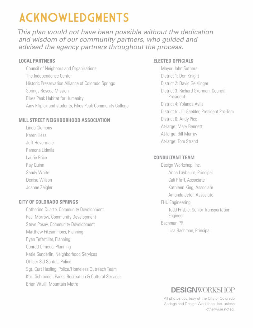
ACKNOWLEDGMENTS
LOCAL PARTNERS Council of Neighbors and OrganizationsThe Independence CenterHistoric Preservation Alliance of Colorado SpringsSprings Rescue MissionPikes Peak Habitat for Humanity Amy Filipiak and students, Pikes Peak Community College
MILL STREET NEIGHBORHOOD ASSOCIATION
Linda ClemonsKaren HessJeff HovermaleRamona LidmilaLaurie Price Ray QuinnSandy WhiteDenise WilsonJoanne Zeigler
CITY OF COLORADO SPRINGS
Catherine Duarte, Community DevelopmentPaul Morrow, Community DevelopmentSteve Posey, Community DevelopmentMatthew Fitzsimmons, PlanningRyan Tefertiller, PlanningConrad Olmedo, PlanningKatie Sunderlin, Neighborhood ServicesOfficer Sid Santos, PoliceSgt. Curt Hasling, Police/Homeless Outreach TeamKurt Schroeder, Parks, Recreation & Cultural ServicesBrian Vitulli, Mountain Metro
This plan would not have been possible without the dedication and wisdom of our community partners, who guided and advised the agency partners throughout the process.
ELECTED OFFICIALSMayor John SuthersDistrict 1: Don Knight District 2: David Geislinger District 3: Richard Skorman, Council
President District 4: Yolanda Avila District 5: Jill Gaebler, President Pro-Tem District 6: Andy Pico At-large: Merv BennettAt-large: Bill Murray At-large: Tom Strand
CONSULTANT TEAMDesign Workshop, Inc.
Anna Laybourn, PrincipalCali Pfaff, Associate Kathleen King, AssociateAmanda Jeter, Associate
FHU Engineering Todd Frisbie, Senior Transportation
EngineerBachman PR
Lisa Bachman, Principal
All photos courtesy of the City of Colorado Springs and Design Workshop, Inc. unless
otherwise noted.

EXECUTIVE SUMMARY 2
HOW TO USE THIS PLAN 4
INTRODUCTION 7Welcome to Mill Street 8Planning Context 6Public Outreach 10Glossary 14
EXISTING CONDITIONS 17Study Area 19Neighborhood Character 20Demographics 22Housing & Affordability 23Economics 25Local Challenges 26Transportation & Mobility 28Parks & Open Space 31
PLAN CONCEPTS & RECOMMENDATIONS 33Vision & Goals 34Enhance Quality of Life for Mill Street Residents 36Cultivate Mill Street Character 40Reconnect Mill Street People & Places 44Create a Resilient Future for Mill Street 48Big Moves 52
ACTION PLAN 57
APPENDICES 70
Community Engagement ASupplemental Maps BLiterature Review CImplementation Tools DResolution E
CONTENTS

2 | Mill Street Neighborhood Plan
WHAT IS THE NEIGHBORHOOD PLAN?
The idea of creating a Mill Street Neighborhood Plan came about over a series of community meetings in 2015 during the negotiations for a Good Neighbor Agreement between the Mill Street Neighborhood Association, Springs Rescue Mission, and the City of Colorado Springs. The expansion of the shelter triggered a demand for more tools to protect the neighborhood character and safety, but it quickly became clear that an update to the 2003 Mill Street Neighborhood Preservation Plan was necessary for reasons beyond the shelter.
The Mill Street Neighborhood has endured for nearly 150 years. In that time, homes have been lost to accommodate dump sites, coal power plant construction and operation, industrial warehouses, and rail line additions. As Colorado Springs development has spread out in every direction over the last few decades, this central community has weathered the closures of schools, grocery stores, and other neighborhood hubs and services.
Downtown Colorado Springs and adjacent neighborhoods are now welcoming an insurgence of new investment and the Mill Street community is seeing an influx of associated challenges and opportunities. While many welcome a revitalization of the area, maintaining the ability to afford to stay in the area and reducing crime and unsafe street activity remain top concerns. The Mill Street Neighborhood Plan is an expression of its residents’ and workers’ sentiments that it is not enough to just survive in this new climate, but to thrive.
PROCESS Over the course of the planning process, community members shared their vision and concerns about the neighborhood, weighed in on project themes, and helped guide the recommendations. Community engagement focused on a four-tiered approach: reach out, listen, engage and share.
VISION Through an inclusive and consensus-building process, the Mill Street Neighborhood Plan will set the stage for the future of the Mill Street community to be a thriving, dynamic place that celebrates its diversity and historic past.
TOP TO BOT TOM :
NEIGHBORHOOD MEETING 2018 AREA BOUNDARY MAP 1: 2 ,500
EXECUTIVE SUMMARY
W M O R E N O A V E
CO
NE
JO
S S
TR
EE
T
SO
UT
H N
EV
AD
A A
VE
NU
E
I N T E R S T A T E 2 5
W RIO GRANDE ST
3
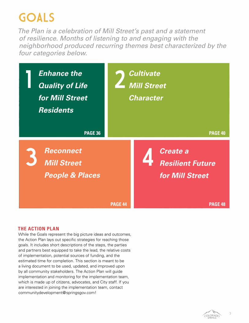
THE ACTION PLAN While the Goals represent the big picture ideas and outcomes, the Action Plan lays out specific strategies for reaching those goals. It includes short descriptions of the steps, the parties and partners best equipped to take the lead, the relative costs of implementation, potential sources of funding, and the estimated time for completion. This section is meant to be a living document to be used, updated, and improved upon by all community stakeholders. The Action Plan will guide implementation and monitoring for the implementation team, which is made up of citizens, advocates, and City staff. If you are interested in joining the implementation team, contact [email protected]!
PAGE 36 PAGE 40
PAGE 48PAGE 44
The Plan is a celebration of Mill Street’s past and a statement of resilience. Months of listening to and engaging with the neighborhood produced recurring themes best characterized by the four categories below.
GOALS
1
3 4
2Enhance the
Quality of Life
for Mill Street
Residents
Cultivate
Mill Street
Character
Reconnect
Mill Street
People & Places
Create a
Resilient Future
for Mill Street

4 | Mill Street Neighborhood Plan
ORIENTATIONThe Mill Street Neighborhood is a special place that has played an important role in the evolution of Colorado Springs. Few American cities have retained their historic workforce neighborhoods in the downtown core, but this one has carried on for 150 years.
The purpose of plan is to be intentional about the future evolution of this neighborhood: encouraging redevelopment of vacant and unused properties in harmony with the neighborhood culture and celebrating its history.
It is expected the Mill Street Neighborhood Plan will be used by a wide array of community members, from residents to city staff and developers. The plan provides a framework for future capital projects, organizational assistance, program opportunities, and land use considerations.
HOW TO USE THIS PLANMILL STREET & ADJACENT DISTRICTSWhile there is overlap between the Downtown study area from the 2016 Experience Downtown Master Plan and the Mill Street Neighborhood study area, the recommendations and land use planning herewithin align. In areas that overlap, Mill Street is considered a subarea of the Downtown.
Also within areas of overlap, there is latitude for a tenant or land owner to align with either district’s plan. In addition, areas that are primarily non-residential overlap are within sectors of the Downtown form-based code that governs use and future development of land.
Just northwest of the Mill Street area is the CityGate Urban Renewal site, established in 2006. In the summer of 2018, the City announced a public-private partnership to site a new Colorado Springs Switchbacks stadium/outdoor event center and apartment building on the CityGate property. The Colorado Springs Urban Renewal Authority expects to update the CityGate plan.
Transition Sector 2
Parks & Open Space
Transition Sector 1
Corridor SectorCentral Sector
New South End District
Southwest DistrictEXPERIENCE DOWNTOWN
FORM-BASED CODE (FBC)
MILL STREET PLAN
Project BoundaryMajor Roads
ED Boundary
River / Creek
LEGEND
F O U N TA I N C R E E K
SH
OO
KS
R
UN
MO
NU
M
E N T
CREEK
EXPE
RIEN
CE
DO
WNT
OW
N
PLAN
BO
UNDA
RY
W MORENO AVE
W RIO GRANDE ST
DOWNTOWN
MILL STREETFOUNTAIN BLVD
S T
EJON S
T
I -25
S N
EVADA A
VE
N N
EVADA A
VE
FORM-BASED CODE BOUNDARY

5
* For more information on affordable housing incentives and other financing tools, please see Appendix D.
Enhance the Quality of Life for Mill Street Residents
Cultivate Mill Street Character
Reconnect Mill Street People and Places
Create a Resilient Future for Mill Street
How will this project contribute to the safety and public health of the neighborhood?
How will this project highlight the neighborhood’s history and/or complement the area’s architectural styles?
How has the project owner engaged with the neighborhood during the project planning phase?
How has this project considered affordability in the neighborhood?*
Will this project provide public gathering spaces?
How will the project’s proposed density impact the surrounding uses?
How does this project provide/complement pedestrian accessibility?
Will this project create employment opportunities for local residents?
How does this project impact the environment?
Does this project preserve residential structures?
How does this project promote street vitality?
How will this project address retention of current residents?
Will this project activate previously vacant or underutilized space?
Will this project provide or support a land use/service that fills a need in the neighborhood?
PROJECT ALIGNMENT Are you proposing a land use change and/or new development in the neighborhood? For new development projects, the table below summarizes plan elements for consideration. It is not expected that all these categories or questions will apply to a single project. These questions are intended to help create an understanding of the proposed development. To determine whether your development plans align with the Mill Street Neighborhood Plan, here are questions to consider in development applications.
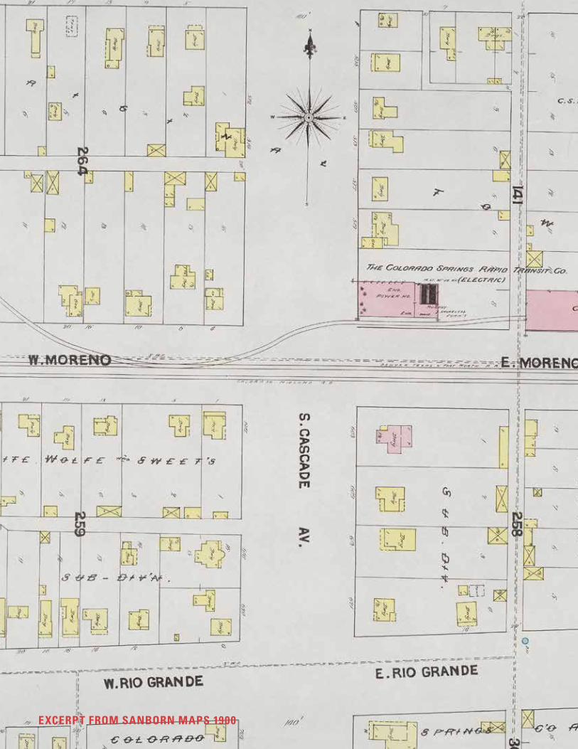
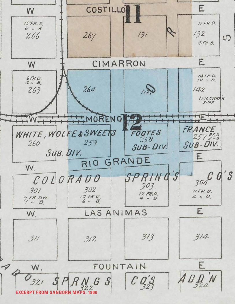
EXCERPT FROM SANBORN MAPS 1900
7
INTRODUCTIONCONTENTS
IntroductionCommunity Engagement OverviewCommunity Engagement TakeawaysGlossary

8 | Mill Street Neighborhood Plan
WELCOME TO MILL STREETLocated just south of Downtown Colorado Springs, the Mill Street Neighborhood is one of the oldest communities in the city.
General William Palmer platted the neighborhood area in 1870, a full year before Colorado Springs was established at the confluence of Fountain and Monument Creeks (located north of the study area). Mill Street got its name from the gristmill built in 1877 at the tail end of Cascade Ave off Fountain Creek. The mill was regionally famous for producing the best wheat and graham flour west of the Mississippi. Due to its proximity to Downtown and the burgeoning Broadmoor resort, the Mill Street Neighborhood became a working-class district for employees of the more affluent areas to the North and South. The neighborhood was formally annexed into the City of Colorado Springs in 1907. Throughout the 20th century, the area’s residential stock decreased as land was purchased for the railroad and industrial land. At the time of the 2003 Mill Street Neighborhood Preservation Plan, there were a number of multigenerational households whose ancestors had grown up in the area. Today the neighborhood includes an eclectic mix of small homes, local-serving retail, and industrial uses. Approximately 800 people call this neighborhood their home.
PLANNING CONTEXT As a city-center neighborhood in Colorado Springs, the Mill Street Neighborhood has been involved in many local planning initiatives dating back to the early 1970s.
Beginning with the Downtown Plan in 1971 and later the 1992 Downtown Action Plan, the City of Colorado Springs has been strategically planning the revitalization of its Downtown for decades. The first major plan to specifically address the Mill Street area was the 2003 Mill Street Neighborhood Preservation Plan. The study boundary of the 2003 plan focused in on the residential core, bounded by Tejon Street to the East, W. Fountain Boulevard to the North, Conejos Street to the West and W. Las Vegas Street to the South. The plan sought to safeguard the historic character, preserve the existing residential stock, organize a program to promote home ownership and cement the identity of the area as a working-class neighborhood.
INTRODUCTION
TOP TO BOT TOM :
VIEW TO MOUNTAINS
RESIDENT WISH FOR THE NEIGHBORHOOD

9
Downtown Plan 1971
Downtown Action Plan 1992
Downtown Transit Center Study 1998
City of Colorado Springs Comprehensive Plan 2000
Mill Street Neighborhood Preservation Plan 2003
CityGate URA Studies 2006
Imagine Downtown Master Plan 2009
Downtown Colorado Springs Form-Based Code 2009
1970s
1990s
2000s
In recent years, targeted planning initiatives have set the stage for incremental change. As these incremental changes pick up in pace and scale, the area will look to a significant catalytic change with the closure of Martin Drake Power Plant by 2035. In the 2009 Imagine Downtown Master Plan (and the 2016 follow-up plan, Experience Downtown), the northern portion of Mill Street was in the study area, included in two Downtown character zones. (More detail on page 18). Separate from the Mill Street area yet heavily influential is the CityGate Urban Renewal Area, which includes a new outdoor stadium. After many years of planning, initial plans were announced in July 2018 to develop a 10,000-seat outdoor stadium for the Switchbacks, Colorado Springs’ minor league soccer team, as well as hundreds of apartments and a mixed use development. The project will be financed from a combination of public and private investment. The 2009 adoption of the Downtown Colorado Springs Form-Based Code (FBC) has the potential to impact building form and density in the Mill Street neighborhood through new development. The code is a regulatory measure used to enact the vision of the Imagine Downtown Master Plan by focusing on quality built form and mixed use development. Previously, the City employed traditional zoning, which designated land uses to segregate types of development. Influential planning and private development projects, such as the US Olympic Museum, have impacted the area in and around the Mill Street neighborhood. In Mill Street, there is a tension between the high-end developments along Tejon and North of the study area and the social services expanding in the South of the study area. This tension manifests in divisions in income and investment based on which side of the train tracks one is on, isolating many members of the community and fueling concerns of displacement and neglect.
In 2019, the City will complete an updated comprehensive plan, which lends urgency and legitimacy to the role of neighborhood plans to address these problems. The Mill Street Neighborhood Plan aims to fulfill PlanCOS’s vision of vibrant neighborhoods by creating a place for all by encouraging inclusion, participation, housing for all price points, and reinvestment in community spaces.1
1 City of Colorado Springs. PlanCOS Draft. “Vibrant Neighborhoods: Goals & Policies.” 2018.
Colorado Springs Park System Master Plan 2014
South Nevada Corridor Study 2015
Experience Downtown Master Plan 2016
Downtown Transit Station Relocation Study 2016
Opportunity360 Measurement Report 2016
Greenway Flats Market Study 2016
Envision Shooks Run Corridor Master Plan 2017
Colorado Springs Bike Master Plan 2018
PlanCOS 2018
2010s
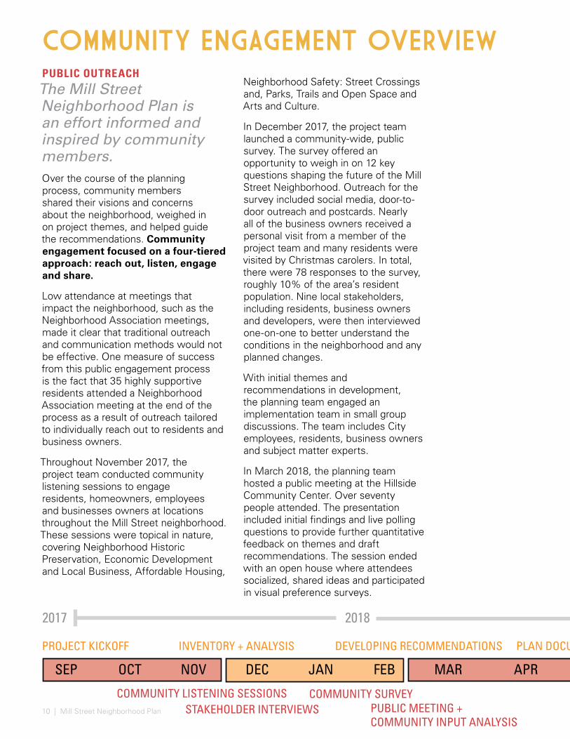
10 | Mill Street Neighborhood Plan PUBLIC MEETING + COMMUNITY INPUT ANALYSIS
PLAN DOCUMENTATION
PUBLIC OUTREACHThe Mill Street Neighborhood Plan is an effort informed and inspired by community members. Over the course of the planning process, community members shared their visions and concerns about the neighborhood, weighed in on project themes, and helped guide the recommendations. Community engagement focused on a four-tiered approach: reach out, listen, engage and share.
Low attendance at meetings that impact the neighborhood, such as the Neighborhood Association meetings, made it clear that traditional outreach and communication methods would not be effective. One measure of success from this public engagement process is the fact that 35 highly supportive residents attended a Neighborhood Association meeting at the end of the process as a result of outreach tailored to individually reach out to residents and business owners.
Throughout November 2017, the project team conducted community listening sessions to engage residents, homeowners, employees and businesses owners at locations throughout the Mill Street neighborhood. These sessions were topical in nature, covering Neighborhood Historic Preservation, Economic Development and Local Business, Affordable Housing,
Neighborhood Safety: Street Crossings and, Parks, Trails and Open Space and Arts and Culture.
In December 2017, the project team launched a community-wide, public survey. The survey offered an opportunity to weigh in on 12 key questions shaping the future of the Mill Street Neighborhood. Outreach for the survey included social media, door-to-door outreach and postcards. Nearly all of the business owners received a personal visit from a member of the project team and many residents were visited by Christmas carolers. In total, there were 78 responses to the survey, roughly 10% of the area’s resident population. Nine local stakeholders, including residents, business owners and developers, were then interviewed one-on-one to better understand the conditions in the neighborhood and any planned changes.
With initial themes and recommendations in development, the planning team engaged an implementation team in small group discussions. The team includes City employees, residents, business owners and subject matter experts.
In March 2018, the planning team hosted a public meeting at the Hillside Community Center. Over seventy people attended. The presentation included initial findings and live polling questions to provide further quantitative feedback on themes and draft recommendations. The session ended with an open house where attendees socialized, shared ideas and participated in visual preference surveys.
2018
DEVELOPING RECOMMENDATIONS
COMMUNITY SURVEYSTAKEHOLDER INTERVIEWS
2017
PROJECT KICKOFF INVENTORY + ANALYSIS
COMMUNITY LISTENING SESSIONS
COMMUNITY ENGAGEMENT OVERVIEW
MAYMAR APRDEC JAN FEBNOVOCTSEP
11
“Improve quality of
life while maintaining
historic value and
affordability.”
- Comment Card
JULY JAN
PUBLIC MEETING + COMMUNITY INPUT ANALYSIS
PLAN DOCUMENTATION DRAFT PLAN ADOPTION
50HOMES & BUSINESSES VISITED BY CHRISTMAS CAROLERS
09ONE-ON-ONE STAKEHOLDER INTERVIEWS
69PARTICIPANTS IN 6 SMALL GROUP LISTENING SESSIONS
78SURVEYS COMPLETED
19AT TENDEES AT HOLIDAY PART Y OPEN HOUSE70+
AT TENDEES AT PUBLIC MEETING
PUBLIC REVIEW PUBLIC REVIEWSTAFF REVIEW STAFF REVIEW
FINAL PLANPREFERRED PLAN
2019
(SOURCE : PUBLIC MEETING)
MAY JUNE DECAUG SEPT OCT NOV

12 | Mill Street Neighborhood Plan
COMMUNITY LISTENING SESSIONSThere were seven listening sessions each with its own focus area. Key attributes that the group thought the plan should speak to are recorded below.
ARTS & CULTURE—Maintain neighborhood feeling, create historic overlay zone, preserve architecture, make neighborhood walkable
AFFORDABLE HOUSING—Preserve historic homes, diversify housing, incentivize homeownership, stabilize rents
ECONOMIC DEVELOPMENT—Control affordablility, create business identity, address food desert, create safer environment
HISTORIC PRESERVATION—Make walkable neighborhood, preserve working class character, preserve heritage, create special outdoor spaces
PARKS, OPEN SPACES AND TRAILS— Maintain trails and bike paths, increase greenway safety, create eyes on the trail
COMMUNITY SAFETY—Increase policing, reduce speeding, enforce rules, collaborate with Springs Rescue Mission, mobilize residents for greater communication
HOMELESS OUTREACH—Provide secure storage space for belongings, offer daytime programming and job opportunities
COMMUNITY SURVEYOutreach for the community survey involved door-to-door visits to local businesses and Christmas caroling for residents. With about 10 percent of the population participating (78 surveys completed), residents (both long-term and short-term) and business owners/employees were all represented. Top priorities included a reduction in crime and nuisance, improved look and feel; affordability; support for existing businesses and better communication between residents and the City. Write-in responses indicated strong concern about homelessness and safety. The full report can be found in Appendix A.
The planning team conducted extensive community engagement through four methods. Below are key takeaways.
COMMUNITY ENGAGEMENT TAKEAWAYS
IMAGES AT RIGHT FROM PUBLIC MEETING :
COMMENTS ON SAFETY
VISUAL PREFERENCE RESPONSES
OPEN HOUSE GUESTS
(SOURCE : COMMUNITY SURVEY, 78 RESPONDENTS)

13
STAKEHOLDER INTERVIEWSA series of one-on-one interviews were conducted with community stakeholders to delve into specific issues about the neighborhood. Key takeaways were that outside business owners do not feel a strong connection to the neighborhood, property owners need further consultation in implementation, safety concerns impact residents as well as businesses, and a strong messaging about neighborhood identity would bolster the area.
PUBLIC MEETINGThere were 70 attendees, ranging from City staff to local business owners, with a smaller percentage representation of residents than the survey. Community members identified the following action items via live polling and during the open house.
UPGRADE INFRASTRUCTURE—The poor condition of the neighborhood’s sidewalks and roadways was a key neighborhood concern. 70% of attendees identified ‘condition of infrastructure’ as a top priority for improvement.
COLLABORATE TO IMPROVE SAFETY—Safety is a core concern in the neighborhood and attendees selected a wide array of strategies for how to improve it, such as more support for those experiencing homelessness and a more proactive and responsive approach to policing.
SUPPORT CLEANUP EFFORTS—Both in the live polling and on comment cards, trash and debris in the neighborhood and along trails were notable concerns. 70% of attendees indicated that trash and debris negatively impact the neighborhood.
REIMAGINE DORCHESTER PARK—When asked what should be done with Dorchester Park, 69% of attendees advocated for major changes.
THE FUTURE—When asked “What possible 20+year changes could be most beneficial to the neighborhood?” 57% of respondents indicated decommissioning of the Drake Power Plant.
WE WANT TO HEAR FROM YOU! THE MILL STREET NEIGHBORHOOD PLAN The Mill Street community is embarking on a planning process to envision the future of their neighborhood. The City of Colorado Springs Community Development Division is currently engaging area residents, visitors and business owners to identify goals, priorities and interests in the future of this historic place.
PROJECT VISION Through an inclusive and consensus- building process, the Neighborhood Plan will set the stage for the future of the Mill Street community to be a thriving, dynamic place that celebrates its diversity and historic past.
W Cimarron St
S Nevada Ave
I-25
Cone
jos
St
MILL STREET NEIGHBORHOOD COMMUNITY SURVEY
14 | Mill Street Neighborhood Plan
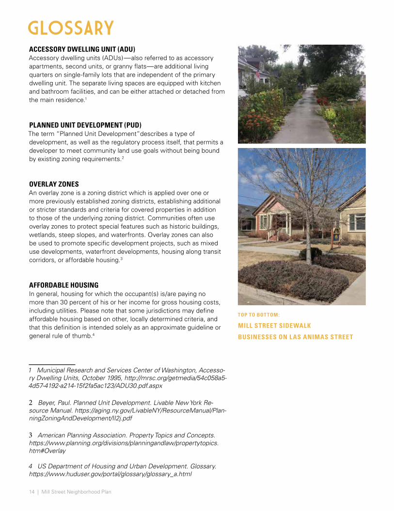
ACCESSORY DWELLING UNIT (ADU) Accessory dwelling units (ADUs)—also referred to as accessory apartments, second units, or granny flats—are additional living quarters on single-family lots that are independent of the primary dwelling unit. The separate living spaces are equipped with kitchen and bathroom facilities, and can be either attached or detached from the main residence.1
PLANNED UNIT DEVELOPMENT (PUD) The term “Planned Unit Development”describes a type of development, as well as the regulatory process itself, that permits a developer to meet community land use goals without being bound by existing zoning requirements.2
OVERLAY ZONES An overlay zone is a zoning district which is applied over one or more previously established zoning districts, establishing additional or stricter standards and criteria for covered properties in addition to those of the underlying zoning district. Communities often use overlay zones to protect special features such as historic buildings, wetlands, steep slopes, and waterfronts. Overlay zones can also be used to promote specific development projects, such as mixed use developments, waterfront developments, housing along transit corridors, or affordable housing.3
AFFORDABLE HOUSING In general, housing for which the occupant(s) is/are paying no more than 30 percent of his or her income for gross housing costs, including utilities. Please note that some jurisdictions may define affordable housing based on other, locally determined criteria, and that this definition is intended solely as an approximate guideline or general rule of thumb.4
1 Municipal Research and Services Center of Washington, Accesso-ry Dwelling Units, October 1995, http://mrsc.org/getmedia/54c058a5-4d57-4192-a214-15f2fa5ac123/ADU30.pdf.aspx
2 Beyer, Paul. Planned Unit Development. Livable New York Re-source Manual. https://aging.ny.gov/LivableNY/ResourceManual/Plan-ningZoningAndDevelopment/II2j.pdf
3 American Planning Association. Property Topics and Concepts. https://www.planning.org/divisions/planningandlaw/propertytopics.htm#Overlay
4 US Department of Housing and Urban Development. Glossary. https://www.huduser.gov/portal/glossary/glossary_a.html
GLOSSARY
TOP TO BOT TOM :
MILL STREET SIDEWALK
BUSINESSES ON LAS ANIMAS STREET
15
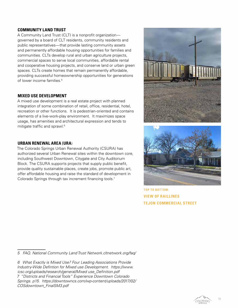
COMMUNITY LAND TRUST A Community Land Trust (CLT) is a nonprofit organization—governed by a board of CLT residents, community residents and public representatives—that provide lasting community assets and permanently affordable housing opportunities for families and communities. CLTs develop rural and urban agriculture projects, commercial spaces to serve local communities, affordable rental and cooperative housing projects, and conserve land or urban green spaces. CLTs create homes that remain permanently affordable, providing successful homeownership opportunities for generations of lower income families.5
MIXED USE DEVELOPMENT A mixed use development is a real estate project with planned integration of some combination of retail, office, residential, hotel, recreation or other functions. It is pedestrian-oriented and contains elements of a live-work-play environment. It maximizes space usage, has amenities and architectural expression and tends to mitigate traffic and sprawl.6
URBAN RENEWAL AREA (URA) The Colorado Springs Urban Renewal Authority (CSURA) has authorized several Urban Renewal sites within the downtown core, including Southwest Downtown, Citygate and City Auditorium Block. The CSURA supports projects that supply public benefit, provide quality sustainable places, create jobs, promote public art, offer affordable housing and raise the standard of development in Colorado Springs through tax increment financing tools.7
5 FAQ. National Community Land Trust Network.cltnetwork.org/faq/
6 What Exactly is Mixed Use? Four Leading Associations Provide Industry-Wide Defintion for Mixed use Development. https://www.icsc.org/uploads/research/general/Mixed use_Definition.pdf7 “Districts and Financial Tools” Experience Downtown Colorado Springs. p15. https://downtowncs.com/wp-content/uploads/2017/02/COSdowntown_FinalSM3.pdf
TOP TO BOT TOM :
VIEW OF RAILLINES
TEJON COMMERCIAL STREET
EXCERPT FROM SANBORN MAPS, 1900

17
CHAPTER TITLE
EXISTING CONDITIONS
OverviewHIstory & CultureLocal CommunityLocal EconomyTransportation & Mobility Parks & Open Space

MILL STREET NEIGHBORHOODEXISTING LAND USE 250’ 500’ 1,000’ 2,000’ N
Project Boundary
Major RoadsRoadsRegional Trails
Parks / Open Space 113k sfVacant 557k sfParking Lots 127k sfIndustrial 141k sf
Residential 1.6m sf Institutional / Civic 14k sf
Commercial /Office 1.61m sf
River / Creek
LEGEND
E MILL ST
S TE
JON
ST
EXISTING LAND USE AREA
Railroad
W MORENO AVEW MORENO AVE
W CIMARRON ST
W RIO GRANDE ST W RIO GRANDE ST
W LAS ANIMAS STW LAS ANIMAS ST
W FOUNTAIN BLVDW FOUNTAIN BLVD
FOUNTAIN CREEK
INTERSTATE 25DORCHESTER
PARK
E MILL ST
SAH
WAT
CH S
TSA
HW
ATCH
ST
BA
LTIC
ST
S C
ASC
AD
E A
VES
CA
SCA
DE
AVE
S TE
JON
ST
S W
EBER
ST
S N
EVA
DA
AVE
s N
EVA
DA
AVE
W LAS VEGAS ST
E MOTOR WAY
MOTOR CITY DR
SIER
RA M
AD
RE S
T
pikes peak greenway
downtown colorado springs
drake power plant

DRAFT 19
OVERVIEWSTUDY AREA
The Mill Street Neighborhood Plan study area focuses on a 202-acre area south of Downtown Colorado Springs. The area is bound by W. Moreno Avenue and W. Rio Grande Street to the North, by South Nevada Street—a mixed use arterial to the East, by Conejos Street and Sahwatch Street to the West, and by Interstate 25 to the South. The boundary borders the Urban Renewal Authority CityGate site to the Northwest, which is undergoing redevelopment.
The neighborhood core is a historic residential community. Industrial uses fringe the residential area to the West and South, including the Drake Power Plant, historically a major employer, slated for decommissioning by 2035. According to the 2003 Mill Street Neighborhood Preservation Plan, the residential core has shrunk substantially over time, due first to the conversion of residential land to industrial uses in the late 1980s and later to the purchase of land by Colorado Springs Utilities (CSU) in 1996 to buffer the power plant. As late as 2000, homes south of Mill Street and west of Sierra Madre Street were purchased by CSU to install rail lines to the power plant. The Springs Rescue Mission, on W. Las Vegas Street, expanded its facility to a 300-bed low-barrier shelter in 2016 and is currently expanding their campus to include permanent, supportive housing (PSH), a housing type that provides wraparound services for people with chronic, disabling conditions who have exited homelessness. The Mission is both a regional asset for the City of Colorado Springs and a local challenge with many business owners and some residents expressing concerns about some spillover effects from people engaging in high risk behavior.
The commercial heart of the Mill Street neighborhood is South Tejon Street; South Nevada Avenue, another major commercial corridor, borders the site on the East. Local businesses offer a broad range of services along Tejon Street.
Form Based Code: Transition Sector 1 Form Based Code: Corridor Sector Form Based Code: Transition Sector 2
Parks / Open Space Institutional / Civic Industrial
Planned Unit Development Commercial / Office
Residential
ZONING MAP
HOME ON SIERRA MADRE STREET
W M O R E N O A V E
CO
NE
JO
S S
TR
EE
T
SO
UT
H N
EV
AD
A A
VE
NU
E
I N T E R S T A T E 2 5
20 | Mill Street Neighborhood Plan
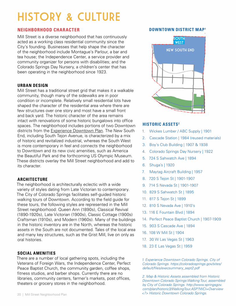
NEIGHBORHOOD CHARACTERMill Street is a diverse neighborhood that has continuously acted as a working class residential community since the City’s founding. Businesses that help shape the character of the neighborhood include Montague’s Parlour, a bar and tea house; the Independence Center, a service provider and community organizer for persons with disabilities; and the Colorado Springs Day Nursery, a children’s center that has been operating in the neighborhood since 1923.
URBAN DESIGN Mill Street has a traditional street grid that makes it a walkable community, though many of the sidewalks are in poor condition or incomplete. Relatively small residential lots have shaped the character of the residential area where there are few structures over one story and most have a small front and back yard. The historic character of the area remains intact with renovations of some historic bungalows into office spaces. The neighborhood includes portions of two Downtown districts from the Experience Downtown Plan. The New South End, including South Tejon Avenue, is characterized by a mix of historic and revitalized industrial, whereas the South West is more contemporary in feel and connects the neighborhood to Downtown and its new civic amenities, such as America the Beautiful Park and the forthcoming US Olympic Museum. These districts overlay the Mill Street neighborhood and add to its character.
ARCHITECTURE The neighborhood is architecturally eclectic with a wide variety of styles dating from Late Victorian to contemporary. The City of Colorado Springs facilitates self-guided historic walking tours of Downtown. According to the field guide for these tours, the following styles are represented in the Mill Street neighborhood: Queen Ann (1890s), Classical Revival (1890-1920s), Late Victorian (1900s), Classic Cottage (1900s) Craftsman (1910s), and Modern (1960s). Many of the buildings in the historic inventory are in the North, whereas the historic assets in the South are not documented. Tales of the local area and many key structures, such as the Grist Mill, live on only as oral histories.
SOCIAL AMENITIES There are a number of local gathering spots, including the Veterans of Foreign Wars, the Independence Center, Perfect Peace Baptist Church, the community garden, coffee shops, fitness studios, and barber shops. Currently there are no libraries, community centers, farmer’s markets, post offices, theaters or grocery stores in the neighborhood.
HISTORY & CULTURE
HISTORIC ASSETS2
1. Wickes Lumber / ABC Supply | 1901
2. Cascade Station | 1984 (reused materials)
3. Boy’s Club Building | 1907 & 1938
4. Colorado Springs Day Nursery | 1922
5. 724 S Sahwatch Ave | 1894
6. Shuga’s | 1920
7. Maytag Aircraft Building | 1957
8. 720 S Tejon St | 1901-1907
9. 714 S Nevada St | 1901-1907
10. 829 S Sahwatch St | 1895
11. 817 S Tejon St | 1899
12. 810 S Nevada Ave | 1910’s
13. 116 E Fountain Blvd | 1894
14. Perfect Peace Baptist Church | 1907-1909
15. 903 S Cascade Ave | 1894
16. 108 W Mill St | 1904
17. 30 W Las Vegas St | 1963
18. 23 E Las Vegas St | 1959
new south end
southwest
DOWNTOWN DISTRICT MAP1
1. Experience Downtown Colorado Springs. City of Colorado Springs. https://coloradosprings.gov/sites/default/files/execsummary_sept2.pdf
2. Map & Historic Assets assembled from Historic Downtown Colorado Springs Walking Tour, assembled by City of Colorado Springs. http://www.springsgov.com/plan/historic3/WalkingTour.ASP?WCI=Overview <?> Historic Downtown Colorado Springs.
21
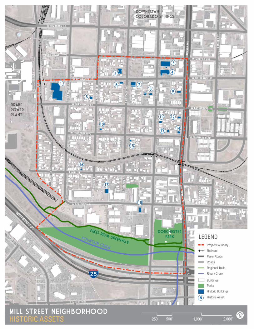
MILL STREET NEIGHBORHOODHISTORIC ASSETS 250’ 500’ 1,000’ 2,000’ N
1
2
3
4
5
6 78
9
10
11 12
1314
15
16
17
18
ParksBuildings
Historic Buildings
LEGENDProject Boundary
Major RoadsRoadsRegional TrailsRiver / Creek
Railroad
N Historic Asset
W MORENO AVEW MORENO AVE
W CIMARRON ST
W RIO GRANDE ST W RIO GRANDE ST
W LAS ANIMAS STW LAS ANIMAS ST
W FOUNTAIN BLVDW FOUNTAIN BLVD
FOUNTAIN CREEK
INTERSTATE 25DORCHESTER
PARK
E MILL ST
SAH
WAT
CH S
TSA
HW
ATCH
ST
BA
LTIC
ST
S C
ASC
AD
E A
VES
CA
SCA
DE
AVE
S TE
JON
ST
S W
EBER
ST
S N
EVA
DA
AVE
s N
EVA
DA
AVE
W LAS VEGAS ST
E MOTOR WAY
MOTOR CITY DR
SIER
RA M
AD
RE S
T
pikes peak greenway
downtown colorado springs
drake power plant

LOCAL COMMUNITYDEMOGRAPHICS
Mill Street is still—by and large—the working-class neighborhood it was one hundred years ago, though many residents are struggling to meet their basic needs. Demographic characteristics, surrounding redevelopment projects, and rising home prices all point to this being the most vulnerable population in the city. Of the 800 residents in the area, over 60% qualify as low income. Unemployment in the area is high at 25%. Over half of residents live alone and nearly 65% rent. There are high rates of persons living with disabilities (34% versus 11% regionally), as well as diagnosed depression (27% versus with 19% regionally), self-reported poor health (29% versus 14% regionally) and diabetes (13% versus to 8% nationally).1
The majority of Mill Street residents are white (75%) and English speakers with only 1% identifying as linguistically isolated and 20.4% of Hispanic origin. Residents are largely middle-aged. There is a sizeable senior population with 15.8% of the population over the age of 65, compared with 11.3% regionally. There is a low proportion of households with children and students bus out of the neighborhood to schools.2
In addition to the residential population, the Springs Rescue Mission (SRM) and the Salvation Army are located in the neighborhood, serving people experiencing homelessness. SRM is largest homeless services facility in the county, sheltering more than 300 people per night. Their mission is to shelter and house the homeless. During its 2016 expansion, SRM, City staff, and the Mill Street Neighborhood Association drafted a Good Neighbor Agreement, acknowledging the roles that each organization played in keeping all parties informed and supported. However, the document was never signed.
Historically, Mill Street was a close-knit community and in recent outreach, many residents still report a strong sense of community pride. In 2001, the Mill Street Neighborhood Association self-published a collection of stories called, “Once Upon a Neighborhood: Who We Are and Why We Care,” to share their perspectives on the Montgomery Community Center, a proposed homeless shelter. In it, Steven U. Mullens writes, “The people of Mill Street are a wonderful eclectic cross-section of blue-collar citizens of the Pikes Peak community. They have worked to their ultimate capacity to purchase, maintain and improve their residences.” The stories speak of declining home values, loss of community pride and concerns about personal safety and distrust of the City. Similar stories are shared today, but also of new challenges of some rapidly increasing home prices, poor quality rental units, and few resources for maintenance and investment.
1 Opportunity360 Measurement Report: Census Tract 23. 2017.2 U.S. Census Bureau, Census 2010 Summary File 1. Esri forecasts for 2017 and 2022.
MILL ST. MEDIAN HOUSEHOLD INCOME
$26,208 CIT Y WIDE MEDIAN HOUSEHOLD INCOME
$77,700
MILL ST. MEDIAN HOME PRICE
$158,333 CIT Y WIDE MEDIAN HOME PRICE
$273,500
ANNUAL MILL ST. INCOME GROW TH
+1.26% ANNUAL MILL ST. MEDIAN HOME PRICE GROW TH
+15.4%

23
HOUSING & AFFORDABILITY
The Mill Street residential area is full of colorful, small-lot homes; most are single story without substantial additions or expansions. HOUSING Roughly 12 blocks in the neighborhood are composed of homes dating from 1902-1915. The median year of construction is 1939 and many do not meet code today. The residential community in Mill Street is about two-thirds renters. Residential vacancy rates are 19% compared to 7% regionally. The historic character of some of these homes has been restored, but also some have been converted to commercial purposes. The small size of the lots, small homes, modest designs and lack of neighborhood amenities are some of the reasons this neighborhood has not become as desirable as other historic neighborhoods in the City. High vacancy rates and low rental rates in this neighborhood are commonly attributed to the condition of units and the area, lack of services and quality community life. These smaller housing types have the potential to provide a high demand sector for a much needed price-point. Affordable housing in close proximity to downtown is a powerful tool in the economics of city-building.
AFFORDABILITY Opportunity360, a recent report by Enterprise Community Partners, a non-profit research group, identified the Mill Street neighborhood as one of the most affordable areas in the city. Eighty-seven percent of 2-bedroom rental units in the neighborhood are affordable for median income households, compared to 63% regionally. The average rental cost per bedroom is $645 in the neighborhood, compared to $1,130 citywide.1 There are new residential developments, such as the upcoming luxury 180-unit apartment building on Cascade and Moreno. At Tejon Street and Cimarron Street, a 27-unit, four-story apartment building is under construction, which will offer luxury lofts that will rent for $1,200 for studios and up to $2,000 for two-bedroom units. Protecting the historic affordability of the area was a stated goal of the Mill Street Neighborhood Preservation Plan. Data from the Environmental Systems Research Institute (ESRI), US Census Bureau, and American Community Survey (ACS) estimate the 2017 median home value in the neighborhood at $158,333, which they predict to grow to $280,263 by 2022. This includes an annual growth rate of 15.4%, grossly out of step with the estimated 1.26% annual income gains. The cost per square foot in Mill Street is $133, comparatively affordable to the citywide average of $176 per square foot.
1 Laden, Rich. “Apartment rents up again in Colorado Springs, but remain shy of record highs.” Colorado Springs Gazette. April 30, 2018.
TOP TO BOT TOM :
RESIDENTIAL HOME
CORNER OF MILL & SIERRA MADRE
MILL ST. MEDIAN HOUSEHOLD INCOME
$26,208 CIT Y WIDE MEDIAN HOUSEHOLD INCOME
$77,700
Only 5% of
community survey
respondents
indicated “quality of
life” is what they like
most about the Mill
Street neighborhood. (SOURCE : COMMUNITY SURVEY, 78 RESPONDENTS)

MILL STREET NEIGHBORHOODAREAS OF CHANGE 250’ 500’ 1,000’ 2,000’ N
W MORENO AVEW MORENO AVE
W CIMARRON ST
W RIO GRANDE ST W RIO GRANDE ST
W LAS ANIMAS STW LAS ANIMAS ST
W FOUNTAIN BLVDW FOUNTAIN BLVD
FOUNTAIN CREEK
INTERSTATE 25
DORCHESTER PARK
E MILL ST
SAH
WAT
CH S
TSA
HW
ATCH
ST
BA
LTIC
ST
S C
ASC
AD
E A
VES
CA
SCA
DE
AVE
S TE
JON
ST
S W
EBER
ST
S N
EVA
DA
AVE
s N
EVA
DA
AVE
W LAS VEGAS ST
E MOTOR WAY
MOTOR CITY DR
SIER
RA M
AD
RE S
T
pikes peak greenway
drake power plant
Project Boundary
Major RoadsRoadsRegional Trails
River / Creek
LEGEND
Railroad
Building
Influence Site
Catalytic Development
Urban Renewal Area (URA)
AREAS OF CHANGE
Parks / Open Space
Vacant
Commercial District
LOWELL URA
CITYGATE URA (2007)
SPRINGS MISSION CAMPUS EXPANSION
DRAKE POWER PLANT CLOSURE (BY 2035)
S CASCADE RES. DEVELOPMENT
BLUE DOT PLACE DEVELOPMENT
MARRIOTT & CASA MUNDI
CITYGATE DEVELOPMENT
S TE
JON
CO
MM
ERCI
AL
CORR
ID0R
LAS ANIMAS BUSINESSES
SOUTHWEST URA (2001)
RAIL BRIDGE REPLACEMENT

25
LOCAL COMMUNITY
ECONOMICS
There are 148 businesses located in the Mill Street neighborhood. LOCAL BUSINESS Of these businesses, 51.4% are in the services sector, 20.9% in professional services, 13.5% in retail, 10.1% in finance, and 6.1% in wholesale trade. A study of 2017 consumer spending in the area, compiled by ESRI, shows that the top three categories for spending were “Food at Home,” “Shelter,” and
“Entertainment.” Along the southern and western edge is an active industrial area, including supply, automotive and storage companies. There are a number of area service providers, including Salvation Army, the Independence Center and the Springs Rescue Mission.
Retail is mostly centered along Tejon and Nevada streets. In recent years, Mill Street has undergone a commercial revitalization. The upcoming U.S. Olympic Museum and soccer stadium northeast of the neighborhood is expected to be the biggest catalyst for further redevelopment. Along South
BUSINESSES ALONG SOUTH TEJON STREET
Tejon Street, a full-service restaurant, Coquette’s, opened in 2017 and Gold Camp Brewing Company opened in 2015. The food and retail redevelopment on the northwest corner of South Tejon and Moreno is opening in late summer 2018. Local developers have been active in the area for decades, retrofitting a number of historic bungalows into office spaces along Las Animas Street between Tejon Street and Nevada Avenue.
OPPORTUNITY ZONE As part of the 2017 tax reform package (Tax Cuts & Jobs Act), the Federal government enacted Opportunity Zones to support areas where economic recovery was uneven and a “persistent lack of growth...left many communities across the country behind.” The Opportunity Zone program offers federal tax incentives to investors that invest in designated low-income areas. The Mill Street neighborhood is entirely located within Census Tract 2300, one of the tracts selected statewide for designation as an Opportunity Zone. For more information on Opportunity Zones, visit the Choose Colorado website.

26 | Mill Street Neighborhood Plan
LOCAL CHALLENGES
ENVIRONMENTAL CONCERNS With its early industrial heritage, the Mill Street neighborhood is unique to any other area in Colorado Springs in that it borders Interstate 25, the railroad tracks, and the Martin Drake power plant. While the pollutants from all of these sources individually meet EPA standards, the combined impact on air quality in the Mill Street neighborhood is a concern for some of the residents. Motor vehicles are the primary pollution source in the Pikes Peak region, emitting more than 80% of carbon dioxide and over half of nitrogen oxide. Motor vehicles, along with construction activities, account for most particulate matter pollution. Coal-fired power plants are the main source of sulfur dioxide emissions. Emissions from Drake are well below EPA requirements and ambient monitoring of the plant’s impact is ongoing. All of the Pikes Peak region complies with federal air quality standards. (Colorado Department of Public Health & Environment, Report to the Public 2017-2018).
COMMUNITY SAFETY Many residents and business owners report both the rising crime and slow response time from law enforcement as the leading factors impeding quality of life in the neighborhood. Arrest data, calls for service, and police response times by and large match the neighborhood perception. In the community survey, reduced crime was the top response (50% of respondents) to the question ‘what do you think are the most important outcomes for a successful neighborhood plan?’ The survey also featured a write-in portion to describe the neighborhood today in one word. 49% of responses were negative (16% neutral and 35% positive) with ‘homeless’ and ‘run-down’ as the top responses but also ‘dangerous’, ‘challenged,’ ‘forgotten’ and ‘troubled’ as other responses. From 2013 to 2017,
LOCAL COMMUNITYarrests for non-violent crime in the Mill Street area increased by 44%, while they decreased by 6% citywide. Local violent crime arrests nearly tripled, compared to a 21% rise citywide. The neighborhood sits between two police stations, the Rio Grande Operations Center and the Gold Hill Division. 2018 response time data shows that while the Colorado Springs Police Department has improved response times to Priority 1 calls, the most urgent, it has also reported slower response times to Priority 2 and 3 calls citywide than previous years.
PUBLIC SPACE SAFETY The neighborhood’s only park, Dorchester Park, is widely seen as unusable due to rampant criminal activity. When compared to other urban parks in the City, Acacia Park in the downtown core and Bancroft Park in Old Colorado City, Dorchester Park receives hundreds more calls for service as logged by CSPD. Between 2014 and 2017, calls for service at Dorchester more than doubled, while decreasing (-53%) at Bancroft and marginally increasing (7%) at Acacia. Similarly, survey respondents found the trail along Fountain Creek risky and unpleasant due to trash, debris, and illegal encampments. CSPD reports an average of 11 arrests per month along and adjacent to the trail for liquor law violations, nearly eight per month for trespassing, seven per month for other offenses including public urination/defecation, harassment, smoking, among others, and four per month for drug use. This kind of behavior discourages use of the trail, creates adverse conditions, and also makes people experiencing homelessness more vulnerable to violent crime.

27
2014
DORCHESTER PARK
ACACIA PARK
BANCROFT PARK100
200
300
400
500
600
2015 2016 2017
AN
NU
AL
CA
LLS
FOR
SER
VIC
E (C
FS)
SERVICE YEAR
SERVICE CALLS PER PARK COMPARISON
TRASH CLEAN UP ALONG FOUNTAIN CREEK
CREDIT: KRDO
(SOURCE : COLORADO SPRINGS POLICE DEPARTMENT, STRATEGIC INFORMATION CENTER, 2018)

28 | Mill Street Neighborhood Plan
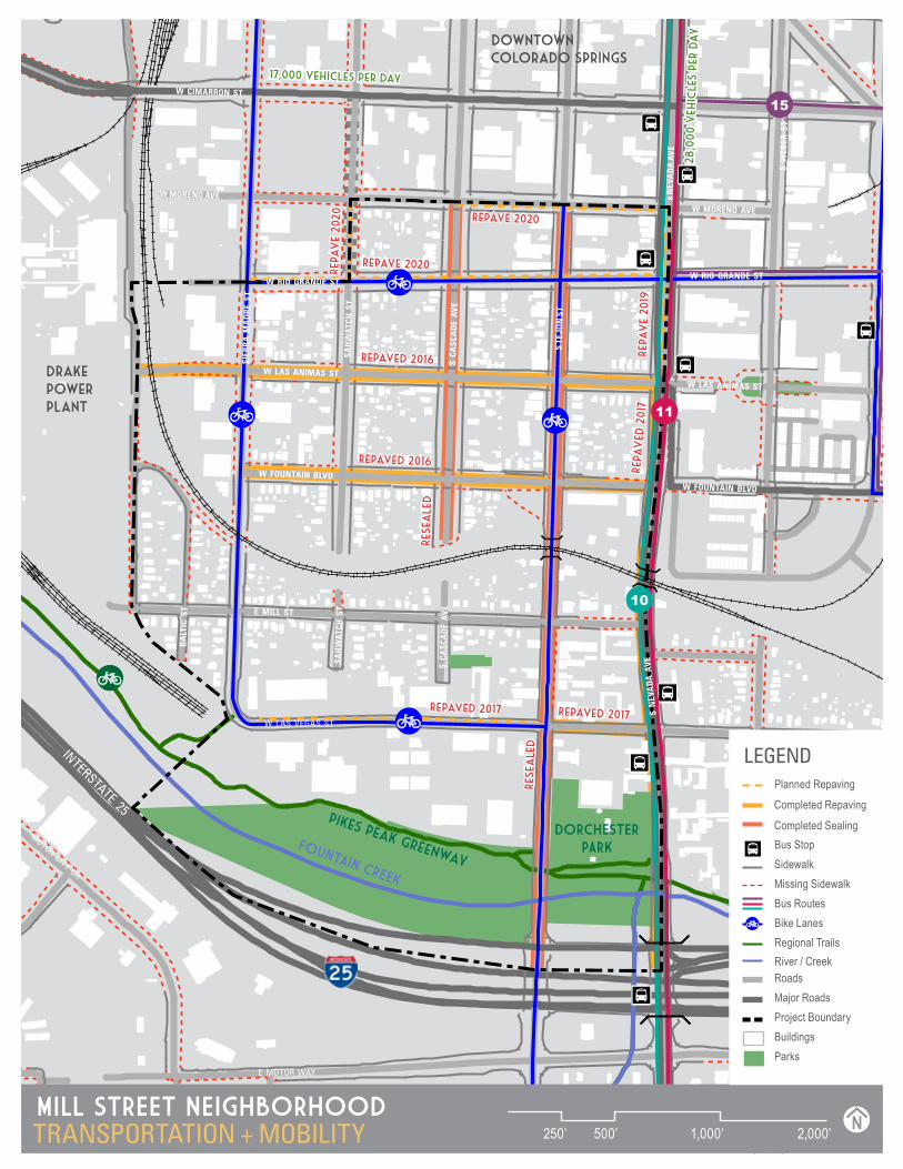
TRANSPORTATION & MOBILITYThe Mill Street neighborhood maintains the Downtown Colorado Springs street grid with 400’ by 400’ blocks. While the neighborhood is centrally located in the City of Colorado Springs, there are several physical barriers that isolate it from adjacent areas, including two local highways, railroad tracks and a major interstate highway.
ROAD INFRASTRUCTURE The neighborhood is bounded by South Nevada Avenue to the East, W Moreno Avenue and W Rio Grande Street to the North, the Drake Power Plant site to the West and Interstate 25 to the South. I-25 is a major transportation and trucking route that connects Wyoming to New Mexico. There is north/south access to I-25 from the Mill Street neighborhood at three locations: Cimarron Street, South Tejon Street and South Nevada Avenue. The City of Colorado Springs has designated Highway 24, Highway 87 and I-25 as truck routes. Las Vegas Street is used locally as a truck route. Within the neighborhood, there are over four miles of on-street bike lanes, providing good north/ south and east / west connectivity. There are two connections to the Pikes Peak Greenway.
PARKING Parking is available throughout the neighborhood. On-street parking meters are patrolled on Tejon Street from Cimarron Street to Rio Grande Street and on Rio Grande between Nevada and Cascade, Monday through Saturday 8:00 a.m. – 6:00 p.m. Local streets have few parking restrictions and parking is available on both sides of the streets for the public. The County-operated Tejon Street parking garage is also available to the public on a limited basis. Businesses reported insufficient
parking and rely mostly on close street parking for their patrons, afforded by the area’s wide street widths which allow parallel parking. The City of Colorado Springs follows a minimum off-street parking requirement for specific uses.
RAIL The neighborhood is bisected by the Union Pacific / Burlington Northern Santa Fe (BNSF) rail lines to the south of Fountain Boulevard. Approximately 50 trains pass through the neighborhood a day, a noticeable noise impact. The rail line has two at-grade intersections at Sierra Madre Street between Fountain and Mill Streets, and at Las Animas Street. There have been numerous pedestrian/ train conflicts along the rail lines. The two overpass rail bridges (Tejon Street and Nevada Avenue) are some of the oldest in the region and are slated for replacement.
BUS TRANSIT Residents and visitors to Mill Street have access along South Nevada Street to three municipal bus lines (10, 11 & 15) through Mountain Metropolitan Transit.
PEDESTRIAN REALM Streets are characteristic of General Palmer’s generous street allowance in the original platting of the city, with an average right-of-way of 100’ for local streets, including tree lawns and detached sidewalks. In initial analysis, of the 11 miles of sidewalk, 29% were incomplete or unpaved. Empty tree lawns are a common sight in the neighborhood. South Cascade Avenue is a local boulevard street, 140’ in width, with a prominent central median and mature canopy. Though the sidewalks on South Cascade are in good repair and have ADA complaint crosswalks, street tree replacement is needed to restore the character of the boulevard to match the northern portion. Pedestrian lighting, particularly in the southern portion of the neighborhood, is lacking.
MILL ST. WALKSCORE
50 / 100 CIT Y WIDE WALKSCORE
36 / 100
MILL ST. BIKESCORE
71 / 100 CIT Y WIDE BIKESCORE
46 / 100
MILL ST. MOBILIT YSCORE
37 / 100 CIT Y WIDE MOBILIT YSCORE
19 / 100
29
15
10
1
11
MILL STREET NEIGHBORHOODTRANSPORTATION + MOBILITY 250’ 500’ 1,000’ 2,000’ N
ParksBuildingsProject BoundaryMajor RoadsRoads
Regional TrailsBike LanesBus RoutesMissing SidewalkSidewalkBus StopCompleted Sealing
River / Creek
LEGEND
17,000 vehicles per day
Repaved 2016
Repave 2020
Repa
ve
2019
Repave 2020
Repaved 2016
Repa
ved
2017
Repaved 2017Repaved 2017
Rese
ale
d
Rese
ale
d
Completed Repaving
Planned Repaving
28,0
00 v
ehic
les
per
day
Repa
ve
2020
W MORENO AVEW MORENO AVE
W CIMARRON ST
W RIO GRANDE STW RIO GRANDE ST
W LAS ANIMAS STW LAS ANIMAS ST
W FOUNTAIN BLVDW FOUNTAIN BLVD
FOUNTAIN CREEK
INTERSTATE 25
DORCHESTER PARK
E MILL ST
SAH
WAT
CH S
TSA
HW
ATCH
ST
BA
LTIC
ST
S C
ASC
AD
E A
VES
CA
SCA
DE
AVE
S TE
JON
ST
S W
EBER
ST
S N
EVA
DA
AVE
s N
EVA
DA
AVE
W LAS VEGAS ST
E MOTOR WAY
MOTOR CITY DR
SIER
RA M
AD
RE S
T
pikes peak greenway
downtown colorado springs
drake power plant

30 | Mill Street Neighborhood Plan
PAGE TITLE
MILL STREET NEIGHBORHOODPARKS & OPEN SPACE 500’ 1,000’ 2,000’ 4,000’ N
DORCHESTER PARK (2018 )
Project Boundary
Major RoadsRoadsRegional Trails
River / Creek
LEGEND
Railroad
Building
5-Minute Walk Radius10-Minute Walk Radius
Tree CanopyParks
Open Space
pikes peak greenway
W CIMARRON ST
S N
EVA
DA
AVE
S TE
JON
ST
S SI
ERRA
MA
DRE
S TE
JON
ST
E MILL ST
W FOUNTAIN BLVD
DORCHESTER PARK
COMMUNITY GARDEN
SOUTH SHOOKS RUN PARK
AMERICA THE BEAUTIFUL PARK
ANTLERS PARK
ALAMO SQUARE PARK
IVYWILD PARK
FOU N TA I N C R E E K
C H E YE N
N E C
RE
EK
SH
OO
KS
R
UN
B E A R C R E E K
F O U N TA I N C R E E K
MO
NU
M
E N T CRE E
K
31
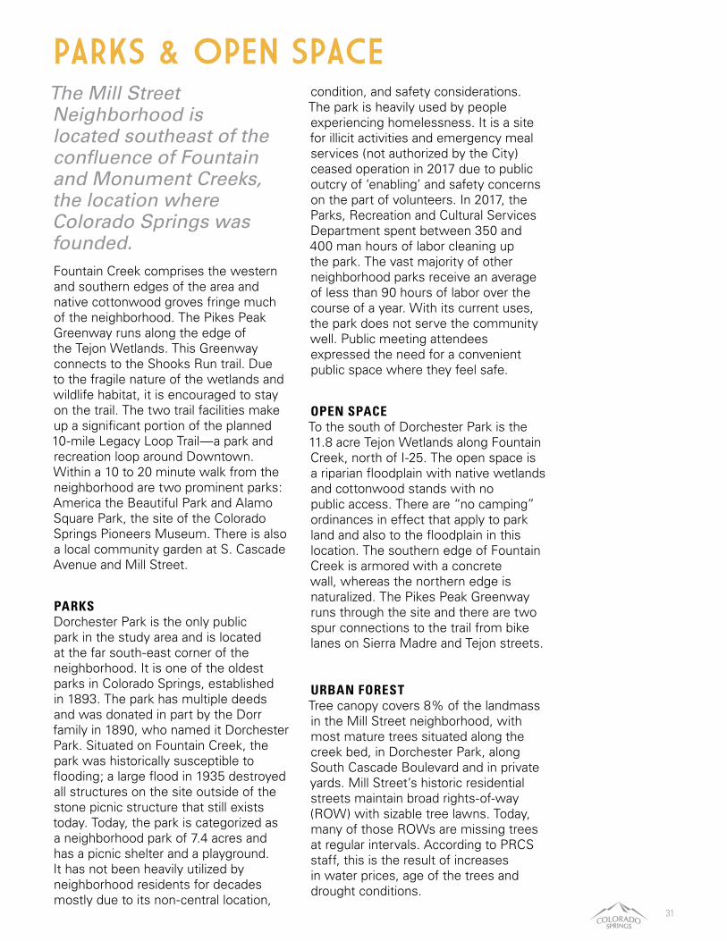
The Mill Street Neighborhood is located southeast of the confluence of Fountain and Monument Creeks, the location where Colorado Springs was founded. Fountain Creek comprises the western and southern edges of the area and native cottonwood groves fringe much of the neighborhood. The Pikes Peak Greenway runs along the edge of the Tejon Wetlands. This Greenway connects to the Shooks Run trail. Due to the fragile nature of the wetlands and wildlife habitat, it is encouraged to stay on the trail. The two trail facilities make up a significant portion of the planned 10-mile Legacy Loop Trail—a park and recreation loop around Downtown. Within a 10 to 20 minute walk from the neighborhood are two prominent parks: America the Beautiful Park and Alamo Square Park, the site of the Colorado Springs Pioneers Museum. There is also a local community garden at S. Cascade Avenue and Mill Street.
PARKS Dorchester Park is the only public park in the study area and is located at the far south-east corner of the neighborhood. It is one of the oldest parks in Colorado Springs, established in 1893. The park has multiple deeds and was donated in part by the Dorr family in 1890, who named it Dorchester Park. Situated on Fountain Creek, the park was historically susceptible to flooding; a large flood in 1935 destroyed all structures on the site outside of the stone picnic structure that still exists today. Today, the park is categorized as a neighborhood park of 7.4 acres and has a picnic shelter and a playground. It has not been heavily utilized by neighborhood residents for decades mostly due to its non-central location,
condition, and safety considerations. The park is heavily used by people experiencing homelessness. It is a site for illicit activities and emergency meal services (not authorized by the City) ceased operation in 2017 due to public outcry of ‘enabling’ and safety concerns on the part of volunteers. In 2017, the Parks, Recreation and Cultural Services Department spent between 350 and 400 man hours of labor cleaning up the park. The vast majority of other neighborhood parks receive an average of less than 90 hours of labor over the course of a year. With its current uses, the park does not serve the community well. Public meeting attendees expressed the need for a convenient public space where they feel safe.
OPEN SPACE To the south of Dorchester Park is the 11.8 acre Tejon Wetlands along Fountain Creek, north of I-25. The open space is a riparian floodplain with native wetlands and cottonwood stands with no public access. There are “no camping” ordinances in effect that apply to park land and also to the floodplain in this location. The southern edge of Fountain Creek is armored with a concrete wall, whereas the northern edge is naturalized. The Pikes Peak Greenway runs through the site and there are two spur connections to the trail from bike lanes on Sierra Madre and Tejon streets.
URBAN FORESTTree canopy covers 8% of the landmass in the Mill Street neighborhood, with most mature trees situated along the creek bed, in Dorchester Park, along South Cascade Boulevard and in private yards. Mill Street’s historic residential streets maintain broad rights-of-way (ROW) with sizable tree lawns. Today, many of those ROWs are missing trees at regular intervals. According to PRCS staff, this is the result of increases in water prices, age of the trees and drought conditions.
PARKS & OPEN SPACE

EXCERPT FROM SANBORN MAPS, 1900

33
PLAN CONCEPTS & RECOMMENDATIONS
GoalsEnhance Quality of Life for Mill Street ResidentsCultivate Mill Street CharacterReconnect Mill Street People & PlacesCreate a Resilient Future for Mill Street

34 | Mill Street Neighborhood Plan
VISION
A neighborhood vision helps answer the question “How does the community see itself in the future?” and captures this aspiration in a single statement. The neighborhood vision was developed at the Strategic Kick-off meeting and was informed by community input throughout the planning process.
The Mill Street Neighborhood will be a thriving, dynamic place that celebrates its diversity and history.

35
To achieve this vision, community input has directed four major goals for the Mill Street Neighborhood. Each goal provides the framework for specific strategies and tactics to help the City of Colorado Springs and the Mill Street Neighborhood work in tandem to achieve the plan vision.
1. ENHANCE THE QUALITY OF LIFE FOR MILL STREET RESIDENTS Community members in the study area experience many of the great qualities of their environment, including beautiful views to the mountains, great proximity to Downtown Colorado Springs and, currently, affordable housing in a competitive market on Colorado’s Front Range. However, there are several factors residents identified, such as trash, unsafe streets and trails, that negatively impact their quality of life.
2. CULTIVATE MILL STREET CHARACTER Mill Street has a variety of defining characteristics, such as its historic homes, wide boulevards and proximity to one of the area’s natural assets, Fountain Creek. When residents, business owners and area workers were asked in a community survey about the Mill Street Neighborhood, many were surprised to learn that the area had a name. This lack of recognition creates unstable boundaries for the neighborhood and does a disservice to the area’s identity within the City.
3. RECONNECT MILL STREET PEOPLE & PLACES Mill Street has some great regional connections for multiple types of transportation, such as its immediate vehicular access to I-25, pedestrian and bike links to the Pikes Peak Greenway and Legacy Loop and being within walking distance to Downtown Colorado Springs. Engagement with neighborhood community members indicated that while regional connections may be great, the neighborhood’s internal connections, both physical and social are lacking. The goals are to encourage more accessible infrastructure and facilitate better communication and inclusive development.
4. CREATE A RESILIENT FUTURE FOR MILL STREET Today the Mill Street Neighborhood is facing big challenges like rising rents, encroaching downtown development and evolving demographics. As the neighborhood looks toward the future, building strength in the local business community, protecting housing affordability and promoting neighborhood ownership will fortify the area and help residents respond, adapt and thrive as the City evolves.
GOALS
In a fiscal impact assessment by the Budget Office, the income stream from increased residential population, development and construction fees, and increased commercial activity for 2019-2028 outweighs the costs of implementing this plan and is a net positive gain for the City.

36 | Mill Street Neighborhood Plan
With a lack of basic amenities in the neighborhood and safety concerns, elevating the quality of life for residents is a top priority. Community members experience many of the great qualities of their environment, including beautiful views to the mountains, great proximity to Downtown Colorado Springs and currently, affordable housing in a competitive market on Colorado’s Front Range. However, there are several factors residents identified that negatively impact liveability.
Enhance the Quality of Life for Mill Street Residents
GOAL 1:
SAFETY Instances of criminal activity, lack of infrastructure and transportation problems all contribute to real and perceived issues of safety in the neighborhood. In order to achieve the neighborhood vision, restoring residents’ sense of safety in the community will be imperative.
ENVIRONMENT The prevalence of trash in the neighborhood, noise from the railroad and I-25, and the degradation of outdoor amenities, such as the adjacent Fountain Creek trail, create adverse conditions that concern some residents. Improving conditions in the area will benefit Mill Street residents’ quality of life.
SOCIAL INTERACTION One of the defining elements of quality environments are opportunities for social interaction. Interactions can be casual, such as saying hello to a neighbor, or more organized, such as a neighborhood block party. While Mill Street does offer some opportunities for connection, such as annual celebrations, the area lacks accessible and comfortable spaces for these to occur. Identifying opportunities and spaces for social connection will help Mill Street achieve its vision.

37
1. Enhance the relationship between area service providers and residents by providing platforms for cross-communication between entities like the Salvation Army and Springs Rescue Mission and Mill Street residents. Platform examples include a neighborhood website, the NextDoor app, mailings or a dedicated liaison.
2. Revisit a Good Neighborhood Agreement or other good faith effort of collaboration with area service providers (such as Salvation Army and Springs Rescue Mission), Mill Street Neighborhood Association and City of Colorado Springs Planning and Community Development.
3. Foster stronger relationships between community members and with police officers by establishing a CSPD community liason, organizing a Crime Prevention through Environmental Design training for residents and business owners and encouraging interaction between neighbors to build community cohesion and an improved sense of safety.
4. Support the development of a street outreach program to connect homeless community members with available service providers.
5. Increase street lighting in the Mill Street Neighborhood. Street lighting will help promote security and can
have positive impacts on quality of life by artificially extending light hours that allows for activity to take place. Street lighting also improves safety for drivers, bus riders, bicyclists and pedestrians.
6. Improve accesssibility and ADA compliance along sidewalks and at intersections throughout the neighborhood to support area residents with disabilities, families with strollers and cyclists.
7. Activate and beautify spaces under rail bridges on Tejon Street and Nevada Avenue corridors to detract vandalism, remove debris, and provide a gateway identity to the Mill Street Neighborhood.
Improve Community Safety
Resident concerns for safety are supported by local police data. The neighborhood has seen significant increases in both non-violent and violent crimes between 2013-2017. There is no proven correlation between increased homelessness and increased crime.
38 | Mill Street Neighborhood Plan
8. Develop a voluntary urban street tree planting and maintenance program with City Forestry for the neighborhood to increase urban canopy, improve environmental quality and aid in area beautification, similar to the North End Woodlands Tree Planting program.
9. Work with City Forestry team to monitor, preserve and provide maintenance assistance for mature trees within the Mill Street neighborhood.
10. Monitor rail compliance with federal noise level standards. Work with the Federal Railroad Administration and the Environmental Protection Agency to measure noise levels and recommend any necessary changes to protect the noise environment for local residents and advocate for the health and welfare of Mill Street residents in upcoming rail corridor study.
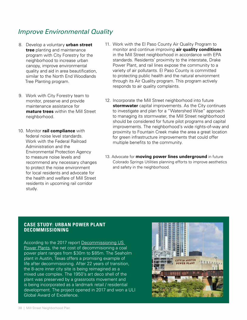
CASE STUDY: URBAN POWER PLANT DECOMMISSIONING
According to the 2017 report Decommissioning US Power Plants, the net cost of decommisioning a coal power plant ranges from $30m to $85m. The Seaholm plant in Austin, Texas offers a promising example of life after decommisioning. After 22 years of transition, the 8-acre inner city site is being reimagined as a mixed use complex. The 1950’s art deco shell of the plant was preserved by a grassroots movement and is being incorporated as a landmark retail / residential development. The project opened in 2017 and won a ULI Global Award of Excellence.
11. Work with the El Paso County Air Quality Program to monitor and continue improving air quality conditions in the Mill Street neighborhood in accordance with EPA standards. Residents’ proximity to the interstate, Drake Power Plant, and rail lines expose the community to a variety of air pollutants. El Paso County is committed to protecting public health and the natural environment through its Air Quality program. This program actively responds to air quality complaints.
12. Incorporate the Mill Street neighborhood into future stormwater capital improvements. As the City continues to investigate and plan for a “Watershed Wise” approach to managing its stormwater, the Mill Street neighborhood should be considered for future pilot programs and capital improvements. The neighborhood’s wide rights-of-way and proximity to Fountain Creek make the area a great location for green infrastructure improvements that could offer multiple benefits to the community.
13. Advocate for moving power lines underground in future Colorado Springs Utilities planning efforts to improve aesthetics and safety in the neighborhood.
Improve Environmental Quality
39
Increase Opportunities for Social Engagement14. Explore opportunities for a new
community gathering space in the neighborhood. This neighborhood currently does not have any public or civic facilities to meet, gather or commune. Community members have expressed interest in a community center and/or an outdoor public space to foster social engagement. Other gathering spaces could be provided through smaller interventions such as seating or benches along rights-of-way or community-developed parklets that take advantage of currently vacant or under used spaces. Possible avenues to address lack of community space are stronger connections and service to the Hillside Community Center and activation of Dorchester Park.
15. Provide institutional support for and promotion of community events generated by Mill Street community members through CONO.
16. Pursue grant funding to create a restorative garden at the Springs Rescue Mission campus to offer individuals who access neighborhood service providers a safe, comfortable and visible space to spend time when access to shelter options are not available. Space design should consider the inclusion of therapeutic gardens, urban agriculture and other productive landscape design.
17. Incentivize private commercial uses to include gathering spaces. Outdoor dining and indoor gathering spaces associated with businesses should be encouraged.
18. Plug into existing programs and events that foster community while beautifying the city. Ex: City Department of Public Works’ Adopt-a-Waterway, Creek Week, Trash Mob (cleanups while in themed costumes), What If Festival, etc.
19. Partner with Pikes Peak Library District and the Pioneers Museum to explore Mill Street pop-up programming, such as oral history walking tours and pop-up libraries.
20. Explore commercial viability and permitting for food truck nights in Mill Street.
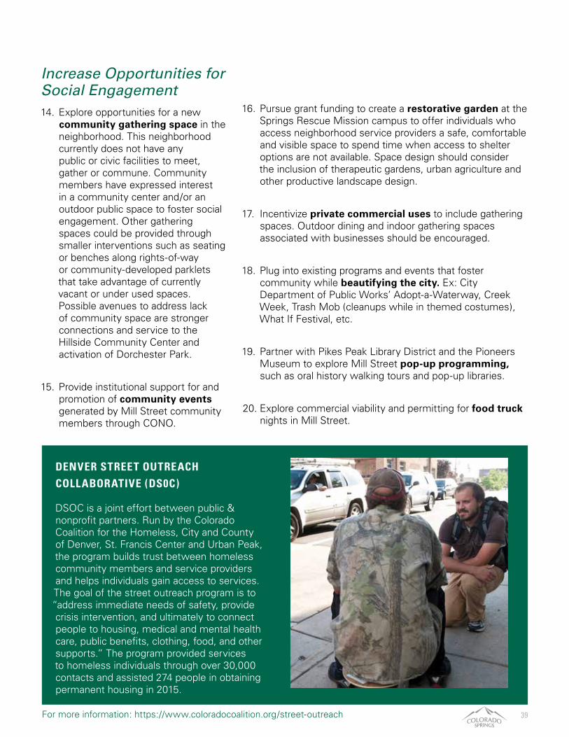
DENVER STREET OUTREACH COLLABORATIVE (DS0C) DSOC is a joint effort between public & nonprofit partners. Run by the Colorado Coalition for the Homeless, City and County of Denver, St. Francis Center and Urban Peak, the program builds trust between homeless community members and service providers and helps individuals gain access to services. The goal of the street outreach program is to “address immediate needs of safety, provide crisis intervention, and ultimately to connect people to housing, medical and mental health care, public benefits, clothing, food, and other supports.” The program provided services to homeless individuals through over 30,000 contacts and assisted 274 people in obtaining permanent housing in 2015.
For more information: https://www.coloradocoalition.org/street-outreach
40 | Mill Street Neighborhood Plan
Mill Street has a variety of defining characteristics, such as its historic homes, wide avenues and streets and proximity to one of the area’s natural assets, Fountain Creek. When residents, business owners and area workers were asked in a community survey about the Mill Street Neighborhood, many were surprised to learn that the area had a name. This lack of recognition creates unstable boundaries for the neighborhood and does a disservice to the area’s identity within the City.
Cultivate Mill Street Character
GOAL 2:
SENSE OF PLACE Residents have identified many of the neighborhood’s historic structures and local businesses as important community landmarks, but these assets lack a unifying feature to tie the pieces together. Creating local programs and building a family of aesthetic characteristics for the neighborhood will help create that sense of place the area needs to celebrate its identity.
PHYSICAL ATTRIBUTES As cities along the Front Range continue to grow and change, some area residents have found that the “new and shiny” often replaces the
“old and tired.” In Mill Street, community members cherish the unique and historic elements of their neighborhood. Polishing and restoring some of these features will help the neighborhood maintain its treasured character while still providing opportunities to balance old with new.
NEIGHBORHOOD HISTORY Past and present residents of the Mill Street neighborhood have gone to great lengths to collect stories about the area’s evolution and document their own histories. Reinforcing these stories and protecting the unique character of the community will help to define the neighborhood and build strength around its identity.
41
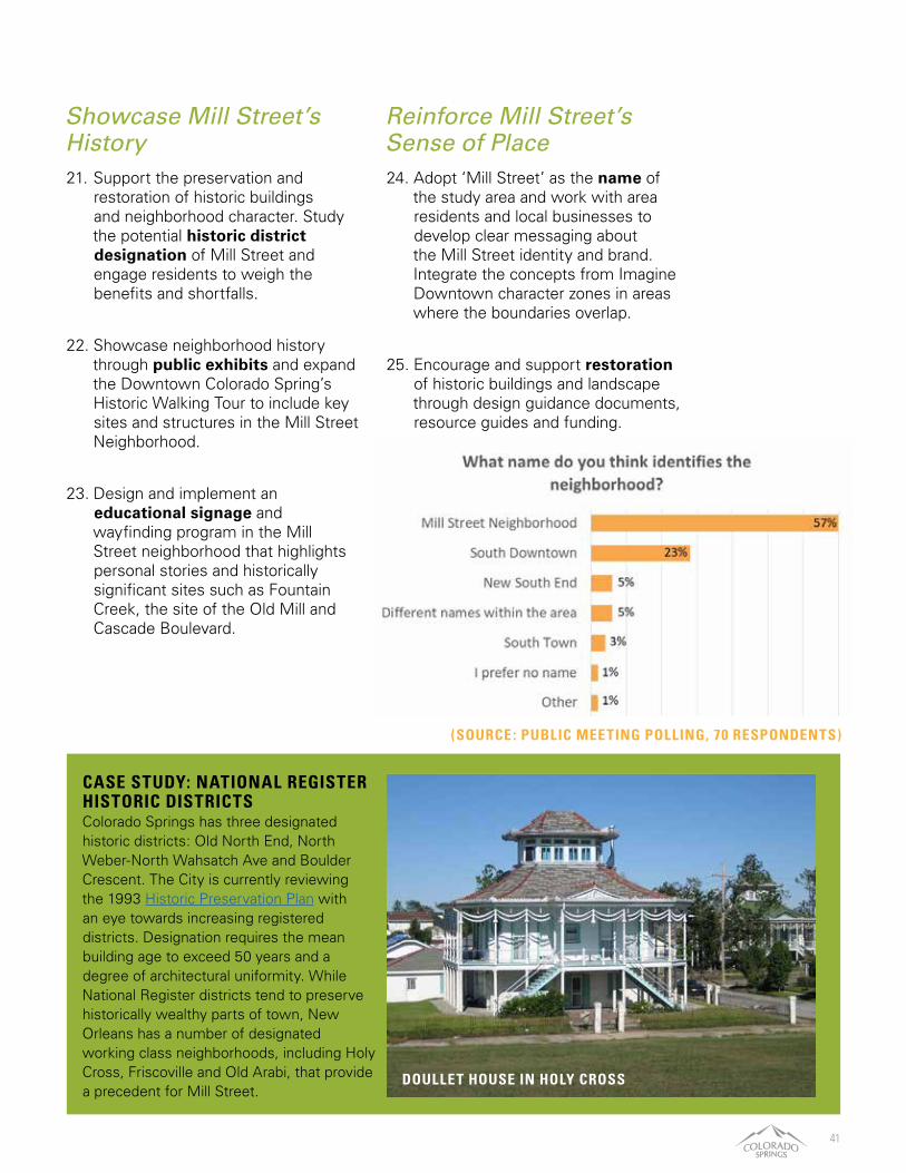
Showcase Mill Street’s History21. Support the preservation and
restoration of historic buildings and neighborhood character. Study the potential historic district designation of Mill Street and engage residents to weigh the benefits and shortfalls.
22. Showcase neighborhood history through public exhibits and expand the Downtown Colorado Spring’s Historic Walking Tour to include key sites and structures in the Mill Street Neighborhood.
23. Design and implement an educational signage and wayfinding program in the Mill Street neighborhood that highlights personal stories and historically significant sites such as Fountain Creek, the site of the Old Mill and Cascade Boulevard.
CASE STUDY: NATIONAL REGISTER HISTORIC DISTRICTSColorado Springs has three designated historic districts: Old North End, North Weber-North Wahsatch Ave and Boulder Crescent. The City is currently reviewing the 1993 Historic Preservation Plan with an eye towards increasing registered districts. Designation requires the mean building age to exceed 50 years and a degree of architectural uniformity. While National Register districts tend to preserve historically wealthy parts of town, New Orleans has a number of designated working class neighborhoods, including Holy Cross, Friscoville and Old Arabi, that provide a precedent for Mill Street.
DOULLET HOUSE IN HOLY CROSS
Reinforce Mill Street’s Sense of Place24. Adopt ‘Mill Street’ as the name of
the study area and work with area residents and local businesses to develop clear messaging about the Mill Street identity and brand. Integrate the concepts from Imagine Downtown character zones in areas where the boundaries overlap.
25. Encourage and support restoration of historic buildings and landscape through design guidance documents, resource guides and funding.
(SOURCE : PUBLIC MEETING POLLING, 70 RESPONDENTS)

42 | Mill Street Neighborhood Plan
Highlighting Mill Street’s Key Physical Attributes26. Explore preservation models for
small homes. As housing needs in Colorado Springs increase, the City should explore options for increasing density while maintaining the scale of housing currently found in the community.
27. Restore the character of South Cascade Avenue. Current tree canopy, planting and maintenance of Cascade should reflect the historic character of this important boulevard and maintain consistency with the boulevard’s treatment in residential neighborhoods to the north.
COMMUNITY INTERESTS IN RIGHT-OF-WAY IMPROVEMENTS
28. Explore opportunities for re-envisioning the rights-of-way along the neighborhood’s historic wide avenues and streets. This alternative public space could foster new and creative ways to bring residents out into social spaces, celebrate community, calm traffic and incorporate arts and education into neighborhood.
29. Showcase the character of the neighborhood on city infrastructure (such as murals and reference to historic stonework on bridges and along streets).

43
Small Home RehabilitationThe New York Department of Housing Preservation and Development and the New York City Housing Authority partners with nonprofits to run the Small Homes Rehabilitation Program. Through the program, vacant residential properties are rehabilitated to offer home ownership opportunities to low to moderate-income homebuyers. So far the program has assisted 100 New York families in pursuing their dream of owning a home.
Maximum Lot Coverage
Arlington, VA (along with many jurisdictions) sets maximum lot coverages to preserve scale. They provide incentive “bonuses”as a means to encourage attractive features, such as front porches and detached garages.
Small Lot Design Guidelines
As a follow-up to the Small Lot Ordinance, the City of Los Angeles drafted guidelines to ensure that future development fit the scale and character of the neighborhood. This includes recommendations on architecture, massing, site design, and contribution to the public realm.
Community Land Trusts
To combat rising costs of living and displacement in Denver, working class communities such as Elyria Swansea and Globeville have established community land trusts. The basic premise is that the trust owns homes in a geographic focus area and then sells the home at an affordable rate to qualifying individuals. The land below is leased but stays as an asset of the trust.
CASE STUDIES: PRESERVING SCALE & HISTORIC HOMES
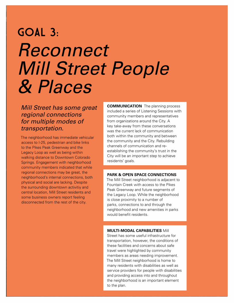
44 | Mill Street Neighborhood Plan
Mill Street has some great regional connections for multiple modes of transportation.The neighborhood has immediate vehicular access to I-25, pedestrian and bike links to the Pikes Peak Greenway and the Legacy Loop as well as being within walking distance to Downtown Colorado Springs. Engagement with neighborhood community members indicated that while regional connections may be great, the neighborhood’s internal connections, both physical and social are lacking. Despite the surrounding downtown activitiy and central location, Mill Street residents and some business owners report feeling disconnected from the rest of the city.
Reconnect Mill Street People & Places
GOAL 3:
MULTI-MODAL CAPABILITIES Mill Street has some useful infrastructure for transportation, however, the conditions of these facilities and concerns about safe travel were highlighted by community members as areas needing improvement. The Mill Street neighborhood is home to many residents with disabilities as well as service providers for people with disabilities and providing access into and throughout the neighborhood is an important element to the plan.
PARK & OPEN SPACE CONNECTIONS The Mill Street neighborhood is adjacent to Fountain Creek with access to the Pikes Peak Greenway and future segments of the Legacy Loop. While the neighborhood is close proximity to a number of parks, connections to and through the neighborhood and new amenities in parks would benefit residents.
COMMUNICATION The planning process included a series of Listening Sessions with community members and representatives from organizations around the City. A key take-away from these conversations was the current lack of communication both within the community and between the community and the City. Rebuilding channels of communication and re-establishing the community’s trust in the City will be an important step to achieve residents’ goals.

45
Improve Neighborhood Communication30. Rebuild strength and participation in the Neighborhood
Association. Colorado Springs’ neighborhood associations can be a driving force for neighborhood improvement, change and decision making. Welcoming home owners, renters, business owners and area workers to participate in the neighborhood association will help solidify a voice for the community through a channel recognized by the City.
31. Offer alternate ways, beyond the Neighborhood Association, for area residents and business owners with varying levels of capacity to participate in community building. Events and programming can provide opportunities for community members to connect with neighbors and learn more about ongoing efforts in the area without the need for a regular, on-going commitment.
32. Offer technical assistance for organization building and communications within the neighborhood association.
33. Create neighborhood leadership opportunities on the boards of service provider organizations.
FULL HOUSE AT THE PUBLIC MEETING
In the public survey, improved communication between residents, businesses and the city was a top response to the question, “What do you think are important outcomes for a successful neighborhood plan?”(SOURCE : PUBLIC MEETING, 70 RESPONDENTS)
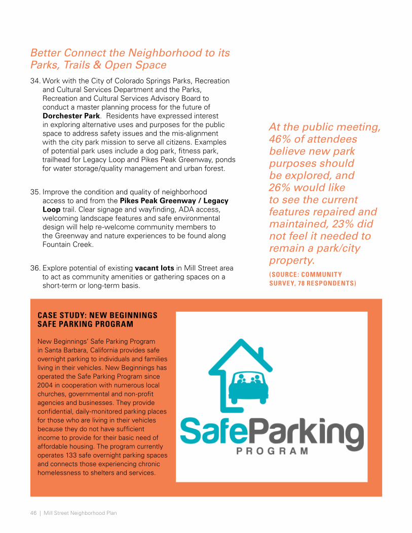
46 | Mill Street Neighborhood Plan
Better Connect the Neighborhood to its Parks, Trails & Open Space34. Work with the City of Colorado Springs Parks, Recreation
and Cultural Services Department and the Parks, Recreation and Cultural Services Advisory Board to conduct a master planning process for the future of Dorchester Park. Residents have expressed interest in exploring alternative uses and purposes for the public space to address safety issues and the mis-alignment with the city park mission to serve all citizens. Examples of potential park uses include a dog park, fitness park, trailhead for Legacy Loop and Pikes Peak Greenway, ponds for water storage/quality management and urban forest.
35. Improve the condition and quality of neighborhood access to and from the Pikes Peak Greenway / Legacy Loop trail. Clear signage and wayfinding, ADA access, welcoming landscape features and safe environmental design will help re-welcome community members to the Greenway and nature experiences to be found along Fountain Creek.
36. Explore potential of existing vacant lots in Mill Street area to act as community amenities or gathering spaces on a short-term or long-term basis.
CASE STUDY: NEW BEGINNINGS SAFE PARKING PROGRAM New Beginnings’ Safe Parking Program in Santa Barbara, California provides safe overnight parking to individuals and families living in their vehicles. New Beginnings has operated the Safe Parking Program since 2004 in cooperation with numerous local churches, governmental and non-profit agencies and businesses. They provide confidential, daily-monitored parking places for those who are living in their vehicles because they do not have sufficient income to provide for their basic need of affordable housing. The program currently operates 133 safe overnight parking spaces and connects those experiencing chronic homelessness to shelters and services.
At the public meeting, 46% of attendees believe new park purposes should be explored, and 26% would like to see the current features repaired and maintained, 23% did not feel it needed to remain a park/city property. (SOURCE : COMMUNITY SURVEY, 78 RESPONDENTS)

47
Enhance Multi-modal Capabilities of the Neighborhood
37. Improve pedestrian accessibility throughout the neighborhood. Improvements include increased sidewalk widths; connecting sidewalks; improving sidewalk conditions; the provision of ramps at key access points; and intersection improvements such as increased pedestrian crossing times at traffic lights and accessible curb ramps.
38. Improve rail safety including at-grade road crossings and addressing the structural integrity of historic overpass structures.
39. Explore traffic calming strategies (including separated bike lanes, bulbouts, rain gardens, and widened tree lawns and others described in the Experience Downtown Master Plan) to improve safety for all modes of transportation.
40. Encourage ridership on Mountain Metro and promote neighborhood stewardship by creating an “Adopt-a-Stop program.”
(SOURCE : PUBLIC MEETING POLLING, 70 RESPONDENTS)
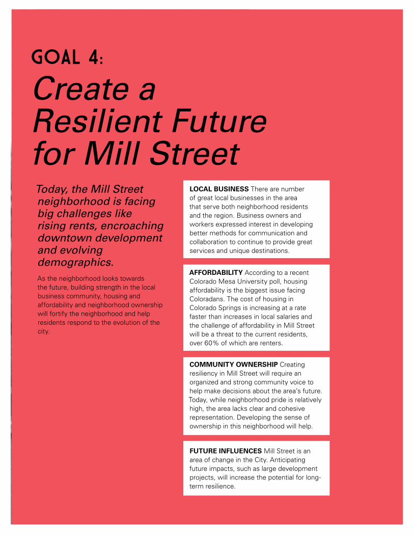
48 | Mill Street Neighborhood Plan
Today, the Mill Street neighborhood is facing big challenges like rising rents, encroaching downtown development and evolving demographics. As the neighborhood looks towards the future, building strength in the local business community, housing and affordability and neighborhood ownership will fortify the neighborhood and help residents respond to the evolution of the city.
Create a Resilient Future for Mill Street
GOAL 4:
LOCAL BUSINESS There are number of great local businesses in the area that serve both neighborhood residents and the region. Business owners and workers expressed interest in developing better methods for communication and collaboration to continue to provide great services and unique destinations.
AFFORDABILITY According to a recent Colorado Mesa University poll, housing affordability is the biggest issue facing Coloradans. The cost of housing in Colorado Springs is increasing at a rate faster than increases in local salaries and the challenge of affordability in Mill Street will be a threat to the current residents, over 60% of which are renters.
COMMUNITY OWNERSHIP Creating resiliency in Mill Street will require an organized and strong community voice to help make decisions about the area’s future. Today, while neighborhood pride is relatively high, the area lacks clear and cohesive representation. Developing the sense of ownership in this neighborhood will help.
FUTURE INFLUENCES Mill Street is an area of change in the City. Anticipating future impacts, such as large development projects, will increase the potential for long-term resilience.

49
Strengthen Local Business41. Work with the Downtown Colorado
Springs Creative District, the Downtown Partnership of Colorado Springs, Pikes Peak Small Business Development Center and area property owners to attract new businesses that will reinforce neighborhood character.
42. Improve neighborhood accessibility to fresh food through the recruitment of a local grocer, regional grocery store, farmer’s market, or organized Community Supported Agriculture shares.
43. Work with local business owners to identify funding for façade improvements along the Tejon and Nevada commercial corridors.
44. Encourage creation of a local community development corporation to create jobs, generate revenue, improve neighborhood outcomes, and provide critical goods and services.
45. Help local businesses organize and work together on future funding opportunities through programs like the local Economic Opportunity Zones program, the federal Opportunity Zone program, and Lodgers and Automobile Rental Tax (LART).
In the survey, 45% of respondents said that ‘housing affordability solutions’ was one of the most important outcomes for a successful neighborhood plan.
Preserve Neighborhood Affordability46. Create policy for the Mill Street neighborhood
to encourage residential affordability. Policies may include incentives for infill housing that features new housing types (garden apartments, accessory dwelling units, townhomes or duplexes) that accommodate higher density and diverse price points and are architecturally consistent with the neighborhood.
47. Encourage mixed use and mixed-income development in the neighborhood.
48. Incentivize mixed use development throughout the neighborhood. Examples of incentives may include permit fee reductions, tax abatements, expedited development approval processes and providing density and building height or floor area bonuses.
49. Work with local land trusts in expanding capacity and securing affordable home rates in the Mill Street neighborhood.
50. Prioritize the Mill Street neighborhood when pursuing CDBG funding for acquisition, architectural barrier removal and housing rehabilitation programs. Promote use of local building professionals when possible.
51. Explore opportunities to create affordable rental housing and increasing homeowner equity by replacing single family homes in severe disrepair with duplexes.
52. Use HOME funds for construction of Accessory Dwelling Units for low-income households to add density and create financial stability.
53. Highlight goal to create and preserve affordable housing in resolution to plan adoption to make case for review standards, future community benefit agreements, and possible improvement district.
(SOURCE : COMMUNITY SURVEY, 78 RESPONDENTS)
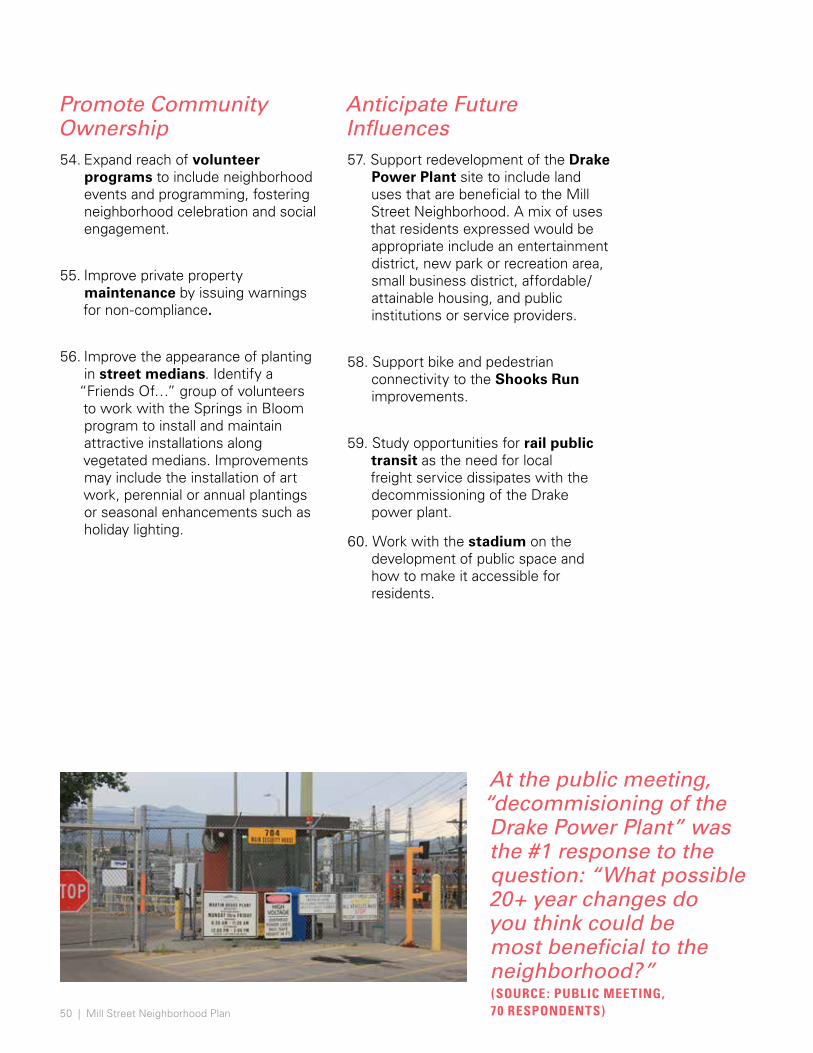
50 | Mill Street Neighborhood Plan
Promote Community Ownership54. Expand reach of volunteer
programs to include neighborhood events and programming, fostering neighborhood celebration and social engagement.
55. Improve private property maintenance by issuing warnings for non-compliance.
56. Improve the appearance of planting in street medians. Identify a
“Friends Of…” group of volunteers to work with the Springs in Bloom program to install and maintain attractive installations along vegetated medians. Improvements may include the installation of art work, perennial or annual plantings or seasonal enhancements such as holiday lighting.
Anticipate Future Influences57. Support redevelopment of the Drake
Power Plant site to include land uses that are beneficial to the Mill Street Neighborhood. A mix of uses that residents expressed would be appropriate include an entertainment district, new park or recreation area, small business district, affordable/attainable housing, and public institutions or service providers.
58. Support bike and pedestrian connectivity to the Shooks Run improvements.
59. Study opportunities for rail public transit as the need for local freight service dissipates with the decommissioning of the Drake power plant.
60. Work with the stadium on the development of public space and how to make it accessible for residents.
At the public meeting, “decommisioning of the Drake Power Plant” was the #1 response to the question: “What possible 20+ year changes do you think could be most beneficial to the neighborhood?”(SOURCE : PUBLIC MEETING, 70 RESPONDENTS)

51
Minimize costs for renters
Emergency Repair Program—the City of Colorado Springs’ Energy Resource Center weatherizes homes for low-income and middle income households, including separate funding for emergency repairs.
Weatherization Assistance Program—federal program to states that provides funds to make capital improvements towards energy efficiency and reduction of greenhouse emissions.
Provide resources for homeowners
Housing Rehabilitation Program—City of Colorado Springs’ Housing Department sponsors rehabilitation construction projects to qualifying low-income and moderate-income households. Sub-programs include: owner occupant rehabilitation program, barrier removal program, emergency repair program and lights and locks for seniors program.
Single Family “Turnkey” Mortgage—El Paso County provides competitive 30-year fixed-rate mortgages with a down payment assistance grant (DPA) up to 4% for low and moderate income homebuyers.
Tax Abatements—freeze taxes at a certain level to incentivize owners to invest in the renewal of their rental properties (ex. New York).
Streamlined Financing—local goverments can streamline process for financing rehabilitation projects as an incentive to owners.
Preserve affordable rental units
One-to-One Replacement—San Diego requires a one-to-one replacement of any affordable rentals that are razed, removed from the stock or converted to condos, by city code.
Community Benefit Agreement—Stipulate that developers in rapidly growing areas, such as TOD’s, have to preserve or provide affordable or rental housing.
Acquisition Funds—Denver provided TOD acquisition funds and grant funds to nonprofits that buy affordable housing near transit centers.
Incentivize affordable housing
Designate TIF funds for affordable housing—devote a portion of revenue from the tax increment financing district towards affordable housing (e.g. California and Chicago) or preservation (e.g. Atlanta, Kansas City and Austin).
Bridge Financing—set up public / private initiative to provide loans to developers pursuing preservation or affordable projects to enable acquisition and pay upfront “soft costs.”
CASE STUDY: AFFORDABLE HOUSING STRATEGIES

52 | Mill Street Neighborhood Plan
Over the next 20 years, the Mill Street Neighborhood will be impacted by major public / private initiatives. Anticipating influences from the surrounding area and potential for redevelopment within the neighborhood helps the Mill Street Neighborhood be proactive in directing the type of place that they want to become. Four big moves could be harnessed to have positive outcomes for the neighborhood, but these opportunities may have unintended negative impacts, such as increased unaffordability for residents.
Big Moves Ahead
WHAT IF...
POWER PLANT REPURPOSING The closure of Drake Power Plant is currently set for 2035. Repurposing of the power plant site will create opportunities as well as challenges for the Mill Street neighborhood. Mill Street residents will continue to be engaged in the future of the site.
FUTURE OF RAIL The Department of Public Works is beginning a planning effort in late 2018 to examine options for replacing aged rail bridges. Advocating for the interest of the Mill Street neighborhood will be ongoing work.
PHOTO: COLORADO SPRINGS GAZETTE
REIMAGINE DORCHESTER In outreach for this project, city stakeholders, service providers and community members expressed concern about the challenging conditions at Dorchester. The Legacy Loop offers an opportunity to activate the Park and further work is needed to make the park safe and active.
INVEST IN NEIGHBORHOOD As an inner city neighborhood, the urban fabric of Mill Street and how it connects to and through the City is vital. With a stadium recently announced for the CityGate site, improvements should benefit the neighborhood, such as new public amenities, job opportunities and additional attainable housing units.

53
What will the Mill Street neighborhood look like in 20 years? How do changes in the neighborhood stand to benefit the community? Imagine: What if we designed our city for compassion and upward mobility? Mill Street residents are bracing for change happening all around their historic community and across the Front Range. As plans for surrounding communities are modified, updated and implemented, it will be important that the Mill Street Neighborhood plays a key role in envisioning the edges and exchanges between the area and its neighbors.
Experience Downtown provides the backdrop for testing ideas about the future. The map studies on the following pages play out two scenarios to explore how area land uses might change in response to anticipated land use changes, infrastructure updates and development projects surrounding the area. Potential changes on the horizon include: repurposing of the Drake Power Plant site to new land uses, replacement of two railroad bridges with related pedestrian improvements and trail connections, consideration of the rail corridor, re-activation of Dorchester Park, and the influence of nearby projects such as the new outdoor stadium at CityGate. These changes are mostly viewed as positive improvements to quality of life and health, and could increase desire to live, work, and own property in this location. The following scenarios ask what would the composition of the neighborhood land uses look like if these potential future opportunities and challenges were addressed. What does an inclusive land use map look like? As these major initiatives unfold, community members are encouraged to use this plan to recommend future land use changes that enable affordability, inclusion, safety, and accessibility.
WHAT IF... BIG MOVES AHEAD
Transformation of an industrial icon Railroad Bridge Replacement
Reimagine Dorchester Park and Activation of Legacy Loop
Invest in Neighborhood’s Urban Fabric
These studies are intended to spur conversation in the Mill Street Neighborhood and gain feedback about what types of uses residents and business owners would like to see in their community, while still maintaining the strength of their residential core.

54 | Mill Street Neighborhood Plan
FO
UNTA
I N C R E E K
BEAR CREEK
FOUNTAIN CREEK
MO
NU
MEN
T C
REEK
NEW OUTDOOR STADIUM
NEW EVENTS SPACE
EXPAND ACTIVITY MIXED USE
EXTEND LAS ANIMAS BUSINESS CORRIDOR WITH
RETAIL/COMMERCIAL
PLAN FOR FUTURE OF RAIL WITH DECOMMISSIONING
OF DRAKE IN MIND
RESIDENTIAL INFILL
REGIONAL BUS TRANSIT HUB
ParksInstitutional
Activity Center Mixed use
General Mixed use
General Residential
BuildingsProject BoundaryMajor RoadsRoads
Regional TrailsRiver / Creek
LEGEND
MILL STREET NEIGHBORHOODEXPLORING NEW USES 400’ 800’ 1,600’ 3,200’ N
PIKES PEAK GREENWAY
LEGACY LOOP
AMERICA THE
BEAUTIFUL
WHAT IF... SCENARIO AScenario A explores the possibility of an entertainment and sports complex with park lands and residential infill to replace the Drake Power Plant, and a commercial corridor extending east / west along Las Animas.
What if Mountain Metro's new downtown transit station relocates to Colorado and Sierra Madre, how will street and trail signage lead visitors to Mill Street and this new regional destination? What if business corridors increased and spread to new locations in the neighborhood, such as Las Animas?
What if new mixed use buildings were woven into the fabric of historic homes and landmarks?
What if many old industrial buildings were converted along Sierra Madre into mixed use projects with residential units?
What if improved rail safety and transportation network connectivity determined the rail alignment?
NEW COMMUNITY
PARK BEAR CREEK
FOUNTAIN CREEK

FO
UNTA
I N C R E E K
SHO
OKS
RUN
BEAR CREEK
FOUNTAIN CREEK
MO
NU
MEN
T C
REEK
NEW COMMUNITY
PARK
EXPAND MIXED USE ACTIVITY
ZONE
REGIONAL TRANSIT HUB
MIXED INCOME RESIDENTIAL
DEVELOPMENT
CASC
ADE
AVEN
UE
CO
NNEC
TO
R RO
UTE
ParksInstitutional
Activity Center Mixed use
General Mixed use
General Residential
BuildingsProject BoundaryMajor RoadsRoads
Regional TrailsRiver / Creek
LEGEND
MILL STREET NEIGHBORHOODEXPLORING NEW DENSITIES 400’ 800’ 1,600’ 3,200’ N
PIKES PEAK GREENWAY
LEGACY LOOP
AMERICA THE
BEAUTIFUL
PLAN FOR FUTURE OF RAIL WITH DECOMMISSIONING
OF DRAKE IN MIND
WHAT IF... SCENARIO BScenario B explores the possibility of a primarily residential and park project to replace the Drake Power Plant with a regional activity zone on the north end of the Drake site and extending eastward.
What if our streets are oriented to lead residents and visitors to this regional destination? What if Mountain Metro’s new downtown transit hub relocates to Costilla and Pueblo? How would street and trail signage lead visitors to Mill Street and the regional activity zone?
What if Cascade were a connector route from the Mill Street to the heart of downtown?
What if a new park connected with the current green infrastructure and residential areas?
What if the majority of the neighborhood became general residential land use, with heavier mixed uses focused north of the area?
What if improved rail safety and transportation network connectivity determined the rail alignment?
NEW OUTDOOR STADIUM

EXCERPT FROM SANBORN MAPS, 1900
57
CHAPTER TITLE
57
ACTION PLANAction Plan PrioritiesEnhance Quality of Life for Mill Street ResidentsCultivate Mill Street CharacterReconnect Mill Street People & PlacesCreate a Resilient Future for Mill Street

58 | Mill Street Neighborhood Plan
ACTION PLAN
The following section is a roadmap on how to address key community concerns and implement short-term projects that will benefit the neighborhood. The action plan provides a timeline, relative cost, funding source and responsible parties for each item.
The action plan identifies a series of short-term strategic steps to implement over the next several years.
59
HOW TO USE THIS ACTION PLAN The goals presented in Chapter 3 provide definition and a long-term view of how these priorities fit together. The following Implementation Action Plan is a “how to” detailed list of near-term action items to be implemented over the short-term. The Budget Office has done an initial Fiscal Impact Analysis on the plan, available in the Appendix.
Over time, the specific actions to address the goals are likely to change. In addition, all actions requiring funding will need to be approved or granted by a funding entity. The intent is to provide a plan for action and should not be construed as a promise. To get involved in making these happen, consider joining the plan’s Implementation Team. Contact [email protected] for more details.
The Action Plan tables include: • Description of actions • Responsible parties and partners • Relative costs • Potential funding sources • Implementation timing
The two most pressing priorities expressed by community member through engagement were:
1. Improve neighborhood safety and cleanliness.
2. Sustain the affordability of the neighborhood.
First and foremost, people want actions to be taken that help them stay in this neighborhood. Both unsafe street and trail conditions and rising housing costs have caused long-term residents and business owners to relocate or feel pressure to move elsewhere. These priorities do not diminish the importance of the other needs expressed by residents that would improve quality of life in the neighborhood. For example, prioritizing affordability may limit opportunities for preservation or development. With these kinds of tough tradeoffs in mind, the plan sought to deliver the greatest benefit to the whole Mill Street community. Many related or supportive actions can begin to take place immediately to demonstrate a commitment to the neighborhood. Other items listed in this action plan may not relate to a top priority but acknowledge that small steps are needed now to cover a long distance. The implementation of this plan is not possible without the sustained engagement and buy-in of community members. They are the heart of the neighborhood and are integral at every stage.
ACTION PLAN PRIORITIES
The acronyms below are used in the following Actions tables under Responsible Parties + Partners and Funding Sources:
ADU = Accessory Dwelling Unit CDD=Community Development Division CONO= Council of Neighbors & Organizations CSPD = Colorado Springs Police Department DPW= Department of Public Works MSNA= Mill Street Neighborhood Association SRM= Springs Rescue Mission PRCS= City of Colorado Springs Parks, Recreation and Cultural Services Department CSED= Colorado Springs Economic Development

60 | Mill Street Neighborhood Plan
ACTION TIMING RELATIVE COST
FUNDING SOURCE
RESPONSIBLE PARTIES
Assess environmental conditions specific to the Mill Street neighborhood.
Work with the El Paso County Air Quality Program to add air quality monitors in the Mill Street neighborhood in accordance with EPA standards. Create an action plan for improving air quality conditions.
year 1 0 N/A CDD, El Paso County
Organize neighborhood support for a public health study.
year 1 0 N/A MSNA, CONO
Conduct a train noise assesment through Nevada Tejon Rail Corridor Study to include solutions for the Mill Street Neighborhood.
year 1 $ N/A DPW
Improve environmental conditions along neighborhood rights of way and the Pikes Peak Greenway.
Work with area service providers, neighborhood volunteers and the City to increase maintenance and trash clean up along the trail.
ongoing $ TBD MSNA, SRM, CONO, PRCS
Organize community cleanup group to regularly maintain trash bins along the trail and throughout the neighborhood.
ongoing $ TBD PRCS, MSNA, CONO
Strengthen relationships with partners in DPW, Keep CoS Beautiful, US Green Building Council, CSU, and CONO to augment cleanup efforts.
ongoing 0 partner organization time
MSNA, SRM, CONO, PRCS, DPW
Work with City’s Homeless Response and Prevention Coordinator to develop and support a “Shelter to Work” plan to engage homeless.
ongoing 0 staff time CDD, COS
Coordinate trail lighting improvements with CDD funded neighborhood lighting improvments.
year 2 $$$ CDD DPW, PRCS
Continue to identify resources for cleanup, community groups, nonprofit entities, and grassroots organizations.
year 3 $ to be determined
MSNA, CDD
Enhance the Quality of Life for Mill Street Residents
GOAL 1:

61
ACTION TIMING RELATIVE COST
FUNDING SOURCE
RESPONSIBLE PARTIES
Upgrade lighting in neighborhood to improve safety.
Convene community members through MSNA to discuss safety issues in the neighborhood and identify focus areas. Invite community liasons from SRM and CSPD to participate in discussion.
year 1 0 N/A MSNA, SRM,CSPD
Conduct an audit of existing street lighting and reports to verify key locations to improve lighting.
year 1 $ CDD CDD
Dedicate resources from the 2018 CDD Mill Street funds for improved lighting.
year 1 0 N/A CDD
Install new street lights at specified locations. year 2 $$ CDD DPW
Increase local rule enforcement in the Mill Street neighborhood.
Host a neighborhood meeting with local officers to discuss areas needing increased police attention. Community comments during the planning process indicated that both the Pikes Peak Greenway and Dorchester Park require increased policing and rule enforcement.
year 1 CSPD officer time
CSPD CSPD, MSNA
Schedule quarterly “Officer Updates” at neighborhood association meetings to communicate successes and failures of increased police presence at identified locations.
on-going quarterly
CSPD officer time
CSPD CSPD, MSNA
Track incidences in identified locations to study the success of the program and potential applicability for other city neighborhoods experiencing and safety issues.
year 1-3 CSPD officer time
CSPD CSPD, MSNA

62 | Mill Street Neighborhood Plan
ACTION TIMING RELATIVE COST
FUNDING SOURCE
RESPONSIBLE PARTIES
Revisit a Good Neighbor Agreement with area service providers, Mill Street Neighborhood Association and City of Colorado Springs Community Development.
Convene shelter providers, residents, business owners, and City to revisit the Good Neighbor Agreement or similar agreement that identifies roles in managing high-risk populations in the neighborhood.
year 1 0 agency staff time
MSNA, area service providers, CSPD, CDD, residents & businesses
Identify a resource to track and report the metrics for a Good Neighbor Agreement with the City and the Neighborhood Association.
year 2 staff time CDD MSNA, SRM, CDD
Add metrics to draft agreement for tracking performance.
year 2 staff time CDD CDD
Create a space for resident involvement on SRM Board. Aim for more than “outreach” but rather reciprocity.
ongoing 0 N/A SRM, MSNA
Institute a community liaison to build relations and communication between service providers and neighborhood groups.
ongoing 0 N/A MSNA, CONO, SRM
Determine enforcement strategy for non-compliance and leverage federal grant dollars for neighborhood engagement and communication.
ongoing $ TBD SRM, MSNA, CDD
Designate a location and pursue grant funding to create a restorative garden for the Springs Rescue Mission campus.
year 2 $ Grants SRM, CONO
Support neighborhood celebration events.
Dedicate small annual budget from CONO to help support events generated by the Mill Street community. Some examples of include: neighborhood block party, holiday caroling, community bazaar, parade, potluck event, music jam session or neighborhood crawl.
years 1-3 $$ CONO MSNA, CONO, residents and businesses
Create publicity and communications training for neighborhood association members to build local capacity for event planning and publicity.
years 1-3 $ CONO MSNA, CONO, residents and businesses
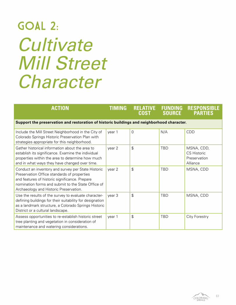
63
Cultivate Mill Street Character
GOAL 2:
ACTION TIMING RELATIVE COST
FUNDING SOURCE
RESPONSIBLE PARTIES
Support the preservation and restoration of historic buildings and neighborhood character.
Include the Mill Street Neighborhood in the City of Colorado Springs Historic Preservation Plan with strategies appropriate for this neighborhood.
year 1 0 N/A CDD
Gather historical information about the area to establish its significance. Examine the individual properties within the area to determine how much and in what ways they have changed over time.
year 2 $ TBD MSNA, CDD, CS Historic Preservation Alliance
Conduct an inventory and survey per State Historic Preservation Office standards of properties and features of historic significance. Prepare nomination forms and submit to the State Office of Archaeology and Historic Preservation.
year 2 $ TBD MSNA, CDD
Use the results of the survey to evaluate character-defining buildings for their suitability for designation as a landmark structure, a Colorado Springs Historic District or a cultural landscape.
year 3 $ TBD MSNA, CDD
Assess opportunities to re-establish historic street tree planting and vegetation in consideration of maintenance and watering considerations.
year 1 $ TBD City Forestry
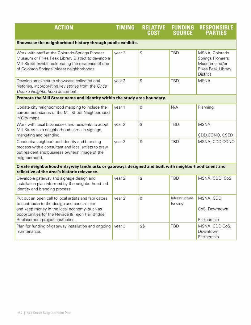
64 | Mill Street Neighborhood Plan
ACTION TIMING RELATIVE COST
FUNDING SOURCE
RESPONSIBLE PARTIES
Showcase the neighborhood history through public exhibits.
Work with staff at the Colorado Springs Pioneer Museum or Pikes Peak Library District to develop a Mill Street exhibit, celebrating the resilience of one of Colorado Springs’ oldest neighborhoods.
year 2 $ TBD MSNA, Colorado Springs Pioneers Museum and/or Pikes Peak Library District
Develop an exhibit to showcase collected oral histories, incorporating key stories from the Once Upon a Neighborhood document.
year 2 $ TBD MSNA
Promote the Mill Street name and identity within the study area boundary.
Update city neighborhood mapping to include the current boundaries of the Mill Street Neighborhood in City maps.
year 1 0 N/A Planning
Work with local businesses and residents to adopt Mill Street as a neighborhood name in signage, marketing and branding.
year 2 $ TBD MSNA,
CDD,CONO, CSED
Conduct a neighborhood identity and branding process with a consultant and local artists to draw out resident and business owners’ image of the neighborhood.
year 2 $ TBD MSNA, CDD,CONO
Create neighborhood entryway landmarks or gateways designed and built with neighborhood talent and reflective of the area’s historic relevance.
Develop a gateway and signage design and installation plan informed by the neighborhood-led identity and branding process.
year 2 $ TBD MSNA, CDD, CoS
Put out an open call to local artists and fabricators to contribute to the design and construction and keep money in the local economy- such as opportunities for the Nevada & Tejon Rail Bridge Replacement project aesthetics.
year 2 0 Infrastructure funding
MSNA, CDD,
CoS, Downtown
Partnership
Plan for funding of gateway installation and ongoing maintenance.
year 3 $$ TBD MSNA, CDD,CoS, Downtown Partnership
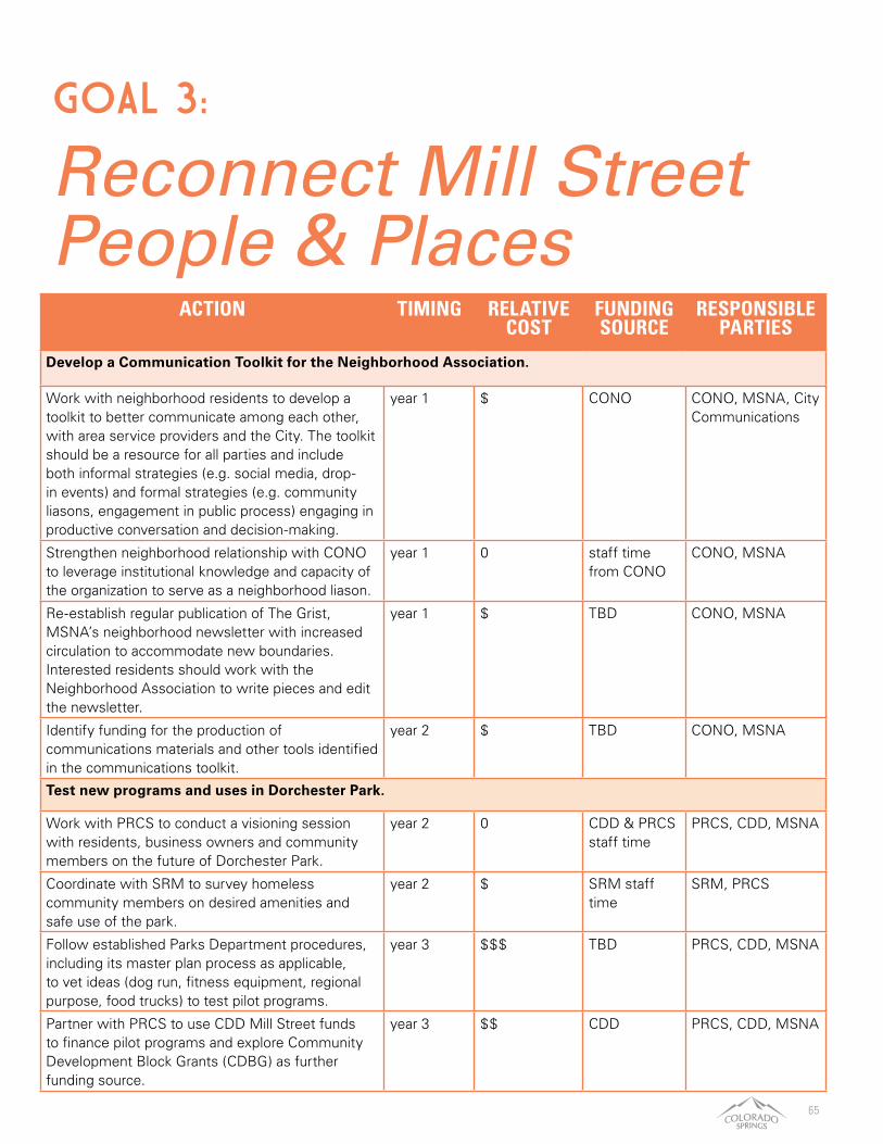
65
ACTION TIMING RELATIVE COST
FUNDING SOURCE
RESPONSIBLE PARTIES
Develop a Communication Toolkit for the Neighborhood Association.
Work with neighborhood residents to develop a toolkit to better communicate among each other, with area service providers and the City. The toolkit should be a resource for all parties and include both informal strategies (e.g. social media, drop-in events) and formal strategies (e.g. community liasons, engagement in public process) engaging in productive conversation and decision-making.
year 1 $ CONO CONO, MSNA, City Communications
Strengthen neighborhood relationship with CONO to leverage institutional knowledge and capacity of the organization to serve as a neighborhood liason.
year 1 0 staff time from CONO
CONO, MSNA
Re-establish regular publication of The Grist, MSNA’s neighborhood newsletter with increased circulation to accommodate new boundaries.Interested residents should work with the Neighborhood Association to write pieces and edit the newsletter.
year 1 $ TBD CONO, MSNA
Identify funding for the production of communications materials and other tools identified in the communications toolkit.
year 2 $ TBD CONO, MSNA
Test new programs and uses in Dorchester Park.
Work with PRCS to conduct a visioning session with residents, business owners and community members on the future of Dorchester Park.
year 2 0 CDD & PRCS staff time
PRCS, CDD, MSNA
Coordinate with SRM to survey homeless community members on desired amenities and safe use of the park.
year 2 $ SRM staff time
SRM, PRCS
Follow established Parks Department procedures, including its master plan process as applicable, to vet ideas (dog run, fitness equipment, regional purpose, food trucks) to test pilot programs.
year 3 $$$ TBD PRCS, CDD, MSNA
Partner with PRCS to use CDD Mill Street funds to finance pilot programs and explore Community Development Block Grants (CDBG) as further funding source.
year 3 $$ CDD PRCS, CDD, MSNA
Reconnect Mill Street People & Places
GOAL 3:

66 | Mill Street Neighborhood Plan
ACTION TIMING RELATIVE COST
FUNDING SOURCE
RESPONSIBLE PARTIES
Improve the character and quality of the Pikes Peak Greenway at Las Vegas Street and Sierra Madre Street trail access point.
Identify funding for the following improvements: pathway paving and ADA accessible design; Crime Prevention through Environmental Design; Safe Routes to parks signage and wayfinding to/from the neighborhood; trail entry landscape features and seating.
year 3 $$$ PRCS, Bike improvement fund
PRCS
Participate in the Colorado Springs Adopt a Park/Trail Program to care for the trail access point.
year 2 $ TBD MSNA, volunteers
Partner with the Department of Public Works to improve street conditions and public rights of way.
Create inventory of all pedestrian intersections in the study area, including information on signalized crossings, condition of sidewalk, timeline for renewal, presence of ramp, detectable warning strips, etc.
year 1 $ COSDPW COSDPW
Identify priority intersections for improvement. year 1 $ COSDPW COSDPW
Host community meeting to present locations for improvements and assess public priorities.
year 1 0 CDD, COSDPW staff time
CDD, COSDPW
Repave portions of S. Nevada Ave year 1 $$ COSDPW COSDPW
Repave portions of Sahwatch St, W. Rio Grande and W. Moreno Ave
year 2 $$ COSDPW COSDPW
Improve pedestrian crossing at Sierra Madre railline intersection
year 3 $$$ COSDPW COSDPW
Apply for CoS Missing Sidewalks Program to fund further improvements and explore additional programs, such as Trail Fund and Safety Fund.
year 3 $ COS COSDPW, CDD
Create an “Adopt-a-Stop” program for bus stops.
Inventory current bus stops and permanent bus shelters in the study area.
year 1 $ CDD CDD, Mountain Metro
Review summary with Mountain Metro to identify possible locations for permanent bus shelters and popular stops.
year 1 $ CDD CDD, Mountain Metro
Conduct outreach to local businesses to find potential “adoptees” for a pilot project.
year 2 0 N/A CDD, local businesses
Establish best practices and standard levels of care for adopted stops.
year 2 $ CDD CDD
Engage the neighborhood in major redevelopment projects.
As major redevelopment projects, such as the stadium at CityGate, the closure of the Drake Power Plant and the replacement of the railroad bridges, move forward, coordinate Mill Street neighborhood meeting with Planning Department.
Ongoing $ Staff time, project owner time
Planning, CSURA, project owners

67
ACTION TIMING RELATIVE COST
FUNDING SOURCE
RESPONSIBLE PARTIES
Form a Mill Street Business Association to help voluntary business owners manage maintenance, development and promotion of their neighborhood.
Meet with local businesses to identify potential
members.
year 1 0 CDD, CSED
staff time
Local Businesses,
CDD, CSED
Work with the City and the Pikes Peak Small Business Development Center to organize a vision and mission and host a first meeting.
year 1 0 CDD, CSED
staff time
Local Businesses,
CDD, CSED,
Chamber & EDC
Coordinate meetings, programs and events with the Mill Street Neighborhood Association.
year 1 $ CDD, CSED CDD, CSED,
Chamber & EDC
The Business Association may take ownership of relevant recommendations laid out in this plan and serve as partners in the pursuit of implementation.
year 2 0 CDD, CSED Local Businesses
Develop an historic preservation and home rehabilitation program for low-income homeowners in historic homes.
Work with the City-wide Historic Preservation Master Plan team to identify opportunity sites for historic home rehabilitation.
year 1 $ To be identified
CDD
Make Mill Street neighborhood a target area for housing rehabilitation programs.
year 1 0 CDD staff time
CDD, Brothers Redevelopment
Identify local developers and contractors with his-toric preservation experience to serve on a Historic Home Rehabilitation Advisory Committee. The com-mittee will help identify resources, materials and key construction considerations.
year 2 $ CDD staff and volunteer time
CDD, HPA, select
construction firms
Work with local preservation partners, such as the Colorado Office of Archaeology & Historic Pres-ervation and the Historic Preservation Alliance to identify funding streams to low-income Mill Street homeowners.
year 2 $ TBD CDD, nonprofit
partners
Develop an application program and work with homeowners to pursue funding.
year 3 $ HPA, CoS HPA, CoS
Create a Resilient Future for Mill Street
GOAL 4:

68 | Mill Street Neighborhood Plan
ACTION TIMING RELATIVE COST
FUNDING SOURCE
RESPONSIBLE PARTIES
Provide resources for affordable infill projects.
Make HOME funds available for low-income homeowners whose housing rehabilitation applications are denied due to excessive repair costs. If rehabilitation can’t be done, rebuilding the home with additional units is an option.
year 1 0 N/A CDD; Homeowners
Once constructed, the homeowner would live in one unit and rent out the remainder as affordable units for a set period. After affordability period ends, the homeowner keeps the added equity and the neighborhood has added density.
year 3 $$ HOME CDD, Homeowners
Promote the construction of Accessory Dwelling Units as an affordable housing and wealth-building tool.
Represent Mill Street in the Planning department’s study of a citywide ADU ordinance (e.g. lot size, maximum lot coverage, etc).
year 1 0 N/A CDD
If citywide ADU ordinance does not pass, create ADU unit overlay district for Mill Street study area.
year 2 $ TBD Planning
Assist low-income homeowners with funding of ADU construction by leveraging HOME funds.
year 2 $$ HOME program
CDD, Homeowners
Introduce more affordable housing in neighborhood through HOME loans, which stipulate rents must be at or below fair market rate (FMR) for ten years or homeowner must pay back construction costs.
year 3 0 HOME program
CDD, Homeowners
Engage new and long-term residents in a place-based program, such as the Community Garden.
Work with the neighborhood association to reach out to new volunteers to plant and maintain the community garden.
year 1 0 N/A MSNA
Organize a local market or farm stand and “market days” events at the Community Garden street. Use opportunities to engage Springs Rescue Mission and residents at this central space.
year 1 $ TBD MSNA, SRM
Address community interests when planning for the replacement of the S. Nevada/ S. Tejon rail bridge.
Rail bridge replacement design should seek to improve conditions for the neighborhood such as noise reduction, air quality, pedestrian and vehicular movement and connectivity, safe crossings, neigh-borhood aesthetics, and opportunity for a neighbor-hood gateway feature.
year 1-3 $ TBD DPW, UPRR/BNSF
Encourage participation from residents and busi-nesses in providing input regarding rail changes.
year 1-3 $ TBD CONO, MSNA, DPW
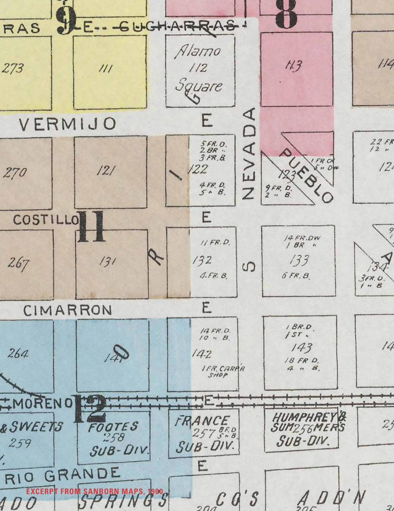
69EXCERPT FROM SANBORN MAPS, 1900