CITY of SARATOGA SPRINGS MULTIHAZARD MITIGATION ...
146
CITY of SARATOGA SPRINGS MULTIHAZARD MITIGATION PLAN DRAFT AUGUST 30, 2017 Sensitive Security Information Strictly not for Public Distribution
-
Upload
khangminh22 -
Category
Documents
-
view
0 -
download
0
Transcript of CITY of SARATOGA SPRINGS MULTIHAZARD MITIGATION ...
CITY of SARATOGA SPRINGS
MULTIHAZARD MITIGATION PLAN
DRAFT
AUGUST 30, 2017
Sensitive Security Information
Strictly not for Public Distribution
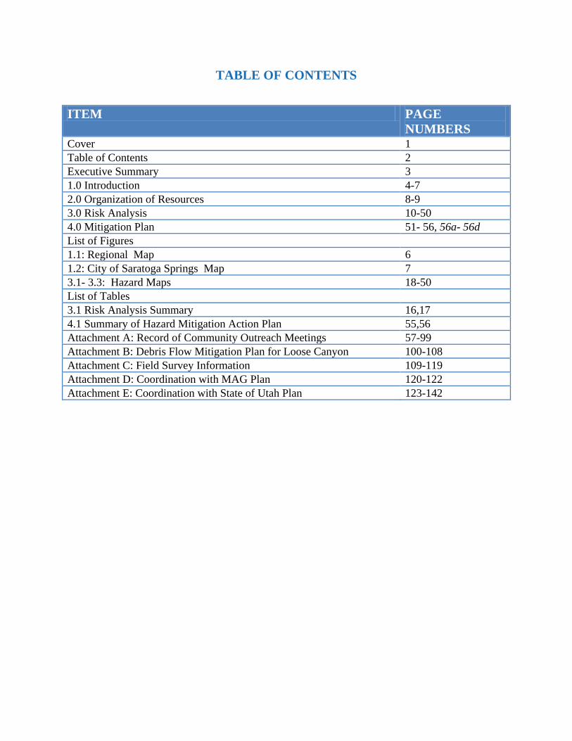
TABLE OF CONTENTS
ITEM PAGE
NUMBERS Cover 1
Table of Contents 2
Executive Summary 3
1.0 Introduction 4-7
2.0 Organization of Resources 8-9
3.0 Risk Analysis 10-50
4.0 Mitigation Plan 51- 56, 56a- 56d
List of Figures
1.1: Regional Map 6
1.2: City of Saratoga Springs Map 7
3.1- 3.3: Hazard Maps 18-50
List of Tables
3.1 Risk Analysis Summary 16,17
4.1 Summary of Hazard Mitigation Action Plan 55,56
Attachment A: Record of Community Outreach Meetings 57-99
Attachment B: Debris Flow Mitigation Plan for Loose Canyon 100-108
Attachment C: Field Survey Information 109-119
Attachment D: Coordination with MAG Plan 120-122
Attachment E: Coordination with State of Utah Plan 123-142
i) EXECUTIVE SUMMARY The City of Saratoga Springs (the City) has a population of more than 30,000, according to the City’s 2016/2017 budget plan. The City is one of the fastest growing municipalities in the greater Salt Lake City area (also known as the Wasatch Front). Land development in the City has taken the form of large “master planned” communities, with progressive land-use and zoning practices. The City anticipates a population of over 120,000 upon final build-out.
The City has chosen to take a proactive approach to the management of the effects of natural hazards. As one of these proactive measures, the City cooperated in the development of the Mountainlands Association of Governments (MAG) plan, which was previously approved by FEMA in 2011. The City also participated in the current update to the MAG plan, which is scheduled to be approved by FEMA in mid to late 2017.
The MAG plan (by necessity) can not address the many and varied specific needs of each participating community. The City therefore requested and received a hazard mitigation planning grant from FEMA in 2017 to develop its own pre-disaster mitigation plan. This plan has been developed to meet the requirements in Federal Law, 44 CFR. The City initially considered a broad range of natural hazards, based upon the hazard listing in the risk analysis portion of the MAG plan. As a part of the City’s outreach efforts, the City met with MAG officials and discussed which of these hazards were more likely to have an impact on the City. This was a necessary step, since risks associated with natural hazards are not uniform throughout the Wasatch Front. City specific risk analyses were performed by a consulting firm (EPIC Engineering). Upon completion of the risk analysis, the City evaluated risk reduction alternatives. This evaluation considered natural hazard risks to life safety, community interruption, and property damage. The resources which the City has to respond to natural hazard events were also considered. Based upon these evaluations, the City identified hazard mitigation alternatives. The City then developed a multiyear plan to mitigate risks that are of the highest consequence. This plan consists of potential mitigation projects to mitigate natural hazards in the following order of priority:
Wildfire Hazard Mitigation through fuel reduction and fire break construction; Debris Flow Hazard Mitigation through channel improvements and basin construction; Severe Storm Hazard Mitigation through emergency generator installation; Earthquake Ground Shaking Hazard Mitigation through nonstructural strengthening of
certain critical facilities; Earthquake Liquefaction Hazard Mitigation through retrofit measures at certain critical
low lying infrastructure facilities; Flood Hazard Mitigation through possible construction of flood control measures around
certain critical facilities. Drought Hazard Mitigation, primarily through a continuation of ongoing water
conservation programs, with possible enhancements through interagency projects.
A listing of potential mitigation projects, estimated costs, and possible grant funding sources is provided in this plan. The plan encompasses a 10 year time frame (2017 to 2026.)
3 of 142
John
Typewritten Text
1.0 INTRODUCTION The City of Saratoga Springs has prepared this multihazard mitigation plan by utilizing a four step process; as required by CFR 44. This planning process consists (prescriptively) of the following steps:
1) ORGANIZATION OF RESOURCES; 2) RISK ANALYSIS; 3) DEVELOPMENT OF A MITIGATION PLAN; and 4) IMPLEMENTATION OF THE PLAN.
As a part of plan implementation, the City intends to mitigate risks where economically feasible. The City may also undertake mitigation projects as a component of future facility improvement or expansion projects. This approach will result in significant risk reduction and improve the City’s ability to serve its constituents. Throughout the implementation phase, the City will coordinate mitigation activities in a manner which is consistent with goals and objectives of the Utah State Mitigation plan, as well as the Mountain lands Association of Governments (MAG) Plan. An overview of findings and mitigation actions identified in this planned process are briefly summarized below. The location of the City is shown in Figure 1.1 and Figure 1.2. The proximity of the City’s facilities to natural hazard areas or zones is shown in the Risk Analysis portion of this plan (Section 2.0).
1.1 Organization of Resources The City has organized and conducted meetings with stakeholders, regional risk planners, the State of Utah DEM emergency planners, FEMA, and local emergency planning groups as a part of preparation of this mitigation plan. The plan was prepared through collaborative efforts with these groups and with input on mitigation needs from the City’s department heads.
1.2 Risk Analysis The risk analysis included hazard identification, and hazard quantification. Probabilistic hazard definitions and quantification methodologies were used. The risk analysis began with consideration of all hazards listed in Mountainlands Association of Governments (MAG) Plan. Upon review of the MAG plan, and discussion of which hazards in the plan were more pertinent to the City, it was determined that the following hazards would be addressed in the City of Saratoga Springs Multihazard Mitigation Plan:
Wildfire Debris Flow Severe Weather Earthquake Flooding Drought
Other hazards identified in the MAG plan were also considered, but found to pose relatively low risks to the City, in comparison to the hazards listed above.
4 of 142
John
Typewritten Text

1.0 INTRODUCTION 1.3 Mitigation Plan
Risk evaluation results led to the identification of potential natural hazard mitigation projects. These projects are listed in Section 4.0 of the City of Saratoga Springs Multihazard Mitigation Plan. The City proposes to complete these projects over a multiyear period of time.
1.4 Implementation
As recommended in the “Local Multihazard Mitigation Planning Guidance” document published by FEMA, The City formally adopts the mitigation plan after receiving approval of the draft final plan from the State of Utah and FEMA.
The Mitigation Plan will be updated every five years, as required by 44 CFR. Official plan revisions will be prepared and submitted to FEMA, as required by 44 CFR.
5 of 142
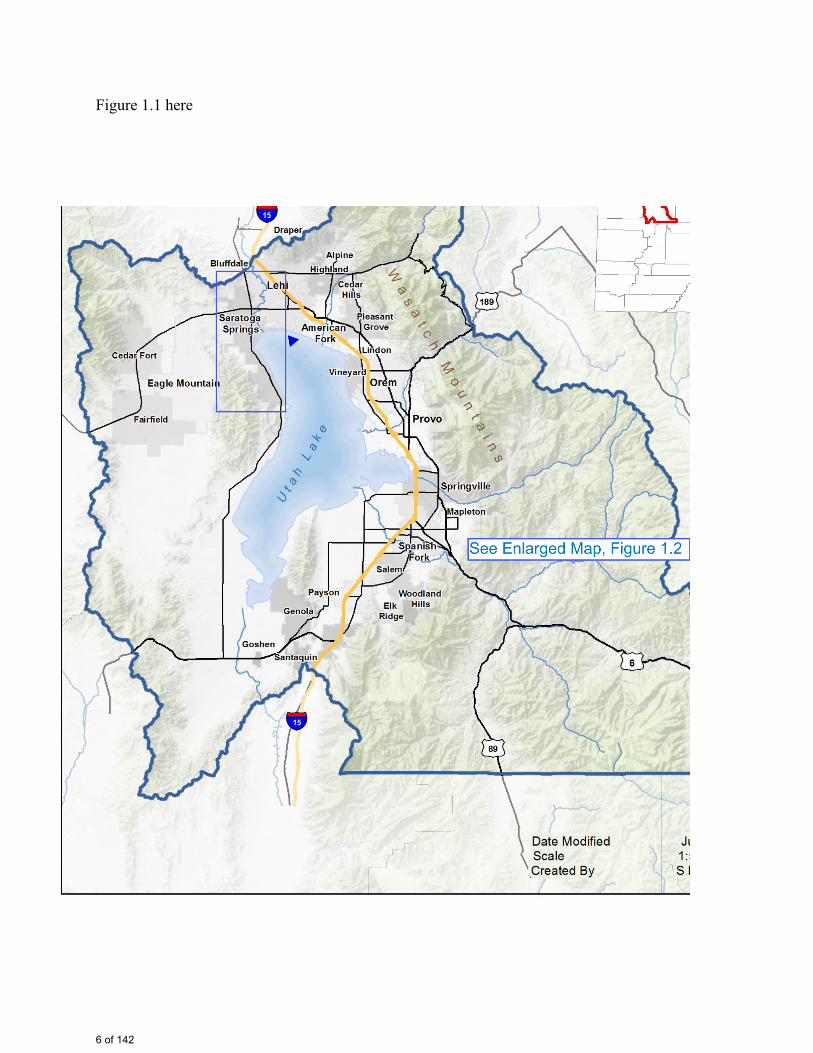
Figure 1.1 here
6 of 142
John
Rectangle
John
Figure 1.1
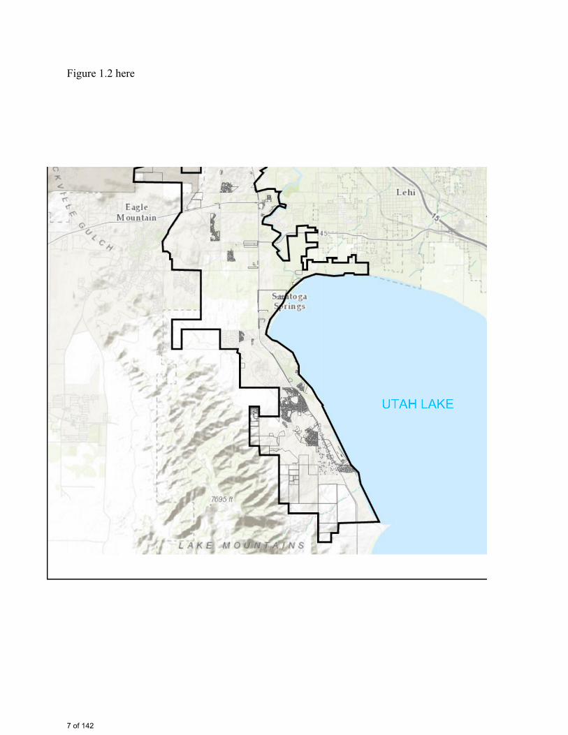
Figure 1.2 here
7 of 142
John
Rectangle
John
Figure 1.2
2.0 ORGANIZATION OF RESOURCES
The City has developed a multihazard mitigation plan in a manner which conforms to mitigation planning regulations under 44 CFR Part 201. The steps included in this process are described in Sections 2.1 through 2.7, below. The City sought and received input from numerous organizations in this planning process.
2.1 Identification of and Coordination with Representatives from the City's Operating Groups
The City has obtained input to the plan from management personal within the City’s emergency response, administration, public works, and engineering departments.
2.2 Identification of, Contact and Coordination with Emergency Services Personnel as Project Participants This task included outreach to emergency service groups, such as firefighting organizations and police.
2.3 Identification of, Contact and Coordination with Representatives of the MAG The Mountainlands Association of Governments (MAG), completed regional mitigation plans in 2011, and has its 2017 update under review by FEMA (as of the date of the City’s plan). The MAG plan encompasses the area served by City, as well as many other communities. The City reviewed the MAG plan and included several overall regional mitigation goals (from the MAG plan) into the City’s plan. The City anticipates adopting the MAG plan upon approval by FEMA. 2.4 Identification of, Contact and Coordination with Representatives of Communities Served by the City The City conducted four meetings to obtain input into its plan. These meetings are documented in Attachment A.
2.5 Meetings with Federal Agencies with Interest in the City’s Hazard Mitigation Planning Process The City’s grant writer met with a FEMA representative during BCA training at the Utah Capital. This meeting focused on discussion of possible near term FEMA grant submittals.
2.6 Meetings with State of Utah Emergency Management Personnel The City coordinated the risk analysis and mitigation planning progress through a regular dialog with the State of Utah Department of Emergency Management personnel. State of Utah personnel also attended public meetings.
8 of 142
2.0 ORGANIZATION OF RESOURCES 2.7 Public Meetings Public involvement in the planning process included multiple outreach efforts to other agencies and the public. The City conducted four formal outreach efforts. These included:
• Meeting with a MAG representative on January 25, 2017; • Meeting with State of Utah and FEMA representatives on March 9, 2017; • Conducting a technical outreach meeting with multiple agencies on March 14, 2017; and • Conducting an outdoor general public outreach meeting on March 20, 2017.
Records of these meetings are provided in Attachment A.
9 of 142
3.0 RISK ANALYSIS
3.1 Methodology
The City’s facilities are all located in relatively close proximity to each other; however, the natural hazards posed to each facility vary. This is due to variations in a number of parameters, including: proximity to hillside drainage areas, proximity to undeveloped areas with high fire hazards, variations in geology, variations in proximity to low lying areas, variation in soil types, variations in ground water elevations, and other parameters. On the other hand, some hazards do not vary substantially within the boundaries of the City. These hazards included ground acceleration levels due to seismic events, risks posed by extreme storm events (snow, wind, lightening) and drought.
3.1.1 Identification and Quantification of Hazards
3.1.1.1 Review mitigation effects on system risk reduction resulting from currently planned capital improvement projects.
The process for allocation of City funds to a project is through the budget process, which is adopted each year by the City Council. The identification of these funds is in the CIP, which is then incorporated in the budget process.
3.1.1.2 Review and incorporate MAG plan information
The MAG plan addresses risk and hazard mitigation for the City’s metropolitan area, as well as many other communities along the south portion of the Wasatch Front. As such, general regional risk assessment information and mitigation actions, which generally pertain to the City, are included in the MAG plan. Also, general hazard quantification and mitigation goals were developed in the MAG plan. Findings from the City’s hazard risk assessment process narrowed the hazards of concern to those most relevant to the City. A correlation of risk assessment findings in the MAG plan and risk assessment findings in the City’s plan is provided in Attachment D. 3.1.1.3 Review and incorporate State of Utah plan information.
The State of Utah plan was reviewed by the City and information was incorporated into the City’s plan, as appropriate. A correlation of risk assessment findings in the State of Utah plan and risk assessment findings in the City’s plan is provided in Attachment E.
3.1.1.4 Review and incorporate risk information from communities served
The City has reviewed natural hazards for each community served as a component of regional risk assessments.
3.1.1.5 Review and incorporate, FEMA Flood Hazard Maps, Fire Hazard Maps, USGS seismic hazard maps, and other published data.
One of the major efforts of the City’s risk assessment process was to develop City specific natural hazard maps. These maps allowed for visual and numerical assessment of the affects of each hazard considered. These maps are provided in Figures 3.1 to 3.33.
10 of 142
John
Typewritten Text

3.0 RISK ANALYSIS
3.1.1.6 Further analyses of hazards specific the City of Saratoga Springs
This work included performing visual reviews of representative wells, pump stations, sewer lift stations, office buildings, and maintenance buildings.
11 of 142
3.0 RISK ANALYSIS 3.2 Hazard Analysis
3.2.1 Identification of Primary Hazards of Concern Based on Regional Hazard Studies
The City’s facilities, as well as residences and businesses within the City, are exposed to many of the natural hazards listed in the MAG and the State plan. An important component of the City’s plan was to identify the hazards which pose significant risks to either essential facility components (or groups of facility components), which could then lead to consequences that did not meet operational /recovery priorities. These operational/recovery priorities were identified during project planning meetings, and are listed below:
1) Provide Life Safety Protection to City Residents and General Public that may be present in the community; 2) Mitigate Loss Property and Operational Disruptions, to the Extent that is economically feasible; and 3) Augment the City’s Disaster Response Preparedness.
The hazard assessment has thus been done in a manner which identifies and quantifies hazards which can pose the greatest threat (risk) to successful achievement of these objectives.
3.2.2 Quantification of Hazards with the Highest Potential Impact on City Facilities
Controlling hazards were found to be: Wildfire, Debris Flow, Extreme Weather (as it relates to power outage), Earthquake Hazards, Flooding, and Drought. Methods used to quantify these hazards for use in risk analysis are given in Section 3.3. Additional assistance was provided by other government officials during public forum and other project meetings. These same government officials were included in the mitigation planning portion of the project.
12 of 142
John
Typewritten Text
3.0 RISK ANALYSIS 3.3 Hazard Analysis by Hazard Type
3.3.1 Wildfire
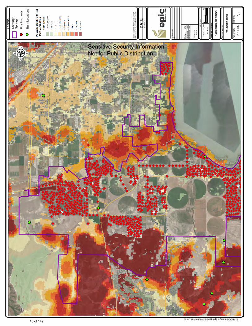
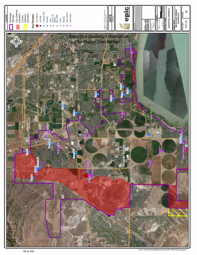
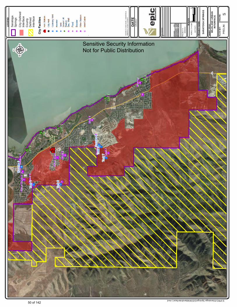
The City assessed risks due to wildfire by reviewing historical wildfire records in the vicinity of the City. There have been 12 wildfires on Lake Mountain just west of Saratoga Springs since 1999. The fires historically have occurred on Bureau of Land Management (BLM) property, which is immediately adjacent to the City on the entire west boundary, and portions of the Northern and southern boundaries. The City assessed hazards posed by wildfires to residences, businesses and infrastructure. A lesser wildfire hazards occurs within some undeveloped areas of the City and in areas on the eastern boundary (adjacent to undeveloped low land areas near Utah Lake). The City conducted additional wildfire risk assessments, beyond those done during the most recent MAG plan update. These assessments resulted in new wildfire hazard maps that shown reduced wildfire hazards within city boundaries, due to installation of infrastructure and pressurized water lines and fire hydrants. Concerning wildfires that affect the boundaries of the city, several practical risk mitigation alternatives are available to mitigate wildfire hazards, including fuel reduction and construction of fire breaks. Wildfire hazard maps are shown in Figures 3.26 to 3.33. 3.3.2 Debris Flow
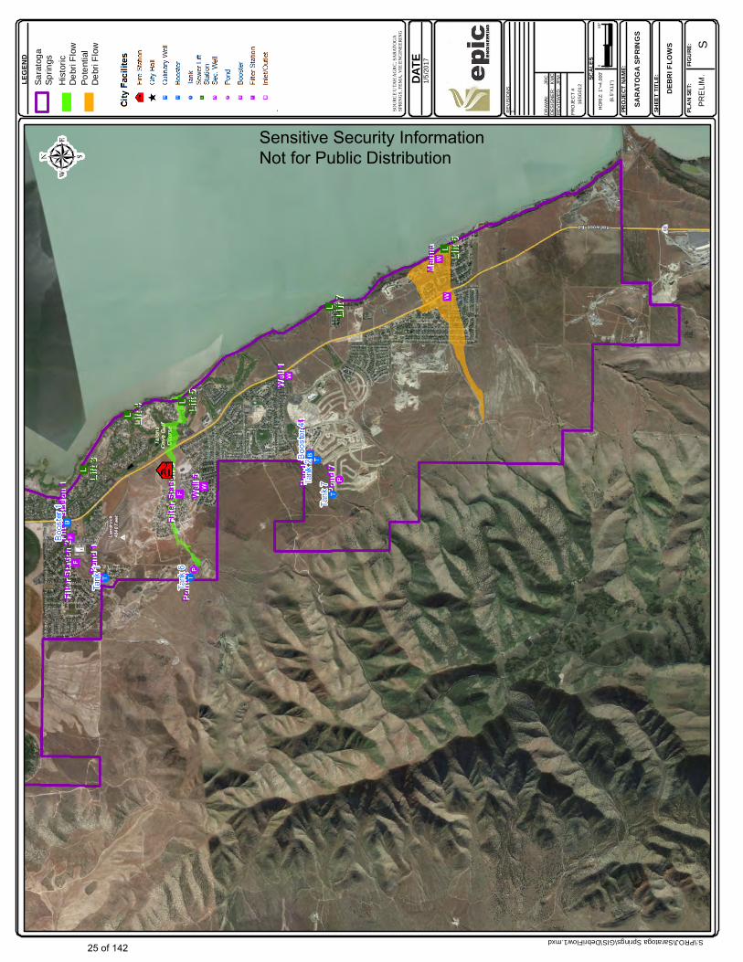
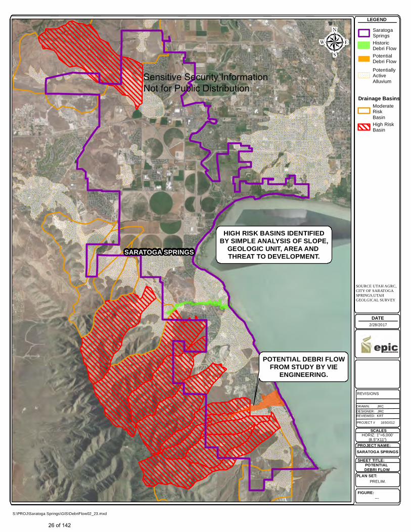
Debris flows result from rapid storm water runoff thought steep natural channels and valleys, such as those in the mountains on the West side of the City. Debris flows are made more severe when a wildfire has recently occurred in affected areas. Due to removed vegetation and scarring on mountain or hillside slopes, there is potential flooding as well as debris flow. Improvements to natural channels are used to direct flooding away from homes, businesses and infrastructure. Debris basins are needed to further protect and keep debris flows away from developed areas. The City has experienced damage from debris flows as recently as 2012. Following this event, the City constructed a debris flow channel and basin to protect the portion of the City that was damaged in 2012.
As a part of development of this hazard mitigation plan, the City conducted a risk analysis of potential debris flow hazards originating in canyons on the west side of the city. This evaluation identified areas for which future debris flows may occur, as shown in Figures 3.7 to 3.9. The City evaluated these potential debris flow areas and determined that the highest risk is posed by debris flows in the Loose Canyon drainage, which could directly affect approximately 150 residential properties, 10 commercial properties, one major North/South traffic corridor, and numerous city streets and utilities in the City of Saratoga Springs. The City proposes to mitigate hazards posed in the Loose Canyon zone by constructing channel improvements and by installing debris basins, as described further in Attachment C. The City may also elect to mitigate potential debris flow hazards in other areas (shown in Figures 3.7 to 3.9 in future projects.
13 of 142
3.0 RISK ANALYSIS 3.3.3 Severe Weather
Hazards related to severe weather that could most significantly affect the city include winter storm, high wind events, and lightening. Tornados are rare in Utah and therefore do not pose a high likelihood hazard, in comparison to other sources of high wind.
Large snow events do historically occur, however the City and the State of Utah Department of Transportation have a well organized snow removal plan, with sufficient equipment to respond to major snow events.
A significant weather hazard posed to the City is high wind, which may occur any time of the year. High wind events have resulted in regional power losses. Lesser risks to city infrastructure include wind damage to buildings and interruption to transportation routes due to debris in traffic lanes.
3.3.4 Earthquake
Most of the City’s facilities and business and residential communities are located in regions which are moderate to high earthquake hazard areas. These areas can be affected by ground shaking, transient wave propagation, and liquefaction induced lateral spreading and permanent ground displacement. The potential for each of these earthquake hazards to result in damage to City’s facilities has been assessed.
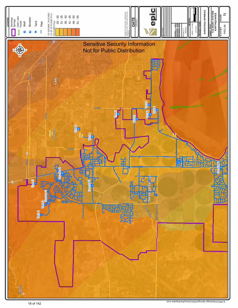
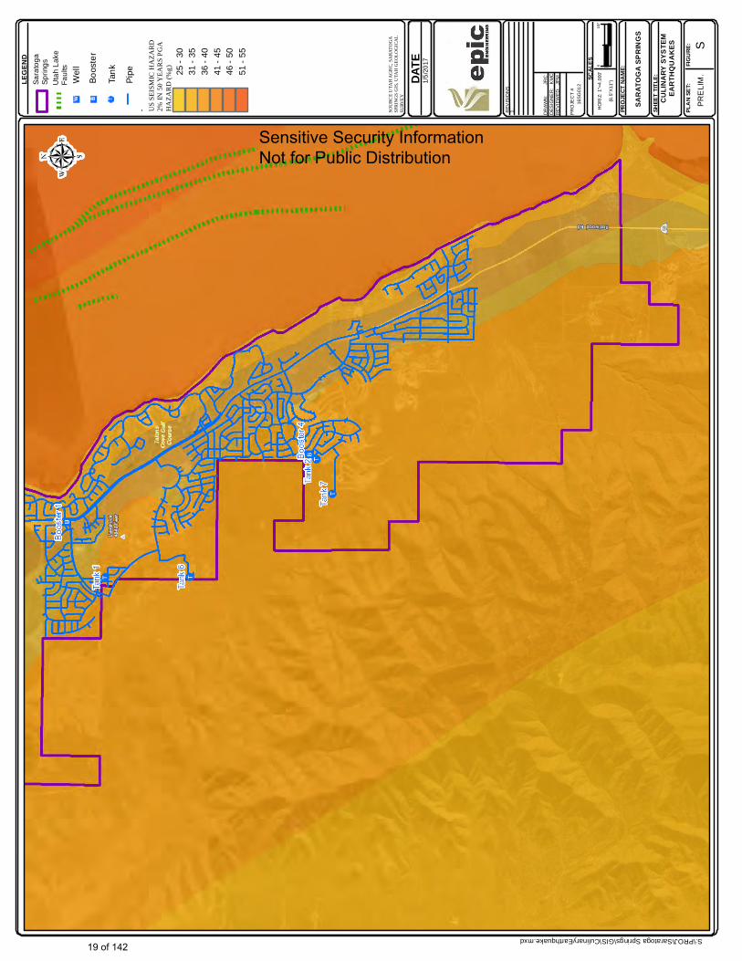
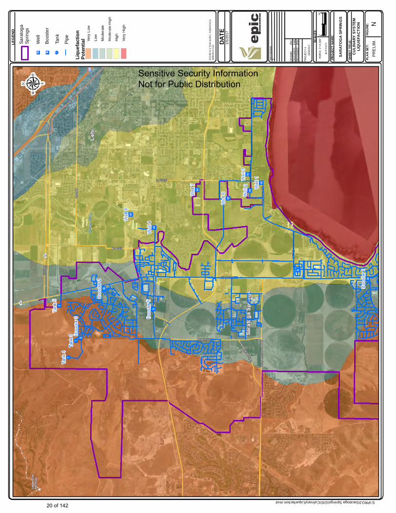
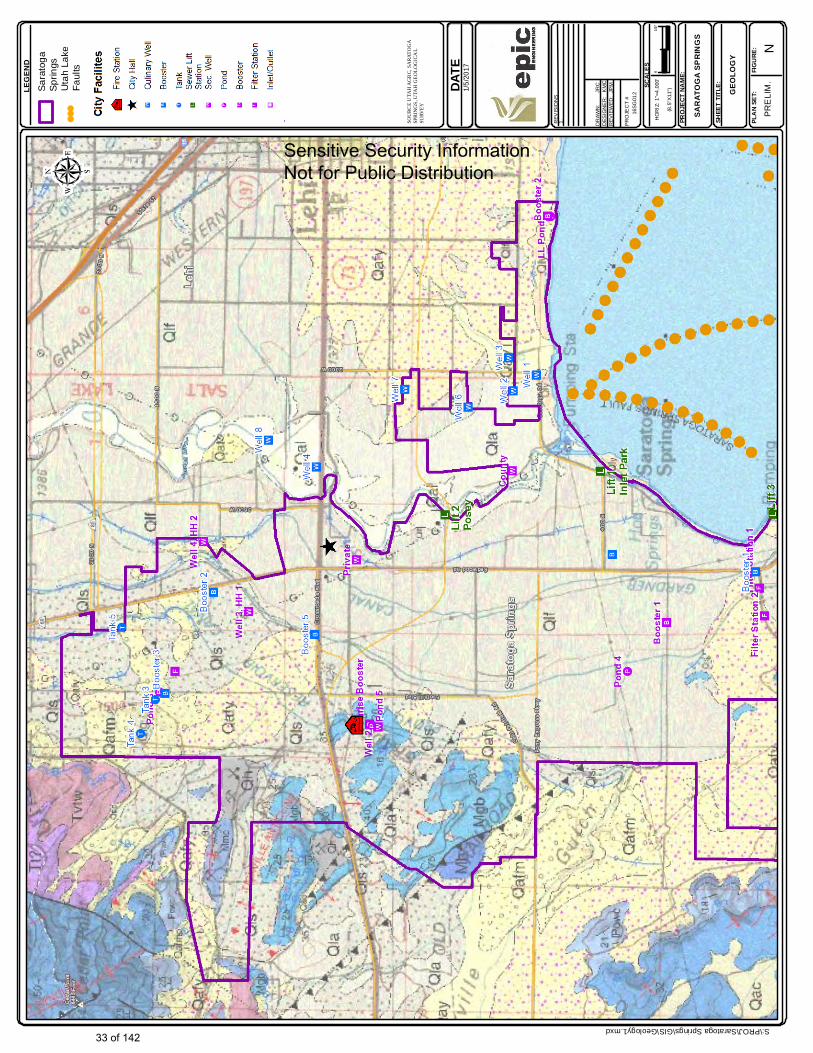
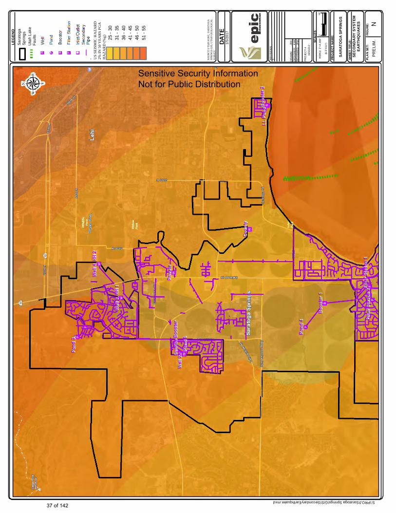
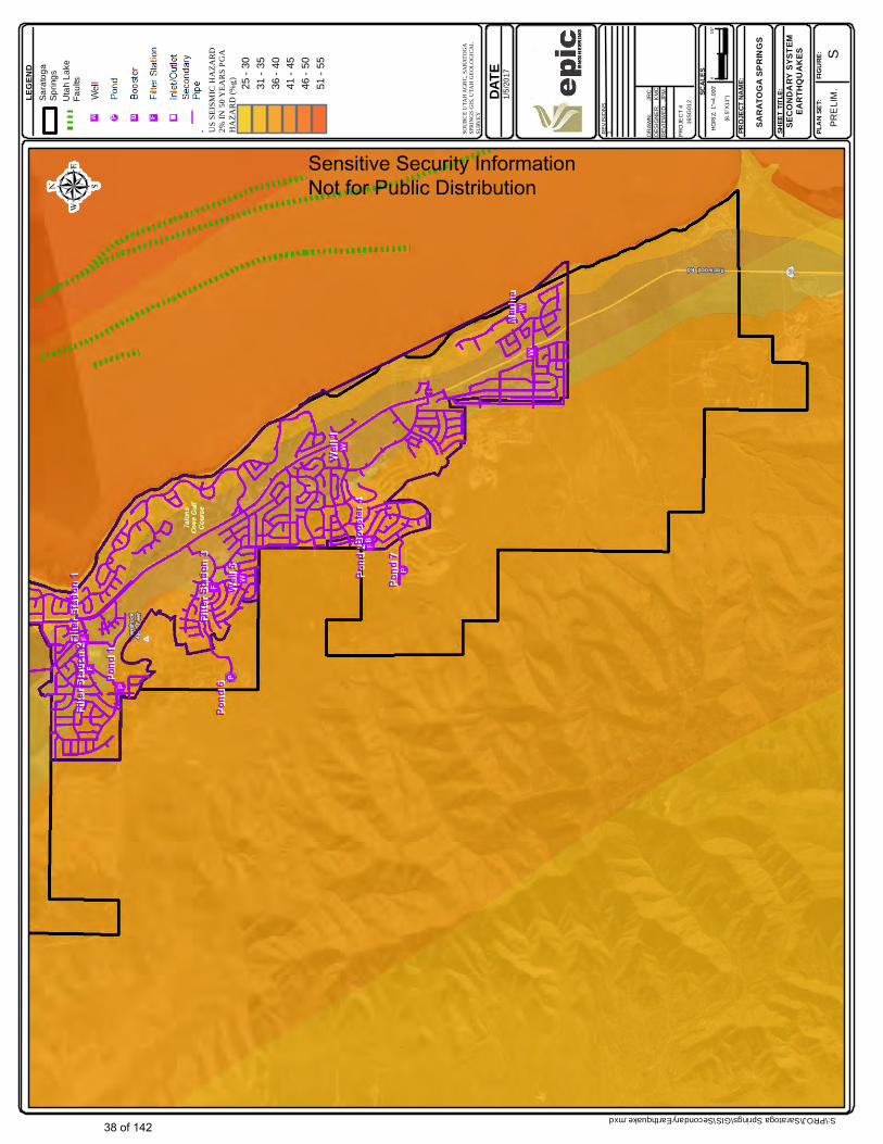
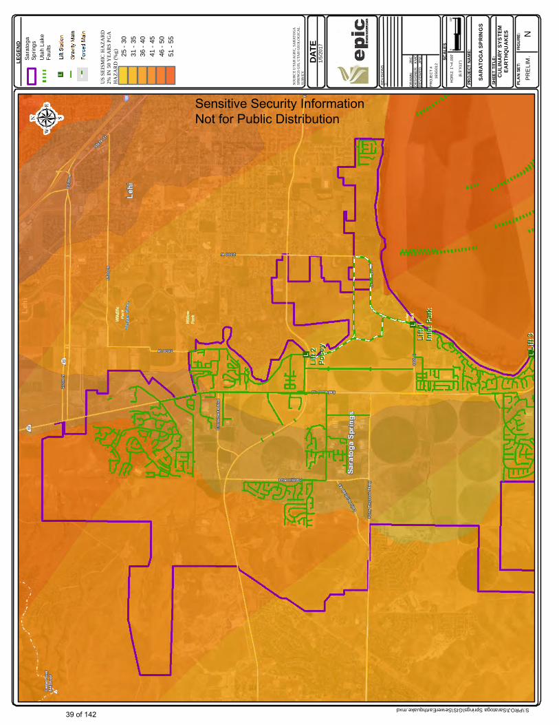
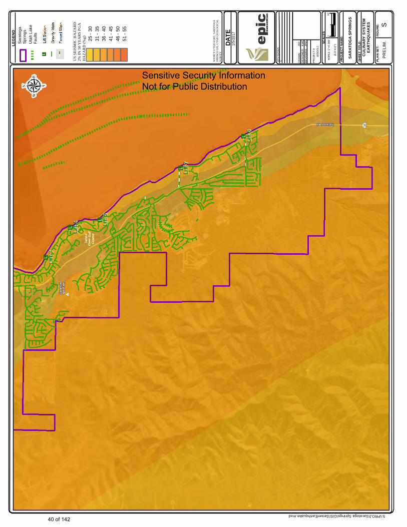
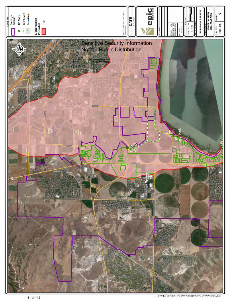
Ground Shaking Ground shaking levels have been determined using USGS data at each site location. Ground shaking levels for two events have been determined: 1) An event with a 10% probability of exceedance in 50 years, and 2) An event with a 2% probability of exceedance in 50 years. Significant City owned buildings have been designed using modern versions of the building code. Risk assessments conducted as a part of preparation of this plan did not identify any significant structural seismic retrofit needs for City owned buildings. However, nonstructural seismic hazards were identified. An overview of these nonstructural seismic hazards is provided in Attachment C. Ground shaking levels are shown in Figures 3.1, 3.2, 3.21-3.23. Ground Displacement Effects Surface faulting locations of active (Holocene age) and historically active (Pleistocene age) ground were investigated and found to not be a significant direct hazard to City facilities, since no facilities are located within know fault rupture zones. Maps of fault zones along the Wasatch Range are included in Figures 3.16 and 3.17. Liquefaction and Lateral Spreading Overall regional liquefaction information has been evaluated. With the exception of low lying areas near the Jordon River and along the Utah Lake shore, liquefaction risks are low. However, the City does have a portion of its infrastructure in the high liquefaction risk areas, including certain water wells and sewer lift stations. Liquefaction hazards areas are shown in Figures 3.3, 3.4, 3.24, and 3.25. These figures also illustrate where City owed infrastructure is with respect to high liquefaction hazard areas.
14 of 142
3.0 RISK ANALYSIS 3.3.5 Flooding
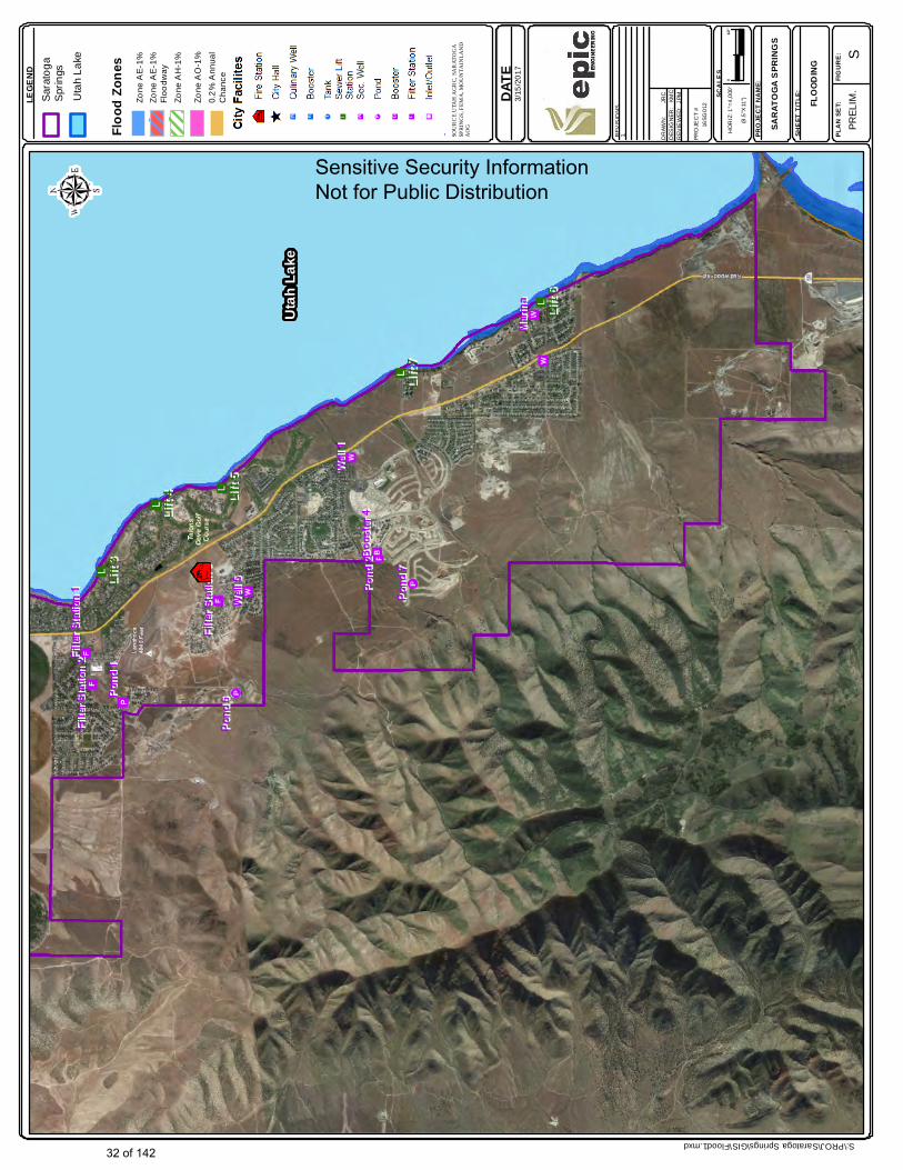
Flood hazards exist in certain low lying areas in the northern portion of the City, near the Jordan River. Risk analyses indicate that low lying utilities, such a sewer lift stations and wells may experience damage and loss of use should flooding occur at the location of these facilities. Flood hazard maps are shown in Figures 3.14 and 3.15.
3.3.6 Natural Hazard Induced Explosion
The City of Saratoga Springs has a number of explosives manufacturing and storage facilities within its boundaries. These facilities are vulnerable natural hazards, including seismic events, wildfire events, and extreme weather (lightening). These facilities are privately owned, therefore the City’s ability to impose natural hazard risk management measures are mostly limited to code enforcement measures.
3.3.7 Drought
Drought is a natural hazard in many parts of the western United States, including Utah. Fortunately, the City of Saratoga Springs has proactively developed and implemented a successful water conservations program. Continuation of this program as the City continues to grow is the most effective drought management strategy. Other drought management efforts could possibly include working with other entities to either pipe or line open secondary water canals. This is however complex from a facility and water rights ownership perspective.
3.3.8 Other Natural Hazards
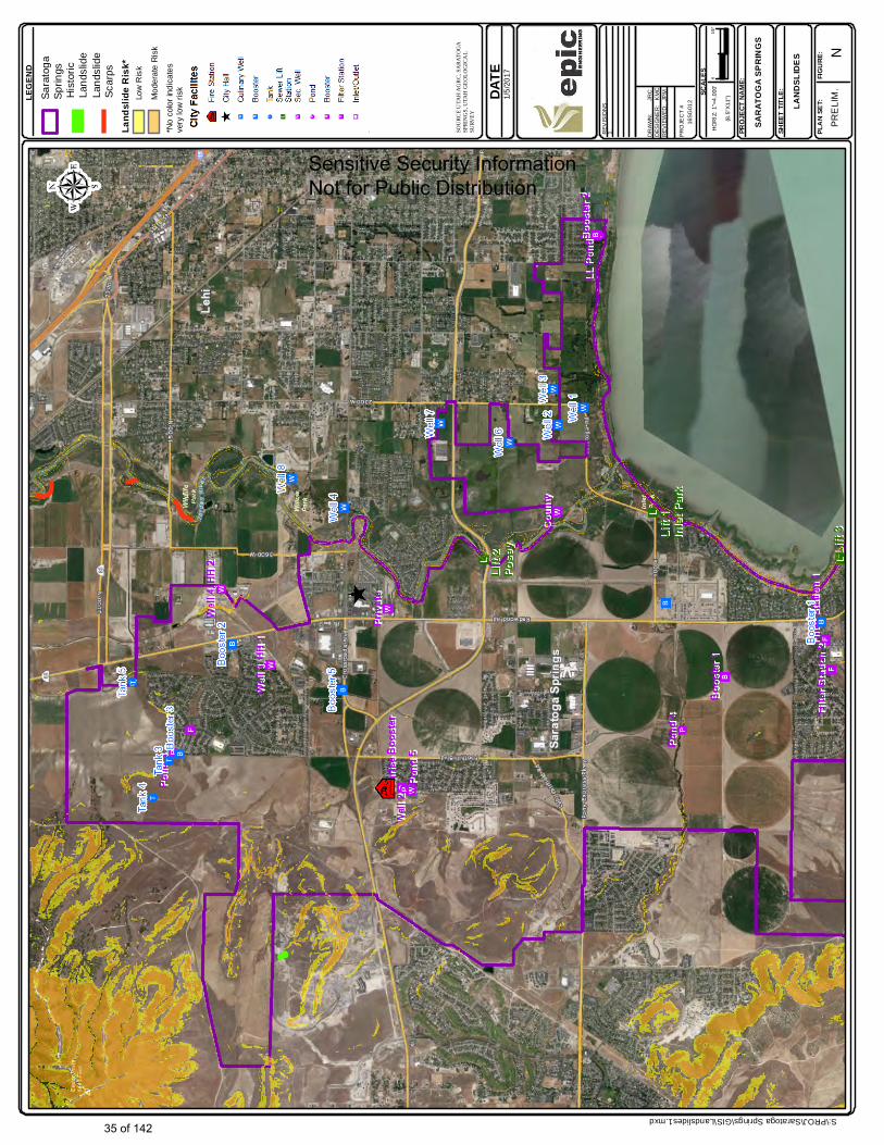
Other hazards of potential concern for the City are identified and described in the MAG plan. These hazards included: avalanche, rockslides, land sliding, and other natural hazards, which are relevant to other facilities in the MAG study area, but were not found to pose any significant risks to the City’s facilities. Landslide maps are provided in Figures 3.18 and 3.19. 3.4 Summary of Risk Analysis Results
Table 3.1 provides a summary structural risk analysis results for all considered hazards. Risk analysis information is provided separately for each hazard considered.
15 of 142

Table 3.1, Page 1 here:
16 of 142
John
Rectangle
John
Table 3.1 pg 1
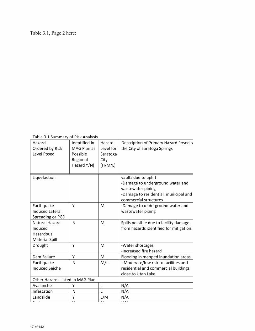
Table 3.1, Page 2 here:
17 of 142
John
Rectangle
John
Table 3.1 pg 2
DATE ep
icE
NG
INE
ER
ING
REV
ISIO
NS
1. DR
AWN
:
JR
CD
ESIG
NE
R:
KM
CR
EVIE
WED
: JP
M
HO
RIZ
: 1"=
4,00
0'
(8.5
"X11
")
PRO
JEC
T #
16SG
012
SCAL
ES
PROJ
ECT N
AME:
SHEE
T TITL
E:
PLAN
SET:
FIGUR
E:
SARA
TOGA
SPR
INGS
PR
ELI
M.
01/2
"
LEGE
ND
SOUR
CE U
TAH A
GRC,
SARA
TOGA
SP
RING
S GIS,
UTA
H GE
OLOG
ICAL
SURV
EY CULIN
ARY
SYST
EMEA
RTHQ
UAKE
S
S:\PROJ\Saratoga Springs\GIS\CulinaryEarthquake.mxd
1/5/
2017
N
Sara
toga
Sp
rings
US SE
ISM
IC H
AZAR
D
2% IN
50 Y
EARS
PGA
HAZA
RD (%
g) 25 -
3031
- 35
36 -
4041
- 45
46 -
5051
- 55
Uta
h La
keFa
ults
Wel
l
Boos
ter
Tank
Pipe
Sensitive Security Information Not for Public Distribution
18 of 142
John
Typewritten Text
Figure 3.1
John
Typewritten Text
John
Typewritten Text
John
Typewritten Text
John
Typewritten Text
John
Typewritten Text
John
Typewritten Text
John
Typewritten Text
John
Typewritten Text
John
Typewritten Text
John
Typewritten Text
John
Typewritten Text
DATE ep
icE
NG
INE
ER
ING
REV
ISIO
NS
1. DR
AWN
:
JR
CD
ESIG
NE
R:
KM
CR
EVIE
WED
: JP
M
HO
RIZ
: 1"=
4,00
0'
(8.5
"X11
")
PRO
JEC
T #
16SG
012
SCAL
ES
PROJ
ECT N
AME:
SHEE
T TITL
E:
PLAN
SET:
FIGUR
E:
SARA
TOGA
SPR
INGS
PR
ELI
M.
01/2
"
LEGE
ND
SOUR
CE U
TAH A
GRC,
SARA
TOGA
SP
RING
S GIS,
UTA
H GE
OLOG
ICAL
SURV
EY CULIN
ARY
SYST
EMEA
RTHQ
UAKE
S
S:\PROJ\Saratoga Springs\GIS\CulinaryEarthquake.mxd
1/5/
2017
S
Sara
toga
Sp
rings
US SE
ISM
IC H
AZAR
D
2% IN
50 Y
EARS
PGA
HAZA
RD (%
g) 25 -
3031
- 35
36 -
4041
- 45
46 -
5051
- 55
Uta
h La
keFa
ults
Wel
l
Boos
ter
Tank
Pipe
Sensitive Security Information Not for Public Distribution
19 of 142
John
Typewritten Text
Figure 3.2
John
Typewritten Text
John
Typewritten Text
John
Typewritten Text
John
Rectangle
John
Typewritten Text
Gray Box Indicates Area of Wells Tanks or Pump Stations
DATE ep
icE
NG
INE
ER
ING
REV
ISIO
NS
1. DR
AWN
:
JR
CD
ESIG
NE
R:
KM
CR
EVIE
WED
: JP
M
HO
RIZ
: 1"=
4,00
0'
(8.5
"X11
")
PRO
JEC
T #
16SG
012
SCAL
ES
PROJ
ECT N
AME:
SHEE
T TITL
E:
PLAN
SET:
FIGUR
E:
SARA
TOGA
SPR
INGS
PR
ELI
M.
01/2
"
LEGE
ND
SOUR
CE U
TAH A
GRC,
SARA
TOGA
SP
RING
S GIS
CULIN
ARY
SYST
EMLIQ
UEFA
CTIO
N
S:\PROJ\Saratoga Springs\GIS\CulinarylLiquefaction.mxd
1/5/
2017
Sara
toga
Sprin
gs
Wel
l
Boos
ter
Tank
Pipe
Lique
factio
nPo
tentia
l Very
Hig
h
Hig
h
Mod
erat
e-H
igh
Mod
erat
e
Low
Very
Low
N
Sensitive Security Information Not for Public Distribution
20 of 142
John
Typewritten Text
Figure 3.3
John
Typewritten Text
John
Rectangle
John
Rectangle

DATE ep
icE
NG
INE
ER
ING
REV
ISIO
NS
1. DR
AWN
:
JR
CD
ESIG
NE
R:
KM
CR
EVIE
WED
: JP
M
HO
RIZ
: 1"=
4,00
0'
(8.5
"X11
")
PRO
JEC
T #
16SG
012
SCAL
ES
PROJ
ECT N
AME:
SHEE
T TITL
E:
PLAN
SET:
FIGUR
E:
SARA
TOGA
SPR
INGS
PR
ELI
M.
01/2
"
LEGE
ND
SOUR
CE U
TAH A
GRC,
SARA
TOGA
SP
RING
S GIS
CULIN
ARY
SYST
EMLIQ
UEFA
CTIO
N
S:\PROJ\Saratoga Springs\GIS\CulinarylLiquefaction.mxd
1/5/
2017
Sara
toga
Sprin
gs
Wel
l
Boos
ter
Tank
Pipe
Lique
factio
nPo
tentia
l Very
Hig
h
Hig
h
Mod
erat
e-H
igh
Mod
erat
e
Low
Very
Low
S
Sensitive Security Information Not for Public Distribution
21 of 142
John
Typewritten Text
Figure 3.4
John
Typewritten Text
DATE ep
icE
NG
INE
ER
ING
REV
ISIO
NS
1. DR
AWN
:
JR
CD
ESIG
NE
R:
KM
CR
EVIE
WED
: JP
M
HO
RIZ
: 1"=
4,00
0'
(8.5
"X11
")
PRO
JEC
T #
16SG
012
SCAL
ES
PROJ
ECT N
AME:
SHEE
T TITL
E:
PLAN
SET:
FIGUR
E:
SARA
TOGA
SPR
INGS
PR
ELI
M.
01/2
"
LEGE
ND
SOUR
CE U
TAH A
GRC,
FEMA
DAM
FAILU
RE
S:\PROJ\Saratoga Springs\GIS\DamFailureNew.mxd
1/5/
2017
Sara
toga
Sprin
gsD
ry C
reek
D
am F
ailu
re N
Sensitive Security Information Not for Public Distribution
22 of 142
John
Typewritten Text
Figure 3.5
John
Typewritten Text
DATE ep
icE
NG
INE
ER
ING
REV
ISIO
NS
1. DR
AWN
:
JR
CD
ESIG
NE
R:
KM
CR
EVIE
WED
: JP
M
HO
RIZ
: 1"=
4,00
0'
(8.5
"X11
")
PRO
JEC
T #
16SG
012
SCAL
ES
PROJ
ECT N
AME:
SHEE
T TITL
E:
PLAN
SET:
FIGUR
E:
SARA
TOGA
SPR
INGS
PR
ELI
M.
01/2
"
LEGE
ND
SOUR
CE U
TAH A
GRC,
FEMA
DAM
FAILU
RE
S:\PROJ\Saratoga Springs\GIS\DamFailureNew.mxd
1/5/
2017
Sara
toga
Sprin
gsD
ry C
reek
D
am F
ailu
re S
Sensitive Security Information Not for Public Distribution
23 of 142
John
Typewritten Text
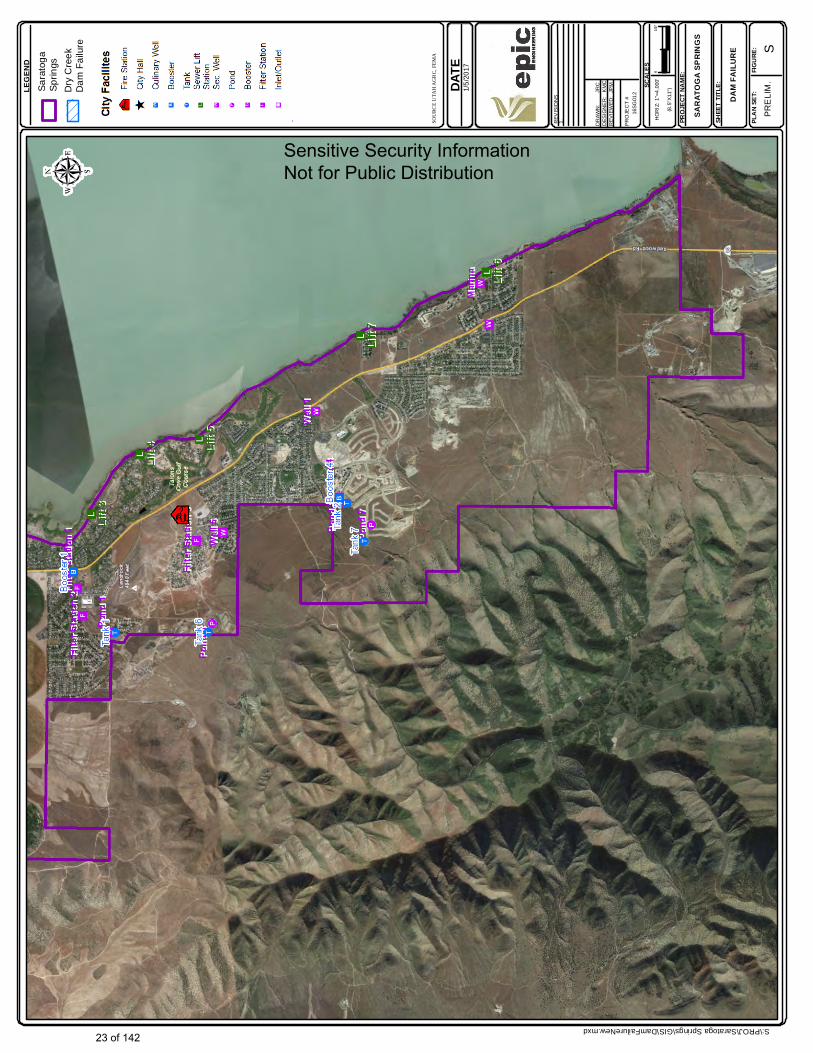
Figure 3.6
John
Typewritten Text

DATE ep
icE
NG
INE
ER
ING
REV
ISIO
NS
1. DR
AWN
:
JR
CD
ESIG
NE
R:
KM
CR
EVIE
WED
: JP
M
HO
RIZ
: 1"=
4,00
0'
(8.5
"X11
")
PRO
JEC
T #
16SG
012
SCAL
ES
PROJ
ECT N
AME:
SHEE
T TITL
E:
PLAN
SET:
FIGUR
E:
SARA
TOGA
SPR
INGS
PR
ELI
M.
01/2
"
LEGE
ND
SOUR
CE U
TAH A
GRC,
SARA
TOGA
SP
RING
S, FE
MA, V
IE EN
GINE
ERIN
G
DEBR
I FLO
WS
S:\PROJ\Saratoga Springs\GIS\DebriFlow1.mxd
1/5/
2017
Sara
toga
Sprin
gs
N
His
toric
Deb
ri Fl
owPo
tent
ial
Deb
ri Fl
ow
Sensitive Security Information Not for Public Distribution
24 of 142
John
Typewritten Text
Figure 3.7
John
Typewritten Text
DATE ep
icE
NG
INE
ER
ING
REV
ISIO
NS
1. DR
AWN
:
JR
CD
ESIG
NE
R:
KM
CR
EVIE
WED
: JP
M
HO
RIZ
: 1"=
4,00
0'
(8.5
"X11
")
PRO
JEC
T #
16SG
012
SCAL
ES
PROJ
ECT N
AME:
SHEE
T TITL
E:
PLAN
SET:
FIGUR
E:
SARA
TOGA
SPR
INGS
PR
ELI
M.
01/2
"
LEGE
ND
SOUR
CE U
TAH A
GRC,
SARA
TOGA
SP
RING
S, FE
MA, V
IE EN
GINE
ERIN
G
DEBR
I FLO
WS
S:\PROJ\Saratoga Springs\GIS\DebriFlow1.mxd
1/5/
2017
Sara
toga
Sprin
gs
S
His
toric
Deb
ri Fl
owPo
tent
ial
Deb
ri Fl
ow
Sensitive Security Information Not for Public Distribution
25 of 142
John
Typewritten Text
Figure 3.8
John
Typewritten Text
SOURCE UTAH AGRC, CITY OF SARATOGA SPRINGS,UTAH GEOLGICAL SURVEY
S:\PROJ\Saratoga Springs\GIS\DebriFlow02_23.mxd
DATE2/28/2017
LEGEND
epicEN GIN EERING
REVISIONS
DRAWN: JRCDESIGNER: JRCREVIEWED: KRT
HORIZ: 1"=6,000'(8.5"X11")
PROJECT # 16SG012
SCALES
PROJECT NAME:
SHEET TITLE:
PLAN SET:
SARATOGA SPRINGS
PRELIM.
POTENTIAL DEBRI FLOW
FIGURE:---
SaratogaSprings
SARATOGA SPRINGS
Drainage Basins
Historic Debri FlowPotential Debri Flow
Potentially ActiveAlluvium
Moderate Risk BasinHigh Risk Basin
HIGH RISK BASINS IDENTIFIEDBY SIMPLE ANALYSIS OF SLOPE,
GEOLOGIC UNIT, AREA AND THREAT TO DEVELOPMENT.
POTENTIAL DEBRI FLOWFROM STUDY BY VIE
ENGINEERING.
Sensitive Security Information Not for Public Distribution
26 of 142
John
Typewritten Text
Figure 3.9
John
Typewritten Text
DATE ep
icE
NG
INE
ER
ING
REV
ISIO
NS
1. DR
AWN
:
JR
CD
ESIG
NE
R:
KM
CR
EVIE
WED
: JP
M
HO
RIZ
: 1"=
4,00
0'
(8.5
"X11
")
PRO
JEC
T #
16SG
012
SCAL
ES
PROJ
ECT N
AME:
SHEE
T TITL
E:
PLAN
SET:
FIGUR
E:
SARA
TOGA
SPR
INGS
PR
ELI
M.
01/2
"
LEGE
ND
SOUR
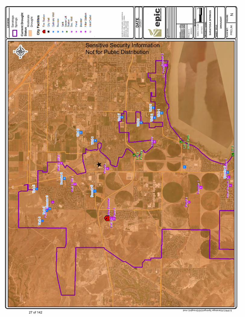
CE U
TAH A
GRC,
SARA
TOGA
SP
RING
S, UN
L, NO
AA, U
SDA,
NATI
ONAL
DRO
UGHT
MI
TIGA
TION
CENT
ER
DROU
GHT
S:\PROJ\Saratoga Springs\GIS\Drought1.mxd
1/5/
2017
Sara
toga
Sprin
gs
N
Mod
erat
e D
roug
ht
Curre
nt Dr
ough
tSt
atus
Sensitive Security Information Not for Public Distribution
27 of 142
John
Typewritten Text
Figure 3.10
John
Typewritten Text
DATE ep
icE
NG
INE
ER
ING
REV
ISIO
NS
1. DR
AWN
:
JR
CD
ESIG
NE
R:
KM
CR
EVIE
WED
: JP
M
HO
RIZ
: 1"=
4,00
0'
(8.5
"X11
")
PRO
JEC
T #
16SG
012
SCAL
ES
PROJ
ECT N
AME:
SHEE
T TITL
E:
PLAN
SET:
FIGUR
E:
SARA
TOGA
SPR
INGS
PR
ELI
M.
01/2
"
LEGE
ND
SOUR
CE U
TAH A
GRC,
SARA
TOGA
SP
RING
S, UN
L, NO
AA, U
SDA,
NATI
ONAL
DRO
UGHT
MI
TIGA
TION
CENT
ER
DROU
GHT
S:\PROJ\Saratoga Springs\GIS\Drought1.mxd
1/5/
2017
Sara
toga
Sprin
gs
S
Mod
erat
e D
roug
ht
Curre
nt Dr
ough
tSt
atus
Sensitive Security Information Not for Public Distribution
28 of 142
John
Typewritten Text
Figure 3.11
John
Typewritten Text
John
Typewritten Text
DATE ep
icE
NG
INE
ER
ING
REV
ISIO
NS
1. DR
AWN
:
JR
CD
ESIG
NE
R:
KM
CR
EVIE
WED
: JP
M
HO
RIZ
: 1"=
4,00
0'
(8.5
"X11
")
PRO
JEC
T #
16SG
012
SCAL
ES
PROJ
ECT N
AME:
SHEE
T TITL
E:
PLAN
SET:
FIGUR
E:
SARA
TOGA
SPR
INGS
PR
ELI
M.
01/2
"
LEGE
ND
SOUR
CE U
TAH A
GRC,
SARA
TOGA
SP
RING
S, UT
AH G
EOLO
GICA
LSU
RVEY
ENGI
NEER
ING
HAZA
RDS
S:\PROJ\Saratoga Springs\GIS\EngineeringHazards1.mxd
1/5/
2017
Sara
toga
Sprin
gs
N
Lim
esto
ne(K
arst
)
Sensitive Security Information Not for Public Distribution
29 of 142
John
Typewritten Text
Figure 3.12
John
Typewritten Text
DATE ep
icE
NG
INE
ER
ING
REV
ISIO
NS
1. DR
AWN
:
JR
CD
ESIG
NE
R:
KM
CR
EVIE
WED
: JP
M
HO
RIZ
: 1"=
4,00
0'
(8.5
"X11
")
PRO
JEC
T #
16SG
012
SCAL
ES
PROJ
ECT N
AME:
SHEE
T TITL
E:
PLAN
SET:
FIGUR
E:
SARA
TOGA
SPR
INGS
PR
ELI
M.
01/2
"
LEGE
ND
SOUR
CE U
TAH A
GRC,
SARA
TOGA
SP
RING
S, UT
AH G
EOLO
GICA
LSU
RVEY
ENGI
NEER
ING
HAZA
RDS
S:\PROJ\Saratoga Springs\GIS\EngineeringHazards1.mxd
1/5/
2017
Sara
toga
Sprin
gs
S
Lim
esto
ne(K
arst
)
Sensitive Security Information Not for Public Distribution
30 of 142
John
Typewritten Text
Figure 3.13
John
Typewritten Text
Utah
Lake
DATE ep
icEN
GIN
EER
ING
REV
ISIO
NS
1. DR
AWN
:
JR
CD
ESIG
NER
: K
MC
REV
IEW
ED:
JPM
HO
RIZ
: 1"=
4,00
0'
(8.5
"X11
")
PRO
JEC
T #
16SG
012
SCAL
ES
PROJ
ECT
NAME
:
SHEE
T TI
TLE:
PLAN
SET
:FIG
URE:
SARA
TOGA
SPR
INGS
PREL
IM.
01/2
"
LEGE
ND
SOUR
CE U
TAH
AGRC
, SAR
ATOG
A SP
RING
S, FE
MA,
MOU
NTAI
NLAN
DAO
G
FLOO
DING
S:\PROJ\Saratoga Springs\GIS\Flood1.mxd
3/15
/201
7
Sar
atog
aS
prin
gs
N
Flood
Zone
s
Uta
h La
ke
0.2
% A
nnua
l C
hanc
e
Zone
AE
-1%
Zone
AE
-1%
Floo
dway
Zone
AH
-1%
Zone
AO
-1%
Sensitive Security Information Not for Public Distribution
31 of 142
John
Typewritten Text
Figure 3.14
John
Typewritten Text
Utah
Lake
DATE ep
icEN
GIN
EER
ING
REV
ISIO
NS
1. DR
AWN
:
JR
CD
ESIG
NER
: K
MC
REV
IEW
ED:
JPM
HO
RIZ
: 1"=
4,00
0'
(8.5
"X11
")
PRO
JEC
T #
16SG
012
SCAL
ES
PROJ
ECT
NAME
:
SHEE
T TI
TLE:
PLAN
SET
:FIG
URE:
SARA
TOGA
SPR
INGS
PREL
IM.
01/2
"
LEGE
ND
SOUR
CE U
TAH
AGRC
, SAR
ATOG
A SP
RING
S, FE
MA,
MOU
NTAI
NLAN
DAO
G
FLOO
DING
S:\PROJ\Saratoga Springs\GIS\Flood1.mxd
3/15
/201
7
Sar
atog
aS
prin
gs
S
Flood
Zone
s
Uta
h La
ke
0.2
% A
nnua
l C
hanc
e
Zone
AE
-1%
Zone
AE
-1%
Floo
dway
Zone
AH
-1%
Zone
AO
-1%
Sensitive Security Information Not for Public Distribution
32 of 142
John
Typewritten Text
Figure 3.15
John
Typewritten Text
DATE ep
icE
NG
INE
ER
ING
REV
ISIO
NS
1. DR
AWN
:
JR
CD
ESIG
NE
R:
KM
CR
EVIE
WED
: JP
M
HO
RIZ
: 1"=
4,00
0'
(8.5
"X11
")
PRO
JEC
T #
16SG
012
SCAL
ES
PROJ
ECT N
AME:
SHEE
T TITL
E:
PLAN
SET:
FIGUR
E:
SARA
TOGA
SPR
INGS
PR
ELI
M.
01/2
"
LEGE
ND
SOUR
CE U
TAH A
GRC,
SARA
TOGA
SP
RING
S, UT
AH G
EOLO
GICA
LSU
RVEY
GEOL
OGY
S:\PROJ\Saratoga Springs\GIS\Geology1.mxd
1/5/
2017
Sara
toga
Sprin
gs
N
Uta
h La
keFa
ults
Sensitive Security Information Not for Public Distribution
33 of 142
John
Typewritten Text
Figure 3.16
John
Typewritten Text

DATE ep
icE
NG
INE
ER
ING
REV
ISIO
NS
1. DR
AWN
:
JR
CD
ESIG
NE
R:
KM
CR
EVIE
WED
: JP
M
HO
RIZ
: 1"=
4,00
0'
(8.5
"X11
")
PRO
JEC
T #
16SG
012
SCAL
ES
PROJ
ECT N
AME:
SHEE
T TITL
E:
PLAN
SET:
FIGUR
E:
SARA
TOGA
SPR
INGS
PR
ELI
M.
01/2
"
LEGE
ND
SOUR
CE U
TAH A
GRC,
SARA
TOGA
SP
RING
S, UT
AH G
EOLO
GICA
LSU
RVEY
GEOL
OGY
S:\PROJ\Saratoga Springs\GIS\Geology1.mxd
1/5/
2017
Sara
toga
Sprin
gs
S
Uta
h La
keFa
ults
Sensitive Security Information Not for Public Distribution
34 of 142
John
Typewritten Text
Figure 3.17
John
Typewritten Text
DATE ep
icE
NG
INE
ER
ING
REV
ISIO
NS
1. DR
AWN
:
JR
CD
ESIG
NE
R:
KM
CR
EVIE
WED
: JP
M
HO
RIZ
: 1"=
4,00
0'
(8.5
"X11
")
PRO
JEC
T #
16SG
012
SCAL
ES
PROJ
ECT N
AME:
SHEE
T TITL
E:
PLAN
SET:
FIGUR
E:
SARA
TOGA
SPR
INGS
PR
ELI
M.
01/2
"
LEGE
ND
SOUR
CE U
TAH A
GRC,
SARA
TOGA
SP
RING
S, UT
AH G
EOLO
GICA
LSU
RVEY
LAND
SLID
ES
S:\PROJ\Saratoga Springs\GIS\Landslides1.mxd
1/5/
2017
Sara
toga
Sprin
gs
N
His
toric
Land
slid
eLa
ndsl
ide
Scar
psLa
ndsli
de R
isk*
*No
colo
r ind
icat
es
very
low
riskLow
Ris
k
Mod
erat
e R
isk
Sensitive Security Information Not for Public Distribution
35 of 142
John
Typewritten Text
Figure 3.18
John
Typewritten Text

DATE ep
icE
NG
INE
ER
ING
REV
ISIO
NS
1. DR
AWN
:
JR
CD
ESIG
NE
R:
KM
CR
EVIE
WED
: JP
M
HO
RIZ
: 1"=
4,00
0'
(8.5
"X11
")
PRO
JEC
T #
16SG
012
SCAL
ES
PROJ
ECT N
AME:
SHEE
T TITL
E:
PLAN
SET:
FIGUR
E:
SARA
TOGA
SPR
INGS
PR
ELI
M.
01/2
"
LEGE
ND
SOUR
CE U
TAH A
GRC,
SARA
TOGA
SP
RING
S, UT
AH G
EOLO
GICA
LSU
RVEY
LAND
SLID
ES
S:\PROJ\Saratoga Springs\GIS\Landslides1.mxd
1/5/
2017
Sara
toga
Sprin
gs
S
His
toric
Land
slid
eLa
ndsl
ide
Scar
psLa
ndsli
de R
isk*
*No
colo
r ind
icat
es
very
low
riskLow
Ris
k
Mod
erat
e R
isk
Sensitive Security Information Not for Public Distribution
36 of 142
John
Typewritten Text
Figure 3.19
John
Typewritten Text
DATE ep
icE
NG
INE
ER
ING
REV
ISIO
NS
1. DR
AWN
:
JR
CD
ESIG
NE
R:
KM
CR
EVIE
WED
: JP
M
HO
RIZ
: 1"=
4,00
0'
(8.5
"X11
")
PRO
JEC
T #
16SG
012
SCAL
ES
PROJ
ECT N
AME:
SHEE
T TITL
E:
PLAN
SET:
FIGUR
E:
SARA
TOGA
SPR
INGS
PR
ELI
M.
01/2
"
LEGE
ND
SOUR
CE U
TAH A
GRC,
SARA
TOGA
SP
RING
S GIS,
UTA
H GE
OLOG
ICAL
SURV
EY
SECO
NDAR
Y SY
STEM
EART
HQUA
KES
S:\PROJ\Saratoga Springs\GIS\SecondaryEarthquake.mxd
1/5/
2017
N
Sara
toga
Sp
rings
US SE
ISM
IC H
AZAR
D
2% IN
50 Y
EARS
PGA
HAZA
RD (%
g) 25 -
3031
- 35
36 -
4041
- 45
46 -
5051
- 55
Uta
h La
keFa
ults
Sensitive Security Information Not for Public Distribution
37 of 142
John
Typewritten Text
Figure 3.20
DATE ep
icE
NG
INE
ER
ING
REV
ISIO
NS
1. DR
AWN
:
JR
CD
ESIG
NE
R:
KM
CR
EVIE
WED
: JP
M
HO
RIZ
: 1"=
4,00
0'
(8.5
"X11
")
PRO
JEC
T #
16SG
012
SCAL
ES
PROJ
ECT N
AME:
SHEE
T TITL
E:
PLAN
SET:
FIGUR
E:
SARA
TOGA
SPR
INGS
PR
ELI
M.
01/2
"
LEGE
ND
SOUR
CE U
TAH A
GRC,
SARA
TOGA
SP
RING
S GIS,
UTA
H GE
OLOG
ICAL
SURV
EY
SECO
NDAR
Y SY
STEM
EART
HQUA
KES
S:\PROJ\Saratoga Springs\GIS\SecondaryEarthquake.mxd
1/5/
2017
S
Sara
toga
Sp
rings
US SE
ISM
IC H
AZAR
D
2% IN
50 Y
EARS
PGA
HAZA
RD (%
g) 25 -
3031
- 35
36 -
4041
- 45
46 -
5051
- 55
Uta
h La
keFa
ults
Sensitive Security Information Not for Public Distribution
38 of 142
John
Typewritten Text
John
Typewritten Text
John
Typewritten Text
Figure 3.21
DATE ep
icE
NG
INE
ER
ING
REV
ISIO
NS
1. DR
AWN
:
JR
CD
ESIG
NE
R:
KM
CR
EVIE
WED
: JP
M
HO
RIZ
: 1"=
4,00
0'
(8.5
"X11
")
PRO
JEC
T #
16SG
012
SCAL
ES
PROJ
ECT N
AME:
SHEE
T TITL
E:
PLAN
SET:
FIGUR
E:
SARA
TOGA
SPR
INGS
PR
ELI
M.
01/2
"
LEGE
ND
SOUR
CE U
TAH A
GRC,
SARA
TOGA
SP
RING
S GIS,
UTA
H GE
OLOG
ICAL
SURV
EY CULIN
ARY
SYST
EMEA
RTHQ
UAKE
S
S:\PROJ\Saratoga Springs\GIS\SewerEarthquake.mxd
1/5/
2017
N
Sara
toga
Sp
rings
US SE
ISM
IC H
AZAR
D
2% IN
50 Y
EARS
PGA
HAZA
RD (%
g) 25 -
3031
- 35
36 -
4041
- 45
46 -
5051
- 55
Uta
h La
keFa
ults
Sensitive Security Information Not for Public Distribution
39 of 142
John
Typewritten Text
Figure 3.22
John
Typewritten Text
DATE ep
icE
NG
INE
ER
ING
REV
ISIO
NS
1. DR
AWN
:
JR
CD
ESIG
NE
R:
KM
CR
EVIE
WED
: JP
M
HO
RIZ
: 1"=
4,00
0'
(8.5
"X11
")
PRO
JEC
T #
16SG
012
SCAL
ES
PROJ
ECT N
AME:
SHEE
T TITL
E:
PLAN
SET:
FIGUR
E:
SARA
TOGA
SPR
INGS
PR
ELI
M.
01/2
"
LEGE
ND
SOUR
CE U
TAH A
GRC,
SARA
TOGA
SP
RING
S GIS,
UTA
H GE
OLOG
ICAL
SURV
EY CULIN
ARY
SYST
EMEA
RTHQ
UAKE
S
S:\PROJ\Saratoga Springs\GIS\SewerEarthquake.mxd
1/5/
2017
S
Sara
toga
Sp
rings
US SE
ISM
IC H
AZAR
D
2% IN
50 Y
EARS
PGA
HAZA
RD (%
g) 25 -
3031
- 35
36 -
4041
- 45
46 -
5051
- 55
Uta
h La
keFa
ults
Sensitive Security Information Not for Public Distribution
40 of 142
John
Typewritten Text
Figure 3.23
John
Typewritten Text
Lift 3
Lift 3
Lift 2
Lift 2
Pose
yPo
sey
Lift 1
Lift 1
Inlet
Park
Inlet
Park
DATE ep
icEN
GIN
EER
ING
REV
ISIO
NS
1. DR
AWN
:
JR
CD
ESIG
NER
: K
MC
REV
IEW
ED:
JPM
HO
RIZ
: 1"=
4,00
0'
(8.5
"X11
")
PRO
JEC
T #
16SG
012
SCAL
ES
PROJ
ECT
NAME
:
SHEE
T TI
TLE:
PLAN
SET
:FIG
URE:
SARA
TOGA
SPR
INGS
PREL
IM.
01/2
"
LEGE
ND
SOUR
CE U
TAH
AGRC
, SAR
ATOG
A SP
RING
S GIS
SEW
ER S
YSTE
MLIQ
UEFA
CTIO
N
S:\PROJ\Saratoga Springs\GIS\SewerLiquefaction02_24.mxd
2/24
/201
7
Lique
factio
nPo
tentia
l
N
Sara
toga
Sp
rings
Hig
hSensitive Security Information Not for Public Distribution
41 of 142
John
Typewritten Text
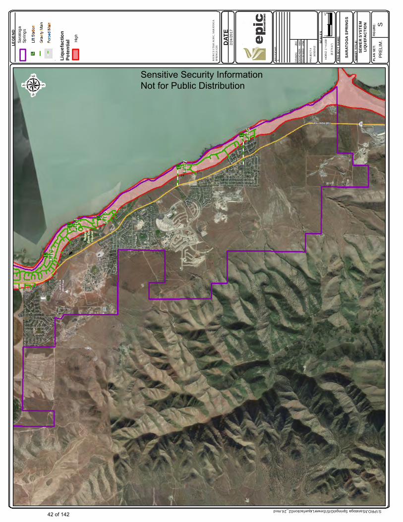
Figure 3.24
John
Typewritten Text
Lift 5
Lift 5
Lift 4
Lift 4
Lift 3
Lift 3
Lift 6
Lift 6
Lift 7
Lift 7
DATE ep
icEN
GIN
EER
ING
REV
ISIO
NS
1. DR
AWN
:
JR
CD
ESIG
NER
: K
MC
REV
IEW
ED:
JPM
HO
RIZ
: 1"=
4,00
0'
(8.5
"X11
")
PRO
JEC
T #
16SG
012
SCAL
ES
PROJ
ECT
NAME
:
SHEE
T TI
TLE:
PLAN
SET
:FIG
URE:
SARA
TOGA
SPR
INGS
PREL
IM.
01/2
"
LEGE
ND
SOUR
CE U
TAH
AGRC
, SAR
ATOG
A SP
RING
S GIS
SEW
ER S
YSTE
MLIQ
UEFA
CTIO
N
S:\PROJ\Saratoga Springs\GIS\SewerLiquefaction02_24.mxd
2/24
/201
7
Lique
factio
nPo
tentia
l
S
Sara
toga
Sp
rings
Hig
hSensitive Security Information Not for Public Distribution
42 of 142
John
Typewritten Text
Figure 3.25
John
Typewritten Text
DATE ep
icE
NG
INE
ER
ING
REV
ISIO
NS
1. DR
AWN
:
JR
CD
ESIG
NE
R:
KM
CR
EVIE
WED
: JP
M
HO
RIZ
: 1"=
4,00
0'
(8.5
"X11
")
PRO
JEC
T #
16SG
012
SCAL
ES
PROJ
ECT N
AME:
SHEE
T TITL
E:
PLAN
SET:
FIGUR
E:
SARA
TOGA
SPR
INGS
PR
ELI
M.
01/2
"
LEGE
ND
SOUR
CE U
TAH A
GRC,
SARA
TOGA
SP
RING
S, FF
SL
WILD
FIRE H
ISTOR
Y
S:\PROJ\Saratoga Springs\GIS\WildfireHistory1.mxd
1/5/
2017
Sara
toga
Sprin
gs
N
Burn
Are
as
Burn
Loc
atio
n
Sensitive Security Information Not for Public Distribution
43 of 142
John
Typewritten Text
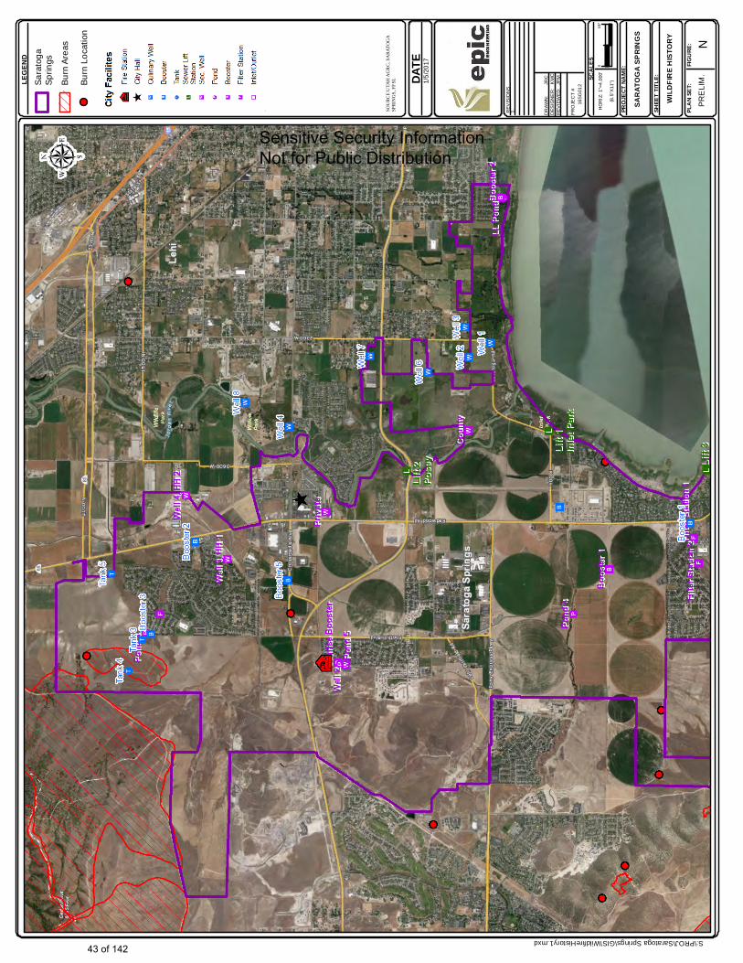
Figure 3.26
John
Typewritten Text
DATE ep
icE
NG
INE
ER
ING
REV
ISIO
NS
1. DR
AWN
:
JR
CD
ESIG
NE
R:
KM
CR
EVIE
WED
: JP
M
HO
RIZ
: 1"=
4,00
0'
(8.5
"X11
")
PRO
JEC
T #
16SG
012
SCAL
ES
PROJ
ECT N
AME:
SHEE
T TITL
E:
PLAN
SET:
FIGUR
E:
SARA
TOGA
SPR
INGS
PR
ELI
M.
01/2
"
LEGE
ND
SOUR
CE U
TAH A
GRC,
SARA
TOGA
SP
RING
S, FF
SL
WILD
FIRE H
ISTOR
Y
S:\PROJ\Saratoga Springs\GIS\WildfireHistory1.mxd
1/5/
2017
Sara
toga
Sprin
gs
S
Burn
Are
as
Burn
Loc
atio
n
Sensitive Security Information Not for Public Distribution
44 of 142
John
Typewritten Text
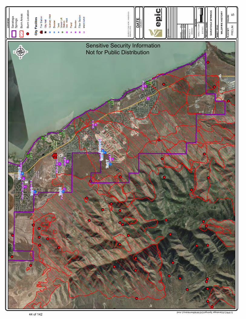
Figure 3.27
John
Typewritten Text
DATE ep
icEN
GIN
EER
ING
REV
ISIO
NS
1. DR
AWN
:
JR
CD
ESIG
NER
: K
MC
REV
IEW
ED:
JPM
HO
RIZ
: 1"=
4,00
0'
(8.5
"X11
")
PRO
JEC
T #
16SG
012
SCAL
ES
PROJ
ECT
NAME
:
SHEE
T TI
TLE:
PLAN
SET
:FIG
URE:
SARA
TOGA
SPR
INGS
PREL
IM.
01/2
"
LEGE
ND
SOUR
CE U
TAH
AGRC
, SAR
ATOG
A SP
RING
S, FF
SL, T
IMMO
NS G
ROUP
WILD
FIRE
RISK
S:\PROJ\Saratoga Springs\GIS\WildfireRisk1.mxd
2/23
/201
7
Sar
atog
aS
prin
gs
N
Fire
Hyd
rant
s
Bur
n Lo
catio
ns
Sensitive Security Information Not for Public Distribution
45 of 142
John
Typewritten Text
Figure 3.28
John
Typewritten Text
DATE ep
icEN
GIN
EER
ING
REV
ISIO
NS
1. DR
AWN
:
JR
CD
ESIG
NER
: K
MC
REV
IEW
ED:
JPM
HO
RIZ
: 1"=
4,00
0'
(8.5
"X11
")
PRO
JEC
T #
16SG
012
SCAL
ES
PROJ
ECT
NAME
:
SHEE
T TI
TLE:
PLAN
SET
:FIG
URE:
SARA
TOGA
SPR
INGS
PREL
IM.
01/2
"
LEGE
ND
SOUR
CE U
TAH
AGRC
, SAR
ATOG
A SP
RING
S, FF
SL, T
IMMO
NS G
ROUP
WILD
FIRE
RISK
S:\PROJ\Saratoga Springs\GIS\WildfireRisk1.mxd
2/23
/201
7
Sar
atog
aS
prin
gs
S
Fire
Hyd
rant
s
Bur
n Lo
catio
ns
Sensitive Security Information Not for Public Distribution
46 of 142
John
Typewritten Text
Figure 3.29
John
Typewritten Text

DATE ep
icEN
GIN
EE
RIN
G
REV
ISIO
NS
1. DR
AWN
:
JR
CD
ESIG
NE
R:
KM
CR
EVIE
WED
: JP
M
HO
RIZ
: 1"=
4,00
0'
(8.5
"X11
")
PRO
JEC
T #
16SG
012
SCAL
ES
PROJ
ECT N
AME:
SHEE
T TITL
E:
PLAN
SET:
FIGUR
E:
SARA
TOGA
SPRI
NGS
PREL
IM.
01/2
"
LEGE
ND
SOUR
CE UT
AH AG
RC, S
ARAT
OGA
SPRI
NGS,
FFSL
, TIM
MONS
GROU
P
WILD
FIRE R
ISK
S:\PROJ\Saratoga Springs\GIS\WildfireRisk1.mxd
2/24
/201
7
Sar
atog
aS
prin
gs
N
Fire
Hyd
rant
s
Bur
n Lo
catio
ns
Land
Own
ership
Poss
ible W
ildfir
e Th
reatFe
dera
l
Priv
ate
Stat
e
Extre
me
Very
Hig
h
Hig
h
Mod
erat
e H
igh
Mod
erat
e
Mod
erat
e Lo
w
Low
Very
Low
Very
Ver
y Lo
w
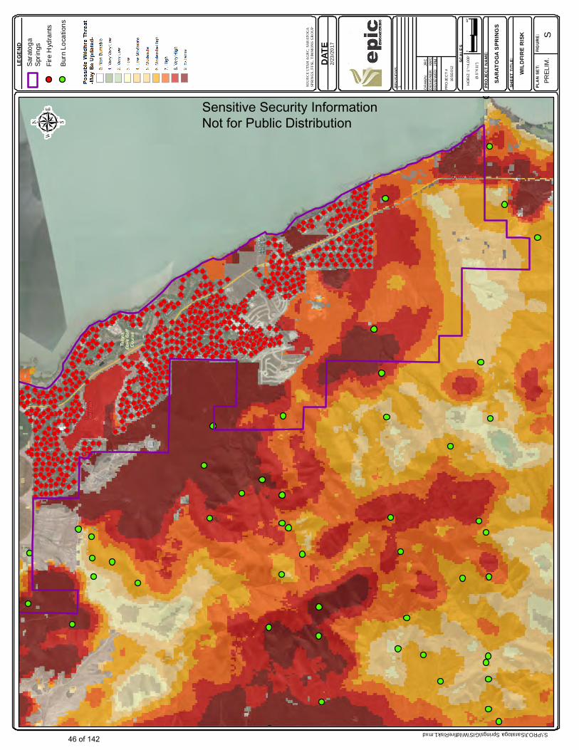
Sensitive Security Information Not for Public Distribution
47 of 142
John
Typewritten Text
Figure 3.30
John
Typewritten Text
DATE ep
icEN
GIN
EE
RIN
G
REV
ISIO
NS
1. DR
AWN
:
JR
CD
ESIG
NE
R:
KM
CR
EVIE
WED
: JP
M
HO
RIZ
: 1"=
4,00
0'
(8.5
"X11
")
PRO
JEC
T #
16SG
012
SCAL
ES
PROJ
ECT N
AME:
SHEE
T TITL
E:
PLAN
SET:
FIGUR
E:
SARA
TOGA
SPRI
NGS
PREL
IM.
01/2
"
LEGE
ND
SOUR
CE UT
AH AG
RC, S
ARAT
OGA
SPRI
NGS,
FFSL
, TIM
MONS
GROU
P
WILD
FIRE R
ISK
S:\PROJ\Saratoga Springs\GIS\WildfireRisk1.mxd
2/24
/201
7
Sar
atog
aS
prin
gs
S
Fire
Hyd
rant
s
Bur
n Lo
catio
ns
Land
Own
ership
Poss
ible W
ildfir
e Th
reatFe
dera
l
Priv
ate
Stat
e
Extre
me
Very
Hig
h
Hig
h
Mod
erat
e H
igh
Mod
erat
e
Mod
erat
e Lo
w
Low
Very
Low
Very
Ver
y Lo
w
Sensitive Security Information Not for Public Distribution
48 of 142
John
Typewritten Text
Figure 3.31
John
Typewritten Text
DATE ep
icE
NG
INE
ER
ING
REV
ISIO
NS
1. DR
AWN
:
JR
CD
ESIG
NE
R:
KM
CR
EVIE
WED
: JP
M
HO
RIZ
: 1"=
4,00
0'
(8.5
"X11
")
PRO
JEC
T #
16SG
012
SCAL
ES
PROJ
ECT N
AME:
SHEE
T TITL
E:
PLAN
SET:
FIGUR
E:
SARA
TOGA
SPR
INGS
PR
ELI
M.
01/2
"
LEGE
ND
SOUR
CE U
TAH A
GRC,
SARA
TOGA
SP
RING
S, UT
AH C
OUNT
Y
WILD
LAND
URB
AN
INTE
RFAC
E
S:\PROJ\Saratoga Springs\GIS\WildlandInterface1.mxd
1/5/
2017
Sara
toga
Sprin
gs
N
Cou
nty
Def
ined
Inte
rface
City
Def
ined
Inte
rface
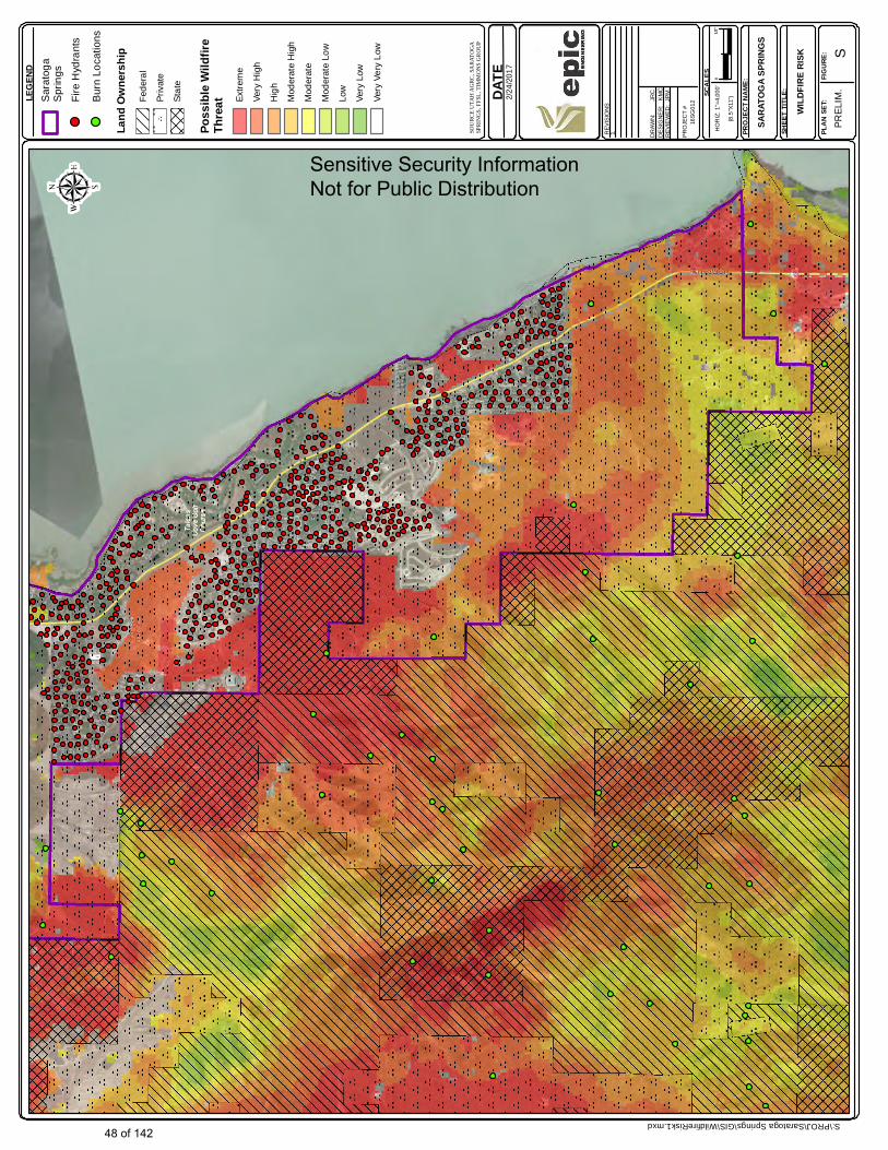
Sensitive Security Information Not for Public Distribution
49 of 142
John
Typewritten Text
Figure 3.32
DATE ep
icE
NG
INE
ER
ING
REV
ISIO
NS
1. DR
AWN
:
JR
CD
ESIG
NE
R:
KM
CR
EVIE
WED
: JP
M
HO
RIZ
: 1"=
4,00
0'
(8.5
"X11
")
PRO
JEC
T #
16SG
012
SCAL
ES
PROJ
ECT N
AME:
SHEE
T TITL
E:
PLAN
SET:
FIGUR
E:
SARA
TOGA
SPR
INGS
PR
ELI
M.
01/2
"
LEGE
ND
SOUR
CE U
TAH A
GRC,
SARA
TOGA
SP
RING
S, UT
AH C
OUNT
Y
WILD
LAND
URB
AN
INTE
RFAC
E
S:\PROJ\Saratoga Springs\GIS\WildlandInterface1.mxd
1/5/
2017
Sara
toga
Sprin
gs
S
Cou
nty
Def
ined
Inte
rface
City
Def
ined
Inte
rface
Sensitive Security Information Not for Public Distribution
50 of 142
John
Typewritten Text
Figure 3.33
John
Typewritten Text
4.0 MITIGATION PLAN 4.1 Mitigation Plan Summary The risk assessment for the City’s Multihazard Mitigation Plan has resulted in the identification of areas in the City’s facilities and the community served which are vulnerable to damage due to natural disasters. The City has prepared a mitigation plan to implement the highest benefit natural hazard mitigation projects. Potential mitigation projects are shown in Table 4.1.
4.2 Methodology for Development of Mitigation Plan
The City has developed potential mitigation actions for facilities which currently may not meet post disaster performance objectives. These performance objectives were determined on a hazard specific basis. Performance objectives were therefore based on life safety protection, continuity of facility use objectives, and input obtained from community outreach meetings. Strategies for hazard mitigation for each considered hazard type are provided in Sections 4.2.1 to 4.2.7.
4.2.1 Wildfire Hazard Mitigation
The City has taken a number of steps to mitigate wildfire hazards thus far. This includes adopting and implementing the State Urban Wildfire Plan. The City is considering plans to implement further wildfire hazard mitigation in the flowing ways: 1) Conduct fuel reduction projects on undeveloped lands adjacent to City boundaries, where such lands pose a wildfire hazard to the City. This will be done cooperatively with the BLM, DNR, and private land owners. 2) Construct fire breaks along or near certain boundaries of the City. This may be done in cooperation with trail development projects, 3) Reduce fuels on undeveloped lands that are in close proximity to City owned infrastructure, such as wells and pump stations. 4) Conduct public education programs, in cooperation with other agencies, such as BLM and DNR to promote fire safe practices on public lands.
4.2.2 Debris Flow Hazard Mitigation
Mitigation of debris flow hazards has been identified as a high priority based on risk assessments described in Section 3.0. One canyon (or drainage area) which recently caused significant damage in the City has been mitigated by installation of channel improvements and basins. The City plans to implement the following additional debris flow hazard mitigation measures: 1) Construct channel improvements and a debris flow basin(s) for the Loose Canyon Drainage; 2) Perform a detailed hazard assessment of other potential debris flow areas; 3) Implement other debris flow hazard mitigation projects, if warranted by 2); and 4) Consider further zoning restrictions as an alternative to 3), where practical.
4.2.3 Extreme Weather Hazard Mitigation
The City currently manages extreme weather as a component of its normal operations. In the case of transportation infrastructure: extreme snow storms, and to a lesser degree flooding have historically resulted in traffic delays. From an overall infrastructure perspective, one of the hazards posed by extreme weather has been loss of electrical power. To mitigate this concern, the City is considering purchasing and installing additional emergency generators. These generators would be serve critical facilities.
51 of 142
4.0 MITIGATION PLAN 4.2.4 Seismic Hazard Mitigation
As stated in the risk assessment portion of this plan, most of the City’s buildings are fairly new (less than 20 years old). Therefore, seismic shaking hazards are relatively low for existing buildings. A visual review of representative City owned buildings did however identify some nonstructural seismic risks that are being considered for mitigation.
Earthquake induced ground settlement and liquefaction may pose risks to facilities located in liquefiable zones. Liquefaction could lead to increase damage levels in buried piping and possibly damage (due to floatation) buried utility vaults. Mitigation for these conditions could include installation of gravel drains at buried vaults, use of flexible piping (such as HDPE piping). Other entities in the western US have also used SCADA upgrades (in some cases in conjunction with earthquake actuated shut off values) to manage water loss until piping repairs can be made after a seismic event. The City is considering the possible application of some of these technologies. 4.2.5 Drought Hazard Mitigation
The water for this system comes from three irrigation grade water wells, the Utah Lake Distributing Canal, and the Spring Creek Canal. The City has an active water conservation program, which includes:
The City has Secondary Water Metering and a Tiered Rate Structure. Coordination of Water Savings Projects Occurs with Local and Regional Water
Management Entities, including: - CUWCD - Local Canal Companies The City may consider submitting grants requests to the US Bureau of Reclamation for future conservation efforts.
4.2.6 Flood Hazard Mitigation
Flood hazards have been mapped by FEMA as a part of the Flood Insurance Risk Management (FIRM) program. This program effectively mitigates many flood hazards by restricting, or requiring flood insurance in mapped flood hazard areas. The MAG plan also provides additional local flood hazard data. One of the most effective hazard mitigation tools for management of flood hazards are the (already in place) zoning and development restrictions in flood hazard risk areas within the City.
However, some facilities by necessity are located in flood hazard areas. In the case of the City, these include certain water wells and many of the City’s sewer lift stations. These facilities are located in low lying areas for hydraulic and other technical reasons. Other facilities, such as transportation infrastructure may be located in low lying areas, or in higher elevation areas in the path of natural drainages. T he City will consider flood hazard mitigation activities for these facilities, which may include:
Installations of berms around low lying sewer lift stations or well pump houses. Construction of additional drainage culverts under transportation infrastructure. Debris flow management, as discussed under the Debris flow mitigation section of this
plan.
52 of 142
4.0 MITIGATION PLAN 4.3 Implementation of the Plan The City intends to implement this mitigation plan in the timeframe shown in Table 4.1. The City will update the plan as projects are implemented, and as long term capital improvement plans are developed by the City. The City will keep a current amended plan on file and submit this plan to FEMA, as required during preparation and submittal of future PDM or HMGP grant requests.
The primary responsible party for implementation actions shall be the City’s Fire Chief (currently Mr. Jess Campbell). This same individual will keep the City’s management personnel up to date regarding plan implementation progress.
The City will inform the State of Utah Division of Emergency Management of plan implementation status. This communication will be sent to the manager of this Division (currently Mr. Brad Bartholomew). 4.3.1 Coordination of Hazard Mitigation Projects With Other Capital Improvement Projects
Culinary Water Improvement Projects The culinary water improvement projects can be coordinated and incorporated into the multi-hazard mitigation plan in the following ways:
As new culinary water storage tanks, pump stations, and well houses are built, the designs may integrate further seismic, fire, and flood protection into the buildings and equipment.
As new sources are developed, more stringent source protection plans can be integrated to protect against specific hazards identified in the multi-hazard mitigation plan for the specific source locations.
As new transmission lines are designed and constructed (in high hazard areas) mitigation measures may be incorporated into the design. An example would be transmission lines that will be servicing areas (that have been identify as high risk for wildfire) could have additional fire protection and flow capacity, and fire hydrants placed more frequently than in low hazard areas.
Secondary Water Improvements The secondary water improvement projects can be coordinated and incorporated into the multi-hazard mitigation plan in the following ways:
System improvements near undeveloped areas of the town and near areas identified as high risk for wildfire can have fire protection uses designed into the system, such as the utilization of green strips and defensible space.
Open channel ditches can be sized for flood control in high hazard flood areas.
53 of 142
4.0 MITIGATION PLAN
Sewer System Improvements The sewer system improvement projects can be coordinated and incorporated into the multi-hazard mitigation plan in the following ways:
As lift stations, pump stations, and wastewater treatment plants are improved, additional seismic, fire, and flood protections may be integrated to help protect against unforeseen natural disasters.
As waste water systems are inspected and repairs are made in high risk areas, such as areas identified to have the potential for liquefaction, seismic protection factors may be incorporated as identified by the plan.
Storm Drain Improvements The storm drain improvement projects can be coordinated and incorporated into the multi-hazard mitigation plan in the following ways:
Culverts in areas that are identified as debris flow basins can be sized appropriately to pass debris without clogging, or have protections placed on them to prevent damage from debris flow.
Open channel storm drain channels can be sized to help channel flood flows in areas identified as high hazard for floods.
Transportation Improvement Projects The transportation improvement projects can be coordinated and incorporated into the multi-hazard mitigation plan in the following ways:
Culverts in areas that are identified as debris flow basins can be sized appropriately to pass debris without clogging, or have protections placed on them to prevent damage from debris flow.
Roads in areas identified as high hazard for wildfire can be designed and laid out as fire breaks.
4.3.2 Annual Evaluation of Plan Implementation Progress.
The City will conduct an annual evaluation of plan implementation progress. The update will consist of a memo stating actual plan progress as it compares to goals in Table 4.1. Updates will also be added if facilities listed in the current plan undergo changes, such as renovations, or additions.
4.3.3 Formal 5-Year Plan Updates
The City will prepare a formal plan update every five years for submittal to the State of Utah and FEMA. 4.3.4 Outreach Plan for Communication of Plan Progress to Stakeholders and the Public
Over the course of the timeframe given in Table 4.1, the City will continue outreach efforts in a manner consistent with those used in the development of this plan.
54 of 142

Table 4.1 page 1 here
55 of 142
John
Rectangle
John
Table 4.1 pg 1
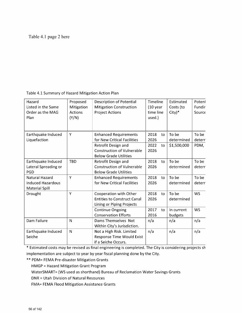
Table 4.1 page 2 here
56 of 142
John
Rectangle
John
Table 4.1 pg 2
4.0 MITIGATION PLAN
(Section 4.4 Added To Plan On August 30, 2017, No Other Changes Made.)
4.4 Inclusion of FEMA Plan Recommendations
The City participated in the current MAG plan and has formally adopted the MAG plan. As such,
the City intends to participate in hazard mitigation actions listed in the MAG plan as appropriate.
Further, the authorities, policies and programs listed in the MAG plan are in included in the
City’s plan also, by virtue of adoption of the MAG plan. The purpose of the City’s plan is to
provide more City specific information and hazard mitigation planning measures. At FEMA’s
request (based on FEMA Comments dated August 17, 2017), the following additional
information has been added to the draft plan dated March 31, 2017:
4.4.1 Documentation of each jurisdiction existing authorities, policies, programs and resources
and its ability to expand on and improve these existing policies and programs (Requirement
§201.6(c)(3)) Addresses FEMA Comment C1.
General: The City has adopted the existing authorities, policies, programs and resources in the
current MAG plan. The City’s Hazard Mitigation Plan therefore includes these provisions in its
plan by reference. Additional narrative specific to the City of Saratoga Springs, related to
authorizes, policies, programs and resources is provided in Sections 4.4.1.1, 4.4.1.2 and 4.4.1.3.
4.4.1.1 Existing Authorities and Capabilities
a) City Level Authorities and Responsibilities
As stated in the MAG Plan: “The Association of Governments (MAG in this case) has been duly
constituted under the authority of Title XI, Chapter13, Utah Code Annotated, 1953, as amended
(The Inter-local Cooperation Act) and pursuant to Section 3 of the Executive Order of the
Governor of the State of Utah, dated May 27, 1970, with the authority to conduct planning
studies and to provide services to its constituent jurisdictions. Utah Code, Title 17, Chapter 27 is
the County Land Use Development and Management Act that grants authority to counties. Utah
Code, Title 10 Chapter 9, grants authority to municipalities”.
The City has further defined responsibilities and authorities of each department within the City.
The City has existing full time professional management and technical staff. These personnel
are fully capable of managing the implementation of the hazard mitigation plan. These
responsibilities and authorizes are as follows: City Administrative and Management Personnel:
Includes a full time city manager and support staff. Fire & EMS: Includes a full time fire chief
and multiple full time personnel and substantial EMS equipment at multiple locations. The City’s
fire chief has primary responsibility for supervision of implementation of hazard reduction
projects described in the City’s hazard mitigation plan. Fire and EMS staff sizes vary, but will
John
Typewritten Text
56a
increase as/if necessary, as the population of the city continues to increase, and thus are not
specifically listed in this plan. Public Works: includes several full time professional engineers,
operations personnel, maintenance personnel and support staff. The City also has its own
equipment and supplies needed for ongoing maintenance and operation of city owned utilities.
Building Inspectors: includes inspectors across required disciplines. Engineering: includes a full
time chief engineer, several staff engineers and GIS personnel.
b) State Level Authorities and Capabilities
As listed in the MAG plan: “The State of Utah derives its authority under the Emergency
Management Act of 1981 (Utah Code 53-2, 63-5) as well as the Governor’s Emergency
Operations Directive and Executive Order of the Governor 11”. State level capabilities are listed
in the MAG plan. As such, these capabilities are not repeated in the City’s plan. The City’s
ability to take advantage of State capabilities will be augmented by virtue of implementing
mitigation actions identified in the City’s plan. The City worked with the State in developing
this plan, which lists City specific mitigation actions (rather than general mitigation actions). The
City will work with State level agencies listed in the MAG plan, as appropriate. These agencies
include: the Utah Division of Emergency Management (as related to pursuit of funding for
mitigation projects), the Utah Division of Forestry, Fire and State Lands (as related to fire hazard
risk reduction), the Division of Natural Resources (as related to fire and flood mitigation), the
Utah Geological Survey (as related to geological hazards assessments).
c) Federal Level Authorities and Capabilities
Federal level authorities and capabilities are listed in the MAG. As such, these capabilities are
not repeated in the City’s plan. The City’s ability to take advantage of Federal capabilities will
be augmented by virtue of implementing mitigation actions identified in the City’s plan. The
City has developed mitigation actions which meet the City’s mitigation goals, while also being
aligned with Federal assistance programs (including PDM and HMGP, FP&S, and others listed
in the adopted MAG plan.) The City intends to cooperate with Federal agencies, including
FEMA, USCOE, BLM and others as needed. The City intends to pursue hazard mitigation grants
available by virtue of the Disaster Mitigation Act of 2000, which defines mitigation planning
requirements for state, local, and tribal governments.
4.4.1.2 Existing Policies (and potential improvements based on implementation of the hazard
mitigation plan)
The City’s policies, as related to hazard mitigation of buildings, currently require the use of
nationally accepted building codes (IBC-2015). Further, the City has adopted a formal flood
management policy, as described in Section 4.4.2. The city has adopted other standards for
construction of or review of public works projects, including those listed in the MAG plan as
appropriate.
John
Typewritten Text
56b

4.4.1.3 Existing Programs (and potential improvements based on implementation of the hazard
mitigation plan)
The City has ongoing programs to mitigate natural hazards. These programs include fire
management programs, storm water management plans, water and wastewater system
improvements, and enforcement of building codes. These and other programs are described in
detail on the City’s website and are available in on-line master plans, and are briefly
summarized in Section 4.3. The City intends to implement hazard mitigation actions, as
previously described in Sections 4.1 to 4.3.
4.4.1.4 Existing Resources (and potential improvements based on implementation of the hazard
mitigation plan)
The City currently has robust administrative, fire and EMS, public works, engineering, and code
enforcement capabilities. These personnel resources will be used to manage implementation the
City’s hazard mitigation plan. The City is likely to retain consultants and construction companies
to design and construct certain hazard mitigation projects. The process of implementing the plan
will increase awareness of natural hazard methods and procedures across all departments in the
City. The educational effects and experience gained through plan implementation will be
beneficial and City personnel as they design future projects and review future projects proposed
by developers and others.
The City will proactively utilize other resources available to assist the City in its hazard
mitigation objectives, as outlined in its plan. Local resources (in addition to City resources)
include: Utah County and other MAG Participant Communities (See MAG plan for more
specific information.) State level resources include: State DEM, DNR, and others as listed in the
MAG plan. Federal resources include: FEMA, USCOE, BLM, and others as listed in the MAG
plan.
4.4.2 Description of Saratoga Springs participation in the NFIP and continued compliance with
NFIP requirements (Requirement §201.6(c)(3)(ii)) Addresses FEMA Comment C2.
The City participates in the National Flood Insurance Program (NFIP). This allows us to stay
current with federal programs and technical assistance and helps obtain reduced insurance rates
for all residents who purchase flood insurance. The City has taken the following steps as a part of
adoption of the NFIP (taken directly from the City’s published publically available information):
“The City recently completed a storm drainage study of the entire geographic area of the City.
This study indicates areas more susceptible to flood damage and makes recommendations
concerning the correct locations of detention ponds, storm channels and culvert facilities. The
City will be installing these improvements over the next 10 years, as needed, to accommodate
growth in existing and future neighborhoods. The City has also had the practice of trying to raise
John
Typewritten Text
56c
awareness of issues like flooding so that you can take whatever steps you need to ensure
maximum protection.
The City has already made or required developers to make improvements to install storm drain
ponds, underground drain systems, and open storm channels leading to Utah Lake. The City also
has several regional park facilities planned of over twenty (20) acres in size that will collect
storm water during large storms. These facilities are all designed to divert and collect water away
from residential areas.
The City also requires Floodplain Development Permits (FDPs) any time that fill or structural
improvements are proposed in the regulatory floodplain. The regulatory floodplain is that area
shown on the approved FEMA Flood Insurance Rate Maps (FIRMs). These maps are available
on the City website (see quick links) or at FEMA’s Website. More complete and detailed
information on floodplain management regulations and procedures can be found in Section
18.02 of the City Code.”
4.4.3 Goals to reduce/avoid long-term vulnerabilities to the identified hazards (Requirement
§201.6(c)(3)(i)) Addresses FEMA Comment C3.
Mitigation of vulnerabilities in the long-term will be done in the following four ways:
a) Mitigation options for currently known hazards are listed in Table 4.1. Table 4.1 provides a
summary of currently identified hazard mitigation actions over the next ten years (2017 to 2026).
This is the same table as in the MAG plan (since the City provided this table to MAG).
b) Mitigation measures may be incorporated into capital improvement plans. Hazard mitigation
is achieved over the long term by incorporation of hazard mitigation into capital improvement
projects, as previously described in Section 4.3.
c) Mitigation measures will be accomplished by participating in other mitigation regional actions
in the MAG plan (not relisted here).
d) Mitigation measures will be accomplished by incorporating mitigation actions in the State of
Utah Plan, as described in Attachment E (not relisted here).
As recommended by FEMA (in comments dated August 17, 2017) future plan updates may
incorporate master planning updates and other updated plans, such as transportation corridor and
storm water plans. Future plan updates to the City’s Plan (done every five years) may also
incorporate future MAG and State of Utah Plan updates, as appropriate.
John
Typewritten Text
56d
John
Typewritten Text

Attachment A: Documentation of Outreach
57 of 142
A.1 Documentation of Outreach The City conducted four formal outreach efforts. These included:
• Meeting with a MAG representative on January 25, 2017 • Meeting with State of Utah and FEMA representatives on March 9, 2017 • Conducting a technical outreach meeting with multiple agencies on March 14, 2017
and • Conducting an outdoor general public outreach meeting on March 20, 2017
Records of these meetings are provided in this attachment. This attachment also includes the outreach presentation used at the March 14, 2017 meeting. The outcome of each meeting is summarized as well.
58 of 142
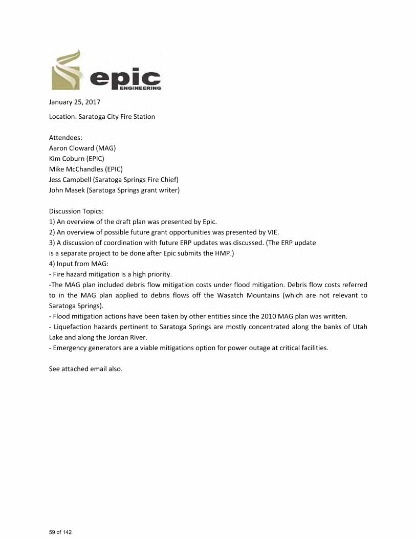
January 25, 2017
Location: Saratoga City Fire Station Attendees: Aaron Cloward (MAG) Kim Coburn (EPIC) Mike McChandles (EPIC) Jess Campbell (Saratoga Springs Fire Chief) John Masek (Saratoga Springs grant writer) Discussion Topics: 1) An overview of the draft plan was presented by Epic. 2) An overview of possible future grant opportunities was presented by VIE. 3) A discussion of coordination with future ERP updates was discussed. (The ERP update is a separate project to be done after Epic submits the HMP.) 4) Input from MAG: - Fire hazard mitigation is a high priority. -The MAG plan included debris flow mitigation costs under flood mitigation. Debris flow costs referred to in the MAG plan applied to debris flows off the Wasatch Mountains (which are not relevant to Saratoga Springs). - Flood mitigation actions have been taken by other entities since the 2010 MAG plan was written. - Liquefaction hazards pertinent to Saratoga Springs are mostly concentrated along the banks of Utah Lake and along the Jordan River. - Emergency generators are a viable mitigations option for power outage at critical facilities. See attached email also.
59 of 142
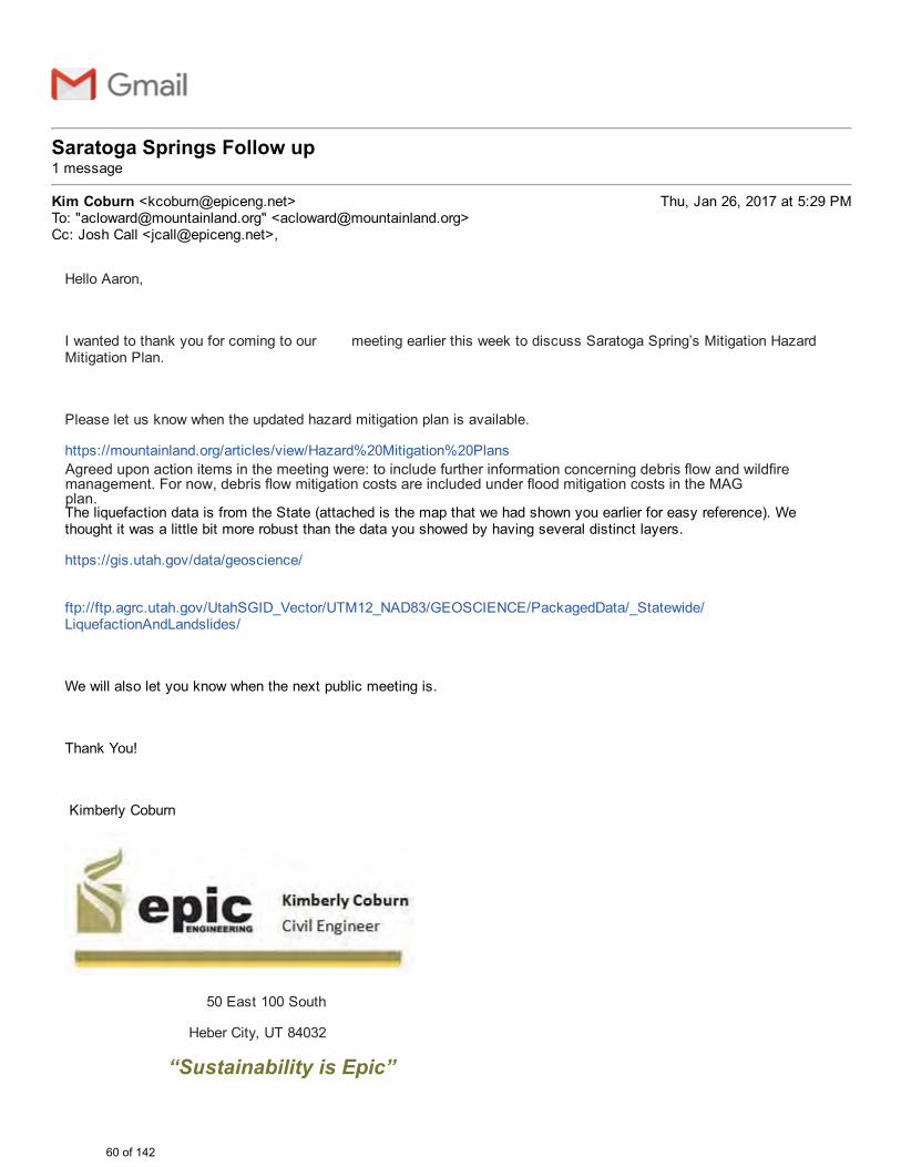
John Masek <[email protected]>
Saratoga Springs Follow up 1 message
Kim Coburn <[email protected]> Thu, Jan 26, 2017 at 5:29 PMTo: "[email protected]" <[email protected]>Cc: Josh Call <[email protected]>,
Hello Aaron,
I wanted to thank you for coming to our meeting earlier this week to discuss Saratoga Spring’s Mitigation HazardMitigation Plan.
Please let us know when the updated hazard mitigation plan is available.
https://mountainland.org/articles/view/Hazard%20Mitigation%20Plans
The liquefaction data is from the State (attached is the map that we had shown you earlier for easy reference). Wethought it was a little bit more robust than the data you showed by having several distinct layers.
https://gis.utah.gov/data/geoscience/
ftp://ftp.agrc.utah.gov/UtahSGID_Vector/UTM12_NAD83/GEOSCIENCE/PackagedData/_Statewide/LiquefactionAndLandslides/
We will also let you know when the next public meeting is.
Thank You!
Kimberly Coburn
50 East 100 South
Heber City, UT 84032
“Sustainability is Epic”
Agreed upon action items in the meeting were: to include further information concerning debris flow and wildfire management. For now, debris flow mitigation costs are included under flood mitigation costs in the MAG plan.
60 of 142
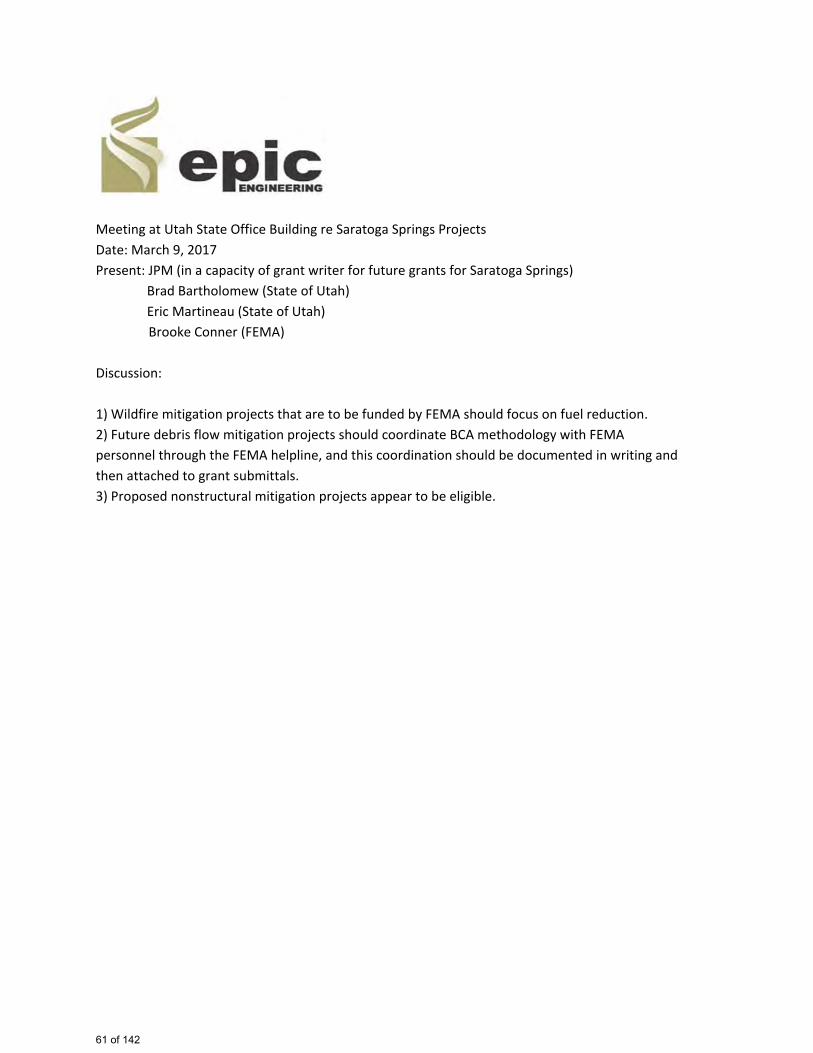
Meeting at Utah State Office Building re Saratoga Springs Projects Date: March 9, 2017 Present: JPM (in a capacity of grant writer for future grants for Saratoga Springs) Brad Bartholomew (State of Utah) Eric Martineau (State of Utah) Brooke Conner (FEMA) Discussion: 1) Wildfire mitigation projects that are to be funded by FEMA should focus on fuel reduction. 2) Future debris flow mitigation projects should coordinate BCA methodology with FEMA personnel through the FEMA helpline, and this coordination should be documented in writing and then attached to grant submittals. 3) Proposed nonstructural mitigation projects appear to be eligible.
61 of 142
March 14, 2017
Location: Saratoga City Fire Station Attendees: See attached attendance list. Discussion Topics: 1) An overview of the draft plan was presented by Epic Engineering. 2) An overview of possible future grant opportunities was presented by VIE. 3) A discussion of coordination with future ERP updates was discussed. (The ERP update Is a separate project to be done after Epic submits the HMP.) 4) Input from the presentation by attendees; -Water system improvements should focus on SCADA, rather than necessarily installation of shut off valves. - Fire hazard mitigation is a high priority. - Nonstructural seismic hazard mitigation is likely to be low cost and very effective. - Flood mitigation of low lying facilities merits consideration. - Attention was brought to future outside public forum meeting to occur on March 20. - A draft plan will be submitted by Epic by March 27. - The city council will consider the plan in its April meeting. - The MAG plan included debris flow mitigation costs for Saratoga Springs under flood mitigation. Debris flow costs referred to in the MAG plan applied to debris flows off the Wasatch Mountains. See attached presentation dated March 14, 2017
62 of 142
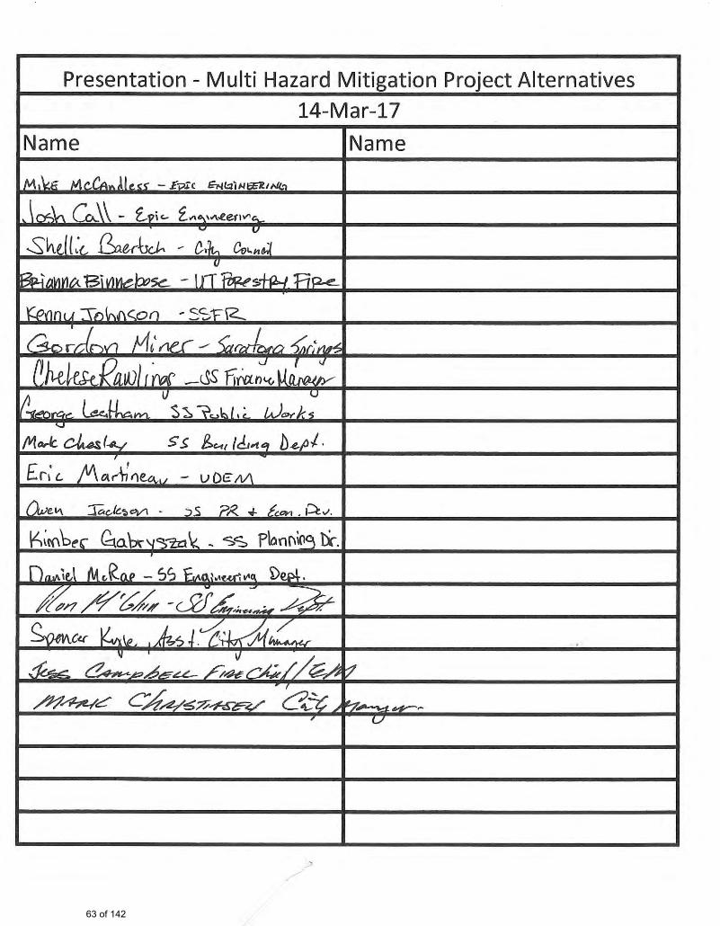
63 of 142
John
Typewritten Text
Power Point Presentation is Attached.
John
Typewritten Text
John
Typewritten Text
John
Typewritten Text
John
Typewritten Text
John
Typewritten Text
C
ity o
f Sar
atog
a S
prin
gs M
ultih
azar
d M
itiga
tion
Pla
n
Out
reac
h M
eetin
g
64 of 142
John
Typewritten Text
March 14, 2017 Presentation and Outreach Meeting
John
Typewritten Text
John
Typewritten Text
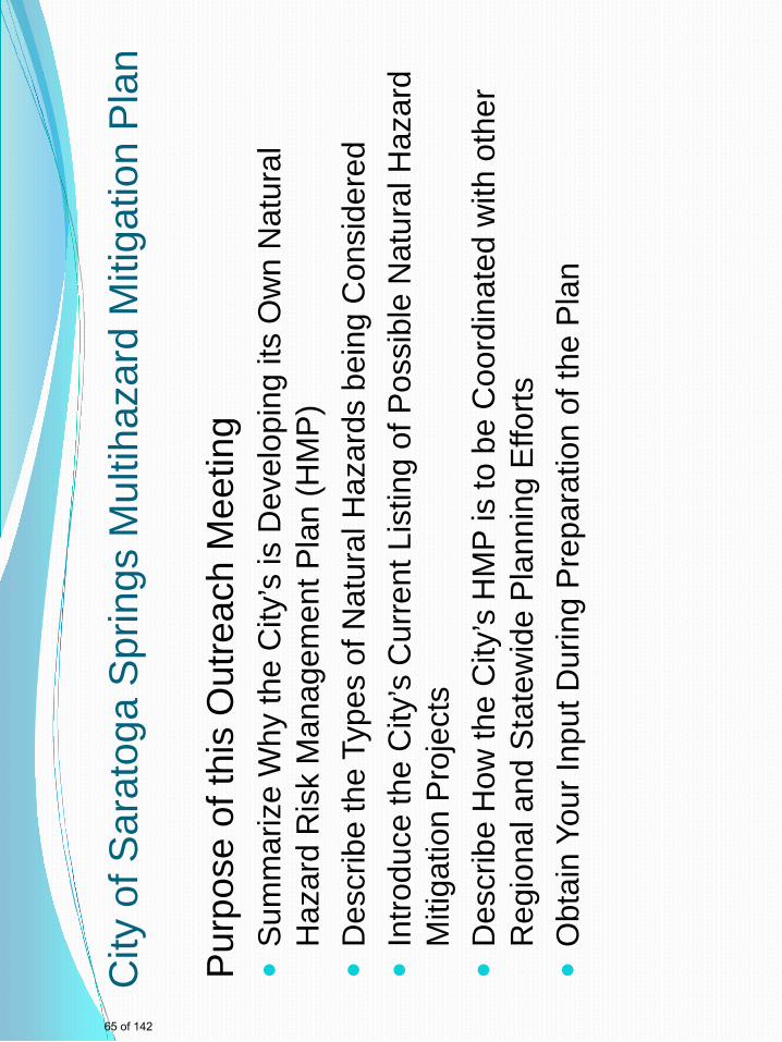
City
of S
arat
oga
Spr
ings
Mul
tihaz
ard
Miti
gatio
n P
lan
Pur
pose
of t
his
Out
reac
h M
eetin
g
Sum
mar
ize
Why
the
City
’s is
Dev
elop
ing
its O
wn
Nat
ural
H
azar
d R
isk
Man
agem
ent P
lan
(HM
P)
D
escr
ibe
the
Type
s of
Nat
ural
Haz
ards
bei
ng C
onsi
dere
d
Intro
duce
the
City
’s C
urre
nt L
istin
g of
Pos
sibl
e N
atur
al H
azar
d M
itiga
tion
Pro
ject
s
D
escr
ibe
How
the
City
’s H
MP
is to
be
Coo
rdin
ated
with
oth
er
Reg
iona
l and
Sta
tew
ide
Pla
nnin
g E
fforts
Obt
ain
Your
Inpu
t Dur
ing
Pre
para
tion
of th
e P
lan
65 of 142
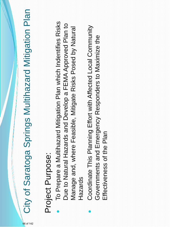
City
of S
arat
oga
Spr
ings
Mul
tihaz
ard
Miti
gatio
n P
lan
Pro
ject
Pur
pose
:
To P
repa
re a
Mul
tihaz
ard
Miti
gatio
n P
lan
whi
ch In
dent
ifies
Ris
ks
Due
to N
atur
al H
azar
ds a
nd D
evel
op a
FE
MA
App
rove
d P
lan
to
Man
age
and,
whe
re F
easi
ble,
Miti
gate
Ris
ks P
osed
by
Nat
ural
H
azar
ds
C
oord
inat
e Th
is P
lann
ing
Effo
rt w
ith A
ffect
ed L
ocal
Com
mun
ity
Gov
ernm
ents
and
Em
erge
ncy
Res
pond
ers
to M
axim
ize
the
Effe
ctiv
enes
s of
the
Pla
n
66 of 142
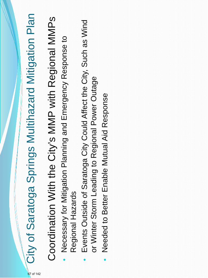
City
of S
arat
oga
Spr
ings
Mul
tihaz
ard
Miti
gatio
n P
lan
Coo
rdin
atio
n W
ith th
e C
ity’s
MM
P w
ith R
egio
nal M
MP
s •
Nec
essa
ry fo
r Miti
gatio
n P
lann
ing
and
Em
erge
ncy
Res
pons
e to
R
egio
nal H
azar
ds
•E
vent
s O
utsi
de o
f Sar
atog
a C
ity C
ould
Affe
ct th
e C
ity, S
uch
as W
ind
or W
inte
r Sto
rm L
eadi
ng to
Reg
iona
l Pow
er O
utag
e •
Nee
ded
to B
ette
r Ena
ble
Mut
ual A
id R
espo
nse
67 of 142
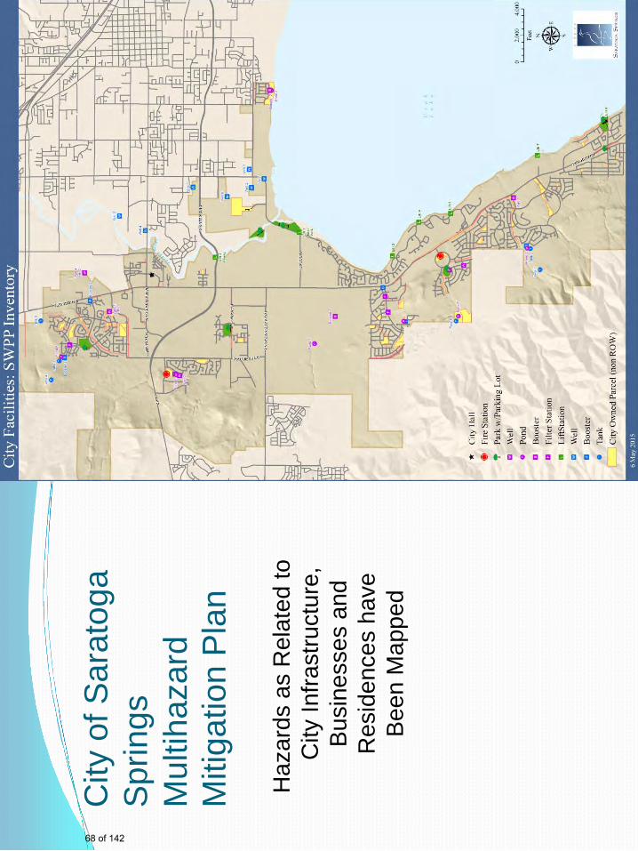
City
of S
arat
oga
Spr
ings
M
ultih
azar
d M
itiga
tion
Pla
n
Haz
ards
as
Rel
ated
to
City
Infra
stru
ctur
e,
Bus
ines
ses
and
Res
iden
ces
have
B
een
Map
ped
68 of 142
John
Typewritten Text
Sensitive Security Information, Not for Public Distribution
John
Typewritten Text
John
Typewritten Text
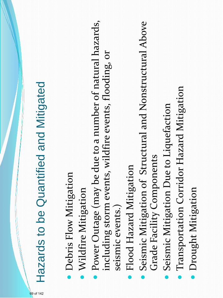
Haz
ards
to b
e Q
uant
ified
and
Miti
gate
d
D
ebri
s Flo
w M
itiga
tion
W
ildfir
e M
itiga
tion
Po
wer
Out
age
(may
be
due
to a
num
ber o
f nat
ural
haz
ards
, in
clud
ing
stor
m e
vent
s, w
ildfir
e ev
ents
, flo
odin
g, o
r se
ism
ic e
vent
s.)
Fl
ood
Haz
ard
Miti
gatio
n
Seis
mic
Miti
gatio
n of
Str
uctu
ral a
nd N
onst
ruct
ural
Abo
ve
Gra
de F
acili
ty C
ompo
nent
s
Seis
mic
Miti
gatio
n D
ue to
Liq
uefa
ctio
n
Tran
spor
tatio
n C
orri
dor H
azar
d M
itiga
tion
D
roug
ht M
itiga
tion
69 of 142
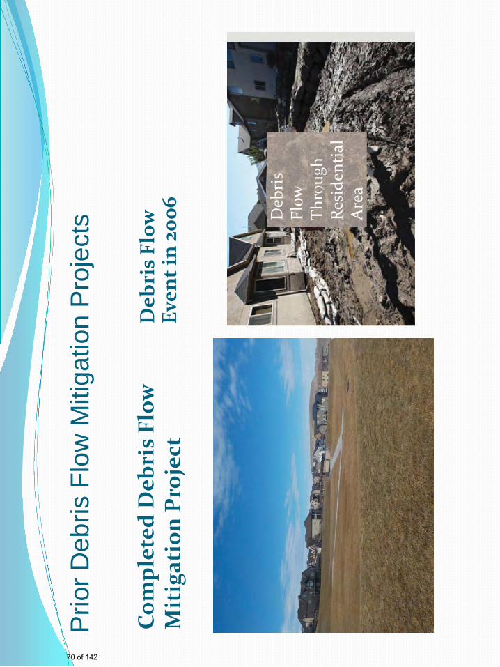
Prio
r Deb
ris F
low
Miti
gatio
n P
roje
cts
Com
plet
ed D
ebri
s Fl
ow
Mit
igat
ion
Pro
ject
D
ebri
s Fl
ow
Even
t in
2006
Deb
ris
Flow
Th
roug
h Re
side
ntia
l A
rea
70 of 142
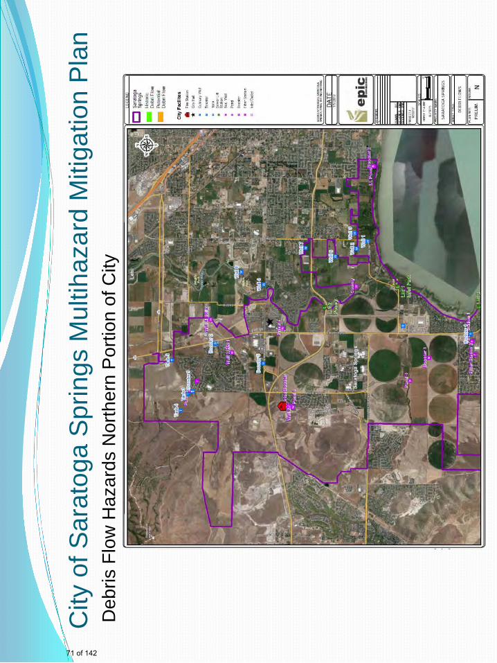
City
of S
arat
oga
Spr
ings
Mul
tihaz
ard
Miti
gatio
n P
lan
Deb
ris F
low
Haz
ards
Nor
ther
n P
ortio
n of
City
71 of 142
John
Typewritten Text
Sensitive Security Information, Not for Public Distribution

City
of S
arat
oga
Spr
ings
Mul
tihaz
ard
Miti
gatio
n P
lan
Deb
ris F
low
Sou
ther
n P
ortio
n of
City
Futu
re N
ear
Term
M
itig
atio
n
Proj
ect A
rea
72 of 142
John
Typewritten Text
John
Typewritten Text
Sensitive Security Information, Not for Public Distribution
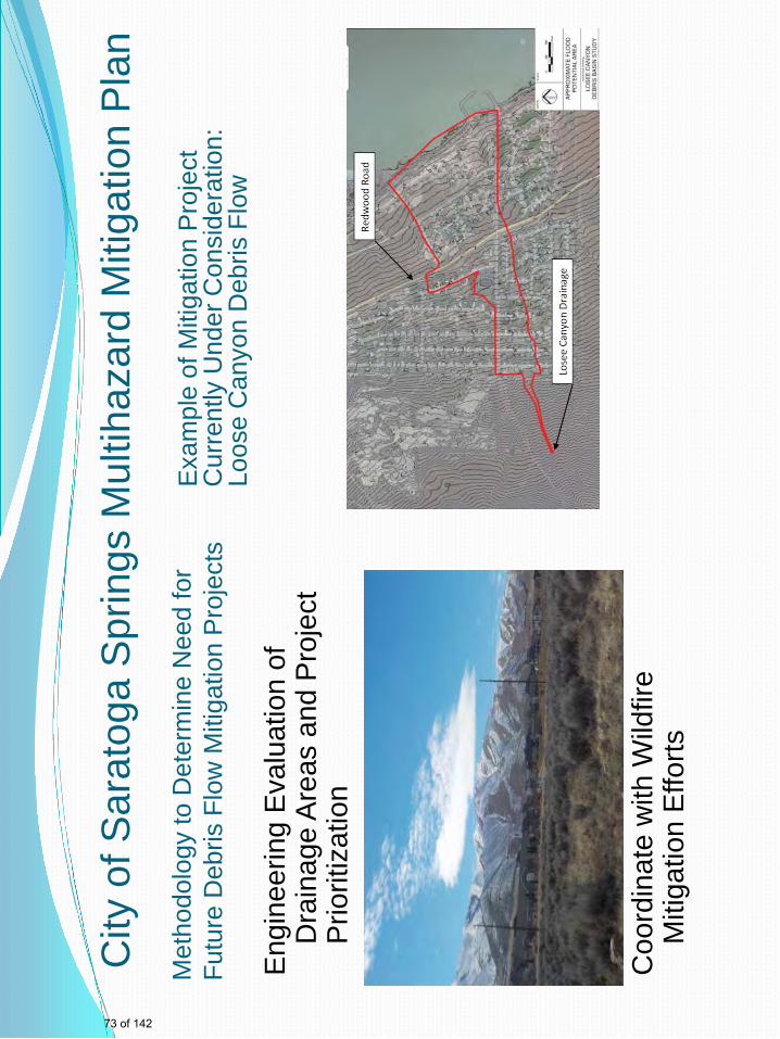
City
of S
arat
oga
Spr
ings
Mul
tihaz
ard
Miti
gatio
n P
lan
Met
hodo
logy
to D
eter
min
e N
eed
for
Futu
re D
ebris
Flo
w M
itiga
tion
Pro
ject
s
Exa
mpl
e of
Miti
gatio
n P
roje
ct
Cur
rent
ly U
nder
Con
side
ratio
n:
Loos
e C
anyo
n D
ebris
Flo
w
E
ngin
eerin
g E
valu
atio
n of
D
rain
age
Are
as a
nd P
roje
ct
Prio
ritiz
atio
n C
oord
inat
e w
ith W
ildfir
e M
itiga
tion
Effo
rts
73 of 142
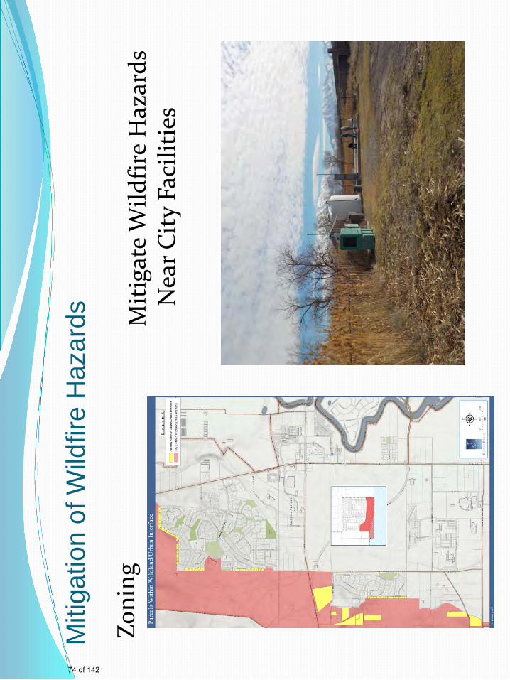
Miti
gatio
n of
Wild
fire
Haz
ards
Zoni
ng
M
itig
ate
Wild
fire
Haz
ards
N
ear C
ity
Faci
litie
s
74 of 142
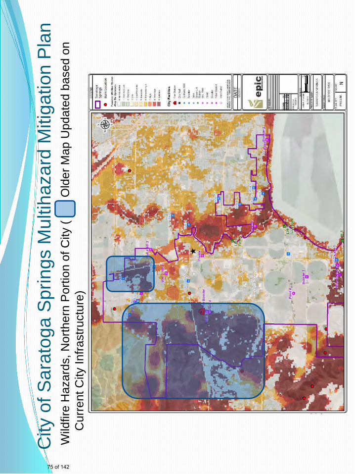
City
of S
arat
oga
Spr
ings
Mul
tihaz
ard
Miti
gatio
n P
lan
Wild
fire
Haz
ards
, Nor
ther
n P
ortio
n of
City
(
O
lder
Map
Upd
ated
bas
ed o
n C
urre
nt C
ity In
frast
ruct
ure)
75 of 142
John
Typewritten Text
Sensitive Security Information, Not for Public Distribution
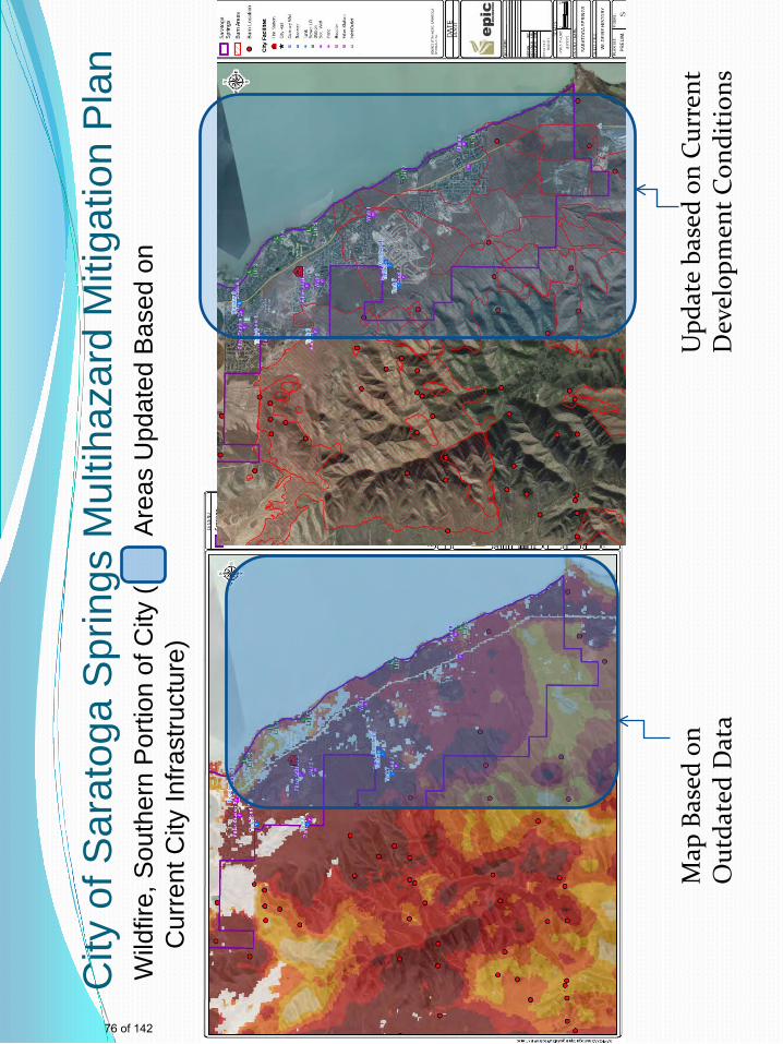
City
of S
arat
oga
Spr
ings
Mul
tihaz
ard
Miti
gatio
n P
lan
Wild
fire,
Sou
ther
n P
ortio
n of
City
(
A
reas
Upd
ated
Bas
ed o
n C
urre
nt C
ity In
frast
ruct
ure)
Map
Bas
ed o
n O
utda
ted
Dat
a
Upd
ate
base
d on
Cur
rent
D
evel
opm
ent C
ondi
tion
s
76 of 142
John
Typewritten Text
Sensitive Security Information, Not for Public Distribution
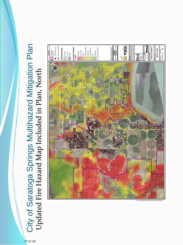
City
of S
arat
oga
Spr
ings
Mul
tihaz
ard
Miti
gatio
n P
lan
Upd
ated
Fir
e H
azar
d M
ap In
clud
ed in
Pla
n, N
orth
77 of 142
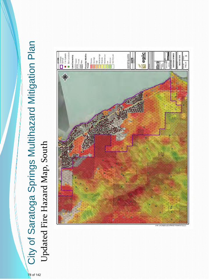
City
of S
arat
oga
Spr
ings
Mul
tihaz
ard
Miti
gatio
n P
lan
Upd
ated
Fir
e H
azar
d M
ap, S
outh
78 of 142
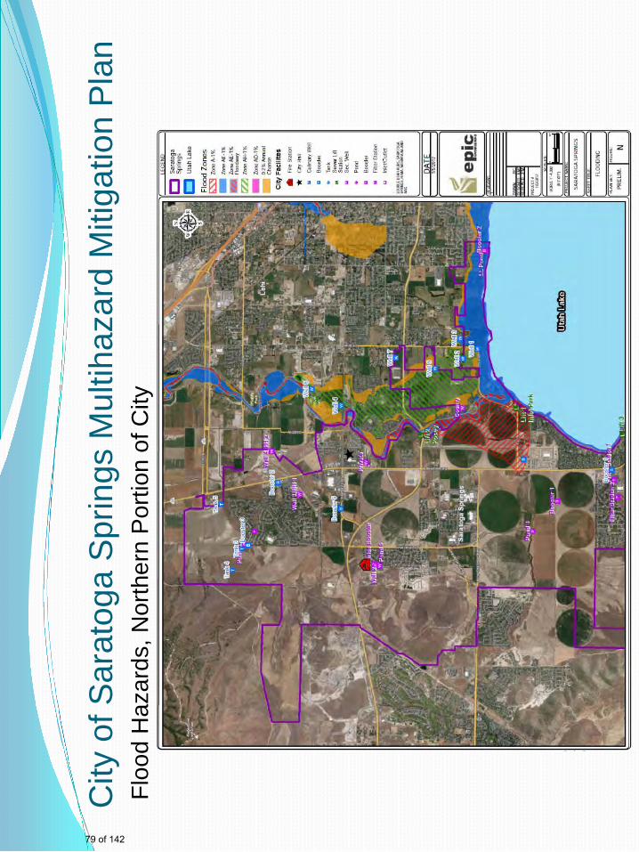
City
of S
arat
oga
Spr
ings
Mul
tihaz
ard
Miti
gatio
n P
lan
Floo
d H
azar
ds, N
orth
ern
Por
tion
of C
ity
79 of 142
John
Typewritten Text
Sensitive Security Information, Not for Public Distribution
John
Typewritten Text

City
of S
arat
oga
Spr
ings
Mul
tihaz
ard
Miti
gatio
n P
lan
Floo
d H
azar
ds, S
outh
ern
Por
tion
of C
ity
80 of 142
John
Typewritten Text
Sensitive Security Information, Not for Public Distribution
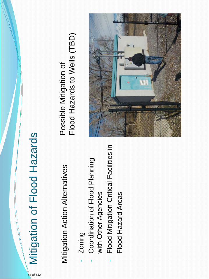
Miti
gatio
n of
Flo
od H
azar
ds
Miti
gatio
n A
ctio
n A
ltern
ativ
es
Pos
sibl
e M
itiga
tion
of
Floo
d H
azar
ds to
Wel
ls (T
BD
)
-Zo
ning
-
Coo
rdin
atio
n of
Flo
od P
lann
ing
with
Oth
er A
genc
ies
-Fl
ood
Miti
gatio
n C
ritic
al F
acili
ties
in
Fl
ood
Haz
ard
Are
as
81 of 142
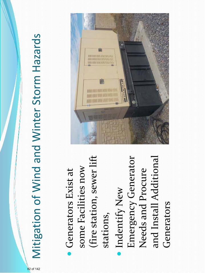
Miti
gatio
n of
Win
d an
d W
inte
r Sto
rm H
azar
ds
Gen
erat
ors
Exis
t at
som
e Fa
cilit
ies n
ow
(fir
e st
atio
n, se
wer
lift
st
atio
ns,
In
dent
ify N
ew
Emer
genc
y G
ener
ator
N
eeds
and
Pro
cure
an
d In
stal
l Add
itio
nal
Gen
erat
ors
82 of 142
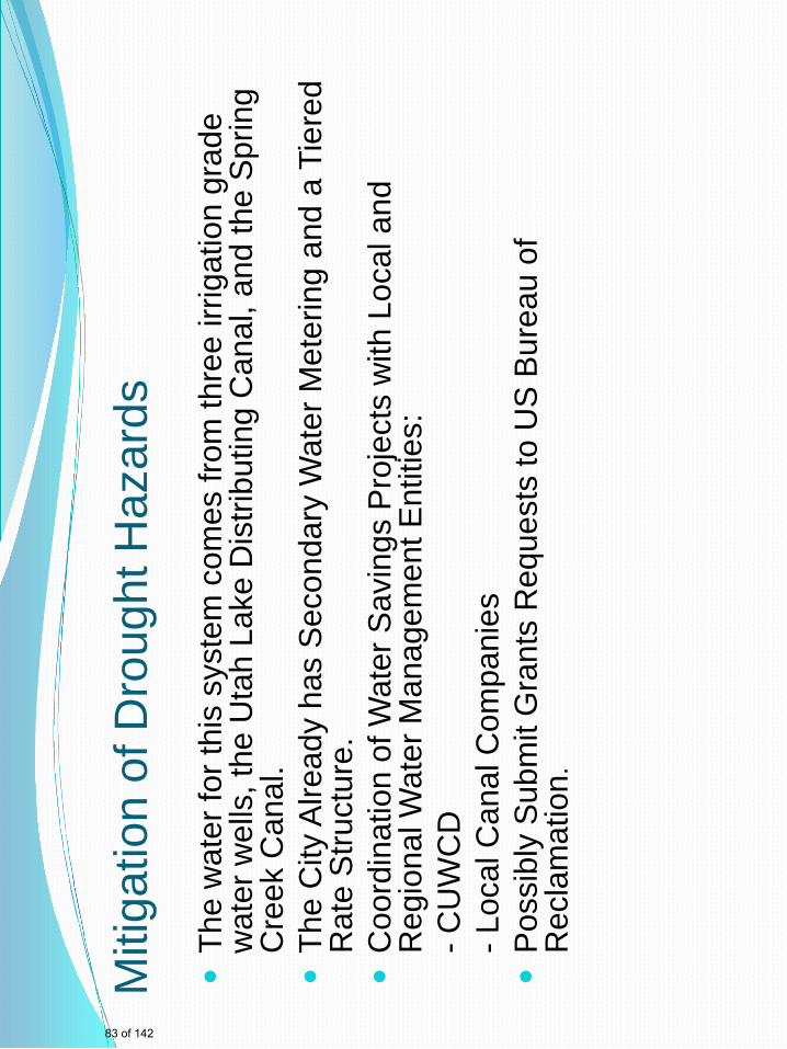
Miti
gatio
n of
Dro
ught
Haz
ards
The
wat
er fo
r thi
s sy
stem
com
es fr
om th
ree
irrig
atio
n gr
ade
wat
er w
ells
, the
Uta
h La
ke D
istri
butin
g C
anal
, and
the
Spr
ing
Cre
ek C
anal
.
The
City
Alre
ady
has
Sec
onda
ry W
ater
Met
erin
g an
d a
Tier
ed
Rat
e S
truct
ure.
Coo
rdin
atio
n of
Wat
er S
avin
gs P
roje
cts
with
Loc
al a
nd
Reg
iona
l Wat
er M
anag
emen
t Ent
ities
:
- CU
WC
D
- L
ocal
Can
al C
ompa
nies
Pos
sibl
y S
ubm
it G
rant
s R
eque
sts
to U
S B
urea
u of
R
ecla
mat
ion .
83 of 142
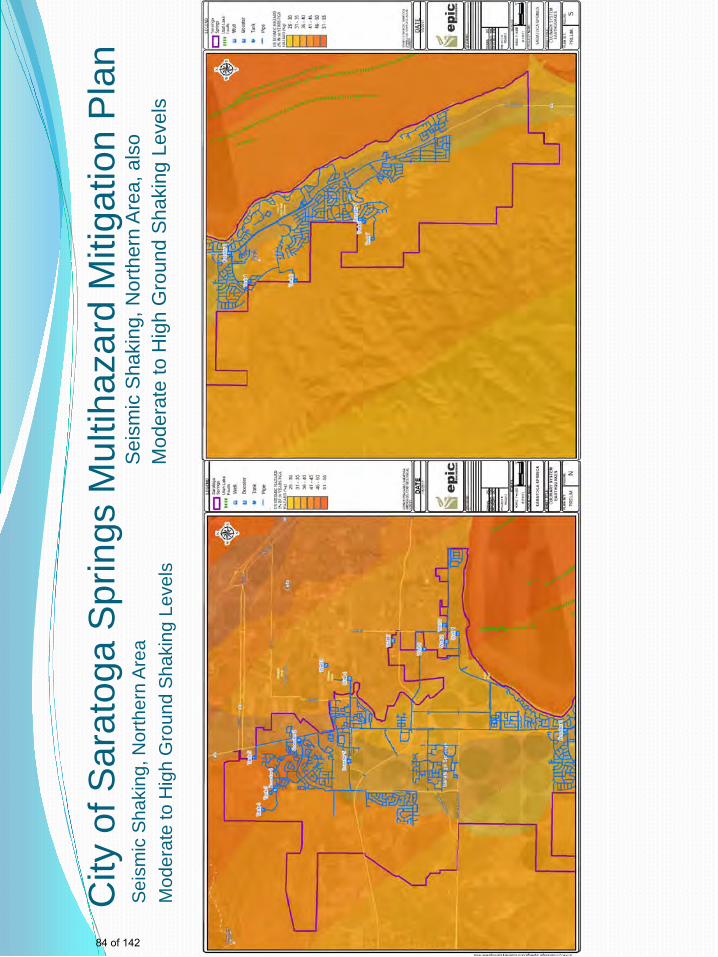
City
of S
arat
oga
Spr
ings
Mul
tihaz
ard
Miti
gatio
n P
lan
Seis
mic
Sha
king
, Nor
ther
n Ar
ea
Mod
erat
e to
Hig
h G
roun
d Sh
akin
g Le
vels
Sei
smic
Sha
king
, Nor
ther
n A
rea,
als
o M
oder
ate
to H
igh
Gro
und
Sha
king
Lev
els
84 of 142
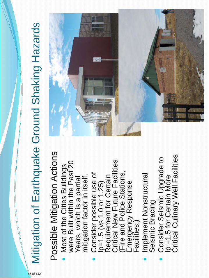
Miti
gatio
n of
Ear
thqu
ake
Gro
und
Sha
king
Haz
ards
P
ossi
ble
Miti
gatio
n A
ctio
ns
M
ost o
f the
Citi
es B
uild
ings
w
ere
Bui
lt w
ithin
the
Pas
t 20
Year
s, w
hich
is a
par
tial
miti
gatio
n fa
ctor
in it
self.
Con
side
r pos
sibl
e us
e of
Ip
=1.5
(vs
1.0
or 1
.25)
R
equi
rem
ent f
or C
erta
in
Crit
ical
New
Fut
ure
Faci
litie
s (F
ire a
nd P
olic
e S
tatio
ns,
Em
erge
ncy
Res
pons
e Fa
cilit
ies.
)
Impl
emen
t Non
stru
ctur
al
Sei
smic
Bra
cing
Con
side
r Sei
smic
Upg
rade
to
Ip =
1.5
for C
erta
in M
ore
Crit
ical
Cul
inar
y W
ell F
acilit
ies
85 of 142
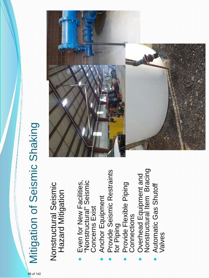
Miti
gatio
n of
Sei
smic
Sha
king
Non
stru
ctur
al S
eism
ic
Haz
ard
Miti
gatio
n
Eve
n fo
r New
Fac
ilitie
s,
“Non
stru
ctur
al” S
eism
ic
Con
cern
s E
xist
Anc
hor E
quip
men
t
Pro
vide
Sei
smic
Res
train
ts
for P
ipin
g
Pro
vide
Fle
xibl
e P
ipin
g C
onne
ctio
ns
O
verh
ead
Equ
ipm
ent a
nd
Non
stru
ctur
al It
em B
raci
ng
A
utom
atic
Gas
Shu
toff
Valv
es
86 of 142
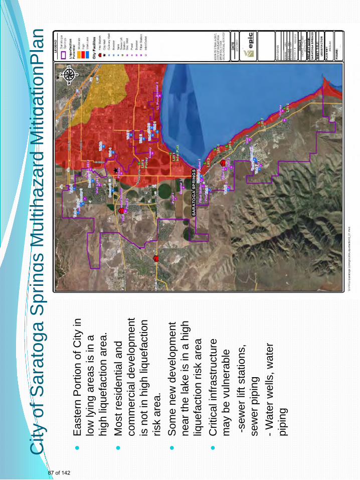
City
of S
arat
oga
Spr
ings
Mul
tihaz
ard
Miti
gatio
nPla
n
E
aste
rn P
ortio
n of
City
in
low
lyin
g ar
eas
is in
a
high
liqu
efac
tion
area
.
Mos
t res
iden
tial a
nd
com
mer
cial
dev
elop
men
t is
not
in h
igh
lique
fact
ion
risk
area
.
Som
e ne
w d
evel
opm
ent
near
the
lake
is in
a h
igh
lique
fact
ion
risk
area
Crit
ical
infra
stru
ctur
e m
ay b
e vu
lner
able
-s
ewer
lift
stat
ions
, se
wer
pip
ing
- W
ater
wel
ls, w
ater
pi
ping
87 of 142
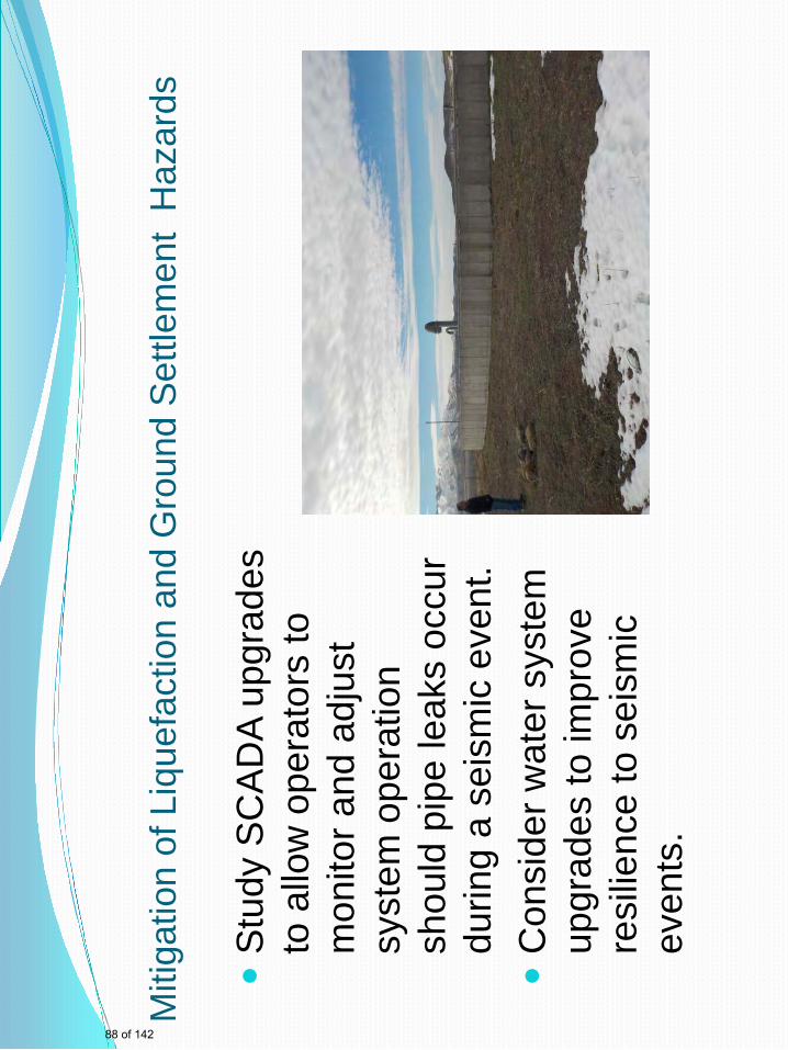
Miti
gatio
n of
Liq
uefa
ctio
n an
d G
roun
d S
ettle
men
t H
azar
ds
S
tudy
SC
AD
A up
grad
es
to a
llow
ope
rato
rs to
m
onito
r and
adj
ust
syst
em o
pera
tion
shou
ld p
ipe
leak
s oc
cur
durin
g a
seis
mic
eve
nt.
Con
side
r wat
er s
yste
m
upgr
ades
to im
prov
e re
silie
nce
to s
eism
ic
even
ts.
88 of 142
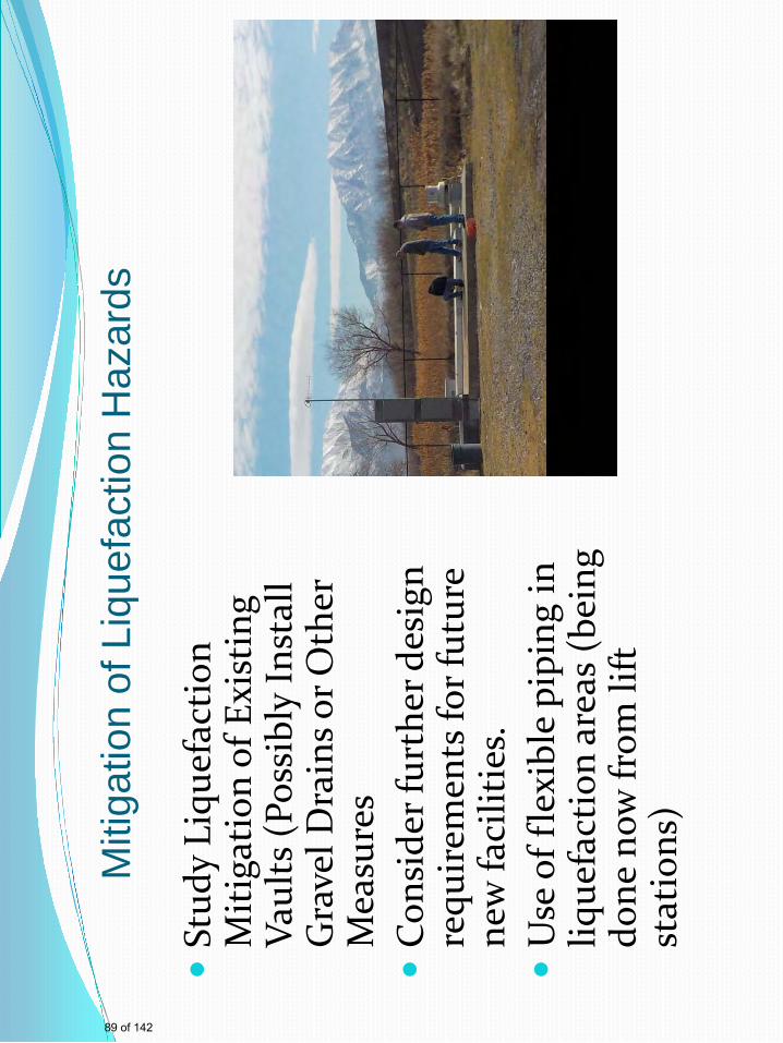
M
itiga
tion
of L
ique
fact
ion
Haz
ards
St
udy
Liqu
efac
tion
M
itig
atio
n of
Exi
stin
g Va
ults
(Pos
sibl
y In
stal
l G
rave
l Dra
ins o
r Oth
er
Mea
sure
s
Con
side
r fur
ther
des
ign
requ
irem
ents
for f
utur
e ne
w fa
cilit
ies.
Use
of f
lexi
ble
pipi
ng in
liq
uefa
ctio
n ar
eas
(bei
ng
done
now
from
lift
st
atio
ns)
89 of 142
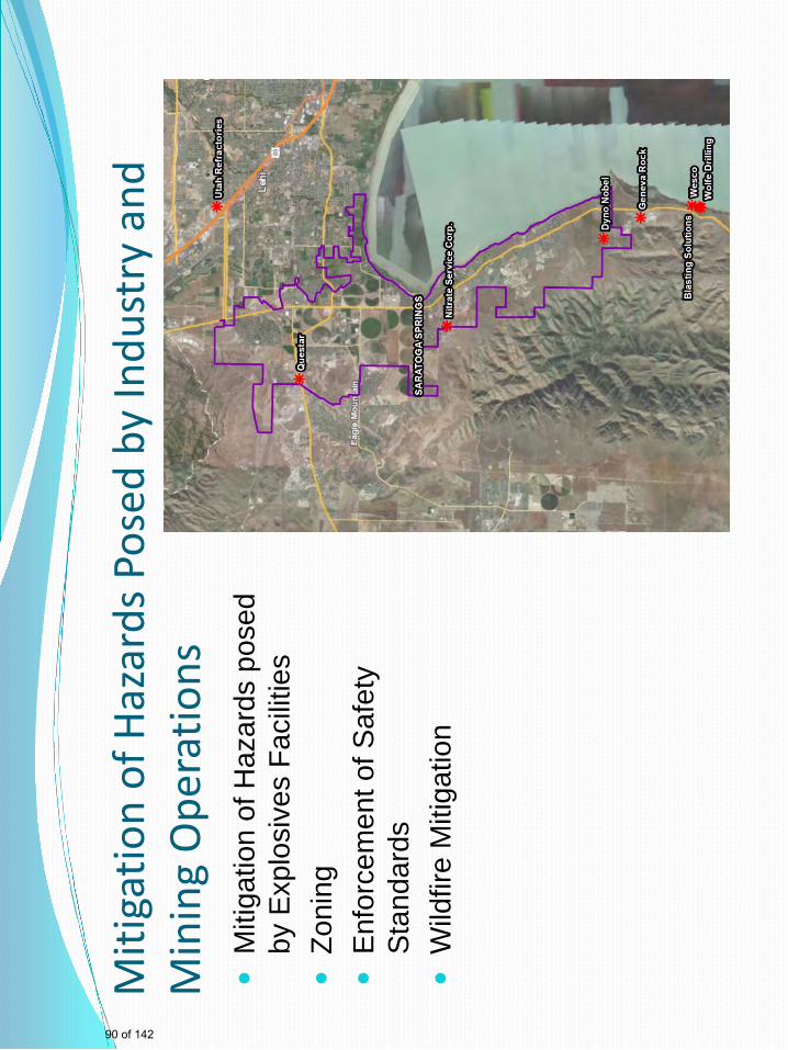
Miti
gatio
n of
Haz
ards
Pos
ed b
y In
dust
ry a
nd
Min
ing
Ope
ratio
ns
M
itiga
tion
of H
azar
ds p
osed
by
Exp
losi
ves
Faci
litie
s
Zoni
ng
E
nfor
cem
ent o
f Saf
ety
Sta
ndar
ds
W
ildfir
e M
itiga
tion
90 of 142
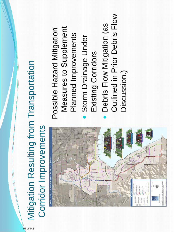
Miti
gatio
n R
esul
ting
from
Tra
nspo
rtatio
n C
orrid
or Im
prov
emen
ts P
ossi
ble
Haz
ard
Miti
gatio
n M
easu
res
to S
uppl
emen
t P
lann
ed Im
prov
emen
ts
S
torm
Dra
inag
e U
nder
E
xist
ing
Cor
ridor
s
Deb
ris F
low
Miti
gatio
n (a
s O
utlin
ed in
Prio
r Deb
ris F
low
D
iscu
ssio
n.)
91 of 142
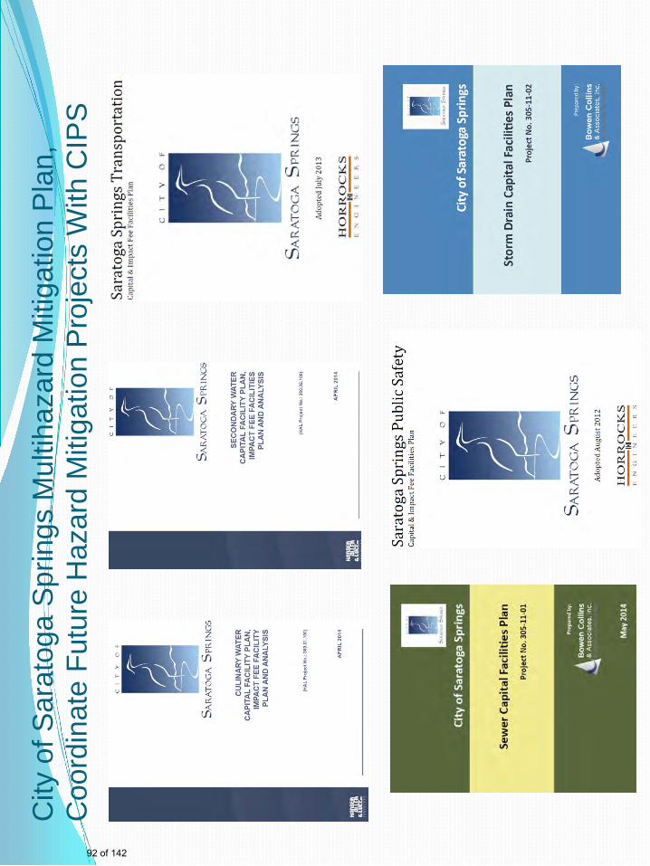
City
of S
arat
oga
Spr
ings
Mul
tihaz
ard
Miti
gatio
n P
lan,
C
oord
inat
e Fu
ture
Haz
ard
Miti
gatio
n P
roje
cts
With
CIP
S
92 of 142
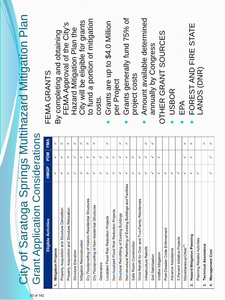
City
of S
arat
oga
Spr
ings
Mul
tihaz
ard
Miti
gatio
n P
lan
Gra
nt A
pplic
atio
n C
onsi
dera
tions
FE
MA
GR
AN
TS
By
com
plet
ing
and
obta
inin
g FE
MA
App
rova
l of t
he C
ity’s
H
azar
d M
itiga
tion
Pla
n th
e C
ity w
ill b
e el
igib
le fo
r gra
nts
to fu
nd a
por
tion
of m
itiga
tion
cost
s.
G
rant
s ar
e up
to $
4.0
Mill
ion
per P
roje
ct
G
rant
s ge
nera
lly fu
nd 7
5% o
f pr
ojec
t cos
ts
A
mou
nt a
vaila
ble
dete
rmin
ed
annu
ally
by
Con
gres
s O
THE
R G
RA
NT
SO
UR
CE
S
U
SB
OR
EPA
FOR
ES
T A
ND
FIR
E S
TATE
LA
ND
S (D
NR
)
93 of 142
City
of S
arat
oga
Spr
ings
Mul
tihaz
ard
Miti
gatio
n P
lan
Pro
vidi
ng C
omm
unity
Inpu
t to
the
Pla
n •
Sug
gest
ions
for I
tem
s to
Incl
ude
in th
e C
ity’s
Pla
n (to
Inco
rpor
ate
Item
s in
You
r Age
ncie
s’ o
r Org
aniz
atio
n’s
Cur
rent
Em
erge
ncy
Pla
ns
or M
itiga
tion
Pla
ns)
•S
ugge
stio
ns to
the
City
to B
ette
r Ena
ble
Your
Age
ncy
or
Org
aniz
atio
n to
Res
pond
to a
nd P
repa
re fo
r a N
atur
al D
isas
ter
•S
ugge
stio
ns to
the
City
for M
etho
ds to
Com
mun
icat
e to
You
r Age
ncy
or O
rgan
izat
ion
Dur
ing
the
Pro
cess
of P
lan
Pre
para
tion
•A
lso
an O
ppor
tuni
ty fo
r the
City
to P
artic
ipat
e in
any
Pre
disa
ster
or
Pos
t Dis
aste
r Pla
nnin
g E
fforts
With
in y
our A
genc
y or
Org
aniz
atio
n.
94 of 142

City
of S
arat
oga
Spr
ings
Mul
tihaz
ard
Miti
gatio
n P
lan
Res
ults
of H
azar
d M
itiga
tion
Pla
n W
ill b
e:
Th
e C
ity w
ill h
ave
mor
e in
dep
th k
now
ledg
e of
pot
entia
l ris
ks
befo
re a
nat
ural
dis
aste
r occ
urs
- Im
prov
ed E
mer
genc
y R
espo
nse
Ach
ieva
ble
- B
ette
r Coo
rdin
atio
n w
ith L
ocal
, Sta
te a
nd F
eder
al G
over
nmen
t A
chie
vabl
e
The
City
will
be
able
to d
evel
op p
lans
for m
itiga
ting
natu
ral h
azar
d ef
fect
s ac
cord
ing
to:
- H
ighe
st B
enef
it/C
ost
- C
oord
inat
ed w
ith C
apita
l Im
prov
emen
t Pla
ns
- S
eek
Gra
nt F
undi
ng to
Pay
for a
Por
tion
of M
itiga
tion
Pro
ject
s
95 of 142

City
of S
arat
oga
Spr
ings
Mul
tihaz
ard
Miti
gatio
n P
lan
96 of 142

City
of S
arat
oga
Spr
ings
Mul
tihaz
ard
Miti
gatio
n P
lan
97 of 142
John
Typewritten Text
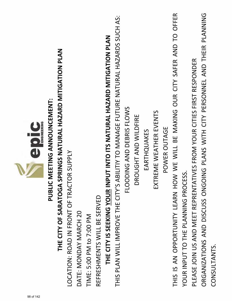
PU
BLIC
MEE
TIN
G A
NN
OU
NCE
MEN
T:
THE
CITY
OF
SARA
TOG
A SP
RIN
GS
NAT
URA
L HA
ZARD
MIT
IGAT
ION
PLA
N
LOCA
TIO
N: R
OAD
IN F
RON
T O
F TR
ACTO
R SU
PPLY
DA
TE: M
ON
DAY
MAR
CH 2
0
TIM
E: 5
:00
PM to
7:0
0 PM
RE
FRES
HMEN
TS W
ILL
BE S
ERVE
D TH
E CI
TY IS
SEE
KIN
G Y
OU
RTH
IS P
LAN
WIL
L IM
PRO
VE T
HE C
ITY’
S AB
ILIT
IY T
O M
ANAG
E FU
TURE
NAT
URA
L HA
ZARD
S SU
CH A
S:
INPU
T IN
TO IT
S N
ATU
RAL
HAZA
RD M
ITIG
ATIO
N P
LAN
FLO
ODI
NG
AND
DEBR
IS F
LOW
S DR
OU
GHT
AND
WIL
DFIR
E EA
RTHQ
UAK
ES
EXTR
EME
WEA
THER
EVE
NTS
PO
WER
OU
TAGE
TH
IS I
S AN
OPP
ORT
UN
ITY
LEAR
N H
OW
WE
WIL
L BE
MAK
ING
OU
R CI
TY S
AFER
AN
D TO
OFF
ER
YOU
R IN
PUT
TO T
HE P
LAN
NIN
G PR
OCE
SS.
PLEA
SE JO
IN U
S AN
D M
EET
REPR
ENTA
TIVE
S FR
OM
YO
UR
CITI
ES F
IRST
RES
PON
DER
ORG
ANIZ
ATIO
NS
AND
DISC
USS
ON
GOIN
G PL
ANS
WIT
H CI
TY P
ERSO
NN
EL A
ND
THEI
R PL
ANN
ING
CON
SULT
ANTS
.
98 of 142

RE
SULT
S O
F M
EETI
NG:
AP
PRO
XIM
ATEL
Y 40
MEM
BERS
OF
THE
PUBL
IC A
TTEN
DED
THE
MEE
TIN
G FR
OM
5PM
TO
7PM
. GE
NER
AL IN
QU
IRES
CO
NCE
RNIN
G HA
ZARD
MIT
IGAT
ION
PLA
NN
ING
WER
E DI
SCU
SSED
.
99 of 142

Attachment B: Debris/Flood Flow Analysis
100 of 142
Attachment B: Debris/Flood Flow Analysis
Debris flows have historically occurred in recent times in the direct vicinity of the proposed Background
Loose Canyon Debris Flow Mitigation Projectcanyon. Fortunately, the debris flow was not directly aligned with developed areas. Nonetheless,
. As recently as 2012, a large debris flow occurred in an adjacent
many homes were flooded, with debris accumulating in basements and first floor levels these homes (ref 1). Additionally, emergency funding, exceeding $3,000,000 dollars, was needed to construct remediation measures at an accelerated pace (Table 1).
Historical data clearly illustrates the hazards posed by debris flow events (caused by water rapid runoff in fire damaged areas) in northern Utah. Peer reviewed scholarly publications indicate that this problem is likely to become more severe, as the effects of climate change in Utah lead to a dryer more fire prone environment. This effect, combined the possibility of storms of increasing severity, further emphasizes the need to construct the proposed mitigation project in the near future. (Refs. 5,6)
Effects of Climate Change on Increased Risk of Wildfire and Debris Flow
The City of Saratoga seeks through this grant request funding to mitigate a potentially much more Proposed Mitigation and Risk Estimate Methodology
severe debris flow event in a canyon near the prior 2012 debris flow event. This canyon is known as Loose Canyon. Unlike the 2012 event, the outfall area for Loose Canyon debris and flooding is directly aligned with a densely developed residential area.
-adapt FEMA/USCOE loss estimation methods from static flood damage of residential facilities;
Losses for residential damage are estimated in Attachment D. In addition to economic losses, considering the direct alignment of the debris flow with residences, loss of life is considered a possibility. For the unmitigated condition, a thorough analysis has been done to:
-determine economic losses based on adaptation of FEMA/USCOE methodologies (Attachment B), based on flood depth and current values of affected residences (Attachment C).
It is important to note that use of the BCA 5.2.1 flood module would be an incorrect approach for loss estimation for the Loose Canyon debris flow scenario. The BCA 5.2.1 software is intended for traditional flow volume analysis is streams/rivers. Debris flow is not directly modeled by the BCA software, therefore FEMA recommends using the damage frequency assessment module. Furthermore, and very importantly, current design codes for buildings (ASCE 7-10, section 5.4.5) require impact analysis of structures in debris flow areas. Loads from debris flow are in addition to hydraulic loads due to static water flooding. This type of analysis is rarely if ever done for typical residential tract type construction. BCA 5.2.1 Software does not have algorithms to estimate losses based on ASCE 7-10 load analysis. As noted in peer reviewed scientific publications (Refs.2,3,4) estimation of debris flow volumes is not readily done with established fragility functions, such as those in the FEMA BCA 5.2.1 or HAZUS programs. Therefore, rational interpretation of data is needed, as recommended by ASCE 7-10 and FEMA. Further, while it is well known and accepted that fire damaged terrain in alluvial and fluvial deposits can flow and lead to destructive loss of life and property; fire frequency estimation is more difficult. Use of historical data is the recommended by FEMA methodology. Fortunately, there is fairly substantial data concerning fire occurrence in the Loose Canyon and foothills area near Saratoga City. These data are referred to in the attached report by CRS consultants. References: 1) Desert News, September 4, 2012, article excerpt attached. 2) Hazus MH Technical Manual; Department of Homeland Security, Washington DC 3) Analysis of Residential Depth-Damage Functions, USCOE, Report 92-R03 4) Journal of the American Waterworks Association, Predicting Debris Yield from Burned Watersheds, 2009 5) K. Sassa, P. Canuti (eds.), USGS, Landslides – Disaster Risk Reduction, Springer-Verlag Berlin Heidelberg 2009 6) FEMA: Mitigation Ideas A Resource for Reducing Risk to Natural Hazards, 2013, page 27
101 of 142
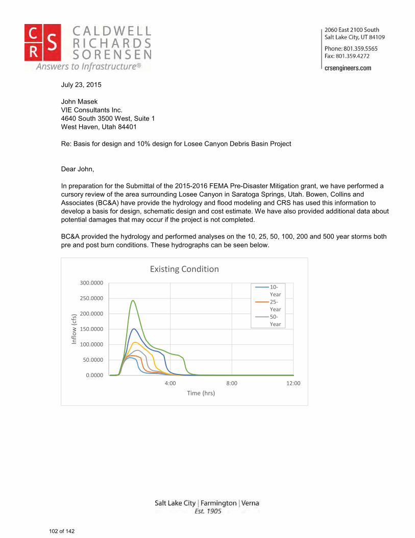
� � ��
�
� � �
�������������� �������������� �������������������� �������������� ����������!�"���#����$�����%�&�'�� ��( )�*�� +����*��,�*�� +��( )�- �������� ��.�/) ��'�� ��0) 1������.��)�� �������2)�2�)�� ��( )�������/3 ����� (��������4����5��6�0)�4. �����)�� � +�� ��+)����7����"��2�)( )3�*�����)� )��)�" �7� (������)�����)) ��* �+�- �������� �� ����)�� +���2) �+��#�����' 7���� �� �����*�6�� � �����8'�96:���"��2) " *��������*) � +����*�(� *�3 *�� �+���*��%���������*��� �� �( )3�� ��� �*�"�� 2���/�� ��( )�*�� +������3�� ��*�� +����*�� ������ 3����������"����� �2) " *�*��** � ����*�����/ ���2 ���� ���*�3�+��������3��� ���)� (�����2) 1���� ��� ��� 32����*����'�96�2) " *�*�������*) � +����*�2�)( )3�*���������� �������������������*������)��� )3��/ ���2)����*�2 ���/�)��� �* � ����;�������*) +)�2�������/�������/�� 7����
��
������
�������
��������
��������
��������
��������
��������
�� ��� ����
� ���
����
���
����������
������ ��!� "����
��#%�&���#%�&���#%�&�
102 of 142
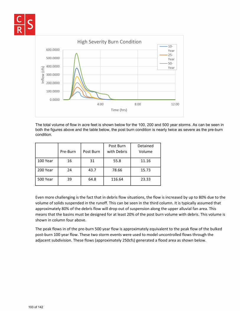
� � �
� � �
��;���� ����" ��3�� (�(� 7� ����)��(���� ���� 7��/�� 7�( )�����������*������)��� )3���6������/������� ��/ �������( +�)����/ "����*�������/���/�� 7�����2 ���/�)��� �* � �� �����)����7 ��������"�)���������2)�4/�)��� �* � �����
�� '��#*+� � '����*+� �'����*+� �
�����6�8����6��&� �"�<��+���
����%�&�� �=� ��� ����� ����=�
����%�&�� �� ��>� >��==� ���>��
����%�&�� �?� =��� ��=�=� ������
�
�@� ��������&��� �� ����������&�����&��� �"�8������������+&��� �G�������������� ���&��"�8K�+Q������V�"+���������@��+����������"���+�Q� "�"�� ������+ �����������& �8����� �� ���������"����+� ���������KQ��&��K�&��+��"���&��&QQ�����&���K���V��������"�8��������������"��Q��+������+�Q� ��� �&�� ������+QQ���&��+@�&���& �&��&���������& ����&������8&�� ���+���8��"���� �"�����&����&�����V��������Q����8+� �@��+��������"�8����������@��+���������� �� ����+� ���+��&8�@����
����Q�&X�������� ��������Q��#8+� �����K�&����������&QQ�����&���K��[+�@&�� ���������Q�&X�������������8+�X�"�Q���#8+� �����K�&�������������������������@� ��������+��"������"���+ �� ������"�����������+�������&"\&�� ���+8"�@���� ���������������&QQ�����&���K����������� ��&��"�&�����"�&��&�&������ �8�������
������
��������
��������
��������
�������
��������
=�������
�� ��� ����
� ���
����
���
����������
]����^�@����K�*+� �!� "���� ��#%�&���#%�&���#%�&�
103 of 142
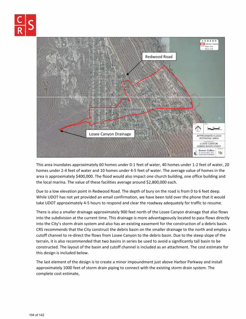
� � �
� � �
�
�����&��&�� + "&����&QQ�����&���K�=��������+ "����#�����������&���G���������+ "����#�����������&���G����������+ "����#����������&����& "����������+ "���#�����������&���������&@��&���@&�+������������ �����&��&����&QQ�����&���K�_��G�������������"���+�"�&������Q&���� ����+����8+��"� �G�� ���������8+��"� ��& "��������&���&�� &������@&�+������������&���������&@��&���&��+ "�_�G���G�����&�����
6+�����&��������@&��� �Q�� ��� �`�"���"�`�&"������"�Q������8+�K�� �������&"��������������=������"��Q��{�����|6}���&�� ���K���Q��@�"�"�& ���&����� ����&��� G�����&@��8�� ����"��@�������Q�� ����&�������+�"��&X��|6}��&QQ�����&���K�#����+���������Q� "�& "����&��������&"�&K�&"�[+&���K�������&�����������+�����
���������&����&���&�����"�&� &���&QQ�����&���K�?�������� ������������~�����!& K� �"�&� &�����&��&����������� ��������+8"�@���� �&�������+��� �������������"�&� &�����������&"@& �&���+��K����&��"����Q&���������"������K�� �������!��K���������"�&� ��K�����& "�&�����&��& ������� ���&���� ������������ ���+���� ����&�"�8����8&�� ��!`^�������� "����&������!��K��� ���+�������"�8����8&�� �� �������&�����"�&� &���������� �����& "���Q��K�&��+�������& ��������#"���������������������~�����!& K� ��������"�8����8&�� ��6+�������������Q����Q�������������&� G�������&����������� "�"���&������8&�� ��� ��������8��+��"����&@��"�&���� ����& ��K��&���8&�� ����8���� ���+���"�������&K�+���������8&�� �& "��+�������& ������� ��+"�"�&��& �&��&���� �����������������&������������"���� ����� ��+"�"�8�������
�����&�������� ���������"���� ����������&���&��� �����Q�+ "�� ��\+���&8�@��]&�8���'&�X�&K�& "�� ��&���&QQ�����&���K��������������������"�&� �Q�Q� ������� ������������������� ��������"�&� ��K�������������Q���������������&��G��
���
`�"���"�`�&"�
~�����!& K� �6�&� &���
104 of 142
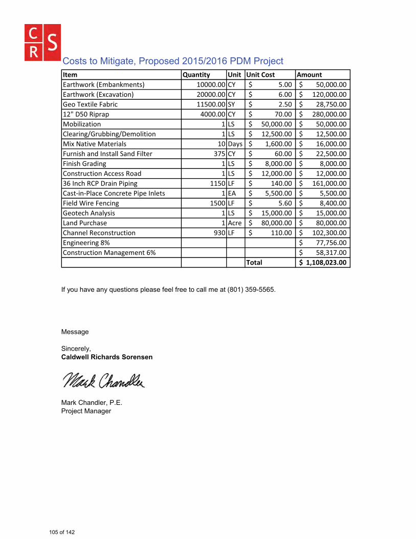
� � �
� � �
����� ������ �� �� ���� ������&������X����8& X�� ��� �������� !% ����_���������������� ��G������_���������&������X�����&@&��� � �������� !% =���_���������������� ���G������_�������������������&8��� �������� ^% ����_���������������� ��G>�����_������������6���`�Q�&Q ������ !% >����_�������������� ���G������_��������8����&��� � ~^ ��G������_������ ��G������_��������!��&�� ����+88� ��6�������� � ~^ ��G������_������ ��G������_�������������&��@���&����&�� �� 6&K� �G=�����_�������� �=G������_���������+� ����& "�� ��&���^& "������� �>� !% =����_�������������� ��G������_���������� ������&"� � � ~^ �G������_�������� �G������_�����������!� ���+���� ��������`�&" � ~^ ��G������_������ ��G������_���������=�� ���`!'�6�&� �'�Q� � ���� ~� �����_������������ �=�G������_������!&��#� #'�&���!� ������'�Q��� ���� � �� �G������_�������� �G������_���������������"�{������ �� � ���� ~� ��=�_���������������� �G�����_�������������������� &�K��� � ~^ ��G������_������ ��G������_��������~& "�'+���&�� � ���� ��G������_������ ��G������_��������!�& ���`��� ���+���� ?�� ~� ������_������������ ���G������_������� �� ���� ���V >>G>�=���_��������!� ���+���� ��& &���� ��=V ��G��>���_��������
����� ������������� ����(�� ����"������<���� ���2������(����()���� ������3�����8$�:���=4����������������+���� ���)���������������� ����� ������
�
����)������*��)�0�����0) 1��������+�)�
Costs to Mitigate, Proposed 2015/2016 PDM Project
105 of 142
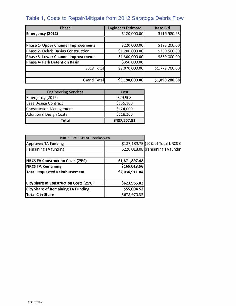
Phase Engineers Estimate Base BidEmergency (2012) $120,000.00 $116,580.68
Phase 1- Upper Channel Improvements $220,000.00 $195,200.00Phase 2- Debris Basins Construction $1,200,000.00 $739,500.00Phase 3- Lower Channel Improvements $1,300,000.00 $839,000.00Phase 4- Park Detention Basin $350,000.00
2013 Total $3,070,000.00 $1,773,700.00
Grand Total $3,190,000.00 $1,890,280.68
Engineering Services CostEmergency (2012) $29,908Base Design Contract $135,100Construction Management $124,000Additional Design Costs $118,200
Total $407,207.83
Approved TA Funding $187,189.75 (10% of Total NRCS CRemaining TA funding $220,018.08 (remaining TA fundin
NRCS FA Construction Costs (75%) $1,871,897.48NRCS TA Remaining $165,013.56Total Requested Reimbursement $2,036,911.04
City share of Construction Costs (25%) $623,965.83City Share of Remaining TA Funding $55,004.52Total City Share $678,970.35
NRCS EWP Grant Breakdown
Table 1, Costs to Repair/Mitigate from 2012 Saratoga Debris Flow
106 of 142
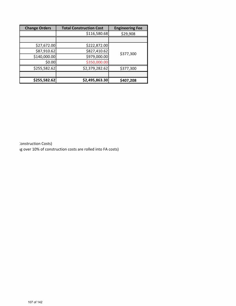
Change Orders Total Construction Cost Engineering Fee$116,580.68 $29,908
$27,672.00 $222,872.00$87,910.62 $827,410.62
$140,000.00 $979,000.00$0.00 $350,000.00
$255,582.62 $2,379,282.62 $377,300
$255,582.62 $2,495,863.30 $407,208
Construction Costs)ng over 10% of construction costs are rolled into FA costs)
$377,300
107 of 142
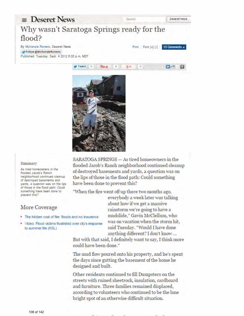
108 of 142

Attachment C: Field Survey Information
109 of 142

C.1 Field Survey Information As a component of development of the City’s hazard mitigation plan, a field survey of representative City facilities was conducted. This survey was used to visually assess these facilities and determine likely hazards that could affect them. Table C.1 Field Survey Results ITEM PHOTO OBSERVATIONS Secondary Well 2
Newer well building structure, likely to be adequate for seismic loads.
Pipe Stand at Well 2
Nonstructural seismic retrofit of piping supports may be needed.
Booster Pump Station 3
Newer well building structure, likely to be adequate for seismic loads.
110 of 142
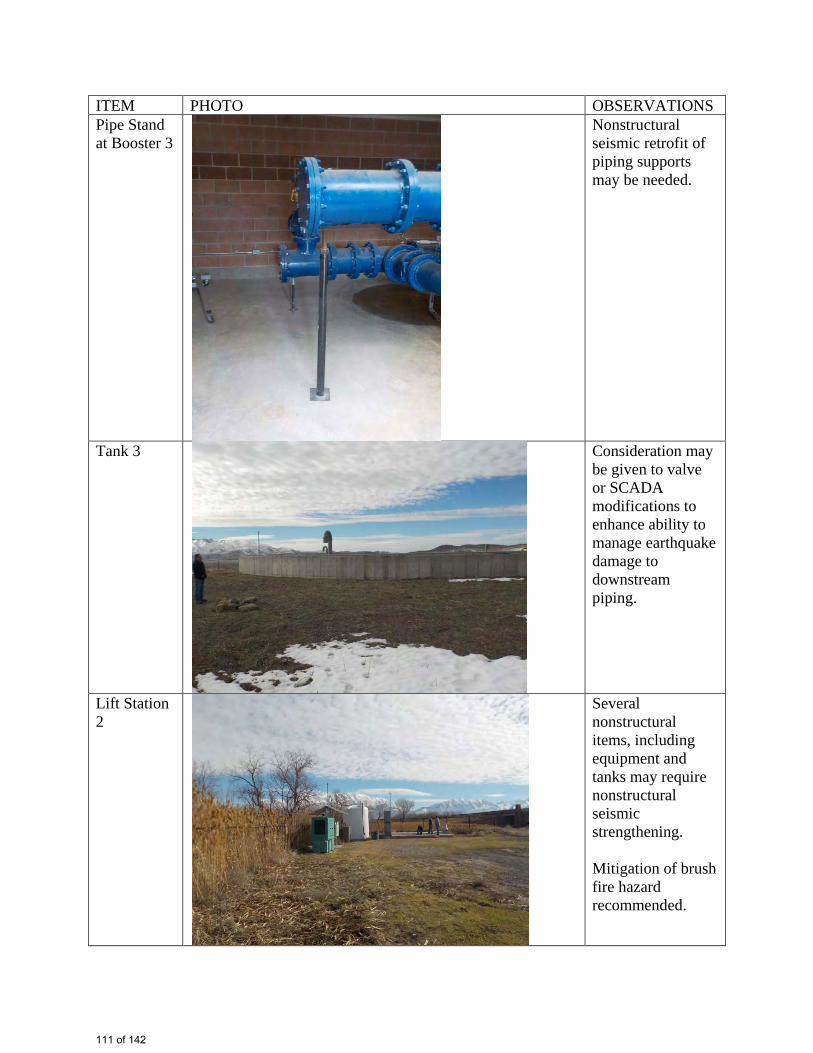
ITEM PHOTO OBSERVATIONS Pipe Stand at Booster 3
Nonstructural seismic retrofit of piping supports may be needed.
Tank 3
Consideration may be given to valve or SCADA modifications to enhance ability to manage earthquake damage to downstream piping.
Lift Station 2
Several nonstructural items, including equipment and tanks may require nonstructural seismic strengthening. Mitigation of brush fire hazard recommended.
111 of 142
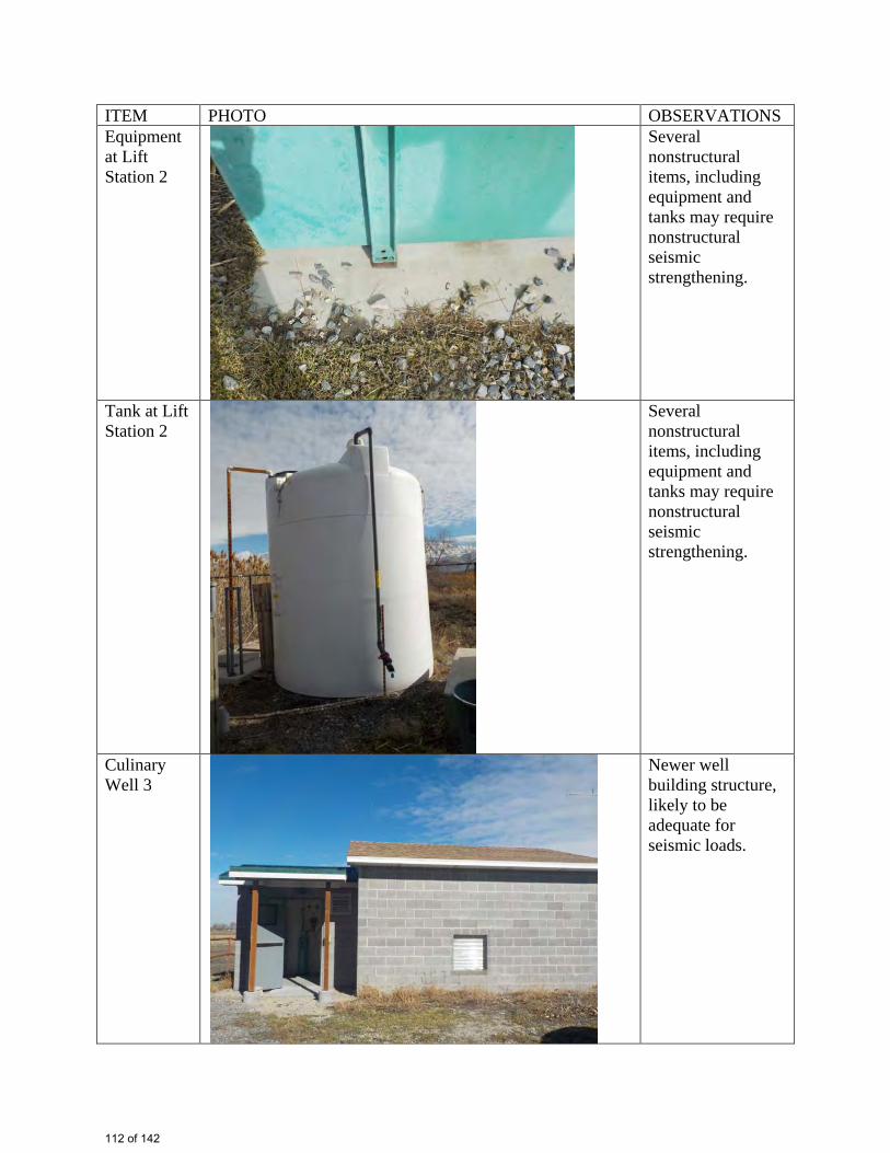
ITEM PHOTO OBSERVATIONS Equipment at Lift Station 2
Several nonstructural items, including equipment and tanks may require nonstructural seismic strengthening.
Tank at Lift Station 2
Several nonstructural items, including equipment and tanks may require nonstructural seismic strengthening.
Culinary Well 3
Newer well building structure, likely to be adequate for seismic loads.
112 of 142
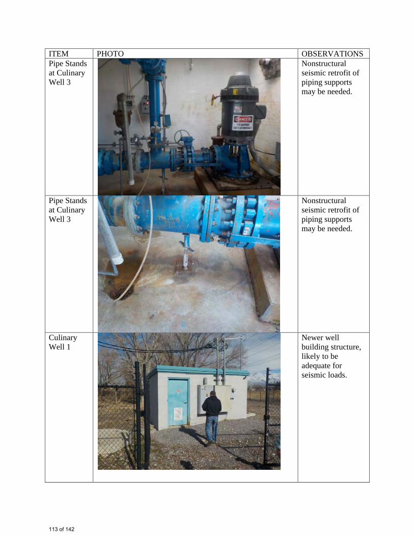
ITEM PHOTO OBSERVATIONS Pipe Stands at Culinary Well 3
Nonstructural seismic retrofit of piping supports may be needed.
Pipe Stands at Culinary Well 3
Nonstructural seismic retrofit of piping supports may be needed.
Culinary Well 1
Newer well building structure, likely to be adequate for seismic loads.
113 of 142
ITEM PHOTO OBSERVATIONS Pipe Stands at Culinary Well 1
Nonstructural seismic retrofit of piping supports may be needed.
Public Works Office Building
Newer building structure, likely to be adequate for seismic loads.
Public Works Shop Building
Newer building structure, likely to be adequate for seismic loads.
114 of 142

ITEM PHOTO OBSERVATIONS Overhead Heaters in Public Works Shop Building
Overhead heaters and piping may require seismic bracing.
Sewer Lift Station 1
Lift station vault may be vulnerable to liquefaction effects.
Vault in Sewer Lift Station 1
Lift station may be vulnerable to liquefaction effects.
115 of 142
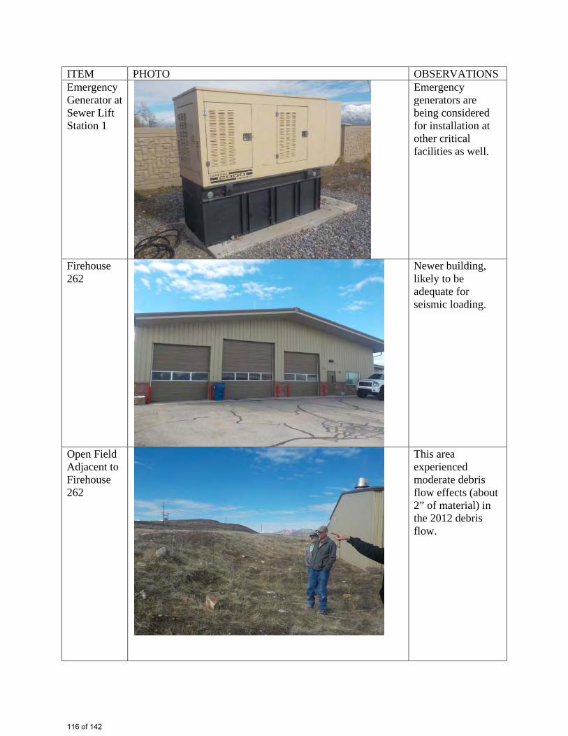
ITEM PHOTO OBSERVATIONS Emergency Generator at Sewer Lift Station 1
Emergency generators are being considered for installation at other critical facilities as well.
Firehouse 262
Newer building, likely to be adequate for seismic loading.
Open Field Adjacent to Firehouse 262
This area experienced moderate debris flow effects (about 2” of material) in the 2012 debris flow.
116 of 142
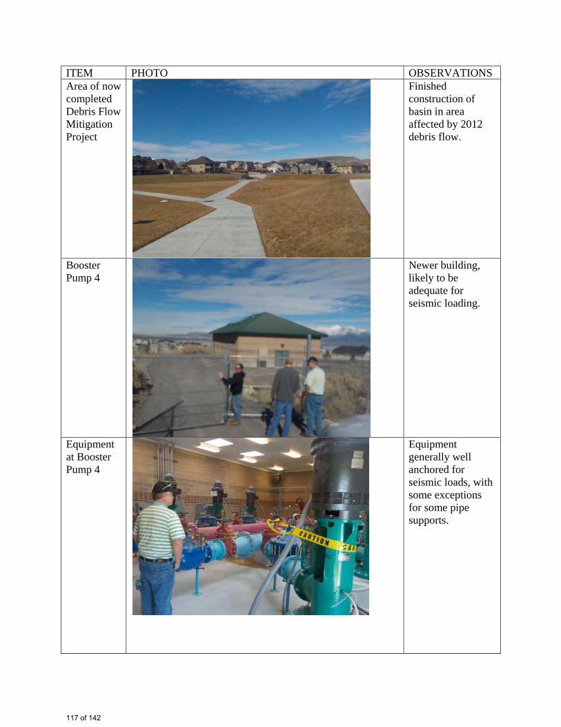
ITEM PHOTO OBSERVATIONS Area of now completed Debris Flow Mitigation Project
Finished construction of basin in area affected by 2012 debris flow.
Booster Pump 4
Newer building, likely to be adequate for seismic loading.
Equipment at Booster Pump 4
Equipment generally well anchored for seismic loads, with some exceptions for some pipe supports.
117 of 142
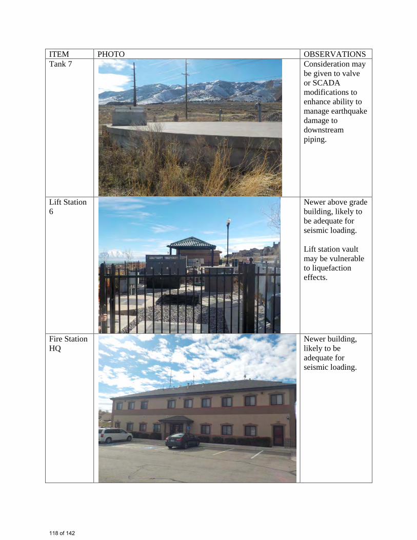
ITEM PHOTO OBSERVATIONS Tank 7
Consideration may be given to valve or SCADA modifications to enhance ability to manage earthquake damage to downstream piping.
Lift Station 6
Newer above grade building, likely to be adequate for seismic loading. Lift station vault may be vulnerable to liquefaction effects.
Fire Station HQ
Newer building, likely to be adequate for seismic loading.
118 of 142
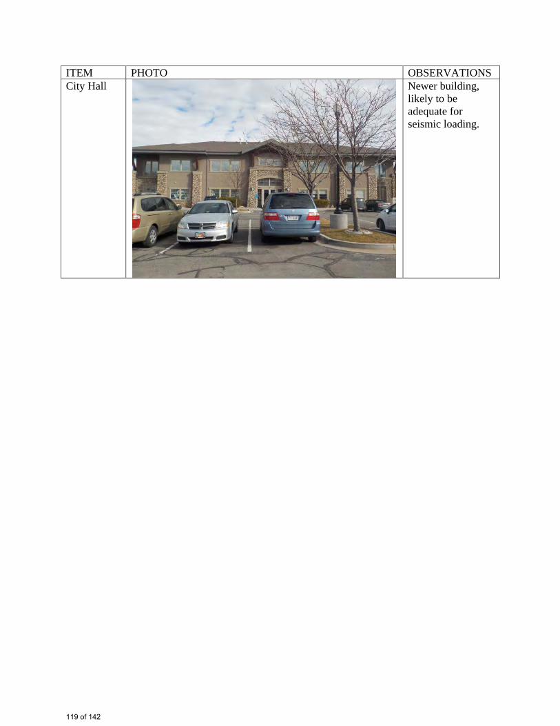
ITEM PHOTO OBSERVATIONS City Hall
Newer building, likely to be adequate for seismic loading.
119 of 142
Attachment D: Correlation of City of Saratoga Springs Hazard Mitigation Plan to MAG Plan
120 of 142
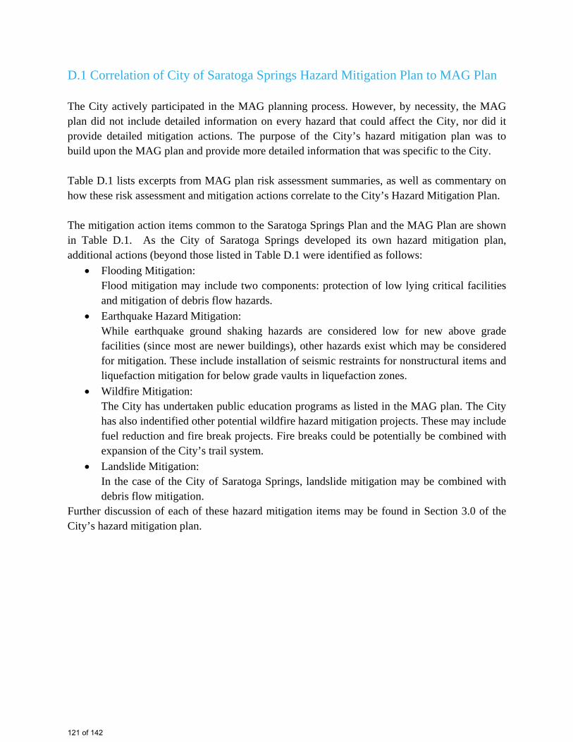
D.1 Correlation of City of Saratoga Springs Hazard Mitigation Plan to MAG Plan
The City actively participated in the MAG planning process. However, by necessity, the MAG plan did not include detailed information on every hazard that could affect the City, nor did it provide detailed mitigation actions. The purpose of the City’s hazard mitigation plan was to build upon the MAG plan and provide more detailed information that was specific to the City.
Table D.1 lists excerpts from MAG plan risk assessment summaries, as well as commentary on how these risk assessment and mitigation actions correlate to the City’s Hazard Mitigation Plan.
The mitigation action items common to the Saratoga Springs Plan and the MAG Plan are shown in Table D.1. As the City of Saratoga Springs developed its own hazard mitigation plan, additional actions (beyond those listed in Table D.1 were identified as follows:
� Flooding Mitigation:Flood mitigation may include two components: protection of low lying critical facilities and mitigation of debris flow hazards.
� Earthquake Hazard Mitigation:While earthquake ground shaking hazards are considered low for new above grade facilities (since most are newer buildings), other hazards exist which may be considered for mitigation. These include installation of seismic restraints for nonstructural items and liquefaction mitigation for below grade vaults in liquefaction zones.
� Wildfire Mitigation:The City has undertaken public education programs as listed in the MAG plan. The City has also indentified other potential wildfire hazard mitigation projects. These may include fuel reduction and fire break projects. Fire breaks could be potentially be combined with expansion of the City’s trail system.
� Landslide Mitigation:In the case of the City of Saratoga Springs, landslide mitigation may be combined with debris flow mitigation.
Further discussion of each of these hazard mitigation items may be found in Section 3.0 of the City’s hazard mitigation plan.
121 of 142
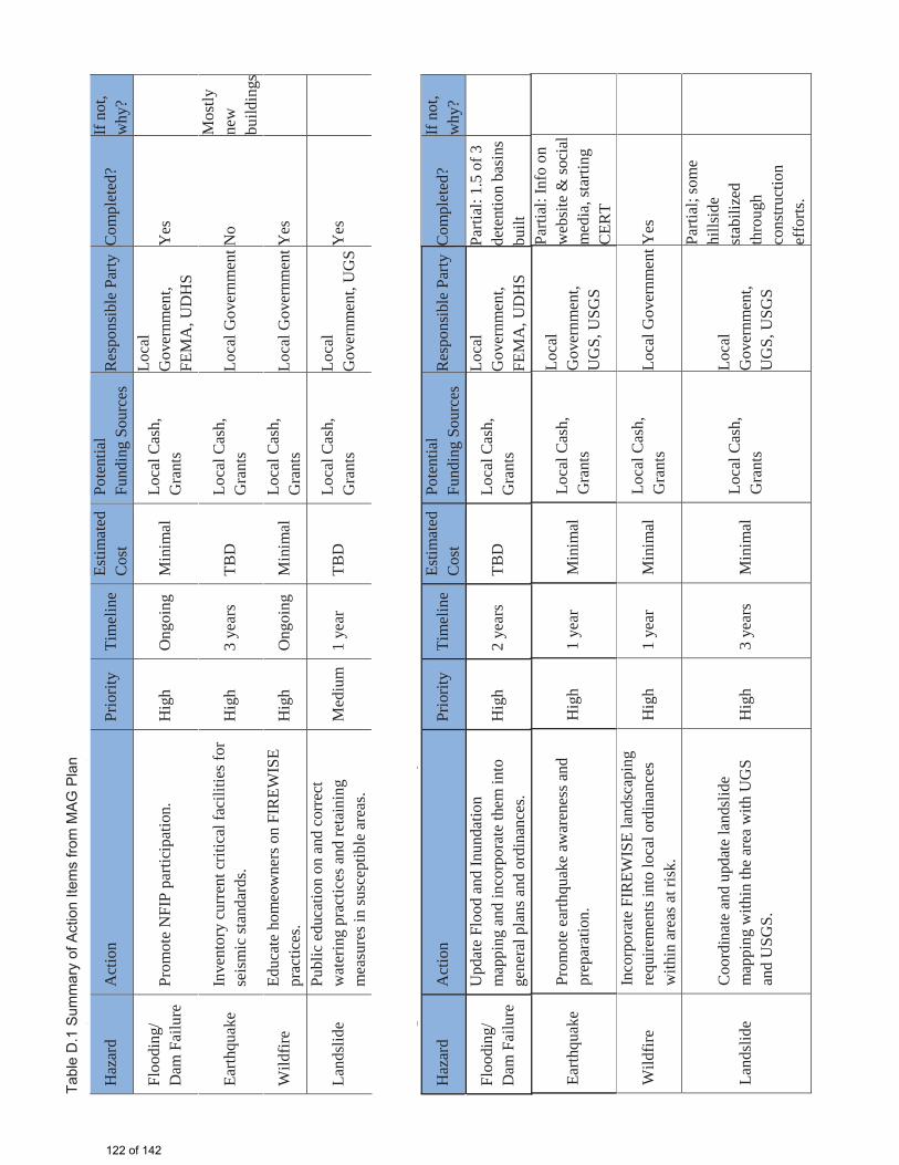
Prot
ectin
g C
urre
nt R
esid
ents
and
Stru
ctur
es: A
naly
sis o
f 201
0 G
oals
Haz
ard
Act
ion
Prio
rity
Tim
elin
eEs
timat
ed
Cos
tPo
tent
ial
Fund
ing
Sour
ces
Res
pons
ible
Par
tyC
ompl
eted
?If
not,
why
?
Floo
ding
/ D
am F
ailu
rePr
omot
e N
FIP
parti
cipa
tion.
Hig
hO
ngoi
ngM
inim
alLo
cal C
ash,
G
rant
s
Loca
l G
over
nmen
t, FE
MA
, UD
HS
Yes
Earth
quak
eIn
vent
ory
curr
ent c
ritic
al fa
cilit
ies f
or
seis
mic
stan
dard
s.H
igh
3 ye
ars
TBD
Loca
l Cas
h,
Gra
nts
Loca
l Gov
ernm
entN
oM
ostly
ne
wbu
ildin
gs
Wild
fire
Educ
ate
hom
eow
ners
on
FIR
EWIS
E pr
actic
es.
Hig
hO
ngoi
ngM
inim
alLo
cal C
ash,
G
rant
sLo
cal G
over
nmen
tYes
Land
slid
ePu
blic
edu
catio
n on
and
cor
rect
w
ater
ing
prac
tices
and
reta
inin
g m
easu
res i
n su
scep
tible
are
as.
Med
ium
1 ye
arTB
DLo
cal C
ash,
G
rant
sLo
cal
Gov
ernm
ent,
UG
SY
es
Prot
ectin
g Fu
ture
Res
iden
ts an
d St
ruct
ures
: Ana
lysi
s of 2
010
Goa
ls
Haz
ard
Act
ion
Prio
rity
Tim
elin
eEs
timat
ed
Cos
tPo
tent
ial
Fund
ing
Sour
ces
Res
pons
ible
Par
tyC
ompl
eted
?If
not,
why
?
Floo
ding
/ D
am F
ailu
re
Upd
ate
Floo
d an
d In
unda
tion
map
ping
and
inco
rpor
ate
them
into
ge
nera
l pla
ns a
nd o
rdin
ance
s.H
igh
2 ye
ars
TBD
Loca
l Cas
h,
Gra
nts
Loca
l G
over
nmen
t, FE
MA
, UD
HS
Parti
al: 1
.5 o
f 3
dete
ntio
n ba
sins
bu
ilt
Earth
quak
ePr
omot
e ea
rthqu
ake
awar
enes
s and
pr
epar
atio
n.H
igh
1 ye
arM
inim
alLo
cal C
ash,
G
rant
s
Loca
l G
over
nmen
t, U
GS,
USG
S
Parti
al: I
nfo
on
web
site
& so
cial
m
edia
, sta
rting
C
ERT
Wild
fire
Inco
rpor
ate
FIR
EWIS
E la
ndsc
apin
g re
quire
men
ts in
to lo
cal o
rdin
ance
s w
ithin
are
as a
t ris
k.H
igh
1 ye
arM
inim
alLo
cal C
ash,
G
rant
sLo
cal G
over
nmen
tYes
Land
slid
eC
oord
inat
e an
d up
date
land
slid
e m
appi
ng w
ithin
the
area
with
UG
S an
d U
SGS.
Hig
h3
year
sM
inim
alLo
cal C
ash,
G
rant
s
Loca
l G
over
nmen
t, U
GS,
USG
S
Parti
al; s
ome
hills
ide
stab
ilize
d th
roug
h co
nstru
ctio
n ef
forts
.
Tabl
e D
.1 S
umm
ary
of A
ctio
n Ite
ms
from
MA
G P
lan
122 of 142

Attachment E: Correlation of City of Saratoga Springs Hazard Mitigation Plan to State of Utah Plan, Utah County
123 of 142
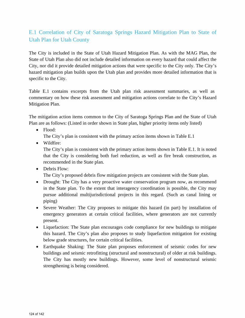
E.1 Correlation of City of Saratoga Springs Hazard Mitigation Plan to State of Utah Plan for Utah County
The City is included in the State of Utah Hazard Mitigation Plan. As with the MAG Plan, the State of Utah Plan also did not include detailed information on every hazard that could affect the City, nor did it provide detailed mitigation actions that were specific to the City only. The City’s hazard mitigation plan builds upon the Utah plan and provides more detailed information that isspecific to the City.
Table E.1 contains excerpts from the Utah plan risk assessment summaries, as well as commentary on how these risk assessment and mitigation actions correlate to the City’s Hazard Mitigation Plan.
The mitigation action items common to the City of Saratoga Springs Plan and the State of Utah Plan are as follows: (Listed in order shown in State plan, higher priority items only listed)
� Flood:The City’s plan is consistent with the primary action items shown in Table E.1
� Wildfire:The City’s plan is consistent with the primary action items shown in Table E.1. It is noted that the City is considering both fuel reduction, as well as fire break construction, as recommended in the State plan.
� Debris Flow: The City’s proposed debris flow mitigation projects are consistent with the State plan.
� Drought: The City has a very proactive water conservation program now, as recommendin the State plan. To the extent that interagency coordination is possible, the City may pursue additional multijurisdictional projects in this regard. (Such as canal lining or piping)
� Severe Weather: The City proposes to mitigate this hazard (in part) by installation of emergency generators at certain critical facilities, where generators are not currently present.
� Liquefaction: The State plan encourages code compliance for new buildings to mitigate this hazard. The City’s plan also proposes to study liquefaction mitigation for existing below grade structures, for certain critical facilities.
� Earthquake Shaking: The State plan proposes enforcement of seismic codes for new buildings and seismic retrofitting (structural and nonstructural) of older at risk buildings. The City has mostly new buildings. However, some level of nonstructural seismic strengthening is being considered.
124 of 142
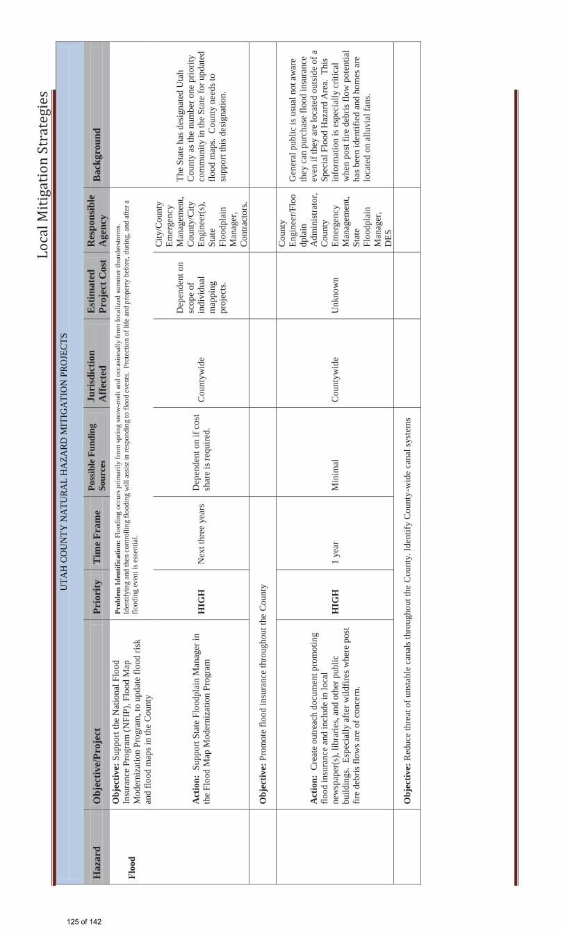
Lo
cal
Mit
iga
tio
n S
tra
teg
ies
UTA
H C
OU
NTY
NA
TUR
AL
HA
ZAR
D M
ITIG
ATI
ON
PR
OJE
CTS
H
azar
d O
bjec
tive/
Proj
ect
Prio
rity
T
ime
Fram
e Po
ssib
le F
undi
ng
Sour
ces
Juri
sdic
tion
Aff
ecte
d E
stim
ated
Pr
ojec
t Cos
t R
espo
nsib
le
Age
ncy
Bac
kgro
und
Floo
d
Obj
ectiv
e: S
uppo
rt th
e N
atio
nal F
lood
In
sura
nce
Prog
ram
(NFI
P), F
lood
Map
M
oder
niza
tion
Prog
ram
, to
upda
te fl
ood
risk
and
flood
map
s in
the
Cou
nty
Prob
lem
Iden
tific
atio
n: F
lood
ing
occu
rs p
rimar
ily fr
om sp
ring
snow
-mel
t and
occ
asio
nally
from
loca
lized
sum
mer
thun
ders
torm
s.
Iden
tifyi
ng a
nd th
en c
ontro
lling
floo
ding
will
ass
ist i
n re
spon
ding
to fl
ood
even
ts.
Prot
ectio
n of
life
and
pro
perty
bef
ore,
dur
ing,
and
afte
r a
flood
ing
even
t is e
ssen
tial.
A
ctio
n: S
uppo
rt St
ate
Floo
dpla
in M
anag
er in
th
e Fl
ood
Map
Mod
erni
zatio
n Pr
ogra
m
HIG
H
Nex
t thr
ee y
ears
D
epen
dent
on
if co
st
shar
e is
requ
ired.
C
ount
ywid
e
Dep
ende
nt o
n sc
ope
of
indi
vidu
al
map
ping
pr
ojec
ts.
City
/Cou
nty
Emer
genc
y M
anag
emen
t, C
ount
y/C
ity
Engi
neer
(s),
Stat
e Fl
oodp
lain
M
anag
er,
Con
tract
ors.
The
Stat
e ha
s des
igna
ted
Uta
h C
ount
y as
the
num
ber o
ne p
riorit
y co
mm
unity
in th
e St
ate
for u
pdat
ed
flood
map
s. C
ount
y ne
eds t
o su
ppor
t thi
s des
igna
tion.
O
bjec
tive:
Pro
mot
e flo
od in
sura
nce
thro
ugho
ut th
e C
ount
y
Act
ion:
Cre
ate
outre
ach
docu
men
t pro
mot
ing
flood
insu
ranc
e an
d in
clud
e in
loca
l ne
wsp
aper
(s),
libra
ries,
and
othe
r pub
lic
build
ings
. Es
peci
ally
afte
r wild
fires
whe
re p
ost
fire
debr
is fl
ows a
re o
f con
cern
.
HIG
H
1 ye
ar
Min
imal
C
ount
ywid
e U
nkno
wn
Cou
nty
Engi
neer
/Flo
odp
lain
A
dmin
istra
tor,
Cou
nty
Emer
genc
y M
anag
emen
t, St
ate
Floo
dpla
in
Man
ager
, D
ES
Gen
eral
pub
lic is
usu
al n
ot a
war
e th
ey c
an p
urch
ase
flood
insu
ranc
e ev
en if
they
are
loca
ted
outs
ide
of a
Sp
ecia
l Flo
od H
azar
d A
rea.
Thi
s in
form
atio
n is
esp
ecia
lly c
ritic
al
whe
n po
st fi
re d
ebris
flow
pot
entia
l ha
s bee
n id
entif
ied
and
hom
es a
re
loca
ted
on a
lluvi
al fa
ns.
O
bjec
tive:
Red
uce
thre
at o
f uns
tabl
e ca
nals
thro
ugho
ut th
e C
ount
y. Id
entif
y C
ount
y-w
ide
cana
l sys
tem
s
125 of 142
John
Typewritten Text
Table E.1
John
Typewritten Text
John
Typewritten Text
John
Typewritten Text
John
Typewritten Text
John
Typewritten Text
John
Typewritten Text
John
Typewritten Text
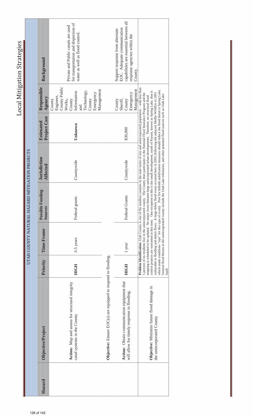
Lo
cal
Mit
iga
tio
n S
tra
teg
ies
UTA
H C
OU
NTY
NA
TUR
AL
HA
ZAR
D M
ITIG
ATI
ON
PR
OJE
CTS
H
azar
d O
bjec
tive/
Proj
ect
Prio
rity
T
ime
Fram
e Po
ssib
le F
undi
ng
Sour
ces
Juri
sdic
tion
Aff
ecte
d E
stim
ated
Pr
ojec
t Cos
t R
espo
nsib
le
Age
ncy
Bac
kgro
und
A
ctio
n: M
ap a
nd a
sses
s for
stru
ctur
al in
tegr
ity
cana
l sys
tem
s in
the
Cou
nty
H
IGH
3-
5 ye
ars
Fede
ral g
rant
s C
ount
ywid
e U
nkno
wn
Cou
nty
Engi
neer
, C
ount
y Pu
blic
W
orks
, C
ount
y In
form
atio
n an
d Te
chno
logy
, C
ount
y Em
erge
ncy
Man
agem
ent
Priv
ate
and
Publ
ic c
anal
s are
use
d fo
r tra
nspo
rtatio
n an
d di
sper
sion
of
wat
er a
s wel
l as f
lood
con
trol.
O
bjec
tive:
Ens
ure
EOC
(s) a
re e
quip
ped
to re
spon
d to
floo
ding
.
A
ctio
n: O
btai
n co
mm
unic
atio
n eq
uipm
ent t
hat
will
allo
w fo
r tim
ely
resp
onse
to fl
oodi
ng.
HIG
H
1 ye
ar
Fede
ral G
rant
s C
ount
ywid
e $3
0,00
0
Cou
nty
Sher
iff,
Cou
nty
Emer
genc
y M
anag
emen
t
Supp
ort r
espo
nse
from
alte
rnat
e EO
C.
Ade
quat
e co
mm
unic
atio
n ca
pabi
litie
s are
ess
entia
l bet
wee
n al
l re
spon
se a
genc
ies w
ithin
the
Cou
nty.
O
bjec
tive:
Min
imiz
e fu
ture
floo
d da
mag
e in
th
e un
inco
rpor
ated
Cou
nty
Prob
lem
Iden
tific
atio
n: U
tah
Cou
nty
is o
ne o
f the
smal
lest
cou
ntie
s in
the
stat
e te
rms o
f siz
e an
d un
inco
rpor
ated
pop
ulat
ion
– w
ith le
ss th
an
5 pe
rcen
t of i
ts re
siden
ts liv
e in
the
unin
corp
orat
ed c
ount
y. T
he C
ount
y do
es p
artic
ipat
e i n
the
Nat
iona
l Flo
od In
sura
nce
Prog
ram
and
the
map
ping
is sc
hedu
led
to b
e up
date
d. N
o m
ajor
rive
rs th
reat
en la
rge
unin
corp
orat
ed u
rban
dev
elop
men
ts.
Ther
efor
e, n
o st
ruct
ural
floo
d co
ntro
l pro
ject
s are
war
rant
ed a
t thi
s tim
e.
One
exc
eptio
n to
this
is th
e sm
all d
evel
opm
ent,
sout
h of
Pay
son,
kno
wn
as S
prin
g La
ke, t
hat i
s vu
lner
able
to fl
oodi
ng a
nd d
ebris
flow
s. A
larg
e de
bris
floo
d ev
ent o
ccur
red
here
in 2
002
(follo
win
g th
e ad
jace
nt M
ollie
Wil d
fire
in 2
001
whi
ch m
ade
cond
ition
s “rip
e” fo
r thi
s typ
e of
eve
nt).
Pos
t fire
hill
side
stab
iliza
tion
mea
sure
s sho
uld
redu
ce th
e flo
od th
reat
to S
prin
g La
ke.
G
ener
al fl
ood
thre
ats i
n th
e un
inco
rpor
ated
cou
nty
incl
ude
the
Uta
h La
ke tr
ibut
arie
s, an
d ot
her p
oten
tial f
lood
sour
ces s
uch
as U
tah
Lake
its
elf.
126 of 142
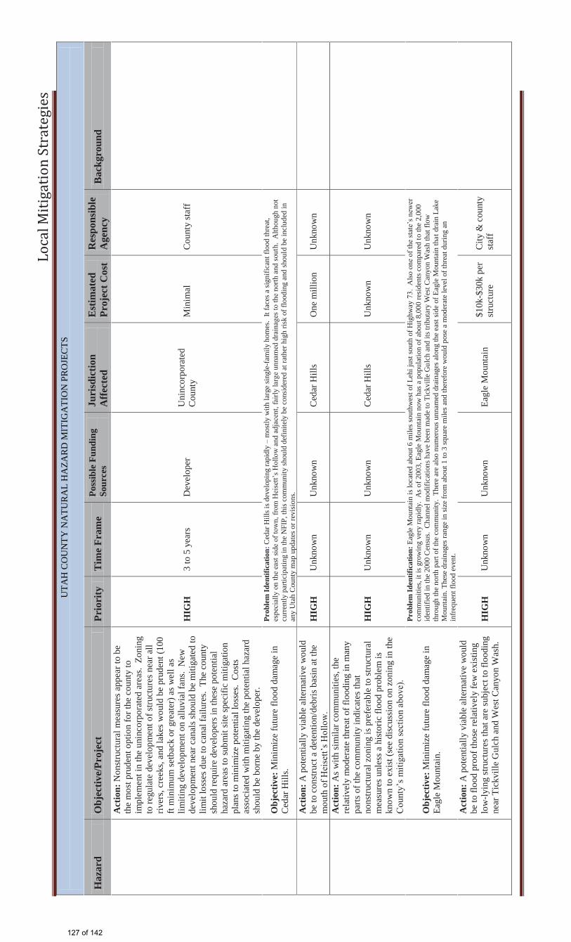
Lo
cal
Mit
iga
tio
n S
tra
teg
ies
UTA
H C
OU
NTY
NA
TUR
AL
HA
ZAR
D M
ITIG
ATI
ON
PR
OJE
CTS
H
azar
d O
bjec
tive/
Proj
ect
Prio
rity
T
ime
Fram
e Po
ssib
le F
undi
ng
Sour
ces
Juri
sdic
tion
Aff
ecte
d E
stim
ated
Pr
ojec
t Cos
t R
espo
nsib
le
Age
ncy
Bac
kgro
und
Act
ion:
Non
stru
ctur
al m
easu
res a
ppea
r to
be
the
mos
t pru
dent
opt
ion
for t
he c
ount
y to
im
plem
ent i
n th
e un
inco
rpor
ated
are
as.
Zoni
ng
to re
gula
te d
evel
opm
ent o
f stru
ctur
es n
ear a
ll riv
ers,
cree
ks, a
nd la
kes w
ould
be
prud
ent (
100
ft m
inim
um se
tbac
k or
gre
ater
) as w
ell a
s lim
iting
dev
elop
men
t on
allu
vial
fans
. N
ew
deve
lopm
ent n
ear c
anal
s sho
uld
be m
itiga
ted
to
limit
loss
es d
ue to
can
al fa
ilure
s. T
he c
ount
y sh
ould
requ
ire d
evel
oper
s in
thes
e po
tent
ial
haza
rd a
reas
to su
bmit
site
spec
ific
miti
gatio
n pl
ans t
o m
inim
ize
pote
ntia
l los
ses.
Cos
ts
asso
ciat
ed w
ith m
itiga
ting
the
pote
ntia
l haz
ard
shou
ld b
e bo
rne
by th
e de
velo
per.
HIG
H
3 to
5 y
ears
D
evel
oper
U
ninc
orpo
rate
d C
ount
y M
inim
al
Cou
nty
staf
f
O
bjec
tive:
Min
imiz
e fu
ture
floo
d da
mag
e in
C
edar
Hill
s.
Prob
lem
Iden
tific
atio
n: C
edar
Hill
s is d
evel
opin
g ra
pidl
y –
mos
tly w
ith la
rge
sing
le-f
amily
hom
es.
It fa
ces a
sign
ifica
nt fl
ood
thre
at,
espe
cial
ly o
n th
e ea
st si
de o
f tow
n, fr
om H
eise
tt’s H
ollo
w a
nd a
djac
ent,
fairl
y la
rge
unna
med
dra
inag
es to
the
north
and
sout
h. A
lthou
gh n
ot
curre
ntly
par
ticip
atin
g in
the
NFI
P, th
is c
omm
unity
shou
ld d
efin
itely
be
cons
ider
ed a
t rat
her h
igh
risk
of fl
oodi
ng a
nd sh
ould
be
incl
uded
in
any
Uta
h C
ount
y m
ap u
pdat
es o
r rev
isio
ns.
A
ctio
n: A
pot
entia
lly v
iabl
e al
tern
ativ
e w
ould
be
to c
onst
ruct
a d
eten
tion/
debr
is b
asin
at t
he
mou
th o
f Hei
sett’
s Hol
low
. H
IGH
U
nkno
wn
Unk
now
n C
edar
Hill
s O
ne m
illio
n U
nkno
wn
Act
ion:
As w
ith si
mila
r com
mun
ities
, the
re
lativ
ely
mod
erat
e th
reat
of f
lood
ing
in m
any
parts
of t
he c
omm
unity
indi
cate
s tha
t no
nstru
ctur
al z
onin
g is
pre
fera
ble
to st
ruct
ural
m
easu
res u
nles
s a h
isto
ric fl
ood
prob
lem
is
know
n to
exi
st (s
ee d
iscu
ssio
n on
zon
ing
in th
e C
ount
y’s m
itiga
tion
sect
ion
abov
e).
HIG
H
Unk
now
n U
nkno
wn
Ced
ar H
ills
Unk
now
n
Unk
now
n
O
bjec
tive:
Min
imiz
e fu
ture
floo
d da
mag
e in
Ea
gle
Mou
ntai
n.
Prob
lem
Iden
tific
atio
n: E
agle
Mou
ntai
n is
loca
ted
abou
t 6 m
iles s
outh
wes
t of L
ehi j
ust s
outh
of H
ighw
ay 7
3. A
lso
one
of th
e st
ate’
s new
er
com
mun
ities
, it i
s gro
win
g ve
ry ra
pidl
y. A
s of 2
003,
Eag
le M
ount
ain
now
has
a p
opul
atio
n of
abo
ut 8
,000
resi
dent
s com
pare
d to
the
2,00
0 id
entif
ied
in th
e 20
00 C
ensu
s. C
hann
el m
odifi
catio
ns h
ave
been
mad
e to
Tic
kvill
e G
u lch
and
its t
ribut
ary
Wes
t Can
yon
Was
h th
at fl
ow
thro
ugh
the
north
par
t of t
he c
omm
unity
. Th
ere
are
also
num
erou
s unn
amed
dra
inag
es a
long
the
east
side
of E
agle
Mou
ntai
n th
at d
rain
Lak
e M
ount
ain.
The
se d
rain
ages
rang
e in
size
from
abo
ut 1
to 3
squa
re m
iles a
nd th
eref
ore
wou
ld p
ose
a m
oder
ate
leve
l of t
hrea
t dur
ing
an
infre
quen
t flo
od e
vent
.
Act
ion:
A p
oten
tially
via
ble
alte
rnat
ive
wou
ld
be to
floo
d pr
oof t
hose
rela
tivel
y fe
w e
xist
ing
low
-lyin
g st
ruct
ures
that
are
subj
ect t
o flo
odin
g ne
ar T
ickv
ille
Gul
ch a
nd W
est C
anyo
n W
ash.
HIG
H
Unk
now
n U
nkno
wn
Eagl
e M
ount
ain
$10k
-$30
k pe
r st
ruct
ure
City
& c
ount
y st
aff
127 of 142
John
Typewritten Text
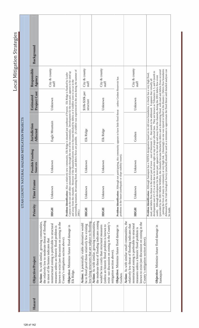
Lo
cal
Mit
iga
tio
n S
tra
teg
ies
UTA
H C
OU
NTY
NA
TUR
AL
HA
ZAR
D M
ITIG
ATI
ON
PR
OJE
CTS
H
azar
d O
bjec
tive/
Proj
ect
Prio
rity
T
ime
Fram
e Po
ssib
le F
undi
ng
Sour
ces
Juri
sdic
tion
Aff
ecte
d E
stim
ated
Pr
ojec
t Cos
t R
espo
nsib
le
Age
ncy
Bac
kgro
und
Act
ion:
As w
ith si
mila
r, gr
owin
g co
mm
uniti
es,
the
rela
tivel
y lo
w to
mod
erat
e th
reat
of f
lood
ing
to m
ost o
f the
hom
es in
dica
tes t
hat
nons
truct
ural
zon
ing
is p
refe
rabl
e to
stru
ctur
al
mea
sure
s unl
ess a
n hi
stor
ic fl
ood
prob
lem
is
know
n to
exi
st (s
ee d
iscu
ssio
n on
zon
ing
in th
e C
ount
y’s m
itiga
tion
sect
ion
abov
e).
HIG
H
Unk
now
n U
nkno
wn
Eagl
e M
ount
ain
Unk
now
n C
ity &
cou
nty
staf
f
O
bjec
tive:
Min
imiz
e fu
ture
floo
d da
mag
e in
El
k R
idge
.
Prob
lem
Iden
tific
atio
n: A
lso a
rela
tivel
y ne
w c
omm
unity
, Elk
Rid
ge is
situ
ated
just
sout
heas
t of P
ayso
n. E
lk R
idge
is fl
anke
d by
Loa
fer
Can
yon
on th
e ea
st a
nd o
ther
unn
amed
dra
inag
es th
roug
h th
e re
st o
f the
com
mun
ity.
Dev
elop
men
t for
the
mos
t par
t, ap
pear
s to
be si
ted
up
and
a way
from
the
chan
nels
. H
owev
er if
the
chan
nels
/cul
verts
wer
e to
bec
ome
bloc
ked
by d
ebris
or i
f wild
fire
wer
e to
occ
ur in
the
surro
undi
ng m
ount
ain,
dev
asta
ting
flood
, mud
, and
deb
ris fl
ows a
re p
ossi
ble.
(A
wild
fire
was
exp
erie
nced
in th
e ar
ea d
urin
g th
e su
mm
er o
f 20
03.)
A
ctio
n: A
pot
entia
lly v
iabl
e al
tern
ativ
e w
ould
be
to fl
ood
proo
f tho
se re
lativ
ely
few
exi
stin
g lo
w-ly
ing
stru
ctur
es th
at a
re su
bjec
t to
flood
ing.
H
IGH
U
nkno
wn
Unk
now
n El
k R
idge
$1
0k-$
30k
per
stru
ctur
e C
ity &
cou
nty
staf
f
Act
ion:
As w
ith si
mila
r, gr
owin
g co
mm
uniti
es,
the
mod
erat
e th
reat
of f
lood
ing
indi
cate
s zon
ing
wou
ld b
e le
ss c
ostly
than
stru
ctur
al m
easu
res
(unl
ess a
n hi
stor
ic fl
ood
prob
lem
is k
now
n to
ex
ist -
see
disc
ussi
on o
n zo
ning
in th
e C
ount
y’s
miti
gatio
n se
ctio
n ab
ove)
.
HIG
H
Unk
now
n U
nkno
wn
Elk
Rid
ge
Unk
now
n C
ity &
cou
nty
staf
f
O
bjec
tive:
Min
imiz
e fu
ture
floo
d da
mag
e in
G
oshe
n.
Prob
lem
Iden
tific
atio
n: A
lthou
gh n
ot p
artic
ipat
ing,
this
com
mun
ity a
ppea
rs to
hav
e lit
tle fl
ood
thre
at -
unl
ess G
oshe
n R
eser
voir
has
prob
lem
s in
the
futu
re (e
arth
quak
e or
slop
e st
abili
ty is
sues
).
Act
ion:
As w
ith si
mila
r sm
all c
omm
uniti
es, t
he
rela
tivel
y lo
w th
reat
of f
lood
ing
indi
cate
s tha
t no
nstru
ctur
al z
onin
g is
pre
fera
ble
to st
ruct
ural
m
easu
res u
nles
s a h
isto
ric fl
ood
prob
lem
is
know
n to
exi
st (s
ee d
iscu
ssio
n on
zon
ing
in th
e C
ount
y’s m
itiga
tion
sect
ion
abov
e).
HIG
H
Unk
now
n U
nkno
wn
Gos
hen
Unk
now
n C
ity &
cou
nty
staf
f
O
bjec
tive:
Min
imiz
e fu
ture
floo
d da
mag
e in
Sa
ntaq
uin.
Prob
lem
Iden
tific
atio
n: A
lthou
gh S
anta
quin
has
a N
SFH
A d
esig
natio
n ba
sed
on it
s old
tow
n bo
unda
ries,
it cl
early
has
a v
ery
high
floo
d,
mud
, and
deb
ris fl
ow th
reat
in th
e ne
wer
par
t of t
own
– ea
st o
f Int
erst
ate
15 –
that
nee
ds to
be
addr
esse
d. I
t app
ears
that
virt
ually
all
deve
lopm
ent e
ast o
f I-1
5 is
at ri
sk d
ue to
its l
ocat
ion
right
on
top
of m
ajor
allu
vial
fans
. Th
ey a
re k
now
n as
Trib
utar
ies 4
, 5, a
nd 6
(nor
th to
so
uth)
. A
lthou
gh d
evel
opm
ent f
or th
e m
ost p
art,
appe
ars t
o be
site
d up
and
aw
ay fr
om th
e ch
anne
ls, d
urin
g th
e 20
0 2 d
ebris
flow
eve
nt
(pre
cede
d by
the
2001
Mol
lie W
ildfir
e), t
he c
hann
els b
ecam
e bl
ocke
d by
deb
ris a
nd a
dev
asta
ting
flood
, with
mud
and
deb
ris fl
ows o
ccur
red
– pu
tting
the
lives
of m
any
in c
omm
unity
at v
ery
high
risk
. (A
maz
ingl
y no
one
was
inju
red
or k
illed
in th
e di
saste
r.) D
ebris
flow
bou
ndar
ies
delin
eate
d by
the
Uta
h G
eolo
gica
l Sur
vey
(atta
ched
) sho
uld
be u
sed
as a
min
imum
to a
ppro
xim
ate
the
flood
thre
at u
ntil
deta
iled
anal
yses
can
be
mad
e.
128 of 142

Lo
cal
Mit
iga
tio
n S
tra
teg
ies
UTA
H C
OU
NTY
NA
TUR
AL
HA
ZAR
D M
ITIG
ATI
ON
PR
OJE
CTS
H
azar
d O
bjec
tive/
Proj
ect
Prio
rity
T
ime
Fram
e Po
ssib
le F
undi
ng
Sour
ces
Juri
sdic
tion
Aff
ecte
d E
stim
ated
Pr
ojec
t Cos
t R
espo
nsib
le
Age
ncy
Bac
kgro
und
A
ctio
n: D
eten
tion/
debr
is b
asin
s are
urg
ently
ne
eded
if th
e to
wn
is g
oing
to c
ontin
ue to
allo
w
deve
lopm
ent “
in h
arm
s way
”.
HIG
H
Unk
now
n U
nkno
wn
Sant
aqui
n
App
roxi
mat
ely
$500
k - $
1 m
illio
n ea
ch –
To
tal $
2.5
m
illio
n
City
, Fed
eral
ag
ency
staf
f.
Act
ion:
As w
ith si
mila
r gro
win
g co
mm
uniti
es,
nons
truct
ural
zon
ing
is le
ss c
ostly
than
st
ruct
ural
mea
sure
s to
prev
ent f
utur
e da
mag
es
(see
dis
cuss
ion
on z
onin
g in
the
Cou
nty’
s m
itiga
tion
sect
ion
abov
e).
HIG
H
Unk
now
n U
nkno
wn
Sant
aqui
n U
nkno
wn
City
staf
f.
O
bjec
tive:
Min
imiz
e fu
ture
floo
d da
mag
e in
Sa
rato
ga S
prin
gs.
Prob
lem
Iden
tific
atio
n: L
ike
Sant
aqui
n, th
is c
omm
unity
has
als
o gr
own
very
rapi
dly
and
is al
so d
esig
nate
d as
a N
SFH
A.
It ap
pear
s to
face
a
mod
erat
e flo
od th
reat
from
Tic
kvill
e G
ulch
on
the
north
and
at l
east
a d
ozen
oth
er d
rain
ages
alo
ng th
e ea
st si
de o
f tow
n (in
add
ition
to th
e th
reat
from
Uta
h La
ke).
A
ctio
n: A
pot
entia
lly v
iabl
e al
tern
ativ
e w
ould
be
to fl
ood
proo
f tho
se re
lativ
ely
few
exi
stin
g lo
w-ly
ing
stru
ctur
es th
at a
re su
bjec
t to
flood
ing.
H
IGH
U
nkno
wn
Unk
now
n Sa
rato
ga S
prin
gs
$10k
-$30
k pe
r st
ruct
ure
City
staf
f
Act
ion:
As w
ith si
mila
r, gr
owin
g co
mm
uniti
es,
the
low
to m
oder
ate
thre
at o
f flo
odin
g in
dica
tes
that
non
stru
ctur
al z
onin
g is
pre
fera
ble
to
stru
ctur
al m
easu
res u
nles
s an
hist
oric
floo
d pr
oble
m is
kno
wn
to e
xist
(see
dis
cuss
ion
on
zoni
ng in
the
Cou
nty’
s miti
gatio
n se
ctio
n ab
ove)
.
HIG
H
Unk
now
n U
nkno
wn
Sara
toga
Spr
ings
U
nkno
wn
City
staf
f, D
ES
O
bjec
tive:
Min
imiz
e fu
ture
floo
d da
mag
e in
V
iney
ard
Prob
lem
Iden
tific
atio
n: A
lthou
gh th
ere
is n
o flo
od th
reat
from
any
rive
rs, c
reek
s, or
stre
ams,
Uta
h La
ke is
with
in th
e co
rpor
ate
boun
dary
-le
avin
g V
iney
ard
at so
me
risk.
A 1
997
CO
E re
conn
aiss
ance
stud
y (P
rovo
Riv
er a
nd T
ribut
arie
s) d
eter
min
ed th
at th
e 10
0 -yr
ele
vatio
n of
Uta
h La
ke w
ould
be
appr
oxim
atel
y 44
94.5
MSL
. M
ost o
f Vin
eyar
d is
wel
l abo
ve th
is el
evat
ion
so th
e re
lativ
e ris
k is
min
imal
.
Act
ion:
As w
ith si
mila
r com
mun
ities
, the
re
lativ
ely
low
thre
at o
f flo
odin
g in
dica
tes t
hat
nons
truct
ural
zon
ing
is p
refe
rabl
e to
stru
ctur
al
mea
sure
s unl
ess a
n hi
stor
ic fl
ood
prob
lem
is
know
n to
exi
st (s
ee d
iscu
ssio
n on
zon
ing
in th
e C
ount
y’s m
itiga
tion
sect
ion
abov
e).
HIG
H
Unk
now
n U
nkno
wn
Vin
eyar
d M
inim
al
City
& D
ES
staf
f
O
bjec
tive:
Min
imiz
e fu
ture
floo
d da
mag
e in
W
oodl
and
Hill
s.
Prob
lem
Iden
tific
atio
n: A
lso
a re
lativ
ely
new
com
mun
ity, W
oodl
and
Hill
s is s
ituat
ed so
uthe
ast o
f Pay
son,
in th
e so
uthe
ast c
orne
r of U
tah
Cou
nty.
Woo
dlan
d H
ills i
s fla
nked
by
Map
le C
anyo
n on
the
east
and
is th
reat
ened
by
Bro
ad a
nd S
nell
Hol
low
s, as
wel
l as a
noth
er u
nnam
ed
drai
nag e
thro
ugh
the
rest
of t
he c
omm
unity
. D
evel
opm
ent f
or th
e m
ost p
art,
appe
ars t
o be
site
d up
and
aw
ay fr
om th
e ch
anne
ls.
How
ever
if
the
chan
nels
/cul
verts
wer
e to
bec
ome
bloc
ked
by d
ebris
or i
f wild
fire
wer
e to
occ
ur in
the
surro
undi
ng m
ount
ain,
dev
asta
ting
flood
, mud
, and
de
bris
flow
s are
pos
sibl
e –
putti
ng th
e co
mm
unity
at v
ery
high
risk
.
129 of 142
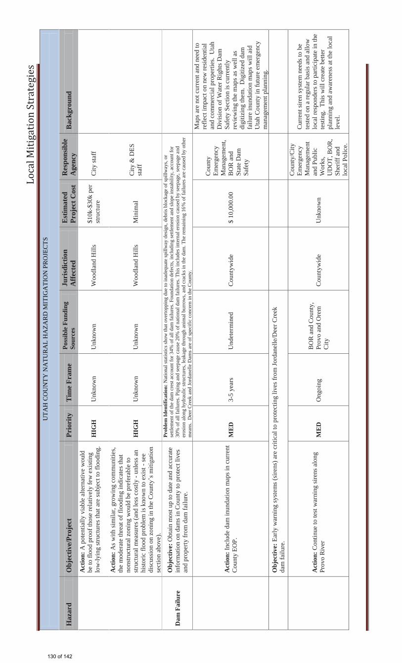
Lo
cal
Mit
iga
tio
n S
tra
teg
ies
UTA
H C
OU
NTY
NA
TUR
AL
HA
ZAR
D M
ITIG
ATI
ON
PR
OJE
CTS
H
azar
d O
bjec
tive/
Proj
ect
Prio
rity
T
ime
Fram
e Po
ssib
le F
undi
ng
Sour
ces
Juri
sdic
tion
Aff
ecte
d E
stim
ated
Pr
ojec
t Cos
t R
espo
nsib
le
Age
ncy
Bac
kgro
und
Act
ion:
A p
oten
tially
via
ble
alte
rnat
ive
wou
ld
be to
floo
d pr
oof t
hose
rela
tivel
y fe
w e
xist
ing
low
-lyin
g st
ruct
ures
that
are
subj
ect t
o flo
odin
g.
HIG
H
Unk
now
n U
nkno
wn
Woo
dlan
d H
ills
$10k
-$30
k pe
r st
ruct
ure
City
staf
f
Act
ion:
As w
ith si
mila
r, gr
owin
g co
mm
uniti
es,
the
mod
erat
e th
reat
of f
lood
ing
indi
cate
s tha
t no
nstru
ctur
al z
onin
g w
ould
be
pref
erab
le to
st
ruct
ural
mea
sure
s (an
d le
ss c
ostly
- un
less
an
hist
oric
floo
d pr
oble
m is
kno
wn
to e
xist
- se
e di
scus
sion
on
zoni
ng in
the
Cou
nty’
s miti
gatio
n se
ctio
n ab
ove)
.
HIG
H
Unk
now
n U
nkno
wn
Woo
dlan
d H
ills
Min
imal
C
ity &
DES
st
aff
Dam
Fai
lure
O
bjec
tive:
Obt
ain
mos
t up
to d
ate
and
accu
rate
in
form
atio
n on
dam
s in
Cou
nty
to p
rote
ct li
ves
and
prop
erty
from
dam
failu
re.
Prob
lem
Iden
tific
atio
n: N
atio
nal s
tatis
tics s
how
that
ove
rtopp
ing
due
to in
adeq
uate
spill
way
des
ign,
deb
ris b
lock
age
of sp
illw
ays,
or
settl
emen
t of t
he d
am c
rest
acc
ount
for 3
4% o
f all
dam
failu
res.
Foun
datio
n de
fect
s, in
clud
ing
settl
emen
t and
slop
e in
stab
ility
, acc
ount
for
30%
of a
ll fa
ilure
s. Pi
ping
and
seep
age
caus
e 20
% o
f nat
iona
l dam
failu
res.
This
incl
udes
inte
rnal
ero
sion
cau
sed
by se
epag
e, se
epag
e an
d er
osio
n al
ong
hydr
aulic
stru
ctur
es, l
eaka
ge th
roug
h an
imal
bur
row
s, an
d cr
acks
in th
e da
m. T
he re
mai
ning
16%
of f
ailu
res a
re c
ause
d by
oth
er
mea
ns.
Dee
r Cre
ek a
nd Jo
rdan
elle
Dam
s are
of s
peci
fic c
once
rn in
the
Cou
nty.
A
ctio
n: In
clud
e da
m in
unda
tion
map
s in
curr
ent
Cou
nty
EOP.
M
ED
3-
5 ye
ars
Und
eter
min
ed
Cou
ntyw
ide
$ 10
,000
.00
Cou
nty
Emer
genc
y M
anag
emen
t, B
OR
and
St
ate
Dam
Sa
fety
Map
s are
not
cur
rent
and
nee
d to
re
flect
impa
ct o
n ne
w re
side
ntia
l an
d co
mm
erci
al p
rope
rties
. U
tah
Div
isio
n of
Wat
er R
ight
s Dam
Sa
fety
Sec
tion
is c
urre
ntly
re
view
ing
the
map
s as w
ell a
s di
gitiz
ing
them
. D
igiti
zed
dam
fa
ilure
inun
datio
n m
aps w
ill a
id
Uta
h C
ount
y in
futu
re e
mer
genc
y m
anag
emen
t pla
nnin
g.
O
bjec
tive:
Ear
ly w
arni
ng s
yste
ms (
sire
ns) a
re c
ritic
al to
pro
tect
ing
lives
from
Jord
anel
le/D
eer C
reek
da
m fa
ilure
.
A
ctio
n: C
ontin
ue to
test
war
ning
sire
ns a
long
Pr
ovo
Riv
er
ME
D
Ong
oing
B
OR
and
Cou
nty,
Pr
ovo
and
Ore
m
City
C
ount
ywid
e U
nkno
wn
Cou
nty/
City
Em
erge
ncy
Man
agem
ent
and
Publ
ic
Wor
ks,
UD
OT,
BO
R,
Sher
iff a
nd
loca
l Pol
ice.
Cur
rent
sire
n sy
stem
nee
ds to
be
test
ed o
n a
regu
lar b
asis
and
allo
w
loca
l res
pond
ers t
o pa
rtici
pate
in th
e te
stin
g. T
his w
ill c
reat
e be
tter
plan
ning
and
aw
aren
ess a
t the
loca
l le
vel.
130 of 142
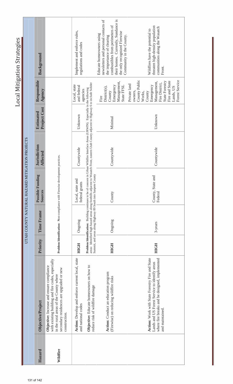
Lo
cal
Mit
iga
tio
n S
tra
teg
ies
UTA
H C
OU
NTY
NA
TUR
AL
HA
ZAR
D M
ITIG
ATI
ON
PR
OJE
CTS
H
azar
d O
bjec
tive/
Proj
ect
Prio
rity
T
ime
Fram
e Po
ssib
le F
undi
ng
Sour
ces
Juri
sdic
tion
Aff
ecte
d E
stim
ated
Pr
ojec
t Cos
t R
espo
nsib
le
Age
ncy
Bac
kgro
und
Wild
fire
Obj
ectiv
e: In
crea
se a
nd e
nsur
e co
mpl
ianc
e w
ith e
xist
ing
build
ing
and
fire
code
s, es
peci
ally
in
the
rura
l are
as o
f the
Cou
nty
whe
re
seco
ndar
y re
side
nces
are
upg
rade
d or
new
co
nstru
ctio
n.
Prob
lem
Iden
tific
atio
n: N
on-c
ompl
ianc
e w
ith F
irew
ise
deve
lopm
ent p
ract
ices
.
A
ctio
n: D
evel
op a
nd e
nfor
ce c
urre
nt lo
cal,
stat
e an
d na
tiona
l cod
es
HIG
H
Ong
oing
Lo
cal,
stat
e an
d fe
dera
l gra
nts
Cou
ntyw
ide
Unk
now
n Lo
cal,
stat
e an
d fe
dera
l ag
enci
es
Impl
emen
t and
enf
orce
rule
s, re
gula
tions
and
cod
es
O
bjec
tive:
Edu
cate
hom
eow
ners
on
how
to
redu
ce ri
sk o
f wild
fire
dam
age
Pr
oble
m Id
entif
icat
ion:
Bui
ldin
g co
ntin
ues t
o be
of c
once
rn in
Urb
an W
ildfir
e In
terfa
ce A
reas
(UR
WIN
). E
spec
ially
in th
e fo
llow
ing
area
s: Id
entif
ied
high
haz
ard
area
s alo
ng fo
othi
lls a
djac
ent t
o W
asat
ch F
ront
, eas
tern
Uta
h C
ount
y ad
jace
nt to
Hig
hway
6 to
incl
ude
Solid
er
Sum
mit,
and
are
as a
long
Hig
hway
89
Sout
h in
to S
anpe
te C
ount
y
A
ctio
n: C
ondu
ct a
n ed
ucat
ion
prog
ram
(F
irew
ise)
on
redu
cing
wild
fire
risks
HIG
H
Ong
oing
C
ount
y C
ount
ywid
e M
inim
al
Fire
D
istri
ct(s
), C
ount
y Em
erge
ncy
Man
agem
ent,
Stat
e FF
SL
Educ
ate
hom
eow
ners
usi
ng
new
slet
ters
and
per
sona
l con
tact
s of
the
impo
rtanc
e of
cle
arin
g co
mbu
stib
les f
rom
per
imet
ers o
f th
eir h
omes
. C
urre
ntly
, Sun
danc
e is
th
e on
ly re
cogn
ized
Fire
wis
e C
omm
unity
in th
e C
ount
y.
Act
ion:
Wor
k w
ith S
tate
For
estry
Fire
and
Sta
te
Land
s and
US
Fore
st S
ervi
ce to
iden
tify
area
s w
here
fire
bre
aks a
nd b
e de
sign
ed, i
mpl
emen
ted
and
mai
ntai
ned.
HIG
H
3-ye
ars
Cou
nty,
Sta
te a
nd
Fede
ral
Cou
ntyw
ide
Unk
now
n
Priv
ate
land
ow
ners
, C
ount
y Pu
blic
W
orks
, C
ount
y Em
erge
ncy
Man
agem
ent,
Fire
Dis
trict
, St
ate
Fore
stry
Fi
re a
nd S
tate
La
nds,
US
Fore
st S
ervi
ce
Wild
fires
hav
e th
e po
tent
ial t
o th
reat
en h
igh-
dens
ity p
opul
atio
n co
mm
uniti
es a
long
the
Was
atch
Fr
ont.
131 of 142
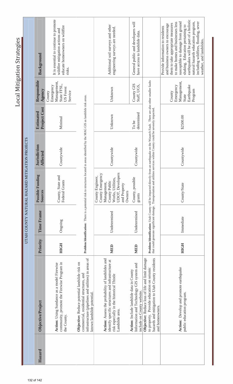
Lo
cal
Mit
iga
tio
n S
tra
teg
ies
UTA
H C
OU
NTY
NA
TUR
AL
HA
ZAR
D M
ITIG
ATI
ON
PR
OJE
CTS
H
azar
d O
bjec
tive/
Proj
ect
Prio
rity
T
ime
Fram
e Po
ssib
le F
undi
ng
Sour
ces
Juri
sdic
tion
Aff
ecte
d E
stim
ated
Pr
ojec
t Cos
t R
espo
nsib
le
Age
ncy
Bac
kgro
und
A
ctio
n: U
sing
Sun
danc
e as
a m
odel
Fire
wis
e co
mm
unity
, pro
mot
e th
e Fi
rew
ise
Prog
ram
in
the
Cou
nty.
H
IGH
O
ngoi
ng
Cou
nty,
Sta
te a
nd
Fede
ral G
rant
s C
ount
ywid
e M
inim
al
Cou
nty
Emer
genc
y M
anag
emen
t, St
ate
FFSL
, U
S Fo
rest
Se
rvic
e
It is
ess
entia
l to
cont
inue
to p
rom
ote
wild
fire
miti
gatio
n ac
tions
and
ed
ucat
e ho
meo
wne
rs o
n w
ildfir
e ris
ks.
Obj
ectiv
e: R
educ
e po
tent
ial l
ands
lide
risk
on
com
mer
cial
, res
iden
tial s
truct
ures
, and
in
fras
truct
ure
(pip
elin
es a
nd u
tiliti
es) i
n ar
eas o
f kn
own
land
slid
e po
tent
ial.
Prob
lem
Iden
tific
atio
n: T
here
is a
pot
entia
l ris
k to
stru
ctur
es lo
cate
d in
are
as id
entif
ied
by th
e M
AG
GIS
as l
ands
lide
risk
area
s.
Act
ion:
Ass
ess t
he p
roba
bilit
y of
land
slid
es a
nd
iden
tify
spec
ific
stru
ctur
es a
nd in
fras
truct
ure
at
risk
espe
cial
ly in
the
hist
oric
al T
hist
le
Land
slid
e ar
ea.
ME
D
Und
eter
min
ed
Cou
nty
Engi
neer
, C
ount
y Em
erge
ncy
Man
agem
ent,
Cou
nty
Publ
ic
Wor
ks, U
tiliti
es,
UD
OT,
Dev
elop
ers
and
Prop
erty
O
wne
rs
Cou
ntyw
ide
Unk
now
n U
nkno
wn
Add
ition
al so
il su
rvey
s and
oth
er
engi
neer
ing
surv
eys a
re n
eede
d.
A
ctio
n: In
clud
e la
ndsl
ide
data
in C
ount
y In
form
atio
n an
d Te
chno
logy
GIS
syst
em a
nd
incl
ude
on C
ount
y w
ebsi
te.
ME
D
Und
eter
min
ed
Cou
nty,
pos
sibl
e gr
ants
C
ount
ywid
e To
be
dete
rmin
ed
Cou
nty
GIS
St
aff,
UG
S,
Gen
eral
pub
lic a
nd d
evel
oper
s w
ill
have
acc
ess t
o la
ndsl
ide
data
.
Obj
ectiv
e: R
educ
e lo
ss o
f life
and
lim
it da
mag
e to
pro
perty
. Pr
ovid
e ed
ucat
ion
on se
ism
ic
haza
rds a
nd m
itiga
tion
to U
tah
Cou
nty
resi
dent
s an
d ho
meo
wne
rs.
Prob
lem
Iden
tific
atio
n: U
tah
Cou
nty
will
be
impa
cted
dire
ctly
from
an
earth
quak
e on
the
Was
atch
Fau
lt. T
here
are
als
o ot
her s
mal
ler f
aults
th
at c
ould
gen
erat
e si
gnifi
cant
dam
age.
Tra
nspo
rtatio
n an
d ut
ilitie
s ser
vice
s with
in C
ount
y co
uld
be se
vere
ly im
pact
ed.
A
ctio
n: D
evel
op a
nd p
rom
ote
earth
quak
e pu
blic
edu
catio
n pr
ogra
m.
HIG
H
Imm
edia
te
Cou
nty/
Stat
e C
ount
ywid
e $2
500.
00
Cou
nty
Emer
genc
y M
anag
emen
t, St
ate
Earth
quak
e Pr
ogra
m
Prov
ide
info
rmat
ion
to re
side
nts
and
busi
ness
ow
ners
to e
ncou
rage
th
em to
take
app
ropr
iate
mea
sure
s to
mak
e ho
mes
and
bus
ines
ses l
ess
susc
eptib
le to
dam
age
from
gro
und
shak
ing.
Edu
catio
n pe
rtain
ing
to
earth
quak
es w
ill b
e pa
rt of
a h
olis
tic
natu
ral h
azar
ds e
duca
tion
prog
ram
, in
clud
ing
wild
fires
, flo
odin
g, se
ver
wea
ther
, and
land
slid
es.
132 of 142
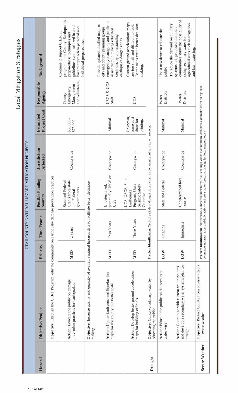
Lo
cal
Mit
iga
tio
n S
tra
teg
ies
UTA
H C
OU
NTY
NA
TUR
AL
HA
ZAR
D M
ITIG
ATI
ON
PR
OJE
CTS
H
azar
d O
bjec
tive/
Proj
ect
Prio
rity
T
ime
Fram
e Po
ssib
le F
undi
ng
Sour
ces
Juri
sdic
tion
Aff
ecte
d E
stim
ated
Pr
ojec
t Cos
t R
espo
nsib
le
Age
ncy
Bac
kgro
und
O
bjec
tive:
Thr
ough
the
CER
T Pr
ogra
m, e
duca
te c
omm
unity
on
earth
quak
e da
mag
e pr
even
tion
prac
tices
A
ctio
n: E
duca
te th
e pu
blic
on
dam
age
prev
entio
n pr
actic
es fo
r ear
thqu
akes
M
ED
2
year
s
Stat
e an
d Fe
dera
l G
rant
s fro
m st
ate
and
Fede
ral
gove
rnm
ents
Cou
ntyw
ide
$50,
000-
$75,
000
Cou
nty
Emer
genc
y M
anag
emen
t an
d vo
lunt
eers
Con
tinue
to su
ppor
t C.E
.R.T
. pr
ogra
m in
the
Cou
nty.
Ear
thqu
akes
pr
epar
edne
ss te
chni
ques
and
gu
idel
ines
can
be
utili
zed
in a
n al
l-ha
zard
app
roac
h to
per
sona
l and
in
divi
dual
pre
pare
dnes
s.
O
bjec
tive:
Incr
ease
qua
lity
and
quan
tity
of a
vaila
ble
natu
ral h
azar
ds d
ata
to fa
cilit
ate
bette
r dec
isio
n-m
akin
g.
A
ctio
n: U
pdat
e fa
ult z
one
and
lique
fact
ion
map
s for
the
coun
ty to
a b
ette
r sca
le
ME
D
Two
Yea
rs
Und
eter
min
ed,
pote
ntia
lly U
SGS
or
UG
S C
ount
ywid
e M
inim
al
USG
S &
UG
S St
aff
Prov
ide
upda
ted,
det
aile
d m
aps t
o ci
ty a
nd c
ount
y pl
anni
ng g
roup
s, em
erge
ncy
man
ager
s, an
d pu
blic
to
assi
st th
em in
mak
ing
educ
ated
de
cisi
ons b
y un
ders
tand
ing
earth
quak
e da
nger
zon
es.
A
ctio
n: D
evel
op b
ette
r gro
und
acce
lera
tion
map
s for
bui
ldin
g of
ficia
ls
ME
D
Thre
e Y
ears
UG
S, U
SGS,
Sta
te
Earth
quak
e Pr
ogra
m, U
tah
Seis
mic
Saf
ety
Com
mis
sion
Cou
ntyw
ide
Unk
now
n,
som
e co
st
shar
e fo
r pr
intin
g.
UG
S
Cur
rent
gro
und
acce
lera
tions
map
s ar
e to
o sm
all a
nd d
iffic
ult t
o re
ad.
Bet
ter m
aps c
reat
e be
tter d
ecis
ion-
mak
ing.
Dro
ught
O
bjec
tive:
Con
serv
e cu
linar
y w
ater
by
educ
atin
g th
e pu
blic
Pr
oble
m Id
entif
icat
ion:
Cyc
lical
per
iods
of d
roug
ht p
lace
a st
rain
on
com
mun
ity c
ulin
ary
wat
er re
sour
ces.
A
ctio
n: E
duca
te th
e pu
blic
on
the
need
to b
e w
ater
wis
e L
OW
O
ngoi
ng
Stat
e an
d Fe
dera
l C
ount
ywid
e M
inim
al
Wat
er
Dis
trict
s U
se a
new
slet
ter t
o ed
ucat
e th
e pu
blic
A
ctio
n: C
oord
inat
e w
ith c
urre
nt w
ater
syst
ems
and
deve
lop
a se
cond
ary
wat
er sy
stem
s pla
n fo
r dr
ough
t L
OW
Im
med
iate
U
ndet
erm
ined
loca
l so
urce
C
ount
ywid
e M
inim
al
Wat
er
Dis
trict
s
To re
duce
the
dem
and
on c
ulin
ary
syst
ems i
t is p
ropo
sed
that
mor
e co
mm
uniti
es st
udy
the
poss
ibili
ty o
f us
ing
seco
ndar
y w
ater
for
agric
ultu
ral u
ses s
uch
as ir
rigat
ion
and
law
n w
ater
ing.
Seve
re W
eath
er
Obj
ectiv
e: P
rote
ct C
ount
y fr
om a
dver
se a
ffect
s of
seve
re w
eath
er
Prob
lem
Iden
tific
atio
n: S
now
stor
ms,
sum
mer
thun
ders
torm
s, ha
il, a
nd h
igh
win
ds o
ver n
orth
ern
Uta
h ha
ve a
dra
mat
ic e
ffec
t on
regi
onal
co
mm
erce
, tra
nspo
rtatio
n, a
nd d
aily
act
ivity
and
are
a m
ajor
fore
cast
cha
lleng
e fo
r loc
al m
eteo
rolo
gist
s.
133 of 142
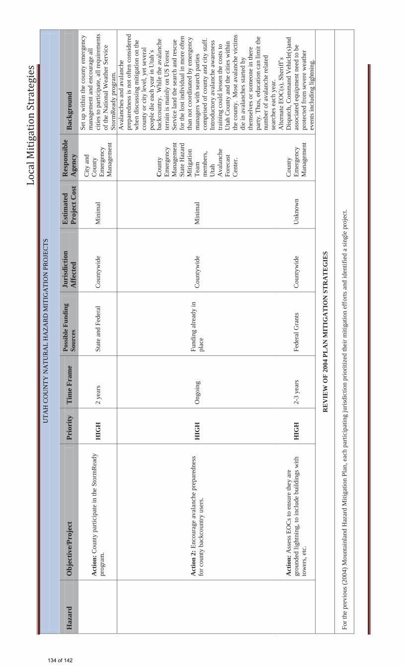
Lo
cal
Mit
iga
tio
n S
tra
teg
ies
UTA
H C
OU
NTY
NA
TUR
AL
HA
ZAR
D M
ITIG
ATI
ON
PR
OJE
CTS
H
azar
d O
bjec
tive/
Proj
ect
Prio
rity
T
ime
Fram
e Po
ssib
le F
undi
ng
Sour
ces
Juri
sdic
tion
Aff
ecte
d E
stim
ated
Pr
ojec
t Cos
t R
espo
nsib
le
Age
ncy
Bac
kgro
und
A
ctio
n: C
ount
y pa
rtici
pate
in th
e St
orm
Rea
dy
prog
ram
. H
IGH
2
year
s St
ate
and
Fede
ral
Cou
ntyw
ide
Min
imal
City
and
C
ount
y Em
erge
ncy
Man
agem
ent
Set u
p w
ithin
the
coun
ty e
mer
genc
y m
anag
emen
t and
enc
oura
ge a
ll ci
ties t
o pa
rtici
pate
, all
requ
irem
ents
of
the
Nat
iona
l Wea
ther
Ser
vice
St
orm
Rea
dy p
rogr
am.
A
ctio
n 2:
Enc
oura
ge a
vala
nche
pre
pare
dnes
s fo
r cou
nty
back
coun
try u
sers
. H
IGH
O
ngoi
ng
Fund
ing
alre
ady
in
plac
e C
ount
ywid
e M
inim
al
Cou
nty
Emer
genc
y M
anag
emen
t St
ate
Haz
ard
Miti
gatio
n Te
am
mem
bers
, U
tah
Ava
lanc
he
Fore
cast
C
ente
r.
Ava
lanc
hes a
nd a
vala
nche
pr
epar
edne
ss is
not
ofte
n co
nsid
ered
w
hen
disc
ussi
ng m
itiga
tion
on th
e co
unty
or c
ity le
vel,
yet s
ever
al
peop
le d
ie e
ach
year
in U
tah’
s ba
ckco
untry
. W
hile
the
aval
anch
e te
rrai
n is
mai
nly
on U
S Fo
rest
Se
rvic
e la
nd th
e se
arch
and
resc
ue
for t
he lo
st in
divi
dual
in m
ore
ofte
n th
an n
ot c
oord
inat
ed b
y em
erge
ncy
man
ager
s with
sear
ch p
artie
s co
mpr
ised
of c
ount
y an
d ci
ty st
aff.
In
trodu
ctor
y av
alan
che
awar
enes
s tra
inin
g co
uld
less
en th
e co
sts t
o U
tah
Cou
nty
and
the
citie
s with
in
the
coun
ty.
Mos
t ava
lanc
he v
ictim
s di
e in
ava
lanc
hes s
tarte
d by
th
emse
lves
or s
omeo
ne in
ther
e pa
rty. T
hus,
educ
atio
n ca
n lim
it th
e nu
mbe
r of a
vala
nche
rela
ted
sear
ches
eac
h ye
ar.
A
ctio
n: A
sses
s EO
Cs t
o en
sure
they
are
gr
ound
ed li
ghtn
ing,
to in
clud
e bu
ildin
gs w
ith
tow
ers,
etc.
H
IGH
2-
3 ye
ars
Fede
ral G
rant
s C
ount
ywid
e U
nkno
wn
Cou
nty
Emer
genc
y M
anag
emen
t
Alte
rnat
e EO
C(s
), Sh
eriff
’s
Dis
patc
h, C
omm
and
Veh
icle
(s)a
nd
asso
ciat
ed e
quip
men
t nee
d to
be
prot
ecte
d fr
om se
vere
wea
ther
ev
ents
incl
udin
g lig
htni
ng.
RE
VIE
W O
F 20
04 P
LA
N M
ITIG
AT
ION
STR
AT
EG
IES
For t
he p
revi
ous (
2004
) Mou
ntai
nlan
d H
azar
d M
itiga
tion
Plan
, eac
h pa
rtici
patin
g ju
risdi
ctio
n pr
iorit
ized
thei
r miti
gatio
n ef
forts
and
iden
tifie
d a
sing
le p
roje
ct.
134 of 142
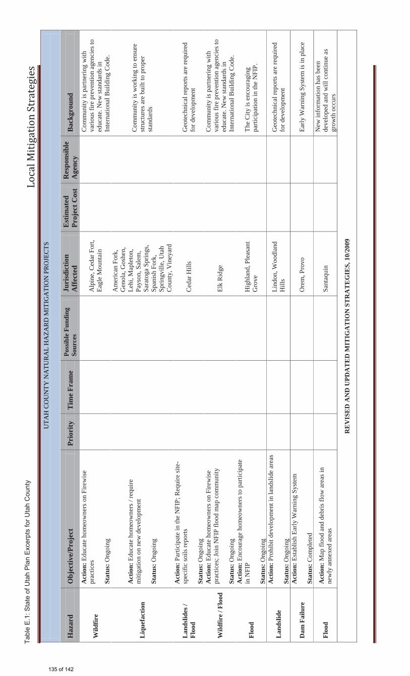
Lo
cal
Mit
iga
tio
n S
tra
teg
ies
UTA
H C
OU
NTY
NA
TUR
AL
HA
ZAR
D M
ITIG
ATI
ON
PR
OJE
CTS
H
azar
d O
bjec
tive/
Proj
ect
Prio
rity
T
ime
Fram
e Po
ssib
le F
undi
ng
Sour
ces
Juri
sdic
tion
Aff
ecte
d E
stim
ated
Pr
ojec
t Cos
t R
espo
nsib
le
Age
ncy
Bac
kgro
und
Wild
fire
Act
ion:
Edu
cate
hom
eow
ners
on
Fire
wis
e pr
actic
es
Stat
us: O
ngoi
ng
A
lpin
e, C
edar
For
t, Ea
gle
Mou
ntai
n
Com
mun
ity is
par
tner
ing
with
va
rious
fire
pre
vent
ion
agen
cies
to
educ
ate.
New
stan
dard
s in
Inte
rnat
iona
l Bui
ldin
g C
ode.
Liq
uefa
ctio
n
Act
ion:
Edu
cate
hom
eow
ners
/ re
quire
m
itiga
tion
on n
ew d
evel
opm
ent
Stat
us: O
ngoi
ng
Am
eric
an F
ork,
G
enol
a, G
oshe
n,
Lehi
, Map
leto
n,
Pays
on, S
alem
, Sa
rato
ga S
prin
gs,
Span
ish
Fork
, Sp
ringv
ille,
Uta
h C
ount
y, V
iney
ard
Com
mun
ity is
wor
king
to e
nsur
e st
ruct
ures
are
bui
lt to
pro
per
stan
dard
s
Lan
dslid
es /
Floo
d
Act
ion:
Par
ticip
ate
in th
e N
FIP;
Req
uire
site
-sp
ecifi
c so
ils re
ports
St
atus
: Ong
oing
C
edar
Hill
s
G
eote
chni
cal r
epor
ts a
re re
quire
d fo
r dev
elop
men
t
Wild
fire
/ Flo
od
Act
ion:
Edu
cate
hom
eow
ners
on
Fire
wis
e pr
actic
es; J
oin
NFI
P flo
od m
ap c
omm
unity
St
atus
: Ong
oing
El
k R
idge
Com
mun
ity is
par
tner
ing
with
va
rious
fire
pre
vent
ion
agen
cies
to
educ
ate.
New
stan
dard
s in
Inte
rnat
iona
l Bui
ldin
g C
ode.
Floo
d
Act
ion:
Enc
oura
ge h
omeo
wne
rs to
par
ticip
ate
in N
FIP
Stat
us: O
ngoi
ng
H
ighl
and,
Ple
asan
t G
rove
Th
e C
ity is
enc
oura
ging
pa
rtici
patio
n in
the
NFI
P.
Lan
dslid
e A
ctio
n: P
rohi
bit d
evel
opm
ent i
n la
ndsl
ide
area
s St
atus
: Ong
oing
Lind
on, W
oodl
and
Hill
s
G
eote
chni
cal r
epor
ts a
re re
quire
d fo
r dev
elop
men
t
Dam
Fai
lure
A
ctio
n: E
stab
lish
Early
War
ning
Sys
tem
St
atus
: Com
plet
ed
O
rem
, Pro
vo
Early
War
ning
Sys
tem
is in
pla
ce
Floo
d A
ctio
n: M
ap fl
ood
and
debr
is fl
ow a
reas
in
new
ly a
nnex
ed a
reas
Sant
aqui
n
N
ew in
form
atio
n ha
s bee
n de
velo
ped
and
will
con
tinue
as
grow
th o
ccur
s
RE
VIS
ED
AN
D U
PDA
TE
D M
ITIG
AT
ION
ST
RA
TE
GIE
S, 1
0/20
09
Tabl
e E
.1: S
tate
of U
tah
Pla
n E
xcer
pts
for U
tah
Cou
nty
135 of 142

Lo
cal
Mit
iga
tio
n S
tra
teg
ies
UTA
H C
OU
NTY
NA
TUR
AL
HA
ZAR
D M
ITIG
ATI
ON
PR
OJE
CTS
H
azar
d O
bjec
tive/
Proj
ect
Prio
rity
T
ime
Fram
e Po
ssib
le F
undi
ng
Sour
ces
Juri
sdic
tion
Aff
ecte
d E
stim
ated
Pr
ojec
t Cos
t R
espo
nsib
le
Age
ncy
Bac
kgro
und
Floo
ding
/ D
am
Failu
re
Obj
ectiv
e 1:
Pro
tect
ing
curr
ent r
esid
ents
and
st
ruct
ures
A
ctio
n: P
rom
ote
NFI
P pa
rtici
patio
n H
IGH
O
ngoi
ng
Loca
l cas
h, G
rant
s
Alp
ine,
Am
eric
an
Fork
, Ced
ar H
ills,
Dra
per,
Elk
Rid
ge,
Fairf
ield
, Gen
ola,
G
oshe
n, H
ighl
and,
M
aple
ton,
Ore
m,
Pays
on, P
leas
ant
Gro
ve, P
rovo
, Sa
lem
, San
taqu
in,
Sara
toga
Spr
ings
, Sp
anis
h Fo
rk,
Sprin
gvill
e,
Vin
eyar
d
Min
imal
Loca
l G
over
nmen
t, FE
MA
, U
DH
S
A
ctio
n: Jo
in N
FIP
com
mun
ity /
parti
cipa
tion
ME
D
1 ye
ar
Loca
l cas
h, G
rant
s Ea
gle
Mou
ntai
n M
inim
al
Loca
l G
over
nmen
t, FE
MA
, U
DH
S
A
ctio
n: P
rom
ote
NFI
P pa
rtici
patio
n; C
lean
dam
dr
aina
ge a
nd re
mov
e de
bris
from
wat
er w
ays
HIG
H
Ong
oing
Lo
cal c
ash,
Gra
nts
Lehi
M
inim
al
Loca
l G
over
nmen
t, FE
MA
, U
DH
S
A
ctio
n: P
rom
ote
NFI
P pa
rtici
patio
n; D
itch
impr
ovem
ents
; Ann
ual d
am in
spec
tions
(Dry
C
anyo
n, S
quaw
Hol
low
) H
IGH
O
ngoi
ng
Loca
l cas
h, G
rant
s Li
ndon
M
oder
ate
Loca
l G
over
nmen
t, FE
MA
, U
DH
S
A
ctio
n: P
ipe
wat
er fr
om fl
ood
basi
n 20
0 S.
and
50
0 N
. to
cana
l. A
ppro
x. 8
,000
ft h
igh-
pres
sure
pi
pe
HIG
H
Ong
oing
Lo
cal c
ash,
Gra
nts
Plea
sant
Gro
ve
$2,0
00,0
00
Loca
l G
over
nmen
t, FE
MA
, U
DH
S
A
ctio
n: C
anyo
n D
ebris
Bas
ins
HIG
H
Ong
oing
Lo
cal c
ash,
Gra
nts
Uta
h C
ount
y (u
ninc
orpo
rate
d)
TBD
Loca
l G
over
nmen
t, FE
MA
, U
DH
S
136 of 142
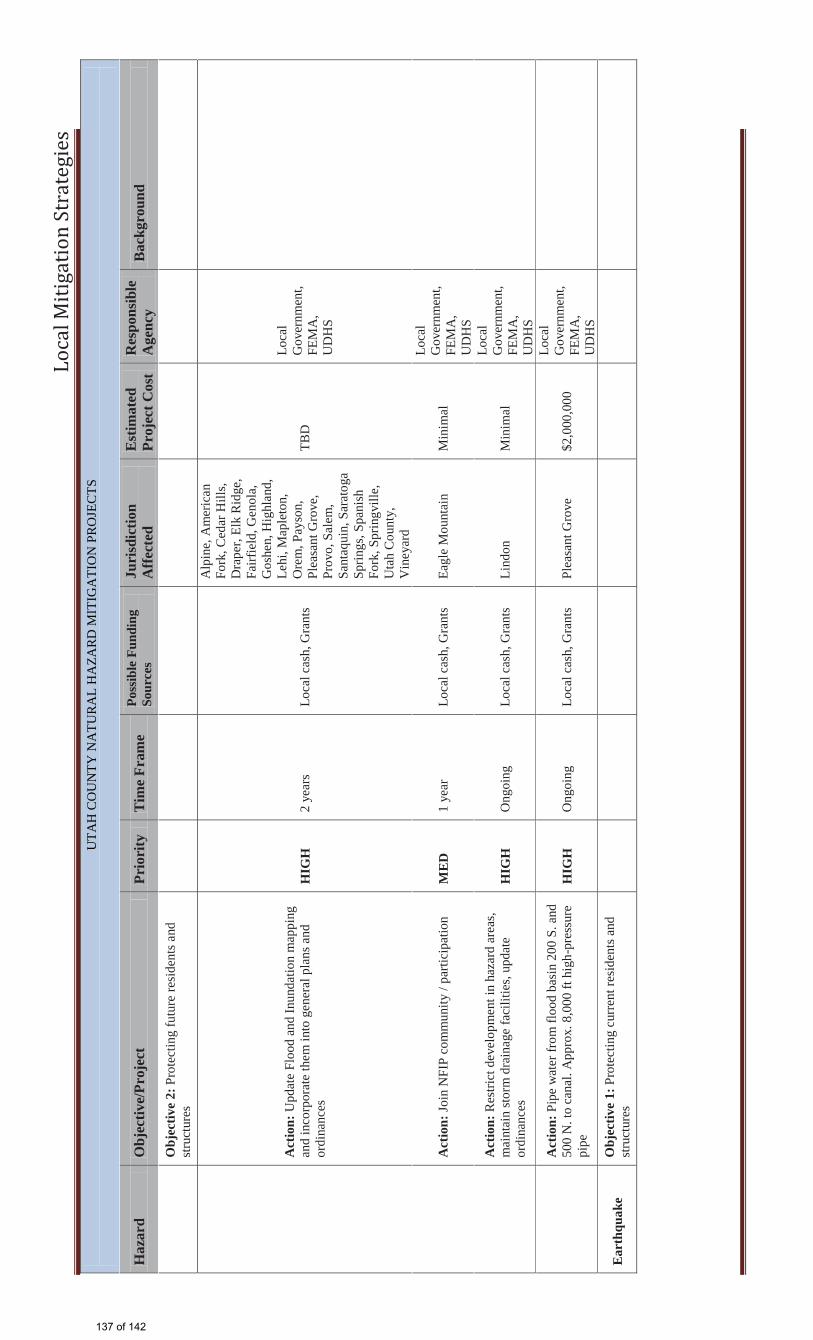
Lo
cal
Mit
iga
tio
n S
tra
teg
ies
UTA
H C
OU
NTY
NA
TUR
AL
HA
ZAR
D M
ITIG
ATI
ON
PR
OJE
CTS
H
azar
d O
bjec
tive/
Proj
ect
Prio
rity
T
ime
Fram
e Po
ssib
le F
undi
ng
Sour
ces
Juri
sdic
tion
Aff
ecte
d E
stim
ated
Pr
ojec
t Cos
t R
espo
nsib
le
Age
ncy
Bac
kgro
und
O
bjec
tive
2: P
rote
ctin
g fu
ture
resi
dent
s and
st
ruct
ures
A
ctio
n: U
pdat
e Fl
ood
and
Inun
datio
n m
appi
ng
and
inco
rpor
ate
them
into
gen
eral
pla
ns a
nd
ordi
nanc
es
HIG
H
2 ye
ars
Loca
l cas
h, G
rant
s
Alp
ine,
Am
eric
an
Fork
, Ced
ar H
ills,
Dra
per,
Elk
Rid
ge,
Fairf
ield
, Gen
ola,
G
oshe
n, H
ighl
and,
Le
hi, M
aple
ton,
O
rem
, Pay
son,
Pl
easa
nt G
rove
, Pr
ovo,
Sal
em,
Sant
aqui
n, S
arat
oga
Sprin
gs, S
pani
sh
Fork
, Spr
ingv
ille,
U
tah
Cou
nty,
V
iney
ard
TBD
Loca
l G
over
nmen
t, FE
MA
, U
DH
S
A
ctio
n: Jo
in N
FIP
com
mun
ity /
parti
cipa
tion
ME
D
1 ye
ar
Loca
l cas
h, G
rant
s Ea
gle
Mou
ntai
n M
inim
al
Loca
l G
over
nmen
t, FE
MA
, U
DH
S
A
ctio
n: R
estri
ct d
evel
opm
ent i
n ha
zard
are
as,
mai
ntai
n st
orm
dra
inag
e fa
cilit
ies,
upda
te
ordi
nanc
es
HIG
H
Ong
oing
Lo
cal c
ash,
Gra
nts
Lind
on
Min
imal
Loca
l G
over
nmen
t, FE
MA
, U
DH
S
A
ctio
n: P
ipe
wat
er fr
om fl
ood
basi
n 20
0 S.
and
50
0 N
. to
cana
l. A
ppro
x. 8
,000
ft h
igh-
pres
sure
pi
pe
HIG
H
Ong
oing
Lo
cal c
ash,
Gra
nts
Plea
sant
Gro
ve
$2,0
00,0
00
Loca
l G
over
nmen
t, FE
MA
, U
DH
S
Ear
thqu
ake
Obj
ectiv
e 1:
Pro
tect
ing
curr
ent r
esid
ents
and
st
ruct
ures
137 of 142

Lo
cal
Mit
iga
tio
n S
tra
teg
ies
UTA
H C
OU
NTY
NA
TUR
AL
HA
ZAR
D M
ITIG
ATI
ON
PR
OJE
CTS
H
azar
d O
bjec
tive/
Proj
ect
Prio
rity
T
ime
Fram
e Po
ssib
le F
undi
ng
Sour
ces
Juri
sdic
tion
Aff
ecte
d E
stim
ated
Pr
ojec
t Cos
t R
espo
nsib
le
Age
ncy
Bac
kgro
und
A
ctio
n: In
vent
ory
curr
ent c
ritic
al fa
cilit
ies f
or
seis
mic
stan
dard
s H
IGH
3
year
s Lo
cal c
ash,
Gra
nts
Alp
ine,
Am
eric
an
Fork
, Ced
ar F
ort,
Ced
ar H
ills,
Dra
per,
Eagl
e M
ount
ain,
Elk
R
idge
, Fai
rfie
ld,
Gen
ola,
Gos
hen,
H
ighl
and,
Map
leto
n,
Ore
m, P
ayso
n,
Plea
sant
Gro
ve,
Prov
o, S
alem
, Sa
ntaq
uin,
Sar
atog
a Sp
rings
, Spa
nish
Fo
rk, S
prin
gvill
e,
Uta
h C
ount
y,
Vin
eyar
d, W
oodl
and
Hill
s
TBD
Lo
cal
Gov
ernm
ent
A
ctio
n: P
rom
ote
earth
quak
e aw
aren
ess a
nd
prep
arat
ion
HIG
H
Ong
oing
Lo
cal c
ash,
Gra
nts
Lehi
M
inim
al
Loca
l G
over
nmen
t
A
ctio
n: F
ollo
w a
nd a
pply
cur
rent
bui
ldin
g co
des a
dopt
ed b
y C
ity
HIG
H
Ong
oing
Lo
cal c
ash,
Gra
nts
Lind
on
Min
imal
Lo
cal
Gov
ernm
ent
O
bjec
tive
2: P
rote
ctin
g fu
ture
resi
dent
s and
st
ruct
ures
138 of 142
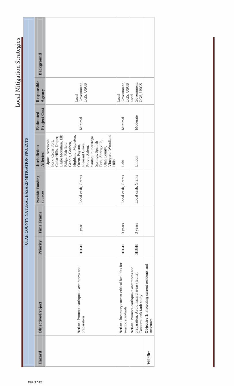
Lo
cal
Mit
iga
tio
n S
tra
teg
ies
UTA
H C
OU
NTY
NA
TUR
AL
HA
ZAR
D M
ITIG
ATI
ON
PR
OJE
CTS
H
azar
d O
bjec
tive/
Proj
ect
Prio
rity
T
ime
Fram
e Po
ssib
le F
undi
ng
Sour
ces
Juri
sdic
tion
Aff
ecte
d E
stim
ated
Pr
ojec
t Cos
t R
espo
nsib
le
Age
ncy
Bac
kgro
und
A
ctio
n: P
rom
ote
earth
quak
e aw
aren
ess a
nd
prep
arat
ion
HIG
H
1 ye
ar
Loca
l cas
h, G
rant
s
Alp
ine,
Am
eric
an
Fork
, Ced
ar F
ort,
Ced
ar H
ills,
Dra
per,
Eagl
e M
ount
ain,
Elk
R
idge
, Fai
rfie
ld,
Gen
ola,
Gos
hen,
H
ighl
and,
Map
leto
n,
Ore
m, P
ayso
n,
Plea
sant
Gro
ve,
Prov
o, S
alem
, Sa
ntaq
uin,
Sar
atog
a Sp
rings
, Spa
nish
Fo
rk, S
prin
gvill
e,
Uta
h C
ount
y,
Vin
eyar
d, W
oodl
and
Hill
s
Min
imal
Lo
cal
Gov
ernm
ent,
UG
S, U
SGS
A
ctio
n: In
vent
ory
curr
ent c
ritic
al fa
cilit
ies f
or
seis
mic
stan
dard
s H
IGH
3
year
s Lo
cal c
ash,
Gra
nts
Lehi
M
inim
al
Loca
l G
over
nmen
t, U
GS,
USG
S
A
ctio
n: P
rom
ote
earth
quak
e aw
aren
ess a
nd
prep
arat
ion.
Avo
id h
azar
d ar
eas (
faul
ts),
Can
berr
a ta
nk fa
ult s
tudy
H
IGH
3
year
s Lo
cal c
ash,
Gra
nts
Lind
on
Mod
erat
e Lo
cal
Gov
ernm
ent,
UG
S, U
SGS
Wild
fire
Obj
ectiv
e 1:
Pro
tect
ing
curr
ent r
esid
ents
and
st
ruct
ures
139 of 142
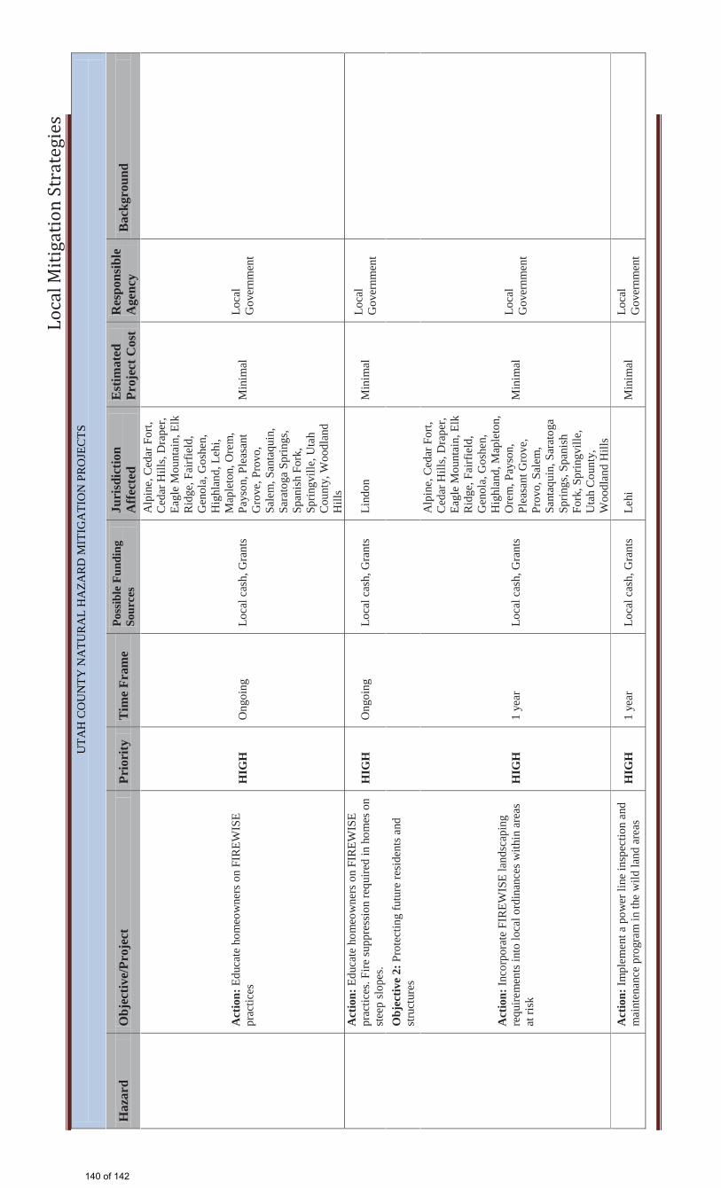
Lo
cal
Mit
iga
tio
n S
tra
teg
ies
UTA
H C
OU
NTY
NA
TUR
AL
HA
ZAR
D M
ITIG
ATI
ON
PR
OJE
CTS
H
azar
d O
bjec
tive/
Proj
ect
Prio
rity
T
ime
Fram
e Po
ssib
le F
undi
ng
Sour
ces
Juri
sdic
tion
Aff
ecte
d E
stim
ated
Pr
ojec
t Cos
t R
espo
nsib
le
Age
ncy
Bac
kgro
und
A
ctio
n: E
duca
te h
omeo
wne
rs o
n FI
REW
ISE
prac
tices
H
IGH
O
ngoi
ng
Loca
l cas
h, G
rant
s
Alp
ine,
Ced
ar F
ort,
Ced
ar H
ills,
Dra
per,
Eagl
e M
ount
ain,
Elk
R
idge
, Fai
rfie
ld,
Gen
ola,
Gos
hen,
H
ighl
and,
Leh
i, M
aple
ton,
Ore
m,
Pays
on, P
leas
ant
Gro
ve, P
rovo
, Sa
lem
, San
taqu
in,
Sara
toga
Spr
ings
, Sp
anis
h Fo
rk,
Sprin
gvill
e, U
tah
Cou
nty,
Woo
dlan
d H
ills
Min
imal
Lo
cal
Gov
ernm
ent
A
ctio
n: E
duca
te h
omeo
wne
rs o
n FI
REW
ISE
prac
tices
. Fire
supp
ress
ion
requ
ired
in h
omes
on
stee
p sl
opes
. H
IGH
O
ngoi
ng
Loca
l cas
h, G
rant
s Li
ndon
M
inim
al
Loca
l G
over
nmen
t
O
bjec
tive
2: P
rote
ctin
g fu
ture
resi
dent
s and
st
ruct
ures
A
ctio
n: In
corp
orat
e FI
REW
ISE
land
scap
ing
requ
irem
ents
into
loca
l ord
inan
ces w
ithin
are
as
at ri
sk
HIG
H
1 ye
ar
Loca
l cas
h, G
rant
s
Alp
ine,
Ced
ar F
ort,
Ced
ar H
ills,
Dra
per,
Eagl
e M
ount
ain,
Elk
R
idge
, Fai
rfie
ld,
Gen
ola,
Gos
hen,
H
ighl
and,
Map
leto
n,
Ore
m, P
ayso
n,
Plea
sant
Gro
ve,
Prov
o, S
alem
, Sa
ntaq
uin,
Sar
atog
a Sp
rings
, Spa
nish
Fo
rk, S
prin
gvill
e,
Uta
h C
ount
y,
Woo
dlan
d H
ills
Min
imal
Lo
cal
Gov
ernm
ent
A
ctio
n: Im
plem
ent a
pow
er li
ne in
spec
tion
and
mai
nten
ance
pro
gram
in th
e w
ild la
nd a
reas
H
IGH
1
year
Lo
cal c
ash,
Gra
nts
Lehi
M
inim
al
Loca
l G
over
nmen
t
140 of 142

Lo
cal
Mit
iga
tio
n S
tra
teg
ies
UTA
H C
OU
NTY
NA
TUR
AL
HA
ZAR
D M
ITIG
ATI
ON
PR
OJE
CTS
H
azar
d O
bjec
tive/
Proj
ect
Prio
rity
T
ime
Fram
e Po
ssib
le F
undi
ng
Sour
ces
Juri
sdic
tion
Aff
ecte
d E
stim
ated
Pr
ojec
t Cos
t R
espo
nsib
le
Age
ncy
Bac
kgro
und
A
ctio
n: In
corp
orat
e FI
REW
ISE
land
scap
ing
requ
irem
ents
into
loca
l ord
inan
ces w
ithin
are
as
at ri
sk
HIG
H
2 ye
ars
Loca
l cas
h, G
rant
s Li
ndon
M
inim
al
Loca
l G
over
nmen
t
Lan
dslid
e O
bjec
tive
1: P
rote
ctin
g cu
rren
t res
iden
ts a
nd
stru
ctur
es
A
ctio
n: P
ublic
edu
catio
n on
cor
rect
wat
erin
g pr
actic
es a
nd re
tain
ing
mea
sure
s in
susc
eptib
le
area
s M
ED
1
year
Lo
cal c
ash,
Gra
nts
Alp
ine,
Am
eric
an
Fork
, Ced
ar F
ort,
Ced
ar H
ills,
Dra
per,
Eagl
e M
ount
ain,
Elk
R
idge
, Gen
ola,
H
ighl
and,
Leh
i, M
aple
ton,
Ore
m,
Pays
on, P
leas
ant
Gro
ve, P
rovo
, Sa
lem
, San
taqu
in,
Sara
toga
Spr
ings
, Sp
anis
h Fo
rk,
Sprin
gvill
e, U
tah
Cou
nty,
Woo
dlan
d H
ills
TBD
Lo
cal
Gov
ernm
ent,
UG
S
O
bjec
tive
2: P
rote
ctin
g fu
ture
resi
dent
s and
st
ruct
ures
A
ctio
n: C
oord
inat
e an
d up
date
land
slid
e m
appi
ng w
ithin
the
area
with
UG
S an
d U
SGS
HIG
H
3 ye
ars
Loca
l cas
h, G
rant
s
Alp
ine,
Am
eric
an
Fork
, Ced
ar F
ort,
Ced
ar H
ills,
Dra
per,
Eagl
e M
ount
ain,
Elk
R
idge
, Gen
ola,
H
ighl
and,
Map
leto
n,
Ore
m, P
ayso
n,
Plea
sant
Gro
ve,
Prov
o, S
alem
, Sa
ntaq
uin,
Sar
atog
a Sp
rings
, Spa
nish
Fo
rk, S
prin
gvill
e,
Uta
h C
ount
y,
Woo
dlan
d H
ills
Min
imal
Lo
cal
Gov
ernm
ent,
UG
S, U
SGS
141 of 142

Lo
cal
Mit
iga
tio
n S
tra
teg
ies
UTA
H C
OU
NTY
NA
TUR
AL
HA
ZAR
D M
ITIG
ATI
ON
PR
OJE
CTS
H
azar
d O
bjec
tive/
Proj
ect
Prio
rity
T
ime
Fram
e Po
ssib
le F
undi
ng
Sour
ces
Juri
sdic
tion
Aff
ecte
d E
stim
ated
Pr
ojec
t Cos
t R
espo
nsib
le
Age
ncy
Bac
kgro
und
A
ctio
n: C
reat
e a
vege
tatio
n pl
acem
ent a
nd
man
agem
ent p
lan
HIG
H
1 ye
ar
Loca
l cas
h, G
rant
s Le
hi
Min
imal
Lo
cal
Gov
ernm
ent,
UG
S, U
SGS
Deb
ris F
low
O
bjec
tive
1: P
rote
ctin
g cu
rren
t res
iden
ts a
nd
stru
ctur
es
A
ctio
n: C
onst
ruct
/ In
stal
l deb
ris fl
ow b
asin
s in
inve
ntor
ied
haza
rd a
reas
M
ED
5
year
s Lo
cal c
ash,
Gra
nts
Lind
on
Hig
h Lo
cal
Gov
ernm
ent,
UG
S
O
bjec
tive
2: P
rote
ctin
g fu
ture
resi
dent
s and
st
ruct
ures
A
ctio
n: M
aint
ain
debr
is fl
ow b
asin
s. M
onito
r w
ildfir
e an
d la
ndsl
ide
area
s H
IGH
O
ngoi
ng
Loca
l cas
h, G
rant
s Li
ndon
M
inim
al
Loca
l G
over
nmen
t, U
GS,
USG
S
RE
VIS
ED
AN
D U
PDA
TE
D M
ITIG
AT
ION
ST
RA
TE
GIE
S, 2
010
Dro
ught
O
bjec
tive:
Con
serv
e cu
linar
y w
ater
by
educ
atin
g th
e pu
blic
A
ctio
n: P
rom
ote
wat
er c
onse
rvat
ion
prog
ram
s "S
low
the
Flow
"
MED
O
ngoi
ng
Loca
l cas
h, G
rant
s, U
DW
R, C
UW
CU
C
ount
ywid
e M
inim
al
Act
ion:
Con
side
r the
ena
ctm
ent o
f wat
er w
ise
land
scap
ing
ordi
nanc
es
HIG
H
1-ye
ar
Loca
l Cas
h an
d G
rant
s
Cou
ntyw
ide
Min
imal
142 of 142