Microfossils from coastal environments as indicators of paleo ...
14
Microfossils from coastal environments as indicators of paleo-earthquakes, tsunamis and storms Jessica E. Pilarczyk a,b, ⁎, Tina Dura c , Benjamin P. Horton a,b , Simon E. Engelhart d , Andrew C. Kemp e , Yuki Sawai f a Sea Level Research, Institute of Marine and Coastal Science, Rutgers University, New Brunswick, NJ, USA b Earth Observatory of Singapore, Nanyang Technological University, Singapore c Department of Earth and Environmental Science, University of Pennsylvania, Philadelphia, PA, USA d Department of Geosciences, University of Rhode Island, Kingston, RI, USA e Department of Earth and Ocean Sciences, Tufts University, Medford, MA 02155, USA f Geological Survey of Japan, National Institute of Advanced Industrial Science and Technology (AIST), Tsukuba Central 7, 1-1-1 Higashi, Tsukuba, Ibaraki 305-8567, Japan abstract article info Article history: Received 22 October 2013 Received in revised form 26 June 2014 Accepted 30 June 2014 Available online 9 July 2014 Keywords: Overwash Transfer functions Land-level change Foraminifera Diatoms Pollen Coastal risk assessment and hazard mitigation require datasets on centennial and millennial temporal scales to capture natural variability and multiple occurrences of the largest, but least frequent, events. Coastal sediments from low-energy depositional environments archive geologic evidence of paleo-earthquakes, tsunamis, and storms. Many of the best reconstructions of these events are derived from changes in microfossil (diatoms, fora- minifera, and pollen) assemblages. In this review we explain how microfossils are used to reconstruct records of paleoearthquakes by quantifying the amount of coseismic and interseismic vertical land movements along tectonically active coastlines. Examples from the United States (Alaska and the Pacific Northwest), Japan, and Chile show that microfossil-based transfer functions may provide continuous records of vertical land movement during earthquake deformation cycles. We discuss how microfossil habitat preferences and taphonomic charac- ter are used to constrain sediment provenance (e.g., beach, nearshore, or offshore sources) and identify overwash deposits, and how this information can be used to reconstruct the recurrence of tsunamis and storms. Analysis of overwash deposits from Thailand and Malaysia indicates the ability of microfossils to resolve individual waves within tsunami sediments, and an example from the Sendai coastal plain in Japan uses foraminifera to ascribe a beach to nearshore provenance for the 2011 Tohoku tsunami deposit. Finally, we present recent examples from the Gulf of Mexico on the use of foraminifera to estimate the volume and distance of transport of storm overwash from hurricanes. © 2014 Elsevier B.V. All rights reserved. 1. Introduction More than half of the world's population resides within 60 km of a coastline, including 60% of the world's most populated cities (Nicholls et al., 2007). Earthquakes, tsunamis and storms present a hazard to these intense concentrations of population, economic production and static infrastructure. Projected (annual) global losses from coastal flooding are expected to rise from US$6 billion in 2005 to US$52 billion by 2050 (Hallegatte et al., 2013). Accurate and realistic estimates of coastal hazards are hindered, however, by instrumental measurements and observational accounts that are too short to identify the potential magnitude and recurrence of rare events. To properly assess the risk of future great earthquakes along subduc- tion zone coastlines, it is essential that the magnitude and recurrence interval of prehistoric earthquakes are well understood (e.g., Satake and Atwater, 2007). Subduction zone earthquakes often involve vertical land-level changes (uplift or subsidence) of the coastline. Such deformation has been measured in the field for a number of large earthquakes, including southern Chile in 1960 (Barrientos and Ward, 1990; Khazaradze et al., 2002; Wang et al., 2007); Alaska in 1964 (Plafker, 1969; Savage et al., 1998; Zweck et al., 2002); Sumatra in 2004 (Banerjee et al., 2007; Chlieh et al., 2007; Paul et al., 2007); and Japan in 2011 (Iinuma et al., 2011; Simons et al., 2011; Ozawa et al., 2012). Land-level changes of this type are archived and recognized in coastal stratigraphic sequences as abrupt changes in relative sea-level (e.g., Atwater, 1987; Bourgeois and Reinhart, 1989; Nelson et al., 1996b; Shennan et al., 1999; Sawai, 2001; Cisternas et al., 2005; Grand Pre et al., 2012). In the wake of the 2004 Indian Ocean and 2011 Tohoku tsunamis, increased attention was paid to identify their predecessors. Examinations of coastal sedimentary records identified paleotsunami deposits that provided insight into the potential scale and impact of the events in 2004 in the Indian Ocean (e.g., Jankaew et al., 2008; Monecke et al., 2008; Malik et al., 2011; Grand Pre et al., 2012; Brill Palaeogeography, Palaeoclimatology, Palaeoecology 413 (2014) 144–157 ⁎ Corresponding author at: Sea Level Research, Institute of Marine and Coastal Science, Rutgers University, 71 Dudley Road, New Brunswick, NJ 08901-8525, USA. Tel.: +1 848 932 3482. E-mail address: [email protected] (J.E. Pilarczyk). http://dx.doi.org/10.1016/j.palaeo.2014.06.033 0031-0182/© 2014 Elsevier B.V. All rights reserved. Contents lists available at ScienceDirect Palaeogeography, Palaeoclimatology, Palaeoecology journal homepage: www.elsevier.com/locate/palaeo
-
Upload
khangminh22 -
Category
Documents
-
view
0 -
download
0
Transcript of Microfossils from coastal environments as indicators of paleo ...
Palaeogeography, Palaeoclimatology, Palaeoecology 413 (2014) 144–157
Contents lists available at ScienceDirect
Palaeogeography, Palaeoclimatology, Palaeoecology
j ourna l homepage: www.e lsev ie r .com/ locate /pa laeo
Microfossils from coastal environments as indicators ofpaleo-earthquakes, tsunamis and storms
Jessica E. Pilarczyk a,b,⁎, Tina Dura c, Benjamin P. Horton a,b, Simon E. Engelhart d, Andrew C. Kemp e, Yuki Sawai f
a Sea Level Research, Institute of Marine and Coastal Science, Rutgers University, New Brunswick, NJ, USAb Earth Observatory of Singapore, Nanyang Technological University, Singaporec Department of Earth and Environmental Science, University of Pennsylvania, Philadelphia, PA, USAd Department of Geosciences, University of Rhode Island, Kingston, RI, USAe Department of Earth and Ocean Sciences, Tufts University, Medford, MA 02155, USAf Geological Survey of Japan, National Institute of Advanced Industrial Science and Technology (AIST), Tsukuba Central 7, 1-1-1 Higashi, Tsukuba, Ibaraki 305-8567, Japan
⁎ Corresponding author at: Sea Level Research, InstituteRutgers University, 71 Dudley Road, New Brunswick, NJ932 3482.
E-mail address: [email protected] (J.E. Pilarcz
http://dx.doi.org/10.1016/j.palaeo.2014.06.0330031-0182/© 2014 Elsevier B.V. All rights reserved.
a b s t r a c t
a r t i c l e i n f oArticle history:Received 22 October 2013Received in revised form 26 June 2014Accepted 30 June 2014Available online 9 July 2014
Keywords:OverwashTransfer functionsLand-level changeForaminiferaDiatomsPollen
Coastal risk assessment and hazard mitigation require datasets on centennial and millennial temporal scales tocapture natural variability and multiple occurrences of the largest, but least frequent, events. Coastal sedimentsfrom low-energy depositional environments archive geologic evidence of paleo-earthquakes, tsunamis, andstorms. Many of the best reconstructions of these events are derived from changes inmicrofossil (diatoms, fora-minifera, and pollen) assemblages. In this reviewwe explain howmicrofossils are used to reconstruct records ofpaleoearthquakes by quantifying the amount of coseismic and interseismic vertical land movements alongtectonically active coastlines. Examples from the United States (Alaska and the Pacific Northwest), Japan, andChile show that microfossil-based transfer functions may provide continuous records of vertical land movementduring earthquake deformation cycles. We discuss howmicrofossil habitat preferences and taphonomic charac-ter are used to constrain sediment provenance (e.g., beach, nearshore, or offshore sources) and identify overwashdeposits, and how this information can be used to reconstruct the recurrence of tsunamis and storms. Analysis ofoverwash deposits from Thailand and Malaysia indicates the ability of microfossils to resolve individual waveswithin tsunami sediments, and an example from the Sendai coastal plain in Japan uses foraminifera to ascribea beach to nearshore provenance for the 2011 Tohoku tsunami deposit. Finally, we present recent examplesfrom the Gulf of Mexico on the use of foraminifera to estimate the volume and distance of transport of stormoverwash from hurricanes.
of Marine and Coastal Science,08901-8525, USA. Tel.: +1 848
yk).
© 2014 Elsevier B.V. All rights reserved.
1. Introduction
More than half of the world's population resides within 60 km of acoastline, including 60% of the world's most populated cities (Nichollset al., 2007). Earthquakes, tsunamis and storms present a hazard tothese intense concentrations of population, economic production andstatic infrastructure. Projected (annual) global losses from coastalflooding are expected to rise from US$6 billion in 2005 to US$52 billionby 2050 (Hallegatte et al., 2013). Accurate and realistic estimates ofcoastal hazards are hindered, however, by instrumental measurementsand observational accounts that are too short to identify the potentialmagnitude and recurrence of rare events.
To properly assess the risk of future great earthquakes along subduc-tion zone coastlines, it is essential that the magnitude and recurrence
interval of prehistoric earthquakes are well understood (e.g., Satakeand Atwater, 2007). Subduction zone earthquakes often involvevertical land-level changes (uplift or subsidence) of the coastline. Suchdeformation has been measured in the field for a number of largeearthquakes, including southern Chile in 1960 (Barrientos and Ward,1990; Khazaradze et al., 2002; Wang et al., 2007); Alaska in 1964(Plafker, 1969; Savage et al., 1998; Zweck et al., 2002); Sumatra in2004 (Banerjee et al., 2007; Chlieh et al., 2007; Paul et al., 2007); andJapan in 2011 (Iinuma et al., 2011; Simons et al., 2011; Ozawa et al.,2012). Land-level changes of this type are archived and recognized incoastal stratigraphic sequences as abrupt changes in relative sea-level(e.g., Atwater, 1987; Bourgeois and Reinhart, 1989; Nelson et al.,1996b; Shennan et al., 1999; Sawai, 2001; Cisternas et al., 2005; GrandPre et al., 2012). In thewake of the 2004 Indian Ocean and 2011 Tohokutsunamis, increased attention was paid to identify their predecessors.Examinations of coastal sedimentary records identified paleotsunamideposits that provided insight into the potential scale and impact ofthe events in 2004 in the Indian Ocean (e.g., Jankaew et al., 2008;Monecke et al., 2008; Malik et al., 2011; Grand Pre et al., 2012; Brill
Upland
Ti
High marsh
Low marsh
Bivalves
Tidal flatSubtidal
Highest tide
Lowest tide
Mean tidelevel
a
Reef flat
Freshwater
High marsh
Low marsh
Tidal flat and subtidal
(e.g. Gomphonema parvulum)
(e.g. Cosmioneis pusilla)
(e.g. Gyrosigma nodiferum)
(e.g. Tabularia fasciculata)
Diatoms
Highest marsh (e.g. Jadammina macrescens)
Middle to high marsh (e.g. Trochammina inflata)Low marsh and tidal flat (e.g. Miliammina fusca)
Tidal flat and subtidal (e.g. Elphidium spp.)
Agg
lutin
ated
Cal
care
ous
Supra tidal testate amoebae
Testate amoebae & foraminifera
Subtidal to intertidal (e.g. Homotrema rubrum)
Offshore planktics
Coral reef (tropical setting)
Salt-marsh (temperate setting)
Offshore
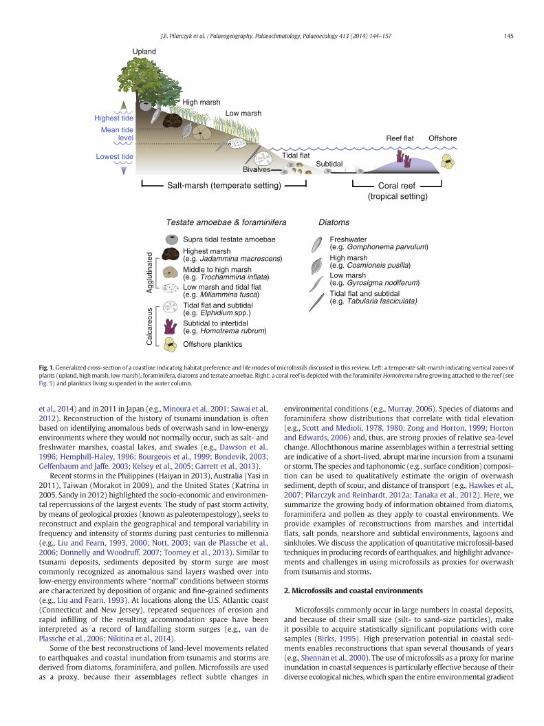
Fig. 1.Generalized cross-section of a coastline indicating habitat preference and lifemodes ofmicrofossils discussed in this review. Left: a temperate salt-marsh indicating vertical zones ofplants (upland, highmarsh, lowmarsh), foraminifera, diatoms and testate amoebae. Right: a coral reef is depictedwith the foraminiferHomotrema rubra growing attached to the reef (seeFig. 5) and planktics living suspended in the water column.
145J.E. Pilarczyk et al. / Palaeogeography, Palaeoclimatology, Palaeoecology 413 (2014) 144–157
et al., 2014) and in 2011 in Japan (e.g., Minoura et al., 2001; Sawai et al.,2012). Reconstruction of the history of tsunami inundation is oftenbased on identifying anomalous beds of overwash sand in low-energyenvironments where they would not normally occur, such as salt- andfreshwater marshes, coastal lakes, and swales (e.g., Dawson et al.,1996; Hemphill-Haley, 1996; Bourgeois et al., 1999; Bondevik, 2003;Gelfenbaum and Jaffe, 2003; Kelsey et al., 2005; Garrett et al., 2013).
Recent storms in the Philippines (Haiyan in 2013), Australia (Yasi in2011), Taiwan (Morakot in 2009), and the United States (Katrina in2005, Sandy in 2012) highlighted the socio-economic and environmen-tal repercussions of the largest events. The study of past storm activity,bymeans of geological proxies (known as paleotempestology), seeks toreconstruct and explain the geographical and temporal variability infrequency and intensity of storms during past centuries to millennia(e.g., Liu and Fearn, 1993, 2000; Nott, 2003; van de Plassche et al.,2006; Donnelly and Woodruff, 2007; Toomey et al., 2013). Similar totsunami deposits, sediments deposited by storm surge are mostcommonly recognized as anomalous sand layers washed over intolow-energy environments where “normal” conditions between stormsare characterized by deposition of organic and fine-grained sediments(e.g., Liu and Fearn, 1993). At locations along the U.S. Atlantic coast(Connecticut and New Jersey), repeated sequences of erosion andrapid infilling of the resulting accommodation space have beeninterpreted as a record of landfalling storm surges (e.g., van dePlassche et al., 2006; Nikitina et al., 2014).
Some of the best reconstructions of land-level movements relatedto earthquakes and coastal inundation from tsunamis and storms arederived from diatoms, foraminifera, and pollen. Microfossils are usedas a proxy, because their assemblages reflect subtle changes in
environmental conditions (e.g., Murray, 2006). Species of diatoms andforaminifera show distributions that correlate with tidal elevation(e.g., Scott and Medioli, 1978, 1980; Zong and Horton, 1999; Hortonand Edwards, 2006) and, thus, are strong proxies of relative sea-levelchange. Allochthonous marine assemblages within a terrestrial settingare indicative of a short-lived, abrupt marine incursion from a tsunamior storm. The species and taphonomic (e.g., surface condition) composi-tion can be used to qualitatively estimate the origin of overwashsediment, depth of scour, and distance of transport (e.g., Hawkes et al.,2007; Pilarczyk and Reinhardt, 2012a; Tanaka et al., 2012). Here, wesummarize the growing body of information obtained from diatoms,foraminifera and pollen as they apply to coastal environments. Weprovide examples of reconstructions from marshes and intertidalflats, salt ponds, nearshore and subtidal environments, lagoons andsinkholes. We discuss the application of quantitative microfossil-basedtechniques in producing records of earthquakes, and highlight advance-ments and challenges in using microfossils as proxies for overwashfrom tsunamis and storms.
2. Microfossils and coastal environments
Microfossils commonly occur in large numbers in coastal deposits,and because of their small size (silt- to sand-size particles), makeit possible to acquire statistically significant populations with coresamples (Birks, 1995). High preservation potential in coastal sedi-ments enables reconstructions that span several thousands of years(e.g., Shennan et al., 2000). The use of microfossils as a proxy for marineinundation in coastal sequences is particularly effective because of theirdiverse ecological niches, which span the entire environmental gradient
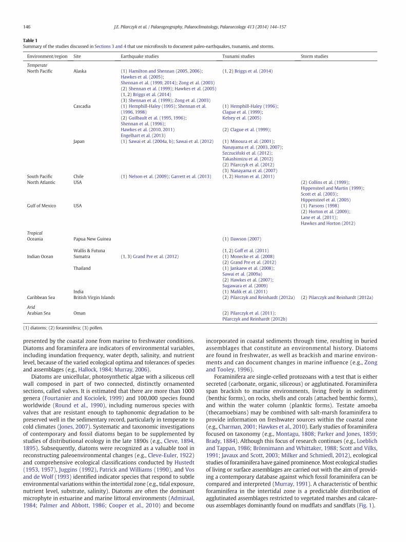
Table 1Summary of the studies discussed in Sections 3 and 4 that use microfossils to document paleo-earthquakes, tsunamis, and storms.
Environment/region Site Earthquake studies Tsunami studies Storm studies
TemperateNorth Pacific Alaska (1) Hamilton and Shennan (2005, 2006);
Hawkes et al. (2005);(1, 2) Briggs et al. (2014)
Shennan et al. (1999, 2014); Zong et al. (2003)(2) Shennan et al. (1999); Hawkes et al. (2005)(1, 2) Briggs et al. (2014)(3) Shennan et al. (1999); Zong et al. (2003)
Cascadia (1) Hemphill-Haley (1995); Shennan et al.(1996, 1998)
(1) Hemphill-Haley (1996);Clague et al. (1999);
(2) Guilbault et al. (1995, 1996);Shennan et al. (1996);
Kelsey et al. (2005)
Hawkes et al. (2010, 2011)Engelhart et al. (2013)
(2) Clague et al. (1999);
Japan (1) Sawai et al. (2004a, b); Sawai et al. (2012) (1) Minoura et al. (2001);Nanayama et al. (2003, 2007);Szczuciński et al. (2012);Takashimizu et al. (2012)(2) Pilarczyk et al. (2012)(3) Nanayama et al. (2007)
South Pacific Chile (1) Nelson et al. (2009); Garrett et al. (2013) (1, 2) Horton et al. (2011)North Atlantic USA (2) Collins et al. (1999);
Hippensteel and Martin (1999);Scott et al. (2003);Hippensteel et al. (2005)
Gulf of Mexico USA (1) Parsons (1998)(2) Horton et al. (2009);Lane et al. (2011);Hawkes and Horton (2012)
TropicalOceania Papua New Guinea (1) Dawson (2007)
Wallis & Futuna (1, 2) Goff et al. (2011)Indian Ocean Sumatra (1, 3) Grand Pre et al. (2012) (1) Monecke et al. (2008)
(2) Grand Pre et al. (2012)Thailand (1) Jankaew et al. (2008);
Sawai et al. (2009a)(2) Hawkes et al. (2007);Sugawara et al. (2009)
India (1) Malik et al. (2011)Caribbean Sea British Virgin Islands (2) Pilarczyk and Reinhardt (2012a) (2) Pilarczyk and Reinhardt (2012a)
AridArabian Sea Oman (2) Pilarczyk et al. (2011);
Pilarczyk and Reinhardt (2012b)
(1) diatoms; (2) foraminifera; (3) pollen.
146 J.E. Pilarczyk et al. / Palaeogeography, Palaeoclimatology, Palaeoecology 413 (2014) 144–157
presented by the coastal zone from marine to freshwater conditions.Diatoms and foraminifera are indicators of environmental variables,including inundation frequency, water depth, salinity, and nutrientlevel, because of the varied ecological optima and tolerances of speciesand assemblages (e.g., Hallock, 1984; Murray, 2006).
Diatoms are unicellular, photosynthetic algae with a siliceous cellwall composed in part of two connected, distinctly ornamentedsections, called valves. It is estimated that there are more than 1000genera (Fourtanier and Kociolek, 1999) and 100,000 species foundworldwide (Round et al., 1990), including numerous species withvalves that are resistant enough to taphonomic degradation to bepreserved well in the sedimentary record, particularly in temperate tocold climates (Jones, 2007). Systematic and taxonomic investigationsof contemporary and fossil diatoms began to be supplemented bystudies of distributional ecology in the late 1890s (e.g., Cleve, 1894,1895). Subsequently, diatoms were recognized as a valuable tool inreconstructing paleoenvironmental changes (e.g., Cleve-Euler, 1922)and comprehensive ecological classifications conducted by Hustedt(1953, 1957), Juggins (1992), Patrick and Williams (1990), and Vosand de Wolf (1993) identified indicator species that respond to subtleenvironmental variationswithin the intertidal zone (e.g., tidal exposure,nutrient level, substrate, salinity). Diatoms are often the dominantmicrophyte in estuarine and marine littoral environments (Admiraal,1984; Palmer and Abbott, 1986; Cooper et al., 2010) and become
incorporated in coastal sediments through time, resulting in buriedassemblages that constitute an environmental history. Diatomsare found in freshwater, as well as brackish and marine environ-ments and can document changes in marine influence (e.g., Zongand Tooley, 1996).
Foraminifera are single-celled protozoans with a test that is eithersecreted (carbonate, organic, siliceous) or agglutinated. Foraminiferaspan brackish to marine environments, living freely in sediment(benthic forms), on rocks, shells and corals (attached benthic forms),and within the water column (planktic forms). Testate amoeba(thecamoebians) may be combined with salt-marsh foraminifera toprovide information on freshwater sources within the coastal zone(e.g., Charman, 2001; Hawkes et al., 2010). Early studies of foraminiferafocused on taxonomy (e.g., Montagu, 1808; Parker and Jones, 1859;Brady, 1884). Although this focus of research continues (e.g., Loeblichand Tappan, 1986; Brönnimann and Whittaker, 1988; Scott and Vilks,1991; Javaux and Scott, 2003; Milker and Schmiedl, 2012), ecologicalstudies of foraminifera have gained prominence.Most ecological studiesof living or surface assemblages are carried out with the aim of provid-ing a contemporary database against which fossil foraminifera can becompared and interpreted (Murray, 1991). A characteristic of benthicforaminifera in the intertidal zone is a predictable distribution ofagglutinated assemblages restricted to vegetated marshes and calcare-ous assemblages dominantly found on mudflats and sandflats (Fig. 1).

tc
Taxo
n ab
unda
nce
(Y)
o = optimumt = tolerancec = maximum
Gaussian unimodal
Species B Species E
X = U (Y)
Partially sampled distribution
b)
o
Upland High marsh Low marsh Tidal flatTid
al e
leva
tion
(X)
MTL
MHW
MHHW
Abu
ndan
ce (
%)
(Y)
a)
Species B
Species C
Species D
Species E
Species F
Species A
ASSEMBLAGE TYPE
Upland
High marsh
Low marsh
Tidal flat
Sampling station
E FA CB
Abundance (%) (Y0)
X0 = Û (Y0)
Species
GplankticsOffshore
c)
Tsunami
Stratigraphy Cor
e de
pth
Pre-seismic signal
upliftInter-seismic
Coseismicsubsidence
Post-seismicuplift
tidal flat mudmarine sandsalt-marsh peatsharp contactgradational contact
D
RECONSTRUCTED ELEVATION (X0)
RELATIVE TO MTL (m)
submergenceemergence
High marsh Low marsh Tidal flat
MTLMHHW MHW
Estimation of paleo-elevation
testate amoebae (freshwater)
Species DSpecies A
Species C Species F
coseismicsubsidence
Environmental Variable (X; Elevation)
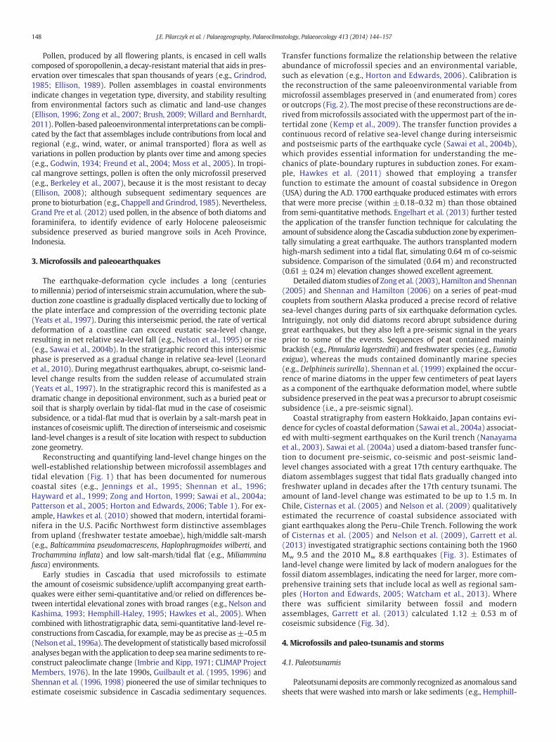
Fig. 2. Schematic of the development and application of a transfer function for assessing vertical landmovements caused by subduction zone earthquakes. a) Distribution ofmicrofossils isdescribed using samples collected (red circles) from transects across the full environmental (tidal elevation) gradient. Modernmicrofossils (Y) andmodern sea level (X) are observable. b)Elevation (X) is quantitatively expressed as an empirically derived function (U) of microfossil assemblages (Y). c) Fossil microfossils (Y0) are observed by documenting assemblages pre-served in sedimentary deposits. The transfer function estimates the elevation with respect to sea level at which each core sample accumulated (X0). The amount of coseismic subsidence(black arrow) is estimated by comparing the pre- and post-earthquake palaeomarsh surface elevations. MHHW=mean higher highwater; MHW=mean highwater; andMTL=meantide level.Modified from Horton et al. (2013).
147J.E. Pilarczyk et al. / Palaeogeography, Palaeoclimatology, Palaeoecology 413 (2014) 144–157
148 J.E. Pilarczyk et al. / Palaeogeography, Palaeoclimatology, Palaeoecology 413 (2014) 144–157
Pollen, produced by all flowering plants, is encased in cell wallscomposed of sporopollenin, a decay-resistant material that aids in pres-ervation over timescales that span thousands of years (e.g., Grindrod,1985; Ellison, 1989). Pollen assemblages in coastal environmentsindicate changes in vegetation type, diversity, and stability resultingfrom environmental factors such as climatic and land-use changes(Ellison, 1996; Zong et al., 2007; Brush, 2009; Willard and Bernhardt,2011). Pollen-based paleoenvironmental interpretations can be compli-cated by the fact that assemblages include contributions from local andregional (e.g., wind, water, or animal transported) flora as well asvariations in pollen production by plants over time and among species(e.g., Godwin, 1934; Freund et al., 2004; Moss et al., 2005). In tropi-cal mangrove settings, pollen is often the only microfossil preserved(e.g., Berkeley et al., 2007), because it is the most resistant to decay(Ellison, 2008); although subsequent sedimentary sequences areprone to bioturbation (e.g., Chappell and Grindrod, 1985). Nevertheless,Grand Pre et al. (2012) used pollen, in the absence of both diatoms andforaminifera, to identify evidence of early Holocene paleoseismicsubsidence preserved as buried mangrove soils in Aceh Province,Indonesia.
3. Microfossils and paleoearthquakes
The earthquake-deformation cycle includes a long (centuriestomillennia) period of interseismic strain accumulation,where the sub-duction zone coastline is gradually displaced vertically due to locking ofthe plate interface and compression of the overriding tectonic plate(Yeats et al., 1997). During this interseismic period, the rate of verticaldeformation of a coastline can exceed eustatic sea-level change,resulting in net relative sea-level fall (e.g., Nelson et al., 1995) or rise(e.g., Sawai et al., 2004b). In the stratigraphic record this interseismicphase is preserved as a gradual change in relative sea-level (Leonardet al., 2010). During megathrust earthquakes, abrupt, co-seismic land-level change results from the sudden release of accumulated strain(Yeats et al., 1997). In the stratigraphic record this is manifested as adramatic change in depositional environment, such as a buried peat orsoil that is sharply overlain by tidal-flat mud in the case of coseismicsubsidence, or a tidal-flat mud that is overlain by a salt-marsh peat ininstances of coseismic uplift. The direction of interseismic and coseismicland-level changes is a result of site location with respect to subductionzone geometry.
Reconstructing and quantifying land-level change hinges on thewell-established relationship between microfossil assemblages andtidal elevation (Fig. 1) that has been documented for numerouscoastal sites (e.g., Jennings et al., 1995; Shennan et al., 1996;Hayward et al., 1999; Zong and Horton, 1999; Sawai et al., 2004a;Patterson et al., 2005; Horton and Edwards, 2006; Table 1). For ex-ample, Hawkes et al. (2010) showed that modern, intertidal forami-nifera in the U.S. Pacific Northwest form distinctive assemblagesfrom upland (freshwater testate amoebae), high/middle salt-marsh(e.g., Balticammina pseudomacrescens, Haplophragmoides wilberti, andTrochammina inflata) and low salt-marsh/tidal flat (e.g., Miliamminafusca) environments.
Early studies in Cascadia that used microfossils to estimatethe amount of coseismic subsidence/uplift accompanying great earth-quakes were either semi-quantitative and/or relied on differences be-tween intertidal elevational zones with broad ranges (e.g., Nelson andKashima, 1993; Hemphill-Haley, 1995; Hawkes et al., 2005). Whencombined with lithostratigraphic data, semi-quantitative land-level re-constructions from Cascadia, for example, may be as precise as±~0.5m(Nelson et al., 1996a). The development of statistically basedmicrofossilanalyses beganwith the application to deep seamarine sediments to re-construct paleoclimate change (Imbrie and Kipp, 1971; CLIMAP ProjectMembers, 1976). In the late 1990s, Guilbault et al. (1995, 1996) andShennan et al. (1996, 1998) pioneered the use of similar techniques toestimate coseismic subsidence in Cascadia sedimentary sequences.
Transfer functions formalize the relationship between the relativeabundance of microfossil species and an environmental variable,such as elevation (e.g., Horton and Edwards, 2006). Calibration isthe reconstruction of the same paleoenvironmental variable frommicrofossil assemblages preserved in (and enumerated from) coresor outcrops (Fig. 2). Themost precise of these reconstructions are de-rived frommicrofossils associated with the uppermost part of the in-tertidal zone (Kemp et al., 2009). The transfer function provides acontinuous record of relative sea-level change during interseismicand postseismic parts of the earthquake cycle (Sawai et al., 2004b),which provides essential information for understanding the me-chanics of plate-boundary ruptures in subduction zones. For exam-ple, Hawkes et al. (2011) showed that employing a transferfunction to estimate the amount of coastal subsidence in Oregon(USA) during the A.D. 1700 earthquake produced estimates with errorsthat were more precise (within ±0.18–0.32 m) than those obtainedfrom semi-quantitative methods. Engelhart et al. (2013) further testedthe application of the transfer function technique for calculating theamount of subsidence along the Cascadia subduction zone by experimen-tally simulating a great earthquake. The authors transplanted modernhigh-marsh sediment into a tidal flat, simulating 0.64 m of co-seismicsubsidence. Comparison of the simulated (0.64 m) and reconstructed(0.61 ± 0.24 m) elevation changes showed excellent agreement.
Detailed diatom studies of Zong et al. (2003), Hamilton and Shennan(2005) and Shennan and Hamilton (2006) on a series of peat-mudcouplets from southern Alaska produced a precise record of relativesea-level changes during parts of six earthquake deformation cycles.Intriguingly, not only did diatoms record abrupt subsidence duringgreat earthquakes, but they also left a pre-seismic signal in the yearsprior to some of the events. Sequences of peat contained mainlybrackish (e.g., Pinnularia lagerstedtii) and freshwater species (e.g., Eunotiaexigua), whereas the muds contained dominantly marine species(e.g., Delphineis surirella). Shennan et al. (1999) explained the occur-rence of marine diatoms in the upper few centimeters of peat layersas a component of the earthquake deformation model, where subtlesubsidence preserved in the peat was a precursor to abrupt coseismicsubsidence (i.e., a pre-seismic signal).
Coastal stratigraphy from eastern Hokkaido, Japan contains evi-dence for cycles of coastal deformation (Sawai et al., 2004a) associat-ed with multi-segment earthquakes on the Kuril trench (Nanayamaet al., 2003). Sawai et al. (2004a) used a diatom-based transfer func-tion to document pre-seismic, co-seismic and post-seismic land-level changes associated with a great 17th century earthquake. Thediatom assemblages suggest that tidal flats gradually changed intofreshwater upland in decades after the 17th century tsunami. Theamount of land-level change was estimated to be up to 1.5 m. InChile, Cisternas et al. (2005) and Nelson et al. (2009) qualitativelyestimated the recurrence of coastal subsidence associated withgiant earthquakes along the Peru–Chile Trench. Following the workof Cisternas et al. (2005) and Nelson et al. (2009), Garrett et al.(2013) investigated stratigraphic sections containing both the 1960Mw 9.5 and the 2010 Mw 8.8 earthquakes (Fig. 3). Estimates ofland-level change were limited by lack of modern analogues for thefossil diatom assemblages, indicating the need for larger, more com-prehensive training sets that include local as well as regional sam-ples (Horton and Edwards, 2005; Watcham et al., 2013). Wherethere was sufficient similarity between fossil and modernassemblages, Garrett et al. (2013) calculated 1.12 ± 0.53 m ofcoseismic subsidence (Fig. 3d).
4. Microfossils and paleo-tsunamis and storms
4.1. Paleotsunamis
Paleotsunami deposits are commonly recognized as anomalous sandsheets that were washed into marsh or lake sediments (e.g., Hemphill-

34
36
38
40
42
44
46
Organic deposit
Tsunami sand
Elevation optima <MHHW
Elevation optima >MHHW
Unknown elevation optima
Key:
50 100 150 200 250 300
50
100
150
200
250
Observed marsh surface elevation (SWLI)
Pre
dict
ed m
arsh
sur
face
ele
vatio
n (S
WLI
)
MSL
MHHW
MH
HW
MS
L
n = 128 r2 = 0.77
0
300
0
StableSubsidence
Uplift
78°W
42°S
46°S
40°S
44°S
74°W
0 200km
74°W
0 200kmN0
1km
74°
Bahía
Quetalmahue
Estero Guillingo
Puente Quilo
41.5°
74°Nazca plate
South American plate
Pacific Ocean
Chucalen (c)
0 50 100 0.5 1 1.5 2
N
Chucalen
a) b)
c)
Lithology
)mc(
htpedero
C
Diatom assemblage summary (%)
Reconstructed PMSE (m aMSL)
e)d)
Chucalendetail shown in b)
A.D. 1960
LowlandUplandUrbanModern transectCore transect
Fig. 3. Summary of findings by Garrett et al., 2013. a) Tectonic setting of the Chilean subduction zone and Chucalen field site location (detail in (b)). Symbols show vertical land surfacedeformation resulting from the 1960 M 9.5 earthquake (Plafker and Savage, 1970). b) Northern Isla de Chiloé, including the Chucalen coring locality and modern transects at EsteroGuillingo and Puente Quilo. c) View of the salt marsh at Chucalen and location of the coring transect (red line). d) Observed versus predicted elevation values for four transects includedin theweighted averaging partial least squares regression (WA-PLS) component 3 transfer functionmodel. Thedata are from the two transects shown in (b) plus two transects collectedbyNelson et al. (2009): Valdivia AC from a fan bordering Río Angachilla; and Valdivia DR from Isla del Rey. The elevation of eachmodern sample was converted to a standardizedwater levelindex (SWLI) to account for variations in tidal ranges between sites. e) Analysis of the stratigraphy, diatom assemblages, and paleomarsh surface elevation reconstructions (PMSE) for the1960 M 9.5 earthquake at Chucalen. Diatom assemblage summary based on modern species coefficients derived from theWA-PLS transfer function model, defined by elevation optimaabove and below mean higher high water (MHHW). Estimates of coseismic deformation compare pre- and post-earthquake paleomarsh surface elevations as estimated by the transferfunction model, accounting for the thickness of any tsunami deposit. Reconstructions are based on the highest and lowest PMSE values and indicate land subsidence of 1.12 ± 0.53 m.Modified from Garrett et al. (2013).
149J.E. Pilarczyk et al. / Palaeogeography, Palaeoclimatology, Palaeoecology 413 (2014) 144–157

a) c)
b)
Fig. 4. A study of foraminifera by Sugawara et al. (2009) showing the effects of transport by tsunami backwash. a) Regional map showing the epicenter of the 2004 Sumatra–Andamanearthquake (star) and broadscale tectonics, and sampling sites at Laem Pakarang and Krabi Thailand. b) Schematic diagram showing pre- (e.g., KT98) and post-tsunami (KLV06 andKT05/PP05) distributions of the six most dominant nearshore foraminifers. The data show net seaward transport (tsunami backwash) of foraminifera during the tsunami, followed bybiological recovery in their optimumshallow-water environment following the event. c) Generalized cross-section of the nearshore–offshore zone showing seaward redistribution of sed-iment during tsunami backwash. Sediment load and speed of bottom currents from seawater retreat increase downslope causing sediment flow in the offshore direction. The decrease inslope at the base of the nearshore zone reduces the kinetic energy of the flow, depositing a layer of allochthonous sediment offshore.Modified from Sugawara et al. (2009).
150 J.E. Pilarczyk et al. / Palaeogeography, Palaeoclimatology, Palaeoecology 413 (2014) 144–157

d)
a)b)
c)
Fig. 5.A study ofmicrofossils in overwash deposits in the British Virgin Islands by Pilarczyk and Reinhardt (2012a). a)Map of Anegada showing locations of hypersaline ponds. b) Enlargedmap of study area showing location of trenches (sites 5, 11, 13, 14, 15, 16, 19) and surface samples (1–5) depicted in (c). c)Homotrema taphonomic data from surface samples andmajorstratigraphic units in the ponds. Two transects (western and eastern) are compared. The western transect runs through Red and Point Peter Ponds, while the eastern transect crossesBumberWell Pond. d)Homotrema individuals taphonomically degrade in color and angularity resulting from increased exposure time after death. 1— Exceptionally-preserved specimenwith a red color, well defined test and angular edges. 2–3—Well-preserved individuals with pink tests, hollowed chambers and angular edges. 4–5—Moderately-preserved Homotremathat are pink, rounded and have hollowed chambers. 6–7—Highly-altered individuals that are light pink to white in color and are highly rounded (Pilarczyk et al., 2014). White bars rep-resent 100 μm.Modified from Pilarczyk and Reinhardt (2012a).
151J.E. Pilarczyk et al. / Palaeogeography, Palaeoclimatology, Palaeoecology 413 (2014) 144–157

152 J.E. Pilarczyk et al. / Palaeogeography, Palaeoclimatology, Palaeoecology 413 (2014) 144–157
Haley, 1996; Clague et al., 1999; Bondevik, 2003; Kelsey et al., 2005).Marinemicrofossils often dominate tsunamioverwashdeposits becauseof the landward transport and deposition of scoured marine sediment(e.g., Dominey-Howes et al., 2000; Mamo et al., 2009; Goff et al., 2012;Tanaka et al., 2012). However, assessing the provenance of tsunamideposits may be complicated because diatoms and foraminifera areoften composed of mixed assemblages due to the fact that tsunamiserode, transport, and deposit marine, brackish, and freshwater sedi-ments (with associated taxa) as they inundate coastal and inland areas(e.g., Dawson et al., 1996; Grand Pre et al., 2012; Briggs et al., 2014).
Microfossil analysis of recent tsunami deposits provides a basisagainstwhich paleo-deposits can be compared. Diatoms and foraminiferawere used to analyze the 2004 Indian Ocean tsunami. In Thailand, the2004 Indian Ocean tsunami deposited a sand unit that graded into athinmud layer and contained amixed diatom assemblage, indicating dif-ferences in flow condition (i.e., current velocity and/or settling velocity ofthe entrained sediments; Sawai et al., 2009a). The lower section of thede-posit was dominated by benthic marine diatoms that live attached tosand grains, themiddle section contained abundantmarine planktic spe-cies, and the mud cap was dominated by a mixture of freshwater, brack-ish, andmarine species. In their analysis of 2004 tsunami sediments fromThailand and Malaysia, Hawkes et al. (2007) were able to identify bothtsunami uprush (i.e., landward flow) characterized by transport of off-shore radiolarians, as well as backwash (e.g., seaward flow) resulting inconcentrations of relocatedmangrove foraminifera. These results showedthatmicrofossils can be used to elucidate individual tsunamiwaves. Sim-ilarly, Sugawara et al. (2009) used foraminifera from the southwesterncoast of Thailand as a sediment tracer and showed that large volumesof coastal material were transported seaward during the tsunami(Fig. 4). In this example, foraminiferal assemblages constrained sedimentprovenancemore effectively thangrain size analysis on the sand. Pre- andpost-2004 tsunami sampling from water depths down to 30 m showedthat nearshore benthic foraminifera (e.g., Ammobaculites spp., Ammoniaspp., Elphidium spp., Rosalina spp.) were entrained by tsunami run-upand subsequently transported seaward by backwash where they arenow archived as allochthonous assemblages in low-energy submarinesediments, highlighting the potential in using offshore environments toidentify paleotsunami deposits.
Recently, several studies used microfossils to assess the provenanceof tsunami sediments deposited by the 2011 Tohoku tsunami. Indepen-dent studies using microfossil analysis on diatoms, foraminifera, andnannoliths (marine calcareous nanofossils) indicated a dominantbeach/dune origin for the overwash sand on the Sendai coastal plainfrom the 2011 Tohoku tsunami (Pilarczyk et al., 2012; Szczucińskiet al., 2012; Takashimizu et al., 2012). In contrast, in RikuzentakataCity, ~100 km north of Sendai Bay, subtidal ostracods were found in2011 Tohoku deposits and suggest that the deposited sediment wassourced from the sea floor in areas where water depth exceeded 9 m(Tanaka et al., 2012).
Notable examples of paleotsunami deposits that have beenidentified in part, using microfossil analysis, include those from theU.K. (Smith et al., 2004), Cascadia (e.g., Hemphill-Haley, 1995, 1996),Sumatra (e.g., Grand Pre et al., 2012), and Japan (e.g., Nanayama et al.,2003, 2007; Sawai et al., 2008, 2012). Hemphill-Haley (1995) useddiatom distributions to show that the inundation area of a tsunami inCascadia ~300 years ago was larger than the distribution inferredfrom overwash sediments alone. Along the Kuril subduction zone inJapan, Nanayama et al. (2007) used diatoms to identify nine sandytsunami deposits intercalated with peat. The diatom assemblage of thepeat units contained freshwater species (e.g., Eunotia spp., Pinnulariaspp.); whereas, sand units were dominated by marine taxa including:Delphineis surirella and Odontella aurita. Based on the record of tsunamideposits, the average recurrence intervals of large subduction zoneearthquakes on the Kuril Trench were estimated to be nearly400 years, but ranging from 100 to 800 years over the last 6000 years(Sawai et al., 2009b).
The taphonomic (or surface) condition of individual microfossils isuseful when the distinction between species assemblages of recentand paleotsunami deposits from the under and overlying material issubtle (e.g., Hemphill-Haley, 1996; Goff et al., 2011; Pilarczyk andReinhardt, 2012b). Furthermore, the individual's size, shape, andpatterns of fragmentation, abrasion, and corrosion assist to understandthe size of the event, depth of scour, and origin of sediment. For exam-ple, Murray (1993), Dawson et al. (1996), and Kortekaas and Dawson(2007) reported high occurrences of fragmented microfossils withinmodern tsunami sediments as a result of high-energy transport. In thecase of the 1998 Papua New Guinea tsunami deposit, Dawson (2007)found that linear, sigmoid and clavate diatoms were more readilyfragmented due to their relatively fragile valve structure. In contrast,high abundances of taphonomically unaltered (i.e., pristine) diatomvalves were found in tsunami deposits from Cascadia (Hemphill-Haley, 1996), Thailand (Sawai et al., 2009a), and Chile (Horton et al.,2011). Pilarczyk and Reinhardt (2012a) used the concentration andtaphonomic character of fragments of the foraminifera Homotremarubra (e.g., color, angularity, chamber structure and size) to gauge thedirectionality (from north to south) of an overwash deposit withincoastal ponds on Anegada, British Virgin Islands (Fig. 5). Overwashsands within coastal ponds on Anegada contained relatively highconcentrations of large (N250 μm), highly-preserved Homotrema thatoriginated from reef sediments to the north of the island. A majorproblem in applying a taphonomic method to foraminiferal assem-blages is discerning between taphonomic characters inherited fromthe original environment and those that are overprinted by an event(Pilarczyk et al., 2011).
4.2. Paleostorms
Landfalling storms (e.g., cyclones, hurricanes, typhoons, nor'easters)are recognized by the presence of a storm surge overwash deposit inlow-energy depositional settings. These deposits extend the eventrecord back in time, permitting the assessment of long-term ecologicalimpacts, spatial and temporal variability of storm activity, and therelationship between storm surge frequency, magnitude, track andclimate change (e.g., Donnelly and Woodruff, 2007; Mann et al.,2009). Detecting and characterizing storm deposits involves the recog-nition of allochthonous marine sand layers (e.g., Liu and Fearn, 1993)and marine-indicative microfossils deposited in low energy, marginal-marine environments such as lakes (e.g., Liu and Fearn, 2000), marshes(e.g., Parsons, 1998; Scott et al., 2003; Hippensteel et al., 2005; Hortonet al., 2009), coastal ponds (e.g., Collins et al., 1999; Woodruff et al.,2009), lagoons/bays (e.g., Lane et al., 2013), and coastal sinkholes(Lane et al., 2011).
The microfossil signature of storms relies on the identification ofabrupt switches to allochthonous assemblages. In salt-marsh coresfrom South Carolina, Hippensteel and Martin (1999) found influxesof recent offshore and Oligo-Miocene foraminifera within modernstorm deposits. Microfossil assemblages have also been used toinfer the provenance of storm-surge sediments. For example, Laneet al. (2011) inferred a storm origin for microfossil-bearing sandswithin a coastal sinkhole in Florida based on unusually high abun-dances of radiolarians and calcareous foraminifera (e.g., Brizalinaspathulata) that originated from at least 5 km offshore. Successiveoverwash sands within the sinkhole provided a record of stormswith decadal resolution for the northeastern Gulf of Mexico thatspans the late Holocene. Hypersaline coastal ponds and sinkholesare useful for reconstructing storm records from tropical environ-ments because they are not influenced by bioturbation. Hawkesand Horton (2012) also inferred a nearshore to inner shelf prove-nance for the overwash sand deposited on the coast of Texas by Hur-ricane Ike in 2008. Their conclusions were based on the presence ofAmmonia spp. and Elphidium spp. (typical of bay and nearshore envi-ronments), as well as Bolivina subaenariensis, Quinqueloculina

Am = Ammonia beccarii, Ap = Ammonia parkinsoniana, Bs = Bolivina subaenariensis, Ee = Elphidium excavatum, Eg = Elphidium galvestonense, Eu = Elphidium gunteri, Er = Elphidium granosum, Ew = Elphidium williamsoni, Qs = Quinqueloculina seminulum, Pl = planktonic sp., TN = total abundance
0 20 40
Am
0 20 40 60 80
Ap
0 20
Ee
0 20 40 60 80
Eg
0 20 40 60 80
Eu
0 20
Ew
0 20
Qs
0 10
Pl
0
4
8
12
16
20
24
28
32
0 200 400
TN24 48
Distance0
Cor
e de
pth
(cm
)
Core C1
c)
a)
Cor
e de
pth
(cm
) 0
4
8
12
16
Am Ap Ee Eg Eu ErQs
TN
0 200 20 40 0 20 40 60 80 0 20 0100 20 40 60 0 20 40 60 0 100
no foraminifera present
Core A9
0
4
8
12
16
20
24
Am Ap Bs Ee Eg Eu Qs Pl TNEr
no foraminifera presentCor
e de
pth
(cm
)
Core B1
0 100 20 0 20 0 200 20 40 60 0 20 40 0 20 40 0 20 40 0 20 0 100 200
overwashsandprairie/saltmarsh soil
Distance (m)
Ele
vatio
n (m
) ab
ove
NA
VD
88
30 50 70 90 110
Site A
0.6
1.0
1.4
1.8
A1
A4A6
A7A8 A10
Ike sand deposit
3.8Hurricane Ike water level
A9*
1.4100 120 140 160 180
1.8
2.2 C1C0C3 C4
C5 C7C8C9 C10
Site C
2.6
*
Ike sand deposit257HWY
140 180 220 260 3001.2
1.6
2.0
B1B0
B4B6 B7 B8
Ike sand deposit
3.2Site B
B2*
3005HWY
Hurricane Ike water levelHurricane Ike damage line B5
b)
Hurricane Ike water level
A2
A3
C2 C6
Galveston Isl
and
Bolivar Peninsula
2
10 km
5
2
4
3
Surge height (m)
Gulf of Mexico
Texas
A
BC
N
Hurricane Ikestorm track
GalvestonBay
Legendstorm gauge
water
tide gauge
transect locationA, B, C
Fig. 6. Summary of findings by Hawkes and Horton (2012). a) Site map showing Hurricane Ike landfall in Galveston, Texas (dashed line) as a Category 2 storm. Gray shading off GalvestonIsland is themeasured stormsurge height inmeters (NOAAprobabilistic storm surge forecast at landfall; Plant et al., 2010). Core sitesA, B, and C are identified aswell as USGS stormgauges(black squares) andNOAA tide gauges thatwithstood the storm (black outlined squares). b) Core sites A, B, and C show shore-perpendicularmeasured transect renderings of the elevationof the pre-storm sediment (gray) and storm induced overwash deposit (stippled) above NAVD88. Core locations are identified with vertical lines and the rectangle locates the sampledcore at each site. Hurricane Ikewater levels are noted as dashed lines. The finer dashed line at core site B reflects the identified hurricane damage line. Zigzags (hiatus) in the y-axes at coresitesA andB represent gaps in the elevation scale (x andy scales donot begin at zero). c) A log for each core (A9, B1, and C1) alongwith thepercent of foraminifera by species (listedby twoletter code, see legend for code explanation), the total number of foraminifera in each 5 cm3 sample and for core C1 the constrained Euclidean distance cluster results for the foraminiferalassemblages. The clusters separate the pre-storm assemblages from the overwash assemblages.Modified from Hawkes and Horton (2012).
153J.E. Pilarczyk et al. / Palaeogeography, Palaeoclimatology, Palaeoecology 413 (2014) 144–157
154 J.E. Pilarczyk et al. / Palaeogeography, Palaeoclimatology, Palaeoecology 413 (2014) 144–157
seminulum and planktics, which inhabit inner shelf environments(Fig. 6). Hawkes and Horton (2012) further noted that only 10–30%of eroded beach material was deposited as overwash during the hur-ricane and that 70–90% of the eroded sediment was redeposited inthe nearshore environment.
Diatom-based studies of storm washover include Parsons (1998), whoreported a multi-source origin for sediments deposited by HurricaneAndrew when it made landfall in Louisiana in 1992. Assemblages withinthe deposit were diverse and consisted of a mixture of diatoms from ma-rine, brackish, and freshwater settings and were easily distinguished fromunderlyingautochthonous salt-marsh taxa.However, not all stormdepositscontain microfossils. Horton et al. (2009) described a paucity of foraminif-era in sediments deposited by Hurricanes Katrina and Rita in 2005 alongthe U.S. Gulf Coast. The absence of foraminifera within the storm depositscould be related to environmental stressors (e.g., seasonal hypoxia in theLouisiana shelf), reproductive factors (e.g., initial size of standing crop, re-productive frequency of the population), destruction of tests during trans-port, or post-depositional change (e.g., carbonate dissolution).
5. Concluding remarks
Microfossil analysis of coastal sediment sequences in conjunction withlithostratigraphic evidence enables recognition and characterization ofpaleo-earthquakes, tsunamis, and storms. The use of microfossils as land-level indicators is based on the strong association betweenmicrofossils and tidal elevation. Examples from Cascadia, Alaska, Japanand Chile document the precision of foraminiferal- and diatom-basedtransfer functions in quantifying the amount of interseismic andcoseismic land-level changes during repeated earthquake deformationcycles. These examples illustrate how capturing centennial- tomillennial-scale event records through microfossil analysis can provideimportant information regarding the magnitude and frequency of pre-historic earthquakes.
Numerous studies have employed microfossil analysis on overwashsediment from recent large magnitude tsunamis and storms to enablepreceding events to be identified in the fossil record. Informationregarding assemblages and the taphonomic condition of individualtests or valves can be used to assess provenance and transport history.Properly constraining sediment provenance provides insight into thedistance of sediment transport and depth of scour (i.e., paleo-waterdepth). The differentiation between tsunami and storm surge depositsin the fossil record is extremely difficult, sincemost of their characteris-tics only indicate marine inundation. But storm surge sedimentsare mainly composed of nearshore material dominated by beach andnearshore sand, whereas tsunami deposits have a wide range ofmaterial from inner shelf to terrestrial debris (Switzer and Jones,2008). Therefore, when placed into geomorphological, sedimentologi-cal, and historical contexts, microfossils can be useful in helping toascribe depositional origin to overwash layers.
The utility of microfossils in documenting event records is depen-dent on their availability for transport and/or suitable preservation.The best microfossil-based reconstructions are from favorable coastalenvironments that are both quiescent and contain sufficient accommo-dation space for sediment to accumulate and preserve (Brill et al., 2014).For example, salt-marshes in Cascadia are excellent recorders of earth-quakes and tsunamis because of the subsiding coastline that providesthe necessary accommodation space. In contrast, net emergent coast-lines (e.g., Chile and Sumatra) do preserve relative sea-level changesrepresentative of the earthquake deformation cycle and tsunamideposits, but the lack of accommodation space makes preservationmore difficult (Grand Pre et al., 2012). Records of localized coseismicsubsidence and accompanying tsunamis on emergent coastlines arescarce, and where discovered, fragmentary (e.g., Dura et al., 2011;Grand Pre et al., 2012; Szczuciński, 2012; Brill et al., 2014).
Microfossils remain at the center of new developments seeking toimprove our understanding of earthquakes, tsunamis, and storms,
how these processes influence coastal evolution, and how they arerecorded within coastal sedimentary sequences. It is also clear fromthe examples presented here that the use of microfossils from coastalenvironments as indicators of paleo-earthquakes, tsunamis, and stormsremains a work in progress. Ample scope exists for improving thereliability, accuracy and precision of the reconstructions. This maycome through the development of new statistical tools (Salonenet al., 2014) or the novel combination of microfossil data withother quantitative environmental proxies (e.g., Khan et al., 2013).However, a firm understanding of the ecology and taphonomy of mi-crofossils must remain central to any future development. Further-more, the quality and reliability of resulting reconstructions aredependent upon an understanding of the geological and geomorpho-logical contexts of the sampling location, and the processes operat-ing within it.
Acknowledgments
Funding for this studywas provided by theNational Science Founda-tion (NSF) awards EAR 1357722, 1402017, and 1418717. This paper is acontribution to IGCP project 588 ‘Preparing for coastal change’. Themanuscript benefited from the thoughtful and productive commentsof Adam Switzer and an anonymous reviewer.
References
Admiraal, W., 1984. The ecology of estuarine sediment-inhabiting diatoms. Prog. Phycol.Res. 3, 269–322.
Atwater, B.F., 1987. Evidence for great Holocene earthquakes along the outer coast ofWashington-State. Science 236, 942–944.
Banerjee, P., Pollitz, F., Nagarajan, B., Bürgmann, R., 2007. Coseismic slip distributions ofthe 26 December 2004 Sumatra–Andaman and 28 March 2005 Nias earthquakesfrom GPS static offsets. Bull. Seismol. Soc. Am. 97 (1A), S86–S102.
Barrientos, S.E., Ward, S.N., 1990. The 1960 Chile earthquake: inversion for slipdistribution from surface deformation. Geophys. J. Int. 103, 589–598.
Berkeley, A., Perry, C.T., Smithers, S., Horton, B.P., Taylor, K.G., 2007. Microfossil-basedpalaeoenvironmental records in intertidal environments: a review of the ecologicaland taphonomic controls on foraminiferal assemblage development. Earth-Sci. Rev.83, 205–230.
Birks, H.J.B., 1995. Statistical modelling of Quaternary science data. In: Maddy, D., Brew, J.S.(Eds.), Quantitative Paleoenvironmental Reconstructions, 5. Quaternary Research Asso-ciation, Cambridge, pp. 161–254.
Bondevik, S., 2003. Storegga tsunami sand in peat below the Tapes beach ridge at Haroy,western Norway, and its possible relation to an early Stone Age settlement. Boreas 32(3), 476–483.
Bourgeois, J., Reinhart, M.A., 1989. Onshore erosion and deposition by the 1960 tsunamiat the Rio Lingue estuary, south-central Chile. Am. Geophys. Union Trans. 70 (43),1331.
Bourgeois, J., Petroff, C., Yeh, H., Titov, V., Synolakis, C.E., Benson, B., Kuroiwa, J., Lander, J.,Norabuena, E., 1999. Geologic setting, field survey and modeling of the Chimbote,Northern Peru, tsunami of 21 February 1996. Pure Appl. Geophys. 154, 513–540.
Brady, H.B., 1884. Report on the Foraminifera Dredged by HMS Challenger during theYears 1873–1876.
Briggs, R.W., Engelhart, S.E., Nelson, A.R., Dura, T., Kemp, A.C., Haeussler, P.J., Corbett, D.R.,Angster, S.J., Bradley, L.A., 2014. Uplift and subsidence reveal a nonpersistentmegathrust rupture boundary. Geophys. Res. Lett. 41 (7), 2289–2296.
Brill, D., Jankaew, K., Neubauer, N., Kelletat, D., Scheffers, A., Vött Brückner, H., 2014.Holocene coastal evolution of southwest Thailand — implications for the site-specific preservation of palaeotsunami deposits. Z. Geomorphol. http://dx.doi.org/10.1127/0372-8854/2014/0132.
Brönnimann, P., Whittaker, J.E., 1988. The Trochamminacea of the discovery report.British Museum of Natural History, pp. 1–152.
Brush, G.S., 2009. Historical land use, nitrogen, and coastal eutrophication: a paleoecolog-ical perspective. Estuar. Coasts 32 (1), 18–28.
Chappell, J.M.A., Grindrod, J., 1985. Pollen analysis: a key to past mangrove commu-nities and successional changes in North Australian coastal environments. In:Bardsley, K.N., Davie, J.D.S., Woodroffe, C.D. (Eds.), Coasts and Tidal Wetlandsof the Australian Monsoon Region. Australian National University, Canberra,pp. 225–236.
Charman, D.J., 2001. Biostratigraphic and palaeoenvironmental applications of testateamoebae. Quat. Sci. Rev. 20, 1753–1764.
Chlieh, M., Avouac, J., Hjorleifsdottir, V., Song, T.A., Ji, C., Sieh, K., Sladen, A., Hebert, H.,Prawirodirdjo, L., Bock, Y., Galetzka, J., 2007. Coseismic slip and afterslip of the greatMw 9.15 Sumatra–Andaman earthquake of 2004. Bull. Seismol. Soc. Am. 97 (1A),S152–S173.
Cisternas, M., Atwater, B.F., Torrejón, F., Sawai, Y., Machuca, G., Lagos, M., Eipert, A.,Youlton, C., Salgado, I., Kamataki, T., Shishikura, M., Rajendran, C.P., Malik, J.K., Rizal,

155J.E. Pilarczyk et al. / Palaeogeography, Palaeoclimatology, Palaeoecology 413 (2014) 144–157
Y., Husni, M., 2005. Predecessors of the giant 1960 Chile earthquake. Nature 437,404–407.
Clague, J.J., Hutchinson, I., Mathewes, R.W., Patterson, R.T., 1999. Evidence for LateHolocene tsunamis at Catala Lake, British Columbia. J. Coast. Res. 15 (1), 45–60.
Cleve, P.T., 1894. Synopsis of the naviculoid diatom I and II. Kongliga Svenska Vetenskaps-Akademien, 26, pp. 1–194.
Cleve, P.T., 1895. Synopsis of the naviculoid diatom I and II. Kongliga Svenska Vetenskaps-Akademien, 27, pp. 1–129.
Cleve-Euler, A., 1922. Om diatomacevegetationen och dess forandringar i Sabysjon,Uppland samt negra damda sjoar i Salatrakten. Sver. Geol. Unders. C309, 1–76.
CLIMAP Project Members, 1976. The surface of the ice-age earth. Science 191,1131–1137.
Collins, E.S., Scott, D.B., Gayes, P.T., 1999. Hurricane records on the South Carolina coast:can they be detected in the sediment record? Quat. Int. 56, 15–26.
Cooper, S., Gaiser, E.E., Wachnicka, A., 2010. Estuarine paleoecological reconstructionsusing diatoms. In: Smol, J.P., Stoermer, E.F. (Eds.), The Diatoms: Applications forthe Environmental and Earth Sciences. Cambridge University Press, Cambridge,pp. 324–345.
Dawson, S., 2007. Diatom biostratigraphy of tsunami deposits: examples from the 1998Papua New Guinea tsunami. Sediment. Geol. 200, 328–335.
Dawson, S., Smith, D.E., Ruffman, A., Shi, S., 1996. The diatom biostratigraphy of tsunami de-posits: examples from recent andmiddle Holocene events. Phys. Chem. Earth 21, 87–92.
Dominey-Howes, D., Cundy, A., Croudace, I., 2000. High energy marine flood depositson Astypalaea Island, Greece: possible evidence for the AD 1956 southern Aegeantsunami. Mar. Geol. 163, 303–315.
Donnelly, J.P., Woodruff, J.D., 2007. Intense hurricane activity over the past5,000 years controlled by El Nino and the West African monsoon. Nature 447,465–468.
Dura, T., Rubin, C.M., Kelsey, H.M., Horton, B.P., Hawkes, A.D., Vane, C.H., Daryono, M.,Grand Pre, C., Ladinsky, T., Bradley, S., 2011. Stratigraphic record of Holocenecoseismic subsidence, Padang, West Sumatra. J. Geophys. Res. 116 (B11306).
Ellison, J.C., 1989. Pollen analysis of mangrove sediments as a sea-level indicator —assessment from Tongatapu, Tonga. Palaeogeogr. Palaeoclimatol. Palaeoecol. 74,327–341.
Ellison, J.C., 1996. Pollen evidence of Late Holocene mangrove development in Bermuda.Glob. Ecol. Biogeogr. Lett. 5 (6), 315–326.
Ellison, J.C., 2008. Long-term retrospection on mangrove development using sedimentcores and pollen analysis: a review. Aquat. Bot. 89 (2), 93–104.
Engelhart, S.E., Horton, B.P., Nelson, A.R., Hawkes, A.D., Witter, R.C., Wang, K., Wang, P.-.L.,Vane, C.H., 2013. Testing the use of microfossils to reconstruct great earthquakes atCascadia. Geology. http://dx.doi.org/10.1130/G34544.1.
Fourtanier, E., Kociolek, J.P., 1999. Catalogue of the diatom genera. Diatom Res. 14, 1–190.Freund, H., Gerdes, G., Streif, H., Dellwig, O., Watermann, F., 2004. The indicative meaning of
diatoms, pollen andbotanicalmacro fossils for the reconstructionof palaeoenvironmentsand sea-levelfluctuations along the coast of Lower Saxony;Germany.Quat. Int. 112, 71–87.
Garrett, E., Shennan, I., Watcham, E.P., Woodroffe, S.A., 2013. Reconstructing paleoseismicdeformation, 1: modern analogues from the 1960 and 2010 Chilean great earth-quakes. Quat. Sci. Rev. 75, 11–21.
Gelfenbaum, G., Jaffe, B., 2003. Erosion and sedimentation from the 17 July 1998 PapuaNew Guinea tsunami. Pure Appl. Geophys. 160, 1969–1999.
Godwin, H., 1934. Pollen analysis. An outline of the problems and potentialities of themethod part I. technique and interpretation. New Phytol. 33 (4), 278–305.
Goff, J., Lamarche, G., Pelletier, B., Chagué-Goff, C., Strotz, L., 2011. Predecessors to the2009 South Pacific tsunami in the Wallis and Futuna archipelago. Earth Sci. Rev.107 (1–2), 91–106.
Goff, J., Chagué-Goff, Nichol, S., Jaffe, B., Dominey-Howes, D., 2012. Progress inpalaeotsunami research. Sediment. Geol. 243, 70–88.
Grand Pre, C.A., Horton, B.P., Kelsey, H.M., Rubin, C.M., Hawkes, A.D., Daryono, M.R.,Rosenberg, G., Culver, S.J., 2012. Stratigraphic evidence for an early Holocene earth-quake in Aceh, Indonesia. Quat. Sci. Rev. 54, 142–151.
Grindrod, J., 1985. The palynology of mangroves on a prograded shore, Princess CharlotteBay, north Queensland, Australia. J. Biogeogr. 12, 323–348.
Guilbault, J.P., Clague, J.J., Lapointe, M., 1995. Amount of subsidence during a lateHolocene earthquake — evidence from fossil tidal marsh foraminifera at VancouverIsland, west coast of Canada. Palaeogeogr. Palaeoclimatol. Palaeoecol. 118, 49–71.
Guilbault, J.P., Clague, J.J., Lapointe, M., 1996. Foraminifera evidence for the amount ofcoseismic subsidence during a late Holocene earthquake on Vancouver Island, westcoast of Canada. Quat. Sci. Rev. 15, 913–937.
Hallegatte, S., Green, C., Nicholls, R.J., Corfee-Morlot, J., 2013. Future flood losses in majorcoastal cities. Nat. Clim. Chang. 3, 802–806.
Hallock, P., 1984. Distribution of selected species of living algal symbiont-bearingforaminifera on two Pacific coral reefs. J. Foraminifer. Res. 14 (4), 250–261.
Hamilton, S., Shennan, I., 2005. Late Holocene relative sea-level changes and the earthquakedeformation cycle around upper Cook Inlet, Alaska. Quat. Sci. Rev. 24, 1479–1498.
Hawkes, A.D., Horton, B.P., 2012. Sedimentary record of storm deposits from HurricaneIke, Galveston and San Luis Islands, Texas. Geomorphology 171–172, 180–189.
Hawkes, A.D., Scott, D.B., Lipps, J.H., Combellick, R., 2005. Evidence for possible precursorevents of megathrust earthquakes on the west coast of North America. Geol. Soc. Am.Bull. 117, 996–1008.
Hawkes, A.D., Bird, M., Cowie, S., Grundy-Warr, C., Horton, B.P., Tan Shau Hwai, A., Law, L.,Macgregor, C., Nott, J., Eong Ong, J., Rigg, J., Robinson, R., Tan-Mullins, M., Tiong, T.,Yasin, Z., Wan Aik, L., 2007. Sediments deposited by the 2004 Indian Ocean tsunamialong the Malaysia–Thailand Peninsula. Mar. Geol. 242, 169–190.
Hawkes, A.D., Horton, B.P., Nelson, A.R., Hill, D.F., 2010. The application of intertidal fora-minifera to reconstruct coastal subsidence during the giant Cascadia earthquake ofAD 1700 in Oregon, USA. Quat. Int. 221, 116–140.
Hawkes, A.D., Horton, B.P., Nelson, A.R., Vane, C.H., Sawai, Y., 2011. Coastal subsidence inOregon, USA, during the giant Cascadia earthquake of AD 1700. Quat. Sci. Rev. 30,364–376.
Hayward, B.W., Grenfell, H.R., Scott, D.B., 1999. Tidal range of marsh foraminifera fordetermining former sea-level heights in New Zealand. N. Z. J. Geol. Geophys. 42 (3),395–413.
Hemphill-Haley, E., 1995. Diatom evidence for earthquake-induced subsidence andtsunami 300 years ago in southern coastal Washington. Geol. Soc. Am. Bull. 107,367–378.
Hemphill-Haley, E., 1996. Diatoms as an aid in identifying late Holocene tsunami deposits.The Holocene 6, 439–448.
Hippensteel, S.P., Martin, R.E., 1999. Foraminifera as an indicator of overwash deposits,barrier island sediment supply, and barrier island evolution: Folly Island, SouthCarolina. Palaeogeogr. Palaeoclimatol. Palaeoecol. 149, 115–125.
Hippensteel, S.P., Martin, R.E., Harris, M.S., 2005. Records of prehistoric hurricanes on theSouth Carolina coast based on micropaleontological and sedimentological evidence,with comparison to other Atlantic Coast records: discussion. Geol. Soc. Am. Bull.117 (1–2), 250–253.
Horton, B.P., Edwards, R.J., 2005. The application of local and regional transfer functions toreconstruct former sea levels, North Norfolk, England. The Holocene 15, 216–228.
Horton, B.P., Edwards, R.J., 2006. Quantifying Holocene sea level change using intertidalforaminifera: lessons from the British Isles. Cushman Found. Foram. Res. Spec. Publ.40 (97 pp.).
Horton, B.P., Rossi, V., Hawkes, A.D., 2009. The sedimentary record of the 2005 hurricaneseason from the Mississippi and Alabama coastlines. Quat. Int. 195, 15–30.
Horton, B.P., Sawai, Y., Hawkes, A.D., Witter, R.C., 2011. Sedimentology and paleontologyof a tsunami deposit accompanying the great Chilean earthquake of February 2010.Mar. Micropaleontol. 79, 132–138.
Horton, B.P., Engelhart, S.E., Kemp, A.C., Sawai, Y., 2013. Microfossils in tidal settings as indicators ofsea-level change, paleoearthquakes, tsunamis, and tropical cyclones. In: Shroder, John F. (Ed.),Treatise on Geomorphology, 14. Academic Press, San Diego, pp. 292–314.
Hustedt, F., 1953. Diatomeen ausdem Naturschutzpark Seeon. Arch. Hydrobiol. 47,625–635.
Hustedt, F., 1957. Die Diatomeenflora des Fluss-systems der Weser im Gebiet derHansestadt Bremen. Abh. Naturwiss. Ver. Bremen 34, 181–440.
Iinuma, T., Ohzono, M., Ohta, Y., Miura, S., 2011. Coseismic slip distribution of the 2011 offthe Pacific coast of Tohoku earthquake (M 9.0) estimated based on GPS data — wasthe asperity in Miyagi-oki ruptured? Earth Planets Space 63, 643–648.
Imbrie, J., Kipp, N.G., 1971. A new micropaleontological method for quantitativepaleoclimatology: application to a late Pleistocene Caribbean core. In: Turekian, K.K.(Ed.), The Late Cenozoic Glacial Ages. Yale University Press, New Haven, CT,pp. 71–181.
Jankaew, K., Atwater, B.F., Sawai, Y., Choowong, M., Charoentitirat, T., Martin, M.E.,Prendergast, A., 2008. Medieval forewarning of the 2004 Indian Ocean tsunami inThailand. Nature 455, 1228–1231.
Javaux, E.J., Scott, D.B., 2003. Illustration of modern benthic foraminifera from Bermudaand remarks on distribution in other subtropical/tropical areas. Palaeontol. Electron.6 (4) (29 pp.).
Jennings, A.E., Nelson, A.R., Scott, D.B., Aravena, J.C., 1995. Marsh foraminiferal assem-blages in the Valdivia estuary, South-Central Chile, relative to vascular plants andsea-level. J. Coast. Res. 11 (1), 107–123.
Jones, V.J., 2007. Diatom introduction. In: Elias, S. (Ed.), Encyclopedia of QuaternaryScience. Elsevier, Oxford, pp. 476–484.
Juggins, S., 1992. Diatoms in the Thames estuary, England: ecology, palaeoecology, andsalinity transfer function. Bibl. Diatomol. 25, 216.
Kelsey, H.M., Nelson, A.R., Hemphill-Haley, E., Witter, R.C., 2005. Tsunami history of anOregon coastal lake reveals a 4600 yr record of great earthquakes on the Cascadiasubduction zone. Geol. Soc. Am. Bull. 117, 1009–1032.
Kemp, A.C., Horton, B.P., Culver, S.J., Corbett, D.R., van de Plassche, O., Gehrels, W.R.,Douglas, B.C., Parnell, A.C., 2009. Timing and magnitude of recent accelerated sea-level rise (North Carolina, United States). Geology 37, 1035–1038.
Khan, N.S., Horton, B.P., McKee, K.L., Jerolmack, D.J., Falcini, F., Enache, M.D., Vane, C.H.,2013. Tracking sedimentation from the historic 2011 Mississippi River Flood inLouisiana Deltaic wetlands. Geology 41, 391–394.
Khazaradze, G., Wang, K., Klotz, J., Hu, Y., He, J., 2002. Prolonged post-seismic deformationof the 1960 great Chile earthquake and implications for mantle rheology. Geophys.Res. Lett. 29 (22), 2050.
Kortekaas, S., Dawson, A.G., 2007. Distinguishing tsunami and storm deposits: an examplefrom Martinhal, SW Portugal. Sediment. Geol. 200, 208–221.
Lane, P., Donnelly, J.P., Woodruff, J.D., Hawkes, A.D., 2011. A decadally-resolvedpaleohurricane record archived in the late Holocene sediments of a Florida sinkhole.Mar. Geol. 287, 14–30.
Lane, C.S., Clark, J.J., Knudsen, A., McFarlin, J., 2013. Late-Holocene paleoenvironmentalhistory of bioluminescent Laguna Grande, Puerto Rico. Palaeogeogr. Palaeoclimatol.Palaeoecol. 369, 99–113.
Leonard, L.J., Currie, C.A., Mazzotti, S., Hyndman, R.D., 2010. Rupture area and displace-ment of past Cascadia great earthquakes from coastal coseismic subsidence. Geol.Soc. Am. Bull. 112, 2079–2096.
Liu, K.-b, Fearn, M.L., 1993. Lake-sediment record of late Holocene hurricane activitiesfrom coastal Alabama. Geology 21, 793–796.
Liu, K.-b, Fearn, M.L., 2000. Reconstruction of prehistoric landfall frequencies ofcatastrophic hurricanes in northwestern Florida from lake sediment records. Quat.Res. 54, 238–245.
Loeblich Jr., A.R., Tappan, H., 1986. Some new and revised genera and families ofhyaline calcareous Foraminiferida (Protozoa). Trans. Am. Microsc. Soc. 105,239–265.

156 J.E. Pilarczyk et al. / Palaeogeography, Palaeoclimatology, Palaeoecology 413 (2014) 144–157
Malik, J.N., Shishikura, M., Echigo, T., Ikeda, Y., Satake, K., Kayanne, H., Sawai, Y.,Murty, C.V.R., Dikshit, O., 2011. Geologic evidence for two pre-2004 earthquakesduring recent centuries near Port Blair, South Andaman Island, India. Geology 39(6), 559–562.
Mamo, B., Strotz, L., Dominey-Howes, D., 2009. Tsunami sediments and their foraminiferalassemblages. Earth Sci. Rev. 96, 263–278.
Mann, M.E., Woodruff, J.D., Donnelly, J.P., Zhang, Z.H., 2009. Atlantic hurricanes andclimate change over the past 1,500 years. Nature 460, 880–883.
Milker, Y., Schmiedl, G., 2012. A taxonomic guide to modern benthic shelf foraminifera ofthe western Mediterranean Sea. Palaeontol. Electron. 15 (2) (16A, 134pp.).
Minoura, K., Imamura, F., Sugawara, D., Kono, Y., 2001. The 869 Jogan tsunami deposit andrecurrence interval of large-scale tsunami on the Pacific coast of northeast Japan. J.Nat. Disaster Sci. 23 (2), 83–88.
Monecke, K., Finger, W., Klarer, D., Kongko, W., McAdoo, B.G., Moore, A.L., Sudrajat, S.U.,2008. A 1,000-year sediment record of tsunami recurrence in northern Sumatra.Nature 455, 1232–1234.
Montagu, G., 1808. Testacea Britannica. S. Woolmer, Exeter, England.Moss, P.T., Kershaw, A.P., Grindrod, J., 2005. Pollen transport and deposition in riverine
and marine environments within the humid tropics of northeastern Australia. Rev.Palaeobot. Palynol. 134, 55–69.
Murray, J.W., 1991. Ecology and Paleoecology of Benthic Foraminifera. Longman, Harlow,Essex (397 pp.).
Murray, J.W., 1993. Distribution and Ecology of Living Benthic Foraminiferids. HeinemannEducational Books, London (247 pp.).
Murray, J.W., 2006. Ecology and Applications of Benthic Foraminifera. CambridgeUniversity Press, Cambridge (426 pp.).
Nanayama, F., Satake, K., Furukawa, R., Shimokawa, K., Atwater, B.F., Shigeno, K., Yamaki,S., 2003. Unusually large earthquakes inferred from tsunami deposits along the Kuriltrench. Nature 424, 660–663.
Nanayama, F., Furukawa, R., Shigeno, K., Makino, A., Soeda, Y., Igarashi, Y., 2007. Nineunusually large tsunami deposits from the past 4000 years at Kiritappu marshalong the southern Kuril Trench. Sediment. Geol. 200, 275–294.
Nelson, A.R., Kashima, K., 1993. Diatom zonation in southern Oregon tidal marshesrelative to vascular plants, foraminifera, and sea level. J. Coast. Res. 9,673–697.
Nelson, A.R., Atwater, B.F., Bobrowsky, P.T., Bradley, L.A., Clague, J.J., Carver, G.A., Darienzo,M.E., Grant, W.C., Krueger, H.W., Sparks, R., Stafford, T.W., Stuiver, M., 1995. Radio-carbon evidence for extensive plate-boundary rupture about 300 years ago at theCascadia subduction zone. Nature 378, 371–374.
Nelson, A.R., Jennings, A.E., Kashima, K., 1996a. An earthquake history derived from strat-igraphic and microfossil evidence of relative sea-level change at Coos Bay, southerncoastal Oregon. Geol. Soc. Am. Bull. 108, 141–154.
Nelson, A.R., Shennan, E., Long, A.J., 1996b. Identifying coseismic subsidence in tidal-wetland stratigraphic sequences at the Cascadia subduction zone of western NorthAmerica. J. Geophys. Res. 101, 6115–6135.
Nelson, A.R., Kashima, K., Bradley, L., 2009. Fragmentary evidence of great‐earthquakesubsidence during Holocene emergence, Valdivia Estuary, South Central Chile. Bull.Seismol. Soc. Am. 99 (1), 71–86.
Nicholls, R.J., Wong, P.P., Burkett, V.R., Codignotto, J.O., Hay, J.E., McLean, R.F., Ragoonaden,S., Woodroffe, C.D., 2007. Coastal systems and low-lying areas. In: Parry, M.L., O.F.,Canziani, J.P., Palutikof, van der Linden, P.J., Hanson, C.E. (Eds.), Climate Change2007: Impacts, Adaptation and Vulnerability. Contribution of Working Group II tothe Fourth Assessment Report of the Intergovernmental Panel on Climate Change.Cambridge University Press, Cambridge, UK, pp. 315–356.
Nikitina, D.L., Kemp, A.C., Horton, B.P., Vane, C.H., van de Plassche, O., Engelhart, S.E., 2014.Storm erosion during the past 2000 years along the north shore of Delaware Bay,USA. Geomorphology 208, 160–172.
Nott, J.F., 2003. Intensity of prehistoric tropical cyclones. J. Geophys. Res. — Atmos. 108(D7), 4212.
Ozawa, S., Nishimura, T., Munekane, H., Suito, H., Kobayashi, T., Tobita, M., Imakiire, T.,2012. Preceding, coseismic, and postseismic slips of the 2011 Tohoku earthquake,Japan. J. Geophys. Res. 117 (B07404).
Palmer, A.J.M., Abbott, W.H., 1986. Diatoms as indicators of sea-level change. In: can dePlassche, O. (Ed.), Sea-level Research: A Manual for the Collection and Evaluation ofData. Geobooks, Norwich, pp. 457–488.
Parker, W.K., Jones, T.R., 1859. On the nomenclature of the foraminifera. II. On the speciesenumerated by Walker and Montagu. Ann. Mag. Nat. Hist. Ser. 3 (4), 333–351.
Parsons, M.L., 1998. Salt marsh sedimentary record of the landfall of HurricaneAndrew on the Louisiana coast: diatoms and other paleoindicators. J. Coast.Res. 14, 939–950.
Patrick, R., Williams, D.D., 1990. Aquatic biota in North America. In: Wolman, M.G., Riggs,H.D. (Eds.), Surface Water Hydrology. Geological Society of America, the Geology ofNorth America, Boulder, Colorado (v 0–1).
Patterson, R.T., Dalby, A.P., Roe, H.M., Guilbault, J.-P., Hutchinson, I., Clague, J.J., 2005.Relative utility of foraminifera, diatoms and macrophytes as high resolutionindicators of paleo-sea level in coastal British Columbia, Canada. Quat. Sci. Rev. 24,2002–2014.
Paul, J., Lowry, A.R., Bilham, R., Sen, S., Smalley Jr., R., 2007. Postseismic deformation of theAndaman Islands following the 26 December, 2004 Great Sumatra–Andaman earth-quake. Geophys. Res. Lett. 34 (19) (L19309).
Pilarczyk, J.E., Reinhardt, E.G., 2012a. Homotrema rubrum (Lamarck) taphonomy as anoverwash indicator in Marine Ponds on Anegada, British Virgin Islands. Nat. Hazards63, 85–100.
Pilarczyk, J.E., Reinhardt, E.G., 2012b. Testing foraminiferal taphonomy as a tsunamiindicator in a shallow arid system lagoon: Sur, Sultanate of Oman. Mar. Geol.295–298, 128–136.
Pilarczyk, J.E., Reinhardt, E.G., Boyce, J.I., Schwarcz, H.P., Donato, S.V., 2011. Assessingsurficial foraminiferal distributions as an overwash indicator in Sur Lagoon, Sultanateof Oman. Mar. Micropaleontol. 80, 62–73.
Pilarczyk, J.E., Horton, B.P., Witter, R.C., Vane, C.H., Chagué-Goff, C., Goff, J., 2012. Sedimen-tary and foraminiferal evidence of the 2011 Tohoku-oki tsunami on the Sendaicoastal plain, Japan. Sediment. Geol. 282, 78–89.
Pilarczyk, J.E., Goff, J., Mountjoy, J., Lamarche, G., Pelletier, B., Horton, B.P., 2014.Sediment transport trends from a tropical Pacific lagoon as indicated byHomotrema rubra taphonomy: Wallis Island, Polynesia. Mar. Micropaleontol.109, 21–29.
Plafker, G., 1969. Tectonics of theMarch 27, 1964, Alaska earthquake. U.S. Geol. Surv. Prof.Pap. 543–1, 1–74.
Plafker, G., Savage, J.C., 1970. Mechanism of the Chilean earthquakes of May 21 and 22,1960. Geol. Soc. Am. Bull. 81, 1001–1030.
Plant, N.G., Stockdon, H.F., Sallenger, A.H., Turco, M.J., East, J.W., Taylor, A.A., Shaffer,W.A., 2010. Forecasting Hurricane impact on coastal topography. Eos 91 (7),65–72.
Round, F.E., Crawford, R.M., Mann, D.G., 1990. The Diatoms. Cambridge University Press,Cambridge (747 pp.).
Salonen, J.S., Luoto, M., Alenius, T., Heikkila, M., Seppa, H., Telford, R.J., Birks, H.J.B., 2014.Reconstructing palaeoclimatic variables from fossil pollen using boosted regressiontrees: comparison and synthesis with other quantitative reconstruction methods.Quat. Sci. Rev. 88, 69–81.
Satake, K., Atwater, B.F., 2007. Long-term perspectives on giant earthquakes and tsunamisat subduction zones. Annu. Rev. Earth Planet. Sci. 35, 349–374.
Savage, J.C., Svarc, J.L., Prescott, W.H., Gross, W.K., 1998. Deformation across the rupturezone of the 1964 Alaska earthquake, 1993–1997. J. Geophys. Res. Solid Earth 103(B9), 21275–21283.
Sawai, Y., 2001. Episodic emergence in the past 3000 years at the Akkeshi estuary,Hokkaido, northern Japan. Quat. Res. 56, 231–241.
Sawai, Y., Horton, B.P., Nagumo, T., 2004a. The development of a diatom-basedtransfer function along the Pacific coast of eastern Hokkaido, northern Japan— an aid in paleoseismic studies of the Kuril subduction zone. Quat. Sci. Rev.23, 2467–2483.
Sawai, Y., Satake, K., Kamataki, T., Nasu, H., Shishikura, M., Atwater, B.F., Horton, B.P.,Kelsey, H.M., Nagumo, T., Yamaguchi, M., 2004b. Transient uplift after a 17th-centuryearthquake along the Kuril subduction zone. Science 306, 1918–1920.
Sawai, Y., Fujii, Y., Fujiwara, O., Kamataki, T., Komatsubara, J., Okamura, Y., Satake, K.,Shishikura, M., 2008. Marine incursions of the past 1500 years and evidence oftsunamis at the Suijin-numa, a coastal lake facing the Japan Trench. The Holocene18, 517–528.
Sawai, Y., Jankaew, K., Martin, M.E., Prendergast, A., Choowong, M., Charoentitirat, T.,2009a. Diatom assemblages in tsunami deposits associated with the 2004 IndianOcean tsunami at Phra Thong Island, Thailand. Mar. Micropaleontol. 73 (1–2),70–79.
Sawai, Y., Kamataki, T., Shishikura, M., Nasu, H., Okamura, Y., Satake, K., Thomson, K.H.,Matsumoto, D., Fujii, Y., Komatsubara, J., Aung, T.T., 2009b. Aperiodic recurrence ofgeologically recorded tsunamis during the past 5500 years in eastern Hokkaido,Japan. J. Geophys. Res. 114 (B01319).
Sawai, Y., Namegaya, Y., Okamura, Y., Satake, K., Shishikura, M., 2012. Challenges ofanticipating the 2011 Tohoku earthquake and tsunami using coastal geology.Geophys. Res. Lett. 39 (L21309).
Scott, D.B., Medioli, F.S., 1978. Vertical zonations of marsh foraminifera as accurateindicators of former sea-levels. Nature 272, 528–531.
Scott, D.B., Medioli, F.S., 1980. Quantitative studies of marsh foraminiferal distributions inNova Scotia: implications for sea level studies. Cushman Found. Foram. Res. Spec.Publ. 17, 58.
Scott, D.B., Vilks, G., 1991. Benthonic foraminifera in the surface sediments of the deep-sea Arctic Ocean. J. Foraminifer. Res. 21, 20–38.
Scott, D.B., Collins, E.S., Gayes, P.T., Wright, E., 2003. Records of prehistoric hurricanes onthe South Carolina coast based on micropaleontological and sedimentologicalevidence, with comparison to other Atlantic Coast records. Geol. Soc. Am. Bull. 115(9), 1027–1039.
Shennan, I., Hamilton, S., 2006. Coseismic and pre-seismic subsidence associated withgreat earthquakes in Alaska. Quat. Sci. Rev. 25, 1–8.
Shennan, I., Long, A.J., Rutherford, M.M., Green, F.M., Innes, J.B., Lloyd, J.M., Zong, Y.,Walker, K.J., 1996. Tidal marsh stratigraphy, sea level change and large earthquakes:I. A 5000 year record in Washington. Quat. Sci. Rev. 15, 1023–1059.
Shennan, I., Long, A.J., Rutherford, M.M., Innes, J.B., Green, F.M., Walker, K.J., 1998.Tidal marsh stratigraphy, sea-level change and large earthquakes: II. Submer-gence events during the last 3500 years at Netarts Bay, Oregon. Quat. Sci. Rev.17, 365–393.
Shennan, I., Scott, D.B., Rutherford, M.M., Zong, Y., 1999. Microfossil analysis of sedimentsrepresenting the 1964 earthquake, exposed at Girdwood Flats, Alaska. Quat. Int. 60,55–73.
Shennan, I., Lambeck, K., Horton, B.P., Innes, J.B., Lloyd, J.M., McArthur, J.J., Purcell, A.,Rutherford, M.M., 2000. Late Devensian and Holocene records of relative sea-levelchanges in northwest Scotland and their implications for glacio-hydro-isostaticmodelling. Quat. Sci. Rev. 19, 1103–1135.
Simons, M., Minson, S.E., Sladen, A., Ortega, F., Jiang, J., Owen, S.E., Meng, L., Ampuero, J.-P.,Wei, S., Chu, R., Helmberger, D.V., Kanamori, H., Hetland, E., Moore, A.W., Webb, F.H.,2011. The 2011 magnitude 9.0 Tohoku-oki earthquake: mosaicking the megathrustfrom seconds to centuries. Science 332, 1421–1425.
Smith, D.E., Shi, S., Cullingford, R.A., Dawson, A.G., Dawson, S., Firth, C.R., Foster, I.D.L.,Fretwell, P.T., Haggart, B.A., Holloway, L.K., Long, D., 2004. The Holocene Storeggaslide tsunami in the United Kingdom. Quat. Sci. Rev. 23, 2291–2321.
157J.E. Pilarczyk et al. / Palaeogeography, Palaeoclimatology, Palaeoecology 413 (2014) 144–157
Sugawara, D., Minoura, K., Nemoto, N., Tsukawaki, S., Goto, K., Imamura, F., 2009.Foraminiferal evidence of submarine sediment transport and deposition by backwashduring the 2004 Indian Ocean tsunami. Island Arc 18, 513–525.
Switzer, A.D., Jones, B.G., 2008. Large-scale washover sedimentation in a freshwaterlagoon from the southeast Australian coast: sea-level change, tsunami or exception-ally large storm? The Holocene 18 (5), 787–803.
Szczuciński, W., 2012. The post-depositional changes of the onshore 2004 tsunamideposits on the Andaman Sea coast of Thailand. Nat. Hazards 60 (1), 115–133.
Szczuciński, W., Kokociński, M., Rzeszewski, M., Chagué-Goff, C., Cachão, M., Goto, K.,Sugawara, D., 2012. Sediment sources and sedimentation processes of 2011Tohoku-oki tsunami deposits on the Sendai Plain, Japan — insights from diatoms,nannoliths and grain size distribution. Sediment. Geol. 282, 40–56.
Takashimizu, Y., Urabe, A., Suzuki, K., Sato, Y., 2012. Deposition by the 2011 Tohoku-okitsunami on coastal lowland controlled by beach ridges near Sendai, Japan. Sediment.Geol. 282, 124–141.
Tanaka, G., Naruse, H., Yamashita, S., Arai, K., 2012. Ostracodes reveal the sea-bed origin oftsunami deposits. Geophys. Res. Lett. 39 (L05406).
Toomey, M.R., Donnelly, J.P., Woodruff, J.D., 2013. Reconstructing mid–late Holocenecyclone variability in the Central Pacific using sedimentary records from Tahaa,French Polynesia. Quat. Sci. Rev. 77, 181–189.
van de Plassche, O., Erkens, G., van Vliet, F., Brandsma, J., van der Borg, K., de Jong, A.F.M.,2006. Salt-marsh erosion associated with hurricane landfall in southern New Englandin the fifteenth and seventeenth centuries. Geology 34 (10), 829–832.
Vos, P.C., de Wolf, H., 1993. Diatoms as a tool for reconstruction sedimentary en-vironments in coastal wetlands: methodological aspects. Hydrobiologa269–270.
Wang, K., Hu, Y., Bevis, M., Kendrick, E., Smalley Jr., R., Vargas, R.B., Lauria, E., 2007. Crustalmotion in the zone of the 1960 Chile earthquake: detangling earthquake-cycledeformation and forearc-sliver translation. Geochem. Geophys. Geosyst. 8 (10), Q10010.
Watcham, E.P., Shennan, I., Barlow, N.L.M., 2013. Scale considerations in using dia-toms as indicators of sea-level change: lessons from Alaska. Quat. Sci. Rev. 28(2), 165–179.
Willard, D.A., Bernhardt, C.E., 2011. Impacts of past climate and sea level change onEverglades wetlands: placing a century of anthropogenic change into a late-Holocene context. Clim. Chang. 107, 59–80.
Woodruff, J.D., Donnelly, J.P., Okusu, A., 2009. Exploring typhoon variability over the mid-to-late Holocene: evidence of extreme coastal flooding from Kamikoshiki, Japan.Quat. Sci. Rev. 28, 1774–1785.
Yeats, R.S., Sieh, K.E., Allen, C.R., 1997. The Geology of Earthquakes. Oxford UniversityPress, Oxford (568 pp.).
Zong, Y.Q., Horton, B.P., 1999. Diatom-based tidal-level transfer functions as an aid inreconstructing Quaternary history of sea-level movements in the UK. J. Quat. Sci.14, 153–167.
Zong, Y.Q., Tooley, M.J., 1996. Holocene sea-level changes and crustal movements inMorecambe Bay, northwest England. J. Quat. Sci. 11, 43–58.
Zong, Y.Q., Shennan, I., Combellick, R.A., Hamilton, S.L., Rutherford, M.M., 2003.Microfossilevidence for land movements associated with the 1964 AD Alaska earthquake. TheHolocene 13, 7–20.
Zong, Y., Chen, Z., Innes, J.B., Chen, C.,Wang, Z.,Wang, H., 2007. Fire and floodmanagement ofcoastal swamp enabled first rice paddy cultivation in east China. Nature 449, 459–462.
Zweck, C., Freymueller, J.T., Cohen, S.C., 2002. The 1964 great Alaska earthquake: presentday and cumulative postseismic deformation in the western Kenai Peninsula. Phys.Earth Planet. Inter. 132, 5–20.