
madhya-pradesh-report.pdf - India Rivers Week
131
-
Upload
khangminh22 -
Category
Documents
-
view
1 -
download
0
Transcript of madhya-pradesh-report.pdf - India Rivers Week

Author
Manoj Misra

India River Week – Madhya Pradesh 2016
2
Contents
Contents ..................................................................................................................................................................... 2
Maps ........................................................................................................................................................................... 3
Tables ......................................................................................................................................................................... 4
INTRODUCTION ..................................................................................................................................................... 6
1. State profile .................................................................................................................................................... 6
2. Climate: .......................................................................................................................................................... 6
3. Physiographic conditions: .............................................................................................................................. 7
4. SONATA (Sone-Narbada-Tapi) RIFT ........................................................................................................... 8
5. Forests .......................................................................................................................................................... 10
6. Water ............................................................................................................................................................ 12
7. Industries ...................................................................................................................................................... 16
POLLUTION ........................................................................................................................................................... 18
8. Polluted River Stretches in Madhya Pradesh ............................................................................................... 18
9. Trace and Toxic Metals In Mp Rivers, 2014 (Cwc) .................................................................................... 19
10. Water Quality of rivers at interstate borders, 2015: ................................................................................. 20
11. Ground water quality ............................................................................................................................... 22
DAMS AND HYDRO POWER DEVELOPMENT ................................................................................................ 22
INTER-STATE AGREEMENTS ............................................................................................................................ 23
12. Narmada Basin ......................................................................................................................................... 23
13. Ganga Basin ............................................................................................................................................. 23
14. Tapi Basin ................................................................................................................................................ 24
15. Godavari Basin ......................................................................................................................................... 24
RIVER BASINS ...................................................................................................................................................... 25
16. Chambal ................................................................................................................................................... 25
17. Narmada ................................................................................................................................................... 52
18. Son ........................................................................................................................................................... 85

India River Week – Madhya Pradesh 2016
3
19. Betwa ....................................................................................................................................................... 93
20. Ken ......................................................................................................................................................... 103
21. Sindh ...................................................................................................................................................... 111
22. Tons River (Tamas River)...................................................................................................................... 114
23. Tapti (Tapi) ............................................................................................................................................ 118
24. Mahi ....................................................................................................................................................... 123
25. Wainganga (Godavari Basin) ................................................................................................................. 125
26. Mandakini or Paisuni ............................................................................................................................. 129
27. Baghain .................................................................................................................................................. 129
CLIMATE CHANGE VULNERABILITY ........................................................................................................... 130
Maps
Map No 1: District Division Map of Madhya Pradesh .............................................................................................. 6
Map No 2: Population Density Distribution of Madhya Pradesh .............................................................................. 7
Map No 3: Physiographic Pattern of M.P .................................................................................................................. 8
Map No 4: Tectonic Control on Drainage ................................................................................................................. 9
Map No 5: Crustal Province .................................................................................................................................... 10
Map No 6: Forest Map of M.P ................................................................................................................................. 10
Map No 7: Wildlife Protected Area in M.P ............................................................................................................. 11
Map No 8: River Map of M.P .................................................................................................................................. 12
Map No 9: River Basin Map of M.P ........................................................................................................................ 13
Map No 10: Block Wise Category of Ground Water Development in M.P ............................................................ 16
Map No 11: Regestered Industrial Location ............................................................................................................ 17
Map No 12: Ground Water Quality ......................................................................................................................... 22
Map No 13: Google Image of Janapao Hill ( Parsuram Kund) ................................................................................ 25

India River Week – Madhya Pradesh 2016
4
Map No 14: Chambal River Basin ........................................................................................................................... 26
Map No 15: Cities of Indore, Dewas, Ujjain and Mandsaur can be seen. White Line Represents MP-Raj Border. 41
Map No 16: River Confluence on Rivers Shivna & Parbati .................................................................................... 43
Map No 17: Google Image of Relict Course of River Chambal .............................................................................. 49
Map No 18: River Confluence on Rivers Parbati & Yamuna .................................................................................. 50
Map No 19: Amarkantak – The origin of river Narmada ........................................................................................ 53
Map No 20: Narmada Basin .................................................................................................................................... 54
Map No 21: Rivers Ajnai and Machak meet Narmada (in Sahasdhara) 25 9 2001 ................................................. 70
Map No 22: Rivers Ajnai and Machak confluence with Narmada (without the Sahasdhara) 24 1 2010 ................ 71
Map No 23: Pendra Origin of River Sone ................................................................................................................ 85
Map No 24: River Kevai (from north east) Meets River Sone (smaller & from south east) ................................... 85
Map No 25: Udgam (origin) in Ratapani National Park .......................................................................................... 93
Map No 26: Betwa River Basin ............................................................................................................................... 94
Map No 27: Ken River Origin ............................................................................................................................... 103
Map No 28: Ken – Betwa Link Project .................................................................................................................. 109
Map No 29: River Sindh Origin ............................................................................................................................. 111
Map No 30: Tons River Origin .............................................................................................................................. 114
Map No 31: Udgam (Origin) of Tapi at Multai ..................................................................................................... 118
Map No 32: Udgam (Origin) of Mahi .................................................................................................................... 123
Map No 33: Udgam (origin) of Wainganga ........................................................................................................... 125
Map No 34: Composite Vulnerability Map of M.P ............................................................................................... 131
Tables
Table 1 : River Basin and Their Features ................................................................................................................ 14
Table 2: Industries Discharging Treated Effluent Into Rivers in MP: ..................................................................... 17

India River Week – Madhya Pradesh 2016
5
Table 3: The Details of Polluted River Stretches ..................................................................................................... 18
Table 4: Toxic Matal in Rivers ................................................................................................................................ 19
Table 5: key notables about the river Chambal system ............................................................................................ 26
Table 6: Historical Site along Rivers ....................................................................................................................... 36
Table 7: Contributors of Pollutant of Shivna River ................................................................................................. 42
Table 8: Contributors of Pollutant of Parabati River ............................................................................................... 44
Table 9: River Kali Sindh Sub basin ........................................................................................................................ 44
Table 10: Contributors of Pollutant of Kali River ................................................................................................... 47
Table 11: River Parbati Sub Basin ........................................................................................................................... 47
Table 12: Contributors of Pollutant of Chambal River ............................................................................................ 50
Table 13: Contributors of Pollutant of River Yamuna ............................................................................................. 51
Table 14:Indicators .................................................................................................................................................. 52
Table 15: Length of major rivers of Narmada system ............................................................................................. 54
Table 16: key notable About the River Narmada System ........................................................................................ 55
Table 17: list of Earthquakes from Hoshangabad District in Narmada valley points .............................................. 71
Table 18: Narmada River Status .............................................................................................................................. 83
Table 19: Key Notables about the River Sone System ............................................................................................ 86
Table 20: Key Notable about the River Betwa System............................................................................................ 95
Table 21: Key Notables about the River Betwa System ........................................................................................ 104
Table 22: key notablesabout the River Sindh System ............................................................................................ 111
Table 23: Key Notables about the River Tons System .......................................................................................... 114
Table 24: Key Notables about the River Tapi System ........................................................................................... 119
Table 25: Key Notables about the River Mahi System .......................................................................................... 124
Table 26: Key Notables about the River Wainganga System ................................................................................ 126
India River Week –Madhya Pradesh 2016
6
INTRODUCTION
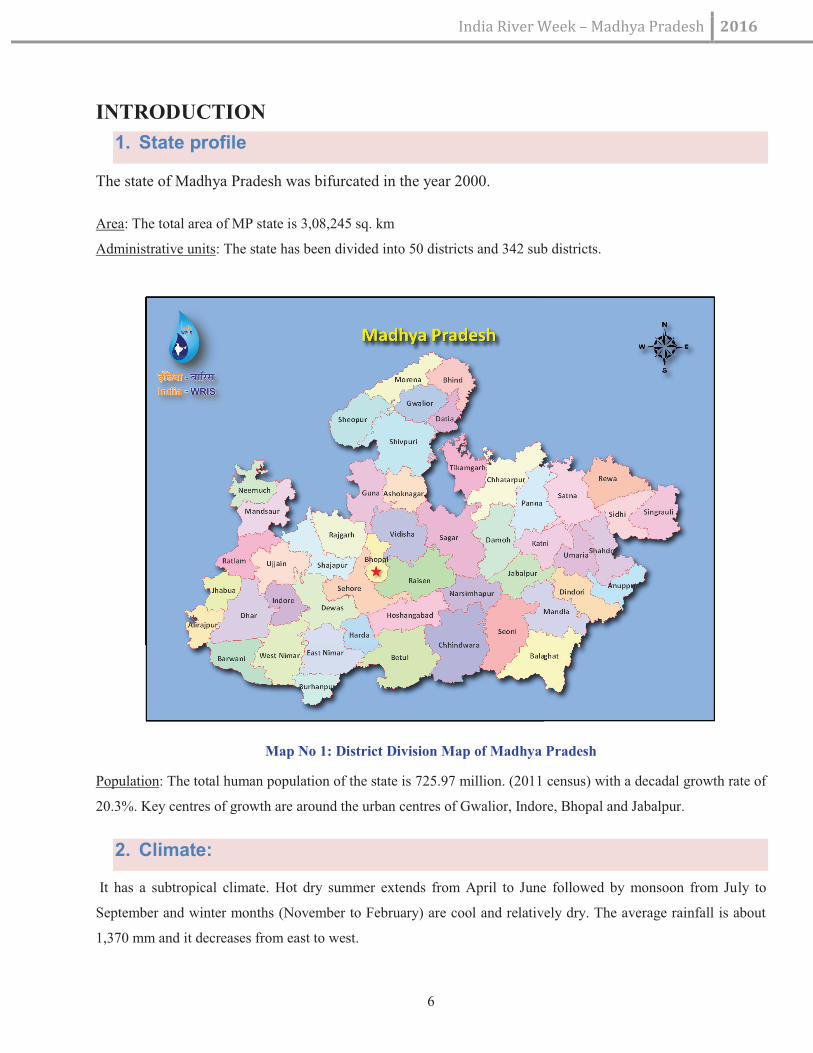
1. State profile
The state of Madhya Pradesh was bifurcated in the year 2000.
Area: The total area of MP state is 3,08,245 sq. km
Administrative units: The state has been divided into 50 districts and 342 sub districts.
Map No 1: District Division Map of Madhya Pradesh
Population: The total human population of the state is 725.97 million. (2011 census) with a decadal growth rate of
20.3%. Key centres of growth are around the urban centres of Gwalior, Indore, Bhopal and Jabalpur.
2. Climate:
It has a subtropical climate. Hot dry summer extends from April to June followed by monsoon from July to
September and winter months (November to February) are cool and relatively dry. The average rainfall is about
1,370 mm and it decreases from east to west.

India River Week –Madhya Pradesh 2016
7
Summer mean maximum temperature rises to about 42.5 deg C in northern parts and the average temperature
during winters is as low as 10 Deg C again in the north while it varies from 10 – 15 deg C in the south. (Source:
Gosain et al in Climate Change in Madhya Pradesh: A Compendium of Expert Views – II)
Map No 2: Population Density Distribution of Madhya Pradesh
3. Physiographic conditions:
Madhya Pradesh consists largely of a plateau streaked with the hill ranges of the Vindhyas and the Satpuras with
the Chattisgarh plains to the east.
For the sake of convenience Madhya Pradesh is divided into 7 Physiographic divisions which are mentioned
below:
· Malwa Plateau
· Plateau of Madhya Bharat
· Bundelkhand Plateau
· Rewa Panna Plateau
· Narmada-Son valley
· Satpura Maikal Range

India River Week –Madhya Pradesh 2016
8
· Baghelkhand Plateau
Map No 3: Physiographic Pattern of M.P
With the Vindhyachal and Satpuda ranges stretching through, almost the entire land mass of the state with few
exceptions (lashkar plain in north, Narmada valley in south west and patches in north west) lay on a number of
plateaus and hills (Kanjarda, Sondwara, Umatwara, Shivpuri, Sagar, Rewa, Chindwara and Betul Plateau and
Barwani hills). Resultantly number of rivers originates from these uplands draining ultimately into neighboring
states.
West flowing river Narmada (in association with the north and north east flowing river Son) utilizes the rift valley
between the Vindhyan and the Satpuda range to bifurcate the state into north – south halves. Tapi, another west
flowing river, with small catchment in the state also flows in a rift valley. This is explained below.
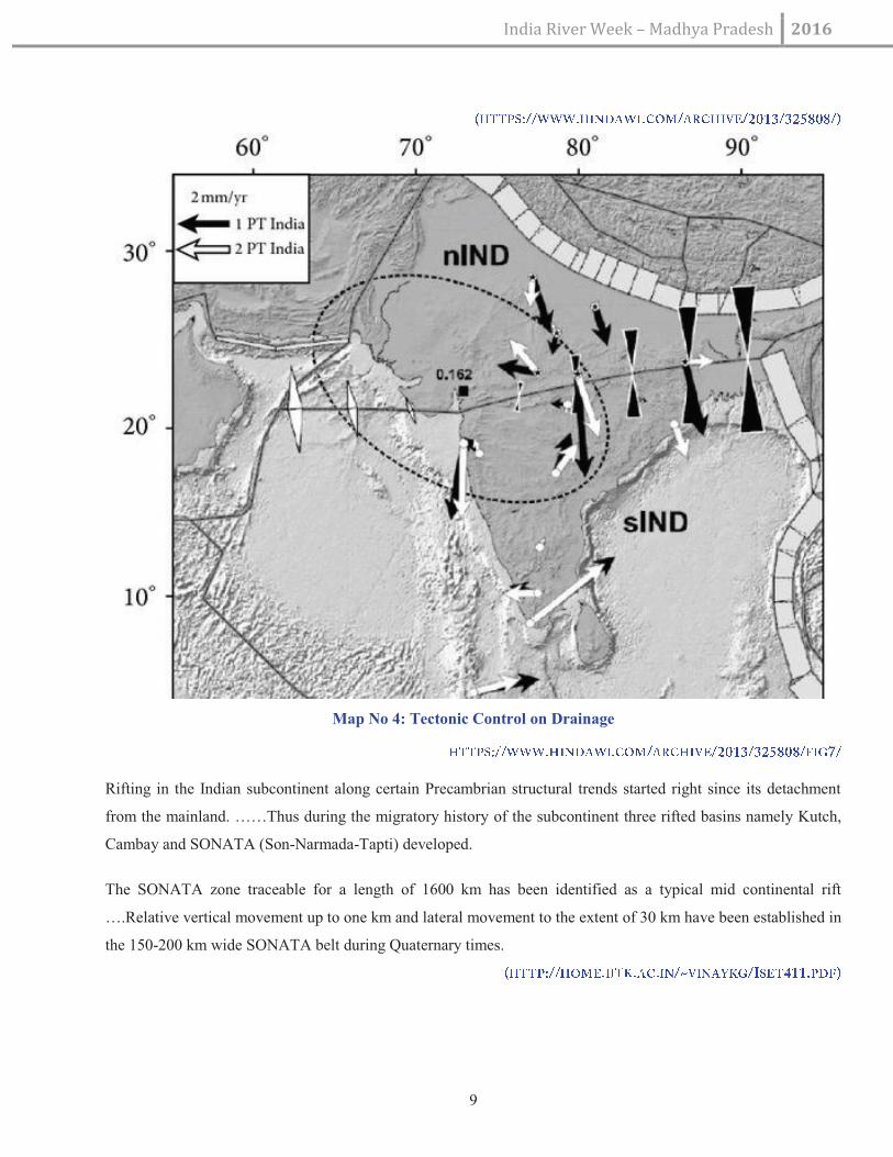
4. SONATA (Sone-Narbada-Tapi) RIFT
The SONATA zone in central Indian shield divides the Indian plate into two halves and has a long tectonic
history dating back to the Archaean times and trends in ENE-WSW direction and is laterally traceable for more
than 1000 km. It demarcates the Peninsular India into two geologically distinct provinces: the Vindhyan-
Bundelkhand province to the north and the Deccan province to the south. The Narmada and Tapi rivers
throughout their course follow these tectonic trends that are also known as central Indian tectonic zone (CITZ)
India River Week –Madhya Pradesh 2016
9
Map No 4: Tectonic Control on Drainage
Rifting in the Indian subcontinent along certain Precambrian structural trends started right since its detachment
from the mainland. ……Thus during the migratory history of the subcontinent three rifted basins namely Kutch,
Cambay and SONATA (Son-Narmada-Tapti) developed.
The SONATA zone traceable for a length of 1600 km has been identified as a typical mid continental rift
….Relative vertical movement up to one km and lateral movement to the extent of 30 km have been established in
the 150-200 km wide SONATA belt during Quaternary times.

India River Week – Madhya Pradesh 2016
10
Map No 5: Crustal Province
5. Forests
Map No 6: Forest Map of M.P

India River Week –Madhya Pradesh 2016
11
Forests of Madhya Pradesh cover around 95,221 sq kms area of the state. This area has been classified into
'Reserved Forest', 'Protected Forest' and 'Unclassified Forest'. Variability in climatic conditions brings about
significant difference in the forest types of the state. There are four important types of forests namely Tropical
Moist, Tropical Dry, Tropical Thorn, and Subtropical broadleaved Hill forests. The forest area can also be
classified on the basis of composition of forest terrains. Based on composition, there are three important forest
formations namely Teak forest, Sal forest and miscellaneous Forests. Bamboo bearing areas are widely distributed
in the state of Madhya Pradesh.
Central, southern and eastern parts of Madhya Pradesh are rich in forests, while western and northern parts are
comparatively deficient in forest.
Forests play a crucial role as river nurseries (most origins lay there) and house of springs that feed the
rivers, the year round. The health of springs is key to river base flows in lean season, since devoid of
high hills and glacial melt (as is true in the case of Himalayan rivers), rivers are fed by their forested
catchments.
Map No 7: Wildlife Protected Area in M.P

India River Week – Madhya Pradesh 2016
12
6. Water
Surface water
The drainage map of the state indicates streams spread over almost the entire land surface of the state.
Map No 8: River Map of M.P
Centrality and topography of the state results in rivers originating from within the state but draining out
into the neighbouring states.
Ganga, Godavari, Tapti, Narmada and Mahi are the major river basins fed by the state. The State is
further divided in to ten river sub basins. These are: 1) Chambal; 2) Sindh; 3) Betwa; 4) Ken; 5) Tons
(Tamsa); 6) Son; 7) Narmada; 8) Wainganga; 9) Tapti; and 10) Mahi.

India River Week – Madhya Pradesh 2016
13
Map No 9: River Basin Map of M.P
The northern part of the state drains largely into the Ganga basin and the southern part into the Godavari
and Tapti (Tapi) system. The Narmada, Tapi and Mahi rivers flow from east to west. The Vindhyas
form the southern boundary of the Ganga Basin, with the western part of the basin draining into the
Yamuna and the eastern part directly into the Ganga itself. All the rivers, which drain into the Ganga
basin flow from south to north, with the Chambal, Shipra, Kali Sindh, Parbati, Kuno, Sind, Betwa,
Dhasan and Ken rivers being the main tributaries of the Yamuna, joining the Ganga. While Tons and
Son which originate in the state join directly the Ganga. The Son is of great significance in that it is the
largest tributary going into the Ganga from the south bank and arising out of the hills of Madhya
Pradesh rather than from the Himalayas. (Source: Gosain et al in Climate Change in Madhya Pradesh: A
Compendium of Expert Views – II ).
The Wainganga, the Wardha, the Pench, the Kanhan and Penganga rivers, discharge their waters into the
Godavari system.

India River Week – Madhya Pradesh 2016
14
Table 1 : River Basin and Their Features
S. No. River
basin
Key rivers (length
within the state in Km)
Catchment in the
state (sq km)
Key tributaries
1 Ganga Sone (500 km) 47849 Mahanadi, Katni, Kawal, Johila,
Gopad, Bana, Kanhar, Rehar
2 Tamas (Tons) (238 km) 11974 Simarbarh, Satna, Bihar, Belan,
Sonekar
3 Yamuna Chambal (965 km) 59940 Kalisindh, Parvati, Kshipra, Khan,
Kuno, Seop
4 Sindh (450 km) 26699 Kunwari, Mahuar, Pahuj
5 Betwa (216 km) 19365 (?) Kaliasot, Halali, Baah, Bina,
Dhasan, Jamni
6 Ken (360 km) 24785 Sonar, Bewar, Bearma, Barve,
Patne, Urmil, Semeri,
7 Baghain ( km) ?
8 Paisuni ( km) ? Jamsar, Rajnak (??)
9 Narmada Narmada (1077 km) 85930 Tawa, Barna, Dudhi, Shakkar,
Hathani, Tenduni, Hiran
10 Tapti Tapti ( 332 km) 9800 Ambharo, Mona, Puna, Kanair,
Kanha, Sukta
11 Godawari Wainganga (272 km) ?? Pench, Kanhan, Bagh
Wardha (58 km) ?? ??
12 Mahi Mahi (183 km) ?? Anas, Khairya, Bageri, Jammar

India River Week –Madhya Pradesh 2016
15
Ground water
Madhya Pradesh has diverse hydrogeological characteristics resulting into varied water potential at
different places. More than 80% of the total land area of the state is covered by variety of hard rocks
varying in geological structures, geomorphological set up and hydro meteorological conditions.
State has following hydrogeological units:
1. Archeans: comprising of old metamorphic rocks, granites, gneisses and schiests. They have very low
primary permeability and form poor aquifers
2. Vindhyans: Comprise of sand stone, shale and limestone. Sand Stone and Shale are hard and compact
forming poor aquifers, Limestone has secondary permeability
3. Gondwans: Sedimentary formations rich in granular zones and form good aquifers
4. InfraTrappeans: Sedimentary formations but have a limited extent and poor to moderate permeability
5. Deccan Traps: The weathered, fractured , jointed and vesicular units of Basalts form moderate to good
aquifers, this type of units form the most important aquifers in the region. They occupy the Malwa
Plateau
6. Alluvium: comprises of unconsolidated gravel, sand , silt clay in various proportions, has primary
intergranular porosity and permeability. They form very good aquifers.
According to a 1998 report the net GW availability in the state (excluding the area now in Chattisgarh) is 3.1
million (ha.m). Out of which total utilizable GW (70% of the net availability) is 2.17 million (ha.m). Current GW
draft is 1.43 million (ha.m). (Quoted in SOE report, MP, 2006).
More than 90% of the rural and 50% of Urban population is dependent on ground water sources in the state.
Ground water being the major source of irrigation. According to ground water report submitted in 2013 about
6,714,300 hectare of land is irrigated through ground water. There are reports about declining Ground water levels
throughout the state. Ground water has also proved to be an important resource to meet the rapidly expanding
demand of drinking water.
It is well known that the flowing rivers contribute significantly to ground water recharge through their associated
aquifers.

India River Week – Madhya Pradesh 2016
16
Map No 10: Block Wise Category of Ground Water Development in M.P
7. Industries
Industrialisation is often associated with an increase in the pollution load onto water bodies including rivers. The
pace of industrialization in the state is slowly but steadly rising. The key industrial centres in the state are in and
around the cities of Indore-Ujjain, Ratlam, Mandsaur, Neemach, Bhopal, Gwalior, Morena, Sagar, Jabalpur and
Satna.

India River Week –Madhya Pradesh 2016
17
Map No 11: Regestered Industrial Location
Table 2: Industries Discharging Treated Effluent Into Rivers in MP:
S.No River Industry Location
1 Chambal M/s Grasim Industries Birlagram, Nagda, Mandsaur
2 Sone M/s Orient Paper Mill Amlai,
3 Narmada M/s Security Paper Mill Hoshangabad

India River Week – Madhya Pradesh 2016
18
POLLUTION
8. Polluted River Stretches in Madhya Pradesh
The rivers in Madhya Pradesh are monitored by CPCB at 96 locations on 41 rivers. Among these 45 locations are
not complying with the Water Quality Criteria. These 45 locations are situated on 21 rivers viz. Banjar, Betwa,
Bichia, Chambal, Chillar, Denwa, Gohad, Gour, Jammer, Kalisot, Khan, Kolar, Kshipra, Kunda, Malei, Narmada,
Parvati, Shivna, Tapi, Tons and Wainganga. The polluted rivers in Madhya Pradesh are in 5 priority classes
(Class- I, II, III, IV and V).
The details of polluted river stretches are as under:
Table 3: The Details of Polluted River Stretches
S. No. River (Basin)
Stretch Towns Length (km)
1 Banjar (Narmada) Malanjkhand - Tingipur Malanjkhand,
Tingipur
15
2 Betwa (Yamuna) Mandidweep - Vidisha Mandidweep,
Vidisha, Bhopal,
Raisen
70
3 Bichia (Tons) Silpari - Gadhawa Rewa 5
4 Chambal
(Yamuna)
Nagda - Rampura Nagda, Rampura 150
5 Chillar (Chambal) Shajapur - Muradpura Shajapur, Dansipura,
Muradpura
10
6 Denwa (Narmada) Dhupgarh - Sarni Dhupgarh, Sarni,
Banipura
50
7 Gohad (Sindh) Gohad dam - Gormi Gohad, Gormi 25
8 Gour (Narmada) Jabalpur - Saliwada Jabalpur 15
9 Jammer (Mahi) Dholowad - Raoti Raoti 5
10 Kaliasot (Betwa) Mandidweep – Samardha Bhopal, 12

India River Week –Madhya Pradesh 2016
19
village Mandidweep
11 Khan (Kshipra) Kabit Khedi - Khajrana Indore 8
12 Kolar Surajnagar - Shirdipuram Indore 8
13 Kshipra (Chambal) Siddhawat -
Trivenisangam
Ujjain 8
14 Kunda Khargone - Khedikhurd Khargone 15
15 Malei Jaora - Barauda Jaora 10
16 Narmada
(Narmada)
Mandala – Bhedaghat.
Sethani ghat - Nemawar
Mandala, Jabalpur,
Hoshangabad,
Nemawar
160
17 Parvati
(Chambal)
Batawada - Pilukhedi Batawada,
Pilukhedi,
Narsinghgarh
80
18 Shivna (Chambal) Mandsaur - Malaykhedi Mandsaur 8
19 Tapi (Tapi) Nepanagar - Burhanpur Nepanagar,
Burhanpur
25
20 Tons (Ganga) Chakghat - Chappar Gargata, Chakghat,
Chapar
5
21 Wainganga
(Godavari)
Chindwara - Balaghat Chindwara,
Balaghat, Seoni
150
9. Trace and Toxic Metals In Mp Rivers, 2014 (Cwc)
Table 4: Toxic Matal in Rivers
S. No. River Location Pollutant
1 Mahi Khanpur, Mataji, Paderdibadi Fe
2 Narmada Bamanghat, Garudeshwar, Handia Fe

India River Week –Madhya Pradesh 2016
20
3 Sone Japla, Koelwar Fe
4 Tapi Sarangkheda Fe
5 Sone Kuldah Bridge Cu
6 Narmada Dindori, Mandleshwar, Manot, Cu
7 Wardha (Godawari) Bamni, Cu
8 Banjar (Narmada) Bamni Ni, Fe
9 Narmada Sandia Ni, Fe
10 Narmada Hoshangabad Ni, Fe
11 Tapi Burhanpur Cu, Ni, Fe
12 Tapi / Purna Gopalkheda Ni, Fe
13 Wainganga Kumhari, Pauni and Ashti Cu, Ni
14 Wardha Hivra Cu, Ni
(STATUS OF TRACE AND TOXIC METALS IN INDIAN RIVERS, 2014 (CWC)
10. Water Quality of rivers at interstate borders, 2015:
Water Quality of River Chambal:
Water quality monitoring of the river is carried out at 02 locations at the interstate boundaries of U.P/M.P. and
Rajasthan/M.P. The BOD and DO concentrations are meeting to the prescribed standards at both the locations.
However, Total Coliform count is exceeding at the location Udi (U.P.).

India River Week – Madhya Pradesh 2016
21
Water Quality of River Mahi:
Water quality monitoring of the river is carried out at 2 different locations of interstate boundary of
M.P./Rajasthan and Gujarat/ Rajasthan. The BOD and DO concentrations are within the prescribed range at both
the locations. Total Coliform count is exceeding at Kadna Dam, (Gujarat).
Water Quality of River Betwa:
Water quality monitoring of the river is carried out at 2 different locations of interstate boundary M.P./U.P.
Concentration of BOD and DO is meeting the prescribed standards whereas Total Coliform count is exceeding at
both the locations.
Water Quality of River Sone:
Water quality monitoring of the river is carried out at 2 different locations of the interstate boundary M.P./U.P.
The BOD and DO level are within the prescribed range whereas Total Coliform count is exceeding at both the
locations.
Water Quality of River Wardha:
Water quality monitoring of the river is carried out at 2 different locations at the interstate boundary
M.P./Maharashtra. The BOD and DO level are meeting to the prescribed standards. However, Total Coliform
count is exceeding at one location i.e. Belur Dhemadabad (Maharashtra).
Water Quality of River Tapi:
Water quality monitoring of the river is carried out at 3 different locations at the interstate boundaries of
Maharashtra/Gujarat and Maharashrta/M.P. The BOD and DO level are meeting the prescribed standard.
However, Total Coliform count is exceeding the prescribed standards at all 03 locations.
Water Quality of River Narmada:
Water quality monitoring of the river is carried out at the location at the interstate boundary of Gujarat/M.P. The
BOD and DO level are meeting the prescribed Standards. Where as the Total Coliform count is exceeding at said
location.
Water Quality of River Wainganga:
Water quality monitoring of the river is carried out at the location of interstate boundary of Maharashrta/M.P. The
BOD and DO level are within the prescribed range indicating the good water quality at the location. Total
Coliform count is exceeding at the aforesaid location.

India River Week –Madhya Pradesh 2016
22
11. Ground water quality
The quality of ground water in the state has been shown in the following map prepared by MPPCB. It is seen that
the ground water quality is poor mostly in and around major cities in the state.
Map No 12: Ground Water Quality
DAMS AND HYDRO POWER DEVELOPMENT
(Source: http://www.india-wris.nrsc.gov.in/wrpinfo/index.php?title=Madhya_Pradesh)
1. There are 758 dams on various rivers in the state.
2. The major Hydro Power Stations in Madhya Pradesh are listed below:
1. Bansagar Tons HE project (River Sone)
2. Indirasagar HE project (NHDC) (River Narmada)
3. Omkareshwar HE project (NHDC) (River Narmada)
4. Madikheda HE project (River Sindh)
5. Bargi HE project (River Narmada)

India River Week – Madhya Pradesh 2016
23
6. Pench HE Project (Joint venture of MP & Maharashtra) (River Pench)
7. Rajghat HE project (Joint venture of MP & UP) (River Bewas, Ken system)
8. Maheshwar HE project (Under Construction)- Under Private sector (River Narmada)
9. Tawa HE Project (Under private sector) (River Narmada)
10. Birsinghpur HE project (River Johilla, Sone system)
INTER-STATE AGREEMENTS
12. Narmada Basin
1. Agreement Dated 22nd July, 1972 between Governments of Gujarat, Madhya Pradesh and Rajasthan on
Narmada Development.
2. Agreement Dated 12th July, 1974 between the Governments of Gujarat, Madhya Pradesh, Maharashtra
and Rajasthan about the Narmada water dispute.
3. Agreement Dated 8th March, 1975 between the Governments of Gujarat, Madhya Pradesh, Maharashtra
and Rajasthan on development of Narmada waters.
4. Agreement Dated 5th April, 1978 between the Governments of Gujarat and Madhya Pradesh about the
medium schemes in Narmada Basin.
5. Narmada Water Dispute Tribunal Award
13. Ganga Basin
1. Agreements Dated 29th April, 1965 between the Governments of Uttar Pradesh and Madhya Pradesh
regarding the following Projects. i) Execution of Bhander Canal (Matatilla Dam) ii) Allocation of Waters
from the Rangwan Dam iii) Allocation of waters from the Jamni Dam.
2. Agreements Dated 18th October, 1965 between the Governments of Uttar Pradesh and Madhya Pradesh
regarding Bhander Canal project.
3. Agreements Dated 1st August, 1972 between the Governments of Uttar Pradesh and Madhya Pradesh
regarding some Irrigation projects in Bundelkhand.
4. Agreements Dated 16th September,1973 among the Governments of Bihar, Madhya Pradesh and Uttar
Pradesh regarding Bansagar project.
5. Summary record of decision taken at the interstate meeting held on 8th December, 1973 between the
officials of Madhya Pradesh and Uttar Pradesh regarding supplies to Bhander Canal- Rabi Season of
1973-74.
6. Agreements Dated 9th December,1973 between the Governments of Uttar Pradesh and Madhya Pradesh
regarding Rajghat Project.

India River Week – Madhya Pradesh 2016
24
7. Summary record of decision taken at the interstate meeting held on 13th January 1977 between the chief
Ministers of Madhya Pradesh and Uttar Pradesh regarding the following projects: (i) Rajghat (ii)Paisuni
(iii) ken Canal (iv) kanhar (v) Urmil, (vi) Bansagar, and (vii) Bhander Canal
8. Agreements Dated 20th February , 1982 on sharing of kanhar waters reached between the states of Bihar,
Madhya Pradesh and Uttar Pradesh.
14. Tapi Basin
1. Agreement Dated 8th march 1964 between the Governments of Maharashtra and Madhya Pradesh
regarding interstate irrigation and Hydel projects.
2. Agreement Dated 16th May, 1969 between the Governments of Maharashtra and Madhya Pradesh
regarding inter-state Irrigation and and Also regarding constitution of inter-state control board for Joint
Irrigation and Hydel Project.
1. 3 Agreement Dated 12th January, 1986 for sharing of Tapi water between Maharashtra and Madhya
Pradesh.
15. Godavari Basin
1. Summary record of decision taken at the inter-state conference held on 27th July and 28th July, 1951
among the states of Bombay, madras, Hyderabad, Madhya Pradesh and Mysore regarding the utilization
of Krishna and Godavari waters.
2. Agreement Dated 8th march, 1964 between the Governments of Maharashtra and Madhya Pradesh
regarding certain inter-state irrigation and hydel projects
3. Agreement Dated 16th May, 1969 between the Governments of Maharashtra and Madhya Pradesh
regarding certain Inter-state irrigation and Hydel Projects: Pench & bagh and also regarding the
constitution of interstate control board for joint irrigation and hydel projects.
4. Agreement Dated 31st January,1975 between the Governments of Maharashtra and Andhra Pradesh
regarding the swarn Project and other agreements between the governments of Madhya Pradesh and
Maharashtra regarding the following Projects: Bhawanthadi, Bhapalpatnam Project I and II, Kalisarar
Project, Nugur II Hydro-Electric Project,Kotri Nibra Hydro- Electric Project and Bandia Hydel Electric
Project.
5. Godavari Water Dispute Tribunal

India River Week – Madhya Pradesh 2016
25
RIVER BASINS
16. Chambal
Starting its life as a very tentative stream from a small pond (Parsuram Kund) on top of a concave hillock
(Janapao hill) near Mhow, it is soon joined by a number of equally ephemeral and meandering streams and the
river does not come into its own till it passes by a village called Chambal Baroda some 25 km from the origin.
Map No 13: Google Image of Janapao Hill ( Parsuram Kund)
Even later, the river is still unsure of itself, despite few notable tributaries meeting and feeding it, till Chamla river
joins it little downstream of the city of Nagda.
According to Volume IV of “Immortal India” by J.H.Dave (Bhavan’s Book University, 1991):
“It is stated that from the same cluster of hills three streams are flowing, namely Chambal, Chambela and
Gambhir. This river Chambal is the same as Charmanvati of the Epic and Puranic literature. It has been
described at several places in the Mahabharata – Adiparva 138, Vana Parva 82, Drona Parva 67, and Santi Parva
29; in Padma purana 1-24 and Meghadoota 1-45; also mentioned in Panini VIII 2-12.
In Kalidasa’s, Meghadoota 1-45, the Yaksha advises the cloud to pay homage to river Charmanvati by getting
down to take its water and this Charmanvati is described by Kalidasa as having her birth on account of the
prowess of Surabhi, the daughter of Kamadhenu. The river is further described as the fame of King Rantideva
flowing as it were in the form of a river.

India River Week – Madhya Pradesh 2016
26
It is with this Rantideva that river Charmanvati i.e. Chambal is connected. It is said that King Rantideva was so
hospitable that two lakhs of cooks were employed in his establishment (drone Parva 67-1). He supplied the best
of foods to his guests. He also performed numerous sacrifices, and as a large number of animals was killed for
this purpose, their hides (charma) were collected into big heaps and the river was flowing here with its mud mixed
with blood through the heap of hides. It is on this account that the river came to be known as Charmanvati.
Map No 14: Chambal River Basin
Following are the key notables (seasonal tribuatries of length less than 10 km have not been considered) about the
river Chambal system in the state (derived from Google earth imageries):
Table 5: key notables about the river Chambal system
S. No Distance from
origin
Tributary River /
Stream / structure
Location / Bank Tributary Length
(Km)
1 3 km River passes under

India River Week – Madhya Pradesh 2016
27
the NH (Agra-
Mumbai)
2 25 km Number of seasonal
streams join to form a
perceptible stream
Chambal Baroda vill
on right bank
30 km
3 55 km Baweri river Mundla (L) 20+ km
4 115 km Chamla river
Anicuts on the river
Piploda (L) 90+ km
PINK due to
number of anicuts
and small dams on
its founder streams
5 127 km Bageri river joins /
major Weir on river
Chambal
Nagda (L) 30+ km
6 128.5 km ?? nala (Dam on the
Nala)
d/s of Nagda ( R ) 10+ km
7 146 km Anicut on the river Rajgarh vill
8 152 km Anicut on the river Malla Khedi vill
9 170 km Anicut on the river Tamboliya vill
10 174 km Maleni River joins
(actually three streams
Kurel, Pingla &
Maleni meet up to
form Maleni). Dams
on Pingla and Kurel
Menda Kheda vill (
L )
90+ km
PINK due to dams
on tributaries.
11 176 km Anicut on the river Gondi Shankar vill
12 185.5 km Anicut on the river Bharatpura vill
13 204 km River Kshipra joins
(Kshipra is combined
waters of rivers Khan,
Gambhir and Kshipra)
Ekalgarh vill. ( R )
Kshipra before
confluence forms
MP-Raj border for
Kshipra – 215 km
Gambhir – 132 km
Khan – 74 km
Kshipra & Khan,

India River Week – Madhya Pradesh 2016
28
3 Dams and anicuts on
tributaries
about 20 km.
Indore, Ujjain cities
in Catchment
both are RED
category due to
dessication and
heavy pollution.
14 204.5 km Anicut on the river Ekalgarh vill.
15 218 km River Choti Kali
Sindh joins. Major
dam on the river
Chambal called
Gandhi sagar.
8 Dams and number of
anicuts on Tributaries
Para Pipli vill. ( R )
The backwaters of
Gandhi Sagar dam
starts
154 km.
PINK due to number
of dams and anicuts
on it.
16 248 km River Shivna joins the
reservoir.
Anicuts on the river
and tributariews
Hingoriya bada vill.
( L )
Mandsaur town
102 km.
PINK due to number
of anicuts and
pollution from
Mandsaur city.
17 252 km River Retam joins the
reservoir.
Three dams on
tributaries.
Bordia vill. ( L ) 90 km
PINK due to dams
and anicuts.
18 255 km River Idar joins the
reservoir.
Dam on tributary
Chachor ( L ) 70 km
PINK due to anicuts
and dam on its
tributary.
19 301 km Dam on river
Chambal. Within MP
(Neemach &
Mandsaur Districts).
Gurla.
Reservoir length is
60 km +
Neemach,
Malhargarh,
Shyamgarh, Garoth,

India River Week – Madhya Pradesh 2016
29
Bhanpura,
20 310 km River Chambal in
gorge before falling
into the reservoir of
Rana Pratap sagar
another dam on river
Chambal in Rajasthan
(Chittorgarh district)
River enters
Rajasthan
21 311 km River Gunjal meets
the Reservoir.
Two dams on
tributaries.
Baghpura vill ( L ) 40 + km
22 336 km Dam site. 25 km long
reservoir.
Rawatbhata.
Rajasthan Atomic
Power Station.
Rawatbhata
township.
23 342 km River Brahmani joins
Chambal. River
Chambal forms gorge.
Bhainsrogarh ( L )
Bhainsorgarh,
Budhpura,
Mandalgarh,
Bichore, Jagpura,
Singoli, (Raj) Begun
(MP) townships
Stone mining.
50 + km
PINK due to anicuts
and small dams on a
tributary
24 382 km Barrage on river Kota town.

India River Week – Madhya Pradesh 2016
30
Chambal. River flows
through a 40 km long
gorge.
Most river water
diverted at the
Barrage.
Keshoraipatan
township on
Chambal. Famous
temples.
Kota Thermal Power
Station.
River exits the
plateau after flowing
through
Bhainsorgarh and
Darra sanctuaries in
Rajasthan
25 407.5 km ?? nala joins Chambal Manasgaon ( R ) 45+ km
26 444 km ?? nala joins Chambal Kherli Khush ( R ) 25+ km
27 449 km ??nala joins Chambal
(two dams on it)
Chambal in poor
health till Kali Sindh
joins it.
Sanga Heri ( R )
40+ km
28 452.5 km River Kali Sindh
meets Chambal (River
Kali Sindh has
Parwan, Laxman,
Niwaj, Amjhar,
Lakhundar and Ahu as
its key tributaries. 8
dams exist on smaller
Navnera ( R ).
River Kali Sindh at
confluence is a
bigger river than
Chambal.
Jhalawar, Ram Ganj
300+ km
PINK due to number
of anicuts and dams
on its tributaries.

India River Week – Madhya Pradesh 2016
31
tributaries) mandi, Nalkheda,
Rajgarh, Pachore,
Shujalpur,
Sarangpur,Shajapur,
Sonkatch towns
29 464 km River Mej meets
Chambal. River Kural
is a major tributary. At
least 5 dams exist in
river Mej system.
Balwan Khurd ( L )
Lakheri,Khatgarh,
Shakargarh towns
Lakheri cement
plant.
150+ km
PINK due to anicuts
and dams.
30 488 km River Parbati meets
Chambal.
Major tributaries of
Parbati are Aheli,
Banganga, Kul,
Andheri etc. Number
(10) dams on the
rivers.
Pali ( R ).
River Chambal after
confluence with
Parbati forms the
inter-state border
between MP and
Rajasthan.
Khatoli, Bapcha
Thermal Power
plant, Vijaypur
Refinery, Ashta,
Sehore towns.
300+ km
RED due to dams
and anicuts.
PINK
due to pollution.
31 507 km River Banas and River
Sip join Chambal on
either banks.
Key Tributaries of
river Banas are
Berach, Menali,
Banas at Barwas ( L
).
Sip at Manpur ( R ).
It is almost the same
distance that river
River Banas – 500+
km
River Sip – 50+ km
River Sip is PINK
due to dams.
River Banas is RED

India River Week –Madhya Pradesh 2016
32
Kothari, Khari, Dai,
Dheel, Sohadra, Morel
and Kalisil. Banas is
perhaps the most
dammed river in
Rajasthan.
Chambal and Banas
has taken before
meeting.
category
32 520.5 km ??Nala meets the river
Chambal
Danteti ( R ) 20+ km
33 554 km River Kuno meets
Chambal.
One dam on a
tributary
Sikheda ( R )
Kuno Sanctuary in
the catchment.
160+ km
River Kuno is BLUE
category
34 802 km River Yamuna meets
river Chambal.
River Chambal forms
MP-Raj border for
first 134 km and then
MP-UP border for
next 84 km.
Bhareh ( L ).
It is amazing that for
the last 248 km of its
flow, river Chambal
has no tributary of
any significance, till
it meets Yamuna.
River Chambal also
forms a tri state (Raj,
MP, UP) Ghariyal
Sanctuary
2707 km
Clearly the total length of the river Chambal basin is in excess of 3509 km. (802 + 2707).
THE CHAMBAL RIVER BADLANDS IS A LATE PLEISTOCENE-HOLOCENE DEGRADATIONAL
LANDSCAPE.
The Chambal is the largest of cratonic (the part of a continent that is stable and forms the central mass of the
continent) rivers in Ganga-Yamuna drainage basin. From source to its confluence with the Yamuna it is about
a 1000 km long. It flows over both the Deccan Basalts and Proterozoic Vindhyan strata and contributes

India River Week – Madhya Pradesh 2016
33
significant amount of sediment to the foreland basin.
Rivers and their associated floodplains go through aggradational and degradational phases. In an
aggradational phase the river is carrying a large sediment load and flooding results in deposition of this
sediment in the flood affected areas. This periodic deposition builds up or aggrades the floodplain.
Conditions may change. For example during longer wet periods and increased rain intensity river discharge
increases. Sediment is not deposited locally but is carried out of the system to the sea. In these conditions
rivers incise or cut into their own deposits. The river channel becomes situated in a deep valley detached from
its floodplain. Starved of sediment, the floodplain degrades as erosion along the main channel and
smaller streams cuts gully and ravines forming badlands.
Pictorial representation of this process -
Chambal region badland formation coincided with the intensification of the southwest Indian monsoon at the
end of the Last Glacial Maximum around 15 thousand years ago and likely continues today, amplified over the
last couple of millennia by intense human reworking of the landscape.
Another mechanism that may initiate a phase of river incision is tectonic uplift and tilting of the region. Tectonic
upwarp may steepen stream gradients increasing their erosive power. That mechanism has been invoked by

India River Week – Madhya Pradesh 2016
34
some to explain phases of incision of the Yamuna and the Chambal
Ravined badlands border not just Chambal river, but also Yamuna, Betwa and Sengur regions in the region.
The incised main channel of the river and the ravines expose older sediment. In these older sediments, earlier
degradational and aggradational episodes can be recognized and coincide with fluctuations in monsoon
intensity.
NATIONAL CHAMBAL SANCTUARY
(http://upecotourism.in/NationalChambalSanctuary.html)
National Chambal Sanctuary, also called the National Chambal Gharial Wildlife Sanctuary, is a 5,400 sq. km tri-
state protected area in northern India home to critically endangered gharial (small crocodiles), the red-crowned
roof turtle and the endangered Ganges river dolphin. Located on the Chambal River near the tri-point of
Rajasthan, Madhya Pradesh and Uttar Pradesh, it was first declared as a PAs in Madhya Pradesh in 1978 and
now constitutes a long narrow eco-reserve co-administered by the three states. Within the sanctuary the pristine
Chambal River cuts through mazes of ravines and hills with many sandy beaches along its banks.
Deep within the subcontinent lies a land whose many secrets lie still hidden from the human eye in its still
largely unexplored terrain. A land is synonymous with harsh terrains and on its breath taking beauty, Chambal.
Now uncover the many secrets of the famed land at the Chambal National Sanctuary. Originating in the
Vindhayan ranges in M.P. the Chambal River snakes its way thought the states of M.P. Rajasthan and U.P.
before finally meeting the Yamuna in the Etawah district of U.P. Its rich bio-diversity ensured that it was declared
a National Sancturary in 1979 with its total area spanning across the three states of M.P. Rajasthan & U.P. The
last bastion for some of the country's most endangerd wildlife like the Gharial, Muggar, Turtles, Otter and the
fresh water Dolphin, the Chambal region also boasts of a wide variety of aquatic and terrestrial bird.
After rampant poaching and fishing almost wiped out the Gharial population from the country in the 70's, captive
breeding and reintroduction programme was started. Chambal was chosen as one of the main areas for
reintroduction the species back in to the wild. The Chambal Sanctuary in U.P. covers an area of 635 sq. kms.
Spread over the Agra and Etawah districts, and a total of 290 different species of migratory and resident birds
have been identified in the region so far. Winter is the best time to visit the sanctuary. A boat ride in its tranquil
waters during this time is an exhilarating experience with spectaculars sightings of the big reptiles basking along
the 180kms. Sparkling sand stretches in the morning sun. but the main draw of the santuray are of course the
Flamingoes that arrive here in November and stay till May. The Rudy Shelduck Also arrives a little earlier in
September & stays here till May. The Indian Skimmers have Huge Colonies in the sanctuary and bred prolifically

India River Week –Madhya Pradesh 2016
35
here.
Biodiversity:
According to a study on vertebrate fauna of the Chambal river basin with emphasis on the National Chambal
Sanctuary (NCS) by Tarun Nair and Y. Chaitanya Krishna
Faunal diversity:
Recorded 147 fish species comprising 32 families; 56 reptile species comprising 19 families; 308 bird species
comprising 64 families and 60 mammal species comprising 27 families from this region, based on available
literature and field observations. This includes six Critically Endangered, 12 Endangered and
18 vulnerable species as categorised by the IUCN Red List of Threatened Species (IUCN 2011).
Places of Mythological and Archeological importance:
Kayatha Culture
Several Chalcolithic sites have been discovered in the Malwa region (catchment of upper Chambal) of central
India. The site at Kayatha, situated on the right bank of the Choti Kali Sindh river (a tributary of Chambal river),
is the type site of this culture, known as "Kayatha culture".
Excavations conducted by V. S. Wakankar (1965–66) and by M. K. Dhavalikar and Z. D. Ansari (1968) revealed
layers from five different periods:
1. Kayatha culture
2. Ahar culture
3. Malwa culture
4. Early historical culture
Sunga-Kushan-Gupta culture
The Kayatha culture represents the earliest known agriculture settlement in the present-day Malwa region. It also
featured advanced copper metallurgy and stone blade industry.

India River Week –Madhya Pradesh 2016
36
Using calibrated radiocarbon, Dhavalikar dated this culture to a period spanning from 2400 BCE to 2000 BCE.
However, calibrated dates by Gregory Possehl place it between 2200 BCE and 2000 BCE
Historical sites:
Table 6: Historical Site along Rivers
S. No. Site Place District
1 Prehistoric Painted Rock Shelters at
Chatarbhuj Nala
Bhanpura Mandsaur
2 Prehistoric Painted Rock Shelters at
Sita Khardi
Bhanpura Mandsaur
3 Brahmanical Rock temple Dhamnar Mandsaur
4 Buddhist Caves (No. 1 to 51) Dhamnar Mandsaur
5 Nav Toran temple Khor Mandsaur
6 Yashodharman's pillar of Victory Sondhani Mandsaur
7 Ekattatso Mahadeva temple Mitaoli Morena
8 Gadhi Padavali Morena
9 Temple Padavali Morena
10 Temple Padavali Morena
11 Siva temple (Locally known as
Kakanmath temple)
Suhania Morena
12 Temple No. 1 to 22 Naresar Morena
13 Group of temples Bateshwar Morena
Sipra or Kshipra
Kshipra, a key tributary of river Chambal is considered as a very sacred river. The citry of Avanti or Ujjayni is on
the banks of this river and the importance and greatness of Sipra, Avanti, and Avanti Mandala and the
Mahakalavana are described in great detail in a special Khanda of Skandapurana called the Avantya Khanda.
After its rise in Malwa this river flows in a north-western direction. At many places it flows as a shallow stream.
In the downs of Malwa this river has got low banks, and the water is used for irrigation, but at other places,
particularly between Mehidpur and A lot the banks are rocky and high. This river passes by Ujjain after it has

India River Week –Madhya Pradesh 2016
37
flowed for about 54 miles from its source. It has been observed that this river has been considered so sacred that
it contains holy spots almost throughout its course and as depicted in several puranas, particularly Skandapurana,
its banks were made holy by the hermitages of ancient and reputed sages. Numerous legends are current in
connection with the acts of sages, gods and demons.
Kalidasa described the city of Avanti situated on the bank of river Sipra in the Raghuvamsa, Canto VI, verses 34
and 35: “This ruler of Avanti stays near the moon-crested Lord Siva enshrined in the temple of Mahakala, one of
the twelve famous Jyotilingas of Siva. This ruler is in the position to enjoy the company of his queens even in the
black of the month feeling the pleasure of the bright half of the month (inasmuch as he is near the moon-crested
God). O lovely princess! If you elect to get married to this young ruler of Avanti you will enjoy yourself in the
gardens of Ujjayini where the trees are shaken by the winds blowing over the ripples of river Sipra.”
It is said that river sipra has come out of the blood of Lord Vishnu and the belief was current even in the days of
Abul Fazl that the waters of this river turned into milk on certain occasions.
Viramitrodaya, Tirthaprakasha, page 531, quoting Matsyapurana, says that just as there are two eyes on the face,
similarly there are two sacred places or tirthas on the earth and they are: one Avimukta (Kasi) situated on the bank
of Ganga and the other Mahakala (Ujjain) situated on the bank of river Sipra.
Periplus mentions Ujjain as Ozeni and states that all commodities were brought from Ujjain to Broach (Barygaza)
for being exported to different parts of India.
The ruins of the ancient city of Ujjain are about a mile from the present city. There are several ghats on the Sipra
river. Every year on the ful moon day of the month of Karthika, there is a fair held at Ujjain. Every twelve years
when Jupiter is in the sign of Scorpio there is a big Kumbhamela held at Ujjain. On this occasion lakhs of sadhus
representing different sects and sampradayas gather together from all parts of India and they take their bath in the
water of river Sipra. Along with the sadhus many pilgrims also join in the Kumbhamela and have a dip in the
sacred river.
Human Intervention and Impacts
Existing Surface water Projects on river Chambal system are a) Gandhi Sagar; b) Ranapratap Sagar; c) Kota
Barrage; d) Parwati Pick-up Weir; e) Harish Chandra Sagar; f) Gudha Dam;
There are 52 irrigation projects including 7 medium projects with the total storage capacity of 271Mm as on going
Surface Projects in the state of Rajasthan. These projects are expected to complete by 2015.

India River Week –Madhya Pradesh 2016
38
River Chambal feeding its own tributaries
Water transfers From Chambal River in the state of Rajasthan
· to Banas Basin (634 Mm3)
· to Gambhir Basin (214 Mm3)
· to Parbati Basin (50 Mm3)
ECOLOGICAL IMPACTS OF THE PROPOSED KANERA LIFT IRRIGATION SCHEME – Tarun Nair
http://www.sanctuaryasia.com/magazines/conservation/5971-of-dams-dacoits-and-death-the-saga-of-the-chambal-
gharials.html
The Kanera Lift Irrigation Scheme on the Chambal river at Kanera, District Bhind, Madhya Pradesh has been
proposed in an area that is one of the few breeding sites of the critically endangered gharial. It is also home to
the Gangetic dolphin, marsh crocodile and several migratory and resident birds. Approach roads and pipelines
have been proposed adjacent to ravines and thorn forests that harbour wolves, caracals, civets and more.
According to a study report by the Wildlife Institute of India (WII) in 2010, “The construction of pillars, the intake
well and the jack well will adversely affect the river bed and the sand bar directly; are likely to change the river
morphology, which will affect the gharial nesting beaches and enhance sedimentation in the downstream. If
these projects become operational, there will be no flow in the river and there will be deficit in water availability
in the downstream.” The flow regime of the river has already shown a declining trend in the last two decades
and resulted in isolated sub-populations of gharials and dolphins. A second report by WII in 2011 further adds:
“The minimum flow requirement for long term survival of gharials is 164.34 m3/sec and for dolphins it is 289.67
m3/sec. At present, this flow is available only during the months of July to October for gharial and July to
September for dolphin in the river stretch between Dholpur and Panchhnada. The period of reduced availability
of flow also corresponds to the gharial breeding season. As the suitable habitat at present is already
compromised by 50 per cent or less in lean months, further withdrawal of water will negatively impact the habitat
suitability for gharial and dolphins significantly. The minimum flow requirement for long term survival of gharials
and dolphin could be achieved if flow from Kota barrage and other subsidiary dams in the Chambal basin is
restored.”
Importance and threats faced by National Chambal Sanctuary (NCS)
The NCS is among the most important and significant habitats where several globally threatened fauna still
survive.

India River Week – Madhya Pradesh 2016
39
Apart from being a strong candidate for World Heritage and Ramsar Convention listings, the NCS is also subject
to international treaties like the Convention on the Conservation of Migratory Species of Wild Animals (Bonn
Convention), which lists both flagship species of the NCS, namely
the Gharial Gavialis gangeticus and Gangetic River Dolphins Platanista gangetica.
It contains the most viable breeding populations of the Critically Endangered Gharial and Red-crowned Roofed
Turtle Batagur kachuga. It is also among the most important strongholds of the
Deccan Mahaseer, Tor khudree, Putitor Mahaseer, Tor putitora,Narrow-headed Softshell
Turtle Chitra indica,Three-stripedRoofedTurtle Batagur dhongoka,Indian skimmer Rynchops albicollis,Black-
bellied Tern Sterna acuticauda, SarusCrane Grus antigone and Gangetic RiverDolphin Platanista gangetica.
The NCS functions as a vital source and nursery for fish fry and fingerlings, contributing significantly to
downstream fisheries in the Gangetic river system (Sivakumar & Choudhury 2008). It is an Important Bird Area
particularly for the Oriental White-backed Vulture Gyps bengalensis, Long-billed Vulture Gyps indicus, Pallas’s
Fish-Eagle Haliaeetus leucoryphus and Greater Spotted Eagle Aquila clanga among others (Islam
& Rahmani 2004). The NCS also serves as among the best over-wintering sites for migratory birds. In addition,
this river sanctuary also forms a vital corridor and link for the movement and dispersal of
Tigers Panthera tigris from the source population of RanthamboreTiger Reserve to the protected areas of Kuno-
Palpur, Madhav National Park and Darrah-Mukundra (Reddy et al. 2012; Rakesh Vyas February 2008 pers.
comm.).
Threats: The Chambal faces severe extractive and intrusive pressures in the form of water impoundment and
abstraction, sand- and stone-mining, fishing, poaching, riparian agriculture, livestock grazing, firewood
collection, miscellaneous domestic activities, and infrastructural development (Hussain 2009; Nair
2010; Katdare et al. 2011; MoEF 2011; Tarun Nair 2006, 2008, 2009–2013 pers. obs.).
Seven major, 12 medium and 134 minor irrigation projects operating in the Chambal River Basin, have greatly
reduced river flow (Hussain & Badola2001). Misleading environment impact assessments have permitted
recently commissioned water abstraction projects to operate in the NCS by suppressing information on species’
occurrences and falsely stating “As there is no significant flora and fauna in or around Chambal River, there
should also not be any ecological impacts from the increase in abstraction” (RUSDIP 2008, page 44). Up- and
downstream effects of dams are well-known, stemming from inundation, flow manipulation, and
fragmentation. Dams obstruct the dispersal and migration of organisms, and these and other effects have been
directly linked to loss of populations and entire species of freshwater fish (Nilsson et al. 2005). Low-flows in the
Chambal River result in discontinuity between deep pools in the river, due to which species become more
vulnerable to netting and dynamiting (Dubey & Mehra 1959; Katdare et al. 2011). Additionally, reduction in the

India River Week – Madhya Pradesh 2016
40
number of inaccessible islands results in increased destruction of nests of Gharials, turtles and ground-nesting
birds like skimmers and Black-bellied Terns (Sundar 2004; Nair 2010). Altered flow regimes, and insufficient
flooding disrupts siltation rates and sand deposition in the river channel. As Moll (1997) notes, upriver dams
exacerbate the problem by preventing replacement sand from coming downriver while increasing erosion by
periodic and unseasonable elevation of water levels.
Sand-mining destroys crucial breeding areas and is one of the most serious threats to the survival of species that
lay their eggs on sand deposits. Stone-mining, common in the upper sections of the river, causes considerable
disturbances to wildlife, destroys key breeding habitats like otter-holts and provides easy access to ammunition
for dynamite fishing (Katdare et al. 2011).
Poaching is another issue that continues unchecked (Murthy 2004; Tarun Nair 2009–2013 pers. obs.) due to
inadequate allocation of field personnel to patrol the sanctuary. Illegal fishing and turtle poaching are rampant,
using a variety of methods (gill net, baited hook-line, dynamite) and these also claim other species like Gharials,
Mugger, river dolphins, otters and several birds (Dubey & Mehra 1959; Vyas 2004; Nair
2010; Taigor & Rao 2010; Katdare et al. 2011). Gill nets are particularly responsible for entangling and drowning
juvenile Gharials, thereby impacting survival and recruitment of smaller size-classes.
Riparian agriculture and associated activities like constant human disturbance from irrigational pump operation
and crop protection, and risks of water pollution from agro-chemical use and oil leaks also contribute substantially
to habitat loss, degradation and pollution (Katdare et al. 2011).
In the future, river flows would be further impacted by the 52 irrigation projects that are under construction and
376 projects that have been planned in the basin (Department of Water Resources, Rajasthan). Additionally, there
are proposals to divert the two most important tributaries of the Chambal – the Parbati and Kalisindh rivers
(NWDA). Inspite of water being the most critical resource in the NCS, the environmental impact assessment for
this project does not account for changes in the hydrological regime due to the diversion of water
(NWDA). There have also been calls to denotify the sanctuary itself in order to facilitate sand-mining.
Red List of Rivers In Chambal Basin
While the upper Chambal system (till Kota town) has been compromised through a number of dams raised on the
main river, the lower Chambal system, despite its status as a three state wildlife sanctuary (National Chambal
Sanctuary) is being increasingly compromised through increasing diversion of water in form of water lift schemes
to meet irrigation as well as drinking water needs of cities in its catchment.

India River Week –Madhya Pradesh 2016
41
Within the state of MP, the most threatened (RED) river of the Chambal system is the River Kshipra on account
its dessication over the years as well as heavy pollution of its tributary namely the river Khan within the city of
Indore. A water lift and transfer scheme from river Narmada to river Kshipra hailed as a succeful model of river
rejuvenation through linking is in reality nothing more than an opportunistic provision of water to meet
ceremonial functions.
The only river in the Chambal system which could be termed BLUE (safe) as of now is the River Kuno which on
account of its passage through a wildlife sanctuary (Kuno Sanctuary) is relatively secure from deleterious human
impacts like diversions and pollution.
All the rest rivers would be termed PINK (Threatened) on account of either dams / anicuts built on them/their
tributaries or loss of their catchment vegetation which has impacted base flows in them.
STATUS
Sub Basins:
SB 1: Origin till the Confluence with River Shivna (250 km)
Map No 15: Cities of Indore, Dewas, Ujjain and Mandsaur can be seen. White Line Represents MP-Raj
Border.
Notables:

India River Week – Madhya Pradesh 2016
42
Ø River originates from near Indore in this Unit
Ø Vegetal cover in catchment is sparse
Ø There is no wildlife Protected Area of note in the Unit
Ø There are a number of historical and archeological sites specially along river Kshipra in the Unit
Ø 5 Key tributaries (Chamla, Maleni, Kshipra, Choti Kali Sindh, Shivna) meet the main-stem of river
Chambal in the Unit
Ø Key polluting cities including Nagda (Chambal), Indore (Khan), Dewas (Kshipra), Ujjain (Kshipra),
Mandsaur (Shivna) fall within the Unit
Ø According to CPCB (2012) Stretch of river Chambal d/s of Nagda town; Chillar river (10 km);
Khan/Kshipra river (8 km); Kshipra river (8 km); Shivna river (8 km) fall within polluted stretches in the
Unit
Ø Number of Anicuts, both in the river Chambal as well as in the Tributaries in the Unit
Ø Number of dams (small) on tributaries in the Unit
Ø Backwaters of Gandhisagar dam (major) on river Chambal in the Unit
Ø First river Kshipra and later after confluence river Chambal forms MP-Raj boundary for some distance
Ø People’s organizations are reported from the city of Indore.
Contributors Table 7: Contributors of Pollutant of Shivna River
Unit Vegetal
cover
Dams Anicuts Cities Polluting
influence
GW/SW People’s
Connect
Overall
SB 1 P R P R R R P RED
Chamla P P P B B R P PINK
Maleni P R P B B R P PINK
Kshipra P R R R R R P RED
Choti
Kali
Sindh
P R R P B P P PINK
Shivna P B P P B P P PINK

India River Week – Madhya Pradesh 2016
43
Ø Over all the river in this Sub basin is categorized as RED (Critical).
Ø River Kshipra, the largest key tributary in the Unit is with RED (Critical) status.
Ø Pollution originating from the cities of Indore, Dewas, Ujjain and Mandsaur is a cause of high concern.
Ø Revegetation of catchment lands in the sub basin needs special attention and effort.
Ø The GW in almost the entire region falls within Critical (Over exploited) levels.
SB 2: Confluence with River Shivna till confluence with River Parbati (~250 km)
Map No 16: River Confluence on Rivers Shivna & Parbati
Notables:
Ø River Chambal travels first for around 60 km within MP, out of which 50 km is the Gandhisagar
reservoir, before entering the state of Rajasthan
Ø River Chambal then travels within Rajasthan till the end of the Unit
Ø Gandhisagar (MP), Rana Pratap sagar, Jawahar sagar and Kota Barrage (all in Rajasthan) are the key
dams on the river Chambal
Ø River Chambal straddles a rocky terrain for almost 130 km till it exits the city of Kota.
Ø Bhainsorgarh & Darra Sanctuaries in the catchment. Portion of National Chambal Sanctuary.
Ø The key cities in the Unit are Neemach (MP), Malhargarh (MP), Rawatbhata (Raj), Bhainsorgarh (Raj),

India River Week – Madhya Pradesh 2016
44
Ø The key Tributaries (7) of Chambal are rivers Retam, Idar, Gunjal, Brahmani, Kali Sindh, Mej and
Parbati. Out of these two rivers namely Kali Sindh and Parbati, being more than 250 km in length
constitute a sub basin of their own.
Ø River Kali Sindh revives river Chambal on confluence as Barrage in Kota diverts most of the river water.
Ø There are number of forts and temple towns in the Unit.
Contributors Table 8: Contributors of Pollutant of Parabati River
Unit Vegetal
cover
Dams Barrage&
Anicuts
Cities Polluting
influence
GW/SW People’s
Connect
Overall
SB 2 P R R R R G P R
Retam P R P B B G P P
Idar P P P B B G P P
Gunjal P P P B B G P P
Brahmani P P P P P G P P
Kali
Sindh
R
Mej P P P P P G P P
Parbati P
It is interesting to note that while all but one tributary in this Unit secure a PINK status, the river main-stem still
gets a RED. This is due to the number of major dams and a barrage that diverts large amount of the river water.
River Kali Sindh Sub basin
Table 9: River Kali Sindh Sub basin
S. No Distance from
origin
Tributary River /
Stream / structure
Location / Bank Tributary Length
(Km)
1 50 ??nalla meets.
River comes into its
own.
Singawada (L)
Dewas District.
10+ km
2 60 ??nalla meets. Roshanabad ( R )
Shajapur district
25+ km

India River Week – Madhya Pradesh 2016
45
3 67 Anicut in the River Sonkatch town
4 76 ??nalla meets. Manasa ( L ) 30+ km
5 116 ??nalla meets Badakheda ( L ) 15+ km
6 133 Anicut in the river Sarangarh town
7 144 ??nalla meets Bioara mandu ( R ) 20+ km
8 190 River Lakhundar
joins.
Seven Dams on the
system.
Number of Anicuts
within less than 5 km
in the the river.
Takhla ( L )
Shajapur district.
Shajapur, Nalkheda
towns
90+ km
RED due to dams
9 220 ??nalla meets
Two dams on it.
River Kali Sindh
meets MP-Raj border
Baray ( L ) 25+ km
10 235 River KS forms inter
state border.
??nalla meets.
Dam on nalla.
River enters
Rajasthan.
Bhumara ( L ) 15+ km
11 255 Barrage on the river as
it meets the plateau
Jetpura.
Bhensrodgarh WL
Sanctuary
12 260 ??nalla meets
Two dams on it
Moria Kheri ( R ) 15+ Km Two
pronged.
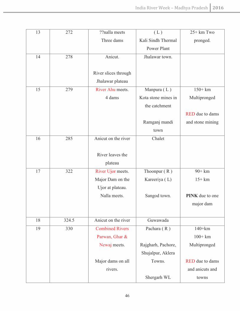
India River Week – Madhya Pradesh 2016
46
13 272 ??nalla meets
Three dams
( L )
Kali Sindh Thermal
Power Plant
25+ km Two
pronged.
14 278 Anicut.
River slices through
Jhalawar plateau
Jhalawar town.
15 279 River Ahu meets.
4 dams
Manpura ( L )
Kota stone mines in
the catchment
Ramganj mandi
town
150+ km
Multipronged
RED due to dams
and stone mining
16 285 Anicut on the river
River leaves the
plateau
Chalet
17 322 River Ujor meets.
Major Dam on the
Ujor at plateau.
Nalla meets.
Thoonpur ( R )
Kareeriya ( L)
Sangod town.
90+ km
15+ km
PINK due to one
major dam
18 324.5 Anicut on the river Guwawada
19 330 Combined Rivers
Parwan, Ghar &
Newaj meets.
Major dams on all
rivers.
Pachara ( R )
Rajgharh, Pachore,
Shujalpur, Aklera
Towns.
Shergarh WL
140+km
100+ km
Multipronged
RED due to dams
and anicuts and
towns

India River Week – Madhya Pradesh 2016
47
Sanctuary
20 332 Anicut on the river Palaita
21 380 River meets Chambal Navnera
Contributors
Table 10: Contributors of Pollutant of Kali River
Unit Vegetal
cover
Dams Barrage&
Anicuts
Cities Polluting
influence
GW/SW People’s
Connect
Overall
SB Kali
Sindh
P R R P P R P RED
Lakhunder P R R P P R P RED
Ahu R R R P R R P RED
Ujor P P R P P P P PINK
Parwan
(Ghar,
Newaj)
P R R R P R P RED
River Parbati Sub Basin
Table 11: River Parbati Sub Basin
S. No Distance from
origin
Tributary River /
Stream / structure
Location / Bank Tributary Length
(Km)
1 5.5 Major dam on the
river
Siddiqueganj
2 30 Ashta town
3 33 Nalla ?? meets
River is taking a NE
direction
Shahwajpur ( R ) 30+ km
4 63 Nalla ?? meets Bhimpura ( R ) 40+ km

India River Week – Madhya Pradesh 2016
48
Two dams
multipronged
5 78 Nalla ?? meets
Three dams
Manakheda ( R )
Township of Sehore
30+ km
Multipronged
6 108 Nalla ?? meets
Dam on origin
Pilu Khedi ( R ) 30+ km
Multipronged
7 140 Town of Narsingh
garh on left bank
8 235 River meets the MP-
Raj border
9 295 River forms MP-Raj
border before entering
Rajasthan
10 310 River Andheri meets.
Atru ( L )
Adani Thermal
Power plant
50+ km
PINK due to
pollution
11 370 River meets Raj-MP
border
River Kul meets.
Three dams on river
Kul
Balunda ( R )
Interesting Volcanic
valley of Bhand
Devra (6 sq km)
60+ km
Multipronged
RED due to dams

India River Week – Madhya Pradesh 2016
49
River from now on
forms MP-Raj border
12 400 River Aheli meets.
Dam on origin
Gurunawada
Utanwad ( R )
40+ km
Multipronged
PINK due to dam
13 410 Site of Parbati – Kali
Sindh natural link
Gordhanpura ( L )
Relict course of river
Chambal???
14 440 River Parbati meets
Chambal
Pali
Map No 17: Google Image of Relict Course of River Chambal

India River Week – Madhya Pradesh 2016
50
Contributors
Table 12: Contributors of Pollutant of Chambal River
Unit Vegetal
cover
Dams Barrage&
Anicuts
Cities Polluting
influence
GW/SW People’s
Connect
Overall
SB
Parbati
P P R P P G P PINK
Andheri P B P P P G P PINK
Kul P R R P P G P RED
Aheli P P R P P G P PINK
SB 3: Confluence with River Parbati till confluence with River Yamuna (~400 km)
Map No 18: River Confluence on Rivers Parbati & Yamuna
Cities of sawai Madhopur, Karauli, Dholpur (Raj) and Sheopur, Gwalior, Morena, Bhind (MP) and Etawah (UP)
can be seen. White line is the river Chambal as well as the Inter state boundary, till very near its confluence with
Yamuna.

India River Week – Madhya Pradesh 2016
51
Notables:
Ø River Chambal forms the inter state border, first between MP and Rajasthan and later MP and UP all
along its length except the last 40 km where it travels entirely within UP before confluence with Yamuna.
Ø The entire stretch of the river Chambal is part of the tri-state (MP, Rajasthan, UP) National Chambal
Sanctuary
Ø Kuno sanctuary falls in the catchment and covers a large part of the river Kuno
Ø The river forms deep ravines on its either banks, as well as possess sandy banks offering suitable habitat
to varied life forms
Ø The key tributaries of Chambal are Sip, Kuno (right bank) and Banas (left bank).
Ø It is notable that after the confluence of river Kuno with Chambal at Jimarccha there is no tributary of
Chambal for almost 350 km till its own confluence with river Yamuna at Bhareh
Ø There are number of ghats and famous forts along the river.
Ø The key cities on the river are Dholpur (Raj) and Morena and Bhind (MP).
Ø The quality of water in the river is pristine, as there are no major cities or industries within the river
catchment
Ø Heavy illegal removal of sand is reported from the sand banks at number of sites
Ø Number of water lift schemes (for irrigation and drinking water) both in the states of Rajasthan and in MP
threatens the flow integrity in the river.
Contributors
Table 13: Contributors of Pollutant of River Yamuna
Unit Vegetal
cover
Dams Barrage&
Anicuts
Cities Polluting
influence
GW/SW People’s
Connect
Overall
SB 3 P B B P R R B PINK
Sip P P P P P G P PINK
Banas R R R P R R P RED
Kuno B P B B B B P BLUE
NOTE: The status of the river main stem despite it being a part of the wildlife Sanctuary is still designated
threatened (PINK) due to polluting influence (sand mining) and water lift schemes.
INDICATORS (Over All For The Entire River Basin)

India River Week – Madhya Pradesh 2016
52
Table 14:Indicators
Biodiversity Discharge Pollution PA/Special
areas
People’s
Action
River
Conflicts
P G P P P B
It is necessary that following actions are taken to restore the health of river Chambal basin as a system:
a) All dams on the main–stem as well as the tributaries and sub tributaries must be mandated to ensure
environmental flow into the respective channels
b) Massive program of revegetation in the catchment need to be started to revive base flows
c) Some of the anicuts on the main-stem as well as the tributaries need to be removed to allow reasonable
free flow of the river
d) All polluting influences (industries, mining, cities) need to be brought under control
e) Integrity of wildlife areas (Sanctuaries) needs to be respected and all developmental plans that could
compromise the same must be reviewed and dropped.
f) Much better effort at riverine research in particular biodiversity is needed.
g) Health of the river Banas system (biggest tributary) as well as river Kshipra system (most polluted) is a
major cause of concern.
h) The river Kuno, the only healthy river in the system needs to be declared as NO GO river in terms of any
developmental activity.
i) The founder basin of rivers Kali Sindh, Parbati and river Datuni (Narmada) which lie very close to one
another (near Siddiqueganj) may be declared a special area for riverine protection.
17. Narmada
The origin of Narmada, also known as river Rewa is a kund at Amarkantak in the Maikal range. Amarkantan is at
a height of around 1000 m on MP-CG border.

India River Week – Madhya Pradesh 2016
53
Map No 19: Amarkantak – The origin of river Narmada
The river basin is divided into 3 sub-basins. The Narmada Upper, middle and lower sub-basin with a total of 150
watersheds. 19 important tributaries along with the main river Narmada, drains an area of 92,672.42 Sq.km which
is 3% of total geographical area of the country. (India-WRIS).
There are a total of 35 Hydro-meteorological stations in the basin. In the basin, 4 distinct seasons occurs across
the year. 90% of the rainfall occurs in the monsoon season. The mean average temperature varies from 18 OC to
32 OC.
About 30% of the basin is covered under major and medium command area. The 21 major and 23 medium
projects constitute 277 dams, 2 barrages, 2 weirs and 4 lifts. These projects have an extensive canal system spread
largely in the middle and lower plains of the basin. Also 2 major hydro-electric projects- Sardar sarovar (Installed
Capacity-1450 MW) and Indira Sagar project (Installed capacity-1015 MW), along with 3 other projects
contributes to a total of 3498.5 MW hydro-power generation in the basin. (Source:India WRIS)

India River Week – Madhya Pradesh 2016
54
Map No 20: Narmada Basin
Table 15: Length of major rivers of Narmada system
S. No River Length km* Comments
1 Narmada 1,333
2 Hiran 205
3 Tendoni 111.3
4 Barna 111.67
5 Kolar 104.3

India River Week – Madhya Pradesh 2016
55
6 Man 89.6
7 Uri 74.5
8 Hatni 111.5
9 Orsang 152.3 In Gujrat state
10 Burhner 182.2
11 Banjar 266.7
12 Sher 135.8
13 Shakkar 167.4
14 Dudhi 171.2
15 Tawa 164.7
16 Ganjal 110.8
17 Chhota Tawa 54
18 Kundi 107.6
19 Goi 137.3
20 Karjan 85.7
*GIS based calculation (India WRIS)
Following are the key notables (seasonal tribuatries of length less than 10 km have not been
considered) about the river Narmada system in the state (derived from Google earth imageries):
Table 16: key notable About the River Narmada System
S. No Distance
from
Tributary River / Stream /
structure
Location / Bank Tributary Length
(Km)

India River Week – Madhya Pradesh 2016
56
origin
1 0 Narmada Udgam Amarkantak
2 7 km Water fall (50 m) Kapil Dhara
3 7.2 km Water fall (3 m) Doodh Dhara
4 16.5 km ???Nalla meets Narmada Pharrisemar ( R )
Nala also originates
close to Amarkantak
10+ km
5 46.5 km River Seoni meets Narmada Musamundi ( L ) 50+ km Multipronged
6 71 km Two streams meet Narmada Lalpur ( L )
Lalpur ( R )
40+ km
10+ km
7 74 km Stream joins Sunha dadar ( L ) 10+ km
8 84 km Stream joins Gidha ( L ) 25+ km
9 97.5 km Streams join on both banks Ghanaghat ( L )
( R )
20+ km
12+ km
10 99 km Anicut on Narmada Dhindori town
11 124.5 km ???Stream joins river Keolari ( L ) 70+ km
12 145 km ??? Stream joins
Anicut on the river
Malpur ( R ) 30+ km
13 175 km ???Stream joins Tendudih ( L ) 25+ km

India River Week – Madhya Pradesh 2016
57
14 195 km ??? Stream joins. Dams on
streams
Bisbani ( R ) 50+ km Multipronged
15 205 km River takes a sudden
southwards turn
Balpur
16 211.5 km ??? stream joins.
Series of dams
Matiyari ( L ) 30+ Km Multipronged
17 223 km ???Stream joins. Dams on it. Bilgarha ( R ) 15+ km
18 233 km ??? Stream joins Khairi ( L ) 10+ km
19 245 km Combined waters of rivers
Halon and Burhner.
One dam on a tributary at
Bichiya.
Deogaon ( L ) 150+km.
Multipronged.
BLUE as no major
diversion, intact
vegetation and no
pollution.
20 260 km Ramnagar, a
medieval town with
monuments
21 265 km Narmada takes a westwards
turn
22 275 km Narmada takes a northwards
turn.
Anicut in the town.
River banjar meets narmada
Mandla Town ( L )
Malajkhand Copper
mines in the
catchment of Banjar.
150+ km.
Multipronged.
PINK as one major
town, polluting
influence and dams on

India River Week – Madhya Pradesh 2016
58
from the south. Dams on
streams.
Mandla, tributaries.
23 281 km Sahasradhara in the river
Narmada
Interesting river bed
formation.
24 285 km Backwaters of Bargi dam on
river Narmada
Khari village
25 305 km ???stream joins. Dams on
streams.
Kikra ( R ) 30+ km.
Multipronged.
25 350 km Major Dam at Bargi on river
Narmada.
????Stream joins upstream of
the Reservoir
Udaipur ( R ) 30+ km.
Multipronged.
26 356 km River Temar joins d/s of the
Dam
Bargi vill ( L ) 50+ km.
Multipronged.
27 366.5 km ???Stream joins Deori vill ( R ) 20+ km.
Multipronged.
28 370 km River Gaur joins.
4 dams and anicuts on the
tributaries
Tewar vill ( R ) 100+ km
Multipronged.
PINK status
29 371 km ??/Stream joins Mahgaon ( L ) 20+ km.
Multipronged.
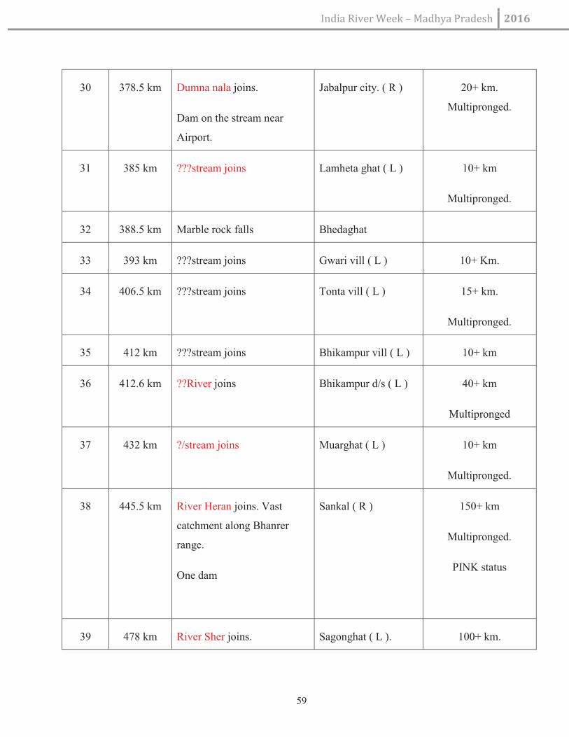
India River Week – Madhya Pradesh 2016
59
30 378.5 km Dumna nala joins.
Dam on the stream near
Airport.
Jabalpur city. ( R ) 20+ km.
Multipronged.
31 385 km ???stream joins Lamheta ghat ( L ) 10+ km
Multipronged.
32 388.5 km Marble rock falls Bhedaghat
33 393 km ???stream joins Gwari vill ( L ) 10+ Km.
34 406.5 km ???stream joins Tonta vill ( L ) 15+ km.
Multipronged.
35 412 km ???stream joins Bhikampur vill ( L ) 10+ km
36 412.6 km ??River joins Bhikampur d/s ( L ) 40+ km
Multipronged
37 432 km ?/stream joins Muarghat ( L ) 10+ km
Multipronged.
38 445.5 km River Heran joins. Vast
catchment along Bhanrer
range.
One dam
Sankal ( R ) 150+ km
Multipronged.
PINK status
39 478 km River Sher joins. Sagonghat ( L ). 100+ km.

India River Week – Madhya Pradesh 2016
60
Vast catchment. Sher is a
mix of Burerewa,
Macharewa, Umar and Sher.
One dam on one small
tributary.
Narsinghpur city in
the catchment.
Multipronged.
BLUE Status
40 518 km River Shahdol joins. Timrawan ( R ).
Tendukheda town in
the catchment.
50+ km Multipronged.
41 526.5 km River Shakkar joins.
Two dams on tributaries.
Sokalpur ( L ).
Gadarwara town in
the catchment.
100+ km
Multipronged.
PINK status
42 553 km River Dudhi joins.
Umardha ( L ).
Originates from
Patalkot.
100+ km.
Multipronged
BLUE status
43 555 km ??stream joins Ketughan ( R ) 30+ km.
Multipronged.
44 565 km ?? stream joins Sandiya ( L ) 50+ km.
Multipronged.
45 577 km ?? stream joins Ajera ( L )
Pipariya town in the
70+ km.
Multipronged.

India River Week – Madhya Pradesh 2016
61
catchment.
46 584 km River Tenduni joins.
Three dams on the
tributaries.
Sirawada mukandi
( R )
Silwani town in the
catchment.
100+ km
Multipronged
PINK status
47 586 km River Barna joins.
Barna Dam on Barpa.
Semrighat ( R )
Bari, Bareli key
towns.
100+ km
Multipronged
RED status
48 592 km ??stream joins. Bamanwada ( R ) 20+ Km.
Multipronged.
49 600 km ?? Stream joins. Isarpur ( L ) 30+ Km
50 602 km ?? Stream joins Lakhanpur ( L ) 25+ km.
Multipronged.
51 605 km ?? Stream joins Satwasa ( L ) 15+ Km
Multipronged
52 622 km ?? Stream joins Nasirabad ( L ) 20+ km.
Multipronged
53 637 km ?? Stream joins Sudania ( R ) 20+ km.
Multipronged
54 647 km ?? Stream joins Jahanpur ( R ) 15+ km.

India River Week – Madhya Pradesh 2016
62
Multipronged
55 650 km River Tawa joins.
Major dam on Tawa.Another
dam at Sarni u/s on Tawa for
Thermal power station.
Ramnagar ( L ).
Betul city,
Pachmarhi, Shahpur,
Ghoradungri, sarni
key towns in the
catchment.
Satpura NP,
Pachmarhi & Bori
Sanctuary in the
catchment.
150+ km.
Multipronged.
Drains Mahadeo Hills
and North of Betul
Plateau.
RED category due to
heavy damming.
56 656 km Strange formations in the
Narmada river bed.
Hoshangabad city on
south of the river.
57 667 km ?? Stream joins. Budni ( R ) 15+ km
58 678 km ?? Stream joins Holipura ( R ) 20+ Km
59 680 km ?? Stream joins.
Originates from Delawadi.
Bibda ( R ) 20+ Km
60 687 km ?? Stream Khoksar ( L ) 20+ km
61 699 km ?? River joins. Hathnapur ( L ) 40+ km
62 704 km ?? Stream joins Bhela ( L ) 30+ km
63 709 km ?? Stream joins Opp Babri( R ) 20+ km.
Multipronged.

India River Week – Madhya Pradesh 2016
63
64 714 km ?? Stream joins Kajli ( L ) 20+ km. Multipronged
65 716 km ?? Stream joins Bhiladiya Khurd ( L ) 10+ km
66 720 km ?? Stream joins Hamidpur ( L ) 25+ km
Multipronged
67 725 km River Kolar joins.
Three dams on it.
Mandi ( R ) 100+ km.
Multipronged.
RED due to dams
68 733 km River Ganjal joins.
One dam on it.
Ariya Bedi ( L ) 150+ km.
Multipronged.
PINK Status
69 736 km River ?? joins.
One dam on it.
Chipaner ( R ).
River Narmada on
rocky bed. Breaks
into number of
shallow streams and
rapids.
100+ km.
Multipronged.
70 743 km ?? Stream joins. Opp Pachora,
Lachora ( R ).
Specialised
vegetation on rocks
in the river bed.
10+ km.
Multipronged.

India River Week – Madhya Pradesh 2016
64
71 755 km Two streams join on either
banks.
Surjana ( L )
Daiyat ( R)
30+ km.
Multipronged.
10+ km.
72 759 km River Jamner joins. Nemawar ( R )
Township of Handia
on the opposite bank
is considered as half
way mark for river
Narmada.
60+ km
Multipronged.
73 770 km ???Stream joins. Mandaleswar ( R ) 20+ km.
Multipronged.
74 773.5 km ?? Stream joins. Bhanjakhedi ( R ) 15+ Km.
Multipronged
75 782 km River Datuni & Chankeshar
joins.
Melpipalya ( R ).
Backwaters of
Indirasagar Dam on
Narmada begin.
River takes a
southwards and then
northwards turn and
forms a parabola.
50+ Km
Multipronged

India River Week – Madhya Pradesh 2016
65
76 840 km Damsite on river Narmada.
Rivers Machak, Ajnai and
Chota Tawa now ends into
the reservoir called Indira
Sagar or Punasa dam.
River Narmada enters into a
rocky Gorge.
The original Shasradhara of
Narmada at confluence with
Ajnai and Machak is totally
transformed. (see google
images)
Punasa
River Ajnai and
Machak ( L )
River Chota Tawa ( L
). Town of Harsud is
inside the reservoir.
Narmada Nagar,
Khandwa, Harda,
Mundi, New Harsud
and Khirkiya are the
towns in the
catchment.
STPP at Dongaliya.
Both Ajnai and
Machak are 100+ km.
Multipronged.
Chota Tawa is
150+ km.
Multipronged.
Ajnai is PINK
Machjak is BLUE
Chota Tawa is PINK
77 845 km ??Stream meets the river. Downstream of the
Dam ( R )
15+ km.
Multipronged.
78 850 km ???River meet the Narmada Premgarh ( R ) 50+ km.
Multipronged.
79 872 km River Sukhi / Kanar meets
Narmada.
Confluence affected by
backwaters of Dam at
Omkareswar.
Kandya ( R ) 50+ km
Multipronged.
80 883.5 km River Kaveri meets the
reservoir of the Dam.
Reservoir ( L ) 50+ Km

India River Week – Madhya Pradesh 2016
66
Multipronged.
81 885 km Dam site at Omkareswar. Omkareswar and
Mandhata are
historical places of
pilgrimage. Mandhata
is an hilly island
formed within the
river, reportedly in a
sign of OM.
82 895.5 km River Choral meets
Narmada.
Dam on its origin.
Barwaha ( R ).
Barwaha township.
Patalpani (see pic ) is
an interesting
geomorphological
feature in the river
channel.
90+ Km.
Multipronged.
PINK status
83 910 km ???Stream joins Devnalya ( R ) 20+ km
Multipronged
84 915.5 km River Raspat joins. Bakawan ( L ).
River Narmada forms
an island at the rocky
confluence.
60+ km
Multipronged.
85 920 km ??stream joins.
Dam at the udgam of the
stream.
Bahegawan ( R ) 20+ km
Multipronged

India River Week – Madhya Pradesh 2016
67
86 924.5 km ??stream joins. Pathrad ( R ) 10+km.
937 km ?? Stream joins. Amlatha ( L ) 15+ km
Multipronged.
87 940 km ??Stream joins.
Dam on it.
Jalud ( R ) 20+ km.
Multipronged.
88 942 km Barrage on Narmada Mandleswar.
Place of Pilgrimage.
89 942.5 km River Beda joins.
Dams and anicuts on
tributaries.
Opp to Mandleswar
( L ).
It is combined waters
of Beda, Kundi and
Amba rivers.
City of Khargone is
in the catchment.
100+ km
Multipronged.
PINK status
90 949 km Stream joins. Kathora ( L ).
Kasrawad town is in
the catchment.
15+ km.
Multipronged.
91 951 km Stream joins. Maheswar ( R ).
Maheswar is a
pilgrimage centre.
20+ km.
Multipronged.
92 961 km River ?? joins. Uchawawad ( R ) 40+ km.

India River Week – Madhya Pradesh 2016
68
Multipronged.
93 966.5 km Stream joins.
Dam on origin.
Khal Bujurg ( L ) 25+ Km.
Multipronged.
94 976 km Stream joins Chichali ( L ) 10+ Km
95 982 km Stream joins Dharmpuri ( R )
Place of Pilgrimage
25+ km
Multipronged
96 985 km River Borad joins.
Four dams on tributaries.
Nandgaon ( L ) 50+ Km
Multipronged.
97 996 km River Man joins.
Four dams on Tributaries.
Ratwa ( R ) 50+ Km
Multipronged.
98 997.5 km River ?? joins.
Four dams on Tributaries.
Nawada Khedi ( L ) 50+ Km
Multipronged.
99 1005 km ?? Stream joins.
Two dams on tributaries.
Kesharpura ( L ) 30+ km
Multipronged
100 1010 km ??stream joins Perkhad ( R ) 15+ km
Multipronged.
101 1020 km ?? stream joins.
Dams on Tributaries
Piplod ( L ) 30 km
Multipronged

India River Week – Madhya Pradesh 2016
69
102 1023 km ??stream Bodhawada ( R ) 20 km
Multipronged.
103 1025 km ?? stream Dehdala ( L ) 15 km
Multipronged.
104 1031 km ?? stream Bhilkheda ( L ) 15+ km
Multipronged
105 1040 km ?? stream Rohana ( R ) 15+ km
106 1041 km River Bagh and Uri joins.
Dams on Tributaries.
Kothada ( R ).
Kukshi and Bagh are
the key towns in the
catchment.
100+ km
Multipronged
PINK status
107 1043.5 km River Goi joins.
Dams on tributaries.
Bhawati ( L )
Sendhwa is key town
in the catchment.
100+ km
Multipronged
PINK status
108 1077 km River Hatni joins.
Dam on Tributary.
Kakrana ( R ).
Alirajpur is the key
town in the
catchment.
Backwaters of Sardar
80+ km
Multipronged.
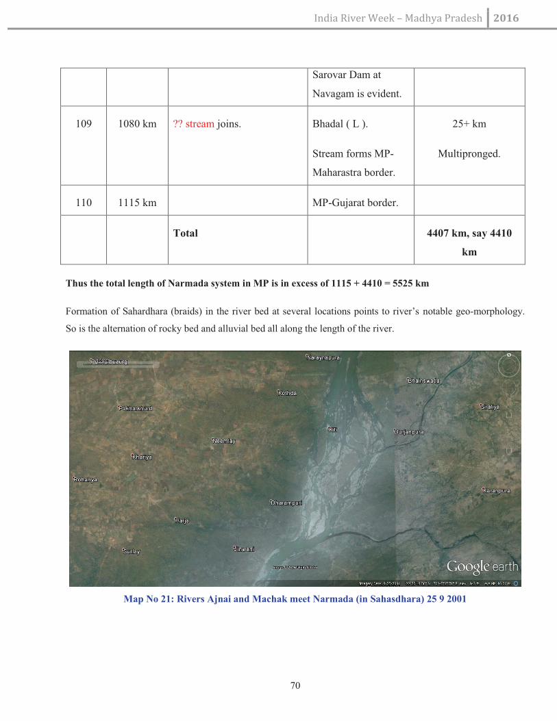
India River Week – Madhya Pradesh 2016
70
Sarovar Dam at
Navagam is evident.
109 1080 km ?? stream joins. Bhadal ( L ).
Stream forms MP-
Maharastra border.
25+ km
Multipronged.
110 1115 km MP-Gujarat border.
Total 4407 km, say 4410
km
Thus the total length of Narmada system in MP is in excess of 1115 + 4410 = 5525 km
Formation of Sahardhara (braids) in the river bed at several locations points to river’s notable geo-morphology.
So is the alternation of rocky bed and alluvial bed all along the length of the river.
Map No 21: Rivers Ajnai and Machak meet Narmada (in Sahasdhara) 25 9 2001

India River Week – Madhya Pradesh 2016
71
Map No 22: Rivers Ajnai and Machak confluence with Narmada (without the Sahasdhara) 24 1 2010
Following list of Earthquakes from Hoshangabad District in Narmada valley points to the seismic
vulnerability of the valley:
Table 17: list of Earthquakes from Hoshangabad District in Narmada valley points
S. No. Date Epicentre Magnitude
1. 1847 May, 27 Near Burwani -
2. 1863, Nov, 19 The Nimar and
Burwani country
-
3. 1926, December, 31 25o.0
o N, 77
o30’ E -
4. 1927, June, 2 24 o .0’ N, 82
o . 3’E 6 .5
5. 1938, March, 14 21 o . 5’ N, 75
o . 0’E 6.5

India River Week –Madhya Pradesh 2016
72
6. 1957, August, 25 22 o . 0’ N, 80
o . 0’ E 5.5
7. 1957 October, 17 21 o . 5’ N, 79
o E 5.0
8. 1967 January, 6 22 o N, 74
o E 4.8
9. 1969, March, 26 22 o. 6’ N, 78
o . 10’ E 4.2
10. 1969, March, 26 22 o . 50’ N, 78
o . 10’ E 4.5
11. 1973, July, 12 630 Km. (From
Delhi—(Near
Jabalapur)-
12 1997, May, 22 Jabalpur , Koshamghat 6.0
(Source: Hoshangabad gazetteer)
Biodiversity
Balapure (2001) studied and reported 21 fish species belonging 16 genera, 6 families and 4 orders on the
fish fauna of River Narmada.
The present study deals with the fish diversity of Barna River and its tributary in Raisen district, Madhya Pradesh,
Central India. Fish studies were undertaken during Oct. 2011 to Nov. 2012. The aim of the study was to explore
the fish fauna of Barna River, a tributary of river Narmada. The sampling stations were conducted in Barna and its
tributary streams. Fishes were collected directly from sampling stations two times in a period of investigation.
The results of present investigation reveal the occurrence of 33 fish species belonging to 5 orders, 9 families and
21 genera. The order Cypriniformes was found dominant (24 species) followed by Perciformes and
Ophiocephaliformes (3 species) both, Mastacembeliformes (2 species) and Beloniformes (1 species). The most
abundant family was Cyprinidae, having 250 individuals (75%) followed by Cobitidae with 32 individuals (10%).

India River Week – Madhya Pradesh 2016
73
Mythology:
It is very frequently mentioned in the Mahabharata and the Matsya, Padma, Kurma and Skanda Puranas.
According to one view, Narmada and Rewa are different rivers. Narmada starts from the Mekala mountain which
is a part of the Riksha Parvata while Rewa starts from Amarakantaka in the Vindhyas. According to Amara Kosa,
Narmada is the same as Rewa and is also called Somodhbhava and Mekala-Kanyaka. The Satapathabrahamana
mentions one Revottaras. Whether Narmada and Rewa are one of different in their origin, one starting from
Amarkantaka and the other from Mekala, both the streams merge into one and are indiscriminately described both
as Rewa and Narmada.
Amarakantaka is mentioned as a very sacred spot where numerous tirthas abide and it is considered very holy and
efficacious for the purpose of performing sraddhas.
Narmada has been described as the best among the rivers, she having issued from the body of Rudra. It is said
she is capable of purifying all creatures and ever immoveables. River Ganga is said to be holy at Kanakhala, river
Saraswati is similarly holy at Kurukshetra; while Narmada, whether she is flowing from a village or a forest, is
said to be holy at all places. The water of river Saraswati is said to purify a person in ten days, that of river
Yamuna in seven days, while the water of river Ganga purifies a person immediately; but in the case of river
Narmada a mere sight of the river even without a bath or a sip of her water is said to be purifying.
Amarakantaka is described as part of the Kalinga country. Numerous sages have performed penance on her
banks. Many perform the Parikramana of the river from its source to its Sangama with the sea.
Narmada is called Namedos by Ptolemy and Namnados by the Periplus. Between Amarakantaka and Broach, the
Agni Kurma and Skanda Puranas state that there are 60 crores and 60 thousand Tirthas but Skanda adds that in
this Kali Yuga there are very few pratyasha tirthas as men in this age are losing their spiritual strength.
Narmada has 35 Sangamas. The best is the Sangama of Rewa with the sea.
Historical, religious sites
Important religious places and Ghats along the course of the river, starting from its origin at Narmadakhund
at Amarkantak hill, are
a) the Amarkantak (in Sanskrit: Neck of Shiva) or Teertharaj (the King of Pilgrimages),
b) Omkareshwar, Maheshwar, and Mahadeo temples, Nemawar Siddeshwar Mandir in the middle
reach of the river – all named after Shiva,
c) Chausath Yogini (sixty four yoginis) temple,
d) Chaubis Avatar temple,

India River Week –Madhya Pradesh 2016
74
e) and Bhrigu Rishi temple in Bharuch.
The Narmada River is also worshipped as mother goddess by Narmadeeya Brahmins.
The importance of the Narmada River as sacred is testified by the fact that the pilgrims perform a holy pilgrimage
of a parikrama or circumambulation of the river. The Narmada Parikrama, as it is called, is considered to be a
meritorious act that a pilgrim can undertake. Many sadhus and pilgrims walk on foot from the Arabian Sea at
Bharuch in Gujarat, along the river, to the source in Maikal Mountains (Amarkantak hills) in Madhya Pradesh and
back along the opposite bank of the river. It is a 2,600-kilometre (1,600 mi) walk.
Fossil records
Narmada Man – the only stone age fossil from India Narmada Man or Narmada Human is the earliest Homo
species of Indian sub-continent. This fossil was found on banks of Narmada River in Hathnora Village of Madhya
Pradesh in 1982. Narmada Man used to live 2.5 Lakh years ago and belonged to Homo erectus species, which was
first among the three Homo species (Homo habilis, Homo ergaster and Homo erectus) to acquire tool making
skills. These three species predate Homo sapience sapience, to which we belong. The importance of Narmada
man is that it is only authentic record of a Homo species fossil from Stone Age in India.
During a recent exploration in the central Narmada valley, researchers have unearthed skeletal parts of hitherto
unknown archaic humans that have inhabited central Narmada valley in India during late to mid Pleistocene.
Hominin femur fossil found from Central Narmada Valley . Image Courtesy: Current Science
According to a research communication published in the Current Science Journal, a partial piece (bone which
extends from shoulder to elbow), a fragmented femur and other stone artifacts collected from netankheri, located

India River Week –Madhya Pradesh 2016
75
3 km away from Hathnora on the banks of Narmada river, shows that Central Narmada Valley had two different
archaic human races.
While one was large robust hominins who used to hunt down latrge mammals with heavy duty weapons, the later
developed pygmy sized one which was hitherto unknown to science, used to hunt smaller animals with lightly
refined tools. The pygmy sized rce could be the real ancestors of all short-bodied populations in South asia, says
the study.
With many short tributaries flowing into it from north and south, the Narmada basin forms a very important
topographic feature of peninsular India. At a time when the Indus and Gangetic valleys were uninhabited
wilderness, Narmada valley was the home for a rich mosaic of human cultures. Since those times lost in antiquity
till today a very large human population including a variety of tribal societies such as Bhils, Gonds, Saigas,
Kurkus, Bhilalas have continued to live depending on Narmada. In short the Narmada basin forms an ideal
microcosm of our country with its extraordinary rich natural heritage supporting cultures ancient and more recent.
People of India venerate Narmada river as the epitome of freedom and sanctity. Even pumping the waters of
Narmada for any purpose is considered by many as sacrilege.

India River Week –Madhya Pradesh 2016
76
DROWNING A HISTORY IN THE NARMADA VALLEY: A SEAT OF OLD HUMAN SETTLEMENTS
AND EVOLUTION IS NOW UNDER THREAT
Posted on June 15, 2015 by admin
A recent fact-finding report,“Drowning a Valley: Destroying a civilisation – Report from Sardar Sarovar Project
Submergence Areas in Madhya Pradesh, Maharashtra and Gujarat”, prepared by an independent commission,
has found massive inconsistencies in the rehabilitation of Narmada dam oustees. At the same time,has said
that the dam would lead to a sharp setback to areas which have come to be consisted as of great historical and
archaeological significance. Consisting of CPI(M) MP Hannan Mollah, National India Federation of Women
leader Annie Raja, ex-forest minister from Kerala Vinay Bishwom, sitting ongress MLA from Badwai, Ramesh
Patel, and experts Raj Kachroo, a senior hydrologist, and Soumya Dutta, a well known expert on energy and
climate issues, wonders how could the great heritage be preserved when large number of fresh areas are
slated to under submergence when the dam’s height is being raisd from the present 121.92 metres to 138.64
metres. Excerpts:
The Narmada valley is not just like any other river valley, though all rivers are in a sense mothers to human
civilisations, by providing plentiful water and soil fertility. As a result of the “Narmada Basin Paleo-anthropology
Project” (NBPA), and the large scale excavations /explorations jointly undertaken by MS University Vadodara
and the US based “Stone Age Institute”, it is being realised that this old river valley has harboured pre-historic
human settlements, possibly even pre-Harappan primitive human ‘civilisation’. According to Prof K Krishnan,
head of MSU’s Department of Archaeology and Ancient History, “This project may throw new light giving
credence to the belief that the Narmada Valley could have been (one of) the centre of human evolution”.
Advanced stone tools and implements have been unearthed in the valley, dating back to the age of the
beginning of modern humans, over 50,000 years ago, and possibly much older. Even if it is one of the oldest
global sites of early evolution of ‘modern’ humans, this is a priceless heritage, certainly not fit for submerging for
a few mega watts of power and some misguided mega-projects.
The NBPA project was founded with the discovery of vertebrate fossils including the only pre-modern human
fossil known in South Asia from the Narmada Basin. The Times of India, while reporting on this in August 2012,
says – “In 1980s, former director of Geological Survey of India (paleontologist) Arun Sonakia had created a
sensation surprising the world with his discovery of the “only human fossil in Asia” from near Hoshangabad in
Central Narmada Valley Basin in Madhya Pradesh which he said was that of a homo erectus (predecessors of
today’s human). In recent times, however, archaeologists have argued that although the discovery has been
variably attributed to different species of homo, its age remains uncertain.
“Through this project, we will collect more human fossils, look at the context of this fossils and go for a precise
dating methodology as very little dating of fossils has been done so far,” co-director and research associate of

India River Week – Madhya Pradesh 2016
77
NBPA from Stone Age Institute Parth Chauhan told TOI. “Study at Narmada Basin is important because of its
geographical location which is very strategic for migration of animal population from North to South and East to
West. It is not only rich in fossils and archaeological sites, but it has a long history of human occupation and this
region is facing submergence due to dam construction,” says Chauhan.
Even the Narmada Hydroelectric Development Corporation Ltd recognizes (SK Dodeja and VB Bhatt, NHDCL,
‘Sustainable Management of Archeologically Important Monuments’) that “…the valley is very rich in
archeologically important wealth”, but arrogantly and foolishly talks about ‘sustainable management’ of such
human history by finding and relocating a few bits and pieces of this treasure.
One can also judge the historical (both anthropological and archaeological) importance of the Narmada basin
from this deep concern expressed by the Anthropological Survey of India – “This modest beginning is a
challenge for future since these human fossils have world-wide interest and implications in understanding
human origins. It is also acclaimed by notable scholars, like Kenneth A. R. Kennedy, that India has enormous
field resources for the palaeo-anthropological investigations where the Narmada basin and the Siwaliks are in
particular of great significance.
“And, we have tapped only a fraction of the same. Therefore, it is imperative that extensive and intensive
systematic explorations and excavations of Central Narmada basin are of immediate concern. This is
particularly very compelling in view of the inevitable submergence of the basin in the wake of Narmada Sagar
Dam backwaters and monsoonal over flooding of Narmada River.”
Apart from these pre-historic treasures, the present day Narmada valley population is also a richly diverse
ethnic and cultural treasure. The adivaasi populations are Bhils, Gonds, Rathwas, Tadvis and many others,
each with its unique culture and traditions. The large village of Chikhalda, with over 750 houses, faces
submergence of about 688 houses, while pre-historic human settlements were discovered nearby. The entire
valley is ripe with hundreds of temples doting its banks and villages, mosques dating few decades to many
centuries. The invaluable treasure of the tribal gods and goddesses, mounds and hillocks are never counted!
Renowned historian SB Ota who has worked for the Archaeological Survey of India (ASI) has written that the
Narmada valley is the only one that has precious remnants from the Palaeolithic age to the current age, at one
place. His revealing findings, which were not favourable to the Government, were disregarded and even his
research work was hampered by the Government which curtained funding. Eminent archaeologists Romila
Thapar, Irfan Habib and others resolved in one of the national meetings of the Archaeological Congress that at
least a hundred years of research would have to be undertaken, in order to unearth all the old, precious
remnants, before the valley can be submerged.
The Narmada valley is thus a national treasure that should be preserved and celebrated. It is a great
misfortune for India that we have governments which value human history and culture so low, and are bent
upon being the destroyers of this heritage.

India River Week –Madhya Pradesh 2016
78
The Narmada Bachao Andolan Movement [NBA]
Since the early 1980s, the Narmada Project has faced mounting opposition from a variety of sources. Protest
groups formed in all three affected states and included or were supported by individuals facing displacement,
students, social activists, Indian environmental NGOs, international NGOs, and transnational networks. In
Gujarat, nineteen villages, whose submersion the Sardar Sarovar dam ensured, formed the Chhatra Yuva
Sangharsh Vahini, a youth protest group. The group engaged in protests and initiated court actions, ultimately
forcing the government of Gujarat to offer a more generous resettlement package. The group’s belief that
Gujarat’s water needs made the dam project necessary guided its decision to focus on rehabilitation efforts and to
ensure that the government adhered to its promises.
In contrast, groups in Madhya Pradesh and Maharashtra opposed the dams altogether. Two such groups,
the Narmada Ghati Navnirman Samiti in Madhya Pradesh and the Narmada Ghati Dharangrastha Samiti in
Maharashtra, subsequently merged to form the Narmada Bachao Andolan in 1989. Under the leadership of the
principal figure associated with the movement, Medha Patkar, the NBA initially sought to verify the claims
regarding the benefits that would flow from the construction of the dams. In the process, it focused on securing
access to documents from the government and the World Bank to ensure greater transparency.
The NBA’s Methods
The success of the NBA campaign resulted from its innovative strategies of resistance that operated
simultaneously at the grassroots, national, and international level. As such, the campaign’s significance as a social
movement extends far beyond India’s national borders. Balakrishnan
Rajagopal—a leading scholar on development and social movements and a long-time observer and researcher of
the Narmada struggle— notes that globally, the NBA is ‘‘regarded as one of the signature public contestations
of the twentieth century that redefined the terms of development, democracy and accountability.’’
While the NBA originally employed ‘‘Gandhian methods’’ such as peaceful marches and protests,after a high-
profile hunger fast in 1991 failed, the NBA announced a ‘‘noncooperation movement’’ in the Narmada valley.
This movement campaigned against the payment of taxes and sought to deny entry to the villages to all
government officials, except teachers and doctors. The NBA subsequently began to consider litigation as an
additional option for a variety of reasons. Their tactics up to this point had frequently drawn violent reactions

India River Week – Madhya Pradesh 2016
79
from the government. In addition, other disadvantaged groups had successfully moved the Supreme
Court, inspiring the NBA to do the same.
The NBA’s Leadership
One of the biggest reason for the success of the NBA was the excellent leadership provided by the most able
persons of the country. The NBA, a broad-based participatory movement, flourished under the leadership of
visionary environmental champions. One of India’s most vibrant and best known living activists, Medha
Patkar (or Medha didi (big sister) as she is called) has led the Narmada movement for over two decades. Her
uncompromising stance against government apathy toward the human and social costs of dam construction and
her ongoing efforts to ensure that transparency and accountability remain hallmark features of development
projects have helped fashion the NBA into one of the most dynamic social movements of our time. A ‘‘veteran of
several fasts [and] monsoon satyagrahas [civil disobedience] on the banks of the rising Narmada,’’ she has
endured police beatings and jail terms in her quest to secure the right to life and the right to livelihood for the over
twenty million people whose lives would be adversely affected by the Narmada Project.
Other women have also played central roles in the campaign. The NBA’s struggle against the Maheshwar Dam in
Madhya Pradesh state, for instance, has been led by the Narmada Shakti Dal, a separate women’s organization
within the NBA that was set up on March 8, 1988—International Women’s Day—and is comprised of female
villagers from Maheshwar. Alongside Medha Patkar, social activist Baba Amte provided moral leadership to the
cause to preserve the Narmada River. Though renowned for his work against leprosy, beginning in the early
1980s he involved himself in the struggle against mega dams. Amte first achieved national prominence for his
work on dams with the publication of Cry O Beloved Narmada in 1989, an elegiac booklet that made the case for
a dam-free Narmada.
Direct Action
Medha Patkar and Baba Amte together let a series of protests, some of which failed while the others achieved
success. In September 1989, Amte led a 60,000-person anti-dam NBA rally in Harsud—a town of 20,000
people in Madhya Pradesh that faced submersion. In May 1990, a massive NBA five-daydharna (sit-in) at then-
Prime Minister V. P. Singh’s residence in New Delhi forced the Prime Minister to agree to ‘‘reconsider’’ the
project. In December 1990, Amte, along with 5,000 protestors, began the Narmada Jan Vikas Sangharsh
Yatra (Narmada people’s progress struggle march), marching over a hundred kilometers from Amte’s
headquarters near Barwani in Madhya Pradesh to Ferkuva on the Madhya Pradesh–Gujarat border. The
government reacted by deploying the Gujarati police force and by bussing in thousands of
governmentsupported pro-dam demonstrators from urban centers in Gujarat. Following the government’s

India River Week – Madhya Pradesh 2016
80
announcement that rising waters from the dam would begin to submerge villages, domestic protest intensified and
with it the resulting backlash from the state. On January 5, 1991, Amte began a ‘‘dharna [sit-in] unto death.’’
The most popular slogans of the NBA were Vikas Chahiye, vinash nahin! (‘‘We want development, not
destruction’’) and Koi nahi hatega, bandh nahi banega! (‘‘No one will move, the dam will not be built’’).
The World Bank Withdraws
The protests against the building of dams were going on increasing day after day. In response to this, the World
Bank decided to review its policies. The World Bank announced in June 1991 that it would commission a team of
independent experts, known as the Morse Commission, to reexamine the Sardar Sarovar Project.96 The
Commission’s independent review had two aims: to assess steps taken to resettle those affected by the Sardar
Sarovar dam, and to assess the efficacy of measures aimed at diminishing the project’s environmental impact.97 It
was chaired by Bradford Morse, the former head of the UN Development Programme, and Thomas Berger, a
former British Columbia Supreme Court judge, neither of whom had ever been Bank employees.
The Commission completed its task and prepared a 357 page report. The report clearly mentioned that there were
several discrepancies in the functioning of the Bank and granting the loan to the Indian Government. It also
recorded a great deal of environmental degradation and a huge violation of human rights.
According to one of the passages of the report…. :-
“We think the Sardar Sarovar Projects as they stand are flawed, that resettlement and rehabilitation of all those
displaced by the Projects is not possible under prevailing circumstances, and that environmental impacts of the
Projects have not been properly considered or adequately addressed. Moreover we believe that the Bank shares
responsibility with the borrower for the situation that has developed… We have decided that it would be
irresponsible for us to patch together a series of recommendations on implementation when the flaws in the
Projects are as obvious as they seem to us. As a result, we think that the wisest course would be for the Bank to
step back from the Projects and consider them afresh. The failure of the Bank’s incremental strategy should be
acknowledged. ”
As a result of the report and huge criticism of the Bank, the Bank withdrew its support from the project.
The Sardar Sarovar Project Today
Construction of the Sardar Sarovar dam proceeded uninterrupted after the suspension on construction was lifted in
1999. On December 31, 2006 Gujarat Chief Minister Narendra Modi announced the completion of the Sardar
Sarovar dam and symbolically poured the last bucket of concrete. Construction was halted at 121.92 meters and

India River Week – Madhya Pradesh 2016
81
experts associated with the project announced they would install only thirty gates of fifty feet [15.24 m] each
within three years. As noted above, according to unofficial estimates, approximately 320,000 people have been
displaced by the Sardar Sarovar dam and as many as one million may be affected due to related displacements by
the canal system and other allied projects. The NBA has continued to engage in various forms of direct action
even as it pursued its legal remedies. While the case stagnated in the Court system, NBA activists organized and
participated in public meetings, rallies, marches, demonstrations, fasts, dharnas, and satyagrahas. These activities
have had three overlapping aims: first, to call for rehabilitation work to take place at the same time as the raising
of the dam as ordered by the Supreme Court; second, to demand the termination of the project altogether; and
third, to protest the series of Supreme Court orders declining to suspend construction. The struggle of the NBA
has also fired the imagination of some of India’s most prominent citizens who have, along the way, acted as the
voice of the movement.
As for the movement’s leaders, each won countless human rights awards in recognition of their contributions. In
2000, Amte returned to his community development project at Anandwan (Forest of Bliss) near Nagpur in
Maharashtra, where he passed away in February 2008 at the age of ninety-four. Upon his death, the Dalai Lama
lamented, ‘‘[h]is demise is a great loss to all of us. I am an admirer of Baba Amte…… [H]is [compassion]
shone through everything he did, including his work for creating greater awareness about the protection of
our environment.’’ Patkar continues to protest against the Narmada Project. While she has abandoned efforts to
pressure the government to forsake the dam, she continues to fight for the rights of displaced persons in Madhya
Pradesh to receive the compensation that the Narmada Tribunal determined they were owed.
Conclusion
According to one NBA partner, the campaign against the construction of dams on the Narmada River is
‘‘symbolic of a global struggle for social and environmental justice,’’ while the NBA itself is a ‘‘symbol of hope
for people’s movements all over the world that are fighting for just, equitable, and participatory
development.’’ Though the NBA has yet to achieve the goals for which it has so tirelessly fought, its victories
against the mammoth odds have earned it the reputation of being one of the most dynamic social movements of
our time and one that the government continues to expend considerable resources to fight against. As noted by
Medha Patkar upon her release from jail on August 6, 2007: ‘‘It’s obvious that the Government [of Madhya
Pradesh] is all out to kill our right to land and also [our] right to agitate.’’
DAM AT MAHESWAR
Environment ministry promises action against Narmada dam builder
Submitted by admin4 on 16 February 2010 - 5:31pm
India River Week – Madhya Pradesh 2016
82
By IANS,
New Delhi : Environment Minister Jairam Ramesh Tuesday said that his ministry will issue a show cause notice to
the company working on the Maheshwar dam in the Narmada valley in view of the large scale protests of people
there who have been affected because of the work, but not rehabilitated.
A group of about 500 people, under the aegis of the Narmada Bachao Andolan, reached the capital Tuesday to
protest against the dam construction. A smaller group went to meet the minister with their complaints.
Alok Agarwal, one of the protesters, said: "Our demand is that the environment ministry should immediately
suspend the construction work on the Maheshwar dam project, which has far outstripped the progress of the
rehabilitation and resettlement measures."
According to Agarwal, the Maheshwar dam, built on the Narmada river Madhya Pradesh, is slated to submerge the
lands and the homes of 50,000-70,000 peasants, fishermen and landless workers in 61 villages.
The project was privatised and handed over to the S. Kumar's Group of Companies in 1992. The environmental
clearances were issued in 1994 and then again in 2001.
"The binding provisions of the Environment (Protection) Act, 1986, held the state government of Madhya Pradesh
and S. Kumar's Group of Companies accountable for the rehabilitation of the villagers. A comprehensive
rehabilitation plan was to be submitted by December 2001 but it has not been done till date," Agarwal said.
"When we met the minister today, he told us that they would issue a show-cause notice to the Maheshwar Hydel
Power Corporation today under Section 5 of the Environment (Protection) Act, 1986," he said.
"The notice would demand a reply from the company as to why the construction work should not be suspended
due to non-compliance with conditions of the clearances given. The firm will have 15 days to reply before action is
taken by the ministry," Agarwal added.
http://twocircles.net/2010feb16/environment_ministry_promises_action_against_narmada_dam_builder.html#.V90a0oh96M8)
Some Notable books on river Narmada:
English:
1. Waters Close Over Us: A Journey along the Narmada: A Journey along the Narmada
(English) (Hardcover, Hartosh Singh Bal). Harper Collins, 2013.
2. Caring for Nature: The River of Life (The Story of the Narmada Bachao Andolan), Subhadra Sen
Gupta, TERI, 2016.

India River Week –Madhya Pradesh 2016
83
3. Ecology of River Narmada, By K. Sankaran Unni
4. Narmadaparikrama - Circumambulation of the Narmada River: On the Tradition of a Unique Hindu
Pilgrimage, by Jurgen Neuss
5. Sacred Virgin: Travels along the Narmada, Royina Grewal, Penguin, 1995
Hindi:
6. Narmada ki Dhara Se, Shiv Kumar Tiwari & Govind Prasad Mishra
7. Saundarya Ki Nadi, Narmada; Amrtasya Narmada; & Teere, Teere, Narmada by Amrit Lal Beghad
STATUS
Table 18: Narmada River Status
River Key Tributary Catchment
Veg
Dams/A
nicuts
Cities Polluting
influence
GW People’s
connect
Narmada
Halon (150+) B P B B B B
Banjar (150+) B P P P B B
Gaur (100+) P P P P G P
Heran ( 150+) B P B P B P
Sher (100+) B P B B B P
Shakkar (100+) B P P P B P
Dudhi (100+) B B B B B B
Tenduni (100+) P P P P P P
Barna (100+) P R P P B P

India River Week – Madhya Pradesh 2016
84
Tawa (150+) P R R P P P
Kolar (100+) P R P P P P
Ganjal (150+) B P B B B B
Ajnai (100+) P P P P B P
Machak (100+) B B B B B B
Chota Tawa (150+) P P P P P P
Choral (90+) P P P P P P
Beda, Kundi, Amba
(100+)
P P P P P P
Bagh, Uri (100+) P P P P P P
Goi (100+) P P P P P P
Hatni (80+) P P P P P P
There are still five rivers (Halon, Sher, Dudhi, Ganjal and Machak) within the Narmada valley in MP that deserve
a BLUE status and Barna, Kolar and Tawa that deserve a RED status. All the rest are PINK.

India River Week – Madhya Pradesh 2016
85
18. Son
River Son forms the other part of the SONATA rift valley. It like its westwards expension viz., river Narmada,
forms the north-south physical divide of the sub continent of India.
River Son is also referred to as Sonabhadra. It is called Nala in masculine and not Nadi in feminine.
The exact origin (udgam) of river Sone is disputed as its headwaters are spread over large tract in the Pendra
Plateau in CG. Although it is claimed to orginate from Amarkantak, like Narmada and some hold that it originates
from Sonemunda village in Pendra in CG.
Map No 23: Pendra Origin of River Sone
For our purpose we have looked at river Sone from the point where it comes into its own after its confluence with
river Kevai.
Map No 24: River Kevai (from north east) Meets River Sone (smaller & from south east)

India River Week – Madhya Pradesh 2016
86
Following are the key notables (seasonal tribuatries of length less than 10 km have not been
considered) about the river Sone system in the state (derived from Google earth imageries):
For the purpose of our study we presume its point zero at its confluence with river Kevai in Anuppur district of
MP.
Table 19: Key Notables about the River Sone System
S. No Distance
from
origin
Tributary River /
Stream / structure
Location / Bank Tributary Length
(Km)
1 0 Kevai river meets
Sone river
Barbaspur / R 80+ km
Kevai river is PINK due
to dams on origin
2 5 Santosh nala joins Kusmahai (L) 15+ km
3 14 River Sarva meets Chulkari / R 50+ km
4 19 Kirnar nala meets Senduri (L) 15+ km
5 28 River Tipan meets Anuppur ( L)
Anuppur is District
headquarters town.
50+ km
6 29.5 Chandas nala meets Anuppur (L) 10+ km
7 31 Bakan river meets Chachai Viran ( L ) 25+ km
8 35 Suthna Nala meets
Big reservoir (Chachai
lake) on the nala
Chachai ( L )
Amarkantak Thermal
Power station
15+ km
9 37 Katna river meets Kelhauri ( R ) 30+ km
India River Week – Madhya Pradesh 2016
87
10 40.5 Anicut on the river Amlai.
Amlai is an industrial
town. Amlai paper Mill,
(OPM)
11 50 Nargara nala meets Saabo ( L ) 10+ km
12 53.5 Kaser nala meets Jarwahi ( R ) 20+ km
13 67 Sarpha / Jamuniha
River meets.
Anicut on Sarpha.
River Sone turns from
south west to north.
Lalpur ( L ) 30+ km
14 73 Nagauwa river meets Bhaga ( R ) 20+ km
15 83 Kunuk River meets Shyamdih ( R )
Shahdol town is nearby.
50+ km
16 103 Muhna / Nirmal river
meets
Balbai ( L ) 50+ km
17 126 Johilla river meets.
Major Dam on river
Johilla at Kurkucha
Majhauli ( L )
Sanjay Gandhi Thermal
power station at
Birsinghpur
Coal mine near Narwar on
one of the tributaries of
Johilla
150+ km
PINK river due to major
dam and pollution
issues.

India River Week – Madhya Pradesh 2016
88
18 131.5 Janar river meets.
Originates from
Bandhavgarh forests
Pipari Tola ( L ) 15+ km
19 132 Chundi River meets Barna ( R ) 50 + km
20 185 Mahanadi / Katni river
meets, Sone river
takes a right angle turn
to east and moves in a
close valley.
Presently it is under
the Bansagar Dam
reservoir
Bansagar Dam reservoir.
Mahandi meets on left
bank as the River Sone
turns east.
Panpatha and Son
Ghariyal wildlife
sanctuaries impacted.
250+ km
Katni is a PINK river
due to pollution from
Katni city.
Mahanadi is a BLUE
river.
21 220 Samdhin river meets. Chachai ( R ) 25+ km
22 238 Banas / Mahan river
meets.
Chandrehi (R )
Sanjay, Bagdara and
Dubri Sanctuaries in the
catchment.
200+ km
BLUE river
23 335 Gopad river meets. Bardi ( R )
Towns of Sidhi, Churhat
in the catchment.
150+ km
24 380 Sone river enters Uttar
Pradesh
Newari (UP)
Total 1315+km
Thus the total length of Sone rivers in MP is 380 km + 1315 km = 1695 km +

India River Week –Madhya Pradesh 2016
89
It is actually river Katni later meeting river Mahanadi which then goes onto meet river Sone,
which is at the root of the SONATA rift formation.
Biodiversity
Fish Biodiversity
A total of 43 fish species belonging to 06 Orders, 14 families and 31 generas were recorded and documented from
the selected sampling sites of the River Sone. In present investigation family Cyprinidae was dominant at all the
sampling sites with 15 species, followed by family Bagridae with 06 species, Schlibeidae 04 species, Channidae
& Siluridae 03 species each.
Conservation Status: It was revealed that, out of a total 48 fish species of River Sone as per CAMP (1998), 4.65% of the fishes belongs
to lower risk least concern (LRlc), 39.53% lower risk near threatened (LRnt), 27.91% vulnerable (VU), 18.61%
not evaluated (NE) and 9.30% endangered (EN) category and according to the IUCN, 79.07% of the fishes
belongs to Least Concern (LC), 16.28% Near Threatened (NT) and 4.65% Data Deficient (DD) (Table-01 & Fig.-
01).
Mythology and early history:
“In Balakanda of Ramayana (Chapter 32 verses 7 to 10) Girivraja is described as the city of Vasumati established
by one king called Vasu. It was surrounded by five hills and it is stated that the river sumagadhi or Magadhi,
which flowed by the side of Girivraja and which is referred to in the Ramayana, is the same as river Son. River
Son has been referred to in many Puranas as a big river. The source of this river is also stated to be the mountain
range known as Riksha parvata. This mountain has been identified with the eastern part of the Vindhya range.
River Suktimati and several other rivers also are stated to rise from the Riksha parvata according to Markandeya
and other Puranas.
It is said that one performing sandhya on the banks of river Sona is emancipated or attains heaven and the merit is
even capable of removing the sin of Brahmahatya. River Son in masculine is also referred to by Kalidasa in his
Raghuvamsa (Canto VII-36). There it is stated that Prince Aja ordered his father’s Minister to guard Indumati
with the help of his army and then Prince Aja proceeded to stop the army of his opponents just as river Son full of
rising waves is proceeding to stop the flow of river Ganga.

India River Week – Madhya Pradesh 2016
90
Kalidasa also referes to Pushpapura or Pataliputra (which was situated on the banks of Sona) in Raghuvamsa VI-
24 where it is stated “ O, Princess! If you desire to marry this Parantapa, the worthy king of Magadha, then you
will enter the capital of Magadha and will give delight to the eyes of ladies of that city sitting in the balconies of
palaces to see you.”
It is stated that rivers Son, and Narmada came out from the two tears dropped by Brahma on the two sides of the
Amarakantaka plateau.
Visvamitra and Rama are described by Valmiki as having crossed Son and Rama states that river Son is full of
deep and pure waters and has sandy banks.
River Son, which was called Hiranyavaha, is referred to by Arrian and Megasthenes as Erannaboas and the reason
why it is connected with Hiranya or gold is stated to be this. It had sands of red gold colour conspicuously visible
on its banks particularly during the rainy season. Another explanation is that in ancient times gold was found in
the alluvium of this river.
It is called Soa by Ptolemy, Sonas by Arrian and is the same as Erannaboas of the Greeks.
The mahatmya of Sona is recorded in Sonamahatmya and in Brahad-brahmaopurana. The river is referred to in
the Ramayana and the Mahabharata. The bed of this river is formed of the sand-stone of the Vindhya range.
Sometimes there are quicksands in the river which are called chor-baru. The silt deposited by the river after it
overflows is very rich and helpful for the growth of abundant crop”.

India River Week –Madhya Pradesh 2016
91
SONE FLOOD FEAR OVER MP DAM WATER BURST - VANSAGAR DISCHARGE TRIGGERS ALARM
FOR BIHAR – 2011
OUR SPECIAL CORRESPONDENT
Patna, Sept. 26: The threat of floods looms large again on at least nine districts across central, south and north Bihar
following unprecedented discharge of water in the river Sone from the Vansagar dam in Madhya Pradesh and Rihand
dam in Uttar Pradesh.
The discharge in the Sone today was 9.5 lakh cusecs against 8.39 lakh cusecs on September 11, when the sudden
rush of water had sparked panic in Bihar. The river hasn’t received such volumes of water since 1975, as a result
threatening areas in central and south Bihar which are normally spared the fury of floods.
The dispute over the sharing of water from Vansagar dam between Bihar and Madhya Pradesh is pending in Patna
High Court. A farmers’ body has filed a PIL asking Madhya Pradesh to regulate the flow of water from the dam.
The surging waters, along with the torrential rains in the catchment areas of the Sone and Ganga in the last 48 hours,
have inundated hundreds of villages in Bhojpur, Arwal, Aurangabad, Kaimur, Rohtas, Gaya and Patna districts in
central and south Bihar, besides Saran and Vaishali in north Bihar.
Meteorologists said an atmospheric depression that created a zone of rain across Bihar while the monsoon withdrew
from the northwest caused water levels to rise in several rivers in the state.
The depression that had crossed the Orissa coast last week and has since evolved into a low pressure zone hung
over northern Bihar this evening, after wiping out Bihar’s rainfall deficit in the past 24 hours.
“Rainfall over the past 24 hours has been hundreds of times the normal for this time of the year,” said Animesh
A rescue team at work in Rohtas district after a fresh release of water in the Sone. Picture by Sanjay Choudhary

India River Week – Madhya Pradesh 2016
92
Chanda, the director of the Patna Meteorological department.
The cumulative rainfall over Bihar since the start of the monsoon on June 1 had until Sunday been about two per cent
below the long-period average, Chanda said. “Now, it is four per cent above average,” he said.
The India Meteorological Department said widespread rain and thundershowers are likely to occur over parts of
Bihar, northern Bengal, Sikkim and the Northeast during the next 48 hours after which the rains are expected to
decrease.
The Sone waters have spilled on to the Chhapra-Patna National Highway 19 at Jhaua and Awatar Nagar. The Sone
meets the Ganga at Haldi Chhapra (Bhojpur). A surge in the Sone has caused excess water in the Ganga, affecting
the settlements along its bank.
Besides, there is enormous pressure on the banks of the Punpun and Muhane — tributaries of the Sone that
crisscross Gaya, Aurangabad and Patna districts. The water has gushed into several villages forcing the people to
move to hillocks and other safer places.
A communiqué from the water resources department today said all the embankments along the Sone were “safe”.
Water resources public relations officer Shubchandra Jha said the Bagmati basin’s catchments areas in Nepal today
recorded 12 to 89mm of rainfall, posing the threat of floods in Madhubani, Darbhanga and Araria districts of north
Bihar.
Though the discharge in the Sone is the highest in 36 years, it can still in no way be compared to the devastation
caused by the Kosi in 2008. The Kosi, which originates from Nepal’s highland, had breached its embankment at
Kusaha (Nepal) and had changed its course, marooning millions, taking heavy toll of human lives and cattle, ending
the existence of hundreds of villages and causing massive destruction to soil and fertility.
On the other hand, the floods caused by the discharge of water in the Sone have so far not taken any human toll. But
it has added to human misery as it has hit people who have seldom encountered floods in their life.
Unlike the people living in north Bihar, which are dotted with makeshift wooden and bamboo houses — obvious signs
of preparedness against floods — those staying in central and south Bihar’s plateau-like landscape replete with
concrete structures besides hillocks and hilltops, are hardly prepared for such a calamity.
Principal secretary, water resources, Afzal Amanullah said: “The flood fighting machinery might have been taken a bit
off-guard when over eight lakh cusecs of water was suddenly discharged in the Sone on September 10 and 11. But
we are alert to the situation now. Patrol parties comprising technical experts and district officials have been guarding
the embankments round the clock while rescue teams are helping the affected people. There is no need to panic.”

India River Week – Madhya Pradesh 2016
93
19. Betwa
In Sanskrit "Betwa" is Vetravati.
The total length of the river from its origin to its confluence with Yamuna is 590 kilometres (370 mi), out of
which 232 kilometres (144 mi) lies in Madhya Pradesh and the balance of 358 kilometres (222 mi) in Uttar
Pradesh. In accordance with an inter-state agreement between the states of Uttar Pradesh and Madhya Pradesh in
1973, Betwa River Board (BRB) was constituted under the Betwa River Board Act, 1976. The Union Minister
of Ministry of Water Resources the Chairman of the Board and the Union Minister of Power, Union Minister of
State for Water Resources, Chief Ministers and Ministers in-charge of Finance, Irrigation and Power of Uttar
Pradesh and Madhya Pradesh are its Members.
River Betwa has a number of Udgam points. One is a depression near village Jhiri on Kolar road from Bhopal.
Another is point within the Ratapani National Park near Obaidullahganj.
Map No 25: Udgam (origin) in Ratapani National Park
The Betwa sub-basin of Yamuna falls in the Bundelkgand region in central India between latitudes 77° 15 ′ and
79°45 ′ N and longitudes 23° 5 ′ and 25° 55 ′ E. It originates in the Raisen district in Madhya Pradesh at an
elevation of 475 m above mean sea level and joins river Yamuna near Hamirpur in Uttar Pradesh, traveling a total
distance of about 564 km.
The basin is saucer-shaped with sandstone hills around its periphery. The topography and elevation (ranging from
700 to 300 m above mean sea level) cause variation in land use, from flat open wheat and gram growing areas to

India River Week –Madhya Pradesh 2016
94
steep forest-covered hills. About a quarter of basin area contains vegetation ranging from thick forest to scattered
bushes, its northern portion is covered with alluvial soils, the central part contains mixed red sandy and black
soils, and the southern part has medium black soils.
The average annual rainfall varies from 700 to 1,200 mm with an average annual rainfall of 1,138 mm, the
average annual evaporation losses are of the order of 1,830 mm, and the average annual runoff is about 13,430
million cubic meter (MCM), out of which nearly 80% occurs in monsoon.
Map No 26: Betwa River Basin

India River Week – Madhya Pradesh 2016
95
Following are the key notables (seasonal tribuatries of length less than 10 km have not been
considered) about the river Betwa system in the state (derived from Google earth imageries):
Table 20: Key Notable about the River Betwa System
S. No Distance from
origin
Tributary River /
Stream / structure
Location / Bank Tributary Length
(Km)
1 0 Ratapani National Park
2 25 Kaliasot nala Mandidweep ( L )
Mandidweep is an
industrial estate.
Bhopal city lies within
the river catchment.
15+ km
River is PINK due
to industrial
pollution and
domestic pollution
from the city of
Bhopal.
3 25.5 Anicut Bhojpur Shiva temple
The city of Bhopal is
slowly expanding till this
point. River forms a
small valley.
4 35 Nalla joins.
Dam on Nalla at Ghoda
Pachad and Barrage at
Kalua Khurd
Mundala Bezyaft ( L )
20+ km
5 37 Barrage on river Siyakundal Barrage
6 77 River passes by Bodh
Stupa
Sanchi (L)
The river meanders
through an interesting
network of small hills till
this point
7 85 Barrage on the river Udaigiri caves.

India River Week – Madhya Pradesh 2016
96
8 87 Satdhara nalla meets the
river.
Halali dam on the nalla
Vidisha ( L )
Vidisha is a district level
town.
50+ km
9 94 Anicut on the river Paloh
10 98 Anicut on the river Gajar
11 102 Keotan river meets Ikodiya Lashkarpur ( R ) 50+ km
12 104 Anicut on the river Manpur
13 107 ??Nalla meets the river Chapkheda ( L ) 20+ km
14 108 Anicut on the river Barri Kasba
15 112 Anicut on the river.
Nalla joins
Sirnota ( R ) 15+ km
16 120 ??Nalla joins
Dam on nalla at
Hinothiya ghat
Chakpiya ( L ) 50+ km
17 128.5 ?? nalla joins
Dam on Nalla at
Barkheda Jat
Johad ( L )
Some kind of mining /
industrial activity on
right bank near
Chorawar
Ganj Basoda town
50+ km
18 158 ?? nalla joins Letani ( R ) 50+ km
19 161 ?? nalla joins
Dam at Ajam nagar
Kolua ( L )
Kurwai town
30+ km
20 175 Bina river joins.
Nalla joins from other
bank
Padocha ( R ) / ( L )
Bina township and Bina
Refinery in the
catchment
Thermal power plant.
Sirchopi
150+ km
PINK status due to
pollution.
15+ km
21 200 Kethan river joins.
Koncha dam at
Badholi ( L )
Sironj township
100+ km
Multipronged
India River Week – Madhya Pradesh 2016
97
Banskhedi
Another dam on its
tributary at Damdama
Another damn at Sironj at
its another tributary
RED status due to
too many dams in
the system.
22 217 River Betwa meets inter
state border
?? Nalla meets
River begins to form
MP-UP boder
30+ km
Multipronged
23 252 Dam on river Betwa
At Rajghat
River follows the MP-
UP border
24 263 ??nalla joins Budhanpur ( L ) 50+ km
Multipronged
25 298 Dam on river Betwa at
Matatila
Pichor nalla meets the
river into the reservoir
Dams on Nalla
River follows MP-UP
border
15+ km
Multipronged
26 305 River Betwa enters UP
27 318 Sukma Dukma Dam on
river Betwa
In UP
River Betwa has two
channels.
28 322 River enters MP
River Jamni joins.
Five dams on Jamni river
Kandhari kalan ( R )
Tikamgarh township
120 + km
Multipronged
RED status due to
too many dams on
the system.
29 335 ??Nalla joins Orchcha ( L )
Orchcha township.
River Betwa in a braided
form.
50+ km
multipronged

India River Week – Madhya Pradesh 2016
98
Orchcha Sanctuary.
30 342 River enters UP again.
Barrage at Pariccha.
Jhansi city.
Pariccha Thermal power
station.
31 373 River in and out of UP
??Nalla joins
Baror ( R )
River finally enters UP
15+ km
32 408 River Dhasan joins
Lachura dam on the river
Dhasan and number of
dams (Saprar, Madaiya
Gond, etc) on its
tributaries
Chadwari ( R ) 250+ km
Multipronged
RED status due to
too many dams on
thye system
33 460 River Birma joins
5 Dams on Birma and
tributaries (Arjun, Swami
Brahmananda etc)
Bhujpur ( R ) 100+ km
RED status
33 493 River Betwa joins River
Yamuna
Hamirpur is a district
head quarters.
Total 1245 +
Thus the total length of river Betwa is not around 500 km but 493+1245 = 1738+ km
It is to be noted that the river Betwa is RED (critical) for almost 50% (~250 km) of its total length due to series of
dams, both on the mainstem and on the tributaries as well as pollution from the cities like Jhansi and Tikamgarh
and the industrial activity around it.
Biodiversity:
Ramghat of River Betwa: A Sacred Ghat for Fish Conservation By Dr. Vipin Vyas*
Ramghat of river Betwa is a sacred ghat situated in the Vidisha town of Madhya Pradesh. It is a religious ghat
(river bank) and many temples are situated on both banks of the river. It is commonly believed that this ghat is a
holy place where saints and rishis performed their tapasya in the ancient sacred places (temples). Fishing in the
area will hurt the sentiments of the devotees as Hindu mythology does not believe in animal killing in general.

India River Week –Madhya Pradesh 2016
99
Naming the ghat as Ram ghat is linked to its ancient history which dates backs to the Ramayana. As mentioned
earlier, the city Vidisha was ruled by Shatrughati, son of Shatrughan, younger brother of Lord Ram.
About 1 km length of this stretch is restricted for fishing, and fishermen avoid fishing in this stretch. Incidentally,
this stretch harbours a deep pool with a depth of 14 meters.
The author conducted experimental netting in adjoining areas close to the deep pool in different seasons and
recorded 48 species of fishes . If the religious beliefs and traditional wisdom contributing to biodiversity
conservation could be suitably integrated with modern scientific management practices, these sacred groves and
pools could become a very useful model for biodiversity conservation. The need of the hour is to document and
popularize such hotspots of biodiversity which could be a source of motivation for conservation of biodiversity
Mythology and early history:
The River Betwa, known as Vetravati/Vetravanti in earlier times, is ascribed great purity and power in ancient
Hindu texts. Described as the Ganga of Kaliyug, it is supposed to wash away all the sins accruing in this sinful
age. Similar to other rivers of the Vindhyan Range, it is regarded as symbol of Shakti. The dialogue between
Shiva and Parvati in Padmapurana says that it destroys sins, even those incurred by criticizing the Vedas.
Brahmapurana refers to Betwa as flowing past the ashram of sage Parashar while the epic Mahabharata describes
it as place where the sage Bhrigu performed yagya (sacrifice). The Tungaranya forest on the banks of Betwa is
regarded as tapovan (forest) where ascetics did penance in their ashrams, taught the Vedas and purified the
wilderness of its evil.
This river is mentioned in the epic Mahabharata along with the Charmanwati river. Both are tributaries of
Yamuna. Vetravati was also known as Shuktimati. The capital of Chedi Kingdom was on the banks of this river.
स!ंकृत के महाक)व बाणभ. ने काद1बर3 और का5लदास ने मेघदतू म9 इसका उ�लेख कया है। बेतवा का *ाचीन नाम
बे/वती है। महाक0व का1लदास ने इस ेबे/वती स5बोधन करत ेहुए 1लखा है क-
तषेा ं द"ु $%थत 'व दसा ल"णां राजधानीम ्
ग4वा स5यः फल ं'वकल ंकामकु4व:य ल;धवा।
तीरोपा?त:त@नतसभुग ंप:यBस :वाद ुद:मात,्
सCं ुभगंमखुBमव पदो वेEव4याFचलोBमH।।

India River Week – Madhya Pradesh 2016
100
हे मेघकु5भकरोगे *ा>त सखु का 0वलास रमण ह@ शीB पहँुचकर मE राजधानी कनाम 0वGदशा !, HयI क यहाँ बे/वती नद@ बह
रह@ है। उसके तट के उपांग भाग मE गजLनपवूLक मनहरण हरके उसका चंचल तरंगशाल@ सNुवाद ुजल *ेयसी के Oभुगं मखु के
समान पान करोगे।
Historical, Cultural and archeological sites along Betwa
Mandidwip: Today an industrial township it was famous as an island in the original Bhopal Jheel (lake), which at
one point was reputedly the largest such man made water body in the country.
Bhim Betka: The Bhimbetka rock shelters are an archaeological site of the Paleolithic, exhibiting the earliest
traces of human life on the Indian subcontinent, and thus the beginning of the South Asian Stone Age. It is
located in the Raisen District in the Indian state of Madhya Pradesh, near Abdullaganj town and inside
the Ratapani Wildlife Sanctuary. At least some of the shelters were inhabited by Homo erectus more than
100,000 years ago. Some of the Stone Age rock paintings found among the Bhimbetka rock shelters are
approximately 30,000 years old. The caves also deliver early evidence of dance. They were declared a World
Heritage Site in 2003.
Sanchi: The Great Stupa at Sanchi is the oldest stone structure in India and was originally commissioned by the
emperor Ashoka the Great in the 3rd century BCE. Its nucleus was a simple hemispherical brick structure built
over the relics of the Buddha. It was crowned by the chatra, a parasol-like structure symbolising high rank,
which was intended to honour and shelter the relics. The construction work of this stupa was overseen by
Ashoka's wife, Devi herself, who was the daughter of a merchant ofVidisha. Sanchi was also her birthplace as
well as the venue of her and Ashoka's wedding. In the 1st century BCE, four elaborately
carved toranas (ornamental gateways) and a balustrade encircling the entire structure were added. The sanchi
stupa built during Mauryan period was made of bricks.
Udayagiri Caves: feature some of the oldest Hindu images and cave temples in India. They are located near the
city of Vidisha, northeast of Bhopal in the state of Madhya Pradesh. One of India's most
important archaeological sites from the Gupta period, the Udayagiri hills and its caves are an archaeological site
under the protection of the Archaeological Survey of India.
Deogarh: is a village in Lalitpur district of the Indian state of Uttar Pradesh. It is located on the right bank
of Betwa River and to the west of Lalitpur hills. It is known forGupta monuments and for many ancient
monuments of Hindu and Jain origins are in and outside the walls of the fort.

India River Week –Madhya Pradesh 2016
101
The Gupta temple dedicated to the Hindu god Vishnu, popularly known as the Dashavatara Temple, is the earliest
known Panchyatana temple in North India. The fort on the hill is dominated by a cluster of Jain temples on its
eastern part, the oldest of these dating to the 8th or 9th century. Apart from Jain temples, the wall frescoes of Jain
images of "iconographic and the stylistic variety", are special features of the fort. The three ghats (ghat means
"flight of stone steps leading to the river"), which provide approach to the Betwa river edge from the fort – the
Nahar Ghat, the Rajghat and the ghat with the Siddh ki Ghufa (saints cave) – are also
of archeologicalsignificance.
Orchha: town in Tikamgarh district of Madhya Pradesh state, India. The town was established by Rudra
Pratap Singh some time after 1501, as the seat of an eponymous former princely state of central India, in
the Bundelkhand region. Orchha lies on the Betwa River, 80 km from Tikamgarh & 15 km
from Jhansi inUttar Pradesh.
Orchha was founded in 1531 (the 16th century AD) by the Bundela Rajput chief, Rudra Pratap Singh, who
became the first King of Orchha, (r. 1501-1531) and also built the Fort of Orchha. The Chaturbhuj Temple was
built during the reign of Emperor Akbar, by the Queen of Orchha Ganeshi Bai, while Raj Mandir was built by
'Madhukar Shah' during his reign, 1554 to 1591.
MANDIDEEP POLLUTION POSES ALARMING THREAT TO BETWA RIVER, HERITAGE SITES
Posted on: Jan 16, 2015 07:26 PM IST | Updated on: Jan 17, 2015 05:32 PM IST
Vivek Trivedi, News18
The unregulated pollution in Mandideep industrial area in Raisen is not only threatening the Betwa river but also
causing threat to heritage sites including Bhimbetka and Bhojpur temple.
One of the prominent industrial areas of the State – Mandideep —houses close to 375 big and small industrial
units along with 80,000 civilian population, which resides in the industrial town.
However, due to apathy of environment watchdog – Madhya Pradesh Pollution Control Board (MPPCB)—the
industrial units are continuing to harm environment through air and water pollution along with the brazen
violation of Environment (protection) Act (EPA) 1986.
The untreated sewage of the human habitations is directly flown into the Kaliasot river which flows on the one

India River Week – Madhya Pradesh 2016
102
side of the town while untreated chemical waste directly mixes into river Betwa which flows on the other side of
the town, environment activist Subhash C Pandey alleged.
“The residential colonies are even supplied with the same polluted water of Kaliasot river,” he claimed.
Pointing out breach of norms laid down for industrial areas in EPA, Pandey claimed that the act prohibits any
railway station or highway within 500 meter radius of the industrial areas but Mandideep has both within the
prohibited limit.
Besides, heritage sites Bhimbetka and Bhojpur temples are also facing damage due to acid rain and air pollution
caused by the industrial cluster, Pandey alleged further.
A petition filed by the activist is currently under consideration before the central bench of National Green
Tribunal (NGT) Bhopal for 15 months.
In the last hearing the NGT rapped the MPPCB over yet to be seen improvement in water quality despite regular
monitoring by the board’s Bhopal region office.
The board which has issued notices to five polluting units in the past, is slapping notices to two more units
shortly.
MPPCB Regional Officer Bhopal PS Bundela said that strict action would be taken against industrial units
flouting norms in Mandideep.
"Mandideep municipality has proposed two effluent treatment plants for treatment of sewage and other waste
and several units have been closed for flouting norms", he said.

India River Week – Madhya Pradesh 2016
103
20. Ken
With a fish like founder basin (see google image), river Ken begins its journey from eastern watershed of Damoh
plateau near a place called Chiruhala in the Katni District. Deogan is the nearest prominent place.
The total length of the main stream is 427 kms, 292 kms in MP, 84 kms in UP and the remaining 51 kms forming
the interstate boundary between MP and UP. Total catchment area of Ken is 28058 km2. A much larger part, as
much as 24576 sq km (87.6%), is in MP and only 3482 sq km (12.4%) in UP.
Currently there is one major irrigation system on Ken, built by the British Government and expanded/ upgraded
after independence, involving Gangau Dam on Ken (80 km upstream of MP/ UP boundary), Bariyarpur Barrage
(40 km upstream of MP/UP boundary) and Rangarwan Dam on River Banne, a tributary of Ken, 8 km upstream
of its confluence with Ken, feeding Bariarpur Barrage from where Ken Canals take off. The system grossly
irrigates 65,950 hectares, about 60,000 hectares in Ken Basin and rest in contiguous Baghain and Mandakini
Basins.
Map No 27: Ken River Origin

India River Week – Madhya Pradesh 2016
104
Following are the key notables (seasonal tribuatries of length less than 10 km have not been
considered) about the river Ken system in the state (derived from Google earth imageries):
Table 21: Key Notables about the River Betwa System
S No Distance
from origin
Tributary River / Stream /
structure
Location / Bank Tributary Length
(Km)
1 0 Chiruhala
2 14 After meeting a number of
founder tributaries the river
comes into its own
Boodha
3 20 River takes a NE turn after
travelling east
Sumeli
4 40 ??Nalla meets the river.
River meanders through a
number of small hills and
finally moves north till it
meets it first notable tributary.
Number of dams on the
tributary
Rohaniya ( L ) 20+ km
5 42 ??Nalla meets the river Gidhauda ( L ) 20+ km
6 45.5 ?? nalla meets Ramgharha ( R ) 20+ km
Multipronged
7 54 ?? nalla meets
Number of dams on the nalla
Satdhara ( L ) 30+ km
Multipronged
8 60 Two nalla meets on either
banks.
Shahpur Kalan ( L )
& ( R )
15+ km
20+ km
multipronged
9 81 ??Nalla meets.
River takes a westwards turn
Ramnagar ( R )
A very interesting
volcano look, stand
alone hill
50+ km
Multipronged

India River Week – Madhya Pradesh 2016
105
10 105 River Patne meets Ken.
4 small dams on the
tributaries
Dagdha ( L ) 70+ km
Multipronged
RED status due to
dams on tributaries
11 115 Ken takes an abrupt
northwards turn.
Nalla meets.
Tighara ( L ) 15+ km
12 127 Combined waters of rivers
Bearma and Sonar (Kopra,
Dehar and Bewas) meet Ken.
No major dam on either
Bearma or on Sonar.
Rajghat project is on river
Bewas tributary.
Singhaura ( L ) 150+ km
200+ km
Multipronged
Bearma and Sonar
are PINK due to
small dams on its
tributaries.
13 130 River Mirhasan joins. Pandvan ( R )
River subsides into a
gorge within the river
bed. Lots of potholes.
Amanganj township.
50+ km
Multipronged
PINK status due to
pollution from
Amanganj.
14 135 River ken enters Panna
National Park
Gorge formation.
15 154 River ?? joins Palkhoa ( L ) 50+ km
Multipronged
PINK status due to
small dams on
tributaries.
16 157 Site of a proposed major dam Daudhan

India River Week – Madhya Pradesh 2016
106
on river Ken
17 159 Barrage on the river Ken Gangau
18 167 River Banne dammed before
meeting the river
Ranguwan ( L ) 50+ km
Multipronged
RED status due to
major dam.
19 187 River Ken leaves the Panna
NP.
Anicut on the river
Madla
20 190.5 ??nalla joins Basata ( R ) 20+ km
21 193 ??nalla joins Khad Khurdi ( R ) 15+ km
22 200 ?? nalla joins Bapatpur ( R )
Panna town
Diamond mines in
Nalla catchment.
20+ km
23 202 Barrage on river Ken Baryarpur
Right Hand canal
takes water to UP
24 212 ?? nala joins.
Dam on it
Ken Ghariyal
sanctuary.
Raneh falls
15+ km
Multipronged
25 215 River Urmil joins.
Major dam on Urmil at
Bhirota
Garhaghat ( L ) 100+ km
Multipronged
PINK status
26 240 River ken meets UP border Forms inter state
border (MP-UP)
27 278 River Kail meet Ken Kudhana (L ) 50+ km

India River Week –Madhya Pradesh 2016
107
Multipronged.
BLUE for no dam
or city or industrial
unit.
28 293 River Ken finally enters UP Parei
29 300 Banda township (UP) PINK due to Banda
city.
30 335 River Chandrawal meets Ken
3 dams on the tributaries
Pailani ( L )
Mahoba town in the
catchment (UP)
70+ km
Multipronged
PINK due to dams
and city of Mahoba
31 350 River Ken meets river
Yamuna
Chilla ghat
Total 1050 + km
Thus the actual length of river Ken is 350+1050 = 1400 + km
Water balance study:
A water balance analysis was carried out to evaluate water balance of the Ken basin for 25 years (1985–2009).
The water balance exhibited that the average annual rainfall in the Ken basin is about 1132 mm. In this, about
23% flows out as surface run-off, 4% as groundwater flow and about 73% as evapotranspiration.
Fish Diversity
Systematic surveys were conducted to explore the diversity of freshwater fishes, distribution, abundance, trophic
ecology and current threats of the fishes at different spatial scale of the river Ken, planned for interlinking in
India. Altogether, 57 species representing 42 genera and 20 families were recorded for the first time from the
studied river. Of the 57 species, seven belong to the ‘endangered’ category and 13 belong to the vulnerable

India River Week –Madhya Pradesh 2016
108
category. Apart from Indian major carps, Tor tor, Bagarius bagarius, Chitala chitala, Pangasius
pangasius, Sperata aor, Wallago attu, Ompok pabda, Ompok bimaculatus, Labeo calbasu, Channa
marulius, andMacrognathus pancalus were the other important species. All the species have been reported for
the first time in this river. Presence of a protected area and forest cover on the upper stretches of the river tends to
have positive effect on the aquatic habitat which is reflected in high fish diversity as compared to lower stretches
which is subjected to several anthropogenic activities. The distribution pattern, community dominance index,
evenness index, similarity index and trophic ecology have been discussed. Some segment of the river showed the
most diversified environmental structure and had the different fish communities. The results of this study would
be useful to develop baseline information for a river, planned for river interlinking which enables predictions on
the change/loss of the fish diversity in the post interlinking phases.
Ken-Betwa Link
One of the most controversial projects designed by the NWDA in the Ministry of Water Resources (MoWR, RD,
GR) is the so called inter linking of the river Ken with river Betwa.
The salient features of the project are:
Linking Ken and Betwa rivers is stated to be able to create new irrigation potential of over 6 lakh hectares in the
Bundelkhand regions of U.P. and M.P. The estimated expenditure is about Rs. 4000 crore. (since revised to Rs
18,000 crores). The link canal will have a length of about 231 km and shall provide irrigation in the Ken basin
areas downstream of proposed Daudhan dam, water short areas of upper Betwa basin (by way of substitution),
areas en-route the link canal, and additional areas of lower Betwa basin to the tune of 6.45 lakh hectares (1.55
lakh hectares in Uttar Pradesh and 4.90 lakh hectares in Madhya Pradesh) utilizing 3,196 Mcum of water. It also
proposes to provide domestic and industrial water needs to the tune of 12 Mcum, besides an installed capacity of
72 MW of hydro-electric-power. About 37 Mcum of water is proposed to be used in meeting the transmission
losses of the canal.
According to the Feasibility Report, an earthen dam is proposed on Ken at Daudhan 2.5 km upstream of the
existing Gangau weir as shown in Map. Two power houses, one Power House No. I, at the foot of the proposed
dam and the other Power House-II at the end of a 2 km long power tunnel, are also proposed. The design
discharge of the link canal at its head is planned to be 72 cumecs. The canal includes a long tunnel in its head
reach, crosses several rivers/streams and finally outfalls into an existing major tank of the princely era viz. Barwa
Sagar on Barwa river, a tributary of Betwa, close to Jhansi. Barwa Sagar is already linked to Parichha Reservoir,
the head works for Betwa Canal System through River Barwa.

India River Week – Madhya Pradesh 2016
109
Map No 28: Ken – Betwa Link Project
Contention and Controversies:
It would seem interesting and even a bit surprising why the first project taken up under the grandiose Inter
Linking of Rivers Scheme should be the transfer of water from a much smaller (only two-thirds of the catchment
area) river to a larger river in the same region; that too from a Yamuna tributary downstream to a Yamuna
tributary upstream. The contentions put forth by the ruling circles that motivated and supported the project are as
follows:
Betwa is a deficit river needing more water for irrigation, urban water supplies, industrial growth etc. This can
probably be said for any and all basins where modern agriculture, industries and urbanisation are proceeding on
and growing in their usual water guzzling style. And thus it is quite understandable that in the government view
Betwa basin is “deficit” or short in water and needs water from elsewhere. It also needs to be noted strongly and
clearly that the proposed transfer of water to Betwa basin from outside is primarily and only to make additional
waters available to the upper Betwa Basin area in districts of Bhopal, Raisen, Vidisha, which are on a fast track of
urbanization, industrialization and modernization of agriculture, being close to Bhopal, the state capital and also
along the main railway lines and highways. The controversy thus becomes about real and deeper intentions
motivating this transfer.

India River Week –Madhya Pradesh 2016
110
A few points about the benefits from the proposed project as made out in the Feasibility report :
i. The additional areas irrigated shall largely be in the upper Betwa Basin (mainly in Raisen and Vidisha
districts) and shall receive waters from other components of this project and not from the Ken Betwa Link
Canal directly.
ii. There shall be very little if any at all, additional irrigation water made available by this project in the UP
districts of Lalitpur, Jhansi, Jalaun, Hamirpur, or Mahoba. The 655 MCM water delivered by the Inter
Linking Canal to the Lower Betwa Basin shall only be by way of substitution for the Betwa waters
withdrawn, not additional waters. The people of the basin are being deceived on this count.
iii. The provision of 3196 MCM water to irrigate only 6.45 lakh hectares or of as much as 12 MCM for
domestic needs of currently … lakh population are excessive and wasteful revealing foul plans.
A complimentary part of the official contention is that Ken Basin has surplus water available for transfer
elsewhere. The question is whether there really would be any surplus water in Ken after development
(urbanization, industrialization and growth in irrigated farming) in Ken Basin at the levels that it has already taken
place or is being planned in Betwa Basin. Or the future development of Ken Basin is being mortgaged to the
current and near future development of upper Betwa basin. The contention seems to be that the existing Canal
System is constraining the development of the upper Betwa basin areas in Bhopal, Raisen and Vidisha districts,
since any additional utilization of water there, is feared to adversely affect the availability of water in the already
established canals and irrigated areas and thus raise a lot of row and furore. The objective of the link would be to
substitute this water withdrawn for the upper Betwa by waters from Ken.
Detailed critique of the K-B link can be seen at:

India River Week – Madhya Pradesh 2016
111
21. Sindh
River Sindh originates near a place called Leteri in Vidisha district.
Map No 29: River Sindh Origin
Total catchment area of the river in Madhya Pradesh is 26,699 sq.km and total length is 470 km. A length of 461
km of the river falls in M.P. and 9 km in Uttar Pradesh. Major tributaries of Sindh are Mahuar, Parbati, Pahuj,
Kunwari.
Following are the key notables (seasonal tribuatries of length less than 10 km have not been
considered) about the river Sindh system in the state (derived from Google earth imageries):
Table 22: key notablesabout the River Sindh System
S.No Distance
from origin
Tributary River /
Stream / structure
Location / Bank Tributary
Length (Km)
1 2.5 River stream crosses
the SH14
State Highway 14, 5.5 km
east of Leteri town
2 23 ??nalla joins. Sumerpur ( L ) 15+ km
3 30 ??Nallas join on either
banks.
Taharpur ( L ) & ( R ) 15+ km and 15+
km
4 42 two nalla join on either
banks
Hogoniya ( L ) & ( R ) 20+ km and 20+
km
5 48 ?? nalla joins Berkhedi ( R ) 15+ km
6 54 ?? nalla joins Sepra ( R ) 15+ km

India River Week – Madhya Pradesh 2016
112
7 68 ?? nalla joins Kaithal ( L ) 20+ km
8 75 ?? nalla joins Kothiya ( L ) 20+ km
9 80 ?? nalla joins Benhta ghat ( R ) 30+ km
10 105 ?? nalla joins Mehmuda ( L ) 20+ km
11 121 ?? nalla joins Ghurwar Khurd ( R ) 50+ km
12 146 ?? nalla joins Sangeswar ( R ) 20+
Multipronged
13 183 Reservoir of dam on
Sindh begins
Shivpuri town in the
catchment
14 205 22 km long reservoir
Madhikheda dam on
river Sindh
15 217 ?? nalla joins Pachpedia ( L ) 20+ km
16 232 Barrage on the river.
River takes a eastwards
turn from northerly
direction
Mohini sagar pick up weir
17 242 ?? nalla joins.
Dam on nalla
Daulatganj ( R ) 20+ km
18 257 River takes a northerly
turn
19 270 River Parbati joins.
Drains the Shivpuri
plateau.
Four dams (Harsi,
Kekata etc) on the
Parbati system
Manpur ( L ).
River Sindh takes a north
east direction.
100 + km
Multipronged
RED status
20 274.5 River Mahuar joins.
Four dams (Samoha
reservoir etc) on
Mahuar and its
tributaries
Hinotiya ( R )
Karera town
80+ km
Multipronged
RED status
21 287 ?/Nalla joins Kotra ( L ) 50+ km
Multipronged
22 390 River Vaisali joins.
Drains the larger part
of the Gwalior plateau
One big and few small
dams.
Kheda Shyampura ( L ).
Towns of Gwalior, Bhind,
Mehgaon
100+ km
Multipronged.
PINK status
23 425 River Sindh meets the Hilgawan

India River Week – Madhya Pradesh 2016
113
UP border.
24 432 River forms the
interstate border
25 441 River Pahuj meets.
3 Dams on Pahuj near
Jhansi.
Drains Jhansi plateau
Dikauli Jagir ( R )
Jhansi township
150+ km
Multipronged.
RED status from
dams and the
city of Jhansi
26 447 River Kunwari meets.
One big dam on its
Tributary (Asan) near
Morena.
Chamrahi Ter ( L )
Pohri, Berad, Palpur,
Morena towns.
Amazing river that runs
almost parallel to river
Chambal in its south and
cuts away all its possible
tributaries
250+ km
Multipronged.
PINK status
27 450 River Sindh meets river
Yamuna
Pachnada (Confluence of
five rivers)
Total 1045+km
Total length of river Sindh is 450+1045 = 1495 km

India River Week – Madhya Pradesh 2016
114
22. Tons River (Tamas River)
River Tons originates in Satna district near Jukesi village from an interesting narraow valley.
Map No 30: Tons River Origin
Total basin area in Madhya Pradesh is 11,974 sq.km. The river meets Ganga after flowing 246 km in Madhya
Pradesh. 7 km making boundary between Madhya Pradesh and Uttar Pradesh and finally 67 km in Uttar Pradesh.
Following are the key notables (seasonal tribuatries of length less than 10 km have not been
considered) about the river Tons system in the state (derived from Google earth imageries):
Table 23: Key Notables about the River Tons System
S. No Distance
from
origin
Tributary River / Stream /
structure
Location / Bank Tributary
Length (Km)
1 0 The founder basin is a narrow
valley between two small but
continuous hill ranges. It is nestled
between the Ken basin on west
and the Sone basin on east.
The alignment of a railway line,
the NH7 and a canal from the
Near Railway line,
Khamriya, District
Satna

India River Week – Madhya Pradesh 2016
115
Bargi dam on Narmada has cut off
number of founder tributaries of
the river.
2 30 River stream furiously meanders Tigara Khurd
3 37 ?? nalla joins Kuthilgawan ( L ) 10+ km
4 53 Drain (previous nalla) joins Irhara ( L )
Large Industry ( ??)
under construction
3 km
5 68 ??nalla joins Khaira ( L )
Large industrial
complex of Maihar
Cement, power plant
and Mine at
Sarlanagar
20+ km
6 78 ??nalla Maihar ( R )
Another cement plant.
Maihar town
20+ km
7 84 Two nalla join on both banks Narhati ( L ) & ( R )
Unchahera town
40+ km
15+ km
8 92 ??Nalla joins Podi ( R ) 20+ km
Multipronged
9 107 ?? nalla joins Kaitha ( L ) 20+ km
Multipronged
10 109 River Satna meets.
Two dams (Devendra nagar dam,
Ulicha dam) on tributaries of Satna
river.
River Tons starts to move north
east
Ghoti ( L )
Satna and Nagod
towns in the
catchment.
100+ km
Multipronged
RED status due
to dams and
pollution from
Satna and Nagod
town.

India River Week – Madhya Pradesh 2016
116
11 126 ??nalla joins. Satri ( R )
Prism and Bhilai JP
cement plants in the
catchment.
30+ km
Multipronged.
12 146 Dam at the confluence of river
Seemrawal and River Tons
Golhata ( L ) 50+ km
Multipronged.
River Tons is
RED due to the
Dam.
13 163 ?/nalla joins.
Dam at Barah kalan on the Nalla.
River Tons enters a Gorge after
the confluence.
Kumhara ( L ) 30+ km
14 176 River Bihar joins.
Barrage on river Bihar just before
the confluence. Chichai falls at the
confluence.
Govind garh lake.
Chachai ( R ).
Towns of Rewa and
Govind garh in the
catchment.
100+ km
PINK due to
Barrage and
dams on
tributaries.
15 186 Power plant on canal of river
Bihar. Water enters river Tons
16 193 River ?? joins.
River Tons turns east.
Dam on nalla at Kihunia
Deukhar ( L ) 80+ km
Multipronged
PINK status
17 218 River Keoti meets.
Famous Keoti falls
Bhungaon ( R ) 100+ km
Multipronged.
BLUE status
18 228 River tons turns Northwards.

India River Week – Madhya Pradesh 2016
117
19 241 ??nalla meets Panasi ( L ) 50+ km
20 246 ??nalla meets.
River meets UP border.
Pandiwar ( L)
Thermal power plant
at Bara in the
catchment.
Town of Shankargarh
30+ km
Multipronged.
21 257 River tons forms MP-UP border.
River Belan meets.
3 Dams, one barrage on the river
and its tributaries.
Chapar ( R )
120+ km
Multipronged.
RED status due
to major dams
and barrages on
the river system
22 258 Barrage on river Tons.
River enters UP.
Gargata
23 268 ??nalla meets. Kharka Khas (R ) 50+ km
Multipronged
24 323 River Tons meets Yamuna Sirsi
Total 888+km
The river Tons (Tamas) is actually 323 + 888 = 1211+ km
Mythology:
The Ashrama of sage Valmiki was situated at the bank’s of Tamasa river. When Sita was exiled by Rama, she
left Ayodhya and came to the banks of Saryu river some 15 km away from the city, where she met Valmiki. He
requested Sita to live in his ashrama situated at the bank of the Tamasa river.
Here Sita spent all her remaining life, and here her twin sons Lava and Kusha received education and trained in
military skills under the tutelage of Valmiki. Also on the banks of river Tamsa was the ashram of Bharadwaj,
mentioned in the Valmiki Ramayana; it is here that on seeing the plight a bird couple, Valmiki created his first
verse, shloka.

India River Week – Madhya Pradesh 2016
118
23. Tapti (Tapi)
River Tapti also known as Tapi, originates from Multai in Betul district. This river also flows from east to west.
Map No 31: Udgam (Origin) of Tapi at Multai
The Tapi River is the second largest westward draining interstate river of the Peninsula.
It covers a large area in the State of Maharashtra besides areas in the states of Madhya Pradesh and Gujarat. The
Tapi Basin is the northern-most basin of the Deccan plateau and is situated between latitudes 200 N to 220 N
approximately. The basin extends over states of Madhya Pradesh, Maharashtra and Gujarat having an area of
65,145 Sq km out of which nearly 80 percent area lies in Maharashtra state. It lies between 72°33’ to 78°17’ east
longitudes and 20°9’ to 21°50’ north latitudes. In Madhya Pradesh the basin has an area of only 9,800 sq km and
a length of 332 km out of the total length of 724 km.
The entire Tapi basin can be divided in three sub-basins: Upper Tapi Basin up to Hatnur confluence of Purna with
the main Tapi (29,430 sq. km)], Middle Tapi Basin from Hatnur up to the Gidhade gauging site (25,320 Sq. km),
and Lower Tapi Basin from the Gidhade gauging site up to the sea (10,395 Sq. km). The annual rainfall for the
upper, middle, and lower Tapi basins for an average year is 935.55 mm, 631.5 mm, and 1,042.33 mm
respectively.
Madhya Pradesh covers portion of the Upper tapi Basin.

India River Week – Madhya Pradesh 2016
119
Following are the key notables (seasonal tribuatries of length less than 10 km have not been
considered) about the river Tapi system in the state (derived from Google earth imageries):
Table 24: Key Notables about the River Tapi System
S. No Distance
from origin
Tributary River / Stream /
structure
Location / Bank Tributary
Length (Km)
1 7 River comes into its own.
Another founder stream
meets.
Amlai town
2 11 Yet more founder stream
meet.
Sandiya ( R )
3 18 Dam on the river Tapi Taikheda
4 38 River ?? meets Deodongri (L ) 40+ km
5 40 ??nalla meets
Anicut and Dam on the
nalla
Gaula ( R ) 30+ km
Multipronged
6 51 ?? nalla meets.
Dam at Sonkhedi
Rawa ( R ) 20+ Km
Multipronged
7 57 ?? nalla meets Gudhi ( R ) 15+ km
Multipronged
8 63 ?? nalla meets Hathidinagar ( R ) 15+ km
9 67 ?? nalla meets Musakhedi ( L ) 40+ km
Multipronged

India River Week – Madhya Pradesh 2016
120
10 83 ?? nalla meets.
Six dams on the nalla
tributaries
Palaspani ( L ) 50+ km
Multipronged
11 87 River turns north from
westwards flow.
Nalla meets.
Jhallar ( L ) 20+ km
12 107 ?? Nalla meets.
River turns west again.
Theska ( R ) 15+ km
Multipronged
13 135 ?? nalla meets Uti ( L ) 20+ km
Multipronged
14 137 Two nallas meet on either
banks.
Two dams on the Right side
nalla
Jamu ( L ) & ( R ) 15+ km
Multipronged
30+ km
Multipronged
15 151 ?Nalla meets Kunkhedi ( L ) 15+ km
Multipronged
16 157 ?Nalla meets Bori ( L ) 20+ km
Multipronged
17 174 ?? nalla meets Dhodra ( R ) 30+ Km
Multipronged

India River Week – Madhya Pradesh 2016
121
18 181 ?? nalla meets.
River turns south.
Naharpur ( R ) 40+ km
Multipronged
19 187 River turns west again
20 197 River ?? meets. Patan ( L ) 80+ km
Multipronged
21 198 River ?? meets Khurda ( R ) 70+ km
Multipronged
22 200 ??nalla meets Chimaipur ( L ) 50+ km
Multipronged
23 202 River Tapi meets MP-MS
border.
24 272 River forms MP-MS border River tapi enters MP
again at Rama Kheda
25 279 ?? nalla joins.
Dam at Khari
Satod ( L ) 30+ km
Multipronged
26 284 ??nalla joins.
Two dams
Jhirmiti ( L ) 40+ Km
Mutlipronged
27 287 ?? nalla joins Amlakhurd ( R ) 15+ km
28 307 ?? nalla joins.
Dam at Rehmanpura
Panch imli ( R) 20+ km
Multipronged

India River Week – Madhya Pradesh 2016
122
29 343 ?? nalla joins. Burhanpur city ( R ) 30+ km
Multipronged
30 352 River ?? joins. Mohona ( L ) 50+ km
Multipronged
31 363 River Tapi meets the MP-
MS border again
32 365 River Tapi forms inter state
border before finally
entering MS
Nachan Kheda
Total 800+km
Thus the actual length of Tapi in MP is 365+800 = 1165+ km
Mythology and early history:
Some scholars have identified river Payoshni with the Purna river rising in Berar and falling into river Tapi.
Puranas have mentioned Tapi and Payoshni separately.
The Tapi-mahatmya is considered to be a part of the Skanda purana. Verses of the Skanda Purana quoted in the
Tirthaprakasa of Viramitrodaya are found in this Tapi Mahatmya.
The Tirthaprakasa or Viramitrodaya, while describing the Mahatmya of Tapi, states that this river is without an
equal and is capable of destroying sins even by her mere smarana, apart from snana, pana or darsana. Those
who give up their bodies on the bank of this river are stated to attain the highest gati. This river is called the
daughter of Sun or Bhanuja. About 108 famous tirthas are mentioned on the bank of this river.
River Tapi is stated to have her birth on the Ashadha Sukla seventh. Tapi was born according to the
Tapimahamya at midday to give shanti to Brahma. This day is observed as a day of great festival. Padmakaparva
is considered very holy. As a matter fact, the whole of the month of Ashadha is considered holy for snana, dana,
sacrifice, penance etc. on the banks of river Tapi.

India River Week – Madhya Pradesh 2016
123
In the 1st chapter of Tapi Mahatmya are mentioned 1089 places of pilgrimages, all of them being temples of God
Siva situated on the banks of Tapi. The second chapter gives 21 names of this river including Tapi, Tapini,
Savitri, Naasatya, Amritasyandini, Sarpavisapaha, Taaraa, etc. This river is also called the daughter of hills, the
Queen of forests.
The Pauranic legend of the Tapi Mahatmya says that Rama established Rameswara linga at Ramnath Ghala near
Surat, that the ocean came to Ram as a Brahman for Dana, that Rama asked him to state what he wanted and the
ocean said that Rama should not bathe in the Tapi-Sagara Sangama – as that would generate such religious merit
that Rama would never be separated from Sita and the Deva Karya would in that event remain unfulfilled ! Rama
is said to have agreed not to bathe there and thereby fulfilled his destiny!
24. Mahi
The origin of river Mahi is near Sardapur from a place called Bichiya in Dhar district of MP.
Map No 32: Udgam (Origin) of Mahi
Total drainage area of Mahi basin is 34842 km² out of which only 6700 km² lies in Madhya Pradesh. Total length
of the river is 583 km of which 158 km traverses in Madhya Pradesh. River Anas is the major tributary of Mahi in
the State.

India River Week – Madhya Pradesh 2016
124
Following are the key notables (seasonal tribuatries of length less than 10 km have not been
considered) about the river Mahi system in the state (derived from Google earth imageries):
Table 25: Key Notables about the River Mahi System
S. No. Distance from
origin
Tributary River / Stream /
structure
Location / Bank Tributary Length
(Km)
1 0 Original few streams Bichiya
2 7 River comes into its own Bhopawar
3 14 Two nalla meets.
River is moving north.
Anicut on Nalla meeting left.
Dam (sardarpur reservoir) on
nalla meeting from right.
Sardarpur ( L ) &
( R )
10+ km both
4 20 Nalla meets. Narsingh deola
( L )
15+ km
Multipronged.
5 44 Nalla meets.
Dam on river Mahi and nalla
confluence.
Dam on Nalla as well.
Kotda ( R ) 30+ km
Multipronged
6 70 ??Nalla meets.
Eight dams on nalla and
tributaries.
Deogarh ( R ) 50+ km
Multipronged.
7 86 ?? nalla meets.
Two dams on the nalla and
tributaries.
Anicut on river Mahi at the
confluence.
River mahi turns west.
Ghugri ( R ) 30+ km
Multipronged
8 104 ??Nalla meets Ghugad ( L ) 30+ km
Multipronged
9 120 ?? nalla meets Bhimpura ( R ) 15+ km
Multipronged

India River Week – Madhya Pradesh 2016
125
10 134 ?? nalla meets.
Dam on nalla
Bhutpada ( R ) 15+ km
Multipronged
11 150 ?? nalla meets Jodhpura ( R ) 40+ km
Multipronged
12 162 ?? nalla meets Amarpura Khurd
( L )
30+ km
Multipronged
13 165 River Mahi meets Rajasthan
border
Jholi Chandragarh
14 169 River form MP-Raj border
before entering rajasthan
Hariyal Kheda
Total 265+km
Thus the actual length of Mahi in MP is 169+265= 434 + km
25. Wainganga (Godavari Basin)
Wainganga begins from a small place called Pathar kuti draining the southern slopes of Satpura hills.
Map No 33: Udgam (origin) of Wainganga
In Madhya Pradesh, the river Wainganga, Kanhan and Pench belonging to the Godavari basin originate in district
Seoni and Chhindwara respectively. Total drainage area of these rivers in Madhya Pradesh is 23,388 sq.km. Of
the three river Wainganga drains the largest area in the state.

India River Week – Madhya Pradesh 2016
126
Following are the key notables (seasonal tribuatries of length less than 10 km have not been
considered) about the river Wainganga system in the state (derived from Google earth imageries):
Table 26: Key Notables about the River Wainganga System
S. No. Distance
from origin
Tributary River /
Stream / structure
Location / Bank Tributary
Length (Km)
1 5 Rivers takes a definite
shape after number of
founder streams join
Rihedda
2 15 ?? nalla joins Pipariya Bharti ( L ) 10+ km
3 27 ?? nalla joins.
River takes northwards
turn from an eastern
direction.
Dam on nalla at Deori
Ganga Ram.
Lakhanwada ( R ) 10+ km
4 43 River takes a sudden
eastwards turn
Sukri
5 73 River meanders in a
south eastern direction.
River Thel meets.
River Wainganga begins
to turn north east
Bhatamatra (R )
Seoni town on river
Thel
60+ km
Multipronged
River Thel is
PINK due to
major town on
it.
6 108 Major Dam on
Wainganga.
Bhimgarh Dam
Gangai banjar
7 124 ??Nalla meets Jatlapur ( L ) 20+ km
8 135 ?? nalla meets
River is moving south
east
Chandeni ( R ) 15 + km

India River Week – Madhya Pradesh 2016
127
9 150 ?? nalla meets Chirchira ( L ) 20+ Km
10 165 ?? nalla meets. River
moves eastwards.
Keolari ( R ) 15+ km
11 170 Two nalla meets on both
banks
Kohka ( L ) and ( R ) 15+ km both
12 180 Rivers enters Gorge.
Nalla meets
Chaurapatha ( L ) 15+ km
13 192 River ?? meets.
Thanwar Reservoir on
tributary.
River Wainganga moves
southwards.
Nainpur Town in
catchment
50+ km
Multipronged
14 200 ?? nalla joins Padriganj ( L) 30 + km
15 207 River Wainganga breaks
into two branches to
meet little later.
16 213 Sawal Jhiriya River
meets
Ghangharia ( L ) 20+ km
17 217 Two branches of
Wainganga meets again
Paundi
18 228 River Hirri meets Khursara ( R ) 90+ km
Multipronged.
BLUE river
19 235 Nalla ?? meets
Barrage on Wainganga
at the confluence.
Banathar ( R ) 20+ km
20 251 River Nahara meets Titwa ( L ) 50+ km
Multipronged
21 266 ??Nalla joins.
Dam on nalla at Tekadi
Roshana ( R ) 30+ km

India River Week – Madhya Pradesh 2016
128
22 301 Wainganga meets the
MP-MS border
Three rivers (Deo, Son
and Bagh) meet
wainganga at this point.
River takes a south west
turn.
Two major dams on
Bagh river at
Satona ( L )
Balaghat town in the
catchment.
Kanha National Park
in the catchment.
All three rivers
are 100+ km
rivers
River Deo and
Son are BLUE
but Bagh is
RED due to
major dams on
it.
23 320 River Wainganga forms
MP-MS border.
River Chandana joins
Murdada ( R )
Waraseoni and
Katangi town in the
catchment.
100+ km
PINK status
24 335 River Bhawanthari
meets. And now forms
MP-MS border.
River Wainganga finally
enters MS.
Sitekasda Dam on
Bhawantari river.
Bapera ( R ) 150+ km
PINK status
Total 1020+km
Thus the actual length of Wainganga in MP is 335+1020 = 1355+ km
NOTE: There are two smaller river systems within the Ganga system that deserve mention.

India River Week –Madhya Pradesh 2016
129
26. Mandakini or Paisuni
Total basin area of river Paisuni in Madhya Pradesh is 416 km². It originates in Satna District and meets
river Yamuna below Banda District.
27. Baghain
The Baghain is said to have its source in a hill in Panna district. It then enters UP, in Banda district and flows in a
north-east direction, separating the district from Chitrakoot district, before it meets the Yamuna. The Baghain
(1504 sq km catchment in MP) brings with it little alluvial soil but it often deposits a large amount of sand near its
junction with the Yamuna. The river has six tributaries including the Ranj and Barua.
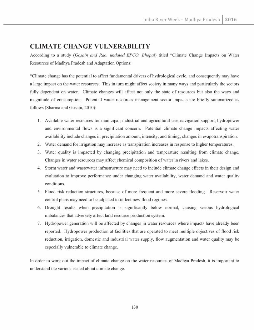
India River Week – Madhya Pradesh 2016
130
CLIMATE CHANGE VULNERABILITY
According to a study (Gosain and Rao, undated EPCO, Bhopal) titled “Climate Change Impacts on Water
Resources of Madhya Pradesh and Adaptation Options:
“Climate change has the potential to affect fundamental drivers of hydrological cycle, and consequently may have
a large impact on the water resources. This in turn might affect society in many ways and particularly the sectors
fully dependent on water. Climate changes will affect not only the state of resources but also the ways and
magnitude of consumption. Potential water resources management sector impacts are briefly summarized as
follows (Sharma and Gosain, 2010):
1. Available water resources for municipal, industrial and agricultural use, navigation support, hydropower
and environmental flows is a significant concern. Potential climate change impacts affecting water
availability include changes in precipitation amount, intensity, and timing; changes in evapotranspiration.
2. Water demand for irrigation may increase as transpiration increases in response to higher temperatures.
3. Water quality is impacted by changing precipitation and temperature resulting from climate change.
Changes in water resources may affect chemical composition of water in rivers and lakes.
4. Storm water and wastewater infrastructure may need to include climate change effects in their design and
evaluation to improve performance under changing water availability, water demand and water quality
conditions.
5. Flood risk reduction structures, because of more frequent and more severe flooding. Reservoir water
control plans may need to be adjusted to reflect new flood regimes.
6. Drought results when precipitation is significantly below normal, causing serious hydrological
imbalances that adversely affect land resource production system.
7. Hydropower generation will be affected by changes in water resources where impacts have already been
reported. Hydropower production at facilities that are operated to meet multiple objectives of flood risk
reduction, irrigation, domestic and industrial water supply, flow augmentation and water quality may be
especially vulnerable to climate change.
In order to work out the impact of climate change on the water resources of Madhya Pradesh, it is important to
understand the various issued about climate change.

India River Week –Madhya Pradesh 2016
131
Map No 34: Composite Vulnerability Map of M.P
Maximum changes in rainfall are expected in parts of the basins of Godavari, Narmada and Mahi followed by
Tapi and Ganga.”