GOVERNMENT OF MADHYA PRADESH - Environmental ...
79
GOVERNMENT OF MADHYA PRADESH WATER RESOURCES DEPARTMENT MAA RATANGARH MULTIPURPOSE PROJECT DISTRICT DATIA (M.P.) Volume - I REPORT & ESTIMATE Cost of Project Rs. 2244.97Crores (Based on USR enforced from 1/9/2017) CHIEF ENGINEER RAJGHAT CANAL PROJECT DATIA (M.P.)
-
Upload
khangminh22 -
Category
Documents
-
view
0 -
download
0
Transcript of GOVERNMENT OF MADHYA PRADESH - Environmental ...

GOVERNMENT OF MADHYA PRADESH
WATER RESOURCES DEPARTMENT
MAA RATANGARH MULTIPURPOSE PROJECT
DISTRICT DATIA (M.P.)
Volume - I
REPORT & ESTIMATE
Cost of Project Rs. 2244.97Crores
(Based on USR enforced from 1/9/2017)
CHIEF ENGINEER
RAJGHAT CANAL PROJECT
DATIA (M.P.)

MAA RATANGARH MULTIPURPOSE PROJECT
DISTT. DATIA (M.P.)
Tehsil : Seondha District : Datia
INDEX
VOLUME - 1
S.No. Chapters Page No
From To
A Section - I Reports
Introduction 1 6
Physical Features 7 7
Inter State Aspect 8 9
Survey and Investigation 10 18
B Section - II
1 Check list 19 24
C Section - III
1 Salient Features 25 26
D Section - IV
1 Estimate 27 122
E Section - V Annexures
1 List of Beneficiary Village 123 128
2 Capacity Table 129 131
3 B.C. Ratio Calculation 132 135
4 Calculation of Pump No 136 138
5 Index Map 139 139

MAA RATANGARH MULTIPURPOSE PROJECT
DISTT. DATIA (M.P.)
CHAPTER -1
INTRODUCTION
1.1 Project proposal and Aims:
Maa Ratangarh multipurpose project envisage the construction of 31.00 mts high
and 1740 mts long including 1162 m earthen dam, 464 m long spillway and 114 m
NOF portion on river Sindh, Which is a tributary of Yamuna river near village
Dangdiroli in Tehsil Seondha of Distt. Datia M.P. Catchment area at Sindh
(Seondha) Dam is 12739 sqkm. which entirely lies in M.P. 1235.25 ha. Govt. land,
1302.79 ha. private land and 799.59 ha forest land i.e. total 3337.63 ha land is
required in whole project.
75 % dependable yield after upstream use is 2812.76 Mcum. However a
gross storage capacity of 246.95 is created by fixing full reservoir level at 161.0 M
after considering submergence constraints to irrigate total available command
area i.e. 78484 ha. One balancing reservoir BR I is proposed near Village Ratwa
with a storage capacity of 5.28 Mcum. Thus the total gross capacity of 252.23
Mcum will be available at the end of mansoon out of which total live capacity is
242.87 Mcum . Inflow in non mansoon months is also utilized.
78484 ha.( CCA) area through a well planned pressurized irrigation on left
flank of the river which lies in Gwalior , Bhind and Datia District is proposed as
under
1 Ratwa Amayan Area 39200 Ha
2 Bilaua Devgrah Area 18984Ha
3. Command area of Bhind Mau branch canal 20300 Ha.
Tiktoli Distributory of Harsi High level Canal, which is given administrative
approval by M.P. Govt, vide letter no. F-22/2/16-17/L.S./13/531 Bhopal Dt.
24/03/2017 for Rs 42.34 crores having culturable command area 3170 Ha. is now
included in Ratwa Amayan Area as per instruction of Higher Authorities.
At present 20300 ha area of Bhind- Mau branch canal is irrigated from
Chambal canal System. A scheme of Micro irrigation of 20000 ha is being
prepared in upper area of Morena and Sheopur district from Chambal canal
system. There are severe problem in tail area of Bhind district due to erratic and
insufficient supply from Rajasthan. To counter this problem 20300 Ha Command
area of Bhind Mau branch canal is proposed to be irrigated from Maa Ratangarh
11

multipurpose project. If required in future in second phase of this project
pressurized irrigation of this command area will be planned.
9.00 Mw power generation is proposed from Main Dam and 30 Mcum
water is provided for drinking water for surrounding area. Environment release of
water is proposed from sluice in Power house.
Increasing in population growth has led to the need for increase in
agriculture production for the survival of mankind. Therefore agriculture has
become an integral part of the development system and irrigation holds the key in
increasing agricultural productivity. Since earlier times natural and manmade
water bodies such as lakes, ponds, tanks and other similar structures were used
for irrigation. A good water resource development which meets the need of the
present generation without compromising the future needs and aspirations is
considered as sustainable development. The concepts of constructing dams to
harness water for irrigation are currently practiced. Irrigation projects are of prime
importance for sustainable and improved crop production and ensuring food
security in the country. Every development project changes the existing
environment at micro and macro level, these changes are inevitable. The impact
or the change in the existing environment can be beneficial or detrimental with
respect to the duration of the project. Therefore the project should be planned,
implemented and monitored is such a way that the demands of the growing
population have to be met with minimum disturbance to the existing ecosystem.
In view of the above since 1956, the Government of Madhya Pradesh is
continuously putting their efforts to provide irrigation facilities in the State by
constructing dams to serve the primary purpose of retaining excess water during
monsoon season and make use of this water effectively for irrigation during non
monsoon season.
Madhya Pradesh is one of the under developed states in India M.P. has
the largest population of tribals in India with ST comprising 23.27% of state's
population (1991) As a part of development Madhya Pradesh Water Resources
Department (MPWRD) have proposed to construct Sindh (Seondha) Dam. The
completion of project will boost economy of the region.
1.2 Location of Project:
Maa Ratangarh Multipurpose Project site is proposed near village Dangdiroli
which comes in Teh. Seondha of District Datia (M.P.). Latitude and Longitude at
Dam site 260 8'-29” and 780-44'-20'' respectively which is covered by toposheet no.
54J/12 and Index map of the project showing dam site, command area, canal
22

network, submergence and location of Dam are enclosed. The site is
approachable from Seondha by a Tar Road up to 6 km. and than 5 km. up to
Dangdroli Dam site by fair weather road .The distance from Datia is 65 km. The
nearest railway station for the Dam site is Datia in New Delhi - Bhopal Section of
Central Railway.
The proposed Dam site comes under assembly constituency No. 20
Seondha and its present M.L.A. is Shri Pradeep Agrawal. Its Parliamentary
constituency is No.3 Bhind - Datia which is represented by M.P. Shri Bhagirath
Prasad.
The Command area comes under constituency No. 12 Mehgaon,
constituency No. 13 Gohad, constituency No. 14 Gwalior rural, constituency No.
19 Dabra and constituency No. 20 Seondha, which are represented by, Shri
Mukesh Chaudhary, Shri Lal Singh Arya, Shri Bharat Singh Kushwah, Smt.
Imarti Devi and Shri Pradeep Agrawal respectively as M.L.A. and all are
demanding this scheme.
1.3 About Madhya Pradesh:
Madhya Pradesh lies in the central part of India. It is located between longitude
740 E to 820 45E and latitude 21" N to 27" N has a geographical area of 308, 245
sq. km. with 51 administrative districts. The state is surrounded by the States of
Uttar Pradesh in the North, Maharashtra in South. Chhattisgarh to the East and
Gujarat and Rajasthan in the West Madhya Pradesh has ten river basins/sub
basins. three of them Mahi, Narmada and Tapti are west flowing while Wainganga
is east flowing and joints River Godavari in the State of Andhra Pradesh. The
remaining six rivers namely Chambal,Sindh , Betwa, Ken, Tons and Sone flow
northwards and joing Yamuna - Ganga River system. There rivers serve as major
source for irrigation water supplies by construction of dams across the river.
There are 6 large dams in the State namely Banasagar, Bargi, Gandhi
Sagar, Indrasagar, Rajghat, and Tawa. The annual rainfall of the state ranges
from 800 mm in the west to 1600 mm in the east. Most of the rainfall is
concentrated in the three to four monsoon months between June to September.
Most of the streams remain dry from January to June. Many surface water storage
structures constructed augment water availability during non monsoon months.
Madhya Pradesh ranks low on all indicators of human development
indices such as per capita state domestic project life expectancy, education levels,
literacy and infant mortality rates More than 80 percent of the poor live in rural
areas. One third of the population belongs to socially and economically
disadvantaged groups officially designated as scheduled Tribes (ST) and
33
scheduled caste (SC) Moreover, MP has the largest population of Tribals in India
with ST comprising 23.27% of state’s population (1991) The proportion of poor is
substantially higher among the tribal groups with 66 percent living at or below the
poverty line.This is the situation in spite of the natural resources viz . land, water
minerals and forests being abundant.
1.3.1 Budelkhand Region.
Datia comes under bundelkhand region now a part of Madhya Pradesh M.P
1.3.2 Datia District.
Datia is the smallest district of M.P. forming eastern part of Gwalior
Commissionery. The district lies into a man body of land mostly on the sindh Pahuj
Doab and five enclaves (Basai, Kamra) surrounded by the portion of Shivpuri
District and bordering Jhansi district of U.P. The main body of the district extends
between the N- latitudes 250 - 28' and 260, 20' and E- longitude 780, 10" and 780,
45' .The farthest enclaves extends in the South up to 250, 3'N, near Talbahat. This
district is bounded by Bhind and Gwlaior (Main block) districts in the North,
Shivpuri District of M.P. and Jhansi District of U.P.in the Sourth,Gwalior and
Shivpuri (Main Block) district in the west and Bhind District of M.P. and Jhansi
district of U.P. in the East (Fig.1). Datia the district headquarter is a town with
sufficient urban activities and is connected with Gwalior and Jhansi by the Delhi -
Bombay Main line of the Central Railway. It is also accessible by the roads from
Gwalior, Jhansi, Bhander and Bhind.
The Datia district forms a part of Bundelkhand region covering an area of
2959 sq.km. The district is divided into five tehsil and three blocks. Tehsils are
Datia, Seondha , Bhander,Indergarh and Badoni and Blocks are Datia , Seondha
and Bhander. 5 Nos urban bodies (1 Nagar Palika and 4 Nagar Panchayat), 290
Gram Panchayat, Three Janpad Panchayat, One Jila Panchayat and No. of
Villages in the District are 735. There are three Assembly constituencies which are
part of Bhind - Datia Loksabha constituencies
1.4 Population:
Datia has population of 786754. The population density of Datia District is 265 per
sq.km. as per statics of year 2011. There are 420157 males and 366597 females
in the district. Total literates in the district are 491445- out of which 303815 are
male and 187630 are female. Gender ratio is 875.
1.5 Climate:
The climate of Datia district is characterized by a hot summer and general dryness
except rainfall during the southwest monsoon season. The year can be divided in
44

to four seasons. The winter season, December to February is followed by summer
season from March to about first week of June. May is the hottest month of the
year with temperature of 42.10C. The minimum temperature during the January is
7.10C.
Rainfall :
The southwest monsoon starts from middle of June and lasts till end of
September, October and middle of November constitute the post monsoon or
retreating monsoon season. The normal annual rainfall of Datia district is 875 mm.
About 90.4% of annual rainfall is received during monsoon season. Only 9.6% of
annual rainfall takes place between October to May.
Humidity:
The humidity comes down lowest in April. It varies between 26% and 83% at
different time in different seasons. The wind velocity is high during the monsoon
period as compared to pre and post monsoon. The wind velocity is highest in June
around 11.3 km/hr and lowest is 3.1 km/hr in November. The average normal
annual wind velocity of Datia district is 6.8 km/hr.
Flood: The flood is not a problem in Sindh river. No serious damage due to floods in this
river is in record.
1.6 Land use and Socio economic aspects:
The major crops of the district are wheat, Jowar, Dalhan Urad, Til, Soyabeen
paddy and gram. Main vegetation are Jamuna Mahua Kher and Achar Total sown
area of the district is 360770 Hact and Net irrigated area is 175732 ha.Total forest
area of the district is 29104.28 Sqkm. The annual average Rainfall of the district is
875 mm.
Agriculture and Irrigation condition:
All major agricultural operations in the area at present are dependent
on rainfall cultivators generally follow the age old agriculture practices therefore
crop yields are low. Water is the main limiting factor and the provision of assured
supply of irrigation water for the proposed command will improve the agricultural
productivity and the area will get relief from repeated scarcity conditions.
1.7.1 Choice of the project:
The Agency surveyed the upstream and downstream area and
found that the present proposed site was the only suitable for earth dam with
gated structure. Hard rock was available in the L/S flank. One site in D/S and other
in u/s is tested but both have very low capacity in basin pool. Thus no other
alternative site was found suitable hence this site is finalized.
55

1.7.2 Fitment of scheme is overall development of the river basin:
The Sindh basin, situated in the northern part of Madhya Pradesh is an
important basin in the state. The river sindh has its origin at village Gopi Talai in
Lateri, Tehsil of Vidsha district in Madhya Pradesh at an elevation of 533.40m
above M.S.L. Sindh a tributary of Yamuna flows mostly through M.P. in the district
of Vidisha, Guna, Ashoknagar,Shivpuri, Gwalior, Datia and Bhind. It then joins
river Yamuna near village Jagammanpur in Jalaun District of Uttar Pradesh. The
total length of the river from its origin to its confluence with Yamuna is 500 km.
The river flows through Malwa Plataue in Vidisha and Guna district. In
Shivpuri it flows through a thick forest and hilly stretch and enters the plains after
the town Narwar in Shivpuri district. The total drainage area up to the confluence
with Yamuna River is 17413 sq.km. and up to the proposed dam site is 5540
sq.km.
The Sindh river has 6 principal tributaries namely Kunwari , Basily, Noon,
Parwati, Mahuar and Pahuj.
1.8 Cost and Benefit of Scheme:
Gross command area of the project is 109015 Ha., out of which 78484
ha. is culturable command area. About 70% of the area of the culturable
command is under cultivation at present. Food grains area grown on 95% of net
cropped area at present.
The project on completion will irrigate 78484 hectare of CCA in Bhind,
Gwalior, Datia, District and the irrigation in these districts will be raised about 20
percent.
Estimated cost of unit I (Head Work) is Rs 867.78 crores , cost of unit II
(Canal) is Rs. 1377.19 Crores. The total cost of project is worked out Rs. 2244.97
Crores. The cost per ha of CCA (78484 ha) is Rs.2.86 Lakh/ha. Cost Benefit Ratio
of this project is 1.85.
The public is very much interested in construction of project and ready to
pay water charges as per rules. The families in submergence are ready to shift in
the rehabilitated area. Full cooperation and participation of public is expected.
66

CHAPTER -2
PHYSICAL FEATURES
2.1 Topography :
Sindh basin extends between North to east. The basin has an area of 26082
sq.km. out of which 17310 Sq km. lies in M.P.and 8772 sq.km. in U.P.
The catchment area at project site is 12739 sq.km. and is fully in M.P. Two
dams namely Madikhada and Mohini Pickup Weir are constructed in the u/s of
proposed site on Sindh. After deduction of their CA the unintercepted CA is 5915
sqkm. The highest point in CA has elevation of 533.40 M and lowest is 102 m the
length of river up to dam site is 430 kms. The averge slope is 1.00 m/km In the
reservoir area. The soil depth is about 2 m and then sandy, gravel, up to 20 m
from river bed and after that the possibility of hard strata available . Hard strata
on left bank is available at shallow depth.
The command area of project is plain and traversed by a number of small
and big nallas which from the natural drainages of the area. Highest elevation is
230 m and the lowest is 160 m. Most of the stream and nallas are non perennial.
Sindh River .The soils of the command area are generally yellow soil based
command has a good slopes and drainage capacity.
The Sindh River flows from south east to North east direction. It meets
Yamuna River about 60 km. of dam site,
2.2. General Geology.
The Sindh river flows through Malwa Plataue in Vidisha and Guna district in
Shivpuri it flows through a thick forest and hilly stretch and enters the plains
after the town Narwar in Shivpuri district. The major part of the Sindh basin is
occupied by Bundelkhand Gneissic complex comprising a variety of medium to
coarse grained granites, migmatites,gneisses. The soil cover is about 2 mt. The
permeability is high at proposed site,very good foundation is not available at
shallow depth. The total drainage area up to the confluence with Yamuna river
is 17413 sq.km. and up to the proposed dam site is 5540 sq.km.
77

C H A P T E R – 3
INTER-STATE ASPECT
3.1 General:
The Sindh basin, situated in the northern part of Madhya Pradesh is an
important basin in the state. The river sindh has its origin at village Gopi Talai in
Lateri, Tehsil of Vidsha district in Madhya Pradesh at an elevation of 533.40m
above M.S.L. Sindh as tributary of Yamuna river flows mostly through M.P. in the
district of Vidisha, Guna,Ashoknagar, Shivpuri, Gwalior, Datia and Bhind. It then
joins river Yamuna near village Jagammanpur in Jalaun District of Uttar Pradesh.
The total length of the river from its origin to its confluence with Yamuna is 500km.
The river flows through Malwa Plataue in Vidisha and Guna district in
Shivpuri it flows through a thick forest and hilly stretch and enters the plains after
the town Narwar in Shivpuri district. Catchment area of the Sindh River up to
proposed dam site is 12739.0 Sq.Km. The yield available from the catchment area
of 12739 sq.km falling above proposed dam site is 4113.15 Mcum out of which
after deducting upstream use 2812.76 Mcum yield is available. it is proposed to
store 252.23 Mcm at the time of construction as gross storage.
3.2 Inter-State aspects of the Project:
The catchment area drained at proposed site is 12739 sq.Km. ,which fully lies
in Madhya Pradesh.
The unintercepted catchment area drained at Sindh (Seondha) Dam site is
5915.00 sq.km. An area of 78484 hect. (CCA) is proposed to be irrigated by the
project in left bank only. The locations of existing scheme with future plan are
indicated in Index map.
As entire Catchment and command area of Sindh (Seondha) Dam lies in
Madhya Pradesh only, hence, as such there no interstate aspect is involved.
3.3 Interstate Agreements on sharing of Sindh River water:
There is no interstate agreement in regards of water of Sindh River. In
respect of the Yamuna basin there exists water sharing agreement in Yamuna
basin among UP, Rajasthan, Haryana, Himachal Pradesh and Delhi for sharing of
88

water by the basin states ex-Tajelwala & ex- Okhla. Unutilized water available in
the Yamuna basin is of the order of 600 MCM.
M.P has not entered into any agreement between adjoining states for
sharing of water in the Yamuna basin. However, if any agreement is required to be
drawn in future in this basin, the yield utilized in the Kunwari River by MP would be
taken into account as use of Madhya Pradesh.
3.4 Submergence and Sharing of Cost:
All components of the Maa Ratangarh Dam lie in Datia district of Madhya
Pradesh and it is planned to irrigate the lands of district Gwalior, Datia and Bhind
(M.P). Entire submergence area lies in district Datia, Bhind and Gwalior.
3.5 Inter-national Issues:
As per stipulations of Union Ministry of Water Resources and to fufill the
international obligations arising out of existing agreement between India and
Bangladesh for sharing of waters of river Ganga, any consumptive utilisation from
a scheme in Ganga basin is required to be met by creation of monsoon storage
and effects of the scheme on the downstream flows during the lean period wef 1st
January to 31st May have to be ascertained. In other words the lean period flows
during this period shall not be tapped for any consumptive utilisation.
Since the proposed project involves creation of storage of 252.23
Mcm corresponding to the annual irrigation requirement of 256.30 Mcm and shall
meet the requirements for the period wef 1st January to 31st May from the
proposed monsoon storages only, downstream flows of river Sindh are not going
to be affected. In view of discussion above no international issues are involved in
planning the scheme.
99

Chapter 4
Survey and Investigation
4.1 General:
The objective of the surveys and investigations is to initially prepare a preliminary
and then the detailed project report (DPR) survey and investigation work includes
topographic and cadastral survey environmental and forest land assessment, geological,
geotechnical and hydrological assessments and investigation.
Madhya Pradesh state as its name implies occupies the central portion of the
country. Hill ranges running across the plateau has subdued topography. It is covered by
survey of India topo sheet in scale of 1:250000 by 63D/8, 63D/4, 64A/1, 64A/5, 54P/16,
55M/13. The Sindh (Seondha) Dam site is located at latitude 26,08’29” N Longitude
78,44’20”E.
4.2 Topographical Survey:
A set of technical specifications were provided by the water resources department
MP to serve as guidelines for preparation of preliminary report and then detailed project
report (DPR) for irrigation project. On the basis of guidelines provided by WRD, MP,
detailed submergence area dam site surveys have been undertaken by contractor using
instruments such as GPS, Total Station. Auto level etc. The levels indicated in this report
are with respect to GTS B.M. reservoir . The submergence survey have also been done
using transferred GTS bench mark Narsing Temple at Mau Dist. Bhind
4.3 Dams and Reservoirs
Reservoir maps have been prepared in global co-ordinate system is in a scale of
1:3000.The print attached is in the scale of 1:6000. Whereas Dam axis L section map is in
scale of 1:3000 and contour interval is 1.00 m.
Lowest river bed level is around 135 M. Reservoir survey has been carried out to
cover an area from Dangdroli to Barkari looking to the probable yields and least area for
submergence. Grid survey at an interval of 30 m was also carried out. Standard total
station machine and Auto level used to carry out the required survey. Dam contours with
grid level plan in enclosed. L-section of dam is enclosed.
4.4 Methodology for topographical survey:
As indicated above field survey were carried out with the help of electronic total
station and auto level machines as suggested in the guidelines of CWC.
The contractor appointed by the WRD has carried out the survey and
investigations for Project.
4.5 Topographical Survey
The surveys have been carried out for the selection of dam site.
Preliminary investigations for the dam site.
1010

Reconnaissance surveys of Sindh River to locate the site.
Detail submergence survey have been observed especially in the river tributary
nallas to plot the contours. Superimposing the contours on the village maps obtained from
the revenue department to identify submerged land. Similarly the details of the property
and villages coming under submergence have been identified.
Detailed survey and investigations for the proposed site.
Block level at 30 m intervals were taken for a length of about 500 m on the
upstream and 500 m on the downstream of the axis of the proposed site. Based on these
surveys the dam axis at the proposed site was aligned taking into consideration the
geological and the topographical features.
Survey for main canal alignment is to be done with the help of total station
machine and Auto level .The minors and command area is identified with the help of topo
sheet.. Detail survey of full command will be done after AA.
4.6 Soil Surveys (Command area):-
Soil survey of command of Sindh (Sendha) Dam project carried out and test result
has obtained.
Salient feature of the command:-
The area is sloping gently and near its out fall into Sindh river, the slope is of the
order 0% to 3% . It is traversed by small drainage channels at short distances and they
help in draining the excess water efficiently. Hence no provision for drainage has been
made. The soil is generally clayey. The main crop grown in Kharif season is jowar, paddy,
mustered, arhar and urd etc. In Rabi season main crop is wheat, gram, linseed, bareley
and masoor etc.
Method of soil survey:-
Field Work (Investigations)
A detailed soil survey of the command area of Maa Ratangarh Multipurpose
Project was carried out in 8 villages covering the area of 21127 hectare. Village map in
the scale 1" = 1 mile was used as base map during survey. Cross country traversing was
done at closure distance so as to cover the maximum area. In course of traversing the soil
texture, soil depth slope, colour, erosion, concretion etc. were examined and on the basis
of different soil phases met during the survey of soil boundaries were identified.
Depending upon the soil heterogeneity and variation, the terrain of the site for the profiles
were selected in the major units. Thus 8 profiles were located.
The profiles were excavated upto 150 cm. or bed rock whichever met earlier. The
profiles were studied for morphological and physical characteristics such as texture,
structure, consistency, color, root distribution effervescence, presence of calcium
carbonate etc. The profiles were divided into different layers on the basis of different
physical chemical and morphological characteristics. One sample was collected from
each horizon for analysis in the lab. In this way 8 samples were collected from 8 profiles.
1111

LABORATORY INVESTIGATION :-
In all 8 samples from whole of the command were collected since it is a very less
number hence all samples were analyzed for the following constituents by the method
shown in the following table.
S.No. Constituents Method
1 2 3
1. Mechanical composition International Pipette Method
2. Water holding capacity Keen Raczkowki Box (Coutts 1930)
3. Available water holding capacity Calculated by factor given in the hand book of irrigation & water management (I.C.A.R.)
4. PH By using PH meter 1:2 soil & water
5. Electrical conductivity Electrical conduct of 1:2 extract by using conductivity bridge.
6. Calcium Carbonate Rapid Titration Method (Piper 1950)
7. Organic Carbon Walkly & Blocks rapid titration method (Piper 1950)
Soils and their classification :-
(SOIL TEXURE & SOIL CHARACTERISTICS)
In broad soil classification it is grouped under deep medium black soil and locally it
is said Mar & Kabar.
The soils under various soil type along with their area and percentage is presented
in following tables:-
S.No. Type of soil Percentage
1. Clay 25.00%
2. Clay loam 27.00%
3. Sandy clay loam 5.00%
4. Sandy clay 12.00%
5. Sandy loam 31.00%
100.00%
It is seen that 31.00% of the command area is occupied by sandy loam texture,
the next type of soil is clay loom which is 27.00% and the remaining area is occupied by
sandy clay, loam, sandy loam hillock, rock, shrubs, inhabitation and road etc.
The soil of the command area is mostly very deep to deep, few areas is having
moderately deep to shallow deep and very limited area comes under very shallow deep
soils.
Various depth classes along with their area and percentage is given below:-
1212

S.No. Group No. Description Area in Hect. Percentage
1 2 3 4 5
1. I Deep to very deep (more than 90 cms.)
57238 81.00%
2. II Moderately deep to deep (22.5 to 45 cms.)
13426 19.00%
Total 70664 100.00%
Topography plays an important role in formation of soils and also type of soil. The
major area of the command comes under 'A' slope nearly 88.21% while 'B' slope covers
11.79% area.
S.No. Slope class Slope range
Description Area in Hect. Percentage
1 2 3 4 5 6
1. A 0 to 1% Nearly leveled
62333 88.21%
2. B 0 to 3% Very gently sloping
8331 11.79%
Total 70664 100.00%
Soil erosion is affected by texture with slope, nature of water shed, size of
catchment with vegetation and rainfall intensity. No such surveys have been done by
Agriculture Department.
Available water holdeing capacity:-
It is the water in soil which is readily available for the plant use. It has been
estimated upto depth of 90 cms. depth by the method given in the technical series-3
published by Water Management Division, Ministry of Agriculture, New Delhi. Estimation
is done by multiplying particular factor with soil depth.
Depending upon the texture and depth the available water holding capacity varies
from soil to soil. The range of A.W.H.C. in different soil is calculated and presented. :-
S.No. Range of A.W.H.C. No. of profile Percentage
1 2 3 4
1 6 to 9 1.5 7.26%
2. 9 to 12 4 19.64%
3. More than 12 15.5 73.10%
Total 21.0 100.00%
Soil reaction:-
Ph value of soil:-
The knowledge of soil pH is very important as it helps in determining the kinds of
fertilizer to be used for the particular soil type and crop. In addition to this pH plays vital
role in connecting to availability and non-availability of nutrients. The best suited pH range
1313

for availability of most of the nutrients is between 6.5 to 7.3. Selected samples have been
analyzed for pH in 1:2 soil and water ratio and the results are tabulated below
S.No. pH Range Class No. of Grid Area in Hectare
Percentage
1 2 3 4 5 6
1. 5.62 to 6.00
Medium acid
2. 6.1 to 6.5 Slightly acidic
3. 6.6 to 7.3 Neutral 3
4. 7.4 to 7.8 Mildly Alkaline
4
5. 7.9 to 8.4 Moderately alkaline
1
Total
ELECTRICAL CONDUCTIVITY (TOTAL SOLUBLE STATE):-
For soils conductivity is taken as a measure of total soluble salts in the soil.
Representative samples have been analyzed for electrical conductivity in 1:2 soil and
water ratio and found that the entire area is well within the harmless limit i.e. less than 1.0
m./Mhos/cm. All the samples have been tested for electrical conductivity and found that it
varies from 0.14 to 0.502m./mhos/cm. There will be no problem of any salt accumulation.
CALCIUM CARBONATE:-
S.No. Range of CaCo3 Area in Hectare Percentage
1 2 3 4
1. 0.5 to 1% 15300 35.35%
2. 1 to 3% 610 1.40%
3. 3 to 5% 1260 2.91%
4. More than 5% 500 1.15%
Total 17670 40.81%
From the table it is clear that maximum area is having 0.5 to 1% CaCO3.
The low content of CaCO3 indicates that soils are not rich in it carbonats.
Fertility status of soils:-
Nitrogen, phosphorus and potash are the major nutrients needed by the plants.
Mostly the Indian soils are poor in nitrogen only hence nitrogen as organic carbon has
been estimated as basis of nitrogen status of the command area.
Organic contents in the soil help in improving ion exchange capacity and acts as
buffering agent in sudden change of pH.
1414
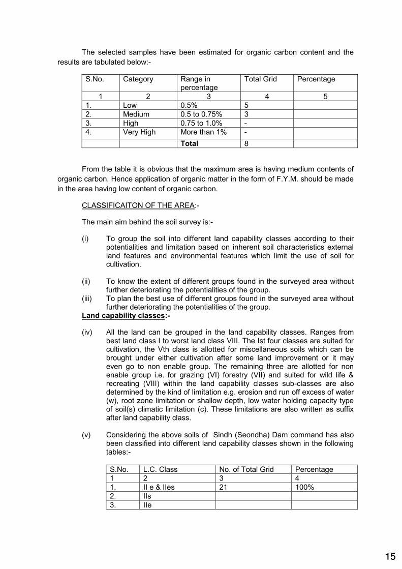
The selected samples have been estimated for organic carbon content and the
results are tabulated below:-
S.No. Category Range in percentage
Total Grid Percentage
1 2 3 4 5
1. Low 0.5% 5
2. Medium 0.5 to 0.75% 3
3. High 0.75 to 1.0% -
4. Very High More than 1% -
Total 8
From the table it is obvious that the maximum area is having medium contents of
organic carbon. Hence application of organic matter in the form of F.Y.M. should be made
in the area having low content of organic carbon.
CLASSIFICAITON OF THE AREA:-
The main aim behind the soil survey is:-
(i) To group the soil into different land capability classes according to their potentialities and limitation based on inherent soil characteristics external land features and environmental features which limit the use of soil for cultivation.
(ii) To know the extent of different groups found in the surveyed area without further deteriorating the potentialities of the group.
(iii) To plan the best use of different groups found in the surveyed area without further deteriorating the potentialities of the group.
Land capability classes:-
(iv) All the land can be grouped in the land capability classes. Ranges from best land class I to worst land class VIII. The Ist four classes are suited for cultivation, the Vth class is allotted for miscellaneous soils which can be brought under either cultivation after some land improvement or it may even go to non enable group. The remaining three are allotted for non enable group i.e. for grazing (VI) forestry (VII) and suited for wild life & recreating (VIII) within the land capability classes sub-classes are also determined by the kind of limitation e.g. erosion and run off excess of water (w), root zone limitation or shallow depth, low water holding capacity type of soil(s) climatic limitation (c). These limitations are also written as suffix after land capability class.
(v) Considering the above soils of Sindh (Seondha) Dam command has also been classified into different land capability classes shown in the following tables:-
S.No. L.C. Class No. of Total Grid Percentage
1 2 3 4
1. II e & IIes 21 100%
2. IIs
3. IIe
1515

It is obvious from the table that the majority of the area is occupied by IIs.
The soil limitation can be over completely applying organic matter and following
proper soil conservation practices with improved agricultural practices.
Soil irrigability classes:-
The interpretation of soil for irrigation is considered while predicting the
behavior of soil under the altered water regime which is brought out by
introduction of irrigation. The soils are grouped after soil irrigability classes
according to their suitability for sustained use under irrigation. The criteria for
classifying the soil under different soil irrigability classes are effective soil depth
surface, texture, soil permeability, available water holding capacity, salinity and
soil erosion etc. There are two irrigability classes denoted by capital letters A to B.
The Maa Ratangarh Multipurpose Project has also been classified for soil
irrigability classes keeping in view the above criteria and found in all the classes
whose details are given in the following table.
S.No. Soil Irrig. classes Area in Hect. Percentage
1 2 3 4
1. A 8324 11.78%
2. B 62340 88.22%
Total 70664 100.00%
It is concluded that most of the area comes under irrigable class 'B'
land irrigability classes:-
It is an advance grouping of soil irrigability classification which takes in to
consideration quality and quantity, irrigation water, drainage requirement etc. In
addition to the above consideration economic aspect viz. production cost and yield
potentials, land development cost and benefit cost ratio is taken into account.
The command area of Sindh (Seondha) Dam is classified under class-I and
II of land irrigability classes.
S.No. L.I. Class No. of Total Grid Percentage
1 2 3 4
1. 1 8324 11.78%
2. 2s 62340 88.22%
3. Total 70664 100.00%
Agricultural practices:-
The main crop grown in Kharif season is jowar as a mixture with moong,
arhar, urd etc., then jowar as a pure crop, paddy, til subsequently. In rabi season
the main crop is wheat, gram, masoor, and mustard. The kharif area is less than
the rabi area and mostly the crop is less than the rabi area and mostly the crop are
shown as rainfed. Out of the total 98735 Hect. of GCA 70664 Hectare area is
proposed under rabi. The yields per HA of different crops are not good.
1616

The farmers of Mehgaon and Morar, seondha are not so advanced and
most of the cultivators are using old practice. After the commencement of the
project the main crop cannot be paddy because most of the area is having high
percentage of clay contents however if the drainage is managed soybean can be
taken as a main major crop which is also a cash crop in kharif.
In rabi, wheat, gram and other existing crop will continue but their yields
will definitely be increased with the inception of the project. The position of the use
of machineries and fertilizer is not very encouraging in the project area. It is
thought that by the introduction of irrigation the use of fertilizer will increase. With
the extension services of Agriculture Department, the advance agriculture practice
can be made popular among the farmers.
Conclusion of soil survey:-
Following conclusions have been observed from above different observations. :-
(i) The soil of the command area is mostly clay (27.29%) and next is clay
loam (26.65%)
(ii) The soils are deep to very deep (61.23%)
(iii) The soils comes under slope class 'A' which is 0 to 1% total area
85.71% is of slope 0 to 1%
(iv) The A.W.H.C. of the soils of command is very good (73.10%)
(v) No. survey for soils erosion is done in command area.
(vi) The most of the area is neutral acid (51.53%). The next range is mildly
alkaline (24.20%). The rest of the area is occupied by medium acid (or slightly
acidic (14.54%). Moderately alkaline area is 4.84%.
(vii) As regards total soluble salts maximum area is under harmless limit
which varies from 0.14 to 0.39 m/Mhos/cem.
(viii) Most of the area is having calcium carbonate content in the range of
0.5 to 1 (29.08%)
(ix) 46% of area is having medium to high content of organic carbon.
(x) Majority of the area is occupied by IInd class i.e. 100% of land capability
class.
(xi) 73.35% area falls under 'B' of the soil irrigability class.
(xii) In land irrigability class 73.35% of the area comes under 2nd class
Recommendation:-
The results of testing of soils of the command area indicate that the area
can be designated as fit for irrigation and is expected to be benefited considerably
by the construction of the project.
1717

4.7 Geological survey:
The GSI is requested for visit of Dam site. However general geology is as
below:
The major part of the Sindh basin is occupied by Bundelkhand Gneissic
complex comprising a variety of medium to coarse grained granites,
migmatites,gneisses. The colour of rock is pink to pinkish grey. The soil cover is
about 1 mt. The permeability is low with very good foundation characteristics. The
ground water potential is moderate.
4.8 Material survey:
The material required for construction are Cement, Earth, Sand, Metal,
stone etc are available in sufficient quantity at economical lead. The quarries have
been identified and found suitable. The material is being used in different
construction activities by department and public and no complain about material
quality is received. However detail testing will be done before execution.
(S.C.Navla) (R.B.Dixit)
Sub Divisional Officer Harsi High Level Canal
Sub Division No.4 Gwalior
Executive Engineer Harsi High Level Canal Division No.2 Dabra)
(R.K.Shrivastava) ( N.P. Kori) Superintending Engineer Chief Engineer Sindh Canal Project Circle Rajghat Canal Project Shivpuri (M.P) Datia (M.P.)
1818

MAA RATANGARH MULTIPURPOSE PROJECT DISTT.DATIA (M.P.)
APPENDIX-III
CHECK LIST FOR RECONNAISSANCE REPORT FOR MEDIUM/MAJOR
IRRIGATION SCHEME Name of the Scheme : MAA RATANGARH MULTIPURPOSE PROJECT
District /Tehsil/Block : Datia/ Seondha / Scondha
Sub-Division : Seondha
1 River Basin /Sub Basin : Sindh
Toposheet No. & Scale : 54J/12 , 1: 50000
Location of the scheme
Latitude : 260-08'-29"
Longitude 780-44'-20"
1.2.1 Is any inter-State aspect involved? Give details. : No
1.2.2 Is any inter-State agreement reached : N.A.
What is the share of state and the proposed utilization through this scheme?
1.3 Catchment area : 12739 sqkm
1.3.1 Is the scheme include in the master plan of the basin? : Yes
1.3.2 Upstream utilization as per master plan under progress / contemplated / scheme.
: 1300.79
1.3.3 Intercepted catchment area / Net available Yeild as site. : 5915 sqkm/
2812.76 Mcum
1.4 The type of scheme:- Storage / Barrage
1.4.1 Is any gauge discharge site on the river established on U/s or D/s of the proposed site? If so, give details.
: U/S - Goraghat GD site Near Dabra in Gwalior Distt.
D/S- Seondha GD site Near Seondha in Distt. Datia.
1.5 Is hydrology of any project in the adjacent basin / sub basin finalized or under finalization? If so give details.
: Madikheda Dam
1.6 Is the scheme initiated to meet up irrigation / power / industrial demand Give reference and details?
: 78484 ha. Irrigation facility in Bhind, Gwalior, Datia Distrct.
1.7 Does the scheme lie in tribal area or draught prone area? : Draught prone Area
1.7.1 Is any tribal area benefited by the project ? Is the command area predominantly covers S/T or S/C beneficiaries.
: Yes
1.8 If any reserve forest area likely to go under submergence or other forest area going under submergence, the same along
: 732.39 Ha forest land
1919

with details or floura and founa getting affected due to submergence should be indicated.
2. Basic Information :
2.1 Authority
Note :- Under this head the authority i.e. No. and date of the memo under which the reconnaissance survey has been ordered may be quoted.
: E-in-C 3441200/04/ 2016/ 157/PEC/ 648/ R& C dt. 25.01.2016 Rs. 60.51 Lacs
2.2 Earlier reconnaissance. if any Yes on dated 12.01.2016
2.3 Name and designation of officer inspecting the site. Shri A.K.Mishra Chief Engineer Rajghat Canal Project Datia
2.4 Date of inspection 12.01.2016
2.5 Access route to dam / weir site.
a) Existing PWD Road 6 km.
b) Proposed, if any 5 km.
Note :- Present condition of different reaches of existing and proposed approaches , whether pucca, all weather pucca unbridged, jeepable Or plyable by foot etc. should be given in this report.
(c) Nearest railway station : Datia
65 km.
2.6 Nearest G.T.S. Bench mark/ its lacation and level : At Narsingh Temple in Mau Distt. Bhind.
RL 152.54 m.
3. Topographical Features of Dam / Weir Site : N/A
3.1 Can the proposed site be considered as natural ? : Yes
3.2 Have alternative sites been considered as natural ? : Yes
3.3 What is the area reconnoitered? Can this be considered as satisfactory, Considering the size of the project ?
: Yes
Note: the extent of area reconnoitered should be clearly marked on the index map.
3.4 (a) What is the approximate width and average depth of river channel(s) to which the flow was confined on the date of reconnaissance?
150m, 6m.
(b) What was the approximate velocity of flow in the river channel (s)?
4.42 M/Sec
(c) What is the approximate width of river at the proposed dam site?
350m
(d) What is the approximate slope of the river bed? 1 in 1046 m
(e) Are there any falls or rapids in u/s or d/s of the dam site ? Yes in U/S
(f) Are the banks steeply rising? if so , what is the approximate slope ?
0.5 : 1
(g) Is there any deep still water pool at or near the site? At Site
2020

4 Surface Geological Condition at Dam / Weir Site
4.1 (a) Is rock exposed at the ground surface? If so in what reach can the quality of rock by visual judgment be considered as satisfactory for foundation both with regard to strength and also ; considering the fissures etc.?
Yes in Left flank
(b) Where rock is not exposed at surface, what is the material at ground surface?
Sandy Soil
(c) Are the any indication in favour of or against the availability of rock at shallow depths?
Indication is there on Left flank only
Note : The above information should cover :
(i) River Bed About 36m below river bed
(ii) Left Flank 2 to 5 M
(iii) Right flank 35 M
(iv) Waste Weir site N/A
(v) Approach channel. N/A
(vi) Spill channel up to its confluence with nala/river. Is a central spillway or a flank spillway indicated by the site conditions? (If flank spillway is recommended , it is presumed that rocky strata would be available for negotiating the proposed fall)
Central Spillway
5. Hydrology
5.1 What rain gauge stations exist within the catchment and the command for what period are the rainfall records available? What do you consider as the average rainfall for (i) Catchment area (ii) Command area?
15 RG Station (1982 to 2014) in Catchment Area.
8 No RG Station considered in command (1982 to 2015)
5.2 Do you agree with the rainfall / Run -off figures computed in the office? If no, what other figures would you suggest? Are these supported by the performance of any adjacent existing reservoir or by any gauging done previously?
Yes
5.3 Is the site suitable for establishing a gauge discharge observation station? If no what alternative site would you suggest.
No
5.4 What would you consider as the likely discharge on the day of inspection? What approximately would be the discharge in the river by the end of may or beginning of June? When does the river dry up normally?
In D/S at Seondha CWC site is available
5.5 What would you consider as the highest known flood level at site? Have you checked the possibility of flood mark on any neighboring structure or is the HFL determined with reference to local enquires?
150 m by local inquiry
5.6 Is the river reported to be carrying comparatively heavy silt load? Would you suggest silt gauging at the site? If so where?
Yes
2121

6. Submergence Area Under the Reservoir 3270.43 Hact.
6.1 Is it possible to check up the spread of the F.R.L. with reference to points for which levels are known?
Yes
Note: It is essential that this point may be particularly examined to check up the correctness of water spread marked on the index map.
6.2 how many villages are likely to be effected by submergence under the proposed reservoir ?
(i) Fully 8 No (With population in 6 village 2 No unpopulated village)
(ii) Partially 16 No only land
6.3 What is the likely percentage of culturable / cultivated area under submergence? Is the percentage of submergence of cultivated land to the area proposed for
Irrigation less than 10%? What would be the percentage of forest land going under submergence? In general in what category would be forest lands come?
Yes within 10% i.e 1.84 % Medium
6.4 Is any reserve forest going under submergence? If so, give details.
NIL
6.5 What would you consider the likely compensation cost per hectare of land of different classification?
(a) Cultivated 8.00
(b) Other culturable lands 6.00
(c) Abadi lands? 6.00
6.6 Are any important towns, roads lines or minerals likely to go under submergence? Are any contemplated roads or railways and transmission lines likely to be affected?
Details in RR Plan
Note: - Sufficient details should given so as to assess generally the impact of the-submergence on the cost of project.
7. Feasibility of irrigation canal/ power channel/ power house. No
7.1 What is the nature of country through which the irrigation canal, power channel will pass in the initial reach ? if the terrain is highly cut up and difficult, would you suggest any alternative arrangement ?
Feasible
7.2 Do you agree generally with the tentative alignment of tunnel (where provided), penstock lines and location of power house or would you suggest any changes ?
NA
7.3 (a) Does your reconnaissance confirm the availability of head ( shown by to sheets )
for power generation ?
NA
(b) Does the topography permit construction of a underground power house ?
NA
2222

8 Construction Materials
8.1 Have you satisfied yourself that construction material of requisite quality would be available in adequate quantities with in economic leads?
Yes
8.2 What would be the approximate leads '?
(i) Hearting material : 2 km.
(ii) Casing material : 15 km.
(iii) Stones for rubble masonary : 15 km.
(iv) Stones for concrete and pitching : 15 km.
(v)Sand : 5 km.
Note: Replies to this question are to be given by personal judgment. No quality or quantity surveys are contemplated for replying to this question.
9 Special Construction Features , if any : ----
9.1 Do you think that the construction of the project will present any special problem and difficulty regarding diversion of river foundation treatment nallah closure, transport of equipment and essential materials etc. If so, these may be enumerated.
: Nil
10. Irrigation Aspect
10.1 What is the broad crop-practice in the command area
(i) Kharif Jawar, Makka, Urad
(ii) Rabi Mastured, Gram
(iii) Perennials -----
(iv) Cotton
10.2 What soils cover the major part of the command area ? Padua, BC soil
10.3 Do you agree with the figures of culturable command area , irrigation intensity and crop pattern assumed by the office ? if so , what are your alternative proposals ? Is
78484 Ha. it is pressurized irrigation scheme so will increased horticulture farming also.
There any specials features which would command large
scale sugarcane irrigation under the project ?
10.4 Is there any possibility of water logging in any part of the
commanded area?
No
Note : Local enquiry with regard to wafer levels of the wells,
would help in answering this question.
11. Conclusion
11.1 After the reconnaissance of the area, are you satisfied with
the prima-facia feasibility of the project, especially with
2323

reference to the following component work as broadly
indicated in the map sent by the office? (give your
comments).
(i) Dam - Masonary or earthen Yes
(ii) Spillway approach and spili channel Yes
(iii) Sluice / Head regulator NA
(iv) Irrigation / Power canal in initial reach Yes
(v) Tunnel / Penstock and power house. Yes
Note: Strike out whichever is not applicable.
11.2 The report should be enclosed with :
(a) A contoured index map showing the approach road to
dam site, command area power house site and canals.
Various alternative proposals made by the inspecting officer
for dam and power house etc. should also be distinctly
indicated.
Yes
(b) A cross-section of the river at dam site with levels
connected with GTS wherever possible. For this purpose
leveling with the help of Abney level will do.
Yes
(c) Statement showing salient features revised in the light of
reconnaissance.
Yes
(d) A certificate by the superintending Engineer stating "The
project appears to be promising ant; may be taken up for
detailed survey"
Yes
(*lf the reconnaissance survey confirms the prima facia
feasibility of the project.)
(e) a brief note on incidental anticipated benefits such as
municipal / industrial / water supply / power generation /
Navigation / Transportation, etc.
Water supply may also
be provided for Seondha
Town.
(S.C.Navla) ( R.B.Dixit) ( R. K. Shrivastava)
Sub Divisional Officer Harsi High Level Canal
Sub Division No.4 Gwalior
Executive Engineer Harsi High Level Canal
Division No.2 Dabra
Superintending Engineer Sindh Canal Project Circle
Shivpuri (M.P)
2424

MAA RATANGARH MULTIPURPOSE PROJECT
SALIENT FEATURE 1 Name of project Maa Ratangarh Multipurpose Project
2 Location
a) State Madhya Pradesh
b) District Datia
c) Tehsil/Block Seondha/Seondha
d) Village Dangdiroli
e) Longitude 780
44'20"
f) Latitude 26008'29"
g) Topo Sheet No. 54J/12 scale 1:50000
3 Hydrology
a) Catchment area 12739 Sq.km.
b) Average annual rainfall 875 mm (Datia)
c) Annual yield
i) Total Yeild 4113.15 Mcum
ii) Yield available at site (deducting U/S
use)
2812.76 Mcum
4 Reservoir Data
A) Capacity Dam BR I TOTAL
a) Gross Capacity 246.95 Mcum 5.28 252.23
b) Dead Storage 9.08 Mcum 0.28 9.36
c) Live Capacity 237.87 Mcum 5.00 242.87
B) Principal Level
a) Nalla bed level (N.B.L.) 135.00 m
b) Lowest sill level (L.S.L.) 142.00 m
c) Max.Draw down level (MDDL) 142.00 m
d) Full tank level (F.T.L.) 161.00 m
e) Max. water level (M.W.L.) 162.80 m
e) Top bund level (T.B.L.) 166.00 m
C) Water spread area
a) Water spread area at L.S.L. 249.61 ha.
b) Water spread area at F.T.L. 3149.63 ha.
c) Villages coming under submergence 24 Nos.
Fully submerged 8 Nos – Khamroli, Dheemarpura, Meghpura,
Nanat, Dhubyai, Madikheda, Jiganiya, Barkari
Partially submerged 16 Nos. DangDiroli, Shikarpur, Bisor, Berchha,
Atrenta, Basai Malik, Mersani Khurd, Mersani
Buzurg, Dhorri, Dhorra, Rubaha, Pahadi,
Chitai, Dang Seondha, Dongarpur, Pali
d)Family Affected 766 No.
e) Total Area Required for Project 3337.63 Ha
Total Forest Area 799.59 Ha - 60.25 Ha in River, Net Forest Area 739.34 Ha.
S.No. Particulars Govt
Land in Ha
Private
Land in Ha
Forest
Land in Ha Total in Ha
1 FOR BARRAGE 1235.25 1302.79 640.59 3178.63
2 FOR BR I 0 0 129.00 129.00
3 CANAL 0 0 30 30
TOTAL 1235.25 1302.79 799.59 3337.63
2525

i) Percentage of Submergence
(culturable land)
1.84%
ii) % of forest Land 1.13%
D) DAM DATA
a) Length of Dam 1740 M
b)Length of Earthen Dam 1162 M
c) Length of Concrete Dam 464 M (Spilway) + 114.0 M( NOF) = 578 M
d)Height of Dam 31.0 M
e) No. and size of Gate 29 Nos., 12m X 15 m Each
5 Irrigation Ratwa
Amayan
Bilaua
Devgrah
Fed to
Bhind canal
Total
a) Gross command area (GCA) 48655 Ha 28200 Ha 32160 ha 109015 ha
b) Culturable command area (CCA) 39200 Ha 18984 Ha 20300 ha 78484 ha
c) No. of benefitted villages 156 No.- 15
No. in Datia,
141 No. in
Bhind Distt
59 No.in
Gwalior
Distt
215 Nos.
d) Length of Rising Main 4.4 Km
(2.2MDia in 2
row)
5.1 Km(1.9
m Dia)
13.9 km
e) Length of pipe line for Pressurized
irrigation system
35.5 Km 21.0 Km 56.50 Km
f)Length of Gravity Main for fed to BMC at
RL 152 m from BR1 RL 200 M
- - 30 Km (2 m dia)
g)Total Power Requirement 16.60MW 8.21MW 24.81 MW
h) Proposed Power Generation 3*3 MW=9 MW
i) Average Level of Command Area 160M 200M
6 Estimated cost 2244.97 Crores
7 Cost Per Hectare in Lakhs 2.86 Lakhs
8 B C Ratio 1.85
(S.C. Navla)
Sub Divisional Officer
Harsi High Level Canal
Sub Division no 04 Gwalior
(R.B.DIXIT)
Executive Engineer
Harsi High Level Canal
Division no 02 Dabra
(R.K.Shrivastava)
Superintending Engineer
Sindh Project Canal Circle
Shivpuri (M.P.)
(N.P.KORI)
Chief Engineer
Rajghat canal Project
Datia (M.P.)
2626

S.No. Sub- Head UNIT-I UNIT-II Total
I Direct Charges1 A- Preliminary 72.15 148.96 221.11
2 B- Land 44368.17 2610.00 46978.17
3 C- Works 36074.31 0.00 36074.31
11 K- Buildings 166.75 20.00 186.75
12 L- Earth Work 0.00 60653.94 60653.94
13 M- Plantation 4.53 10.00 14.53
15 O- Miscellaneous 20.20 50.00 70.20
16 P- Maintenance 360.74 0.00 360.74
17 Q- Special T& P 0.00 0.00 0.00
18 R- Communication 150.00 0.00 150.00
19 S- Power Plant 0.00 5400.00 5400.00
20 T- Water Supply Works 0.00 0.00 0.00
21 U- Distributaries and Minors / Sub- Minors 0.00 51202.97 51202.97
22 V- Water Courses &f ield Channels 0.00 0.00 0.00
23 W- Drainage 0.00 0.00 0.00
24 X- Environment & Ecology 30.22 0.00 30.22
Total 81247.07 120095.88 201342.95
II Establishment Charges (3% of cost of Unit - I works
less B-Land and X Enviornment Cost) 1105.46 3524.58 4630.04
Total Direct Charges 82352.53 123620.45 205972.98
G.S.T @ 12 % of 'I' Works except ‘B’ Land 4425.47 14098.31 18523.78
G. TOTAL 86778.00 137718.76 224496.76
Rs in Crores 867.78 1377.19 2244.97
MAA RATANGARH MULTIPURPOSE PROJECT
TEHSIL :- SEONDHA DISTRICT :- DATIA
ABSTRACT OF COST
(Amount in Rs Lakhs)
(R.K. Shrivastava)
Superintending Engineer
Sindh Project Canal Circle
Shivpuri (M.P.)
(N.P.Kori)
Chief Engineer
Rajghat Canal Project
Datia (M.P.)
(S.C. Navla)
Sub Divisional Officer
H.H.L.C. Sub Dn. No. 4
Gwalior (M.P.)
(R.B.Dixit)
Executive Engineer
H.H.L.C. Division No. 2
Dabra Distt. Gwalior (M.P.)
2727

TEHSIL :- SEONDHA DISTRICT :- DATIA
S.No. Sub- Head Amount
I Direct Charges
1 A- Preliminary 72.15
2 B- Land 44,368.17
3 C- Works 36,074.31
4 D- Regulators & Measuring Devices -
5 E- Falls -
6 F- Cross Drainage Works -
7 G- Bridges -
8 H- Escape -
9 I- Navigation Works -
10 J- Power Plant Civil Works -
11 K- Buildings 166.75
12 L- Earth Work -
13 M- Plantation 4.53
14 N- Tanks & Reserviors -
15 O- Miscellaneous 20.20
16 P- Maintenance 360.74
17 Q- Special T& P -
18 R- Communication 150.00
19 T- Water Supply Works -
20 U- Distributaries and Minors / Sub- Minors -
21 V- Water Courses &f ield Channels -
22 W- Drainage -
23 X- Environment & Ecology 30.22
24 Y- Loss of stock 0.25% of head work except head
A,B,QandX
-
Total 81,247.07
II Establishment Charges (3% of cost of Unit - I
works less B-Land and X Enviornment Cost)
1,105.46
Total Direct Charges 82,352.53
G.S.T @ 12 % of 'I' Works except ‘B’ Land 4,425.47
G. TOTAL 86,778.00
MAA RATANGARH MULTIPURPOSE PROJECT
ABSTRACT OF COST UNIT I
(S.C. Navla)
Sub Divisional Officer
H.H.L.C. Sub Dn. No. 4
Gwalior (M.P.)
(R.K. Shrivastava)
Superintending Engineer
Sindh Project Canal Circle
Shivpuri (M.P.)
(R.B.Dixit)
Executive Engineer
H.H.L.C. Division No. 2
Dabra Distt. Gwalior (M.P.)
(N.P.Kori)
Chief Engineer
Rajghat Canal Project
Datia (M.P.)
2828

TEHSIL :- SEONDHA DISTRICT :- DATIA
S.no. Item Amount
1Provisition for preliminary Surveyworks @
0.2%of 'C' Works 72.15
TOTAL 72.15
( R.S. Chouhan) ( S.C.Navla) ( R.B.Dixit )
Sub Engr. Sub Divisional Officer Executive Engineer
Harsi High Level Canal Sub Dn No. 4 Harsi High Level Canal Division
Gwalior No.2 Dabra, Distt. Gwalior
MAA RATANGARH MULTIPURPOSE PROJECT
ABSTRACT OF 'A' PRELIMINARY
UNIT I HEAD WORK
2929

TEHSIL :- SEONDHA DISTRICT :- DATIA
1
2
Total
Say Rs
(S.C.Navla)
Sub Divisional Officer
Harsi High Level Canal Sub Dn. No 4
Gwalior (M.P.) Dabra Distt. Gwalior (M.P.)
MAA RATANGARH MULTIPURPOSE PROJECT
UNIT – ‘I’ HEAD WORKS
‘B’ LAND
ABSTARCT
S.no. Amount Item
( R.S. Chouhan)
Sub Engr.
443.68 crores
38645.58
5722.59
44368.17
Provision for compensation of land
property coming under submergence.
Provision for rehabilitation of families
affected due to construction of dam
(R.B. Dixit)
Executive Engineer
Harsi High Level Canal Dn. No 2
3030

S.No. Description Qty. Unit Amount
1 Compensation for Land coming under
submergence a) Irrigated Private land AcquisitionKhamroli 116.95 2.5 X 7.00 Ha. 2046.63
Naanat 43.16 2.5 X 7.00 Ha. 755.3
Dang Diroli 28.69 2.5 X 8.00 Ha. 573.8
Visor 40.61 2.5 X 7.00 Ha. 710.68
Barecha 43.23 2.5 X 8.00 Ha. 864.6
Atrenta 54.81 2.5 X 8.00 Ha. 1096.2
Basai Malik 24.44 2.5 X 9.00 Ha. 549.9
Marseni Bujurg 37.29 2.5 X 9.50 Ha. 885.64
Pahadi 40.51 2.5 X 10.50 Ha. 1063.39
Ghuvivai 26.57 2.5 X 7.00 Ha. 464.98
Jigniya 50.72 2.5 X 10.00 Ha. 1268
Medpura 9.33 2.5 X 9.00 Ha. 209.93
Shikarpura 9.91 2.5 X 7.00 Ha. 173.43
Madikheda 18.04 2.5 X 8.00 Ha. 360.8
Dongarpur 6.99 2.5 X 7.00 Ha. 122.33
Marseni Khurd 26.65 2.5 X 9.50 Ha. 632.94
577.9 11778.55
b}Unirrigated Private land Acquisition
Khamroli 148.84 2.5 X 6.00 Ha. 2232.6
Naanat 54.94 2.5 X 6.00 Ha. 824.1
Dang Diroli 36.51 2.5 X 6.00 Ha. 547.65
Visor 43.99 2.5 X 6.00 Ha. 659.85
Barecha 55.01 2.5 X 6.00 Ha. 825.15
Atrenta 69.75 2.5 X 6.00 Ha. 1046.25
Basai Malik 31.1 2.5 X 6.00 Ha. 466.5
Marseni Bujurg 47.47 2.5 X 6.00 Ha. 712.05
Pahadi 53.69 2.5 X 6.00 Ha. 805.35
Ghuvivai 33.82 2.5 X 6.00 Ha. 507.3
Jigniya 59.53 2.5 X 6.00 Ha. 892.95
Medpura 11.87 2.5 X 6.00 Ha. 178.05
Shikarpura 12.61 2.5 X 6.00 Ha. 189.15
Madikheda 22.96 2.5 X 6.00 Ha. 344.4
Dongarpur 8.89 2.5 X 6.00 Ha. 133.35
Marseni Khurd 33.91 2.5 X 6.00 Ha. 508.65
724.89 2.5 X 6.00 Ha. 10873.35
c} Forest Land (up to F.R.L.) 580.34 Ha. 8705.1
2 Compensation of Private PropertyKachha (Av. Area 25 sqm.) 503 No. 603.60
Pacca (Av. Area 50 sqm.) 263 No. 1052.00
3 Compensation for Govt. Property(a) Electric Line 15 Kms 45
(b) Bridge 1 Nos 5500
(a) Govt. Building 10 Nos 30
5500.0
MAA RATANGARH MULTIPURPOSE PROJECT
UNIT – I HEAD WORK ACQUISITION OF PROPERTIES & LAND
Rate (In Lakhs)
15
1.2
4.0
3.0
3.0
3131

4 Stationary required for preparation for land
acquisition proposals tracing blue prints
duplication etc.
L.S 1
5 Cost of boundary stones purchase of maps
demarcation of property acquired
L.S 10
6 Legal expenses required during acquisition L.S 1
7 Publicity required for evacuation of villages
during monsoon together with safety demarcation.
L.S 0.98
8 Compensation of Religious structure 15 No 45
38645.58
( R.S. Chouhan)
Sub Engr.
Gwalior (M.P.)
3.0
Grand Total
(S.C.Navla)
Sub Divisional Officer
Harsi High Level Canal Sub Dn. No 4
3232

Rate Amount
(Lakh) ( Rs in
Lakh)
1 2 3 4 5 61 1.- Provision of housing units in case of displacement 766 Each 1.2 919.2
2 4.- Choice of annuity or employment - one time payment
of 5 lakh rupees per affected family
766 Each 5 3830
3 5.- Subsistence grant for displaced families for a period
of one year
Each affected family which is displaced from the land
acquired shall be given a monthly subsistence allowance
equivalent to 3000/- per month for one year
766 Each 0.36 275.76
4 10 - One time Resettlement Allowance -
Each affected family shall be given a one time "
Resettlement Allowance" of 25000/- only
766 Each 0.25 191.5
5 Acquisition of land for resettlement of families affected Govt. land will
be provided
6 CIVIL AMENITIES ...
Primary School, Middle School, Anganwadi complex,
Girls Hostel, Boys Hostel
PS-4 Each 5 20
MS-2 Each 5 10
ANG-4 Each 5 20
b) One Community Hall Panchayat Bhavan @ 500 family 2 Each 5 10
c) One dispensary for every 500 families. 2 Each 10 20
d) One seed store for every 500 families. 2 Each 2 4
e) Drinking water well through for every 50 families. 15 Each 1 15
f) One pond if feasible for every 500 families. 2 Each 5 10
g) One tree platform every 50 families 16 Each 0.05 0.8
h) One religious. Place of worship for every one Religious
Community.
2 Each 5 10
i) Construction of approach road and including drainage
system and culvert for new Abadi.
7 Km 5 35
J) Electrical distribution lines and street light 2 km/100
families.
15 Km 3 45
k) Children’s park for 500 familes. 2 Each 1.5 3
m) Development of land area proposed fro model Town. 8 Ha 1 8
7 8 – Grant for Artisans, Shopkeepers, landless or agricultural labours for establishing their self
employment
250 Each 0.25 62.5
8 Adding 1% preliminary survey and investigation of item
5 & 6 (Rs.210.8lakhs)
2.11
a)
ESTIMATE FOR REHABILITATION WORK FOR THE OUSTEES FROM
MAA RATANGARH MULTIPURPOSE PROJECT SUBMERGENCE AREA
(BASED ON NATIONAL R & R POLICY 2013 )
S.no Provision number of the Policy/ Item Qty Unit
3333

9 Planning of one model village with consultation of
experts. (2% of 5&6 = Rs 210.8 Lakhs)
4.22
10 6 – Transportation aid for shifting of rehabilitated families. (@25000/Each families)
766 Each 0.25 191.5
11 11 – stamp duty and Registration charges to be borne by Government
1job 25
13 Provision for Disaster and other compulsory work 1 job 5
14 Plantation around Rehabilitation Colony 1 Job 5
Total 5722.59
( R.S. Chouhan)
Sub Engr.
(S.C.Navla)
Sub Divisional Officer
Harsi High Level Canal Sub Dn. No 4
Gwalior (M.P.)
3434

Govt
Land
Private
Land
Forest
LandTotal
Govt
Land
Private
Land
Forest
LandTotal
Govt
Land
Private
Land
Forest
LandTotal
1 Area Under Submergence 1235.25 1302.79 611.59 3149.63 0 0 120.8 120.8 1235.25 1302.8 732.39 3270.43
2 DAM SHEET 15 15 8 8
3 Rising Main 0 0 0 0
4 Approach road, colony 2 2 0 0
5 Power Station 1 1 0.1 0.1
Aproch channel& TRC 10 10
6 Jackwell,Pump house 1 1 0.1 0.1
DETAIL OF LAND
TOTAl 1235.25 1302.79 640.59 3178.63 0 0 129 129
in River 60.25
Net reqd for Unit I 580.34
DETAIL OF LAND
ACQUISITIONFOR CANAL0 0 30 30
Govt
Land
Private
Land
Forest
LandTotal
FOR DAM 1235.25 1302.79 640.59 3178.63
FOR BR I 0 0 129 129 Forest 799.59
CANAL 0 0 30 30
TOTAL 1235.25 1302.79 799.59 3337.63
739.34 *
Harsi High Level Canal Sub Dn. No 4
Gwalior (M.P.)
( R.S. Chouhan)
Sub Engr.
DETAIL OF LAND ACQUISITION
S.No. Particulars
DETAIL OF LAND AQCTUISITION
FOR DAM
DETAIL OF LAND AQCTUISITION
FOR BR I RATWA Area Under Submergence i/c BR
Ha (i/c 60.25 Ha in River)
(S.C.Navla)
Sub Divisional Officer
3535

TEHSIL :- SEONDHA DISTRICT :- DATIA
S.No. Qty. Amount
(Lakhs)
1 3 4
1 1 32858.47
2 1 3215.84
36074.31
Lakhs
( S.C.Navla)
Sub Divisional Officer
Harsi High Level Canal
Sub Division no 04 Gwalior
Harsi High Level Canal Division
No. 2 Dabra, Distt. Gwalior
Executive Engineer
MAA RATANGARH MULTIPURPOSE PROJECT
UNIT-1 HEAD WORK
GENERAL ABSTRACT OF 'C' MASONRY
Total
( R.B.Dixit )
Sub-Head
2
Construction of Ogee Spillway
Construction of Earthen Dam
Sub Engr.
( R.S. Chouhan)
3636

S.No. Item Qty Rate Unit Amount USR
Item no
1 2 3 4 5 6 7
Excavation of Foundation of Spillway.
1 Excavation in all kind of
soft/loose/hard/dense soils, moorum &
moorum mixed with boulders and mud
including dressing, placing the
excavated soil neatly in specified dump
area or disposing off the same as
directed, including cost of site
clearance, all materials, machinery,
labour and dressing etc. Complete.
( as per sheet No. 1 )
634658.85 38.00 Cum 24117036.00 2.01
2 Excavation in soft /disintegrated
/weathered rock including wet
excavation, dressing, placing the
excavated material neatly in specified
dump area or disposing off the same as
directed, including cost of site
clearance, all materials, machinery,
labour and dressing etc. Complete. ( as
per sheet No. 1 )
118998.53 81.00 Cum 9638881.00 2.02
3 Excavation in hard rock of all toughness
requiring blasting, minimising damage
to rock beyond excavation line and
placing the excavated rock neatly in
specified dump area or disposing off the
same as directed, including wet
excavation, cost of site clearance, all
materials, machinery, labour etc.
Complete. ( as per sheet No. 1 )
39666.18 252.00 Cum 9995877.00 2.03
Cost of Excavation of Foundation of
Spillway.
437.52 Lakh
4 (C-1) ,Providing and laying M-15 grade
Mass Concrete design mix using
graded aggregates, clean, hard,
including cost of all materials,
machinery, labour, formwork, cantering,
scaffolding, cleaning, batching, mixing,
placing in position, levelling, vibrating,
finishing, curing, packing joints of
shuttering etc. Complete. Using
aggregate of maximum size 80 mm
177723.95 3048 Cum 541702614.00 3.15.2
MAA RATANGARH MULTIPURPOSE PROJECT ABSTRACT OF COST OF CENTRAL SPILLWAY
Unit - 1 Head work, C Masonry
Concreting of Over flow & Non overflow portion of
Spillway.
3737

S.No. Item Qty Rate Unit Amount USR
Item no
1 2 3 4 5 6 7
5 (C-2) ,Providing and laying M-20 grade
Mass Concrete design mix using
graded aggregate, clean, hard including
cost of all materials, machinery, labour,
formwork, centring, scaffolding,
cleaning, batching, mixing, placing in
position, levelling, vibrating, finishing,
curing, packing joints of shuttering etc.
Complete. Using aggregate of
maximum size 80mm
72720.47 3181 cum 231323820.00 3.16.2
6 (C-3) ,Providing and laying M-25 grade
Mass Concrete design mix using
graded aggregate, clean, hard including
cost of all materials, machinery, labour,
formwork, centring, scaffolding,
cleaning, batching, mixing, placing in
position, levelling, vibrating, finishing,
curing, packing joints of shuttering etc.
Complete. Using aggregate of
maximum size 40 mm
141133.60 3627 cum 511891567.00 3.57
7 (C-4) ,Providing and laying M-20 grade
Reinforced Cement Concrete design
mix using graded aggregate, clean,
hard including cost of all
materials(excluding cost of providing
and placing reinforcement steel/bars)
,machinery, labour, formwork, centring,
scaffolding, cleaning, batching, mixing,
placing in position, levelling, vibrating,
finishing, curing, packing joints of
shuttering etc. Complete. Using
aggregate of maximum size 40mm
6162.00 4223 cum 26022126.00 3.18.1
8A (C-5) , Providing and laying M-25 grade
Reinforced Cement Concrete design
mix using graded aggregate, clean,
hard including cost of all
materials(excluding cost of providing
and placing reinforcement steel/bars)
,machinery, labour, formwork, centring,
scaffolding, cleaning, batching, mixing,
placing in position, levelling, vibrating,
finishing, curing, packing joints of
shuttering etc. Complete. Using
aggregate of maximum size 40 mm
1910.52 4615 cum 8817050.00 3.58.1
3838

S.No. Item Qty Rate Unit Amount USR
Item no
1 2 3 4 5 6 7
8b C-6, Providing and laying M-25 grade
Reinforced Cement Concrete design
mix using graded aggregate, clean,
hard including cost of all
materials(excluding cost of providing
and placing reinforcement steel/bars)
,machinery, labour, formwork, centring,
scaffolding, cleaning, batching, mixing,
placing in position, levelling, vibrating,
finishing, curing, packing joints of
shuttering etc. Complete. Using
aggregate of maximum size 20 mm
3809.38 4893 cum 18639277.00 3.58.2
9 C-7 -Providing and forming porous
(without sand) concrete precast body
drain of size 400 x 400 x 200 mm with
200 mm diameter central hole using
cement and 20 mm down approved,
clean, hard, graded coarse aggregates
in 1 : 5 proportion by weight including
cost of all materials, machinery, labour,
formwork, batching, mixing, placing in
position, tamping, curing etc. Complete.
779.57 4430 cum 3453509.00 3.23
10 (C-7 ) ,Providing and laying M-20 grade
Plain Cement Concrete design mix
using graded aggregate, clean, hard
including cost of all materials,
machinery, labour, formwork, centring,
scaffolding, cleaning, batching, mixing,
placing in position, levelling, vibrating,
finishing, curing, packing joints of
shuttering etc. Complete. Using
aggregate of maximum size 20mm
1255.00 4050 cum 5082750.00 3.17.2
11 Providing and laying in position design
mix concrete with temperature
reinforcement for 75 mm thick
(average) wearing coat over bridge
slabs, laid in alternate panels to the
required camber, including formwork,
tamping, vibration, finishing, curing
,packing joints of shuttering etc.
Complete, including cleaning RCC
surface and applying cement slurry (2kg
per sqm) before laying concrete
(excluding cost of reinforcement) using
graded aggregate of maximum size 20
mm.M20 concrete
325.13 4698 Cum 1527437.00 5.16.2
3939

S.No. Item Qty Rate Unit Amount USR
Item no
1 2 3 4 5 6 7
12 Providing, fabricating and placing in
position steel reinforcement bars for
Reinforced cement concrete / Plain
Cement Concrete structures including
cost of all materials, machinery, labour,
cleaning, straightening, cutting,
bending, hooking, lapping / welding
joints wherever required, tying with 1.25
mm diameter soft annealed steel wire
etc. Complete.
6856.45 46963 t 321999334.00 3.13
13 Dewatering and pumping the working
area including all connecting operation
required etc. complete. for cleanliness
of working area by 5hp to 10 hp diesel
pump
32400.00 225 hrs 7290000.00 3.55.2
14 Providing and laying M-20 grade RCC
design mix using 20 mm graded
aggregates, clean, hard for solid
parapet (as per Annexure-XII)
consisting of 350 x 200 mm kerb, 350 x
350 x 1000 mm pillars spaced
approximately at 3.35 m c / c, 125 mm
thick wall 800 mm height with 125 mm
thick and 350 mm wide coping slab for
wall and 125 mm thick 400 x 400 mm
coping for pillars with top edges of kerb
and coping chamfered / rounded as
directed including cost of all materials,
machinery, labour, formwork, centring,
scaffolding, cleaning, batching, mixing,
placing in position, levelling, vibrating,
finishing, curing etc. complete
(excluding cost of providing and placing
reinforcement steel and gate ) .
1192.00 2013 mts 2399496.00 3.20
15 Providing elastomeric bearing such as
restrained neoprene bearings or any
other type with mild steel plates or
shims, manufactured as per
specification given in approved design
of the bearings, including packing, fixing
with adhesives as specified in the
design etc. complete
11600000 2.00 Cucm 23200000.00 5.25
4040

S.No. Item Qty Rate Unit Amount USR
Item no
1 2 3 4 5 6 7
16 Providing and fixing in position 1mm
thick and 355 mm wide annealed
copper sealing strips In contraction
joints, including bending to specified
shape and providing butt joints with
overlap of 50 mm and 10 mm dia. M. S.
anchor rods of 600 mm length at 900
mm centre to centre alternately on both
sides, Including welding and brazing of
anchor bars and joints, etc. complete in
all respect.
1529.10 2630 rm 4021533.00 3.30
17 Providing in contraction joints by fixing
225 mm wide central bulb type PVC
water stop transparent or white in colour
in single line supported by 10 mm dia.
steel dowel rods on either side at 1
metre interval including cost of all
materials, machinery, labour,
vulcanizing water seal joints etc.
Complete.
676.00 331 rm 223756.00 3.31
18 Providing and constructing PVC pipe
weep holes for concrete / masonry walls
including cost of all materials,
machinery, labour, providing 200 x 200
x 200 mm size porous concrete block
made of cement and 20 mm down
coarse aggregate in 1 : 4 proportion by
volume with 100 mm thick sand backing
at the junction of wall and soil back fill,
etc., complete. 150mm dia
7300.00 312.0 Rm 2277600.00 5.26.2
19 Providing and fixing in position, 12 mm
thick pre-moulded fillers non-extruding
and resilient type (bitumen-impregnated
fibre), IS: 1838, on the pier cap
including cleaning of surface etc.
complete.
16.875 1604.0 sqm 27068.00 5.28
21 Installation of Generator Set for
controling and operation of Radial and
stop log gates and lighting on hoisting
bridge during night .
2 2400000 L S 4800000.00
22
M25 RCC diaphragm wall with graded
aggregate of maximum size 20mm
excavating trench, reinforcement,
grouting of joints, performance of all
test and trimming top 0.50m including
cost of all operations with all lead and
lift, etc.complete in all respect (40kg
steel).
Chhatisgarh
WRD
SOR
(a) Up to 6.00 m depth 7051.80 14964 Cum 105523135.00
(b) above 6.00 m depth 12340.65 19019 Cum 234706822.004141

S.No. Item Qty Rate Unit Amount USR
Item no
1 2 3 4 5 6 7
Cost of Concreting of Over flow &
Non overflow portion of Spillway.
20549.29 Lakh
23 Preparing foundation bed for masonry
or concrete by removing all loose
material by wedging / chiselling upto
150 mm and disposing off the same as
directed and cleaning the surface with
air and water jet including cost of all
materials, machinery, labour etc.
Complete.
64862 42.0 sqm 2724192.98 3.01
Consolidation grouting
24 Drilling 50 to 75 mm dia. holes vertical
or inclined upto 10 degrees to vertical in
rock / masonry / concrete by percussion
drilling method using waggon drill or
any other suitable equipment including
cost of all materials, machinery, labour,
re-drilling through partially set grout
wherever required etc. complete.
Beyond 0 m to 06 m from surface
10200 385 m 3927000.00 3.03.1.1
25 Drilling 50 to 75 mm dia. holes vertical
or inclined upto 10 degrees to vertical in
rock / masonry / concrete by percussion
drilling method using waggon drill or
any other suitable equipment including
cost of all materials, machinery, labour,
re-drilling through partially set grout
wherever required etc.
complete.Beyond 6 m depth from
surface add extra for every 6 m.
additional depth
6800 39 m 265200.00 3.03.1.2
26 Conducting percolation test in the drill
holes at the desired pressure including
water supply arrangements and
necessary accessories etc.
complete.Up to 10 m depth
1700 248 nos 421600.00 3.05.1
27 Flushing grout holes of all sizes with
water and air jets alternatively for an
average period of 30 minutes and
observing water intake after flushing
including cost of all materials,
machinery, labour etc. complete.
17000 75 m 1275000.00 3.07
Cost of Anchorage, Drilling and Grouting
4242

S.No. Item Qty Rate Unit Amount USR
Item no
1 2 3 4 5 6 7
28 Consolidation grouting with neat cement
grout mix of suitable consistency under
specified grout pressure as directed in
drilled holes by stage grouting method
including cost of all materials,
machinery, labour, re-drilling if
necessary
68 8131 per
ton of
cemen
t
552908.00 3.08
29 Providing and fixing 25 mm dia. 3 m
long cold twisted deformed steel dowel
bars with one end driven into 38 mm
diameter 1.50 m deep hole drilled in
bed rock and other end provided with L-
bend for embedding in concrete /
masonry of over flow / non-over flow
blocks and other appurtenant works
including cost of all materials,
machinery, labour, drilling and cleaning
hole, filling hole with specified cement
mortar, driving anchor rod etc.
Complete.
11500 868 nos 9982000.00 3.11
Curtain , & Drainage holes of Spillway
30 Wet percussion drilling 50 to 75 mm
dia. holes in drainage gallery, for
grouting, , vertical or at specified
inclination, in masonry concrete or rock
up to 10 m depth,(a) 0° to 10° vertically
downwards
1440 991 m 1427040.00 3.03.3.1
31 Conducting percolation test in the drill
holes at the desired pressure including
water supply arrangements and
necessary accessories etc.
complete.Up to 10 m depth
144 248 nos 35712.00 3.05.1
32 Flushing grout holes of all sizes with
water and air jets alternatively for an
average period of 30 minutes and
observing water intake after flushing
including cost of all materials,
machinery, labour etc. complete.
1440 75 m 108000.00 3.07
33 Curtain grouting with neat cement grout
mix of suitable consistency under
specified grout pressure as directed in
drilled holes by stage grouting method
including cost of all materials,
machinery, labour, re-drilling if
necessary, required admixtures etc.
Complete.
10 9058 MT 90580.00 3.09
Cost of Anchorage, Drilling and
Grouting of Spillway .
208.09 Lakh
Add for coffer dam , diversion works
back filling etc.
L.S. 200.00 Lakh
4343

S.No. Item Qty Rate Unit Amount USR
Item no
1 2 3 4 5 6 7
Soil Stabilization and Strengthening
of Strata below concrete Dam
L.S. 300.00 Lakh
DEDUCTION FOR EXCAVATED ROCK to
be used
39666.18 -105 Cum -41.65 Lakh
Grand Total in Lakhs 21653.25 Lakh
Cost of Vertical gates 11205.22 Lakh
Grand Total 32858.47 Lakh
( R.S. Chouhan)
Sub Engr. Sub Divisional Officer
Harsi High Level Canal
ub Division no 04 Gwali
( R.B.Dixit )
Executive Engineer
Harsi High Level Canal Division
Dabra, Distt. Gwalior
( S.C. Navla )
4444

S.
No.R.D.
Ground
Level
Bottom
R.L of
Excavate
d Level
Height
Between
GL -
Excavated
RL
Bottom
Width at
Excavated
RL or (
Block)
Area Of
Excavati
on
Mean
Area
Length
in m.
Quantity Remark
1 2 4 5 6 7 10 11 12 13 14
1 353.75 150.870 142.000 8.870 16.250 144.14
370 151.110 142.000 9.110 16.250 148.04 146.09 129.59 18931 Left Training Wall
Total 18931 L/S Trainning Wall
2 370 151.110 142.000 9.110 19.020 173.27 Left NOF
390 154.360 142.000 12.360 19.020 235.09 204.18 20.00 4084
3 390 154.360 142.000 12.360 19.020 235.09
420 152.440 142.000 10.440 19.020 198.57 216.83 30.00 6505
4 420 152.440 142.000 10.440 19.020 198.57
460 149.170 142.000 7.170 19.020 136.37 167.47 40.00 6699
Total 17287 L/S NOF
5 460 149.170 142.000 7.170 10.000 71.70
470 147.500 142.000 5.500 10.000 55.00 63.35 93.50 5923
Total 5923 L/S Divide Wall
6 470 147.500 132.000 15.500 123.650 1916.58
480 145.830 132.000 13.830 123.650 1710.08 985.79 10.00 9858
7 480 145.830 132.000 13.830 123.650 1710.08
510 137.750 132.000 5.750 123.650 710.99 1210.53 30.00 36316
8 510 137.750 132.000 5.750 123.650 710.99
540 136.410 132.000 4.410 123.650 545.30 628.14 30.00 18844
9 540 136.410 132.000 4.410 123.650 545.30
570 135.660 132.000 3.660 123.650 452.56 498.93 30.00 14968
10 570 135.660 132.000 3.660 123.650 452.56
600 134.980 132.000 2.980 123.650 368.48 410.52 30.00 12316
11 600 134.980 132.000 2.980 123.650 368.48
630 135.410 132.000 3.410 123.650 421.65 395.06 30.00 11852
12 630 135.410 132.000 3.410 123.650 421.65
MAA RATANGARH MULTIPURPOSE PROJECT
Quantity Calculation of Spillway Excavation (StatementNo 1)
4545

660 136.420 132.000 4.420 123.650 546.53 484.09 30.00 14523
13 660 136.420 132.000 4.420 123.650 546.53
690 137.450 132.000 5.450 123.650 673.89 610.21 30.00 18306
14 690 137.450 132.000 5.450 123.650 673.89
720 138.260 132.000 6.260 123.650 774.05 723.97 30.00 21719
15 720 138.260 132.000 6.260 123.650 774.05
750 138.960 132.000 6.960 123.650 860.60 817.33 30.00 24520
16 750 138.960 132.000 6.960 123.650 860.60
780 143.590 132.000 11.590 123.650 1433.10 1146.85 30.00 34406
17 780 143.590 132.000 11.590 123.650 1433.10
810 148.800 132.000 16.800 123.650 2077.32 1755.21 30.00 52656
18 810 148.800 132.000 16.800 123.650 2077.32
840 148.900 132.000 16.900 123.650 2089.69 2083.50 30.00 62505
19 840 148.900 132.000 16.900 123.650 2089.69
870 149.570 132.000 17.570 123.650 2172.53 2131.11 30.00 63933
20 870 149.570 132.000 17.570 123.650 2172.53
900 150.150 132.000 18.150 123.650 2244.25 2208.39 30.00 66252
21 900 150.150 132.000 18.150 123.650 2244.25
934 151.100 132.000 19.100 123.650 2361.72 2302.98 34.00 78301
Total 541275 Over Flow & Piers
22 934 149.570 132.000 17.570 26.550 466.48
944 151.140 132.000 19.140 26.550 508.17 487.33 10.00 4873
Total 4873 R/S NOF
23 944 151.100 132.000 19.100 82.000 1566.20 R/S Trainning Wall
967.75 151.360 132.000 19.360 82.000 1587.52 1576.86 23.75 37450
Total 37450 R/S Trainning Wall
24 142.355 132.000 10.355 4.000 41.42 60.00 2485 Middle Divide Wall
151.100 132.000 19.100 2.000 38.20 60.00 2292 Right End Divide Wall
Total 4777 Divide Walls
19 540 132.000 125.2 6.800 1.000 6.80
570 132.000 117.52 14.480 1.000 14.48 10.64 30.00 319
20 570 132.000 117.52 14.480 1.000 14.48
660 132.000 111.67 20.330 1.000 20.33 17.41 90.00 1566
21 660 132.000 111.67 20.330 1.000 20.33
750 132.000 105.8 26.200 1.000 26.20 23.27 90.00 2094
22 750 132.000 105.8 26.200 1.000 26.20
4646

934 132.000 104.14 27.860 1.000 27.86 27.03 184.00 4974
Total 8953 U/S Cutoff
Total 8953 D/S Cutoff
648424
Ground
Level
Bottom
R.L of
Excavate
d Level
Height
Between
GL -
Excavated
RL
Area
Area
1 u/s 148 135.000 13.000 300X20
145 135.000 10.000 6000.00 69000
2 d/s 148 135.000 13.000
145 135.000 10.000 6600.00 75900 300X22
Total 144900
793324
1 80% 634658.85 Cum
2 15.00% 118998.53 Cum
3 5.00% 39666.18 Cum
793324
( R.S. Chouhan)
Sub Engr. Sub Divisional Officer
Harsi High Level Canal
Sub Division no 04 Gwalior
( S.C. Navla )
Total Qty in Cum
River Training work
4747

S.No. R.D.
Bottom
Width at
Excavated
RL or
( Block)
Mean
width
Length
in m.
Quantity Remark
1 2 3 11 12 13 14
1 353.75 16.250 Left Training Wall
370 16.250 16.25 129.59 2106 L/S Trainning Wall
Total 2106 L/S Trainning Wall
2 370 19.020 Left NOF
460 19.020 19.02 90.00 1712
Total 1712 L/S NOF
3 460 10.000
470 10.000 10.00 93.50 935 L/S Divide Wall
Total 935 L/S Divide Wall
4 470 123.650
934 123.650 123.65 464.00 57374 Over Flow & Piers
Total 57374 Over Flow & Piers
5 934 26.550
944 26.550 26.55 10.00 266 R/S NOF
5 944 82.000 R/S Trainning Wall
967.75 82.000 82.00 23.75 1948
Total 1948 R/S Trainning Wall
6 540 1.000
934 1.000 1.00 394.00 394 U/S Cutoff
7 540 1.000
934 1.000 1.00 394.00 394 D/S Cutoff
Total 788 R/S Trainning Wall
64862
( S.C. Navla )
Sub Divisional Officer
Harsi High Level Canal
Sub Division no 04 Gwalior
MAA RATANGARH MULTIPURPOSE PROJECT
Bottom Area Calculation of Spillway Excavation
(Statement No 2)
Total Qty in SQM
( R.S. Chouhan)
Sub Engr.
4848

S.No. Item NO L B H QTY. Unit
1 2 3 4 5 6 7 8
4/3.15.1 (C-1) ,Providing and laying M-15
grade Mass Concrete design mix
using graded aggregates, clean,
hard, including cost of all materials,
machinery, labour, formwork,
cantering, scaffolding, cleaning,
batching, mixing, placing in position,
levelling, vibrating, finishing, curing,
packing joints of shuttering etc.
Complete. Using aggregate of
maximum size 80 mm
NOF blocks L/S No.1-3 1 90 17903.70
Left Training wall 1 129.59 21788.61
Left Divide Wall 1 93.5 8.5 24 19074.00
Over Flow blocks 1 464 80443.68
NOF blocks R/S No. 1 10 3938.30
Right Training wall 1 82 29694.66
Middle Divide wall 1 (60+71.5)/2 4 34 8942.00
End Divide Wall 1 (60+71.5)/2 2 34 4471.00
Deduct for Gallery 1 474 4 4.5 8532.00
Total Qty of C-1 177723.95 Cum
5/3.18.1 (C-2) ,Providing and laying M-20
grade Mass Concrete design mix
using graded aggregate, clean, hard
including cost of all materials,
machinery, labour, formwork,
centring, scaffolding, cleaning,
batching, mixing, placing in position,
levelling, vibrating, finishing, curing,
packing joints of shuttering etc.
Complete. Using aggregate of
maximum size 80mm
NOF blocks L/S No.1-3 1 90 6683.40
Left Training wall 1 129.59 1974.95
Left Divide Wall 1 93.5 1.5 24 3366.00
NOF blocks R/S No. 1 10 1065.80
Right Training wall 1 82 1741.68
stilling basin 1 464 57888.64
Total Qty of C-2 72720.47 Cum
124.76
MAA RATANGARH MULTIPURPOSE PROJECT
UNIT-I Estimate of Concreting of Spillway
198.93
168.135
173.37
393.83
362.13
74.26
15.24
106.58
21.24
4949

S.No. Item NO L B H QTY. Unit
1 2 3 4 5 6 7 8
6/3.16.1 (C-3) ,Providing and laying M-25
grade Mass Concrete design mix
using graded aggregate, clean, hard
including cost of all materials,
machinery, labour, formwork,
centring, scaffolding, cleaning,
batching, mixing, placing in position,
levelling, vibrating, finishing, curing,
packing joints of shuttering etc.
Complete. Using aggregate of
maximum size 40 mm
Over Flow blocks- crest & upstream
face
1 464 76513.60
U/S Apron 1 464 23153.60
Top of stilling Basin with end sill 1 464 29023.20
Piers 28 4 12443.20
141133.60 Cum
7/3.16.2 (C-4) ,Providing and laying M-20
grade Reinforced Cement Concrete
design mix using graded aggregate,
clean, hard including cost of all
materials(excluding cost of providing
and placing reinforcement
steel/bars) ,machinery, labour,
formwork, centring, scaffolding,
cleaning, batching, mixing, placing in
position, levelling, vibrating, finishing,
curing, packing joints of shuttering
etc. Complete. Using aggregate of
maximum size 40mm
Arround Gallery 1 474 13 6162.00
Total Qty of C-4 6162.00 Cum
8a/3.18.2 (C-5) , Providing and laying M-25
grade Reinforced Cement Concrete
design mix using graded aggregate,
clean, hard including cost of all
materials(excluding cost of providing
and placing reinforcement
steel/bars) ,machinery, labour,
formwork, centring, scaffolding,
cleaning, batching, mixing, placing in
position, levelling, vibrating, finishing,
curing, packing joints of shuttering
etc. Complete. Using aggregate of
maximum size 40 mm
Beams 4 464 0.6 0.8 890.88
Breast Wall 29 12 1019.64
1910.52 Cum
2.93
Total Qty of
164.9
49.9
62.55
111.1
Total Qty of
5050

S.No. Item NO L B H QTY. Unit
1 2 3 4 5 6 7 8
8b/3.19.1 C-6, Providing and laying M-25 grade
Reinforced Cement Concrete design
mix using graded aggregate, clean,
hard including cost of all
materials(excluding cost of providing
and placing reinforcement
steel/bars) ,machinery, labour,
formwork, centring, scaffolding,
cleaning, batching, mixing, placing in
position, levelling, vibrating, finishing,
curing, packing joints of shuttering
etc. Complete. Using aggregate of
maximum size 20 mm
deck slab 1 464 8.40 0.76 2962.18
Slab on Left Nof 1 90 8.4 0.7 529.20
Slab on Right Nof 1 10 8.4 0.7 58.80
Block outs for Embeded Parts of
Gates
Sill beam Block out 2X30 12 0.60 0.60 259.20 Cum
Total Qty of C-6 3809.38
9/3.23 C-7 -Providing and forming porous
(without sand) concrete precast body
drain of size 400 x 400 x 200 mm
with 200 mm diameter central hole
using cement and 20 mm down
approved, clean, hard, graded coarse
aggregates in 1 : 5 proportion by
weight including cost of all materials,
machinery, labour, formwork,
batching, mixing, placing in position,
tamping, curing etc. Complete.
For Porous Concrete Blocks
In NOF Portion (0.40x0.40)-0.785(0.2x0.2)
33 24 101.85
In OF Portion 464/3 (0.40x0.40)-0.785(0.2x0.2)
155 34 677.72
Total Qty of C-7 779.57 Cum
10/3.17.2 (C-7 ) ,Providing and laying M-20
grade Plain Cement Concrete design
mix using graded aggregate, clean,
hard including cost of all materials,
machinery, labour, formwork,
centring, scaffolding, cleaning,
batching, mixing, placing in position,
levelling, vibrating, finishing, curing,
packing joints of shuttering etc.
Complete. Using aggregate of
maximum size 20mm
0.1286
0.1286
5151

S.No. Item NO L B H QTY. Unit
1 2 3 4 5 6 7 8
For Blockcuts in Contraction Joints
OF
29 1.25 2 14 1015.00
For Blockcuts in Contraction Joints
NOF
4 1.25 2 24 240.00 Cum
Total Qty of C-7 1255.00
11/5.16.2 Providing and laying in position
design mix concrete with temperature
reinforcement for 75 mm thick
(average) wearing coat over bridge
slabs, laid in alternate panels to the
required camber, including formwork,
tamping, vibration, finishing, curing
,packing joints of shuttering etc.
Complete, including cleaning RCC
surface and applying cement slurry
(2kg per sqm) before laying concrete
(excluding cost of reinforcement)
using graded aggregate of maximum
size 20 mm.
M20 concrete 1 578 7.50 0.075 325.13
Total Qty 325.13 Cum
12/3.13 Providing, fabricating and placing in
position steel reinforcement bars for
Reinforced cement concrete / Plain
Cement Concrete structures
including cost of all materials,
machinery, labour, cleaning,
straightening, cutting, bending,
hooking, lapping / welding joints
wherever required, tying with 1.25
mm diameter soft annealed steel wire
etc. Complete. 6856.45 Tonne
13/3.55.3 Dewatering and pumping the working
area including all connecting
operation required etc. complete. for
cleanliness of working area by 5hp to
10 hp diesel pump
6 300 days 18 hrs 32400 hrs
5252

S.No. Item NO L B H QTY. Unit
1 2 3 4 5 6 7 8
14/3.20 Providing and laying M-20 grade
RCC design mix using 20 mm graded
aggregates, clean, hard for solid
parapet (as per Annexure-XII)
consisting of 350 x 200 mm kerb, 350
x 350 x 1000 mm pillars spaced
approximately at 3.35 m c / c, 125
mm thick wall 800 mm height with
125 mm thick and 350 mm wide
coping slab for wall and 125 mm thick
400 x 400 mm coping for pillars with
top edges of kerb and coping
chamfered / rounded as directed
including cost of all materials,
machinery, labour, formwork,
centring, scaffolding, cleaning,
batching, mixing, placing in position,
levelling, vibrating, finishing, curing
etc. complete (excluding cost of
providing and placing reinforcement
steel and gate ) .
Parapet Wall 2 596 1192.00 mts
Total 1192.00 mts
15/5.25 29*8
232 100 50 10 11600000 Cu cm
16/3.30 Providing and fixing in position 1mm
thick and 355 mm wide annealed
copper sealing strips In contraction
joints, including bending to specified
shape and providing butt joints with
overlap of 50 mm and 10 mm dia. M.
S. anchor rods of 600 mm length at
900 mm centre to centre alternately
on both sides, Including welding and
brazing of anchor bars and joints, etc.
complete in all respect.
a In NOF Portion block joints 4 81.4 325.60
b In O.F. Portion block joints 29 41.5 1203.50
Total Qty strips 1529.10 RM
Providing elastomeric bearings such
as restrained neoprene bearings or
any other type with mild steel plates
or shims, manufactured as per
specifications given in the approved
design of the bearings, including-
packing, fixing with adhesives as
specified in the design etc. complete.
5353

S.No. Item NO L B H QTY. Unit
1 2 3 4 5 6 7 8
17/3.31 Providing in contraction joints by
fixing 225 mm wide central bulb type
PVC water stop transparent or white
in colour in single line supported by
10 mm dia. steel dowel rods on either
side at 1 metre interval including cost
of all materials, machinery, labour,
vulcanizing water seal joints etc.
Complete.
Around Gallery at block joint
52 13.0 676.00
Total Qty of PVC water joints 676.00 RM
18/5.26.2 Providing and constructing PVC pipe
weep holes for concrete / masonry
walls including cost of all materials,
machinery, labour, providing 200 x
200 x 200 mm size porous concrete
block made of cement and 20 mm
down coarse aggregate in 1 : 4
proportion by volume with 100 mm
thick sand backing at the junction of
wall and soil back fill, etc., complete.
150mm dia
In R/S Training wall 3m c/c in 220.52
m in avg ht 31 m
73
X10
10 7300.00 RM
Total Qty of pipe in RM 7300.00 RM
19/5.28 Providing and fixing in position, 12
mm thick pre-moulded fillers non-
extruding and resilient type (bitumen-
impregnated fibre), IS: 1838, on the
pier cap including cleaning of surface
etc. complete.
30 7.5 -- 0.075 16.875 sqm
21 Installation of Generator Set for
controling and operation of Radial
and stop log gates and lighting on
hoisting bridge during night .
2 2.00
22
M25 RCC diaphragm wall with
graded aggregate of maximum size
20mm excavating trench, reinforce-
ment, grouting of joints,performance
of all test and trimming top 0.50m
including cost of all operations with all
lead and lift, etc.complete in all
respect (40kg steel).
(a) Up to 6.00 m depth
U/S & D/S Cutoff 2 464 1.00 6.00 5568.00
L/S & R/S Cutoff (side Cutoff) 2 123.65 1.00 6.00 1483.80
7051.80 Cum
(b) above 6.00 m depth
U/S & D/S Cutoff 2 464 1.00 10.50 9744.00
5454

S.No. Item NO L B H QTY. Unit
1 2 3 4 5 6 7 8
L/S & R/S Cutoff (side Cutoff) 2 123.65 1.00 10.50 2596.65
12340.65 Cum
( R.S. Chouhan)
Sub Engineer Sub Divisional Officer
Harsi High Level Canal
Sub Division no 04 Gwalior
( S.C. Navla )
5555

S.No. NOS L B H QTY. Unit
1 3 4 5 6 7 8
23/3.01
1 -- -- -- 64862 sqm
24/3.03.
1.1
1700 6 -- -- 10200 m
25/3.03.
1.2
1700 4 6800 m
26/3.05.
1
1700 -- -- -- 1700 Nos
27/3.07
1700 10 17000 m
28/3.08
1700 10 68 MT
MAA RATANGARH MULTIPURPOSE PROJECT
Drilling 50 to 75 mm dia. holes vertical or
inclined upto 10 degrees to vertical in rock /
masonry / concrete by percussion drilling
method using waggon drill or any other
suitable equipment including cost of all
materials, machinery, labour, re-drilling
through partially set grout wherever required
etc. complete. Beyond 0 m to 06 m from
surface
Drilling 50 to 75 mm dia. holes vertical or
inclined upto 10 degrees to vertical in rock /
masonry / concrete by percussion drilling
method using waggon drill or any other
suitable equipment including cost of all
materials, machinery, labour, re-drilling
through partially set grout wherever required
etc. complete.Beyond 6 m depth from
surface add extra for every 6 m. additional
depth
Conducting percolation test in the drill holes
at the desired pressure including water
supply arrangements and necessary
accessories etc. complete.Up to 10 m depth
Flushing grout holes of all sizes with water
and air jets alternatively for an average
period of 30 minutes and observing water
intake after flushing including cost of all
materials, machinery, labour etc. complete.
Consolidation grouting with neat cement
grout mix of suitable consistency under
specified grout pressure as directed in drilled
holes by stage grouting method including
cost of all materials, machinery, labour, re-
drilling if necessary
Anchorage, Drilling and Grouting of Spillway
Item
2
Preparing foundation bed for masonry or
concrete by removing all loose material by
wedging / chiselling upto 150 mm and
disposing off the same as directed and
cleaning the surface with air and water jet
including cost of all materials, machinery,
labour etc. Complete.
Consolidation grouting ( primary and
secondary drilling)
5656

S.No. NOS L B H QTY. Unit
1 3 4 5 6 7 8
Item
2
29/3.11
11500 11500 Nos
30/3.03.
3.1
144 10 -- -- 1440.00 m
31/3.05.
1
144 -- -- -- 144 Nos
32/3.07
144 10 1440.00 m
33/3.09
-- -- -- -- 10.00 MT
( R.S. Chouhan)
Sub Engineer Sub Divisional Officer
Harsi High Level Canal
Sub Division no 04 Gwalior
( S.C. Navla )
Curtain , & Drainage holes of Spillway
Wet percussion drilling 50 to 75 mm dia.
holes in drainage gallery, for grouting, ,
vertical or at specified inclination, in masonry
concrete or rock up to 10 m depth,(a) 0° to
10° vertically downwards
Conducting percolation test in the drill holes
at the desired pressure including water
supply arrangements and necessary
accessories etc. complete.Up to 10 m depth
Flushing grout holes of all sizes with water
and air jets alternatively for an average
period of 30 minutes and observing water
intake after flushing including cost of all
materials, machinery, labour etc. complete.
Curtain grouting with neat cement grout mix
of suitable consistency under specified grout
pressure as directed in drilled holes by stage
grouting method including cost of all
materials, machinery, labour, re-drilling if
necessary, required admixtures etc.
Complete.
Providing and fixing 25 mm dia. 3 m long
cold twisted deformed steel dowel bars with
one end driven into 38 mm diameter 1.50 m
deep hole drilled in bed rock and other end
provided with L-bend for embedding in
concrete / masonry of over flow / non-over
flow blocks and other appurtenant works
including cost of all materials, machinery,
labour, drilling and cleaning hole, filling hole
with specified cement mortar, driving anchor
rod etc. Complete.
5757

S.No Location Shape Dia in
mm
Wt. / m in
kg
Spacing
in cm
Av.
Length
in m.for
each bar
Peripher
y of pier/
height
No of
pier
Nos in
each
pier
Total
length in
m
Wt. in kg
1 2 3 4 5 6 7 8 9 10 11 12
1 Main bar in height 2
row
32mm 6.31 15 35 48.00 30 320 672000 4240320
2 Distribution bar in
horizontally
16 1.57 12 48 35.00 30 292 420480 660154
3 Distribution bar in
horizontally
12 mm 0.888 12 56 35 30 292 490560 435617
Total Reinforcement for Piers of Spillway in MT = 5336.09 5336091
S.No Location Shape Dia in
mm
Wt. / m in
kg
Spacing
incm
Length
in m.for
each
span
No of
Span
Nos in
each
Span
Total
length in
m
Wt. in kg
1 main bar bottom 25 mm 3.85 14 12.5 29 60 21750 83738
2 distribution bar
bottom
10 mm 0.617 11 7.92 29 109 25035 15447
3 main bar top 10 mm 0.617 28 11.92 29 30 10370 6399
4 distribution bar Top 10 mm 0.617 30 7.92 29 28 6431 3968
Total Reinforcement for Bridge Slab of Spillway in MT = 109.55 109551
MAA RATANGARH MULTIPURPOSE PROJECT
Bar bending Schedule of Piers reinforcement of Spillway (For 4 m. wide Pier)
Bar bending Schedule of reinforcement of Bridge Slab of Spillway (For 8.4 m. Length)
8.32
11.92
8.32
5858

Qty of concrete in beams = 2644.80 cum
taking 1% steel 160881.04 kg = 207.617 t
Reinforcement for end sill in Stilling basin =
concrete in end sill = 1205.78 cum
Taking reinforcement as 1% 0.01* 1205.78 *7850= 94653.73 Kg = 94.65 MT
Reinforcement for Foundation Gallery
length of galleries 180 m Qty of conc.= 13* 180 m = 2340 cum
Taking reinforcement as 0.75% of this 0.0075* 2340 *7850= 137767.5 Kg = 137.77 MT
Total Reinforcement for Foundation Gallery in MT = 819.72
S.No Location Shape Dia in
mm
Wt. / m in
kg
Spacing
in cm
avg
Length
in m.for
each bar
width of
block
No of
block
Nos in
each
block
Total
length in
m
Wt. in kg
1 Main bar vertical 16 mm 1.58 15 11.5 16.0 29 107 35685 56382
height of
block
3 distribution bar
Horizantal
12 mm 0.888 15 22 11.5 29 77 49126 43624
4 distribution bar
Horizantal
12 mm 0.888 20 22 11.5 29 96 61248 54388
Total Reinforcement for OF in MT = 154.39 154394
Reinforcement of O.F. of Spillway (For 464 m. Length)
Reinforcement of BEAMS OF Bridge Slab of Spillway
5959

Surface area
s.no particulars no width length area
1 NOF left side no.1 1 (8.4+14.6) 12 138 11.5
2 R/S Trainnig wall 10787.55
3 NOF right side 3 (8.4+47.54) 30 2517.3 27.97
total 13442.85
Reinforcement of N.O.F., key wall, abutment wing wall of Spillway @ 10kg /sqm= 134428.5 kg
= 134.43 t
Grand Total of Reinforcement in MT = 6856.45
( R.S. Chouhan)
Sub Engineer Sub Divisional Officer
Harsi High Level Canal
Sub Division no 04 Gwalior
Reinforcement of N.O.F., key wall, abutment wing wall of Spillway
( S.C. Navla )
6060

S.No. Item Qty Rate Unit Amount
1 2 3 4 5 6
1/
8.01.1
Design, Drawing, fabrication, supply,
erection,testing and commissioning of Embedded
parts consisting of sill beam, vertical tracks,
vertical seal tracks, sealing frame, Guide
tracks/rails, wall plates, seal seats, anchors,
anchor girders, yoke girders, tie flats, trunnion
supports, rope and pulley supports etc. and any
required necessary item ,with all accessories as
per relevant IS code, for all type radial gates/
Vertical lift fix wheel type sluice and Canal
gates/Stop log gates including cost of all
materials, machinery, labour, cutting,
aligning,anchoring, welding, finishing, cleaning,
tools and tackles, applying two coat of zinc rich
epoxy primer to give dry film thickness of 70± 5
microns and finish coat(two coats)of solvent less
coal tar epoxy paint using airless spray to provide
dry film thickness of 150± 5 microns per coat thus
total dry film thickness of all coats, including
primer coating, should not be les than 350
microns., including packing & forwarding,
transportation charges complete item, as per
specifications and approved drawings
2241.39 98431 Tonne 220622259.0
2/
8.03
Design, Drawing, fabrication, supply, erection,
testing and commissioning of Vertical lift fix wheel
type sliding gate/inter changeable Stop log gates
consisting of skin plate,stiffeners, horizontal
girders, pulley, pulley supports, bracings, lifting
lug, bracket, rubber seals, clamps plates etc., with
all accessories as per relevant for Canal , sluice
Vertical gates and spillway gates including cost of
all materials, machinery, labour, cutting, bending,
aligning, anchoring, welding, seal fixing, tools and
tackles etc., finishing, cleaning ,applying two coat
of zinc rich epoxy primer to give dry film thickness
of 70± 5 microns and finish coat (twocoats)of
solvent less coal tar epoxy paint using airless
spray to provide dry film thickness of 150± 5
microns per coat thus total dry film thickness of all
coats, including primer coating, should not be less
than 350 microns., complete as per specifications
and approved drawings complete, including
packing & forwarding, transportation charges for
structural steel components and other materials
2701.51 103614 Tonne 279914257.0
MAA RATANGARH MULTIPURPOSE PROJECT
ABSTRACT OF COST OF VERTICAL GATES FOR SPILLWAY
6161

S.No. Item Qty Rate Unit Amount
1 2 3 4 5 6
3/
8.04
Design, Drawing, fabrication, supply, erection,
testing and commissioning of Vertical lift sliding
type gate with frame consisting of skin
plate,sealing frame, stiffeners, horizontal and
vertical girders, guide, stainless steel flat/Brass
flat, rivets, wedges, lifting rods etc., with all
accessories as per relevant IS code including
frame & gate complete set for Canal Cross,
Escape, Head regulator /Tank head regulator
including cost of all materials,machinery, labour,
cutting, aligning, welding,finishing, cleaning, seal
fixing, tools and tackles etc., applying two coat of
zinc rich epoxy primer to give dry film thickness of
70± 5 microns and finish coat(two coats)of solvent
less coal tar epoxy paint using airless spray to
provide dry film thickness of 150± 5 microns per
coat thus total dry film thickness of all coats,
including primer coating, should not be less than
350 microns., complete as per specifications and
approved drawings with all lead and lifts, including
packing & forwarding,transportation charges for
structural
138.79 102208 Tonne 14185448.0
4/
8.06
Design, Drawing, fabrication, supply,
erection,testing and commissioning of Adequate
capacity electrically operated rope drum hoist
according to relevant IS code ,consisting of hoist
platform bridge, rope drums, connecting shaft,
gear system, Reduction gear unit, electric motor,
electromagnetic brake system, control panel,
pulleys, wire rope, gate position indicator, limit
switch with inbuilt manual operating system, etc.
complete, with all accessories for operating gates
including cost of all materials, machinery, labour,
cutting,aligning, anchoring, welding, finishing,
cleaning, greasing, oil filling, tools and tackles,
applying two coats of zinc chromate red oxide
primer and three coats of approved synthetic
enamel paint etc., complete as per specifications
and approved drawings, including packing &
forwarding, transportation charges for all
materials.
9649.00 40556 Per
Ton
Capac
ity
391324844.0
6262

S.No. Item Qty Rate Unit Amount
1 2 3 4 5 6
5/
8.09
Design, Drawing, fabrication, supply,
erection,testing and commissioning of adequate
capacity Moving Gantry Crane according to
relevant IS code consisting of rail mounted gantry
frame, top platform with handling long/cross travel
arrangements ,rope drums, gear systems,
rails,electric motors, electromagnetic brake
system,operator and panel cabin, control panel,
wire rope ,ladder, motorized cable reeling drum,
suitable counter weight etc. with all accessories
for Operating stop log gates elements including
cost of all materials, machinery, tools and
tackles,labour, aligning, anchoring, welding,
cleaning,greasing, applying two coats of zinc
chromate red oxide primer three coats of
approved synthetic enamel paint etc., complete as
per specificationsand approved drawings with all
lead and lifts,including packing & forwarding,
transportation,charges for all materials.
32.67 190592 Tonne 6226641.0
6/
8.10
Design, Drawing, fabrication, supply,
erection,testing and commissioning of Automatic
lifting beam with all accessories, like
automaticdetach/attach system, hooks/rollers,
guides ,pins complete for handling, lowering and
lifting of Stop log/ emergency gates including cost
of all materials, machinery, tools and tackles,
labour, cutting, aligning, welding, finishing,
cleaning,applying one coat of zinc rich epoxy
primer and two coats of cold applied coal tar
epoxy paint etc. complete as per specifications
and approved drawings, including packing &
forwarding,transportation charges for structural
steel components and other materials.( per tonne
weight)
6.13 142885 Tonne 875885.0
6363

S.No. Item Qty Rate Unit Amount
1 2 3 4 5 6
7/
8.11
Design, Drawing, fabrication, supply, erection and
commissioning of Trestle assy/ Railing
decking/Trash rack/Structural steel hoist bridge/
structural steel hoist supporting structure for
monorail /Catwalk bridge for connecting spillway
piers for all type of sluice with embedded parts
consisting of columns, beams, bracings,
stiffeners,ties, chequered plate covering, hand
railing, ladder etc., with all other accessories for
operating gates, other structure including cost of
all materials,machinery, labour, tools and tackles,
cutting, aligning, anchoring, welding, finishing,
cleaning, applying two coats of zinc chromate red
oxide primer and three coats of approved
synthetic enamel paint etc., complete as per
specificationsand approved drawings , including
packing &forwarding, transportation charges for
structural steel components and other materials.
2161.21 79878 Tonne 172633132.0
8/
8.12
Design, fabrication, supply, erection and
commissioning of adequate capacity Electrically
operated mono-rail hoist assembly consisting of
electric motor, rope drum, gear system, wire
ropewith lifting attachment, Monorail long
beam,equalizer idle pulleys, festoon cabling,
control panel etc., with all accessories for
operating pump house stop-log gate including cost
of all materials (excluding only hoisting supporting
trestle columnstructure ), machinery, labour,
cleaning, greasing etc., complete as per
specifications and approved drawings , including
packing & forwarding transportation charges for
structural steel components and other materials.
8.17 47648 Tonne 389284.0
9/10.2
M.P.
P.W.D.
S.O.R.
Structural Steel work riveted,bolted or welded in
built up sections, trusses and framed
work,including cutting, hoisting,fixing in position
and applying a priming coat of approved steel
primer all complete.
500000 68.7 Kg 34350000.0
Total in lakhs
Total in lakhs 11205.22
Lakh
1,120,521,756.00
( R.S. Chouhan) (S.C.Navla) (R.B. Dixit)
Sub Engr. Sub Divisional Officer Executive Engineer
Harsi High Level Canal Sub Dn. No 4 Harsi High Level Canal Dn. No 2
Gwalior (M.P.) Dabra Distt. Gwalior (M.P.)
6464

S.No. Item NOS L H B QTY. Unit
1 2 3 4 5 6 7 8
1/8.01 Design, Drawing, fabrication, supply,
erection,testing and commissioning of
Embedded parts consisting of sill beam,
vertical tracks, vertical seal tracks, sealing
frame, Guide tracks/rails, wall plates, seal
seats, anchors, anchor girders, yoke
girders, tie flats, trunnion supports, rope
and pulley supports etc. and any required
necessary item ,with all accessories as per
relevant IS code, for all type radial gates/
Vertical lift fix wheel type sluice and Canal
gates/Stop log gates including cost of all
materials, machinery, labour, cutting,
aligning,anchoring, welding, finishing,
cleaning, tools and tackles, applying two
coat of zinc rich epoxy primer to give dry
film thickness of 70± 5 microns and finish
coat(two coats)of solvent less coal tar
epoxy paint using airless spray to provide
dry film thickness of 150± 5 microns per
coat thus total dry film thickness of all coats,
including primer coating, should not be les
than 350 microns., including packing &
forwarding, transportation charges complete
item, as per specifications and approved
drawings
2241.39 Tonne
2/8.03 Design, Drawing, fabrication, supply,
erection, testing and commissioning of
Vertical lift fix wheel type sliding gate/inter
changeable Stop log gates consisting of
skin plate,stiffeners, horizontal girders,
pulley, pulley supports, bracings, lifting lug,
bracket, rubber seals, clamps plates etc.,
with all accessories as per relevant for
Canal , sluice Vertical gates and spillway
gates including cost of all materials,
machinery, labour, cutting, bending,
aligning, anchoring, welding, seal
fixing,tools and tackles etc., finishing,
cleaning ,applying two coat of zinc rich
epoxy primer to give dry film thickness of
70± 5 microns and finish coat (twocoats)of
solvent less coal tar epoxy paint using
airless spray to provide dry film thickness of
all coats, including primer coating, should
not be less than 350 microns., complete as
per specifications and approved drawings
complete, including packing & forwarding,
transportation charges for structural steel
components and other materials
2701.51 Tonne
MAA RATANGARH MULTIPURPOSE PROJECT
UNIT-I Estimate of Vertical Gates of Spillway
6565

S.No. Item NOS L H B QTY. Unit
3/8.04 Design, Drawing, fabrication, supply,
erection, testing and commissioning of
Vertical lift sliding type gate with frame
consisting of skin plate,sealing frame,
stiffeners, horizontal and vertical girders,
guide, stainless steel flat/Brass flat, rivets,
wedges, lifting rods etc., with all
accessories as per relevant IS code
including frame & gate complete set for
Canal Cross, Escape, Head regulator /Tank
head regulator including cost of all
materials,machinery, labour, cutting,
aligning, welding,finishing, cleaning, seal
fixing, tools and tackles etc., applying two
coat of zinc rich epoxy primer to give dry
film thickness of 70± 5 microns and finish
coat(two coats)of solvent less coal tar
epoxy paint using airless spray to provide
dry film thickness of 150± 5 microns per
coat thus total dry film thickness of all coats,
including primer coating, should not be less
than 350 microns., complete as per
specifications and approved drawings with
all lead and lifts, including packing &
forwarding,transportation charges for
structural
138.79 Tonne
4/8.06 Design, Drawing, fabrication, supply,
erection,testing and commissioning of
Adequate capacity electrically operated
rope drum hoist according to relevant IS
code ,consisting of hoist platform bridge,
rope drums, connecting shaft, gear system,
Reduction gear unit, electric motor,
electromagnetic brake system, control
panel, pulleys, wire rope, gate position
indicator, limit switch with inbuilt manual
operating system, etc. complete, with all
accessories for operating gates including
cost of all materials, machinery, labour,
cutting,aligning, anchoring, welding,
finishing, cleaning, greasing, oil filling, tools
and tackles, applying two coats of zinc
chromate red oxide primer and three coats
of approved synthetic enamel paint etc.,
complete as per specifications and
approved drawings, including packing &
forwarding, transportation charges for all
materials.
9649.00 Per Ton
Capacity
6666

S.No. Item NOS L H B QTY. Unit
5/8.09 Design, Drawing, fabrication, supply,
erection,testing and commissioning of
adequate capacity Moving Gantry Crane
according to relevant IS code consisting of
rail mounted gantry frame, top platform with
handling long/cross travel arrangements
,rope drums, gear systems, rails,electric
motors, electromagnetic brake
system,operator and panel cabin, control
panel, wire rope ,ladder, motorized cable
reeling drum, suitable counter weight etc.
with all accessories for Operating stop log
gates elements including cost of all
materials, machinery, tools and
tackles,labour, aligning, anchoring, welding,
cleaning,greasing, applying two coats of
zinc chromate red oxide primer three coats
of approved synthetic enamel paint etc.,
complete as per specificationsand approved
drawings with all lead and lifts,including
packing & forwarding,
transportation,charges for all materials.
32.67 Tonne
6/8.10 Design, Drawing, fabrication, supply,
erection,testing and commissioning of
Automatic lifting beam with all accessories,
like automaticdetach/attach system,
hooks/rollers, guides ,pins complete for
handling, lowering and lifting of Stop log/
emergency gates including cost of all
materials, machinery, tools and tackles,
labour, cutting, aligning, welding, finishing,
cleaning,applying one coat of zinc rich
epoxy primer and two coats of cold applied
coal tar epoxy paint etc.,
complete as per specifications and
approved drawings, including packing &
forwarding,transportation charges for
structural steel components and other
materials.( per tonne weight)
6.13 Tonne
6767

S.No. Item NOS L H B QTY. Unit
7/8.11 Design, Drawing, fabrication, supply,
erection and commissioning of Trestle assy/
Railing decking/Trash rack/Structural steel
hoist bridge/ structural steel hoist
supporting structure for monorail /Catwalk
bridge for connecting spillway piers for all
type of sluice with embedded parts
consisting of columns, beams, bracings,
stiffeners,
ties, chequered plate covering, hand railing,
ladder etc., with all other accessories for
operating gates, other structure including
cost of all materials,
machinery, labour, tools and tackles,
cutting, aligning, anchoring, welding,
finishing, cleaning, applying two coats of
zinc chromate red oxide primer and three
coats of approved synthetic enamel paint
etc., complete as per specifications
and approved drawings , including packing
&forwarding, transportation charges for
structural steel components and other
materials.
80 % of item no 2 Tonne
8/8.12 Design, fabrication, supply, erection and
commissioning of adequate capacity
Electrically operated mono-rail hoist
assembly consisting of electric motor, rope
drum, gear system, wire ropewith lifting
attachment, Monorail long beam,equalizer
idle pulleys, festoon cabling, control panel
etc., with all accessories for operating pump
house stop-log gate including cost of all
materials (excluding only hoisting
supporting trestle columnstructure ),
machinery, labour, cleaning, greasing
etc., complete as per specifications and
approved drawings , including packing &
forwarding transportation charges for
structural steel components and other
materials.
8.17 Tonne
9/10.2
M.P.
P.W.D.
S.O.R.
Structural Steel work riveted,bolted or
welded in built up sections, trusses and
framed work,including cutting,
hoisting,fixing in position and applying a
priming coat of approved steel primer all
complete for cat walk
L.S. 500000 Kg
( R.S. Chouhan)Sub Engineer Sub Divisional Officer
Harsi High Level Canal
Sub Division no 04 Gwalior
( S.C. Navla )
6868

TEHSIL :-SEONDHA DISTRICT : DATIA
S.N
o.Item of Work Unit Qty.
Rate
(in Rs)
Amount
(in Rs)Ref. CSR
1 2 3 4 5 6 7
1
Ordinary shrub jungle (area below 25%
covered by shrubs) clearance involving
removal of grass, shrubs, bushes and twigs
including rooting out & disposal etc.
complete.
sqm 30124.71 0.50 15,062 9.01
2
Medium shrub jungle(25% to 50% area
covered by shrubs) clearance involving
removal of grass, shrubs, bushes and twigs
including rooting out & disposal
etc.complete.
sqm 30124.71 1.10 33,137 9.02
3
Thick shrub jungle (area above 50% covered
by shrubs) clearance involving removal of
grass, shrubs, bushes and twigs including
rooting out & disposal etc. complete
sqm 15062.36 2.00 30,125 9.03
4
Removing stumps, tree roots etc., including
excavation, stacking materials neatly and
levelling surface etc. complete.
Girth up to 0.60 m 1000 31.00 31,000 9.04.1
Girth over 0.6 m up to 1.2m 560 62.00 34,720 9.04.2
5
Stripping the seat of embankment of all
foreign materials, vegetation and other
growth like grass roots etc. and removing the
rubbish up to a suitable distance including
dressing and jungle clearance etc. complete.
cum 10247.14 42.00 430,380 3.48
EXCAVATION 7.5
6
Excavation in all kind of soft/ loose/ hard
/dense soils, moorum & moorum mixed
with boulders and mud including dressing,
placing the excavated soil neatly in specified
dump area or disposing off the same as
directed, including cost of site clearance, all
materials, machinery, labour and dressing
etc. Complete.
Cum 2.01
(A) CUT-OFF TRENCH 3785.61 38 143,853
(B) FILTER 5977.63 38 227,150
(C) DRAIN 4420.27 38 167,970
7
Excavation in soft /disintegrated/
weathered rock including wet excavation,
dressing, placing the excavated material
neatly in specified dump area or disposing
off the same as directed, including cost of
site clearance, all materials, machinery,
labour and dressing etc. Complete.
Cum 2.02
MAA RATANGARH MULTIPURPOSE PROJECT
UNIT I HEADWORKS'L' EARTHWORK- ABSTRACT OF COST OF EARTHEN DAM
6969

(A) CUT-OFF TRENCH 6309.36 81 511,058 2.02
8
Excavation in hard rock of all toughness
requiring blasting, minimising damage to
rock beyond excavation line and placing the
excavated rock neatly in specified dump
area or disposing off the same as directed,
including wet excavation, cost of site
clearance, all materials, machinery, labour
etc. Complete
Cum 2.03
(A) CUT-OFF TRENCH 2523.74 252 635,983 2.03
Earthwork
9
Earthwork for embankment (hearting/
casing) using selected soil from approved
borrow areas in layers of 250 to 300 mm
(before compaction) including cost of all
materials, machinery, labour and dressing,
all other operations such as collection of soil,
spreading soil in layer of specified thickness,
sorting out, breaking clods, levelling,
sectioning edges / sides, watering,
compacting to achieve maximum dry density
using sheep foot roller/vibratory compactors
etc. Complete
cum 270137.14 30.00 8,104,114
2.07-2.01
(68-38 =30)
Utilized
from
Excavation
10
Earthwork for cut off trench filling using
selected impervious soil from approved
borrow areas in layers of 250 to 300 mm
(before compaction) including cost of site
clearance, all materials, machinery, labour,
dressing, all other operations such as
collection of soil, spreading soil in layer of
specified thickness, sorting out, breaking
clods, levelling, watering, compacting to
achieve maximum dry density using sheep
foot roller/vibratory compactors etc. complete
with lead up to 500 m and all lifts.
cum 12618.71 75.00 946,403 2.08
11
Compaction of earthwork at optimum
moisture content to achieve maximum dry
density by mechanical sheep foot
roller/vibratory compactors etc. (excluding
watering)
cum 21987.59 15.00 329,814 2.09
12Watering earthwork for compaction at
optimum moisture content.cum 21987.59 9.00 197,888 2.10
13
Construction of rock toe in earthen
embankments Including laying and hand
packing, dressing, wedging and finishing
over surface etc. complete.
3.37
Quarried stone- 3.37.2
Other than black trap, basalt or granite cum 2790.46 683.00 1,905,887 3.37.2.1
Providing filter blanket horizontally, Including
laying, spreading, packing etc. Complete in
layers of required thickness but excluding
excavation of foundation. (Extended filter)
3.35
Metal 40 mm nominal size. cum 11674.87 800.00 9,339,900 3.35.3
Sand passing through 4.75 mm screen cum 35024.62 941.00 32,958,170 3.35.10
Blanket below G.L.
Sand passing through 4.75 mm screen cum 13367.52 941.00 12,578,836 3.35.10
14
7070

71
15
Providing filter blanket on inclined surface
steeper than 1 in 5 and chimney filter ,
Including laying,spreading, packing etc.
Complete in layers of required thickness but excluding excavation of foundation.
On inclined surfaces (Inclined filter) 3.36
metal 40 mm nominal size. cum 923.73 880.00 812,881 3.36.1.3
Sand passing through 4.75 mm screen. cum 14848.44 1035.00 15,368,133 3.36.1.10
16
Providing and constructing longitudinal/cross
drains trapezoidal in shape with 1 m bottom
width and depth of 0.9 m having side slope
of 1:1 with graded filter having 150 mm thick
sand & metal layer, and 300 mm thick rubble
layer from approved source satisfying
specified filter criteria in layers of specified
thickness including cost of all materials,
machinery, labour, laying to required slopes,
compaction etc. complete as per
specification and approved drawings.
3.34
(b) Sand cum 1734.12 943.00 1,635,279 3.34.1 (c) Aggregate 40mm nominal size cum 1347.25 797.00 1,073,758 3.34.2 (d) Rubble cum 1153.51 412.00 475,247 3.34.3
17
Providing and constructing Dry rubble wall
(toe wall) with stone of minimum size 0.021
cum at the base of stone pitching or rip-rap
excluding excavation etc. complete.
cum
1626.80
614.00
998,855
3.45
18
Providing and constructing dump riprap as
per IS-8237 over 400mm thick graded filter
media backing consisting of sand, clean,
hard, and graded (Metal/shingle) aggregates
laid in layers of 200 mm thick each including
cost of all materials for riprap filter media,
machinery, labour, laying to required slopes
as per approved drawings, packing and
wedging with stone chips etc. Complete.
3.46
600 mm thick sqm 3323.29 710.00 2,359,535 3.46.1
19
Providing and constructing hand packed
riprap as per IS- 8237 over 300 mm thick
graded filter media backing consisting of
sand, clean, hard, and 40mm graded
(Metal/shingle) aggregates laid in layers of
150 mm thick each including cost of all
materials, labour,hand packing/ wedging stone chips finishing etc.Complete.
3.47
450 mm thick sqm 20971.30 592.00 12,415,009 3.47.2
20
Preparing surface for turfing, including laying
15 cm of good soil on top in 7.5 cm layers,
surface watering and light ramming etc. Completes
sqm
21090.84
31.00
653,816
3.5
21 Turfing on prepared surface including seed or sods.
sqm 21090.84 20.00 421,817 3.51
22
Wet percussion drilling 50 to 75 mm dia.
holes in drainage gallery, for grouting,
drainage holes or anchor etc., vertical or at
specified inclination, in masonry concrete or rock up to 10 m depth
3.03.3
0° to 10° vertically downwards m 1770.50 991.00 1,754,566.00 3.03.3.1
71

72
23 Curtain grouting with neat cement grout
mix of suitable consistency under specified
grout pressure as directed in drilled holes
by stage grouting method including cost of
all materials, machinery, labour, re-drilling if
necessary, required admixtures etc.
Complete.
per
tonne
375.00
9058
3,396,750.00
3.09
24 Construction of precast RCC railing of M30
Grade, aggregate size not exceeding 12
mm, true to line and grade, tolurence of
vertical RCC post not to exceed 1 in 500,
centre to centre spacing between vertical
post not to exceed 2000 mm, leaving
adequate space between vertical post for
expansion, complete as per approved
drawings and technical and as per relevant
clauses of sections 1500, 1600, 1700 and
clause 2703 of specifications (as per MoST
specification drawing SD/202 or SD/305)
RM
1162.00
1928
2,240,336.00
MPPWD
SOR -2017-
Chapter 14
(14.6)
25
M25 RCC diaphragm wall with graded
aggregate of maximum size 20mm
excavating trench, reinforcement, grouting
of joints, performance of all test and
trimming top 0.50m including cost of all
operations with all lead and lift, etc. complete in all respect (40kg steel).
Chhatis-
garh
WRD
SOR
(a) Up to 6.00 m depth cum 2966.4 14964.00 44,389,210.00
(b) above 6.00 m depth cum 8687.748 19019.00 165,232,279.00
DEDUCT FOR GOVT. EXCAVATED ROCK CUM 2523.74 -105.00 264,993.00
TOTAL 32,15,83,928.00
GRAND TOTAL 32,15,83,928.00
Say 3215.84 Lakh
( R.S. Chouhan) (S.C.Navla) (R.B. Dixit)
Sub Engr. Sub Divisional Officer
Harsi High Level Canal Sub Dn. No 4
Executive Engineer
Harsi High Level Canal Dn. No 2 Gwalior (M.P.) Dabra Distt. Gwalior (M.P.)
72

DISTRICT : DATIA
UTILIZATION For H.S/H.M = 90.00% 0.00% 100.00%
Qty.of
H.S./H.M
Qty.of
D.R./S.RQty.of H.R.
H.S /H.M
90%
D.I.R/S.R. H.R.
100%
1 Stripping 10247.142 0.000 0.000 9222.43 0.00 0.00
2 Cut off Trench 3785.614 6309.356 2523.742 3407.05 0.00 2523.74
3 Filter 5977.626 0.000 0.000 5379.86 0.00 0.00
4 Drains 4420.272 0.000 0.000 3978.25 0.00 0.00
21987.59 0 2523.74TOTAL UTILIZATION
SNO. PARTICULARS
RECIEVED QTY FROM EXCAVATION TOTAL UTILIZABLE QUANTITY FROM
MAA RATANGARH MULTIPURPOSE PROJECT TEHSIL :-SEONDHA
UTILIZATION STATEMENT FOR THE CONSTRUCTION OF EARTHEN DAM
For D.I.R/S.R = For H.R =
( R.S. Chouhan) (S.C.Navla)
Sub Engr. Sub Divisional Officer
Harsi High Level Canal Sub Dn. No 4
Gwalior (M.P.)
7373

TBL
FTL 7.50 mts
MWL
LSL
RL
U/S berm 6.00 160.00
D/s berm 6.00 160.00
Area
0.00 to 6.00 2.5:1 15.000 45
6.00 to 15.13 3:1 42.390 261.985
0.00 to 6.00 2.5:1 15.000
6.00 to 15.13 3.0:1 42.390
from from Berm
R.L.
from from Berm
R.L.
0.00 6.00 160.00 0.00 6.00 160.00
to to width to to width
6.00 15.13 6.00 6.00 15.13 6.00
2.5:1 3:1 mts 2.5:1 3:1 mts
1 30.00 166.00 0.00 0.00 0.00 0.00 0.00 0.00 0.00 0.00 0.00 0.00 0.00 0.00 0.00 0.00
2 60.00 165.65 0.35 0.15 0.00 0.00 0.15 2.62 0.15 0.00 0.00 0.15 2.93 2.93 30.00 87.94
3 90.00 165.08 0.92 1.06 0.00 0.00 1.06 6.90 1.06 0.00 0.00 1.06 9.02 9.02 30.00 270.48
4 120.00 164.55 1.45 2.63 0.00 0.00 2.63 10.87 2.63 0.00 0.00 2.63 16.13 16.13 30.00 483.94
Central
Area
D/S Area
Total
Area
Mean
AreaDistance
Quantity
(in cum)
Total
U/S
D/S
S.No. R.D. G.L.Height
of dam
U/S Area
Total
161.00 Top width of Dam =
162.80
146.00
Height of Dam SlopesWidth at end of slope (without
berm) in U/S
MAA RATANGARH MULTIPURPOSE PROJECT
TEHSIL :-SEONDHA DISTRICT : DATIA
Quantity of Earthwork of Dam
166.00 Max ht of dam = 15.13 M
7474

5 150.00 164.15 1.85 4.28 0.00 0.00 4.28 13.88 4.28 0.00 0.00 4.28 22.43 22.43 30.00 672.94
6 180.00 163.10 2.90 10.51 0.00 0.00 10.51 21.75 10.51 0.00 0.00 10.51 42.78 42.78 30.00 1283.25
7 210.00 162.61 3.39 14.37 0.00 0.00 14.37 25.42 14.37 0.00 0.00 14.37 54.16 48.47 30.00 1453.95
8 240.00 162.01 3.99 19.90 0.00 0.00 19.90 29.93 19.90 0.00 0.00 19.90 69.73 61.94 30.00 1858.21
9 270.00 160.69 5.31 35.25 0.00 0.00 35.25 39.83 35.25 0.00 0.00 35.25 110.32 90.02 30.00 2700.61
10 300.00 159.31 6.69 45.00 0.71 4.14 49.85 50.18 45.00 0.71 4.14 49.85 149.88 130.10 30.00 3902.98
11 330.00 157.67 8.33 45.00 8.14 13.98 67.12 62.48 45.00 8.14 13.98 67.12 196.72 173.30 30.00 5199.08
12 368.00 150.87 15.13 45.00 261.99 54.78 361.77 113.48 45.00 261.99 54.78 361.77 837.01 516.86 38.00 19640.82
13 946.00 151.23 14.77 45.00 246.92 52.62 344.54 110.78 45.00 246.92 52.62 344.54 799.85 818.43 0.00 0.00
14 960.00 151.36 14.64 45.00 241.57 51.84 338.41 109.80 45.00 241.57 51.84 338.41 786.63 793.24 14.00 11105.38
15 990.00 151.37 14.63 45.00 241.17 51.78 337.95 109.73 45.00 241.17 51.78 337.95 785.62 786.12 30.00 23583.67
16 1020.00 151.68 14.32 45.00 228.63 49.92 323.55 107.40 45.00 228.63 49.92 323.55 754.51 770.06 30.00 23101.84
17 1050.00 151.51 14.49 45.00 235.47 50.94 331.41 108.68 45.00 235.47 50.94 331.41 771.50 763.00 30.00 22890.04
18 1080.00 151.98 14.02 45.00 216.78 48.12 309.90 105.15 45.00 216.78 48.12 309.90 724.95 748.22 30.00 22446.70
19 1110.00 152.37 13.63 45.00 201.78 45.78 292.56 102.23 45.00 201.78 45.78 292.56 687.34 706.14 30.00 21184.30
20 1140.00 152.98 13.02 45.00 179.22 42.12 266.34 97.65 45.00 179.22 42.12 266.34 630.33 658.83 30.00 19765.00
21 1170.00 153.61 12.39 45.00 157.10 38.34 240.44 92.92 45.00 157.10 38.34 240.44 573.80 602.07 30.00 18061.99
22 1200.00 154.16 11.84 45.00 138.76 35.04 218.80 88.80 45.00 138.76 35.04 218.80 526.40 550.10 30.00 16502.97
23 1230.00 154.59 11.41 45.00 125.05 32.46 202.51 85.58 45.00 125.05 32.46 202.51 490.60 508.50 30.00 15254.94
24 1260.00 154.81 11.19 45.00 118.25 31.14 194.39 83.93 45.00 118.25 31.14 194.39 472.71 481.66 30.00 14449.69
25 1290.00 154.99 11.01 45.00 112.80 30.06 187.86 82.57 45.00 112.80 30.06 187.86 458.30 465.50 30.00 13965.13
26 1320.00 155.08 10.92 45.00 110.11 29.52 184.63 81.90 45.00 110.11 29.52 184.63 451.16 454.73 30.00 13641.82
27 1350.00 155.25 10.75 45.00 105.09 28.50 178.59 80.63 45.00 105.09 28.50 178.59 437.81 444.49 30.00 13334.58
28 1380.00 155.80 10.20 45.00 89.46 25.20 159.66 76.50 45.00 89.46 25.20 159.66 395.82 416.82 30.00 12504.49
29 1410.00 156.62 9.38 45.00 67.84 20.28 133.12 70.35 45.00 67.84 20.28 133.12 336.58 366.20 30.00 10986.05
30 1440.00 157.47 8.53 45.00 47.55 15.18 107.73 63.98 45.00 47.55 15.18 107.73 279.44 308.01 30.00 9240.31
31 1470.00 158.22 7.78 45.00 31.45 10.68 87.13 58.35 45.00 31.45 10.68 87.13 232.62 256.03 30.00 7680.79
32 1500.00 158.89 7.11 45.00 18.50 6.66 70.16 53.33 45.00 18.50 6.66 70.16 193.64 213.13 30.00 6393.85
33 1530.00 159.70 6.30 45.00 4.64 1.80 51.44 47.25 45.00 4.64 1.80 51.44 150.12 171.88 30.00 5156.42
34 1560.00 160.31 5.69 40.47 0.00 0.00 40.47 42.68 40.47 0.00 0.00 40.47 123.62 136.87 30.00 4106.03
35 1590.00 160.88 5.12 32.77 0.00 0.00 32.77 38.40 32.77 0.00 0.00 32.77 103.94 113.78 30.00 3413.27
7575

36 1620.00 161.38 4.62 26.68 0.00 0.00 26.68 34.65 26.68 0.00 0.00 26.68 88.01 95.97 30.00 2879.21
37 1650.00 161.78 4.22 22.26 0.00 0.00 22.26 31.65 22.26 0.00 0.00 22.26 76.17 82.09 30.00 2462.73
38 1680.00 162.15 3.85 18.53 0.00 0.00 18.53 28.88 18.53 0.00 0.00 18.53 65.93 71.05 30.00 2131.53
39 1710.00 163.10 2.90 10.51 0.00 0.00 10.51 21.75 10.51 0.00 0.00 10.51 42.78 54.35 30.00 1630.59
40 1740.00 165.24 0.76 0.72 0.00 0.00 0.72 5.70 0.72 0.00 0.00 0.72 7.14 24.96 30.00 748.79
41 1770.00 166.00 0.00 0.00 0.00 0.00 0.00 0.00 0.00 0.00 0.00 0.00 0.00 3.57 30.00 107.16
1) = 356,283.44
(R.S. Chouhan) ( S.C.Navla)
Sub Divisional Officer
a) = 2790.46 Harsi High Level Canal
b) = 15772.17 Sub Division no 04 Gwalior
c) = 46699.50
d) = 1680.00
e) = 19204.18
Total = 86146.30
= 270,137.14
Horizontal Filter
Cross Drains
Rip Rap
NET EMBANKMENT QTY
356283.44
Total Earthwork Qty
Sub EnginnerDeduct For
Inclined Filter
Rock Toe/Boulder Toe
Total
7676

TEHSIL :-SEONDHA
MWL :- 162.80
R.D.
(m)Length (m)
Stripping
Level (m)
M.W.L
(m)
H
(m)
Boulder
Toe level
(m)
Height of
B.T.
(m)
Area (Sqm) M.A (sqm)Qty
(cum)
1 2 3 4 5 6 7 10 11 12
30 0 166.00 162.80 0.00 0.00 0.00 0 2.5 :1
60 30 165.65 162.80 0.00 0.00 0.00 0 2.5 :1 0.00 0.00 0.00
90 30 165.08 162.80 0.00 0.00 0.00 0 2.5 :1 0.00 0.00 0.00
120 30 164.55 162.80 0.00 0.00 0.00 0 2.5 :1 0.00 0.00 0.00
150 30 164.15 162.80 0.00 0.00 0.00 0 2.5 :1 0.00 0.00 0.00
180 30 163.10 162.80 0.00 0.00 0.00 0 2.5 :1 0.00 0.00 0.00
210 30 162.61 162.80 0.19 162.64 1.00 1 :1 2.5 :1 1.75 0.88 26.25
240 30 162.01 162.80 0.79 162.13 1.00 1 :1 2.5 :1 1.75 1.75 52.50
270 30 160.69 162.80 2.11 161.01 1.00 1 :1 2.5 :1 1.75 1.75 52.50
300 30 159.31 162.80 3.49 159.83 1.00 1 :1 3.0 :1 2.00 1.88 56.25
330 30 157.67 162.80 5.13 158.44 1.00 1 :1 3.0 :1 2.00 2.00 60.00
368 38 150.87 162.80 11.93 152.66 1.79 1 :1 3.0 :1 6.41 4.20 159.75
946 0 151.23 162.80 11.57 152.97 1.74 1 :1 3.0 :1 6.03 6.22 0.00
960 14 151.36 162.80 11.44 153.08 1.72 1 :1 3.0 :1 5.89 5.96 83.41
990 30 151.37 162.80 11.43 153.09 1.72 1 :1 3.0 :1 5.88 5.89 176.58
1020 30 151.68 162.80 11.12 153.35 1.67 1 :1 3.0 :1 5.56 5.72 171.69
1050 30 151.51 162.80 11.29 153.20 1.69 1 :1 3.0 :1 5.74 5.65 169.56
1080 30 151.98 162.80 10.82 153.60 1.62 1 :1 3.0 :1 5.27 5.50 165.12
1110 30 152.37 162.80 10.43 153.94 1.57 1 :1 3.0 :1 4.90 5.08 152.49
1140 30 152.98 162.80 9.82 154.45 1.47 1 :1 3.0 :1 4.34 4.62 138.57
1170 30 153.61 162.80 9.19 154.99 1.38 1 :1 3.0 :1 3.80 4.07 122.13
1200 30 154.16 162.80 8.64 155.46 1.30 1 :1 3.0 :1 3.36 3.58 107.43
1230 30 154.59 162.80 8.21 155.82 1.23 1 :1 3.0 :1 3.04 3.20 95.91
1260 30 154.81 162.80 7.99 156.01 1.20 1 :1 3.0 :1 2.88 2.96 88.65
1290 30 154.99 162.80 7.81 156.16 1.17 1 :1 3.0 :1 2.75 2.81 84.33
1320 30 155.08 162.80 7.72 156.24 1.16 1 :1 3.0 :1 2.68 2.72 81.45
1350 30 155.25 162.80 7.55 156.38 1.13 1 :1 3.0 :1 2.57 2.63 78.75
1380 30 155.80 162.80 7.00 156.85 1.05 1 :1 3.0 :1 2.20 2.39 71.58
1410 30 156.62 162.80 6.18 157.55 1.00 1 :1 3.0 :1 2.00 2.10 63.06
1440 30 157.47 162.80 5.33 158.27 1.00 1 :1 3.0 :1 2.00 2.00 60.00
MAA RATANGARH MULTIPURPOSE PROJECT
DISTRICT : DATIA
BOULDER TOE QUANTITY
Inner
slope
Outer
slope
8 9
7777