Thermal spray coating of Al N utilizing detonation spray technique
Upload
agriculturalathensuCategory
view
0download
0
L
CL
a
ARRA
KLEGPO
1
(osi1mpiMuf2i
0d
Computers and Electronics in Agriculture 70 (2010) 355–368
Contents lists available at ScienceDirect
Computers and Electronics in Agriculture
journa l homepage: www.e lsev ier .com/ locate /compag
ocation-aware system for olive fruit fly spray control
ostas M. Pontikakos ∗, Theodore A. Tsiligiridis 1, Maria E. Drougka 1
aboratory of Informatics, Division of Informatics, Mathematics and Statistics, Agricultural University of Athens, 75 Iera Odos Street, 11855 Athens, Greece
r t i c l e i n f o
rticle history:eceived 4 December 2008eceived in revised form 14 May 2009ccepted 15 July 2009
eywords:ocation-aware systemxpert systemeographical Information Systemrecision Farminglive fruit fly
a b s t r a c t
Location awareness is essential for many Precision Farming (PF) tasks with strong spatiotemporal, envi-ronmental, public health and food safety characteristics. Nevertheless, its role is much more crucial in PFtasks with efficacy depending mainly on local climate conditions and the collaboration of users. A PF taskwith the aforementioned characteristics is the insecticide-bait ground spraying against olive fruit fly, themost serious pest on olive cultivations. It requires location awareness, so as to be more efficient, friendlyfor the environment and the domestic areas, and ensure olive products with low insecticide residues. Thisresearch proposes an innovative, integrated, Location-Aware System (LAS) suitable for the ground controlof the olive fruit fly. The developed system enables rapid prototyping of Location-Aware (LA) services in anintelligent PF environment combining location sensing technologies with wireless Internet, GeographicalInformation Systems (GIS), and Expert Systems (ES). We focus on the functional and operational capa-bilities of the middleware architecture, on the design issues of the developed GIS, ES, and LA modules,as well as, on the factors and infrastructure that must be considered during the spraying process. Basedon this framework we developed specific LA services, such as finding the area to be sprayed, estimatingthe amount of the spraying solution required, canceling the spraying process, etc. These services aim in
a more efficient and environmental friendly treatment. To validate the LAS a moderate-scale experimentis performed showing that the proposed system is functional and operational. LAS consult effectively thetractor attendants on how to spray, by means of reducing spraying failures and minimizing the decisionsthat must be taken during spraying process. Preliminary results report that with LAS no over sprayingsoccur, sprayings are based on infestation risk, cultivation characteristics, and meteorological conditions.Finally, a safe distance from biological cultivations, environmental protected and domestic areas is kept,e are
avoiding pollution of thes. Introduction
Olive fruit fly (scientific name; Bactrocera oleae or Dacus oleaeGmelin), Diptera: Tephritidae) is the most serious insect pest oflive fruits in the world. It affects the olive tree cultivation causingerious qualitative and quantitative consequences with economicmpacts and monetary losses (Neuenschwander and Michelakis,978; Economopoulos et al., 1986). Even with the pesticide treat-ents that are applied every year to control the olive fruit fly
opulation, the damage caused by this insect in the fruits, resultsn about 10–30% loss of the olive crop (Economopoulos et al., 1982;
ichelakis, 1990; Economopoulos, 2002). Without treatment and
nder optimum climate conditions, for the development of the oliveruit fly, the insect could infect up to 100% of the olive fruits (Athar,005). Control of olive fruit fly depends on either killing the hatch-
ng eggs and larvae in the olive fruit or stopping the female from
∗ Corresponding author. Tel.: +30 210 5294176; fax: +30 210 5294199.E-mail address: costas [email protected] (C.M. Pontikakos).
1 Tel.: +30 210 5294176; fax: +30 210 5294199.
168-1699/$ – see front matter © 2009 Elsevier B.V. All rights reserved.oi:10.1016/j.compag.2009.07.013
as with insecticide residues.© 2009 Elsevier B.V. All rights reserved.
mating or laying eggs. This can be accomplished with broadcastfoliar sprays, or bait spraying applications using different attrac-tants in combination with insecticides, or with massive numbersof sterile male’s release. However, in real pest management con-ditions, bait spray from ground is considered as the most effectivetreatment against olive fruit fly (Manousis and Moore, 1987).
In most cases, bait sprays from the ground are performed basedon the sprayer attendants’ experience. As a result spraying efficacyis limited, whereas environmental protection is not taken system-atically into account. Global Positioning System (GPS) technology,still in its’ first steps, is now used in order to monitor the tractorsand find out any failures in the spraying process. Most studies arefocused on monitoring (Liebhold et al., 1993; Lyons et al., 2002) ormodeling (Kapatos and Fletcher, 1983) the olive fruit fly populationand adjust the spraying areas according to their findings. To thebest of our knowledge, no proper attention has been given so far on
the improvement of the spraying process from the research com-munity. Note that the spraying process has spatial and temporalcharacteristics, which must be taken into account for an appro-priate distribution of the spraying solution. For example, tractorattendants must know during the spraying process the current
3 Electro
ltaucosaaotdhAtm
eladtaamcn(nwgtpabbtm
netaaanls2mpe
AwEp
•
•
•
56 C.M. Pontikakos et al. / Computers and
ocal conditions, such as temperature, wind speed, insect popula-ion characteristics, density coverage of olive trees, etc., so as topply the appropriate quantity of the spraying solution per areanit. As a result, the success of the spraying process depends on theultivation characteristics, insect’s population dynamics and mete-rological conditions. Management tools are needed for the groundprayings against olive fruit fly because in many cases, the efficacyppears to be very limited and/or the environmental protection islmost absent. The impacts on the environment, the food chain, theperators and the natural enemies of the pests could be reduced ifhe ground sprays were limited to those that are necessary and con-ucted in an appropriate and systematic way. Clearly, this problemas all the characteristics of a Precision Farming (PF) or Precisiongriculture (PA) application and in order to find an effective solu-
ion, it is necessary to look on the new technological advances andethods offered.
The main issue in any PF environment is to provide access tolectronic agro-environmental (e.g. biological, climatic, meteoro-ogical, etc.) records, namely, a step in the direction of providingccurate and timely information to farmers for the support ofecision-making. Note that farms are distinguished by the dis-ributed nature of the information, the intensive collaborationnd mobility of their personnel, as well as their need to accessgro-environmental information occasionally. Obviously, the afore-entioned provision has motivated the introduction of ubiquitous
omputing technology, assuming of course that the design sce-arios for developing PF systems respond to particular conditionsi.e. soil or cultivation characteristics, meteorological conditions,umber of users, etc.) and demands (i.e. solving a pest problemith a specific precision). For this reason, in this research, we sug-
est an iterative user-centered development method to understandhe bait sprayings from ground and to envision and deploy appro-riate scenarios, in which the main system components respondutonomously in accordance with the context. Examples, of possi-le scenarios in the problem of bait sprays from the ground coulde to stop the spraying activity in case the temperature exceeds ahreshold or to avoid the possibility of spraying nearby an environ-
ental or domestic area.In many real cases, a PF environment is saturated with heteroge-
eous computational and wireless communication devices (Zhangt al., 2002). In addition, any service offered has to be accessibleo diverse and non-specialist farmers through simple, intelligentnd effortless interactions. Thus, there is a need the system to beware of the specialized context in order to provide informationnd services when the farmers need them. For example, PF utilizesew information and communication technology techniques to get
ocalized environmental conditions of the farm through the use ofatellite or aerial imagery, GPS and other means (Auernhammer,001). The information gained is utilized for taking decisions toake environmental safe and optimal use of resources and improve
roductivity and quality by making appropriate use of water, nutri-nts, pest management, etc.
The aim of this paper is to propose an intelligent Location-ware System (LAS) that combines location sensing technologiesith wireless Internet, Geographical Information Systems (GIS) and
xpert Systems (ES), for monitoring and controlling olive fly pestroblem in a ubiquitous PF environment. It contributes in:
Supporting a generic Wireless Sensor Network (WSN) model forhandling heterogeneous meteorological data, managed by a sim-ple interface (Pontikakos and Tsiligiridis, 2007).
Providing a middleware architecture design, that allows softwareagents to cooperate and communicate among themselves, dis-seminating and/or gathering the sensory data on the WSN.Developing an intelligent system that integrates Location-Aware(LA) services in a ubiquitous PF environment by means of combin-nics in Agriculture 70 (2010) 355–368
ing GIS, ES and LA modules in order to improve the efficacy of baitsprayings from ground against the olive fruit fly and minimize theconsequences in the natural environment. The developed mod-ules support tasks like the countering measures selection and thealarm spraying levels.
• Reporting some encouraging preliminary results obtained froma moderate-scale experiment, which was carried out at theprovince of Laconia (Greece) in order to validate the proposedsystem under real ground spraying conditions.
The paper is organized as follows. Section 2 provides some back-ground information by means of the description of the problemand the related work undertaken so far. Section 3 provides theunderlying methods adopted and the tools used. Details about dataacquisition, the proposed architecture and the description of theexperimental site, the olive fruit fly population monitoring andtreatment procedures, as well as the software tools used, are pro-vided in this section. Some preliminary results obtained from theexperiment are reported in Section 4. Finally, in Section 5 the mainconclusions along with the future work are presented.
2. Background
2.1. Problem description
As already mentioned olive fruit flies affect the olive tree cul-tivation causing serious qualitative and quantitative consequenceswith economic impacts. The insect is monophagous and has threeto five generations per year depending upon local conditions. Theflies are very mobile and have the ability to seek out cooler areas ofthe orchard and urban trees. Its mobility and the fact that genera-tions overlap, make the treatment of this insect a complicated task(Manousis and Moore, 1987; Mazomenos et al., 2002; Montiel andJones, 2002).
The olive fruit fly control with insecticide-bait spraying appli-cations from ground consists of two phases. The first phase is themonitoring of the pest population in order to take a decision to sprayor not. The number of adults in traps (i.e. McPhail traps) and obser-vations of larval stages in fruit samples are coupled with climaticdata (temperature, relative humidity, etc.) to make predictions ofdamages and take preventive measures. The second phase is thespraying application process itself. It aims at minimizing the popu-lation of the adult stage of the olive fruit fly with the least impact forthe environment and with the lowest cost. To achieve these goalsseveral problems need to be solved concerning geospatial, meteo-rological, biological and other agro-environmental data that existduring the spraying applications.
The spray process takes place during the day using tractors. Eachtractor covers one section of the spraying area. The insecticide-baitsolution applies in a course spray or stream to a small portion ofthe tree. There is no need to cover the whole tree, because the adultflies are attracted to the bait, feed on it and die. During the sprayapplications several problems may arise:
• During the spraying process the meteorological parameters neednot to exceeded specific thresholds, defined in advance. Notethat the air temperature and wind speed values are usuallyunknown to the spraying attendant and therefore, the sprayingcould continue, even in cases the meteorological conditions areinappropriate.
• Usually, the sprayings cover large areas. Thus, it is difficult forthe tractor attendants to memorize their spraying areas, and as aresult over or under spraying may occur.
• The spray volume dependents on the coverage of olive trees. Nev-ertheless, the spraying attendant cannot easily determine the
Electro
•
•
•
fsifih
taiqi
•
•
•
•
2
c
C.M. Pontikakos et al. / Computers and
number of the olive trees per area unit. In addition, the spray-ing attendant cannot determine the olive fruit fly population ofthe spraying areas. Therefore, the spray volume per area cannotbe determined at all.The spraying attendant is not aware of the areas inside the spray-ing area, which must not be sprayed for some reason (i.e. domesticor environmentally protected areas, biological cultivations, etc.).In addition to the spraying coverage area, the exact location of theattendant is not always known to the supervisor. Therefore, thespraying results cannot be evaluated easily.The problem of pattern insect population is spatially distributed.Insects are usually dispersed in a wide geographical area andthe prediction of the insect population size, must maintain thisspatial dimension of the problem.
Further, to avoid failures in the spray treatment a number ofactors should be taken into account, such as the area of olive treeshould be large enough, the population of olive fruit flies shouldncrease significantly, the olives must be in an advanced stage, theemale to male insect ratio should be greater than one, the femalensects must be mature, as well as the temperature, wind speed andumidity levels should not exceed a threshold.
Finally, the requirements from the agro-environmental con-ext may include the efficiency in preserving measures takengainst the spatial dispersion of the olive fruit fly, the efficiencyn ground spraying treatment, the environmental protection, theuality assurance, the reduction of cost, etc. An analysis of the most
mportant requirements follows:
Preserve spatial dispersion: A pest free area is an area in which aspecific pest does not occur and should be maintained in thiscondition. In cases where the olive fruit fly free area is situ-ated near or within an infested area, preventive measures andspecific procedures are required for its establishment and mainte-nance. Efficiency in preserving measures taken against the spatialdispersion of the olive fruit fly requires the determination, estab-lishment, verification, declaration and maintenance of the olivefruit fly free areas, as well as the consideration of the possibleneed for buffer zones.Efficacy in ground spraying treatment: The ground spraying treat-ment is about fulfilling dissimilar needs. First, offline datagathering and making it available for in-depth analysis shouldbe fulfilled. Next, real-time reporting requirements for identify-ing and reporting the current environmental conditions should beconsidered. Finally, guidance requirements need to be examined,not simply giving answers to certain problems, but also foresee-ing and forewarning about potential environmental problems. Fora real-time ground spraying treatment system the main objec-tive is to provide to the farmers improved, reliable, and adaptableservices for various environmental conditions.Environmental protection: The guidelines on standards for agri-cultural pesticide applications and related procedures consist ofdetailed specifications and requirements. Application timing isinfluenced by meteorological conditions, which may result inphysical and volatility spray losses. Temperature, relative humid-ity, wind speed and the possibility of rain can all affect in theefficiency of spray dispersion.Quality assurance: The quality assurance guidelines, by meansof compliance with approved procedures, should include thesurveillance procedures (both trapping and fruit sampling whenused), regulatory controls and corrective action planning.
.2. Related work
Much literature exists on PA technologies and applications. Aomprehensive overview of worldwide development and current
nics in Agriculture 70 (2010) 355–368 357
status of PA technologies can be found in Zhang et al. (2002).Sensor networks have been used in PA to assist in spatial datacollection, precision irrigation, variable-rate technology and sup-plying data to farmers. One example has been the prevention offrost damage to vineyard (Burrell et al., 2004). Another examplehas focused on measuring the microclimate of a potato crop todeliver detailed information for decision support systems for Phy-tophthora (destructive parasitic fungi causing brown rot in plants)control (Goense et al., 2005). This involves measuring temperatureand relative humidity in the crop canopy. An overview of availableWSN that are applicable to agriculture and food industry has beengiven in Wang et al. (2006). WSN typically publish the data to theWorld Wide Web and allow real-time access to the data. Differenttypes of data is collected by the sensor nodes to measure specificenvironmental parameters, as well as generic data, such as GPS,temperature, relative humidity, wind speed and wind direction,light, motion, etc. At the server-side the data can be visualized andanalyzed within a GIS, and published via the Web to give researchersseamless access to information. GIS and geostatistical methods arepowerful tools for understanding the spatial-related data, such asdistribution patterns of an insect pest population (Sciarretta et al.,2001; Papadopoulos et al., 2003).
The evolution of wireless networking and mobile ubiquitouscomputing in combination with the advances in location sens-ing technologies has created the LA computing (Küpper, 2005;O’Grady et al., 2007). In this context, ubiquitous computing is a newparadigm, relying on the use of tiny devices embedded in everydayobjects and environments. Due to their versatility, LA applicationsare able to integrate information related to geographical position,mapping, routing, searching, multimedia content and address loca-tion functionalities with user-specific profile and content. There area wide variety of LA applications (Pontikakos et al., 2005), whichare used in environmental monitoring (habitat, pollution, etc.), PA,emergency situations, navigation, industrial automation, security,advertising, etc.
LA systems need intelligent capabilities to be adaptive to farm-ers, reactive to context, and learn from their behavior in supportof decision-making and to provide high quality services based ontheir preferences. In addition, they have to be able to adapt tochanging access networks (Wi-Fi, GPRS, GSM, etc.) and changingenvironments automatically without bothering farmers or otherrelated personnel to intervene. The LA intelligent services need tobe accessed by the interesting users and specialists through simpleand effortless interactions. ES (Siler and Buckley, 2005) combinethe experimental and experiential knowledge of specialists to aidfarmers in making the best decisions for their cultivations. Sev-eral attempts have been made to develop decision support systemsand ES for optimizing agriculture operations. Support systems havebeen developed for weed control (Macé et al., 2007), irrigation(Srinivasan et al., 1991; Lilburne et al., 1998; Bergez et al., 2004),fertilization (Lewis et al., 2003; Bonfil et al., 2004) and pest man-agement (Ellison et al., 1998; Mahaman et al., 2002; Cohen et al.,2008). In a pest management problem similar to the olive fruit flyproblem, Cohen et al. (2008) have developed a spatial decision sys-tem for monitoring the Mediterranean fruit fly (Ceratitis capitata(Wied), Diptera: Tephritidae) on citrus. Their system provides rec-ommendations to the coordinators’ decisions in order to reduce thenumber of unnecessary spray actions and the number of sprayedplots. Although, their decision support system is flexible, it does notfocus in the spraying process of each plot.
An important issue in the pest management domain, which
has not been given the proper attention so far by the researchcommunity, is the development of a middleware that supportsheterogeneous PF environments, processes and delivers contextualinformation to the farmers and simplifies any decision process con-cerning the agricultural practice. Software agents (Tripathi et al.,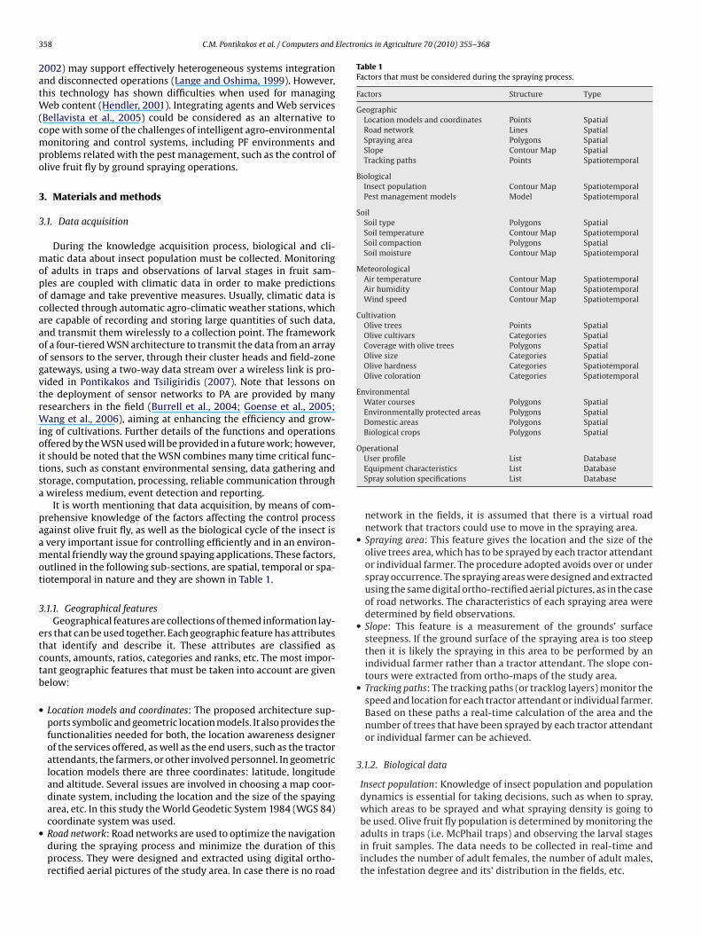
3 Electronics in Agriculture 70 (2010) 355–368
2atW(cmpo
3
3
mopocaaoogvtrWioitsa
paamot
3
etctb
•
•
Table 1Factors that must be considered during the spraying process.
Factors Structure Type
GeographicLocation models and coordinates Points SpatialRoad network Lines SpatialSpraying area Polygons SpatialSlope Contour Map SpatialTracking paths Points Spatiotemporal
BiologicalInsect population Contour Map SpatiotemporalPest management models Model Spatiotemporal
SoilSoil type Polygons SpatialSoil temperature Contour Map SpatiotemporalSoil compaction Polygons SpatialSoil moisture Contour Map Spatiotemporal
MeteorologicalAir temperature Contour Map SpatiotemporalAir humidity Contour Map SpatiotemporalWind speed Contour Map Spatiotemporal
CultivationOlive trees Points SpatialOlive cultivars Categories SpatialCoverage with olive trees Polygons SpatialOlive size Categories SpatialOlive hardness Categories SpatiotemporalOlive coloration Categories Spatiotemporal
EnvironmentalWater courses Polygons SpatialEnvironmentally protected areas Polygons SpatialDomestic areas Polygons SpatialBiological crops Polygons Spatial
Operational
58 C.M. Pontikakos et al. / Computers and
002) may support effectively heterogeneous systems integrationnd disconnected operations (Lange and Oshima, 1999). However,his technology has shown difficulties when used for managing
eb content (Hendler, 2001). Integrating agents and Web servicesBellavista et al., 2005) could be considered as an alternative toope with some of the challenges of intelligent agro-environmentalonitoring and control systems, including PF environments and
roblems related with the pest management, such as the control oflive fruit fly by ground spraying operations.
. Materials and methods
.1. Data acquisition
During the knowledge acquisition process, biological and cli-atic data about insect population must be collected. Monitoring
f adults in traps and observations of larval stages in fruit sam-les are coupled with climatic data in order to make predictionsf damage and take preventive measures. Usually, climatic data isollected through automatic agro-climatic weather stations, whichre capable of recording and storing large quantities of such data,nd transmit them wirelessly to a collection point. The frameworkf a four-tiered WSN architecture to transmit the data from an arrayf sensors to the server, through their cluster heads and field-zoneateways, using a two-way data stream over a wireless link is pro-ided in Pontikakos and Tsiligiridis (2007). Note that lessons onhe deployment of sensor networks to PA are provided by manyesearchers in the field (Burrell et al., 2004; Goense et al., 2005;
ang et al., 2006), aiming at enhancing the efficiency and grow-ng of cultivations. Further details of the functions and operationsffered by the WSN used will be provided in a future work; however,
t should be noted that the WSN combines many time critical func-ions, such as constant environmental sensing, data gathering andtorage, computation, processing, reliable communication throughwireless medium, event detection and reporting.
It is worth mentioning that data acquisition, by means of com-rehensive knowledge of the factors affecting the control processgainst olive fruit fly, as well as the biological cycle of the insect isvery important issue for controlling efficiently and in an environ-ental friendly way the ground spaying applications. These factors,
utlined in the following sub-sections, are spatial, temporal or spa-iotemporal in nature and they are shown in Table 1.
.1.1. Geographical featuresGeographical features are collections of themed information lay-
rs that can be used together. Each geographic feature has attributeshat identify and describe it. These attributes are classified asounts, amounts, ratios, categories and ranks, etc. The most impor-ant geographic features that must be taken into account are givenelow:
Location models and coordinates: The proposed architecture sup-ports symbolic and geometric location models. It also provides thefunctionalities needed for both, the location awareness designerof the services offered, as well as the end users, such as the tractorattendants, the farmers, or other involved personnel. In geometriclocation models there are three coordinates: latitude, longitudeand altitude. Several issues are involved in choosing a map coor-dinate system, including the location and the size of the spayingarea, etc. In this study the World Geodetic System 1984 (WGS 84)
coordinate system was used.Road network: Road networks are used to optimize the navigationduring the spraying process and minimize the duration of thisprocess. They were designed and extracted using digital ortho-rectified aerial pictures of the study area. In case there is no roadUser profile List DatabaseEquipment characteristics List DatabaseSpray solution specifications List Database
network in the fields, it is assumed that there is a virtual roadnetwork that tractors could use to move in the spraying area.
• Spraying area: This feature gives the location and the size of theolive trees area, which has to be sprayed by each tractor attendantor individual farmer. The procedure adopted avoids over or underspray occurrence. The spraying areas were designed and extractedusing the same digital ortho-rectified aerial pictures, as in the caseof road networks. The characteristics of each spraying area weredetermined by field observations.
• Slope: This feature is a measurement of the grounds’ surfacesteepness. If the ground surface of the spraying area is too steepthen it is likely the spraying in this area to be performed by anindividual farmer rather than a tractor attendant. The slope con-tours were extracted from ortho-maps of the study area.
• Tracking paths: The tracking paths (or tracklog layers) monitor thespeed and location for each tractor attendant or individual farmer.Based on these paths a real-time calculation of the area and thenumber of trees that have been sprayed by each tractor attendantor individual farmer can be achieved.
3.1.2. Biological data
Insect population: Knowledge of insect population and populationdynamics is essential for taking decisions, such as when to spray,which areas to be sprayed and what spraying density is going to
be used. Olive fruit fly population is determined by monitoring theadults in traps (i.e. McPhail traps) and observing the larval stagesin fruit samples. The data needs to be collected in real-time andincludes the number of adult females, the number of adult males,the infestation degree and its’ distribution in the fields, etc.
Electro
3
Tniot
3
3
3
dlaa
3
aep
prises of four modules; the Communication (Com) module, the LAmodule, the GIS module, and finally, the ES module. Since thesemodules are independent of each other new modules may be addedor existing ones may be modified easily, facilitating the expansion,the improvement and the usage of the proposed architecture.
C.M. Pontikakos et al. / Computers and
Pest management models: Pest management models for olive fruitfly are based on relations between climate conditions, insect pop-ulation, yield loss or damage and economic parameters. On a pestmanagement system Kapatos and Fletcher (1983) have used eco-logical criteria to model the olive fruit fly population dynamics.
.1.3. Soil dataOlive fruit fly is possible to complete its pupal stage in the soil.
herefore, knowledge of pupation depth of the olive fruit fly inature is an important factor to determine the degree of infestation
n an area. Four abiotic factors influence the pupation depth of thelive fruit fly. These factors are the soil type, the soil temperature,he compaction and the soil moisture.
.1.4. Meteorological data
Air temperature: According to Kapatos and Fletcher (1986) the olivefruit fly survives best in cooler coastal climate, but is also foundin hot, dry regions. Temperature relationships and developmentalthresholds for olive fruit fly are given in Rice (2000). The optimumtemperature for the insect development is between 20 and 30 ◦C.High temperatures (35 ◦C or more) are detrimental to adult fliesand to maggots in the fruit. The adult activity is approximately at15.5 ◦C. High temperatures in the range 38–41 ◦C are detrimentalto adult flies and to immature stages in fruit. The air temperatureduring the spraying process must be between 12 and 28 ◦C. Thedevelopmental temperature thresholds are different among thebiological stages (egg, larva, pupa and adult) of the insect.Air humidity: Olive fruit flies survive best in more humid climates.Also, they infest fruits in olive trees that are grown in dry regions.Wind speed: The air speed during the spraying process must beless than 8 m/s. High air wind speed inhibits the insect flights. Asa result the olive fruit flies are not fed by the sprayed solution andsurvive.
.1.5. Cultivation data
Olive cultivars susceptibility: According to Neuenschwander et al.(1985) there is a range of susceptibility among different olive cul-tivars. The size of olives is considered as one of the most importantfactors. There is a positive correlation between infestation levelsand olive sizes. As a result, infestation is higher in large olive sidedcultivars than one bearing small olives. Olive hardness is anotherimportant factor determining the infestation levels. There is a neg-ative correlation between infestation and hardness. When olivesreach their final sizes they become softer. The olive colorationseems to play a role in infestation. For example, green olives aremore susceptible than brown ones.Coverage with olive trees: The coverage density of the olive treesin the spraying area is important for the determination of thedistribution of the sprayed solution.
.1.6. Environmental dataThe knowledge of the exact location of water courses, of the
omestic or environmentally protected areas, as well as of the bio-ogical crops areas is very important in order to determine theppropriate buffer zones between the sprayed and non-sprayed
reas..1.7. Operational dataOperational data includes user profile, specific equipment char-
cteristics (size and power of the tractor, sprayer’s specifications,tc.) and spray solution specifications (dosage, method of usage,recautions, etc.).
nics in Agriculture 70 (2010) 355–368 359
3.2. System architecture
This section presents the architecture of the developed LAS,which utilizes software agent technology as well as Web-services,and integrates GIS, ES and multimedia technology in order todevelop and implement ground spraying control services for olivefruit fly. The LAS is able to gather data in a systematic way andmaking it available for in-depth analysis in order to identify andreport the current environmental conditions, as well as to foreseeand warn about potential problems. For this, a number of softwareagents are developed and included in the LAS so as; to invoke auto-matically the appropriate Web services, to manage offline tasks,such as preparing and converting the data that are going to be sentto the server, to monitor the spraying actions, such as when andwhere a spraying occurs, to manage multimedia content, i.e. exe-cute voice actions for a decision of the ES or present an image to thedevice screen, and finally to synchronize the LAS components func-tions. Note that agents (Gervais et al., 2004) and XML Web services(W3C, 2008) can assist users (farmers and the involved personnel)in a range of different ways; they hide the complexity of difficulttasks, they perform tasks on the users’ behalf, they can train or teachthe user, they help different users to collaborate, and they monitorevents and procedures.
The developed Web services of the LAS are used so as:
• To provide authentication–authorization.• To download the appropriate software agents and multimedia
content (digital images, voice commands, etc.) to the user device(Pocket PC).
• To update the meteorological data, the user interface, the GIS data,the ES and the Knowledge Base (KB) of the ES, etc., to the client.
• To send the supervisors’ messages to the Pocket PC.• To send the data about the spraying process, such as track paths,
spraying points, etc., to the server.• To upload multimedia content, such as images from the Pocket
PC camera, to the server.• To decide whether a plot was sprayed efficiently.
The proposed system architecture is shown in Fig. 1. It com-
Fig. 1. System architecture.
3 Electronics in Agriculture 70 (2010) 355–368
msTpieootaos
3
abmtotiAwCl
3
ctmippsimoFG
3
ifdcotwleiim
3
ooE
I
Table 2Decisions, explanations and the used data of the ES.
Decision Explanations Data
Spray with density “X” Infestation levels are high Geographic, soil,meteorological
Infestation levels are low CultivationHigh infestation riskLow infestation riskOlive cultivarsusceptibility is highOlive cultivarsusceptibility is low
Do not spray Temperature is too low Soil, meteorological,geographic
Humidity is lowThis area is not yourspraying area
Go to the next plot The area has beenalready sprayed
Geographic, Operational
Abort spraying process Temperature is too high Meteorological
60 C.M. Pontikakos et al. / Computers and
The architecture supports symbolic and geometric locationodels with location awareness commands, which are respon-
ible for the management of the functionalities of the system.he system provides an agent interface that facilitates the com-osition, by sending and receiving messages between agents. It
nvolves the designer of the KB, the GIS experts, and finally thend users, namely, the tractor attendants, the farmers and thether personnel involved. The developed system offers a numberf characteristics, such as: temporal continuity, reactivity, cogni-ion, presence of agents, collaborative behaviour, mobility, locationnd authentication, dynamic architecture, infrastructure for devel-ping autonomous agents, integration of agents and Web services,upport for interoperability and spatiotemporal optimization.
.2.1.1. The Com moduleThe Com module consists of different types of mobile agents in
ccordance with their functionalities, as for example, the network-ased operations, the sensors’ hardware, the data acquisitionechanisms, etc. It receives the required sensing data captured by
he sensor acquisition devices, and performs network processing inrder to facilitate query dissemination. The network operations ofhe Com module are distributed into four layers, each one of whichs controlled by some appropriate task oriented mobile agents.gents in each layer perform their assigned tasks by collaboratingith agents of the same layer or with agents of the other layers of the
om module and transmit the processed data to their destinationayer.
.2.1.2. The LA moduleThe LA module coordinates all modules of the proposed appli-
ation. It is responsible for the input of the objects’ location intohe system, the transformation of the position coordinates of the
oving objects, the management of the information and the track-ng layers of the GIS module described below. It combines the datarovided with the location data of the objects, as well as the datarovided by other components and the communication with theerver, the moving clients and the graphical user interface. Also, its responsible for the management of the tasks and the events that
ust be executed during the spraying process and the managementf the multimedia content (images, sound, video and hypermedia).inally, it presents the created services to the end user in a friendlyraphical User Interface (GUI) form.
.2.1.3. The GIS moduleThe GIS module implements processes, such as navigation, rout-
ng, geo-coding, map representation, searching, etc. It is responsibleor the management of the spatial and ancillary data. The spatialata is stored locally and can be updated using some appropriateommands. It is presented in the information layers, the numberf which depends on the service and type features of the applica-ion. An information layer of a special type is the tracking layer,hich stores the position of the moving objects in real-time. Ancil-
ary data is the attributes of the spatial objects (points, polygons,tc.), the users’ profile and actions, the system parameters, the sens-ng data, etc. The interactivity of the GIS functionality is achieved bynvoking some appropriate commands (e.g. data updating, system
anagement, browsing, multimedia management, etc.).
.2.1.4. The ES moduleThe internal representation of the knowledge base contains a list
f possible decisions, a list of conditions and a list of rules. The KBf the ES consists of a set of rules encoding the domain expertise.ach rule is an expression of the form:
F 〈conditions〉 THEN 〈actions〉
Wind is too high
Turn left/right Distance from a previousposition is too small
Geographic
where if the conditions are true then the actions are executed.Actions could be a set of commands or decisions that send a con-clusion to the working memory (i.e., spray = abort), display into thescreen a user notification (i.e., abort spraying) or an image, or playmultimedia content, such as sound and video. Finally, the Inferenceengine of the ES supports forward chaining (or data-driven) mecha-nisms. A list of the main decisions of the proposed system is shownin Table 2.
3.3. Experimental study
A moderate-scale experiment was conducted in order to evalu-ate the proposed system. The experiment was carried out betweenJuly and October of 2008 in the municipality of Monemvasia in theLaconia province (South-East Peloponnesus) of Greece (Fig. 2). Therandomized complete block experimental design was used. Threeregions, the villages Agios Nikolaos, Nomia and Talanta with olivetree cultivations were selected. Each region was divided in sections,and three neighboring sections were selected. Every section is morethan 0.3 km2 and has about 3000 olive trees. All sections are dividedin plots with different geographical (slope, ground, etc.) and culti-vation characteristics (cultivation density, cultivation variety, etc.).Each section was assigned to be sprayed by one tractor. The trac-tor attendants had sprayed their section at least once in the past.The first spray application in each section is the reference sprayapplication. For comparison reasons in this first spray the atten-dant was not allowed to use the system, even though the tractorwas tracked by it. In the next spray application of the same sectionthe attendant consults the system in order to spray. The server ofthe system was located in the InfoLab of the Agricultural Univer-sity of Athens, approximately 160 km away from the study area.Microsoft Windows Server 2003 was used as server’s operatingsystem. The data on the server was come from the stuff respon-sible for the measurements of the insect population, the Pocket PCdevices of the tractor attendants, the scientists in charge, such aspest management experts, GIS experts, etc., the meteorological sta-tion that was established near by the area of the experiment andthe farmers.
3.3.1. Monitoring the olive fruit fly populationThe ground spraying operations for the olive fruit fly control are
focused on the reduction of the adult population as it is the onlystage of the life cycle that the insect is exposed. In order to monitor
C.M. Pontikakos et al. / Computers and Electronics in Agriculture 70 (2010) 355–368 361
tttpnrsut
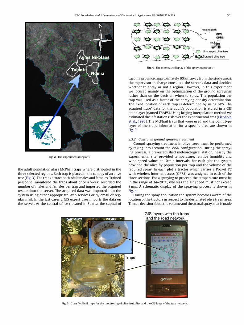
8 m/s. A schematic display of the spraying process is shown in
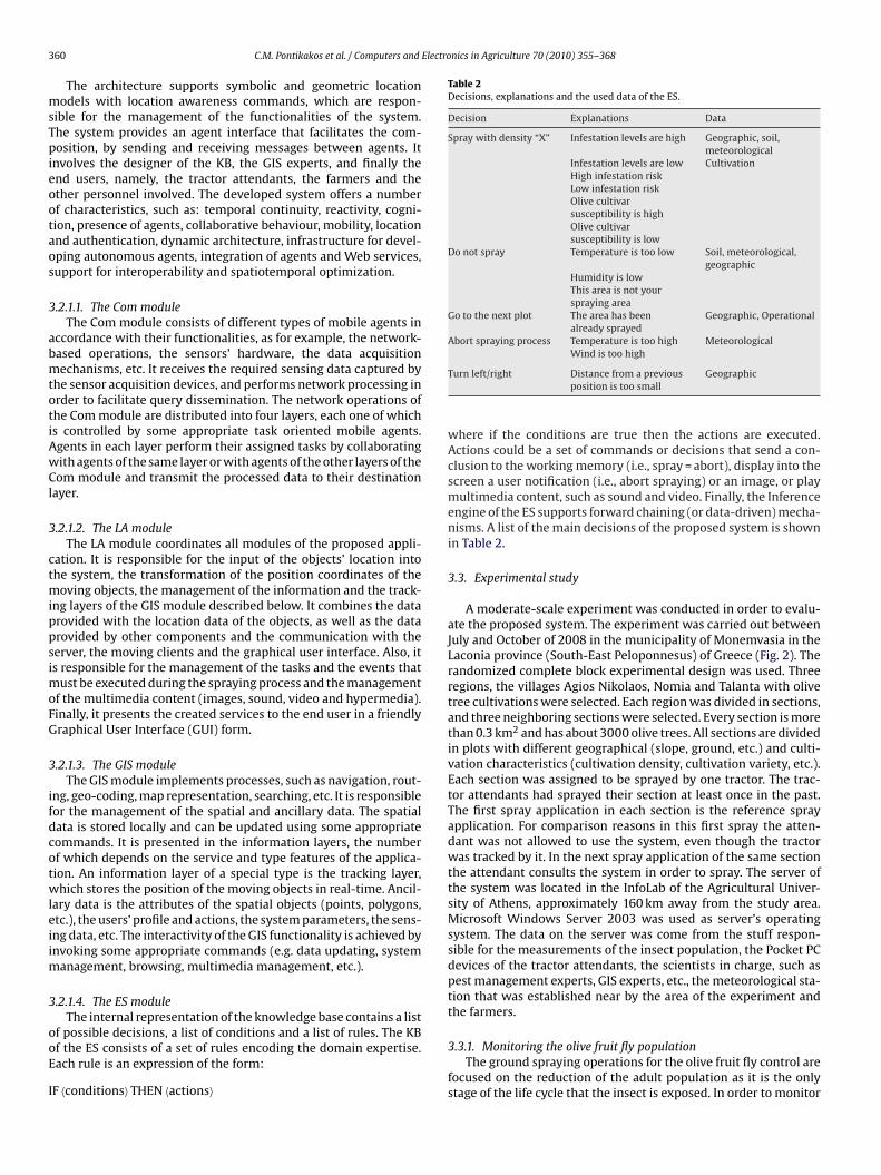
Fig. 2. The experimental regions.
he adult population glass McPhail traps where distributed in thehree selected regions. Each trap is placed in the canopy of an oliveree (Fig. 3). The traps attract both adult males and females. Trainedersonnel monitored the traps about once a week, recorded theumber of males and females per trap and imported the acquired
esults into the server. The acquired data was imported into theystem using either appropriate Web services or by email or reg-lar mail. In the last cases a GIS expert user imports the data onhe server. At the central office (located in Sparta, the capital ofFig. 3. Glass McPhail traps for the monitoring of olive
Fig. 4. The schematic display of the spraying process.
Laconia province, approximately 60 km away from the study area),the supervisor in charge consulted the server’s data and decidedwhether to spray or not a region. However, in this experimentwe focused mainly on the optimization of the ground sprayingsrather than on the decision when to spray. The population pertrap was used as a factor of the spraying density determination.The fixed location of each trap is determined by using GPS. Theacquired traps’ data for the adult’s population is stored in a GISpoint layer (named TRAPS). Using kriging interpolation method weestimated the infestation risk over the experimental area (Liebholdet al., 1993). The McPhail traps that were used and the point typelayer of the traps information for a specific area are shown inFig. 3.
3.3.2. Control in ground spraying treatmentGround spraying treatment in olive trees must be performed
by taking into account the WSN configuration. During the spray-ing process, a pre-established meteorological station, nearby theexperimental site, provided temperature, relative humidity andwind speed values at 10 min intervals. For each plot the systemprovided the olive fly population per trap and the volume of therequired spray. In each plot a tractor which carries a Pocket PCwith wireless Internet access (GPRS) was assigned in each of thethree sections. For a spraying to proceed the temperature must bein the range of 14–28 ◦C, whereas the air speed must not exceed
Fig. 4.During the spray application the system becomes aware of the
location of the tractors in respect to the designated olive trees’ area.Then, a decision about the volume and the actual spray area is made
fruit flies and the GIS layer of the trap network.
362 C.M. Pontikakos et al. / Computers and Electro
aarebtitittaaaoit
stsTctdtiiefsp
IL
E
E
pt
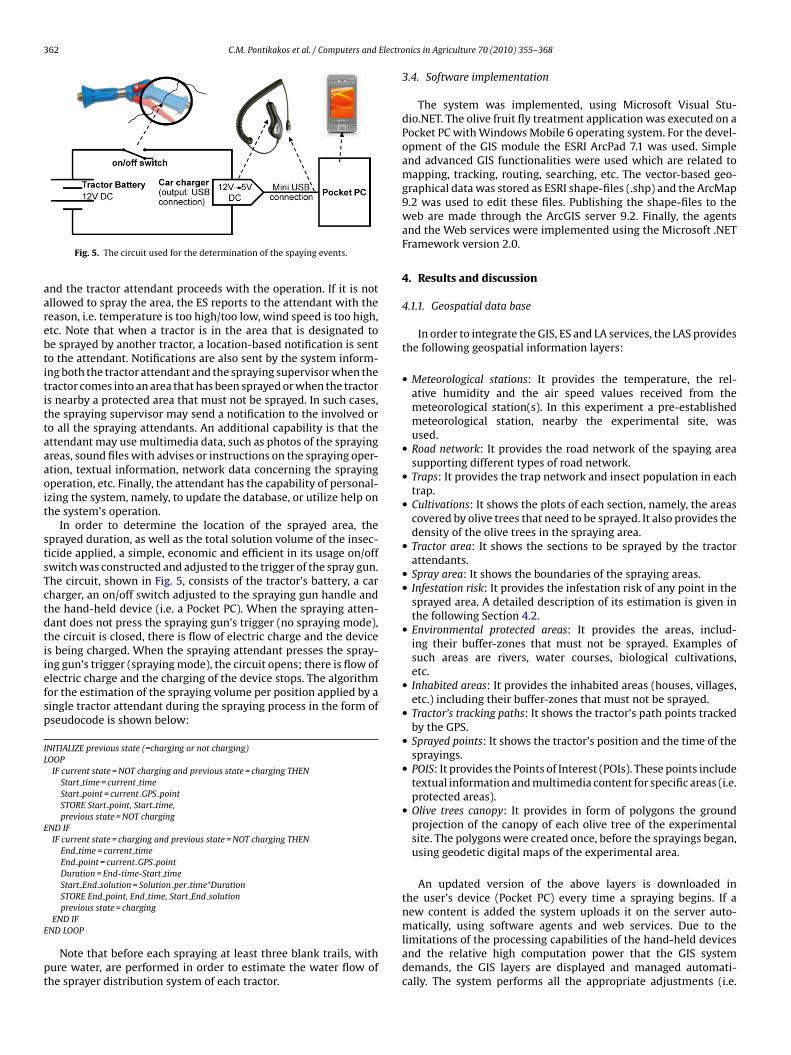
Fig. 5. The circuit used for the determination of the spaying events.
nd the tractor attendant proceeds with the operation. If it is notllowed to spray the area, the ES reports to the attendant with theeason, i.e. temperature is too high/too low, wind speed is too high,tc. Note that when a tractor is in the area that is designated toe sprayed by another tractor, a location-based notification is sento the attendant. Notifications are also sent by the system inform-ng both the tractor attendant and the spraying supervisor when theractor comes into an area that has been sprayed or when the tractors nearby a protected area that must not be sprayed. In such cases,he spraying supervisor may send a notification to the involved oro all the spraying attendants. An additional capability is that thettendant may use multimedia data, such as photos of the sprayingreas, sound files with advises or instructions on the spraying oper-tion, textual information, network data concerning the sprayingperation, etc. Finally, the attendant has the capability of personal-
zing the system, namely, to update the database, or utilize help onhe system’s operation.
In order to determine the location of the sprayed area, theprayed duration, as well as the total solution volume of the insec-icide applied, a simple, economic and efficient in its usage on/offwitch was constructed and adjusted to the trigger of the spray gun.he circuit, shown in Fig. 5, consists of the tractor’s battery, a carharger, an on/off switch adjusted to the spraying gun handle andhe hand-held device (i.e. a Pocket PC). When the spraying atten-ant does not press the spraying gun’s trigger (no spraying mode),he circuit is closed, there is flow of electric charge and the devices being charged. When the spraying attendant presses the spray-ng gun’s trigger (spraying mode), the circuit opens; there is flow oflectric charge and the charging of the device stops. The algorithmor the estimation of the spraying volume per position applied by aingle tractor attendant during the spraying process in the form ofseudocode is shown below:
NITIALIZE previous state (=charging or not charging)OOP
IF current state = NOT charging and previous state = charging THENStart time = current timeStart point = current GPS pointSTORE Start point, Start time,previous state = NOT charging
ND IFIF current state = charging and previous state = NOT charging THEN
End time = current timeEnd point = current GPS pointDuration = End-time-Start timeStart End solution = Solution per time*DurationSTORE End point, End time, Start End solutionprevious state = charging
END IF
ND LOOPNote that before each spraying at least three blank trails, withure water, are performed in order to estimate the water flow ofhe sprayer distribution system of each tractor.
nics in Agriculture 70 (2010) 355–368
3.4. Software implementation
The system was implemented, using Microsoft Visual Stu-dio.NET. The olive fruit fly treatment application was executed on aPocket PC with Windows Mobile 6 operating system. For the devel-opment of the GIS module the ESRI ArcPad 7.1 was used. Simpleand advanced GIS functionalities were used which are related tomapping, tracking, routing, searching, etc. The vector-based geo-graphical data was stored as ESRI shape-files (.shp) and the ArcMap9.2 was used to edit these files. Publishing the shape-files to theweb are made through the ArcGIS server 9.2. Finally, the agentsand the Web services were implemented using the Microsoft .NETFramework version 2.0.
4. Results and discussion
4.1.1. Geospatial data base
In order to integrate the GIS, ES and LA services, the LAS providesthe following geospatial information layers:
• Meteorological stations: It provides the temperature, the rel-ative humidity and the air speed values received from themeteorological station(s). In this experiment a pre-establishedmeteorological station, nearby the experimental site, wasused.
• Road network: It provides the road network of the spaying areasupporting different types of road network.
• Traps: It provides the trap network and insect population in eachtrap.
• Cultivations: It shows the plots of each section, namely, the areascovered by olive trees that need to be sprayed. It also provides thedensity of the olive trees in the spraying area.
• Tractor area: It shows the sections to be sprayed by the tractorattendants.
• Spray area: It shows the boundaries of the spraying areas.• Infestation risk: It provides the infestation risk of any point in the
sprayed area. A detailed description of its estimation is given inthe following Section 4.2.
• Environmental protected areas: It provides the areas, includ-ing their buffer-zones that must not be sprayed. Examples ofsuch areas are rivers, water courses, biological cultivations,etc.
• Inhabited areas: It provides the inhabited areas (houses, villages,etc.) including their buffer-zones that must not be sprayed.
• Tractor’s tracking paths: It shows the tractor’s path points trackedby the GPS.
• Sprayed points: It shows the tractor’s position and the time of thesprayings.
• POIS: It provides the Points of Interest (POIs). These points includetextual information and multimedia content for specific areas (i.e.protected areas).
• Olive trees canopy: It provides in form of polygons the groundprojection of the canopy of each olive tree of the experimentalsite. The polygons were created once, before the sprayings began,using geodetic digital maps of the experimental area.
An updated version of the above layers is downloaded inthe user’s device (Pocket PC) every time a spraying begins. If anew content is added the system uploads it on the server auto-
matically, using software agents and web services. Due to thelimitations of the processing capabilities of the hand-held devicesand the relative high computation power that the GIS systemdemands, the GIS layers are displayed and managed automati-cally. The system performs all the appropriate adjustments (i.e.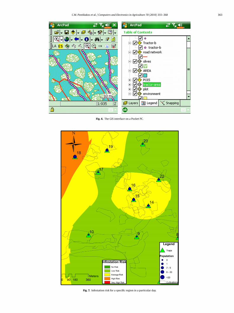
C.M. Pontikakos et al. / Computers and Electronics in Agriculture 70 (2010) 355–368 363
Fig. 6. The GIS interface on a Pocket PC.
Fig. 7. Infestation risk for a specific region in a particular day.
364 C.M. Pontikakos et al. / Computers and Electronics in Agriculture 70 (2010) 355–368
decisi
nuotdddi
Fig. 8. The
avigation, map scale, zoom in, zoom out, etc.) including datapdating. Thus, the GIS layer is displayed in the device screennly when it is necessary, i.e., it gives significant information to
he user. The same approach is used in the communication of theevice with the server. For example, the data that is not altereduring the spraying process is uploaded on the server or it isownloaded on the device less frequently. Fig. 6 shows the GISnterface.
on process.
4.2. Modeling the infestation risk
The decision about spraying in a specific region is based on a
number of criteria, concerning the trapped population, namely, thepopulation of olive fruit flies should be increased, the female tomale insect ratio should be greater than one, and the number of theflies’ population should exceed a threshold (more than 5 flies pertrap).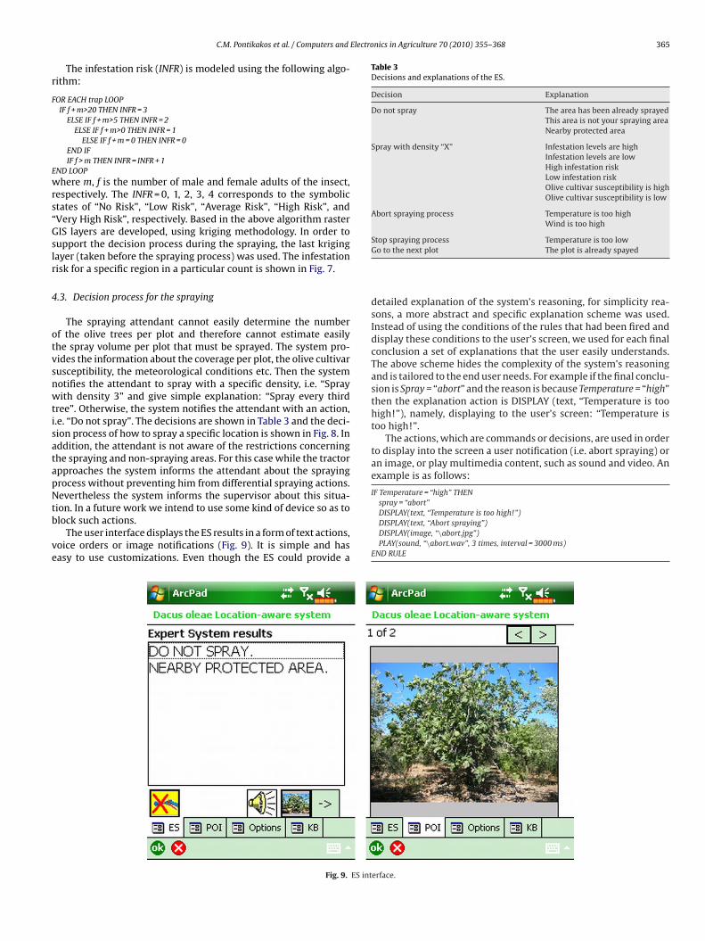
Electronics in Agriculture 70 (2010) 355–368 365
r
F
E
wrs“Gslr
4
otvsnwtisatapNtb
ve
Table 3Decisions and explanations of the ES.
Decision Explanation
Do not spray The area has been already sprayedThis area is not your spraying areaNearby protected area
Spray with density “X” Infestation levels are highInfestation levels are lowHigh infestation riskLow infestation riskOlive cultivar susceptibility is highOlive cultivar susceptibility is low
Abort spraying process Temperature is too highWind is too high
C.M. Pontikakos et al. / Computers and
The infestation risk (INFR) is modeled using the following algo-ithm:
OR EACH trap LOOPIF f + m>20 THEN INFR = 3
ELSE IF f + m>5 THEN INFR = 2ELSE IF f + m>0 THEN INFR = 1
ELSE IF f + m = 0 THEN INFR = 0END IFIF f > m THEN INFR = INFR + 1
ND LOOP
here m, f is the number of male and female adults of the insect,espectively. The INFR = 0, 1, 2, 3, 4 corresponds to the symbolictates of “No Risk”, “Low Risk”, “Average Risk”, “High Risk”, andVery High Risk”, respectively. Based in the above algorithm rasterIS layers are developed, using kriging methodology. In order to
upport the decision process during the spraying, the last krigingayer (taken before the spraying process) was used. The infestationisk for a specific region in a particular count is shown in Fig. 7.
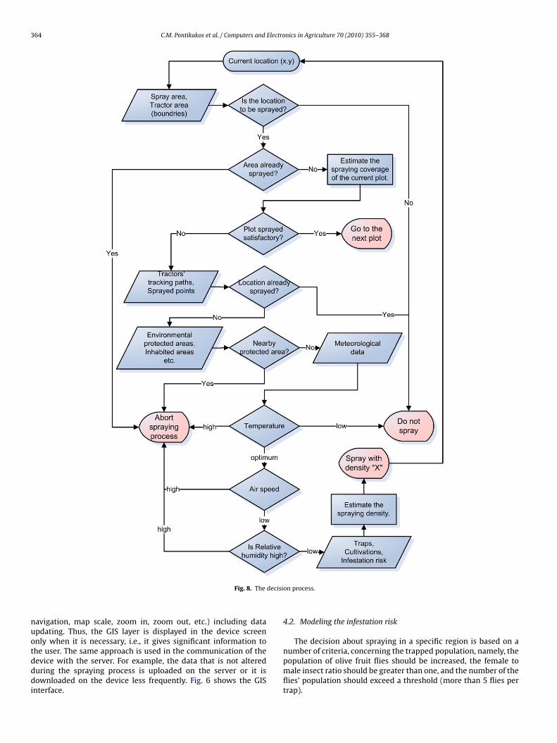
.3. Decision process for the spraying
The spraying attendant cannot easily determine the numberf the olive trees per plot and therefore cannot estimate easilyhe spray volume per plot that must be sprayed. The system pro-ides the information about the coverage per plot, the olive cultivarusceptibility, the meteorological conditions etc. Then the systemotifies the attendant to spray with a specific density, i.e. “Sprayith density 3” and give simple explanation: “Spray every third
ree”. Otherwise, the system notifies the attendant with an action,.e. “Do not spray”. The decisions are shown in Table 3 and the deci-ion process of how to spray a specific location is shown in Fig. 8. Inddition, the attendant is not aware of the restrictions concerninghe spraying and non-spraying areas. For this case while the tractorpproaches the system informs the attendant about the sprayingrocess without preventing him from differential spraying actions.evertheless the system informs the supervisor about this situa-
ion. In a future work we intend to use some kind of device so as tolock such actions.
The user interface displays the ES results in a form of text actions,oice orders or image notifications (Fig. 9). It is simple and hasasy to use customizations. Even though the ES could provide a
Fig. 9. ES int
Stop spraying process Temperature is too lowGo to the next plot The plot is already spayed
detailed explanation of the system’s reasoning, for simplicity rea-sons, a more abstract and specific explanation scheme was used.Instead of using the conditions of the rules that had been fired anddisplay these conditions to the user’s screen, we used for each finalconclusion a set of explanations that the user easily understands.The above scheme hides the complexity of the system’s reasoningand is tailored to the end user needs. For example if the final conclu-sion is Spray = “abort” and the reason is because Temperature = “high”then the explanation action is DISPLAY (text, “Temperature is toohigh!”), namely, displaying to the user’s screen: “Temperature istoo high!”.
The actions, which are commands or decisions, are used in orderto display into the screen a user notification (i.e. abort spraying) oran image, or play multimedia content, such as sound and video. Anexample is as follows:
IF Temperature = “high” THENspray = “abort”
DISPLAY(text, “Temperature is too high!”)DISPLAY(text, “Abort spraying”)DISPLAY(image, “\abort.jpg”)PLAY(sound, “\abort.wav”, 3 times, interval = 3000 ms)END RULE
erface.
366 C.M. Pontikakos et al. / Computers and Electronics in Agriculture 70 (2010) 355–368
tapirtttirp
sbliscTttotoodsIufc
4
rmtaaico
double spraying occurred, while in cases without LAS several oversprayings were noted. In addition, without LAS some biological cul-tivations were sprayed while with LAS no such an issue occurred.Furthermore, without LAS sprayings occurred nearby domestic or
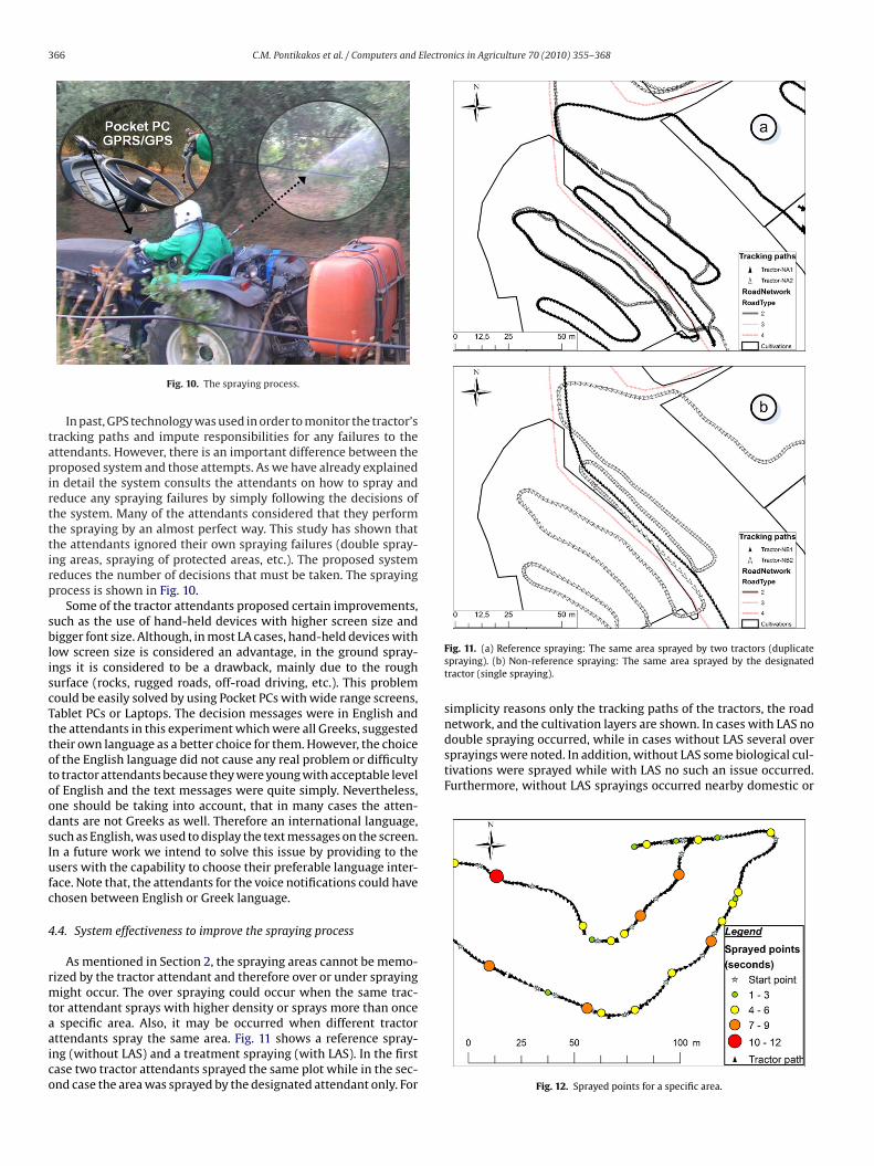
Fig. 10. The spraying process.
In past, GPS technology was used in order to monitor the tractor’sracking paths and impute responsibilities for any failures to thettendants. However, there is an important difference between theroposed system and those attempts. As we have already explained
n detail the system consults the attendants on how to spray andeduce any spraying failures by simply following the decisions ofhe system. Many of the attendants considered that they performhe spraying by an almost perfect way. This study has shown thathe attendants ignored their own spraying failures (double spray-ng areas, spraying of protected areas, etc.). The proposed systemeduces the number of decisions that must be taken. The sprayingrocess is shown in Fig. 10.
Some of the tractor attendants proposed certain improvements,uch as the use of hand-held devices with higher screen size andigger font size. Although, in most LA cases, hand-held devices with
ow screen size is considered an advantage, in the ground spray-ngs it is considered to be a drawback, mainly due to the roughurface (rocks, rugged roads, off-road driving, etc.). This problemould be easily solved by using Pocket PCs with wide range screens,ablet PCs or Laptops. The decision messages were in English andhe attendants in this experiment which were all Greeks, suggestedheir own language as a better choice for them. However, the choicef the English language did not cause any real problem or difficultyo tractor attendants because they were young with acceptable levelf English and the text messages were quite simply. Nevertheless,ne should be taking into account, that in many cases the atten-ants are not Greeks as well. Therefore an international language,uch as English, was used to display the text messages on the screen.n a future work we intend to solve this issue by providing to thesers with the capability to choose their preferable language inter-
ace. Note that, the attendants for the voice notifications could havehosen between English or Greek language.
.4. System effectiveness to improve the spraying process
As mentioned in Section 2, the spraying areas cannot be memo-ized by the tractor attendant and therefore over or under spraying
ight occur. The over spraying could occur when the same trac-or attendant sprays with higher density or sprays more than once
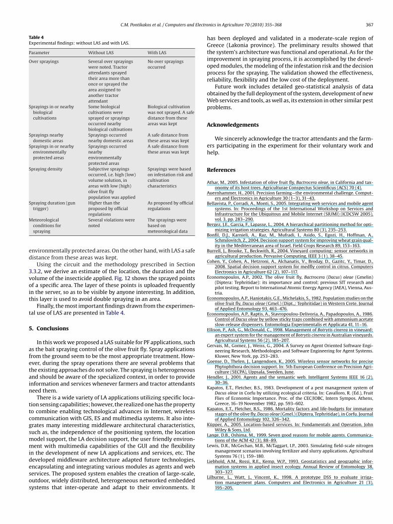
specific area. Also, it may be occurred when different tractorttendants spray the same area. Fig. 11 shows a reference spray-ng (without LAS) and a treatment spraying (with LAS). In the firstase two tractor attendants sprayed the same plot while in the sec-nd case the area was sprayed by the designated attendant only. For
Fig. 11. (a) Reference spraying: The same area sprayed by two tractors (duplicatespraying). (b) Non-reference spraying: The same area sprayed by the designatedtractor (single spraying).
simplicity reasons only the tracking paths of the tractors, the roadnetwork, and the cultivation layers are shown. In cases with LAS no
Fig. 12. Sprayed points for a specific area.
C.M. Pontikakos et al. / Computers and Electro
Table 4Experimental findings: without LAS and with LAS.
Parameter Without LAS With LAS
Over sprayings Several over sprayingswere noted. Tractorattendants sprayedtheir area more thanonce or sprayed thearea assigned toanother tractorattendant
No over sprayingsoccurred
Sprayings in or nearbybiologicalcultivations
Some biologicalcultivations weresprayed or sprayingsoccurred nearbybiological cultivations
Biological cultivationwas not sprayed. A safedistance from theseareas was kept
Sprayings nearbydomestic areas
Sprayings occurrednearby domestic areas
A safe distance fromthese areas was kept
Sprayings in or nearbyenvironmentallyprotected areas
Sprayings occurrednearbyenvironmentallyprotected areas
A safe distance fromthese areas was kept
Spraying density Subjective sprayingsoccurred, i.e. high (low)volume solution, inareas with low (high)olive fruit flypopulation was applied
Sprayings were basedon infestation risk andcultivationcharacteristics
Spraying duration (guntrigger)
Higher than theproposed by officialregulations
As proposed by officialregulations
M
ed
3voit
t
5
afetain
ttcgsmmidesos
eteorologicalconditions forspraying
Several violations werenoted
The sprayings werebased onmeteorological data
nvironmentally protected areas. On the other hand, with LAS a safeistance from these areas was kept.
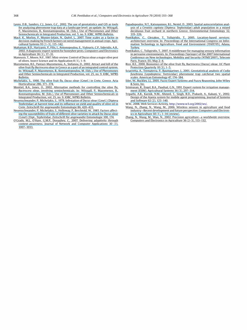
Using the circuit and the methodology prescribed in Section.3.2, we derive an estimate of the location, the duration and theolume of the insecticide applied. Fig. 12 shows the sprayed pointsf a specific area. The layer of these points is uploaded frequently
n the server, so as to be visible by anyone interesting. In addition,his layer is used to avoid double spraying in an area.
Finally, the most important findings drawn from the experimen-al use of LAS are presented in Table 4.
. Conclusions
In this work we proposed a LAS suitable for PF applications, suchs the bait spraying control of the olive fruit fly. Spray applicationsrom the ground seem to be the most appropriate treatment. How-ver, during the spray operations there are several problems thathe existing approaches do not solve. The spraying is heterogeneousnd should be aware of the specialized context, in order to providenformation and services whenever farmers and tractor attendantseed them.
There is a wide variety of LA applications utilizing specific loca-ion sensing capabilities; however, the realized one has the propertyo combine enabling technological advances in Internet, wirelessommunication with GIS, ES and multimedia systems. It also inte-rates many interesting middleware architectural characteristics,uch as, the independence of the positioning system, the locationodel support, the LA decision support, the user friendly environ-ent with multimedia capabilities of the GUI and the flexibility
n the development of new LA applications and services, etc. The
eveloped middleware architecture adapted future technologies,ncapsulating and integrating various modules as agents and webervices. The proposed system enables the creation of large-scale,utdoor, widely distributed, heterogeneous networked embeddedystems that inter-operate and adapt to their environments. Itnics in Agriculture 70 (2010) 355–368 367
has been deployed and validated in a moderate-scale region ofGreece (Lakonia province). The preliminary results showed thatthe system’s architecture was functional and operational. As for theimprovement in spraying process, it is accomplished by the devel-oped modules, the modeling of the infestation risk and the decisionprocess for the spraying. The validation showed the effectiveness,reliability, flexibility and the low cost of the deployment.
Future work includes detailed geo-statistical analysis of dataobtained by the full deployment of the system, development of newWeb services and tools, as well as, its extension in other similar pestproblems.
Acknowledgements
We sincerely acknowledge the tractor attendants and the farm-ers participating in the experiment for their voluntary work andhelp.
References
Athar, M., 2005. Infestation of olive fruit fly, Bactrocera oleae, in California and tax-onomy of its host trees. Agriculturae Conspectus Scientificus (ACS) 70 (4).
Auernhammer, H., 2001. Precision farming—the environmental challenge. Comput-ers and Electronics in Agriculture 30 (1–3), 31–43.
Bellavista, P., Corradi, A., Monti, S., 2005. Integrating web services and mobile agentsystems. In: Proceedings of the 1st International Workshop on Services andInfrastructure for the Ubiquitous and Mobile Internet (SIUMI) (ICDCSW 2005),vol. 3, pp. 283–290.
Bergez, J.E., Garcia, F., Lapasse, L., 2004. A hierarchical partitioning method for opti-mizing irrigation strategies. Agricultural Systems 80 (3), 235–253.
Bonfil, D.J., Karnieli, A., Raz, M., Mufradi, I., Asido, S., Egozi, H., Hoffman, A.,Schmilovitch, Z., 2004. Decision support system for improving wheat grain qual-ity in the Mediterranean area of Israel. Field Crops Research 89, 153–163.
Burrell, J., Brooke, T., Beckwith, R., 2004. Vineyard computing: sensor networks inagricultural production. Pervasive Computing, IEEE 3 (1), 38–45.
Cohen, Y., Cohen, A., Hetzroni, A., Alchanatis, V., Broday, D., Gazitc, Y., Timar, D.,2008. Spatial decision support system for medfly control in citrus. ComputersElectronics in Agriculture 62 (2), 107–117.
Economopoulos, A.P., 2002. The olive fruit fly, Bactrocera (Dacus) oleae (Gmelin)(Diptera: Tephritidae): its importance and control; previous SIT research andpilot testing. Report to International Atomic Energy Agency (IAEA), Vienna, Aus-tria.
Economopoulos, A.P., Haniotakis, G.E., Michelakis, S., 1982. Population studies on theolive fruit fly, Dacus oleae (Gmel.) (Dipt.,: Tephritidae) in Western Crete. Journalof Applied Entomology 93, 463–476.
Economopoulos, A.P., Raptis, A., Stavropoulou-Delivoria, A., Papadopoulos, A., 1986.Control of Dacus oleae by yellow sticky traps combined with ammonium acetateslow-release dispensers. Entomologia Experimentalis et Applicata 41, 11–16.
Ellison, P., Ash, G., McDonald, C., 1998. Management of Botrytis cinerea in vineyard:an expert system for the management of Botrytis cinerea in Australian vineyards.Agricultural Systems 56 (2), 185–207.
Gervais, M., Gomez, J., Weiss, G., 2004. A Survey on Agent Oriented Software Engi-neering Research, Methodologies and Software Engineering for Agent Systems.Kluwer, New York, pp. 253–283.
Goense, D., Thelen, J., Langendoen, K., 2005. Wireless sensor networks for precisePhytophthora decision support. In: 5th European Conference on Precision Agri-culture (5ECPA), Uppsala, Sweden, June.
Hendler, J., 2001. Agents and the semantic web. Intelligent Systems IEEE 16 (2),30–36.
Kapatos, E.T., Fletcher, B.S., 1983. Development of a pest management system ofDacus oleae in Corfu by utilizing ecological criteria. In: Cavalloro, R. (Ed.), FruitFlies of Economic Importance. Proc. of the CEC/IOBC, Intern Sympos. Athens,Greece, 16–19 November 1982, pp. 593–602.
Kapatos, E.T., Fletcher, B.S., 1986. Mortality factors and life-budgets for immaturestages of the olive fly, Dacus oleae (Gmel.) (Diptera, Tephritidae), in Corfu. Journalof Applied Entomology 102, 326–342.
Küpper, A., 2005. Location-based services. In: Fundamentals and Operation. JohnWiley & Sons, Ltd.
Lange, D.B., Oshima, M., 1999. Seven good reasons for mobile agents. Communica-tions of the ACM 42 (3), 88–89.
Lewis, D.R., McGechan, M.B., McTaggart, I.P., 2003. Simulating field-scale nitrogenmanagement scenarios involving fertilizer and slurry applications. AgriculturalSystems 76 (1), 159–180.
Liebhold, A.M., Rossi, R.E., Kemp, W.P., 1993. Geostatistics and geographic infor-mation systems in applied insect ecology. Annual Review of Entomology 38,303–327.
Lilburne, L., Watt, J., Vincent, K., 1998. A prototype DSS to evaluate irriga-tion management plans. Computers and Electronics in Agriculture 21 (3),195–205.
3 Electro
L
M
M
M
M
M
M
N
N
O
W3C, 2008. Web Services Activity, http://www.w3.org/2002/ws/.Wang, N., Zhang, N., Wang, M., 2006. Wireless sensors in agriculture and food
68 C.M. Pontikakos et al. / Computers and
yons, D.B., Sanders, C.J., Jones, G.C., 2002. The use of geostatistics and GIS as toolsfor analyzing pheromone trap data at a landscape level: an update. In: Witzgall,P., Mazomenos, B., Konstantopoulou, M. (Eds.), Use of Pheromones and OtherSemiochemicals in Integrated Production, vol. 5, no. 9. IOBC, WPRS Bulletin.
acé, K., Morlon, P., Munier-Jolain, N., Quéré, L., 2007. Time scales as a factor indecision-making by French farmers on weed management in annual crops. Agri-cultural Systems 93 (1–3), 115–142.
ahaman, B.D., Harizanis, P., Filis, I., Antonopoulou, E., Yialouris, C.P., Sideridis, A.B.,2002. A diagnostic expert system for honeybee pests. Computers and Electronicsin Agriculture 36 (1), 17–31.
anousis, T., Moore, N.F., 1987. Mini-review. Control of Dacus oleae a major olive pestof olives. Insect Science and its Application 8 (1), 1–9.
azomenos, B.E., Pantazi-Mazomenou, A., Stefanou, D., 2002. Attract and kill of theolive fruit fly Bactrocera oleae in Greece as a part of an integrated control system.In: Witzgall, P., Mazomenos, B., Konstantopoulou, M. (Eds.), Use of Pheromonesand Other Semiochemicals in Integrated Production, vol. 25, no. 9. IOBC, WPRSBulletin.
ichelakis, S., 1990. The olive fruit fly, Dacus oleae (Gmel.) in Crete, Greece. ActaHorticulturae 286, 371–374.
ontiel, B.A., Jones, O., 2002. Alternative methods for controlling the olive fly,Bactrocera oleae, involving semiochemicals. In: Witzgall, P., Mazomenos, B.,Konstantopoulou, M. (Eds.), Use of Pheromones and Other Semiochemicals inIntegrated Production, vol. 25, no. 9. IOBC, WPRS Bulletin.
euenschwander, P., Michelakis, S., 1978. Infestation of Dacus oleae (Gmel.) (DipteraTephritidae) at harvest time and its influence on yield and quality of olive oil inCrete. Zeitschrift für angewandte Entomologie 86, 420–433.
euenschwander, P., Michelakis, S., Holloway, P., Berchtold, W., 1985. Factors affect-ing the susceptibility of fruits of different olive varieties to attack by Dacus oleae(Gmel) (Dipt., Tephritidae. Zeitschrift für angewandte Entomologie 100, 174.
’Grady, M.J., O’Hare, G.M.P., Donaghey, C., 2007. Delivering adaptivity throughcontext-awareness. Journal of Network and Computer Applications 30 (3),1007–1033.
nics in Agriculture 70 (2010) 355–368
Papadopoulos, N.T., Katsoyannos, B.I., Nestel, D., 2003. Spatial autocorrelation anal-ysis of a Ceratitis capitata (Diptera: Tephritidae) adult population in a mixeddeciduous fruit orchard in northern Greece. Environmental Entomology 32,319–326.
Pontikakos, C., Glezakos, T., Tsiligiridis, T., 2005. Location-based services:architecture overview. In: Proceedings of the International Congress on Infor-mation Technology in Agriculture, Food and Environment (ITAFE’05), Adana,Turkey.
Pontikakos, C., Tsiligiridis, T., 2007. A middleware for managing sensory informationin pervasive environments. In: Proceedings (Springer) of the 2007 InternationalConference on New technologies, Mobility and Security (NTMS’2007), TelecomParis, France, EU, May 2–4.
Rice, R.E., 2000. Bionomics of the olive fruit fly, Bactrocera (Dacus) oleae. UC PlantProtection Quarterly 10 (3), 1–5.
Sciarretta, A., Trematerra, P., Baumgartner, J., 2001. Geostatistical analysis of Cydiafunebrana (Lepidoptera: Tortricidae) pheromone trap catchesat two spatialscales. American Entomology 47, 174–184.
Siler, W., Buckley, J.J., 2005. Fuzzy Expert Systems and Fuzzy Reasoning. John Wiley& Sons, Inc.
Srinivasan, R., Engel, B.A., Paudyal, G.N., 1991. Expert system for irrigation manage-ment (ESIM). Agricultural Systems 36 (3), 297–314.
Tripathi, A.R., Karnik, N.M., Ahmed, T., Singh, R.D., Prakash, A., Kakani, V., 2002.Design of the Ajanta system for mobile agent programming. Journal of Systemsand Software 62 (2), 123–140.
industry—Recent development and future perspective. Computers and Electron-ics in Agriculture 50 (1), 1–14 (review).
Zhang, N., Wang, M., Wan, N., 2002. Precision agriculture—a worldwide overview.Computers and Electronics in Agriculture 36 (2–3), 113–132.
Copyright © 2022 FDOKUMEN


![[flY] Alph.a](https://static.fdokumen.com/doc/165x107/63370c276fd2e64f8d0dd91b/fly-alpha.jpg)