llanfoist to abergavenny pedestrain feasibility study weltag ...
66
July 2014 LLANFOIST TO ABERGAVENNY PEDESTRAIN FEASIBILITY STUDY WELTAG OPTION APPRAISAL Monmouthshire County Council 351264W-HHC Draft
-
Upload
khangminh22 -
Category
Documents
-
view
1 -
download
0
Transcript of llanfoist to abergavenny pedestrain feasibility study weltag ...
July 2014
LLANFOIST TO ABERGAVENNY
PEDESTRAIN FEASIBILITY STUDY
WELTAG OPTION APPRAISAL
Monmouthshire County Council
351264W-HHC
Draft


Llanfoist to AbergavennyPedestrian Link Feasibility Study
WELTAG OPTION APPRAISAL
3512464W-HHC
Prepared forMonmouthshire County Council
PO Box 106Caldicot
NP26 9AN
Prepared byParsons Brinckerhoff
29 Cathedral RoadCardiff
CF11 9HA
www.pbworld.com

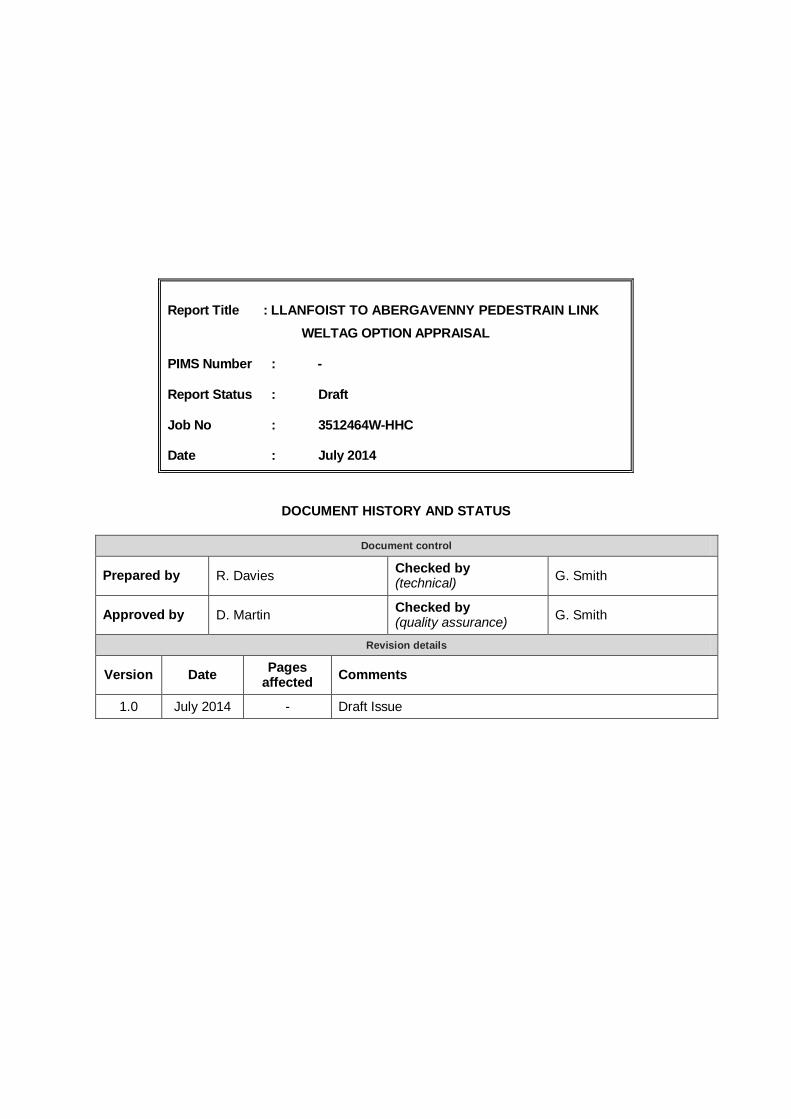
Report Title : LLANFOIST TO ABERGAVENNY PEDESTRAIN LINKWELTAG OPTION APPRAISAL
PIMS Number : -
Report Status : Draft
Job No : 3512464W-HHC
Date : July 2014
DOCUMENT HISTORY AND STATUS
Document control
Prepared by R. Davies Checked by(technical) G. Smith
Approved by D. Martin Checked by(quality assurance) G. Smith
Revision details
Version Date Pagesaffected Comments
1.0 July 2014 - Draft Issue

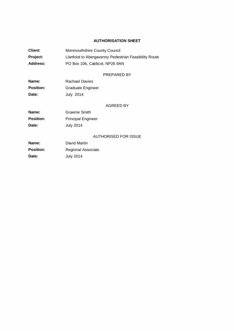
AUTHORISATION SHEET
Client: Monmouthshire County CouncilProject: Llanfoist to Abergavenny Pedestrian Feasibility RouteAddress: PO Box 106, Caldicot, NP26 9AN
PREPARED BYName: Rachael DaviesPosition: Graduate EngineerDate: July 2014
AGREED BYName: Graeme SmithPosition: Principal EngineerDate: July 2014
AUTHORISED FOR ISSUEName: David MartinPosition: Regional AssociateDate: July 2014

LLANFOIST TO ABERGAVENNYWELTAG OPTION APPRAISAL
WelTAG Planing & Stage 1 Report - Draft Prepared by Parsons BrinckerhoffJuly 2014 for Monmouthshire County Council
CONTENTSPage
1 INTRODUCTION 11.1 Purpose of this Report 11.2 Study Background 11.3 Relevant Policies 11.4 Study Location and Current Situation 31.5 Recent History 4
2 PLANNING STAGE 52.1 Overview 52.2 Identified Problems and Opportunities 52.3 Transport Planning Objectives 62.4 Transport Planning Objectives Testing 72.5 Potential Solutions 112.6 Summary 11
3 Option Development 123.1 Option Development 123.2 Option 1 – Create new link up stream of Llanfoist Bridge 123.3 Option 2 – Modify existing LLanfoist Bridge 123.4 Option 3 – Create new link downstream of Llanfoist Bridge 123.5 Option 4 - Create new link downstream of Llanfoist Bridge 133.6 Costs Estimates 133.7 Option Refinement 133.8 Summary 15
4 WELTAG STAGE 1 APPRAISAL 164.1 Methodology 164.2 Appraisal Criteria 164.3 Noise Assessment Criteria 184.4 Air Quality Assessment Criteria 184.5 Greenhouse Gas Emissions Assessment Criteria 194.6 Landscape and Townscape Assessment Criteria 194.7 Biodiversity Assessment Criteria 214.8 Heritage Assessment Criteria 244.9 Geology and Soils Assessment Criteria 254.10 Water Assessment Criteria 264.11 Transport Safety Assessment Criteria 274.12 Personal Security Assessment Criteria 274.13 Permeability Assessment Criteria 284.14 Physical Fitness Assessment Criteria 294.15 Social Inclusion Assessment Criteria 304.16 Equality, Diversity and Human Rights Assessment Criteria 314.17 Appraisal Summary Tables 324.18 Stage 1 Summary 34
LLANFOIST TO ABERGAVENNYWELTAG OPTION APPRAISAL
WelTAG Planing & Stage 1 Report - Draft Prepared by Parsons BrinckerhoffJuly 2014 for Monmouthshire County Council
4.19 Recommendations for Stage 2 WelTAG 34
5 Preferred Option 355.1 Introduction 355.2 Southern Link 1 355.3 Southern Link 2 365.4 Southern Link 3 375.5 Northern Link 1 385.6 Northern Link 2 395.7 Recommendation for Further Development 395.8 Outline Scheme Proposals 405.9 Cost Estimate 415.10 Opportunity for Phased Development 425.11 Land Requirements 425.12 Recommendations 42
6 References 43
APPENDICES
Appendix A - Appraisal Summary Tables
Appendix B – Figures
LLANFOIST TO ABERGAVENNYWELTAG OPTION APPRAISAL
WelTAG Planing & Stage 1 Report - Draft Prepared by Parsons BrinckerhoffJuly 2014 for Monmouthshire County Council
- 1 -
1 INTRODUCTION
1.1 Purpose of this Report
1.1.1 This report summarises the findings of the Welsh Transport Appraisal Guidance(WelTAG)1 Appraisal for the LLanfoist to Abergavenny Pedestrian Link feasibilitystudy, outlining methodology, option development, appraisal and conclusions.
1.1.2 The structure of this report is as follows:
Section 1: Introduction
Section 2: WelTAG Planning Stage
Section 3: Option Development
Section 4: WelTAG Stage 1 Appraisal
Section 5: Summary and Recommendations
Section 6: Project Viability and Business Case
1.2 Study Background
1.2.1 Parsons Brinckerhoff (PB) was appointed by Monmouthshire County Council (MCC)to develop, assess and cost alternative outline options to improve facilities forpedestrians and cyclists travelling between Llanfoist and Abergavenny, particularlythe means of crossing the River Usk, and to recommend a strategy for implementingimprovements promptly and economically.
1.2.2 Options will be developed and appraised against the WelTAG assessment areas, i.e.Environment, Economy and Society, as well as study Transport Planning Objectives(TPOs), which will be defined during the WelTAG Planning Stage to align withrelevant policies and identified issues & opportunities.
1.3 Relevant Policies
Regional Transport Plan
1.3.1 The commissioned project aims to have a beneficial impact on the following RegionalTransport Plan objectives:
To improve access for all to a wide range of services and facilities includingemployment and business, education and training, health care, tourism andleisure activities;
To improve the sustainability of transport by improving the range and quality of,and awareness about, transport options, including those which improve healthand well being;
To improve the efficiency and reliability of the movement of people and freightwithin and beyond South East Wales to support the regional economy;
To improve integration between policies, service provision and modes oftransport in south East Wales;
LLANFOIST TO ABERGAVENNYWELTAG OPTION APPRAISAL
WelTAG Planing & Stage 1 Report - Draft Prepared by Parsons BrinckerhoffJuly 2014 for Monmouthshire County Council
- 2 -
To implement measures which promote a positive contribution to improving airquality and reducing the adverse impact of transport on health and climatechange, including reducing carbon emissions;
To implement measures which help to reduce the negative impact of transportacross the region on the natural and built environment including biodiversity; and
To improve road safety and personal security in South East Wales.
Local Development Plan
1.3.2 The Adopted Monmouthshire Local Development Plan (LDP) February 2014 coversthe period 2011 – 2021. Land to the north of the River Usk which is within the studyarea has been allocated as an area of amenity importance within the LDP. Land tothe south of the River Usk also within the study area is unallocated within the LDP.
1.3.3 The Llanfoist pedestrian and cycling river crossing has been identified as a transportroute and scheme that is likely to be implemented within the plan period or needs tobe protected to avoid longer term aspirations being prejudiced.
Active Travel Bill
1.3.4 The Active Travel Bill is anticipated to be in place from mid 2014 following the currentconsultation stage. The Bill will require all Local Authorities to:
Develop existing Route Maps, and
Develop Integrated Network Maps to identify aspirations for future develop overthe next 15 years.
The Active Travel Bill will place a duty on all Local Authorities to build infrastructure(cycleways/footpaths/facilities) to demonstrate a year on year improvement in qualityand extent of Active Travel Infrastructure.
The outcome of the llanfoist to Abergavenny Pedestrian Link study will be a keyelement of Monmouthshire CC’s Integrated Network Map for future Active TravelInfrastructure.
LLANFOIST TO ABERGAVENNYWELTAG OPTION APPRAISAL
WelTAG Planing & Stage 1 Report - Draft Prepared by Parsons BrinckerhoffJuly 2014 for Monmouthshire County Council
- 3 -
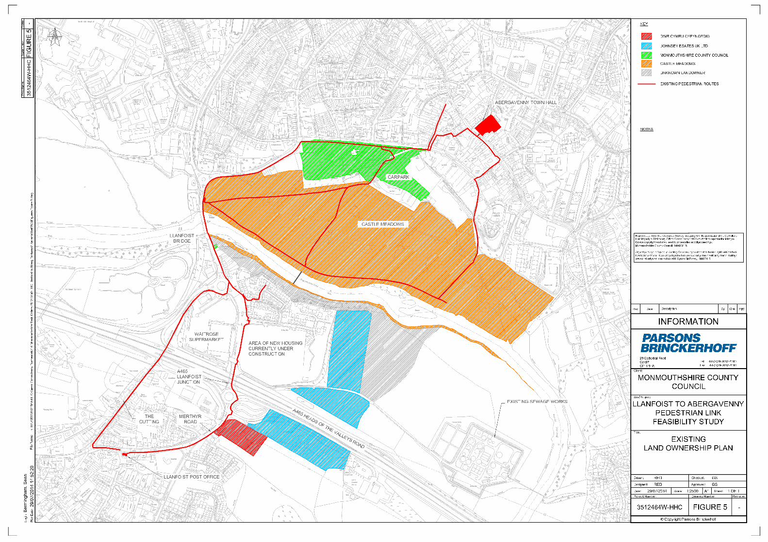
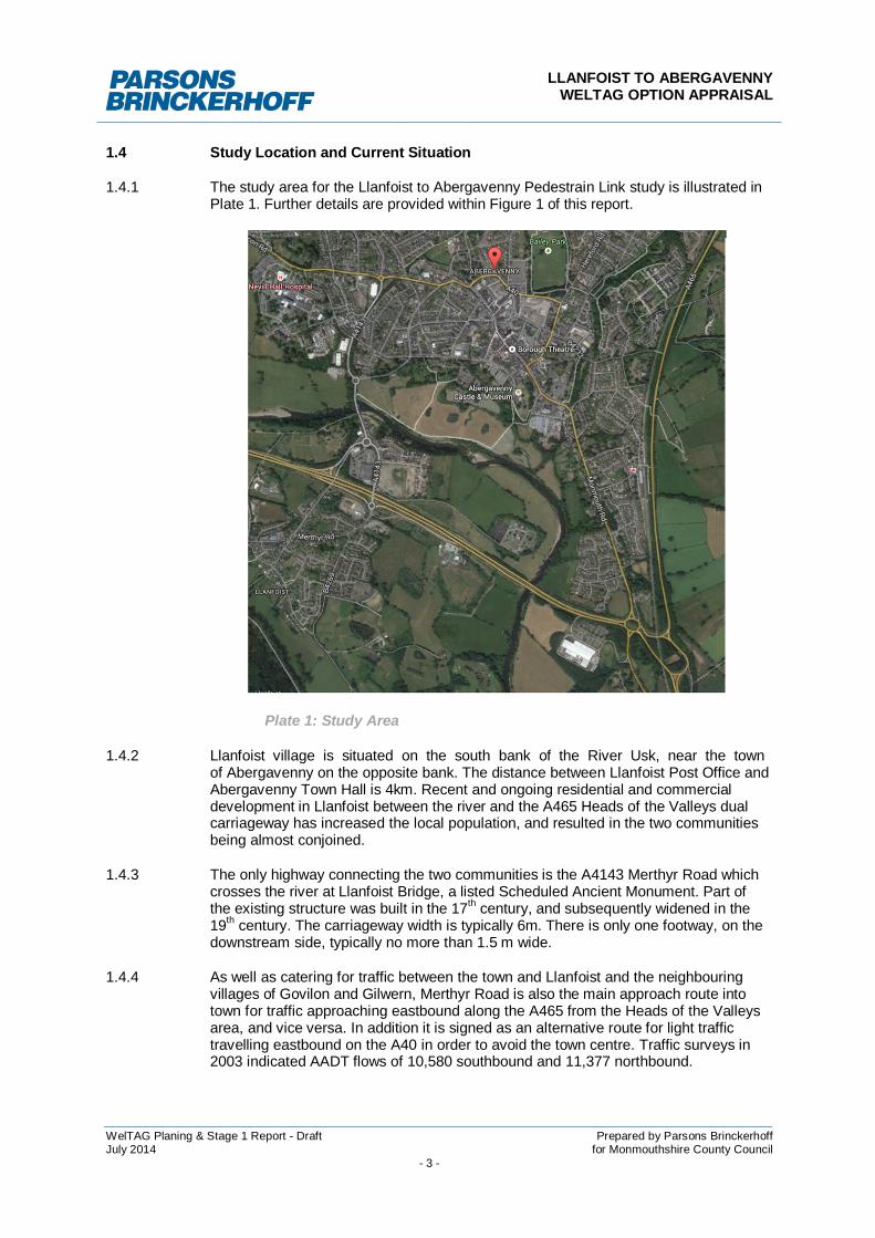
1.4 Study Location and Current Situation
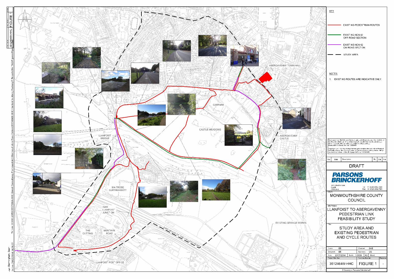
1.4.1 The study area for the Llanfoist to Abergavenny Pedestrain Link study is illustrated inPlate 1. Further details are provided within Figure 1 of this report.
Plate 1: Study Area
1.4.2 Llanfoist village is situated on the south bank of the River Usk, near the townof Abergavenny on the opposite bank. The distance between Llanfoist Post Office andAbergavenny Town Hall is 4km. Recent and ongoing residential and commercialdevelopment in Llanfoist between the river and the A465 Heads of the Valleys dualcarriageway has increased the local population, and resulted in the two communitiesbeing almost conjoined.
1.4.3 The only highway connecting the two communities is the A4143 Merthyr Road whichcrosses the river at Llanfoist Bridge, a listed Scheduled Ancient Monument. Part ofthe existing structure was built in the 17th century, and subsequently widened in the19th century. The carriageway width is typically 6m. There is only one footway, on thedownstream side, typically no more than 1.5 m wide.
1.4.4 As well as catering for traffic between the town and Llanfoist and the neighbouringvillages of Govilon and Gilwern, Merthyr Road is also the main approach route intotown for traffic approaching eastbound along the A465 from the Heads of the Valleysarea, and vice versa. In addition it is signed as an alternative route for light traffictravelling eastbound on the A40 in order to avoid the town centre. Traffic surveys in2003 indicated AADT flows of 10,580 southbound and 11,377 northbound.
LLANFOIST TO ABERGAVENNYWELTAG OPTION APPRAISAL
WelTAG Planing & Stage 1 Report - Draft Prepared by Parsons BrinckerhoffJuly 2014 for Monmouthshire County Council
- 4 -
1.4.5 The bridge lies on National Cycle Network route 46 between Merthyr Tydfil andHereford and thus forms an important leisure link between Abergavenny town centre,the World Heritage Site (of Blaenavon) and Iron Mountain Trail. The volume of traffic,the proximity of southbound vehicles, particularly HGVs, to the kerbline, combinedwith the limited footway (which is sometimes occupied by fishermen casting theirrods from the bridge), create unappealing and unsafe facilities for pedestrians.Anecdotal evidence suggests many people who would otherwise walk betweentown and village are deterred solely due to the poor pedestrian facilities on thebridge. Those with impaired mobility are particularly disadvantaged by the currentpedestrian facilities.
1.4.6 The Abergavenny to Merthyr Tydfil Railway was carried on a high level bridgeadjacent to and upstream from the existing road bridge. After the line was closed in1958 the bridge was demolished, believed to be in the 1960s. Parts of the approachembankments and accommodation bridges are still extant.
1.5 Recent History
1.5.1 Originally there was a footway on the upstream side of the road bridge, with metalrailings as a parapet, but no footway on the downstream side. It is believed that thefootway was transferred to the downstream side, and the metal railings on theupstream side replaced with a masonry parapet, sometime in the late 1960s or early1970s. The existing footway links more logically with the connecting footway networkand pedestrian desire lines.
1.5.2 Circa 2003 the Welsh Assembly Government (WAG) commenced investigations intothe possibility of upgrading the A4143 to form part of the A40 trunk road, in order toenable the existing A40 through the centre of Abergavenny to be detrunked. WAGdesired to widen the carriageway to more readily accommodate HGVs. In a leafletpublicising a public exhibition in September 2003 it was stated:-
‘It is proposed to remove the existing footbridge from the eastside of Usk Bridge(Tudor Bridge) and provide a separate footbridge/cycleway on the west side,detached from the bridge. The highway will be widened to cater for the volume ofexisting and transferred traffic.’
1.5.3 Subsequently plans were prepared showing how a metal walkway might becantilevered onto the existing structure on the outside of the west side parapet. It isbelieved that CADW objected to any suggestion of cantilevering a footway onto theeastside parapet so as not to detract from the view of the bridge when observed fromCastle Meadows.
1.5.4 It is understood the Environment Agency’s (EA) preference was for thecantilevered footway to be on the downstream side, as at times of high flood the waterlevel is higher on the upstream side than downstream. Hence the EA required thedesign to include gates at either end of the footway which could be closed duringexceptionally high water levels.
1.5.5 MCC expressed concern that the natural pedestrian desire line was on thedownstream side of the bridge, and sought assurances from WAG that pelicancrossings would be provided across Merthyr Road on both sides of the bridge. In theevent WAG decided not to pursue the scheme, and neither this scheme nor anyalternative has been developed since.
LLANFOIST TO ABERGAVENNYWELTAG OPTION APPRAISAL
WelTAG Planing & Stage 1 Report - Draft Prepared by Parsons BrinckerhoffJuly 2014 for Monmouthshire County Council
- 5 -
2 PLANNING STAGE
2.1 Overview
2.1.1 The planning stage is regarded as the first phase within the overall planning andimplementation cycle of all transportation schemes within Wales. This involvesconsideration of the transport problems and opportunities and the generation oftransport planning objectives relevant to the study that will form the focus for thestudy.
2.1.2 The approach to the Planning Stage is summarised in WelTAG as follows:
“The planning process has to start from problems and opportunities, then setobjectives, then identify the best ways of achieving these. An important implication ofthis is that the planner has to consider a diverse range of alternatives, and not startfrom an implicit objective of promoting a particular proposal.”
2.1.3 In line with the WelTAG Planning Stage approach, Parsons Brinckerhoff hasundertaken a desk based assessment of previous studies and other relevant literatureto identify and collate the key transport problems and opportunities for an improvedshared use cycle and pedestrian transport link between Llanfoist and Abergavenny.
2.1.4 This section discusses the problems and opportunities with the existing facilitieswithin the study area and identifies transport planning objectives and possiblesolutions that address all, or part, of the overall study objective.
2.2 Identified Problems and Opportunities
2.2.1 Through consultation with MCC representatives and key stakeholders, and incombination with site visits and desk-based assessments, the following key schemeproblems and opportunities have been identified.
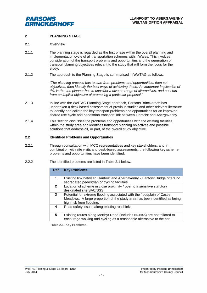
2.2.2 The identified problems are listed in Table 2.1 below.
Ref Key Problems
1 Existing link between Llanfoist and Abergavenny - Llanfoist Bridge offers nosegregated pedestrian or cycling facilities
2 Location of scheme in close proximity / over to a sensitive statutorydesignated site SAC/SSSI.
3 Potential for extreme flooding associated with the floodplain of CastleMeadows. A large proportion of the study area has been identified as beinghigh risk from flooding.
4 Road safety issues along existing road links
5 Existing routes along Merthyr Road (includes NCN46) are not tailored toencourage walking and cycling as a reasonable alternative to the car
Table 2.1: Key Problems
LLANFOIST TO ABERGAVENNYWELTAG OPTION APPRAISAL
WelTAG Planing & Stage 1 Report - Draft Prepared by Parsons BrinckerhoffJuly 2014 for Monmouthshire County Council
- 6 -
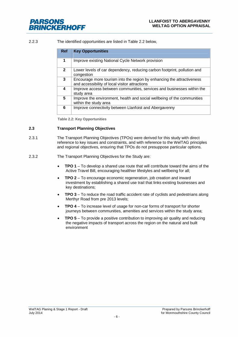
2.2.3 The identified opportunities are listed in Table 2.2 below,
Ref Key Opportunities
1 Improve existing National Cycle Network provision
2 Lower levels of car dependency, reducing carbon footprint, pollution andcongestion
3 Encourage more tourism into the region by enhancing the attractivenessand accessibility of local visitor attractions
4 Improve access between communities, services and businesses within thestudy area
5 Improve the environment, health and social wellbeing of the communitieswithin the study area
6 Improve connectivity between Llanfoist and Abergavenny
Table 2.2: Key Opportunities
2.3 Transport Planning Objectives
2.3.1 The Transport Planning Objectives (TPOs) were derived for this study with directreference to key issues and constraints, and with reference to the WelTAG principlesand regional objectives, ensuring that TPOs do not presuppose particular options.
2.3.2 The Transport Planning Objectives for the Study are:
TPO 1 – To develop a shared use route that will contribute toward the aims of theActive Travel Bill, encouraging healthier lifestyles and wellbeing for all;
TPO 2 – To encourage economic regeneration, job creation and inwardinvestment by establishing a shared use trail that links existing businesses andkey destinations;
TPO 3 – To reduce the road traffic accident rate of cyclists and pedestrians alongMerthyr Road from pre 2013 levels;
TPO 4 – To increase level of usage for non-car forms of transport for shorterjourneys between communities, amenities and services within the study area;
TPO 5 – To provide a positive contribution to improving air quality and reducingthe negative impacts of transport across the region on the natural and builtenvironment
LLANFOIST TO ABERGAVENNYWELTAG OPTION APPRAISAL
WelTAG Planing & Stage 1 Report - Draft Prepared by Parsons BrinckerhoffJuly 2014 for Monmouthshire County Council
- 7 -
2.4 Transport Planning Objectives Testing
2.4.1 Section 4.4 of the WelTAG requires that all Transport Planning Objectives besubjected to a process of appraisal against the identified problems and opportunities,the National Transport Strategy Outcomes and related Strategic Priorities to ensurethat they are fit for purpose and meet the intended needs of the scheme.
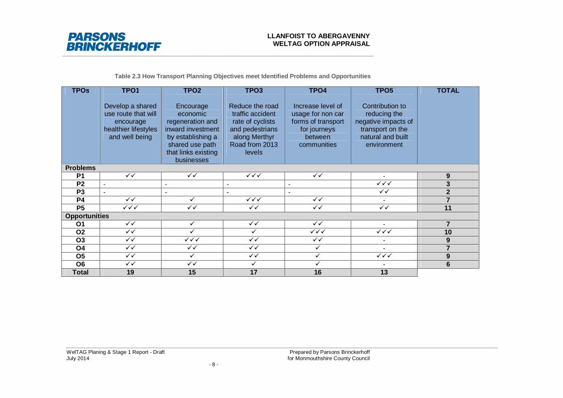
2.4.2 Table 2.3 demonstrates how the TPOs address or progress relevant issues identifiedduring the WelTAG Planning Stage. The relationship between each TPO and eachidentified problem or opportunity is denoted as follows:
Minor Fit
Moderate Fit
Major Fit
The table demonstrates that each of the identified problems and opportunities aredirectly addressed by at least one TPO. TPO1, develop a shared use route that willcontribute toward the aims of the Active Travel Bill, encouraging healthier lifestylesand wellbeing for all, is the stand out performer when appraised against the problemsand opportunities.
2.4.3 Table 2.4 and 2.5 show how each transport planning objective relates to the WelshTransport Strategy and Regional Strategic Priorities respectively.
2.4.4 In this instance TPO 4, increase level of usage for non-car forms of transport forshorter journeys between communities, amenities and services within the study area,performers the best against the Welsh Transport Strategy Outcomes, with TPO 1scoring the highest in the Regional Strategic Priorities appraisal.
LLANFOIST TO ABERGAVENNYWELTAG OPTION APPRAISAL
WelTAG Planing & Stage 1 Report - Draft Prepared by Parsons BrinckerhoffJuly 2014 for Monmouthshire County Council
- 8 -
Table 2.3 How Transport Planning Objectives meet Identified Problems and Opportunities
TPOs TPO1
Develop a shareduse route that will
encouragehealthier lifestyles
and well being
TPO2
Encourageeconomic
regeneration andinward investmentby establishing ashared use paththat links existing
businesses
TPO3
Reduce the roadtraffic accidentrate of cyclists
and pedestriansalong Merthyr
Road from 2013levels
TPO4
Increase level ofusage for non carforms of transport
for journeysbetween
communities
TPO5
Contribution toreducing the
negative impacts oftransport on thenatural and built
environment
TOTAL
ProblemsP1 - 9P2 - - - - 3P3 - - - - 2P4 - 7P5 11
OpportunitiesO1 - 7O2 10O3 - 9O4 - 7O5 9O6 - 6
Total 19 15 17 16 13

LLANFOIST TO ABERGAVENNYWELTAG OPTION APPRAISAL
WelTAG Planing & Stage 1 Report - Draft Prepared by Parsons BrinckerhoffJuly 2014 for Monmouthshire County Council
- 9 -
Table 2.4 How the Developed TPOs Relate to Wales Transport Strategy Outcomes
Table 2.5 How the Developed TPOs Relate to Regional Transport Plan
Key Transport Planning Objectives (TPOs)Minor FitModerate Fit
Major Fit TPO
1
TPO
2
TPO
3
TPO
4
TPO
5
TOTA
L
Wales Transport Strategy OutcomesSocial OutcomesImprove access to healthcare 8Improve access to education, training and lifelong learning 8Improve access to shopping and leisure facilities 9Encourage healthy lifestyles 8Improve the actual and perceived safety of travel 10Economic OutcomesImprove access to employment opportunities 10Improve connectivity within Wales and internationally 10Improve the efficient, reliable and sustainable movement of people 10Improve the efficient, reliable and sustainable movement of freight 6Improve access to visitor attractions 12Environmental OutcomesIncrease the use of more sustainable materials 9Reduce the contribution of transport to greenhouse gas emissions 9Adapt to the impacts of climate change 7Reduce the contribution of transport to air pollution and other harmful emissions 8Improve the impact of transport on the local environment 11Improve the effect of transport on our heritage 6Improve the impact of transport on biodiversity 6TOTAL 34 22 23 40 27
LLANFOIST TO ABERGAVENNYWELTAG OPTION APPRAISAL
WelTAG Planing & Stage 1 Report - Draft Prepared by Parsons BrinckerhoffJuly 2014 for Monmouthshire County Council
- 10 -
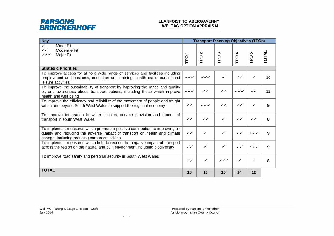
Key Transport Planning Objectives (TPOs)Minor FitModerate Fit
Major Fit
TPO
1
TPO
2
TPO
3
TPO
4
TPO
5
TOTA
L
Strategic PrioritiesTo improve access for all to a wide range of services and facilities includingemployment and business, education and training, health care, tourism andleisure activities
10
To improve the sustainability of transport by improving the range and qualityof, and awareness about, transport options, including those which improvehealth and well being
12
To improve the efficiency and reliability of the movement of people and freightwithin and beyond South West Wales to support the regional economy 9
To improve integration between policies, service provision and modes oftransport in south West Wales 8
To implement measures which promote a positive contribution to improving airquality and reducing the adverse impact of transport on health and climatechange, including reducing carbon emissions
9
To implement measures which help to reduce the negative impact of transportacross the region on the natural and built environment including biodiversity 9
To improve road safety and personal security in South West Wales8
TOTAL 16 13 10 14 12
LLANFOIST TO ABERGAVENNYWELTAG OPTION APPRAISAL
WelTAG Planing & Stage 1 Report - Draft Prepared by Parsons BrinckerhoffJuly 2014 for Monmouthshire County Council
- 11 -
2.5 Potential Solutions
2.5.1 Following the agreement of the transport planning objectives and taking into accountthe performance of the objectives against the identified problems and opportunitiesand the national and regional strategic priorities, the study team considered potentialsolutions that have the potential to address all, or part, of the transport planningobjectives.
2.5.2 The potential solutions are listed below in Table 2.6.
2.5.3 When considering options the study team have prioritised TPOs 1 and 4 as essentialcomponents in delivering the schemes objectives and TPOs 2, 3 and 5 as importantcontributors.
Ref Potential Solutions
1 Create new link up stream of Llanfoist Bridge
2 Modify existing Llanfoist Bridge
3 Create new link downstream of Llanfoist Bridge adjacent to the White CastleDevelopment
4 Create new link downstream of Llanfoist Bridge between the White CastleDevelopment and the Sewerage works
Table 2.6: Potential Solutions
2.6 Summary
2.6.1 As described in Section 2.3, the transport planning objectives were derived for theLlanfoist to Abergavenny Pedestrian Link Study with direct reference to problems andopportunities identified and also with regard to relevant strategic priorities.
2.6.2 Four options, in the form of route corridors, have been identified that have thepotential to address all, or part, of the transport planning objectives.

LLANFOIST TO ABERGAVENNYWELTAG OPTION APPRAISAL
WelTAG Planing & Stage 1 Report - Draft Prepared by Parsons BrinckerhoffJuly 2014 for Monmouthshire County Council
- 12 -
3 OPTION DEVELOPMENT
3.1 Option Development
3.1.1 Following the planning stage, the options taken forward for stage 1 appraisal neededto be further developed to allow a high level assessment of the potential optionsperformance against the TPOs and Welsh Impact Areas. Options have beensufficiently developed into broad route corridors to illustrate the potential worksfootprint, impact and requirements. It should be noted that at this stage in the processthe broad route corridors are simply suggestions on how, or where, the route corridorcould lie.
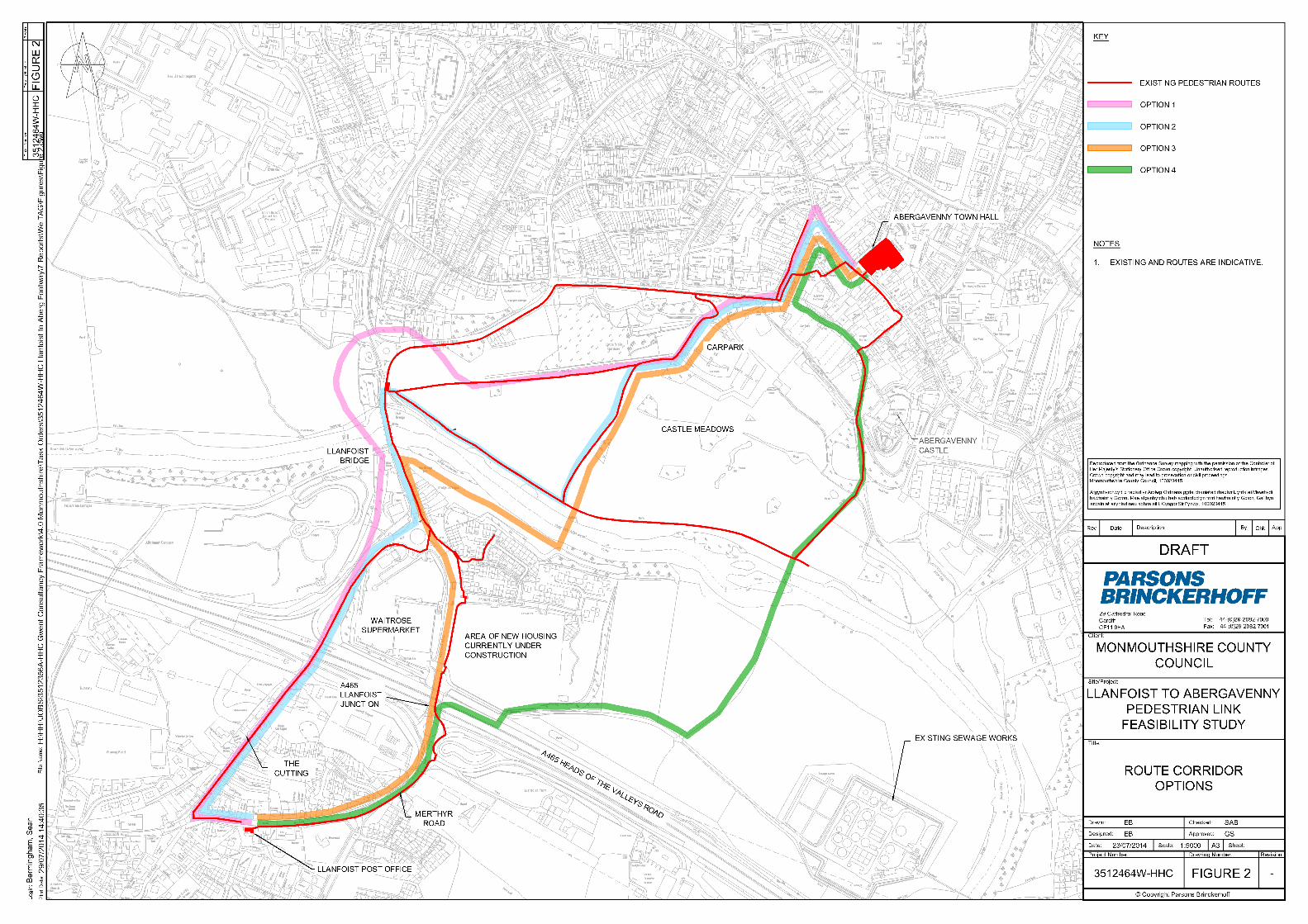
3.1.2 A narrative of the potential core route options is provided in Sections 3.2 to 3.5 belowand are also illustrated in Figure 2.
3.2 Option 1 – Create new link up stream of Llanfoist Bridge
3.2.1 Option 1 would provide a new shared use crossing approximately 70 to 80metresupsteam of the Llanfoist Bridge on the approximate line of the former Abergavenny toMerthyr Railway bridge.
3.2.2 It is anticipated that the link would be created by utilising the existing pedestrian andcycle infrastructure along The Cutting in Llanfoist and connect into existinginfrastructure along Merthyr Road in on the northern bank of the River Usk inAbergavenny. New approach paths connecting the new river crossing to the existinginfrastructure would need to be constructed.
3.2.3 This option has an anticipated construction cost of £660k to £825k.
3.3 Option 2 – Modify existing LLanfoist Bridge
3.3.1 Option 2 would see the existing bridge modified, either by cantilevering or widening ofa parapet, to provide sufficient width for a fully compliant shared use pedestrian andcycle link.
3.3.2 This option has an anticipated construction cost of £4.5M to £5M.
3.4 Option 3 – Create new link downstream of Llanfoist Bridge adjacent to theWhite Castle Development
3.4.1 Option 3 would see a new shared use crossing installed approximately 300metreseast of the existing Llanfoist Bridge. The new crossing would link with existingfootpaths on the north side of the River Usk, but will require the construction of a newfootpath, approximately 300metres in length, on the southern side of the River Usk,behind Bridge Cottages and The Bridge public House in order to allow access to thebridge from the A4143 Merthyr Road. An additional access would be required to linkthe existing and new residential developments at Cooper Way. This access wouldinvolve construction of a ramp to compensate for the 10metre level differencebetween the man-made plateau where the residential area has been constructed andthe river bank. The estimated span of the footbridge would be 42metres.
3.4.2 This option has an anticipated construction cost of £615k to £780k.
LLANFOIST TO ABERGAVENNYWELTAG OPTION APPRAISAL
WelTAG Planing & Stage 1 Report - Draft Prepared by Parsons BrinckerhoffJuly 2014 for Monmouthshire County Council
- 13 -
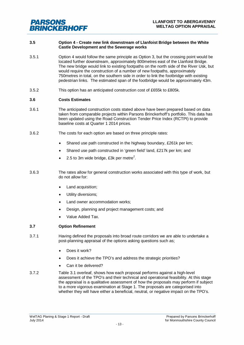
3.5 Option 4 - Create new link downstream of Llanfoist Bridge between the WhiteCastle Development and the Sewerage works
3.5.1 Option 4 would follow the same principle as Option 3, but the crossing point would belocated further downstream, approximately 800metres east of the Llanfoist Bridge.The new bridge would link to existing footpaths on the north side of the River Usk, butwould require the construction of a number of new footpaths, approximately750metres in total, on the southern side in order to link the footbridge with existingpedestrian links. The estimated span of the footbridge would be approximately 43m.
3.5.2 This option has an anticipated construction cost of £655k to £805k.
3.6 Costs Estimates
3.6.1 The anticipated construction costs stated above have been prepared based on datataken from comparable projects within Parsons Brinckerhoff’s portfolio. This data hasbeen updated using the Road Construction Tender Price Index (RCTPI) to providebaseline costs at Quarter 1 2014 prices.
3.6.2 The costs for each option are based on three principle rates:
Shared use path constructed in the highway boundary, £261k per km;
Shared use path constructed in ‘green field’ land, £217k per km; and
2.5 to 3m wide bridge, £3k per metre2.
3.6.3 The rates allow for general construction works associated with this type of work, butdo not allow for:
Land acquisition;
Utility diversions;
Land owner accommodation works;
Design, planning and project management costs; and
Value Added Tax.
3.7 Option Refinement
3.7.1 Having defined the proposals into broad route corridors we are able to undertake apost-planning appraisal of the options asking questions such as;
Does it work?
Does it achieve the TPO’s and address the strategic priorities?
Can it be delivered?
3.7.2 Table 3.1 overleaf, shows how each proposal performs against a high-levelassessment of the TPO’s and their technical and operational feasibility. At this stagethe appraisal is a qualitative assessment of how the proposals may perform if subjectto a more vigorous examination at Stage 1. The proposals are categorised intowhether they will have either a beneficial, neutral, or negative impact on the TPO’s.
LLANFOIST TO ABERGAVENNYWELTAG OPTION APPRAISAL
WelTAG Planing & Stage 1 Report - Draft Prepared by Parsons BrinckerhoffJuly 2014 for Monmouthshire County Council
- 14 -
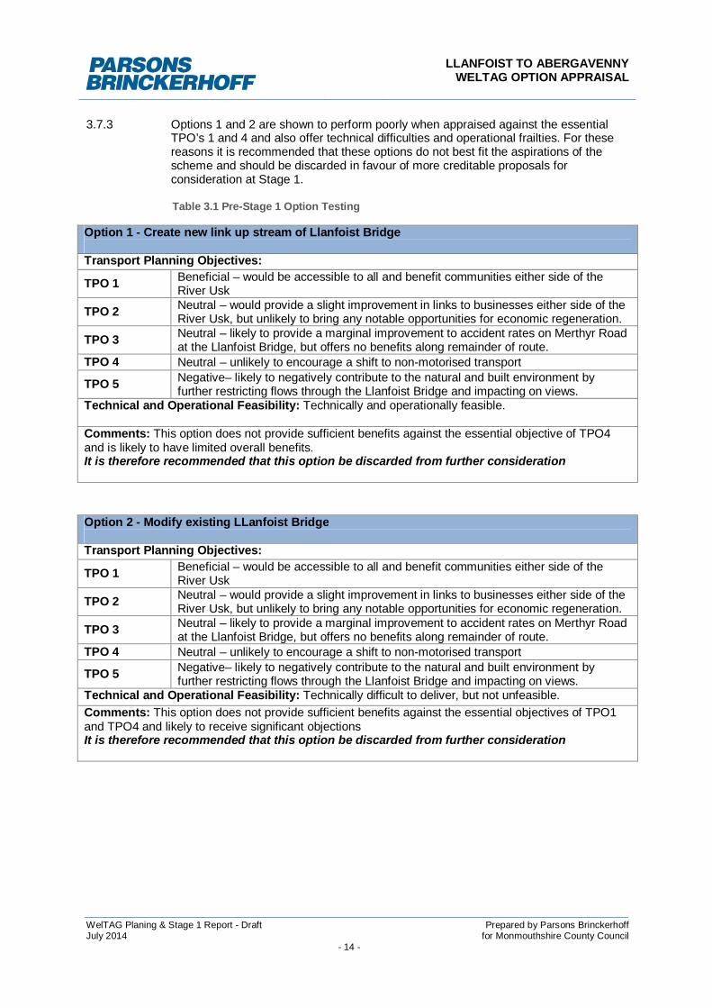
3.7.3 Options 1 and 2 are shown to perform poorly when appraised against the essentialTPO’s 1 and 4 and also offer technical difficulties and operational frailties. For thesereasons it is recommended that these options do not best fit the aspirations of thescheme and should be discarded in favour of more creditable proposals forconsideration at Stage 1.
Table 3.1 Pre-Stage 1 Option Testing
Option 1 - Create new link up stream of Llanfoist Bridge
Transport Planning Objectives:
TPO 1 Beneficial – would be accessible to all and benefit communities either side of theRiver Usk
TPO 2 Neutral – would provide a slight improvement in links to businesses either side of theRiver Usk, but unlikely to bring any notable opportunities for economic regeneration.
TPO 3 Neutral – likely to provide a marginal improvement to accident rates on Merthyr Roadat the Llanfoist Bridge, but offers no benefits along remainder of route.
TPO 4 Neutral – unlikely to encourage a shift to non-motorised transport
TPO 5 Negative– likely to negatively contribute to the natural and built environment byfurther restricting flows through the Llanfoist Bridge and impacting on views.
Technical and Operational Feasibility: Technically and operationally feasible.
Comments: This option does not provide sufficient benefits against the essential objective of TPO4and is likely to have limited overall benefits.It is therefore recommended that this option be discarded from further consideration
Option 2 - Modify existing LLanfoist Bridge
Transport Planning Objectives:
TPO 1 Beneficial – would be accessible to all and benefit communities either side of theRiver Usk
TPO 2 Neutral – would provide a slight improvement in links to businesses either side of theRiver Usk, but unlikely to bring any notable opportunities for economic regeneration.
TPO 3 Neutral – likely to provide a marginal improvement to accident rates on Merthyr Roadat the Llanfoist Bridge, but offers no benefits along remainder of route.
TPO 4 Neutral – unlikely to encourage a shift to non-motorised transport
TPO 5 Negative– likely to negatively contribute to the natural and built environment byfurther restricting flows through the Llanfoist Bridge and impacting on views.
Technical and Operational Feasibility: Technically difficult to deliver, but not unfeasible.Comments: This option does not provide sufficient benefits against the essential objectives of TPO1and TPO4 and likely to receive significant objectionsIt is therefore recommended that this option be discarded from further consideration
LLANFOIST TO ABERGAVENNYWELTAG OPTION APPRAISAL
WelTAG Planing & Stage 1 Report - Draft Prepared by Parsons BrinckerhoffJuly 2014 for Monmouthshire County Council
- 15 -
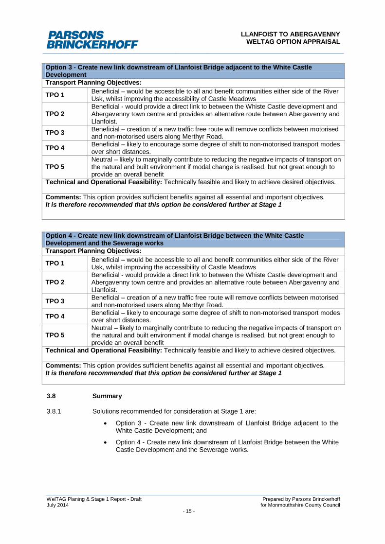
Option 3 - Create new link downstream of Llanfoist Bridge adjacent to the White CastleDevelopmentTransport Planning Objectives:
TPO 1 Beneficial – would be accessible to all and benefit communities either side of the RiverUsk, whilst improving the accessibility of Castle Meadows
TPO 2Beneficial - would provide a direct link to between the Whiste Castle development andAbergavenny town centre and provides an alternative route between Abergavenny andLlanfoist.
TPO 3 Beneficial – creation of a new traffic free route will remove conflicts between motorisedand non-motorised users along Merthyr Road.
TPO 4 Beneficial – likely to encourage some degree of shift to non-motorised transport modesover short distances.
TPO 5Neutral – likely to marginally contribute to reducing the negative impacts of transport onthe natural and built environment if modal change is realised, but not great enough toprovide an overall benefit
Technical and Operational Feasibility: Technically feasible and likely to achieve desired objectives.
Comments: This option provides sufficient benefits against all essential and important objectives.It is therefore recommended that this option be considered further at Stage 1
Option 4 - Create new link downstream of Llanfoist Bridge between the White CastleDevelopment and the Sewerage worksTransport Planning Objectives:
TPO 1 Beneficial – would be accessible to all and benefit communities either side of the RiverUsk, whilst improving the accessibility of Castle Meadows
TPO 2Beneficial - would provide a direct link to between the Whiste Castle development andAbergavenny town centre and provides an alternative route between Abergavenny andLlanfoist.
TPO 3 Beneficial – creation of a new traffic free route will remove conflicts between motorisedand non-motorised users along Merthyr Road.
TPO 4 Beneficial – likely to encourage some degree of shift to non-motorised transport modesover short distances.
TPO 5Neutral – likely to marginally contribute to reducing the negative impacts of transport onthe natural and built environment if modal change is realised, but not great enough toprovide an overall benefit
Technical and Operational Feasibility: Technically feasible and likely to achieve desired objectives.
Comments: This option provides sufficient benefits against all essential and important objectives.It is therefore recommended that this option be considered further at Stage 1
3.8 Summary
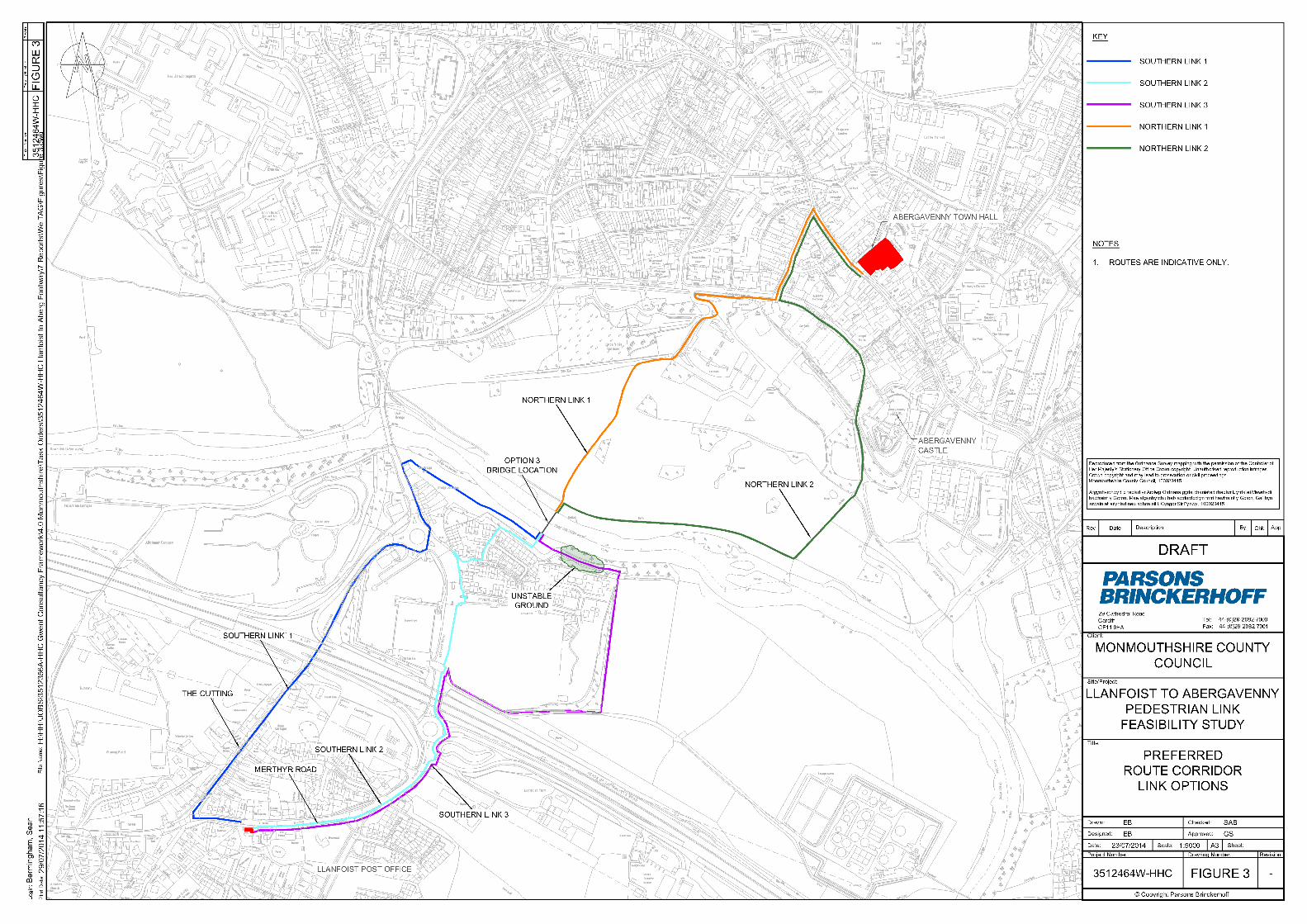
3.8.1 Solutions recommended for consideration at Stage 1 are:
Option 3 - Create new link downstream of Llanfoist Bridge adjacent to theWhite Castle Development; and
Option 4 - Create new link downstream of Llanfoist Bridge between the WhiteCastle Development and the Sewerage works.

LLANFOIST TO ABERGAVENNYWELTAG OPTION APPRAISAL
WelTAG Planing & Stage 1 Report - Draft Prepared by Parsons BrinckerhoffJuly 2014 for Monmouthshire County Council
- 16 -
4 WELTAG STAGE 1 APPRAISAL
4.1 Methodology
4.1.1 The approach to the Stage 1 Appraisal is intended to screen and test the optionsagainst both the Transport Planning Objectives (TPOs) and the strategic WelshImpact Areas policy to ensure that proposals address the problems identified andadhere to the Wales Transport Strategy.
4.1.2 The Welsh Impact Areas focus on the three pilars of sustainability that underlie policyin Wales. They are;
Economy;
Environment; and
Society.
4.1.3 The Stage 1 appraisal aims to:
Assess the extent to which the options resolve all or some of the problems, ortake advantage of identified opportunities;
Assess how well a proposal performs against the TPOs and Welsh Impact Areas;
Test the strength of the overall case for the proposal;
Evaluate deliverability and risk issues, as well as the likely level of support; and
Avoid wasted resources on detailed information for proposals that perform poorlyagainst the points above, eliminating them from further development.
4.2 Appraisal Criteria
4.2.1 The Stage 1 Appraisal requires the anticipated outcomes of each option to bepresented using Appraisal Summary Tables (ASTs) for comparison of theirperformances against the appraisal criteria. The best performing options can then beidentified and recommended for further development / implementation.
4.2.2 ASTs extract the core economic, environmental and social impacts from eachtransport proposal, under the respective appraisal criteria. As well as assessing howwell a proposal performs against the Transport Planning Objectives and Welsh ImpactAreas, an evaluation of deliverability, risk, and strength of local support is also carriedout.
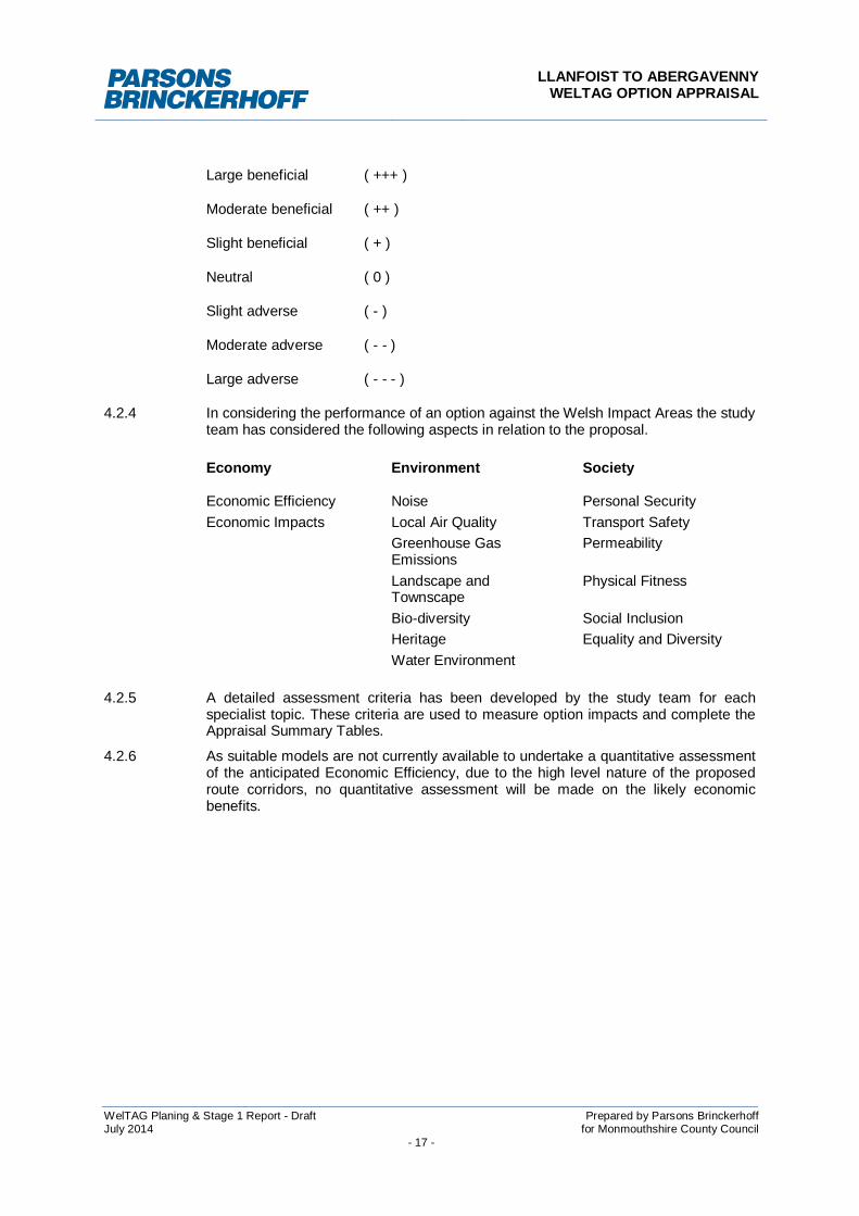
4.2.3 Qualitative measures for each appraisal principle are addressed on their own merits.The results of the assessment of the impact significance are summarised using aseven point scale to indicate the magnitude of the impact as shown on the proceedingpage:
LLANFOIST TO ABERGAVENNYWELTAG OPTION APPRAISAL
WelTAG Planing & Stage 1 Report - Draft Prepared by Parsons BrinckerhoffJuly 2014 for Monmouthshire County Council
- 17 -
Large beneficial ( +++ )
Moderate beneficial ( ++ )
Slight beneficial ( + )
Neutral ( 0 )
Slight adverse ( - )
Moderate adverse ( - - )
Large adverse ( - - - )
4.2.4 In considering the performance of an option against the Welsh Impact Areas the studyteam has considered the following aspects in relation to the proposal.
Economy Environment Society
Economic Efficiency Noise Personal SecurityEconomic Impacts Local Air Quality Transport Safety
Greenhouse GasEmissions
Permeability
Landscape andTownscape
Physical Fitness
Bio-diversity Social InclusionHeritage Equality and DiversityWater Environment
4.2.5 A detailed assessment criteria has been developed by the study team for eachspecialist topic. These criteria are used to measure option impacts and complete theAppraisal Summary Tables.
4.2.6 As suitable models are not currently available to undertake a quantitative assessmentof the anticipated Economic Efficiency, due to the high level nature of the proposedroute corridors, no quantitative assessment will be made on the likely economicbenefits.

LLANFOIST TO ABERGAVENNYWELTAG OPTION APPRAISAL
WelTAG Planing & Stage 1 Report - Draft Prepared by Parsons BrinckerhoffJuly 2014 for Monmouthshire County Council
- 18 -
4.3 Noise Assessment Criteria
4.3.1 The category of noise was appraised on the condition of the number of people likelyto be affected by an option as shown in Table 4.1:Table 4.1 Noise Assessment Criteria
4.4 Air Quality Assessment Criteria
4.4.1 The assessment criteria for air quality were based on the change in concentrationupon completion of a proposed option, as shown in Table 4.2:Table 4.2 Air Quality Assessment Criteria
Change
Negative change(decrease in concentration)
Nochange
Positive change(increase in concentration)
Large Moderate Small Neutral Small Moderate Large
Concentrationwithout scheme
Well aboveobjective + + + + + + + + 0 - - - - - - - -
Above theobjective + + + + + + + 0 - - - - - - -
Below objective + + + + + + 0 - - - - - -
Well belowobjective + + + + 0 - - - -
Significance of change Description of change
Large adverse- - -
Increase in number of people annoyed >100
Moderate adverse- -
Increase in number of people annoyed 50 < 100
Slight adverse-
Increase in number of people annoyed 1 < 49
Neutral effect0
Decrease/ Increase in number of people annoyed = 0
Slight beneficial+
Decrease in number of people annoyed 1 < 49
Moderate beneficial+ +
Decrease in number of people annoyed 50 < 100
Large beneficial + + +
Decrease in number of people annoyed > 100
LLANFOIST TO ABERGAVENNYWELTAG OPTION APPRAISAL
WelTAG Planing & Stage 1 Report - Draft Prepared by Parsons BrinckerhoffJuly 2014 for Monmouthshire County Council
- 19 -
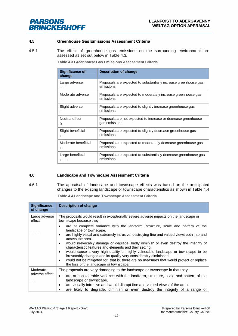
4.5 Greenhouse Gas Emissions Assessment Criteria
4.5.1 The effect of greenhouse gas emissions on the surrounding environment areassessed as set out below in Table 4.3.Table 4.3 Greenhouse Gas Emissions Assessment Criteria
Significance ofchange
Description of change
Large adverse- - -
Proposals are expected to substantially increase greenhouse gasemissions
Moderate adverse- -
Proposals are expected to moderately increase greenhouse gasemissions
Slight adverse-
Proposals are expected to slightly increase greenhouse gasemissions
Neutral effect0
Proposals are not expected to increase or decrease greenhousegas emissions
Slight beneficial+
Proposals are expected to slightly decrease greenhouse gasemissions
Moderate beneficial+ +
Proposals are expected to moderately decrease greenhouse gasemissions
Large beneficial+ + +
Proposals are expected to substantially decrease greenhouse gasemissions
4.6 Landscape and Townscape Assessment Criteria
4.6.1 The appraisal of landscape and townscape effects was based on the anticipatedchanges to the existing landscape or townscape characteristics as shown in Table 4.4Table 4.4 Landscape and Townscape Assessment Criteria
Significanceof change
Description of change
Large adverseeffect
_ _ _
The proposals would result in exceptionally severe adverse impacts on the landscape ortownscape because they: are at complete variance with the landform, structure, scale and pattern of the
landscape or townscape. are highly visual and extremely intrusive, destroying fine and valued views both into and
across the area. would irrevocably damage or degrade, badly diminish or even destroy the integrity of
characteristic features and elements and their setting. would cause a very high quality or highly vulnerable landscape or townscape to be
irrevocably changed and its quality very considerably diminished. could not be mitigated for, that is, there are no measures that would protect or replace
the loss of the landscape or townscape.Moderateadverse effect_ _
The proposals are very damaging to the landscape or townscape in that they: are at considerable variance with the landform, structure, scale and pattern of the
landscape or townscape. are visually intrusive and would disrupt fine and valued views of the area. are likely to degrade, diminish or even destroy the integrity of a range of
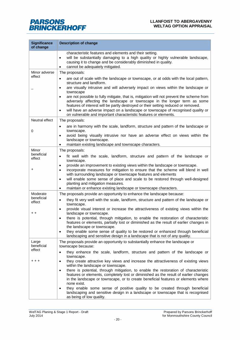
LLANFOIST TO ABERGAVENNYWELTAG OPTION APPRAISAL
WelTAG Planing & Stage 1 Report - Draft Prepared by Parsons BrinckerhoffJuly 2014 for Monmouthshire County Council
- 20 -
Significanceof change
Description of change
characteristic features and elements and their setting. will be substantially damaging to a high quality or highly vulnerable landscape,
causing it to change and be considerably diminished in quality. cannot be adequately mitigated.
Minor adverseeffect
_
The proposals: are out of scale with the landscape or townscape, or at odds with the local pattern,
structure and landform. are visually intrusive and will adversely impact on views within the landscape or
townscape are not possible to fully mitigate, that is, mitigation will not prevent the scheme from
adversely affecting the landscape or townscape in the longer term as somefeatures of interest will be partly destroyed or their setting reduced or removed.
will have an adverse impact on a landscape or townscape of recognised quality oron vulnerable and important characteristic features or elements.
Neutral effect
0
The proposals: are in harmony with the scale, landform, structure and pattern of the landscape or
townscape. avoid being visually intrusive nor have an adverse effect on views within the
landscape or townscape. maintain existing landscape and townscape characters.
Minorbeneficialeffect
+
The proposals: fit well with the scale, landform, structure and pattern of the landscape or
townscape. provide an improvement to existing views within the landscape or townscape. incorporate measures for mitigation to ensure that the scheme will blend in well
with surrounding landscape or townscape features and elements will enable some sense of place and scale to be restored through well-designed
planting and mitigation measures. maintain or enhance existing landscape or townscape characters.
Moderatebeneficialeffect
+ +
The proposals provide an opportunity to enhance the landscape because: they fit very well with the scale, landform, structure and pattern of the landscape or
townscape. provide visual interest or increase the attractiveness of existing views within the
landscape or townscape. there is potential, through mitigation, to enable the restoration of characteristic
features or elements, partially lost or diminished as the result of earlier changes inthe landscape or townscape.
they enable some sense of quality to be restored or enhanced through beneficiallandscaping and sensitive design in a landscape that is not of any quality.
Largebeneficialeffect
+ + +
The proposals provide an opportunity to substantially enhance the landscape ortownscape because: they enhance the scale, landform, structure and pattern of the landscape or
townscape. they create attractive key views and increase the attractiveness of existing views
within the landscape or townscape. there is potential, through mitigation, to enable the restoration of characteristic
features or elements, completely lost or diminished as the result of earlier changesin the landscape or townscape, or to create beneficial features or elements wherenone exist.
they enable some sense of positive quality to be created through beneficiallandscaping and sensitive design in a landscape or townscape that is recognisedas being of low quality.
LLANFOIST TO ABERGAVENNYWELTAG OPTION APPRAISAL
WelTAG Planing & Stage 1 Report - Draft Prepared by Parsons BrinckerhoffJuly 2014 for Monmouthshire County Council
- 21 -
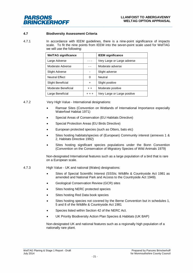
4.7 Biodiversity Assessment Criteria
4.7.1 In accordance with IEEM guidelines, there is a nine-point significance of impactsscale. To fit the nine points from IEEM into the seven-point scale used for WelTAGwe will use the following:
WelTAG significance IEEM significance
Large Adverse - - - Very Large or Large adverse
Moderate Adverse - - Moderate adverse
Slight Adverse - Slight adverse
Neutral Effect 0 Neutral
Slight Beneficial + Slight positive
Moderate Beneficial + + Moderate positive
Large Beneficial + + + Very Large or Large positive
4.7.2 Very High Value - International designations:
Ramsar Sites (Convention on Wetlands of International Importance especiallyWaterfowl Habitat 1971)
Special Areas of Conservation (EU Habitats Directive)
Special Protection Areas (EU Birds Directive)
European protected species (such as Otters, bats etc)
Sites hosting habitats/species of (European) Community interest (annexes 1 &2, Habitats Directive 1992)
Sites hosting significant species populations under the Bonn Convention(Convention on the Conservation of Migratory Species of Wild Animals 1979)
Non-designated International features such as a large population of a bird that is rareon a European scale.
4.7.3 High Value - UK and national (Wales) designations:
Sites of Special Scientific Interest (SSSIs; Wildlife & Countryside Act 1981 asamended and National Park and Access to the Countryside Act 1949).
Geological Conservation Review (GCR) sites
Sites hosting NERC protected species
Sites hosting Red Data book species
Sites hosting species not covered by the Berne Convention but in schedules 1,5 and 8 of the Wildlife & Countryside Act 1981
Species listed within Section 42 of the NERC Act.
UK Priority Biodiversity Action Plan Species & Habitats (UK BAP)
Non-designated UK and national features such as a regionally high population of anationally rare plant.
LLANFOIST TO ABERGAVENNYWELTAG OPTION APPRAISAL
WelTAG Planing & Stage 1 Report - Draft Prepared by Parsons BrinckerhoffJuly 2014 for Monmouthshire County Council
- 22 -
Regional designations, which cannot be reasonably substituted including:
Important “inventory” sites (e.g. ancient semi-natural woodland and grasslandinventories)
JNCC Red List birds of conservation concern 2002 – 2007 (awaiting update)
JNCC Wales list of birds of conservation concern 2002 – 2007 (awaitingupdate)
Non - designated regional features that cannot be reasonably substituted, such as alocally significant area of a regionally scarce complex natural habitat.
4.7.4 Medium Value - Regionally important designations that can be reasonably substitutedincluding:
Local Nature Reserves (LNRs; National Parks and Access to the CountrysideAct 1949)
Important “inventory” sites (e.g. ancient semi-natural woodland and grasslandinventories)
JNCC Red List of Birds of Conservation Concern 2002 – 2007 (awaitingupdate)
JNCC Wales list of birds of conservation concern 2002 – 2007 (awaitingupdate)
Non – designated regional features that can be reasonably substituted such a locallysignificant area of regionally scarce simple, man-made habitat.
4.7.5 Lower Value - Locally designated sites such as County and District including:
Sites of Importance to Nature Conservation (SINCs)/County Wildlife Series(CWSs)/ other local designations
Regional Important Geological Sites (RIGs)
Other sites (not described above) with Local Biodiversity Action Plan (LBAP)habitats/species
Non-designated local features (County and District) such as a of SINC valuewhere no SINCs have been designated in that region
Parish/ward level sites of local nature conservation value or some other biodiversity or geological interest
4.7.6 Negligible Value - Sites or habitats with no listed or recognised nature conservationinterest
4.7.7 The magnitude of impact will be assessed by the scale of loss or damage predicted tosemi-natural vegetation, wildlife habitats and protected species. Significance will beassigned by looking at the magnitude of change to habitats and species of local andregional importance and assigning higher significance to greater loss of regionallyimportant habitats. The following criteria for determining the magnitude of impact willbe used and are based upon, or adapted from, those given in the guidance.
LLANFOIST TO ABERGAVENNYWELTAG OPTION APPRAISAL
WelTAG Planing & Stage 1 Report - Draft Prepared by Parsons BrinckerhoffJuly 2014 for Monmouthshire County Council
- 23 -
Very large or large adverse - The proposal (either on its own or with otherproposals) may adversely affect the integrity of the site, in terms of thecoherence of its ecological structure and function, across its whole area, thatenables it to sustain the habitat, complex of habitats and/or the populationlevels of species of interest. This includes large-scale damage or loss of a largeproportion of a particular semi-natural habitat type or protected species habitatthat is of regional/national importance or listed as a key habitat in the UKBiodiversity Action Plan Steering Group Report Loss of Protected Species.
Moderate adverse - The site’s integrity will not be adversely affected but theeffect on the site is likely to be significant in terms of its ecological objectives.If, in the light of full information, it cannot be clearly demonstrated that theproposal will not have an adverse effect on integrity, then the impact should beassessed as major negative. This would apply in the case of damage or loss ofa small proportion of a particular semi-natural habitat type or protected specieshabitat that is of local importance or listed as a key habitat in the UKBiodiversity Action Plan Steering Group Report.
Slight adverse - Neither of the above apply, but some minor negative impact isevident. (In the case of Natura 2000 sites, a further appropriate assessmentmay be necessary if detailed plans are not yet available).This would apply inthe case of damage or loss of common semi-natural vegetation, wildlifehabitats or important wildlife but not protected species. Habitats are not locallyor regionally important.
Neutral - No observable impact in either direction. This would apply in thecase of damage or minor losses of common types of habitats or commonwildlife. Habitats are not locally or regionally important.
Slight positive - Impacts which provide a slight net gain for biodiversity overall.This would apply in the case of an increase in the population of a species orarea of habitat that is not locally or nationally important.
Moderate positive - Impact which provide a net gain for biodiversity overall(but which will not positively affect the integrity of the site). This would includea small increase in the proportion of a semi-natural habitat or habitat of aprotected species that is locally important or listed as a key habitat within theUK Biodiversity Action Plan Steering Group Report.
Very large or large positive - Impact which provides a net gain for biodiversityoverall in terms of increases in habitat diversity (and which may positively affectthe integrity of the site). This would apply in the case of a large-scale increasein a protected species or habitat of a protected species that is locally importantor listed as a key habitat within the UK Biodiversity Action Plan Steering GroupReport.
LLANFOIST TO ABERGAVENNYWELTAG OPTION APPRAISAL
WelTAG Planing & Stage 1 Report - Draft Prepared by Parsons BrinckerhoffJuly 2014 for Monmouthshire County Council
- 24 -
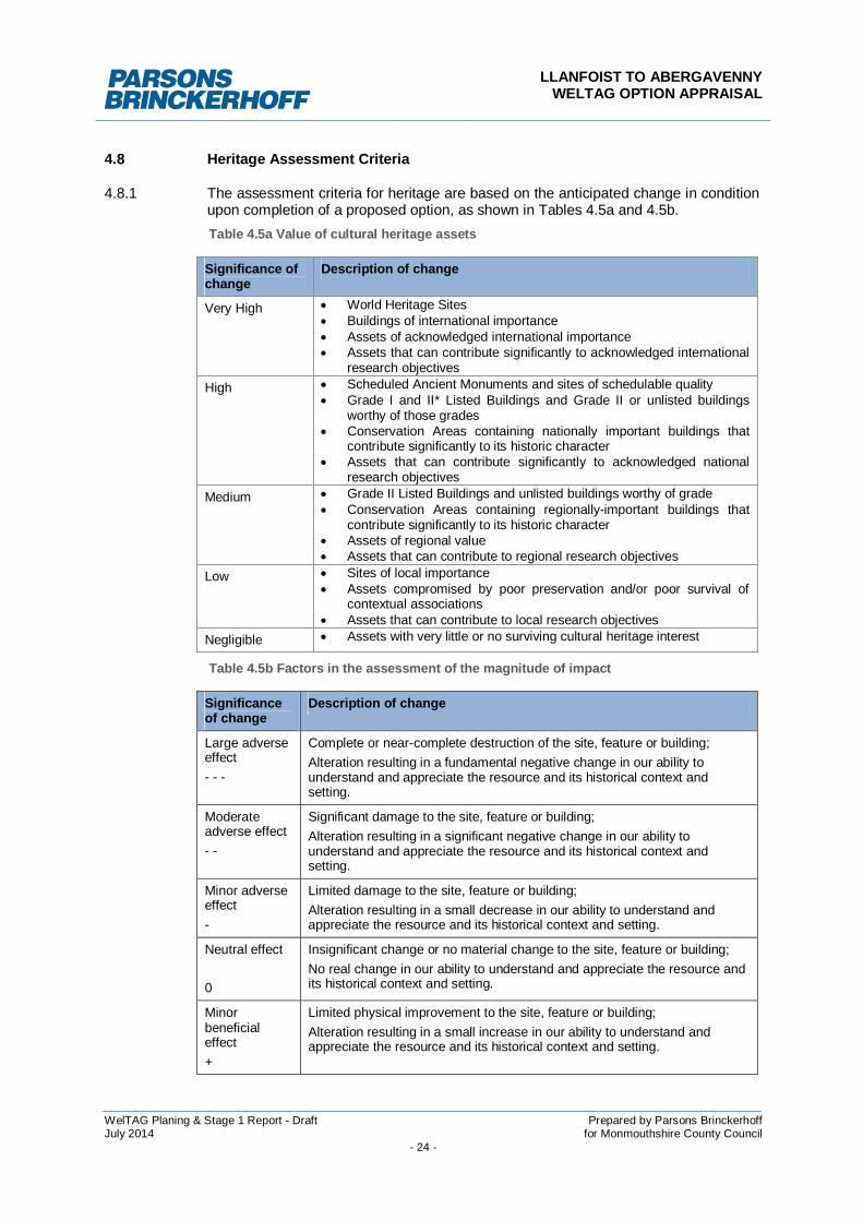
4.8 Heritage Assessment Criteria
4.8.1 The assessment criteria for heritage are based on the anticipated change in conditionupon completion of a proposed option, as shown in Tables 4.5a and 4.5b.Table 4.5a Value of cultural heritage assets
Significance ofchange
Description of change
Very High World Heritage Sites Buildings of international importance Assets of acknowledged international importance Assets that can contribute significantly to acknowledged international
research objectivesHigh Scheduled Ancient Monuments and sites of schedulable quality
Grade I and II* Listed Buildings and Grade II or unlisted buildingsworthy of those grades
Conservation Areas containing nationally important buildings thatcontribute significantly to its historic character
Assets that can contribute significantly to acknowledged nationalresearch objectives
Medium Grade II Listed Buildings and unlisted buildings worthy of grade Conservation Areas containing regionally-important buildings that
contribute significantly to its historic character Assets of regional value Assets that can contribute to regional research objectives
Low Sites of local importance Assets compromised by poor preservation and/or poor survival of
contextual associations Assets that can contribute to local research objectives
Negligible Assets with very little or no surviving cultural heritage interest
Table 4.5b Factors in the assessment of the magnitude of impact
Significanceof change
Description of change
Large adverseeffect- - -
Complete or near-complete destruction of the site, feature or building;Alteration resulting in a fundamental negative change in our ability tounderstand and appreciate the resource and its historical context andsetting.
Moderateadverse effect- -
Significant damage to the site, feature or building;Alteration resulting in a significant negative change in our ability tounderstand and appreciate the resource and its historical context andsetting.
Minor adverseeffect-
Limited damage to the site, feature or building;Alteration resulting in a small decrease in our ability to understand andappreciate the resource and its historical context and setting.
Neutral effect
0
Insignificant change or no material change to the site, feature or building;No real change in our ability to understand and appreciate the resource andits historical context and setting.
Minorbeneficialeffect+
Limited physical improvement to the site, feature or building;Alteration resulting in a small increase in our ability to understand andappreciate the resource and its historical context and setting.
LLANFOIST TO ABERGAVENNYWELTAG OPTION APPRAISAL
WelTAG Planing & Stage 1 Report - Draft Prepared by Parsons BrinckerhoffJuly 2014 for Monmouthshire County Council
- 25 -
Significanceof change
Description of change
Moderatebeneficialeffect+ +
Significant physical improvement to the site, feature or building;Alteration resulting in a significant positive change in our ability tounderstand and appreciate the resource and its historical context andsetting.
Largebeneficialeffect+ + +
Fundamental physical improvement to the site, feature or building;Alteration resulting in a fundamental positive change in our ability tounderstand and appreciate the resource and its historical context andsetting.
Unknown Uncertain change, normally applying to an area in which the extent,character and quality of preservation of archaeological remains is notknown. Also applies where the project design is not sufficiently developedfor effects to be accurately determined.
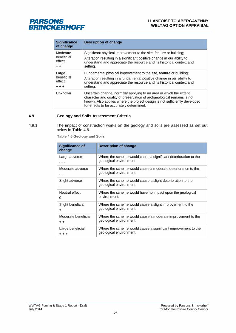
4.9 Geology and Soils Assessment Criteria
4.9.1 The impact of construction works on the geology and soils are assessed as set outbelow in Table 4.6.Table 4.6 Geology and Soils
Significance ofchange
Description of change
Large adverse- - -
Where the scheme would cause a significant deterioration to thegeological environment.
Moderate adverse- -
Where the scheme would cause a moderate deterioration to thegeological environment.
Slight adverse-
Where the scheme would cause a slight deterioration to thegeological environment.
Neutral effect0
Where the scheme would have no impact upon the geologicalenvironment.
Slight beneficial+
Where the scheme would cause a slight improvement to thegeological environment.
Moderate beneficial+ +
Where the scheme would cause a moderate improvement to thegeological environment.
Large beneficial+ + +
Where the scheme would cause a significant improvement to thegeological environment.
LLANFOIST TO ABERGAVENNYWELTAG OPTION APPRAISAL
WelTAG Planing & Stage 1 Report - Draft Prepared by Parsons BrinckerhoffJuly 2014 for Monmouthshire County Council
- 26 -
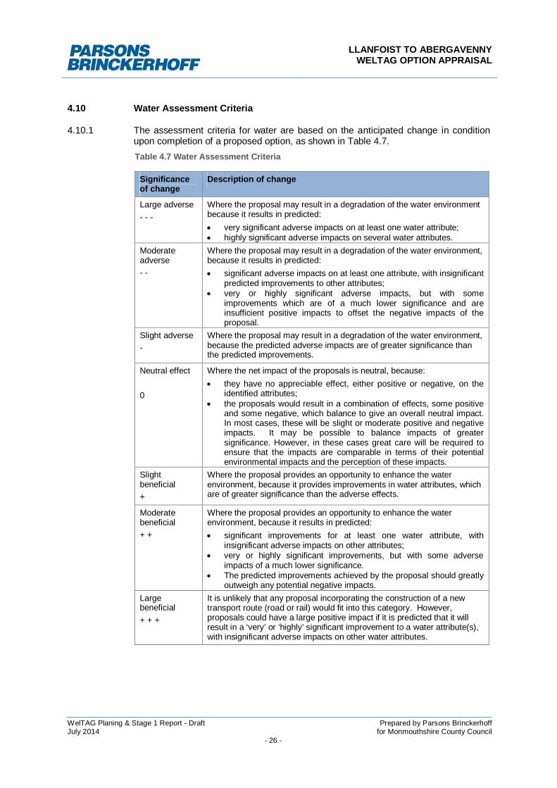
4.10 Water Assessment Criteria
4.10.1 The assessment criteria for water are based on the anticipated change in conditionupon completion of a proposed option, as shown in Table 4.7.Table 4.7 Water Assessment Criteria
Significanceof change
Description of change
Large adverse- - -
Where the proposal may result in a degradation of the water environmentbecause it results in predicted: very significant adverse impacts on at least one water attribute; highly significant adverse impacts on several water attributes.
Moderateadverse- -
Where the proposal may result in a degradation of the water environment,because it results in predicted: significant adverse impacts on at least one attribute, with insignificant
predicted improvements to other attributes; very or highly significant adverse impacts, but with some
improvements which are of a much lower significance and areinsufficient positive impacts to offset the negative impacts of theproposal.
Slight adverse-
Where the proposal may result in a degradation of the water environment,because the predicted adverse impacts are of greater significance thanthe predicted improvements.
Neutral effect
0
Where the net impact of the proposals is neutral, because: they have no appreciable effect, either positive or negative, on the
identified attributes; the proposals would result in a combination of effects, some positive
and some negative, which balance to give an overall neutral impact.In most cases, these will be slight or moderate positive and negativeimpacts. It may be possible to balance impacts of greatersignificance. However, in these cases great care will be required toensure that the impacts are comparable in terms of their potentialenvironmental impacts and the perception of these impacts.
Slightbeneficial+
Where the proposal provides an opportunity to enhance the waterenvironment, because it provides improvements in water attributes, whichare of greater significance than the adverse effects.
Moderatebeneficial+ +
Where the proposal provides an opportunity to enhance the waterenvironment, because it results in predicted: significant improvements for at least one water attribute, with
insignificant adverse impacts on other attributes; very or highly significant improvements, but with some adverse
impacts of a much lower significance. The predicted improvements achieved by the proposal should greatly
outweigh any potential negative impacts.Largebeneficial+ + +
It is unlikely that any proposal incorporating the construction of a newtransport route (road or rail) would fit into this category. However,proposals could have a large positive impact if it is predicted that it willresult in a ‘very’ or ‘highly’ significant improvement to a water attribute(s),with insignificant adverse impacts on other water attributes.
LLANFOIST TO ABERGAVENNYWELTAG OPTION APPRAISAL
WelTAG Planing & Stage 1 Report - Draft Prepared by Parsons BrinckerhoffJuly 2014 for Monmouthshire County Council
- 27 -
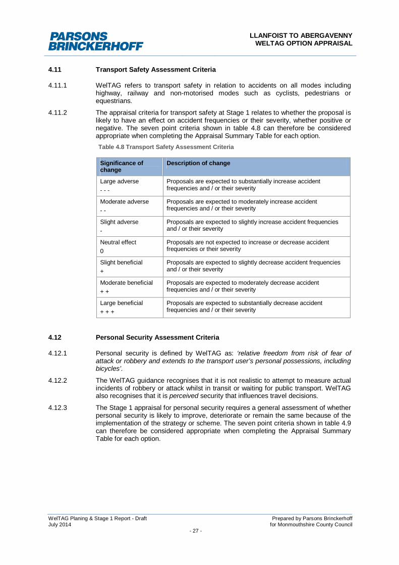
4.11 Transport Safety Assessment Criteria
4.11.1 WelTAG refers to transport safety in relation to accidents on all modes includinghighway, railway and non-motorised modes such as cyclists, pedestrians orequestrians.
4.11.2 The appraisal criteria for transport safety at Stage 1 relates to whether the proposal islikely to have an effect on accident frequencies or their severity, whether positive ornegative. The seven point criteria shown in table 4.8 can therefore be consideredappropriate when completing the Appraisal Summary Table for each option.Table 4.8 Transport Safety Assessment Criteria
Significance ofchange
Description of change
Large adverse- - -
Proposals are expected to substantially increase accidentfrequencies and / or their severity
Moderate adverse- -
Proposals are expected to moderately increase accidentfrequencies and / or their severity
Slight adverse-
Proposals are expected to slightly increase accident frequenciesand / or their severity
Neutral effect0
Proposals are not expected to increase or decrease accidentfrequencies or their severity
Slight beneficial+
Proposals are expected to slightly decrease accident frequenciesand / or their severity
Moderate beneficial+ +
Proposals are expected to moderately decrease accidentfrequencies and / or their severity
Large beneficial+ + +
Proposals are expected to substantially decrease accidentfrequencies and / or their severity
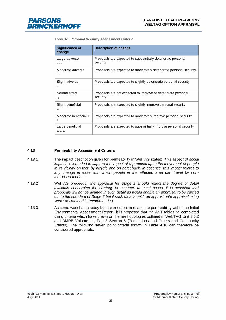
4.12 Personal Security Assessment Criteria
4.12.1 Personal security is defined by WelTAG as: ‘relative freedom from risk of fear ofattack or robbery and extends to the transport user’s personal possessions, includingbicycles’.
4.12.2 The WelTAG guidance recognises that it is not realistic to attempt to measure actualincidents of robbery or attack whilst in transit or waiting for public transport. WelTAGalso recognises that it is perceived security that influences travel decisions.
4.12.3 The Stage 1 appraisal for personal security requires a general assessment of whetherpersonal security is likely to improve, deteriorate or remain the same because of theimplementation of the strategy or scheme. The seven point criteria shown in table 4.9can therefore be considered appropriate when completing the Appraisal SummaryTable for each option.
LLANFOIST TO ABERGAVENNYWELTAG OPTION APPRAISAL
WelTAG Planing & Stage 1 Report - Draft Prepared by Parsons BrinckerhoffJuly 2014 for Monmouthshire County Council
- 28 -
Table 4.9 Personal Security Assessment Criteria
Significance ofchange
Description of change
Large adverse- - -
Proposals are expected to substantially deteriorate personalsecurity
Moderate adverse- -
Proposals are expected to moderately deteriorate personal security
Slight adverse-
Proposals are expected to slightly deteriorate personal security
Neutral effect0
Proposals are not expected to improve or deteriorate personalsecurity
Slight beneficial+
Proposals are expected to slightly improve personal security
Moderate beneficial ++
Proposals are expected to moderately improve personal security
Large beneficial+ + +
Proposals are expected to substantially improve personal security
4.13 Permeability Assessment Criteria
4.13.1 The impact description given for permeability in WelTAG states: ‘This aspect of socialimpacts is intended to capture the impact of a proposal upon the movement of peoplein its vicinity on foot, by bicycle and on horseback. In essence, this impact relates toany change in ease with which people in the affected area can travel by non-motorised modes’.
4.13.2 WelTAG proceeds, ‘the appraisal for Stage 1 should reflect the degree of detailavailable concerning the strategy or scheme. In most cases, it is expected thatproposals will not be defined in such detail as would enable an appraisal to be carriedout to the standard of Stage 2 but if such data is held, an approximate appraisal usingWebTAG method is recommended’.
4.13.3 As some work has already been carried out in relation to permeability within the InitialEnvironmental Assessment Report, it is proposed that the AST tables be completedusing criteria which have drawn on the methodologies outlined in WebTAG Unit 3.6.2and DMRB Volume 11, Part 3 Section 8 (Pedestrians and Others and CommunityEffects). The following seven point criteria shown in Table 4.10 can therefore beconsidered appropriate.
LLANFOIST TO ABERGAVENNYWELTAG OPTION APPRAISAL
WelTAG Planing & Stage 1 Report - Draft Prepared by Parsons BrinckerhoffJuly 2014 for Monmouthshire County Council
- 29 -
Table 4.10 Permeability Assessment Criteria
Significance ofchange
Description of change
Large adverse- - -
People are likely to be deterred from making non-motorised journeys toan extent sufficient to induce a reorganisation of their activities. In somecases, this could lead to a change in the location of centres of activity orto a permanent loss of access to certain facilities for a particularcommunity. Those who make journeys by non-motorised means willexperience considerable hindrance.
Moderateadverse- -
Some people, particularly children and old people, are likely to bedissuaded from making journeys by non-motorised means. For others,journeys will be longer or less attractive.
Slight adverse-
All people wishing to make movements by non-motorised means will beable to do so, but there will probably be some hindrance to movement
Neutral effect0
Little or no hindrance to movement by non-motorised means.
Slight beneficial+
All people wishing to make movements by non-motorised means will beable to do so and there will probably be some encouragement tomovement
Moderatebeneficial+ +
Some people, particularly children and old people, are likely to beencouraged to make journeys by non-motorised means. For others,journeys will be shorter or more attractive.
Large beneficial+ + +
People are likely to be encouraged to make non-motorised journeys toan extent sufficient to induce a reorganisation of their activities. In somecases, this could lead to an increase use in the centres of activity or tonew access to certain facilities for a particular community. Those whomake journeys by non-motorised means will experience considerableencouragement.
4.14 Physical Fitness Assessment Criteria
4.14.1 The term physical fitness has been used in WelTAG because it is the aspect ofgeneral health that can be most closely associated with active travel. Health is a highpriority in Wales and travelling on foot, by bicycle or horseback can makecontributions towards physical fitness and well-being.
4.14.2 The Stage 1 appraisal for physical fitness states that ‘it is sufficient for the planner toreach a reasoned view as to whether travel by active modes can be expected toincrease or decrease as a result of the proposal. Where more can be said withconfidence about any distribution implications, this should also be included in theshort qualitative statement’. The following seven point criteria shown in table 4.11can therefore be considered appropriate when completing the Appraisal SummaryTable for each option in relation to physical fitness.
LLANFOIST TO ABERGAVENNYWELTAG OPTION APPRAISAL
WelTAG Planing & Stage 1 Report - Draft Prepared by Parsons BrinckerhoffJuly 2014 for Monmouthshire County Council
- 30 -
Table 4.11 Physical Fitness Assessment Criteria
Significance ofchange
Description of change
Large adverse- - -
Proposals are expected to substantially decrease travel by activemodes.
Moderate adverse- -
Proposals are expected to moderately decrease travel by activemodes.
Slight adverse-
Proposals are expected to slightly decrease travel by activemodes.
Neutral effect0
Proposals are not expected to increase or decrease travel byactive modes.
Slight beneficial+
Proposals are expected to slightly increase travel by activemodes.
Moderate beneficial+ +
Proposals are expected to moderately increase travel by activemodes
Large beneficial+ + +
Proposals are expected to substantially increase travel by activemodes
4.15 Social Inclusion Assessment Criteria
4.15.1 The WelTAG appraisal guidance for social inclusion states that accessibility andsocial inclusion are synonymous. The former is the measurement of the relative easewith which people can get to their destinations and obtain the services that areimportant to them and the latter is the degree with which members of society are ableto lead a full life. For a WelTAG transport appraisal however, social inclusion isdefined as the degree to which a lack of accessibility hampers an individual’s qualityof life.
4.15.2 WelTAG guidance identifies eight indicators to be used in appraising social inclusionimpacts, which are as follows:
1. Proportion of households within a) 60 and b) 90 minute non-motorised traveltime threshold(s) of a National Health Service District General Hospitalbetween 10:00 and 12:00 on a Tuesday;
2. Proportion of people aged 16 – 74 within a) 60 and b) 90 minute non-motorised travel time threshold(s) of ‘Learning Providers’ (as recognisedwithin the ELWa National Planning Framework) between 7:00 and 9:00 on aTuesday
3. Proportion of households within a) 60 and b) 90 minutes non-motorised traveltime thresholds of a ‘Key Centre’ between 10:00 and 12:00 on a Tuesday;and
4. Proportion of households within a) 60 and b) 90 minute non-motorised traveltime thresholds of a ‘Key Centre’ between 20:00 and 22:00 on a Saturday.
4.15.3 The goal of the appraisal is to establish which of these numbers would change as aresult of the scheme, and whether they would increase or decrease. Therefore, thefollowing seven point criteria shown in table 4.12 can be considered appropriate when
LLANFOIST TO ABERGAVENNYWELTAG OPTION APPRAISAL
WelTAG Planing & Stage 1 Report - Draft Prepared by Parsons BrinckerhoffJuly 2014 for Monmouthshire County Council
- 31 -
completing the Appraisal Summary Table for each option in relation to SocialInclusion.Table 4.12 Social Inclusion Assessment Criteria
Significance ofchange
Description of change
Large adverse- - -
Proposals are expected to substantially decrease the proportions inindicators 1 to 4.
Moderate adverse- -
Proposals are expected to moderately decrease the proportions inindicators 1 to 4.
Slight adverse-
Proposals are expected to slightly decrease the proportions inindicators 1 to 4.
Neutral effect0
Proposals are not expected to increase or decrease theproportions in indicators 1 to 4.
Slight beneficial+
Proposals are expected to slightly increase the proportions inindicators 1 to 4.
Moderate beneficial+ +
Proposals are expected to moderately increase the proportions inindicators 1 to 4.
Large beneficial+ + +
Proposals are expected to substantially increase the proportions inindicators 1 to 4.
4.16 Equality, Diversity and Human Rights Assessment Criteria
4.16.1 The WelTAG guidance for a Stage 1 Appraisal states that ‘all positive and negativeimpacts, particularly disproportionate impacts, arising from the strategy or scheme(s)should be qualitatively assessed against the following equality impact groups:
Race, ethnicity, colour or nationality;
Sex marital status;
Disability: physical, sensory or mental;
Age;
Religion or belief;
Sexual orientation;
Welsh language;
Other: Lone parent, economic inactivity, social and multiple deprivation
4.16.2 Issues relating to compatibility with human rights legislation should also beconsidered.
4.16.3 Following consultation with the Welsh Assembly Government, it was suggested thatan assessment criteria for assessing equality, diversity and human rights should alsotake into account statutory duties imposed on public authorities e.g. Race Relations(Amendment) Act 2000, Disability Discrimination Act 2005 and Sex Discrimination Act1975 (as Amended by the Equality Act 2006). Therefore, the following seven pointcriteria shown in table 4.13 can be considered appropriate when completing theAppraisal Summary Table for each option.
LLANFOIST TO ABERGAVENNYWELTAG OPTION APPRAISAL
WelTAG Planing & Stage 1 Report - Draft Prepared by Parsons BrinckerhoffJuly 2014 for Monmouthshire County Council
- 32 -
Table 4.13 Equality, Diversity and Human Rights Assessment Criteria
Significance ofchange
Description of change
Large adverse- - -
Proposals are expected to have a severe adverse effect in relationto one or more of the equality impact groups and statutory duties.
Moderate adverse- -
Proposals are expected to have a moderate adverse effect inrelation to one or more of the equality impact groups and statutoryduties.
Slight adverse-
Proposals are expected to have a slight adverse effect in relation toone or more of the equality impact groups and statutory duties.
Neutral effect0
Proposals are not expected to beneficially or adversely effectissues relating to equality impact groups and statutory duties
Slight beneficial+
Proposals are expected to have a slight beneficial effect in relationto one or more of the equality impact groups and statutory duties.
Moderate beneficial+ +
Proposals are expected to have a moderate beneficial effect inrelation to one or more of the equality impact groups and statutoryduties.
Large beneficial+ + +
Proposals are expected to have a large beneficial effect in relationto one or more of the equality impact groups and statutory duties.
4.17 Appraisal Summary Tables
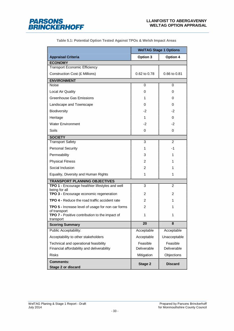
4.17.1 Table 5.1 summarises how each identified transport solution performs against boththe TPOs and Welsh Impact Areas. Full ASTs for all options are provided in AppendixA.
LLANFOIST TO ABERGAVENNYWELTAG OPTION APPRAISAL
WelTAG Planing & Stage 1 Report - Draft Prepared by Parsons BrinckerhoffJuly 2014 for Monmouthshire County Council
- 33 -
Table 5.1: Potential Option Tested Against TPOs & Welsh Impact Areas
WelTAG Stage 1 Options
Appraisal Criteria Option 3 Option 4ECONOMYTransport Economic Efficiency
Construction Cost (£ Millions) 0.62 to 0.78 0.66 to 0.81
ENVIRONMENTNoise 0 0
Local Air Quality 0 0
Greenhouse Gas Emissions 1 0
Landscape and Townscape 0 0
Biodiversity -2 -2
Heritage 1 0
Water Environment -2 -2
Soils 0 0
SOCIETYTransport Safety 3 2
Personal Security 1 -1
Permeability 3 1
Physical Fitness 2 1
Social Inclusion 2 1
Equality, Diversity and Human Rights 1 1
TRANSPORT PLANNING OBJECTIVESTPO 1 - Encourage healthier lifestyles and wellbeing for all
3 2
TPO 3 - Encourage economic regeneration 2 2
TPO 4 - Reduce the road traffic accident rate 2 1
TPO 5 - Increase level of usage for non car formsof transport
2 1
TPO 7 - Positive contribution to the impact oftransport
1 1
Scoring Summary 20 8
Public Acceptability: Acceptable Acceptable
Acceptability to other stakeholders Acceptable Unacceptable
Technical and operational feasibility Feasible FeasibleFinancial affordability and deliverability Deliverable Deliverable
Risks Mitigation Objections
Comments:Stage 2 or discard
Stage 2 Discard
LLANFOIST TO ABERGAVENNYWELTAG OPTION APPRAISAL
WelTAG Planing & Stage 1 Report - Draft Prepared by Parsons BrinckerhoffJuly 2014 for Monmouthshire County Council
- 34 -
4.18 Stage 1 Summary
4.18.1 The following two options were taken forward for consideration and assessment atWelTAG Stage 1:
Option 3 - Create new link downstream of Llanfoist Bridge adjacent to theWhite Castle Development
Option 4 - Create new link downstream of Llanfoist Bridge between the WhiteCastle Development and the Sewerage works
4.18.2 The best performing route option is Option 3 ‘Create new link downstream of LlanfoistBridge adjacent to the White Castle Development’. The main advantages over Option4 stems from the anticipated level of use once completed, resulting in far greatersocial benefits.
4.19 Recommendations for Stage 2 WelTAG
4.19.1 The Stage 1 appraisal clearly demonstrated that Option 3 is best placed to meet, notonly the projects Transport Planning Objectives, but also the Welsh Impact Areas.Given the performance of Option 3 at Stage 1 and the anticipated capital costs of theproject, it is recommended that no further appraisal of the option, in the form of adetailed Stage 2 assessment is undertaken. This decision is supported by WelTAGfor schemes less than £5 million in value and where further assessment would be aninefficient use of resources. Instead, further work should focus on the feasibility andtechnically deliver of Option 3 to ensure that the most sustainable and publicallyacceptable scheme is developed and put forward for development in the near future.

LLANFOIST TO ABERGAVENNYWELTAG OPTION APPRAISAL
WelTAG Planing & Stage 1 Report - Draft Prepared by Parsons BrinckerhoffJuly 2014 for Monmouthshire County Council
- 35 -
5 PREFERRED OPTION
5.1 Introduction
5.1.1 During initial site walkover inspections and desk top reviews undertaken by theproject team, two principle route elements were identified, those being:
Links south of the River Usk; and
Links north of River Usk.
5.1.2 The opportunities and challenges associated with each link within the route corridor,including sub-options, together with a recommendation for further development isdiscussed in this section.
5.1.3 The various link options are shown in Figure 3.
5.2 Southern Link 1
Route Corridor
5.2.1 Starting on the B4246 Merthyr Road at the junction with The Cutting the route wouldfollow the existing NCN 46 shared use infrastructure leading under the A465underpass and out on to the Waitrose Roundabout. Between Waitrose Roundaboutand Llanfoist Bridge users would be encouraged to use the existing eastern footwayleading to the Bridge Inn Free House. At the Bridge Inn, a new path would beconstructed along the southern bank of the River Usk that leads to a new rivercrossing.
Constraints
5.2.2 There are no constraints along the existing infrastructure between The Cutting andthe Waitrose Roundabout. The existing footway between Waitrose Roundabout andthe Bridge Inn is of sub-standard width for shared use. At the identified turn in intothe new path along the southern bank of the River Usk the path would pass through ashort section of land currently used for parking by patrons of the Bridge Inn. To createthe new path along the river bank vegetation would need to be cleared.
Link Requirements
5.2.3 The existing footway between the Waitrose Roundabout and the Bridge Inn wouldneed to be widened to provide sufficient width for safe use as a shared use cycleway /footway. This could be achieved by reducing the width of the adjacent carriageway, orrestricting on-street parking. At the turn in to the new path a short link could becreated between the area used for parking and the new path without the need torestrict existing parking arrangements. A two-way path 2-3metres wide with localisedtrail width reductions around mature trees and other features could be provided alongthe southern embankment of the River Usk.
Technical Delivery
5.2.4 The Southern Link 1, approximately 1.1km in length would be technically feasible todeliver. Approximately 0.275km of the trail along the southern embankment of theRiver Usk would need to be constructed and approximately 0.1km of existing footwaypath would need to be widened. The remainder of the link would require no works.
LLANFOIST TO ABERGAVENNYWELTAG OPTION APPRAISAL
WelTAG Planing & Stage 1 Report - Draft Prepared by Parsons BrinckerhoffJuly 2014 for Monmouthshire County Council
- 36 -
5.2.5 Due to the density of the trees and vegetation along the southern embankment of theriver Usk some tree felling and vegetation clearance would be required to create thetrail corridor.
5.2.6 A trail could be constructed that traverses along the side slope, allowing for effectivesurface water management and minimal engineering works.
5.2.7 Access during construction could be gained from the Bridge Inn entrance andpotentially from the private driveway forming part of Southern Link 2 subject to theagreement of the landowner. The creation of either of these routes would also assistin the installation of the bridge deck by forming a suitable access route.
End User
5.2.8 This link would offer gentle gradient changes (up to 5%) improving the existingwalking and cycling experience in and around Llanfoist and Abergavenny. The routewould be suitable for all ages and stages of health and would fit in with Sustransaspirations for good quality off road pedestrian and cycling routes.
5.3 Southern Link 2
Route Corridor
5.3.1 Starting on the B4246 Merthyr Road at Llanfoist Post Office the route would follow theexisting shared use infrastructure along Merthyr Road leading under the A465overbridge and to the White Castle housing development. The route would then turnright into Riverside Drive via an existing ramped public right of way and continuealong newly built footway up to Property No. 40. At this point a new path would becreated through the private driveway leading down on to the southern embankment ofthe River Usk where it would link in to a new river crossing.
Constraints
5.3.2 There are no constraints along the existing infrastructure along Merthyr Road,however, the existing ramped footway leading in to Riverside Drive is of insufficientwidth for a two way shared use path. The private driveway is wide enough to continueto accommodate two vehicles and allow a new path to be constructed but wouldrequire negotiations with the landowners. Behind the property, the embankment whichis covered with mature trees falls sharply towards the river.
Link Requirements
5.3.3 The existing ramped path between Merthyr Road and Riverside Drive would benefitfrom being widened to accommodate shared use. A new short section of pathwaywould need to be constructed through the driveway of Property No.40 to link into anew 2-3metres wide ramp leading down towards the river crossing.
Technical Delivery
5.3.4 The Southern Link 2, approximately 0.8km in length would be technically feasible todeliver. Approximately 0.05km of the trail behind Property No. 40 of Riverside Drivewould need to be constructed on ramp. The ramp would be linked to the river crossingand the Riverside Drive by approximately 0.04km of new path construction. Theremainder of the link would require no works accept for new signing.
LLANFOIST TO ABERGAVENNYWELTAG OPTION APPRAISAL
WelTAG Planing & Stage 1 Report - Draft Prepared by Parsons BrinckerhoffJuly 2014 for Monmouthshire County Council
- 37 -
5.3.5 Due to the density of the trees and vegetation along the southern embankment of theriver Usk some tree felling and vegetation clearance would be required to create thepath corridor.
5.3.6 Access during construction could be gained from the private driveway forming part ofSouthern Link 2 subject to the agreement of the landowner, however it is likely thatsome form of temporary path along the embankment would need to be installed toconstruct the ramp and install the bridge.
End User
5.3.7 This link would offer moderate gradient changes (up to 7%) in keeping with theexisting walking and cycling experience in and around Llanfoist and Abergavenny.The route would be suitable for all ages and stages of health and would fit in withSustrans aspirations for good quality pedestrian and cycling routes.
5.4 Southern Link 3
Route Corridor
5.4.1 Starting on the B4246 Merthyr Road at Llanfoist Post Office the route would follow theexisting shared use infrastructure along Merthyr Road leading under the A465overbridge. Immediately north of the overbridge the route would turn right and followan unclassified track leading to the Sewerage Works. At the eastern boundary of thehousing development a new path would be created leading up to the River Uskembankment and a new river crossing.
Constraints
5.4.2 There are no constraints along the existing infrastructure along Merthyr Road, or theunclassified track leading to the Sewerage Works. At the identified turn on to the newpath at the eastern boundary of the housing development site no particularlyunmanageable constraints exist, however, as the path returns towards the new bridgecrossing site, the path would need to be formed through an area of unstable groundthat would require extensive remedial works.
Link Requirements
5.4.3 A new shared use 2-3metre wide path would need to be constructed around theeastern boundary of the housing development.
Technical Delivery
5.4.4 The Southern Link 3, approximately 1.3km in length would be technically feasible,although challenging, to deliver. Approximately 0.5km of the trail along the easternboundary of the housing development would need to be constructed, of which, 0.2kmwould pass through an area of ground that experienced a landslip in February 2014.The remainder of the link would require no works other than new signing.
5.4.5 Due to the density of the trees and vegetation along the southern embankment of theriver Usk some tree felling and vegetation clearance would be required to create thetrail corridor.
5.4.6 Access during construction could be gained from the unclassified track and potentiallyfrom the private driveway forming part of Southern Link 2 subject to the agreement of
LLANFOIST TO ABERGAVENNYWELTAG OPTION APPRAISAL
WelTAG Planing & Stage 1 Report - Draft Prepared by Parsons BrinckerhoffJuly 2014 for Monmouthshire County Council
- 38 -
the landowner. The creation of either of these routes would also assist in theinstallation of the bridge deck by forming a suitable access route.
End User
5.4.7 This link would offer moderate gradient changes (up to 7%) in keeping the existingwalking and cycling experience in and around Llanfoist and Abergavenny. The routewould be suitable for all ages and stages of health and would fit in with Sustransaspirations for good quality off road pedestrian and cycling routes, although the linkmay be too far away from the desire lines to entice regular users.
5.5 Northern Link 1
5.5.1 Upon crossing the river, the route would broadly follow an existing pathway throughCastle Meadows leading to Ryefield Lane Car Park. The route would exit the car parkat Tudor Street opposite the Magistrates Court via a newly constructed path adjacentto the existing carriageway, before connecting into the existing shared use NCNinfrastructure at Nevill Street.
Constraints
5.5.2 Castle Meadows forms part of the River Usk flood plain and holds someenvironmental and biodiversity value. At the car park, no segrated path is in place,with walkers forced to use the car park access road to exit on to Tudor Street. Onceon Tudor Street, existing shared use infrastructure is in good condition.
Link Requirements
5.5.3 A new shared use 2-3metre wide path would need to be constructed along the broadline of the existing permeable paving walking path. At the car park a new path wouldneed to be created around the western side of the facility to connect in to TudorStreet.
Technical Delivery
5.5.4 The Northern Link 1, approximately 0.9km in length would be technically feasible todeliver. Approximately 0.35km of the existing trail the Castle Meadows would need tobe reconstructed and a new path approximately 0.15km in length would be built toprovide an off road connection in to Tudor Street. The remainder of the link wouldrequire no works.
5.5.5 Access during construction could be gained from the Ryefiled Car Park, which couldalso serve as a potential site compound during the works. By constructing the pathfrom north to south, access could also be gained to the northern embankment of theRiver Usk to install the river crossing.
End User
5.5.6 This link would offer gentle gradient changes (up to 5%) improving the existingwalking and cycling experience in and around Llanfoist and Abergavenny. The routewould be suitable for all ages and stages of health and would fit in with Sustransaspirations for good quality off road pedestrian and cycling routes. The link would alsoimprove access to Castle Meadows and may encourage further recreational use.

LLANFOIST TO ABERGAVENNYWELTAG OPTION APPRAISAL
WelTAG Planing & Stage 1 Report - Draft Prepared by Parsons BrinckerhoffJuly 2014 for Monmouthshire County Council
- 39 -
5.6 Northern Link 2
5.6.1 Upon crossing the river, the route would turn immediately right and follow the existingNCN towards Abergavenny Castle and on to Nevill Street.
Constraints
5.6.2 Castle Meadows forms part of the River Usk flood plain and holds someenvironmental and biodiversity value. The single lane road around the castle has nosegregated footway, or cycleway and exits on to Castle Street at a particularly poorjunction layout that struggles to accommodate non-motorised users. Once on CastleStreet, existing shared use infrastructure is in reasonable condition.
Link Requirements
5.6.3 The existing NCN path would need to be improved to provide a continuous 2-3metrewide bound shared path between the new river crossing and the single lane road atthe castle. Some works to improve the safety of non-motorised users at the CastleStreet / Castle walks junction would also be desirable to accommodate any increasein its use.
Technical Delivery
5.6.4 The Northern Link 2, approximately 1.1km in length would be technically feasible todeliver. Approximately 0.65km of the existing trail would need to be reconstructed andsome improvement works would be needed around castle Street. The remainder ofthe link would require no works.
5.6.5 Restricted access during construction could be gained from the Castle Street, or byforming a temporary access from Ryefiled Car Park across Cstle Meadows.
End User
5.6.6 This link would offer gentle gradient changes (up to 5%) through Castle Meadows, buta gradient change of up to 10% would be experienced when travelling up to theCastle, making it challenging for some users.
5.7 Recommendation for Further Development
Southern Link
5.7.1 Considering the quality of the existing infrastructure along The Cutting (Southern Link1), it is recommended that this is maintained as the principal pedestrian and cyclistlink south of the River Usk and marketed as such, with the existing infrastructurealong Merthyr Road between the Posts Office and the White Castle housingdevelopment maintained as an alternative depending upon the users destination.
5.7.2 At Waitrose Roundabout where these two pathways merge together, it isrecommended that Southern Link 1 is taken forward as the preferred link, withSouthern Link 2 implemented as a ‘short cut’ for pedestrians only if an agreementcould be formed with the landowners and sufficient funding is available.
5.7.3 Southern Link 3 should not be taken forward as part of this scheme, as it is unlikely togenerate the desired level of use due to it passing through a remote area away fromthe desire line and the anticipated technical difficulties and higher costs associated
LLANFOIST TO ABERGAVENNYWELTAG OPTION APPRAISAL
WelTAG Planing & Stage 1 Report - Draft Prepared by Parsons BrinckerhoffJuly 2014 for Monmouthshire County Council
- 40 -
with remediating the embankment. However, it may be worth consideringimplementing this route as a pedestrian link should future development of the areatake place.
Northern Link
5.7.4 Considering the challenges faced in developing Northern Link 2, particularly in gainingconsent to modify the existing infrastructure around Abergavenny Castle and theuncertainty in attracting users, it is recommended that Northern Link 1 is takenforward as the preferred option.
5.7.5 Northern Link 1 would provide a high quality direct route between the new rivercrossing and Abergavenny Town Hall through the heart of Castle Meadows. Theroute would be suitable for all abilities and links into to good quality existing shareduse infrastructure on Tudor Street.
5.8 Outline Scheme Proposals
5.8.1 Outline scheme proposals for the preferred option have been developed and areprovided in Figure 4.
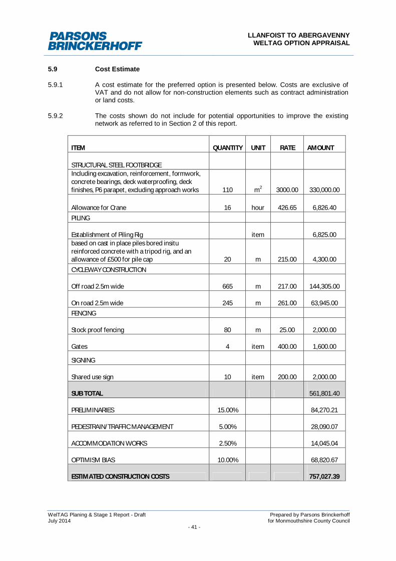
LLANFOIST TO ABERGAVENNYWELTAG OPTION APPRAISAL
WelTAG Planing & Stage 1 Report - Draft Prepared by Parsons BrinckerhoffJuly 2014 for Monmouthshire County Council
- 41 -
5.9 Cost Estimate
5.9.1 A cost estimate for the preferred option is presented below. Costs are exclusive ofVAT and do not allow for non-construction elements such as contract administrationor land costs.
5.9.2 The costs shown do not include for potential opportunities to improve the existingnetwork as referred to in Section 2 of this report.
ITEM QUANTITY UNIT RATE AMOUNT
STRUCTURAL STEEL FOOTBRIDGEIncluding excavation, reinforcement, formwork,concrete bearings, deck waterproofing, deckfinishes, P6 parapet, excluding approach works 110 m2 3000.00 330,000.00
Allowance for Crane 16 hour 426.65 6,826.40PILING
Establishment of Piling Rig item 6,825.00based on cast in place piles bored insitureinforced concrete with a tripod rig, and anallowance of £500 for pile cap 20 m 215.00 4,300.00CYCLEWAY CONSTRUCTION
Off road 2.5m wide 665 m 217.00 144,305.00
On road 2.5m wide 245 m 261.00 63,945.00FENCING
Stock proof fencing 80 m 25.00 2,000.00
Gates 4 item 400.00 1,600.00
SIGNING
Shared use sign 10 item 200.00 2,000.00
SUB TOTAL 561,801.40
PRELIMINARIES 15.00% 84,270.21
PEDESTRAIN/TRAFFIC MANAGEMENT 5.00% 28,090.07
ACCOMMODATION WORKS 2.50% 14,045.04
OPTIMISM BIAS 10.00% 68,820.67
ESTIMATED CONSTRUCTION COSTS 757,027.39
LLANFOIST TO ABERGAVENNYWELTAG OPTION APPRAISAL
WelTAG Planing & Stage 1 Report - Draft Prepared by Parsons BrinckerhoffJuly 2014 for Monmouthshire County Council
- 42 -
5.10 Opportunity for Phased Development
5.10.1 Depending on project funding the following outline construction phasing could beadopted:
Phase 1 - Install new river crossing
Phase 2 - Create new path along southern embankment of the River Usk
Phase 3 - Widen existing footway at the Bridge Inn
Phase 4 - Surface northern link path between the new river crossing and the car park
Phase 5 - Create new segregated path alongside the car park
Phase 6 - Create new link to Riverside Drive for pedestrians
5.11 Land Requirements
5.11.1 A land ownership plan is provided in Figure 5 of this report. Sections of southern routelandownership still needs to be confirmed.
5.12 Recommendations
5.12.1 It is recommended that the preferred route as indicated on Figure 4 is taken forwardfor further development and implementation.
5.12.2 During the next stage of project development the following timeline should beconsidered:
Present findings to officers and members as part of the Bryn-y-CwmTransport Working Group;
Consult key stakeholders, including MCC planning departments, CADW,NRW, Abergavenny Town Council and Llanfoist Community Council;
Carryout topographical survey;
Determine the requirement for any ecological surveys, includingarboriculturist to review potential tree loss;
Consult with NRW regarding the availability of existing flood modelling todetermine the freeboard level of the bridge. If unavailable appoint a suitablyexperienced consultant to carryout flood modelling to determine freeboardlevel;
Carryout preliminary bridge layout proposals enabling lengths of approachramps to be determined;
Hold a public consultation event;
Progress geotechinical site investigation to assist future design of bridgefoundations;
Meet MCC planning department to determine planning requirements;
Carryout Flood Consequence Assessment to support future planningsubmission;
Submit planning application;
Develop detailed design proposals; and
Tender construction works.

LLANFOIST TO ABERGAVENNYWELTAG OPTION APPRAISAL
WelTAG Planing & Stage 1 Report - Draft Prepared by Parsons BrinckerhoffJuly 2014 for Monmouthshire County Council
- 43 -
6 REFERENCES
1 Welsh Transport Planning and Appraisal Guidance (WelTAG), June 2008, WelshAssembly Government
LLANFOIST TO ABERGAVENNYWELTAG OPTION APPRAISAL
WelTAG Planing & Stage 1 Report - Draft Prepared by Parsons BrinckerhoffJuly 2014 for Monmouthshire County Council
Appendix AAppraisal Summary Tables

LLANFOIST TO ABERGAVENNYWELTAG OPTION APPRAISAL
WelTAG Planing & Stage 1 Report - Draft Prepared by Parsons BrinckerhoffJuly 2014 for Monmouthshire County Council
Llanfoist to Abergavenny: WelTAG Stage 1 Appraisal – Appraisal Summary Table (AST)
ASTs llanfoist to Abergavenny
Option 3Create new link downstream of Llanfoist Bridge adjacent to the White Castle Development
Appraisal Criteria Assessment Distribution Significance
EconomyTransport EconomicEfficiency
Cost: £620-780k Study Area
EALI (widereconomic Impacts)
Would serve north-south movements betweenLlanfoist and Abergavenny, with benefits forcommunities, businesses and tourism across thewider study area. May have the potential toencourage further development east of Whitecastle by improving accessibility.
EnvironmentNoise A new shared use path is likely to encourage some
car users to take non-motorised transport for shortjourneys between Llanfoist and Abergavenny. Aslight modal shift in local travel patterns couldoccur but is not likely to alter existing levels ofnoise pollution in any significant way.
Study Area Neutral (0)
Local Air Quality A new shared use path is likely to encourage somecar users to take non-motorised transport for shortjourneys between Llanfoist and Abergavenny.,although the impact on existing air quality levels isthought to be negligible.
Along Merthyr Road Neutral (0)
Greenhouse GasEmissions
A new shared use path is likely to encourage somecar users to take non-motorised transport for shortjourneys between Llanfoist and Abergavenny, Thisis likely to reduce existing levels of vehicle milestravelled.
Along Merthyr Road Slight beneficial (+)
Landscape andtownscape
Creating a shared use path along the River Uskembankment is unlikely to have any significanteffects on the landscape or townscape. A corridoris already in place along the river bank and in mostparts is flanked by mature vegetation. Thestructure would be visible from Castle Meadows,but could be mitigated through appropriate choiceof structure and landscaping on the northern side.
Rural landscape Neutral (0)
Bio-diversity The river crossing has the potential to impact uponthe River Usk SAC and SSSI. An array of habitatsincluding mature trees and hedgerows are alsolikely are affected to some extent.
Habitats andterritories along theRiver Usk
Moderate adverse(- -)
Heritage Proposal generally contained within an alreadydeveloped area and would have very limitedimpact on any surviving cultural heritage interest.Potential to improve the impact of transport on theGrade I listed bridge.
Along A40 Slight beneficial (+)
Water environment The construction of a path on ‘green’ land willincrease surface water runoff. The creation ofcrossing of the River Usk will impact on thefloodplains capacity.
River Usk Moderate adverse(- -)
Soils The construction of a path will involve the removalof topsoil, but this is unlikely to significantly alterthe geological environment.
Along route Neutral (0)
SocietyTransport safety The removal of conflicts between vehicles and
non-motorised users will substantially reduceaccident frequencies and / or their severity for non-motorised users along Merthyr Road
Along Merthyr Road Large beneficial(+++)
Llanfoist to Abergavenny: WelTAG Stage 1 Appraisal – Appraisal Summary Table (AST)
ASTs llanfoist to Abergavenny
Option 3Create new link downstream of Llanfoist Bridge adjacent to the White Castle Development
Appraisal Criteria Assessment Distribution Significance
Personal security Overall proposals are expected to improvepersonal security. People are likely to feel moresecure during hours of day light, but less secureduring darkness.
Along Merthyr Road Slight beneficial (+)
Permeability People are likely to be encouraged to make non-motorised journeys to an extent sufficient to inducea reorganisation of their activities. In some cases,this could lead to increased use in the centres ofactivity or to new access to certain facilities for aparticular community. Those who make journeysby non-motorised means already will experienceconsiderable encouragement.
North/south of RiverUsk
Large beneficial(+++)
Physical Fitness Proposals are expected to substantially increasetravel by active modes
Study Area Moderate beneficial(++)
Social Inclusion Proportion of households within 60 minutes non-motorised transport travel time of a ‘Key Centre’ islikely to be increased for communities either sideof the River Usk.
Study Area Moderate beneficial(++)
Equality, Diversity &Human Rights
Proposals are expected to have a moderatebeneficial effect in relation to the mobility of theyoung, old and disabled.
Study Area Slight beneficial (+)
Transport Planning ObjectivesTPO 1 (+++) would be accessible to all and benefit communities throughout the study area.TPO 2 (++) would provide an improvement in links to businesses along the A40 corridor.TPO 3 (++) likely to improve accident rates along Merthyr Road.TPO 4 (++) likely to encourage a shift to non-motorised transport modes over short distances between
Llanfoist and AbergavennyTPO 5 (+) likely to make a positive contribution to the effects of transport in the regionPublic acceptability: Likely to be acceptable to general publicAcceptability to other stakeholders: Likely to receive challenges from environmental bodies owing to its impact on thewater environment. Likely to be generally acceptable to other stakeholders subject to mitigation of impacts.Technical and operational feasibility: Technically feasibleFinancial affordability and deliverability: Affordable, with potential for developer contributions.Risks: Acceptability of flooding impact; effects on housing at White Castle.Comment: This option fits well with all Transport Planning Objectives and performs well against most Welsh ImpactAreas. The proposal is technically and operationally viable, would best fit the surrounding environment and encouragethe greatest usage.
It is therefore recommended that this option be taken forward to WelTAG Stage 2.
Llanfoist to Abergavenny: WelTAG Stage 1 Appraisal – Appraisal Summary Table (AST)
ASTs llanfoist to Abergavenny
Option 6Create new right of way along dismantled railwayAppraisal Criteria Assessment Distribution Significance
EconomyTransport EconomicEfficiency
Cost: £660-810k Llanfoist andAbergavenny east
EALI (widereconomic Impacts)
Would serve north-south movements betweenLlanfoist and east Abergavenny, with benefits forcommunities, businesses and tourism across thestudy area. May have the potential to encouragefurther development east of White castle byimproving accessibility.
EnvironmentNoise A new shared use path is likely to marginally
encourage some car users to take non-motorisedtransport for short journeys between Llanfoist andAbergavenny east. A slight modal shift in local travelpatterns could occur but is not likely to alter existinglevels of noise pollution in any significant way.
Study Area Neutral (0)
Local Air Quality A new shared use path is likely to marginallyencourage some car users to take non-motorisedtransport for short journeys between Llanfoist andAbergavenny east, although the impact on existingair quality levels is thought to be negligible.
Along MerthyrRoad
Neutral (0)
Greenhouse GasEmissions
A new shared use path is likely to marginallyencourage some car users to take non-motorisedtransport for short journeys between Llanfoist andAbergavenny east, although the impact on existingcar miles travelled is thought to be negligible.
Along MerthyrRoad
Neutral (0)
Landscape andtownscape
Creating a shared use path along the River Uskembankment is unlikely to have any significanteffects on the landscape or townscape. A corridor isalready in place along the river bank and in mostparts is flanked by mature vegetation. The structurewould be visible from Abergavenny Castle, but couldbe mitigated through appropriate choice of structureand landscaping on the northern side.
Rural landscape Neutral (0)
Bio-diversity The river crossing has the potential to impact uponthe River Usk SAC and SSSI. An array of habitatsincluding mature trees and hedgerows are also likelyare affected to some extent.
Habitats andterritories alongthe River Usk
Moderate adverse(- -)
Heritage Proposal generally located within green field landthat may result in very limited impact on anysurviving cultural heritage interest. Potential toimprove the impact of transport on the Grade I listedbridge, but new bridge may impact on historic settingof Abergavenny Castle.
River Usk corridor Neutral (0)
Water environment The construction of a path on ‘green’ land willincrease surface water runoff. The creation ofcrossing of the River Usk will impact on thefloodplains capacity.
River Usk Moderate adverse(- -)
Soils The construction of a path will involve the removal oftopsoil, but this is unlikely to significantly alter thegeological environment.
Along route Neutral (0)
SocietyTransport safety The removal of conflicts between vehicles and non-
motorised users will reduce accident frequenciesand / or their severity for non-motorised users alongMerthyr Road
Along MerthyrRoad
Moderate beneficial(++)
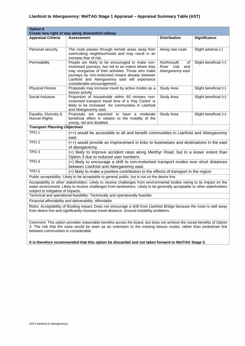
Llanfoist to Abergavenny: WelTAG Stage 1 Appraisal – Appraisal Summary Table (AST)
ASTs llanfoist to Abergavenny
Option 6Create new right of way along dismantled railwayAppraisal Criteria Assessment Distribution Significance
Personal security The route passes through remote areas away fromoverlooking neighbourhoods and may result in anincrease fear of risk.
Along new route Slight adverse (-)
Permeability People are likely to be encouraged to make non-motorised journeys, but not to an extent where theymay reorganise of their activities. Those who makejourneys by non-motorised means already betweenLlanfoist and Abergavenny east will experienceconsiderable encouragement.
North/south ofRiver Usk andAbergavenny east
Slight beneficial (+)
Physical Fitness Proposals may increase travel by active modes as aleisure activity
Study Area Slight beneficial (+)
Social Inclusion Proportion of households within 60 minutes non-motorised transport travel time of a ‘Key Centre’ islikely to be increased for communities in Llanfoistand Abergavenny east.
Study Area Slight beneficial (+)
Equality, Diversity &Human Rights
Proposals are expected to have a moderatebeneficial effect in relation to the mobility of theyoung, old and disabled.
Study Area Slight beneficial (+)
Transport Planning ObjectivesTPO 1 (++) would be accessible to all and benefit communities in Llanfoist and Abergavenny
east.TPO 2 (++) would provide an improvement in links to businesses and destinations in the east
of abergavenny.TPO 3 (+) likely to improve accident rates along Merthyr Road, but to a lesser extent than
Option 3 due to reduced user numbers.TPO 4 (+) likely to encourage a shift to non-motorised transport modes over short distances
between Llanfoist and Abergavenny east.TPO 5 (+) likely to make a positive contribution to the effects of transport in the regionPublic acceptability: Likely to be acceptable to general public, but is not on the desire line.Acceptability to other stakeholders: Likely to receive challenges from environmental bodies owing to its impact on thewater environment. Likely to receive challenges from landowners. Likely to be generally acceptable to other stakeholderssubject to mitigation of impacts.Technical and operational feasibility: Technically and operationally feasible.Financial affordability and deliverability: Affordable.Risks: Acceptability of flooding impact; Does not encourage a shift from Llanfoist Bridge because the route is well awayfrom desire line and significantly increase travel distance. Ground instability problems.
Comment: This option provides reasonable benefits across the board, but does not achieve the social benefits of Option3. The risk that the route would be seen as an extension to the existing leisure routes, rather than pedestrian linkbetween communities is considerable.
It is therefore recommended that this option be discarded and not taken forward to WelTAG Stage 2.
LLANFOIST TO ABERGAVENNYWELTAG OPTION APPRAISAL
WelTAG Planing & Stage 1 Report - Draft Prepared by Parsons BrinckerhoffJuly 2014 for Monmouthshire County Council
Appendix BFigures

LLANFOIST TO ABERGAVENNYWELTAG OPTION APPRAISAL
WelTAG Planing & Stage 1 Report - Draft Prepared by Parsons BrinckerhoffJuly 2014 for Monmouthshire County Council