Linkages between local knowledge drought forecasting indicators and scientific drought forecasting...
8
Linkages between local knowledge drought forecasting indicators and scientific drought forecasting parameters in the Limpopo River Basin in Southern Africa Bright Chisadza a,n , Michael J. Tumbare a , Washington R. Nyabeze b , Innocent Nhapi c a Department of Civil Engineering, University of Zimbabwe, Box MP167, Mt. Pleasant, Harare, Zimbabwe b WR Nyabeze and Associates, Box 863, Witkoppen, 2018 Johannesburg, South Africa c Department of Environmental Engineering, Chinhoyi University of Technology, P. Bag 7724, Chinhoyi, Zimbabwe article info Article history: Received 8 September 2014 Received in revised form 21 January 2015 Accepted 22 January 2015 Available online 22 January 2015 Keywords: Drought forecasting Limpopo River Basin Local traditional knowledge Natural disaster Normalised Difference Vegetation Index abstract This article aims at evaluating linkages between selected local traditional knowledge (LTK) indicators with meteorological drought forecasting parameters in the Mzingwane catchment area of Zimbabwe. In addition, the article investigates possible ways of integrating selected LTK indicators with the meteor- ological drought forecasting parameters to improve applicability of meteorological drought forecasts at local level. LTK forecast data from trees and plants for 2012/2013 season was collected through structured questionnaires administered on 40 household heads. Monthly rainfall data spanning the period Sep- tember 1999–May 2013 (14 years) were used for the calculation of Standard Precipitation Index (SPI) for the study catchment. The trends in drought severity scale were then compared to the results from local traditional knowledge drought forecasting (LTKDF) to find out the degree to which they could be cor- related. The GEONETCast ten day composite, SPOT VEGETATION, normalized difference vegetation index (S10 NDVI) dataset with a 1 km resolution was used to evaluate vegetation condition and hence track drought occurrence and severity. The trends in drought severity scale from NDVI were then compared to the results from LTKDF to establish the level of correlation. The analyses carried out shows a good cor- relation between traditional plant and tree indicators with resulting conditions captured as NDVI and SPI. The challenge on the LKDF systems, however, was lack of historical data to ensure adequate analysis and comparison with meteorological data. The study therefore recommends continuous monitoring and standardisation of LTK data. & 2015 Elsevier Ltd. All rights reserved. 1. Introduction Semi-arid southern Zimbabwe experiences frequent droughts and dry spells during the crop growing season, making rain-fed agriculture risky [6,16]. The knowledge of weather patterns and droughts is therefore an important aspect in the planning and management of agriculture and water resource systems. In Sub- Saharan Africa, resource-challenged national meteorological ser- vices are tasked with the responsibility of monitoring and pre- dicting weather using complex tools. In recent years, meteor- ological science has made enormous progress in predicting climate at both global and regional scale. Scientific forecasting methods apply Global Circulation Models (GCMs) but downscaling to local level, have proved to be a huge challenge mainly because of inadequate calibration data, failure to accommodate local climate circulation systems and variations in geophysical conditions. The realization that sea surface temperatures (SSTs) influence global atmospheric circulation enables scientists to formulate forecasts of seasonal rainfall [26]. These “formal” rainfall forecasts are pre- sented as the probability of the seasonal rainfall being in the above normal, below normal, or normal compared with historical trends. National meteorological services use well-calibrated weather sta- tions that meet World Meteorological Organisation standards but the high cost of acquiring and installing the equipment has re- sulted in very limited spatial deployment of fully equipped sta- tions [13]. Furthermore, the high monitoring and maintenance cost for isolated stations has resulted in a large number of the stations being abandoned. Despite these challenges, meteor- ological institutions continue to provide regular climate forecasts especially in the form of seasonal climate outlooks. In Zimbabwe the Meteorological Services Department (MSD) is the agency re- sponsible for monitoring and predicting weather and climate, Contents lists available at ScienceDirect journal homepage: www.elsevier.com/locate/ijdrr International Journal of Disaster Risk Reduction http://dx.doi.org/10.1016/j.ijdrr.2015.01.007 2212-4209/& 2015 Elsevier Ltd. All rights reserved. n Corresponding author. E-mail address: [email protected] (B. Chisadza). International Journal of Disaster Risk Reduction 12 (2015) 226–233
-
Upload
independent -
Category
Documents
-
view
4 -
download
0
Transcript of Linkages between local knowledge drought forecasting indicators and scientific drought forecasting...

International Journal of Disaster Risk Reduction 12 (2015) 226–233
Contents lists available at ScienceDirect
International Journal of Disaster Risk Reduction
http://d2212-42
n CorrE-m
journal homepage: www.elsevier.com/locate/ijdrr
Linkages between local knowledge drought forecasting indicators andscientific drought forecasting parameters in the Limpopo River Basin inSouthern Africa
Bright Chisadza a,n, Michael J. Tumbare a, Washington R. Nyabeze b, Innocent Nhapi c
a Department of Civil Engineering, University of Zimbabwe, Box MP167, Mt. Pleasant, Harare, Zimbabweb WR Nyabeze and Associates, Box 863, Witkoppen, 2018 Johannesburg, South Africac Department of Environmental Engineering, Chinhoyi University of Technology, P. Bag 7724, Chinhoyi, Zimbabwe
a r t i c l e i n f o
Article history:Received 8 September 2014Received in revised form21 January 2015Accepted 22 January 2015Available online 22 January 2015
Keywords:Drought forecastingLimpopo River BasinLocal traditional knowledgeNatural disasterNormalised Difference Vegetation Index
x.doi.org/10.1016/j.ijdrr.2015.01.00709/& 2015 Elsevier Ltd. All rights reserved.
esponding author.ail address: [email protected] (B. Chisadza
a b s t r a c t
This article aims at evaluating linkages between selected local traditional knowledge (LTK) indicatorswith meteorological drought forecasting parameters in the Mzingwane catchment area of Zimbabwe. Inaddition, the article investigates possible ways of integrating selected LTK indicators with the meteor-ological drought forecasting parameters to improve applicability of meteorological drought forecasts atlocal level.
LTK forecast data from trees and plants for 2012/2013 season was collected through structuredquestionnaires administered on 40 household heads. Monthly rainfall data spanning the period Sep-tember 1999–May 2013 (14 years) were used for the calculation of Standard Precipitation Index (SPI) forthe study catchment. The trends in drought severity scale were then compared to the results from localtraditional knowledge drought forecasting (LTKDF) to find out the degree to which they could be cor-related. The GEONETCast ten day composite, SPOT VEGETATION, normalized difference vegetation index(S10 NDVI) dataset with a 1 km resolution was used to evaluate vegetation condition and hence trackdrought occurrence and severity. The trends in drought severity scale from NDVI were then compared tothe results from LTKDF to establish the level of correlation. The analyses carried out shows a good cor-relation between traditional plant and tree indicators with resulting conditions captured as NDVI and SPI.The challenge on the LKDF systems, however, was lack of historical data to ensure adequate analysis andcomparison with meteorological data. The study therefore recommends continuous monitoring andstandardisation of LTK data.
& 2015 Elsevier Ltd. All rights reserved.
1. Introduction
Semi-arid southern Zimbabwe experiences frequent droughtsand dry spells during the crop growing season, making rain-fedagriculture risky [6,16]. The knowledge of weather patterns anddroughts is therefore an important aspect in the planning andmanagement of agriculture and water resource systems. In Sub-Saharan Africa, resource-challenged national meteorological ser-vices are tasked with the responsibility of monitoring and pre-dicting weather using complex tools. In recent years, meteor-ological science has made enormous progress in predicting climateat both global and regional scale. Scientific forecasting methodsapply Global Circulation Models (GCMs) but downscaling to locallevel, have proved to be a huge challenge mainly because of
).
inadequate calibration data, failure to accommodate local climatecirculation systems and variations in geophysical conditions. Therealization that sea surface temperatures (SSTs) influence globalatmospheric circulation enables scientists to formulate forecasts ofseasonal rainfall [26]. These “formal” rainfall forecasts are pre-sented as the probability of the seasonal rainfall being in the abovenormal, below normal, or normal compared with historical trends.National meteorological services use well-calibrated weather sta-tions that meet World Meteorological Organisation standards butthe high cost of acquiring and installing the equipment has re-sulted in very limited spatial deployment of fully equipped sta-tions [13]. Furthermore, the high monitoring and maintenancecost for isolated stations has resulted in a large number of thestations being abandoned. Despite these challenges, meteor-ological institutions continue to provide regular climate forecastsespecially in the form of seasonal climate outlooks. In Zimbabwethe Meteorological Services Department (MSD) is the agency re-sponsible for monitoring and predicting weather and climate,
B. Chisadza et al. / International Journal of Disaster Risk Reduction 12 (2015) 226–233 227
including forecasting seasonal rainfall for the whole country.Rural farmers in Mzingwane catchment apply both meteor-
ological and local traditional knowledge to forecast weather anddroughts. However, the challenge is access by communities to lo-cation specific rainfall forecasts which would enable them to takeappropriate decisions at the farm level is very limited [4]. Thebenefits of local traditional knowledge (LTK) within disaster riskreduction are gradually being identified and acknowledged [15].However, despite this acknowledgement, LTK reaching the deci-sion makers is not accompanied by the correct strategies for dis-aster risk reduction [15]. Traditional knowledge systems are gen-erally defined by [2] as the knowledge of a people of a particulararea based on their interactions and experiences within that area,their traditions, and their incorporation of knowledge emanatingfrom elsewhere into their production and economic systems. LTKtends to be the result of cumulative experience and observation,tested in the context of everyday life, and devolved by oral com-munication and repetitive engagement rather than through formalinstruction [29]). Local people, who live close to the natural re-sources, observe the activities around them and are first to identifyany changes within their locality and adapt to them. Appearance ofcertain birds, mating of certain animals, or the nature of floweringof certain plants are all important signals of changes in time andseasons that are well understood by traditional knowledge. It isthese indicators that are either located on one's farm or near one'shome that have been used as indicative objects in making deci-sions of livelihood significance by farmers [3]. Traditional knowl-edge is the basis for local level decisions in such areas as foodproduction, education, natural resources management, agricultureand health as well as a host of other livelihood activities in ruralareas [30]. This ability to comprehend environmental clues andapply them to farming choices is performative knowledge that isintuitive and ingrained in practice, rather than articulated in a setof abstract principles or calculations [24]. LTK can help fine-tuneweather and climate predictions for application at local level,much as traditional healing systems have provided many phar-maceuticals, techniques, information and ideas that Western bio-medicine has adopted [21]. The United Nations EnvironmentProgramme (UNEP) recognizes the role of local traditionalknowledge in the conservation of natural resources and manage-ment of natural disasters. Researchers on climate change in otherregions [10,8] have recognized that despite the differences in thecriteria used by local farmers and scientists to define seasonalphenomena, there is also significant overlap between them. Thismakes local traditional observations potentially useful to climatescientists. In Offon River basin in Ghana, farmers are able to pre-dict well the onset of rains and plan their planting activities tocoincide with the rains [7]. Findings from Zimbabwe suggest thatsome local indicators have predictive ability [25,28,3].
Some studies on the contributions of LTK to climate changeresearch also show that LTK and science can complement eachother [12,22] through the different types of data collected and thedifferent scales of analysis. However, LTK is location-specific andcan be very detailed. Formal scientific forecasts are mainly re-gional and global. The temporal scales at which both forms ofknowledge (LTK and scientific) are generated is also different. LTKis generated continuously; while scientific forecasting depends onfrequency of data capture and analysis for events and the resultsare then presented at time scales such as hourly, daily, monthly oryearly. According to Roncoli et al. [26], comparison betweenforecasts can also help generate important theoretical insights intothe relationships between different knowledge systems. Roncoliet al. [26] suggests that a comparison between local and scientificforecasting knowledge leads to the following two key questions:Firstly, are local knowledge forecasts accurate and secondly areLTK forecasts reliable? Lack of historical and quantitative data
hinders adequate evaluation of LTKs. Scientific and LTKs weatherand climate forecasts have strengths and weaknesses and themajor challenge is how to bring these two forms of knowledgetogether in a way that acknowledges their limitations, whilebuilding upon their respective strengths [9].
This study was therefore undertaken with the following ob-jectives; firstly to evaluate linkages between selected LTK in-dicators with meteorological drought forecasting parameters(mainly vegetation), and secondly, to analyse possible ways ofintegrating selected LTK with meteorological parameters. Thestudy focuses on analysis of the impacts of drought on vegetation.This was done by analysing changes in vegetation activity andgreenness (leaf cover density, healthy and population of plants ortees) using both LTK and NDVI. Possible linkages between vege-tation based LTK indicators and NDVI parameters were alsoanalysed.
2. Description of the study area
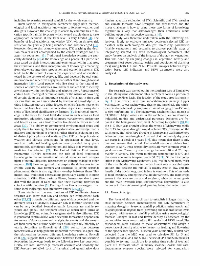
The research was carried out in the southern part of Zimbabwein the Mzingwane catchment. This catchment forms a portion ofthe Limpopo River Basin. The location of the study area is shown inFig. 1. It is divided into four sub-catchments, namely; UpperMzingwane; Lower Mzingwane, Shashe and Mwenezi. The catch-ment is characterised by low, erratic rainfall ranging from 450 mmto 650 mm/annum [11]. The Mzingwane catchment has an area of63,000 km2. Major water uses in the catchment are for domestic,industrial, mining and agricultural purposes. Droughts are fre-quent in the Mzingwane catchment. According to Nyabeze [18,19],the 1:10 four-year drought affects the whole of Mzingwane whilethe 1:15 four-year drought would achieve 91% coverage of thecatchment. The 1991/1992 drought in Mzingwane was somewherebetween these two droughts. A period of 4 moderately dry yearscan occur in a block of 5 years [17]. This means that there is onlyone wet season that period. The rainfall season stretches fromOctober to April. Intra-season dry spells are very common even ingood seasons. These dry spells range between 10 and 20 days,mainly in January. The mean minimum temperature is 5 °C andthe mean maximum temperature is 30 °C [11]. Of the total popu-lation in the Mzingwane catchment, 66% lives in rural areas. Mostof the smallholder farmers in the catchment rely on rainfed agri-culture, and because the rainfall is usually erratic, low, and thelength of dry spells long, crop failure is common. This often leadsto food insecurity among the smallholder farmers. The main cropsgrown in the area are maize and sorghum, while cattle and goatsare the main livestock kept. Environmental degradation is alsocommon in the catchment, gold panning being the main driver.
2.1. Research design
The focus of this research was to establish linkages that mayexist between selected meteorological and LTK parameters inmapping droughts. Seasonal rainfall prediction using acacia andcolophospermum mopane trees (flowering and leaf production) wascompared with seasonal rainfall prediction using meteorologicalforecast. Changes in leaf and flower density as observed by thecommunities were compared to SPI results and NDVI trend. Therespondents were allowed to make observations and assign apercentage of density relative to the normal fruiting and floweringof the specific tree species. Fourteen years of monthly rainfall datacollected from the MSD was used to calculate SPI for 3 and6 month periods (SPI3 and SPI6). The use of SPI3 and SPI6 makes itpossible to try and match the forecasting time scale of tree andplant LTK forecasts which is mainly seasonal. Acacia and colo-phospermum mopane species were selected for comparison

Fig. 1. The Mzingwane catchment and its location in Zimbabwe.Adapted from [34].
B. Chisadza et al. / International Journal of Disaster Risk Reduction 12 (2015) 226–233228
because they are the predominant tree species used as LTK treeindicators in the Mzingwane catchment [5]. A LTK drought se-verity scale was developed based on fruiting and flowering pat-terns of Acacia and Mopane trees. The scale is shown in Table 1.The scale shows the severity of drought in Mzingwane catchmentusing different tree fruiting and flowering densities. Zero and va-lues near zero indicate a normal rainfall season. Drought casesrange from 1 to 3. Values closer to 1 indicate less severe droughtconditions and a value of 3 indicates very severe or extremedrought conditions. LTK index is calculated by a summation of thetotal number of respondents per category divided by the totalrespondents multiplied by the score for each month as shown byEq. (1). There are 5 categories altogether. Seasonal drought pre-diction using NDVI images were compared to seasonal droughtprediction using LTK-based on tree and plants. Both forecasts arebased on vegetation condition to predict seasonal outlook.
⎜ ⎟⎛⎝
⎞⎠I
xn
LTK index equation, Score(1)i
ii
1
5
˘ ∑ = ×=
=
where Ĭ is the LTK plant index, xi represents the number re-spondents for a category, n is the total number of respondents, andi is the category.
2.2. Data collection and analysis
2.2.1. SPI analysisMonthly rainfall datasets from September 1999 to May 2013
(14 years) were used for the calculation of SPI. The data was ob-tained from MSD for rainfall stations in the study catchment. Thedataset was first formatted using Ms Excel and then inputed intoDrinC drought indices calculator (www.ewra.net/medbasin/DrinC.htm) for the calculation of SPI for 3 and 6 month periods. Thetrends in drought severity scale were then compared to the results
from LTKDF to find out the degree to which they could becorrelated.
2.2.2. Vegetation trend analysisThe GEONETCast ten day composite, SPOT VEGETATION, nor-
malized difference vegetation index (S10 NDVI) dataset with a1 km resolution was used to evaluate vegetation condition. Thedataset was provided by GEONETCast for Developing Countries(DevCoCast). A S10 NDVI image is the result of a combination ofthe atmospherically corrected data of all segments of the givendecade into a single global world image using the Maximum ValueComposite (MVC) algorithm (VEG4AFRICA, 2013). Two hundredand seventy S10 NDVI images were downloaded for the period1 October 1998–31 March 2013. Vegetation trend for each pixellocation was calculated using a series of maximum NDVI value foreach half of the season using ILWIS 3.3. Thus the season wasbroken into two three-month periods of October–December(OND), and January–March (JFM). Beitbridge, Esighodini, Mangweand Mwenezi districts were selected to graphically show the an-nual trend in maximum NDVI for the 15 year period (a periodwhich tallies with the available rainfall data for the stations). Fig. 2shows the general steps followed to calculate maximum, long termaverage NDVI.
2.2.3. LTK dataA total of 40 structured questionnaires, were administered in
8 wards located within the Mzingwane catchment. The 8 wardswere distributed evenly over four districts located in the catch-ment, namely; Mangwe, Mzingwane, Beitbridge and Mwenezidistricts. Household heads were the respondents and these com-prised of 24 females and 16 males. The questionnaires were fo-cusing on observed changes on the traditional drought indicatorsand the dates when the observations were made, interpretation ofobservations and the subsequent LTK weather and drought

Table 1Drought severity ranking by farmers using dominant tree species (Acacia andMopane species).
Fruits/leaf density/floweringlevels
Drought severity Physical value/score
Very dense (90–100% density) Very severe 3Dense (70–80% density) Severe 2Few (60–70% density) Less severe or
moderate1
Moderate (50–60% density) Normal 0Less than moderate (less than 50%
density)Wet �1
B. Chisadza et al. / International Journal of Disaster Risk Reduction 12 (2015) 226–233 229
forecast. The purpose of this data was to calculate the LTK droughtindex based on trees and plants.
3. Results and discussion
3.1. Forecast for Mzingwane catchment for 2012/2013 season usingLTK tree and plant
Questionnaire respondents classified the acacia and colophos-permum mopane tree leaf and fruit density for each month for the2012/2013 season as shown in Figs. 3 and 4. The majority of therespondents observed and classified the leaf density as moderatefor all the months. A few respondents noted few leaves. Accordingto the LTK drought severity scale moderate leaf density indicates anormal rainfall season and few leaves are indicative of a less se-vere drought. The LTK index values were ranging from 0.175 to0.45 (Figs. 5 and 6), indicating that normal conditions prevailed forthe whole season.
3.2. Seasonal rainfall analysis for the Mzingwane catchment area
The average monthly rainfall statistics for the study stations areshown in Figs. 7 and 8. The rainfall average for a station is based ondaily rainfall data. Monthly rainfall for a station is obtained bysumming daily rainfall totals. Average monthly rainfall is theaverage of the monthly amount of rainfall for a location over amonth. The average monthly rainfall in Fig. 5 was obtained byadding the rainfall for each month at a location for 14 years anddividing it by 30 (number of years). In this research 14 year datawas used because it was the only data that could be obtained, MAPis for 14 year data. Average monthly rainfall as a percentage ofmean annual precipitation (MAP) for the study stations shows thatfrom November to March all sites recorded precipitation greaterthan 5% of the MAP. The Umzingwane station received more totalaverage seasonal rainfall compared to all the other study stations.
Fig. 2. Steps followed to calculate ma
Mangwe had the lowest total average seasonal rainfall.Fig. 9 shows the comparison between the observed (measured)
and average rainfall on four study stations for 2012/2013 season.December and January recorded the greatest difference betweenobserved rainfall and average rainfall for all the study stations.Two prolonged dry spells in November, March and February wereobserved in all the stations. Rainfall time series results show thatthe rainfall was poorly distributed (Fig. 9). A combination of poorrainfall distribution and below average rains for February andMarch, which are the critical months for crop development, wasnoted. Most rainfall was received between December and January,while critical months (February and March) for tasselling of cerealslike maize and sorghum received below average rainfall.
3.3. Three and six month SPI results vs. LTK plant and trees droughtseverity scale
In order to determine the severity of drought events of 3 and6 month duration in Mzingwane catchment, SPI values were cal-culated for all study site stations for different time scales. The3 and 6 month time scales were chosen for analysis because theyfit well within the timescale used by traditional drought fore-casting (tree and plants) and therefore comparison for the sametime scales can be made with LTKs. Figs. 10 and 11 show 6 monthSPI at two of the stations (Umzingwane and Beitbridge). TheUmzingwane station is the meteorological data collection stationfor Esighodini. Severe and longest droughts (SPI6o�1.5) wereexperienced between 2000/2001 (SPI3 �2.27) and 2001/2002(SPI6 �2.59) for both stations. There was a moderate meteor-ological drought in 2011/12 season, whilst 2012/2013 season was anear normal season according to SPI 6. SPI3 for Umzingwane sta-tion (Fig. 9) also showed that 2012/2013 season was near normal.The 2012/2013 season was a normal season meteorologically asindicated by the SPI and rainfall time series results for the studystations. LTK results for the stations based on tree and plants in-dicated the 2012/2013 season near normal to normal (Fig. 4).Therefore the results are similar to the SPI results for 2012/2013season.This is in agreement with McDowell et al. [14], who statedthat the differences in the response of vegetation types to droughtis correlated to their response to water deficits.
3.4. Comparison of plant phenology from LTK with NDVI drivenforecast for 2011/2012 and 2012/2013 season
3.4.1. Vegetation condition trendsFigs. 12 and 13 show significant troughs in NDVI for drought
years for both OND and JFM. The results from Figs. 12 and 13showed that notable drought seasons were 2002/2003; 2005/2006and 2006/2007. JFM had better vegetation condition compared toOND period. Mangwe and Beitbridge had poorer vegetation
ximum, long term average NDVI.

Fig. 3. Percentage observed leaf density on trees and plants for 2012/2013 season for the sites.
Fig. 4. Combined observed leaf density on trees and plants for 2012/2013 season.
Fig. 5. LTK drought index values for 2012/2013 season for the study stations.
Fig. 6. Combined LTK drought index values for 2012/2013 season.
Fig. 7. Average monthly rainfall for the study stations (1999–2013).
B. Chisadza et al. / International Journal of Disaster Risk Reduction 12 (2015) 226–233230
condition when compared to Mwenezi and Esighodini. The reasoncould be that Mwenezi and Esighodini receive relatively morerainfall than Mangwe and Beitbridge. Furthermore, parts ofEsighodini are in natural region IV of Zimbabwe. NDVI data
showed normal vegetation conditions for all the study sites for2012/2013 season. This means that 2012/2013 season was a nor-mal year (there was no drought).

Fig. 8. Monthly rainfall as a percentage of MAP (1999–2013) for the study stationsfor 2013.
Fig. 10. SPI series for Beitbridge station for 1999–2013 for 3 and 6 month timescales.
Fig. 11. SPI series for Umzingwane station for 1999–2013 for 3 and 6 month timescales.
B. Chisadza et al. / International Journal of Disaster Risk Reduction 12 (2015) 226–233 231
3.5. NDVI anomaly
NDVI values range between 1 and �1. Negative (between 0 and�1) values show areas with little to no vegetation (rocks, ice,desert) and positive (between 0 and 1) values indicate denser andhealthier (higher green density) vegetation. A value of 0 indicatesnormal/the same vegetation activity or no significant differencebetween the images. Negative anomaly means doing badly com-pared to the long term (15 years). An anomaly of zero means thereis no change and a positive anomaly means performance betterthan the LTA. Fig. 14 shows the NDVI difference map for Mzing-wane catchment for OND 2012 compared to long term mean. Thephysical NDVI values were between �0.22 and 0.42 for the ma-jority of areas in Mzingwane catchment for the period of OND.Thus vegetation activity was predominantly normal to abovenormal condition for the majority of the catchment.
Fig. 15 shows that predominantly normal to above normalcondition prevailed in the region for JFM. Above normal conditionsprevailed in Beitbridge and Mwenezi for the period of JFM, whilenormal conditions prevailed in Umzingwane and Mangwe. Therewere less potential drought areas for JFM compared to OND;
Fig. 9. Observed rainfall vs. avera
showing vegetation response to significant rainfall received inDecember and January. Only Mangwe area showed potentialdrought conditions for JFM 2013. The results compare very wellwith the forecast obtained from LTK based on acacia and C. mopanespecies for both OND and JFM. The observation by local ques-tionnaire respondents was moderate to below moderate leaf andflowering density for OND and moderate fruiting for JFM. In both
ge rainfall for study stations.

Fig. 12. Maximum NDVI Trend for OND.
Fig. 13. Maximum NDVI trend for JFM.
Fig. 14. Mzingwane catchment NDVI difference map for OND 2012 compared to long term (15 years) mean.
B. Chisadza et al. / International Journal of Disaster Risk Reduction 12 (2015) 226–233232
cases the interpretation was that of a normal to slightly belownormal season. LTK tree and plant indexes for the 2012/2013season ranged from 0.175 to 0.45, indicating normal to near nor-mal conditions for all study sites (Figs. 5 and 6). Therefore there isgood link between traditional plant and tree indicators with re-sulting conditions captured as NDVI.
3.6. Linkages and integration of scientific and traditional knowledgesystems
The analyses carried out show good link between LTK indexresults with resulting conditions captured as NDVI and indicesbased on observed rainfall. This is in agreement with Re-ngalakshmi [23], who state that some of the weather predictors(e.g., wind speed and direction, temperature changes) used byfarmers are similar to those used in the scientific forecast. Treesand plants respond to climate factors and farmers observe these
changes in plants and trees. They are able to track weather pat-terns and natural disasters such as droughts using their observa-tions. This is in conformity with Sakai et al. [27] who suggest cli-mate changes affect a number of proximate cues for tropical treephonologies. Proximate cues include onset of rain in seasonal cli-mates [27], drought in seasonal climates [1], cold snaps [31], in-creasing temperature [31], and soil moisture [33]. Moreover,Vicente-Serrano et al. [32] noted that drought impacts cause de-creased plant growth and vegetation activity especially in arid andsemi-arid regions. Certain tree and plant species exhibit a strongresistance to water stress and are well adapted to water shortagethrough different mechanisms. Some indicators like trees andplants; birds, and animals respond to climatic parameters that areused to forecast weather by scientists. ENSO, El Nino, tempera-tures, wind and humidity are some weather cues that the LTKindicators respond to. An analysis by Orlove et al. [20] points to acorrelation between El Nino-related reduced rainfall and dimin-ished Pleiades visibility, an indicator used by Peruvian farmers inmaking planting decisions. The major challenge with LTK in-dicators is to establish and quantify thresholds at which the LTKsrespond to weather elements that cause a drought. LKDF systemprovides mainly qualitative data.
4. Conclusion and recommendations
The analyses carried out shows good link between traditionalplant and tree indicators with resulting conditions captured asNDVI and indices (SPI) based on observed rainfall. The analysesalso showed that there is potential to integrate LTK indicatorsbased on trees and plants with NDVI-derived scientific parameters.The 2012/2013 season was a normal year based on both scientificand traditional forecasts. The paper shows that there is potentialto integrate related parameters from LKDF and scientific droughtand weather forecasting systems. The challenge on the LKDF sys-tems, however, was lack of historical data to ensure adequatecomparison and conclusions to be made. The study therefore re-commends that in order to resolve the challenge, LKDF need to beafforded more attention and support through their adoption bydrought forecasting agencies. The full potential LTK can be realisedif education curricula incorporate local knowledge and if it is

Fig. 15. Mzingwane catchment NDVI difference map for JFM 2013 compared to long term (15 years) mean.
B. Chisadza et al. / International Journal of Disaster Risk Reduction 12 (2015) 226–233 233
further developed through collaborative research between scien-tists and local communities.
References
[1] P.S. Ashton, T.J. Givnish, S. Appanah, Staggered flowering in the Dipter-ocarpaceae: new insights into floral induction and the evolution of mastfruiting in the aseasonal tropics, Am. Nat. (1988) 44–66.
[2] Cultivating Knowledge, Genetic Diversity, Farmer Experimentation And CropResearch, in: W. Boef, A. Kojo, W. Kate, B. Anthony (Eds.), Intermediate Tech-nology Publications, London, 1993.
[3] B. Chisadza, M.J. Tumbare, I. Nhapi, W.R. Nyabeze, Useful traditional knowl-edge indicators for drought forecasting in the Mzingwane Catchment area ofZimbabwe, Disaster Prev. Manag. 22 (2013) 312–325.
[4] B. Chisadza, M.J. Tumbare, I. Nhapi, W.R. Nyabeze, Validation of local knowl-edge drought forecasting systems in the Limpopo River Basin in SouthernAfrica, Disaster Prev. Manag. 23 (5) (2014) 551–566.
[5] T.M. Chiuta, C. Mutambirwa, Environmental Flows and Institutional Provisionsfor Management in Semi-Arid South Western Zimbabwe, IWRM – IHP 2008,Cape Town, 2008.
[6] P.J.M. Cooper, J. Dimes, K.P.C. Rao, B. Shapiro, B. Shiferaw, S. Twomlow, Copingbetter with current climatic variability in the rain-fed farming systems of sub-Saharan Africa: an essential first step in adapting to future climate change?Agric. Ecosyst. Environ. 126 (24–35) (2008).
[7] B.A. Gyampoh, S. Amisah, M. Idinoba, J. Nkem, Using traditional knowledge tocope with climate change in rural Ghana, Unasylva 60 (2009) 70–74.
[8] K.M. Hinkel, B.M. Jones, W.R. Eisner, C.J. Cuomo, R.A. Beck, R. Frohn, Methodsto assess natural and anthropogenic thaw lake drainage on the western Arcticcoastal plain of northern Alaska, J. Geophys. Res.: Earth Surf. (2007) 112.
[9] IDRC, Integrating meteorological and indigenous knowledge-based seasonalclimate forecasts for the agricultural sector: lessons from participatory actionresearch in sub-Saharan Africa, in: G. Ziergovel, A. Opere (Eds.), ClimateChange and Adaptation in Africa, CCAC, Ottawa, 2010.
[10] G.J. Laidler, T. Ikummaq, Human geographies of sea ice: freeze/thaw processesaround Igloolik, Nunavut, Canada, Polar Rec. 44 (2008) 127–154.
[11] Love, D., Taigbenu, A.E., Jonker, L., 2005. An Overview of the MzingwaneCatchment Zimbabwe.
[12] W.K. Luseno, J.G. Mcpeak, C.B. Barrett, P.D. Little, G. Gebru, Assessing the valueof climate forecast information for pastoralists: evidence from SouthernEthiopia and Northern Kenya, World Dev. 31 (2003) 1477–1494.
[13] M. Masinde, A. Bagula, ITIKI: bridge between African indigenous knowledgeand modern science of drought prediction, Knowl. Manag. Dev. J. 7 (2011)274–290.
[14] N. Mcdowell, W.T. Pockman, C.D. Allen, D.D. Breshears, N. Cobb, T. Kolb,J. Plaut, J. Sperry, A. West, D.G. Williams, Mechanisms of plant survival andmortality during drought: Why do some plants survive while others succumbto drought? New Phytol. 178 (2008) 719–739.
[15] J. Mercer, D. Dominey-Howes, I. Kelman, K. Lloyd, The potential for combiningindigenous and western knowledge in reducing vulnerability to environ-mental hazards in small island developing states, Environ. Hazards 7 (2007)245–256.
[16] W. Mupangwa, S. Walker, S. Twomlow, Start, end and dry spells of thegrowing season in semi-arid southern Zimbabwe, J. Arid Environ. 75 (2011)1097–1104.
[17] S. Ndlovu, Coping with Drought. Mainstreaming Livelihood Centred Ap-proaches to Disaster Management, Practical Action, Harare, 2010.
[18] W.R. Nyabeze, Estimating and interpreting hydrological drought indices usinga selected catchment in Zimbabwe, Phys. Chem. Earth Parts A/B/C 29 (2004)1173–1180.
[19] W.R. Nyabeze, Hydrological drought analysis for Zimbabwe (Ph.D. thesis),University of the Witwatersrand, 2004.
[20] Orlove B.S., Chiang J.C.H., Cane M.A., Forecasting Andean rainfall and crop yieldfrom the influence of El NO on Pleiades visibility, Nature 403 (2000) 68–71.
[21] B. Orlove, C. Roncoli, M. Kabugo, A. Majugu, Indigenous climate knowledge insouthern Uganda: the multiple components of a dynamic regional system,Clim. Change 100 (2010) 243–265.
[22] D. Reidlinger, F. Berkes, Contributions of traditional knowledge to under-standing climate change in the Canadian Arctic, Polar Rec. (2001) 315–328.
[23] R. Rengalakshmi, Linking Traditional and Scientific Knowledge Systems onClimate Prediction and Utilization, MS Swaminathan Research Foundation,Chennai, 2008.
[24] P. Richards, Cultivation: knowledge or performance, in: M. Hobart (Ed.), AnAnthropological Critique of Development: The Growth of Ignorance, Routle-dge, New York, 1993.
[25] J. Risiro, D. Mashoko, D.T. Tshuma, E. Rurinda, Weather forecasting and in-digenous knowledge systems in Chimanimani District of Manicaland, Zim-babwe, J. Emerg. Trends Educ. Res. Policy Stud. 3 (2012) 561–566.
[26] C. Roncoli, K. Ingram, P. Kirshen, Reading the rains: local knowledge andrainfall forecasting in Burkina Faso, Soc. Nat. Resour. 15 (2002) 409–427.
[27] S. Sakai, R.D. Harrison, K. Momose, K. Kuraji, H. Nagamasu, T. Yasunari,L. Chong, T. Nakashizuka, Irregular droughts trigger mass flowering in asea-sonal tropical forests in Asia, Am. J. Bot. 93 (2006) 1134–1139.
[28] K. Shoko, N. Shoko, Indigenous weather forecasting systems: a case study ofthe abiotic weather forecasting indicators for wards 12 and 13 in MberengwaDistrict Zimbabwe, Asian Soc. Sci. 9 (2012) 285.
[29] Sillitoe, P., 2007. Local science vs. global science: an overview. In: Sillitoe, P.(Ed.), Local Science vs. Global Science: Approaches to Indigenous Knowledgein International Development, New York, Berghahn.
[30] I.J. Tekwa, M.D. Belel, Impacts of traditional soil conservation practices insustainable food production, Agric. Soc. Sci. 5 (2009) 128–130.
[31] C.P. Van Schaik, J.W. Terborgh, S.J. Wright, The phenology of tropical forests:adaptive significance and consequences for primary consumers, Ann. Rev.Ecol. Syst. (1993) 353–377.
[32] S.M. Vicente-Serrano, C. Gouveia, J.J. Camarero, S. Begueraa, R. Trigo, J.I. Lopez-Moreno, C. Azorin-Molina, E. Pasho, J. Lorenzo-Lacruz, J. Revuelto, Response ofvegetation to drought time-scales across global land biomes, Proc. Natl. Acad.Sci. 110 (2013) 52–57.
[33] S.J. Wright, O. Calderon, Seasonal, El Nino and longer term changes in flowerand seed production in a moist tropical forest, Ecol. Lett. 9 (2006) 35–44.
[34] ZINWA, National Catchment Database, Unpublished GIS database, Harare,2010.