Lesson 6 Snow avalanche & Glacier - CDEEP-IIT Bombay
64
Prof. R. Nagarajan, CSRE , IIT Bombay GNR 639 : Natural Disaster And Management Lesson 6 Snow avalanche & Glacier 6.01
-
Upload
khangminh22 -
Category
Documents
-
view
2 -
download
0
Transcript of Lesson 6 Snow avalanche & Glacier - CDEEP-IIT Bombay
GNR 639
Prof. R. Nagarajan, CSRE , IIT Bombay
GNR 639 : Natural Disaster And Management
Lesson 6
Snow avalanche & Glacier
6.01
GNR 639
Prof. R. Nagarajan, CSRE , IIT Bombay
GNR 639 : Natural Disaster And ManagementSnowfall - precipitation that falls from the clouds over higher altitudes which consists of snowflakes, in a variety of sizes and shapes. Snow is composed of small ice particles in the form of granular material. It has an open and soft structure, unless packed by external pressure.
Powdery Snow is fluffy, granular when it begins the cycle of melting and refreezing, and eventually iceonce it packs down. After multiple melting and refreezing cycles, snow becomes a dense mass called
snow pack. Powdery snow moves with the wind from the landing location forming deposits called snowdrifts.
The water equivalent of a given amount of snow is the depth of a layer of water having the same mass and upper area. The snow covering a given area has a water equivalent of 50 cm, when it melt into a pool of water 50 cm deep covering the same area.
Once the snow is on the ground, it will settle by its own weight due to differential evaporation until its density is approximately 30% of water.
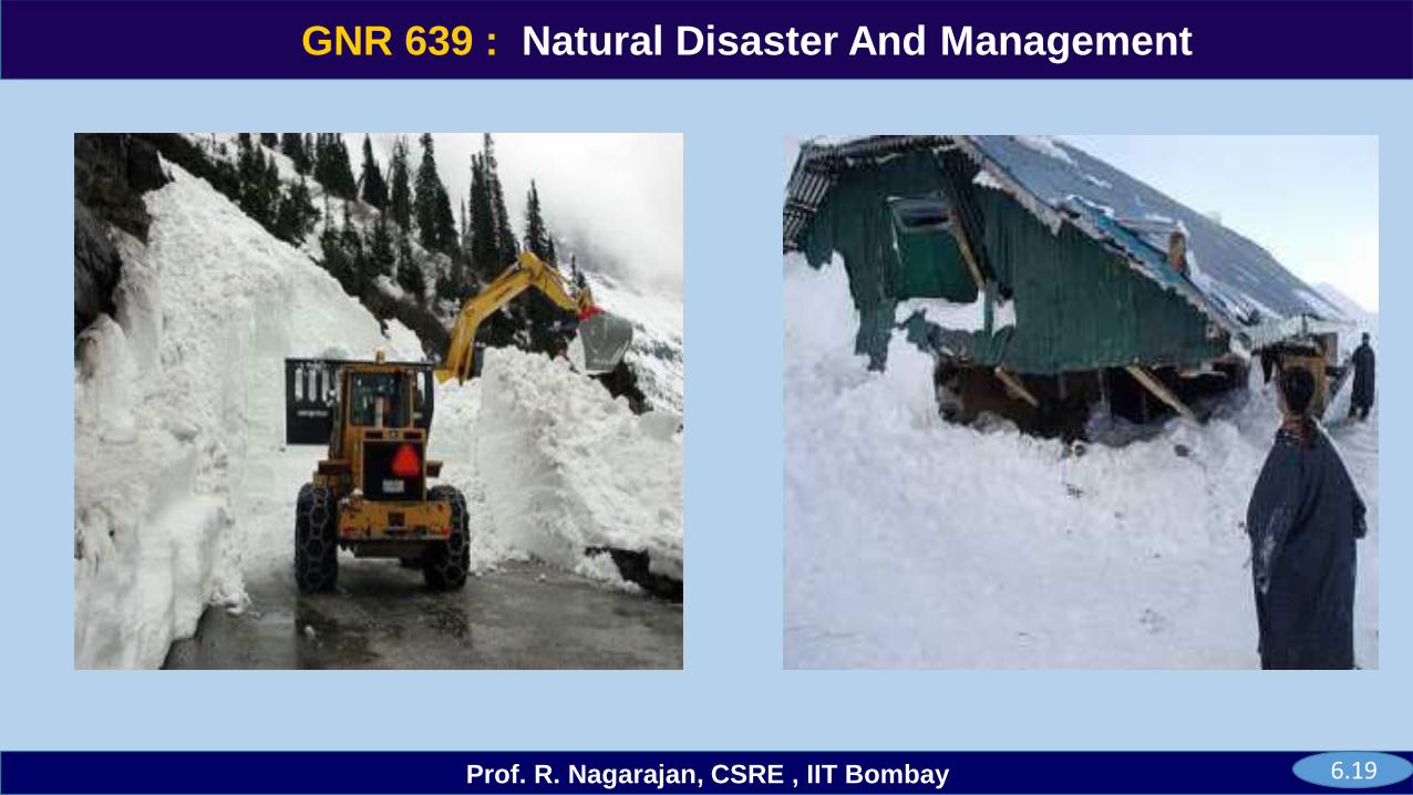
Snow avalanche - are the moving masses of snow that contain rock, soil or ice, caused by direct loading of snowfall from large-scale weather system of the mountains. Precipitation patterns and intensity, wind direction and wind speed, and radiation heating or cooling on snow are important in snow avalanche..
6.02

GNR 639
Prof. R. Nagarajan, CSRE , IIT Bombay
GNR 639 : Natural Disaster And Management
Courtesy: realaspen.com) (courtesy: colorado.edu)
6.03
GNR 639
Prof. R. Nagarajan, CSRE , IIT Bombay
GNR 639 : Natural Disaster And Management
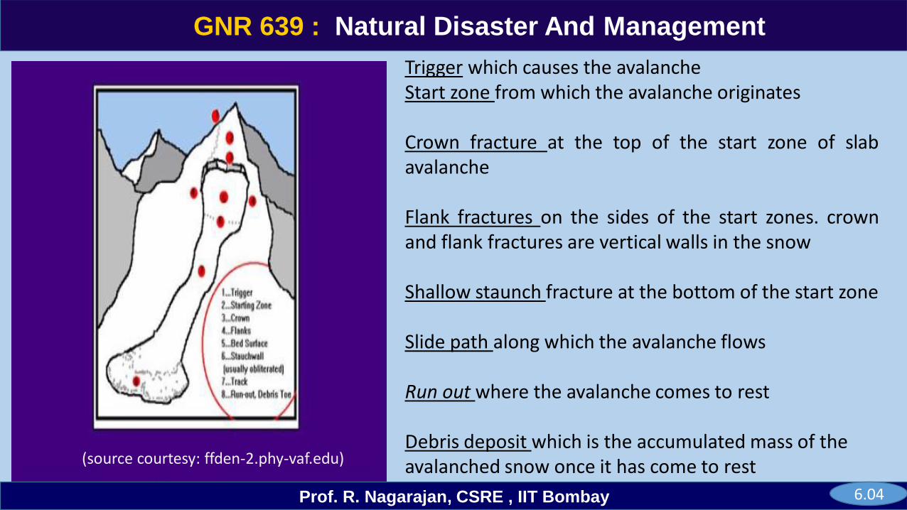
Trigger which causes the avalanche Start zone from which the avalanche originates
Crown fracture at the top of the start zone of slabavalanche
Flank fractures on the sides of the start zones. crownand flank fractures are vertical walls in the snow
Shallow staunch fracture at the bottom of the start zone
Slide path along which the avalanche flows
Run out where the avalanche comes to rest
Debris deposit which is the accumulated mass of the avalanched snow once it has come to rest (source courtesy: ffden-2.phy-vaf.edu)
6.04
GNR 639
Prof. R. Nagarajan, CSRE , IIT Bombay
GNR 639 : Natural Disaster And Management
6.05
GNR 639
Prof. R. Nagarajan, CSRE , IIT Bombay
GNR 639 : Natural Disaster And Management
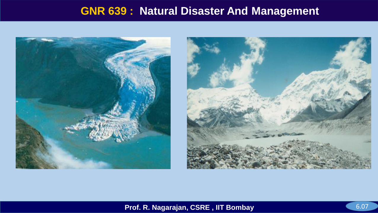
6.06
GNR 639
Prof. R. Nagarajan, CSRE , IIT Bombay
GNR 639 : Natural Disaster And Management
6.07
GNR 639
Prof. R. Nagarajan, CSRE , IIT Bombay
GNR 639 : Natural Disaster And Management
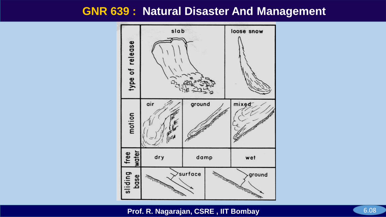
6.08
GNR 639
Prof. R. Nagarajan, CSRE , IIT Bombay
GNR 639 : Natural Disaster And Management
Wet snow avalanche or isothermal avalanche occurs when the snow pack becomes saturated by water. When the percentage of water is very high they are known as slush flows and they can move on very shallow slopes.
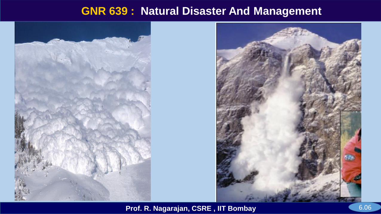
Powder snow avalanches are the largest, most powerful of avalanches that can exceed speeds of 300 km/h.Masses of 10,000,000 tonnes. Turbulent suspension of snow particles then flows as gravity current.
Slab avalanches are generated when an additional load causes a brittle failure of a slab that is bridging aweak snow layer. This failure is propagated through fracture formation in the bridging slab. It accounts foraround 90% of avalanche-related fatalities, and occur when there is a strong, cohesive layer of slab snow.
Loose snow and isothermal avalanches are generated when a stress causes a shear failure in a weakinterface, either within the snow pack, or at the base. When the failure occurs at the base they are knownas full depth avalanches.
Spin drift avalanches occur when wind lifted snow is funneled into a steep drainage from above thedrainage. It occurs in freshly fallen snow that has a lower density and is most common on steeper terrain.
6.09
GNR 639
Prof. R. Nagarajan, CSRE , IIT Bombay
GNR 639 : Natural Disaster And Management
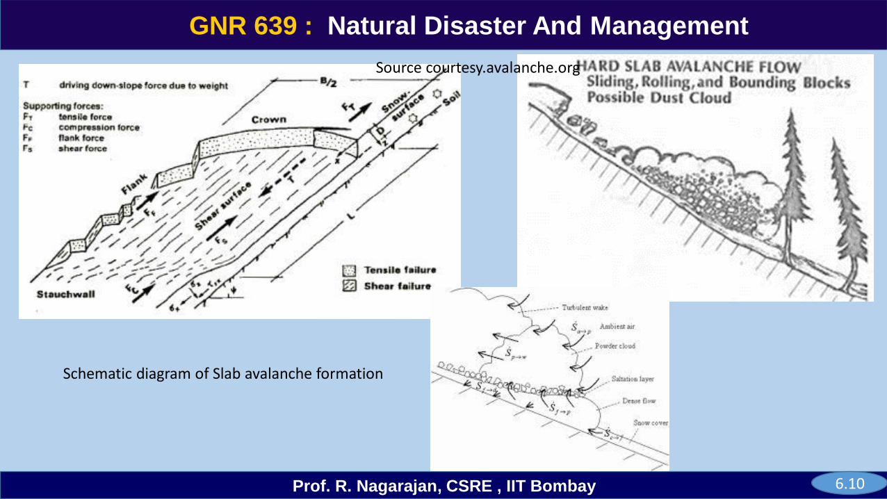
Schematic diagram of Slab avalanche formation
6.10
Source courtesy.avalanche.org
GNR 639
Prof. R. Nagarajan, CSRE , IIT Bombay
GNR 639 : Natural Disaster And Management
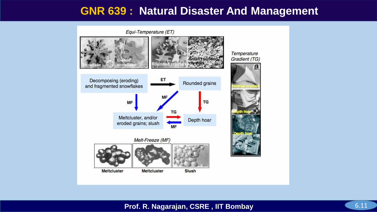
6.11
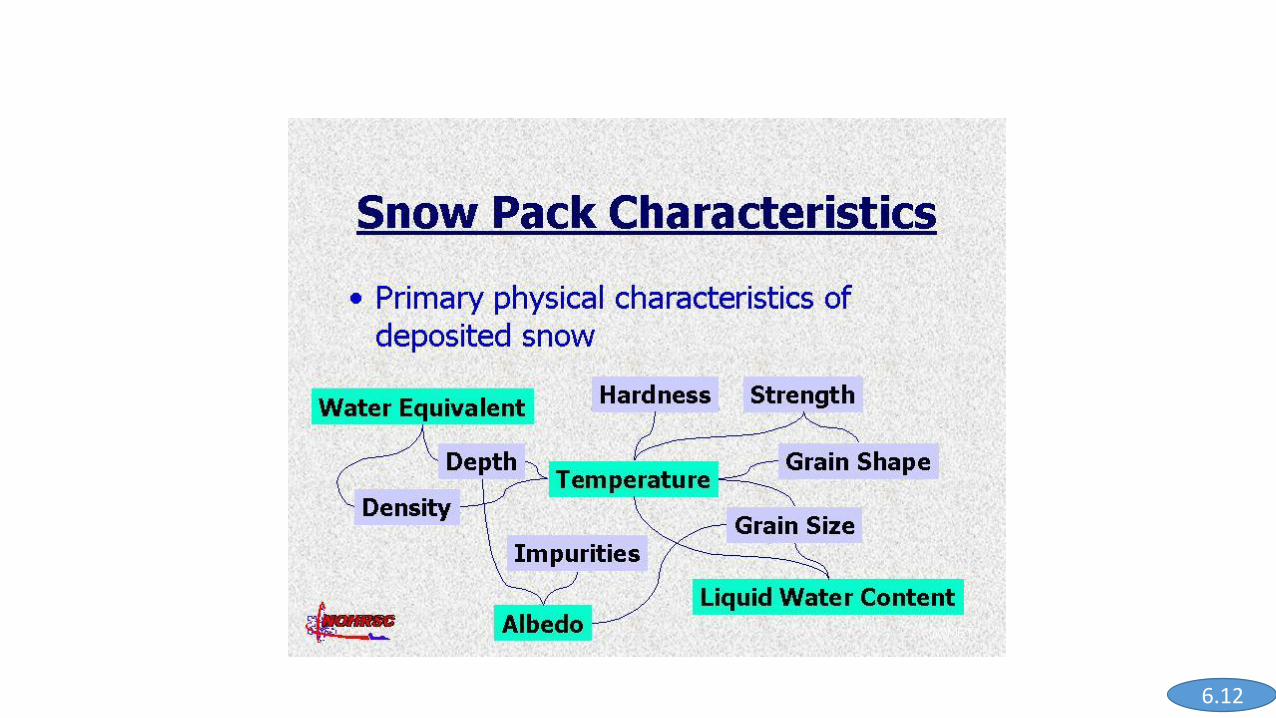
6.12
GNR 639
Prof. R. Nagarajan, CSRE , IIT Bombay
GNR 639 : Natural Disaster And Management
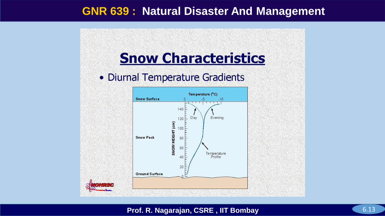
6.13
GNR 639
Prof. R. Nagarajan, CSRE , IIT Bombay
GNR 639 : Natural Disaster And Management
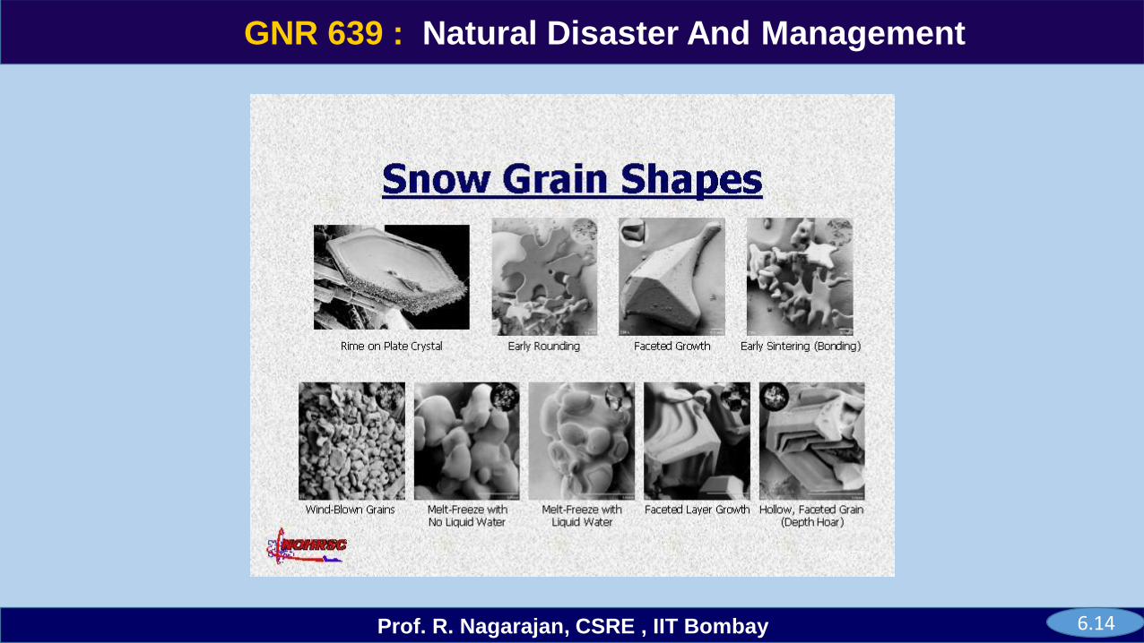
6.14
GNR 639
Prof. R. Nagarajan, CSRE , IIT Bombay
GNR 639 : Natural Disaster And Management
6.15
GNR 639
Prof. R. Nagarajan, CSRE , IIT Bombay
GNR 639 : Natural Disaster And Management
6.16
GNR 639
Prof. R. Nagarajan, CSRE , IIT Bombay
GNR 639 : Natural Disaster And Management
6.17
(Source courtesy: avalanche.org)
GNR 639
Prof. R. Nagarajan, CSRE , IIT Bombay
GNR 639 : Natural Disaster And Management
6.18
GNR 639
Prof. R. Nagarajan, CSRE , IIT Bombay
GNR 639 : Natural Disaster And Management
6.19
GNR 639
Prof. R. Nagarajan, CSRE , IIT Bombay
GNR 639 : Natural Disaster And Management
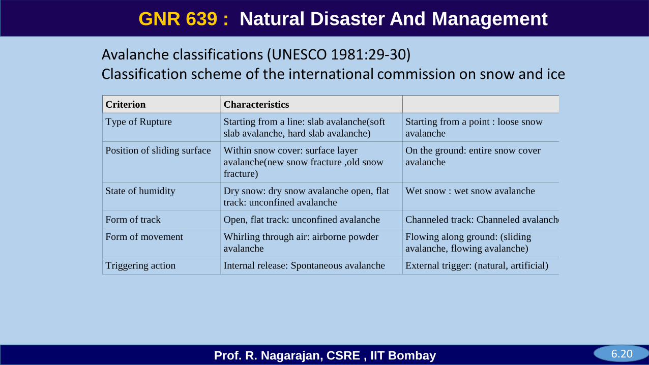
Criterion Characteristics
Type of Rupture Starting from a line: slab avalanche(soft
slab avalanche, hard slab avalanche)
Starting from a point : loose snow
avalanche
Position of sliding surface Within snow cover: surface layer
avalanche(new snow fracture ,old snow
fracture)
On the ground: entire snow cover
avalanche
State of humidity Dry snow: dry snow avalanche open, flat
track: unconfined avalanche
Wet snow : wet snow avalanche
Form of track Open, flat track: unconfined avalanche Channeled track: Channeled avalanche
Form of movement Whirling through air: airborne powder
avalanche
Flowing along ground: (sliding
avalanche, flowing avalanche)
Triggering action Internal release: Spontaneous avalanche External trigger: (natural, artificial)
Avalanche classifications (UNESCO 1981:29-30)Classification scheme of the international commission on snow and ice
6.20
GNR 639
Prof. R. Nagarajan, CSRE , IIT Bombay
GNR 639 : Natural Disaster And Management
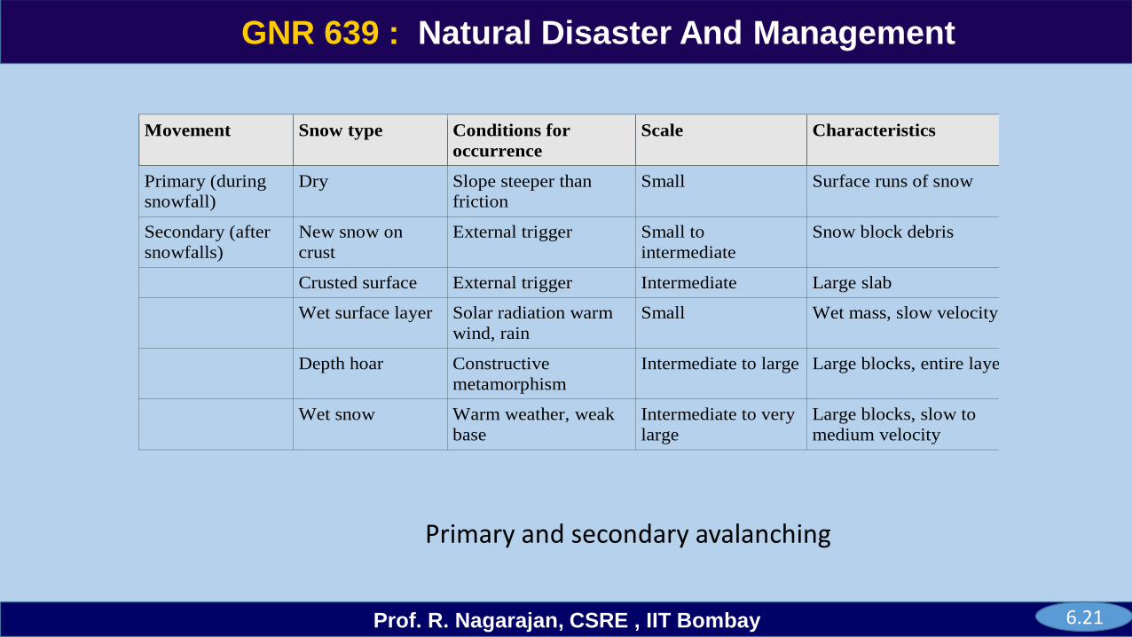
Movement Snow type Conditions for
occurrence
Scale Characteristics
Primary (during
snowfall)
Dry Slope steeper than
friction
Small Surface runs of snow
Secondary (after
snowfalls)
New snow on
crust
External trigger Small to
intermediate
Snow block debris
Crusted surface External trigger Intermediate Large slab
Wet surface layer Solar radiation warm
wind, rain
Small Wet mass, slow velocity
Depth hoar Constructive
metamorphism
Intermediate to large Large blocks, entire layer
Wet snow Warm weather, weak
base
Intermediate to very
large
Large blocks, slow to
medium velocity
Primary and secondary avalanching
6.21
GNR 639
Prof. R. Nagarajan, CSRE , IIT Bombay
GNR 639 : Natural Disaster And Management
Terrain Factors
Snow can accumulate deeply and quickly in mountain areas, increasing the possibility of an avalanche. You can offer clues about avalanche likelihood. Terrain traps serve as accumulation points for snow and debris
Altitude - risk factor increases with increases in altitude. Tree line is an imaginary line, above which conditions become too harsh for trees to grow, and avalanches start above the tree line.
Vegetation - 90% of avalanches occur on terrain with a green cover and average ground cover height is lower than 2 m. during avalanches, trees and rocks catch debris and cause excessive snow pile-up, as well as provide lethal obstacles for anyone caught in an avalanche. Smooth surfaces, such as a rock face or grassy slope may cause avalanches during the spring melting season.
Slope Aspect - slope orientations are much more affected by wind-loading, particularly northeast, east, and southeast. Most of the avalanches run on slopes facing north, east, and northeast because the sun is at such a low angle, particularly during the winter, a colder and deeper snowpack develops.
Slope steepness – Avalanches most frequently occur on natural slope of 300 to 450, but their release is from 25 to 650 slopes. Avalanches can occur on any slope angles under the right conditions.
6.23
GNR 639
Prof. R. Nagarajan, CSRE , IIT Bombay
GNR 639 : Natural Disaster And Management
Slope profile – Disastrous avalanches are more likely to begin on convex slopes but may also begin on concave slopes. Short slopes may be as dangerous as long slopes
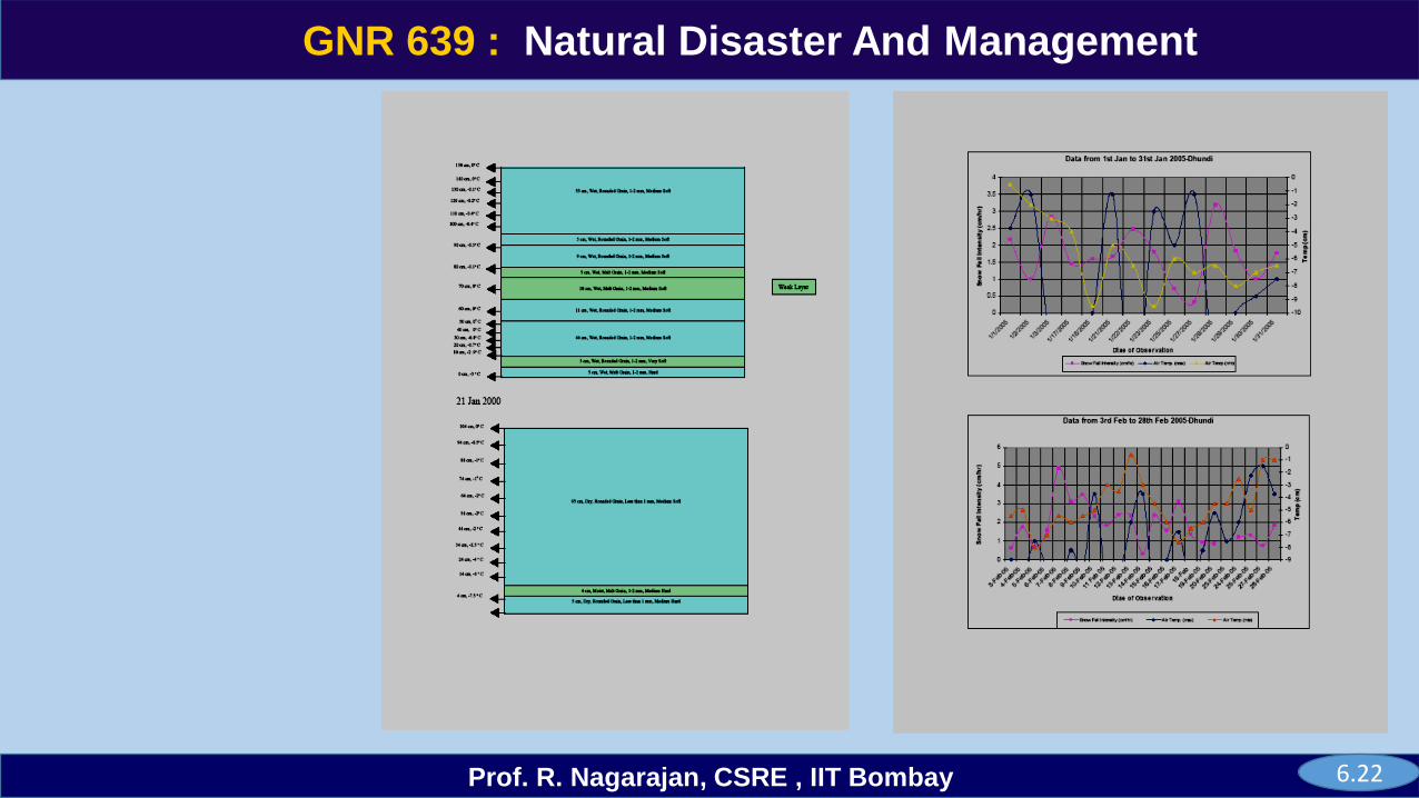
Meteorology Rapid weather changes in wind, temperature, snow, rainfall cause changes in the stability of the snowpack.
Wind Direction - The wind can deposit snow ten times more rapidly than snow falling directly from the sky. Wind drifted snow is always found on steep slopes. A cornice or icy overhang at the top of a mountain or ridge is a telltale sign of wind scouring.
Wind Speed- The snow that is fallen on the mountain terrain is redistributed by wind drift. From high crests snow is blown to cause excessive deposition in depression, zones of avalanche formation and on leveled ground where snow drift glaciers may form. Wind speed over 10 km/hr can transport crystals of diameter 1-2 mm to a distance of 100 to 500 m on an average.
Air Temperature is the most important element responsible of metamorphic changes in snow cover.
Temperature-Gradient (TG) layer may gain strength by sintering and instability may reappear during spring by melting of the sintering bonds. This condition can be significantly warmer on the bottom of the snow pack than at the snow's surface.
6.24
GNR 639
Prof. R. Nagarajan, CSRE , IIT Bombay
GNR 639 : Natural Disaster And Management
6.22
GNR 639
Prof. R. Nagarajan, CSRE , IIT Bombay
GNR 639 : Natural Disaster And Management
Storms – Avalanches are most likely to run either during or immediately after a storm where there has been significant snowfall. The 24 hours following a heavy snowstorm are the most critical period.
Snow Cover Recent snowfall puts extra stress on the existing snowpack, especially if it does not adequately bond to the pre-existing surface layer. The extra weight of new snow alone can cause a snow slab to break off and fall down the slope in storm-induced avalanches. Snowfall amounts of one foot or more create the most hazardous situations.
Snow-Depth - New snow layers more 25-30 cm thick most frequently lead to soft slabs. It has been found out that risk factor increases with increases in snow depth.
Snow Temperature - Avalanche generally occurs when snow temperature is in and around <-70 C due to formation of weak TG layer.
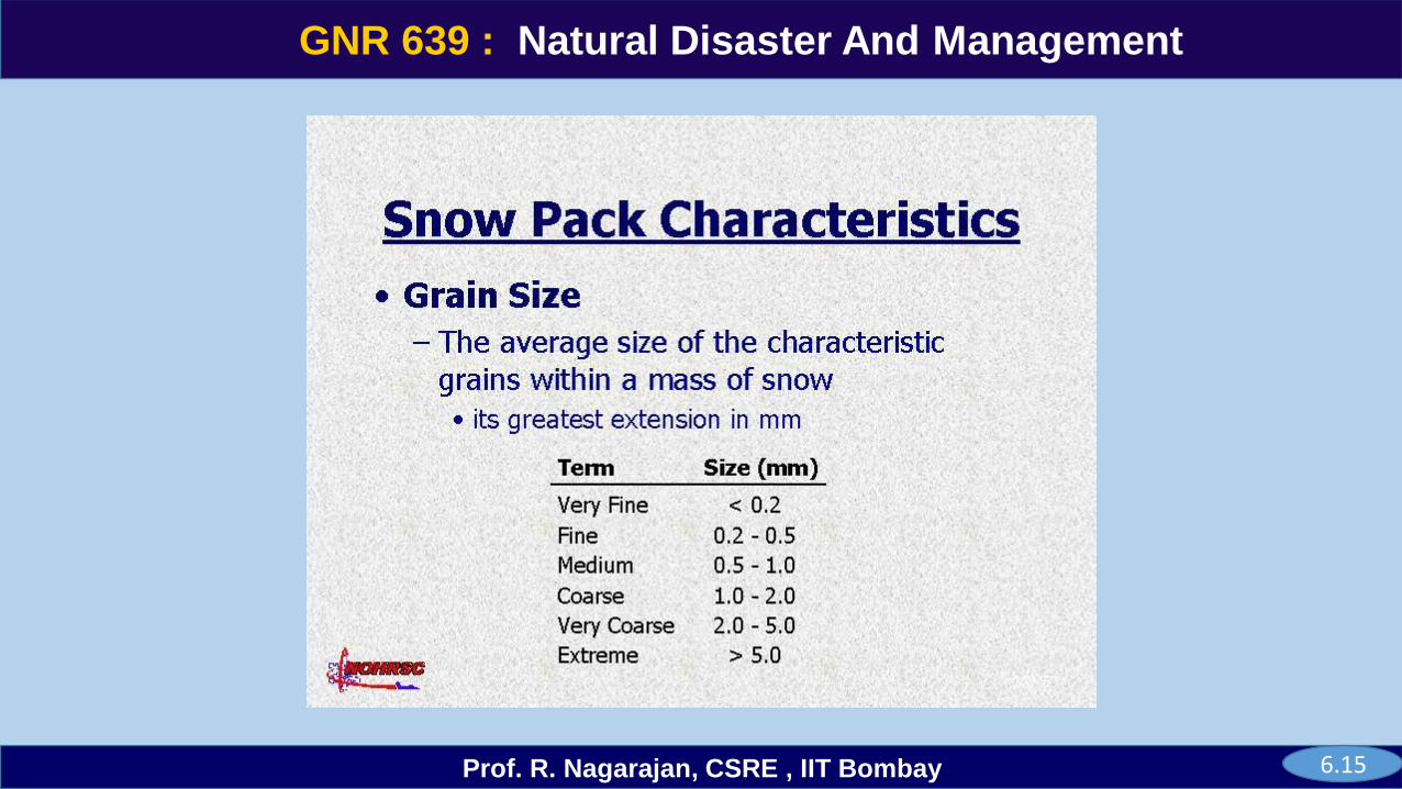
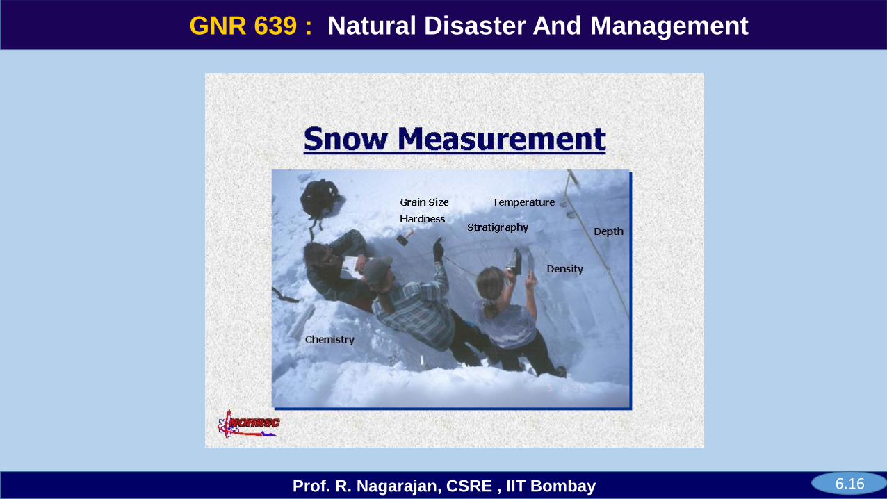
Snow Grain Size- A difference in grain size greater than 0.5 mm and a large difference in hardness indicate instability, as does a depth to the interface between 20 cm and 85 cm.
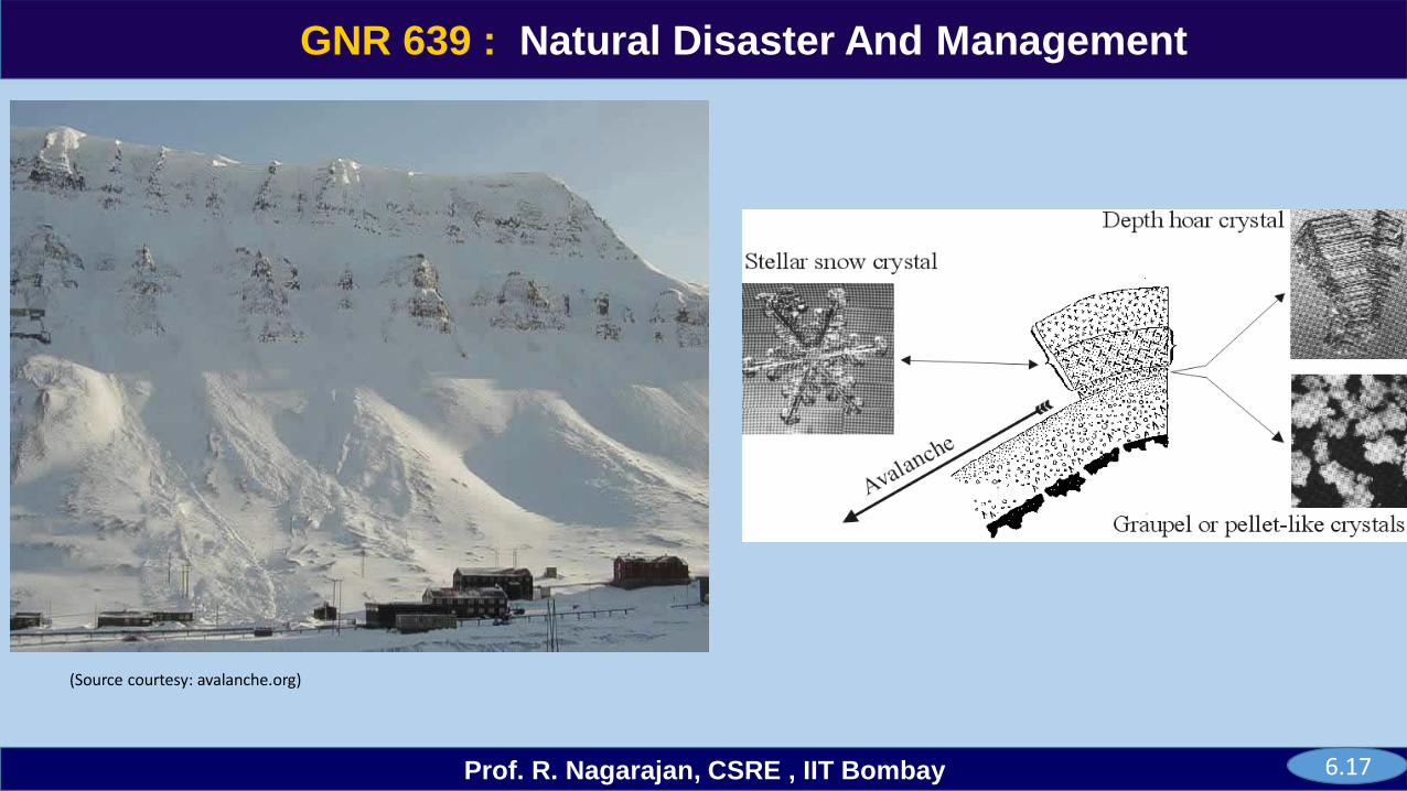
Depth hoar forms in areas of a snowpack where temperature gradients are greater than 10ºC per meter. Depth hoar is often the weakest layer in the snowpack and is a potential sliding layer for avalanches.
6.25
GNR 639
Prof. R. Nagarajan, CSRE , IIT Bombay
GNR 639 : Natural Disaster And Management
Snow Density - The stability of the snowpack is influenced by many factors, but two of the mostimportant is the strength of the weak layer and the load it has to support. The fresh snow depth, typeand density also offer clues to stability.
Grain Type of weak layer - Persistent grain types (facets, depth hoar and surface hoar) as well as icelenses, crusts and grain type anomalies raise suspicion in any snow profile.
Snow layering – Testing of the layering and bonding of the snow structure by using ski or probe poleindicate the strength of the various snow layers. The strong layers may act as a sliding surface foravalanches, especially if overlaid by a weak layer.
Wet snow – A rainfall can rapidly weaken surface snow and overload, weak layers. During sustainedrainfall a series of avalanches may occur on the same slope as progressively deeper snow layers areweakened and stressed.
Snow Depth and Anchoring - Large rocks, trees, and dense brush anchor the snow. Smooth, uncoveredslopes without these natural anchors are more dangerous. But avalanches can start even among trees.Weak layers deep in the snowpack can cause avalanches even if the surface layers are strong or wellbonded.
6.26
GNR 639
Prof. R. Nagarajan, CSRE , IIT Bombay
GNR 639 : Natural Disaster And ManagementOther observations
Old slide pads - Avalanches reoccur in paths where they’ve occurred before. Look for pushed over
small trees and trees with limbs broken off. Avoid steep gullies and open slopes.
Recent avalanche activity – If you see evidence of recent avalanche’s suspect dangerous conditions
especially on other slopes with similar aspects.
Sounds and cracks – If the snow sounds hollow, particularly on a leeward slope, conditions are
probably dangerous. If the snow cracks and the cracks spread, this usually indicates slab avalanche
danger is high.
Elevation – Although avalanche danger generally increases with elevation, unusual weather conditions
combined with local topography may occasionally reverse this relationship.
Volcanic peaks – On volcanic peaks above 8000 to 10,000 feet elevation, significant avalanche hazard
may exist during any time of year.
Information – Check the local weather and avalanche forecasts. NOAA weather radio will carry these
forecasts when high or extreme hazard is expected. Contact the forest service or nearest ski area.
Depth hoar is a coarse and grainy form of snow crystal which is the culprit behind avalanches.
6.27
GNR 639
Prof. R. Nagarajan, CSRE , IIT Bombay
GNR 639 : Natural Disaster And Management
Snowpack safety testsTest skiing is applied for testing the stability of the most recently deposited snow. It is the stability where a skier adds stress to the snow through his or her weight by jumping, kicking and turning.
Explosives are primarily used for avalanche control in snow safety work. It indicates fair to poor stability on the test slope. A crater created by explosive without an avalanche or cracking indicates stable snow pack.
Rutsch block test is carried out to test slopes, prior to skiing over them.
The load level failure 1- indicates the failure under the weight of the block alone; 2 – one
person on skis steps carefully on the block from above; 3- the person’s weights the skis by
making a rapid knee bend; 4 – the person on skis jumps; 5 – the person on skis jumps a
second time; 6- the person jumps onto the block without skis and 7 – no failure observed.
6.28
GNR 639
Prof. R. Nagarajan, CSRE , IIT Bombay
GNR 639 : Natural Disaster And Management
Shovel shear test is to locate weak layers and interfaces. It is done by cutting a vertical column of snow to a depth below suspected weak layers. The shear force is applied by inserting the shovel blade behind the column and pulling in a down slope direction until a failure occurs. The failure is described as :
Very easy – the column fails during cutting or insertion of the shovel (shear frame index (< 100N/m2); Easy – the column fails with a very low shovel pressure (shear frame index (100 - 1000N/m2); Moderate – the column fails under moderate shovel pressure (shear frame index (1000 -2500N/m2); Hard – the column fails after a firm sustained pressure (shear frame index ( 2500 - 4000N/m2).
Fracture propagation is the sudden subsidence of the snow pack due to shear fracture propagation, when weight is added by machines or persons. Often the subsidence is accompanied by a whopping sound as air in the snowpack is compressed by the propagating shear disturbance.
6.29
GNR 639
Prof. R. Nagarajan, CSRE , IIT Bombay
GNR 639 : Natural Disaster And Management
Two basic types of models are used:
topographical-statistical models and dynamic models.
Coefficients for the statistical models are based on at least 20 measured extreme run outs in paths
within a specific mountain range. The run out estimates cannot be used with confidence in other ranges.
Using regression or distribution parameters from the dataset and a reference point in the lower path
known as the Beta (β) point), it is possible to estimate the probability of a given path having a run out a
specified distance past the Beta point.
The most commonly applied types of statistical run out models are known as Alpha-Beta (α−β) and Run
out Ratio (Δx/Xβ). If the return period is known at a reference point such as Beta, and the parameters
are known for the relevant Run out Ratio model, then the run out past the reference point can be
estimated for a specific return period. Some key limitations of these models include: lack of availability
for many ranges, run-up on the opposite side of the valley, and their run out estimates are independent
of terrain anomalies, release zone area, release mass and confinement or gullies in the path to be
mapped.
6.31
GNR 639
Prof. R. Nagarajan, CSRE , IIT Bombay
GNR 639 : Natural Disaster And Management
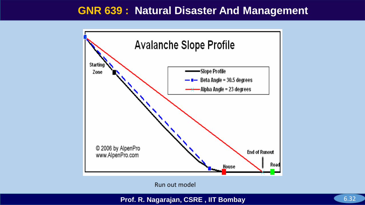
Topographical model - The run-out distance is appropriate for analysis along longitudinally concave profiles. The
run-out distance equations are found by regression analysis.
The calculated run-out is expected under a given climatic region and snow conditions favoring them. Extreme-
value model assumes that the alpha (α) & beta (β) observations are made on an average observation period of
100 years and the number of avalanches behind each extreme alpha (α) observation does not vary too much.
Dynamic models use physical laws such as conservation of mass and momentum to predict avalanche speed
down a simplified representation of the topography of the path.
One-dimensional (1D) models predict the velocity of the centre of mass or the front along the centre line of the
path. The earlier 1D model represents the terrain as a sequence of segments, each with constant slope angle,
down the centerline of the path. In Switzerland, AVAL-1D is currently used for hazard mapping.
Two-dimensional (2D) models estimate the flow depth or lateral extent whereas 3D models estimate both.
Using the calculated velocity and estimates of flow density based on published values and/or experience,
impact pressures along the path can be estimated.
6.34
GNR 639
Prof. R. Nagarajan, CSRE , IIT Bombay
GNR 639 : Natural Disaster And Management
Run out model
6.32
GNR 639
Prof. R. Nagarajan, CSRE , IIT Bombay
GNR 639 : Natural Disaster And Management
Hazard mapping benefits from runout estimates from largely independent methods such as vegetation, human records, statistical models and dynamic models
Statistical models use data sets of rare events of 100 years return periods obtained in the mountain range. Unique snow pack and snow loading conditions develop in some isolated areas in all but very winters. This model is successfully used within Western Fiords of Norway Geotechnical Institute (NGI method). It uses:-
• The alpha angle (α) measured from the crown location to a tip of the run out;
• The point where the local profile slope becomes 100 is identified
• beta (β) angle is measured from the 100 point to the crown location. Constraints is it uncertainity in α angle.
6.33
GNR 639
Prof. R. Nagarajan, CSRE , IIT Bombay
GNR 639 : Natural Disaster And Management
Avalanche forecast classification • Snow and weather data measured at or above surface as numerical • Snow pack factors such as snow pit analysis as non-numerical and Stability factors using
stability test or observed occurrence.
• True forecast - probability of avalanche occurrence is determined before the incremental changes in weather and snows. Depend heavily on accurate weather forecast & subsequent stability estimate of snow pack. French SAFRAN-CROCUS-MEPRA system
• Meso-scale areas like mountain passes & Skiing areas use incremental changes that are taking place or taken place.
• Ski & Highway operation warnings based on morning observations. Stability functions could be determined and precision of prediction increased for detailed spatial forecasts and named as B1.
• Micro scale area - Predictions after incremental snow and weather conditions taken place, extensive sampling, scanning of avalanches & skiing performed.
• Helicopter is used for surveillance and increased spatial and temporal resolution of forecast.
6.37
GNR 639
Prof. R. Nagarajan, CSRE , IIT Bombay
GNR 639 : Natural Disaster And Management
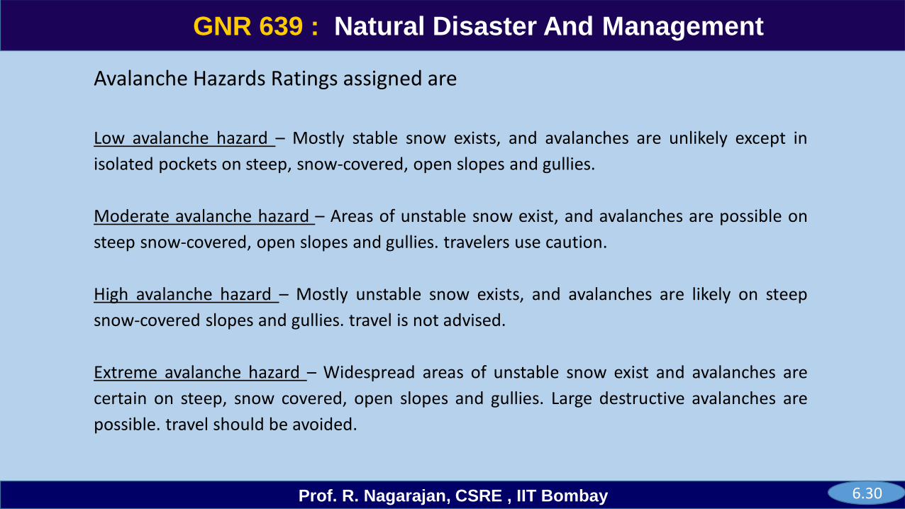
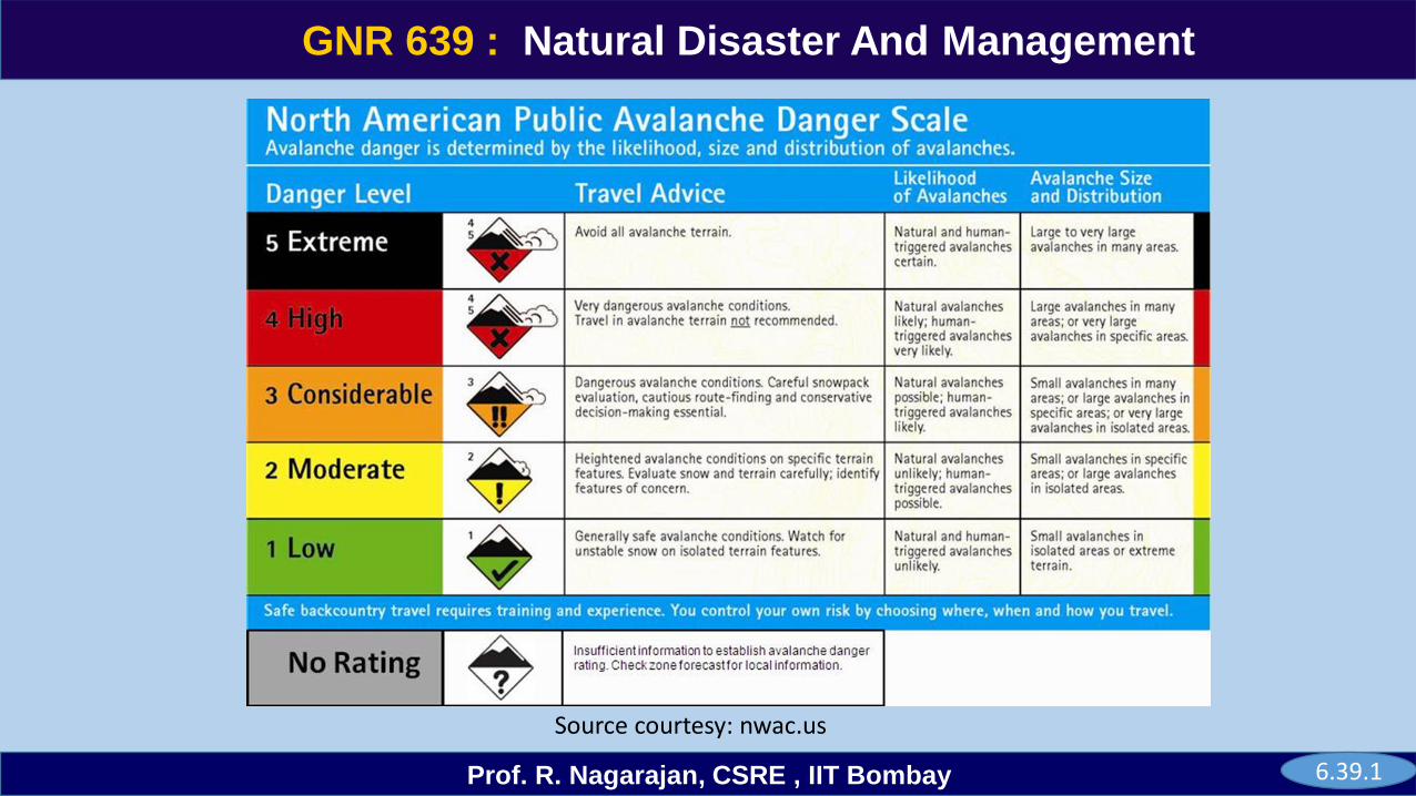
Avalanche Hazards Ratings assigned are
Low avalanche hazard – Mostly stable snow exists, and avalanches are unlikely except in
isolated pockets on steep, snow-covered, open slopes and gullies.
Moderate avalanche hazard – Areas of unstable snow exist, and avalanches are possible on
steep snow-covered, open slopes and gullies. travelers use caution.
High avalanche hazard – Mostly unstable snow exists, and avalanches are likely on steep
snow-covered slopes and gullies. travel is not advised.
Extreme avalanche hazard – Widespread areas of unstable snow exist and avalanches are
certain on steep, snow covered, open slopes and gullies. Large destructive avalanches are
possible. travel should be avoided.
6.30
GNR 639
Prof. R. Nagarajan, CSRE , IIT Bombay
GNR 639 : Natural Disaster And Management
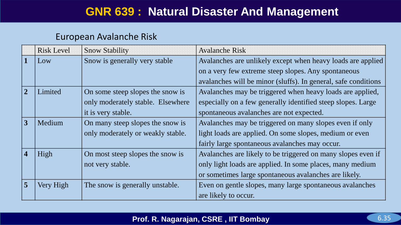
European Avalanche Risk
Risk Level Snow Stability Avalanche Risk
1 Low Snow is generally very stable Avalanches are unlikely except when heavy loads are applied
on a very few extreme steep slopes. Any spontaneous
avalanches will be minor (sluffs). In general, safe conditions
2 Limited On some steep slopes the snow is
only moderately stable. Elsewhere
it is very stable.
Avalanches may be triggered when heavy loads are applied,
especially on a few generally identified steep slopes. Large
spontaneous avalanches are not expected.
3 Medium On many steep slopes the snow is
only moderately or weakly stable.
Avalanches may be triggered on many slopes even if only
light loads are applied. On some slopes, medium or even
fairly large spontaneous avalanches may occur.
4 High On most steep slopes the snow is
not very stable.
Avalanches are likely to be triggered on many slopes even if
only light loads are applied. In some places, many medium
or sometimes large spontaneous avalanches are likely.
5 Very High The snow is generally unstable. Even on gentle slopes, many large spontaneous avalanches
are likely to occur.
6.35

GNR 639
Prof. R. Nagarajan, CSRE , IIT Bombay
GNR 639 : Natural Disaster And Management
US avalanche danger rating for Ski areas
Parameters Low Moderate Considerable High Extreme
Settlement 20% 10 % 5% 0%
24 hr snow (inches) 7-10” 11-15” 16-25” 26-30” >30 ”
12 hr snow (inches) 0-6 ” 7 -10 ” 11 - 15” 16- 25” >25”
Temperature Trend (0F) 260 26-300 30-310 30-500 >500
Wind (mph) 0-10 12-18 20-30 30-50 > 50
Intensity (inches/hr) 0.08 0.1 0.11-0.18 > 0.2
Density 5% 6-10% 11-18% >20%
Layering Low Moderate Considerable High Extreme
Natural Activity Low Moderate Considerable High Extreme
6.36
GNR 639
Prof. R. Nagarajan, CSRE , IIT Bombay
GNR 639 : Natural Disaster And Management
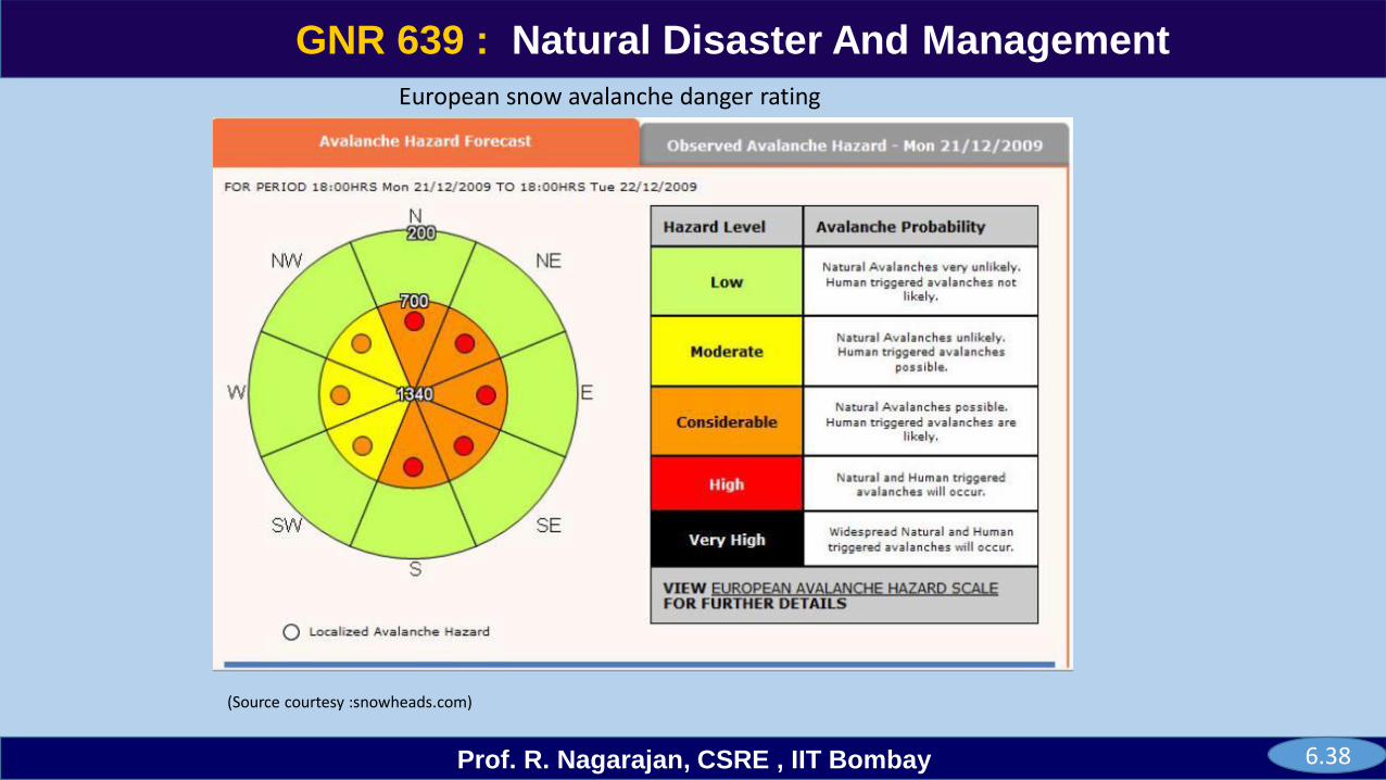
European snow avalanche danger rating
(Source courtesy :snowheads.com)
6.38
GNR 639
Prof. R. Nagarajan, CSRE , IIT Bombay
GNR 639 : Natural Disaster And Management
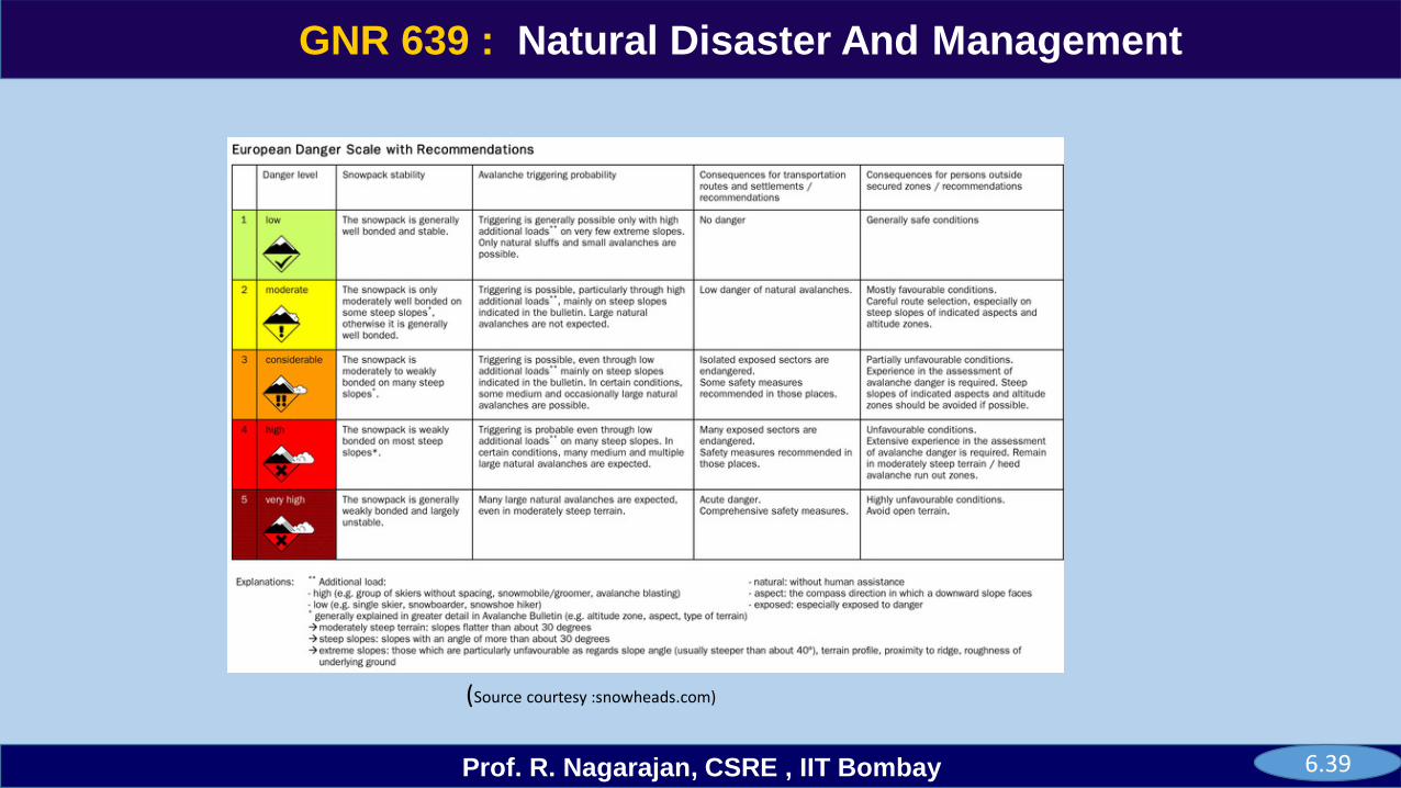
(Source courtesy :snowheads.com)
6.39
GNR 639
Prof. R. Nagarajan, CSRE , IIT Bombay
GNR 639 : Natural Disaster And Management
6.39.1
Source courtesy: nwac.us
GNR 639
Prof. R. Nagarajan, CSRE , IIT Bombay
GNR 639 : Natural Disaster And Management
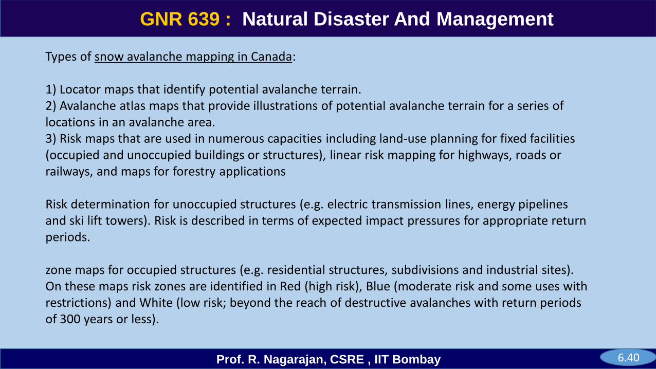
Types of snow avalanche mapping in Canada:
1) Locator maps that identify potential avalanche terrain. 2) Avalanche atlas maps that provide illustrations of potential avalanche terrain for a series of locations in an avalanche area. 3) Risk maps that are used in numerous capacities including land-use planning for fixed facilities (occupied and unoccupied buildings or structures), linear risk mapping for highways, roads or railways, and maps for forestry applications
Risk determination for unoccupied structures (e.g. electric transmission lines, energy pipelines and ski lift towers). Risk is described in terms of expected impact pressures for appropriate return periods.
zone maps for occupied structures (e.g. residential structures, subdivisions and industrial sites). On these maps risk zones are identified in Red (high risk), Blue (moderate risk and some uses with restrictions) and White (low risk; beyond the reach of destructive avalanches with return periods of 300 years or less).
6.40
GNR 639
Prof. R. Nagarajan, CSRE , IIT Bombay
GNR 639 : Natural Disaster And Management
Linear risk mapping for transportation routes. This involves formal risk calculation for roads, highways or railways, and accounts for avalanche frequency, traffic volume, waiting traffic, expected damage and path length exposed.
Forest harvest risk mapping addresses two concerns: possible avalanche initiation in future harvested terrain; and existing avalanche paths that intersect future harvested terrain.
6.41
GNR 639
Prof. R. Nagarajan, CSRE , IIT Bombay
GNR 639 : Natural Disaster And Management
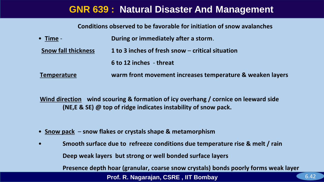
Conditions observed to be favorable for initiation of snow avalanches
• Time - During or immediately after a storm.
Snow fall thickness 1 to 3 inches of fresh snow – critical situation
6 to 12 inches - threat
Temperature warm front movement increases temperature & weaken layers
Wind direction wind scouring & formation of icy overhang / cornice on leeward side (NE,E & SE) @ top of ridge indicates instability of snow pack.
• Snow pack – snow flakes or crystals shape & metamorphism
• Smooth surface due to refreeze conditions due temperature rise & melt / rain
Deep weak layers but strong or well bonded surface layers
Presence depth hoar (granular, coarse snow crystals) bonds poorly forms weak layer6.42
GNR 639
Prof. R. Nagarajan, CSRE , IIT Bombay
GNR 639 : Natural Disaster And Management
Avalanche avoidance
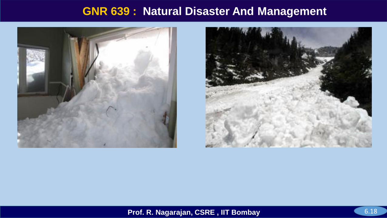
Preventative measures are employed in areas where avalanches pose a significant threat to people, such as ski resorts and mountain towns, roads and railways. The simplest active measure is by repeatedly traveling on a snow pack as snow accumulates; this can be by means of boot-packing, ski-cutting, or machine grooming.
Explosives are used extensively to prevent avalanches, by triggering smaller avalanches that break down instabilities in the snow pack, and removing over burden that can result in larger avalanches. Explosive charges are delivered by a number of methods including hand tossed charges, helicopter dropped bombs, Gazex concussion lines, and ballistic projectiles launched by air cannons and artillery.
Passive preventive systems such as Snow fences and light walls can be used to direct the placement of snow. Snow builds up around the fence, especially the side that faces the prevailing Winds.
Trees can either be planted or they can be conserved, such as in the building of a ski resort, to reduce the strength of avalanches.
6.43
GNR 639
Prof. R. Nagarajan, CSRE , IIT Bombay
GNR 639 : Natural Disaster And Management
Artificial barriers can be very effective in reducing avalanche damage. There are several types.
Snow net barrier uses a net strung between poles that are anchored by guy wires in addition to their foundations.
Rigid snow fence like structure may be constructed of steel, wood or pre-stressed concrete.
Terrain management involves reducing the exposure of an individual to the risks of traveling in avalanche terrain by carefully selecting which areas of slopes is safe to travel on.
The safest routes are on ridge tops and slightly on the windward side away from cornices. Windward slopes are usually safer than leeward slopes. If you cannot travel on ridge is, the next safest route is out in the valley far from the bottom of slopes.
Avoid cornices move toward ridge tops by detouring around cornice areas. If you must cross a potentially dangerous slope stay high and near the top. If you see cracks or avalanche fracture lines in the snow, avoid them and nearby similar slopes.
6.44
GNR 639
Prof. R. Nagarajan, CSRE , IIT Bombay
GNR 639 : Natural Disaster And Management
Only one person at a time should cross a potentially dangerous slope. All others should watch.
Group management Minimize the number of people on the slope, and maintain separation. Route selection should also consider what dangers lie above and below the route, and the consequences of an unexpected avalanche (i.e., unlikely to occur, but deadly if it does). Stop or camp only in safe locations.
Risk Factor Awareness about avalanche safety requires gathering and accounting for a wide range of information such as the meteorological history of the area, the current weather and snow conditions,
Avalanche safety begins even before you begin your travel and keeping an eye out for weather and terrain conditions. Proper equipment can be a critical factor in rescue efforts. Avalanche victim will either endure fatal trauma due to collisions with rocks or trees during an avalanche, or will suffocate after they are buried by snow.
Avalanche beacons (transceivers) are the most commonly used rescue device. They are the standard equipment for ski-area patrollers and heli-ski operators.
6.45
GNR 639
Prof. R. Nagarajan, CSRE , IIT Bombay
GNR 639 : Natural Disaster And Management
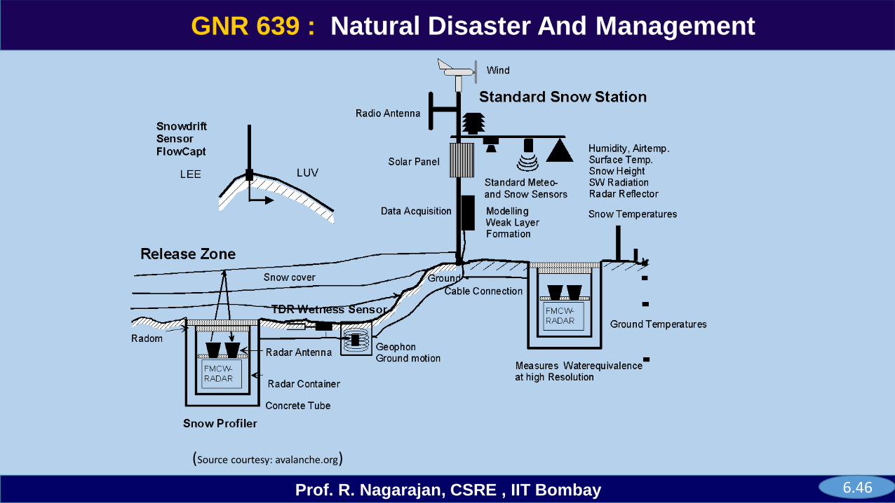
(Source courtesy: avalanche.org)
6.46
GNR 639
Prof. R. Nagarajan, CSRE , IIT Bombay
GNR 639 : Natural Disaster And Management
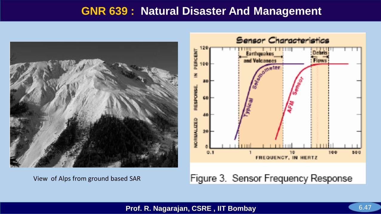
View of Alps from ground based SAR
6.47
GNR 639
Prof. R. Nagarajan, CSRE , IIT Bombay
GNR 639 : Natural Disaster And Management
Lesson 6.1
Glacier
6.1.01
GNR 639
Prof. R. Nagarajan, CSRE , IIT Bombay
GNR 639 : Natural Disaster And Management
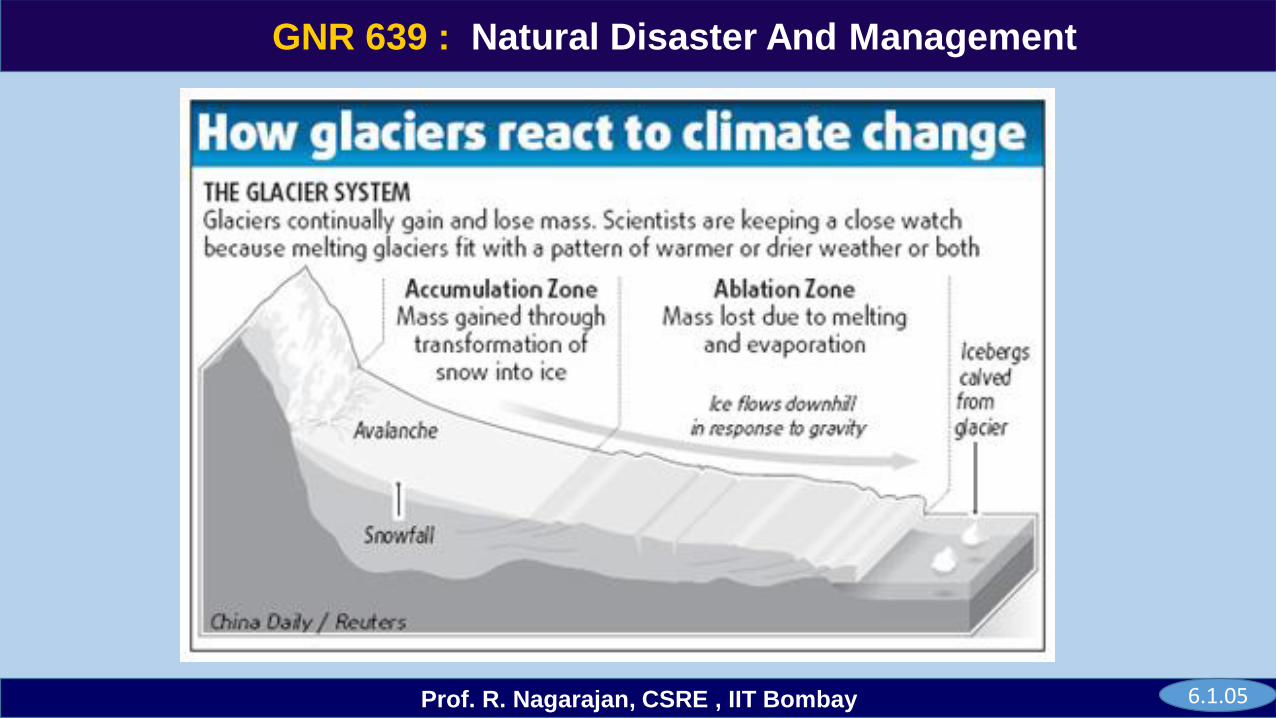
Glacier is a large persistent body of ice on land and moves slowly down the slope. It forms in a location where the accumulation of snow and sleet exceeds the amount of snow that melts. It transports rock and debris abraded from its substrate and deposits as cirques and moraines landforms. In the tropics, glaciers occur only on high mountains.
Types of Glaciers - morphology, thermal characteristics and behavior.
Alpine glaciers form on the crests and slopes of mountains and are also known as mountain glaciers or cirque glaciers. When they fills a valley is called a valley glacier. They are feed outlet glaciers, tongues of ice that extend into valleys below far from the margins of the larger ice masses.
Larger glaciers that cover an entire mountain range or volcano are known as an ice cap or ice field.
Ice shelves are areas of floating ice, commonly located at the margin of an ice sheet. As a result they are thinner and have limited slopes and reduced velocities.
Ice streams are fast-moving sections of an ice sheet that are several hundred km long.
Tidewater glaciers are glaciers that terminate in the sea. As the ice reaches the sea, it breaks off, or calve, forming icebergs.
6.1.02
GNR 639
Prof. R. Nagarajan, CSRE , IIT Bombay
GNR 639 : Natural Disaster And Management
temperate glacier is at melting point throughout the year, from its surface to its base, while the ice of a polar glacier is always below freezing point, although the surface snowpack may experience seasonal melting.
sub-polar glacier has characteristics of both temperate and polar ice. As the snow and ice thickens, they reach a point where they begin to move, due to a combination of the surface slope and the pressure of the overlying snow and ice.
Ice sheets are the largest glaciers. These enormous masses of ice are not visibly affected by the landscape as they cover the entire surface beneath them,
Glaciers move or flow downhill due to the internal deformation of ice and gravity. Friction between ice and rock and geothermal heat from the Earth's interior also contribute to melting.
Velocity increases with increasing slope, thickness, snowfall, longitudinal confinement, basal temperature, melt water production and reduced bed hardness.
6.1.03
GNR 639
Prof. R. Nagarajan, CSRE , IIT Bombay
GNR 639 : Natural Disaster And Management
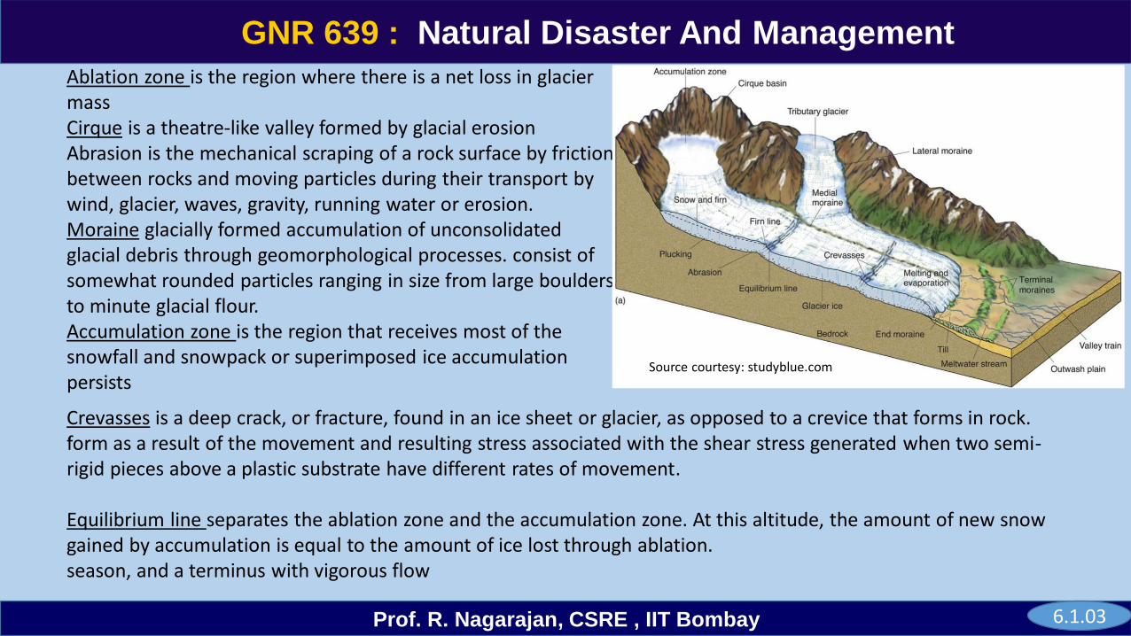
Ablation zone is the region where there is a net loss in glacier massCirque is a theatre-like valley formed by glacial erosionAbrasion is the mechanical scraping of a rock surface by friction between rocks and moving particles during their transport by wind, glacier, waves, gravity, running water or erosion.Moraine glacially formed accumulation of unconsolidated glacial debris through geomorphological processes. consist of somewhat rounded particles ranging in size from large boulders to minute glacial flour. Accumulation zone is the region that receives most of the snowfall and snowpack or superimposed ice accumulation persists
.
Source courtesy: studyblue.com
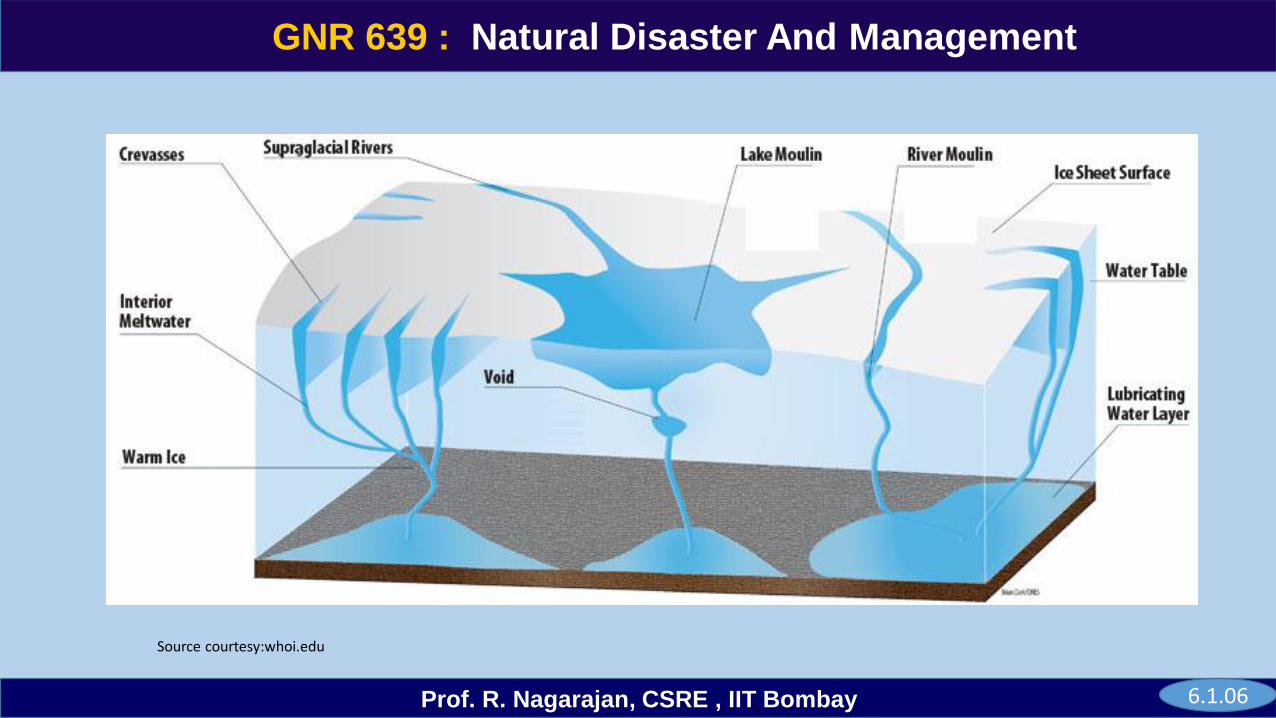
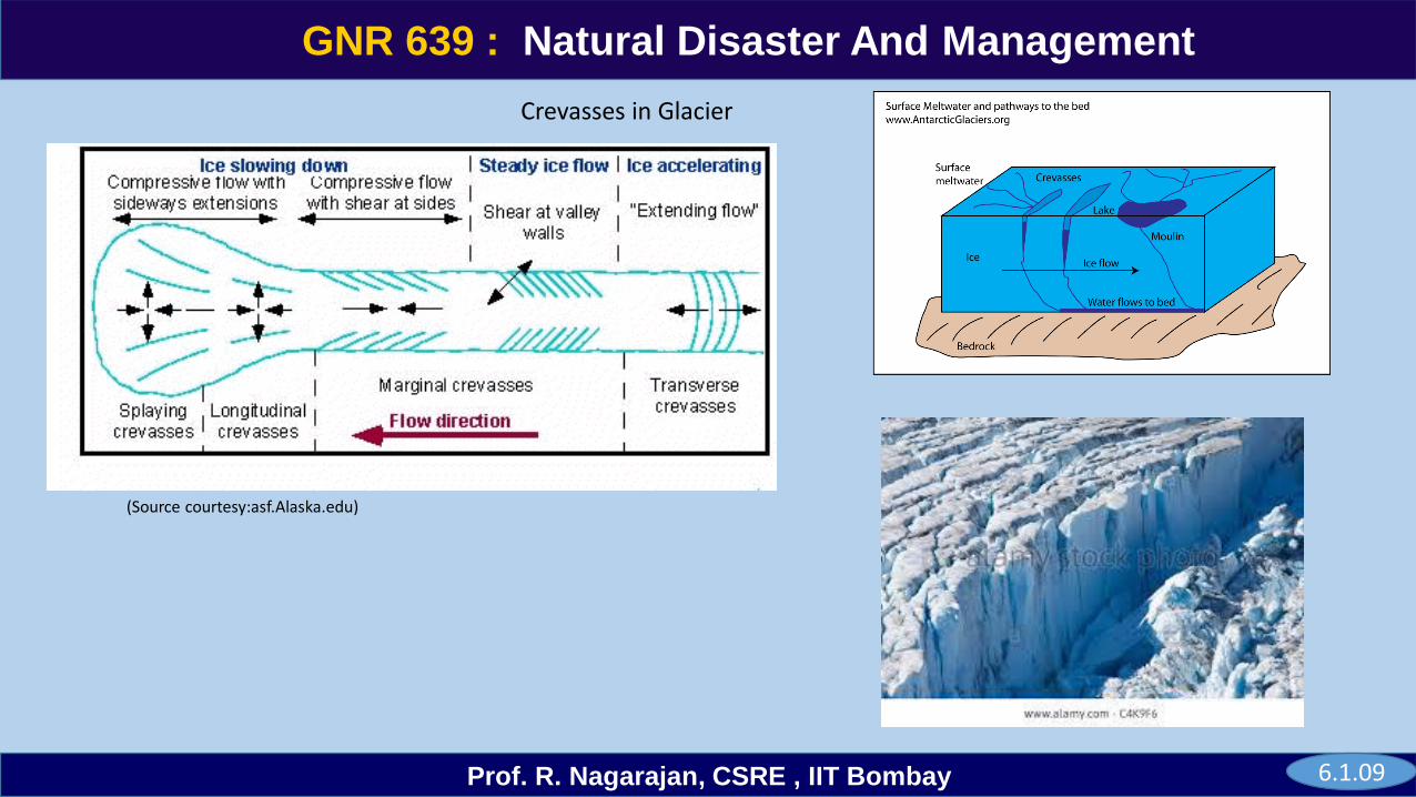
Crevasses is a deep crack, or fracture, found in an ice sheet or glacier, as opposed to a crevice that forms in rock. form as a result of the movement and resulting stress associated with the shear stress generated when two semi-rigid pieces above a plastic substrate have different rates of movement.
Equilibrium line separates the ablation zone and the accumulation zone. At this altitude, the amount of new snow gained by accumulation is equal to the amount of ice lost through ablation. season, and a terminus with vigorous flow
6.1.03
GNR 639
Prof. R. Nagarajan, CSRE , IIT Bombay
GNR 639 : Natural Disaster And Management
Source courtesy :www2.usgs.gov
Source courtesy :natky.in
Source courtesy :nasa.gov
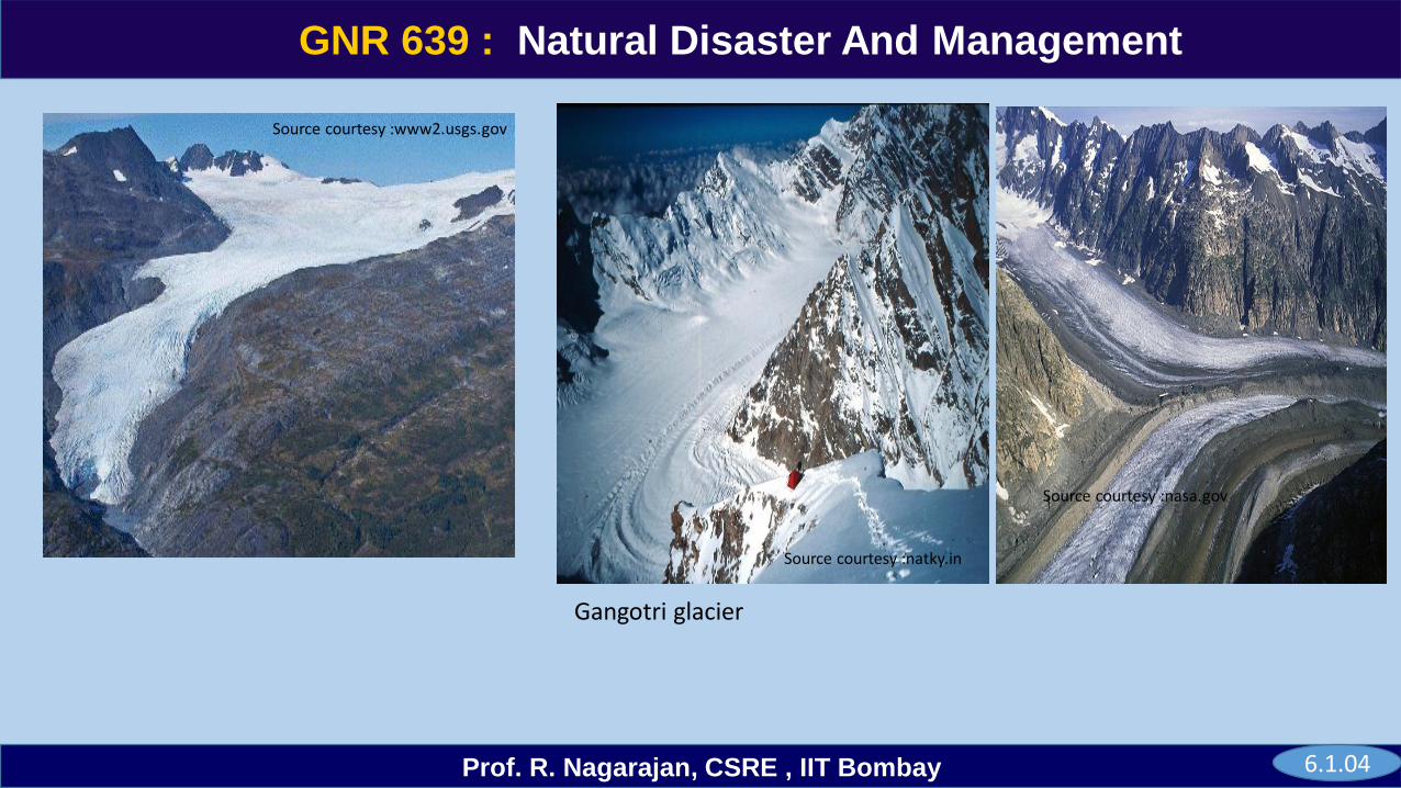
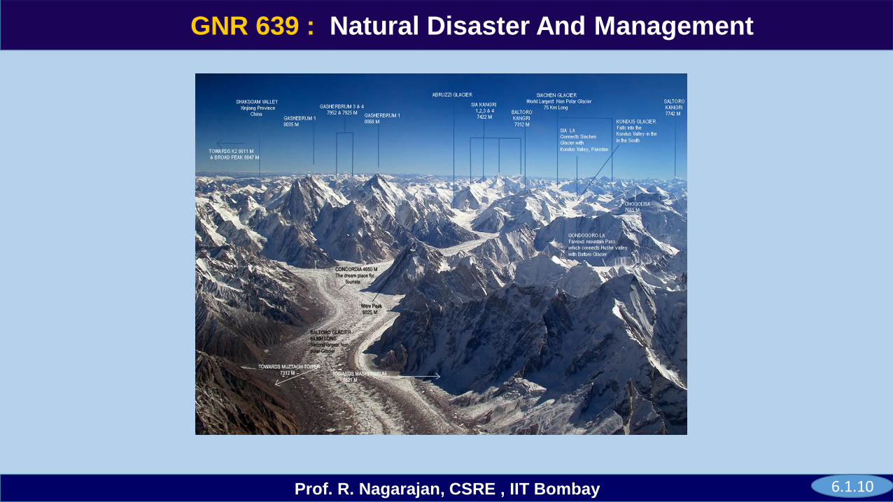
Gangotri glacier
6.1.04
GNR 639
Prof. R. Nagarajan, CSRE , IIT Bombay
GNR 639 : Natural Disaster And Management
6.1.05
GNR 639
Prof. R. Nagarajan, CSRE , IIT Bombay
GNR 639 : Natural Disaster And Management
6.1.06
Source courtesy:whoi.edu
GNR 639
Prof. R. Nagarajan, CSRE , IIT Bombay
GNR 639 : Natural Disaster And Management
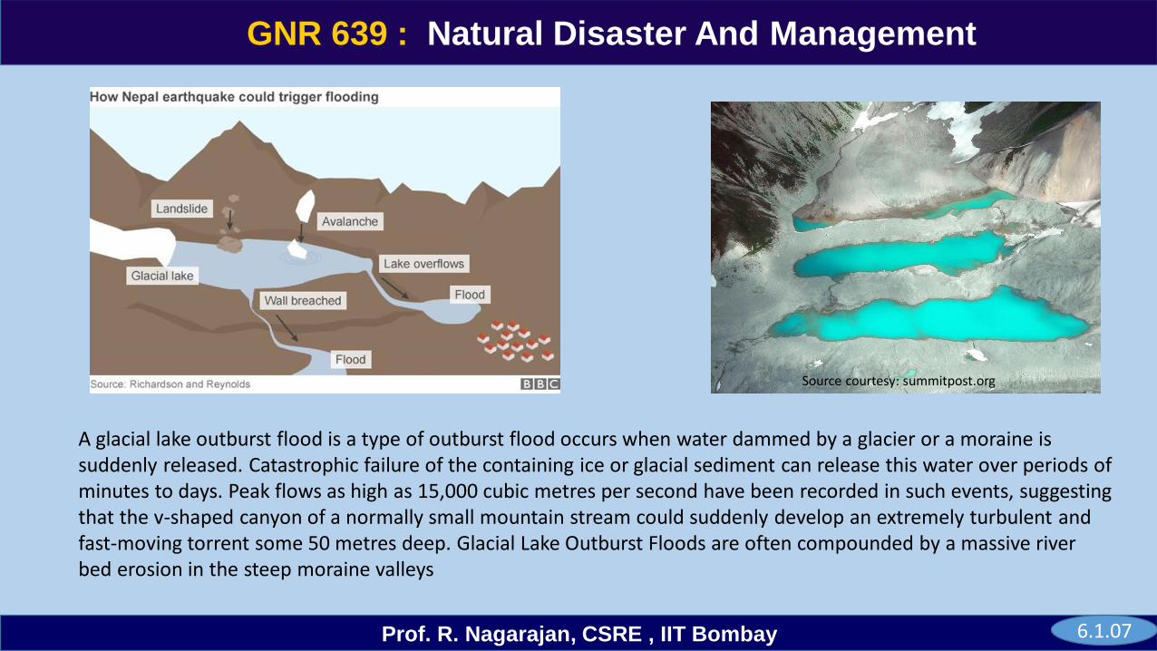
A glacial lake outburst flood is a type of outburst flood occurs when water dammed by a glacier or a moraine is suddenly released. Catastrophic failure of the containing ice or glacial sediment can release this water over periods of minutes to days. Peak flows as high as 15,000 cubic metres per second have been recorded in such events, suggesting that the v-shaped canyon of a normally small mountain stream could suddenly develop an extremely turbulent and fast-moving torrent some 50 metres deep. Glacial Lake Outburst Floods are often compounded by a massive river bed erosion in the steep moraine valleys
Source courtesy: summitpost.org
6.1.07
GNR 639
Prof. R. Nagarajan, CSRE , IIT Bombay
GNR 639 : Natural Disaster And Management
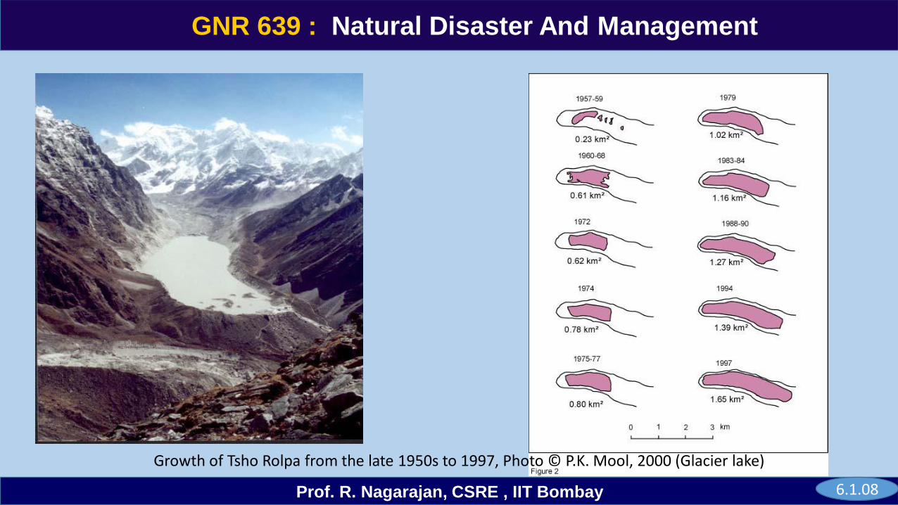
Growth of Tsho Rolpa from the late 1950s to 1997, Photo © P.K. Mool, 2000 (Glacier lake)
6.1.08
GNR 639
Prof. R. Nagarajan, CSRE , IIT Bombay
GNR 639 : Natural Disaster And Management
(Source courtesy:asf.Alaska.edu)
Crevasses in Glacier
6.1.09
GNR 639
Prof. R. Nagarajan, CSRE , IIT Bombay
GNR 639 : Natural Disaster And Management
6.1.10
GNR 639
Prof. R. Nagarajan, CSRE , IIT Bombay
GNR 639 : Natural Disaster And Management
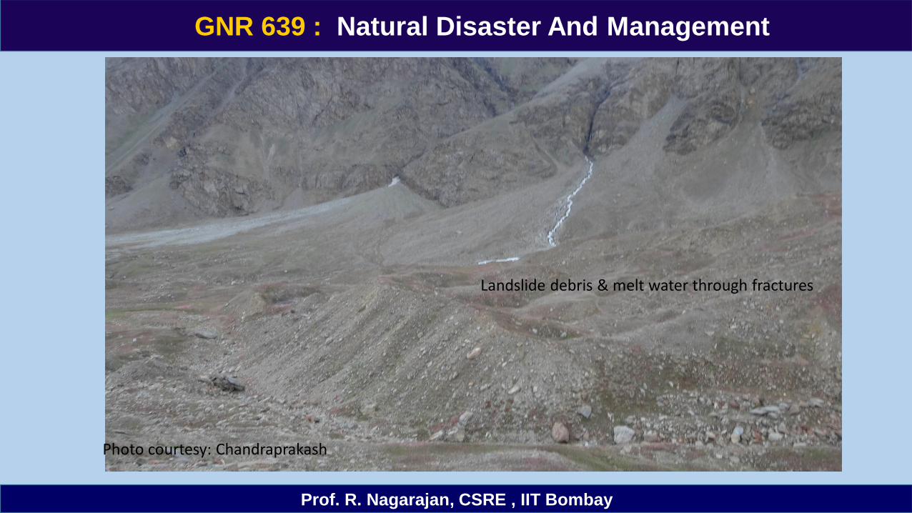
Photo courtesy: Chandraprakash
Landslide debris & melt water through fractures
GNR 639
Prof. R. Nagarajan, CSRE , IIT Bombay
GNR 639 : Natural Disaster And Management
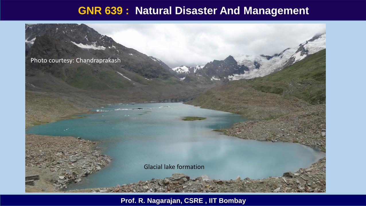
Photo courtesy: Chandraprakash
Glacial lake formation
GNR 639
Prof. R. Nagarajan, CSRE , IIT Bombay
GNR 639 : Natural Disaster And Management
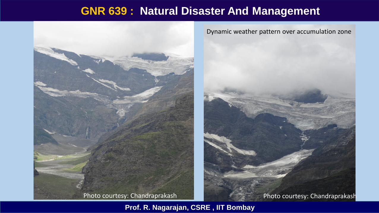
Photo courtesy: Chandraprakash Photo courtesy: Chandraprakash
Dynamic weather pattern over accumulation zone
GNR 639
Prof. R. Nagarajan, CSRE , IIT Bombay
GNR 639 : Natural Disaster And Management
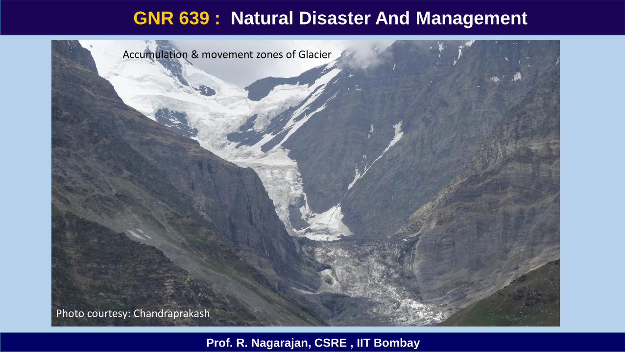
Accumulation & movement zones of Glacier
Photo courtesy: Chandraprakash
GNR 639
Prof. R. Nagarajan, CSRE , IIT Bombay
GNR 639 : Natural Disaster And Management
Thank you