Recent glacier retreat and climate trends in Cordillera Huaytapallana, Peru
11
Recent glacier retreat and climate trends in Cordillera Huaytapallana, Peru J.I. López-Moreno a , S. Fontaneda a , J. Bazo b , J. Revuelto a , C. Azorin-Molina a , B. Valero-Garcés a , E. Morán-Tejeda a , S.M. Vicente-Serrano a , R. Zubieta c , J. Alejo-Cochachín d a Instituto Pirenaico de Ecología, Consejo Superior de Investigaciones Científicas (CSIC), Zaragoza, Spain b Servicio Nacional de Meteorología e Hidrología del Perú (SENAMHI), Lima, Peru c Instituto Geofísico de Perú, Lima, Peru d Unidad de Glaciología, Autoridad Nacional del Agua (ANA), Huaraz, Peru abstract article info Article history: Received 29 July 2013 Received in revised form 21 October 2013 Accepted 30 October 2013 Available online 7 November 2013 Keywords: glacier retreat snow line climate change lake formation Cordillera Huaytapallana Peru We analyzed 19 annual Landsat Thematic Mapper images from 1984 to 2011 to determine changes of the glaci- ated surface and snow line elevation in six mountain areas of the Cordillera Huaytapallana range in Peru. In con- trast to other Peruvian mountains, glacier retreat in these mountains has been poorly documented, even though this is a heavily glaciated area. These glaciers are the main source of water for the surrounding lowlands, and melting of these glaciers has triggered several outburst floods. During the 28-year study period, there was a 55% decrease in the surface covered by glaciers and the snowline moved upward in different regions by 93 to 157 m. Moreover, several new lakes formed in the recently deglaciated areas. There was an increase in precipi- tation during the wet season (October–April) over the 28-year study period. The significant increase in maximum temperatures may be related to the significant glacier retreat in the study area. There were significant differences in the wet season temperatures during El Niño (warmer) and La Niña (colder) years. Although La Niña years were generally more humid than El Niño years, these differences were not statistically significant. Thus, glaciers tended to retreat at a high rate during El Niño years, but tended to be stable or increase during La Niña years, although there were some notable deviations from this general pattern. Climate simulations for 2021 to 2050, based on the most optimistic assumptions of greenhouse gas concentrations, forecast a continuation of climate warming at the same rate as documented here. Such changes in temperature might lead to a critical situation for the glaciers of the Cordillera Huaytapallana, and may significantly impact the water resources, ecology, and natural hazards of the surrounding areas. © 2013 Elsevier B.V. All rights reserved. 1. Introduction The central Andes have 99% of the tropical glaciers world-wide and 71% of these glaciers are in Peru (Vuille et al., 2008a, 2008b; Chevalier et al., 2011). Glaciers are the major source of freshwater for some of the largest cities of South America, including Quito, Lima, and La Paz. These glaciers also provide water for irrigation of traditional agriculture in the mountains, modern intensive farming in the foothills and low- lands (Messerli, 2001; Mark, 2008; Bury et al., 2011), and hydropower (Vergara et al., 2007; Chevalier et al., 2011). However, glaciers are also behind natural hazards and have caused thousands of fatalities in recent decades. Glacial lakes may overflow, chunks of glaciers may collapse into lakes, and high seismic activity can increase the risk of glacial lake outburst floods (GLOFs). These can lead to flooding of croplands and residential areas in the alluvial fans and valley bottoms (Reynolds, 1992; Portocarrero, 1995; Carey, 2005; Carey et al., 2012). There has been a marked decrease in the glaciated areas of the Peruvian Andes since the end of the Little Ice Age in ~1850 (Georges, 2004; Vuille et al., 2008a, 2008b), and an acceleration in the degradation and retreat of these glaciers in the last decades of the 20th century (Kaser and Georges, 1999; Francou and Vincent, 2007; Raup et al., 2007). Thus, from 1970 to 1997, glacier coverage in Peru declined by more than 20% (Bury et al., 2011; Fraser, 2012). This recent accelerated decline is associated with an increase in air temperature across the re- gion (Vuille and Bradley, 2000; Kaser and Osmaston, 2002; Mark and Seltzer, 2005; Bradley et al., 2009). Higher air temperatures increase heat transfer and the portion of precipitation in the liquid phase; but an increase in temperature also raises the saturation vapor pressure, causing a rise in specific humidity under the assumption of constant relative humidity (Hense et al., 1988; Wagnon et al., 1999). The reduced latent heat flux limits sublimation, and available radiative energy is more efficiently consumed by melting, leading to increased loss of glacier mass (Sicart et al., 2005). The retreat of these glaciers has led to the formation of new proglacier lakes and an increase in the surface and volume of many existing lakes (Ames, 1998). It has also increased Global and Planetary Change 112 (2014) 1–11 E-mail address: [email protected] (J.I. López-Moreno). 0921-8181/$ – see front matter © 2013 Elsevier B.V. All rights reserved. http://dx.doi.org/10.1016/j.gloplacha.2013.10.010 Contents lists available at ScienceDirect Global and Planetary Change journal homepage: www.elsevier.com/locate/gloplacha
-
Upload
independent -
Category
Documents
-
view
0 -
download
0
Transcript of Recent glacier retreat and climate trends in Cordillera Huaytapallana, Peru

Global and Planetary Change 112 (2014) 1–11
Contents lists available at ScienceDirect
Global and Planetary Change
j ourna l homepage: www.e lsev ie r .com/ locate /g lop lacha
Recent glacier retreat and climate trends in CordilleraHuaytapallana, Peru
J.I. López-Moreno a, S. Fontaneda a, J. Bazo b, J. Revuelto a, C. Azorin-Molina a, B. Valero-Garcés a,E. Morán-Tejeda a, S.M. Vicente-Serrano a, R. Zubieta c, J. Alejo-Cochachín d
a Instituto Pirenaico de Ecología, Consejo Superior de Investigaciones Científicas (CSIC), Zaragoza, Spainb Servicio Nacional de Meteorología e Hidrología del Perú (SENAMHI), Lima, Peruc Instituto Geofísico de Perú, Lima, Perud Unidad de Glaciología, Autoridad Nacional del Agua (ANA), Huaraz, Peru
E-mail address: [email protected] (J.I. López-Moreno).
0921-8181/$ – see front matter © 2013 Elsevier B.V. All rihttp://dx.doi.org/10.1016/j.gloplacha.2013.10.010
a b s t r a c t
a r t i c l e i n f oArticle history:Received 29 July 2013Received in revised form 21 October 2013Accepted 30 October 2013Available online 7 November 2013
Keywords:glacier retreatsnow lineclimate changelake formationCordillera HuaytapallanaPeru
We analyzed 19 annual Landsat Thematic Mapper images from 1984 to 2011 to determine changes of the glaci-ated surface and snow line elevation in six mountain areas of the Cordillera Huaytapallana range in Peru. In con-trast to other Peruvianmountains, glacier retreat in these mountains has been poorly documented, even thoughthis is a heavily glaciated area. These glaciers are the main source of water for the surrounding lowlands, andmelting of these glaciers has triggered several outburst floods. During the 28-year study period, there was a55% decrease in the surface covered by glaciers and the snowline moved upward in different regions by 93 to157 m. Moreover, several new lakes formed in the recently deglaciated areas. There was an increase in precipi-tation during thewet season (October–April) over the 28-year study period. The significant increase inmaximumtemperaturesmay be related to the significant glacier retreat in the study area. Therewere significant differencesin thewet season temperatures during El Niño (warmer) and LaNiña (colder) years. Although LaNiña yearsweregenerallymorehumid than El Niño years, these differenceswere not statistically significant. Thus, glaciers tendedto retreat at a high rate during El Niño years, but tended to be stable or increase during La Niña years, althoughtherewere some notable deviations from this general pattern. Climate simulations for 2021 to 2050, based on themost optimistic assumptions of greenhouse gas concentrations, forecast a continuation of climatewarming at thesame rate as documented here. Such changes in temperature might lead to a critical situation for the glaciers ofthe Cordillera Huaytapallana, and may significantly impact the water resources, ecology, and natural hazards ofthe surrounding areas.
© 2013 Elsevier B.V. All rights reserved.
1. Introduction
The central Andes have 99% of the tropical glaciers world-wide and71% of these glaciers are in Peru (Vuille et al., 2008a, 2008b; Chevalieret al., 2011). Glaciers are the major source of freshwater for some ofthe largest cities of South America, including Quito, Lima, and La Paz.These glaciers also provide water for irrigation of traditional agriculturein the mountains, modern intensive farming in the foothills and low-lands (Messerli, 2001; Mark, 2008; Bury et al., 2011), and hydropower(Vergara et al., 2007; Chevalier et al., 2011). However, glaciers are alsobehind natural hazards and have caused thousands of fatalities in recentdecades. Glacial lakes may overflow, chunks of glaciers may collapseinto lakes, and high seismic activity can increase the risk of glacial lakeoutburst floods (GLOFs). These can lead to flooding of croplands andresidential areas in the alluvial fans and valley bottoms (Reynolds,1992; Portocarrero, 1995; Carey, 2005; Carey et al., 2012).
ghts reserved.
There has been a marked decrease in the glaciated areas of thePeruvian Andes since the end of the Little Ice Age in ~1850 (Georges,2004; Vuille et al., 2008a, 2008b), and an acceleration in the degradationand retreat of these glaciers in the last decades of the 20th century(Kaser and Georges, 1999; Francou and Vincent, 2007; Raup et al.,2007). Thus, from 1970 to 1997, glacier coverage in Peru declined bymore than 20% (Bury et al., 2011; Fraser, 2012). This recent accelerateddecline is associated with an increase in air temperature across the re-gion (Vuille and Bradley, 2000; Kaser and Osmaston, 2002; Mark andSeltzer, 2005; Bradley et al., 2009). Higher air temperatures increaseheat transfer and the portion of precipitation in the liquid phase; butan increase in temperature also raises the saturation vapor pressure,causing a rise in specific humidity under the assumption of constantrelative humidity (Hense et al., 1988;Wagnon et al., 1999). The reducedlatent heat flux limits sublimation, and available radiative energy ismore efficiently consumed by melting, leading to increased loss ofglacier mass (Sicart et al., 2005). The retreat of these glaciers has ledto the formation of new proglacier lakes and an increase in the surfaceand volume of many existing lakes (Ames, 1998). It has also increased

2 J.I. López-Moreno et al. / Global and Planetary Change 112 (2014) 1–11
the risk of avalanches, glacier collapses (Fraser, 2012), and flooding dur-ing thewet season because more rain reduces the buffering effect of iceand snow (Peduzzi et al., 2010). Moreover, glacier retreat has also in-creased discharges from glacier-fed streams. When glacial replenish-ment of these streams ceases, there will be reduced dry-season flowsand increased hydrologic variability (Mark and Seltzer, 2005; Juenet al., 2007; Bury et al., 2011).
In view of the environmental and socioeconomic significance of theAndean glaciers, many previous studies have examined the generalcharacteristics, significance, and changes of Peruvian glaciers (see thereviews of Vuille et al., 2008a; Rabatel et al., 2013 as an example). How-ever, most of this research has focused on the Cordillera Blanca, becauseit is the largest glacier-covered area of the tropical Andes, and has a longrecord of natural hazards, and outburst floods and avalanches in this re-gion have killed 25,000 people in the Callejón de Huaylash since 1940(Portocarrero, 1995; Fraser, 2012). There have been studies of someothermountainous regions of Peru, including the Cordillera Huayhuash,Cordillera Raura (McFadden et al., 2011), Cordillera Vilcanota (Brecherand Thompson, 1993; Seimon et al., 2007; Salzmann et al., 2013), andCoropuna (Racoviteanu et al., 2007). However, the changes of someheavily glaciated mountain regions in Peru have not yet been studiedin detail. One example is the Cordillera Huaytapallana (Province ofJunin, Central Peru), which has many mountains exceeding5000 m a.s.l. and numerous glaciers that are the main source of fresh-water for domestic and agricultural uses in the Mantaró River Basin,which has more than 1,000,000 inhabitants (ANA, 2010). This regionalso has a history of seismic activity associated with the Huaytapallanafault (Dorbath et al., 1991). Moreover, glacial lake outburst floods(GLOFs) have occurred here in recent decades because of the accelerat-edmelting of glaciers. For example, a GLOF occurred in the Shulcas Riverin December of 1990 and it destroyed hundreds of houses and causedmany fatalities in the city of Huancayo. In the last decade, the Geophys-ical Institute of Peru (IGP) has analyzed the hydrological significance ofsome headwaters to determine how climate change may impact futurewater availability in this region (IGP, 2010; Arroyo, 2011). Zubieta andLagos (2010) examined ten Landsat TM images to estimate changes inice cover over the most glaciated area of the Mantaro river basin andconcluded that this lost 59% of its ice cover from 1974 to 2006.
In the present study, we analyzed changes in the glaciated areas andin the mean elevation of the snowline (limit between snow and ice in aglacier that roughly separates the accumulation and ablation zones)from 1984 to 2011 for the entire Cordillera Huaytapallana, a regionthat includes six glaciated areas. We also studied the relationship ofchanges in glaciers with local changes in temperature and precipitationand variability of the El Niño/La Niña Southern Oscillation (ENSO),which previous studies identified as the main source of interannual cli-mate variability and changes in the annual mass of glaciers in otherPeruvian mountains (Kaser et al., 2003; Vuille et al., 2008a; Rabatelet al., 2013). Finally, we used temperature and precipitation projectionssimulated by different climate models to forecast changes of glaciers ofthis region from 2021 to 2050.
2. Study
The Cordillera Huaytapallana is in the eastern part of the CentralAndes of Peru, north of the city of Huancayo (Fig. 1). The Cordilleradrains into theMantaró and Perene rivers,which are part of theAmazonbasin. The study area includes the main mountain area, Huaytapallana,and other five neighboring glaciated mountains: Pitita, Marairazo,Utcohuarco, Azulcocha, and Chapico. The Huaytapallana area con-tains 30 peaks from 4850 m a.s.l. to 5572 m a.s.l (the height ofHuaytapallana, also known as Lazuntay), and is heavily glaciated. TheChapico and Utcohuarco areas (east of the Huaytapallana area) alsohave significant glaciers, and themaximumelevations in these areas ex-ceed 5300 and 5150 m a.s.l., respectively. The presence of glaciers in theother three areas (north of the Huaytapallana area) is very limited and
maximumelevations are close to 5000 m a.s.l. in all three areas. Glaciersin CordilleraHuaytapallana are typically of the cirque type andmany arehanging glaciers and heavily crevassed because of the steepness. Thisregion also has numerous lakes, many of which are formed in recentdecades due to the rapid glacier retreat in this area.
Fig. 2 shows the long-term monthly precipitation and temperatureat two locations close to the Cordillera. These regions exhibit climaticconditions typical of tropical mountains, with a wet season fromOctober to April and a dry season fromMay to September. The dry sea-son only receives about 10% of the annual precipitation.Due to the prox-imity of this region to the equator (~11°S latitude), the temperature(especially the maxima) has very low annual variability. The minimumtemperature has moderate annual variability, and July is the coldestmonth. At 4475 m a.s.l. (Tunelcero observatory), theminimum temper-ature is below freezing during the dry season, but the mean maximumtemperature exceeds 10 °C throughout the year.
Despite the low annual variability in temperature, Sicart et al. (2005)showed that the energy balance of glaciers in the outer tropics is charac-terized by marked seasonality of incoming long-wave length radiationbecause of increased cloud cover during thewet season. The dry seasonis characterized by low ablation because of the very negative long-wavelength radiative balance and the strong latent heat flux. Indeed,due to the high katabatic winds and low humidity of the dry wintermonths, turbulent convection of the surface boundary layer, which isnegligible during thewet season, is increased and this leads to high sub-limation (Francou et al., 2003).
3. Data and methods
3.1. Processing of remote sensing data
We reviewed all available Landsat-Thematic Mapper (TM) and-Enhanced Thematic Mapper (ETM+) images from the archives of theUnited States Geological Survey (USGS, http://landsat.usgs.gov/). Moststudies based on Landsat data consider ETM+ and TM radiometry tobe comparable, so we used TM data from 1984 and, switched toETM+ data when it became available because of the better calibrationof this sensor (Teillet et al., 2001). We switched back to TM due to theETM+SLC failure in 2003. A total of 19 images were processed for anal-ysis of ice-covered areas and the locations of snowlines for the periodfrom 1984 to 2011. The images were taken during the dry season(June–August) because of the low cloud cover and minimal snowcover during that season. This reduces misclassification of ice-coveredareas and provides a better classification of the snowlines. For someyears, it was not possible to select an image because the presence of asignificant cloud cover or anomalous snow accumulation prevented dis-crimination of glaciated surfaces from seasonal snow cover.
Images provided by the USGS were processed to Standard TerrainCorrection (level 1 T), which provides systematic radiometric and geo-metric accuracy by incorporating ground control points whileemploying a Digital Elevation Model (DEM) for topographic accuracy(more details in http://landsat.usgs.gov/Landsat_Processing_Details.php). Geodetic accuracy of the product depends on the accuracy of theground control points and resolution of the DEM (30 m cell size). TheX and Y root mean square error was less than 30 m (1 pixel) for all im-ages and provided a precise geometric match. After geometric correc-tion, cloud cover and cloud shadows were manually digitized andeliminated.
The database was processed by use of calibration and cross-calibration of the TM and ETM+ images (Vogelmann et al., 2001).Chander et al. (2004) and Teillet et al. (2004) identified an exponentialdecay of the solar reflective bands of Landsat 5-TM since 1984, withsome differences between bands, so we applied equations proposedby Teillet et al. (2004) for correction. The coefficients of calibration forLandsat 7-ETM+ were obtained according to upper and lower at-satellite radiance levels indicated in the Landsat-7 Science Data Users

Fig. 1.Mapof the study area showing location of the 6 glaciers of interest in theCordilleraHuaytapallana and themeteorological stations usedhere (in blue dots). Thenumbers indicate thestations analyzed in Fig. 2, i. 1: Tunelcero; 2: Jauja. (For interpretation of the references to color in this figure legend, the reader is referred to the web version of this article.)
3J.I. López-Moreno et al. / Global and Planetary Change 112 (2014) 1–11
Handbook (http://ltpwww.gsfc.nasa.gov/IAS/handbook/handbook_toc.html). These values corresponded to date (before or after July 1, 2000)and type of gain (high or low, as embeddedwithin the product format).Atmospheric correction was applied using the 6S radiative transfermodel, which includes external atmospheric information (Vermoteet al., 1997). In addition a non-Lambertian topographic correction wasused to prevent errors caused by differences in illumination conditions(Teillet et al., 1982), and a relative normalization was employed forimages of different dates (Du et al., 2002). This procedure providedaccurate measurements of physical surface reflectance units. The cor-rections applied to the images assured the temporal homogeneity of
the dataset, absence of artificial noise due to sensor degradation and at-mospheric conditions, and spatial comparability of different areas.Vicente-Serrano et al. (2008) provided details of the correctionprocedures.
3.2. Estimation of ice-covered area and snowline altitudes from remotesensing images
Snow and ice covered areas were discriminated from snow-freeareas and cloudiness using the NDSI (Normalized Difference SnowIndex), calculated from an equation that describes the relationship

Fig. 2. Long-term average monthly precipitation (vertical bars), maximum (red solid line) and minimum (blue dashed line) temperatures in two selected meteorological stations. (Forinterpretation of the references to color in this figure legend, the reader is referred to the web version of this article.)
4 J.I. López-Moreno et al. / Global and Planetary Change 112 (2014) 1–11
of the second band (TM2, visible) and fifth band (TM5, medium-infrared) of Landsat:
NDSI ¼ TM2−TM5ð Þ= TM2þ TM5ð Þ:
A pixel wasmapped as snow or icewhen the NDSI valuewas greaterthan 0.4 (Dozier, 1989). In order to validate the estimated ice coveredarea derived using the above mentioned methodology, we used anIkonos image of September 2006 available from Google Earth, to becompared with the used Landsat image of August 2006. We selectedone hundred of random points over the Huaytapallana sector, discrimi-nating from the Ikonos image (with 82 cm of spatial resolution in thepanchromatic) the ice covered and ice free areas. Selected points includ-ed areas very close to the edge of the glaciers, and surfaces covered byold ice with a high content of sediments. These points were testedwith the discrimination done using the threshold of 0.4 of the NSDI de-rived from Landsat. All the points were properly classified, indicatingthe high accuracy achieved for estimating the area covered by ice inthe region. The practical absence of debris covered glaciers in the regionis an obvious advantage to ensure the accuracy of the ice covered sur-face estimation along the whole studied period.
Snowlines indicate the snow-ice boundaries and can be considered aproxy for the equilibrium-line altitude (Zemp et al., 2007). We used asupervised classification of each calibrated image to distinguish snowand ice within the glaciated surfaces (identified from calculation ofthe NDSI) and identified pure training areas representative of ice andsnow based on visual inspection of each Landsat image. Discriminationwas determined by use of the six reflective spectral bands of each imagewith a maximum likelihood Bayesian classifier, a method based onBayes' theorem that incorporates prior knowledge. Maximum likeli-hood classification is based on the probability density function associat-ed with a training site signature (Mather, 1985; Bolstad and Lillesand,1991). A pixel is assigned to the most likely class based on comparisonof the posterior probability that it belongs to each of the signaturesbeing considered. After automatic classification of each image, wechecked the validity of the final snow and ice classification by compar-ison of the type of surface visually identified at 75 random points ineach image with the supervised classification. The accuracy of imageclassification was 83 to 96%.
We selected the years 1988, 1997, 2006, and 2010 to analyze theevolution of the mean elevation of the snowlines because these yearshad the least snow on top of the glaciers. In other words, during theseyears there was a lower probability of snow accumulation immediatelyprior to image acquisition. The elevation of the snowline varied signifi-cantly among different parts of the analyzed glaciers, so individualvalueswere obtained for 20 glacier fronts of three areas of the Cordillera(Huaytapallana, Chapico, and Utcohuarco, Fig. 6).
The 99th, 50th and 1st percentiles of the frequency distributions ofthe elevation of the glaciated areas were used to estimate the upper,mean and lower elevations of the ice cover in each mountain area ondifferent dates. Moreover, the frequency distribution of elevation andpotential incoming solar radiation was obtained for areas that were de-glaciated during the studyperiod.Mean annual potential incoming solarradiation under clear-sky conditions was calculated from the DEMmodel using the tool Solar Areal Radiation, implemented in ARC-GIS(Fu and Rich, 2002).
3.3. Climatic analysis
Climatic trends were analyzed from monthly series of precipitationand maximum and minimum temperatures from 11 observatoriesthat were within 50 km of the Cordillera Huaytapallana. All selectedtime series had less than 10% missing data. Data was provided by thePeruvian Service of Meteorology and Hydrology (SENAMHI) and wassubjected to a complete protocol of gap filling, quality control, and ho-mogenization testing with an independent reference series (seeGonzalez-Hidalgo et al., 2009). Monthly data for the period from 1965to 2012 were aggregated for the wet season (October–April) and dryseason (May–September). Series were standardized as anomalies ofthe long-term average in centigrade (°C) and percentage (%) for tem-perature and precipitation, respectively. Then the eleven serieswere av-eraged to obtain a single regional series that described themain climateinterannual signal of the focus (Borradaile, 2003).
Moderate and strong El Niño and La Niña years during the study pe-riod were identified according to the Oceanic Niño Index (ONI), thestandard used by NOAA to identify El Niño (warm) and La Niña (cool)events in the tropical Pacific (Smith et al., 2008). This is the running 3-monthmean sea surface temperature (SST) anomaly for theNiño 3.4 re-gion (i.e., 5°N–5°S, 120°–170°W). An event is defined as the presence of5 consecutive months with an anomaly of at least +1 °C for warmevents (El Niño) or with an anomaly of at least −1 °C for cold events(La Niña). The occurrence of El Niño and La Niña years are related tothe interannual changes in the area covered by ice, temperature, andprecipitation. In the analysis of changes in glaciated surfaces, the lackof satellite images for several years prevented quantitative analysis, soonly qualitative assessment was provided. Anomalies of temperatureand precipitation observed during the different phases of the SouthernOscillation were compared by the Wilcoxon–Mann–Whitney test(Wilks, 2006), with a critical p-value less than 0.05, to identify signifi-cant differences in the monthly means of two subsets. Although para-metric tests such as the t-test are more powerful for samplecomparisons, the Wilcoxon–Mann–Whitney test is based on ranks anddoes not require normally distributed samples (Helsel and Hirsch,1992).

5J.I. López-Moreno et al. / Global and Planetary Change 112 (2014) 1–11
3.4. Climate simulations of 2021 to 2050
Simulations of temperature and precipitation for the 20th and the21st centuries developed by 20 modeling groups in the frame of theCoupled Modelling Integrated Project (CMIP 5, Taylor et al., 2012)were used to predict climate changes in this region from 2021 to2050. We used the emission scenario defined by the RepresentativeConcentration Pathways (RCPs) 2.6, which considers the lowest emis-sion of greenhouse gases for the next few decades, based on an assump-tion of reduced emissions after the middle of the 21st century(Meinshausen et al., 2011). We selected this RCP to identify the mini-mum expected change in climate conditions in this region induced byanthropogenic causes. The average simulated precipitation and maxi-mum and minimum temperatures for the period 2021–2050 wassubtracted from the simulated values for the period 1980–2010 (controlperiod) to calculate the magnitude of change.
4. Results
4.1. Changes in the ice-covered areas and snowline elevations
Table 1 shows the changes in the surface covered by ice, and the el-evation of the upper, mean, and lower ice-covered areas in the sixmountainous areas of the Cordillera Huaytapallana during the study pe-riod. The values for 1984 and 2011 were obtained from the ends of thelinear trends of the temporal series of annual ice cover. In this way,these estimations of changes aremore robust than a simple comparisonof 1984 and 2011. The results indicate that ice cover decreased dramat-ically in all 6 areas. For the whole Cordillera Huaytapallana the 56% ofthe surface covered by ice has disappeared, decreasing from 50.2 km2
in 1984 to 22.05 km2 in 2011. For the 3 areas at the lowest elevationsandwith the least glaciated areas (Pitita,Marairazo andAzulcocha), gla-ciers disappeared completely or had less than 1 km2 of ice cover area. Inthe Chapico and Utcohuarco areas, glaciers covered only 3.45 and2.9 km2 in 2011, about one-third of the areas that they covered in1984 (9.8 and 8.2 km2). It is remarkable that the summit areas (above5000 m a.s.l.) also lost ice cover, as indicated by the slight decrease inthe upper elevations of the 6 glaciers (0–56 m), and that the lower ele-vations of the 6 glaciers were 115 to 366 m higher in 2011.Huaytapallana, the main glaciated area of the Cordillera, had 14.9 km2
of glaciated cover in 2011, 42% of that in 1984 (26.5 km2). The lower el-evation of this glacier increased by 115 m, but the upper elevation didnot change, because the summit of the Huaytapallana (or Lazuntay)peak remained covered by ice.
Fig. 3 shows the distribution of glaciers in the Huaytapallana area in2011 and 1984. This figure shows that a significant amount of this sur-face (11.7 km2)was deglaciated. Analysis of the accumulated frequencydistribution of the deglaciated surface during the study period indicatedthat 80% of the ice lost was in areas below 5100 m a.s.l., and that icecover was mostly lost in slopes that received higher solar radiation(Fig. 4). Fig. 3 also shows that 11 new small and medium size lakes
Table 1Change in glacier extent, upper (99th percentile), mean (50th percentile) and lower (1st perce
Area(km2)
Upper elevation(m a.s.l.)
1984 2011 Dif. 1984 2011
Huaytapallana 26.5 14.9 −11.6 5555 5555Chapico 9.8 3.45 −6.35 5309 5288Utcohuarco 8.2 2.9 −5.6 5145 5133Pitita 3.8 0.7 −3.1 5078 5075Marairazo 1.6 0.1 −1.5 5056 5000Azulcocha 0.3 ND ND 4900 NDTotal 50.2 22.05 28.1
were formed in the deglaciated areas during the study period. Most ofthe new lakes are on the north side of the ridge, coinciding with thefaster thawing of the ice in this region.
Fig. 5 shows the annual changes of the ice-covered surface in thewhole Cordillera Huaytapallana (sum of all six areas). This datashows a decrease from 55.6 to 24.8 km2 (44%). Most of the ice lossesoccurred from 1984 to 1997, when the ice-covered area was reducedby 31.6 km2. This period coincided with a high frequency of El Niñoevents (1987, 1991, 1992, 1994 and 1997). The only La Niña eventduring this first part of the series was in 1988, and this was followedby a slight increase of the glacial surface in 1989. From 1997 to 2011,the ice cover continued to decrease, but at a slower rate. There werefour La Niña events during this period (1998, 2000, 2008 and 2011)andmost of them coincided with a slight increase of the area coveredby ice. There were only two El Niño events during this period (2002and 2009), and they seem unrelated to the largest ice losses duringthis period.
Fig. 6 shows our analysis of the glacier fronts of the Huaytapallana,Chapico and Hutcohuarco areas (upper panels), and their changes insnowline elevation (lower panels). In these three areas, there was a no-table increase in mean snowline elevation. In particular, the meansnowline elevation moved from 4983 m a.s.l. (1988) to 5075 m a.s.l.(2010) in Huaytapallana, from 4728 m a.s.l. (1988) to 4895 m a.s.l.(2010) in Chapico, and from 4797 m a.s.l. (1988) to 4890 m a.s.l(2010) in Hutcohuarco. This figure also shows that therewas significantvariability in the temporal evolution and magnitude of change of thedifferent glacier fronts.
4.2. Temperature and precipitation trends
Fig. 7 shows the interannual evolution of maximum and mini-mum temperatures during the wet and dry seasons from 1965 to2011. There was marked interannual variability in all of these se-ries, and there were also long-term general trends. The minimumtemperature during the dry season had a statistically significant de-crease of −0.10 °C decade−1 (α b 0.05); the minimum tempera-ture during the wet season had an increase of 0.06 °C decade−1,but this was not significant (α N 0.05). The evolution of minimumtemperatures during the time period when glacier analysis wasavailable (1984–2011) was very similar to that for the entire period(−0.13 °C decade−1 vs. −0.10 °C decade−1 and 0.04 °C decade−1
vs. 0.06 °C decade−1, respectively).The maximum temperature had significant increases (α b 0.05 for
both) during the wet and dry seasons. For the full period (1965–2011),the wet and dry seasons each had a warming rate of 0.22 °C decade−1.During the period when glacier analysis was available (1984–2011),these trends were slightly lower, but still significant (0.17 °C decade−1
for the wet season and 0.28 °C decade−1 for the dry season).Fig. 8 shows the interannual variability of precipitation during the
wet and dry seasons. During the wet season, there was a significantlong-term increase in precipitation from 1965 to 2011. Interestingly,
ntile) elevation of glaciers in the Cordillera Huaytapallana during the period 1984–2011.
Mean elevation(m a.s.l.)
Lower elevation(m a.s.l.)
Dif. 1984 2011 Dif. 1984 2011 Dif.
0 5059 5130 −71 4600 4715 −115−21 4849 4925 −76 4439 4686 −247−12 4796 4875 −79 4394 4760 −366−3 4748 4818 −70 3835 4061 −226−56 4813 4931 −118 4540 4715 −175ND 4684 ND ND 4494 ND ND

Fig. 3.Glacier extent in theHuaytapallana sector in 1984 and 2011. Lakes existing in 1984 are colored in blue. Lakes formedduring the studied period are colored in red. (For interpretationof the references to color in this figure legend, the reader is referred to the web version of this article.)
6 J.I. López-Moreno et al. / Global and Planetary Change 112 (2014) 1–11
the period of 1984 to 2011 is characterized by a dominance of negativeanomalies until 1995, and a dominance of positive anomalies from 1995to 2011. The dry season is characterized by significant alternations ofshort periods of positive and negative anomalies, with an overall long-term negative trend.
Fig. 4. Accumulated frequency distribution of elevation (A) and potential incom
Fig. 9 shows boxplots of the frequency distribution ofmaximum andminimum temperatures and precipitation for El Niño years, La Niñayears, and other years (neither El Niño nor La Niña). During the dry sea-son (3 plots on the right of Fig. 9), therewere no remarkable differencesin temperature or precipitation for these 3 phases. However, during the
ing radiation (B) of deglaciated areas (in %) during the period 1984–2011.

Fig. 5. Interannual evolution of ice covered area. El Niño and La Niña events are indicatedwith “O” and “A”, respectively.
Huaytapallana
Year
1985 1990 1995 2000 2005 2010 2015
Ele
vati
on
(m
)
4850
4900
4950
5000
5050
5100
5150
5200
1985 1990 19954550
4600
4650
4700
4750
4800
4850
4900
4950
Chapico
Fig. 6.Upper panels: Glacier fronts where the evolution of elevation of the snowlines have beenerage of each sector (black dots) for the years 1988, 1997, 2006 and 2010. (For interpretation ofarticle.)
7J.I. López-Moreno et al. / Global and Planetary Change 112 (2014) 1–11
wet season (3 plots on the left of Fig. 9), a Wilcoxon–Mann–Whitneytest indicated statistically significant differences (α b 0.05) in mini-mum and maximum temperatures during El Niño and La Niña years.In particular, 75% of the years classified as El Niño had positive anoma-lies in temperature, but all years classified as La Niña had negativeanomalies. The other years were intermediate, and had means close tothe long-term average, although there were some years with positiveand negative anomalies. In other words, fewer temperature anomaliesoccurred during years not classified as El Niño or La Niña. Precipitationwas not significantly different among the three groups during the wetseason. However, La Niña years had the highest mean precipitation,and 75% of El Niño years had negative anomalies.
4.3. Projected temperature and precipitation change for the period 2021–2050
Finally, Fig. 10 shows the mean and 75th and 25th percentiles offorecasted changes in precipitation and temperature from the GeneralCirculation Models participating in the CMIP 5 project for the periodfrom 2021 to 2050 relative to the 1981–2010 control period underthe Representative Concentration Pathway (RCP) 2.6. This analysis
Year
2000 2005 2010 2015
Year
1985 1990 1995 2000 2005 2010 2015
4700
4750
4800
4850
4900
4950Hutcohuarco
studied. Lower panels: Elevation of snowline in each glacier front (grey dots) and the av-the references to color in thisfigure legend, the reader is referred to theweb version of this

Fig. 7. Temporal evolution of minimum (upper panel) andmaximum (lower panel) temperatures during thewet (October–April; black line) and the dry (May–August; grey dashed line)1965–2011 seasons. Vertical dashed lines indicate the start of the analyzed 1984–2011 period. Reported temperature trend (in °C per decade−1) is shown for both 1965–2011 and 1984–2011 (in brackets) periods. (For interpretation of the references to color in this figure legend, the reader is referred to the web version of this article.)
8 J.I. López-Moreno et al. / Global and Planetary Change 112 (2014) 1–11
forecasts that precipitation will remain very similar to that observed dur-ing the control period. Thus, 50% of themodels forecast changes less than5%. Temperature is forecasted to continue increasing for the next several
Fig. 8. Temporal evolution of precipitation during thewet (October–April; upper panel) and theof the analyzed 1984–2011 period. Precipitation anomaly (in %) is shown as deviation from th
decades during the wet and the dry seasons. Analyses of inter-model av-erages indicate an increase ofmaximum temperature of 1.3 °C during thewet season and 1.2 °C during the dry season.
dry (May–August; lower panel) 1965–2011 seasons. Vertical dashed lines indicate the starte 1965–2011 mean.
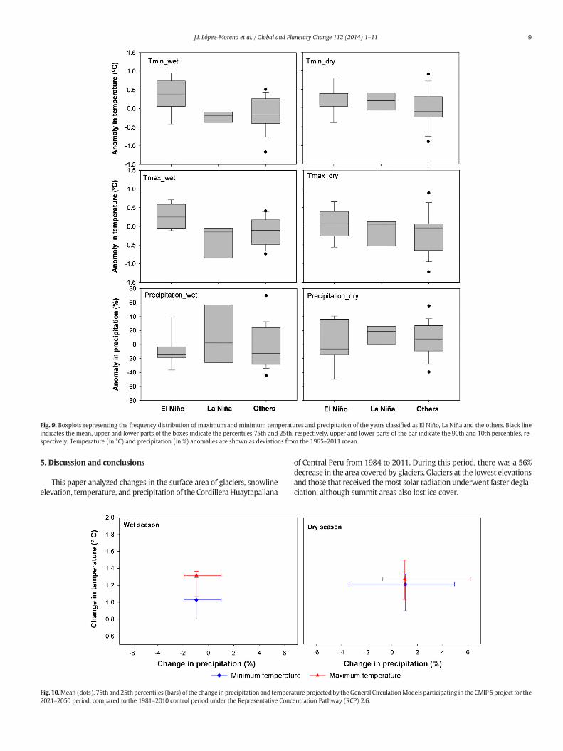
Fig. 9. Boxplots representing the frequency distribution of maximum and minimum temperatures and precipitation of the years classified as El Niño, La Niña and the others. Black lineindicates the mean, upper and lower parts of the boxes indicate the percentiles 75th and 25th, respectively, upper and lower parts of the bar indicate the 90th and 10th percentiles, re-spectively. Temperature (in °C) and precipitation (in %) anomalies are shown as deviations from the 1965–2011 mean.
9J.I. López-Moreno et al. / Global and Planetary Change 112 (2014) 1–11
5. Discussion and conclusions
This paper analyzed changes in the surface area of glaciers, snowlineelevation, temperature, and precipitation of the CordilleraHuaytapallana
Fig. 10.Mean (dots), 75th and 25th percentiles (bars) of the change inprecipitation and tempera2021–2050 period, compared to the 1981–2010 control period under the Representative Conc
of Central Peru from 1984 to 2011. During this period, there was a 56%decrease in the area covered by glaciers. Glaciers at the lowest elevationsand those that received themost solar radiation underwent faster degla-ciation, although summit areas also lost ice cover.
ture projectedby theGeneral CirculationModels participating in theCMIP 5 project for theentration Pathway (RCP) 2.6.

10 J.I. López-Moreno et al. / Global and Planetary Change 112 (2014) 1–11
The rate of glacier retreat in Huaytapallana reported here is dou-ble than that reported for Cordillera Blanca (Bury et al., 2011; Fraser,2012). This is probably because of the lower elevation of theCordillera Huaytapallana. Tropical glaciers at elevations lower than5400 m a.s.l. are very unstable, in contrast to high-elevation tropicalglaciers, whose changes are more modest, and these high elevationglaciers may even undergo positive mass balances (Rabatel et al.,2013). Indeed, different areas of the Cordillera Huaytapallanahave experienced very different rates of ice cover loss; in thoseat lower elevations the losses were the greatest. Thus in thethree areas whose summits were close to 5000 m a.s.l., someglaciers have completely melted or now have less than 1 km2 area.The two areas with intermediate glaciated surface and whosesummits are 5150 and 5300 m a.s.l. have lost two-thirds oftheir glaciated surface since 1984. However, the main area(Huaytapallana), which has significant surfaces above 5000 m a.s.l.,lost only 42% of its ice cover. Zubieta and Lagos (2010) also analyzedthis last area for the period of 1976–2006, and they reported an iceloss of 59%.
The snowline in Cordillera Huaytapallana has moved upward in ele-vation by 93 to 157 m, depending of the mountain area. These valuesare in close agreement with those reported for Cordillera Raura(97 m), and are significantly greater than those reported for Cordillerade Huayhuash (24 m) for the period from 1986 to 2005 (McFaddenet al., 2011). These differences seem to be related to the initial snowlineelevations of these different Cordilleras. Thus in 1984, snowlines in Cor-dillera Huaytapallana were between 4728 and 4890 m a.s.l. for thethree analyzed areas, in 1986 the snowline in Cordillera Raura was at4947 m a.s.l. and the snowline in Cordillera Huayhuash was at5062 m a.s.l.. In other words, glaciers at lower elevations appear moresensitive to climate change. The same effect seems to be operating atthe low-elevation glaciers of the Cordillera Blanca, in which YanamareyGlacier, which does not exceed 5200 m a.s.l., is retreating at a rategreater than 30 m year−1 (Bury et al., 2011).
About 80% of the glacier retreat that we documented for theCordillera Huaytapallana occurred from 1984 to 1997. The periodfrom 1998 to 2011 was characterized by alternations of stability,slight increases, and slight decreases of glacier area. Studies of cli-mate changes in the Tropical Andes have reported increases in airtemperature (0.1 °C decade−1 between 1939 and 2006; Vuilleet al., 2008a, 2008b). Recent studies estimated a warming rate of0.39 °C decade−1 for the late 20th century in Cordillera Blanca(Mark and Seltzer, 2005), 0.2 °C decade−1 in Cordillera Huayhuash(McFadden et al., 2011), and 0.2 °C decade−1 in CordilleraVilcanota (Salzmann et al., 2013). In Cordillera Huaytapallana, min-imum temperature increased slightly during the wet season anddecreased slightly during the dry season. However, maximum tem-perature increased 0.22 °C decade−1 overall for the period from1965 to 2011. Precipitation in this region also increased duringthe wet season from 1965 to 2011. Thus, glacier retreat in this re-gion seems to be related to the increased temperature, because atemperature-induced change from snow to rain can increase gla-cier decline, and because glacial ablation is greater in a warmer cli-mate (Francou et al., 2003). However, it is necessary to assess theeffects of other components of the energy and mass balance ofthese glaciers on changes in ice cover. For example, an increase inthe elevation of the snowlines documented here and changes inthe phase of the precipitation (from snow to rain) might also affectthe albedo of the glaciers (Favier et al., 2004). In addition, increasedprecipitation is probably associated with greater cloudiness andhigher atmospheric humidity. Several authors have documentedan increase in water vapor in the Tropical Andes (Hense et al.,1988; Vuille et al., 2003), and this could lead to an increase inlong-wavelength radiation (Ohmura, 2001) and attenuation of theturbulent flux that increases the availability of energy for the melt-ing of ice (Sicart et al., 2005).
The results presented here indicate that ENSO appeared to affecttemperature and precipitation in the Cordillera Huaytapallana. Inother mountains of Peru and Bolivia, El Niño years are characterizedby higher temperatures and less precipitation, with an opposite patternfor La Niña years (Garreaud and Aceituno, 2001; Vuille et al., 2008a,2008b). The same general pattern occurred in Cordillera Huaytapallana,but only temperature (not precipitation)was significantly different in ElNiño and La Niña years. However, other studies reported significantnegative correlations (Lagos et al., 2005), or less significant correlations(Silva et al., 2008), between the warm phase of ENSO and precipitationduring thepeak of the rainy season in theMantaro basin of Peru. This re-sulted in a particularly strong Niño 4 SST index (averaged over 160°E–150°W, 5 °S–5 °N), which indicates an indirect effect of SST on theMantaro basin, most likely through atmospheric teleconnections (e.g.,Garreaud and Aceituno, 2001). In Cordillera Blanca, Kaser et al. (2003)and Vuille et al. (2008b) found that negative mass balance deviationsusually occur during El Niño years and positivemass balance deviationsusually occur during La Niña years. However, these authors also notedthe presence of deviations from this pattern. Our results are in linewith these findings. In general, El Niño years were associated withmarked decreases in the ice cover in Huaytapallana, and La Niña yearswere associated with stability or slight increases in the ice cover.Thus, the observed acceleration of deglaciation in the CordilleraHuaytapallana from 1984 to 1997 can be attributed to the large numberof El Niño events during that period; in contrast, La Niña events weremore common from1998 to 2011, and therewasmuch less deglaciationduring that period. In addition, therewere also deviations in this generalpattern in Huaytapallana, which is not surprising given the large varia-tions in temperature and precipitation in years not classified as El Niñoor La Niña.
We ran climatemodels based on themost optimistic greenhouse gasemission scenario (RCP2.6) to forecast changes in our study region from2021 to 2050. The results indicated an increase in temperature bymorethan 1.2 °C, but only minor changes in precipitation. Other more pessi-mistic scenarios for Peruvian mountain regions have forecasted in-creases in temperature of 2–3 °C by the year 2050 (Bradley et al.,2004; Juen et al., 2007). Based on our observations of glaciers inHuaytapallana during the study period, an increase of 1.2 °C (predictedby the “best case” scenario) would lead to the disappearance or near-disappearance of glaciers in all areas that we studied except in theHuaytapallana area, although glaciers in that region would also be se-verely affected. These changes could have a great impact on the hydrol-ogy of theMantaro basin, especially in the Sholcas sub-basin that drainsthe most important glaciated area. Moreover, the formation of newlakes in unstable high mountain environments is likely to continue,and this may lead to increased risk of flooding, especially because ofthe very steep and crevassed nature of these glaciers. The presentstudy provides a foundation for a better understanding of the effect ofclimate change on glaciers and of the evolution of newly formed glaciallakes in this region. This information is required to provide better fore-casts of future changes and to improve the responses to the forecastedchanges in hydrology, ecology, and natural hazards.
Acknowledgments
This work was supported by funding from the Spanish ResearchCouncil (research project I-COOP0089: “Glacier retreat in the CordilleraBlanca and Cordillera Huaytapallana in Peru: Evidences and Impacts onlocal population”).
References
Agencia Nacional del Agua del Perú (ANA), 2010. Evaluación de recursos hídricossuperficiales en la cuenca del Río Mantaro. Ministerio de Agricultura. Agencianacional del Agua, Lima.
Ames, A., 1998. A documentation of glacier tongue variations and lake development in theCordillera Blanca, Peru. Z. Gletscherk. Glazialgeol. 34 (1), 1–36.

11J.I. López-Moreno et al. / Global and Planetary Change 112 (2014) 1–11
Arroyo, J., 2011. Tendencias y cambio del clima del valle del Mantaromediante los análisisde índices de precipitación efectiva y temperatura eficiente. Apuntes Cienc. Soc. 01,45–54.
Bradley, R.S., Keimig, F.T., Diaz, H.F., Hardy, D.R., 2009. Recent changes in freezing levelheights in the Tropics with implications for the deglacierization of high mountain re-gions. Geophys. Res. Lett. 36 (L17701). http://dx.doi.org/10.1029/2009GL037712 (2).
Brecher, H.H., Thompson, L.G., 1993. Measurement of the retreat of Qori Kalis Glacier inthe Tropical Andes of Peru by terrestrial photogrammetry. Photogramm. Eng. RemoteSens. 59, 1017–1022.
Bolstad, P.V., Lillesand, T.M., 1991. Rapidmaximum likelihood classification. Photogramm.Eng. Remote Sens. 57 (1), 67–74.
Borradaile, G., 2003. Statistics of Earth Science Data. Ed. Springer-Verlag, Berlin: 248 p.Bradley, R.S., Keimig, F.T., Diaz, H.F., 2004. Projected temperature changes along the
American cordillera and the planned GCOS network. Geophysical Research Letters31 L16210.
Bury, J.T., Mark, B.G., McKenzie, J.M., French, A., Baraer, M., In Huh, K., Zapata Luyo, M.A.,Gomez Lopez, R.J., 2011. Glacier recession and human vulnerability in the Yanamareywatershed of the Cordillera Blanca, Peru. Clim. Chang. 105, 179–206.
Carey, M., 2005. Living and dying with glaciers: people's historical vulnerability toavalanches and outburst floods in Peru. Glob. Planet. Chang. 47, 122–134.
Carey, M., Huggel, C., Bury, J., Portocarrero, C., Haeberli, W., 2012. An integrated socio-environmental framework for climate change adaptation and glacier hazardmanagement: lessons from Lake 513, Cordillera Blanca, Peru. Clim. Chang. 112,733–767.
Chander, G., Helder, D.L., Markham, B.L., Dewald, J.D., Kaita, E., Thome, K.J., Micijevic, E.,Ruggles, T.A., 2004. Landsat-5 TM reflective-band absoluteradiometric calibration.IEEE Trans. Geosci. Remote Sens. 42, 2746–2760.
Chevalier, P., Pouyand, B., Suarez, W., Condom, T., 2011. Climate change threats to envi-ronment in the Tropical Andes: glaciers and water resources. Reg. Environ. Chang.11 (1), 179–187.
Dorbath, L., Dorbath, C., Jimenez, E., Rivera, L., 1991. Seismicity and tectonics deformation inthe Eastern cordillera and the sub-Andean zone of central Peru. J. S. Am. Earth Sci. 4,13–24.
Dozier, J., 1989. Spectral signature of alpine snow cover from the Landsat ThematicMapper. Remote Sens. Environ. 28, 9–22.
Du, Y., Teillet, P., Cihlar, J., 2002. Radiometric normalization of multitemporal high resolu-tion satellite images with quality control and land cover change detection. RemoteSens. Environ. 82, 123–134.
Favier, V., Wagnon, P., Chazarin, J.-P., Maisincho, L., Coudrain, A., 2004. One-year measure-ments of surface heat budget on the ablation zone of Antizana glacier 15, EcuadorianAndes. J. Geophys. Res. 109 (D18105).
Francou, B., Vuille, M., Wagnon, P., Mendoza, J., Sicart, J.E., 2003. Tropical climate changerecorded by a glacier in the central Andes during the last decades of the 20th century:Chacaltaya, Bolivia, 16S. J. Geophys. Res. 108 (D5), 4154.
Francou, B., Vincent, C., 2007. Les glaciers à l'épreuve du climat, IRD Editions (274 pp).Fraser, B., 2012. Melting in the Andes: Goodbay glaciers. Nature 491, 180–182.Fu, P., Rich, P.M., 2002. A geometric solar radiation model with applications in agriculture
and forestry. Comput. Electron. Agric. 37, 25–35.Helsel, D.R., Hirsch, R.M., 1992. Statistical Methods inWater Resources. Elsevier (522 pp).Juen, I., Kaser, G., Georges, C., 2007. Modeling observed and future runoff from a glacierized
tropical catchment (Cordillera Blanca, Perú). Glob. Planet. Chang. 59 (1–4), 37–48.Garreaud, R.D., Aceituno, P., 2001. Interannual rainfall variability over the South American
Altiplano. J. Clim. 14, 2779–2789.Georges, C., 2004. The 20th century glacierfluctuations in the tropical Cordillera Blanca,
Peru. Arctic, Antarctic and Alpine Research 36 (1), 100–107.Gonzalez-Hidalgo, J.C.., López-Bustins, J.A., Stepánek, P., Martín-Vide, J., de Luis, M., 2009).
monthly precipitation trends on the mediterranean fringe of the iberian peninsuladuring the second half of the 20th century (1951–2000). international journal of cli-matology 29, 1415–1429.
Hense, A., Krahe, P., Fhonh, H., 1988. Recent fluctuations of tropospheric temperature andwater vapour content in the tropics. Meteorol. Atmos. Phys. 38, 215–227.
Kaser, G., Georges, C., 1999. On themass balance of low latitude glaciers with particular con-sideration of the Peruvian Cordillera Blanca. Geografiska Annaler 81A (4), 643–651.
Kaser, G., Osmaston, H.A., 2002. Tropical Glaciers. Cambridge University Press, New York(209 pp).
Kaser, G., Juen, I., Georges, C., Gómez, J., Tamayo, W., 2003. The impact of glaciers on therunoff and the reconstruction of mass balance history from hydrological data in thetropical Cordillera Blanca, Peru. J. Hydrol. 282 (1–4), 130–144.
Lagos, P., Silva, Y., Nickl, E., 2005. El Niño y la precipitación en los Andes del Perú. Bol. Soc.Geol. Lima Espec. 6, 7–23 (Alberto Giesecke Matto).
Mather, P.M., 1985. A computationally-efficient maximum-likelihood classifier employingprior probabilities for remotely-sensed data. Int. J. Remote Sens. 6 (2), 369–376.
McFadden, E.M., Ramage, J., Rodbell, D.T., 2011. Landsat TM and ETM+ derived snowlinealtitudes in the Cordillera Huayhuash and Cordillera Raura, Peru, 1986–2005.Cryosphere 5, 419–430.
Instituto Geofísico del Perú (IGP), 2010. Cambio climático en la cuenca del Río Mantaró.Ed. Instituto Geofísico del Perú, Lima, 260p.
Mark, B.G., Seltzer, G.O., 2005. Evaluation of recent glacier recession in the CordilleraBlanca, Peru (AD 1962–1999): spatial distribution of mass loss and climatic forcing.Quat. Sci. Rev. 24, 2265–2280.
Meinshausen, M., Smith, S.J., Calvin, K.V., Daniel, J.S., Kainuma, M.L.T., Lamarque, J.-F.,Matsumoto, K., Montzka, S.A., Raper, S.C.B., Riahi, K., Thomson, A.M., Velders, G.J.M.,van Vuuren, D., 2011. The RCP Greenhouse gas concentrations and their extensionfrom 1765 to 2300. Clim. Chang. 109 (1–2), 213–241.
Messerli, B., 2001. The international year of the mountains, the Mountain Research Initia-tive, and PAGES editorial. Past Glob. Chang. News 9 (3), 2.
Mark, B.G., 2008. Tracing tropical Andean glaciers over space and time: some lessons andtransdiciplinary implications. Global and Planetary Change 60 (1–2), 101–114.
Ohmura, A., 2001. Physical basis for the temperature/melt-index method. J. Appl. Meteor.40, 753–761.
Peduzzi, P., Herold, C., Silverio, W., 2010. Assessing high altitude thickness, volume andchanges using field, GIS and remote sensing techniques: the case of Nevado Coropuna(Peru). Cryosphere 4, 313–323.
Portocarrero, C., 1995. Retroceso de glaciares en el Perú: consecuencias sobre los recursoshídricos y los riesgos geodinámicos. Bull. Institut Fr. Étud. Andines 24 (3), 697–706.
Rabatel, A., Francou, B., Soruco, A., Gomez, J., Cáceres, B., Ceballos, J.L., Basantes, R., Vuille,M., Sicart, J.-E., Huggel, C., Scheel, M., Lejeune, Y., Arnaud, Y., Collet, M., Condom, T.,Consoli, G., Favier, V., Jomelli, V., Galarraga, R., Ginot, P., Maisincho, L., Mendoza, J.,Ménégoz, M., Ramirez, E., Ribstein, P., Suarez, W., Villacis, M., Wagnon, P., 2013. Cur-rent state of glaciers in the tropical Andes: a multi-century perspective on glacierevolution and climate change. Cryosphere 7, 81–102.
Raup, B., Racoviteanu, A., Khalsa, S.J.S., Helm, C., Armstrong, R., Arnaud, Y., 2007. TheGLIMS geospatial glacier database: a new tool for studying glacier change. Glob. Plan-et. Chang. 56 (1–2), 101–110.
Reynolds, J.M., 1992. The identification and mitigation of glacier-related hazards: exam-ples from the Cordillera Blanca, Peru. In: McCall, G.J.H., Laming, D.C.J., Scott, S.(Eds.), Geohazards. Chapman & Hall, London, pp. 143–157.
Salzmann, N., Huggel, C., Rohrer, M., Silverio, W., Mark, B.G., Burns, P., Portocarrero, C.,2013. Glacier changes and climate trends derived from multiple sources in the datascarce Cordillera Vilcanota region, southern Peruvian Andes. Cryosphere 7, 103–118.
Silva, Y., Takahashi, K., Chávez, R., 2008. Dry and wet rainy seasons in the Mantaro riverbasin (Central Peruvian Andes). Adv. Geosci. 14, 261–264.
Racoviteanu, A.E., Manley, W., Arnaud, Y., Williams, M.W., 2007. Evaluating digital eleva-tion models for glaciologic applications: an example from Nevado Coropuna,Peruvian Andes. Glob. Planet. Chang. 59 (1–4), 110–125.
Seimon, T.A., Seimon, A., Daszak, P., Halloy, S.R.P., Schloegel, L.M., Aguliar, C.A., Sowell, P.,Hyatt, A.D., Konecky, B., Simmons, J.E., 2007. Upward range extension of Andean an-urans and chytridiomycosis to extreme elevations in response to tropical deglacia-tion. Glob. Chang. Biol. 13, 288–299.
Sicart, J.-E., Wagnon, P., Ribstein, P., 2005. Atmospheric controls of heat balance of ZongoGlacier (16° S, Bolivia). J. Geophys. Res. 110 (D12106).
Smith, T.M., Reynolds, R.W., Peterson, T.C., Lawrimore, J., 2008. Improvements to NOAA'shistorical merged land–ocean surface temperature analysis (1880–2006). J. Clim. 21,2283–2296.
Taylor, K.E., Stouffer, R.J., Meehl, G.A., 2012. An overview of CMIP5 and the experimentaldesign. Bull. Am. Meteorol. Soc. 93, 485–498.
Teillet, P.M., Guindon, B., Goodeonugh, D.G., 1982. On the slope-aspect correction of mul-tispectral scanner data. Can. J. Remote. Sens. 8, 84–106.
Teillet, P.M., Barker, J.L., Markham, B.L., Irish, R.R., Fedosejevs, G., Storey, J.C., 2001. Radio-metric cross-calibration of the Landsat-7 ETM+ and Landsat-5 TM sensors based ontandem data sets. Remote Sens. Environ. 78, 39–54.
Teillet, P.M., Helder, D.L., Ruggles, T.A., Landry, R., Ahern, F.J., Higgs, N.J., Barsi, J., Chander,G., Markham, B.L., Barker, J.L., Thome, K.J., Schott, J.R., Palluconi, F.D., 2004. A definitivecalibration record for the Landsat-5 Thematic Mapper anchored to the Landsat-7 ra-diometric scale. Can. J. Remote. Sens. 30, 631–643.
Vergara, W., A. M., et al., 2007. Economic Impacts of Rapid Glacier Retreat in the Andes.EOS 88 (25), 261–268.
Vermote, E.F., Tanré, D., Deuzé, J.L., Herman, M., Morcrette, J.J., 1997. Second simulation ofthe satellite signal in the solar spectrum, 6S: an overview. IEEE Trans. Geosci. RemoteSens. 35, 675–686.
Vicente-Serrano, S.M., Pérez-Cabello, F., Lasanta, T., 2008. Assessment of radiometric cor-rection techniques in analyzing vegetation variability and change using time series ofLandsat images. Remote Sens. Environ. 112, 3916–3934.
Vogelmann, J.E., Helder, D., Morfitt, R., Choate, M.J., Merchant, J.W., Bulley, H., 2001. Effectsof Landsat 5 Thematic Mapper and Landsat 7 enhanced Thematic Mapper Plus radio-metric and geometric calibrations and corrections on landscape characterization. Re-mote Sens. Environ. 78, 55–70.
Vuille, M., Bradley, R.S., 2000. Mean annual temperature trends and their vertical struc-ture in the tropical Andes. Geophys. Res. Lett. 27, 3885–3888.
Vuille, M., Bradley, R.S., Werner, M., Keimig, F., 2003. 20th century climate change in thetropical Andes: observations and model results. Clim. Chang. 59 (1–2), 75–99.
Vuille, M., Francou, B., Wagnon, P., Juen, I., Kaser, G., Mark, B.G., Bradley, R.S., 2008a. Cli-mate change and tropical Andean glaciers: past, present and future. Earth-Sci. Rev.89, 79–96.
Vuille, M., Kaser, G., Juen, I., 2008b. Glacier mass balance variability in the CordilleraBlanca, Peru and its relationship with climate and the large-scale circulation. Glob.Planet. Chang. 62, 14–28.
Wagnon, P., Ribstein, P., Francou, B., Pouyaud, B., 1999. Annual cycle of energy balance ofZongo Glacier, Cordillera Real, Bolivia. J. Geophys. Res. 104, 3907–3923.
Wilks, D.S., 2006. Statistical Methods in the Atmospheric Sciences, Second ed. AcademicPress (618 pp).
Zemp, M., Hoelzle, M., Haeberli, W., 2007. Distributed modelling of the regional climaticequilibrium line altitude of glaciers in the European Alps. Glob. Planet. Chang. 56,83–100.
Zubieta, R., Lagos, P., 2010. Cambios de la superficie glaciar en la cordillera Huaytapallana:periodo 1976–2006. Cambio climático en la cuenca del río Mantaro: Balancede 7 años de estudio en la cuenca del Mantaro. Instituto Geofísico del Perú, Lima(260 pp).