Late Pleistocene dispersal corridors across the Iranian Plateau
16
This article appeared in a journal published by Elsevier. The attached copy is furnished to the author for internal non-commercial research and education use, including for instruction at the authors institution and sharing with colleagues. Other uses, including reproduction and distribution, or selling or licensing copies, or posting to personal, institutional or third party websites are prohibited. In most cases authors are permitted to post their version of the article (e.g. in Word or Tex form) to their personal website or institutional repository. Authors requiring further information regarding Elsevier’s archiving and manuscript policies are encouraged to visit: http://www.elsevier.com/authorsrights
Transcript of Late Pleistocene dispersal corridors across the Iranian Plateau

This article appeared in a journal published by Elsevier. The attachedcopy is furnished to the author for internal non-commercial researchand education use, including for instruction at the authors institution
and sharing with colleagues.
Other uses, including reproduction and distribution, or selling orlicensing copies, or posting to personal, institutional or third party
websites are prohibited.
In most cases authors are permitted to post their version of thearticle (e.g. in Word or Tex form) to their personal website orinstitutional repository. Authors requiring further information
regarding Elsevier’s archiving and manuscript policies areencouraged to visit:
http://www.elsevier.com/authorsrights

Author's personal copy
Late Pleistocene dispersal corridors across the Iranian Plateau: A casestudy from Mirak, a Middle Paleolithic site on the northern edge of theIranian Central desert (Dasht-e Kavir)
Hamed Vahdati Nasab a,*, Geoffrey A. Clark b, Shirin Torkamandi a
aDepartment of Archaeology, Faculty of Humanities, Tarbiat Modares University, Jalal Ale Ahmad, Tehran, Iranb School of Human Evolution and Social Change, Arizona State University, Tempe, AZ, USA
a r t i c l e i n f o
Article history:Available online 3 December 2012
a b s t r a c t
This paper has two objectives. Mirak is a major Middle Paleolithic open-air site on the northern edge ofthe Iranian Central Desert. Flake-based blank production, an abundance of prepared and châpeau degendarme platforms, a significantly high value for the Levallois index, the presence of tools typical of‘Mousterian’ technology, and the near-total absence of Upper Paleolithic diagnostics all indicate thatMirak dates to the Middle Paleolithic (ca. 250e47 ka BP in the Levant). Although clearly a palimpsest,a case is made for high compositional integrity at Mirak, and a relative lack of disturbance. Second, thispaper proposes three major migratory corridors used by foragers during the Upper Pleistocene and earlyHolocene. Identification of those corridors is based on survey data acquired since the mid-1990s, thedistribution of other known Paleolithic sites on the Iranian Plateau, and sparse data from geography,geology, and geomorphology. Route A follows the north coast of the Persian Gulf and the Sea of Oman insouthern Iran, Route B skirts the southern shore of the Caspian Sea in northern Iran, and Route C runsbetween the southern foothills of the Alborz Mountains and northern edge of the Iranian Central Desert.
� 2012 Elsevier Ltd and INQUA. All rights reserved.
1. Introduction
Middle Paleolithic sites are among the most evocative in worldprehistory. The most obvious reason for such an assertion is theircorrelation with archaic human populations, amongst whichNeanderthals are the best known. Not all Middle Paleolithic sitesare associated with Neanderthals. Some Levantine Mousterian sites(e.g., Qafzeh, Skhul) contain human fossils assigned to anatomicallymodern humans (Bar-Yosef, 1992, 1998; Shea, 2003a, 2003b), andthe authorship of some European Mousterian industries has alsobeen called into question (e.g., Vindija (Karavanic, 1995), El Castillo(Bernaldo and Mailló, 2009), Riparo Mezzena (Longo et al., 2012)).The near-absence of any hominin remains from Middle Paleolithicsites in Iran (Bisitun (Trinkaus and Biglari, 2006) is an exception)has made correlation between the Mousterian and any specificgroup of hominins even more complicated. Because of regionalpolitical instability, logistical factors (Paleolithic sites are often inremote areas), and a strong emphasis on Iran’s spectacular proto-history, limited attention has been given to the Middle Paleolithic
in general and the Iranian Plateau in specific. Although the mostimportant Middle Paleolithic site in the region is Shanidar Cave,located across the border in Iraqi Kurdistan (Trinkaus,1983; Solecki,1963), most Middle Paleolithic sites are in caves and rock sheltersclustered in the eastern slopes of the Zagros Mountains and exca-vated from the late 1920s through the late 1960s by western‘pioneers’ like Dorothy Garrod (Hazar Merd (Garrod, 1930)), Car-leton Coon (Bisitun, Tamtama, Khunik (Coon, 1951, 1957; Smith,1986)), Frank Hole and Kent Flannery (Kunji, Gar Arjeneh, Ghamari(Hole and Flannery, 1967; Speth, 1971; Baumler and Speth, 1993)),Bruce Howe (Warwasi, Gar Kobeh (Braidwood and Howe, 1960;Lindly, 2005)), Phillip Smith (Ghar-i Khar (Young and Smith, 1966;Smith, 1986)), Peder Mortensen (Hulailan sites (Mortensen, 1974,1993)), and Charles McBurney (Ke-Aram I (McBurney, 1970; Bew-ley, 1984)). Because of the overthrow of the Shah (1979) and theIraqeIran War (1980e1988), most western involvement in Paleo-lithic archaeology ceased until the mid-1990s, when a new gener-ation of Iranian scholars initiated survey projects in areas outsidethe Zagros. Many new Middle Paleolithic sites were discovered,most of them surface scatters of variable contextual integrity. Theyinclude Sepid-Dasht (Vahdati Nasab et al., 2009), Zavieh (Heydari-Guran et al., 2012), Moghanak and Otchunak (Chevrier et al., 2006;Berillon et al., 2007), Jamo-Riz (Dashtizadeh, 2009), the Ghaleh
* Corresponding author.E-mail address: [email protected] (H.V. Nasab).
Contents lists available at SciVerse ScienceDirect
Quaternary International
journal homepage: www.elsevier .com/locate/quaint
1040-6182/$ e see front matter � 2012 Elsevier Ltd and INQUA. All rights reserved.http://dx.doi.org/10.1016/j.quaint.2012.11.028
Quaternary International 300 (2013) 267e281
Author's personal copy
Gushe site complex (Conard et al., 2009), and the subject of thisreport, Mirak (Vahdati Nasab, 2009; Rezvani and Vahdati Nasab,2010). Sometimes in collaboration with westerners (e.g., Otte,Jaubert, Conard), the only substantial report on the results of thesesurveys, most of which took place in the past 15 years, was pub-lished in 2009 (Otte et al., 2009).
The intention here is (1) to describe a newly discovered MiddlePaleolithic surface site, Mirak, located on the northern edge of theDasht-e Kavir; (2) to make a case for high contextual and compo-sitional integrity for the site, despite the fact that it is an obviouspalimpsest; (3) to put Mirak in a larger regional context in whichsurface sites are quite common; (4) to wring as much behavioralinformation out of the systematic surface collections as possible;and (5) to establish Mirak’s relationship to one of three dispersalcorridors used throughout the Pleistocene (Fig. 1).
2. Geography and historical background
Bounded by the Alborz Mountains in the north and the LutDesert (Dasht-e Lut) in the southeast, the Iranian Central Desert(Dasht-e Kavir) is a large (77,600 km2) salt desert situated in themiddle of the Iranian Plateau at an average elevation of 900e1000 m (Fig. 2). One of the driest places on earth, the plateau isalmost rainless today, with a very arid climate. Because of salinesoils and sediments, only desert adapted halophytic species cangrow there (e.g., Artemisia vulgaris). Although the northern marginsof the Dasht-e Kavir might have supported ephemeral lakes andmarshes at intervals during the Pleistocene, and have a fewpermanent water sources today, the Dasht-e Lut is a sand desertthat cannot support any life at all. Even with modern technology,human settlement remains mostly confined to the edges of theplateau and to the oases. Although the hard rock geology of Iran hasbeen fairly well investigated (e.g., Stöcklin, 1974, 1981), and itsmajor tectonic and sedimentary units mapped (e.g., Berberian,
1981), these studies lack the resolution required for geo-archaeological research. Despite its importance for human evolu-tion, the Quaternary period remains poorly known.
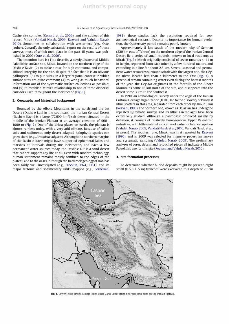
Approximately 5 km south of the modern city of Semnan(220 km east of Tehran) on the northern edge of the Iranian CentralDesert lie a series of small mounds, known to local residents asMirak (Fig. 3). Mirak originally consisted of seven mounds 4e11 min height, separated from each other by a few hundred meters, andextending in a line for about 2.5 km. Several seasonal and perma-nent water resources surroundMirak with the largest one, the Gey-No River, located less than a kilometer to the east (Fig. 3). Aperennial stream containing water even during the hottest monthsof the year, the Gey-No originates in the foothills of the AlborzMountains some 16 km north of the site, and disappears into thedesert some 3 km to the southeast.
In 1990, an archaeological survey under the aegis of the IranianCulturalHeritageOrganization (ICHO) led to the discovery of twovastlithic scatters in this area, separated from each other by about 3 km(Rezvani,1990). The northern one, knownasDelazian, has undergonerepeated systematic surveys and its lithic assemblages have beenextensively studied. Although a palimpsest produced mainly bydeflation, it consists of relatively homogeneous Upper Paleolithicindustries, with littlematerial indicative of earlier or later occupation(Vahdati Nasab, 2009; Vahdati Nasab et al., 2010; Vahdati Nasab et al.,in press). The southern one, Mirak, was first reported by Rezvani(1990), and in 2009 was selected for intensive pedestrian surveyand systematic sampling (Vahdati Nasab, 2009). The preliminaryanalyses of cores, debris, and retouched pieces all indicate a MiddlePaleolithic age for this site (Rezvani and Vahdati Nasab, 2010).
3. Site formation processes
To determine whether buried deposits might be present, eightsmall (0.5 � 0.5 m) trenches were excavated to a depth of 70 cm
Fig. 1. Lower (close circle), Middle (open circle), and Upper (triangle) Paleolithic sites on the Iranian Plateau.
H.V. Nasab et al. / Quaternary International 300 (2013) 267e281268
Author's personal copy
below the modern surface in the flat areas adjacent to the mounds.No subsurface deposits were uncovered, initially indicating that theartifacts are restricted to surface contexts. In July, 2012, Mirak wasrevisited by one of the authors (HVN) and Abbas Einali, a geomor-phologist affiliated with the Iranian Geological Survey. Althougha preliminary geomorphological assessment was made in 2009, itfocused on the artifact scatters, rather than the mounds them-selves. The second visit helped clarify the formation processes atthe site and led to a better understanding of the relationshipbetween the artifact scatters and the mounds.
The only vegetation in the area occurred on top of the mounds.The artifact concentrations themselves were devoid of vegetation,as were the surrounding flatlands. The vegetation appears to haveabsorbed whatever water was available during mesic intervals, andconcentrated the dominantly alkaline minerals dissolved in it
around their roots, thus rendering the mound tops relativelyresistant towind erosion compared to the adjacent flat areas wherethe artifacts are concentrated. The long-term dominant geomor-phological process in the region, aeolian deposition, concentratedsands and silts around these clumps of vegetation, forming whatbecame the mound cores. Accelerated during wet periods, theprocess took place repeatedly over the Pleistocene and thosemounds not destroyed by wind erosion grew larger incrementally,preserving artifacts and fauna in the mound cores. As was the caseat Delazian, a deflated palimpsest comprising the remains ofnumerous campsites is indicated, with vertical concentration ofartifacts but with only relatively minor horizontal displacement. Itis these remnant concentrations of what once were living surfacesthat provided the source of the dense artifact accumulations thatare the subject of this report.
A scenario that could account for Mirak would be one in whicha series of short-term, ephemeral campsites are clustered in thevicinity of relatively reliable water in an extremely arid regionwhere humans were essentially ‘tethered’ to water sources, at leastduring dry intervals (Olszewski and Coinman, 1998; Coinman,2007, 2009; Hauck, 2011). Paleotemperatures played a role inchanging atmospheric moisture and, as a rule, cold intervals wereusually dry, warm intervals relativelywet (e.g., Cordova, 2007: 124).Although doubtless beset by numerous so-far undetected fluctua-tions in temperature and moisture, the Dasht-e Kavir was almostcertainly uninhabited during dry/cold intervals (MIS 6, 4) and onlyits northern margins could have been exploited, albeit sporadically,by small bands of foragers during wet/warm phases (MIS 5, 3).
4. Materials and methods
Mirak covers a surface area of approximately 1.6 km2. Consid-ering the size of the site and the enormous number of artifacts,eight loci (AeH) consisting of 4 � 10 m transects were randomlyselected, and all lithics within these loci were collected (Table 1).To make sure the dispersion of the artifacts is roughly homogenousthroughout the site, all eight loci were compared to each other
Fig. 2. Location of Mirak in Iran and general view of the site.
Fig. 3. Mirak e relative frequency of cortex.
H.V. Nasab et al. / Quaternary International 300 (2013) 267e281 269

Author's personal copy
using conventional techno-typological systematics (a Bordesiansystem analogous to that used in Europe and the Levant). Theresults indicated that no statistically significant differences areobservable among the loci; therefore, the entire collection (7744pieces) is aggregated for the rest of the analysis. The pieces them-selves are in pristine condition, with little evidence of rolling,trampling, or other forms of mechanical abrasion.
All collected lithics were classified into (1) débitage, (2) tools, (3)debris, (4) cores and (5) core fragments (Table 2). Débitage refers tomorphological flakes and blades (i.e., those that exhibit strikingplatforms, eraillure scars, bulbs of percussion, etc. e the normalcriteria by which flakes and blades are defined). Debris refers to theby-products of lithic reduction e small, sharp angular pieces oftool-stone that lack the above characteristics but that are clearlydue to flint knapping (sometimes called ‘shatter’). The appearanceof shatter indicates a certain amount of lithic reduction on site and,since shatter tends to be small, relatively little transport off-site. Atool is defined as a flake or blade that exhibits at least some clear-cut marginal retouch. Although there are lots of tools, relatively fewof them are formal tools like side-scrapers. Most of them arecontinuously retouched pieces (CRPs) e otherwise unmodifiedflakes with some continuous marginal retouch.
Following the preliminary categorization presented in Table 2,artifacts were classified by (1) blank type, (2) platform configura-tion, (3) amount of cortex, (4) the extent to which they wereutilized (with low-power magnification, �50), (5) retouch inten-sity, (6) raw material type, and (7) tool typology. The intent was totry to establish unequivocally that, despite its open-air context,Mirak is a credible Middle Paleolithic site (or, more accurately,series of sites). It was also hoped to gain some insight into aspectsof reduction, raw material transfers, and the extent to whichretouched pieces figured in the overall collection (Miller and Bar-ton, 2006).
5. Results
5.1. Technology
Table 3 summarizes major aspects of lithic technology for theLoci AeH collections. As presented in the table, flake production isclearly the major knapping technology at Mirak (88%), followed bythe production of blades and (scarce) bladelets (12%). The domi-nance of flakes is interesting because flake-dominated assemblagestend to be more strongly correlated with relatively high mobilitybecause flakes are more amenable to modification ‘in the field’ thanare blades (Kuhn, 1995). It would also suggest that organic tech-nologies associated with standardized hafts were not emphasizedin flake-dominated assemblages as blades are better suited toinsertion in weapon and tool armatures of standardized shape.
Platform variability is widely recognized as an importantmonitor of modal blank production technologies (Odell, 2004: 126)and has been used by someworkers as a proxy for flake dimensions(e.g., Dibble,1995; Dibble and Pelcin,1995). The sample of completeblanks was scored according to seven widely recognized platformtypes cross-classified by blank type (Table 4). Although there wereexamples of all platform types, plain and prepared platforms weredominant regardless of blank type.
5.1.1. CortexThe amount of cortex (Fig. 4) and edge utilization (Fig. 5) on
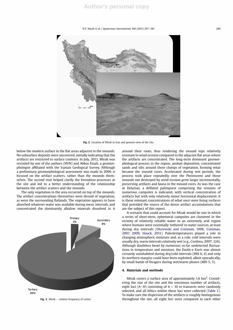
whole blanks were also measured. The average percentage ofcortex preserved in a collection of flakes is an indication of therelative importance of stages in a reduction sequence. Collectionswith much cortex typically represent the earliest stages ina reduction sequence. Those with little cortex suggest later stages.Edge utilization sheds light on how intensively a collection ofblanks was actually used, whether they were retouched or not.Current thinking suggests that the production of sharp-edgedflakes was the primary objective of most flint knapping duringthe Paleolithic, and that it provides a better monitor of activitysuites than do the frequently overemphasized retouched tools (e.g.,Barton, 1991; Dibble, 1995). In the case of cortex, the blanks wereclassified into primary (>50% cortex), secondary (<50% cortex), andtertiary (no cortex) groups. Tertiary blanks were by far the domi-nant category (89%), suggesting that primary and secondaryreduction took place off-site. Utilized and unutilized edges wereabout equally common (Fig. 5). To the extent that the assemblage isunaltered by post-depositional processes, this suggests far moreintensive utilization of unretouched blanks than is commonlyrecognized. Tertiary blanks also suggest substantial mobility
Fig. 4. Mirak e relative frequency of utilization (with low-power magnification �50).
Table 1Mirak e lithic counts from loci A to H.
Locus A B C D E F G H Total
Number 968 989 1021 856 1213 974 711 1012 7744
Table 2Mirak e major lithic categories.
Type Number Percentage
Débitage 2416 31.2Tools 3816 49.3Debris 1184 15.3Core & core fragments 328 4.2Total 7744 100.0
Table 3Mirak e blank types.
Blank type Number Percentage
Flake 5504 88.3Blade 304 4.9Bladelet 424 6.8Total 6232 100.0
Table 4Mirak e platform types.
Platform Number Percentages
Linear 624 15.7Plain 1572 39.5Cortical 108 2.7Partly removed 150 3.8Prepared 1230 30.9Châpeau de gendarme 156 3.9Stepped 138 3.5Total 3978 100.0
H.V. Nasab et al. / Quaternary International 300 (2013) 267e281270
Author's personal copy
because mobile foragers would be unlikely to carry cores orpartially decortified flakes around with them, especially if theywere uncertain about the location of suitable raw material in thelandscape.
5.1.2. Retouched piecesIn total 3816 retouched pieceswere collected from Loci A toH, an
unusually high incidence of retouch (61%). These pieces were clas-sified into four groups based on the intensity of retouch observed onthe edges of the blanks (Fig. 6). Most of the sample (78%) consists ofsemi-abrupt ‘light’ and ‘medium’ retouch extending along part ofone or more edge(s) and defined by a series of continuous detach-ments (what are sometimes called ‘continuously-retouched pieces,’or CRPs). Abrupt (or ‘backing’) retouch and flat invasive retouch arerare (12%, 10% respectively). As noted above, while flakes withmarginal retouch are common, formal tool types are quite rare, andare dominated by different side-scraper types (single, double,convergent, etc.). Dibble has shown conclusively that side-scrapershape is mostly determined by blank size and shape (e.g., whetherflakes are broad or narrow) and by the relative intensity of retouch,and not ‘mental templates’ that conform to arbitrary cultural norms(Dibble, 1984a, 1984b, 1987, 1995).
5.1.3. Raw material variabilityIn regard to raw material variability, it should be kept in mind
that all rocks found in the vicinity of Mirak have been introduced byhuman and/or geological agencies. Given the terrain surrounding
the site, which lies in a shallow basin filled with fine-grained siltsand sands, and the absence of evidence for high-energy sedimenttransport (e.g., pebbles, cobbles, etc.), the former is more likely thanthe latter. The seven kinds of rock represented in the sample arechalcedony (20% by count), chert (40%), tuff (a compacted mix ofvolcanic glass and ash, 26%), jasper (7%), sandstone (4%), basalt (2%),and andesite (1%). The cryptocrystalline siliceous rocks (chert,chalcedony, jasper) and the igneous basalt, andesite and tuff arewell-suited to knapping; the sandstone is not. The collection isdominated by chert, chalcedony and tuff, which together accountfor 86% of the sample (Fig. 7).
5.2. Typology
5.2.1. Retouch intensityAlthough there are exceptions (e.g., the blade-dominated
Levantine Tabun D-Type Mousterian (Bar-Yosef, 1998: 44e47)),Mousterian assemblages are defined historically as flake-basedtechnologies with relatively high frequencies of retouched pieces,mostly different kinds of scrapers (Bordes, 1961, 1969; Binford,1973; Mellars, 1996; Moncel et al., 2009; Picin et al., 2011). WhileLevallois technology is by no means universal (i.e., there are manyMousterian assemblages that lack it altogether), its deployment toproduce flakes and points of standardized shape is also one of themajor indicators of a Middle Paleolithic assemblage, especially inthe Levant (Monnier, 2006). There is much evidence for Levalloistechnology at Mirak (IL ¼ 46.0), but Levallois production andretouch in Mousterian assemblages have been shown to varyindependently of one another both within and across sites (Marks,1983). The various side scraper types, CRPs, notches and denticu-lates show no strong correlation with Levallois blanks; some of thescrapers are made on recurrent Levallois blanks (Böeda, 1988a,1988b) (Figs. 8 and 9). As noted, most of the tools were made onflakes. Although pieces with some retouch account for almost halfthe collection (49.3%), retouch is not very intensive, sometimestaken as an indicator of short-term campsites rather than basecamps occupied for longer periods of time (these typically havehigh indices of retouch intensity) (Marks and Freidel, 1977). Sidescrapers consist of 36% of the assemblage; single (11%) and double-convergent (12%) forms are most common. Notches and denticu-lates are also present in significant numbers (11%) (Fig. 7).
To summarize the compositional make-up of the Mirak collec-tion, it is (1) heavily flake-dominated, with aflake:blade ratio of 9:1;(2) Levallois technology is common (IL ¼ 46.0), and the Levalloisindex is rivaled only by Bisitun (IL ¼ 55.8), far exceeding those ofKunji and Warwasi (Table 5); (3) faceted and dihedral platformpreparation are dominant, although a wide range of platform typesoccurs; (4) tertiary flakes lacking cortex comprise 89% of theassemblage, suggesting that primary and secondary decorticationtook place off-site; (5) about half the complete blanks were utilized(i.e., they showevidence of edgewear anddamage), (6) rawmaterialis dominated by chert and chalcedony, and there is no evidence forlong-distance transport, and (7) there is a very high incidence ofretouch, but most of it consists of short series of detachments alongblank margins, rather than ‘shaped’ or ‘formal’ tools; consequently,(8) retouch intensity is low. How might these characteristics of theMirak collection be interpreted in behavioral terms?
Fig. 6. Mirak e relative frequency of raw material types.
Table 5Mirak e comparison of Mirak Levallois (IL) and scraper (IR) indices with those ofKunji, Bisitun, and Warwasi.
Index Kunji Bisitun Warwasi A Warwasi B Warwasi C Warwasi D Mirak
IL 10.1 55.8 13.1 7.4 7.5 11.2 46.0IR 62.1 68.3 56.0 62.2 57.4 53.8 62.7
Fig. 5. Mirak e relative frequency of retouch intensity.
H.V. Nasab et al. / Quaternary International 300 (2013) 267e281 271

Author's personal copy
6. Behavioral inferences e a shift in perspective
The ability to answer this question turns on interpretation of thetechnological and typological variables recognized in the conven-tional systematics used to describe Mirak, and what the overallapproach suggests. To do this requires a shift in perspective fromone emphasizing fine-grained descriptions of morphological vari-ation in artifact form and frequency, and the tendency to equatepatterns elicited from them to human groups, to one emphasizingsituational variables with which all foragers had to contend (e.g.,raw material procurement, blank production, tool production,maintenance, refitting, discard), particularly as influenced bymobility (more specifically, the duration of site occupation (e.g.,Marks, 1988; Marks and Freidel, 1977; Binford, 1980; Kuhn, 1992,1995)). It should be kept in mind that, with very rare exceptions(e.g., Shott et al., 2011), Paleolithic archaeological sites are time-averaged palimpsests that have nothing to do with day-to-day,year-to-year, or even generational behavior (e.g., Barton, 1990,1991, 1997). They compress into an undifferentiated lump whatsurely was significant environmental variation and equally signif-icant variation in human biocultural responses to environmentalchange (e.g., Barton and Riel-Salvatore, 2012). A particular typefrequency in an archaeological collection thus bears no relationshipto the frequency of that type in a collection of artifacts actually usedby anyone at any time. What is probably being detected instead isa complex array of assemblage structures representing variouscombinations of two basic behavioral strategies determined byforager mobility in particular places and moments in time (Kuhn,1991, 1992, 1995). One is to supply individuals with a flexible,portable toolkit, useful under conditions of uncertainty and ina variety of contexts. The other is to provision places in the land-scape where technological activities are likely to be performed.Although foragers practice both provisioning strategies over thelong term, which strategy is selected in a particular situation willdepend largely upon perceptions of resource distributions in thelocal and regional context, and upon patterns of mobility and theduration of site occupation. If foragers are highly mobile, and if thelocation of target resources cannot be predicted (e.g., if prey weresolitary or widely scattered; if meat were scavenged), they mustdepend on the limited array of things they can carry with them.
This in turn puts constraints on the sizes and kinds of artifacts thatare likely to end up in what, in functional terms, would have beensmall, ephemeral, short-term campsites. If foragers were morestable residentially e if they moved less over the course of anannual round and if occupations tended to be of longer duration(e.g., if intercept hunting of gregarious species were emphasized)ethere would be more predictable reuse of specific locations in thelandscape, and tool makers could stockpile artifacts and rawmaterials at these places in anticipation of future needs. Mobilityand duration of site occupation, linked ultimately to the distribu-tion of food and water in the environment, should allow forprediction of the composition of artifact assemblages left behind atthe two kinds of sites.
An acknowledged palimpsest located in a marginally habitablezone on the edge of a desert, howwell does Mirak correspond e onaverage e to either of these two modal site types? The flake-dominated collections, the near-absence of primary andsecondary decortication flakes and the relatively few cores wouldsuggest that Mousterian occupations at Mirak were short-termephemeral campsites where flake blanks could either be used ‘asis’ or reworked into other tools as circumstances required. Becauseof more stringent design specifications, blades are not so wellsuited for subsequent modification. The high incidence of retouchwould seem to argue in favor of a higher proportion of residentialbases until the casual, ad hoc nature of the retouch is takeninto account. Most of the tools are continuously retouched pieces(CRPs) e otherwise unmodified flakes with light marginal retouchalong part of one or both edges. They are not formal tools.
7. Comparisons with other sites
In default of anything that could be used to directly date Mirak(e.g., fauna, stratigraphy, organic sediments), lithic techno-typologywas used to provide additional support for a Middle Paleolithicassignment for the site. Mirak lithics are mostly made on flakeswith a low incidence of lamellar production (Table 3). Moreover,35% of the platform types comprise various kinds of preparedplatforms, including the distinctive dihedral and châpeau degendarme variants. Both are characteristic of the Mousterian else-where (e.g., Bar-Yosef, 1996, 2000) (Figs. 9 and 10). Mirak was also
Fig. 7. Mirak e typology.
H.V. Nasab et al. / Quaternary International 300 (2013) 267e281272

Author's personal copy
compared with unequivocal Mousterian sites in Luristan (Kunji,Bisitun andWarwasi AeD) using the Levallois (IL) and the restrictedscraper (IRe) indices (Table 5).
In Iran only a few Middle Paleolithic sites have been excavated,and fewer still have been studied, dated and published. Kunji,Bisitun and Warwasi are among them, all located in the central
Zagros at elevations between 1300 and 1400 m. Kunji cave was firsttested by Field (1939), and later dated to around 50 ka BP by Holeand Flannery (1967); its lithic assemblages were studied byBaumler and Speth (1993). A rock shelter, Bisitun was first exca-vated by Coon in 1949 (Coon, 1957); its collections have beenanalyzed and published by Dibble (1984a, 1984b). Warwasi rock
Fig. 8. Mirak e retouched pieces: 1 Mousterian point; 2e5, 7 convergent side scrapers; 6 convex scraper with facetted striking platform; 8 continuously retouched piece (2 edges);9 circular scraper; 10 denticulate; 11 side scraper on a retouched blade.
H.V. Nasab et al. / Quaternary International 300 (2013) 267e281 273
Author's personal copy
shelter was excavated by Bruce Howe (Braidwood and Howe, 1960;Braidwood et al., 1961), and the lithics from its Mousterian levels(AeD) were analyzed by Dibble and Holdoway (1993). All threesites were re-examined by Lindly (2005) as part of his doctoraldissertation research.
So far as the scraper index (IRe) is concerned, the Mirak (62.7)collection closely resembles Kunji (62.1) and Warwasi B (62.2), lessso the other sites. Warwasi D (53.8) diverges most strongly, but allthe Zagros Mousterian sites display high scraper indices. Mirak’sLevallois index (46.0) is much higher than those of the other siteswith the exception of Bisitun (55.8), but what this observation
means in behavioral terms is contested. Levallois technology andthe overall nature of pattern in the Mousterian are both contro-versial in Iran (Vahdati Nasab, 2010a). The presence or absence andfrequency of Levallois technology and the overall affinities of theIranian Mousterian with its Levantine and Caucasian counterpartshave a long history, going back to Garrod’s 1928 excavations atHazar Merd in Iraqi Kurdistan (Garrod, 1930). Garrod identifiedwhat she thought were similarities between the Mousterian in theLevant, notably at Tab�un, and in the Zagros. However, McBurney(1964) believed he could identify marked techno-typologicalaffinities between the Zagros and Middle Paleolithic sites in the
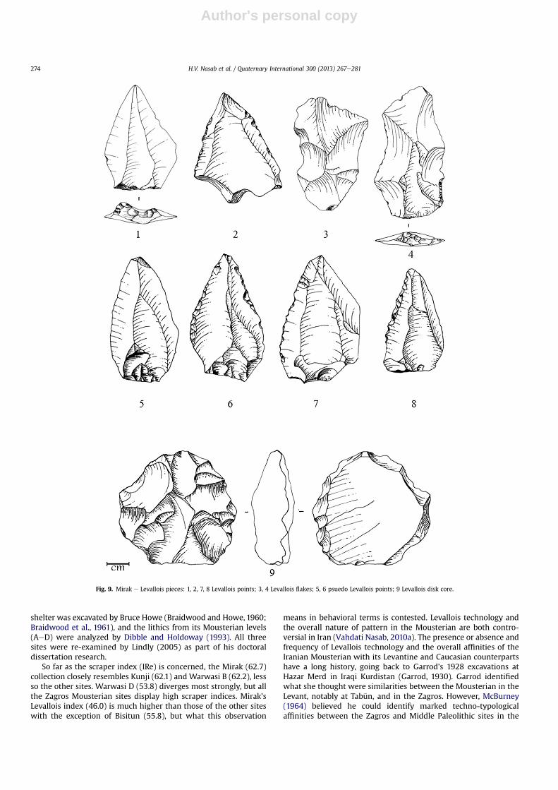
Fig. 9. Mirak e Levallois pieces: 1, 2, 7, 8 Levallois points; 3, 4 Levallois flakes; 5, 6 psuedo Levallois points; 9 Levallois disk core.
H.V. Nasab et al. / Quaternary International 300 (2013) 267e281274

Author's personal copy
Caucasus, a finding recently confirmed by Lindly (2005: 85e94). Inthe first regional synthesis of the Zagros Mousterian, based onworkat Shanidar D, Bisitun, Hazar Merd C and Kunji, Skinner (1965)claimed that there was no evidence of Levallois technology, facetedplatforms, discoidal cores, and bifaces in the ZagrosMousterian, buthigh frequencies of side-scrapers and retouched (‘Mousterian’)points. In the early 1980s, Dibble reanalyzed the Bisitun collectionsand, contra Skinner, uncovered substantial evidence for Levalloistechnology (Dibble, 1984a,b). Then, in the early 1990s, Baumler andSpeth (1993) restudied the latter’s 1969 collections from Kunji(Speth, 1971) and concluded that Skinner was right e they con-formed in most respects to Skinner’s definition. Recent workreports a high frequency of Levallois technology in the Zagros(Roustaei, 2010). Variation in raw material ‘package size’, coupledwith the constraints imposed on mobile foragers in areas wheresuitable raw material is scarce, are suggested to be driving thesepatterns, but simple sampling error owed to the few surveys in thehighlands is likely to be the main reasonwhy it has been so difficultto get a clear picture of the Mousterian in this relatively well-investigated area. Whatever the case, with the addition of cred-ible open-air Mousterian sites like Mirak in regions outside theZagros, it is becoming clear that there is much more variability inthe Iranian Middle Paleolithic than is commonly appreciated (seepapers in Conard et al., 2009). This observation also applies to other
regions, notably eastern Europe and the Soviet successor states(Clark, 2009).
Although Mirak is believed to be a relatively ‘pristine’ Mouste-rian palimpsest (series of campsites superimposed on top of oneanother), it is important to keep in mind that the conventionalsystematics used to describe the artifact collections here have beensubjected to much criticism in recent years in respect of whatpattern might mean (e.g., Dibble, 1995; Clark, 2002, 2009). Manyworkers also note a ‘disconnect’ between the normative reductionstrategies and idealized tool forms that constitute the basicanalytical units of the conventional systematics and the behaviorsthat supposedly produced them (Riel-Salvatore and Barton, 2004;Shea, 2011).
8. Discussion
8.1. Residential and logistical mobility
Whereas Mousterian lithics in the Zagros were probably carriedinto the mountains in the form of usable blanks and partly-reducedcores during seasonal (summer) forays by hominins living at lowerelevations during the rest of the year (Lindly, 2005), Mirak e ina very different environment e appears to represent a case of localaccess to tool-stone. Fine-grained, homogeneous, volcanic tuff
Fig. 10. Routes A, B, and C e migratory pathways on the Iranian Plateau.
H.V. Nasab et al. / Quaternary International 300 (2013) 267e281 275

Author's personal copy
occurs in marker beds and drainages 16 km north of Mirak, chertand chalcedony in the form of cobbles in the Gey-No River channel,less than 1 km to the east. Rawmaterial in close proximity, and lightand medium retouch on most (78%) of the tools all tend to indicatelocal procurement. The only factor that doesn’t square with thisscenario is the amount of cortex. It is usually assumed that, in siteswith easy access to abundant raw material sources, primary andsecondary decortication flakes should show up in relatively highfrequencies. This is not the case for Mirak (Fig. 4). Cores and debrisare also underrepresented (4%, 15% respectively). The high inci-dence of tertiary blanks associated with low frequencies of coresand debris suggest that the preliminary stages of lithic reduction(i.e., decortication) might have taken place off-site (or at leastoutside Units AeH), perhaps at the loci of procurement.
8.2. Forager mobility and the composition of lithic assemblages
Over the past 30 years, Marks and Freidel (1977), Binford (1982,1983) and Kuhn (1995), amongmany others, have proposedmodelsto describe and explain artifact diversity and function in hunter-gatherer sites. In one way or another, they all relate foragermobility to the kinds and quantities of artifacts found in campsitesof different kinds and with different durations of occupation.Although neither the first nor, perhaps, the best of these models,the one proposed by Lewis Binford has received the widest atten-tion, and has been applied in many Pleistocene archaeologicalcontexts all over the world. Binford characterized forager mobilitystrategies in terms of an idealized continuum between residentialmobility, where small numbers of foragers move as a group fromone resource patch to the next, producing sites that are essentiallyspatial and compositional replicates of one another, and logisticalmobility, where camps are occupied for longer periods of time, andparties are deployed from a central base on relatively short trips toprocure particular kinds of resources (e.g., firewood, water, edibleplants, game). Logistical mobility would thus produce at least twomodal kinds of sites (i.e., larger, long-term residential bases withfeatures, diverse artifact assemblages, and small, short-termlimited activity stations with few or no features, restricted artifactassemblages), and probably more. The two mobility patterns wereproposed as opposite ends of a continuum, and no forager groupwas exclusively residentially or logistically mobile, but ratheremphasized one or the other strategy depending upon a complexcombination of climate, temperature, precipitation, latitude (resi-dential mobility tended to be higher at higher latitudes), seasonalvariation in resource distributions (a function of latitude), size andcomposition of the local group, duration of occupation, anda number of other factors. Any given forager group would thereforeexhibit a combination of both strategies over the course of anannual round. Longer term (decadal, generational, etc.) shifts in thebalance of residential and logistical mobility were also recognized(Andrefsky, 2005: 214) and palimpsests like Mirak would be ex-pected to reflect a time-averaged modal ‘signature’ if, indeed, thesites were functional equivalents of one another.
8.3. Site function, artifact density and incidence of Retouch
Based on the Binford model, Chatters (1987) proposed the use ofan evenness index to predict site function based on artifact diver-sity. He classified sites as winter base camps, winter hunting sites(both consistent with Binford’s logistic camps), and spring basecamps (consistent with Binford’s residential camps). Chatters’evenness index ranges between 0 (least diversity) and 1 (mostdiversity). Low values are taken to indicate transient campsiteswith a limited range of activities (hence a small number anda limited range of artifacts), typically occupied for very short
periods of time; higher values indicate residential base campswhere occupations were of longer duration and where a widerrange of activities took place (hence more diverse artifact assem-blages). The evenness index (E) for Mirak was calculated using theformula proposed by Andrefsky (2005: 215):
E ¼�P�ni
n
��log
nin
�
log s
where ni stands for the number of artifacts of a given type, n equalsthe total number of artifacts for all types, and s is the number ofartifact types. For Mirak, E ¼ 0.83, which falls toward the ‘basecamp’ end of the range. Keeping in mind that the ‘site’ isa palimpsest (composite of many small sites), the collection is bothabundant and diverse, suggesting that a wide range of activitiestook place there. This configuration would be consistent with longterm use of single locale, perhaps a spring or a lake, or both.Work ina similarly xeric environment, Jordan’s Wadi al’Hasa, shows thatpermanent water sources acted as powerful attractors to bothhumans and animals (e.g., Coinman and Olszewski, 2003, 2007;Cordova, 2007), and that large quantities of artifacts accumulatedover time in the vicinity of lakes, marshes, and springs. This wasalso the case during the long Mousterian sequence at Hummal, oneof the artesian springs at El Kowm in the Syrian Desert (Hauck,2011).
Although no fauna were recovered, the high overall lithicdensity and the diverse and numerous side scrapers could indicatethat one of the major activities at Mirak was hunting and pro-cessing of meat and hides and that, on average, high density, highdiversity artifact accumulations are more likely to represent theremains of residential bases than short-term ephemeral campsites(Kuhn, 1995; Miller and Barton, 2008; Hauck, 2011). This view isconsistent with the apparent concentration of relatively permanentwater sources in the immediate vicinity of the site (fossil lakes,springs, streams, the Gey-No River). Almost no paleoclimateresearch has been undertaken in the Iranian Central Desert,however, and, except for a brief reconnaissance in 2009, none alongits northern margin, so that reconstruction of ancient landscapesmust await the full spectrum of geoscience research (i.e., geomor-phology, geoarchaeology, palynology, sedimentology, paleohy-drography, paleoecology, etc.) upon which such reconstructionsdepend. A deflated depression immediately to the south of Mirakexposes sandy sediments that contrast with what might be lacus-trine silts at the site itself. It should be noted that over the pastcentury the desert appears to have expanded along its northernedge, as indicated by the remains of the historical city of Semnan,located about a kilometer south of its present location. Whileextremely rapid in geological time, it suggests that the fluctuatingdesert margin set fairly stringent limits on whether or not humanscould live there at all, and this is particularly true of ‘technologicallychallenged’ foragers. Although there is, as yet, no basis for identi-fying these fluctuations in the archaeological record, it is possible tosay something about when they occurred using dated evidencefrom the Levant and Arabia and, based on site distribution maps,identify the most likely corridors of migration or dispersal (Fig. 10).
9. Migratory corridors on the Iranian Plateau
More than six decades of survey and excavation leave no doubtthat the Iranian Plateau has been occupied, albeit sporadically intime and differentially in space, since the Lower Paleolithic(Vahdati Nasab, 2011). Because of the history of investigation, mostknown Paleolithic sites are concentrated in the Zagros Mountains,but that is changing rapidly due to recent surveys (e.g., Otte et al.,
H.V. Nasab et al. / Quaternary International 300 (2013) 267e281276

Author's personal copy
2009). Other geographical zones like the east coast of the PersianGulf, the southern shore of the Caspian Sea, and the northern edgeof the Central Desert are now attracting researchers for variousreasons, among them the identification of the migratory pathwaysused for hominin range extensions (Fig. 10). The physical geographyof Iran essentially confines movement to these corridors. Whilesome natural barriers (e.g., mountains, seas, deserts) might presentobstacles to human movement, archaeological evidence points tohuman movement through the intermountain valleys of the Zagrosand Alborz since at least the Middle Paleolithic, and probably muchearlier. Long term, long distance movements were not goaldirected, of course, but were incremental and probably owed torange extensions, perhaps driven by pursuit of the gregariousungulates upon which most Pleistocene foragers relied. Climatechange almost certainly affected the volume of ‘traffic’ along theseroutes, but there were probably no substantial intervals in theUpper Pleistocene when they were not in use, essentially becausethere are no viable alternatives to skirt the Dasht-e Kavir and theDasht-e Lut. It is therefore expected that there would be significantconcentrations of Paleolithic sites along these routes. With moreextensive survey data available since the mid-1990s, efforts weremade to determine whether or not this was so during the MiddlePaleolithic as a whole. How the volume of ‘traffic’ along theseroutes changed over time is the subject of another paper but, giventhe marine isotope record of global paleoclimatic oscillations, itshould also be possible to retrodict whether, to what extent, andeven perhaps when, a particular route was most likely to have beenemphasized.
The modern nation of Iran (surface area 1,648,000 km2) consistsof a high plateau (average elevation 1000 m) located between twodepressions, the Caspian Sea on the north and the Persian Gulf onthe south. Most of the interior of the country is sparsely populatedeven today, and consists of deserts ringed by mountain chains. Themassive NW/SE trending Zagros Chain (max. elev. 4548 m) formsthe modern border between Iraq and Iran, and stretches south forover 1000 km from Lake Van in Turkey to the Persian Gulf. To thenorth of Tehran lie the Alborz Mountains (max. elev. 5671 m),a narrow, E/W trending range that parallels the southern shore ofthe Caspian Sea and separates its low, humid and fertile coastalplain from the central plateau. The Makrân Chain (max. elev.>4000 m) lies between the central plateau and the Gulf of Omanwhereas the Khasht Range (max. elev. 4042 m) hooks north fromthe Makrân to form the border with Pakistan and Afhanistan(Schweizer, 1975; Loveday, 1994).
9.1. Route A e Baluchistan through the Mâkran along the northshore of the Persian Gulf
The three migratory routes or corridors (AeC) are shown inFig. 10. Routes A and B are mainly coastal pathways. Route Aextends from Iranian Baluchistan in the southeast, through theMakrân coast, and along the northeastern shore of the Persian Gulf.The Gulf was clearly much wider during cold intervals, when sealevel regression created a broad, resource-rich river valley (e.g.,Rose, 2010). The significance of this corridor has been recognizedsince the 1970s. In 1966e7 Hume initiated Paleolithic surveys in theterraces of the Simish and Moshkid Rivers near the border withPakistan with the intent to track possible early hominin rangeextensions from source populations in East Africa. He identifiedseveral Paleolithic sites, at least two of which appear to be MiddlePaleolithic (Fig. 10, A1, A2) (Hume, 1976). Field surveys during the1970s in the Makrân region along the Gulf of Oman coast alsoresulted in the discovery of a few Paleolithic sites, some of themassigned to a Levallois-type Mousterian (Fig. 10, A3) (Vita-Finzi andCopeland,1980). During the same decade, archaeological surveys in
northern Baluchistan revealed still more Paleolithic sites in thisregion (Marucheck, 1976) (Fig. 10, A4). More recently, surveys bythe TübingeneIranian Stone Age Research Project (TISARP) of theBasht region in the southern Zagros foothills identified 15 Paleo-lithic caves and rock shelters, and some open sites (Ghasidian et al.,2009) (Fig. 10, A5). Other post-1995 surveys have also led to thediscovery of Paleolithic sites in the Khuzestan Plain on the riverterraces of Karkheh River (Vahdati Nasab, personal observation)(Fig. 10, A6). Work in the Jam-o Riz valley revealed several Middleand Upper Paleolithic localities at regions very close to the northcoast of the Persian Gulf (Dashtizadeh, 2009) (Fig. 10, A7). To theauthors’ knowledge, the most recent work concerning the IranianPaleolithic is on the north coast of the Persian Gulf, whereMortazavi et al. (2012) report the occurrence of Lower and MiddlePaleolithic sites in the terraces along the Dez River (Fig. 10, A8).
9.2. Route B e from Turkmenistan to the Ukraine via the Caspiancoastal plain
Route B extends from northwest Afghanistan (a mountainousregion) and southwest Turkmenistan (mostly dry steppe with littlearboreal vegetation), skirting the southern shore of the Caspian Sea(a narrow, low-lying, densely vegetated coastal plain), andextending north into the Ukraine (Fig. 10). The coastal plain isbounded on the south by the steep, virtually impassible AlborzMountains, rising to an elevation of nearly 6000 m within a fewkilometers of the sea. The unusual bioenvironmental potentials ofRoute B (e.g., moderate temperature, abundance of plants andanimals, lots of fresh water, coastal and marine resources) ina generally xeric region, coupled with the presence of caves androck shelters, has attracted researchers to the south shore of theCaspian since the early 1950s. Coon was the first to explore theregion (January, 1949), leading to the discovery and excavation oftwo well-known caves, Belt (Kamarband) and Hotu, both withMesolithic and Neolithic occupations, but nothing earlier (Coon,1957) (Fig. 10, B1, B2). In 1963, McBurney excavated a MiddlePaleolithic sequence in Ke-Aram I cave (Golestan Province) at theeastern end of the Alborz chain, reporting a non-Levallois Mous-terian dominated by points and scrapers that resembles Skinner’sZagros Group A (esp. Shanidar) but contrasts sharply with evidencefor Levallois technology in other Zagros sites (esp. Bisitun) (cf.McBurney, 1964, 1970 with Dibble and Holdoway, 1993) (Fig. 10,B3). Based on 1990s re-studies of collections from some of theclassic Zagros Mousterian sites stored in museums (e.g., Bisitun,Kunji, Kobeh, Warwasi, Houmian), it has become apparent thatthere is a great deal more variability in the Iranian Mousterian thanhas commonly been appreciated (see Dibble and Holdoway, 1993;Lindly, 2005 for discussion of sources of variation). McBurney alsoexcavated Al-Tepe (Ali-Tepe, Ali-Tappeh), a cave located a fewhundred meters from Belt and Hotu on the Caspian coastal plainand, like them, containing only Mesolithic occupations (McBurney,1968: 395e6) (Fig. 10, B4). In 1972, a Franco-Iranian team headedby Keraudren and Thibault did some preliminary reconnaissance inthe valleys leading down from the Alborz Mountains to the CaspianSea and identified Pleistocene alluvial deposits with Paleolithicartifacts (Keraudren and Thibault, 1973) (Fig. 10, B5). This workstimulated renewed interest in the region, led to more intensiveFranco-Iranian surveys in the 1990s and early 2000s (notably in theAmol region) and eventually ended in the discovery and excavationof the Upper Paleolithic site of Garm Rud 2 (Berillon et al., 2007,2009) (Fig. 10). By the 1990s, it was becoming evident that thesouthern shore of the Caspian Sea, best-known previously for Beltand Hotu, also had a rich Paleolithic archaeological record hithertoignored even by Iranian scholars, and underscoring the significanceof Route B as a migratory corridor for different groups of hominins
H.V. Nasab et al. / Quaternary International 300 (2013) 267e281 277

Author's personal copy
throughout prehistory. In the summer of 1999, Khal-Vasht rockshelter in Gilan Province on the southwestern side of Caspian Seawas identified and, based on its lithic typology, was assigned to theUpper and Epipaleolithic periods (Biglari and Abdi, 1999) (Fig. 10,B7). Two years later, an Iranian-Japanese expedition to the north-western Alborz Mountains discovered the Lower Paleolithic opensite of Ganj Par, located on the terraces of the Sepidroud River(Biglari et al., 2004) (Fig. 10, B8). In 2006, another Lower Paleolithicsite, the cave of Darband A, was discovered in the same region(Biglari and Shidrang, 2006) (Fig. 10, B9). In the same year, a jointIranian-Russian team initiated a series of surveys in the south-western corner of the Caspian Sea near the city of Rasht, where thecoastal plain opens out to the west. Thework led to the discovery ofat least 42 Paleolithic sites but, because of problems with identi-fying sites and recording site locations, and the possible mixing ofcollections after recovery, it is not possible to pinpoint all the re-ported localities on the map (Beshkani, 2008). In 2008, the secondseason of the Iranian-Korean Paleolithic Project (IKPP) reportedtwo new Paleolithic sites in the Gilân highlands, Yar-Shalman andMalehan (Vahdati Nasab, 2010b) (Fig. 10, B10, B11). The most recentfield mission in this region (Gilân, Mâzanderân Provinces) tookplace in the spring of 2009 and involved preliminary soundings atthe Mesolithic cave site of Komishan, located 12 km west of Hotuand Kamarband (Vahdati Nasab et al., 2011) (Fig. 10, B12).
9.3. Route C e from Afghanistan via the north edge of the CentralDesert to Azerbaijan
In contrast to Routes A and B, Route C is an inland corridorconnecting Afghanistan’s Herat Province with Azerbaijan by way ofa pass between the southern piedmont of the Alborz Range and thenorthern edge of the Central Desert (Fig. 10). Part of the Silk Road,its eastern terminus is the region around Lake Urmia, a large lake(ca. 5600 km2) ringed by salt marshes that lies at the bottom ofa large closed depression surrounded bymountains to the west andnorth, by plateaux to the south, and by plateaux and volcanic conesto the east. Notable for its extreme salinity (second only to the DeadSea) and unique flora and fauna, it was designated a wetland pro-tected region by the Iranian government in 1967. The pass varies inwidth from 20 to 80 km, and contains many important archaeo-logical sites from all periods, thus testifying to its significance asa conduit or corridor for trade and human and animal movement ingeneral. Several perennial and seasonal rivers originating at highelevations in the mountains deposit their rich alluvial sediments inthe pass providing a favorable environment for humans both in thepast and in the present.
Paleolithic research along Route C is in a very preliminary stagecompared to work in the Zagros and the northern slopes of theAlborz Range. Near its western end lies the open site of Khaleseh,assigned to the Lower Paleolithic based on assessments of its lithictechnological and typological affinities. Lacking bifaces, it isconsidered a ‘chopper-chopping tool’ site (Alibeigi and Khosravi,2009) (Fig. 10, C1). To the best of the authors’ knowledge, no caveor rock shelter in Iran has so far yielded stratified Lower Paleolithicindustries, and the Acheulean is known mostly from isolatedsurface finds. In the west, handaxes and bifaces occur in theHulailan Valley in north Luristan (e.g., Sar Kam, Tepe Gakia) andthere is a relatively credible Acheulean surface scatter at Pal Barik(Mortensen, 1974, 1993). None of these sites are on Route C. A fewisolated bifaces were recovered east of Lake Urmia in Azerbaijan(Singer and Wymer, 1978). In the extreme southeast, there are twoalleged LP site clusters in Baluchistan near the Pakistani border,separated from each other by about 300 km. Both are referred tothe ‘Ladizian,’ an industry that also lacks bifaces. Like Khaleseh,they were assigned to a ‘chopper-chopping tool’ industry although
questions have arisen both with regard to the human authorship ofsome of the lithics and because they were dated by terracesequences then thought to be linked to the European glacialsequence in the north German lowland plain (Hume, 1976;Marucheck, 1976). Credible Acheulean open sites also occur on theeastern slopes of the Zagros in Iraqi Kurdistan (e.g., and esp., BardaBalka). Reported by Braidwood and Howe (1960), they werecollected but never intensively investigated. Barda Balka is perhapsthe most promising of these, as the artifacts occur in Upper Pleis-tocene river gravels between two silt layers near a spring. There isan associated fauna (elephant, rhinoceros, deer, ovicaprines,onager), which augurs well for relatively undisturbed contextualintegrity (Wright and Howe, 1951; Smith, 1986: 15, 16).
Sepid-Dasht is a Middle Paleolithic site with Levallois tech-nology located on the Qazvin Plain south of the Alborz Mountains(Vahdati Nasab et al., 2009) (Fig. 10, C2). Nargeh is another Mous-terian surface scatter northwest of the Central Desert (Biglari andGhaffari, 2002) (Fig. 10, C3). The western edge of the CentralDesert has been more extensively surveyed than the eastern part ofRoute C, and numerous Paleolithic sites have been reported byICHO surveys in the region. However, only a few of these sites havereached publication. Zavieh (Heydari-Guran et al., 2012) (Fig. 10,C4), Bardia (Conard et al., 2009) (Fig.10, C5) and Sefid-Ab (Shidrang,2009) (Fig. 10, C6) are the most important ones. Limited survey inthe Masile Basin located in the southern outskirts of Tehran led tothe discovery of a MP-dominated palimpsest but the small samplecollected precludes more secure chronological placement (MalekShahmirzadi, 1994; Fig. 10, C7). Moving east, test excavations atGhaleh Askar in the foothills of the Dam�avand volcano in thecentral Alborz Range northeast of Tehran produced a blade andbladelet-dominated collection assigned to the Upper and Epi-paleolithic on the basis of artifact typology (Amirloo, 1990; Fig. 10,C8). Surveys conducted by the Franco-Iranian PaleoanthropologicalProgramme (FIPP) in 2002 and 2003 in the same region led to thediscovery of two Mousterian open sites, Moghanak and Otchunak,for which preliminary reports are available (Chevrier et al., 2006;Berillon et al., 2007) (Fig. 10, C9).
Mirak (Fig. 10, C10) was discussed earlier (see also Rezvani andVahdati Nasab, 2010). This paper has made a fairly strong casethat the site is a Mousterian palimpsest with relatively goodcontextual integrity, but given the near-total absence of radiometricdates for the sites discussed here (in fact, for the Iranian Paleolithicin general), that assessment rests solely upon the techno-typological description of the artifacts themselves. Also locatedon Route C a few kilometers north of Mirak is the large open site ofDelazian, or the Delazian Mounds (Fig. 10, C11). As the nameimplies, it consists of several mounds with dense artifact concen-trations on top ofmarls and sands, in the vicinity of a fossil lake, andalmost certainly owed to in situ deflation. In contrast to Mirak,Delazian represents a series of Upper (and possibly Epipaleolithic)campsites stacked on top of one another, and concentrated intoa single artifact horizon by deflation. There are no Mousteriandiagnostics in these extensive surface scatters (Vahdati Nasab,2009; Vahdati Nasab et al., 2010; Vahdati Nasab et al., n.d.).
The northeast section of Route C is very poorly known and theonly published material goes back to limited surveys and excava-tions conducted in the 1950s and 1970s. East of the city of Mashadnear the border with Turkmenistan, a surface scatter was reportedby a Franco-Iranian geoarchaeological survey on one of the highterraces of the Kashafrud River. Called Khorasan, it is thought todate to the early Pleistocene. It lacks bifaces and, according to theconvention of the time, was considered to pertain to a LowerPaleolithic ‘chopper-chopping tool’ industry (Ariai and Thibault,1975) (Fig. 10, C12). If subsequent investigation confirms its asso-ciation with the terrace, Khorasan could constitute the oldest
H.V. Nasab et al. / Quaternary International 300 (2013) 267e281278

Author's personal copy
evidence of a hominin presence in the country. The easternmostsite on Route C is Khunik, a Mousterian rock shelter near theeponymous village discovered and excavated by Coon in 1949(Coon,1957: 126,127) (Fig.10, C13). Khunik is said to have produced“fine flints like those of Bisitun,” but was determined to be exten-sively disturbed (Coon described it as an “upside down site”because potsherds, metal, and a modern human skeleton wererecovered beneath theMousterian levels (Coon,1957: 126)). In lightof the rudimentary knowledge of site formation processes in the1940s, Khunik might repay further investigation. Since caves androck shelters are common in the area, a survey might locate addi-tional Paleolithic sites.
10. Conclusions
Coon (1957: 322) was the first to note that the peculiar geog-raphy of Iran severely constrained movement around its centraldeserts, and that a migration corridor originating in Iraqi Kurdistan(specifically, in the valley of the Greater Zab) and terminating onthe southern coast of the Caspian Sea (part of Route B) mightaccount for the migration of Upper Paleolithic peoples from theEast to the West. In the era of ex oriente lux, tracking the peregri-nations of ‘the blade makers’ (cf. Bar-Yosef and Kuhn, 1999) wasregarded as an important goal of archaeological research. Researchidentifies two other potential routes for hominin and animal rangeextension, Routes A and C, of which the formerwas almost certainlythe more important. Exposure of up to 200,000 km2 of continentalshelf during glacial maxima would have facilitated movementalong what is today the Persian Gulf in an environment that wasa broad river valley teeming with game and plant resources, andfresh water, in a region that was dry over throughout most of thePleistocene. Because of subsidence and Holocene inundationbeginning in the Tardiglacial, tracing the movements of earlyhumans along this corridor is likely to be problematic, exceptinsofar as vestiges of what is sometimes regarded as a refugium(Rose, 2010; Groucutt and Petraglia, 2012) during hyperarid inter-vals are preserved along its eastern shore. Advances in underwaterarchaeology might also contribute to a better sample of submergedPaleolithic sites, at least along the relatively shallow coastline(Bailey and Flemming, 2008; Bailey, 2009).
Finally, it is noteworthy that, except for caves and rock sheltersin the Zagros Mountains, most of the sites reported here are opensites, located during recent surveys. The information potential ofthese sites cannot be overstated. While assessments of sitecontextual integrity are crucial to ascertain how much confidencecan be placed in any patterns adduced from them, there isa commonmisconception that hominins spent most of their time incaves and rock shelters. The idea arose from (1) the questionableassumption that all or most open sites are ‘disturbed’ (whereasthose in caves are largely intact), (2) the history and world-wideimpact of the European research tradition, which focused almostexclusively on caves, and (3) the difficulty with distinguishingdiscrete artifact clusters from the background distributions of stoneartifacts common in many desert environments (e.g., Clark et al.,2001).
Except in areas where late Pleistocene land surfaces are coveredby a thickmantle of Holocene alluvium (e.g., western Europe), opensites are now known to be more common than those in caves androck shelters. Although there are exceptions (e.g., Hummal,a deeply stratified artesian spring in the Syrian Desert (Hauck,2011)), they are also more likely to be single component sites.Researchers must look for ways to better exploit the enormouspotential of open sites for making behavioral inferences (e.g., Millerand Barton, 2008) in order to distance ourselves from the notionthat caves and rock shelters are more reliable indicators of human
behavior than open sites. Site formation processes are likely to bemuch more complex and difficult to untangle in caves and rockshelters because the concentrated human, animal, and geologicalactivities in them were spatially confined over millennia. Theimpact of such factors is apparent in an understanding of thePaleolithic archaeology of Iran, which until recently has sufferedfrom a lack of systematic surveys (Vahdati Nasab, 2011). Althoughnew discoveries of Paleolithic sites look very promising, muchremains to be done to get a picture of site distributions in time andspace for the Iranian Plateau (indeed, for the nation as a whole) asa necessary prelude to the behavioral interpretation that should bethe goal of a paleoanthropologically informed archaeology.
Acknowledgements
We wish to thank Huw Groucutt and James Blinkhorn, theorganizers of ‘The Middle Paleolithic in the Desert’ Conference atOxford University for providing the opportunity to present andpublish our data. We are also indebted to the anonymous reviewersof Quaternary International for their thoughtful evaluations of theoriginal manuscript; we have tried to incorporate their suggestionswherever possible. Mr. Hassan Rezvani, the discoverer of Mirak,generously allowed us to conduct field research there. Mr. AbbasKashian, the director of the Iranian Cultural Heritage Organization(ICHO) office in Semnam Province, allocated the funds required toconduct the fieldwork. Drs. Mousavi Koohpar and Fazeli Nashli, co-directors of the Iranian Centre for Archaeological Research (ICAR) atthe time of survey, issued the survey and testing permits thatallowed us to do the work. We are grateful to Mehdi Ebrahimian,Soroush Hashemi, Esmat Zandi, and Hassan Ziaeldin for logisticalsupport. Special thanks go to the surveying and lab crew: MozghanJayez, Ali Haghighat, Mohammad Hossein Rezaei, Mana Jamia-lahmadi, Mojtaba and Mohammad Sina Ebrahimian. Ms. Jayez alsois responsible for the artifact illustrations. Our photographer wasMs. Hengameh Ilkhani Moghaddam; she also assisted in thecompletion of the survey report upon which this article is based.
References
Alibeigi, S., Khosravi, S., 2009. Tepeh Khaleseh: a new Neolithic and Palaeolithic sitein the Abharrud Basin in north-western Iran. Antiquity 83 (319). Project Gallery.
Amirloo, E., 1990. Excavation in Demavand. Iranian Journal of Archaeology andHistory 8e9, 90e96 (in Farsi).
Andrefsky, W.J., 2005. Lithics: Macroscopic Approaches to Analysis. CambridgeUniversity Press, Cambridge.
Ariai, A., Thibault, C., 1975. Nouvelles précisions à propos de l’outillage paléolithiqueancient sur galets du Khorassan (Iran). Paléorient 3, 101e108.
Bailey, G.N., Flemming, N., 2008. Archaeology of the continental shelf: marineresources, submerged landscapes and underwater archaeology. QuaternaryScience Reviews 27, 2153e2166.
Bailey, G.N., 2009. The Red Sea, coastal landscapes and hominin dispersals. In:Petraglia, M., Rose, J. (Eds.), The Evolution of Human Populations in Arabia.Springer, Dordrecht, pp. 15e37.
Bar-Yosef, O., 1992. Middle Palaeolithic human adaptations in the MediterraneanLevant. In: Akazawa, T., Aoki, K., Kimura, T. (Eds.), The Evolution and Dispersalon Modern Humans in Asia. Hokusen-sha, Tokyo, pp. 189e215.
Bar-Yosef, O., 1998. The chronology of the Middle Paleolithic of the Levant. In:Akazawa, T., Aoki, K., Bar-Yosef, O. (Eds.), Neandertals and Modern Humans inWestern Asia. Plenum, New York, pp. 39e56.
Baumler, M., Speth, J., 1993. A Middle Paleolithic assemblage from Kunji Cave, Iran.In: Olszewski, D., Dibble, H. (Eds.), The Paleolithic Prehistory of the Zagros-Taurus. University of Pennsylvania Museum, Philadelphia, pp. 1e73.
Berberian, M., 1981. Active faulting and tectonics of Iran. In: Gupta, H.K., Delany, F.(Eds.), Zagros-Kush-Himalaya Geodynamic Evolution. Geological Society ofAmerica, Boulder, pp. 33e69.
Berillon, G., Asgari Khaneghah, A., Antoine, P., Bahain, J.-J., Chevrier, B., Zeitoun, M.,Aminzadeh, M., Beheshti, H., Ebadollahi Chanzangh, H., Nochadi, S., 2007.Discovery of new open-air Paleolithic localities in Central Alborz, northern Iran.Journal of Human Evolution 52, 380e387.
Berillon, G., Asgari Khaneghah, A., Chevrier, B., Auguste, P., Zeitoun, M., Beheshti, H.,Nochadi, S., Ebadollahi Chanzangh, H., Rairez Rozzi, F., Bahain, J.-J., Antoine, P.,Vercoutere, C., 2009. Late Pleistocene prehistory in the Central Alborz:preliminary results of the French and Iranian Paleoanthropological Programme
H.V. Nasab et al. / Quaternary International 300 (2013) 267e281 279

Author's personal copy
on the excavation of Garm Roud 2 (Amol, Mazandaran). In: Otte, M., Biglari, F.,Jaubert, J. (Eds.), British Archaeological Research International Series No. 1968.Iran Paleolithic, Oxford, pp. 101e108.
Beshkani, A., 2008. Introducing Paleolithic Sites on the Southern Shore of theCaspian Sea. Unpublished MA thesis, Department of Archaeology, University ofTehran (in Farsi).
Biglari, F., Abdi, H., 1999. Report of preliminary survey of the Khal-Vasht rockshelter,Amar Loo, Gilan Province. Iranian Journal of Archaeology and History 1-2, 68e72 (in Farsi).
Biglari, F., Ghaffari, R., 2002. Nargeh: first evidence of the Middle Paleolithic in theQazvin Plain, northwest of the Central Plateau. ICHO Archaeological Reports 2,165e171 (in Farsi).
Biglari, F., Shidrang, S., 2006. The Lower Paleolithic occupation of Iran. Near EasternArchaeology 69, 160e168.
Biglari, F., Heydari, H., Shidrang, S., 2004. Ganj Par: the first evidence for LowerPaleolithic occupation in the southern Caspian Basin, Iran. Antiquity 78 (302).Project Gallery.
Binford, L., 1973. Interassemblage variability: the Mousterian and the functionalargument. In: Renfew, C. (Ed.), The Explanation of Culture Change. Duckworth,London, pp. 227e254.
Binford, L., 1982. The archaeology of place. Journal of Anthropological Archaeology1, 5e31.
Binford, L., 1983. Long-term land use patterns: some implications for archaeology.In: Binford, L. (Ed.), Working at Archaeology. Academic Press, New York,pp. 379e386.
Böeda, E., 1988a. Le concept laminaire: rupture et filiation avec le concept Levallois.In: Otte, M. (Ed.), L’Homme de Néandertal. La Mutation, vol. 8, Liège, ERAUL No.35, pp. 41e60.
Böeda, E., 1988b. Le concept Levallois et évaluation de son champ d’application. In:Binford, L., Rigaud, J.-Ph. (Eds.), L’Homme de Néandertal. La Technique, vol. 4,Liège, ERAUL No. 31, pp. 13e26.
Bordes, F., 1961. Mousterian cultures in France. Science 134, 803e810.Bordes, F., 1969. Reflections on typology and techniques in the Paleolithic. Arctic
Anthropology 6, 1e29.Braidwood, R., Howe, B., Reed, C., 1961. The Iranian Project. Science 133, 2008e2010.Chatters, J.C., 1987. Hunter-gatherer adaptations and assemblage structure. Journal
of Anthropological Research 6, 336e375.Chevrier, B., Berillon, G., Asgari Khaneghah, A., Antoine, P., Bahain, J.-J., Zeitoun, V.,
2006. Moghanak, Otchounak, Garm Roud 2: nouveaux assemblages paléo-lithiques dans le Nord de l’Iran. Caractérisations typo-technologiques et attri-butions chrono-culturelles. Paléorient 32, 59e79.
Clark, G.A., Coinman, N.R., Neeley, M.P., 2001. The Paleolithic of Jordan in theLevantine context. In: Zaghloul, M., et al. (Eds.), Studies in the History andArchaeology of Jordan, vol. VII. Department of Antiquities, Amman, pp. 49e68.
Clark, G.A., 2002. Neandertal archaeology e implications for our origins. AmericanAnthropologist 104, 50e67.
Clark, G.A., 2009. Accidents of history: conceptual frameworks in paleoarchaeology.In: Camps, M., Chauhan, P. (Eds.), Sourcebook of Paleolithic Transitions:Methods, Theories and Interpretations. Springer, New York, pp. 19e42.
Coinman, N.R., 2007. Midnight at the oasis: the end of the Pleistocene in the Wadial-Hasa. In: Levy, T., Daviau, M., Younker, R., Shaer, M. (Eds.), Crossing Jordan:North American Contributions to the Archaeology of Jordan. Equinox, London,pp. 187e194.
Coinman, N.R., 2009. A tale of two sites: Pleistocene hunter-foragers of the Jorda-nian Eastern Deserts. In: Khraisheh, F., et al. (Eds.), Studies in the History andArchaeology of Jordan X. Department of Antiquities of Jordan, Amman,pp. 347e362.
Conard, N., Ghasidian, E., Heydari, S., 2009. The open-air Late Paleolithic site ofBardia and the Paleolithic occupation of the Qaleh Gusheh sand dunes, EsfahanProvince, Iran. In: Otte, M., Biglari, F., Jaubert, J. (Eds.), British ArchaeologicalResearch International Series No. 1968. Iran Paleolithic, Oxford, pp. 141e154.
Coon, C.S., 1957. The Seven Caves e Archaeological Explorations in the Middle East.Alfred Knopf, New York.
Dashtizadeh, A., 2009. Palaeolithic remains from the north coast of the Persian Gulf:preliminary results from the Jam-o-Riz Plain, Bushehr Province, Iran. Antiquity83 (319). Project Gallery.
Dibble, H.L., Holdoway, S., 1993. The Middle Paleolithic industries of Warwasi. In:Olszewski, D., Dibble, H. (Eds.), The Paleolithic Prehistory of the Zagros-Taurus.University of Pennsylvania Museum, Philadelphia, pp. 75e99.
Dibble, H.L., Pelcin, A., 1995. The effect of hammer mass and velocity on flake mass.Journal of Archaeological Science 22, 429e439.
Dibble, H.L., 1984a. Interpreting typological variation in Middle Paleolithicscrapers: function, style or sequence of reduction? Journal of Field Archae-ology 11, 431e436.
Dibble, H.L., 1984b. The Mousterian industry from Bisitun Cave (Iran). Paléorient 10,23e34.
Dibble, H.L., 1987. The interpretation of Middle Paleolithic scraper morphology.American Antiquity 52, 109e117.
Dibble, H.L., 1995. Middle Paleolithic scraper reduction: background, clarification,and review of the evidence to date. Journal of Archaeological Method andTheory 2, 299e368.
Field, H., 1939. Contributions to the Anthropology of Iran. In: Chicago, Anthropo-logical Series, vol. 29. Field Museum of Natural History.
Ghasidian, E., Azadi, A., Heydari-Guran, S., Conard, N., 2009. Late Paleolithic culturaltraditions in the Basht region of the Southern Zagros of Iran. In: Otte, M.,
Biglari, F., Jaubert, J. (Eds.), British Archaeological Research International Series1968. Iran Paleolithic, Oxford, pp. 125e140.
Groucutt, H., Petraglia, M., 2012. The prehistory of the Arabian Peninsula:deserts, dispersals, and demography. Evolutionary Anthropology 21, 113e125.
Hauck, T.C., 2011. Mousterian technology and settlement dynamics in the site ofHummal (Syria). Journal of Human Evolution 61, 519e537.
Heydari-Guran, S., Ghasidian, E., Conard, N., 2012. The Deserts behind the ZagrosMountains: Middle Paleolithic Technology and Paleoenvironments. Paper Pre-sented at ‘The Middle Paleolithic in the Desert’ Conference (13e14 January,2012). Wolfson College, Oxford University.
Hole, F., Flannery, K., 1967. The prehistory of south-western Iran: a preliminaryreport. Proceedings of the Prehistoric Society 38, 147e206.
Hume, G.W., 1976. The Ladizian: an Industry of the Asian Chopper-chopping ToolComplex in Iranian Baluchistan. Dorance & Company, Philadelphia.
Keraudren, B., Thibault, C., 1973. Sur les formations Plio-Pleistocène du litoral Ira-nien de la Mer Caspienne. Paléorient 1, 141e149.
Longo, L., Boaretto, E., Caramelli, D., Giunti, P., Lari, M., Milani, M., Mannino, A.,Sala, B., Hohenstein, U., Condemi, S., 2012. Did Neandertals and anatomicallymodern humans coexist in northern Italy during the late MIS 3? QuaternaryInternational 259, 102e112.
Malek Shahmirzadi, S., 1994. A Middle Paleolithic scraper from the Masile Basinnear Tehran. Paléorient 20, 123e125.
Marks, A.E., Freidel, D., 1977. Prehistoric settlement patterns in the Avdat/Aqev area.In: Marks, A. (Ed.), Prehistory and Paleoenvironments in the Central Negev,Israel, vol. 2. Southern Methodist University Press, Dallas, pp. 131e159.
Marks, A.E., 1983. The Middle to Upper Paleolithic transition in the Levant.Advances in World Archaeology 2, 51e98.
Marks, A.E., 1988. The Middle to Upper Paleolithic transition in the southernLevant: technological change as an adaptation to increasing mobility. In:Otte, M. (Ed.), L’Homme de Néandertal. La Mutation, vol. 8, Liège, ERAUL No.35, pp. 109e124.
Marucheck, J., 1976. A survey of seasonal occupation sites in northern Baluchistan.In: Bagherzadeh, F. (Ed.), Proceedings of the 4th Annual Symposium onArchaeological Research in Iran. ICHO, Tehran, pp. 272e283.
McBurney, C.B.M., 1964. Preliminary report on Stone Age reconnaissance in north-eastern Iran. Proceedings of the Prehistoric Society 30, 382e399.
McBurney, C.B.M., 1968. The cave of Ali Tappeh and the Epipaleolithic in north-eastern Iran. Proceedings of the Prehistoric Society 34, 385e413.
Mellars, P.A., 1996. The Neanderthal Legacy. Princeton University Press, Princeton.Miller, A., Barton, C.M., 2008. Exploring the land: a comparison of land use patterns
in the Middle and Upper Paleolithic of the western Mediterranean. Journal ofArchaeological Science 35, 1427e1437.
Moncel, M.-H., Chacón, M.G., Coudenneau, A., Fernandes, P., 2009. Points andconvergent tools in the European early Middle Palaeolithic site of Payre(France). Journal of Archaeological Science 36, 1892e1909.
Monnier, G.F., 2006. The Lower/Middle Paleolithic periodization in western Europe.Current Anthropology 47, 709e744.
Mortazavi, M., Biglari, F., Dinarvand, Y., Mehranpoor, H., Yazdanfar, A., Alipoor, M.,Khodabakhshi Parizi, M., Ahmadzadeh Shohani, L., 2012. A Paleolithic surveyaround the Dez River in southwestern Iran. In: Proceedings of the 4th Inter-national Conference on Society in South Asian Archaeology. University of Sistanand Baluchistan, Zahedan.
Olszewski, D.I., Coinman, N.R., 1998. Settlement patterning during the Late Pleis-tocene in the Wadi al-Hasa, west-central Jordan. In: Coinman, N.R. (Ed.), TheArchaeology of the Wadi al-Hasa, West-Central Jordan. Surveys, SettlementPatterns and Paleoenvironments, vol. 1. Arizona State University, Tempe,Anthropological Research Papers No. 50, pp. 177e203.
Otte, M., Biglari, F., Jaubert, J. (Eds.), 2009. Iran Paleolithic. British ArchaeologicalResearch International Series 1968. Oxford.
Picin, A., Peresani, M., Vaquero, M., 2011. Application of a new typological approachto classifying denticulate and notched tools: the study of two Mousterian lithicassemblages. Journal of Archaeological Science 38, 711e722.
Rezvani, H., Vahdati Nasab, H., 2010. A major Paleolithic open site at Mirak, SemnanProvince, Iran. Antiquity 84 (323). Project Gallery.
Rezvani, H., 1990. Settlement patterns of prehistoric cultures in Semnan Province.In: Alizadeh, A., Majidzadeh, Y., Malek Shahmirzadi, S. (Eds.), 32 Articles inMemory of E. Negahban. Tehran University Press, Tehran, pp. 7e19.
Riel-Salvatore, J., Barton, C.M., 2004. Late Pleistocene technology, economicbehavior and land-use dynamics in southern Italy. American Antiquity 69,257e274.
Rose, J., 2010. New light on human prehistory in the Arabo-Persian Gulf oasis.Current Anthropology 51. 849e868, 875, 876.
Roustaei, K., 2010. Discovery of Middle Palaeolithic occupation at high altitude inthe Zagros Mountains, Iran. Antiquity 84 (325). Project Gallery.
Shea, J.J., 2003a. Close encounters: Neanderthals and modern humans in the MiddlePaleolithic of the Levant. The Review of Archaeology 24, 42e55.
Shea, J.J., 2003b. The Middle Paleolithic of the East Mediterranean Levant. Journal ofWord Prehistory 17, 313e394.
Shea, J., 2011. Stone tool analysis and human origins research: some advice fromUncle Screwtape. Evolutionary Anthropology 20, 48e53.
Shidrang, S., 2009. A typo-technological study of an Upper Paleolithic collectionfrom Sefid-Ab, central Iran. In: Otte, M., Biglari, F., Jaubert, J. (Eds.), BritishArchaeological Research International Series 1968. Iran Paleolithic, Oxford,pp. 47e56.
H.V. Nasab et al. / Quaternary International 300 (2013) 267e281280

Author's personal copy
Shott, M., Lindly, J.M., Clark, G.A., 2011. Continuous modeling of core reduction:lessons from refitting cores fromWHS 623�, an Upper Paleolithic site in Jordan.Paleoanthropology 2011, 320e333.
Stöcklin, J., 1974. Possible ancient continental margins in Iran. In: Burk, C.A.,Drake, C.L. (Eds.), The Geology of Continental Margins. SpringereVerlag, NewYork, pp. 873e887.
Stöcklin, J., 1981. A brief report on geodynamics in Iran. In: Gupta, H.K., Delany, F.(Eds.), Zagros-Kush-Himalaya Geodynamic Evolution.Boulder. GeologicalSociety of America, pp. 70e73.
Vahdati Nasab, H., Mollasalehi, H., Saeedpour, M., Jamshidi, N., 2009. P aleolithicLevalloisian assemblages from Boeen Zahra in the Qazvin Plain (Iran). Antiquity83 (320). Project Gallery.
Vahdati Nasab, H., Roustaei, K., Rezvani, H., 2010. Delazian (Mirak I): evidence ofPaleolithic settlement at the northern edge of the Iranian Central Desert. In:Matthiae, P., Pinnock, F., Nigro, L., Marchetti, N. (Eds.), Proceedings of the 6th
International Congress on the Archaeology of the Ancient Near East, vol. 2.Università di Roma ‘La Sapienza’, Roma.
Vahdati Nasab, H., Jayez, M., Hojabri Nobari, A., Khademi Nadooshan, F., Ilkhani, H.,Mahfroozi, A., 2011. Komishan Cave, Mazandaran, Iran: an Epipaleolithic andlater site on the southern Caspian Sea. Antiquity 85 (328). Project Gallery.
Vahdati Nasab, H., 2009. Paleolithic Survey of the Mirak Geographical Region.Tehran. Iranian Cultural Heritage and Tourism Organization, Tehran (in Farsi).
Vahdati Nasab, H., 2010a. Reassessment of the prehistory of southwestern Iran(Hole and Flannery 1967). International Journal of Humanities 17, 1e12.
Vahdati Nasab, H., 2010b. Paleolithic survey of Gilan, second field season. Journal ofArchaeological Research of Modares 1, 15e25 (in Farsi).
Vahdati Nasab, H., 2011. Paleolithic archaeology of Iran. International Journal ofHumanities 18, 63e87.
Vita-Finzi, C., Copeland, L., 1980. Surface finds from Iranian Makran. Iran 18,149e155.
H.V. Nasab et al. / Quaternary International 300 (2013) 267e281 281