Understanding fine-grained river-sediment dispersal on continental margins
12
Understanding fine-grained river-sediment dispersal on continental margins J.P. Walsh a, ⁎, C.A. Nittrouer b a Department of Geological Sciences and Institute for Coastal Science and Policy, East Carolina University, Greenville, NC 27858, United States b School of Oceanography, University of Washington, Seattle, WA 98195-7940, United States abstract article info Article history: Received 10 September 2008 Received in revised form 14 March 2009 Accepted 23 March 2009 Communicated by John T. Wells Keywords: deltas rivers continental margins sedimentation Studies of fine-grained sediment dispersal in the marine environment have documented diversity in the behavior of depositional systems on continental margins with different oceanographic conditions and morphologies. Based on the pattern and nature of sediment accumulation for twenty-three case studies, we propose there are five basic types of dispersal systems, and these are related to river, wave, tide and margin characteristics. Data suggest that the type of dispersal system on any margin can be predicted with knowledge of sediment load, mean significant wave height, tidal range and continental-shelf width at a river mouth, and from these, a hierarchical decision tree is developed. Analysis of the dispersal-system type of more than 100 river mouths reveals that proximal-accumulation-dominated (PAD) and marine-dispersal- dominated (MDD) systems are most abundant. But, estuarine-accumulation-dominated (EAD) systems also are anticipated to be numerous globally. Research quantifying marine sediment dynamics in these system types is needed. Although less common, the size and nature of subaqueous-delta-clinoform (SDC) and canyon-captured (CC) systems also warrant future attention to their study. Strong correlations between physical characteristics (i.e., significant wave height and tidal range) and the depth and distance to the nearest maximum shelf depocenter provide evidence that in reality a continuum exists between the system types. The process-related partitioning of sediment in the five different types of marine dispersal systems has important implications for understanding the stratigraphic record and the cycling of carbon. © 2009 Elsevier B.V. All rights reserved. 1. Introduction A river dispersal system is the means and area over which water, sediments and solutes are generated, transferred and stored in a given drainage basin, from the source through the sea. The components of dispersal systems (e.g., mountains, floodplains, deltas), their con- nectivity and their functioning vary dramatically as result of the tectonic setting, climate, and many other factors. This paper specifically examines the nature of sedimentation in the marine portion of dispersal systems, where most sediment emanating from a source stream will be deposited under the influence of basin processes. Marine sedimentary deposits can take a variety of shapes, and can be characterized by substantial subaqueous deltas (e.g., Amazon; Nittrouer et al., 1996). It is well understood that the morphology and stratigraphy of the proximal portion of deltaic systems are regulated by waves, tides, and sediment supply (Coleman and Wright, 1975; Galloway, 1975; Wright, 1985; Orton and Reading, 1993). The subaerial and shallow parts of the delta generally contain a considerable fraction of sandy sediments. But the bulk of sediment discharged by rivers consists of silt and clay particles, and these particles generally accumulate at deeper depths in the ocean, where the strength of waves and tides are diminished. Commonly associated with fine-grained particles are organic materials and other chemical species that may be buried or recycled in the seabed (Hedges and Keil, 1995). Storage of terrestrial/marine carbon and anthropogenic pollutants has important implications for marine ecosystems, climate cycles, and human impacts. Additionally, the high-resolution record of potentially thick, deltaic deposits may give new, detailed insights into late Holocene sea-level rise and climate change. To address these concerns, it is important that we understand how fine-grained river sediments accumulate under different oceanographic conditions and morphological configurations as highlighted by McKee et al. (2004). This paper aims to integrate existing knowledge about marine fine- sediment dispersal systems, so that insights on individual systems can be placed in a larger context and further research can be planned. At this point, a relatively small number of dispersal systems have been examined thoroughly with sedimentological and geophysical tools. The goals of this work are threefold: (1) to identify commonality among the systems that have been examined, (2) to determine how basic characteristics of dispersal systems distinguish them, and (3) to use these insights to predict the nature of unknown systems. Marine Geology 263 (2009) 34–45 ⁎ Corresponding author. Tel.:+ 1 252 328 5431. E-mail address: [email protected] (J.P. Walsh). 0025-3227/$ – see front matter © 2009 Elsevier B.V. All rights reserved. doi:10.1016/j.margeo.2009.03.016 Contents lists available at ScienceDirect Marine Geology journal homepage: www.elsevier.com/locate/margeo
Transcript of Understanding fine-grained river-sediment dispersal on continental margins
Marine Geology 263 (2009) 34–45
Contents lists available at ScienceDirect
Marine Geology
j ourna l homepage: www.e lsev ie r.com/ locate /margeo
Understanding fine-grained river-sediment dispersal on continental margins
J.P. Walsh a,⁎, C.A. Nittrouer b
a Department of Geological Sciences and Institute for Coastal Science and Policy, East Carolina University, Greenville, NC 27858, United Statesb School of Oceanography, University of Washington, Seattle, WA 98195-7940, United States
⁎ Corresponding author. Tel.:+ 1 252 328 5431.E-mail address: [email protected] (J.P. Walsh).
0025-3227/$ – see front matter © 2009 Elsevier B.V. Adoi:10.1016/j.margeo.2009.03.016
a b s t r a c t
a r t i c l e i n f oArticle history:Received 10 September 2008Received in revised form 14 March 2009Accepted 23 March 2009
Communicated by John T. Wells
Keywords:deltasriverscontinental marginssedimentation
Studies of fine-grained sediment dispersal in the marine environment have documented diversity in thebehavior of depositional systems on continental margins with different oceanographic conditions andmorphologies. Based on the pattern and nature of sediment accumulation for twenty-three case studies, wepropose there are five basic types of dispersal systems, and these are related to river, wave, tide and margincharacteristics. Data suggest that the type of dispersal system on any margin can be predicted withknowledge of sediment load, mean significant wave height, tidal range and continental-shelf width at a rivermouth, and from these, a hierarchical decision tree is developed. Analysis of the dispersal-system type ofmore than 100 river mouths reveals that proximal-accumulation-dominated (PAD) and marine-dispersal-dominated (MDD) systems are most abundant. But, estuarine-accumulation-dominated (EAD) systems alsoare anticipated to be numerous globally. Research quantifying marine sediment dynamics in these systemtypes is needed. Although less common, the size and nature of subaqueous-delta-clinoform (SDC) andcanyon-captured (CC) systems also warrant future attention to their study. Strong correlations betweenphysical characteristics (i.e., significant wave height and tidal range) and the depth and distance to thenearest maximum shelf depocenter provide evidence that in reality a continuum exists between the systemtypes. The process-related partitioning of sediment in the five different types of marine dispersal systems hasimportant implications for understanding the stratigraphic record and the cycling of carbon.
© 2009 Elsevier B.V. All rights reserved.
1. Introduction
A river dispersal system is the means and area over which water,sediments and solutes are generated, transferred and stored in a givendrainage basin, from the source through the sea. The components ofdispersal systems (e.g., mountains, floodplains, deltas), their con-nectivity and their functioning vary dramatically as result of thetectonic setting, climate, and many other factors. This paperspecifically examines the nature of sedimentation in the marineportion of dispersal systems, where most sediment emanating from asource stream will be deposited under the influence of basinprocesses.
Marine sedimentary deposits can take a variety of shapes, and canbe characterized by substantial subaqueous deltas (e.g., Amazon;Nittrouer et al., 1996). It is well understood that the morphology andstratigraphy of the proximal portion of deltaic systems are regulatedby waves, tides, and sediment supply (Coleman and Wright, 1975;Galloway,1975;Wright,1985; Orton and Reading,1993). The subaerialand shallow parts of the delta generally contain a considerable
ll rights reserved.
fraction of sandy sediments. But the bulk of sediment discharged byrivers consists of silt and clay particles, and these particles generallyaccumulate at deeper depths in the ocean, where the strength ofwaves and tides are diminished.
Commonly associated with fine-grained particles are organicmaterials and other chemical species that may be buried or recycledin the seabed (Hedges and Keil, 1995). Storage of terrestrial/marinecarbon and anthropogenic pollutants has important implications formarine ecosystems, climate cycles, and human impacts. Additionally,the high-resolution record of potentially thick, deltaic deposits maygive new, detailed insights into late Holocene sea-level rise andclimate change. To address these concerns, it is important that weunderstand how fine-grained river sediments accumulate underdifferent oceanographic conditions and morphological configurationsas highlighted by McKee et al. (2004).
This paper aims to integrate existing knowledge aboutmarine fine-sediment dispersal systems, so that insights on individual systems canbe placed in a larger context and further research can be planned. Atthis point, a relatively small number of dispersal systems have beenexamined thoroughly with sedimentological and geophysical tools.The goals of this work are threefold: (1) to identify commonalityamong the systems that have been examined, (2) to determine howbasic characteristics of dispersal systems distinguish them, and (3) touse these insights to predict the nature of unknown systems.

35J.P. Walsh, C.A. Nittrouer / Marine Geology 263 (2009) 34–45
2. Background
There are a number of factors affecting the accumulation of river-derived sediments in the ocean (Orton and Reading, 1993; Nittrouerand Wright, 1994; Wright and Nittrouer, 1995), and these may beseparated into drainage- and receiving-basin characteristics (see Fig. 5in Coleman and Wright, 1975). Influential aspects of the drainagebasin include the volume of sediment supply and also the timing andnature of sediment discharge, e.g., the grain-size distribution, andwater/sediment ratio (Orton and Reading, 1993). The amount ofsediment supply has been shown to be proportional to drainage basinarea and elevation (Milliman and Meade, 1983; Milliman, 1995) andrelated to mountain uplift rate (Hovius, 1998), but it is also influencedby a number of other factors including geology, vegetation, rainfall,and human activities (Pinet and Souriau, 1988; Summerfield andHulton, 1994; Syvitski et al., 2005). Wave climate and tidal flows arecritical receiving-basin characteristics that impact marine dispersal,but other currents (e.g., density-driven transport and geostrophiccirculation) and margin geometry also are important. Because small(silt and clay) sedimentary particles may be transported easily, theyare extremely sensitive to oceanographic conditions (Orton andReading, 1993).
A complete review of shelf-sediment-transport mechanisms isbeyond the scope of this paper; the reader is referred to Nittrouer andWright (1994), Nittrouer et al. (2007) and the references therein andbelow. There are three primary means in which sediments aretransported across continental margins: (1) surface-plume (orhypopycnal) transport, (2) dilute-suspension bottom-boundary-layer dispersal, and (3) sediment gravity flows (e.g., hyperpycnalplumes and fluid muds). Although impressive from altitude, surfaceplumes transport a relatively small amount of the sediment load froma river, and flocculation is a key process restricting transport distances(Geyer et al., 2004). Flocculation coupled with estuarine circulation atriver mouths produces the turbidity maximum, a zone characterizedby high suspended-sediment concentrations and commonly rapidsediment deposition (Geyer et al., 2004). In this way, most sedimentsare placed at or near the seabed where rivers meet the coastal ocean.These sediments can subsequently move across and along continentalmargins in the bottom boundary layer as dilute suspensions,immediately above the seabed. Research with instrumented tripodshas documented and quantified the frequency, magnitude, anddirection of sediment transport by currents and waves on continentalshelves (Sternberg and Nowell, 1999; Sternberg, 2005; Cacchioneet al., 2006; and the papers therein).
After initial deposition, sediment resuspension is governed by thethreshold of motion for sediments, which is a function of the criticalbed shear stress and the combined wave-current bed shear stresscreated by the physical conditions (e.g., waves, tides, wind-drivencirculation). When the combined bed shear stress exceeds the criticalstress, sediments are resuspended, and currents can disperse anysuspended sediment. Eventually, sediments will deposit when (andwhere) thewaves and currents are reduced, as particles flocculate andsettle (Nittrouer and Wright, 1994). Depending on the conditions,particles (or some fraction of those deposited) can experiencemultiple episodes of transport and re-deposition until their ultimatesite of accumulation is reached. Relatively recently, in situ measure-ments have revealed the importance of sediment gravity flows (densesuspensions) as a key transport agent on continental shelves (Wrightet al., 1988; Sternberg et. al., 1991; Ogston et al., 2000; Traykovski etal., 2000; Wright et al., 2001; Puig et al; 2004); however, only onrelatively steep shelves can these flows move by their own weight.Wright et al. (2001) calculate that sediment gravity flows withRichardson numbers of b0.25 can become autosuspending at slopes of0.7° or greater. Elsewhere, waves and/or currents must assisttransport. In fact, most shelves have gradients much less than 0.7°.For this reason, wave- and current-assisted gravity-driven transport
can be important on portions of some margins. Geyer et al. (2004)states “Notwithstanding the recent progress in identifying newmechanisms of sediment transport on the continental shelf, we area long way from the point at which sediment fluxes and depositionpatterns can be predicted, given knowledge of the supply, thegeometry and forcing conditions.” This is a reasonable statement,and thus we note here that this paper is not intended to predict thelocations or rates of sediment deposition in different systems. Rather,the analysis aims to identify commonalities in the nature ofsedimentation in the diversity of marine dispersal systems.
Based on quantitative studies of the marine sediment dispersalsystems, a range in sedimentation behavior is evident. Many rivershave relatively small sediment loads and large estuaries, such thatlittle fluvial sediment reaches the continental shelf (Dalrymple et al.,1992). But, many others with substantial loads have filled theirestuaries, and these are actively supplying most of their sediment tothe shelf. For the Po River, largest accumulation rates (1–3 cm/y) arefound only ~2 km from the mouth (Frignani and Langone, 1991;Palinkas and Nittrouer, 2007). In contrast, foreset beds of the Amazonsubaqueous delta clinoform experience very high rates of sedimentaccumulation (N10 cm/y) approximately 250 km from the AmazonRiver mouth (Dukat and Kuehl, 1995; Kuehl et al., 1996). In fact, anumber of studies have documented subaqueous delta clinoformsseaward of river mouths (e.g., Amazon, Nittrouer et al., 1986; Kuehlet al., 1989; Kuehl et al., 1996; Nittrouer et al., 1996; Ganges–Brahmaputra, Kuehl et al., 1997; Michels et al., 1998; Yellow(Huanghe), Alexander et al., 1991; Liu et al., 2002, 2004; Yangtze(Changjiang), McKee et al., 1983, 1984; Nittrouer et al., 1984; Fly,Harris et al., 1993; Walsh et al., 2004; Indus, Giosan et al., 2006), andthis body of work indicates similarity in the processes and products ofthese systems. However, other research shows subaqueous deltaclinoforms are not formed everywhere. For example, along the EelRiver margin in northern California, flood deposits and largeaccumulation rates (0.5–0.8 cm/y, over a 100-year timescale) arefound on the shelf in water depths of ~60 m about 15 km from thefluvial source, without a notable subaqueous delta clinoform(Wheatcroft et al., 1997; Sommerfield and Nittrouer, 1999). Despitelarge sediment loads, a subaqueous delta clinoform is also absentseaward of the Copper and Columbia rivers (Nittrouer and Sternberg,1981; Jaeger et al., 1998). In Papua New Guinea, the Sepik Riverdischarges its load essentially into a submarine canyon, and excep-tional rates of sediment deposition and accumulation (N2.5 cm/y) areevident at 650 m water depth (Walsh and Nittrouer, 2003). Similarsedimentation is evident in the Congo system (Heezen et al., 1964;Droz et al., 1996). Examination of the range in the amount of sedimentcarried to and off the shelf by various marine dispersal systemssuggests a continuum exists that is related to the width of thecontinental shelf and the dominant dispersal processes (Walsh andNittrouer, 2003).
Although primarily oriented towards sequence stratigraphicmodeling, Swift and Thorne (1991) provide a conceptual frameworkfor shelf sedimentation, referred to as “regime theory”, which isrelevant to the research presented here. They suggest that fourvariables regulate shelf depositional behavior: sediment input rate(Q), relative sea-level change (R), the delivered grain size (M), anddispersive sediment transport (D) which is a function of fluid powerfrom waves, tides and currents (P). Their “Concept of the EquilibriumShelf”, which is based on earlier work (see references therein), arguesthat sediments will accumulate vertically until reaching “wave base”,the theoretical depth above which physical transport processespreclude accumulation. They discuss how the Q/P relationship isfundamental in controlling sedimentation on shelves. Swift andThorne (1991) further explain that systems where Q×MNR×D are“deltaic” while those in which Q×MbR×D are “estuarine”. In thelatter case, sufficient accommodation space is available for storage. Inessence, the present paper investigates Q and P variability (but waves

36 J.P. Walsh, C.A. Nittrouer / Marine Geology 263 (2009) 34–45
and tides independently) as well the Q×M:R×D relationship toevaluate marine sediment dispersal in modern systems. Additionally,shelf width is examined as it is thought to be an important factorregulating shelf accommodation space (Walsh and Nittrouer, 2003).This paper does not further discuss the ideas of Swift and Thorne(1991) explicitly, but the findings are relevant to this work. McCave(1972) provides another perspective regarding the distributions offine sediments on continental shelves and suggests that there are fivebasic types of shelf mud patterns, which are controlled by sedimentavailability (or concentration) and the wave and current activity. Bothdiffusive (by waves and tides) and advective (by currents) transportare hypothesized to control mud distribution onmargins, and gravity-driven flows are thought to be important for moving sediment downthe continental slope. The present paper builds on these proposedideas.
3. Methods
A literature review was conducted to develop a conceptualframework on the nature of sediment accumulation at river mouthsand the controlling factors. Using marine dispersal systems that havebeen studied in detail (Table 1), the pattern and partitioning ofsediment accumulation was examined to categorize systems intodifferent behavioral types, and specific information was compiled forthe systems. Then, plots of the physical data (e.g., mean significantwave height vs. tidal range) were created to investigate if theidentified types of systems have similar characteristics. In addition,the shortest distance and shallowest depth to the location of thenearest maximum shelf depocenter (NMSD; i.e., the location of mostrapid fine-sediment accumulation) were measured. These locationsare identified from radionuclide accumulation rates, sedimentologicalinformation, and seismic-reflection data, and the data are employed toevaluate physical controls on fine-sediment accumulation acrossdifferent dispersal systems.
To use these insights to predict the sedimentation behavior inother systems, locations of more than 100 large river mouths were
Table 1Characteristics of dispersal systems previously studied in detail.
River # River Natural sedimentload (mt y−1)
Shelf width(km)
Tidal range(m)
Mean wave(m)
100 Delaware 1 133 1.7 1.292 Susquehanna 2 405 0.6 0.06 Mississippi 400 15 0.3 0.915 Nile 120 40 0.2 NA
27 Yukon 60 699 0.7 NA
34 Niger 40 54 0.8 1.139 Rhone 31 36 0.4 NA56 Ebro 18 37 0.0 NA58 Brazos 16 130 0.5 1.166 Po Yellow 13 429 0.5 NA2 (Huanghe) 1100 1105 1.1 0.71 Amazon 1200 330 4.8 1.13 Ganges–Brahmaputra 1060 321 3.6 0.95 Yangtze 480 557 3.4 1.111 Mekong 160 271 2.9 1.016 Fly 115 155 3.4 1.418 Purari 80 83 3.4 1.341 Kikori 30 146 3.4 1.421 Copper 70 81 3.0 2.346 Eel 24 16 1.9 3.060 Columbia 15 49 2.5 2.919 Sepik 80 3 0.8 0.931 Zaire (Congo) 43 39 1.1 1.4
Systems listed in the table are those that were used to develop the hierarchical decision tree imaximum shelf depocenter (NMSD; i.e., the zone of high sediment accumulation) wasaccumulation rates or seismic reflection data. Where information was not calculated or ava
entered into a spreadsheet of river characteristics (e.g., sediment load,Table 1, Fig. 1A), using data from Hovius (1998) and Milliman andSyvitski (1992). The narrowest shelf width at these river mouths wasestimated by measuring the shortest distance to the 200-m isobathfrom the bathymetry of the British Oceanographic Data Center (1994)with the provided point-and-click tool. This table was converted intoan ArcView shapefile for integration with wave and tide data. Meantidal range information was obtained from a database of 6507locations (Fig. 1B). A near-global distribution of mean significantwave height was created by averaging six years of output (February1997 to January 2003) at three-hour intervals from the NOAAWavewatch III model (gray shading in Fig. 2A; Tolman, 2002). Toassign wave and tidal information to each system, the nearest valuewithin 40 km of a river mouth was selected. Data beyond this rangewere considered to be inappropriate. This spreadsheet of data isavailable upon request. In some cases, wave and/or tidal informationwere not available within 40 km, and a 0-m value was assigned(Fig. 2). For example, several Mediterranean rivers have tidal-rangeinformation, but similar wave data was not available in these areas.Based on available published data (Palanques et al., 2002; Wang andPinardi, 2002), a significant wave height of 1 m was assumed for thePo and Ebro Rivers in Table 1. Other rivers without wave and/or tidedata were assigned a mean significant wave height and/or tidal rangeof 0 m as these systems generally are located in areas with little fetch,with seasonal ice cover, and/or on an inland sea; a revised predictioncan be made with other data.
4. Results
A histogram of each variable is provided to illustrate thedistribution of the data (Fig. 2, right). As has been pointed out byMilliman and Syvitski (1992), the number of rivers with smalldrainage areas (and thus, small water and sediment discharge)exceeds that of large systems by at least one order of magnitude;this is evident in the sediment discharge data of Fig. 2, right). Thesediment-load, shelf-width and tidal-range data have similar trends,
Shortest distanceto NMSD (km)
Shallowest depthof NMSD (km)
Class References
NA NA EAD Fletcher et al. (1992)NA NA EAD Langland and Cronin (2000)1 5 PAD See text and Allison and Neill (2002)NA NA PAD Summerhayes et al. (1978); Coleman
et al. (1981)NA NA PAD Nelson and Creager (1977); Nelson et al.
(1980)NA NA PAD Allen (1964)NA NA PAD Aloisi et al. (1975); Got et al. (1985)NA NA PAD Maldonado et al. (1980); Got et al. (1985)NA NA PAD Rodriguez et al. (2000)1.5 4 PAD See text and Correggiari et al. (2001)15 8 PAD See text250 35 SDC See text80 20 SDC See text50 7.5 SDC See text and Hori et al. (2001, 2002)NA NA SDC Ta et al. (2002a,b)30 25 SDC See textNA 30 SDC See textNA 25 SDC See text20 70 MDD See text15 60 MDD See text15 60 MDD See textNA NA CC See textNA NA CC See text
n Fig. 6. See Fig. 5 for examples of classifications. The distance to and depth of the nearestmeasured on several margins where the NMSD could be identified with sedimentilable a “NA” is indicated.

Fig. 1. Magnitude of sediment discharge (A), and tidal range and shelf width (B) at many large river mouths. Size and color of symbols are scaled as indicated. Sediment dischargeunits are megatons per year (Mt y−1), and data are adopted from Milliman and Syvitski (1992) and Hovius (1998). Background data are elevations from ETOPO2 (Smith andSandwell, 1997; Jakobsson et al., 2000). Rivers are the following: 1=Amazon, 2=Yellow (Huanghe), 3 and 4=Ganges–Brahmaputra, 5=Yangtze (Changjiang), 6=Mississippi,7=Irrawaddy, 8=Indus, 9=Magdalena, 10=Godavari, 11=Mekong, 12=Orinoco, 13=Red, 14=Colorado, 15=Nile, 16=Fly, 17=Orange, 18=Purari, 19=Sepik, 20=Parana,21=Copper, 22=Pearl, 23=Danube, 24=Krishna, 25=Choshui, 26=Mahanadi, 27=Yukon, 28=Tigris–Euphrates, 29=Amur, 30=Zambezi, 31=Zaire, 32=Mackenzie,33=Liao He, 34=Niger, 35=Daling, 36=Kaoping, 37=Limpopo, 38=Tana, 39=Rhone, 40=Tsengwen, 41=Kikori, 42=Murray, 43=Damodar, 44=Waiapu, 45=Susitna,46=Eel, 47=Peinan, 48=Kizil Irmak, 49=Semani, 50=Chira, 51=Fraser, 52=Hsiukuluan, 53=Hualien, 54=Ord, 55=Rio Grande, 56=Ebro, 57=Rufiji, 58=Brazos, 59=Ob,60=Columbia, 61=Drini, 62=Huaihe, 63=Indigirka, 64=Haast, 65=Negro, 66=Po, 67=Rio Negro, 68=Yenisey, 69=Lena, 70=Chao Phraya, 71=Uruguay, 72=Kuskok-wim, 73=Waiapoa, 74=Rio Colorado, 75=Pechora, 76=Colville, 77=Kolyma, 78=Sao Francisco, 79=Severnaya, 80=St. Lawrence, 81=Burdekin, 82=Jana, 83=Sanaga,84=Waiau, 85=Dnestr, 86=Vistula, 87=Mobile, 88=Garonne, 89=Dnepr, 90=Colorado, 91=Senegal, 92=Susquehanna, 93=Loire, 94=Seine, 95=Hudson, 96=Elbe,97=Don, 98=Rhein, 99=Meuse, 100=Delaware, 101=Rio Grande, 102=Weser, 103=Apalachicola, 104=Kemijoki, 105=Oder.
37J.P. Walsh, C.A. Nittrouer / Marine Geology 263 (2009) 34–45
indicating rivers with relatively small sediment loads, shelf widths,and tidal ranges are more common in this dataset. In total, twenty fiveof the systems have a shelf width b40 km. A number of systems haveno wave data; the remaining data range from 0.7 to 3 m and have amode at 1.1 m. Two scatter plots of these data are created to showdistribution of the variables with respect to others and to illustratehow the well-studied systems in Table 1 are distributed (Fig. 3). Note,neither of the graphs exhibits a simple relationship between thevariables. The only strong relationships observed in the data collectedare shown in Fig. 4.
By comparing sediment accumulation patterns from previousstudies, we have identified five basic types of fine-grained marinedispersal systems (Fig. 5). Each system that has been studied in some
detail is classified using this scheme (Table 1). The example systems inFig. 5 (right) are not end-members, and it is likely that true end-members do not exist. Most, if not all, systems probably lose a fractionof their load to various segments of a continental margin. The systemtypes proposed in Fig. 5 are designed to explain how the majority ofsediment supplied by a river is stored in the marine setting. TheDelaware and Susquehanna rivers with relatively low sediment loads(b2 Mt y−1) drain into large, unfilled estuaries, which capture themajority of the sediment load (Fig. 3A; Fletcher et al., 1992; Langlandand Cronin, 2000); these systems are classified as EstuarineAccumulation Dominated (EAD) (Table 1; Fig. 5). Deltaic systemswith rapid rates of sediment accumulation very close to their mouth(e.g., Po and Mississippi rivers) are referred to as Proximal
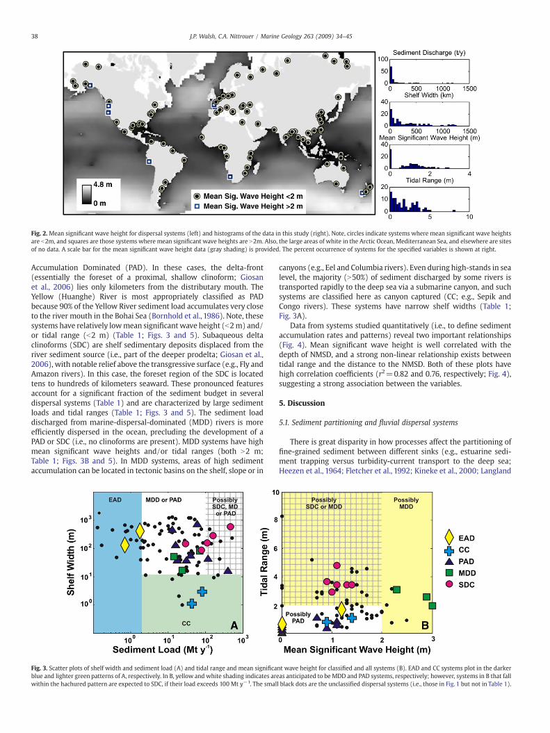
Fig. 2. Mean significant wave height for dispersal systems (left) and histograms of the data in this study (right). Note, circles indicate systems where mean significant wave heightsare b2m, and squares are those systems where mean significant wave heights are N2m. Also, the large areas of white in the Arctic Ocean, Mediterranean Sea, and elsewhere are sitesof no data. A scale bar for the mean significant wave height data (gray shading) is provided. The percent occurrence of systems for the specified variables is shown at right.
38 J.P. Walsh, C.A. Nittrouer / Marine Geology 263 (2009) 34–45
Accumulation Dominated (PAD). In these cases, the delta-front(essentially the foreset of a proximal, shallow clinoform; Giosanet al., 2006) lies only kilometers from the distributary mouth. TheYellow (Huanghe) River is most appropriately classified as PADbecause 90% of the Yellow River sediment load accumulates very closeto the river mouth in the Bohai Sea (Bornhold et al., 1986). Note, thesesystems have relatively lowmean significant wave height (b2m) and/or tidal range (b2 m) (Table 1; Figs. 3 and 5). Subaqueous deltaclinoforms (SDC) are shelf sedimentary deposits displaced from theriver sediment source (i.e., part of the deeper prodelta; Giosan et al.,2006), with notable relief above the transgressive surface (e.g., Fly andAmazon rivers). In this case, the foreset region of the SDC is locatedtens to hundreds of kilometers seaward. These pronounced featuresaccount for a significant fraction of the sediment budget in severaldispersal systems (Table 1) and are characterized by large sedimentloads and tidal ranges (Table 1; Figs. 3 and 5). The sediment loaddischarged from marine-dispersal-dominated (MDD) rivers is moreefficiently dispersed in the ocean, precluding the development of aPAD or SDC (i.e., no clinoforms are present). MDD systems have highmean significant wave heights and/or tidal ranges (both N2 m;Table 1; Figs. 3B and 5). In MDD systems, areas of high sedimentaccumulation can be located in tectonic basins on the shelf, slope or in
Fig. 3. Scatter plots of shelf width and sediment load (A) and tidal range and mean significablue and lighter green patterns of A, respectively. In B, yellow and white shading indicates arewithin the hachured pattern are expected to SDC, if their load exceeds 100 Mt y−1. The smal
canyons (e.g., Eel and Columbia rivers). Even during high-stands in sealevel, the majority (N50%) of sediment discharged by some rivers istransported rapidly to the deep sea via a submarine canyon, and suchsystems are classified here as canyon captured (CC; e.g., Sepik andCongo rivers). These systems have narrow shelf widths (Table 1;Fig. 3A).
Data from systems studied quantitatively (i.e., to define sedimentaccumulation rates and patterns) reveal two important relationships(Fig. 4). Mean significant wave height is well correlated with thedepth of NMSD, and a strong non-linear relationship exists betweentidal range and the distance to the NMSD. Both of these plots havehigh correlation coefficients (r2=0.82 and 0.76, respectively; Fig. 4),suggesting a strong association between the variables.
5. Discussion
5.1. Sediment partitioning and fluvial dispersal systems
There is great disparity in how processes affect the partitioning offine-grained sediment between different sinks (e.g., estuarine sedi-ment trapping versus turbidity-current transport to the deep sea;Heezen et al., 1964; Fletcher et al., 1992; Kineke et al., 2000; Langland
nt wave height for classified and all systems (B). EAD and CC systems plot in the darkeras anticipated to be MDD and PAD systems, respectively; however, systems in B that falll black dots are the unclassified dispersal systems (i.e., those in Fig. 1 but not in Table 1).

Fig. 4. Scatter plots of mean significant wave height versus depth to nearestmaximum shelf depocenter (NMSD) (A) and tidal range versus distance to NMSD (B). These plots use datafrom quantitatively studied systems listed in Table 1. Note, the x-axis in A is linear, but is logarithmic in B.
39J.P. Walsh, C.A. Nittrouer / Marine Geology 263 (2009) 34–45
and Cronin, 2000; Walsh and Nittrouer, 2003). A scatter plot of meansignificant wave height versus mean tidal range is a simple, objectiveway to compare processes affecting coastal and shelf systems (Davisand Hayes, 1984), and rivers classified in this study (Table 1) areplotted in Fig. 3B to illustrate how physical processes may relate to thedispersal-system classifications. The scatter plot in Fig. 3A can be usedas a similar tool to examine the shelf width and sediment load of asystem. Shown on these plots is an interpretation of where the fivesystem types are anticipated to plot; this interpretation will bediscussed further.
Fig. 5. Major types of marine river-sediment dispersal systems (left side) and representative(D) and SDC (E) are the Po, Sepik, Eel and Fly rivers, respectively (right). These example systeare shown in small figures for each example system. Locations of maximum fine-grained sedIsobath positions are noted on right. See Table 1 for references.
5.1.1. Estuarine-accumulation-dominated (EAD) systemsEAD systems are characterized by flocculation and estuarine
circulation, and these are commonly the most critical processesregulating the nature of sediment accumulation. EADs represent thesimplest scenario of marine dispersal, where the load of a system issufficiently small that the estuary into which it drains remainsunfilled. Sediments generally are rapidly deposited, and, even ifresuspended, only a small portionmight escape. As a result, regardlessof other characteristics (shelf width, waves, or tides, as indicated inFig. 3A), most river sediments accumulate within the estuary. The
examples of each type (except EAD, right side). Examples for the PAD (B), CC (C), MDDms do not reflect end-members. The distribution of 100-y sediment accumulation ratesiment accumulation in each system type (left) and examples (right) are shown in red.

40 J.P. Walsh, C.A. Nittrouer / Marine Geology 263 (2009) 34–45
Delaware and Susquehanna rivers are two examples of EAD systems,but numerous others are found along the west and east sides of theAtlantic Ocean and elsewhere. Based on these two systems, thesediment load criterion for an EAD system is assumed to be b2Mt y−1
(Fig. 3A). However, quantitative knowledge about the sedimentbudgets from more systems may shift this boundary. Sediment loadis not expected to be the sole factor regulating this system type, but itis used here as a first-order proxy. The size of the receiving estuary, thetiming of the discharge, and the oceanographic conditions also can beimportant.
5.1.2. Proximal-accumulation-dominated (PAD) systemsAs in the EAD case, PAD systems are also characterized by
flocculation and rapid deposition of fine-grained sediments. In thesecases, however, the sediments supplied by source streams have filledthe estuaries and presently enter coastal water bodies experiencingrelatively small waves and a low tidal range (Fig. 3B).With diminishedstream-transport capacity from effluent spreading and insufficientbed shear stresses for sediment movement by marine processes, themajority (N50%) of fine-grained sediments flocculate and depositclose to (within a few kilometers of) the coastline (e.g., Fisk et al.,1954; Scruton, 1960; Frignani and Langone, 1991; Fox et al., 2004;Frignani et al., 2005; Corbett et al., 2006; Palinkas and Nittrouer,2007). A significant portion of the load also can be advected in thedirection of prevailing currents (e.g., 35–40% for the Po River, Fig. 5;Frignani et al., 2005). This rapid proximal sediment accumulationforms the depositional bulge where each distributary reaches thecoastline (Fisk et al., 1954). Like the Mississippi delta, these systemscan build to unstable relief onto the surrounding shelf, and thus beprone to mass-failure events (e.g., Coleman and Prior, 1988). Due tothe nature of PAD systems (i.e., sediments accumulate rapidly neartheir discharge location), channel migration and switching arecommon. For this reason, sediment may be discharged by more thanone distributary channel, and several foci of sediment accumulationcan occur on the continental shelf adjacent to each distributarychannel (Fig. 5, right).
5.1.3. Canyon-captured (CC) systemsAt CC river mouths, the majority of the sediment load moves
rapidly down a canyon immediately seaward of the river mouth;sediment gravity flows (e.g., turbidity currents) are the primarymeans of sediment transport to the deep sea in such systems (Heezenet al., 1964; Kineke et al., 2000; Walsh and Nittrouer, 2003). Theproximity of a submarine canyon is the most important factordetermining the degree to which, the load of a system is lost to acanyon. At river mouths where the shelf is narrow (and steep),canyons can be more closely positioned to a fluvial source, or mayform the natural extensions of river valleys. As a first approach, theminimum gradient for an autosuspending gravity flow (0.7°; Wrightet al., 2001) is used to identify margins where this form of transportwill dominate. This criterion suggests that shelves b12 km in width(assuming a shelf break depth of 150 m) are locations where CCsystems should be anticipated. The two examples described here, theSepik and Congo rivers, match this description. Because CC systemsare most likely found in areas with narrow continental shelves thattypically have small tidal ranges, they should plot near the abscissa inFig. 3B. Other types of modern dispersal systems can lose a portion oftheir sediment load to the deep sea (e.g., Eel: Mullenbach andNittrouer, 2000; Columbia: Baker and Hickey, 1986; Mississippi:Coleman et al., 1998; Ganges–Brahmaputra: Kuehl et al., 1989), yetthese are not classified as CC systems as themajority (N50%) is not lostto a canyon.
Many studies of modern dispersal systems have documented thetransport of fluvial sediment through canyons. These incised featuresmay extend very close to river mouths, thereby intercepting the shelfdispersal pathway of river sediments. A significant portion of the
sediment from the Sepik, Eel, Congo, and Ganges–Brahmaputra Riveris transported regularly and rapidly by sediment gravity flows throughsubmarine canyons (Heezen et al., 1964; Kudrass et al., 1998;Mullenbach and Nittrouer, 2000; Puig et al., 2003; Walsh andNittrouer, 2003; Puig et al., 2004). All of these systems have shelvesnarrower than 50 km adjacent to the canyon head. These examplesprovide good evidence for the impact of shelf width on off-shelfsediment transport (Walsh and Nittrouer, 2003). In the CC systems(Sepik and Congo Rivers), a submarine canyon extends essentially intothe river mouth; in other cases, a canyon is incised into thesurrounding margin near the discharge location. The Ganges–Brahmaputra system highlights how a canyon may capture asignificant part (~1/3) of the river sediment budget, although notbeing immediately adjacent to the river mouth (Goodbred and Kuehl,1999). The Swatch of No Ground (a submarine canyon) is situatedover 200 km from the river mouth, yet sediment is activelytransported into and through this canyon because of strong along-shelf transport and the very narrow shelf at the canyon head (Kudrasset al., 1998). Numerous aspects of sedimentary dynamics (e.g., bottomEkman veering, internal waves) and their coupling can also impact theextent of off-shelf sediment transport.
5.1.4. Marine-dispersal-dominated (MDD) systemsBottom-boundary layer transport and sediment gravity flows
efficiently disperse most river sediments on the continental marginsurrounding an MDD system. The cartoon of a MDD system impliesone large area of greatest sediment accumulation (Fig. 5, left). But, asdepicted for the Eel River system, several isolated foci of sedimentaccumulation may exist; these distorted bulls-eye patterns may berelated to dominant currents, fluid-mud transport pathways, andstructural controls allowing sediment accumulation to be locallyelevated at several sites over the same time scale (Fig. 5, right;Nittrouer and Sternberg, 1981; Jaeger et al., 1998; Alexander andSimoneau., 1999; Sommerfield and Nittrouer, 1999; Mullenbach andNittrouer, 2000). MDD systems develop where rivers discharge theirsediment load into an oceanographic environment with moderate tolarge waves and/or currents (gray area in Fig. 3B). Because ofenergetic receiving-basin conditions, the majority of the fine-grainedsediment load cannot accumulate at shallowwater depths proximal tothe river mouth; only a fraction (up to 10%) may be sequesteredamong proximal sandy sediments (e.g., the Eel River shelf; Crockettand Nittrouer, 2004). The development of fluid muds during floodingcan allow deposition of discrete beds at a consistent location on thecontinental shelf (Wheatcroft et al., 1997; Sommerfield and Nittrouer,1999). Nevertheless, a considerable portion of the load is advectedacross and along the margin (tens to hundreds of kilometers) as aresult of efficient dispersal by bottom and intermediate nepheloidlayers (Alexander and Simoneau, 1999; Walsh and Nittrouer, 1999;Mullenbach and Nittrouer, 2000; Puig et al., 2003, 2004). The impactof the mean significiant wave height and tidal range on the nearestmaximum shelf depocenter suggests their critical control on MDDdevelopment (Fig. 4). These relationships reflect the importance ofwave orbitals and tidal currents on the depth and distances,respectively, where fine sediment can accumulate. The data suggestthat both waves and tides are important to continental-marginsediment dispersal and, specifically, MDD-system functioning.
5.1.5. Subaqueous-delta-clinoform (SDC) systemsSDC systems are different from EAD and PAD systems in that their
coastline is characterized by a “tide-dominated delta” (triangular-shaped) as a result of strong astronomical tidal flow (Coleman andWright, 1975; Galloway; 1975), and tidal flows are important incarrying the fine-sediment load greater distances from the shoreline(Figs. 3B and 5). In dispersal systems with a SDC, at least twoimportant areas (including the SDC) of marine sediment storage areidentified (Fig. 5, left). Expansive coastal wetlands and floodplains are

41J.P. Walsh, C.A. Nittrouer / Marine Geology 263 (2009) 34–45
common to these systems, and a significant fraction of the riversediment load may be stored in these regularly (marine) orepisodically (freshwater) flooded areas. These characteristics resultfrom the broad, low-gradient margins where SDC systems are located.In the Amazon and Ganges–Brahmaputra systems, it is estimated thatabout one third of the load is sequestered in the region between thebeginning of tidal influence and the river mouth (Nittrouer et al.,1996; Goodbred and Kuehl, 1998). Coastal areas of the Gulf of Papuamay store 14% of the load from several large rivers including the Fly,Kikori, and Purari Rivers (Walsh and Nittrouer, 2004). The separationof coastal and shelf sinks (Fig. 5, left) is accomplished throughenergetic tidal flow and wave action (Figs. 3B and 4). The pattern ofsediment accumulation on a SDC is generally aligned with bathy-metric isobaths, and is parallel to but significantly displaced (tens tohundreds of kilometers) from the shoreline (Fig. 5, right). This patternreflects the impact of waves and tides on the depth and distance ofsediment accumulation (Fig. 4). A subaqueous delta clinoformaccretes vertically to the depth (known as the rollover point) abovewhich fine sediments in the topset region are in disequilibrium withthe oceanographic conditions (Walsh et al., 2004). Energetic flowsgradually or episodically move sediment seaward. Ultimately, greatestaccumulation rates are situated on the more steeply dipping foresetregion, where combined (wave and current) bed shear stresses arediminished, due to deeper water depths (Fig. 2, right; Harris et al.,1993; Kuehl et al., 1996;Walsh et al., 2004). The rollover point (i.e., theshallow boundary of the foreset region, where sediments accumulate
Fig. 6. The hierarchical decision tree developed in this study. This hierarchical decision toceanographic and morphologic characteristics. The tool was constructed by evaluating the
most rapidly) may be better regarded as the “wave-current base”(Walsh et al., 2004).
Large tidal range (N2 m), in particular, is a key trait of SDC systems,as tidal flows enable the separation between the river mouth and theregion of high sediment accumulation rates on the subaqueuos deltaclinoform (Fig. 3B). But, the amount of sediment supplied to themargin seaward of a river mouth also is hypothesized to be important(Fig. 3A). SDC systems listed in Table 1 have sediment loads that covera broad range,115–1200Mt y−1. SDCs have not been found seaward ofany rivers with smaller sediment loads, e.g., Eel, Columbia. Based onthis information, we infer that any river or group of rivers withappropriate physical conditions (i.e., large tidal range and modestwave climate) and a load N100Mt y−1 could develop a SDC. The KikoriRiver (which discharges 30 Mt y−1) empties into the northwesternGulf of Papua along with the larger Fly and Purari Rivers among others(Walsh et al., 2004), and the combined loads (N300Mt y−1; Milliman,1995) coalesce to form a SDC in this region. The rationale for needing alarge sediment load for SDC development is based on the observationthat as the distance to the nearest maximum shelf depositionincreases non-linearly with tidal range (Fig. 4B), the area overwhich sediments must accumulate to produce a subaqueous deltaclinoform also increases non-linearly because of effluent spreading.For this reason, systems with sediment loads b100 Mt y−1 but largetides (N2m) are hypothesized to be unable to form a subaqueous deltaclinoform (Fig. 3A). For the same reason, systems with large loads butN2 m mean significant wave heights also will not create subaqueous
ree is designed to predict the marine dispersal system at a river mouth using basicfactors controlling well-studied dispersal systems (Table 1; Fig. 3).

42 J.P. Walsh, C.A. Nittrouer / Marine Geology 263 (2009) 34–45
delta clinoforms (Fig. 3B). More data are needed to better establish theboundaries between SDC and MDD systems, but undoubtedly,sediment load is a key factor. Given the available data, a 100 Mt y−1
limit is assumed based on the Fly River in the westernmost (updrift)portion of the Gulf of Papua (Fig. 3A).
5.2. A prediction tool
A reasonable prediction of the sediment dispersal type at any rivermouth can be made with knowledge of tidal range, significant waveheight, sediment supply and shelf width (Fig. 3). A hierarchicaldecision tree is developed here to predict the type of marine dispersalsystem at any river mouth (Fig. 6). This approach successfully predictsall the system classifications listed in Table 1, except the Kikori andPurari rivers which act as SDC systems as a result of their enhancedload.With the basic information available (sediment load, shelf width,mean significant wave height and tidal range) for a given system, onecan use the decision tree to predict the type of marine dispersalsystem at a river mouth. The predictions for each system withavailable (or assumed) data are plotted in Fig. 7. The prediction totalsfor each system are the following: 16 EAD, 39 PAD, 9 CC, 32 MDD, and8 SDC. In these data, PAD andMDD systems aremost abundant, but, aspointed out earlier, this study is heavily biased towards large riversystems. In reality, the number of EAD systems (i.e., those with a loadb2 Mt y−1) should be significantly larger than the other classes, whilethe number of SDC systemswould bemodified the least. The literatureon EAD systems is indeed extensive, but process-oriented sedimentdynamics studies and sediment budgets are needed for more EADsystems, to better quantify trapping efficiencies. PAD and MDDsystems also are likely to be more numerous, as these are producedby rivers withmoderate sediment loads. These systems also have beenrelatively understudied (Table 1). Although SDC and CC systems arerarer, their size and nature (dominated by gravity-driven flows)requires further research to quantify and, ultimately, model thesesystems.
The research presented here attempts to find order within thecomplexity of nature, and, in so doing, disregards important subtletiesin terrestrial and marine processes that have impacts on fine-grainedsediment dispersal of specific river systems. This is the bane of suchapproaches. Nevertheless, this research is valuable in that it helps
Fig. 7. Predictions for the type of marine dispersal system characterizing N100 rivers in thhierarchical decision tree in Fig. 6. Data are available upon request.
explain and evaluate which and why some systems behave similarly,and this is accomplished using data that are readily available for manydispersal systems. Regional currents undoubtedly also play animportant role in regulating the nature of fine-sediment dispersalon continental margins, but to the knowledge of the authors, thesedata do not exist in a form that can be easily accounted for globally.Additionally, this classification highlights the existence of distinctlydifferent types of dispersal systems, and this is relevant not only tomodern studies but also to interpretation of ancient strata.
5.3. A continuum of systems
The observed relationships between marine processes and thedepth and distance of the NMSD have significant implications for theproposed classification system (Fig. 4), as they suggest that fine-grained sediment dispersal responds over a predictable scale to meansignificant wave height and tidal range (linear and logarithmic,respectively). It is hypothesized that the former relationship is relatedto thewave orbital control on thewater depth at which fine sedimentscan accumulate, and the latter is caused by the distance fine-sedimentmust be transported to reach these water depths on continentalshelves, which is a consequence of their shelf width. These relation-ships imply that dispersal systems lie more in a continuum than asdiscrete types (e.g., there is no exact boundary between PAD andSDC systems). The modeling work of Swenson et al. (2005) nicelyillustrates this concept, highlighting how the changes in the distancebetween the shoreline and rollover point are impacted by the physicalconditions. With these comments inmind, the reader should be awarethat the thresholds used in the decision tree (Fig. 6) are not welldefined and probably do not represent absolute boundaries (Fig. 3).Nonetheless, the hierarchical decision tree is valuable as it providesdirection for using process-related factors to understand the diversityin dispersal systems. Future research can test, refine and refute theideas presented.
5.4. System types through geologic time
It must be mentioned that the type of marine sediment dispersalfor many river systems certainly has changed with time. During lowstands of sea level, when rivers debouched at the modern shelf break,
is study. These predictions were made using the available data (Figs. 1 and 2) and the

43J.P. Walsh, C.A. Nittrouer / Marine Geology 263 (2009) 34–45
CC systems would have been considerably more common than today(Milliman and Syvitski, 1992), and wave and tide conditions werelikely different as climate and shelf width (and, therefore, fetch) werealtered. As sea level rose rapidly after the Last Glacial Maximum, mostrivers systems stored their sediment loads in estuarine valleyscrossing the shelf (i.e., were EAD systems). When sea-level riseslowed around 8–6 ky BP and where sediment overwhelmed theholding capacity of some estuaries, deltas began to form around theworld (Warne and Stanley, 1995). In this way, the modern dispersalsystems presented in Fig. 7 reflect the transition of former estuaries tonon-EAD systems (i.e., a balance between sediment fill and initialsize). This evolution in system behavior must be kept in mind wheninterpreting the geologic record.
5.5. Implications
Variability in the process-related partitioning of sediments in thefive fundamental types of dispersal systems identified in this study hassignificant implications for the fate of carbon; a detailed discussionwith specific focus on large river margins is provided in McKee et al.(2004). Rapid deposition and accumulation of sediment, particularlyin thick beds from sediment gravity flows (e.g., fluid muds or turbiditycurrents) can minimize biological mixing and carbon respiration.Continued remobilization of sediment allows multiple opportunitiesfor carbon respiration by oxygen-, iron-, and manganese-basedelectron-receptor systems for bacterial decomposition (Aller et al.,2004). Particularly in EAD, PAD and CC cases, terrestrially suppliedcarbon can have little opportunity for oxidation in the marineenvironment; rapid transport and thick accumulation of sedimentlikely minimizes oxygen exposure times, and enhances carbon burial(Hedges and Keil, 1995; Harnett et al., 1998). Fluid muds also cantransport sediment in MDD and SDC systems, but much of thissediment experiences multiple episodes of sediment movement, andcarbon has repeated opportunities for incineration in such systems(Aller, 1998). Dynamics and complexities in carbon loading (e.g., Goniet al., 1997; Leithold and Blair, 2001) and respiration with multipleelectron receptors (e.g., Aller,1998) need to be better understood in alltypes of dispersal systems for the development of realistic globalcarbon budgets (Keil et al., 1997; McKee et al., 2004).
6. Conclusions
The conclusions of this research are the following:
1) Fine-grained fluvial sediment dispersal systems can be dividedinto five basic types: estuarine accumulation dominated (EAD),canyon captured (CC), proximal accumulation dominated (PAD),marine dispersal dominated (MDD), and subaqueous delta clino-form (SDC).
2) These divisions are based on the dominant mode and pattern ofsedimentation anticipated from each type. EAD and PAD systems areregulated by flocculation, and immediate deposition. CC systems aredominated by gravity-driven off-shelf sediment transport, andMDDandSDC are controlledby dilute suspension transport in the benthic-boundary-layer and sediment gravity flows.
3) Basic characteristics of these systems (mean significant waveheight, tidal range, shelf width and sediment load) can be used topredict the dispersal system using a hierarchical decision tree.
4) Strong relationships between themean significantwave height andthe depth and distance of the nearest maximum shelf depocentersuggest that a continuum exists between the systems types.
5) More research is needed to verify or improve the definition of theboundaries between the dispersal system types, and develop abetter understanding how sedimentological and geochemicalprocesses affect the quality and quantity of sediment accumulation.
Acknowledgements
The authors thank the National Science Foundation (grants OCE9904167, OCE 0203351 and OCE 0452166), the National GeographicSociety (grant 6573-99) and the Office of Naval Research (ONRN00014-00-1-0846) for funding this research. Neal Driscoll gavehelpful support for this paper. The work was inspired by discussionswithmany past lab mates and other colleagues. Liviu Giosan and otheranonymous reviewers are acknowledged for suggestions whichimproved the manuscript.
References
Alexander, C.R., Simoneau, A.M., 1999. Spatial variability in sedimentary processes onthe Eel continental slope. Mar. Geol. 154 (1–4), 243–254.
Alexander, C.R., DeMaster, D.J., Nittrouer, C.A.,1991. Sediment accumulation in amodernepicontinental-shelf setting—the Yellow Sea. Mar. Geol. 98 (1), 51–72.
Allen, J.R.L., 1964. Sedimentation in the modern delta of the river Niger, west Africa,Deltaic and shallow marine deposits. In: Van Straaten, L.M.J.U. (Ed.), Deltaic andShallow Marine Deposits: Proceedings of the 6th International SedimentologicalCongress. Developments in Sedimentology 1. Elsevier, Amsterdam, pp. 26–34.
Aller, R.C., 1998. Mobile deltaic and continental shelf muds as suboxic, fluidized bedreactors. Mar. Chem. 61 (3–4), 143–155.
Aller, R.C., Hannides, A., Heilbrun, C., Panzeca, C., 2004. Coupling of early diageneticprocesses and sedimentary dynamics in tropical shelf environments: the Gulf ofPapua deltaic complex. Cont. Shelf Res. 24, 2455–2486.
Allison, M.A., Neill, C.F., 2002. Accumulation rates and stratigraphic character of themodern Atchafalaya River prodelta, Louisiana. Trans. Gulf Coast Assoc. Geol. Soc. 52,1031–1040.
Aloisi, J.C., Monaco, A., Thommeret, J., Thommeret, Y., 1975. Evolution paleogeographi-que du plateau continental languedocien dans le cadre du golfe du Lyon; Analysecomparee des donnees sismiques, sedimentologiques et radiometriques concer-nant le Quaternaire recent. (Paleogeographical evolution of the Languedoccontinental shelf in the framework of the Gulf of Lion; comparative analysis fromseismic, sedimentologic and radiometric data concerning the upper Quaternary).Rev. Geogr. Phys. Geol. Dyn. 17 (1), 13–22.
Baker, E.T., Hickey, B.M., 1986. Contemporary sedimentation processes in and around anactive West-Coast submarine-canyon. Mar. Geol. 71, 15–34.
Bornhold, B.D., Yang, Z.S., Keller, G.H., Prior, D.B., Wiseman, W.J., Wang, Q., Wright, L.D.,Xu, W.D., Zhuang, Z.Y., 1986. Sedimentary framework of the modern Huanghe(Yellow-River) Delta. Geo-Mar. Lett. 6 (2), 77–83.
British Oceanographic Data Center, 1994. GEBCO Digital Atlas. British OceanographicData Center, Birkenhead, Merseyside, United Kingdom.
Cacchione, D., Sternberg, R.W., Ogston, A.S., 2006. Bottom instrumented tripods:history, applications, and impacts. Cont. Shelf Res. 26 (17–18), 2319–2334.
Coleman, J.M., Wright, L.D., 1975. Modern river deltas: variability of processes and sandbodies. In: Broussard, M.L. (Ed.), Deltas, Models for Exploration. Houston GeologicalSociety, Houston, pp. 99–149.
Coleman, J.M., Prior, D.B., 1988. Mass-wasting on continental margins. Annu. Rev. EarthPlanet. Sci. 16, 101–119.
Coleman, J.M., Roberts, H.H., Murray, S.P., Salama, M., 1981. Morphology and dynamicsedimentology of the Eastern Nile Delta Shelf. Mar. Geol. 42 (1–4), 301–326.
Coleman, J.M., Roberts, H.H., Stone, G.W., 1998. Mississippi River delta: an overview. J.Coast. Res. 14 (3), 698–716.
Corbett, D.R., Mckee, B., Allison, M., 2006. Nature of decadal-scale sedimentaccumulation on the western shelf of the Mississippi River delta. Cont. Shelf Res.26, 2125–2140.
Correggiari, A., Trincardi, F., Langone, L., Roveri, M., 2001. Styles of failure in lateHolocene highstand prodelta wedges on the Adriatic shelf. J. Sediment. Res. 71 (2),218–236.
Crockett, J.S., Nittrouer, C.A., 2004. The sandy inner shelf as a repository for muddysediment: an example from Northern California. Cont. Shelf Res. 24 (1), 55–73.
Dalrymple, R.W., Zaitlin, B.A., Boyd, R., 1992. Estuarine facies models: conceptual basisand stratigraphic implications. J. Sediment. Petrol. 62, 1130–1146.
Davis, R.A., Hayes, M.O., 1984. What is a wave-dominated coast? Mar. Geol. 60, 313–329.Droz, L., Rigaut, F., Cochonat, P., Tofani, R., 1996. Morphology and recent evolution of the
Zaire turbidite system (Gulf of Guinea). Geol. Soc. Amer. Bull. 108 (3), 253–269.Dukat, D.A., Kuehl, S.A., 1995. Non-steady-state Pb-210 flux and the use of Ra-228/Ra-
226 as a geochronometer on the Amazon Continental-Shelf. Mar. Geol. 125 (3–4),329–350.
Fisk, H.N., McFarlan, E.J., Kolb, C.R., Wilbert, L.J., 1954. Sedimentary framework of themodern Mississippi delta. J. Sediment. Petrol. 24, 76–99.
Fletcher, C.H., Knebel, H.J., Kraft, J.C., 1992. Holocene depocenter migration andsediment accumulation in Delaware Bay—a submerging marginal marine sedi-mentary basin. Mar. Geol. 103 (1–3), 165–183.
Fox, J.M., Hill, P.S., Milligan, T.G., Boldrin, A., 2004. Flocculation and sedimentation onthe Po River Delta. Mar. Geol. 203 (1–2), 95–107.
Frignani, M., Langone, L., 1991. Accumulation rates and Cs-137 distribution in sedimentsoff the Po River Delta and the Emilia-Romagna Coast (Northwestern Adriatic Sea,Italy). Cont. Shelf Res. 11 (6), 525–542.
Frignani, M., Langone, L., Ravaioli, M., Sorgente, D., Alvisi, F., Albertazzi, S., 2005. Fine-sediment mass balance in the western Adriatic continental shelf over a centurytime scale. Mar. Geol. 222–223, 113–133.

44 J.P. Walsh, C.A. Nittrouer / Marine Geology 263 (2009) 34–45
Galloway, W.E., 1975. Process framework for describing the morphologic andstratigraphic evolution of deltaic depositional systems. In: Broussard, M.L. (Ed.),Deltas, Models for Exploration. Houston Geological Society, Houston, pp. 87–98.
Geyer, W.R., Hill, P.S., Kineke, G.C., 2004. The transport, transformation and dispersal ofsediment by buoyant coastal flows. Cont. Shelf Res. 24, 927–949.
Giosan, L., Constantinescu, S., Clift, P.D., Tabrez, A.R., Danish, M., Inam, A., 2006. Recentmorphodynamics of the Indus delta shore ans shelf. Cont. Shelf Res. 26, 1668–1684.
Goni, M.A., Ruttenberg, K.C., Eglinton, T.I., 1997. Source and contribution of terrigenousorganic carbon to surface sediments in theGulf ofMexico.Nature389(6648), 275–278.
Goodbred, S.L., Kuehl, S.A., 1998. Floodplain processes in the Bengal Basin and thestorage of Ganges–Brahmaputra river sediment: an accretion study using Cs-137and Pb-210 geochronology. Sediment. Geol. 121 (3–4), 239–258.
Goodbred, S.L., Kuehl, S.A., 1999. Holocene and modern sediment budgets for theGanges–Brahmaputra river system: evidence for highstand dispersal to flood-plain,shelf, and deep-sea depocenters. Geology 27 (6), 559–562.
Got, H., Aloesi, J.-C., Monaco, A., 1985. Sedimentary processes in Mediterranean deltasand shelves. In: Stanley, D.J., Wezel, F.-C. (Eds.), Springer-Verlag, New York.
Harris, P.T., Baker, E.K., Cole, A.R., Short, S.A., 1993. A preliminary-study of sedimentationin the tidally dominated Fly River Delta, Gulf of Papua. Cont. Shelf Res. 13 (4),441–472.
Hartnett, H.E., Keil, R.G., Hedges, J.I., Devol, A.H., 1998. Influence of oxygen exposuretime on organic carbon preservation in continental margin sediments. Nature 391(6667), 572–574.
Hedges, J.I., Keil, R.G., 1995. Sedimentary organic-matter preservation—an assessmentand speculative synthesis. Mar. Chem. 49 (2–3), 81–115.
Heezen, B.C., Ewing, M., Granelli, N.C.L., Menzies, R.J., Schneider, E.D., 1964. Congosubmarine canyon. Am. Assoc. Petroleum Geol. 48 (7), 1126–1149.
Hori, K., et al., 2001. Sedimentary facies of the tide-dominated paleo-Changjiang(Yangtze) estuary during the last transgression. Mar. Geol. 177 (3–4), 331–351.
Hori, K., Saito, Y., Zhao, Q., Wang, P., 2002. Architecture and evolution of the tide-dominated Changjiang (Yangtze) River delta, China. Sediment. Geol. 146 (3–4),249–264.
Hovius, N., 1998. Controls on sediment supply by large rivers. SEPM Spec. Publ. 42,47–69.
Jakobsson, M., et al., 2000. New grid of Arctic bathymetry aids scientists andmapmakers. Eos Trans. Am. Geophys. Union 81 (9), 89, 93, 96.
Jaeger, J.M., Nittrouer, C.A., Scott, N.D., Milliman, J.D., 1998. Sediment accumulationalong a glacially impacted mountainous coastline: North-east Gulf of Alaska. BasinRes. 10 (1), 155–173.
Keil, R.G., Mayer, L.M., Quay, P.D., Richey, J.E., Hedges, J.I., 1997. Loss of organic matterfrom riverine particles in deltas. Geochim. Cosmochim. Acta 61 (7), 1507–1511.
Kineke, G.C., Woolfe, K.J., Kuehl, S.A., Milliman, J.D., Dellapenna, T.M., Purdon, R.G., 2000.Sediment export from the Sepik River, Papua New Guinea: evidence for a divergentsediment plume. Cont. Shelf Res. 20, 2239–2266.
Kudrass, H.R., Michels, K.H., Wiedicke, M., Suckow, A., 1998. Cyclones and tides asfeeders of a submarine canyon off Bangladesh. Geology 26, 715–718.
Kuehl, S.A., Hariu, T.M., Moore, W.S., 1989. Shelf sedimentation off the Ganges–Brahmaputra River system—evidence for sediment bypassing to the Bengal fan.Geology 17 (12), 1132–1135.
Kuehl, S.A., Nittrouer, C.A., Allison,M.A., Faria, L.E.C., Dukat, D.A., Jaeger, J.M., Pacioni, T.D.,Figueiredo, A.G., Underkoffler, E.C., 1996. Sediment deposition, accumulation, andseabed dynamics in are energetic fine-grained coastal environment. Cont. Shelf Res.16 (5–6), 787–815.
Kuehl, S.A., Levy, B.M., Moore,W.S., Allison, M.A., 1997. Subaqueous delta of the Ganges–Brahmaputra river system. Mar. Geol. 144 (1–3), 81–96.
Langland, M., Cronin, T. (Eds.), 2000. A Summary Report of Sediment Processes inChesapeake Bay and Watershed. USGS Water Resources Investigations Report 03-4123. U.S. Geological Survey, p. 122.
Leithold, E.L., Blair, N.E., 2001. Watershed control on the carbon loading of marinesedimentary particles. Geochim. Cosmochim. Acta 65, 2231–2240.
Liu, J.P., Milliman, J.D., Gao, S., 2002. The Shandong mud wedge and post-glacialsediment accumulation in the Yellow Sea. Geo-Mar. Lett. 21 (4), 212–218.
Liu, J.P., Milliman, J.D., Gao, S., Cheng, P., 2004. Holocene development of the YellowRiver's subaqueous delta, North Yellow Sea. Mar. Geol. 209 (1–4), 45–67.
Maldonado, A., Serra, J., Martrous, F., Verdaguer, A., Aloisi, J.C., Got, H., Monaco, A.,Mirabile, L., 1980. La plateforme continentale de l'Ebre dans le cadre de l'evolutionrecente du delta. The continental shelf of the Ebro region in the framework of Recentdelta evolution. Abstracts-International Geological Congress 26, Paris, p. 508.
McCave, I.N., 1972. Transport and escape of fine-grained sediment from shelf areas. In:Swift, D.J.P., Duane, D., Pilkey, O.H. (Eds.), Shelf Sediment Transport. DowdenHutchinson and Ross, Stroudsburg, PA, pp. 225–248.
McKee, B.A., Nittrouer, C.A., DeMaster, D.J., 1983. Concepts of sediment deposition andaccumulation applied to the continental-shelf near the mouth of the Yangtze-River.Geology 11 (11), 631–633.
McKee, B.A., DeMaster, D.J., Nittrouer, C.A., 1984. The use of Th-234/U-238 disequili-brium to examine the fate of particle-reactive species on the Yangtze continental-shelf. Earth Planet. Sci. Lett. 68 (3), 431–442.
McKee, B.A., Aller, R.C., Allison, M.A., Bianchi, T.S., Kineke, G.C., 2004. Transport andtransformation of dissolved and particulate materials on continental marginsinfluenced by major rivers: benthic boundary layer and seabed processes. Cont.Shelf Res. 24 (7–8), 899–926.
Michels, K.H., Kudrass, H.R., Hubscher, C., Suckow, A., Wiedicke, M.,1998. The submarinedelta of the Ganges–Brahmaputra: cyclone-dominated sedimentation patterns.Mar. Geol. 149 (1–4), 133–154.
Milliman, J.D., 1995. Sediment discharge to the ocean from small mountainous rivers:the New Guinea example. Geo-Mar. Lett. 15 (3–4), 127–133.
Milliman, J.D., Meade, R.H., 1983. World-wide delivery of river sediment to the oceans. J.Geol. 91 (1), 1–21.
Milliman, J.D., Syvitski, J.P.M., 1992. Geomorphic tectonic control of sediment dischargeto the ocean—the importance of small mountainous rivers. J. Geol. 100 (5),525–544.
Mullenbach, B.L., Nittrouer, C.A., 2000. Rapid deposition of fluvial sediment in the EelCanyon, northern California. Cont. Shelf Res. 20 (16), 2191–2212.
Nelson, H., Creager, J.S., 1977. Displacement of Yukon-derived sediment from Bering Seato Chukchi Sea during Holocene time. Geology 5 (3), 141–146.
Nelson, C.H., Rowland, R.W., Stoker, S.W., Bradley, B.R., 1980. Interplay of physical andbiological sedimentary structiures of the Bering epicontinental shelf. In: Larsen, M.C., Nelson, C.H., Thor, D.R. (Eds.), Geological, Geochemical, and GeotechinicalObservation on the Bering Shelf, Open-File Report 80-979. U.S. Geological Survey,Reston, VA.
Nittrouer, C.A., Sternberg, R.W., 1981. The formation of sedimentary strata in anallochthonous shelf environment—the Washington continental-shelf. Mar. Geol. 42(1–4), 201–232.
Nittrouer, C.A., Wright, L.D., 1994. Transport of particles across continental shelves. Rev.Geophys. 32 (1), 85–113.
Nittrouer, C.A., DeMaster, D.J., McKee, B.A., 1984. Fine-scale stratigraphy in proximal anddistal deposits of sediment dispersal systems in the East China Sea. Mar. Geol. 61(1), 13–24.
Nittrouer, C.A., Kuehl, S.A., DeMaster, D.J., Kowsmann, R.O., 1986. The deltaic nature ofAmazon shelf sedimentation. Geol. Soc. Amer. Bull. 97 (4), 444–458.
Nittrouer, C.A., et al., 1996. The geological record preserved by Amazon shelfsedimentation. Cont. Shelf Res. 16 (5–6), 817–841.
Nittrouer, C.A., Austin, J.A., Field, M.E., Kravitz, J.H., Syvitski, J.P.M., Wiberg, P.L., 2007.Writing a Rosetta Stone: Insights into Continental-Margin Sedimentary Processesand Strata, Special Publication 37 of the International Association of Sedimentol-ogists. Blackwell Publishing, Malden, MA. 549 pp.
Ogston, A.S., Cacchione, D.A., Sternberg, R.W., Kineke, G.C., 2000. Observations of stormand river flood-driven sediment transport on the northern california continentalshelf. Cont. Shelf Res. 20, 2141–2162.
Orton, G.J., Reading, H.G., 1993. Variability of deltaic processes in terms of sedimentsupply, with particular emphasis on grain size. Sedimentology 40, 475–512.
Palanques, A., Puig, P., Guillen, J., Jimenez, J., Gracia, V., Sanchez-Arcilla, A., Madsen, O.,2002. Near-bottom suspended sediment fluxes on the microtidal low-energy Ebrocontinental shelf (NW Mediterranean). Cont. Shelf Res. 22 (2), 285–303.
Palinkas, C.M., Nittrouer, C.A., 2007. Modern sediment accumulation on the Po shelf,Adriatic Sea. Cont. Shelf Res. 27, 489–505.
Pinet, P., Souriau, M., 1988. Continental erosion and large-scale relief. Tectonics 7,563–582.
Puig, P., Ogston, A.S., Mullenbach, B.L., Nittrouer, C.A., Sternberg, R.W., 2003. Shelf-to-canyon sediment-transport processes on the Eel continental margin (northernCalifornia). Mar. Geol. 193 (1–2), 129–149.
Puig, P., Ogston, A.S., Mullenbach, B.L., Nittrouer, C.A., Parsons, J.D., Sternberg, R.W.,2004. Storm-induced sediment gravity flows at the head of the Eel submarinecanyon, northern California margin. J. Geophys. Res. Oceans 109 (C3).
Rodriguez, A.B., Hamilton, M.D., Anderson, J.B., 2000. Facies and evolution of themodern Brazos Delta, Texas; wave versus flood influence. J. Sediment. Res. 70 (2),283–295.
Scruton, P.C.,1960. Delta building and the deltaic sequence. In: Shepard, F.P., Phleger, F.B.,van Andel, T.H. (Eds.), Recent Sediments, northwest Gulf of Mexico. AmericanAssociation of Petroleum Geologists, Tulsa, OK.
Smith, W.H.F., Sandwell, D.T., 1997. Global sea floor topography from satellite altimetryand ship depth soundings. Science 277, 1956–1962.
Sommerfield, C.K., Nittrouer, C.A., 1999. Modern accumulation rates and a sedimentbudget for the Eel shelf: a flood-dominated depositional environment. Mar. Geol.154 (1–4), 227–241.
Sternberg, R., 2005. Sediment transport in the coastal ocean: a retrospective evaluationof the benthic tripod and its impact, past, present and future. Sci. Mar. 69, 43–54.
Sternberg, R.W., Nowell, A.R.M., 1999. Continental shelf sedimentology: scales ofinvestigation define future research opportunities. J. Sea Res. 41 (1–2), 55–71.
Sternberg, R.W., Kineke, G.C., Johnson, R., 1991. An instrument system for profilingsuspended sediment, fluid, and flow conditions in shallow marine environments.Cont. Shelf Res. 11 (2), 109–122.
Summerfield, M.A., Hulton, N.J., 1994. Natural controls of fluvial denudation ratesin major world drainage basins. J. Geophys. Res. B Solid Earth Planets 99,13871–13883.
Summerhayes, C.P., Sestini, G., Misdorp, R., Marks, N., 1978. Nile Delta; nature andevolution of continental shelf sediments. Mar. Geol. 27 (1–2), 43–65.
Swenson, J.B., Paola, C., Pratson, L., Voller, V.R., Murray, A.B., 2005. Fluvial and marinecontrols on combined subaerial and subaqueous delta progradation: morphody-namic modeling of compound-clinoform development. J. Geophys. Res. Earth Surf.110, 1–16.
Swift, D.J.P., Thorne, J.A.,1991. Sedimentation on continental margins: I. A general modelfor shelf sedimentation. In: Swift, D.J.P., Tillman, R.W., Oertel, G.F., Thorne, J.A.(Eds.), Shelf Sand and Sandstone Bodies, Geometry, Facies and SequenceStratigraphy: International Association of Sedimentologists Special Publication,vol. 14, pp. 3–31.
Syvitski, J.P.M., Vörösmarty, C.J., Kettner, A.J., Green, P.A., 2005. Impact of humans on theflux of terrestrial sediment to the global coastal ocean. Science 308, 376–380.
Ta, T.K.O., Nguyen, V.L., Tateishi,M., Kobayashi, I., Saito, Y., Nakamura, T., 2002a. Sedimentfacies and LateHolocene progradation of theMekong RiverDelta in Bentre Province,southern Vietnam: an example of evolution from a tide-dominated to a tide- andwave-dominated delta. Sediment. Geol. 152 (3–4), 313–325.

45J.P. Walsh, C.A. Nittrouer / Marine Geology 263 (2009) 34–45
Ta, T.K.O., Nguyen, V.L., Tateishi, M., Kobayashi, I., Tanabe, S., Saito, Y., 2002b. Holocenedelta evolution and sediment discharge of the Mekong River southern Vietnam.Quat. Sci. Rev. 21 (16–17), 1807–1819.
Tolman, H.L., 2002. Usermanual and system documentation ofWAVEWATCH-III version2.22. NOAA/NWS/NCEP/OMB technical note, 222: 133 pp.
Traykovski, P., Geyer,W.R., Irish, J.D., Lynch, J.F., 2000. The role of wave-induced density-driven fluid mud flows for cross-shelf transport on the Eel River continental shelf.Cont. Shelf Res. 20, 2113–2140.
Walsh, J.P., Nittrouer, C.A., 1999. Observations of sediment flux to the Eel continentalslope, northern California. Mar. Geol. 154 (1–4), 55–68.
Walsh, J.P., Nittrouer, C.A., 2003. Contrasting styles of off-shelf sediment accumulationin New Guinea. Mar. Geol. 196 (3–4), 105–125.
Walsh, J.P., Nittrouer, C.A., 2004. Mangrove sedimentation in the Gulf of Papua, PapuaNew Guinea. Mar. Geol. 208, 225–248.
Walsh, J.P., et al., 2004. Clinoform mechanics in the Gulf of Papua, New Guinea. Cont.Shelf Res. 24 (19), 2487–2510.
Wang, X.H., Pinardi, N., 2002. Modeling the dynamics of sediment transport andresuspension in the northern Adriatic Sea. J. Geophys. Res. Oceans 107 (C12), 3225.
Warne, A.G., Stanley, D.J., 1995. Sea-level change as critical factor in development ofbasin margin sequences: new evidence from late Quaternary record. J. Coast. Res.Spec. Issue 17, 231–240.
Wheatcroft, R.A., Sommerfield, C.K., Drake, D.E., Borgeld, J.C., Nittrouer, C.A., 1997. Rapidand widespread dispersal of flood sediment on the northern California margin.Geology 25 (2), 163–166.
Wright, L.D., 1985. River deltas, In: Davis, R.A. (Ed.), Coastal Sedimentary Environments,2nd ed. Springer-Verlag, New York, pp. 1–75.
Wright, L.D., Nittrouer, C.A., 1995. Dispersal of river sediments in coastal seas—sixcontrasting cases. Estuaries 18 (3), 494–508.
Wright, L.D., Wiseman, W.J., Bornhold, B.D., Prior, D.B., Suhayda, J.N., Keller, G.H., Yang,Z.S., Fan, Y.B., 1988. Marine dispersal and deposition of Yellow-River silts by gravity-driven underflows. Nature 332, 629–632.
Wright, L.D., Friedrichs, C.T., Kim, S.C., Scully, M.E., 2001. Effects of ambient currents andwaves on gravity-driven sediment transport on continental shelves. Mar. Geol. 175(1–4), 25–45.