
What are corridors and what are the issues? Introduction to special issue: the governance of...
11
What are corridors and what are the issues? Introduction to special issue: the governance of corridors Hugo Priemus, Wil Zonneveld * OTB Research Institute for Housing, Urban and Mobility Studies, Delft University of Technology, Thijsseweg 11, P.O. Box 5030, 2629 JA Delft, The Netherlands Abstract Linear concepts such as the corridor have a long history in spatial and urban planning. The recent megacorridor or eurocorridor concept, proposed in the context of discussion on European territorial development, strives to integrate policies on infrastructure, urbanisation and economic development. As is shown by the example of the Netherlands, the corridor concept can count on a hostile reception from spatial planners. As an analytical concept the corridor can hardly be denied its legitimacy. Several urgent policy issues can be attached to corridor developments that together require an improved coordination between policy domains at different spatial levels. Ó 2003 Elsevier Ltd. All rights reserved. Keywords: Megacorridors; Eurocorridors; Spatial planning 1. The starting point: corridors as bundles of infrastruc- ture As a starting point, we can imagine corridors to be bundles of infrastructure that link two or more urban areas. These can be highways (sometimes via different routes), rail links (high-speed trains, intercity lines, local trains or trams), separate bus lanes, cycle paths, canals, short-sea connections and air connections. In general, however, corridor development concerns connections that use different transport modes (e.g. car, train, tram, ship, aeroplane), and carry both passenger and freight transport. One can also adopt a broader interpretation of corridors that encompasses things like ICT infra- structure, power lines and cables as well as pipes for drinking water, natural gas, crude oil, electricity and sewage. This contribution, however, will concern itself mainly with traffic infrastructure, that is, passenger and freight transport links. The development of corridors over the course of time has reflected technological advances in transport modes, and the construction legacy of different varieties of in- frastructure. New generations of infrastructure are often located in the vicinity of older systems and sometimes–– in cases of replacement––on top of older systems. In other words: the development of corridors is strongly path dependent. This is the crux of WhebellÕs theory of corridors (Whebell, 1969). In most parts of the world, cities were initially linked over land only by road. Wagons, carts and coaches were drawn over these roads by horses and other animals, and roadhouses, inns and markets sprung up along the way. In areas rich in water, rivers and other water routes were important conduits for sailboats, rowboats and barges. Industrialisation brought with it the personal car and the lorry, and finally also the highway. Curves were straightened out, roads were paved and average speeds soared. Although industrialisation also brought motor- boats and steamboats, the increase in traffic over water was much less dramatic than that on land. Road net- works became increasingly elaborate, while waterway networks remained much more basic, being expanded only in exceptional circumstances. Finally, the age of industrialisation brought trains and trams, for which a completely new rail-based infrastructure was laid out. Initially, the hearts of existing cities were linked via land-based routes according to the logic of shortest distances. Later, however, railway stations were lo- cated outside city centres in order to avoid large-scale * Corresponding author. Tel.: +31-15-2781038; fax: +31-15- 2784422. E-mail address: [email protected] (W. Zonneveld). 0966-6923/$ - see front matter Ó 2003 Elsevier Ltd. All rights reserved. doi:10.1016/S0966-6923(03)00028-0 Journal of Transport Geography 11 (2003) 167–177 www.elsevier.com/locate/jtrangeo
Transcript of What are corridors and what are the issues? Introduction to special issue: the governance of...
Journal of Transport Geography 11 (2003) 167–177
www.elsevier.com/locate/jtrangeo
What are corridors and what are the issues? Introductionto special issue: the governance of corridors
Hugo Priemus, Wil Zonneveld *
OTB Research Institute for Housing, Urban and Mobility Studies, Delft University of Technology, Thijsseweg 11, P.O. Box 5030,
2629 JA Delft, The Netherlands
Abstract
Linear concepts such as the corridor have a long history in spatial and urban planning. The recent megacorridor or eurocorridor
concept, proposed in the context of discussion on European territorial development, strives to integrate policies on infrastructure,
urbanisation and economic development. As is shown by the example of the Netherlands, the corridor concept can count on a
hostile reception from spatial planners. As an analytical concept the corridor can hardly be denied its legitimacy. Several urgent
policy issues can be attached to corridor developments that together require an improved coordination between policy domains at
different spatial levels.
� 2003 Elsevier Ltd. All rights reserved.
Keywords: Megacorridors; Eurocorridors; Spatial planning
1. The starting point: corridors as bundles of infrastruc-
ture
As a starting point, we can imagine corridors to be
bundles of infrastructure that link two or more urban
areas. These can be highways (sometimes via different
routes), rail links (high-speed trains, intercity lines, local
trains or trams), separate bus lanes, cycle paths, canals,
short-sea connections and air connections. In general,
however, corridor development concerns connectionsthat use different transport modes (e.g. car, train, tram,
ship, aeroplane), and carry both passenger and freight
transport. One can also adopt a broader interpretation
of corridors that encompasses things like ICT infra-
structure, power lines and cables as well as pipes for
drinking water, natural gas, crude oil, electricity and
sewage. This contribution, however, will concern itself
mainly with traffic infrastructure, that is, passenger andfreight transport links.
The development of corridors over the course of time
has reflected technological advances in transport modes,
and the construction legacy of different varieties of in-
* Corresponding author. Tel.: +31-15-2781038; fax: +31-15-
2784422.
E-mail address: [email protected] (W. Zonneveld).
0966-6923/$ - see front matter � 2003 Elsevier Ltd. All rights reserved.
doi:10.1016/S0966-6923(03)00028-0
frastructure. New generations of infrastructure are often
located in the vicinity of older systems and sometimes––in cases of replacement––on top of older systems. In
other words: the development of corridors is strongly
path dependent. This is the crux of Whebell�s theory of
corridors (Whebell, 1969). In most parts of the world,
cities were initially linked over land only by road.
Wagons, carts and coaches were drawn over these roads
by horses and other animals, and roadhouses, inns and
markets sprung up along the way. In areas rich in water,rivers and other water routes were important conduits
for sailboats, rowboats and barges.
Industrialisation brought with it the personal car and
the lorry, and finally also the highway. Curves were
straightened out, roads were paved and average speeds
soared. Although industrialisation also brought motor-
boats and steamboats, the increase in traffic over water
was much less dramatic than that on land. Road net-works became increasingly elaborate, while waterway
networks remained much more basic, being expanded
only in exceptional circumstances. Finally, the age of
industrialisation brought trains and trams, for which a
completely new rail-based infrastructure was laid out.
Initially, the hearts of existing cities were linked via
land-based routes according to the logic of shortest
distances. Later, however, railway stations were lo-cated outside city centres in order to avoid large-scale
168 H. Priemus, W. Zonneveld / Journal of Transport Geography 11 (2003) 167–177
demolition and to spare the surrounding area the dis-turbances caused by the noise and smoke of the trains.
The best example of this is probably London, where all
its stations are terminals. With the explosion in car
traffic, congestion and traffic safety levels in the built-up
area became increasingly intolerable. It was first at-
tempted to remedy this by clearing large thoroughfares
through old city neighbourhoods, but after the 1960s,
the solution was increasingly sought in ring roads cir-cumnavigating the city and––literally––holding traffic
off at a distance.
The consequence of this historical development is not
only that cities are currently situated at a node (or better:
nodes) of different kinds of infrastructure (the main theme
of the book �Splintering Urbanism� by Graham and
Marvin, 2001), but also that these infrastructure nodes
are laid out differently vis-�aa-vis the cities and each other;this fact has seriously compromised the interconnectiv-
ity and interoperationality of various traffic networks.
Understandably, airports generally lie at a fairly great
distance from city centres, or where this is not the case
(e.g. Athens), are moved further away. This situation
may please taxi drivers, but not most travellers. Only
recently, however, has there been a growing level of
attention for direct and seamless connections betweenairports and city centres via train, light rail or metro
(e.g. Tokyo, London––Heathrow, Amsterdam––Schi-
phol). Train and roadway networks are quite poorly
integrated. Here and there, Park & Ride facilities have
been developed at a number of railway stations and
well-situated transfer stations along the motorway, in
order to promote seamless multi-modal travel and fa-
cilitate transfers from one transport network to theother. In so doing, one encounters not only site location
and traffic-technical difficulties, but also institutional
problems such as the coordination of services and the
absence of a universal fare structure (e.g. a �smart card�system). These kinds of developments, combined with
the consequences of new generations of infrastructure
(path-dependency), have resulted in a situation that in
many parts of the world––particularly those character-ised by high population densities such as north-west
Europe––heavy bundles of infrastructure exist whose
location exerts a powerful influence on urbanisation
patterns and economic development.
2. The corridor as a planning concept
2.1. Planning urbanisation
The use of �corridor� as a planning concept is in fact
rather old. About a century ago, linear city models werepresented as alternatives for the densely populated,
concentric industrial city. The most famous of these was
put forth by the Spanish urbanist Soria y Mata (1844–
1920) in a series of articles published as early as 1882. Infact, he was the first urban planner to design an urban
model fully tailored to the development of transport
technology. Soria y Mata had strong misgivings about
the often-chaotic urban development in his day. To
combat this, he proposed that urban extensions be fully
adjusted to the infrastructure necessary for efficient
transport. The �Ciudad Lineal� takes the form of a city of
400 m wide, centred on a tramway and a parallel-run-ning thoroughfare. Although he advocated a new sort of
land policy to make the Ciudad Lineal possible from a
social point of view, his model was traditional since only
dwellings for the more affluent had immediate access to
the central axis. For the study of urban models, it is
important to remember that the Ciudad Lineal did not
represent a model of an alternative linear city, but was
created to extend existing ones (Hall, 1996, p. 112 ff.). Assuch, the model has been influential because many re-
gional plans made since then have advocated some sort
of linear extension of large cities based upon infra-
structure. The basic difference in most cases is that an
unbroken linear development was certainly not pro-
posed, but more the model of �beads on a string�: smaller
urban settlements grouped along an infrastructural line.
The famous Copenhagen Finger Plan of 1947 is a clearexample of this (Lemberg, 1997). Similar plans have
been developed for the cities of Oslo and Stockholm
(Fullerton and Knowles, 1991). The unplanned extension
of cities based on the road system, on the other hand,
has always been rejected by virtually all urban planners.
Using the words of Mumford (1937) this would ulti-
mately lead to the �Townless Highway�. Also many
conservationists up to the present day strongly rejectsuch a model. At an early stage of the profession, the
mere occupation of the countryside by urban functions
was opposed by planners. Later on––the last decades of
the twentieth century––the fragmentation of scenic areas
and the destruction of ecological infrastructure were
becoming the main grounds for objections. Neverthe-
less, history tells us that urbanisation in the shape of
linear and fragmented development has taken place on agrand scale. Studies of many towns seem to agree that
1850 represents a peak in urban densities (Hohenberg
and Hollen Lees, 1995, p. 303 ff.). After that, most Eu-
ropean cities spread out into the surrounding country-
side rapidly, sometimes in a carefully planned manner
and sometimes totally haphazardly. Technological in-
novations clearly made this possible, first with the ar-
rival of tram and railway lines and electricity, later onwith the internal combustion engine and the private car.
The trams and railways, although enabling urban de-
centralisation, also allowed for some regrouping in the
form of streetcar suburbs. However, the private car
made decentralisation in totally fragmented patterns
possible, although some sort of clustering is often still
discernable at a higher level of scale. The corridor

H. Priemus, W. Zonneveld / Journal of Transport Geography 11 (2003) 167–177 169
concept thus forms part of the ongoing debate on pat-terns of urbanisation and urban spatial structure.
2.2. Megacorridors and economic development
Only recently, at least in the European Union, the
corridor concept is turning into a multi-faceted concept.
The �project� Europe 1992, aiming at a �borderless� Eu-rope, played a pivotal role. The assumption was that the
abolition of the barriers posed by national borders
would result in a substantial rise in cross-border and
transnational relations, which could ultimately reshape
the spatial structure and thus the map of Europe in asignificant way. In hindsight, it is not surprising that the
modern version of the corridor concept––the megacor-
ridor––crept up in this period of time. More or less at
the same time as the unfolding of the Europe 1992
project, an infrastructure discourse at the European le-
vel took shape (Hajer, 2000). In regional policy there
was a firm belief that enhancing the level of connectivity
would stimulate the economic performance of regionslagging behind. This line of thinking was scaled up to
the level of Europe. Economic integration pushed for-
ward by the Europe 1992 project should thus be ac-
companied by a policy programme aimed at the physical
integration of the European territory. This was linked in
part to the expectation that certain areas and regions
would profit more from integration than others, and
that there will also be some clear �losers�. Geographicallocation has a lot to do with this, so it was assumed.
New cross-border and transnational infrastructure
would offset remoteness and peripherality and, in gen-
eral, make economic integration physically possible.
Assumptions and expectations like this have led to the
project of Transeuropean Networks, which is probably
(at least in financial terms) one of the most important
outcomes of the European infrastructure discourse.Transportation itself became the object of coopera-
tion within the European Union. The first reason for this
was that the passing of the deadline of the Europe 1992
project did not bring all the obstacles to trans-border
traffic to an end. A well-known example is the division of
European airspace into many sub-spaces, each com-
manded by its own air traffic control system. The Eu-
ropean rail system is plagued by similar institutionalfragmentation, resulting in a host of different technical
systems being used by national rail companies simulta-
neously. This problem has led to a distinct corridor
concept, not in the dictionary sense of the word (i.e. safe
passage through an otherwise hostile territory), but as
unhampered passage (freeway) through an institution-
ally and technically fragmented European territory. So
what we are dealing with here is in fact an institutionalcorridor, albeit limited to the transportation theme. All
these various strands of thinking and emerging policy
issues focussed on the idea of linkages were brought to-
gether under the umbrella of the (mega)corridor concept.In particular some of the transnational studies carried
out to produce the European Commission report �Eu-rope 2000+� (CEC, 1994) gave prominence to this con-
cept. Attention is especially directed to the concept of the
eurocorridor, a guiding concept in the study report on
the Central Capital City region (CEC, 1996), an area
encompassing Southeast England, northern France, the
Netherlands (except the northern provinces), Belgium,Luxembourg and parts of western Germany. In this re-
port, the eurocorridor is defined as a combination of one
or more important infrastructure axes (road, rail, tele-
communication lines) with heavy flows of cross-border
traffic that link important urban areas (ibid., 1996, p.
107). Literally speaking, the CCC-study makes a dis-
tinction between (euro)corridors and urban areas. Still,
the study is not conclusive on this point because it sees aclose connection between the level of competitiveness of
an urban area and whether this area is located in a cor-
ridor or not. The study speaks in terms of an emerging
group of cities with very high nodality (London, Paris,
Frankfurt, Brussels, Amsterdam, Cologne, Duisburg
and Lille). This is to the �disadvantage� of, for instance,cities in regions not linked to the network. For that
reason the CCC-study promotes the development ofseveral new eurocorridors and the improvement of me-
tropolitan cooperation and connectivity in existing eu-
rocorridors. So behind this �policy scenario� lies the
assumption that (new) infrastructure is of crucial im-
portance––maybe even decisive––when it comes to
competitiveness. The concept of a eurocorridor is
therefore intimately linked to the European cohesion
discourse. It does also however raise the issue of insti-tutional and administrative fragmentation in an area
where there are strong links between the constituent
parts. The CCC-area is a European macro-region char-
acterised by a very high density of borders. This is even
more the case because the internal borders of Belgium,
from a spatial planning point of view, can be considered
as national borders as well.
2.3. The eurocorridor approach
The European Spatial Development Perspective has
brought with it the discussion on �eurocorridors�––thepreferred term in the ESDP––to a new level by advo-
cating it as nothing less than a comprehensive planning
concept (CEC, 1999). In the ESDP the eurocorridor is
indeed considered as a bundle of infrastructure, but also
as a development corridor. ‘‘The spatial concept of eu-
rocorridors can establish connections between the sector
policies of, say, transport, infrastructure, economic de-
velopment, urbanisation and environment. The devel-opment perspective for eurocorridors, should clearly
indicate the areas where the growth of activities can be
clustered and the areas which are to be protected as
170 H. Priemus, W. Zonneveld / Journal of Transport Geography 11 (2003) 167–177
open space’’ (CEC, 1999, p. 36). Obviously, the ESDPdoes not go into detail on how to avoid ribbon devel-
opment, an issue that is, by nature, located at a lower
spatial level, although the makers of the ESDP are
clearly against it. In fact when we compare the final
ESDP with various drafts of it, it becomes clear that the
eurocorridor concept stirred up considerable debate
when preparing the final version of the ESDP.
The Noordwijk- and Glasgow-versions of the ESDP(CEC, 1997; British Presidency, 1998) explicitly advo-
cate the development of eurocorridors as an important
element of a European spatial development agenda.
While the final ESDP just advocates building bridges
between sector policies, the Glasgow document lists not
only specific policy goals but also states that eurocorri-
dors should be developed. Eurocorridors ‘‘could [be]
used as a conceptual tool for integrating policies relat-ing to the development of multinodality, cooperation
between cities, the improvement of infrastructure and
transport in more peripheral areas, the reduction of con-
gestion, international accessibility, etc. Such corridors
could contribute considerably to the cohesion of the
European territory’’ (British Presidency, 1998, p. 67). On
top of that, the document lists examples of eurocorri-
dors which have already emerged or that could be devel-oped and linked with existing ones. To the first category
belong corridors like Transmanche–London–Glasgow;
Amsterdam–Brussels–Paris; Brussels–Cologne–Hannov-
er–Berlin–Poznan–Warzaw; Rotterdam–Ruhr–Rhine–
Main–Stuttgart–Munich. To the second category belong
corridors like Dublin–Manchester–London–Transman-
che and Rotterdam–Hannover–Berlin (British Presi-
dency, 1998, p. 67).These early versions of the ESDP are clearly in line
with the preceding CCC-study. Eurocorridors are seen
as instrumental in spreading economic development
over the European territory: eurocorridors ‘‘can help
structure the territory of the whole continent.’’ (British
Presidency, 1998, p. 49). There are two plausible ex-
planations as to why such a eurocorridor approach was
toned down. The listing of specific eurocorridors prob-ably did not fit neatly into national spatial planning
policies. It is likely that in several countries no agree-
ment could be reached on the question of which areas
could or should be designated as eurocorridors. More
fundamental is the rejection by some Member States of
the eurocorridor concept in itself, particularly the ar-
gumentation in favour of corridor development. In these
countries it was assumed that eurocorridors would pavethe way for ribbon development. Two clear examples
are Belgium, where a fierce debate on corridor devel-
opment took place in the mid-1990s (Houthaeve, 1993;
Van Naelten, 1995) and the Netherlands. We will in-
vestigate the Dutch debate in some detail because this
debate illustrates the difficulties that especially spatial
planners have with the corridor concept.
3. The corridor concept put to the test: the example ofthe Netherlands
3.1. The debate
About a decade ago, the Dutch National Spatial
Planning Agency, part of the Ministry of Housing,
Spatial Planning and the Environment (better known by
its Dutch acronym as the Ministry of VROM), asked theNetherlands Economic Institute (NEI) to describe the
main spatial economic structure of the Netherlands
(Priemus, 2001). The NEI also proposed to investigate
the competitive position of the Dutch economy not only
in terms of inward investments but also by looking at
the potential of companies already located in the
Netherlands. This research was motivated in part by the
observation that not all companies were happy aboutlocating in cities. This proposal went considerably fur-
ther than the activities of the Ministry of VROM at the
time: the ministry was advocating the planning concept
of �urban nodes� and arguing for the establishment of
international companies at these nodes. So this was
what the world should look like according to the na-
tional spatial planning strategy. In contrast the NEI
stated that if one looked at the map, some �strips� be-came visible that were particularly attractive to inter-
nationally operating companies. These strips were
dubbed �corridors�. The resulting report �Development
strategies for Dutch regions and cities in an interna-
tional perspective� (NEI, 1995) can be interpreted as the
starting shot for discussions in the Netherlands on cor-
ridors.
The Ministry of Economic Affairs was quick to takeup the gauntlet. In a working paper, the Ministry indi-
cated its intention to pay more attention to economic
activities in spatial policy (EZ, 1999). They pointed out,
using maps and charts, that an expansion was taking
place from the Randstad to the East and to the South
along hinterland routes. The NEI concept of corridors
was adopted by this ministry (Fig. 1): corridor devel-
opment was put forward as a natural process, as anexpression of bottom-up preferences of the private sec-
tor for the location of firms.
With a sufficient supply of space in these corridors
this process ought to be capable of being accommo-
dated. With this paper the Ministry of Economic Affairs
provided the political response to the proposals included
in the NEI-report. Moreover, parties such as the
Chambers of Commerce and regional developmentcompanies supported these ideas. For them, corridors fit
neatly into their employment argument: the substantial
streams of goods flowing through corridors offered a
potential for derived activities (and thus employment)
and therefore deserved support. These actors felt that
the government should meet the location preferences of
the business community, even those outside the cities. A
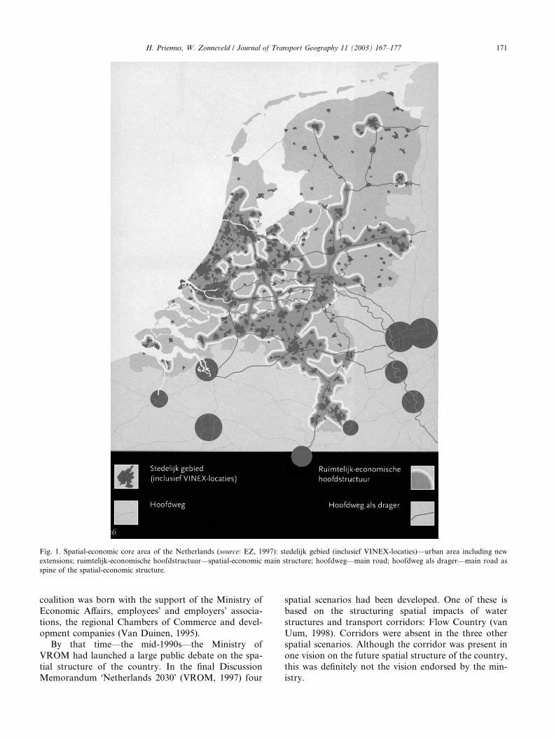
Fig. 1. Spatial-economic core area of the Netherlands (source: EZ, 1997): stedelijk gebied (inclusief VINEX-locaties)––urban area including new
extensions; ruimtelijk-economische hoofdstructuur––spatial-economic main structure; hoofdweg––main road; hoofdweg als drager––main road as
spine of the spatial-economic structure.
H. Priemus, W. Zonneveld / Journal of Transport Geography 11 (2003) 167–177 171
coalition was born with the support of the Ministry of
Economic Affairs, employees� and employers� associa-tions, the regional Chambers of Commerce and devel-
opment companies (Van Duinen, 1995).By that time––the mid-1990s––the Ministry of
VROM had launched a large public debate on the spa-
tial structure of the country. In the final Discussion
Memorandum �Netherlands 2030� (VROM, 1997) four
spatial scenarios had been developed. One of these is
based on the structuring spatial impacts of water
structures and transport corridors: Flow Country (van
Uum, 1998). Corridors were absent in the three otherspatial scenarios. Although the corridor was present in
one vision on the future spatial structure of the country,
this was definitely not the vision endorsed by the min-
istry.
1 Policy preparation in the Netherlands follows somewhat corpo-
ratist paths (see Hajer and Zonneveld, 2000).
172 H. Priemus, W. Zonneveld / Journal of Transport Geography 11 (2003) 167–177
Shortly afterwards, the government started thepreparation of a new (Fifth) policy memorandum on
spatial planning (on average about every ten years such
a memorandum is produced, the first one published as
early as 1960). The Starting Memorandum on Spatial
Planning was published in the beginning of 1999 as a
foretaste of the Fifth Policy Document on Spatial
Planning. By no means the least important aim of this
document was to bridge the gap between the Ministry ofHousing, Spatial Planning and the Environment and the
other departments dealing with the spatial-economic
structure of the country: Economic Affairs; Agriculture,
Nature Management and Fisheries; and Transport,
Public Works and Water Management (Priemus, 1999).
The Starting Memorandum was endorsed by the min-
isters of the four departments listed above and can thus
be perceived as a cabinet paper. The then minister ofspatial planning declared in an interview (Cate, 1999)
that: ‘‘Corridors are not my idea. My ambitions go
further’’. Nevertheless he seemed to identify the corridor
as an empirical phenomenon in the Starting Memoran-
dum on Spatial Planning, according to the following
passage (VROM, 1999, pp. 39–41): ‘‘The dynamics of
the city are often stronger along the urban arterial roads
and in the large centres at the edge of an urban areathan in the inner cities. These dynamics tend to move
along these arterial roads and transport axes, mostly
because good accessibility is essential for maintain-
ing the dynamics. In spatial terms this takes place near
the large economic centres and along the transport
axes which provide the connections to the European
networks, not only in the Randstad but also in the re-
gions that lie between the Randstad, the Ruhr and theBrussels–Antwerp–Ghent region. As a result of this the
business activity in parts of Gelderland, North Brabant
and Limburg acquires a stronger international profile.
The companies grow there the most quickly, so that the
need for extra space for work but also for other urban
functions is sharply felt.’’ (translation HP/WZ).
Relevant to this was a plea by the official government
advisory council on spatial planning, the VROM-Raad(1999), for a change from unplanned corridor formation
to planned corridor development. The Starting Memo-
randum seems to introduce the corridor as a planning
concept as well. According to the Starting Memo-
randum, by adapting the space within corridors to the
desired differentiation in residential and working envi-
ronments, the necessary dynamics can acquire form and
substance and the pressure on green space outside canbe minimised. The argument runs as follows: one should
promote selective and bundled urbanisation where eco-
nomic opportunities occur and have green spaces near
areas where urbanisation takes place. Erosion of sup-
port for the existing cities must be avoided, not only
from an economic point of view, but also in terms
of society. What is required is a limited number of
well-situated corridors. Otherwise there would be athreat to the vitality of the cities and the green spaces
between corridors and cities. Corridors are sustained by
bundles of highways, rail and where possible water and
pipe connections linked together through multimodal
transfer points. A limited number of nodes on these
connections would become profiled as top national and
international locations. These would be the existing
cities and a few newly identified transfer points noted fortheir good accessibility and available space. Nodes and
corridors belong to each other. Improvement of �green�functions is needed both in and around the corridors.
Similarly, space should be created at nodes for a broad
range of residential and work environments, inter-
spersed with green areas. This arrangement would lead
to more variety, while at the same time maintaining
open natural areas and water for recreation and for useas buffers between the cities within and between the
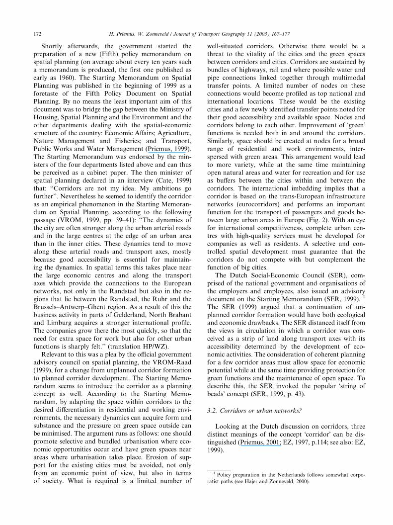
corridors. The international imbedding implies that a
corridor is based on the trans-European infrastructure
networks (eurocorridors) and performs an important
function for the transport of passengers and goods be-
tween large urban areas in Europe (Fig. 2). With an eye
for international competitiveness, complete urban cen-
tres with high-quality services must be developed forcompanies as well as residents. A selective and con-
trolled spatial development must guarantee that the
corridors do not compete with but complement the
function of big cities.
The Dutch Social-Economic Council (SER), com-
prised of the national government and organisations of
the employers and employees, also issued an advisory
document on the Starting Memorandum (SER, 1999). 1
The SER (1999) argued that a continuation of un-
planned corridor formation would have both ecological
and economic drawbacks. The SER distanced itself from
the views in circulation in which a corridor was con-
ceived as a strip of land along transport axes with its
accessibility determined by the development of eco-
nomic activities. The consideration of coherent planning
for a few corridor areas must allow space for economicpotential while at the same time providing protection for
green functions and the maintenance of open space. To
describe this, the SER invoked the popular �string of
beads� concept (SER, 1999, p. 43).
3.2. Corridors or urban networks?
Looking at the Dutch discussion on corridors, three
distinct meanings of the concept �corridor� can be dis-
tinguished (Priemus, 2001; EZ, 1997, p.114; see also: EZ,
1999).
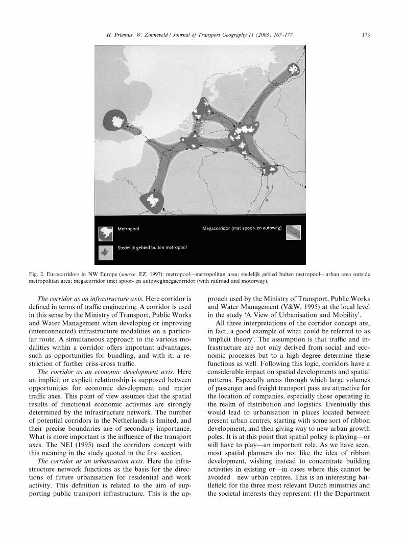
Fig. 2. Eurocorridors in NW Europe (source: EZ, 1997): metropool––metropolitan area; stedelijk gebied buiten metropool––urban area outside
metropolitan area; megacorridor (met spoor- en autoweg)megacorridor (with railroad and motorway).
H. Priemus, W. Zonneveld / Journal of Transport Geography 11 (2003) 167–177 173
The corridor as an infrastructure axis. Here corridor is
defined in terms of traffic engineering. A corridor is used
in this sense by the Ministry of Transport, Public Works
and Water Management when developing or improving
(interconnected) infrastructure modalities on a particu-
lar route. A simultaneous approach to the various mo-
dalities within a corridor offers important advantages,such as opportunities for bundling, and with it, a re-
striction of further criss-cross traffic.
The corridor as an economic development axis. Here
an implicit or explicit relationship is supposed between
opportunities for economic development and major
traffic axes. This point of view assumes that the spatial
results of functional economic activities are strongly
determined by the infrastructure network. The numberof potential corridors in the Netherlands is limited, and
their precise boundaries are of secondary importance.
What is more important is the influence of the transport
axes. The NEI (1995) used the corridors concept with
this meaning in the study quoted in the first section.
The corridor as an urbanisation axis. Here the infra-
structure network functions as the basis for the direc-
tions of future urbanisation for residential and workactivity. This definition is related to the aim of sup-
porting public transport infrastructure. This is the ap-
proach used by the Ministry of Transport, Public Works
and Water Management (V&W, 1995) at the local level
in the study �A View of Urbanisation and Mobility�.All three interpretations of the corridor concept are,
in fact, a good example of what could be referred to as
�implicit theory�. The assumption is that traffic and in-
frastructure are not only derived from social and eco-nomic processes but to a high degree determine these
functions as well. Following this logic, corridors have a
considerable impact on spatial developments and spatial
patterns. Especially areas through which large volumes
of passenger and freight transport pass are attractive for
the location of companies, especially those operating in
the realm of distribution and logistics. Eventually this
would lead to urbanisation in places located betweenpresent urban centres, starting with some sort of ribbon
development, and then giving way to new urban growth
poles. It is at this point that spatial policy is playing––or
will have to play––an important role. As we have seen,
most spatial planners do not like the idea of ribbon
development, wishing instead to concentrate building
activities in existing or––in cases where this cannot be
avoided––new urban centres. This is an interesting bat-tlefield for the three most relevant Dutch ministries and
the societal interests they represent: (1) the Department
174 H. Priemus, W. Zonneveld / Journal of Transport Geography 11 (2003) 167–177
of Transport which, almost by nature, mainly looks atthe capacity of infrastructure networks and a smooth
circulation of traffic flows; (2) the ministry of Economic
Affairs prioritising an abundant supply of space for
economic development at attractive locations and––for
this reason––embracing the (mega)corridor concept; (3)
the ministry responsible for spatial planning, striving for
a neat, orderly and well-contained urbanisation of so-
ciety, which does not disrupt green belts, scenic areasand nature reserves (and therefore rejecting all corridor
concepts).
This whole discussion represents a tremendous task
for spatial planning: how can it combine the endogenous
qualities and characteristics of areas and zones sur-
rounding cities with the transportation functions and
potentials of railway stations, airports and access points
to the motorway system? (see Bertolini and Spit, 1998).So far Dutch spatial planning strived to achieve con-
tained urbanisation, and well-defined compact cities.
Looking at the spatial distribution of cities, towns and
villages, their functional relationships, their growing size
and intertwining of labour and housing markets and,
finally, the dense network of infrastructure it seems
logical that spatial planning accepts the reality of net-
work cities and urban networks even when the presentadministrative organisation is not at all equipped to
cope with the emerging reality.
The challenge seems to have been taken up by the
national government. The main planning concept in the
Fifth Policy Document on Spatial Planning (VROM,
2001) has become that of the �urban network�. Urban
networks are economic–geographic zones that, in spatial
terms, take on the form of a network of compact cities.Not every compact city needs to strive separately for
completeness of functions and services, because this
completeness can be reached at the level of a network.
Urban networks require the fulfilment of two condi-
tions. First, cities within an urban network must not
compete with each other in spatial terms; they must
collaborate about where best to accommodate various
functions. Second, urban areas within urban networksneed to be well connected with each other via integrated
systems of public transport.
At first sight, the concept of urban networks fits very
well with the rise of �network society� and the network
economy in which economic and social relationships
become more open and horizontal. Urban networks
have replaced corridors as the spatial planning concept
in the Fifth Spatial Planning Memorandum. Neverthe-less, the question remains whether the empirically ob-
servable spatial phenomenon of corridors can still be
denied or ignored. And the question also remains how
the spatial organisation of corridors should be mapped
out. A Dutch parliamentary workgroup set up for
evaluating national spatial planning policy seriously
regrets that the Dutch debate on corridors was com-
pletely dominated by the issue of urban form. The as-sociation with ribbon development had made the mere
mention of the corridor concept taboo, while the con-
cept of eurocorridor highlights the necessity for proper
coordination of the various policy domains. Here the
workgroup pointed to the (final) ESDP (Parlementaire
Werkgroep Vijfde Nota Ruimtelijke Ordening, 2000, p.
277 ff.) As we have seen, in the �Starting Memorandum�the government seemed willing to concede that corridordevelopment is not the same as ribbon development but,
in so doing, it still only paid attention to the question of
urban form. Thus the criticism of the parliamentary
workgroup is valid. It is also obvious that the European
dimension is entirely beyond the horizon. Also missing
is the point brought forward by the ESDP that euro-
corridors are basically large bundles of infrastructure
crossing European space and exerting influence on Eu-ropean patterns of urbanisation and economic devel-
opment (CEC, 1999, pp. 70–71).
In this special issue, this tension between transport
functions, economic functions and spatial functions will
be raised again and again. Naturally, it is the task of
politicians and officials to reconcile these functions. In
this way, the growing interest in both scholarly as well as
political circles for polynuclear urban regions, networkcities and urban networks is particularly relevant. Ur-
banisation is thus viewed at a higher (regional) level
of scale in a manner that takes into account the acces-
sibility of urban cores for individual and public trans-
port, the variation in residential preferences of
households and the differentiated location preferences of
businesses.
4. Corridor challenges
When we observe the development of traffic infra-structure and the dynamics of megacorridors between
urban areas, we are confronted with a number of specific
challenges.
(1) How should long distance and short distance traffic
be regulated? More and more, the solution to this
question is being sought in disentangling the infra-
structure of these two traffic types. For example,
one can levy fees for long-distance traffic (e.g. toll
roads, road pricing), and for short-distance traffic
during parts of the day with high congestion. In gen-eral, this concerns an optimalisation of the traffic in-
frastructure.
(2) How should the interconnectivity and interopera-
tionability of networks be promoted? This issue re-
quires a reasoned and hierarchical design of
networks and infrastructure with multimodal nodes
for both freight (terminals) and passenger transport
(stations, transfer stations).
Fig. 3. The seven most important megacorridors in North West Eu-
ropa: (1) Randstad–Flemish Diamond; (2) Randstad–RheinRuhr; (3)
RheinRuhr–Flemish Diamond; (4) Flemish Diamond–Lille; (5) Lille–
Paris; (6) Lille–London; (7) London–West Midlands.
H. Priemus, W. Zonneveld / Journal of Transport Geography 11 (2003) 167–177 175
(3) How can synergy between urban patterns and trafficinfrastructure networks be increased? This question
is related to the accessibility of housing areas and
business parks, the multimodality of nodes and the
relationship between urban areas and green and
water structures.
(4) How can one prevent corridor development from
taking place at the expense of existing urban centres?
How can one prevent infrastructure networks fromfragmenting the open countryside and damaging
natural areas? How can the spatial quality of land-
scapes and the biodiversity and ecological signifi-
cance of natural areas be guaranteed with the
development of corridors? These issues will require
gaining further insight into the location and logic
of green–blue networks (we add the dimension of
�blue� because of the increasing relevance of watersystems for spatial planning), and prioritising these
as much as possible over traffic network routes.
Where conflicts arise, underground infrastructure
or stacking (e.g. eco-flyovers) may offer a way out.
(5) Corridors situated between polynuclear urban re-
gions usually cross municipal borders, regional bor-
ders and even national borders. This necessitates the
coproduction of policy between municipalities, re-gional authorities and national governments, and
also between different sectors: spatial planning,
housing, economic affairs, agriculture, environment
and transportation. Particularly differences in regu-
lation and policy practices between nations must
be overcome. Successful examples of multi-level
governance, policy coproduction and multi-actor
systems can offer guidance in this regard.
5. This issue
This issue of the Journal of Transport Geography is
informed by a large research project called CORRI-
DESIGN. This project investigated the development of
megacorridors in north-west Europe. Seven megacorri-
dors were identified as the starting point of the analyses
(see Fig. 3): (1) the Randstad–Flemish Diamond corri-
dor; (2) the Randstad–RheinRuhr corridor; (3) the
RheinRuhr–Flemish Diamond corridor; (4) the FlemishDiamond–Lille corridor; (5) the Lille–Paris corridor; (6)
the Lille–London corridor; (7) the London–West Mid-
lands corridor. CORRIDESIGN started from the ob-
servation that regional economies are entwined on a
European scale. CORRIDESIGN examined whether, to
what extent and how this process towards a network
society is spatially linked with the development of cross-
border megacorridors or bundles of infrastructures be-tween the large urban regions in north-west Europe.
This emphasis on the possible development of cross-
border megacorridors implied a focus of CORRIDE-
SIGN on transnationality. Important questions in
CORRIDESIGN included: which types of corridor de-
velopment should be stimulated, slowed down or un-done?; where should corridors be developed, and why
there?; should the growing spatial coherence within
megacorridors be followed by institutional coherence?
if so, which public or private parties should be involved?
CORRIDESIGN was a joint project of the OTB
Research Institute for Housing, Urban and Mobility
Studies, Delft University of Technology (Lead Partner);
The Bartlett School of Planning, University CollegeLondon; School of Planning and Housing, University of
Central England, Birmingham; Department of Social
Sciences Administration, London School of Economics;
Institute of Urban and Regional Planning, Catholic
University of Leuven; Institute for Traffic Planning and
Design, Essen University; and the Institut F�eed�eeratif deRecherche sur les Economies et les Soci�eet�ees Industrielles(IFRESI), Lille (with the collaboration of Territories,Sites & Cit�ees). The project was co-financed by the Eu-
ropean Regional Development Fund under the IN-
TERREG IIC Programme, a European Community
Initiative concerning Transnational Cooperation on
Spatial Planning.
The contribution by Chapman, Pratt, Larkham and
Dickins on the London–West Midlands corridor clearly
illustrates how difficult it is to arrive at improved policyintegration when so many different opinions exist about
what a corridor exactly entails. Nevertheless the authors
also show that there is a great deal of consensus about
spatial developments within a corridor. Irrespective of
their background, stakeholders within the London–
West Midlands corridor rejected any sort of linear urban
development but instead embraced a form of concen-
tration. For lack of a better term, this is also referred toas �beads on string� development.

176 H. Priemus, W. Zonneveld / Journal of Transport Geography 11 (2003) 167–177
Sch€oonharting, Schmidt, Frank and Bremers concen-trate primarily on what consequences the intersection of
various large European corridors will have on a large
urban area such as RheinRuhr. The most urgent task,
namely achieving a fundamental improvement of the
constituent relations between various infrastructure
networks, is difficult to bring about without having a
minimum level of administrative integration. Rhein-
Ruhr is just at the beginning of what could be called acapacity building phase, although a few important new
initiatives are also underway. These authors also make it
clear that there is no support whatsoever in the urban
region to understand corridor development as a con-
vergence of urban areas and business locations.
The analysis offered by Romein, Trip and De Vries
orients itself primarily to the area between the polynu-
clear urban regions of the Randstad and the FlemishDiamond. This �in between area� is an important conduit
for large-scale infrastructure binding the two urban
networks and the mainports within them. The authors
show that the decisions taken regarding infrastructure
(e.g. new connections, upgrading of existing ones), is still
too much the exclusive domain of national governments
and policy sectors. They argue for new kinds of multi-
level governance.Albrechts and Coppens take a closer look at the
conflicts between megacorridor development and the
area-specific qualities within important nodes. Their
case study is the new High Speed Train terminal Brus-
sels South. Inspired by concepts such as �space of flows�and �space of places�, each of which follows its own lo-
gic, the authors unpack the events that have transpired
in order to transform this station area into what it isnow, not only as a HST terminal but also as a new node
for economic activity. They painstakingly examine the
mechanisms influencing transport companies and land-
owners. As a result, they arrive at a number of funda-
mental recommendations for policy practice in which
the concept of subsidiarity figures prominently.
Next, De Vries and Priemus examine in detail what
the main conclusions appear to be in the previous fourcontributions: corridor development in particular de-
mands an improvement of the governance structure with
respect to infrastructure, urbanisation and economic
development. They argue that corridor development
clearly requires an improvement in the coordination
between various policy areas: (1) an improvement in the
coordination between different policy sectors and seg-
ments of society; (2) an improvement in cooperationbetween public and private organisations; (3) improve-
ment in coordination at the cross-border level because
corridors do in fact cross-borders; (4) and finally an
improvement in the coordination between central and
local governments.
In summary, the various papers of this special issue
demonstrate––including this introduction––that (euro
or mega) corridors should not be conceived as an entityoccupying physical space. Although corridors originate
with the large-scale bundling of infrastructure, they
certainly do not constitute a new urban field. Corridors
comprise the arena within which an attempt must be
made to arrive at an integration of a multitude of social
interests. In this sense, a corridor is neither a sectoral
nor a spatial concept, but rather the indication of a
challenge: that of improving the governance of infra-structure and area development.
Acknowledgements
The background of this paper and this special issue
is informed by research conducted within the frame-
work of the CORRIDESIGN project co-financed by
the European Community through the INTERREG
IIC programme for the North-West Metropolitan Area
(NWMA). The contribution of Wil Zonneveld is part of
the NWO-ESR programme �Spatial Developments and
Policies in Polynuclear Urban Configurations inNorthwest Europe� which was financed by NWO, BNG
(Dutch Municipalities Bank) and the municipalities of
Amsterdam, Rotterdam, The Hague and Utrecht.
References
Bertolini, L., Spit, T., 1998. Cities on Rails: The Redevelopment of
Railway Station Areas. Spon Press, London.
British Presidency, 1998. European Spatial Development Perspective
(ESDP): Complete draft; Meeting of ministers responsible for
spatial planning of the Member States of the European Union.
Glasgow, 8 June 1998.
Cate, F.T., 1999. Minister Pronk bewaart ruimtelijke visie voor Vijfde
Nota: �Corridors zijn niet mijn idee. Mijn ambitie gaat verder�(Minister Pronk maintains a spatial vision for the Fifth Policy
Document: �Corridors are not my idea. My ambition stretches
further�). Binnenlands Bestuur, 19 February, pp. 18–19.
CEC, Commission of the European Communities, 1994. Europe
2000+; Cooperation for European territorial development. Office
for the Official Publications of the European Communities,
Luxembourg.
CEC, Commission of the European Communities; Directorate General
XVI, 1996. The prospective development of the central and capital
cities and regions, Regional Development Studies No. 22. Office for
Official Publications of the European Communities, Luxembourg.
CEC, Commission of the European Communities, 1997. European
Spatial Development Perspective: First Official Draft; Presented at
the Informal Meeting of Ministers Responsible for Spatial Plan-
ning of the Member States of the European Union, Noordwijk,
June 1997. Office for Official Publications of the European
Communities, Luxembourg.
CEC, Commission of the European Communities, 1999. European
Spatial Development Perspective. Towards Balanced and Sustain-
able Development of the Territory of the European Union. Agreed
at the Informal Council of Ministers responsible for Spatial
Planning in Potsdam, May 1999. Office for Official Publications of
the European Community, Luxembourg.
H. Priemus, W. Zonneveld / Journal of Transport Geography 11 (2003) 167–177 177
Duinen, L. van, 1995. Eindrapport NUBS-corridor (Final report
NUBS-corridor); Studierapport. Provincie Noord-Brabant, Den
Bosch.
EZ, Ministerie van Economische Zaken (Ministry of Economic
Affairs), 1997. Ruimte voor Economische Dynamiek (Space for
Economic Dynamics), Een verkennende analyse van ruimtelijk-
economische ontwikkelingen tot 2020. EZ, The Hague.
EZ, Ministerie van Economische Zaken (Ministry of Economic
Affairs), 1999. Nota Ruimtelijk-Economisch Beleid (Memorandum
Spatial Economic Policy). EZ, The Hague.
Fullerton, B., Knowles, R.D., 1991. Scandinavia. Paul Chapman
Publishing, London.
Graham, S., Marvin, S., 2001. Splintering urbanism: networked
infrastructures, technological mobilities and the urban condition.
Routledge, London.
Hajer, M.A., 2000. Transnational networks as transnational policy
discourse: some observations on the politics of spatial development
in Europe. In: Salet, W., Faludi, A. (Eds.), The Revival of Strategic
Spatial Planning. Royal Netherlands Academy of Arts and
Sciences, Amsterdam, pp. 135–142.
Hajer, M.A., Zonneveld, W., 2000. Spatial planning in the network
society––rethinking the principles of planning in the Netherlands.
European Planning Studies 8 (3), 337–355.
Hall, P., 1996. Cities of Tomorrow: An Intellectual History of Urban
Planning and Design in the Twentieth Century, Updated ed.
Blackwell Publishers, Oxford.
Hohenberg, P.M., Hollen Lees, L., 1995. The Making of Urban
Europe 1000–1994. Harvard University Press, Cambridge.
Houthaeve, R., 1993. Corpulente corridors: over de ruimte en
mythologie van Marc van Naelten (Corpulent corridors: about
the space and mythology of Marc Van Naelten). Planologisch
Nieuws 13 (1), 54–61.
Lemberg, K., 1997. Danish Urban Planning: Urban Developments in
the Copenhagen Region. In: Bosma, K., Hellinga, H. (Eds.),
Mastering the City; North-European City Planning 1900–2000.
NAI Publishers/EFL Publications, Rotterdam/The Hague, pp. 20–
31.
Mumford, L., 1937. What Is a City. Architectural Record LXXXII.
Reprinted in: LeGates, R. (Ed.), 1996. The City Reader. Routl-
edge, New York, pp. 183–188.
NEI, Nederlands Economisch Instituut (Netherlands Economic Insti-
tute), 1995. Ontwikkelingsstrategie€een voor Nederlandse regio�s en
steden in internationaal perspectief (Development strategies for
Dutch regions and cities in international perspectives). VNO-
NCW, The Hague.
Parlementaire Werkgroep Vijfde Nota Ruimtelijke Ordening (Parlia-
mentary Working Party Fifth Policy Document on Spatial Plan-
ning), 2000. Notie van ruimte. Op weg naar de Vijfde Nota
ruimtelijke ordening (Notion of space: On the road to the Fifth
Policy Document on Spatial Planning), Tweede Kamer 27 210, No.
1–2. Sdu Publishers, The Hague.
Priemus, H., 1999. Four ministries, four spatial planning perspectives?
dutch evidence on the persistent problem of horizontal coordina-
tion. European Planning Studies 7 (5), 563–585.
Priemus, H., 2001. Corridors in the Netherlands: apple of discord in
spatial planning. TESG, Tijdschrift voor Economische en Sociale
Geografie 92 (1), 100–107.
SER, Sociaal-Economische Raad (Social-Economic Council), 1999.
Advies Startnota ruimtelijke ordening en Perspectievennota verk-
eer en vervoer (Advice on Starting Memorandum Spatial Planning
and Perspectives Policy Document Traffic and Transport), Advies
99/06. SER, The Hague.
Uum, E. van, 1998. Spatial planning scenarios for the Netherlands,
TESG. Tijdschrift voor Economische en Sociale Geografie 89 (1),
106–116.
Van Naelten, M., 1995. Het corridor-model; Een planologisch �verhaal�met en over cijfers, feiten en betwistingen (The corridor model: een
planning story with and about figures, facts and disputes).
Planologisch Nieuws 13 (1), 30–50.
VROM, Ministerie van Volkshuisvesting, Ruimtelijke Ordening en
Milieubeheer, 1997, Nederland 2030––Discussienota (Netherlands
2030––Discussion Memorandum). VROM, The Hague.
VROM, Ministerie van Volkshuisvesting, Ruimtelijke Ordening en
Milieubeheer (Ministry of Housing, Spatial Planning and the
Environment), 2001. Ruimte maken, ruimte delen, Vijfde Nota
Ruimtelijke Ordening deel 1: Ontwerp (Fifth Policy Document on
Spatial Planning part 1: draft). VROM, The Hague.
VROM, Ministerie van Volkshuisvesting, Ruimtelijke Ordening en
Milieubeheer, Ministerie van Economische Zaken, Ministerie van
Landbouw, Natuurbeheer en Visserij en Ministerie van Verkeer en
Waterstaat (Ministry of Housing, Spatial Planning and the
Environment, Ministry of Economic Affairs, Ministry of Agricul-
ture, Ministry of Transport, Public Works and Watermanage-
ment), 1999. Startnota Ruimtelijke Ordening (Starting
Memorandum Spatial Planning). Sdu Publishers, The Hague.
V&W, Ministerie van Verkeer en Waterstaat (Ministry of Transport,
Public Works and Water Management), 1995. Visie op verstedel-
ijking en mobiliteit (A View of Urbanisation and Mobility). V&W,
The Hague.
VROM-Raad, 1999. Corridors in balans: van ongeplande corri-
dorvorming naar geplande corridorontwikkeling (Corridors
in balance: from unplanned corridor formation to planned
corridor development), Advies 011. VROM-Raad, The
Hague.
Whebell, C.F.J., 1969. Corridors: a theory of urban systems. Annals
of the Association of American Geographers 59 (1), 1–26.