Large Scarps and Massive Slide on the Briatico–Bivona Shelf, Calabria, Italy: Potential Link with...
13
Large Scarps and Massive Slide on the Briatico–Bivona Shelf, Calabria, Italy: Potential Link with the Destructive September 1905 Earthquake Jean-Daniel Stanley † , Maria Pia Bernasconi ‡ *, and Graham A.J. Nickerson § † Geoarchaeology Program and Department of Paleobiology E-205 NMNH Smithsonian Institution Washington, DC 20013, U.S.A. ‡ Dipartimento di Biologia Ecologia e Scienze della Terra (DiBEST) Cubo 15B, Universit` a della Calabria 87036—Rende, Cosenza, Italy § Highland Geo Solutions 45 Highland Heights Taymouth NB E6C1Y2, Canada ABSTRACT Stanley, J.-D.; Bernasconi, M.P., and Nickerson G.A.J., 2014. Large scarps and massive slide on the Briatico–Bivona shelf, Calabria, Italy: potential link with the destructive September 1905 earthquake. Journal of Coastal Research, 30(2), 215–227. Coconut Creek (Florida), ISSN 0749-0208. A multibeam sonar (MBS) survey of the northern Capo Vaticano shelf between the towns of Briatico and Bivona, Calabria, Italy, has revealed a markedly broken margin offset by three large scarps: the upper scarp (S1) at approximate depths of 16–22 m, the middle scarp (S2) at ~36–58 m, and the deeper scarp (S3) at ~88–101 m. The configuration of S1 shows high relief to 33 m and a slope to 598, which suggests a fault or tectonic–gravitative origin. Substantial volumes of sediment, mostly sand, are being rapidly transferred from the inner shelf toward and across the upper shelf break, and one could expect a smoothing and burial of the upper scarp, but 10 MBS profiles show the sharp, angular shape of that feature. Some of the mass gravitative deposits just below some headwall scarps that extend to the shelf-slope that break NE of Briatico also reveal very recent origins. Additionally, a massive slide block north of Bivona, ~350–400 m in length, appears to have detached from the inner shelf and shifted onto the middle shelf. It is proposed that several of these seafloor features may, in some manner, be associated with the powerful and destructive September 1905 earthquake that affected a large sector of Calabria. Five potential epicenters on the SW margin of Calabria have previously been proposed for that event, and this MBS study area is in proximity to one of those. It is recommended that two localities in the survey area, one NE of Briatico and the other north of Bivona, be selected as test zones for further geological and geophysical analyses. ADDITIONAL INDEX WORDS: Calabrian Arc, Capo Vaticano peninsula, epicenters, faults, gravity flows, land uplift, sand waves, sediment displacement, seismotectonics, shelf breaks, Tyrrhenian Sea. INTRODUCTION This investigation focuses on high-relief, step-like scarps and associated seafloor features discovered on the continen- tal shelf that abuts the northern Capo Vaticano peninsula on the SW Tyrrhenian margin of Calabria, Italy. The study area, recently examined by ship-mounted multibeam sonar (MBS), lies less than 1 km seaward of the shoreline, between the towns of Briatico to the west and Vibo Marina to the east (Figure 1). The original purpose of the cruise was to gather detailed information of the seafloor surface to identify possible underwater archaeological features on the shelf in the vicinity of two large, submerged Greek breakwaters near the mouth of the Trainiti River (Bernasconi and Stanley, 2013; Jannelli, Lena and Givigliano, 1992). Although obser- vations made during this research cruise did not reveal new archaeological structures, the MBS survey unexpectedly recorded very large, morphological features that had not been previously described on that shelf. Along most of the inner shelf, at a depth of about 20 m, the bottom surface is sharply broken by a well-defined scarp of high relief. Two other large scarps that had not been previously reported were also mapped at middle and outer shelf depths in the western part of the survey area off Briatico. All three shelf breaks are oriented near-parallel to the present coastline. The presence of these distinct, step-like features is of interest in light of seismotectonic observations made in the region: the high hills backing the coastline in the study area have been uplifted at very rapid rates (Antonioli et al., 2009; Bianca et al., 2011; Tortorici et al., 2003), the terrains on land and offshore have been affected by active faults (Cucci and Tertulliani, 2006; Tortorici et al., 2003), and this sector, positioned in the Calabrian Arc, is one of the most structurally active in Italy, affected annually by dozens of earthquakes, most of low intensity (magnitude [M] 4) (Boschi et al., 1995; Cucci and Tertulliani, 2006; Guerra et al., 2006; Tiberti, Fracassi, and Valensise, 2006). This region has attracted the attention of numerous geologists and geophys- icists during the past century because, at least in part, of the powerful (M 6.8 6 0.2) and highly destructive earthquake that occurred on 8 September 1905 (Cucci and Tertulliani, 2006, 2010). The event resulted in more than 500 deaths, 327 very seriously damaged villages, and the loss of more than 14,000 houses in this sector of Calabria (Guerra and Savaglio, 2006; Pugliese, 1996). The 1905 earthquake and the tsunami associated with it (Piatanesi and Tinti, 2002; Tinti, 2006) resulted in an extensive body of scientific publications dating from 1906, just after the event (Rizzo, 1906), to the present (Loreto et al., DOI: 10.2112/JCOASTRES-D-13-00158.1 received and accepted in revision 10 August 2013; corrected proofs received 19 August 2013. Published Pre-print online 18 November 2013. *Corresponding author: [email protected] Ó Coastal Education & Research Foundation 2014 Journal of Coastal Research 30 2 215–227 Coconut Creek, Florida March 2014
Transcript of Large Scarps and Massive Slide on the Briatico–Bivona Shelf, Calabria, Italy: Potential Link with...
Large Scarps and Massive Slide on the Briatico–BivonaShelf, Calabria, Italy: Potential Link with the DestructiveSeptember 1905 Earthquake
Jean-Daniel Stanley†, Maria Pia Bernasconi‡*, and Graham A.J. Nickerson§
†Geoarchaeology Program andDepartment of Paleobiology E-205 NMNHSmithsonian InstitutionWashington, DC 20013, U.S.A.
‡Dipartimento di BiologiaEcologia e Scienze della Terra (DiBEST)Cubo 15B, Universita della Calabria87036—Rende, Cosenza, Italy
§Highland Geo Solutions45 Highland HeightsTaymouth NB E6C1Y2, Canada
ABSTRACT
Stanley, J.-D.; Bernasconi, M.P., and Nickerson G.A.J., 2014. Large scarps and massive slide on the Briatico–Bivonashelf, Calabria, Italy: potential link with the destructive September 1905 earthquake. Journal of Coastal Research, 30(2),215–227. Coconut Creek (Florida), ISSN 0749-0208.
A multibeam sonar (MBS) survey of the northern Capo Vaticano shelf between the towns of Briatico and Bivona, Calabria,Italy, has revealed a markedly broken margin offset by three large scarps: the upper scarp (S1) at approximate depths of16–22 m, the middle scarp (S2) at ~36–58 m, and the deeper scarp (S3) at ~88–101 m. The configuration of S1 shows highrelief to 33 m and a slope to 598, which suggests a fault or tectonic–gravitative origin. Substantial volumes of sediment,mostly sand, are being rapidly transferred from the inner shelf toward and across the upper shelf break, and one couldexpect a smoothing and burial of the upper scarp, but 10 MBS profiles show the sharp, angular shape of that feature. Someof the mass gravitative deposits just below some headwall scarps that extend to the shelf-slope that break NE of Briaticoalso reveal very recent origins. Additionally, a massive slide block north of Bivona, ~350–400 m in length, appears to havedetached from the inner shelf and shifted onto the middle shelf. It is proposed that several of these seafloor features may,in some manner, be associated with the powerful and destructive September 1905 earthquake that affected a large sectorof Calabria. Five potential epicenters on the SW margin of Calabria have previously been proposed for that event, and thisMBS study area is in proximity to one of those. It is recommended that two localities in the survey area, one NE of Briaticoand the other north of Bivona, be selected as test zones for further geological and geophysical analyses.
ADDITIONAL INDEX WORDS: Calabrian Arc, Capo Vaticano peninsula, epicenters, faults, gravity flows, land uplift,sand waves, sediment displacement, seismotectonics, shelf breaks, Tyrrhenian Sea.
INTRODUCTIONThis investigation focuses on high-relief, step-like scarps
and associated seafloor features discovered on the continen-
tal shelf that abuts the northern Capo Vaticano peninsula on
the SW Tyrrhenian margin of Calabria, Italy. The study area,
recently examined by ship-mounted multibeam sonar (MBS),
lies less than 1 km seaward of the shoreline, between the
towns of Briatico to the west and Vibo Marina to the east
(Figure 1). The original purpose of the cruise was to gather
detailed information of the seafloor surface to identify
possible underwater archaeological features on the shelf in
the vicinity of two large, submerged Greek breakwaters near
the mouth of the Trainiti River (Bernasconi and Stanley,
2013; Jannelli, Lena and Givigliano, 1992). Although obser-
vations made during this research cruise did not reveal new
archaeological structures, the MBS survey unexpectedly
recorded very large, morphological features that had not
been previously described on that shelf. Along most of the
inner shelf, at a depth of about 20 m, the bottom surface is
sharply broken by a well-defined scarp of high relief. Two
other large scarps that had not been previously reported were
also mapped at middle and outer shelf depths in the western
part of the survey area off Briatico. All three shelf breaks are
oriented near-parallel to the present coastline.
The presence of these distinct, step-like features is of
interest in light of seismotectonic observations made in the
region: the high hills backing the coastline in the study area
have been uplifted at very rapid rates (Antonioli et al., 2009;
Bianca et al., 2011; Tortorici et al., 2003), the terrains on land
and offshore have been affected by active faults (Cucci and
Tertulliani, 2006; Tortorici et al., 2003), and this sector,
positioned in the Calabrian Arc, is one of the most
structurally active in Italy, affected annually by dozens of
earthquakes, most of low intensity (magnitude [M] � 4)
(Boschi et al., 1995; Cucci and Tertulliani, 2006; Guerra et al.,
2006; Tiberti, Fracassi, and Valensise, 2006). This region has
attracted the attention of numerous geologists and geophys-
icists during the past century because, at least in part, of the
powerful (M � 6.8 6 0.2) and highly destructive earthquake
that occurred on 8 September 1905 (Cucci and Tertulliani,
2006, 2010). The event resulted in more than 500 deaths, 327
very seriously damaged villages, and the loss of more than
14,000 houses in this sector of Calabria (Guerra and
Savaglio, 2006; Pugliese, 1996).
The 1905 earthquake and the tsunami associated with it
(Piatanesi and Tinti, 2002; Tinti, 2006) resulted in an
extensive body of scientific publications dating from 1906,
just after the event (Rizzo, 1906), to the present (Loreto et al.,
DOI: 10.2112/JCOASTRES-D-13-00158.1 received and accepted inrevision 10 August 2013; corrected proofs received 19 August 2013.Published Pre-print online 18 November 2013.*Corresponding author: [email protected]� Coastal Education & Research Foundation 2014
Journal of Coastal Research 30 2 215–227 Coconut Creek, Florida March 2014
2012), all in agreement as to its high intensity. However, the
position of the earthquake epicenter and the seismogenetic
source continue to be active topics of discussion but have
remained without final resolution. The nature and scale of
new shelf morphobathymetric and sedimentological infor-
mation presented here warrant attention and may, perhaps,
provide some further assistance in detecting some effects in
the marine environment associated with that major event.
BACKGROUNDAttention is directed toward the shelf platform positioned
between the northern margin of the Capo Vaticano peninsula
and the adjoining slope that extends seaward to the southern
Gulf of Saint Eufemia in the Tyrrhenian Sea (Figure 1, left).
The study area is located in, and is part of, the Calabrian Arc,
the highly tectonically active region in southern Italy that
geologically and seismically records the effects of plate motion
and contact between North Africa and southern Europe in the
central Mediterranean (Basili et al., 2008; Milia et al., 2009;
Tansi et al., 2007). Nautical charts of the seafloor shelf and
slope in this region (CNR, 1985), most compiled with standard,
single-beam systems, have been insufficiently detailed to
clearly illustrate the bathymetric features discussed here.
Moreover, published offshore geological mapping in this region,
such as in the Gulf of Saint Eufemia (Loreto et al., 2012; Milia et
al., 2009), has provided valuable local seafloor morphological
data and subbottom stratigraphic and tectonic information in
deeper water settings, but most studies have not detailed the
shallower, MBS-surveyed, upper continental margin area
shown in Figure 1.
The references cited in the present study comprise mainly
recent publications on the geology, geophysics, and seismology
of the Tyrrhenian–Calabrian study area. They enable the
reader interested in obtaining an updated background access to
the locality of faults and earthquake epicenters documented on
land and at sea in the region around the survey area described
herein. For example, a number of studies in this region have
proposed different potential localities for the epicenter of the
1905 event. Among the five localities that have been proposed,
two are positioned on land: the original proposed by Rizzo
(1906) on the Lamezia Terme coastal plain to the NE, and one
in the hills in the vicinity of Vibo Valentia to the south of the
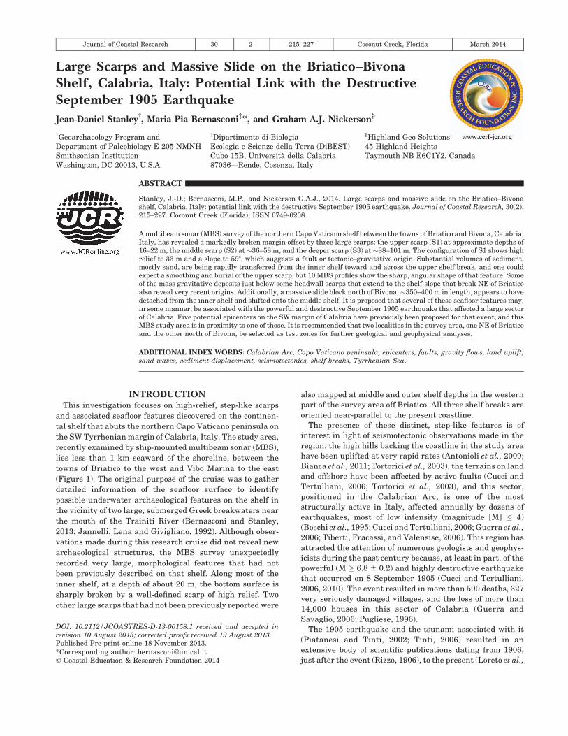
Figure 1. Left: Location map of the study area on the northern margin of Capo Vaticano peninsula, SW Calabria (C). Image source is from http://upload.
wikimedia.org/wikipedia/commons/4/49/Southern_Italy_topographic_map-blank.png. Also indicated are the Tyrrhenian Sea (TS), the Ionian Sea (IS), the Gulf of
Taranto (GT), and the regions surrounding C: Campania (CA), Basilicata (B), Puglia (P), and Sicily (S). Right: The MBS survey area, extending seaward between
the towns of Briatico and Vibo Marina. Circles with numbers correspond to rivers and/or torrents that discharge sediment onto inner shelf in the examined area.
1, Spadaro Fiumara; 2, Rizzuta Fiumara; 3, Trainiti River; 4, Sant’Anna River.
Journal of Coastal Research, Vol. 30, No. 2, 2014
216 Stanley, Bernasconi, and Nickerson
survey area (Boschi et al., 1995). The other three localities are
positioned offshore: in the central part of the Saint Eufemia
Gulf (Riuscetti and Schick, 1964), off the Capo Vaticano
peninsula near Briatico (Camassi and Stucchi, 1997), and one
at some distance directly west of Capo Vaticano (Michelini et
al., 2005). A review of the literature indicates that authors are
conscious of the seismological complexities and limitations in
selecting a definitive epicenter position for the 1905 event and
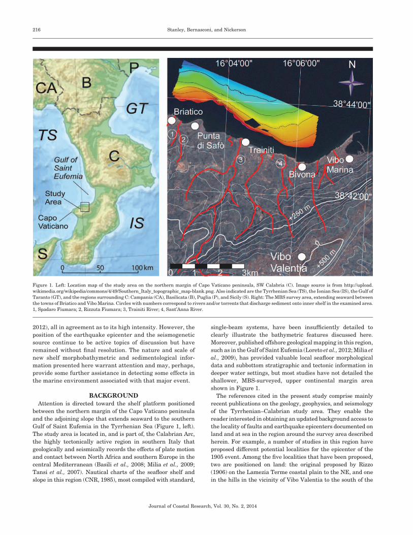
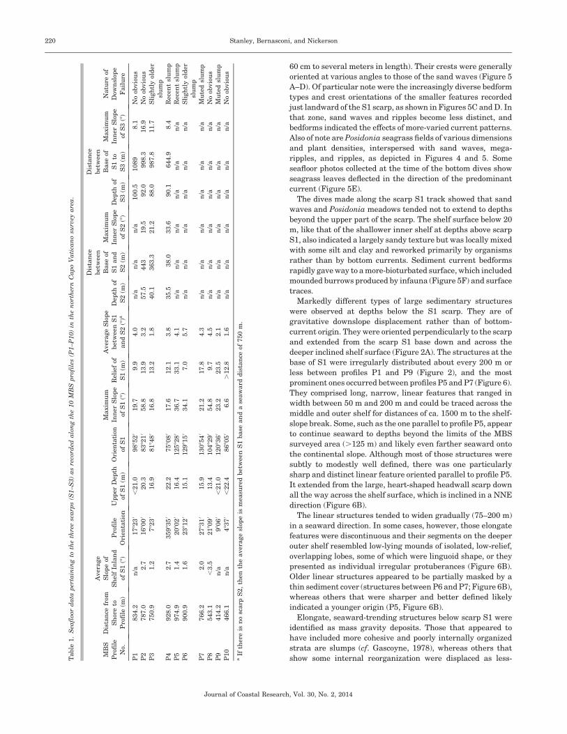
Figure 2. (A) MBS image of the surveyed area that shows distinct scarps and offsets discovered on the northern Capo Vaticano shelf. (B) Position in the survey
area of 10 near-parallel, seaward-trending profiles (P1–P10), which extend between~20 m and 120 m of depth, and of two cross-section profiles (P5a and P11) that
intersect two large seafloor features described in text. Also indicated are the three scarps (S1–S3).
Journal of Coastal Research, Vol. 30, No. 2, 2014
Large Scarps and Massive Slide on the Briatico-Bivona Shelf 217
recognize the need for further geophysical and geological
observations.
Of the five potential epicenter localities proposed, the one off
the Capo Vaticano peninsula near Briatico (Camassi and
Stucchi, 1997) is the closest to the survey sector discussed in
this article. It is estimated to be about 2000 m north of that
town and positioned within ~1000 m of the western margin of
our MBS survey area (Figure 2). This proposed Briatico
epicenter is also in proximity to the SW–NE-trending Capo
Vaticano fault that parallels the NE-oriented shore of the Capo
Vaticano peninsula toward Briatico, and then extends seaward
into the Gulf of Saint Eufemia (Anzidei et al., 2006).
The high hills that back the coastal plain are characterized
by rapid, average uplift rates, some to 1 to 2 mm/y since the
Pleistocene (Bianca et al., 2011), resulting from deep-seated to
shallower underlying, large-scale strike-slip faulting and from
more-surficial, extensional tectonics and normal faulting
(Basili et al., 2008). Moreover, geoarchaeological investigations
on land near the northern Capo Vaticano coast indicate
considerable changes in both environmental settings and in
shoreline positions since Greek times (Cucarzi, Iannelli, and
Rivolta, 1995; Jannelli, Lena, and Givigliano, 1992). Recent
studies show that coastal margin development in this region is
associated with motion of proximal terrains both on land and at
sea, and that evolution has continued to the present (Stanley
and Bernasconi, 2012a). Especially useful is the finding that,
midway between Bivona and Briatico, the two Greek break-
waters off Trainiti (Figure 2) have been submerged and
substantially tilted seaward, and that the shoreline in that
sector shifted landward and then readvanced seaward by
several hundred meters since Roman times (Bernasconi and
Stanley, 2013).
METHODOLOGYThe seafloor data acquired by the MBS system provide high-
quality, sharply defined three-dimensional (3-D) images that
can be viewed from different angles and perspectives and that
show details of bottom features as small as several centimeters.
The MBS database described and interpreted here was
collected in June 2011 aboard the RPM Nautical Foundation
research vessel, the Hercules.
Bathymetric mapping was obtained with a hull-mounted,
dual-head EM3002D MBS echo sounder from Kongsberg
Maritime division. The two heads are mounted at oblique
angles so as to provide increased coverage compared with a
single head system. Operationally, we have found that the most
effective configuration for the R/V Hercules is a sector of 658 for
each head with an overlap of 58 at nadir. The system emits a
total of 508 beams at a maximum rate of 40 pings/s, and it uses
multiple frequencies (293, 300, and 307 kHz). The advanced,
real-time processing power of the system allows adjacent
beams to be steered, so they span a specific angle or cover a
specific distance on the seafloor. The frequency determines the
vertical resolution, which was a constant 1 cm over the survey
area. Conversely, horizontal resolution depends on the distance
travelled from the transducer to the seafloor. Beams intersect-
ing the seabed at a normal angle, typically the inner beams
close to nadir, are at a higher resolution than are those striking
the seafloor at an oblique angle, such as the outer beams. Depth
also has a large effect on the ability of a multibeam to resolve
seabed features. Because our survey ranged from approxi-
mately 10 m to deeper than 100 m, the horizontal resolution
ranged anywhere from 20 cm to .10 m. The principles of
underwater acoustics can be found in Medwin and Clay (1998)
and Lurton (2002).
The raw sounding data collected by the Kongsberg system
was converted to depths with CARIS software. This process
takes the copious slant range measurements and converts
them to points with Cartesian coordinates and an assigned
depth value. Data from CARIS was exported to Fledermaus to
clean them, using the CUBE algorithm (Calder, 2003). CUBE
uses stochastic methods to analyze the accuracy of the ship’s
positioning and echo sounder to identify and eliminate random
noise from the sounding data. When multiple overlapping
survey lines are used, the most reliable measurements are
accepted and erroneous data are excluded. The filtered results
are then gridded using a weighted moving-average filter
(Fledermaus User’s Guide, 2011) to produce a 3-D surface
representing the bathymetry of the survey area.
The survey grid was loaded into Global Mapper geographic
information system (GIS) software and merged with various
other geospatial data sets, such as topography and remotely
sensed imagery, along with geomorphological and geological
structures mapped and published in other research publica-
tions. These various data sets were plotted in a single
compilation and used to interpret seafloor structures along
the coastline. Features apparent in the bathymetric data
between 10 m and 100 m and/or apparent in the imagery data
in areas too shallow (,10 m) for the survey vessel to navigate
were investigated. Profiling tools were used to generate
bathymetric profiles along the coast, which generally trend
perpendicular to the shoreline. These profiles were used to
graph depth vs. horizontal distance to enhance large bathy-
metric trends.
To supplement the MBS survey, two dives were made by
personnel of the Nucleo Sommozzatori of the Guardia di
Finanza of Vibo Valentia Marina in June 2012 to obtain
‘‘ground-truth’’ information along a seafloor track that closely
paralleled the upper-scarp margin. Dive depths on the inner
shelf covered the area between ~16 m and 20 m just landward
of the scarp to ~25–30 m below the upper-scarp break, and a
continuous record of the seafloor surface was made by video
camera.
OBSERVATIONSShelf Scarps and Offsets
The sector surveyed by MBS was about 6.5 km long,
approximately 1.6 km wide, and covered an area of ~10.4
km2 (Figure 2A), with seafloor data between depths of ~18 m
and~125 m obtained from ship track lines parallel to the coast.
Using that database, a series of 10 near-parallel, seaward-
trending profiles, numbered P1 to P10, from W to E, were
selected for detailed analysis (Figure 2B). The profiles were
oriented approximately perpendicular to the coast and ranged
in length from 1000 m (P4, P5) to 1500 m (P1, P2, P8, P9; Figure
3). The distances between those 10 profiles ranged from about
400 m to 1000 m. An eleventh profile (P11) was obtained at
midshelf depths between 50 m and 65 m to detail a large, high-
Journal of Coastal Research, Vol. 30, No. 2, 2014
218 Stanley, Bernasconi, and Nickerson
relief seafloor feature observed in the area between profiles P9
and P10 (Figure 2).
During the course of the survey, three shelf breaks or scarps
(S1–S3) were mapped in the MBS survey area, and the
following data were determined for each feature (Table 1):
maximum slope at the scarp, relief of the scarp, average slope of
the shelf between scarps, distance between scarps, and a
description of postdepositional downslope failure as observed
on the MBS profiles. Also noted on the inner shelf were the
distance from the shore to the landward position of the profile
line and the average slope of the shelf just landward of the first
(S1, or uppermost) scarp.
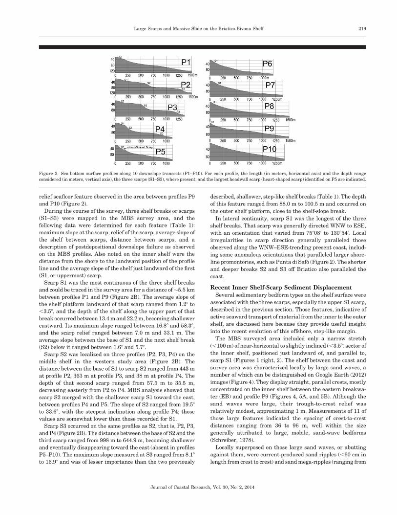
Scarp S1 was the most continuous of the three shelf breaks
and could be traced in the survey area for a distance of~5.5 km
between profiles P1 and P9 (Figure 2B). The average slope of
the shelf platform landward of that scarp ranged from 1.28 to
,3.58, and the depth of the shelf along the upper part of that
break occurred between 13.4 m and 22.2 m, becoming shallower
eastward. Its maximum slope ranged between 16.88 and 58.38,
and the scarp relief ranged between 7.0 m and 33.1 m. The
average slope between the base of S1 and the next shelf break
(S2) below it ranged between 1.68 and 5.78.
Scarp S2 was localized on three profiles (P2, P3, P4) on the
middle shelf in the western study area (Figure 2B). The
distance between the base of S1 to scarp S2 ranged from 443 m
at profile P2, 363 m at profile P3, and 38 m at profile P4. The
depth of that second scarp ranged from 57.5 m to 35.5 m,
decreasing easterly from P2 to P4. MBS analysis showed that
scarp S2 merged with the shallower scarp S1 toward the east,
between profiles P4 and P5. The slope of S2 ranged from 19.58
to 33.68, with the steepest inclination along profile P4; those
values are somewhat lower than those recorded for S1.
Scarp S3 occurred on the same profiles as S2, that is, P2, P3,
and P4 (Figure 2B). The distance between the base of S2 and the
third scarp ranged from 998 m to 644.9 m, becoming shallower
and eventually disappearing toward the east (absent in profiles
P5–P10). The maximum slope measured at S3 ranged from 8.18
to 16.98 and was of lesser importance than the two previously
described, shallower, step-like shelf breaks (Table 1). The depth
of this feature ranged from 88.0 m to 100.5 m and occurred on
the outer shelf platform, close to the shelf-slope break.
In lateral continuity, scarp S1 was the longest of the three
shelf breaks. That scarp was generally directed WNW to ESE,
with an orientation that varied from 758080 to 1308540. Local
irregularities in scarp direction generally paralleled those
observed along the WNW–ESE-trending present coast, includ-
ing some anomalous orientations that paralleled larger shore-
line promontories, such as Punta di Safo (Figure 2). The shorter
and deeper breaks S2 and S3 off Briatico also paralleled the
coast.
Recent Inner Shelf-Scarp Sediment DisplacementSeveral sedimentary bedform types on the shelf surface were
associated with the three scarps, especially the upper S1 scarp,
described in the previous section. Those features, indicative of
active seaward transport of material from the inner to the outer
shelf, are discussed here because they provide useful insight
into the recent evolution of this offshore, step-like margin.
The MBS surveyed area included only a narrow stretch
(,100 m) of near-horizontal to slightly inclined (,3.58) sector of
the inner shelf, positioned just landward of, and parallel to,
scarp S1 (Figures 1 right, 2). The shelf between the coast and
survey area was characterized locally by large sand waves, a
number of which can be distinguished on Google Earth (2012)
images (Figure 4). They display straight, parallel crests, mostly
concentrated on the inner shelf between the eastern breakwa-
ter (EB) and profile P9 (Figures 4, 5A, and 5B). Although the
sand waves were large, their trough-to-crest relief was
relatively modest, approximating 1 m. Measurements of 11 of
those large features indicated the spacing of crest-to-crest
distances ranging from 36 to 96 m, well within the size
generally attributed to large, mobile, sand-wave bedforms
(Schreiber, 1978).
Locally superposed on those large sand waves, or abutting
against them, were current-produced sand ripples (,60 cm in
length from crest to crest) and sand mega-ripples (ranging from
Figure 3. Sea bottom surface profiles along 10 downslope transects (P1–P10). For each profile, the length (in meters, horizontal axis) and the depth range
considered (in meters, vertical axis), the three scarps (S1–S3), where present, and the largest headwall scarp (heart-shaped scarp) identified on P5 are indicated.
Journal of Coastal Research, Vol. 30, No. 2, 2014
Large Scarps and Massive Slide on the Briatico-Bivona Shelf 219
60 cm to several meters in length). Their crests were generally
oriented at various angles to those of the sand waves (Figure 5
A–D). Of particular note were the increasingly diverse bedform
types and crest orientations of the smaller features recorded
just landward of the S1 scarp, as shown in Figures 5C and D. In
that zone, sand waves and ripples become less distinct, and
bedforms indicated the effects of more-varied current patterns.
Also of note are Posidonia seagrass fields of various dimensions
and plant densities, interspersed with sand waves, mega-
ripples, and ripples, as depicted in Figures 4 and 5. Some
seafloor photos collected at the time of the bottom dives show
seagrass leaves deflected in the direction of the predominant
current (Figure 5E).
The dives made along the scarp S1 track showed that sand
waves and Posidonia meadows tended not to extend to depths
beyond the upper part of the scarp. The shelf surface below 20
m, like that of the shallower inner shelf at depths above scarp
S1, also indicated a largely sandy texture but was locally mixed
with some silt and clay and reworked primarily by organisms
rather than by bottom currents. Sediment current bedforms
rapidly gave way to a more-bioturbated surface, which included
mounded burrows produced by infauna (Figure 5F) and surface
traces.
Markedly different types of large sedimentary structures
were observed at depths below the S1 scarp. They are of
gravitative downslope displacement rather than of bottom-
current origin. They were oriented perpendicularly to the scarp
and extended from the scarp S1 base down and across the
deeper inclined shelf surface (Figure 2A). The structures at the
base of S1 were irregularly distributed about every 200 m or
less between profiles P1 and P9 (Figure 2), and the most
prominent ones occurred between profiles P5 and P7 (Figure 6).
They comprised long, narrow, linear features that ranged in
width between 50 m and 200 m and could be traced across the
middle and outer shelf for distances of ca. 1500 m to the shelf-
slope break. Some, such as the one parallel to profile P5, appear
to continue seaward to depths beyond the limits of the MBS
surveyed area (.125 m) and likely even farther seaward onto
the continental slope. Although most of those structures were
subtly to modestly well defined, there was one particularly
sharp and distinct linear feature oriented parallel to profile P5.
It extended from the large, heart-shaped headwall scarp down
all the way across the shelf surface, which is inclined in a NNE
direction (Figure 6B).
The linear structures tended to widen gradually (75–200 m)
in a seaward direction. In some cases, however, those elongate
features were discontinuous and their segments on the deeper
outer shelf resembled low-lying mounds of isolated, low-relief,
overlapping lobes, some of which were linguoid shape, or they
presented as individual irregular protuberances (Figure 6B).
Older linear structures appeared to be partially masked by a
thin sediment cover (structures between P6 and P7; Figure 6B),
whereas others that were sharper and better defined likely
indicated a younger origin (P5, Figure 6B).
Elongate, seaward-trending structures below scarp S1 were
identified as mass gravity deposits. Those that appeared to
have included more cohesive and poorly internally organized
strata are slumps (cf. Gascoyne, 1978), whereas others that
show some internal reorganization were displaced as less-Table
1.
Sea
floo
rd
ata
per
tain
ing
toth
eth
ree
sca
rps
(S1–S
3)
as
reco
rded
alo
ng
the
10
MB
Sp
rofi
les
(P1–P
10)
inth
en
orth
ern
Ca
po
Va
tica
no
surv
eya
rea
.
MB
S
Pro
file
No.
Dis
tan
cefr
om
Sh
ore
to
Pro
file
(m)
Aver
age
Slo
pe
of
Sh
elf
Inla
nd
ofS
1(8
)
Pro
file
Ori
enta
tion
Up
per
Dep
th
ofS
1(m
)
Ori
enta
tion
ofS
1
Maxim
um
Inn
erS
lop
e
ofS
1(8
)
Rel
ief
of
S1
(m)
Aver
age
Slo
pe
bet
wee
nS
1
an
dS
2(8
)aD
epth
of
S2
(m)
Dis
tan
ce
bet
wee
n
Base
of
S1
an
d
S2
(m)
Maxim
um
Inn
erS
lop
e
ofS
2(8
)
Dep
thof
S3
(m)
Dis
tan
ce
bet
wee
n
Base
of
S1
to
S3
(m)
Maxim
um
Inn
erS
lop
e
ofS
3(8
)
Natu
reof
Dow
nsl
ope
Fail
ure
P1
834.2
n/a
1782
30
,21.0
9885
20
19.7
9.9
4.0
n/a
n/a
n/a
100.5
1089
8.1
No
obvio
us
P2
787.0
2.7
1680
00
20.3
8382
10
58.8
13.9
3.2
57.5
443
19.5
92.0
998.3
16.9
No
obvio
us
P3
750.9
1.2
782
30
16.9
8184
80
16.8
13.2
1.8
40.1
363.3
21.2
88.0
987.8
11.7
Sli
gh
tly
old
er
slu
mp
P4
928.0
2.7
35983
50
22.2
7580
80
17.6
12.1
3.8
35.5
38.0
33.6
90.1
644.9
8.4
Rec
ent
slu
mp
P5
974.9
1.4
2080
20
16.4
12582
80
36.7
33.1
4.1
n/a
n/a
n/a
n/a
n/a
n/a
Rec
ent
slu
mp
P6
900.9
1.6
2381
20
15.1
12981
50
34.1
7.0
5.7
n/a
n/a
n/a
n/a
n/a
n/a
Sli
gh
tly
old
er
slu
mp
P7
766.2
2.0
2783
10
15.9
13085
40
21.2
17.8
4.3
n/a
n/a
n/a
n/a
n/a
n/a
Mu
ted
slu
mp
P8
543.1
,3.5
2180
90
13.4
10482
90
54.8
9.7
4.5
n/a
n/a
n/a
n/a
n/a
n/a
No
obvio
us
P9
414.2
n/a
980
60
,21.0
12083
60
23.2
23.5
2.1
n/a
n/a
n/a
n/a
n/a
n/a
Mu
ted
slu
mp
P10
466.1
n/a
483
70
,22.4
8680
50
6.6
.12.8
1.6
n/a
n/a
n/a
n/a
n/a
n/a
No
obvio
us
aIf
ther
eis
no
scarp
S2,
then
the
aver
age
slop
eis
mea
sure
dbet
wee
nS
1base
an
da
seaw
ard
dis
tan
ceof
750
m.
Journal of Coastal Research, Vol. 30, No. 2, 2014
220 Stanley, Bernasconi, and Nickerson
dense, more-fluid gravity flows (Middleton and Hampton, 1973;
Middleton and Southard, 1977). The best-defined and perhaps
most-complete downslope mass gravity deposit in the study
area was the slump oriented parallel to profile P5 in, and
extending just below the heart-shaped headwall scarp (Figure
6A). This linear belt of displaced sediment was clearly derived
from failure of material that had originally formed in what now
remains as the steepened headwall scarp S1 slope at, and just
below, 20 m. It accounted for the volume of material that was
detached, failed, and flowed from the steep incline (36.78), with
a high relief (33.1 m), downward with incomplete reorganiza-
tion of sediment during transport. Associated features included
locally well-defined lateral margins, pressure ridges, second-
order flow fabric, and translated blocks between the headwall
and translational-toe domains (cf. Gascoyne, 1978). As shown
on the MBS image, large, individual fragments forming the
chaotic, displaced mass are not only apparent in plan view
(Figures 6B) but also in the cross-section of that slump deposit
(Figures 2, P5a, 6C). Sediment blocks of considerable size were
recognized in the upper part of the slump, as shown on the
cross-section, with some exceeding 15 m in length and 1 m in
relief.
In addition to slumps and other mass-flow deposits, a
particularly large, distinct, arcuate feature was observed along
profile P11, positioned at the middle-shelf depths between
profiles P9 and P10 (Figure 2B). The long axis of that structure,
ca. 350–400 m, was oriented approximately parallel to the 60 m
isobath. In both plan view (Figure 2A) and the cross-section
view (Figure 7, lower), the shallower, upslope segment of the
structure merges with the seafloor surface sediment, whereas
its seaward profile shows a distinct, high-relief, scarp-like face
between depths of 55 m and 62.5 m (Figure 7, upper and lower).
GEOLOGICALLY RECENT SHELFBREAKFORMATION
The presence of the three well-defined, step-like shelf breaks
offshore, localized largely between Briatico and Punta di Safo,
is not entirely surprising in view of the almost continuous and
periodically powerful seismotectonic activity in this part of the
Calabrian Arc. This is a region where hundreds of earthquake
epicenters have been recorded on land and at sea during the
past two decades (Cucci and Tertulliani, 2006; Guerra et al.,
2006) and where fault motion and high average rates of land
uplift (to 1–2 mm/y) have been measured for the Quaternary
(Antonioli et al., 2009; Bianca et al., 2011; Tortorici et al., 2003).
It is unusual, nevertheless, for a continental shelf, even one
being deformed in an active tectonic region, to be offset to the
extent observed here. We do not believe that the scarps
originated as a result of fluvial sediment input at earlier times
of seasonal floods, inasmuch as the river mouths at the coast
are not aligned with the headwall scarps we observed on the
inner shelf (Figures 1 and 2). However, without the availability
Figure 4. Google Earth image showing the narrow stretch of inner shelf landward of scarp S1 between the eastern breakwater (EB) to the west, and profile P9 to
the east. A series of near-parallel sand-wave crests, oriented at a low angle to scarp S1, record the dominant eastward path of coastal currents. Coast-parallel
Posidonia meadows occur primarily on the innermost part of the shelf. Also indicated are H, Greek harbor; TR, Trainiti River mouth; TD, Trainiti Delta; and RR,
the railway line.
Journal of Coastal Research, Vol. 30, No. 2, 2014
Large Scarps and Massive Slide on the Briatico-Bivona Shelf 221
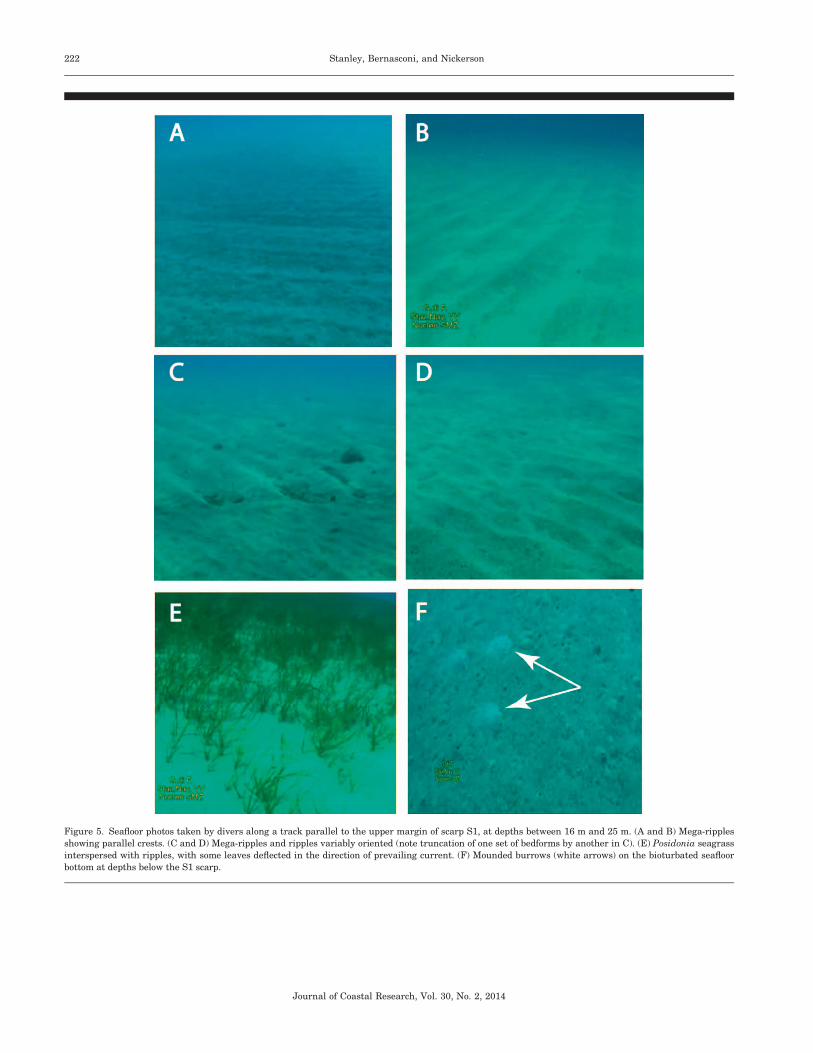
Figure 5. Seafloor photos taken by divers along a track parallel to the upper margin of scarp S1, at depths between 16 m and 25 m. (A and B) Mega-ripples
showing parallel crests. (C and D) Mega-ripples and ripples variably oriented (note truncation of one set of bedforms by another in C). (E) Posidonia seagrass
interspersed with ripples, with some leaves deflected in the direction of prevailing current. (F) Mounded burrows (white arrows) on the bioturbated seafloor
bottom at depths below the S1 scarp.
Journal of Coastal Research, Vol. 30, No. 2, 2014
222 Stanley, Bernasconi, and Nickerson
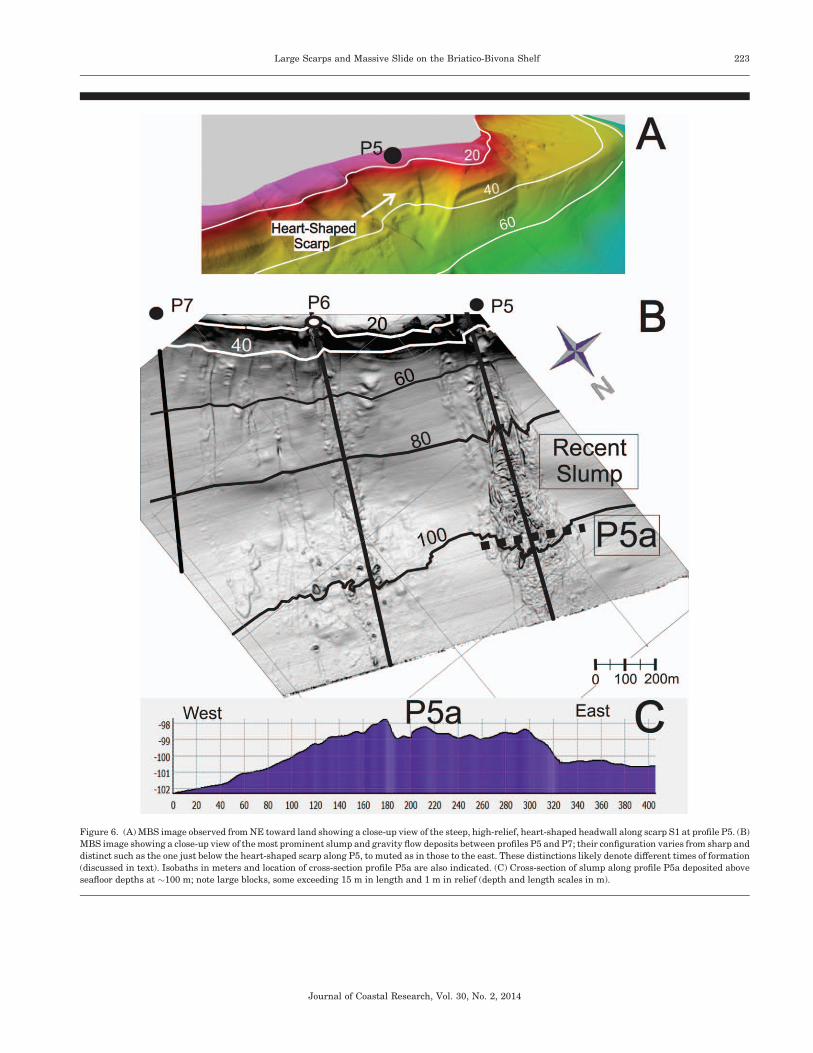
Figure 6. (A) MBS image observed from NE toward land showing a close-up view of the steep, high-relief, heart-shaped headwall along scarp S1 at profile P5. (B)
MBS image showing a close-up view of the most prominent slump and gravity flow deposits between profiles P5 and P7; their configuration varies from sharp and
distinct such as the one just below the heart-shaped scarp along P5, to muted as in those to the east. These distinctions likely denote different times of formation
(discussed in text). Isobaths in meters and location of cross-section profile P5a are also indicated. (C) Cross-section of slump along profile P5a deposited above
seafloor depths at ~100 m; note large blocks, some exceeding 15 m in length and 1 m in relief (depth and length scales in m).
Journal of Coastal Research, Vol. 30, No. 2, 2014
Large Scarps and Massive Slide on the Briatico-Bivona Shelf 223
of deep penetration, high-resolution, subbottom seismic pro-
files for this specific sector, we can only speculate at this time
that the three submerged scarps are, in some manner, fault
related and triggered at unknown depths beneath the seafloor
surface. The steep, high-sloped, laterally extending scarps,
especially S1, resemble extensionally displaced structures on
land, such as some of the step-like faults and marine terraces
on the adjacent north Capo Vaticano hills, which have been
subject to uplift at least since the Pleistocene (Antonioli et al.,
2009; Bianca et al., 2011; Tortorici et al., 2003). Of note in this
respect are the two closest large fault traces on land, oriented
SW–NE, which delineate the surveyed zone, i.e. the Capo
Vaticano fault to the immediate west and the Vibo Valentia
fault to the south (Cucci and Tertulliani, 2006; Tortorici et al.,
2003). The orientation of the three scarps we mapped, however,
parallel the WNW–ESE trends of the large and active
Coccorino and Nicotera faults on the southern margin of the
Capo Vaticano peninsula (Bianca et al., 2011, their Figure 1).
The submarine scarps also closely parallel the well-defined
WNW–ESE-trending isobaths, probably structurally con-
trolled between 200 and 400 m of the adjacent continental
slope (Bianca et al., 2011) and some fault trends in the Gulf of
Saint Eufemia (Tansi et al., 2007, their figure 1).
Direct evidence of recent displacement of the seafloor surface
adjacent to the survey sector is provided by the configuration of
one of the two long Greek breakwaters (EB, Figure 4) that
extends from near the shoreline at Trainiti to roughly 300 m
seaward on the inner shelf. This feature, mapped by Jannelli,
Lena, and Givigliano (1992), shows that its submerged upper
surface descends from�3 m msl at the coastline to�9 m msl on
the inner shelf, the latter being positioned only several
hundred meters landward of scarp S1. This lowering beneath
the present sea level by as much as 6 m of the structure’s upper
surface occurred at some time between the end of Greek time
and the present (Bernasconi and Stanley, 2013; Stanley and
Bernasconi, 2012a). This late Holocene to recent seaward-tilted
configuration is attributed largely to natural substrate subsi-
dence and seafloor structural offset at rates from ~2.6 to 2.8
mm/y (Stanley and Bernasconi, 2012b). It should also be noted
that the NNE tilt of the shelf parallels the same structural-tilt
trend observed on land in the Capo Vaticano peninsula (Bianca
et al., 2011, their figure 1). It thus appears that terrains
landward of the shore experienced mostly uplift, along with
lateral displacement in some cases, whereas the adjacent
underwater features of the northern Capo Vaticano shelf
primarily record a step-like lowering.
MBS observations suggest recent geological development of
the scarps and their likely continued evolution in late Holocene
time to the present. A strong line of evidence for this, albeit
indirect, is provided by their overall angular, high-relief and
steeply inclined form. This expression of recent formation is
maintained in spite of the high-energy sedimentary bedforms
Figure 7. (Upper) MBS oblique view toward land of the massive slide block at middle shelf depths observed on profile P11 denoting its arcuate shape and the
presence of its distinct scarp-like face. The position of the SE–NW-oriented cross-section is also indicated. (Lower) Cross-section of P11 showing the upslope
segment of the slide that merges with seafloor surface sediment, and the 7.5 m relief of its scarp-like face (between about 55 and 62.5 m). Depth and length in
meters. Circles in both images indicate upper part of scarp that faces downslope. (Color for this figure is available in the online version of this paper.)
Journal of Coastal Research, Vol. 30, No. 2, 2014
224 Stanley, Bernasconi, and Nickerson
that prevail along the inner shelf and cause large volumes of
sand to be transferred seaward from the innermost shelf
downslope to and across the broken topography of the shelf
platform. The bedforms recording this displacement include
sand ripples that generally require mean-flow velocities of
~20–30 cm/s and sand waves that usually develop at stronger
mean-flow velocities from ~30–80 cm/s (Reineck and Singh,
1980). Moreover, sand wave crests are positioned mostly
transverse or at a small angle to the dominant current direction
and record the prevailing eastward trajectory of coastal
currents in this inner shelf area above scarp S1. This current
trend is confirmed by mapping of the nearshore area
documented by the Italian CNR (1985).
Sedimentation studies of sand waves in the nearshore sectors
of some margins in other parts of the world provide estimated
sand-wave migration rates to 10–15 m/y (Bijker, Wilkens, and
Hulscher, 1998). An easterly displacement of the sand body by
~1 km on the inner shelf in the study area since the 1905
earthquake can be projected conservatively if a sand-wave
advance rate of 10 m/y is assumed. The crests of those mobile
bedforms in the study area are oriented S–N (from 3548 to 68 N),
and as they advance, the sand waves come into contact at an
angle with the WNW–ESE-trending scarp S1 (Figure 4). That
causes considerable volumes of sand to be actively shifted to,
across, and down the steep scarp face toward the greater
depths of the shelf surface. At that rate of seaward sediment
displacement and loss to the inner shelf, it is expected that,
over time, the scarp and shelf surface below it would have
become considerably smoothed, partially buried, and much less
well-defined than presently observed. This would suggest that
scarp S1 is a young and still-evolving feature.
The long, narrow, seaward-trending sedimentary structures
just below scarp S1 are those that have been displaced
primarily by the effects of gravity, such as slumps and less-
dense, more-fluid gravity flow deposits rather than bottom
currents. These displaced sediments are derived primarily
from periodic failure of material that had originally formed
along the steepened scarp S1 at depths of ~18 m to ~22 m. In
some instances, the narrow sediment tongues below a scarp,
such as the deposit along profile P5, present all the character-
istics typical of a mass of material that has been detached,
failed, and displaced from shallow depths down the steep
incline with incomplete reorganization of original strata during
transport in a seaward direction. Structures present beneath
these scooped-out scarps, such as the heart-shaped depression
at the head of profile P5, display the well-defined characteris-
tics of slumps between the headwall and the translated blocks
of the toe domain (Figure 6). The configuration of gravitative
deposits, either of muted or of sharp and distinct form, could
well record differences in the timing of their formation.
By far the largest gravitative failure (P11) was interpreted
here as a massive (.350 m long), cohesive slide block derived
from the inner shelf, perhaps detached at or near scarp S1. The
MBS images show that it is not a slump involving major
disruption of the original stratification during transport, but a
slide block derived from the inner shelf that moved en masse
with only minor dislocation and reworking of the strata within
it during transport. That material slid on its semiconsolidated-
to-indurated base in a seaward direction (cf. Reineck and Singh,
1980), moving across the fairly gentle incline to its present site
on the middle shelf. Some of the recent sediment that partially
covers the rear (landward margin) and upper part of that block
may have been triggered as a very large cloud of material at the
time of the gravity event. It is envisioned that much of that
material may have been blocked by the massive, displaced
section resting on the midshelf and became trapped behind it.
HOW RECENT IS RECENT?This MBS survey was key for discovering and describing the
large morphobathymetric features on the northern Capo
Vaticano shelf, but new research efforts will be required to
more reliably interpret their origin and the timing of their
formation. It will be essential to survey the three scarps by
means of high-resolution, subbottom seismic profiling to map
their 3-D configuration and to determine whether they are, in
some manner, associated with the 1905 seismotectonic event.
For example, it is necessary to determine whether the sharp
and distinct scarp S1 was the result of a major offset that
occurred during a single brief span of time or was formed by
several major vertical offset movements or by multiple slippage
events over a longer period. It should also be established
whether the three scarps in the Briatico area were associated
with a single event or were formed at different times,
independent of each other. With high-resolution geophysical
data, it may, perhaps, be possible to identify whether a series of
small, low-relief, step-like offsets are buried at depth beneath
the large S1 scarp feature. If that were the case, one could
imagine a scenario not unlike the one that produced some
terrace offsets through the Pleistocene to recent time on the
adjacent land that backs the survey area, but with the
difference that offshore terrains have been lowered by
extensional displacement rather than having been uplifted.
Even with the availability of that information, however, the
timing of scarp origin and that of the massive slide block
detached from the inner shelf would remain unknown. To
establish whether there was any possible relation with the 1905
earthquake, it would be necessary to recover a set of continuous
sediment sections in cores collected along several traverses from
the inner shelf to and across scarp S1 and also across the slide
block. Age determination of such a relatively recent event would
require application of two or more dating methods. Very recent
events (at the century level) need short-lived isotope-count
analyses, such as lead-210 and cesium-137, whereas radiocar-
bon dates could be used to determine ages in excess of~200–300
years. It would also be helpful to emplace time–depth sensors to
be monitored periodically on the step-like shelf-break surface.
These might serve to detect possible elevation shifts that may
result from ongoing and future displacement triggered by
downslope gravitative motion, faulting, or combined tectonic–
gravitative processes at depth (Rebesco et al., 2009).
Based on the present MBS survey and the seismotectonic
databases available for this northern Capo Vaticano sector, it is
suggested that two sectors of the Briatico–Bivona inner shelf
survey area examined here may have failed either largely or
partially as a result of the 1905 earthquake and warrant
additional attention. One is positioned along scarp S1 to the NE
of Briatico and includes the area between profiles P5 and P6,
and the other is the massive slide block at profile P11 north of
Journal of Coastal Research, Vol. 30, No. 2, 2014
Large Scarps and Massive Slide on the Briatico-Bivona Shelf 225
Bivona. A multidisciplinary investigation using diverse tech-
nologies will likely be the most productive approach to
exploring the two areas proposed.
ACKNOWLEDGMENTSAppreciation is expressed to Dr. J. Royal, RPM Nautical
Foundation for generously providing ship time and equipment
on the R/V Hercules; Captain E. Vella and crew for their
valued assistance; and Mr. K. Llewellyn of Highland Geo
Solutions for efficient collection of the MBS data during the
cruise. The authors thank Mr. W. Boardman for assistance in
compiling the final figures in this article, and Mr. P. L.
Clemente for editorial assistance and text preparation. Dives
were conducted by personnel of the Nucleo Sommozzatori–
Guardia di Finanza of Vibo Valentia Marina, Calabria,
through the sponsorship of Commander A. D’Amico. Helpful,
constructive, outside reviews were made by Drs. F. Muto,
University of Calabria-Rende, and C. Tansi, IRPI-CNR of
Cosenza, Calabria. Travel funds for this project (to J.D.S) were
provided by the Director’s Office and Department of Paleobi-
ology of the National Museum of Natural History, Highland
Geo Solutions, and the RPM Nautical Foundation; funds for
field work and travel were provided (to M.P.B.) by the
University of Calabria (Ministry of Education, Universities
and Research grant ex-60%), and by the Office of Fellowships
and Grants of the Smithsonian Institution, Washington, DC.
LITERATURE CITEDAntonioli, F.; Ferranti, L.; Fontana, A.; Amorosi, A.; Bondesan, A.;
Braitenberg, C.; Dutton, A.; Fontolan, G.; Furlani, S.; Lambeck, K.;Mastronuzzi, G.; Monaco, C.; Spada, G., and Stocchi, P., 2009.Holocene relative sea-level changes and vertical movements alongthe Italian and Istrian coastlines. Quaternary International,206(1–2), 102–133.
Anzidei, M.; Esposito, A.; Antonioli, F.; Benini, A.; Tertulliani, A., anddel Grande, C., 2006. I movimenti verticali nell’area di Briatico:evidenze da indicatori archeologici marittimi nell’area del terre-moto del 1905. In: Guerra, I. and Savaglio, A., (eds.), 8 Settembre1905 Terremoto in Calabria. Castrovillari: Regione CalabriaAssessorato alla Cultura, pp. 301–321.
Basili, R.; Valensise, G.; Vannoli, P.; Burrato, P.; Fracassi, U.;Mariano, S.; Tiberti, M.M., and Boschi, E., 2008. The database ofindividual seismogenetic sources (DISS), version 3: summarizing20 years of research on Italy’s earthquake geology. Tectonophysics,453(1–4), 20–43.
Bernasconi, M.P. and Stanley, J.-D., 2013. Post-Greek coastline shiftsinterpreted by biostratigraphic analysis on Hipponion’s seismo-tectonically active margin, Calabria, Italy [published online aheadof print]. Journal of Coastal Research. doi: 10.2112/JCOASTRES-D-13-00113.1.
Bianca, M.; Catalano, S.; De Guidi, G.; Gueli, A.M.; Monaco, C.;Ristuccia, G.M.; Stella, G.; Tortorici, G.; Tortorici, L., and Troja,S.O., 2011. Luminescence chronology of Pleistocene marineterraces of Capo Vaticano peninsula (Calabria, Southern Italy).Quaternary International, 232(1–2), 114–121.
Bijker, R.; Wilkens, J., and Hulscher, S., 1988. Sandwaves: where andwhy. In: Proceedings of the Eighth International Offshore andPolar Engineering Conference, Montreal Canada May 24–29,Volume 2. (Abstract) p. 153.
Boschi, E.; Ferrari, G.; Gasperini, P.; Guidoboni, E.; Smriglio, G., andValensise, G., 1995. Catalogo dei Forti Terremoti in Italia dal 461a.C. al 1980. Bologna, ING-SGA, 970p.
Calder, B., 2003. Automatic statistical processing of multibeam data.International Hydrographic Review, 4(1), 1–16.
Camassi, R. and Stucchi, M., 1997. NT4.1.1, Un Catalogo Parametricodei Terremoti di Area Italiana al di Sopra della Soglia del danno.
Milano: Gruppo Nazionale Difesa dai terremoti, Rapporto interno,95p.
CNR (Consiglio Nazionale Ricerche), 1985. Atlante delle SpiaggeItaliane. Foglio 241, Nicastro. Rome: Consiglio Nazionale Ricerche,scale 1:100.000, 1 sheet.
Cucci, L. and Tertulliani, A., 2006. I terrazzi marini nell’area di CapoVaticano (Arco Calabro): solo un record di sollevamento regionale oanche di deformazione cosismica?. Il Quaternario, 19(1), 89–101.
Cucci, L. and Tertulliani, A., 2010. The Capo Vaticano (Calabria)coastal terraces and the 1905 M7 earthquake: the geomorpholog-ical signature of the regional uplift and coseismic slip on southernItaly. Terra Nova, 22(5), 378–389.
Cucarzi, M.; Iannelli, M.T., and Rivolta, A., 1995. The coastal site ofBivona. Its detection and its environmental changes throughgeoarchaeological explorations. In: Proceedings of the InternationalConference: Geosciences and Archaeology in the MediterraneanCountries (Cairo 28–30 November 1993, The Geological Survey ofEgypt), pp. 149–168.
Fledermaus User’s Guide, 2011. Version 7 2011. IVS3D (InteractiveVisualization Systems), New Brunswick: Fledermaus Inc. (Unpub-lished Report), 471p.
Gascoyne, P., 1978. Gravity-slide deposits. In: Fairbridge, R.W. andBourgeois, J. (eds.), The Encyclopedia of Sedimentology. Strouds-burg: Dowden, Hutchinson & Ross, pp. 386–389.
Google Earth image, 2012. http://www.google.it/intl/it/earth/index.html.
Guerra, I.; De Rose, C.; Gervasi, A.; Neri, G.; Orecchio, B., and Presti,D., 2006. Attivita’ sismica recente in Calabria Centro-Meridionale.In: Guerra, I. and Savaglio, A. (eds.), 8 Settembre 1905 Terremotoin Calabria. Castrovillari: Regione Calabria Assessorato allaCultura, pp. 261–288.
Guerra, I. and Savaglio, A., 2006. 8 Settembre 1905 Terremoto inCalabria. Castrovillari (CS): AGM s.r.l., 337p.
Jannelli, M.T.; Lena, G., and Givigliano, G.P., 1992. Indaginisubacquee nel tratto di costa tra Zambrone e Pizzo Calabro, conparticolare riferimento agli stabilimenti antichi per la lavorazionedel pesce. In: Azienda Autonoma di Soggiorno e Turismo Giardini,(ed.), V Rassegna di Archeologia Subacquea, V Premio FrancoPapo. Messina: Edizioni P&M Associati s.r.l, pp. 9–43.
Loreto, M.F.; Zgur, F.; Facchin, L.; Fracassi, U.; Pettenati, F.; Tomini,I.; Burca, M.; Diviacco, P.; Sauli, C.; Cossarini, G.; De Vittor, C.;Sandron, D. and Explora Team of Technicians, 2012. In search of anew imaging for historical earthquakes: a new geophysical surveyoffshore western Calabria (southern Tyrrhenian Sea, Italy).Bollettino di Geofisica Teorica ed Applicata, 53, 385–401.
Lurton, X., 2002. Underwater Acoustic: An Introduction. Chichister:Springer Praxis, pp. 268–282.
Michelini, A.; Lomax, A.; Nardi, A.; Rossi, A.; Palombo, B., and Bono,A., 2005. A modern re-examination of the locations of the 1905Calabria and 1908 Messina Straits earthquakes. GeophysicalResearch Abstracts, 7, 07909.
Medwin, H. and Clay, C.S., 1998. Fundamental of AcousticalOceanography. Milwaukee: Academic, 712p.
Middleton, G.V. and Hampton, M.A., 1973. Sediment gravity flows:Mechanics of flow and deposition. In: Society of EconomicPaleontologists and Mineralogists, Pacific Section, Short Course,pp. 1–38.
Middleton, G.V. and Southard, J.B., 1977. Mechanics of SedimentMovement. Tulsa, Oklahoma: Society of Economic Paleontologistsand Mineralogists, Short Course 3, 246p.
Milia, A.; Turco, E.; Pierantoni, P.P., and Schettino, A., 2009. Four-dimensional tectono-stratigraphic evolution of the southeasternperi-Tyrrhenian basins (margin of Calabria, Italy). Tectonophysics,476(1), 41–56.
Piatanesi, A. and Tinti, S., 2002. Numerical modelling of theSeptember 8, 1905 Calabrian (southern Italy) tsunami. Geophys-ical Journal International, 150(1), 271–284.
Pugliese, F., 1996. Il Terremoto dell’8 Settembre 1905 in Calabria.Florence: Arti Grafiche BMB, 223p.
Rebesco, M.; Neagu, R.C.; Cuppari, A.; Muto, F.; Accettella, D.;Dominici, R.; Cova, A.; Romano, C., and Caburlotto, A., 2009.Morphobathymetric analysis and evidence of submarine massmovements in the western Gulf of Taranto (Calabria margin,
Journal of Coastal Research, Vol. 30, No. 2, 2014
226 Stanley, Bernasconi, and Nickerson
Ionian Sea). International Journal of Earth Science, 98(4), 791–805.
Reineck, H.-E. and Singh, I.B., 1980. Depositional SedimentaryEnvironments. New York: Springer-Verlag, 549p.
Riuscetti, M. and Schick, R., 1964. Earthquakes and tectonics insouthern Italy. In: Proceedings of the Joint Symposium ofEuropean Seismology Commission and European GeophysicalSociety, Trieste, pp. 59–78.
Rizzo, G.B., 1906. Sulla velocita di propagazione delle onde sismichedel terremoto della Calabria del giorno 8 Settembre 1905. Memoriedella Regia Accademia delle Scienze, Torino, serie II, Tomo LVII,pp. 310–352.
Schreiber, B.C., 1978. Sand waves. In: Fairbridge, R.W. andBourgeois, J. (eds.), The Encyclopedia of Sedimentology. Strouds-burg: Dowden, Hutchinson & Ross, pp. 652–653.
Stanley, J.-D. and Bernasconi, M.P., 2012a. Did powerful land upliftand offshore subsidence events displace ancient Hipponionn’s portfacilities on Calabria’s Trainiti coastal margin?. Rendiconti OnlineSocieta Geologica Italiana, 21(1), 768–772.
Stanley, J.-D. and Bernasconi, M.P., 2012b. Buried and submergedGreek archaeological coastal structures and artifacts as gauges tomeasure late Holocene seafloor subsidence off Calabria, Italy.Geoarchaeology, 27(1), 1–17.
Tansi, C.; Muto, F.; Critelli, S., and Iovine, G., 2007. Neogene-Quaternary strike-slip tectonics in the central Calabrian Arc(Southern Italy). Journal of Geodynamics, 43(3), 393–414.
Tiberti, M.M.; Fracassi, U., and Valensise, G., 2006. Il quadrosismotettonico del grande terremoto del 1905. In: Guerra, I. andSavaglio, A. (eds.), 8 Settembre 1905 Terremoto in Calabria.Castrovillari: Regione Calabria Assessorato alla Cultura, pp.181–205.
Tinti, S. 2006: Il maremoto del 1905 nel Golfo di Sant’Eufemia. In:Guerra, I. and Savaglio, A., (eds.), 8 Settembre 1905 Terremoto inCalabria. Castrovillari: Regione Calabria Assessorato alla Cultura,pp. 289–299.
Tortorici, G.; Bianca, M.; De Guidi, G.; Monaco, C., and Tortorici, L.,2003. Fault activity and marine terracing in the Capo Vaticanoarea (southern Calabria) during the Middle-Late Quaternary.Quaternary International, 101–102, 269–278.
Journal of Coastal Research, Vol. 30, No. 2, 2014
Large Scarps and Massive Slide on the Briatico-Bivona Shelf 227