Estimating the ages of fault scarps in the Arava, Israel
13
ELSEVIER Tectonophysics 253 (1996) 305-317 TECTONOPHYSICS Estimating the ages of fault scarps in the Arava, Israel Yehouda Enzel a, *, Rivka Amit b, Naomi Porat h, Ezra Zilberman b, Bruce J. Harrison c a Institute of Earth Sciences and Dep. of Geography, Hebrew University, Jerusalem 91904, Israel b Geological Survey of Israel, 30 Malchei Israel St., Jerusalem 95501, Israel c Department of Geosciences, New Mexico Institute of Mining and Technology, Socorro, NM 87801, USA Received 7 February 1995; accepted 19 June 1995 Abstract Systematic age estimations for the numerous fault scarps that rupture the alluvial fans in the southern Arava valley, Israel, are rare or nonexistent. Here we estimate the morphologic ages of several of these faults by the fault scarp degradation method and show that the ages agree well with ages estimated by the independent, earlier soil-geomorphic studies. The values we use for the coefficient of diffusion for the fault scarp degradation process are calibrated by a few numerical ages. These ages were determined by the Infrared Stimulated Luminescence (IRSL) method on one of the fault scarps and are the only numerical ages in the region. The morphologic ages are all in a correct stratigraphic order and in agreement with field stratigraphic relationships determined by earlier studies. They indicate that the studied fault scarps range in age from the latest Pleistocene to very recent times. The most recent fault scarps, which were analyzed are less than 2000 years old and perhaps much younger. They indicate that at least two earthquakes with magnitude > 6.5 have affected southem Israel and Jordan during that period. It is emphasized that so far we have studied only a limited number of fault scarps and therefore the number of large earthquakes during the last one to two millennia is a minimum. 1. Introduction In the southern Arava Valley (Ha'Arava in Fig. 1), along the Dead Sea transform, there are numer- ous fault scarps (e.g., Fig. 2) that displace Quater- nary surficial deposits (Garfunkel, 1970; Garfunkel et al., 1981; Gerson and Grossman, 1991; Druckman et al., 1993; Gerson et al., 1993). In addition to many other indicators, the abundant fault scarps testify to the significant tectonism and earthquakes in this * Corresponding author. region. However, the timing and magnitudes of the earthquakes associated with most of these faults are not known. The lack of suitable dating material prevents the determination of the ages of the faulted surficial deposits. Therefore, it is almost impossible to asses the recent faulting activity and the long-term seismic hazard in that region in general, and to the city of Elat (Fig. 1) and the nearby Jordanian city of Aqaba in particular. The most recent studies, therefore, have used the soil-geomorphic approach for estimating the relative and correlative ages of specific fault scarps (Gerson and Grossman, 1991; Gerson et al., 1993; Amit et al., 1995). These labor-intensive studies 0040-1951/96/$15.00 © 1996 Elsevier Science B.V. All rights reserved SSDI 0040- 1951(95)00072-0
Transcript of Estimating the ages of fault scarps in the Arava, Israel
ELSEVIER Tectonophysics 253 (1996) 305-317
TECTONOPHYSICS
Estimating the ages of fault scarps in the Arava, Israel
Yehouda Enzel a, *, Rivka Amit b, Naomi Porat h, Ezra Zilberman b, Bruce J. Harrison c
a Institute of Earth Sciences and Dep. of Geography, Hebrew University, Jerusalem 91904, Israel b Geological Survey of Israel, 30 Malchei Israel St., Jerusalem 95501, Israel
c Department of Geosciences, New Mexico Institute of Mining and Technology, Socorro, NM 87801, USA
Received 7 February 1995; accepted 19 June 1995
Abstract
Systematic age estimations for the numerous fault scarps that rupture the alluvial fans in the southern Arava valley, Israel, are rare or nonexistent. Here we estimate the morphologic ages of several of these faults by the fault scarp degradation method and show that the ages agree well with ages estimated by the independent, earlier soil-geomorphic studies. The values we use for the coefficient of diffusion for the fault scarp degradation process are calibrated by a few numerical ages. These ages were determined by the Infrared Stimulated Luminescence (IRSL) method on one of the fault scarps and are the only numerical ages in the region. The morphologic ages are all in a correct stratigraphic order and in agreement with field stratigraphic relationships determined by earlier studies. They indicate that the studied fault scarps range in age from the latest Pleistocene to very recent times. The most recent fault scarps, which were analyzed are less than 2000 years old and perhaps much younger. They indicate that at least two earthquakes with magnitude > 6.5 have affected southem Israel and Jordan during that period. It is emphasized that so far we have studied only a limited number of fault scarps and therefore the number of large earthquakes during the last one to two millennia is a minimum.
1. Introduct ion
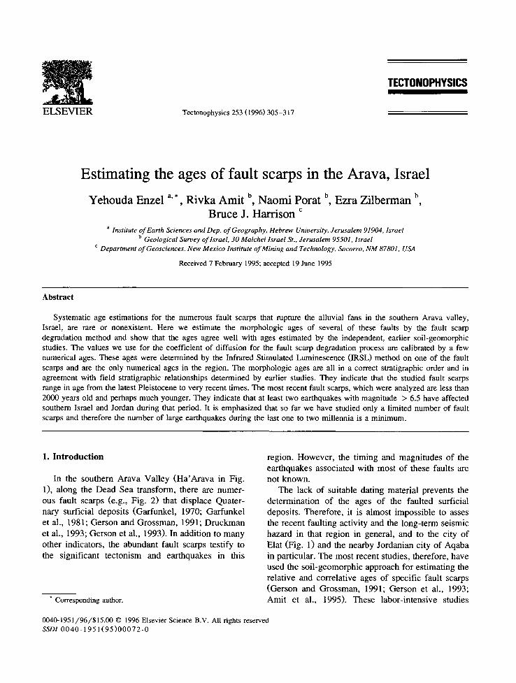
In the southern Arava Valley ( H a ' A r a v a in Fig. 1), along the Dead Sea transform, there are numer- ous fault scarps (e.g., Fig. 2) that displace Quater- nary surficial deposits (Garfunkel, 1970; Garfunkel et al., 1981; Gerson and Grossman, 1991; Druckman et al., 1993; Gerson et al., 1993). In addition to many other indicators, the abundant fault scarps testify to the significant tectonism and earthquakes in this
* Corresponding author.
region. However , the timing and magnitudes of the earthquakes associated with most of these faults are not known.
The lack of suitable dating material prevents the determination of the ages of the faulted surficial deposits. Therefore, it is almost impossible to asses the recent faulting activity and the long-term seismic hazard in that region in general, and to the city of Elat (Fig. 1) and the nearby Jordanian city of Aqaba in particular. The most recent studies, therefore, have used the soi l-geomorphic approach for estimating the relative and correlative ages of specific fault scarps (Gerson and Grossman, 1991; Gerson et al., 1993; Amit et al., 1995). These labor-intensive studies
0040-1951/96/$15.00 © 1996 Elsevier Science B.V. All rights reserved SSDI 0040- 1951(95)00072-0
306 Y. Enzel et a l . / Tectonophysic~ 253 (1996) 305-317
Fig. 1. Location map and air photograph showing several of the fault scarps in the Nahal Shehoret alluvial fan, southern Arava.
Y. Enzel et al. / Tectonophysics 253 (1996) 305-317 307
Observed fault
- r - -~ Fault ?
. . . . Buried fault
.............. Open fissures
Trench
Topographic profile
Late Pleistocene surface
Early to middle Holocene surface
Middle Holocene surface
~ Late Holocene and active surfaces
NS 0 50m t J
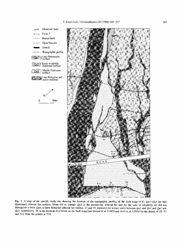
Fig. 2. A map of the specific study site showing the location of the topographic profiles of the fault scarp (FS). Qal-Qa5 are late Quaternary alluvial fan surfaces (from old to young). Qa5 is the present-day alluvial fan and for the sake of simplicity we did not distinguish it from Qa4, a latest Holocene alluvial fan surface. T1 and 72 represent the terrace risers between Qal and Qa3 and Qal and Qa3, respectively. T6 is the location of a trench on the fault scarp [see Gerson et al. (1993) and Amit et al. (1995) for the details of T6, T1 and T21. Note the graben at TI8.
308 Y. Enzel et al. / Tectonophysics 253 (1996) 305-317
have produced only limited number of age estima- tion of faults.
Here, we explore the geomorphic method of mor- phologic age dating (e.g., Nash, 1980; Mayer, 1984) for estimating ages of fault scarps in that problematic region. Our goals are to test the approach of morpho- logic age dating in this region, to determine the regional coefficient of diffusion and to estimate the ages of several fault scarps. The initial results, which are in agreement with other dating methods indicate the possible use of morphologic ages in the southern Arava as well as in other extremely arid environ- ments. The application of this method should be viewed as a screening tool of the many scarps that exist in the region. We stress that this method is not an alternative to efforts to provide age dating by other more accurate techniques. It is a preliminary and complimentary study to estimate ages and to prioritize future efforts to be invested in any specific fault by the detailed soil-geomorphic studies.
Recently, Porat et al. (1994) have produced the first numerical dates of any alluvial surface in that region by the optically stimulated luminescence (IRSL) method. We have taken advantage of these more accurate, numerical dates to determine a re- gional diffusion coefficient for fault scarps (see be- low). An agreement of the results with the previously determined field stratigraphic relationships will be an additional criterion for the quality of the morpho- logic ages. The determination of a regional coeffi- cient of diffusion will allow for further estimations of ages of fault scarps in the region.
2. Study site
The southern Arava valley (Fig. 1) is under ex- treme arid climatic conditions. Mean annual precipi- tation is 30 mm which occurs during a few isolated storms during the late fall and winter. Mean annual temperature is 25°C with extremely hot summers and cooler winters. During the Quaternary the regional climate varied between mildly to extremely arid conditions (Horowitz, 1979; Gat and Magaritz, 1980; Begin et al., 1985).
Fault scarps and terrace risers in the distal por-
tions of the Nahal Shehoret alluvial fan were se- lected because previous soil and geomorphologic studies have already determined the relative ages of the formation of the alluvial fan surfaces and faulting (Gerson et al., 1985, Gerson et al., 1993; Gerson and Amit, 1987; Gerson and Grossman, 1991; Birkeland and Gerson, 1991; Amit et al., 1993).
There are several alluvial fan surfaces in the Nahal Shehoret. Qal (Fig. 2; Gerson et al., 1993) is the oldest and most extensive surface and is ruptured by many faults. Only a few remnants of Qa2 exist and they are distinguished from the more extensive and younger Qa3 by surface morphology and the degree of soil development (Amit et al., 1995). Qa4 and Qa5 are mapped together as they are the active channels (Qa5) and the alluvial surface that can be still flooded (Qa4). Surface Qal is of a Late Pleis- tocene age ( < 100 ka) and was abandoned and faulted prior to the formation of alluvial surfaces Qa2 and Qa3, which are inset into and, therefore younger, than surface Qal (Gerson et al., 1993). Later, Qa2 and Qa3 were ruptured by more recent faults produc- ing younger, less pronounced, fault scarps (Fig. 2). The surface morphology and the degree of soil de- velopment indicate that both surfaces were formed during the Holocene. The stratigraphic relationship and the degree of soil development indicate that Qa2 is probably a slightly older alluvial surface than Qa3 (Amit et al., 1995). These age estimates are based on correlation to the Nahal Zeelim soil chronosequence (Amit and Gerson, 1986) and indicate that Qa2 and Qa3 are probably early to middle Holocene and middle Holocene alluvial fan surfaces, respectively. All of these Quaternary units are composed of un- consolidated sandy gravel alluvial deposits.
Alluvial fans Qal and Qa3 and the fault at site T6 were dated using infrared stimulated luminescence on alkali feldspars (Porat et al., 1994). The ages show that the sediments at the top of Qal deposits were deposited at 60.9 _+ 4.6 ka and the fault dis- placed surface Qal between 36.7 _+ 4.5 and 14.7 _+ 2.5 ka (Fig. 3) after Qal was already abandoned. The later age also determine the maximum age for surface Qa3 (Porat et al., 1994). These ages are in excellent agreement with the stratigraphic relation- ship and the estimated ages based on the earlier independent soil-geomorphic studies (Gerson et al., 1993; Amit et al., 1995).
Y. Enzel et al. / Tectonophysics 253 (1996) 305-317 309
3. Modeling of a scarp
The original morphology of fault scarps in allu- vial deposits is altered by gravitational and slope processes. Younger scarps have steeper slope angles than older scarps, which (a) have the same height, (b) consist of similar deposits and (c) are influenced by similar climatic conditions (Wallace, 1977, Wal- lace, 1980; Bucknam and Anderson, 1979). These observations are the basis for age dating through scarp morphologic characteristics (Kirkby and Kirkby, 1976; Bucknam and Anderson, 1979; Nash, 1980, Nash, 1984, Nash, 1986; Colman and Ma- chette, 1981; Machette, 1982; Colman and Watson, 1983; Mayer, 1984, Mayer, 1987; Hanks et al., 1984; Hanks and Wallace, 1985; Andrews and Hanks, 1985; Pierce and Colman, 1986; Kenderick et al., 1990; Begin, 1992). The analytical approach to scarp degradation involves matching a measured scarp pro- file with a scarp morphology predicted by a model which follows a diffusion equation (e.g., Nash, 1980; Colman and Watson, 1983). The scarp degradation by diffusion process is analogous to a one-dimen- sional heat flow driven by a gradient. Among others, Nash has proposed a scarp degradation model as in Eq. (1):
Oy 02y c - - ( l )
Ot Ox 2
which states that the change in elevation (y in meters) with time (t in years) of each point along the slope is proportional through a diffusion coefficient (c in m 2 yr - l ) to local curvature as defined by the elevation and the distance (x in meters) from the inflection point along the scarp (e.g., Nash, 1980; Mayer, 1984).
The application of either analytical or finite ele- ment solutions for Eq. (1) are aimed at the determi- nation of the age, t, of a fault scarp. The solution is discussed extensively in the literature cited above and computerized procedures give a similar age of fault scarps (Nash, 1987). Here we use the procedure SLOPEAGE by Nash (1987), The solution is based on the identification of the initial fault scarp topogra- phy, the present-day topography, and assuming dif- fusive processes. There are two unknowns in the equation: the time since the formation of the scarp
(t), which is the cause of the entire effort, and the coefficient of diffusion, c. The product ct, which is the solution of Eq. (1) is defined as the morphologic age of a scarp (e.g., Colman and Watson, 1983). To calculate the age, t, from ct, it is necessary to determine the regional coefficient of diffusion for the specific conditions and alluvial material (Hanks et al., 1984; Mayer, 1984).
Several morphologic features, important for the modeling of fault scarps, include the initial slope angle and the slope of the previous alluvial surface. After the initial formation of a scarp by faulting it is modified by collapse and mass movement processes so the scarp is at the angle of repose. This angle is used as the initial scarp angle for modeling. This process is thought to occur over a few hundreds of years in arid environments (Begin, 1992). Subse- quent scarp degradation is assumed to occur by geomorphic processes that can be modeled using the diffusion equation. The precise angle of repose is unknown, but its range in nature is known and therefore various angles can be used in the model to identify their influence on the resulting morphologic age. Nash (1987) listed the criteria for scarps that can be analyzed by the SLOPEAGE procedure (as well as by the other procedures). In field studies it is not simple to identify fault scarps which comply with all his criteria. However, where the ages of scarps are independently determined, earlier studies have shown that with all its limitations this method- ology provides a good approximation of surface faulting age (e.g., Kenderick et al., 1990). To the best of our knowledge, the scarps in this study comply with most of the conditions.
3.1. Which coefficient to use
Prior to our work there was not even one numeri- cal age in the study area. Therefore, it was possible to use only a roughly estimated regional diffusion coefficient based on other estimations which exist for the Negev. Begin (1992) estimated coefficient values for terrace risers in the northern Negev, Bow- man and Gerson (1986) for the shoreline cliffs of ancient Lake Lisan along the present-day Dead Sea and Bowman and Gross (1989) for a fault scarp in the northem Arava. Table 1 summarizes these esti- mations. A minimum coefficient of 0.1 m 2 ka - ~ was

EA
ST
Des
crip
tion
of
unit
s:
1,4
Sand
y si
lt
2 G
rit,
gran
ules
and
san
d
3,8,
9,11
,13,
23
Coa
rse
grav
el
5,7
Sand
and
fin
e gr
avel
6 Sa
nd a
nd c
oars
e gr
avel
10,1
2,22
Fi
ne g
rave
l
14,2
4 Si
lt, s
and
and
fine
gra
vel
15-2
1 Sa
nd, s
ilt a
nd fi
ne g
rave
l
15 - 1
8,20
-21,
24 C
ollu
vial
uni
ts
£4 I
-i-
!
T6-9
I-.
- 5
~='=
',~
~a~.
. 22
i
22
iiiiiiii
iiiiiiii
i:ii i
Q 2,
~: 1"
: ! : S
"9] ~
.: : :
~ 7: ~
2 :,:.
2 ; ;
; ; ~
CI: :
: 2 ~
: D: z
'~
" (1
7)
- 7
::::::
::::::
::::::
::::::
::::::
::::::
::::::
91',i
,o,;
10 _
[ 60
.9 t
'4.6
kla
Fa
ultA
N
63W
90E
11
i i
0 1
2 3
4 24
Qal
\ +
2.5
ka
19.0
+ 1
.7 k
a
/ Fa
ult
B
//
N18
W77
E
36 i
4.5
ka
T6-8
2
T6-6
T6-
4
au
,,o
N 10
W90
E
I I
I I
I I
I I
I i
I i
;
5 6
7 8
9 10
11
12
13
14
15
16
17
18
T6-2
T6
-3
l
I ~
Faul
t D
N10
W80
E
WE
ST
58
.4 +
11.
2 ka
T6_l
liQ al
Gra
vel
Fine
gra
vel
Sand
y si
lt Sa
nd a
nd s
ilt
Wel
l dev
elop
ed R
eg s
oil
You
ng R
eg s
oil
Petr
osal
ic h
oriz
on
1~
Shat
tere
d gr
avel
411
Faul
t Jo
int
__
Sedi
men
tary
con
tact
::
Rot
ated
cla
sts
T6-
4 So
il pr
ofile
Q
al
Allu
vial
fan
sur
face
I I
I I
I
19
20
21
22
23
DIS
TA
NC
E (
m)
Fig.
3.
Log
of
Tre
nch
T6 (m
odif
ied
from
Ger
son
et a
l., 1
993;
IR
SL d
ate
are
from
Por
at e
t al
., 19
94).
Not
e th
at t
he f
ault
s of
fset
Qa3
, whi
ch i
s co
mpr
ised
of
unit
s 19
-22,
by
only
a
few
cen
tim
eter
s.
e~
e~ Q
I "--4
Y. Enzel et a l . / Tectonophysics 253 (1996) 305-317
Table 1 Estimations of the coefficient of diffusion (c) for fault scarps and terrace risers in the Negev area
311
Area Estimated c (m 2 ka- l) Source Remarks
Northern Negev > 0.1 Begin (1992)
Shorelines of Lake Lisan 0.4 Bowman and Gerson (1986) (all are < 14 ka) Fault scarps in the northern > 0.2 and also > 0.4 Bowman and Gross (1989) Arava. All are < 14ka
0.4-2 Southern Amva 0.2-0.3
Bowman and Gross (1989) Enzel et al. (1994), this study
Minimum value: c > 0.4 will produce too young ages May not be applied to alluvial deposits (D. Bowman, pers. commun., 1994) If c < 0.4 than the fault scarps are becoming older than the lake deposits they rupture In marls of Lake Lisan c > 0.4 will make all scarps as young as the present
estimated for the northern Negev terrace risers and a coefficient of 0.4 m 2 ka - 1 for the Lake Lisan shore- lines. These values agree with the lower range of estimated values for c in the United States (see table 1 in Begin, 1992). A coefficient > 0.4 m E ka- 1
would have caused all fault scarps and terrace risers to be very recent (within the last l0 ka). Therefore, in our analyses we used the range 0.1-0.4 m E ka -~ for the diffusion coefficient, rather than a single value. Obviously, the use of such a wide range of values for c will result in a wide range of ages. We narrowed the value through the results of the IRSL age dating as will be shown below.
4. R e s u l t s
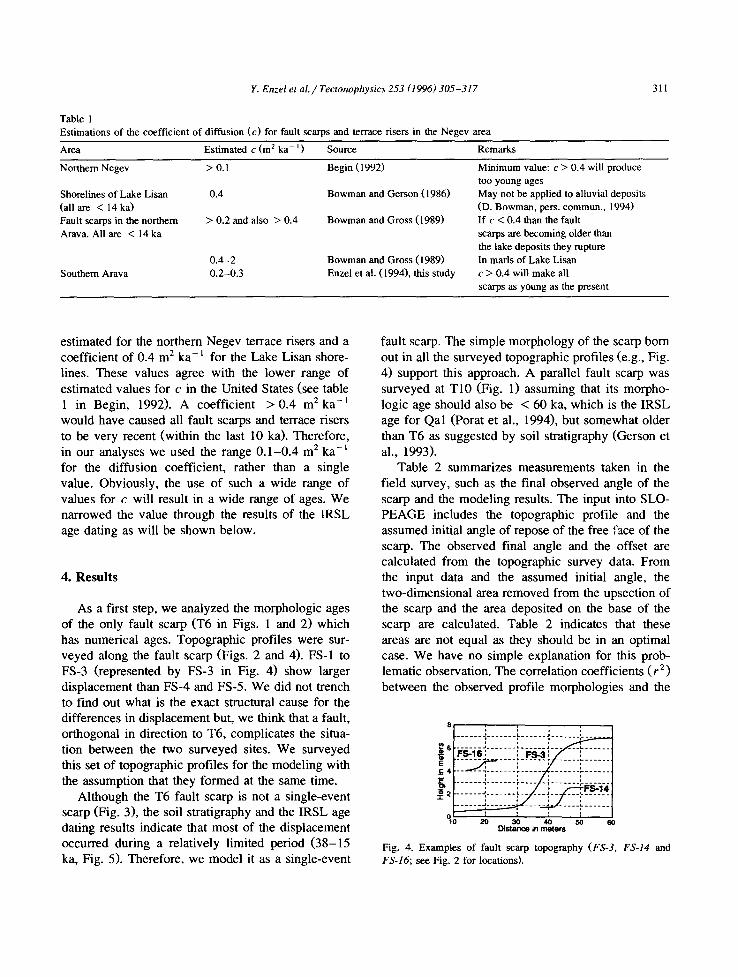
As a first step, we analyzed the morphologic ages of the only fault scarp (T6 in Figs. 1 and 2) which has numerical ages. Topographic profiles were sur- veyed along the fault scarp (Figs. 2 and 4). FS-1 to FS-3 (represented by FS-3 in Fig. 4) show larger displacement than FS-4 and FS-5. We did not trench to find out what is the exact structural cause for the differences in displacement but, we think that a fault, orthogonal in direction to T6, complicates the situa- tion between the two surveyed sites. We surveyed this set of topographic profiles for the modeling with the assumption that they formed at the same time.
Although the T6 fault scarp is not a single-event scarp (Fig. 3), the soil stratigraphy and the IRSL age dating results indicate that most of the displacement occurred during a relatively limited period (38-15 ka, Fig. 5). Therefore, we model it as a single-event
fault scarp. The simple morphology of the scarp born out in all the surveyed topographic profiles (e.g., Fig. 4) support this approach. A parallel fault scarp was surveyed at T10 (Fig. 1) assuming that its morpho- logic age should also be < 60 ka, which is the IRSL age for Qal (Porat et al., 1994), but somewhat older than T6 as suggested by soil stratigraphy (Gerson et al., 1993).
Table 2 summarizes measurements taken in the field survey, such as the final observed angle of the scarp and the modeling results. The input into SLO- PEAGE includes the topographic profile and the assumed initial angle of repose of the free face of the scarp. The observed final angle and the offset are calculated from the topographic survey data. From the input data and the assumed initial angle, the two-dimensional area removed from the upsection of the scarp and the area deposited on the base of the scarp are calculated. Table 2 indicates that these areas are not equal as they should be in an optimal case. We have no simple explanation for this prob- lematic observation. The correlation coefficients ( r 2) between the observed profile morphologies and the
8 ; , ; , . . . . . . . - ' . . . . . . . C . . . . . . a . . . . . . . ' . . . .
( n ~ ( ; . . . . . . . .
:::::::::::::::::::::::o. . . . . . . . . . . . . . . . . . . . 4 . . . . . . . :- . . . . . . . . . . - Z ' ~ - - ~ # ~ - ~ - ~
Distance in meters
F i g . 4 . E x a m p l e s o f f a u l t s c a r p t o p o g r a p h y (FS-3, FS-14 and FS-16; see Fig. 2 for locations).
312 Y. Enzel et al. / Tectonophysics 253 (1996) 305-317
FS-4
FS-1
FS-5
FS-2
FS-3
FS-lO
0 ' ' '10 ' ' ' 2 '0 ' ' ' 3 0 ' ' '4C)' ' '5'0' ' '60 ' ' '7()' ' ' S 0 ' ' '90 ' ' i00 Thousands years B.P.
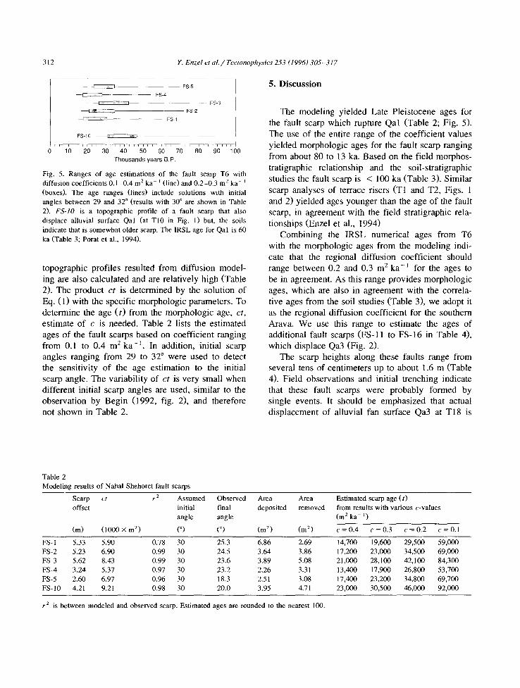
Fig. 5. Ranges of age estimations of the fault scarp T6 with diffusion coefficients 0.1-0.4 m 2 ka- i (line) and 0.2-0.3 m e ka- i (boxes). The age ranges (lines) include solutions with initial angles between 29 and 32 ° (results with 30 ° are shown in TabLe 2). FS-IO is a topographic profile of a fault scarp that also displace alluvial surface Qal (at T10 in Fig. 1) but, the soils indicate that is somewhat older scarp. The IRSL age for Qal is 60 ka (Table 3; Porat et al., 1994).
topographic profiles resulted from diffusion model- ing are also calculated and are relatively high (Table 2). The product c t is determined by the solution of Eq. (1) with the specific morphologic parameters. To determine the age (t) from the morphologic age, ct ,
estimate of c is needed. Table 2 lists the estimated ages of the fault scarps based on coefficient ranging from 0.1 to 0.4 m 2 ka - I . In addition, initial scarp angles ranging from 29 to 32 ° were used to detect the sensitivity of the age estimation to the initial scarp angle. The variability of c t is very small when different initial scarp angles are used, similar to the observation by Begin (1992, fig. 2), and therefore not shown in Table 2.
5. Discussion
The modeling yielded Late Pleistocene ages for the fault scarp which rupture Qal (Table 2; Fig. 5). The use of the entire range of the coefficient values yielded morphologic ages for the fault scarp ranging from about 80 to 13 ka. Based on the field morphos- tratigraphic relationship and the soil-stratigraphic studies the fault scarp is < 100 ka (Table 3). Similar scarp analyses of terrace risers (T1 and T2, Figs. 1 and 2) yielded ages younger than the age of the fault scarp, in agreement with the field stratigraphic rela- tionships (Enzel et al., 1994)
Combining the IRSL numerical ages from T6 with the morphologic ages from the modeling indi- cate that the regional diffusion coefficient should range between 0.2 and 0.3 m 2 ka-1 for the ages to be in agreement. As this range provides morphologic ages, which are also in agreement with the correla- tive ages from the soil studies (Table 3), we adopt it as the regional diffusion coefficient for the southern Arava. We use this range to estimate the ages of additional fault scarps (FS-11 to FS-16 in Table 4), which displace Qa3 (Fig. 2).
The scarp heights along these faults range from several tens of centimeters up to about 1.6 m (Table 4). Field observations and initial trenching indicate that these fault scarps were probably formed by single events. It should be emphasized that actual displacement of alluvial fan surface Qa3 at TI8 is
Table 2 Modeling results of Nahal Shehoret fault scarps
Scarp ct r 2 Assumed Observed offset initial final
angle angle
(m) (1000 × m 2) (°) (°)
Area Area Estimated scarp age (t) deposited removed from results with various c-values
(m 2 ka- l)
(m 2) (m 2) c = 0.4 c = 0.3 c = 0.2 c = 0.1
FS- 1 5.33 5.90 0.78 30 25.3 FS-2 5.23 6.90 0.99 30 24.5 FS-3 5.62 8.43 0.99 30 23.6 FS-4 3.24 5.37 0.97 30 23.2 FS-5 2.60 6.97 0.96 30 18.3 FS- I 0 4.21 9.21 0.98 30 20.0
6.86 2.69 14,700 19,600 29,500 59,000 3.64 3.86 17,200 23,000 34,500 69,000 3.89 5.08 21,000 28,100 42,100 84,300 2.26 3.31 13,400 17,900 26,800 53,700 2.51 3.08 17,400 23,200 34,800 69,700 3.95 4.71 23,000 30,500 46,000 92,000
r 2 is between modeled and observed scarp. Estimated ages are rounded to the nearest 100.

Y. Enzel et al. / Tectonophysics 253 (1996) 3 0 5 - 3 1 7 313
Table 3 Summary of estimated ages (in thousands of years B.P.) of alluvial fan surfaces, fault scarp terrace risers at the Nahal Shehoret alluvial fan, southern Arava
Feature dated Soil-geomorphic studies a Scarp degradation modeling b IRSL dating c
1 Late Pleistocene ( ~ 100) > 50 60 d Surface Qa2 10-14 < 20 and probably > 6 e _ Surface Qa3 6 -14 < 14 < 15 f Terrace riser TI (footslope) g 6 -14 6 -14 < 15 Terrace riser T2 (footslope) 10-14 9-17 < 15 Fault scarp 14-100 17-50 ~ 15-38 h
probably latest Pleistocene
a From Amit and Gerson (1986), Gerson et al. (1993) and Amit et al. (1993, Amit et al. (1995). The age range of the fault scarp from this methodology also includes the possible ages of the various faulting events. b Enzel et al. (1994) and this study, with diffusion coefficients ranging from 0.2 to 0.3 m 2 ka - t (see Table 1). c From Porat et al. (1994). d The age is from the last alluvial deposit prior to the formation of the soil on top of Qal and is identical to the age from the same stratigraphic unit on the footwall, which is currently buried on the downthrown block at the base of the fault scarp. The dated sample is from underneath the soil-gypsic horizon which indicates no addition of sand after abandonment of the surface; the age indicates that the alluvial fan deposit was deposited prior to about 60 ka and abandoned later to form surface Qal. e Postdates the fault scarp and predates the formation of terrace riser Qa l -Qa3 (T1). f Age of deposition, was abandoned later. g The footslope soils better represent the age (Harrison et al., in press; Amit et al., 1995). h The age of the first colluvial wedge on the fault scarp is ~ 38 ka and the main faulting ended at about 15 ka.
l e s s t h a n t he s c a r p h e i g h t b e c a u s e o f t h e f o r m a t i o n o f
a g r a b e n a n d is a c t u a l l y a b o u t 0 . 8 m . W e s u r v e y e d
t he t o p o g r a p h i c p r o f i l e s ( F S - 1 1 to F S - 1 6 ) o f t h r e e o f
t h e s e f a u l t s c a r p s ( n o t e t h a t t h e t h r e e F S - 1 1 p r o f i l e s
a re f r o m a s m a l l f au l t , w h i c h s p l a y s f r o m t h e m a i n
s c a r p ; F ig . 2) . T a b l e 4 s u m m a r i z e s t h e m o d e l i n g
r e s u l t s a n d t h e m o r p h o l o g i c a g e s o f t h e s e s c a r p s
b a s e d o n t h e c o e f f i c i e n t r a n g e t h a t w a s d e t e r m i n e d
a b o v e ( 0 . 2 - 0 . 3 m 2 k a - 1). T h e r e s u l t s s h o w t h a t t he
m o r p h o l o g i c a g e s o f t h e s c a r p s a r e a l l v e r y r e c e n t
a n d a re l a t e H o l o c e n e , in a g r e e m e n t w i t h t he e a r l i e r
H o l o c e n e a g e s o f a l l u v i a l s u r f a c e s Q a 2 a n d Q a 3
Table 4 Modeling results of fault scarps (see Fig. 2 for location) which rupture Holocene surfaces in the Nahal Shehoret alluvial fan
Scarp ct r 2 Assumed Observed Area Area Estimated scarp age (t) offset initial final deposited removed from results with various
angle angle c-values (m 2 ka - ' )
(m) (1000 × m 2) (°) (°) (m 2) (m 2) c = 0.3 c = 0.2
FS-11a 0.65 0.10 0.99 30 19.6 0.07 0.05 300 500 FS-I lb 0.96 0.19 0.98 30 19.9 0.12 0.11 600 950 FS-I lc 1.05 0.14 0.96 30 23.8 0.12 0.08 500 700 FS-12n 0.90 0.23 0.99 30 19.2 0.13 0.14 800 1100 FS- 12s 1.06 0.20 0.95 30 23.4 0.09 0.25 700 1000 FS-12 1.02 0.35 0.93 30 19.4 0.18 0.26 1200 1700 FS-13 1.67 0.32 0.99 30 25.8 0.19 0.23 1100 1600 FS-14 1.75 0.42 0.97 30 29.4 0.26 0.15 1400 2100 FS-15 1.72 0.36 0.98 30 27.6 0.17 0.20 1200 1800 FS-16 0.79 0.27 0.98 30 20.7 0.12 0.21 900 1350 FS- 16n 0.81 0.17 0.90 30 20.7 0.05 0.18 600 850
See Table 1 and text for explanation. The scarp offset not always represent true fault displacement. Only the results with an initial angle of 30 ° are presented.
314 Y. Enzel et a l . / T e c t o n o p h y s i c s 253 (1996) 3 0 5 - 3 1 7
D - - ~ 16s I,.--.q 16n
~-16
151 4-~ ~ ~ I Estimated age of Qa3 ~ - -
1 3 - - 12s
12n Estimated 12 ; - ~ age of Qa2
m--.,zl 1c i , . - - - ~ l l l b
z,--..i 1 1 a i i J i i i x i J J i i f i
1 2 3 4 5 6 7 8
Thousands years B.P.
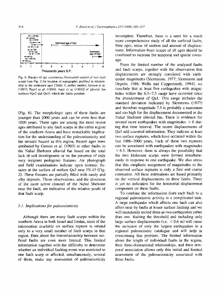
Fig. 6. Ranges of age estimations (horizontal marks) of two fault scarps (see Fig. 2 for location of topographic profiles) in relation- ship to the estimated ages [Table 3; earlier studies; Gerson et al. (1993); Enzel el al. (1994); Amit et al. (1995)] of alluvial fan surfaces (Qa2 and Qa3), which the faults postdate.
(Fig. 6). The morphologic ages of these faults are younger than 2000 years and can be even less than 1000 years. These ages are among the most recent ages attributed to any fault scarps in the entire region of the southern Arava and have remarkable implica- tion for the understanding of the paleoseismicity and the seismic hazard in this region. Recent ages were attributed by Gerson et al. (1993) to other faults in the Nahal Shehoret alluvial fan based on the total lack of soil development or on the presence of only very incipient pedogenic features. Air photograph and field examinations indicate open tectonic fis- sures at the surface of surface Qa3 near FS-15 (Fig. 2). These fissures are partially filled with sandy and silty deposits. These observations, and the diversion of the most active channel of the Nahal Shehoret near the fault, are indicative of the relative youth of that fault scarp.
5.1. Implications for paleoseismicity
Although there are many fault scarps within the southern Arava in both Israel and Jordan, most of the information available on surface rupture is related only to a very small number of fault scarps in that region. Data about the interrelationship between sur- ficial faults are even more limited. This limited information together with the difficulty to determine whether an individual faulting event was restricted to one fault scarp or affected, simultaneously, several of them, make any assessment of paleoseismicity
incomplete. Therefore, there is a need for a much more comprehensive study of all the surficial faults, their ages, sense of motion and amount of displace- ment. Information from scarps of all ages should be combined to increase the temporal and spatial cover- age.
From file limited number of the analyzed faults and fault scarps, together with the observation that displacements are strongly correlated with earth- quake magnitudes (Slemmons, 1977; Slemmons and Depolo, 1986; Wells and Coppersmith, 1994), we conclude that at least five earthquakes with magni- tudes within the 6.5-7.5 range have Occurred since the abandonment of Qal . This range includes the standard deviation indicated by Slemmons (1977) and therefore magnitude 7.5 is probably a maximum and too high for the displacement documented in the Nahai Shehoret alluvial fan. There is evidence for several more earthquakes with magnitudes > 6 dur- ing that time interval. The recent displacements of Qa3 add essential information. They indicate at least two surface ruptures, which have occurred within the last 1000-2000 years. Each of these two ruptures can be associated with earthquakes with magnitudes > 6.5. However, there is always the possibility that the two Holocene scarps were formed simultane- ously in response to one earthquake. We also stress that this simplistic assignment of magnitudes to the observed surface ruptures is only a first and coarse estimation. All these estimations are based primarily on the vertical displacements on these faults. There is yet no indication for the horizontal displacement component on these faults.
To combine the information from each fault to a regional paleoseismic activity is a complicated task. A large earthquake which affects one fault can also affect near-by faults at lesser surface faulting and we will mistakenly record them as two earthquakes rather than one. Raising the threshold and including only large surface displacements (i.e. < 0.6 m) will cause the inclusion of only the largest earthquakes in a regional paleoseismic catalogue and will help in overcoming this problem. The limited information about the length of individual faults in the region, their three-dimensional relationships, and their tem- poral association allows only this initial and limited assessment of the paleoseismicity associated with these faults.

Y. Enzel et al. / Tectonophysics 253 (1996) 305-317 315
6. Summary and conclusions
Independently, the soil stratigraphic studies (Ger- son et al., 1993), the scarp degradation modeling (Enzel et al., 1994; this study) and the IRSL studies (Porat et al., 1994) have produced internally consis- tent ages for both the faulting and alluvial surfaces Qal, Qa2 and Qa3 (Table 3). These approaches complement each other, and suggest that the age estimates are reasonable and determine a more reli- able age range for the faulting of the Nahal Shehoret alluvial fan. These results indicate that these method- ologies can be applied to other faults in alluvial fans in the southern Arava.
Within the limited area of the Nahal Shehoret alluvial fan, the scarp degradation modeling proved to be a useful tool in determining the ages of fault scarps (this study) and terrace risers (Enzel et al., 1994). According to the modeling, the age of the fault scarp is 50-17 ka and alluvial surfaces Qa2 and Qa3 were probably formed during the early and middle Holocene in agreement with the earlier soil studies. Recent faults displace these Holocene sur- faces and the modeling of the fault scarps indicates ages < 2 ka and perhaps less than 1000 years for these scarps. These scarps indicate that one or two earthquake with magnitude > 6.5 have occurred very recently. If this is indicative of the activity of other faults in the region, then occurrence of relatively large earthquake is more common than was previ- ously thought.
Scarp degradation modeling can serve as an ex- ploratory tool in distinguishing between groups of fault scarps of similar ages in the entire region of the southern Arava within the detection limit (Hanks et al., 1984; Begin, 1992) and therefore to help in detecting changes in patterns of faults through time. In combination with independent and detailed soil- stratigraphic studies and alluvial stratigraphy it can be a tool in estimating paleoseismicity even in this extremely arid environment where only a few numer- ical dates exist and the age-control is relatively poor. The independent IRSL dates of the Nahal Shehoret alluvial fan deposits helped in verifying and narrow- ing the range of the regional diffusion coefficient to 0.2-0.3 m 2 ka -1, a range that should be used in future modeling.
The diffusion modeling approach to provide the
morphologic age of fault scarps and terrace risers is applicable in the extremely arid southern Arava val- ley in Israel. It provides systematic ages, which are in agreement with other methods. This is yet the only test whether this method can provide a relatively good estimation of the age of numerous fault scarps in the region. Even if the estimated ages are not accurate, the morphologic ages provide additional relative age dating tool that distinguishes well be- tween scarps of various ages. Therefore, this method can be applied in similar extremely arid areas, in the Middle East and other regions, which lack other, more reliable dating materials.
Acknowledgements
We thank Y. Weiler and the Licensing Division of the Israeli Atomic Energy Commission for the continuous financial support and encouragement. Additional support was provided by the Hebrew Univ. Internal Funds and VATAT. JBJH was a Golda Meir Post-Doctoral Fellow. IRSL measure- ments were carried out at the Luminescence Dating Laboratory at the University of Wales, Aberystwyth. We thank Dr. A.G. Wintle for help and for providing us with these facilities. We discussed the regional implications of this study with Y. Eyal, D. Wachs and Y. Weiler. Comments by Drs. B. Begin, T. Hanks, L. Mayer and D. Nash have demonstrated to us how helpful the review process can be.
References
Amit, R. and Gerson, R., 1986. The evolution of Holocene Reg (gravely) soils in deserts--an example from the Dead Sea region. Catena, 13: 59-79.
Amit, R., Gerson, R. and Yaalon, D.H., 1993. Stages and rate of the gravel shattering process by salts in desert Reg soils. Geoderma, 57: 295-324.
Amit, R., Harrison, J.B.J. and Enzel, Y., 1995. Use of soils and colluvial deposits in analyzing tectonic events - - the southern Arava Rift, Israel. Geomorphology, 12: 91-107.
Andrews, D.J. and Hanks, T.C., 1985. Scarp degraded by linear diffusion: Inverse solution for age. J. Geophys. Res., 90: 10,913-10,208.
Begin, Z.B., 1992. Application of quantitative morphologic dating to paleo-seismicity of the northwestern Negev, Israel. Isr. J. Earth Sci., 41: 95-103.
316 Y. Enzel et al. / Tectom~physics 253 (1996) 305-317
Begin, Z.B., Broecker, W., Buchbinder, B., Drnckman, Y., Kanf- man, A., Magaritz, M. and Neev, D., 1985. Dead Sea and Lake Lisan levels in the last 30,000 years. Geol. Surv. Isr. Rep. MM-29, 18 pp.
Birkeland, P.W. and Gerson, R., 1991. Soil catena development with time in a hot desert, southern Israel - - field data and salt distribution. J. Arid Environ., 21: 267-281.
Bowman, D. and Gerson, R., 1986. Morphology of the latest Quaternary surface faulting in the Gulf of Elat region, eastern Sinai. Tectonophysics, 128: 97-119.
Bowman, D. and Gross, T., 1989, Neotectonics in the Northern Arava. Res. Rep. to the Israel Department of Energy, 52 pp. (in Hebrew).
Bucknam, R.L. and Anderson, R.E., 1979. Estimation of fault- scarp ages from a scarp-height-slope-angle relationship. Geol- ogy, 7 :11-14 .
Colman, S.M. and Machette, M.N., 1981. Application of a diffu- sion-equation model of fault-scarp degradation to late Quater- nary fault scarps in Colorado and New Mexico. Geol. Soc. Am., Abstr. Progr., 13: 429.
Colman, S.M. and Watson, K., 1983. Ages estimated from diffu- sion-equation model for scarp degradation. Science, 221: 263- 265.
Drnckman, Y., Weisbrod, T. and Garfunkel, Z., 1993. Geological map of Israel, 1:100,000, Sheets 25, 26. Geol. Surv. Israel, Jerusalem.
Enzel, Y., Amit, R., Harrison, J.B.J. and Porat, N., 1994. Morpho- logic dating of fault scarps and terrace risers in the southern Arava, Israel: Comparison to other age-dating techniques and implications for paleoseismicity. Isr. J. Earth Sci., 43:91 - 103.
Garfunkel, Z., 1970. The tectonics of the western margins of the Southern Arava. Ph.D. Diss. Hebrew Univ. of Jerusalem, 361 pp. (Hebrew with English summary).
Garfunkel, Z., Zak, I. and Freund, R., 1981. Active faulting in the Dead Sea Rift. Tectonophysics, 80: 1-26.
Gat, J.R. and Magaritz, M., 1980. Climatic variations in the eastern Mediterranean Sea area. Naturwissenschaften, 67: 80- 87.
Gerson, R. and Amit, R., 1987. Rates and modes of dust accretion and deposition in an arid region - - the Negev, Israel. In: L.K. Frostick and I. Reid (Editors), Desert Sediments: Ancient and Modern. Geol. Soc. London, Spec. Publ., 35: 157-169.
Gerson, R. and Grossman, S., 1991. Later stages in the morpho- tectonic evolution of the southern Arava valley rift, Jerusalem, Israel. Minist. Energy Infrastruct. Rep. ES-1-91, 31 pp.
Gerson, R., Amit, R. and Grossman, S., 1985. Dust availability in desert terrains - - A study in the deserts of Israel and Sinai. U.S. Army Res. Dev. Stand. Group, UK, Contract No. DAJA45-83-C-0041, 173 pp.
Gerson, R., Grossman, S., Amit, R. and Greenbaum, N., 1993. Indicators of faulting events and period of quiescence in desert alluvial fans. Earth Surf. Process. Landforms, 18: 181-202.
Hanks, T.C. and Wallace, R.E., 1985. Morphological analysis of the Lake Lahontan shoreline and beachfront fault scarps, Pershing County, Nevada. Seismol. Soc. Am. Bull., 75: 835- 846.
Hanks, T.C., Bucknam, R.L., Lajoie, K.L. and Wallace, R.E., 1984. Modification of wave-cut and fault-controlled land- forms. J. Geophys. Res., 89: 5771-5790.
Harrison, J.B.J., Kendrick, K.J., Weldon, R.J. and McFadden, L.D., in press. Temporal and spatial variations in terrace riser catenas in Transverse Ranges, Southern California. Catena.
Horowitz, A., 1979. The Quaternary of Israel. Academic Press, New York, NY, 394 pp.
Kenderick, K.J., Harrison, J.B.J. and McFadden, L.D., 1990. An evaluation of a non-linear diffusion equation as a model for determining the rate of scarp degradation in Cajon Pass, Southern California. Mojave Desert Quaternary Res. Symp. San Bernardino County Museum, Redlands, CA, May 18-21, 199O.
Kirkby, A. and Kirkby, M.J., 1976. Geomorphic processes and the surface survey of archeological sites in semiarid areas. In: D.A. Davidson and M.L. Shackley (Editors), Geoarcheology: Earth Science and the Past. Duckworth, London, pp. 229-253.
Machette, M.N., 1982. Quaternary and Pliocene faults in the La Jencia and southern parts of the Albuquerque-Belen basins, New Mexico: Evidence of fault history from fault-scarp mor- phology and Quaternary geology. In: J.A. Grambling and S.G. Wells (Editors), Albuquerque Country I!. N. M. Geol. Soc., pp. 161-170.
Mayer, L., 1984. Dating Quaternary fault scarps formed in allu- vium using morphologic dating. Quat. Res., 22: 300-313.
Mayer, L., 1987. Sources of error in morphologic dating of fault scarps. In: A.J. Crone (Editor), Proc. XXXIX Conf., Work- shop on Directions in Paleoseismicity. U.S. Geol. Surv., Open-File Rep. 87-673.
Nash, D.B., 1980. Morphologic dating of degraded normal fault scarps. J. Geol., 88: 353-360.
Nash, D.B., 1984. Morphologic dating of alluvial terrace scarps and fault scarps near West Yellowstone, Montana. Geol. Soc. Am. Bull., 95: 1413-1424.
Nash, D.B., 1986. Morphologic dating and modeling degradation of fault scarps. In: National Research Council, Studies in Geophysics - - Active Tectonics. National Academy Press, Washington, DC, pp. 181-194.
Nash, D.B., 1987. SLOPEAGE - - A computer program for morphologic dating of scarps. Fenneman-Rich Geograph. Lab., Dep. Geol., Univ. Cincinnati, OH.
Pierce, K.L. and Colman, S.M., 1986. Effect of height and orientation (microclimate) on geomorphic degradation rates and processes: late glacial terrace scarps in central Idaho. Geol. Soc. Am. Bull., 97: 869-885.
Porat, N., Amit, R. and Wintle, A.G., 1994. IRSL dating of fault-related sediments at the Nahal Shehoret alluvial fan, southern Arava, Israel. In: R. Amit, Y. Arkin and F. Hirsch (Editors), lsr. Geol. SOC. Annu. Meet. 1994, p. 84.
Slemmons, D.B., 1977. Fault and earthquake magnitude. In: State- of-the-art Assessing of Earthquake Hazards in the United States. U.S. Army Corps Waterways Exp. Stn., Misc. Pap. S-73-1, Rep. 6, 169 pp.
Slemmons, D.B. and Depolo, C.M., 1986. Evaluation of active faulting and associated hazards. In: National Research Coun-
Y. Enzel et al. / Tectonophysics 253 (1996) 305-317 317
cil, Studies in Geophysics - - Active Tectonics. National Academy Press, Washington, DC, pp. 45-62.
Wallace, R.E., 1977. Profile and ages of young fault scarps, north-central Nevada. Geol. Soc. Am. Bull., 88: 1267-1281.
Wallace, R.E., 1980. Degradation of the Hegben Lake fault scarps of 1959. Geology, 8: 225-229.
Wells, D.L. and Coppersmith, K.J., 1994. New empirical relation- ships among magnitude, repture length, rupture width, rupture area and surface displacement. Bull. Seismol. Soc. Am., 84: 974-1002.