Large-scale slope instability at the southern margin of the Ediacaran Yangtze platform (Hunan...
13
Precambrian Research 148 (2006) 32–44 Large-scale slope instability at the southern margin of the Ediacaran Yangtze platform (Hunan province, central China) E. Vernhet a,b,∗ , C. Heubeck b , M.-Y. Zhu c , J.-M. Zhang c a Centre de S´ edimentologie-Pal´ eontologie, Universit´ e de Provence 3, Place Victor Hugo, 13331 Marseille-Cedex 3, France b Institut f ¨ ur Geologische Wissenschaften, Freie Universit¨ at, Malteserstrasse 74-100, D-12249 Berlin, Germany c Nanjing Institute of Geology and Palaeontology, 39 Beijing Donglu, Nanjing, 210008 Jiangsu Province, PR China Received 27 April 2005; received in revised form 15 March 2006; accepted 29 March 2006 Abstract Thirteen stratigraphical sections from the Doushantuo Formation, Hunan province, central China, indicate large-scale mass wasting of the Yangtze platform margin between the late Neoproterozoic glaciation and the earliest Cambrian. Numerous sedimentary discontinuities, due to regional slides, olistostromes, and slumps have modified the stratigraphy between the shallow-water carbonate platform margin and the siliciclastic slope. Slide blocks are predominantly gently deformed and are largely composed of shallow water dolomitized limestones. Slide sheets may reach a regional extent of up to ∼5000 km 2 and are embedded in anoxic shales at an unknown water depth. © 2006 Elsevier B.V. All rights reserved. Keywords: Slope; Margin collapse; Yangtze platform; Doushantuo formation; China 1. Introduction The Neoproterozoic and Cambrian strata of the Yangtze platform are one of the foremost locations in the world to study the Cambrian bioradiation. A detailed understanding of the temporal succession and ecolog- ical factors involved in this radiation event, however, has been hindered by the lack of detailed correlations between the numerous fossil-bearing locations and by a poor understanding of the depositional processes (Zhu et al., 2003). The transitional zone between the fos- siliferous, stratigraphically incomplete, shallow-water carbonate environment and the stratigraphically com- plete but fossil free deepwater siliciclastic environment may enable a better correlation between the platform ∗ Corresponding author. E-mail address: [email protected] (E. Vernhet). and the basin. This would assist with reconstructing a detailed stratigraphical account of the tectonic and cli- matic drivers in the evolution of the Yangtze platform. Thirteen stratigraphic sections were measured dur- ing two field seasons in 2002 and 2003. Representative samples were cut, polished, and scanned in order to highlight sedimentary structures and facies. Thin sec- tion petrography aided in the identification of mineral- ogy, diagenesis and microfacies. All sections are located in Hunan province, central China (Fig. 1), situated on the south-east facing slope of the Yangtze carbonate platform which formed during the Late Neoproterozoic (635-551 Ma) (Condon et al., 2005). 2. Geological setting During the Late Neoproterozoic, the palaeogeo- graphic location of South China and its position in the Rodinia supercontinent is, like many other small 0301-9268/$ – see front matter © 2006 Elsevier B.V. All rights reserved. doi:10.1016/j.precamres.2006.03.009
-
Upload
independent -
Category
Documents
-
view
4 -
download
0
Transcript of Large-scale slope instability at the southern margin of the Ediacaran Yangtze platform (Hunan...

Precambrian Research 148 (2006) 32–44
Large-scale slope instability at the southern margin of theEdiacaran Yangtze platform (Hunan province, central China)
E. Vernhet a,b,∗, C. Heubeck b, M.-Y. Zhu c, J.-M. Zhang c
a Centre de Sedimentologie-Paleontologie, Universite de Provence 3, Place Victor Hugo, 13331 Marseille-Cedex 3, Franceb Institut fur Geologische Wissenschaften, Freie Universitat, Malteserstrasse 74-100, D-12249 Berlin, Germany
c Nanjing Institute of Geology and Palaeontology, 39 Beijing Donglu, Nanjing, 210008 Jiangsu Province, PR China
Received 27 April 2005; received in revised form 15 March 2006; accepted 29 March 2006
Abstract
Thirteen stratigraphical sections from the Doushantuo Formation, Hunan province, central China, indicate large-scale masswasting of the Yangtze platform margin between the late Neoproterozoic glaciation and the earliest Cambrian. Numerous sedimentarydiscontinuities, due to regional slides, olistostromes, and slumps have modified the stratigraphy between the shallow-water carbonateplatform margin and the siliciclastic slope. Slide blocks are predominantly gently deformed and are largely composed of shallowwater dolomitized limestones. Slide sheets may reach a regional extent of up to ∼5000 km2 and are embedded in anoxic shales atan unknown water depth.© 2006 Elsevier B.V. All rights reserved.
Keywords: Slope; Margin collapse; Yangtze platform; Doushantuo formation; China
1. Introduction
The Neoproterozoic and Cambrian strata of theYangtze platform are one of the foremost locations inthe world to study the Cambrian bioradiation. A detailedunderstanding of the temporal succession and ecolog-ical factors involved in this radiation event, however,has been hindered by the lack of detailed correlationsbetween the numerous fossil-bearing locations and by apoor understanding of the depositional processes (Zhuet al., 2003). The transitional zone between the fos-siliferous, stratigraphically incomplete, shallow-watercarbonate environment and the stratigraphically com-plete but fossil free deepwater siliciclastic environmentmay enable a better correlation between the platform
∗ Corresponding author.E-mail address: [email protected] (E. Vernhet).
and the basin. This would assist with reconstructing adetailed stratigraphical account of the tectonic and cli-matic drivers in the evolution of the Yangtze platform.
Thirteen stratigraphic sections were measured dur-ing two field seasons in 2002 and 2003. Representativesamples were cut, polished, and scanned in order tohighlight sedimentary structures and facies. Thin sec-tion petrography aided in the identification of mineral-ogy, diagenesis and microfacies. All sections are locatedin Hunan province, central China (Fig. 1), situated onthe south-east facing slope of the Yangtze carbonateplatform which formed during the Late Neoproterozoic(635-551 Ma) (Condon et al., 2005).
2. Geological setting
During the Late Neoproterozoic, the palaeogeo-graphic location of South China and its position inthe Rodinia supercontinent is, like many other small
0301-9268/$ – see front matter © 2006 Elsevier B.V. All rights reserved.doi:10.1016/j.precamres.2006.03.009

E. Vernhet et al. / Precambrian Research 148 (2006) 32–44 33
Fig. 1. Geographic location of the study area, northern HunanProvince, central China, representing the Ediacaran south eastward-dipping slope of the Yangtze platform.
blocks, poorly constrained. Li et al. (1995) proposedthat the South China block linked Australia to Laurentiabetween 1 Ga and 700 Ma while Powell and Pisarevsky(2002) also joined South China to Australia in theirreconstruction of Gondwana and Laurentia. Palaeomag-netic analyses suggest an equatorial location at 600 Ma(Macouin et al., 2004) with the collision of the Yangtzecraton and the Cathaysia block (the south-eastern sec-tion of present-day China) forming the South Chinablock during the Mesoproterozoic to early Neoprotero-zoic (Condie, 2003; Pisarevsky et al., 2003).
During the Neoproterozoic the Yangtze craton waslocated within an extensional regime following thebreak-up of Rodinia. After the Late Neoproterozoicthe platform evolved into a passive continental mar-gin (Wang and Li, 2003) (Fig. 2A.). Today the Yangtzecraton is bordered by the Gingfeng–Xiangfan–Guangji(Qin-Lin) fault zone to the north, extending from Tibet tonorthern Anhui, and the Cathaysia suture to the south-east (Fig. 2B). This resulted from collisions with theCathaysia block to the south-east during the Silurianand Early Triassic and the North China craton duringthe Early Triassic (Hsu and Chen, 1999). This causeda moderate deformation of the Palaeozoic sedimentarycover. Cretaceous extensional tectonics created largefault bounded basins filled by continental facies. In gen-eral, the Proterozoic–Palaeozoic strata are preserved atthickness of several kilometres and have been moder-ately deformed by large-scale folds.
2.1. Stratigraphy
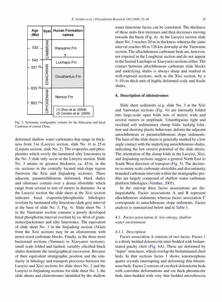
Within the studied interval (Fig. 3) the sedimentaryrecord is marked by diamictites in the Nantuo Forma-tion, which are most likely a product of the Marinoanglaciation (Zhou et al., 2004; Condon et al., 2005).These putatively glaciogenic sediments have receivedrenewed interest within the “Snowball Earth” theory(Hoffman et al., 1998; Hoffman and Schrag, 2000,2002). A “cap carbonate” unit that overlies the tillitesforms the base of the Doushantuo Formation. Unusualsedimentary structures (Nogueira et al., 2003) and anegative �13C isotope anomaly (Knoll et al., 1993;Germs, 1995; Corsetti and Hagadorn, 2000; Jiang etal., 2003) occur in these “cap carbonates”, marking asudden change from icehouse to greenhouse conditionsduring the Late Neoproterozoic. The diamictites of theNantuo Formation and the overlying “cap carbonates” ofthe Doushantuo Formation occur widely throughout thecentral and southern Yangtze platform. The DoushantuoFormation in the Hunan province is dominated by black,thinly laminated, variably silicified shales inter-beddedwith thin dark grey siltstone beds, which originate fromturbidity currents, or occasionally with thinly laminatedchert. Within this formation two phosphorite units aretraceable across the region and are commonly usedas stratigraphical markers. Tuffaceous sediments arecommon to abundant but are finely dispersed within theshales. The boundary of the Doushantuo Formation withthe overlying Liuchapo Formation is conventionally
placed at the first occurrence of the thick-bedded blackchert. This boundary, though, is often eroded and inseveral sections represents the base of a major slideinvolving olistostromes and outcrop scale contortedbedding. The black silicified shales of the Liuchapo For-mation grade updip into the dolomitized shallow-waterlimestones of the Dengying Formation, which are com-mon across the platform in the northern Hunan and Hubeiprovinces.3. Correlation of sections
Arranging the analysed sections according to theirdistance from the (inferred) margin of the shallow water,carbonate dominated, Yangtze platform (Figs. 1 and 4)indicates a progradational sequence containing numer-ous, laterally related, correlatable gravity depositsincluding slump folds, slides, olistostromes, debris flowsand turbidites.
In the four sections closest to the inferred platformmargin (between the Luoyixi and Liujiata sections)slump-folded shales are inter-bedded with gently

34 E. Vernhet et al. / Precambrian Research 148 (2006) 32–44
Fig. 2. (A) Palaeoenvironmental reconstruction of the southern Yangtze platform during the early Ediacaran (Doushantuo Fm; ∼635–550 Ma,Condon et al., 2005) (partly modified after Steiner, 2001). (B) Tectonic blocks of present-day eastern China. The North China block collided withYangtze craton during the Permian/Triassic, while the Cathaysia block collided with Yangtze craton during the Silurian/Early Triassic. The Yangtzecraton added the Cathaysia block to form the South China block (after Wang and Mo, 1995).
E. Vernhet et al. / Precambrian Research 148 (2006) 32–44 35
Fig. 3. Schematic stratigraphic column for the Ediacaran and basalCambrian of central China.
deformed shallow water carbonates that range in thick-ness from 3 m (Luoyixi section, slide No. 4) to 25 m(Liujiata section, slide No. 2). The evaporites and phos-phorites which overly the laminated silty limestones inthe No. 3 slide only occur at the Luoyixi section. SlideNo. 3 attains its greatest thickness, ca. 45 m, in thesix sections in the centrally located mid-slope region(between the Xixi and Jinjiadong sections). Thereadjacent, parautochthonous deformed, black shalesand siltstones contain over a dozen olistoliths whichrange from several to tens of meters in diameter. As atthe Luoyixi section the slide sheet at the Xixi sectionindicates basal evaporitic/phosphoritic lithologiesoverlain by laminated silty limestone (dark grey intervalat the base of slide No. 3, Fig. 4). Slide sheet No. 3in the Yanwutan section contains a poorly developedbasal phosphorite interval overlain by ca. 40 m of grain-stones/packstones and silty limestones. The equivalentof slide sheet No. 3 in the Jinjiadong section (54 kmfrom the Xixi section) may be an olistostrome withmeter-sized carbonate blocks. Finally, in the three mostbasinward sections (Yunmaxi to Xiaoyanxi sections),small scale folded and faulted, variably silicified blackshales dominate the stratigraphical succession. Becauseof their equivalent stratigraphic position and the sim-ilarity in lithology and transport processes between theLuoyixi and Xixi sections for slide sheet No. 2 and theLuoyixi to Jinjiadong sections for slide sheet No. 3, theslide sheets and olistostromes identified by the shallow
water limestone facies can be correlated. The thicknessof these units first increases and then decreases movingtowards the basin (Fig. 4). At the Luoyixi section slidesheet No. 3 reaches 20 m in thickness whereas the sameinterval reaches 60 m 126 km downdip at the Yanwutansection. The allochthonous carbonate beds are, however,not exposed in the Longbizui section and do not appearin the basinal Liuchapo or Xiaoyanxi sections either. Thecontact between allochthonous carbonate slide blocksand underlying shales is always sharp and marked inwell-exposed sections, such as the Xixi section, by a5–10 cm thick unit of highly deformed scaly and fissileshales.
4. Description of olistostromes
Slide sheet sediments (e.g. slide No. 3 at the Xixiand Yanwutan sections (Fig. 4)) are internally foldedinto large-scale open folds tens of meters wide andseveral meters in amplitude. Unambiguous tight andisoclinal soft sedimentary slump folds, lacking folia-tion and showing plastic behaviour, deform the adjacentautochthonous or parautochthonous slope sediments.The base of the slide sheets is generally marked by a lowangle contact with the underlying autochthonous shales,indicating the low erosive potential of the slide sheets.The orientation of the slump folds in the Luoyixi, Xixi,and Jinjiadong sections suggest a general North East toSouth West direction of transport (Fig. 5). The decime-tre to metre scale carbonate olistoliths and discontinuity
bounded carbonate intervals within the stratigraphic pro-files are largely composed of shallow water carbonateplatform lithologies (Vernhet, 2005).In the outcrop three facies associations are dis-tinguishable. Facies associations A and B representallochthonous sediments whereas facies association Ccorresponds to autochthonous slope sediments. Faciesanalysis is summarized below and in Table 1.
4.1. Facies association A: low energy, shallowwater environment
4.1.1. DescriptionFacies association A consists of two facies. Facies 1
is a thinly bedded dolomicrite inter-bedded with biolam-inated patchy chert (Fig. 6A). These are deformed by“tepee” structures, which overlap the biolaminated chertbeds. In thin sections facies 1 shows xenomorphousquartz crystals interrupting and deforming thin bitumi-nous beds. Facies 2 consists of cm thick dolomicrite bedswith convolute deformations and cm thick phosmicritebeds inter-bedded with very thin bedded microbreccia

36E
.Vernhetetal./Precam
brianR
esearch148
(2006)32–44
Fig. 4. Stratigraphic correlation diagram between key sections in the Hunan province showing the south eastward-progradation of discrete mass slides (slides 1–4) on the south eastward-dippingslope of the Yangtze platform. See Fig. 1 for location.

E.Vernhetetal./P
recambrian
Research
148(2006)
32–4437
Table 1Summary of slope facies
Facies association Facies Description Components Grain descriptions Bedding type Sedimentary structures Interpretation Sections
Allochthonous faciesA Facies 1 Biolaminated phosphorites,
dolomicrite and/or patchychert; locally, interbeddedwith fine-sized grainstones
Silica, phosphorite,evaporites
mm-Sized dolo- orphos-intraclasts;Stromatolitic clasts
∼10 cm thick, laterallycontinuous, non-cyclic;lenticular bedding forthe grainstones
Bio-laminations,desiccation structuresas mudcracks and“tepees”
Edge ofshallow-water inclosed basin withemergence periods
Luoyixi, Yanwutan(Hunan)
Facies 2 Phosmicrites with evaporiticdolomicrites; collapse andmicro breccias
Apatite cement,dolomite micrites,evaporites
cm-to-dm-sizedphos-intraclasts
Laterally discontinuous,lenticular bedding
Collapse breccias,evaporite-inducedconvolutes
Edge ofshallow-water inclosed basin withemergence periods
Xixi (Hunan)
B Facies 3 Medium sand-sizedwackestones/packstones withhorizontal laminations ortrough cross-bedding; locally,thin-bedded breccia
Intraclasts, carbonatemicrite matrix,evaporite (?)
Medium sand-sizeddolo-intraclasts;cm-sizedphos-intraclasts inbreccia
cm-to-dm-thickbedding, laterallycontinuous
Winnowing-inducedhorizontal laminations,cm-scale troughcross-bedding
Above fairweatherwave base (∼30 mwater depth)
Xixi, Yanwutan,Luoyixi (Hunan)
Facies 4–5 Cross-stratifiedgrainstones/medium-sand-sizedgrainstones/packstones
Intraclasts,recrystallizeddolomites, micrite
Medium sand-sizeddolo-intraclasts
dm-Thick bedding,cross-strated, laterallydiscontinuous
Trough cross-bedding Sandbanks (5–60 mwater depth)
Yanwutan (Hunan)
Autochthonous faciesC Facies 6 Shales, shales interbedded
with phosphorites and/orsiltstones
(Calcareous) shales,apatite cement,(calcareous) siltstones
Thin-bedded, laterallycontinuous, non-cyclic
Thin parallellaminations due todiscrete changes ingrain size
Basin and slope withturbidite deposits
All sections
Shales, mudstones,wackestones/packstones,slump folds, olistoliths
(Calcareous) shales,fine-grained sandwacke-stones/packstones;varying in olistoliths
Thin-bedded, laterallydiscontinuous,non-cyclic
Thin, plan-parallellaminations, slumpfolds, varying inolistoliths
Slope with turbiditedeposits andolistostromes
Luoyixi, Longbizui,Xixi, Yanwutan,Sangshuping,Liujata, Jinjiadong,Liuchapo, Yunmaxi(Hunan)

38 E. Vernhet et al. / Precambrian Research 148 (2006) 32–44
Fig. 5. Sediment transport direction, as inferred from the orientationof slump fold axes in three locations (Luoyixi, Xixi and Jianjiadongsections). Thin arrows point to downslope direction, perpendicular toaxial plan of synsedimentary folds. Large grey arrow indicates overalldirection of the mass wasting.
containing mm-sized phosphorite clasts (Fig. 6B) or dm-sized breccia with cm-sized phosphorite clasts (Fig. 6C).The phosmicrite is either a biolaminated brown-redphosmicrite (“soft” phosmicrite) or a black phosmicrite(“hard” phosmicrite). The dolomicrite shows differentdegrees of deformations, which affects the organisationof the phosmicrite bedding (Fig. 6C). In thin sec-tions facies 2 reveals brown phosmicrite inter-beddedwith bituminous rich beds and thin beds of euhedraldolomite crystals. Locally fan shaped crystals are alsopresent.
4.1.2. InterpretationThe dominant micritic facies in facies association
A suggest a low-energy environment. Rare high-energyevents, such as storms, may have allowed the formationof microbreccias.
The “tepee” structures and the on-lapped chert bedsobserved in facies 1 may indicate that the sedimentationof the chert beds occurred after “tepee” formation. Con-sequently, “tepees” may represent syndeposition defor-mation following desiccation with facies 1 representativeof deposition in a shallow water environment subjectedto exposure periods.
The presence of evaporite in facies 2 is inferred fromthe convoluted structures and petrographic analysis ofthin sections. Brecciation within facies 2 has resulted inthe formation of evaporites, precipitation and dissolu-tion, which may have induced a collapse of the phos-
Fig. 6. Facies association A. Low-energy, shallow-water environment.(A) Facies 1: biolaminated patchy chert with “tepee” structures (whiterectangle) inter-bedded with dolomite. Luoyixi section. (B) Facies2: “hard” phosmicrite inter-bedded with microbreccia with mm-sizedphosphorite clasts. Xixi section. (C) Facies 2: evaporite-mediated brec-cia. The formal presence of evaporite induced the collapse of thephosphorite beds by precipitation and dissolution. Xixi section. c:chert; d: dolomite; hp: “hard” phosphorite; sp: “soft” phosphorite; mb:microbreccia bed; m: phosmicrite bed. For (B) and (C) scale bar divi-sion = 1 cm.
phorite beds. The evaporites and micrites may eitherindicate a restricted evaporitic environment that waseither located close enough to the platform margin to beincorporated into the slides, or was formed under early

E. Vernhet et al. / Precambrian Research 148 (2006) 32–44 39
diagenetic conditions with the oxidation of biogenic H2Sfrom decaying organic matter (Hill, 1995).
4.2. Facies association B: high-energy,shallow-water environment
4.2.1. DescriptionFacies association B consists of three facies rep-
resented by medium to high-energy deposits. Facies3 includes packstones with mm-sized intraclasts orga-nized in normally graded plan-parallel bedding surfacesand silty dolomitized limestones with trough, cm scale,cross-bedding (Fig. 7A). Facies 4 and 5 shows dm-sized trough cross-stratified and cross-bedded dolomi-tized limestones respectively (Fig. 7B). In thin sectionsthese facies show euhedral to xenomorphous, ∼50 �m,dolomite crystals. Opaque minerals are rare.
4.2.2. InterpretationThe secondary dolomitization makes primary tex-
tures difficult to identify. The preserved sedimentarystructures of these facies suggest that the dolomitizedlimestones were grainstones prior to dolomitization.However, the exact nature of grainstones (e.g., ooidal,peloidal) remains unknown. The normally graded, hor-izontally laminated, packstone and the trough cross-bedding which results in current ripples may indicatethat facies 3 was deposited on a shallow water, wavedominated, subtidal shelf (Fig. 7A). The trough cross-stratified grainstones may originate from the displace-mtmfs
4e
4
swcsdfi
4
n
Fig. 7. Facies association B: high-energy, shallow water environment.(A) Trough cross-bedded silty limestones. Luoyixi section. (B) Troughcross-stratified grainstone. Yanwutan section. (C) Facies associationC: low-energy, deep environment. Autochthonous black (silicified)shale. Discrete discontinuities correspond to the scar of previousslides.
the slope by suspension settling, or by turbiditic cur-rents. Slump folds and discrete internal discontinuitiesalso suggest that gravity-related mass movements haveoccurred. Breccia are interpreted as debrites resulting ofdebris flows.
ent of sand banks (facies 4; Fig. 7B) while the dm-sizedrough cross-bedding may correspond to the displace-ent of megaripples (facies 5). Consequently, these
acies may also have been deposited on a shallow waterubtidal shelf under the action of high-energy currents.
.3. Facies association C: low-energy, deep-waternvironment
.3.1. DescriptionFacies C is represented by thin-bedded silty
hales inter-bedded with normally graded packstones/ackestones, rare thick bedded, grain-supported brec-
ia/conglomerate (facies 6; Fig. 7C) showing internaloft-deformations, folded long angular clasts and cm- tom-sized round clasts. Slump folds and discrete intra-ormational discontinuities locally disturb the beddingn places (Fig. 7C).
.3.2. InterpretationFacies association C corresponds to the autochtho-
ous and para-autochthonous sediments deposited on

40 E. Vernhet et al. / Precambrian Research 148 (2006) 32–44
Fig. 8. Schematic ideal sequence of gravity induced facies occurringon submarine slopes (after Coniglio and Dix, 1992; Whitham, 1993;Stow et al., 1998; Lee and Chough, 2001).
5. Discussion
5.1. Evidence of large-scale mass displacements
Three criteria serve to identify large-scale slides: Thelaterally correlated units reveal the general characteris-tics of gravity movement processes in a logical downdipsuccession and may include the complete spectrum ofmass displacement processes (Fig. 8). During the ini-tiation of mass movements slumps and slides creategently folded limestones (Fig. 9A and A′) above dis-crete levels of highly deformed basal shear (Coniglioand Dix, 1992), megatruncation surfaces (Stewart et al.,1993) and slip surfaces (Stow et al., 1998) (Fig. 9Band C). Within mass movements slides of decametrethickness and possible km scale lateral extent and olis-tostromes involving meter-sized blocks increase in abun-dance (Fig. 9D). At the end of the mass movement thereduction in olistolith size (Jinjiadong section) or theirabsence in downslope sections (Liuchapo and Xiaoyanxisections) indicates that olistostromes were replaced bydebrites (Fig. 9E) or turbidites. Meter-scale tight to iso-clinal slump folds are common throughout the study areaallowing the downslope transportation direction to beinferred.
The complete theoretical sequence of gravity relateddeformations (Fig. 8) cannot be identified in a singleslide sheet. Slide sheet No. 1 (Fig. 4) shows only debrite(Fig. 9E) while slide sheet No. 4 (Fig. 4) shows onlyolistostromes (Fig. 9D). Except for the debrites of slide
sheet No. 1 (Fig. 4), the cohesion of the olistolith sedi-ments in the large-scale olistostromes (slide sheets No.2, 3, and 4; Fig. 4) are preserved and may represent anearly stage of mass movement.
Abrupt and erosional contacts in the stratigraphicprofiles without transitional facies from deep-water(autochthonous) facies to shallow water (allochthonous)facies are present throughout. Slide units include faciesdeposited in shallow-water protected basins with periodsof exposure (facies association A; facies 1 and 2) andfacies deposited on the shallow water, subtidal, wave-dominated platform (facies association B; facies 3, 4,and 5). The presence of these facies, which are unex-pected in slope environments, supports an allochthonousorigin for these deposits and the large-scale slide sheetinterpretations detailed above.
These unusual facies successions have a regional cov-erage. The allochthonous shallow water carbonates arepresent within a single stratigraphic unit for at least70 km between the Luoyixi and Yanwutan sections. Thismay represent either an assemblage of individual blocksexceeding outcrop size (several 100 m) at each of thethree adjacent mid-slope locations for the Liujiata, Xixiand Yanwutan sections or, a single coherent body on themid slope of ca. 50 km × 70 km in size.
5.2. Slide dimensions, displacement distance, andslope geometry
The largest, recent, documented submarine slides
are from the volcanic flanks of Hawaii (Moore et al.,1995; Cervelli et al., 2002; Ward, 2002) and Tenerife(Hurlimann et al., 2001). Some of these slides consist ofup to 2000 km3 of re-mobilized sediment (Ward, 2002).Debrites and turbidites, the most distal deposits of masswasting, may be transported up to several hundred kilo-metres from their source (Coniglio and Dix, 1992). Theseprocesses have been studied using seismic data and sonarimagery along modern slopes. For example, the recentPalos Verdes, California, slide carried ca. 0.34 km3 ofmass sediment over 4–5 km (Bohannon and Gardner,2004). In the North Aegean Sea Lykousis et al. (2002)documented a slide of 3–8 km3 over an area of 85 km2and a runout distance of 6–7 km. In the Japanese Sea Leeet al. (1996) studied slide sheets 10 km long and 50 mthick. The geological record also preserves examples ofsignificantly larger slides. Beutner and Craven (1996)describe a coherent Ordovician carbonate mass move-ment of 1300 km2 and several kilometres thickness thatmoved 30 km along a gently dipping surface. Similarly,Stewart et al. (1993) documented truncation surfacesover 56 km along the depositional strike and 8 km basin-

E. Vernhet et al. / Precambrian Research 148 (2006) 32–44 41
Fig. 9. (A) Gravity-related deformations in the silty limestones of slide sheet No. 3 at Xixi section. (A′) cm-sized ripples on the surface beddingof the silty limestones in slide sheet No. 3 (Xixi section). (B) Angular discontinuity between the Doushantuo Formation shales and overlying blacksilicified shales of the Liuchapo Formation, representing a slide horizon (Jinjiadong section). (C) Highly deformed sediment interval interpreted asthe slide surface at the base of slide sheet No. 2 (Xixi section, lower Doushantuo Formation). (D) Elongate silty limestone olistoliths (slide sheetNo. 4, white lines) in dm to m scale, slump folded black shale (upper Doushantuo Formation in the Luoyixi section). Note the erosive base ofthe olistolith and the undeformed overlying beds (black lines). (E) Debrites, showing near complete loss of sediment cohesion and local plasticdeformation, folded bed (white contour) (Sangshuping section, slide sheet No. 1).
ward. Large-scale submarine sliding or gravity inducedmass movement can occur along detachment surfacesdue to reduced frictional strength. This may be causedby high pore-water pressure (Spence and Tucker, 1997;Huvenne et al., 2002; Lykousis et al., 2002; Watts, 2004;
Martel, 2004), the dissociation of gas hydrates (Lee etal., 1996) or by the injection of volcanic gases (Beutnerand Craven, 1996).
The approximate location of the Yangtze platformmargin can be constrained from existing data (Bureau

42 E. Vernhet et al. / Precambrian Research 148 (2006) 32–44
of Geology and Mineral Resources, 1987, 1988, 1990)(Fig. 1). The greatest updip and proximal part of slideNo. 3 (Luoyixi section) appears to be located approxi-mately 36 km basinward of the inferred platform mar-gin (Figs. 1 and 4). Fragmentation of this slide sheetoccurs approximately 130 km basinward of the plat-form margin, upslope of the Jinjiadong section (Fig. 10).Therefore, this slide is estimated to cover an area ofapproximately 5000 km2 with a minimum thickness ofabout 10 m. The volume of displaced sediments probably
exceeds 50 km3. Thus, the large-scale slide sheet No. 3in the Ediacaran Yangtze platform slope, compared withpreviously studied major slides, shows an unusual large-scale extent area and small thickness.
Earthquakes (Mullins et al., 1991; Heubeck, 1992;Hurlimann et al., 2001), previous stress history (Silva etal., 2004), intense storm events (Stow et al., 1998), sig-nificant regressions (Lee et al., 1996, Spence and Tucker,1997) or sediment overloading (Coniglio and Dix, 1992;Bosellini et al., 1993; Spence and Tucker, 1997) may
Fig. 10. Proposed sedimentary evolution for the allochthonous deposi
ts on the Ediacaran south eastward-dipping Yangtze platform.
E. Vernhet et al. / Precambrian Research 148 (2006) 32–44 43
have initiated this sliding. The presence of evaporitesand phosphorites at the base of several large-scale slidesmay have facilitated this displacement.
A relationship between large scale mass wastingalong the platform margin and variations in sea level mayalso exist. The internal stratigraphy of the largest slideblock, No. 3, consists of a phosphoritic and evaporiticinterval with exposure features overlain by a medium tocoarse-grained carbonate interval. These may reflect asea level lowstand facies overlain by a transgressive orsea level highstand facies. Based on similarities withinthe lithological sequence and its thickness and facies,Vernhet (2005) proposed a correlation between the inter-nal slide sheet stratigraphy and autochthonous sectionsof the Doushantuo Formation. A subsequent lowstand,not represented in the slide sheet No. 3, may have trig-gered widespread mass wasting along the southeast-facing platform.
6. Conclusions
Our work documents large-scale mass transportationon the Yangtze platform slope during the Ediacaran.Three criteria help to identify the oversized slide sheets:(1) correlation between sections of allochthonous inter-vals; (2) abrupt vertical facies changes separated by thin,highly deformed, beds: interpreted as displacement lev-els; (3) the regional extent of the sliding unit. The sedi-mentary facies of the slide blocks allows an approximatereconstruction of the platform margin, which primarilycrprmpmssm
A
appdtpat
ity of the manuscript. The authors thank George Swamm(University College of London) for the correction of theEnglish language.
References
Beutner, E.C., Craven, A.E., 1996. Volcanic fluidization and the HeartMountain detachment, Wyoming. Geology 24, 595–598.
Bohannon, R.G., Gardner, J., 2004. Submarine landslides of San-Pedroescarpment, southwest of Long Beach, California. Mar. Geol. 203,261–268.
Bosellini, A., Neri, C., Luciani, V., 1993. Platform margin col-lapses and sequence stratigraphic organization of carbonate slopes:Cretaceous-Eocene, Gargano Promontory, southern Italy. TerraNova 5, 282–297.
Bureau of Geology and Mineral Resources of Guizhou Province,1987. Regional Geology of Guizhou Province, Geological Mem-oirs Series 1 Number 7. Geological Publishing House, Beijing.
Bureau of Geology and Mineral Resources of Hunan Province, 1988.Regional Geology of Hunan Province, Geological Memoirs Series1 Number 8. Geological Publishing House, Beijing.
Bureau of Geology and Mineral Resources of Hubei Province, 1990.Regional Geology of Hubei Province, Geological Memoirs Series1 Number 20. Geological Publishing House, Beijing.
Cervelli, P., Segall, P., Johnson, K., Lisowski, M., Miklius, A., 2002.Sudden aseismic fault slip on the south flank of Kilauea volcano.Nature 415, 1014–1018.
Condie, K.C., 2003. Supercontinents, superplumes and continentalgrowth: the Neoproterozoic record. In: Windley, Y.M., Dasgupta,S., Yoshida, M. (Eds.), Proterozoic East Gondwana: Superconti-nent Assembly and Breakup. Geol. Soc. Publ. House, London.
Condon, D., Zhu, M.-Y., Bowring, S., Yang, A., Jin, Y.-G., 2005. U-Pb ages from the Neoproterozoic Doushantuo Formation, China.
onsists of shallow water more or less restricted envi-onment. Displacement may have been facilitated by theresence of low strength evaporites and brittle phospho-ites at the base of the slides and/or by water and gas accu-ulation in the highly stratified sediments. Geochemical
rofiles in the deep-water facies of the Doushantuo For-ation, aiming at sampling stratigraphically continuous
ections of the Ediacaran, need to take into account thetratigraphic complexities caused by these widespreadass wasting events.
cknowledgements
Vernhet and Heubeck thank their colleagues for theirssistance with the fieldwork in China. This study tooklace within the multidisciplinary Sino-German researchrogram “From ‘Snowball Earth’ to the Cambrian biora-iation”, supported by DFG and NSFC. Elodie Vernhethanks the “Asforme” association for their financial sup-ort. The authors thank Prof. Eriksson, Prof. Chen andn anonymous reviewer for their valuable comments andheir precise reviews, which helped to improve the qual-
Science 308, 95–98.Coniglio, M., Dix, G.R., 1992. Carbonate slopes. In: Walker, R.G.,
James, N.P. (Eds.), Facies Models: Responses to the Sea LevelChange. Geol. Soc., Canada.
Corsetti, F.A., Hagadorn, J.W., 2000. Precambrian-Cambrian transi-tion: Death Valley, US. Geology 28, 299–302.
Germs, G.J.B., 1995. The Neoproterozoic of southwestern Africa, withemphasis on platform stratigraphy and paleontology. PrecambrianRes. 73, 137–151.
Heubeck, C., 1992. Sedimentology of large olistoliths, southernCordillera Central, Hispaniola. J. Sed. Petrol. 62, 474–482.
Hill, C., 1995. Sulfur redox reactions: hydrocarbons, native sulfur,Mississippi Valley-type deposits, and sulfuric acid karst in theDelaware Basin, New Mexico and Texas. Environ. Geol. 25, 16–23.
Hoffman, P.F., Kaufman, A.J., Halverson, G.P., Schrag, D.P., 1998. ANeoproterozoic snowball earth. Science 281, 1342–1346.
Hoffman, P.F., Schrag, D.P., 2000. Snowball earth. Sci. Am. 282,68–76.
Hoffman, P.F., Schrag, D.P., 2002. The snowball earth hypothesis: test-ing the limits of global change. Terra Nova 14, 129–155.
Huvenne, V.A.I., Crocker, P.F., Henriet, J.-P., 2002. A refreshing 3Dview of an ancient sediment collapse and slope failure. Terra Nova14, 33–40.
Hurlimann, M., Ledesma, A., Martı, J., 2001. Characterisation of avolcanic residual soil and its implications for large landslide phe-nomena: application to Tenerife, Canary Islands. Eng. Geol. 59,115–132.

44 E. Vernhet et al. / Precambrian Research 148 (2006) 32–44
Hsu, K.J.H., Chen, H.-H., 1999. Geologic Atlas of China. Elsevier,Amsterdam.
Jiang, G.-Q., Kennedy, M.J., Christie-Blick, N., 2003. Stable isotopicevidence for methane seeps in Neoproterozoic postglacial cap car-bonates. Nature 426, 822–826.
Knoll, A., Fairchild, I.J., Swett, K., 1993. Calcified microbes in Neo-proterozoic carbonates: implications for our understanding of theProterozoic/Cambrian transition. Palaios 8, 512–525.
Lee, H.J., Chough, S.K., Yoon, S.H., 1996. Slope-stability change fromlate Pleistocene to Holocene in the Ulleung Basin, East Sea (Japan).Sed. Geol. 104, 39–51.
Lee, S.H., Chough, S.K., 2001. High-resolution (2–7 kHz) acousticand geometric characters of submarine creep deposits in the SouthKorea Plateau, East Sea. Sedimentology 48, 629–644.
Li, Z.-X., Zhang, L., McA-Powell, C., 1995. South China in Rodinia:part of the missing link between Australia—East Antarctica andLaurentia? Geology 23, 407–410.
Lykousis, V., Roussaki, G., Alexandri, M., Pavlaki, P., Papoulia, I.,2002. Sliding and regional slope stability in active margins: NorthAegean Trough (Mediterranean). Mar. Geol. 186, 281–298.
Macouin, M., Besse, J., Ader, M., Gilder, S., Yang, Z., Sun, Z.,Agrinier, P., 2004. Combined paleomagnetic and isotopic datafrom the Doushantuo carbonates, South China: implications forthe “snowball Earth” hypothesis. Earth Planet. Sci. Lett. 224, 387–398.
Martel, S.J., 2004. Mechanics of landslide initiation as a shear fracturephenomenon. Mar. Geol. 203, 319–339.
Moore, J.G., Bryan, W.B., Beeson, M.H., Normark, W.R., 1995. Giantblocks in the South Kona landslide, Hawaii. Geology 23, 125–128.
Mullins, H.T., Dolan, J., Breen, N., Andersen, B., Gaylord, M., Petruc-cione, J.L., Wellner, R.W., Melillo, A.J., Jurgens, A.D., 1991.Retreat of carbonate platforms: response to tectonic processes.Geology 19, 1089–1092.
Nogueira, A.C.R., Riccomini, C., Nobrega Sial, A., Veloso Moura,
Proterozoic East Gondwana: Supercontinent Assembly andBreakup. Geol. Soc. Publ. House, London.
Powell, C.M., Pisarevsky, S.A., 2002. Late Neoproterozoic assemblyof East Gondwana. Geology 30, 3–6.
Silva, A.J., Baxter, C.D.P., LaRosa, P.T., Bryant, W.R., 2004. Inves-tigation of mass wasting on the continental slope and rise. Mar.Geol. 203, 355–366.
Spence, G.H., Tucker, M.E., 1997. Genesis of limestone megabrecciasand their significance in carbonate sequence stratigraphic models:a review. Sediment. Geol. 112, 163–193.
Steiner, M., 2001. Die fazielle Entwicklung und Fosiilverbreitung aufder Yangtze Plattform (Sudchina) im eoproterozoikum/fruhestenKambrium. Freiberger Forschungshefte 492, 1–26 (in German).
Stewart, W.D., Dixon, O.A., Rust, B.R., 1993. Middle Cambriancarbonate-platform collapse, southeastern Canadian Rocky Moun-tains. Geology 21, 687–690.
Stow, D.A.V., Reading, H.G., Collinson, J.D., 1998. Deep seas. In:Reading, H.G. (Ed.), Sedimentary Environments: Processes, Faciesand Stratigraphy. Blackwell, Oxford.
Vernhet, E., 2005. Sedimentary processes, evolution, and paleoenvi-ronmental reconstruction of the southern margin of the EdiacaranYangtze platform (Doushantuo Formation, central China). PhDThesis, Freie Universitat Berlin, 175 pp.
Wang, H.-Z., Mo, X.-X., 1995. An outline of the tectonic evolution ofChina. Episodes 18, 6–16.
Wang, J., Li, Z.X., 2003. History of the Neoproterozoic rift basins inSouth China: implications for Rodinia break-up. Precambrian Res.122, 141–158.
Ward, S.N., 2002. Slip-sliding away. Nature 415, 973–974.Watts, P., 2004. Probabilistic predictions of landslide tsunamis off
Southern California. Mar. Geol. 203, 281–301.Whitham, A.G., 1993. Facies and depositional processes in an Upper
Jurassic to Lower Cretaceous pelagic sedimentary sequence,Antarctica. Sedimentology 40, 331–349.
Zhou, C.-M., Tucker, R., Xiao, S.-H., Peng, Z.-X., Yuan, X.-L., Chen,
C.A., Fairchild, T.R., 2003. Soft-sediment deformation at the baseof the Neoproterozoic Puga cap carbonate (SW Amazon craton,Brazil): confirmation of rapid icehouse to greenhouse transition inSnowball Earth. Geology 31, 613–616.Pisarevsky, S.A., Wingate, M.T.D., McA Powell, C., Johnson, S.,Evans, D.D., 2003. Models of Rodinia assembly and fragmen-tation. In: Windley, Y.M., Dasgupta, S., Yoshida, M. (Eds.),
Z., 2004. New constraints on the ages of Neoproterozoic glaciationsin south China. Geology 32, 437–440.
Zhu, M.-Y., Zhang, J.-M., Steiner, M., Yang, A.-H., Li, G.-X.,Erdtmann, B.D., 2003. Sinian and Early Cambrian stratigraphicframeworks from shallow- to deep-water facies of the YangtzePlatform: an integrated approach. Prog. Nat. Sci. 13 (12), 951–960.