Comparing and Contrasting Expressionism, Abstract, and Pop ...

1801
Proceedings of the XVI ECSMGEGeotechnical Engineering for Infrastructure and DevelopmentISBN 978-0-7277-6067-8
© The authors and ICE Publishing: All rights reserved, 2015doi:10.1680/ecsmge.60678
Coastal slope instability in contrasting geo-environmental conditions
L'instabilité des pentes côtières en conditions géo-environnementauxcontrastés
S.B. Mickovski*1, O. Santos2 , P.M.D. Ingunza2 and L. Bressani3
1 Glasgow Caledonian University, Glasgow, Scotland, UK 2 Universidade Federal do Rio Grande do Norte, Natal, Brazil
3Universidade Federal do Rio Grande do Sul, Porto Alegre, Brazil * Corresponding Author
ABSTRACT With changing climate and increasing soil erosion rates the stability of coastal slopes worldwide gains importance every day.We investigated the mechanisms of instability on two coastal slopes in two different bio-geo-climatic regions with a view of comparing thepotential destabilising factors, hazards and consequences from a multi-disciplinary aspect. The slopes in north-east Scotland comprise thinsilts and sands over sandstone bedrock. Both shallow slips and erosion processes have shaped the slope which is also further destabilised bythe wave action from the sea. Grasses, shrubs and planted trees are partially covering the slope face. The slopes in Brazil comprise thicksand deposits over weak sandstone bedrock. Shallow translational slips as well as water and wind erosion effects dominate on the mainlyfallow slope. In the vegetated areas of the slope, climbers and grasses are recorded with an occasional presence of a tree. We conclude thatthe mechanisms of failure in different regions can be similar and so can be the destabilising factors. Through numerical modelling and eco-technological specification, we propose hazard mitigation measures and remediation techniques that are of value across the climatic regionswhich would provide resilience for the coastal slopes liable to instability. We also propose an engineering approach to the solution of thistype of problem involving knowledge from a number of disciplines related to geotechnics from the perspective of preservation of naturalresources.
RÉSUMÉ Avec l'évolution du climat et l'augmentation des taux d'érosion du sol la stabilité des pentes côtières gains à travers le mondeimportance chaque jour. Nous avons étudié les mécanismes d'instabilité sur deux versants côtiers dans deux régions bio-géo-climatiquesdifférentes en vue de comparer les facteurs déstabilisateurs potentiels, les risques et les conséquences d'un aspect multi-disciplinaire. Lespentes dans le nord-est de l'Ecosse comprennent limons et sables fins plus gréseux. Les deux feuillets superficiels et processus d'érosion ontfaçonné la pente qui est également en outre déstabilisé par l'action des vagues de la mer. Graminées, arbustes et arbres plantés couvrent par-tiellement la pente de ski face. Les pentes au Brésil comprennent les dépôts de sable épais sur fragilité du substratum rocheux de grès.Translation faible glisse ainsi que les effets de l'érosion hydrique et éolienne dominent sur le versant principalement en jachère. Dans leszones de végétation de la pente, les grimpeurs et les graminées sont enregistrées avec une présence occasionnelle d'un arbre. Nous con-cluons que les mécanismes de rupture dans les différentes régions peuvent être similaires et peuvent donc être les facteurs de déstabilisa-tion. Grâce à la spécification de la modélisation et de l'éco-technologique numérique nous proposons danger des mesures d'atténuation etles techniques d'assainissement qui sont de valeur dans les régions climatiques qui fourniraient résilience pour les pentes côtières suscep-tibles d'instabilité. Nous proposons également une approche d'ingénierie à la solution de ce type de problèmes impliquant la connaissanced'un certain nombre de disciplines liées à la géotechnique du point de vue de la préservation de ressources naturelles.
1 INTRODUCTION
The potential of natural or manmade soil slopes to undergo movement and become unstable is expected to increase with the global climate change (IPCC 2013). Slope instability events including landslips and erosion can be triggered by changing rainfall pat-
terns, sea level increase, and change of land use pat-terns (e.g. deforestation, desertification), increasing the risk of instability on slopes that have been stable for long periods. While the risk can be minimized by accounting for these changes when designing the new manmade slopes, natural and existing slopes are at higher risk of instability in a changing climate. This
Geotechnical Engineering for Infrastructure and Development
1802
instability is demonstrated as shallow slips in pre-dominantly granular materials and deeper circular failures in predominantly cohesive materials are usu-ally caused by gravity, weak soils or increase in pore water pressures. These failures, when combined with the erosion processes caused by wind, rain, and wave action, can dramatically decrease the stability for the slope, leading to soil mass wasting, and endangering life and property (Mickovski, 2014).
The interplay of the destabilization factors and the possible mitigation measures would depend on the slope location, the resources available, and the extent of risk. As both the causes of instability and mitiga-tion measures can be varied, a multi-disciplinary knowledge is needed to address this global problem which is a departure from the current reactive engi-neering approaches, where only the geotechnical as-pects of the problem are considered. Potential multi-disciplinary solutions should include eco-engineering strategies for minimizing erosion and stability risk, which gained in popularity in recent years due to re-quirements for sustainability (Norris et al. 2008). While eco-engineering slope stability designs exist, practical application in design and monitoring of per-formance are lacking, possibly due to reluctance to accept solutions without ‘hard’ engineering backing.
This paper investigates the mechanisms of insta-bility on two coastal slopes in two different bio-geo-climatic regions with a view of comparing the poten-tial de-stabilising factors, hazards and consequences from a multi-disciplinary aspect. It also explores po-tential sustainable solutions using vegetation for mit-igation of instability risks, which provide benefits for the slope users while minimising the financial costs of the mitigation.
2 METHODOLOGY
In this study we use the technological problem solv-ing approach (Lommler 2012) to explore possible slope instability mitigation methods for similar prob-lems occurring in different bio-geo-climatic regions. Adopting the tactical instability risk assessment ap-proach (Glendinning et al. 2009) we assessed the causes and mechanisms of failures on the slope using a range of techniques including site inspections, desk study, mapping, sampling, laboratory testing, and surveying, before outlining potential sustainable mit-
igation measures accounting for the potential bene-fits, costs, and risks.
3 CASE STUDIES
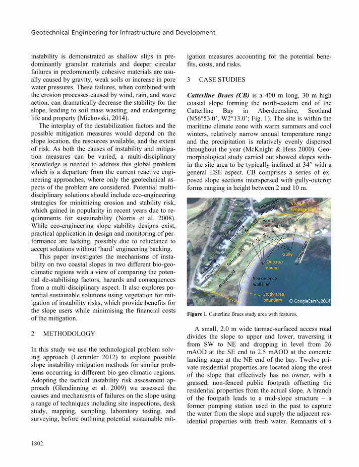
Catterline Braes (CB) is a 400 m long, 30 m high coastal slope forming the north-eastern end of the Catterline Bay in Aberdeenshire, Scotland (N56°53.0’, W2°13.0’; Fig. 1). The site is within the maritime climate zone with warm summers and cool winters, relatively narrow annual temperature range and the precipitation is relatively evenly dispersed throughout the year (McKnight & Hess 2000). Geo-morphological study carried out showed slopes with-in the site area to be typically inclined at 34° with a general ESE aspect. CB comprises a series of ex-posed slope sections interspersed with gully-outcrop forms ranging in height between 2 and 10 m. Figure 1. Catterline Braes study area with features.
A small, 2.0 m wide tarmac-surfaced access road
divides the slope to upper and lower, traversing it from SW to NE and dropping in level from 26 mAOD at the SE end to 2.5 mAOD at the concrete landing stage at the NE end of the bay. Twelve pri-vate residential properties are located along the crest of the slope that effectively has no owner, with a grassed, non-fenced public footpath offsetting the residential properties from the actual slope. A branch of the footpath leads to a mid-slope structure – a former pumping station used in the past to capture the water from the slope and supply the adjacent res-idential properties with fresh water. Remnants of a
sea defense wall comprising rounded boulders of 200 – 300 mm diameter exist at the toe of the slope delin-eating it from the beach. The sea defense wall com-prises sections of mass poured concrete gravity wall of trapezoidal cross-section, gabion baskets intercon-nected with a metal chain of approx. 200 mm diame-ter links, and an array of concrete cubes of 1 m3 vol-ume. The line of the sea wall is broken and the structures comprising it damaged to various degrees due to the action of the waves and potentially seep-age from the slope.
Published geological maps (BGS 2013) show the superficial soils at the site area (Fig. 1) to comprise Raised Beach Deposits (RBD) of sands and gravels of the Quaternary period on the slopes and Mill of Forest Till Formation (Glacial Till) at the crest of the slope. The bedrock is indicated to comprise Catter-line Conglomerate Formation of early Devonian age with clasts mainly of lava, but also containing psam-mite, quartzite, vein-quartz and feldspar porphyry in a medium-grained lithic sandstone matrix. Trial pit-ting and subsequent laboratory tests (BS1377 1990) carried out at 25 locations across the Upper and Lower slope to depths of 500 mm confirmed the pub-lished information and recorded the uppermost soil horizons as 300 mm thick topsoil underlain by red-dish-brown gravelly silty sand of low dry strength and low plasticity (BSEN14688 2004).
A review of satellite imagery from the past 10 years, the land cover maps and field observations from the past two years record the slope to be a neu-tral grassland covered with a range of vegetation types to a varying degree. Grasses, herbs, shrubs and planted trees are present on the slope, with the cover-age varying seasonally from approximately 20% in winter to approximately 80% during the vegetative period. At the crest of the slope and beyond the resi-dential properties, arable and horticultural land use is recorded.
Published hydro-geology maps (Macdonald 2004) indicate the superficial aquifers to be of moderate to high productivity with predominantly intergranular flow. The aquifers are indicated to be vulnerable to pollutants not readily adsorbed or transformed (SNIFFER 2004). Detailed site inspection showed a visible seepage line at the level of and adjacent to the pumping house, as well as 25 m north of the pumping house, indicating a spring or a series of non-
ephemeral springs, which then flows along naturally formed gullies towards a non-maintained gravel drain running along the access road which discharges into the sea at the landing stage. The surface water from the residential properties is discharged mainly near the crest of the slope, and collected in the same grav-el drain at the side of the access road.
There is a history of landslide activity along the slope, demonstrated through the series of hollows, gullies, outcropping rock mounds, and bulges which represent washouts, near-surface slope failures linked to the springs, and areas of ongoing creep (Fig. 2). Local sources document landslips dating back from the 1950s with the more recent major events (1994, 1995, and 2013) resulting in creation and enlarge-ment of the gullies and failure scars on the slope.
Figure 2. (a)Shallow translational slides and mudflow and (b) Deeper slides behind the seawall defense.
Based on the detailed site inspection, several
mechanisms of failure become evident. Translational slips of 0.5-1.0m depth (Fig. 2a) occur mainly on the upper slope in the sparsely vegetated and exposed ar-eas of the slope potentially due to oversteep slopes combined with the surface and/or groundwater acting as a destabilizing agent. These failures are progres-sive up- or down-slope and result in exposing the su-perficial soil deposits which are then further eroded by the surface/ground water. At the locations where the surface/ground water is the main driving agent, these slips can take the form of a mudslide or mud-flow after a heavy rain or storm event, resulting in deposition of washed-out fine material but also shrubs/small trees and blockage of the access road (Fig.2a). In both cases, the washed-out material blocks the gravel drain, which causes further erosion and instability by running off and penetrating into the soil on the lower slope. Deeper slides (1.0-2.0m depth) were recorded on the lower slope which may be connected to the stability and retention capacity of the seawall defense. During the event in 2013, high

1803
instability is demonstrated as shallow slips in pre-dominantly granular materials and deeper circular failures in predominantly cohesive materials are usu-ally caused by gravity, weak soils or increase in pore water pressures. These failures, when combined with the erosion processes caused by wind, rain, and wave action, can dramatically decrease the stability for the slope, leading to soil mass wasting, and endangering life and property (Mickovski, 2014).
The interplay of the destabilization factors and the possible mitigation measures would depend on the slope location, the resources available, and the extent of risk. As both the causes of instability and mitiga-tion measures can be varied, a multi-disciplinary knowledge is needed to address this global problem which is a departure from the current reactive engi-neering approaches, where only the geotechnical as-pects of the problem are considered. Potential multi-disciplinary solutions should include eco-engineering strategies for minimizing erosion and stability risk, which gained in popularity in recent years due to re-quirements for sustainability (Norris et al. 2008). While eco-engineering slope stability designs exist, practical application in design and monitoring of per-formance are lacking, possibly due to reluctance to accept solutions without ‘hard’ engineering backing.
This paper investigates the mechanisms of insta-bility on two coastal slopes in two different bio-geo-climatic regions with a view of comparing the poten-tial de-stabilising factors, hazards and consequences from a multi-disciplinary aspect. It also explores po-tential sustainable solutions using vegetation for mit-igation of instability risks, which provide benefits for the slope users while minimising the financial costs of the mitigation.
2 METHODOLOGY
In this study we use the technological problem solv-ing approach (Lommler 2012) to explore possible slope instability mitigation methods for similar prob-lems occurring in different bio-geo-climatic regions. Adopting the tactical instability risk assessment ap-proach (Glendinning et al. 2009) we assessed the causes and mechanisms of failures on the slope using a range of techniques including site inspections, desk study, mapping, sampling, laboratory testing, and surveying, before outlining potential sustainable mit-
igation measures accounting for the potential bene-fits, costs, and risks.
3 CASE STUDIES
Catterline Braes (CB) is a 400 m long, 30 m high coastal slope forming the north-eastern end of the Catterline Bay in Aberdeenshire, Scotland (N56°53.0’, W2°13.0’; Fig. 1). The site is within the maritime climate zone with warm summers and cool winters, relatively narrow annual temperature range and the precipitation is relatively evenly dispersed throughout the year (McKnight & Hess 2000). Geo-morphological study carried out showed slopes with-in the site area to be typically inclined at 34° with a general ESE aspect. CB comprises a series of ex-posed slope sections interspersed with gully-outcrop forms ranging in height between 2 and 10 m. Figure 1. Catterline Braes study area with features.
A small, 2.0 m wide tarmac-surfaced access road
divides the slope to upper and lower, traversing it from SW to NE and dropping in level from 26 mAOD at the SE end to 2.5 mAOD at the concrete landing stage at the NE end of the bay. Twelve pri-vate residential properties are located along the crest of the slope that effectively has no owner, with a grassed, non-fenced public footpath offsetting the residential properties from the actual slope. A branch of the footpath leads to a mid-slope structure – a former pumping station used in the past to capture the water from the slope and supply the adjacent res-idential properties with fresh water. Remnants of a
sea defense wall comprising rounded boulders of 200 – 300 mm diameter exist at the toe of the slope delin-eating it from the beach. The sea defense wall com-prises sections of mass poured concrete gravity wall of trapezoidal cross-section, gabion baskets intercon-nected with a metal chain of approx. 200 mm diame-ter links, and an array of concrete cubes of 1 m3 vol-ume. The line of the sea wall is broken and the structures comprising it damaged to various degrees due to the action of the waves and potentially seep-age from the slope.
Published geological maps (BGS 2013) show the superficial soils at the site area (Fig. 1) to comprise Raised Beach Deposits (RBD) of sands and gravels of the Quaternary period on the slopes and Mill of Forest Till Formation (Glacial Till) at the crest of the slope. The bedrock is indicated to comprise Catter-line Conglomerate Formation of early Devonian age with clasts mainly of lava, but also containing psam-mite, quartzite, vein-quartz and feldspar porphyry in a medium-grained lithic sandstone matrix. Trial pit-ting and subsequent laboratory tests (BS1377 1990) carried out at 25 locations across the Upper and Lower slope to depths of 500 mm confirmed the pub-lished information and recorded the uppermost soil horizons as 300 mm thick topsoil underlain by red-dish-brown gravelly silty sand of low dry strength and low plasticity (BSEN14688 2004).
A review of satellite imagery from the past 10 years, the land cover maps and field observations from the past two years record the slope to be a neu-tral grassland covered with a range of vegetation types to a varying degree. Grasses, herbs, shrubs and planted trees are present on the slope, with the cover-age varying seasonally from approximately 20% in winter to approximately 80% during the vegetative period. At the crest of the slope and beyond the resi-dential properties, arable and horticultural land use is recorded.
Published hydro-geology maps (Macdonald 2004) indicate the superficial aquifers to be of moderate to high productivity with predominantly intergranular flow. The aquifers are indicated to be vulnerable to pollutants not readily adsorbed or transformed (SNIFFER 2004). Detailed site inspection showed a visible seepage line at the level of and adjacent to the pumping house, as well as 25 m north of the pumping house, indicating a spring or a series of non-
ephemeral springs, which then flows along naturally formed gullies towards a non-maintained gravel drain running along the access road which discharges into the sea at the landing stage. The surface water from the residential properties is discharged mainly near the crest of the slope, and collected in the same grav-el drain at the side of the access road.
There is a history of landslide activity along the slope, demonstrated through the series of hollows, gullies, outcropping rock mounds, and bulges which represent washouts, near-surface slope failures linked to the springs, and areas of ongoing creep (Fig. 2). Local sources document landslips dating back from the 1950s with the more recent major events (1994, 1995, and 2013) resulting in creation and enlarge-ment of the gullies and failure scars on the slope.
Figure 2. (a)Shallow translational slides and mudflow and (b) Deeper slides behind the seawall defense.
Based on the detailed site inspection, several
mechanisms of failure become evident. Translational slips of 0.5-1.0m depth (Fig. 2a) occur mainly on the upper slope in the sparsely vegetated and exposed ar-eas of the slope potentially due to oversteep slopes combined with the surface and/or groundwater acting as a destabilizing agent. These failures are progres-sive up- or down-slope and result in exposing the su-perficial soil deposits which are then further eroded by the surface/ground water. At the locations where the surface/ground water is the main driving agent, these slips can take the form of a mudslide or mud-flow after a heavy rain or storm event, resulting in deposition of washed-out fine material but also shrubs/small trees and blockage of the access road (Fig.2a). In both cases, the washed-out material blocks the gravel drain, which causes further erosion and instability by running off and penetrating into the soil on the lower slope. Deeper slides (1.0-2.0m depth) were recorded on the lower slope which may be connected to the stability and retention capacity of the seawall defense. During the event in 2013, high
Mickovski, Santos, Ingunza and Bressani

Geotechnical Engineering for Infrastructure and Development
1804
waves topped the seawall and started eroding the lower slope at the same time increasing the porewater pressures in the lower slope. This resulted in instabil-ity of the seawall which was destroyed at the gabion sections and dislocated at the concrete block sections. This collapse allowed the movement of the soil on the slope (Fig. 2b) which resulted in subsidence of the access road embankment. It is possible that this failure can migrate upslope and lead to further insta-bility, potentially affecting the properties at the crest.
The coast of Rio Grande do Norte (RN) state in Northeastern Brazil is being increasingly occupied owing to the rise in tourist activities. In morphologi-cal terms, the RN coast is composed of cliffs and ex-tensive dune fields. The cliffs consist of uneven ter-rain with elevations up to 50 m and slopes ranging from 40 to 90, generally quite close to the coastline. Since cliff tops are popular scenic viewpoints, there is strong pressure to build infrastructure such as ho-tels and restaurants in the immediate vicinity, and the government, which owns the land, grants concessions to private developers from the tourism industry. However, cliffs face serious stability problems, which are aggravated by the loads imposed by adja-cent buildings and infrastructure and the responsibili-ties from the concession parties are not detailed with specifics on slope instability, erosion and mitigation.
In geoenvironmental terms the area is character-ized by a hot, humid and sub-humid tropical climate. The plant cover is native and reforested with exotic species. The natural vegetation comprises restinga (sandy dunes with low forests of medium sized trees and shrubs adapted to dry and nutrient-poor condi-tions) and Atlantic Forest.
In geological terms, the cliffs are formed by sedi-mentary material from the Grupo Barreiras (GB) sed-iments, characterised by extensive spatial continuity. They are present along the entire coast, and consist of continental terrigenous and marine sedimentary cov-er, dating from the Miocene to the Early Pleistocene. In the study area GB is characterised by fluvial-lagoon facies on the coastal slopes, represented by fi-ne to medium-grained clear quartz-feldspar sand, in-terspersed with greenish-gray clay films and struc-tured organic matter (CPRM 2006). The soil material is very heterogeneous, with strength variations be-tween the different layers mainly in the vertical di-rection. Typical strength parameters vary: =27-32 ̊
and c=116-192 kPa in natural state (5-10% moisture content), and = 26-30 ̊ and c=23-54 kPa when soaked (Severo 2005).
The cliffs in the study area (Fig. 3) have been sys-tematically analyzed in order to understand the caus-es and mechanisms of mass movements (Silva 2003; Braga 2005; Severo 2005; Santos et al. 2008; Nasci-mento 2009; Severo 2011; Souza Jr 2013).
Figure 3. Rio Grande do Norte study area location.
The mechanisms observed (Fig. 4) result from the sum of continental and coastal processes. The groundwater level is below the toe of the slope and does not play a major role in the failure mechanisms. Surface water flow during the rainy season (February to July) as another continental process, is a major triggering mechanism for instability on the slopes. The steepest slopes exhibit fractures on the upper portion of the massif. During the rainy season frac-tures are filled with water, which pressures the mate-rial outward, causing blocks to topple and fall (Fig 4. a, b, c). The coastal processes are represented by the action of waves and currents at the base of the cliffs that undermine the toe of the slopes and cause pro-gressive upward failure.
A second morphological feature consists of a 90 slope on the lower part with inclination ranging from 30 to 45 on the upper portion (Fig. 4d). This type of slope can result in blocks toppling from the lower part (Fig. 4e) and rotational landslides on the upper portion (Fig. 4f).
The third type of morphology consists of a slope with mean inclination between 30 and 45 from the toe to the crest (Fig. 4g). These slopes are exposed to water infiltration along their face. Moisture pene-trates the slope (Fig. 4h), decreasing shear resistance
of the material that makes up the cliff, by reducing suction. This mechanism may trigger translational or rotational landslides (Fig. 4i). They are normally shallow landslides (approx. 1 m depth), involving the colluvium mantle deposited on the slope. This type of slope is also exposed to ravine and gully fluvial ero-sion due to continental processes.
Figure 4. Mass movement mechanisms observed in the RN study area (Santos Jr et al. 2011).
4 DISCUSSION/CONCLUSIONS
Both case studies identified problems with mass wasting and instability on slopes located in con-trasting bio-geo-environmental conditions. Investiga-tion into the potential causes of the problems showed that in both cases water (ground or surface but also sea through wave action) was the main driving agent resulting in erosion (superficial erosion, gully for-mation, mudflows) and slope instability (translational and rotational slides, topples, and slumps). Other fac-tors such as land use change during construction and traffic featured strongly among the factors associated with triggering slope instability. Both cases illustrat-ed a global problem occurring over different time pe-riods and resulting in loss of continental mass.
Classic geotechnical engineering solutions for these types of problems involve structural (concrete, steel, timber) retaining solutions and similar anchor-age and mesh solutions for erosion protection. Em-ploying such solutions over the large area of natural slopes may be, however, highly uneconomical. Addi-tionally, it may not be viable where the ownership of the sloping land is not clear (such as in the CB case
study) or where the land concessionaries are not clearly tasked with preventing and mitigating insta-bility (RN case study). Risks associated with poten-tial slope instability are connected to the financial as-pects of managing the slope and, in the case where structural solutions are required, may prevent the owners and users from access to the slope even for instability mitigation.
Potential solutions viable in such circumstances may be using an eco-engineering approach, which has been applied in different slope instability scenar-ios elsewhere (e.g. Mickovski 2014). The design of instability mitigation (Tab.1) could be based on vege-tation performing an engineering function in the solu-tion (Fig. 5). Table 1. Summary of slope stability problems and potential eco-engineering solutions for the case studies.
Problem Eco-engineering solution (Norris et al. 2008)
Shallow slips Planting, brush-layering, live fascines Erosion Seeding, mulching Mudflow Drainage
Live check dams Vegetated channels, live drains
Deep slides Limited, combine with structural methods The vegetation roots help resist the shear forces at
the failure plane by an increase in cohesion of the soil permeated with fine roots, while the larger, struc-tural (usually tree) roots act as structural reinforce-ment inclusions and anchor the upper soil strata which is relevant to shallow slips and erosion (Norris et al. 2008). The hydrological benefits of vegetation for slope stability include the potential of decreasing the porewater pressures through evapotranspiration, but also rainfall attenuation and sediment entrapment which are relevant to erosion, flow, and drainage problems. Other advantages of this approach, apart from the decrease in carbon footprint of the works and the improvement of ecological habitats (biodi-versity) - both relevant not only to the tourist industry - are the relatively low labour and material costs for installation and maintenance.
The disadvantages include the need for temporary protection/maintenance measures while the vegeta-tion is established on the slope, the durability of the solution and the limitation of soil depth where these techniques are effective which is governed by the rooting depth. Eco-engineering solutions can be em-ployed in combination with structural engineering so-

1805
waves topped the seawall and started eroding the lower slope at the same time increasing the porewater pressures in the lower slope. This resulted in instabil-ity of the seawall which was destroyed at the gabion sections and dislocated at the concrete block sections. This collapse allowed the movement of the soil on the slope (Fig. 2b) which resulted in subsidence of the access road embankment. It is possible that this failure can migrate upslope and lead to further insta-bility, potentially affecting the properties at the crest.
The coast of Rio Grande do Norte (RN) state in Northeastern Brazil is being increasingly occupied owing to the rise in tourist activities. In morphologi-cal terms, the RN coast is composed of cliffs and ex-tensive dune fields. The cliffs consist of uneven ter-rain with elevations up to 50 m and slopes ranging from 40 to 90, generally quite close to the coastline. Since cliff tops are popular scenic viewpoints, there is strong pressure to build infrastructure such as ho-tels and restaurants in the immediate vicinity, and the government, which owns the land, grants concessions to private developers from the tourism industry. However, cliffs face serious stability problems, which are aggravated by the loads imposed by adja-cent buildings and infrastructure and the responsibili-ties from the concession parties are not detailed with specifics on slope instability, erosion and mitigation.
In geoenvironmental terms the area is character-ized by a hot, humid and sub-humid tropical climate. The plant cover is native and reforested with exotic species. The natural vegetation comprises restinga (sandy dunes with low forests of medium sized trees and shrubs adapted to dry and nutrient-poor condi-tions) and Atlantic Forest.
In geological terms, the cliffs are formed by sedi-mentary material from the Grupo Barreiras (GB) sed-iments, characterised by extensive spatial continuity. They are present along the entire coast, and consist of continental terrigenous and marine sedimentary cov-er, dating from the Miocene to the Early Pleistocene. In the study area GB is characterised by fluvial-lagoon facies on the coastal slopes, represented by fi-ne to medium-grained clear quartz-feldspar sand, in-terspersed with greenish-gray clay films and struc-tured organic matter (CPRM 2006). The soil material is very heterogeneous, with strength variations be-tween the different layers mainly in the vertical di-rection. Typical strength parameters vary: =27-32 ̊
and c=116-192 kPa in natural state (5-10% moisture content), and = 26-30 ̊ and c=23-54 kPa when soaked (Severo 2005).
The cliffs in the study area (Fig. 3) have been sys-tematically analyzed in order to understand the caus-es and mechanisms of mass movements (Silva 2003; Braga 2005; Severo 2005; Santos et al. 2008; Nasci-mento 2009; Severo 2011; Souza Jr 2013).
Figure 3. Rio Grande do Norte study area location.
The mechanisms observed (Fig. 4) result from the sum of continental and coastal processes. The groundwater level is below the toe of the slope and does not play a major role in the failure mechanisms. Surface water flow during the rainy season (February to July) as another continental process, is a major triggering mechanism for instability on the slopes. The steepest slopes exhibit fractures on the upper portion of the massif. During the rainy season frac-tures are filled with water, which pressures the mate-rial outward, causing blocks to topple and fall (Fig 4. a, b, c). The coastal processes are represented by the action of waves and currents at the base of the cliffs that undermine the toe of the slopes and cause pro-gressive upward failure.
A second morphological feature consists of a 90 slope on the lower part with inclination ranging from 30 to 45 on the upper portion (Fig. 4d). This type of slope can result in blocks toppling from the lower part (Fig. 4e) and rotational landslides on the upper portion (Fig. 4f).
The third type of morphology consists of a slope with mean inclination between 30 and 45 from the toe to the crest (Fig. 4g). These slopes are exposed to water infiltration along their face. Moisture pene-trates the slope (Fig. 4h), decreasing shear resistance
of the material that makes up the cliff, by reducing suction. This mechanism may trigger translational or rotational landslides (Fig. 4i). They are normally shallow landslides (approx. 1 m depth), involving the colluvium mantle deposited on the slope. This type of slope is also exposed to ravine and gully fluvial ero-sion due to continental processes.
Figure 4. Mass movement mechanisms observed in the RN study area (Santos Jr et al. 2011).
4 DISCUSSION/CONCLUSIONS
Both case studies identified problems with mass wasting and instability on slopes located in con-trasting bio-geo-environmental conditions. Investiga-tion into the potential causes of the problems showed that in both cases water (ground or surface but also sea through wave action) was the main driving agent resulting in erosion (superficial erosion, gully for-mation, mudflows) and slope instability (translational and rotational slides, topples, and slumps). Other fac-tors such as land use change during construction and traffic featured strongly among the factors associated with triggering slope instability. Both cases illustrat-ed a global problem occurring over different time pe-riods and resulting in loss of continental mass.
Classic geotechnical engineering solutions for these types of problems involve structural (concrete, steel, timber) retaining solutions and similar anchor-age and mesh solutions for erosion protection. Em-ploying such solutions over the large area of natural slopes may be, however, highly uneconomical. Addi-tionally, it may not be viable where the ownership of the sloping land is not clear (such as in the CB case
study) or where the land concessionaries are not clearly tasked with preventing and mitigating insta-bility (RN case study). Risks associated with poten-tial slope instability are connected to the financial as-pects of managing the slope and, in the case where structural solutions are required, may prevent the owners and users from access to the slope even for instability mitigation.
Potential solutions viable in such circumstances may be using an eco-engineering approach, which has been applied in different slope instability scenar-ios elsewhere (e.g. Mickovski 2014). The design of instability mitigation (Tab.1) could be based on vege-tation performing an engineering function in the solu-tion (Fig. 5). Table 1. Summary of slope stability problems and potential eco-engineering solutions for the case studies.
Problem Eco-engineering solution (Norris et al. 2008)
Shallow slips Planting, brush-layering, live fascines Erosion Seeding, mulching Mudflow Drainage
Live check dams Vegetated channels, live drains
Deep slides Limited, combine with structural methods The vegetation roots help resist the shear forces at
the failure plane by an increase in cohesion of the soil permeated with fine roots, while the larger, struc-tural (usually tree) roots act as structural reinforce-ment inclusions and anchor the upper soil strata which is relevant to shallow slips and erosion (Norris et al. 2008). The hydrological benefits of vegetation for slope stability include the potential of decreasing the porewater pressures through evapotranspiration, but also rainfall attenuation and sediment entrapment which are relevant to erosion, flow, and drainage problems. Other advantages of this approach, apart from the decrease in carbon footprint of the works and the improvement of ecological habitats (biodi-versity) - both relevant not only to the tourist industry - are the relatively low labour and material costs for installation and maintenance.
The disadvantages include the need for temporary protection/maintenance measures while the vegeta-tion is established on the slope, the durability of the solution and the limitation of soil depth where these techniques are effective which is governed by the rooting depth. Eco-engineering solutions can be em-ployed in combination with structural engineering so-
Mickovski, Santos, Ingunza and Bressani

Geotechnical Engineering for Infrastructure and Development
1806
lutions (i.e. retention walls, anchors, nails) where the potential failures occur at depths beyond the rooting zone and this integrated approach can lower the overall costs of the works (Mickovski, 2014).
Figure 5. Potential eco-engineering strategies employed on a slope for prevention and mitigation of instability risks.
The geotechnical risks associated with this ap-
proach include unforeseen ground and vegetation conditions, reluctance to rely on vegetation for stabil-ity and residual risk of deeper slope instability. These can be mitigated with more detailed desk studies and ground investigations to also include for critical in-formation related to the vegetation as demonstrated in the case studies. Additionally, the geotechnical en-gineer has to have an awareness of the potential eco-engineering methods and their selection and applica-bility for different problems and in different climates. Documenting and reporting of relevant case studies will decrease this risk and contribute towards mini-mization of the durability and maintenance issues.
Future work will include more detailed ground in-vestigation and eco-engineering survey at the study sites in order to establish the variation in the soil and vegetation parameters that will enable modeling and designing of the stabilization measures. We also en-visage small pilot studies on the case study slopes for investigating the viability of different eco-engineering solutions and verification of the model assumptions through monitoring.
The actual implementation of the stabilization measures would depend on the availability of finance and stakeholder engagement which, supported with the results of the pilot studies, may be the most viable mechanisms for raising the awareness of these strate-gies within the engineering community and obtaining the necessary funds for implementation.
REFERENCES
BGS (British Geological Survey). 2013. 1:50 000 Geology [SHAPE geospatial data], Scale 1:50,000, Tiles: sc067, Updated: 1 October 2013. BS 1377. 1990. Methods of test for soils for civil engineering pur-poses. Parts 1-9. British Standards Institution. London, UK. BS EN 14688. 2004. Geotechnical investigation and testing - Iden-tification and classification of soil, Parts 1-2. British Standards In-stitution, London, UK. Braga, K.G. 2005. Use of the checklist in the identification of ero-sion processes. MSc thesis, UFRN, Brazil, 96p [in Portuguese]. CPRM (Geological Survey of Brazil). 2006. Geology and mineral Resources of RN. Ministry of Mines and Energy [in Portuguese]. Glendinning, S. Hall, J. & Manning, L. 2009.Asset-management strategy for infrastructure embankments. Eng. Sust. 162: 111-120. IPCC. 2013. Climate Change 2013 - The Physical Science Basis. Intergovernmental Panel on Climate Change, Switzerland. Lommler, J.C. 2012. Geotechnical Problem Solving. Wiley-Blackwell, 358pp. Macdonald, A.M. Ball D.F. & Ó Dochartaigh, B.É. 2004. A GIS of aquifer productivity in Scotland: explanatory notes. British Geo-logical Survey Commissioned Report, CR/04/047N. 21pp. McKnight, T.L. & Hess, D. 2000. Climate Zones and Types: The Köppen System. Physical Geography: A Landscape Appreciation. Prentice Hall. pp. 226–235. Mickovski SB (2014) Stabilisation of former trunk road embank-ment using combined structural and eco-engineering strategies. In Lakušić, S (ed.) Proc. 3rd Int’l Conf. on Road and Rail Infrastr. CETRA2014, Split, Croatia 28-30April, 2014, pp273-278. Mickovski, SB (2014) Resilient design of landslip prevention measures, Forensic Engineering, 10.1680/feng.14.00001. Nascimento, K.C. 2009. DGPS Monitoring and Erosion Processes Analyses at the Coastline of Pirangi do Norte Beach, Brazil. MSc Thesis, UFRN, Brazil, 94p [in Portuguese]. Norris, J.E. Stokes, A. Mickovski, S.B. Cammeraat, E. van Beek, R. Nicoll, B.C. Achim, A. 2008. Slope Stability and Erosion Con-trol: Ecotechnological Solutions, Springer, 290pp. Santos, O.F. Severo, R.N.F. Scudelari, A.C. & Amaral, R.F. 2008. Sea cliff stability processes: a case history in the Northeast region of Brazil. Geotecnia, 114, 71-90 [in Portuguese]. Santos, O.F. Scudelari, A.C. Costa, Y.D. & Costa, C.M. 2011. Sea cliff retreat mechanisms in northeastern Brazil. J’l Coast. Rese., (Proc. 11th Int’l Coast. Symp.,Szczecin, Poland) SI 64, 820-824. Severo, R.N.F. 2005. Analysis of stability of sea cliffs between Ti-bau do Sul and Pipa Beach, Brazil. MSc thesis, UFRN, Brazil, 139p [in Portuguese]. Severo, R.N.F. 2011. Geotechnical characterization of the cliff of Ponta do Pirambu in Tibau do Sul - RN considering the influence of the behavior of soils in undisturbed states and artificially ce-mented. PhD thesis. UFPE, Brazil, 277p [in Portuguese]. Silva, W.S. 2003. Study of the surficial dynamics and geotechnical properties of the sea cliffs of Tibau do Sul County, Brazil. MSc thesis, UFRN, Brazil, 150p [in Portuguese]. SNIFFER, 2004. Development of a groundwater vulnerability screening methodology for the Water Framework Directive. Final Report, Project WFD28. 52pp. Souza Jr., C. 2013. Analysis of cliff stability at the coastal zone of Baía Formosa/RN, Brazil. MSc thesis, UFRN, Brazil, 139p [in Portuguese].
Geomechanical model of soil formation on glacial slopes of the Blidinje syncline
Modele geomecanique de la formation du sol sur les pentes gla-ciales du synclinal de Blidinje
M. Prskalo*1 and M. Milicevic1 1 University of Mostar, Mostar, Bosnia and Herzegovina
* Corresponding Author
ABSTRACT Geomechanical characteristics of the Blidinje syncline material were explored analysing certain geological events and their influence on the formation of relief. These parameters have a direct influence on the relief formation and dictate the speed of these process-es, but also the new morphological design of the Blidinje area. The geomechanical model of soil formation on glacial slopes suggests that this material is much more compact from the geomechanical point of view than one would assume at first impression. Namely, the natural processes that lead to these geomechanical parameters of the moved and intact material, primarily shear strength and internal friction angle, determine the speed of these processes and the "new morphological design" of the entire Blidinje area. Thus, they form and gradually shape new slopes and new syncline relief. The extensive research and field and laboratory measurements give a significant contribution to studies on geotechnical parameters of glacial and fluvio-glacijal mass in the area of the Nature Park of Blidinje, Bosnia and Herzegovina. The re-sults should encourage a systematic use of these materials but in terms of very careful and scientifically based validation of this phenome-non in order to understand its significance and protection.
RÉSUMÉ En essayant d'analyser seulement une partie de certains évènements géologiques et de leur influence sur la formation du relief, on a voulu définir les propriétés des matériaux du synclinal de Blidinje. Ce sont justement ces paramètres qui dictent la vitesse de ces pro-cessus ainsi que la nouvelle solution morphologique de l'espace de Blidinje. Ils ont une influence directe sur la modélisation du relief. Le modèle géomécanique de la formation du sol sur les pentes glaciales fait penser qu'il s'agit d'un matériau beaucoup plus compact, vu d'un aspect géomécanique, que ce qu'on pourrait supposer a première vue. Ces processus naturels, qui ont influencé la création des paramètres géomécaniques de matériaux aussi bien mobiles qu’intacts, et avant tout leur résistance au cisaillement et l'angle de friction intérieure, dic-tent la vitesse de ces processus, mais également « le nouveau design morphologique » de l'espace de Blidinje. Ainsi se créent et prennent forme progressivement les nouvelles pentes et le nouveau relief du synclinal. Des recherches approfondies, des prises de mesures sur le ter-rain tout comme dans les laboratoires ont grandement contribué à la connaissance de paramètres géomécaniques des glaciers et fluvio-glaciers du Parc naturel de Blidinje, Bosnie-Herzégovine. Les résultats obtenus devraient conduire à l'utilisation systématique de ces maté-riaux, dans le sens de l'évaluation précise et scientifique de ce phénomène, afin de bien comprendre sa signification et de le protéger.
1 INTRODUCTION
It can be said that the Blidinje Nature Park is a jewel in the environmental terms. Certainly, this finding is reflected in the historical formation of relief, its de-velopment, and before all its current natural forming. The Blidinje Nature Park is situated in the zone of Outer Dinarides, close to its northern perimeter,
northwest of Mostar, on the right bank of the Neretva river, Bosnia and Herzegovina. Cvrsnica and Vran, high and still almost untouched mountains, are dis-tinguished by steep crags and slopes that are intense-ly eroded by glacial erosion (Figure 1). The paper tries to present a segment of geological events that ended long ago and ongoing processes. Their combined effect is a relief that is constantly be-
Copyright © 2022 FDOKUMEN