LAND USE SERVICES DEPARTMENT PLANNING COMMISSION ...
425
LAND USE SERVICES DEPARTMENT PLANNING COMMISSION STAFF REPORT HEARING DATE: February 5, 2015 AGENDA ITEM: 2 Project Description : Vicinity Map N APNs: 0315-231-17 & 0315-085-28 Applicant: Munem Maida Community: Erwin Lake/Third Supervisorial District Location: East/southeast corner of State Highway 38 and State Lane Project No.: P201300086/CUP Staff: Oxso Shahriari, Planner Rep.: Steeno Design Studio Proposal: A Conditional Use Permit to establish a 6,793 square foot convenience store, a gas station, and a caretaker residence on 0.90 acre 827 Hearing Notices Sent On: January 22, 2015 Report Prepared By: Oxso Shahriari SITE INFORMATION: Parcel Size: 0.90 Acre Terrain: Nearly flat Vegetation: Moderately dense forest community with sporadic indigenous vegetation SURROUNDING LAND DESCRIPTION: AREA EXISTING LAND USE LAND USE ZONING/OVERLAY DISTRICTS Site Vacant General Commercial (CG) Biological Resources & Fire Safety Overlay (FS-1) Overlays North Vacant General Commercial (CG) Biological Resources & Fire Safety Overlay (FS-1) Overlays South Single Family Residence (South & Southeast) Single Residential (RS) Biological Resources & Fire Safety Overlay (FS-1) Overlays East Vacant and Single Family Residences Single Residential (RS) Biological Resources & Fire Safety Overlay (FS-1) Overlays West Vacant General Commercial (CG) Biological Resources & Fire Safety Overlay (FS-1) Overlays AGENCY COMMENT City Sphere of Influence: N/A None Water Service: Big Bear City Community Services District Will Serve Septic/Sewer Service: Big Bear City Community Services District Will Serve STAFF RECOMMENDATION: That the Planning Commission APPROVE a Conditional Use Permit to establish a 6,793 square-foot convenience store, gas station, and caretaker residence on 0.90 ac. In accordance with Section 86.08.010 of the Development Code, this action may be appealed to the Board of Supervisors. 1 of 425
-
Upload
khangminh22 -
Category
Documents
-
view
0 -
download
0
Transcript of LAND USE SERVICES DEPARTMENT PLANNING COMMISSION ...

LAND USE SERVICES DEPARTMENT
PLANNING COMMISSION STAFF REPORT
HEARING DATE: February 5, 2015 AGENDA ITEM: 2
Project Description : Vicinity Map N
APNs: 0315-231-17 & 0315-085-28
Applicant: Munem Maida Community: Erwin Lake/Third Supervisorial District
Location: East/southeast corner of State Highway 38 and State Lane
Project No.: P201300086/CUP Staff: Oxso Shahriari, Planner Rep.: Steeno Design Studio
Proposal: A Conditional Use Permit to establish a 6,793 square foot convenience store, a gas station, and a caretaker residence on 0.90 acre
827 Hearing Notices Sent On: January 22, 2015 Report Prepared By: Oxso Shahriari
SITE INFORMATION: Parcel Size: 0.90 Acre Terrain: Nearly flat
Vegetation: Moderately dense forest community with sporadic indigenous vegetation
SURROUNDING LAND DESCRIPTION:
AREA EXISTING LAND USE LAND USE ZONING/OVERLAY DISTRICTS
Site Vacant General Commercial (CG) Biological Resources & Fire Safety Overlay (FS-1) Overlays
North Vacant General Commercial (CG) Biological Resources & Fire Safety Overlay (FS-1) Overlays
South Single Family Residence (South & Southeast)
Single Residential (RS) Biological Resources & Fire Safety Overlay (FS-1) Overlays
East Vacant and Single Family Residences Single Residential (RS) Biological Resources & Fire Safety Overlay (FS-1) Overlays
West Vacant General Commercial (CG) Biological Resources & Fire Safety Overlay (FS-1) Overlays
AGENCY COMMENT
City Sphere of Influence: N/A None Water Service: Big Bear City Community Services District Will Serve Septic/Sewer Service: Big Bear City Community Services District Will Serve
STAFF RECOMMENDATION: That the Planning Commission APPROVE a Conditional Use Permit to establish a 6,793 square-foot convenience store, gas station, and caretaker residence on 0.90 ac. In accordance with Section 86.08.010 of the Development Code, this action may be appealed to the Board of Supervisors.
1 of 425

Munem Maida P201300086/0315-231-17 & 0315-085-28 Planning Commission Staff Report Date of Hearing: February 5, 2015
THIS PAGE INTENTIONALLY LEFT BLANK
2 of 425

Munem Maida P201300086/0315-231-17 & 0315-085-28 Planning Commission Staff Report Date of Hearing: February 5, 2015
VICINITY MAP (Regional)
3 of 425

Munem Maida P201300086/0315-231-17 & 0315-085-28 Planning Commission Staff Report Date of Hearing: February 5, 2015
AERIAL MAP
4 of 425

Munem Maida P201300086/0315-231-17 & 0315-085-28 Planning Commission Staff Report Date of Hearing: February 5, 2015
OFFICIAL LAND USE DISTRICT MAP
5 of 425

Munem Maida P201300086/0315-231-17 & 0315-085-28 Planning Commission Staff Report Date of Hearing: February 5, 2015
SITE PLAN
6 of 425

Munem Maida P201300086/0315-231-17 & 0315-085-28 Planning Commission Staff Report Date of Hearing: February 5, 2015
PROJECT RENDERINGS
Elevations
7 of 425

Munem Maida P201300086/0315-231-17 & 0315-085-28 Planning Commission Staff Report Date of Hearing: February 5, 2015
PROJECT RENDERINGS
View from State Highway 38
8 of 425

Munem Maida P201300086/0315-231-17 & 0315-085-28 Planning Commission Staff Report Date of Hearing: February 5, 2015
SITE PHOTOS
Looking east from within the project site with State HWY 38 in the background
9 of 425

Munem Maida P201300086/0315-231-17 & 0315-085-28 Planning Commission Staff Report Date of Hearing: February 5, 2015
Looking north from within the project site
10 of 425

Munem Maida P201300086/0315-231-17 & 0315-085-28 Planning Commission Staff Report Date of Hearing: February 5, 2015
Looking west from within the project site with State Highway 38 to the left
11 of 425
Munem Maida P201300086/0315-231-17 & 0315-085-28 Planning Commission Staff Report Date of Hearing: February 5, 2015
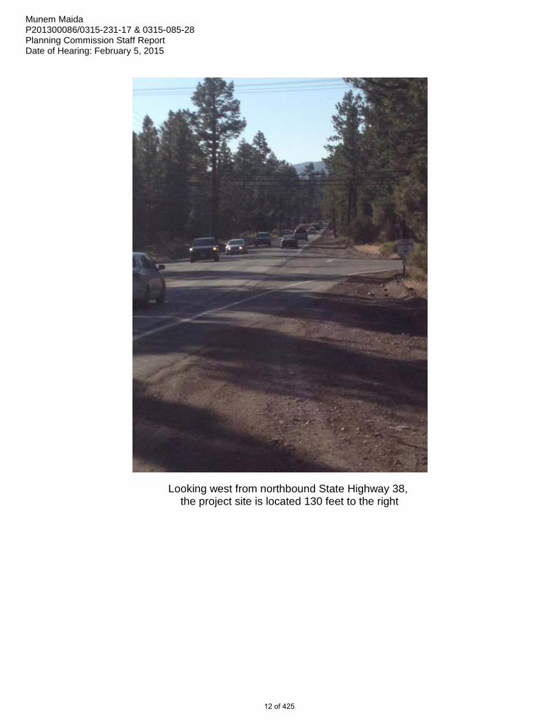
Looking west from northbound State Highway 38, the project site is located 130 feet to the right
12 of 425

Munem Maida P201300086/0315-231-17 & 0315-085-28 Planning Commission Staff Report Date of Hearing: February 5, 2015
PROJECT DESCRIPTION AND BACKGROUND: The proposed project (Project) is a Conditional Use Permit (CUP) to establish a convenience store, gas station, and a caretaker residence on 0.90 acre. The Project includes a 5,641 square-foot convenience store, a 1,152 square-foot caretaker residence on the upper level and four gas dispensing stations (eight pumps total) under a 2,400 square-foot canopy. The balance of the nearly one-acre parcel is set aside for landscaping and parking requirements. The Project site is zoned General Commercial (CG) and is located in the unincorporated area of the County’s Mountain Region, approximately 2 miles south of Erwin Lake. The Project site is located at the southeast corner of State Highway 38 (SR-38) and State Lane, which will provide legal and physical access to the site. The Project is within Fire Safety Overlay District (FS-1). This Project proposal is consistent with the permitted uses in CG zoning district, subject to approval of a CUP application and meeting the development standards. The Project was originally introduced to the Planning Commission on April 17, 2014. The Planning Commission continued the item to May 22, 2014,to allow time to respond to comments received from the California Department of Fish and Wildlife (CDFW) on April 16, 2014. Additional analysis and clarification were provided by the applicant’s biologist addressing potential impacts to Biological Resources, and a revised Initial Study was prepared based on the new analysis. ANALYSIS: DEVELOPMENT STANDARDS. The Project complies with development standards of the CG zone as set forth in Chapter 82.05 of the Development Code, including building height and setback requirements, parking and landscaping. The Project zoning requires 20% landscaping; the Project provides 24.3%. The Project meets its parking requirements by providing 27 parking spaces, including one disabled parking space and one loading space. PUBLIC COMMENT. The Project notice has been sent to 45 surrounding property owners within 300 feet of the Project site, as required by Development Code Section 84.27.070. Other interested parties, both in support of and opposed to the Project, have contacted the Planning Division; and have been provided Project information and related reports. Comments in support of and against the Project have been received in various forms: mail, email, signed petition, electronic petition, and fax. The County has received 79 comments in support and 703 (including 683 electronic signatures) in opposition to the Project. Staff has responded to the inquiries to provide additional Project information, and answered questions about the Project. A total of 827 Notices of Hearing were sent through various media to the surrounding property owners and those who expressed interest in attending the Public Hearing. VISUAL IMPACT. The Project will not have a substantial adverse effect on a scenic vista because the site is separated from the highway and the traveling public by the Caltrans right-of-way. The right-of-way contains indigenous trees that buffer the site from view. No protected trees are identified on the site. However, as a Condition of Approval, the applicant must obtain an approved Tree or Plant Removal Permit from the Planning Division in compliance with Section 88.01.050 (Tree or Plant Removal Requirements), before the removal of any regulated trees and plants. The Project will retain over 20% of the site in a natural undeveloped vegetated or re-vegetated condition, sufficient to ensure vegetative coverage for a forest environment. Many trees (fifty-seven Jeffrey Pines and three Cypress trees six inches in diameter or wider) will be retained on site as regulated native trees. These trees, along with the newly planted landscaping, will minimize any potential visual impact to a level below significance. The Project includes architectural features, as depicted on the conditionally approved site plan and elevations that reflect the mountain character of the surrounding areas. The proposed development provides aesthetic qualities of a mountain lodge that blends well with the surrounding area. The Project will use low intensity lamps. All lighting shall be hooded and designed with sharp-cutoff luminaries to
13 of 425

Munem Maida P201300086/0315-231-17 & 0315-085-28 Planning Commission Staff Report Date of Hearing: February 5, 2015
reflect away from adjoining properties and public thoroughfares. A lighting plan is required, subject to review and approval by Planning Division, which requires that all Project light sources be placed and designed so as not to cause glare or excessive light spillage into neighboring sites or public roadways. Consistent with County Development Code Chapter 83.07: Glare and Outdoor Lighting, this approval does not allow installation or use of any artificial light source that will be emitted into the night sky. The Project will not be a source of substantial light or glare, therefore, no mitigation measures are deemed necessary. The Project as proposed meets County’s goals in conserving scenic qualities. Therefore, no potentially significant impact is anticipated and no mitigation measures are deemed necessary. BIOLOGICAL RESOURCES. The Project site is a vacant parcel. A 2013 General Biological Resources Assessment, and a subsequent revised 2014 assessment, were prepared by RCA Associates, LLC. The Assessment included a site survey and literature review, a search of U.S. Fish and Wildlife Service and CDFW data bases, and a search of the California Natural Diversity Database. While the site has been identified as being located within the distribution of the California spotted owl, southern rubber boa and flying squirrel, the assessment found none of these sensitive wildlife species present during the survey. The assessment also identified the bald eagle and unarmored Threespine Stickleback fish, both of which have potential habitat two miles to the north. An amendment letter to the original General Biological Resources Assessment dated February 3, 2014, was received from RCA Associates to further address concerns raised on potential off-site impacts to the unarmored Threespine Stickleback fish as a result of a potential oil spill or seepage associated with this Project. The amendment finds that although population of the stickleback fish may be present two miles north of the Project site, it is unlikely the species would be affected by any potential onsite leakage or seepage. Any seepage/spillage from the site would likely be contained before any gasoline or diesel fuel reaches the intermittent channels of Shay Creek. The letter continues that any leakage or seepage from the underground tanks will be immediately reported and mitigation measures, if needed, will be implemented. Therefore, the assessment does not propose any mitigation measures for stickleback fish at this time as potential impacts of the Project are deemed less than significant. Additionally, no sensitive habitats (i.e., streams, wetlands, etc.) or wildlife corridors exist on the Project site, nor were any such habitats noted in adjacent areas. The site supports a moderately dense Ponderosa Pine community with some Pinyon Pines and California Junipers. However, the assessment did not identify any blue line streams during the field investigation, nor were any wildlife corridors found to cross the property. The assessment finds that “no sensitive species are expected to occur on the site based on the results of the field investigation and the location of the 0.90-acre parcel in an area which has been disturbed due to past development activities”. The General Biological Assessment finds that while some wildlife species will be displaced into adjacent areas, the cumulative impacts are not expected to be significant given the amount of similar vegetation in adjacent areas and the relatively small size of the property. TRAFFIC AND CIRCULATION. A Traffic Study was performed by Hall & Foreman, Inc. to address traffic impacts of the Project and the expected trip generation. The study encompasses the area streets and specifically the intersection of State Lane and State Highway 38, which provides local and regional access to the study area. In addition, the Traffic Study considered impacts resulting from the Project and other projected area growth to consider cumulative impacts and traffic conditions up to 2035. The Traffic Study also considered the existing and projected traffic volumes and turning movements at peak hours of 7:00 am to 9:00 am and 4:00 pm to 6:00 pm; as well as a 24-hour intersection volume count at the intersection of Highway 38 and State Lane. These counts were conducted in December of 2012. The volume at State Lane and First Lane (an unpaved road providing access to two properties east of the Project site) were also observed.
14 of 425
Munem Maida P201300086/0315-231-17 & 0315-085-28 Planning Commission Staff Report Date of Hearing: February 5, 2015
A traffic signal warrant analysis was conducted at the intersection of Highway 38 and State Lane to determine if the installation of a traffic control signal would improve the overall safety and/or operation of the intersection. Consideration was given to the geometrics of each approach, the number of lanes, and accident history rates for the intersection. It was determined that a traffic signal was not warranted. Additional analysis was requested by Caltrans to consider potential impacts to the Project area traffic. Caltrans initially cleared the Project in August 28, 2013, stating that all of its concerns had been addressed. In June 02, 2014, and based on the revised Traffic Report dated September 19, 2013, Caltrans requested truck turning templates for the northbound SR-38 right-turn onto State Lane and additional analysis for a left-turn pocket from the southbound SR-38 onto State Lane. On August 5, 2014, Caltrans approved the Project to proceed with encroachment permits. Final approval of SR-38 traffic improvements remain subject to approval by Caltrans and shall meet not only Caltrans Highway Design Manual (HDM) and Access Management Plan standards, but also the Federal Highway Administration’s Intersection Design Standards. The Traffic Division has reviewed the Project, related site plan, intersection geometrics and the referenced Traffic Studies and found the Project to be consistent with County development standards for providing access and improvements needed for the proposed use. AIR QUALITY. The Project site is located within the jurisdiction of the South Coast Air Quality Management District (SCAQMD). An Air Quality Impact Analysis was prepared for this Project by Urban Crossroads to analyze emissions from short term construction activities and long term operational activities. The study finds that short-term construction-source emissions would be temporary and intermittent in nature and would not result in persistent impacts that would affect substantial numbers of people. The study finds that Project construction-source emissions would not conflict with the applicable Air Quality Management Plan (AQMP). Air quality mitigation measures for dust control have been required as conditions of approval. Application of these mitigation measures will address potential short-term impacts related to construction equipment operations. Therefore these potential short-term impacts are considered less than significant. Potential long-term operational impacts of the Project were also analyzed by the referenced Air Quality Study. The study finds that the proposed Project would not cause a “hotspot” as a result of the Project related activities and increased traffic during the ongoing operations, nor would the Project result in a significant adverse health impact. Project operational-source emissions would not conflict with the AQMP. The study continues to find that for regional emissions, the Project would not exceed the numerical thresholds of significance established by the SCAQMD. INITIAL STUDY. An Initial Study has been prepared for the Project in compliance with the California Environmental Quality Act (CEQA). Letters and emails were received from concerned citizens and agencies. These communications raised concerns regarding potential impacts on biological resources, traffic and air quality. Professional reports prepared for this Project have addressed all concerns. The findings of these reports conclude that no significant impact is anticipated, and that any potential impact will be less than significant. The Initial Study reiterates these findings and concludes that the proposed Project would not have any significant adverse impacts with application of the proposed mitigation measures. Therefore, a Mitigated Negative Declaration is proposed for adoption by the Planning Commission. The revised Initial Study was made available for public review and comment; through submittal to the State Clearinghouse on November 21, 2014. The Initial Study was also published online, and comments were recieved.
15 of 425

Munem Maida P201300086/0315-231-17 & 0315-085-28 Planning Commission Staff Report Date of Hearing: February 5, 2015
RECOMMENDATION: That the Planning Commission: 1) ADOPT the Mitigated Negative Declaration, based on a finding that the Initial Study was completed in
compliance with CEQA, that it has been reviewed and considered prior to approval of the Project, and that the Initial Study/Mitigated Negative Declaration reflects the independent judgment of the County of San Bernardino;
2) ADOPT the Findings as contained in the Staff Report; 3) APPROVE the Conditional Use Permit to establish a convenience store, gas station, and a
caretaker residence on 0.90 acre, subject to the recommended Conditions of Approval; and 4) FILE a Notice of Determination. ATTACHMENTS: EXHIBIT A: Findings EXHIBIT B: Conditions of Approval EXHIBIT C: Initial Study 2014 EXHIBIT D: Revised General Biological and Desert Tortoise Reports; RCA Associates; 2014 EXHIBIT E: Biological Letter; RCA Associates; 2014 EXHIBIT F: Preliminary Hydrology Study; Jerry L. Miles, P.E.; 2013 EXHIBIT G: Preliminary Water Quality Management Plan; Jerry L. Miles, P.E.; 2013 EXHIBIT H: Supplemental Preliminary Hydrology Analysis of Off-Site Flows 2014 EXHIBIT I: Revised Traffic Report: Hall & Foreman, Inc.; 2014 with Appendices (Exhibit-A 6-27-2014,
Winter Weekend Traffic Analysis 01-15-2014, and Response to Caltrans Letter 06-23-2014) EXHIBIT J: Air Quality Impact Analysis; Urban Cross Roads; 2014
16 of 425

EXHIBIT A
Findings
17 of 425

Findings / Munem Maida APNs: 0315-231-17 & 0315-085-28/P201300086 Planning Commission Date of Hearing: February 05, 2015 FINDINGS: Conditional Use Permit
Conditional Use Permit (CUP) to establish a 6,793 square-foot convenience store, gas station, and a caretaker residence (Project) on 0.90 acre.
1. The site for the proposed use is adequate in landscaping, parking, and open space
needs. Additionally, the proposed facility is required, either by design or by application of Conditions of Approval, to comply with all requirements pertaining to a CUP application, including required setbacks. The proposed Project is consistent with County development standards and the designated zoning of General Commercial (CG).
2. The site for the proposed use has adequate access, which means that the site design
incorporates appropriate street and highway characteristics to serve the proposed use because the proposed convenience store and gas station will have adequate legal and physical access by utilizing State Lane, along the east/southeast of the Project site. The County Public Works Department/Traffic Division has reviewed the site plan and its proposed driveway access, and has found that the site has adequate access to support the proposed use and related activities. Caltrans has reviewed and requires additional improvements at the intersection of State Highway 38 and State Lane. Final improvements at the intersection of State Highway 38 and State Lane shall meet not only Caltrans Highway Design Manual (HDM) and Access Management Plan standards, but also the Federal Highway Administration’s Intersection Design Standards.
3. The proposed use will not have a substantial adverse effect on abutting property or the
allowed use of the abutting property, which means that the use will not generate excessive noise, traffic, vibration, or other disturbance because the proposed use is permitted in CG Zoning District, subject to approval of a CUP and meeting the requirements set forth by the Conditions of Approval. The proposed Project has been reviewed for traffic, noise, air quality and waste management impacts. As determined by licensed professionals, this use will not generate excessive disturbances and any impact will be less than significant. In addition, the use will not substantially interfere with the present or future ability to use solar energy systems because the use and its proposed structure will not cast significantly large, sun-blocking shadows across a potential site for such solar energy system.
4. The proposed use and manner of development are consistent with the goals, policies,
standards and maps of the County General Plan because the proposed facility will provide services typically considered beneficial to neighboring residences. The proposed development together with the provisions for its design and improvement are consistent with the goals and policies of the General Plan. Specifically, the proposed use is consistent with:
GOAL LU 1 which states that, “the County will have a compatible and harmonious arrangement of land uses by providing a type and mix of
18 of 425

functionally well-integrated land uses that are fiscally viable and meet general social and economic needs of the residents.”
The proposed Gas Station and Convenience store is located within the CG zoning district, which is set aside and intended to provide opportunities for small to medium sized commercial development beneficial to the surrounding property owners. This Project will serve the surrounding community by providing a neighborhood facility currently not available in the immediate vicinity.
5. There is supporting infrastructure, existing or available, consistent with the intensity of
development, to accommodate the proposed development without significantly lowering service levels because the Project site is sufficiently served by State Lane, which is connected to the State Highway 38, located only 150 feet west of the site. The intensity of the proposed use has been determined to minimally increase service demands. Neither the short-term construction activities nor the long-term operational activities will cause level of service for traffic to fall below the required standards, as depicted in the Traffic Study performed by Hall and Foreman, LLC. The Project water and sewer needs will be served by Big Bear City Community Service District as will-serve letters are on file.
6. The lawful conditions stated in the approval are deemed necessary to protect the public
health, safety and general welfare because the Conditions of Approval incorporate mitigation measures intended to reduce any potential impacts in the area of noise, biological resources and air quality associated with the Project. The other conditions, when implemented, will protect the public health, safety and welfare by providing adequate site improvements.
7. The design of the site has considered the use of solar energy systems and passive or
natural heating and cooling opportunities, in that adequate space is made available through the site design for future installation of such systems.
8. The Project is consistent with the California Environmental Quality Act (CEQA) because
an Initial Study has been prepared in compliance with CEQA, which represents the independent judgment of the County acting as the lead agency for the Project. The Initial Study contains mitigation measures recommended to minimize potential impacts on biological resources, air quality, and noise levels. The Initial Study and the draft Mitigated Negative Declaration were posted and made available for public review as required by law. Based on the referenced Initial Study, the proposed Project would not have significant adverse impacts with application of the proposed mitigation measures. Therefore, a Mitigated Negative Declaration is proposed.
19 of 425

EXHIBIT B
Conditions of Approval
20 of 425

CONDITIONS OF APPROVAL
Conditional Use Permit MUNEM MAIDA
GENERAL REQUIREMENTS Conditions of Operation and Procedures
LAND USE SERVICES – Planning (909) 387-8311
1. Project Approval Description. This Conditional Use Permit is approved subject to these Conditions of Approval to establish a 6,793 square foot convenience store, gas station, and a care-taker residence on 0.90 acre at the east/southeast corner of State highway 38 and State Lane, within the community of Erwin lake in the Third Supervisorial District; Assessor Parcel Numbers: 0315-231-17 & 0315-085-28; Project Number: P201300086.
2. Development Standards. The Developer shall identify and meet all applicable development standards. This project is located in the General Commercial (CG) Zoning District and is subject to all development standards such as building setbacks, maximum building height, minimum required landscaping, and all other applicable requirements.
3. Revisions. Any alteration or expansion of these facilities, a proposed change of use, any change to proposed parking allocation, or increase in the developed area of the site from that shown on the approved site plan shall require additional land use review and relevant application(s) at the time such revision is being considered.
4. Continuous Effect. All of the conditions of this Conditional Use Permit are continuously in effect throughout the operative life of the project for the use approved. Failure of the Developer to comply with any or all of the conditions at any time may result in a public hearing and revocation of the MUP, provided adequate notice, time and opportunity is provided to the property owner or other party to correct the non-complying situation.
5. Development Impact Fees. Additional fees may be required prior to issuance of development permits. Fees shall be paid as specified in adopted fee ordinances.
6. Indemnification. In compliance with SBCC §81.01.070, the Developer shall agree, to defend, indemnify, and hold harmless the County or its “indemnitees” (herein collectively the County’s elected officials, appointed officials (including Planning Commissioners), Zoning Administrator, agents, officers, employees, volunteers, advisory agencies or committees, appeal boards or legislative body) from any claim, action, or proceeding against the County or its indemnitees to attack, set aside, void, or annul an approval of the County by an indemnitee concerning a map or permit or any other action relating to or arising out of County approval, including the acts, errors or omissions of any person and for any costs or expenses incurred by the indemnitees on account of any claim, except where such indemnification is prohibited by law. In the alternative, the Developer may agree to relinquish such approval. Any condition of approval imposed in compliance with the County Development Code or County General Plan shall include a requirement that the County acts reasonably to promptly notify the Developer of any claim, action, or proceeding and that the County cooperates fully in the defense. The Developer shall reimburse the County and its indemnitees for all expenses resulting from such actions, including any court costs and attorney fees, which the County or its indemnitees may be required by a court to pay as a result of such action.
21 of 425

Conditions of Approval PAGE 2 of 18 Conditional Use Permit / Munem Maida APNs: 0315-231-17 & 0315-085-28 / P201300086 Planning Commission Date of Hearing: February 05, 2015 The County may, at its sole discretion, participate at its own expense in the defense of any such action, but such participation shall not relieve the Developer of their obligations under this condition to reimburse the County or its indemnitees for all such expenses. This indemnification provision shall apply regardless of the existence or degree of fault of indemnitees. The Developer’s indemnification obligation applies to the indemnitees’ “passive” negligence but does not apply to the indemnitees’ “sole” or “active” negligence or “willful misconduct” within the meaning of Civil Code Section 2782.
7. Expiration. This Conditional Use Permit approval shall become null and void if it is not exercised
within three years of the effective date of this approval, unless an extension of time is approved. The permit is deemed exercised when either:
• The permittee has commenced actual construction or alteration under a validly issued building permit or
• The permittee has substantially commenced the approved land use or activity on the project site, for those portions of the project not requiring a building permit (SBCC §86.06.060)
PLEASE NOTE: This will be the ONLY notice given of the expiration date. The developer is responsible for initiation of any Extension of Time application.
8. Extension of Time/CUP. Extensions of time to the expiration date (listed above or as otherwise extended) may be granted in increments each not to exceed an additional three years beyond the current expiration date. An application to request consideration of an extension of time may be filed with the appropriate fees no less than 30 days before the expiration date. Extensions of time may be granted base on a review of the application, which includes a justification of the delay in construction and a plan of action for completion. The granting of such an extension request is a discretionary action that may be subject to additional or revised conditions of approval or site plan modifications. (§SBCC 86.06.060)
9. Project Account. The actual-cost project number for this project is P201300086. The Developer shall maintain a positive account balance at all times during pre- and post-approval stages of this land use review application including, Condition Compliance activities, file closure and any other required follow-on work (e.g. landscape performance review). All fees required for processing shall be paid in full prior to final inspection and authorization of occupancy and operation.
10. Condition Compliance. In order to obtain grading, building and occupancy permits, the Developer shall process a Condition Compliance Review with all affected County agencies and coordinate with County Planning in accordance with the directions stated in the Approval letter. A minimum balance of $1,000.00 must be in the project account P201300086 at the time the Condition Compliance Review is initiated. Sufficient funds shall be made available by the Developer during all stages of this land use review.
11. Enforcement. If any County enforcement activities are required to enforce compliance with the conditions of approval, the Developer shall be charged for such enforcement activities in accordance with the San Bernardino County Code Schedule of Fees.
12. Sign Lighting. All signs proposed by this project may only be lit by steady, stationary, shielded light directed at the sign, by light inside the sign, by direct stationary neon lighting or by an alternating lighting system that changes no more than once per hour. The glare from the luminous source shall not exceed one-half (0.5) foot-candle.
13. Follow-on Permits. The applicant shall ascertain and comply with the requirements of all Federal, State, County and Local agencies as are applicable to the proposed use and the project area. These include, but are not limited to: a) FEDERAL: None; b) STATE: Regional Water Quality Control, and Southern Coast Air Quality Management District, c) COUNTY: Departments of Public
22 of 425
Conditions of Approval PAGE 3 of 18 Conditional Use Permit / Munem Maida APNs: 0315-231-17 & 0315-085-28 / P201300086 Planning Commission Date of Hearing: February 05, 2015 Health; Environmental Health Services, Land Use Services (Planning, Building and Safety, Code Enforcement, etc.), Public Works; and 4) LOCAL: Big Bear City Fire Department.
14. Continuous Maintenance. The project Developer shall enforce architectural controls to ensure on-going compatibility of colors, materials and theme. The property will be maintained so that it is visually attractive and not dangerous to the health and welfare of its own occupants & the surrounding properties. The Owner shall ensure that all facets of the development are regularly maintained and inspected so that they are kept in continual good repair. The following shall be met: a. All structures, fencing, walks, parking lots, driveways, signs, water features, outside furniture and
fixtures shall be kept in good repair and condition. b. All trash, storage and loading areas shall be kept neatly and in orderly manner. c. All graffiti and debris shall be removed daily. d. There shall be no metal storage containers allowed unless specifically approved by this or
subsequent land use approvals, as detailed in Project Description herein. e. Landscaping shall be kept in thriving condition. Drought-resistant, fire retardant vegetation shall
be used where applicable for any replacement landscaping and erosion control to reduce water consumption and promote slope stability.
f. All landscaped areas shall be irrigated in a manner designed to conserve water. g. Annual maintenance shall be conducted for proper structural, electrical and mechanical safety,
and properly operating irrigation system. h. Annual maintenance shall include repainting faded or stained surfaces and re-glazing windows. i. Mechanical equipment and roof top mechanical equipment shall be screened from public view.
Such screens shall be maintained to be visually attractive and in good repair. j. The Developer shall ensure that all traffic circulation surfaces and markings shall be clearly
defined, regularly repainted and maintained in good operating conditions at all times. These markings include but are not limited to painted parking spaces, curb painting directional designations, “No Parking” designations and “Fire Lane” designations. In cases where non-asphaltic surfaces are allowed, free-standing signs (subject to Planning review and approval) to accomplish here-stated circulation markings and guidance shall be required.
15. Weed Abatement. The applicant shall comply with San Bernardino County weed abatement regulations and periodically clear the site of all non-complying vegetation. This includes removal of all Russian Thistle (tumbleweeds).
16. Performance Standards. The approved land uses shall operate in compliance with the general performance standards listed in the SBCC Chapter 83.01, regarding air quality, electrical disturbance, fire hazards (storage of flammable or other hazardous materials), heat, noise, vibration, and the disposal of liquid waste. In addition to these, none of the following shall be perceptible without instruments at any point outside the project boundaries at adjoining property lines:
• Odors: No offensive or objectionable odor. • Smoke: No smoke of a greater density than that described in No. 2 on the Ringelman Chart,
as published currently by the United State Bureau of Mines, shall be emitted from any project source.
• Radiation: No dangerous amount of radioactive emissions. • Toxic Gasses: No emission of toxic, noxious or corrosive fumes or gases. • Glare: No intense glare that is not effectively screened from view at any point outside the
project boundary.
17. The Developer shall ensure that the development operates in conformity with the following performance standards: a. No use shall involve vibration perceptible without instruments at project site’s property lines. b. Project noise levels shall not exceed County Noise Standards of 55 dB(A) where the project
abuts single family residences from 7am-10pm, as measured at the project site’s property lines. 23 of 425

Conditions of Approval PAGE 4 of 18 Conditional Use Permit / Munem Maida APNs: 0315-231-17 & 0315-085-28 / P201300086 Planning Commission Date of Hearing: February 05, 2015 c. Project noise levels after 10pm shall not exceed 45 dB(A) where the project site abuts single
family residences, as measured at the project site’s property lines. Compliance with San Bernardino County Noise Standard(s) and Development Code is mandatory and is subject to Department of Environmental Health Services review and approval (DEHS).
d. No use shall emit offensive or objectionable odor perceptible at project site’s property lines. e. No use shall create smoke from any source shall emit a greater density described in No. 2 on
the Ringelmann Chart as published by the United States Bureau of Mines. f. No use shall emit toxic, noxious or corrosive fumes of gases. g. No use shall emit/cause dirt, dust, fly ash, and other forms of particulate matter. h. No use shall involve dangerous amount of radioactive emissions. i. Every operation producing intense glare or heat shall be conducted in a manner as to effectively
screen the glare from view at any point on the lot line of the lot in which the use is located and to dissipate the heat so that it is not perceptible without instruments.
j. All uses shall conform to the provisions of the San Bernardino County Hazardous Waste Management Plan.
18. Air Quality – Operations. The Developer shall submit for review and obtain approval from County
Planning of a signed letter agreeing to include as a condition of all construction contracts/ subcontracts requirements to reduce vehicle and equipment emissions and other impacts to air quality by implementation of State Regulations such as AB1493 (Pavley I and II) that will reduce emissions from the employees’ automobiles and light duty trucks, anticipated to come into effect prior to 2020, Executive Order S-1-07 (Low Carbon Fuel Standard) and submitting documentation of compliance. The Developer shall further state that the proposed project shall comply with all applicable regulations promulgated to meet the State’s AB-32 goals and regulations adopted by the California Air Resources Board (i.e. the tire pressure program, low rolling resistance tire, low friction engine oils, goods movement efficiency measures, heavy duty vehicle aerodynamic efficiency, and medium and heavy duty vehicle hybridization). Operation of all off-road and on-road diesel vehicles/equipment shall comply with the County Diesel Exhaust Control Measures [SBCC §83.01.040 (c)] including but not limited to: a. Equipment/vehicles shall not be left idling in excess of five minutes. b. Engines shall be maintained in good working order to reduce emission. c. On-site electrical power connections shall be made available where feasible. d. Ultra low-sulfur diesel fuel shall be utilized. e. Electric and gasoline powered equipment shall be substituted for diesel powered equipment
where feasible. f. Signs shall be posted requiring all vehicle drivers and equipment operators to turn off engines
when not in use. g. All on-road diesel trucks shall not idle more than five minutes per truck trip or per day on the
project site.
19. Air Quality – HRA Revisions. If there is any future change in land use that includes sensitive receptors as defined by SCAQMD, then a Health Risk Assessment (HRA) shall be prepared, submitted for review and approval obtained from County Planning to demonstrate that a significant health risk will not be posed at the time revisions are being considered.
LAND USE SERVICES – BUILDING AND SAFETY (909) 387-8311 20. Building Occupancy. Any building without specified tenants and uses may receive final inspection for
construction purposes only. A Tenant Improvement or a Tenant Review that identifies the tenant and proposed uses shall be submitted and approved prior to occupancy being granted.
21. Provide disabled parking in each parking area to serve each accessible building or area.
24 of 425

Conditions of Approval PAGE 5 of 18 Conditional Use Permit / Munem Maida APNs: 0315-231-17 & 0315-085-28 / P201300086 Planning Commission Date of Hearing: February 05, 2015
COUNTY FIRE (760) 995-8190 22. Jurisdiction. The above referenced project is under the jurisdiction of the San Bernardino County
Fire Department herein (“Fire Department”). Prior to any construction occurring on any parcel, the applicant shall contact the Fire Department for verification of current fire protection requirements. All new construction shall comply with the current Uniform Fire Code requirements and all applicable statutes, codes, ordinances and standards of the Fire Department.
23. Construction Permits. Construction permits, including Fire Condition Letters, shall automatically expire and become invalid unless the work authorized by such permit is commenced within 180 days after its issuance, or if the work authorized by such permit is suspended or abandoned for a period of 180 days after the time the work is commenced. Suspension or abandonment shall mean that no inspection by the Department has occurred with 180 days of any previous inspection. After a construction permit or Fire Condition Letter, becomes invalid and before such previously approved work recommences, a new permit shall be first obtained and the fee to recommence work shall be one-half the fee for the new permit for such work, provided no changes have been made or will be made in the original construction documents for such work, and provided further that such suspension or abandonment has not exceeded one year. A request to extend the Fire Condition Letter or Permit may be made in writing PRIOR TO the expiration date justifying the reason that the Fire Condition Letter should be extended.
COUNTY FIRE – Hazardous Material (909) 386-8401
24. Business Emergency Plan. Prior to occupancy, operator shall submit disclosure information using the California Environmental Reporting System (CERS) for emergency release or threatened release of hazardous materials and wastes or apply for exemption from hazardous materials laws and regulations. Contact Office of the Fire Marshal, Hazardous Materials Division at (909) 386-8401.
25. Hazardous Material Permits. Prior to occupancy, applicant shall be required to apply for one or
more of the following: a Hazardous Materials Handler Permit, a Hazardous Waste Generator Permit, an Aboveground Storage Tank Permit, and/or an Underground Storage Tank Permit. For information, Office of the Fire Marshal, Hazardous Materials Division at (909) 386-8463.
PUBLIC HEALTH – Environmental Health Services (800) 442-2283
26. Noise. Noise level shall be maintained at or below County Standards, Development Code Section 83.01.080.
27. Refuse. All refuse generated at the premises shall at all times be stored in approved containers and shall be placed in a manner so that environmental public health nuisances are minimized. All refuse not containing garbage shall be removed from the premises at least 1 time per week, or as often as necessary to minimize public health nuisances. Refuse containing garbage shall be removed from the premises at least 2 times per week, or as often if necessary to minimize public health nuisances, by a permitted hauler to an approved solid waste facility in conformance with San Bernardino County Code Chapter 8, Section 33.0830 et. seq.
PUBLIC WORKS – Solid Waste Management (909) 386-8701
28. Recycling Storage Capacity. The developer shall provide adequate space and storage bins for both refuse and recycling materials. This requirement is to assist the County in compliance with the recycling requirements of AB 2176.
29. Mandatory Commercial Recycling. Beginning July 1, 2012 all businesses defined to include a commercial or public entity that generates 4 or more cubic yards of commercial solid waste a week
25 of 425

Conditions of Approval PAGE 6 of 18 Conditional Use Permit / Munem Maida APNs: 0315-231-17 & 0315-085-28 / P201300086 Planning Commission Date of Hearing: February 05, 2015 or is a multi-family residential dwelling of 5 units or more to arrange for recycling services. The County is required to monitor business recycling and will require the business to provide recycling information. This requirement is to assist the County in compliance with the recycling requirements of AB 341.
PUBLIC WORKS – Traffic (909) 387-8186
30. Caltrans Review. Caltrans Review and approval of the project is required. The Traffic Study prepared and revised (on September 19, 2013) by Hall and Foreman, Inc. has been reviewed and approved by Caltrans to address project’s traffic issues at the intersection of Highway 38 and State Lane.
31. Vehicle Back Out. The project vehicles shall not back out into the public roadway.
32. Right-turn In Only. The northwesterly project driveway along State Lane shall be restricted to right-turn in only.
CALTRANS DISTRICT 8 (909) 388-7017
33. Infrastructure Improvements. Based on the revised Traffic Report dated June 27, 2014, and the Highway Design Manual (HDM) Topic 405 Intersection Design Standards the developer shall provide:
• A left-turn pocket on the SR 38 southbound at the intersection of State Lane shall be designed
according to the HMD Topic 405 Intersection Design Standards. • A widening of the existing shoulder at the southeast corner of SR 38 and State Lane to
accommodate the north to east right turn movement for trucks. 34. Additional Requirements. Additional requirements not decipherable from the proposed conceptual
geometrics may be required when final construction/street improvement plans are submitted to the Office of Encroachment Permits.
LAND USE SERVICES – Land Development – Roads (909) 387-8311
35. Road Standards. All required street improvements shall comply with latest San Bernardino County
Road Planning and Design Standards and the San Bernardino County Standard Plans.
LAND USE SERVICES – Land Development – Drainage (909) 387-8311
36. FEMA Flood Zone. The project is located within Flood Zone D according to FEMA Panel Number 8035H dated 08/28/2008. Flood hazards are undetermined in this area, but possible.
37. Tributary Drainage. Adequate provisions should be made to intercept and conduct the tributary off site - on site drainage flows around and through the site in a manner, which will not adversely affect adjacent or downstream properties at the time the site is developed.
38. Natural Drainage. The natural drainage courses traversing the site shall not be occupied or
obstructed.
39. Additional Drainage Requirements. In addition to drainage requirements stated herein, other "on-site" and/or "off-site" improvements may be required which cannot be determined from tentative plans at this time and would have to be reviewed after more complete improvement plans and profiles have been submitted to this office.
26 of 425

Conditions of Approval PAGE 7 of 18 Conditional Use Permit / Munem Maida APNs: 0315-231-17 & 0315-085-28 / P201300086 Planning Commission Date of Hearing: February 05, 2015
40. Continuous BMP Maintenance. The property owner/Developer is required to provide periodic and continuous maintenance of all Best Management Practices (BMP) devices/facilities listed in the County approved Water Quality Management Plan (WQMP) for the project. This includes but is not limited to, filter material replacement and sediment removal, as required to assure peak performance of all BMPs. Furthermore, such maintenance activity will require compliance with all Local, State, or Federal laws and regulations, including those pertaining to confined space and waste disposal methods in effect at the time such maintenance occurs.
41. BMP Enforcement. In the event the property owner or the Developer (including any successors or assigns) fails to accomplish the necessary BMP maintenance within five (5) days of being given written notice by County LAND USE SERVICES, then the County shall cause any required maintenance to be done. The entire cost and expense of the required maintenance shall be charged to the property owner and/or the Developer, including administrative costs, attorney’s fees and interest thereon at the rate authorized by the County Code from the date of the original notice to the date the expense is paid in full.
PRIOR TO ISSUANCE OF GRADING PERMITS OR A LAND DISTURBING ACTIVITY
THE FOLLOWING SHALL BE COMPLETED
LAND USE SERVICES – Planning (909) 387-8311
42. GHG – Construction Performance Standards. The Developer shall submit for County planning review and approval a signed letter agreeing to include as a requirement for all construction contracts/subcontracts to reduce potential GHG impacts. The Developer and contractors shall adhere to the following: a. Implement both the approved Dust Control and Coating Restriction Plans. b. Selection of construction equipment will be based on low-emissions factors and high-energy
efficiency. All diesel/gasoline-powered construction equipment shall be replaced, where possible, with equivalent electric or CNG equipment.
c. Use low-sulfur fuel for stationary equipment. (SCAQMD Rules 431.1 and 431.2) d. Trucks/equipment shall not be left idling on site in excess of 5 minutes e. Grading plans shall include the following statements verbatim:
• “All construction equipment shall be tuned and maintained in accordance with the manufacturer’s specifications”.
• “All construction equipment (including electric generators) shall be shut off by work crews when not in use and shall not idle for more than 5 minutes.”
f. Minimize vehicles and equipment operating at the same time. g. Reduce daily equipment operation hours during smog season (May-October). h. Schedule construction traffic ingress/egress to not interfere with peak-hour traffic and to
minimize traffic obstructions. Queuing of trucks on and off site shall be prevented. A flag person shall be retained to maintain efficient traffic flow and safety adjacent to existing roadways.
i. Recycle and reuse construction and demolition waste (e.g. soil, vegetation, concrete, lumber, metal, and cardboard) per County Solid Waste procedures.
j. The construction contractor shall support and encourage ridesharing and transit incentives for the construction crew and educate all construction workers about the required waste reduction and the availability of recycling services.
43. Tree and Plant Removal Plan. A Tree or Plant Removal Plan shall be presented to the County
Planning for review and approval. A signed letter shall be submitted to Planning agreeing to the following: a. Any removal of regulated trees and/or plants shall be consistent with the County Development
Code Section 88.01.050. 27 of 425

Conditions of Approval PAGE 8 of 18 Conditional Use Permit / Munem Maida APNs: 0315-231-17 & 0315-085-28 / P201300086 Planning Commission Date of Hearing: February 05, 2015 b. Adequate number of the existing trees six inches in diameter or wider shall remain on the
project site. Fifty-seven Jeffrey Pines and three cypress trees are proposed and are hereby required to remain on the project site.
44. Air Quality – Dust Control Plan. The developer shall submit to County Planning a Dust Control
Plan (DCP) consistent with SCAQMD guidelines and a letter agreeing to include in any construction contracts and/or subcontracts a requirement that the contractors adhere to the requirements of the DCP. The DCP shall include these elements to reduce dust production: a. Exposed soil shall be kept continually moist through a minimum of twice daily waterings to
reduce fugitive dust during all grading and construction activities. b. Street sweeping shall be conducted when visible soil accumulations occur along site access
roadways to remove dirt dropped by construction vehicles. c. Site access driveways and adjacent streets shall be washed daily, if there are visible signs of
any dirt track-out at the conclusion of any workday. d. Tires of vehicles will be washed before the vehicles leave project site and enter a paved road. e. Any truck hauling dirt away from the site shall be covered f. During high wind conditions (i.e., wind speeds exceeding 25 mph), areas with disturbed soil
shall be watered hourly and activities on unpaved surfaces shall be terminated until wind speeds no longer exceed 25 mph.
g. Storage piles that are to be left in place for more than three working days shall either be sprayed with a non-toxic soil binder, or covered with plastic or revegetated.
[Mitigation Measure III-1]
45. Air Quality – Construction Plan. Developer shall submit written verification that all construction contracts and sub-contracts for the project contain provisions that require adherence to the following standards to reduce impacts to air quality. During construction, each contractor and subcontractor shall implement the following, whenever feasible: a. Suspend use of all construction equipment operations during second stage smog alerts. For
daily forecast, call (800) 367-4710 (San Bernardino and Riverside counties). b. Trucks/equipment shall not be left idling on site for periods in excess of 10 minutes. c. Provide temporary traffic control during all phases of construction. d. Substitute diesel-powered equipment with electric and gasoline-powered equipment. e. Onsite electrical power hook-ups shall be provided for electric construction tools to eliminate the
need for diesel-powered electronic generators. f. Install storm water control systems to prevent mud deposition onto paved areas during
construction. g. Contractors shall use low sulfur fuel for stationary construction equipment as required by AQMD
Rules 431.1 and 431.2 to reduce the release of undesirable emissions. [Mitigation Measure III-2]
46. Air Quality – Coating Restriction Plan. The developer shall submit a letter agreeing to these Coating Restrictions and to include in any construction contracts and/or subcontracts a requirement that the contractors adhere to these requirements. These shall include, but are not be limited to:
a. Architectural coating volume shall not exceed the significance threshold for ROG, which is 75 lbs./day and the combined daily ROC volume of architectural coatings and asphalt paving shall not exceed the significance threshold for ROC of 75 lbs. per day
b. Architectural coatings with Reactive Organic Compounds (ROC) shall not have a content greater than 100 g/l.
c. High-Volume, Low Pressure (HVLP) spray guns will be used to apply coatings. [Mitigation Measure III-3]
47. Cultural Resources. The Developer shall prepare, submit for review and obtain approval of a letter agreeing to adhere to the following requirements and to include in all construction
28 of 425

Conditions of Approval PAGE 9 of 18 Conditional Use Permit / Munem Maida APNs: 0315-231-17 & 0315-085-28 / P201300086 Planning Commission Date of Hearing: February 05, 2015
contracts/ subcontracts a requirement that project contractors adhere to the following requirements: If archaeological, paleontological and/or historical resources are uncovered during ground disturbing activities, all work in that area shall cease immediately until written clearance by County Planning is provided indicating that satisfactory mitigation has been implemented. A qualified expert (e.g. archaeologist or paleontologist), as determined by County Planning in consultation with the County Museum shall be hired to record the find and recommend any further mitigation. The Developer shall implement any such additional mitigation to the satisfaction of County Planning. If human remains are uncovered during ground disturbing activities, the San Bernardino County Coroner shall be contacted within 24 hours of the find. If the remains or cultural artifacts are determined to be of Native American origin, the local Native American representative shall also be notified.
[Mitigation Measure V1]
48. Construction Noise. The “developer” shall submit for review and obtain approval of an agreement letter that stipulates that all construction contracts/subcontracts contain as a requirement that the following noise attenuation measures be implemented: a. Exterior construction activities shall be limited between 7 a.m. and 7 p.m. There shall be no
exterior construction activities on Sundays or National Holidays. b. Interior construction activities may occur on any day and any time provided they comply with the
County noise standards. (SBCC 83.01.080). c. Construction equipment shall be muffled per manufacturer’s specifications. d. All stationary construction equipment shall be placed in a manner so that emitted noise is
directed away from sensitive receptors nearest the project site. [Mitigation Measure XI-1]
49. Construction Noise. The “developer” shall submit for review and obtain approval of an agreement letter that stipulates that all construction contracts/subcontracts contain as a requirement that the following noise attenuation measures be implemented: e. Exterior construction activities shall be limited between 7 a.m. and 7 p.m. There shall be no
exterior construction activities on Sundays or National Holidays. f. Interior construction activities may occur on any day and any time provided they comply with the
County noise standards. (SBCC 83.01.080). g. Construction equipment shall be muffled per manufacturer’s specifications. h. All stationary construction equipment shall be placed in a manner so that emitted noise is
directed away from sensitive receptors nearest the project site. [Mitigation Measure XI-1]
50. Construction Noise. The “developer” shall submit for review and obtain approval of an agreement letter that stipulates that all construction contracts/subcontracts contain as a requirement that the following noise attenuation measures be implemented: i. Exterior construction activities shall be limited between 7 a.m. and 7 p.m. There shall be no
exterior construction activities on Sundays or National Holidays. j. Interior construction activities may occur on any day and any time provided they comply with the
County noise standards. (SBCC 83.01.080). k. Construction equipment shall be muffled per manufacturer’s specifications. l. All stationary construction equipment shall be placed in a manner so that emitted noise is
directed away from sensitive receptors nearest the project site. [Mitigation Measure XI-1]
29 of 425

Conditions of Approval PAGE 10 of 18 Conditional Use Permit / Munem Maida APNs: 0315-231-17 & 0315-085-28 / P201300086 Planning Commission Date of Hearing: February 05, 2015
51. Construction Noise. The “developer” shall submit for review and obtain approval of an agreement letter that stipulates that all construction contracts/subcontracts contain as a requirement that the following noise attenuation measures be implemented: m. Exterior construction activities shall be limited between 7 a.m. and 7 p.m. There shall be no
exterior construction activities on Sundays or National Holidays. n. Interior construction activities may occur on any day and any time provided they comply with the
County noise standards. (SBCC 83.01.080). o. Construction equipment shall be muffled per manufacturer’s specifications. p. All stationary construction equipment shall be placed in a manner so that emitted noise is
directed away from sensitive receptors nearest the project site. [Mitigation Measure XI-1]
LAND USE SERVICES – Building and Safety (909) 387-8311 52. A preconstruction inspection, tree removal plan and permit in compliance with the County's Plant
Protection and Management Ordinance, shall be approved prior to any land disturbance and/or removal of any trees or plants.
53. An erosion and sediment control plan and permit shall be submitted to and approved by the Building Official prior to any land disturbance.
54. Prior to issuance of building permits, erosion control devices must be installed at all perimeter
openings and slopes. No sediment is to leave the job site.
55. All runoff must be held to pre-development levels per Section 82.13.080 of the San Bernardino County Development Code.
56. If grading exceeds fifty (50) cubic yards, approved plans will be required. Grading plans shall be
submitted to Building and Safety for review and approval prior to grading/land disturbance.
PUBLIC WORKS – Surveyor (909) 387-8149 57. A Site Plan shows bearings and distances which are not of record. A Record of Survey is required
per Section 8762 of the Business & Professions Code.
58. If any activity on this project will disturb any land survey monumentation, including but not limited to vertical control points (benchmarks), said monumentation shall be located and referenced by or under the direction of a licensed land surveyor or registered civil engineer authorized to practice land surveying prior to commencement of any activity with the potential to disturb said monumentation, and a corner record or record of survey of the references shall be filed with the County Surveyor (Section 8771(b) Business and Professions Code).
LAND USE SERVICES – Land Development – Drainage (909) 387-8311 59. Drainage Improvement. A Registered Civil Engineer shall investigate and design adequate
drainage facilities to intercept and conduct the off-site and on-site drainage flows around and through the site in a manner, which will not adversely affect adjacent or downstream properties. Submit drainage study for review and obtain approval. A $520 deposit for drainage review will be collected upon submittal to the Land Development Division.
30 of 425

Conditions of Approval PAGE 11 of 18 Conditional Use Permit / Munem Maida APNs: 0315-231-17 & 0315-085-28 / P201300086 Planning Commission Date of Hearing: February 05, 2015
60. FEMA Flood Zone. The project is located within Flood Zone D according to FEMA Panel Number 8035H dated 08/28/2008. Flood hazards are undetermined in this area, but possible.
61. Topo Map. A topographic map shall be provided to facilitate the design and review of necessary
drainage facilities. 62. Grading Plans. Grading plans shall be submitted for review and approval obtained. A $520 deposit
for grading plan review will be collected upon submittal to the Land Development Division. 63. Natural Drainage. The natural drainage courses traversing the site shall not be occupied or
obstructed. 64. Permit. A permit, or authorized clearance, shall be obtained from the Land Development Division
prior to issuance of a grading permit by County Building and Safety. 65. WQMP. A completed Water Quality Management Plan (WQMP) shall be submitted for review and
approval obtained. A $2,500 deposit for WQMP review will be collected upon submittal to the Land Development Division. Copies of the WQMP guidance and template can be found at: (http://www.sbcounty.gov/dpw/land/npdes.asp)
66. WQMP Inspection Fee. The Developer shall deposit an inspection fee for WQMP in the amount of
$3,600 to Land Development Division.
PUBLIC HEALTH – Environmental Health Services (800) 442-2283
67. Vectors. The project area has a high probability of containing vectors. DEHS Vector Control Section will determine the need for vector survey and any required control programs. A vector clearance letter shall be submitted to DEHS/Land Use.
COUNTY FIRE (760) 995-8190 68. Fire Fee. The required fire fees are due at time of submittal; and paid to the San Bernardino
County Fire Department/Community Safety Division. This fee is in addition to fire fees that are paid to other City or County offices. [F40]
69. Water System Commercial. A water system approved and inspected by the Fire Department is
required. The system shall be operational, prior to any combustibles being stored on the site. All fire hydrants shall be spaced no more than three hundred (300) feet apart (as measured along vehicular travel-ways) and no more than three hundred [300) feet from any portion of a structure. [F54]
70. Primary Access Paved. Prior to building permits being issued to any new structure, the primary
access road shall be paved or an all-weather surface and shall be installed as specified in the General Requirement conditions (Fire # F-9), including width, vertical clearance and turnouts, if required. [F89]
71. Building Plans. Not less than three (3) complete sets of Building Plans shall be submitted to the Fire
Department for review and approval. [F42]
31 of 425

Conditions of Approval PAGE 12 of 18 Conditional Use Permit / Munem Maida APNs: 0315-231-17 & 0315-085-28 / P201300086 Planning Commission Date of Hearing: February 05, 2015
PRIOR TO ISSUANCE OF BUILDING PERMITS
THE FOLLOWING SHALL BE COMPLETED
LAND USE SERVICES – Planning (909) 387-8311
72. Lighting Plan. All lighting shall be consistent with the County Development Code Chapter 83.07: Glare and Outdoor Lighting. The Developer shall submit a Lighting Plan for review and obtain approval from County Planning prior to the issuance of a building permit. The following shall apply: a. Project’s artificial light sources shall not emit light into the night sky. b. Project’s artificial light sources shall not cause glare or spill beyond project site’s boundaries. c. All outdoor lighting shall be hooded and designed with sharp-cutoff luminaries to reflect away
from adjoining properties and public thoroughfares. d. All light fixtures are to be concealed except for pedestrian-oriented safety and accent lights. e. Security lighting shall be shielded and not project beyond property boundaries f. Security lighting shall not be considered as replacement for other required lighting. g. Lighting shall be required on all new development for the purpose of providing illumination to
ensure public safety and security. Lighting fixtures shall be functional, coordinated and visually attractive. Lighting shall be required at the following locations: • Pedestrian walkways, building entries, driveway entries and parking. • Hazardous locations such as changes of grade and stairways shall be well-lit with lower-
level supplemental lighting or additional overhead units. h. Low intensity lamps shall be used especially at the development edge. i. All parking lot and driveway lighting shall provide uniform illumination at a minimum level of 0.5
foot candle. j. Exterior wall-mounted floodlights are expressly prohibited except for security lighting. k. All illuminated signs are to be internally illuminated. l. Lighting of building faces is permitted so long as such lighting will not cause glare or spillage. m. Lighting fixtures and their structural support shall be compatible with onsite structures in design
and construction. n. Parking lot and pedestrian lighting fixtures shall be reviewed and approved by County Planning. o. Lighting shall be used to ensure public safety. Shatter-proof coverings are recommended on
low-level fixtures.
73. Landscape and Irrigation Plan. Landscape and Irrigation Plans shall be prepared in conformance with Chapter 83.10, Landscaping Standards, of the County Development Code. The Developer shall submit four copies of a landscape and irrigation plan to County Planning.
74. Signs & Lighting. When future signs are proposed, a signage program shall be provided to County
planning for review and approval and shall include building elevations (and sign elevations and plan in case of a monument sign as an example), and a plan showing onsite improvements along with proposed sign’s location(s), dimensions, lettering type(s), overall size in sq. ft., and color(s). The program shall depict the mechanism, sources, and placement of lighting. The signage shall be uniform and shall comply with the County Development Code’s Chapter 83.13: Sign Regulations.
LAND USE SERVICES – Building and Safety (909) 387-8311
75. Any building, sign, trash enclosure or structure to be constructed or located on site will require
professionally prepared plans, subject to approval by the Building and Safety Division. 76. Submit plans and obtain separate building permits for any required walls, retaining walls or trash
enclosures.
32 of 425

Conditions of Approval PAGE 13 of 18 Conditional Use Permit / Munem Maida APNs: 0315-231-17 & 0315-085-28 / P201300086 Planning Commission Date of Hearing: February 05, 2015
77. Submit plans and obtain permits for all fences greater than six feet (6’) in height and any walls required by Planning.
78. All new buildings shall be designed to include the “Green Building Measures” as outlined in the
California Green Building Standards Code. 79. Occupancy separation between the fuel dispensing station and the “M” occupancy group(s) shall
comply with the Building Code. 80. Provide van accessible parking for the disabled. One in every eight accessible spaces, but not less
than one, shall be served by an access aisle 96 inches wide and shall be designated “Van Accessible”. The words “NO PARKING” shall be painted on the ground within each eight-foot loading area as specified in the California Building Code.
81. Provide a path of travel from the disabled person accessible parking spaces to the primary
entrances to the building.
LAND USE SERVICES – Code Enforcement (909) 387-8311
82. Sign Registration. Prior to installation of any freestanding, wall, roof, projecting or monument sign, an approved sign registration application is required subject to review and approval by County Code Enforcement.
COUNTY FIRE – Community Safety (760) 995-8190
83. Fire Flow Test. Your submittal did not include a flow test report to establish whether the public water supply is capable of meeting your project fire flow demand. You will be required to either produce a current flow test report from your water purveyor demonstrating that the fire flow demand is satisfied or you must install an approved fire sprinkler system. This requirement shall be completed prior to combination inspection by Building and Safety. [F05B]
PUBLIC HEALTH – Environmental Health Services (800) 442-2283
84. Water. Water purveyor shall be EHS approved. 85. Verification Letter – Water . Applicant shall procure a verification letter from the water agency with
jurisdiction. This letter shall state whether or not water connection and service shall be made available to the project by the water agency. This letter shall reference the Assessor’s Parcel Number. For projects with current active water connections, a copy of water bill with project address may suffice.
86. Sewage. Method of sewage disposal shall be EHS approved. 87. Verification Letter – Sewage. Applicant shall procure a verification letter from the sewering agency
with jurisdiction. This letter shall state whether or not sewer connection and service shall be made available to the project by the sewering agency. The letter shall reference the Assessor’s Parcel Number.
33 of 425

Conditions of Approval PAGE 14 of 18 Conditional Use Permit / Munem Maida APNs: 0315-231-17 & 0315-085-28 / P201300086 Planning Commission Date of Hearing: February 05, 2015
88. Noise Level. Submit preliminary acoustical information demonstrating that the proposed project
maintains noise levels at or below San Bernardino County Noise Standard(s), San Bernardino Development Code Section 83.01.080. The purpose is to evaluate potential future on-site and/or adjacent off-site noise sources. If the preliminary information cannot demonstrate compliance to noise standards, a project specific acoustical analysis shall be required. Submit information/analysis to the DEHS for review and approval.
89. Food Plans. Plans for food establishments shall be reviewed and approved by DEHS.
SPECIAL DISTRICTS (909) 387-5940
90. Street Lighting Plans. This parcel lies within the boundaries of County Service Area SL-1, a street light district. Street lights are required. The Developer shall submit street lighting plans and plan check fees to County Special Districts Department for review and approval at 157 West 5th Street, 2nd Floor; San Bernardino, CA 92415-0450. For further information, contact Special Districts at: (909) 316-7307.
LAND USE SERVICES – Land Development - Roads (909) 387-8311
91. Road Dedication/Improvement. The Developer shall submit for review and obtain approval from the Land Use Services Department the following dedications, plans and permits for the listed required improvements, designed by a Registered Civil Engineer (RCE), licensed in the State of California. These shall be submitted to the Land Use Services Department, located at 385 N. Arrowhead Ave, San Bernardino CA 92415-0187. Phone: (909) 387-8311.
State Lane (Mountain Secondary Highway – 60’) • Street Improvements. Design A.C. dike with match up paving 22 feet from centerline. • Driveway Approach. Design driveway approach per San Bernardino County Standard 129B,
and located per Standard 130.
92. Road Design. Road sections shall be designed and constructed to Mountain Road Standards of San Bernardino County, and to the policies and requirements of the County Department of Public Works and in accordance with the Master Plan of Highways.
93. Street Improvement Plans. The developer shall submit for review and obtain approval of street
improvement plans prior to construction. 94. Utilities. Final plans and profiles shall indicate the location of any existing utility facility or utility pole
which would affect construction, and any such utility shall be relocated as necessary without cost to the County.
95. Encroachment Permits. Prior to installation of road and drainage improvements, a permit is required
from County Public Works, Transportation Operations Division, Permit Section, (909) 387-8039, as well as other agencies prior to work within their jurisdiction.
96. Soils Testing. Any grading within the road right-of-way prior to the signing of the improvement plans
shall be accomplished under the direction of a soils testing engineer. Compaction tests of embankment construction, trench back fill, and all sub-grades shall be performed at no cost to San Bernardino County and a written report shall be submitted to the Transportation Operations Division, Permits Section of County Public Works, prior to any placement of base materials and/or paving.
34 of 425

Conditions of Approval PAGE 15 of 18 Conditional Use Permit / Munem Maida APNs: 0315-231-17 & 0315-085-28 / P201300086 Planning Commission Date of Hearing: February 05, 2015
97. Open Roads/Cash Deposit. Existing County roads, which will require reconstruction, shall remain open for traffic at all times, with adequate detours, during actual construction. A cash deposit shall be made to cover the cost of grading and paving prior to issuance of road encroachment permit. Upon completion of the road and drainage improvement to the satisfaction of the Department of Public Works, the cash deposit may be refunded.
98. Transitional Improvements. Right-of-way and improvements (including off-site) to transition traffic and
drainage flows from proposed to existing, shall be required as necessary. 99. Street Gradients. Road profile grades shall not be less than 0.5% unless the engineer at the time of
submittal of the improvement plans provides justification to the satisfaction of County Public Works confirming the adequacy of the grade.
100. Caltrans Approval. Obtain comments, approval and permits from Caltrans for access requirements
and working within their right-of-way
PUBLIC WORKS – Traffic (909) 387-8186
101. Street Improvements (Replace Warning Signs). Based on the Traffic Study (revised) dated June 27, 2014 from Hall and Foreman, Inc., the applicant shall submit street improvement plans and obtain approval from the Department of Public Works for the replacement of the existing Reverse Turn (W1-3) signs on State Lane with a combination Horizontal Alignment/Intersection warning signs for eastbound and westbound traffic.
CALTRANS DISTRICT 8 (909) 388-7017
102. Infrastructure Improvements. Based on the revised Traffic Report dated June 27, 2014, and the Highway Design Manual (HDM) Topic 405 Intersection Design Standards, the developer shall gain Caltrans’ approval and signoff for installation of the following improvements: • A left-turn pocket on the SR-38 southbound at the intersection of State Lane shall be designed
according to the HMD Topic 405 Intersection Design Standards. • A widening of the existing shoulder at the southeast corner of SR-38 and State Lane to
accommodate the north-to-east right turn movement for trucks. 103. Additional Requirements. Additional requirements not decipherable from the proposed conceptual
geometrics may be required when final construction/street improvement plans are submitted to the Office of Encroachment Permits.
PUBLIC WORKS – Solid Waste Management (909) 386-8701 104. The C&D Plan – Part 1. The developer shall prepare, submit, and obtain approval from Solid Waste
Management Division (SWMD) of a “Construction Waste Management Recycling Plan (C&D Plan), Part I” for each phase of the project. The C&D Plan shall list the types and volumes of solid waste materials expected to be generated from grading and construction. The Plan shall include options to divert from landfill disposal materials for reuse or recycling by a minimum of 50% of total volume. Forms can be found on our website at www.sbcounty.gov/dpw/solidwaste. Upon completion of construction, the developer shall complete SWMD’s C&D Plan Part 2 and shall provide documentation of diversion of materials including but not limited to receipts or letters documenting material types and weights from diversion facilities or certification reuse of materials on site.
35 of 425
Conditions of Approval PAGE 16 of 18 Conditional Use Permit / Munem Maida APNs: 0315-231-17 & 0315-085-28 / P201300086 Planning Commission Date of Hearing: February 05, 2015
PRIOR TO FINAL INSPECTION OR OCCUPANCY THE FOLLOWING SHALL BE COMPLETED
LAND USE SERVICES – Planning (909) 387-8311
105. Parking and On-site Circulation. Parking and on-site circulation requirements shall be installed as follows:
a. All vehicular access drives shall be surfaced with all-weather paving with a minimum two (2) inches of asphalt and six (6) inches of base or greater.
b. All primary vehicular access drives shall be twenty-six feet (26’) wide or greater. c. All parking lot vehicular aisle width shall be twenty-four feet (24’) wide or greater. d. All paved parking stalls shall be clearly striped and permanently maintained. e. All paved access drives shall have all circulation markings clearly painted and permanently
maintained including arrows painted to indicate direction of traffic flow. f. All crosswalks will be delineated with a minimum 3” white or yellow painted line. g. All internal parking lot stops shall be installed with a painted limit line and shall have either a
breakaway pole sign and/or painted “STOP” lettering on the paving. h. Other markings for bike & motorcycles stands, etc. shall be painted and permanently
maintained. i. No parking shall be allowed along the project entry drives, except in designated spaces.
103. Disabled Access. Disabled access parking spaces shall be provided and permanently set aside for
use by the disabled per Section 83.11.060 of the County Development Code and all ADA Standards. These parking spaces shall be clearly marked and said markings shall be maintained in good condition at all times.
104. Wheel Stops. All back-in truck trailer parking spaces shall have a wheel stop or other physical barrier twelve feet from any wall, fence or building to prevent damage. All other vehicle spaces shall have wheel stops installed when adjacent to public roadways, fences, walls or buildings; and when facing structures, these shall be three feet (3’) away from such structures.
105. Screen Rooftop. All roof top mechanical equipment is to be screened from ground vistas. 106. Screen Dumpsters. All trash receptacles shall be screened from public view. 107. Landscaping Installed. All landscaping shown on the approved landscaping plan and all walls/
fencing (as delineated on the approved landscape plan) shall be completed. 108. Landscaping Survival Surety. Surety in a form and manner determined acceptable to County
Counsel and the Land Use Services Director shall be required for all landscape planting and irrigation systems to ensure that the landscaping remains in a healthy thriving condition for a minimum of three (3) full years and that the irrigation system continues to function properly for a minimum of three (3) full years. As a minimum this surety shall be in an amount equal to 120% of the cost estimate by a licensed landscape architect and must include material and labor for each landscaped area. Failure to accomplish the screening and other landscape objectives listed in the landscaping conditions for this proposed use shall require additional/replacement plantings or other corrective measures as determined necessary by the County Code Enforcement.
36 of 425

Conditions of Approval PAGE 17 of 18 Conditional Use Permit / Munem Maida APNs: 0315-231-17 & 0315-085-28 / P201300086 Planning Commission Date of Hearing: February 05, 2015
LAND USE SERVICES – Code Enforcement (909) 387-8311
109. Special Use Permit (SUP) – Landscaping. The Developer shall submit an SUP application with the appropriate fees and obtain approval for the confirmation inspections and administration of the surety to guarantee the installation, proper maintenance, and thriving condition of the required landscaping.
LAND USE SERVICES – Building and Safety (909) 387-8311 110. Any building without specified tenants and uses may receive final inspection for construction purposes
only. A Tenant Improvement or an Tenant Review that identifies the tenant and proposed uses shall be submitted and approved prior to occupancy being granted
111. Provide van accessible parking spaces for the disabled. One in every eight accessible spaces, but not less than one, shall be served by an access aisle 96 inches wide and shall be designated Van Accessible. The words “NO PARKING” shall be painted on the ground within each eight-foot loading area as specified in the California Building Code.
112. Submit an outdoor lighting plan and obtain permits prior to installation of lighting standards.
113. Sign lighting shall comply with California Energy regulations.
114. Prior to occupancy all Planning Division requirements and sign offs shall be completed.
COUNTY FIRE (760) 995-8190 115. Commercial Addressing. Commercial and industrial developments of 100,000 sq. ft or less shall
have the street address installed on the building with numbers that are a minimum six (6) inches in height and with a three quarter (3/4) inch stroke. The street address shall be visible from the street. During the hours of darkness, the numbers shall be electrically illuminated (internal or external). Where the building is two hundred (200) feet or more from the roadway, additional non-illuminated contrasting six (6) inch numbers shall be displayed at the property access entrances.
116. Additional Requirements. In addition to the Fire requirements stated herein, other on-site and off-
site improvements may be required which cannot be determined from tentative plans at this time and would have to be reviewed after more complete improvement plans and profiles have been submitted to this office.
COUNTY FIRE – Hazardous Material (909) 386-8401
117. Business Emergency Plan. Prior to occupancy, the operator shall submit either a Business Emergency/Contingency Plan for emergency release or threatened release of hazardous materials and wastes or a letter of exemption. Contact County Office of the Fire Marshall/Hazardous Materials Division/Emergency Response and Enforcement Section at: (909) 386-8401.
118. Hazardous Material Permits. Prior to occupancy, applicant shall be required to apply for one or
more of the following: a Hazardous Materials Handler Permit, a Hazardous Waste Generator Permit, an Aboveground Storage Tank Permit and/or an Underground Storage Tank Permit.
37 of 425

Conditions of Approval PAGE 18 of 18 Conditional Use Permit / Munem Maida APNs: 0315-231-17 & 0315-085-28 / P201300086 Planning Commission Date of Hearing: February 05, 2015
LAND USE SERVICES – Land Development - Roads (909) 387-8311
119. Road Improvements. All required on-site and off-site improvements shall be completed by the applicant, inspected and approved by County Land Use Services.
120. Structural Section Testing. A thorough evaluation of the structural road section, to include parkway
improvements, from a qualified materials engineer, shall be submitted to County Public Works. 121. Parkway Planting. Trees, irrigation systems, and landscaping required to be installed on public
right-of-way shall be approved by County Land Use Services and Current Planning and shall be maintained by the adjacent property owner or other County-approved entity.
LAND USE SERVICES – Land Development - Drainage (909) 387-8311
122. Drainage and WQMP Improvements. All required drainage and WQMP improvements shall be completed by the applicant, inspected and approved by County Land Use Services.
123. WQMP Final File. An electronic file of the final and approved WQMP shall be submitted to Land
Development Division, Drainage Section.
PUBLIC WORKS – Traffic (909) 387-8186
124. Street Improvements Installed (Replace Warning Signs). The applicant shall replace the existing Reverse Turn (W1-3) signs on State Lane with a combination Horizontal Alignment/Intersection warning signs for eastbound and westbound traffic per the street improvement plans, which were submitted and approved prior to issuance of building permits.
PUBLIC WORKS – Solid Waste Management (909) 386-8701
125. The C&D Plan – Part 2. The developer shall complete SWMD’s C&D Plan Part 2”. This summary
shall provide documentation of actual diversion of materials including but not limited to receipts or letters from diversion facilities or certification reuse of materials on site. The C&D Plan – Part 2 shall provide evidence to the satisfaction of County Solid Waste that demonstrates that the project has diverted from landfill disposal materials for reuse or recycling by a minimum of 50% of total volume of all construction waste.
END OF CONDITIONS
38 of 425

EXHIBIT C
Initial Study 2014
39 of 425

SAN BERNARDINO COUNTY INITIAL STUDY ENVIRONMENTAL CHECKLIST FORM
This form and the descriptive information in the application package constitute the contents of Initial Study pursuant to County Guidelines under Ordinance 3040 and Section 15063 of the State CEQA Guidelines. PROJECT LABEL:
APN:
APPLICANT:
0315-231-17 & 0315-085-28 MUNEM MAIDA
USGS Quad: MOON RIDGE
PROPOSAL: A CONDITIONAL USE PERMIT TO ESTABLISH A 6,793 SQUARE FOOT CONVENIENCE STORE, GAS STATION, AND A CARETAKER RESIDENCE ON 0.90 ACRE
T, R, Section:
T 2n R 2E Sec.19 NE ¼
COMMUNITY: ERWIN LAKE/3RD SUPERVISORIAL DISTRICT Thomas Bros.: 4812-H1 LOCATION: EAST/SOUTHEAST CORNER OF STATE
HIGHWAY 38 AND STATE LANE Community: ERWIN LAKE
PROJECT NO.: P201300086/CUP LUD: General Commercial (CG) REP('S): STAFF:
STEENO DESIGN STUDIO OXSO SHAHRIARI, PLANNER
Overlays:
Biological Resources and Fire Safety (FS-1) Overlays
PROJECT CONTACT INFORMATION:
Lead Agency: County of San Bernardino Land Use Services Department – Planning Division 385 North Arrowhead Avenue; First Floor San Bernardino, CA 92415-0187
Contact Person: Oxso Shahriari, Planner
Phone No: (909) 387-8311 Fax No: (909) 387-3223 E-mail: [email protected]
Project Sponsor: Steeno Design Studio for Munem Maida
11774 Hesperia Road, Suite B1 Hesperia, CA 92345
(760) 244-5001
PROJECT DESCRIPTION: The proposed project is a Conditional Use Permit to establish a 6,793 square foot convenience store, gas station, and a caretaker residence on .90 acre, with the balance of the site set aside for customer and employee parking, circulation, and required landscaping.
ENVIRONMENTAL/EXISTING SITE CONDITIONS: The project is located on the east/southeast corner of State Highway 38 and State Lane; in the community of Erwin Lake, approximately 2 miles south of the Baldwin Lake. The site is zoned General Commercial (CG) and is surrounded by similarly zoned parcels to the north and west. To the east and south/southwest the zoning is residential. The project site supports a moderately dense community of evergreens, but no protected trees have been identified. The project site is in Fire Safety Overlay (FS-1) and Biological Resources overlays, for which the project has been reviewed and conditioned through this land use application.
40 of 425
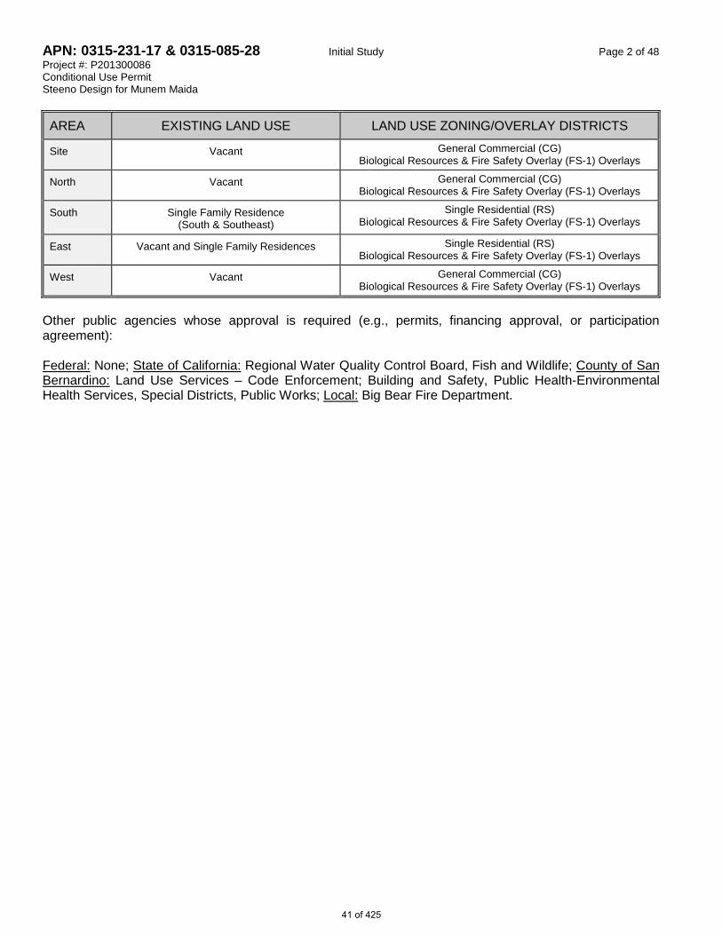
APN: 0315-231-17 & 0315-085-28 Initial Study Page 2 of 48 Project #: P201300086 Conditional Use Permit Steeno Design for Munem Maida
AREA EXISTING LAND USE LAND USE ZONING/OVERLAY DISTRICTS
Site Vacant General Commercial (CG) Biological Resources & Fire Safety Overlay (FS-1) Overlays
North Vacant General Commercial (CG) Biological Resources & Fire Safety Overlay (FS-1) Overlays
South Single Family Residence (South & Southeast)
Single Residential (RS) Biological Resources & Fire Safety Overlay (FS-1) Overlays
East Vacant and Single Family Residences Single Residential (RS) Biological Resources & Fire Safety Overlay (FS-1) Overlays
West Vacant General Commercial (CG) Biological Resources & Fire Safety Overlay (FS-1) Overlays
Other public agencies whose approval is required (e.g., permits, financing approval, or participation agreement): Federal: None; State of California: Regional Water Quality Control Board, Fish and Wildlife; County of San Bernardino: Land Use Services – Code Enforcement; Building and Safety, Public Health-Environmental Health Services, Special Districts, Public Works; Local: Big Bear Fire Department.
41 of 425

APN: 0315-231-17 & 0315-085-28 Initial Study Page 3 of 48 Project #: P201300086 Conditional Use Permit Steeno Design for Munem Maida EVALUATION FORMAT This initial study is prepared in compliance with the California Environmental Quality Act (CEQA) Guidelines. This format of the study is presented as follows. The project is evaluated based upon its effect on eighteen (18) major categories of environmental factors. Each factor is reviewed by responding to a series of questions regarding the impact of the project on each element of the overall factor. The Initial Study Checklist provides a formatted analysis that provides a determination of the effect of the project on the factor and its elements. The effect of the project is categorized into one of the following four categories of possible determinations: Potentially Less than Less than No Significant Significant with Significant Impact
Impact Mitigation Incorporated
Substantiation is then provided to justify each determination. One of the four following conclusions is then provided as a summary of the analysis for each of the major environmental factors. 1. Therefore, no impacts are identified or anticipated and no mitigation measures are required. 2. Therefore, no significant adverse impacts are identified or anticipated and no mitigation measures are
required. 3. Possible significant adverse impacts have been identified or anticipated and the following mitigation
measures are required as a condition of project approval to reduce these impacts to a level below significant. The required mitigation measures are: (List mitigation measures)
4. Significant adverse impacts have been identified or anticipated. An Environmental Impact Report (EIR) is
required to evaluate these impacts, which are (Listing the impacts requiring analysis within the EIR).
At the end of the analysis the required mitigation measures are restated and categorized as being either self- monitoring or as requiring a Mitigation Monitoring and Reporting Program.
42 of 425

APN: 0315-231-17 & 0315-085-28 Initial Study Page 4 of 48 Project #: P201300086 Conditional Use Permit Steeno Design for Munem Maida ENVIRONMENTAL FACTORS POTENTIALLY AFFECTED: The environmental factors checked below would be potentially affected by this project, involving at least one impact that is a "Potentially Significant Impact" as indicated by the checklist on the following pages.
Aesthetics Agriculture & Forest Resources
Air Quality
Biological Resources Cultural Resources Geology /Soils Greenhouse Gas Emissions Hazards & Hazardous
Materials Hydrology / Water
Quality Land Use/ Planning Mineral Resources Noise Population / Housing Public Services Recreation Transportation/Traffic Utilities / Service Systems Mandatory Findings of
Significance
DETERMINATION: (To be completed by the Lead Agency) On the basis of this initial evaluation, the following finding is made:
The proposed project COULD NOT have a significant effect on the environment, and a NEGATIVE DECLARATION will be prepared.
Although the proposed project could have a significant effect on the environment, there will not be a significant effect in this case because revisions in the project have been made by or agreed to by the project proponent. A MITIGATED NEGATIVE DECLARATION will be prepared.
The proposed project MAY have a significant effect on the environment, and an ENVIRONMENTAL IMPACT REPORT is required.
The proposed project MAY have a "potentially significant impact" or "potentially significant unless mitigated" impact on the environment, but at least one effect 1) has been adequately analyzed in an earlier document pursuant to applicable legal standards, and 2) has been addressed by mitigation measures based on the earlier analysis as described on attached sheets. An ENVIRONMENTAL IMPACT REPORT is required, but it must analyze only the effects that remain to be addressed.
Although the proposed project could have a significant effect on the environment, because all potentially significant effects (a) have been analyzed adequately in an earlier EIR or NEGATIVE DECLARATION pursuant to applicable standards, and (b) have been avoided or mitigated pursuant to that earlier EIR or NEGATIVE DECLARATION, including revisions or mitigation measures that are imposed upon the proposed project, nothing further is required.
Signature (prepared by): Oxso Shahriari, Planner Date: 11/21/2014
Signature: Dave Prusch, Supervising Planner Date: 11/21/2014
43 of 425

APN: 0315-231-17 & 0315-085-28 Initial Study Page 5 of 48 Project #: P201300086 Conditional Use Permit Steeno Design for Munem Maida Potentially
Significant Impact
Less than Significant with
Mitigation Incorp.
Less than Significant
No Impact
I. AESTHETICS - Would the project a) Have a substantial adverse effect on a scenic vista?
b) Substantially damage scenic resources, including but not limited to trees, rock outcroppings, and historic buildings within a state scenic highway?
c) Substantially degrade the existing visual character or quality of the site and its surroundings?
d) Create a new source of substantial light or glare, which
would adversely affect day or nighttime views in the area?
SUBSTANTIATION (Check if project is located within the view-shed of any Scenic Route listed in the General Plan):
I a)
Less Than Significant Impact. The project will not have a substantial adverse effect on a scenic vista because the site is separated from the State Highway 38 and the traveling public by the state owned land, containing indigenous trees that buffer the site from view. The project facilitates architectural features, as depicted on the conditionally approved site plan and elevations that complements the mountainous character of the surrounding areas. The proposed development provides aesthetic qualities of a mountain lodge that blends well with the surrounding vistas. As a condition of approval, all the agreed-upon design/architectural components and the required landscaping shall be installed and kept in optimum conditions during the life of the project. The project as proposed meets County’s goals in conserving the scenic qualities of this route. Therefore, no potentially significant impact is anticipated and no mitigation measures are deemed necessary
I b) Less Than Significant Impact. The project will not substantially damage scenic resources, including but not limited to trees, rock outcroppings, and historic buildings within a state scenic highway because these resources will not be substantially compromised as a result of this project. No rock outcroppings or historic buildings have been identified on the site. No protected trees are identified on the site. However, as a Condition of Approval, a Tree or Plant Removal Plan shall be presented to the County Planning for review and approval, issued in compliance with Section 88.01.050 (Tree or Plant Removal Requirements), for the removal of regulated trees and plants. The project will retain 20% of the site in a natural undeveloped vegetated or re-vegetated condition sufficient to ensure vegetative coverage for a forest environment. Adequate number of trees (Fifty seven Jeffrey Pines, 3 cypress trees 6 inches in diameter or wider) shall be remained on site as regulated native trees. These along with the newly planted landscaping will minimize any potential visual impact to a level below significance. These trees along with those on the public land along state highway and to the west/southwest to the site will buffer the development from the traveling public’s view traveling along the State Highway. Therefore, no potentially significant impact is anticipated in this area of concern and no mitigation measures are deemed necessary.
44 of 425

APN: 0315-231-17 & 0315-085-28 Initial Study Page 6 of 48 Project #: P201300086 Conditional Use Permit Steeno Design for Munem Maida
I c) Less Than Significant Impact. The proposed project does not have the potential to substantially degrade the existing visual character or quality of the site and its surroundings because the site is separated from the State Highway 38 and the traveling public by the state owned land, containing indigenous trees that buffer the site from view. The project is conditioned to provide adequate landscaping and screening to minimize any potential impact to its surroundings. The proposed development provides aesthetic qualities of a mountain lodge that blends well with the surrounding vistas. As a condition of approval, all the agreed-upon design/architectural components and the required landscaping shall be installed and kept in optimum conditions during the life of the project. Therefore, no potentially significant impact is anticipated in this area and no mitigation measures are deemed necessary.
I d) Less Than Significant Impact. The proposed project’s onsite lighting will be designed in
accordance with standards defined in the County Development Code to shield away all light sources from the street, night sky, and the surrounding residential properties. All signs proposed by this project may only be lit by steady, stationary and shielded light sources, and the glare from the luminous source shall not exceed one-half (0.5) foot-candle. A lighting plan is required, subject to review and approval by Planning which requires that all project light sources be placed and designed so as not to cause glare or excessive light spillage into neighboring sites, night sky, or public roadways. As Consistent with County Development Code Chapter 83.07: Glare and Outdoor Lighting, this approval does not allow installation or use of any artificial light source that will be emitted into the night sky. The project is conditioned to use low intensity lamps especially at the development boundaries. All lighting shall be hooded and designed with sharp-cutoff luminaries to reflect away from adjoining properties and public thoroughfares. The project will not be a source of substantial light or glare, therefore, no potentially significant impact is anticipated in this area of concern and no mitigation measures are deemed necessary.
Therefore, no significant adverse impacts are identified or anticipated and no mitigation measures are required.
45 of 425

APN: 0315-231-17 & 0315-085-28 Initial Study Page 7 of 48 Project #: P201300086 Conditional Use Permit Steeno Design for Munem Maida
Potentially Significant
Impact
Less than Significant with
Mitigation Incorp.
Less than Significant
No Impact
II. AGRICULTURE AND FOREST RESOURCES - In determining whether impacts to agricultural resources are significant environmental effects, lead agencies may refer to the California Agricultural Land Evaluation and Site Assessment Model (1997) prepared by the California Department of Conservation as an optional model to use in assessing impacts on agriculture and farmland. In determining whether impacts to forest resources, including timberland, are significant environmental effects, lead agencies may refer to information compiled by the California Department of Forestry and Fire Protection regarding the state’s inventory of forest land, including the Forest and Range Assessment Project and the Forest Legacy Assessment Project, and the forest carbon measurement methodology provided in Forest Protocols adopted by the California Air Resources Board. Would the project:
a) Convert Prime Farmland, Unique Farmland, or Farmland
of Statewide Importance (Farmland) as shown on the maps prepared pursuant to the Farmland Mapping and Monitoring Program of the California Resources Agency, to non-agricultural use?
b) Conflict with existing zoning for agricultural use, or a Williamson Act contract?
c) Conflict with existing zoning for, or cause rezoning of,
forest land (as defined in Public Resources Code section 12220(g)), timberland (as defined by Public Resources Code section 4526), or timberland zoned Timberland Production (as defined by Government Code section 51104(g))?
d) Result in the loss of forestland or conversion of forestland to non-forest use?
e) Involve other changes in the existing environment, which, due to their location or nature, could result in conversion of farmland, to non-agricultural use or conversion of forestland to non-forest use?
46 of 425

APN: 0315-231-17 & 0315-085-28 Initial Study Page 8 of 48 Project #: P201300086 Conditional Use Permit Steeno Design for Munem Maida
SUBSTANTIATION (Check if project is located in the Important Farmlands Overlay):
II a) No Impact. The subject property is not identified or designated as Prime Farmland, Unique Farmland, or Farmland of Statewide importance on the maps prepared, pursuant to the Farmland Mapping and Monitoring Program of the California Resources Agency. Therefore, proposed development will not negate or hamper any agricultural uses on the site.
II b) No Impact. The proposed project does not conflict with existing zoning for agricultural use or a
Williamson Act contract because the subject property is not zoned for agricultural use.
II c) No Impact. The project does not conflict with existing zoning for, or cause rezoning of, forest land (as defined in Public Resources Code section 12220(g)), timberland (as defined by Public Resources Code section 4526), or timberland zoned Timberland Production (as defined by Government Code section 51104(g)) because the project is not identified as a timberland resources. Therefore, no potential for such rezoning or conversion of the resources exists due to this development.
II d) Less Than Significant Impact. The proposed use does not result in the loss of forestland or conversion of forestland to non-forest use because the project is conditioned to retain 20% of the site in a natural undeveloped vegetated OR re-vegetated condition sufficient to ensure vegetative coverage for a forest environment, as outlined in 88.01.050 (f) (2) (II). As a Condition of Approval, a Tree or Plant Removal Permit shall be presented to the County Planning, issued in compliance with Section 88.01.050 (Tree or Plant Removal Requirements), for the removal of regulated trees and plants to ensure adequate number regulated native trees shall remain on the project site. Adequate number of trees—Fifty seven Jeffrey Pines, 3 cypress trees—6 inches in diameter or wider are kept on the grounds. Therefore, no potential impact is anticipated in this area of concern and no mitigation measures are deemed necessary.
II e) Less Than Significant Impact. The proposed use does not involve other changes in the existing environment, which, due to their location or nature, could result in conversion of farmland, to non-agricultural use or conversion of forestland to non-forest use because the project site does not meet the definitions of farmland. Forest land character of the site shall be sustained as described in II-d, above. Therefore, no potential impact is anticipated in this area of concern and no mitigation measures are deemed necessary.
Therefore, no significant adverse impacts are identified or anticipated and no mitigation measures are required.
47 of 425

APN: 0315-231-17 & 0315-085-28 Initial Study Page 9 of 48 Project #: P201300086 Conditional Use Permit Steeno Design for Munem Maida Potentially
Significant Impact
Less than Significant with
Mitigation Incorp.
Less than Significant
No Impact
III. AIR QUALITY - Where available, the significance criteria established by the applicable air quality management or air pollution control district may be relied upon to make the following determinations. Would the project:
a) Conflict with or obstruct implementation of the
applicable air quality plan?
b) Violate any air quality standard or contribute substantially to an existing or projected air quality violation?
c) Result in a cumulatively considerable net increase of any criteria pollutant for which the project region is non-attainment under an applicable federal or state ambient air quality standard (including releasing emissions, which exceed quantitative thresholds for ozone precursors)?
d) Expose sensitive receptors to substantial pollutant concentrations?
e) Create objectionable odors affecting a substantial
number of people?
SUBSTANTIATION (Discuss conformity with the South Coast Air Quality Management Plan, if applicable):
III a) Less Than Significant Impact. The project is within the South Coast Air Basin and under the jurisdiction of the South Coast Air Quality Management District. The South Coast Air Quality Management District is responsible for maintaining and ensuring compliance with its Air Quality Management Plans. A project is non-conforming if it conflicts with or delays implementation of any applicable attainment or maintenance plan. The project will not conflict with or obstruct implementation of the South Coast Air Quality Management Plan, because the project is conditioned to follow all the District’s rules and regulation as these measures are mandatory requirements. A project may also be non-conforming if it, as examples, increases the gross number of dwelling units, increases the number of trips, and/or increases the overall vehicle miles traveled in an affected area relative to applicable land use plans. The project is anticipated to lead to a net decrease in traffic because it will serve the Highway 38 traffic which is both entering and leaving the Big Bear Valley, as well as providing the first service station in the south Erwin Lake area, thereby allowing local residents to obtain gasoline and convenience store products without having to travel into Big Bear City or Big Bear Lake. , therefore reducing the miles traveled for similar products and services. While the project will minimally generate additional vehicle trips from service and delivery vehicles servicing the site, the existence of the gas station is expected to serve the local residents and reduce vehicle miles currently traveled to reach the same products and services not currently available on or near the project site. This 6,793 square foot convenience store, gas station, and a caretaker residence is consistent with the growth projections and associated emissions used in the adopted County of San Bernardino Greenhouse Gas Emission Reduction Plan because it is smaller in size than the sample Gas Station/Convenience store of 7,200 square feet used for the referenced study. Therefore the project is expected to fall short of 3000 metric tons of Carbon Dioxide Equivalent (CO2e) per year for the proposed use. 48 of 425

APN: 0315-231-17 & 0315-085-28 Initial Study Page 10 of 48 Project #: P201300086 Conditional Use Permit Steeno Design for Munem Maida
An Air Quality Report has been prepared by Urban Crossroads for this project and finds that the “Project would not exceed the numerical thresholds of significance established by the South Coast Air Quality Management District (SCAQMD).” The study also finds that “Project construction-source emissions would not conflict with the applicable Air Quality Management Plan (AQMP).” Although not required, the study recommends that best available control measures (BACM AQ-1 and BACM AQ-2) are implemented to further reduce the impacts during the construction. Therefore, no significant impact is anticipated and no mitigation measure is deemed necessary.
III b) Less Than Significant Impact. The project is not expected to violate any air quality standard or
contribute substantially to an existing or projected air quality violation, because the proposed use does not exceed thresholds of concern, as established by the District for this category of use. The project’s construction and operational emissions are expected to fall short of 3000 metric tons of Carbon Dioxide Equivalent (CO2e) per year for this use type. However, some impact is identified during project construction, therefore mitigation measures III-1, III-2 and III-3 are imposed to further limit or control potential fugitive dust and regulate construction activities. The aforementioned study prepared by Urban Crossroads finds that “Project construction-source emissions would not conflict with the applicable Air Quality Management Plan (AQMP).” The study finds that “construction-source odor emissions would be temporary, short-term, and intermittent in nature and would not result in persistent impacts that would affect substantial numbers of people. Potential construction-source odor impacts are therefore considered less-than-significant.” Although not required, the study recommends that Best Available Control Measures (BACM AQ-1 and BACM AQ-2) are implemented to further reduce the impacts during the construction. Upon completion, the site will be paved and landscaped which will mean little or no wind-blown dust or particulate matter will leave the site. Temporary potential significant impacts are anticipated during construction, therefore mitigation measures III-1, III-2 and III-3 are required as conditions of approval to reduce any potential impact to a level below significance.
III c) Less Than Significant Impact With Mitigation Incorporated. The aforementioned study prepared by Urban Crosses Roads finds that “the Project area is designated as an extreme non‐attainment area for ozone, and a non‐attainment area for PM10 and PM2.5”. The study continues: “The SCAQMD has recognized that there is typically insufficient information to quantitatively evaluate the cumulative contributions of multiple projects because each project applicant has no control over nearby projects. With regard to determining the significance of the contribution from the Project, the SCAQMD recommends that any given project’s potential contribution to cumulative impacts should be assessed using the same significance criteria as for project-specific impacts. Therefore, this analysis assumes that individual projects that do not generate operational or construction emissions that exceed the SCAQMD’s recommended daily thresholds for project-specific impacts would also not cause a commutatively considerable increase in emissions for those pollutants for which the Basin is nonattainment, and, therefore, would not be considered to have a significant, adverse air quality impact. Alternatively, individual project-related construction and operational emissions that exceed SCAQMD thresholds for project-specific impacts would be considered cumulatively considerable. As previously noted, the project will not exceed the applicable SCAQMD regional threshold for construction and operational-source emissions. As such, the project will result in a cumulatively less than significant impact.” The project will not result in a cumulatively considerable net increase of any criteria pollutant for which the project region is in non-attainment under an applicable federal or state ambient air quality standard (including releasing emissions which exceed quantitative thresholds for ozone precursors), because the proposed uses do not exceed established thresholds of concern for this use category. This 6,793 square foot convenience store, gas station, and a caretaker residence is consistent with the growth projections and associated emissions used in the County of San Bernardino Emission 49 of 425

APN: 0315-231-17 & 0315-085-28 Initial Study Page 11 of 48 Project #: P201300086 Conditional Use Permit Steeno Design for Munem Maida
Reduction Plan because it is less in size than sample Gas Station/Convenience store of 7,200 square feet, and therefore it is expected to fall short of 3000 metric tons of Carbon Dioxide Equivalent (CO2e) per year for this use type. Operation and the related equipment proposed for this use do not generate identifiable criteria pollutants is most likely not to approach the threshold of potentially significant Greenhouse Gas (GHG) emissions set forth for the proposed use.
III d) Less Than Significant Impact. The project will not expose sensitive receptors to substantial
pollutant concentrations, because the construction or operation of this facility does not involve identified concentrations of substantial pollutants. The aforementioned Air Quality Impact Analysis has also considered potential impact of project-generated air pollutant emissions at sensitive receptors which can include uses such as long term health care facilities, rehabilitation centers, and retirement homes. Residences, schools, playgrounds, child care centers, and athletic facilities can also be considered as sensitive receptors. The analysis indicates that the project will not exceed the SCAQMD Localized Significance Thresholds (LSTs) during construction with Best Available Control Measures (BACMs). Therefore sensitive receptors would not be subject to a significant air quality impact during project construction. As relates to operational impacts, the aforementioned LST analysis indicates that the project will not exceed the SCAQMD localized significance thresholds during operational activities. The proposed project would not result in a Carbon Monoxide or Nitrogen Dioxide “hotspots” as a result of project related traffic during ongoing operations, nor would the project result in a significant adverse health impact, due to the ongoing operations. Per the referenced Air Quality analysis; a very conservative (overstating rather than understating potential impacts) estimate, toxic air contaminants (TACs) “have the potential to contribute to health risk in the project vicinity”. However, the project will remain under SCAQMD’s Rule 461 (Gasoline Transfer and Dispensing) and shall be required to meet and maintain standards. Based on the screening procedure using methodology presented in the document “Gasoline Service Station Industry-wide Risk Assessment Guidelines” published by the California Air Pollution Control Officers Association (CAPCOA), it is anticipated that no sensitive receptors in the project vicinity will be exposed to a cancer risk. In fact the risk is less than half of the applicable threshold. The study concludes: “The project would not result in a significant health risk impact due to toxic air contaminants (TACs) associated with gasoline dispensing activities.” Thus, any potential impact to sensitive receptors will be less than significant due to operational activities of the project.
III e) Less Than Significant Impact. The project will not create odors affecting a substantial number of
people because there are no identified potential uses that will result in the production of objectionable odors due to ongoing operation of the project. Any potential objectionable odor that may result from construction are temporary and intermittent, therefore mitigation measures III-1, III-2 and III-3 are required to reduce any potential impact to a level below significance. Therefore, no potentially significant impact is anticipated.
Possible significance adverse impacts have been identified or anticipated and the following mitigation measures are required as conditions of project approval to reduce these impacts to a level below significant.
50 of 425

APN: 0315-231-17 & 0315-085-28 Initial Study Page 12 of 48 Project #: P201300086 Conditional Use Permit Steeno Design for Munem Maida
MM# Mitigation Measures
III-1 Air Quality – Dust Control Plan. The developer shall submit to County Planning a Dust Control Plan (DCP) consistent with SCAQMD guidelines and a letter agreeing to include in any construction contracts and/or subcontracts a requirement that the contractors adhere to the requirements of the DCP. The DCP shall include these elements to reduce dust production: a. Exposed soil shall be kept continually moist through a minimum of twice daily waterings to
reduce fugitive dust during all grading and construction activities b. Street sweeping shall be conducted when visible soil accumulations occur along site access
roadways to remove dirt dropped by construction vehicles. c. Site access driveways and adjacent streets shall be washed daily, if there are visible signs of
any dirt track-out at the conclusion of any workday. d. Tires of vehicles will be washed before vehicle leave project site and enter a paved road. e. Any truck hauling dirt away from the site shall be covered f. During high wind conditions (i.e., wind speeds exceeding 25 mph), areas with disturbed soil
shall be watered hourly and activities on unpaved surfaces shall be terminated until wind speeds no longer exceed 25 mph.
g. Storage piles that are to be left in place for more than three working days shall either be sprayed with a non-toxic soil binder, or covered with plastic or revegetated.
[Mitigation Measure III-1]
III-2 Air Quality – Construction Plan. Developer shall submit written verification that all construction contracts and sub-contracts for the project contain provisions that require adherence to the following standards to reduce impacts to air quality. During construction, each contractor and subcontractor shall implement the following, whenever feasible: a. Suspend use of all construction equipment operations during second stage smog alerts. For
daily forecast, call (800) 367-4710 (San Bernardino and Riverside counties). b. Trucks/equipment shall not be left idling on site for periods in excess of 10 minutes. c. Provide temporary traffic control during all phases of construction. d. Substitute diesel-powered equipment with electric and gasoline-powered equipment. e. Onsite electrical power hook-ups shall be provided for electric construction tools to eliminate the
need for diesel-powered electronic generators. f. Install storm water control systems to prevent mud deposition onto paved areas during
construction. g. Contractors shall use low sulfur fuel for stationary construction equipment as required by AQMD
Rules 431.1 and 431.2 to reduce the release of undesirable emissions. [Mitigation Measure III-2]
III-3 Air Quality – Coating Restriction Plan. The developer shall submit a letter agreeing to these Coating Restrictions and to include in any construction contracts and/or subcontracts a requirement that the contractors adhere to these requirements. These shall include, but are not be limited to: a. Architectural coatings with Reactive Organic Compounds (ROC) shall not have a
content greater than 100 g/l. b. Architectural coating volume shall not exceed the significance threshold for ROG, which
is 75 lbs./day and the combined daily ROC volume of architectural coatings and asphalt paving shall not exceed the significance threshold for ROC of 75 lbs. per day
c. High-Volume, Low Pressure (HVLP) spray guns will be used to apply coatings. [Mitigation Measure III-3]
51 of 425

APN: 0315-231-17 & 0315-085-28 Initial Study Page 13 of 48 Project #: P201300086 Conditional Use Permit Steeno Design for Munem Maida Potentially
Significant Impact
Less than Significant with
Mitigation Incorp.
Less than Significant
No Impact
IV. BIOLOGICAL RESOURCES - Would the project:
a) Have substantial adverse effects, either directly or through habitat modifications, on any species identified as a candidate, sensitive or special status species in local or regional plans, policies, or regulations, or by the California Department of Fish and Wildlife or U.S. Fish and Wildlife Service?
b) Have a substantial adverse effect on any riparian habitat or other sensitive natural community identified in local or regional plans, policies, and regulations or by the California Department of Fish and Wildlife or US Fish and Wildlife Service?
c) Have a substantial adverse effect on federally protected wetlands as defined by Section 404 of the Clean Water Act (including, but not limited to, marsh, vernal pool, coastal, etc…) through direct removal, filling, hydrological interruption, or other means?
d) Interfere substantially with the movement of any native resident or migratory fish or wildlife species or with established native resident or migratory wildlife corridors, or impede the use of native wildlife nursery sites?
e) Conflict with any local policies or ordinances protecting biological resources, such as a tree preservation policy or ordinance?
f)
Conflict with the provisions of an adopted Habitat Conservation Plan, Natural Community Conservation Plan, or other approved local, regional or state habitat conservation plan?
SUBSTANTIATION (Check if project is located in the Biological Resources Overlay or contains habitat for any species listed in the California Natural Diversity Database ):
IV a) Less Than Significant Impact. This project will not have a substantial adverse effect, either
directly or through habitat modifications, on any species identified as a candidate, sensitive, or special status species in local or regional plans, policies, or regulations, or by the California Department of Fish and Wildlife or U.S. Fish and Wildlife Service, because the site is not expected to support any sensitive species, sensitive habitats, or wildlife corridors based on the General Biological Resources Assessment report prepared for this site by the RCA Associates, LLC. in 2013. The site was evaluated for the presence of sensitive plant and animal species as well as potential habitat for these sensitive species that included flying squirrel, rubber bar, and California spotted owl as well as 24-sentsive plant species documented in the surrounding region, primarily in associate with Baldwin Lake, which is located about two miles to the north of the project site. The study finds that the .91-acre project site is near developed portion of the Big Bear Lake area and “is not expected to support any sensitive species”. The study finds that “no sensitive habitats (i.e. 52 of 425

APN: 0315-231-17 & 0315-085-28 Initial Study Page 14 of 48 Project #: P201300086 Conditional Use Permit Steeno Design for Munem Maida
streams, wetlands, etc.) or wildlife corridors were observed, nor were any such habitats noted in the adjacent areas. In response to the expressed community opposition concerned with potential impacts to the biological resources—and specifically as related to potential impact on the Unarmored three-spine stickleback fish, the applicant’s biologist has performed additional biological surveys on April 28, 2014; which has resulted in an updated May 2014 report. The site was further evaluated to assess the drainage channel directly west and north of the site, existing site conditions, and potential impacts to stickleback populations. The field investigation was performed on April 28, 2014 from 7AM to 3:30 PM; and reconfirmed that the site “does not support any sensitive habitats such as streams and wetlands, nor were any wildlife corridors identified on the property”. The study finds that the USGS Moonridge Quadrangle does not show any blue line channels on the site and no drainage channels or streams bisect the site based on field work conducted in April 2014. A small swale about 30 feet in length and about six inches wide does occur along the western edge of the site; however, this swale does not connect with any off-site channels nor does it direct any significant water flows on-site. A letter dated February 3, 2014 was prepared by RCA Associates LLC to address comments raised regarding potential impacts to the unarmored threespine stickleback fish. RCA Associates reviewed existing information on the species from the California Natural Diversity Data Base (CNDDB, 2013) and U.S. Fish and Wildlife Service (USFWS, 2009). According to the letter provided to Planning, and based on the review of available information, the nearest documented population of the stickleback species is approximately 0.9 miles north of the project site and is associated with Shay Creek and Shay Pond. The species was observed in 1995 in Shay Creek which is a tributary to Baldwin Lake, which is directly east of Big Bear City. This population is assumed to still be present in Shay Creek and Shay Pond; although surveys for the stickleback fish have not been conducted since 2009. Two small intermittent channels of Shay Creek are also located about 0.5 miles northeast and northwest of the project site. The study finds that “although population of the stickleback may be present north of the project site, it is unlikely that the species would be affected by any potential onsite leakage or seepage problems” because “operation of the proposed fuel dispensers will be property maintained and kept in good operating conditions at all times as per State of California requirements”. The study continues: “any leakage or seepage from the underground tanks will be immediately reported and mitigation measures, if needed, will be implemented. "Cumulative impacts to the biological resources in the area are expected to be negligible” based on the existing habitats on the 0.9-acre site, as documented in the referenced 2013 and 2014 General Biological Reports. The RCA states that: “the site supports a relatively undisturbed ponderosa pine community typical of the area. Loss of 0.9-acres of this habitat is not expected to generate adverse cumulative impacts to regional biological resources due to the small size of the potential habitat loss”. In addition, development of the site as proposed is not expected to generate any adverse cumulative impacts to any sensitive species in the area. As previously noted the site does not support any populations of sensitive species; although, populations of the Unarmored Threespine Stickleback are located about 0.9 miles north of the project site”. The project will be designed in order to meet all local, State, and Federal Best Management Practices requirements in order to maintain all on-site water flows within the boundaries of the property. The RCA also states that: “any on-site spills of gasoline or other toxic substances will be contained on the site and will not enter into any of the drainage channels near the site through the use of a concrete swale on the property”; and concludes: “based on the existing project design and proposed implementation of various protection measures, cumulative impacts to the stickleback from the proposed project are expected to be negligible." Therefore, potential impacts to the biological resources will be less than significant.
53 of 425

APN: 0315-231-17 & 0315-085-28 Initial Study Page 15 of 48 Project #: P201300086 Conditional Use Permit Steeno Design for Munem Maida
IV b) Less Than Significant Impact. This project will not have a substantial adverse effect on any riparian habitat or other sensitive natural community identified in local or regional plans, policies, regulations or by the California Department of Fish and Wildlife or US Fish and Wildlife Service because no riparian habitat or sensitive natural community are identified on the project site. The 2013 and 2014 General Biological Reports prepared by RCA found no sensitive habitats, stream, wetlands or wildlife corridors on the project site to potentially support riparian habitat. A 2014 Supplemental Preliminary Hydrology Analysis was prepared in response to a response letter from the State of California, Department of Fish and Wildlife, dated April 16, 2014. This response letter questions the potential impacts of the proposed subject development on the stream drainage along State Highway 38 (identified by Fish and Wildlife as “Shay Creek”) for the proposed hydrologic and hydraulic issues of the project site. The study finds that a “blue line” stream is shown on the USGS quadrangle topographic map and ends at Highway 38 south of the subject site (see image titled OFF-SITE TOPOGRAPHY, below).
54 of 425
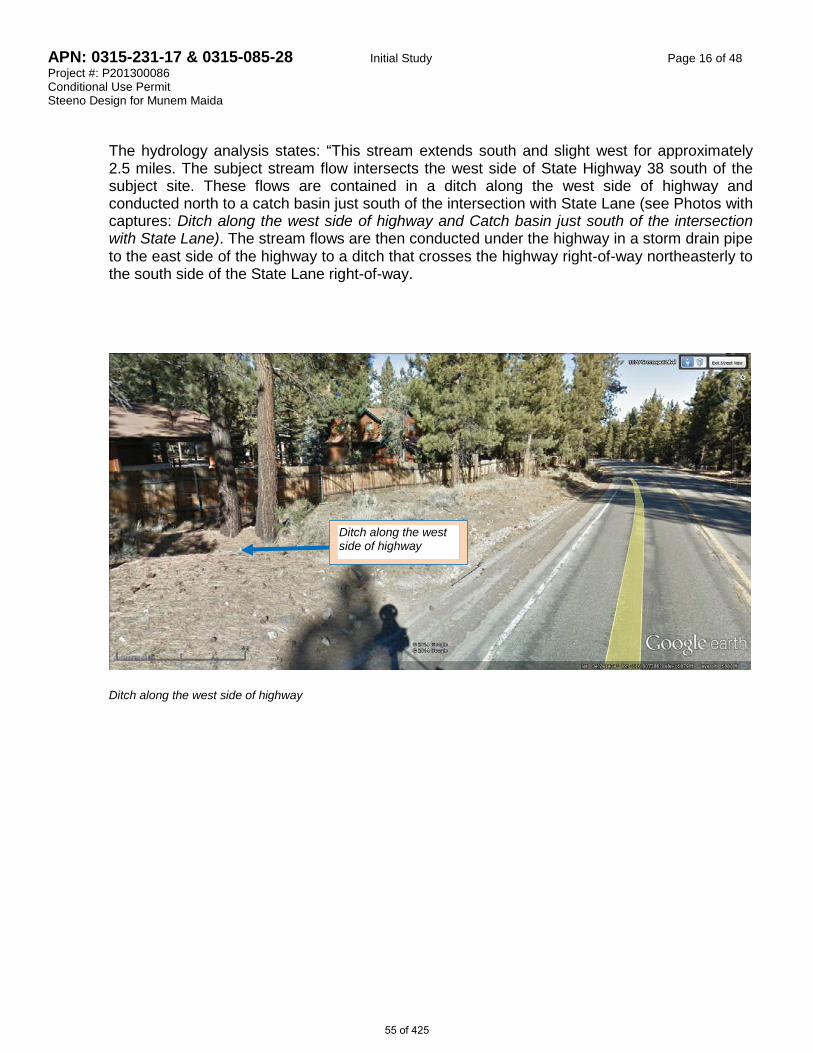
APN: 0315-231-17 & 0315-085-28 Initial Study Page 16 of 48 Project #: P201300086 Conditional Use Permit Steeno Design for Munem Maida
The hydrology analysis states: “This stream extends south and slight west for approximately 2.5 miles. The subject stream flow intersects the west side of State Highway 38 south of the subject site. These flows are contained in a ditch along the west side of highway and conducted north to a catch basin just south of the intersection with State Lane (see Photos with captures: Ditch along the west side of highway and Catch basin just south of the intersection with State Lane). The stream flows are then conducted under the highway in a storm drain pipe to the east side of the highway to a ditch that crosses the highway right-of-way northeasterly to the south side of the State Lane right-of-way.
Ditch along the west side of highway
Ditch along the west side of highway
55 of 425

APN: 0315-231-17 & 0315-085-28 Initial Study Page 17 of 48 Project #: P201300086 Conditional Use Permit Steeno Design for Munem Maida
Catch basin just south of the intersection of Highway 38 and State Lane These flows then cross northerly State Lane in a culvert pipe and continue northeasterly. It appears that off-site stream flows do not enter or cross the subject site. As it relates to the onsite drainage flow, onsite flows will be contained on site and treated by onsite Best Management Practices (BMP’s) in an effort to contain pollutants, trash and sediments generated by the proposed use. The onsite 100-year 1-hour storm generated will be captured and contained in an off-site BMP underground retention basin and allowed to percolate. A proposed concrete swale along the subject site’s westerly boundary will conduct any off-site flows northerly, to keep off-site flows from entering the site. Based on the information provided in the revised Biological Assessment and the Supplemental Preliminary-Hydrology Analysis of Off-site Flows, any potential significant impact to the biological resources due to the project will be less than significant.
IV c) Less Than Significant Impact. This project will not have a substantial adverse effect on federally protected wetlands as defined by Section 404 of the Clean Water Act (including, but not limited to marsh, vernal pool, coastal, etc.) through direct removal, filling, hydrological interruption, or other means because the project is not located within an identified protected wetland because the 2013 and 2014 Biological Assessments mentioned above find no sensitive habitats, stream, wetlands or wildlife corridors on this site. Therefore, any potential significant impact to the biological resources due to the project will be less than significant.
IV d) Less Than Significant Impact. This project will not interfere substantially with the movement of
any native resident or migratory fish or wildlife species or with established native resident or migratory wildlife corridors, or impede the use of native wildlife nursery sites, because the site is not expected to support any sensitive species, sensitive habitats, wildlife nursery, or wildlife corridors, based on the 2013 and 2014 General Biological Assessments prepared for this site by the RCA Associates, LLC. Therefore, any potential significant impact to the biological resources due to the project will be less than significant.
Catch basin
56 of 425

APN: 0315-231-17 & 0315-085-28 Initial Study Page 18 of 48 Project #: P201300086 Conditional Use Permit Steeno Design for Munem Maida
IV e) Less Than Significant Impact. This project will not conflict with any local policies or ordinances
protecting biological resources because such ordinances take effect when protected tree species are present on a given site. No protected species of trees has been identified on this parcel. The management and well-being of the native regulated tree falls under Chapter 88.01: Plant Protection and Management, discussed separately under Agriculture and Forest Resources, II-d. Therefore, any potential significant impact to the biological resources due to the project will be less than significant.
IV f) Less Than Significant Impact. This project will not conflict with the provisions of an adopted
Habitat Conservation Plan, Natural Community Conservation Plan, or other approved local, regional or state habitat conservation plan because no such plan has been identified on this project site, based on the 2013 & 2014 General Biological Assessments prepared by the RCA Associates, LLC. Therefore, any potential significant impact to the biological resources due to the project will be less than significant.
Therefore, no significant adverse impacts are identified or anticipated and no mitigation measures are required.
57 of 425
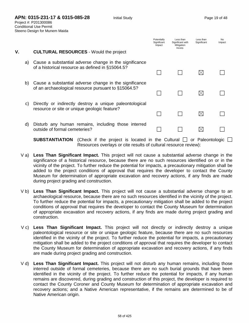
APN: 0315-231-17 & 0315-085-28 Initial Study Page 19 of 48 Project #: P201300086 Conditional Use Permit Steeno Design for Munem Maida Potentially
Significant Impact
Less than Significant with
Mitigation Incorp.
Less than Significant
No Impact
V. CULTURAL RESOURCES - Would the project
a) Cause a substantial adverse change in the significance of a historical resource as defined in §15064.5?
b) Cause a substantial adverse change in the significance of an archaeological resource pursuant to §15064.5?
c) Directly or indirectly destroy a unique paleontological resource or site or unique geologic feature?
d) Disturb any human remains, including those interred outside of formal cemeteries?
SUBSTANTIATION (Check if the project is located in the Cultural or Paleontologic
Resources overlays or cite results of cultural resource review):
V a) Less Than Significant Impact. This project will not cause a substantial adverse change in the significance of a historical resource, because there are no such resources identified on or in the vicinity of the project. To further reduce the potential for impacts, a precautionary mitigation shall be added to the project conditions of approval that requires the developer to contact the County Museum for determination of appropriate excavation and recovery actions, if any finds are made during project grading and construction.
V b) Less Than Significant Impact. This project will not cause a substantial adverse change to an
archaeological resource, because there are no such resources identified in the vicinity of the project. To further reduce the potential for impacts, a precautionary mitigation shall be added to the project conditions of approval that requires the developer to contact the County Museum for determination of appropriate excavation and recovery actions, if any finds are made during project grading and construction.
V c) Less Than Significant Impact. This project will not directly or indirectly destroy a unique
paleontological resource or site or unique geologic feature, because there are no such resources identified in the vicinity of the project. To further reduce the potential for impacts, a precautionary mitigation shall be added to the project conditions of approval that requires the developer to contact the County Museum for determination of appropriate excavation and recovery actions, if any finds are made during project grading and construction.
V d) Less Than Significant Impact. This project will not disturb any human remains, including those
interred outside of formal cemeteries, because there are no such burial grounds that have been identified in the vicinity of the project. To further reduce the potential for impacts, if any human remains are discovered, during grading and construction of this project, the developer is required to contact the County Coroner and County Museum for determination of appropriate excavation and recovery actions; and a Native American representative, if the remains are determined to be of Native American origin.
58 of 425

APN: 0315-231-17 & 0315-085-28 Initial Study Page 20 of 48 Project #: P201300086 Conditional Use Permit Steeno Design for Munem Maida Therefore, no significant adverse impacts are identified or anticipated. As a precautionary measure to further reduce any potential for impacts, the following requirement will apply:
MM# Mitigation Measures
V-1 Cultural Resources. The “developer” shall prepare, submit for review and obtain approval of a letter agreeing to adhere to the following requirements and to include in any construction contracts/ subcontracts a requirement that project contractors adhere to the following requirements: If archaeological, paleontological and/or historical resources are uncovered during ground disturbing activities, all work in that area shall cease immediately until written clearance by County Planning is provided indicating that satisfactory resource excavation and recovery has been implemented. A qualified expert (e.g. archaeologist or paleontologist), as determined by County Planning in consultation with the County Museum shall be hired to record the find and recommend appropriate actions. The developer shall implement any such additional action to the satisfaction of County Planning and the County Museum. If human remains are uncovered during ground disturbing activities, the San Bernardino County Coroner shall be contacted within 24 hours of the find. If the remains or cultural artifacts are determined to be of Native American origin, the local Native American representative shall also be notified. [Mitigation Measure V-1]
59 of 425
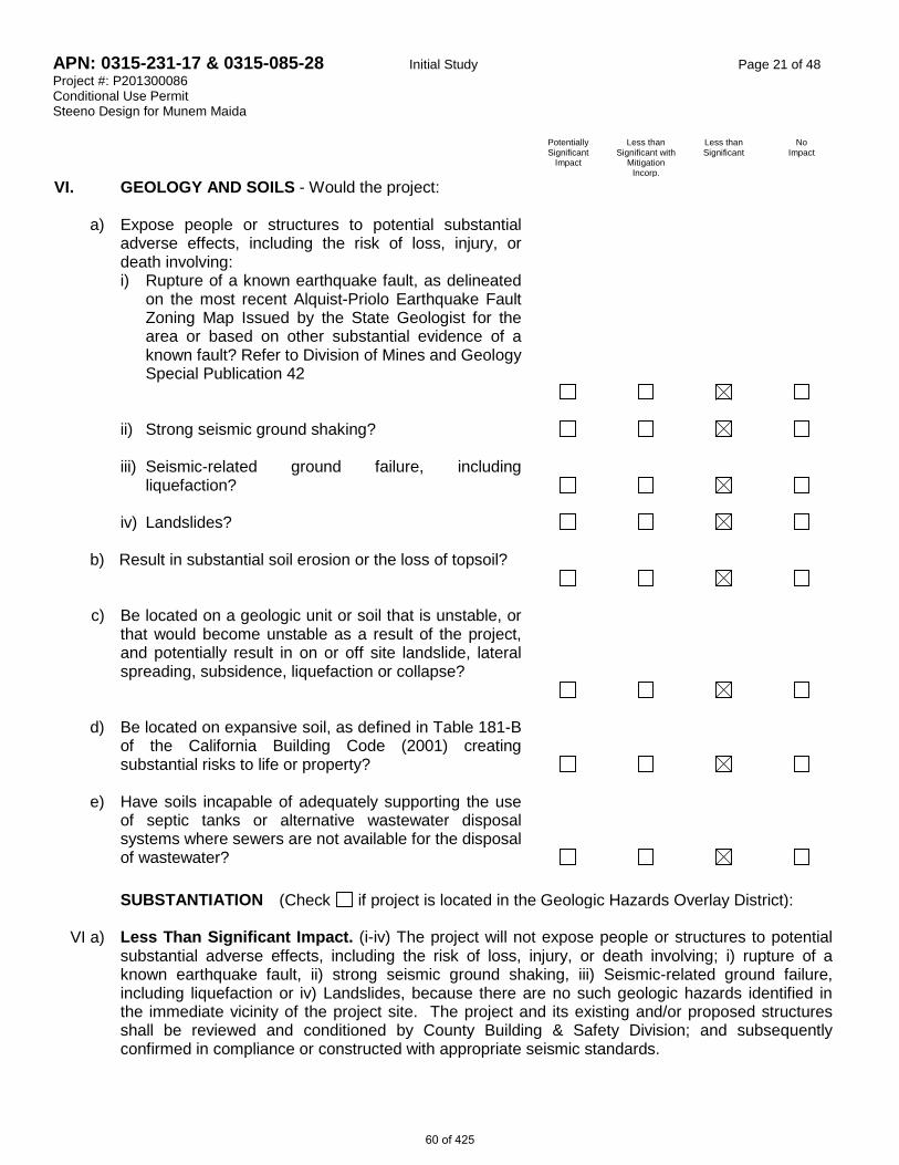
APN: 0315-231-17 & 0315-085-28 Initial Study Page 21 of 48 Project #: P201300086 Conditional Use Permit Steeno Design for Munem Maida Potentially
Significant Impact
Less than Significant with
Mitigation Incorp.
Less than Significant
No Impact
VI. GEOLOGY AND SOILS - Would the project:
a) Expose people or structures to potential substantial adverse effects, including the risk of loss, injury, or death involving:
i) Rupture of a known earthquake fault, as delineated on the most recent Alquist-Priolo Earthquake Fault Zoning Map Issued by the State Geologist for the area or based on other substantial evidence of a known fault? Refer to Division of Mines and Geology Special Publication 42
ii) Strong seismic ground shaking? iii) Seismic-related ground failure, including
liquefaction?
iv) Landslides?
b) Result in substantial soil erosion or the loss of topsoil?
c) Be located on a geologic unit or soil that is unstable, or
that would become unstable as a result of the project, and potentially result in on or off site landslide, lateral spreading, subsidence, liquefaction or collapse?
d) Be located on expansive soil, as defined in Table 181-B of the California Building Code (2001) creating substantial risks to life or property?
e) Have soils incapable of adequately supporting the use of septic tanks or alternative wastewater disposal systems where sewers are not available for the disposal of wastewater?
SUBSTANTIATION (Check if project is located in the Geologic Hazards Overlay District):
VI a) Less Than Significant Impact. (i-iv) The project will not expose people or structures to potential substantial adverse effects, including the risk of loss, injury, or death involving; i) rupture of a known earthquake fault, ii) strong seismic ground shaking, iii) Seismic-related ground failure, including liquefaction or iv) Landslides, because there are no such geologic hazards identified in the immediate vicinity of the project site. The project and its existing and/or proposed structures shall be reviewed and conditioned by County Building & Safety Division; and subsequently confirmed in compliance or constructed with appropriate seismic standards.
60 of 425

APN: 0315-231-17 & 0315-085-28 Initial Study Page 22 of 48 Project #: P201300086 Conditional Use Permit Steeno Design for Munem Maida
VI b) Less Than Significant Impact. The project will not result in substantial soil erosion or the loss of topsoil because the scope of construction activities proposed will not require further substantial disturbance of the site. The project and related grading and construction activities shall be reviewed and conditioned by County Building & Safety Division; and subsequently confirmed in compliance or constructed with appropriate seismic standards. Therefore, no potentially significant impact is anticipated in this area and no mitigation measures are deemed necessary.
VI c) Less Than Significant Impact. The project is not identified as being located on a geologic unit or
soil that has been identified as being unstable or having the potential to result in on- or off-site landslide, lateral spreading, subsidence, liquefaction or collapse. The project and related grading and construction activities shall be reviewed and conditioned by County Building & Safety Division; and subsequently confirmed in compliance or constructed with appropriate seismic standards. Therefore, no potentially significant impact is anticipated in this area and no mitigation measures are deemed necessary.
VI d) Less Than Significant Impact. The project site is not located in an area that has been identified
as having the potential for expansive soils; therefore it will not create substantial risks to life or property. The project and related grading and construction activities shall be reviewed and conditioned by County Building & Safety Division; and subsequently confirmed in compliance or constructed with appropriate seismic standards. Therefore, no potentially significant impact is anticipated in this area and no mitigation measures are deemed necessary.
VI e) Less Than Significant Impact. The proposed development will not have wastewater disposal
needs; therefore no significant impact is anticipated. The project and related grading and construction activities shall be reviewed and conditioned by County Building & Safety Division; and subsequently confirmed in compliance or constructed with appropriate seismic standards. Therefore, no potentially significant impact is anticipated in this area and no mitigation measures are deemed necessary.
Therefore, no significant adverse impacts are identified or anticipated and no mitigation measures are required. 61 of 425

APN: 0315-231-17 & 0315-085-28 Initial Study Page 23 of 48 Project #: P201300086 Conditional Use Permit Steeno Design for Munem Maida
Potentially Significant
Impact
Less than Significant with
Mitigation Incorp.
Less than Significant
No Impact
VII. GREENHOUSE GAS EMISISONS - Would the project:
a) Generate greenhouse gas emissions, either directly or indirectly, that may have a significant impact on the environment?
b) Conflict with any applicable plan, policy or regulation of an agency adopted for the purpose of reducing the emissions of greenhouse gases?
SUBSTANTIATION (Check if project is located within the Mineral Resource Zone Overlay):
VII a, b) Less Than Significant Impact. Operational emissions of the proposed project would not exceed criteria or GHG emissions thresholds because this 6,793 square foot convenience store, gas station, and a caretaker residence is consistent with the growth projections and associated emissions used in the adopted County of San Bernardino Greenhouse Gas Emission Reduction Plan because it is smaller in size than the sample Gas Station/Convenience store of 7,200 square feet used for the referenced study, therefore the project is expected to fall short of 3000 metric tons of Carbon Dioxide Equivalent (CO2e) per year for the proposed use. As discussed in Air Quality section of this document, An Air Quality Report has been prepared by Urban Crossroads for this project and finds that the “Project would not exceed the numerical thresholds of significance established by the South Coast Air Quality Management District (SCAQMD).” The study also finds that “project construction-source emissions would not conflict with the applicable Air Quality Management Plan (AQMP).” Although not required, the study recommends that best available control measures (BACM AQ-1 and BACM AQ-2) are implemented to further reduce the impacts during the construction. Therefore, no significant impact is anticipated and no mitigation measure is deemed necessary. The Air Quality – Construction Mitigation condition will address the air quality and GHG emission concerns for construction activities including equipment and trucks visiting the site. Therefore, no potentially significant impact is anticipated in this area and no mitigation measures are deemed necessary. Therefore, no significant adverse impacts are identified or anticipated and no mitigation measures are required.
62 of 425

APN: 0315-231-17 & 0315-085-28 Initial Study Page 24 of 48 Project #: P201300086 Conditional Use Permit Steeno Design for Munem Maida Potentially
Significant Impact
Less than Significant with
Mitigation Incorp.
Less than Significant
No Impact
VII. HAZARDS AND HAZARDOUS MATERIALS - Would the project:
a) Create a significant hazard to the public or the
Environment through the routine transport, use, or disposal of hazardous materials?
b) Create a significant hazard to the public or the environment through reasonably foreseeable upset and accident conditions involving the release of hazardous materials into the environment?
c) Emit hazardous emissions or handle hazardous or acutely hazardous materials, substances, or waste within one-quarter mile of an existing or proposed school?
d) Be located on a site, which is included on a list of hazardous materials sites compiled pursuant to Government Code Section 65962.5 and, as a result, would it create a significant hazard to the public or the environment?
e) For a project located within an airport land use plan or, where such a plan has not been adopted, within two miles of a public airport or public use airport, would the project result in a safety hazard for people residing or working in the project area?
f)
For a project within the vicinity of a private airstrip, would the project result in a safety hazard for people residing or working in the project area?
g) Impair implementation of or physically interfere with an adopted emergency response plan or emergency evacuation plan?
h) Expose people or structures to a significant risk of loss, injury or death involving wildland fires, including where wildlands are adjacent to urbanized areas or where residences are intermixed with wildlands?
63 of 425
APN: 0315-231-17 & 0315-085-28 Initial Study Page 25 of 48 Project #: P201300086 Conditional Use Permit Steeno Design for Munem Maida
SUBSTANTIATION VII a) Less Than Significant Impact. The project will not create a significant hazard to the public or the
environment through the routine transport, use, or disposal of hazardous materials, because the use proposed is not anticipated to involve such activities. If such uses are proposed on-site in the future, they will be subject to permit and inspection by the Hazardous Materials Division of the County Fire Department, and in some instances, to additional land use review. Therefore, no potentially significant impact is anticipated in this area and no mitigation measures are deemed necessary.
VII b) Less Than Significant Impact. The project will not create a significant hazard to the public or the
environment through reasonably foreseeable upset and accident conditions involving the release of hazardous materials into the environment, because any proposed use or construction activity that might use hazardous materials is subject to permit and inspection by the Hazardous Materials Division of the County Fire Department. Therefore, no potentially significant impact is anticipated in this area and no mitigation measures are deemed necessary.
VII c) Less Than Significant Impact. The project uses will not emit hazardous emissions or handle
hazardous or acutely hazardous materials, substances, or waste within one-quarter mile of an existing or proposed school, because the project does not propose the use of hazardous materials and all existing and proposed schools are more than one-quarter mile away from the project site. If such uses are proposed in the future on this site, they will be subject to permit and inspection by the Hazardous Materials Division of the County Fire Department and in some instances additional land use review. Therefore, no potentially significant impact is anticipated in this area and no mitigation measures are deemed necessary.
VII d) Less Than Significant Impact. The project site is not included on a list of hazardous materials
sites.
VII e) Less Than Significant Impact. The project site is not located within an airport land use plan; therefore, the project cannot result in a safety hazard for people residing or working in the project area.
VII f) Less Than Significant Impact. The project site is not within the vicinity or approach/departure flight
path of a private airstrip.
VII g) Less Than Significant Impact. The project will not impair implementation of or physically interfere with an adopted emergency response plan or emergency evacuation plan, because the project has adequate access from State Highway 38.
VII h) Less Than Significant Impact. The project will not expose people or structures to a significant risk
of loss, injury or death involving wildland fires, because the proposed facility and its associated structures shall be reviewed by County Fire for approval. Therefore, no potentially significant impact is anticipated in this area and no mitigation measures are deemed necessary.
64 of 425

APN: 0315-231-17 & 0315-085-28 Initial Study Page 26 of 48 Project #: P201300086 Conditional Use Permit Steeno Design for Munem Maida Potentially
Significant Impact
Less than Significant with
Mitigation Incorp.
Less than Significant
No Impact
VIII. HYDROLOGY AND WATER QUALITY - Would the project:
a) Violate any water quality standards or waste discharge
requirements?
b) Substantially deplete groundwater supplies or interfere substantially with groundwater recharge such that there would be a net deficit in aquifer volume or a lowering of the local groundwater table level (e.g., the production rate of pre-existing nearby wells would drop to a level, which would not support existing land uses or planned uses for which permits have been granted)?
c) Substantially alter the existing drainage pattern of the site or area, including through the alteration of the course of a stream or river, in a manner that would result in substantial erosion or siltation on- or off-site?
d) Substantially alter the existing drainage pattern of the site or area, including through the alteration of the course of a stream or river, or substantially increase the rate or amount of surface runoff in a manner that would result in flooding on- or off-site?
e) Create or contribute runoff water, which would exceed the capacity of existing or planned storm water drainage systems or provide substantial additional sources of polluted runoff?
f) Otherwise substantially degrade water quality?
g) Place housing within a 100-year flood hazard area as mapped on a Federal Flood Hazard Boundary or Flood Insurance Rate Map or other flood hazard delineation map?
h) Place within a 100-year flood hazard area structure that would impede or redirect flood flows?
i) Expose people or structures to a significant risk of loss,
injury or death involving flooding, including flooding as a result of the failure of a levee or dam?
j) Inundation by seiche, tsunami, or mudflow? 65 of 425

APN: 0315-231-17 & 0315-085-28 Initial Study Page 27 of 48 Project #: P201300086 Conditional Use Permit Steeno Design for Munem Maida SUBSTANTIATION VIII a) Less Than Significant Impact. The project will not violate any water quality standards or waste
discharge requirements, because the proposed mechanisms that provide water and discharge systems shall be reviewed by County EHS to ensure compliance with both water quality and waste discharge requirements. Therefore, no potentially significant impact is anticipated in this area and no mitigation measures are deemed necessary.
VIII b) Less Than Significant Impact. The project will not substantially deplete groundwater supplies or
interfere substantially with groundwater recharge such that there would be a net deficit in aquifer volume or a lowering of the local groundwater table level, because the project proponent is required to provide EHS with documentations that substantiate water availability, of acceptable quality, to serve the development. Therefore, no potentially significant impact is anticipated in this area and no mitigation measures are deemed necessary.
VIII c) Less Than Significant Impact. The project will not substantially alter the existing drainage pattern
of the site or area, including the alteration of the course of a stream or river, in a manner that would result in substantial erosion or siltation on- or off-site because only minimal grading is associated with project; and there are no rivers or streams on site. The project is conditioned not alter or occupy natural drainage courses. Therefore, no potentially significant impact is anticipated in this area and no mitigation measures are deemed necessary.
VII d) Less Than Significant Impact. The project will not substantially alter the existing drainage pattern
of the site or area, including through the alteration of the course of a stream or river, or substantially increase the rate or amount of surface runoff in a manner which would result in flooding on- or off-site because no river or stream has been identified on the project site. A Water Quality Management Plan has been reviewed by County Land Use Services Drainage Section to ensure surface runoff will either be entirely handled on site, or that the overflow will not impede on surrounding properties and or road infrastructure. Therefore, no potentially significant impact is anticipated in this area and no mitigation measures are deemed necessary.
VIII e) Less Than Significant Impact. The project will not create or contribute runoff water which would
exceed the capacity of existing or planned stormwater drainage systems or provide substantial additional sources of polluted runoff because a Water Quality Management Plan has been reviewed by County Land Use Services Drainage Section to ensure surface runoff will either be entirely handled on site, or that the overflow will not impede on surrounding properties or stormwater drainage infrastructure. Therefore, no potentially significant impact is anticipated in this area and no mitigation measures are deemed necessary.
VIII f) Less Than Significant Impact. The project will not otherwise substantially degrade water quality,
because appropriate measures for water quality protection and erosion control have been required. Therefore, no potentially significant impact is anticipated in this area and no mitigation measures are deemed necessary.
VIII g) Less Than Significant Impact. The project will not place unprotected housing within a 100-year
flood hazard area as mapped on a Federal Flood Hazard Boundary or Flood Insurance Rate Map or other flood hazard delineation map because the project is not within an area with determined flood hazard and it does not involve residential housing development. Therefore, no potentially significant impact is anticipated in this area and no mitigation measures are deemed necessary.
66 of 425

APN: 0315-231-17 & 0315-085-28 Initial Study Page 28 of 48 Project #: P201300086 Conditional Use Permit Steeno Design for Munem Maida
VIII h) Less Than Significant Impact. The project will not place within a 100-year flood hazard area
structures that would impede or redirect flood flows because the project site is not identified by the County Land Use Services Drainage Section to be within a 100-year flood hazard area. Therefore, no potentially significant impact is anticipated in this area and no mitigation measures are deemed necessary.
VIII i) Less Than Significant Impact. The project will not expose people or structures to a significant risk
of loss, injury or death involving flooding, including flooding as a result of the failure of a levee or dam, because the project site is not within any identified path of a potential inundation flow that might result in the event of a dam or levee failure or that might occur from a river, stream, lake or sheet flow situation. Therefore, no potentially significant impact is anticipated in this area and no mitigation measures are deemed necessary.
VIII j) Less Than Significant Impact. The project will not be impacted by inundation by seiche, tsunami,
or mudflow, because the project is not adjacent to any body of water that has the potential of seiche or tsunami nor is the project site in the path of any potential mudflow. Therefore, no potentially significant impact is anticipated in this area and no mitigation measures are deemed necessary.
Therefore, no significant adverse impacts are identified or anticipated and no mitigation measures are required.
67 of 425

APN: 0315-231-17 & 0315-085-28 Initial Study Page 29 of 48 Project #: P201300086 Conditional Use Permit Steeno Design for Munem Maida Potentially
Significant Impact
Less than Significant with
Mitigation Incorp.
Less than Significant
No Impact
IX. LAND USE AND PLANNING - Would the project:
a) Physically divide an established community?
b) Conflict with any applicable land use plan, policy, or regulation of an agency with jurisdiction over the project (including, but not limited to the general plan, specific plan, local coastal program, or zoning ordinance) adopted for the purpose of avoiding or mitigating an environmental effect?
c) Conflict with any applicable habitat conservation plan or natural community conservation plan?
SUBSTANTIATION
IX a) Less Than Significant Impact. The project will not physically divide an established community,
because the project is a logical and orderly extension of the planned land uses. Therefore, no potentially significant impact is anticipated in this area and no mitigation measures are deemed necessary.
IX b) Less Than Significant Impact. The project will not conflict with any applicable land use plan,
policy, or regulation of an agency with jurisdiction over the project adopted for the purpose of avoiding or mitigating an environmental effect, because the project is consistent with all applicable land use policies and regulations of the County Code and General Plan as the proposed use is consistent with its designated zoning. Therefore, no potentially significant impact is anticipated in this area and no mitigation measures are deemed necessary.
IX c) Less Than Significant Impact. The project will not conflict with any applicable habitat conservation
plan or natural community conservation plan, because there is no habitat conservation plan or natural community conservation plan within the area surrounding the project site and no habitat conservation lands are required to be purchased as mitigation for the proposed project. Therefore, no potentially significant impact is anticipated in this area and no mitigation measures are deemed necessary.
Therefore, no significant adverse impacts are identified or anticipated and no mitigation measures are required.
68 of 425

APN: 0315-231-17 & 0315-085-28 Initial Study Page 30 of 48 Project #: P201300086 Conditional Use Permit Steeno Design for Munem Maida Potentially
Significant Impact
Less than Significant with
Mitigation Incorp.
Less than Significant
No Impact
X. MINERAL RESOURCES - Would the project:
a) Result in the loss of availability of a known mineral resource that would be of value to the region and the residents of the state?
b) Result in the loss of availability of a locally important mineral resource recovery site delineated on a local general plan, specific plan or other land use plan?
SUBSTANTIATION (Check if project is located within the Mineral Resource Zone Overlay):
X a) Less Than Significant Impact. The project will not result in the loss of availability of a known mineral resource that would be of value to the region and the residents of the state because there are no identified important mineral resources on the project site. Therefore, no potentially significant impact is anticipated in this area and no mitigation measures are deemed necessary.
X b) Less Than Significant Impact. The project will not result in the loss of availability of a locally
important mineral resource recovery site delineated on a local general plan, specific plan or other land use plan, because there are no identified locally important mineral resources on the project site. Therefore, no potentially significant impact is anticipated in this area and no mitigation measures are deemed necessary.
Therefore, no significant adverse impacts are identified or anticipated and no mitigation measures are required.
69 of 425

APN: 0315-231-17 & 0315-085-28 Initial Study Page 31 of 48 Project #: P201300086 Conditional Use Permit Steeno Design for Munem Maida Potentially
Significant Impact
Less than Significant with
Mitigation Incorp.
Less than Significant
No Impact
XI. NOISE - Would the project:
a) Exposure of persons to or generation of noise levels in excess of standards established in the local general plan or noise ordinance, or applicable standards of other agencies?
b) Exposure of persons to or generation of excessive groundborne vibration or groundborne noise levels?
c) A substantial permanent increase in ambient noise levels in the project vicinity above levels existing without the project?
d) A substantial temporary or periodic increase in ambient noise levels in the project vicinity above levels existing without the project?
e) For a project located within an airport land use plan or, where such a plan has not been adopted, within two miles of a public airport or public use airport, would the project expose people residing or working in the project area to excessive noise levels?
f)
For a project within the vicinity of a private airstrip, would the project expose people residing or working in the project area to excessive noise levels?
SUBSTANTIATION (Check if the project is located in the Noise Hazard Overlay District or is subject to severe noise levels according to the General Plan Noise Element
): XI a-c) Less Than Significant Impact. The proposed project will not include uses that will exceed San
Bernardino County Noise Standards and those of County Development Code. The “developer” as defined in the Conditions of Approval will be required to ensure that the noise generated by the ongoing operations, and the associate groundborne noise, shall not exceed County Noise Standards. Because the project abuts residential development, the project is conditioned to monitor its noise levels to ensure project noise will not exceed County Noise Standards of 55 dB(A) for residential areas from 7am-10pm, as measured at the project’s property boundaries. Noise levels after 10pm shall not exceed 45 dB(A) where the project site abuts single family residences. Therefore, no potentially significant impact is anticipated in this area.
XI d) Less Than Significant Impact With Mitigation Incorporated. The project may generate
substantial temporary or periodic increase in ambient noise levels above levels existing without the project due to construction activities which may include excavations, grading, and building erection/modification on the project site. Mitigation measure XI-1 as stated below will reduce any potential noise impact of this temporary construction. Therefore, no potentially long term significant impact is anticipated in this area.
70 of 425

APN: 0315-231-17 & 0315-085-28 Initial Study Page 32 of 48 Project #: P201300086 Conditional Use Permit Steeno Design for Munem Maida
XI e) No Impact. The project site is not located within an airport land use plan; therefore, the project cannot result in a safety hazard for people residing or working in the project area.
XI f) No Impact. The project is not within the vicinity of a private airstrip; therefore, the project cannot
result in a safety hazard for people residing or working in the project area. Possible significance adverse impacts have been identified or anticipated and the following mitigation measures are required as conditions of project approval to reduce these impacts to a level below significant.
MM# Mitigation Measures
XI-1 Noise Mitigation. The “developer” shall submit for review and obtain approval of an agreement letter that stipulates that all construction contracts/subcontracts contain as a requirement that the following noise attenuation measures be implemented: a) Exterior construction activities shall be limited between 7 a.m. and 7 p.m. There shall be no
exterior construction activities on Sundays or National Holidays. b) Interior construction activities may occur on any day and any time provided they comply with the
County noise standards. (SBCC 83.01.080). c) Construction equipment shall be muffled per manufacturer’s specifications. d) All stationary construction equipment shall be placed in a manner so that emitted noise is
directed away from sensitive receptors nearest the project site. [Mitigation Measure XI-1]
71 of 425

APN: 0315-231-17 & 0315-085-28 Initial Study Page 33 of 48 Project #: P201300086 Conditional Use Permit Steeno Design for Munem Maida Potentially
Significant Impact
Less than Significant
with Mitigation Incorp.
Less than Significant
No Impact
XII. POPULATION AND HOUSING - Would the project:
a) Induce substantial population growth in an area, either directly (for example, by proposing new homes and businesses) or indirectly (for example, through extension of roads or other infrastructure)?
b) Displace substantial numbers of existing housing, necessitating the construction of replacement housing elsewhere?
c) Displace substantial numbers of people, necessitating the construction of replacement housing elsewhere?
SUBSTANTIATION
XII a) No Impact. The project will not induce population growth in the area either directly or indirectly
because the project is not proposing any new residential development and will make use of the existing roads and infrastructure. Therefore, no potentially significant impact is anticipated in this area and no mitigation measures are deemed necessary.
XII b) No Impact. The proposed use will not displace substantial numbers of existing housing units,
necessitating the construction of replacement housing because the project does not propose demolition of any existing housing to necessitate the construction of replacement housing. Therefore, no potentially significant impact is anticipated in this area and no mitigation measures are deemed necessary.
XII c) No Impact. The proposed use will not displace substantial numbers of people because the project
uses does not proposes to displace any number of people. Therefore, no potentially significant impact is anticipated in this area and no mitigation measures are deemed necessary.
Therefore, no significant adverse impacts are identified or anticipated and no mitigation measures are required.
72 of 425

APN: 0315-231-17 & 0315-085-28 Initial Study Page 34 of 48 Project #: P201300086 Conditional Use Permit Steeno Design for Munem Maida Potentially
Significant Impact
Less than Significant
with Mitigation Incorp.
Less than Significant
No Impact
XIII. PUBLIC SERVICES
a) Would the project result in substantial adverse physical impacts associated with the provision of new or physically altered governmental facilities, need for new or physically altered governmental facilities, the construction of which could cause significant environmental impacts, in order to maintain acceptable service ratios, response times or other performance objectives for any of the public services:
Fire Protection? Police Protection? Schools? Parks?
Other Public Facilities?
SUBSTANTIATION XIII a) Less Than Significant Impact. The proposed project will not result in substantial adverse physical
impacts associated with the provision of new or physically altered governmental facilities, need for new or physically altered governmental facilities, the construction of which could cause significant environmental impacts in order to maintain acceptable service ratios, response times or other performance objectives for any of the public services, including fire and police protection, schools, parks or other public facilities because the proposed development is expected to contribute to overall business tax revenues to provide a source of funding for such governmental facilities and public services which is deemed sufficient to offset any demand increases by this project. Therefore, no potentially significant impact is anticipated in this area and no mitigation measures are deemed necessary.
Therefore, no significant adverse impacts are identified or anticipated and no mitigation measures are required.
73 of 425

APN: 0315-231-17 & 0315-085-28 Initial Study Page 35 of 48 Project #: P201300086 Conditional Use Permit Steeno Design for Munem Maida Potentially
Significant Impact
Less than Significant
with Mitigation Incorp.
Less than Significant
No Impact
XIV. RECREATION
a) Would the project increase the use of existing neighborhood and regional parks or other recreational facilities such that substantial physical deterioration of the facility would occur or be accelerated?
b) Does the project include recreational facilities or require the construction or expansion of recreational facilities, which might have an adverse physical effect on the environment?
SUBSTANTIATION XIV a) Less Than Significant Impact. This project will not increase the use of existing neighborhood and
regional parks or other recreational facilities such that substantial physical deterioration of the facility would occur or be accelerated because of the project does not involve residential development and will not cause impacts associated with an increase in populations. Therefore, no potentially significant impact is anticipated in this area and no mitigation measures are deemed necessary.
XIV b) Less Than Significant Impact. This project does not include recreational facilities or require the
construction or expansion of recreational facilities that might have an adverse physical effect on the environment because the proposed development will not result in an increased demand for recreational facilities. Therefore, no potentially significant impact is anticipated in this area and no mitigation measures are deemed necessary.
Therefore, no significant adverse impacts are identified or anticipated and no mitigation measures are required.
74 of 425

APN: 0315-231-17 & 0315-085-28 Initial Study Page 36 of 48 Project #: P201300086 Conditional Use Permit Steeno Design for Munem Maida Potentially
Significant Impact
Less than Significant
with Mitigation Incorp.
Less than Significant
No Impact
XV. TRANSPORTATION/TRAFFIC - Would the project:
a) Cause an increase in traffic, which is substantial in relation to the existing traffic load and capacity of the street system (i.e., result in a substantial increase in either the number of vehicle trips, the volume to capacity ratio on roads, or congestion at intersections)?
b) Exceed, either individually or cumulatively, a level of service standard established by the county congestion management agency for designated roads or highways?
c) Result in a change in air traffic patterns, including either an increase in traffic levels or a change in location that results in substantial safety risks?
d) Substantially increase hazards due to a design feature (e.g., sharp curves or dangerous intersections) or incompatible uses (e.g., farm equipment)?
e) Result in inadequate emergency access?
f) Result in inadequate parking capacity?
g) Conflict with adopted policies, plans, or programs supporting alternative transportation (e.g., bus turnouts, bicycle racks)?
SUBSTANTIATION XV a-b) Less Than Significant Impact. The proposed project will not cause an increase in traffic, which is
substantial in relation to the existing traffic load and capacity of the street system, i.e., result in a substantial increase in either the number of vehicle trips, the volume to capacity ratio on roads, or congestion at intersections, because a 2013 Traffic Report prepared by Hall & Foreman, Inc. has concluded that the project traffic “will not cause any significant negative impact to the surrounding street system”. As a result of community opposition, Caltrans required additional analysis from the applicant, leading to preparation of the revised 2014 Traffic Analysis by Hall & Foreman. The revised report further examines the traffic impacts of the project and presents recommended traffic improvements. Based on the proposed traffic distribution and patterns, project trip generation and intersection capacity analyses were conducted to assess the estimated project impacts. Also considered were design of the intersections and project driveways. Additionally, truck turning templates were applied to the existing intersection geometries at Highway 38 and State Lane, Truck Turning templates were applied to the existing geometrics. These turn movements included northbound right, southbound left and westbound left and right turns. A custom fuel tanker was modeled to represent the model vehicle with dimensions and specifications. The truck turning templates are provided in Figure 13. As illustrated some widening of the shoulder at the southeast corner of the intersection will be needed to accommodate the north to east right turn movement. 75 of 425

APN: 0315-231-17 & 0315-085-28 Initial Study Page 37 of 48 Project #: P201300086 Conditional Use Permit Steeno Design for Munem Maida
The revised 2014 Traffic Report also performed a left turn warrant analysis using Caltrans’ recently recommended “Access Management” document, specifically the “Criteria for Left-Turn Declaration Lanes on Rural Two-Lane Highways”. While the un-signalized intersections of Highway 38 and State Lane, and State Lane and First Lane/project Driveway are anticipated to continue to operate at Level of Service (LOS) “C” or better, the applicant has proposed – and as accepted by Caltrans – a left-turn lane from southbound Highway 38 into State Lane.
76 of 425

APN: 0315-231-17 & 0315-085-28 Initial Study Page 38 of 48 Project #: P201300086 Conditional Use Permit Steeno Design for Munem Maida
Based on the aforementioned 2014 Traffic Report, the following improvements shall be met: Intersection Improvement Mitigations a) Widening of the intersection of Greenspot Blvd/Hwy 38 and State Lane/ Mitchell Lane to
accommodate a southbound 100 foot left turn lane and north to east right turn movement. (see Figure 14)
Site Improvement Mitigations a) Driveway Number 1 is to be constructed as right turn in only. b) Driveway Number 2 is to be constructed as full access, adjacent First Lane. The intersection will
be Two Way Stop Controlled (TWSC) at the driveway and First Lane. c) The curb and gutter along State Lane, project frontage, will be constructed. d) Upgrading the existing warning signage along State lane.
(see Figure 15)
77 of 425

APN: 0315-231-17 & 0315-085-28 Initial Study Page 39 of 48 Project #: P201300086 Conditional Use Permit Steeno Design for Munem Maida
78 of 425

APN: 0315-231-17 & 0315-085-28 Initial Study Page 40 of 48 Project #: P201300086 Conditional Use Permit Steeno Design for Munem Maida
XV c) Less Than Significant Impact. The project will not result in a change in air traffic patterns, including either an increase in traffic levels or a change in location that results in substantial safety risks, because there are no anticipated notable impacts on air traffic volumes by passengers or freight generated by the proposed use and no new air traffic facilities are proposed. Therefore, no potentially significant impact is anticipated in this area and no mitigation measures are deemed necessary.
XV d) Less Than Significant Impact. The project will not substantially increase hazards due to a design feature or incompatible uses, because the project site is adjacent to or near established roads, State Highway 38 and State Lane which provide adequate physical access with appropriate sight distance and properly controlled intersections with the newly recommended improvements discussed under XV a-b which has resulted in Mitigation Measure XV-1.
XV e) Less Than Significant Impact. The project will not result in inadequate emergency access,
because the project will be conditioned to provide adequate access points, designed to accommodate emergency vehicles. Therefore, no potentially significant impact is anticipated in this area and no mitigation measures are deemed necessary.
XV f) Less Than Significant Impact. The project will not result in inadequate parking capacity, because
the project parking needs for project visitors and employees has been analyzed and deemed satisfactory. Therefore, no potentially significant impact is anticipated in this area and no mitigation measures are deemed necessary.
XV g) Less Than Significant Impact. The project will not conflict with adopted policies, plans, or
programs supporting alternative transportation (e.g., bus turnouts, bicycle racks), because the scope the proposed project is deemed appropriately serviced with the improvements made to the existing infrastructure by implementing Mitigation Measure XV-1.
Possible significance adverse impacts have been identified or anticipated and the following mitigation measure is required as a condition of project approval to reduce these impacts to a level below significant.
MM# Mitigation Measures
XV-1 Traffic. The “developer” shall meet the following mitigation measure to the satisfaction of Caltrans: Intersection Improvement Mitigations b) Widening of the intersection of Greenspot Blvd/Hwy 38 and State Lane/ Mitchell Lane to
accommodate a southbound 100 foot left turn lane and north to east right turn movement. Site Improvement Mitigations e) Driveway Number 1 is to be constructed as right turn in only. f) Driveway Number 2 is to be constructed as full access, adjacent First Lane. The intersection will
be Two Way Stop Controlled (TWSC) at the driveway and First Lane. g) The curb and gutter along State Lane, project frontage, will be constructed. h) Upgrading the existing warning signage along State lane. [Mitigation Measure XV-1]
79 of 425

APN: 0315-231-17 & 0315-085-28 Initial Study Page 41 of 48 Project #: P201300086 Conditional Use Permit Steeno Design for Munem Maida Potentially
Significant Impact
Less than Significant
with Mitigation Incorp.
Less than Significant
No Impact
XVI. UTILITIES AND SERVICE SYSTEMS - Would the project:
a) Exceed wastewater treatment requirements of the applicable Regional Water Quality Control Board?
b) Require or result in the construction of new water or
wastewater treatment facilities or expansion of existing facilities, the construction of which could cause significant environmental effects?
c) Require or result in the construction of new storm water drainage facilities or expansion of existing facilities, the construction of which could cause significant environmental effects?
d) Have sufficient water supplies available to serve the project from existing entitlements and resources, or are new or expanded entitlements needed?
e) Result in a determination by the wastewater treatment provider, which serves or may serve the project that it has adequate capacity to serve the project's projected demand in addition to the provider's existing commitments?
f) Be served by a landfill(s) with sufficient permitted capacity to accommodate the project's solid waste disposal needs?
g) Comply with federal, state, and local statutes and regulations related to solid waste?
SUBSTANTIATION
XVI a) Less Than Significant Impact. The proposed project will not exceed wastewater treatment
requirements of the Regional Water Quality Control Board as determined by County Public Health – Environmental Health Services (EHS); therefore any impact will be less than significant in this area. Therefore, no potentially significant impact is anticipated in this area and no mitigation measures are deemed necessary.
XVI b) Less Than Significant Impact. The proposed project will not require or result in the construction of
new water or wastewater treatment facilities or expansion of existing facilities because the project water and sewage disposal need shall be subject to the County Environmental Health Services’ (EHS) review and approval. Therefore, no potentially significant impact is anticipated in this area and no mitigation measures are deemed necessary.
80 of 425

APN: 0315-231-17 & 0315-085-28 Initial Study Page 42 of 48 Project #: P201300086 Conditional Use Permit Steeno Design for Munem Maida
XVI c) Less Than Significant Impact. The proposed project will not require or result in the construction of
new storm water drainage facilities or expansion of existing facilities that cause significant environmental effects because the project will use the existing storm water and drainage infrastructure. The project’s hydrology and drainage conditions have been review by County Drainage Section, based on the Preliminary Hydrology Study and a Preliminary Water Quality Management Plan prepared by Jerry L. Miles, P.E. The County Drainage Section is in support of the project subject to Conditions of Approval. Therefore, no potentially significant impact is anticipated in this area and no mitigation measures are deemed necessary.
XVI d) Less Than Significant Impact. The proposed project will have sufficient water supplies available to
serve its operation from existing entitlements and resources because the project will either be served by an established water purveyor, or conditioned to have its onsite water source reviewed and approved by EHS. Therefore, no potentially significant impact is anticipated in this area and no mitigation measures are deemed necessary.
XVI e) Less Than Significant Impact. The proposed project’s wastewater treatment system shall be
reviewed for approval by County EHS. Therefore onsite handling of wastewater shall be continually monitored to ensure compliance. Therefore, no potentially significant impact is anticipated in this area and no mitigation measures are deemed necessary.
XVI f) Less Than Significant Impact. The proposed project’s solid waste disposal needs shall be
serviced by an approved solid waste facility in conformance with the San Bernardino County Code Chapter 8, Section 33.0830, subject to County EHS review and approval. Therefore, no potentially significant impact is anticipated in this area and no mitigation measures are deemed necessary.
XVI g) Less Than Significant Impact. The proposed project is required to comply with federal, state, and
local statutes and regulations related to solid waste. The proposed project’s solid waste disposal needs shall be serviced by an approved solid waste facility in conformance with the San Bernardino County Code Chapter 8, Section 33.0830, subject to County EHS review and approval. Therefore, no potentially significant impact is anticipated in this area and no mitigation measures are deemed necessary.
Therefore, no significant adverse impacts are identified or anticipated and no mitigation measures are required.
81 of 425

APN: 0315-231-17 & 0315-085-28 Initial Study Page 43 of 48 Project #: P201300086 Conditional Use Permit Steeno Design for Munem Maida Potentially
Significant Impact
Less than Significant
with Mitigation
Incorp.
Less than Significant
No Impact
XVII. MANDATORY FINDINGS OF SIGNIFICANCE:
a) Does the project have the potential to degrade the quality of the environment, substantially reduce the habitat of a fish or wildlife species, cause a fish or wildlife population to drop below self-sustaining levels, threaten to eliminate a plant or animal community, reduce the number or restrict the range of a rare or endangered plant or animal or eliminate important examples of the major periods of California history or prehistory?
b) Does the project have impacts that are individually limited, but cumulatively considerable? (“Cumulatively considerable” means that the incremental effects of a project are considerable when viewed in connection with the effects of past projects, the effects of other current projects, and the effects of probable future projects)?
c) Does the project have environmental effects, which will cause Substantial adverse effects on human beings, either directly Or indirectly?
SUBSTANTIATION XVII a) Less Than Significant Impact. The project will not have the potential to significantly degrade the
overall quality of the region’s environment or substantially reduce the habitat of a fish or wildlife species, cause a fish or wildlife population to drop below self-sustaining levels, threaten to eliminate a plant or animal community, reduce the number or restrict the range of a rare or endangered plant or animal or eliminate important examples of the major periods of California history or prehistory because the project’s potential impacts have been reviewed by RCA Associates, LLC through performance of a General Biological Resources Assessment which finds that the site is not expected to support any sensitive species, sensitive habitats, or wildlife corridors. In response to the expressed community opposition concerned with potential impacts to the biological resources—and specifically as related to potential impact on the Unarmored three-spine stickleback fish, the applicant’s biologist has performed additional biological surveys on April 28, 2014; which has resulted in an updated May 2014 report. The site was further evaluated to assess the drainage channel directly west and north of the site, existing site conditions, and potential impacts to stickleback populations. The field investigation was performed on April 28, 2014 from 7AM to 3:30 PM; and reconfirmed that the site “does not support any sensitive habitats such as streams and wetlands, nor were any wildlife corridors identified on the property”. The study finds that the USGS Moonridge Quadrangle does not show any blue line channels on the site and no drainage channels or streams bisect the site based on field work conducted in April 2014. A small swale about 30 feet in length and six inches wide does occur along the western edge of the site; however, this swale does not connect with any off-site channels nor does it direct any significant water flows on-site. A letter dated February 3, 2014 was prepared by RCA Associates LLC to address comments raised regarding potential impacts to the unarmored threespine stickleback fish. RCA Associates reviewed existing information on the species from the California Natural Diversity Data Base (CNDDB, 2013) and U.S. Fish and Wildlife Service (USFWS, 2009). According to the letter provided to Planning, and
82 of 425
APN: 0315-231-17 & 0315-085-28 Initial Study Page 44 of 48 Project #: P201300086 Conditional Use Permit Steeno Design for Munem Maida
based on the review of available information, the nearest documented population of the stickleback species is approximately 0.9 miles north of the project site and is associated with Shay Creek and Shay Pond. The species was observed in 1995 in Shay Creek which is a tributary to Baldwin Lake, which is directly east of Big Bear City. This population is assumed to still be present in Shay Creek and Shay Pond; although surveys for the stickleback fish have not been conducted since 2009. Two small intermittent channels of Shay Creek are also located about 0.5 miles northeast and northwest of the project site. The study finds that “although population of the stickleback may be present north of the project site, it is unlikely that the species would be affected by any potential onsite leakage or seepage problems” because “operation of the proposed fuel dispensers will be property maintained and kept in good operating conditions at all times as per State of California requirements”. The study continues: “any leakage or seepage from the underground tanks will be immediately reported and mitigation measures, if needed, will be implemented. "Cumulative impacts to the biological resources in the area are expected to be negligible” based on the existing habitats on the 0.9-acre site, as documented in the referenced 2013 and 2014 General Biological Reports. The RCA states that: “the site supports a relatively undisturbed ponderosa pine community typical of the area. Loss of 0.9-acres of this habitat is not expected to generate adverse cumulative impacts to regional biological resources due to the small size of the potential habitat loss”. In addition, development of the site as proposed is not expected to generate any adverse cumulative impacts to any sensitive species in the area. As previously noted the site does not support any populations of sensitive species; although, populations of the Unarmored Threespine Stickleback are located about 0.9 miles north of the project site”. The project will be designed in order to meet all local, State, and Federal Best Management Practices requirements in order to maintain all on-site water flows within the boundaries of the property. The RCA also states that: “any on-site spills of gasoline or other toxic substances will be contained on the site and will not enter into any of the drainage channels near the site through the use of a concrete swale on the property”; and concludes: “based on the existing project design and proposed implementation of various protection measures, cumulative impacts to the stickleback from the proposed project are expected to be negligible." Therefore, potential impacts to the biological resources will be less than significant. The 2013 and 2014 General Biological Reports prepared by RCA find that the proposed project will not have a substantial adverse effect on any riparian habitat or other sensitive natural community identified in local or regional plans, policies, regulations or by the California Department of Fish and Wildlife or US Fish and Wildlife Service because no riparian habitat or sensitive natural community are identified on the project site. The study This project will not have a substantial adverse effect on federally protected wetlands as defined by Section 404 of the Clean Water Act (including, but not limited to marsh, vernal pool, coastal, etc.) through direct removal, filling, hydrological interruption, or other means because the project is not located within an identified protected wetland. The Assessments mentioned above finds no sensitive habitats, stream, wetlands or wildlife corridors on this site. No protected species of trees has been identified on this parcel. The management and well-being of the native regulated tree falls under Chapter 88.01: Plant Protection and Management—discussed separately under Agriculture and Forest Resources, II-d. The reference study by RCA Associates, LLC. also finds that the project will not conflict with the provisions of an adopted Habitat Conservation Plan, Natural Community Conservation Plan, or other approved local, regional or state habitat conservation plan because no such plan has been identified on this project site. No potentially significant impact to biological resources is anticipated and no mitigation measures are deemed necessary. Operational emissions of the proposed project would not exceed criteria or GHG emissions thresholds because this 6,793 square foot convenience store, gas station, and a caretaker residence is consistent with the growth projections and associated emissions used in the adopted County of San Bernardino Greenhouse Gas Emission Reduction Plan because it is smaller in size 83 of 425

APN: 0315-231-17 & 0315-085-28 Initial Study Page 45 of 48 Project #: P201300086 Conditional Use Permit Steeno Design for Munem Maida
than the sample Gas Station/Convenience store of 7,200 square feet used for the referenced study, therefore the project is expected to fall short of 3000 metric tons of Carbon Dioxide Equivalent (CO2e) per year for the proposed use. An Air Quality Report has been prepared by Urban Crossroads for this project and finds that the “Project would not exceed the numerical thresholds of significance established by the South Coast Air Quality Management District (SCAQMD).” The study also finds that “Project construction-source emissions would not conflict with the applicable Air Quality Management Plan (AQMP).” Although not required, the study recommends that best available control measures (BACM AQ-1 and BACM AQ-2) are implemented to further reduce the impacts during the construction. As discussed in Air Quality section of this document, the proposed project’s primary contribution to air emissions is attributable to construction activities. The project’s construction and operational emissions are expected to fall short of 3000 metric tons of Carbon Dioxide Equivalent (CO2e) per year for this use type. However, some impact is identified during project construction due to construction activities, equipment emissions, and emissions from construction workers personal vehicles traveling to and from the construction site, therefore mitigation measures III-1, III-2 and III-3 are imposed to further limit or control potential fugitive dust and regulate construction activities. The aforementioned study prepared by Urban Crossroads finds that “project construction-source emissions would not conflict with the applicable Air Quality Management Plan (AQMP).” The study finds that “construction-source odor emissions would be temporary, short-term, and intermittent in nature and would not result in persistent impacts that would affect substantial numbers of people. Potential construction-source odor impacts are therefore considered less-than-significant.” Although not required, the study recommends that Best Available Control Measures (BACM AQ-1 and BACM AQ-2) are implemented to further reduce the impacts during the construction. Upon completion, the site will be paved and landscaped which will mean little or no wind-blown dust or particulate matter will leave the site. Temporary potential significant impacts are anticipated during construction, therefore mitigation measures III-1, III-2 and III-3 are required as conditions of approval to reduce any potential impact to a level below significance. Operational emissions of the proposed project would not exceed criteria or GHG emissions thresholds because this 6,793 square foot convenience store, gas station, and a caretaker residence is consistent with the growth projections and associated emissions used in the adopted County of San Bernardino Greenhouse Gas Emission Reduction Plan because it is smaller in size than the sample Gas Station/Convenience store of 7,200 square feet used for the referenced study, therefore the project is expected to fall short of 3000 metric tons of Carbon Dioxide Equivalent (CO2e) per year for the proposed use. As it relates to operational impacts, the aforementioned LST Air Quality Analysis indicates that the project will not exceed the SCAQMD localized significance thresholds during operational activities. The proposed project would not result in a Carbon Monoxide or Nitrogen Dioxide “hotspots” as a result of project related traffic during ongoing operations, nor would the project result in a significant adverse health impact, due to the ongoing operations. There are no identified historic or prehistoric resources identified on this site. If any archaeological or paleontological resources are identified during land disturbance and/or project construction, the project is conditioned to stop and identify appropriate authorities, which will properly record and/or remove for classification any such finds.
XVII b) Less Than Significant Impact. The project does not have impacts that are individually limited, but cumulatively considerable. The other project sites in the area to which this project would add cumulative impacts have either existing or planned infrastructure that is sufficient for all planned uses. These sites are capable of absorbing such uses without generating any cumulatively significant impacts.
84 of 425

APN: 0315-231-17 & 0315-085-28 Initial Study Page 46 of 48 Project #: P201300086 Conditional Use Permit Steeno Design for Munem Maida
XVII c) Less Than Significant Impact. The project will not have other environmental effects that will cause
substantial adverse effects on human beings, either directly or indirectly, as there are no such impacts identified by the studies conducted for this project or identified by review of the design of the proposed project. The project will be conditioned to ensure that all necessary mitigation measures are followed prior to occupancy.
Therefore, no significant adverse impacts are identified or anticipated and no mitigation measures are required. XVIII. MITIGATION MEASURES (Any mitigation measures, which are not 'self-monitoring shall have a Mitigation Monitoring and Reporting Program prepared and adopted at time of project approval) SELF MONITORING MITIGATION MEASURES:(Condition compliance will be verified by existing procedure)
MM# Mitigation Measures
III-1 Air Quality – Dust Control Plan. The developer shall submit to County Planning a Dust Control Plan (DCP) consistent with SCAQMD guidelines and a letter agreeing to include in any construction contracts and/or subcontracts a requirement that the contractors adhere to the requirements of the DCP. The DCP shall include these elements to reduce dust production: a. Exposed soil shall be kept continually moist through a minimum of twice daily waterings to
reduce fugitive dust during all grading and construction activities. b. Street sweeping shall be conducted when visible soil accumulations occur along site access
roadways to remove dirt dropped by construction vehicles. c. Site access driveways and adjacent streets shall be washed daily, if there are visible signs of
any dirt track-out at the conclusion of any workday. d. Tires of vehicles will be washed before vehicles leave project site and enter a paved road. e. Any truck hauling dirt away from the site shall be covered f. During high wind conditions (i.e., wind speeds exceeding 25 mph), areas with disturbed soil shall
be watered hourly and activities on unpaved surfaces shall be terminated until wind speeds no longer exceed 25 mph.
g. Storage piles that are to be left in place for more than three working days shall either be sprayed with a non-toxic soil binder, or covered with plastic or revegetated.
[Mitigation Measure III-1] III-2 Air Quality – Construction Plan. Developer shall submit written verification that all construction
contracts and sub-contracts for the project contain provisions that require adherence to the following standards to reduce impacts to air quality. During construction, each contractor and subcontractor shall implement the following, whenever feasible: a. Suspend use of all construction equipment operations during second stage smog alerts. For
daily forecast, call (800) 367-4710 (San Bernardino and Riverside counties). b. Trucks/equipment shall not be left idling on site for periods in excess of 10 minutes. c. Provide temporary traffic control during all phases of construction. d. Substitute diesel-powered equipment with electric and gasoline-powered equipment. e. Onsite electrical power hook-ups shall be provided for electric construction tools to eliminate the
need for diesel-powered electronic generators. f. Install storm water control systems to prevent mud deposition onto paved areas during
construction. g. Contractors shall use low sulfur fuel for stationary construction equipment as required by AQMD
Rules 431.1 and 431.2 to reduce the release of undesirable emissions. [Mitigation Measure III-2] 85 of 425

APN: 0315-231-17 & 0315-085-28 Initial Study Page 47 of 48 Project #: P201300086 Conditional Use Permit Steeno Design for Munem Maida
III-3 Air Quality – Coating Restriction Plan. The developer shall submit a letter agreeing to these Coating
Restrictions and to include in any construction contracts and/or subcontracts a requirement that the contractors adhere to these requirements. These shall include, but are not be limited to: a. Architectural coating volume shall not exceed the significance threshold for ROG, which is 75
lbs./day and the combined daily ROC volume of architectural coatings and asphalt paving shall not exceed the significance threshold for ROC of 75 lbs. per day
b. Architectural coatings with Reactive Organic Compounds (ROC) shall not have a content greater than 100 g/l.
c. High-Volume, Low Pressure (HVLP) spray guns will be used to apply coatings. [Mitigation Measure III-3]
V-1 Cultural Resources. The “developer” shall prepare, submit for review and obtain approval of a letter
agreeing to adhere to the following requirements and to include in any construction contracts/ subcontracts a requirement that project contractors adhere to the following requirements: If archaeological, paleontological and/or historical resources are uncovered during ground disturbing activities, all work in that area shall cease immediately until written clearance by County Planning is provided indicating that satisfactory resource excavation and recovery has been implemented. A qualified expert (e.g. archaeologist or paleontologist), as determined by County Planning in consultation with the County Museum shall be hired to record the find and recommend appropriate action. The developer shall implement any such additional action to the satisfaction of County Planning and the County Museum. If human remains are uncovered during ground disturbing activities, the San Bernardino County Coroner shall be contacted within 24 hours of the find. If the remains or cultural artifacts are determined to be of Native American origin, the local Native American representative shall also be notified. [Mitigation Measure V-1]
XI-1 Noise Mitigation. The “developer” shall submit for review and obtain approval of an agreement letter that stipulates that all construction contracts/subcontracts contain as a requirement that the following noise attenuation measures be implemented: a. Exterior construction activities shall be limited between 7 a.m. and 7 p.m. There shall be no
exterior construction activities on Sundays or National Holidays. b. Interior construction activities may occur on any day and any time provided they comply with the
County noise standards. (SBCC 83.01.080). c. Construction equipment shall be muffled per manufacturer’s specifications. d. All stationary construction equipment shall be placed in a manner so that emitted noise is
directed away from sensitive receptors nearest the project site. [Mitigation Measure XI-1]
XV-1 Traffic. The “developer” shall meet the following mitigation measure to the satisfaction of Caltrans:
Intersection Improvement Mitigations a) Widening of the intersection of Greenspot Blvd/Hwy 38 and State Lane/ Mitchell Lane to
accommodate a southbound 100 foot left turn lane and north to east right turn movement. Site Improvement Mitigations a) Driveway Number 1 is to be constructed as right turn in only. b) Driveway Number 2 is to be constructed as full access, adjacent to First Lane. The intersection
will be Two Way Stop Controlled (TWSC) at the driveway and First Lane. c) The curb and gutter along State Lane, project frontage, will be constructed. d) Upgrading the existing warning signage along State lane. [Mitigation Measure XV-1]
86 of 425

APN: 0315-231-17 & 0315-085-28 Initial Study Page 48 of 48 Project #: P201300086 Conditional Use Permit Steeno Design for Munem Maida GENERAL REFERENCES
• Alquist-Priolo Special Studies Zone Act Map Series (PRC 27500) • California Department of Water Resources Bulletin #118 (Critical Regional Aquifers), 1975 • CEQA Guidelines, Appendix G • California Standard Specifications, July 1992 • County Museum Archaeological Information Center • County of San Bernardino Development Code, 1998 • County of San Bernardino General Plan, adopted 1989, revised 1998 • County of San Bernardino Hazard Overlay Map FH 27 • County of San Bernardino Identified Hazardous Materials Waste Sites List, April 1998 • County of San Bernardino, Countywide Integrated Waste Management Plan, March 1995 • County of San Bernardino, June 2004, San Bernardino County Stormwater Program, Model Water
Quality Management Plan Guidance. • County of San Bernardino Road Planning and Design Standards • Environmental Impact Report, San Bernardino County General Plan, 1989 • Federal Emergency Management Agency Flood Insurance Rate Map and Flood Boundary Map • South Coast Air Quality Management District, CEQA Air Quality Handbook, November 1993
PROJECT SPECIFIC STUDIES: General Biological Resources Assessment; RCA Associates, LLC.; January 2013 Updated Biological Resources Assessment; RCA Associates, LLC. May, 2014 Amended Biological Letter re: Stickleback Fish; RCA Associates LLC; February 2014 Supplemental Preliminary Hydrology Analysis of Off-Site Flows; JERRY L. MILES, P.E.; May, 2014 Revised Traffic Report; Hall & Foreman, Inc.; June 2014 with Appendices (Exhibit-A 6-27-2014, Winter Weekend Traffic Analysis 01-15-2014, and Response to Caltrans Letter 06-23-2014) Preliminary Water Quality Management Plan; Jerry L. Miles, P.E.; February 2013 Preliminary Hydrology Study; Jerry L. Miles, P.E.; February 2013 Air Quality Report Eagle Ridge Market; Urban Crossroads; February 25, 2014
87 of 425

EXHIBIT D
Revised General Biological and Desert Tortoise Reports; RCA Associates
88 of 425

89 of 425

90 of 425

91 of 425

92 of 425

93 of 425

94 of 425

95 of 425

96 of 425

97 of 425

98 of 425
99 of 425
100 of 425
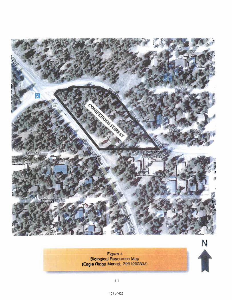
101 of 425

102 of 425

103 of 425

104 of 425

105 of 425

106 of 425
107 of 425

108 of 425

109 of 425

110 of 425

111 of 425

112 of 425

113 of 425

114 of 425

115 of 425

116 of 425

117 of 425
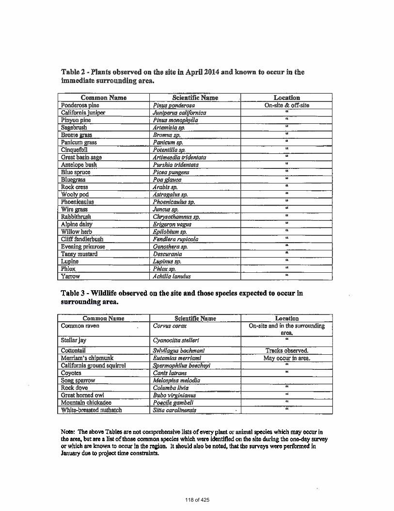
118 of 425

119 of 425

120 of 425

EXHIBIT E
Biological Letter; RCA Associates; 2014
121 of 425

122 of 425

123 of 425

124 of 425

125 of 425

126 of 425

127 of 425

Exhibit F
Preliminary Hydrology Study; Jerry L. Miles, P.E.; 2013
128 of 425

129 of 425

130 of 425

131 of 425

132 of 425

133 of 425

134 of 425

135 of 425

136 of 425

137 of 425

138 of 425

139 of 425

140 of 425

141 of 425

142 of 425

143 of 425

Exhibit G
Preliminary Water Quality Management Plan; Jerry L. Miles, P.E.; 2013
144 of 425

145 of 425

146 of 425

147 of 425

148 of 425

149 of 425
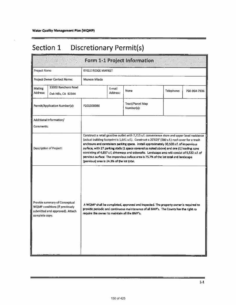
150 of 425

151 of 425

152 of 425

153 of 425

154 of 425

155 of 425

156 of 425

157 of 425

158 of 425
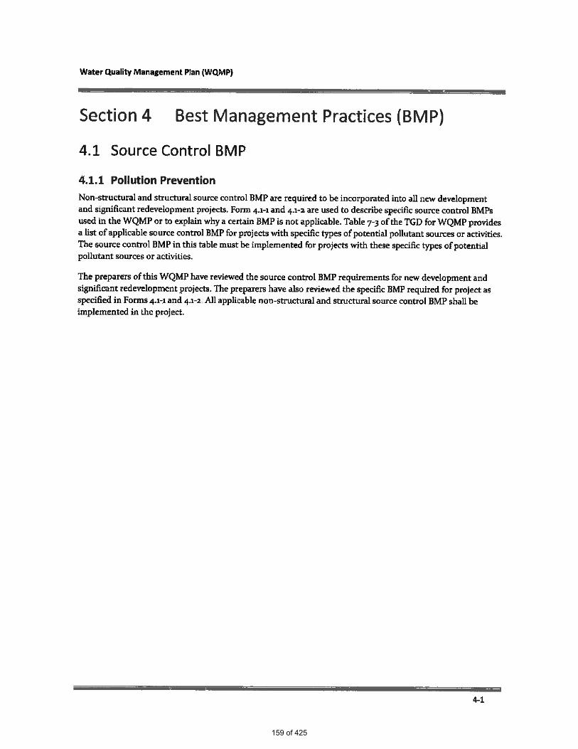
159 of 425

160 of 425

161 of 425
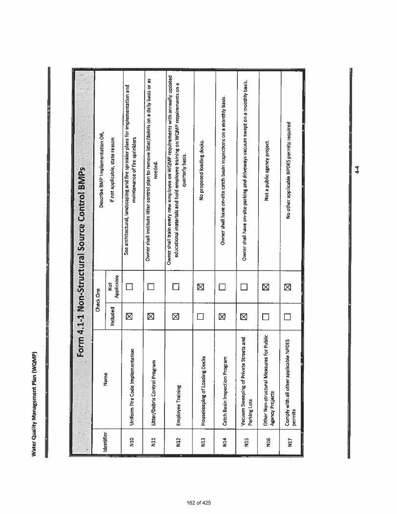
162 of 425

163 of 425
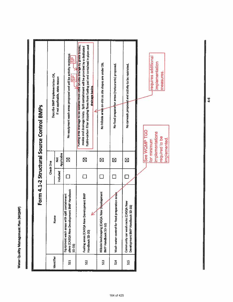
164 of 425

165 of 425

166 of 425

167 of 425

168 of 425

169 of 425

170 of 425

171 of 425

172 of 425

173 of 425

174 of 425
175 of 425
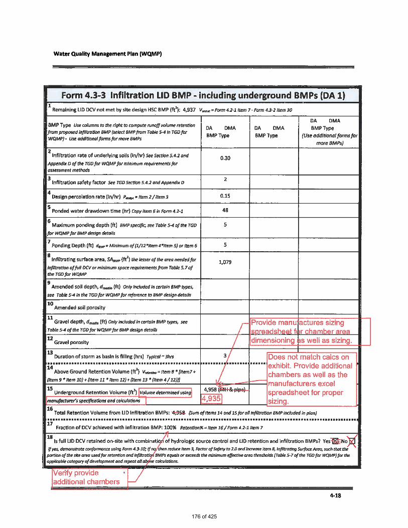
176 of 425

177 of 425

178 of 425

179 of 425

180 of 425
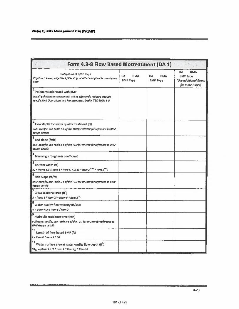
181 of 425

182 of 425

183 of 425

184 of 425

185 of 425
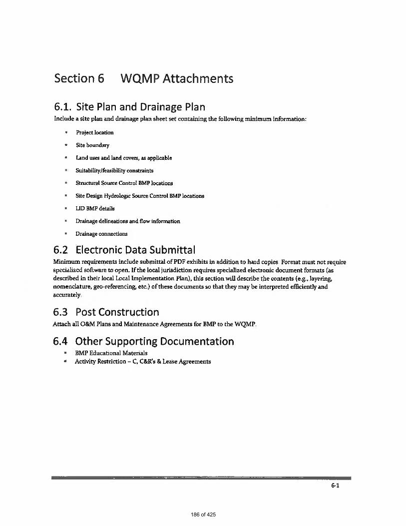
186 of 425

187 of 425

188 of 425
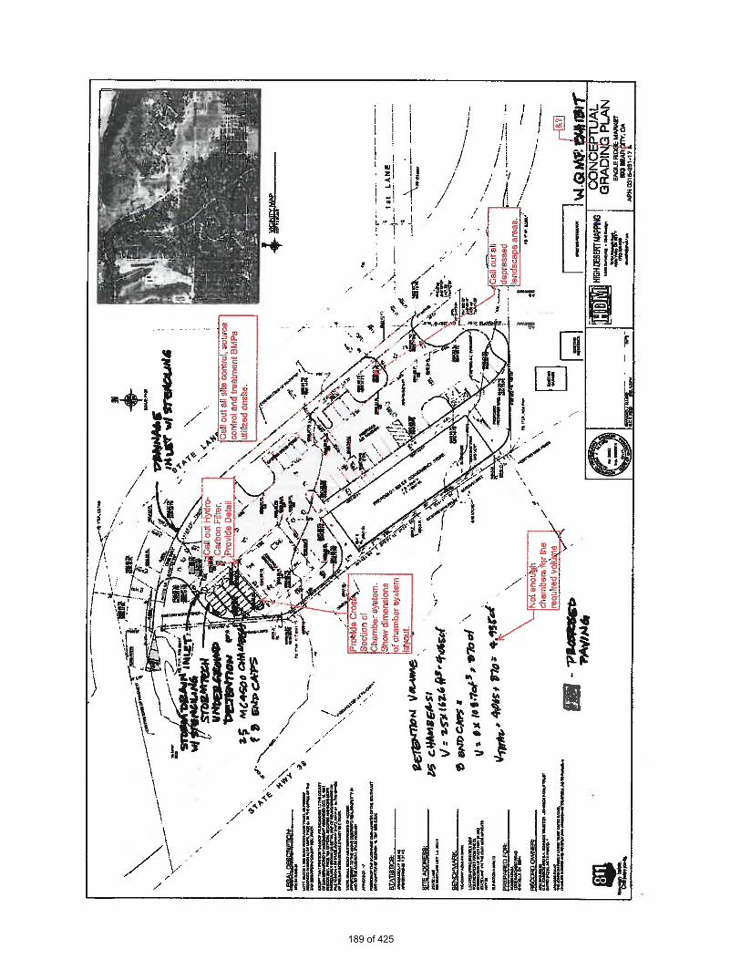
189 of 425

190 of 425

EXHIBIT H
Supplemental Preliminary Hydrology Analysis of Off-Site Flows 2014
191 of 425

SUPPLEMENTAL PRELIMINARY HYDROLOGY
ANALYSIS OF OFF-SITE FLOWS
FOR
PROPOSED EAGLE MARKET
S.E. CORNER OF STATE HWY 38 & STATE LANE
IN
SAN BERNARDINO, CALIFORNIA
(A.P.N. 0315-231-17)
FOR
STEENO DESIGN STUDIO
11774 HESPERIA ROAD, SUITE B
HESPERIA, CA 92345
760-244-5001
BY
JERRY L. MILES, P.E.
P.O. BOX 1861
APPLE VALLEY, CA 92307
192 of 425
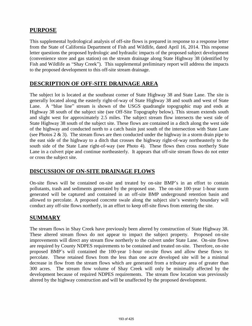
PURPOSE
This supplemental hydrological analysis of off-site flows is prepared in response to a response letter
from the State of California Department of Fish and Wildlife, dated April 16, 2014. This response
letter questions the proposed hydrologic and hydraulic impacts of the proposed subject development
(convenience store and gas station) on the stream drainage along State Highway 38 (identified by
Fish and Wildlife as “Shay Creek”). This supplemental preliminary report will address the impacts
to the proposed development to this off-site stream drainage.
DESCRIPTION OF OFF-SITE DRAINAGE AREA
The subject lot is located at the southeast corner of State Highway 38 and State Lane. The site is
generally located along the easterly right-of-way of State Highway 38 and south and west of State
Lane. A “blue line” stream is shown of the USGS quadrangle topographic map and ends at
Highway 38 south of the subject site (see Off-Site Topography below). This stream extends south
and slight west for approximately 2.5 miles. The subject stream flow intersects the west side of
State Highway 38 south of the subject site. These flows are contained in a ditch along the west side
of the highway and conducted north to a catch basin just south of the intersection with State Lane
(see Photos 2 & 3). The stream flows are then conducted under the highway in a storm drain pipe to
the east side of the highway to a ditch that crosses the highway right-of-way northeasterly to the
south side of the State Lane right-of-way (see Photo 4). These flows then cross northerly State
Lane in a culvert pipe and continue northeasterly. It appears that off-site stream flows do not enter
or cross the subject site.
DISCUSSION OF ON-SITE DRAINAGE FLOWS
On-site flows will be contained on-site and treated by on-site BMP’s in an effort to contain
pollutants, trash and sediments generated by the proposed use. The on-site 100-year 1-hour storm
generated will be captured and contained in an off-site BMP underground retention basin and
allowed to percolate. A proposed concrete swale along the subject site’s westerly boundary will
conduct any off-site flows northerly, in an effort to keep off-site flows from entering the site.
SUMMARY
The stream flows in Shay Creek have previously been altered by construction of State Highway 38.
These altered stream flows do not appear to impact the subject property. Proposed on-site
improvements will direct any stream flow northerly to the culvert under State Lane. On-site flows
are required by County NDPES requirements to be contained and treated on-site. Therefore, on-site
proposed BMP’s will contained the 100-year 1-hour on-site flows and allow these flows to
percolate. These retained flows from the less than one acre developed site will be a minimal
decrease in flow from the stream flows which are generated from a tributary area of greater than
300 acres. The stream flow volume of Shay Creek will only be minimally affected by the
development because of required NDPES requirements. The stream flow location was previously
altered by the highway construction and will be unaffected by the proposed development.
193 of 425

OFF-SITE TOPOGRAPHY
PHOTO 1
SUBJECT PROPERTY
LOCATION
BLUE LINE STREAM
ADJACENT TO
SUBJECT PROPERTY
194 of 425

PHOTO 2
PHOTO 3
195 of 425

PHOTO 4
SAN BERNARDINO COUNTY DRAINAGE AREA AERIAL
DRAINAGE AREA
BOUNDARY
196 of 425

Exhibit I
Revised Traffic Report: Hall & Foreman, Inc.; 2014 with Appendices (Exhibit-A 6-27-2014,
Winter Weekend Traffic Analysis 01-15-2014, and Response to Caltrans Letter 06-23-2014)
197 of 425

TUSTIN 17782 17th Street
Suite 200 Tustin, CA 92780-1947
714.665.4500 Fax: 714.665.4501
LOS ANGELES
881 Wilshire Boulevard, Suite 1450
Los Angeles, CA 90017-2606 213.785.7887
SANTA CLARITA
25152 Springfield Court Suite 350
Santa Clarita, CA 91355-1096 661.284.7400
Fax 661.284.7401
TEMECULA 41951 Remington Avenue
Suite 130 Temecula, CA 92590-3745
951.294.9300 Fax: 951.294-9301
VICTORVILLE
14297 Cajon Avenue Suite 101
760.524.9100 Fax 760.524.9101
www.hfinc.com
Dedicated Service Since 1961
PROPOSED COMMERCIAL DEVELOPMENT EAGLE RIDGE MARKET
ERWIN LAKE, CA
PREPARED FOR: STEENO DESIGN STUDIO
PREPARED BY: HALL & FOREMAN, INC.
14297 CAJON STREET, #101 VICTORVILLE, CA 92392
UPDATED REPORT
June 27, 2014
198 of 425

-i-
June 27, 2014 Job No. VV.130048.0000 Mr. Tom Steeno Steeno Design Studio 11774 Hesperia Rd, Suite 1B Hesperia, CA, 92345 RE: TRAFFIC STUDY – EAGLE RIDGE MARKET- STATE HWY 38 and STATE LANE-
ERWIN LAKE, CALIFORNIA Dear Mr. Steeno; Hall & Foreman Inc. is pleased to submit this Updated Traffic Study in the unincorporated community of Erwin Lake for the proposed Eagle Ridge commercial development at the southeast corner of Highway 38 and State Lane. The project is comprised of a Gas Station with Convenience Market and a Residence for the caretaker. The report examines the traffic impacts specifically for the project and presents recommended traffic improvements. The report also addresses the impacts of overall growth within the area to assure that cumulative traffic mitigations can be addressed. We are pleased to have been of assistance to you in processing and obtaining approval for the project. If you have any questions or comments, please feel free to contact me at 760-524-9115. Respectfully submitted, Hall & Foreman Inc. Robert A. Kilpatrick, P.E., T.E. Vice President/Associate
199 of 425

-ii-
TABLE OF CONTENTS
Page
1. Introduction .......................................................................................................................... 1
2. Existing Conditions ............................................................................................................. 4
Existing Street System ........................................................................................................... 4
Existing Traffic Volumes ......................................................................................................... 4
Existing Traffic Analysis .......................................................................................................... 7
3. Background Traffic .............................................................................................................. 9
Area Growth ........................................................................................................................... 9
Background Traffic Analysis ................................................................................................... 9
4. Project Conditions ..............................................................................................................12
Project Trip Generation .........................................................................................................12
Project Trip Distribution .........................................................................................................12
Project Traffic Analysis ..........................................................................................................16
Traffic Signal Warrant Analysis ..............................................................................................19
Left Turn Warrant Analysis ....................................................................................................19
Truck Turning Templates .......................................................................................................19
Greenspot Blvd (Highway 38) and State Lane/Mitchelle Lane Intersection Geometrics .........20
State Lane Sight Distance Analysis .......................................................................................20
5. Future Conditions ...............................................................................................................24
Area Growth ..........................................................................................................................24
Future Traffic Analysis ...........................................................................................................29
6. Project Mitigation And Summary .......................................................................................30
Site Improvement Mitigations ................................................................................................30
Intersection Improvement Mitigations ....................................................................................30
7. Appendix ............................................................................................................................31
o Other Area Projects o Intersection Capacity Analysis Calculations o Traffic Signal Warrant Worksheets – Highway 38 and State Lane o Left Turn Warrant Analysis – Highway 38 and State Lane
200 of 425

-iii-
LIST OF TABLES Table 1: Intersection Capacity Analysis - Existing Condition ...................................................... 7 Table 2: Intersection Capacity Analysis - Existing Plus Background Condition ........................... 9 Table 3: Project Trip Generation ...............................................................................................12 Table 4: Intersection Capacity Analysis - Project Condition .......................................................16 Table 5: Volume Comparison for Caltrans Access Management Plan Analysis.........................19 Table 6: Intersection Capacity Analysis - Future Year 2035 Condition without Project ..............29 Table 7: Intersection Capacity Analysis - Future Year 2035 Condition with Project ...................29
LIST OF FIGURES Figure 1: Vicinity Map ................................................................................................................. 2 Figure 2: Site Plan ..................................................................................................................... 3 Figure 3: Weekday AM and PM Existing Traffic Volumes ........................................................... 5 Figure 4: Winter Friday and Sunday Existing Traffic Volumes .................................................... 6 Figure 5: Existing Intersection Geometrics ................................................................................. 8 Figure 6: Weekday AM and PM Year 2014 Background Traffic Conditions ...............................10 Figure 7: Winter Friday and Sunday Year 2014 Background Traffic Conditions ........................11 Figure 8: Project Trip Distribution ..............................................................................................13 Figure 9: Weekday AM and PM Project Trips ............................................................................14 Figure 10: Winter Friday and Sunday Project Trips ...................................................................15 Figure 11: Weekday AM and PM Project Conditions .................................................................17 Figure 12: Winter Friday and Sunday Project Conditions ..........................................................18 Figure 13: Truck Turning Templates .........................................................................................21 Figure 14: Proposed Intersection Geometrics ...........................................................................22 Figure 15: State Lane Proposed Project Mitigations ..................................................................23 Figure 16: Weekday AM and PM Year 2035 Traffic Volume without Project .............................25 Figure 17: Winter Friday and Sunday Year 2035 Traffic Volume without Project .......................26 Figure 18: Weekday AM and PM Year 2035 Traffic Volume with Project ..................................27 Figure 19: Winter Friday and Sunday Year 2035 Traffic Volume with Project ............................28
201 of 425

-1-
1. INTRODUCTION This report identifies the traffic impacts and presents recommendations for access and traffic mitigation for the proposed project located at the southeast corner of Highway 38 and State Lane in the unincorporated community of Erwin Lake, which is southeasterly of the unincorporated community of Big Bear City. The proposed project consists of a Convenient Store with a gas station and a Residence for the caretaker. The site will be accessible from a right turn in only driveway, and a dual entry driveway to be constructed on State Lane east of Highway 38. Figure 1 illustrates the vicinity map and project location and Figure 2 illustrates the proposed project site plan. The project is located in the unincorporated community of Erwin Lake in San Bernardino County. The project is bound by State Lane to the north, Highway 38 to the west, residential homes to the east and south of the project site. Access to the project site is proposed off of State Lane. No direct access is proposed to be from Highway 38. To address traffic impacts due to the proposed project, a study area encompassing the streets in the area was developed. The study area specifically includes the intersection of Highway 38 and State Lane. Highway 38 provides local and regional access to the study area. In addition to addressing traffic impacts due specifically to development of the project, this study addresses impacts due to development correlating with the development of the project and cumulative projects up to the year 2035 within the study area. The examination of potential development correlating with the development of the project is known as background traffic. Traffic due to other projects and an estimated straight line growth in the area is added to existing traffic to create a base for analyzing project traffic impacts. In addition, this report addresses traffic conditions for the future Year 2035 forecast year. Identified as future traffic, the traffic generation of the adjoining projects which is incorporated into the area growth is included. The purpose of the future year analysis is to assure that traffic improvements for the intersection are not needed to accommodate the anticipated future traffic.
202 of 425

PROJECT
SITE
STATE LANE
BALDWIN LANE
BARTON LANE
HA
TC
HE
RY
D
RIV
E
MIT
CH
ELL LA
NE
CE
DA
R G
LE
N D
RIV
E
B
I
G
B
E
A
R
B
O
U
L
E
V
A
R
D
MA
PLE
LA
NE
G
R
E
E
N
S
P
O
T
B
L
V
D
(
S
R
-
3
8
)
BIG BEAR BOULEVARD (SR-38)
G
R
E
E
N
W
A
Y
D
R
IV
E
(S
R
-3
8
/S
R
-1
8
)
N
O
R
T
H
S
H
O
R
E
D
R
I
V
E
(
S
R
-
1
8
)
S
R
-
1
8
SHAY ROAD
TO
LUCERNE VALLEY
BIG BEAR
CITY
SUGARLOAF
ERWIN
LAKE
TO
REDLANDS
TO
BIG BEAR LAKE
STATE COURT
HE
RIT
AG
E T
RA
IL
S
R
-
3
8
1ST LANE
FIGURE
Fax. 760-524-9101
14297 Cajon St., Suite 101 Victorville, CA., 92392-2335
Phn. 760-524-9100
EAGLE RIDGE MARKET
ERWIN LAKE, CALIFORNIA
VICINITY MAP
1
203 of 425

1ST LANE
STATE LANE
P
R
O
P
O
S
E
D
5
,
6
4
1
S
Q
.
F
T
.
'
C
'
S
T
O
R
E
@
L
O
W
E
R
L
E
V
E
L
1
,
1
5
2
S
Q
.
F
T
.
U
P
P
E
R
L
E
V
E
L
C
A
R
E
T
A
K
E
R
S
R
E
S
I
D
E
N
C
E
FIGURE
Fax. 760-524-9101
14297 Cajon St., Suite 101 Victorville, CA., 92392-2335
Phn. 760-524-9100
EAGLE RIDGE MARKET
ERWIN LAKE, CALIFORNIA
SITE PLAN
2
204 of 425

-4-
2. EXISTING CONDITIONS Existing Street System The project site currently is vacant and undeveloped. Land uses around the site consist of single family residential developments to the east and south of the project site. Streets in and near the vicinity of the project are mostly paved residential streets with some undeveloped dirt roads. The existing developed roads range in pavement widths of 20 to 50 feet and are in good to fair condition. The following roadways provide regional access to the project within the study area: Greenspot Boulevard/Highway 38 provides local and regional access in the project area. Highway 38 (SR 38) traverses north to south and provides access from the Big Bear Lake area to Redlands/Yucaipa and the Interstate I-10 Freeway. This roadway is primarily a two-lane highway (one lane in each direction). The intersection of Highway 38 and State Lane is currently two-way-stop-controlled. State Lane will provide the primary access to the project site. State Lane is primarily a two-lane paved road (one lane in each direction) fronting the project site east of Highway 38. Currently, State Lane does not consist of a curb and gutter along the property. First Lane is a 25 foot wide local unpaved road. First Lane functions similar to an alley providing access to residential property east of the project. The project proposes to construct the driveways on State Lane east of Highway 38, as shown on the Site Plan, Figure 2. Two existing intersections within the study area has been identified that may potentially be impacted by the project. The intersections are;
• Highway 38 and State Lane • State Lane and First Lane
Currently both of these intersections are Two Way Stop Controlled (TWSC). Existing Traffic Volumes Newport Traffic Studies staff conducted Weekday AM (7:00-9:00 AM) and Weekday PM (4:00-6:00 PM) peak hour turning movement counts and 24 hour intersection volume count, at the intersection of Highway 38 and State Lane, identified for detailed analysis. These counts were conducted in December of 2012. A subsequent Winter Weekend Friday (4:00-7:00 PM) and Sunday (3:00-6:00 PM) peak period turning movement counts, at the intersection of Highway 38 and State Lane, were conducted on December 13, 2013 and December 15, 2013 respectively. This count was conducted while the local ski resorts were in operation. The resulting volumes are presented in the appendix of this report. Figure 3 illustrates the weekday AM and PM existing peak hour traffic volumes. Turning movement volumes for First lane were not recorded since volumes were so low turning movement volumes were estimated to be conservative. Figure 4 illustrates the winter Friday and Sunday existing peak hour traffic volumes.
205 of 425

WEEKDAY AM AND PM
EXISTING TRAFFIC VOLUMES
- STUDY INTERSECTION
LEGEND
- WEEKDAY AM/PM PEAK HOUR VOLUMESXX/XX
FIGURE
Fax. 760-524-9101
14297 Cajon St., Suite 101 Victorville, CA., 92392-2335
Phn. 760-524-9100
EAGLE RIDGE MARKET
ERWIN LAKE, CALIFORNIA
3
206 of 425

WINTER FRIDAY AND SUNDAY
EXISTING TRAFFIC VOLUMES
- STUDY INTERSECTION
LEGEND
- WINTER FRIDAY/SUNDAY PM XX/XX
FIGURE
Fax. 760-524-9101
14297 Cajon St., Suite 101 Victorville, CA., 92392-2335
Phn. 760-524-9100
EAGLE RIDGE MARKET
ERWIN LAKE, CALIFORNIA
4
PEAK HOUR VOLUMES
207 of 425

-7-
Existing Traffic Analysis An intersection capacity analysis was conducted for the study intersection to determine a present level-of-service (LOS). Based on the existing intersection geometrics as illustrated in Figure 5 and the Weekday AM, Weekday PM, Winter Friday PM, and Winter Sunday PM peak hour traffic volumes. The capacity analysis for the un-signalized intersection was conducted utilizing HCS 2010, which is an un-signalized intersection capacity analysis program, developed by McTrans. This program was developed in accordance with the 2010 Highway Capacity Manual. The analysis determines a level-of-service (LOS), which quantitatively describes the operating characteristics of un-signalized intersections. The LOS ranges from “A” (the best) through “F” (system breakdown). The LOS for the intersection represents the LOS for the critical movement. This is typically the stop controlled left turn from the minor street. Table 1: Intersection Capacity Analysis - Existing Condition Eagle Ridge Market Traffic Study
Intersection Weekday AM Peak
Weekday PM Peak
Winter Friday
PM Peak
Winter Sunday
PM Peak Delay LOS Delay LOS Delay LOS Delay LOS
Highway 38 and State Lane (3) 13.6 B 15.4 C 18 C 14.8 B State Lane and First Lane Project Driveway (3) 10 A 9.7 A - - - -
(1) LOS – HCM Level of Service (2) Delay –In Seconds (3) Un-Signalized Intersection Source: Hall & Foreman Inc As provided in Table 1 under existing traffic conditions, the un-signalized intersections of Highway 38 and State Lane, and State Lane and First Lane/Project Driveway are operating at LOS “C” or better.
208 of 425

FIGURE
Fax. 760-524-9101
14297 Cajon St., Suite 101 Victorville, CA., 92392-2335
Phn. 760-524-9100
EAGLE RIDGE MARKET
ERWIN LAKE, CALIFORNIA
EXISTING INTERSECTION
GEOMETRICS
- STUDY INTERSECTIONS
LEGEND
- EXISITNG GEOMETRIC
5
- UNSIGNALIZED
209 of 425

-9-
3. BACKGROUND TRAFFIC Area Growth To analyze the project impacts, the inclusion of traffic generated by other projects within the study area is necessary. Other area projects at the intersections were taken into consideration. The County of San Bernardino has identified one project which would impact the study intersection as presented in Exhibit A in the Appendix of this report. This growth with other area project traffic volumes is known as background traffic. Typically, regional and local growth is expected over the years at rates ranging from 1% to 2% compounded annually. Based on the existing traffic volumes, a straight line growth at a 2% increase compounded annually was utilized. This growth is known as background traffic. The analysis of background traffic allows a comparison of traffic impacts with and without the project applying the growth to the existing turn movement volumes. Figure 6 illustrates weekday AM and PM year 2014 background traffic volumes. Figure 7 illustrates the winter Friday and Sunday year 2014 background traffic volumes. Background Traffic Analysis To determine the impacts of the project to the study intersection, existing plus the anticipated background traffic project peak hour volumes were calculated. The analysis was conducted with the existing intersection geometrics. Table 2: Intersection Capacity Analysis - Existing Plus Background Condition Eagle Ridge Market Traffic Study
Intersection Weekday AM Peak
Weekday PM Peak
Winter Friday
PM Peak
Winter Sunday
PM Peak Delay LOS Delay LOS Delay LOS Delay LOS
Highway 38 and State Lane (3) 14.4 B 16.3 C 19.5 C 15.8 C State Lane and First Lane Project Driveway (3) 10.1 B 9.8 A - - - -
(1) LOS – HCM Level of Service (2) Delay –In Seconds (3) Un-Signalized Intersection Source: Hall & Foreman Inc. As provided in Table 2 under existing plus background traffic conditions, the un-signalized intersections of Highway 38 and State Lane, and State Lane and First Lane/Project Driveway are anticipated to continue to operate at LOS “C” or better.
210 of 425
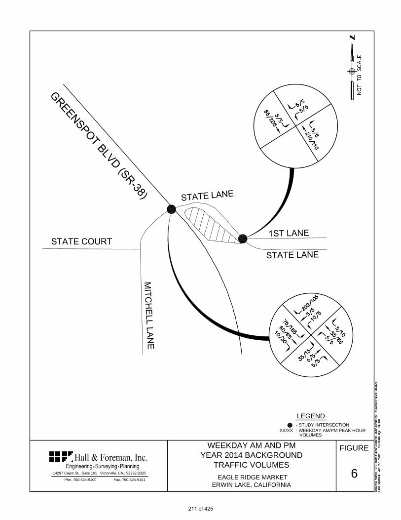
FIGURE
Fax. 760-524-9101
14297 Cajon St., Suite 101 Victorville, CA., 92392-2335
Phn. 760-524-9100
EAGLE RIDGE MARKET
ERWIN LAKE, CALIFORNIA
WEEKDAY AM AND PM
YEAR 2014 BACKGROUND
TRAFFIC VOLUMES
6
- STUDY INTERSECTION
LEGEND
- WEEKDAY AM/PM PEAK HOURXX/XX
VOLUMES
211 of 425

FIGURE
Fax. 760-524-9101
14297 Cajon St., Suite 101 Victorville, CA., 92392-2335
Phn. 760-524-9100
EAGLE RIDGE MARKET
ERWIN LAKE, CALIFORNIA
WINTER FRIDAY AND SUNDAY
YEAR 2014 BACKGROUND
TRAFFIC VOLUMES
7
- STUDY INTERSECTION
LEGEND
XX/XX
- WINTER FRIDAY/SUNDAY PM
PEAK HOUR VOLUMES
212 of 425
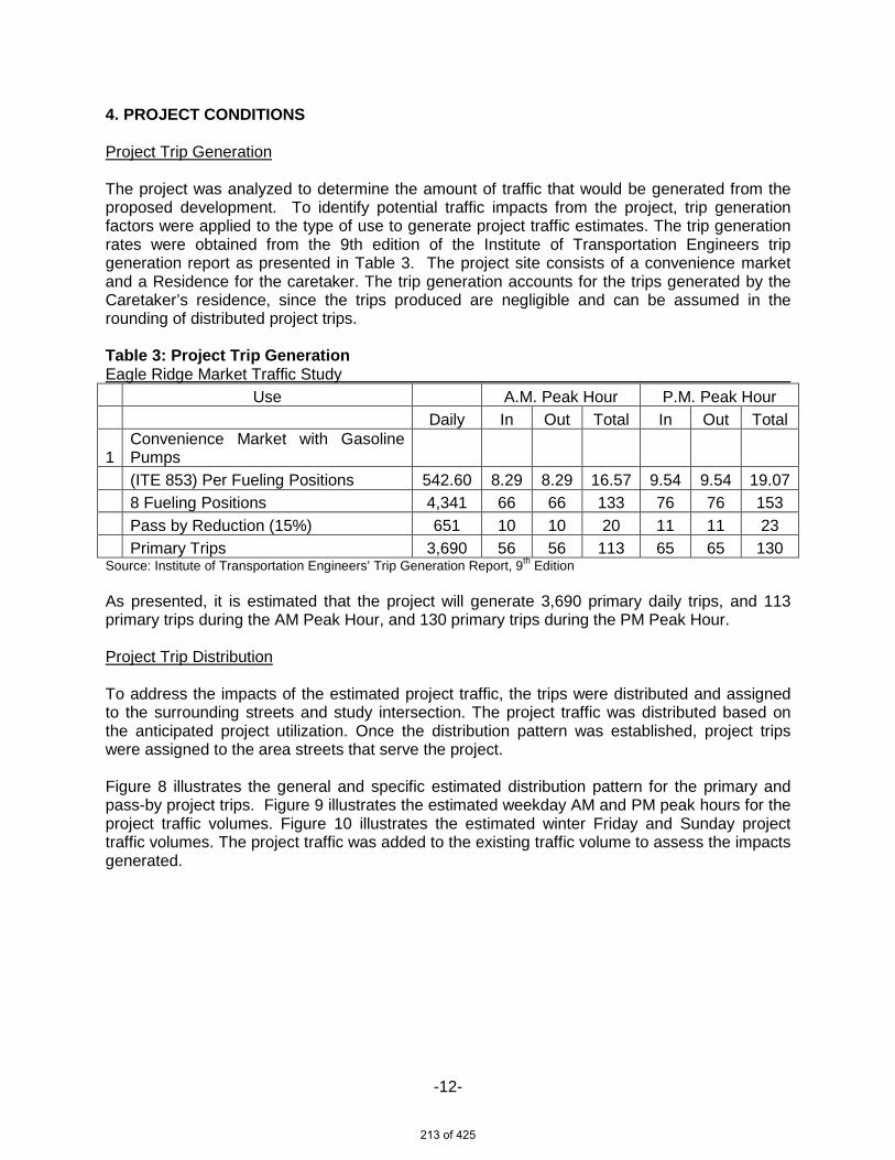
-12-
4. PROJECT CONDITIONS Project Trip Generation The project was analyzed to determine the amount of traffic that would be generated from the proposed development. To identify potential traffic impacts from the project, trip generation factors were applied to the type of use to generate project traffic estimates. The trip generation rates were obtained from the 9th edition of the Institute of Transportation Engineers trip generation report as presented in Table 3. The project site consists of a convenience market and a Residence for the caretaker. The trip generation accounts for the trips generated by the Caretaker’s residence, since the trips produced are negligible and can be assumed in the rounding of distributed project trips. Table 3: Project Trip Generation Eagle Ridge Market Traffic Study Use A.M. Peak Hour P.M. Peak Hour Daily In Out Total In Out Total
1 Convenience Market with Gasoline Pumps
(ITE 853) Per Fueling Positions 542.60 8.29 8.29 16.57 9.54 9.54 19.07 8 Fueling Positions 4,341 66 66 133 76 76 153 Pass by Reduction (15%) 651 10 10 20 11 11 23 Primary Trips 3,690 56 56 113 65 65 130 Source: Institute of Transportation Engineers’ Trip Generation Report, 9th Edition
As presented, it is estimated that the project will generate 3,690 primary daily trips, and 113 primary trips during the AM Peak Hour, and 130 primary trips during the PM Peak Hour. Project Trip Distribution To address the impacts of the estimated project traffic, the trips were distributed and assigned to the surrounding streets and study intersection. The project traffic was distributed based on the anticipated project utilization. Once the distribution pattern was established, project trips were assigned to the area streets that serve the project. Figure 8 illustrates the general and specific estimated distribution pattern for the primary and pass-by project trips. Figure 9 illustrates the estimated weekday AM and PM peak hours for the project traffic volumes. Figure 10 illustrates the estimated winter Friday and Sunday project traffic volumes. The project traffic was added to the existing traffic volume to assess the impacts generated.
213 of 425

FIGURE
Fax. 760-524-9101
14297 Cajon St., Suite 101 Victorville, CA., 92392-2335
Phn. 760-524-9100
EAGLE RIDGE MARKET
ERWIN LAKE, CALIFORNIA
PROJECT TRIP DISTRIBUTION
25 %
40 %
10 %
25 %
PRIMARY
PASS-BY
8
- STUDY INTERSECTION
LEGEND
- WEEKDAY AM/PM AND - WINTER XX/XX
PROJECT TRIP PERCENTAGE
FRIDAY/SUNDAY PM PROJECT
214 of 425

FIGURE
Fax. 760-524-9101
14297 Cajon St., Suite 101 Victorville, CA., 92392-2335
Phn. 760-524-9100
EAGLE RIDGE MARKET
ERWIN LAKE, CALIFORNIA
PASS-BY
WEEKDAY AM AND PM
PROJECT TRIPS
PRIMARY
TOTAL
9
- STUDY INTERSECTION
LEGEND
XX/XX
- AM/PM PROJECT TRIPS
215 of 425

FIGURE
Fax. 760-524-9101
14297 Cajon St., Suite 101 Victorville, CA., 92392-2335
Phn. 760-524-9100
EAGLE RIDGE MARKET
ERWIN LAKE, CALIFORNIA
PASS-BY
WINTER FRIDAY AND SUNDAY
PROJECT TRIPS
PRIMARY
TOTAL
10
- STUDY INTERSECTION
LEGEND
XX/XX
- WINTER FRIDAY/SUNDAY PM
PROJECT TRIPS
216 of 425

-16-
Project Traffic Analysis Based on the proposed traffic distribution, assignment patterns and project trip generation, intersection capacity analyses were conducted to assess the estimated project impacts. To determine the project impacts at the study intersection and driveways, the Background Year 2014 volumes and project trips, known as Project Conditions, were calculated. Figure 11 illustrates weekday AM and PM year 2014 project conditions traffic volumes. Figure 12 illustrates the winter Friday and Sunday project conditions traffic volumes. Intersection capacity analysis for the Project Condition was performed using the same methodology as presented in Chapter 1. Table 4: Intersection Capacity Analysis - Project Condition Eagle Ridge Market Traffic Study
Intersection Weekday AM Peak
Weekday PM Peak
Winter Friday
PM Peak
Winter Sunday
PM Peak Delay LOS Delay LOS Delay LOS Delay LOS
Highway 38 and State Lane (3) 15.7 C 19.4 C 24.9 C 20.0 C State Lane and First Lane Project Driveway (3) 11.6 B 12.3 B - - - -
(1) LOS – HCM Level of Service (2) Delay –In Seconds (3) Un-Signalized Intersection Source: Hall & Foreman Inc. As presented in Table 4 under project traffic conditions, the un-signalized intersections of Highway 38 and State Lane, and State Lane and First Lane/Project Driveway are anticipated to continue to operate at LOS “C” or better.
217 of 425

FIGURE
Fax. 760-524-9101
14297 Cajon St., Suite 101 Victorville, CA., 92392-2335
Phn. 760-524-9100
EAGLE RIDGE MARKET
ERWIN LAKE, CALIFORNIA
WEEKDAY AM AND PM
PROJECT TRAFFIC VOLUMES
11
- STUDY INTERSECTION
LEGEND
- WEEKDAY AM/PM PEAK HOURXX/XX
VOLUMES
218 of 425

FIGURE
Fax. 760-524-9101
14297 Cajon St., Suite 101 Victorville, CA., 92392-2335
Phn. 760-524-9100
EAGLE RIDGE MARKET
ERWIN LAKE, CALIFORNIA
WINTER FRIDAY AND SUNDAY
PROJECT TRAFFIC VOLUMES
12
- STUDY INTERSECTION
LEGEND
XX/XX - WINTER FRIDAY/SUNDAY PM
PEAK HOUR VOLUMES
219 of 425

-19-
Traffic Signal Warrant Analysis A traffic signal warrant analysis was conducted at the intersection of Highway 38 and State Lane to determine if the installation of a traffic control signal would improve the overall safety and/or operation of the intersection. Traffic Signal Warrant worksheets are provided in the Appendix. Consideration is given to the geometrics of each approach and the number of lanes used for the analysis. It was determined that a traffic signal was not warranted based on eight hour volumes, four hour volumes, peak hour volumes, or delay. The level of safety of the intersection was also considered by reviewing accident history for the intersection. The Transportation Injury Mapping System (TIMS) was referenced. TIMS report for Highway 38 and State Lane showed that a single accident occurred within the five year data period. Based on the above criteria the warrants for the installation of a traffic signal at this intersection are not met. Left Turn Warrant Analysis Several Left Turn Warrant Analysis Methodologies are available and presented in the Caltrans “Access Management” document. The Left Turn Warrant Analysis methodology to be used as presented in the California State Department of Transportation (Caltrans) “Access Management Plan” Table 17.B-3: Criteria for Left-Turn Deceleration Lanes on Rural Two-Lane Highways. The criteria for an intersection with a speed of 50 mph is a Left-turn Deceleration Lane is required on Rural Two-Lane Highways for 16 or more Advancing Vehicles turning left per hour (vph). Table 5 presents the volumes used in the analysis of the southbound (Greenspot Blvd/Highway 38) left turn movement. As a result for all conditions the Advancing Vehicles turning left is greater than 16 vehicles per hour (vph). A Left-turn lane is proposed for the southbound left turn. Table 5: Volume Comparison for Caltrans Access Management Plan Analysis Greenspot Blvd (Highway 38) and State Lane/Mitchelle Lane Intersection
Intersection Weekday AM Peak
Weekday PM Peak
Winter Friday
PM Peak
Winter Sunday
PM Peak VA VL VA VL VA VL VA VL
Existing Condition 125 70 265 180 310 215 330 145
Existing plus Background 145 75 280 185 340 225 350 150
Project Year 2014 165 100 305 215 365 255 375 180
Year 2035 without Project 200 105 395 260 470 315 485 210
Year 2035 with Project 220 130 420 290 495 345 510 240 (1) VA – Advancing Volume (veh/h) (2) VL –Advancing Vehicles turning Left (veh/h) Source: Hall & Foreman Inc Truck Turning Templates Truck Turning templates were applied to the existing geometrics. These turn movements include northbound right, southbound left and westbound left and right turns. A custom fuel tanker was modeled to represent the model vehicle with dimensions and specifications. The truck turning templates are provided in Figure 13. As illustrated some widening of the shoulder at the southeast corner of the intersection will be needed to accommodate the north to east right turn movement.
220 of 425

-20-
Greenspot Blvd (Highway 38) and State Lane/Mitchelle Lane Intersection Geometrics The intersection of Greenspot Blvd (Highway 38) and State Lane/Mitchelle Lane, as previously discussed, was evaluated to determine if a traffic signal was warranted, a left turn lane was needed, and fuel tanker truck turning movements would be accommodated. The traffic signal warrant analysis resulted in the criterion not being met. The left turn warrant analysis resulted in the criterion being met for the southbound left turn movement. Widening of the southbound approach is proposed to accommodate a 100 feet long left turn lane. The length of the left turn lane will accommodate a fuel tanker truck and vehicle waiting to complete the left turn movement. The custom fuel tanker truck turning templates resulted in some widening of the shoulder at the southeast corner of the intersection needed to accommodate the north to east right turn movement. The Proposed Project Intersection Geometrics are illustrated in Figure 14. State Lane Sight Distance Analysis The project proposed to provide driveway access to the site along State Lane. A full access second driveway is proposed to intersect with the existing adjacent road First Lane. The proposed driveway intersection will be and un-signalized two-way stop controlled intersection, providing free movement along State Lane. Potential sight distance constraints were evaluated prior to selection of the location of the driveway due to the alignment of State Lane. The “Corner Sight Distance Triangle” utilized the current advisory speed of 20 mph. The north-west bound traffic currently has an advisory speed posted upon the approach of the westbound reverse curve on State Lane. The south-east bound traffic currently has an advisory speed posted upon the eastbound approach of the reverse curve on State Lane. The Caltrans Highway Design Manual presents a corner sight distance requirement of 7.5 second travel time for a vehicle to cross from a minor road. Based on the current advisory speed of 20 mph and the 7.5 second travel time the sight distance requirement would be 220 feet. Project mitigations and Sight Distance Triangles are illustrated in Figure 15. The figure illustrates the placement of the second driveway accommodating the minimum corner sight distance of 220 feet for the westbound traffic traveling at the advisory speed of 20 mph. The eastbound traffic traveling at the advisory speed of 20 mph are also provided with adequate corner sight distance, providing 254 foot line of sight.
221 of 425

S
T
A
T
E
L
A
N
E
MITCHELLE LANE
4
5
4
GR
EE
NS
PO
T B
OU
LE
VA
RD
(S
R 38)
18
0
1
5
0
1
2
0
90
OUTSIDE SWEPT PATH
INSIDE SWEPT PATH
6
0
3
0
STEERING LOCK ANGLE = 41.8 deg.
ACHIEVED STEERING ANGLE:
30 deg. SWEEP ANGLE: 20.9 deg.
60 deg. SWEEP ANGLE: 30.9 deg.
90 deg. SWEEP ANGLE: 36.0 deg.
120 deg. SWEEP ANGLE: 38.6 deg.
150 deg. SWEEP ANGLE: 40.1 deg.
180 deg. SWEEP ANGLE: 40.9 deg.
37.5 ft
4
3
.
5
f
t
5.0 ft
31.0 ft
15.0 ft
20.0 ft
4.0 ft
8.2 ft
FIGURE
Fax. 760-524-9101
14297 Cajon St., Suite 101 Victorville, CA., 92392-2335
Phn. 760-524-9100
EAGLE RIDGE MARKET
ERWIN LAKE, CALIFORNIA
TRUCK TURNING TEMPLATES
13
222 of 425

FIGURE
Fax. 760-524-9101
14297 Cajon St., Suite 101 Victorville, CA., 92392-2335
Phn. 760-524-9100
EAGLE RIDGE MARKET
ERWIN LAKE, CALIFORNIA
PROPOSED INTERSECTION
GEOMETRICS
14
LEGEND
- POWER POLE LOCATION
223 of 425

1
S
T
L
A
N
E
S
T
A
T
E
L
A
N
E
PR
OP
OS
ED
5,641 S
Q.F
T.
'C
' S
TO
RE
@
LO
WE
R LE
VE
L
1,152 S
Q. F
T.
UP
PE
R LE
VE
L
CA
RE
TA
KE
RS
RE
SID
EN
CE
FIGURE
Fax. 760-524-9101
14297 Cajon St., Suite 101 Victorville, CA., 92392-2335
Phn. 760-524-9100
EAGLE RIDGE MARKET
ERWIN LAKE, CALIFORNIA
PROJECT MITIGATIONS
15
2
2
0
'
M
I
N
.
254'
LIN
E O
F S
IG
HT
L
I
N
E
O
F
S
I
G
H
T
PROPOSEDEXISTING
W1-3
W1-4
MODIFIED
PROPOSEDEXISTING
W1-3
W1-4
MODIFIED
36" MIN.
36" MIN.
STATE LANE PROPOSED
224 of 425

-24-
5. FUTURE CONDITIONS Area Growth This report is primarily concerned with traffic impacts created by the proposed project. However, growth within the study area due to development will occur. To analyze the future conditions a 2% growth per year of the existing peak hour volumes was considered. Figure 16 illustrates weekday AM and PM year 2035 without project forecasted volumes. Figure 17 illustrates the winter Friday and Sunday year 2035 without project forecasted volumes. Figure 18 illustrates weekday AM and PM year 2035 with project forecasted volumes. Figure 19 illustrates the winter Friday and Sunday year 2035 with project forecasted volumes.
225 of 425
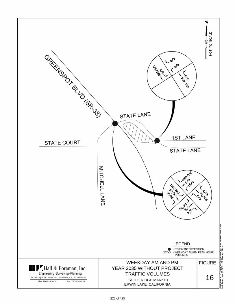
FIGURE
Fax. 760-524-9101
14297 Cajon St., Suite 101 Victorville, CA., 92392-2335
Phn. 760-524-9100
EAGLE RIDGE MARKET
ERWIN LAKE, CALIFORNIA
WEEKDAY AM AND PM
YEAR 2035 WITHOUT PROJECT
TRAFFIC VOLUMES
16
- STUDY INTERSECTION
LEGEND
- WEEKDAY AM/PM PEAK HOURXX/XX
VOLUMES
226 of 425

FIGURE
Fax. 760-524-9101
14297 Cajon St., Suite 101 Victorville, CA., 92392-2335
Phn. 760-524-9100
EAGLE RIDGE MARKET
ERWIN LAKE, CALIFORNIA
- STUDY INTERSECTION
LEGEND
XX/XX
17
- WINTER FRIDAY/SUNDAY PM
PEAK HOUR VOLUMES
WINTER FRIDAY AND SUNDAY
YEAR 2035 WITHOUT PROJECT
TRAFFIC VOLUMES
227 of 425

FIGURE
Fax. 760-524-9101
14297 Cajon St., Suite 101 Victorville, CA., 92392-2335
Phn. 760-524-9100
EAGLE RIDGE MARKET
ERWIN LAKE, CALIFORNIA
18
- STUDY INTERSECTION
LEGEND
- WEEKDAY AM/PM PEAK HOURXX/XX
VOLUMES
WEEKDAY AM AND PM
YEAR 2035 WITH PROJECT
TRAFFIC VOLUMES
228 of 425

FIGURE
Fax. 760-524-9101
14297 Cajon St., Suite 101 Victorville, CA., 92392-2335
Phn. 760-524-9100
EAGLE RIDGE MARKET
ERWIN LAKE, CALIFORNIA
- STUDY INTERSECTION
LEGEND
XX/XX
19
- WINTER FRIDAY/SUNDAY PM
PEAK HOUR VOLUMES
WINTER FRIDAY AND SUNDAY
YEAR 2035 WITH PROJECT
TRAFFIC VOLUMES
229 of 425

-29-
Future Traffic Analysis The intersection of Highway 38 and State Lane was analyzed using the capacity analysis methodology described in Chapter 1. The analysis was conducted with the anticipated project and Future Year 2035 traffic volumes and the existing intersection geometrics. The results of the analysis are shown in Table 6 and Table 7.
Table 6: Intersection Capacity Analysis - Future Year 2035 Condition without Project Eagle Ridge Market Traffic Study
Intersection Weekday AM Peak
Weekday PM Peak
Winter Friday
PM Peak
Winter Sunday
PM Peak Delay LOS Delay LOS Delay LOS Delay LOS
Highway 38 and State Lane (3) 19.0 C 23.6 C 35.0 D 24.2 C State Lane and First Lane Project Driveway (3) 10.7 B 10.4 B - - - -
(1) LOS – HCM Level of Service (2) Delay –In Seconds (3) Un-Signalized Intersection Source: Hall & Foreman Inc. As presented in Table 6 under Year 2035 traffic conditions, the un-signalized intersections of Highway 38 and State Lane, and State Lane and First Lane/Project Driveway are anticipated to operate at LOS “D” or better. Table 7: Intersection Capacity Analysis - Future Year 2035 Condition with Project Eagle Ridge Market Traffic Study
Intersection Weekday AM Peak
Weekday PM Peak
Winter Friday
PM Peak
Winter Sunday
PM Peak Delay LOS Delay LOS Delay LOS Delay LOS
Highway 38 and State Lane (3) 21.9 C 29.6 D 47.7 E 30.5 D State Lane and First Lane Project Driveway (3) 12.8 B 13.6 B - - - -
(1) LOS – HCM Level of Service (2) Delay –In Seconds (3) Un-Signalized Intersection Source: Hall & Foreman Inc. As presented in Table 7 under Year 2035 traffic conditions with project, the un-signalized intersections of Highway 38 and State Lane, and State Lane and First Lane/Project Driveway are anticipated to continue to operate at an acceptable LOS.
230 of 425

-30-
6. PROJECT MITIGATION AND SUMMARY As presented, the project is anticipated to minimally impact area intersections. Improvements to area intersections are needed based on current traffic conditions and to handle estimated project and future traffic. Site Improvement Mitigations 1. Driveway Number 1 is to be constructed as right turn in only.
2. Driveway Number 2 is to be constructed as full access, adjacent First Lane. The intersection
will be Two Way Stop Controlled (TWSC) at the driveway and First Lane.
3. The curb and gutter along State Lane, project frontage, will be constructed.
4. Upgrading the existing warning signage along State lane. Figure 15 illustrates this specific
mitigation.
Intersection Improvement Mitigations
1. Widening of the intersection of Greenspot Blvd/Hwy 38 and State Lane/ Mitchelle Lane to
accommodate a southbound 100 foot left turn lane and north to east right turn movement, as
illustrated in Figure 14.
231 of 425

-31-
7. APPENDIX
1. Other Area Projects 2. Intersection Capacity Analysis Calculations 3. Traffic Signal Warrant Worksheets – Highway 38 and State Lane 4. Left Turn Warrant Analysis – Highway 38 and State Lane
232 of 425

1. Other Area Projects
233 of 425

234 of 425

2. Intersection Capacity Analysis Calculations
235 of 425

35
0
560
5
50
20 470 90
100
55
10
-5
0
2575
60
15
0
-5
20
20
BACKGROUND
5
20
0
0
0
15
0
10
EXISTING +
BACKGROUND +
PROJECT
5
TRIPS
225
15
25
TOTALS 435
70
45
10
200
5
55
SCENERIO #
CONDITION
EB THRU
10
5
5
NB THRU
NB LEFT
WB THRU
WB RIGHT
5
10WB LEFT
EB RIGHT
5
0
STATE LANE DRIVE
35 0
HIGHWAY 38
5
TURN MOVEMENTS
TRAFFICTRAFFIC
EXISTING +
BACKGROUND
TRAFFIC
EXISTING PROJECT
PROJECTED GROWTH
PER YEAR:
27-Jun-14
SUBJECT
SUMMARY
BY
TM
SHEET OF
2
JOB NO.
OF1
DATE
VV.130048.0000
E/W STREET :
:
CONDITION DIAGRAMS
:CONDITION
N/S STREET
PROJECT YEAR : 2014
2%
STATE LANE DRIVE
HIGHWAY 38
WEEKDAY AM PEAK HOUR
Tustin Office: 714.665.4500 Tel/ 714.665.4501 Fax
Santa Clarita Office: 661.284.7400 Tel/ 661.284.7401 Fax
Victorville Office: 760.524.9100 Tel/ 760.524.9101 Fax
Temecula Office: 951.294.9300 Tel/ 951.294.9301 Fax
EB LEFT
190
SB RIGHT
SB THRU
SB LEFT
35
0
10
0
0
15
0
5
5
50
5 10NB RIGHT 5
0
5
15 25
5 20
YEAR 2035 YEAR 2035
WITHOUT WITH
PROJECT PROJECT
EXISTING GEOMETRICS FUTURE GEOMETRICSPROPOSED GEOMETRICS
80 75
15 15
645 735
280 305
5 5
75 70
5 15
105 130
50 50
5 20
5
236 of 425
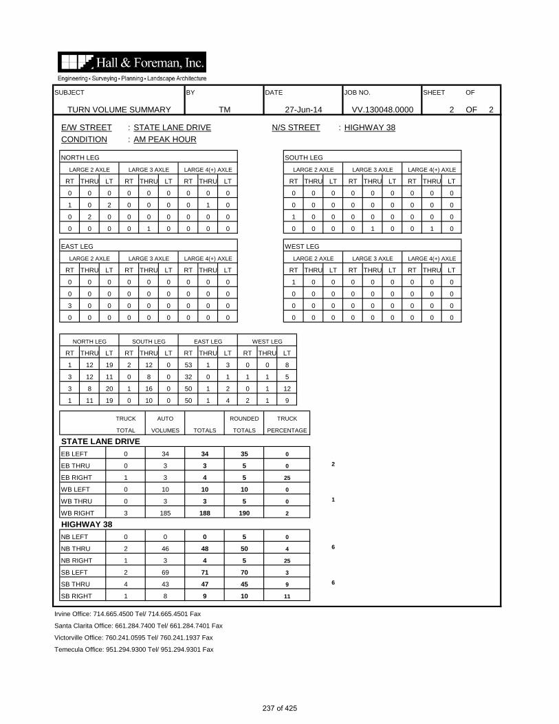
Irvine Office: 714.665.4500 Tel/ 714.665.4501 Fax
Santa Clarita Office: 661.284.7400 Tel/ 661.284.7401 Fax
Victorville Office: 760.241.0595 Tel/ 760.241.1937 Fax
Temecula Office: 951.294.9300 Tel/ 951.294.9301 Fax
SB RIGHT 1 8 9 10 11
SB THRU 4 43 47 45 9
SB LEFT 2 69 71 70 3
1 3 4 5 25
NB THRU 2 46 48 50 4
NB RIGHT
HIGHWAY 38NB LEFT 0 0 0 5 0
WB RIGHT 3 185 188 190 2
WB THRU 0 3 3 5 0
WB LEFT 0 10 10 10 0
EB RIGHT 1 3 4 5 25
0
EB THRU 0 3 3 5 0
STATE LANE DRIVEEB LEFT 0 34 34 35
TOTAL VOLUMES TOTALS TOTALS PERCENTAGE
TRUCK AUTO ROUNDED TRUCK
50 1 4 2 1 91 11 19 0 10 0
50 1 2 0 1 123 8 20 1 16 0
32 0 1 1 1 53 12 11 0 8 0
53 1 3 0 0 81 12 19 2 12 0
RT THRU LT RT THRU LT
NORTH LEG SOUTH LEG EAST LEG WEST LEG
RT THRU LT RT THRU LT
0 0 00 0 0 0 0 00 0 0 0 0 0
0 0 03 0 0 0 0 0
0 0 0
0 0 00 0 0 0 0 0
0 0 00 0 0 0 0 00 0 0 0 0 0
0 0 00 0 0 0 0 0
0 0 0
0 0 00 0 0 1 0 0
RT THRU LT RT THRU LTRT THRU LT RT THRU LTRT THRU LT RT THRU LT
LARGE 2 AXLE LARGE 3 AXLE LARGE 4(+) AXLE LARGE 2 AXLE LARGE 3 AXLE LARGE 4(+) AXLE
1 0 0 1 0
EAST LEG WEST LEG
0 0 0 0 0 0
0 0 0
0 0 0 0 1 0 0
1 0 0 0 0 00 2 0 0 0 0 0 0 0
0 00 0
RT
1 0 2 0 0
0 0 0 0
00 0 0 0 0 00 0 1
LT
CONDITION : AM PEAK HOUR
NORTH LEG
RT THRU
0 0 0
LT
0 0 0 0 0 0 0
RT THRU LT RT THRU LT
0 0 0
6
SUBJECT BY DATE JOB NO. SHEET OF
2
1
6
OF 2
E/W STREET : STATE LANE DRIVE N/S STREET :
THRU LT RT THRU LT RT THRU
HIGHWAY 38
TURN VOLUME SUMMARY TM 27-Jun-14 VV.130048.0000 2
SOUTH LEG
LARGE 2 AXLE LARGE 3 AXLE LARGE 4(+) AXLE LARGE 2 AXLE LARGE 3 AXLE LARGE 4(+) AXLE
237 of 425

238 of 425

239 of 425

240 of 425

241 of 425

HCS+: Unsignalized Intersections Release 5.6 _______________________TWO-WAY STOP CONTROL SUMMARY___________________________ Analyst: TM Agency/Co.: Hall and Foreman, Inc Date Performed: 12/10/2012 Analysis Time Period: AM Peak Hour Intersection: Highway 38/State Lane Drive Jurisdiction: San Bernardino County Units: U. S. Customary Analysis Year: Existing Conditions Project ID: VV.130048.0000 East/West Street: State Lane Drive North/South Street: Highway 38 Intersection Orientation: NS Study period (hrs): 1.00 ______________________Vehicle Volumes and Adjustments_________________________ Major Street: Approach Northbound Southbound Movement 1 2 3 | 4 5 6 L T R | L T R ______________________________________________________________________________ Volume 5 50 5 70 45 10 Peak-Hour Factor, PHF 0.88 0.88 0.88 0.88 0.88 0.88 Hourly Flow Rate, HFR 5 56 5 79 51 11 Percent Heavy Vehicles 6 -- -- 6 -- -- Median Type/Storage Undivided / RT Channelized? Lanes 0 1 0 0 1 0 Configuration LTR LTR Upstream Signal? No No ______________________________________________________________________________ Minor Street: Approach Westbound Eastbound Movement 7 8 9 | 10 11 12 L T R | L T R ______________________________________________________________________________ Volume 10 5 190 35 5 5 Peak Hour Factor, PHF 0.88 0.88 0.88 0.88 0.88 0.88 Hourly Flow Rate, HFR 11 5 215 39 5 5 Percent Heavy Vehicles 0 0 2 0 0 25 Percent Grade (%) 0 0 Flared Approach: Exists?/Storage No / No / Lanes 0 1 0 0 1 0 Configuration LTR LTR ______________________________________________________________________________ __________________Delay, Queue Length, and Level of Service___________________ Approach NB SB Westbound Eastbound Movement 1 4 | 7 8 9 | 10 11 12 Lane Config LTR LTR | LTR | LTR ______________________________________________________________________________ v (vph) 5 79 231 49 C(m) (vph) 1516 1517 966 466 v/c 0.00 0.05 0.24 0.11 95% queue length 0.01 0.16 0.94 0.35 Control Delay 7.4 7.5 9.9 13.6 LOS A A A B Approach Delay 9.9 13.6 Approach LOS A B ______________________________________________________________________________
242 of 425

HCS+: Unsignalized Intersections Release 5.6 _______________________TWO-WAY STOP CONTROL SUMMARY___________________________ Analyst: TM Agency/Co.: Hall and Foreman, Inc Date Performed: 12/10/2012 Analysis Time Period: AM Peak Hour Intersection: Highway 38/State Lane Drive Jurisdiction: San Bernardino County Units: U. S. Customary Analysis Year: Existing plus Background Project ID: VV.130048.0000 East/West Street: State Lane Drive North/South Street: Highway 38 Intersection Orientation: NS Study period (hrs): 1.00 ______________________Vehicle Volumes and Adjustments_________________________ Major Street: Approach Northbound Southbound Movement 1 2 3 | 4 5 6 L T R | L T R ______________________________________________________________________________ Volume 5 55 5 75 60 10 Peak-Hour Factor, PHF 0.88 0.88 0.88 0.88 0.88 0.88 Hourly Flow Rate, HFR 5 62 5 85 68 11 Percent Heavy Vehicles 6 -- -- 6 -- -- Median Type/Storage Undivided / RT Channelized? Lanes 0 1 0 0 1 0 Configuration LTR LTR Upstream Signal? No No ______________________________________________________________________________ Minor Street: Approach Westbound Eastbound Movement 7 8 9 | 10 11 12 L T R | L T R ______________________________________________________________________________ Volume 10 5 200 35 5 5 Peak Hour Factor, PHF 0.88 0.88 0.88 0.88 0.88 0.88 Hourly Flow Rate, HFR 11 5 227 39 5 5 Percent Heavy Vehicles 0 0 2 0 0 25 Percent Grade (%) 0 0 Flared Approach: Exists?/Storage No / No / Lanes 0 1 0 0 1 0 Configuration LTR LTR ______________________________________________________________________________ __________________Delay, Queue Length, and Level of Service___________________ Approach NB SB Westbound Eastbound Movement 1 4 | 7 8 9 | 10 11 12 Lane Config LTR LTR | LTR | LTR ______________________________________________________________________________ v (vph) 5 85 243 49 C(m) (vph) 1494 1509 955 431 v/c 0.00 0.06 0.25 0.11 95% queue length 0.01 0.18 1.02 0.38 Control Delay 7.4 7.5 10.1 14.4 LOS A A B B Approach Delay 10.1 14.4 Approach LOS B B ______________________________________________________________________________
243 of 425
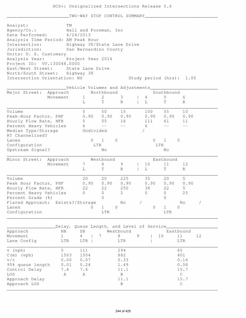
HCS+: Unsignalized Intersections Release 5.6 _______________________TWO-WAY STOP CONTROL SUMMARY___________________________ Analyst: TM Agency/Co.: Hall and Foreman, Inc Date Performed: 4/24/2013 Analysis Time Period: AM Peak Hour Intersection: Highway 38/State Lane Drive Jurisdiction: San Bernardino County Units: U. S. Customary Analysis Year: Project Year 2014 Project ID: VV.130048.0000 East/West Street: State Lane Drive North/South Street: Highway 38 Intersection Orientation: NS Study period (hrs): 1.00 ______________________Vehicle Volumes and Adjustments_________________________ Major Street: Approach Northbound Southbound Movement 1 2 3 | 4 5 6 L T R | L T R ______________________________________________________________________________ Volume 5 50 15 100 55 10 Peak-Hour Factor, PHF 0.90 0.90 0.90 0.90 0.90 0.90 Hourly Flow Rate, HFR 5 55 16 111 61 11 Percent Heavy Vehicles 6 -- -- 6 -- -- Median Type/Storage Undivided / RT Channelized? Lanes 0 1 0 0 1 0 Configuration LTR LTR Upstream Signal? No No ______________________________________________________________________________ Minor Street: Approach Westbound Eastbound Movement 7 8 9 | 10 11 12 L T R | L T R ______________________________________________________________________________ Volume 20 20 225 35 20 5 Peak Hour Factor, PHF 0.90 0.90 0.90 0.90 0.90 0.90 Hourly Flow Rate, HFR 22 22 250 38 22 5 Percent Heavy Vehicles 0 0 2 0 0 25 Percent Grade (%) 0 0 Flared Approach: Exists?/Storage No / No / Lanes 0 1 0 0 1 0 Configuration LTR LTR ______________________________________________________________________________ __________________Delay, Queue Length, and Level of Service___________________ Approach NB SB Westbound Eastbound Movement 1 4 | 7 8 9 | 10 11 12 Lane Config LTR LTR | LTR | LTR ______________________________________________________________________________ v (vph) 5 111 294 65 C(m) (vph) 1503 1504 882 401 v/c 0.00 0.07 0.33 0.16 95% queue length 0.01 0.24 1.49 0.58 Control Delay 7.4 7.6 11.1 15.7 LOS A A B C Approach Delay 11.1 15.7 Approach LOS B C ______________________________________________________________________________
244 of 425

HCS+: Unsignalized Intersections Release 5.6 _______________________TWO-WAY STOP CONTROL SUMMARY___________________________ Analyst: TM Agency/Co.: Hall and Foreman, Inc Date Performed: 12/10/2012 Analysis Time Period: AM Peak Hour Intersection: Highway 38/State Lane Drive Jurisdiction: San Bernardino County Units: U. S. Customary Analysis Year: Year 2035 without Project Project ID: VV.130048.0000 East/West Street: State Lane Drive North/South Street: Highway 38 Intersection Orientation: NS Study period (hrs): 1.00 ______________________Vehicle Volumes and Adjustments_________________________ Major Street: Approach Northbound Southbound Movement 1 2 3 | 4 5 6 L T R | L T R ______________________________________________________________________________ Volume 5 75 5 105 80 15 Peak-Hour Factor, PHF 0.95 0.95 0.95 0.95 0.95 0.95 Hourly Flow Rate, HFR 5 78 5 110 84 15 Percent Heavy Vehicles 6 -- -- 6 -- -- Median Type/Storage Undivided / RT Channelized? Lanes 0 1 0 0 1 0 Configuration LTR LTR Upstream Signal? No No ______________________________________________________________________________ Minor Street: Approach Westbound Eastbound Movement 7 8 9 | 10 11 12 L T R | L T R ______________________________________________________________________________ Volume 15 5 280 50 5 5 Peak Hour Factor, PHF 0.95 0.95 0.95 0.95 0.95 0.95 Hourly Flow Rate, HFR 15 5 294 52 5 5 Percent Heavy Vehicles 0 0 2 0 0 25 Percent Grade (%) 0 0 Flared Approach: Exists?/Storage No / No / Lanes 0 1 0 0 1 0 Configuration LTR LTR ______________________________________________________________________________ __________________Delay, Queue Length, and Level of Service___________________ Approach NB SB Westbound Eastbound Movement 1 4 | 7 8 9 | 10 11 12 Lane Config LTR LTR | LTR | LTR ______________________________________________________________________________ v (vph) 5 110 314 62 C(m) (vph) 1469 1489 926 319 v/c 0.00 0.07 0.34 0.19 95% queue length 0.01 0.24 1.53 0.72 Control Delay 7.5 7.6 10.9 19.0 LOS A A B C Approach Delay 10.9 19.0 Approach LOS B C ______________________________________________________________________________
245 of 425

HCS+: Unsignalized Intersections Release 5.6 _______________________TWO-WAY STOP CONTROL SUMMARY___________________________ Analyst: TM Agency/Co.: Hall and Foreman, Inc Date Performed: 4/24/2013 Analysis Time Period: AM Peak Hour Intersection: Highway 38/State Lane Drive Jurisdiction: San Bernardino County Units: U. S. Customary Analysis Year: Year 2035 with Project Project ID: VV.130048.0000 East/West Street: State Lane Drive North/South Street: Highway 38 Intersection Orientation: NS Study period (hrs): 1.00 ______________________Vehicle Volumes and Adjustments_________________________ Major Street: Approach Northbound Southbound Movement 1 2 3 | 4 5 6 L T R | L T R ______________________________________________________________________________ Volume 5 70 15 130 75 15 Peak-Hour Factor, PHF 0.95 0.95 0.95 0.95 0.95 0.95 Hourly Flow Rate, HFR 5 73 15 136 78 15 Percent Heavy Vehicles 6 -- -- 6 -- -- Median Type/Storage Undivided / RT Channelized? Lanes 0 1 0 0 1 0 Configuration LTR LTR Upstream Signal? No No ______________________________________________________________________________ Minor Street: Approach Westbound Eastbound Movement 7 8 9 | 10 11 12 L T R | L T R ______________________________________________________________________________ Volume 25 20 305 50 20 5 Peak Hour Factor, PHF 0.95 0.95 0.95 0.95 0.95 0.95 Hourly Flow Rate, HFR 26 21 321 52 21 5 Percent Heavy Vehicles 0 0 2 0 0 25 Percent Grade (%) 0 0 Flared Approach: Exists?/Storage No / No / Lanes 0 1 0 0 1 0 Configuration LTR LTR ______________________________________________________________________________ __________________Delay, Queue Length, and Level of Service___________________ Approach NB SB Westbound Eastbound Movement 1 4 | 7 8 9 | 10 11 12 Lane Config LTR LTR | LTR | LTR ______________________________________________________________________________ v (vph) 5 136 368 78 C(m) (vph) 1477 1483 854 291 v/c 0.00 0.09 0.43 0.27 95% queue length 0.01 0.30 2.25 1.09 Control Delay 7.4 7.7 12.4 21.9 LOS A A B C Approach Delay 12.4 21.9 Approach LOS B C ______________________________________________________________________________
246 of 425

Tustin Office: 714.665.4500 Tel/ 714.665.4501 Fax
Santa Clarita Office: 661.284.7400 Tel/ 661.284.7401 Fax
Victorville Office: 760.524.9100 Tel/ 760.524.9101 Fax
Temecula Office: 951.294.9300 Tel/ 951.294.9301 Fax
2014
PROJECTED GROWTH: 2%
PER YEAR
EXISTING GEOMETRICS PROPOSED GEOMETRICS FUTURE GEOMETRICS
TURN MOVEMENTS
PROJECT YEAR :
SUMMARY TM
CONDITION DIAGRAMS
DATE JOB NO. SHEET OF
27-Jun-14 VV.130048.0000 2 OF 2
SUBJECT BY
E/W STREET :
:
:CONDITION
N/S STREET
PM PEAK HOUR
EXISTING + EXISTING + YEAR 2035 YEAR 2035
EXISTING BACKGROUND BACKGROUND PROJECT BACKGROUND + WITHOUT WITH
TRAFFIC TRAFFIC TRAFFIC TRIPS PROJECT PROJECT PROJECT
SCENERIO #
EB THRU 5 0 5 15 20 5 20
EB RIGHT 5 0 5 0 5 5 5
WB LEFT 5 0 5 10 15 5 15
WB THRU 5 0 5 15 20 5 20
WB RIGHT 100 0 105 30 135 145 175
HIGHWAY 38
NB LEFT 5 0 5 0 5 5 5
NB THRU 60 20 80 -5 75 105 100
NB RIGHT 10 0 10 10 20 15 25
SB LEFT 180 0 185 30 215 260 290
TOTALS 475 30 515 100 615 705 805
SB THRU 55 10 65 -5 60 90 85
SB RIGHT 30 0 30 0 30 45 45
STATE LANE DRIVE
HIGHWAY 38
STATE LANE DRIVE
EB LEFT 15 0 15 0 15 20 20
CONDITION
247 of 425

HIGHWAY 38
TURN VOLUME SUMMARY TM 27-Jun-14 VV.130048.0000 2
SOUTH LEG
LARGE 2 AXLE LARGE 3 AXLE LARGE 4(+) AXLE LARGE 2 AXLE LARGE 3 AXLE LARGE 4(+) AXLE
0
SUBJECT BY DATE JOB NO. SHEET OF
5
2
0
OF 2
E/W STREET : STATE LANE DRIVE N/S STREET :
THRU LT RT THRU LT RT THRU LT
0 0 0 0 0 0 0
RT THRU LT RT THRU LT
0 0 0
0
LT
CONDITION : PM PEAK HOUR
NORTH LEG
RT THRU
0 0 0
0
0 00 0
RT
0 0 0 0 0
0 0 0 0
00 0 0 0 0 00 0
0 0 0
0 0 1 0 0 0 0
0 0 0 0 0 00 0 0 0 0 0 0 0
LARGE 2 AXLE LARGE 3 AXLE LARGE 4(+) AXLE
0 0 0 0 0
EAST LEG WEST LEG
0 0 0 0 0 0
RT THRU LT RT THRU LT
LARGE 2 AXLE LARGE 3 AXLE LARGE 4(+) AXLE
RT THRU LT RT THRU LTRT THRU LT RT THRU LT
0 0 00 0 0 0 0 0
0 0 0 0 0 0
0 0 01 0 0 0 0 0
0 0 0 0 0 00 0 0 0 0 1
0 0 00 0 0 0 0 0
1 0 0 0 0 0
0 0 00 0 0 0 0 0
0 0 0 0 0 00 0 0 0 0 0
RT THRU LT RT THRU LT
NORTH LEG SOUTH LEG EAST LEG WEST LEG
RT THRU LT RT THRU LT
31 1 1 1 2 68 14 28 3 22 0
22 0 1 0 1 011 9 46 2 16 2
20 0 0 0 1 34 17 49 3 10 0
PERCENTAGE
TRUCK AUTO ROUNDED TRUCK
24 0 1 1 0 49 16 57 4 10 0
STATE LANE DRIVEEB LEFT 1 13 14 15
TOTAL VOLUMES TOTALS TOTALS
EB RIGHT 0 2 2 5 0
7
EB THRU 0 4 4 5 0
2
WB THRU 0 1 1 5 0
WB LEFT 0 3 3 5 0
HIGHWAY 38NB LEFT 0 2 2 5
WB RIGHT 2 97 99 100
NB RIGHT 0 12 12 10 0
0
NB THRU 0 58 58 60 0
SB THRU 0 56 56 55 0
SB LEFT 1 180 181 180 1
Irvine Office: 714.665.4500 Tel/ 714.665.4501 Fax
Santa Clarita Office: 661.284.7400 Tel/ 661.284.7401 Fax
Victorville Office: 760.241.0595 Tel/ 760.241.1937 Fax
Temecula Office: 951.294.9300 Tel/ 951.294.9301 Fax
SB RIGHT 0 32 32 30 0
248 of 425

249 of 425

250 of 425

251 of 425

252 of 425

HCS+: Unsignalized Intersections Release 5.6 _______________________TWO-WAY STOP CONTROL SUMMARY___________________________ Analyst: TM Agency/Co.: Hall and Foreman, Inc Date Performed: 12/10/2012 Analysis Time Period: PM Peak Hour Intersection: Highway 38/State Lane Drive Jurisdiction: San Bernardino County Units: U. S. Customary Analysis Year: Existing Condition Project ID: VV.130048.0000 East/West Street: State Lane Drive North/South Street: Highway 38 Intersection Orientation: NS Study period (hrs): 1.00 ______________________Vehicle Volumes and Adjustments_________________________ Major Street: Approach Northbound Southbound Movement 1 2 3 | 4 5 6 L T R | L T R ______________________________________________________________________________ Volume 5 60 10 180 55 30 Peak-Hour Factor, PHF 0.90 0.90 0.90 0.90 0.90 0.90 Hourly Flow Rate, HFR 5 66 11 200 61 33 Percent Heavy Vehicles 0 -- -- 0 -- -- Median Type/Storage Undivided / RT Channelized? Lanes 0 1 0 0 1 0 Configuration LTR LTR Upstream Signal? No No ______________________________________________________________________________ Minor Street: Approach Westbound Eastbound Movement 7 8 9 | 10 11 12 L T R | L T R ______________________________________________________________________________ Volume 5 5 100 15 5 5 Peak Hour Factor, PHF 0.90 0.90 0.90 0.90 0.90 0.90 Hourly Flow Rate, HFR 5 5 111 16 5 5 Percent Heavy Vehicles 0 0 2 7 0 0 Percent Grade (%) 0 0 Flared Approach: Exists?/Storage No / No / Lanes 0 1 0 0 1 0 Configuration LTR LTR ______________________________________________________________________________ __________________Delay, Queue Length, and Level of Service___________________ Approach NB SB Westbound Eastbound Movement 1 4 | 7 8 9 | 10 11 12 Lane Config LTR LTR | LTR | LTR ______________________________________________________________________________ v (vph) 5 200 121 26 C(m) (vph) 1513 1535 873 371 v/c 0.00 0.13 0.14 0.07 95% queue length 0.01 0.45 0.48 0.23 Control Delay 7.4 7.7 9.8 15.4 LOS A A A C Approach Delay 9.8 15.4 Approach LOS A C ______________________________________________________________________________
253 of 425

HCS+: Unsignalized Intersections Release 5.6 _______________________TWO-WAY STOP CONTROL SUMMARY___________________________ Analyst: TM Agency/Co.: Hall and Foreman, Inc Date Performed: 12/10/2012 Analysis Time Period: PM Peak Hour Intersection: Highway 38/State Lane Drive Jurisdiction: San Bernardino County Units: U. S. Customary Analysis Year: Existing plus Background Project ID: VV.130048.0000 East/West Street: State Lane Drive North/South Street: Highway 38 Intersection Orientation: NS Study period (hrs): 1.00 ______________________Vehicle Volumes and Adjustments_________________________ Major Street: Approach Northbound Southbound Movement 1 2 3 | 4 5 6 L T R | L T R ______________________________________________________________________________ Volume 5 80 10 185 65 30 Peak-Hour Factor, PHF 0.90 0.90 0.90 0.90 0.90 0.90 Hourly Flow Rate, HFR 5 88 11 205 72 33 Percent Heavy Vehicles 0 -- -- 0 -- -- Median Type/Storage Undivided / RT Channelized? Lanes 0 1 0 0 1 0 Configuration LTR LTR Upstream Signal? No No ______________________________________________________________________________ Minor Street: Approach Westbound Eastbound Movement 7 8 9 | 10 11 12 L T R | L T R ______________________________________________________________________________ Volume 5 5 105 15 5 5 Peak Hour Factor, PHF 0.90 0.90 0.90 0.90 0.90 0.90 Hourly Flow Rate, HFR 5 5 116 16 5 5 Percent Heavy Vehicles 0 0 2 7 0 0 Percent Grade (%) 0 0 Flared Approach: Exists?/Storage No / No / Lanes 0 1 0 0 1 0 Configuration LTR LTR ______________________________________________________________________________ __________________Delay, Queue Length, and Level of Service___________________ Approach NB SB Westbound Eastbound Movement 1 4 | 7 8 9 | 10 11 12 Lane Config LTR LTR | LTR | LTR ______________________________________________________________________________ v (vph) 5 205 126 26 C(m) (vph) 1499 1507 847 344 v/c 0.00 0.14 0.15 0.08 95% queue length 0.01 0.47 0.52 0.24 Control Delay 7.4 7.8 10.0- 16.3 LOS A A A C Approach Delay 10.0- 16.3 Approach LOS A C ______________________________________________________________________________
254 of 425

HCS+: Unsignalized Intersections Release 5.6 _______________________TWO-WAY STOP CONTROL SUMMARY___________________________ Analyst: TM Agency/Co.: Hall and Foreman, Inc Date Performed: 4/24/2013 Analysis Time Period: PM Peak Hour Intersection: Highway 38/State Lane Drive Jurisdiction: San Bernardino County Units: U. S. Customary Analysis Year: Project Year 2014 Project ID: VV.130048.0000 East/West Street: State Lane Drive North/South Street: Highway 38 Intersection Orientation: NS Study period (hrs): 1.00 ______________________Vehicle Volumes and Adjustments_________________________ Major Street: Approach Northbound Southbound Movement 1 2 3 | 4 5 6 L T R | L T R ______________________________________________________________________________ Volume 5 75 20 215 60 30 Peak-Hour Factor, PHF 0.90 0.90 0.90 0.90 0.90 0.90 Hourly Flow Rate, HFR 5 83 22 238 66 33 Percent Heavy Vehicles 0 -- -- 0 -- -- Median Type/Storage Undivided / RT Channelized? Lanes 0 1 0 0 1 0 Configuration LTR LTR Upstream Signal? No No ______________________________________________________________________________ Minor Street: Approach Westbound Eastbound Movement 7 8 9 | 10 11 12 L T R | L T R ______________________________________________________________________________ Volume 15 20 135 15 20 5 Peak Hour Factor, PHF 0.90 0.90 0.90 0.90 0.90 0.90 Hourly Flow Rate, HFR 16 22 150 16 22 5 Percent Heavy Vehicles 0 0 2 7 0 0 Percent Grade (%) 0 0 Flared Approach: Exists?/Storage No / No / Lanes 0 1 0 0 1 0 Configuration LTR LTR ______________________________________________________________________________ __________________Delay, Queue Length, and Level of Service___________________ Approach NB SB Westbound Eastbound Movement 1 4 | 7 8 9 | 10 11 12 Lane Config LTR LTR | LTR | LTR ______________________________________________________________________________ v (vph) 5 238 188 43 C(m) (vph) 1507 1499 674 293 v/c 0.00 0.16 0.28 0.15 95% queue length 0.01 0.57 1.16 0.51 Control Delay 7.4 7.9 12.4 19.4 LOS A A B C Approach Delay 12.4 19.4 Approach LOS B C ______________________________________________________________________________
255 of 425

HCS+: Unsignalized Intersections Release 5.6 _______________________TWO-WAY STOP CONTROL SUMMARY___________________________ Analyst: TM Agency/Co.: Hall and Foreman, Inc Date Performed: 12/10/2012 Analysis Time Period: PM Peak Hour Intersection: Highway 38/State Lane Drive Jurisdiction: San Bernardino County Units: U. S. Customary Analysis Year: Year 2035 without Project Project ID: VV.130048.0000 East/West Street: State Lane Drive North/South Street: Highway 38 Intersection Orientation: NS Study period (hrs): 1.00 ______________________Vehicle Volumes and Adjustments_________________________ Major Street: Approach Northbound Southbound Movement 1 2 3 | 4 5 6 L T R | L T R ______________________________________________________________________________ Volume 5 105 15 260 90 45 Peak-Hour Factor, PHF 0.95 0.95 0.95 0.95 0.95 0.95 Hourly Flow Rate, HFR 5 110 15 273 94 47 Percent Heavy Vehicles 0 -- -- 0 -- -- Median Type/Storage Undivided / RT Channelized? Lanes 0 1 0 0 1 0 Configuration LTR LTR Upstream Signal? No No ______________________________________________________________________________ Minor Street: Approach Westbound Eastbound Movement 7 8 9 | 10 11 12 L T R | L T R ______________________________________________________________________________ Volume 5 5 145 20 5 5 Peak Hour Factor, PHF 0.95 0.95 0.95 0.95 0.95 0.95 Hourly Flow Rate, HFR 5 5 152 21 5 5 Percent Heavy Vehicles 0 0 2 7 0 0 Percent Grade (%) 0 0 Flared Approach: Exists?/Storage No / No / Lanes 0 1 0 0 1 0 Configuration LTR LTR ______________________________________________________________________________ __________________Delay, Queue Length, and Level of Service___________________ Approach NB SB Westbound Eastbound Movement 1 4 | 7 8 9 | 10 11 12 Lane Config LTR LTR | LTR | LTR ______________________________________________________________________________ v (vph) 5 273 162 31 C(m) (vph) 1455 1474 800 224 v/c 0.00 0.19 0.20 0.14 95% queue length 0.01 0.68 0.76 0.48 Control Delay 7.5 8.0 10.6 23.6 LOS A A B C Approach Delay 10.6 23.6 Approach LOS B C ______________________________________________________________________________
256 of 425

HCS+: Unsignalized Intersections Release 5.6 _______________________TWO-WAY STOP CONTROL SUMMARY___________________________ Analyst: TM Agency/Co.: Hall and Foreman, Inc Date Performed: 4/24/2013 Analysis Time Period: PM Peak Hour Intersection: Highway 38/State Lane Drive Jurisdiction: San Bernardino County Units: U. S. Customary Analysis Year: Year 2035 with Project Project ID: VV.130048.0000 East/West Street: State Lane Drive North/South Street: Highway 38 Intersection Orientation: NS Study period (hrs): 1.00 ______________________Vehicle Volumes and Adjustments_________________________ Major Street: Approach Northbound Southbound Movement 1 2 3 | 4 5 6 L T R | L T R ______________________________________________________________________________ Volume 5 100 25 290 85 45 Peak-Hour Factor, PHF 0.95 0.95 0.95 0.95 0.95 0.95 Hourly Flow Rate, HFR 5 105 26 305 89 47 Percent Heavy Vehicles 0 -- -- 0 -- -- Median Type/Storage Undivided / RT Channelized? Lanes 0 1 0 0 1 0 Configuration LTR LTR Upstream Signal? No No ______________________________________________________________________________ Minor Street: Approach Westbound Eastbound Movement 7 8 9 | 10 11 12 L T R | L T R ______________________________________________________________________________ Volume 15 20 175 20 20 5 Peak Hour Factor, PHF 0.95 0.95 0.95 0.95 0.95 0.95 Hourly Flow Rate, HFR 15 21 184 21 21 5 Percent Heavy Vehicles 0 0 2 7 0 0 Percent Grade (%) 0 0 Flared Approach: Exists?/Storage No / No / Lanes 0 1 0 0 1 0 Configuration LTR LTR ______________________________________________________________________________ __________________Delay, Queue Length, and Level of Service___________________ Approach NB SB Westbound Eastbound Movement 1 4 | 7 8 9 | 10 11 12 Lane Config LTR LTR | LTR | LTR ______________________________________________________________________________ v (vph) 5 305 220 47 C(m) (vph) 1461 1467 609 193 v/c 0.00 0.21 0.36 0.24 95% queue length 0.01 0.79 1.68 0.95 Control Delay 7.5 8.1 14.2 29.6 LOS A A B D Approach Delay 14.2 29.6 Approach LOS B D ______________________________________________________________________________
257 of 425
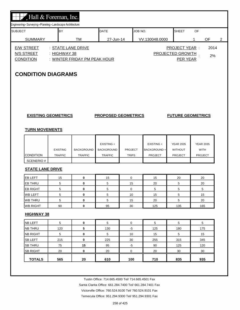
SUBJECT BY DATE JOB NO. SHEET OF
OF 2
E/W STREET :
SUMMARY TM 27-Jun-14 VV.130048.0000 1
CONDITION :: 2%
WINTER FRIDAY PM PEAK HOUR PER YEAR
N/S STREET :
TURN MOVEMENTS
CONDITION DIAGRAMS
EXISTING GEOMETRICS PROPOSED GEOMETRICS FUTURE GEOMETRICS
EXISTING + EXISTING + YEAR 2035 YEAR 2035
EXISTING BACKGROUND BACKGROUND PROJECT BACKGROUND + WITHOUT WITH
STATE LANE DRIVE
EB LEFT 15 0 15 0
PROJECT PROJECT
SCENERIO #
CONDITION TRAFFIC TRAFFIC TRAFFIC TRIPS PROJECT
15 20 20
EB THRU 5 0 5 15 20 5 20
EB RIGHT 5 0 5 0 5 5 5
5 15
WB THRU 5 0 5 15 20 5
WB LEFT 5 0 5 10 15
HIGHWAY 38
NB LEFT 5 0 5 0
20
WB RIGHT 90 0 95 30 125 135 165
5 5 5
NB THRU 120 5 130 -5 125 180 175
NB RIGHT 5 0 5 10 15 5 15
0 20
315 345
SB THRU 75 15 95 -5 90 125 120
SB LEFT 215 0 225 30 255
Tustin Office: 714.665.4500 Tel/ 714.665.4501 Fax
Santa Clarita Office: 661.284.7400 Tel/ 661.284.7401 Fax
Victorville Office: 760.524.9100 Tel/ 760.524.9101 Fax
Temecula Office: 951.294.9300 Tel/ 951.294.9301 Fax
STATE LANE DRIVE PROJECT YEAR : 2014
HIGHWAY 38 PROJECTED GROWTH
30 30
TOTALS 565 20 610 100 710 835 935
SB RIGHT 20 0 20
258 of 425

SUBJECT BY DATE JOB NO. SHEET OF
December 13, 2013HIGHWAY 38
WINTER FRIDAY PM PEAK HOURSTATE LANE DRIVE
OF 2TURN VOLUME SUMMARY TM 27-Jun-14 VV.130048.0000 2
E/W STREET : N/S STREET :
STATE LANE DRIVETOTAL VOLUMES TOTALS TOTALS
0 20 20
EB LEFT 0 0 16 15
HIGHWAY 38WB RIGHT 0 0 92 90
NB THRU 2 0 122
PERCENTAGE
TRUCK AUTO ROUNDED TRUCK
0 0 0 0 0 00 0 0 0 0 0
0 0 0 0 0 00 0 0 0 0 0
0 0 0 0 0 000 0 0 0 0
RT THRU LT RT THRU LT
EAST LEG WEST LEG
0 0 0 0 0 0
0 0 0 0 0 00 0 0 0 0 0
0 0 0
0 0 00 0 0
0 0 0
NORTH LEG SOUTH LEG
RT THRU LT RT THRU LT
0 0 0 0 0 0
0 0 0 0 0 0
0 0 0 0 0 0
0 0 0 0 0 00 0 0 0 0 0
0 0 0 0 0 0
0 0 0 0 0 0
LT RT THRU LT
0 0 00 0 0 1 0 0 0 0 0
RT
LARGE 3 AXLE LARGE 4(+) AXLE
1 0 0 1 0
THRU LT RT THRU LT
LARGE 2 AXLE LARGE 3 AXLE LARGE 4(+) AXLE
RT THRU LT RT THRU LTRT THRU
0 0 0
LARGE 2 AXLE
EAST LEG WEST LEG
0 0 0 0 0 00 0 0 0 1 0 0
1 00 02
0 0 0 0 0
0 0 00 0 0 0
RT
1 0
CONDITION :
NORTH LEG
2 0 0
0 0
0 0
THRU
0 0 0
LTLT RT THRU LT
0 0 0
RT THRULT RT THRU
0 00 00 0
00
0
EB THRU 0 0 2 5 0
WB LEFT 0 0 7 5 0
EB RIGHT 1 0 1 5 100
0
WB THRU 0 0 3 5 0
NB LEFT 0 0 7 5 0
SB RIGHT 1
1 0 6 5 17NB RIGHT
5
Irvine Office: 714.665.4500 Tel/ 714.665.4501 Fax
Santa Clarita Office: 661.284.7400 Tel/ 661.284.7401 Fax
THRU LT RT THRU
0 0 0 0 0 0 0
RT
1
LT
120 2
SB LEFT 2 0 214 215 1
Temecula Office: 951.294.9300 Tel/ 951.294.9301 Fax
SOUTH LEG
LARGE 2 AXLE LARGE 3 AXLE LARGE 4(+) AXLE LARGE 2 AXLE LARGE 3 AXLE LARGE 4(+) AXLE
COUNT DATE :
Victorville Office: 760.241.0595 Tel/ 760.241.1937 Fax
0 0 0
SB THRU 4 0 73 75 5
259 of 425

260 of 425

261 of 425

262 of 425

263 of 425

HCS+: Unsignalized Intersections Release 5.6 _______________________TWO-WAY STOP CONTROL SUMMARY___________________________ Analyst: TM Agency/Co.: Hall and Foreman, Inc Date Performed: 1/7/2014 Analysis Time Period: Friday Peak Hour Intersection: Highway 38/State Lane Drive Jurisdiction: San Bernardino County Units: U. S. Customary Analysis Year: Existing Conditions Project ID: VV.130048.0000 East/West Street: State Lane Drive North/South Street: Highway 38 Intersection Orientation: NS Study period (hrs): 1.00 ______________________Vehicle Volumes and Adjustments_________________________ Major Street: Approach Northbound Southbound Movement 1 2 3 | 4 5 6 L T R | L T R ______________________________________________________________________________ Volume 5 120 5 215 75 20 Peak-Hour Factor, PHF 0.93 0.93 0.93 0.93 0.93 0.93 Hourly Flow Rate, HFR 5 129 5 231 80 21 Percent Heavy Vehicles 5 -- -- 5 -- -- Median Type/Storage Undivided / RT Channelized? Lanes 0 1 0 0 1 0 Configuration LTR LTR Upstream Signal? No No ______________________________________________________________________________ Minor Street: Approach Westbound Eastbound Movement 7 8 9 | 10 11 12 L T R | L T R ______________________________________________________________________________ Volume 5 5 90 15 5 5 Peak Hour Factor, PHF 0.93 0.93 0.93 0.93 0.93 0.93 Hourly Flow Rate, HFR 5 5 96 16 5 5 Percent Heavy Vehicles 5 5 5 5 5 5 Percent Grade (%) 0 0 Flared Approach: Exists?/Storage No / No / Lanes 0 1 0 0 1 0 Configuration LTR LTR ______________________________________________________________________________ __________________Delay, Queue Length, and Level of Service___________________ Approach NB SB Westbound Eastbound Movement 1 4 | 7 8 9 | 10 11 12 Lane Config LTR LTR | LTR | LTR ______________________________________________________________________________ v (vph) 5 231 106 26 C(m) (vph) 1473 1432 761 303 v/c 0.00 0.16 0.14 0.09 95% queue length 0.01 0.58 0.48 0.28 Control Delay 7.5 8.0 10.5 18.0 LOS A A B C Approach Delay 10.5 18.0 Approach LOS B C ______________________________________________________________________________
264 of 425

HCS+: Unsignalized Intersections Release 5.6 _______________________TWO-WAY STOP CONTROL SUMMARY___________________________ Analyst: TM Agency/Co.: Hall and Foreman, Inc Date Performed: 1/7/2014 Analysis Time Period: Friday Peak Hour Intersection: Highway 38/State Lane Drive Jurisdiction: San Bernardino County Units: U. S. Customary Analysis Year: Existing plus Background Project ID: VV.130048.0000 East/West Street: State Lane Drive North/South Street: Highway 38 Intersection Orientation: NS Study period (hrs): 1.00 ______________________Vehicle Volumes and Adjustments_________________________ Major Street: Approach Northbound Southbound Movement 1 2 3 | 4 5 6 L T R | L T R ______________________________________________________________________________ Volume 5 130 5 225 95 20 Peak-Hour Factor, PHF 0.93 0.93 0.93 0.93 0.93 0.93 Hourly Flow Rate, HFR 5 139 5 241 102 21 Percent Heavy Vehicles 5 -- -- 5 -- -- Median Type/Storage Undivided / RT Channelized? Lanes 0 1 0 0 1 0 Configuration LTR LTR Upstream Signal? No No ______________________________________________________________________________ Minor Street: Approach Westbound Eastbound Movement 7 8 9 | 10 11 12 L T R | L T R ______________________________________________________________________________ Volume 5 5 95 15 5 5 Peak Hour Factor, PHF 0.93 0.93 0.93 0.93 0.93 0.93 Hourly Flow Rate, HFR 5 5 102 16 5 5 Percent Heavy Vehicles 5 5 5 5 5 5 Percent Grade (%) 0 0 Flared Approach: Exists?/Storage No / No / Lanes 0 1 0 0 1 0 Configuration LTR LTR ______________________________________________________________________________ __________________Delay, Queue Length, and Level of Service___________________ Approach NB SB Westbound Eastbound Movement 1 4 | 7 8 9 | 10 11 12 Lane Config LTR LTR | LTR | LTR ______________________________________________________________________________ v (vph) 5 241 112 26 C(m) (vph) 1446 1420 745 274 v/c 0.00 0.17 0.15 0.09 95% queue length 0.01 0.61 0.53 0.31 Control Delay 7.5 8.1 10.7 19.5 LOS A A B C Approach Delay 10.7 19.5 Approach LOS B C ______________________________________________________________________________
265 of 425

HCS+: Unsignalized Intersections Release 5.6 _______________________TWO-WAY STOP CONTROL SUMMARY___________________________ Analyst: TM Agency/Co.: Hall and Foreman, Inc Date Performed: 1/7/2014 Analysis Time Period: Friday Peak Hour Intersection: Highway 38/State Lane Drive Jurisdiction: San Bernardino County Units: U. S. Customary Analysis Year: Project Year 2014 Project ID: VV.130048.0000 East/West Street: State Lane Drive North/South Street: Highway 38 Intersection Orientation: NS Study period (hrs): 1.00 ______________________Vehicle Volumes and Adjustments_________________________ Major Street: Approach Northbound Southbound Movement 1 2 3 | 4 5 6 L T R | L T R ______________________________________________________________________________ Volume 5 125 15 250 90 20 Peak-Hour Factor, PHF 0.90 0.90 0.90 0.90 0.90 0.90 Hourly Flow Rate, HFR 5 138 16 277 100 22 Percent Heavy Vehicles 5 -- -- 5 -- -- Median Type/Storage Undivided / RT Channelized? Lanes 0 1 0 0 1 0 Configuration LTR LTR Upstream Signal? No No ______________________________________________________________________________ Minor Street: Approach Westbound Eastbound Movement 7 8 9 | 10 11 12 L T R | L T R ______________________________________________________________________________ Volume 15 20 120 15 20 5 Peak Hour Factor, PHF 0.90 0.90 0.90 0.90 0.90 0.90 Hourly Flow Rate, HFR 16 22 133 16 22 5 Percent Heavy Vehicles 5 5 5 5 5 5 Percent Grade (%) 0 0 Flared Approach: Exists?/Storage No / No / Lanes 0 1 0 0 1 0 Configuration LTR LTR ______________________________________________________________________________ __________________Delay, Queue Length, and Level of Service___________________ Approach NB SB Westbound Eastbound Movement 1 4 | 7 8 9 | 10 11 12 Lane Config LTR LTR | LTR | LTR ______________________________________________________________________________ v (vph) 5 277 171 43 C(m) (vph) 1447 1408 543 224 v/c 0.00 0.20 0.31 0.19 95% queue length 0.01 0.73 1.37 0.71 Control Delay 7.5 8.2 14.7 24.9 LOS A A B C Approach Delay 14.7 24.9 Approach LOS B C ______________________________________________________________________________
266 of 425

HCS+: Unsignalized Intersections Release 5.6 _______________________TWO-WAY STOP CONTROL SUMMARY___________________________ Analyst: TM Agency/Co.: Hall and Foreman, Inc Date Performed: 1/7/2014 Analysis Time Period: Friday Peak Hour Intersection: Highway 38/State Lane Drive Jurisdiction: San Bernardino County Units: U. S. Customary Analysis Year: Year 2035 without Project Project ID: VV.130048.0000 East/West Street: State Lane Drive North/South Street: Highway 38 Intersection Orientation: NS Study period (hrs): 1.00 ______________________Vehicle Volumes and Adjustments_________________________ Major Street: Approach Northbound Southbound Movement 1 2 3 | 4 5 6 L T R | L T R ______________________________________________________________________________ Volume 5 180 5 315 125 30 Peak-Hour Factor, PHF 0.95 0.95 0.95 0.95 0.95 0.95 Hourly Flow Rate, HFR 5 189 5 331 131 31 Percent Heavy Vehicles 5 -- -- 5 -- -- Median Type/Storage Undivided / RT Channelized? Lanes 0 1 0 0 1 0 Configuration LTR LTR Upstream Signal? No No ______________________________________________________________________________ Minor Street: Approach Westbound Eastbound Movement 7 8 9 | 10 11 12 L T R | L T R ______________________________________________________________________________ Volume 5 5 135 20 5 5 Peak Hour Factor, PHF 0.95 0.95 0.95 0.95 0.95 0.95 Hourly Flow Rate, HFR 5 5 142 21 5 5 Percent Heavy Vehicles 5 5 5 5 5 5 Percent Grade (%) 0 0 Flared Approach: Exists?/Storage No / No / Lanes 0 1 0 0 1 0 Configuration LTR LTR ______________________________________________________________________________ __________________Delay, Queue Length, and Level of Service___________________ Approach NB SB Westbound Eastbound Movement 1 4 | 7 8 9 | 10 11 12 Lane Config LTR LTR | LTR | LTR ______________________________________________________________________________ v (vph) 5 331 152 31 C(m) (vph) 1399 1361 665 151 v/c 0.00 0.24 0.23 0.21 95% queue length 0.01 0.96 0.89 0.77 Control Delay 7.6 8.5 12.0 35.0- LOS A A B D Approach Delay 12.0 35.0- Approach LOS B D ______________________________________________________________________________
267 of 425

HCS+: Unsignalized Intersections Release 5.6 _______________________TWO-WAY STOP CONTROL SUMMARY___________________________ Analyst: TM Agency/Co.: Hall and Foreman, Inc Date Performed: 1/7/2014 Analysis Time Period: Friday Peak Hour Intersection: Highway 38/State Lane Drive Jurisdiction: San Bernardino County Units: U. S. Customary Analysis Year: Year 2035 with Project Project ID: VV.130048.0000 East/West Street: State Lane Drive North/South Street: Highway 38 Intersection Orientation: NS Study period (hrs): 1.00 ______________________Vehicle Volumes and Adjustments_________________________ Major Street: Approach Northbound Southbound Movement 1 2 3 | 4 5 6 L T R | L T R ______________________________________________________________________________ Volume 5 175 15 340 120 30 Peak-Hour Factor, PHF 0.95 0.95 0.95 0.95 0.95 0.95 Hourly Flow Rate, HFR 5 184 15 357 126 31 Percent Heavy Vehicles 5 -- -- 5 -- -- Median Type/Storage Undivided / RT Channelized? Lanes 0 1 0 0 1 0 Configuration LTR LTR Upstream Signal? No No ______________________________________________________________________________ Minor Street: Approach Westbound Eastbound Movement 7 8 9 | 10 11 12 L T R | L T R ______________________________________________________________________________ Volume 15 20 160 20 20 5 Peak Hour Factor, PHF 0.95 0.95 0.95 0.95 0.95 0.95 Hourly Flow Rate, HFR 15 21 168 21 21 5 Percent Heavy Vehicles 5 5 5 5 5 5 Percent Grade (%) 0 0 Flared Approach: Exists?/Storage No / No / Lanes 0 1 0 0 1 0 Configuration LTR LTR ______________________________________________________________________________ __________________Delay, Queue Length, and Level of Service___________________ Approach NB SB Westbound Eastbound Movement 1 4 | 7 8 9 | 10 11 12 Lane Config LTR LTR | LTR | LTR ______________________________________________________________________________ v (vph) 5 357 204 47 C(m) (vph) 1405 1356 456 131 v/c 0.00 0.26 0.45 0.36 95% queue length 0.01 1.07 2.38 1.62 Control Delay 7.6 8.6 19.2 47.7 LOS A A C E Approach Delay 19.2 47.7 Approach LOS C E ______________________________________________________________________________
268 of 425

SUBJECT BY DATE JOB NO. SHEET OF
OF 2
E/W STREET : PROJECT YEAR : 2014
SUMMARY TM 27-Jun-14 VV.130048.0000 2
CONDITION : PER YEAR
N/S STREET : PROJECTED GROWTH: 2%
TURN MOVEMENTS
CONDITION DIAGRAMS
EXISTING GEOMETRICS PROPOSED GEOMETRICS FUTURE GEOMETRICS
EXISTING + EXISTING + YEAR 2035 YEAR 2035
EXISTING BACKGROUND BACKGROUND PROJECT BACKGROUND + WITHOUT WITH
STATE LANE DRIVE
EB LEFT 10 0 10 0
PROJECT PROJECT
SCENERIO #
CONDITION TRAFFIC TRAFFIC TRAFFIC TRIPS PROJECT
10 15 15
EB THRU 5 0 5 15 20 5 20
EB RIGHT 5 0 5 0 5 5 5
WB THRU 5 0 5 15 20 5 20
140 170
WB LEFT 10 0 10 10 20 15 25
HIGHWAY 38
NB LEFT 5 0 5 0 5 5
WB RIGHT 95 0 100 30 130
5
NB THRU 70 20 95 -5 90 125 120
NB RIGHT 10 0 10 10 20 15 25
240
SB THRU 170 10 185 -5 180 255 250
SB LEFT 145 0 150 30 180
Tustin Office: 714.665.4500 Tel/ 714.665.4501 Fax
Santa Clarita Office: 661.284.7400 Tel/ 661.284.7401 Fax
Victorville Office: 760.524.9100 Tel/ 760.524.9101 Fax
Temecula Office: 951.294.9300 Tel/ 951.294.9301 Fax
STATE LANE DRIVE
HIGHWAY 38
WINTER SUNDAY PM PEAK HOUR
20 20
TOTALS 545 30 595 100 695 815 915
SB RIGHT 15 0 15 0 15
210
269 of 425
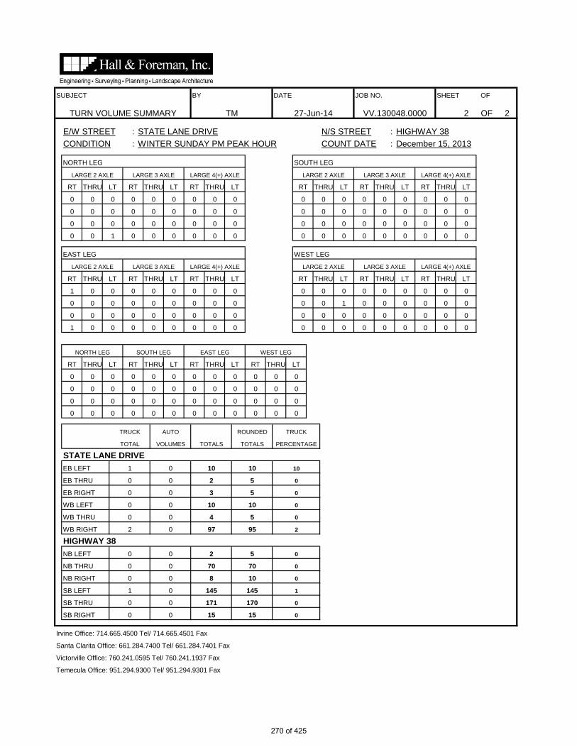
SUBJECT BY DATE JOB NO. SHEET OF
STATE LANE DRIVE N/S STREET : HIGHWAY 38COUNT DATE : December 15, 2013
OF 2TURN VOLUME SUMMARY TM 27-Jun-14 VV.130048.0000 2
STATE LANE DRIVETOTAL VOLUMES TOTALS TOTALS
0 15 15
EB LEFT 1 0 10 10
NB LEFT 0 0 2 5
SB RIGHT 0
PERCENTAGE
TRUCK AUTO ROUNDED TRUCK
0 0 0 0 0 00 0 0 0 0 0
0 0 0 0 0 00 0 0 0 0 0
0 0 0 0 0 000 0 0 0 0
RT THRU LT RT THRU LT
EAST LEG WEST LEG
0 0 0 0 0 0
0 0 0 0 0 00 0 0 0 0 0
0 0 0
0 0 00 0 0
0 0 0
NORTH LEG SOUTH LEG
RT THRU LT RT THRU LT
0 0 0 0 0 0
0 0 0 0 0 0
1 0 0 0 0 0
0 0 0 0 0 10 0 0 0 0 0
1 0 0 0 0 0
0 0 0 0 0 0
LT RT THRU LT
0 0 00 0 0 0 0 0 0 0 0
RT
LARGE 3 AXLE LARGE 4(+) AXLE
0 0 0 0 0
THRU LT RT THRU LT
LARGE 2 AXLE LARGE 3 AXLE LARGE 4(+) AXLE
RT THRU LT RT THRU LTRT THRU
0 0 0
LARGE 2 AXLE
EAST LEG WEST LEG
0 0 0 0 0 00 0 1 0 0 0 0
0 00 00
0 0 0
0 0 00 0 0 0
RT
0 0
CONDITION :
NORTH LEG
0 0 0
0 0
0 0
WINTER SUNDAY PM PEAK HOUR
0 0 0
LTLT RT THRU LT
0 0 0
RT THRU
0
0 00 00 0
00 0 0
10
EB THRU 0 0 2 5 0
WB LEFT 0 0 10 10 0
EB RIGHT 0 0 3 5 0
2
HIGHWAY 38WB RIGHT 2 0 97 95
WB THRU 0 0 4 5 0
0
NB THRU 0 0 70 70 0
145 1
NB RIGHT 0 0 8 10 0
0
E/W STREET :
THRU LT RT
Irvine Office: 714.665.4500 Tel/ 714.665.4501 Fax
Santa Clarita Office: 661.284.7400 Tel/ 661.284.7401 Fax
Victorville Office: 760.241.0595 Tel/ 760.241.1937 Fax
THRU LT RT THRU
0 0 0 0 0 0 0
RT
0
LT
0
Temecula Office: 951.294.9300 Tel/ 951.294.9301 Fax
SOUTH LEG
LARGE 2 AXLE LARGE 3 AXLE LARGE 4(+) AXLE LARGE 2 AXLE LARGE 3 AXLE LARGE 4(+) AXLE
THRU
0
SB THRU 0 0 171 170 0
SB LEFT 1 0 145
270 of 425

271 of 425

272 of 425
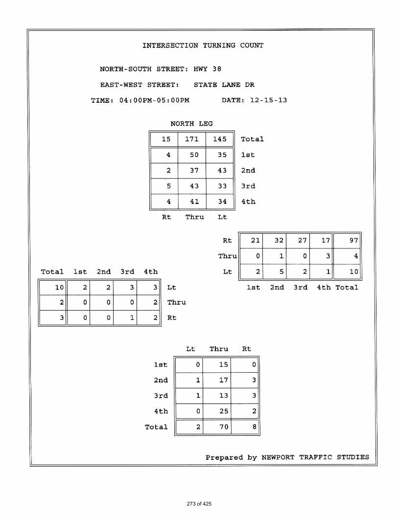
273 of 425

274 of 425

HCS+: Unsignalized Intersections Release 5.6 _______________________TWO-WAY STOP CONTROL SUMMARY___________________________ Analyst: TM Agency/Co.: Hall and Foreman, Inc Date Performed: 1/7/2014 Analysis Time Period: Sunday Peak Hour Intersection: Highway 38/State Lane Drive Jurisdiction: San Bernardino County Units: U. S. Customary Analysis Year: Existing Condition Project ID: VV.130048.0000 East/West Street: State Lane Drive North/South Street: Highway 38 Intersection Orientation: NS Study period (hrs): 1.00 ______________________Vehicle Volumes and Adjustments_________________________ Major Street: Approach Northbound Southbound Movement 1 2 3 | 4 5 6 L T R | L T R ______________________________________________________________________________ Volume 5 70 10 145 170 15 Peak-Hour Factor, PHF 0.94 0.94 0.94 0.94 0.94 0.94 Hourly Flow Rate, HFR 5 74 10 154 180 15 Percent Heavy Vehicles 5 -- -- 5 -- -- Median Type/Storage Undivided / RT Channelized? Lanes 0 1 0 0 1 0 Configuration LTR LTR Upstream Signal? No No ______________________________________________________________________________ Minor Street: Approach Westbound Eastbound Movement 7 8 9 | 10 11 12 L T R | L T R ______________________________________________________________________________ Volume 10 5 95 10 5 5 Peak Hour Factor, PHF 0.94 0.94 0.94 0.94 0.94 0.94 Hourly Flow Rate, HFR 10 5 101 10 5 5 Percent Heavy Vehicles 5 5 5 5 5 5 Percent Grade (%) 0 0 Flared Approach: Exists?/Storage No / No / Lanes 0 1 0 0 1 0 Configuration LTR LTR ______________________________________________________________________________ __________________Delay, Queue Length, and Level of Service___________________ Approach NB SB Westbound Eastbound Movement 1 4 | 7 8 9 | 10 11 12 Lane Config LTR LTR | LTR | LTR ______________________________________________________________________________ v (vph) 5 154 116 20 C(m) (vph) 1360 1494 803 386 v/c 0.00 0.10 0.14 0.05 95% queue length 0.01 0.34 0.51 0.16 Control Delay 7.7 7.7 10.2 14.8 LOS A A B B Approach Delay 10.2 14.8 Approach LOS B B ______________________________________________________________________________
275 of 425

HCS+: Unsignalized Intersections Release 5.6 _______________________TWO-WAY STOP CONTROL SUMMARY___________________________ Analyst: TM Agency/Co.: Hall and Foreman, Inc Date Performed: 1/7/2014 Analysis Time Period: Sunday Peak Hour Intersection: Highway 38/State Lane Drive Jurisdiction: San Bernardino County Units: U. S. Customary Analysis Year: Existing plus Background Project ID: VV.130048.0000 East/West Street: State Lane Drive North/South Street: Highway 38 Intersection Orientation: NS Study period (hrs): 1.00 ______________________Vehicle Volumes and Adjustments_________________________ Major Street: Approach Northbound Southbound Movement 1 2 3 | 4 5 6 L T R | L T R ______________________________________________________________________________ Volume 5 95 10 150 185 15 Peak-Hour Factor, PHF 0.94 0.94 0.94 0.94 0.94 0.94 Hourly Flow Rate, HFR 5 101 10 159 196 15 Percent Heavy Vehicles 5 -- -- 0 -- -- Median Type/Storage Undivided / RT Channelized? Lanes 0 1 0 0 1 0 Configuration LTR LTR Upstream Signal? No No ______________________________________________________________________________ Minor Street: Approach Westbound Eastbound Movement 7 8 9 | 10 11 12 L T R | L T R ______________________________________________________________________________ Volume 10 5 100 10 5 5 Peak Hour Factor, PHF 0.94 0.94 0.94 0.94 0.94 0.94 Hourly Flow Rate, HFR 10 5 106 10 5 5 Percent Heavy Vehicles 5 5 5 5 5 5 Percent Grade (%) 0 0 Flared Approach: Exists?/Storage No / No / Lanes 0 1 0 0 1 0 Configuration LTR LTR ______________________________________________________________________________ __________________Delay, Queue Length, and Level of Service___________________ Approach NB SB Westbound Eastbound Movement 1 4 | 7 8 9 | 10 11 12 Lane Config LTR LTR | LTR | LTR ______________________________________________________________________________ v (vph) 5 159 121 20 C(m) (vph) 1342 1492 771 354 v/c 0.00 0.11 0.16 0.06 95% queue length 0.01 0.36 0.56 0.18 Control Delay 7.7 7.7 10.5 15.8 LOS A A B C Approach Delay 10.5 15.8 Approach LOS B C ______________________________________________________________________________
276 of 425

HCS+: Unsignalized Intersections Release 5.6 _______________________TWO-WAY STOP CONTROL SUMMARY___________________________ Analyst: TM Agency/Co.: Hall and Foreman, Inc Date Performed: 1/7/2014 Analysis Time Period: Sunday Peak Hour Intersection: Highway 38/State Lane Drive Jurisdiction: San Bernardino County Units: U. S. Customary Analysis Year: Project Year 2014 Project ID: VV.130048.0000 East/West Street: State Lane Drive North/South Street: Highway 38 Intersection Orientation: NS Study period (hrs): 1.00 ______________________Vehicle Volumes and Adjustments_________________________ Major Street: Approach Northbound Southbound Movement 1 2 3 | 4 5 6 L T R | L T R ______________________________________________________________________________ Volume 5 90 20 180 180 15 Peak-Hour Factor, PHF 0.90 0.90 0.90 0.90 0.90 0.90 Hourly Flow Rate, HFR 5 100 22 200 200 16 Percent Heavy Vehicles 5 -- -- 5 -- -- Median Type/Storage Undivided / RT Channelized? Lanes 0 1 0 0 1 0 Configuration LTR LTR Upstream Signal? No No ______________________________________________________________________________ Minor Street: Approach Westbound Eastbound Movement 7 8 9 | 10 11 12 L T R | L T R ______________________________________________________________________________ Volume 20 20 130 10 20 5 Peak Hour Factor, PHF 0.90 0.90 0.90 0.90 0.90 0.90 Hourly Flow Rate, HFR 22 22 144 11 22 5 Percent Heavy Vehicles 5 5 5 5 5 5 Percent Grade (%) 0 0 Flared Approach: Exists?/Storage No / No / Lanes 0 1 0 0 1 0 Configuration LTR LTR ______________________________________________________________________________ __________________Delay, Queue Length, and Level of Service___________________ Approach NB SB Westbound Eastbound Movement 1 4 | 7 8 9 | 10 11 12 Lane Config LTR LTR | LTR | LTR ______________________________________________________________________________ v (vph) 5 200 188 38 C(m) (vph) 1336 1447 601 278 v/c 0.00 0.14 0.31 0.14 95% queue length 0.01 0.48 1.36 0.47 Control Delay 7.7 7.9 13.7 20.0 LOS A A B C Approach Delay 13.7 20.0 Approach LOS B C ______________________________________________________________________________
277 of 425

HCS+: Unsignalized Intersections Release 5.6 _______________________TWO-WAY STOP CONTROL SUMMARY___________________________ Analyst: TM Agency/Co.: Hall and Foreman, Inc Date Performed: 1/7/2014 Analysis Time Period: Sunday Peak Hour Intersection: Highway 38/State Lane Drive Jurisdiction: San Bernardino County Units: U. S. Customary Analysis Year: Year 2035 without Project Project ID: VV.130048.0000 East/West Street: State Lane Drive North/South Street: Highway 38 Intersection Orientation: NS Study period (hrs): 1.00 ______________________Vehicle Volumes and Adjustments_________________________ Major Street: Approach Northbound Southbound Movement 1 2 3 | 4 5 6 L T R | L T R ______________________________________________________________________________ Volume 5 125 15 210 255 20 Peak-Hour Factor, PHF 0.95 0.95 0.95 0.95 0.95 0.95 Hourly Flow Rate, HFR 5 131 15 221 268 21 Percent Heavy Vehicles 5 -- -- 5 -- -- Median Type/Storage Undivided / RT Channelized? Lanes 0 1 0 0 1 0 Configuration LTR LTR Upstream Signal? No No ______________________________________________________________________________ Minor Street: Approach Westbound Eastbound Movement 7 8 9 | 10 11 12 L T R | L T R ______________________________________________________________________________ Volume 15 5 140 15 5 5 Peak Hour Factor, PHF 0.95 0.95 0.95 0.95 0.95 0.95 Hourly Flow Rate, HFR 15 5 147 15 5 5 Percent Heavy Vehicles 5 5 5 5 5 5 Percent Grade (%) 0 0 Flared Approach: Exists?/Storage No / No / Lanes 0 1 0 0 1 0 Configuration LTR LTR ______________________________________________________________________________ __________________Delay, Queue Length, and Level of Service___________________ Approach NB SB Westbound Eastbound Movement 1 4 | 7 8 9 | 10 11 12 Lane Config LTR LTR | LTR | LTR ______________________________________________________________________________ v (vph) 5 221 167 25 C(m) (vph) 1256 1418 663 212 v/c 0.00 0.16 0.25 0.12 95% queue length 0.01 0.55 1.01 0.40 Control Delay 7.9 8.0 12.3 24.2 LOS A A B C Approach Delay 12.3 24.2 Approach LOS B C ______________________________________________________________________________
278 of 425

HCS+: Unsignalized Intersections Release 5.6 _______________________TWO-WAY STOP CONTROL SUMMARY___________________________ Analyst: TM Agency/Co.: Hall and Foreman, Inc Date Performed: 1/7/2014 Analysis Time Period: Sunday Peak Hour Intersection: Highway 38/State Lane Drive Jurisdiction: San Bernardino County Units: U. S. Customary Analysis Year: Year 2035 with Project Project ID: VV.130048.0000 East/West Street: State Lane Drive North/South Street: Highway 38 Intersection Orientation: NS Study period (hrs): 1.00 ______________________Vehicle Volumes and Adjustments_________________________ Major Street: Approach Northbound Southbound Movement 1 2 3 | 4 5 6 L T R | L T R ______________________________________________________________________________ Volume 5 120 25 240 250 20 Peak-Hour Factor, PHF 0.95 0.95 0.95 0.95 0.95 0.95 Hourly Flow Rate, HFR 5 126 26 252 263 21 Percent Heavy Vehicles 5 -- -- 5 -- -- Median Type/Storage Undivided / RT Channelized? Lanes 0 1 0 0 1 0 Configuration LTR LTR Upstream Signal? No No ______________________________________________________________________________ Minor Street: Approach Westbound Eastbound Movement 7 8 9 | 10 11 12 L T R | L T R ______________________________________________________________________________ Volume 25 20 170 15 20 5 Peak Hour Factor, PHF 0.95 0.95 0.95 0.95 0.95 0.95 Hourly Flow Rate, HFR 26 21 178 15 21 5 Percent Heavy Vehicles 5 5 5 5 5 5 Percent Grade (%) 0 0 Flared Approach: Exists?/Storage No / No / Lanes 0 1 0 0 1 0 Configuration LTR LTR ______________________________________________________________________________ __________________Delay, Queue Length, and Level of Service___________________ Approach NB SB Westbound Eastbound Movement 1 4 | 7 8 9 | 10 11 12 Lane Config LTR LTR | LTR | LTR ______________________________________________________________________________ v (vph) 5 252 225 41 C(m) (vph) 1261 1411 510 182 v/c 0.00 0.18 0.44 0.23 95% queue length 0.01 0.65 2.33 0.86 Control Delay 7.9 8.1 17.6 30.5 LOS A A C D Approach Delay 17.6 30.5 Approach LOS C D ______________________________________________________________________________
279 of 425

EXISTING GEOMETRICS FUTURE GEOMETRICSPROPOSED GEOMETRICS
120 120
0 5
435 530
5 5
0 15
295 295
5 5
5 5
0 50
0 5
0 15
5 5
0 5
YEAR 2035 YEAR 2035
WITHOUT WITH
PROJECT PROJECT
Tustin Office: 714.665.4500 Tel/ 714.665.4501 Fax
Santa Clarita Office: 661.284.7400 Tel/ 661.284.7401 Fax
Victorville Office: 760.524.9100 Tel/ 760.524.9101 Fax
Temecula Office: 951.294.9300 Tel/ 951.294.9301 Fax
EB LEFT
5
SB RIGHT
SB THRU
SB LEFT
0
0
0
0
0
0
0
0
0
200
5 0NB RIGHT 5
0
E/W STREET :
:
CONDITION DIAGRAMS
:CONDITION
N/S STREET
PROJECT YEAR : 2014
2%WEEKDAY AM PEAK HOUR
STATE LANE DRIVE
PROJECT DRIVEWAY
SUBJECT
SUMMARY
BY
TM
SHEET OF
2
JOB NO.
OF1
DATE
VV.130048.0000
TURN MOVEMENTS
TRAFFICTRAFFIC
EXISTING +
BACKGROUND
TRAFFIC
EXISTING PROJECT
PROJECTED GROWTH
PER YEAR:
27-Jun-14
PROJECT DRIVEWAY
TRIPS
0 0
STATE LANE DRIVE
0
0
210
SCENERIO #
CONDITION
EB THRU
5
0
0
NB THRU
NB LEFT
WB THRU
WB RIGHT
0
5WB LEFT
EB RIGHT
0
0
TOTALS 300
5
80
0
BACKGROUND
15
5
0
0
50
5
15
0
EXISTING +
BACKGROUND +
PROJECT
5
0
50
0
410
15
210
0 315 95
5
85
5
0
5
05
85
5
15
0
5
5
5
5
0
280 of 425

STATE LANE DRIVE
TURN VOLUME SUMMARY TM 27-Jun-14 VV.130048.0000 2
SOUTH LEG
LARGE 2 AXLE LARGE 3 AXLE LARGE 4(+) AXLE LARGE 2 AXLE LARGE 3 AXLE LARGE 4(+) AXLE
4
SUBJECT BY DATE JOB NO. SHEET OF
0
0
1
OF 2
E/W STREET : PROJECT DRIVEWAY N/S STREET :
THRU LT RT THRU LT RT THRU LT
0 0 0 0 0 0 0
RT THRU LT RT THRU LT
0 0 0
1
LT
CONDITION : AM PEAK HOUR
NORTH LEG
RT THRU
0 0 0
0
0 00 0
RT
1 0 2 0 0
0 0 0 0
00 0 0 0 0 00 0
0 0 0
0 0 0 0 1 0 0
1 0 0 0 0 00 2 0 0 0 0 0 0
LARGE 2 AXLE LARGE 3 AXLE LARGE 4(+) AXLE
1 0 0 1 0
EAST LEG WEST LEG
0 0 0 0 0 0
RT THRU LT RT THRU LT
LARGE 2 AXLE LARGE 3 AXLE LARGE 4(+) AXLE
RT THRU LT RT THRU LTRT THRU LT RT THRU LT
0 0 00 0 0 1 0 0
0 0 0 0 0 0
0 0 00 0 0 0 0 0
0 0 0 0 0 00 0 0 0 0 0
0 0 00 0 0 0 0 0
0 0 0 0 0 0
0 0 03 0 0 0 0 0
0 0 0 0 0 00 0 0 0 0 0
RT THRU LT RT THRU LT
NORTH LEG SOUTH LEG EAST LEG WEST LEG
RT THRU LT RT THRU LT
53 1 3 0 0 81 12 19 2 12 0
32 0 1 1 1 53 12 11 0 8 0
50 1 2 0 1 123 8 20 1 16 0
PERCENTAGE
TRUCK AUTO ROUNDED TRUCK
50 1 4 2 1 91 11 19 0 10 0
PROJECT DRIVEWAYEB LEFT 0 0 0 0
TOTAL VOLUMES TOTALS TOTALS
EB RIGHT 0 0 0 0 0
0
EB THRU 0 0 0 0 0
WB THRU 0 0 0 0 0
WB LEFT 0 0 5 5 0
STATE LANE DRIVENB LEFT 0 0 0 0 0
WB RIGHT 0 0 5 5 0
0 0 5 5 0
NB THRU 3 198 201 200 0
NB RIGHT
SB THRU 3 75 78 80 5
SB LEFT 0 0 5 5 0
Irvine Office: 714.665.4500 Tel/ 714.665.4501 Fax
Santa Clarita Office: 661.284.7400 Tel/ 661.284.7401 Fax
Victorville Office: 760.241.0595 Tel/ 760.241.1937 Fax
Temecula Office: 951.294.9300 Tel/ 951.294.9301 Fax
SB RIGHT 0 0 0 0 0
281 of 425

HCS+: Unsignalized Intersections Release 5.6 _______________________TWO-WAY STOP CONTROL SUMMARY___________________________ Analyst: TM Agency/Co.: Hall and Foreman, Inc Date Performed: 1/30/13 Analysis Time Period: AM Peak Hour Intersection: Project Dwy#2/State Lane Drive Jurisdiction: San Bernardino County Units: U. S. Customary Analysis Year: Existing Project ID: VV.130048.0000 East/West Street: Project Driveway #2 North/South Street: State Lane Drive Intersection Orientation: NS Study period (hrs): 1.00 ______________________Vehicle Volumes and Adjustments_________________________ Major Street: Approach Northbound Southbound Movement 1 2 3 | 4 5 6 L T R | L T R ______________________________________________________________________________ Volume 200 5 5 80 Peak-Hour Factor, PHF 0.88 0.88 0.88 0.88 Hourly Flow Rate, HFR 227 5 5 90 Percent Heavy Vehicles -- -- 0 -- -- Median Type/Storage Undivided / RT Channelized? Lanes 1 0 0 1 Configuration TR LT Upstream Signal? No No ______________________________________________________________________________ Minor Street: Approach Westbound Eastbound Movement 7 8 9 | 10 11 12 L T R | L T R ______________________________________________________________________________ Volume 5 5 Peak Hour Factor, PHF 0.88 0.88 Hourly Flow Rate, HFR 5 5 Percent Heavy Vehicles 0 0 Percent Grade (%) 0 0 Flared Approach: Exists?/Storage No / / Lanes 0 0 Configuration LR ______________________________________________________________________________ __________________Delay, Queue Length, and Level of Service___________________ Approach NB SB Westbound Eastbound Movement 1 4 | 7 8 9 | 10 11 12 Lane Config LT | LR | ______________________________________________________________________________ v (vph) 5 10 C(m) (vph) 1348 733 v/c 0.00 0.01 95% queue length 0.01 0.04 Control Delay 7.7 10.0- LOS A A Approach Delay 10.0- Approach LOS A ______________________________________________________________________________
282 of 425

HCS+: Unsignalized Intersections Release 5.6 _______________________TWO-WAY STOP CONTROL SUMMARY___________________________ Analyst: TM Agency/Co.: Hall and Foreman, Inc Date Performed: Analysis Time Period: AM Peak Hour Intersection: Project Dwy#2/State Lane Drive Jurisdiction: San Bernardino County Units: U. S. Customary Analysis Year: Existing plus Background Project ID: VV.130048.0000 East/West Street: Project Driveway #2 North/South Street: State Lane Drive Intersection Orientation: NS Study period (hrs): 1.00 ______________________Vehicle Volumes and Adjustments_________________________ Major Street: Approach Northbound Southbound Movement 1 2 3 | 4 5 6 L T R | L T R ______________________________________________________________________________ Volume 210 5 5 85 Peak-Hour Factor, PHF 0.88 0.88 0.88 0.88 Hourly Flow Rate, HFR 238 5 5 96 Percent Heavy Vehicles -- -- 0 -- -- Median Type/Storage Undivided / RT Channelized? Lanes 1 0 0 1 Configuration TR LT Upstream Signal? No No ______________________________________________________________________________ Minor Street: Approach Westbound Eastbound Movement 7 8 9 | 10 11 12 L T R | L T R ______________________________________________________________________________ Volume 5 5 Peak Hour Factor, PHF 0.88 0.88 Hourly Flow Rate, HFR 5 5 Percent Heavy Vehicles 0 0 Percent Grade (%) 0 0 Flared Approach: Exists?/Storage No / / Lanes 0 0 Configuration LR ______________________________________________________________________________ __________________Delay, Queue Length, and Level of Service___________________ Approach NB SB Westbound Eastbound Movement 1 4 | 7 8 9 | 10 11 12 Lane Config LT | LR | ______________________________________________________________________________ v (vph) 5 10 C(m) (vph) 1335 721 v/c 0.00 0.01 95% queue length 0.01 0.04 Control Delay 7.7 10.1 LOS A B Approach Delay 10.1 Approach LOS B ______________________________________________________________________________
283 of 425

HCS+: Unsignalized Intersections Release 5.6 _______________________TWO-WAY STOP CONTROL SUMMARY___________________________ Analyst: TM Agency/Co.: Hall and Foreman, Inc Date Performed: 4/24/2013 Analysis Time Period: AM Peak Hour Intersection: Project Dwy#2/State Lane Drive Jurisdiction: San Bernardino County Units: U. S. Customary Analysis Year: Project Year 2014 Project ID: VV.130048.0000 East/West Street: Project Driveway #2 North/South Street: State Lane Drive Intersection Orientation: NS Study period (hrs): 1.00 ______________________Vehicle Volumes and Adjustments_________________________ Major Street: Approach Northbound Southbound Movement 1 2 3 | 4 5 6 L T R | L T R ______________________________________________________________________________ Volume 15 210 5 5 85 5 Peak-Hour Factor, PHF 0.90 0.90 0.90 0.90 0.90 0.90 Hourly Flow Rate, HFR 16 233 5 5 94 5 Percent Heavy Vehicles 0 -- -- 0 -- -- Median Type/Storage Undivided / RT Channelized? Lanes 0 1 0 0 1 0 Configuration LTR LTR Upstream Signal? No No ______________________________________________________________________________ Minor Street: Approach Westbound Eastbound Movement 7 8 9 | 10 11 12 L T R | L T R ______________________________________________________________________________ Volume 5 5 5 50 5 15 Peak Hour Factor, PHF 0.90 0.90 0.90 0.90 0.90 0.90 Hourly Flow Rate, HFR 5 5 5 55 5 16 Percent Heavy Vehicles 0 0 0 0 0 0 Percent Grade (%) 0 0 Flared Approach: Exists?/Storage No / No / Lanes 0 1 0 0 1 0 Configuration LTR LTR ______________________________________________________________________________ __________________Delay, Queue Length, and Level of Service___________________ Approach NB SB Westbound Eastbound Movement 1 4 | 7 8 9 | 10 11 12 Lane Config LTR LTR | LTR | LTR ______________________________________________________________________________ v (vph) 16 5 15 76 C(m) (vph) 1507 1341 618 620 v/c 0.01 0.00 0.02 0.12 95% queue length 0.03 0.01 0.07 0.42 Control Delay 7.4 7.7 11.0 11.6 LOS A A B B Approach Delay 11.0 11.6 Approach LOS B B ______________________________________________________________________________
284 of 425

HCS+: Unsignalized Intersections Release 5.6 _______________________TWO-WAY STOP CONTROL SUMMARY___________________________ Analyst: TM Agency/Co.: Hall and Foreman, Inc Date Performed: 1/30/13 Analysis Time Period: AM Peak Hour Intersection: Project Dwy#2/State Lane Drive Jurisdiction: San Bernardino County Units: U. S. Customary Analysis Year: Year 2035 without Project Project ID: VV.130048.0000 East/West Street: Project Driveway #2 North/South Street: State Lane Drive Intersection Orientation: NS Study period (hrs): 1.00 ______________________Vehicle Volumes and Adjustments_________________________ Major Street: Approach Northbound Southbound Movement 1 2 3 | 4 5 6 L T R | L T R ______________________________________________________________________________ Volume 295 5 5 120 Peak-Hour Factor, PHF 0.95 0.95 0.95 0.95 Hourly Flow Rate, HFR 310 5 5 126 Percent Heavy Vehicles -- -- 0 -- -- Median Type/Storage Undivided / RT Channelized? Lanes 1 0 0 1 Configuration TR LT Upstream Signal? No No ______________________________________________________________________________ Minor Street: Approach Westbound Eastbound Movement 7 8 9 | 10 11 12 L T R | L T R ______________________________________________________________________________ Volume 5 5 Peak Hour Factor, PHF 0.95 0.95 Hourly Flow Rate, HFR 5 5 Percent Heavy Vehicles 0 0 Percent Grade (%) 0 0 Flared Approach: Exists?/Storage No / / Lanes 0 0 Configuration LR ______________________________________________________________________________ __________________Delay, Queue Length, and Level of Service___________________ Approach NB SB Westbound Eastbound Movement 1 4 | 7 8 9 | 10 11 12 Lane Config LT | LR | ______________________________________________________________________________ v (vph) 5 10 C(m) (vph) 1257 641 v/c 0.00 0.02 95% queue length 0.01 0.05 Control Delay 7.9 10.7 LOS A B Approach Delay 10.7 Approach LOS B ______________________________________________________________________________
285 of 425

HCS+: Unsignalized Intersections Release 5.6 _______________________TWO-WAY STOP CONTROL SUMMARY___________________________ Analyst: TM Agency/Co.: Hall and Foreman, Inc Date Performed: 4/24/2013 Analysis Time Period: AM Peak Hour Intersection: Project Dwy#2/State Lane Drive Jurisdiction: San Bernardino County Units: U. S. Customary Analysis Year: Year 2035 with Project Project ID: VV.130048.0000 East/West Street: Project Driveway #2 North/South Street: State Lane Drive Intersection Orientation: NS Study period (hrs): 1.00 ______________________Vehicle Volumes and Adjustments_________________________ Major Street: Approach Northbound Southbound Movement 1 2 3 | 4 5 6 L T R | L T R ______________________________________________________________________________ Volume 15 295 5 5 120 5 Peak-Hour Factor, PHF 0.95 0.95 0.95 0.95 0.95 0.95 Hourly Flow Rate, HFR 15 310 5 5 126 5 Percent Heavy Vehicles 0 -- -- 0 -- -- Median Type/Storage Undivided / RT Channelized? Lanes 0 1 0 0 1 0 Configuration LTR LTR Upstream Signal? No No ______________________________________________________________________________ Minor Street: Approach Westbound Eastbound Movement 7 8 9 | 10 11 12 L T R | L T R ______________________________________________________________________________ Volume 5 5 5 50 5 15 Peak Hour Factor, PHF 0.95 0.95 0.95 0.95 0.95 0.95 Hourly Flow Rate, HFR 5 5 5 52 5 15 Percent Heavy Vehicles 0 0 0 0 0 0 Percent Grade (%) 0 0 Flared Approach: Exists?/Storage No / No / Lanes 0 1 0 0 1 0 Configuration LTR LTR ______________________________________________________________________________ __________________Delay, Queue Length, and Level of Service___________________ Approach NB SB Westbound Eastbound Movement 1 4 | 7 8 9 | 10 11 12 Lane Config LTR LTR | LTR | LTR ______________________________________________________________________________ v (vph) 15 5 15 72 C(m) (vph) 1467 1257 539 534 v/c 0.01 0.00 0.03 0.13 95% queue length 0.03 0.01 0.09 0.47 Control Delay 7.5 7.9 11.9 12.8 LOS A A B B Approach Delay 11.9 12.8 Approach LOS B B ______________________________________________________________________________
286 of 425

Tustin Office: 714.665.4500 Tel/ 714.665.4501 Fax
Santa Clarita Office: 661.284.7400 Tel/ 661.284.7401 Fax
Victorville Office: 760.524.9100 Tel/ 760.524.9101 Fax
Temecula Office: 951.294.9300 Tel/ 951.294.9301 Fax
2014
PROJECTED GROWTH: 2%
PER YEAR
EXISTING GEOMETRICS PROPOSED GEOMETRICS FUTURE GEOMETRICS
TURN MOVEMENTS
PROJECT YEAR :
SUMMARY TM
CONDITION DIAGRAMS
DATE JOB NO. SHEET OF
27-Jun-14 VV.130048.0000 2 OF 2
SUBJECT BY
E/W STREET :
:
:CONDITION
N/S STREET
EXISTING + EXISTING + YEAR 2035 YEAR 2035
EXISTING BACKGROUND BACKGROUND PROJECT BACKGROUND + WITHOUT WITH
WEEKDAY PM PEAK HOUR
STATE LANE DRIVE
CONDITION TRAFFIC TRAFFIC TRAFFIC TRIPS PROJECT PROJECT PROJECT
SCENERIO #
PROJECT DRIVEWAY
EB LEFT 0 0 0 55 55 0 55
EB THRU 0 0 0 5 5 0 5
EB RIGHT 0 0 0 20 20 0 20
WB LEFT 5 0 5 0 5 5 5
WB THRU 0 0 0 5 5 0 5
WB RIGHT 5 0 5 0 5 5 5
STATE LANE DRIVE
NB LEFT 0 0 0 20 20 0 20
NB THRU 105 0 110 0 110 155 155
0 0 0 10 10 0 10
NB RIGHT 5 0 5 0 5 5 5
SB LEFT 5 0 5 0 5 5 5
PROJECT DRIVEWAY
TOTALS 320 0 335 115 450 460 575
SB THRU 195 0 205 0 205 285 285
SB RIGHT
287 of 425

STATE LANE DRIVE
TURN VOLUME SUMMARY TM 27-Jun-14 VV.130048.0000 2
SOUTH LEG
LARGE 2 AXLE LARGE 3 AXLE LARGE 4(+) AXLE LARGE 2 AXLE LARGE 3 AXLE LARGE 4(+) AXLE
0
SUBJECT BY DATE JOB NO. SHEET OF
0
0
2
OF 2
E/W STREET : PROJECT DRIVEWAY N/S STREET :
THRU LT RT THRU LT RT THRU LT
0 0 0 0 0 0 0
RT THRU LT RT THRU LT
0 0 0
0
LT
CONDITION : PM PEAK HOUR
NORTH LEG
RT THRU
0 0 0
0
0 00 0
RT
0 0 0 0 0
0 0 0 0
00 0 0 0 0 00 0
0 0 0
0 0 1 0 0 0 0
0 0 0 0 0 00 0 0 0 0 0 0 0
LARGE 2 AXLE LARGE 3 AXLE LARGE 4(+) AXLE
0 0 0 0 0
EAST LEG WEST LEG
0 0 0 0 0 0
RT THRU LT RT THRU LT
LARGE 2 AXLE LARGE 3 AXLE LARGE 4(+) AXLE
RT THRU LT RT THRU LTRT THRU LT RT THRU LT
0 0 00 0 0 0 0 0
0 0 0 0 0 0
0 0 01 0 0 0 0 0
0 0 0 0 0 00 0 0 0 0 1
0 0 00 0 0 0 0 0
1 0 0 0 0 0
0 0 00 0 0 0 0 0
0 0 0 0 0 00 0 0 0 0 0
RT THRU LT RT THRU LT
NORTH LEG SOUTH LEG EAST LEG WEST LEG
RT THRU LT RT THRU LT
31 1 1 1 2 68 14 28 3 22 0
22 0 1 0 1 011 9 46 2 16 2
20 0 0 0 1 34 17 49 3 10 0
PERCENTAGE
TRUCK AUTO ROUNDED TRUCK
24 0 1 1 0 49 16 57 4 10 0
PROJECT DRIVEWAYEB LEFT 0 0 0 0
TOTAL VOLUMES TOTALS TOTALS
EB RIGHT 0 0 0 0 0
0
EB THRU 0 0 0 0 0
0
WB THRU 0 0 0 0 0
WB LEFT 0 0 5 5 0
STATE LANE DRIVENB LEFT 0 0 0 0
WB RIGHT 0 0 5 5
NB RIGHT 0 0 5 5 0
0
NB THRU 2 101 103 105 0
SB THRU 1 196 197 195 0
SB LEFT 0 0 5 5 0
Irvine Office: 714.665.4500 Tel/ 714.665.4501 Fax
Santa Clarita Office: 661.284.7400 Tel/ 661.284.7401 Fax
Victorville Office: 760.241.0595 Tel/ 760.241.1937 Fax
Temecula Office: 951.294.9300 Tel/ 951.294.9301 Fax
SB RIGHT 0 0 0 0 0
288 of 425

HCS+: Unsignalized Intersections Release 5.6 _______________________TWO-WAY STOP CONTROL SUMMARY___________________________ Analyst: TM Agency/Co.: Hall and Foreman, Inc Date Performed: 1/30/13 Analysis Time Period: PM Peak Hour Intersection: Project Dwy#2/State Lane Drive Jurisdiction: San Bernardino County Units: U. S. Customary Analysis Year: Existing Project ID: VV.130048.0000 East/West Street: Project Driveway #2 North/South Street: State Lane Drive Intersection Orientation: NS Study period (hrs): 1.00 ______________________Vehicle Volumes and Adjustments_________________________ Major Street: Approach Northbound Southbound Movement 1 2 3 | 4 5 6 L T R | L T R ______________________________________________________________________________ Volume 105 5 5 195 Peak-Hour Factor, PHF 0.90 0.90 0.90 0.90 Hourly Flow Rate, HFR 116 5 5 216 Percent Heavy Vehicles -- -- 0 -- -- Median Type/Storage Undivided / RT Channelized? Lanes 1 0 0 1 Configuration TR LT Upstream Signal? No No ______________________________________________________________________________ Minor Street: Approach Westbound Eastbound Movement 7 8 9 | 10 11 12 L T R | L T R ______________________________________________________________________________ Volume 5 5 Peak Hour Factor, PHF 0.90 0.90 Hourly Flow Rate, HFR 5 5 Percent Heavy Vehicles 0 0 Percent Grade (%) 0 0 Flared Approach: Exists?/Storage No / / Lanes 0 0 Configuration LR ______________________________________________________________________________ __________________Delay, Queue Length, and Level of Service___________________ Approach NB SB Westbound Eastbound Movement 1 4 | 7 8 9 | 10 11 12 Lane Config LT | LR | ______________________________________________________________________________ v (vph) 5 10 C(m) (vph) 1479 772 v/c 0.00 0.01 95% queue length 0.01 0.04 Control Delay 7.4 9.7 LOS A A Approach Delay 9.7 Approach LOS A ______________________________________________________________________________
289 of 425

HCS+: Unsignalized Intersections Release 5.6 _______________________TWO-WAY STOP CONTROL SUMMARY___________________________ Analyst: TM Agency/Co.: Hall and Foreman, Inc Date Performed: 1/30/13 Analysis Time Period: PM Peak Hour Intersection: Project Dwy#2/State Lane Drive Jurisdiction: San Bernardino County Units: U. S. Customary Analysis Year: Existing plus Project Project ID: VV.130048.0000 East/West Street: Project Driveway #2 North/South Street: State Lane Drive Intersection Orientation: NS Study period (hrs): 1.00 ______________________Vehicle Volumes and Adjustments_________________________ Major Street: Approach Northbound Southbound Movement 1 2 3 | 4 5 6 L T R | L T R ______________________________________________________________________________ Volume 110 5 5 205 Peak-Hour Factor, PHF 0.90 0.90 0.90 0.90 Hourly Flow Rate, HFR 122 5 5 227 Percent Heavy Vehicles -- -- 0 -- -- Median Type/Storage Undivided / RT Channelized? Lanes 1 0 0 1 Configuration TR LT Upstream Signal? No No ______________________________________________________________________________ Minor Street: Approach Westbound Eastbound Movement 7 8 9 | 10 11 12 L T R | L T R ______________________________________________________________________________ Volume 5 5 Peak Hour Factor, PHF 0.90 0.90 Hourly Flow Rate, HFR 5 5 Percent Heavy Vehicles 0 0 Percent Grade (%) 0 0 Flared Approach: Exists?/Storage No / / Lanes 0 0 Configuration LR ______________________________________________________________________________ __________________Delay, Queue Length, and Level of Service___________________ Approach NB SB Westbound Eastbound Movement 1 4 | 7 8 9 | 10 11 12 Lane Config LT | LR | ______________________________________________________________________________ v (vph) 5 10 C(m) (vph) 1472 759 v/c 0.00 0.01 95% queue length 0.01 0.04 Control Delay 7.5 9.8 LOS A A Approach Delay 9.8 Approach LOS A ______________________________________________________________________________
290 of 425

HCS+: Unsignalized Intersections Release 5.6 _______________________TWO-WAY STOP CONTROL SUMMARY___________________________ Analyst: TM Agency/Co.: Hall and Foreman, Inc Date Performed: Analysis Time Period: PM Peak Hour Intersection: Project Dwy#2/State Lane Drive Jurisdiction: San Bernardino County Units: U. S. Customary Analysis Year: Project Year 2014 Project ID: VV.130048.0000 East/West Street: Project Driveway #2 North/South Street: State Lane Drive Intersection Orientation: NS Study period (hrs): 1.00 ______________________Vehicle Volumes and Adjustments_________________________ Major Street: Approach Northbound Southbound Movement 1 2 3 | 4 5 6 L T R | L T R ______________________________________________________________________________ Volume 20 110 5 5 205 10 Peak-Hour Factor, PHF 0.90 0.90 0.90 0.90 0.90 0.90 Hourly Flow Rate, HFR 22 122 5 5 227 11 Percent Heavy Vehicles 0 -- -- 0 -- -- Median Type/Storage Undivided / RT Channelized? Lanes 0 1 0 0 1 0 Configuration LTR LTR Upstream Signal? No No ______________________________________________________________________________ Minor Street: Approach Westbound Eastbound Movement 7 8 9 | 10 11 12 L T R | L T R ______________________________________________________________________________ Volume 5 5 5 55 5 20 Peak Hour Factor, PHF 0.90 0.90 0.90 0.90 0.90 0.90 Hourly Flow Rate, HFR 5 5 5 61 5 22 Percent Heavy Vehicles 0 0 0 0 0 0 Percent Grade (%) 0 0 Flared Approach: Exists?/Storage No / No / Lanes 0 1 0 0 1 0 Configuration LTR LTR ______________________________________________________________________________ __________________Delay, Queue Length, and Level of Service___________________ Approach NB SB Westbound Eastbound Movement 1 4 | 7 8 9 | 10 11 12 Lane Config LTR LTR | LTR | LTR ______________________________________________________________________________ v (vph) 22 5 15 88 C(m) (vph) 1341 1472 608 584 v/c 0.02 0.00 0.02 0.15 95% queue length 0.05 0.01 0.08 0.53 Control Delay 7.7 7.5 11.1 12.3 LOS A A B B Approach Delay 11.1 12.3 Approach LOS B B ______________________________________________________________________________
291 of 425

HCS+: Unsignalized Intersections Release 5.6 _______________________TWO-WAY STOP CONTROL SUMMARY___________________________ Analyst: TM Agency/Co.: Hall and Foreman, Inc Date Performed: 1/30/12 Analysis Time Period: PM Peak Hour Intersection: Project Dwy#2/State Lane Drive Jurisdiction: San Bernardino County Units: U. S. Customary Analysis Year: Year 2035 without Project Project ID: VV.130048.0000 East/West Street: Project Driveway #2 North/South Street: State Lane Drive Intersection Orientation: NS Study period (hrs): 1.00 ______________________Vehicle Volumes and Adjustments_________________________ Major Street: Approach Northbound Southbound Movement 1 2 3 | 4 5 6 L T R | L T R ______________________________________________________________________________ Volume 155 5 5 285 Peak-Hour Factor, PHF 0.95 0.95 0.95 0.95 Hourly Flow Rate, HFR 163 5 5 300 Percent Heavy Vehicles -- -- 0 -- -- Median Type/Storage Undivided / RT Channelized? Lanes 1 0 0 1 Configuration TR LT Upstream Signal? No No ______________________________________________________________________________ Minor Street: Approach Westbound Eastbound Movement 7 8 9 | 10 11 12 L T R | L T R ______________________________________________________________________________ Volume 5 5 Peak Hour Factor, PHF 0.95 0.95 Hourly Flow Rate, HFR 5 5 Percent Heavy Vehicles 0 0 Percent Grade (%) 0 0 Flared Approach: Exists?/Storage No / / Lanes 0 0 Configuration LR ______________________________________________________________________________ __________________Delay, Queue Length, and Level of Service___________________ Approach NB SB Westbound Eastbound Movement 1 4 | 7 8 9 | 10 11 12 Lane Config LT | LR | ______________________________________________________________________________ v (vph) 5 10 C(m) (vph) 1422 677 v/c 0.00 0.01 95% queue length 0.01 0.04 Control Delay 7.5 10.4 LOS A B Approach Delay 10.4 Approach LOS B ______________________________________________________________________________
292 of 425

HCS+: Unsignalized Intersections Release 5.6 _______________________TWO-WAY STOP CONTROL SUMMARY___________________________ Analyst: TM Agency/Co.: Hall and Foreman, Inc Date Performed: 4/24/2013 Analysis Time Period: PM Peak Hour Intersection: Project Dwy#2/State Lane Drive Jurisdiction: San Bernardino County Units: U. S. Customary Analysis Year: Year 2035 with Project Project ID: VV.130048.0000 East/West Street: Project Driveway #2 North/South Street: Intersection Orientation: NS Study period (hrs): 1.00 ______________________Vehicle Volumes and Adjustments_________________________ Major Street: Approach Northbound Southbound Movement 1 2 3 | 4 5 6 L T R | L T R ______________________________________________________________________________ Volume 20 155 5 5 285 10 Peak-Hour Factor, PHF 0.95 0.95 0.95 0.95 0.95 0.95 Hourly Flow Rate, HFR 21 163 5 5 300 10 Percent Heavy Vehicles 0 -- -- 0 -- -- Median Type/Storage Undivided / RT Channelized? Lanes 0 1 0 0 1 0 Configuration LTR LTR Upstream Signal? No No ______________________________________________________________________________ Minor Street: Approach Westbound Eastbound Movement 7 8 9 | 10 11 12 L T R | L T R ______________________________________________________________________________ Volume 5 5 5 55 5 20 Peak Hour Factor, PHF 0.95 0.95 0.95 0.95 0.95 0.95 Hourly Flow Rate, HFR 5 5 5 57 5 21 Percent Heavy Vehicles 0 0 0 0 0 0 Percent Grade (%) 0 0 Flared Approach: Exists?/Storage No / No / Lanes 0 1 0 0 1 0 Configuration LTR LTR ______________________________________________________________________________ __________________Delay, Queue Length, and Level of Service___________________ Approach NB SB Westbound Eastbound Movement 1 4 | 7 8 9 | 10 11 12 Lane Config LTR LTR | LTR | LTR ______________________________________________________________________________ v (vph) 21 5 15 83 C(m) (vph) 1262 1422 530 500 v/c 0.02 0.00 0.03 0.17 95% queue length 0.05 0.01 0.09 0.60 Control Delay 7.9 7.5 12.0 13.6 LOS A A B B Approach Delay 12.0 13.6 Approach LOS B B ______________________________________________________________________________
293 of 425

3. Traffic Signal Warrant Worksheets – Highway 38 and State Lane
294 of 425

295 of 425

296 of 425

297 of 425

298 of 425

299 of 425

300 of 425

301 of 425

302 of 425

303 of 425

304 of 425

305 of 425

306 of 425

307 of 425

4. Left Turn Warrant Analysis – Highway 38 and State Lane
308 of 425
70
60%
65
50% 50%
65
70
VA
VL
VS
CONDITION
165
100
55
60%
TRAFFIC
EXISTING +
BACKGROUND
TRAFFIC
EXISTING
EXISTING +
BACKGROUND +
PROJECT
JOB NO.DATE
VV.130048.0000
E/W STREET : 55MPH
19-Jun-14
SUBJECT
LEFT TURN WARRANT
BY
TM
:
CONDITION DIAGRAMS
:CONDITIONN/S STREET WEEKDAY AM PEAK HOUR
STATE LANE DRIVE
HIGHWAY 38DESIGN SPEED :
Tustin Office: 714.665.4500 Tel/ 714.665.4501 Fax
Santa Clarita Office: 661.284.7400 Tel/ 661.284.7401 Fax
Victorville Office: 760.524.9100 Tel/ 760.524.9101 Fax
Temecula Office: 951.294.9300 Tel/ 951.294.9301 Fax
145
70
60%
95 90
85 90VO
VL (%)
125
60
75
YEAR 2035 YEAR 2035
WITHOUT WITH
PROJECT PROJECT
200 220
105 130
309 of 425

70%
VL 180 185
VL (%) 70% 70% 70% 70%
215 260 290
STATE LANE DRIVE DESIGN SPEED : 55MPHHIGHWAY 38 CONDITION : WEEKDAY PM PEAK HOUR
CONDITION DIAGRAMS
CONDITION TRAFFIC TRAFFIC PROJECT
VS 85 95 90 135 130
VA 265 280 305 395 420
BACKGROUND + WITHOUT WITH
VO 75 95 100 125
JOB NO.
E/W STREET :
:N/S STREET
SUBJECT BY DATE
LEFT TURN WARRANT TM 19-Jun-14 VV.130048.0000
Tustin Office: 714.665.4500 Tel/ 714.665.4501 Fax
Santa Clarita Office: 661.284.7400 Tel/ 661.284.7401 Fax
Victorville Office: 760.524.9100 Tel/ 760.524.9101 Fax
Temecula Office: 951.294.9300 Tel/ 951.294.9301 Fax
EXISTING + EXISTING + YEAR 2035 YEAR 2035
EXISTING BACKGROUND
PROJECT PROJECT
130
310 of 425

VL (%) 70% 70% 70% 70% 70%
VS 95 115 110 155 150
315 345
VA 310 340 365 470
EXISTING + EXISTING + YEAR 2035 YEAR 2035
EXISTING BACKGROUND BACKGROUND + WITHOUT WITH
PROJECT
Tustin Office: 714.665.4500 Tel/ 714.665.4501 Fax
Santa Clarita Office: 661.284.7400 Tel/ 661.284.7401 Fax
Victorville Office: 760.524.9100 Tel/ 760.524.9101 Fax
Temecula Office: 951.294.9300 Tel/ 951.294.9301 Fax
VO 130 140 145 190 195
495
VL 215 225 255
PROJECT
CONDITION DIAGRAMS
CONDITION TRAFFIC TRAFFIC PROJECT
WINTER FRIDAY PM PEAK HOURN/S STREET : HIGHWAY 38 CONDITION :
E/W STREET :
LEFT TURN WARRANT TM 19-Jun-14 VV.130048.0000
STATE LANE DRIVE DESIGN SPEED : 55MPH
JOB NO.SUBJECT BY DATE
311 of 425

VS 185 200
240
VL (%) 40% 40% 50% 40% 50%
VL 145 150 180 210
Tustin Office: 714.665.4500 Tel/ 714.665.4501 Fax
Santa Clarita Office: 661.284.7400 Tel/ 661.284.7401 Fax
Victorville Office: 760.524.9100 Tel/ 760.524.9101 Fax
Temecula Office: 951.294.9300 Tel/ 951.294.9301 Fax
VO 85 110 115 145 150
VA 330 350 375 485 510
270
EXISTING BACKGROUND BACKGROUND + WITHOUT WITH
CONDITION TRAFFIC TRAFFIC PROJECT PROJECT PROJECT
195 275
YEAR 2035
CONDITION DIAGRAMS
EXISTING + EXISTING + YEAR 2035
N/S STREET : HIGHWAY 38 CONDITION : WINTER SUNDAY PM PEAK HOUR
E/W STREET :
LEFT TURN WARRANT TM 19-Jun-14 VV.130048.0000
STATE LANE DRIVE DESIGN SPEED : 55MPH
JOB NO.SUBJECT BY DATE
312 of 425

17
��������
������������ ��������
313 of 425

314 of 425

315 of 425

316 of 425

317 of 425

318 of 425

319 of 425

EXISTING GEOMETRICS
125 120
30 30
835 925
135 160
5 5
180 175
5 15
315 340
20 20
5 20
5
YEAR 2035 YEAR 2035
WITHOUT WITH
PROJECT PROJECT
Tustin Office: 714.665.4500 Tel/ 714.665.4501 Fax
Santa Clarita Office: 661.284.7400 Tel/ 661.284.7401 Fax
Victorville Office: 760.524.9100 Tel/ 760.524.9101 Fax
Temecula Office: 951.294.9300 Tel/ 951.294.9301 Fax
EB LEFT
90
SB RIGHT
SB THRU
SB LEFT
5
5
120
5 10NB RIGHT
5
5 15
5 20
STATE LANE DRIVE
HIGHWAY 38
E/W STREET :
:
CONDITION DIAGRAMS
:CONDITION FRIDAY PEAK HOUR
N/S STREET
PROJECT YEAR : 2014
2%
SUBJECT
SUMMARY
BY
TM
SHEET OF
2
JOB NO.
OF1
DATE
VV.130048.0000
TURN MOVEMENTS
TRAFFICTRAFFIC
EXISTING +
BACKGROUND
TRAFFIC
EXISTING PROJECT
PROJECTED GROWTH
PER YEAR:
7-Jan-14
SCENERIO #
CONDITION
EB THRU
5
5
NB THRU
NB LEFT
WB THRU
WB RIGHT
WB LEFT
EB RIGHT
STATE LANE DRIVE
15
HIGHWAY 38
5
120
15
25
TOTALS 565
215
75
20
95
5
130
5
5
5
0
15
0
BACKGROUND
5
15
0
15
0
10
EXISTING +
BACKGROUND +
PROJECT
50
0
0
0
5
TRIPS
700
5
125
20 610 90
250
90
20
-5
0
25225
95
15
0
-5
20
0
0
15
0
5
0
15
20
20
320 of 425

HIGHWAY 38
TURN VOLUME SUMMARY TM 7-Jan-14 VV.130048.0000 2
SOUTH LEG
LARGE 2 AXLE LARGE 3 AXLE LARGE 4(+) AXLE LARGE 2 AXLE LARGE 3 AXLE LARGE 4(+) AXLE
COUNT DATE : December 13, 2013
SUBJECT BY DATE JOB NO. SHEET OF
OF 2
E/W STREET : STATE LANE DRIVE N/S STREET :
THRU LT RT THRU LT RT THRU LT
0 0 0 0 0 0 0
RT THRU LT RT THRU LT
0 0 0
1
LT
CONDITION : FRIDAY PEAK HOUR
NORTH LEG
RT THRU
0 0 0
0
0 00 0
RT
1 0 2 0 0
0 0 0 0
00 0 0 0 0 00 0
0 0 0
0 0 0 0 1 0 0
1 0 0 0 0 00 2 0 0 0 0 0 0
LARGE 2 AXLE LARGE 3 AXLE LARGE 4(+) AXLE
1 0 0 1 0
EAST LEG WEST LEG
0 0 0 0 0 0
RT THRU LT RT THRU LT
LARGE 2 AXLE LARGE 3 AXLE LARGE 4(+) AXLE
RT THRU LT RT THRU LTRT THRU LT RT THRU LT
0 0 00 0 0 1 0 0
0 0 0 0 0 0
0 0 00 0 0 0 0 0
0 0 0 0 0 00 0 0 0 0 0
0 0 00 0 0 0 0 0
0 0 0 0 0 0
0 0 00 0 0 0 0 0
0 0 0 0 0 00 0 0 0 0 0
RT THRU LT RT THRU LT
NORTH LEG SOUTH LEG EAST LEG WEST LEG
RT THRU LT RT THRU LT
0 0 0 0 0 00 0 0 0 0 0
0 0 0 0 0 00 0 0 0 0 0
0 0 0 0 0 00 0 0 0 0 0
PERCENTAGE
TRUCK AUTO ROUNDED TRUCK
0 0 0 0 0 00 0 0 0 0 0
STATE LANE DRIVEEB LEFT 0 0 16 15
TOTAL VOLUMES TOTALS TOTALS
EB RIGHT 1 0 1 5 100
0
EB THRU 0 0 2 5 0
WB THRU 0 0 3 5 0
WB LEFT 0 0 7 5 0
HIGHWAY 38NB LEFT 0 0 7 5 0
WB RIGHT 0 0 92 90 0
1 0 6 5 17
NB THRU 2 0 122 120 2
NB RIGHT
SB THRU 4 0 73 75 5
SB LEFT 2 0 214 215 1
Irvine Office: 714.665.4500 Tel/ 714.665.4501 Fax
Santa Clarita Office: 661.284.7400 Tel/ 661.284.7401 Fax
Victorville Office: 760.241.0595 Tel/ 760.241.1937 Fax
Temecula Office: 951.294.9300 Tel/ 951.294.9301 Fax
SB RIGHT 1 0 20 20 5
321 of 425
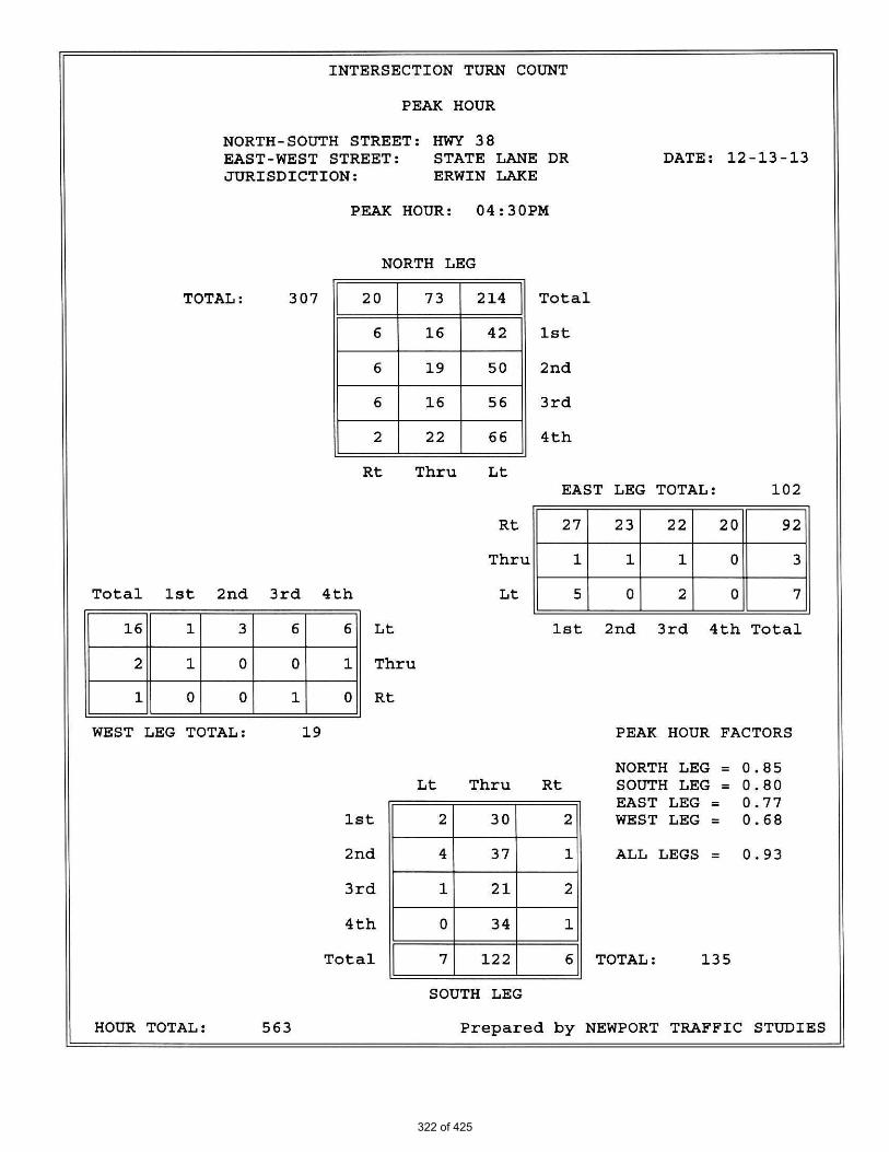
322 of 425

323 of 425

324 of 425

325 of 425

HCS+: Unsignalized Intersections Release 5.6 _______________________TWO-WAY STOP CONTROL SUMMARY___________________________ Analyst: TM Agency/Co.: Hall and Foreman, Inc Date Performed: 1/7/2014 Analysis Time Period: Friday Peak Hour Intersection: Highway 38/State Lane Drive Jurisdiction: San Bernardino County Units: U. S. Customary Analysis Year: Existing Conditions Project ID: VV.130048.0000 East/West Street: State Lane Drive North/South Street: Highway 38 Intersection Orientation: NS Study period (hrs): 1.00 ______________________Vehicle Volumes and Adjustments_________________________ Major Street: Approach Northbound Southbound Movement 1 2 3 | 4 5 6 L T R | L T R ______________________________________________________________________________ Volume 5 120 5 215 75 20 Peak-Hour Factor, PHF 0.93 0.93 0.93 0.93 0.93 0.93 Hourly Flow Rate, HFR 5 129 5 231 80 21 Percent Heavy Vehicles 5 -- -- 5 -- -- Median Type/Storage Undivided / RT Channelized? Lanes 0 1 0 0 1 0 Configuration LTR LTR Upstream Signal? No No ______________________________________________________________________________ Minor Street: Approach Westbound Eastbound Movement 7 8 9 | 10 11 12 L T R | L T R ______________________________________________________________________________ Volume 5 5 90 15 5 5 Peak Hour Factor, PHF 0.93 0.93 0.93 0.93 0.93 0.93 Hourly Flow Rate, HFR 5 5 96 16 5 5 Percent Heavy Vehicles 5 5 5 5 5 5 Percent Grade (%) 0 Flared Approach: Exists?/Storage No / No / Lanes 0 1 0 0 1 0 Configuration LTR LTR ______________________________________________________________________________ __________________Delay, Queue Length, and Level of Service___________________ Approach NB SB Westbound Eastbound Movement 1 4 | 7 8 9 | 10 11 12 Lane Config LTR LTR | LTR | LTR ______________________________________________________________________________ v (vph) 5 231 106 26 C(m) (vph) 1473 1432 761 303 v/c 0.00 0.16 0.14 0.09 95% queue length 0.01 0.58 0.48 0.28 Control Delay 7.5 8.0 10.5 18.0 LOS A A B C Approach Delay 10.5 18.0 Approach LOS B C ______________________________________________________________________________
326 of 425

HCS+: Unsignalized Intersections Release 5.6 _______________________TWO-WAY STOP CONTROL SUMMARY___________________________ Analyst: TM Agency/Co.: Hall and Foreman, Inc Date Performed: 1/7/2014 Analysis Time Period: Friday Peak Hour Intersection: Highway 38/State Lane Drive Jurisdiction: San Bernardino County Units: U. S. Customary Analysis Year: Existing plus Background Project ID: VV.130048.0000 East/West Street: State Lane Drive North/South Street: Highway 38 Intersection Orientation: NS Study period (hrs): 1.00 ______________________Vehicle Volumes and Adjustments_________________________ Major Street: Approach Northbound Southbound Movement 1 2 3 | 4 5 6 L T R | L T R ______________________________________________________________________________ Volume 5 130 5 225 95 20 Peak-Hour Factor, PHF 0.93 0.93 0.93 0.93 0.93 0.93 Hourly Flow Rate, HFR 5 139 5 241 102 21 Percent Heavy Vehicles 5 -- -- 5 -- -- Median Type/Storage Undivided / RT Channelized? Lanes 0 1 0 0 1 0 Configuration LTR LTR Upstream Signal? No No ______________________________________________________________________________ Minor Street: Approach Westbound Eastbound Movement 7 8 9 | 10 11 12 L T R | L T R ______________________________________________________________________________ Volume 5 5 95 15 5 5 Peak Hour Factor, PHF 0.93 0.93 0.93 0.93 0.93 0.93 Hourly Flow Rate, HFR 5 5 102 16 5 5 Percent Heavy Vehicles 5 5 5 5 5 5 Percent Grade (%) 0 0 Flared Approach: Exists?/Storage No / No / Lanes 0 1 0 0 1 0 Configuration LTR LTR ______________________________________________________________________________ __________________Delay, Queue Length, and Level of Service___________________ Approach NB SB Westbound Eastbound Movement 1 4 | 7 8 9 | 10 11 12 Lane Config LTR LTR | LTR | LTR ______________________________________________________________________________ v (vph) 5 241 112 26 C(m) (vph) 1446 1420 745 274 v/c 0.00 0.17 0.15 0.09 95% queue length 0.01 0.61 0.53 0.31 Control Delay 7.5 8.1 10.7 19.5 LOS A A B C Approach Delay 10.7 19.5 Approach LOS B C ______________________________________________________________________________
327 of 425

HCS+: Unsignalized Intersections Release 5.6 _______________________TWO-WAY STOP CONTROL SUMMARY___________________________ Analyst: TM Agency/Co.: Hall and Foreman, Inc Date Performed: 1/7/2014 Analysis Time Period: Friday Peak Hour Intersection: Highway 38/State Lane Drive Jurisdiction: San Bernardino County Units: U. S. Customary Analysis Year: Project Year 2014 Project ID: VV.130048.0000 East/West Street: State Lane Drive North/South Street: Highway 38 Intersection Orientation: NS Study period (hrs): 1.00 ______________________Vehicle Volumes and Adjustments_________________________ Major Street: Approach Northbound Southbound Movement 1 2 3 | 4 5 6 L T R | L T R ______________________________________________________________________________ Volume 5 125 15 250 90 20 Peak-Hour Factor, PHF 0.90 0.90 0.90 0.90 0.90 0.90 Hourly Flow Rate, HFR 5 138 16 277 100 22 Percent Heavy Vehicles 5 -- -- 5 -- -- Median Type/Storage Undivided / RT Channelized? Lanes 0 1 0 0 1 0 Configuration LTR LTR Upstream Signal? No No ______________________________________________________________________________ Minor Street: Approach Westbound Eastbound Movement 7 8 9 | 10 11 12 L T R | L T R ______________________________________________________________________________ Volume 15 20 120 15 20 5 Peak Hour Factor, PHF 0.90 0.90 0.90 0.90 0.90 0.90 Hourly Flow Rate, HFR 16 22 133 16 22 5 Percent Heavy Vehicles 5 5 5 5 5 5 Percent Grade (%) 0 0 Flared Approach: Exists?/Storage No / No / Lanes 0 1 0 0 1 0 Configuration LTR LTR ______________________________________________________________________________ __________________Delay, Queue Length, and Level of Service___________________ Approach NB SB Westbound Eastbound Movement 1 4 | 7 8 9 | 10 11 12 Lane Config LTR LTR | LTR | LTR ______________________________________________________________________________ v (vph) 5 277 171 43 C(m) (vph) 1447 1408 543 224 v/c 0.00 0.20 0.31 0.19 95% queue length 0.01 0.73 1.37 0.71 Control Delay 7.5 8.2 14.7 24.9 LOS A A B C Approach Delay 14.7 24.9 Approach LOS B C ______________________________________________________________________________
328 of 425

HCS+: Unsignalized Intersections Release 5.6 _______________________TWO-WAY STOP CONTROL SUMMARY___________________________ Analyst: TM Agency/Co.: Hall and Foreman, Inc Date Performed: 1/7/2014 Analysis Time Period: Friday Peak Hour Intersection: Highway 38/State Lane Drive Jurisdiction: San Bernardino County Units: U. S. Customary Analysis Year: Year 2035 without Project Project ID: VV.130048.0000 East/West Street: State Lane Drive North/South Street: Highway 38 Intersection Orientation: NS Study period (hrs): 1.00 ______________________Vehicle Volumes and Adjustments_________________________ Major Street: Approach Northbound Southbound Movement 1 2 3 | 4 5 6 L T R | L T R ______________________________________________________________________________ Volume 5 180 5 315 125 30 Peak-Hour Factor, PHF 0.95 0.95 0.95 0.95 0.95 0.95 Hourly Flow Rate, HFR 5 189 5 331 131 31 Percent Heavy Vehicles 5 -- -- 5 -- -- Median Type/Storage Undivided / RT Channelized? Lanes 0 1 0 0 1 0 Configuration LTR LTR Upstream Signal? No No ______________________________________________________________________________ Minor Street: Approach Westbound Eastbound Movement 7 8 9 | 10 11 12 L T R | L T R ______________________________________________________________________________ Volume 5 5 135 20 5 5 Peak Hour Factor, PHF 0.95 0.95 0.95 0.95 0.95 0.95 Hourly Flow Rate, HFR 5 5 142 21 5 5 Percent Heavy Vehicles 5 5 5 5 5 5 Percent Grade (%) 0 0 Flared Approach: Exists?/Storage No / No / Lanes 0 1 0 0 1 0 Configuration LTR LTR ______________________________________________________________________________ __________________Delay, Queue Length, and Level of Service___________________ Approach NB SB Westbound Eastbound Movement 1 4 | 7 8 9 | 10 11 12 Lane Config LTR LTR | LTR | LTR ______________________________________________________________________________ v (vph) 5 331 152 31 C(m) (vph) 1399 1361 665 151 v/c 0.00 0.24 0.23 0.21 95% queue length 0.01 0.96 0.89 0.77 Control Delay 7.6 8.5 12.0 35.0- LOS A A B D Approach Delay 12.0 35.0- Approach LOS B D ______________________________________________________________________________
329 of 425

HCS+: Unsignalized Intersections Release 5.6 _______________________TWO-WAY STOP CONTROL SUMMARY___________________________ Analyst: TM Agency/Co.: Hall and Foreman, Inc Date Performed: 1/7/2014 Analysis Time Period: Friday Peak Hour Intersection: Highway 38/State Lane Drive Jurisdiction: San Bernardino County Units: U. S. Customary Analysis Year: Year 2035 with Project Project ID: VV.130048.0000 East/West Street: State Lane Drive North/South Street: Highway 38 Intersection Orientation: NS Study period (hrs): 1.00 ______________________Vehicle Volumes and Adjustments_________________________ Major Street: Approach Northbound Southbound Movement 1 2 3 | 4 5 6 L T R | L T R ______________________________________________________________________________ Volume 5 175 15 340 120 30 Peak-Hour Factor, PHF 0.95 0.95 0.95 0.95 0.95 0.95 Hourly Flow Rate, HFR 5 184 15 357 126 31 Percent Heavy Vehicles 5 -- -- 5 -- -- Median Type/Storage Undivided / RT Channelized? Lanes 0 1 0 0 1 0 Configuration LTR LTR Upstream Signal? No No ______________________________________________________________________________ Minor Street: Approach Westbound Eastbound Movement 7 8 9 | 10 11 12 L T R | L T R ______________________________________________________________________________ Volume 15 20 160 20 20 5 Peak Hour Factor, PHF 0.95 0.95 0.95 0.95 0.95 0.95 Hourly Flow Rate, HFR 15 21 168 21 21 5 Percent Heavy Vehicles 5 5 5 5 5 5 Percent Grade (%) 0 0 Flared Approach: Exists?/Storage No / No / Lanes 0 1 0 0 1 0 Configuration LTR LTR ______________________________________________________________________________ __________________Delay, Queue Length, and Level of Service___________________ Approach NB SB Westbound Eastbound Movement 1 4 | 7 8 9 | 10 11 12 Lane Config LTR LTR | LTR | LTR ______________________________________________________________________________ v (vph) 5 357 204 47 C(m) (vph) 1405 1356 456 131 v/c 0.00 0.26 0.45 0.36 95% queue length 0.01 1.07 2.38 1.62 Control Delay 7.6 8.6 19.2 47.7 LOS A A C E Approach Delay 19.2 47.7 Approach LOS C E ______________________________________________________________________________
330 of 425

Tustin Office: 714.665.4500 Tel/ 714.665.4501 Fax
Santa Clarita Office: 661.284.7400 Tel/ 661.284.7401 Fax
Victorville Office: 760.524.9100 Tel/ 760.524.9101 Fax
Temecula Office: 951.294.9300 Tel/ 951.294.9301 Fax
2014
PROJECTED GROWTH: 2%
PER YEAR
TURN MOVEMENTS
PROJECT YEAR :
SUMMARY TM
CONDITION DIAGRAMS
DATE JOB NO. SHEET OF
7-Jan-14 VV.130048.0000 1 OF 2
SUBJECT BY
STATE LANE DRIVE
HIGHWAY 38
E/W STREET :
:
:CONDITION SUNDAY PEAK HOUR
N/S STREET
EXISTING + EXISTING + YEAR 2035 YEAR 2035
EXISTING BACKGROUND BACKGROUND PROJECT BACKGROUND + WITHOUT WITH
CONDITION TRAFFIC TRAFFIC TRAFFIC TRIPS PROJECT PROJECT PROJECT
SCENERIO #
STATE LANE DRIVE
EB LEFT 10 0 10 0 10 15 15
EB THRU 5 0 5 15 20 5 20
EB RIGHT 5 0 5 0 5 5 5
WB LEFT 10 0 10 10 20 15 25
WB THRU 5 0 5 15 20 5 20
WB RIGHT 95 0 100 30 130 140 170
HIGHWAY 38
NB LEFT 5 0 5 0 5 5 5
NB THRU 70 20 95 -5 90 125 120
NB RIGHT 10 0 10 10 20 15 25
SB LEFT 145 0 150 30 180 210 240
TOTALS 545 30 595 100 695 815 915
SB THRU 170 10 185 -5 180 255 250
SB RIGHT 15 0 15 0 15 20 20
331 of 425

HIGHWAY 38
TURN VOLUME SUMMARY TM 7-Jan-14 VV.130048.0000 2
SOUTH LEG
LARGE 2 AXLE LARGE 3 AXLE LARGE 4(+) AXLE LARGE 2 AXLE LARGE 3 AXLE LARGE 4(+) AXLE
COUNT DATE : December 15, 2013
SUBJECT BY DATE JOB NO. SHEET OF
OF 2
E/W STREET : STATE LANE DRIVE N/S STREET :
THRU LT RT THRU LT RT THRU LT
0 0 0 0 0 0 0
RT THRU LT RT THRU LT
0 0 0
0
LT
CONDITION : SUNDAY PEAK HOUR
NORTH LEG
RT THRU
0 0 0
0
0 00 0
RT
0 0 0 0 0
0 0 0 0
00 0 0 0 0 00 0
0 0 0
0 0 1 0 0 0 0
0 0 0 0 0 00 0 0 0 0 0 0 0
LARGE 2 AXLE LARGE 3 AXLE LARGE 4(+) AXLE
0 0 0 0 0
EAST LEG WEST LEG
0 0 0 0 0 0
RT THRU LT RT THRU LT
LARGE 2 AXLE LARGE 3 AXLE LARGE 4(+) AXLE
RT THRU LT RT THRU LTRT THRU LT RT THRU LT
0 0 00 0 0 0 0 0
0 0 0 0 0 0
0 0 01 0 0 0 0 0
0 0 0 0 0 00 0 0 0 0 1
0 0 00 0 0 0 0 0
1 0 0 0 0 0
0 0 00 0 0 0 0 0
0 0 0 0 0 00 0 0 0 0 0
RT THRU LT RT THRU LT
NORTH LEG SOUTH LEG EAST LEG WEST LEG
RT THRU LT RT THRU LT
0 0 0 0 0 00 0 0 0 0 0
0 0 0 0 0 00 0 0 0 0 0
0 0 0 0 0 00 0 0 0 0 0
PERCENTAGE
TRUCK AUTO ROUNDED TRUCK
0 0 0 0 0 00 0 0 0 0 0
STATE LANE DRIVEEB LEFT 1 0 10 10
TOTAL VOLUMES TOTALS TOTALS
EB RIGHT 0 0 3 5 0
10
EB THRU 0 0 2 5 0
2
WB THRU 0 0 4 5 0
WB LEFT 0 0 10 10 0
HIGHWAY 38NB LEFT 0 0 2 5
WB RIGHT 2 0 97 95
NB RIGHT 0 0 8 10 0
0
NB THRU 0 0 70 70 0
SB THRU 0 0 171 170 0
SB LEFT 1 0 145 145 1
Irvine Office: 714.665.4500 Tel/ 714.665.4501 Fax
Santa Clarita Office: 661.284.7400 Tel/ 661.284.7401 Fax
Victorville Office: 760.241.0595 Tel/ 760.241.1937 Fax
Temecula Office: 951.294.9300 Tel/ 951.294.9301 Fax
SB RIGHT 0 0 15 15 0
332 of 425

333 of 425

334 of 425

335 of 425

336 of 425

HCS+: Unsignalized Intersections Release 5.6 _______________________TWO-WAY STOP CONTROL SUMMARY___________________________ Analyst: TM Agency/Co.: Hall and Foreman, Inc Date Performed: 1/7/2014 Analysis Time Period: Sunday Peak Hour Intersection: Highway 38/State Lane Drive Jurisdiction: San Bernardino County Units: U. S. Customary Analysis Year: Existing Condition Project ID: VV.130048.0000 East/West Street: State Lane Drive North/South Street: Highway 38 Intersection Orientation: NS Study period (hrs): 1.00 ______________________Vehicle Volumes and Adjustments_________________________ Major Street: Approach Northbound Southbound Movement 1 2 3 | 4 5 6 L T R | L T R ______________________________________________________________________________ Volume 5 70 10 145 170 15 Peak-Hour Factor, PHF 0.94 0.94 0.94 0.94 0.94 0.94 Hourly Flow Rate, HFR 5 74 10 154 180 15 Percent Heavy Vehicles 5 -- -- 5 -- -- Median Type/Storage Undivided / RT Channelized? Lanes 0 1 0 0 1 0 Configuration LTR LTR Upstream Signal? No No ______________________________________________________________________________ Minor Street: Approach Westbound Eastbound Movement 7 8 9 | 10 11 12 L T R | L T R ______________________________________________________________________________ Volume 10 5 95 10 5 5 Peak Hour Factor, PHF 0.94 0.94 0.94 0.94 0.94 0.94 Hourly Flow Rate, HFR 10 5 101 10 5 5 Percent Heavy Vehicles 5 5 5 5 5 5 Percent Grade (%) 0 0 Flared Approach: Exists?/Storage No / No / Lanes 0 1 0 0 1 0 Configuration LTR LTR ______________________________________________________________________________ __________________Delay, Queue Length, and Level of Service___________________ Approach NB SB Westbound Eastbound Movement 1 4 | 7 8 9 | 10 11 12 Lane Config LTR LTR | LTR | LTR ______________________________________________________________________________ v (vph) 5 154 116 20 C(m) (vph) 1360 1494 803 386 v/c 0.00 0.10 0.14 0.05 95% queue length 0.01 0.34 0.51 0.16 Control Delay 7.7 7.7 10.2 14.8 LOS A A B B Approach Delay 10.2 14.8 Approach LOS B B ______________________________________________________________________________
337 of 425

HCS+: Unsignalized Intersections Release 5.6 _______________________TWO-WAY STOP CONTROL SUMMARY___________________________ Analyst: TM Agency/Co.: Hall and Foreman, Inc Date Performed: 1/7/2014 Analysis Time Period: Sunday Peak Hour Intersection: Highway 38/State Lane Drive Jurisdiction: San Bernardino County Units: U. S. Customary Analysis Year: Existing plus Background Project ID: VV.130048.0000 East/West Street: State Lane Drive North/South Street: Highway 38 Intersection Orientation: NS Study period (hrs): 1.00 ______________________Vehicle Volumes and Adjustments_________________________ Major Street: Approach Northbound Southbound Movement 1 2 3 | 4 5 6 L T R | L T R ______________________________________________________________________________ Volume 5 95 10 150 185 15 Peak-Hour Factor, PHF 0.94 0.94 0.94 0.94 0.94 0.94 Hourly Flow Rate, HFR 5 101 10 159 196 15 Percent Heavy Vehicles 5 -- -- -- -- Median Type/Storage Undivided / RT Channelized? Lanes 0 1 0 0 1 0 Configuration LTR LTR Upstream Signal? No No ______________________________________________________________________________ Minor Street: Approach Westbound Eastbound Movement 7 8 9 | 10 11 12 L T R | L T R ______________________________________________________________________________ Volume 10 5 100 10 5 5 Peak Hour Factor, PHF 0.94 0.94 0.94 0.94 0.94 0.94 Hourly Flow Rate, HFR 10 5 106 10 5 5 Percent Heavy Vehicles 5 5 5 5 5 5 Percent Grade (%) 0 0 Flared Approach: Exists?/Storage No / No / Lanes 0 1 0 0 1 0 Configuration LTR LTR ______________________________________________________________________________ __________________Delay, Queue Length, and Level of Service___________________ Approach NB SB Westbound Eastbound Movement 1 4 | 7 8 9 | 10 11 12 Lane Config LTR LTR | LTR | LTR ______________________________________________________________________________ v (vph) 5 159 121 20 C(m) (vph) 1342 1460 771 353 v/c 0.00 0.11 0.16 0.06 95% queue length 0.01 0.37 0.56 0.18 Control Delay 7.7 7.8 10.5 15.8 LOS A A B C Approach Delay 10.5 15.8 Approach LOS B C ______________________________________________________________________________
338 of 425

HCS+: Unsignalized Intersections Release 5.6 _______________________TWO-WAY STOP CONTROL SUMMARY___________________________ Analyst: TM Agency/Co.: Hall and Foreman, Inc Date Performed: 1/7/2014 Analysis Time Period: Sunday Peak Hour Intersection: Highway 38/State Lane Drive Jurisdiction: San Bernardino County Units: U. S. Customary Analysis Year: Project Year 2014 Project ID: VV.130048.0000 East/West Street: State Lane Drive North/South Street: Highway 38 Intersection Orientation: NS Study period (hrs): 1.00 ______________________Vehicle Volumes and Adjustments_________________________ Major Street: Approach Northbound Southbound Movement 1 2 3 | 4 5 6 L T R | L T R ______________________________________________________________________________ Volume 5 90 20 180 180 15 Peak-Hour Factor, PHF 0.90 0.90 0.90 0.90 0.90 0.90 Hourly Flow Rate, HFR 5 100 22 200 200 16 Percent Heavy Vehicles 5 -- -- 5 -- -- Median Type/Storage Undivided / RT Channelized? Lanes 0 1 0 0 1 0 Configuration LTR LTR Upstream Signal? No No ______________________________________________________________________________ Minor Street: Approach Westbound Eastbound Movement 7 8 9 | 10 11 12 L T R | L T R ______________________________________________________________________________ Volume 20 20 130 10 20 5 Peak Hour Factor, PHF 0.90 0.90 0.90 0.90 0.90 0.90 Hourly Flow Rate, HFR 22 22 144 11 22 5 Percent Heavy Vehicles 5 5 5 5 5 5 Percent Grade (%) 0 0 Flared Approach: Exists?/Storage No / No / Lanes 0 1 0 0 1 0 Configuration LTR LTR ______________________________________________________________________________ __________________Delay, Queue Length, and Level of Service___________________ Approach NB SB Westbound Eastbound Movement 1 4 | 7 8 9 | 10 11 12 Lane Config LTR LTR | LTR | LTR ______________________________________________________________________________ v (vph) 5 200 188 38 C(m) (vph) 1336 1447 601 278 v/c 0.00 0.14 0.31 0.14 95% queue length 0.01 0.48 1.36 0.47 Control Delay 7.7 7.9 13.7 20.0 LOS A A B C Approach Delay 13.7 20.0 Approach LOS B C ______________________________________________________________________________
339 of 425

HCS+: Unsignalized Intersections Release 5.6 _______________________TWO-WAY STOP CONTROL SUMMARY___________________________ Analyst: TM Agency/Co.: Hall and Foreman, Inc Date Performed: 1/7/2014 Analysis Time Period: Sunday Peak Hour Intersection: Highway 38/State Lane Drive Jurisdiction: San Bernardino County Units: U. S. Customary Analysis Year: Year 2035 without Project Project ID: VV.130048.0000 East/West Street: State Lane Drive North/South Street: Highway 38 Intersection Orientation: NS Study period (hrs): 1.00 ______________________Vehicle Volumes and Adjustments_________________________ Major Street: Approach Northbound Southbound Movement 1 2 3 | 4 5 6 L T R | L T R ______________________________________________________________________________ Volume 5 125 15 210 255 20 Peak-Hour Factor, PHF 0.95 0.95 0.95 0.95 0.95 0.95 Hourly Flow Rate, HFR 5 131 15 221 268 21 Percent Heavy Vehicles 5 -- -- 5 -- -- Median Type/Storage Undivided / RT Channelized? Lanes 0 1 0 0 1 0 Configuration LTR LTR Upstream Signal? No No ______________________________________________________________________________ Minor Street: Approach Westbound Eastbound Movement 7 8 9 | 10 11 12 L T R | L T R ______________________________________________________________________________ Volume 15 5 140 15 5 5 Peak Hour Factor, PHF 0.95 0.95 0.95 0.95 0.95 0.95 Hourly Flow Rate, HFR 15 5 147 15 5 5 Percent Heavy Vehicles 5 5 5 5 5 5 Percent Grade (%) 0 0 Flared Approach: Exists?/Storage No / No / Lanes 0 1 0 0 1 0 Configuration LTR LTR ______________________________________________________________________________ __________________Delay, Queue Length, and Level of Service___________________ Approach NB SB Westbound Eastbound Movement 1 4 | 7 8 9 | 10 11 12 Lane Config LTR LTR | LTR | LTR ______________________________________________________________________________ v (vph) 5 221 167 25 C(m) (vph) 1256 1418 663 212 v/c 0.00 0.16 0.25 0.12 95% queue length 0.01 0.55 1.01 0.40 Control Delay 7.9 8.0 12.3 24.2 LOS A A B C Approach Delay 12.3 24.2 Approach LOS B C ______________________________________________________________________________
340 of 425

HCS+: Unsignalized Intersections Release 5.6 _______________________TWO-WAY STOP CONTROL SUMMARY___________________________ Analyst: TM Agency/Co.: Hall and Foreman, Inc Date Performed: 1/7/2014 Analysis Time Period: Sunday Peak Hour Intersection: Highway 38/State Lane Drive Jurisdiction: San Bernardino County Units: U. S. Customary Analysis Year: Year 2035 with Project Project ID: VV.130048.0000 East/West Street: State Lane Drive North/South Street: Highway 38 Intersection Orientation: NS Study period (hrs): 1.00 ______________________Vehicle Volumes and Adjustments_________________________ Major Street: Approach Northbound Southbound Movement 1 2 3 | 4 5 6 L T R | L T R ______________________________________________________________________________ Volume 5 120 25 240 250 20 Peak-Hour Factor, PHF 0.95 0.95 0.95 0.95 0.95 0.95 Hourly Flow Rate, HFR 5 126 26 252 263 21 Percent Heavy Vehicles 5 -- -- 5 -- -- Median Type/Storage Undivided / RT Channelized? Lanes 0 1 0 0 1 0 Configuration LTR LTR Upstream Signal? No No ______________________________________________________________________________ Minor Street: Approach Westbound Eastbound Movement 7 8 9 | 10 11 12 L T R | L T R ______________________________________________________________________________ Volume 25 20 170 15 20 5 Peak Hour Factor, PHF 0.95 0.95 0.95 0.95 0.95 0.95 Hourly Flow Rate, HFR 26 21 178 15 21 5 Percent Heavy Vehicles 5 5 5 5 5 5 Percent Grade (%) 0 0 Flared Approach: Exists?/Storage No / No / Lanes 0 1 0 0 1 0 Configuration LTR LTR ______________________________________________________________________________ __________________Delay, Queue Length, and Level of Service___________________ Approach NB SB Westbound Eastbound Movement 1 4 | 7 8 9 | 10 11 12 Lane Config LTR LTR | LTR | LTR ______________________________________________________________________________ v (vph) 5 252 225 41 C(m) (vph) 1261 1411 510 182 v/c 0.00 0.18 0.44 0.23 95% queue length 0.01 0.65 2.33 0.86 Control Delay 7.9 8.1 17.6 30.5 LOS A A C D Approach Delay 17.6 30.5 Approach LOS C D ______________________________________________________________________________
341 of 425

EXHIBIT J
Air Quality Impact Analysis; Urban Cross Roads; 2014
342 of 425

Eagle Ridge Market AIR QUALITY IMPACT ANALYSIS COUNTY OF SAN BERNARDINO
PREPARED BY: Haseeb Qureshi [email protected] (949) 660-1994 x217 Stephen Abille [email protected] (949) 660-1994 x234 FEBRUARY 25, 2014
09105-02 AQ Report
343 of 425

Eagle Ridge Market Air Quality Impact Analysis
09105-02 AQ Report
ii
TABLE OF CONTENTS
TABLE OF CONTENTS .......................................................................................................................... II APPENDICES ..................................................................................................................................... III LIST OF EXHIBITS .............................................................................................................................. IV LIST OF TABLES ................................................................................................................................ IV LIST OF ABBREVIATED TERMS ............................................................................................................ V 1 INTRODUCTION ......................................................................................................................... 1
1.1 Project Overview ........................................................................................................................... 1 1.2 Existing Land Uses ........................................................................................................................ 1 1.3 Summary of Findings ..................................................................................................................... 1 1.4 Standard Regulatory Requirements/Best Available Control Measures (BACMs) ......................... 4 1.5 Construction-Source Mitigation Measures ................................................................................... 5 1.6 Operational-Source Mitigation Measures .................................................................................... 5
2 AIR QUALITY SETTING ................................................................................................................ 6
2.1 South Coast Air Basin .................................................................................................................... 6 2.2 Existing Air Quality ........................................................................................................................ 6 2.3 Regional Air Quality ...................................................................................................................... 8 2.4 Local Air Quality ............................................................................................................................ 8 2.5 Regulatory Background ............................................................................................................... 14 2.6 Existing Project Site Air Quality Conditions ................................................................................ 16
3 PROJECT AIR QUALITY IMPACT ................................................................................................ 17
3.1 Introduction ................................................................................................................................ 17 3.2 Standards of Significance ............................................................................................................ 17 3.3 Project-Related Sources of Potential Impact .............................................................................. 18 3.4 Construction Emissions ............................................................................................................... 18 3.5 Operational Emissions ................................................................................................................ 21 3.6 Localized Signifiance - Construction Activity.............................................................................. 23 3.7 Localized Significance – Long-Term Operational Activity ........................................................... 26 3.8 CO “Hot Spot” Analysis ............................................................................................................... 26 3.9 Air Quality Management Planning .............................................................................................. 27 3.10 Toxic Air Contaminants Associated with Gasoline Dispensing ................................................... 29 3.11 Potential Impacts to Sensitive Receptors ................................................................................... 30 3.12 Odors ........................................................................................................................................... 30 3.13 Cumulative Impacts .................................................................................................................... 31
4 REFERENCES ............................................................................................................................ 32 5 CERTIFICATION ........................................................................................................................ 34
344 of 425

Eagle Ridge Market Air Quality Impact Analysis
09105-02 AQ Report
iii
APPENDICES
APPENDIX 3.1: CALEEMOD EMISSIONS MODEL OUTPUTS
345 of 425

Eagle Ridge Market Air Quality Impact Analysis
09105-02 AQ Report
iv
LIST OF EXHIBITS
EXHIBIT 1-A: LOCATION MAP ............................................................................................................. 2 EXHIBIT 1-B: PRELIMINARY SITE PLAN ................................................................................................ 3
LIST OF TABLES
TABLE 2-1: AMBIENT AIR QUALITY STANDARDS .................................................................................. 7 TABLE 2-2: ATTAINMENT STATUS OF CRITERIA POLLUTANTS IN THE SOUTH COAST AIR BASIN (SCAB) 10 TABLE 2-3: PROJECT AREA AIR QUALITY MONITORING SUMMARY 2010-2012.................................... 11 TABLE 3-1: MAXIMUM DAILY EMISSIONS REGIONAL THRESHOLDS .................................................... 18 TABLE 3-2: CONSTRUCTION DURATION ............................................................................................. 20 TABLE 3-3: CONSTRUCTION EQUIPMENT ASSUMPTIONS ................................................................... 20 TABLE 3-4: EMISSIONS SUMMARY OF OVERALL CONSTRUCTION (WITHOUT BACMS) ......................... 21 TABLE 3-5: SUMMARY OF PEAK OPERATIONAL EMISSIONS (WITHOUT MITIGATION) ......................... 23 TABLE 3-6: LOCALIZED SIGNIFICANCE SUMMARY CONSTRUCTION (WITHOUT BACMS) ....................... 25 TABLE 3-7: LOCALIZED SIGNIFICANCE SUMMARY CONSTRUCTION (WITH MITIGATION) ..................... 25 TABLE 3-8: LOCALIZED SIGNIFICANCE SUMMARY OPERATIONS (WITHOUT MITIGATION) ................... 26
346 of 425
Eagle Ridge Market Air Quality Impact Analysis
09105-02 AQ Report
v
LIST OF ABBREVIATED TERMS
(1) Reference
µg/m3 Microgram per Cubic Meter
AADT Annual Average Daily Trips
AQIA Air Quality Impact Analysis
AQMD Air Quality Management District
AQMP Air Quality Management Plan
ARB California Air Resources Board
BACM Best Available Control Measures
BMPs Best Management Practices
CAA Federal Clean Air Act
CAAQS California Ambient Air Quality Standards
CalEEMod California Emissions Estimator Model
Caltrans California Department of Transportation
CAPCOA California Air Pollution Control Officers Association
CARB California Air Resources Board
CCR California Code of Regulations
CEQA California Environmental Quality Act
CFR Code of Federal Regulations
CO Carbon Monoxide
DPM Diesel Particulate Matter
EPA Environmental Protection Agency
LST Localized Significance Threshold
NAAQS National Ambient Air Quality Standards
NO2 Nitrogen Dioxide
NOx Oxides of Nitrogen
Pb Lead
PM10 Particulate Matter 10 microns in diameter or less
PM2.5 Particulate Matter 2.5 microns in diameter or less
PPM Parts Per Million
Project Eagle Ridge Market
ROG Reactive Organic Gases
SCAB South Coast Air Basin
SCAQMD South Coast Air Quality Management District
SIPs State Implementation Plans
SRA Source Receptor Area
TAC Toxic Air Contaminant
347 of 425

Eagle Ridge Market Air Quality Impact Analysis
09105-02 AQ Report
vi
TIA Traffic Impact Analysis
TOG Total Organic Gases
VMT Vehicle Miles Traveled
VOC Volatile Organic Compounds
348 of 425

Eagle Ridge Market Air Quality Impact Analysis
09105-02 AQ Report
1
1 INTRODUCTION
This report presents the results of the air quality impact analysis (AQIA) prepared by Urban Crossroads, Inc., for the Eagle Ridge Market (referred to as “Project”), which is located at the southeast corner of Highway 38 and State Lane in the unincorporated community of Erwin Lake as shown on Exhibit 1-A.
The purpose of this AQIA is to evaluate the potential impacts to air quality associated with construction and operation of the proposed Project, and recommend measures to mitigate impacts considered potentially significant in comparison to established regulatory thresholds.
1.1 PROJECT OVERVIEW
The Project is proposed to include the development of a convenient store with an 8 pump gas station as shown on Exhibit 1-B. For the purposes of this AQIA, it is assumed that the Project will be constructed and at full occupancy by 2014.
1.2 EXISTING LAND USES
The Project site is currently vacant, undeveloped and not generating quantifiable emissions.
1.3 SUMMARY OF FINDINGS
Short-Term Construction
For regional emissions, the Project would not exceed the numerical thresholds of significance established by the South Coast Air Quality Management District (SCAQMD). Although not required, best available control measures (BACM AQ-1 and BACM AQ-2) are recommended to further reduce the impacts.
Without BACMs, emissions during construction activity will exceed the SCAQMD’s localized significance threshold for particulate matter emissions (PM10 - particulate matter ≤ 10 microns; and PM2.5 - particulate matter ≤ 2.5 microns). It should be noted that the impacts without BACMs do not take credit for reductions achieved through standard regulatory requirements (Rule 403). After implementation of BACM AQ-1 and BACM AQ-2, the emissions resulting from short-term construction activity will not exceed the SCAQMD LST thresholds. A less than significant impact would occur with the application of mitigation measures.
Project construction-source emissions would not conflict with the applicable Air Quality Management Plan (AQMP).
Established requirements addressing construction equipment operations, and construction material use, storage, and disposal requirements act to minimize odor impacts that may result from construction activities. Moreover, construction-source odor emissions would be temporary, short-term, and intermittent in nature and would not result in persistent impacts that would affect substantial numbers of people. Potential construction-source odor impacts are therefore considered less-than-significant.
349 of 425

Eagle Ridge Market Air Quality Impact Analysis
09105-02 AQ Report
2
EXHIBIT 1-A: LOCATION MAP
350 of 425

Eagle Ridge Market Air Quality Impact Analysis
09105-02 AQ Report
3
EXHIBIT 1-B: PRELIMINARY SITE PLAN
351 of 425
Eagle Ridge Market Air Quality Impact Analysis
09105-02 AQ Report
4
Long-Term Operational
For regional emissions, the Project would not exceed the numerical thresholds of significance established by the SCAQMD. Thus a less than significant impact would occur for Project-related operational-source emissions without the application of mitigation measures.
Project operational-source emissions would not result in or cause a significant localized air quality impact as discussed in the operational LSTs section of this report. The proposed Project would not result in a significant CO “hotspot” as a result of Project related traffic during ongoing operations, nor would the Project result in a significant adverse health impact as discussed in Section 3.8, thus a less than significant impact to sensitive receptors during operational activity is expected. Project operational-source emissions would not conflict with the AQMP.
The Project would not result in a significant health risk impact due to toxic air contaminants (TACs) associated with gasoline dispensing activities (see Section 10.0).
Substantial odor-generating sources include land uses such as agricultural activities, feedlots, wastewater treatment facilities, landfills or various heavy industrial uses. The Project does not propose any such uses or activities that would result in potentially significant operational-source odor impacts. Potential sources of operational odors generated by the Project would include disposal of miscellaneous commercial refuse. Moreover, SCAQMD Rule 402 acts to prevent occurrences of odor nuisances (1). Consistent with County requirements, all Project-generated refuse would be stored in covered containers and removed at regular intervals in compliance with solid waste regulations. Potential operational-source odor impacts are therefore considered less-than-significant.
1.4 STANDARD REGULATORY REQUIREMENTS/BEST AVAILABLE CONTROL MEASURES (BACMS)
Measures listed below (or equivalent language) shall appear on all Project grading plans, construction specifications and bid documents, and the County shall ensure such language is incorporated prior to issuance of any development permits. County monitoring of construction activities shall be conducted to ensure mitigation compliance.
SCAQMD Rules that are currently applicable during construction activity for this Project include but are not limited to: Rule 1113 (Architectural Coatings) (2); Rule 431.2 (Low Sulfur Fuel) (3); Rule 403 (Fugitive Dust) (4); and Rule 1186 / 1186.1 (Street Sweepers) (5). In order to facilitate monitoring and compliance, applicable SCAQMD regulatory requirements are summarized below.
BACM AQ-1
The following measures shall be incorporated into Project plans and specifications as implementation of Rule 403 (4):
All clearing, grading, earth-moving, or excavation activities shall cease when winds exceed 25 mph per SCAQMD guidelines in order to limit fugitive dust emissions.
352 of 425
Eagle Ridge Market Air Quality Impact Analysis
09105-02 AQ Report
5
The contractor shall ensure that all disturbed unpaved roads and disturbed areas within the Project are watered at least three (3) times daily during dry weather. Watering, with complete coverage of disturbed areas, shall occur at least three times a day, preferably in the mid-morning, afternoon, and after work is done for the day.
The contractor shall ensure that traffic speeds on unpaved roads and Project site areas are reduced to 15 miles per hour or less
Additional regulatory requirements that are in effect during Project construction include the following:
BACM AQ-2
The California Air Resources Board, in Title 13, Chapter 10, Section 2485, Division 3 of the of the California Code of Regulations, imposes a requirement that heavy duty trucks accessing the site shall not idle for greater than five minutes at any location. This measure is intended to apply to construction traffic. Grading plans shall reference that a sign shall be posted on-site stating that construction workers need to shut off engines at or before five minutes of idling (6).
1.5 CONSTRUCTION-SOURCE MITIGATION MEASURES
No significant impacts were identified and no mitigation measures are required
1.6 OPERATIONAL-SOURCE MITIGATION MEASURES
No significant impacts were identified and no mitigation measures are required
353 of 425

Eagle Ridge Market Air Quality Impact Analysis
09105-02 AQ Report
6
2 AIR QUALITY SETTING
This section provides an overview of the existing air quality conditions in the Project area and region.
2.1 SOUTH COAST AIR BASIN
The Project site is located in the South Coast Air Basin (SCAB) within the jurisdiction of SCAQMD (7). The SCAQMD was created by the 1977 Lewis-Presley Air Quality Management Act, which merged four county air pollution control bodies into one regional district. Under the Act, the SCAQMD is responsible for bringing air quality in areas under its jurisdiction into conformity with federal and state air quality standards. As discussed above, the Project site is located within the South Coast Air Basin, a 6,745-square mile subregion of the SCAQMD, which includes portions of Los Angeles, Riverside, and San Bernardino Counties, and all of Orange County. The larger South Coast district boundary includes 10,743 square miles.
The SCAB is bound by the Pacific Ocean to the west and the San Gabriel, San Bernardino, and San Jacinto Mountains to the north and east. The Los Angeles County portion of the Mojave Desert Air Basin is bound by the San Gabriel Mountains to the south and west, the Los Angeles / Kern County border to the north, and the Los Angeles / San Bernardino County border to the east. The Riverside County portion of the Salton Sea Air Basin is bound by the San Jacinto Mountains in the west and spans eastward up to the Palo Verde Valley.
2.2 EXISTING AIR QUALITY
Existing air quality is measured at established SCAQMD air quality monitoring stations. Monitored air quality is evaluated and in the context of ambient air quality standards. These standards are the levels of air quality that are considered safe, with an adequate margin of safety, to protect the public health and welfare. National Ambient Air Quality Standards (NAAQS) and California Ambient Air Quality Standards (CAAQS) currently in effect, as well health effects of each pollutant regulated under these standards are shown in Table 2-1 (8)(9).
The determination of whether a region’s air quality is healthful or unhealthful is determined by comparing contaminant levels in ambient air samples to the state and federal standards presented in Table 2-1. The air quality in a region is considered to be in attainment by the state if the measured ambient air pollutant levels for O3, CO, SO2, NO2, PM10, and PM2.5 are not equaled or exceeded at any time in any consecutive three-year period; and the federal standards (other than O3, PM10, PM2.5, and those based on annual averages or arithmetic mean) are not exceeded more than once per year. The O3 standard is attained when the fourth highest eight-hour concentration in a year, averaged over three years, is equal to or less than the standard. For PM10, the 24 hour standard is attained when 99 percent of the daily concentrations, averaged over three years, are equal to or less than the standard.
354 of 425

Eagle Ridge Market Air Quality Impact Analysis
09105-02 AQ Report
7
TABLE 2-1: AMBIENT AIR QUALITY STANDARDS
355 of 425

Eagle Ridge Market Air Quality Impact Analysis
09105-02 AQ Report
8
2.3 REGIONAL AIR QUALITY
The SCAQMD monitors levels of various criteria pollutants at 30 monitoring stations throughout the air district. In 2012, the federal and state ambient air quality standards (NAAQS and CAAQS) were exceeded on one or more days for ozone, PM10, and PM2.5 at most monitoring locations (10). No areas of the SCAB exceeded federal or state standards for NO2, SO2, CO, sulfates or lead. See Table 2-2 for attainment designations for the SCAB (11).
2.4 LOCAL AIR QUALITY
Relative to the Project site, the nearest long-term air quality monitoring site for Ultra-Fine Particulates (PM2.5) is the South Coast Air Quality Management District East San Bernardino Mountains monitoring station, located approximately 2.85 miles northwest of the Project site in San Bernardino (SRA 38) (12). The nearest long-term air quality monitoring site for Ozone (O3) and Inhalable Particulates (PM10) is the Central San Bernardino Mountains monitoring station, located approximately 26.67 miles west of the Project site in San Bernardino (SRA 37). The nearest long-term air quality monitoring site for Carbon Monoxide (CO) and Nitrogen Dioxide (NO2) is the Central San Bernardino Valley 2 monitoring station, located approximately 28.35 miles southwest of the Project site in San Bernardino (SRA 34).
The most recent three (3) years of data available is shown on Table 2-3 and identifies the number of days ambient air quality standards were exceeded for the study area, which is was considered to be representative of the local air quality at the Project site (10) (13). Additionally, data for SO2 has been omitted as attainment is regularly met in the South Coast Air Basin and few monitoring stations measure SO2 concentrations.
Criteria pollutants are pollutants that are regulated through the development of human health based and/or environmentally based criteria for setting permissible levels. Criteria pollutants, their typical sources, and effects are identified below:
Carbon Monoxide (CO): Is a colorless, odorless gas produced by the incomplete combustion of carbon-containing fuels, such as gasoline or wood. CO concentrations tend to be the highest during the winter morning, when little to no wind and surface-based inversions trap the pollutant at ground levels. Because CO is emitted directly from internal combustion engines, unlike ozone, motor vehicles operating at slow speeds are the primary source of CO in the Basin. The highest ambient CO concentrations are generally found near congested transportation corridors and intersections.
Sulfur Dioxide (SO2): Is a colorless, extremely irritating gas or liquid. It enters the atmosphere as a pollutant mainly as a result of burning high sulfur-content fuel oils and coal and from chemical processes occurring at chemical plants and refineries. When SO2 oxidizes in the atmosphere, it forms sulfates (SO4). Collectively, these pollutants are referred to as sulfur oxides (SOX).
Nitrogen Oxides (Oxides of Nitrogen, or NOx): Nitrogen oxides (NOx) consist of nitric oxide (NO), nitrogen dioxide (NO2) and nitrous oxide (N2O) and are formed when nitrogen (N2) combines with oxygen (O2). Their lifespan in the atmosphere ranges from one to seven days for nitric oxide and nitrogen dioxide, to 170 years for nitrous oxide. Nitrogen oxides are typically created during combustion processes, and are major contributors to smog formation and acid
356 of 425

Eagle Ridge Market Air Quality Impact Analysis
09105-02 AQ Report
9
deposition. NO2 is a criteria air pollutant, and may result in numerous adverse health effects; it absorbs blue light, resulting in a brownish-red cast to the atmosphere and reduced visibility. Of the seven types of nitrogen oxide compounds, NO2 is the most abundant in the atmosphere. As ambient concentrations of NO2 are related to traffic density, commuters in heavy traffic may be exposed to higher concentrations of NO2 than those indicated by regional monitors.
Ozone (O3): Is a highly reactive and unstable gas that is formed when volatile organic compounds (VOCs) and nitrogen oxides (NOX), both byproducts of internal combustion engine exhaust, undergo slow photochemical reactions in the presence of sunlight. Ozone concentrations are generally highest during the summer months when direct sunlight, light wind, and warm temperature conditions are favorable to the formation of this pollutant.
PM10 (Particulate Matter less than 10 microns): A major air pollutant consisting of tiny solid or liquid particles of soot, dust, smoke, fumes, and aerosols. The size of the particles (10 microns or smaller, about 0.0004 inches or less) allows them to easily enter the lungs where they may be deposited, resulting in adverse health effects. PM10 also causes visibility reduction and is a criteria air pollutant.
PM2.5 (Particulate Matter less than 2.5 microns): A similar air pollutant consisting of tiny solid or liquid particles which are 2.5 microns or smaller (which is often referred to as fine particles). These particles are formed in the atmosphere from primary gaseous emissions that include sulfates formed from SO2 release from power plants and industrial facilities and nitrates that are formed from NOX release from power plants, automobiles and other types of combustion sources. The chemical composition of fine particles highly depends on location, time of year, and weather conditions. PM2.5 is a criteria air pollutant.
Volatile Organic Compounds (VOC): Volatile organic compounds are hydrocarbon compounds (any compound containing various combinations of hydrogen and carbon atoms) that exist in the ambient air. VOCs contribute to the formation of smog through atmospheric photochemical reactions and/or may be toxic. Compounds of carbon (also known as organic compounds) have different levels of reactivity; that is, they do not react at the same speed or do not form ozone to the same extent when exposed to photochemical processes. VOCs often have an odor, and some examples include gasoline, alcohol, and the solvents used in paints. Exceptions to the VOC designation include: carbon monoxide, carbon dioxide, carbonic acid, metallic carbides or carbonates, and ammonium carbonate. VOCs are a criteria pollutant since they are a precursor to O3, which is a criteria pollutant. The SCAQMD uses the terms VOC and ROG (see below) interchangeably.
Reactive Organic Gases (ROG): Similar to VOC, Reactive Organic Gases (ROG) are also precursors in forming ozone and consist of compounds containing methane, ethane, propane, butane, and longer chain hydrocarbons, which are typically the result of some type of combustion/decomposition process. Smog is formed when ROG and nitrogen oxides react in the presence of sunlight. ROGs are a criteria pollutant since they are a precursor to O3, which is a criteria pollutant. The SCAQMD uses the terms ROG and VOC (see previous) interchangeably.
Lead (Pb): Lead is a heavy metal that is highly persistent in the environment. In the past, the primary source of lead in the air was emissions from vehicles burning leaded gasoline. As a result of the removal of lead from gasoline, there have been no violations at any of the SCAQMD’s regular air monitoring stations since 1982. Currently, emissions of lead are largely limited to stationary sources such as lead smelters. It should be noted that the Project is not anticipated to generate a quantifiable amount of lead emissions. Lead is a criteria air pollutant.
357 of 425

Eagle Ridge Market Air Quality Impact Analysis
09105-02 AQ Report
10
TABLE 2-2: ATTAINMENT STATUS OF CRITERIA POLLUTANTS IN THE SOUTH COAST AIR BASIN (SCAB)
Criteria Pollutant State Designation Federal Designation
Ozone - 1hour standard Nonattainment No Standard
Ozone - 8 hour standard Nonattainment Extreme Nonattainment
PM10 Nonattainment Serious Nonattainment
PM2.5 Nonattainment Nonattainment
Carbon Monoxide Attainment Attainment/Maintenance
Nitrogen Dioxide Nonattainment2 Attainment/Maintenance
Sulfur Dioxide Attainment Attainment
Lead Attainment/Nonattainment Attainment/Nonattainment
All others Attainment/Unclassified Attainment/Unclassified
358 of 425

Eagle Ridge Market Air Quality Impact Analysis
09105-02 AQ Report
11
TABLE 2-3: PROJECT AREA AIR QUALITY MONITORING SUMMARY 2010-2012
POLLUTANT STANDARD YEAR
2010 2011 2012
Ozone (O3)
Maximum 1-Hour Concentration (ppm) 0.142 0.160 0.140
Maximum 8-Hour Concentration (ppm) 0.123 0.136 0.112
Number of Days Exceeding State 1-Hour Standard > 0.09 ppm 52 58 56
Number of Days Exceeding State 8-Hour Standard > 0.07 ppm 101 103 108
Number of Days Exceeding Federal 1-Hour Standard > 0.12 ppm 6 8 2
Number of Days Exceeding Federal 8-Hour Standard > 0.075 ppm 74 84 86
Number of Days Exceeding Health Advisory ≥ 0.15 ppm 0 1 0
Carbon Monoxide (CO)
Maximum 1-Hour Concentration (ppm) 2 1.9 3.1
Maximum 8-Hour Concentration (ppm) 1.7 1.7 1.7
Number of Days Exceeding State 1-Hour Standard > 20 ppm 0 0 0
Number of Days Exceeding Federal / State 8-Hour Standard > 9.0 ppm 0 0 0
Number of Days Exceeding Federal 1-Hour Standard > 35 ppm 0 0 0
Nitrogen Dioxide (NO2)
Maximum 1-Hour Concentration (ppm) 0.069 0.062 0.067
Annual Arithmetic Mean Concentration (ppm) 0.019 0.017 --
Number of Days Exceeding State 1-Hour Standard > 0.18 ppm 0 0 0
Particulate Matter ≤ 10 Microns (PM10)
Maximum 24-Hour Concentration (µg/m3) 39 43 43
Number of Samples 57 59 --
Number of Samples Exceeding State Standard > 50 µg/m3 0 0 0
Number of Samples Exceeding Federal Standard > 150 µg/m3 0 0 0
Particulate Matter ≤ 2.5 Microns (PM2.5)
Maximum 24-Hour Concentration (µg/m3) 35.4 30.7 34.8
Annual Arithmetic Mean (µg/m3) 8.4 8.5 36.4
Number of Samples Exceeding Federal 24-Hour Standard > 35 µg/m3 0 0 0 Source: South Coast AQMD (www.aqmd.gov) http://www.epa.gov/airdata/
359 of 425

Eagle Ridge Market Air Quality Impact Analysis
09105-02 AQ Report
12
Health Effects of Air Pollutants
Ozone
Individuals exercising outdoors, children, and people with preexisting lung disease, such as asthma and chronic pulmonary lung disease, are considered to be the most susceptible sub-groups for ozone effects. Short-term exposure (lasting for a few hours) to ozone at levels typically observed in Southern California can result in breathing pattern changes, reduction of breathing capacity, increased susceptibility to infections, inflammation of the lung tissue, and some immunological changes. Elevated ozone levels are associated with increased school absences. In recent years, a correlation between elevated ambient ozone levels and increases in daily hospital admission rates, as well as mortality, has also been reported. An increased risk for asthma has been found in children who participate in multiple sports and live in communities with high ozone levels.
Ozone exposure under exercising conditions is known to increase the severity of the responses described above. Animal studies suggest that exposure to a combination of pollutants that includes ozone may be more toxic than exposure to ozone alone. Although lung volume and resistance changes observed after a single exposure diminish with repeated exposures, biochemical and cellular changes appear to persist, which can lead to subsequent lung structural changes.
Carbon Monoxide
Individuals with a deficient blood supply to the heart are the most susceptible to the adverse effects of CO exposure. The effects observed include earlier onset of chest pain with exercise, and electrocardiograph changes indicative of decreased oxygen supply to the heart. Inhaled CO has no direct toxic effect on the lungs, but exerts its effect on tissues by interfering with oxygen transport and competing with oxygen to combine with hemoglobin present in the blood to form carboxyhemoglobin (COHb). Hence, conditions with an increased demand for oxygen supply can be adversely affected by exposure to CO. Individuals most at risk include fetuses, patients with diseases involving heart and blood vessels, and patients with chronic hypoxemia (oxygen deficiency) as seen at high altitudes.
Reduction in birth weight and impaired neurobehavioral development have been observed in animals chronically exposed to CO, resulting in COHb levels similar to those observed in smokers. Recent studies have found increased risks for adverse birth outcomes with exposure to elevated CO levels; these include pre-term births and heart abnormalities.
Particulate Matter
A consistent correlation between elevated ambient fine particulate matter (PM10 and PM2.5) levels and an increase in mortality rates, respiratory infections, number and severity of asthma attacks and the number of hospital admissions has been observed in different parts of the United States and various areas around the world. In recent years, some studies have reported an association between long-term exposure to air pollution dominated by fine particles and increased mortality, reduction in life-span, and an increased mortality from lung cancer.
360 of 425

Eagle Ridge Market Air Quality Impact Analysis
09105-02 AQ Report
13
Daily fluctuations in PM2.5 concentration levels have also been related to hospital admissions for acute respiratory conditions in children, to school and kindergarten absences, to a decrease in respiratory lung volumes in normal children, and to increased medication use in children and adults with asthma. Recent studies show lung function growth in children is reduced with longterm exposure to particulate matter.
The elderly, people with pre-existing respiratory or cardiovascular disease, and children appear to be more susceptible to the effects of high levels of PM10 and PM2.5.
Nitrogen Dioxide
Population-based studies suggest that an increase in acute respiratory illness, including infections and respiratory symptoms in children (not infants), is associated with long-term exposure to NO2 at levels found in homes with gas stoves, which are higher than ambient levels found in Southern California. Increase in resistance to air flow and airway contraction is observed after short-term exposure to NO2 in healthy subjects. Larger decreases in lung functions are observed in individuals with asthma or chronic obstructive pulmonary disease (e.g., chronic bronchitis, emphysema) than in healthy individuals, indicating a greater susceptibility of these sub-groups.
In animals, exposure to levels of NO2 considerably higher than ambient concentrations results in increased susceptibility to infections, possibly due to the observed changes in cells involved in maintaining immune functions. The severity of lung tissue damage associated with high levels of ozone exposure increases when animals are exposed to a combination of ozone and NO2.
Sulfur Dioxide
A few minutes of exposure to low levels of SO2 can result in airway constriction in some asthmatics, all of whom are sensitive to its effects. In asthmatics, increase in resistance to air flow, as well as reduction in breathing capacity leading to severe breathing difficulties, are observed after acute exposure to SO2. In contrast, healthy individuals do not exhibit similar acute responses even after exposure to higher concentrations of SO2.
Animal studies suggest that despite SO2 being a respiratory irritant, it does not cause substantial lung injury at ambient concentrations. However, very high levels of exposure can cause lung edema (fluid accumulation), lung tissue damage, and sloughing off of cells lining the respiratory tract.
Some population-based studies indicate that the mortality and morbidity effects associated with fine particles show a similar association with ambient SO2 levels. In these studies, efforts to separate the effects of SO2 from those of fine particles have not been successful. It is not clear whether the two pollutants act synergistically or one pollutant alone is the predominant factor.
Lead
Fetuses, infants, and children are more sensitive than others to the adverse effects of Pb exposure. Exposure to low levels of Pb can adversely affect the development and function of
361 of 425

Eagle Ridge Market Air Quality Impact Analysis
09105-02 AQ Report
14
the central nervous system, leading to learning disorders, distractibility, inability to follow simple commands, and lower intelligence quotient. In adults, increased Pb levels are associated with increased blood pressure.
Pb poisoning can cause anemia, lethargy, seizures, and death; although it appears that there are no direct effects of Pb on the respiratory system. Pb can be stored in the bone from early age environmental exposure, and elevated blood Pb levels can occur due to breakdown of bone tissue during pregnancy, hyperthyroidism (increased secretion of hormones from the thyroid gland) and osteoporosis (breakdown of bony tissue). Fetuses and breast-fed babies can be exposed to higher levels of Pb because of previous environmental Pb exposure of their mothers.
Odors
The science of odor as a health concern is still new. Merely identifying the hundreds of VOCs that cause odors poses a big challenge. Offensive odors can potentially affect human health in several ways. First, odorant compounds can irritate the eye, nose, and throat, which can reduce respiratory volume. Second, studies have shown that the VOCs that cause odors can stimulate sensory nerves to cause neurochemical changes that might influence health, for instance, by compromising the immune system. Finally, unpleasant odors can trigger memories or attitudes linked to unpleasant odors, causing cognitive and emotional effects such as stress.
2.5 REGULATORY BACKGROUND
2.5.1 FEDERAL REGULATIONS
The U.S. EPA is responsible for setting and enforcing the NAAQS for O3, CO, NOx, SO2, PM10, and lead (8). The U.S. EPA has jurisdiction over emissions sources that are under the authority of the federal government including aircraft, locomotives, and emissions sources outside state waters (Outer Continental Shelf). The U.S. EPA also establishes emission standards for vehicles sold in states other than California. Automobiles sold in California must meet the stricter emission requirements of the CARB.
The Federal Clean Air Act (CAA) was first enacted in 1955, and has been amended numerous times in subsequent years (1963, 1965, 1967, 1970, 1977, and 1990). The CAA establishes the federal air quality standards, the NAAQS, and specifies future dates for achieving compliance (14). The CAA also mandates that states submit and implement State Implementation Plans (SIPs) for local areas not meeting these standards. These plans must include pollution control measures that demonstrate how the standards will be met.
The 1990 amendments to the CAA that identify specific emission reduction goals for areas not meeting the NAAQS require a demonstration of reasonable further progress toward attainment and incorporate additional sanctions for failure to attain or to meet interim milestones. The sections of the CAA most directly applicable to the development of the Project site include Title I (Non-Attainment Provisions) and Title II (Mobile Source Provisions). Title I provisions were established with the goal of attaining the NAAQS for the following criteria pollutants O3, NO2, SO2, PM10, CO, PM2.5, and lead. The NAAQS were amended in July 1997 to include an
362 of 425

Eagle Ridge Market Air Quality Impact Analysis
09105-02 AQ Report
15
additional standard for O3 and to adopt a NAAQS for PM2.5. Table 3-1 (previously presented) provides the NAAQS within the basin.
Mobile source emissions are regulated in accordance with Title II provisions. These provisions require the use of cleaner burning gasoline and other cleaner burning fuels such as methanol and natural gas. Automobile manufacturers are also required to reduce tailpipe emissions of hydrocarbons and nitrogen oxides (NOx). NOx is a collective term that includes all forms of nitrogen oxides (NO, NO2, NO3) which are emitted as byproducts of the combustion process.
2.5.2 CALIFORNIA REGULATIONS
The CARB, which became part of the California EPA in 1991, is responsible for ensuring implementation of the California Clean Air Act (AB 2595), responding to the federal CAA, and for regulating emissions from consumer products and motor vehicles. The California CAA mandates achievement of the maximum degree of emissions reductions possible from vehicular and other mobile sources in order to attain the state ambient air quality standards by the earliest practical date. The CARB established the CAAQS for all pollutants for which the federal government has NAAQS and, in addition, establishes standards for sulfates, visibility, hydrogen sulfide, and vinyl chloride. However at this time, hydrogen sulfide and vinyl chloride are not measured at any monitoring stations in the SCAB because they are not considered to be a regional air quality problem. Generally, the CAAQS are more stringent than the NAAQS (9)(8).
Local air quality management districts, such as the SCAQMD, regulate air emissions from commercial and light industrial facilities. All air pollution control districts have been formally designated as attainment or non-attainment for each CAAQS.
Serious non-attainment areas are required to prepare air quality management plans that include specified emission reduction strategies in an effort to meet clean air goals. These plans are required to include:
Application of Best Available Retrofit Control Technology to existing sources;
Developing control programs for area sources (e.g., architectural coatings and solvents) and indirect sources (e.g. motor vehicle use generated by residential and commercial development);
A District permitting system designed to allow no net increase in emissions from any new or modified permitted sources of emissions;
Implementing reasonably available transportation control measures and assuring a substantial reduction in growth rate of vehicle trips and miles traveled;
Significant use of low emissions vehicles by fleet operators;
Sufficient control strategies to achieve a five percent or more annual reduction in emissions or 15 percent or more in a period of three years for ROGs, NOx, CO and PM10. However, air basins may use alternative emission reduction strategy that achieves a reduction of less than five percent per year under certain circumstances.
2.5.3 AIR QUALITY MANAGEMENT PLANNING
Currently, the NAAQS and CAAQS are exceeded in most parts of the SCAB. In response, the SCAQMD has adopted a series of Air Quality Management Plans (AQMPs) to meet the state and
363 of 425

Eagle Ridge Market Air Quality Impact Analysis
09105-02 AQ Report
16
federal ambient air quality standards (15). AQMPs are updated regularly in order to more effectively reduce emissions, accommodate growth, and to minimize any negative fiscal impacts of air pollution control on the economy. A detailed discussion on the AQMP and Project consistency with the AQMP is provided in Section 3.8.
2.6 EXISTING PROJECT SITE AIR QUALITY CONDITIONS
The Project site is currently vacant, and therefore does not generate quantifiable emissions. Existing air quality conditions at the Project site would generally reflect ambient monitored conditions as presented previously at Table 2-3.
364 of 425

Eagle Ridge Market Air Quality Impact Analysis
09105-02 AQ Report
17
3 PROJECT AIR QUALITY IMPACT
3.1 INTRODUCTION
The Project has been evaluated to determine if it will violate an air quality standard or contribute to an existing or projected air quality violation. Additionally, the Project has been evaluated to determine if it will result in a cumulatively considerable net increase of a criteria pollutant for which the SCAB is non-attainment under an applicable federal or state ambient air quality standard. The significance of these potential impacts is described in the following section.
3.2 STANDARDS OF SIGNIFICANCE
The criteria used to determine the significance of potential Project-related air quality impacts are taken from the Initial Study Checklist in Appendix G of the State CEQA Guidelines (14 California Code of Regulations §§15000, et seq.). Based on these thresholds, a project would result in a significant impact related to air quality if it would (16):
Conflict with or obstruct implementation of the applicable air quality plan.
Violate any air quality standard or contribute to an existing or projected air quality violation.
Result in a cumulatively considerable net increase of any criteria pollutant for which the project region is in non-attainment under an applicable federal or state ambient air quality standard (including releasing emissions, which exceed quantitative thresholds for ozone precursors).
Expose sensitive receptors to substantial pollutant concentrations.
Create objectionable odors affecting a substantial number of people.
Within the context of the above threshold considerations, and based on the SCAQMD’s CEQA Air Quality Handbook (1993), a project’s localized CO emissions impacts would be significant if they exceed the following California standards for localized CO concentrations (17):
1-hour CO standard of 20.0 parts per million (ppm)
8-hour CO standard of 9.0 ppm.
The SCAQMD has also developed regional and localized significance thresholds for other regulated pollutants, as summarized at Table 3-1 (18). The SCAQMD’s CEQA Air Quality Significance Thresholds (March 2011) indicate that any projects in the SCAB with daily emissions that exceed any of the indicated thresholds should be considered as having an individually and cumulatively significant air quality impact.
365 of 425

Eagle Ridge Market Air Quality Impact Analysis
09105-02 AQ Report
18
TABLE 3-1: MAXIMUM DAILY EMISSIONS REGIONAL THRESHOLDS
Pollutant Construction Operations
NOx 100 lbs/day 55 lbs/day
VOC 75 lbs/day 55 lbs/day
PM10 150 lbs/day 150 lbs/day
PM2.5 55 lbs/day 55 lbs/day
Sox 150 lbs/day 150 lbs/day
CO 550 lbs/day 550 lbs/day
Lead 3 lbs/day 3 lbs/day
3.3 PROJECT-RELATED SOURCES OF POTENTIAL IMPACT
Land uses such as the Project affect air quality through construction-source and operational-source emissions.
On October 2, 2013, the SCAQMD in conjunction with the California Air Pollution Control Officers Association (CAPCOA) released the latest version of the California Emissions Estimator Model™ (CalEEMod™) v2013.2.2. The purpose of this model is to calculate construction-source and operational-source criteria pollutant (NOx, VOC, PM10, PM2.5, SOx, and CO) and greenhouse gas (GHG) emissions from direct and indirect sources; and quantify applicable air quality and GHG reductions achieved from mitigation measures (19). Accordingly, the latest version of CalEEMod™ has been used for this Project to determine construction and operational air quality emissions. Output from the model runs for both construction and operational activity are provided in Appendix 3.1.
3.4 CONSTRUCTION EMISSIONS
Construction activities associated with the Project will result in emissions of CO, VOCs, NOx, SOx, PM10, and PM2.5. Construction related emissions are expected from the following construction activities:
Site Preparation
Grading (including soil export)
Building Construction
Paving (curb, gutter, flatwork, and parking lot)
Architectural Coatings (Painting)
Construction Workers Commuting
Construction is expected to commence in June 2014 and will last through November 2014. Construction duration by phase is shown on Table 3-2. The construction schedule utilized in the analysis represents a “worst-case” analysis scenario should construction occur any time after the respective dates since emission factors for construction decrease as the analysis year
366 of 425

Eagle Ridge Market Air Quality Impact Analysis
09105-02 AQ Report
19
increases. The duration of construction activity and associated equipment represents a reasonable approximation of the expected construction fleet as required per CEQA guidelines. Site specific construction fleet may vary due to specific project needs at the time of construction. The duration of construction activity was based on input from the applicant and CalEEMod model defaults. The associated construction equipment was estimated based on the SCAQMD’s recommendation for the buildout of a 1-acre project site. Please refer to specific detailed modeling inputs/outputs contained in Appendix 3.1 of this analysis. A detailed summary of construction equipment assumptions by phase is provided at Table 3-3. It should be noted that the emissions estimates provided at Table 3-4 represent a “worst-case” (i.e. overestimation) of actual emissions that will likely occur.
Dust is typically a major concern during rough grading activities. Because such emissions are not amenable to collection and discharge through a controlled source, they are called “fugitive emissions”. Fugitive dust emissions rates vary as a function of many parameters (soil silt, soil moisture, wind speed, area disturbed, number of vehicles, depth of disturbance or excavation, etc.). The CalEEMod model was utilized to calculate fugitive dust emissions resulting from this phase of activity. The Project site will require around 1,800 cubic yards of soil export in order to balance. Soil export will commence in June 2014, concurrent with grading activity, and will last for a duration of approximately two working days.
Construction emissions for construction worker vehicles traveling to and from the Project site, as well as vendor trips (construction materials delivered to the Project site) were estimated based on information from the applicant and the CalEEMod model.
367 of 425

Eagle Ridge Market Air Quality Impact Analysis
09105-02 AQ Report
20
TABLE 3-2: CONSTRUCTION DURATION
Phase Duration (working days)
Site Preparation 1
Grading 2
Building Construction 100
Paving 5
Architectural Coatings 5
TABLE 3-3: CONSTRUCTION EQUIPMENT ASSUMPTIONS
Activity Equipment Number Hours Per Day
Site preparation Graders 1 8
Tractors/Loaders/Backhoes 1 8
Grading
Graders 1 8
Water Trucks 1 8
Rubber Tired Dozers 1 8
Tractors/Loaders/Backhoes 1 8
Building Construction
Cranes 1 8
Forklifts 2 8
Tractors/Loaders/Backhoes 2 8
Paving
Cement and Mortar Mixer 4 8
Pavers 1 8
Rollers 1 8
Tractors/Loaders/Backhoes 1 8
Architectural Coatings Air Compressors 1 8
368 of 425

Eagle Ridge Market Air Quality Impact Analysis
09105-02 AQ Report
21
3.4.1 CONSTRUCTION EMISSIONS SUMMARY
Impacts without BACMs
The estimated maximum daily construction emissions without BACMs are summarized on Table 3-4. Detailed construction model outputs are presented in Appendix 3.1. Under the assumed scenarios, emissions resulting from the Project construction will not exceed any criteria pollutant thresholds established by the SCAQMD. It should be noted that the impacts without BACMs and do not take credit for reductions achieved through standard regulatory requirements (SCAQMD’s Rule 403). Therefore, a less than significant impact would occur without the application of BACMs and standard regulatory requirements.
TABLE 3-4: EMISSIONS SUMMARY OF OVERALL CONSTRUCTION (WITHOUT BACMS)
Year VOC NOx CO SOx PM10 PM2.5
2014 7.34 72.70 46.92 0.11 9.51 5.31
Maximum Daily Emissions 7.34 79.50 51.23 0.11 11.50 6.48
SCAQMD Regional Threshold 75 100 550 150 150 55
Threshold Exceeded? NO NO NO NO NO NO
3.5 OPERATIONAL EMISSIONS
Operational activities associated with the proposed Project will result in emissions of ROG, NOX, CO, SOX, PM10, and PM2.5. Operational emissions would be expected from the following primary sources:
Vehicles
Fugitive dust related to vehicular travel
Combustion Emissions Associated with Natural Gas and Electricity
Landscape maintenance equipment
Emissions from consumer products
Architectural coatings
3.5.1 VEHICLES
Project operational (vehicular) impacts are dependent on both overall daily vehicle trip generation and the effect of the Project on peak hour traffic volumes and traffic operations in the vicinity of the Project. The Project related operational air quality impacts derive primarily from vehicle trips generated by the Project. Trip characteristics available from the report, Proposed Commercial Development Highway 38 and State Lane Traffic Study (Hall & Foreman, Inc.) 2013 were utilized in this analysis (20).
369 of 425

Eagle Ridge Market Air Quality Impact Analysis
09105-02 AQ Report
22
3.5.2 FUGITIVE DUST RELATED TO VEHICULAR TRAVEL
Vehicles traveling on paved roads would be a source of fugitive emissions due to the generation of road dust inclusive of tire wear particulates. The emissions estimates for travel on paved roads were calculated using the CalEEMod model.
3.5.3 COMBUSTION EMISSIONS ASSOCIATED WITH NATURAL GAS AND ELECTRICITY
Electricity and natural gas are used by almost every project. Criteria pollutant emissions are emitted through the generation of electricity and consumption of natural gas. However, because electrical generating facilities for the Project area are located either outside the region (state) or offset through the use of pollution credits (RECLAIM) for generation within the SCAB, criteria pollutant emissions from offsite generation of electricity is generally excluded from the evaluation of significance and only natural gas use is considered. The emissions associated with natural gas use were calculated using the CalEEMod model.
3.5.4 LANDSCAPE MAINTENANCE EQUIPMENT
Landscape maintenance equipment would generate emissions from fuel combustion and evaporation of unburned fuel. Equipment in this category would include lawnmowers, shedders/grinders, blowers, trimmers, chain saws, and hedge trimmers used to maintain the landscaping of the Project. The emissions associated with landscape maintenance equipment were calculated based on assumptions provided in the CalEEMod model.
3.5.5 CONSUMER PRODUCTS
Consumer projects include, but are not limited to detergents, cleaning compounds, polishes, personal care products, and lawn and garden products. Many of these products contain organic compounds which when released in the atmosphere can react to form ozone and other photochemically reactive pollutants. The emissions associated with use of consumer products were calculated based on assumptions provided in the CalEEMod model. In the case of the commercial/retail uses proposed by the Project, no substantive on-site use of consumer products is anticipated.
3.5.6 ARCHITECTURAL COATINGS
Over a period of time the buildings that are part of this Project will be subject to emissions resulting from the evaporation of solvents contained in paints, varnishes, primers, and other surface coatings as part of Project maintenance. The emissions associated with architectural coatings were calculated using the CalEEMod model.
3.5.7 OPERATIONAL EMISSIONS SUMMARY
Impacts without Mitigation
Operational-source emissions without implementation of mitigation measures are summarized on Table 3-5. Prior to implementation of appropriate mitigation measures, Project operational-source emissions would not exceed applicable SCAQMD regional thresholds of significance.
370 of 425

Eagle Ridge Market Air Quality Impact Analysis
09105-02 AQ Report
23
Therefore, a less than significant impact would occur without the application of appropriate mitigation measures.
TABLE 3-5: SUMMARY OF PEAK OPERATIONAL EMISSIONS (WITHOUT MITIGATION)
Operational Activities – Summer Emissions VOC NOx CO SOx PM10 PM2.5
Area Source Emissions 0.25 4.00e-5 3.74e-3 -- 1.00e-5 1.00e-5
Energy Source Emissions 8.00e-5 7.00e-5 5.90e-4 -- 5.00e-5 5.00e-5
Mobile Emissions 15.49 20.69 96.91 0.11 6.75 1.96
Maximum Daily Emissions 15.74 20.69 96.91 0.11 6.75 1.96
SCAQMD Regional Threshold 55 55 550 150 150 55
Threshold Exceeded? NO NO NO NO NO NO
Operational Activities – Winter Emissions VOC NOx CO SOx PM10 PM2.5
Area Source Emissions 0.25 4.00e-5 3.74e-3 -- 1.00e-5 1.00e-5
Energy Source Emissions 8.00e-5 7.00e-5 5.90e-4 -- 5.00e-5 5.00e-5
Mobile Emissions 15.19 21.36 101.45 0.10 6.76 1.97
Maximum Daily Emissions 15.43 21.36 101.45 0.10 6.76 1.97
SCAQMD Regional Threshold 55 55 550 150 150 55
Threshold Exceeded? NO NO NO NO NO NO
3.6 LOCALIZED SIGNIFIANCE - CONSTRUCTION ACTIVITY
BACKGROUND ON LOCALIZED SIGNIFICANCE THRESHOLD (LST) DEVELOPMENT
The analysis makes use of methodology included in the SCAQMD Final Localized Significance Threshold Methodology (Methodology) (21). The SCAQMD has established that impacts to air quality are significant if there is a potential to contribute or cause localized exceedances of the federal and/or state ambient air quality standards (NAAQS/CAAQS). Collectively, these are referred to as Localized Significance Thresholds (LSTs).
The significance of localized emissions impacts depends on whether ambient levels in the vicinity of any given project are above or below State standards. In the case of CO and NO2, if ambient levels are below the standards, a project is considered to have a significant impact if project emissions result in an exceedance of one or more of these standards. If ambient levels already exceed a state or federal standard, then project emissions are considered significant if they increase ambient concentrations by a measurable amount. This would apply to PM10 and PM2.5; both of which are non-attainment pollutants.
The SCAQMD established LSTs in response to the SCAQMD Governing Board’s Environmental Justice Initiative I-4. LSTs represent the maximum emissions from a project that will not cause or contribute to an exceedance of the most stringent applicable federal or state ambient air quality standard at the nearest residence or sensitive receptor. The SCAQMD states that lead agencies can use the LSTs as another indicator of significance in its air quality impact analyses.
371 of 425

Eagle Ridge Market Air Quality Impact Analysis
09105-02 AQ Report
24
LSTs were developed in response to environmental justice and health concerns raised by the public regarding exposure of individuals to criteria pollutants in local communities. To address the issue of localized significance, the SCAQMD adopted LSTs that show whether a project would cause or contribute to localized air quality impacts and thereby cause or contribute to potential localized adverse health effects. The analysis makes use of methodology included in the SCAQMD Final Localized Significance Threshold Methodology (LST Methodology) (21).
APPLICABILITY OF LSTS FOR THE PROJECT
For this Project, the appropriate Source Receptor Area (SRA) for the LST is the East San Bernardino Mountains monitoring station (SRA 38). LSTs apply to carbon monoxide (CO), nitrogen dioxide (NO2), particulate matter ≤ 10 microns (PM10), and particulate matter ≤ 2.5 microns (PM2.5). The SCAQMD produced look-up tables for projects less than or equal to 5 acres in size.
In order to determine the appropriate methodology for determining localized impacts that could occur as a result of Project-related construction, the following process is undertaken:
The CalEEMod model is utilized to determine the maximum daily on-site emissions that will occur during construction activity.
The SCAQMD’s Fact Sheet for Applying CalEEMod to Localized Significance Thresholds
(22) is used to determine the maximum site acreage that is actively disturbed based on the construction equipment fleet and equipment hours as estimated in CalEEMod.
If the total acreage disturbed is less than or equal to five acres per day, then the SCAQMD’s screening look-up tables are utilized to determine if a Project has the potential to result in a significant impact (the SCAQMD recommends that Projects exceeding the screening look-up tables undergo dispersion modeling to determine actual impacts). The look-up tables establish a maximum daily emissions threshold in pounds per day that can be compared to CalEEMod outputs.
If the total acreage disturbed is greater than five acres per day, then the SCAQMD recommends dispersion modeling to be conducted to determine the actual pollutant concentrations for applicable LSTs in the air. In other words, the maximum daily on-site emissions as calculated in CalEEMod are modeled via air dispersion modeling to calculate the actual concentration in the air (e.g., parts per million or micrograms per cubic meter) in order to determine if any applicable thresholds are exceeded.
EMISSIONS CONSIDERED
SCAQMD’s Methodology clearly states that “off-site mobile emissions from the Project should NOT be included in the emissions compared to LSTs (21).” Therefore, for purposes of the construction LST analysis only emissions included in the CalEEMod “on-site” emissions outputs were considered.
372 of 425

Eagle Ridge Market Air Quality Impact Analysis
09105-02 AQ Report
25
MAXIMUM DAILY DISTURBED-ACREAGE
The SCAQMD produced a construction fleet mix that was based on the disturbance of a 1 acre site. The 1 acreage disturbance and its associated construction equipment will be used to determine localized impacts consistent with SCAQMD protocol.
Receptors
The nearest sensitive receptor land use is located approximately 20 meters south, immediately adjacent to the Project site. Notwithstanding, the Methodology explicitly states that “It is possible that a project may have receptors closer than 25 meters. Projects with boundaries located closer than 25 meters to the nearest receptor should use the LSTs for receptors located at 25 meters (21).” Accordingly, LSTs for receptors at 25 meters are utilized in this analysis and provide for a conservative i.e. “health protective” standard of care.
Impacts without BACMs
Without implementation of BACMs, emissions during construction activity will exceed SCAQMD’s localized significance thresholds for PM10 and PM2.5. Table 3-6 identifies the localized impacts without BACMs at the nearest receptor location in the vicinity of the Project. It should be noted that the impacts do not take credit for reductions achieved through standard regulatory requirements (SCAQMD’s Rule 403).
TABLE 3-6: LOCALIZED SIGNIFICANCE SUMMARY CONSTRUCTION (WITHOUT BACMS)
On-Site Grading Emissions NOx CO PM10 PM2.5
Maximum Daily Emissions 31.24 17.39 6.62 4.02
SCAQMD Localized Threshold 118 775 4 4
Threshold Exceeded? NO NO YES YES
Impacts with BACMs
After implementation of BACMs, emissions during construction activity will not exceed any of the SCAQMD’s localized significance thresholds. Table 3-7 identifies the localized impacts with BACMs at the nearest receptor location in the vicinity of the Project.
TABLE 3-7: LOCALIZED SIGNIFICANCE SUMMARY CONSTRUCTION (WITH MITIGATION)
On-Site Grading Emissions NOx CO PM10 PM2.5
Maximum Daily Emissions 31.24 17.39 3.56 2.47
SCAQMD Localized Threshold 118 775 4 4
Threshold Exceeded? NO NO NO NO
373 of 425

Eagle Ridge Market Air Quality Impact Analysis
09105-02 AQ Report
26
3.7 LOCALIZED SIGNIFICANCE – LONG-TERM OPERATIONAL ACTIVITY
Table 3-8 shows the calculated emissions for the Project’s operational activities compared with the applicable LSTs. The LST analysis includes on-site sources only; however, the CalEEMod™ model outputs do not separate on-site and off-site emissions from mobile sources. In an effort to establish a maximum potential impact scenario for analytic purposes, the emissions shown on Table 3-8 represent all on-site Project-related stationary (area) sources and five percent (5%) of the Project-related mobile sources. Considering that the weighted trip length used in CalEEMod™ for the Project is approximately 16.6 miles, 5% of this total would represent an on-site travel distance for each car and truck of approximately 1 mile or 5,280 feet, thus the 5% assumption is conservative and would tend to overstate the actual impact. Modeling based on these assumptions demonstrates that even within broad encompassing parameters, Project operational-source emissions would not exceed applicable LSTs.
The operational LSTs are located approximately 3.0 meters south, immediately adjacent to the Project site within SRA 32.
As noted above and indicated, sensitive receptors may be located nearer immediately adjacent to the Project site boundaries. Notwithstanding, the Methodology explicitly states that “It is possible that a project may have receptors closer than 25 meters. Projects with boundaries located closer than 25 meters to the nearest receptor should use the LSTs for receptors located at 25 meters (23).” Accordingly, LSTs for receptors at 25 meters are utilized in this analysis and provide for a conservative i.e. “health protective” standard of care. If emissions exceed the LST for a 2-acre site, then dispersion modeling needs to be conducted.
TABLE 3-8: LOCALIZED SIGNIFICANCE SUMMARY OPERATIONS (WITHOUT MITIGATION)
Operational Activity NOx CO PM10 PM2.5
Maximum Daily Emissions 1.07 5.07 0.34 0.10
SCAQMD Localized Threshold 118 775 1 1
Threshold Exceeded? NO NO NO NO
As shown on Table 3-8, operational emissions would not exceed the LST thresholds for the nearest sensitive receptor. Therefore, the Project will have a less than significant localized impact during operational activity.
3.8 CO “HOT SPOT” ANALYSIS
As discussed below, the Project would not result in potentially adverse CO concentrations or “hot spots.” Further, detailed modeling of Project-specific carbon monoxide (CO) “hot spots” is not needed to reach this conclusion.
It has long been recognized that adverse localized CO concentrations (“hot spots”) are caused by vehicular emissions, primarily when idling at congested intersections. In response, vehicle emissions standards have become increasingly stringent in the last twenty years. Currently, the
374 of 425

Eagle Ridge Market Air Quality Impact Analysis
09105-02 AQ Report
27
allowable CO emissions standard in California is a maximum of 3.4 grams/mile for passenger cars (there are requirements for certain vehicles that are more stringent). With the turnover of older vehicles, introduction of cleaner fuels, and implementation of increasingly sophisticated and efficient emissions control technologies, CO concentrations in the Project vicinity have steadily declined, as indicated by historical emissions data presented previously at Table 2-3.
A CO “hotspot” would occur if an exceedance of the state one-hour standard of 20 ppm or the eight-hour standard of 9 ppm were to occur. At the time of the 1993 Handbook, the SCAB was designated nonattainment under the California AAQS and National AAQS for CO (17). As identified within SCAQMD's 2003 AQMP and the 1992 Federal Attainment Plan for Carbon Monoxide (1992 CO Plan), peak carbon monoxide concentrations in the SCAB were a result of unusual meteorological and topographical conditions and not a result of congestion at a particular intersection (24). To establish a more accurate record of baseline CO concentrations affecting the SCAB, a CO “hot spot” analysis was conducted in 2003 for four busy intersections in Los Angeles at the peak morning and afternoon time periods. This hot spot analysis did not predict any violation of CO standards. It can therefore be reasonably concluded that projects (such as the proposed Depot at Santiago Mixed-Use Project) that are not subject to the extremes in vehicle volumes and vehicle congestion that was evidenced in the 2003 Los Angeles hot spot analysis would similarly not create or result in CO hot spots. Similar considerations are also employed by other Air Districts when evaluating potential CO concentration impacts. More specifically, the Bay Area Air Quality Management District (BAAQMD) concludes that under existing and future vehicle emission rates, a given project would have to increase traffic volumes at a single intersection by more than 44,000 vehicles per hour—or 24,000 vehicles per hour where vertical and/or horizontal air does not mix—in order to generate a significant CO impact (25). The proposed Project considered herein would not produce the volume of traffic required to generate a CO hotspot either in the context of the 2003 Los Angeles hot spot study, or based on representative BAAQMD CO threshold considerations. Therefore, CO hotspots are not an environmental impact of concern for the proposed Project. Localized air quality impacts related to mobile-source emissions would therefore be less than significant.
3.9 AIR QUALITY MANAGEMENT PLANNING
The Project site is located within the SCAB, which is characterized by relatively poor air quality. The SCAQMD has jurisdiction over an approximately 10,743 square-mile area consisting of the four-county Basin and the Los Angeles County and Riverside County portions of what use to be referred to as the Southeast Desert Air Basin. In these areas, the SCAQMD is principally responsible for air pollution control, and works directly with the Southern California Association of Governments (SCAG), county transportation commissions, local governments, as well as state and federal agencies to reduce emissions from stationary, mobile, and indirect sources to meet state and federal ambient air quality standards.
Currently, these state and federal air quality standards are exceeded in most parts of the Basin. In response, the SCAQMD has adopted a series of Air Quality Management Plans (AQMPs) to meet the state and federal ambient air quality standards. AQMPs are updated regularly in
375 of 425

Eagle Ridge Market Air Quality Impact Analysis
09105-02 AQ Report
28
order to more effectively reduce emissions, accommodate growth, and to minimize any negative fiscal impacts of air pollution control on the economy.
The Final 2012 AQMP was adopted by the AQMD Governing Board on December 7, 2012 (15). The 2012 AQMP incorporates the latest scientific and technological information and planning assumptions, including the 2012 Regional Transportation Plan/Sustainable Communities Strategy and updated emission inventory methodologies for various source categories.
Similar to the 2007 AQMP, the 2012 AQMP was based on assumptions provided by both CARB and SCAG in the latest available EMFAC model for the most recent motor vehicle and demographics information, respectively. The air quality levels projected in the 2012 AQMP are based on several assumptions. For example, the 2012 AQMP has assumed that development associated with general plans, specific plans, residential projects, and wastewater facilities will be constructed in accordance with population growth projections identified by SCAG in its 2012 RTP. The 2012 AQMP also has assumed that such development projects will implement strategies to reduce emissions generated during the construction and operational phases of development. The Project’s consistency with the 2012 AQMP is discussed as follows:
Criteria for determining consistency with the AQMP are defined in Chapter 12, Section 12.2 and Section 12.3 of the SCAQMD’s CEQA Air Quality Handbook (1993) (17). These indicators are discussed below:
Consistency Criterion No. 1: The proposed Project will not result in an increase in the frequency or severity of existing air quality violations or cause or contribute to new violations, or delay the timely attainment of air quality standards or the interim emissions reductions specified in the AQMP.
Construction Impacts
The violations that Consistency Criterion No. 1 refers to are the CAAQS and NAAQS. CAAQS and NAAQS violations would occur if localized significance thresholds (LSTs) were exceeded. As evaluated as part of the Project LST analysis (previously presented), the Project’s localized construction-source emissions will not exceed applicable LSTs after implementation of BACMs, and a less than significant impact is expected.
Operational Impacts
The Project LST analysis demonstrates that Project operational-source emissions would not exceed applicable LSTs, and are therefore less-than-significant. Additionally, Project operational-source emissions would not result in exceedances of applicable SCAQMD regional thresholds.
On the basis of the preceding discussion, the Project is determined to be consistent with the first criterion.
Consistency Criterion No. 2: The Project will not exceed the assumptions in the AQMP based on the years of Project build-out phase.
376 of 425

Eagle Ridge Market Air Quality Impact Analysis
09105-02 AQ Report
29
Construction and Operational Impacts
The 2012 Air Quality Management Plan (AQMP) demonstrates that the applicable ambient air quality standards can be achieved within the timeframes required under federal law. Growth projections from local general plans adopted by cities in the district are provided to the Southern California Association of Governments (SCAG), which develops regional growth forecasts, which are then used to develop future air quality forecasts for the AQMP. The Project site is zoned General Commercial (GC) and the proposed land use is consistent with this designation thus it is assumed that the Project is consistent with the growth projections included in the AQMP.
AQMP Consistency Conclusion
The Project would not result in or cause NAAQS or CAAQS violations. The Project’s land use designation for the subject site does not materially affect the uses allowed or their development intensities as reflected in the adopted zoning. The Project is therefore considered to be consistent with the AQMP.
3.10 TOXIC AIR CONTAMINANTS ASSOCIATED WITH GASOLINE DISPENSING
Emissions resulting from the proposed gas station have the potential to result in toxic air contaminants (TACs) (e.g., benzene, hexane, MTBE, toluene, xylene) and have the potential to contribute to health risk in the project vicinity. It should be noted that standard regulatory controls such as the SCAQMD’s Rule 461 (Gasoline Transfer and Dispensing) would apply to the project in addition to any permits required that demonstrate appropriate operational controls. It is our understanding that the SCAQMD has issued a permit for the Project that will limit the annual throughput to no more than 3,600,000 gallons. For purposes of this evaluation cancer risk estimates can be made consistent with the methodology presented in the document Gasoline Service Station Industry-wide Risk Assessment Guidelines (California Air Pollution Control Officers Association (CAPCOA), 1997). Based on data provided in the CAPCOA document, emissions resulting from a gasoline station (scenario 6A, E-2) will result in a cancer risk of 1.53 in one million for every million gallons of gasoline dispensed annually for the nearest sensitive receptors, located not closer than 60 meters (~200 feet)1 from the center of the gasoline station canopy (per CAPCOA guidance). Based on this screening procedure it is anticipated that no sensitive receptors in the project vicinity will be exposed to a cancer risk of greater than 10 in one million and the maximum exposed sensitive receptor would be exposed to a risk of 5.51 in one million which is less than half of the applicable threshold. It should be noted that this screening-level risk estimate is very conservative (i.e. it would overstate rather than understate potential impacts).
1 This distance is based on personal communication with Oxso Shahriari from the County of San Bernardino on 2/3/2014 and was also verified
through aerial imagery
377 of 425

Eagle Ridge Market Air Quality Impact Analysis
09105-02 AQ Report
30
3.11 POTENTIAL IMPACTS TO SENSITIVE RECEPTORS
The potential impact of Project-generated air pollutant emissions at sensitive receptors has also been considered. Sensitive receptors can include uses such as long term health care facilities, rehabilitation centers, and retirement homes. Residences, schools, playgrounds, child care centers, and athletic facilities can also be considered as sensitive receptors.
Results of the LST analysis indicate that the Project will not exceed the SCAQMD localized significance thresholds during construction (with BACMs). Therefore sensitive receptors would not be subject to a significant air quality impact during Project construction.
Results of the LST analysis indicate that the Project will not exceed the SCAQMD localized significance thresholds during operational activity. The proposed Project would not result in a CO “hotspot” as a result of Project related traffic during ongoing operations, nor would the Project result in a significant adverse health impact as discussed in Section 3.8. Thus a less than significant impact to sensitive receptors during operational activity is expected.
3.12 ODORS
The potential for the Project to generate objectionable odors has also been considered. Land uses generally associated with odor complaints include:
Agricultural uses (livestock and farming)
Wastewater treatment plants
Food processing plants
Chemical plants
Composting operations
Refineries
Landfills
Dairies
Fiberglass molding facilities
The Project does not contain land uses typically associated with emitting objectionable odors. Potential odor sources associated with the proposed Project may result from construction equipment exhaust and the application of asphalt and architectural coatings during construction activities, and the temporary storage of typical solid waste (refuse) associated with the proposed Project’s (long-term operational) uses. Standard construction requirements would minimize odor impacts from construction. The construction odor emissions would be temporary, short-term, and intermittent in nature and would cease upon completion of the respective phase of construction and is thus considered less than significant. It is expected that Project-generated refuse would be stored in covered containers and removed at regular intervals in compliance with the County’s solid waste regulations. The proposed Project would also be required to comply with SCAQMD Rule 402 to prevent occurrences of public nuisances.
378 of 425

Eagle Ridge Market Air Quality Impact Analysis
09105-02 AQ Report
31
Therefore, odors associated with the proposed Project construction and operations would be less than significant and no mitigation is required.
3.13 CUMULATIVE IMPACTS
The Project area is designated as an extreme non‐attainment area for ozone, and a non‐attainment area for PM10 and PM2.5.
The SCAQMD has recognized that there is typically insufficient information to quantitatively
evaluate the cumulative contributions of multiple projects because each project applicant has
no control over nearby projects. Nevertheless, the potential cumulative impacts from the
Project and other projects are discussed below.
Related projects could contribute to an existing or projected air quality exceedance because the Basin is currently nonattainment for ozone, PM10, and PM2.5. With regard to determining the significance of the contribution from the Project, the SCAQMD recommends that any given project’s potential contribution to cumulative impacts should be assessed using the same significance criteria as for project-specific impacts. Therefore, this analysis assumes that individual projects that do not generate operational or construction emissions that exceed the SCAQMD’s recommended daily thresholds for project-specific impacts would also not cause a commutatively considerable increase in emissions for those pollutants for which the Basin is in nonattainment, and, therefore, would not be considered to have a significant, adverse air quality impact. Alternatively, individual project-related construction and operational emissions that exceed SCAQMD thresholds for project-specific impacts would be considered cumulatively considerable. As previously noted, the Project will not exceed the applicable SCAQMD regional threshold for construction and operational-source emissions. As such, the Project will result in a cumulatively less than significant impact.
379 of 425

Eagle Ridge Market Air Quality Impact Analysis
09105-02 AQ Report
32
4 REFERENCES
1. South Coast Air Quality Management District. RULE 402. Nuisance. [Online] May 7, 1976. [Cited: November 13, 2013.] http://www.aqmd.gov/rules/reg/reg04/r402.pdf.
2. —. RULE 1113. Architectural Coatings. [Online] http://www.aqmd.gov/rules/reg/reg11/r1113.pdf.
3. —. RULE 431.2. Sulfur Content of Liquid Fuels. [Online] http://www.aqmd.gov/rules/siprules/sr431-2.pdf.
4. —. RULE 403. Fugitive Dust. [Online] http://www.aqmd.gov/rules/reg/reg04/r403.pdf.
5. —. RULE 1186. PM10 Emissions From Paved and Unpaved Roads, and Livestock Operations. [Online] http://www.aqmd.gov/rules/reg/reg11/r1186.pdf.
6. State of California. California Code of Regulations. Department of Industrial Relations. [Online] http://www.dir.ca.gov/dlse/ccr.htm.
7. South Coast Air Quality Management District. Southern California Air Basins. [Online] [Cited: November 13, 2013.] http://www.aqmd.gov/map/mapaqmd1.pdf.
8. Environmental Protection Agency. National Ambient Air Quality Standards (NAAQS). [Online] 1990. [Cited: November 13, 2013.] http://www.epa.gov/air/criteria.html.
9. Air Resources Board. California Ambient Air Quality Standards (CAAQS). [Online] 2009. [Cited: November 13, 2013.] http://www.arb.ca.gov/research/aaqs/caaqs/caaqs.htm.
10. Environmental Protection Agency. Monitor Values Report. [Online] [Cited: November 13, 2013.] http://www.epa.gov/airdata/ad_rep_mon.html.
11. Air Resources Board. Air Quality Standards and Area Designations. [Online] 2012. [Cited: November 13, 2013.] http://www.arb.ca.gov/desig/desig.htm.
12. South Coast Air Quality Management District. Air Quality Reporting. [pdf] Diamond Bar : Sierra Wade Associates, 1999.
13. Air Resources Board. [Online] [Cited: November 13, 2013.] http://www.arb.ca.gov/adam/select8/sc8start.php.
14. Environmental Protection Agency. Air Pollution and the Clean Air Act. [Online] [Cited: November 13, 2013.] http://www.epa.gov/air/caa/.
15. South Coast Air Quality Management District. 2012 Air Quality Management Plan (AQMP). [Online] 2012. [Cited: November 13, 2013.] http://www.aqmd.gov/aqmp/2012aqmp/draft/index.html.
16. California Environmental Quality Act. Checklist. [Online] [Cited: Nnovember 13, 2013.] http://ceres.ca.gov/ceqa/guidelines/Appendix_G.html.
17. South coast Air Quality Management District. CEQA Air Quality Handbook (1993). [Online] 1993. [Cited: November 13, 2013.] http://www.aqmd.gov/ceqa/oldhdbk.html.
18. South Coast Air Quality Management District. Greenhouse Gases (GHG) CEQA Significance Thresholds. [Online] [Cited: November 13, 2013.] http://www.aqmd.gov/ceqa/handbook/GHG/GHG.html.
19. —. California Emissions Estimator Model. [Online] 2013. [Cited: November 13, 2013.] http://www.caleemod.com/.
20. Hall & Foreman, Inc. Proposed Commercial Development Highway 38 and State Lane Traffic Study . 2013.
380 of 425

Eagle Ridge Market Air Quality Impact Analysis
09105-02 AQ Report
33
21. South Coast Air Quality Management District. Final Localized Significance Threshold Methodology. 2003.
22. —. Fact Sheet for Applying CalEEMod to Localized Significance Thresholds. [Online] [Cited: December 9, 2013.] http://aqmd.gov/ceqa/handbook/LST/CalEEModguidance.pdf.
23. —. Localized Significance Thresholds Methodology. s.l. : South Coast Air Quality Managment District, 2003.
24. —. 2003 Air Quality Management Plan. [Online] 2003. http://www.aqmd.gov/aqmp/aqmd03aqmp.htm.
25. Bay Area Air Quality Management District. [Online] http://www.baaqmd.gov/.
381 of 425
Eagle Ridge Market Air Quality Impact Analysis
09105-02 AQ Report
34
5 CERTIFICATION
The contents of this air study report represent an accurate depiction of the environmental impacts associated with the proposed Eagle Ridge Market. The information contained in this air quality impact assessment report is based on the best available data at the time of preparation. If you have any questions, please contact me directly at (949) 660-1994 ext. 217.
Haseeb Qureshi Senior Associate URBAN CROSSROADS, INC. 41 Corporate Park, Suite 300 Irvine, CA 92606 (949) 660-1994 x217 [email protected]
EDUCATION
Master of Science in Environmental Studies California State University, Fullerton • May, 2010
Bachelor of Arts in Environmental Analysis and Design University of California, Irvine • June, 2006
PROFESSIONAL AFFILIATIONS AEP – Association of Environmental Planners AWMA – Air and Waste Management Association ASTM – American Society for Testing and Materials
PROFESSIONAL CERTIFICATIONS
Environmental Site Assessment – American Society for Testing and Materials • June, 2013 Planned Communities and Urban Infill – Urban Land Institute • June, 2011 Indoor Air Quality and Industrial Hygiene – EMSL Analytical • April, 2008 Principles of Ambient Air Monitoring – California Air Resources Board • August, 2007 AB2588 Regulatory Standards – Trinity Consultants • November, 2006 Air Dispersion Modeling – Lakes Environmental • June, 2006
382 of 425

Eagle Ridge Market Air Quality Impact Analysis
09105-02 AQ Report
APPENDIX 3.1:
CALEEMOD EMISSIONS MODEL OUTPUTS
383 of 425

San Bernardino-South Coast County, Summer
Eagle Ridge Market
1.1 Land Usage
Land Uses Size Metric Lot Acreage Floor Surface Area Population
Parking Lot 27.00 Space 0.24 10,800.00 0
Convenience Market With Gas Pumps 8.00 Pump 0.03 1,129.40 0
1.2 Other Project Characteristics
Urbanization
Climate Zone
Rural
10
Wind Speed (m/s) Precipitation Freq (Days)2.2 32
1.3 User Entered Comments & Non-Default Data
1.0 Project Characteristics
Utility Company Southern California Edison
2014Operational Year
CO2 Intensity (lb/MWhr)
569.24 0.029CH4 Intensity (lb/MWhr)
0.006N2O Intensity (lb/MWhr)
CalEEMod Version: CalEEMod.2013.2.2 Date: 2/21/2014 10:29 AMPage 1 of 21
384 of 425

Project Characteristics - CPUC GHG Calculator version 3c
Land Use - based on information provided by the applicant
Construction Phase -
Off-road Equipment - SCAQMD’s recommendation for the buildout of a 1-acre project site
Off-road Equipment - SCAQMD’s recommendation for the buildout of a 1-acre project site
Off-road Equipment - SCAQMD’s recommendation for the buildout of a 1-acre project site
Off-road Equipment - SCAQMD’s recommendation for the buildout of a 1-acre project site
Woodstoves -
Energy Use - based on a 2014 operational year
Construction Off-road Equipment Mitigation -
Grading -
Trips and VMT -
Off-road Equipment - SCAQMD’s recommendation for the buildout of a 1-acre project site
2.0 Emissions Summary
Table Name Column Name Default Value New Value
tblGrading MaterialExported 0.00 1,800.00
tblOffRoadEquipment HorsePower 400.00 189.00
tblOffRoadEquipment LoadFactor 0.38 0.50
tblOffRoadEquipment OffRoadEquipmentType Graders
tblOffRoadEquipment OffRoadEquipmentUnitAmount 1.00 0.00
tblOffRoadEquipment OffRoadEquipmentUnitAmount 2.00 1.00
tblOffRoadEquipment UsageHours 6.00 8.00
tblOffRoadEquipment UsageHours 1.00 6.00
tblOffRoadEquipment UsageHours 6.00 7.00
tblProjectCharacteristics CO2IntensityFactor 630.89 569.24
tblProjectCharacteristics UrbanizationLevel Urban Rural
CalEEMod Version: CalEEMod.2013.2.2 Date: 2/21/2014 10:29 AMPage 2 of 21
385 of 425

2.1 Overall Construction (Maximum Daily Emission)
ROG NOx CO SO2 Fugitive PM10
Exhaust PM10
PM10 Total
Fugitive PM2.5
Exhaust PM2.5
PM2.5 Total
Bio- CO2 NBio- CO2 Total CO2 CH4 N2O CO2e
Year lb/day lb/day
2014 7.3380 71.1102 44.9826 0.1063 7.1259 2.3798 9.5057 3.1174 2.1893 5.3067
Total 7.3380 71.1102 44.9826 0.1063 7.1259 2.3798 9.5057 3.1174 2.1893 5.3067
Unmitigated Construction
ROG NOx CO SO2 Fugitive PM10
Exhaust PM10
PM10 Total
Fugitive PM2.5
Exhaust PM2.5
PM2.5 Total
Bio- CO2 NBio- CO2 Total CO2 CH4 N2O CO2e
Year lb/day lb/day
2014 7.3380 71.1102 44.9826 0.1063 4.0662 2.3798 6.4460 1.5674 2.1893 3.7567
Total 7.3380 71.1102 44.9826 0.1063 4.0662 2.3798 6.4460 1.5674 2.1893 3.7567
Mitigated Construction
ROG NOx CO SO2 Fugitive PM10
Exhaust PM10
PM10 Total
Fugitive PM2.5
Exhaust PM2.5
PM2.5 Total
Bio- CO2 NBio-CO2 Total CO2 CH4 N20 CO2e
Percent Reduction
0.00 0.00 0.00 0.00 42.94 0.00 32.19 49.72 0.00 29.21 0.00 0.00 0.00 0.00 0.00 0.00
CalEEMod Version: CalEEMod.2013.2.2 Date: 2/21/2014 10:29 AMPage 3 of 21
386 of 425

2.2 Overall Operational
ROG NOx CO SO2 Fugitive PM10
Exhaust PM10
PM10 Total
Fugitive PM2.5
Exhaust PM2.5
PM2.5 Total
Bio- CO2 NBio- CO2 Total CO2 CH4 N2O CO2e
Category lb/day lb/day
Area 0.2458 4.0000e-005
3.7400e-003
0.0000 1.0000e-005
1.0000e-005
1.0000e-005
1.0000e-005
Energy 8.0000e-005
7.0000e-004
5.9000e-004
0.0000 5.0000e-005
5.0000e-005
5.0000e-005
5.0000e-005
Mobile 15.4896 20.6917 96.9103 0.1078 6.5034 0.2489 6.7523 1.7365 0.2282 1.9647
Total 15.7354 20.6925 96.9146 0.1078 6.5034 0.2489 6.7524 1.7365 0.2282 1.9648
Unmitigated Operational
ROG NOx CO SO2 Fugitive PM10
Exhaust PM10
PM10 Total
Fugitive PM2.5
Exhaust PM2.5
PM2.5 Total
Bio- CO2 NBio- CO2 Total CO2 CH4 N2O CO2e
Category lb/day lb/day
Area 0.2458 4.0000e-005
3.7400e-003
0.0000 1.0000e-005
1.0000e-005
1.0000e-005
1.0000e-005
Energy 8.0000e-005
7.0000e-004
5.9000e-004
0.0000 5.0000e-005
5.0000e-005
5.0000e-005
5.0000e-005
Mobile 15.4896 20.6917 96.9103 0.1078 6.5034 0.2489 6.7523 1.7365 0.2282 1.9647
Total 15.7354 20.6925 96.9146 0.1078 6.5034 0.2489 6.7524 1.7365 0.2282 1.9648
Mitigated Operational
CalEEMod Version: CalEEMod.2013.2.2 Date: 2/21/2014 10:29 AMPage 4 of 21
387 of 425

3.0 Construction Detail
Construction Phase
Phase Number
Phase Name Phase Type Start Date End Date Num Days Week
Num Days Phase Description
1 Site Preparation Site Preparation 6/1/2014 6/2/2014 5 1
2 Grading Grading 6/3/2014 6/4/2014 5 2
3 Building Construction Building Construction 6/5/2014 10/22/2014 5 100
4 Paving Paving 10/23/2014 10/29/2014 5 5
5 Architectural Coating Architectural Coating 10/30/2014 11/5/2014 5 5
OffRoad Equipment
ROG NOx CO SO2 Fugitive PM10
Exhaust PM10
PM10 Total
Fugitive PM2.5
Exhaust PM2.5
PM2.5 Total
Bio- CO2 NBio-CO2 Total CO2 CH4 N20 CO2e
Percent Reduction
0.00 0.00 0.00 0.00 0.00 0.00 0.00 0.00 0.00 0.00 0.00 0.00 0.00 0.00 0.00 0.00
Residential Indoor: 0; Residential Outdoor: 0; Non-Residential Indoor: 2,180; Non-Residential Outdoor: 727 (Architectural Coating – sqft)
Acres of Grading (Site Preparation Phase): 0.5
Acres of Grading (Grading Phase): 0.75
Acres of Paving: 0
CalEEMod Version: CalEEMod.2013.2.2 Date: 2/21/2014 10:29 AMPage 5 of 21
388 of 425

3.1 Mitigation Measures Construction
Water Exposed Area
Phase Name Offroad Equipment Type Amount Usage Hours Horse Power Load Factor
Site Preparation Graders 1 8.00 174 0.41
Site Preparation Tractors/Loaders/Backhoes 1 8.00 97 0.37
Grading Concrete/Industrial Saws 0 8.00 81 0.73
Grading Off-Highway Trucks 1 8.00 189 0.50
Grading Rubber Tired Dozers 1 6.00 255 0.40
Grading Tractors/Loaders/Backhoes 1 7.00 97 0.37
Building Construction Cranes 1 4.00 226 0.29
Building Construction Forklifts 2 6.00 89 0.20
Building Construction Tractors/Loaders/Backhoes 2 8.00 97 0.37
Paving Cement and Mortar Mixers 4 6.00 9 0.56
Paving Pavers 1 7.00 125 0.42
Paving Rollers 1 7.00 80 0.38
Paving Tractors/Loaders/Backhoes 1 7.00 97 0.37
Architectural Coating Air Compressors 1 8.00 78 0.48
Grading Graders 1 6.00 174 0.41
Trips and VMT
Phase Name Offroad Equipment Count
Worker Trip Number
Vendor Trip Number
Hauling Trip Number
Worker Trip Length
Vendor Trip Length
Hauling Trip Length
Worker Vehicle Class
Vendor Vehicle Class
Hauling Vehicle Class
Site Preparation 2 5.00 0.00 0.00 19.80 7.90 20.00 LD_Mix HDT_Mix HHDT
Grading 4 10.00 0.00 225.00 19.80 7.90 20.00 LD_Mix HDT_Mix HHDT
Building Construction 5 5.00 2.00 0.00 19.80 7.90 20.00 LD_Mix HDT_Mix HHDT
Paving 7 18.00 0.00 0.00 19.80 7.90 20.00 LD_Mix HDT_Mix HHDT
Architectural Coating 1 1.00 0.00 0.00 19.80 7.90 20.00 LD_Mix HDT_Mix HHDT
CalEEMod Version: CalEEMod.2013.2.2 Date: 2/21/2014 10:29 AMPage 6 of 21
389 of 425

3.2 Site Preparation - 2014
ROG NOx CO SO2 Fugitive PM10
Exhaust PM10
PM10 Total
Fugitive PM2.5
Exhaust PM2.5
PM2.5 Total
Bio- CO2 NBio- CO2 Total CO2 CH4 N2O CO2e
Category lb/day lb/day
Fugitive Dust 0.5303 0.0000 0.5303 0.0573 0.0000 0.0573
Off-Road 1.4341 14.4817 7.3936 9.3700e-003
0.8920 0.8920 0.8206 0.8206
Total 1.4341 14.4817 7.3936 9.3700e-003
0.5303 0.8920 1.4223 0.0573 0.8206 0.8779
Unmitigated Construction On-Site
ROG NOx CO SO2 Fugitive PM10
Exhaust PM10
PM10 Total
Fugitive PM2.5
Exhaust PM2.5
PM2.5 Total
Bio- CO2 NBio- CO2 Total CO2 CH4 N2O CO2e
Category lb/day lb/day
Hauling 0.0000 0.0000 0.0000 0.0000 0.0000 0.0000 0.0000 0.0000 0.0000 0.0000
Vendor 0.0000 0.0000 0.0000 0.0000 0.0000 0.0000 0.0000 0.0000 0.0000 0.0000
Worker 0.0305 0.0430 0.5610 9.4000e-004
0.0753 6.1000e-004
0.0759 0.0200 5.6000e-004
0.0205
Total 0.0305 0.0430 0.5610 9.4000e-004
0.0753 6.1000e-004
0.0759 0.0200 5.6000e-004
0.0205
Unmitigated Construction Off-Site
CalEEMod Version: CalEEMod.2013.2.2 Date: 2/21/2014 10:29 AMPage 7 of 21
390 of 425

3.2 Site Preparation - 2014
ROG NOx CO SO2 Fugitive PM10
Exhaust PM10
PM10 Total
Fugitive PM2.5
Exhaust PM2.5
PM2.5 Total
Bio- CO2 NBio- CO2 Total CO2 CH4 N2O CO2e
Category lb/day lb/day
Fugitive Dust 0.2068 0.0000 0.2068 0.0223 0.0000 0.0223
Off-Road 1.4341 14.4817 7.3936 9.3700e-003
0.8920 0.8920 0.8206 0.8206
Total 1.4341 14.4817 7.3936 9.3700e-003
0.2068 0.8920 1.0988 0.0223 0.8206 0.8430
Mitigated Construction On-Site
ROG NOx CO SO2 Fugitive PM10
Exhaust PM10
PM10 Total
Fugitive PM2.5
Exhaust PM2.5
PM2.5 Total
Bio- CO2 NBio- CO2 Total CO2 CH4 N2O CO2e
Category lb/day lb/day
Hauling 0.0000 0.0000 0.0000 0.0000 0.0000 0.0000 0.0000 0.0000 0.0000 0.0000
Vendor 0.0000 0.0000 0.0000 0.0000 0.0000 0.0000 0.0000 0.0000 0.0000 0.0000
Worker 0.0305 0.0430 0.5610 9.4000e-004
0.0753 6.1000e-004
0.0759 0.0200 5.6000e-004
0.0205
Total 0.0305 0.0430 0.5610 9.4000e-004
0.0753 6.1000e-004
0.0759 0.0200 5.6000e-004
0.0205
Mitigated Construction Off-Site
CalEEMod Version: CalEEMod.2013.2.2 Date: 2/21/2014 10:29 AMPage 8 of 21
391 of 425

3.3 Grading - 2014
ROG NOx CO SO2 Fugitive PM10
Exhaust PM10
PM10 Total
Fugitive PM2.5
Exhaust PM2.5
PM2.5 Total
Bio- CO2 NBio- CO2 Total CO2 CH4 N2O CO2e
Category lb/day lb/day
Fugitive Dust 5.0160 0.0000 5.0160 2.5410 0.0000 2.5410
Off-Road 2.8808 31.2439 17.3851 0.0221 1.6031 1.6031 1.4748 1.4748
Total 2.8808 31.2439 17.3851 0.0221 5.0160 1.6031 6.6191 2.5410 1.4748 4.0159
Unmitigated Construction On-Site
ROG NOx CO SO2 Fugitive PM10
Exhaust PM10
PM10 Total
Fugitive PM2.5
Exhaust PM2.5
PM2.5 Total
Bio- CO2 NBio- CO2 Total CO2 CH4 N2O CO2e
Category lb/day lb/day
Hauling 2.5114 39.7802 26.4756 0.0823 1.9594 0.7755 2.7349 0.5365 0.7133 1.2498
Vendor 0.0000 0.0000 0.0000 0.0000 0.0000 0.0000 0.0000 0.0000 0.0000 0.0000
Worker 0.0610 0.0861 1.1219 1.8700e-003
0.1505 1.2200e-003
0.1517 0.0399 1.1100e-003
0.0410
Total 2.5724 39.8663 27.5975 0.0842 2.1099 0.7767 2.8866 0.5764 0.7144 1.2908
Unmitigated Construction Off-Site
CalEEMod Version: CalEEMod.2013.2.2 Date: 2/21/2014 10:29 AMPage 9 of 21
392 of 425

3.3 Grading - 2014
ROG NOx CO SO2 Fugitive PM10
Exhaust PM10
PM10 Total
Fugitive PM2.5
Exhaust PM2.5
PM2.5 Total
Bio- CO2 NBio- CO2 Total CO2 CH4 N2O CO2e
Category lb/day lb/day
Fugitive Dust 1.9563 0.0000 1.9563 0.9910 0.0000 0.9910
Off-Road 2.8808 31.2439 17.3851 0.0221 1.6031 1.6031 1.4748 1.4748
Total 2.8808 31.2439 17.3851 0.0221 1.9563 1.6031 3.5593 0.9910 1.4748 2.4658
Mitigated Construction On-Site
ROG NOx CO SO2 Fugitive PM10
Exhaust PM10
PM10 Total
Fugitive PM2.5
Exhaust PM2.5
PM2.5 Total
Bio- CO2 NBio- CO2 Total CO2 CH4 N2O CO2e
Category lb/day lb/day
Hauling 2.5114 39.7802 26.4756 0.0823 1.9594 0.7755 2.7349 0.5365 0.7133 1.2498
Vendor 0.0000 0.0000 0.0000 0.0000 0.0000 0.0000 0.0000 0.0000 0.0000 0.0000
Worker 0.0610 0.0861 1.1219 1.8700e-003
0.1505 1.2200e-003
0.1517 0.0399 1.1100e-003
0.0410
Total 2.5724 39.8663 27.5975 0.0842 2.1099 0.7767 2.8866 0.5764 0.7144 1.2908
Mitigated Construction Off-Site
CalEEMod Version: CalEEMod.2013.2.2 Date: 2/21/2014 10:29 AMPage 10 of 21
393 of 425
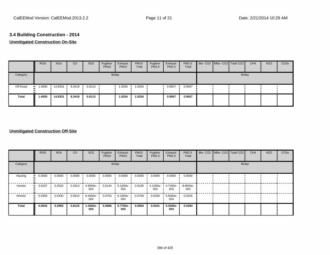
3.4 Building Construction - 2014
ROG NOx CO SO2 Fugitive PM10
Exhaust PM10
PM10 Total
Fugitive PM2.5
Exhaust PM2.5
PM2.5 Total
Bio- CO2 NBio- CO2 Total CO2 CH4 N2O CO2e
Category lb/day lb/day
Off-Road 1.4930 14.8331 8.3419 0.0113 1.0334 1.0334 0.9507 0.9507
Total 1.4930 14.8331 8.3419 0.0113 1.0334 1.0334 0.9507 0.9507
Unmitigated Construction On-Site
ROG NOx CO SO2 Fugitive PM10
Exhaust PM10
PM10 Total
Fugitive PM2.5
Exhaust PM2.5
PM2.5 Total
Bio- CO2 NBio- CO2 Total CO2 CH4 N2O CO2e
Category lb/day lb/day
Hauling 0.0000 0.0000 0.0000 0.0000 0.0000 0.0000 0.0000 0.0000 0.0000 0.0000
Vendor 0.0237 0.2520 0.2513 4.9000e-004
0.0144 5.1600e-003
0.0195 4.1000e-003
4.7400e-003
8.8500e-003
Worker 0.0305 0.0430 0.5610 9.4000e-004
0.0753 6.1000e-004
0.0759 0.0200 5.6000e-004
0.0205
Total 0.0542 0.2950 0.8123 1.4300e-003
0.0896 5.7700e-003
0.0954 0.0241 5.3000e-003
0.0294
Unmitigated Construction Off-Site
CalEEMod Version: CalEEMod.2013.2.2 Date: 2/21/2014 10:29 AMPage 11 of 21
394 of 425

3.4 Building Construction - 2014
ROG NOx CO SO2 Fugitive PM10
Exhaust PM10
PM10 Total
Fugitive PM2.5
Exhaust PM2.5
PM2.5 Total
Bio- CO2 NBio- CO2 Total CO2 CH4 N2O CO2e
Category lb/day lb/day
Off-Road 1.4930 14.8331 8.3419 0.0113 1.0334 1.0334 0.9507 0.9507
Total 1.4930 14.8331 8.3419 0.0113 1.0334 1.0334 0.9507 0.9507
Mitigated Construction On-Site
ROG NOx CO SO2 Fugitive PM10
Exhaust PM10
PM10 Total
Fugitive PM2.5
Exhaust PM2.5
PM2.5 Total
Bio- CO2 NBio- CO2 Total CO2 CH4 N2O CO2e
Category lb/day lb/day
Hauling 0.0000 0.0000 0.0000 0.0000 0.0000 0.0000 0.0000 0.0000 0.0000 0.0000
Vendor 0.0237 0.2520 0.2513 4.9000e-004
0.0144 5.1600e-003
0.0195 4.1000e-003
4.7400e-003
8.8500e-003
Worker 0.0305 0.0430 0.5610 9.4000e-004
0.0753 6.1000e-004
0.0759 0.0200 5.6000e-004
0.0205
Total 0.0542 0.2950 0.8123 1.4300e-003
0.0896 5.7700e-003
0.0954 0.0241 5.3000e-003
0.0294
Mitigated Construction Off-Site
CalEEMod Version: CalEEMod.2013.2.2 Date: 2/21/2014 10:29 AMPage 12 of 21
395 of 425

3.5 Paving - 2014
ROG NOx CO SO2 Fugitive PM10
Exhaust PM10
PM10 Total
Fugitive PM2.5
Exhaust PM2.5
PM2.5 Total
Bio- CO2 NBio- CO2 Total CO2 CH4 N2O CO2e
Category lb/day lb/day
Off-Road 1.2331 11.8542 7.3554 0.0111 0.7457 0.7457 0.6898 0.6898
Paving 0.1258 0.0000 0.0000 0.0000 0.0000
Total 1.3589 11.8542 7.3554 0.0111 0.7457 0.7457 0.6898 0.6898
Unmitigated Construction On-Site
ROG NOx CO SO2 Fugitive PM10
Exhaust PM10
PM10 Total
Fugitive PM2.5
Exhaust PM2.5
PM2.5 Total
Bio- CO2 NBio- CO2 Total CO2 CH4 N2O CO2e
Category lb/day lb/day
Hauling 0.0000 0.0000 0.0000 0.0000 0.0000 0.0000 0.0000 0.0000 0.0000 0.0000
Vendor 0.0000 0.0000 0.0000 0.0000 0.0000 0.0000 0.0000 0.0000 0.0000 0.0000
Worker 0.1097 0.1549 2.0194 3.3700e-003
0.2709 2.2000e-003
0.2731 0.0719 2.0000e-003
0.0739
Total 0.1097 0.1549 2.0194 3.3700e-003
0.2709 2.2000e-003
0.2731 0.0719 2.0000e-003
0.0739
Unmitigated Construction Off-Site
CalEEMod Version: CalEEMod.2013.2.2 Date: 2/21/2014 10:29 AMPage 13 of 21
396 of 425

3.5 Paving - 2014
ROG NOx CO SO2 Fugitive PM10
Exhaust PM10
PM10 Total
Fugitive PM2.5
Exhaust PM2.5
PM2.5 Total
Bio- CO2 NBio- CO2 Total CO2 CH4 N2O CO2e
Category lb/day lb/day
Off-Road 1.2331 11.8542 7.3554 0.0111 0.7457 0.7457 0.6898 0.6898
Paving 0.1258 0.0000 0.0000 0.0000 0.0000
Total 1.3589 11.8542 7.3554 0.0111 0.7457 0.7457 0.6898 0.6898
Mitigated Construction On-Site
ROG NOx CO SO2 Fugitive PM10
Exhaust PM10
PM10 Total
Fugitive PM2.5
Exhaust PM2.5
PM2.5 Total
Bio- CO2 NBio- CO2 Total CO2 CH4 N2O CO2e
Category lb/day lb/day
Hauling 0.0000 0.0000 0.0000 0.0000 0.0000 0.0000 0.0000 0.0000 0.0000 0.0000
Vendor 0.0000 0.0000 0.0000 0.0000 0.0000 0.0000 0.0000 0.0000 0.0000 0.0000
Worker 0.1097 0.1549 2.0194 3.3700e-003
0.2709 2.2000e-003
0.2731 0.0719 2.0000e-003
0.0739
Total 0.1097 0.1549 2.0194 3.3700e-003
0.2709 2.2000e-003
0.2731 0.0719 2.0000e-003
0.0739
Mitigated Construction Off-Site
CalEEMod Version: CalEEMod.2013.2.2 Date: 2/21/2014 10:29 AMPage 14 of 21
397 of 425

3.6 Architectural Coating - 2014
ROG NOx CO SO2 Fugitive PM10
Exhaust PM10
PM10 Total
Fugitive PM2.5
Exhaust PM2.5
PM2.5 Total
Bio- CO2 NBio- CO2 Total CO2 CH4 N2O CO2e
Category lb/day lb/day
Archit. Coating 6.7370 0.0000 0.0000 0.0000 0.0000
Off-Road 0.5950 3.7031 2.5621 3.9600e-003
0.3269 0.3269 0.3269 0.3269
Total 7.3319 3.7031 2.5621 3.9600e-003
0.3269 0.3269 0.3269 0.3269
Unmitigated Construction On-Site
ROG NOx CO SO2 Fugitive PM10
Exhaust PM10
PM10 Total
Fugitive PM2.5
Exhaust PM2.5
PM2.5 Total
Bio- CO2 NBio- CO2 Total CO2 CH4 N2O CO2e
Category lb/day lb/day
Hauling 0.0000 0.0000 0.0000 0.0000 0.0000 0.0000 0.0000 0.0000 0.0000 0.0000
Vendor 0.0000 0.0000 0.0000 0.0000 0.0000 0.0000 0.0000 0.0000 0.0000 0.0000
Worker 6.0900e-003
8.6100e-003
0.1122 1.9000e-004
0.0151 1.2000e-004
0.0152 3.9900e-003
1.1000e-004
4.1000e-003
Total 6.0900e-003
8.6100e-003
0.1122 1.9000e-004
0.0151 1.2000e-004
0.0152 3.9900e-003
1.1000e-004
4.1000e-003
Unmitigated Construction Off-Site
CalEEMod Version: CalEEMod.2013.2.2 Date: 2/21/2014 10:29 AMPage 15 of 21
398 of 425

4.0 Operational Detail - Mobile
3.6 Architectural Coating - 2014
ROG NOx CO SO2 Fugitive PM10
Exhaust PM10
PM10 Total
Fugitive PM2.5
Exhaust PM2.5
PM2.5 Total
Bio- CO2 NBio- CO2 Total CO2 CH4 N2O CO2e
Category lb/day lb/day
Archit. Coating 6.7370 0.0000 0.0000 0.0000 0.0000
Off-Road 0.5950 3.7031 2.5621 3.9600e-003
0.3269 0.3269 0.3269 0.3269
Total 7.3319 3.7031 2.5621 3.9600e-003
0.3269 0.3269 0.3269 0.3269
Mitigated Construction On-Site
ROG NOx CO SO2 Fugitive PM10
Exhaust PM10
PM10 Total
Fugitive PM2.5
Exhaust PM2.5
PM2.5 Total
Bio- CO2 NBio- CO2 Total CO2 CH4 N2O CO2e
Category lb/day lb/day
Hauling 0.0000 0.0000 0.0000 0.0000 0.0000 0.0000 0.0000 0.0000 0.0000 0.0000
Vendor 0.0000 0.0000 0.0000 0.0000 0.0000 0.0000 0.0000 0.0000 0.0000 0.0000
Worker 6.0900e-003
8.6100e-003
0.1122 1.9000e-004
0.0151 1.2000e-004
0.0152 3.9900e-003
1.1000e-004
4.1000e-003
Total 6.0900e-003
8.6100e-003
0.1122 1.9000e-004
0.0151 1.2000e-004
0.0152 3.9900e-003
1.1000e-004
4.1000e-003
Mitigated Construction Off-Site
CalEEMod Version: CalEEMod.2013.2.2 Date: 2/21/2014 10:29 AMPage 16 of 21
399 of 425

ROG NOx CO SO2 Fugitive PM10
Exhaust PM10
PM10 Total
Fugitive PM2.5
Exhaust PM2.5
PM2.5 Total
Bio- CO2 NBio- CO2 Total CO2 CH4 N2O CO2e
Category lb/day lb/day
Mitigated 15.4896 20.6917 96.9103 0.1078 6.5034 0.2489 6.7523 1.7365 0.2282 1.9647
Unmitigated 15.4896 20.6917 96.9103 0.1078 6.5034 0.2489 6.7523 1.7365 0.2282 1.9647
4.1 Mitigation Measures Mobile
4.2 Trip Summary Information
4.3 Trip Type Information
Average Daily Trip Rate Unmitigated Mitigated
Land Use Weekday Saturday Sunday Annual VMT Annual VMT
Convenience Market With Gas Pumps 4,340.80 1,635.76 1335.04 2,491,402 2,491,402
Parking Lot 0.00 0.00 0.00
Total 4,340.80 1,635.76 1,335.04 2,491,402 2,491,402
Miles Trip % Trip Purpose %
Land Use H-W or C-W H-S or C-C H-O or C-NW H-W or C-W H-S or C-C H-O or C-NW Primary Diverted Pass-by
Convenience Market With Gas Pumps
18.50 10.10 7.90 0.80 80.20 19.00 14 21 65
Parking Lot 18.50 10.10 7.90 0.00 0.00 0.00 0 0 0
LDA LDT1 LDT2 MDV LHD1 LHD2 MHD HHD OBUS UBUS MCY SBUS MH
0.477446 0.065927 0.171594 0.156638 0.055185 0.009062 0.015877 0.037321 0.001132 0.001346 0.004831 0.000736 0.002906
CalEEMod Version: CalEEMod.2013.2.2 Date: 2/21/2014 10:29 AMPage 17 of 21
400 of 425

5.0 Energy Detail
ROG NOx CO SO2 Fugitive PM10
Exhaust PM10
PM10 Total
Fugitive PM2.5
Exhaust PM2.5
PM2.5 Total
Bio- CO2 NBio- CO2 Total CO2 CH4 N2O CO2e
Category lb/day lb/day
NaturalGas Mitigated
8.0000e-005
7.0000e-004
5.9000e-004
0.0000 5.0000e-005
5.0000e-005
5.0000e-005
5.0000e-005
NaturalGas Unmitigated
8.0000e-005
7.0000e-004
5.9000e-004
0.0000 5.0000e-005
5.0000e-005
5.0000e-005
5.0000e-005
5.2 Energy by Land Use - NaturalGas
NaturalGas Use
ROG NOx CO SO2 Fugitive PM10
Exhaust PM10
PM10 Total
Fugitive PM2.5
Exhaust PM2.5
PM2.5 Total
Bio- CO2 NBio- CO2 Total CO2 CH4 N2O CO2e
Land Use kBTU/yr lb/day lb/day
Convenience Market With Gas
Pumps
7.17865 8.0000e-005
7.0000e-004
5.9000e-004
0.0000 5.0000e-005
5.0000e-005
5.0000e-005
5.0000e-005
Parking Lot 0 0.0000 0.0000 0.0000 0.0000 0.0000 0.0000 0.0000 0.0000
Total 8.0000e-005
7.0000e-004
5.9000e-004
0.0000 5.0000e-005
5.0000e-005
5.0000e-005
5.0000e-005
Unmitigated
5.1 Mitigation Measures Energy
4.4 Fleet Mix
Historical Energy Use: N
CalEEMod Version: CalEEMod.2013.2.2 Date: 2/21/2014 10:29 AMPage 18 of 21
401 of 425
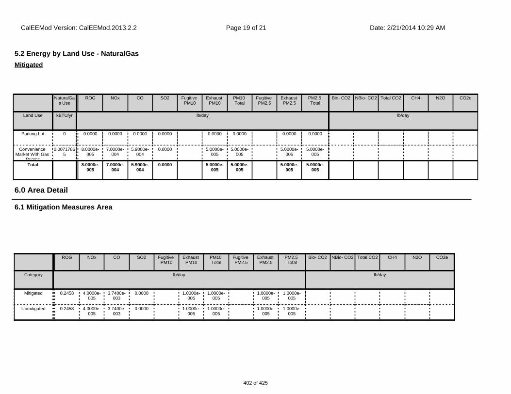
6.1 Mitigation Measures Area
6.0 Area Detail
ROG NOx CO SO2 Fugitive PM10
Exhaust PM10
PM10 Total
Fugitive PM2.5
Exhaust PM2.5
PM2.5 Total
Bio- CO2 NBio- CO2 Total CO2 CH4 N2O CO2e
Category lb/day lb/day
Mitigated 0.2458 4.0000e-005
3.7400e-003
0.0000 1.0000e-005
1.0000e-005
1.0000e-005
1.0000e-005
Unmitigated 0.2458 4.0000e-005
3.7400e-003
0.0000 1.0000e-005
1.0000e-005
1.0000e-005
1.0000e-005
5.2 Energy by Land Use - NaturalGas
NaturalGas Use
ROG NOx CO SO2 Fugitive PM10
Exhaust PM10
PM10 Total
Fugitive PM2.5
Exhaust PM2.5
PM2.5 Total
Bio- CO2 NBio- CO2 Total CO2 CH4 N2O CO2e
Land Use kBTU/yr lb/day lb/day
Parking Lot 0 0.0000 0.0000 0.0000 0.0000 0.0000 0.0000 0.0000 0.0000
Convenience Market With Gas
Pumps
0.00717865
8.0000e-005
7.0000e-004
5.9000e-004
0.0000 5.0000e-005
5.0000e-005
5.0000e-005
5.0000e-005
Total 8.0000e-005
7.0000e-004
5.9000e-004
0.0000 5.0000e-005
5.0000e-005
5.0000e-005
5.0000e-005
Mitigated
CalEEMod Version: CalEEMod.2013.2.2 Date: 2/21/2014 10:29 AMPage 19 of 21
402 of 425

7.0 Water Detail
6.2 Area by SubCategory
ROG NOx CO SO2 Fugitive PM10
Exhaust PM10
PM10 Total
Fugitive PM2.5
Exhaust PM2.5
PM2.5 Total
Bio- CO2 NBio- CO2 Total CO2 CH4 N2O CO2e
SubCategory lb/day lb/day
Architectural Coating
9.2300e-003
0.0000 0.0000 0.0000 0.0000
Consumer Products
0.2362 0.0000 0.0000 0.0000 0.0000
Landscaping 3.8000e-004
4.0000e-005
3.7400e-003
0.0000 1.0000e-005
1.0000e-005
1.0000e-005
1.0000e-005
Total 0.2458 4.0000e-005
3.7400e-003
0.0000 1.0000e-005
1.0000e-005
1.0000e-005
1.0000e-005
Unmitigated
ROG NOx CO SO2 Fugitive PM10
Exhaust PM10
PM10 Total
Fugitive PM2.5
Exhaust PM2.5
PM2.5 Total
Bio- CO2 NBio- CO2 Total CO2 CH4 N2O CO2e
SubCategory lb/day lb/day
Architectural Coating
9.2300e-003
0.0000 0.0000 0.0000 0.0000
Consumer Products
0.2362 0.0000 0.0000 0.0000 0.0000
Landscaping 3.8000e-004
4.0000e-005
3.7400e-003
0.0000 1.0000e-005
1.0000e-005
1.0000e-005
1.0000e-005
Total 0.2458 4.0000e-005
3.7400e-003
0.0000 1.0000e-005
1.0000e-005
1.0000e-005
1.0000e-005
Mitigated
CalEEMod Version: CalEEMod.2013.2.2 Date: 2/21/2014 10:29 AMPage 20 of 21
403 of 425

8.1 Mitigation Measures Waste
7.1 Mitigation Measures Water
8.0 Waste Detail
10.0 Vegetation
9.0 Operational Offroad
Equipment Type Number Hours/Day Days/Year Horse Power Load Factor Fuel Type
CalEEMod Version: CalEEMod.2013.2.2 Date: 2/21/2014 10:29 AMPage 21 of 21
404 of 425
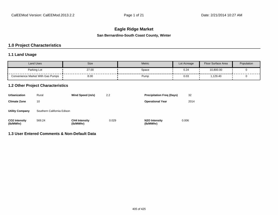
San Bernardino-South Coast County, Winter
Eagle Ridge Market
1.1 Land Usage
Land Uses Size Metric Lot Acreage Floor Surface Area Population
Parking Lot 27.00 Space 0.24 10,800.00 0
Convenience Market With Gas Pumps 8.00 Pump 0.03 1,129.40 0
1.2 Other Project Characteristics
Urbanization
Climate Zone
Rural
10
Wind Speed (m/s) Precipitation Freq (Days)2.2 32
1.3 User Entered Comments & Non-Default Data
1.0 Project Characteristics
Utility Company Southern California Edison
2014Operational Year
CO2 Intensity (lb/MWhr)
569.24 0.029CH4 Intensity (lb/MWhr)
0.006N2O Intensity (lb/MWhr)
CalEEMod Version: CalEEMod.2013.2.2 Date: 2/21/2014 10:27 AMPage 1 of 21
405 of 425

Project Characteristics - CPUC GHG Calculator version 3c
Land Use - based on information provided by the applicant
Construction Phase -
Off-road Equipment - SCAQMD’s recommendation for the buildout of a 1-acre project site
Off-road Equipment - SCAQMD’s recommendation for the buildout of a 1-acre project site
Off-road Equipment - SCAQMD’s recommendation for the buildout of a 1-acre project site
Off-road Equipment - SCAQMD’s recommendation for the buildout of a 1-acre project site
Woodstoves -
Energy Use - based on a 2014 operational year
Construction Off-road Equipment Mitigation -
Grading -
Trips and VMT -
Off-road Equipment - SCAQMD’s recommendation for the buildout of a 1-acre project site
2.0 Emissions Summary
Table Name Column Name Default Value New Value
tblGrading MaterialExported 0.00 1,800.00
tblOffRoadEquipment HorsePower 400.00 189.00
tblOffRoadEquipment LoadFactor 0.38 0.50
tblOffRoadEquipment OffRoadEquipmentType Graders
tblOffRoadEquipment OffRoadEquipmentUnitAmount 1.00 0.00
tblOffRoadEquipment OffRoadEquipmentUnitAmount 2.00 1.00
tblOffRoadEquipment UsageHours 6.00 8.00
tblOffRoadEquipment UsageHours 1.00 6.00
tblOffRoadEquipment UsageHours 6.00 7.00
tblProjectCharacteristics CO2IntensityFactor 630.89 569.24
tblProjectCharacteristics UrbanizationLevel Urban Rural
CalEEMod Version: CalEEMod.2013.2.2 Date: 2/21/2014 10:27 AMPage 2 of 21
406 of 425

2.1 Overall Construction (Maximum Daily Emission)
ROG NOx CO SO2 Fugitive PM10
Exhaust PM10
PM10 Total
Fugitive PM2.5
Exhaust PM2.5
PM2.5 Total
Bio- CO2 NBio- CO2 Total CO2 CH4 N2O CO2e
Year lb/day lb/day
2014 7.3377 72.7012 46.9155 0.1060 7.1259 2.3824 9.5083 3.1174 2.1916 5.3091
Total 7.3377 72.7012 46.9155 0.1060 7.1259 2.3824 9.5083 3.1174 2.1916 5.3091
Unmitigated Construction
ROG NOx CO SO2 Fugitive PM10
Exhaust PM10
PM10 Total
Fugitive PM2.5
Exhaust PM2.5
PM2.5 Total
Bio- CO2 NBio- CO2 Total CO2 CH4 N2O CO2e
Year lb/day lb/day
2014 7.3377 72.7012 46.9155 0.1060 4.0662 2.3824 6.4485 1.5674 2.1916 3.7590
Total 7.3377 72.7012 46.9155 0.1060 4.0662 2.3824 6.4485 1.5674 2.1916 3.7590
Mitigated Construction
ROG NOx CO SO2 Fugitive PM10
Exhaust PM10
PM10 Total
Fugitive PM2.5
Exhaust PM2.5
PM2.5 Total
Bio- CO2 NBio-CO2 Total CO2 CH4 N20 CO2e
Percent Reduction
0.00 0.00 0.00 0.00 42.94 0.00 32.18 49.72 0.00 29.20 0.00 0.00 0.00 0.00 0.00 0.00
CalEEMod Version: CalEEMod.2013.2.2 Date: 2/21/2014 10:27 AMPage 3 of 21
407 of 425

2.2 Overall Operational
ROG NOx CO SO2 Fugitive PM10
Exhaust PM10
PM10 Total
Fugitive PM2.5
Exhaust PM2.5
PM2.5 Total
Bio- CO2 NBio- CO2 Total CO2 CH4 N2O CO2e
Category lb/day lb/day
Area 0.2458 4.0000e-005
3.7400e-003
0.0000 1.0000e-005
1.0000e-005
1.0000e-005
1.0000e-005
Energy 8.0000e-005
7.0000e-004
5.9000e-004
0.0000 5.0000e-005
5.0000e-005
5.0000e-005
5.0000e-005
Mobile 15.1890 21.3551 101.4491 0.1009 6.5034 0.2554 6.7588 1.7365 0.2342 1.9707
Total 15.4349 21.3558 101.4534 0.1009 6.5034 0.2555 6.7589 1.7365 0.2342 1.9708
Unmitigated Operational
ROG NOx CO SO2 Fugitive PM10
Exhaust PM10
PM10 Total
Fugitive PM2.5
Exhaust PM2.5
PM2.5 Total
Bio- CO2 NBio- CO2 Total CO2 CH4 N2O CO2e
Category lb/day lb/day
Area 0.2458 4.0000e-005
3.7400e-003
0.0000 1.0000e-005
1.0000e-005
1.0000e-005
1.0000e-005
Energy 8.0000e-005
7.0000e-004
5.9000e-004
0.0000 5.0000e-005
5.0000e-005
5.0000e-005
5.0000e-005
Mobile 15.1890 21.3551 101.4491 0.1009 6.5034 0.2554 6.7588 1.7365 0.2342 1.9707
Total 15.4349 21.3558 101.4534 0.1009 6.5034 0.2555 6.7589 1.7365 0.2342 1.9708
Mitigated Operational
CalEEMod Version: CalEEMod.2013.2.2 Date: 2/21/2014 10:27 AMPage 4 of 21
408 of 425

3.0 Construction Detail
Construction Phase
Phase Number
Phase Name Phase Type Start Date End Date Num Days Week
Num Days Phase Description
1 Site Preparation Site Preparation 6/1/2014 6/2/2014 5 1
2 Grading Grading 6/3/2014 6/4/2014 5 2
3 Building Construction Building Construction 6/5/2014 10/22/2014 5 100
4 Paving Paving 10/23/2014 10/29/2014 5 5
5 Architectural Coating Architectural Coating 10/30/2014 11/5/2014 5 5
OffRoad Equipment
ROG NOx CO SO2 Fugitive PM10
Exhaust PM10
PM10 Total
Fugitive PM2.5
Exhaust PM2.5
PM2.5 Total
Bio- CO2 NBio-CO2 Total CO2 CH4 N20 CO2e
Percent Reduction
0.00 0.00 0.00 0.00 0.00 0.00 0.00 0.00 0.00 0.00 0.00 0.00 0.00 0.00 0.00 0.00
Residential Indoor: 0; Residential Outdoor: 0; Non-Residential Indoor: 2,180; Non-Residential Outdoor: 727 (Architectural Coating – sqft)
Acres of Grading (Site Preparation Phase): 0.5
Acres of Grading (Grading Phase): 0.75
Acres of Paving: 0
CalEEMod Version: CalEEMod.2013.2.2 Date: 2/21/2014 10:27 AMPage 5 of 21
409 of 425
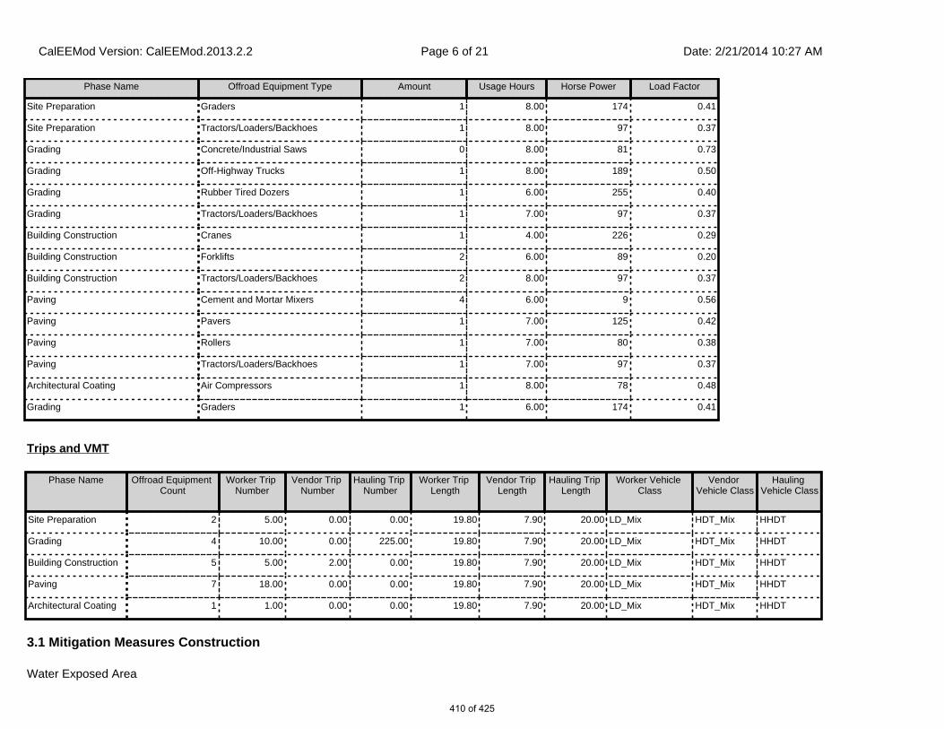
3.1 Mitigation Measures Construction
Water Exposed Area
Phase Name Offroad Equipment Type Amount Usage Hours Horse Power Load Factor
Site Preparation Graders 1 8.00 174 0.41
Site Preparation Tractors/Loaders/Backhoes 1 8.00 97 0.37
Grading Concrete/Industrial Saws 0 8.00 81 0.73
Grading Off-Highway Trucks 1 8.00 189 0.50
Grading Rubber Tired Dozers 1 6.00 255 0.40
Grading Tractors/Loaders/Backhoes 1 7.00 97 0.37
Building Construction Cranes 1 4.00 226 0.29
Building Construction Forklifts 2 6.00 89 0.20
Building Construction Tractors/Loaders/Backhoes 2 8.00 97 0.37
Paving Cement and Mortar Mixers 4 6.00 9 0.56
Paving Pavers 1 7.00 125 0.42
Paving Rollers 1 7.00 80 0.38
Paving Tractors/Loaders/Backhoes 1 7.00 97 0.37
Architectural Coating Air Compressors 1 8.00 78 0.48
Grading Graders 1 6.00 174 0.41
Trips and VMT
Phase Name Offroad Equipment Count
Worker Trip Number
Vendor Trip Number
Hauling Trip Number
Worker Trip Length
Vendor Trip Length
Hauling Trip Length
Worker Vehicle Class
Vendor Vehicle Class
Hauling Vehicle Class
Site Preparation 2 5.00 0.00 0.00 19.80 7.90 20.00 LD_Mix HDT_Mix HHDT
Grading 4 10.00 0.00 225.00 19.80 7.90 20.00 LD_Mix HDT_Mix HHDT
Building Construction 5 5.00 2.00 0.00 19.80 7.90 20.00 LD_Mix HDT_Mix HHDT
Paving 7 18.00 0.00 0.00 19.80 7.90 20.00 LD_Mix HDT_Mix HHDT
Architectural Coating 1 1.00 0.00 0.00 19.80 7.90 20.00 LD_Mix HDT_Mix HHDT
CalEEMod Version: CalEEMod.2013.2.2 Date: 2/21/2014 10:27 AMPage 6 of 21
410 of 425

3.2 Site Preparation - 2014
ROG NOx CO SO2 Fugitive PM10
Exhaust PM10
PM10 Total
Fugitive PM2.5
Exhaust PM2.5
PM2.5 Total
Bio- CO2 NBio- CO2 Total CO2 CH4 N2O CO2e
Category lb/day lb/day
Fugitive Dust 0.5303 0.0000 0.5303 0.0573 0.0000 0.0573
Off-Road 1.4341 14.4817 7.3936 9.3700e-003
0.8920 0.8920 0.8206 0.8206
Total 1.4341 14.4817 7.3936 9.3700e-003
0.5303 0.8920 1.4223 0.0573 0.8206 0.8779
Unmitigated Construction On-Site
ROG NOx CO SO2 Fugitive PM10
Exhaust PM10
PM10 Total
Fugitive PM2.5
Exhaust PM2.5
PM2.5 Total
Bio- CO2 NBio- CO2 Total CO2 CH4 N2O CO2e
Category lb/day lb/day
Hauling 0.0000 0.0000 0.0000 0.0000 0.0000 0.0000 0.0000 0.0000 0.0000 0.0000
Vendor 0.0000 0.0000 0.0000 0.0000 0.0000 0.0000 0.0000 0.0000 0.0000 0.0000
Worker 0.0287 0.0460 0.4776 8.5000e-004
0.0753 6.1000e-004
0.0759 0.0200 5.6000e-004
0.0205
Total 0.0287 0.0460 0.4776 8.5000e-004
0.0753 6.1000e-004
0.0759 0.0200 5.6000e-004
0.0205
Unmitigated Construction Off-Site
CalEEMod Version: CalEEMod.2013.2.2 Date: 2/21/2014 10:27 AMPage 7 of 21
411 of 425

3.2 Site Preparation - 2014
ROG NOx CO SO2 Fugitive PM10
Exhaust PM10
PM10 Total
Fugitive PM2.5
Exhaust PM2.5
PM2.5 Total
Bio- CO2 NBio- CO2 Total CO2 CH4 N2O CO2e
Category lb/day lb/day
Fugitive Dust 0.2068 0.0000 0.2068 0.0223 0.0000 0.0223
Off-Road 1.4341 14.4817 7.3936 9.3700e-003
0.8920 0.8920 0.8206 0.8206
Total 1.4341 14.4817 7.3936 9.3700e-003
0.2068 0.8920 1.0988 0.0223 0.8206 0.8430
Mitigated Construction On-Site
ROG NOx CO SO2 Fugitive PM10
Exhaust PM10
PM10 Total
Fugitive PM2.5
Exhaust PM2.5
PM2.5 Total
Bio- CO2 NBio- CO2 Total CO2 CH4 N2O CO2e
Category lb/day lb/day
Hauling 0.0000 0.0000 0.0000 0.0000 0.0000 0.0000 0.0000 0.0000 0.0000 0.0000
Vendor 0.0000 0.0000 0.0000 0.0000 0.0000 0.0000 0.0000 0.0000 0.0000 0.0000
Worker 0.0287 0.0460 0.4776 8.5000e-004
0.0753 6.1000e-004
0.0759 0.0200 5.6000e-004
0.0205
Total 0.0287 0.0460 0.4776 8.5000e-004
0.0753 6.1000e-004
0.0759 0.0200 5.6000e-004
0.0205
Mitigated Construction Off-Site
CalEEMod Version: CalEEMod.2013.2.2 Date: 2/21/2014 10:27 AMPage 8 of 21
412 of 425

3.3 Grading - 2014
ROG NOx CO SO2 Fugitive PM10
Exhaust PM10
PM10 Total
Fugitive PM2.5
Exhaust PM2.5
PM2.5 Total
Bio- CO2 NBio- CO2 Total CO2 CH4 N2O CO2e
Category lb/day lb/day
Fugitive Dust 5.0160 0.0000 5.0160 2.5410 0.0000 2.5410
Off-Road 2.8808 31.2439 17.3851 0.0221 1.6031 1.6031 1.4748 1.4748
Total 2.8808 31.2439 17.3851 0.0221 5.0160 1.6031 6.6191 2.5410 1.4748 4.0159
Unmitigated Construction On-Site
ROG NOx CO SO2 Fugitive PM10
Exhaust PM10
PM10 Total
Fugitive PM2.5
Exhaust PM2.5
PM2.5 Total
Bio- CO2 NBio- CO2 Total CO2 CH4 N2O CO2e
Category lb/day lb/day
Hauling 2.6173 41.3653 28.5752 0.0822 1.9594 0.7781 2.7375 0.5365 0.7157 1.2522
Vendor 0.0000 0.0000 0.0000 0.0000 0.0000 0.0000 0.0000 0.0000 0.0000 0.0000
Worker 0.0574 0.0921 0.9552 1.7100e-003
0.1505 1.2200e-003
0.1517 0.0399 1.1100e-003
0.0410
Total 2.6746 41.4574 29.5304 0.0839 2.1099 0.7793 2.8892 0.5764 0.7168 1.2932
Unmitigated Construction Off-Site
CalEEMod Version: CalEEMod.2013.2.2 Date: 2/21/2014 10:27 AMPage 9 of 21
413 of 425
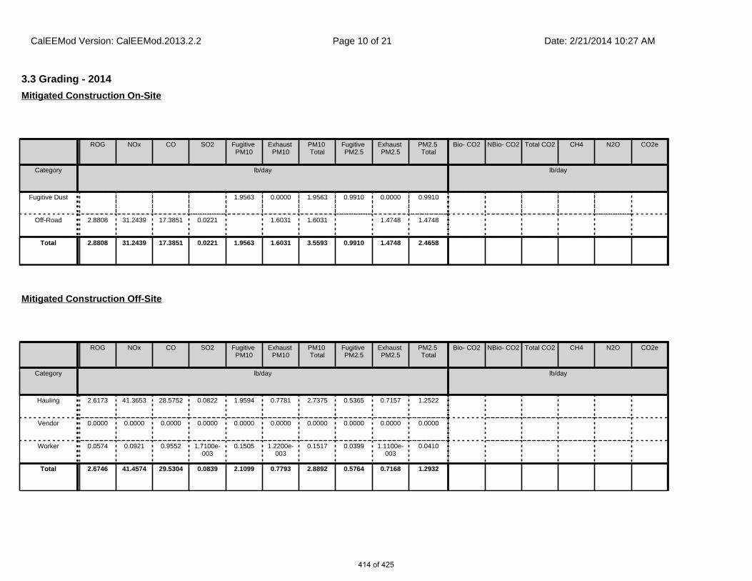
3.3 Grading - 2014
ROG NOx CO SO2 Fugitive PM10
Exhaust PM10
PM10 Total
Fugitive PM2.5
Exhaust PM2.5
PM2.5 Total
Bio- CO2 NBio- CO2 Total CO2 CH4 N2O CO2e
Category lb/day lb/day
Fugitive Dust 1.9563 0.0000 1.9563 0.9910 0.0000 0.9910
Off-Road 2.8808 31.2439 17.3851 0.0221 1.6031 1.6031 1.4748 1.4748
Total 2.8808 31.2439 17.3851 0.0221 1.9563 1.6031 3.5593 0.9910 1.4748 2.4658
Mitigated Construction On-Site
ROG NOx CO SO2 Fugitive PM10
Exhaust PM10
PM10 Total
Fugitive PM2.5
Exhaust PM2.5
PM2.5 Total
Bio- CO2 NBio- CO2 Total CO2 CH4 N2O CO2e
Category lb/day lb/day
Hauling 2.6173 41.3653 28.5752 0.0822 1.9594 0.7781 2.7375 0.5365 0.7157 1.2522
Vendor 0.0000 0.0000 0.0000 0.0000 0.0000 0.0000 0.0000 0.0000 0.0000 0.0000
Worker 0.0574 0.0921 0.9552 1.7100e-003
0.1505 1.2200e-003
0.1517 0.0399 1.1100e-003
0.0410
Total 2.6746 41.4574 29.5304 0.0839 2.1099 0.7793 2.8892 0.5764 0.7168 1.2932
Mitigated Construction Off-Site
CalEEMod Version: CalEEMod.2013.2.2 Date: 2/21/2014 10:27 AMPage 10 of 21
414 of 425

3.4 Building Construction - 2014
ROG NOx CO SO2 Fugitive PM10
Exhaust PM10
PM10 Total
Fugitive PM2.5
Exhaust PM2.5
PM2.5 Total
Bio- CO2 NBio- CO2 Total CO2 CH4 N2O CO2e
Category lb/day lb/day
Off-Road 1.4930 14.8331 8.3419 0.0113 1.0334 1.0334 0.9507 0.9507
Total 1.4930 14.8331 8.3419 0.0113 1.0334 1.0334 0.9507 0.9507
Unmitigated Construction On-Site
ROG NOx CO SO2 Fugitive PM10
Exhaust PM10
PM10 Total
Fugitive PM2.5
Exhaust PM2.5
PM2.5 Total
Bio- CO2 NBio- CO2 Total CO2 CH4 N2O CO2e
Category lb/day lb/day
Hauling 0.0000 0.0000 0.0000 0.0000 0.0000 0.0000 0.0000 0.0000 0.0000 0.0000
Vendor 0.0252 0.2597 0.2789 4.9000e-004
0.0144 5.2200e-003
0.0196 4.1000e-003
4.8000e-003
8.9000e-003
Worker 0.0287 0.0460 0.4776 8.5000e-004
0.0753 6.1000e-004
0.0759 0.0200 5.6000e-004
0.0205
Total 0.0539 0.3057 0.7565 1.3400e-003
0.0896 5.8300e-003
0.0955 0.0241 5.3600e-003
0.0294
Unmitigated Construction Off-Site
CalEEMod Version: CalEEMod.2013.2.2 Date: 2/21/2014 10:27 AMPage 11 of 21
415 of 425
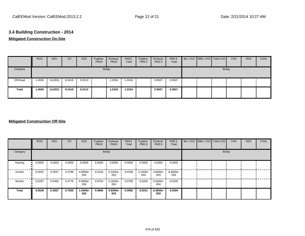
3.4 Building Construction - 2014
ROG NOx CO SO2 Fugitive PM10
Exhaust PM10
PM10 Total
Fugitive PM2.5
Exhaust PM2.5
PM2.5 Total
Bio- CO2 NBio- CO2 Total CO2 CH4 N2O CO2e
Category lb/day lb/day
Off-Road 1.4930 14.8331 8.3419 0.0113 1.0334 1.0334 0.9507 0.9507
Total 1.4930 14.8331 8.3419 0.0113 1.0334 1.0334 0.9507 0.9507
Mitigated Construction On-Site
ROG NOx CO SO2 Fugitive PM10
Exhaust PM10
PM10 Total
Fugitive PM2.5
Exhaust PM2.5
PM2.5 Total
Bio- CO2 NBio- CO2 Total CO2 CH4 N2O CO2e
Category lb/day lb/day
Hauling 0.0000 0.0000 0.0000 0.0000 0.0000 0.0000 0.0000 0.0000 0.0000 0.0000
Vendor 0.0252 0.2597 0.2789 4.9000e-004
0.0144 5.2200e-003
0.0196 4.1000e-003
4.8000e-003
8.9000e-003
Worker 0.0287 0.0460 0.4776 8.5000e-004
0.0753 6.1000e-004
0.0759 0.0200 5.6000e-004
0.0205
Total 0.0539 0.3057 0.7565 1.3400e-003
0.0896 5.8300e-003
0.0955 0.0241 5.3600e-003
0.0294
Mitigated Construction Off-Site
CalEEMod Version: CalEEMod.2013.2.2 Date: 2/21/2014 10:27 AMPage 12 of 21
416 of 425

3.5 Paving - 2014
ROG NOx CO SO2 Fugitive PM10
Exhaust PM10
PM10 Total
Fugitive PM2.5
Exhaust PM2.5
PM2.5 Total
Bio- CO2 NBio- CO2 Total CO2 CH4 N2O CO2e
Category lb/day lb/day
Off-Road 1.2331 11.8542 7.3554 0.0111 0.7457 0.7457 0.6898 0.6898
Paving 0.1258 0.0000 0.0000 0.0000 0.0000
Total 1.3589 11.8542 7.3554 0.0111 0.7457 0.7457 0.6898 0.6898
Unmitigated Construction On-Site
ROG NOx CO SO2 Fugitive PM10
Exhaust PM10
PM10 Total
Fugitive PM2.5
Exhaust PM2.5
PM2.5 Total
Bio- CO2 NBio- CO2 Total CO2 CH4 N2O CO2e
Category lb/day lb/day
Hauling 0.0000 0.0000 0.0000 0.0000 0.0000 0.0000 0.0000 0.0000 0.0000 0.0000
Vendor 0.0000 0.0000 0.0000 0.0000 0.0000 0.0000 0.0000 0.0000 0.0000 0.0000
Worker 0.1032 0.1657 1.7194 3.0700e-003
0.2709 2.2000e-003
0.2731 0.0719 2.0000e-003
0.0739
Total 0.1032 0.1657 1.7194 3.0700e-003
0.2709 2.2000e-003
0.2731 0.0719 2.0000e-003
0.0739
Unmitigated Construction Off-Site
CalEEMod Version: CalEEMod.2013.2.2 Date: 2/21/2014 10:27 AMPage 13 of 21
417 of 425

3.5 Paving - 2014
ROG NOx CO SO2 Fugitive PM10
Exhaust PM10
PM10 Total
Fugitive PM2.5
Exhaust PM2.5
PM2.5 Total
Bio- CO2 NBio- CO2 Total CO2 CH4 N2O CO2e
Category lb/day lb/day
Off-Road 1.2331 11.8542 7.3554 0.0111 0.7457 0.7457 0.6898 0.6898
Paving 0.1258 0.0000 0.0000 0.0000 0.0000
Total 1.3589 11.8542 7.3554 0.0111 0.7457 0.7457 0.6898 0.6898
Mitigated Construction On-Site
ROG NOx CO SO2 Fugitive PM10
Exhaust PM10
PM10 Total
Fugitive PM2.5
Exhaust PM2.5
PM2.5 Total
Bio- CO2 NBio- CO2 Total CO2 CH4 N2O CO2e
Category lb/day lb/day
Hauling 0.0000 0.0000 0.0000 0.0000 0.0000 0.0000 0.0000 0.0000 0.0000 0.0000
Vendor 0.0000 0.0000 0.0000 0.0000 0.0000 0.0000 0.0000 0.0000 0.0000 0.0000
Worker 0.1032 0.1657 1.7194 3.0700e-003
0.2709 2.2000e-003
0.2731 0.0719 2.0000e-003
0.0739
Total 0.1032 0.1657 1.7194 3.0700e-003
0.2709 2.2000e-003
0.2731 0.0719 2.0000e-003
0.0739
Mitigated Construction Off-Site
CalEEMod Version: CalEEMod.2013.2.2 Date: 2/21/2014 10:27 AMPage 14 of 21
418 of 425

3.6 Architectural Coating - 2014
ROG NOx CO SO2 Fugitive PM10
Exhaust PM10
PM10 Total
Fugitive PM2.5
Exhaust PM2.5
PM2.5 Total
Bio- CO2 NBio- CO2 Total CO2 CH4 N2O CO2e
Category lb/day lb/day
Archit. Coating 6.7370 0.0000 0.0000 0.0000 0.0000
Off-Road 0.5950 3.7031 2.5621 3.9600e-003
0.3269 0.3269 0.3269 0.3269
Total 7.3319 3.7031 2.5621 3.9600e-003
0.3269 0.3269 0.3269 0.3269
Unmitigated Construction On-Site
ROG NOx CO SO2 Fugitive PM10
Exhaust PM10
PM10 Total
Fugitive PM2.5
Exhaust PM2.5
PM2.5 Total
Bio- CO2 NBio- CO2 Total CO2 CH4 N2O CO2e
Category lb/day lb/day
Hauling 0.0000 0.0000 0.0000 0.0000 0.0000 0.0000 0.0000 0.0000 0.0000 0.0000
Vendor 0.0000 0.0000 0.0000 0.0000 0.0000 0.0000 0.0000 0.0000 0.0000 0.0000
Worker 5.7400e-003
9.2100e-003
0.0955 1.7000e-004
0.0151 1.2000e-004
0.0152 3.9900e-003
1.1000e-004
4.1000e-003
Total 5.7400e-003
9.2100e-003
0.0955 1.7000e-004
0.0151 1.2000e-004
0.0152 3.9900e-003
1.1000e-004
4.1000e-003
Unmitigated Construction Off-Site
CalEEMod Version: CalEEMod.2013.2.2 Date: 2/21/2014 10:27 AMPage 15 of 21
419 of 425

4.0 Operational Detail - Mobile
3.6 Architectural Coating - 2014
ROG NOx CO SO2 Fugitive PM10
Exhaust PM10
PM10 Total
Fugitive PM2.5
Exhaust PM2.5
PM2.5 Total
Bio- CO2 NBio- CO2 Total CO2 CH4 N2O CO2e
Category lb/day lb/day
Archit. Coating 6.7370 0.0000 0.0000 0.0000 0.0000
Off-Road 0.5950 3.7031 2.5621 3.9600e-003
0.3269 0.3269 0.3269 0.3269
Total 7.3319 3.7031 2.5621 3.9600e-003
0.3269 0.3269 0.3269 0.3269
Mitigated Construction On-Site
ROG NOx CO SO2 Fugitive PM10
Exhaust PM10
PM10 Total
Fugitive PM2.5
Exhaust PM2.5
PM2.5 Total
Bio- CO2 NBio- CO2 Total CO2 CH4 N2O CO2e
Category lb/day lb/day
Hauling 0.0000 0.0000 0.0000 0.0000 0.0000 0.0000 0.0000 0.0000 0.0000 0.0000
Vendor 0.0000 0.0000 0.0000 0.0000 0.0000 0.0000 0.0000 0.0000 0.0000 0.0000
Worker 5.7400e-003
9.2100e-003
0.0955 1.7000e-004
0.0151 1.2000e-004
0.0152 3.9900e-003
1.1000e-004
4.1000e-003
Total 5.7400e-003
9.2100e-003
0.0955 1.7000e-004
0.0151 1.2000e-004
0.0152 3.9900e-003
1.1000e-004
4.1000e-003
Mitigated Construction Off-Site
CalEEMod Version: CalEEMod.2013.2.2 Date: 2/21/2014 10:27 AMPage 16 of 21
420 of 425

ROG NOx CO SO2 Fugitive PM10
Exhaust PM10
PM10 Total
Fugitive PM2.5
Exhaust PM2.5
PM2.5 Total
Bio- CO2 NBio- CO2 Total CO2 CH4 N2O CO2e
Category lb/day lb/day
Mitigated 15.1890 21.3551 101.4491 0.1009 6.5034 0.2554 6.7588 1.7365 0.2342 1.9707
Unmitigated 15.1890 21.3551 101.4491 0.1009 6.5034 0.2554 6.7588 1.7365 0.2342 1.9707
4.1 Mitigation Measures Mobile
4.2 Trip Summary Information
4.3 Trip Type Information
Average Daily Trip Rate Unmitigated Mitigated
Land Use Weekday Saturday Sunday Annual VMT Annual VMT
Convenience Market With Gas Pumps 4,340.80 1,635.76 1335.04 2,491,402 2,491,402
Parking Lot 0.00 0.00 0.00
Total 4,340.80 1,635.76 1,335.04 2,491,402 2,491,402
Miles Trip % Trip Purpose %
Land Use H-W or C-W H-S or C-C H-O or C-NW H-W or C-W H-S or C-C H-O or C-NW Primary Diverted Pass-by
Convenience Market With Gas Pumps
18.50 10.10 7.90 0.80 80.20 19.00 14 21 65
Parking Lot 18.50 10.10 7.90 0.00 0.00 0.00 0 0 0
LDA LDT1 LDT2 MDV LHD1 LHD2 MHD HHD OBUS UBUS MCY SBUS MH
0.477446 0.065927 0.171594 0.156638 0.055185 0.009062 0.015877 0.037321 0.001132 0.001346 0.004831 0.000736 0.002906
CalEEMod Version: CalEEMod.2013.2.2 Date: 2/21/2014 10:27 AMPage 17 of 21
421 of 425

5.0 Energy Detail
ROG NOx CO SO2 Fugitive PM10
Exhaust PM10
PM10 Total
Fugitive PM2.5
Exhaust PM2.5
PM2.5 Total
Bio- CO2 NBio- CO2 Total CO2 CH4 N2O CO2e
Category lb/day lb/day
NaturalGas Mitigated
8.0000e-005
7.0000e-004
5.9000e-004
0.0000 5.0000e-005
5.0000e-005
5.0000e-005
5.0000e-005
NaturalGas Unmitigated
8.0000e-005
7.0000e-004
5.9000e-004
0.0000 5.0000e-005
5.0000e-005
5.0000e-005
5.0000e-005
5.2 Energy by Land Use - NaturalGas
NaturalGas Use
ROG NOx CO SO2 Fugitive PM10
Exhaust PM10
PM10 Total
Fugitive PM2.5
Exhaust PM2.5
PM2.5 Total
Bio- CO2 NBio- CO2 Total CO2 CH4 N2O CO2e
Land Use kBTU/yr lb/day lb/day
Convenience Market With Gas
Pumps
7.17865 8.0000e-005
7.0000e-004
5.9000e-004
0.0000 5.0000e-005
5.0000e-005
5.0000e-005
5.0000e-005
Parking Lot 0 0.0000 0.0000 0.0000 0.0000 0.0000 0.0000 0.0000 0.0000
Total 8.0000e-005
7.0000e-004
5.9000e-004
0.0000 5.0000e-005
5.0000e-005
5.0000e-005
5.0000e-005
Unmitigated
5.1 Mitigation Measures Energy
4.4 Fleet Mix
Historical Energy Use: N
CalEEMod Version: CalEEMod.2013.2.2 Date: 2/21/2014 10:27 AMPage 18 of 21
422 of 425

6.1 Mitigation Measures Area
6.0 Area Detail
ROG NOx CO SO2 Fugitive PM10
Exhaust PM10
PM10 Total
Fugitive PM2.5
Exhaust PM2.5
PM2.5 Total
Bio- CO2 NBio- CO2 Total CO2 CH4 N2O CO2e
Category lb/day lb/day
Mitigated 0.2458 4.0000e-005
3.7400e-003
0.0000 1.0000e-005
1.0000e-005
1.0000e-005
1.0000e-005
Unmitigated 0.2458 4.0000e-005
3.7400e-003
0.0000 1.0000e-005
1.0000e-005
1.0000e-005
1.0000e-005
5.2 Energy by Land Use - NaturalGas
NaturalGas Use
ROG NOx CO SO2 Fugitive PM10
Exhaust PM10
PM10 Total
Fugitive PM2.5
Exhaust PM2.5
PM2.5 Total
Bio- CO2 NBio- CO2 Total CO2 CH4 N2O CO2e
Land Use kBTU/yr lb/day lb/day
Parking Lot 0 0.0000 0.0000 0.0000 0.0000 0.0000 0.0000 0.0000 0.0000
Convenience Market With Gas
Pumps
0.00717865
8.0000e-005
7.0000e-004
5.9000e-004
0.0000 5.0000e-005
5.0000e-005
5.0000e-005
5.0000e-005
Total 8.0000e-005
7.0000e-004
5.9000e-004
0.0000 5.0000e-005
5.0000e-005
5.0000e-005
5.0000e-005
Mitigated
CalEEMod Version: CalEEMod.2013.2.2 Date: 2/21/2014 10:27 AMPage 19 of 21
423 of 425
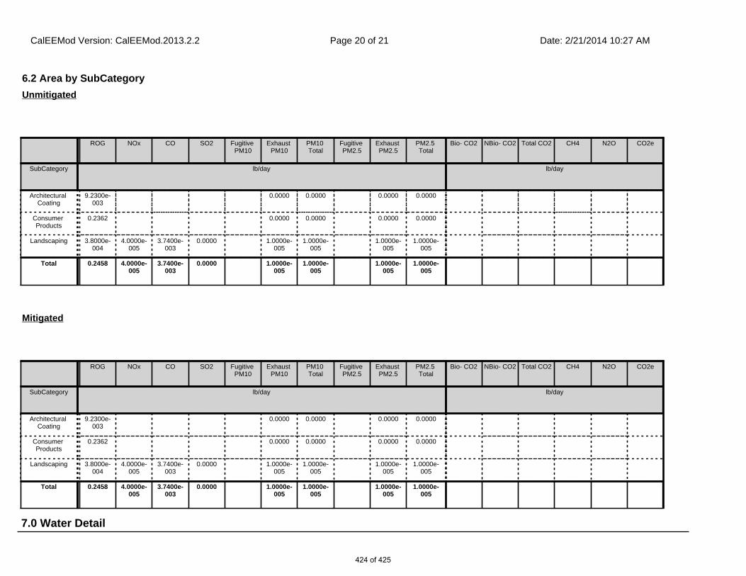
7.0 Water Detail
6.2 Area by SubCategory
ROG NOx CO SO2 Fugitive PM10
Exhaust PM10
PM10 Total
Fugitive PM2.5
Exhaust PM2.5
PM2.5 Total
Bio- CO2 NBio- CO2 Total CO2 CH4 N2O CO2e
SubCategory lb/day lb/day
Architectural Coating
9.2300e-003
0.0000 0.0000 0.0000 0.0000
Consumer Products
0.2362 0.0000 0.0000 0.0000 0.0000
Landscaping 3.8000e-004
4.0000e-005
3.7400e-003
0.0000 1.0000e-005
1.0000e-005
1.0000e-005
1.0000e-005
Total 0.2458 4.0000e-005
3.7400e-003
0.0000 1.0000e-005
1.0000e-005
1.0000e-005
1.0000e-005
Unmitigated
ROG NOx CO SO2 Fugitive PM10
Exhaust PM10
PM10 Total
Fugitive PM2.5
Exhaust PM2.5
PM2.5 Total
Bio- CO2 NBio- CO2 Total CO2 CH4 N2O CO2e
SubCategory lb/day lb/day
Architectural Coating
9.2300e-003
0.0000 0.0000 0.0000 0.0000
Consumer Products
0.2362 0.0000 0.0000 0.0000 0.0000
Landscaping 3.8000e-004
4.0000e-005
3.7400e-003
0.0000 1.0000e-005
1.0000e-005
1.0000e-005
1.0000e-005
Total 0.2458 4.0000e-005
3.7400e-003
0.0000 1.0000e-005
1.0000e-005
1.0000e-005
1.0000e-005
Mitigated
CalEEMod Version: CalEEMod.2013.2.2 Date: 2/21/2014 10:27 AMPage 20 of 21
424 of 425

8.1 Mitigation Measures Waste
7.1 Mitigation Measures Water
8.0 Waste Detail
10.0 Vegetation
9.0 Operational Offroad
Equipment Type Number Hours/Day Days/Year Horse Power Load Factor Fuel Type
CalEEMod Version: CalEEMod.2013.2.2 Date: 2/21/2014 10:27 AMPage 21 of 21
425 of 425