CITY OF SILOAM SPRINGS PLANNING COMMISSION ...
66
CITY OF SILOAM SPRINGS PLANNING COMMISSION Tuesday, May 11, 2021 at 5:30 p.m. City Administration Building 400 N. Broadway AGENDA I. Planning Commission A. Call to Order B. Roll Call C. Approval of Minutes of the meeting of April 13, 2021 D. Development Permit Approval 1. Significant Development Permit, SD21-06 22100 Block of Hwy. 16 Owner: Roderic Allen on behalf of Michael Cox Agent: Expedient Civil Engineering, PLLC, - Jason E. Ingalls, PE To the Board on June 1, 2021 2. Preliminary Plat Development Permit, PP21-02 816 Arkansas Hwy. 16 Owner: Roth Family, Inc. Agent: Bates and Associates, - Geoff Bates, PE. To the Board on June 1, 2021 3. Final Plat Development Permit, FP21-02 2900 Block of Cheri Whitlock Dr. Owner: Wilden Revocable Trust Agent: Ward Jones Realty, - Ward Jones To the Board on June 1, 2021 4. Rezoning Development Permit, RZ21-03 Rezoning from A-1 to C-2 and G-I 2900 Block of Cheri Whitlock Dr. Owner: Wilden Revocable Trust Agent: Ward Jones Realty, Ward Jones To the Board on June 1, 2021 5. Rezoning Development Permit, RZ21-04 Rezoning from A-1 to R-2 1803 Dawn Hill Rd. Owner: Jeff Stewart Agent: Construction Services Inc., - James Caldwell, PLS To the Board on June 1, 2021 6. Rezoning Development Permit, RZ21-05 Rezoning From I-2 to C-2 3550 Hwy. 412 E. Owner: Robert & Marilee Dyke Agent: CEI Engineering, Inc. – Cameron Smith To the Board on June 1, 2021
-
Upload
khangminh22 -
Category
Documents
-
view
3 -
download
0
Transcript of CITY OF SILOAM SPRINGS PLANNING COMMISSION ...

CITY OF SILOAM SPRINGS PLANNING COMMISSION
Tuesday, May 11, 2021 at 5:30 p.m. City Administration Building
400 N. Broadway
AGENDA
I. Planning Commission A. Call to Order B. Roll Call C. Approval of Minutes of the meeting of April 13, 2021 D. Development Permit Approval
1. Significant Development Permit, SD21-06
22100 Block of Hwy. 16 Owner: Roderic Allen on behalf of Michael Cox Agent: Expedient Civil Engineering, PLLC, - Jason E. Ingalls, PE To the Board on June 1, 2021
2. Preliminary Plat Development Permit, PP21-02 816 Arkansas Hwy. 16 Owner: Roth Family, Inc. Agent: Bates and Associates, - Geoff Bates, PE. To the Board on June 1, 2021
3. Final Plat Development Permit, FP21-02 2900 Block of Cheri Whitlock Dr. Owner: Wilden Revocable Trust Agent: Ward Jones Realty, - Ward Jones To the Board on June 1, 2021
4. Rezoning Development Permit, RZ21-03
Rezoning from A-1 to C-2 and G-I 2900 Block of Cheri Whitlock Dr. Owner: Wilden Revocable Trust Agent: Ward Jones Realty, Ward Jones To the Board on June 1, 2021
5. Rezoning Development Permit, RZ21-04 Rezoning from A-1 to R-2 1803 Dawn Hill Rd. Owner: Jeff Stewart Agent: Construction Services Inc., - James Caldwell, PLS To the Board on June 1, 2021
6. Rezoning Development Permit, RZ21-05
Rezoning From I-2 to C-2 3550 Hwy. 412 E. Owner: Robert & Marilee Dyke Agent: CEI Engineering, Inc. – Cameron Smith To the Board on June 1, 2021

2
7. Special Use Development Permit, SU21-03 305 S. Mt. Olive St. Owner and Agent: Chad Dilday To the Board on June 1, 2021
E. City Comprehensive Plan Monthly Update F. Board Approved Permit
1. Final Plat Development Permit, FP21-01
2300 Block of N. Mt. Olive St. Owner: Yessss Development, LLC To the Board on June 1, 2021
G. Staff Approved Permits
1. Lot Line Adjustment Development Permit, LA21-02
3550 Hwy. 412 E. Owner: Robert & Marilee Dyke’s Agent: CEI Engineering, Inc. – Cameron Smith Went to the Board for Easements on May 4, 2021
2. Lot Line Adjustment Development Permit, LA21-03
606 and 612 N. Madison St. Owner: Ram Group Assets, LLC Agent: Construction Services, Inc. – James Caldwell, PLS To the Board for Easements on May 18, 2021
H. Adjournment

MINUTES OF THE REGULAR MEETING OF THE PLANNING COMMISSION OF THE
CITY OF SILOAM SPRINGS, BENTON COUNTY, ARKANSAS APRIL 13, 2021
The Planning Commission of the City of Siloam Springs, Benton County, Arkansas, met in regular session at the City Administration Building on April 13, 2021 The meeting was called to order by Chairman Smith. Roll Call: Song, Montgomery, Salley, McKinney, Smith, McKenzie – Present. Driscoll – Absent. Present City Staff: Senior City Planner, Ben Rhoads; City Engineer, Justin Bland; and City Attorney, Jay Williams; Permit Technician, Brian Phillips; all present. A copy of the March 9, 2021, minutes had previously been given to each Commissioner. A motion was made by Montgomery and seconded by McKenzie to accept the minutes. A Voice Vote was taken on the pending motion. Motion passed unanimously. Item D1. Significant Development Permit, SD21-03, 22000 Hwy. 16. Ben Rhoads briefed the item. Staff recommended approval with conditions. Following discussion by the commission, a motion was made by McKinney to approve the item with staff’s stated conditions and seconded by Salley. Motion passed unanimously. This item will go to the Board of Directors on May 4, 2021. Item D2. Preliminary Plat Development Permit, PP21-01, 600 to 700 Block of East Lake Francis Drive. Rhoads briefed the item. Staff recommended approval with conditions. Rhoads said one phone call of opposition had been received concerning traffic and condition of Lake Francis Drive. Judy Saferite, 726 E. Cypress Court, addressed the commission with concerns about the possibility of parking along Lake Francis Drive, traffic volume, and narrowness of Aspen Court. Rhoads addressed her concerns. Commissioners had questions about Lake Francis Drive improvements. Justin Bland addressed them. Following discussion by the commission, a motion was made by McKenzie to approve the item with staff’s stated conditions and seconded by Montgomery. Motion passed unanimously. This item will go to the Board of Directors on May 4, 2021. Item D3. Rezone Development Permit, RZ21-02, 900 Block of South Washington Street. Rhoads briefed the item. Rhoads stated a late email was received on April 12 and a letter was hand delivered on April 13 in opposition to the request. Staff recommended denial of the application. Ron Homeyer, Civil Engineering, 701 S. Mt. Olive Street addressed the commission on behalf of the applicant. Following discussion by the commission, a motion was made by Song to deny the permit and seconded by McKinney. The commission voted 5-1 to deny the request with member McKenzie voting against the motion to deny. Member Driscoll was absent. This item will go to the Board of Directors on May 4, 2021. Item E. City Comprehensive Plan Monthly Update. Rhoads briefed the item. Item F1. Annexation / Zoning Development Permit, AX21-01, 23006 Lawlis Road. Rhoads briefed the item. Went to the Board on April 6, 2021.

Item G1. Lot Split Development Permit, LS21-04, 402 South Oak Hill Street. Rhoads briefed the item. Went to the Board for Easements on April 6, 2021. Item G2. Lot Split Development Permit, LS21-01, 911 Hwy 16 South. Rhoads briefed the item. Went to the Board for Easements on April 20, 2021. Item G3. Lot Split Development Permit, LS21-06, 3000 Block of Waukesha Road. Rhoads briefed the item. Went to the Board for Easements on April 20, 2021. Item G4. Lot Line Adjustment Permit, LA21-01, 415 East University Street. Went to the Board for Easements on May 4, 2021. There being no further business, a Motion was made by Song and seconded by McKinney to adjourn. A Voice Vote was called. Motion passed unanimously. Meeting adjourned. ATTEST: APPROVED: _________________________ ______________________________ Renea Ellis, City Clerk J.W. Smith, Chairman (SEAL)

PLANNING COMMISSION STAFF REPORT TO: Planning Commission FROM: Ben Rhoads, AICP, Senior Planner Justin Bland, PE, City Engineer Cc: Don Clark, Community Development Director DATE: May 4, 2021 RE: Significant Development Permit, SD21-06 / 22100 Block of Hwy. 16 Recommendation: Motion to approve SD21-06 (Significant Development Permit), subject to the following conditions: 1) The applicant shall annex the subject property into the City of Siloam Springs and request to
apply the I-1 zone, as indicated on the significant development permit, prior to construction on the property.
2) The applicant must file a utility easement plat via separate instrument, as directed by the City Engineer, prior to certificate of occupancy.
3) The applicant shall comply with exterior parking lot lighting City standards, including a photometric plan in the architectural plans, prior to building permit issuance.
Section A: Background A-1) APPLICATION REVIEW DATES Planning Commission review: May 11, 2021 Board of Directors review: June 1, 2021 A-2) APPLICANT AND AGENT
Applicant/Owner: Roderic Allen on behalf of Michael Cox Agent: Expedient Civil Engineering, PLLC, Jason E. Ingalls, PE A-3) SUBJECT PROPERTY ADDRESS
22100 Block of Hwy. 16 A-4) PROJECT SUMMARY
The applicant requests to construct a 67,178 sq. ft. food processing facility, of which 61,534 square feet will be warehouse space and the remaining 5,644 will be office space. The facility will add approximately 100 new jobs to the area.
A-5) LEGAL NOTICE
Site posted: April 9, 2021. Newspaper legal notification: April 21, 2021 (Herald Leader). Letter legal notification: April 20, 2021. Staff received no calls or correspondence on the request.

5/6/21 P.N. 15-18576-000, SD21-06 2
A-6) REFERENCE APPLICATIONS
The following application is associated with this request: • AX21-03 (Annexation Development Permit)
This application will be heard at the June 15, 2021 regular meeting of the Board of Directors. A-7) ANTICIPATED PROJECT APPROVAL EXPIRATION DATE
If this project is approved on the projected Board of Directors’ review date, the project will expire if no work begins on or before: June 1, 2022. For cause shown, the applicant may request a 180-day deadline extension if received no less than 30 days prior to the shown expiration.
A-8) EXISTING LAND USES AND ZONING
EXISTING LAND USE EXISTING ZONING Vacant Benton County – No Zoning
PROPOSED LAND USE PROPOSED ZONING Industrial (Use Unit 21) I-1 District (Industrial)
SURROUNDING LAND USE SURROUNDING ZONING North: Vacant Woodlands North: Benton County – No Zoning South: Vacant Industrial
(future development) South: I-2 District (Light Industrial)
East: Vacant East: Benton County – No Zoning West: Heavy Industrial West: I-1 District (Industrial)
Figure A-7 (1): General Area Map

5/6/21 P.N. 15-18576-000, SD21-06 3
Figure A-7 (2): Site View
Section B: Site Analysis B-1) PROJECT ANALYSIS AND APPROVAL CRITERIA
The following criteria are shown to indicate if this proposal meets the minimum criteria for approval. Criteria I-II is a subsection of Sec. 102-54 (land use) and subsection 102-54 (lot standards) of the Municipal Code; Criterion III is Sec. 102-74; Criterion IV is Sec. 102-75; Criterion V is Sec. 102-76; Criterion VI is Chapter 53 (Landscaping Code); Criterion VII is Sec. 102-77 thru 102-78; and Criterion VIII is Sec. 54-34.
Note: The I-1 zone is proposed per the related annexation request, therefore it will be used as the assumed zoning for this application review.
I. ZONING USE UNIT CONSISTENCY
I-1 District (Industrial)
(a) Purpose The district is established to protect the accessibility, efficiency, utility and value of intensive industrial enterprises, and to provide areas which are reasonably accessible to adults, but are not adjacent to businesses serving children, for business restricted by law to adult customers.
(b) Planned uses Large scale industrial uses fall under Use Unit 21 (General Industrial). Use Unit 21 is permitted in the I-1 district.
(c) Special uses This does not apply to this project, as the proposed use is a planned use.
North

5/6/21 P.N. 15-18576-000, SD21-06 4
II. LOT STANDARDS CONSISTENCY
The minimum I-1 zone standards are compared with the subject property’s lot below:
MINIMUM (I-1) ZONING REQUIREMENTS
SUBJECT PROPERTY PROPOSAL
(d) Lot dimensions (1) 30,000 square feet
11.70 acres or 509,652 square feet
(2) Lot Width: 150 ft. 633.85 feet (e) Building limits (1)(a) Setbacks: (When not abutting an ‘R’ zone) 1. Front: 50 feet.
214.5 ft.
2. Side: 10 feet 131 ft. (North side) 60 ft (South side)
3. Side on Corner: 20 feet N/A 4. Rear: 25 feet 457 ft. (2)(a) Height Limit: 35 feet maximum 30.0 ft. to the eave. (33 ft. average to
roof peak) (3) Floor / area Ratio: 0.60 (maximum) 12.0 % (4) Maximum Lot Coverage: 80 percent 70.5 % (f) Open Space (1) Landscape buffer not less than ten feet wide along property lines and a 6 ft. opaque screen
North 93 ft. South: 10 ft. East: 44.5 ft. West: 391.5 ft.
(2) Minimum percent of open space: 20% 10% must be visible from front or sides of the lot from addressing right-of-way
29.5% 10% is visible from Hwy. 16.
III. PARKING SPACE DESIGN CONSISTENCY
PARKING SPACE REQUIREMENTS SUBJECT PROPERTY PROPOSAL
(1) At least 9 ft. wide x 18 ft. long Spaces comply (2) Graded for effective drainage Spaces comply (3) Surfaced with asphalt or concrete Spaces are paved with standard duty
asphalt paving (4) Sited to not block emergency
vehicle access Parking complies per FD review
(5) Minimum parking lane width: 24 ft (15 feet for a one-way drive).
24 ft.
(6) Curbed if 8 feet from sidewalk Parking lot is curbed (7) Lot striping Parking lot is striped

5/6/21 P.N. 15-18576-000, SD21-06 5
IV. PARKING STANDARDS CONSISTENCY
Parking is calculated for manufacturing and office facility. The parking ratio for manufacturing is 1 space for every 1,200 square feet and the parking ratio for office is one space for every 200 square feet.
USE REQUIRED PARKING
EXISTING PARKING
NET PROPOSED PARKING1
PARKING SURPLUS/ DEFICIT
Warehouse 51.27 0 51 0 Office 28.22 0 20 -82 Total 79.493 0 71
1 Includes ADA accessible spaces. 2 The applicant is requesting a parking waiver of 10.57% of the total required parking. The City Code permits parking waivers by the permitting authority up to 30% in cases where good cause is shown by the applicant.
3 The attached parking waiver letter rounds this to 80 spaces, however for the purpose of this calculation, staff rounded this down to 79 spaces required. See report Sec. B-5 for more information.
V. PARKING AREA DESIGN STANDARDS CONSISTENCY
CONDITION FOR NUMBER OF PARKING SPACES
SUBJECT PROPERTY PROPOSAL
(1) 5 or more spaces: shall be continuous lit at night.
Spaces to be lit by full cutoff light fixtures on the sides of the buildings.
(2) 8 or more spaces: adequate turn around.
The Fire Department reviewed the proposal and determined that it allows for adequate vehicular turn around on all proposed parking areas.
(3) 10 or more: shall be paved with asphalt or concrete.
Parking lot is paved with standard duty asphalt paving.
(4) Parking lot landscaping is required as follows: a. 12-50: 8 percent of gross interior parking area
2,765 SF. 10.63 percent of the parking lot interior is landscaped.
(5) No parking allowed along easements, except as specifically shown
The parking area encroachment into the easement is typical and has been approved by all public and private utilities.
VI. LANDSCAPING COMPLIANCE
After staff review, the applicant made changes to the landscape plan to meet or exceed the minimum landscaping requirements of the City Code. For additional information, please consult the attached landscaping plan.
VII. DRIVEWAY DESIGN STANDARDS CONSISTENCY
MINIMUM DRIVEWAY STANDARDS REQUIREMENTS
SUBJECT PROPERTY PROPOSAL
(1) Surface Surface must be paved with asphalt, concrete or paver stones
All driveways will be paved concrete paving
(2) (c) Width 1. Width shall not be less than 25 ft.
nor greater than 50 ft.
31 feet Table continues on page 6

5/6/21 P.N. 15-18576-000, SD21-06 6
(3) Curbs, lane markings.
Curbing and markings shall effectively delineate traffic lanes.
Table continued from page 5 All drives and parking areas have curbs and appropriate lane markings
(4) Interior drive setbacks. c. No driveway that serves more than
40 parking spaces may be intersected by an interior drive with 75 feet of the roadway surface.
(a) 106 feet from roadway
Minimum Drive intersection with the street. (1) Arterial (and larger) streets:
a. 100 feet from the centerline of any other driveway;
b. 100 feet from the boundary of an intersection street’s right-of-way; and
c. 50 feet from all boundaries of the lot, except the boundary abutting the arterial street.
The remaining Code in this section is not applicable for the proposed project.
Arkansas Highway 161
(a) 398 feet2 (b) 253 feet (c) N/A (shared drive access with the
lot to the south)
(d) Number (1) Minimum number: One (2) Maximum number: One per 150 ft. (c) Location
Driveway location: Not over easements; must align with facing driveways
(d) Angle: Right angle (90 degrees) (e) Grade: Must not exceed 5% grade
The existing drive meets or exceeds these requirements.
1 For the purpose of this analysis, Hwy. 16 is classified as an arterial street. 2 The distance is measured to a driveway that is currently in the approval process with the City and ArDOT for an unrelated project south of the subject property.
VIII. LAND USE CODE REQUIREMENTS
According to the Land Use Code, a significant development permit shall only be authorized when the applicant has convincingly demonstrated that the proposed significant project: (1) Will not interfere with other owners’ reasonable peace and enjoyment of their
neighboring properties:
The applicant’s proposal is a food processing manufacturing facility. Staff is aware of no evidence that the proposed development will cause a consistent disturbance to the peace and enjoyment of the neighboring properties, which are either undeveloped or are the same land use as the proposal. Enforcement of the City Code’s nuisance chapter will ensure that excessive noise, or unsightly debris, etc. is mitigated. These rules ensure that the proposal will not inherently decrease the quality of life standards already in place across the City.

5/6/21 P.N. 15-18576-000, SD21-06 7
(2) Will not substantially damage any property value in the neighborhood:
(3) Will be compatible with and respect the context of its location and the character of the surrounding existing neighborhoods:
(4) Will not, whether by the nature of the use, or by the siting, height, or design of structures or landscaping, tend to burden the present or future use of neighboring properties in accordance with current zoning standards:
(5) Is adequately supported by infrastructure, including without limitation, water and sewage systems, streets, parking, and drainage:
The property is located along a major thoroughfare and is planned for zoning appropriate for industrial use. Nothing in the proposal is indicative of damage to neighboring property values as the neighboring properties are either like uses or they are undeveloped.
The proposed center is consistent with other industrial properties in the existing neighborhood, particularly to the west and south.
There is no evidence that the proposal will cause any substantial burden to the present uses around the area. Traffic will slightly increase, but not beyond the design capacity of Hwy. 16. If traffic is not exceeding posted speed limits, the addition of new vehicles will not increase the safety risk. Staff raised the issue with ArDOT on a potential intersection improvement at Hwy. 412 and Hwy. 16. to address the traffic increases.
Water System A 12” water main exists on the east side of Hwy. 16. Staff finds this line adequate to serve the needs for the proposed development. Sanitary Sewer System A 10” sanitary sewer line runs along north side of the property as well as along the east side of Hwy. 16. Staff finds this existing infrastructure to be adequate for wastewater needs. Storm Sewer System The development will cause an increase in peak stormwater flow from the site due to the increase in impervious area. To mitigate this increase a detention basin is being proposed. The detention basin is proposed to reduce the 100-year pre-development peak flows of 105 cfs down to 89 cfs in the 100-year post-development peak flow rate. In addition, the detention pond will require a water quality feature to hold the first 1” of rainfall up to 24 hours and allow any suspended sediment to drop out. Staff finds that the proposed storm sewer system design meets the requirements of the drainage manual. Parking Refer to Criterion IV under report Section B-1

5/6/21 P.N. 15-18576-000, SD21-06 8
(6) Is consistent with sound planning of the city’s growth in terms of health, safety, and convenience within the neighborhood and affected vicinity:
(7) Promotes favorable economic conditions or public welfare within the city. B-2) COMPREHENSIVE PLAN CONSISTENCY
The 2030 Land Use Map describes this area as medium density residential. The proposed use is not consistent with the 2030 Land Use Map, however a sizable 35.4-acre industrial site to the north of this area is being developed as residential, so adding industrial at the subject property helps offset the loss of industrial designated area to the north. The zoning of the 35.4 acres is R-3, so the future land use map did not come into play for the development of that area. Furthermore, the development pattern in this area, along a major highway, has been industrial to the west and south. Taking these factors into consideration, staff is in support of the development proposal and the related annexation and zoning request to I-1.
B-3) TRAFFIC IMPACT
The proposed development will increase traffic in the area. According to the Institute of Traffic Engineer’s Trip Generation Manual there will be 4.96 trips per day per 1,000 sq. feet of warehouse added (Land Use 100 – Light Industrial) and 9.74 trips per day per 1,000 sq. ft. of general office area (Land Use 710 - General Office Building). This will result in the calculated addition of 360 trips per day onto Hwy. 16 for the proposed building. The agent has informed staff that the site plans to have two shifts with 50 people per shift. In addition there will be truck traffic, but the agent wasn’t aware of what the daily volume would be on average. However, the calculated 360 trips per day appears to be in line with what would be expected based on the number of employees and modest number of trucks per day. Hwy. 16 . is classified as a minor arterial street in the Master Street Plan with an ultimate design capacity of up to 22,000 vehicles per day. The current traffic count on Hwy. 16 in this area is 4,600 vehicles per day so the additional 360 trips will keep the road within its design capacity. The stopping and intersection sight distances are adequate and staff does not see any major safety issues. Staff has approached ArDOT regarding improving the intersection of Hwy. 16 and Hwy. 412 as much of this traffic is expected to go north. Staff will keep engaging them regarding what can be done.
B-4) UTILITY DESIGN
Water The proposal ties into the existing 12” water main with an 8” main line extension that loops around the building. City staff finds that this is adequate for domestic and fire flow needs.
There is nothing in the proposal which would indicate unsound city planning. The proposal meets or exceeds the minimum proposed I-1 zoning requirements.
The food processing facility will add 100 new jobs to the area. As a result, increased economic activity will occur by increased employment and utility sales.

5/6/21 P.N. 15-18576-000, SD21-06 9
Sanitary Sewer The proposal ties into the sewer with a service line at the north side of the property. Storm Sewer/Drainage See discussion in Section B-1 (Criterion VIII-4)
B-5) STAFF DISCUSSION General Summary Proposal is a 61,534 square foot industrial warehouse and food processing facility and a 5,644
attached office, the total development being 67,178 square feet. The facility is located on Hwy. 16, north of an existing warehouse used by Day Spring Cards. The facility will employ approximately 100 people and will be used for processing eggs and
other food products. Staff has determined that the facility will primarily be used as a warehouse with a smaller office
area. As such, the applicant has advised staff that there will be adverse impacts to the area in terms of light, sound, air, or odor emissions.
Traffic Flow and Site Design The proposal utilizes a new 31 ft-wide driveway to Hwy. 16. Three main parking areas for
passenger vehicles will stem off the main drive. The building also makes use of 16 bays for semi-tractor trailers to load and upload product from
the facility. These bays are situated on the east and sound sides of the building. There is adequate concrete paved area for the truck traffic and needed turning movements for
ingress and egress. The paving material is a standard asphalt duty for the passenger vehicle parking areas, this is
because there will be less wear and tear in the areas. Parking Area Design The applicant is proposing three main parking areas, a 23-space lot in front of the facility and
two additional areas to the right of the primary entry drive, for a total of 71 parking spaces. This is 8 spaces short of the 79 required by Code.
Due to the limitations on the number of employees and visitors expected to this site, the applicant is requesting a 10.57 percent parking space reduction. This is allowed per Code Section 102-75(6)(d), which grants the permitting authority the ability to reduce parking to up to 30 percent of the quantity required.
The applicant informed staff in the attached letter that the 100 employees will be divided into two work shifts, there should be no more than 50 vehicles at the property at any given time.
The additional parking, beyond 50 spaces, will allow for overflow for work shift changes. Furthermore, there are ample paved areas on the site for passenger vehicles to que while waiting for employees to exit the property, if needed. Therefore, the need for additional parking becomes superfluous. Staff is in support of the request.

5/6/21 P.N. 15-18576-000, SD21-06 10
Pedestrian Mobility A sidewalk is constructed along Hwy. 16. Sidewalk is also shown from the main parking area
to the facility. Other Considerations Annexation and zoning to I-1 is required, see Sec A-
6 and the staff suggested condition. The annexation is a requirement for hooking onto
City-operated utilities. Storm water drainage is handled through a planned
on-site detention basin on the NW corner of the site. The traffic and drainage reports were reviewed by the City Engineer and received a positive
recommendation.
Conditions and Staff Conclusions As shown on page 1 of this report, staff is recommending approval with three condition needed
regarding the required annexation and zoning of the property to I-1, a needed easement plat, and the requirement for a photometric lighting plan.
Fiscal Impact: Street impact fees will be assessed upon building permit issuance. Attachments:
Site Plan Proposal with Landscape Plan Architectural Rendering Parking Waiver Letter
Key Points: • Consistent with the proposed
zoning. • Annexation/zoning is
required. • Adding 100 jobs to the
community. • Applicant requesting a
10.5% parking reduction.

File No.
SHEET NAME
JOB NUMBER
DATE
CHECKED BY:
DRAWN BY:
4/1/2021
5/3/2021
Know what'sbelow.Callbefore you dig.
21-1013.dwg
Rev
Com
men
tsD
ate
9200
SU
ITS
US
DR
, STE
. BBE
LLA
VIST
A, A
R 7
2714
O: (
479)
364
-002
8D
: (47
9) 3
67-2
924
M: (
509)
759
-530
0EM
AIL:
jaso
n@ec
e-pl
lc.c
om
2418
5 M
ILL
RD, S
UMM
ERS,
AR
7276
9
HW
Y 16
SILO
AM S
PRIN
GS,
AR
MIC
HAE
L C
OX
JEI
JEI
21-1013
1PE
R C
ITY
CO
MM
ENTS
4/21
/202
1
2PE
R C
ITY
CO
MM
ENTS
5/3/
2021
C1.0
COVER SHEET
ROCK
HILL
FOO
DS P
ACKA
GING
&DI
STRI
BUTI
ON F
ACIL
ITY
ROCK HILL FOODS PACKAGING &DISTRIBUTION FACILITY
HIGHWAY 16 SOUTHSILOAM SPRINGS, ARKANSAS
TAX PARCEL #15-18576-000
SD21-06 (Rockhill Foods) 3rd Submittal
AutoCAD SHX Text
A:\Projects\2021 Projects\21-1013 Rockhill Foods Packaging & Distribution Facility\Dwg\21-1013.dwg
AutoCAD SHX Text
NOT FOR CONSTRUCTION
AutoCAD SHX Text
N
AutoCAD SHX Text
O
AutoCAD SHX Text
I
AutoCAD SHX Text
T
AutoCAD SHX Text
A
AutoCAD SHX Text
Z
AutoCAD SHX Text
I
AutoCAD SHX Text
R
AutoCAD SHX Text
O
AutoCAD SHX Text
H
AutoCAD SHX Text
T
AutoCAD SHX Text
U
AutoCAD SHX Text
A
AutoCAD SHX Text
F
AutoCAD SHX Text
O
AutoCAD SHX Text
E
AutoCAD SHX Text
T
AutoCAD SHX Text
A
AutoCAD SHX Text
C
AutoCAD SHX Text
I
AutoCAD SHX Text
F
AutoCAD SHX Text
C
AutoCAD SHX Text
I
AutoCAD SHX Text
T
AutoCAD SHX Text
R
AutoCAD SHX Text
E
AutoCAD SHX Text
R
AutoCAD SHX Text
E
AutoCAD SHX Text
E
AutoCAD SHX Text
N
AutoCAD SHX Text
I
AutoCAD SHX Text
G
AutoCAD SHX Text
N
AutoCAD SHX Text
E
AutoCAD SHX Text
S
AutoCAD SHX Text
A
AutoCAD SHX Text
S
AutoCAD SHX Text
N
AutoCAD SHX Text
A
AutoCAD SHX Text
K
AutoCAD SHX Text
R
AutoCAD SHX Text
A
AutoCAD SHX Text
ECE
AutoCAD SHX Text
No. 3356
AutoCAD SHX Text
VICINITY MAP NOT TO SCALE
AutoCAD SHX Text
NOTE TO CONTRACTOR: THE CONTRACTOR SHALL NOT TAKE ANY ADVANTAGE OF ANY APPARENT ERROR OR OMISSION IN THE PLANS OR SPECIFICATIONS. IN THE EVENT THE CONTRACTOR DISCOVERS SUCH AN ERROR OR OMISSION, THE CONTRACTOR SHALL IMMEDIATELY NOTIFY THE ENGINEER. THE ENGINEER WILL THEN MAKE SUCH CORRECTIONS AND INTERPRETATIONS AS MAY BE DEEMED NECESSARY FOR FULFILLING THE INTENT OF THE PLANS AND SPECIFICATIONS.
AutoCAD SHX Text
north
AutoCAD SHX Text
%%UCONSTRUCTION NOTES%%U
AutoCAD SHX Text
21685 MILL RD SUMMERS, ARKANSAS 72769
AutoCAD SHX Text
SPRINGDALE, ARKANSAS 72763
AutoCAD SHX Text
4901 S. 48TH STREET
AutoCAD SHX Text
FAYETTEVILLE, ARKANSAS 72701
AutoCAD SHX Text
HAROLD DR
AutoCAD SHX Text
410 N. BROADWAY
AutoCAD SHX Text
1301 FEDERAL WAY
AutoCAD SHX Text
LOWELL, ARKANSAS 72745
AutoCAD SHX Text
(479) 524-3103
AutoCAD SHX Text
(479) 524-3777
AutoCAD SHX Text
(479) 442-1977
AutoCAD SHX Text
(479) 238-0932
AutoCAD SHX Text
(479) 333-7009
AutoCAD SHX Text
ADDRESS
AutoCAD SHX Text
RESOURCE LIST
AutoCAD SHX Text
NAME
AutoCAD SHX Text
TELEPHONE
AutoCAD SHX Text
COX COMMUNICATIONS MR. JASON COMBS
AutoCAD SHX Text
SILOAM SPRINGS ELECTRIC MR. PHIL STOKES
AutoCAD SHX Text
AT&T MR. LAYNE RHODES
AutoCAD SHX Text
CITY OF SILOAM SPRINGS PLANNING MR. BEN RHOADS
AutoCAD SHX Text
BLACK HILLS ENERGY MR. BRANDON STUBBS
AutoCAD SHX Text
DEVELOPER MICHAEL COX
AutoCAD SHX Text
(479) 238-0944
AutoCAD SHX Text
CITY OF SILOAM SPRINGS ENGINEERING MR. JUSTIN BLAND
AutoCAD SHX Text
(479) 365-2402
AutoCAD SHX Text
CITY OF SILOAM SPRINGS (FIRE MARSHAL) MR. DUSTIN KINDELL
AutoCAD SHX Text
1-800-482-8998
AutoCAD SHX Text
UTILITY LOCATIONS ARKANSAS ONE-CALL SYSTEM, INC.
AutoCAD SHX Text
1600 W. QUARTER ROAD
AutoCAD SHX Text
1. CONTRACTOR SHALL RETAIN A FULL SET OF THE LATEST APPROVED CONTRACTOR SHALL RETAIN A FULL SET OF THE LATEST APPROVED CONSTRUCTION PLANS ON SITE DURING CONSTRUCTION ACTIVITIES. 2. COORDINATE START-UP AND ALL CONSTRUCTION ACTIVITIES WITH THE COORDINATE START-UP AND ALL CONSTRUCTION ACTIVITIES WITH THE DEVELOPER'S RESIDENT REPRESENTATIVE. 3. CONSTRUCTION METHODS AND MATERIALS NOT SPECIFIED IN THESE PLANS CONSTRUCTION METHODS AND MATERIALS NOT SPECIFIED IN THESE PLANS ARE TO MEET OR EXCEED THE SITEWORK SPECIFICATIONS PROVIDED BY EXPEDIENT CIVIL ENGINEERING, PLLC OR AS SPECIFIED BY THE DEVELOPER'S RESIDENT REPRESENTATIVE. 4. ALL CONSTRUCTION WORK AND UTILITY WORK OUTSIDE OF PROPERTY ALL CONSTRUCTION WORK AND UTILITY WORK OUTSIDE OF PROPERTY BOUNDARIES SHALL BE PERFORMED IN COOPERATION WITH AND IN ACCORDANCE WITH REGULATIONS OF THE AUTHORITIES CONCERNED. 5. PUBLIC CONVENIENCE AND SAFETY: PUBLIC CONVENIENCE AND SAFETY: THE CONTRACTOR SHALL CONDUCT THE WORK IN A MANNER THAT WILL ENSURE, AS FAR AS PRACTICABLE, THE LEAST OBSTRUCTION TO TRAFFIC AND SHALL PROVIDE FOR THE CONVENIENCE AND SAFETY OF THE GENERAL PUBLIC AND RESIDENTS ALONG AND ADJACENT TO HIGHWAYS IN THE CONSTRUCTION AREA IN AN ADEQUATE AND SATISFACTORY MANNER IN ACCORDANCE WITH THE LATEST EDITION OF THE MANUAL ON UNIFORM TRAFFIC CONTROL DEVICES (MUTC) FOR STREETS AND HIGHWAYS AND THE ARKANSAS DEPARTMENT OF TRANSPORTATION STANDARD SPECIFICATIONS FOR HIGHWAY CONSTRUCTION, LATEST EDITION. 6. GRADING NOTES: GRADING NOTES: GRADING NOTES: A. THE CONSTRUCTION AREA SHALL BE CLEARED, GRUBBED, AND THE CONSTRUCTION AREA SHALL BE CLEARED, GRUBBED, AND STRIPPED OF TOPSOIL AND ORGANIC MATTER FROM ALL AREAS TO BE OCCUPIED BY BUILDING AND PAVING. TOPSOIL FOR REPLACEMENT ON SLOPES MAY BE STOCKPILED ON SITE. EXCESS TOPSOIL MAY BE WASTED IN FILL SLOPES EXCEPT THAT NO TOPSOIL WILL BE WASTED WITHIN 10 FEET OF THE EDGE OF THE BUILDING OR PAVED AREA. BURNING OF TIMBER AND DEBRIS WILL NOT BE PERMITTED UNLESS APPROVAL IS OBTAINED FROM GOVERNING OFFICIALS. B. AREAS TO RECEIVE FILL SHALL BE SCARIFIED AND THE TOP 8-INCH AREAS TO RECEIVE FILL SHALL BE SCARIFIED AND THE TOP 8-INCH DEPTH COMPACTED TO 95% OF THE MAXIMUM DRY DENISTY PER ASTM D1557. ANY UNSUITABLE AREAS SHALL BE UNDERCUT AND REPLACED WITH SUITABLE MATERIAL BEFORE ANY FILL MATERIAL CAN BE APPLIED. C. OFF-SITE FILL MATERIAL(SANDY CLAY, CLAYEY SAND, GRAVELLY CLAY, OFF-SITE FILL MATERIAL(SANDY CLAY, CLAYEY SAND, GRAVELLY CLAY, OR CLAYEY GRAVEL), SHALL HAVE A PLASTICITY INDEX OF 15 OR LESS, A LIQUID LIMIT OF 40 OR LESS, A CBR VALUE GREATER THAN 8, AND CONTAIN NO ROCK LARGER THAN 4 INCHES. OFF-SITE FILL MATERIAL SHALL BE APPROVED BY THE DEVELOPER'S REPRESENTATIVE PRIOR TO BRINGING ON SITE. D. AREAS THAT ARE TO BE CUT TO SUBGRADE LEVELS SHALL BE AREAS THAT ARE TO BE CUT TO SUBGRADE LEVELS SHALL BE PROOF ROLLED WITH A FULLY LOADED TANDEM-AXLE DUMP TRUCK OR SIMILAR APPROVED CONSTRUCTION EQUIPMENT TO DETECT UNSUITABLE SOILS. CUT AREAS ARE TO BE SCARIFIED AND RECOMPACTED TO 95% MAXIMUM DRY DENSITY PER ASTM D698 AND TESTED BY A GEOTECHNICAL ENGINEER PRIOR TO PLACEMENT OF BASE MATERIAL. E. IN ALL AREAS OF EXCAVATION, IF UNSUITABLE SOILS ARE IN ALL AREAS OF EXCAVATION, IF UNSUITABLE SOILS ARE ENCOUNTERED, A QUALIFIED GEOTECHNICAL ENGINEER SHALL RECOMMEND TO THE DEVELOPER'S CONSTRUCTION DIVISION ON THE METHODS OF UNDERCUTTING AND REPLACEMENT OF PROPERLY COMPACTED, APPROVED FILL MATERIAL. ALL PROOF ROLLING AND UNDERCUTTING SHALL BE PERFORMED DURING A SUFFICIENT DURATION OF DRY WEATHER PERIOD. F. THE CONTRACTOR SHALL BE RESPONSIBLE FOR THE CONTROL OF THE CONTRACTOR SHALL BE RESPONSIBLE FOR THE CONTROL OF DUST AND DIRT RISING AND SCATTERING IN THE AIR DURING CONSTRUCTION AND SHALL PROVIDE WATER SPRINKLING OR OTHER SUITABLE METHODS OF CONTROL. THE CONTRACTOR SHALL COMPLY WITH ALL GOVERNING REGULATIONS PERTAINING TO ENVIRONMENTAL PROTECTION. G. AN INDEPENDENT TESTING LABORATORY, SELECTED AND PAID BY THE AN INDEPENDENT TESTING LABORATORY, SELECTED AND PAID BY THE CONTRACTOR, APPROVED BY THE DEVELOPER, SHALL BE RETAINED TO PERFORM CONSTRUCTION TESTING OF THE SUBGRADE FOR COMPLIANCE WITH THE MINIMUM REQUIREMENTS OF SUBGRADE COMPACTION. FOR BASE COURSE AND ASPHALT PAVING. H. ALL SLOPES ARE TO BE 3:1 OR FLATTER UNLESS OTHERWISE ALL SLOPES ARE TO BE 3:1 OR FLATTER UNLESS OTHERWISE INDICATED. SLOPES STEEPER THAN 3:1, BUT FLATTER THAN 2:1 SHALL BE STABILIZED BY AN APPROVED VEGETATIVE LAYER OR OTHER APPROVED METHODS. I. ALL SLOPES EXCEEDING 2:1 SHALL BE PROTECTED BY RIP-RAP, CONCRETE PAVING, OR OTHER METHODS INDICATED ON THESE PLANS THAT WILL PREVENT EROSION, AND PLACED SUCH THAT THE SURFACE IS FLUSH WITH SURROUNDING GROUND AND SHAPED TO CHANNEL WATER IN DIRECTIONS INDICATED.
AutoCAD SHX Text
J. CONTRACTOR SHALL REFER TO THE STORMWATER POLLUTION PREVENTION CONTRACTOR SHALL REFER TO THE STORMWATER POLLUTION PREVENTION PLAN AND REPORT FOR STORMWATER QUALITY CONTROL INCLUDING EROSION AND SEDIMENT CONTROL. PROPER MEASURES SHALL BE PRACTICED TO PREVENT EROSION ALONG THE EDGE OF PROPERTY, TOE OF SLOPE, AND ALONG DITCHES. MUD AND DEBRIS ARE NOT ALLOWED TO FLOW ONTO ADJACENT PROPERTIES. K. CONTRACTOR IS TO REMOVE AND DISPOSE OF ALL DEBRIS, RUBBISH AND CONTRACTOR IS TO REMOVE AND DISPOSE OF ALL DEBRIS, RUBBISH AND OTHER MATERIALS RESULTING FROM PREVIOUS AND CURRENT DEMOLITION OPERATIONS. 7. PAVING NOTES: PAVING NOTES: A. ASPHALT CONCRETE SURFACE SHALL BE TYPE 2 PER SECTION 407 AND ASPHALT CONCRETE SURFACE SHALL BE TYPE 2 PER SECTION 407 AND BASE COURSE MATERIALS SHOULD MEET OR EXCEED THE REQUIREMENTS SPECIFIED IN THE ARKANSAS DEPARTMENT OF TRANSPORTATION STANDARD SPECIFICATIONS FOR HIGHWAY CONSTRUCTION, LATEST EDITION. B. AN INDEPENDENT TESTING LABORATORY, SELECTED AND PAID BY THE AN INDEPENDENT TESTING LABORATORY, SELECTED AND PAID BY THE CONTRACTOR, APPROVED BY THE DEVELOPER, SHALL BE RETAINED TO PERFORM CONSTRUCTION TESTING OF IN-PLACE ASPHALT CONCRETE COURSES FOR COMPLIANCE WITH REQUIREMENTS FOR THICKNESS AND SURFACE SMOOTHNESS REQUIREMENTS AS SPECIFIED IN THE CONSTRUCTION SPECIFICATIONS. 8. CONCRETE NOTES: CONCRETE NOTES: A. CONCRETE PAVING AND STRUCTURES SHOULD CONFORM TO THE ARKANSAS CONCRETE PAVING AND STRUCTURES SHOULD CONFORM TO THE ARKANSAS DEPARTMENT OF TRANSPORTATION STANDARD SPECIFICATIONS FOR HIGHWAY CONSTRUCTION, LATEST EDITION. B. AN INDEPENDENT TESTING LABORATORY, SELECTED AND PAID BY THE AN INDEPENDENT TESTING LABORATORY, SELECTED AND PAID BY THE CONTRACTOR, APPROVED BY THE DEVELOPER, SHALL BE RETAINED TO PERFORM CONSTRUCTION TESTING OF CONCRETE FOR COMPLIANCE WITH CONCRETE STRENGTH REQUIREMENTS AS SPECIFIED IN THE CONSTRUCTION SPECIFICATIONS. C. VERTICAL CONCRETE SURFACES EXPOSED TO THE GENERAL PUBLIC SHALL VERTICAL CONCRETE SURFACES EXPOSED TO THE GENERAL PUBLIC SHALL BE WET-RUBBED TO A SMOOTH FINISH AFTER FORMS HAVE BEEN REMOVED. HORIZONTAL SURFACES SHALL BE BROOMED AS REQUIRED IN THE CONSTRUCTION PROJECT SPECIFICATIONS. D. CONTRACTOR IS TO PROVIDE WEAKENED-PLANE (CONSTRUCTION) JOINTS, CONTRACTOR IS TO PROVIDE WEAKENED-PLANE (CONSTRUCTION) JOINTS, SECTIONING CONCRETE INTO AREAS AT 10-FOOT ON CENTERS, MAXIMUM EACH WAY. CONSTRUCT WEAKENED-PLANE JOINTS FOR A DEPTH EQUAL TO AT LEAST 1/4" CONCRETE THICKNESS. CONTRACTOR IS TO FURNISH JOINT FILLERS APPROVED BY THE DEVELOPER'S CONSTRUCTION DIVISION OR AS DETAILED ON PLANS. 9. UTILITY NOTES: UTILITY NOTES: A. CONSTRUCTION SHALL NOT START ON ANY PUBLIC UTILITY SYSTEM UNTIL CONSTRUCTION SHALL NOT START ON ANY PUBLIC UTILITY SYSTEM UNTIL WRITTEN APPROVAL HAS BEEN RECEIVED FROM THE CITY OF SILOAM SPRINGS (CITY), AND THE CONTRACTOR HAS BEEN NOTIFIED BY EXPEDIENT CIVIL ENGINEERING, PLLC. B. CONTRACTOR SHALL NOT OPEN, TURN OFF, INTERFERE WITH, OR ATTACH CONTRACTOR SHALL NOT OPEN, TURN OFF, INTERFERE WITH, OR ATTACH ANY PIPE OR HOSE TO OR TAP ANY WATER MAIN BELONGING TO THE CITY UNLESS DULY AUTHORIZED TO DO SO BY THE CITY. ANY ADVERSE CONSEQUENCES OF ANY SCHEDULED OR UNSCHEDULED DISRUPTIONS OF SERVICE TO THE PUBLIC ARE TO BE THE LIABILITY OF THE CONTRACTOR. EXPEDIENT CIVIL ENGINEERING, PLLC AND THE DEVELOPER ARE TO BE HELD HARMLESS. C. DISINFECTION AND PRESSURE TESTING OF WATER LINES SHALL BE DISINFECTION AND PRESSURE TESTING OF WATER LINES SHALL BE PERFORMED AND PAID FOR BY THE CONTRACTOR UNDER SUPERVISION OF A REPRESENTATIVE OF THE CITY AND A REPRESENTATIVE OF EXPEDIENT CIVIL ENGINEERING, PLLC. CONTRACTOR SHALL NOTIFY EXPEDIENT CIVIL ENGINEERING, PLLC AT LEAST ONE WEEK IN ADVANCE, PRIOR TO ANY TESTING. D. ALL WATER AND SEWER MAINS THAT ARE TO BE PUBLIC LINES SHALL BE ALL WATER AND SEWER MAINS THAT ARE TO BE PUBLIC LINES SHALL BE CONSTRUCTED IN ACCORDANCE WITH THE LATEST CITY STANDARD SPECIFICATIONS AND THE ARKANSAS STATE HEALTH DEPARTMENT STANDARD SPECIFICATIONS, AND SHALL BE INSPECTED BY THE UTILITY INSPECTOR & EXPEDIENT CIVIL ENGINEERING, PLLC. 10. BLASTING AND EXPLOSIVE MATERIALS: BLASTING AND EXPLOSIVE MATERIALS: A. THE CONTRACTOR IS SUBJECT TO ALL FEDERAL, STATE AND LOCAL THE CONTRACTOR IS SUBJECT TO ALL FEDERAL, STATE AND LOCAL REGULATIONS GOVERNING THE USE AND STORAGE OF EXPLOSIVE MATERIALS AND IS RESPONSIBLE FOR OBTAINING ALL REQUIRED PERMITS AND LICENSES. B. EXPEDIENT CIVIL ENGINEERING, PLLC ACCEPTS NO RESPONSIBILITY OR EXPEDIENT CIVIL ENGINEERING, PLLC ACCEPTS NO RESPONSIBILITY OR LIABILITY PERTAINING TO STORAGE, USE, METHODS, PROCEDURES, SAFETY PRECAUTIONS, TECHNICAL SPECIFICATIONS, CONCERNING BLASTING AND EXPLOSIVE MATERIALS. THE CONTRACTOR SHALL HOLD THE OWNER, ENGINEER, AND THEIR ASSOCIATES HARMLESS WITH REGARD TO BLASTING AND EXPLOSIVE MATERIALS.
AutoCAD SHX Text
SHEET INDEX
AutoCAD SHX Text
No.
AutoCAD SHX Text
DESCRIPTION
AutoCAD SHX Text
No.
AutoCAD SHX Text
Date
AutoCAD SHX Text
C1.0
AutoCAD SHX Text
C2.0
AutoCAD SHX Text
C3.0
AutoCAD SHX Text
C4.0
AutoCAD SHX Text
COVER SHEET
AutoCAD SHX Text
TOPOGRAPHIC & BOUNDARY SURVEY
AutoCAD SHX Text
DEMOLITION & STORM WATER POLLUTION PREVENTION PLAN
AutoCAD SHX Text
SITE PLAN
AutoCAD SHX Text
GRADING PLAN
AutoCAD SHX Text
C5.0
AutoCAD SHX Text
UTILITY PLAN
AutoCAD SHX Text
C6.0
AutoCAD SHX Text
WATER LINE A (STA:0+00-9+50)
AutoCAD SHX Text
C7.0
AutoCAD SHX Text
(479) 824-3656
AutoCAD SHX Text
SITE
AutoCAD SHX Text
HWY 16
AutoCAD SHX Text
US 412
AutoCAD SHX Text
ARKANSAS
AutoCAD SHX Text
F
AutoCAD SHX Text
O
AutoCAD SHX Text
E
AutoCAD SHX Text
T
AutoCAD SHX Text
A
AutoCAD SHX Text
T
AutoCAD SHX Text
S
AutoCAD SHX Text
REGISTERED
AutoCAD SHX Text
PROFESSIONAL
AutoCAD SHX Text
ENGINEER
AutoCAD SHX Text
No.11411
AutoCAD SHX Text
C8.0
AutoCAD SHX Text
DETAILS
AutoCAD SHX Text
C9.0
AutoCAD SHX Text
05/03/2021
AutoCAD SHX Text
05/03/2021
AutoCAD SHX Text
05/03/2021
AutoCAD SHX Text
05/03/2021
AutoCAD SHX Text
05/03/2021
AutoCAD SHX Text
05/03/2021
AutoCAD SHX Text
05/03/2021
AutoCAD SHX Text
05/03/2021
AutoCAD SHX Text
05/03/2021
AutoCAD SHX Text
SILOAM SPRINGS, ARKANSAS 72761
AutoCAD SHX Text
410 N. BROADWAY
AutoCAD SHX Text
SILOAM SPRINGS, ARKANSAS 72761
AutoCAD SHX Text
410 N. BROADWAY
AutoCAD SHX Text
SILOAM SPRINGS, ARKANSAS 72761
AutoCAD SHX Text
SILOAM SPRINGS, ARKANSAS 72761
AutoCAD SHX Text
DETAILS
AutoCAD SHX Text
C10.0
AutoCAD SHX Text
05/03/2021
AutoCAD SHX Text
L1.0
AutoCAD SHX Text
05/03/2021
AutoCAD SHX Text
C9.0
AutoCAD SHX Text
LANDSCAPE PLAN
AutoCAD SHX Text
WATER LINE A (STA:9+50-16+95)
AutoCAD SHX Text
L2.0
AutoCAD SHX Text
LANDSCAPE DETAILS
AutoCAD SHX Text
05/03/2021
AutoCAD SHX Text
2
AutoCAD SHX Text
2
AutoCAD SHX Text
2
AutoCAD SHX Text
2
AutoCAD SHX Text
2
AutoCAD SHX Text
2
AutoCAD SHX Text
2
AutoCAD SHX Text
2
AutoCAD SHX Text
2
AutoCAD SHX Text
2
AutoCAD SHX Text
2
AutoCAD SHX Text
2


File No.
SHEET NAME
JOB NUMBER
DATE
CHECKED BY:
DRAWN BY:
4/1/2021
5/3/2021
Know what'sbelow.Callbefore you dig.
21-1013.dwg
Rev
Com
men
tsD
ate
9200
SU
ITS
US
DR
, STE
. BBE
LLA
VIST
A, A
R 7
2714
O: (
479)
364
-002
8D
: (47
9) 3
67-2
924
M: (
509)
759
-530
0EM
AIL:
jaso
n@ec
e-pl
lc.c
om
2418
5 M
ILL
RD, S
UMM
ERS,
AR
7276
9
HW
Y 16
SILO
AM S
PRIN
GS,
AR
MIC
HAE
L C
OX
JEI
JEI
21-1013
1PE
R C
ITY
CO
MM
ENTS
4/21
/202
1
2PE
R C
ITY
CO
MM
ENTS
5/3/
2021
C4.0
SITE PLAN
ROCK
HILL
FOO
DS P
ACKA
GING
&DI
STRI
BUTI
ON F
ACIL
ITY
AutoCAD SHX Text
T
AutoCAD SHX Text
T
AutoCAD SHX Text
E
AutoCAD SHX Text
50.00
AutoCAD SHX Text
525.79
AutoCAD SHX Text
N02°26'10"E
AutoCAD SHX Text
10' U.E./ LANDSCAPE BUFFER
AutoCAD SHX Text
10' SETBACK
AutoCAD SHX Text
20' U.E. CENTERED ON EXISTING SANITARY SEWER MANHOLES.
AutoCAD SHX Text
OWNER: ALLEN RODERICK PN: 15-18577-000 ZONED (COUNTY)
AutoCAD SHX Text
OWNER: STANDARD MATERIALS GROUP PN: 03-00340-000 ZONED I-1
AutoCAD SHX Text
OWNER: KEMP HOLDINGS LLC PN: 03-00344-000 ZONED I-1
AutoCAD SHX Text
OWNER: KEMP HOLDINGS LLC PN: 03-00344-002 ZONED I-1
AutoCAD SHX Text
50.00
AutoCAD SHX Text
OWNER: ALLEN RODERICK PN: 15-18576-000 ZONED I-2
AutoCAD SHX Text
OWNER: OZARK MANAGEMENT COMPANY LLC PN: 18-12741-001 BENTON COUNTY - N/A
AutoCAD SHX Text
IPF 1/2
AutoCAD SHX Text
IPF 1/2
AutoCAD SHX Text
IPF 1/2
AutoCAD SHX Text
IPF 1/2
AutoCAD SHX Text
IPF 1/2
AutoCAD SHX Text
IPF 1/2
AutoCAD SHX Text
25' SETBACK & U.E.
AutoCAD SHX Text
IPF 1/2
AutoCAD SHX Text
39.40 N81°00'41"E
AutoCAD SHX Text
36.97 N87°07'08"W
AutoCAD SHX Text
N87°07'08"W 560.36
AutoCAD SHX Text
S02°34'23"W 691.94
AutoCAD SHX Text
50' SETBACK
AutoCAD SHX Text
10' SETBACK
AutoCAD SHX Text
10' U.E./ LANDSCAPE BUFFER
AutoCAD SHX Text
ARKANSAS HIGHWAY 16 (80' R/W)
AutoCAD SHX Text
VAN
AutoCAD SHX Text
9
AutoCAD SHX Text
2H
AutoCAD SHX Text
PROPOSED WAREHOUSE 61,534 SF FFE=1187.00
AutoCAD SHX Text
PROPOSED OFFICE 5,644 SF FFE= 1187.00
AutoCAD SHX Text
170.51'
AutoCAD SHX Text
170.51'
AutoCAD SHX Text
134.65'
AutoCAD SHX Text
100'
AutoCAD SHX Text
225'
AutoCAD SHX Text
25.21'
AutoCAD SHX Text
75'
AutoCAD SHX Text
75'
AutoCAD SHX Text
40.05'
AutoCAD SHX Text
40.05'
AutoCAD SHX Text
140.92'
AutoCAD SHX Text
11
AutoCAD SHX Text
11
AutoCAD SHX Text
LOT 2 (PLAT 2014-660) OWNER: ALLEN RODERICK PN: 15-18576-000 DEED: L2019-50617 ZONED (COUNTY) 11.70 A/C M.O.L.
AutoCAD SHX Text
15' U.E.
AutoCAD SHX Text
15' U.E.
AutoCAD SHX Text
15' U.E.
AutoCAD SHX Text
30' SETBACK & U.E.
AutoCAD SHX Text
11
AutoCAD SHX Text
15' U.E.
AutoCAD SHX Text
10' LANDSCAPE BUFFER
AutoCAD SHX Text
15' U.E.
AutoCAD SHX Text
1H
AutoCAD SHX Text
11
AutoCAD SHX Text
11
AutoCAD SHX Text
15' U.E.
AutoCAD SHX Text
A:\Projects\2021 Projects\21-1013 Rockhill Foods Packaging & Distribution Facility\Dwg\21-1013.dwg
AutoCAD SHX Text
NOT FOR CONSTRUCTION
AutoCAD SHX Text
0
AutoCAD SHX Text
SCALE 1" =
AutoCAD SHX Text
NORTH
AutoCAD SHX Text
ENGINEER: EXPEDIENT CIVIL ENGINEERING, PLLC 9200 SUITS US DR, STE. B BELLA VISTA, AR 72714 (479) 364-0028
AutoCAD SHX Text
ZONING: I-1 (PENDING ANNEXATION)
AutoCAD SHX Text
PARKING REQUIREMENTS: 1. WAREHOUSE - 1 SPACE PER 1,200 SF, OFFICE - 1 SPACE PER 200 SF 2. 61,534 SF WAREHOUSE, 5,644 SF OFFICE 3. NUMBER OF PARKING SPACES REQUIRED - 80 SPACES 4. NUMBER OF ACCESSIBLE SPACES PROVIDED - 2 SPACES 5. NUMBER OF STANDARD PARKING SPACES PROVIDED - 69 SPACES 6. TOTAL NUMBER OF PARKING SPACES PROVIDED - 71 SPACES (REQUEST WAIVER FOR 9 SPACES) GREENSPACE: TOTAL LOT AREA (EXCLUDING ROW): 11.70 AC 11.70 AC IMPERVIOUS AREA: 3.45 AC 3.45 AC PERVIOUS AREA: 8.25 AC 8.25 AC % PERVIOUS: 70.5%70.5%
AutoCAD SHX Text
SURVEYOR: MIKE MILLION 12 NEFFWOOD LN BELLA VISTA, AR 72715 (479) 366-0640
AutoCAD SHX Text
FLOOD STATEMENT: THE PROPERTY SHOWN HEREON LIES WITHIN FLOOD ZONE "X" AS SHOWN ON FEMA FLOOD INSURANCE RATE MAP NUMBER 05007C0370J WITH AN EFFECTIVE DATE OF SEPTEMBER 28, 2007. AREAS DETERMINED TO BE OUTSIDE THE 500 YEAR FLOOD PLAIN.
AutoCAD SHX Text
N
AutoCAD SHX Text
O
AutoCAD SHX Text
I
AutoCAD SHX Text
T
AutoCAD SHX Text
A
AutoCAD SHX Text
Z
AutoCAD SHX Text
I
AutoCAD SHX Text
R
AutoCAD SHX Text
O
AutoCAD SHX Text
H
AutoCAD SHX Text
T
AutoCAD SHX Text
U
AutoCAD SHX Text
A
AutoCAD SHX Text
F
AutoCAD SHX Text
O
AutoCAD SHX Text
E
AutoCAD SHX Text
T
AutoCAD SHX Text
A
AutoCAD SHX Text
C
AutoCAD SHX Text
I
AutoCAD SHX Text
F
AutoCAD SHX Text
C
AutoCAD SHX Text
I
AutoCAD SHX Text
T
AutoCAD SHX Text
R
AutoCAD SHX Text
E
AutoCAD SHX Text
R
AutoCAD SHX Text
E
AutoCAD SHX Text
E
AutoCAD SHX Text
N
AutoCAD SHX Text
I
AutoCAD SHX Text
G
AutoCAD SHX Text
N
AutoCAD SHX Text
E
AutoCAD SHX Text
S
AutoCAD SHX Text
A
AutoCAD SHX Text
S
AutoCAD SHX Text
N
AutoCAD SHX Text
A
AutoCAD SHX Text
K
AutoCAD SHX Text
R
AutoCAD SHX Text
A
AutoCAD SHX Text
ECE
AutoCAD SHX Text
No. 3356
AutoCAD SHX Text
GENERAL NOTES: 1. STOCKPILING OF CONSTRUCTION SPOIL MATERIAL AT PARTICULAR LOCATIONS SHALL STOCKPILING OF CONSTRUCTION SPOIL MATERIAL AT PARTICULAR LOCATIONS SHALL ONLY BE ALLOWED FOR A LIMITED TIME PERIOD, NOT TO EXCEED 6 MONTHS. 2. PRIOR TO FINAL INSPECTION OF THE GRADING PERMIT, THE FOLLOWING STANDARDS PRIOR TO FINAL INSPECTION OF THE GRADING PERMIT, THE FOLLOWING STANDARDS SHALL BE ACHIEVED FOR COMPLETION OF CONSTRUCTION: A. DEVELOPMENT AND GRADING WITHIN THE DISTURBED AREA IS COMPLETE AND DEVELOPMENT AND GRADING WITHIN THE DISTURBED AREA IS COMPLETE AND MATCHES PLANS AS APPROVED BY THE PLANNING COMMISSION, AND B. THE DISTURBED SOIL AREA IS OBSERVED TO HAVE 80% GRASS COVERAGE AND THE DISTURBED SOIL AREA IS OBSERVED TO HAVE 80% GRASS COVERAGE AND 100% STABILITY, AND C. NO SLOPES STEEPER THAN 3:1 PITCH UNLESS OTHERWISE APPROVED IN WRITING NO SLOPES STEEPER THAN 3:1 PITCH UNLESS OTHERWISE APPROVED IN WRITING BY THE DIRECTOR OF ENGINEERING, AND D. NOTICE OF ALL VIOLATIONS ISSUED HAVE ALL CORRECTIVE ACTIONS APPROVED NOTICE OF ALL VIOLATIONS ISSUED HAVE ALL CORRECTIVE ACTIONS APPROVED WITH AN INSPECTION REPORT SIGNED BY A REPRESENTATIVE OF THE DIRECTOR OF ENGINEERING. E. ALL HEAVY EQUIPMENT, STOCKPILES, AND CONSTRUCTION SITE MATERIALS HAVE ALL HEAVY EQUIPMENT, STOCKPILES, AND CONSTRUCTION SITE MATERIALS HAVE BEEN REMOVED FROM THE CONSTRUCTION SITE. 4. ACCESSIBILITY FOR PERSONS WITH DISABILITIES IN PARKING LOTS AND BUILDING ACCESSIBILITY FOR PERSONS WITH DISABILITIES IN PARKING LOTS AND BUILDING APPROACHES SHALL BE AS REQUIRED BY THE CURRENT ADA AND AS MAY FORM TIME TO TIME BE AMENDED. 5. PROPOSED PRIVATE LIGHTS ARE TO BE PAID FOR BY THE OWNER OF THE PROPOSED PRIVATE LIGHTS ARE TO BE PAID FOR BY THE OWNER OF THE PROPERTY. 6. NO BUILDING PERMIT WILL BE ISSUED UNTIL PROPERTY IS ANNEXED AND ZONED NO BUILDING PERMIT WILL BE ISSUED UNTIL PROPERTY IS ANNEXED AND ZONED 7. FACILITY WILL GENERATE APPROXIMATELY 100 NEW JOBS.FACILITY WILL GENERATE APPROXIMATELY 100 NEW JOBS.
AutoCAD SHX Text
%%ULEGEND
AutoCAD SHX Text
FOUND IRON PIN PROPERTY LINE EXISTING EASEMENT EXISTING FENCE EXISTING ASPHALT EXISTING CENTERLINE OF ROAD PROPOSED SETBACK PROPOSED CONCRETE PROPOSED STANDARD ASPHALT PROPOSED EASEMENT
AutoCAD SHX Text
IPF 1/2 REBAR
AutoCAD SHX Text
50
AutoCAD SHX Text
50
AutoCAD SHX Text
50'
AutoCAD SHX Text
OWNER/DEVELOPER: MICHAEL COX 21685 MILL RD SUMMERS, AR 72769 (479) 824-3656
AutoCAD SHX Text
SILOAM SPRINGS PLANNING COMMISSION APPROVAL: APPROVED BY THE SILOAM SPRINGS PLANNING COMMISSION AND RECOMMENDED FOR ACCEPTANCE____ DAY OF ___________, 2021. ___________________________________ PLANNING COMMISSION CHAIRPERSON
AutoCAD SHX Text
SILOAM SPRINGS BOARD OF DIRECTORS APPROVAL: APPROVED BY THE SILOAM SPRINGS BOARD OF DIRECTORS AND RECOMMENDED FOR ACCEPTANCE____ DAY OF ___________, 2021. ___________________________________ CITY CLERK
AutoCAD SHX Text
ARKANSAS
AutoCAD SHX Text
F
AutoCAD SHX Text
O
AutoCAD SHX Text
E
AutoCAD SHX Text
T
AutoCAD SHX Text
A
AutoCAD SHX Text
T
AutoCAD SHX Text
S
AutoCAD SHX Text
REGISTERED
AutoCAD SHX Text
PROFESSIONAL
AutoCAD SHX Text
ENGINEER
AutoCAD SHX Text
No.11411
AutoCAD SHX Text
AS SURVEYED DESCRIPTION: A PART OF THE SOUTH EAST QUARTER (SE 1/4) OF THE NORTHEAST QUARTER (1/4), SECTION EIGHT (8), TOWNSHIP SEVENTEEN (17) NORTH, RANGE THIRTY THREE (33) WEST IN, BENTON COUNTY, ARKANSAS, BEING MORE PARICULARLY DESCRIBED AS FOLLOWS: COMMENCING AT THE SOUTHEAST (SE) CORNER OF THE SE 1/4 OF THE NE 1/4 OF SAID SECTION 8; THENCE N02°34'23"E 159.07 FEET TO THE POINT OF BEGINNING; THENCE N87°07'08"W PASSING THROUNG A FOUND 1/2" IRON PIN AT A DISTANCE OF 37.09 FEET, SAID IRON PIN BEING ON THE WESTERN RIGHT-OF-WAY OF ARKANSAS STATE HIGHWAY 16, FOR A TOTAL DISTANCE OF 992.84 FEET TO A FOUND IRON PIN; THENCE N02°36'28"E 433.55 FEET TO A FOUND IRON PIN; THENCE N81°00'41"E, PASSING THROUGH A FOUND 1/2" IRON PIN, SAID IRON PIN BEING ON SAID WESTERN RIGHT-OF-WAY OF ARKANSAS STATE HIGHWAY 16, FOR A TOTAL DISTANCE OF 1013.12 FEET; THENCE S02°34'23"W 641.94 FEET; TO THE POINT OF BEGINNING, CONTAINING 533,804 SQUARE FEET OR 12.25 ACRES, MORE OR LESS. SUBJECT TO ANY RIGHTS-OF-WAY, EASEMENTS, COVENANTS OR RESTRICTIONS OF RECORD OR FACT.
AutoCAD SHX Text
BASIS OF BEARING: STATE PLANE COORDINATE SYSTEM- STATE PLANE COORDINATE SYSTEM- ARKANSAS NORTH ZONE-NAD 83. ELVATION DATUM: NAVD-88 NAVD-88 SCALE FACTOR: GROUND TO STATE PLANE: 0.99993128 GROUND TO STATE PLANE: 0.99993128 CONVERGENCE ANGLE: -1°-27'-48" -1°-27'-48"
AutoCAD SHX Text
KEYNOTES:
AutoCAD SHX Text
1
AutoCAD SHX Text
2
AutoCAD SHX Text
HEAVY DUTY CONCRETE PER DETAIL STANDARD ASPHALT SECTION PER DETAIL ACCESSIBLE PARKING SIGN PER DETAIL ACCESSIBLE RAMP PER DETAIL ACCESSIBLE PARKING STRIPING PER DETAIL THICKENED EDGE SIDEWALK PER DETAIL SIDEWALK PER DETAIL
AutoCAD SHX Text
2/C9.0
AutoCAD SHX Text
1/C9.0
AutoCAD SHX Text
3/C9.0
AutoCAD SHX Text
5/C9.0
AutoCAD SHX Text
6/C9.0
AutoCAD SHX Text
7/C9.0
AutoCAD SHX Text
3
AutoCAD SHX Text
4
AutoCAD SHX Text
5
AutoCAD SHX Text
6
AutoCAD SHX Text
7
AutoCAD SHX Text
STREET 12/C10.0
AutoCAD SHX Text
1
AutoCAD SHX Text
1
AutoCAD SHX Text
1
AutoCAD SHX Text
2
AutoCAD SHX Text
SETBACKS: FRONT: 50' 50' SIDE: 10' 10' REAR: 25'25'
AutoCAD SHX Text
FLOOR TO AREA RATIO (FAR): TOTAL LOT AREA (EXCLUDING ROW):509,652 SF GROSS FLOOR AREA: 67,178 SF 67,178 SF FAR: 0.132 0.132
AutoCAD SHX Text
TRASH COMPACTOR

File No.
SHEET NAME
JOB NUMBER
DATE
CHECKED BY:
DRAWN BY:
4/1/2021
5/3/2021
Know what'sbelow.Callbefore you dig.
21-1013.dwg
Rev
Com
men
tsD
ate
9200
SU
ITS
US
DR
, STE
. BBE
LLA
VIST
A, A
R 7
2714
O: (
479)
364
-002
8D
: (47
9) 3
67-2
924
M: (
509)
759
-530
0EM
AIL:
jaso
n@ec
e-pl
lc.c
om
2418
5 M
ILL
RD, S
UMM
ERS,
AR
7276
9
HW
Y 16
SILO
AM S
PRIN
GS,
AR
MIC
HAE
L C
OX
JEI
JEI
21-1013
1PE
R C
ITY
CO
MM
ENTS
4/21
/202
1
2PE
R C
ITY
CO
MM
ENTS
5/3/
2021
C6.0
UTILITY PLAN
ROCK
HILL
FOO
DS P
ACKA
GING
&DI
STRI
BUTI
ON F
ACIL
ITY
AutoCAD SHX Text
S
AutoCAD SHX Text
E
AutoCAD SHX Text
T
AutoCAD SHX Text
WV
AutoCAD SHX Text
E
AutoCAD SHX Text
WV
AutoCAD SHX Text
E
AutoCAD SHX Text
T
AutoCAD SHX Text
S
AutoCAD SHX Text
S
AutoCAD SHX Text
S
AutoCAD SHX Text
S
AutoCAD SHX Text
D
AutoCAD SHX Text
Y
AutoCAD SHX Text
H
AutoCAD SHX Text
W
AutoCAD SHX Text
E
AutoCAD SHX Text
6
AutoCAD SHX Text
7
AutoCAD SHX Text
8
AutoCAD SHX Text
WV
AutoCAD SHX Text
WV
AutoCAD SHX Text
WV
AutoCAD SHX Text
H
AutoCAD SHX Text
Y
AutoCAD SHX Text
D
AutoCAD SHX Text
WV
AutoCAD SHX Text
H
AutoCAD SHX Text
Y
AutoCAD SHX Text
D
AutoCAD SHX Text
H
AutoCAD SHX Text
Y
AutoCAD SHX Text
D
AutoCAD SHX Text
50.00
AutoCAD SHX Text
525.79
AutoCAD SHX Text
N02°26'10"E
AutoCAD SHX Text
10' U.E./ LANDSCAPE BUFFER
AutoCAD SHX Text
10' SETBACK
AutoCAD SHX Text
20' U.E. CENTERED ON EXISTING SANITARY SEWER MANHOLES.
AutoCAD SHX Text
OWNER: ALLEN RODERICK PN: 15-18577-000 ZONED (COUNTY)
AutoCAD SHX Text
OWNER: STANDARD MATERIALS GROUP PN: 03-00340-000 ZONED I-1
AutoCAD SHX Text
OWNER: KEMP HOLDINGS LLC PN: 03-00344-000 ZONED I-1
AutoCAD SHX Text
OWNER: KEMP HOLDINGS LLC PN: 03-00344-002 ZONED I-1
AutoCAD SHX Text
50.00
AutoCAD SHX Text
OWNER: ALLEN RODERICK PN: 15-18576-000 ZONED I-2
AutoCAD SHX Text
OWNER: OZARK MANAGEMENT COMPANY LLC PN: 18-12741-001 BENTON COUNTY - N/A
AutoCAD SHX Text
IPF 1/2
AutoCAD SHX Text
IPF 1/2
AutoCAD SHX Text
IPF 1/2
AutoCAD SHX Text
IPF 1/2
AutoCAD SHX Text
IPF 1/2
AutoCAD SHX Text
IPF 1/2
AutoCAD SHX Text
25' SETBACK & U.E.
AutoCAD SHX Text
IPF 1/2
AutoCAD SHX Text
39.40 N81°00'41"E
AutoCAD SHX Text
36.97 N87°07'08"W
AutoCAD SHX Text
N87°07'08"W 560.36
AutoCAD SHX Text
S02°34'23"W 691.94
AutoCAD SHX Text
50' SETBACK
AutoCAD SHX Text
10' SETBACK
AutoCAD SHX Text
10' U.E./ LANDSCAPE BUFFER
AutoCAD SHX Text
ARKANSAS HIGHWAY 16 (80' R/W)
AutoCAD SHX Text
VAN
AutoCAD SHX Text
PROPOSED WAREHOUSE 61,534 SF FFE=1187.00
AutoCAD SHX Text
PROPOSED OFFICE 5,644 SF FFE= 1187.00
AutoCAD SHX Text
170.51'
AutoCAD SHX Text
170.51'
AutoCAD SHX Text
134.65'
AutoCAD SHX Text
100'
AutoCAD SHX Text
225'
AutoCAD SHX Text
25.21'
AutoCAD SHX Text
75'
AutoCAD SHX Text
75'
AutoCAD SHX Text
40.05'
AutoCAD SHX Text
40.05'
AutoCAD SHX Text
140.92'
AutoCAD SHX Text
FDC
AutoCAD SHX Text
15' U.E.
AutoCAD SHX Text
15' U.E.
AutoCAD SHX Text
15' U.E.
AutoCAD SHX Text
30' SETBACK & U.E.
AutoCAD SHX Text
15' U.E.
AutoCAD SHX Text
10' LANDSCAPE BUFFER
AutoCAD SHX Text
15' U.E.
AutoCAD SHX Text
6
AutoCAD SHX Text
8
AutoCAD SHX Text
8
AutoCAD SHX Text
W
AutoCAD SHX Text
IM
AutoCAD SHX Text
RPZA
AutoCAD SHX Text
RPZA
AutoCAD SHX Text
RPZA
AutoCAD SHX Text
15' U.E.
AutoCAD SHX Text
A:\Projects\2021 Projects\21-1013 Rockhill Foods Packaging & Distribution Facility\Dwg\21-1013.dwg
AutoCAD SHX Text
NOT FOR CONSTRUCTION
AutoCAD SHX Text
0
AutoCAD SHX Text
SCALE 1" =
AutoCAD SHX Text
NORTH
AutoCAD SHX Text
N
AutoCAD SHX Text
O
AutoCAD SHX Text
I
AutoCAD SHX Text
T
AutoCAD SHX Text
A
AutoCAD SHX Text
Z
AutoCAD SHX Text
I
AutoCAD SHX Text
R
AutoCAD SHX Text
O
AutoCAD SHX Text
H
AutoCAD SHX Text
T
AutoCAD SHX Text
U
AutoCAD SHX Text
A
AutoCAD SHX Text
F
AutoCAD SHX Text
O
AutoCAD SHX Text
E
AutoCAD SHX Text
T
AutoCAD SHX Text
A
AutoCAD SHX Text
C
AutoCAD SHX Text
I
AutoCAD SHX Text
F
AutoCAD SHX Text
C
AutoCAD SHX Text
I
AutoCAD SHX Text
T
AutoCAD SHX Text
R
AutoCAD SHX Text
E
AutoCAD SHX Text
R
AutoCAD SHX Text
E
AutoCAD SHX Text
E
AutoCAD SHX Text
N
AutoCAD SHX Text
I
AutoCAD SHX Text
G
AutoCAD SHX Text
N
AutoCAD SHX Text
E
AutoCAD SHX Text
S
AutoCAD SHX Text
A
AutoCAD SHX Text
S
AutoCAD SHX Text
N
AutoCAD SHX Text
A
AutoCAD SHX Text
K
AutoCAD SHX Text
R
AutoCAD SHX Text
A
AutoCAD SHX Text
ECE
AutoCAD SHX Text
No. 3356
AutoCAD SHX Text
%%ULEGEND
AutoCAD SHX Text
FOUND IRON PIN PROPERTY LINE EXISTING EASEMENT EXISTING FENCE EXISTING ASPHALT EXISTING CENTERLINE OF ROAD EXISTING 10" SEWER MAIN EXISTING SEWER MANHOLE EXISTING 12" WATER MAIN EXISTING WATER VALVE EXISTING FIRE HYDRANT EXISTING OVERHEAD POWER EXISITNG POWER POLE EXISTING TELEPHONE PEDESTAL PROPOSED SETBACK PROPOSED CONCRETE PROPOSED STANDARD ASPHALT PROPOSED 8" WATER LINE PROPOSED 6" WATER LINE PROPOSED FDC LINE PROPOSED 8" FIRE LINE PROPOSED 2.5" WATER SERVICE PROPOSED 1" WATER SERVICE PROPOSED FIRE HYDRANT PROPOSED WATER VALVE PROPOSED 2" WATER METER PROPOSED FDC PROPOSED 6" SEWER SERVICE PROPOSED SEWER CLEANOUT PROPOSED UNDERGROUND ELECTRIC PROPOSED GAS LINE PROPOSED TELEPHONE & CABLE REDUCED PRESSURE BACKFLOW ASSEMBLY
AutoCAD SHX Text
IPF 1/2 REBAR
AutoCAD SHX Text
50
AutoCAD SHX Text
50
AutoCAD SHX Text
50'
AutoCAD SHX Text
KEYNOTES:
AutoCAD SHX Text
1
AutoCAD SHX Text
SANITARY SEWER CLEANOUT PER DETAIL 2.5" SCH 40 PVC WATER SERVICE FROM METER TO NEW BUILDING POINT OF CONNECTION. PROVIDE AND EMBED PIPE PER DETAIL NEW TRANSFORMER TO BE LOCATED AT NORTHEAST BUILDING CORNER. COORDINATE LOCATION AND CONDUIT SIZE WITH POWER COMPANY. INSTALL NEW SANITARY SEWER SERVICE FROM SERVICE TAP TO BUILDING AT MINIMUM 2.0%. CORE BORE EXISTING MANHOLE ABOVE EXISTING BENCH. EMBED LINE PER DETAIL CITY TO MAKE TAP INTO MANHOLE. 2" WATER METER SETTER, BOX, LID, CORPORATION STOP, AND PIGTAIL PER CITY STANDARD DETAILS 12" X 12" X 8" TAPPING SLEEVE AND 8" GATE VALVE PER CITY STANDARD DETAILS TAP TO BE PERFORMED BY CITY OF SILOAM SPRINGS. 8" DUCTILE IRON FIRE SPRINKLER LINE. EMBED PIPE PER DETAIL
AutoCAD SHX Text
2
AutoCAD SHX Text
3
AutoCAD SHX Text
4
AutoCAD SHX Text
5
AutoCAD SHX Text
8/C7.0.
AutoCAD SHX Text
WATER AND SEWER NOTES: 1. USE 1" SERVICE TUBING FOR SERVICE CONNECTIONS. USE 1" SERVICE TUBING FOR SERVICE CONNECTIONS. 2. MAINTAIN A 10' MINIMUM HORIZONTAL CLEARANCE BETWEEN WATER AND MAINTAIN A 10' MINIMUM HORIZONTAL CLEARANCE BETWEEN WATER AND SEWER SERVICE LINES. A MINIMUM OF 18" VERTICAL SEPARATION IS REQUIRED AT WATER AND SEWER LINE CROSSINGS. 3. ALL WORK SHALL BE IN COMPLIANCE WITH THE CITY STANDARD ALL WORK SHALL BE IN COMPLIANCE WITH THE CITY STANDARD SPECIFICATIONS. 4. 4" FIRE LINE SHALL BE C-900. 4" FIRE LINE SHALL BE C-900. 5. ALL MECHANICAL JOINT FITTINGS TO BE INSTALLED WITH THRUST ALL MECHANICAL JOINT FITTINGS TO BE INSTALLED WITH THRUST BLOCKING. 6. FIRE LINE DOUBLE DETECTOR CHECK VALVE ASSEMBLEY TO BE LOCATED FIRE LINE DOUBLE DETECTOR CHECK VALVE ASSEMBLEY TO BE LOCATED INSIDE THE BUILDING.
AutoCAD SHX Text
UTILITY NOTES: A. CONSTRUCTION SHALL NOT START ON ANY PUBLIC UTILITY SYSTEM UNTIL WRITTEN APPROVAL HAS BEEN RECEIVED FROM THE APPROPRIATE UTILITY AUTHORITIES AND CONSTRUCTION SHALL NOT START ON ANY PUBLIC UTILITY SYSTEM UNTIL WRITTEN APPROVAL HAS BEEN RECEIVED FROM THE APPROPRIATE UTILITY AUTHORITIES AND THE CITY OF SILOAM SPRINGS AND CONTRACTOR HAS BEEN NOTIFIED BY EXPEDIENT CIVIL ENGINEERING, PLLC. B. DISINFECTION AND PRESSURE TESTING OF WATER LINES SHALL BE PERFORMED AND PAID FOR BY THE CONTRACTOR UNDER SUPERVISION OF A REPRESENTATIVE OF DISINFECTION AND PRESSURE TESTING OF WATER LINES SHALL BE PERFORMED AND PAID FOR BY THE CONTRACTOR UNDER SUPERVISION OF A REPRESENTATIVE OF THE CITY AND EXPEDIENT CIVIL ENGINEERING, PLLC. C. ALL WATER AND SEWER MAINS THAT ARE TO BE PUBLIC LINES SHALL BE CONSTRUCTED IN ACCORDANCE WITH SPECIFICATIONS PREVIOUSLY APPROVED BY THE CITY ALL WATER AND SEWER MAINS THAT ARE TO BE PUBLIC LINES SHALL BE CONSTRUCTED IN ACCORDANCE WITH SPECIFICATIONS PREVIOUSLY APPROVED BY THE CITY AND THE ARKANSAS STATE HEALTH DEPARTMENT AND SHALL BE INSPECTED BY THE CITY INSPECTOR & EXPEDIENT CIVIL ENGINEERING, PLLC. D. ALL WATER MAINS SHALL BE PVC C-900 DR-18. SANITARY SEWER MAINS SHALL BE PVC, SDR-26 AND ALL SANITARY SEWER MANHOLES ARE 4' DIAMETER UNLESS ALL WATER MAINS SHALL BE PVC C-900 DR-18. SANITARY SEWER MAINS SHALL BE PVC, SDR-26 AND ALL SANITARY SEWER MANHOLES ARE 4' DIAMETER UNLESS NOTED. E. ALL FILL UNDER UTILITY LINES SHALL BE COMPACTED IN 6 INCH LIFTS COMPACTED TO 95% STANDARD PROCTOR DENSITY. ALL FILL UNDER UTILITY LINES SHALL BE COMPACTED IN 6 INCH LIFTS COMPACTED TO 95% STANDARD PROCTOR DENSITY. F. ALL DENSITY TESTING REPORTS ARE TO BE FORWARDED TO THE CITY, EXPEDIENT CIVIL ENGINEERING, PLLC, AND THE CONTRACTOR. ALL DENSITY TESTING REPORTS ARE TO BE FORWARDED TO THE CITY, EXPEDIENT CIVIL ENGINEERING, PLLC, AND THE CONTRACTOR. G. EVERY SANITARY SEWER MANHOLE SHOULD BE VACUUM TESTED AS WORK PROGRESSES. EVERY SANITARY SEWER MANHOLE SHOULD BE VACUUM TESTED AS WORK PROGRESSES. H. WATER MAINS AND SANITARY SEWERS SHALL BE CONSTRUCTED AS FAR APART AS PRACTICABLE, AND SHALL BE SEPARATED BY UNDISTURBED AND COMPACTED EARTH. WATER MAINS AND SANITARY SEWERS SHALL BE CONSTRUCTED AS FAR APART AS PRACTICABLE, AND SHALL BE SEPARATED BY UNDISTURBED AND COMPACTED EARTH. A MINIMUM HORIZONTAL DISTANCE OF 10 FEET SHOULD BE MAINTAINED BETWEEN WATER LINES AND SEWER LINES OR OTHER SOURCES OF CONTAMINATION. WATER LINES AND SEWERS SHALL NOT BE LAID IN THE SAME TRENCH EXCEPT ON THE WRITTEN APPROVAL OF THE ARKANSAS DEPARTMENT OF HEALTH. WATER MAINS NECESSARILY IN CLOSE PROXIMITY TO SEWERS MUST BE PLACED SO THAT THE BOTTOM OF THE WATER LINE WILL BE AT LEAST 18 INCHES ABOVE THE TOP OF THE SEWER LINE AT ITS HIGHEST POINT. IF THIS DISTANCE MUST UNAVOIDABLY BE REDUCED, THE WATER LINE OR THE SEWER LINE MUST BE ENCASED IN WATERTIGHT PIPE WITH SEALED WATERTIGHT ENDS EXTENDING AT LEAST TEN FEET EITHER SIDE OF THE CROSSING. ANY JOINT IN THE ENCASEMENT PIPE IS TO BE MECHANICALLY RESTRAINED. THE ENCASEMENT PIPE MAY BE VENTED TO THE SURFACE IF CARRYING WATER OR SEWER UNDER PRESSURE. WHERE A WATER LINE MUST UNAVOIDABLY PASS BENEATH THE SEWER LINE, AT LEAST 18 INCHES OF SEPARATION MUST BE MAINTAINED BETWEEN THE OUTSIDE OF THE TWO PIPES IN ADDITION TO THE PRECEDING ENCASEMENT REQUIREMENT. EXCEPTIONS TO THIS MUST BE APPROVED IN WRITING BY THE ARKANSAS DEPARTMENT OF HEALTH.
AutoCAD SHX Text
NOTE: ALL MATERIALS AND METHODS USED TO CONSTRUCT PUBLIC WATER AND SEWER MAINS SHALL CONFORM TO CITY STANDARD DETAILS AND STANDARD SPECIFICATIONS
AutoCAD SHX Text
6
AutoCAD SHX Text
7
AutoCAD SHX Text
8
AutoCAD SHX Text
9
AutoCAD SHX Text
NEW FIRE HYDRANT, 6" GATE VALVE, AND THRUST BLOCKING PER CITY STANDARD DETAILS FDC LINE MUST BE INSTALLED BY A LICENSED FIRE SPRINKLER INSTALLER. EMBED PIPE PER DETAIL FDC MUST BE LOCATED WITHIN 100' OF A FIRE HYDRANT, BE FREESTANDING, WITH 5" STORZ CONNECTION AND KNOX LOCKING CAP UNDERGROUND GAS. COORDINATE SIZE AND LOCATION WITH GAS COMPANY. UNDERGROUND PRIMARY ELECTRIC CONDUIT WITH PULL STRING. COORDINATE METER LOCATIONS AND CONDUIT SIZES AND NUMBER OF CONDUITS WITH ELECTRICAL CONTRACTOR FOUR 4" PVC UNDERGROUND TELECOMMUNICATION CONDUITS WITH PULL STRING 8" PVC C-900 FIRE LINE GRIT SAND SEPARATOR PER CITY REQUIREMENTS
AutoCAD SHX Text
10
AutoCAD SHX Text
WV
AutoCAD SHX Text
D
AutoCAD SHX Text
Y
AutoCAD SHX Text
H
AutoCAD SHX Text
T
AutoCAD SHX Text
S
AutoCAD SHX Text
WV
AutoCAD SHX Text
FDC
AutoCAD SHX Text
H
AutoCAD SHX Text
Y
AutoCAD SHX Text
D
AutoCAD SHX Text
W
AutoCAD SHX Text
4/C7.0.
AutoCAD SHX Text
11
AutoCAD SHX Text
12
AutoCAD SHX Text
ARKANSAS
AutoCAD SHX Text
F
AutoCAD SHX Text
O
AutoCAD SHX Text
E
AutoCAD SHX Text
T
AutoCAD SHX Text
A
AutoCAD SHX Text
T
AutoCAD SHX Text
S
AutoCAD SHX Text
REGISTERED
AutoCAD SHX Text
PROFESSIONAL
AutoCAD SHX Text
ENGINEER
AutoCAD SHX Text
No.11411
AutoCAD SHX Text
6/C7.0.
AutoCAD SHX Text
SHEET C8.0
AutoCAD SHX Text
4/C7.0.
AutoCAD SHX Text
4/C7.0.
AutoCAD SHX Text
4/C7.0.
AutoCAD SHX Text
SHEET C8.0
AutoCAD SHX Text
SHEET C8.0
AutoCAD SHX Text
13
AutoCAD SHX Text
62' OF 18" CMP CULVERT
AutoCAD SHX Text
RPZA
AutoCAD SHX Text
14

File No.
SHEET NAME
JOB NUMBER
DATE
CHECKED BY:
DRAWN BY:
4/1/2021
5/3/2021
Know what'sbelow.Callbefore you dig.
21-1013.dwg
Rev
Com
men
tsD
ate
9200
SU
ITS
US
DR
, STE
. BBE
LLA
VIST
A, A
R 7
2714
O: (
479)
364
-002
8D
: (47
9) 3
67-2
924
M: (
509)
759
-530
0EM
AIL:
jaso
n@ec
e-pl
lc.c
om
2418
5 M
ILL
RD, S
UMM
ERS,
AR
7276
9
HW
Y 16
SILO
AM S
PRIN
GS,
AR
MIC
HAE
L C
OX
JEI
JEI
21-1013
1PE
R C
ITY
CO
MM
ENTS
4/21
/202
1
2PE
R C
ITY
CO
MM
ENTS
5/3/
2021
L1.0
LANDSCAPE PLAN
ROCK
HILL
FOO
DS P
ACKA
GING
&DI
STRI
BUTI
ON F
ACIL
ITY
PLAN VIEW
AutoCAD SHX Text
S
AutoCAD SHX Text
E
AutoCAD SHX Text
T
AutoCAD SHX Text
WV
AutoCAD SHX Text
E
AutoCAD SHX Text
WV
AutoCAD SHX Text
E
AutoCAD SHX Text
T
AutoCAD SHX Text
S
AutoCAD SHX Text
S
AutoCAD SHX Text
S
AutoCAD SHX Text
S
AutoCAD SHX Text
D
AutoCAD SHX Text
Y
AutoCAD SHX Text
H
AutoCAD SHX Text
W
AutoCAD SHX Text
E
AutoCAD SHX Text
WV
AutoCAD SHX Text
WV
AutoCAD SHX Text
WV
AutoCAD SHX Text
H
AutoCAD SHX Text
Y
AutoCAD SHX Text
D
AutoCAD SHX Text
WV
AutoCAD SHX Text
H
AutoCAD SHX Text
Y
AutoCAD SHX Text
D
AutoCAD SHX Text
H
AutoCAD SHX Text
Y
AutoCAD SHX Text
D
AutoCAD SHX Text
50.00
AutoCAD SHX Text
525.79
AutoCAD SHX Text
N02°26'10"E
AutoCAD SHX Text
10' U.E./ LANDSCAPE BUFFER
AutoCAD SHX Text
10' SETBACK
AutoCAD SHX Text
20' U.E. CENTERED ON EXISTING SANITARY SEWER MANHOLES.
AutoCAD SHX Text
OWNER: ALLEN RODERICK PN: 15-18577-000 ZONED (COUNTY)
AutoCAD SHX Text
OWNER: STANDARD MATERIALS GROUP PN: 03-00340-000 ZONED I-1
AutoCAD SHX Text
OWNER: KEMP HOLDINGS LLC PN: 03-00344-000 ZONED I-1
AutoCAD SHX Text
OWNER: KEMP HOLDINGS LLC PN: 03-00344-002 ZONED I-1
AutoCAD SHX Text
50.00
AutoCAD SHX Text
OWNER: ALLEN RODERICK PN: 15-18576-000 ZONED I-2
AutoCAD SHX Text
OWNER: OZARK MANAGEMENT COMPANY LLC PN: 18-12741-001 BENTON COUNTY - N/A
AutoCAD SHX Text
IPF 1/2
AutoCAD SHX Text
IPF 1/2
AutoCAD SHX Text
IPF 1/2
AutoCAD SHX Text
IPF 1/2
AutoCAD SHX Text
IPF 1/2
AutoCAD SHX Text
IPF 1/2
AutoCAD SHX Text
25' SETBACK & U.E.
AutoCAD SHX Text
IPF 1/2
AutoCAD SHX Text
39.40 N81°00'41"E
AutoCAD SHX Text
36.97 N87°07'08"W
AutoCAD SHX Text
N87°07'08"W 560.36
AutoCAD SHX Text
S02°34'23"W 691.94
AutoCAD SHX Text
50' SETBACK
AutoCAD SHX Text
10' SETBACK
AutoCAD SHX Text
10' U.E./ LANDSCAPE BUFFER
AutoCAD SHX Text
ARKANSAS HIGHWAY 16 (80' R/W)
AutoCAD SHX Text
VAN
AutoCAD SHX Text
PROPOSED WAREHOUSE 61,534 SF FFE=1187.00
AutoCAD SHX Text
PROPOSED OFFICE 5,644 SF FFE= 1187.00
AutoCAD SHX Text
170.51'
AutoCAD SHX Text
170.51'
AutoCAD SHX Text
134.65'
AutoCAD SHX Text
100'
AutoCAD SHX Text
225'
AutoCAD SHX Text
25.21'
AutoCAD SHX Text
75'
AutoCAD SHX Text
75'
AutoCAD SHX Text
40.05'
AutoCAD SHX Text
40.05'
AutoCAD SHX Text
140.92'
AutoCAD SHX Text
LOT 2 (PLAT 2014-660) OWNER: ALLEN RODERICK PN: 15-18576-000 DEED: L2019-50617 ZONED (COUNTY) 11.70 A/C M.O.L.
AutoCAD SHX Text
FDC
AutoCAD SHX Text
15' U.E.
AutoCAD SHX Text
15' U.E.
AutoCAD SHX Text
15' U.E.
AutoCAD SHX Text
30' SETBACK & U.E.
AutoCAD SHX Text
15' U.E.
AutoCAD SHX Text
10' LANDSCAPE BUFFER
AutoCAD SHX Text
15' U.E.
AutoCAD SHX Text
W
AutoCAD SHX Text
IM
AutoCAD SHX Text
RPZA
AutoCAD SHX Text
RPZA
AutoCAD SHX Text
RPZA
AutoCAD SHX Text
15' U.E.
AutoCAD SHX Text
A:\Projects\2021 Projects\21-1013 Rockhill Foods Packaging & Distribution Facility\Dwg\21-1013.dwg
AutoCAD SHX Text
NOT FOR CONSTRUCTION
AutoCAD SHX Text
0
AutoCAD SHX Text
SCALE 1" =
AutoCAD SHX Text
NORTH
AutoCAD SHX Text
N
AutoCAD SHX Text
O
AutoCAD SHX Text
I
AutoCAD SHX Text
T
AutoCAD SHX Text
A
AutoCAD SHX Text
Z
AutoCAD SHX Text
I
AutoCAD SHX Text
R
AutoCAD SHX Text
O
AutoCAD SHX Text
H
AutoCAD SHX Text
T
AutoCAD SHX Text
U
AutoCAD SHX Text
A
AutoCAD SHX Text
F
AutoCAD SHX Text
O
AutoCAD SHX Text
E
AutoCAD SHX Text
T
AutoCAD SHX Text
A
AutoCAD SHX Text
C
AutoCAD SHX Text
I
AutoCAD SHX Text
F
AutoCAD SHX Text
C
AutoCAD SHX Text
I
AutoCAD SHX Text
T
AutoCAD SHX Text
R
AutoCAD SHX Text
E
AutoCAD SHX Text
R
AutoCAD SHX Text
E
AutoCAD SHX Text
E
AutoCAD SHX Text
N
AutoCAD SHX Text
I
AutoCAD SHX Text
G
AutoCAD SHX Text
N
AutoCAD SHX Text
E
AutoCAD SHX Text
S
AutoCAD SHX Text
A
AutoCAD SHX Text
S
AutoCAD SHX Text
N
AutoCAD SHX Text
A
AutoCAD SHX Text
K
AutoCAD SHX Text
R
AutoCAD SHX Text
A
AutoCAD SHX Text
ECE
AutoCAD SHX Text
No. 3356
AutoCAD SHX Text
%%ULEGEND
AutoCAD SHX Text
FOUND IRON PIN PROPERTY LINE EXISTING EASEMENT EXISTING FENCE EXISTING ASPHALT EXISTING CENTERLINE OF ROAD EXISTING 10" SEWER MAIN EXISTING SEWER MANHOLE EXISTING 12" WATER MAIN EXISTING WATER VALVE EXISTING FIRE HYDRANT EXISTING OVERHEAD POWER EXISITNG POWER POLE EXISTING TELEPHONE PEDESTAL PROPOSED SETBACK PROPOSED CONCRETE PROPOSED STANDARD ASPHALT PROPOSED 8" WATER LINE PROPOSED 6" WATER LINE PROPOSED FDC LINE PROPOSED 8" FIRE LINE PROPOSED 2.5" WATER SERVICE PROPOSED FIRE HYDRANT PROPOSED WATER VALVE PROPOSED 2" WATER METER PROPOSED FDC PROPOSED 6" SEWER SERVICE PROPOSED SEWER CLEANOUT PROPOSED UNDERGROUND ELECTRIC PROPOSED GAS LINE PROPOSED TELEPHONE & CABLE PROPOSED TREE PROPOSED SHRUB PROPOSED SEED/SOD
AutoCAD SHX Text
IPF 1/2 REBAR
AutoCAD SHX Text
50
AutoCAD SHX Text
50
AutoCAD SHX Text
50'
AutoCAD SHX Text
WV
AutoCAD SHX Text
D
AutoCAD SHX Text
Y
AutoCAD SHX Text
H
AutoCAD SHX Text
T
AutoCAD SHX Text
S
AutoCAD SHX Text
WV
AutoCAD SHX Text
FDC
AutoCAD SHX Text
H
AutoCAD SHX Text
Y
AutoCAD SHX Text
D
AutoCAD SHX Text
W
AutoCAD SHX Text
ARKANSAS
AutoCAD SHX Text
F
AutoCAD SHX Text
O
AutoCAD SHX Text
E
AutoCAD SHX Text
T
AutoCAD SHX Text
A
AutoCAD SHX Text
T
AutoCAD SHX Text
S
AutoCAD SHX Text
REGISTERED
AutoCAD SHX Text
PROFESSIONAL
AutoCAD SHX Text
ENGINEER
AutoCAD SHX Text
No.11411
AutoCAD SHX Text
SPACING
AutoCAD SHX Text
SIZE (MIN.)
AutoCAD SHX Text
BOTANICAL NAME
AutoCAD SHX Text
COMMON NAME
AutoCAD SHX Text
QUANTITY
AutoCAD SHX Text
KEY
AutoCAD SHX Text
9
AutoCAD SHX Text
2" CALIPER B & B MIN. 8'
AutoCAD SHX Text
%%UPARKING LOT TREE LANDSCAPING
AutoCAD SHX Text
SPACING
AutoCAD SHX Text
SIZE (MIN.)
AutoCAD SHX Text
BOTANICAL NAME
AutoCAD SHX Text
COMMON NAME
AutoCAD SHX Text
QUANTITY
AutoCAD SHX Text
KEY
AutoCAD SHX Text
CAROLINA ROSE
AutoCAD SHX Text
3 GALLON
AutoCAD SHX Text
75
AutoCAD SHX Text
%%USTREET SHRUBS
AutoCAD SHX Text
Rosa Carolina
AutoCAD SHX Text
SPACING
AutoCAD SHX Text
SIZE (MIN.)
AutoCAD SHX Text
BOTANICAL NAME
AutoCAD SHX Text
COMMON NAME
AutoCAD SHX Text
QUANTITY
AutoCAD SHX Text
KEY
AutoCAD SHX Text
40' MIN.
AutoCAD SHX Text
%%USTREET TREES
AutoCAD SHX Text
REDBUD
AutoCAD SHX Text
CERCIS
AutoCAD SHX Text
30
AutoCAD SHX Text
2" CALIPER B & B MIN. 8'
AutoCAD SHX Text
SPACING
AutoCAD SHX Text
SIZE (MIN.)
AutoCAD SHX Text
BOTANICAL NAME
AutoCAD SHX Text
COMMON NAME
AutoCAD SHX Text
QUANTITY
AutoCAD SHX Text
KEY
AutoCAD SHX Text
48' MIN.
AutoCAD SHX Text
%%UPERIMETER TREES
AutoCAD SHX Text
48
AutoCAD SHX Text
2" CALIPER B & B MIN. 8'
AutoCAD SHX Text
AMERICAN HOLLEY
AutoCAD SHX Text
ILEX OPACA
AutoCAD SHX Text
8' MIN.
AutoCAD SHX Text
REDBUD
AutoCAD SHX Text
CERCIS
AutoCAD SHX Text
8" LENGTH OF 2-PLY RUBBER HOSE AT TRUNK
AutoCAD SHX Text
DOUBLE STRAND 12 GAUGE WIRE COVERED WITH 2-PLY RUBBER HOSE PAINTED FLOURESCENT ORANGE
AutoCAD SHX Text
6" DEEP SAUCER WITH 4" LAYER SHREDDED HARDWOOD BARK MULCH
AutoCAD SHX Text
REMOVE BURLAP & ROPE EMOVE BURLAP & ROPE FROM TOP 1/3 OF ROOT BALL
AutoCAD SHX Text
UNDISTURBED SUBSOIL
AutoCAD SHX Text
BACKFILL MIX 5 PARTS EXISTING SOIL 1 PART PEAT MOSS MIXED THOROUGHLY
AutoCAD SHX Text
6"
AutoCAD SHX Text
8' STEEL TEE POST BURIED 3'-4' IN GROUND
AutoCAD SHX Text
2' MIN.
AutoCAD SHX Text
2' LENGTH OF WHITE FLAGGING
AutoCAD SHX Text
TREE PLANTING DETAIL NOT TO SCALE
AutoCAD SHX Text
3. WAREHOUSE - 1 SPACE PER 1,200 SF, OFFICE - 1 SPACE PER 200 SF 4. 61,534 SF WAREHOUSE, 5,644 SF OFFICE 5. NUMBER OF PARKING SPACES REQUIRED - 80 SPACES 6. NUMBER OF ACCESSIBLE SPACES PROVIDED - 2 SPACES 7. NUMBER OF STANDARD PARKING SPACES PROVIDED - 69 SPACES 8. TOTAL NUMBER OF PARKING SPACES PROVIDED - 71 SPACES (REQUEST WAIVER FOR 9 SPACES)
AutoCAD SHX Text
LANDSCAPING NOTES: 1. IRRIGATION TO BE DESIGN-BUILD. IRRIGATION TO BE DESIGN-BUILD. 2. PLANT SHRUBS PER DETAIL 10/C9.0 PLANT SHRUBS PER DETAIL 10/C9.0 10/C9.0 3. CONTRACTOR TO ASCERTAIN LOCATION AND DEPTH OF ALL UTILITIES PRIOR TO EXCAVATION AND BE RESPONSIBLE CONTRACTOR TO ASCERTAIN LOCATION AND DEPTH OF ALL UTILITIES PRIOR TO EXCAVATION AND BE RESPONSIBLE FOR DAMAGE RESULTING FROM PLANTING OPERATIONS. REPAIRS SHALL BE MADE AT NO COST TO THE OWNER. 4. ALL UNDERGROUND UTILITIES MAY NOT BE SHOWN ON THE SURVEY. CONTACT THE LOCAL UTILITY LOCATION ALL UNDERGROUND UTILITIES MAY NOT BE SHOWN ON THE SURVEY. CONTACT THE LOCAL UTILITY LOCATION SERVICES PRIOR TO COMMENCING CONSTRUCTION. 5. ALL AREAS NOTED AS "LAWN" ON PLAN, AND ALL OTHER AREAS ON SITE WHICH ARE NOT OTHERWISE ALL AREAS NOTED AS "LAWN" ON PLAN, AND ALL OTHER AREAS ON SITE WHICH ARE NOT OTHERWISE DESIGNATED AND ARE DAMAGE BY CONSTRUCTION, ARE TO BE PLANTED WITH SOLID SOD BERMUDA GRASS. 6. ALL PLANTING BEDS THAT ABUT LAWN AREAS TO BE BORDERED BY STEEL EDGING. ALL PLANTING BEDS THAT ABUT LAWN AREAS TO BE BORDERED BY STEEL EDGING. 7. FINISH GRADE FOR SHRUB, GROUND COVER, AND LAWN AREA SHALL BE HELD 1" BELOW TOP OF ADJACENT FINISH GRADE FOR SHRUB, GROUND COVER, AND LAWN AREA SHALL BE HELD 1" BELOW TOP OF ADJACENT PAVEMENT AND CURBS UNLESS OTHERWISE NOTED ON DRAWINGS. 8. FIELD STAKE LOCATIONS OF PROPOSED TREES FOR REVIEW APPROVAL BY OWNER'S REPRESENTATIVE PRIOR TO FIELD STAKE LOCATIONS OF PROPOSED TREES FOR REVIEW APPROVAL BY OWNER'S REPRESENTATIVE PRIOR TO DELIVERY OF TREES. 9. FOR ADDITIONAL PLANTING REQUIREMENTS REFER TO SPECIFICATIONS. FOR ADDITIONAL PLANTING REQUIREMENTS REFER TO SPECIFICATIONS. 10. BY SUBMITTING A BID, THE CONTRACTOR ACKNOWLEDGES HAVING VISITED THE SITE AND BECOME FAMILIAR WITH BY SUBMITTING A BID, THE CONTRACTOR ACKNOWLEDGES HAVING VISITED THE SITE AND BECOME FAMILIAR WITH THE CONDITIONS RELATED TO THE INSTALLATION OF THE SITE IMPROVEMENTS.
AutoCAD SHX Text
LANDSCAPING REQUIREMENTS: STREET TREES 1 STREET TREE PER 40 LF OF UNINTERRUPTED PREVIOUS LOT FRONTAGE. 1 ORNAMENTAL TREE PER 40 LF OF UNINTERRUPTED PERVIOUS LOT FRONTAGE. 5 SHRUBS PER 40 LF OF STREET. * REQUIRED: 599 LF / 40 = 15 REQUIRED: 599 LF / 40 = 15 599 LF / 40 = 15 599 LF / 40 = 15 599 LF / 40X5 = 75 * PROVIDED: 15 LARGE TREES PROVIDED: 15 LARGE TREES 15 LARGE TREES 15 SMALL TREES PERIMETER LANDSCAPE BUFFER 1 SHADE TREE PER 50 LF OF SIDE LOT LENGTH. * REQUIRED: NORTH PROPERTY BUFFER- 975 LF / 50 = 20 REQUIRED: NORTH PROPERTY BUFFER- 975 LF / 50 = 20 NORTH PROPERTY BUFFER- 975 LF / 50 = 20 SOUTH PROPERTY BUFFER- 956 LF / 50 = 20 WEST PROPERTY BUFFER- 434 LF / 50 = 09 * PROVIDED: NORTH PROPERTY BUFFER- 20 LARGE TREES PROVIDED: NORTH PROPERTY BUFFER- 20 LARGE TREES NORTH PROPERTY BUFFER- 20 LARGE TREES SOUTH PROPERTY BUFFER- 20 LARGE TREES WEST PROPERTY BUFFER- 09 LARGE TREES INTERIOR GROSS AREA 51 < 150 PARKING SPACES = 8% GROSS INTERIOR LANDSCAPE AERA * REQUIRED: 26,007 SF X 8% = 20801 SF AREA REQUIRED: 26,007 SF X 8% = 20801 SF AREA 26,007 SF X 8% = 20801 SF AREA * PROVIDED: 3050 SF PROVIDED: 3050 SF 3050 SF
AutoCAD SHX Text
PARKING LOT LANDSCAPING 1. REQUIRED - 8% OF TOTAL PARKING AREA TO BE LANDSCAPED REQUIRED - 8% OF TOTAL PARKING AREA TO BE LANDSCAPED PER LANDSCAPE CODE SECTION 102-76 (51-150 PARKING SPACES) 26,007 SF PARKING AREA X 8% = 2,081 SF 2. PROVIDED - 3050 SF

SD21‐06 – Cox – Elevation ‐ Northwest
6

An equal opportunity employer
9200 Suits Us Dr, Ste. B Bella Vista, AR 72714
Phone: (479) 364-0028 Email: [email protected]
April 21, 2021
Ben Rhoads Senior Planner City of Siloam Springs 410 N. Broadway Siloam Springs, AR 72761
RE: ROCKHILL FOODS PACKAGING & DISTRIBUTION FACILITY
SIGNIFICANT DEVELOPMENT PERMIT HIGHWAY 16, SILOAM SPRINGS, AR
ECE PROJECT NO. 21-1013 CITY PROJECT NO. SD21-06
Dear Mr. Rhoads:
Rockhill Foods is proposing to construct a 67,178 square foot food packaging and distribution facility
with associated parking and drive aisles along South Highway 16 in Siloam Springs, Arkansas.
Approximately 100 new jobs will be created with the facility. There is 61,534 square feet of warehouse and
5,644 square feet of office. Per City Code, there are 80 parking spaces required. We are providing 71 new
parking spaces. The plant will work in two shifts with approximately 50 people per shift. Therefore, 80
spaces are not needed at this facility. We are requesting a waiver for 9 parking spaces.
Additionally, Rockhill Foods is requesting the building sewer and domestic water services, to the building,
to be installed by the City. Rockhill Foods will be adding 100 new jobs to the local economy and is
requesting the City to partner with them on these costs.
.
Thank you for your consideration of the waiver and utility service considerations and we look forward to
discussing them further with you and to your approval.
Best Regards,
EXPEDIENT CIVIL ENGINEERING, PLLC
Jason E. Ingalls, P.E. Owner/Senior Project Manager Cc: Rockhill Foods

5/6/2021 P.N. 03-00403-010
PLANNING COMMISSION STAFF REPORT
TO: Planning Commission FROM: Ben Rhoads, AICP, Senior Planner Justin Bland, PE, City Engineer Cc: Don Clark, Community Development Director DATE: May 4, 2021 RE: Preliminary Plat Development Permit, PP21-02 / 816 Hwy. 16 Recommendation: Motion to table PP21-02 (Preliminary Plat Development Permit) to the June 8, 2021 Planning Commission.
Section A: Background: A-1) APPLICATION REVIEW DATES
Planning Commission review: May 11, 2021 Board of Directors review: To be determined.
A-2) APPLICANT AND AGENT
Applicant/Owners: Roth Family Inc. Agent: Bates and Associates, - Geoff Bates, PE.
A-3) SUBJECT PROPERTY ADDRESS 816 AR. Hwy. 16.
A-4) PROJECT SUMMARY
The applicant wishes to establish a preliminary plat called the Bellvue Addition. The sole phase is for 64 single-family residential lots on 24.5 acres, which includes the detention pond. The applicant is requesting that this project be tabled to the June 8, 2021 Planning Commission due to issues requiring resolution with the on-site detention basin. These issues could not be resolved in time to make it onto the May 11th Planning Commission Agenda. The full staff report, attachments, and analysis will be furnished once a final subdivision design is submitted.
A-5) LEGAL NOTICE
Site posted: April 9, 2021. Newspaper legal notification: April 18, 2021 (Northwest Arkansas Democrat Gazette). Letter legal notification: April 16, 2021. Staff received no calls or correspondence on the request.

PLANNING COMMISSION STAFF REPORT
TO: Planning Commission FROM: Ben Rhoads, AICP, Senior Planner Cc: Don Clark, Community Development Director DATE: May 04, 2021 RE: Final Plat Development Permit, FP21-02 / 2900 Bock of Cheri Whitlock Dr. Recommendation: Approval of FP21-02 (Final Plat Development Permit), subject to the following conditions: 1.) The applicant must file this plat at the Benton County Circuit Clerk’s office and provide two
filed copies to the City within 45 days of the Board acceptance of this plat. 2.) The applicant must successfully rezone the subject property to C-2 and G-I, as indicated on
the attached plat, prior to recordation of the plat. Section A: Background: A-1) APPLICATION REVIEW DATES
Planning Commission review: May 11, 2021 Board of Directors review: June 1, 2021
A-2) APPLICANT AND AGENT
Applicant/Owner: Wilden Revocable Trust, Imogene E. & Robert W. Agent: Ward Jones Realty, Inc. – Ward Jones
A-3) SUBJECT PROPERTY ADDRESS
2900 Block of Cheri Whitlock Dr. (The High School Addition) A-4) PROJECT SUMMARY
The applicant desires to subdivide Lot 1 of the High School Addition, consisting of 7.35 acres, into 3 new lots as follows: LOT 1A consists of 2.30 acres or 100,188 sq. ft. of lot area more or less. LOT 1B consists of 3.05 acres or 132,858 sq. ft. of lot area more or less. LOT 1C consists of 2.0 acres or 87,120 sq. ft. of lot area more or less.
A-5) LEGAL NOTICE
Site posted: April 6, 2020. Newspaper legal notification: April 21, 2021 (Herald-Leader). Letter legal notification: April 16, 2021. Staff received no calls or correspondence on the request.

5/6/21 P.N. 03-06100-000, FP21-02
2
A-6) REFERENCE APPLICATIONS
The following application is associated with this request: • RZ21-03 (Rezoning Development Permit) This application will be heard at the May 11, 2021 regular meeting of the Planning Commission.
A-7) ANTICIPATED PROJECT APPROVAL EXPIRATION DATE
Because this plat does not require improvements at this stage, there is no permit expiration applicable. Once the plat is filed for record, the project is finished.
A-8) EXISTING LAND USES AND ZONING
EXISTING LAND USE EXISTING ZONING Vacant A-1 District (Agricultural)
PROPOSED LAND USE PROPOSED ZONING Large Institution (Use Unit 14) Commercial1
C-2 District (Roadway Commercial) / G-I District (General Institutional)
SURROUNDING LAND USE SURROUNDING ZONING North: Large Institution
(Place of Worship) / Vacant North: G-I District (General Institutional) /
Benton County – No Zoning South: Vacant South: A-1 District (Agricultural) East: Vacant East: C-2 District (Roadway Commercial) West: Vacant West: C-2 District (Roadway Commercial)
1Exact development plans are unknown at this time, therefore a use unit is not shown.
Figure A-8 (1): General Area Map

5/6/21 P.N. 03-06100-000, FP21-02
3
Figure A-7(2): Site View
Section B: Site Analysis B-1) PROJECT ANALYSIS AND APPROVAL CRITERIA
The following criteria are shown to indicate if this proposal meets the minimum criteria for approval. Criteria I and II is a subsection of Sec. 102-53 and 102-58 of the Municipal Code; Criterion III is Sec. 102-33 of the Land Use Code.
I. ZONING USE UNIT CONSISTENCY
Proposed C-2 District (Roadway Commercial)
(a) Purpose The district is established to protect the accessibility, efficiency, utility and value of intensive commercial enterprises located on major thoroughfares and patronized by businesses or by the general public. (b) Planned uses A commercial space, less than 10,000 square feet, but with over 100 trip ends per day, falls within Use Unit 15 (Medium impact commercial or office facility, retail beverages). Use Unit 15 is permitted in the C-2 District. The future land uses on Lots 1A & 1B is presently unknown as of writing this report, however due to the size of the proposed lots, Use Unit 15 is most likely the future land use unit.
(c) Special uses Special uses will be determined at the time of development for each lot. Zoning allows for the following special uses Unit 13 (Utilities); Unit 16.1 (Large Impact Pharmacy or Medical Marijuana Dispensary or Cultivation Facility); Unit 19 (Antenna Tower or Mast); Unit 20 (Light Industry); Unit 21 (General Industry); and Unit 24 (Retail Controlled Beverage Sales).
North

5/6/21 P.N. 03-06100-000, FP21-02
4
Proposed G-I District (General Institutional)
Planned Uses The proposal1 for Lot 1C is an institutional use consistent with large institutional uses associated with Use Unit 16, which is permitted in G-I District. Special uses This does not apply to this project, as the proposed use is a planned use.
1Staff has not yet received a development plan for the institution, however this has been verbally conveyed as the intended use.
II. LOT STANDARDS CONSISTENCY1 The minimum proposed C-2 zone standards are compared with the subject property’s lot below:
MINIMUM (C-2) ZONING
REQUIREMENTS SUBJECT PROPERTY PROPOSAL
(d) Lot dimensions (1) 8,000 sq. ft.
Lot 1A: 2.30 acres or 100,188 square feet Lot 1B: 3.05 acres or 132,858 square feet
(2) Lot Width: 80 ft. Lot 1A: 624.12 feet Lot 1B: 347.77 feet
(e)(3) Floor / area ratio. 0.60 Lot 1A: 0.0 % Lot 1B: 0.0 %
(4) Maximum Lot Coverage: 80 percent
Lot 1A: 0.0 % Lot 1B: 0.0 %
Average Lot Size: 2.67 acres
The minimum proposed G-I zone standards are compared with the subject property’s lot below:
MINIMUM (G-I) ZONING
REQUIREMENTS SUBJECT PROPERTY PROPOSAL
(d) Lot dimensions (1) 5,000 sq. ft. Lot 1C: 2.0 acres or 87,120 square feet (2) Lot Width: 50 ft. Lot 1C: 227.82 feet (e)(3) Floor / area ratio. 0.60 Lot 1C: 0.0 % (4) Maximum Lot Coverage:
60 percent Lot 1C: 0.0 %
Average Lot Size: N/A – see (d)(1) above. 1Because the plat indicates the proposed zones, these zones are used for the lot analysis rather than the existing A-1 zone, see staff suggested condition No. 3 in the recommendation on page 1.
III. LAND USE CODE REQUIREMENTS
According to the Land Use Code, a final plat development permit shall only be authorized when the applicant has convincingly demonstrated the following:
(b) Standards. A preliminary plat and final plat development permit shall be authorized
only when the applicant has convincingly demonstrated that the proposed plat:

5/6/21 P.N. 03-06100-000, FP21-02
5
(1) Will not interfere with other owners' reasonable peace and enjoyment of their neighboring properties:
(2) Will be compatible with and respect the context of its location and the character of the surrounding existing, or planned, neighborhoods:
(3) Will not, whether by the nature of the use, or by the siting, or design of streets or landscaping, tend to burden the present or future use of neighboring properties in accordance with current zoning standards and the subdivision regulations in section 87 of this Code:
(4) Is adequately supported by infrastructure, including without limitation, water and
sewage systems, streets, and drainage:
City staff is aware of no evidence that the proposed platting for commercial and institutional development will cause a consistent disturbance to the peace and enjoyment of the neighboring properties. The neighboring properties are either similar land use or are unoccupied agricultural land. Enforcement of the City Code’s nuisance chapter will ensure that excessive noise, or unsightly debris, etc. is mitigated.
Commercial uses in this area are not anticipated to impact property values. Staff has requested that a cross access easement be added so that the future development on Lots 1A & 1C can use a shared driveway in the aim to eliminate an extra drive on Cheri Whitlock Dr. By adding this cross-access easement on to the plat, the area will be safer for future traffic ingress and egress.
There is no evidence that the proposal will cause any substantial burden to the present uses around the area. Traffic will increase, but not beyond the street capacity of Cheri Whitlock Dr. It in unknown what the future land use will be for Lots 1A & 1B.
Water System There is an existing 12” on the south side of Cheri Whitlock Dr. Staff finds this existing infrastructure to be adequate for fire and projected water needs.
Sanitary Sewer System There is an existing 8” PVC sewer main on the north side of Cheri Whitlock Dr. This same sewer line crosses the street south to service the east side of Lot 1C. Staff finds this existing infrastructure to be adequate for wastewater needs.
Storm Sewer System Storm water detention will be designed once there is a known land use and design.

5/6/21 P.N. 03-06100-000, FP21-02
6
(5) Is consistent with sound planning of the city's growth in terms of health, safety, and convenience within the neighborhood and any affected vicinity:
(6) Promotes favorable economic conditions or public welfare within the city:
(7) Is described in a survey showing all lots subdivided, lot boundaries, existing buildings, existing and proposed streets, alleys, drainage structures, easements and other requirements provided to the administrator:
(8) Consists of lots and streets that conform with this Municipal Code; and
(9) Consists of buildable lots that: a. Abut a public street; or b. By permanent easement of record, which easement shall run with the burdened
and benefited land, and by construction approved by the administrator, provide full access to a public street, for free occupancy by public utilities and for free transit by public safety equipment; and
c. Will have all infrastructure required by law:
B-2) COMPREHENSIVE PLAN CONSISTENCY The 2030 Land Use Map describes this area as commercial and office and public facilities. The proposed plat is consistent with the 2030 Land Use Map.
B-3) TRAFFIC IMPACT
Without the specific proposed uses, it is too early to determine the full impact of what may develop on these lots. However, with direct access to Cheri Whitlock Dr., the site has a high capacity for additional traffic and should be able to easily accommodate typical commercial and institutional development. Additional details will be forthcoming at the time of significant development for each lot.
B-4) UTILITY DESIGN
No utilities are designed as part of the proposed final plat. For more on the existing utilities, see report Sec. B-1(III)(4).
The proposed plat does not appear to hinder sound planning of the City’s growth. Nothing in the proposal will consistently inhibit or harm the public health, safety, and convenience within the neighborhood. The final impact of these lots will not be known until a development proposal is submitted for review.
The proposal adds economic opportunities to the City through the development of two new commercial lots and one new institutional lot. These lots are appropriate for future commercial enterprises / office uses and institutional uses.
The required items are shown on the final plat survey.
See criterion (II) in this report for analysis on the lot configuration. The proposed street meets the minimum street standards set forth in the Master Street Plan.
The proposal abuts a public right-of-way that will provide convenient and safe access for all shown lots in the proposed development.

5/6/21 P.N. 03-06100-000, FP21-02
7
B-5) STAFF ANALYSIS General Summary The applicant is sub-dividing Lot 1 of the High School Addition and proposing to split this
lot into three new lots, yielding to four total lots in the revised High School Addition. The southern lot contains an existing access easement from Sue Anglin Dr. and is not
affected by the proposal. The project is occurring on the vacant parcels on the south side Cheri Whitlock Dr., located
across the street from First Assembly of God Church. In addition to the proposed plat revision, the
applicant is seeking a rezoning request to rezone two lots to C-2 and one to lot G-I. See A-6 for more details.
Because this plat has not been reviewed earlier by the Planning Commission as a preliminary plat, it is subject to the Commission’s review and recommendation.
Lot Configuration Lots are generally evenly divided, with the center
lot, 1B, the widest of the three. Lot 1C is the smallest at 2 acres, this is planned for a future church, there are not firm plans
for the remaining lots at this time. All lots have adequate access to a major thoroughfare and adequate utilities for
development. The commercial lots are sized appropriately for any manner of future commercial or office uses, per the proposed C-2 zoning.
In an effort to reduce the number of driveway access points on Cheri Whitlock Dr., an arterial street, staff requested that the applicant place a shared access easement between lots 1A and 1B. This easement will allow future occupants of either lot legal access to cross to the neighboring lot, so there may be one drive shared between both lots. The final driveway status will not be known until the City receive development plans for these lots.
Conditions and Staff Conclusions The first staff recommended conditions is standard. The second condition is needed because the property is not zoned according to the plat, so
the rezoning is required first before this plat can be filed for record. The condition allows for action to be taken on this application before the rezoning is finalized. Failure to acquire the needed zoning will nullify the approval if the condition is adopted by the Planning Commission and Board of Directors.
Fiscal Impact: Staff does not anticipate any fiscal impacts at this time. Street impact fees will be calculated upon development of each proposed lot. Attachments:
Site Specific Proposal
Key Points: • Proposed Lots are
Consistent with the proposed zoning.
• Cross access easement to assist with future traffic needs.
• One lot will be for a future place of worship.

FP21-02 (Wilden) 2nd Submittal

PLANNING COMMISSION STAFF REPORT
TO: Planning Commission FROM: Ben Rhoads, AICP, Senior Planner Cc: Don Clark, Community Development Director DATE: May 04, 2021 RE: Rezoning Development Permit, RZ21-03 / Rezone from A-1 to C-2 and G-I /
2900 Bock of Cheri Whitlock Dr. Recommendation: Motion to approve RZ21-03 (Rezone Development Permit). Section A: Background: A-1) APPLICATION REVIEW DATES
Planning Commission review: May 11, 2021 Board of Directors review: June 1, 2021
A-2) APPLICANT AND AGENT
Applicant/Owner: Wilden Revocable Trust, Imogene E. & Robert W. Agent: Ward Jones Realty, Inc. – Ward Jones
A-3) SUBJECT PROPERTY ADDRESS
2900 Block of Cheri Whitlock Dr. (The High School Addition) A-4) PROJECT SUMMARY
The applicant desires to rezone Lot 1 of the High School Addition, consisting of 7.35 acres, from A-1 District (Agricultural) to C-2 District (Roadway Commercial) and G-I District (General Institutional). Lot 1 is also proposed to be re-subdivided into three lots. See A-6, below.
A-5) LEGAL NOTICE
Site posted: April 6, 2020. Newspaper legal notification: April 21, 2021 (Herald-Leader). Letter legal notification: April 16, 2021. Staff received no calls or correspondence on the request.
A-6) REFERENCE APPLICATIONS
The following application is associated with this request: FP21-02 (Final Plat Development Permit).
This application will be presented at the May 11, 2021 regular meeting of the Planning Commission.

5/6/21 P.N. 03-06100-000; RZ21-03 2
A-7 EXISTING LAND USES AND ZONING
EXISTING LAND USE EXISTING ZONING Vacant A-1 District (Agricultural)
PROPOSED LAND USE PROPOSED ZONING Large Institution (Use Unit 14) Commercial1
C-2 District (Roadway Commercial) / G-I District (General Institutional)
SURROUNDING LAND USE SURROUNDING ZONING North: Large Institution
(Place of Worship) / Vacant North: G-I District (General Institutional) /
Benton County – No Zoning South: Vacant South: A-1 District (Agricultural) East: Vacant East: C-2 District (Roadway Commercial) West: Vacant West: C-2 District (Roadway Commercial)
1Exact development plans are unknown at this time, therefore a use unit is not shown.
Figure A-7 (1): General Area Map

5/6/21 P.N. 03-06100-000; RZ21-03 3
Figure A-7 (2): Site View
Section B: Site Analysis B-1) PROJECT ANALYSIS AND APPROVAL CRITERIA
The following criteria are shown to indicate if this proposal meets the minimum criteria for approval. Criteria I-II is a subsection of Sec. 102-53 and 102-58 of the Municipal Code and Criterion III is Sec. 54-37 of the Land Use Code.
I. ZONING USE UNIT CONSISTENCY: C-2 (Roadway commercial)
(a) Purpose
The district is established to protect the accessibility, efficiency, utility and value of intensive commercial enterprises located on major thoroughfares and patronized by businesses or by the general public.
(b) Planned uses The C-2 zoning district allows Use Units 2, 8, 9, 10, 11, 12, 14, 15, 16, 17, and 18 by right. These use units permit such uses as, but not limited to, parks, small to large office, small to large retailer and/ or commercial facility, small motel, small motor vehicle service station, small to large institution, recreational vehicle park, and a commercial parking lot.
(c) Special uses
Special use for the proposed zone includes Use Unit 13 (Utilities), Use Unit 19 (Antenna Tower or Mast), Use Unit 20 (Light Industry), and Use Unit 21 (General Industry).
ZONING USE UNIT CONSISTENCY: G-I (General Institutional)
(a) Purpose
The district is established to protect the accessibility, efficiency, utility and value of general civic and institutional uses, including municipal buildings, schools, colleges, hospitals, medical clinics, assisted living facilities, cemeteries, cultural and recreation centers, and places of worship.
North

5/6/21 P.N. 03-06100-000; RZ21-03 4
(b) Planned uses
Use Units 2 (Parks), 12 (Small institution), 13 (Utilities), and 14 (Large government, religious, or healthcare facility). The planned use best falls within Use Unit 14.
(c) Special uses
The proposed use is a planned use, the following are the special uses: Use Units 3 (Residential, single family), 4 (Residential, two-family), 5 (Residential, multi-family), and 19 (Antenna tower or mast).
II. LOT STANDARDS CONSISTENCY
The minimum C-2 zone standards are compared with the subject property’s lot below: MINIMUM (C-2) ZONING
REQUIREMENTS SUBJECT PROPERTY PROPOSAL
(d) Lot dimensions (1) 8,000 sq. ft.
Lot 1A: 2.30 acres or 100,188 square feet Lot 1B: 3.05 acres or 132,858 square feet
(2) Lot Width: 80 ft. Lot 1A: 624.12 feet Lot 1B: 347.77 feet
(e)(3) Floor / area ratio. 0.60 Lot 1A: 0.0 % Lot 1B: 0.0 %
(4) Maximum Lot Coverage: 80 percent
Lot 1A: 0.0 % Lot 1B: 0.0 %
Average Lot Size: 2.67 acres
The minimum G-I zone standards are compared with the subject property’s lot below: MINIMUM (G-I) ZONING
REQUIREMENTS SUBJECT PROPERTY PROPOSAL
(d) Lot dimensions (1) 5,000 sq. ft. Lot 1C: 2.0 acres or 87,120 square feet (2) Lot Width: 50 ft. Lot 1C: 227.82 feet (e)(3) Floor / area ratio. 0.60 Lot 1C: 0.0 % (4) Maximum Lot Coverage: 60 percent
Lot 1C: 0.0 %
Average Lot Size: N/A – see (d)(1) above.
III. LAND USE CODE REQUIREMENTS According to the Land Use Code, a rezoning development permit shall only be authorized when the applicant has convincingly demonstrated that the proposed zoning: (a) Will not substantially interfere with other owners’ reasonable peace and enjoyment
of their neighboring properties:
City staff is aware of no evidence that the proposed rezoning for commercial and institutional use will cause a consistent disturbance to the peace and enjoyment of the neighboring properties. The neighboring properties are either similar land use or are unoccupied agricultural land. Enforcement of the City Code’s nuisance chapter ensures that excessive noise, or unsightly debris, etc. is mitigated. These rules safeguard quality of life standards across the City.

5/6/21 P.N. 03-06100-000; RZ21-03 5
(b) Will not substantially damage any property value in the neighborhood:
(c) Will be compatible with and respect the context of its location and the character of the surrounding existing neighborhoods:
(d) Will not, whether by the nature of the allowed uses in the proposed zone, or by the allowed siting, height, or design of structures or landscaping in the proposed zone, tend to burden the present or future use of neighboring properties in accordance with current zoning standards:
(e) Is adequately supported by infrastructure, including without limitation, streets, and parking:
Commercial and institutional uses in this area are not anticipated to impact property values due to the existing institutional land use established to the north of the subject property. The remaining unoccupied properties are zoned or planned for similar commercial use. The lot to the south, zoned A-1, is planned for a future auxiliary rec use by the high school. As such, the proposed zoning should not impact property values.
The proposed zoning is of an identical use classes as what abuts to the west and north and it is generally compatible with the existing and future planned uses in the neighborhood.
Water System There is an existing 12” on the south side of Cheri Whitlock Dr. Staff finds this existing infrastructure to be adequate for fire and projected water needs.
Sanitary Sewer System There is an existing 8” PVC sewer main on the north side of Cheri Whitlock Dr. This same sewer line crosses the street south to service the east side of Lot 1C. Staff finds this existing infrastructure to be adequate for wastewater needs.
Storm Sewer System Storm water detention will be designed once there is a known land use and design.
Commercial and institutional uses in this area are not anticipated to burden the present or future uses of neighboring properties due to the proposed use being equal or lesser intensity than the existing and planned land uses abutting the subject property. Staff will review the future driveway alignments for development to ensure that they align correctly with the church use to the north. Given that there are no development plans for any of the three lots proposed for rezoning, the proposed zone, on its face, should not cause a burden to neighboring properties.

5/6/21 P.N. 03-06100-000; RZ21-03 6
(f) Compared to present zoning of the property, is equally or more consistent with: 1. Sound planning of the city’s growth; and with 2. Public health, safety, and convenience within the neighborhood:
B-2) COMPREHENSIVE PLAN CONSISTENCY
The 2030 Land Use Map describes this area as commercial and office and public facilities. The following zone(s) are appropriate according to the designation: C-1, C-1A, C-2 and G-I. The proposed C-2 and G-I zones, and their locations, are compliant with the future land use map.
Figure B-2 (1) Future Land Use Map
B-3) STAFF DISCUSSION General Summary The applicant is requesting to rezone the 2900
block of Cheri Whitlock Dr. from A-1 to C-2 and G-I. The rezoning is being considered in concert with a related final plat to split Lot 1 of the High School Addition into three new lots. For more on the final plat, see section A-6 of this report.
The request is to zone the western two lots to C-2 and rezone the eastern lot as G-I. Only the G-I lot has a planned use at this point, that is for a future church.
The final plat document will be held for filing for record until this rezoning request is approved.
The proposed rezoning, on its face, does not prevent sound planning of the City’s growth. Nothing in the proposal will consistently inhibit or harm the public health, safety, and convenience within the neighborhood. The long-term plan for Cheri Whitlock Dr. is for commercial uses, the proposed zoning fits within this plan.
Key Points: • Lots Comply with Zoning • Consistent with the land
use plan • Assists with future
development needs

5/6/21 P.N. 03-06100-000; RZ21-03 7
The rezoning meets the minimum lot requirements (see above). The future land use map calls for office and commercial and public facility uses in this area. Staff believes the proposed zones match to the guidance of the future land use map. G-I is the best zone to match with public facilities.
Existing and Future Land Uses The area is best descried as an undeveloped tract that was once used as a farm, but is
presently unoccupied. A new church has been built immediately to the north of the subject property, and zoning is in place for future commercial development on either side of said property.
The future land use plan for this area is commercial and institutional. The proposal matches to this plan.
Neighborhood Context and Compatibility Staff finds no reasons why the rezoning would be considered incompatible with the planned
future commercial growth along the City’s secondary east/west thoroughfare, after Hwy. 412. As commercial development sites develop on Hwy. 412, this area will be the next commercial corridor. Therefore, staff supports this proposed zoning to that end.
Conditions and Staff Conclusions Staff is in support of the request with no needed conditions. The particulars of the
developments will be reviewed once development proposals are presented to the City for consideration.
Fiscal Impact: Staff is not aware of any fiscal impact at this time. Attachments:
Site Plan


PLANNING COMMISSION STAFF REPORT
TO: Planning Commission FROM: Ben Rhoads, AICP, Senior Planner Cc: Don Clark, Community Development Director DATE: May 04, 2021 RE: Rezoning Development Permit, RZ21-04 / Rezone from A-1 to R-2 / 1803 Dawn
Hill Rd. Recommendation: Motion to approve RZ21-04 (Rezone Development Permit). Section A: Background: A-1) APPLICATION REVIEW DATES
Planning Commission review: May 11, 2021 Board of Directors review: June 1, 2021
A-2) APPLICANT AND AGENT
Applicant/Owner: Jeff Stewart Agent: Construction Services, Inc. - James Caldwell, PLS
A-3) SUBJECT PROPERTY ADDRESS
1803 Dawn Hill Rd. A-4) PROJECT INTENT
The applicant desires to rezone a portion of Lot 1 of the Stewart Estates Addition, consisting of 4.66 acres, from A-1 District (Agricultural) to R-2 District (Residential, medium). This is the remainder of Lot 1 that is not already zoned R-2.
A-5) LEGAL NOTICE
Site posted: April 6, 2020. Newspaper legal notification: April 25, 2021 (NWA Democrat Gazette). Letter legal notification: April 25, 2021. Staff received one call of a questing nature and no correspondence on the request.
A-6) REFERENCE APPLICATIONS
The following application is associated with this request: LS21-07 (Lot Split Development Permit)
This application will be heard at the June 8, 2021 regular meeting of the Planning Commission as an informational item.

5/6/21 P.N. 03-00396-000; RZ21-04 2
A-7 EXISTING LAND USES AND ZONING
EXISTING LAND USE EXISTING ZONING Vacant Woodlands A-1 District (Agricultural)
PROPOSED LAND USE PROPOSED ZONING Single-family residential (Use Unit 3) R-2 District (Residential, medium)
SURROUNDING LAND USE SURROUNDING ZONING North: Agricultural / Vacant North: R-2 District (Residential, single-family) South: Single-family residential South: R-2 District (Residential, single-family) East: Vacant Woodlands East: A-1 District (Agricultural) West: Single-family residential /
Institution – Place of Worship West: R-2 District (Residential, single-family) /
G-I District (General Institutional)
Figure A-7 (1): General Area Map

5/6/21 P.N. 03-00396-000; RZ21-04 3
Figure A-7 (2): Site View
Section B: Site Analysis B-1) PROJECT ANALYSIS AND APPROVAL CRITERIA
The following criteria are shown to indicate if this proposal meets the minimum criteria for approval. Criteria I-II is a subsection of Sec. 102-45 of the Municipal Code; Criteria III is Sec. 54-37 of the Land Use Code.
I. ZONING USE UNIT CONSISTENCY: R-2 (Residential, medium)
(a) Purpose The district is established to protect the enjoyment, privacy, and value of single-family dwellings with yards on medium-size lots. (b) Planned uses Use Units 2 (Parks) and 3 (Residential, medium).
(c) Special uses The proposed use is a planned use, the following are the special uses: Use Unit 8 (Small Office), Use Unit 10.1 (Bed and Breakfast), Use Unit 12 (Small institution), and Use Unit 14 (Large institution).
North

5/6/21 P.N. 03-00396-000; RZ21-04 4
II. LOT STANDARDS CONSISTENCY The minimum R-2 zone standards are compared with the subject property below1.
MINIMUM (R-2) ZONING REQUIREMENTS
SUBJECT PROPERTY PROPOSAL
Lot Area: 7,000 sq. ft. for single-family 259,312.68 sq. ft. or 5.953 acres2 Lot Width: 60 ft. 228.27 ft.3 Maximum Lot Coverage: 40% Approx. 0% (undeveloped)
1 The lot figures include the entire lot the area, 1.29 acres is already zoned R-2. 2 Note, there are plans to subdivide a portion of Lot 1, see report Sec. A-6. 3 Using lot frontage on East Copper Leaf Dr.
III. LAND USE CODE REQUIREMENTS According to the Land Use Code, a rezoning development permit shall only be authorized when the applicant has convincingly demonstrated that the proposed zoning: (a) Will not substantially interfere with other owners’ reasonable peace and
enjoyment of their neighboring properties:
(b) Will not substantially damage any property value in the neighborhood:
(c) Will be compatible with and respect the context of its location and the character of the surrounding existing neighborhoods:
(d) Will not, whether by the nature of the allowed uses in the proposed zone, or by the allowed siting, height, or design of structures or landscaping in the proposed zone, tend to burden the present or future use of neighboring properties in accordance with current zoning standards:
City staff is aware of no evidence that the proposed rezoning for single-family use will cause a consistent disturbance to the peace and enjoyment of the neighboring properties. The neighboring properties are generally either unoccupied or are the same land use of equal density. Enforcement of the City Code’s nuisance chapter ensures that excessive noise, or unsightly debris, etc. is mitigated. These rules safeguard quality of life standards across the City.
Residential uses in this area are not anticipated to impact property values due to the existing residential land use established to the south and west of the subject property. Therefore, property values should remain stable.
The proposed zoning is of similar use classes and is generally compatible with the residential uses in the neighborhood, especially to the south.
Residential uses in this area are not anticipated to burden the present or future uses of neighboring properties due to the proposed use being equal or lesser intensity than the existing or future land uses abutting the subject property, or the abutting land uses are presently unoccupied.

5/6/21 P.N. 03-00396-000; RZ21-04 5
(e) Is adequately supported by infrastructure, including without limitation, streets and
parking:
(f) Compared to present zoning of the property, is equally or more consistent with:
1. Sound planning of the city’s growth; and with 2. Public health, safety, and convenience within the neighborhood:
B-2) COMPREHENSIVE PLAN CONSISTENCY The 2030 future land use map describes the subject property as Medium Density Family (3-10 dwellings/acre). The proposed R-2 zone is consistent with the designation.
Figure B-2 (1) Future Land Use Map
Water System There is an existing 18” ductile iron water main that runs on the west side of the property, along Dawn Hill Rd. There is a second 8” water main that runs on the south side of E. Copper Leaf Dr. Staff finds this existing infrastructure to be adequate for fire and projected water needs.
Sanitary Sewer System There is an existing 8” PVC sewer main that runs on the south side of E Copper Leaf Dr. Staff finds this existing infrastructure to be adequate for wastewater needs.
Storm Sewer System Applicable storm water detention will be designed once there is a known land use and design.
The proposed development does not markedly inhibit sound planning of the City’s growth. Nothing in the proposal will consistently inhibit or harm the public health, safety, and convenience within the neighborhood. Housing demand remains robust, additional zoning for housing accommodates the City’s

5/6/21 P.N. 03-00396-000; RZ21-04 6
B-3) STAFF ANALYSIS General Summary The applicant is requesting to rezone 1803
Dawn Hill Rd. from A-1 to R-2. The site is best described as a single-family home with undeveloped acreage located east of First Baptist Church.
The rezoning meets the minimum lot requirements (see above). The future land use map calls for medium density residential uses in this area, which the proposed zone fits into.
There is a planned lot split that will create an additional residential lot. Because the A-1 zone requires a minimum of 3 acres for lots, the proposed rezoning is needed to allow for the proposed smaller lots.
Existing and Future Land Uses The area is best described as a rural/residential interface transitioning to primary rural
tracts as moving north. This area is intended for future residential development.
Neighborhood Context and Compatibility The neighborhood context is a mix of two-family and single-family housing to the south,
with larger lot residential to the north mixed with undeveloped land/agriculture and woodlands.
There is nothing in the proposal which would appear out of character with the neighborhood. The property was previous zoned P-D for a planned residential development “Aurora Gables” that never came to fruition, so the owner reverted the property back to A-1, agricultural. The current plan to shift this back to R-2 appears to be in line with the future plans for this area.
Conditions and Staff Conclusions Staff is in support of the proposed zoning with no needed conditions.
Fiscal Impact: Staff is not aware of any fiscal impact at this time. Attachments:
Site Plan
Key Points: • Lots complies with zoning. • Consistent with the land
use plan. • Assists with housing needs. • Future lot split will create a
residential lot.

G-I
RZ21-04 (Stewart) 1st Submittal

PLANNING COMMISSION STAFF REPORT
TO: Planning Commission FROM: Ben Rhoads, AICP, Senior Planner Cc: Don Clark, Community Development Director DATE: May 04, 2021 RE: Rezoning Development Permit, RZ21-05 / Rezone from I-2 to C-2 / 3550 Hwy.
412 E. Recommendation: Motion to approve RZ21-05 (Rezone Development Permit). Section A: Background: A-1) APPLICATION REVIEW DATES
Planning Commission review: May 11, 2021 Board of Directors review: June 1, 2021
A-2) APPLICANT AND AGENT
Applicant/Owner: Robert and Marilee Dykes Agent: CEI Engineering, Inc. – Cameron Smith
A-3) SUBJECT PROPERTY ADDRESS
3550 Hwy. 412 E. A-4) PROJECT SUMMARY
The applicant desires to rezone metes and bounds property, consisting of 0.65 acres, from and I-2 District (Light Industrial) to C-2 District (Roadway Commercial). The rezoning coincides with an adjusted lot, see A-6 below.
A-5) LEGAL NOTICE
Site posted: April 6, 2021. Newspaper legal notification: April 21, 2021 (Herald Leader). Letter legal notification: April 19, 2021. Staff received two calls of a questioning nature on the future proposed business. Staff
received no correspondence on the request. A-6) REFERENCE APPLICATIONS
The following application is associated with this request: LA20-02 (Lot Split Development Permit)
This application will be presented at the May 11, 2021 regular meeting of the Planning Commission.

5/6/21 P.N. 03-04335-000; RZ21-05 2
A-7 EXISTING LAND USES AND ZONING
EXISTING LAND USE EXISTING ZONING Single-family residential (vacant) I-2 District (Light Industrial)
PROPOSED LAND USE PROPOSED ZONING Small service station (Use Unit 11) C-2 District (Roadway Commercial)
SURROUNDING LAND USE SURROUNDING ZONING North: Commercial – restaurant North: C-2 District (Roadway Commercial) South: Vacant South: I-2 District (Light Industrial) East: Vacant / future right-of-way East: I-2 District (Light Industrial) West: Commercial – small service
station West: C-2 District (Roadway Commercial)
Figure A-7 (1): General Area Map

5/6/21 P.N. 03-04335-000; RZ21-05 3
Figure A-7 (2): Site View
Section B: Site Analysis B-1) PROJECT ANALYSIS AND APPROVAL CRITERIA
The following criteria are shown to indicate if this proposal meets the minimum criteria for approval. Criteria I-II is a subsection of Sec. 102-53 of the Municipal Code and Criterion III is Sec. 54-37 of the Land Use Code.
I. ZONING USE UNIT CONSISTENCY: C-2 (Roadway commercial)
(a) Purpose
The district is established to protect the accessibility, efficiency, utility and value of intensive commercial enterprises located on major thoroughfares and patronized by businesses or by the general public.
(b) Planned uses This property is planned for a commercial business, which best falls under Use Unit 11 (Small service station). Use Unit 11 is permitted by right in the proposed C-2 District. The C-2 zoning district allows Use Units 2, 8, 9, 10, 11, 12, 14, 15, 16, 17, and 18 by right. These use units permit such uses as, but not limited to, parks, small to large office, small to large retailer and/ or commercial facility, small motel, small motor vehicle service station, small to large institution, recreational vehicle park, and a commercial parking lot.
North
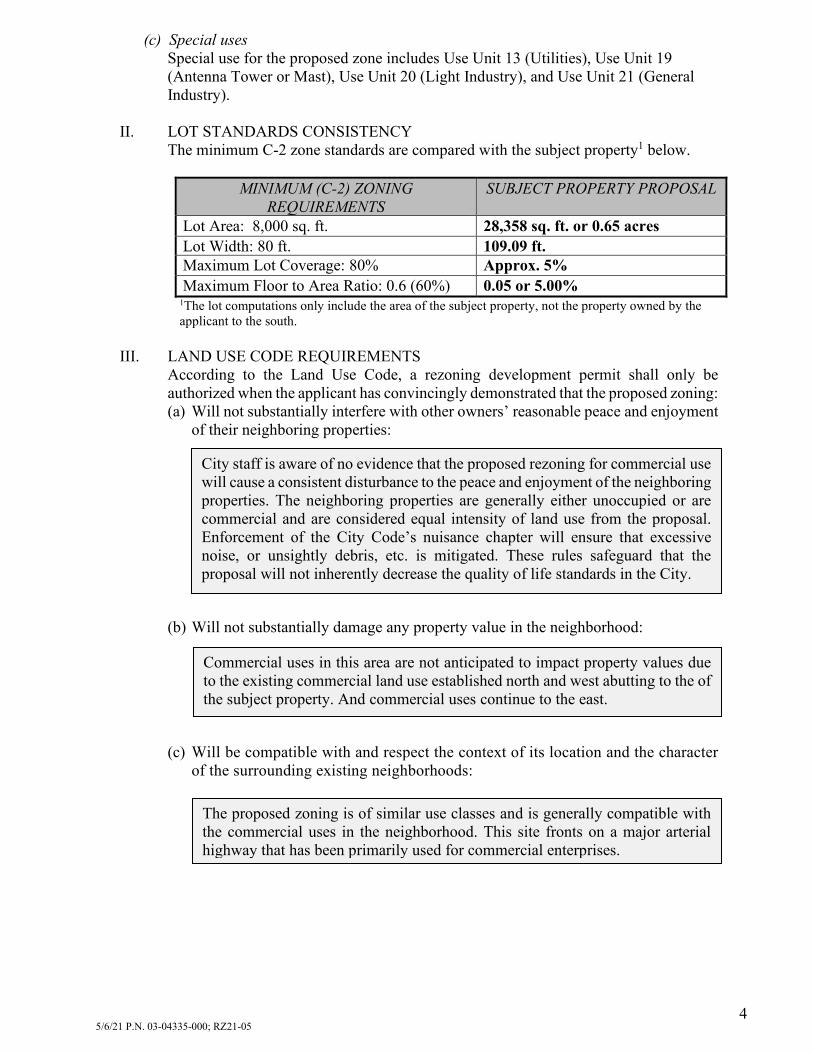
5/6/21 P.N. 03-04335-000; RZ21-05 4
(c) Special uses
Special use for the proposed zone includes Use Unit 13 (Utilities), Use Unit 19 (Antenna Tower or Mast), Use Unit 20 (Light Industry), and Use Unit 21 (General Industry).
II. LOT STANDARDS CONSISTENCY
The minimum C-2 zone standards are compared with the subject property1 below.
MINIMUM (C-2) ZONING REQUIREMENTS
SUBJECT PROPERTY PROPOSAL
Lot Area: 8,000 sq. ft. 28,358 sq. ft. or 0.65 acres Lot Width: 80 ft. 109.09 ft. Maximum Lot Coverage: 80% Approx. 5% Maximum Floor to Area Ratio: 0.6 (60%) 0.05 or 5.00%
1The lot computations only include the area of the subject property, not the property owned by the applicant to the south.
III. LAND USE CODE REQUIREMENTS
According to the Land Use Code, a rezoning development permit shall only be authorized when the applicant has convincingly demonstrated that the proposed zoning: (a) Will not substantially interfere with other owners’ reasonable peace and enjoyment
of their neighboring properties:
(b) Will not substantially damage any property value in the neighborhood:
(c) Will be compatible with and respect the context of its location and the character
of the surrounding existing neighborhoods:
City staff is aware of no evidence that the proposed rezoning for commercial use will cause a consistent disturbance to the peace and enjoyment of the neighboring properties. The neighboring properties are generally either unoccupied or are commercial and are considered equal intensity of land use from the proposal. Enforcement of the City Code’s nuisance chapter will ensure that excessive noise, or unsightly debris, etc. is mitigated. These rules safeguard that the proposal will not inherently decrease the quality of life standards in the City.
Commercial uses in this area are not anticipated to impact property values due to the existing commercial land use established north and west abutting to the of the subject property. And commercial uses continue to the east.
The proposed zoning is of similar use classes and is generally compatible with the commercial uses in the neighborhood. This site fronts on a major arterial highway that has been primarily used for commercial enterprises.

5/6/21 P.N. 03-04335-000; RZ21-05 5
(d) Will not, whether by the nature of the allowed uses in the proposed zone, or by the allowed siting, height, or design of structures or landscaping in the proposed zone, tend to burden the present or future use of neighboring properties in accordance with current zoning standards:
(e) Is adequately supported by infrastructure, including without limitation, streets and
parking:
(f) Compared to present zoning of the property, is equally or more consistent with:
1. Sound planning of the city’s growth; and with 2. Public health, safety, and convenience within the neighborhood:
B-2) COMPREHENSIVE PLAN CONSISTENCY The 2030 future land use map describes this area as commercial. The following zone(s) are appropriate according to the designation: C-1, C-1A, C-2. The proposed C-2 zone is compliant with all existing and future land uses.
Water System There is an existing 10” water main that runs on the north side of the property. Staff finds this existing infrastructure to be adequate for fire and projected water needs.
Sanitary Sewer System There is an existing 8” sewer main that runs on the north side of the property. Staff finds this existing infrastructure to be adequate for wastewater needs.
Storm Sewer System Applicable storm water detention will be designed once there is a known land use and design.
Commercial uses in this area are not anticipated to burden the present or future uses of neighboring properties due to the proposed use being equal or lesser intensity than the land uses abutting the subject property, or the abutting land uses are presently unoccupied.
The proposed rezoning does not appear to inhibit sound planning of the City’s growth or harm the public health, safety, and convenience within the neighborhood.

5/6/21 P.N. 03-04335-000; RZ21-05 6
Figure B-2 (1) Future Land Use Map
B-3) STAFF DISCUSSION General Summary The applicant is requesting to rezone 3550 Hwy.
412 East from I-2 to C-2, the site of an abandoned single-family residential home on the south side of the highway, located south of Starbucks Coffee.
The rezoning was prompted by the applicant’s request to construct an automobile services center on the property and the zoning is required to allow for a more favorable side on corner setback to accommodate the requested development.
The I-2 zone also allows commercial development, but with greater setback as the development may also be industrial in nature.
The rezoning meets the minimum lot requirements (see above). The future land use map calls for office and commercial uses in this area. The proposal is consistent with the future land use map’s guidance for the area.
Key Points: • Lots Comply with Zoning • Consistent with the land
use plan • Associated lot line
adjustment plat. • ROW dedicated for Simon
Sager Ave.

5/6/21 P.N. 03-04335-000; RZ21-05 7
Existing and Future Land Uses The area is best described as a remnant residential property in an area that is rapidly
developing for commercial uses. The properties to the north and west were recently constructed within the last two years.
The future of this area is commercial according to the 2030 land use plan. In addition to the planned development of the subject property, the applicant plans to adjust
the lot. Therefore, an associated lot line adjustment land survey is required. Land is dedicated on the survey for the future southern extension of Simon Sager Ave. The street is immediately to the north of the subject property.
The applicant will construct the first segment of the new street to allow side access to the subject property, there will be no direct drive entrance on Hwy. 412, similar to Starbucks across the street.
The work will include the western two-thirds of the street (2 out of the 3 lanes). This is wide enough to allow for safe access to the subject property.
The street construction will be inspected by City staff and will be tied to the building permit, no certificate of occupancy will be issued until the City has accepted that the improvements to Simon Sager fully meets the City’s standards for street construction.
The City has received a building permit for the subject property, a significant development permit will not be required due to the size of the proposed building and disturbed area of the lot falling below the threshold determining a significant project.
Neighborhood Context and Compatibility As mentioned in the existing and future land uses section of this report, the neighborhood
context is best described as roadway oriented commercial. Staff finds no grounds as to the proposal being incompatible with the area.
There are no plans at this time to rezone the southern lot, also owned by the applicant. It can be developed for either commercial or industrial based on its current I-2 zoning.
Conditions and Staff Conclusions Staff is in support of the request and requires no conditions on the rezoning approval.
Fiscal Impact: Staff is not aware of any fiscal impact at this time. The costs of the partial street extension of Simon Sager Ave. will be borne by the developer. Attachments:
Site Plan

S
G
GGG
G
WW
OHEOHEOHEOHEOHE
SS SS SS SS
SSSS
SSSSSS
U.S. HIGHWAY 412 EAST
5' DRAINAGE & UTILITY EASEMENTPER DOC 2008-35122
20' DRAINAGE & UTILITY EASEMENTPER DOC 2003-24885
20' U
TILI
TY E
ASEM
ENT
PER
PLAT
L20
1930
430
10' UTILITY EASEMENTPER PLAT L201930430
LOT 2EAST SILOAM COMMERCIAL SUBDIVISION
PLAT L201930430PARCEL 03-06137-000
RHODES DEVELOPMENTS COMPANY, LLCDEED INST. L202011679
ZONE: C-2
TRACT 2R28,358 SQ. FT.±
OR 0.65 AC.±
(VARIABLE WIDTH PUBLIC RIGHT-OF-WAY PER AHTD JOB# 9626)
80.1
21.6
21.1
29.2'
5.9'
27.9'
29.4
'
57.7'
34.7
'
5' DRAINAGE & UTILITY EASEMENTPER DOC 2008-32657
136.
3' R
/W
PORTION OF RIGHT-OF-WAY GRANTBK. 338, PG. 4
SINGLE STORY WOODFRAME HOUSE
70.2
S87°10'14"E
S02°
36'3
7"W
100.08'
30.0
8'
100.09'
S87°11'34"E
S02°
36'2
7"W
N87°14'06"W
N02
°36'
15"E
269.
58'
100.07'
PARCEL 03-06099-000PLAT L201832110
WILMARK VENTURES, LLCPLAT 6/21/2018 - L2018322110
DEED INST. L201839505ZONE: I-2
20' DRAINAGE & UTILITY EASEMENTPER DOC 2003-6543
1,25
3.16
'
S87°11'34"E S88°37'37"E 91.63'
324.
68'
1/2" REBARCALDWELL LS1310
5/8" REBAR1021
5/8" REBAR1021
2" ALUM CAPAHTD
5/8" REBARLS1021
5/8" REBAR1618
N:681854.99'E:572448.21'
MNF LS1618
1,24
9.99
'
S88°37'37"E
TOTAL AREA309,603 SQ. FT.±
OR 7.11 AC.±
5' DRAINAGE & UTILITY EASEMENTPER DOC 2008-32659
20' DRAINAGE & UTILITY EASEMENTPER DOC 2003-6543
R/W TAKING 579-269R/W TAKING 577-179N
02°3
6'44
"E30
.32'
94.07'S87°11'34"E
PROPERTY LINETO BE REMOVED
PROPERTY LINETO BE REMOVED
228.
60'
153.51'
107.40'
N87°18'33"W
S13°44'05"E
CB
=N0
4° 47' 51"W
CD
=126.45'
R=
4 87.00'
L=126.81'
Δ=14° 55' 0
8"
EL1
EL2
EL3
EL4
EL5
Easement Line Table
LINE
EL1
EL2
EL3
EL4
EL5
BEARING
N02°36'15"E
N87°18'30"W
N02°36'15"E
S87°18'30"E
N02°36'15"E
DISTANCE
10.29'
10.00'
64.85'
10.00'
54.56'
CB
=N0
5° 45' 34"W
CD
=9
5.44'
R=
415.00'
L=9
5.66'
Δ=13°12' 24"
S12°21'46"E
39.32'
DEDICATED R/W(DYKES DRIVE)PER THIS PLAT
101,063 SQ. FT.±OR 2.32 AC.±
10' UTILITY ESMTPER THIS PLAT649 SQ. FT.±OR 0.01 AC.±
107.01'
NORTH LINE R/W DEDICATION
NEWPROPERTY LINE
NORTH LINE TRACT 2
41.0
5'
TRACT 1R180,181 SQ. FT.
OR 4.14 AC.±
48.98'
NE/cNE1/4 of theSW1/4 ofSection 4,T17N, R33W
GRI
D
Convergence -1°27'32"Combined Scale Factor: 0.9999389664
5/8" Rebar w/Blue Cap
Northing: 681854.30 US Ft.Easting: 572463.68 US Ft.
Elevation = 1160.44'
0 20' 30' 40'
SCALE IN FEET
LegendBoundary Line
Adjoining Boundary Line
Easement Line
(Size)
S
Centerline
Gas Line
Overhead Electric LineSanitary Sewer Line
Storm Drainage Pipe
Water Line
Found Monument (As Noted)
Set 5/8" Rebar "PLS#1021"
Water MeterFire Hydrant
Sewer Manhole (SMH)
Utility Pole
Water Valve
G
OHE
SS
W
G Warning Gas Line Sign
Calculated Point
Except: Deed Bk. 577, Pg. 179 & Deed Bk. 579, Pg. 269
SHEET TITLE
CEI PROJECT NUMBER
DATE
PROFESSIONAL OF RECORD
FIELD WORK
DESIGNER
REVISION
CEI ENGINEERING ASSOCIATES, INC.
© 2021 CEI ENGINEERING ASSOCIATES, INC.
REV-0
4/1/2021
31499
3108 SW REGENCY PKWYBENTONVILLE, AR 72712PHONE: (479) 273-9472
FAX: (479) 273-0844
3030 LBJ FREEWAY, SUITE 100DALLAS, TX 75234
PHONE: (972) 488-3737FAX: (972) 488-6732
CORPORATE TBPLS FIRM #10031500
BRANCH TBPLS FIRM #10194234
U.S
. 412
City o
f Silo
am Sp
rings, Ben
ton C
ount
y, Ark
ansa
s
Dyke
s Fa
mily
Add
ition
State Survey Code: 500-17N-33W-0-04-310-04-1666
Lot Line AdjustmentLLA
Instrument No.INST.
Found Mag Nail (MNF)
OWNERS
Parcel #03-04335-000Parcel #03-04336-000Parcel #03-12688-000
Dykes Family Trust - Robert L. Jr. & Marilee D.PO Box 211Siloam Springs, AR 72761
Right-of-WayR/W
TRACT 2R0.67 ACRES
RE
ZO
NE
OF
REZONEAPPLICATION
EXHIBIT

PLANNING COMMISSION STAFF REPORT TO: Planning Commission FROM: Ben Rhoads, AICP, Senior Planner Justin Bland, PE, City Engineer Cc: Don Clark, Community Development Director DATE: May 4, 2021 RE: Special Use Development Permit, SU21-03 / 305 S. Mt. Olive St. Recommendation: Motion to approve SU21-03 (Special-Use Development Permit)
Section A: Background: A-1) APPLICATION REVIEW DATES
Planning Commission review: May 11, 2021 Board of Directors review: June 1, 2021
A-2) APPLICANT AND AGENT
Applicant and Agent: Chad Dilday representing Avery Hudson Wealth Management, LLC A-3) SUBJECT PROPERTY ADDRESS
305 S. Mt. Olive St. A-4) PROJECT INTENT
The applicant requests to use an 896 sq. ft. single-family residence, currently under construction, as a short-term rental, qualifying under use unit 10.1 for bed and breakfasts. The residence will not be owner occupied, but used solely for short term lease of less than 30 consecutive days.
A-5) LEGAL NOTICE
Site posted: April 6, 2021. Newspaper legal notification: April 21, 2021 (Herald Leader). Letter legal notification: April 15, 2021. Staff received no calls and one letter of correspondence on the request. The letter is
attached to this report.

5/6/21 P.N. 03-03257-000, SU21-03 2
A-6) EXISTING LAND USES AND ZONING
EXISTING LAND USE EXISTING ZONING1 Vacant / Under construction R-O District (Residential, office) /
H-1 Overlay District (Historic) PROPOSED LAND USE PROPOSED ZONING
Single-Family Residential used as Bed and Breakfast (Use Unit 10.1)
No zoning change is proposed
SURROUNDING LAND USE SURROUNDING ZONING North: Sager Creek / Offices / Public Park3 North: C-1 District (General Commercial)2 South: Single-Family Residential South: R-3 District (Residential, two-family)1 East: Public Park3 East: C-1 District (General Commercial)1
R-2 District (Residential, medium)1 West: Single-Family Residential West: R-3 District (Residential, two-family)1
1Properties are also located in the H-1 (Historic) Overlay District. 2Properties are also located in the H-1DT (Historic Downtown) Overlay District 3Properties do not abut the property, but are separated by Sager Creek.
Figure A-6 (1): General Area Map

5/6/21 P.N. 03-03257-000, SU21-03 3
Figure A-6 (2): Site View
Section B: Site Analysis B-1) PROJECT ANALYSIS AND APPROVAL CRITERIA
The following criteria are shown to indicate if this proposal meets the minimum criteria for approval. Criteria I-II is a subsection of Sec. 102-49 (land use) and subsection 102-50 (lot standards) of the Municipal Code; Criterion III is Sec. 54-36.
I. ZONING USE UNIT CONSISTENCY
Planned Uses The proposal is consistent with Bed and Breakfast uses associated with Use Unit 10.1, this is not permitted as a planned use, see special uses below. Special uses The proposed use 10.1 (Bed and Breakfasts) is a permitted under special use in the zone district.
II. LOT STANDARDS CONSISTENCY
The minimum H-11 zone standards are compared with the subject property’s lot below: MINIMUM (H-1) ZONING
REQUIREMENTS SUBJECT PROPERTY PROPOSAL
(c) Lot dimensions (1) Lot Area: 4,000 sq. ft. for Use Unit 32
0.32 acres or 13,939 square feet
(2) Lot Width: 40 ft. Approx. 117 feet (3) Floor / area Ratio: 0.50 (maximum) 0.03 or 6.42 %3 (4) Maximum Lot Coverage: 50 percent Approx. 9.5 %3
1The Historic Overlay District lot standards take precedence over the base zone standards. 2The Use Unit used for lot standards is Unit 3, for single-family house. This is what is permitted in an associated building permit.
3Based on the approved single-family building permit currently under construction.
North

5/6/21 P.N. 03-03257-000, SU21-03 4
III. LAND USE CODE REQUIREMENTS According to the Land Use Code, a special use permit shall only be authorized when the applicant has convincingly demonstrated that the proposed project: a. Will not interfere with other owners’ reasonable peace and enjoyment of their
neighboring properties:
b. Will not substantially damage any property value in the neighborhood:
c. Will be compatible with and respect the context of its location and the character of the surrounding existing neighborhoods:
d. Will not, whether by the nature of the use, or by the siting, height, or design of structures or landscaping, tend to burden the present or future use of neighboring properties in accordance with current zoning standards:
The applicant’s proposal is a short-term rental usage of a single-family residential structure currently under construction. The assumed impacts of these rental units on their face appear to be minimal compared to the general occupancy of a single-family home whether it is by the owner of the home or long-term renter. Staff has observed that the nature of the business of leasing out space requires that the property be kept clean and orderly to attract positive reviews. Staff is aware of no evidence that the proposed bed and breakfast special use will cause a consistent disturbance to the peace and enjoyment of the neighboring properties. Should there be a noise issue, the current City Codes and noise ordinance may be employed in no different manner than any residential use that generates nuisances. Enforcement of the City Code’s nuisance chapter ensures that excessive noise, or unsightly debris, etc. is mitigated. These rules ensure that the proposal will not inherently decrease the quality of life standards already in place across the City.
There is no evidence that the proposal will cause any substantial burden to the present uses around the area. Traffic will not increase beyond a typical residential use, only vehicles will change week by week as occupancy changes over. As mentioned in criteria one, the business model aims to attract perspective users by offering amenities such as flowers, well maintained lawns, a tidy appearance, etc. These amenities will typically enhance the property in the neighborhood rather than being a burden.
The property’s outside appearance will look like a small residential dwelling, as such, it appears to be compatible and respects the neighborhood context. See the attached image depicting the design of the structure. The use component of this request does not have structural design implications.
The property is in a residential area and is intended to be used as a short-term residence for visitors to the area. A residential structure being used as a residence, and not as a common hotel usage with a lit commercial parking lot, etc., will not substantially impact property values in the neighborhood. There is no evidence presented with the application that the proposed special use will impact negatively neighboring properties.

5/6/21 P.N. 03-03257-000, SU21-03 5
e. Is adequately supported by infrastructure, including without limitation, water and sewage systems, streets, parking, and drainage:
f. Is consistent with sound planning of the city’s growth in terms of health, safety,
and convenience within the neighborhood and affected vicinity:
g. Promotes favorable economic conditions or public welfare within the city.
B-2) COMPREHENSIVE PLAN CONSISTENCY
The 2030 Land Use Map describes this area as mixed use. The proposed use is consistent with the 2030 Land Use Map.
B-3) STAFF DISCUSSION General Summary Proposal is bed and breakfast located at 305 S Mt. Olive St. The applicant received a building permit to construct a single-family house, however plans
were never confirmed as to the final use of the property, whether that would be a bed and breakfast, an owner-occupied home with occasional use as a bed and breakfast, or a flex space to lease out office space, which is another land use permitted by right in the R-O zone district.
A bed and breakfast will increase economic activity by the collection of the hotel/motel tax as well as facilitating tourists to the downtown area to spend money in downtown or area restaurants and attractions.
There is nothing in the proposal which would indicate unsound city planning. The proposal, as developed, meets or exceeds the minimum R-O zoning requirements.
Water System A 1” water main exists on the southwest corner of the property. Staff finds this line adequate to serve the needs for the proposed development. Sanitary Sewer System A 4” sewer line runs along east side of S. Mt. Olive St. Staff finds this existing infrastructure to be adequate for wastewater needs. Storm Sewer System Storm water runoff is handled by direct drainage into Sager Creek. Staff has approved of this arrangement for the storm water runoff impacts generated by the developed property. Parking The residential unit has four parking spaces, this meets the minimum required for a residential rooming house, the closest equivalency in the parking code for the proposed use. The metric is one parking stall per bed.

5/6/21 P.N. 03-03257-000, SU21-03 6
After staff determined the applicant’s the final intent for the structure, that the structurewas being constructed solely for the purpose of a short-term rental, staff requested that theapplicant apply for the special use permit to allow for this use, under use unit 10.1.
Use unit 10.1 is the best fit for the proposed use, therefore it is being employed throughthis special use permit.
Because this is primarily a business use in a residential zone, the Zoning Code requires thatbed and breakfasts, under use unit 10.1, be approved through a special use approval ratherthan a use by right.
The residence will be used exclusively as a short-term rental with occupancy less than 30days. The entire property will be leased out.
The bed and breakfast service is listed on-line and leasing is done virtually, there is no on-site employees, check-in agent, or housekeeping staff to clean rooms, etc. The house willprimary be unoccupied when not in use by the customer.
A professionally prepared breakfast will not be included with the rental, the term is a carry-over from past business models when breakfast would typically be served to the guests.
Finally, staff has been made aware of other like uses in operation in the City, staff will becontacting the operators of these businesses if a special use permit or business license isrequired.
Residential Impacts Staff is unaware of any lasting impacts to the neighborhood from granting the special use
approval. The nature of the business use is to allow different occupants to reside in the residence as
one would in a hotel room, only there will be no commercial parking lot, lobby, on-siteemployees, or other accruements what would be common to a hotel. The applicant mayerect a sign; however this is permitted in the R-O zone district regardless of if this permitis granted or not.
The only known impact is shifting occupancy, if that is considered an impact.
House Construction As this is an usual property in its location, staff
will provide some details on the house construction, its location, and some history.
In 2001, a front setback variance was granted on the property to allow for it to be closer to Mt. Olive St. This was granted as the site has a sharp drop off to Sager Creek as one travels to the east on the lot.
The house approved for construction makes useof the 2001 setback variance, as it runs with the land and does not expire.
The house is positioned close enough to Mt.Olive to not pose risks of tilting over the hillside, nor will any part of the property becantilevered over the cliff face. The size of the house is small and scaled appropriately forthe lot size. The foundation of the future house is shown in the site view photo A-5(2).
The proposed structure was granted a building permit, meeting the building and zoningcodes as a single-family home. Nothing on the building permit application indicated aproposal for a bed and breakfast use.
Key Points: • Zoned R-O for a residence
or office use• Applicant would like to run
a virtual on-lined basedshort-term rental of theproperty,
• Staff finds no grounds toobject to this use based on what has been presented.

5/6/21 P.N. 03-03257-000, SU21-03 7
Conditions and Staff Conclusions As shown on page 1 of this report, staff is recommending approval with no conditions
needed. Section C: Fiscal Impact Per the existing Master Street Plan, a street impact fee of $245.37 was assessed with the building permit application. Attachments:
Site Proposal (House Rendering and Site Plan). Letter from the Applicant on the Proposal. Letter from Neighbor

SU21‐03 – Dilday – Site Plan
26

SU21‐03 – Dilday – Elevation
27


STATUSREPORT
PROJECT: Siloam Springs Comprehensive Plan PROJECT NO.: SLO 20252 TO: Don Clark TIME PERIOD COVERED: 4/1/21 – 4/30/21 FROM: Dawn T. Warrick, AICP DATE: 05/03/2021 PROJECT MEETINGS:
Biweekly staff status meetings – April 14, 2021; April 29, 2021
PROJECT SCHEUDLE, TASKS, AND DELIVERABLES:
Tasks 1 & 2 are complete Tasks 3 & 4 are active, with scheduling and milestones outlined below:
Task / Milestone Date Notes
Phases 1 & 2: Project Initiation and Research/Review
Task 1: Project Initiation Complete
Task 2: Community Snapshot Complete
Phase 3: Public Involvement
Task 3: Public Involvement ‐ General On‐going
3.01 Public Involvement Plan Complete
3.02 Review PIP; branding options; website; survey content
bi‐weekly calls In progress
3.03 MetroQuest Survey Complete Closed April 30 3.04 Meetings 2 Go Complete Closed April 30 Task 4: Vision, Guiding Principles & Goals
4.01 P&Z, Board of Directors & CPAC‐ project overview/orientation
3/2/2021 Rescheduled due to weather; Complete
4.02 City Orientation Tour (virtual) in progress Add GIS storymap to project
website 4.03 Public Input Meeting #1 3/18/2021 Complete 4.04 Stakeholder Meetings 3/2/21; 3/18/21 Complete
4.05 Vision statement and guiding principles
4.06 Goals, Strategies (framework) 4.07 QC Review
4.08
Conference call w/ Client to review Snapshot, Guiding Principles, Vision, Goals
5/10/2021 Review CPAC #1 materials during regular staff status meeting on 5/10/21
4.09 CPAC Meeting #1 (Guiding Principles, Vision, Goals)
5/17/2021 In‐person
4.10 Public Input Meeting #2 (1 day) TBD
Phase 4: Plan Development
Phase : Production and Adoption

STATUSREPORT
PUBLIC ENGAGEMENT:
Survey responses (through 4/30/21) – 698 699 o Survey availability was extended from 4/12/21 to 4/30/21 o 109 surveys were submitted during the extension
Website signups (through 4/30/21) ‐ 205 Meeting kits completed – TBD Paper surveys completed – TBD Project information available at Dogwood Festival In April we reached 2,600 people with an engagement of around 125 (including link clicks and
shares). UPCOMING ACTIVITIES:
Analyze public input CPAC meeting #1 – Vision, Goals, Guiding Principles Schedule and prepare for Public Input Meeting #2 ‐ TBD
ADDITIONAL INFORMATION: