Land husbandry : components and strategy - Horizon IRD
392
-
Upload
khangminh22 -
Category
Documents
-
view
0 -
download
0
Transcript of Land husbandry : components and strategy - Horizon IRD


Foreword
Since the 1939 work of Bennett, the father of soil conservation, the world has seen a host of erosioncontrol manuals, most of them in English or Spanish and describing practical experience, technical principles,mechanical (and sometimes biological) methods to be used, and a series of practical recipes that have beenadopted with varying degrees of success in specific regions. However, there have been few authors who, havingseen at first hand the relative ineffectiveness of the generally recommended techniques, have been ready to re-examine the erosion control principles that Bennett developed for the very specific environmental, social andeconomic conditions of the large-scale, mechanized cropping of groundnut, cotton, tobacco and cereals, allproviding little ground cover, that the European immigrants introduced into the semi-arid Great Plains of theUnited States of America during the Great Depression of the 1930s. Bennett’s approach to soil conservation(based on draining runoff water from cultivated fields along gently sloping channels to designated outlets) wasthen applied, with no prior testing, in totally different circumstances (for example among small subsistencefarmers in tropical upland areas) ... with the very indifferent results that have been seen by all.
Science has made giant strides since Bennett’s day.
Firstly , it has been discovered that the kinetic energy of raindrops can lead to degradation of cultivated soils.Risks of runoff and erosion can therefore be cut by introducing production systems that provide better groundcover (Ellison 1944, Stallings 1953, Wischmeier and Smith 1960 and 1978, Hudson 1973, Roose 1977a, etc.).
Secondly, people have realized that there are many different processes in soil degradation and erosion, with avariety of causes – and a similar variety of sometimes contradictory factors involved in any action to alter them.Treatment of sheet erosion has, for instance, sometimes increased the risk of landslides (as can happen withmarls).
Thirdly , differences in physical landscapes and in the social and economic conditions of effective application oferosion control methods are better analysed today. The erosion crises facing large-scale, modern landowners intemperate zones are no longer treated in the same way as the subsistence problems of poor, densely-populatedcommunities clinging to tropical hillsides.
Instead of simply describing schemes that have worked in one specific place, today one has to learn to assessdifferent conditions and work with, rather than against, the forces of nature; for example, by progressivelymodifying the slope of a hillside by slowing down sheet runoff and using farming techniques that will graduallyterrace the land, instead of tearing at mountains with powerful bulldozers to produce often unstable andexpensive-to-maintain infrastructure.
The author would like to remind agricultural experts that erosion control is not the exclusive domain of specialistsworking to rehabilitate land degraded because it has been more mined than farmed, but must incorporate theviewpoints of the land-use planner responsible for water and soil fertility management in the development ofcropping systems that are profitable, sustainable, and safe for rural and urban environments.

Since the 1980s there has been much criticism of the failure rate of most programmes incorporatingerosion control.
It is now recognized that there are two spheres in erosion control:
· The State sphere, with the government responding to disasters and sending in engineers to stoplandslides, control torrents, replant mountains with trees, or harness watercourses that threaten structuralworks, lines of communication, inhabited areas, irrigation schemes and dams through siltation. In the publicinterest, representatives of the central authorities insist on water control in the rural environment. It isexpensive and upsets the farmers, but is the only way of controlling the quality of water supplies (the off-site perspective), and only the State is in a position to engage in such large-scale mechanical undertakings.
· The farming sphere of land protection (the on-site perspective), which can be assured only by the ruralcommunity, so long as it is helped in making a correct diagnosis of the causes of the erosion crisis and thebest ways of improving environmental protection, biomass production and living standards.
It is essentially on this latter sphere – that of water, soil fertility and biomass management (GCES), or landhusbandry – that this work would like to focus, taking stock especially of research by French-speaking soil,agricultural and geographical experts (particularly from ORSTOM and CIRAD), who have worked mainly inAfrica, where problems develop much faster than in Europe. After all, the work of English-speaking experts inthis sphere is already well known (Wischmeier and Smith 1978, Hudson 1992).
The author presents a personal and intentionally confrontational point of view, offering a new and moreconstructive approach to the problems small farmers face in their battle with the degradation of their land. This isnot a manual with clear-cut remedies for each and every erosion problem, but a work that should allow researchexperts, teachers and agronomists in the field to appreciate differences in situations, diagnose the causes ofcrises, and propose a range of technical solutions from which a small rural community (a family, a ward, a village,a slope, a hillside or a micro-watershed) can choose the technological package best suited to its particular needs.Rather more «instruction-oriented» material for training extension agents (Dupriez and De Leener 1990, Inades1989) and more technical manuals on torrent control and landslides (Heusch 1988, CEMAGREF documentation)or improving soil fertility (Pieri 1989) are available elsewhere.
This document has been used for eight years as a basis for courses on «Land Husbandry as an Instrument inLand Management» given to 700 agricultural or forestry engineers at CNEARC and ENGREF in Montpellier, inFrance, and ANDAH in Haiti, as well as 50 senior water technicians at ETSHER in Ouagadougou, in BurkinaFaso. It is hoped that future editions will be enriched with readers’ comments and details of new experiences. Itwill have met its aim if it provides large numbers of land-use planners and agronomists with pointers fordeveloping intensive and sustainable farming systems suited to specific environmental situations and social andeconomic contexts.

Contents
Page
Foreword iii
List of figures ixList of tables x iiList of photographic plates xivAcronyms and abbreviations xvAcknowledgements xvi
INTRODUCTION 1
PART ONE: EROSION CONTROL STRATEGIES AND THE CONCEPTOF LAND HUSBANDRY 9
1. DEFINITIONS: WORDS CONCEAL A PHILOSOPHY 11
Erosion 11Soil loss tolerance 11Erosion varies according to place: different agents, two perspectives 13Erosion varies according to time 14Soil degradation 17Factors in the water balance 19
2. HISTORY OF EROSION CONTROL STRATEGIES 21
Soil erosion and population density 23Traditional erosion control strategies 24Modern strategies for developing rural water infrastructures 25Land husbandry 27
3. SOME SOCIAL AND ECONOMIC ASPECTS OF EROSION 41
Erosion crisis diversity 41Who is concerned by erosion control? 43The importance of exceptional rainstorms 44Erosion effects in different regions 46Effects of erosion on the eroded site: loss of productivity 48Negative off-site effects of erosion 61The economic rationale for land husbandry 63

Page
Criteria for the success of soil conservation projects 65Morocco case study: socio-economic study of erosion control
in the Loukkos Basin 69
PART TWO: EROSION CONTROL AS A RESPONSE TO VARIOUS EROSIONPROCESSES 75
4. DRY MECHANICAL EROSION 77
Definition, forms, dynamics 77Causative factors 77Erosion control methods 78
5. SHEET EROSION: THE INITIAL PHASE OF WATER EROSION 81
Forms and symptoms of sheet erosion 81Cause and dynamics of sheet erosion 83Wischmeier and Smith’s Empirical Soil Loss Model 88Soil erodibility 91The topographical factor 96Effects of plant cover 106Influence of cropping techniques 118Erosion control strategies 151Erosion control practices 153The P factor in Wischmeier’s equation 163Erosion control structures re water management methods 163Variability of erosion factors 195Conclusions on the applicability of the USLE in Africa 197Implementation of Wischmeier’s erosion forecast equation 199
6. LINEAR EROSION 201
Forms of linear erosion 201The cause and processes of linear erosion 203Factors in runoff 206Controlling runoff and linear erosion 209Cost effective gully treatment 213
7. MASS MOVEMENT 217
Forms of mass movement 217Causes and processes of mass movement 219Risk factors 220Mass movement control 221

Page
8. WIND EROSION 239
Processes 239Forms of wind structures 240Effects of wind erosion 241Factors affecting the extent of wind erosion 242Wind erosion control 242
PART THREE: CASE STUDIES 247
9. THE WIDE RANGE OF EROSION CONTROL STRATEGIES IN WEST AFRICA:FROM SUBEQUATORIAL FOREST TO SUDANO-SAHELIAN SAVANNAH 251
Erosion control in the subequatorial forest zone of the Abidjan region ofsouthern Côte d’Ivoire 252
Erosion control in the humid, tropical, Sudanian savannah of Korhogo innorthern Côte d’Ivoire 255
Erosion control in the tropical savannah environment of the Koutiala region ofMali: strictly rainfed farming 257
Erosion control in the Sudano-Sahelian savannah of the Ouahigouya region ofnorth-western Burkina Faso: runoff farming 259
Erosion control in the northern Sahelian zone around the Dori marshes inBurkina Faso: valley farming 262
10. DEVELOPMENT OF THE BAMILÉLÉ BOCAGE 267
The situation 267Diagnosis: relatively fragile environments 267Effective traditional techniques 269Hazards 274Some suggested improvements 277
11. AGROFORESTRY, MINERAL FERTILIZATION AND LANDHUSBANDRY IN RWANDA 281
The situation 281Analysis of local conditions 282Traditional techniques 286Suggestions for managing surface water 288Suggestions for managing soil fertility 291
12. A NEW APPROACH TO EROSION CONTROL IN HAITI 297
The situation 297Analysis of local conditions 301Farmers’ traditional strategies and their limitations 305Control measures 313

Page
13. AGRICULTURAL EROSION IN THE ECUADORIAN ANDES 321
The situation 321Soil erosion: diagnosis and source 321Hazards: the impact of erosion on the agricultural environment 323Suggested improvements 328
14. THE MEDITERRANEAN MONTANE REGION OF ALGERIA 331
The situation 331Diagnosis: trial conditions 333Hazards 333Suggested improvements: influence of the farming system 336
15. PAYS DE CAUX: A TEMPERATE, FIELD-CROP REGION INNORTH-WESTERN FRANCE 339
The situation 339Local conditions 340Hazards: the erosion process and its negative effects 341Solutions and measures adopted 341
PROSPECTS AND ORIENTATIONS 347
Land husbandry: a new philosophy 349Land husbandry: a strategy for action 350
REFERENCES 353
FURTHER READING 372

List of figures
Page
1. Variety of erosion problems in different places: diversity of perspectives andagents 12
2. Nature of problems: imbalances in the «managed» environment lead to soildegradation, then erosion speeds up the process 16
3. Water balance 184. Relationship between population density, erosion, cropping, stock-raising and
fertility management 225. Zaï: traditional method of soil restoration 376. Cumulative effect of erosion on soil productivity at different levels of fertility 507. Selectivity, the danger of sheet erosion 528. Graph showing the water balance for the Sudano-Sahelian region of
Ouagadougou, Burkina Faso 549. Changes in the water balance under natural vegetation as a function of
climate 5610. Maize yields for varying depths of scouring and three levels of N application
(IITA Ibadan Station) 5811. Maize production as a function of the level of mechanical scouring and mineral
fertilization with a view to restoring productivity 6012. Effect of cumulative erosion or scouring on production potential of soil 6213. Production loss as a function of cumulative erosion 7014. The off-site cost of the rise in siltation rate 7215. Diagram of erosion, structural and sedimentation crusts 8216. Kinetic energy of rain as a function of rainfall intensity and regions where
observed 8217. Sketch map showing mean annual climatic aggressiveness in West and Central
Africa: condition of erosion plots 8618. Intensity/duration curves for storms of known frequency at each point in West
Africa 8819. Hjulström’s diagram 9220. Erodibility of Tunisian soils under a rain simulator 9421. Nomograph allowing a quick assessment of the «K» factor of soil erodibility 9522. Topographical factor 10023. Effect of length of slope on three sites of varying susceptibility to rill erosion 10424. Various formulae linking the spacing of erosion control structures and slope
gradient depending on country where applied 10525. Development of plant cover of various crops in the course of the year 11026. Erosion varies according to the height of plant cover from the ground 11227. Combined effect of mulch plus canopy when raindrops fall from an average
height of 1 metre or less 11228. Effect of various erosion control treatments of Beaujolais grapevines (Pommier,
France) on runoff, erosion and quality of wine 114

Page
29. Runoff as a function of soil surface conditions and cropping techniques undera simulated rainstorm of 62 mm/h for two hours 122
30. Runoff depth as a function of the maize seed-bed at Beaumont/Dème 12631. Direction of ridging in relation to slope 14832. Direction of ridging in mountainous areas (Peru and Cameroon) as a function
of rainstorm risk 14933. Tabias and spillways 16434. Cross-section of a tabia and its jesser 16435. Rural land use planning in the Maghreb as a function of hydrogeological
factors 16536. Classification of traditional water management systems by climate 16637. Harvesting and storing runoff from a semi-arid catchment 16838. Cistern and plot used to test contingency irrigation of a garden 16939. Water harvesting: experimental site at Bossomboré (Ziga, near Ouahigouya,
Burkina Faso) 17040. Diagram of a microcatchment 17241. Beds drained by furrows channelling water to a grass spillway and cistern on
a vertisol at the ICRISAT Hyderabad Center 17342. Infiltration (blind) ditch with a grassed riser above it 17443. Mediterranean, bench, or radical terrace 17544. (a) Step microterracing; (b) Discontinuous forest step terracing 17645. Various runoff diversion structures 17846. Runoff diversion: principles, practice and drawbacks 17947. Development of a semi-pervious erosion control structure to dissipate runoff
energy 18448. Examples of semi-pervious microdams in a semi-arid area 18649. Diagram of the experimental layout at Bidi in Burkina Faso 19250. Comparison of runoff: control plot/treated plot. Average rainfall 19351. Comparison of runoff: control plots/treated plots as a function of rainfall
aggressiveness 19352. Pervious or semi-pervious check dam 19453. Forms of linear erosion 20254. Onset of runoff: three theories 20455. Various types of flexible, fairly inexpensive, pervious sills that are easy to
build with local materials 21456. Forms of mass movement 21857. Rotational spoon-shaped slide 21958. Three processes of wind erosion: suspension, saltation, traction 24059. (a) Influence of a wind-break on the wind; (b) Influence of a wind-break on
production of a cereal grain 244

Page
60. Erosion control in a subequatorial Guinean forest environment, e.g. the Abidjanregion 254
61. Diagram showing improved use of a granitic landscape in Sénoufo country(Korhogo): example of farming requiring drainage in a Sudanian zone 256
62. Diagram showing improved use of a hillslope in Minianka country: anexample of rainfed farming proper 258
63. Diagram showing improved use of a granitic landscape on the Mossi Plateau:runoff farming 260
64. Diagram showing improved use of a Sahelian landscape: example of anagropastoral system in which intensive farming is confined to the valley 264
65. Relief map showing rainfall distribution 26866. Geological map showing population distribution 27067. Traditional use of space (enlarged sector of an area of the granite uplands) 27168. Direction and layout of ridges on a plot 27269. Some erosion control measures to be implemented 27670. Agro-environmental zones of Rwanda showing altitude and rainfall 28271. Six processes leading to rural environmental degradation 28672. Development of gradual terraces into horizontal terraces: a CIGAND project
proposal 29073. Effect of hedges of Leucaena leucocephale and Calliandra calothyrsus on
average annual runoff, erosion, biomass production of hedge and harvests oftwo cropping seasons at the ISAR station at Rubona in Rwanda on a 27% slopeand on acid ferralitic soil 292
74. Erosion risk and suggested improvements for the granito-gneissic hills ofRwanda 296
75. Map of Haiti 30076. Agro-environmental cross-section of the transect 30277. Types of garden, fertility transferral, and tree cover 30678. Preparing a compost mound 30879. Effect of overly long ridges 30980. System of straw barriers 31081. Man-made erosion: tilling the soil on a slope 31182. Types of erosion control and main development actions in the agro-
environmental sub-units of the transect 31283. Soil erosion and conservation in Ecuador (DNA-ORSTOM Project) 32484. The dynamics of the erosion process in Haute-Normandie 34085. Detailed survey and erosion dynamics of the Bourg-Dun watershed, France 34286. Reorganized drainage in the Bourg-Dun watershed 344

List of tables
Page
1. Recovery of degraded soil protected from grazing 352. Runoff in the Manakazo watershed (Madagascar) 463. Selective losses from sheet erosion on a 7% slope at Adiopodoumé (Côte
d’Ivoire) as a function of plant cover 514. Chart of the average water balance for the Ouagadougou region, Sudano-
Sahelian savannah 545. Three fertilization levels on degraded soils 596. Cost of farm erosion in DH/ha/yr for a cereal-fallow-grassland rotation on
medium slopes 707. Cost of siltation 738. Degradation and erosion, their causes, environmental factors and their
consequences are very diverse 769. Influence of season, maximum intensity in 30 minutes, and rainfall over the
previous decade on erosion and runoff from rainfall of comparable volume onbare soil and covered soil 84
10. Effect of slope on runoff and erosion at Séfa, Senegal 9011. Runoff and erosion on bare soil and under pineapple as a function of crop
residues 9212. Erosion and runoff as a function of slope under forest, crops and bare soil at
the ORSTOM centre at Adiopodoumé in southern Côte d’Ivoire 9813. Erosion and runoff at Adiopodoumé (Côte d’Ivoire) as a function of plant
cover, cropping practices and slope 10714. Post-mowing protection by three forage crops 11015. Effect on erosion control of a cover plant under bush crops 11116. Effect of intensified production on runoff and erosion 11517. Effect of bush fire on runoff from a plot (Gonse, 1967-1973) 11618. Influence on runoff of protection from grazing and fires measured under two
fallows: Saria (Burkina Faso) 11619. Effect of tilling with a hoe (Adiopodoumé, 7% slope) 11920. Effect of tilling plus harrowing on runoff, erosion and turbidity on bare plots
(Adiopodoumé, 1971 season) 11921. Reaction to rainfall according to the preparation of a bare ferralitic gravelly soil
(CIRAD, Bouaké) 12022. Influence of the number and type of seedbed preparations on a brown, slaking,
alluvial, leached soil at Campagne/Hesdin, France 12323. Influence of cropping system on soil degradation and runoff during a winter
storm with 33 mm of rain in one hour 12424. Effect of cropping techniques on runoff and erosion (caused by simulated
rainstorms of 40 mm in one hour) on maize seedbeds on terrefort on a hillsidein the Lauragais region 125

Page
25. Cropping systems efficiency surveys and erosion control practices in Brazil 14326. Erosion, runoff and yields as a function of soil preparation techniques 14427. Effect of mounding on an almost bare soil (7% slope, Adiopodoumé, 1956) 14428. Effects of tied contour ridging on a sandy soil in southern Côte d’Ivoire under
pineapple 14629. Importance of plant cover and cropping techniques for various crops in West
Africa 14930. Importance of plant cover in Tunisia 15031. Cropping techniques and erosion control structures as a function of surface
water management 15432. Erosion and runoff control from plastic mulch on bare soil under Panicum 16033. The «erosion control practices factor» P in Wischmeier and Smith’s equation
for forecasting sheet erosion 16234. Diversion bunds and an intensive motorized system of preparing a shallow
ferruginous soil on gravel sheet have little effect on runoff, erosion and yieldsof various crops: Gampela, 25 km from Ouagoudougou (Burkina Faso) 180
35. Effect of buffer strips and contour cropping in humid and dry tropical zones(trials on erosion plots) 182
36. Effect of barriers of grasses (Setaria) or shrub (Leucaena or Calliandra) onerosion: Ruhande hill near Butaré in Rwanda 182
37. Tests on the effect of stone bunds and tillage on runoff, erosion and milletyields at the Bidi Station, Samniweogo, northern Yatenga, Burkina Faso 190
38. Assessment of measures to be taken to reduce erosion to tolerable levels 19939. Variety of environmental conditions along a bioclimatic belt in West Africa,
and range of suggested control methods 26540. Erosion and runoff of annual rainfall on small plots on steeply sloping ferralitic
soils in Rwanda and Burundi 28441. Crop requirements of NPK, lime and manure on the acid ferralitic soils of
Rwanda 29342. Selection of species on the basis of agro-environmental factors and types of
structure 31643. Agrarian structure in Ecuador 1954-1985: number of holdings and area
occupied 32244. Soil loss on 50 m² plots (1981-84 and 1982) 32545. Annual soil loss and rainfall on 100 m² plots 32646. Development of agricultural production in the Sierra 1970-85 32647. Conservation methods tested on improved 1 000 m² plots 32848. Runoff, erosion, yields and net revenue for 15 erosion plots at the INRF station
at Ouzera, Algeria 33449. Effect of soil type and slope on runoff and erosion on bare fallow 33650. Effect of improved farming practices on runoff, erosion and net income 336

List of photographic plates
Page
1. Sheet erosion 127 2. Erodibility of various soils 128 3. Soil degradation 129 4. Effects of fire 130 5. Mechanized clearing 131 6. Reforestation in a Sudano-Sahelian zone 132 7. Reforestation in a Sudano-Sahelian zone 133 8. SPR 134 9. SPR 13510. Erosion control structures in a Sudano-Sahelian zone 13611. Erosion control structures in mountainous zones 13712. Mass movement 13813. Gullying 13914. Gully control 14015. Gully control 14116. Wind erosion 14217. Tillage 22318. Agroforestry 22419. Agroforestry 22520. Haiti 22621. Haiti 22722. Ecuador 22823. Algeria 22924. Land husbandry 23025. Land husbandry 23126. Water management 23227. Water management 23328. Biomass management 23429. Biomass management 23530. Animal husbandry 23631. Animal husbandry 23732. Rwanda 238
Acronyms and abbreviations
ANDAH Association Nationale des Agronomes HaïtiensAREAS Association Régionale pour l’Etude et l’Amélioration des Sols (France)CEMAGREF Centre National du Machinisme Agricole, du Génie Rural, des Eaux et Forêts (France)CIRAD International Cooperation Centre on Agrarian Research for DevelopmentCNEARC Centre National d’Etudes en Agronomie des Régions Chaudes (France)CTFT Centre Technique Forestier Tropical (CIRAD)DRSPR Division de la Recherche sur les Systèmes de Production Rurale de l’Institut d’Economie Rurale
de Bamako (Mali)EC European CommunityENGREF Ecole Nationale du Génie Rural et des Eaux et Forêts (France)ESAT Ecole Supérieure d’Agronomie Tropicale (France)ETSHER Ecole de Techniciens Supérieurs en Hydraulique Rurale (France)ICRAF International Center for Research in AgroforestryICRISAT International Crops Research Institute for the Semi-Arid TropicsIITA International Institute of Tropical AgricultureINRA Institut National de la Recherche Agronomique (France)INRF Institut National de Recherches Forestières (Algeria)IRA Institut de Recherche Agronomique (Cameroon)IRAZ Institut de Recherche Agronomique du ZaireIRFA Institut Français de Recherche Fruitière Outre-mer (CIRAD)IRHO Institut de Recherche sur les Huiles et Oléagineux (CIRAD)ISAR Institut Supérieure Agronomique du RwandaISCO International Soil Conservation OrganisationITCF Institut Technique des Céréales et des Fourrages (France)LH land husbandryNGO non-governmental organizationONTF Office Nationale du Travaux ForestièreORSTOM Institut Français de Recherche Scientifique pour le Développement en CoopérationPRATIC Projet de Recherche appliquée à l’Aménagement intégré des Terroirs Insulaires CaraibesRML rehabilitaton of mountainous landSPR soil protection and restorationSWC soil and water conservationUSDA United States Department of AgricultureUSLE Universal Soil Loss Equation

Acknowledgements
First of all I should like to express my gratitude to ORSTOM, which encouraged me to put to good use theknowledge French-speaking research experts have gained over the past thirty years in the field of soilconservation, water management and fertilization.
Next, I should like to thank David Sanders and Jean Claude Griesbach of the FAO Soil ResourcesManagement and Conservation Service for their encouragement throughout the preparation of this work.
A dozen or so colleagues agreed to read the first draft, and I am particularly grateful to them forencouraging me to revise it in order to complete, correct and expand it. They all provided me with major ideas:
- Jacques Arrivets, CIRAD agricultural scientist, for his thoughts on the aim and presentation of the work;- Christophe De Jaegher, a young agricultural scientist working in Peru under an external aid programme, for
details of traditional Peruvian soil preparation methods;- Georges De Noni and Marc Viennot, my colleagues at ORSTOM, for a whole chapter on erosion in the
Ecuadorian Andes;- Jean-Marie Fotsing, a Cameroonian geographer, lecturer at Yaoundé University, for a chapter on Bamiléké
hedge systems (bocage);- Bernard Heusch, agricultural scientist, for his vast experience of soil conservation problems throughout the
world;- Charles Lilin, forestry expert at the French Ministry of the Environment, for a chapter on sociological
aspects of erosion crises;- Raymond Mura, forestry expert with CEMAGREF, for his experience of rehabilitation strategies for
mountainous terrain;- Jean François Ouvry, agricultural scientist and director of a regional association for land improvement, for a
summary of the work of a whole INRA team on large-scale agricultural planning in northern France;- Chris Reij, geographer at the Free University of Amsterdam, for many ideas on traditional methods of
water management and soil conservation;

- Bernard Smolikowski, agricultural expert working in Haiti under an external aid programme, and MichelBrochet, Director of ESAT in Montpellier, for a whole chapter on Haiti;
- Christian Valentin, of ORSTOM, for details of soil surface structures;- François Ségala, agricultural scientist, and Jean Claude Griesbach, geographer, technical officers in FAO’s
Soil Resources Management and Conservation Service, for constructive criticism and invaluable support incompleting the work.
I should also like to acknowledge my debt to the young research scientists who have carried out their thesiswork under my direction or verified certain land husbandry ideas in the field - François Ndayizigiyé, VincentNyamulinda and Léonard Sekayange in Rwanda, Vincent Ngarambé and Théodomir Rishirumuhirwa in Burundi,Mourad Arabi, Morsli Boutkhil, Mohammed Mazour, Rachid Chebbani and other colleagues from the INRFerosion team in Algeria, F.X. Masson, Djamel Boudjemline, Marie Antoinette Raheliarisoa in France, and ZachéeBoli and Bep Aziem, IRA soil and agricultural scientists in Cameroon.
I cannot close these acknowledgements without recalling all I owe to the «elders» who patiently initiatedand guided me throughout my career: in France, Bernard Heusch, Frédéric Fournier, Claude Charreau andGeorges Aubert; in the English-speaking world, Norman Hudson, Walter Wischmeier, Donald Meyer and WilliamMoldenhauer.
Finally, my thanks go to Mme Rigollet and Chrissi Smith-Redfern for tirelessly typing, correcting and editingthe manuscript, and Mr Mazzei for drawing the figures so well.
Most of the photographs have been taken from my own collection. Other sources have been cited in thetext, and I am grateful for their assistance.
Ideas do not belong to any one person, but are the fruit of a long period of gestation and the encounterbetween people and a range of environments and socio-economic conditions. May all those who have played apart in this long labour be included in this expression of gratitude.

INTRODUCTION


Since the Earth first appeared it has been shaped by erosion... and for over seven thousand years human beingshave pitted themselves against erosion, trying to defend their lands against the assaults of rain and runoff (Lowdermilk1953). One may therefore wonder whether there is anything left for research to discover, or anything that has notalready been said.
The scientific study of erosion, however, did not start until the early 20th century, first in Germany (Wollny),then 40 years later in the United States of America at the time of the Great Depression. Under pressure from apublic panic-stricken by duststorms that were darkening the midday sun (the Dust Bowl), the American Governmentcommissioned Bennett to set up the famous Soil Conservation Service, with about ten field stations to measurerunoff and sediment load. And it was not until the 1940s that a scientist, shut away in his laboratory while bombsrained down over Europe, discovered that the kinetic energy developed by falling raindrops was the source of soilsurface degradation, runoff and a major part of the erosion observed on cultivated land (the splash effect) (Ellison1944).
Only in the 1950s, following the Madison Congress of the International Soil Science Association, did Ameri-can methods of measuring runoff and erosion on small plots spread to French-speaking (F. Fournier) and English-speaking (N.W. Hudson) Africa, then Latin America and, more recently, Asia and Europe.
The United States therefore had a 20-year start on the rest of the world in collecting data and developing thefirst empirical model, the Universal Soil Loss Equation (USLE), to predict soil loss at plot level. The sole claim madefor this model is that of helping engineers to design soil conservation systems for specific soil, climatic, topographicaland plant-cover conditions, and it has disappointed many scientists who have applied it inappropriately outside thiscompass. Although it has eventually been seen that the USLE is not universal but is confined to circumstanceswhere erosive energy comes not only from rain (but also from runoff, as in upland areas and on soils rich in swellingclay, or from gravity, as in landslips), this somewhat dated model is still today – and will be for some time to come –the only one sufficiently balanced to be used in many countries where runoff is associated with soil surface degra-dation. It will take a further 12 years or so to perfect new physical models and adjust them for each region – nor isit certain that they will perform better than the latest versions of the USLE, as long as the latter are restricted to theirintended sphere of sheet erosion.
Similarly, in the field of soil conservation, people have long been satisfied to apply American-developed meth-ods throughout the world, without testing their suitability for local conditions. However, in the last ten years, thesignificance of climatic, social, demographic and economic elements has been recognized, and this fact, togetherwith new trial results, has raised questions about the treatments prescribed in all the manuals since Bennett.
It is primarily a matter of the rising failure rate for erosion control projects in developing countries (Hudson1992), for American methods do not translate successfully to tropical countries. Local farmers who are familiar withland husbandry strategies in their traditional agricultures have been disappointed by the modern soil conservation

methods imposed by international experts and government authorities: they require a lot of hard work and upkeep,and provide no improvement in yields. Even if the soil cover is kept in place, tropical soils are usually so poor thattheir fertility has to be restored and their infiltration capacity improved if they are to produce significantly more thantraditional systems.
Also, farmers will sometimes abandon such developed land or destroy trees donated under projects, suspect-ing the State of wanting to get its hands on their land – for land traditionally belongs to those who care for it, and treesmark its boundaries. Hence the spate of misunderstandings and failures throughout the Maghreb and West Africa.
Even in the United States, evaluation of 60 years of water and soil conservation – which have swallowed upbillions of dollars – reveals only partial success. There are still major problems of pollution (linked to animal hus-bandry, chemical fertilizers and industry) and of sediment transport in rivers: 25% of tilled land loses over 12 t/ha/yrof sediment, the official tolerance level for deep soils. The situation today would of course be worse had nothingbeen done, but the need for a change in approach seems clear. Hitherto, soil protection has been carried out byvolunteer farmers with State assistance, since everyone realized that the environment must be protected in order toensure land productivity for future generations.
The American survey shows that erosion does not necessarily lead to a fall in yields, particularly on thick loessdeposits. Today the State tends to introduce coercive clauses; for example, if farmers do not participate in a givenprogramme to freeze fragile land, swamps and mountains, or do not abide by instructions for erosion control on tilledland, they will have no right to government subsidies intended to encourage them to diversify production.
Analysis of the effects of selective erosion on tropical land, especially forest areas where chemical andbiological fertility is concentrated in the top 25 cm of the soil, shows that:
· it is not enough to improve degraded land (soil protection and rehabilitation) in order to address farmers’problems;
· even soil and water conservation (SWC) tends to be unwelcome, since it requires considerable work andbrings little improvement in yields.
To meet the challenge of this century and feed a population that doubles every 20 years, not only must theserious processes of gullying and landslides that produce sediment load in rivers (the sphere of State concern) behalted, but also water and nutrients on good land must be correctly managed before degradation sets in, and de-graded but potentially productive soils must be rehabilitated. Only farming communities can manage the rural envi-ronment, and if farmers’ co-operation is to be assured, they must be shown, on their own land, that sound landmanagement (including a range of technological packages) can quickly increase their output and returns, optimizetheir labour, and make their efforts more profitable, while effectively protecting their land capital.
It should be noted that it is not always necessary to resort to sophisticated techniques with expensive inputs,or to import machinery that is hard to maintain. Astonishing results can often be achieved simply by combiningscientific knowledge of the phenomena to be corrected with traditional know-how. This is the case with zaï, atraditional method of rehabilitating degraded soil among the Mossi of Burkina Faso. With no other input than labour(350 hours/ha) and manure (3 t/ha/yr), 600 to 1 000 kg of grain can be grown on the regenerated fields. And with a

little supplementary mineral fertilizer (N and P) results considerably higher than the national average (600 kg/ha/yr)should be achieved (Roose, Dugue and Rodriguez 1992).
Certain favourable circumstances have led to a change in farmers’ attitudes to soil conservation projects.
First, drought has brought much suffering to the people of the Sahel and reduced livestock by half. It hasshown farmers that they must change their practice of extensive farming, balance their livestock holdings againstavailability of forage, and organize village-based land-use planning, as the boundaries of villages are now known.This crisis has revealed the importance not only of protecting land against erosion (expressed in t/ha/yr), but aboveall of managing the available water (reducing runoff) and nutrients (mulch, manure, compost, and mineral supple-ments), and halting the water and nutrient losses caused initially by erosion and then by drainage.
Secondly, and strangely enough, the “cost-pricing” operation for mineral fertilizers required by the WorldBank in Africa has shown the validity of organic fertilizers and, most importantly, the low stocks of nutrients easilytaken up by plants in most tropical soils (other than some volcanic soils, brown vertisols or alluvial soils). It isextremely dangerous to the nutritional status of both human beings and livestock to be reduced to simply recyclingthe biomass (dung, paddock litter, compost, mulch, and ever-shorter fallow) which inevitably translates into soildeficiencies (N, P, K and Ca + Mg in very acid soils). Mineral supplements incorporated in compost are essential forany intensification of farming, if only to allow the growth of atmospheric nitrogen-fixing legumes.
The third circumstance that has aroused interest in land husbandry projects is population growth (an in-crease of 2.5 to 3.7% per year, or a doubling every 20 years) as a result of improved hygiene and diet. In WestAfrica the boundaries of village lands used to be uncertain, if not indeed a bone of contention, but land was plentifuland traditional chiefs used to grant plots to anyone asking to farm them. Nowadays, land availability is frequentlyexhausted, and instead of expanding croplands with little thought to their degradation, people have to live exactlywhere they are, making the most of natural resources.
Three strategies are generally developed to cope with land pressure in African countries:
· emigration, either for the dry season or for good, of some of the children to the less arid zones where there arebetter returns from work;
· supplementing farm revenue with other activities – craft work, trading, teaching, etc.;
· improving land management, intensifying and diversifying production by choosing more profitable lines (spe-cialized livestock, fodder crop production, vegetables, fruit, forestry products for fuelwood and poles, treenurseries, etc.).
In Yatenga in north-western Burkina Faso, rural development project activities have enabled some youngpeople to find enough resources locally to live decently. As a result of extension work, and of drought or pressure onland as the case may be, farmers today are much better disposed toward village-based land-use planning projects.Their aim is to protect their land resources, but especially to manage the scarce available water and nutrients in the

biomass. Or they may simply want to own the land – for, after the various upheavals, no one knows for sure if theland belongs to the village community, the State, citizens with official documentation, or simply whomever developsand farms it.
Finally, research has also advanced in a number of fields. Experts have measured the relative effect of thevarious factors influencing erosion. They have shown that the slope gradient is more important than its length, whoseeffect is closely linked to the state of the soil surface, especially its roughness. Under certain conditions, the actualtopographical position is extremely important, since the lower slopes quickly becomes waterlogged from hypodermicrunoff from uphill or from a rising water table near rivers. Under certain conditions (e.g. the chalky, clayey soils ofthe Mediterranean region), sheet erosion on hillsides is less serious than regressive gullying, which starts from thestreams, attacking rich alluvial soil and irrigated terraces before cutting into the slopes. This means that erosioncontrol operations should not necessarily concentrate on steep slopes. Runoff from barely sloping broad pedimentsand slaking loamy soils can be more serious than from steep slopes that are well protected by leafy vegetation or agravel pavement (Heusch 1970). A river can swell in a rainstorm without runoff from steep slopes (the theory of thepartial contribution of a catchment basin to runoff; Cosandey 1983, Campbell 1983).
Soil is not necessarily a “non-renewable natural resource”. While it is true that if the thin layer of a rendzinecovering a chalky rock is lost, that land will be lost for thousands of years and runoff water will concentrate there, ifthe six rules for restoring soil fertility (page 36, Chapter 2) are respected, it will take one to five years to bring life andproductivity back to totally degraded and abandoned soils (e.g. the tropical ferruginous soils rehabilitated by the zaïmethod in Burkina Faso).
Soil conservation has hitherto been seen as a long-term investment in order to protect future generations’ landlegacy, and this was in fact the theme of the fifth ISCO conference in Bangkok (Rimwanich 1988). The newstrategy of land husbandry represents an attempt to solve the immediate problems facing farmers: ensuring a clearincrease in biomass production and income by improving the management of surface water and nutrients on the bestland, rehabilitating degraded land that has potential (a sufficiently deep profile), finding the least expensive way ofstopping gullying, and collecting runoff water in order to establish core areas of agricultural intensification. Insofar asthe farmers must be trained to protect their environment, matters must be viewed from their perspective; in otherwords, any effort must see a return – and very quickly.
Progress on the technological level is also being made today. For example, it has been realized thatmechanical methods of erosion control (terracing, drainage ditches, diversion bunds) are not the main thing, but mustbe kept to a minimum, using the simplest and cheapest methods as back-up to more effective biological methods(Hudson 1992). Other methods of runoff control seem to be better suited to the African smallholder than thediversion works recommended by Bennett for large-scale mechanized farming in the United States.
Farmers are often more ready to accept water (and nutrient) management methods such as water harvestingin semi-arid zones, total infiltration (mulching) or dissipation of runoff energy through use of grass banks, hedges orstone bunds, for these are approaches that are closer to their traditional methods and enable them to improvesecurity if not production levels.

Another major issue is that of tillage.
The validity of deep ploughing and heavy mechanization is being re-examined, for, in contrast to their successin allowing an immediate increase in infiltration, rooting and yields (more than 30% to 50% on soils capable of storingthe extra infiltrated water), they also speed up mineralization of organic matter in the soil, destroy its stable macroporosityand structure, increase hydraulic differentiation in the soil profile, reduce its cohesiveness (and thus its resistance torunoff) and in the medium term (10 to 30 years) accelerate its degradation. Major efforts are at present being madein Africa and elsewhere (United States, Brazil, Europe) to develop cropping systems that use minimum tillage,confining the operation to breaking up the soil with a toothed implement along planting rows, which also receivefertilizer.
In the Sudanian zone of Cameroon, for instance, 10 to 15 years of annual ploughing + hoeing + ridging underintensive cropping of cotton + cereals are enough to induce degradation of tropical ferruginous soils, which are all themore fragile, being sandy, poor in organic matter (less than 1%) and exposed to violent rains (Boli, Bep and Roose1991). Thirty years of fallow, burning and extensive grazing will not sufficiently improve soil fertility: carbon in-creases from 0.3% to 0.6%, nitrogen remains at around one-tenth the rate of carbon, and the pH goes up by one unit(5 to 6). Animals are the most effective means of improving soil quality: in earthworm casts, Trinervitermestermites’ nests and former overnight cattle corrals, carbon can reach 1% and the pH exceed 6.5.
There must thus be a return to farming systems similar to forestry systems in which the soil is never com-pletely bare, receiving regular mineral and organic inputs from the litter. As in traditional cropping systems, anattempt is now being made to reinstate spatial variation within the cropped zone, plant deep-rooting trees that willbring dispersed nutrients to the surface, rear animals that enhance the biomass and concentrate scattered nutrientsand grow crops combined with an under-storey of plant cover (weeds or a carpeting of legumes).
Developed village land is no longer strictly divided into forest area (livestock help to control weeds, as docertain interplanted crops), rangeland area (forage shrubs play a major role in improving forage quality, especiallyduring the dry season), inhabited area (the surrounding highly intensive multi-storey gardens are an importantsource of revenue) and cropped area. There are thus many positive interactions among trees, livestock and crops(see the ICRAF studies).
It was felt that it would be useful to present data gathered over the past 40 years by French-speakingscientists in Africa, Latin America and Europe, in order to provide a good overview of these new situations and awhole new approach to protecting agrosystems.
In Part One, after defining the terms to be used, the range of different situations in terms of processes,timescales and places, the aims of those directly involved, and the demographic, sociological and economic condi-tions of the farmers are indicated.
Part Two contains a brief study of the various processes and a more detailed one of “early” forms of erosion,i.e. sheet and rill erosion and dry mechanical erosion. A systematic analysis of factors governing erosion within theframework of Wischmeier and Smith’s 1978 Universal Soil Loss Equation (USLE) for predicting soil loss leadsnaturally to proposals for a practical approach to defining erosion control.

Lastly, Part Three presents a series of case studies from densely populated tropical mountainous areas(Rwanda, Ecuador, Algeria, Cameroon), subequatorial areas (Côte d’Ivoire), semi-arid tropical areas (Burkina Faso,Mali) and temperate zones (northern France).
There is no intention here of denying the responsibility of the State in the spheres of land-use planning,rural infrastructure, mountain reforestation, torrent control, protection of rivers, dams and other engineering workssuch as the rehabilitation of mountainous terrain, teaching people to respect their environment, training specializedtechnical staff, and subsidies for upland agriculture to prevent emigration. However, it may be helpful to complementthis hydraulic infrastructural approach with one from the perspective of rural agricultural development (farmers andherders) that enlists the solidarity of rural communities in the upkeep and improved management of the naturalresources (water + soil + nutrients) that they have inherited and must responsibly bequeath to future generations.
This work has evolved from a course, “Land Husbandry as a Tool of Land Management,” which has beengiven over the past seven years to agricultural engineers, foresters and water technicians at CNEARC and ENGREFin Montpellier in France, ETSHER in Ouagadougou, Burkina Faso, Chad and in Haiti. It is a working documentwhich it is hoped will be improved as more information and trial results come in. It was produced with a view tooffering constructive new ideas and encouragement to agricultural experts in NGOs and national and internationalinstitutions who have the task of working in the field to improve people’s standard of living and the health of the landthat feeds them.

PART ONE
Erosion control strategies and the concept of land husbandry


Chapter 1
Definitions: words conceal a philosophy
The problems of environmental degradation are closely bound up with the development of populations and civiliza-tions. They are of equal interest to agriculturists, foresters, geographers, hydrologists and sedimentologists as well asto social economists. However, each discipline has developed its own specialized language, so that the same wordscan have different meanings to different experts.
It is therefore necessary to specify the meaning of words and the meanings given them by the variousspecialists who enter the picture at different points in time and space in pursuit of their own goals. This is vital for thedesign of more effective erosion control projects.
EROSION
“Erosion” comes from erodere, a Latin verb meaning “to gnaw.” Erosion gnaws away at the earth like a dog at abone. This has given rise to the pessimistic view of some writers who see erosion as a leprosy gnawing away theearth until only a whitened skeleton is left. The chalky mountains around the Mediterranean well illustrate thisstripping away of the flesh of mountains as the trees are cut down and the sparse vegetation burned (e.g. Greece).In reality, this is a natural process which indeed wears down all mountains (also referred to by the English schoolas the denudation rate, which is the lowering rate of the soil level); however, at the same time erosion enrichesvalleys and forms the rich plains that feed a large part of humanity. It is therefore not necessarily desirable to stop allerosion, but rather to reduce it to an acceptable or tolerable level.
SOIL LOSS TOLERANCE
In terms of erosion, tolerance was first defined as soil loss balanced by soil formation through weathering of rocks.This can vary from 1 to 12 t/ha/yr, according to climate, type of rock and soil depth. However, it was very quicklyrealized that the productivity of the humiferous horizons, rich in biogenic elements, is far greater than that of alterites,weathered rocks which are more or less sterile. Moreover, this approach ignores the importance of the selectiveerosion of the nutrients and colloids that are what make soils fertile. Tolerance was then defined as erosion thatdoes not lead to any appreciable reduction in soil productivity. Here too, however, there were considerableproblems. There is still not enough known about the loss of productivity of different types of soil in relation to erosion;and in the case of some deep soils on loess, high soil losses on slopes entail only a small drop in soil productivity, butdo lead to unacceptable damage downstream in terms of pollution of fresh water and siltation of dams.


Three aspects must therefore be considered: speed of soil rehabilitation; maintenance of soil productivitygiven equal inputs; and respect for the environment in terms of water quality, especially runoff sediments (Stocking1978, Mannering 1981).
EROSION VARIES ACCORDING TO PLACE: DIFFERENT AGENTS, TWO PERSPECTIVES
Erosion is the result of several processes and can be divided into three phases: loosening of particles, solid transport,and sedimentation. Whatever the scale of study – a square metre or a watershed of hundreds of thousands of squarekilometres – these three phases are always found, although they will differ in intensity, with the agents of erosiondiffering according to the predominant phase.
In mountainous country, when plant cover is destroyed, gullying, torrents and landslides carry away muchsolid matter, causing widespread damage to communication networks. Public works engineers and foresters thencome in to maintain lines of communication, replant rangelands and ski runs, reforest denuded slopes and controltorrents. Rural populations are primarily concerned with managing water and nutrients on pastures or irrigatedterraces rather than combating erosion (see the Cévennes and the irrigated Alpine grasslands in France).
In the foothills where slopes are still steep, erosion damage comes from gullying by torrents, which transporthuge amounts of sediment load, and to a lesser degree from vegetation degradation through overgrazing or fires and“pirate” (unplanned, unsupervised) farming. Here again, foresters will try to solve the problem of dam siltationthrough rehabilitation of mountainous land (RML) and soil protection and restoration (SPR).
Lastly, in the plains, the most frequent problems are siltation of canals, rivers and ports, flooding of majorriverbeds, muddy colluvial deposits in residential areas (ill-advisedly built downhill from land that, though it should notbe, is under mechanized cultivation), and water pollution (fine suspended sediment [washload] or toxic dischargesfrom farming or industry).
As Figure 1 shows, the parties to soil degradation and the departments engaged in erosion control vary, as dotheir goals and strategies. The wide range of forms of erosion in different places is matched by a similar variety ofagents of erosion control and interests at stake.
On farms and hillsides, those who manage the land, i.e. farmers, agronomists, soil scientists andgeomorphologists, speak of erosion or soil loss (sediment yield). In speaking of rivers, hydrologists and sedimentologiststalk about sediment delivery, or suspended load (clay, silt and organic matter in suspension – i.e. the washload), andbedload (coarse sand and gravel). There can be considerable differences – arising from the so-called “sedimentratio” - between hillside erosion and sediment delivery in a river. What happens is that some heavier sediment isdeposited, if only temporarily, at the foot of slopes and in valleys, providing nutrients to colluvial and alluvial soils andnot reaching the sea or a dam reservoir until much later, so that the sediment ratio is less than 1. Specific washload(t/km2/yr) decreases as the watershed increases in size. For example, on loesses in Brabant, Belgium, Bolline (1982)recorded particle detachment due to splash erosion at a rate of about 130 t/ha/yr under a rotation of beet and wheat.Soil loss from the foot of 25-metre-long plots was no more than 30 t/ha/yr, and sediment transport in the nearby river

barely 0.13 t/ha/yr. In France, some experiences (Boiffin, Papy and Peyre. pers. comm., 1990) have shown thaterosion on the slaking loamy soils of the Paris basin is worrying only when conditions favouring runoff concentrationoccur together: soil sealed by slaking crusts, scanty plant cover, extended rainy period, large plots where landconsolidation has eliminated runoff management structures.
By contrast, in mountains or wherever drainage slopes are steep (e.g. the Mediterranean region), the erosiveenergy of runoff is higher than that of rain. Soil loss from cultivated fields may be small (0.1 to 15 t/ha/yr – Heusch1970, Arabi and Roose 1989), while sediment transport exceeds 100 to 200 t/ha/yr in gullies and wadis (Olivry, pers.comm., 1989; Buffalo, pers. comm., 1990). In this case, the larger the catchment area, the more abundant and fast-moving is the concentrated runoff, the greater are peak discharges, and the more runoff gnaws away at the bed andsides of wadis, causing gullying and landslips on low terraces. In this last case, the sediment ratio can be higher than1 and specific erosion can increase with the size of the catchment area (Heusch, pers. comm., 1973).
EROSION VARIES ACCORDING TO TIME
· Normal or geological erosion (morphogenesis) is generally defined as the process that slowly shapeshillsides (0.1 to 1 t/ha/yr), allowing the formation of soil cover from the weathering of rocks and from alluvialand colluvial deposits (pedogenesis). A terrain is described as stable when pedogenesis (speed of rock weath-ering) and morphogenesis (erosion, denudation) are in balance.
· However, geological erosion is not always gradual. In zones subject to paroxysmic orogenic upthrust, thesediment transport rate can reach 50 t/ha/yr (Indonesia, Nepal, the Bolivian Andes) and up to 100 t/ha/yr inthe Himalayas which are rising by 1 cm every year. Likewise, in cyclone-prone tropical zones, morphogenesisis currently very pronounced, especially where plant cover has been degraded (communication from Heusch1991). Geological erosion can also occur suddenly and catastrophically following rare events – a series ofrainstorms which soak the ground, or during seismic or volcanic activity. An example would be the memorablemud flows in Colombia which wiped a village of 25 000 inhabitants (Nevado del Ruiz) from the map in a singlenight in 1988. At the Telman dam in southern Tunisia, Bourges et al. (1979) have recorded annual averagerunoff of 14% to 25% of rainfall and soil loss of 8.2 t/ha/yr, but on 12 December 1978 there was a once-in-a-century rainfall of 250 mm in 26 hours, resulting in 80% runoff and soil loss of 39 t/ha in a single day. Suchcatastrophic phenomena are not rare on the geological timescale. Flotte (pers. comm., 1984) hasdescribed the torrential lava flow at Mechtras in Great Kabylia (Algeria) of about 150 million m3, covering 18km2, 7 km in length, on a 6.8% slope. These catastrophic movements, involving large volumes of mixedmaterial and spreading over several kilometres in a very short time, often depend on climatic factors differentfrom those known today. However, such masses could always be set in motion again if the required climaticfactors coincided (exceptionally heavy rain after soil freezing or emission of steam from volcanoes or earthtremors), or after poorly-planned “management” has unbalanced slope equilibrium.
It is very difficult to control these two types of geological erosion, for the necessary means are expensive andnot always effective. In France, the Major Risks Department of the Finance Ministry (la Délégation aux Risques du

Ministère des finances) will declare a state of natural disaster and require insurance companies to reimburse thedamage, so the costs are passed on to the whole community of insurance-holders.
· Erosion accelerated by human activities, following careless exploitation of the environment, is 100 to1 000 times faster than normal erosion. It takes a soil loss of 12-15 t/ha/yr, i.e., 1 mm/yr or 1 m/1 000 years,to exceed the rock weathering rate (20 to 100 000 years to weather a metre of granite in high-rainfall tropicalconditions, according to Leneuf 1965). The arable layer loses particles through selective erosion (“soilskeletonization”) and gets thinner (scouring), while runoff increases (20 to 50 times more runoff under cropsthan under forests), resulting in peak flows further downstream that are highly prejudicial to the hydrographicnetwork (Roose 1973).
Definitions must still be given of the suspended load (the weight of particles in suspension in water), thecapacity of a fluid (the mass of particles it can transport) and the competence of a fluid (the largest size ofparticle it can transport in relation to its speed).


SOIL DEGRADATION [Plate 3]
There are also a number of causes of soil degradation: salinization, waterlogging, compaction through mechanization,mineralization of organic matter, and skeletonization through selective erosion. In the humid tropics, although erosioncomprises three phases (detachment, transport and sedimentation), degradation of cropland affects only thedestabilization of the soil structure and soil macroporosity but not particle transport over long distances. Basically itcomes from two processes:
· mineralization of organic matter in the soil (more active in a hot, humid climate) and mineral uptake bycrops (uncompensated by applications of manure), leading to a reduction in the activity of the micro- andmesofauna responsible for macroporosity;
· skeletonization or relative increase of sand or gravel in the surface horizons through selective ero-sion of fine particles, organic matter or nutrients as a consequence of rain splash, which compacts the soil,breaks up clods, and carries off particles which form thin slaked surfaces and sedimentation crusts in thevicinity, which then encourage runoff.
An example of the degradation chain for tropical soil is given in Figure 2.
Under tropical forests, soil is very well protected from sun and rain energy by the canopy (850 t/ha ofbiomass), which tempers temperature fluctuations, and also by the understorey and especially the litter (8-15 t/ha/yrof organic matter recycled throughout the year) which feeds the mesofauna and quickly recycles nutrients (turno-ver). Roots are plentiful in the topsoil and up to the litter, reducing nutrient loss through drainage and runoff. A smallnumber of roots penetrate to a great depth, taking up water and nutrients when the topsoil is dry. Scanty runoff (1-2%), 50% evapotranspiration and a similar amount of drainage result in the formation of deep homogenous soils,more acid on the surface than at depth. The vigour of forests (with the largest trees dominating at heights of over 35m) may be misleading as to the fertility of the (ferralitic) soils on which they grow. Tropical forests in fact arecontinuously recycling their residues and recovering (from deep below) nutrients leached by drainage water orreleased from deep weathering of rocks and minerals, in a process described as biological upwelling (Roose 1980b).
Savannah is much less efficient in counterbalancing variations in energy. The biomass (50-150 t/ha) is muchsmaller, and the litter (0-5 t/ha/yr) is burnt off by frequent bush fires, leaving the soil bare to face the first brief butvery violent storms. Runoff is therefore much greater than under forest, especially when there are late fires (Roose1979).
The hotter and drier the climate, the more termites there are and the fewer earthworms, but termite tunnellingand turning under of organic matter (below the fire zone) are less beneficial than the activity of earthworms (Roose1975). Evapotranspiration and runoff being stronger (because of slaking crusts) and rainfall less plentiful, the wettingfront does not penetrate so far into the soil and deposits fine particles detached from the surface and iron compoundscontaining organic matter. These are the leached tropical ferruginous soils. Horizons vary more widely, and the soilis less homogenous. Roots regularly penetrate to the accumulation horizon, though not as deeply as under forest.


How does the situation develop under cultivation following clearance of forest or savannah?
In terms of plant cover, there is a simplification of the ecosystem (under forest there are more than 200species of trees per hectare, fewer than 25 under savannah, and at best 2 to 4 species with mixed cropping). Thebiomass (0-5 t/ha) decreases, as does rooting, often hampered by cropping techniques (slaking crusts and deeptillage). Soil cover is reduced in time (4-6 month cycle) and provides poor protection from the sun’s rays (highertemperatures are reached) and rain splash (slaking crust formation and heavy runoff).
At the level of the soil, the climate is hotter and drier under cultivation and energy less buffered than underforest:
· litter is much reduced, except where there are cover plants;· levels of organic matter and micro- and mesofauna activity fall;· macroporosity breaks down after a few years, and infiltration capacity decreases;· soil becomes more compacted and spatial discontinuities develop: thin slaked surface and plough pan.
It is thus clear that cropping on cleared forest land is a real disaster, compromising the whole balance of thesoil system. Nutrients are lost faster, compensatory deposits decrease, and the physical and chemical fertility of theland collapses after a few years’ intensive cropping. There have been many instances of the failure of “modern”cropping, such as that of the Compagnie Générale des Oléagineux Tropicaux in Casamance during the 1950s.
Runoff and erosion are thus very clear alarm signals that the cropping system is out of balance with theenvironment and that soil fertility must be restored, either by a long period of forest fallow (20-30 years) or byrobust measures to re-establish macroporosity (tillage), organic matter, the fermented biomass needed to revive it(manure or compost), and the dressing to strengthen its structure and improve pH. What still in fact has to be doneis to work out better modern systems of clearing land and intensive production systems more capable of sustainableand balanced production than the traditional ones now in place.
FACTORS IN THE WATER BALANCE
Rainfall and ephemeral inputs (dew, mist: a few dozen to 150 mm per year) vary greatly according to altitude,distance from the sea and orientation of hillsides to moist rain-bearing winds.
The different terms of the water balance must be defined (Figure 3):
Rain = Runoff + Drainage + Actual evapotranspiration ± Var. stored groundwater
Surface runoff is the excess rain which does not filter down into the soil, running along the surface, form-ing rivulets and quickly joining up with the river where it causes high peak floods in a relatively short time (re-sponse time about half an hour in a 1 km2 basin).

Subsurface flow or interflow is slower, for it moves through the top horizons of the soil, which are oftenmuch more porous than the deeper mineral horizons (response time of several hours in a 1 km2 basin).
Lastly, temporary and permanent water tables hold back the base flow of rivers because of muchslower discharge (response time of several days for a basin of several km2, or even some months for the largestbasins).
In conclusion, erosion is a combination of processes that vary in time and space on the basis of environmentalconditions and poor land management. Erosion control involves various agents, whose interests are notnecessarily compatible. The priorities of erosion control must therefore be clearly specified and the most effectivemethods selected for each situation, either to conserve or restore the fertility and productivity of farmland, or tocontrol sedimentation and improve water quality, which are areas of particular interest to townspeople,industrialists and irrigation corporations.

Chapter 2
History of erosion control strategies
Erosion is an old problem. From the time land emerges from the seas it is lashed by the forces of wind, waves andrain. In response, people try to counter the negative effects of these agents of erosion.
The development of agricultural production involves an increased risk of land degradation:
· either by expansion to new land which turns out to be fragile and becomes exhausted after a few years’farming, through mineralization of organic matter and removal of nutrients without adequate replenishment,
· or by intensification and the wrong use of inputs:
• intensive mineral fertilization can lead to soil acidification and water pollution (particularly if inputs areout of balance with crop requirements and soil storage capacity);
• irrigation reduces soil structure stability or results in salinization (in arid conditions);
• mechanization, especially motorization, speeds up the mineralization of organic matter in soil, the deg-radation of soil structure and the compaction of deep horizons, accentuating the soil’s response towetting (a sharp drop in infiltration rate at the ploughing depth, even when there is no real ploughingpan).
While there is an increased risk of soil degradation when land is put under cultivation, rural societies do theirbest to gradually build up techniques that will allow the long-term preservation of soil productivity (organic or limedressing, drainage, multicropping). However, when new needs emerge too fast, a crisis will arise to which ruralsociety cannot respond in time. And here the State must step in to help overcome the crisis by technical assistance(technical guidelines) and financial support (subsidies).
Soil degradation through erosion, acidification or salinization is probably one cause of the decline of ancientcivilizations, in that population concentration in countryside and town led to excessive economic pressure on produc-tion from the countryside (e.g. 12th-century France, Egypt today). Where fields are no longer left fallow, soildegradation soon sets in, with nothing to compensate for what crops take from the soil or for losses from erosion ordrainage.


As early as 1944, the geographer Harroy had clearly realized why “Africa is a dying land”: it was dying as aresult of the destabilizing methods of colonial systems which intensified soil use, hastened removal of assimilablenutrients and mineralization of organic matter, and pushed the indigenous people on to the poorest and most fragileland, reducing the length of fallow periods. He advocated a three-pronged policy:
· full protection of national parks in order to protect natural ecosystems;· terrace-type erosion control structures such as bench terraces or infiltration (blind) ditches;· research on balanced cropping and production systems combining animal husbandry, forestry and agriculture
(agroforestry).
SOIL EROSION AND POPULATION DENSITY
Accelerated erosion and excessive runoff are connected with a kind of development that throws thebalance of the countryside out of kilter: clearance of fragile zones, denudation and compaction of soil throughovergrazing, exhaustion of soil through intensive cropping without compensation from applications of organic matterand nutrients. If it is true that human activity increases erosion risks through ill-judged farming methods,there is hope that the present trend can be reversed: by improving infiltration to produce more biomass,and increasing plant cover to return more organic residue to the soil, thereby reducing the runoff, ero-sion and drainage that soon deplete tropical soils. In this context, soil conservation is not the land-useplanner’s main aim, but simply one component of a technological package to make possible the intensi-fication of agricultural production vital to meeting this century’s major challenge: to double productionevery ten years to keep pace with population growth in tropical countries.
Some writers claim that erosion increases as a function of population density (Figure 4). It is true that ina given agrarian system, if the population passes a certain threshold, land starts to run short, and soil restorationmechanisms seize up (Pieri 1989). For example, in Sudano-Sahelian zones, when the population exceeds 20-40inhabitants/km2, the fallow period is shortened to the point of ineffectiveness, and one speaks of a densely populateddegraded area when the population reaches about 100 inh/km2. Adults then have to migrate during the dry season tofind supplementary resources in order to ensure their families’ survival (e.g. Burkina Faso).
Interestingly enough, in other more humid tropical zones – with two cropping seasons or richer, volcanic soils(Java, for example) – the term high density is not used until the population goes beyond 250-750/km2. The cases ofRwanda and Burundi are particularly striking: despite very acid soils and slopes of over 30-80%, families managebetter on a single hectare than in the Sahel, so long as they intensify their production systems, practise intercropping,plant trees, stable stock, quickly recycle all wastes, and stop the bleeding of nutrients through erosion and drainage.
It may then be concluded that the environment becomes degraded as population density grows, until it reachesa certain level after which farmers are obliged to change their production systems. This is what has happened inSudano-Sahelian zones with the prolonged drought of the past 20 years (the population is scarcely growing any morebecause of emigration). Farmers in Yatenga are willing to invest 30 to 100 days a year to install erosion control

structures allowing them to manage water and soil fertility on their plots: stone bunds, ponds, rows of trees or grassstrips, re-establishing pastures and treed paddocks on cultivated blocks (Roose and Rodriguez 1990; Roose, Duguéand Rodriguez 1992).
TRADITIONAL EROSION CONTROL STRATEGIES
For seven thousand years, humanity has left records of the battle with erosion, soil degradation and runoff, trying toimprove soil fertility and water management (Lowdermilk 1953), and it can be seen that traditional methods areclosely bound up with social and economic conditions.
Shifting cultivation , the oldest strategy, has been used on every continent wherever and whenever popula-tion was less dense (20-40/km2 depending on soil richness and rainfall). After clearing and burning, crops are grownon the ashes, and the land is then abandoned when it no longer yields enough return for the work (invasion of weedsand loss of the most easily assimilated nutrients). A considerable reserve of land (about 20 times the cultivated area)is required for the system to remain in balance: if demographic pressure increases, the fallow period is shortened,leading to steady soil degradation. These strategies are well suited to sparsely populated areas with deep soils andannual rainfall of over 600 mm.
By contrast, bench terracing or irrigated Mediterranean terraces coincide with a dense population and ashortage of land for cultivation (especially in mountain areas) and occur where labour is cheap. Such strategiesrequire 600 to 1 200 days’ work per hectare to build and maintain erosion control structures, plus an enormous effortto restore soil fertility, and are accepted by farmers only where they have no other alternative for survival or for theproduction of profitable crops. This happened in the case of the Kirdis of northern Cameroon as they held out againstthe ascendancy of Islam, or the Incas of Peru in the Machu Picchu region, who built remarkable bench terraces inthe 15th century as a defence against incursions by peoples from the Amazon Basin – and then by the Spanish(Guide Bleu du Pérou, Hachette, pp. 246-247).
Ridges, intercropping and agroforestry. In the humid, volcanic forest zones of southwestern Cameroon,despite dense population (150-600/km2), the Bamiléké have succeeded in establishing a reasonable balance bycombining intercropping, which covers large ridges throughout the year, with various systems of agroforestry.
Stone lines and low walls combined with fertility maintenance through use of organic manure. Likevarious other ethnic groups in Africa, the Dogon of Mali took refuge in the sandstone cliffs of Bandiagara in formerdays to resist Moslem influence, and had to develop a whole set of conservation practices in order to survive:
· small fields surrounded by sandstone blocks to trap sand in the dry season and runoff during the rains;
· low stone walls and bringing sandy earth up from the plain to create soil on sandstone slabs that act asmicrocatchments to harvest water;
· honeycomb constructions for onion production, watered with calabashes;

· mulching and composting with crop residues, domestic waste and animal manure in order to maintain house-hold gardens in arid, sandy conditions.
Bocage or the close association of cropping, animal husbandry and arboriculture. Europe has al-ready experienced several erosion crises, the most well-known in the Middle Ages, when population pressure forcedabandonment of the natural fallow period. Tilling the soil and ploughing in dung were introduced with a view torestoring the chemical and physical fertility of soil more quickly. Stock farming was combined with cropping, and thecountryside was partitioned by a series of thickets, small fields and meadows surrounded by hedges.
Nowadays, however, the mechanization and industrialization of agriculture, the economic crisis and the break-down of traditional societies are forcing the abandonment of these methods, which geographers and anthropologistshave described in glowing terms but which are viewed askance by “modern” soil conservation experts, who con-sider them inadequate to solve the problems of large-scale watershed management (Critchley, Reij and Seznec1992).
Such positions certainly require re-examination, and although there is no wish to idealize traditional methods,analysis should be devoted to their spatial distribution, operating conditions, effectiveness, cost, and present vitality;above all, ways of improving them must be developed (see the proceedings of the European Community meeting inCrete, 1993).
MODERN STRATEGIES FOR DEVELOPING RURAL WATER INFRASTRUCTURES
More recently, various modern erosion control strategies have been developed, basically to improve the land, re-shape it (terracing), and provide hydroagricultural infrastructures. Priority was given to mechanical means of watermanagement.
Rehabilitation of mountainous land (RML) began in France in 1850, then spread to European mountainareas, where forestry departments sought to protect fertile plains and communication routes from torrent-generateddamage by buying up degraded mountain land, re-establishing plant cover, and controlling torrents through civil andbiological engineering techniques. They had to deal with a crisis in which upland small farmers could no longersurvive without pasturing their herds on common lands, which then became degraded through overgrazing (Lilin1986).
Soil and water conservation (SWC) on cultivated land in the United States has been the province ofagronomists since 1930. The rapid expansion of industrial crops offering little cover – such as cotton, groundnut,tobacco and maize – in the Great Plains had unleashed cataclysmic wind erosion, such as the dustbowl effect, whenthe sky was darkened even at midday, and water erosion as well. By 1930, during the Great Depression, 20% ofarable land had been degraded. Public opinion forced the government to act. Under the impetus of Bennett (1939)the Soil Conservation Service established soil conservation districts, providing advice and assistance to farmerswanting technical and financial help to manage their land. Agronomists and hydrologists at headquarters carried outstudies and drew up projects.
Today there are still two conflicting schools of thought in erosion control:

· one school follows Bennett in arguing that gullying is what causes the most spectacular transport of solids;since gullying is a result of runoff energy, which is a function of its squared mass and speed (Runoff energy= 1/2 ms2), erosion control concentrates on mechanical means of reducing runoff speed and its erosive force(diversion bunds), weirs and grass spillways) without reducing the mass of runoff on fields;
· the other school follows Ellison’s work (1944) on rain splash, and that of Wischmeier’s team, arguing thatrunoff develops following degradation of the surface structure from the impact of raindrops; erosion controlhere centres on the fields, concentrating on plant cover, cropping techniques and a minimum of structures.
These two approaches have been identified in France on large-scale holdings:
• one on slaking loamy soils, especially in winter (closed soil with little cover);
• the other on the same land during spring storms, on seed beds and especially on sandy soils (around theRiver Sarthe or in south-western France).
Analysis of the dynamics of erosion and runoff (caused by saturation or the condition of the slaking surface)helps assess the relative importance of areolar and linear erosion and determine the implications for erosioncontrol strategies (comm. from Lilin, 1991).
Soil protection and restoration (SPR) [Plates 8 and 9] developed in Algeria, then spread around theMediterranean basin between 1940 and 1960 in an attempt to deal with serious sedimentation problems in reservoirsand the degradation of roads and land. The primary objectives were those of protecting land degraded by overgrazingand clearing, and restoring its infiltration potential by planting trees, considered the best way of improving soil. Majormechanized resources and an abundant local labour force were mobilized to control sheet runoff on cultivated land(various kinds of bunds, Monjauze embankments, etc.), in order to reforest degraded land and set up zones ofintensive farming (Plantié 1961, Putod 1960, Monjauze 1962, Gréco 1979).
The foresters’ main concern was with agricultural regeneration, which took place within the framework ofthe “rural renewal” (Monjauze 1962). For them the SPR concept was more important than it was for the advocatesof RML.
However, this operation developed in an authoritarian political context (the Algerian war) and the social goalof fighting unemployment rapidly became a priority (ditch-digging) while other resources were blocked by thepolitical situation (comm. from Mura, 1991).
All these measures have not been in vain, as some critics would maintain, for degradation of the countrysidewould certainly have been even worse without them. However, people seriously began to doubt the validity of thewhole SWC approach after an American study revealed that erosion had in fact hardly affected the productivity ofdeep soil. It has been shown in many cases that soil is a renewable resource, although the cost of restoring it is oftenprohibitive in view of the available economic resources. Nonetheless, there are cases – in Burkina Faso, Rwandaand Haiti – where demographic pressure and pressure on land have led to the restoration of degraded land in recordtime (one year).

LAND HUSBANDRY [Plates 24 and 25]
Since 1975-80 numerous research experts, social scientists, economists and agronomists have voiced criticisms ofthe frequent failure of water management schemes implemented too hastily and without reference to local people’sviews (Lovejoy and Napier 1986).
In the United States, despite 50 years of remarkable work by the Soil Conservation Service and the annualexpenditure of millions of dollars, 25% of arable land is still losing more than 12 t/ha/yr, the tolerance limit for deepsoils. Although there have been no sand-storms as catastrophic as those of the 1930s, pollution and siltation of damsremain major problems. With a view to improving the effectiveness of the purely voluntary efforts of farmers hopingto protect the productivity of their land, federal laws (on cropping grasslands, wetlands and fragile land) now forcefarmers to respect rules for conservation-minded land use, failing which they lose the right to any of the financialincentives intended to support the American farm sector.
In the Maghreb and West Africa, farmers often prefer to abandon State-improved land rather than maintainprotection works of which they do not understand the purpose, and whose ownership is unclear (Heusch 1986).
Many reasons have been advanced for these partial failures (Marchal 1979, Lefay 1986).
· choice of techniques ill-suited to soil, climate or slope;· bad planning, incorrect implementation or lack of follow-up and maintenance;· no training or preparation of beneficiaries, who reject the project because loss of surface area is not balanced
by increased yields;· poor organization of production units (fragmented and isolated plots).
A STRATEGY BASED ON AGRICULTURAL DEVELOPMENT
Given these failures, a new strategy had to be developed taking better account of the needs of those in direct chargeof the land, both farmers and herders, by offering methods that would improve soil infiltration capacity, fertilization,and yields – or better, farmers’ profits (Roose 1987a). This method was named “water, biomass and soil fertilitymanagement” by Roose in 1987, then “land husbandry” by Shaxson, Hudson, Sanders, Roose and Moldenhauer in1989. It starts from the way farmers experience soil degradation problems, and comprises three phases:
1. Preparatory discussions among farmers, research scientists and technical support staff. This phase coverstwo surveys to identify problems and assess their importance and causes and the factors that can be broughtinto play to reduce runoff and erosion. It also includes field visits to the village community to foster their senseof communal responsibility, learn how degradation problems touch them, and discover the strategies theyalready have for improving water use, maintaining soil fertility, renewing plant cover and controlling wander-ing livestock. Also looked at are social and economic constraints, limiting factors, land ownership, credit,training and availability of labour.
2. On-farm field trials are set up to measure and compare the risks of runoff or erosion and the higher yieldsresulting from various types of development or improved cropping techniques. This procedure will establish a

technical layout and determine the feasibility, profitability and effectiveness of the erosion control methodsrecommended: evaluation must be carried out jointly by farmers and technical experts.
3. A comprehensive land-use plan should then be established after one to five years of dialogue, with a viewto rationally intensifying farming on productive land, characterizing the terrain, controlling gullies and stabiliz-ing soil, preferably through the use of simple biological methods that farmers can handle themselves. Nothingcan be done without the prior agreement of the farmers, who must be encouraged to manage their land as aunified whole.
Answers to the different problems will vary according to local social and economic conditions (large modernlandholders or small subsistence farmers), even when the physical environment is the same. This is the main differ-ence from previous approaches.
FROM SOIL CONSERVATION TO WATER, BIOMASS AND SOIL FERTILITY MANAGEMENT
It has become very clear in recent times that soil conservation schemes confined to reducing the amount of soilcarried away by erosion cannot answer the needs of farmers in tropical regions. Indeed, experts have been sayingfor a long time that soil has to be conserved so as to maintain the productivity of the land; thus, the title of thefifth ISCO conference (Bangkok 1988) was “Land Conservation for Future Generations.” This is a duty to societyand a long-term investment!
Farmers (not always of their own volition) have undertaken to devote considerable efforts to schemes tocontrol erosion on their land, but have been disappointed to see that their land still deteriorated and crop yields stillfell. The erosion control structures imposed (drainage ditches, diversion channels, bunds) have often reduced thearable area (by 3% to 20%) without any equivalent improvement in the productivity of “protected” plots. If farmersare to be motivated, it is not enough to keep the soil in place: water must be managed and soil fertilityrestored in order to see a significant increase in yields from these tropical soils, the majority of which are alreadyvery poor (especially tropical ferralitic and ferruginous soils that are sandy on the surface).
Land husbandry must show immediate returns: the challenge is to double production in twenty years soas to keep up with population growth. SWC is essential for stopping loss of water and nutrients through erosion andfor preserving the soil’s storage capacity. But SWC is not enough, for the farmers need to receive immediaterewards for their labour in protecting their land. This is possible – at least with sufficiently deep soils – if improve-ment of both nutrient and surface-water management (drainage in cases of waterlogging, subsoiling of calcareouscrusted or sealed horizons, rough tillage or mulching if the surface is crusted) are undertaken together.
In traditional systems it is the long fallow period that allows the recovery of good soil structure, ensures anadequate level of organic matter, and the availability of nutrients for crops. Burning can raise the pH by a couple ofdegrees and counter aluminium toxicity, particularly in humid zones. With population growth and expanding needs,however, fallow periods have been shortened so much that they can no longer restore soil fertility. The mechaniza-tion of farming has expanded the amount of cultivated area rather more than it has increased yields (Pieri 1989). Inmany regions all the arable land has already been cleared, so now the productivity of land resources has to beintensified.
Initially, farmers understood intensification as meaning a reduction of the fallow period and an expansion ofcropping to all arable areas: average yields (600 kg/ha) were maintained by clearing new land.
Then rural organization and training services recommended animal-traction tillage and use of selected dis-ease-resistant seeds from field stations. Only small amounts of mineral fertilization were extended (less than 100 kg/ha of NPKCa). Yields rose from 600 to 1 100 kg/ha (cereals, groundnut, cotton), but as the balance of organicmatter and nutrients was negative, soils quickly deteriorated, as did yields. Attempts were then made to improve thefallow period and fodder production.
Finally, development corporations suggested intensive cropping systems: cotton and maize in Sudanian areas,and groundnut and millet in drier, sandier areas. These systems combine larger inputs of mineral fertilizer (over 200kg/ha on cash crops), tillage (turning under and hoeing/ridging), oxen-traction (which implies fodder and manureproduction on each farm), rotation with no fallow for ten years or fallow under a fodder crop (often legumes), andselected varieties with good response to fertilizers and the regular use of pesticides and herbicides.
Results were encouraging, but varied greatly according to rainfall, soil type, and socio-economic conditions(Pieri 1989). Crop yields increased two- to fourfold (1 500-2 500 kg/yr) and up to tenfold in field stations with deep,even-textured soil. However, after five to ten years yield improvements from mineral fertilizers were falling annuallyby 10%. Cropped soil receiving only mineral fertilizers is deficient in organic matter. In savannah areas the amountof humus in the soil declines by 2% a year on loamy-sandy soil, 4% on very sandy soil (Clay + Loam < 10%) and upto 7% where there is considerable erosion and/or drainage.
Ploughing in crop residues – or what is left at the start of the rainy season (less than 10%) – is not enough,especially when such residues can be put to better use by cattle or craftsmen. Ploughing in coarse straw (Carbon/Nitrogen < 40 will produce nitrogen lock-up) or green manure does stimulate microbial activity for some months,accelerating mineralization of reserves of stable humus. The only way of maintaining soil productivity seems to beapplications of manure or well-decomposed compost (C/N < 15) (3-10 t/ha/yr), supplemented by essential mineralsto correct soil deficiencies. This maintains the level of organic matter in the soil (and thus its structure and its water-and nutrient-storage capacity), prevents acidification, and fosters deep rooting and biological activity (micro- andmesofauna) (Chopart 1980).
Erosion, poor tillage (carried out too late or crushing the soil too fine), plus applications of nitrogen fertilizerhasten depletion of the soil’s stores of organic matter. By contrast, rotation of different types of crop, use of fullmineral fertilization, tillage leaving a rough surface, minimum tillage along seed lines plus a litter of residue spread onthe surface, and fallow crops producing a large amount of root biomass (Andropogon, Pennisetum or cultivatedlegumes) all delay depletion of organic matter.
On tropical ferralitic and ferruginous kaolonitic clay soils, organic matter plays an important part in protectingsoil structure and its ability to store water and nutrients. Kaolinitic clay which has a cation exchange capacity of only14 milliequivalents per 100 grams will give only 1-2 meq in horizons colonized by roots (Clay + Loam 20%),whereas humus will give up to 250 meq per 100 grams.
Although crop yields may not be directly linked to levels of organic matter in the soil below certain threshholds(Organic matter/[Clay + Loam] < 0.07), soil structure breaks down, runoff and erosion accelerate, rooting is lesseffective as the soil becomes compacted, and nutrients are less easily accessible. Degraded soil gives a poorerreturn for fertilizer as there is less water available in compacted soil (Pieri and Moreau 1987).
It was believed at one time that massive mineral applications, including the dose needed to correct soil defi-ciencies (applied every 4 to 10 years) plus the replacement dose (taken up by crops), would solve all these problems:increasing both yields and the available biomass to improve the level of organic matter in the soil. What was forgot-ten was the risk of acidification from nitrogen and other acid fertilizers (sulphates and chlorides), as well as lossesthrough erosion and drainage and, above all, the rapid mineralization of organic matter, which is further acceleratedin tilled soil. Even if such a huge input of fertilizer is technically feasible, it is not always economically viable. Forexample, it was seen that on an intensively irrigated banana plantation in southern Côte d’Ivoire on highly desaturatedferralitic soils, erosion and (especially) leaching led to losses of 9% of the phosphorus, 100% of the lime andmagnesium (1 tonne of dolomite) and 60% of the nitrogen and potassium (at least 300 units), although these werespread out over ten applications a year around the foot of each plant (Roose and Godefroy 1977). A tendency toacidification of sandy soils has also been noted in the case of nitrogen, sulphate and chloride abuse.
A major new development was the insistence of World Bank economists on cost-pricing fertilizers in orderto reduce wastage. Fertilizer subsidies were intended to offset the huge costs of transport, and their withdrawalmeant that small farmers scattered in thousands of villages were denied access to this modern technology and thusthe possibility of increasing returns on their labour. They therefore had to turn back to regional resources (crushednatural limestone and phosphates) and more or less converted local biomass. However, it very soon became clearthat a fatal imbalance was fast being reached between inputs of nutrients and losses through erosion, drainage anduptake by crops.
Forest fallows are able to draw nutrients from deep down (the product of weathering of minerals andrecovery of solutions that have drained down below crop roots) and recycle them at the surface (8-15 t/ha/yr addedto the litter). It takes 8 to 20 years to reconstitute soils in subequatorial forest zones, 15 to 30 years in Sudanian forestzones, and 30 to over 50 years in Sahelian zones. By contrast, degradation of the surface horizon is much faster;nutrient reserves are depleted after 2 to 6 years of intensive cropping, and after 15 to 20 years the macroporosity hasdecreased and a sand horizon is all that is left after selective erosion. Furthermore, if soil is deficient because theparent material is poor in a given element (for instance phosphorus), the vegetation will also be so, equally the litterand humus, so that a supplementary mineral input becomes essential.
In savannah areas, where the biomass is mostly composed of grass which burns each year, fertility is concen-trated by animals who harvest the biomass dispersed over rangeland (often very poor land unsuitable for cropping)and return it in night paddocks in the form of dung. This is not real manure (which ferments at 80°C, killing seeds),but sun-dried dung trampled into powder by livestock kept in paddocks with no straw. This mixture of muddy earthand poorly decomposed organic matter contains many seeds of weeds and fodder shrubs ready to germinate. The

rather poor organic matter has unfortunately lost much nitrogen through gasification in the sun, since there is nostraw to trap the nitrogen and form humus. It would be easy to improve and increase manure production throughsome kind of system of stabling animals on straw litter (which would collect liquid waste and reduce loss fromdrainage), shaded by a rudimentary roof, until such time as a tree canopy can form. The role of trees in the manage-ment of a dung-compost heap is that of providing a more temperate atmosphere, protecting the fermenting biomassfrom direct sunlight, reducing evaporation (and hence the need for water), recovering some of the nutrients lost indrainage, and producing a litter richer in nutrients than grass straw can provide [Plates 30 and 31].
The contributions of manure from livestock, however, are limited. In an extensive system, one cow gives 0.6t/ha/yr of dung, whereas it takes 3 t/ha/yr of manure to keep soil carbon above critical level. Five cows are thereforeneeded to produce 3 tonnes and maintain an hectare of crops, and since it takes four hectares of extensive rangelandto feed one cow, 20 hectares of extensive rangeland are needed for the upkeep of one hectare of culti-vated land through the use of organic manure. This performance can be improved by intensive animal hus-bandry: one cow can be kept on the crop residues from one hectare; one cow can moreover produce 1.5 tonnes ofmanure if she is kept on litter over-night and during the hot hours of the day; and, lastly, one hectare of an intensiveforage crop can in fact keep the two cows needed to produce three tonnes of manure.
From the soil standpoint, however, only 30-40% of nutrients in the biomass digested by animals are excretedback to the soil. All conversions have an efficiency rate. The best animals fix up to 70% of the nutrients in theirdiet to form bone (Ca + P), protein (N-P-S, magnesium and various trace elements), most of which are lost to thesoil. It would be a good idea if powdered bone, blood, horns, hooves and other animal products not used elsewherewere returned to the soil. In the intensive systems of Rwanda, where population density is over 250 per km2,organic manure can maintain only a third of the farm (often less than one hectare to feed 4-10 people), with therest of the land being used for very undemanding crops such as cassava and sweet potato. Small animal husbandrywith the stock feeding on communal lands and along roads is often the only way small farmers can survive and buildup a modest nest-egg to cope with life’s emergencies (illness, accidents) and social relations (marriages, funerals,etc.) (Roose et al. 1992).
Composting is an even longer way of transforming the biomass (6-18 months) with returns no greater thanfrom manure. However, it is a valid technique for those without livestock (the poorest farmers) or with largeamounts of industrial waste available (coffee husks, brewery draff, town sewage, etc.). The main problem is theamount of work required to produce good compost. Compost pits dug in the fields have been tried, in order to avoiddouble transportation of straw and crop residues, but most of them stay empty, and any compost is poor. The onlyeffective ones are the compost-manure-rubbish pits close to the house, which receive all available residues plusashes and domestic waste. To help the mixture ferment with minimum waste, small pits (4 m x 2 m) are recom-mended, planted with trees, which will give shade, a cool, damp environment and a biomass rich in minerals, andwhose roots will recover solutions leached from the compost by drainage water. Since the maximum is 5 t/ha/yr perfamily (i.e. 0.2-0.5 ha manured per farm unit), additional solutions must be sought in order to fertilize the whole farm.However, it is a good basis for starting to grow vegetable crops.

Turning in residues and weeds: people often tend to overlook the mass of crop residues, roots and particu-larly weeds which farmers turn in when tilling and hoeing. However, it is a short process (1-3 months), allowingspeedy recycling of the nutrients in the biomass. There are also various traditional methods of gathering weeds intopiles to dry, then covering them with a mound of earth in which sweet potatoes are then planted. After the sweetpotato harvest, the organic-matter-rich earth is then spread. Repeatedly turning in fresh organic matter throughoutthe year in this way does allow maintenance of a certain level of organic carbon in the soil, but its effect on soilfertility and resistance to erosion is limited. Moreover, farmers are increasingly using this biomass for their livestock,since fallows are disappearing. Also, a 1% increase in the amount of organic matter in the soil brings a mere 5%reduction in soil erodibility (Wischmeier, Johnson and Cross 1971). Sizable applications of broken-down organicmatter are needed for a 1% rise in the amount of carbon in 10 cm of soil (1% of 1 500 tonnes of soil). Simplyploughing in 15 tonnes of barely broken-down straw only leads to lock-up of the nitrogen fixed by the microbial mass,and lower yields.
A thick mulch (7-10 cm, or 20-25 t/ha) is a very effective way of reducing evaporation and weed growth,maintaining soil moisture during the dry season, and halting erosion. It is also a short-cycle means of restoring thewhole of the biomass and its constituent nutrients (K, Ca, Mg, C, initially by leaching, and N and P by mineralizationand humification through the action of meso- and microfauna). The litter on the top of the soil disappears 30% moreslowly than when the organic matter is ploughed under, and there is less risk of nitrogen deficiency. Under forest,where the soil is often best, litter is never ploughed in but is left to the action of earthworms, termites and othermesofauna: soils which are not degraded are fully capable of absorbing organic matter deposited on the surface.Mulching has been successfully tested on coffee and banana plantations which proved to be the least eroded anddegraded plots on hillsides long cultivated. Unfortunately there is never enough plant residue to cover all the culti-vated land. Nevertheless, a light mulch (2-6 t/ha), spread at the start of the rainy season, once the soil has beentilled and sown, cushions the force of raindrops and runoff and maintains good infiltration longer, as well as encour-aging good mesofauna performance. Even if only 50% of the soil is mulched, erosion risk can be reduced by 80%.On crusted soil mulching is effective in reducing erosion, but less so runoff. In any case, mulching improves soilstructure by providing the surface soil with nutrients and fresh organic matter.
None of these recycling techniques is perfect, but must be used in combination to draw the best from each[Plates 28 and 29].
Agroforestry [Plates 18 and 19], and especially planting hedges every 5 to 10 metres, gives a mass of fodderand mulch which can be returned to the soil during tilling. Usually, deep-rooting leguminous shrubs capable ofproducing 4 to 8 tonnes of dry organic matter/ha/yr are used (Balasubramanian and Sekayange 1992, König 1992,Ndayizigiyé 1992). Despite all this organic matter, a supplementary mineral application will still be necessary,both to condition the soil, raising the pH above 5 in order to suppress aluminium toxicity and allow legumes togrow, and also to offset soil deficiencies by directly giving plants the necessary nutrients where they need themand when they can store them.
It is often too expensive to correct soil mineral deficiencies with direct applications, and it alsomakes little sense unless the soil storage system is improved (organic matter and clay content). In many cases thereis also a retrogradation of phosphorus in the presence of iron and lime, or of potassium if the environment contains

swelling clays (montmorillonites). The soil systems in high-rainfall tropical zones also suffer from many kinds of loss,first through erosion, then through drainage, and finally through gasification. The risks of leaching can be reduced byobserving the following rules:
· split applications of fertilizer ( at sowing, at shooting or heading, and at ear-emergence);
· liming after the period of heavy rains;
· gauging dosage to soil and plant storage capacities;
· choosing nutrients in a form that plants can assimilate;
· enhancing soil storage capacity by applying organic matter or clay with a high fixation capacity (swellingsmectite);
· spreading fertilizer over the whole area penetrated by roots;
· encouraging a certain amount of weed cover, which is then cut down at the right time to form litter (suchvegetation will temporarily hold nutrients that could easily be leached);
· balancing applications according to plant needs and availability in the soil.
While trials of biomass production in plant containers (control + NPK + NP + PK + NK) reveal the relativeimportance of soil deficiencies and soil potential, the level of uptake indicates the minimum nutrient applicationsneeded to attain a production goal (Chaminade 1965). Monitoring plants (leaf analysis) and soil (soil analysis) isexpensive, but it does show what the plants are consuming and what is lacking in the soil. Sampling is essential formeaningful results (Boyer 1970, Pieri 1989).
SOIL RESTORATION AND LAND REHABILITATION
Population pressure, drought and overgrazing in many semi-arid tropical regions have degraded plant cover andimpoverished soil in organic matter, nutrients and fine particles (selective erosion). Eventually, the soil may beacidified, then scoured, destructured, crusted by rain-splash and compacted in depth following tillage and the miner-alization of organic matter. There are therefore significant sterile areas (5-20% of the land) which are non-produc-tive but give rise to considerable runoff that then causes gullying problems on good arable land further downstream.
Until now such degraded land has been turned over to foresters for restoration. Their response is to declarethe land off limits, (i.e. protect it against bush fires, herders responsible for overgrazing and farmers who havecleared these fragile soils), planting it with some pioneer tree species and managing surface water through the useof bunds or diversion ditches. People and animals are asked to live elsewhere or be liable to fines ... which leads tothe classic tension between foresters, herders and farmers. Closing land off is often a very effective method if plantdegradation has not progressed too far, but it is difficult to enforce under strong population pressure, and its effec-tiveness decreases in low-rainfall areas.
From a land husbandry perspective, it seems more effective – and cost-effective too – for farmers to con-centrate on the sound management of good, productive land before it becomes degraded, since there is a

faster and larger increase in yields on deep soil than on exhausted stony soil. Prevention is better than cure! How-ever, there are cases where restoration of degraded land is a priority for the population:
· rehabilitation of stony land (what Haitians call “finished land”) on hilltops, for runoff from them will gully goodcultivated land lower down;
· restoration of land that is degraded but still has an agricultural future, with a possibility of water- and nutrient-storage in a profile thick enough to ensure a cropping cycle despite climatic vagaries (more than 30 cm ofclayey soil, more than 60 cm of sandy soil);
· when pressure on land becomes acute, not only must soil be restored at all costs, but productive soil must becreated wherever rocks can collect rainwater (as with the Dogon people of Mali).
LAND REHABILITATION TO PERMIT EXTENSIVE USE OF NATURAL RESOURCES
The procedure here is gentle intervention in order to encourage plant cover to regenerate, without major changes inthe nature of the soil:
· improving water storage in sandy semi-arid zones by the use of an “imprinter” roller which pits the ground totrap runoff water, sand and wind-borne seeds (Dixon 1983); this method, called pitting, works well in sandyzones, but is almost useless on degraded vertisols;
· rough tillage or criss-cross ripping (subsoiling) with direct sowing of perennial grasses or fodder shrubs; thismethod has a temporary effect in Niger, but little effect in southern Mali on denuded bunds (700 mm rainfall)(Poel and Kaya 1989), north-western Burkina Faso (Roose, Dugue and Rodriguez 1992) on a gravel pedi-ment (500 mm rainfall) and northern Cameroon on degraded vertisols;
· closing land off to prevent fire and grazing: very effective on soil still partially covered, at Gonsé in BurkinaFaso (rainfall 700 mm) (Roose and Piot 1984, Roose 1992a) and at Kaniko in Mali (Poel and Kaya 1989), butof no use if the soil is completely bare and crusted (Poel and Kaya 1989);
· spreading twigs and bark (Chase and Boudouresque 1989, in Niger), cotton stalks (Poel and Kaya 1989, inMali – Table 1) or sorghum stalks (Roose and Rodriguez 1990, in Burkina Faso); this is the most effectiveway of trapping wind-borne seeds and sand and attracting mesofauna which will drill through the slakingcrust, thereby restoring soil infiltration capacity;
· stone bunds to catch rain – or lines of straw, grass, pebbles and branches – act in the same way as above, butonly foster vegetation regrowth three metres on either side of the permeable obstacle which slows downrunoff and encourages sedimentation;
· Euphorbia balsamifera hedges have difficulty surviving on the deeply degraded and acid soils of Kaniko(Poel and Kaya in southern Mali), whereas Opuntia hedges in Algeria and zizyphus, acacia and variousthornbushes in Burkina Faso have fixed the soil well .. when protected from livestock (Roose et al. 1992);

· earth bunds, whether straight or semi-circular, are short-lived and allow only grass to grow at the points whererunoff collects, in Burkina Faso (Roose, Dugue and Rodriguez 1992) and Mali (Poel and Kaya 1989);
· on degraded vertisols in Cameroon, only when earth bunds were used to isolate the small pits was there aslight improvement in infiltration - and in cereal production;
· if the area is used by livestock during the dry season, there will be less biomass and the surviving species willdiffer (Chase and Boudouresque 1989; Poel and Kaya 1989).
RESTORING THE PRODUCTIVITY OF FARMLAND
With deep, healthy soil which has been scoured by erosion or degraded by crops that have upset the balance oforganic matter and nutrients, the use of a single approach, whether biological, physical or chemical, will rarely besuccessful. On the other hand, soil productivity can be restored very fast (1 to 4 years) in tropical semi-arid andespecially semi-humid and humid zones as long as the following six rules are observed [see box] (Roose et al. 1992)
In a Sudano-Guinean climate, fallow periods of luxuriant tall grasses may improve the physical properties ofrich soil which has not become too degraded through cropping (Morel and Quantin 1972), whereas in Sudano-Sahelian zones a short fallow period of natural grass-growth (2-6 years after 2-3 years under crops) cannot beexpected to maintain – much less, restore – the land’s agricultural productivity (Pieri 1989). On tropical ferruginoussandy soil in the Tcholliré region of northern Cameroon, Roose (1992a) observed only very slight improvements incarbon content (0.3-0.6%), nitrogen content (0.01-0.06%) and pH (5.3-6) of grasslands after 30 years of burningand extensive grazing each year. The best results (C = 1%) were produced by earthworm casts, and termite moundsin old paddocks where livestock were kept overnight. Infiltration capacity, on the other hand, is much better on oldfallow land, because of roots and the tunnelling of earthworms and termites.
An excellent example of the rapid restoration of productivity of degraded land is the traditional Mossi methodknown as zaï (Figure 5). During the dry season, farmers dig out pits 15 cm deep and 40 cm in diameter on degradedplots every 80 cm, tossing the earth downhill. The dry desert Harmattan wind blows various organic residues into

them. These are quickly attacked by termites (Trinervitermes) which dig tunnels through the crusted surface,allowing the first rains to soak down deep, out of danger of direct evaporation.
Two weeks before the onset of the rains (15 May to 15 June), farmers spread one or two handfuls of dry dung(1-2.5 t/ha) in the bottom of the pits and cover it with earth to prevent runoff from carrying away dry organic matteron its surface.
Some sow a dozen seeds of millet if the soil is light, or sorghum if the soil is loamy-clayey (about 8 kg/ha ofseed in seed holes before or after the first rains).
The first rains run copiously over the surface crust ( of the land): the basins capture this runoff (enough tosoak a pocket of soil up to a metre in depth). The seeds germinate together, break up the slaking crust and send rootsdown deep to where they find stores of both water and nutrients recycled by the termites. The concentration ofwater and nutrients around the seed holes can make yields as high as 800 kg/ha the first year and steadily increasefor 30 years as the whole field improves.
At harvest time, stalks are cut at a height of one metre and left to reduce wind-speed and trap wind-borneorganic matter.
SIX RULERS FOR SOIL RESTORATION
1. If the soil is scoured by erosion, runoff must first be brought under control (stone contour lines, hedges etc.).
2. If the soil is compacted, deep tillage will be required to restore macroporosity to the soil cover.
3. Since the structure is usually unstable, a stabilizer must be ploughed in (well-decomposed organic matter,gypsum, lime), while also sowing plants that produce deep roots and a luxuriant biomass capable of stabilizingthe macropores in the profile (e.g. sorghum, Stylosanthes, Pennisetum).
4. If the surface horizon has been depleted or stripped, microflora and mesofauna should be introduced whichcan restore positive changes in soil structure and promote the assimilability of mineral nutrients (manure orwell-decomposed compost).
5. If the soil is acid, it should be limed up to a pH value of over 5 and until aluminium and manganese toxicity areeliminated.
6. Finally, soil mineral deficiencies should be steadily corrected by feeding crops as they require, andenveloping mineral supplements (N and P) in organic manure so they will not be leached through drainageor bound up by iron or free aluminium.


In the second year, the farmer either finds time to dig new basins between the first ones and dress them withmanure, or pulls up the stubble and resows in the old basin. Stubble-clumps laid between basins are in turn attackedby termites. After five years the whole area has been turned over and manured so that the soil is now pliant enoughto be tilled normally. Some farmers say that land restored by the zaï technique can be cropped for over 30 years.
A variation known as “forest zaï” is especially interesting. Dried, unfermented goats’ dung contains a lot ofseeds that have passed through the animals’ digestive systems and are ready to germinate. Some astute farmersnoticed that fodder shrubs, mostly pod legumes, were growing in the basins. During weeding they now leave twoyoung forest plants every 3 metres, which then benefit from the water and manure meant for the cereals. Atharvesting, sorghum stalks are left about 1 metre high, so that they protect the soil from wind erosion and keep theyoung forest shoots out of sight of the goats (see Figure 5). Cereals are sown and harvested every year, and everyfive years the forest transplants are cut for poles and firewood. In this way, without the use of wire fencing, anagroforestry intercropping system is set up that restocks Acacia albida and other legumes that can maintain cerealproduction while providing fodder, litter and wood. The forest zaï method can also be used to plant live fences.
There are three obstacles to the expansion of the zaï method: the work is very hard during the dry season(about 300 hours at 4 hours a day), runoff has to be controlled by a line of stones around the plot, and there are limitsto supplies of manure. If the land is prepared in December, the oxen are still well-nourished on crop residues,morning temperatures are still cool, and the soil not too hard; and criss-cross subsoiling can cut tilling time by half.Lacking manure, termites can be attracted by twigs and other organic residues. Not all farmers are aware of thepositive role of termites, but in fact fear them, preferring to recycle biomass by producing manure or compost ratherthan by mulching. However, it should be noted that it is even easier for termites to attack manure under the ground,although it is less visible. This method could be further improved with supplementary applications of nitrogen andphosphates, both of which are in short supply in the soil and in dung (due to gasification from exposure to sunlight)(Roose, Kaboré and Guénat, 1995). So here there is a traditional technique of soil restoration and reforestationoriented toward agroforestry and well-suited to slopes in Sudano-Sahelian zones that have become severely de-graded after periods of drought (Roose and Rodriguez 1990).
MANAGEMENT OF LAND STRIPPED DOWN TO ROCK
· If rocks are hard and weather very slowly, and the storage capacity of the soil is very poor, the bestpractice in semi-arid zones (with at least one dry season) is to use these plots as a catchment area, collectingrunoff in a gutter or a concrete track and leading it to a roughcast, waterproofed tank dug in the ground. Afterremoving the sand, this water can be used for stock-watering and household purposes, as well as providingsupplementary irrigation for small intensively cropped plots of legumes and other highly profitable crops out ofthe rainy season. Examples of this method of localized intensification can be found in Haiti (Smolikovski 1989)and Burkina Faso (Roose and Rodriguez 1990) (see Figures 37 and 38).
· If the rocks are soft (soft sandstone, schist, argillite, marl, etc.) or weather quickly (basalt and other vol-canic or rough-grained rock), it is hard to cover the whole surface as the soil is too thin, too steeply sloping andscoured during the heaviest rains. However, it is possible to use the flower-pot technique of concentratingwater, available nutrients and care on a few plants of primary local interest. Pits of at least 1 m3 are dug every5 to 10 metres. The small amount of mineral earth available is then mixed in the bottom of these pits with twohandfuls of complete fertilizer and a bucketful of well-decomposed manure/compost/peat. Banana or abyother suitable fruit-tree is planted in each pit, with a series of (preferably leguminous) creepers around it,

which will steadily fill up the space between the patches under intensive cultivation. The only other task nowis to divert surface flow to the pits, drain off any excess, and place ash and any vegetable residues that canturn into compost around the trees. A classic example of this technique can be seen in the Canary Islands,where grapevines are planted in pits dug in a lava field.
· Van der Poel and Kaya’s system (1989). This method tries to combine regeneration of natural vegetation(grassing) with plantations of crops more profitable for farmers. Lines of stones or strips of cotton stalks areset along contour lines every 7 metres and a line of Anacardium occidentale planted between them – by sodseeding – after the second rainy season. This is a thrifty species well-suited to tropical ferruginous soils, andmakes an excellent firebreak since its dense foliage smothers any other plants. The recovery rate and growthof the fruit trees can be improved by cutting the grass encroaching on the buffer strips and spreading it aroundthe trees as a mulch. Clearly the plots have to be off limits to livestock for the system to work, and this can bereinforced by explaining the land-use plan to the village shepherds (plus coloured tags on the trunks of sur-rounding trees). The whole arrangement reduces runoff and the risk of erosion further down, and at the sametime steadily restores land productivity (fodder, fruit and wood). This system is rather like “striped shrubland”in which runoff from a bare crusted area will irrigate an area of shrubland (grass + shrubs) which benefitsfrom this additional water. There could be a whole series of variations adapted to each semi-arid zone accord-ing to soil type, vegetation and the needs of those managing the soil.
· Agricultural rehabilitation of soils on hardened volcanic ash in Mexico. Quantin (1992) and a researchteam financed by the EC studied the rehabilitation of tepetate or hardened volcanic ash whose topsoil hasbeen severely eroded. A variety of preliminary tilling techniques were used in order to restore the agriculturalproduction capacity of this sterile material:
• criss-cross crawler-drawn subsoiling with teeth penetrating to 50 cm every 60 cm;• levelling slope terraces isolated by banks and ditches;• successive tilling and harrowing to reduce blocks of hardened ash to 3-5 cm in diameter.
As extensive farming is the practice (rangeland), farmers have very little manure available – barely enoughfor 0.5-1 hectare. The cost of tilling the soil comes to 8 000 FF/ha. If maize is planted the first year, yields arevery poor, even with a dressing of NPK, either on its own or with a little dried paddock dung.
However, wheat can give 1 500 kg/ha from the first year if there is a dressing of NPK, alone or with dung.From the third or fifth year, biological problems disappear, and yields normally amount to 6 000 kg/ha/yr ifweather conditions are favourable. If the farmer repays only the basic costs, this operation of rehabilitatingdegraded land will become profitable after eight years. The new manured soil has better infiltration and ismore stable and less vulnerable to erosion than the original cultivated soil.

CONCLUSIONS
The development of human settlements inevitably raises problems of degradation of natural resources. In facing thischallenge, rural communities have developed traditional techniques of water and soil fertility management that are inharmony with the physical, social and economic environment of their time. Although these traditional methods arenow declining, and have been too often ignored or scorned by SWC experts, it is worth studying their workings anddynamics, for they can serve as a point of departure in the dialogue with farmers for a sustainable improvement oftheir environment.
Given the enormous problems of protecting land resources and public works (roads, etc.), and the quality of waterneeded for the development of towns and irrigation schemes, the technical experts have for the most part developedmechanical approaches which have turned out to be expensive and relatively ineffective. It is now realized that landprotection is the business of those who actually manage and use the land, in other words, the farmers and herders.If their participation is to be enlisted, it would seem that present strategies must be changed and their most urgentproblems addressed first (food security, improved standard of living, etc.). Soil conservation is still vital, but it is notenough to guarantee real and sustainable development: the land is already too poor and too degraded. Landhusbandry tries to meet the challenge by improving both water and nutrient management in order to obtain a markedimprovement in biomass production.
Land-use planning is still the province of the State, which alone has the expertise and resources to solve suchproblems as mountain reforestation, torrent control, river management, stabilization of the road network and areasprone to landslides. RML and SWC are therefore strategies that are still valid today, but they must be combined withapproaches that are more in tune with farmers’ interests.

Chapter 3
Some social and economic aspects of erosion
Erosion is not simply a technical problem, and if erosion control has enjoyed only a qualified success so far, thereason lies not only in the failure to solve certain technical aspects of the problem to full satisfaction, but also in theneed to pay more attention to the social and economic roots of erosion crises.
In the name of the public good, civil engineers have tried to impose their own solutions without bothering toomuch about the specific interests of each of the “beneficiaries” of engineering schemes. Here an attempt is made toenter into dialogue with the people who actually work the land, and to define their reaction in terms of their immedi-ate concerns.
An analysis is then made of the extent of erosion problems throughout the world and the special importanceof exceptional rainstorms.
After this, known facts about the cost of erosion are schematized; on the one hand, the immediate on-siteeffects of erosion and runoff on production, nutrient losses and the long-term productivity of degraded soil at the plotlevel; on the other hand, the off-site problems and damage caused by runoff when it swells peak floods, reactivatesriver gouging and riverbank degradation, pollutes water through nutrients and suspended matter, or silts up dams andreduces the quality of the water indispensable for the development of towns and intensive farming.
Lastly, an attempt is made to orient the choice of an erosion control strategy on the basis of the economicobjectives of such engineering projects, and define the conditions for their success. A brief case study of an erosioncontrol scheme in Morocco is also given.
EROSION CRISIS DIVERSITY (comm. from C. Lilin)
Moving from one age or one country to another, major categories of erosion crises can clearly be defined – eventhough closer analysis will reveal the unique aspects of any given situation. If this diversity is under-estimated, achosen approach may turn out to be unsuitable.
EROSION AND THE POPULATION/RESOURCE IMBALANCE
Population growth is reflected in a growing pressure on the natural resources of a given area, which in turn leads totheir over-exploitation and degradation. The history of many countries is marked by such erosion crises, which can

be classified either according to the causes of degradation or according to the response to the problem.
· Factors involved in degradation. In many cases, the effects of the population/resource imbalance areaggravated by other processes. Thus in many developing countries, the presence of wide social differences inrural societies can be noted. Already disadvantaged social groups are sidelined, with their access to landresources reduced, and they are pushed onto marginal land (often also the most fragile). These disadvan-taged groups also often have poor land tenure status. Now, land insecurity and conditions such as sharecrop-ping or undivided ownership (land held in common) are disincentives to investment, inasmuch as the risks aretoo great or the possible benefits for the actual workers of the land too small.
Other processes also help create difficult conditions for the investment inherent in erosion control measures:scarce financial resources, for example. Marginalization also leads to the adoption of survival approaches,which favour the very short term. And these may persist even when conditions come to favour thedisadvantaged sectors of the farming population.
In many countries the mechanical effects of population growth are aggravated by social processes that createwhat might be termed spiralling degradation. In such cases, erosion constitutes one indissociable aspect ofunder-development.
· Working out a response. An erosion crisis can be compared to a disease that attacks a body, in this case arural society. Historians studying past crises have shown how local societies have reacted in an effort tocontrol erosion. For example, Blanchemanche has analysed the response to the 17th- and 18th-century ero-sion crises in the pre-alpine French Mediterranean region. Rural societies met the challenge by stepping upfarm production through techniques such as terracing and irrigation, taking ideas from more technically ad-vanced regions such as Tuscany. Local élites played a key role in the search for techniques (technologytransfer), their adaptation to local conditions and their dissemination.
In many developing countries, however, local élites are not capable of taking responsibility for the erosionproblem. Rural societies are often in crisis and traditional structures have lost their authority, while the modernstructures in place are incapable of playing their role effectively. Such societies do not have the necessarylocal structures to meet the various challenges of under-development, and there is a great temptation for asocial actor such as the State to take the place of weak local structures, setting up projects to provide thetechnical elements of a response to the erosion problem.
Such a strategy might have been effective in the very specific context of erosion in mountain areas in 19th-century France, just as a strategy of State intervention favouring the technical aspects of the problem mayalso be valid in treating the present erosion crisis in certain large-scale farming and wine-growing hillsideareas in France, inasmuch as the rural societies in question have efficient local structures (e.g. at the level ofthe commune, the county council, the modern agricultural sector and the department-level agricultural au-thorities). The main role of the State is then that of encouraging the production and spread of suitable technol-ogy so as to help speed up implementation of measures ensuring erosion control.

On the other hand, where an erosion crisis affects rural societies that are themselves in crisis, erosion controlto a large extent means reinforcement of the authority of local structures. It is important not to neglect theinstitutional aspect of the problem in such cases.
EROSION AS A FAILING OF MODERNIZATION
Erosion can be seen as a result of over-hasty modernization in certain large-scale farming or wine-growing areas ofWestern Europe. The last few decades have seen a series of changes, which are reflected in substantial increasesboth in productivity per hectare and, even more strikingly, in the productivity of the individual farm worker. Thesemyriad and rapid changes (greater specialization of production systems, mechanization and motorization, increase inplot size, and elimination of structures instrumental in rural hydrology, etc.), have had major effects on the soil, andhave led to an erosion crisis in some regions.
In tropical countries, a similar situation is observed where traditional farming has been replaced by modern,mechanized monocropping.
Similarly, in older times, changes in cropping practices or the introduction of some new crop – for example, themove to obligatory three-year rotation, or the introduction of potato-farming – sometimes led to the development oferosion.
Where erosion can be analysed as a consequence of agricultural modernization, priority must be given to thetechnical aspects of the question. Once the necessary technology has been worked out and tested, implementationwill be all the easier inasmuch as the most forward-looking farmers are in general those most concerned by thisproblem, which is bound up with the introduction of new technology.
EROSION CONTROL IS NOT SIMPLY A TECHNICAL PROBLEM
If the diversity of erosion crises is taken into greater account, it will be easier to adapt strategies to specific situa-tions, with major variations in the emphasis on the design and dissemination of technology, treatment of the problemof under-development as a whole, and the institutional aspects.
A major difficulty springs from the fact that in developing countries the simultaneous treatment of thesedifferent aspects is vital, often constituting the key to the effectiveness of any action. Now, it is also in such difficultcontexts that the production of appropriate technology can leave much to be desired, coordination of the activities ofdifferent administrative offices is problematic, and the sheer weight of projects enjoying foreign aid acts against theircontinuity.
WHO IS CONCERNED BY EROSION CONTROL?
In general, big landowners (> 500 ha) are usually little concerned by erosion, for they can easily abandon degradedland as wasteland.
In France, erosion problems are relatively rare on smallholdings (livestock production or multi-croppingmixed with livestock), for the small farm units are often well manured by animals raised under the zero grazing

system. The most enterprising farmers are in fact the ones with serious erosion problems, for they contract debts topurchase large tractors and other equipment to prepare seed beds in the most advanced manner, as well as heavy-duty trailers to transport harvests. They have accepted land consolidation in order to make their farms as cost-effective as possible by eliminating all obstacles (ditches, hedges, copses) that can impede the advance of machin-ery. It is the people downstream who actually raise the question of erosion control, when they suffer the ill-effectsof peak runoff flows, pollution of groundwater and rivers, gullying, and mud flows in inhabited areas. The biglandowners should take an interest in no-till techniques, especially since the new EC agricultural policy calls fordownsizing production, set-aside for particularly fragile land, and extensive livestock production on grasslands (Seguyet al. 1989; De Ployey 1990).
In developing countries, large numbers of poor small farmers are hard pressed to assure the survival oftheir large families (5 to 10 members in Rwanda) on tiny farms (0.2 to 1.5 ha). Despite falling yields, they cannotallow the depleted soil to rest, so that it is often barely covered (especially in semi-arid areas), fragile, located onsteep slopes, and ill-protected from runoff from neighbouring plots and roads. Some families put off investing in landmanagement until erosion damage is so serious that they have no choice. Other families in similar conditions simplyup and leave, abandoning everything to try their luck in towns, or else they send some adult members to neighbouringcountries to bring in a little extra income. Farmers’ interest in land management depends greatly on the land tenuresystem. If they are the actual owners, they will invest their time (often the only input available) to mark the bounda-ries of their plots (hedges, low walls, lines of stones) and improve the land (organic dressing, liming, progressive orradical terracing, trenching to break up calcareous crusting, clearing the land of stones, agroforestry). It is relativelyeasy to introduce agroforestry or intensive cropping under orchard trees, but in cases of sharecropping or tenancy,farmers cannot improve the land they work for fear of being accused of trying to appropriate the land and thereforehaving their permission to work the land withdrawn, or of suffering rent rises on the basis of improvements.
In Haiti , there are three kinds of land. An “A plot” will hold the owner’s house, and is a multi-storey garden,encompassing fruit trees, forage for tethered small livestock, a vegetable garden, and pigs, all protected from pilfer-ing and very well kept. “B plots” are further away, less well guarded, less intensively farmed, and less well protectedagainst erosion. Lastly, most farmers rent some more distant land – “C plots” – which are unfenced, very littledeveloped, and often with trees and soil in an advanced state of degradation. A recent survey showed that allfarmers give priority to managing their A plots, which are the best protected – even if this means putting offmanagement of their most degraded land – which is where SWC specialists have been unsuccessfully focusing forhalf a century, trying out every known method of ditching and terracing (Naegel 1991).
THE IMPORTANCE OF EXCEPTIONAL RAINSTORMS
When the press mentions erosion, it is usually talking about natural disasters which have led to exceptional damageand the loss of human life in the space of a few days – or even hours. People are very often not directly responsiblefor such disasters, which are caused by natural forces beyond our control, for example, volcanic eruptions, earth-quakes, or torrential rain falling on frozen soil. However, human beings can aggravate such damage through ill-advised development. Forgetting the wisdom of their forebears, they have built structural works or homes in the path
of avalanches or mud flows, or close to geological faults (San Francisco is an example here), in main river-channelsor any other area subject to occasional flooding, thus increasing the catastrophic effects of such exceptional events.
The recent floods at Nîmes in southern France are a good example (Davy 1989). On 3 October 1988, aviolent storm unleashed 420 mm of rain in 6 hours on two small Mediterranean catchment areas that dominate thetown. The torrents and springs flowing from the limestone hills swelled inordinately and swept violently through theold town, carrying everything with them: vehicles, the contents of shops, etc. There are channels capable of evacu-ating such huge quantities of water, and these were respected by the Romans in ancient times. In recent years,however, they have been blocked by buildings, Highway 113 (which is designed for flooding and is not a problem),the embankment carrying railway lines, 20 metres of which were swept away (the drains being blocked by thewrecked vehicles) and lastly the motorway, which is slightly elevated. A vast area was therefore flooded, with 4thousand million FF of damage and 11 fatalities.
The question is whether most erosion damage is a result of such very widely reported but rare disasters,which are very difficult to prevent, or is rather caused by the aggregate energy of rain falling on cultivated soil whichcould be better protected. A detailed study of erosion damage in the wine-growing areas of Alsace (Schwing 1979)showed that the annual cost of retrieving eroded soil from downslope and loss of inputs following normal storms wasabout 2 000 FF/ha/yr, whereas the additional damage caused by exceptional events amounted to 15 000 FF/ha/every25 years, plus local community expenses.
While it is well known that exceptional rains generally produce major damage, the extent of suchdamage varies in different environments. In temperate areas, according to Wischmeier, the sum of the rain erosivityof all significant showers (over 12.5 mm) is what decides the annual erosion level at the catchment level. In sub-equatorial areas (e.g. Côte d’Ivoire) the situation seems similar (Roose 1973), whereas in areas subject to frequentcyclones (e.g. New Caledonia, the West Indies, Réunion), cloudbursts are so heavy (500 mm in a few hours) thatthey deeply mark the landscape (regressive gullies, broad river-beds and large numbers of alluvial terraces). Simi-larly, in semi-arid, Sahel-Saharan or Mediterranean areas nothing may happen for years, and then in the space of afew hours, an exceptional storm, or series of storms, savagely reshapes the landscape for years or even centuries tocome, with deep gullies, landslides, the undermining of wadi banks, and large-scale sediment-ation in flooded plains(e.g. the events in Tunisia in 1969; Claude, Francillon and Loyer 1970). This means that it is not always easy todistinguish active gullies from forms that are a legacy of the past, and there is sometimes no direct link betweenforms of erosion and surrounding land use.
Another major economic question is whether erosion control measures are as effective for excep-tional storms as for ordinary rainfall. Hydrologists generally agree (the gradex methodology) that after a certainamount of rain has fallen – whether exceptionally heavy or exceptionally long – the runoff from a catchment areatends towards 100%. This peak is attained for highly variable recurrent storms depending on the kind of rain, thestatus of the soil and plant cover, and how the whole catchment area has been managed. In such exceptional events,there is hugely swollen streamflow in the outlet channels and impressive sediment loads from the bed, banks and lowterraces. However, at the watershed level, the more intelligently planned the erosion control measures are (terracesprotected by hedges, grass banks, well-structured soil under a mulch or thick plant cover, etc.), the less danger thereis of damage during such exceptional storms. Moreover, torrent-control dams are designed to withstand the effectsof such cloudbursts (comm. from Mura 1992).

The problem was considered in connection with watershed management in the Tananarive basin in the Mala-gasy uplands. Since this basin drains five rivers and has only one small outlet, which is partially blocked by a rockybar, it is regularly flooded by cyclones from the Indian Ocean. These floods are all the more damaging in that theydestroy rice harvests and can sometimes drive over one hundred thousand people to flee their homes (Roose 1982).
Three solutions have been examined. The first is that of broadening and deepening the outlet by blowing upthe rocky bar, but this entails the risk that regressive erosion could destroy the rice fields that provide food for thecapital. Secondly, part of the catchment area could be eliminated, and flood crests could be checked by buildingdams to store runoff from the heaviest downpours; this is a very neat solution, but costly in foreign currency. Lastly,the hill areas could be managed and afforested, erosion control structures reinforced (terraces with grass embank-ments) and cropping techniques improved; this solution would take some years, but it is within the financial reach ofa poor country with strong governmental presence.
The only available trial results (four 4-ha catchment areas at Manakazo on the Malagasy high plateaux; Table2) show that peak discharges from the regional control catchment (burnt savannah with Loudetia stipoïdes) are tentimes greater than under young pine forests (Pinus patula) and four times greater than on farmed catchments withprogressive terraces (Goujon 1972). For the rare storm, peak discharges do in fact tend to blur the picture, but onlyfor storms occurring once every five hundred years under forest and once every hundred years on farm land.Despite its long-term effectiveness, the method has not been developed on a large scale, since it takes too long (over10 years) for forests to be effective against runoff.
EROSION EFFECTS IN DIFFERENT REGIONS
The severity of erosion will vary considerably from place to place.
Kaar: Annual average runoff coefficientMax KR maximum runoff coefficient

At the 1982 New Delhi International Congress of Soil Science, Kanwar (1982) showed that of the world’s 13500 million ha of land not under water, 22% is suitable for cropping but only 10%) is currently farmed. Losses inarable land have increased over the past ten years to a current rate of 7 to 10 million ha/yr as a result of erosion,salinization or urbanization. At this rate, it would take three centuries to destroy all arable land. Erosion is hence aserious world problem, although it is particularly worrying in certain regions.
Around 1930 in the United States 20% of arable land was seriously damaged by erosion as a result of theearlier and ill-considered decision by European settlers unaccustomed to such semi-arid conditions to plough andfarm the Great Plains. This was the grim “dust bowl” era, when dust clouds darkened the sky at noon. Such a publicoutcry was raised that the American government decided to set up a full-scale soil and water conservation service,offering farmers technical and financial support in each district to volunteer to join the programme. At the same timea network of research stations was set up, which 30 years later led to the formulation of the Universal Soil LossEquation, or USLE (Wischmeier and Smith 1958; 1978). In 1986, Lovejoy and Napier observed that after 50 yearsof massive investment in human resources and funding, 25% of agricultural land were still losing over 12 t/ha/yr, therecognized tolerance limit. So the issue remains topical, although water pollution and water quality attract moreattention today than soil conservation.
In France, a survey by Henin and Gobillot (1950) established that an estimated 4 million ha of farmland hadbeen degraded by water or wind erosion. Since the danger was considered limited, little research funding wasavailable in this area. Thus France still has no proper erosion control technology, which causes considerable prob-lems in the case of impact studies.
Taking the European Community as a whole, De Ploey (1990) estimates that 25 million ha have been seriouslyaffected by erosion. France is thought to account for 5 million of this total, and the cost of erosion-caused damage isput at 10 thousand million FF, excluding the intrinsic value of the lost soil, which is hard to quantify.
Much more dramatic figures in tropical countries were cause for alarm. In 1977 Combeau reported that 80%of the land in Madagascar was suffering accelerated erosion. Also 45% of the surface area of Algeria is affectedby erosion, which translates into 100 ha of arable land lost for every day of rain.
In Tunisia, Hamza (1992) estimated the average annual sediment load transported by the different water-sheds. Assuming an average soil depth of 50 cm, the equivalent of 15 000 ha of land are washed into the sea bywater erosion each year!
More serious than these dramatic extrapolations are the soil losses recorded on 100 m2 plots established since1950 by ORSTOM and the CIRAD institutes (Roose 1967, 1973, 1980a), under Professor Frederic Fournier’sinfluence. Soil losses range from 1 to 200 t/ha/yr (and up to 700 tonnes in mountain areas on 30 to 60% slopes) undercrops adapted to average forest slopes (4 to 25%), with losses of 0.5 to 40 t/ha under millet, sorghum, groundnut andcotton on the long tropical ferruginous pediments of the Sudano-Sahelian regions (Roose and Piot 1984; Boli, Bepand Roose 1991).
If an apparent surface horizon density of 1.2 to 1.5 is assumed, the amounts removed by erosion range from0.1 to 7 mm (and even 15 mm in mountain areas) depending on topography, climate and crop. This corresponds to 1to 70 cm (150) cm/century or 0.2 to 14 m in the past two thousand years, though the same soil has obviously not been

cropped for two thousand years! Land exhausted after 2 to 15 years of relatively intense and unbalanced cropping(removal and losses not being made up for by replacements and supplements) was left fallow, which has the primaryeffect of reducing erosion (Roose 1992b).
The length of soil life can also be estimated on the basis of mean annual soil loss, the depth of soil to whichroots can reach, the rate of soil fertility regeneration, and the soil yield curve as a function of the depth of the arablelayer (Elwell and Stocking 1984). In a forest environment, with aggressive rainfall and steep slopes, soil losses canbe considerable, and degradation very fast (a few years). However, soil regeneration is equally fast, for degradedsoil provided it is quickly covered by vegetation.
In semi-arid areas, the life span can be several decades, despite slight slopes and aggressive rainfall, but therestoration of soil fertility is slower in that biomass production is poor in low-rainfall areas and the soil is greatlydepleted.
Analysis of the sediment load of hundreds of American and European rivers shows that there is a semi-aridclimatic zone (mean annual rainfall 350 - 700 mm, depending on how continental the watershed is), where specificdegradation of watersheds is greatest. In lower-rainfall zones, the specific sediment decreases with rain energy(Fournier 1955). In higher-rainfall areas, the plant cover intercepts a good part of the energy of rain and runoffenergy (Fournier 1955 and 1960). Although this is statistically true at the macrofocus of an entire watershed, it is notso at village level, and even less so on the plot level. The specific management system used for each plot leads tomajor local variations – a valid reason for developing cropping techniques encompassing erosion control.
The economic impact of erosion can be analysed from two perspectives:
· the on-site perspective of plots on which the signs of runoff and erosion have developed;· the off-site perspective of damage further downstream.
EFFECTS OF EROSION ON THE ERODED SITE: LOSS OF PRODUCTIVITY
The economic cost of erosion on the eroded site itself can be expressed in a variety of terms.
LOSSES IN PRODUCTIVE LAND AND OTHER OBSTACLES TO DEVELOPMENT
Taking the example of the Salci pineapple plantation at Ono in southern Côte d’Ivoire, land clearance, followed bymechanized farming of a 1 000-ha industrial plantation very quickly brought erosion problems, which were counteredby installing access tracks along contour lines, establishing grass-covered ridges and alternating rows of pineapplesof different ages and ground-covering capacities: it takes six months for a pineapple to cover more than 90% of thesoil and protect it against erosion. However, in about 1973, the importation of new mechanized cropping techniquesfrom Hawaii, based on a tanker with a 17-m sprayer arm for fertilizer, weed-killer and nematicide meant a furtherredesign of the plantation, eliminating the banks and contour tracks to allow for 34-m wide planted rows more or lessfollowing the contour lines. Gullying erosion appeared at once, preventing the heavy machinery from reaching wholesectors, which therefore had to be worked once more by hand (which was not very cost-effective). The proportion

of productive land lost to erosion (gullying, plants uprooted, the burying of plants under a layer of sterile sand, etc.)amounted to barely 2%, which is a more than acceptable figure. However, the affected area that had to be aban-doned for mechanization was much greater (70 ha for one large gully alone) and production delays increased everyyear. Once channels have formed, runoff water generally follows the same route, so that soil loss increases overtime. It is interesting to note that 1 000 ha of small plots cleared and manually farmed by small African planters havenever had any erosion problem. The use of heavy vehicles reduces soil infiltration capacity and increases runoff,which collects on tracks before creating gullies on the plots. In tropical areas erosion takes effect very fast – abouttwo to four years – whereas it takes 30 years for similar effects of excessive mechanization to be observed inEurope.
Another example. In England, Evans (1981) studied erosion on a 10 x 10 km area north of London. Hereagain, the actual area affected by erosion was small (2.9%) but concentrated in certain points: the steep slopesbordering the loess uplands and farmed by the poorest farmers, who could not afford to rest the land or put it underpermanent pasture, since they have to ensure food self-sufficiency or at least a corresponding cash income. Thepotential risks of erosion on these steep slopes and of damage in the case of heavy rainstorms are much greater thanon the plateaux, which belong mostly to rich landowners. There may therefore be a connection between erosionrisks, the social and economic level of small farmers, fragile land, and the interest of such farmers in erosion control.
LOSSES IN YIELD AND PROFIT MARGINS
Although production losses (2 to 5%) may be slight and easily compensated for in regional terms through the use ofnew inputs (fertilizers, drainage, mechanization of tillage), the situation is very different for individual small farmers.As much as 10% of topsoil can be lost on this steeply sloping land, with a 30% fall in production and a 50% fall in netincome once inputs have been paid for, so that the profit margin essential for the farmer’s family shrinks seriously.Erosion therefore has a greater effect on small farmers, who will be marginalized for lack of credit facilities,initiative or know-how. And they can do nothing about it without a radical change in production methods (high-returnproduction). So there is spiralling impoverishment for the poor and a search for new solutions by those who have themeans.
VARYING EFFECTS OF EROSION ON SOIL PRODUCTIVITY
In the United States the cost of the Soil Conservation Service and its slight impact on soil loss led people to questionthe effects of erosion on soil productivity (the basis of Bennett’s SWC system). It was observed that productivityhad hardly fallen at all on deep loess soils, which are homogenous to a depth of several metres; indeed, the ill effectsof erosion (-1% in yields) were easily made up for by providing new inputs (Dregne 1988) (cf. Figure 6). On theother hand, thin rendzines (forest soils where fertility is concentrated in the topsoil) and many tropical soils veryquickly lose their productive capacity.
SELECTIVE EROSION OF FINE PARTICLES, NUTRIENTS AND ORGANIC MATTER
If the quality of eroded soil and the runoff water collected downstream of the eroded plots is compared with the soilleft in place to a depth of 10 cm, in terms of plant cover and extent of losses through erosion (Table 3), the followingresults are seen (Roose 1977a):· nutrient losses grow in parallel with the volume of runoff and eroded matter; but the nutrient content of soil
falls more slowly than the rise in the volume of displaced soil and water;

· much higher proportions of nutrients are found in the water and eroded soil than in the soil in place (horizon:10 cm); this is clear for carbon, nitrogen, phosphorus, clay and loam (up to 50 ì) but still more striking forexchangeable bases (14 to 18 times more on cropped land); sheet erosion is thus selective in terms of thenutrients and colloids that are the essence of soil fertility;
· the lower the eroded volume the greater the selectivity of sheet erosion, i.e. from bare to cropped and fromcropped to forest land.
This is easily explained in two ways (Figure 7). On the one hand, the removal capacity of sheet runoff is slightsince it is slowed down by the roughness of the soil surface, stalks, exposed roots and litter. Sheet runoff can removeonly the light matter: the organic matter, clays and loams to which most nutrients are bound. Forest soils, on the otherhand – and to a lesser extent savannah soils – accumulate organic matter and nutrients on the surface. When therain beats down on these soils the first few millimetres – the richest – are the first to be eroded. The more erosionadvances, the more it comes from rills and gullies, and the more the generally poorer subsurface is involved. Scouredland is thus less selectively enriched than in the case of surface sheet erosion.
THE COST OF NUTRIENT LOSS
Another aspect of economic loss from erosion is the amount and cost of fertilizer needed to replace the nutrients lostthrough erosion. This has been calculated by Roose (1973 and 1977a) for southern Côte d’Ivoire. Under secondary

rainforest, chemical losses from erosion are slight: 26 kg/ha/yr of carbon + 3.5 kg of nitrogen + 0.5 kg of phosphorus,and a few kg/ha/yr of bases. These losses are easily made up through biological upwelling (OM deposits in litter) andthe nutrients in rainwater.
On the other hand, under extensive cropping with fairly poor ground cover, nutrient loss from erosion in kg/ha/yr amounts to 98 kg of nitrogen, 57 kg of calcium, 39 kg of magnesium, and 29 kg of phosphorus and potassium. Tocompensate these losses by fertilizer applications would take 7 tonnes of fresh manure, 470 kg/ha of ammoniasulphate, 160 kg of superphosphate, 200 kg of dolomite, and 60 kg/ha/yr of potassium chloride. Unsurprisingly, then,the soils of southern Côte d’Ivoire are exhausted after two years of traditional cropping, especially when removal byharvesting and losses through drainage (800 mm per year) are also added into the equation.


Stocking (1986) later took Hudson’s data from analyses of soil and water collected on different plots in the1960s, together with a map of present-day land use in Zimbabwe, and calculated that each year the country lost 10million tonnes of nitrogen and 5 million tonnes of phosphorus as a result of erosion.
Fortunately, the nutrients lost to these plots are not definitively lost to the country, but can be recovered onplots downstream, nourish fish, or perhaps end up on rich alluvial or colluvial land, though they may equally wellprovoke eutrophication. Nevertheless, before launching a mineral fertilization project, nutrient losses from erosionmust first be halted, for they cause a serious chemical imbalance in cultivated land (Roose 1980a; Roose, Fauck andPedro 1981).
PRODUCTION LOSSES CAUSED BY RUNOFF
In hot countries with temporary arid seasons, biomass production depends on soil fertility, but still more on wateravailability when the crop needs it.
Now, if the water balance is calculated even roughly (Roose 1980a, or Somé 1989), it can be seen that insubequatorial zones, development of 25% runoff (a frequent rate on land under cereals, cassava and other foodcrops)leads to a reduction in the volume of water draining below the roots. This means that there is a certain compensationbetween nutrient loss through runoff and through drainage, although very few effects of runoff are seen on realevapotranspiration, biomass production and crop yields.
Against this, in semi-arid zones (mean annual rainfall less than 700 mm), the same percentage of runoffactually observed under foodcrops and cotton not only limits the possibility of drainage (and hence of groundwaterrecharge), but also reduces real evapotranspiration and hence the potential for biomass production (Figures 8 and 9).
In the day-to-day reality of arid zones, the depressive effect of runoff on production is even more acute ifwater storage in the soil is lowered by runoff at the start of the cropping cycle (delayed seedling planting), or lowduring flowering (few ears fertilized) or at the end of the cycle (grains imperfectly filled) due to poor runoff andgroundwater management (Nicou, Ouattara and Somé 1987). In Sudano-Sahelian zones the impact of runoff fromthe first storms at the onset of the rainy season deserves emphasis. These storms clear the surface of organicresidues and animal wastes that have collected throughout the dry season. Such losses of organic matter lead to aconsiderable drop in the productivity of land on the broad pediments of Sudano-Sahelian zones.
Another generalized effect of runoff, whatever the climate, is to reduce the concentration period of rainwater,increase peak discharge (and hence sediment load and the scale of structural works), and cause a reduction in thebase discharge of rivers, particularly in the dry season when water is needed for irrigation purposes.
Hydrologists, who often look for catchment areas with heavy runoff after each rainfall to feed lakes, reser-voirs or towns, have a very different viewpoint from agronomists, who look for better infiltration and better actualevapotranspiration for better plant production. Hydrologists and agronomists are, however, of one mind in looking forclear water and the most even year-round flow possible, in keeping with the principles of good management. Even


so, in arid zones, certain areas of the watershed may be needed for water harvesting to ensure the growth of cropson small areas (runoff farming) (Critchley, Reij and Seznec 1992).
In conclusion, runoff control has different consequences depending on the water balance (Table 4). In high-rainfall areas, runoff reduction leads to a slight improvement in the actual evapotranspiration, but mainly to increaseddrainage and hence increased risk of leaching – and in the rate of flow when the river is at its lowest. Agroforestrycan be brought into play to increase the actual evapotranspiration.
In semi-arid zones (with less than 700 mm of mean annual rainfall) runoff reduction increases the storedwater available for the actual evapotranspiration, and hence biomass production (and yields).
LONG-TERM EROSION-INDUCED REDUCTION IN SOIL PRODUCTION POTENTIAL
Runoff and erosion can have an immediate deleterious effect on yields of standing crops, but can also progressivelymodify the physical, chemical and biological nature of the soil (through selective erosion of the most fertile compo-nents) and reduce the long-term potential of certain soils, especially thin soils (with poor water- and fertilizer-storagecapacities) and forest soils (where fertility and biological activity are concentrated in the surface horizons). It maybe wondered whether the productivity of these soils can be restored simply by stepping up the amount of fertilizerused (cost of soil restoration).
In Nigeria, Lal (1983) examined the impact of erosion on the productivity of an alfisol at the IITA station nearIbadan, using three approaches:
· On 24 erosion plots (125 m2) with 1, 5, 10 and 15% slopes, subject to different treatments from 1971 to 1976,he measured different levels of cumulative erosion and calculated the depressive effect of erosion on thecharacteristics of the surface horizon, particularly for carbon, nitrogen, assimilable phosphorus, pH and totalporosity. Multiple regressive analysis of the effect of three soil properties on maize yields indicates thaterosion-induced changes in the soil have a significant effect on yields.
Maize yield = 1.79 - 0.007 E + 0.7 (Co) + 0.07 (Po) + 0.002 (Ic) - r = 0.9
Maize yields (in t/ha) fall with cumulative erosion (E in t/ha), but increase with the level of organic carbon (Coin %), total porosity (Po in %) and infiltration capacity (Ic in cm/h). r is the regression factor.
This regression seems to indicate that erosion-induced reduction in soil productivity can be countered prima-rily by adding organic matter, and secondly through cropping techniques that improve porosity (or water-storage capacity) and infiltration capacity.
· Having obtained varying erosion levels on the same plots, Lal then monitored maize yields during four crop-ping seasons (1977-78), using the same treatment and average fertilizer rates (40 + 80 N + 26 P, + 30 K perha).
As foreseen, the least erosion was on the plots with a 1% slope. Despite this low rate, however, the best yieldswere not from these 1% slopes but on plots with 5, 10 and 15% slopes.


On average, maize yields fell by 0.26, 0.1, 0.08 and 0.1 t/ha per millimetre of eroded soil on plots with 1, 5, 10and 15% slopes, respectively. The yield reduction rate for a 1% slope is thus two to three times higher than onsteeper slopes that are more seriously eroded. This can be attributed to the fact that runoff increases sharplyon these flatter plots where infiltration declines faster due to rain splash.
Apparently, above a threshold of 4 mm (60 t/ha) of cumulative erosion in six years, maize yields fall fast. Thiswould give a tolerance rate of roughly 10 t/ha/yr of erosion for this type of soil, although it is difficult togeneralize, since productivity reduction rates, as a function of the decrease in soil depth, could have beengreater if there had been greater water stress during these four farm seasons.
· Lal tried to speed up his experiments by mechanically scouring the surface of plots with a 1% slope just besidethe erosion plots on a ferralitic soil over a gravel sheet at about 25 cm (paleustalf) that had been under bushfallow for 15 years.
The soil was scoured to 0, 10 and 20 cm, and treated at three fertilizer rates (N = 0, 60 and 120 kg/ha; and P= 0, 25 and 75 kg/ha) using a split plot layout, with each treatment repeated three times, and the maize grown withouttillage.
Variance analysis shows that scouring has a significant depressive effect on plant height, leaf nutrient content,and the grain and biomass yields. The surprising finding is that the effect of nitrogen application is observable only onplots that have not been scoured, implying that accelerated erosion can irreversibly reduce the soil productivity ofshallow soils (negative interaction of erosion with mineral fertilization).

Moreover, the reduction rate in terms of grain (0.13 and 0.09 t/ha/cm of scoured soil) and straw (0.16 and0.12 t/ha/cm) is much higher for the first centimetres of topsoil scoured, and would be even more marked if less than10 cm had been scoured at a time.
Nitrogen and phosphate applications had positive effects on N and P content in the leaves of cultivated plants.If grain yields did not rise in economic terms, this was because of other limiting factors, particularly the porosity,structure and water-storage capacity of deep horizons now exposed to rain splash.
Comparison of productivity losses from artificial scouring (0.013 t/ha/mm) and natural erosion (0.26 t/ha/mm) on the same shallow soil shows that the effects of natural sheet erosion are 20 times more serious thansimple mechanical scouring, since sheet erosion selectively removes the most fertile elements: organic matter,clays and loams, and the most soluble nutrients.
Lal concludes that the studies on “scoured plots” gave only relative indications of the impact of erosion on soilproductivity, especially on shallow soils (Figure 10).
Another example has been given on a recently cleared oxisol (tropeptic eutrustox, kaolinitic clayey) on theisland of Oahu (Hawaii) (El-Swaify, Dangler and Armstrong 1982). Preliminary studies showed that this soil had astrong concentration of fertility in the first ten centimetres as well as in a compact layer at about 35 cm. It was thendecided to assess the harmful impact of scouring the first ten centimetres and exposing the subsoil with its unfavour-able physical characteristics. The three treatments (scouring of 0, 10 and 35 cm) were restored with three levels offertilization (0, 50 and 100% of requirements to attain peak production) (Figure 11).
The results showed that this oxisol has a much higher potential (11 t/ha) than the Ibadan alfisol and thatfertilization (especially N and P) has a decided influence in almost all situations. Even so, yields fall very sharplywhen 35 cm of soil is removed, probably because the rooting system develops poorly in this extreme case.
Without fertilizer (Fo), yields fell by half for a 10 cm scouring, and by 90% when the whole humiferoushorizon was removed. There appears to be a threshold beyond which yields fall sharply even if large doses offertilizer are applied (110 N + 50 P) (Table 5).
The cost of restoring severely scoured soil becomes uneconomic (220 N + 450 P + 250 K + 3 500 CaO), forthe physical properties of the subsoil are unsuitable for root growth and the soil’s phosphorus fixation rate is veryhigh. The economic impact of erosion is particularly marked when restoration of the subsoil requires major phos-phate and lime inputs, a syndrome very frequent in tropical soils.

These two experiments on tropical soils with very different productivity demonstrate clearly how sheet ero-sion, although hard to see, can have a serious long-term effect on the productive capacity of soils. Even if it is modestin annual terms, this depressive effect is cumulative, eventually thrusting itself into the limelight when certain prop-erties of the soil pass tolerance thresholds:
· levels of organic matter (0.6% according to Pieri 1989) and clay (10%),· structural stability and infiltration capacity,· water- and nutrient-storage capacity.
A soil degraded through sheet erosion is a tired soil and barely reacts to applications of mineral fertilizer. Thisis what happens with shallow ferralitic soils on ironstone or gravel sheet, and soils with compacted horizons close tothe surface.
Even so, not all soils are non-renewable natural resources. In the section on “Restoring Soils and Rehabilitat-ing Land” in Chapter 2, it was seen that if a series of six rules is respected (and not simply the application of mineralfertilizers), the fertility of a good number of sufficiently deep soils can quickly be restored. However, the cost of suchrestoration rises the longer the delay in protecting the soil: thus the soil has to be tilled in depth, fermented organicmatter, fertilizers and conditioners have to be applied, the induced porosity has to be taken over by an abundantbiomass ... and the soil has to be protected against runoff.
Lastly, in the very special case of old ferralitic soils that are acid and completely desaturated (ultisols), it mightseem best to speed up their erosion in order to improve their productivity. However, the price would be high, for one
must take account of the impact of huge quantities of sterile matter that would clutter up the richer plains, and alsoenvisage a major investment in order to restore fertility to the rejuvenated soils. When experimental bench terraceswere built on the Rwanda hills, nothing grew on these soils altered down to Horizon B without a huge application ofmanure (30 t/ha) combined with liming (3 t/ha every two years) and supplementary mineral dressings (50 N + 50 P+ 50 K) (Rutunga 1992).
So erosion affects the production potential of a soil. In the case of a desaturated ferralitic soil (e.g., alfisols),if it has been eroded it can no longer store water and nutrients and supply them to crops as and when needed. It hasalso lost some of the biogenic components of the topsoil, and so micro-organisms are inefficient or slower at recy-cling the nutrients contained in the soil. Lastly, rooting is usually insufficient in the subsoil when the topsoil has beeneroded.
NEGATIVE OFF-SITE EFFECTS OF EROSION
On-site erosion affects individuals and is often viewed fatalistically, whereas the downstream damage disturbsgroups who have access to public opinion and the media, and who can organize protests against those responsible.
The negative effects of erosion on yields and the production potential of land vary widely (from nil to heavy).However, the cost of off-site damage in terms of eroded fields is generally much higher, and the effects much morespectacular, amply justifying the majority of large-scale erosion control schemes.
This observation is true of RML, which seeks to maintain communication links in the mountains and protectrestructured valleys. It is also true of SPR, which seeks to protect soil, but especially to prevent dams from silting uptoo fast, and structural works, roads and villages from being destroyed.
Even soil conservation, officially designed to maintain land production capacity, also concentrates on protect-ing water quality, which is so essential for urban dwellers. This is why the State makes considerable efforts toprovide technical and financial assistance to farmers to develop their land (a task undertaken with varying degreesof willingness or coercion in different regions). In the United States, nearly 50% of scientists in the Soil ConservationService work on water quality and various types of pollution problems rather than on soil protection.
Off-site damage consists firstly of a deterioration in the quality of river water due to the suspended loadthat accompanies flood waters formed mostly by runoff. Suspended load includes organic matter (a threat to theoxygen essential to river fauna) resulting, for example, from intensive stock farming (liquid manure), as well asnitrogen and phosphorus (from mineral fertilizers used by farmers), which can lead to eutrophication of ponds(invasion by algae which will in turn asphyxiate the fish). While abundant runoff at certain times of year increasespeak discharge into spillways, it also reduces supplies to groundwater and the rate of low-water flow. On the onehand, it causes downstream sediment on the river bed and banks to be recycled downstream – an erosion phenom-enon often seen in small watercourses in Africa. On the other hand, the reduced low flow in the dry season can nolonger carry away pollutants from industry, towns and intensive farming, resulting in the eutrophication of water-

courses and the death of many tons of fish each year in Europe. Peak flood sediment loads also cause damage,leaving torrential mud flows at the bottom of fields, in ditches, on roads and in cellars. Once the peak flood is over,considerable amounts of sediment are deposited in lakes, rivers, canals and harbours.
This is why there are wide variations in the life-span of dams – an essential consideration in their economicviability – from one region to another, and even within the same region, depending on the respective size of thereservoir and catchment area, but also on climate, plant cover, and watershed management (basin gullies and riverbanks).
While the Kossou Dam in the tree savannah of central Côte d’Ivoire is unlikely to silt up in a thousand years,the main Maghreb reservoirs have a very short life-span (25 to 60 years) and the hill or check dams (small reservoirsvery close to the source of silt) may well last less than two years and no more than ten.
Bearing in mind the cost of even the smallest dam, it is easy to appreciate why such huge efforts are made toreduce sediment load in the Mediterranean area, where the lithology is clay layers, marls, and soft sandstone orschist, alternating with hard limestone or sandstone strata, combined with steep slopes and plant cover often heavilydegraded by overgrazing and fires.
In Algeria laudable efforts have been made since 1945 to reforest valley heads (50 000 ha) or badlands,check further gullying, control wadis, and manage 300 000 ha of cropland by putting in flat and graded channel

terracing (built by the SPR service, then by the National Forestry Department). Since 1978 terrace construction hasbeen suspended, following criticism by experts, rejection by farmers, and above all economic problems. Erosioncontrol has been reduced to protection of structural works, reforestation, plant cover for gullies, and construction ofmajor dams. Only RML is left to watch over water quality, irrigation schemes and the needs of urban populations.For small farmers, the only activity of the State today concerns land improvement (i.e. subsoiling of calcareouscrusted soils to increase cereal productivity) and the building of small check dams to provide water for stock,household use and a few irrigated hectares at valley heads. Even this policy is questioned by hydrologists, who pointout that the level of dam siltation remains the same after upper watershed management. The works of Heusch (1970and 1982) and Demmak (1982) show that most of the sediment trapped in reservoirs comes from gullying, landslips,the collapse of river banks and streambed displacement. On the basis of erosion control projects intended to reducedownstream damage or preserve land resources in catchment areas, a compromise will be sought allowing work tobe carried out in the valleys to trap silt and stabilize banks while managing the watershed to reduce and delay runoff(land improvement, grass banks, farming techniques to cover the soil in winter and replant overgrazed areas). Thereare methods of economic calculation that provide for selection of the most effective erosion control, balancing thecosts of this against the expected damage in the absence of intervention (cf. the CEMAGREF courses in Grenoble).
THE ECONOMIC RATIONALE FOR LAND HUSBANDRY
Erosion control has in the past been seen as a means of conserving long-term soil productivity, and it has been verydifficult to justify the short-term economic viability of erosion control projects. In view of the size of the task, largesums (several thousand million dollars worldwide) have been spent on land protection programmes, but their effec-tiveness has been limited by the approach used and methods not really suited to social and economic conditions.Since available finance is limited, choices must be based on specific objectives. The most effective and economicalmethods must be identified; then, on this basis, the best sites for intervention can be worked out, depending on theobjectives of each project. Figure 12 shows the different reactions of two types of soil to erosion. Curve 3 shows therapid productivity loss of a forest soil in which fertility is concentrated near the surface. Curve 1 shows that produc-tivity loss for a deep loess is slight even under heavy erosion, for there is a thick layer of fertile soil, and its water andnutrient storage capacity is barely affected (except by the loss of surface organic matter).
The conventional strategy applied by foresters and land-use planners (RML and SPR) entailed interventionwherever sediment transport is heaviest: steep slopes, gullies, scoured areas and sterile, exhausted soils. Such actionhas very little effect on the productivity of very degraded soils (yield gains (d y) 1 and 2 in Figure 12) – which is whyfarmers are reluctant to adopt the practices imposed, such as terraces, which do not improve yields, and why theyalso resist restricted grazing.
Major improvements in soil productivity (d y 3) will be seen only if work is carried out on soils that still havea good surface fertility, not on exhausted or deep soils (Curve 1). Curve 3 is much sharper in the case of slighterosion than when erosion is already high and soils too degraded. Land husbandry advocates this approach, in whicha modest improvement in production systems results in improved rainwater storage, higher biomass production,improved soil cover, and therefore much less erosion.


If the money earmarked for soil protection is to be used to the best advantage, it is logical toinvest it in the best productive land in order to prevent its degradation or else to restore production on soilsjust beginning to deteriorate, rather than pouring money into completely scoured land which requires large-scaleinvestment and considerable time before recovery to an acceptable level of productivity. However, there are cases(e.g. Haiti) where the tops of very eroded hills (known as “finished land”) are the source of heavy runoff which candestroy fertile soil on the lower slopes. These hill-tops must therefore be planted and protected from grazing, and therunoff water collected in tanks for supplementary irrigation of the deep soils of the lower slopes.
The conventional intervention on scoured soils rarely has positive effects on yields (d y1 and d y2). To enlistthe farmers’ involvement, it is best to choose land that is still viable and will respond fast and significantly to newproduction systems.
Nevertheless, from a social point of view, it is not possible to abandon all degraded and unprofitable land, forthis would accelerate migration, with the attendant problems. There are also circumstances where erosion-degradedsoils are the only kind available and can in fact be restored with a small financial outlay. This is the case for certainland on the Mossi plateau (Burkina Faso), which can at present be restored in one year using the zaï method (300hours of digging and pick-work + 3 tonnes of manure and its transportation – Roose, Dughe and Rodriguez 1992).
On the other hand, if the aim is that of limiting sediment transport and the risk of siltation – or if theobjectives are social (providing work for the poorest members of society in high emigration areas) – action must betaken in the most severely eroded areas and those closest to the river bed (gully, bank and torrent control).
CRITERIA FOR THE SUCCESS OF SOIL CONSERVATION PROJECTS
The 136 experts taking part in the 1987 Puerto Rico Seminar – research experts and developers, all of whom hadpractical experience of soil conservation in steeply sloping tropical areas – talked at length about the reasons for soil

conservation project success (Sanders 1988, Hudson 1991), and here we offer our conclusions, including otherexperiences as well (Critchley, Reij and Seznec 1992).
· No universal solution. While rules for water and soil-fertility conservation may be universally valid, envi-ronmental, social and economic conditions vary so widely that universal solutions must not be extended. Theeffectiveness, cost and limitations of each technique must first be studied, then the regions in each countrythat have more or less similar environmental conditions must be defined, and lastly an array of solutions mustbe proposed on the basis of local conditions – slope, land tenure system, economic possibilities, farmer train-ing, and the availability of labour, equipment and supplies.
· Taking account of farmers’ immediate priorities. i.e. increased production, security, income and stand-ard of living, getting the best return from labour. If soil conservation is planned exclusively on the basis of theoff-site problems caused by siltation or flooding, high-valley farmers will not feel involved, and the State willhave to step in and assume responsibility for rural hydraulic works. Soil and water conservation requires amajor effort in terms of shaping the landscape, managing runoff, altering cropping techniques, and maintainingstructures through the years. If farmers see that the soil continues to deteriorate (through mineralization oforganic matter and rain splash) and crop yields keep dropping, they will quickly stop expanding – or evenmaintaining – the erosion control mechanisms that cost so much effort for nothing in return. Inexpensive,effective water management systems are therefore needed that can also be combined with a package oftechniques to improve yields and net farmer income substantially, reduce risks or simplify work (new andmore profitable crops, markets where farmers can sell at higher prices and buy selected seed, fertilizers,herbicides, pesticides). Since the soil already tends to be poor and poorly structured, measures must be takento ensure the rapid recovery of soil fertility (turning in fermented organic matter to improve structure, restor-ing macroporosity, improving infiltration and water- and nutrient-storage capacity, correcting pH and soildeficiencies indicated by plants, providing nutrients directly to plants as and when necessary in cases ofreduced storage capacity, encouraging deep rooting) while also minimizing water and nutrient loss througherosion and/or deep drainage.
· Taking traditional methods as a starting point. These all-too-often scorned methods must be reviewed,and variations from one farmer to another assessed, together with their limitations, economic potential andpossible improvements. Conclusions can also be drawn on the environment, the water balance and major risks(very dry years or exceptionally severe storms). Traditional farmers cannot allow themselves the luxury ofharvest failure, and therefore take account of what happens on the land during exceptional phases (Roose1992c).
· Highly flexible long-term programmes. Since the aim is a radical change in behaviour (based on theknowledge that erosion is not inevitable, but the result of unsound management), it will take time to convincepeople, to finalize the techniques and to train the future leaders of rural communities. Some financiers alreadyrealize that they cannot demand the same immediate rates of return nor the same project durations when theintention is to improve the environment; however, evaluation teams still need to be persuaded that it is difficultto fix a time-frame for each operation when it is difficult to know a priori which technological package willbe acceptable to the inhabitants. One poor rainy season can also hold up progress on a project. Financing

should therefore be staggered, while one time-frame is needed for evaluation by farmers and local technicalstaff, and another by international experts.
· Modest projects that are gradually expanded (replicability). Since it is vital for the rural community totake responsibility for its environment, it is best to start on a modest scale with simple operations to intensifyproduction, and then move on – depending on the farmers’ level of participation – to the various phases offinalizing, implementing, evaluating, maintaining and extending techniques to the whole of a slope, local area,hill or small watershed.
· The need for land security. Farmers who rent their land are not sure of holding on to it once it has beendeveloped, for the owner may be afraid that the improvements are an attempt at appropriation and thereforetake it back, perhaps even renting it out to a competitor at a higher rate. This is a major problem in connectionwith agroforestry.Clear examples of this were seen in a small watershed near Jacmel in Haiti, where farmers first chose toimprove Plot A – land in good condition, well covered by a multi-storey garden surrounded by a hedge toprotect the house and the produce of this fully-owned plot against theft. Only later would they turn theirattention to the more degraded land, which was being farmed but not managed since it was rented fromabsentee landlords.In other places (e.g. Yatenga in Burkina Faso) it has been observed that farmers view stone lines, grass stripsor trees planted around their plots much more as confirmation of property rights and as aids to water andnutrient management than as protection against erosion. Without the landlord’s agreement, a farmer willseldom feel inclined to improve rented land.
· Making use of existing structures. When a totally new structure is set up, there is a danger that notenough attention will be paid to the views and customs of the local population, so that the erosion controlmechanisms will be abandoned at the end of the project. It is better to choose NGOs and local organizationswith care, and to bolster existing government structures (with vehicles, staff training and means for self-advancement); this is the price of ensuring sustainable project impact.
· Taking account of local production systems and family constraints. Often the first question is to under-stand the economic, social and political organization of a farming community (village, district, etc.), and tograsp the constraints (availability of labour, energy, manure and inputs, and the possibility of marketing orprocessing surpluses through livestock production, crafts, trade).
· Women account for over half the work force on SWC schemes, which means training must be planned forfemale groups. Traditional strategies for water management, soil fertility and erosion or acidification controlmust be reviewed, and representatives of farmers’ groups chosen to communicate, train and gradually en-courage farmers to introduce new techniques, taking care to avoid creating tension between “model progres-sive farmers” (who often receive too much aid to be truly representative) and the many conservative andmistrustful graduates of previous unfortunate experiences.
· Initiating action simultaneously for agriculture, animal husbandry and tree production. Small farm-ers are generally concerned first and foremost with food crops (for food security), and next with animalhusbandry – their “savings bank” or cash reserve in case of need. The only trees “grown” are fruit species:

trees are traditionally considered a gift of nature to be used according to needs, and land, wood, trees and theirfruit do not necessarily belong to the same owner. In some countries, the inland water and forestry depart-ment issues permits only to recognized woodcutters, who fell trees according to the market for fuel- orconstruction wood (posts and beams) in the local town, with no reference to the owner of the land. Landown-ers will quite obviously be reluctant to plant trees if they have no guarantee of profit from them. If “wood hasno owner until it has been cut into logs,” it is easier to understand the destruction of the tree cover in WestAfrica, since anybody can lop branches off a tree to provide forage for his/her flock.Similarly, temporarily ruling a part of communal rangeland off-limits in order to allow regeneration of perennialplants and fodder shrubs is something of a challenge, given the risk that people from neighbouring villages willthen send their hungry animals to graze it. However, when population density is high and land pressureintense, there comes a time when farmers realize that since the time when all the trees were cleared themicroclimate has become drier, runoff damage more extensive (gullying) and water a rare commodity in thedry season. However, if trees are to be reintroduced in the form of hedges, contour lines or orchards, livestockcannot be left to wander at will, and a more intensive stock farming system must be developed (semi-confine-ment with grazing only on the way to the watering point, the clearing of tracks and forests, and tethering onfallow). Providing litter, supplementary fodder (crop residues) and mineral supplements for animals certainlyentails more work, but it makes stock farming more profitable (less loss, improved health, better-quality meat),gives a better return from the dispersed biomass, and improves the quality and quantity of manure: up to5 tonnes of composted manure/farmer/ha/yr in Rwanda and Burundi.Traditional land-use planners tend to make a clear-cut distinction between land for crops, animal husbandryand forests, whereas the positive interaction between trees, crops and stock should be exploited. Stock drawas much advantage from crop residues as from pasture, particularly in forest areas. In the Mediterraneanregion, forest areas need herds to reduce fire risks by grazing the bushy undergrowth. Elsewhere, trees profitfrom association with crops, for they grow better on deep tilled and weeded soils than on wastelands that aretoo exhausted to make cropping economically viable (viz. village woods, which are often poorly managedsince nobody knows who owns the wood). Crops need manure, and particularly nitrogen, phosphorus andother nutrients that are cropped over a large area and subsequently excreted by animals kept overnight instables or corrals. Trees can help crops, providing litter, recycling nutrients from deep in the ground, andreducing wind speed and the risk of wind erosion. So, although each kind of land will have its main purpose, allpositive interactions between these three sectors of agriculture must be fostered.
· Subsidies, food aid, wages. It is now agreed that incentives, gifts of food, tools, wages, etc. (anything givenin exchange for participation in a development project), should be limited, for what often happens is thatparticipants lose interest when the assistance stops. Particularly in the case of private land under developmentschemes, aid must be kept to a minimum (fertilizer, trees and selected seed, etc.), and eliminated as soon asthe positive effects are clear to the recipients. However, there are some especially harsh environments, e.g.the Sahel, with large landless families and young people in search of work, where some kind of wage must bepaid if a sizeable labour force is to be on hand during the dry season: without this indispensable input for groupsurvival, the most able-bodied adults emigrate to other countries to earn more from their work. Even in cases
such as this, however, payments must be kept small to allow the participants to develop a sense of ownershipvis-a-vis the improvements and to feel responsible for their upkeep and protection. On the other hand, it is agood idea to make the farmers’ task easier by providing tools and other items at subsidized prices so that theyhave to spend less time on management activities (picks, shovels, pickaxes, sickles, fertilizers, wheelbarrows,carts to transport stones).
· Training of men and women farmers in simple techniques. If the schemes are to continue to spreadonce the project itself is over, particular care must be taken to choose simple techniques accessible to allvillagers once one villager has been trained, and needing no input that cannot be produced in the village. Eachperson must be able to work his or her own land as and when he/she wants.Projects that introduce heavy machinery offer the best guarantee of rapid development of SPR in the fieldfollowed by failure once the project ends for lack of upkeep on the part of farmers. This approach short-circuits the dialogue phases and the preliminary tests to assess project feasibility, effectiveness and economicviability of the methods with the farmers.
· Project design. At present it takes two or three hurried field missions to formulate a project, with too littletime to talk with farmers about their problems and traditional methods. Each mission then draws up its reportwithout much concern for the findings of its predecessor(s). Some people are now recommending that thethree phases should be condensed into one, so that a single team has time to reach a deeper understanding ofthe country and gather first-hand information in the field.
· Research and project monitoring-evaluation. There are still many technical aspects of erosion control tobe clarified, but study of the interlinkage between the human environment and technical know-how (particu-larly the economic cost of erosion) is clearly needed. Research experts unfortunately seldom have the meansto set up individual erosion control schemes. On the other hand, reviewing the history of earlier projects, andmonitoring and frequent evaluation of new ones, could make it easier to grasp the technical and humanconstraints.
MORROCO CASE STUDY: SOCIO-ECONOMIC STUDY OF EROSION CONTROL IN THELOUKKOS BASIN (cf. Alaoui 1992a, b)
A social and economic study of the problems connected with erosion control was recently carried out in the LoukkosBasin by a Moroccan consultancy firm (Agroconcept). The main conclusions of an economist on the team can besummarized as follows:
THEORETICAL RELATIONS BETWEEN FARMERS’ ATTITUDES AND ECONOMIC VARIABLES
There is a simple theoretical relationship between farmers’ attitudes and such economic variables as price rises,subsidies for inputs, the “risk effect” or landownership. Field studies are the only way to determine the local effectof these variables.
A FIELD SURVEY OF FARMERS’ ATTITUDES TO SPR IN FRUIT-GROWING
Importance of the local factor: the attitudes of farm leaders in the same district tend to be fairly similar. Out of 117farmers in the 22 districts surveyed, 41% were in favour of terracing for fruit-growing, 48% against, and 11%uncommitted, but the views within each individual district were much the same.

Technical factors (inappropriate techniques, fruit trees and terrain) are less often determinants of attitudethan factors connected with land use (right of use, ownership, grazing, etc.).
The State sets up physical structures for erosion control. Farmers will also anticipate future State intervention:shorter fallow periods, cropping on rangeland as a reaffirmation of ownership rights, more intensive use of land orrequests for development to take advantage of promised wages.

THE COST OF EROSION
Potential losses in fertilizer equivalent: 680 DH/ha/yr in 1978 in the Tleta Basin, or $US 100 (at May 1992 rates).
Erosion operates by decreasing selectivity of the richest elements in the soil, supporting soil scientists’ claimsthat:
Yt = iY e-aSL
Yt = annual yield in t/haiY = initial yield
wherea = initial parameterSL = cumulative yearly soil loss in t/ha/year
The costs of erosion from yield losses range from 0 to 257 DH at 1990 financial prices for discount rateof 0.08 and a coefficient “a” of 0.04 to 0.15 (Table 6).
THE COSTS OF EROSION DAMAGE DOWNSTREAM
The site costs and benefits of water control can be seen in the following curves:
· the benefit curve rises over time as water is put to ever-varied use;· the cost curve falls with the passage from construction investment to upkeep investment.
In theory, a site with a very steep curve must be seen as a non-renewable resource.
At Loukkos (Morocco), two simulations were produced for management of the reservoir:
· the first looked at the annual rate of siltation for 1979-1990: 35 million m3 per year;· the second showed an increase of 50% in the siltation rate.
The cost of siltation is then calculated as the difference in production levels in these two situations evalu-ated at market prices.
These survey results confirm farmers’ views on the low average costs of erosion. Erosion costs are low incomparison with the cost of other production factors, and land values vary little as a result of erosion-relatedfactors (slope, SPR improvements), but widely as a result of factors linked to production costs (distance, status,mechanization possibilities) and yields (soil and plantation type) (Figure 13).
Moreover, farmers do not see erosion as a sure and steady factor, but more as a chance process linked toexceptional weather combined with the state of certain plots at a given moment, further reducing the cost oferosion in their minds.


As long as agricultural demand does not exceed a certain level (50% of the reservoir), the reduced storagecapacity due to siltation is reflected in more frequent discharges and greater availability of water at the levelrecommended for turbine generation of electricity: this is the positive effect of siltation on power produc-tion (Figure 14).
With the rise in agricultural demand towards the year 2020, the major effect of siltation becomes thereduction in average agricultural supply.
These cost curves were obtained by valuing energy production and irrigation water at their opportunity cost(0.7 DH/kwh): market cost of substitute energy production and value of lost farm production (0.4 DH/m3).
If the cost of siltation in cubic metres of sediment is calculated on the basis of the discount rate and oppor-tunity cost of water, this gives indicators of the off-site costs of soil loss that can be used to justify investments insoil conservation. Any investment in erosion control can be analysed by reckoning the total cubic metres stabilizedover the period under consideration in terms of the major costs (Table 7).
Bearing in mind the site, this indicator is more sensitive to discount rate than to other parameters.
This indicates that on this site the choice of mechanical techniques with immediate impact (civil engineer-ing) cannot be justified by reasons of siltation control if they are more expensive or less reliable in the mediumterm than less-immediate biological conservation techniques (e.g. reforestation).
ANALYSIS OF AGRICULTURAL POLICIES
Historians have often seen the loss of competitiveness of farming in the upper watershed compared to that in thelower as a major cause of population transfer and pressure on resources.
If such migration is to be reduced, mountain economies need to focus more on their comparative advan-tages (e.g. tourism, quality mountain produce such as cheese, fruit and honey) (Seznec 1992).
A recent study on production support in Morocco in terms of producer subsidy equivalent (PSE) showsthat price policy has provided much less support to traditional farm produce from the foothills and mountain areas(barley, durum wheat, olives and sheep: PSE = 0 to 0.1) than to modern irrigated production (sugar, soft wheat,rapeseed, beet, pure-bred cattle: PSE = 0.3 to 1.5).

CONCLUSION: LINES OF RESEARCH TO BE DEVELOPED
· Improve knowledge of land-use systems in mountain regions.· Calculate erosion economics in terms of yield losses/cumulative erosion.· Effect of agricultural policies on integrated watershed development.
CONCLUSION: NEED FOR A SOCIOLOGICAL AND ECONOMIC ANALYSIS OF EROSION CRISES ANDFARMERS’ EXPECTATIONS
In world terms , soil degradation is worrying, but has not yet reached disastrous proportions.
However, in local terms, losses in yields and potential production wipe out the profits of smallholders and/orheighten the risk of famine. And famines are reappearing in many places in semi-arid Africa in the wake of strongdemographic pressure, lower rainfall and political instability. Adults are migrating from certain regions (e.g. southof the Sahel) to secure additional income to feed their families. This factor must be taken into account, for thesemigrants will not be on hand for village-based land-use planning programmes that require a large local labourforce.
Erosion affects soil productivity to varying degrees, depending, for example, on whether it concerns a deephomogenous soil or a soil in which fertility is confined to the surface horizons. Research is now underway todetermine which soils are the most economically viable for investments in erosion control.
The first results clearly indicate that it is more profitable for farmers to invest the limited sums at their command tomanage land that has not yet suffered too heavily. However, to date RML and SPR have intervened mainly inheavily degraded areas abandoned by farmers, in order to reduce sediment transport ... and - at a very high price -maintain the quality of the water needed for large-scale irrigation schemes and urban expansion.
If the intention is to enlist farmers’ participation, their perspective must obviously be taken into account (whichmeans rapid improvement in land and labour productivity); otherwise the State must provide them with incentivesand compensation for their efforts to achieve the national objectives of land stability and/or water quality.
Further study is still needed on the effectiveness, feasibility and comparative costs of the different erosion-control methods and to model the most economic structures for each region.

PART TWO
Erosion control as a response to various erosion processes
STATE OF RESEARCH, ANALYSIS AND APPLICATION TO LAND HUSBANDRY
Part Two will take account of the various types of erosion that have been observed, in order to adapt erosion controlas closely as possible to the «ecological niches» and functional segments of each slope. The forms of erosion reflectthe local efficiency of various processes – processes using a variety of energy sources, and subject to a variety ofmodifying factors (Table 8).
Although one type of erosion can sometimes develop into another as degradation advances (e.g. sheet erosiondeveloping into rill and then gully erosion), each series (comprising type, cause, factors and method) will be allotteda separate chapter of varying length. Given the aim of the present work – to develop the management of water andsoil fertility – sheet erosion – the initial phase of the erosive process – will be treated in greater detail, using variousexperimental findings. The basic principles and the results of some recent trials on methods of controlling the othererosion processes are highlighted, with reference to more specialized manuals.


Chapter 4
Dry mechanical erosion
DEFINITION, FORMS, DYNAMICS
This type of «tillage» erosion is a process (removal + transport + deposition) that takes place without the action ofwater. Little is known about it, or its extent in quantitative terms. Through gravity and the simple pressure of farmimplements, the top horizons are stripped from the upper slopes and from areas where the slope surface is irregular,and this mass of soil is then pushed down to the bottom of the toposequence, where it banks up along the edges ofplots or in concave colluvial deposits whose texture is very like that of the original horizon.
Each tillage carries off a slice of earth (about 10 t/ha on a 100 x 100 m plot) and each hoeing sends severalclods of earth downhill. When all this is added up, in two years time it produces a small wall 1.30 metres high (i.e.about 40 t/ha/yr) (Ecuador - De Noni and Viennot 1991) building 1-metre banks in four to five years, i.e. a rise of 20cm per year (Côte d’Ivoire, Rwanda and Burundi - Roose and Bertrand 1971, Roose 1990).
An orchard was planted in about 1960 near Ouzera in Algeria on a hillside with a 35% slope on red fersialiticsoil. Thirty years later the trees were perched on pedestals, for 30 cm of earth had been stripped away frombetween them. Even adding up cumulative erosion over 30 years on a bare plot (15 t/ha/yr = 1 mm), it amounts to nomore than 3 cm, while creeping of the soil cover from tillage would come to 27 cm, i.e. 135 t/ha/yr (Roose 1991), asa result of two criss-cross tillages (in autumn and spring) to keep the soil bare and cloddy.
CAUSATIVE FACTORS
The degree of soil displacement depends on:
· the type of implement: a mouldboard plough displaces more earth than a chisel (Revel et al. 1989), a discplough, a cultivator or a harrow;
· the frequency of passes: in a humid zone with two rainy seasons, land is ploughed twice and hoed twice; ina tropical humid zone with one season, it is ploughed once and hoed twice; in a semi-humid Mediterraneanzone, it is often rough-ploughed twice and hoed twice; in a semi-arid zone, it is ploughed once and hoed once;and in a temperate zone, it is ploughed once and harrowed two or three times;
· the direction of tillage: the soil may be tilled along the contour with the mouldboard oriented downhill oruphill; it can be done from the top to the bottom of the hill (the usual case with tractors on slopes steeper than

15%); or, lastly, it can be done from the bottom to the top of the plot (usually the case with manual tilling indeveloping countries); it is very rare for implements to push soil uphill, and in mountain areas or where earthis scarce, soil is in fact collected mechanically or in small baskets on the level ground and carried upslope (aswith vineyards); it is also noted that the repeated passage of farm machinery can significantly slow the rate ofstripping by dry mechanical erosion (Revel et al. 1989);
· the slope: the steeper the slope, the more the clods dislodged by the hoe will roll downhill; in mountain areas,upper slopes and hilltops are often stripped, indicating not only sheet erosion (which has not been offset) butabove all large-scale dry mechanical erosion.
Slope irregularities are also weathered, with the soil surface being lighter in colour there and the surfacehorizon thinner. Scouring must thus speed up where the slope is steeper, and slow down – possibly with colluvialdeposition – where the slope is gentler, especially on embankments or the lower slope. On plots in the BelgianBrabant, a soil loss of 30 t/ha/yr through sheet and rill erosion has been recorded. Harvesting sugar beet or potatoeson slightly moist loamy land displaces 15-50 t/ha/yr of soil, i.e. 1-3 mm/yr. The two processes of sheet erosion anddry mechanical erosion have often been confused, with the white patches on upper slopes and breaks in slopes beingtaken as evidence of sheet erosion, whereas dry mechanical erosion by implements has probably two to ten timesthe effect of sheet erosion (Wassmer 1981, Nyamulinda 1989).
EROSION CONTROL METHODS
Control of sheet erosion and of dry mechanical erosion has often been taken as the same thing because the causativefactors and control methods tend to overlap.
· Reducing the number of passes by implements and also the amount of tillage. There is a trend towardminimum tillage, with crop residues being left on the surface, and spring cultivation being confined to rowscovering 10% of the soil surface. This most effective method has been studied in the Lauragais region insouthwestern France (Roose and Cavalié 1986).
· The energy spent on tillage must be reduced. The soil does not always need to be turned with a plough.Simply breaking it up with the teeth of a chisel or cultivator aërates it in depth, increases macroporosity,water-storage capacity and rooting, and keeps organic matter and crop residues on the surface. In its mostextreme form, minimum tillage can be reduced to a simple line while the rest of the soil is covered with astubble mulch. Preparing the soil in this way cuts the risk of dry mechanical erosion from implements by 90%.
· The direction of tillage is important. If the slope is less than 14%, the soil may be worked mechanically,alternating from one direction to the other, which evens out the effect or restricts sediment transport (Revel etal. 1989). If the slope is steeper than 14%, however, tractors risk turning over, so that the land must either bedivided up into cultivated strips between banks, reducing the slope sufficiently, or planted with perennial crops

requiring no tillage or cover plants or mulch, or else tilled and hoed in the direction of the maximum slope butsown across the slope, with small dams, risers and bunds installed every 10 metres, or with localized hand-planted crops staggered as much as possible throughout the season.
· Banks should be built in such a way as to create horizons of run-on, fertility and soil on each level of theslope, which will in due course develop into progressive terraces. This will work only if the soil is deep enough;otherwise the banks have to be less than 5 metres apart, with some slope being kept on the cultivated terraces,tilling the land in beds or large ridges perpendicular to the slope when it is steeper than 40% (an example fromthe Comoros Islands).


Chapter 5
Sheet erosion: the initial phase of water erosion
The term sheet erosion refers to the way the energy of raindrops affects the whole of the soil surface, and dislodgedmatter is carried away by sheet runoff. This is the initial stage of soil degradation from erosion [Plate 1].
FORMS AND SYMPTOMS OF SHEET EROSION
Sheet erosion leads to degradation of the whole soil surface. This means that it is hardly detectable from one year tothe next, since a significant erosion of 15-30 t/ha/yr corresponds to a 1-2 mm loss in depth – insignificant whencompared with the expansion of soil, the roughness of soil after tillage (Difference in height [dH] = 2-10 cm) or therespiration of swelling clay soils simply from rewetting (dH of several centimetres). However, when combined withdry mechanical erosion (and with deterioration of macroporosity following accelerated mineralization of organicmatter, or simply compacting by implements), sheet erosion can lead to removal of most of the surface horizonin a few decades (10-20 cm dH in comparison with the neighbouring profile still under forest). The most widelyrecognized sign of sheet erosion, then, is the presence of pale patches at the most scoured and severely affectedpoints in fields (hilltops and breaks in slope gradient).
The second symptom is that stones are brought up to the surface by tilling implements. Farmers say that«stones grow», but what really happens is that the surface horizon melts away and deep tillage brings pebbles to thesurface. After several showers, the fine soil is carried away by the rain either through deep drainage or selectiveerosion, while pebbles too heavy to be carried away collect on the surface (Roose 1973, Poesen 1987). If there issand in the soil, the impact of raindrops will dislodge particles from the clods, planing them, and turning them, on theone hand, into erosion-induced or slaking surface layers (superficial rearrangement of clods) and sedimentationcrusts and, on the other hand (Figure 15), into:
· veils of washed sand, white in an acid environment, pink or red if the sand is ferruginous;· dark craters in these pale sandy veils (left by the last heavy drops of the last storm); and· small columns that form under large leaves which protect the soil from rain splash.


However, the most dramatic forms are the small pedestals topped with a hard object (seeds, roots, leaves,pebbles or simply crusted earth protected by lichen) which resist the onslaught of raindrops. They are higher (0.5-15 cm) when erosion is more severe, that is, on bare, relatively unhomogenous soil and on steep slopes. These littlecolumns are proof that raindrop energy attacks the soil surface and that runoff carries off fine, light particles but thatit does not have the force to cut away the bases of the columns. As soon as there is abundant runoff, it stratifies anddevelops enough energy of its own to attack the base and edges of its bed, and will cut down the small pedestalsand leave microcliffs in their place (dH = 1-10 cm). Sheet erosion will then combine with linear erosion to form rilland interrill erosion, which can develop into grooves (Height = a few cm), rills (H = 10-50 cm) and gullies (H =more than 50 cm) if no steps are taken to correct this process of nascent erosion (= dry mechanical erosion + sheeterosion + grooves and rills) (Roose 1967; 1977a).
The consequences of sheet erosion are:
· levelling of the soil surface by degradation of clods and filling up of troughs; this leads to various smooth,whitened crusts;
· skeletonization of surface horizons through the selective loss of organic matter and clay, leaving behind alayer of sand and gravel paler than the underlying surface horizon;
· scouring of the surface horizon, leaving pale patches where the underlying mineral horizon is exposed.
CAUSE AND DYNAMICS OF SHEET EROSION
Sheet erosion is caused by the force of raindrops impacting on bare soil (Ellison 1944) and dislodging particles ofearth. This force is dependent on the speed of fall (a function of the length of fall and the wind-speed) and the weight(a function of the diameter of drops). After falling for 10 metres raindrops reach 90% of their final speed, which isdetermined by the balance between gravity and the air resistance of the bearing surface of the drop (Laws andParson 1943). Wind can increase the force of raindrops by 20-50% (Lal 1976), but turbulence reduces the diameterof drops to 3-5 mm. The force is often stronger under the crowns of tall trees than on cultivated plots because thedrops come together on the leaf sheathes, forming larger drops (Valentin 1981). Raindrop diameter in storms ofvarying intensity can be observed for each region, resulting in regressions such as: energy of a storm = energy ofeach segment of rain falling at a given intensity multiplied by the number of millimetres fallen at this intensity. Suchproportions (Figure 16) vary considerably from one region to another, and in the absence of regional data on rainfallenergy, those of Wischmeier and Smith (1978) can be used.
This impact energy is dissipated in four ways:
· compression of the soil under the rain’s impact, following rapid moistening of the soil surface;· crushing and shearing stress: separation of aggregated particles;· projection of elementary particles in a crown formation on flat soil and transport in all directions but most
effectively downhill on slopes;· noise of the impact of the drops on resistant material.

This rain energy meets opposition in the cohesion or resistance of soil matter, which may already be tosome extent degraded:
• by breaking up on contact of drops with dried clods;• by wetting followed by drying, creating small cracked clods;• by compression by tyres or rollers, creating small broken clods;• by dispersion of colloids, either through prolonged wetting or through salinization or the presence of
exchangeable sodium.
The resistance of the soil material will depend on the presence of pebbles, the percentage of silt and fine sand(10-100 ì), organic matter and clay, the presence of gypsum or limestone, iron hydroxides and free aluminium, andagain the structural stability and permeability of the profile (see «Soil erodibility», page 91).
Particles are initially carried a short distance by the splash effect and then by sheet runoff. The impact ofraindrops sends droplets and particles in all directions, but on slopes the distance covered uphill is less than thatdownhill, so that on the whole particles move downhill in jumps. Christoï’s experiments (1961) at the NiangolokoIRHO station in southern Burkina Faso showed that soil particles can jump up to 50 cm into the air and travel morethan 2 m at a time during heavy storms at the end of the dry season. Sheet runoff starts only after puddles haveformed and water that has not infiltrated overflows from one puddle to another. As the runoff spreads over thesurface, it moves slowly even on 5-10% slopes because of the roughness of the soil surface (clods, grass, leaves,roots, pebbles, etc.) which keeps the speed below 25 cm/s. Faster than that, runoff will not only carry fine particlesbut can also attack the soil, digging out stratified channels in which speed quickly builds up, and thus becoming linearerosion (grooves, rills and gullies). See the Hulström curves (Figure 19).
Sedimentation. As raindrops fall, particles or even aggregates (especially if large stormdrops fall on dryclods) will become detached from clods, filling in any hollows and forming sedimentation crusts which allow verylittle infiltration (Figure 15).

Sheet erosion observed on an erosion plot depends (Table 9) on:
· the maximum intensity (I) of the rain that triggers runoff (max I in 15 minutes on steep slopes, or max I in30 minutes on average slopes);
· the energy of the rain (E C) which dislodges particles then easily carried away;· the duration of the rain and/or the soil moisture level before the rain.
Hudson (1965 and 1973) working in Zimbabwe, and Elwell and Stocking (1975) working on well-structuredferralitic soils (oxisols), have found the best relation between erosion and raindrop energy above a certain intensitythreshold (I > 25 mm/h) (E = K E [kinetic energy] if I > 25 mm/h). These authors have observed that only intenserain leads to erosion. However, it is likely that any rain will have some ill effect on the soil surface, for even if not allrains produce runoff, they do foster the development of a fairly impermeable crust and accelerate runoff in futurestorms.
If there really is a rain intensity threshold below which runoff does not occur, it will vary according to themoisture level of the soil and the degradation of its surface before the rain starts (cf. the work of Lafforgue 1977,Raheliarisoa 1986, Casenave and Valentin 1989). Lal (1976) argues that a sudden peak intensity in 7 or 15 minutesis even better correlated with erosion than intensity for 30 minutes. This may be true in certain places (De Noni,Nouvelot and Trujillo 1984 on volcanic soil in Ecuador), but not necessarily everywhere. Roose (1973) has shownthat on the sandy ferralitic soils of southern Côte d’Ivoire the longer the rain’s maximum intensity lasts, the higherthe regression coefficient, while Lal (1976) has shown that wind can increase the energy of raindrops – although itis difficult to take this into account, since both rain intensity and wind intensity rarely exist at the same time.
Wischmeier (1959) combined the kinetic energy of each rainstorm multiplied by the greatest amount of rain inany 30-minute period (mm/h) into a single erosivity index (EI30), which takes full account of the three conditionsof rain energy, peak intensity and duration, as described above.
Inasmuch as processing a rain-gauge printout for each rainstorm is a finicky and tedious operation, and not allthe necessary information on rain intensity is always available, many authors have tried to simplify the task ofestimating the rainfall erosivity index.
In West Africa, Charreau (1970), Delwaulle (1973), and Galabert and Millogo (1973) found a direct relationbetween kinetic energy and rainfall:
R’ = (a + b H) . I30
In Nigeria, Lal proposes:
R’ = precipitation in cm x max I 7'.
Roose (1977a) analysed readings from 20 stations between Séfa in Senegal and Deli in Chad and betweenAbidjan in southern Côte d’Ivoire and Allokoto in Niger, and showed that in West Africa there is a direct relationbetween the mean annual aggressiveness index and the mean annual rainfall over the same period (overmore than ten years).
m a R = m a R x 0.5 + 0.05 in West Africa,


0.6 on a coastal strip 40 km wide,0.3-0.2 in mountains in Cameroon (Roose), Rwanda, Burundi and Madagascar (Sarrailh),0.1 in the Mediterranean area of Algeria (Arabi 1991),less than 0.01 in the oceanic temperate zone.
It is, however, interesting to study the extent of erosion phenomena in relation to different levels ofprecipitation. During the 1965 season at Adiopodoumé (maize grown on ridges following the slope) there was norunoff for showers of less than 15 mm, nor serious erosion for those of less than 30 mm. At least 30 mm wereneeded for runoff to occur in any given shower, and more than 90 mm to be certain of sediment transport. On thebasis of the nature of the soil, but also plant cover and cropping methods, each plot therefore has its own triggerpoint below which there is no sign of erosion (Roose 1973). In reality precipitation levels are not totallyindependent of rainfall intensity – or at least intensity for 30 minutes and more.
Figure 17 is a diagram showing the distribution of the Wischmeier index, R, for West and Central Africabased simply on average isohyets adjusted on the basis of different coefficients. This was possible because thereare good correlations in this part of Africa between peak intensity and annual rainfall: 1/10 frequency (Brunet-Moret 1963; 1967; Roose 1977b).
Note the curves: intensity, duration, as functions of rainfall (Figure 18).
In the United States, Wischmeier’s index varies from 20 to 650 units. In Europe the index varies from 20 to150. In the Mediterranean region, RUSA = 50-350 (Tunisia, Morocco, Algeria). In dry tropical zones, RUSA = 100-450, and in humid tropical zones, 500-1 200 (Roose 1973).
It should be noted, however, that serious disparities have been observed between sheet erosion in certainregions and rainfall aggressiveness according to Wischmeier’s equation. The point is that aggressive rain can takethe form of storms at the onset of the rainy season as in West Africa, or summer storms as in Europe, or longshowers of fine, drenching rain with little force, falling on soaked soil, at the end of winter or beginning of springas in France or Algeria. In the latter case, erosion is caused more by runoff energy, hence taking the form oflinear erosion, than by the energy of the raindrops themselves. (It may also develop into massive earthmovements if the slope is steep enough.)
For watersheds of over 2 000 km2, Fournier showed in 1960 that sediment transport was essentiallydependent on two factors: topography and aggressiveness, or what he called the «indice de continentalité»(rainfall continentality index) (c). This index is equal to the relation between the square of the rainfall in thewettest month divided by the mean annual rainfall. In this form it applies only to sediment transport in largewatersheds, and cannot be applied directly to sheet erosion on plots, which depends too much on plant cover andtilling techniques. However, attempts have been made to estimate Wischmeier’s index of rain aggressiveness,working from the total of Fournier’s monthly indices, and good regional correlations have emerged betweenWischmeier’s index and Fournier’s modified, monthly index (Arnoldus 1980).

WISCHMEIER AND SMITH’S EMPIRICAL SOIL LOSS MODEL (USLE)
After 20 years of erosion trials on plots in at least 10 states in the USA, a large amount of data was waiting to beprocessed. In 1958, Wischmeier, a statistician with the Soil Conservation Service, was put in charge of analysingand collating over 10 000 annual records of erosion on plots and small catchments at 46 stations on the GreatPlains. Wischmeier and Smith’s aim (1960 and 1978) was to establish an empirical model for predicting erosion ona cultivated field so that erosion control specialists could choose the kind of measures needed in order to keeperosion within acceptable limits given the climate, slope and production factors.
ANALYSIS OF THE PRINCIPLES OF THE EQUATION
Erosion is seen as a multiplier of rainfall erosivity (the R factor, which equals the potential energy); thismultiplies the resistance of the environment, which comprises K (soil erodibility), SL (the topographical

factor), C (plant cover and farming techniques) and P (erosion control practices). Since it is a multiplier, if onefactor tends toward zero, erosion will tend toward zero.
This erosion prediction equation is composed of five sub-equations:
E = R x K x SL x C x P
1. First, R, the rainfall erosivity index, equals E, the kinetic energy of rainfall, multiplied by I30 (maximumintensity of rain in 30 minutes expressed in cm per hour). This index corresponds to the potential erosionrisk in a given region where sheet erosion appears on a bare plot with a 9% slope.
2. Soil erodibility, K , depends on the organic matter and texture of the soil, its permeability and profilestructure. It varies from 70/100 for the most fragile soil to 1/100 for the most stable soil. It is measured onbare reference plots 22.2 m long on 9% slopes, tilled in the direction of the slope and having received noorganic matter for three years.
3. SL, the topographical factor, depends on both the length and gradient of the slope. It varies from 0.1 to 5in the most frequent farming contexts in West Africa, and may reach 20 in mountainous areas.
4. C, the plant cover factor, is a simple relation between erosion on bare soil and erosion observed under acropping system. The C factor combines plant cover, its production level and the associated croppingtechniques. It varies from 1 on bare soil to 1/1000 under forest, 1/100 under grasslands and cover plants, and1 to 9/10 under root and tuber crops.
5. Finally, P is a factor that takes account of specific erosion control practices such as contour tilling ormounding, or contour ridging. It varies from 1 on bare soil with no erosion control to about 1 /10 with tiedridging on a gentle slope.
Each of these factors will be studied in detail in the following paragraphs. In practice, in order to work outthe production systems and erosion control measures to be set up in a given region the first step is to determinethe risk of erosion from rainfall, then the degree of erodibility. A series of trials then follow to determine a factorC on the basis of desired rotations, farming techniques and erosion control practices; finally, the length andgradient are calculated for the slope to be obtained through erosion control structures in order to reduce land lossto a tolerable level (1-12 t/ha/yr). It is thus a practical model for an engineer with few data to use as a lessempirical basis for finding rational solutions to practical problems.
INTRINSIC LIMITATIONS OF THE USLE MODEL
1. The model applies only to sheet erosion since the source of energy is rain; so it never applies to linearor mass erosion.
2. The type of countryside: the model has been tested and verified in peneplain and hilly country with1-20% slopes, and excludes young mountains, especially slopes steeper than 40%, where runoff is agreater source of energy than rain and where there are significant mass movements of earth.


3. The type of rainfall: the relations between kinetic energy and rainfall intensity generally used inthis model apply only to the American Great Plains, and not to mountainous regions although differentsub-models can be developed for the index of rainfall erosivity, R.
4. The model applies only for average data over 20 years and is not valid for individual storms. AMUSLE model has been developed for estimating the sediment load produced by each storm, which takesinto account not rainfall erosivity but the volume of runoff (Williams 1975).
5. Lastly, a major limitation of the model is that it neglects certain interactions between factors in order todistinguish more easily the individual effect of each. For example, it does not take into account the effecton erosion of slope combined with plant cover, nor the effect of soil type on the effect of slope.
At present this empirical model is being used as a practical guide for engineers and is still beingdeveloped in several countries. However, it does not always satisfy scientists who are looking for physicalmodels based on the primary erosion processes and also hope to identify the processes occurring in isolatedrainstorms instead of average values collected over 20 years. One must avoid trying to derive more from themodel than the initial hypotheses permit – and, above all, more than the authors actually incorporated in theirempirical model. In Zimbabwe a model valid for the region – SLEMSA – has been developed (Elwell 1981).Other models are based on Wischmeier’s equation, such as EPIC (Williams 1982) or on physical processes, suchas the RILL AND INTER-RILL MODEL or EUROSEL, the new European model for predicting erosion. Itshould be noted that at present only the USLE model is widely used in many countries. A good ten years mustpass before other models can be used on a daily basis in the field. Moreover, it is not certain that such physicalmodels will be more effective than the best locally adapted versions of present empirical models (Renard et al.1991) – a point confirmed at the Merida Seminar in Venezuela (May 1993).
SOIL ERODIBILITY
The erodibility of a soil [Plate 2] as a material with a greater or lesser degree of coherence is defined by itsresistance to two energy sources: the impact of raindrops on the soil surface, and the shearing action of runoffbetween clods in grooves or rills. The first studies on the erodibility of materials were done by Hjulström in canals(Figure 19). Hjulström’s diagram shows that there are three sectors, depending on water velocity and thediameter of soil particles. Analysis of the erosion sector shows that the diameter of the particles of the mostfragile matter is about 100 microns, i.e. fine sand. With finer matter, cohesion develops simply as the surfaces ofthe clays rub together, while coarser clumps become increasingly heavy and therefore harder to transport. Thiskind of trial is concerned with resistance to the erosive force of river or runoff in a wet environment.
Soil scientists have long realized that soils react at varying speeds to raindrop attack and structuraldegradation. A whole series of laboratory and field tests has been set up to try to define structural stability withrespect to water – for example, Ellison’s capsules (1944) where sifted aggregates are exposed to raindropenergy, Hénin’s structural stability test (Hénin and Monnier 1956) where aggregates are submerged andsifted under water, the waterdrop test where graded clods (30 gr) are exposed to drops of water falling from


a specific height (McCalla 1944) or Middleton’s dispersion test (1930) which seeks to compare the content ofparticles naturally dispersed in water with and without dispersant.
Quantin and Combeau’s work (1962) on ten erosion plots at Grimari in the Central African Republicshowed that a higher Hénin’s instability index will also increase both erosion and the average sediment load, andthat the products carried away are finer.
E (t/ha) = 4.9 log 10 IS – 0.5 R = 0.902C (g/l) = 2.47 IS – 0.1 R = 0.904
These authors noted that the instability index, IS, varies according to season, plant cover and time elapsedsince clearing. Tropical soils would thus be less sensitive towards the end of the dry season when plant coverdecreases, and more sensitive on old cleared land – as has been tested under cotton in northern Cameroon (Boli,Bep and Roose 1991).
In order to approximate natural conditions, many authors have taken populations of aggregates from tilledhorizons and exposed them to simulated rainfall in the laboratory in order to classify soils according to theirresistance to erosion (Madagascar, Zimbabwe, Canada, United States, and many others). In a comparative study,Bryan (1981) showed that soils were classified differently according to type of simulator and procedures used inexperiments. Recently, Le Bissonnais (1988) has clearly shown that in fact different processes of soil degradationwere involved, and that these were dependent on the different programmes of simulated rainfall.
Many tests have been carried out in the field, under simulated rain. For example, Swanson andDedrick (1965) in the United States, Dumas (1965) in Tunisia, Pontanier et al. in Cameroon (1984) and Tunisia,Lelong, Roose and Darthout (1992), Masson (1992) and Gril (1982) in France, Roose and Asseline (1978),Collinet and Valentin (1979 and 1984), Valentin and Janeau (1989) in West Africa, and Delhoume et al. (1989) inMexico. Working on calcareous soils on 50 m2 plots in Tunisia, Dumas showed that soil erodibility depends on theamount of pebbles, the amount of organic matter, and the equivalent humidity of the soil, which depends in turn onits texture (Figure 20). From this figure, it can be seen that in the case of Mediterranean calcareous soil anincrease of 1% in the amount of organic matter reduces soil erodibility by a mere 5%, whereas a 10% presenceof pebbles in the surface horizon will reduce its erodibility by over 15%. When the percentage of pebbles exceeds40%, there is a decrease in the reduction in soil erodibility. In the young calcareous Mediterranean countryside,the percentage of pebbles is therefore a sign of good resistance to soil erosion.
In the United States Wischmeier and Smith have defined the standard bare reference plot as having a9% slope, 22.2 m in length, cultivated in the direction of the slope, and having had no organic matter ploughed infor three years. On these reference plots, under both natural and simulated rainfall, Wischmeier and hiscolleagues calculated multiple regressions between soil erodibility and 23 different soil parameters. Simplifying, itturns out that erodibility depends essentially on the amount of organic matter in the soil, the texture of the soil,especially sand of 100-2 000 microns and silt of 2-100 microns, and lastly the profile, the structure of thesurface horizon and permeability (Figure 21). Several years later, Singer, Blackard and Janitsky (1978) showedthat some supplementary factors have to be added in the case of Californian soil, in particular iron and freealuminium , the type of clay and the salinity of the matter. Today, if the texture of the surface horizons, their

level of organic matter, iron and free aluminium are known, and the type of clay, plus some observations on theprofile, an initial estimate of the soil’s resistance to sheet and rill erosion can be given.
Since the highest-level soil classifications do not take these parameters into account, there is no clearrelation between erodibility and currently recognized soil types. However, the K erodibility index varies inthe United States between 0.7 for the most fragile soils, 0.3 for brown leached soils, and 0.02 for the mostresistant soils. In Africa, scientists (Roose 1980, Roose and Sarrailh 1989) have found values from 0.12 forferralitic soils on granite, 0.2 for ferralitic soils on schist, and up to 0.4 if the ferralitic soils are covered byvolcanic deposits. They found 0.2-0.3 on tropical ferruginous soils, 0.01-0.1 on vertisols, and 0.01-0.05 on soilswhich were gravelly even on the surface. Overall measurements using a rain simulator, even on 50 m2 plots, give

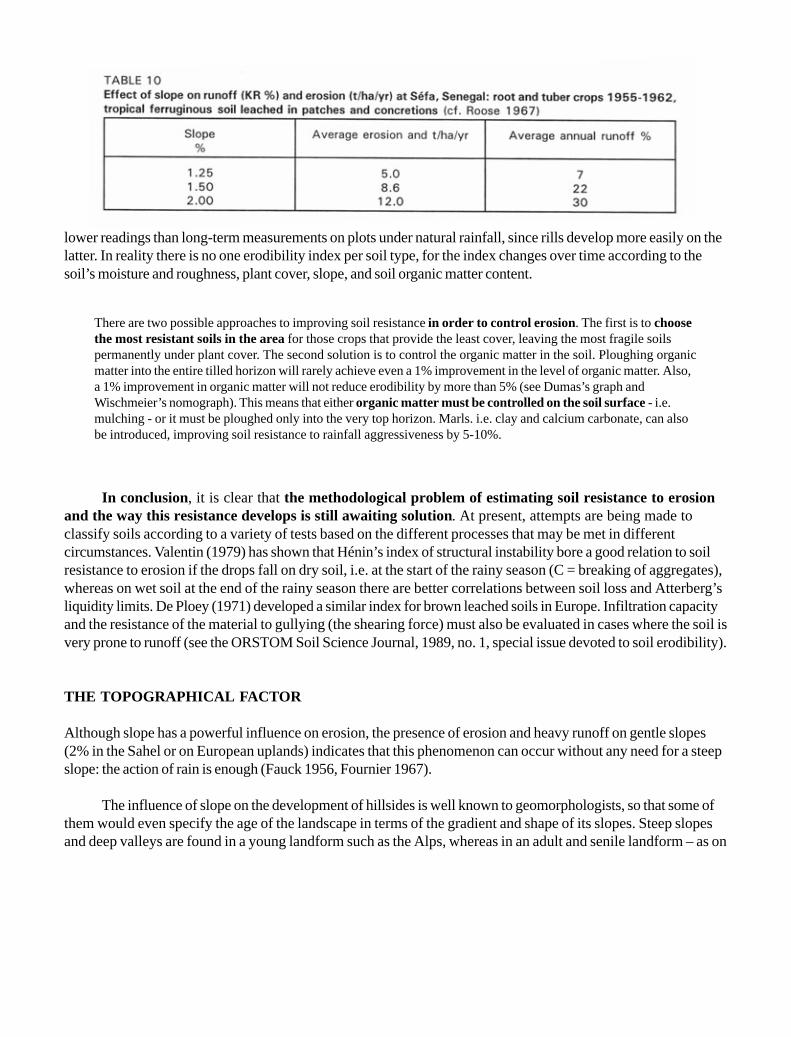
lower readings than long-term measurements on plots under natural rainfall, since rills develop more easily on thelatter. In reality there is no one erodibility index per soil type, for the index changes over time according to thesoil’s moisture and roughness, plant cover, slope, and soil organic matter content.
In conclusion, it is clear that the methodological problem of estimating soil resistance to erosionand the way this resistance develops is still awaiting solution. At present, attempts are being made toclassify soils according to a variety of tests based on the different processes that may be met in differentcircumstances. Valentin (1979) has shown that Hénin’s index of structural instability bore a good relation to soilresistance to erosion if the drops fall on dry soil, i.e. at the start of the rainy season (C = breaking of aggregates),whereas on wet soil at the end of the rainy season there are better correlations between soil loss and Atterberg’sliquidity limits. De Ploey (1971) developed a similar index for brown leached soils in Europe. Infiltration capacityand the resistance of the material to gullying (the shearing force) must also be evaluated in cases where the soil isvery prone to runoff (see the ORSTOM Soil Science Journal, 1989, no. 1, special issue devoted to soil erodibility).
THE TOPOGRAPHICAL FACTOR
Although slope has a powerful influence on erosion, the presence of erosion and heavy runoff on gentle slopes(2% in the Sahel or on European uplands) indicates that this phenomenon can occur without any need for a steepslope: the action of rain is enough (Fauck 1956, Fournier 1967).
The influence of slope on the development of hillsides is well known to geomorphologists, so that some ofthem would even specify the age of the landscape in terms of the gradient and shape of its slopes. Steep slopesand deep valleys are found in a young landform such as the Alps, whereas in an adult and senile landform – as on
There are two possible approaches to improving soil resistance in order to control erosion. The first is to choosethe most resistant soils in the area for those crops that provide the least cover, leaving the most fragile soilspermanently under plant cover. The second solution is to control the organic matter in the soil. Ploughing organicmatter into the entire tilled horizon will rarely achieve even a 1% improvement in the level of organic matter. Also,a 1% improvement in organic matter will not reduce erodibility by more than 5% (see Dumas’s graph andWischmeier’s nomograph). This means that either organic matter must be controlled on the soil surface - i.e.mulching - or it must be ploughed only into the very top horizon. Marls. i.e. clay and calcium carbonate, can alsobe introduced, improving soil resistance to rainfall aggressiveness by 5-10%.

the old African continent – there are plateaux, gentle slopes, pediments and vast peneplains.
Slope intervenes in erosion in terms of its form, gradient, length and position.
THE FORM OF SLOPES
Estimating the influence of the concavity, convexity, regularity or warp of a slope is a very delicate procedure.This factor is too often neglected, which in large part explains why authors come up with such divergent results.As eroding plots age and are exposed to severe erosion, they become more and more concave, since the base ofthe plot stays fixed (the runoff channel) and the middle of the plot erodes more quickly than the top. This meansthat each year the slope of the plots must be readjusted so that the results are not falsified by default. Accordingto Wischmeier (1974), with a smooth average slope, sediment transport is reduced on a warped or concave slope(due to localized sedimentation), but increased on a convex slope due to the gradient of the steepest portion. Thepresence of concave slopes in a landscape indicates that there must be trapping, siltation and colluvial deposit inthe valley. In general, erosion on the hillside exceeds the sediment transport in the river – although this is not thecase in the Mediterranean area, where the main cause of sediment transport is the energy and volume of runoff(Heusch 1971; Arabi and Roose 1989).
SLOPE GRADIENT
As the gradient increases, the kinetic energy of rainfall remains constant, but transport accelerates toward thefoot as the kinetic energy of the runoff increases and outweighs the kinetic energy of the rainfall when theslope (S) exceeds 15%. In 1940 Zingg showed that soil loss increases exponentially with the slope gradient. In theUnited States the exponent is 1.4:
E = K S1.4
Hudson and Jackson (1959) emphasized that in Central Africa aggressiveness of climate increases theeffect of slope over what is found in the United States, so that they obtained exponents averaging about 1.63 oncomplete rotations (including grassland and fallow periods), and up to 2.02 on clayey soil and 2.17 on sandy soilunder extensive maize cropping. An exponent in the region of 2 would seem more likely under African conditions(Hudson 1973).
At Séfa in Senegal, Roose (1967) found that erosion and runoff increase very quickly with minorvariations in slope (0.5%) (see Table 10).
In Côte d’Ivoire on food crops between 1964 and 1976, Roose (1980a) obtained an exponent higher than2 for extensive crops that provide little cover, such as groundnut, maize and cassava.
On the other hand, in Nigeria Lal (1976) found that erosion increases with slope according to anexponential curve of 1.2 on modified ferralitic soil enriched with gravel (alfisol) when the soil is bare, but that soilloss is independent of slope (from 1 to 15%) if crop residues are left on the surface. Runoff as such woulddepend more on the hydrodynamic properties of the soil than on the slope itself.


On erosion plots with slopes of 4, 7 and 20% at the ORSTOM centre at Adiopodoumé in southern Côted’Ivoire , Roose (1980a) compared erosion on bare soils and on soils covered with pineapple plantations, residueshaving been burnt, ploughed in, or left on the surface. He recorded a more than proportional increase of erosionwith the slope, but highlighted the existence of gradient thresholds below which erosion is small but abovewhich it suddenly increases. For example, when residues are ploughed in, erosion is very slight on slopes of under7%, but beyond 20% it quickly moves far above the tolerance level. If residues are left on the surface as a mulch,erosion is negligible even beyond 20%. Similarly, during the second cropping cycle, planting took place in Augustso that the pineapple plants provided good cover to the soil before the aggressive rains of the following June; verylittle erosion was recorded, whatever the slope and the way crop residues were handled. These results clearlyindicate the existence of interaction between the effect of slope, plant cover and treatment of cropresidues (Table 11). It has been noted in West Africa that natural vegetation that has survived fires protectslandforms very well (Roose 1971, Avenard and Roose 1972). The same can be seen in southern Côte d’Ivoire,where there are slopes of over 65% on sandy-clayey ferralitic soil protected by dense secondary forest. If forestis cleared manually without destroying the root network that provides cohesion to the topsoil, the soil can resistthe aggressiveness of rainfall for one or two years. However, if forest or savannah is cleared mechanically,scouring the fertile topsoil, erosion and runoff assume catastrophic proportions, further aggravated on steepslopes.
Adiopodoumé has three plots under closed secondary forest, and three cultivated in 1966/67, maintainedunder bare fallow, and tilled before the rainy season from 1968 to 1972. Slopes varied from 4.5 to 65%. Table 12shows average soil losses (in t/ha/yr) and runoff (as a percentage of annual rainfall) recorded during the period1956 to 1972 (Roose, 1973).
Erosion is seen to increase proportionately faster than slope, and faster under crops than on bare soil.Under crops (cassava followed by groundnut), if the average erosion on a 4.5% slope is taken as the basis (E =18.8 t/ha/yr), soil loss increases fourfold when the slope rises to 7% (i.e. 1.5 times steeper) and another fourfoldwhen it rises to 23% (i.e. 5.1 times steeper than the control plot). Erosion increases more slowly on a bare plot,but starts higher (E = 60 t/ha/yr). It seems clear that on a steep slope there is an interaction between theeffects of slope and the decrease in plant cover resulting from water stress and mineral deficiency in plantsgrowing on steep eroded slopes. Alongside this quantitative aspect, the forms of erosion change with the slopeand the soil profile. On a gentle slope (4%) raindrop energy dislodges aggregates and releases fine particles.Stable suspensions of colloids may travel long distances through the drainage system. Sand, on the other hand,collects on the soil surface, giving it a striped appearance with alternating dark bands (from stripped soil in relief)and yellow streaks (from sand in the grooves). The soil surface is almost flat on 4% slopes, but on a 7% slope,these lower areas deepen into widened rills into which sand in the washload settles. Microcliffs and smallpedestals (2-4 cm) appear, which clearly show the extent of the scouring damage caused by sheet erosion. Lastly,on slopes of more than 20%, the runoff evacuation system removes particles of all sizes (up to 5 or 10 mm indiameter) and digs out grooves, so that the soil surface becomes extremely uneven, with deep rills (5-20 cm) andnumerous humps chiselled by rain and runoff and protected by objects such as seeds, roots, leaves, bits of potteryand even hardened or crusted clods. In the United States Smith and Wischmeier (1957) have shown that on plotswith a slope of 3 to 18% exposed to natural rainfall for 17 years, a second-degree equation works better than thelogarithmic functions proposed by other American scientists, though these are in fact very close. This equation is:


E = L/100 (0.76 + 0.53 S + 0.076 S2)
where E, erosion, is expressed in t/ha, S, slope gradient, in %, and L, slope length, in feet (Figure 22).
Wischmeier (1966) has shown that runoff usually increases with the slope on small plots, but that theincrease varies with soil surface roughness and water-retention capacity (type of crop and saturation level beforethe rain).
In Côte d’Ivoire, the runoff/erosion duo behaves in a very different manner with respect to slope. AtAdiopodoumé under crops, the runoff coefficient reaches 16% on a 4.5% slope, and stabilizes at around 24% onplots with a 7 or 23% slope. On bare fallow ground, runoff decreases noticeably (35, 33, 24%) when the slopeincreases from 4 to 7 and 23%, and this phenomenon has been confirmed over years of trials. This decrease inrunoff as the slope increases is seen not only with average runoff coefficients, but also with maximumcoefficients when the soil is saturated (KRmax = 98, 95, 76%). These trends were confirmed in subsequent years(1975-1977) under pineapple (Table 11). On bare soil runoff dropped from 44 to 35 and 29% as the slopeincreased from 4 to 7 and 20%. Under pineapple, runoff increased slightly or even decreased depending on howcrop residues were handled. Here again, there is interaction between the slope and the condition of the soilsurface as these affect runoff.
Hudson (1957) had already noted these phenomena in what was then Rhodesia, where he observed thaterosion increases exponentially with slope, but that runoff increases rapidly at first (up to roughly 2% of slope)and then stabilizes.
In Nigeria too, Lal (1975) observed that runoff stabilized above a certain gradient depending on the waycrop residues were used and on soil type.
The decrease in the runoff coefficient on bare soil may be explained, at least partially, by the followingfactors (Roose 1973):
· The sloping surface exposed to the rain increases as the slope grows steeper. In other words, if the area ofthe plot is field-measured without taking account of the vertical component, there will be an error of 0.3%for a 4.5% slope, 0.7% for a 7% slope, and 2% for a 20% slope.
· As the slope increases, the type of erosion changes, chiselling the ground into different shapes andthereby increasing the surface area – and hence the number of pores that can absorb water, at least in theinitial phase.
· When the slope is gentle, runoff energy is too weak to carry relatively coarse sandy particles very far.When it rains, these are released by the splash effect and then slowly carried downhill. As they move theymay be drawn in by pores and block them. They also go to form microstrata – the phenomenon of glazingfamiliar to agronomists. On a steep slope, however, all particles detached by the rain’s force are carried offthe plot, and it may be surmised that more pores stay open, for erosion scours the soil surface heavily. Inany case, it has been observed in the field that crust formation occurs much more slowly on steepslopes and that hoeing has much longer-lasting effects than on gentle slopes.

· Lastly, the hydraulic gradient increases in line with the topography; i.e. steep slopes drain faster thangentle ones.
If erosion increases exponentially with slope despite a decrease in runoff, this is because the total sedimenttransport (suspended load + bedload) increases substantially with the slope.
As early as 1948, Woodruff in the United States showed that while the contribution of the kinetic energy ofraindrops is of primary importance on a gentle slope, it is secondary to runoff energy over a 16% gradient.Heusch (1969, 1970, 1971) then showed that on pre-Rif marls in Morocco, erosion and runoff are sometimesaffected more by position in the toposequence than by gradient. On the vertisol toposequence on marl,erosion and runoff readings increase at the foot of the slope, where the gradient decreases. This would be due tovery marked phenomena of oblique drainage in these soils that are fissured down to the weathering level of thenearly impermeable marly rock. On a steep slope at the top of the hill (concave slope), rain infiltrates directly asfar as the impermeable level, and then drains quickly down to the foot of the hill (gentle slope), where it re-emerges (Roose 1971). And this is where the gullies start that then climb back up to attack hills in regressive(headward) erosion. As Heusch (1971) has rightly pointed out, the steeper the topography, the steeper thehydraulic gradient. This means that water circulates quickly inside the soil, thus allowing the soil to reabsorb acertain amount of water before saturation. The soil on steep slopes and hilltops will dry out quicker, thusproducing less runoff. In marly landscapes with steep slopes, erosion consists mainly of undermined banks,wandering wadis, gullying and landslides (Heusch 1971).
Somewhat similar processes have been described and studied on the Sudanian savannahs of central andwestern Côte d’Ivoire by a multi-disciplinary ORSTOM team (Valentin, Fritsch and Planchon 1987). The redgravelly ferralitic soils at the top of the toposequence are resistant and permeable so that only rarely are anysignificant traces of erosion found here. Ferruginous tropical hillsides are already more fragile, with small,discontinuous gullies, while larger gullies form on the sandy hydromorphic lowlands, growing in size as they moveback up the landscape. Although these sequences in a Sudanian region operate very differently from those ofmarls in a Mediterranean region, topographical position often seems significant in explaining the development oferosion.
SLOPE LENGTH
In theory, the longer the slope, the more runoff will accumulate, gathering speed and gaining its own energy,causing rill erosion and then more serious gullying. Thus, Zingg (1940) found that erosion increases exponentially(exponent = 0.6) with the length of the slope. Hudson (1957 and 1973) considered that a higher exponent value ismore appropriate in tropical regions. Wischmeier, Smith and Uhland (1958) examined 532 annual results onerosion plots, and concluded that the ratio between erosion and length of slope varies more from year toyear than from one site to another; the value of the exponent (from 0.1 to 0.9) is strongly affected by changesin soil, plant cover, use of crop residues, etc. Then in 1956 a research team from Purdue University, Nebraska,USA, decided to adopt an exponent of 0.5 to express the average influence of length of slope on soil loss forcurrent field work. The influence of slope length on runoff is still less clear, being sometimes positive,sometimes negative, sometimes nil, depending on the prior moisture and condition of the soil surface(Wischmeier 1966).

At Séfa in Senegal (Roose 1967) three plots with a 1.25% slope were compared. On one plot, twice aslong as the others, the crops of the other two plots were alternated (strip cropping in the direction of the slope). Ingeneral, runoff was weaker on the long plot (KR = 19% as against 21%), while erosion was higher (E = 6.08 asagainst 5.55 t/ha/yr) than on the two short plots, but the difference in behaviour was barely significant.
At Agonkamé in southern Benin (Verney, Volkoff and Willaime 1967, Roose 1976), conclusions fromtwo neighbouring plots (slope = 4.5%) also failed to clearly confirm any increase in erosion with length of slope.Under natural thicket, erosion and runoff were weaker on the long slope (60 m), while the following year, oncleared land with stumps removed, runoff on the two plots was similar, while erosion on the shorter plot (30 m)was much greater than on the longer plot (E = 27.5 as against 17 t/ha/yr). At Boukombé in northern Benin(Willaime 1962), observations on three plots under millet 21, 32 and 41 metres long with a 3.7% slope showedscarcely any difference in runoff (KR = 4%) or erosion (E = 0.8, 1 and 0.7 t/ha). The influence of length of slopeis therefore neither consistent nor particularly strong.
In Côte d’Ivoire , Lafforgue and Naah (1976) simulated 12 rainfalls totalling 652 mm for anaggressiveness index of 1161 on four plots with a 6% slope on former grassland. The soil was sandy-clayey andall plant débris was carefully removed from the land. When length increased from 1 to 2 to 5 and 10 metres,runoff changed from 27 to 29 to 23 to 20%, but erosion increased from 8 to 8.6 to 11.3 to 13.7 t/ha/yr – becauseturbidity (the solids suspended in the water) increased from 5 to 27 g/l. On these relatively short slopes, runoffdecreased, while erosion and sediment load increased as the slope lengthened. However, there is no proof thatthere will be a proportionate increase in erosion when the length of the slope is increased to 50, 100or 150 metres.
In the United States, Meyer, Decoursay and Romkens (1976) studied the effect of slope length on threesites with varying susceptibility to rill erosion. They showed that the effect of slope length was felt after a certaindistance and that the speed of increase in erosion varied depending on soil susceptibility to rill erosion. Here againthere is an interaction between the effect of slope length and soil sensitivity to rill erosion (Figure 23).
Ramser’s equation was developed to calculate the gap between two erosion control structures. Inpractice, soil conservation engineers have adapted Ramser’s equation, linking the difference in height betweentwo erosion control structures (H in metres) directly to the gradient of the slope (S in %) while ignoring anyinteraction with soil cover and production system.
Ramser’s equation: H (metres) = 0.305 (a + [S%/b]) (1)
a = 2 b varies from 2 to 4 if the climate is more aggressive
where a and b are parameters made to vary empirically by 25% depending on climatic aggressiveness or specificerosion risks (see Figure 24).
According to Figure 24 (taken from Combeau 1977), on a 10% slope:
- in Guinea, aggressive climate, H = 1.37 m, and gap = 14 m

- in Burkina Faso, less aggressive, H = 1.62 m, and gap = 16 m- in Tunisia, H = 3 m, and gap = 30 m.
Ramser’s equation is in fact far from complete, since it takes no account of possible interactions betweenthe effects of slope, soil type, condition of surface and topographical position. It has even been seen that slopelength has no apparent effect on erosion at certain stations in Africa.
There is little point in developing models that take account of slope length. Advice on field observation ofthe birth of rills would be preferable, allowing farmers to build erosion control structures at intervals reasonablefrom the technical standpoint and affordable for the farmer (5-50 m).
In Algeria, Saccardy (1950) used an assessment of peak rainfall intensity of about 3 mm/min over half anhour, and proposed for slopes of
< 25% H3 = 260 S (2)> 25% H2 = 64 S (3)
where H is the difference in altitude between two bunds (in metres), and S is the slope of the land (as apercentage).


According to Heusch (1986), «There is no theoretical or practical justification for these formulae».Wischmeier’s SL factor for the distance given by Saccardy’s equation is not constant, but increases progressivelyfrom 0.4 for a 3% slope 66 m long, to 11 for a 50% slope and a gap of 12.7 m. At the very most, it can be agreedthat Formula 3 can also be written:
H.C = 64
where C is a coefficient depending on local conditions, particularly climate,
which is the same as saying that the energy comes from the runoff if the slope is 25% or more.
This uncertainty over the influence of slope length on sheet and rill erosion throws fresh doubton the generalized use of erosion control techniques such as terracing, bunds and diversion channelswhich are too often indiscriminately applied in very different climates. While terracing is justified in a sub-desertenvironment where rainfall is below 400 mm/yr, it may be best replaced by biological methods in regions wherevegetation can cover the soil and intercept the rain (Roose 1974). From a scientific viewpoint, the topographicalfactor and its multiple interactions should be further investigated and more clearly defined, for the influence ofslope is not independent of plant cover, cropping techniques, soil type and probably climate (Roose 1973; 1977).However, until sufficient data are available, Wischmeier’s topographical index or an exponential equation such asSL = C x L0.5 x S1.2-2, where L is length of slope in metres, and S the gradient in percent, can be relied upon. Itshould be satisfactory in most cases (Hudson 1973; Roose 1977).
In practice, rather than systematically applying models developed to some extent for other physical andhuman circumstances, the best approach seems to be a compromise between (a) field observation on the distanceafter which rill erosion develops, and (b) how many obstacles the farmers can accept on their land.
EFFECTS OF PLANT COVER
Plant cover is effective in preventing erosion to the extent that it absorbs the kinetic energy of raindrops, covers alarge proportion of the soil during periods of the year when rainfall is most aggressive, slows down runoff, and
Consequences for erosion control
Reduction of gradient was generally more effective than reduction of length of slope in controlling sheet and rillerosion. However, it does appear that under major crops the land must be partitioned with linear structures - semi-pervious microdams - which allow a reduction in runoff energy while encouraging the evacuation of water to thebottom of well-protected banks. This means that the ill effects of slope length can all be countered by buildingerosion control structures; all interactions of factors concerning the condition of the surface must be broughtinto play, especially encouraging roughness of soil and plant cover on cultivated fields between semi-perviousfiltering structures. This will reduce the effect of slope length and gradient on erosion. It should be noted thatslope length has little effect on sheet erosion because the speed of sheet runoff is kept down by the roughnessof the soil, whereas it may have a significant effect on rill erosion.

keeps the soil surface porous. However, it is difficult to assess the protective action of plant cover without aclose look at the farming techniques involved.
Plant cover is certainly the most important factor for erosion, inasmuch as erosion goes from 1 to over 1000 tonnes when, all else being equal, plant cover on a plot falls from 100% to 0% (compare the plots underpineapple and harvest residues left on the surface, with the bare plots in Table 13).
INFLUENCE OF TYPES OF PLANT COVER
Table 13 shows three types of plant cover.
Full cover year-round
This category encompasses closed forest, but also secondary shrub forest, unburnt tree savannah, natural fallow,grasslands with grasses more than one year old, and shrub crops with cover plants or mulching. Erosion is alwaysnegligible under such thick cover (E = 0.01 to 1.5 t/ha/yr) and runoff very slight (KR % = 0.5-5% on average, 10-25% at most in the case of exceptional rainfall). Erosion and runoff are generally very slight under forest,although there are some exceptions: a forest on a 65% slope on tertiary sand near Abidjan, a plot with a 20%slope on schist-engendered soil at Azaguie, a forest plot in Guyana on Bonidoro schist (Blancaneaux 1979), and aforest plot in a very high-rainfall area in Gabon (Collinet 1971). The maximum runoff observed in these often verymoist forests can rise to over 35% for a single rainstorm. On the most usual types of slope, it seems that runoff isconsiderably stronger on ferralitic schist-engendered soil than on soil resulting from granite or tertiary sediment.With their foliage distributed over several levels, their bushes and their litter of dead leaves, forests provide year-round cover to the soil, protecting it against the energy of falling rain.
Mesofauna (termites and earthworms) keep the soil porous, and infiltration speed remains high throughoutthe rainy season. The only problem that may arise is saturation of the soil above a relatively impervious horizonwith low macroporosity, for example the base of the gravel sheet at Azaguie, and also laterally drained soils inGuyana. Similar results – in other words, very little erosion or runoff – have been observed on three plots underclosed degraded forest thickets on the Agonkamé station in southern Benin (Verney, Volkoff and Willaime 1967;Roose 1976b). As in forest areas, runoff travels between the soil and the litter and is constantly slowed down byunevenness in the soil and trapped by the holes left by rotted roots and mesofauna. Its flow is broken and itsvolume reduced in the sequences studied.
Under savannah or old fallows that have been protected for some years, average runoff (Kaar = 0.02-5%)and maximum runoff coefficients are very little higher than under forest. On the other hand, as seen below, iffires occur each year, particularly late in the season, conditions are radically different.
Bare soils, bare fallows or fallows providing little cover during the most aggressive months
Erosion is greater the steeper the slope and the more aggressive the climate. At Adiopodoumé, erosion rises froman average of 60 to 138 and 570 t/ha/yr with a slope increase from 4-7 to 23%, and runoff is very heavy (averageKR = 25-40% with maximum KR = 70-90%). In principle, farmers never leave their soil uncovered during the

rainy season, but grow some crop; otherwise the ground is invaded by weeds. However, if for some reason theysow their crops too late, the soil will be left without cover during the first months of the rainy season and willbehave like that on bare plots. Erosion on a late-sown plot is thus roughly 80% that of a bare plot.
Incomplete cover for part of the year
Some food, industrial, cover or forage crops are planted late or simply need time to thrive. Erosion phenomenaare clearly intermediate, but depend very much on the planting date, crop spacing, slope and cropping techniques.
* The first column is the probable maximum each year per rainstorm; the second column igure refers toan axceptional rainstorm occurring once every ten years.
** Exceptional rainfall.

Table 13 shows that food crops are among those offering the least soil protection. Erosion under cassava or yamamounts to 22 to 93 t/ha/yr on a 7% slope, whereas under maize and groundnut it varies between 35 and 131 t/ha/yr. This is with no erosion control measures, late planting, and widely spaced crops on poor soil. In any case, 80%cover only developed after two to five months, in other words after the heaviest rains. This does not happen ontraditionally farmed fields, since farmers often plant very soon after the first rains and almost always combinevarious crops providing complementary cover and succeeding one another in time and space. Under intensivecropping, the risk of having to resow if dry periods follow the first storms is too great, so that planting necessarilyfollows relatively late after tillage, often two to three weeks after the sowing date in the traditional system.However, tillage does encourage deep rooting, and fertilizer applications make it possible to catch up for thegrowth lag and to space plants more closely.
Table 13 also shows that erosion – and to a lesser degree runoff – depends largely on the proportion ofsoil not covered by plants before the heaviest rains. It is not simply a question of the green matter producedon the field, but more specifically of the vertical – or, better, slightly oblique – projection of cover provided. Duringmajor rainstorms, the angle of incidence of drops is generally less than 25°, except in the case of certaintornadoes, when it can be as much as 45°. It also depends on the architecture of the plant structure: i.e., theheight of foliage above the soil and whether plants are funnel-like and thus concentrate water (e.g. pineapple andmaize), or umbrella-like and scatter the drops (e.g. cassava).
There has been little general study of the dynamics of the cover provided by different crops, and there isno reliable technique for measuring every type of plant. Different procedures have therefore been used to assessplant cover on erosion plots (Roose 1973):
· the average diameter of the circle covered by groundnut rosettes, the proportion of surface covered by thecircle circumscribed by a tuft of cassava (on a vertical photo);
· the number and surface area of maize leaves;
· the covered or bare geometric areas between rows of Stylosanthes or groundnut or under savannah;
· the quartile points (needles touching the cover or not) for grasses, weeds, stubble and pineapple.
Figure 25 shows that the growth dynamics of plant cover varies considerably depending on the type ofplant but also on cropping techniques (spacing, date of planting, fertilizer applications) and climate (rainfall andlight). If heavy rainstorms occur one month prior to sowing, erosion will therefore depend as much on the type ofplants as on cropping techniques. Hence the concept of «soil-degrading» or «protective» plants, according to thespeed at which they cover the soil – a factor that must be tempered by appropriate cropping techniques. Grassesgenerally protect the soil better than pulses or cassava, although crop protective capacity can be improved a greatdeal by early planting in relation to the periods of heaviest rain. For example, Stylosanthes reaches the samecovering capacity (95%) as Panicum but two months later. Some plants are described as soil-degrading becausethey cover the soil slowly, for example pineapple and cassava, which gain by only 10 to 20% of cover per month.

Some plants such as groundnut, maize and other cereals cover the soil very poorly in the first two months,reaching 80% only at the end of the third month, but since their cycle is fairly short (4 months), for the remainderof the year the bare soil is exposed to rain splash unless there are weeds to cover the soil and absorb raindropenergy. Other plants seen as degrading are simply grown in a way ill-suited to providing ground cover. This

applies, for example, to tobacco, which is widely spaced in order to produce more beautiful leaves. This problemcan be solved by mulching the spaces between such poor cover crops. It is obviously not possible to use mulchunder cotton, another notoriously degrading crop which takes at least two months to cover the soil, and alsoleaves no later trace of organic matter in the soil as its leaves are grazed and the stalks and roots carefully pulledup and burnt. It is in fact a combination of lack of plant cover and organic imbalance that leads to soil degradationunder these different crops. Against this, Panicum maximum and other grasses that grow in large tufts can coverthe soil in one month.
Table 14 shows the considerable amount of erosion protection provided by the stubble and superficial rootsof three forage plants even after mowing:
· runoff is reduced to ½ and erosion to 1/17 and even 1/415 of that observed on the bare plot;
· mown Cynodon is still much more effective than Stylosanthes (sown in rows) and especially Panicum,which grows in tufts; erosion depends on the areas of soil left uncovered after mowing, i.e. 20 to 40%under Cynodon, 60% under Stylosanthes in rows, and almost 90% under Panicum.
In Table 15 it should be noted that results vary widely for incomplete cover. This is fortunate fordevelopment experts, for the variability is a result not only of variations in rainfall and imperfections inmeasurement methods, but primarily of the way in which crops are planted and tended. Experts can thereforemanipulate cropping techniques, using biological or mechanical approaches. The first method for soil and waterconservation, the biological technique, aims at intensifying production on the best land by increasing plant cover. Itentails early, close planting of vigorous species well suited to regional conditions, adequate soil preparation,balanced fertilizer applications, sufficient phytosanitary protection, the use of cover plants or mulching, croprotation and alternating cover and root and tuber crops.
It is particularly important to ensure soil cover during the heaviest rains, particularly from 15 May to 15 Julyat Adiopodoumé. On two identical plots with a 7% slope, one month’s delay in planting Panicum maximum led toan increase in erosion from 1 to 89 t/ha, and in runoff from 10 to 20% for the rainiest three months of the year.


The choice of a very vigorous cassava variety and manure supplements reduced erosion from 93 to 30 t/ha/yr on neighbouring plots.
For shrub crops, planting a good cover crop generally solves erosion problems (see coffee, palm oil, cocoaand rubber plantations in Côte d’Ivoire) (Table 15).
INFLUENCE OF THE HEIGHT OF PLANT COVER (Figures 26 and 27)
Figure 26 shows that erosion is dependent not only on plant cover but also on plant height above the ground. Forexample, when plant cover is 100% but is 4 metres high, erosion will be about 75% of that on a bare plot; if thecover is 2 metres high, erosion will be about 50%; and if it is 50 cm high, erosion will still be about 18%.However, if there is a mulch, erosion will be reduced to 3%. If reduced erosion concerns the percentage of soilcovered by mulch, a very fast reduction is seen for a relatively small area. For example, for 10% of soil cover,erosion is no more than 78%, for 20% it is no more than 60%, and for 50% it is only 30% of that found on thebare control plot.
This means that litter has a very quick impact on erosion. Mulching can be of use in erosion controleven without covering the whole ground. If even as little as 20% is covered, erosion is reduced by 40%; if themulch covers about 40%, erosion is reduced by 60%, and if 80% is covered, erosion is reduced by 90% fromwhat would be found on bare soil.
Figure 27 shows the combined effect of mulch and canopy. If there is no canopy, the previous curve isseen for the effect of mulch on erosion, but if 20, 40, 60, 80 or 100% of the ground is also covered by canopy,there is a progressive increase in erosion control. Thus, with mulch covering 20%, erosion is about 60%, but ifthere is also 100 percent canopy cover, erosion will be no more than 30%. This means that if the mulch is nottotal, the leaf vault can have a considerable effect in reducing erosion.
Lastly, erosion can be reduced for a catchment if crops that provide poor soil protection (e.g. maize,groundnut, tobacco, cassava, yam) are alternated with grass leys or permanent grassland, or even buffer strips.
PLANT ARCHITECTURE
The architecture of plants can also affect the development of gullying and erosion, for trees with leaves thatchannel water toward the trunk operate as funnels, and water thus collected at the foot of the trunk can start toshear through the ridges, which will then drain off all the water contained in the furrows, giving rise to a gully.This occurs particularly with pineapple, but also – to a lesser extent – with maize. The other type of architectureis that of umbrella-like plants, which send drops of water outwards and thus scatter their energy; banana andcassava are examples here.
The influence of root formation must also be considered. Fasciculate surface roots hold the surface of thesoil. Tap-roots grow in volume to start with, occupying the soil macropores and hence reducing infiltration, butthey later rot, leaving tubes stabilized by organic matter, thus encouraging infiltration.
Intensified farming does not necessarily lead to increased soil degradation and erosion. Hudson (1973)indeed demonstrated that the production of one sack of maize caused 50 times more erosion when grown


INFLUENCE OF CROP RESIDUE MANAGEMENT
Recall the test in Table 11 in which the presence of a cover of pineapple and burnt-off residues reduced erosionon bare soil from 200 t/ha to 25 t/ha and 11 t/ha if the residues are burnt or ploughed in, but 0.4 t/ha if left on thesurface. Similarly, runoff fell from an average of 36% on bare, tilled soil to 6.4% under pineapple with burnt-offresidues, 2% if the residues are ploughed in, and 0.6% if left on the ground. This clearly indicates that residuesleft on the soil surface are much more effective in reducing erosion than residues ploughed into thesoil to improve its structure.
In France the best vineyards are often located on slopes. Since grapevines provide very little cover duringthe winter and spring storms (maximum plant cover = 40%), this crop poses serious problems for controllingrunoff from steep slopes and preventing it from carrying away too much soil. This led Gril (1982) to set up testson a Beaujolais grapevine, using an ORSTOM-type rain minisimulator, to assess the influence of six methods ofsoil preparation and organic matter management on the runoff coefficient (% of the rain), erosion (g/m2/h) andquality of wine (Figure 28). The results clearly showed that:
· tillage reduces the runoff observed on untilled soil (by 15%), but makes little difference to erosion;
· the presence of crushed vine-shoots tends to increase runoff and erosion (+ 37%); curiously, this is theworst possible treatment;
· dug-in compost reduces runoff (by 11%) and erosion (by 24%) as against plain tillage;
· covering the soil with a compost – or, better still, a mulch – is the most effective method, reducing runoffby 65% and erosion by 98% as against the tilled control plot, with no ill-effects on the quantity, pH andalcoholic strength of the wine;
· the variation coefficient is high during the first half hour (13 to 54%), but falls as the rain continues: thecondition of the surface is therefore very variable and important during short storms, but differences arereally established during the second half hour.
EFFECT OF BUSH FIRES [Plate 4]
Under savannah or old fallow protected for several years, average runoff (Kaar = 0.02 to 5%) and maximumrunoff are not much higher than under forest (Saria 1971-1974 and Korhogo 1967-1975: Roose 1979 and 1980a).
extensively than when thickly plantedand combined with fertilizer. This is notonly because larger areas had to becleared in order to produce the sameamount of maize, but also becauseerosion is higher on sparsely plantedfields than closely planted ones. Similarly,fertilizers can have a significantprotective effect against erosion(Table 16).

However, the situation is radically different if fires take place each year. Gonsé is a good example here(Table 17), for there is a sharp difference in soil cover if fire crosses a plot.
If the fire is early (one month after the last useful rain), it passes fast, burning the dried aërial parts, butdestroying neither grass clumps nor major tree branches. On the other hand, it does wipe out the young seedlings,the litter of dead leaves, and a good number of insects and pests.
Late fires – as can happen in Sudanian and Sudano-Sahelian savannah in May, just before the rains – aredisasters, for the vegetation is so dry that the fire lingers on each clump of grass, destroying every last stalk, theaërial parts of bushes, and sometimes even large trees. The soil is left practically bare, and will have littleprotection for at least a year. Rainstorms beat freely on the surface, forming a thin, almost totally impervious,slaking surface, giving rise to severe sheet runoff.
On the other hand, if the plot is totally protected from grazing and fires, tall plants and bushes thrive andyoung saplings take root, covering the land completely in two to four years and producing substantial litter to fullyabsorb rainfall energy and encourage the activity of the fauna that perforate the surface horizons.

Trials on fallow at Saria at the Mossi Plateau Centre clearly show the effect of stubble left on the soil sincethe end of 1971 (Table 18). In 1971, runoff was very high, as much as 40 and 50%, for the young fallow hadalmost no cover as yet, and the older fallow was grazed extensively. During the two years that the plots wereprotected from grazing and fires, runoff and erosion were kept down to a bare few percent of runoff. In April1974, before the first storms, all the grass and dry leaves covering the ground on the plots was gathered. Theaverage – and especially the peak – runoff immediately rose by several percent, although not returning to itsinitial level, for the clumps of grass quickly spread again as soon as the rains started, and the mesofauna did notsuffer too much.
EFFECT OF FIRE CONTROL SYSTEMS ON THE NATURE OF PLANT COVER
A few kilometres from Bouaké in central Côte d’Ivoire the CTFT set up a very clear demonstration trial in the1950s on the effect of fire on Guinean savannah (rainfall of 1 200 mm spread over four seasons) at theKokondekro forestry station. On a sloping ferralitic soil, three one-hectare plots were isolated by fire-breaks andsubjected each year either to late fire, early, running fire, or total protection from fire. After 30 years, thefollowing observations could be made:
· on the plot subjected to fire (annual, late), the tree vegetation had practically vanished, giving place to agrass savannah;
· on the plot subjected to early, running fire one month after the last useful rainfall, tall plants shared the areawith shrubby, fire-tolerant, stunted, misshapen, but fairly abundant shrub vegetation;
· on the plot totally protected from fire (a mere two accidental fires in 30 years), the grass had practicallyvanished, smothered by a very thick secondary forest rich in creepers and undergrowth, much morevigorous than the surrounding savannah, which was burnt almost every year, and composed of large,dominant trees (10 to 30 trees per hectare) and a mixture of tall plants and numerous shrubs.
Although unfortunately no information is available on changes in soil or on runoff, it is clear that fire has adecisive influence on the development of grasses and trees and on the variety of species present.
EFFECT OF TUFTS OF GRASS
In the absence of fire and grazing, infiltration recovers after a few years on old fallow. While double-ringinfiltration tests (Müntz) have shown that infiltration is very slight between tufts of grass on denuded areas (1 to20 mm/h), it is five to ten times greater under tufts of grass (over 100 mm/h). Such soil provides congenial shelterto termites and other small animals which build very temporary structures and hollow out passages; together withthe passages left by rotted roots, these help infiltration (Roose 1979). This means that the better the young plantsgrow, the more extensively they cover the soil surface and the more they divert raindrops from their trajectory inorder to lead them toward the base of the clumps, where they can infiltrate easily. Stalks and subaërial roots, butabove all litter, also act as brakes on sheet runoff, slowing it down and thus increasing the time and volume ofinfiltration – although grass stalks are in fact more effective in trapping suspended solids than in reducing thevolume of runoff.

INFLUENCE OF CROPPING TECHNIQUES [Plate 17]
It is increasingly clear that the condition of the soil surface plays a major role in reducing runoff and soil loss.
There are two complementary approaches to improving surface condition. The first has been seen:covering the soil, planting early and densely, possibly using fertilizer, and also keeping the surface covered bystubble and other crop residues.
The second approach concerns tillage, and will be developed in the present subsection. It entails keepingthe soil surface rough, increasing aëration and macroporosity, and improving root development, while workingto control weeds and digging in organic residues to improve the organic status and structural stability of the soil.Lastly, contour cropping and ridging, if possible using tied ridges, can slow or even halt runoff on the soilsurface. Although such techniques are mechanical means of reducing runoff, tilling the soil also encourages thedevelopment of roots and hence of plant cover, which means that these methods combine both mechanicaland biological aspects.
EFFECT OF DEEP TILLAGE
Preliminary work on tropical ferruginous soil at Gampela in Burkina Faso (Birot et al. 1968) showed that tillagetemporarily reduces runoff and erosion, but increases detachability and hence the long-term erosion risk, even onrelatively gentle slopes.
Table 19 shows the effect of tillage with a cultivator on erosion at the ORSTOM Adiopodoumé Centre(7% slope, highly desaturated sandy ferralitic soil). Increased erosion and reduced runoff are observed on a baretilled plot. Erosion increases despite a reduction in runoff after tillage (sandy ferralitic soil).
Tillage temporarily increases the porosity of the material but reduces its cohesiveness. Table 20 gives thevarious readings for erosion under rainfall for dates before and after tillage (tillage date 9 April 1971) on threebare plots with 4, 7 and 20% slopes.
Runoff is nil for three weeks when rainfall is 87 mm, increasing again sharply on the gentle slope whereverthe surface has been smoothed, but much more gradually on the steep slope. Tillage slows down runoff for 50days (corresponding to rainfall of 170 mm).
CONCLUSION
Whatever the slope, cropping technique, extent of soil fragility or climatic aggressiveness, full plant cover(regardless of its architecture and botanical composition, so long as it reaches 80%) ensures a high level of soiland water conservation. The influence of plant cover is greater than that of any other factor. Biological methodsthat help increase plant cover should therefore have priority in any effort to improve water management,infiltration, biomass production and soil conservation. Elwell (1981) found that even if only 40% of the soil wascovered by crops, this reduced erosion by 80% on oxisols in Zimbabwe, which are more resistant than the soilstested in West Africa. This clearly shows the possible interaction between plant cover and soil type withreference to erosion.

Erosion cannot really be measured since runoff is nil, although rainfall impact clearly plays a short-termrôle inasmuch as the surface starts off cloddy and open but becomes smooth and sealed after four to six weeks(splash effect on clods and sedimentation in the lower parts). After 50 days erosion becomes exceptionally high,then falls after two months following compaction and crusting of the surface. It would seem that tillage has alonger-lasting effect on a steep slope than on a gentler slope, but when runoff does start up again, erosionbecomes much greater on steep slopes because of the high energy of runoff.
Turbidity of runoff water (fine suspended load) is slight during the dry season (when the soil is crusted)but increases sharply when the first heavy rains come after tillage (the load is 10 to 100 times heavier), thengradually decreases as a smooth, sealed surface is re-formed. To sum up, on this sandy ferralitic soil, sincetillage with a cultivator to a depth of 15 cm leaves the surface cloddy, it can allow total absorption ofrains of 45 to 80 mm, and its moderating action on erosion and runoff can be felt for three to fiveweeks (corresponding to 50 to 190 mm of rain) on a bare plot.

These results obtained in southern Côte d’Ivoire on ferralitic soils and bare plots would seem to militateagainst tillage, for the benefits in terms of infiltration last only one month, and at the end of the year soil losses aregreater on tilled soil (25% more than on compacted soil). However, it is important to remember the interactionbetween the effects of tillage (temporary improvement of porosity) and plant growth (better rooting = better plantcover).
Another very instructive test on the effects of tillage was carried out by CIRAD at the central Côted’Ivoire Bouaké Centre on plots of modified sandy ferralitic soil with a gravel horizon at a depth of about 30 cm(Kalms 1975). For four years comparisons were made of the reaction to rainfall of a bare gravelly soil workedtwice a year in four different ways, although always in the same direction as the slope: tillage to 25 cm with amouldboard plough (P), similar tillage followed by a light harrowing (P + H), surface harrowing to 5 to 10 cm (H)and no-till (O) (Table 21).
Tillage (deep or even shallow) improved infiltration: runoff is always greatest on untilled, bare soil, andthe difference is even more marked when only the erosive rains that took place after tillage are considered. Onthe other hand, erosion changes over time, but from the third year onwards it is decidedly less on the bareploughed and harrowed soil than on the bare soil that was tilled only shallowly or not at all. Tillage clearlyincreases the fine suspended load in runoff. The gravel turned up by tillage can be seen on the surface of theground (gravel content: 10 to 13% without tillage, 22 to 28% with tillage). On such gravelly ferralitic soil inBouaké, tillage therefore increases infiltration and reduces erosion by bringing gravel up to thesurface, which then acts as a mulch, protecting the soil surface.
These two tests were carried out on bare soils, but what happens when the interactions between soilpreparation and plant growth, and their effect on erosion are considered? Recall first the measurements oferosion and runoff under pineapple as a function of cropping techniques at Adiopodoumé on 4, 7 and 20% slopes(Table 11). Average runoff on bare soil was 36%. With plant cover of pineapple and burnt residues, it was cut to6.4%. When residues were turned in, resulting in improved soil structure, runoff was no more than 2%, and whenresidues were left on the surface as a mulch, runoff was less than 1%. In this latter case, even on a soil that hasnot been tilled, infiltration is good because of the effect of mulching. So far as erosion was concerned, losses of200 t/ha/yr were seen on bare soil, 25 t/ha/yr on burnt residues, 12 t/ha/yr on turned-in residues, and a mere 0.4 t/ha/yr when residues were left on the surface. This indicates that tillage combined with pineapple coverconsiderably reduces erosion; turning in residues improves soil structure, fosters infiltration and reduceserosion by another 50%, but non-tillage, this time combined with a cover of crop residues, cuts runoffand erosion to negligible levels.

In Nigeria (the IITA Ibadan Station), Lal (1975) considers erosion risks on bare soil after tillage to be sogreat – following structural degradation of the topsoil – that he recommends minimum tillage and even thisconfined to the planting line, while the space between is covered with residues from the previous crop. Thismethod of minimum tillage combined with mulching can bring problems with weed- and pest-control, so that yieldsare not always the best in years with the right amounts of rainwater. However, when rainfall is insufficient orpoorly distributed, more sustainable production is assured by improved infiltration, limitation of erosion loss,maintenance of structure at its original level, increased activity of mesofauna (especially earthworms) and animproved heat regime.
On the other hand, on sandy tropical ferruginous soils in the dry tropical regions of Senegal,Charreau and Nicou (1971a, b) showed that without deep tillage, yields are halved since water supplies areinadequate, the root network is not sufficiently developed, and rainwater infiltrates poorly into these soils whichare sensitive to rain splash, which puts back the sowing date. Charreau (1969) observed that if organic matter isploughed in during a rough tillage at the end of the cropping cycle, prior to the dry season, structural stability andinfiltration are both improved, thus reducing erosion problems.
The numerous trials carried out since 1975 by Asseline, Collinet, Lafforgue, Roose and Valentin undersimulated rainfall confirm:
· the very temporary improvement in infiltration as a result of tillage: after 120 mm of rain, there ispractically no trace of this improvement on any of the soils tested at Adiopodoumé Centre and in BurkinaFaso;
· the increase in the fine suspended load in runoff after tillage;
· the extremely beneficial and lasting effect for soil and water conservation of plant cover and of leavingcrop residues on the surface;
· the very marked but temporary effect of tied ridging and other methods aimed at increasing the roughnessof the soil (Lafforgue and Naah 1976; Roose and Asseline 1978; Collinet and Lafforgue 1979; Collinet andValentin 1979).
At Bidi, on sandy-clayey soil, tillage increases both infiltration and yields (+ 50 to 100%) in the first years,but quickly exhausts and weakens the soil, so that after three years erosion increases and yields fall.
Simulated rainfall experiments were conducted around Lake Bam in Burkina Faso comparing a slaking soilwith a rough tilled soil, covered and not covered with a mulch, with tied ridging. Figure 29 gives themeasurements under simulated rainfall of 62 mm/h for two hours on ferruginous soils in the dry tropical regionnorth of Ouagadougou. These confirm:
· poor infiltration of end-of-dry-season storms falling on a crusted soil;· infiltration reduced to 36 mm;· the positive but temporary effect of tillage, which delays runoff and allows 82 mm of infiltration;· the very positive effect of tillage followed by mulching, which allows 104 mm of infiltration;


· the very positive effect of tied ridging, which allows the first 60 mm of rain to infiltrate, and then maintains anoverall level of penetration that is always higher than in any other case; whatever the technique proposed, it iseffective only to the extent that it lastingly eliminates the thin slaked surface which to a large extent governs thewater dynamics in the profile unless a warped horizon is found close to the surface (Collinet and Lafforgue1979).
In the United States, Duley (1939) found the influence of surface crusting on runoff to be greater than that ofsoil type or the porosity of the different horizons. Burnell and Larson (1969) show that the delay in the start of runofffollowing tillage depends less on the depth of soil turned over than on the roughness of the surface. Harrold (pers.comm. 1967) considers that in regions where heavy but short summer storms are the greatest danger, deep contourtillage can considerably delay the onset of runoff by increasing both the roughness of the surface and itsmacroporosity (its sponge capacity). Dry subsoiling of soils with a hardened horizon close to the surface can alsoincrease infiltration, so long as the whole of the hardened and compacted layer is broken up (Birot and Galabert 1967,Masson 1971).
Mannering, Meyer and Johnson (1968) report that when maize was grown for five years with minimum tillage,soil aggregation and infiltration increased by 24%, while erosion fell by 34% in comparison with the conventionaltreatment (full tillage). These authors emphasize the importance of not harrowing the soil surface in preparing theseedbed. Hence the idea of harrowing only the seed row and leaving the space between in large clods covered withcrop refuse (Masson 1971, Shanholtz and Lilliard 1969).
In northern France (Tables 22 and 23), Roose and Masson conducted experiments on a farmer’s field ofleached, loamy, slaked, brown soil, to determine the effect of fine-tilling the seedbed on the emergence of wheat seeds
• Simulated rainfall is 33 mm in 1 hour (normally occurring once every 4 years).• The difference in yields is 1000 kg/ha favouring the less tilled plots.• This is an excellent example of land husbandry where the farmers realize that if runoff (and erosion) risks are to
be reduced and production increased, they must reduce investments in inputs: fewer hours of tillage, less wearon the tractor, less energy. In this case, there is no need for extension services to point out insistently that theirinterests coincide with protection of the environment (reduction in downstream flooding and gullying.

and on runoff and yields. When the soil is harrowed two to four times, with a faster tractor, the number of seedsgerminating per square metre falls from 129 to 59. Runoff from a simulated rainfall of 33 mm/h rises from 5 to66% when the ground is harrowed more times, and yields fall by about one tonne. Farmers have thereforerealized that with less tillage they can improve infiltration, the productivity of their land, and net income, whilereducing risks of erosion and environmental pollution (Roose and Masson 1983).
This survey shows the wide range of runoff risk (and hence of erosion) on slaked, loamy soils worked indifferent ways.
Animal traction entails much lower risk than mechanized traction (0 to 73%). Grassland leys temporarilyprotect the soil, but when broken up they rapidly become less effective (KR = 24 48 73%). Subsoiling canlocally offer partial assistance (KR = 30 <-> 73%), but the highest risks were seen after harvesting endive andpotato (deep tillage) with heavy machinery. On these soils, compacted by the repeated passage of tractors andtrailers, 90% of all rainfall soon takes the form of runoff.

With the same ORSTOM-type simulator, the effects of various cropping techniques on runoff and erosionwere tested on brown, clayey soils known as terrefort on a hillside in the Lauragais region near Toulouse insouth-western France (Roose and Cavalié 1988) (Table 24). The experiment compared reactions to 44 mm/h ofrainfall on three segments of the slope – the plateau of 2 to 6%, the lower slope of 14 to 20%, and the upperslope of 22 to 29%. The control plot was treated to rough autumn tillage with one or two extra passes in thespring, while a whole series of improved techniques proposed by the farmers were used on the experimentalplots. In the first place, it was observed that overall runoff falls slightly from 22 to 19% as the slope gets steeper.With one extra hoeing, there is a further slight reduction in runoff from 19 to 12%. If, on the other hand,harrowing is followed by a cultipacker roller, runoff rises sharply from 20 to 35%, for the roller packs down thetopsoil and breaks the clods into fine particles, which quickly re-form into a slaking crust. If the tractor is driventwice over the same place, runoff rises from 20 to 77%. Similarly, a runoff of 83% was recorded in wheel-ruts asa result not only of a reduction in the amount of soaking rain (i.e. that needed to trigger runoff), but also of areduction in the final filtration rate, which falls from 12 to 4 or 1 mm per hour. In order to avoid such compactionin the spring, an attempt was made to prepare the seedbed in the autumn. This resulted in a rise in runoff from 19to 32%, for throughout the winter the seedbed was degraded and formed slaking crusts. When ploughing wasreplaced by the use of teeth to loosen the soil and the stubble was ploughed in the autumn, runoff barely fell at all.On the other hand, with the stubble left in place after the autumn loosening, and the land tilled solely along theseed line, runoff fell from 19 to 7%, the rainwater retained rose to 20 mm, and the final infiltration rate remainedat 23 mm/h.

This experiment clearly shows how compaction and the number of times machinery is driven overthe soil affect runoff, and also the positive effect of a rough autumn tillage (or else loosening the soil and leavingthe stubble on the surface), followed in the spring by working the soil exclusively along the planting line.
A similar experiment under simulated rain was carried out in central France by a team of scientists fromORSTOM, the French Cereal and Forage Technical Institute, INRA, and Orleans University. The aim was todiscover the risk of runoff as a function of the type of maize seedbed on a leached, loamy, very slaked, brown soil(Rahéliarisoa 1986, Lelong, Roose and Darthout 1992).
Six treatments allowed observation of the effects of date of tillage, fineness of tillage when preparing theseedbed, and presence of stubble in the case of no-till (Figure 30). It was seen firstly that no-till on a bare soilleads to the highest risks of runoff. However, if 50% of the soil surface is covered by stubble mulch, this methoddoes not necessarily produce more runoff than late tilling just prior to sowing. On the other hand, early tilling,especially if followed by a long dry period, helps to maintain good structure and a good infiltration level. The finerthe tillage, the greater the risks of runoff.
In the final analysis, the medium-term advantages of till or no-till in terms of water management and soilconservation depend to a large extent on soil type (i.e. its sensitivity to rain splash, compactness, amount ofgravel, permeability, and initial amount of organic matter), slope, plant cover, the use of stubble, the date of tillagein relation to aggressive rains, and above all the type of tillage. Tillage is often a necessary evil for rootdevelopment, weed control and breaking up the thin slaked surface that seals certain soils rich in loam and finesand and poor in organic matter (particularly tropical ferruginous soils and leached, tempered brown soils). It isimportant to avoid overtilling steep slopes in humid tropical zones.
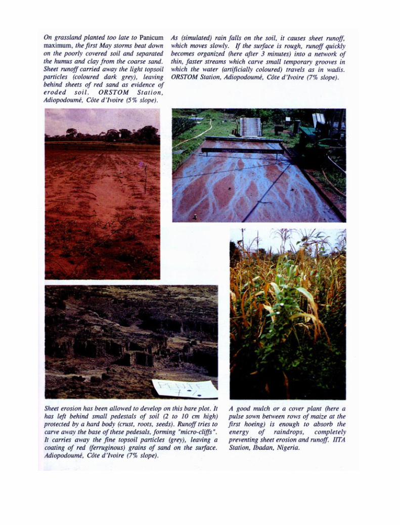


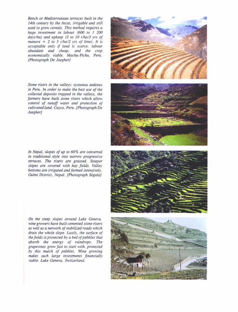


One of the main focuses of present research on soil conservation is the use of crop residues and tillage, and there isas yet no real proof of the long-term positive agricultural and economic effects of such techniques as mini-mum tillage, localized tillage with the space between rows being protected by stubble, partial ploughing in of stubble(stubble mulching) and no-till, leaving stubble on the surface (mulch tillage) – techniques that all seem to have apositive effect on water management and soil conservation. In any case, there are still various practical obstacles inthe way of using these methods in which organic residues are left on the surface: weed control (herbicides areexpensive), machinery to break up the soil without turning it over (vibrating teeth in place of a plough), machinery tosow through a mulch, and pest-control problems (particularly grasshoppers and snails).
In Brazil, Leprun, da Silveira and Sobral (1986) collated the results of experiments on erosion plots in thenorth-eastern, central-western and southern regions (Table 25). These show the remarkable efficiency of simplefarming and biological practices that are easy and inexpensive for farmers to apply, and that ensure long-termproductivity. In the best situations, these biological practices allow control of erosion and a decided reduction inrunoff.
The most effective mechanized cropping techniques are minimum tillage, sod seeding in the mulch made up ofresidues from the previous crop, or else contour cropping. The best biological techniques are crop rotation, croppingon a mulch of crop residues or green manure, and permanent contour buffer strips.

In view of the difficulty of maintaining infiltration under major mechanized crops and reducing erosion throughcontrol structures on contour lines (Murundum in Brazil, the Monjauze embankment in Algeria), Séguy et al. (1989)worked with co-operatives to develop a holistic farming system that reduces tillage to a minimum and entails selec-tion of disease-resistant seed, development of material for sod seeding plus fertilizer applications in stubble mulches(from manual planting canes to mechanized seeders), sowing legumes as catch crops under maize, dressings suitedto the production level, a range of herbicides and pesticides compatible with mulch cropping, and a research andmarketing network.
All these methods are at present being tested in Cameroon by IRA and CIRAD scientists within the frame-work of intensive cotton and cereal farming under Sudano-Sahelian conditions on typically fragile tropical ferrugi-nous sandy soils.
SHALLOW TILLAGE (HOEING)
Since the formation of a thin slaked surface has a marked effect on infiltration, it might be hoped that shallow tillagewould be enough to save both soil and water. And at Adiopodoumé (Roose 1973) it has been observed that theeffects of hoeing a bare, sandy soil are similar to, though more ephemeral than, those of ploughing. Following ashallow scratching with the hoe, the soil can absorb only a single fairly gentle rainfall of 10 to 30 mm and erosion iscontained for one to eight days after which it exceeds that on the control plots. While runoff is temporarily slowed,turbidity rises considerably, falling only with the formation of a new thin slaked surface.

The same conclusions could be drawn from cropping technique trials under simulated rainfall on steep-slopingloam-clay soil in the Lauragais region in south-western France. A rainfall of 40 mm in one hour produced a slightincrease in infiltration, but the thin slaked surface then re-formed and with the higher turbidity soil loss in the endmatched that on the control plot (Table 23).
At Bouaké (Table 21), shallow harrowing of bare soil barely reduced runoff compared to the untilled controlplot but increased erosion considerably (Kalms 1975).
On the other hand, on the broad, gently sloping, tropical ferruginous pediments of Burkina Faso,Nicou, Ouattara and Somé (1987) showed that yields close to those obtained after tillage could be obtained so longas the surface was broken up each time the slaking crust re-formed (Table 26). The point is that in these semi-aridSudano-Sahelian zones, tillage necessarily entails later sowing than that traditional among the Mossi farmers, whilesimply scratching the soil allows the plants to take root faster and the runoff to start later if the slaking crust is brokenup regularly. In places where people have never adopted tillage, scratching the surface with a donkey-drawn imple-ment is a fast and inexpensive operation within the reach of small farmers.
Shallow tillage unblocks the macropores of the soil surface, and can thus improve infiltration in semi-aridzones and even in temperate zones, so long as the soil is kept free of a thin slaked surface until plant cover can takeover. On the other hand, harrowing is a dangerous practice everywhere, especially on steep slopes; it servesvery little purpose and should be avoided during the period of major rainstorms.
MOUNDING AND RIDGING
These techniques are widely used in Africa to ensure good root development (cassava, yam), and good drainage intemporary wetlands (including Sudanian areas), and to collect fertile soil around plants grown on the most degradedsoils. Ridging also facilitates weed-control by giving the crop an advantage of 10 to 20 cm in height over the weeds.However, mounding – and, to a slightly lesser degree, ridging – is a dangerous practice, for although it theoreticallyincreases the infiltration surface (hence in principle reducing runoff), it also increases the average slope of theland, reduces soil cohesiveness, and concentrates runoff along specific lines. It also increases erosion, which risesexponentially with the slope of the land (Table 27) (Roose 1973).
Two temporary experiments carried out during the 1956, 1967, 1968 and 1969 seasons at Adiopodoumésuggest a slight reduction in runoff and an increase in erosion and turbidity on a ridged soil under cassava or maize.However, these phenomena are not always very clear.
It would be easy to reduce soil and water loss for crops grown on mounds and ridges by tying and mulchingthem. However, it would then be impossible to avoid the formation of a very unfavourable surface structure inthe furrows and pans they form which would reduce soil infiltration capacity at the end of the rainy season. Insemi-arid Sudano-Sahelian areas, level planting on unridged ground followed by hoeing and hoe-mounding at three-weekly intervals, then by tying, allow broad, tropical, ferruginous pediments to absorb rainstorms of 50 to 70 mm –the levels to be expected at the start of the rainy season when the cover has not yet taken over. Studies by Rodriguez(1986) in Burkina Faso have shown that tied mounding allows considerable improvements in infiltration -and also in
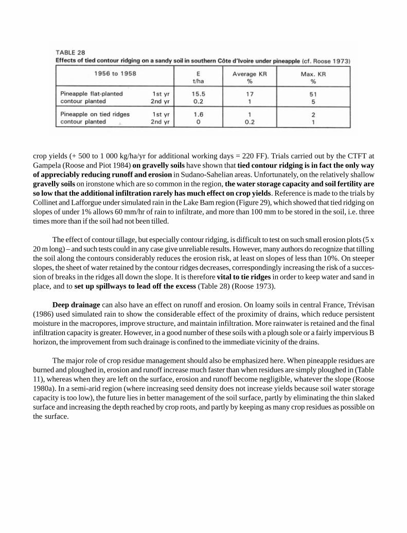
crop yields (+ 500 to 1 000 kg/ha/yr for additional working days = 220 FF). Trials carried out by the CTFT atGampela (Roose and Piot 1984) on gravelly soils have shown that tied contour ridging is in fact the only wayof appreciably reducing runoff and erosion in Sudano-Sahelian areas. Unfortunately, on the relatively shallowgravelly soils on ironstone which are so common in the region, the water storage capacity and soil fertility areso low that the additional infiltration rarely has much effect on crop yields. Reference is made to the trials byCollinet and Lafforgue under simulated rain in the Lake Bam region (Figure 29), which showed that tied ridging onslopes of under 1% allows 60 mm/hr of rain to infiltrate, and more than 100 mm to be stored in the soil, i.e. threetimes more than if the soil had not been tilled.
The effect of contour tillage, but especially contour ridging, is difficult to test on such small erosion plots (5 x20 m long) – and such tests could in any case give unreliable results. However, many authors do recognize that tillingthe soil along the contours considerably reduces the erosion risk, at least on slopes of less than 10%. On steeperslopes, the sheet of water retained by the contour ridges decreases, correspondingly increasing the risk of a succes-sion of breaks in the ridges all down the slope. It is therefore vital to tie ridges in order to keep water and sand inplace, and to set up spillways to lead off the excess (Table 28) (Roose 1973).
Deep drainage can also have an effect on runoff and erosion. On loamy soils in central France, Trévisan(1986) used simulated rain to show the considerable effect of the proximity of drains, which reduce persistentmoisture in the macropores, improve structure, and maintain infiltration. More rainwater is retained and the finalinfiltration capacity is greater. However, in a good number of these soils with a plough sole or a fairly impervious Bhorizon, the improvement from such drainage is confined to the immediate vicinity of the drains.
The major role of crop residue management should also be emphasized here. When pineapple residues areburned and ploughed in, erosion and runoff increase much faster than when residues are simply ploughed in (Table11), whereas when they are left on the surface, erosion and runoff become negligible, whatever the slope (Roose1980a). In a semi-arid region (where increasing seed density does not increase yields because soil water storagecapacity is too low), the future lies in better management of the soil surface, partly by eliminating the thin slakedsurface and increasing the depth reached by crop roots, and partly by keeping as many crop residues as possible onthe surface.

On the very rich volcanic soils of south-western Cameroon, the Bamiléké traditionally multicrop half adozen species on large ridges running perpendicular to the contour lines on steep slopes (Fotsing 1992a) (Figure 31).Inexperienced agricultural scientists felt that these large ridges should be perpendicular to the greatest slope, butthen saw that in heavy rains, water would collect at certain points on the slope, overflow the ridges, and form moreserious gullies than in the traditional system. It must be emphasized that on slopes steeper than 25% the advan-tages are greatest if ridges are oriented in the direction of the greatest slope, which limits the catchmentarea and hence the volume of runoff between ridges. In the case of small and medium rainstorms, damage willobviously be greater when mounding follows the direction of the slope and will certainly lead to quite considerableerosion in the course of the year, but it does help to reduce the major risks of landslips or gullying. Thus thecontour ridging method is not universally applicable. One elegant solution might be large ridges on a gentle slope(under 1%) toward a prearranged spillway, with ties between these ridges every 1 to 5 metres. Such ties must belower than the ridges themselves in order to allow progressive lateral drainage during exceptional rainstorms. How-ever, the secret of the success of the Bamilékés’ ridging method lies in keeping a very thick permanent cover thanksto the combination of a large number of different crops throughout the year (see Part III).
In mountainous areas, tillage entails some serious hazards:
· it temporarily improves infiltration but reduces soil cohesiveness, thus heightening the risks of erosion andsliding;
· it allows organic matter to be turned in, but exposes the subsurface, which is poorer in humus, to rainfallimpact;
· above all, it accelerates dry mechanical creep, since the implements move the clods.
The following solutions have been put forward:
· rough tillage by two to four people working together turning large clods in order to dig in plants, grass andmanure;
· mounding is dangerous, for it concentrates runoff into rivulets which soon carve channels on steep slopes;· ridging is often used to dig in the fallow and crop residues:
• it collects a great deal of well-drained, friable soil for tubers;• it stores water (60 to 22 mm if the slope increases from 2 to 40%) if it is perpendicular to the slope (a
risk of landslips in the heaviest rains);• it drains slopes if it is oblique or follows the direction of the slope;• it gives crops an advantage in height over weeds.
In Peru, depending on the season, the farmers may choose full tillage, ridging prior to sowing, ridging aconsiderable time after sowing, or tractor tillage (Figure 32). It has been seen that yields can be increased whilereducing tillage time – and hence increasing the benefit for farmers. For tractor tillage, however, this obviouslygreatly increases the risk of degradation, for tillage has to follow the direction of the greatest slope if the tractor is notto overturn.


Moreover, in dry years the farmersmake their ridges perpendicular to the slopein order to store as much water as possible,whereas if it looks like a very wet year, theyfollow the direction of the greatest slope inorder to facilitate drainage, and if the yearlooks uncertain, they make one square set per-pendicular to the slope and the next in thedirection of the slope, creating a patchworkof little plots that allows runoff to circulateslowly.
The C factor (influence of plant cover andcropping techniques in Wischmeier’s equa-tion)
In Wischmeier’s equation, the C factor is therelationship between erosion measured on abare fallow reference plot under a given crop.It expresses the interaction between the crop
and cropping techniques and how this affects the reaction of a soil type to rainfall. The C factor changes as theplants grow and the state of the soil surface alters, and can be calculated for each of the main periods of the croppingcycle and the region under consideration: five periods are recognized in the United States, and up to nine in high-rainfall tropical areas with two cropping seasons. Taking account only of an annual overall measurement, the follow-ing figures have been obtained in West Africa (Roose 1973) (Table 29) and Tunisia (Table 30).
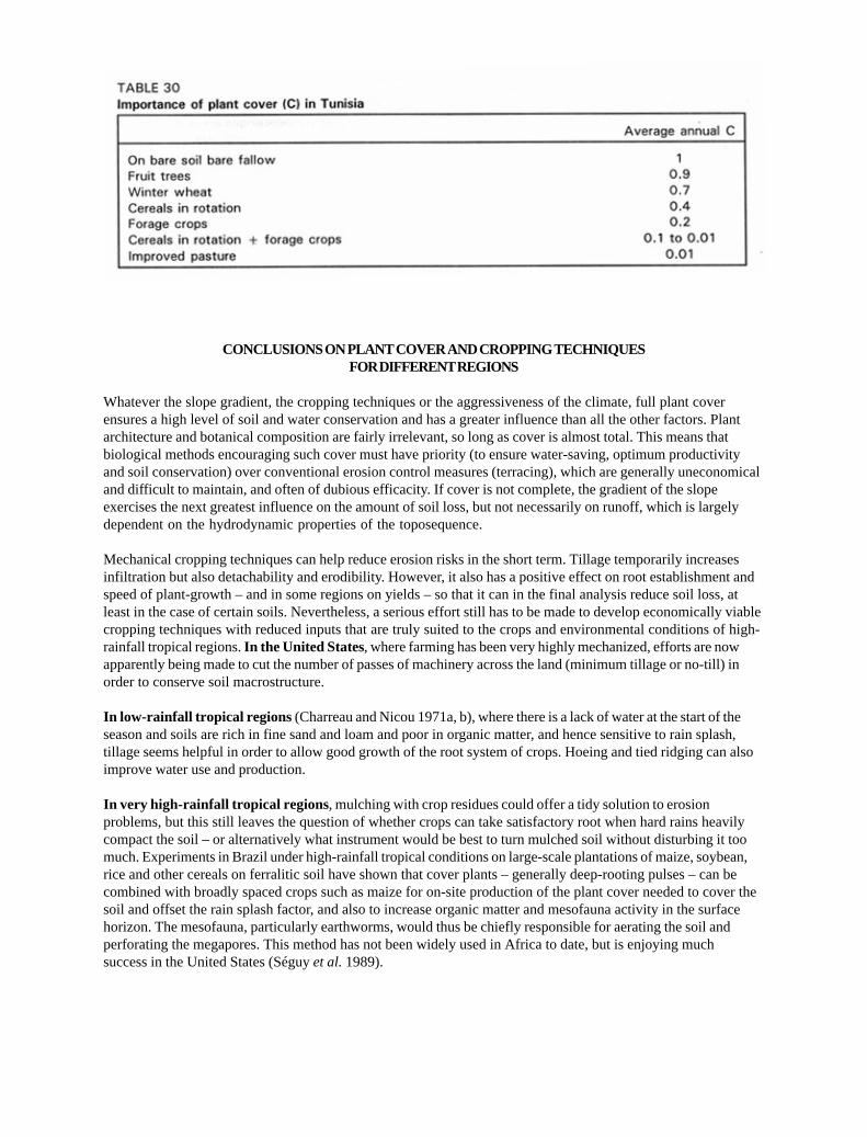
CONCLUSIONS ON PLANT COVER AND CROPPING TECHNIQUESFOR DIFFERENT REGIONS
Whatever the slope gradient, the cropping techniques or the aggressiveness of the climate, full plant coverensures a high level of soil and water conservation and has a greater influence than all the other factors. Plantarchitecture and botanical composition are fairly irrelevant, so long as cover is almost total. This means thatbiological methods encouraging such cover must have priority (to ensure water-saving, optimum productivityand soil conservation) over conventional erosion control measures (terracing), which are generally uneconomicaland difficult to maintain, and often of dubious efficacity. If cover is not complete, the gradient of the slopeexercises the next greatest influence on the amount of soil loss, but not necessarily on runoff, which is largelydependent on the hydrodynamic properties of the toposequence.
Mechanical cropping techniques can help reduce erosion risks in the short term. Tillage temporarily increasesinfiltration but also detachability and erodibility. However, it also has a positive effect on root establishment andspeed of plant-growth – and in some regions on yields – so that it can in the final analysis reduce soil loss, atleast in the case of certain soils. Nevertheless, a serious effort still has to be made to develop economically viablecropping techniques with reduced inputs that are truly suited to the crops and environmental conditions of high-rainfall tropical regions. In the United States, where farming has been very highly mechanized, efforts are nowapparently being made to cut the number of passes of machinery across the land (minimum tillage or no-till) inorder to conserve soil macrostructure.
In low-rainfall tropical regions (Charreau and Nicou 1971a, b), where there is a lack of water at the start of theseason and soils are rich in fine sand and loam and poor in organic matter, and hence sensitive to rain splash,tillage seems helpful in order to allow good growth of the root system of crops. Hoeing and tied ridging can alsoimprove water use and production.
In very high-rainfall tropical regions , mulching with crop residues could offer a tidy solution to erosionproblems, but this still leaves the question of whether crops can take satisfactory root when hard rains heavilycompact the soil – or alternatively what instrument would be best to turn mulched soil without disturbing it toomuch. Experiments in Brazil under high-rainfall tropical conditions on large-scale plantations of maize, soybean,rice and other cereals on ferralitic soil have shown that cover plants – generally deep-rooting pulses – can becombined with broadly spaced crops such as maize for on-site production of the plant cover needed to cover thesoil and offset the rain splash factor, and also to increase organic matter and mesofauna activity in the surfacehorizon. The mesofauna, particularly earthworms, would thus be chiefly responsible for aerating the soil andperforating the megapores. This method has not been widely used in Africa to date, but is enjoying muchsuccess in the United States (Séguy et al. 1989).

The fundamental effect of plant cover and of the adaptation of cropping techniques to regional environmentalconditions are subsumed under the C factor in the USLE model. Taking account only of an annual overall measure-ment, this factor varies from 0.9 to 0.1 for the main crops grown in West Africa. It can fall to 0.01 under a forestcrop with cover plants and under grassland, and to 0.001 under a mulched crop and under forests of varyingdensities.
EROSION CONTROL STRATEGIES
Conventional erosion control generally recommends the application of erosion control structures and cropping tech-niques that have shown an ability to retain water and slow down erosion in some other place and under some othercircumstances, so it is hardly surprising that most projects involving erosion control have met with failure over thepast 50 years (Hudson 1990).
Here the effectiveness of erosion control practices and structures for surface water management, as well asthe problems raised by certain production systems are briefly examined and analysed, and then an attempt is madeto show how Wischmeier’s empirical model can be put to practical use (Roose 1977a, 1987b and 1992b).
At the beginning of this work it was shown how governments have been led to approach erosion control fromthe off-site viewpoint, or that of the general interest of their citizens, focusing on protection of the quality ofwater (rural development strategies). Here, however, these problems are considered from the on-site viewpoint,in an effort to solve the farmer’s problems of land degradation. Agricultural development strategies are discussed.
CAPITAL DEVELOPMENT STRATEGIES
In this perspective, the watershed is the natural physiographical unit for management, particularly erosion control,and the following procedure is adopted.
· First of all, a map of land potential is drawn up.
The US Department of Agriculture (USDA) has defined eight categories of land on the basis of the con-straints to large-scale farming.
Classes 1 and 2 are slightly sloping (from 0 to 2%) and are fairly well drained. Such land is suitable for almostall crops without any special intervention, apart from drainage.
Classes 3 to 6 cover arable slopes: the limitations on cropping increase in accordance with how shallow thesoil is, to what extent pebbles and stones prevent mechanization, and how steep the slope is.
Classes 7 and 8 must be kept under permanent plant cover, protective forests or extensive grassland. Crop-ping is not permitted.
However, land potential must be classified in each individual case on the basis of local climate, landforms andsoil. For example, in the semi-arid Sudano-Sahelian conditions of the Mossi Plateau, distinctions are tradition-

ally made between (i) the steeply sloping ironstone or gravel top of the toposequence, which is reserved foranimal husbandry and extensive rangelands, (ii) the broad, gently sloping pediment, which consists, first, of ashallow sandy area, limited in use, and, secondly, a clay-loam area on the lower part of the slope, which iswhere cropping will be concentrated, and (iii) the soil at the bottom of the slope, which is always to someextent hydromorphic.
Once the map of soil potential has been drawn up, a map of present erosion risks and another of landuse are needed. When these 1:10 000 scale maps have been compared, a map of intervention and ruralinfrastructure for watershed management can be drawn up.
· The permanent structures for this scheme are then decided.
First comes the road network, the drainage network and the bridges to enable people to move around thecatchment, particularly when transporting harvests. At this point an erosion control system can be decided,for example:
• gradual terraces defined by strips tilled downhill, based on grass buffer strips or banks;• a system of beds developed by ICRISAT for vertisols on slopes of less than 2% (Pathak, Miranda and
El-Swaïfy 1985);• a system of level benches for areas where population pressure is strong;• a system of stepped diversion terraces such as those found in North Africa, or a system of individual
terraces for orchards.
· The last step is to plan a production system to take account of both environmental and human conditions(people’s needs, economic viability of production, the local market and level of knowledge, and food self-sufficiency). Next come rotations and fertilizing and conditioning systems. Land to be set aside for forestry,used as pasture, and to be cropped must be identified, along with the areas to be irrigated or drained. Adrainage system must then be planned, adequate outlets built, rivers and gullies stabilized, and the regionalmarket and transport organized.
Within the framework of this strategy, the officially designated watershed manager will decide which areasare to be closed off and which are to be used as pasture for livestock, together with a whole set of conditionsfor production in the region.
AGRICULTURAL DEVELOPMENT STRATEGIES
In this approach to rural development, the expert will start by trying to meet the farmers’ needs, a three-stageprocess.
· The first stage is to establish dialogue with the local people and gain their confidence. The expertwill question the farmers to learn about the present land-use system and traditional production systems and todiscover where, when and how environmental problems arise. He/she will then look for links between runoffand erosion problems and the local farming system, seeing how farmers perceive the problems and how theytry to solve them. Lastly, he/she will work with them to find ways of increasing the infiltration of rainwater in

order to increase biomass, yields, and the returns on the farmers’ labour, as well as how to promote plantcover and thus reduce erosion risks. Once he/she has grasped the problems and observed the possible solu-tions already found by the farmers, he/she can propose more technical approaches for their consideration.
· The second stage entails field trials on the farmers’ own land, where risks of runoff and erosion will beassessed for different types of rainfall. Various cropping techniques or erosion control structures will becompared, again on their land, so that the feasibility, effectiveness and economic viability of each element ofa solution can be evaluated as precisely as possible. This stage will require between three and five years,ending with an evaluation of results by both farmers and technicians.
· The third stage entails a land-use plan no longer confined to individual farm units, but encompassing aslope, hillside or watershed, or the area occupied by a rural community. At this stage, the maps of potentialland use, present damage and erosion risks, and current land use (a 1:10 000 scale aerial map) will be com-pared, and schemes acceptable to the farmers will be selected for each functional land segment starting withthe cropped area, then the upper slopes, and lastly the valley bottoms.
This kind of land-use planning demands a more sophisticated approach to social and economic aspects: theentire rural population must participate from the project design stage onwards and be involved in thevarious phases of survey, demonstration and trial, and extension in the field. Observance of traditional water andfertility management methods will allow the methods best suited to the local environmental conditions and the socio-economic context of the local population.
Land husbandry is based on rational management of water and nutrients. Nutrient management must linkfertilizer (organic and mineral) with erosion control. Water management must enable the available water to be usedin such a way as to maximize soil productivity.
If a diagonal line is drawn through West Africa from the Sahara down to the subequatorial zone, four methodsof water management can be distinguished, depending on climate and soil permeability. And each of these methodsentails specific cropping techniques and erosion control structures.
EROSION CONTROL PRACTICES
This refers to cropping techniques used exclusively with a view to reducing runoff and erosion damage (Tables 31and 33).
CONTOURING
This simply entails making sure that cropping techniques follow contour lines. Soil roughness (clods and smallhollows) must be laid perpendicular to the slope, so that the eventual runoff sheet is slowed as much as possible. Themethod is effective only on gentle slopes: the P (or erosion control practices) factor will be 0.5 on slopes between 1and 8%, 0.6 on 8 to 12% slopes, 0.8 on 17 to 20% slopes, and close to 1 on slopes steeper than 25% (Wischmeier andSmith 1978). In other words, the steeper the slope, the less soil roughness can hold back water. A variant consists of

alternating crops in contour strips, thus combining the above effect with that of rotating crops with varying degreesof sensitivity to erosion.
CONTOUR RIDGING
It has been seen that tillage followed by ridging can increase erosion risks simply by increasing the slope. However,if the ridges are set perpendicular to the greatest slope, the furrows can hold a considerable amount of watercontaining suspended sandy or loamy solids. Contour ridging is twice as effective as simple contour tillage, reducingerosion to about 30% of that on the flat-tilled control plot for slopes of 1 to 8%. However, its effectiveness decreasesas the slope increases, and on very steep slopes exceptionally heavy rain can cause breaks in ridges, thus giving riseto serious gullying or even landslides. This is all the more likely if the surface horizon is sandy and very permeablewhile the subsurface horizons are much less so. A first solution consists of setting the ridges at a slight slope, so thatexcess water can flow slowly – slowly enough to carry away very little solid matter – to a planned outlet (experi-ments by Hudson in Zimbabwe). Another solution is contour tied ridging, in which a series of pans and ties perpen-dicular to the ridges prevent the water behind the ridges from falling through a breach and creating a gully. Thirty tosixty millimetres of water will be trapped in the pans together with the heavier sediments, while the excess water canflow behind the ridges until it reaches designated outlets. To be effective, the ties must be 1 to 5 metres apart. Themethod has performed very well, reducing erosion to 10% of normal. Such methods are, however, suitable only forsoils that are very permeable to a considerable depth.
On volcanic soil in Cameroon, the Bamiléké have developed an ingenious system of large, zigzag ridges setparallel to the slope and covered throughout the year by companion crops. This reduces the erosive force of runoff(Fotsing 1992b).

It is therefore difficult to advise on the orientation of ridges with a view to reducing erosion. The decisionwill depend on interactions between slope, cropping system and soil type. Only after local field trials can adecision be taken on the most effective and safest orientation for each cropping system.
BUFFER STRIPCROPPING
On slopes of less than 8%, erosion is thus cut to 30% of the control plot (P = 0.3). However, the effectiveness ofbuffer strips varies according to their width, the crop mixture, and the amount of concentrated runoff. While suchstrips are strikingly effective in the case of light to medium rainstorms, they can quickly become waterlogged underexceptional rainfall. They act as filters, slowing down the runoff flow, causing a fall in its competence – and hencethe sedimentation of coarse sand and organic matter – and allowing its infiltration rate to rise. These filters are veryeffective when there is a mixture of pulses and grasses, and when the soil surface has a large number of stalks orroots per square metre (Roose and Bertrand [1971] in Côte d’Ivoire, and Delwaulle [1973] in Niger). In principle,ground-creeping plants with rhizomes and many scattered stalks are more effective than large tufts of grass. If thelatter is used, a light mulch of cut tufts must be left on the soil-surface to prevent water from flowing between thetufts and digging channels. Live hedges staggered on alternate lines over a strip 50 to 100 cm wide act in a waysimilar to grassy strips, although they tend to be less effective, at least during the first years. In the semi-arid zonesof Burkina Faso and even in southern Niger, when strips of Andropogon gayanus are sown on the edges of plots,or else about 20 metres from one another, a fair proportion of the sand carried off by wind erosion (Renard and Vanden Beldt 1991) or water erosion (Roose and Rodriguez 1990) can be trapped. Erosion control strips have been triedout on erosion plots at Adiopodoumé and Bouaké in Côte d’Ivoire, and at Alokoto in Niger (Roose and Bertrand1971, Delwaulle 1973), and it appears that once 0.5- to 4-metre strips of thick grass are established, they can reducesoil loss to one-tenth and runoff to about one-third compared to the control plot. The more aggressive the climate, thesteeper the slope, the less crop cover there is and the more erosion-prone the soil, the wider the strips must be toensure effectiveness. In any case, it is best to start with strips at least 5 metres wide, for they can always benarrowed later.
Any leafy plants provide good cover on erosion control strips, particularly natural fallow plants, but the pres-ence of pulses with tap-roots and large, deep-rooting perennial grasses improves infiltration. In tropical areas,Andropogon gayanus, Pennisetum purpureum, Paspalum notatum, Tripsacum laxum, a mixture of variousStilosanthes, sugar cane and various forage plants can be used. Setaria sphacelata gives good results for the firsttwo years, but is quickly exhausted on poor, acid soils.
However, plants whose seeds spread too easily into the fields should be avoided (unless the erosion controlstrips are mown before the plants flower). Spreading by suckers, runners or stolons (Synodon dactylon) is evenworse. Plants with tightly packed roots and numerous stalks will slow runoff more effectively than free-standingtrees.
Some experts have warmly recommended various vetivers, because they survive well in semi-arid regionswhere overgrazing is frequent. They produce siliceous, long-lasting mulch, but their forage quality is poor. Theproblem is that the strip has to be destroyed in order to extract the essence from their roots. Wherever possible,therefore, it is better to use forage plants and grasses that are suited to local conditions.

The buffer strip acts as a sponge, partially absorbing runoff waters, and also as a comb, slowing down runoffso it will deposit soil from the cropped field above. The runoff water infiltrates deeply or is at least slowed down,reducing its competence, so that it deposits the coarsest eroded sediments. This in turn maintains good porosity andleads to the formation of a small terrace at the rate of 5 to 20 cm per year, which as time passes transformslandscapes into a succession of gently sloping fields and banks protected by leafy growth.
This inexpensive method has been tested extensively and successfully on research stations, industrial planta-tions (rubber and pineapple) and modernized small-scale farms. It has some very decided advantages:
· it is easy and inexpensive for small farmers to launch;
· large areas can be treated fast without the costly, cumbersome intervention of surveying teams: after a one-day course in use of the water-tube level, most farmers are able to mark out the contours on their land;
· forage produced on the strips can be used to feed stock or to mulch the fields;
· this living network along contour lines can act as a reference for the orientation of cropping procedures;
· the land used to make buffer strips is not immobilized since they are also productive. Farmers who have nocows can be dissuaded from setting fire to the strips to destroy insects and other pests by planting trees –either fruit species, or trees that can produce kindling and posts – in the centre of the strips or on their lowerside. The main problem with this method is to clearly and definitively separate the grass strips and the sur-rounding fields and fallow land. Particularly in arid zones, where it is hard to establish grass because ofovergrazing, if rock débris is available this erosion control measure can be reinforced by arranging unbrokenlines of stones inside the strips (Delwaulle 1973, Roose and Bertrand 1971, Roose and Rodriguez 1990). Thiscombines contour cropping and buffer stripcropping, cutting the length of the slope and gradually reducing thegradient through the natural formation of grass banks. Such methods are already widely used in mountainouscountries and are now being tested in semi-arid zones in Mali, Burkina Faso and Cameroon. They have beenused for centuries in Europe, the Americas and Asia, where banks are protected by grass and bushes that canbe as tall as 2 to 4 metres. The buffer strips develop spontaneously into banks, which act as boundariesbetween plots.
In the Sudano-Sahelian zone of southern Mali, the DRSPR suggested that grass strips 3 metres wide shouldbe planted across cultivated fields at 50-metre intervals (thus covering 6% of the land). Six perennial species werecompared in 1987/88. Brachiaria ruzizensis quickly covers the land even in the first year, but Stylosanthes hamatagrows better in the second year. Andropogon gaianus is popular, although establishment need to be worked on.Macroptilium lathyroides and atropurpureum, Clitoria ternatea and Pennisetum pedicellatum proved disap-pointing. At present, the DRSPR is advising a mixture of Brachiaria and Stylosanthes. Some farmers toss theBrachiaria hay and mix it with molasses as feed for livestock.

At Yatenga (400 to 700 mm of rainfall), located north-east of this same zone but in Burkina Faso, Rodriguezhas developed a method to be used by small farmers for harvesting Andropogon sp. and Pennisetum pedicellatumseeds in December. At the start of the rainy season in June, the seeds are pounded with damp sand to abrade them,then moistened for 12 hours. They are sown on a 50-cm-wide, shallow-tilled strip uphill of lines of stones, or betweentwo plough furrows, every 20 to 25 metres. Farmers like these Andropogon hedges, not only because they help tocontrol sheet runoff, but also because they produce the long straw needed for roofs and artisanal crafts; they alsoprovide excellent forage, and livestock particularly appreciate their green shoots in the dry season: even where tuftsof Andropogon grow in a cropped field, they are not hoed (Roose and Rodriguez 1990).
NATURAL OR ARTIFICIAL MULCHING
The aggressive rainfall plus the permeability and natural resistance of ferralitic soils to water erosion make the mainproblem in these high-rainfall tropical zones finding a way to cover the ground during the critical period of hard rains,thus preventing destruction of the structure of the surface horizon, the formation of slaking crusts and the start ofrunoff. Natural conditions are such that most food crops (particularly, cassava, yam, maize and groundnut) andcertain industrial crops (banana, pineapple, etc.) are incapable of covering the soil sufficiently before the criticalperiod. A light mulch, as a temporary supplement to plant cover, may be composed of crop residues or otherinputs, or a soil conditioner such as Curasol may be used to create a flexible crust to protect the surface. A deadcover (straw mulch or a layer of pebbles) can be a satisfactory substitute for living cover in conserving water andprotecting soil; for example, a plot covered with a few centimetres of straw (4 to 6 t/ha) protects the soil as well asa covered, 30-metre secondary forest, even in years with very heavy rainfall (Table 13). A method widespreadamong market gardeners, mulching is very effective in helping infiltration of rainwater, reducing runoff and evapo-ration, and protecting the soil against erosion. It deserves extension in traditionally farmed areas where fields arealways surrounded by quantities of available brushwood.
The situation can be different under semi-arid conditions, particularly Sudano-Sahelian zones that are overgrazedduring the dry season so that soils are practically bare at the start of the rainy season. In these regions, the problemis finding mulch. Although the mulching method is widely known, it tends to be confined to fertilizing the fields of thepoorest farmers who have neither livestock nor manure.
In this case, the farmers go into the bushland, collecting the branches of shrubs (Bauhinia and Piliostigma)and pulses that the livestock tend not to eat, and spread them over their small fields, partly to reduce runoff and partlyto encourage the activity of termites, which will open up infiltration passages into the soil and redistribute the fertileelements in the mulch. Collinet and Valentin (1984), using simulated rain, have also shown that mulching can slowdown the reduction in infiltration capacity following cropping. However, when soils are fairly impervious, sandy orpoor in organic matter, they can rapidly become degraded under mulching, simply through the wetting anddrying out of the soil surface. Effectiveness is therefore dependent on soil texture and capacity to resist degrada-tion through simple wetting or through clay dispersion when the cation exchange capacity is rich in sodium. Intropical mountains, notably in Rwanda and Burundi, coffee fields that have been mulched for 40 years have sufferedno erosion. This shows how effective mulching can be, both in maintaining soil fertility and infiltration capacity, andalso in protecting from erosion. The problem is that of collecting enough biomass throughout the year to keep several

centimetres of mulch on the surface of the soil. In the beginning, mulching under coffee trees had two purposes: thesoil was kept moist and fresh under the trees at the end of the rainy season by providing a covering of 10 to 15 cmof straw, and the soil surface was protected against erosion during the rainy season by a thin (2 to 5 cm) layer ofstraw. On small farms of about one hectare on steep slopes, it proved difficult in these mountainous areas to produceenough biomass to cover the whole surface, especially when this biomass is needed mainly to feed livestock in orderto produce milk, meat and manure. It seems that if the existing banks are transformed into productive sloping banks,covered partly with leafy plants and partly with a double hedge of shrubby pulses (Leucaena leucocephala,Calliandra calothyrsus, etc.), and if trees are planted every 5 metres along the lower side of the bank, this willallow production of sufficient biomass to cover the soil surface, at least after preparation of the seed bed and aftersowing, by cutting the hedges and spreading the prunings on the ground. The twigs can then be collected again somemonths later and used as fuel for cooking. This method is now being tested in Rwanda (Ndayizigiyé 1992) andBurundi. Crop residues can be another source of mulch (ISAR).
In the case of industrial crops, it may be hard to obtain enough green matter to make mulching economical.However, as many crop residues as possible can be left on the surface of the soil in order to protect it between twocrops and even during the following cropping cycle. There are various versions of this stubble mulching technique,and although it is very popular in the United States, it does require special equipment to aërate the soil without turningit or disturbing the mulch.
Lal (1975) simply suggests pushing crop residues into the space between planting lines and restricting pre-paratory harrowing to the sowing line. On plots prepared in this way at the IITA Centre at Ibadan in Nigeria, heshowed that infiltration speed remains maximal under crop residues laid on the surface – thanks to the activity ofearthworms – and that runoff and erosion remain slight whatever the slope, whereas soil losses increase exponentiallywith the slope on neighbouring tilled plots. An ORSTOM and IRFA experiment at Adiopodoumé clearly shows therole of crop residues in pineapple plantations, and that of tillage in water management as a function of slope. Duringthe first planting cycle, with about 2 000 mm of rainfall, the average erosion on three slopes (4, 7 and 20%) was 197t/ha on bare soil. Under pineapple, flat-planted in lines perpendicular to the slope, with the previous crop residuesburned and turned in, erosion was under 25 t/ha. With similar treatment but with the residues simply dug in withoutburning, erosion was lower by half (12 t/ha). Lastly, when the residues were left on the surface, plant cover wastotal, and erosion negligible (0.4 t/ha, or 1% of that on bare soil, and less than 2% of that under pineapple whenresidues were burned and dug in). Similarly, runoff averaged 36% on bare soil, 6% under pineapple cover, 2% whenresidues were dug in, and 0.6% when residues were left on the surface. Moreover, no significant increase in runoffwas observed under mulching when the slope increased from 4 to 22%. The main conclusion is that when cropresidues are spread on the soil surface, the risk of erosion on the steeper slopes is reduced to the point where strictcontour cropping could be abandoned, which would make it much easier to mechanize farming (Valentin and Roose1982).
Lastly, ploughing organic matter into the soil can improve structural stability and resistance to rainfall impact.According to Wischmeier’s nomograph, a 1% increase in organic matter in the surface horizon means that soillosses can be reduced by 5% for loamy soils due to improved structure and by 3% for clayey or sandy soils.However, this means digging considerable amounts of organic matter into the soil, for in humid tropical regions, most

organic matter vanishes quickly, with less than 5% remaining in the soil as stabilized humus. On the other hand, if thesame amount of matter is spread over the surface, it will act as a mulch and reduce soil loss by 60 to 99%. Ittherefore seems that managing the biomass on the soil surface not only considerably reduces losses through runoffand erosion, but also recycles nutrients through the gradual uptake by plants throughout the rainy season. Fieldobservations under both humid tropical conditions (Adiopodoumé) and semi-arid conditions (Saria in Burkina Faso)show that crop residues can cover the soil surface for three to five months – the time needed for the crop to providemore than 80% cover – which is generally enough to reduce erosion to a tolerable level.
ARTIFICIAL MULCHING: SPRAYED “CURASOL”
Mulching methods and their variants generally have technical or economic drawbacks (risks of plant disease, insect-damage and weed infestation in the first case, and 250 to 300 days’ work to collect the mulch in the second) whichtend to be unacceptable in large-scale industrial farming. Hence the idea of testing an artificial mulch easy to applywith spraying equipment already found on a good many mechanized farms. An acetate of polyvinyl (sold under thename Curasol by the Hoechst company) was tested. At Adiopodoumé this product was sprayed on immediatelyafter tillage, levelling and planting, in a single dose of 60 grams of Curasol diluted in 1 litre of water per square metreof soil. After some hours of exposure to the sun, this sticky, milky product forms a flexible 1-mm-thick film whichprotects the soil against the kinetic energy of falling raindrops (Roose 1975; 1977a). The treatment was tested forfour years on three pairs of plots:
· a 7% slope planted to Panicum maximum at 40 x 40 cm intervals;· a 7% bare slope;· a 20% bare slope.
Table 32 shows that Curasol considerably reduced soil loss (a reduction of 40 to 75%), and to a lesser extentrunoff (a reduction of 20 to 55%). Although its protective effect decreased after three months of violent rain (1 200mm), it was still functional after one year. It had no significant effect on forage yields (Panicum) but was extremelyeffective against erosion under this plant cover.
It was not a foregone conclusion that use of this plastic glue might reduce runoff, for it could in fact haveblocked the soil pores. On-site observation shows that when it is sprayed on to a well-aërated (recently tilled) soil itforms a flexible film which slightly increases runoff in comparison with the control plot for a number of rainstorms,but that after this the porosity of the untreated plot decreases faster than that of the protected plot, tipping thebalance in favour of Curasol. The product does not form a unbroken, impermeable film, but coats soil surfaceaggregates, boosting their resistance to the onslaught of falling rain.
Curasol always allows a certain amount of erosion. Since protection is not uniform and unbroken, waterdiscovers weak spots in the film, and raindrop energy digs holes into which runoff rushes, undermining the base ofthe microcliffs thus formed and broadening the areas attacked by headward erosion. This means that if there is aplant cover protecting the flexible plastic film against rainfall energy, the Curasol film lasts longer. It should also benoted that the plastic film will not stand up either to the abrasion of grains of sand carried in an active rill or to thepassage of heavy machinery (tractors, etc.) and workers, for erosion sets in very fast at broken points.


Although very effective on these sandy soils, treatment with Curasol was unable to bring erosion on bare soildown to under 10 tonnes, the tolerance level on this type of soil. Its cost price (4 000 FF/ha in 1973 for an averagedose of 60 g/l/m2) and the large amount of water taken to apply it (10 m3/ha) are major drawbacks to its widespreaduse even in intensive farming. However, Curasol can play a very effective role in fixing road embankments, irriga-tion channels and scoured surfaces in urban or industrial areas if applied in combination with certain grass seeds andthe fertilizer needed for the latter to grow.
By way of comparison, in Côte d’Ivoire it takes 250 days’ work to collect 40 to 80 t/ha of brushwood in thebush and spread it on the fields, equal to 4 000 FF in 1990. If a field of Guatemala grass (Tripsacum laxum) isavailable, it takes only 150 days to obtain a thick mulch. Tests have shown that 4 to 6 tonnes of dry straw are enoughto obtain satisfactory protection against erosion (Lal 1975), so that the cost price of this technique could be cut stillfurther. The protective value of the various forms of mulching has been shown time and time again and neverdisproven. If its use is still limited, this is because its applicability in tropical conditions on different soils and in varioussocial contexts has yet to be proven (problems with herbicides and phytosanitary products). Implements capable ofaerating the soil without disturbing the mulch also must still be developed, as must no-till cropping systems of provenlong-term economic viability.
COVER PLANTS
Since the main difficulty connected with mulching is that of producing and transporting biomass to the field once thesoil has been prepared and planted, the obvious answer was to try to produce this biomass on the spot. Experimentswith a crop of deep-rooting pulses sown as catch crops under maize or some other cereal have therefore beencarried out, first in Brazil twenty years ago (Séguy et al. 1989), then in Nigeria (IITA Station, Ibadan). While themain crop grows and makes use of the top layers of soil, it slows down the growth of the pulse, which, while awaitingbetter light, sends tap-roots deep under the area, and gradually forms a carpet of leaves and stalks in varying statesof decomposition. After the main crop has been harvested, space and light allow the pulse to grow fast during thefew weeks when there is still enough water in the soil under the area used by the main crop. During the dry season,the soil is therefore covered by a carpet, fostering mesofauna activity – earthworms in humid tropical areas, andtermites in semi-arid areas or on too-sandy soil. At the start of the following cropping season, either the dry seasonhas killed off all the pulses, leaving dead cover, or there has been enough water to keep them alive or to give rise toa new living cover from the seeds dropped by the pulses. In the latter case, either the pulses are killed off with aherbicide (3 l/ha of Gramoxone), taking advantage of this to kill off any other weeds that may have developed, orelse they are left to grow, but then cut back before the following crop cycle begins. Instead of being ploughed in toprepare the ground for the following crop, this litter is separated by a toothed disc and the soil is broken up with apronged implement, with the basic fertilizer and seeds being injected behind it. The soil is swept back over thesowing line, and a small roller presses it down to assure good contact between soil moisture and seeds. In thissystem, less than 10% of the soil moisture is bare, loosened and vulnerable to erosion. Experience shows that the soilsurface is not degraded, the sand remains bound to the organic matter, and there is very little risk of erosion andrunoff. The method also offers a certain number of other advantages: first and foremost, as in the original forestenvironment, it makes it possible to restore the organic matter and return a certain number of nutrients to the surfaceso that they can then be redistributed in the soil during the course of the rainy season. It is a neat technique, reducing

inputs, fertilizers and cropping operations while protecting the soil against the onslaught of rain and erosion. Eliminat-ing runoff can perhaps allow water to be supplied to both crops, and hence reduce the competition between them.The system can be compared to the old method of green manuring, which consisted of introducing a crop when thefallow time came, and ploughing it in before the end of the rainy season. Part of this crop could be used by leavingthe cover plant on the soil surface in the form of litter. The use of cover plants, particularly pulses, is well known andvery widespread under industrial tree crops such as palm, coconut, rubber, coffee and cacao. It seems that a formof this system could be developed for use under temporary root and tuber crops. Lastly, a more stable system couldbe found than the intensive systems which call for so many inputs in the form of mineral fertilizers and tillage.

THE P FACTOR IN WISCHMEIER’S EQUATION
The “erosion control practices factor” (P) is the relation between soil loss on a treated field and that on a neighbour-ing, untreated plot of similar size, or a control plot. Small erosion plots (100 to 200 m2) are generally ill-suited to thestudy of erosion control practices, and comparisons should be made on small catchments of about one hectare.Therefore here only a comparison is given of results in North and West Africa with the coefficients advocated in theUnited States after many trials carried out on small catchments (Wischmeier, Smith and Uhland 1958, Roose andBertrand 1971, Roose 1973, Delwaulle 1973).
Erosion control techniques to divert or totally absorb water are not found in Table 33, since these are encom-passed in the topographical factor, in which the length of slope is reduced to the breadth of cropped strips betweentwo banks. In any case, very few studies have scientifically demonstrated a reduction in soil loss from catchmentareas after treatment with terracing, for most of them do not differentiate between the effects of terracing and thoseof the consequent improvement in plant cover on the same catchment (Roose 1974, Goujon and Bailly 1974).
Table 33 clearly shows that biological techniques (maximum soil cover, use of fertilizer, correct tillage, mulching,cover plants, rotations, etc.) are much more effective than mechanical techniques (terracing, ridging, etc.), whichare expensive to install and difficult to maintain. Despite this, mechanical techniques receive much fuller treatmentin soil conservation manuals, and are advocated more often than not without prior adaptation studies (Roose 1971;1973; 1974; 1977b). Nevertheless, it should be noted that the drier the area and the more difficult it is to implementbiological methods, the more one should use mechanical methods to help the plants to become established and coverthe ground as quickly as possible.
EROSION CONTROL STRUCTURES AS RELATED TO WATER MANAGEMENT METHODS[Plates 26 and 27]
There are bound to be rainstorms whose water the soil cannot fully absorb – a point of major importance in arid andsemi-arid areas, for this water can be collected and used to improve productivity locally. The following four watermanagement methods and erosion control structures apply:
· runoff harvesting (catching runoff for supplementary irrigation);· total absorption or infiltration;· runoff diversion (redirecting excess water);· runoff spreading (distribution of runoff energy).
STRUCTURES FOR RUNOFF HARVESTING
In semi-arid countries where rainfall is too sparse to allow crops to be grown on the whole slope, part is used tofavour runoff, which is then retrieved lower down to irrigate smaller areas, make up for any lack in rainfall, andenhance crop security (Hudson 1990).
In their work on runoff harvesting to improve crop production, Reij, Mulder and Begeman (1988) classify theavailable techniques as follows:


• short-distance water harvesting: microcatchments, half-moons;• harvesting water at the bottom of a long slope: earth bunds, boulis, trapezoidal bunds, in Turkana in Kenya;• harvesting river-water from its bed;• diversion of wadi flows;• dam with reservoir cropping after absorption.
In Tunisia, Gosselin (1939) studied rural land use planning from the hydrogeological perspective (El Amani1983). In the upper watershed, he distinguishes tabias, trapezoidal earth bunds, reinforced below with a stone walland on the sides with a stone-lined spillway. Some 2 to 5 metres high, they bar a valley several dozen metres wide.A tabia acts as a path, behind which runoff water and loamy-sandy silt collects, bounding a jessour – a kind of well-watered field where annual crops (barley, peas, lentils, beans, water melons) are grown in the shade of trees suitedto the successive silt deposits (fig, olive, pomegranate, almond) (Figures 33 and 34).
Terraces or meskats are engineered on the slopes, irrigated by channels that catch slope runoff.
Lastly, a whole series of structures in the valley allows flood spate or groundwater to be harnessed (Figures35 and 36).
El Amani (1983) then classified traditional water management systems in terms of climate (Figure 36).
In the Sudano-Sahelian region of West Africa, most soils have a surface crust. This gives rise to particu-larly harmful surface runoff in these semi-arid climates, selectively carrying away organic matter and nutrients fromthe surface horizons.


A whole series of traditional soil fertility and water conservation techniques can be seen in these areas inwhich both the water balance and the ethnic make-up vary greatly.
Many such methods are seen in operation on the broad pediments below rocky or lateritic hills used asextensive rangeland for livestock, so that these rangelands act to harvest the abundant runoff.
The Zaï method
This is a complex traditional method allowing recovery of degraded soils on broad, loamy-sandy pediments. Itcombines harvesting runoff with concentrating manure and available water in pans, making use of termite activity.There are many variants, including forest zaï which is particularly suitable for introducing agroforestry into a Sudano-Sahelian area (Figure 5).
Half-moons (Figure 37)
On broad, loamy pediments which degrade very fast once the natural plant cover disappears, runoff from 10 to 20m2 can be harvested by arranging half-moon shaped bunds, 2 to 6 metres in diameter, on which cereals or trees aregrown. At Ouramiza in Niger, the 20-cm-deep half-moon has a cropped area of 6 m2 for a reception area of 16 m2
(2-m-wide semi-circles are set 4 metres apart along a contour line and 4 metres from the next contour line and thereare 313 half-moons per hectare, for an estimated cost of 900 FF = 80 work-days/ha). Pans 3 x 0.6 x 0.6 m (1 m3)can also be dug to drain 10 m2: one or two trees are planted at the low point (FAO Keita Valley project). There is aserious risk of clogging in these microcatchments in the case of millet and certain trees because of the suspendedload in the runoff, which quickly forms fairly impermeable crusts. The use of straw or branches would allow wind-blown sand to be trapped in order to maintain a good infiltration capacity -and the localized use of manure could alsohelp.
Cisterns or boulis (Figures 37, 38 and 41)
Cisterns or boulis are dug out of the broad pediment where rangeland (gravel pediment) meets cropped land (loamypediment). Some Mossi farmers have progressively dug out water holes, cisterns or boulis 1 to 2 metres deep, usingthe soil removed to build a crescent-shaped bund extending over a hundred metres or so. When the first rains come,they give farmers 100 to 500 m3 of runoff water with a fairly heavy washload. The water can be used either toirrigate a small garden, which can produce two well-manured, furrow-irrigated crops of lean-season maize and latewatermelons, or stock-watering so that the animals, not having to migrate to a watering point in the valley, will loseless weight at the end of the dry season. This system improves food security, especially in the lean season, but it doesrequire a great deal of work, which can, however, be done gradually over several dry seasons with the help of a teamof neighbours. The necessary labour could also be reduced by locating the boulis at the top of a gully where a greatdeal of runoff is concentrated before acquiring much solid matter in suspension. The latter approach would alsosolve the problem of treating gullies, which could become stabilized below the boulis through the simple reduction inpeak flows. There are now hand pumps (e.g. ETSHER 2000 at Ouagadougou) capable of raising 10 m3 of water/day 1 metre in height.

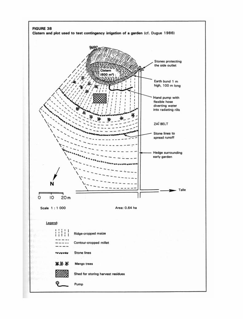

A number of risks must be taken into account. Erosion on the pediment above the boulis could progres-sively fill in the pool, and so measures are needed to keep the soil in place (lines of stones, grass strips) withoutreducing runoff too much. Another solution is to recover the fresh sediment for brick-making once the water falls(sun-drying them in the dry season). The bund can slide into the pool if not ringed by a paved area about 1 metrewide, and may also be damaged by livestock or rain. It can be helpful to install a paved area (or grassy vegetation)uphill of the bund, pressing the ground down well and protecting it from livestock with a thorn hedge. Livestock mustnot be allowed to wade in the pool itself for fear of infection from a sick animal. A drinking trough must be set upbelow the bund, fed by a flexible pipe that siphons the water to a filter (200-litre drum filled with alternating layers of

sand and wood charcoal). The bund must be protected by blocks of laterite or tufts of perennial grass (e.g. Andropogon)to prevent erosion of the edges if it overflows.
Earth bunds for water harvesting
Runoff from the surrounding hills or rangeland can also be harvested behind an earth bund and used to irrigate afield. A series of stone lines should be laid out every 20 metres (Figure 39), bringing the ratio between catchmentand field below one to three in an area with 400 to 600 mm of rainfall, and slowing sheet runoff to under 25 cm/sec,thus preventing gullying when a storm spreads additional water over a field that already has a tendency to runoff.However, this method of runoff management has its risks, for in dry years harvesting may not provide enough waterfor seeds, and in wet years the excessive water can reduce production by temporarily waterlogging the soil (Hudson1990) and breaking down the bunds.
In the Turkana district of Kenya, Finkel (1985) worked out a simple equation to estimate the ratio betweenwater harvesting area and cropped field:
water harvesting area = water needs of crop – mean annual rainfallcropped area (mean ann. rain x runoff coeff.) x effic. of crop water
In this semi-arid region of Kenya, the ratio (R < 200 mm) ranges from 15 to 40 for sorghum and various pulses(cf. Reij, Mulder and Begeman 1988), but the bunds have recently suffered damage in a year with high rainfall. Inthe 600-mm rainfall area around Ouahigouya, this ratio would be 1 to 3.
Negarim microcatchments
This is the best known system of water harvesting on short slopes in order to irrigate a tree crop (Figure 40). Thebasic element is a small hole, forming an absorption basin 40 cm deep, and a rim formed of a V- or half-moon-shapedearth berm 20 cm high. In a new orchard in Israel, the absorption area would be about 4 x 4 metres, while thecatchment area would be three to six times larger.
Earthen beds draining excess water into a cistern (on a vertisol)
Vertisols are very clayey and chemically fairly fertile soils extremely difficult to work in the rainy season, when theyare muddy. However, they can be tilled in the dry season one month after the end of the rains, dividing the fields intoa succession of beds 1.5 metres wide separated by small, gently sloping (0.5%) furrows to carry drainage water toa spillway and into a cistern dug out of the ground (Figure 41). This system allows two crops: a rainy season cropwhere drainage allows sorghum to grow on the beds prepared and sown before the onset of the rains; then, after therainy season, the ground is so swollen that it has a reserve of about 400 mm of water when the vertisol is 1 metredeep. The cistern holding the runoff water contains several hundred cubic metres, which can be used only assupplementary irrigation from the fields to make up for a sudden break in the rains or the end of the season. Thissystem, developed by ICRISAT near Hyderabad in central India, allowed farmers to double their income, althoughrequiring considerable work at a time of year when they would rather concentrate efforts on the rice fields in thevalley bottoms. This whole approach is suitable only for vertisols rich in swelling clay, and not for red, ferruginous,tropical soils, which cannot hold enough water.
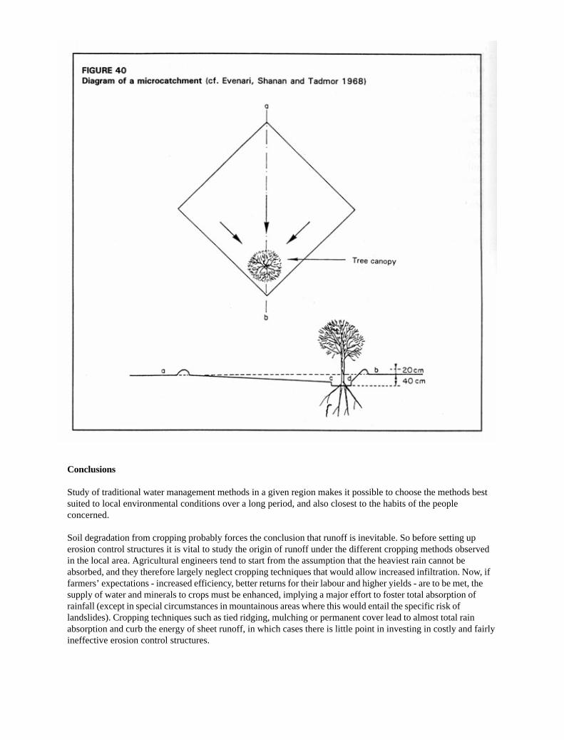
Conclusions
Study of traditional water management methods in a given region makes it possible to choose the methods bestsuited to local environmental conditions over a long period, and also closest to the habits of the peopleconcerned.
Soil degradation from cropping probably forces the conclusion that runoff is inevitable. So before setting uperosion control structures it is vital to study the origin of runoff under the different cropping methods observedin the local area. Agricultural engineers tend to start from the assumption that the heaviest rain cannot beabsorbed, and they therefore largely neglect cropping techniques that would allow increased infiltration. Now, iffarmers’ expectations - increased efficiency, better returns for their labour and higher yields - are to be met, thesupply of water and minerals to crops must be enhanced, implying a major effort to foster total absorption ofrainfall (except in special circumstances in mountainous areas where this would entail the specific risk oflandslides). Cropping techniques such as tied ridging, mulching or permanent cover lead to almost total rainabsorption and curb the energy of sheet runoff, in which cases there is little point in investing in costly and fairlyineffective erosion control structures.


TOTAL ABSORPTION STRUCTURES
Total absorption structures are used in two cases:when rainfall barely ensures crop evapotranspira-tion,and in very permeable places.
Rwandan blind ditches with grassed risers (orKenyan Fanya Juu) (Figure 42)
As early as the mid-1930s in Rwanda and Burundi,the Belgians suggested digging contour ditches onslopes of less than 20% where the ferralitic soil coveris deep and very permeable and where there is littlerisk of landslides.
Runoff water trapped in the ditches is pre-vented from collecting at a low point (due to con-struction errors or localized fragility), and carving deepgullies, by 50-cm-thick ties marking off sections ofditch 3 m long and 60 cm deep and broad. The soilmust be thrown uphill and fixed with tall grasses(Pennisetum purpureum, Setaria splendida orsphacelata, Tripsacum laxum or Vetiver) to createa gradual concave terrace.
Advantages. Infiltration (blind) ditches provide good dividers for overly-long slopes, with storage of runoff and siltthat can be particularly useful in dry regions; the formation of gradual terraces can also be encouraged by throwingthe earth and silt uphill and protecting the risers with plants that fix the soil in place. These ditches restock thegroundwater and moisten the surroundings, so that bananas and other water-demanding trees can be planted nearthe ditch.
Disadvantages. This technique is restricted to deep permeable soils and slopes of less than 20% (Tondeur 1950).
• Such ditches have been widely used under the wrong conditions (shallow soils on schist or granite), and wherethey have failed to receive proper maintenance, gullying and landslides have been the result.
• It takes 300 days’ work per hectare to dig the ditches, and 20 to 50 days of upkeep before the farmers see anyclear improvement in production.
• The area occupied by the ditches (1 m every 10 to 20 m) amounts to a loss of 5 to 10% of arable land withoutmuch increase in production from the cropped strips.
• If the soil cover is shallow (on mica schist or volcanic ash on granite), these ditches increase the risk oflandslides by accelerating the water’s access to the slide bed-plane.
• If the soil is not very permeable or the ditches are too small, badly kept and silted up, then runoff overflows,creating the very gullies one meant to avoid.

• The vertical risers often tend to be unstable because of failure to maintain the grass strips, and especiallywhere they are undermined by workers preparing the fields below.
Suggestion. In order to increase stability, the risers must be re-cut, and the humus-rich top part slid down togetherwith its plant cover onto the sterile, uncovered area. In Burundi, it has been seen that water, soil and nutrients tendto collect on these sloping banks, and that these deposits can be protected and improved by intensive forage produc-tion on the risers, and by planting trees to drain the foot and reduce the risk of sliding, and lastly by hedges or fruitbushes, cut back each year to keep the height of the riser the same.
Instead, if large trees were planted above the riser, they could easily loosen it in high winds. There is a trendaway from such ditches today, with access paths being set up in their place, or those still existing being transformedinto compost pits for planting bananas (Roose 1990).
Mediterranean or Bench Terraces (Figure 43)
Bench terraces are most often seen in mountains around the Mediterranean basin, but also in the Peruvian Andes,Bali (Indonesia) and China – in places where there is little level land, or where the population is dense or threatenedby an invader (as in the case of the Dogons in Mali), or where work is obligatory or labour very cheap, and whereproducts with high added value (e.g. carnations in Nice, strawberries in Spain and Lozère, kif in the central Rif andkat in the Hararghe region of Ethiopia) can be grown by irrigation and exported.
The benches are made of a subvertical riser reinforced with stones or plants, and a terrace with a slightreverse slope, with a possibility of irrigation and drainage down the slope.
Advantages:
• The benches create flat areas and suppress sheet erosion.
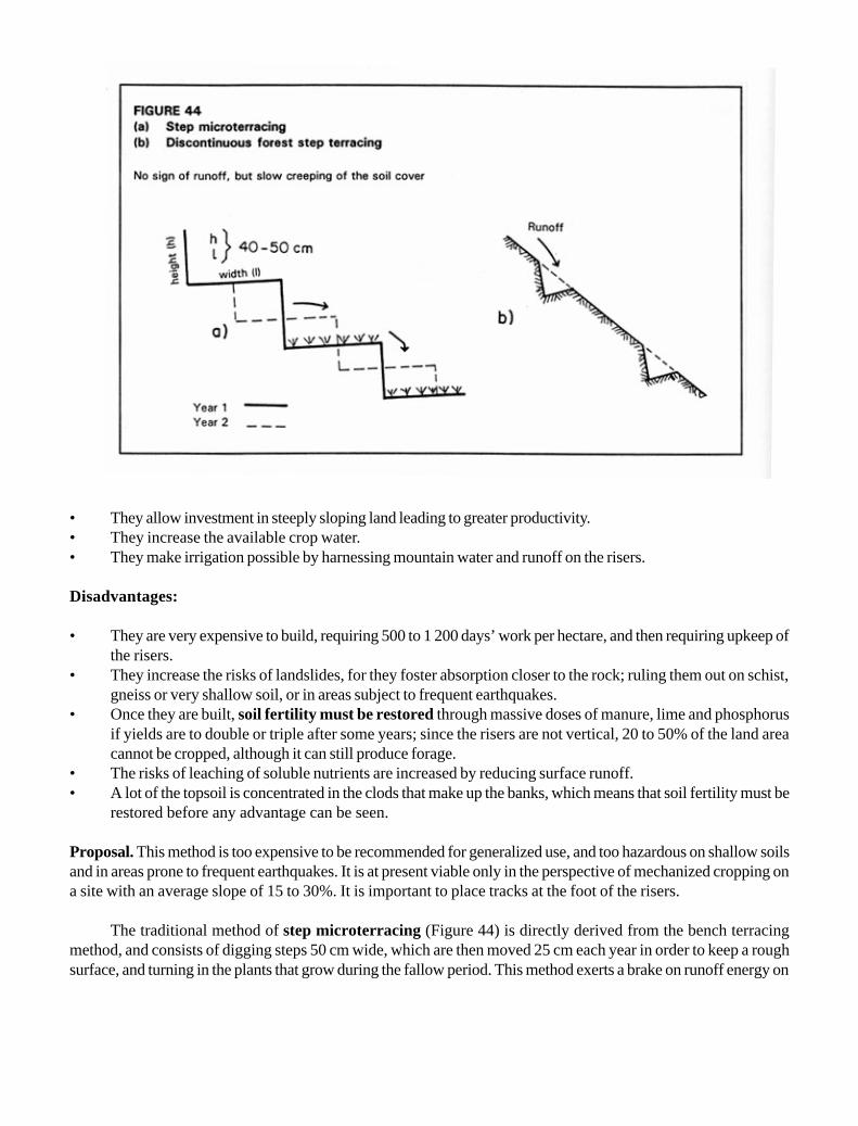
• They allow investment in steeply sloping land leading to greater productivity.• They increase the available crop water.• They make irrigation possible by harnessing mountain water and runoff on the risers.
Disadvantages:
• They are very expensive to build, requiring 500 to 1 200 days’ work per hectare, and then requiring upkeep ofthe risers.
• They increase the risks of landslides, for they foster absorption closer to the rock; ruling them out on schist,gneiss or very shallow soil, or in areas subject to frequent earthquakes.
• Once they are built, soil fertility must be restored through massive doses of manure, lime and phosphorusif yields are to double or triple after some years; since the risers are not vertical, 20 to 50% of the land areacannot be cropped, although it can still produce forage.
• The risks of leaching of soluble nutrients are increased by reducing surface runoff.• A lot of the topsoil is concentrated in the clods that make up the banks, which means that soil fertility must be
restored before any advantage can be seen.
Proposal. This method is too expensive to be recommended for generalized use, and too hazardous on shallow soilsand in areas prone to frequent earthquakes. It is at present viable only in the perspective of mechanized cropping ona site with an average slope of 15 to 30%. It is important to place tracks at the foot of the risers.
The traditional method of step microterracing (Figure 44) is directly derived from the bench terracingmethod, and consists of digging steps 50 cm wide, which are then moved 25 cm each year in order to keep a roughsurface, and turning in the plants that grow during the fallow period. This method exerts a brake on runoff energy on

RUNOFF DIVERSION
When rainfall is too abundant or too intense to be stored or totally absorbed by the soil, it has to be drained viadiversion ditches, bunds or terraces (Figure 45) in order to trap the sheet runoff before it gathers enough energy togully the slope. Runoff is then evacuated from the cultivated area toward natural or manmade spillways to allow itto reach the low water point without causing too much damage.
Bennett developed this method of runoff management to counter the degradation of soils subject to mechani-zation in the Great Plains of the United States, but its application in developing countries is unfortunately fraught withproblems.
Advantages. These ditches do drain excess water from cultivated areas.
Disadvantages. The ditches represent a loss of 5 to 15% in arable land.
Sheet erosion between the structures can persist, in which case soil will silt up the ditches (gentler slope),causing overflowing and gullying, and ruining the whole installation. The structures require very precise surveying inorder to allow the slope of the channels to increase gradually from 0.2 to 0.4%. They are expensive to build andmaintain, requiring resources for rapid channel clearance and maintenance.
There are two kinds of gullying risk: on slopes when ditches overflow, and at spillways where water from awhole hillside is concentrated. This means that the problem has simply been shifted: there has been no reduction insoil degradation, nor in sheet erosion between the erosion control structures. In Africa, this system is rarely main-tained as it should be, so that it generally ends in failure after four to ten years – and sometimes less – as ditchesintended to evacuate runoff fill with eroded soil and subsequently overflow during the heaviest rainstorms.
slopes of up to 80%, but does not prevent the soil cover from slowly creeping downhill due to dry mechanical erosion(Rwehumbiza and Roose 1992, Hudson 1973, Fournier 1967).
There is an arid zone variant in which only part of the slope is terraced to collect runoff on the banks andencourage full absorption of rainwater and the recovery of runoff. This means that the water from most light andaverage rainstorms is absorbed totally by the strip of cropped soil. However, the method does envisage a drainagesystem allowing excess water to be evacuated during the exceptionally heavy rainstorms that are so dangerousaround the Mediterranean.
Conclusion
Total absorption structures offer radical solutions in semi-arid regions where plant production is closelydependent on the availability of water, and also on steep slopes where it is difficult to control runoff withoutcreating gullies.
However, installation and upkeep of such structures require a heavy investment. Furthermore, they cannot beinstalled indiscriminately without increasing the risks of landslides and the leaching of nutrients.


Table 34 shows how little effect diversion bunds have on runoff, erosion and yields for cultivation with inten-sive mechanized tillage on a shallow, tropical, ferruginous soil on gravel sheet (Roose and Piot 1984). On a broadpediment with a 0.7% slope, the CTFT compared runoff, erosion and yields on four plots between 1967 and 1972: astandard control plot, a traditional untilled Mossi field with sod-seeding in planting holes, and two plots with diversionbunds, using intensive methods of tillage, hoeing and ridging, parallel to the slope and untied on one, and perpendicu-lar to the slope and tied in certain years on the other. The maximum runoff observed during the heaviest rainstormson bare soil was 70%, while it varied from 37 to 45% on cropped soil, whatever cropping method was used, evenfalling to 31% when the ridges were tied.
Average annual runoff reaches 40% on bare plots. Plant cover reduces it to 20-24% whatever the croppingsystem, but only tied ridging brings a real reduction (4%). Erosion on these gentle slopes can be as much as 16 t/ha/yr on bare soil (but is cut to a quarter on cultivated soils), and a little higher on soils with ridging in the same directionas the slope (but significantly lower if the ridging is perpendicular to the slope and tied). However, there is nosignificant difference in yields under a traditional non-till system or under an elaborate system, with the use ofnumerous cropping techniques as well as diversion structures. On these shallow and fairly unproductive soils, theretherefore seems no point in investing in either tillage or diversion ditches. Runoff reductions are slight, and even ifthey were sizeable, the soils are incapable of storing the water, so that the nutrients saved from runoff would quiteprobably be carried off in the drainage water.
STRUCTURES TO DISSIPATE RUNOFF ENERGY
When rainfall exceeds the soil’s absorption capacity, the sheet runoff can be controlled by spreading it across thewhole slope rather than concentrating it in channels and outlets, where it can cause problems.
Its energy can be dispersed by keeping the speed below 25 cm/sec – the speed corresponding to the energyneeded for runoff to detach particles (Hjulström 1935) (Figure 20).
Such dispersion across the slope is achieved partly by cropping techniques that keep the soil surface rough(clods, many grass stalks, effect of weeds and mulching, etc.) and partly by structures such as permeable microdams,which temporarily slow the flow, allow some sedimentation, spread the flood, reduce peak flows and improveabsorption.
Grass Strips (Table 35) reduced runoff to 30 or 60% of that on the control plot, and erosion to 30 and even 10%.
Hedges made up of two or three staggered lines of grasses or shrubs also operate as very effective permeablemicrodams.
On the Ruhande Experimental Station near Butare in Rwanda, König (1992) showed that on a 27% slopewhere erosion on bare soil can be as much as 550 t/ha/yr, isolated trees have very little effect, whereas hedges ofCalliandra or Leucaena planted every 10 metres cut erosion to less than 7 t/ha/yr. Hedges of Setaria are twice aseffective in reducing erosion (0.3 t/ha/yr), but are exhausted after being used for forage for three to five years(Table 36).
On the ISAR Rubona Station, 20 km from Butare in Rwanda, Ndayizigiyé (1992) compared the erosioncontrol effectiveness of shrub hedges of Calliandra, Calliandra plus Setaria, and Leucaena (two lines, 50 cmapart), placed 7 metres apart on a 24% slope on a very desaturated, sandy-clayey, ferralitic soil.
For rainfall of 1 000-1 250 mm (established over ten months), the average annual runoff coefficient (bare soilor traditional cropping) remains moderate (6 to 12%), but tends to increase as the soil surface degrades, and canexceed 45 to 50% with the heaviest rainstorms in the second rainy season on waterlogged soil. On the other hand,
Conclusions on diversion structures
Following Bennett’s manual and other work by American researchers, runoff diversion structures have been builtall over the world in the past 50 years, with no prior tests of their effectiveness or suitability under local socialand economic conditions.
Today it has become clear how ineffective they are in Mediterranean areas, Sudano-Sahelian areas (Burkina Faso,Niger) and the mountains of Central Africa, and on the long pediments of South Africa. These methods areexpensive (especially the surveying work), reduce arable land, and fail to prevent either loss of soil fertility orsheet erosion. They are valid options only under mechanized cropping systems, but are difficult to maintain andshould therefore be avoided in developing countries.


on plots protected by hedges, runoff tends to fall to under 2% whatever the type of plants, especially if prunings arespread on the soil surface between crops, and the weeds collected during hoeing are arranged at the foot of thehedges.
Erosion reaches 300 to 500 t/ha/yr on the bare control plot, and 200 to 250 t/ha/yr under traditional cropping,but falls toward 1 t/ha/yr on plots protected by grass or shrubs, clearly indicating that treated plots are stable aftertwo to three years. So SWC has been successful, but what of crop yields?
Tests show that the biomass produced by shrubs increases gradually from 1.5 to 3.2 kg per linear metre ofhedge, that the presence of grass (Setaria) at the foot of the shrubs gives good results in the first year but that afterthis Calliandra alone produces more than Leucaena, and lastly that annual nutrient intake by the deep-rootedshrubs can be as high as 78 kg of nitrogen, 10 kg of phosphorus, and 17 kg of potassium, which are then redistributedin the form of mulch during the crop growth cycle.
It had been hoped that a combination of prunings from hedges and 10 t/ha/yr of manure (dried paddock dung)would gradually improve crop yields. In fact, however, levels remained only fair (500 to 250 kg/ha of maize, plus 500to 800 kg/ha of beans in the first season, and 450 to 650 kg/ha of sorghum in the second season). In the fourth yearit eventually became clear that soil fertility had to be restored (a supplement of 2.5 t/ha of lime, 10 t/ha of paddockdung, and 300 kg/ha of NPK – 17.17.17) if crop yields were to increase significantly (more than 2 t/ha of beans and1.4 t/ha of sorghum).
Complex grassed risers. After some years the microdams (grass strips, hedges, etc.) have produced gradualterraces divided up by steep-sided banks protected by a grass sward.
Figure 47 shows the development of a grassed riser on a 20 to 60% slope over a five- to ten-year period,during which it reaches a maximum height of 1 to 1.5 metres, after which there is an increased risk of destructionfrom animal burrows, gullying, and landslides, and farming problems as well (Roose 1990).
Since any break in the line of the riser across the hill compromises these measures, it is recommended that thewhole length be pegged out with the rural community, and the first line of grass indicating the basic contour lineplanted across the whole slope or hill, leaving the individual farmers to complete the work during the five successiveyears, at their own pace on their own land. Imposing treatment of the whole hillside on the rural community canundermine the farmers’ sense of responsibility, leading to neglect of the necessary upkeep (Ngarambé 1991). If thegrassed strip is not continuous, runoff water will rush into the breach, carving out a gully and undermining the wholesystem.
Lines of Stones, Stakes, Grass or Straw (Figure 48a and b). This heading covers single barrier lines establishedalong contour lines and permeable to sheet runoff. Many examples can be seen in Sudano-Sahelian semi-arid areasof Mali, Burkina Faso and Niger. Stone lines slow down the runoff so that it spreads out in sheets several centime-tres deep, thus causing sedimentation first of sand particles, and then of finer particles which tend to clog thesurface. The lines filter the water, trapping straw, animal faeces dropped during the dry season on rangelands, andvarious types of floating organic residue. This creates a localized deposit of fertilizer in the sedimentation area andin the watered area. And if these lines are laid out in the right direction, in the dry season they also trap sand carried


NOTES ON FIGURE 47
Objectives
1. Dissipating runoff energy by spreading the sheet over the soil surface, which is protected by a thicksward of grass.
2. Transforming the soil cover into a series of gently sloped, cropped areas and protected banks (0.5 to 2 mhigh depending on soil depth and resistance).
Methods
1st year Mark out the contour line (every 5 to 20 m depending on slope and soil depth) by plantingperennial grasses. Tillage will add 10 cm of soil above, and remove 10 cm of soil below.
2nd year Plant 2 additional rows of grass x pulses.
3rd year Plant another 2 additional rows, then plant quick-growing trees at the foot of the bank to reducerisks of landslides.
Since the soil cover will now vary in depth, more demanding plants can be grown in the zone above the bankwhere soil, water and fertile elements accumulate, and hardier plants below it in the scoured area to be restored.
Advantages
Terraces are formed progressively through erosion, but primarily through tillage (+ 20 cm in height per year). Thefarmers can do all the work themselves.
Such a system requires neither major investment nor major upkeep, and pegging out the contour line does notrequire such precise surveying as do drains.
There is no loss (as against 6 to 10% for ditches) in crop area: (wood, fruit and forage crops will grow particularlywell on the banks).
Effectiveness is maintained even in the case of very heavy rainstorms, and increases with time.

off by wind erosion. They enhance production potential by concentrating both water and nutrients over an area 2 to6 metres broad above the barrier, and redistributing it below it when there is excess water.
Hazards. When sheet runoff builds up before the barriers, it eventually finds a way out, and at this point it speeds up(the Venturi effect), carving out a channel below the line, then under the stones, thus burying them.
As it spreads out in front of the barrier, the sheet creates a lateral movement which can lead to a localconcentration of runoff and the formation of a more aggressive drainage line capable of carving out channels andshifting gravel and pebbles.
These lines are fragile: a single kick from the hoof of a passing animal can shift a stone, causing a breachthrough which the water will pour. The resulting rills then develop into gullies.
The lines have a limited life-span. The stakes and straw rot and are attacked by termites. The clumps of grassare choked in the centre, so that they thin out and leave pernicious breaches. The stones are overturned by livestockor buried under sand.
However, the organic matter accumulated in front of the barriers will have drawn termites, which oftenimprove macroporosity and absorption capacity at this point, so that abundant grass and shrubs, and sometimes eventrees, will grow there. In order to counter the lateral movement of water that leads to soil erosion, lateral ties can beintroduced either by making small ridges perpendicular to the barrier, or by tying the field laterally in a bee-hivepattern – as is often done by the Mossi in north-western Burkina Faso to restore soil at the foot of hills. Anotheroption is to wait a year until the drainage lines become clear and then use large stones to reinforce the weaker pointswhere water collects. The soil must also be kept rough through regular tillage in order to break up the slaking orsedimentation crust which seals the soil surface. Hoeing the earth up into tied ridges lowers the risk of waterconcentration. Lastly, a filter of straw or a hedge above the stone or grass lines will make them much more effec-tive.
Low stone bunds (Figure 48c).
Two or three layers of stones are so arranged along the contour line as to reinforce one another, a technique widelyused in Yatenga Province of Burkina Faso. Lining one hectare with these stone bunds (400 m) takes about 30 to 60days’ work, plus transport between quarry and field (1 day’s use of a truck). The bunds slow down runoff, spreadingit in sheets so that it is absorbed in less than one hour, thus causing successive sedimentation of sand, aggregates, andfine, humus-bearing particles, which will then form a sedimentation crust. Only the excess water flows over the firstlayer of stones. More water is stored than in the case of stone lines, and the sheet of water often covers 5 to 8metres in front of the permeable barrier. The bund filters straw, animal faeces and various kinds of floating, organicmatter, so that farmers see one of its most useful functions as that of maintaining soil fertility.

Theoretically, these stone bunds are laid perpendicular to the direction of the water flow, but not necessarilyto winds. They thus do not always trap sand blown across the ground during the dry season.
The bottom of the first layer of stones is planted several centimetres deep in the ground, with soil betweenthem, so that 5 to 15 cm of filtering, organic, sandy soil collects above the bund, improving soil storage capacity andforming new topsoil.
The second and third layers downhill (made of smaller stones or grass) divide the excess flow, absorbing therunoff energy and preventing channels from being dug out downstream of the barrier during major rainstorms.Tillage of the cropped strip and erosion will soon cause an embankment to form. It must be stabilized with grass, forexample Andropogon and Pennisetum.
Hazards. If the top of the bund is not strictly horizontal (as in the case of smoothed contour lines), the sheet runoffflows toward the lower points and forms drainage lines, speeding up and carving out channels, which then developinto gullies and drain water from the whole slope. However, a strictly followed contour line will produce fields ofwidely varying sizes and shapes (a deviation of 10 metres for the slightest termite hill on 2% slopes), which causesproblems for mechanized cropping. Even then, small drainage lines will form, but these can be treated in variousways:
· using large stones to reinforce the points where the water collects, and gradually levelling these areas;· increasing the roughness of the soil through coarse tillage with toothed implements, repeated hoeing, and tied
ridging;· sowing grass (Andropogon) above and around the bund to brake sheet runoff;· tying the field for 5 metres above the bund with earth ridges or stone bunds – although the latter can cause
problems for mechanized cropping (Lamachère and Serpantié 1991).
Damage to the bund by passing livestock can be reduced by planting grass (to cover the stones), and a hedgebelow the bund, as well as trees which will eventually “tie” the landscape, creating an area dominated by hedges. Inareas where stones are scarce, the same effect can be achieved by sowing a 50-cm strip of grass (Andropogon) ora hedge (at least three lines staggered on alternate rows) between two contour ridges (20 cm high) (Roose andRodriguez 1990). In mountainous areas farmers often collect stones that come to the surface and heap them up onthe edges of their fields (particularly on banks around the fields). If these heaps of stones are arranged along contourlines, they act as stone bunds.
A team of ORSTOM scientists (Serpantié, Lamachère, Martinelli and others 1986-1992) have studied thecombined effects of stone bunds and tillage, comparing this with a control plot in a water-harvesting area in the Bidiregion near Ouahigouya in Yatenga, in north-western Burkina Faso (Table 37, Figure 49) (Serpantié and Martinelli1987; Lamachère and Serpantié 1991).
Stone walls (Figure 48d).
These walls are carefully built by piling up flat stones, wedged with small rock chips. They are often found insandstone hills, for example near Bamako in Mali. The first step is to dig a trench along the contour line, digging

down to a coherent horizon, and build a drainage filter made of a layer of sand and gravel on the sides and bed of thetrench.
On a medium to steep slope, gradual terraces are quickly formed by throwing the earth from the trench uphilland by water erosion, but above all by dry mechanical erosion during tillage.
Hazards. The direct pressure exercised on the wall by the soil cover and ground water can push it out of true so thatit will bulge and, eventually collapsing unless there is good drainage above the wall and a bed of gravel below.
As time passes, the foot of the wall will be eaten away by water erosion or tillage in the field below it. Thisprocess can be slowed by planting grass or fruit trees on the bank that develops at the foot of the wall, which willprevent soil from creeping downhill.
Pervious and semi-pervious check dams (Figures 48e and 52).
This approach entails heaping up a line of large stones with the crest following the contour line, in order to dam thehead of a valley, thus slowing flow and facilitating groundwater recharge. It can take 300 to 600 days’ work to buildthese enormous stone bunds which are 200 to 300 metres long and 1 to 2 metres high. The length of the dam dependson its height and the depth of the gullying at each point. The crest of the dam must follow the contour linestrictly and the dam itself must be set in a foundation trench 20 to 40 cm deep, which must also be covered by apervious bed. This barrier slows down runoff to the valley bottom, although it passes quickly through the large stones– unless the dam has been built with a pervious core of finer gravel, which can hold back water for several days.
If a sheet of water is to be kept upstream of the dam (in other words, if it is to be a semi-pervious rather thana pervious dam), for example to grow rice, a clayey core behind the gravel filter will be necessary.
Sedimentation upstream of the stone dam is fine and slow (1 mm per year) in a fairly undegraded, undulatinglandscape, but can be fast (10 to 50 cm per year) in a gullied, hilly landscape (e.g. the area north of Ouagadougou –Dezilleau and Minoza 1988).
Hazards. If water filters too fast through the dam, erosion can burrow through it and below it. If there is too muchpressure beneath, the water carves out a gully which will eventually breach the dam through headward erosion. Agravel and sand filter must therefore be built to slow down runoff: this material is poured into the foundation trenchunder the structure, as well as between the large stones that make up its core (Figure 52).
If the sheet of water flowing over the dam is over 20 cm, the structure may well be swept away by the speedof the current. This can be prevented by placing large stones, or better a small gabion, on the brow of the dam, andalso on the slope of its upstream side (2/1 slope).
The water normally drains away fast after the rains stop, although the land immediately above is left water-logged, so that the sorghum traditionally grown in flat valley bottoms rots and suffers from waterlogging, while wateris not available long enough to grow rice – which is prized for feast-days. Only off-season gardens and fruit trees


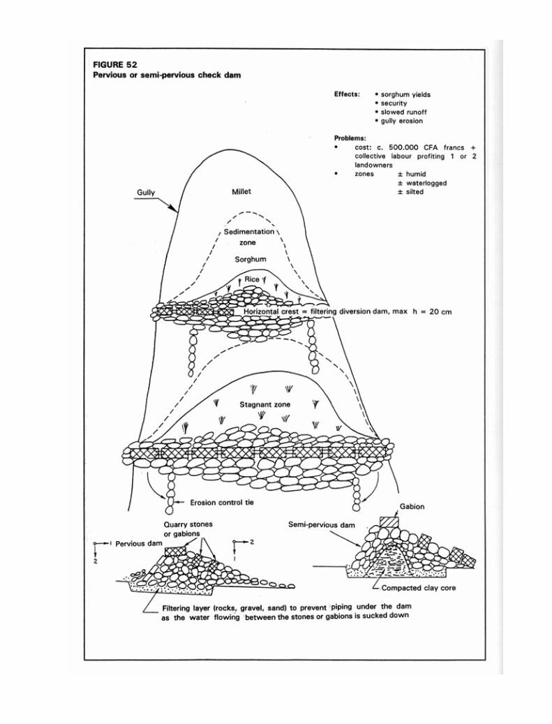
located around the valley in fact profit from the increased groundwater recharge from a check dam. It is thereforeimportant to have a clear idea of objectives. Check dams recharge groundwater but do not hold back much water –in any case not enough to produce rice four years out of five in the Ouahigouya region. If the aim is to create a ricefield, it is best to choose an impervious soil-saving earth dam, which will hold back a large enough sheet of water forthis crop.
Problems connected with land ownership should also be borne in mind, for building a check dam of this typerequires considerable work on the part of the local community (15 people for 30 days) and the transport of a hugevolume of stones (from 100 to 500 m3, at an average cost of 4 to 40 000 FF). And although the structure takes all thiseffort on the part of the community, it in fact allows improvement of a mere 0.5 to 1 hectare, probably belonging toa single family. In order to avoid wrangling, advance plans should be made to redistribute the improved land to thosetaking part – not always a possible solution. Another solution is to negotiate a form of payment by the beneficiary tothe neighbours who help in the work, by creating a bank which advances money and recovers it on improvedharvests in the following years. Food for work, payment in kind, or an undertaking to work for the others for somedays, are other possibilities.
The same amount of effort and the same volume of stones could go to improve 10 to 20 hectares of slopingland belonging to twenty families, who could easily build the necessary stone bunds on their own. It has not yet beenascertained whether this form of watershed management can offer the same production security as management ofthe valley bottoms, bearing in mind that although certain bottoms are completely flooded in the rainy season, inparticularly dry years they are the only places where villagers can be sure of a certain level of productivity.
The importance of ensuring household food security makes it vital to improve both the land in the valleybottoms, which will produce even in dry years, and the land on the hillsides, which will produce best in wet years.
However, it must always be borne in mind that, like other methods, this is not the universal solution. It is validfor certain gullied valley bottoms, but much less so for flat bottoms, where there is very little sedimentation.
VARIABILITY OF EROSION FACTORS
Before opting for a specific erosion control method, it is best to take another look at the causes of erosion and thefactors that modify the form it takes under the environmental conditions where this work was done – i.e. the old andweathered hills of Africa.
By analysing the available findings of the erosion forecast equation – i.e. 560 plots per year – these variousfactors can be reviewed and quantified (Roose 1975):
In conclusion, there is a wide variety of semi-pervious microdams. They have the advantages of being easy forvillagers to build, and of changing topographical conditions (the gradient of the slope). However, they do lead tothe loss of some runoff as well as the nutrients and colloids that represent the wealth of these soils. This watercould be recovered further downstream by irrigation infrastructure.

· The climatic aggressiveness factor (RUSA) is very high, rising from 200 units in northern Burkina Faso toover 1 400 in southern Côte d’Ivoire (Figure 17). Moreover, it is very unevenly divided over the year: 75% ofannual R is often concentrated in 2 or 3 months at the start of the cropping season when the soil has littlecovering.
R, the erosive force of rainfall, varies from 100 to 2 000
· Soil resistance to erosion of ferralitic soils (K = 0.01 to 0.18) and cropped tropical ferruginous soils (K =0.2 to 0.3) is much better than that of many leached soils in temperate regions (where K varies from 0.2 to0.7).
K, soil erodibility, varies from 0.01 to 0.3
However, it is difficult to reduce erodibility once a soil has become degraded and lost its organic matter, clay,structure and permeability: K rises from 0.1 to 0.2 or 0.35 with the degradation of cropped soils.
· The topographical factor combines the length (L) and slope (S) factors. The length factor is neither con-stant nor very great: for practical reasons, a team of American scientists has estimated that erosion increasesin proportion to the square root of slope length (SL2). Slope (gradient), on the other hand, does have a decisiveeffect. Sediment load increases exponentially (exponent = ± 1.4 to 2) with the percentage of slope (Zingg1940, Hudson 1973, Roose 1975) – or in accordance with a very close second-degree equation (Wischmeierand Smith 1960). On the commonest slopes (0.1 to 15%) with a length of 60 metres, SL varies from 0.1 to 5.
SL, the topographical index, varies from 0.1 to 5(and up to 20 in mountainous areas)
· Soil cover (the C factor) from plant cover (and stones) has a much greater effect than all the other erosionfactors. Thus, however aggressive the climate, whatever the slope, whatever the soil type, erosion will beslight with a soil cover of over 90%. However, it should be noted that cropping techniques play a major rôleduring the crop growth cycle.
C, the interaction between plant cover and croppingtechniques, ranges from 1 to 0.001

CONCLUSIONS ON THE APPLICABILITY OF THE USLE IN AFRICA
Now that erosion has been measured on quite a few -- more than 560 -- experimental plots in West, North andCentral Africa, there is a basis for questioning the applicability of the “universal” soil losses equation (Wischmeierand Smith 1978) in Africa.
1. The equation applies only to sheet and rill erosion (hence to the nascent erosion that concerns us here) inhilly country, excluding mountainous areas where landslides and linear erosion (rills, gullies and torrents) arepredominant. It addresses neither the type of runoff nor suspended load. If necessary, each subequation canbe adjusted to take account of runoff energy on steep slopes.
2. This empirical model requires a large number of results replicated at different times and places, for it looksat behaviour in the medium and long term (20 years). The use of rainfall simulators (with one-time data foreach situation) can offset the lack of data on plots under natural rainfall, but cannot replace them. It is alwaysdifficult to compare specific results obtained under simulated rainfall with average results over a number ofyears on actual plots. Experiments on agricultural stations are long and costly. In practice, in the absence ofsufficient local results, use can be made of the tables presented in this work, which give the correspond-ing coefficients for Africa or the United States (cf. Wischmeier and Smith 1978).
3. The equation is based on results on small plots (100 m2), fields or very small catchments (a few hectares).This leads to problems of scale when trying to forecast regional figures for erosion, and especially forpredicting sediment load in large watersheds where water management systems may be threatened by siltation.
In conclusion, in the tropical regions of interest here, the most important factors for interventions to curtailerosion and runoff are plant cover and slope. There seem to be four feasible biological approaches.
1. Intensified cropping on the best and least sloping lands. Special attention should be given to sowingdates and rates, fertilizer, straw and crop residues on the soil surface, preparation of the seed-bed, andmanagement of organic matter.
2. Protection of the areas most vulnerable to fire and overgrazing by the provision of permanent cover(forest, savannah, pasture or orchard).
3. Treatment of gullies and outlets to evacuate temporary excess water with minimum sediment transport.Provision of access to plots and drainage systems.
4. Definitive land management at the watershed level, with the use of erosion strips as risers and the roughalignment of all tillage operations perpendicular to the steepest slope.
Unlike mechanical interventions, which are not cheap, not cost-effective, and not easy to maintain, the biologicalmethods suggested here are well-suited to tropical conditions where grass is abundant, slopes are medium, andtechnical and financial resources are scarce. Similarly, with a view to stabilizing water supplies and waterways andprotecting roads and irrigation works, as well as increasing farm production, there is no doubt that it is morehelpful to increase absorption over the whole farmed area by extending plant cover than by evacuating all excessrunoff.

4. It is difficult to set precise figures for tolerable erosion levels, since the equation ignores the quality oferoded material. The wealth of many tropical soils is stored in the top 20 centimetres (especially under forest),and sheet erosion selectively carries away organic and mineral colloids, plus nutrients, which together assurethe soil’s water and chemical reserves (Roose 1967; 1973).
5. The equation seems to apply fairly well to soils rich in kaolinite, tempered, leached, brown soils, andtropical ferralitic and ferruginous soils, excluding soils rich in swelling clay (vertisols, tropical brown soils,saline soils), which very quickly present large-scale gullying due to their poor absorption capacity once theyare wet.
6. Lastly, the equation ignores interactions between the different factors – interactions that proved verynumerous as the results were analysed. For example, soil reaction to rainfall aggressiveness differs greatlydepending on slope, whether the soil is clayey (rill erosion) or sandy (sheet erosion), and the condition of thesoil surface (roughness due to cropping methods, prior soil moisture, management of crop residues).
Granted all this, it must be recognized not only the practicality of this equation in the field for rational landuse planning, but also its scientific value in defining the relative influence of each of the factors involved. It istherefore very effective in fulfilling its purpose of defining the erosion control techniques to select in a given situa-tion. On the old continent of Africa, use of Wischmeier’s equation seems justified by a large number of results (560)concerning the soils, crops and slopes most widely farmed.
The aggressiveness factor takes full account of how cumulative rainfall and rainfall intensity and durationinteract with soil losses. It might also be combined with a soil moisture factor that would show how wet the soil wasbefore the rain. The laborious processing of thousands of pluviogrammes gave a first rough idea of the geographicaldistribution of mean annual rainfall aggressiveness in the southern part of West Africa, apart from the coastal stripand mountainous areas, indicating that rainfall is fairly homogenous in terms of how much, how hard, how long andhow often. However, there is still the question of whether erosion control should be based on average figures forrainfall aggressiveness or on the dangers represented by exceptional storms that occur at ten- or evenhundred-year intervals. Tests on the latter approach have not yet been carried out.
Soil cover in the form of plant cover and stones is much more important than all the other factorsaffecting erosion. Plant architecture and cropping techniques become secondary once the soil has a 90% cover.However, cropping techniques can have an effect during the growing phase, and the C factor allows selection of thetechniques and plants best suited to local environmental conditions.
Soil erodibility . Contrary to an opinion widely held by agronomists, tropical ferralitic soils, and to a lesserextent tropical ferruginous soils, especially those with a high gravel content, seem less vulnerable than many leachedsoils in temperate regions. The striking damage found in tropical areas is in fact a result of the particular aggressive-ness of tropical rains. The nomograph put forward by Wischmeier, Johnson and Cross in 1971 to allow rapid calcu-lation of the index of soil resistance to erosion seems applicable so long as it is combined with a qualifying coefficientthat takes account of the gravel or rock débris present in the tilled horizon (Dumas 1965). Lastly, it would seem thatsoils rich in swelling clay, such as vertisols, tropical brown soils and volcanic soils, require individual examination, for

they act in a very specific way and the equation therefore does not hold in their case. Analysis is still needed of thevery specific manner in which runoff appears.
The topographical factor, particularly length of slope, certainly represents a weak point in the equation, forit should be adjusted according to type and texture of soil, and type of plant cover. However, until sufficient data arecollected under natural or simulated rain, it can be used in most practical cases. The caveat is, however, importantfor the choice of erosion control techniques, which are too often based on reducing length of slope, an approacheffective only for rill erosion and rarely for sheet erosion. Such reservations must be even stronger when the effectof topographical position exceeds that of slope, for example where headward erosion has its origin in the drainagenetwork or the valley bottom.
Biological-type erosion control techniques – in other words, those encouraging soil cover – are therefore themost effective, the least costly, and the best suited to conditions on the plains and largely undulating uplands of the oldcontinent of Africa.
In conclusion, Wischmeier and Smith’s equation cannot be described as universal, for it applies neither toswelling clay soils, nor to volcanic soils, nor to mountainous regions with young landforms where linear gullyingerosion is predominant, nor to Saharan and Mediterranean areas where exceptional rainfall has a decisive impor-tance. Nonetheless, it seems well suited to forecasting erosion in most types of cultivated land in West Africa,particularly gentle to medium slopes on clayey-sandy, tropical, ferralitic and ferruginous soils.
IMPLEMENTATION OF WISCHMEIER’S EROSION FORECAST MODEL
The aim here is that of defining a production system (including productive crop rotation, feasible cropping techniquesand effective erosion control structures) which will keep erosion risk below the tolerance threshold – generallyrecognized as between 1 and 12 t/ha/yr, depending on soil-type. The Sudano-Sahelian, cotton-growing area ofMali can be taken as an example (Table 38):
1. Rainfall = 800 m : mean R index = 800 x 0.5 = 400 t/ha/yr (Figure 17).

2. The K factor – indicating erodibility – for cultivated tropical ferruginous soils in the region ranges from 0.3 fordegraded soils to 0.2 for an intensive system recycling a great deal of organic matter (Figures 20 and 21).
3. SL, the topographical factor. Supposing that cropping is on a broad pediment with a 2% slope 300 metres long:
- Figure 22 shows that SL = 0.4;- if a diversion ditch is introduced every 50 metres, SL = 0.24;- if a diversion ditch is introduced every 25 metres, SL = 0.18;- if a low stone bund or a hedge is introduced every 25 metres, SL = 0.12,
for each bund creates a 25-cm-high bank which reduces the gradient of the slope.
4. The C factor, for a continuous rotation, ranges from 0.4 to 0.8 depending on whether cropping is intensive orextensive (Table 29):
- the addition of groundnut would change nothing (C = 0.4 to 0.8);
- the succession of 4 years of cropping + 4 years of fallow would cut C by half
Ccscsffff = 0.4 + 0.4 + 0.4 + 0.4 + 0.1 + 0.01 + 0.01 + 0.01 = 0.28
(Ccscsffff = a crop rotation of cotton, sorghum, cotton, sorghum, fallow, fallow, fallow, fallow)
In the long term, the risks have been halved thanks to the fallow, but four years of production have beensacrificed.
In order to maintain production, another plot would have had to be cleared – a solution no longerpossible in some areas of Africa, where population pressure causes landholding problems.
- A purely biological solution is possible with the use of mulch or cover plants (C = 0.01, and E = 0.32 t/ha/yr) without resorting to either erosion control structures or ridging.
5. Erosion control practices (P). Calculations show that introducing erosion control structures is not enough;cropping practices and/or rotations must be altered. In the best of cases, with an intensive system, stonebunds every 25 metres and contour tillage, the erosion risk is still double the tolerance level (E = 1 t/ha/yr).
If tied contour ridging is introduced, erosion ranges between 0.4 and 0.8 where runoff dissipation or diversionstructures are adopted. Although this second solution is a mechanical one and hence more expensive, it is alsoeasier to implement in a semi-arid region where the biomass is eaten by livestock and the rainy season is tooshort to grow pulses as a catch crop under cereals.

Chapter 6
Linear erosion
When rainfall intensity exceeds the absorption capacity of the soil surface, puddles form which are then joined up byrivulets of water, and when these rivulets reach a certain speed – 25 cm per second according to Hjulström (1935)– they take on an energy of their own. The energy such erosion generates is confined to and concentrated in flowlines on the steepest slopes, and no longer spread over the whole surface. Linear erosion is therefore an indicationthat runoff has become organized, picking up speed and acquiring a kinetic energy capable of cutting into the soil andcarrying away larger and larger particles – and not only clay and silt as in selective sheet erosion, but gravel orpebbles and larger blocks once gullying begins.
There are some very well-researched manuals on the treatment of linear erosion (Hudson 1973; Gray andLeiser 1982; Cemagref 1982-88; Geyik 1986; Heusch 1988), as well as vast numbers of specialized articles (Boiffin,Papy and Peyre 1986; Watson, Laflen and Franti 1986; Govers et al. 1987; Laflen 1987; Meunier 1989; Poesen1989; Deymier 1992; Combes 1992). The present work is concerned chiefly with controlling soil degradation and theonset of erosion. It will therefore give a brief description of the various types of gullying and their causes, followedby an explanation of treatment for medium-sized gullies within the reach of small farmers, and the principles to befollowed by non-expert developers in order to avoid the main causes of failure (see the “Ten Commandments”, page216). The reader can consult the specialized works listed in the bibliography for further information on torrent andlarge gully control. The following chapters will approach mass movement and wind erosion in a similar manner.
FORMS OF LINEAR EROSION
Once runoff starts, lightweight particles are carried away – particularly organic matter, crop residues and animalfaeces, as well as fine particles of clay, loam and sand. “Flood debris” can be seen on the ground, often made up oflong, fibrous, organic matter, but also ribbons of sand, which are very frequent in wadis. Linear erosion [Plate 13]appears when sheet runoff becomes more organized, digging deeper and deeper into the ground. The results aredescribed as grooves when the little channels are only a few centimetres deep, and rills when they are over 10centimetres deep but can still be eliminated through cropping techniques. Gullying sheet erosion is when thechannels are between 10 and 20 centimetres deep but as much as several metres wide, and real gullies are whenthe channels are at least 50 centimetres deep and, more specifically, when they can no longer be eliminated throughcropping techniques. The gully category can then be subdivided. First, there are small gullies, where the bed is stillovergrown with leafy – and especially shrubby – growth, and that can be quickly stopped by biological methods. Onthe other hand, in large gullies, which can stretch for several kilometres, the central channel contains rocky


boulders as evidence of large-scale sediment transport and a certain flashiness. Since the bottoms of such gulliesare mobile, biological methods alone are no longer capable of stabilizing them, and cement sills and expensivemechanical methods will have to be used (Lilin and Koohafkan 1987, Mura 1990).
Gully shape is also important. Some are V-shaped, with an even slope down to the lowest point, others are U-shaped, with vertical sides, and still others develop through tunnelling and subsidence (Figure 53). Large ortorrential gullies are those in which floods are so violent and frequent and sediment transport so extensive thatthere is no hope of establishing plant cover in their bed within a reasonable timeframe. Examination of the bed itselfcompletes the diagnosis. The bed of a torrential gully is usually blocked with coarse alluvial deposits, and there isvery little woody vegetation. On the other hand, in small gullies which will respond to biological treatment, alluvialdeposits are finer and woody vegetation is still found in some sections – so long as the degradation of such vegetationhas not been too much exacerbated by cropping (Lilin and Koohafkan 1987).
THE CAUSE AND PROCESSES OF LINEAR EROSION
The cause of linear erosion is to be sought in runoff energy, which depends on runoff volume and its squared speed.
THREE THEORIES OF THE ONSET OF RUNOFF
1. Horton’s theory (1945). Runoff starts when rainfall intensity exceeds soil absorption capacity (Figure 54a).Comparing infiltration to rainfall intensity, absorption decreases over time partly because capillary potentialfalls as the wetting front penetrates into the soil, and partly because soil structure at the surface has deterio-rated. Rainfall generally has one or several peaks, and any volume of rain over the infiltration curve can beconsidered runoff. In the example chosen, even at similar intensity peaks runoff volume can vary consider-ably depending on when peak intensity occurs during the storm. The earlier this peak, the less runoff there willbe, since absorption capacity decreases over time. However, hydrologists were unable to obtain any clearcorrelation between runoff volume for a watershed and rainfall intensity, and so another explanation had to besought.
2. Soil saturation theory. Runoff starts when all the pores in the soil are filled with water (Figure 54b). In thecourse of a simulated rainstorm, if runoff starts after rain has soaked the soil, it will increase until it stabilizesat a level corresponding to the absorption capacity of the soil. However, if the rainfall persists (more than 100mm), runoff may rise again, reaching a new plateau of stabilized infiltration. This simply means that the tilledhorizon has reached saturation, so that the macroporous storage capacity of this horizon is filled to overflow-ing. If the underlying horizon is totally impervious, the amount of runoff will correspond precisely to that of thesimulated rainfall; there may, however, be a certain residual absorption capacity corresponding to that of theplough pan. When the soil is totally saturated, any drop of rain will run off, irrespective of rainfall intensity.
3. Theory of partial watershed surface contribution to runoff. Figure 54c shows that the runoff measuredat river-level depends on the area of the saturated soil in the valley bottom. If watershed surface runoff

is measured during the dry season, it is seen that the river reacts very quickly to rainstorms whereas no runoffis seen on the slopes! The volume of runoff is less during this dry period because only a narrow strip in thevalley bottom is saturated – often only the minor bed. At the end of the winter, however, when the whole soilcover has been soaked to capacity, the slightest rainfall replenishes the aquifer, which will spread out side-ways, saturating a greater area of the valley. As a result, even if there is no runoff on the slope duringthe rainy season, the entire watershed will contribute to the volume of flow in the river throughextension of the saturated area, inasmuch as the groundwater is recharged directly by draining the entirebasin.
Erosion control therefore takes a different form depending on the origin of runoff. If, as in the firstcase, runoff is a result of degradation of the soil surface, erosion control will primarily entail protecting this soilsurface through plant cover, or delaying formation of a slaking crust. If, on the other hand, runoff sets in aftersaturation of the soil, the first step will be to control drainage. Plants will slow runoff and store it temporarily, thusreducing peak floods and the energy available to carry away solid matter. Lastly, if runoff appears only at specificplaces in the watershed, there is no point in setting up diversion bunds on the banks of steeper slopes, for very littlerunoff forms there. This explains the failure of many erosion control projects, which simply apply prescriptionsdeveloped in temperate regions under very different environmental conditions (for example, diversion ditches inSudano-Sahelian areas).
THE PROCESS OF GULLYING
The kinetic energy of raindrops on a slope is more or less constant, depending on the wind-speed. Runoff, on theother hand, tends to accumulate and run together on a longer slope. If the peak flow increases, the soil surface willbe cut and a rill will start to form. It will then deepen as the water-borne sediment abrades the bottom of the rill, theedges cave in, and the material thus dislodged is carried away.
V-shaped gullies are the form most common in nature, and tend to be found in relatively loose, homogene-ous material – sandy-clay, clay, marl, or schist. The slopes of these gullies alter as the rock weathers: in coldseasons through the alternation of freezing weather and sun, and in hot seasons through the alternation of dry andstormy periods. In Mediterranean areas, weathering can reach 4 to 10 mm per year for marl and schist. Subsidencetakes place during exceptional rainstorms. One or two storms per year are enough to carry away all particlesaccumulated in the gully bottom during the year, and for the solid load in the runoff to abrade the valley bottom.
During intermediate seasons, the fine matter accumulated on the slopes as the rock weathers slides down tothe bottom of the gully, partly as a result of the impact of raindrops, partly through formation of small secondary rills,but most often through the mass sloughing of water-saturated particles. Since slope equilibrium has been far ex-ceeded, no vegetation can take root. Erosion control must therefore concentrate on preventing further excavation ofthe bottom of the gully and re-establishing equilibrium.
U-shaped gullies are a second type common in nature on heterogeneous material. The base may bemade up of very resistant material, in which case the channel will broaden as the sides cave in during exceptionalflows. If, on the other hand, the resistant layer is found on the surface, runoff will cut deep into the material until it

reaches a temporary or permanent water table, which will exercise lateral pressure on the base of the slope until itcaves in (undermining the banks). Here again, the gully bottom must be stabilized and the sediment retained until theslopes attain equilibrium. In the agro-industrial farmlands of the Paris basin, there are also “boxed” U-shaped gullieswhich cut down through increasingly sticky silt from the seed bed down through the tilled horizon and plough pan intothe compacted untilled B horizon.
Tunnelling is a third form of gullying, and is still more difficult to treat. It can develop on gentle slopes, inmaterial with surface cracks, on soil rich in swelling clay (vertisols, tropical brown soils, etc.), or on marl rich ingypsum or other soluble minerals (frequent in the Mediterranean basin). During end-of-dry-season rainstorms, thewater penetrates these cracked soils down to the weathered rock, percolating through the cracks to the bottom ofthe slope, where headwater-cutting can form gullies. As hypodermic runoff pours into cracks in the soil, these willgradually become tunnels, which will in due course cave in, forming headward-cutting gullies that can advance byseveral dozen metres during major rainstorms. Dry tillage is the only way of blocking these cracks and forcing thewater to wet the whole soil mass instead of soaking primarily into the megapores.
FACTORS IN RUNOFF
FACTORS AFFECTING THE VOLUME OF RUNOFF
· Rainfall is the primary element: cumulative rainfall in cases where runoff sets in after saturation of thesoil, or the intensity of rainfall over 30 minutes (Wischmeier and Smith 1960, Roose 1973), which is whataffects rainsplash and the onset of runoff. On steep slopes in the Andes, the maximal intensity is counted over15 minutes (Ecuador: De Noni, Viennot and Trujillo 1989).
In Zimbabwe, Hudson claims that rain causes almost no runoff or erosion on very resistant oxisols whenrainfall intensity is less than 25 mm per hour. There are therefore intensity thresholds for rainfall belowwhich runoff cannot start on a permeable soil (Casenave and Valentin 1989, Raheliarisoa 1986). Using a rainsimulator, Lafforgue and Naah (1976) demonstrated that in the case of a rough soil surface the absorptioncapacity of the soil increases with any increase in rainfall intensity. On the other hand, if the soil has a finelypowdered, smooth surface, an increase in rainfall intensity has no effect on absorption. On fragile, loamy soil,infiltration decreases as rainfall intensity increases, for an almost impermeable slaking crust forms faster(Raheliarisoa 1986).
· Soil moisture content prior to rainfall is the second element affecting the volume of runoff. Thisfactor is expressed either in terms of the lack of soil saturation before the rain (pores not swollen with water),or in terms of the number of hours before it rained, or by use of the Köhler index. The amount of rain absorbedis generally much higher for a dry soil than a moist one: while it may be 10 to 40 mm for dry soil, it will oftenbe only 1 to 10 mm for moist soil. There is an interaction between the condition of the soil structure andinitial soil moisture. Boiffin (1976) and Raheliarisoa (1986) demonstrated that simulated rainfall on a dry,loamy soil can degrade the soil surface faster than on already moistened soil.

· The third point affecting the volume of runoff is the size of the catchment area drained by the samechannel (Zimbabwe: Stocking 1978).
· The state of the soil surface encompasses:
• soil surface structure;• cracking;• holes of biological origin;• roughness.
Soil roughness mainly influences the amount of rain absorbed before the soil is saturated, but the influenceof this factor decreases with steeper gradients, for the volume stored in puddles decreases on steep slopes.
When the soil surface is degraded, clods dissolve, and a thin structural crust forms on their surface, thusreducing infiltration to a few millimetres – or a few dozen millimetres – per hour. However, the sedimenta-tion crusts that spread over the area, starting with the puddles between the clods, can be as thick as severalcentimetres and have extremely low infiltration capacity: from 0 to 10 mm/h. Runoff on a given plot will thusdepend on the area covered by the various types of crust, and by the macropores that remain open betweenthe clods on the soil surface.
· The gradient of the slope. This generally reduces the volume of runoff, for on a steep slope internaldrainage is better, and a slaking crust forms more slowly as it is continually destroyed by runoff energy. Thelength of the slope also affects the volume of runoff, but although this volume, expressed as a percentage,theoretically remains constant all the way down the slope, in many instances of bare soil it seems that therunoff coefficient decreases as the slope lengthens (Roose 1973, Valentin 1978).
· Cropping techniques can increase absorption to a considerable degree. At Pouni in Burkina Faso, absorp-tion on a bare, untilled soil was compared with that on the same soil when crop residues were dug in or whenit was treated with tied ridging. Absorption of a 120-millimetre rainstorm rises from 35 mm to over 104. Alsoof interest here are French trials in the Pas de Calais region measuring the effect of the number of passesof farm implements over the land.
· The effect of mesofauna at Saria in Burkina Faso should also be highlighted. The final infiltration of a 100mm sheet of water over 100 cm2 was measured. Absorption was between 5 and 12 mm/h on crusted baresoil, about 60 mm/h where there were termite holes, as much as 90 mm/h after the slaking crust was removed,and finally 120 mm/h after the soil was dug to a depth of 5 cm. Holes made by earthworms, and in some casestermites, can have a considerable effect on infiltration, inasmuch as the flow in a tube varies to the fifth powerof the diameter of the tube. The flow in a 2/mm pore will be 32 times greater than in a 1-mm pore. And thetunnels left by earthworms and termites are often over 4 mm in diameter.
FACTORS AFFECTING FLOW VELOCITY
The second factor that can help to reduce or increase the kinetic energy of runoff is its velocity.

· Runoff velocity depends on the depth of the runoff sheet and the slope and roughness of the channel. Theslope increases the speed of flow and hence the advance of gullying, although gullying can very easily start onslopes of less than 1%.
· The topographical position of the plot can also be a major factor (Heusch 1970): water can drain awayin the soil until it reaches the valley bottom, but gullying can develop where the groundwater emerges, laterleading to headward erosion.
· Differences in height will also influence the depth of gullies: the height from which water falls into thegully causes a considerable vortex energy, which will accelerate erosion or the speed at which gully-headsadvance. Stocking’s studies on the speed at which gullies advance in Zimbabwe should also be mentionedhere. Having studied different types of gully on homogeneous soils, he observes that whatever the type ofgully, erosion depends on:
• the volume of rainfall, i.e. r in mm;• the surface area of the catchment in km2, and hence the volume of runoff;• the height of the fall at the head of the gully (h).
The equation is as follows:
Gully erosion = 6.87 x 10⁻³ r1.34 x s1 x h0.52
· Plant cover has a complex influence on linear erosion:
• plant cover protects against the impact of rainsplash, hence prolonging soil permeability and reducingthe volume of runoff;
• its litter attracts mesofauna (which dig out macropores) and absorbs a considerable quantity ofrunoff energy;
• the roughness of the soil depends on the number of stalks per square metre, so that a plant covermade up of grasses with many stalks is more effective than trees in protecting the soil againstrunoff.
· The soil itself affects runoff and erosion in various ways. Thus, the roughness of the soil surfaceslows down runoff and also affects the volume stored, while the stability of the soil structure affectsthe velocity of rainsplash and hence the amount of the rain absorbed before runoff starts. If the soil sur-face contains gravel or larger stones, there can be two opposite effects (Poesen 1989; Valentin andFigueroa 1987): if such stones are on the soil surface, they protect it against splash and also protect theunderlying macroporosity, and hence have a positive effect on infiltration. On the other hand, if the stonesare included in the sedimentation or slaking crusts, runoff will increase. If soils are compacted, they willbe less pervious but more cohesive, and therefore more resistant to runoff. If the soil profile is homo-geneous, erosion will produce a V-shaped gully, whereas if soil resistance is irregular, a U-shapedgully with vertical sides will form because erosion velocity depends on how well the material resists cutting.
In 1935 Hjulström studied soil erodibility as a function of soil texture and flow velocity, in canals. In agraph (Figure 19, page 92) showing flow velocity as a function of particle size, Hjulström demonstratedthree levels: an upper erosion level, with a minimum of about 100 microns, a lower sedimentation level,and between the two a transport level. Erosion starts at a minimum flow velocity of 25 cm per second
and with the texture of the bank soil at about 100 microns, i.e., the size of fine sand, which is lighter thancoarse sand and gravel and less cohesive than loam and clay. The minimum flow velocity for erosion isroughly 25 cm/s. It therefore appears that the most vulnerable matter – fine sand in this case – is slightlycoarser than in sheet erosion, where the most vulnerable matter is 10-100 ì (Wischmeier, Johnson andCross 1971). This is why sheet runoff moving at under 25 cm/s carries away only fine particles and lightparticles detached by rainsplash, and not coarse sand. On the other hand, where runoff is concentrated,erosion is no longer selective and the speed and energy of the flow increase, digging out rills. When theslope gets steeper, runoff energy increases and exceeds that of sheet erosion. Energy becomes channelledtoward the formation of rills and gullies, scouring the topsoil and draining all loose material across thebreadth of the slope along these lines.
A further observation is that the transport area in sandy textures is very narrow, so that the shift fromthe erosion to the sedimentation level occurs as soon as runoff speed falls: hence the sandy depositsthat very often litter channels – for example diversion ditches, particularly at the end of each spate.This is particularly striking in the case of rivers in the Sudano-Sahelian area of Cameroon, the beds ofwhich are littered with coarse sand.
CONTROLLING RUNOFF AND LINEAR EROSION
This entails cutting runoff velocity and gradually reducing the volume of runoff.
ON FIELDS
The volume of runoff leaving a field can be reduced by adjusting cropping techniques and plant cover. Deeptillage allows better root growth, better water storage in subsurface horizons, and hence better development ofplant cover, significantly reducing erosion and runoff. Another and opposite technique is never to leave the soilsurface bare, till it as little as possible, and only along the seed line. Here again water is absorbed through themacropores created by mesofauna, and the level of erosion is very low. Where there are earthworms and ter-mites, they will consume the litter deposited on the soil surface, dig out macropores, and maintain optimum ab-sorption.
IN DRY VALLEYS
In dry valleys, small gullies and the bottoms of drained valleys, it is often enough simply not to till the soil or tokeep compacted land under grassland to reduce erosion damage. Living obstacles such as hedges or deadobstacles such as bales of straw can also be set up in a V formation across such valleys. Another, but moreexpensive, solution consists of digging out storm ponds or building small earth dams to reduce flood flows andtrap the suspended solid load in order to prevent mudflows from damaging inhabited areas. However, the expenseof this method should be considered, for it immobilizes land and requires regular channel clearance.

BIOLOGICAL FIXATION OF SMALL GULLIES (cf. Lilin and Koohafkan 1987)
Small gully erosion varies considerably from one region to another depending on the extent of degradation. Ifwoody vegetation still constitutes a protective armour for the valley bottom but is showing signs of weakness insome places, more attention should simply be given to preventive measures, and agricultural development cur-tailed in the bottom. Once the gully has started to cut into the bottom, the broken balance will need to be restored.
There are two distinct aims of this type of intervention.
The main objective will generally be that of improving farm or forest productivity by exploiting thealluvium that builds up behind each sill in the gully bottom. Since torrent phenomena are almost negligible, thesedeposits often have a high productive potential. As soil collects above the sill, fruit trees (for example: in Haiti –breadfruit, mango, coconut, banana; in Algeria – pear, apple, apricot, walnut, or poplar, ash, etc.) or water-demanding food crops can be planted.
The second objective is that of reducing the solid load and regulating flows. This aspect especiallyconcerns sectors downstream of the area treated. Mindful of environmental conditions and the plant materialavailable, the biological treatment of small gullies should be stressed. The basic instrument is a sill crosswise tothe gully made up of living plants. This approach is based on the technique of hedges of large, close-plantedcuttings used by peasant farmers to fence farm plots and protect them from livestock. The technique is widelyused in Haiti, Rwanda and Burundi and is easy for farmers to learn, although it requires adaptation to the specificproblems of gully treatment.
Various types of plant material are used in building a sill: large cuttings of woody species, and plants suchas sisal and grasses to break the flow of the water and protect the lower side of the construction from undermin-ing. Species must be chosen on the basis of their suitability for gully treatment: resistance to very swift-flowingwater, jolting, bark-stripping, undermining and submersion; and a swift growth-rate. Euphorbia lactea, varioussisals, Bromelia, Glyciridia septium, yucca, Bambusa vulgaris, guava, Jatropha curcas, Cassia and Leucaenaleucocephala can be used in Haiti. However, this list of useful plants should be adapted for each region. Theconditions each requires, as well as production methods for fragments or cuttings and rooted plants, will need tobe spelled out.
After a hedge has been planted across the bed, a filter to induce deposit of the sediment load is formed bybranches laid against the hedge. The height of this filter must be raised as the alluvial deposit and hedge grow inheight. In Haiti, it is best to use cuttings between 1.2 and 1.5 metres high, 50 cm of which are below ground tostabilize the sills. In favourable conditions, the cuttings making up the sill can be planted directly across the bedwithout further care, in fairly close single or double lines with about 30 cm between cuttings. In some cases,recovery of the active gully-bed must start from the two banks – particularly when the colluvium is regularlyswept away by floods as spring tides uproot plants during peak flows. Under these conditions, it may be possibleto re-establish vegetation in the gully by using the trees growing on the two banks, for example by bending a slipdown from either bank and attaching earth-filled woven baskets or old tyres in which cuttings have been planted.This favours the establishment of vegetation.

When gullying is already too far advanced, the technique is to build a small dry-stone sill before plantingwoody shrubs. As the sill silts up, it creates a favourable environment for the establishment of plants. It alsospreads the sheet of water flowing down the gully during peak floods, thus helping to prevent the plant sill frombeing swept away. Where few stones are available, they can be replaced by earth-filled salvage bags, pro-tected by a thin layer of gravel or cement, or simply earth – especially for plastic bags that disintegrate fasterwhen exposed to the sun’s rays. These barriers made of stones or bags of earth have a temporary rôle, with thebiological barrier then taking over in order to control gullying. They need not be very high – 50 to 100 cm atthe notch should be adequate – but they must be V-shaped so as to concentrate the flow down the stream of thegully.
Once these small structures are built they must be properly maintained:
· repair of weak points in the sill with supplementary planting;· addition of a filter of plant residues;· making sure that the water cannot flow around the barrier, by planting protective vegetation along the
banks, reinforcing this if need be with branches;· prevention of undermining below the barrier by limiting its height and planting certain species immediately
below it: agave and fast-growing forage plants.
Generally speaking, government officers cannot be responsible for such upkeep. The farmers can beexpected to assume this responsibility if the barriers have a great enough effect on farm productivityin the gully bottom. The distance between such correction sills in a small gully does not need to be calculatedas precisely as for large, torrential gullies: alluvium is usually shallower, so that any localized cutting due to de-struction of a sill develops more slowly into headward erosion than it does in the presence of deep alluvium inlarger gullies. The authors of treatment projects therefore have a certain flexibility in the positioning of sills, whichmeans that they can start the treatment where there are no land tenure problems, or where the landowners on thegully banks are willing to work together. In principle, priority should be given to the upstream sections, where thechances of success are higher as torrentiality is less. Once these sections have been treated, it will also be easierto treat the lower sections.
The second priority is that of treating gully sections that can lead to more appreciable results, for example atopographical situation allowing creation of a large alluvial deposit with a similar type of construction, proximity tothe village and good access, thus facilitating surveillance and the removal of harvests.
LARGE, TORRENTIAL GULLIES (Lilin and Koohafkan 1987)
In large, torrential gullies, torrent-correction dams are the developer’s basic instrument. Such treatment can havetwo objectives:
1. Stabilizing the length-wise profile of the gully in sections where there is a general tendency to cutting.The constructions primarily hold back the part of the hillside that would gradually be carried down into thegully (through undermining of banks and sliding) if the cutting continued; in other words, they stopheadward erosion. The objective here is therefore not to hold back a great deal of sediment, but to preventthe gully from deepening.

2. Holding back sediment in transit sections where there is little cutting. Here retention becomes the mainpurpose, rather than a by-product as in the first case. Storage of alluvium (a) helps to prevent silting-up indams further downstream, (b) improves water resources by spreading floods and storing ground water inthe alluvium thus collected, and (c) protects inhabited areas against torrential wash.
The general principles to be observed in treating large gullies are as follows:
· The dams must have a long life-span, since plants cannot be expected to take over at once. They will bebuilt in resistant materials – gabions, but especially masonry dams of large stones and cement.
· Plants play a major rôle even if the dams are the central element in this treatment. Establishment of veg-etation on the alluvial deposits (except in the central part of the channel, which is left free to facilitateflow):
• consolidates siltation, or the accumulation of sediment in the channel, and allows steeper slopes,which inturn means that more such matter can be stored;
• channels and recentres flows, so that banks are not undermined and water does not flow around thestructure;
• produces wood, forage or fruit, depending on the choice of species used, in a place made unsuitablefor annual crops by torrentiality.
· The structures must backstop one another, with spacing calculated on the basis of the equilibrium bedslope, i.e., the slope point at the gully bottom at which there is neither removal nor sedimentation. Theprinciple of stepped torrent control must be respected if the intervention is to be lasting. Excessive spacingor the destruction of one structure will compromise the long-term stability of all the structures above, forheadward erosion is particularly rapid when a mass of alluvium carpets the gully bed. Even when sucherosion is slower because it has to cut through rock, calculations must be based on the long term, bearing inmind the intended sustainability.
Where spacing between structures is too great, the dam base is undermined and the cost of repair opera-tions high (underpinning of the stonework, building an auxiliary dam). It is therefore better economics to spacedams so as to minimize the risk of undermining.
When the aim is that of stabilizing the profile, the sections where cutting is important must be treated.Modest-sized structures are often enough to halt cutting. When the aim is that of trapping and storing sediment,operations are usually concentrated lower down, on more gently sloping sections, so that a greater volume ofsediment can be trapped for a dam of the same height – although this second objective does also mean increaseddam height.
The torrent control works described represent a technique that is both expensive and fragile. The highcost is due to the use of durable materials (gabions and stonework) and the need to build structures sturdy andlarge enough to withstand the various constraints and risks (jolts from boulders, shearing of unstable banks,overturning under the pressure of water, undermining, piping erosion, circumvention, etc.).
The fragility stems from the fact that destruction of one structure often leads to the destruction of thoseupstream as a result of headward erosion. Such treatment of a large gully is financially justified only if major

economic interests are at stake and there is a sufficiently well-funded, well-staffed unit responsible for ensuringmaintenance.
TREATMENT OF MEDIUM-SIZED GULLIES THROUGH MECHANICAL AND BIOLOGICAL ENGI-NEERING (Lilin and Koohafkan 1987)
When small gullies have deteriorated to the point where direct biological barriers are no longer feasible, butbefore the torrential gullying stage, biological action can be taken only after the gully-bottom has been stabilizedby building sills.
The various principles for treatment of medium-sized gullies are given in the “Ten Commandments forGully Treatment” (page 216). Since the sills do not have an indefinite life-span, a saving can be made on drystone barriers where stones are scarce, and on gabions where these are still too expensive, by replacing themwith sills in metal fencing, which generally cost about one-third as much. The successive establishment of vegeta-tion is what, in the end, definitely stabilizes the gully. The first point is to fix sediment as soon as it is deposited, byplanting rhizome grasses which will continue to grow as the sediment piles up, while unbroken, closely-plantedlines of shrubs on the sides of the gully will help to recentre the flow. Then, when enough soil has collected, largefodder, fruit or high-value timber trees can be planted along the gully to stabilize the slopes. Research should bedone to find the most suitable and productive species for the sides of the gully. A line of trees along the edge ofthe gully can also help to isolate this micro-environment, which is still fragile.
For small and medium-sized gullies, the use of plants attractive to farmers can also be fostered. Thefarmers can then be trained to maintain this system of gully fixing and control while at the same time producingforage, fruit and wood.
In Algeria, for example, the life-span of dams is very short – between two and ten years for small earthdams, and twenty to fifty years for large dams. Action therefore focused on rehabilitation of mountainous landand gully control (Figure 55). The general aim is that of stopping erosion, in other words blocking the process ofgullying. Low dams are built in deep, narrow bottlenecks where raised sills then form. These can be graduallyraised to the point where the slope and the banks reach equilibrium. It is a question of managing sediment. How-ever, since treatment of a medium-sized gully 1 km long costs between 100 000 and 500 000 FF (US$ 20 000 and100 000) and there are tens of thousands of gullies requiring treatment, feasibility studies are being done to reducethe cost and to make intervention more cost-effective (Roose 1989, Bourougaa and Monjengue 1989). Atpresent, gabions are being built at the mouths of secondary gullies where they flow into main gullies, while thewhole length of these secondary gullies can then be stabilized through use of sills made of light-weight wire mesh.
COST EFFECTIVE GULLY TREATMENT [Plates 14 and 15]
The very high cost of torrent control and gully treatment (between US$ 20 000 and 100 000/km), is only justifiedwhere there are dams, housing, roads or major constructions to be protected downstream.


Prevention being better than cure, it is best not to wait until soils are deeply degraded, but rather to reducerunoff and erosion in the fields by developing production systems that provide good soil cover.
However, both small and medium gullies can be treated with simplified and fairly inexpensive sills (20% ofthe cost of gabions), using unsophisticated materials and the labour of local farmers who can quickly be trained(Figure 55).
The originality of this approach is that it not only stops the linear erosion that produces gullies and trapsseveral dozen cubic metres of sediment behind the sills, it also maximizes the moisture stored in the trappedsediments so that green forage and trees will grow in the dry season, thus motivating farmers to manage theirland and treat gullies correctly. This last point is vital in order to advance from an omnipresent State to a newstage of fostering the farmer initiative indispensable for sustainability in the rural sector.
The next stage consists of treating secondary gullies and then building small dams that can provide waterfor mountain farmers who are chronically short of water for their livestock and for the irrigation of small, highly-productive gardens.


Chapter 7
Mass movement
While sheet erosion attacks the soil surface and gullying affects drainage lines on a slope, mass movement involvesmassive erosion of a large volume of the soil cover. This chapter will outline the general principles for means ofpreventing and controlling mass movement that are within the reach of peasant farmers. The view is that only theState has sufficient technical, financial and legal means to control sloughing and landslides (which can often causereal disasters), and to impose restrictions on the use of land under the greatest threat from mass movement.
FORMS OF MASS MOVEMENT [Plate 12]
The many forms of mass movement can be divided into six main groups (Figure 56):
· Creep
This is a relatively slow sliding of the surface layers of the soil cover, generally without detachment, and iswidely observed on steep slopes where young forest saplings are bent and the base of adult trees crooked. Inagroforestry areas, livestock treading on slopes can also lead to a stepped formation flanked by a network offissures (Moeyersons 1989a, b).
Another form of creep – that of dry mechanical erosion – is caused by cropping techniques, and has beentreated separately. Like sheet and rill erosion, these various processes eventually scour the hill-tops and clogslope bottoms.
· Rapid sliding
Sliding or sloughing of plates of earth is the sliding of a thick or thin layer of overlying material over a morecompact horizon (often weathered rock) which acts as a slide bed-plane. This is a very common occurrenceon schist where the dip parallels the slope of the land, on gneiss, and on marl in process of weathering.
· Sheepback slopes
These are soft forms appearing in wet conditions when the surface horizons pass the point of plasticity andmove slowly, like toothpaste, between the root networks holding the topsoil in place, and the compact, imper-vious horizon made up of a material such as weathered marl or clay.

· Mudflows (or torrential washes)
These are high-density mixtures of water and soil which have passed the liquidity point and can carry awaylarge masses of mud and impressively sized rocks at high speed. When such flows occur, they start as achannel and end as an outwash fan (or débris cone) of material with a wide variety of textures. Fine material

is subsequently removed by water erosion, either sheet or rill, leaving behind a mass of gravel and blocks ofrock of very varied sizes. Such phenomena often appear following a plate slide or in a gully when an excep-tional rainstorm clears away weathering débris that has been collecting for some years (Temple and Rapp1972).
· Rotational spoon-shaped slides (Figure 57)
This is a slide in which the soil surface and part of the mass rotate as they slide, so that a counterslope appearson the slope. There is often a whole series of such slides, giving the landscape a sheepback appearance.There is usually a moist area in the hollow of the spoon where moisture-loving plants grow (Carex). Aftervery wet periods, runoff often sets in on the sides of the counterslope, gradually gullying it out of existence andleaving only a dip in the slope which is difficult to distinguish from an ordinary gully.
· Local forms
This category covers rock slides, the undermining of banks, and slope subsidence leading to localized sliding.These are very frequent at gully heads: they cause the upper part of the lips of the gully to slide, and move thegully upwards through headward cutting. They are also found in wadis, particularly in the concave sections ofmeanders.
CAUSES AND PROCESSES OF MASS MOVEMENTS
The cause of both slow and rapid mass movements is an imbalance between the soil cover, stored water and plantcover, and the friction they exert on the sloping substratum of weathered rock on which they rest (maximum slopeof 30° to 40° = 65%). This imbalance can manifest itself progressively on one or more slide planes following wetting,or when the soil cover goes beyond the point of plasticity (creep with deformation though without actual breaks) orliquidity (mudflows).

Such imbalance most often occurs suddenly in answer to one or both of two kinds of event: earthquakes andvery heavy cloudbursts (over 75 mm in 2-3 hours) (Temple and Rapp 1972). As water races through fissures ormegapores (tunnelling) and down to rotten rock, hydrostatic pressure builds up at a certain distance from the crest(5 to 95 m at Mgeta in Tanzania) or at the confluence of underground trickles of water. This pressure can push awaythe formed soil mass, detaching it from a fragile level of rotten rock; hence the very frequent plate slides on schist,gneiss and porous volcanic material deposits over impervious rock (for example, volcanic ash on granite domes inRwanda).
This imbalance can be created by earthquakes, cracking as frost and thaw alternate, the dessication ofswelling clay, rock weathering, wetting of the soil cover to the point of saturation, wetting of the slide bed-plane sothat it becomes slippery (as in the case of silt from weathered mica), the presence of rocks with preferential fractureplanes (argilite, clay, marl, schist, micaceous rocks, gneiss). Human beings can cause more such mass movementsby altering the external geometry of a slope (by terracing, cutting into it to build roads or houses, overloading it withlandfill, altering natural flows, or by the erosion that occurs at the foot of a slope after deviation of a watercourse,etc.). Vegetation also has an effect. In their study of a site subject to débris-slide and mudflow, Temple and Rapp(1972) showed that 47% of cutting occurs on cropped fields (maize + millet + beans), 47% on fallow and grazingland, and less than 1% on the highest-rainfall forest zones. Even free-standing trees seem to have an effect, for onlytrails where no trees were planted show signs of sliding. One row of trees would be enough to avoid the process.However, some major slides occurred in the highest-rainfall forest zone (R 2 000 mm) which received 185 mm in72 hours on 23 February 1970. Reforestation is therefore not a sure-fire defence against landslides, and the type of(forest) probably also plays a part. Convex slopes (weathering in orange-half forms) and deeply scoured valleys willalso be susceptible to landslides (Temple and Rapp 1972; Avenard 1989; Moeyersons 1989a, b).
Risk factors
According to Ferry (1987), the decisive factors in soil cover resistance to sliding are expressed in Coulomb’s equa-tion:
s = c + (p – u) tangent fwhere s represents resistance to shearing
c soil cohesionp normal pressure at the surface of the movement due to gravityu pressure of interstitial water in the soilf internal friction angletangent of f, the friction coefficient.
Sliding takes place when the shearing constraint exceeds soil resistance or when the plasticity or liquiditypoint is reached. Creep is often seen when the soil cover is thick, the slope steep, and the climate very wet. Platesliding is more likely in the presence of gneiss, schist or volcanic ash deposits on convex schist or granite slopeswhere a dip follows the direction of the slope, when soil cover is not very deep, on steep slopes (> 60%), or againwhen there is an impervious level or a steeply sloping and excessively lubricated contact plane.
Slopes with small ridges, bunds or sheepbacks are generally found in moist, marly sites, as are rotationallandslides. Undercutting of riverbanks and the banks of gully-heads or sides is generally linked to flows whichundercut soil cover to such an extent that they cause rock slides. Tunnels formed as gypsum or salt dissolves, ordug into the soil cover by rodents, can also collapse when water pours into them. Undermined banks are frequentat turns in the river and in meanders.
MASS MOVEMENT CONTROL
Mass movement control tends to be both expensive and far from simple. Unlike sheet or linear erosion control,mass movement control often means preventing rainwater from soaking into the soil, adding to the weightof the soil cover and rapidly reaching the slide bed-plane. The surface is therefore drained to evacuate runoff toless vulnerable zones, generally the convex sections of a slope. The zone over the slide bed-plane can be drainedin depth to prevent interstitial pressure from detaching the soil cover from the stable zone beneath the slide bed-plane.
Another method is that of drying the land by increasing plant evapotranspiration, for example byplanting eucalyptus or other plants with a high evapotranspiration capacity. However, it is important to preventsuch vegetation from becoming overwhelming, so shrubs must be kept on the edges of fields. If trees are intro-duced they must be coppiced, i.e., the vegetation must be kept young as it will then evapotranspire and producemaximum biomass. Very tall trees should not be kept on slopes where risks of sliding are high. When the slidebed-plane is close to the soil surface, tree roots can oppose strong mechanical resistance to shearing of the soilcover, whereas when the potential slide surface is too deep for the roots to reach, such resistance is no longeroperative: overloading slopes with trees may even add to slide risks. Moreover, trees can shake in the wind,transmit vibrations to the soil and produce cracks that favour localized infiltration of runoff water down to theslide bed-plane. Quick-growing species with tap-root systems are preferable, and clear felling is to be avoided, forit destroys the whole root framework in the soil cover at one time. Trees not only increase resistance to shearingthrough the mechanical action of their roots, they also alter the water content of the soil: evapotranspiration ishigh in a forest and this keeps the interstitial pressure of water in the soil cover lower – which is why there is asharp increase in soil humidity after clear felling.
Preventive methods are the most important. Infrastructures should not be built on unstable slopes and, ifthere is no other choice, the cuts and fills that upset slope equilibrium must be kept to a minimum. If, for example,a slope has to be cut into for a road, the embankment must be strengthened by providing the abutment with ariprapping mask or a supporting wall which counters rotational sliding and improves drainage on the slope. Thereshould be a ditch uphill of the road to intercept runoff and prevent it from infiltrating the traction cracks in the soilcover above the cutting. Drains level with the weathered rock of the threatened zone will reduce hydrostaticpressure.
If cracks are observed on the soil surface, for example between micro-terraces formed by untetheredlivestock, surface tillage can help infiltration water to spread over the whole soil cover, and thus delay theadvance of the wetting front toward the slide bed-plane and improve evaporation of the water mass (Rwanda:Moeyersons 1989a, b). When a road is built on a steep slope, it is a good idea to start stabilizing the road plate byplanting and coppicing eucalyptus on the banks above and below it, or planting grass and ensuring it is not re-

moved. A drained wall can also be built, with foundations well-anchored in the rock. Lastly, on very steep rockyslopes in mountainous areas, sheets of wire netting can be thrown down to break the fall of rocks.
In Tanzania, Temple and Rapp (1972) showed that mass sliding in plates is very rare in forest zones (1%),and that even isolated trees can reduce its occurrence, particularly along roads. However, reforestation is not aninfallible solution, or even a method that can be widely used in mid-altitude mountain areas (like Mgeta) with highpopulation densities (170 to 510 inh/km2) and where people depend on rich and well-watered land for theirlivelihood (staple food crops and vegetables for the towns). At the most, they can be advised that the annualcrops grown on small step terraces 1 m wide would be best combined with lines of trees on the ridges (euca-lypts), on the banks around fields (fruit trees) and along river-banks (bamboo, eucalyptus or other local species)(Rwehumbiza and Roose 1992).
In Rwanda, zones subject to land-slides on slopes of over 45% are often planted to eucalyptus and left aspasture land. Houses are built on a flat space dug out of the convex side of a stable slope, and a double line ofeucalyptus dries the bed-plate along the principal tracks by drawing up water.
CONCLUSION
Mass movement control must be primarily preventive: e.g., mapping vulnerable zones, drawing up a land useplan, banning building work or any modification of slopes, and protection in the form of coppice forests.However, it is not always possible to avoid cropping in these fragile mountain areas, which are often moredensely populated than the surrounding lowlands because the climate is healthier (malaria-free) and the landbetter-watered.
Landslide control calls for expertise and major funding in order to drain slide bed-planes - and this is beyond thereach of small farmers. State investment in such measures are only justified where vital structures are at risk: roadnetworks, villages, dams, etc. There are, however, some measures well-known to farmers long familiar with theregion: the use of trees - particularly eucalyptus and bamboo - to dry out the ground and stabilize the slowmovement of soil cover on steep slopes and along river-banks. Careful choice of species should make it possibleto transform these inhabited landscapes into a stable landscape dominated by hedges, as has been done by theBamiléké (see Chapter 10).
Lastly, the relative risks of the various erosion processes in each zone must be carefully evaluated beforeerosion control is undertaken. Sheet erosion control (which tends to improve infiltration) and the digging of diver-sion ditches on slopes steeper than 25% (which drain the surface horizons but can lead water more quickly downto slide bed-planes) are often the source of huge and even more catastrophic land-slides. Temple and Rapp (pers.comm.) report that after a single rainstorm of 100 to 186 mm in three days (23-25 February 1973) in Tanzania,the overall damage caused by about a thousand landslides was estimated at 500 000 FF (US$ 100 000), with sixdead, nine houses destroyed, 20 goats drowned, and 500 hectares of crops wiped out; 14% of the farms lost theirharvests, roads were cut by floods for six weeks, etc.


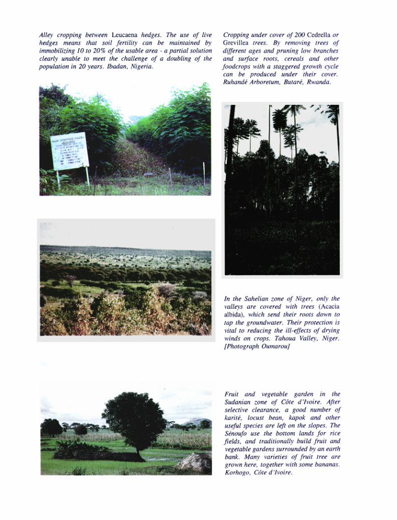


Chapter 8
Wind erosion
There is considerable wind erosion in West Africa in dry tropical zones where annual rainfall is below 600 mm, thedry season lasts more than six months, and steppe-type vegetation leaves large stretches of bare soil. It can alsodevelop elsewhere when the soil is being prepared and large amounts of surface matter are crushed fine.
PROCESSES [Plate 16]
The wind exercises a pressure on solid particles in repose. This pressure is exerted above the centre of gravity onthe surface exposed to wind and is opposed by a friction centred on the base of the particles. The two forcescombined tend to rock heavy particles (0.5 to 2 mm) and make them roll.
Moreover, the difference in speed between the top and bottom of particles means that they are drawn up-wards. The lighter particles rise vertically until the gradient of velocity is too low to bear them, at which point they fallback, pushed by the wind, following a subhorizontal curve. As they fall, these grains of sand transmit their energy toother grains of sand (as in a game of bowls) or degrade loamy-clay aggregates, releasing dust (Heusch 1988).
The three processes described below can be observed in the field when the wind-speed exceeds 15 to 25 km/h (or 4 to 7 m/s) depending on air turbulence (De Ploey 1980, Mainguet 1983, Heusch 1988) (Figure 58).
· Saltation of fine sand (0.1 to 0.5 mm): in this process, sheets of sand raised by violent wind travel severaldozen metres over smooth surfaces, leaving sheets of ripplemarked sand on the ground or small mounds ofsand trapped by plant tufts. These sand sheets lash at rocks in desert areas, giving them a typical mushroomshape (corrasion), and cause serious crop damage.
· Deflation: in this process light particles of soil (clay, loam and organic matter) are carried away in suspension.This dust is sucked up by vortices as high as several thousand metres, and then dispersed as a dry mist, or itmay travel several thousand kilometres as a dust cloud. This category covers both wind-borne loam torn fromperiglacial loess steppes, and the Sahara dust that falls in Montpellier three times a year and once or twice ayear in Paris.
· Creep: grains of sand 0.5 to 2 mm and too heavy to be sucked very high are thrown off balance by gusts ofwind, and rolled and dragged over the soil surface to the tops of dunes, which can advance several metres perhour in this way in strong winds.

FORMS OF WIND STRUCTURES
The form of dunes depends on the prevailing winds.
If the prevailing winds come from only one direction, the dunes can be straight, paralleling the coast(formed by the winds that sweep across the beach at low tide) or crescent-shaped, with the side toward the windgently sloped. In the second form, the wind pushes grains of sand up to the top of the gentle slope, and they then fall

on to the steep slope inside the semicircle. Dunes advance more slowly as they grow in size. According to studies byBourgoin (1956) along the route of the Mauritanian railway, dunes 3 metres high will advance between 40 and 80metres per year, dunes 12 metres high will advance between 12 and 35 metres, and those 24 metres high, between8 and 17 metres.
In order to avoid the risk of sanding-up, lines of communication are not taken through areas with live dunes.A 50-cm bank with a very gentle slope (1/5 to 1/10) is also built so that the wind speeds up as it crosses the road,preventing it from depositing sand. The wind-speed can be increased still further at particularly vulnerable points bysetting up 3 x 1 m deflecting panels at a 60° slant, or triangular cross-sectioned sand mounds 8 metres from the road,with the top and sides covered with a 20- to 50-cm layer of gravel.
If the prevailing winds are multidirectional , sand dunes can sometimes stretch several hundred kilome-tres; lying at a tangent to the wake of an obstacle, the Silk is oblique with respect to what could be termed the annualwind. During storms, sand travels along the dune, parallel to this structure, which continues growing in the samedirection (Mainguet 1983). The profile is of two steep slopes of moving sands, meeting in a sharp ridge.
There are also pyramidal dunes (ghourd) with several ridges leading down from the top, as evidence ofmultidirectional winds.
There are also hollowed dunes – corridors between two dunes where the wind pours through and digs outyardangs. The sheets of sand carried between the dunes in this way will be trapped by tufted plants, graduallyforming what are called nebkas, which continue to grow, eventually forming larger and larger dunes.
The material often comes from matter previously removed by water erosion – inland or marine sediment,products of weathering or disintegration of coarse-grained rocks, or else from soil finely powdered by tillage tech-niques, particularly the ill-advised use of disc ploughs, especially on volcanic soil (for example the basaltic soil ofNicaragua or the loam of the Great Plains in the United States).
EFFECTS OF WIND EROSION
· The first effect is the winnowing of light particles. Wind erosion is very selective, carrying the finest particles– particularly organic matter, clay and loam – many kilometres. The build-up of this alluvial matter stripped bythe wind from the periglacial steppes gave rise to the fertile loess soils that cover large areas of Europe andNorth America, where highly productive farming has developed.
· The most spectacular forms are dunes – mounds of more or less sterile sand – which move as the wind takesthem, even burying oases and ancient cities.
· Degradation of sedimentation crusts on the surface of stripped soils, or the weathering of rocks at their basewhere they are in contact with the soil (abrasion).
· Sheets of sand travelling close to the ground (30 to 50 metres) can degrade crops (particularly millet or cottonseedlings in semi-arid zones).

· Lastly, wind erosion reduces the capacity of the soil to store nutrients and water, thus making the environmentdrier.
FACTORS AFFECTING THE EXTENT OF WIND EROSION
· Aridity of climate. Wind erosion can also take place in high-rainfall climates when certain months of theyear are particularly dry (but only if the soil is tilled with techniques that crush the surface fine). It tends to beslight in Africa, however, except where rainfall is less than 600 mm; there are more than six months withoutrain; potential evapotranspiration exceeds 2 000 mm; soils have been left bare; and the vegetation shifts fromsavannah to steppe, with patches of bare soil.Wind-speed also has to exceed about 20 km/h or 6 m/s over dry soils. Wind erosion phenomena will increaseproportionately in the presence of strong, regular prevailing winds or gusts.
· Soil texture. Loamy sand, rich in particles between 10 and 100 microns in size, is the most vulnerable soil(Bagnold 1937). More clayey soil is much stickier, better-structured, and hence more resistant. Coarse sandand gravelly or rocky soils are also more resistant, since the particles are too heavy to be removed by winderosion. The optimum size for wind erosion is about 80 microns.
· Soil structure. The less structure-improving matter a soil has on the surface (organic matter, iron and freealuminium, lime), the more fragile it will be, while the presence of sodium or salt often leads to formation of alayer of dust on the surface, which fosters wind erosion.
· State of the soil surface. If the soil surface is stony, forming a “pavement”, the risks of wind erosion arelower – as, for example, in regs.A rough surface, left by cloddy tillage or ridges perpendicular to the prevailing wind, slows down the wind atground level, thus reducing saltation.
· Vegetation. Stubble and crop residues in the soil cut wind-speed at ground level.· Soil moisture increases cohesion of sand and loam, temporarily preventing their erosion by wind.
WIND EROSION CONTROL
Wind erosion control is carried out on two fronts: reducing wind-speed at ground level, and increasing soil cohesion,thus improving soil resistance to wind.
INCREASING SOIL COHESION
Applications of organic matter in the surface horizons improve soil structure.
Spraying the soil with refinery sludge, heavy oil or bitumen and plastics industry waste (for example, dilutedglue) binds particles to the soil surface making it difficult for the wind to remove them (Gand University experi-ments).

Where there is enough water, supplementary irrigation can be an effective and financially viable way ofreducing erosion problems. Irrigating the soil prior to the normal rainy season is enough to allow favourable tillageconditions and establish plant cover before the destructive tornadoes which generally come at the start of the rainyseason.
INCREASING ROUGHNESS OF THE SOIL SURFACE
This entails cropping techniques that leave large clods on the soil surface or ridges perpendicular to the direction ofthe prevailing wind – although ridges must not be more than 40 cm high or the wind will lop off their tops, thusspeeding up erosion.
Another very effective control method is that of leaving crop residues in the fields. In Burkina Faso, forexample, when millet and sorghum stubble is cut at a height of 1 metre and left vertical to the soil surface, it traps alarge amount of dust, together with leaves that tornado winds have blown off the trees.
INCREASING PLANT COVER
Wind-speed can also be cut by increasing plant density. Since this is clearly not easy in arid zones, it is particularlyimportant to ensure sound crop residue management, keeping residues on the ground so as to increase roughnessand protect the soil surface, rather than ploughing in, which would only slightly improve soil structure and resistanceto wind. In the semi-arid tropical conditions of West Africa, the large natural stands of Acacia albida so prevalentin cultivated zones generally provide fairly effective protection against wind erosion in these fragile areas by cuttingwind-speed at ground level, and also shedding leaves onto the ground. Unfortunately, most of these stands are madeup of between 25 and 40 very old trees per hectare and are in urgent need of regeneration. Planting 100 to 150 youngtrees along the defence lines against water erosion would give a good density of adult trees. In areas subject toviolent blows from a regular direction, hedges and wind-breaks are well-known methods.
WIND-BREAKS
Their role is twofold: they cut wind-speed to reduce both evaporation and wind erosion. The effect of cutting wind-speed by 20% is operative over an area 10 to 12 times the height of the barrier before and behind it.
This protection depends on the permeability of the wind-break, for relative impermeability reduced speedmore, but over a smaller area. According to Heusch (1988), if the speed is cut too much by very close planting, thetemperature rises and crops are scorched along the wind-break. It would be better to regenerate a stand of about 40adult trees to cut the wind-speed more regularly.
In principle, wind-breaks reduce evapotranspiration by up to 20% (although the water consumption of thewind-break itself can offset this positive effect), hence the attraction of wind-breaks around irrigated crops. In theKeita Valley in Niger, a marked rise in yields (+27%) is seen except in the direct vicinity of the wind-breaks, wherethe millet suffers from root competition with the roots of the wind-break (shade and competition for water).
The best arrangement would be two rows of tall trees surrounded by two rows of low trees, making up a 10-metre strip (Figure 59b), half of which is logged at a time. The cropped area between wind-breaks can be as wide


as 100 metres if the tall trees are over 5 metres. Root competition is reduced by breaking the young horizontal rootsof the trees from the first year onwards by raking the tillage furrow. It is particularly important to repair breaches ina hedge to keep the wind from pouring through at these points (the Venturi effect) and considerably reducingeffectiveness.
When the trees are cut, it is best to leave two metres above the ground so that livestock do not destroy newshoots.
The most commonly grown tree species in Africa are eucalyptus, casuarina, neem, various acacias, tama-risk and cypress – although cypress is susceptible to a serious disease. Reeds of various kinds can also be useful.
A wind-break does not have to be very thick: the thicker it is, in fact, the more impervious – and thus the lesseffective – it becomes. At a distance of 10 times the height of the barrier, the wind-speed on the leeward side is 56%the speed of the local wind behind a line of reeds, 72% behind a 20-m thick wind-break, and 83% behind a 600-mwide forest strip (Combeau 1977).
In Niger, Renard and Van den Beldt (1991) noticed that huge quantities of sand were trapped in the strips ofAndropogon surrounding their trial plots, and they therefore suggest that farmers should surround their fields witha double row of Andropogon. Elsewhere, low crops such as groundnut and cotton are protected by interspersingthem with rows of millet and sorghum, which can reach a height of 4 m. Lastly, although the initial objective of wind-breaks is that of reducing evaporation caused by the wind, they also help to reduce the amount of solid wind-bornematter. The wind must be able to pass through them and not set up eddies, and they must combine species withcomplementary forms and heights and in sufficient numbers, so that they can be logged in succession and regularlyrenewed (Figure 59).
DUNE FIXATION
The point of dune fixation is to eliminate the source of sand and to keep the dunes in place, using both mechanicaland biological methods. In places where dangerous winds come from only one direction, wind erosion can bestopped by rows perpendicular to this wind at distances of 20 times the height of the rows. So if millet or sorghumstalks 1 to 1.5 metres high are used, rows should be spaced every 20 metres, or the wind will take up sand betweenthese lines of defence. This means that large amounts of material are needed (millet stalks, oleanders which grow inwadis, palms, or prunings from the forest trees or shrubs found in the region), and the removal of this material helpsto degrade the area. If – as is often the case – the dangerous winds come from a variety of directions, the use ofgrids of permeable plastic sheeting with a 5- to 10-mm mesh and a height of 50 to 80 cm is indicated. The strongerthe winds, the smaller the grid, ranging from 5 x 5 m to 8 x 8 m in normal conditions. Some plastic sheeting, scorchedby UV rays, turns to dust after two years, and is therefore to be avoided, while some black UV-resistant plastic canbe used for two years on one site and then moved to another. The main problem is to stretch it and to have solidenough stakes to hold it (12-mm reinforced concrete posts). As soon as this grid is in place and the soil surface hasbecome more stable, a variety of grasses and shrubs must be planted inside it to restore plant cover and definitivelystabilize the dune.

Another inexpensive method well suited to West Africa is that of sowing rows or grids of millet or some otherfast-growing plant in the rainy season, thus giving the soil further stability. If the survival of these fragile planted plotsis to be assured, it is obviously vital to protect them against grazing and fire, although after five years some light andwell-supervised grazing may be possible.
In France, the first attempts to stabilize coastal dunes were made in the 16th century, when the town ofBayonne had a sand-loving plant sown on the live dunes at Cap Breton, followed by reforestation with sea pines. In1786, Bremontier, a public works engineer, initiated measures to fix the sandy heaths near Arcachon, by havingbranches of broom spread over the sand, and sowing with pine. These attempts were so successful that work thencontinued until 1876, covering 80 000 ha and costing 9.6 million “gold francs” plus 3.5 million for the creation andupkeep of a long, protective coastal dune to cut the wind-speed and allow the pines to grow.
This protective dune 50 metres behind the high water mark has a bank with a 20% slope facing the westwinds and planted with Ammophila arenaria, then a flat top, with a palisade on posts along its axis, then a crumblingbank of sand. When the fence is about to be capped by deposits, it is raised again with a gin, until the dune eventuallyreaches a height of 10 metres (in 10 ± 2 years). In front and to the sides, wattling marks off the area to be stabilized,and seeds are broadcast inside this area, after which the soil is covered with branches of pine, gorse, heather orbroom laid one over the other like tiles on a roof, with the thick ends of the branches pushed into the ground towardsthe wind.
One hectare will take 25 kg of pine seed, 15 kg of broom seed, plus gorse and Ammophila, 120 000 15-kgbundles of branches, and 120 days of work, plus the cost of creating the fence (Heusch 1988, p. 184).
CONCLUSION
It is interesting to see how similar wind and sheet water erosion are in terms of the processes involved, the effectson the soil, and the factors and control methods. Indeed, an equation very similar to the USLE has been drawn upto forecast wind erosion. Wind erosion assumes significant proportions only when the wind carries a load ofsand grains which bombard the bare soil surface, and sheet erosion occurs when rain splashes on naked soil.Both forms of erosion selectively carry off fine particles from the soil surface, and both are eliminated bymulching the soil or by providing an adequate plant cover. Both processes lead to a reduction in fine particles inthe surface horizon – or scouring of the whole horizon in the most extreme cases. The factors that can be broughtinto play are soil cover, pervious barriers that allow the medium (water or air) to filter slowly, and improvement ofthe structure, cohesion and roughness of the tilled horizon. The control methods are therefore very similar:hedges, wind-breaks, keeping crop residues on the soil surface, thick plant cover, coarse tillage, mounding or tiedridging, reduction of the length of fields exposed to prevailing winds or runoff, organic or mineral applications(lime or gypsum), etc. This is why this publication is confined to general principles, referring readers to the manymanuals giving details of plant species suited to local dry conditions.

PART THREE
Case studies
LAND HUSBANDRY ENCOURAGES REGIONAL DIVERSITY IN EROSION CONTROL DEPENDING ON ENVIRONMENTAL, SOCIAL AND ECONOMIC CONDITIONS
In Part One of this work the variety of forms that erosion can take in terms of both space (the effect of scale) andtime has been emphasized.
It was shown how serious the economic impact of erosion can be for a regional community, especially interms of downstream damage caused by peak runoff flows, deterioration in the quality of water, and siltation ofreservoirs and river beds as suspended load is deposited. Degradation of cultivated land and loss of productivity onsoil exposed to erosion vary widely depending on soil type, amount of rainfall and topographical position. An historicalreview of erosion control strategies shows that for thousands of years humanity has demonstrated a capacity toadapt to changes in environmental and human circumstances – in this case, to erosion crises. However, the accelerationof demographic, social and economic change in recent decades has led to a new erosion crisis, with causes that varyfrom those in large-scale field-crop regions (excessive mechanization, ill-suited to local conditions) to those in semi-arid, extensive agropastoral regions (degradation of plant cover and of organic matter in the soil) or densely populatedmountainous regions (increasingly intensive farming with no balanced input of nutrients).
Erosion control is thus not simply a technical problem (and in any case effective techniques are still unavailablein many places), but is in fact primarily a human problem. This has led to proposals for a new approach based onsolving immediate needs (increased productivity of both land and labour) while guaranteeing the future through thebest management of available water, biomass and nutrients.
In Part Two the five main types of erosion are briefly examined, noting the causes and factors determiningthe extent of each, and outlining some of the principles of erosion control. (Specific methods have been described indetail in many manuals: CTFT 1969; Hudson 1973; Heusch 1988; Hurni 1986.) Closer concentration was placed onthe difficulties of controlling sheet and rill erosion – in other words, the initial forms, which farmers can control ontheir plots.

The success or failure of such control generally depends on measures taken at the field level, and it is herethat peasant farmers’ skill is demonstrated in making the best of their physical, social and economic circumstances,developing widely varying techniques for managing water and soil fertility.
Wischmeier and Smith’s empirical model has been used to provide a consistent framework for analysis of thecauses and contributing factors in sheet (and rill) erosion. The value and limitations of this empirical model have beenpointed out: its systematic approach allows definition of the risks of sheet erosion on fields with an average slope (1to 20%) and a less empirical approach in suggesting a range of methods for reducing average soil loss over a 20-yearperiod to a theoretically acceptable level; it takes no account of exceptional rainfall (typhoons with strong winds,tropical tornadoes with 500 mm of rainfall in one to three days), interactions between different functional sections ofa toposequence (water accumulation on the lower part of a slope), steep slopes (> 20%) where the energy of runoffsupersedes that of rainsplash, or, most especially, regional variations in cultural, social and economic conditionsaffecting the choice of soil conservation methods.
This is the reason why this third part expands the picture of the variety of problems and approaches toconservation to include a wide range of environmental conditions (temperate, semi-arid Mediterranean or Sudano-Sahelian climate, subequatorial forest or over-populated mountainous zone, etc.) and human circumstances (developedor developing countries, population pressure varying from 10 to 700 inhabitants per km2). A set of case studies byFrench-speaking experts working in very different regions is used to demonstrate the ways in which land husbandrycan meet present needs for increased land and labour productivity, while improving the rural environment. Since landhusbandry is a relatively recent concept, the choice of examples is still limited, and the perspective is not yet broadenough to draw any definitive conclusions from these trials.
Chapter 9 compares the environmental conditions and soil degradation problems along a whole bioclimaticsequence starting from the subequatorial zone of southern Côte d’Ivoire, crossing the Sudano-Sahelian zones ofMali and Burkina Faso, and ending with the Sahelian zone of West Africa.
In Chapter 10, J.M. Fotsing describes the development of the Bamiléké bocage in south-western Cameroon,where erosion is inversely proportionate to intensification of agriculture.
Chapter 11 reports the present state of research on the integration of agroforestry and subsistence farmingamong very dense populations (150 to 800 per km2) farming the steep slopes of the Milles Collines region ofRwanda.
Chapter 12 moves to Haiti, describing the implementation of a land husbandry approach based on the people’sparticipation in a whole system of rural development.
In Chapter 13, a Franco-Ecuadorian team analyses the situation of peasant farmers on the volcanic Cordillerasof the Andes, and describes solutions recently developed by these farmers.
Chapter 14 gives the initial results of an INRF-ORSTOM Franco-Algerian team’s research, which seeks todefine erosion risks and develop intensive farming on the steep slopes of the semi-arid Mediterranean mountainregions of northern Algeria.

Lastly, in Chapter 15, J.F. Ouvry, an agricultural scientist working with AREAS, describes the problemsinvolved in the management of surface water in intensive field-crop areas on the temperate plains of northernFrance.
This aim will have been achieved if at the end of this third part the reader has become aware that it is notenough to apply solutions that have had some (unverified) positive effects in some other part of the world.
No erosion control measures can be envisaged without close analysis of:
· the comparative risks of different kinds of erosion;
· existing traditional methods of managing water and nutrients and restoring soil fertility;
· demographic and/or socio-economic problems, as well as land-tenure and political difficulties linked to theerosion crisis;
· means of increasing production of biomass;
· costs, and the capacity of farmers and/or communities to invest in a land husbandry strategy.


Chapter 9
The wide range of erosion control strategies in West Africa: from subequatorial forest to Sudano-Sahelian savannah
AN EXAMPLE OF AN AGROCLIMATIC SEQUENCE
If a line were drawn from Abidjan to the Sahel a wide range of traditional farming systems would be found along thisline.
In the Guinean forest zone of Côte d’Ivoire, there are small mounds on which cassava, maize, groundnut,okra, etc. are multicropped.
In the Sudanian tree savannah of northern Côte d’Ivoire, the Sénoufo shift huge amounts of soil, forming verylarge mounds (about 80 cm high) to grow tubers (yam, cassava). In following years the fields are ridged with cropresidues placed in the furrows and covered with soil from the mounds.
Three hundred kilometres further north, the Miniana in the Koutiala region of Mali reduce tillage to a fairlyhasty ploughing following by two surface hoeings.
Another three hundred kilometres further north, the Mossi of the Sudano-Sahelian tree savannah region ofOuahigouya practice direct drill seeding and then flat-hoe.
Lastly, in the sandy zone of northern Yatenga, the Peuhl practice surface sod seeding on untilled ground, andthen use hoes to make mounds between the plants in order to concentrate water around the millet planting holes.
This wide range of farming techniques is not the outcome of chance, but of the long adaptation of each groupto the environment in which it lives. The longer people have been settled on a given site and the harsher their livingconditions, the more they will have developed strategies for managing water, biomass and soil fertility that are suitedto their environmental, social and economic situation. It would seem that where farmers have developed very fewspecial techniques, this is often because they have recently migrated from a place with very different problems. Forexample, in Cameroon the Capsiki, farmers in the Mandara mountains near Mokolo, build bench terraces and low

stone walls on steep slopes in an extremely densely populated area. When these people are shifted to the under-populated Sudanian zone of south-eastern Bénoué, beyond Tcholliré, they completely abandon their techniques forwater and soil fertility management.
Traditional farming techniques are usually very well adapted to the environmental conditions of the locality –as can be seen by comparing the water balances of the various areas.
These traditional strategies have now been largely abandoned, and are indeed no longer adequatefor coping with the problems of soil degradation arising from population pressure: the population is doubling everytwenty years in Sahelian savannah and mountain zones. Fortunately, part of this population is migrating into Sudanianzones, thereby relieving pressure on land in the very vulnerable Sahelian zones. Nonetheless, study of traditionalstrategies provides a good basis for the development of new strategies of water and soil fertility manage-ment in order to counteract soil degradation, runoff and erosion, which are all closely linked. The failure of a numberof erosion control schemes would quite probably have been avoided if traditional methods had been studied moreclosely and an erosion control strategy more in tune with local environmental, social and economic conditions hadbeen proposed in place of the generalized imposition of methods developed during the 1930s for mechanized farmingin the United States.
The following pages briefly describe ten different situations, with the treatment used for each, depending onthe type of land management, general environmental conditions (especially the water balance for each type of crop)and social and economic conditions (especially population pressure) [Plate 10].
EROSION CONTROL IN THE SUBEQUATORIAL FOREST ZONE OF THE ABIDJAN REGIONOF SOUTHERN CÔTE D’IVOIRE
TRADITIONAL FARMING TECHNIQUES
Following gradual land clearance over five years, Ebrié farmers build small mounds 30 cm high in February, wellbefore the rainy season. These mounds allow them to plant a combination of crops that are complementary in bothtime and space: on the one hand, cassava cuttings, which take a very long time to cover the ground, and, on the other,very fast-growing crops such as maize, groundnut, okra and tomato, which cover the mounds quickly, are harvestedin three or four months, and then leave growing space for the cassava. Mounding has several purposes: apart fromdrainage and the accumulation of humus so that the tubers grow well, it also organizes drainage and collects fertiliz-ing elements around the crop. And this mixed cropping means that the soil is covered for two years.
A bush or tree crop – coffee, cacao, palm or rubber – is also often introduced under this cover of more or lessannual crops. When the soil is exhausted, it is abandoned to fallow or the tree crop, making sure that the under-storey is cut back under the trees. The number of shade trees may be reduced after a short while, but palms and kolatrees are retained.
ANALYSIS OF LOCAL CONDITIONS
Such landscapes are composed of convex hills, with typical half-orange forms and convex slopes which may reach40% at the edges, and flat, sandy, hydromorphic lowlands. Soil on the hills is ferralitic, sandy-clayey, and veryresistant to sheet erosion (K = 0.10). This soil is permeable but very acidic and chemically impoverished.

Annual average rainfall is about 2 100 mm, spread over ten months; the maximum monthly rainfall is in June,with 700 mm, and annual drainage is 1 000 mm. Evapotranspira-tion is low (1 200 mm). Daily rainfall may reach 250mm once every ten years.
HAZARDS
At the top of gently sloping hills there are two risks:
· soil degradation from the rapid mineralization of organic matter, rainfall impact, and skeletonization of thesurface horizon;
· acidification due both to abundant drainage and to leaching of fertilizing elements.
On steep, convex slopes, the previous hazards are combined with that of gullying. And in the valley bottomsthe hydromorphic soil is prone to waterlogging in the rainy season and parching in the dry season. As these areas areoften peaty and sandy, the soil is very acid, which has to be corrected.
SUGGESTED IMPROVEMENTS (Figure 60)
The neatest solution to the problems of degradation of organic matter and acidification is to cover the soil perma-nently with tree crops, with a cut-back under-storey grazed by livestock to some extent. On gently sloping up-lands root and tuber crops providing less ground cover may be planted (cereals, cassava or various food crops), theaim being to cover the soil in order to minimize surface degradation and slow down runoff.
The second point is to fertilize root and tuber crops with staggered applications of both organic and mineralfertilizer: drainage is so copious during the rainy season that most of the nutrients added to the soil are drained off inJune and July, unless the crops are able to take up and store them in their tissues.
The third point is to restore the amount of organic matter in the soil, either by cutting the under-storey, diggingin crop residues, or, better, keeping crop residues on the surface and mulching.
It is important to plant early and closely, and to plan both mineral and organic applications – which must bestaggered in view of the risk of removal by drainage, the poor storage capacity of the soil and the physiological needsof the crops, rather than deficiencies in the soil. Lime is needed if the pH is below 4.8, in order to avoid aluminiumtoxicity.
On steep slopes, apart from the risks outlined above, it is essential to ensure a permanent cover of pastureland,or, if possible, tree crops with an under-storey of legumes (a mixture of Pueraria and Centrosema). If there is nochoice but to grow food crops here, either the whole slope should be mulched, or hedges should be planted and theprunings used to cover the ground with a permanent light mulch.


In the valleys, the problem is that of organizing drainage of excess water during the rainy season, digginglateral channels to catch water from slopes, and providing irrigation during the dry season, especially for bananaplantations and horticulture. Staggered applications of organic matter, lime and mineral nutrients must be planned,taking account of the risk of their removal by drainage.
EROSION CONTROL IN THE HUMID, TROPICAL, SUDANIAN SAVANNAH OF KORHOGO INNORTHERN CÔTE D’IVOIRE
TRADITIONAL FARMING TECHNIQUES
After selective, gradual clearing by burning over several years, the Sénoufo build large mounds as high as 60 to 80cm to grow yam or cassava.
During the second, third and fourth years, the farmers place weeds, crop residues and assorted biomasselements between the mounds, covering them with earth, taking half a mound from either side. This forms new largeridges on which they intercrop maize, sorghum and groundnut with various secondary crops such as tomato, tobaccoand okra.
The fields form a patchwork of small ridged plots with tied edges. When rainfall is excessive, the water runsinto a drainage ditch, which unfortunately often turns into a gully. The direction of the ridges is seen as irrelevant,varying from one field to another.
The Sénoufo have a long tradition of agroforestry, and when they are clearing land, they retain a whole seriesof trees of recognized value: locust bean, karité, kapok, baobab, Daniela olivieri and many others. As the yearspass, they protect the stumps of these trees while cutting them back to allow food crops to be grown.
In the hydromorphic valley bottoms, the Sénoufo grow irrigated rice, digging a feeder channel down the sideof the valley, with side offtakes for excess water, and central drainage capable of carrying off large amounts ofwater during the wettest months.
ANALYSIS OF LOCAL CONDITIONS
Average annual rainfall ranges from 1 000 to 1 400 mm. The heaviest monthly rainfall can reach 400 mm for anannual volume of drainage of 400-200 mm. The aggressiveness factor is very high at 700 to 500 – and at ten-yearlyintervals rainfall in a single day can reach 140 mm. Risks of leaching and erosion are therefore considerable,although reduced by a luxuriant vegetation.
The landscape is composed of lateritic tabular hills or granite domes surrounded by scree slopes of large rocksand long sloping pediments of red or ochre ferralitic soil, with gradients decreasing from 5 to 1%. The soil in thevalley bottoms is hydromorphic, sandy and humus-bearing. Traditionally this low-lying land was used as a reservesupply of green forage for livestock during the dry season, but in the past 50 years a large proportion has been givenover to irrigated rice, increasing the danger of overgrazing on the slopes. The soil on the hills is ferralitic, verydesaturated, often gravelly, and resistant to erosion, but acid and chemically very impoverished. Although the wholeprofile is ferralitic in type, the top horizons are at present in the process of changing into more ferruginous tropical

soils. Toward the foot of the slope is a spring line, and below this is the greyish, hydromorphic and generally sandy-clayey soil used for rice growing.
HAZARDS
The soil on the hills has a good structure and good drainage. It is exposed to risks of acidification through use offertilizers, degradation of organic matter (like all tropical soils, and leaching caused by extensive internal drain-age. If this soil is mechanically tilled it gradually loses most of its organic matter and its resistance to the impact of

rainsplash, becoming prone to erosion and runoff. On steep slopes, in heavily populated areas with overgrazing andlate fires, gullies tend to develop on the lower part of slopes. On the central cropped pediment, apart from thedangers of soil degradation, acidification and leaching, sheet erosion can turn into gullying. Moreover, the runofffrom the hills can also waterlog the surface soil and rot tubers.
SUGGESTED IMPROVEMENTS (Figure 61)
In the ironstone uplands, scree slopes and broad gravel pediments, forestry potential can be improved by plantingcashew, teak and forage trees.
Small fruit gardens, irrigated from wells, can be planted around dwellings, which are very numerous in thisregion. Indeed, below the gravelly layer there are alterites which stay moist almost to capacity on the fields through-out the better part of the year. Cisterns could be dug at the foot of this zone to lighten the task of drawing water forlivestock and village use (permanent water tables lie at a depth of between 10 and 30 m).
So far as the cultivated section is concerned, it is best to keep small ridged fields on gentle slopes, tying themto some extent, and possibly sowing rainfed rice in the furrows. Grass strips with trees (which will act as greenstakes) or hedges should be planted around fields to keep out wandering livestock. Spillways also have to be built tocarry off excess water during the wettest months, and to act as grassed pathways for removal of produce during thedrier months.
Rice fields can be laid out in the valley bottoms with two side channels collecting water flowing from thespring lines and river water upstream. The centre of the valley is the central drain through which the river flows, andthis will carry off excess water. Fruit and vegetable gardens can be created on the edges of the valley, not far fromthe spring lines. Lastly, it would be wise to plan a dry-season fodder crop on the rice fields and in the wetter parts ofthe valley, planting hedges in order to control livestock more effectively.
EROSION CONTROL IN THE TROPICAL SAVANNAH ENVIRONMENT OF THE KOUTIALAREGION OF MALI: strictly rainfed farming
TRADITIONAL FARMING TECHNIQUES
In times past the Minianca traditionally used the sandy and even the gravelly land at the top of hills, building theirvillages on lateritic ironstone in order to avoid being surprised by possible enemies. Nowadays, with mechanizationand animal traction, they prefer to farm the loamy-sandy sloping pediments, and tillage is confined to one passagewith the plough and two with the hoe, mounding at the same time.
Animal husbandry is always extensive. During the rainy season a shepherd (often an outsider) takes thevillage animals to the grazing lands. During the dry season livestock live off crop residues and any greenery remain-ing in the valley bottoms.
In the evening cattle are gathered in paddocks protected by a dead hedge. Dried dung trodden into powder bythe animals’ feet accumulates in these paddocks. Wood requirements have so far been met by taking it from the
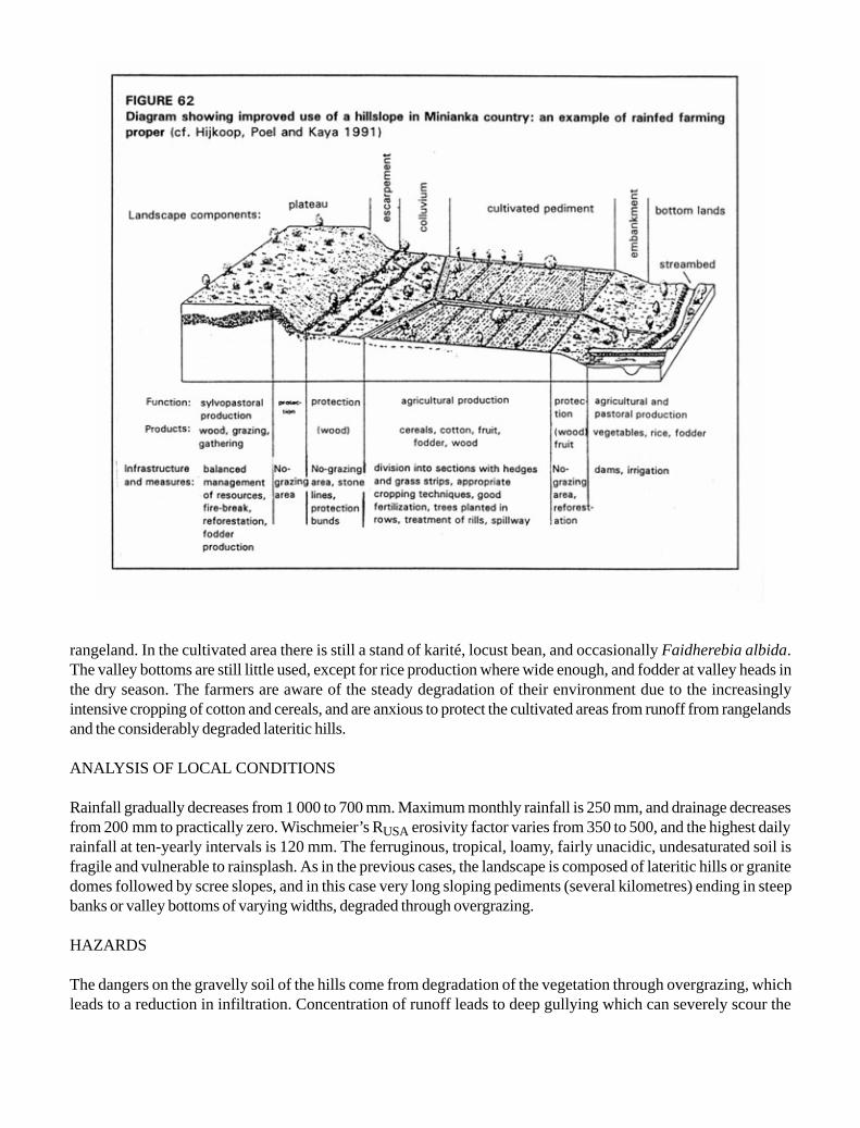
rangeland. In the cultivated area there is still a stand of karité, locust bean, and occasionally Faidherebia albida.The valley bottoms are still little used, except for rice production where wide enough, and fodder at valley heads inthe dry season. The farmers are aware of the steady degradation of their environment due to the increasinglyintensive cropping of cotton and cereals, and are anxious to protect the cultivated areas from runoff from rangelandsand the considerably degraded lateritic hills.
ANALYSIS OF LOCAL CONDITIONS
Rainfall gradually decreases from 1 000 to 700 mm. Maximum monthly rainfall is 250 mm, and drainage decreasesfrom 200 mm to practically zero. Wischmeier’s RUSA erosivity factor varies from 350 to 500, and the highest dailyrainfall at ten-yearly intervals is 120 mm. The ferruginous, tropical, loamy, fairly unacidic, undesaturated soil isfragile and vulnerable to rainsplash. As in the previous cases, the landscape is composed of lateritic hills or granitedomes followed by scree slopes, and in this case very long sloping pediments (several kilometres) ending in steepbanks or valley bottoms of varying widths, degraded through overgrazing.
HAZARDS
The dangers on the gravelly soil of the hills come from degradation of the vegetation through overgrazing, whichleads to a reduction in infiltration. Concentration of runoff leads to deep gullying which can severely scour the

slopes. On the cultivated sloping pediments, apart from soil degradation through mineralization of organic matter andrainsplash, there is also gullying from the hills, the deposition of stretches of sand and gravel, and the skeletonizationof the surface horizon from very frequent tillage. In the hydromorphic zone in the valley bottoms, the risks are thoseof degradation through overgrazing, gullying of the bed, and siltation from gullies spanning the entire cultivated area.
SUGGESTED IMPROVEMENTS (Figure 62)
Runoff on the ironstone uplands must be checked by stone lines, grass and forage bushes regenerated, and fodderresources restored. At the bottom of this area, cisterns could be dug in front of the protection dikes that now collectrunoff water over 400 metres and lead it toward spillways to divert it during the excessive rains of August. Thespillways double as paths during the cotton harvest in the dry season.
In the zone of the broad sloping pediments, grassed spillways are needed to divert runoff and to bring out theharvest. Plots must be bordered by hedges and trees, organic matter and nutrients balanced on plots, and fullabsorption encouraged through deep tillage followed by tied mounding. In the valley bottoms fertility must be re-stored through organic manure and fodder crops to improve the production of fruit and vegetables. And in the rice-growing sections, a second, dry-season crop could be grown, allowing deep-rooting plants to draw on water storeddeep in the soil. This last section can be improved by using bunds made of earth and clumps of grass to help leveleach plot perfectly. The main problem in these lowlands is often the flooding caused by heavy rains, and a centralchannel is therefore needed to drain the whole valley bottom.
EROSION CONTROL IN THE SUDANO-SAHELIAN SAVANNAH OF THE OUAHIGOUYA REGIONOF NORTH-WESTERN BURKINA FASO: runoff farming
TRADITIONAL FARMING TECHNIQUES
Mossi farmers behave like pioneers, clearing and burning nearly all the trees, save a few acacias, Sclerocaryabirrea, baobabs, etc.
At the time of the first storms of the rainy season, and without tilling the soil, they drill-seed sorghum on thebest land and millet (plus some groundnut and cowpea) on sandy or gravelly land, in holes every metre. They resowas many as five times if necessary and then hoe once or twice. On the sandy soil in the north, hoeing is combinedwith clearing around the roots, thus improving infiltration around the clumps of millet.
The farmers treat exhausted soils with applications of organic material (2 to 5 t/ha of dried, powdered pad-dock dung and household ash) or a mulch of cereal stalks and branches of pulses unattractive to livestock, such asPiliostigma reticulatum and Bauhimia refuscens, and then leave the land as grassland.
They use the zaï method to restore exhausted land, catching runoff in a small pit that contains some organicmanure. The tunnelling activity of termites allows this organic matter to trap 100 mm of water after the first storms(Roose and Piot 1984; Roose and Rodriguez 1990; Roose, Dugué and Rodriguez 1992).


The traditional use of boulis or water tanks several dozen cubic metres in size, with the earth being dug outand spread downhill in a half-moon shape, also allows them to collect some of the runoff from the hills to waterlivestock near the rangeland and irrigate a small garden (Dugué 1988). Where land is short, the Mossi farmers usea system known as zipelle in which stone lines are arranged in a honeycomb pattern to rehabilitate eroded, bare andcrusted surfaces where even natural vegetation can no longer grow through lack of infiltration. These lines ofstones, grass or stakes slow down runoff and encourage the deposition of organic matter and coarse, permeablesediment. From the second year, the sandy horizon so formed is tilled, manured and planted – and as much as 800 kg/ha of sorghum is often harvested (Wright 1985).
As in the previous case, livestock are moved to the rangelands during the rainy season. After the harvest, theanimals are fed crop residues, but are then left to shift for themselves, wandering over the area at will.
ANALYSIS OF LOCAL CONDITIONS
Annual rainfall decreases from 700 mm in the south to 400 mm in the north. Maximum monthly rainfall rarelyexceeds 100 mm, and drainage is only occasional – between 50 mm and zero. Rainfall aggressiveness decreasesfrom 400 to 200 on the RUSA scale, and the maximum rainfall in a single day over a ten-year period rarely exceeds100 mm. The landscape is very like that in the previous case, but is composed of lateritic hills or granite domes, andvery long, broad, sloping pediments with valley bottoms of varying breadths. On the hills, the gravelly lithosols areironstone to varying degrees over deep alterite, and contain very little water. On the other hand, the deep alteritesunder the gravel sheets are moist throughout the year. The broad, sloping pediment is composed of leached, tropical,ferruginous soil, loamy-sandy on the surface and more clayey at depth. The valley bottoms are hydromorphic andsandy or loamy.
HAZARDS
As little is stored in the gravelly lithosols of the lateritic hills, overgrazing leads to degradation of the vegetation,which in turn reduces the activity of mesofauna, forms slaking and sediment crusts on the soil surface, and encour-ages heavy runoff leading to gullying. The cultivated sections often present an advanced degradation of soil fertility,acidification and skeletonization of the surface horizon, which becomes very sandy, easily eroded and vulnerable torainsplash. Sand and gravel from gullying on the hills are also deposited on these sections. The soil has a verydepleted stock of nutrients, so that crops must be nourished as and when needed. The general degradation of the soilin the valley bottoms through overgrazing and cropping with no restoration of organic matter or nutrients is also to bedeplored. Added to this, the gullies upstream lead to gullying of the river bed and/or generalized siltation of the valleybottom. The broad bottom lands are difficult to manage, since they are flooded for several days during the heaviestrainstorms two years out of three.
SUGGESTED IMPROVEMENTS (Figure 63)
Improvement of the rangelands on the ironstone hills and gravel pediment may be achieved by reforestation with thehelp of forage shrub species, if a partial ban on grazing can be organized for five years. Such improvements can beassisted by slowing runoff with stone lines and replanting grass, first scratching the dry ground with a prongedsubsoiler, and spreading organic débris (twigs, bark, straw) or stones to trap water, sand and seeds. If the soil is too

degraded, subsoiling along the tree-planting lines can have a lasting effect, at least on the gravelly pediment. Lastly,runoff storage can be improved either by building half-moons or total absorption ditches, or by digging out thecisterns known as boulis to obtain water for livestock or for irrigating a small garden.
With respect to the cultivated area on the loamy-sandy pediment, stop-wash lines can be set up every 20 to 25m, and hedges planted around the fields, with trees every 5 m to build up a stock of karité, Acacia albida and variouspulses. The stop-wash lines can be made of rows of stones or grass, the long-term objective being the creation of alandscape in which sufficiently large crop fields are surrounded by hedges so that livestock can be kept on the fieldsduring the periods when the animals eat crop residues, or off them when the soil has been prepared and the crops aregrowing.
In the irrigated valleys, filtering dams built at valley-heads will spread flood waters, trap some of the waterand sediment, replenish the water table, and increase food security by providing off-season water to vegetable andfruit gardens. Where the valley is larger, with a catchment area of several square kilometres, earth bunds can bebuilt to retain enough to provide water for the village. This method of semi-pervious microdams improves yields andcontributes to the food security of these very poor regions which have practically no cash crops. Furthermore, thesuggested improvements are very inexpensive and within the reach of any farmer.
EROSION CONTROL IN THE NORTHERN SAHLEIAN ZONE AROUND THE DOTI MARCHESIN BURKINA FASO: valley farming
TRADITIONAL FARMING TECHNIQUES
In this zone with under 400 mm of rainfall, conditions contrast greatly with those in Sudanian zones. Rainfall is moreerratic and falls on a small area. While there are several methods of collecting rainwater or runoff to grow trees andcereals in the wide runon areas in the Mediterranean environment of the northern Sahara where rain falls during thecold season, water conservation strategies are few and less easily apparent in the tropical Sahelian zone where rainfalls in the hot season. Strategies focus on choosing crops according to the soil (millet on sand, sorghum on loam andin the bottom lands, and irrigated gardens around the wetlands) and on taking advantage of storms when these occur(very light tillage, but with repeated sod-seeding, requiring very little seed [3 kg/ha] or work [9 h]) with large areasbeing sown, although a good proportion may be abandoned when it comes time to do the hoeing.
A frequent survival strategy is short-distance migration in order to gather wild crabgrass or water-lily bulbs.Homes are on the cultivated fields from November to August, near granaries and milking places. Herds are system-atically moved to temporary pastures.
This region depends essentially on the extensive pasturing of herds, which are moved as seems most advan-tageous. The use of crop residues and even animal excreta as fuel demonstrates the severe lack of wood in thiszone.

ANALYSIS OF LOCAL CONDITIONS
Rainfall varies from 400 to less than 150 mm, the maximum monthly rainfall is roughly 175 mm, drainage is calcu-lated as nil, the erosivity factor is under 200, highest daily rainfall in a ten-year period is 80 mm, and the populationdensity drops sharply to less than 10 per km2.
The landscape is composed of dioritic hills followed by a broad, sloping, sandy, then loamy, pediment, terminat-ing in the region of the pond. Small dunes form around clumps of grass and bushes on the sandy pediment. Some oldFaidherbia albida and other thorny vegetation still survive on the loamy pediment, especially where the water tableis not too far down. Soil is lithomorphic on the mountains and sandy on the dunes, with sub-arid, brown-red soilsaround the marshes. Traditional techniques entail flat-sowing millet on sand and sorghum on the clayey lowlands,and using the slopes as extensive pasture. Gardens are planted in the lowlands, with a certain amount of floodrecession cropping all around the pond.
HAZARDS
The main risk in the sandy zone is wind erosion along with degradation of vegetation from both overgrazing and thewind erosion. Rainsplash on the sloping loamy pediments results in very extensive runoff, which digs small gullies.
SUGGESTED IMPROVEMENTS (Figure 64)
In this extremely fragile environment, it is dangerous to advise the development of an agropastoral system to matchpopulation growth. Development appears to be blocked today, since almost all the possible land is now being farmed.Fallow periods are disappearing, the soil is becoming exhausted, and the cost of inputs (mineral fertilizers and short-cycle varieties) is only economically viable in years when rainfall is abundant and well distributed. However, thefollowing measures could be tested on an area such as that at Ségué in northern Yatenga:
· planting hedges or thorny fodder species in sandy areas (Balanites, Acacias albida, Acacias nilotica, etc.);
· microcatchment water-harvesting for small ridged fields on loamy pediments;
· agroforestry in the bottom lands (stone lines, hedges, forage and fruit trees);
· organizing the shores of ponds and marshlands for diversified intensive cropping (fodder for dairy production,cereals, vegetables and some fruit trees).
However, it is clear that agricultural production is restricted to the lowlands and that animal husbandry withshort-distance nomadism is better adapted than cropping to this very fragile Sahelian environment.


Chapter 10
Development of the Bamiléké bocage
EXAMPLE OF TRADITIONAL ADAPTATION TO STRONG POPULATION PRESSURE
THE SITUATION
Situated in Central Africa between 5° and 6° N, the Bamiléké uplands occupy 6 196 km2 to the south of thehighlands of western Cameroon (Figure 65). With an average population of 168 per km2, reaching 600 in someplaces, it is one of the few tropical regions supporting such a large population on traditional rainfed farming. Analysisshows that the farming techniques are relatively effective in maintaining fertility and controlling erosion. However,current changes in the region are leading to a simplification of techniques in areas long occupied and to an expansionof these same farming methods to recently developed areas. Heavy population pressure, increasing numbers ofdwellings and contemporary social and economic demands may well have adverse effects on a fragile environment;even the relatively unaggressive rainfall tends increasingly to accumulate on the surface, and the ensuing runoffthreatens farmed slopes. What is the answer? Is it possible to envisage a heavily populated, productive and stablemountain area? The partial success of the Western Province Rural Development Project – which included diggingerosion control ditches, building bench terraces on the slopes, and applying mineral fertilizers – encourages consid-eration of solutions based essentially on local know-how in an environment with considerable agricultural potential.
DIAGNOSIS: RELATIVELY FRAGILE ENVIRONMENTS
UNDULATING LANDFORMS MARKED BY STEEP SLOPES
The Bamiléké region is a high plateau at an average altitude of 1 450 m. It can be divided into three main sections,ranging from 700 to 2 740 m (Figure 65).
Up to 1 100 m, the peripheral plains (Noun in the east and Mbo in the southwest) occupy nearly 20% of thearea. The flat surface is relieved by small gentle hills (less than 12% slope).
Between 1 100 and 1 600 m, the uplands constitute the main relief pattern, accounting for more than 70% ofthe region, with two distinct types:

· the granito-gneissic plateau in the south, with polyconvex or half-orange landforms, and occasional graniteoutcrops;
· the basaltic plateau in the north, with more even landforms, in which the land between the rivers has flattened,rounded or elongated hillocks, separated by narrow valleys; slopes steeper than 25% and those between 12and 25% are predominant.
Above 1 600 m, the mountains (less than 15% of the area) exhibit a more rugged topography, with 75% oftheir area on slopes of over 25%. This category covers the small granite mountains rising to less than 2 100 m in thesouth, and the volcanic Bambouto chain in the northwest which rises in steps to a maximum of 2 740 m.

UNAGGRESSIVE RAINFALL ON VULNERABLE SOILS
The climate is subequatorial monsoon in type, chiefly moist and cool, with one rainy season from mid-March tomid-November. Annual rainfall is everywhere over 1 400 mm (Bangangté 1 457, Bafang 1 731, Bafoussam 1 796,Santchou 1 727, Dschang 1 919, Baranka 2 500), although it decreases considerably from west to east, and also fromsouth to north due to altitude. The peak rainfall levels are in August and September; in Bafoussam, for example, theyreach 90 to 116 mm in March, April and May, and 118 mm in August. However, hourly intensity is low (15 to 40 mm/h). Temperatures are kept down by the altitude (in Bafoussam maxima are between 23° and 27° C).
Soils can be divided into three groups (Champaud 1973, Segalen 1967):
· ferralitic soils derived from basalt are the most widespread, with very favourable physical and hydric proper-ties – great depth, high porosity, friability without gravel, a high clay content, and surface permeability; hardenedferralitic soils with occasional outcrops of ironstone;· relatively unevolved soils derived from basic soft volcanic rock (ash, lapilli), very rich in organic matter,nitrogen and exchangeable bases, and very permeable;· hydromorphic soils – sandy and deficient on granite, peaty on basalt and alluvial deposits – are found in themarshy lowlands; they are not particularly fertile, but the presence of water, flat topography and high organic mattercontent makes for good farmland.
Soil texture is very varied, with silt content ranging from 10 to 30% and clay from 10 to 70%. However,whatever the soil make-up, local variations depend on the position in the toposequence. Generally speaking, soils aredeeper, finer and more fertile on the lower slopes than on the higher reaches. The traditional farming techniques andorganization of farmland reflect these local variations.
STRONG POPULATION PRESSURE, ALTHOUGH VARYING IN ACCORDANCE WITH GEOLOGICALSUBSTRATUM (Figure 66)
The Bamiléké country has been inhabited for a long time and is densely populated, with an average of 168 per km2
(1987). This figure means very little, however: density everywhere in the basalt region is higher than 200, in someareas approaching or even exceeding 1 000 (Ducret and Fotsing 1987), while outside the basalt region it rarelyexceeds 150, with the lowest densities in the alluvial zones and in mountain areas.
Population pressure is accentuated by the fact that dwellings are scattered, and also by the inheritancesystem: one male inheriting the entire family landholding. Non-inheriting sons therefore become founders of newlineages and have to find land for themselves elsewhere. With an annual growth rate of 3.2%, there is no let-up inpressure on land, despite a massive exodus toward the towns.
EFFECTIVE TRADITIONAL TECHNIQUES
Land use in the Bamiléké country combines and/or juxtaposes agriculture and animal husbandry. Agrarian systemsare fairly complex, and the associated improvement techniques vary according to the predominance of agriculture orlivestock, as well as the permanence of human settlements. Both intensive and extensive systems are found.

TRADITIONAL INTENSIVE SYSTEMS (Figure 67)
These are seen in the inhabited regions of the uplands, where family farms have three kinds of land essential forfamily autonomy (lowland, slope and hilltop). Intensive polyculture is combined with small animal husbandry (sheep,goats, pigs, poultry) in a bocage landscape. Family farms (generally less than 3 ha) spread down a whole slope, witha varied range of crops grown from the hilltop down to the valley.
The higher parts of the slopes are used either as pasture for sheep and goats (Pennisetum purpureum,Panicum maximum) or for food-crops (temporary or permanent) with groundnut intercropped with maize, sweetpotato, beans and yam. Where density is lower, fire is used to clear land and renew fodder.


The middle sections contain houses and multi-storey multicrop gardens. In the shady coffee plantations,maize, groundnut, yautia, cassava, taro, yam, vegetables, various herbs and banana are combined with coffee, orwith fruit or forest trees around the houses and pig pens. On plots kept exclusively for food crops, a second-seasoncrop (beans, sweet potato, potato) follows the maize harvest. The generalized presence of trees – between 120 and130 per hectare – gives the countryside a luxuriant look.
The lowlands are kept for raffia palms, Raphia farinifera, bordered by small fields of tubers (yautia, taro,yam, cassava, etc.) combined with some banana trees and various vegetables.
There are various techniques for preserving soil fertility.
· The use of a fallow period allows natural reconstitution of soil nutrients. On intensive food-crop fields thereis a short fallow between cropping seasons, while groundnut fields on the hilltops are left fallow for one to twoyears.
· Mixed farming: plots left fallow are grazed by sheep and goats, which eat the harvest residues and leavemanure. The pig pen is regularly shifted around the settlement, with the vacated space being used for crops.Manure collected from places where livestock regularly gather (piggeries, chicken coops, goat pens and smallpoultry enclosures at the start of the sowing season) is spread in the furrows.
· Digging in organic matter under ridges: harvest residues, livestock manure, domestic refuse, ash and anyother organic matter that can enrich the soil is laid in the furrows and earthed over as the fields are beingprepared. However, as not all the organic manure is transformed during the cropping season, tillage bringsundecomposed matter back to the surface, and this provides partial protection for the soil.
· Recycling the biomass: this is particularly effective when ridges and furrows are alternated, with the ridgescarrying the crops and the furrows receiving domestic refuse and cleared weeds which will in due coursefertilize a future ridge. In this way, one part of the soil is rested and reconstituted so as to receive crops in thefollowing season.
· Eco-burning: this consists of piling up the weeds cleared from a plot, covering them with earth, and thensetting them alight through a hole in the side. The slow combustion preserves all the ash from the incineration,protects it from rainfall, and promotes soil fertilization.
Erosion control methods are similarly varied.
· Combining several crops on the same ridge: this safeguards the stability of the ridge, provides good soilcover, and reduces erosion – which explains how large ridges laid parallel with the slope effectively withstandrunoff.
· Practising two cropping cycles: confined to food-crop plots, this ensures a permanent soil cover, especiallywhen the crops from the first cycle remain partially present on the fields.
· Combination trees and crops: fruit or forest trees provide the shade needed by certain crops, curb windspeed, and maintain soil moisture. Their litter protects the soil from raindrop impact and slows down erosion.
· Keeping harvest residues on the fields: maize stubble is left standing and groundnut haulms are left infurrows, thus providing a mulch for the soil and protecting it from the sun during the dry season, and from theill-effects of runoff.
· Planting hedges to fence off the cultivated area: the “control hedges” and “closure hedges” are used tolead livestock from the vicinity of the houses up to the communal pastures on the hilltops. When reinforcedhorizontally with raffia ribs, they are effective in checking the flow of water and trapping suspended sedi-ment. These forest hedges also break the wind speed. Made up of fast-growing species which can be grownfrom cuttings (Ficus spp., Markhamia lutea, Polyscias fulva, Harungana madagascarensis, Podocarpusmilanjianus, Dracaena arborea, Hymenodycton floribundum, Datura stamonium, Veronia sp.), they area major source of firewood, provide stakes for climbing crops, and also a secondary source of forage for smalllivestock.
· The size and layout of ridges on cultivated plots (Figure 68): this varies according to topographicalposition, type of crop and depth of soil (except that the length of the ridge is sometimes determined by plotsize):
• on steep slopes with shallow soils, small ridges (50-70 cm wide and 20-30 cm high) are laid parallel tothe steepest slope in staggered rows from the top to the bottom of the slope. The ridges are completelycovered by crops, and so this arrangement is very effective in controlling runoff, channelling rainwater,cutting water velocity and reducing erosion;
• on gentle and medium slopes, large ridges (70-90 cm wide and 30-40 cm high) are laid out in a patch-work pattern, though with a slight preference for ridges parallel with the contour. Ridges parallel andperpendicular to the slope are therefore often found on the same plot.

Laying ridges parallel to the slope is well suited to the central regions where the short length of slopes, the highinfiltration capacity of the soil, and continuous cropping prevent both the concentration of rainwater on the surfaceand fast surface flow. On the other hand, the technique is unsuitable in mountainous and granitic regions whereinfiltration is lower and the slope more pronounced.
USE OF LAND RESERVES AND MARGINAL LAND
Steep slopes, swampy or hydromorphic plains and mountain areas have long received little consideration fromtraditional development, although they have been farmed without title by Mbororo herders and indigenous farmers.
· On grazing land in mountain areas, semi-sedentary Mbororo herders raise cattle and sheep. The abun-dance of grass means that only a short transhumance is necessary in the dry season. Some herders practiseintensive agriculture around their semi-permanent campsites, co-operating with the indigenous Bamiléké inorder to take full advantage of the dung from night corrals (Fotsing 1990).
· On new farmland, farming techniques are hasty, land improvements perfunctory, and intercropping ex-tremely simplified. Preference is given to market-garden crops (potato, onion, garlic, carrot) or food cropsyielding quick returns (maize, beans), which provide scant ground cover.
This is an openfield landscape, scorched in the dry season, dotted here and there with a few fruit trees. Theonly wooded land is some pioneer eucalyptus rows which serve little purpose in erosion control since they arelocated at valley heads and on flat land where there is little risk of erosion.
HAZARDS
RECENT CHANGES IN AGRARIAN SYSTEMS
· In intensively farmed areas, “land hunger” linked to strong population pressure leads to fragmented familyfarms and a shortage of space. Sons and brothers are increasingly being settled on the higher sections, andplots leased to the emigrés for secondary dwellings. In the districts of the basaltic Bafou plateau, the buildingdensity is 3.3 dwellings per hectare with an annual rate of increase of about 3%, with population density at thetolerance threshold (more than 1 200 per km2). Space is less crowded in the granitic area, where there hasbeen considerable outmigration for a long time, and the annual rate of increase in building is lower (1.5%), asis the density (0.82 dwellings per ha) (Ducret and Fotsing 1987).
On constantly shrinking farms – 1.3 ha on average – market gardening simplifies the hedges and fewer treesare grown. The fallow period tends to disappear, and the use of mineral fertilizers becomes widespread for allcrops. Mineral fertilizers are supplemented by off-farm livestock, particularly poultry manure. The disappear-ance of hilltop grazing land has reduced sheep and goat raising to penned and staked systems. The adoption

of soybeans, Z 230 maize and Cardinal potatoes – varieties popularized by the UCCAO (the Central Union ofWestern Agricultural Cooperatives) – confirms the tendency to diversification and completes the saturationof the agrarian space.
· In the peripheral zones, the demand for farmland encourages anarchic land settlement and cropping ofsteep slopes. Herdsmen are driven out, dealing a fatal blow to the large livestock-rearing sector. In less thanfive years, new farm settlements on the Bamboutos have left livestock nothing to graze but slopes that cannotbe cropped (Fotsing 1989). The rangelands still available are overgrazed and managed cyclically using strat-egies based on seasonal transhumance.
AREAS EXPOSED TO A VARIETY OF EROSION RISKS
Rain is the main erosive agent threatening farmland in the Bamiléké area. Erosive rain falls on poorly covered soil atan intensity of 75-120 mm/h. Cloudbursts of 150 mm/h for 15 minutes are relatively frequent (Morin 1989). They arelinked to the squall lines and fall in March-April, June and October on almost bare soil (the start of the croppingseason and the time of hoeing and harvesting).
At the beginning of the rainy season, rainstorms beat down on the dry and sometimes powdery surface –which is poorly protected by burnt-off plant cover or totally bare after clearing or ridging. In the middle of the rainyseason, the rain beats down on weeded, waterlogged plots. Even though runoff does not start until the soil is fullysaturated, it can then cause severe flooding and even landslides.
Runoff coefficients are low because of the high total porosity of the surface structures. Infiltration is 50-100mm/h on soil of basaltic origin, and only 9-10 mm/h on granitic soil. The great depth of basaltic soils and the thickmantle of alterite they cover – sometimes over 3 m – absorbs almost all rainwater, thus impeding runoff. On graniticslopes the sandy-loam texture and shallowness of the soil allow formation of a slaking crust and increased runoff.Elsewhere, the shortness of slopes due to the undulating landscape reduces the speed of surface flow and thus itserosive capacity. As soon as it accumulates, runoff spreads out in the bottom lands, marshes or subsidence basins.
TYPES OF EROSION AND DEGRADATION OBSERVED
In the western highlands, erosion depends initially on the impact of rainsplash and the presence of soils that allowrunoff. However, erosivity depends largely on farming techniques.
In areas of traditional intensive polyculture, there is little erosion, the only exception being dry mechanicalerosion due to the use of ridging. Nevertheless, the land at the bottom of concave slopes, which has been longest inuse, is showing signs of impoverishment – a clear indication of the low level of colluvial inputs and of the extent oferosion and local leaching. Current changes also encourage the onset of runoff and erosion. The area arounddwellings and the lower sides of paths and tracks are prone to rill erosion, which increases near secondary dwellingsand the outlets of spillways built by the Public Works Department on public roads.

Continuous cropping on the same plots leads to recourse to mineral fertilizers. Chemical fertilizers (N20-P10-K10, urea and N12-P6-K20), officially meant for coffee, are diverted to food and horticultural crops. Fertilizationrates are high (250-300 kg/ha on horticultural plots in the Djutitsa foothills), but nitrogen excess and potassiumdeficiency are observed (154N 63P 54K for coffee, 147N 72P 72K for food crops, and 427N 218P 235K formarket-garden crops) (Ducret and Grangeret 1986). On the gravelly hilltops, maize is deficient in nitrogen, potas-sium and phosphorus. This is attributed by farmers to exhaustion of these gravelly soils which “don’t hold fertilizersproperly”.
On higher slopes where the natural vegetation is still in place, water runs off over the carpet of grass coverwith no damage to the soil, even on steep slopes. On slopes with depleted vegetation, sheet erosion gradually loosensthe clumps of stubble and their roots; this is then compounded by trampling by livestock, which compacts the soil andcreates the conditions for concentrated runoff. Some sand and gravel may then be carried off (Morin 1989).
On recently occupied land, slipshod farming techniques are leading to soil degradation. In the Bamboutos,repeated eco-burning is destroying the structure of topsoil over trachytes which were never very cohesive. AtBaleng, on 25% slopes tilled in ridges parallel with the slope, Olivry (1974) recorded 120 t/ha of degradation duringthree rainy season months. He attributes the high sediment load in runoff at Mbam throughout the rainy season toparticles removed from food-crop plots in the Bamiléké country. Nevertheless, the figures are low compared withthe 500 to 700 t/ha/yr recorded at Adiopodoumé under crops on sandy ferralitic soil on a 22% slope (Roose 1977a).

In conclusion, soil degradation in the Bamiléké area is inversely proportional to the intensification of croppingand the amount of plant cover at ground level, and does not depend on the slope. The situation therefore calls for arethinking of current strategies for developing available land, taking account of the wisdom patiently accumulated bylocal farmers in their many years of experience.
SOME SUGGESTED IMPROVEMENTS
EROSION CONTROL MEASURES (Figure 69)
Restoration of the traditional bocage system: maintaining the legal barriers and improving forage, and planting foragehedges on cultivated plots located on sloping land. Forage hedges of Leucaena, Callyandra callothyrsus or foragehibiscus, cut every three months to provide livestock fodder and to manure and mulch cultivated plots, will not reducethe arable area by much. Reinforced horizontally with raffia ribs, they will reduce water speed, halt sedimenttransport and control the movements of livestock. They will be planted every 15 m on slopes of under 25% (every 10m on steeper slopes). Spacing will also have to take account of the size of family farms and the existence oflivestock paddocks and fences around dwellings. Grass strips will be planted on the lower side of these fences tomaximize their effectiveness in curbing sediment transport. Reconversion to the bocage system will be easier iffarmers are encouraged to rear sheep.
Orientation of ridges on slopes as a function of the slope:
· on slopes of under 25%:
• small contour ridges, preferably tied, on the hilltops on shallower soil, in order to facilitate infiltration andhinder formation of runoff; care will be taken to ensure that the ridges all end at the same point toensure a special channel for runoff;
• tied ridges in rows of six to eight ridges every 5 m, half-way down the slope on plots multi-cropped withcoffee and foodcrops; the rows will be separated by forage hedges; a furrow between each strip,regularly mulched and broken on the downhill side by a small line of stones, will channel runoff;
• large ridges perpendicular to the slope near thalwegs on deep soils with tubers under permanent culti-vation; this layout will prevent gullying in heavy rainstorms, while permanent soil cover will curb ero-sion;
· on slopes of over 25%:
• small tied contour ridges from the summit down to the lower third of the slope; this accounts for thephysical constraints of ridging and seems more effective than simple contour ridges in breaking theforce of runoff and facilitating infiltration of rainwater;
• ridges in alternating rows every 5 m toward the foot of the slope; if the soil cover is relatively thin withabundant coarse elements, ridges should not follow the slope as the soil is almost bare during the periodof heavy rainstorms.

Construction of small stone lines parallel with contour lines, half-way between the hedges and preferablyacross the runoff routes. These lines will curb the speed of runoff and thus reduce soil erosion. The stones used arethose piled by farm women to clear the plots.
Building large stone lines on the uphill side of the hedges every 10 or 15 m, using the stones and boulders thatlitter agricultural land in the granitic zone. These lines will reinforce erosion control structures. By curbing mechani-cal erosion, they will also constitute the first step in forming gradual terraces.
Light mulching on cultivated plots: uses banana or raffia leaves or twigs cut from hedges, and is necessary onplots that are not under crops during the second cropping season. It cuts evaporation and conserves soil moisture,helping plants to withstand water stress at the beginning of the cropping season. Under the shade-giving coffeebushes, it will eliminate the need for the frequent tillage that cuts the trees’ roots and accelerates dry mechanicalerosion.
Reforestation with eucalypts combined with annual crops on slopes between 40 and 60%. An intercroppingsystem based on semi-shifting rotation. For the first two years after the trees are planted, the whole plot is tilled andcropped. In the third to sixth years, fallow and cropping alternate each year on different parts of the reforested area.Thinning is started in the sixth year, to pave the way for gradual renewal of the plantation. Tree size is controlled bysystematically removing surface roots that can harm crops. The trees then send down tap roots that helps tomaintain the stability of the slopes. Their slowly decomposing leaves act as a mulch, protecting the soil from rainsplashand maintaining soil moisture, so that only light tillage is required at the start of the cropping cycle. Plots of potato,garlic or onion grow well between eucalypts planted 5 to 8 m apart in the Bamboutos reforestation area.
Systematic reforestation with eucalypts on slopes of over 60%, with a ban on any crops that require tillage.The trees must be spaced far enough apart (3 to 4 m) to allow the development of an under-storey to protect the soilfrom rainsplash. Such areas can then be used as rangeland when the trees have grown to over 2 m. If the slope liesover a slide bed-plane, coppiced eucalypts felled every 5 to 7 years will gradually dry out the underlying water andstabilize the slope. This tree is also a good source of firewood and timber, and can produce a good income (Fotsing1992c).
RESTORING SOIL FERTILITY
Rational applications of mineral supplements and the sale of appropriate fertilizers will compensate for potassiumand phosphorus deficiencies. Ploughing in P and K before sowing and dressings of N during the growth period willcertainly be advantageous and less expensive. (The 20 – 10 – 10 for P2O5 and K2O costs more than other prod-ucts).
Improving the fallow by introducing pulses as a catch crop sown under the last crop after hoeing will hastenreconstitution of nutrients in plots being rested. If these plots are used as pasture for small ruminants they will benefitfrom the animal dung.
Improvement of animal husbandry methods. With small tethered livestock, this will mean shifting their stakessystematically so that the same areas are not overgrazed. With large livestock, it will mean instituting a semi-stablingsystem near campsites, and rotational grazing coupled with a short dry-season transhumance covering the entirerange land area.

Building cisterns for better water management during the dry season. In areas with many buildings, thesecisterns will collect water from roofs, watercourses and paths. This reserve of water will be used in brick-making,as a supplementary source of irrigation for vegetable gardens during the off-season – as is seen among some Bafoumarket-gardeners – and for stock watering. The latter will eliminate the need for herders to move their herds duringthe dry season, which encourages farmers to take over grazing land.
Integrated plant and animal husbandry in mountainous regions, strictly delimiting the sphere of influence ofeach. Dung from places where livestock is stabled will fertilize cultivated plots, while fencing a section of grazingland will foster forage regrowth. Livestock can also eat crop residues on harvested fields.
Construction of compost-manure-rubbish pits. This can become a widespread practice in populous areas,using the pits from which earth is taken for brick-making. Kitchen refuse, ash, coffee residues, brewing draff, wastefrom animal pens, banana stems, etc. will be piled up here and slowly decompose in the shade of the trees surround-ing the houses. Refuse with a slow humification rate will be left behind, while a portion of the organic manure takento the fields will promote the spread of market-gardening. In areas of extensive livestock production, the pits will bedug between grazing land and farm land, so that dung gathered on the range will be mixed with dried straw, consti-tuting a major source of organic fertilizer. This technique will reduce the practice of dry-season burning, whichexposes the soil to runoff and erosion.
These support measures will back up the suggested improvements, mainly the reorganization of the fertilizermarket, as well as the whole supply and marketing system. This will allow generalized access to inputs and make iteasier for farmers to sell their produce. Setting up “fertilizer banks” for each district and collaboration betweenfarmers’ organizations and agricultural co-operatives are also fundamental (Fotsing 1992a, b). Lastly, a generalrestructuring of the land-tenure system is imperative if farmers are to have the security of tenure essential for anysustainable intervention.
CONCLUSIONS
Concerted initiatives by the authorities have met with very limited success in the face of the ever-present threatof erosion and soil degradation in the Bamiléké area. First and foremost, the farmers’ lack of enthusiasm for theproposed erosion control measures reveals the wide gap between these proposals and the farmers’ own approachto land use. The processes of soil degradation now underway are a reality that present techniques can no longercontrol. On the other hand, the relatively effective traditional techniques simply require improvement, for they arewell integrated with the environment and take into account the central rôle of women in the agriculturalproduction process. The suggestions have therefore been largely based on local know-how. If properly applied,they will preserve the agricultural potential of this region for a long time to come.
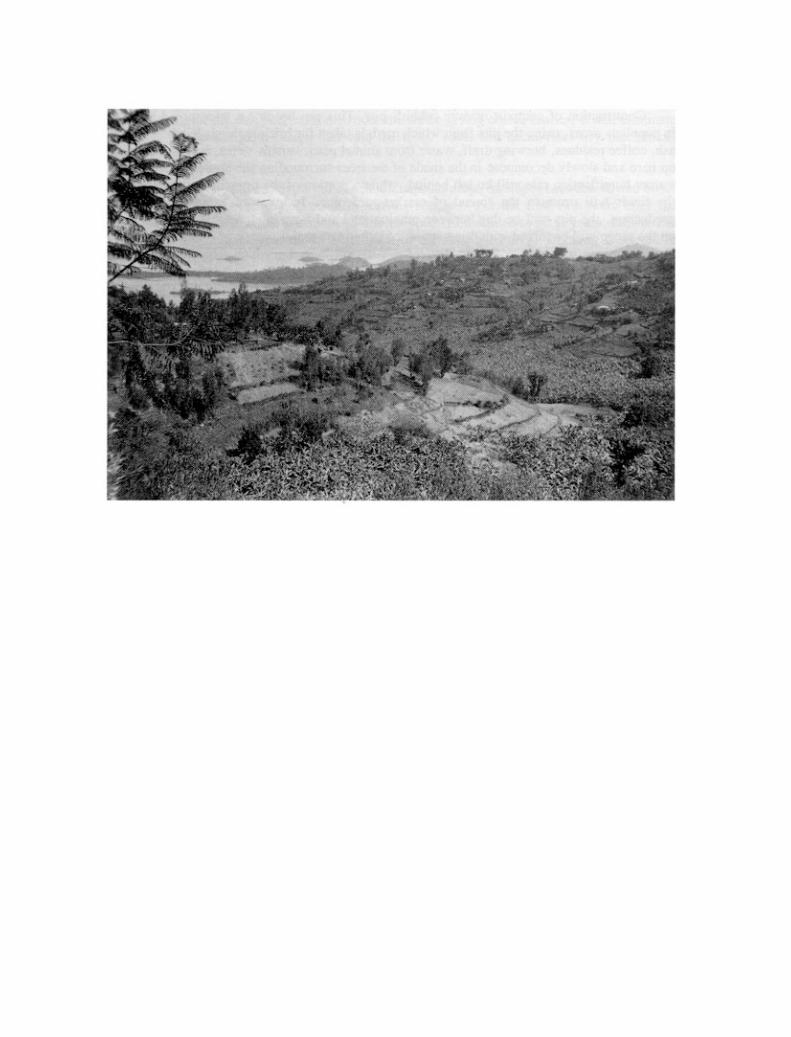

Chapter 11
Agroforestry, mineral fertilization and land husbandry in Rwanda
ATTAINING FOOD SELF-SUFFICIENCY IN A HEAVILY POPULATED TROPICAL MOUNTAIN REGION
THE SITUATION
Rwanda is a small (26 000 km2) mountainous (900 to 4 200 m altitude) land-locked country in Central Africa, morethan 1 000 km from the Indian Ocean and 2 000 km from the Atlantic.
A country with a thousand hills, Rwanda has a very wide variety of landscapes. There are six major bioclimaticzones, divided according to geological bedrock, landform, population density, crops, and especially rainfall, whichincreases with altitude (Delepierre 1982; Gasana 1990) (see Figure 70).
The country has recently undergone massive demographic growth: its population was estimated at 1 million atthe beginning of the century, 2.6 million at Independence in 1962, 8 million in 1992, and will exceed 10 million towardsthe year 2000. The growth rate is one of the highest in the world – 3.7%, meaning that the population doubles every17 years. Economic growth can no longer keep up with population growth, and the farming population has fallenbelow the poverty threshold. As the country has virtually no more land reserves, the average size of holdings isshrinking dangerously; it is now under 0.8 ha, and more than 25% of families have to subsist on less than 0.4 ha.
Three communities inhabit this high, tropical landscape: artisans (5%), farmers (85%) and herders (10%).The farmers – the largest group – cultivate the slopes of mid-altitude hills, while the herders occupy the hilltopsduring the rainy season and the lowlands during the dry season. As a result of population pressure, agriculture rapidlytook over all arable land, so that the large cattle herds were forced into the eastern savannahs or the highlands (theZaire-Nile Divide and volcanoes). Moreover, 50% of farming households today have some sheep or goats, and 30%have one or two cows. When farms are only 0.4 ha it is no longer possible to expand animal husbandry and foragecrops: fallow periods have almost disappeared, and grazing is limited to roadsides and private or communal thickets.The trend is inexorably toward keeping small animals (goats, pigs, chickens) more or less permanently penned. This

raises the problem of fertilizing land that was hitherto manured with cattle dung, for the reduced availability of dungmeans that it is no longer possible to maintain fertility on more than 30% of the land. More organic manure (frompens), more mineral supplements, and mulching will thus be needed.
The main problem for this agricultural country (more than 90% of the population earns its living from agricul-ture) with scant mineral or commercial resources is that of ensuring food and wood self-sufficiency for a very largepopulation (from 150 to over 800 per km2), without degrading this landscape of large elongated hills.
Since erosion risks vary greatly in Rwanda, the volcanic zone (one-third of the country), the areas surroundingLake Kivu, and the Zaire-Nile Divide (where risks of landslides are greater, the steeper the slope, the more abundantthe rainfall [up to 2 000 mm] and the more frequent the earthquakes) have been left aside, and the results confinedto those obtained on the central uplands (in the Butaré region) and in the low-lying savannah zone of the east(Karama).
ANALYSIS OF LOCAL CONDITIONS
The two zones selected vary considerably in terms of erosion risks.
· The low-lying plains (900 to 1 500 m altitude), covered in shrub savannah, receive 800 to 1 000 mm/yr ofrain over two rainy seasons. This area is less rugged (slopes of less than 15%), less well-watered, and lessdensely populated than the rest of the country as a result of malaria and various tropical ailments, and conse-quently less exposed to the risk of erosion. Most of the eastern part of this area is presently given over toextensive livestock production, even though the soil is often quite fertile. The ferralitic or ferruginous soilshere are less acid and less desaturated than elsewhere, but water runs off more easily (a result of theformation of slaking crusts) and crops suffer each year from rainfall irregularity and stress. Managing surfacewater is probably the main problem for agricultural development in the area, while losses through erosion anddrainage are moderate.
· The central plateau (1 500 to 2 000 m altitude) receives between 1 200 and 1 500 mm of rain, spread overten months. Rainfall erosivity is significant (250 to 500 RUSA units), and the very dense farming population(250 to 800 per km2) has to cultivate every piece of land, including slopes of over 40% on the sides of convexhills.
During the first season (September to December), the rain is fine and only one quarter as forceful as in WestAfrica. It falls on dry, well-drained, and manually well-tilled soil, and does not cause much damage. However, in thesecond season (February to June) there are several larger, heavy storms (60 to 100 mm/day). If they fall on moistsoil, on steeply sloping slopes or soil fine-tilled for sowing, the water forms rills, which then scour the full depth of thetilled soil down the whole length of the plot. All this soil easily blocks the erosion control ditches, which overflow, sothat the runoff accumulated in them then cuts gullies which will wreck erosion control measures all the way down tothe foot of the hill.
The topsoil horizon is quickly scoured, not only by rill erosion but also by dry mechanical erosion followingmultiple tillage procedures: deep-ploughing the land twice (to dig in weeds) and hoeing twice in each cropping seasoncauses 30 to 60 tonnes of earth to move down the slope as far as the next obstacle, so that banks rise by 15 to 30 cmper year.
At this rate, the soil cover on the hilltops is soon stripped, uncovering alterites and blocks of rock. Much lesswater is now absorbed and retained, which means that during periods of heavy rainfall, large amounts of water gushdown from the degraded hilltops, gullying the slopes, changing the flow rate of rivers, increasing peak flows, attack-ing river banks, and washing away the gravel from river beds. The delicate balance in these mountains is disruptedby uncontrolled clearing, overgrazing, growing crops that provide little cover on very steep slopes, and the removalof stones that protect river beds for building.
Ferralitic soils are generally very desaturated, acidic, (frequent pH of 5 – 4), deficient in P and N, and poor inbases. They seem on the whole very permeable, except where they have been compacted (tracks, cattle trails, pathsto dwellings) or pounded by rain. They retain little water (1 mm of available water per centimetre of soil) or nutrients(1 to 5 meq/100 g of fine soil), so that it is important to maintain an adequate level of organic matter. They are oftenrejuvenated by erosion, with a layer of rubble or ferruginous gravel at a depth of between 30 and 100 cm. Soilerodibility ranges from low to medium on schist, and Wischmeier’s K factor is generally under 0.20 (Roose andSarrailh 1989, Ndayizigiyé 1993).

Except for the two planting periods the countryside is green, for annual rainfall is good -if irregularly distrib-uted. Erosion risk would therefore be moderate if the cultivated slopes were not so steep (Berding 1992). Twocountry-wide surveys indicated that 50% of the cultivated land is on slopes exceeding 18%, 20% on slopes exceed-ing 40%, 5 to 6% on slopes exceeding 65% (the limit for terracing), and 1% on slopes exceeding 84%.
Erosion risks are aggravated locally by two phenomena.
· Land tenure problems. The concern for equality in inheritance means that each heir receives an equalshare of each section of land, which means in turn splitting the original plot into as many vertical strips as thereare heirs. The result is that on densely populated hills (those farmed for a long time) very long, narrow plotsare put under crops at the same time, which seriously increases the risk that sheet erosion will scour the soilright to the bottom of the slope. Once such scouring starts, it happens again each year in the same spots,because it is difficult to prevent runoff from flowing toward the lowest points in a field. The land is quicklyruined. Land tenure laws should be changed.
· Landslides. If erosion control on a hill calls for digging total absorption ditches on slopes of over 40% or onshallow soils on a sliding alterite (schist, gneiss, micaceous rock or volcanic ash on granite domes), the slope

is thrown out of balance. If a long series of storms waterlogs the soil cover (and especially if this is com-pounded by earthquakes), it can start sliding from one of these ditches, and continue down to the river, whichcan then be temporarily blocked by this mass of earth.
Experiments show how urgent it is to combine all available erosion control techniques in order to stabilizesloping land while also substantially increasing its productivity (see Table 40).
There are about 250 reliable measurements of annual erosion on plots of 100 m2 (20 m in length) fairly similarto farmers’ fields, on steep slopes (25 to 60%, except for the IRAZ banana plantations, where S = 8%), on ferraliticsoils that have been somewhat rejuvenated or received colluvial deposits and are very desaturated and acid, but alsovery resistant to rainfall aggressiveness (K < 0.2 to 0.1). The results of these experiments indicate that:
· the risks of sheet and then rill erosion are very high on bare soil, varying from 300 to 550 t/ha/yr, dependingmuch more on rainstorms than on slope; it would take only 5 to 10 years to remove the whole topsoil horizon(20 cm) at this rate;
· the risks of runoff (Kaar = 10 to 40%) can be serious on such steep slopes when they are poorly covered (aswith degraded soil);
· traditional farming methods and intercropping do considerably lessen risks (C = 0.2 to 0.5), but not enough,since the tolerance threshold is no more than 1 to 12 t/ha/yr depending on soil depth;
· trees dotted among the crops do little to improve soil conservation;
· hedges of grass or bushes every 10 metres, plus large ridges covered with pulses or sweet potatoes every5 metres, do constitute a valid preliminary solution;
· mulching (tested under banana, coffee or cassava) is a second solution which is immediately effective evenon steep slopes;
· reforestation with pines (needle litter being very effective) or other species allowing an under-storey quicklyreduces runoff and erosion to acceptable levels (Roose, Ndayizigiyé and Sekayange 1992).
Blind ditches and bench terraces cannot be studied effectively on these small plots (5 m wide). On landmanaged under erosion control projects, it has been seen that these methods can increase risks of gullying andlandslides where the soil cover is thin or the slope too steep (> 40%).
Farming methods – not just erosion control structures – play the major rôle in stabilizing slopes.
In conclusion, these verdant landscapes can give an impression of stability to busy experts who are used tothe gullied, bare land of semi-arid regions. In reality, however, the soil is very poor, very steep slopes of 60 to 100%are cultivated out of necessity as land is short, rain is excessive at some periods and scant at others, and the coverprovided by crops on the most degraded land is too light to protect the soil from the various erosive processes in theRwandan hills (see Figure 71).

TRADITIONAL TECHNIQUES
The crops are planted in dispersed fashion around the habitat in direct relation to soil fertilization. When a youngfamily sets up home on a levelled platform cut into the hill, it plants its banana plantation around it, and this willreceive most of the available nutrients (domestic waste, crop residues, ash, peelings and latrine waste). Companionfood crops are grown between the bananas: maize, beans, cush-cush, potato and herbs. A small field of maizeintercropped with beans receives a little manure/compost, and broadcast-sown sorghum is grown in the secondseason.
The only plots not eroded are those that are mulched and under coffee trees: in order to avoid the penaltiesconscientiously imposed by Ministry of Agriculture field staff, coffee plots (100 to 200 m2) are copiously mulchedwith cassava and sorghum stalks, various types of grass pulled up from the banks, and banana leaves. The remaining

land (two-thirds) receives no manure or fertilizer, and inevitably degrades under such frugal crops as cassava andsweet potato.
Weeds are carefully pulled up, either – depending on need and season – to feed stabled animals, or to coverfurrows and reduce erosion, or to be piled up in large heaps, covered with earth and immediately planted with sweetpotato cuttings. In any case, vegetation is very quickly recycled.
Plots are sometimes scattered several kilometres away from dwellings (rented fields). Despite the manydisadvantages (time spent travelling back and forth, difficulty in guarding and manuring plots), scattered fields doallow farmers to cope with climate-related risks (localized storms and hail, damage from animals and disease).Young technocrats dream of dwellings concentrated in villages and consolidation of landholdings so as to promoteintensive, modern, mechanized farming. This is a serious mistake in a country with no alternative way to feed a verylarge rural population forced off the land (no industry, no international waterway, no trade). Furthermore, the land istoo steep to risk the introduction of tractors (little likelihood of cost effectiveness, and risks of compaction), and anelement that now enriches the land (domestic waste) would become a pollutant hard to control within a village.
Present farming techniques take a great deal of work, which is often performed by groups of neighbours usingtwo rudimentary implements, the machete (sometimes curved like a sickle) and a long-handled hoe. Following ashort fallow (from a few months to one or two years), the soil surface is cleared of infesting weeds and then deep-ploughed to turn in the weeds (30 cm and more). Stolons and other persistent roots are dried in heaps, and compostedor burnt. A month later the plot is fine-tilled for drill sowing (maize) or broadcast sowing (second-season sorghum);an intercrop may be sown after the first hoeing to fill empty seed holes and cover the whole area.
All tillage is manual, using hoes. Animal traction is difficult on steep slopes and is never even considered, forthere is no tradition of draught animals. There is no mechanization (far too expensive at such a distance from thesea), which means that there is little compaction of deep horizons, and drainage seems normal. Deep drainage wouldbe needed only in the vicinity of springs.
Ridging or larger mounding is confined to tuber crops and digging in weeds. On the other hand, crops areusually grown on raised beds or large mounds in the valleys and marshlands in order to ensure good drainage.
Apart from spreading manure on fields near dwellings, soil fertility is maintained by intercropping, rotation,digging in weeds, and a short fallow. However, there is an erosion control technique traditionally used on steepslopes, especially for growing peas on schist and in the highlands in the north and on the Zaire-Nile Divide (Nyamulinda1989). It consists of micro-step terraces 1 metre wide, cut into the slope, preserving the root systems of clumps ofgrass. This allows space for a double row of maize/beans or peas. The risers (0.5 to 1 m high) are kept firmly inplace by the root networks. The main concern with these narrow terraces is to keep the cultivated beds within thetopsoil horizon, for the wider the terrace the more the soil structure is disturbed and the more the sterile deeperhorizons are exposed (Roose et al. 1992). The traditional technique is to turn half a bed on to the one below in the

second year – thereby mechanically shifting the surface layer of soil right along the slope. Trials on erosion plotshave shown that with an improved version of this method (placing beds strictly along the contour and using the grassfrom the risers) all erosion can be stopped and rainwater better managed, even on schist soils on 60% slopes.
Lastly, there is a local technique of managing runoff on tracks, which consists of digging a pit in the upperslope, in which runoff and its load of sediment are directed. When it is half-full of sediment, a clump of banana treesis planted in it, to benefit from the additional water and nutrients. When the first pit is almost full, another is dug lowerdown (= Rudumburi).
In conclusion, traditional methods allowed maintenance of the stability of the landscape and a modest produc-tion level. Now that the population has become too numerous to keep enough land under fallow, something has to bedone to keep the soil in place, but also to bring about a rapid increase in soil productivity for both food and fuelwoodcrops).
SUGGESTIONS FOR MANAGING SURFACE WATER
ADAPTATION TO EACH CLIMATIC REGION
In semi-arid regions (especially the eastern savannah), placing land under cultivation brings a major increase inrunoff and a reduction in evapotranspiration, and thus in the production of biomass. Runoff control measures (im-provements in infiltration and localized storage) can therefore have a considerable impact on yields of crops thatsuffer as much from drought as from mineral deficiency. Farmers will quickly become interested in runoff manage-ment techniques.
In humid regions (R > 1 000 mm), clearing land and putting it under cultivation bring an increase in the risksof runoff, in peak flows of rivers, and therefore in the risk of erosion of banks. There is a consequent reduction indrainage, the leaching of fertilizers, and the dry season flow of springs and rivers. Runoff (and erosion) control willthus have relatively little effect on crop yields, unless there are periods of drought during vulnerable phases in thegrowth cycle. This is one reason why erosion control has had little impact on yields in the humid hills of Rwanda, theother causes being the chemical poverty and acidity of the soil.
In conclusion, if runoff is reduced by farming techniques and/or suitable erosion control structures, plantproduction must be intensified to avoid increased risk of nutrient leaching by drainage water and landslides on steepslopes: hence the attraction of intercropping, fertilization and agroforestry.
WATER MANAGEMENT STRUCTURES SUITABLE FOR RWANDA
Four approaches to surface water management can be identified, depending on climate and soil permeability, withcorresponding erosion control structures and farming techniques (Roose, Ndayizingiyé and Sekayange 1992). Hereonly the most appropriate are described.
Cisterns of drinking water collecting 10 to 50 m3 of clean water from roofs considerably alleviate the workof carrying water, improve hygiene, and allow for a few penned animals, the production of manure and a veryintensive multi-storey garden around dwellings.

Cisterns or pools collecting runoff water (100 to 500 m3) on tracks or rocky or overgrazed slopes allowlivestock watering and supplementary irrigation of short-season vegetable and fruit crops (see Haiti).
Total absorption ditches encourage infiltration of runoff water on slopes of less than 20%, on deep, perme-able soil. Unfortunately, they require a lot of work (200 to 350 days to dig, plus 20 to 50 days per year for upkeep),and hardly improve crop yields at all (which is why farmers abandon them). Their main attraction is in the gradualtransformation of the landscape into very gently sloping terraces. Diversion ditches are unadvisable for mountainousregions, as gullying is bound to set in at their outlets.
Stop-wash lines or semi-pervious microdams (lines of grass, stones, hedges, grassed banks) do not stoprunoff, but do slow down water, dissipate its energy, and spread it into sheets, thereby encouraging sedimentation. Abank quickly forms (20 to 30 cm/yr), with a gradual terrace which can then be transformed into two horizontalterraces, one enriched (reserved for intensive cropping), and the other poorer (frugal crops such as cassava andsweet potatoes), so that fertility must be gradually restored (see Figure 72). The demand for labour is more occa-sional (50 days to build, plus 10 days per year for upkeep), as are fertilizer requirements.
Horizontal or bench terraces allow all water (rain + runoff between terraces) to be absorbed, and makethe most of manure inputs. Clearly, however, bench terracing requires a huge investment in terms of labour (500 to1 000 days/ha to build) and inputs (10 t/ha of manure, 1 to 5 t/ha of lime, plus the fertilizer for each crop) before thenatural fertility of the soil is restored. This method should be chosen only if there are both inputs and the markets andpraticable roads to capitalize on surplus production. There must be no risk of landslides.
Micro-step terraces (cultivated width about 1 metre) on permanent grassed risers (maximum 50 to 100 cm)require much less work and stabilize steep slopes very well under manual intercropping, since the crop roots remainin the original topsoil.
THE MOST SUITABLE TILLAGE TECHNIQUES
Tillage techniques that modify the state of the soil surface, roughness, plant cover, the activity of mesofauna and/orinfiltration capacity are often very effective in reducing the volume of runoff and dissipating its energy.
Flat tillage with large clods is essential on soils that are too compacted. It temporarily increasesinfiltration, improves water storage and helps to dig in crop residues and combat weeds. Unfortunately, it inhibitsearthworm activity, reduces soil cohesion, and increases erodibility by runoff water, especially if seeds are sown ona bed of very fine aggregates.
Mounding and ridging, parallel with the slope, gather together good topsoil so that large tubers can begrown, but these practices are dangerous on steep slopes since they concentrate runoff into trickles that can dig rillsand gullies, and detach gravel and other stones that protect the soil from rainsplash.

Tied ridging perpendicular to the slope improves water storage under small rainstorms, but can lead togullying or landslides under heavy storms. Only large ridges (H = width 40 cm) permanently protected bycreeping plants (e.g. sweet potato or forage pulses) and at intervals of under 5 metres, can break the force ofrunoff on slopes. Combined with hedges, they can quickly stabilize steep slopes (20 to 60%).

SUGGESTIONS FOR MANAGING SOIL FERTILITY
BIOMASS MANAGEMENT
In Rwanda, most farmers are too poor to buy enough mineral fertilizer to boost the productivity of all their land.Traditionally their only means of maintaining or restoring soil productivity is the biomass produced on their fields andon fallow areas, roadsides, communal forests, etc. Application of SPR and SWC methods (ditches) does not in-crease biomass production, and also reduces the productive area. Land husbandry, on the other hand, attaches greatimportance to improving biomass production and to careful management of organic matter so as to restore theessential nutrients to the soil as quickly as possible.
In the tropical African rain forest 8 to 15 t/ha of litter are returned to the soil each year. Under savannah 2 to8 t/ha of leaves are returned to the soil, unless they are destroyed by fire or livestock! After clearing (burning offnatural vegetation and putting the land under crops), the amount of organic matter in the topsoil horizons falls by 40%in four to ten years, depending on how organic residues are managed – manure, compost, direct turning in, ormulching.
Under crops there is a fair amount of available biomass:
· maize and sorghum can leave 2 to 5 t/ha/6 months of residues, at present used for feeding stock or mulchingthe coffee plantation;
· soybeans, groundnuts and beans produce 0.5 to 2 t/ha of good-quality fodder;
· cassava and sweet potatoes provide 0.5 to 2 t/ha of biomass which can be used for feeding pigs or mulchingthe coffee;
· a banana plantation (3 x 5 m density) can produce 3.3 t/ha of stems and 2 to 6 t/ha of leaves which can beused as mulch or fodder;
· short fallow periods (a few months between two cropping cycles) and weeds provide 0.5 to 2 t/ha/yr of greenmatter.
AGROFORESTRY
This method can considerably boost biomass production on cultivated fields. Two hundred trees (Grevillea robusta,Cedrella serrata, Polyscias fulva, etc.) planted in or around fields can produce enough firewood for the wholefamily, plus 1 to 4 t/ha/yr of leaves and twigs very useful for mulching.
Planted every 5 to 10 metres, hedges of Calliandra calothyrsus, Leucaena leucocephala or diversifolia,or Cassia spectabilis, can provide 3 to 9 t/ha/yr of leaves (excellent fodder) and 2 to 7 t/ha/yr of firewood; in otherwords, more biomass may be produced on a cultivated field from crop residues, trees and hedges, than underprimary or secondary forest. However, it is important to make sure that enough of it is restored to the soil.
BIOLOGICAL UPTAKE OF NUTRIENTS THROUGH AGROFORESTRY
If the soil is neither too acid nor too deficient in phosphorus, the shrubs chosen for hedges can fix nitrogen from theair. Depending on author and site (Balasubramanian and Sekayange (1992) in the eastern savannah, König (1992)


and Ndayizigiyé (1992) around Butaré on the central plateau), cutting the hedges three times can bring up to the soilsurface: 75 to 130 kg/ha/yr of nitrogen, 2 to 20 kg of phosphorus, 20 to 60 kg of potassium, and similar amounts ofcalcium and magnesium, depending on the richness of the soil in these elements – an input of minerals close to thatfrom 10 tonnes of farm manure. Apart from the litter provided by 200 trees per hectare, it is clear that agroforestrycan make a considerable contribution to the organic and mineral balance of the soil in two ways: by significantlyreducing nutrient loss through erosion and drainage, but also by extracting nitrogen from the air and through theuptake of nutrients carried by drainage beyond the reach of the roots of annual crops.
APPLICATIONS OF ORGANIC MATTER AND MINERAL SUPPLEMENTS
Figure 73 compares the effects of three types of hedge, always at intervals of 7 metres, on erosion (t/ha/yr), averageannual runoff (Kaar %), biomass production from hedges, and cereal production.
Biomass. Calliandra hedges give twice as much biomass as Leucaena (4 to 8 t/ha/yr). Prunings spread onthe ground three times a year cover 80% of the surface with Calliandra and 40% with Leucaena. However, aftertwo weeks all the small leaves have gone, digested by soil microflora, leaving only the twigs – which children cancollect as firewood. Perhaps other shrubs should be investigated for intercropping.
Runoff. Apart from the first month after planting, the soil is so well-covered that after two years runoff isnegligible: 12% on bare soil, 8 to 10% under traditionally grown crops, 1 to 2.5% under crops with hedges every7 metres. Runoff is serious only in the case of the long rainstorms of the second season under sorghum on awaterlogged soil. Maximum daily runoff reaches 68% on bare fallow, 20 to 35% under crops.
Soil loss. Sheet and rill erosion decreases from 450 t/ha/yr on bare fallow to 80 to 120 t/ha/yr under tradition-ally grown crops, and 1 to 2 t/ha/yr under crops two to three years after planting hedges. It should be noted that thecrops received 10 t/ha/yr of farm manure (and even 90 t/ha in the third year), although even such a high input ofmanure was not enough to bring erosion down to acceptable levels. However, while erosion tends to increase from

year to year under traditional methods, it decreases on plots protected by hedges proportionate to the slope of theland (from 27 to 15%).
Impact on crop production. In the first year harvests were much the same, indicating that the plots weresimilar at the outset. In the second year, despite 10 t/ha of manure, yields fell from 10 to 30%. In the third year,following an application of 30 t/ha of manure, yields climbed from 32 to 53 or 68% in the fields with hedges. It wasonly in the fourth year, when 2.5 t/ha of CaCo3+, 10 tonnes of manure and N51, P51, K51 were applied that yieldsincreased markedly from 500 to over 2 000 kg/ha of cereals and up to 2 318 kg/ha between the hedges, despite thespace taken up by these hedges (15%). Second-season sorghum production remained poor (420 to 640 kg/ha)except after liming and supplementary mineral applications (up to 1 544 kg on the plots with hedges).
In this trial on acid ferralitic soil, it seems that even if erosion and runoff are brought under control, yields stillcontinue to fall. Ten tonnes of manure plus six tonnes of pulse mulch were not capable of increasing yields of cerealsand beans, because the plants, the soil, the animals and the organic manure are deficient in the same elements(especially P and N). However, yields tripled and the erosion control measures paid off after the pH was corrected(2.5 t/ha/3 yrs of lime was enough to eliminate aluminium toxicity), and supplementary minerals applied (60 units ofNPK were enough for the cereals).
So far it seems that farmers are becoming steadily more interested in hedges, but more as sources of dry-season fodder and boundary markers than as erosion control measures. They have not fully grasped all that isinvolved in the hedge system, particularly the need to cut back roots and branches to limit competition with crops.
RESTORING SOIL FERTILITY
Outside the volcanic zones, desaturated ferralitic soils are very acid, often exhibit aluminium toxicity, and haveexcellent drainage, which means that there is a high risk that fertilizer will be leached out in drainage water, espe-cially if runoff is suppressed without intensifying cropping. In such circumstances, farmers will reject soil conserva-tion as leading to no increased return for their work. It is vital that soil conservation, water storage and fertilityrestoration be introduced simultaneously if there is to be any significant improvement in yields.
The following six rules must be followed if soil fertility is to be restored in one or two years:
· control of runoff and erosion;· deep subsoiling in order to reorganize rooting;· stabilization of macroporosity by digging in organic matter (or lime) and by a crop with a vigorous rooting
system;· correction of the pH (pH 5);· revitalization of the soil through applications of manure or compost (3 to 10 t/ha/2 yrs);· correction of the main soil deficiencies, or at least provision of the essential crop nutrients.

MAINTENANCE MANURING
As was seen in the Rubona trial (Figure 73), once erosion has been brought under control and the physical, biologicaland chemical fertility of the soil restored to an acceptable level, plants still have to be fed (localized manuring) as andwhen needed (staggered doses), depending on crop production goals (N = 40 to 160 kg/ha/yr + P = 30 to 100 kg/ha/yr + K = 20 to 100 kg/ha/yr) and the risk of periodic leaching. In practice, organic residues have to be bettermanaged and the mineral supplements vital to the crops added, as ferralitic soil can store very few nutrients and littlewater.
Rutunga (1992) has noted that on Rwanda’s poor land, liming (2 to 5 t/ha) should be done every three years,and organic manure applied every three crop cycles. On soil of average richness, liming makes little or no difference,but mineral and organic manuring does. As for rich volcanic soil, weak doses of NPK have so far produced onlyslight improvements in yields.
CONCLUSIONS ON LAND HUSBANDRY IN RWANDA (Plate 32)
In the heavily populated tropical mountains of Central Africa, the risks of erosion (300 to 700 t/ha/yr) anddegradation of soil fertility increase with slope and population density (150 to 800 per km2) (Figure 74).
Some production systems can keep erosion at an acceptable level: mulching under coffee, banana or cassava,large contour ridges with permanent plant cover, green manure covering the soil surface, reforestation withspecies that provide good litter. Radical or gradual terracing (1 000 and 100 days’ labour respectively) and othererosion control structures are less effective than biological systems (grassed banks, hedges, etc.) and requiremore upkeep and space.
Agroforestry (e.g. 200 trees per hectare plus hedges every 5 to 10 m) can control erosion (1 to 3 t/ha/yr), producefodder and mulch (4 to 10 t/ha/yr) and take up nutrients from deep in the soil (N 20 to 100, P 10 to 20, K 2 to 40, Ca+ Mg 20 to 40, etc.), with a reasonable amount of work (10 to 30 days per year). Animal husbandry can enhancethe benefit of this biomass, since dung is one of the keys to fertilizing ferralitic soil, which is like a sieve.
However, despite applications of 10 t/ha/yr of dried corral-dung and 4 to 8 t/ha of pulse mulch, land productivityhas remained very low (400 to 800 kg of beans, maize and sorghum, 3 to 8 t/ha of cassava). If the challenge ofdoubling production before the population doubles (17 years) is to be met, it is vital to propose a technologicalpackage comprising management of both water and soil: cisterns, hedges, organic fertilization (mulching, greenmanure and improved farm manure) with a mineral supplement (40 to 100 kg/ha/yr of NPK, and 2 to 5 t/ha/3 yrs oflime). SWC is not enough.
It may be noted that the densest populations in the world live in “multi-storey gardens” where the positiveinteraction between animal husbandry, crops and trees is carried to the furthest extreme. In Africa, much remainsto be done before achieving the intensity of production found in the gardens of Asia.

Chapter 12
A new approach to erosion control in Haiti
AN EXAMPLE OF A CALCAREOUS-BASALT TRANSECT
IN THE HILLS OF SOUTHERN HAITI
THE SITUATION
A SPECIAL CONTEXT
Since the 1950s, Haiti has been experiencing accelerated degradation of its rural land and natural resources. Al-though agriculture is undergoing a particularly difficult crisis, it still constitutes one of the dynamic forces of thecountry’s economy.
Malnutrition in the countryside, the decline in exports (50% in the last 10 years), a major rural exodus and theinability of families to save are thrusting Haitian farmers into a cycle of decapitalization that will be hard to break, forthe very low farm income (falling from $450 to $250 in 1992) no longer allows most of them to renew either theirlivestock or their implements. Furthermore, the rising population has aggravated pressure on land, resulting in in-creasingly frequent cropping and reduced fallowing of the same land, leading in turn to overgrazing and hasteningsoil degradation.
This is seen not only in lower fertility, but also in accelerated soil loss, since the components of the physicalenvironment are naturally fragile: 60% of cultivated land is on very steep mountain slopes (20 to 80%), with fre-quently violent rainfall conducive to runoff. The outcome of all these factors is lower returns on labour, in the face ofwhich charcoal production seems a good alternative to improving farming income. This has led to uncontrolleddeforestation, accelerating the deterioration of the natural resources that underpin agriculture.
The consequent decapitalization, accompanied by a loss of social cohesion, forces farmers into a survivalmentality, making it hard to approach land management as a group effort (control of livestock grazing and of wood-cutting), although this is a sine qua non of successful development or erosion control efforts.

THE FAILURE OF SO-CALLED “MODERN” EROSION CONTROL STRATEGIES
From the 1960s until 1990, national authorities were advised by international bodies and donors that the answer to thecrisis of the rural sector lay in solving natural resource conservation problems. The special situation in Haiti encour-aged implementation of a large number of schemes and projects based on a “modern” strategy of rural development,thus turning this country into a kind of erosion control laboratory.
Unfortunately, this approach to improvement and development nearly always led to closing off large areas tolivestock, or else to soil and water conservation schemes (SWC) that turned erosion control into an isolated experi-ence. Such projects achieved only mixed and questionable results, and often ended in failure.
The strategy adopted concentrated on developing a unified area, usually a watershed, emphasizing the physi-cal coherence of the various processes. It gave priority to infrastructure installations (roads, feeder roads, gullycontrol, contour channels, dry stone walls, radical terraces) with most of the work being done with the help of thelocal populace in exchange for some remuneration (in money or kind). And it was meant to have an almost immedi-ate effect on the conservation of natural resources.
Failure sprang basically from the fact that “general interest” was the paramount factor, legitimizing infrastruc-ture development and making soil conservation (SWC) the prime objective – although Haitian farmers had a verydifferent view, and saw such projects simply as ways of ensuring an immediate income, even though the proposedconservation techniques failed to offer short-term improvements in yields and income.
Furthermore, there is no direct relationship between these techniques and the set of constraints that farmershave to face. This gap between proposals and constraints arises from a deep ignorance of the farmers’ economicperspective, of how farming systems work in general, and of land tenure issues in particular.
The latter entail an inheritance system that encourages fragmentation and joint ownership, aggravating landinsecurity and the danger of food insecurity as farm plots shrink in size.
The installation of erosion control structures means sacrificing some of the already limited arable land, with nopossibility of improved yields for many years to come. The extra work required for their upkeep is work that only thefarmers themselves can assure. Furthermore, these techniques neither reduce degradation on the land between thestructures nor improve productivity. They are not very effective, and sometimes increase such risks as overflow,gullying and landslides by upsetting ecological balance on the slope. To avoid these constraints, erosion controlstructures are often built on land marginalized by farmers.
Similarly, research work focuses more on selecting species and on the depth or inclination of terraces than onways of integrating trees or mechanical structures into traditional farming systems.
Project organization needs revision, and a change from the approach whereby the population is used as alabour pool without any real participation. Project monitoring and evaluation are also needed.

There is thus a complete divergence between the objectives of a project that prioritizes the capital develop-ment approach and the objectives of the people involved (who are rarely consulted). The situation is now such thatit is no longer enough either to protect or to conserve the soil. The population is growing rapidly, and production mustbe increased without degrading the environment.
A NEW PARTICIPATORY APPROACH: THE SALAGNAC/AQUIN PROJECTS AND PRATIC
Another approach, based on rural development, has been worked out since 1985, aiming mainly at solving thepeople’s immediate problems (food security, improved yields, better returns for work) through better land use usingtechniques, suited to the Haitian context, that safeguard the environment and land resources. Soil and water conser-vation, from being an end in itself, becomes a means of establishing stable production systems.
This approach, now known as land husbandry, seeks to improve infiltration on fields so as to increase biomassproduction (and hence yields) by providing better soil cover and re-establishing the balance of organic and mineralmatter in the soil. It attempts to reduce the impact of erosion and sediment transport by modifying productionsystems, while ensuring that farmers take responsibility for their own environment.
It was adopted by two French aid projects, Salagnac-Aquin (1978-92) and PRATIC (1988-92), concerningthe Petite River transect Nippes-Salagnac-Aquin (Figure 75), with activities1 aimed at encouraging intensificationand diversification of farm production while stabilizing slopes: new cash crops, increased foodcrop yields on landwith the best potential. The goal was to relieve the most vulnerable land from cropping pressure (frequent tillage andovergrazing) and transform it into a forest- and fruit-tree farming area, improving animal husbandry conditions, etc.It was based on the following principles:
· Farmer participation right from the project design stage. This is a decisive factor for protection activi-ties and vital to project success, as the farmers are the only people who can guarantee upkeep of erosioncontrol structures at the plot level and/or on the slope as a whole.
· Reinforcing traditional methods of soil and water conservation. Haitian farmers have themselves adoptedtraditional survival strategies to control erosion and boost soil fertility.
· Selecting zones that have retained maximum agricultural production potential.
· Intervening on individual plots and slopes, and then, whenever possible, at the watershed level. Erosioncontrol thus focusses first on the plot, then on the farm, and finally on the whole area. Piecemeal treatment ofindividual plots is no alternative to treatment of a watershed, for they require different strategies (the ruraldevelopment and capital development approaches), which should in fact be complementary.


· Combining soil conservation activities with convergent activities that allow enhanced production sys-tems (intensification and diversification of cropping, improved animal husbandry, creation of savings andcredit).
· Setting up a system of contractual relations with precise definition of the conditions of intervention, andof farmer-project relationships, with clarification of the activities that are the strict responsibility of eachfarmer (improvements on individual plots), those that are the responsibility of the rural community (roads,feeder roads, communal cisterns, gully control), and finally the commitments of the project.
· Allowing for planning, monitoring and evaluation (measuring the effects). This type of programme willrequire much time (8 to 10 years) before it has any noticeable effect on production systems or can modifypractices while ensuring that farmers take responsibility for management of their environment. It has threenecessary phases:
· 1st phase: analysis of local conditions in order to discover the potential and limitations of the physicalenvironment, including the processes of soil degradation (where, when and how they arise), but also thefarmers’ traditional methods of farming their land and managing water and fertility. This analysis will fosterdialogue with the communities and help build trust.
· 2nd phase: on-site trials in order to establish technical terms of reference (comparing traditional tech-niques with the proposed techniques).
· 3rd phase: evaluation of the results by both communities and experts, prior to planning intervention onwhole hillslopes and watersheds.
ANALYSIS OF LOCAL CONDITIONS
A VARIETY OF NATURAL ENVIRONMENTS
This variety springs from the interaction of several factors, the most important of which are the nature of the soils,the bioclimate and the topography.
Four major agro-environmental units (Figure 76) have been identified, with various sub-units. These distinc-tions are fundamental to any understanding of the choices made by farmers regarding crop distribution and land useon each plot. They are as follows:
Unit 1: high bluffs and calcareous uplands. Between 500 and 900 m in altitude, they have ferralitic soil onthe higher reaches, and calcimagnesic soil lower down. They are stony, and organic fertility is poor. Rainfall isfrequent and sometimes heavy (60 to 88 mm/h). Winds can be violent and constitute an additional crop constraint.The basic crop combination is maize-beans-sweet potato, with the occasional addition of cabbage and yam. This isthe most deforested zone on the transect except for areas that are densely populated thanks to the presence ofgardens, always owned outright, around the home: the devant porte kaye garden, also known as the lakou.
Unit 2: marly-calcareous hillslopes and bottom lands. This is an area where springs emerge, and wherethe soils are more favourable to permanent crops (vertisols, brown calcareous soils). Rainfall is heavy enough to


allow two cropping seasons, mainly yam, maize, sorghum and black beans. Banana, coffee and malanga (Xanthosomaspp.) are also found in the cooler spots (gullies, bottoms). Forest cover is extensive, with a preponderance ofbreadfruit (Artocarpus incisa non-semifera variety).
Unit 3: andesitic or basaltic bluffs. This unit is less well-watered (1 200 mm/yr) and below 300 m inaltitude. A fairly marked dry season makes only one cropping season possible: sorghum, groundnut, Congo pea, andsometimes maize. The soils of volcanic origin are very well-suited to agriculture; however, they are often found onslopes, exposing them to strong sheet erosion from diffuse runoff or groove and rill erosion.
Unit 4: the Aquin plain. This lies between sea level and 300 m. The climate is dry tropical, with a meanannual rainfall of 600-1 000 mm with considerable yearly variation and a dry season of six to eight months. The soilsare vertisols, with little infiltration on gentle slopes (3 to 10%). Cropping systems concentrate on various combina-tions: maize, cowpea, sorghum, Congo pea, vigna. Gullying is frequent at points where rainwater concentrates(roads and paths).
A VARIETY OF PRODUCTION SYSTEMS
Several factors account for this diversity:
· unequal pressure on landowning;
· complex types of land tenure, the four major types being (in decreasing order of security): land ownershipwith formally divided inherited land, informally divided inherited land or jointly owned inherited land; to whichshould be added types of land use: owner-operated (the most common), tenancy ($60 to $120/ha/yr), andshare-cropping (one-third to one-half share handed to the owner), the system in use among the poorest;
· the available human resources, whether sold or bought;
· the availability of livestock resources.
These internal factors give rise to three major farming systems, corresponding to a variety of socio-economiclevels:
· Low: farmers owning very little land (less than 1 ha), tending to share-crop, with very meagre capital re-sources and reduced livestock resources, and who very often have to sell their labour to augment theirincome. For some this is simply the way they start off in farming, but for others it is a permanent condition, themain cause being land rentals that obviate savings.
· Medium: there is enough arable land (1 to 3 ha) to feed the whole family, making the head of the householdless dependent on rich farmers and the market, but also less integrated with the latter. Accumulation is basedon farm production, and can be slowed down by the growth of the family. Farming swings between the twoextremes, keeping a dynamic balance.

· High: arable land (more than 3 ha) allows production in excess of family needs, and there is enough livestockto function as productive savings. The accumulation processes usually start with a large inheritance and/or asecond activity (carpentry, bricklaying, etc.). These farms draw on a significant labour pool, and quicklyincrease their capital.
These differences in farming systems explain the different ways in which natural resources are managed, andthe different degrees of their degradation, and also why strategies for maintaining fertility will be different. Forexample, the density of livestock per hectare on farms with little land will tend to lead to compaction of soil, thenrunoff and finally erosion; selling one’s labour or working on land with insecure tenure does not encourage a maxi-mum investment of labour or inspire people to protect the cultivated area. Jointly owned land shows advanceddegradation: severe compaction, outcrops of mother-rock, no trees, very poor fertility.
A VARIETY OF DEGRADATION PROCESSES
The range of factors mentioned above (agro-environmental conditions and farming systems) also explains the vari-ety in processes of soil-cover degradation, which happens in three stages:
· constant, rapid mineralization of organic matter, not compensated for after clearing (little or no organic matterdug in) and hastened by (selective) erosion;
· gradual slipping of surface layers through repeated tilling of soil under foodcrops that are not long in theground (on slopes the soil is always tilled downhill);
· onset of runoff and gullying following compaction of the soil by tethered livestock and on paths, especiallyfollowing reduction in the water storage capacity of soil scoured by dry mechanical (man-made) erosion; inareas with calcareous substrata the saturation point is reached after 70 to 80 mm of rainfall on deep ferraliticsoil and less than 30 mm on worn-out land or rendzinas; and rainstorms of more than 60 to 80 mm/h occurthree to six times every year, plus hurricanes every four to ten years, with more than 400 mm of rain in fivedays.
Sheet erosion seems insignificant in Unit 1: true slaking crusts are rarely seen, but there are frequentaggregate discharges, as well as disintegration of mounds and compaction of the soil surface. Clayey, well-struc-tured, chalky and pebbly soils are very resistant: rainsplash dislodges aggregates.
Linear erosion is seen everywhere in the form of grooves (channels of several centimetres) (Unit 1) andrills (tens of centimetres), quickly developing into active gullies (metres) (Units 2, 3, 4) if nothing is done to stop it.Land where there are outcrops of mother-rock (“worn-out land”), tracks and paths, overgrazed fallows and vertisolson basalt are the source of dangerous runoff on steep slopes. Impermeable brown soils on basalt give copious runoff(Pi = 2 to 5 mm with moisture).
Mass movement takes the form of creep and dry mechanical erosion due to tilling on steep slopes, andthrough headward cutting starting from the network of gullies on convex slopes (especially Unit 3).

Erosion of banks is very widespread in the plains, where rivers carrying excess sediment loads (Unit 4)frequently alter channel.
Generally speaking, erosion is more significant on basaltic or andesitic than calcareous soil, although eco-nomic effects vary according to the nature of the subsoil. Thus, on a basaltic or andesitic substratum there is a highrate of weathering of mother-rock and pedogenesis is quite fast, so that there are fairly good possibilities of restoringfertility following degradation. However pedogenesis is much slower on calcareous substratum, and once the soilcapital has been depleted there is much less possibility.
Farmers’ traditional strategies and their limitations
In these very varied conditions, farmers choose, combine and apportion plant species by area and season. Croppingpatterns are thus the outcome of reasoned choices and indicate how far farmers have adapted to local conditions.For all that, there is not necessarily a proper balance, and there are certain worrying developments that could end infailure.
COMBATING DEGRADATION: A FARMER’S WAY OF MANAGING FERTILITY
The three Haitian gardens: improving fertility or increasing soil degradation by transferring crop residues?
Fertility in the three gardens involves livestock-based transfers.
Each farm in Unit 1 comprises at least the following three gardens:
· The devant porte kaye garden (A), also called lakou (500 to 1 000 m2): this is an area of dense vegetationsurrounding the house, and is always owned by the householder. Many perennial or annual species are grownin combination here, forming several storeys: avocado (Persea americana), chadequier (Citrus maxima),banana, coffee, malanga (Xanthosoma campestris), taro (Colocacia esculenta), yam (Discorea sp.), chayoteor christophene (Sechia edulis), pumpkin (Cucurbita moschata), chives (Allium fostulosum).
· The pré-kaye garden (B) (1 000 to 5 000 m2): this treeless area is bounded by a shrub hedge to mark off theproperty and protect crops from wind and animals. Beans, maize, yams, sweet potato (Ipomea batata) andcassava (Manihot utilissima) are grown here in combination.
· The loin kaye garden (C), often with a total area of over 5 000 m2: this garden is found in areas with veryfew trees and far from dwellings. It may be rented, share-cropped or jointly owned. Fertility is low and soil isdegraded. Farmers intercrop beans and sweet potato for six months, after which the plot is left as grassland.If the garden is extremely degraded and situated on a steep slope (D), it is left fallow for long periods (morethan three years) as goat pasture (racks zone).
Farms in Unit 2 differ in various ways from those in Unit 1. The considerable tree cover in these zones makesit hard to distinguish between A and B gardens, so that both could be lumped together as a single A garden.However, there is a new type of garden here that the farmers call a “field” and is comprised basically of banana

(sometimes combined with malanga) under tree cover. These gardens are not always found near dwellings, and theirlocation depends on the availability of water and the coolness of the soil, i.e., in the bottom lands or near spring lines.
In Unit 3 there is still the garden near the house, in a space protected and bounded by a continuous hedge,situated on dry bluffs, although it tends to become poorer at lower altitudes, sometimes whittled down to a few treesscattered around the house (coconut, mango); in short, gardens A and B tend to become a single, lightly wooded, B-
type garden. There are also perennial bottomland gardens, heavily wooded and very fertile, which can be classifiedas A gardens growing in wetter areas.
This garden structure disappears in Unit 4.
Arguably, the distribution of the different types of garden is mainly determined in Unit 1 by the distance ofplots from dwellings, and in Units 2 and 3 by soil type (lowlands = alluvial and colluvial deposits) and humidity.
It is important to note that farmers transfer crop residues from one plot to another in order to manage reservesof organic matter (Figure 77). However, while fertility increases in certain gardens (usually the freehold ones) nearthe dwellings, this is at the expense of other plots (usually share-cropped or rented) further away, where fertilitydrops because crop residues are regularly used on plots with more secure tenure. Farmers have little interest infertilizing these more distant plots when they do not know if they will be able to use them the following year. The landtenure factor is pivotal to soil degradation.
THE USE OF FALLOWS
Fallows used to be common in Haiti, but are tending to disappear. Fallow periods can last from three months to twoyears depending on the type of garden and the land available to the farmer.
In Unit 1, the poorer land furthest from the home is left fallow for one or two years after a cropping cycle ofone or two years. On the most fertile land closest to the home, the fallow lasts only two to six months – the timeneeded to fertilize the plot by keeping animals on it who are fed fodder. In the first case, the land is “rested.” Thesecond is in fact a fertilization technique.
In Unit 3, intercropping (maize, sorghum, Congo pea) fill the plot throughout most of the year (April toJanuary) and then preparation of the soil starts with the first rains (March/April). Fallows are infrequent and only atlong intervals. Soil fertility depends solely on the effectiveness of intercropping, for there is no mineral fertilization.The farmer will always give economic reasons (no seed, insufficient labour available, etc.) for not cultivating a plot,rather than reasons connected with preserving fertility.
Conclusions. When fallow periods are long (one to two years), livestock is left tethered without fodder,initially to eat harvest residues on the spot (maize or sorghum stubble, or potato haulms), and then to graze. Thisgives an on-site recycling of organic matter from animal dung which, being unfermented, loses much nitrogen in thesun. This technique often leads to compaction of the soil on steep slopes, encouraging runoff.
CONCENTRATING ORGANIC MATTER WITHIN MOUNDS
This practice is followed on all types of garden (Figure 78). After a fallow period, and one month before sowing andplanting, weeds are hoed, dried and piled up. They are then covered with earth from the surface horizon (15 cm),which is the richest in organic matter, to form mounds about 1 metre in diameter. This procedure assists root growthby improving drainage and aëration, but, more importantly, it allows a concentration of organic matter within the

mound. As the most demanding plant, maize is sown in the most favourable location, while Congo pea – lessdemanding because of its deep, powerful root system – is sown in the least favourable location.
BURNING
This practice is common in Units 3 and 4 where the residual plant material is very woody – sorghum stubble, Congopea or cassava stalks – and is burnt when there is enough of it, since it would decompose too slowly otherwise.Although such burning allows rapid preparation of the ground and also releases a large number of mineral elements,making them available quickly at the start of the growing season, there are some drawbacks: it encourages runoffand scouring on steep slopes, and does not allow enhanced water retention or enrichment with organic matter bydigging in. If the slopes have good organic matter content, there is less degradation, but sheet erosion is still signifi-cant.
COMBATING SHEET EROSION
Sheet erosion occurs in Units 2 and 3 on slopes, and in Unit 1 on degraded soil on steep slopes.

The farmers use traditional control measures, but these are limited in effect – although they do have theadvantage of being integrated into the farming system and could therefore be improved.
· Horizontal ridges (Figure 79) on a slope are not enough to stem erosion. They have only a limited effect onrunoff, and rarely follow contour lines. And when they are too long, water collects at certain points, the ridgesgive way, and linear erosion starts with heavy rainstorms.
· Straw barriers are widely used, but to little effect. These small barriers (Figure 80) are made by sticking twowooden posts into the ground, then laying other woody residues between them, interwoven with green fallowresidue after clearing. These structures are not permanent and can have no cumulative effect over the years.Moreover, they are only roughly horizontal, and are too permeable.
· Hedges of various species could have some degree of effectiveness. Unfortunately, they are found only onplots near dwellings (A- and B-type gardens), i.e., on gentle slopes on freehold land. Furthermore, they areplanted chiefly as enclosures and not along the contour lines, with the main purpose of protecting against theftand preventing animals from straying. The species used are not attractive to livestock and produce littlebiomass. Here too, such investments are made on land with the most secure tenure.
COMBATING LINEAR EROSION
Farmers also use wattle barriers to prevent rills or grooves, but this is less common, since these forms of erosionappear mostly in Units 3 and 4 where vegetation is sparser.

For small and medium gullies, farmers build small sills of plant material or stones, but this not-very-commonpractice requires care and upkeep, since the structures are often fragile and can be swept away in heavy rain.
COMBATING MASS MOVEMENT
There is no traditional technique for combating this form of erosion. Moreover, such phenomena are often hastenedby the way that farmers till slopes: each year they work from top to bottom as they prepare mounds or ridges, so thata portion of the soil is moved downhill (Figure 81). This amounts to a gradual sliding of the surface layer material.
ONE WAY OF MANAGING BIOMASS: WOODED GARDENS
The existence of a tree strata in the various gardens and their distribution in the different environmental units hasalready been mentioned (Figure 77). Despite what people say, trees always play an important rôle in Haitian farm-ing. This rôle may expand or contract according to circumstances, but management of trees is closely tied to the

production factors of the farming system concerned (land tenure, income level, method of stock rearing, form ofinheritance,2 etc.).
Haitian farmers are aware of the environmental rôle of wooded spaces (better infiltration of rainwater, biomassproduction, reduction in the effects of rainsplash and in mass movement). However, outside factors (pressure onland and low incomes that tend to favour the sale of charcoal) and other implicit farming constraints often make ithard for them to preserve this heritage.
Moreover, the traditional tethered system of animal husbandry precludes planted trees. The role of livestockin savings and in income-producing gives animals priority over trees. Growing trees or shrubs requires a majorchange in methods of animal husbandry.
All these traditional erosion control techniques confirm that Haitian farmers are the shapers of the agrarianlandscape. However, despite their remarkable adaptability, the whole approach to production and the dynamics of


rural Haitian society admittedly lead to breaking points which could compromise the sustainability of certain sys-tems. The main causes include the following:
· a very restrictive agrarian space, exposed to all types of erosion;
· land tenure problems that hamper co-ordinated control structures on a plot or slope and also encourageerosion;
· abrupt changes in techniques as a result of economic breakdowns (the coffee market) forcing farmers tointroduce new crops or at least grow them on a new, more intensive scale, and so hasten the process ofdegradation (clearing and weeded crops);
· intensification prevents renewal of stock of organic matter and replacement is insufficient; tillage also accel-erates sliding of the soil cover, so that in a few years (six to eight) “mixed” land can turn into “worn-out” land.
Conclusions. The farmers’ traditional techniques for managing water and soil fertility – and also their tillagetechniques – must be reinforced, in order to improve management of surface water, increase organic (then mineral)inputs, and improve plant cover by encouraging the use of enclosures.
CONTROL MEASURES [Plates 20 and 21]
In recent years, the Salagnac project has implemented a number of important activities (a marketing network, astore of inputs managed by a farmers’ association, a people’s savings and credit bank, individual and communalcisterns). The situation was ripe for an environmental management investment project (PRATIC) based on thisapproach.
So far as intensification of plant production is concerned, there are three spheres that now offer a promisingfuture for the densely populated mountainous areas:
· the market garden and food crop combination: market-garden crops are the top rotation crops and pay for theapplications of mineral fertilizer that often allow a doubling of foodcrop yields;
· fruit tree farming: a sizeable and growing market in the United States;
· dairy farming.
The solutions envisaged addressed production and farm issues at the watershed and individual plot levelsalike. Technical proposals were tested for each of the agro-environmental units (Figure 82) for:
· management of surface water;· management of fertility and biomass;· management of livestock;· development of agroforestry;· support activities to backstop these proposals.

SUGGESTIONS FOR IMPROVED MANAGEMENT OF SURFACE WATER
Harvesting runoff: diverting potentially dangerous water and putting it to good use
Such water is harvested especially in Units 1 and 2, allowing:
· protection of areas with good agricultural potential (A and B gardens, soils with good potential) againstrunoff; 3 km of paved track (US$12/m) have been built downhill of land with strong runoff (rendzinas) anduphill of ferralitic soils, allowing recovery of this water; the feeder road serves as a water harvesting area, andis protected by low walls and reinforced by channels acting as outlets into torrential gullies;
· increased availability of water, completely absent in Unit 1, for domestic needs, supplementary irrigationfor establishing individual small pre-season market gardening nurseries, and watering semi-penned livestock;farm labour also becomes more plentiful by releasing household members from the time-consuming task offetching water (2 to 3 hrs/day).
Collective cisterns in the fields (50 to 150 m3) store water from tracks, paths or eroded slopes, as do individualtanks (8 to 12 m3) from the roofs of houses. About 20 field cisterns (US$40/m3) and 550 individual tanks (US$35/m3)have been built.
Stone sills (Unit 1) have also been built to help trap sediment load and water in small gullies, with a view tocreating islands of fertility, quickly capitalized on by farmers.
All these infrastructures have also allowed:
· access to previously hard-to-reach areas: the feeder road facilitates transport of farm produce to marketsand will eventually reduce the use of pack animals to carry the produce; this would allow a partial reductionin overgrazing;
· an immediate and visible improvement in income by creating employment for the most poverty-stricken (wages for work on structures considered “communal”: track, cisterns, low protection walls, andsills).
The choice of structures and their location was made after a study of each sub-basin, and with the participa-tion of the farmers. The study defined areas with heavy runoff, areas with good agricultural potential to be protected,locations for structures to divert excess water into torrential gullies, and the route to be taken by the track. Theplanning sometimes incorporated elements of production systems – building cisterns near areas where marketgardening is well-developed.
Maximum infiltration and dispersion of runoff energy
Several techniques allowing better infiltration – farming techniques such as mulching and hedge-planting, i.e.,contour planting of permanent vegetation – have been used on many farm plots, mostly in Units 1 and 3. All these actas buffer strips, halting sediment transport during tillage (mass movement caused by tilling from top to bottom of theslope) or heavy rain (sheet erosion), and should therefore lead in the medium term to the development of gradualterraces. This process requires simple but specific and regular upkeep. It makes use of the traditional techniques of

wattle and hedged enclosures, and allows runoff to be slowed when the hedge is reinforced with its own residue(woody offcuts when gathering forage or firewood, or when pruning) and harvest residues (twigs, branches andstraw) which are laid against this permanent vegetation. However, vegetation must be reinforced in fragile zones,and new filters of plant residue added when the old ones are destroyed or covered with soil, to prevent breaches.
Planting hedges is one of the techniques most widely extended by the project. It is clearly more beneficial onbasaltic soil (Unit 3), for the material weathers very fast, and there are excellent possibilities of restoring soil fertilityon degraded soils.
The potential is slight for calcareous soil (Unit 1), and the technique is attractive only for plots that still havegood potential.
Few live hedges have been planted in Unit 2 areas, which still have good tree cover and were not considereda priority.
On the Aquin plain (Unit 4), hedging techniques have been used to treat gully bottoms. Weirs made ofvegetation are built on alluvial deposits (deeper soil, rich in organic matter and with good moisture content) carrieddown by torrential, rain-caused erosion and trapped by small sills made of sacks of soil. This technique allowscultivation of such financially viable crops as banana, pineapple and coconut.
SUGGESTIONS FOR IMPROVED MANAGEMENT OF SOIL FERTILITY AND BIOMASS
If the productivity of land and labour is to be increased, a vital first step is improved management of water, but alsoof nutrients and organic matter.
The nutrient turnover cycle should therefore be improved by reconsidering the use of the available biomass,which should be considerably boosted by material from the newly planted hedges.
The project began to extend the practice of surface mulching with a mixture of Leucaena or Gliricidiasepium residues and maize or sorghum stubble on the sloping ground of Units 1 and 3. This cover will probably beable to solve 80% of runoff and erosion problems on basaltic soil, and will considerably improve the balance oforganic matter in calcareous soil, which is often very deficient. The technique has already been very successful onmarket-garden plots spread with mineral and organic fertilizer in the form of spot applications of powdered corraldung. The straw-dung combination produces “real manure,” which is more effective in fixing the nitrogen in excreta.
SUGGESTIONS FOR IMPROVED MANAGEMENT OF LIVESTOCK
Animals – apart from cattle – are a form of savings that gives a quick return. However, there are considerabledifficulties involved in their management in Haiti:
· left free, livestock prevent or destroy any biological control measure;· tethered animals compact the soil, overgraze it and foster runoff.

However, the direction of the Salagnac/Aquin project, which is concerned with dairy production, has beentowards semi-stabling, with livestock being kept in stables during the night, then being either tethered during the dayor led to watering sites. This livestock management method could be developed thanks to increased fodder produc-tion (hedges), an increased number of watering points (tanks), but also more fencing to prevent animals fromstraying.
THE IMPORTANCE OF AGROFORESTRY IN THE SUGGESTED TECHNIQUES
Agroforestry techniques developed under the project meet a variety of needs:
· improving infiltration by slowing flow rate;
· increasing production of biomass (about 3 to 5 t/ha/yr where the distance between risers is about 10 m) toimprove fertility organically, spreading the residues from shrub legume cuttings on the ground; this biomasswill restore nutrients quickly but steadily, and is also useful for feeding livestock (cut grass and legumes),firewood and, in the longer term, fruit and timber production;
· reducing erosion problems in synergy with the above measures and halting various processes of sedimenttransport;
· improving protection from wind and straying animals.
The main aim is not to reforest all the degraded areas but rather to:
· cover 40 to 60% slopes by replanting trees in well-spaced stands on very degraded land, and in morescattered formation on cultivated plots, in order to check the movement of the soil cover; fruit species havebeen planted (150/ha) on Units 1, 2 (calcareous-marly) and on Unit 3 in 0.5 m3 pits with a good dose oforganic matter;
· partition the countryside with multipurpose risers and surrounding plots with wind-break hedges offorest or fodder species, while promoting the development of gradual terraces; planting hedges to protectagainst straying livestock, to act as wind-breaks, and to stabilize the risers (along the route of a road or path),and also to mark off property and encourage intensification (market-garden crops, fruit trees); large cuttingsare used to form partitions which are then reinforced with forest trees.
Various species have been used (Table 42) for such partitions, chosen on the basis of production factors(tenure, distance, arable land), farmers’ needs (fodder, wood, fruit, etc.), but also the physical potential of the plot,according to the sub-units described above. These species are carefully distributed over the area in question:
· forage grass on the risers as they are built to hold them in place and act as a second filter;
· hedges of legumes grown as bushes (2 to 3 prunings a year) on the upper side of the risers every 25 cm;

· forest or fruit trees below the risers (or above, if the soil is very moist), 5 to 8 metres apart depending on thespace between risers.
SUPPORT MEASURES
These indispensable measures encompass:
· Introduction of more profitable crops – market-garden production. This diversification of crops in Units 1and 2 is the “transmission belt” between control measures, increased soil fertility and increased productivity andproduction with the corollary of increased income. The constant expansion in cash crops means that the farmersnow hope to protect and therefore better manage their land. Development measures require various kinds of supportmeasures – as for cabbage-growing. Cabbage requires a significant investment by the farmer (seed, fertilizer,organic matter, water, treatment products), and although cabbage is often planted in C or D gardens, the farmerswould now like to improve these gardens by adding wind-breaks and fences, and planting grass to benefit fromfertilizer inputs and existing tanks and fruit trees, thus ensuring protection and a better return on their investment. Forthe first time, fertility is being transferred to C and D gardens.
· Measures concerning livestock. The emphasis today is on increasing milk production, which entails actionto improve nutrition, management, and genetic factors.
· Diversification of fruit production. A number of double-grafting programmes (grafting on adult trees over5 years old) have been implemented right across the whole transect in order to introduce improved varieties(oranges, mandarins and grapefruit for the American market) or off-season varieties (mangos, avocados) forthe national market.
· Better land tenure. The proposed control measures represent a significant outlay in labour and sometimesmoney. When farmers have good land tenure security, they are much more interested in improvements that donot offer an immediate return. Otherwise the real owner may very well want to recover a plot that has beenrented out or share-cropped, or perhaps increase the rent. Most control measures have been confined toowner-operated plots – which restricts interventions aimed at a whole hillslope or sub-watershed.
Similarly, the introduction of intensification techniques (the use of mineral and organic fertilizers) will bedifficult if the plot is share-cropped or in short-term tenancy, even if returns may be immediate, for such aninvestment can work to the advantage of the owner, who can then take back his/her land the next year. It hasbeen seen that the most degraded plots are those where land tenure security is weakest, and that fertility isconstantly being transferred from these plots to others.
Trials of long-term leases (8 to 10 years) were started when the contract between the project, the owner andthe tenant was signed (the situation is more complicated for share-croppers), thereby giving greater tenuresecurity and entitling the tenant to benefit from what his/her investments produce.
· On-site trials. These are very important, and must serve as demonstrations. They have consisted in:

• introduction of the technique of tied ridging to replace potato mounds on steeply sloping ferralitic soil(sub-units 12); this trial could not be continued;
• trials on different horizontal biological structures with different plant materials (Gliricidia sepium,Calliandra);
• more exacting studies on the relation between erosion risks and runoff under different cropping sys-tems, and on the effect of contour hedges and hedge management on total water, fertility, erosion, andbiomass production; political events prevented the implementation of these trials.
1 These activities were abruptly broken off following the suspension of aid after the September 1992 coup.2 Usually, when a farming couple dies, the pré-kaye garden will be kept and divided into a number of A-type
gardens, or destroyed (trees felled, crops divided) and abandoned. Since the number of heirs makes it impossibleto share out the inheritance equitably, the land becomes jointly owned.
CONCLUSIONS
There have been many projects to develop the rural sector in Haiti which have often disrupted the physicalenvironment by implementing poorly integrated erosion control structures which were, moreover, seldom properlymaintained.
Land husbandry offers new hope in terms of interventions in the rural sector. Its methods show that there is nocontradiction between development of agricultural production (intensification and diversification of plant andanimal production) and protection and conservation of the environment (fertility, soil and water) which is the truebasis of such production. This strategy must be identified with the human landscape. Its success depends onunderstanding how farming systems operate, and on knowing the physical environment and more particularly thepotential of the soil.
Erosion problems vary enormously because of the great variety in physical, social and economic contexts.However, peasant farmers continue to use management techniques that cause the least imbalance in theenvironment. It is vital that these be taken as a starting point and improved, if integrated solutions are to befound. This approach will ensure that the farmers adopt and maintain the various measures and structures,intensifying production and protecting the environment.


Chapter 13
Agricultural erosion in the Ecuadorian Andes
A NATURAL AND HISTORICAL PHENOMENON
THE SITUATION
Although Ecuador is a small country (270 000 km2) in terms of the South-American continent, it contains a remark-able mosaic of landscapes. This variety, which encompasses the juxtaposition of cold, temperate and hot ecosystemswithin a short space, is a result of the huge mountain barrier of the Andes, locally called the Sierra. This range,running from north to south through the centre of the country, is bordered on the west by the Pacific coast and on theeast by the Amazonian foothills. Wedged between two low plains, the Sierra is hence a classic mountain environ-ment with striking variations in altitude.
Human activity, traditionally agricultural, has had to adapt to this high mountain environment. Early on, duringthe two thousand years preceding the Spanish conquest, the Sierra was the centre of a flourishing agriculture, for thepopulation, which never exceeded 200 000, was able to develop an approach that was in harmony with the environ-ment. These long-ago societies spontaneously practised crop diversification and land use involving different ecologi-cal zones, and developed an irrigation system with channels following the contour of a tight network of terraces.Over the centuries, the troubled history of the Spanish conquest and more recently the social effects of populationpressure have forced an imbalance in the relationship between human beings and environment. At present theagricultural frontier is expanding upwards and is coming up against the constraints imposed by mountains (those ofclimate and slope). This is the context that has seen the development of the minifundio area – which, in the verydifficult conditions of foodcrop plots of less than 1 hectare, is now facing acute erosion problems.
SOIL EROSION: DIAGNOSIS AND SOURCE
A NATURAL PHENOMENON: A MOUNTAIN ENVIRONMENT
The Sierra is an enormous mountain barrier, 100 to 120 kilometres wide, made up of two parallel ranges (theCordilleras) with a depression between them formed by a succession of fault basins. The main landforms are asfollows:

· In the intra-Andean zone there are two distinct tiers within watersheds. Below 2 400 m the terrain isrelatively flat (0 to 20% slope) with scattered shrubby xerophytic plant cover. The people live in small villagesand grow irrigated crops: sugar cane, fruit trees and vegetables. Evidence of erosion can be seen everywhere– not only in the irrigated areas where there is insufficient control over water, but also in the areas poorlyprotected by the shrubby plant cover. However, most of the Sierra landscapes lie on the second tier between2 400 and 3 200 m, which has the following features:• a tight network of ravines and cañones – evidence of active headward erosion -where slopes are over
70%; there is very little agriculture, and only shallow soils;• flat runon areas (less than 10% slope) where the large cattle ranches (haciendas) are found; the
landforms between these areas and the ravines are much less regular (25 to 50% slopes), with apronounced shrinking of small maize plots in the face of long-standing and very active erosion;
• either pediment-terraces or débris cones, rising up to the mountainous zone; on slopes of less than 25%animal husbandry flourishes on large- or medium-sized farms (haciendas with hundreds of hectares,or fincas with tens of hectares); higher up, between 3 000 and 3 200 m, are the first escarpments,where the first wave of minifundios has been established, a development that has led to increasederosion.
· On the ranges or cordilleras, the Andean highlands start at 3 200 m (De Noni and Viennot 1985), and it ishere that minifundios have spread extensively in the last ten years. Potato, onion, broad bean, barley, quinoa,lupin, etc. are grown as high as 3 800 m, where extensive sheep and goat-rearing takes over – and sometimesllamas, which can go as high as 4 400 m. The ever-increasing inroads of agriculture in this environment isreflected in active degradation.
· Lastly, on the outer slopes, gradients are even steeper (over 70%). Erosion is localized and depends on soilinstability, which increases as the natural vegetation and pastures are steadily replaced by tropical crops.
The Andes thus constitute an environment very prone to erosion (through the action of rain and humans),since there is a relationship between slope, speed of flow, volume of runoff and intensity of erosion.
AN HISTORICAL PHENOMENON: MINIFUNDIOS AND HACIENDAS
The Sierra is the region of the country with the greatest population pressure on land. As a general rule, heavypopulation densities, varying from 50 to over 200 per km2 (Ambato region) (Delaunay 1989), characterize the

minifundios. The distribution of farm units (number and area), based on Ministry of Agriculture censuses, is givenin Table 43.
For all years, minifundios (0 to 20 ha) account for more than 80% of the farm units, but occupy only 20% ofthe arable land and are located mostly in places where it is hard to get a good return. The good flat land in thewatershed is managed by the haciendas for extensive cattle ranching. This paradoxical situation is the outcome ofan historical process with three key phases (De Noni 1986):
· the historical consequences of the Spanish conquest were dramatic, leading to a general decline in population(through war, disease, etc.); in practice, the indigenous people were treated as slave labour and were herdedtogether on to huge estates, which then quickly developed into the large farms better known as haciendas;
· since the beginning of this century, Ecuador has seen a remarkable expansion in population, particularly in therural sector; in 1586, the population of the whole country was about 150 000; between 1780 and 1886, itdoubled from 500 000 to 1 000 000; and between 1886 (Estrada 1977) and 1989 it increased tenfold, reaching10 500 000;
· in the face of the widespread discontent of a rapidly growing population, on 11 July 1964 the military govern-ment then in power passed an agrarian reform law with the aim of abolishing the virtual condition of servitude(huasipungo) to which the numerous labourers on the haciendas had been reduced since the conquest; thelarge landholders were to surrender their privileges and give up a part of their land; this is how the minifundioagrarian system developed, with the units being run by small peasant farmers who were now free landown-ers; in reality, however, the haciendas kept the best land for themselves, yielding only inhospitable land to theagrarian reform.
HAZARDS: THE IMPACT OF EROSION ON THE AGRICULTURAL ENVIRONMENT
The combination of a mountainous landscape and heavy population pressure on the land is the cause of the chronicerosion found in the Andes. Along the whole length of the Andean depression, the frontiers of colonization havebeen pushed further and further back in the space of a few years, with a proportionate increase in the forms oferosion and in the amount of abandoned land.
EXTENT OF AGRICULTURAL EROSION
According to the results of a joint survey by the Ecuadorian Ministry of Agriculture and Animal Husbandry andORSTOM on the main processes of erosion in Ecuador (Almeida, De Noni et al. 1984, De Noni and Viennot 1987),50% of the country’s area (70% of it in the Andes, and 30% in the coastal and Amazonian regions) is affected byprocesses of degradation. In the Andes, the most degraded region, there are two distinct zones:
· the intra-Andean basin (1 500 to 3 000 m) where very little arable soil is left; in the northern and centralsections of the basin there is a formation of hardened volcanic ash, locally called cangahua, remarkable forits extent and its depth, and sterile for agricultural use; this formation appears when soil and volcanic ash havebeen scoured by erosion;

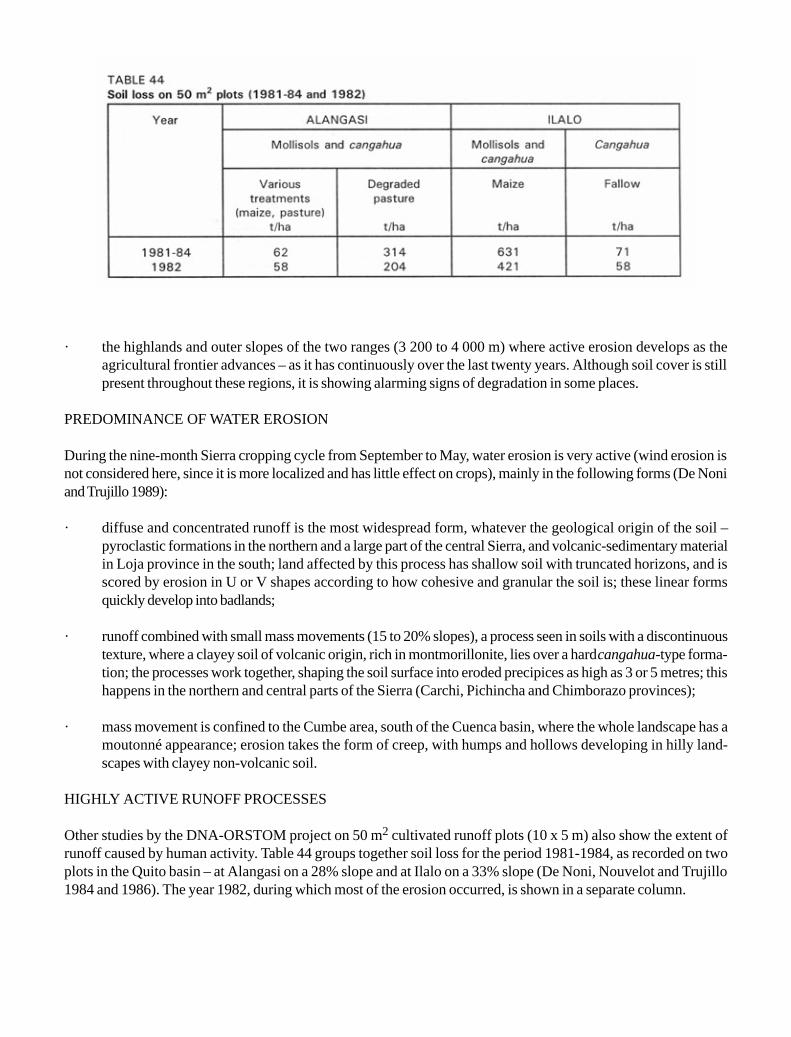
· the highlands and outer slopes of the two ranges (3 200 to 4 000 m) where active erosion develops as theagricultural frontier advances – as it has continuously over the last twenty years. Although soil cover is stillpresent throughout these regions, it is showing alarming signs of degradation in some places.
PREDOMINANCE OF WATER EROSION
During the nine-month Sierra cropping cycle from September to May, water erosion is very active (wind erosion isnot considered here, since it is more localized and has little effect on crops), mainly in the following forms (De Noniand Trujillo 1989):
· diffuse and concentrated runoff is the most widespread form, whatever the geological origin of the soil –pyroclastic formations in the northern and a large part of the central Sierra, and volcanic-sedimentary materialin Loja province in the south; land affected by this process has shallow soil with truncated horizons, and isscored by erosion in U or V shapes according to how cohesive and granular the soil is; these linear formsquickly develop into badlands;
· runoff combined with small mass movements (15 to 20% slopes), a process seen in soils with a discontinuoustexture, where a clayey soil of volcanic origin, rich in montmorillonite, lies over a hard cangahua-type forma-tion; the processes work together, shaping the soil surface into eroded precipices as high as 3 or 5 metres; thishappens in the northern and central parts of the Sierra (Carchi, Pichincha and Chimborazo provinces);
· mass movement is confined to the Cumbe area, south of the Cuenca basin, where the whole landscape has amoutonné appearance; erosion takes the form of creep, with humps and hollows developing in hilly land-scapes with clayey non-volcanic soil.
HIGHLY ACTIVE RUNOFF PROCESSES
Other studies by the DNA-ORSTOM project on 50 m2 cultivated runoff plots (10 x 5 m) also show the extent ofrunoff caused by human activity. Table 44 groups together soil loss for the period 1981-1984, as recorded on twoplots in the Quito basin – at Alangasi on a 28% slope and at Ilalo on a 33% slope (De Noni, Nouvelot and Trujillo1984 and 1986). The year 1982, during which most of the erosion occurred, is shown in a separate column.

Since 1986 the project has expanded its scope, establishing larger runoff plots (20 x 5 m = 100 m2) locatedthroughout an area stretching 800 km along the Sierra, from Pichincha province in the north, to Loja province in thesouth. There are two types of plot: a bare, tilled plot, in accordance with Wischmeier’s prescription (Wischmeier andSmith 1978, Roose 1968) and a control plot using local crops and practices. The bare Wischmeier plot is not only afundamental scientific reference plot, but in the present case also reflects the real features of the farm year – fallowpoor in leafy vegetation and soil bare at the time of sowing barley. For the period 1986-88, the results are given inTable 45.
The following are the main lessons to be drawn from the results:
· Events of spectacular erosion on cultivated soil: for example, on the 50 m2 plots monocropped with maize,erosion exceeded 600 t/ha.
· Irregular erosion from one year to another: at Alangasi and Ilalo soil losses in 1981, 1983 and 1984 were lowcompared with 1982, when most of the erosion occurred. The results also vary considerably from one year toanother on the individual station; for example, in 1987-88 16 times more soil loss than in 1986-87 was recordedat Mojanda, and 7 times more at Tumbaco on the Wischmeier plots, and 32 times more at Tumbaco on thecontrol plot.
· The absence of a regular erosion season during the year (most of the erosion is the result of the five mosterosive rainstorms, out of a total of some forty erosive rainstorms per year per station): the amounts of rain in

the individual rainfalls are not the only explanation of soil losses. In calculating correlation coefficients for theyears 1986-87 and 1987-88, it appears that the best correlations with the weight of eroded soil are recordedwith IM15 or IM30, although the maximum intensities in the Sierra are only low to average: 15 to 45 mm/h.The “R” values on the erosivity index are therefore only moderate, rarely exceeding 100: 60 at Cangahua, 90at Tumbaco, and 100 to 110 at Mojanda and Riobamba. However, all these figures are also subject to annualvariations, and can be considerably higher and extremely erosive. On the Ilalo plot (50 m2), erosion was over400 t/ha/yr in 1982; an IM15 of 90 mm/h was responsible for 270 t/ha/day of lost soil, and another of 70 mm/h for 120 t/ha/day.
ABSENCE OF CONSERVATION METHODS AND FOOD DEFICIT
The history of land use clearly brings out two distinct types of farmer: rich landowners on the haciendas, andmarginalized peasant farmers on the minifundios. The latter are forced by sheer necessity to produce more in orderto survive: driven into a marginal environment, they have been obliged to push the environment beyond its limits, withthe result that all along the Sierra today there is a striking absence of erosion control practices suited to the environ-ment (De Noni, Viennot and Trujillo 1986). For example, on the densely cultivated highlands of Chimborazo andCotopaxi provinces, there are some perfunctory soil conservation structures consisting of hedges and small ditches.The latter are very shallow (20 to 40 cm) and steeply sloping (20 to 25%) in comparison with a conventional ditch,so that they cannot channel excessive water, and rapidly become gullies. Similarly, hedges, usually composed ofsigses (Gybernium), are placed randomly in relation to the main slope. Moreover, these structures, set on the edgesof plots, are only rarely combined with contour tilling.
There is also systematic destruction or abandonment of early agricultural structures inherited from pre-Columbiansocieties. These remains (Gondard 1983), mostly bench terraces, are made with risers built of stone or blocks ofhardened ash. At Pimampiro in Imbabura province, the risers are deliberately knocked down to make room for largeplots mechanically tilled in the direction of the slope. Similarly, near Zhud in Cañar province in a recently settled areawith medium-sized holdings, wide concave terraces dating from the Cañari civilization are appearing from beneaththe shrubby vegetation (chaparral) during clearing. At Punin and Flores, as well as Colta and Chunchi, all inChimborazo province, at an altitude between 3 200 and 3 600 m, and on steep slopes (40 to 60%), there are realterraces separated by risers several metres high. Here again, the intermediate risers have been abandoned ordestroyed, leaving only those that lie along property boundaries, so that they now border excessively wide andsloping “pseudo-terraces”, which are totally unsuited to local conditions.
Certainly in order to survive, but also in the hope of entering the market economy, the small farmers haveoriented the minifundios toward the crops that provide the basic local foodstuffs – cereals (maize, wheat andbarley) and tubers (potatoes). However, natural limitations have prevented the development of profitable farming, sothat the situation of the minifundios is now very precarious: in some regions self-subsistence is barely assured,while surplus production is rare and depends on a year of exceptional yields. Ministry of Agriculture data on levelsof farm production over the past 15 years clearly illustrate this crisis situation (Table 46).
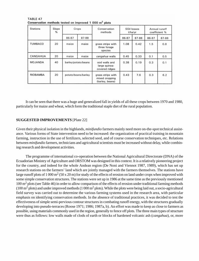
It can be seen that there was a huge and generalized fall in yields of all these crops between 1970 and 1980,particularly for maize and wheat, which form the traditional staple diet of the rural population.
SUGGESTED IMPROVEMENTS [Plate 22]
Given their physical isolation in the highlands, minifundio farmers mainly need more on-the-spot technical assist-ance. Various forms of State intervention need to be increased: the organization of practical training in mountainfarming, instruction in the use of fertilizers, selected seed, and of course conservation techniques, etc. Relationsbetween minifundio farmers, technicians and agricultural scientists must be increased without delay, while combin-ing research and development activities.
The programme of international co-operation between the National Agricultural Directorate (DNA) of theEcuadorian Ministry of Agriculture and ORSTOM was designed in this context. It is a relatively pioneering projectfor the country, and indeed for the whole Andean region (De Noni and Viennot 1987, 1989), which has set upresearch stations on the farmers’ land which are jointly managed with the farmers themselves. The stations havelarge runoff plots of 1 000 m2 (50 x 20 m) for study of the effects of erosion on land under crops when improved withsome simple conservation structures. The stations were set up in 1986 at the same time as the previously mentioned100 m2 plots (see Table 46) in order to allow comparison of the effects of erosion under traditional farming methods(100 m2 plots) and under improved methods (1 000 m2 plots). While the plots were being laid out, a socio-agriculturalfield survey was carried out to determine the various farming systems used in the research area, with particularemphasis on identifying conservation methods. In the absence of traditional practices, it was decided to test theeffectiveness of simple semi-pervious contour structures in combating runoff energy, with the structures graduallydeveloping into pseudo-terraces (Roose 1971; 1986; 1987a, b). An effort was made to keep as close to farmers aspossible, using materials commonly used in the region, generally to fence off plots. The three main types of structurewere thus as follows: low walls made of clods of earth or blocks of hardened volcanic ash (cangahua), or, more

simply, grass strips, either grazed or cropped (quinoa or lupin). The methods tested over the period 1986-88 gave theresults seen in Table 47.
These data demonstrate that simple conservation systems within the reach of the local farming community –contour ridging combined with grass strips or low earth walls – can noticeably reduce erosion. On all the improvedplots, whatever the station, earth loss is minimal and erosion tolerable – usually less than 8 t/ha/yr and often close to1 t/ha/yr. Yields are also better; for example, at Mojanda the potato harvest was 4.3 t/ha on the control plot and 7.6t/ha on the improved plot.
At Riobamba, for the period from 20 September to 12 November 1987 (the sowing date), three erosivedownpours resulted in a soil loss of 33.8 t/ha on the traditional plot where seedbeds had been prepared, while erosionon the improved plot was only 1.1 t/ha for the same period and the same tillage. And at Tumbaco, rainfall on 19October 1987 alone, in the middle of the fallow period and one month prior to sowing (on 18 November), caused asoil loss of 34 t/ha, while the improved plot lost only 140 kg over the same period.
Although encouraging, these preliminary data show that not all the problems have been overcome, and thatbefore launching awareness and extension programmes it is essential to carry out observations under both experi-mental and on-site conditions. This remark is based on the example provided by the changing size and shape of thegrass-clod walls on the Mojanda station. Initially they were about 30 cm high, made up of two layers of earth clods.Then, although erosion on the plot was insignificant (0.2 to 0.3 t/ha/yr), in the course of the cropping year the farmermoves considerable amounts of soil from the top to the bottom of the plot with the broad blade of his mattock(asadon). Digging or hoeing always starts at the foot of a wall, creating a hollow at the base, and the soil is thendrawn towards the bottom of the plot until another wall comes in the way. These simultaneous processes of hollow-ing out in front of walls and filling up behind them meant that the walls had to be heightened several times, rising from30 to 130 cm during the 20 months of observations, while the initially straight slope steadily developed into terraces.It is estimated that almost 40 tonnes of soil per 100 linear metres accumulates behind the walls in this way each year.
CONCLUSIONS
As one of the major mountain barriers in the world, the Andes constitute an environment that is naturally proneto erosion. Erosion has also been exacerbated in Ecuador over at least the past two decades by the impact of theminifundio, with a troubled history that has led to small farmers being sidelined onto inhospitable land. Thanks towork carried out jointly with the local small farmers, the DNA-ORSTOM project has blazed a new trail, carryingout trials that demonstrate that erosion control is not an impossible challenge, despite natural limitations and theweight of history. Using simple structures suited to local conditions and accepted by the local people, thisapproach should lead to conservation of soil fertility, guarantee better harvests, and effect an all-roundimprovement in farmers’ living standards within a single generation.

Chapter 14
The Mediterranean Montane Region of Algeria
AGRICULTURAL INTENSIFICATION... WITHOUT DEGRADATION
THE SITUATION
Although the northern region of Algeria is by far the most productive, it is a very fragile area of young mountains,with soft rocks such as argillite, marl and schist alternating with hard rocks such as limestone and sandstone. Thesemi-arid Mediterranean climate brings fine, gentle, but saturating rain during the cool winter, and dangerous thun-dery rainstorms during the torrid summer months.
The soils (regesols, grey vertisols, brown calcareous soils, and red fersiallitic soils) often have a slaked sur-face, and are gravelly, poor in organic matter, and deficient in phosphorus and nitrogen.
Following various waves of colonization (Roman, Turkish and French) and recent population pressure (51inhabitants per km2 in the mountains), there are now frequent signs of overgrazing (six sheep per hectare) oncompletely bare mountains. Sheet and rill erosion, gullying and mass movement, displacement of wadi channels anddegradation of riverbanks, destruction of roads and accelerated silting-up of reservoirs over the past 15 to 20 yearsare all signs of advanced and general degradation in this area.
In view of these serious erosion problems, between 1940 and 1970 foresters and rural engineering expertsdeveloped a strategy entailing capital investment in rural development (SPR), comprising:
· reforestation of high valleys and mountain tops;· control of torrents and gullies;· terracing of cultivated land: in 30 years Algerian terraces were built on more than 300 000 hectares (at a cost
of between US$ 1 000 and 2 000/ha).
The main objective was a reduction in the siltation of dams, since suitable sites for reservoirs are limited.

However, by 1977 the failure of SPR in the rural environment was clear: the farmers rejected the terracingsystem which deprived them of 10 to 20% of their arable land and offered almost no improvement in soil productiv-ity; wood production was still too low; and the siltation rate was still rising! Terracing projects were halted foreconomic reasons (the second oil crisis) (Heusch 1986). Forestry experts carried on with their work of reforestationand torrent control (RML), but apart from some land improvement projects (subsoiling on brown soil with calcareouscrusts), little more was done to stabilize the land farmed by small farmers (Roose 1987a, b).
The first measurements of erosion on runoff plots (Kouidri, Arabi and Roose 1989) confirmed the view thatsheet erosion on slopes accounted for only a minor part (0.2 to 1 t/ha/yr) of the sediment load in wadis (Heusch 1970,Demmak 1982). This may explain why the reduction in the siltation rate of reservoirs was still so high even when theslopes had been well reforested or terraced. The wadis are the focal point of the various phenomena, for gullyingand wholesale crumbling of slopes sheared away by wandering wadis are the primary source of the sedimentcarried by rivers during the heaviest flood flows.
Nevertheless, sheet erosion from slopes can be very high – up to 80% of the heaviest rainstorms falling onslaking or sealing crusts or on soil compacted by overgrazing, roads, cattle trails, and fallows left as common grazingland. And it is this runoff from bare slopes that creates gullies, swells very dangerous peak flows, underminesriverbanks, and leads to heavy sedimentation in reservoirs.
In view of the present-day difficulties and slowing down of industry, the Algerian government is promoting areturn to the land, with the intensification of mountain farming. However, it hopes that this can be done withouthastening montane degradation and siltation of the reservoirs that are so indispensable for irrigation and the con-stantly expanding towns.
Before farmers can take an interest in maintaining their land and the quality of surface water, it would seemvital to address their immediate concerns – those of increasing their income and security while improving themanagement of water and nutrients on productive land. The first thing to be done is not to stabilize gullied land, butrather to analyse and improve production systems and the water and mineral balance of the best land. Restoringforests and treating gullied slopes is still the main concern of the forestry department.
This new approach has given rise since 1985 to a “land husbandry aid programme” concerned with researchand training, and involving the participation of a dozen research scientists from INRF and ORSTOM. The pro-gramme covers three sub-programmes:
· two surveys of the effectiveness of SPR, first by the forestry department in order to discover the mosteffective interventions, and then by a multidisciplinary research team in order to make a scientific analysis ofthe reasons for successes and failures;
· the treatment of small catchment areas (20 to 300 ha) near Médéa, Mascara and Tlemcen;· evaluation of the volume of runoff and erosion with the help of a rainfall simulator and a network of runoff
plots and gullies.
Here only the main data from the INRF station at Ouzera (Arabi and Roose 1989) are reported, althoughsimilar data have been gathered near Tlemcen (Mazour 1992).

DIAGNOSIS: TRIAL CONDITIONS
Fifteen runoff plots (22.2 x 4.5 m) were prepared on farmers’ fields around the Ouzera research station, 90 kmsouth of Algiers.
The landscape consists of a series of calcareous uplands (900 to 1 200 m in altitude), with steep slopes (12 to40%) and deep valleys where wadis flow intermittently.
Soil types depend on lithology and topographical position (Pouget 1974, Aubert 1987), and are as follows:
· pale yellow lithosols on grey calcareous colluvial deposits, rich in CaCo3, but poor in organic matter;· darkish grey vertisols on marl, well-structured, 2% organic matter, saturated with calcium, pH 7 to 8, very
resistant to rainsplash, but prone to gullying and mass movement;· red fersiallitic soils on soft limestone, poor in organic matter, fragile and lacking stability on the surface;· brown calcareous soils on colluvial deposits, 2 to 3% organic matter, a shallow profile, but well-structured on
the surface.
In this mountainous region (Blidéen Atlas), the forest cover decreased from 18 to 13% between 1982 and1991, while vineyards and orchards increased from 2 to 7% and 8 to 14% respectively – a typical effect of popula-tion growth and the development of mountain farming. Tillage practices are confined to ploughing twice to controlweeds, then a cover crop to dig in fertilizers (N33, P45, K90) and slightly reduce the size of clods.
The average annual rainfall over the past 40 years is 680 mm at Médéa, although between 1986 and 1990,rainfall at Ouzera station (7 km away) varied between 408 and 566 mm, and the rainfall aggressivity factor(Wischmeier’s RUSA) was about 46.
The aim of these trials was to compare potential runoff and erosion risks on a bare tilled plot (internationalcontrol) with those under four production systems (a vineyard, an orchard, an agropastoral system and a sylvopastoralsystem) on four typical soils in a semi-arid Mediterranean zone with mild winters.
The improvements to the regional control plot consist of rough but carefully oriented tillage, the use of herbi-cides and pesticides, improved seed, balanced fertilization, a fodder fallow of legumes, and intercropping in rotationunder the orchard. The recorded parameters are rainfall (amount, intensity, erosivity), runoff (Kaar, the averageannual coefficient, and max KR %, the maximum coefficient for a heavy rainstorm as a percentage of rainfall),erosion (fine suspended matter and coarse sediment), production of biomass and fruit, net income and the soilsurface parameters (closed, open and covered surface, surface humidity).
Hazards
Rainfall was 100 to 250 mm less than the average. Only one set of major rainstorms was recorded, totalling 130 mmin three days, and falling in the summer on dry soil.

Rainfall is much less forceful than in West Africa. The annual average rainfall ratio is about 0.1 at the Médéastation, 0.5 in Côte d’Ivoire and 0.25 in the mountains of Cameroon, Rwanda and Burundi.
Average annual runoff (Kaar %) (Table 48) is modest (0.5 to 4% of rainfall), and the maximum during arainstorm is 8 to 36% (40% in exceptional cases). On the bare control fallow, annual runoff was still modest (10 to18%) compared with levels in a tropical environment (25 to 40% in Côte d’Ivoire). However, if the bare soil ispacked down or waterlogged during the winter, runoff can exceed 50 to 80% on marl and red fersiallitic soil.
With similar soil conditions, slopes and tillage techniques, it was noted that plant cover – especially withimproved techniques – effectively reduced erosion risks.
As many other writers have noted, tillage improved infiltration. For example, under the grapevines on the plotwhere tillage was replaced by herbicides in order to control weeds, runoff increased significantly because thesurface horizon was compacted, but at the same time erosion decreased because the soil was more cohesive. In thecase of an exceptionally heavy rainstorm, the water storage capacity of the soil would soon be exhausted, and runoffcould increase to such an extent on the tilled plot that it would carry away the tilled – and therefore less cohesive –horizon, at least on the steepest slopes. This is frequent in the fields.
Under natural vegetation (scrubland developing into grassland or forest), very considerable litter cover (morethan 80% of the surface covered) meant that although runoff was frequent on soil compacted by overgrazing it wasnever dangerous (max KR 7%). However, it has often been observed in Algeria that drainage lines and gullies ariseon overgrazed rangeland (especially on tracks worn by livestock) or even in some forest plantations degraded bygrazing.
Runoff generally begins after 20 mm of rain on dry ground, and after 3 mm on compacted or moist ground.The precise point at which rain gives rise to runoff clearly depends on the specific features of each rainstorm(intensity, but also capacity to saturate the soil), but first and foremost on the condition of the soil surface (humidityof the top 10 cm, presence of fissures, worm holes, slaking crusts, litter, pebbles and large clods). The most copiousrunoff occurs only when all the conditions are optimal – usually between November and March – or during anexceptional summer storm (every five years).
Sheet erosion was a very modest 0.1 to 2 t/ha/yr on cultivated fields and 1.5 to 18 t/ha/yr on bare fallowdespite steep slopes (12 to 40%), for rainfall is fairly gentle (RUSA < 50) and the soils are very resistant (K = 0.01 to0.01), rich in calcium-saturated clay, and often stony.
Even if erosion were to reach 19 t/ha/yr (1.27 mm of soil), it would take two and a half centuries to remove20 cm of topsoil. It has been proved in trials that sheet erosion selectively removes organic matter, clayey and loamycolloids and nutrients, while rill erosion removes soil unselectively. Thus, when rill erosion sets in, it usually removesthe topsoil, especially on steep slopes. If sheet erosion appears not to be the most powerful process on slopes, rillerosion and especially creep caused by farm implements appear to be the forms most active in transforming moun-tain landscapes.
For example, at Ouzera on an orchard planted 30 years ago, 30 cm of soil is now missing between the treetrunks. Even if recorded sheet erosion is as much as 1.5 t/ha/yr (0.1 mm), in 30 years 3 cm of soil would have beenlost, while 27 cm must have been moved by dry mechanical erosion during the twice-yearly deep criss-cross tillagewith a crawler tractor. Tillage therefore hastens the transformation of mountain slopes, contributing to the formationof banks on the edges of fields.
Soil erodibility was seen to be very low, even after three years of untilled fallow (K = 0.01 to 0.02).However, sheet and rill erosion are increasing each year.
Erosion was high on red fersiallitic soils (10 to 19 t/ha/yr), average on grey vertisols (2 to 3 t/ha/yr) andminimal on brown calcareous soils (1.5 to 2 t/ha/yr). It seems that gravel offers very effective protection.

It is difficult to comment on the likelihood of runoff for different soils, since the slopes vary as much as the soiltypes. However, it does seem clear that average annual runoff and maximum daily runoff decrease as the gradientincreases, at least on bare fallow (Table 49) – an astonishing conclusion that was previously reached by Heusch inMorocco (1970) and Roose in Côte d’Ivoire (1973).
This result throws doubt on the validity of the equations of Ramser, Saccardy and others, for whom the spacebetween terraces should decrease as the gradient increases. Heusch has already shown in Morocco that the posi-tion of a field in the toposequence can be more important than the gradient of the slope itself.
SUGGESTED IMPROVEMENTS: INFLUENCE OF THE FARMING SYSTEM [Plate 23]
Better plant cover (high crop density, fertilizers, rotations with pulses, a winter crop between fruit trees and grape-vines) steadily but undramatically reduced runoff and field erosion (Table 50).
More important, however, is the very marked improvement in crop yields and farmers’ income (see Table 48).The traditional cereal crop can bring in 2 500 dinars/ha/yr, while the improved, intensive cereal/legume rotation

brings in 35 800, and up to 42 000 or 65 000 dinars when this rotation is introduced between rows of grapevines orfruit trees.
These results show that it is possible both to intensify mountain farming and to reduce the risk of degradationof the rural environment.
The yields recorded on the traditionally worked runoff plots (100 m2) were as poor as those on nearbyfarmers’ fields (700 kg/ha/yr of winter wheat, 2 800 kg of grapes, 800 kg of apricots, these latter being diseased). Onthe neighbouring erosion plots treated with improved techniques, yields reached 4 800 to 6 500 kg/ha/yr of winterwheat, 4 000 kg of grapes, plus 3 400 kg of dried beans.
Furthermore, straw, pulsecrop leaves and other crop residues also increased significantly (from 0.2 to 2 or 3 t/ha/yr) so that livestock production and the availability of manure or organic residues can in the long run improve soilfertility and resistance to erosion.
Yield improvements are unlikely to be as spectacular on large areas as on the small erosion plots (100 m2), butthe first step has been taken: that of showing that farming can be intensified while steadily improving the ruralenvironment.
That this is a viable investment is shown by the following. After subtracting the extra costs of improved seed,fertilizers, pesticides, herbicides, the work of soil preparation and harvesting, farmers are still left with a much highernet income than that from traditional crops.
1) extensive grazing in wooded areas can bring in 500 DA/ha1
2) traditional winter wheat 2 500 DA/ha3) grapevines or traditional apricot orchards 10-17 000 DA/ha4) improved rotation: wheat x fodder pulse 28-33 000 DA/ha5) combination of this rotation with grapes and apricots 42-65 000 DA/ha
This would indicate that returns can be multiplied tenfold for cereals and threefold for grapes if an intensivesystem is adopted. If the traditional wheat-grassland rotation is replaced by intensified orchards, returns are multi-plied twentyfold. This is one of the benefits of mountains with a mild, moist climate, for farming cannot always beintensified if the soil is too shallow and rainfall is less than 400 mm.
With such evidence in hand, it is possible to interest farmers in changing and improving their practices so as toincrease conservation of water and soil fertility. Indeed, after three years of trials, the hill farmers copied the projectmethods and achieved better yields than the project itself in 1991, a year when rainfall was well distributed.
1 5 Algerian dinars (DA) = 1 FF $US 0.2 at 1992 exchange rates.

CONCLUSIONS
There has not yet been time to put into practice the full range of land husbandry measures for the improvement ofa village-based area or small watershed. It takes time both to modify farmers’ practices and to assemble thewherewithal for field demonstrations showing that land productivity can be improved, small farmers’ incomes canbe increased, and risks of degradation of the landscape can be reduced in mid-altitude Mediterranean mountainareas.
Chapter 15
Pays de Caux: a temperate, field-crop region in north-western France
PROTECTING THE DRAINAGE SYSTEM AND IMPROVING INFILTRATION
THE SITUATION
Runoff, soil erosion and flooding have become more frequent and more serious in the Pays de Caux region in thepast 20 years (Auzet 1990; Papy and Boiffin 1988) – as they have in a large part of north-western France.
A very real desire for soil and water conservation has been growing for some years now. At first action wasconfined to combating catastrophic floods, but in recent years, local authorities in the Seine Maritime departmenthave spent US$ 4 million on check dams. Efforts are now being made to implement comprehensive, long-termprogrammes for whole watersheds (regional operation set up in 1985 with the Board of Agriculture).
These programmes have two components:
· an agricultural component, to reduce soil erosion and runoff on slopes by increasing the roughness and infiltra-tion capacity of the soil surface, with interventions by the individual farmer;
· a water-management component, for collective schemes to control the inevitable flows, and hence curberosion and flooding in the valleys.
In the agricultural sphere, various techniques perfectly integrated with existing production systems have beendeveloped in successive stages:
· precise definition of the type of erosion, and the factors on which intervention is possible (Boiffin, Papy andEimberck 1988);
· investigation of the actual amounts involved in erosion phenomena (internal SRAE reports 1989, 1990, 1991)(Daix 1991, Ouvry 1992);
· analysis of production systems and points where manoeuvre is possible (in financial and technical terms) andthe time available on farms (Papy and Boiffin 1988, Poujade 1989);

· research into and propagation of agricultural solutions that are suited to the specific production systems, inorder to increase accumulation and infiltration while preserving the potential and profitability of plots as wellas facility of tillage;
· solutions are at first implemented individually so that each farmer can see that there is room for manoeuvrefor him, and so that the rural community can then take collective control of the whole agricultural catchmentarea.
LOCAL CONDITIONS
The Pays de Caux area lies along the coast in the Seine-Maritime department. It is a chalky undulated upland area,with gentle slopes (1 to 5% on tilled land) throughout. It has no drainage system because of the underlying karst, andalso because of a very tight network of dry valleys. Intensive multicropping is practised in these uplands.

The soil cover is fairly homogeneous. Brown, slightly leached soils have formed on the wind-blown holocenesilt that covers the uplands. The amount of clay in the tilled horizon varies between 10 and 15%, and the organicmatter in the tilled silt is close on 1.6%.
The climate is oceanic in type with gentle rainfall averaging 900 mm annually, spread evenly throughout theyear. The heaviest day’s rainfall in a 10-year period is only 48 mm.
HAZARDS: THE EROSION PROCESS AND ITS NEGATIVE EFFECTS
The erosion process is typical of that from concentrated runoff as described by Ouvry (1982,), Boiffin, Papy andEimberck (1988), Boiffin, Papy and Peyre (1986) and Auzet (1990). Erosion phenomena are linear and generallyconfined to the thalweg axis, although they can also appear on the headlands (ends of fields) or on any lines ofconcentration between plots. Occasionally, erosion takes the form of shoestrings or parallel rills on slopes steeperthan 4%. Damage often occurs in winter even though rainfall intensity is under 5 mm/h, and sometimes duringsummer storms. Soil losses are always confined to the thalweg, but vary greatly, ranging between 0 and 500 m3/km2
per year (Ouvry 1992).
On the basis of erosion type, Boiffin, Papy and Peyre (1986) divide the catchment area into two distinct zones(Figure 84):
· the sides and head of the catchment area, which produce runoff;· the thalweg and other lines of concentration where the flow cuts into the soil.
The runoff in this region of very gentle rainfall depends mainly on factors related to the state of the soilsurface, notably its roughness, and the speed of formation and extent of slaking crusts.
In winter, after the last tillage, 30 to 40 cumulative centimetres of rainfall of any intensity are enough to formthe first thin slaked surfaces and sedimentation crusts. The roughness of the seedbeds allows a maximum surfaceretention of 3 to 6 mm and a minimum of 1 mm to zero, depending on the type of crop, the preceding crop, soilmoisture when tilled, the type of implements used to prepare the seedbed, the number of farm machinery passes, andthe type of tractor equipment (Boiffin, Papy and Eimberck 1988).
SOLUTIONS AND MEASURES ADOPTED
There are two consequences of the process of concentrated erosion:
· different solutions must be found and advised for slopes and thalwegs (unlike the case of regions whererainsplash is the most telling factor), and farmers must learn to treat these distinct sectors of a single plot indifferent ways;
· farmers’ motivation varies, depending on whether their plots are located upstream in the watershed or in asmall valley where erosion is more of a threat.

The example of a watershed at Bourg-Dun given in Figure 85 covers 60 hectares, five of which were stillunder grassland in 1991. Consolidation dates from 1957, when the boundaries were fixed, with parallel plots lying inthe direction of the slope. The production systems on the four farms consist of intensive multicropping.
Starting in 1978, erosion began to appear regularly on different sectors along the thalweg line, as Figure 84shows. Ludwig, Boiffin and Masclet (1992) estimated the volume of the rills to be 100.8 m3 during the winter of1988-89.
By 1986, some of the farmers wanted to control soil erosion. When the rills and gullies started preventingthem from moving harvesting equipment as they wished, the problem was serious enough to spur them into action.Loss of time for all the tillage work and loss of area in terms of non-harvestable zones and others where weeds couldnot be controlled were much more important issues for the farmers than the actual grooves caused by erosion – andin any case the area lost by cutting along the thalweg is very minor (between 0.1% and 1% of the land undercultivation).

MEASURES TAKEN
As a first phase, a relationship of mutual trust was established with these farmers, based on a thorough knowledgeof agricultural constraints, farming systems and farm finances.
In a second phase, the farmers tested very simple agricultural solutions on their own plots – solutions that costnothing and were usually based on observation and commonsense, so that they gradually realized that runoff anderosion are not inevitable, but can be curbed. The most delicate operation is that of distinguishing the different zoneswithin a plot, and then selecting the right solutions for each. After this, collective action is needed to control andmanage water over the entire watershed.
FARMING PRACTICES
All the solutions aim primarily at roughening the soil surface and ensuring good macroporosity, and secondly atslowing the formation of slaking crusts, then breaking them (Ouvry 1987).
For example, all wheel-marks must be eliminated, since they can cover between 5 and 33% of the soil surfacefor beet and maize, depending on the type and make of seed-drill and secondary implements (such as wheel-markobliterators). For crops, the condition of the surface is determined at planting-time. A cloddy seedbed is preparedwithout crushing or rolling the soil surface, depending on the previous crop, residues and soil moisture. Highlyarticulated implements are not recommended: better a cultivator with rigid or vibrating tines which can prepare thesoil in one operation, or sometimes two (Ouvry 1989).
For widely-spaced crops, it is recommended that fine tillage be confined to the seeding strip, i.e., one-third ofthe area, leaving the space between rows very cloddy. Use of a mechanical weeder or hoeing between the rows soas to break the slaking crust is also recommended for these crops. The choice of tine, either a blade-like jointer (notrecommended) or a hoe-type shape (recommended) is very important, in view of its effect on the risk of summererosion.
There is more room for manoeuvre over intercropping. Without going into detail, the solutions depend on thefollowing points:
· the surface should be cloddy and rough for maximum surface retention by the last tillage;· tillage should be perpendicular or diagonal to the slope; it may even be partial if there are strong climatic or
time constraints;· a mulch of crushed straw should be used;· a green manure (or intermediate crop) can also be planted, so long as it is dense enough and grows quickly
enough to protect the soil fast and maintain an infiltration rate of 10 mm/h; there must also be good controlover its effects on subsequent crops.
DRAINAGE
The aim is to install runoff harvesting structures, alternating with storage structures, in order to control flow (Boiffin,Papy and Eimberck 1988, Ouvry 1987, 1992). In this watershed the farmers have gradually set up the variouscomponents of such a system, as shown in Figure 86 (Ouvry 1987).

Some erosion control structures are permanent, while some, such as compacted strips, are temporary andhave to be redone after each tillage. The strips have the attraction of being very simple, but are suited to veryspecific conditions, being limited, for example, to mild rainfall. However, they demonstrate three points to the farm-ers:
· something can be done;· the two operational sectors must be treated differently;· if this is not sufficient, a more radical solution will have to be devised, using ditches to divide the plot, or grass
strips.

DIFFICULTIES ENCOUNTERED
All this work required considerable time. Furthermore, one of the farmers was not motivated, since his plots werelocated uphill and suffered no damage. This means that if measures to limit runoff are to be applied throughout agiven area, they have to be an integral part of the agricultural advice given by all the experts and field staff.
If the expert advice is not followed, there may be various reasons:
· lack of time;· humid climate;· lack of suitable equipment;· cost of green manure;· side effects of green manure.
The search for solutions must therefore take account of these limitations.
COST
The cost of all these control measures comes under two headings:
· the average annual cost of one person totally engaged in regional mobilization for erosion control wouldamount to US$ 90 000;
· the cost of the solutions: the solutions sought always have the lowest cost possible, generally nil, apart fromtime; full advantage is taken of existing farm machinery and structures.
The only direct cost is that of green manure, which varies between US$ 20 and 60/ha.
The cost of drainage solutions varies widely:
· compacted strip = 0;· ploughed furrow on the edge of the plot along the thalweg axis = 0;· grass strip: grassing = US$ 0.6/m2 (seed), and terracing under contract = US$ 6/m2;· ditch (section # 1 m2) = US$ 7/m2;· pond 100 to 500 m3 = US$ 8/m3.
All the larger dams come under the responsibility of the local communities in association with the farmers:
· a flood meadow (pasture located at the bottom of the valley and barred by a compacted bank at least 1 mhigh), which could hold 1 000 to 10 000 m3, would cost between US$ 6 and 12 per m2 stored;
· a classic basin dam costing between US$ 20 and 40/m3, or a cost per hectare of the catchment area ofbetween US$ 300 and 3 000.

CONCLUSIONS
In view of the importance of the condition of the surface of cultivated plots in determining runoff and erosionrisks, the farmers’ rôle is clearly critical. This surface condition depends on how the soil is used, the croppingsystem, tillage, and the choice of implements.
Preventive and remedial treatment of these phenomena will therefore be carried out with the farmers or not at all.
This long-term undertaking will be done by agricultural experts, working to show farmers how to integrate erosionand runoff control measures into their overall approach.
Moreover, preventive measures, dictated by the type of erosion, must be implemented simultaneously. Thisentails planning and establishing a drainage system at the time of consolidation of holdings, a step now beingcarried out jointly by the farmers and the members of the communal consolidation commissions.
Plots may also be aligned diagonally to the slope to take full advantage of any possible spreading, for saving 1 or2 mm of runoff through surface roughness represents 30 to 50% of the total flow.
As a last resort, when runoff cannot be totally avoided, dams will have to be built to protect the village, inaddition to the agricultural and drainage measures implemented at various points in the watershed.
Such structures are certainly of interest to all parties: soil erosion will be restricted on the farm; siltation of damswill be reduced; pollution will be reduced in regularly scoured catchments and rivers; and floods will also be lessserious and less frequent in the rural towns.
Measures such as these, which will bear fruit in the long term, must be carried out within the framework of acomprehensive rural development policy decided by elected provincial and regional representatives.

PROSPECTS AND ORIENTATIONS
LAND HUSBANDRY: A NEW PHILOSOPHY
Runoff and erosion control has proven more complex than anticipated. On the one hand, there are many processesof soil degradation, and there is a long way to go before the technology is tailored to the range of environments foundin the world: remedies are too often applied with no knowledge of their effectiveness against erosion, their feasibilityor their economic viability in a given time and place. Moreover, many sociological and economic factors have not yetbeen properly grasped: land tenure problems and investment security, farmers’ goals and priorities, the availability ofland, inputs and labour, and opportunities to get more benefit from farm produce and improve living standards, health,etc.
Simply conserving soil cannot satisfy most farmers because it brings no immediate return for the extra workrequired. Most land is already so poor and degraded that even if losses through erosion are curbed, the productivityof both land and labour is still mediocre. However, the population doubles every 15 to 30 years, which implies thechallenge of doubling production in ten years in order to catch up with the geometric progression in population. Soilconservation is not enough: fertility has to be restored in order to allow a satisfactory and early return on the labourinvested. Land husbandry tries to bring about a decided increase in yields, while stabilizing the environment.
In pursuit of this aim, land husbandry improves the management of water, organic matter and nutrients inorder to create intensification points for production and for development of the rural environment through animalhusbandry (manure being one of the keys to productivity on tropical soils incapable of storing much water or nutri-ents), agroforestry and off-season crops. Land husbandry aims primarily at a signficant increase in yields (or, better,in net income), and this requires stabilization of the environment. Erosion control is no longer the rallying call forpublic opinion, but simply one necessary component of a technological package.
The belief was that soil nutrients could be mobilized through various biological means – manure, compost,mulch, hedges, green manure. Many recent examples from tropical countries have shown that on acid ferralitic soilsagroforestry (and particularly cropping between hedges) can halt erosion even on steep slopes (25 to 60%) and curbthe degradation of cultivated land. However, like green manuring, this “simultaneous cultivation and fallow” immo-bilizes 10 to 20% of the land simply in order to maintain a very modest level of production, not enough to keep pacewith population pressure. If this vicious circle is to be broken, soil fertility must first be restored – which is notpossible without massive applications of manure (3 to 10 t/ha), lime (1 to 5 t/ha) and mineral fertilizers that can bedirectly taken up by crops.
The densest rural populations in the world live in multi-storey gardens where positive interaction betweenlivestock, crops and trees is pursued to the furthest extreme. In Africa there is still a great deal to be done in orderto intensify animal husbandry and manage trees so as to minimize competition with traditional crops.

LAND HUSBANDRY: A STRATEGY FOR ACTION
This work has collated research on the dynamics of erosion and the erosion control methods developed over the pastforty years, especially in French-speaking Africa, and has led to the formulation of new research approaches andorientations for rural development.
NEW RESEARCH APPROACHES
· Study of traditional strategies for managing water, soil and soil fertility: the way they work, the causes of theirdecline, and the possibilities of improving them;
· study of the feasibility, acceptability, effectiveness and economic viability of erosion control methods;
· study of the costs of erosion and of erosion control at the individual plot and watershed levels;
· regional adaptation of methods of managing water, nutrients and biomass;
· refining methods of dissipating runoff energy on slopes;
· the social and economic aspects of erosion, and how to increase farmers’ awareness of problems of environ-mental degradation;
· degradation and, above all, restoration of the productivity of the land: the rôles of livestock, trees, micro-organisms (manure) and mineral supplements;
· development of models of the risks of runoff, drainage and erosion, but also optimal land use, taking accountof the limitations imposed by production systems and farm sizes.
NEW ORIENTATIONS FOR RURAL DEVELOPMENT
Since the participation of farmers is vital for the sustainability of erosion control, farmer priorities must be taken intoaccount, and research involve their participation in finding ways of improving land productivity and getting a betterreturn on their labour. Erosion control should no longer be presented as the main objective, but as part of a techno-logical package designed to improve the management of water, biomass and nutrients:
· systematically improving existing techniques while avoiding increased dependency on inputs coming fromoutside the village (funding, sophisticated technology, etc.);
· integrating new elements into farming systems (agroforestry, multicropping, catch fallows of legumes, accel-erated rotation, supplementary irrigation and manuring);
· promoting the cheapest and most effective erosion control structures;
· taking account of market studies and the condition of the road network in order to draw the most benefit fromproduction;

· refining methods of draining both roads and the slopes on which they are built;
· adaptation of erosion control to the land-tenure system.
The prospects for research and rural development outlined in this book call on the various parties to worktogether. The various activities are envisaged within a framework of close cooperation between national agencies,non-governmental organizations, development agencies and the users of the land. The rôle of national agencies inparticular should be transformed from that of executing agency to that of promoter. The ideal programme directlyinvolves the users of the land in planning and implementing their own solutions. To this end, national agencies shouldassume responsibility for creating an awareness of land degradation, and the users of the land should be helped todevelop their own organizations.

References
Alaoui O. 1992a. Analyse économique de la lutte antiérosive : cas du bassin du LoukkosMaroc. Agroconcept, Séminaire sur le Programme National de la recherche surl’aménagement des bassins versants. Rabat, 14 p.
Alaoui O. 1992b. Analyse économique et recherche appliquée à la lutte antiérosive. Quelles priorités ? Ateliernational pour la définition d’un programme de recherche appliquée en aménagement intégré des bassinsversants. Rabat, Maroc, avril 1992. Agroconcept, 19 pages.
Almeida G., De Noni G. et al. 1984. Los principales procesos erosivos en Ecuador. PRONAREG-PRONACOS-ORSTOM, Quito, 31 p. con un mapa del país a escala 1/1000.000.
Arabi M. 1991. Influence de quatre systèmes de production sur le ruissellement et l’érosion en milieu montagnardméditerranéen, Médéa, Algérie. Thèse doctorat géographie, Univ. Grenoble. 276 p.
Arabi M. and Roose E. 1989. Influence de quatre systèmes de production en région méditerranéenne de moyennemontagne algérienne. Bull. Réseau Erosion 9 : 39-51. ORSTOM, Montpellier.
Arabi M. and Roose E. 1992. Water and soil fertility management G.CES. A new strategy to fight erosion inAlgerian mountains. Paper to ISCO 7, Sydney : 11 p.
Arnoldus H. 1981. An approximation of the rainfall factor in the USLE. In : Assessment of Erosion. de Boodt andGabriels (eds.). John Wiley. pp. 127-132.
Aubert G. 1987. Erodibilité des sols de la région d’Ouzera. Bull. Réseau Erosion 8 : 97-99.
Auzet V. 1990. L’érosion des sols par l’eau dans les régions de grande culture: aspects aménagement. Ministère del’Environnement et Ministère de l’Agriculture, Paris. CEREG, Strasbourg. 39 p. + annexes.
Avenard J.M. 1989. Sensibilité aux mouvements de masse. Cah. ORSTOM Pédol. 25(1) : 119-130.
Avenard J.M. and Roose E.J. 1972. Quelques aspects de la dynamique actuelle sur versants en Côte d’Ivoire.Comm. 22e Congrès Int. Géographie, Canada. ORSTOM Abidjan, 25 p.
Bagnold R.A. 1937. Transport of sand by wind. Geogr. J. 89-436.
Balasubramanian V. and Sekayange L. 1992. Effets de la culture en couloir sur les propriétés du sol et lesperformances des arbustes et des cultures vivrières dans un environnement semi-aride du Rwanda. Bull.Réseau Erosion 12 : 180-190.

Bedu L. 1986. Contribution à la mise en valeur des sols du Yatenga. Projet d’aménagement du terroir de ZigaBurkina Faso. Mémoire ENSAA-CNEARC-CIRAD, Montpellier, France, 90 p.
Bennett H.H. 1939. Elements of Soil Conservation. 2nd edition. Mac Graw-Hill, New York.
Berding F. 1992. Les facteurs de l’érosion : état actuel des connaissances. Kigali, Rwanda, Minagri, Séminaire surla stratégie nationale de conservation des sols. 26 p.
Birot Y. and Galabert I. 1967. L’amélioration des rendements en agriculture par l’aménagement antiérosif et lestechniques culturales dans l’Ader Doutchi-Maggia Niger. In : Colloque Fertilité des sols tropicaux.Tananarive, Comm. n° 109 : 1316-1331.
Birot Y., Galabert T., Roose E. and Arrivets J. 1968. Deuxième campagne d’observations sur la station de mesurede l’érosion de Gampéla : 1968. CTFT-Ouagadougou, Burkina Faso, 40 p.
Blancaneaux Ph. 1979. Dynamique des sols ferrallitiques sur granito-gneiss en Guyane française. Relation avecl’érosion, le ruissellement et le lessivage oblique. ORSTOM, Paris, 162 p.
Boiffin J. 1976. Histoire hydrique et stabilité structurale de la terre. Ann. Agron. 274 : 447-463.
Boiffin J., Papy F. and Eimberck J. 1988. Influence des systèmes de culture sur les risques d’érosion parruissellement concentré. I. Analyse des conditions de déclenchement de l’érosion. Agronomie 8(81) : 663-673.
Boiffin J., Papy F. and Peyre Y. 1986. Systèmes de production, systèmes de culture et risques d’érosion dans lePays de Caux. Rapport INA-PG, INRA, Paris. 154 p. + annexes.
Boli Z., Bep A. and Roose E. 1991. Enquête sur l’érosion en région cotonnière du Nord Cameroun. Bull. RéseauErosion 11 : 127-138.
Bolline A. 1982. Etude et prévision de l’érosion des sols limoneux cultivés en moyenne Belgique. Thèse DrGéographie Univ. Liège, 356 p.
Bonvallot J. 1986. Tabias et Jessour du Sud Tunisien. Agriculture dans les zones marginales et parade à l’érosion.Cah. ORSTOM Pédol. 22(2) : 163-172.
Bourges J., Floret C., Girard G. and Pontanier R. 1979. Etude d’un milieu représentatif du Sud Tunisien typeSEGUI : la citerne TELMAN, Campagnes 1972-77. Min. Agriculture/ORSTOM Tunis, 87 p.
Bourgoin J. 1956. Rapport sur les tracés de voies ferrées pour l’évacuation des minerais de Fort Gourand etAkjoujt. BCEOM, 57 p.
Bourougaa L. and Monjengue S. 1989. Fixation mécanique et biologique des ravines. Expérimentation dans larégion semi-aride de Béni-Slimane, Algérie. Bull. Réseau Erosion 9 : 19-29.
Boyer J. 1970. Essais de synthèse des connaissances acquises sur les facteurs de fertilité des sols en Afriqueintertropicale francophone. ORSTOM, Paris, 175 p.
Brunet-Moret Y. 1963. Etude générale des averses exceptionnelles en Afrique occidentale. République de HauteVolta. Edité par CIEH, ORSTOM Paris, 23 p. + annexes.

Brunet-Moret Y. 1967. Etude générale des averses exceptionnelles en Afrique occidentale. République de Côted’Ivoire. Edité par CIEH, ORSTOM Paris, 20 p. + annexes.
Bryan R.B. 1981. Soil erosion under simulated rainfall in the field and laboratory: variability of erosion undercontrolled conditions. In : Proc. IAMS 135: 391-403.
Buchy M. 1989. L’arbre dans l’économie rurale des collines de la moyenne région du delta du Fleuve Rouge.Exemple de la coopérative de Chan Mong. Rapport de stage CNEARC-ENGREF, Montpellier, 60 p.
Burnell R.E. and Larson W.E. 1969. Infiltration as influenced by tillage-induced roughness and pore-space. SoilSci. Soc. Amer. Proc. 333 : 449-452.
Campbell I.A. 1983. The partial area contribution concept and its application to the problem of sediment sourceareas. In: Soil Erosion and Conservation. El-Swaify and Moldenhauer (eds.), Soil Cons. Soc. America,Ankeny, USA, pp 128-138.
Casenave A. and Valentin C. 1989. Les états de surface de la zone sahélienne. Influence sur l’infiltration.ORSTOM, Paris, série Didactiques, 229 p.
CEMAGREF. 1982. La végétation d’espaces ravinés dans les Alpes du Sud. Cemagref Grenoble, 54 p.
CEMAGREF. 1985. Les éléments techniques de drainage de glissements de terrain.
CEMAGREF. 1986-1987. Les dégâts causés par les pluies intenses dans le bassin du Croult Val d’Oise. ConseilGénéral du Val d’Oise, Ministère de l’Environnement, 3 rapports, 236 p.
Chaminade R. 1965. Recherches sur la fertilité et la fertilisation des sols tropicaux. Principes de base et techniquedes vases de culture. L’Agron. Trop. 20(10) : 1014-1017.
Champaud J. 1973. Atlas régional Ouest 2, commentaire des cartes. ORSTOM, Yaoundé, 118 P. + 10 cartes.
Charreau C. 1969. Influence des techniques culturales sur le développement du ruissellement et de l’érosion enCasamance. VII Congrès Int. Génie Rural CNRA, Bambey Sénégal, 13 p.
Charreau Cl. 1970. Pluie et érosion. IRAT, Bambey, Sénégal, séminaire climatologie : 12 p.
Charreau C. and Nicou R. 1971a. L’amélioration du profil cultural dans les sols sableux de la zone tropicale sècheouest africaine et des incidences agronomiques. Agron. Trop. 26(9) : 903-978.
Charreau C. and Nicou R. 1971b. L’amélioration du profil cultural dans les sols sableux de la zone tropicale sècheouest africaine et des incidences agronomiques. Agron. Trop. 26(11) : 1183-1247.
Chase R.G. and Boudouresque E. 1989. A study of methods for revegetation of barren crusted sahelian forestsoils. Proc. Symposium “Soil, crop and water management in the sudano-sahelian zone”. INRAN-ICRISATNiamey, Niger, 385 p.: pp. 125-136.
Chopart J.C. 1980. Etude au champ des systèmes racinaires des principales cultures pluviales au Sénégal. ThèseDoct. Inst. Nat. Polytechnique Toulouse, France, 160 p. + annexes.

Christoï R. 1961. Résultats obtenus à l’essai “EROSION” de la station de Niangoloko Haute-Volta. IRHO, 51pages.
CTFT. 1969. Conservation des sols au Sud du Sahara. Min. Affaires Etrangères et CTFT, Paris, Collectiontechniques rurales en Afrique n° 12.
Claude J., Francillon G. and Loyer J.Y. 1976. Les alluvions déposées par l’oued Medjerda lors des cruesexceptionnelles de mars 1973. DRES-ORSTOM, 162 p. + photos + Annexes.
Collinet J. 1971. Premiers résultats de l’exploitation d’une parcelle de lessivage oblique ERLO dans la région deLibreville Gabon. ORSTOM, Libreville, 15 p.
Collinet J. and Lafforgue A. 1979. Mesures de ruissellement et d’érosion sous pluies simulées pour quelques typesde sols de Haute-Volta. ORSTOM, Abidjan, 129 p.
Collinet J. and Valentin C. 1979. Analyse des différents facteurs intervenant sur l’hydrodynamique superficielle.Nouvelles perspectives. Applications agronomiques. Cah. ORSTOM Pédol. 174 : 283-328.
Collinet J. and Valentin C. 1984. Evaluation of erosion factors in Western Africa using rainfall simulation. Proc.Symp. Harare AISH 144: 451-461.
Combeau A. 1977. Erosion et conservation des sols. ORSTOM, Paris, 85 p.
Combes F. 1992. Les plantations RTM. Bull. Réseau Erosion 12 : 52-56.
Cosandey C. 1983. Recherches sur le bilan de l’eau dans l’Ouest du Massif Armoricain. Thèse Doct. Etat, Paris,Institut Géographie, 515 p.
Critchley W., Reij C. and Seznec A. 1992. Water harvesting for plant production. Part 2. Case studies andconclusions for sub-Saharan Africa. World Bank Technical Paper, 120 p.
Daix C. 1991. Analyse du ruissellement en fonction de la dynamique spatiale des états de surface du sol.Approche à l’échelle du bassin versant élémentaire en Pays de Caux. Mémoire de fin d’études. 35 p. +annexes.
Davy L. 1989. Une catastrophe naturelle : l’averse mémorable du 3/10/88 et ses conséquences hydrologiques.Hydrologie Continentale 4(2) : 75-92.
Delaunay. D. 1989 Espacios demográficos y redes migratorias, Collection : Etudes de Géographie, CorporaciónEditora Nacional, Colegio de Geografos del Ecuador, Quito. pp. 71-98.
Delepierre G. 1982. Les régions agro-climatiques en relation avec l’intensité de l’érosion du sol. Bull. Agric.Rwanda 2 : 87-95.
Delhoume J.P. Asseline J., Ruiz Valdes J. and Viramonte D. 1989. Caractérisation hydrodynamique au moyen d’uninfiltromètre à aspersion de sols représentatifs du Nord aride du Mexique. Projet MAPIMI, Inst. Ecologia deMexico and ORSTOM, Paris, à paraître.
Delwaulle J.C. 1973. Résultats de six années d’observations sur l’érosion au Niger. Bois et Forêts des Tropiques150: 15-37.
Demmak A. 1982. Contribution à l’étude de l’érosion et des transports solides en Algérie septentrionale. ThèseDoct. Ing., Paris, 323 p.
De Noni. G. 1986 Breve historia de la erosión en el Ecuador. Documentos de investigación nº6, CEDIG-ORSTOM, Quito. pp. 15-23.
De Noni G. and Trujillo G. 1989. Quelques réflexions au sujet de l’érosion et de la conservation des sols enEquateur. Colloque et Séminaire “Equateur 1986”, vol.1, Edit. de l’ORSTOM, Paris, p. 133-143.
De Noni G. and Viennot M. 1985. Estudio de algunos procesos de erosión en la Sierra volcánica del Ecuador 3200m-4800 m. Revista colombiana de la ciencia del suelo, Bogotá XVI(1) : 23-31.
De Noni G. and Viennot M. 1987. De l’approximation cartographique aux réalisations de terrain: la lutte contrel’érosion agricole dans les Andes équatoriennes. Colloque sur les sociétés rurales de montagne Andes etHimalaya, CNRS- Université de Grenoble. pp. 61-65.
De Noni G. and Viennot M. 1989. Le projet DNA-ORSTOM sur l’Etude de l’érosion et des pratiques deconservation des sols en Equateur. Bull. Réseau Erosion, ORSTOM, Montpellier. 5 p.
De Noni G. and Viennot M. 1991. L’érosion agricole dans les Andes de l’Equateur. Bull. Réseau Erosion n° 11 :205-209.
De Noni G., Nouvelot J.F. and Trujillo G. 1984. Erosion and conservation of volcanic ash soils in the highlands ofEcuador: a case study. Sixth International Soil Classification Workshop, Chile and Ecuador, part 1. pp. 263-274, SMSS Washington, PUCC Santiago de Chile.
De Noni G., Nouvelot J.F. and Trujillo G. 1986. Estudio cuantitativo de la erosión con fines de protección de lossuelos: las parcelas de Alangasi y Ilalo. CEDIG-ORSTOM, Documentos de investigación Nº 6, Quito. pp. 35-47.
De Noni G., Viennot M. and Trujillo G. 1986. L’érosion et la conservation des sols en Equateur. Cah. ORSTOMPédol. 22(2), Paris, pp. 235-245.
De Noni G., Viennot M. and Trujillo G. 1989. Mesures de l’érosion dans les Andes de Equateur. Cah. ORSTOMPédol. 25(1-2) : 183-196. Paris.
De Ploey J. 1971. Liquefaction and rainwash erosion. Zeitschr. Geomorph. 15: 491-496.
De Ploey J. 1980. Some field measurements and experimental data on wind-blown sands. In : Assessment ofErosion. De Boodt and Gabriels (eds.). John Wiley, UK. pp. 541-552.
De Ploey J. 1990. La conservation des sols. La Recherche 227, Suppl. 6 : 111-122.
Deymier Ch. 1992. Les outils de génie civil dans la lutte contre l’érosion torrentielle. Bull. Réseau Erosion 12 : 28-39.
Dezilleau D. and Minoza F. 1988. Digues filtrantes : projet AFUP RISSIAM-BAM Burkina Faso. In : Le Sahel enlutte contre la désertification. Ed. Rochette, Cills-PAC. pp. 239-260.

Dixon R.M. 1983. Land imprinting for controlling infiltration and desertification processus. ASAE paper, 83-2514.
Dregne H.E. 1988. Erosion, Productivity and Sustainable Agriculture. Int. Center for Arid and and Semiarid landstudies, Texas Techn. Univ. Lubbock, Texas, 11 p.
Duchaufour M. and Bizimana M. 1992. Restauration de la fertilité et conservation des eaux et des sols en régionmontagneuse du Burundi. Bull. Réseau Erosion 12 : 161-178.
Ducret G. and Fotsing J.M. 1987. Evolution des systèmes agraires à Bafou Ouest-Cameroun. Rev. de Géo. duCam. VII(1) Yaoundé, : 1-18.
Ducret G. and Grangeret I. 1986. Quelques aspects des systèmes de cultures en pays Bamiléké. CUDS, Dschang,33 p.
Dugué P. 1986. L’utilisation des ressources en eau à l’échelle d’un village. Perspective de développement de petitspérimètres irrigués de saison des pluies et de saison sèche. CIRAD/DSA Montpellier, Collection SystèmesAgraires n° 6.
Dugué P. 1988. Possibilités et limites de l’intensification des cultures vivrières en zone soudano-sahélienne : lecas du Yatenga. Thèse ENSA-M Montpellier, 252 p.
Duley F.L. 1939. Surface factors affecting the rate of intake of water by soils. Soil Sci. Soc. Amer. Proc. 4 : 60-64.
Dumas J. 1965. Relation entre l’érodibilité des sols et leurs caractéristiques analytiques. Cah. ORSTOM Pédol.3(4) : 307-333.
Dupriez H. and De Leener Ph. 1990. Les chemins de l’eau : ruissellement, irrigation, drainage. Terres and Vie(eds.). Nivelles (Belgique). 380 p.
El Amani S. 1983. Les aménagements hydrauliques traditionnels en Tunisie. Centre de Recherche du Génie Rural,Tunis, 69 p.
Ellison W.D. 1944. Studies of raindrop erosion. Agric. Eng. 25 : 131-181.
El-Swaify S.A., Dangler E.W. and Armstrong C.L. 1982. Soil erosion by water in the tropics. Hitahr, Univ.Hawaii, Research Extension Série n° 24, 173 p.
Elwell H.A. 1981. A soil loss estimation technique for southern Africa SLEMSA. In : Soil Conservation Problemsand Prospects. Morgan (ed.). John Wiley, Chichester. pp. 281-292.
Elwell H.A. and Stocking M.A. 1975. Parameters for estimating annual runoff and soil loss from agricultural landin Rhodesia. Water Resources Research 11(4) : 601-605.
Elwell H.A. and Stocking M.A. 1984. Estimating soil life-span for conservation planning. Tropical Agriculture61(2): 148-150.
Estrada Ycaza J. 1977. Regionalismo y migración, Publicaciones del Archivo histórico del Guayas, Guayaquil.296 p.
Evenari M., Shanan L. and Tadmor N.H. 1968. Runoff farming in the desert. Agron. J. 60(1) : 29-38.

Evans R. 1981. Assessments of soil erosion and peat wastage for parts of East Anglia, England. In: SoilConservation: Problems and Prospects. Morgan R.P.C. (ed.). John Wiley. pp. 521-530.
Fauck R. 1956. Erosion et mécanisation agricole. Bureau des sols en Afrique occidentale, 24 p.
Ferry O. 1987. Conservation des sols et participation paysanne en Commune de Kinyami : Rwanda. AFUP,France.
Finkel M. 1985. Turkana water harvesting manual. FAO, Rome.
Fotsing J.M. 1989. Colonisation agricole et évolution de l’élevage sur les pentes sud des monts Bamboutos Ouest-Cameroun. Rev. de Géo. du Cam. IX(2) Yaoundé, : 118-138.
Fotsing J.M. 1990. Transformation des pratiques pastorales en milieu d’altitude densément peuplé : les versansméridionaux des monts Bamboutos Ouest-Cameroun. Les Cahiers de la Recherche Développement N° 27,Montpellier, : 32-46.
Fotsing J.M. 1992a. Stratégies paysannes de gestion de terrains et de lutte anti-érosive en pays Bamiléké OuestCameroun. Bull. Réseau Erosion 12 : 241-254.
Fotsing J.M. 1992b. Diagnostic des problèmes d’érosion et éléments de solution en pays Bamiléké Cameroun.Bull. Réseau Erosion 12 : 241-254.
Fotsing J.M. 1992c.En marge de l’UCCAO : les associations des non caféiculteurs de la province de l’ouest duCameroun. Les Cahiers de la Recherche Développement (sous presse).
Fournier F. 1955. Les facteurs de l’érosion du sol par l’eau en Afrique occidentale française. AcadémieAgriculture de Paris. Séance 23.11.1955. pp. 1-6.
Fournier F. 1960. Climat et érosion. Thèse de Géographie. Presses Univ. de France, Paris. 201 p.
Fournier F. 1967. La recherche en érosion et conservation des sols sur le continent africain. Sols Africains 12(1) :5-53.
Galabert J. and Millogo E. 1973. Rapport de synthèse 1972. Erosivité des pluies au Burkina Faso. CTFT/Min.Agriculture, Ouagadougou Burkina, 46 p.
Garrigue N. 1990. La place de l’arbre dans le paysage agricole : Etude des “jardins boisés” dans le bassin versantde Petite Rivière de Nippes, Haïti. Mémoire CNEARC, Montpellier, 125 p.
Gasana J.K. 1990. Classification des régions agro-bio-climatiques du Rwanda. Doc. travail du Min. Agriculturede Kigali.
Geyik M.P. 1986. Watershed management field manual. Gully control. FAO Conservation Guide 13/2, Rome.
Gondard P. 1983. 10 cartes en couleurs, 1/200.000, d’utilisation actuelle des sols et des formations végétales dansla Sierra de l’Equateur. Département de Géographie de PRONAREG.
Gosselin M. 1939. L’hydraulique en Tunisie. Archives de l’Institut Pasteur de Tunis, tome 3.

Goujon P. 1972. Essai de défense contre l’érosion des hauts plateaux malgaches. L’aménagement de Manankazo.In : C.R. Commission Internationale de Génie Rural, Firenze : 12-16 sept. 1972. 16 p.
Goujon P. and Bailly C. 1974. Aménagements antiérosifs et économie de l’Eau. Comm. XIII Journées del’Hydraulique, Paris, rapport 11, 7 p.
Govers G., Everaert W., Poesen J., Rauws G. and De Ploey J. 1987. Susceptibilité d’un sol limoneux à l’érosionpar rigoles : essais dans le grand Canal de Caen. Bull. Centre Géomorphol. CNRS de Caen 33 : 84-106.
Gray D.H. and Leiser A.T. 1982. Biotechnological Slope Protection and Erosion Control. Van Nostrand Reinhold,New York.
Gréco J. 1979. La défense des sols contre l’érosion. La Maison Rustique, Paris, 183 p.
GRET/FAMV. 1991. Manuel d’agronomie tropicale appliquée à l’agriculture haïtienne. 489 p.
Gril J.J. 1982. L’érosion dans le vignoble du Beaujolais. Etude comparative des techniques culturales sur lacommune de Pommiers. Cemagref Lyon, DDA, Chambre Agriculture : 28 p. + 5 ann. Cemagref B.I., 317,juin 1984 : 47-52.
Guarrigue N. 1990. Place de l’arbre dans le paysage agricole : étude des jardins boisés du bassin versant dePetite rivière de Nippes Haïti. CNEARC-PRATIC, Montpellier. 86 p.
Guyot G. 1963. Influence d’un brise-vent sur le rendement d’un champ de céréales. Ann. Agron. 4. Paris.
Hamza A. 1992. Quantification des pertes en terre du territoire tunisien. Bull. Réseau Erosion 13 : 188-192.
Harroy J.P. 1944. Afrique, terre qui meurt. Bruxelles, Académie Royale de Belgique, 557 p.
Hartmanshenn T. 1991. Analyse agroécologique de la zone d’action du projet d’intensification de la productionvivrière IPV. Projet IPV - Minagri-GTZ Kigali, Rwanda : 75 p. + Ann.
Hénin S. and Gobillot T. 1950. L’érosion en France. Bull. Techn. Min. Agric. Paris 50 : 9-11.
Hénin S. and Monnier G. 1956. Evaluation de la stabilité structurale du sol. CRAISS, Paris, volume B : 49-52.
Heusch B. 1969. L’érosion dans le bassin de Sebou, Maroc : une approche quantitative. Revue Géogr. Maroc 15 :109-128.
Heusch B. 1970. L’érosion du Pré-Rif. Une étude quantitative de l’érosion hydraulique dans les collines marneusesdu Pré-Rif occidental, Maroc. Annales Rech. Forestières au Maroc 12 : 9-176.
Heusch B. 1971. Estimation et contrôle de l’érosion hydrique. Soc. Sci. Nat. Phys. Maroc, C. R., 37 : 41-54.
Heusch B. 1982. Etude de l’érosion et des transports solides en zone semi-aride. Rech. Biblio sur l’Afrique duNord. Projet PNUD Rab/80/04 : 83 p.

Heusch B. 1986. Cinquante ans de banquettes de DRS en Afrique du Nord : un bilan. Cah. ORSTOM Pédol. 22(2): 153-162.
Heusch B. 1988. Aménagement de terroir : techniques de lutte contre l’érosion. CNEARC Montpellier, 199 p.
Hijkoop J. Poel P. van der and Kaya B. 1991. Aménagement antiérosif et gestion de terroir : une lutte de longuehaleine. IER Bamako + KIT Amsterdam, 154 p.
Hjulström F. 1935. Studies on the morphological activity of rivers as illustrated by the river Fyries. Bull. Geo.Inst. Univ. Uppsala 25 : 293-305 and 442-452.
Hudson N.W. 1957. Erosion control research. Progress report on Henderson Research station. Rhodesia Agric.J. 54: 297-323.
Hudson N.W. 1965. The influence of rainfall on the mechanics of soil erosion. MSc Thesis, University ofCapetown.
Hudson N.W. 1973. Soil Conservation. Batsford, London, 320 p.
Hudson N.W. 1990. Conservation des sols et des eaux dans les zones semi-arides. FAO Bulletin pédologique n°57, Rome, 182 p. English version: Soil and water conservation in semi-arid areas. FAO Soils Bulletin 57.1987. 172 p. FAO, Rome.
Hudson N.W. 1991. A study of the reasons for success or failure of soil conservation projects. FAO SoilsBulletin 64, Rome, 65 p.
Hudson N.W. 1992. Land Husbandry. Batsford, London, 192 p.
Hudson N.W. and Jackson D.C. 1959. Results achieved in the measurement of erosion and runoff in SouthernRhodesia. In : C.R. 3er Inter African Soils Conf. Dalaba, section 2: 1-15.
Hurni H. 1986. Soil Conservation in Ethiopia: Guidelines for Development Agents. Ministry of Agriculture,CFSCDD, Ethiopie, 100 p.
Inades. 1989. Formation en Agriculture au Rwanda, Kigali, 32 p.
ISRIC. Carte mondiale de dégradation des sols.
Kalms J.M. 1975. Influence des techniques culturales sur l’érosion et le ruissellement en région Centre de Côted’Ivoire. IRAT, Bouaké, 9 p. In : Soil Conservation and Management in the Humid Tropics. Edited in 1979by Greenland and Lal. John Wiley. pp. 195-202.
Kampen J., Krishna J.H. and Pathak P. 1981. Rainy season cropping on deep vertisols in the semi arid tropics :effects on hydrology and soil erosion. In : Tropical Agricultural Hydrology. Hal and Russel (eds.). JohnWiley. pp 257-271.
Kanwar J.S. 1982. Managing soil ressources to meet the challenge to mankind. Presidential address of 12th Int.Congress of Soil Science, New Delhi, India. 8-16 February 1982. Plenary Session paper, pp. 1-32.
König D. 1991. Contribution des méthodes agroforestières à la lutte antiérosive au Rwanda. Bull. Réseau Erosion11 : 185-191.

König D. 1992. L’agriculture écologique agroforestière. Une stratégie intégrée de conservation des sols auRwanda. Bull. Réseau Erosion 12 : 130-139.
Kouidri R., Arabi M. and Roose E. 1989. Premiers résultats de mesure du ruissellement et de l’érosion en nappe :Medea, Algérie. Bull. Réseau Erosion 9 : 33-38.
Lafforgue A. 1977. Inventaire et examen des processus élémentaires de ruissellement. Application à uneexploitation méthodique des données obtenues sous pluies simulées. Cah. ORSTOM, Hydrol. 14(4) : 299-344.
Lafforgue A. and Naah E. 1976. Exemple d’analyse expérimentale des facteurs du ruissellement sous pluiessimulées. Cah. ORSTOM Hydrol. 13(3) : 195-237.
Laflen J.M. 1987. Effect of tillage systems on concentrated flow erosion. In : Soil Conservation and Productivity.Pla Sentis (ed.). ISCO 4, Maracay, Venezuela. pp. 798-809.
Lal R. 1975. Role of mulching techniques in tropical soil and water management. IITA Techn. Bull. No. 1, Ibadan.38 p.
Lal R. 1976. Soil erosion problems on an Alfisoil in Western Nigeria and their control. IITA Monograph No. 1,Ibadan, Nigeria. 208 pp.
Lal R. 1983. Soil erosion and its relation to productivity in tropical soils. In : Soil Erosion and Conservation. El-Swaïfy, Moldenhauer and Lô (eds). Soil Cons. Soc. of Am., Ankeny Iowa, USA. pp 237-247.
Lamachère J.M. and Serpantié G. 1991. Valorisation agricole des eaux de ruissellement et lutte contre l’érosion surchamps de mil en zone soudano-sahélienne. Région de Bidi, Yatenga, Burkina Faso. Bull. Réseau Erosion 11 :88-104.
Laws J.O. and Parson D.A. 1943. The relation of rain drop size to intensity. Trans. Amer. Geophys. Union 709-721.
Le Bissonnais Y. 1988. Analyse des mécanismes de désagrégation et de la mobilisation des particules de terre sousla pluie. Thèse Université Orléans/INRA : 220 p.
Lefay O. 1986. Etude de l’efficacité des travaux de DRS en Algérie. Rapport de stage CNEARC-ORSTOM-INRF,Montpellier. 50 p. + ann.
Lelong F., Roose E. and Darthout R. 1992. Susceptibilité au ruissellement et à l’érosion en nappe de différentstypes texturaux de sols cultivés ou non du territoire français. Expérimentation au champ sous pluies simulées.Univ. Orléans, ORSTOM, INRA : 15 p.
Leneuf N. 1965. L’altération des granites calco-alcalins et des granodiorites en Côte d’Ivoire forestière : les solsqui en sont dérivés. Thèse Fac. Sci. Paris, 210 p.
Leprun J.C., Silveira C.D. da and Sobral Filho R.M. 1986. Efficacité des pratiques culturales antiérosives testéessous différents climats brésiliens. Cah. ORSTOM Pédol. 22(2) : 223-233.
Lilin Ch. 1986. Histoire de la restauration des terrains en montagne. Cah. ORSTOM Pédol. 22(2) : 139-146.

Lilin Ch. and Koohafkan P. 1987. Techniques biologiques de conservation des sols en Haïti. FAO, Rome, 36 p.
Lovejoy J.B. and Napier T. 1986. Conserving soil: sociological insights. J. Soil and Water Conservation 41(5) :304-310.
Lowdermilk W.C. 1953. Conquest of the land through 7 000 years. Agriculture Information Bull. 99. USDA,SCS.
Ludwig B., Boiffin J. and Masclet A. 1992. Origine spatiale des sédiments et contribution relative aux pertes enterre de différentes formes d’érosion au sein d’un bassin versant cultivé. In : Farm Lands Erosion inTemperate Plains Environnements and Hills. 25-29 May 1992, Saint Cloud.
Mainguet M. 1983. Dunes vives, dunes fixées, dunes vêtues : une classification selon le bilan d’alimentation, lerégime éolien et la dynamique des édifices sableux. Z. Geomorph. N.F. Suppl. Bd 45 : 265-285.
Mannering J.V. 1981. The use of soil loss tolerance as a strategy for soil conservation. In: ISCO 2, Morgan (ed.),Wiley: p. 337-350.
Mannering J.V., Meyer L.D. and Johnson C.B. 1968. Effect of cropping intensity on erosion and infiltration.Agron. J., 602: 206-209.
Marchal J.Y. 1979. L’espace des techniciens et celui des paysans. “Maîtrise de l’espace agraire etdéveloppement”. Mémoire ORSTOM, Paris, n° 89 : 245-252.
Masson J.H. 1971. L’érosion des sols par l’eau en climat méditerranéen. Méthodes expérimentales pour l’étudedes quantités de terre érodée à l’échelle du champ. Thèse Doc. Ing. USTL, Montpellier, 213 p.
Masson F.X. 1992. Gestion des sols de la région du Nord France. Relation Sols et formations superficielles.Proposition d’une démarche générale. Doct. ès Sciences Naturelles. Thèse UST Lille : 513 p.
Mazour M. 1992. Les facteurs de risque de l’érosion en nappe dans le bassin versant d’Isser : Tlemcen, Algérie.Bull. Réseau Erosion 12 : 300-313.
McCalla T.M. 1944. Waterdrop method of determining stability of soil structure. Soil Sci. 58 : 117-123.
Meunier M. 1989. Essai de synthèse des connaissances en érosion et hydraulique torrentielle. La Houille Blanche5.
Meyer L.D., De Coursey D.G. and Romkens M.J. 1976. Soil erosion concepts and misconcepts. Proc. Third Fed.Inter agency sed. Conf. US Geol. Survey, Denver, USA.
Middelton H.E. 1930. Properties of soils which influence erosion. USDA Techn. Bull. 178: 16 p.
Moeyersons J. 1989a. Les glissements de terrain au Rwanda occidental : leurs causes et les possibilités de leurprévention. Cah. ORSTOM Pédol. 25(1) : 131-150.

Moeyersons J. 1989b. La nature de l’érosion des versants au Rwanda. Thèse Univ. Leuven. Annales SciencesEconomiques. Musée de Tervuren Belgique. Vol. 19 : 379 p.
Monjauze A. 1962. Rénovation rurale : rôle et dispositifs d’infiltration. Délégation Générale, Dept. Forêts,Service DRS, Alger, 16 p.
Morel R. and Quantin P. 1972. Observation sur l’évolution à long terme de la fertilité des sols cultivés à Grimari(Rép. Centrafricaine). Agron. Trop. 27(6) : 667-739.
Morin S. 1989. Hautes terres et bassins de l’ouest-Cameroun. Thèse de Doctorat d’Etat, Université de BordeauxIII, Tomes I and II, 1190 p.
Mura R. 1990. La correction torrentielle. Cemagref, Grenoble, 9 p.
Naegel Ph. 1991. Une stratégie de développement rural : la gestion conservatoire de l’eau de la biomasse et de lafertilité du sol. Etude du cas de la Vallée de Jacmel Haïti. Mémoire CNEARC, Montpellier, 105 p.
Ndayizigiyé F. 1992. Valorisation des haies arbustives Calliandra et Leucaena dans la lutte contre l’érosion enzone de montagne Rwanda. Bull. Réseau Erosion 12 : 120-129.
Ndayizigiyé F. 1993. La gestion conservatoire de l’eau et de la fertilité des sols au Rwanda. Analyse destechniques antiérosives et de leurs effets sur la productivité des terres. Thèse Doct. Géogr. Phys. Univ.Strasbourg, 246 p.
Neboit R. 1991. L’homme et l’érosion dans le monde. Fac. Lettres Univ. Clermont-Ferrand, France, 2e édition,269 p.
Ngarambé V. 1992. Stratégies paysannes en pays de montagne : le Burundi : résumé. Bull. Réseau Erosion 12 :179.
Nicou R., Ouattara B. and Some L. 1987. Effet des techniques d’économie de l’eau à la parcelle sur les culturescéréalières au Burkina-Faso. INERA, Ouagadougou, 77 p.
Nyamulinda V. 1989. Méthodes autochtones de conservation des sols en préfecture de Ruhengeri. Bull. Agric.Rwanda 3 : 147-158.
Olivry J.-C. 1974. Régimes hydrologiques en pays bamiléké - la Mifi-sud. Tome 2 : Interprétation des mesures :modèles et bilan, basses eaux et crues. Yaoundé, 290 p.
Olivry C. and Hoorelbeck J. 1989. Erodibilité des terres noires marneuses de la vallée du Büech, France. Cah.ORSTOM Pédol. 25, 11 : 95-110.
Ouvry J.F. 1982. Localisation et description des sites d’érosion des sols agricoles du bassin inférieur de l’YèresSeine maritime. Mémoires DDA, ENSA Rennes. INRA Rennes and Rouen, 72 p. + annexes.
Ouvry J.F. 1987. Bilan des travaux. Campagne 1986-1987. Rapport AREAS. 153 p.
Ouvry J.F. 1989. Effet des techniques culturales sur la susceptibilité des terrains à l’érosion par ruissellementconcentré. Expérience du Pays de Caux France. Cah. ORSTOM Pédol. 251 : 157-170.
Ouvry J.F. 1992. L’évolution de la grande culture et l’érosion des terres dans le Pays de Caux. Bull. Assoc.Franç., Paris 2 : 107-113.
Papy F. and Boiffin J. 1988. Influence des systèmes de culture sur les risques d’érosion par ruissellementconcentré. II. Evaluation des possibilités de maîtrise du phénomène dans les exploitations agricoles.Agronomie 881 : 745-756.
Pathak P., Miranda S. and El-Swaïfy S.A. 1985. Improved rainfed farming or semi-arid tropics: implications forsoil and water conservation. In : Soil Erosion and Conservation. El-Swaïfy, Moldenhauer and Lo (eds.).S.W.C. Soc. of America. pp. 338-354.
Pieri C. 1989. Fertilité des terres de savane. Bilan de 30 ans de recherche et de développement agricole au Sud duSahara. Min. Coop. et Dév., CIRAD Paris, 444 p.
Peltier R. 1989. Un essai sylvo-pastoral au Nord Cameroun. MESIRES Maroua (Cameroun), CTFT Nogent(France) 41 p.
Pieri Ch. and Moreau R. 1987. Soil fertility and fertilization of tropical crops. The experience of CIRAD andORSTOM. Montpellier. World Bank-ORSTOM-CIRAD Seminar, pp. 67-92.
Plantié L. 1961. Technique franco-algérienne des banquettes de DRS. Délégation Générale, Dept. Forêts, ServiceDRS d’Oran, 22 p.
Poel P. Van der and Kaya B. 1989. Comparaison des méthodes de régénération des endroits dégradés sur la bergedu marigot à Kaniko. DRSPR/V-FSB, Sikasso.
Poesen J. 1987. Transport of rock fragments by rill flow. A field study. Catena, suppl. 8 : 35-54.
Poesen J. 1989. Conditions for gully formation in the Belgian loam belt and some ways to control them. SoilTechnology 1: 39-52.
Pontanier R., Moukouri Kuoh H., Sayol R., Seiny-Boukar L. and Thebe B. 1984. Comportement hydrique etsensibilité à l’érosion de quelques sols du Nord Cameroun. ORSTOM-IRA, Yaoundé, 76 p.
Pouget M. 1974. Etude agro-pédologique de la région d’Ouzera. ANRH, Alger. 72 p.
Poujade C. 1989. La maîtrise du ruissellement et de l’érosion par concentration du ruissellement par les pratiquesculturales, à l’échelle d’un bassin versant : approche méthodologique. Institut National Agronomique Paris-Grignon. INRA-SAD. Mémoire. 62 p. + annexes.
Putod R. 1956. La protection des vignes contre l’érosion. Revue Agronomie d’Afrique du Nord 1992 : 567-576.
Quantin P. 1992. Etude des sols volcaniques indurés “tepetates” des bassins de Mexico et Tlaxcala en vue de leurréhabilitation agricole. ORSTOM Paris CEE Bruxelles, Contrat TS2A-212 C : 85 p.
Quantin P. and Combeau A. 1962. Erosion et stabilité structurale du sol. AISH n° 59: 124-130.
Raheliarisoa M.A. 1986. Influence des techniques culturales sur le comportement hydrodynamique et sur lasusceptibilité à l’érosion de sols limoneux et sableux sous pluies simulées. Thèse Univ. Orléans, ORSTOM-INRA, 300 p.

Reij C., Mulder P. and Begeman L. 1988. Water harvesting for plant production. World Bank Technical Paper n°91, 123 p.
Renard Ch. and Van den Beldt. 1991. Bordures d’Andropogon comme LAE éolienne au Sahel Niger. Bull. RéseauErosion n° 11 : 156.
Renard K.G., Foster G., Weesics G.A. and Porter J.P. 1991. Revised universal soil loss equation RUSLE. USLE-EPIC-RUSLE-Wepp Bull. 1 : 30-33.
Revel J.C. Coste N., Cavalié J. and Costes J.L. 1989. Premiers résultats expérimentaux sur l’entraînementmécanique des terres par le travail du sol dans le Terrefort toulousain France. Cah. ORSTOM Pédol. 25(1) :111-118.
Rimwanich. 1988. Land conservation for future generations. Proc. ISCO - 5th. Bangkok, Thailand, 667 p.
Rodriguez M.S. 1986. Agronomic practices for reducing drought stress and improving maïze grain yield in thesemi-arid tropics of West Africa. DUA/STRC/SAFGRAD Intern. Drought Symposium, Nairobi, Kenya.
Roose E. 1967. Dix années de mesure de l’érosion et du ruissellement au Sénégal. Agon. Trop. 22(2) : 123-152.
Roose E. 1968. Mesure de l’érodibilité d’un sol facteur K sur la parcelle de référence de Wischmeier. Protocolestandard et discussion. ORSTOM, Abidjan, 10 p. revue en 1988.
Roose E. 1971. Influences des modifications du milieu naturel sur l’érosion, le ruissellement, le bilan hydrique etchimique, suite à la mise en culture sous climat tropical Côte d’Ivoire et Haute-Volta. Rapport ORSTOM,Abidjan, 22 p.
Roose E. 1973. Dix-sept années de mesure expérimentale de l’érosion et du ruissellement sur un sol ferrallitiquesableux de basse Côte d’Ivoire. ORSTOM Abidjan, 125 p. Thèse Doc. Ing. Fac. Sci. Abidjan, n° 20.
Roose E. 1974. Conséquences hydrologiques des aménagements antiérosifs. In : 13e Journées de l’Hydraulique,Paris, rapport 10, 6 p.
Roose E. 1975. Natural mulch or chemical conditioner for reducing soil erosion in humid tropical areas. In: SoilConditioners. SSSA Special publication 7(12) : 131-137.
Roose E. 1976a. Use of the universal soil loss equation to predict erosion in west Africa. In: Soil Erosion:Prediction and Control. SCSA, special publication n° 21: 60-74.
Roose E. 1976b. Le problème de la conservation de l’eau et du sol en République Populaire du Bénin : synthèseen 1976. FAO/ORSTOM Cotonou, 34 p.
Roose E. 1977a. Erosion et Ruissellement en Afrique de l’Ouest. Vingt années de mesure en parcellesexpérimentales. Travaux et Doc. ORSTOM Paris n° 78, 108 p.
Roose E. 1977b. Application of the USLE in West Africa. In : Soil Conservation and Management in the HumidTropics”. Greenland and Lal (eds.). John Wiley. pp 177-188.

Roose E. 1977c. Adaptation des méthodes de conservation des sols aux conditions écologiques et socio-économiques de l’Afrique de l’Ouest. Agron. Trop. 332 : 132-140.
Roose E. 1979. Dynamique actuelle d’un sol ferrallitique gravillonnaire issu de granite sous culture et sous unesavane arbustive soudanienne du Nord Côte d’Ivoire. Korhogo, campagnes 1967-1975. In : Cah. ORSTOM,Sér. Pédol. 17(2) : 81-118.
Roose E. 1980a. Dynamique actuelle de sols ferrallitiques et ferrugineux tropicaux d’Afrique occidentale. Etudeexpérimentale des transferts hydrologiques et biologiques de matières sous végétations naturelles oucultivées. Thèse Doct. ès Sciences, Université d’Orléans, 587 p. In : Travaux et Documents de l’ORSTOM,Paris, n° 130, 569 p.
Roose E. 1980b. Approach to the definition of rain erosivity and soil erodibility in West Africa. In : Assessment ofErosion. De Boodt and Gabriels (eds.). John Wiley. pp. 153-164.
Roose E. 1982. Influences potentielles des aménagements antiérosifs des collines dans le projet de protectioncontre les inondations de la plaine de Antananarivo Madagascar. Rapport de mission 21/4 au 14/5/82.ORSTOM Montpellier, 38 p.
Roose E. 1986. Terrasses de diversion ou microbarrages perméables? Analyse de deux démarches de conservationde l’eau et des sols chez les petits fermiers de la zone soudano-sahélienne d’Afrique occidentale. Cah.ORSTOM Pédol. XXII(2) : 81-92. Paris.
Roose E. 1987a. Gestion conservatoire de l’eau et de la fertilité des sols dans les paysages soudano-sahéliensd’Afrique Occidentale. Stratégies classiques et nouvelles. In : Soil, Crop, Water Management Systems forRainfed Agriculture in Semi-arid Zone. Proceedings ICRISAT. pp. 55-72.
Roose E. 1987b. Evolution des stratégies de lutte antiérosive en Algérie ; nouvelle démarche : la GCES. SéminaireINRF de Medea Algérie. Bull. Réseau Erosion 7 : 91-96.
Roose E. 1989. Bilan de trois années de coopération INRF-ORSTOM sur le thème de la G. CES. Bull. RéseauErosion 9 : 13 and rapport ORSTOM Montpellier, 25 p.
Roose E. 1990. Un programme national de Gestion Conservatoire de l’eau et de la fertilité des sols au Burundi.Min. Environnement, Aménagement et Tourisme, Bujumbura, Burundi-ORSTOM Montpellier, 32 p.
Roose E. 1991. Conservation des sols en zone méditarrénenne. Synthèse et proposition d’une nouvelle stratégie delutte antiérosive : la GCES. Cah. ORSTOM Pédol. 26(2): 145-181.
Roose E. 1992a. Contraintes et espoirs de développement d’une agriculture durable en montagne tropicale. Bull.Réseau Erosion n° 12 : 57-70.
Roose E. 1992b. Capacité des jachères à restaurer la fertilité des sols pauvres en zone soudano sahélienned’Afrique occidentale. C. Rendu Séminaire sur la Jachère, ORSTOM Montpellier, 11 p.
Roose E. 1992c. Diversité des stratégies traditionnelles et modernes de conservation de l’eau et des sols en milieusoudano-sahélien d’Afrique occidentale. In : Aridité, contrainte au développement. ORSTOM Paris,Collection Didactique, pp 481-506.

Roose E. and Asseline J. 1978. Mesure des phénomènes d’érosion sous pluies simulées aux parcelles d’érosiond’Adiopodoumé : II - Les charges solides et solubles des eaux de ruissellement sur sol nu et diverses culturesd’ananas. Cah. ORSTOM Pédol. 16(1) : 43-72.
Roose E. and Bertrand R. 1971. Contribution à l’étude de la méthode des bandes d’arrêt pour lutter contrel’érosion hydrique en Afrique de l’Ouest. Résultats expérimentaux et observations sur le terrain. Agron. Trop.26(11): 1270-1283.
Roose E. and Cavalié J. 1986. New strategy of water management and soil conservation. In : Proceedings ISCO 5Bangkok. Rimwanich (ed.). pp. 913-924.
Roose E. and Cavalié J. 1988. New strategy of water management and soil conservation. Application in developedand developing countries. ISCO 5: Land Conservation for Future Generations. Rimwanich (ed.). Ministryof Agriculture, Bangkok, Thaïland. pp. 913-924.
Roose E. and Godefroy J. 1977. Pédogenèse actuelle comparée d’un sol ferrallitique remanié sur schiste sousforêt et sous bananeraie fertilisée irriguée de Basse Côte d’Ivoire : Azaguié, 1966-73. Cah. ORSTOM Pédol.15(4) : 409-436.
Roose E. and Masson F.X. 1983. Consequences of heavy mechanization and new rotations on runoff and onloessial soil degradation in the North of France. In : ISCO 3: Preserve the Land. Honolulu. El-Swaify andMoldenhauer (eds.). Soil Cons. Soc. Amer., Ankeny. pp. 24-33.
Roose E. and Piot J. 1984. Runoff, erosion and soil fertility restoration on the Mossi Plateau Central Burkina Faso,Symposium Harare, Zimbabwe, AISH Publication n° 144: 485-498.
Roose E. and Rodriguez L. 1990. Aménagement de terroir au Yatenga. Quatre années de GCES : bilan etperspectives. ORSTOM Montpellier, 40 p.
Roose E. and Sarrailh J.M. 1989. Erodibility de quelques sols tropicaux. Vingt années de mesure en parcellesd’érosion sous pluies naturelles. Cah. ORSTOM Pédol. 25(1) : 7-30.
Roose E., Arrivets J. and Poulain J.F. 1978. Dynamique actuelle de deux sols ferrugineux tropicaux indurés issusde granite sous sorgho et sous une savane soudano sahélienne : Saria Haute-Volta, campagnes 1971 à 74.ORSTOM, Paris, 123 p.
Roose E., Dugue P. and Rodriguez L. 1992. La GCES : une nouvelle stratégie de lutte antiérosive appliquée àl’aménagement de terroirs en zone Soudano Sahélienne du Burkina Faso. Bois et Forêts des Tropiques 233(3): 49-63.
Roose E., Fauck R. and Pedro G., 1981. Modifications fondamentales de la dynamique actuelle des solsferrallitiques et ferrugineux tropicaux d’Afrique occidentale sous l’influence de la mise en culture. C.R.Académie Sciences Paris, tome 292, sér. 11 : 1457-1460.
Roose E., Lelong F. and Colombani J. 1983. Influence du bioclimat et de l’aménagement des sols sur les élémentsdu bilan hydrique en Afrique de l’Ouest. J. Sciences Hydrologiques 28 2 : 283-309.
Roose E., Ndayizigiye F. and Sekayange L. 1992. La GCES : une nouvelle stratégie pour l’intensification de laproduction et la restauration de l’environnement rural sur les collines du Rwanda. Bull. Réseau Erosion n° 12: 140-160. Cah. ORSTOM Pédol., 264, sous presse.

Roose E., Ndayizigiye F., Sekayange L. and Nsengimana J. 1992. La GCES : une nouvelle stratégie pourl’intensification de la production et la restauration de l’environnement rural au Rwanda. Bulletin RéseauErosion n° 12 : 140-160.
Rutunga V. 1992. Synthèse des connaissances sur la fertilité des terres et la fertilisation des cultures au Rwanda1960-1990. MINAGRI, Kigali, Projet PNUD-FAO, 122 p.
Rwehumbiza F.B. and Roose E. 1992. La GCES, une nouvelle stratégie pour les systèmes de production de HautMgeta dans les Monts Uluguru, près de Morogoro en Tanzanie. Bull. Réseau Erosion 12 : 201-211.
Saccardy L. 1950. Note sur le calcul des banquettes de restauration des sols. Terres et eaux, Alger 11 : 3-19.
Sanders D.W. 1988. Soils and water conservation on steep lands: a summary of Puerto Rico workshopdiscussions. pp. 275-282. In: Conservation Farming on Steep Lands. Moldenhauer W.C. and Hudson N.W.(eds.). Soil and Water Conservation Society, Ankeny, Iowa, USA, 296 p.
Schwing J.F. 1979. Evaluation du poids économique de l’érosion dans le vignoble alsacien. In : Colloque surl’érosion agricole des sols en milieu tempéré. Strasbourg C.R. publiés par H. and T. Vogt, CEREG,Strasbourg, 275 p. : 175-182.
Segalen P. 1967. Les sols et la géomorphologie au Cameroun. Cah. ORSTOM Pédol. 52 : 137-147.
Séguy L., Bouzinac S., Pacheco A. and Kluthcouski J. 1989. Des modes de gestion mécanisée des sols et descultures aux techniques de gestion en semis direct, sans travail du sol, appliquées aux cerrados du CentreOuest brésilien. Doc. IRAT, Montpellier. 185 p.
Serpantié G. and Martinelli B. 1987. Les points de vue de l’agronome et du sociologue sur la confrontation despaysans aux aménagements dans le Yatenga. Doc. ORSTOM, Ouagadougou.
Seznec A. 1992. Réflexions sur le projet de développement de la montagne marocaine. Note de synthèse duSéminaire d’Azilal CCCD. Bull. Réseau Erosion n° 12 : 358-364.
Shanholtz V.O. and Lilliard J.H. 1969. Tillage system effects on water use efficiency. J. Soil and Water Cons. 245:186-189.
Shaxson T.F., Hudson N.W., Sanders D.W., Roose E. and Moldenhauer W.C. 1989. Land Husbandry: AFramework for Soil and Water Conservation. Soil and Water Conservation Society, Ankeny, Iowa, USA, 64p.
Singer M.J., Blackard J. and Janitsky P. 1980. Dithionite iron and soil cation content as factors in soil erodibility.In : Assessment of Erosion. De Boodt and Gabriels (eds.). John Wiley. pp. 259-268.
Smith D.D. and Wischmeier W.H. 1957. Factors affecting sheet and rill erosion. Amer. Geophys. Union Trans.386 : 88-896.
Smolikowski B. 1989. Aménagements des bassins versants en Haïti. Synthèse atelier Conjonction n° 182-183, 6p.

Somé L. 1989. Diagnostic agro-pédo-climatique du risque de sécheresse au Burkina-Faso. Etude de quelquestechniques agronomiques améliorant la résistance pour les cultures de sorgho, mil et maïs. Thèse USTLMontpellier, France. 320 p.
Stallings J.H. 1953. Continuous plant cover: the key to soil and water erosion. J. Soil and Water Cons. 8 : 63-68.
Stocking M. 1978. A dilemma for soil conservation. AREA 10 : 306-308.
Stocking M.A. 1986. The Cost of Soil Erosion in Zimbabwe in terms of Three Major Nutrients. Consultants’working paper n° 3, Soil Conservation Programme, FAO/AGLS, Rome.
Suchel J.B. 1989. Les privilèges climatiques du pays bamiléké. Les Cahiers d’Outre Mer 42(165) : 29-52.
Swanson N.P. and Dedrick A.R. 1965. Protecting soil surface against water erosion with organic mulches.Meeting of Amer. Soc. Agr. Eng. Columbus, Ohio, 10 p.
Temple P. and Rapp A. 1972. Landslides in the MGETA area, Western Uluguru mountains, Tanzania.Geomorphological effects of Suddan heavy rainfall. In: Studies of Soil Erosion and Sedimentation inTanzania. Rapp, Berry and Temple (eds.). Geografiska Annales 54(3-4) : 157-194.
Tondeur G. 1950. Erosion, spécialement au Congo belge. Publication Ministère des Colonnes, Bruxelles, 3e édit.,240 p.
Trévisan D. 1986. Comportement hydrique et susceptibilité à l’érosion de sols limoneux cultivés. Etudeexpérimentale sous pluies simulées. Thèse 3ème cycle, Univ. Orléans/INRA/ORSTOM : 243 p.
Valentin C. 1978. Divers aspects des dynamiques actuelles de quelques sols ferrallitiques et interprétationagronomique. ORSTOM Abidjan, Côte d’Ivoire, 141 p.
Valentin C. 1979. Problèmes méthodologiques de la simulation de pluies. Application à l’étude de l’érodibilité dessols. In : Colloque sur l’érosion agricole en milieu tempéré. H. and T. Vogt (eds.). INRA Colmar. Univ.Strasbourg. pp. 117-122.
Valentin C. 1981. Organisations pelliculaires superficielles de quelques sols de régions subdésertiques Agadès :Niger. Thèse 3e cycle, Paris 7, ORSTOM, Paris, série Etudes et Thèses, édit. 1985, 259 p.
Valentin C. and Janeau J.L. 1989. Les risques de dégradation structurale de la surface des sols en savane humidede Côte d’Ivoire. Cah. ORSTOM Pédol. 25(1) : 41-52.
Valentin C. and Roose E. 1982. Soil and water conservation problems in pineapple plantations of South IvoryCoast. In : Soil Conservation: Problems and Prospects. R.P.C. Morgan (ed.). John Wiley. pp. 239-246.
Valentin C. and Ruiz Figueroa J.F. 1987. Effects of kinetic energy and water application rate on the developmentof crusts in a fine sandy loan soil using sprinkling irrigation and rainfall simulation. In : Micromorphologie desSols, AISS/AFES Paris. pp. 401-408.

Valentin C., Fritsch E. and Planchon O. 1987. Sols, surfaces et formes d’érosion linéaire en milieu ferrallitique desavane. In : Land Development Management of Acid Soils. IBSRAM Proc. n° 4. Bangkok: 67-81.
Verney R., Volkoff B. and Willaime P. 1967. Etude de l’érosion sur terres de Barre. ORSTOM Cotonou, 14 p.
Wassmer P. 1981. Recherches géomorphologiques au Rwanda. Etude de l’érosion des sols et de ses conséquencesdans la préfecture de Kiboye. Thèse 3e cycle, Univ. Strasbourg.
Watson D.A., Laflen J.M. and Franti T.G. 1986. Estimating ephemeral gully erosion. ASAE Paper 86: 2020.
Willaime P. 1962. Etudes pédologiques de Boukombe. ORSTOM Cotonou, 76 p.
Williams J.R. 1975. Sediment yield prediction with USLE using runoff energy factor. In : ARS-S-40. Agr. Res.Serv., USDA. Washington DC. pp. 244-252.
Williams J.R. 1982. The physical components of the EPIC model. In : Soil Erosion and Conservation. ISCO 3. El-Swaïfy, Moldenhauer and Co (eds.). SWC. Sol of America, Ankeny, USA. pp. 273-284.
Wischmeier W.H. 1959. A rainfall erosivity index for a universal soil loss equation. Soil Sci. Soc. Amer. Proc. 23:246-249.
Wischmeier W.H. 1966. Surface runoff in relation to physical and management factors. Proc. 1st Pan Am. SoilCons. Congress Sao Paolo, Brazil. pp. 237-244.
Wischmeier W.H. 1974. New developments in estimating water erosion. 29e Meeting Soil Cons. Soc. Amer.Syracuse, New York. pp. 179-186.
Wischmeier W.H. and Smith D.D. 1958. Rainfall energy and its relationship to soil loss. Trans. Amer. Geophys.Union 39: 285-291.
Wischmeier W.H. and Smith D.D. 1960. A universal soil loss estimating equation to guide conservation farmplanning. Proc. 7th Inter. Congress Soil Science Soc. Vol. 1 : 418-425.
Wischmeier W.H. and Smith D 1978. Predicting rainfall erosion losses: a guide to conservation planning. USDA-ARS Agriculture Handbook Nº 537, Washington DC. 58 p.
Wischmeier W.H., Jonhson C.B. and Cross B.V. 1971. A soil erodibility nomograph for farmland and constructionsties. J. Soil and Water Conservation 26(5): 189-192.
Wischmeier W.H.., Smith D.D. and Uhland R.E. 1958. Evaluation of factors in the soil loss equation. Agron. Eng.39(8) : 458-462 and 474.
Woodruff C.M. 1948. Erosion in relation to rainfall, crop cover and slope on a greenhouse plot. Soil Sci. Proc. 12: 475.
Wright P. 1985. La gestion des eaux de ruissellement. Projet Agroforesterie OXFAM Ouagadougou.
Zingg A.W. 1940. Degree and length of land slope as it affects soil loss and runoff. Agric. Eng. 21: 59-64.

Further reading
CHAPTER 1: INTRODUCTION
Eggli A. 1985. La conservation des sols à l’aide des méthodes agroforestières : le cas duRwanda. Bull. Recherche Agron. de Gembloux Belgique 20(4) : 561-587.
Kang B.T., Wilson G.F. and Lawson T.L. 1984. Alley Cropping : A Stable Alternative to Shifting Cultivation.IITA, Ibadan-Nigeria: 22 p.
Stallings J.H. 1957. Soil Conservation. Prentice Hall, New York, 575 p.
Young A. 1986. The potential of agroforestry for soil conservation. Part 1. Erosion Control. Working Paper n° 42- ICRAF, Nairobi, Kenya.
Young A. 1989. Agroforestry for Soil Conservation Science and Practice of Agroforestry. ICRAF-CAB Internat.,Wallingford, UK, 275 p.
CHAPTER 2: DEVELOPMENT OF EROSION CONTROL
Godefroy J., Roose E. and Muller M. 1970. Estimation des pertes par les eaux de ruissellement et de drainage deséléments fertilisants dans un sol de bananeraie du sud de la Côte d’Ivoire. Fruits 25(6) : 403-420.
Godefroy J., Roose E. and Muller M. 1975. Estimation des pertes par les eaux de ruissellement et de drainage deséléments fertilisants dans un sol de bananeraie du sud de la Côte d’Ivoire. Fruits 30(4) : 223-235.
Poel P. Van der. 1988. La production et la conservation du fumier organique. Rapport sur les essais 1988 au Mali.IER/DRA/KIT. Bamako/Amsterdam.
Roose E. 1988. Soil and water conservation lessons from steep slopes farming in French speaking countries ofAfrica. In: Conservation Farming on Steep Lands. Moldenhauer W.C. and Hudson N.W. (eds.) Soil andWater Conservation Society, Ankeny, USA, pp. 129-139.
Roose E., Kabores V. and Guenat Ch. 1995. Le zaï: fonctionnement, limites et améliorations d’une pratiqueafricaine de réhabilitation de la végétation de la productivité des terres dégradées de la région Soudano-Sahélienne. Cahier ORSTOM Pedol. 28(2). sous press.
Roose E., Kabores V. and Guenat Ch. 1995. Le zaï, une technique traditionelle africaine de réhabilitation des terresdégradées de la région Soudano-Sahélienne. In: L’homme peut refaire ce qu’il a defait ? Pontanier et al.(eds.). Libbey Eurotext, Paris. pp. 249-265.

CHAPTER 3: SOCIAL AND ECONOMIC ASPECTS
Biot Y. 1988. Modelling productivity losses caused by erosion. In: Proceedings of ISCO 5. Rimwanich (ed.), Min.of Agriculture, Bangkok, Thailand. pp. 177-196.
Biot Y. 1990. THEPROM, an erosion-productivity model. In : Soil Erosion on Agricultural Land. Boardman J.,Foster I.D. and Dearing J.A. (eds). John Wiley. pp. 465-479.
Claude J. and Chartier R. 1977. Mesure de l’envasement dans les retenues de six barrages en Tunisie : campagne1975. AISH n° 122 : 219-252.
Demmak A. 1984. Recherche d’une relation empirique entre les apports solides spécifiques et les paramètresclimatiques des bassins : cas algérien. Publication AISH n° 144 : 403-414.
Kouti A., Taabni M. and Tihay J. 1991. Gestion des barrages collinaires dans le Tell Oranais Algérie. Bull. RéseauErosion n° 11 : 157-163.
Larson W.E., Pierce F.J. and Dowdy R.H. 1983. Loss in long-term productivity from soil erosion in the UnitedStates. In: Soil Erosion and Conservation. El-Swaîfy, Moldenhauer and Lô (eds.) Soil Cons. Soc. Am.,Ankeny, USA: 262-271.
Stocking M.A. 1984. Erosion and Soil Productivity: A Review. Consultants’ working paper n° 1. SoilConservation Programme, FAO/AGLS, Rome. 102 p.
Stocking M.A. 1987. Quantifying the on-site impact of soil erosion in land conservation for future generation,ISCO 5 Bangkok, S. Rimwanich (ed.)., Ministry of Agriculture, Dept. of Land Management, Bankgok,Thaïland. pp. 137-162.
Young K.K. 1980. The impact of erosion on the productivity of soils in the United States. In : Assessment ofErosion. De Boodt and Gabriels (eds.). John Wiley. pp. 295-304.
CHAPTER 5: SHEET EROSION
Elwell H.A. and Stocking M.A. 1973. Rainfall parameters for soil loss estimation in a subtropical climate. J. Agric.Eng. Res. 18: 169-177.
Hudson N.W. 1963. Rainfall intensity and erosivity. Advisory notes, Dept. of Conservation, Rhodesia, 5 p.
Kalman R. 1967. Le facteur climatique de l’érosion dans le bassin du Sebou,Maroc. Projet Sebou, 32 p.
Pihan J. 1979. Risques climatiques d’érosion hydrique des sols en France. In : Colloque Strasbourg. T. and J.Vogt (eds.). pp. 13-18.
Erodibility
Moldenhauer W.C., Lovely W.G., Swanson N.P. and Currence H.D. 1971. Effect of row grades and tillagesystems on soil and water losses. J. Soil and Water Cons. 26 5: 193-195.
Ngo-Chang-Bang. 1967. Méthode et appareil pour l’étude dynamique de la structure des sols. In : Colloque“Fertilité des sols tropicaux. Tananarive, tome 1. CIRAD, Montpellier. pp. 51-68.

Topography
Fritsch J.M. 1992. Les effets du défrichement de la forêt amazonienne et de la mise en culture sur l’hydrologie depetits bassins versants : Opération Ecerex en Guyane française. ORSTOM, Paris, 392 p.
Sarrailh J.M. 1983. Les parcelles de ruissellement : synthèse de quatre années d’étude. In : Le projet ECEREX :C.R. Les journées de Cayenne. pp. 394-403.
Sarrailh J.M. 1984. Mise en valeur de l’écosystème forestier guyanais : ECEREX, 1ers résultats. Bois et Forêtsdes Tropiques 206 : 13-32.
Farming techniques: effect of tillage
Hulugalle N.R. 1988. Intercropping millet and Bambara groundnut on tied ridges in the Sudan Savannah of BurkinaFaso. Arid Soil Research and Rehabilitation 2: 97-109.
Séguy L., Bouzinac S., Pacheco A. and Kluthcouski J. 1989. Des modes de gestion mécanisée des sols et descultures aux techniques de gestion en semis direct, sans travail du sol, appliquées aux cerrados du CentreOuest brésilien. Doc. IRAT, Montpellier. 185 p.
Erosion control
Evenari M., Shanan L. and Tadmor N.H., 1971. The Negev: The Challenge of a Desert. Harvard University press,Cambridge, Mass.
Krantz B.A., Kampen J. and Virmani S.M. 1978. Soil and water conservation and utilization for increased foodproduction in the semi-arid tropics. ICRISAT, Hyderabad, India.
Matlon P.J., Vierich H. and Mc Intire J. 1987. Annual report of ICRISAT/Upper Volta Economics programs 1984.ICRISAT, Ouagadougou.
Nyamulinda V. and Ngiruwonsanga. Lutte antiérosive et stratégies paysannes dans les montagnes du Rwanda.Bull. Réseau Erosion 12 : 71-82.
Perrier E.R. 1984. Soil and water management program for the 1981-84 growing seasons. Final Report ICRISAT/SAFGRAD/Kamboinse Agricultural Experiment Station, Ouagadougou, Burkina Faso.
Rochette R. 1989. Le Sahel en lutte contre la désertification. CILLS/PACC/GTZ, Weikersheim, Allemagne, 592 p.
Roose E. 1990. Méthodes traditionnelles de gestion de l’eau et des sols en Afrique occidentale soudano sahélienne.Définitions, fonctionnement, limites et améliorations possibles. Bull. Réseau Erosion, 10 : 98-107.
CHAPTER 6: GULLIES
De Noni G., Pourrut P. and Viennot M. 1987. Analyse de l’impact du “Nino” 1982-83 sur le milieumorphodynamique instable de l’Equateur. Colloque “Climats et risques naturels”, AFGP, Paris : 157-168.

Fauck R., Moureau C. and Thomann C. 1969. Bilan de l’évolution des sols de Séfa Casamance, Sénégal après 15années de culture continue. Agron. Trop. 24(3) : 263-301.
Faure Y., Gourc J.P., Giraud A. and Bechetoille A. 1988. Application des géotextiles à la protection contrel’érosion de formations instables Alpes. Cemagref, ONF, Grenoble, 5 p.
Gueyrand R. 1986. Seuils à armature préfabriquée pour la petite correction torrentielle dans les Alpes du Sud.Cemagref-ONF Grenoble, 28 p.
Hoeblich J.M. 1992. Le lavaka malgache, une forme d’érosion utilisable. Bull. Réseau Erosion 12 : 255-268.
Monnier G., Boiffin J. and Papy F. 1986. Réflexions sur l’érosion hydrique en conditions climatiques ettopographiques modérées : cas de systèmes de grande culture de l’Europe de l’Ouest. Cah. ORSTOM Pédol.22(2) : 123-131.
Stocking M. 1980. Examination of the factors controlling gully growth. In : Assessment of Erosion. De boodt andGabriels (eds.). John Wiley. pp. 505-521.
CHAPTER 8: WIND EROSION
Bagnold R.A. 1954. The Physics of Blown Sand and Desert Dunes. Chapman and Hall, UK. 265 p.
Causin A. 1956. Etude des barkkanes à l’est de Port-Etienne. Dir. Gén. Trav. Publ. AOF., Mauritanie, 17 p.
Chepil W.S. and Woodruff N.P. 1963. The physics of wind erosion and its control. Advances in Agronomy 15 :211-302.
Fryrear D.W. 1989. Wind erosion : mechanics, measurement and control. In : ICRISAT-INRAN Workshop,Niamey, Niger. pp. 117-124.
CHAPTER 9: WEST AFRICAN SAVANNAHS
Roose E. 1985. Rapport de mission auprès de la DRSPR dans la région du Sud Mali 3-17/12/84. KIT,Amsterdam.
CHAPTER 10: DEVELOPMENT OF THE BAMILEKE BOCAGE
Dongmo J.L. 1981. Le dynamisme bamiléké. vol. 1, La maîtrise de l’espace agraire. Yaoundé, CEPER, 424 P.
Ngoufo R. 1988. Les Monts Bamboutos : environnement et utilisation de l’espace. Thèse de Doctorat de 3e cycle,Université de Yaoundé, T I , 349 p.
Suchel J.B. 1987. Les climats du Cameroun. Thèse de Doctorat d’Etat ès-lettres, Université de Bordeaux III,Bordeaux, 3 vo. 1186 p. + 1 vol. Atlas.

CHAPTER 11: RWANDA
Bitoki O., Kaboneka S. and Duchaufour H. 1990. L’agroforesterie. Du fourrage, mais pour quel objectif ? Sém.Agrostologie, Bujumbura, ISABU. 18 p.
Duchaufour H. 1991. Bilan de dix ans de recherches en parcelles et bassin versant au Burundi. Bull. RéseauErosion 11 : 36-37.
Eggli A. 1985. La conservation des sols à l’aide des méthodes agroforestières : le cas du Rwanda. Bull. Rech.Agron. Gembloux 20(3 + 4) : 561-587.
Kang B.T., Wilson G.F. and Lawson T.L. 1984. Alley cropping: a stable alternative to shifting cultivation. IITA,Ibadan, 22 p.
Moeyersons J. 1990. Les glissements de terrain au Rwanda occidental. Cah. ORSTOM Pédol. 25(1) : 131+150.
Ndayizigiye F. 1990. Aperçu sur les pratiques de conservation des sols et de gestion de l’eau au Rwanda. Bull.Réseau Erosion 10 : 87-97.
Ndayizigiyé F. 1991. Aménagement des collines sur le plateau central du Rwanda. Bull. Réseau Erosion 11 : 173-184.
Neumann I. 1983. Use of trees in smallholder agriculture in tropical hyghlands. In : Environmentally-soundAgriculture. Lockerretz W. (ed.). Pragger, New York. pp. 351-374.
Neumann I. 1983. La promotion des cultures associées au projet. Etude et Expériences n° 4. PAP, Nyabisindu,Rwanda. 75 p.
Neumann I. and Pietrowicz P. 1985. L’agroforesterie à Nyabisindu. Etude et Expériences n° 9 PAP. Nyabisindu,Rwanda.
Ngarambe V. 1990. Les techniques culturales et l’aménagement de terroir au Burundi. Bull. Réseau Erosion 11 :195-204.
Nyamulinda V. 1991. Erosion de versants sous culture et transports solides dans les bassins des hautes terres deRuhengeri au Rwanda. Bull. Réseau Erosion 11 : 38-63.
Nyamulinda V. and Ngiruwonsanga V. 1992. Lutte antiérosive et stratégies paysannes dans les montagnes duRwanda. Bull. Réseau Erosion 12 : 71-82.
PAP. 1984. L’érosion et la lutte contre l’érosion. Fiche techn. n° 1, PAP, Nyabisindu, 36 p.
PAP. 1985. L’arbre et la haie dans l’exploitation paysanne. Fiche technique n° 3, PAP, Nyabisindu.
PAP. 1987. Agroforesterie à Nyabisindu. Fiche technique n° 9. PAP, Nyabisindu.
PAP. 1990. Essais de valorisation des talus dans le système des terrasses progressives. Fiche technique n° 10.PAP, Nyabisindu.
Roose E., Ndayizigiye F., Nyamulinda V. and Byiringiro E. 1988. La gestion conservatoire de l’eau et de la fertilitédes sols G.CES : une nouvelle stratégie de lutte antiérosive pour le Rwanda. Bull. Agric. Rwanda 21(4) :264-277.

Sabatier J. 1986. Lutte antiérosive et développement sur la bordure orientale du Plateau Central du Rwanda.Sémin. CIRAD-DSA, Montpellier.
Tassin J. 1992. Agroforesterie, Conservation des sols et réalités paysannes. Bull. Réseau Erosion 12 : 191-193.
Yamoah C.F., Agboola A.A. and Mulongoy K., 1986. Nutrient contribution and maïze performance in alleycropping systems. Agroforestry systems 4: 247-254.
CHAPTER 12: HAITI
Albrecht A. 1990. Note sur la distribution des sols du bassin versant Bitako-Petite rivière de Nippes péninsule sudde la République d’Haïti. ORSTOM-Martinique, 11 p.
Bellande A. 1987. Rationalité socio-économique des systèmes de production dans la zone de Madian-Salagnac.Thèse, Université Mac Gill, 165 p.
Bouchet G. and Pierre Jean I. 1985. Actions de développement dans les marnes basaltiques de Lavial-Poly. ProjetFAC/CEE : 14 p.
Brochet M., Cavalie J., Pillot D. and de Reynal V. 1980. Espace rural et société agraire en transformation. Institutfrançais, 232 p.
Bureau J.C. 1986. Note de synthèse sur les actions de conservation des sols en Haïti. Mission de coopération. Portau Prince, 90 p.
Cabidoche Y.M. 1984. Reconnaissance pédologique dans le district de Jacmel. INRA-Guadeloupe, 41 p.
Cabidoche Y.M. 1989. Distribution et propriétés des sols sur le transect Madian-Salagnac-Aquin. INRA-Guadeloupe, 35 p.
Groupe de Recherche Développement GRD. 1979. Mode de tenure en Haïti et degré de sécurité à Madian-Salagnac. 9 p.
Jean Y. 1989. La conservation de l’eau et des sols à la plaine d’Aquin Haïti. conjonction n° 182, 13 p.
Kermel-Torres D. and Roca P. 1990. Bilan prospectif d’une agriculture résiliante. ORSTOM/CNRS-CEGETBordeaux, 9 p.
Lilin C., Brochet M. and Smolikowski B. 1988. Rapport de mission. Mission de coopération-PRATIC, Montpellier.12 p.
Murray C.F. 1979. Terraces, trees and haitian peasants : 25 years of erosion control in Haiti. USAID, 109 p.
Saint-Dic R. 1981. Systèmes de tenure et lutte anti-érosive en Haiti. Thèse de Msc, Université de Laval Canada, 81p.
Smolikowski B. 1989. Quelle stratégie pour l’aménagement intégré en Haïti ? Actes du colloque inter-régionalGuadeloupe. Conseil Général/UNESCO, 14 p.

CHAPTER 13: ECUADOR
Santana R. 1983. Campesinado indigena y el desafio de la modernidad. CAAP, Quito. 209 p.
CHAPTER 14: ALGERIA
Saccardy L. 1949. Nécessité de la lutte contre les érosions. Méthodes modernes de conservation des sols et deseaux. Bull. Techn. des ISA, n° 142, Revue Terres et Eaux, n° 9, Alger.
CHAPTER 15: PAYS DE CAUX
Auzet A.V., Boiffin J., Papy F., Maucorps J. and Ouvry J.F. 1990. An approach to assess erosion forms anderosion risks on agricultural land in Northern Paris Basin, France. In : Soil Erosion on Agricultural Lands.Boardman, Foster and Dearing (éds.). John Wiley, London, pp. 383-400.
Boiffin J. and Monnier G. 1991. Simplification du travail du sol et érosion hydrique. Perspectives Agricoles n°161-162-163. pp. 42-48.
Boardman J. and Robinson D.A. 1985. Soil erosion, climatic vagary and agricultural change on the Downs aroundLewes and Brighton, autumn 1982. Applied Geography 5: 243-258.
Bresson L.M. and Boiffin J. 1990. Morphological characterization of soil crust development stages on anexperimental field. Géoderma 47. Elsevier Science Publishers, Amsterdam. pp. 301-325.
Comité d’Aménagement de la Canche et de l’Authie, SRAE du Nord - Pas de Calais.1978, 1979. Etude surl’érosion des terres agricoles dans le Val de Canche. 4 documents, 132 p. + annexes.
De Ploey J. 1988. No tillage, experiments in the Central Belgium loess belt. Soil Technology 1 : 181-184.
Devillers D. 1990. La réduction des travaux du sol lors de l’implantation des betteraves. Comparaison dedifférentes techniques étudiées en Haute Normandie pendant la campagne 1989. Institut Supérieur Agricolede Beauvais. ITB. Rapport de stage.
Duvoux B. 1990. Protection rapprochée des cours d’eau contre les effets de l’érosion des terres agricoles.CEMAGREF. 86 p.
Foster G.R. 1985, Understanding ephemeral gully erosion concentrated flow erosion. Purdue Univ., WestLafayette, 29 p. + annexes.
Kirkby M.J. and Morgan R.P.C. 1978. Soil Erosion. British Geomorphological Research Group. 440 p.
Laval F. and Frileux H. 1991. Réaménagement hydraulique d’un bassin hydrographique soumis à l’érosion:Propositions techniques et coûts. Etude du bassin du Mauconduit. Rapport de stage. Agence de l’Eau SeineNormandie, délégation de Haute Normandie. AREAS 30 p. + annexes.

Martin L. 1979. Accelerated soil erosion from tractor wheelings: a case study in Mid-Bedforshire, England. Col.sur l’érosion des sols en milieu tempéré non méditerrannéen. Univ. Louis Pasteur Strasbourg, INRA: pp. 151-161.
Papy F. and Douyer C. 1991. Influence des états de surface du territoire agricole sur le déclenchement desinondations catastrophiques. Agronomie 11 : 201-215.
Papy F. and Souchere V. 1993. Control of overland runoff and talweg erosion: the experience of a French region:Pays de Caux. In: Farmland Erosion in Temperate Plains Environment. S. Wicherek (ed.). Elsevier. pp. 503-514.
Savat and De Ploey J. 1982. Sheetwash and rill development by surface flow. In : Badland Geomorphology andPiping. R. Bryan and A. Yair (eds.). Geo Books, Norwich. pp. 113-126.
Soil Conservation Service. 1986. Urban hydrology for small watersheds. United States Department of Agriculture.Soil Conservation Service. Engineering Division. 100 p. + annexes.