Lake Breezes in Southern Ontario and Their Relation to Tornado Climatology
13
OCTOBER 2003 795 KING ET AL. Lake Breezes in Southern Ontario and Their Relation to Tornado Climatology PATRICK W. S. KING,MICHAEL J. LEDUC,DAVID M. L. SILLS,NORMAN R. DONALDSON,DAVID R. HUDAK, PAUL JOE, AND BRIAN P. MURPHY Meteorological Service of Canada, Toronto, Ontario, Canada (Manuscript received 26 March 2002, in final form 14 February 2003) ABSTRACT Geostationary Operational Environmental Satellite (GOES) imagery is used to demonstrate the development of lake-breeze boundaries in southern Ontario under different synoptic conditions. The orientation of the gradient wind with respect to the shorelines is important in determining the location of such lines. When moderate winds (5–10 m s 21 ) are parallel to straight sections of coastlines, cloud lines can extend well inland. In the region between Lakes Huron and Erie lake-breeze lines merge frequently, sometimes resulting in long-lasting stationary storms and attendant heavy rain and flooding. The influence of the lakes is apparent in the tornado climatology for the region: tornadoes appear to be suppressed in regions visited by lake-modified air and enhanced in regions favored by lake-breeze convergence lines. The cloud patterns in the case of a cold front interacting with merging lake-breeze boundaries are shown to be similar to those on a major tornado outbreak day. Two of the cases discussed are used as conceptual models to explain many of the features in the patterns of tornado touchdown locations. In general, it appears that the lakes suppress tornadoes in southern Ontario, compared with neighboring states and in particular in areas where southwest winds are onshore, but enhance tornado likelihood locally in areas of frequent lake-breeze activity. 1. Introduction The effects of the Great Lakes on winter weather in southern Ontario are well known (see Burrows 1991) but there has been less systematic study of summertime effects. Shenfeld and Thompson (1962) discussed two cases in which severe thunderstorms formed on lake- breeze fronts at the west end of Lake Ontario. Fore- casters at the Regional Centre Toronto Office (RCTO) (Murphy 1991; Leduc et al. 1993) have pointed out the likely involvement of lake breezes in severe weather events. Clodman and Chisholm (1994, 1996) related maxima in lightning climatology and the occurrence of quasistationary rainstorms to lake breezes. The lead author began studying lake breezes and their effects on summer severe weather in 1994 with the co- operation of forecasters at RCTO. King et al. (1996, hereafter KLM96) demonstrated a relationship between lake breezes and tornado climatology in southern On- tario. King (1997) suggested that a tornado maximum in the central part of the southwestern Ontario peninsula is due to the deep inland penetration and merger of convergence lines from Lake Erie and Lake Huron. King Corresponding author address: Mr. Patrick King, Meteorological Service of Canada, 4905 Dufferin St., Toronto, ON M3H 5T4, Can- ada. E-mail: [email protected] (1996) discussed a case in which merging lake-breeze convergence lines resulted in a long-lasting squall line with heavy rain, golfball-sized hail, and damaging winds. The results described in these papers and from the Southern Ontario Oxidant Study—Meteorological Measurements (SOMOS) project (Sills et al. 1994) led to the Effects of Lake Breezes on Weather (ELBOW) project in 1997 (King et al. 1999) to study the inland penetration and merger of lake breezes. Some prelim- inary modeling results of a quasi-stationary multicel- lular cluster that formed at the merger point of the Erie and Huron convergence lines during ELBOW have been reported previously (Sills and King 1998; Sills 1998). The purpose of this study is to demonstrate the char- acteristics of lake breezes and their effects on summer- time convection in southern Ontario, in particular on tornado climatology. Effects of irregular shorelines, in- teractions with the mean flow, and interactions with cold fronts will be illustrated using satellite imagery. We show several days with mean flow from the southwest since that surface wind direction is most often associated with summer severe weather. Since the development of lake-breeze convergence lines is closely related to wind direction, a few events with flows from other directions will be shown as well. This work is intended to set the stage for modeling studies and further field work to elucidate the physical processes described here.
Transcript of Lake Breezes in Southern Ontario and Their Relation to Tornado Climatology

OCTOBER 2003 795K I N G E T A L .
Lake Breezes in Southern Ontario and Their Relation to Tornado Climatology
PATRICK W. S. KING, MICHAEL J. LEDUC, DAVID M. L. SILLS, NORMAN R. DONALDSON, DAVID R. HUDAK,PAUL JOE, AND BRIAN P. MURPHY
Meteorological Service of Canada, Toronto, Ontario, Canada
(Manuscript received 26 March 2002, in final form 14 February 2003)
ABSTRACT
Geostationary Operational Environmental Satellite (GOES) imagery is used to demonstrate the developmentof lake-breeze boundaries in southern Ontario under different synoptic conditions. The orientation of the gradientwind with respect to the shorelines is important in determining the location of such lines. When moderate winds(5–10 m s21) are parallel to straight sections of coastlines, cloud lines can extend well inland. In the regionbetween Lakes Huron and Erie lake-breeze lines merge frequently, sometimes resulting in long-lasting stationarystorms and attendant heavy rain and flooding. The influence of the lakes is apparent in the tornado climatologyfor the region: tornadoes appear to be suppressed in regions visited by lake-modified air and enhanced in regionsfavored by lake-breeze convergence lines. The cloud patterns in the case of a cold front interacting with merginglake-breeze boundaries are shown to be similar to those on a major tornado outbreak day. Two of the casesdiscussed are used as conceptual models to explain many of the features in the patterns of tornado touchdownlocations. In general, it appears that the lakes suppress tornadoes in southern Ontario, compared with neighboringstates and in particular in areas where southwest winds are onshore, but enhance tornado likelihood locally inareas of frequent lake-breeze activity.
1. Introduction
The effects of the Great Lakes on winter weather insouthern Ontario are well known (see Burrows 1991)but there has been less systematic study of summertimeeffects. Shenfeld and Thompson (1962) discussed twocases in which severe thunderstorms formed on lake-breeze fronts at the west end of Lake Ontario. Fore-casters at the Regional Centre Toronto Office (RCTO)(Murphy 1991; Leduc et al. 1993) have pointed out thelikely involvement of lake breezes in severe weatherevents. Clodman and Chisholm (1994, 1996) relatedmaxima in lightning climatology and the occurrence ofquasistationary rainstorms to lake breezes.
The lead author began studying lake breezes and theireffects on summer severe weather in 1994 with the co-operation of forecasters at RCTO. King et al. (1996,hereafter KLM96) demonstrated a relationship betweenlake breezes and tornado climatology in southern On-tario. King (1997) suggested that a tornado maximumin the central part of the southwestern Ontario peninsulais due to the deep inland penetration and merger ofconvergence lines from Lake Erie and Lake Huron. King
Corresponding author address: Mr. Patrick King, MeteorologicalService of Canada, 4905 Dufferin St., Toronto, ON M3H 5T4, Can-ada.E-mail: [email protected]
(1996) discussed a case in which merging lake-breezeconvergence lines resulted in a long-lasting squall linewith heavy rain, golfball-sized hail, and damagingwinds. The results described in these papers and fromthe Southern Ontario Oxidant Study—MeteorologicalMeasurements (SOMOS) project (Sills et al. 1994) ledto the Effects of Lake Breezes on Weather (ELBOW)project in 1997 (King et al. 1999) to study the inlandpenetration and merger of lake breezes. Some prelim-inary modeling results of a quasi-stationary multicel-lular cluster that formed at the merger point of the Erieand Huron convergence lines during ELBOW have beenreported previously (Sills and King 1998; Sills 1998).
The purpose of this study is to demonstrate the char-acteristics of lake breezes and their effects on summer-time convection in southern Ontario, in particular ontornado climatology. Effects of irregular shorelines, in-teractions with the mean flow, and interactions with coldfronts will be illustrated using satellite imagery. Weshow several days with mean flow from the southwestsince that surface wind direction is most often associatedwith summer severe weather. Since the development oflake-breeze convergence lines is closely related to winddirection, a few events with flows from other directionswill be shown as well. This work is intended to set thestage for modeling studies and further field work toelucidate the physical processes described here.
796 VOLUME 18W E A T H E R A N D F O R E C A S T I N G
FIG. 1. Topographical map of southern ON. Height contours are in m MSL. The dash–dotlines are the Niagara Escarpment and Oak Ridges Moraine.
2. Geography and physiography of southernOntario
Southern Ontario (Fig. 1) can be divided into twoparts: southwestern Ontario, a peninsula bounded byLake Erie, Lake Huron, and western Lake Ontario, andeastern Ontario, the region lying east of Georgian Bayand north of Lake Ontario. Names of places and featuresreferred to in the text are shown in Fig. 2.
The principal physiographic feature in southwesternOntario is the Niagara Escarpment, which runs parallelto the south coast of Lake Ontario, north along 808Wto Georgian Bay, and then to the northwest. Elevationsrise gently about 200 m from the level of Lakes Huronand Erie to the Dundalk Uplands and then drop sharplyeast of the escarpment. The eastern and northern facesof the escarpment are steeply sloped in places; at thesouthern end of Georgian Bay there is a drop of 200 mover a distance of a few kilometers.
Southwest of London the main peninsula narrows to80 km wide between Lakes Huron and Erie, with afurther narrowing to 40 km in Essex County. North ofLake Erie east of London, the land is relatively flat andmost of the relief occurs at the shoreline where thereare 10–30-m bluffs along much of its length. Severalsignificant peninsulas break the Lake Erie coast, notablyLong Point extending about 40 km into the lake, andPoint Pelee and Pointe aux Pins farther to the west.
Although the area west of the escarpment is generallyflat to gently rolling, there are areas of more significantrelief owing to glacial features such as moraines anddrumlin fields.
The northern coastline of Lake Ontario is more reg-
ular than that of Lake Erie, but the topography is morecomplex. The Oak Ridges Moraine runs east from theescarpment roughly 30 km north of the lake. At thewestern end it is 200–300 m higher than the level ofLake Ontario so there can be significant upslope con-ditions with southerly winds. East of Georgian Bay theland rises about 200 m to the Algonquin Highlands,which is bordered on the east by an escarpment.
3. Sea breezes and lake breezes
a. Interactions with the gradient wind andtopography
In this section we briefly review some results con-cerning lake breezes and sea breezes, concentrating onstudies in the Great Lakes. For a more general discussionand a complete list of references, the reader is referredto Pielke (1984) or Simpson (1994).
Wexler (1946) noted that the gradient wind, topog-raphy and coastline irregularities, and atmospheric sta-bility were all important factors in determining the char-acteristics of a sea-breeze circulation. In particular, henoted that in regions with pronounced topography, up-slope and sea-breeze circulations developed indepen-dently but later combined into one system.
In a series of papers based on both observational andmodeling studies, Estoque (Estoque 1962, 1981; Es-toque and Gross 1981) established the basis of inter-actions between sea or lake breezes and the mean flow.His ideas have been extended by others including Pielke(1974), Savijarvi and Alestalo (1988), Arritt (1993), andComer and McKendry (1993).

OCTOBER 2003 797K I N G E T A L .
FIG. 2. Place names and geographical features in southwestern ON. The Niagara Escarpmentand Oak Ridges Moraine are marked by the dash–dot line.
Using a 2D model, Estoque (1962) found that, underan offshore gradient wind, a sea-breeze front formedbut moved inland only a few kilometers. When the windwas onshore, the sea-breeze circulation was much weak-er but moved well inland. When winds were parallel tothe coastline, inland penetration and strength dependedon the direction of the pressure gradient with respect tothe shoreline. When the lower pressure was over thewater, frictional convergence resulted in an offshorecomponent and the sea-breeze front developed near thecoast. When lower pressure was over land, it was anal-ogous to the onshore situation and the convergence linewas weaker and farther inland.
Estoque (1981) and Estoque and Gross (1981) madeobservational and theoretical studies (using a 3D model)of the Lake Ontario lake breeze to study gradient windand topographical effects. Lake breezes penetrated asmuch as 50 km inland by 1800 eastern standard time(EST). A double maximum formed in the vertical ve-locity field on the north side of the lake; one maximumdue to the lake breeze and the other apparently inducedby the Oak Ridges Moraine. As the lake breeze movedinland, the two maxima combined. They attributed dis-crepancies from theoretical expectations to the compli-cated configuration of the shorelines and to horizontalnonuniformities in orographic features.
Comer and McKendry (1993) extended these resultsusing the Colorado State Model (CSU) model (Pielke1974) to model Lake Ontario lake breezes with gradientflows from SW to N. They used idealized versions ofreal cases with weak gradients (1.7–3.7 m s21) to ini-tialize the model. In all cases they found significant
inland penetration north of Lake Ontario: penetrationsranging from about 30 km at the west end of the laketo 80 at the east end. Their model domain included LakeSimcoe and parts of Lake Erie and Georgian Bay. Al-though they do not mention it, their figures clearly showinteractions between the Lake Ontario lake breeze andlake breezes from Lake Erie and Georgian Bay.
Lyons (1971) discussed the formation of a shallowanticyclone over Lake Michigan. He pointed out thatshort segments of lake breezes can develop parallel tothe southeast shore of the lake when winds were toostrong to allow development of a lake breeze on theeastern or western shores. The lines were 40–80 kmlong and tangent to the coastline at a point where thegeneral flow is tangent to the lake. Using satellite data,Purdom (1976) showed similar lines extending inlandup to 200 km along bays on the Texas coast.
b. Convection
Byers and Rodebush (1948) found that convergenceof sea breezes from two coasts was an important factorin a thunderstorm maximum in central Florida. On theFlorida panhandle, where only one sea breeze is present,the convergence was smaller and less persistent. Pielke(1974) confirmed Byers and Rodebush’s results by usinga 3D numerical model to conclude that sea breezes andtheir interactions are a principal control on summertimeconvection in Florida.
In the Great Lakes region, Chandik and Lyons (1971)discussed several types of interactions that can occurbetween lake breezes and convective storms on southern
798 VOLUME 18W E A T H E R A N D F O R E C A S T I N G
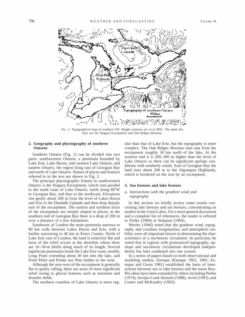
FIG. 3. GOES-8 visible satellite image at 1402 EST 2 Aug 1996.The Niagara Escarpment and Oak Ridges Moraine are marked by thedash–dot lines; the estimated positions of lake-breeze fronts by dottedlines. YYZ is Pearson Airport near Toronto and YXU is the Londonairport.
Lake Michigan. The most common effect was for thelake to suppress convection. In one case, a squall lineapproaching from the west intensified as it encounteredthe lake breeze, but then dissipated rapidly. Thunder-storms forming on the lake-breeze front on the down-wind side of the lake sometimes moved inland as asquall line. They also noted that the lakes had little effecton organized squall lines and that severe thunderstormsoccasionally developed on lake-breeze fronts.
In summary, sea breezes and lake breezes are pow-erful generators of boundaries and these boundarieshave been shown to be linked with convection in manyareas. In this paper we will provide a more systematicaccount of the effects of lake breezes on severe weatherin southern Ontario using several examples to illustratethe nature of boundaries produced by lake breezes insouthern Ontario under different synoptic conditionsand the resulting weather conditions.
4. Examples
The methodology in this paper follows that of Purdom(1976) in using Geostationary Operational Environ-mental Satellite (GOES) images to illustrate various fea-tures of lake breezes. We assume that persistent quasi-stationary lines that conform closely to coastlines aredue to lake-breeze circulations or lake-breeze circula-tions interacting with the mean flow. We use sequencesand time composites of images to illustrate such per-sistent lines. Ideally we would have supplemented thesatellite and radar analyses with surface mesoanalyses,but the surface network in southern Ontario is not suf-ficiently dense to do so. In a few cases we are able toconfirm, using data from a single station, that a cloudline is associated with a lake breeze.
Although there is no such thing as a ‘‘typical’’ case,the cases discussed below cover the most importantlake-breeze effects on weather that occurs in southernOntario. Among these, we try to illustrate changes tothe interactions between the lake-breeze circulation andthe mean flow as the mean flow increases.
Because lake breezes are forced by the solar cycle,local standard time (EST 5 UTC 2 5) is used in thisstudy. Solar noon occurs about 1230 EST in south-western Ontario.
a. Weak flow (2 August 1996)
There are few days in the Great Lakes region withzero gradient flow, which would allow the developmentof ‘‘pure’’ lake breezes. Most examples we have seenare, like this case, days with a weak northwesterly flow.The development of clouds associated with lake breezeson such days is illustrated by a satellite image at 1402EST 2 August 1996 (Fig. 3) when the lake-breeze cir-culations had reached their greatest inland penetration.Estimated positions of lake-breeze fronts are shown as
dotted lines; the Niagara Escarpment and Oak RidgesMoraine are indicated by dash–dot lines.
Well-developed lake-breeze circulations are evidentnear all the lakes. The greatest inland penetration (about55 km) is on the east side of Lake Huron where thelake breeze is assisted by the weak NW flow. The LakeOntario lake breeze has moved inland up to 30 km andappears to be marked almost exactly by the NiagaraEscarpment and the Oak Ridges Moraine. This is typicalin weak flows and is likely related to interactions be-tween terrain-induced circulations and lake breezes asdiscussed by Wexler (1946) and Estoque and Gross(1981).
North of Lake Erie, the front has penetrated about 15km inland to the southwest of Port Stanley and 20 kminland to the east. Although the main front has movedfarther inland, there must still be convergence on thepeninsula at the head of Long Point Bay to support thethunderstorm there (indicated by A). On the NiagaraPeninsula, the Ontario and Erie fronts appear to havemerged.
Thunderstorms developed on the Lake Ontario frontnorthwest of Pearson Airport (YYZ). These storms ini-tially moved toward the NW, but as they grew into theflow aloft, they began moving toward the ESE and dis-sipated. Forecasters in Toronto have long noted the ten-dency for thunderstorms moving from the west to dis-sipate as they approach Pearson. They attributed this todownslope flow from the escarpment but an alternativeexplanation is that storms dissipate as they encounterlake-modified air.
This case illustrates most of the features seen on dayswith weak gradient flows. Next we discuss how the lake-breeze circulations are modified when interacting witha moderate SW gradient flow.

OCTOBER 2003 799K I N G E T A L .
FIG. 4. Surface map at 1200 UTC (0700 EST) 31 Jul 1994. Thismap was extracted from the archive at the Canadian MeteorologicalCentre. Frontal positions were added based on the National Oceanicand Atmospheric Administration (NOAA) National Weather Servicedaily weather map series.
FIG. 5. Composite GOES-7 visible image at 1000–1230 EST 31Jul 1994. This image is the average of six visible images at half-hourintervals from 1000 to 1230 EST. Significant boundaries discussedin the text are marked by letters and dotted lines. The dash–dot lineis the Niagara Escarpment.
b. Moderate SW flow (31 July 1994)
This was a typical summer’s day in southern Ontario:a moderate (about 6 m s21) southwesterly flow betweena high in Pennsylvania and a low in northwestern On-tario (Fig. 4) was bringing warm moist air over theregion. By late morning, fair weather cumulus had de-veloped over much of the area and thunderstorms de-veloped along lake-breeze fronts.
Figure 5 is a composite of six GOES-7 visible imagesfrom 1000 to 1230 EST. The composite image highlightsthree regimes: clear skies over the lakes and in regionsof onshore flow, generally cloudy skies inland withbanding suggesting horizontal convective rolls, and en-hanced convection associated with lake-breeze bound-aries and topographical effects.
On the western half of Lake Erie, where the gradientwind was parallel to the coast, an apparent lake-breezefront (B–C in Fig. 5) developed near the coast and ex-tended inland beyond Woodstock. The lake-breeze frontshowed no further inland motion once it had formed.East of Port Stanley, where the winds were onshore,there was enhanced convection parallel to the coast andabout 40 km inland (from point C to E).
These two branches evolved differently. On the east-ern branch, clouds formed first on east–west shorelinesat about 0800 EST. The area north of the coastline filledwith cumulus cloud over the next 2 h and by about 1000EST a line of more intense cumulus formed along theline C–E. This line reached its maximum strength atabout 1100 EST (according to data from the King radar,located 40 km north of Toronto; see Fig. 2) and thendissipated. This line did not form at the lakeshore andmove inland; it formed in place. From watching ani-mations, it appears that cloud elements traveled inlandalong horizontal convective rolls and became enhancedas they reached line C–E. We speculate that the gradientflow had advected lake air inland and the convection
developed on a boundary between lake-modified air andunmodified air, perhaps on an internal boundary layeras discussed by Finkele et al. (1995).
Convection on the western branch (B–C) developedmore slowly with clouds first forming at about 0900EST. Clouds developed slowly at first and then veryrapidly after 1100 EST, about the same time as the east-ern branch was dissipating. No severe weather was re-ported but there were brief heavy downpours of up to15 mm of rain.
The NE–SW-oriented coast at the head of Long PointBay also generated a line extending inland to meet theeastern branch of the main front (D–E). This line is afrequent feature in satellite images under moderate pre-vailing southwest flows and appears to be an inlandextension of the convection that forms on this peninsulaon days with weaker flows.
Convergence lines associated with Lake Huron weremuch less developed in satellite imagery. Some en-hanced convection can be seen between Sarnia andGrand Bend (line F–G) and extending inland. Farthernorth, the line H–J marks a transition from cloud-freeskies to banded clouds oriented with the winds; therewas no enhanced convection with this line. A strongthunderstorm did form near Grand Bend at about 1500EST when outflow from a storm on the Erie line collidedwith the Huron line. This storm produced heavy rain asit moved northeast.
Since the winds are parallel to the Lake Erie coastwest of Port Stanley, Estoque’s (1962) model wouldsuggest an onshore friction-induced component on theCanadian side of Lake Erie and an offshore componenton the U.S. side. This appears to be the case since thefront forms inland on the Canadian side and clouds goright to the shoreline on the American side. Estoque’smodel also predicts stronger vertical velocities on the

800 VOLUME 18W E A T H E R A N D F O R E C A S T I N G
FIG. 6. Surface map at 1200 UTC (0700 EST) 21 Jul 1994.
FIG. 7. Sequence of GOES-7 infrared images on 21 Jul 1994: (a)1130, (b) 1200, (c) 1230, and (d) 1300 EST. The same temperaturescale, indicated between the images, was used for all figures. In (c)and (d) temperatures in the range of 2508 to 2608C are highlightedin black. The coldest temperature is indicated in each image.
U.S. side. We modeled this case using the MesoscaleCompressible Community model (MC2; Benoit et al.1997) and it showed much stronger vertical velocitieson the U.S. side. Similar arguments suggest that thestronger vertical velocities should be on the front on theHuron side of the isthmus. If cloud development can beused as a surrogate for the strength of the front, just theopposite seems to be the case. Perhaps other factors suchas moisture availability may be important but generallywe have observed that the Erie front is more active thanthe Huron front when there is no larger-scale synopticforcing. Significant developments seem to occur on theHuron front more often when there are interactions withthe Erie front or with other features such as cold fronts.
The behavior of the lake breezes on the Niagara Pen-insula bears special mention. In the weak flow case, theErie and Ontario fronts merged in the center of thepeninsula. In this case, there appears to be a mergedErie–Ontario front just offshore on Lake Ontario. Ac-cording to satellite data, the cloud line first formed rightalong the shoreline and by the time radar indicated rainfrom the cells, it had been pushed offshore. This be-havior is consistent with the modeling of both Estoqueand Gross (1981) and Comer and McKendry (1993).Although their model domains included only the easternend of Lake Erie, both models showed the Erie breezemerging with the Ontario breeze near the southern shoreof Lake Ontario.
North of Lake Ontario the situation is more complex.In the composite image a persistent line of convectionis evident running along the Oak Ridges Moraine eastfrom the escarpment. This line developed suddenly atabout 1100 EST with no indications of a cloud linehaving moved inland. As in the weak flow case, complexinteractions between terrain-induced circulations andthe lake breeze are likely responsible. Clouds developedon the east side of the escarpment, apparently in an areaof gravity-wave-induced upward motion, and movedeastward. Modeling of this day using the MC2 modelat 10-km horizontal resolution indicated that a gravitywave formed in the southwest flow over the escarpment
with downward motion in the lee and an area of upwardmotion farther east, consistent with the cloud patternsobserved.
The boundaries highlighted in Fig. 5 will be used insection 5 to explain patterns in the tornado climatologyof southern Ontario. In the next section we discuss theinteraction of cold fronts with lake breezes.
c. Moderate to strong SW flow interacting with acold front (21 July 1994)
The synoptic situation at 0700 EST on 21 July 1994is shown in Fig. 6. There was a moderate to strong(about 10 m s21) southwest flow ahead of a cold frontcrossing Michigan.
As it crossed Lake Huron, the front was marked bya continuous cloud band along the front with coldestcloud-top temperatures of about 2288C. The develop-ment of deep convection on the cold front from 1130to 1330 EST is shown in Fig. 7. After the front crossedthe eastern shore of the lake a sharp increase in theGOES-7 reflectivity and a drop in the IR brightnesstemperature to 2418C indicated the development of astrong cell near Teeswater. By 1230 EST, the line ofcolder tops had extended farther northeast and by 1300EST cloud-top temperatures were nearing 2608C. By1300 EST, the rapid expansion of the 2508C isothermshows that the anvil had been swept eastward up to 80

OCTOBER 2003 801K I N G E T A L .
FIG. 8. King radar images on 21 Jul 1994: (a) 1300, (b) 1400, (c) 1500, (d) 1600, (e) 1700,and (f ) 1800 EST. The rain rate is indicated by the gray scale: medium gray, #1 mm h21;light gray, between 1 and 32 mm h21; dark gray, $32 mm h21. Hourly wind observations areindicated for Mount Forest (WLS), London (YXU), Kitchener (YKF), and Toronto Pearson(YYZ).
FIG. 9. Minimum composite of GOES-7 images from 1500 to 1730EST on 21 Jul 1994. The image was formed by finding the minimumbrightness of the six images at each pixel. Thus gray areas indicatethe presence of cloud in each of the six images and, hence, persistenceof convection at that location.
km. The dashed white line is the Lake Huron lake-breezeboundary, as in Fig. 5 (J–K). Although surface data arenot available to confirm the exact location of the lake-breeze boundary, it seems likely that the explosion inconvection was due to the interaction of the cold frontwith the lake breeze.
Figure 8 is a series of King radar images at hourlyintervals from 1300 to 1800 EST. Initially, the front was
marked by a continuous narrow band of heavy ($64mm h21) precipitation. By 1400 EST, the beginnings ofa line building back toward Grand Bend, Ontario, areevident. As this line grows over the next hour, the orig-inal line shrinks to the northeast. By the end of theperiod, an inverted-Y structure is present with two armsextending along the coastlines, apparently merging in amidpeninsula line. The midpeninsula line was quasi sta-tionary for 4 h and produced up to 70 mm of rain.
Surface wind observations are plotted at four stations.At Mount Forest, Ontario (WLS), both temperature anddewpoint dropped sharply between 1300 and 1400 ESTas the wind shifted to the southwest, indicating a coldfrontal passage. A brief shower occurred at London,Ontario (YXU), as the cloud line passed the station butthe winds remained southerly. Farther south Cleveland,Ohio, reported a thunderstorm and a temperature dropof 88C as the wind shifted to the southwest. An hourlater at Kitchener, Ontario (YKF), the winds shifted tothe southwest and the dewpoint dropped slightly but thetemperature remained constant. Later at Toronto’s Pear-son Airport (YYZ), the winds shifted to the southwestbut there was little change in temperature or dewpoint.From theses observations it appears that at least the Eriebranch of the lake-breeze circulation maintained itselfas the cold front passed through.
Figure 9 is a minimum reflectivity composite of sixGOES-7 visible images from 1500 to 1730 EST. Sinceeach pixel shows the minimum reflectivity from the six

802 VOLUME 18W E A T H E R A N D F O R E C A S T I N G
FIG. 10. Comparison of cloud boundaries from 21 Jul (dash–dot)and 31 Jul (dash) 1994. The background image is a mean compositeof six GOES-8 visible images from 22 Aug 1996, another day witha moderate southwest flow. Note the similarity in boundaries on thatday also.
FIG. 11. Comparison of cloud patterns between 21 Jul 1994 and 31 May 1985, the day of amajor tornado outbreak in Ontario and Pennsylvania–Ohio.
images, this figure highlights locations where cloudspersisted for the entire period. The bright white areasextending into Lake Erie and the northeast from LakeSimcoe are from deep convection associated with thecold front. Narrow lines parallel to the coasts of LakesHuron and Erie, which merged into the midpeninsulaline, were persistent over a 3-h period. Although moresurface observations would be useful, it appears fromradar and satellite imagery that the inverted-Y structurewas a merger of Erie and Huron lake-breeze circulationsand that this circulation either maintained itself or was
quickly reestablished in spite of the cold frontal passage.This seems curious, but Pielke (1974) noted that seabreezes are reestablished quickly after cold frontal pas-sages in Florida.
In this case, unlike that of 31 July, no east–west linedevelops north of Lake Erie (cf. line C–E in Fig. 5).The gradient wind on 21 July was about 10 m s21 com-pared to about 6 m s21 on 31 July. Modeling results(Arritt 1992) suggest that convergence lines will notform in onshore flows when the onshore flow exceedssome threshold between 3.5 and 7.5 m s21. Since theeast–west line dissipated after a few hours on 31 July,the onshore gradient was probably near the thresholdfor formation of a convergence line, in agreement withArritt’s result. Although the boundary breaks down inmoderate onshore flows, the branch parallel to the coasttends to persist and extend farther inland.
The other major difference between the two cases isthe merger of the Huron and Erie lines in a midpeninsulaline, as illustrated in Fig. 10. The background in Fig.10 is a composite GOES-8 visible image from 1200 to1400 EST on 22 August 1996, showing boundaries insimilar locations with the hint of a midpeninsula line.It is uncertain under what conditions mergers occur.During ELBOW 1997, a quasi-stationary multicellularcluster formed at the apparent merger of the Huron andErie lines. Modeling with MC2 (Sills and King 1998;Qiu 2002) and visual observations suggest that whenconvection formed between the two lines, they beganto approach each other. Further modeling work is re-quired to establish the conditions for such mergers.
Finally, in Fig. 11 we compare the cloud patterns from
OCTOBER 2003 803K I N G E T A L .
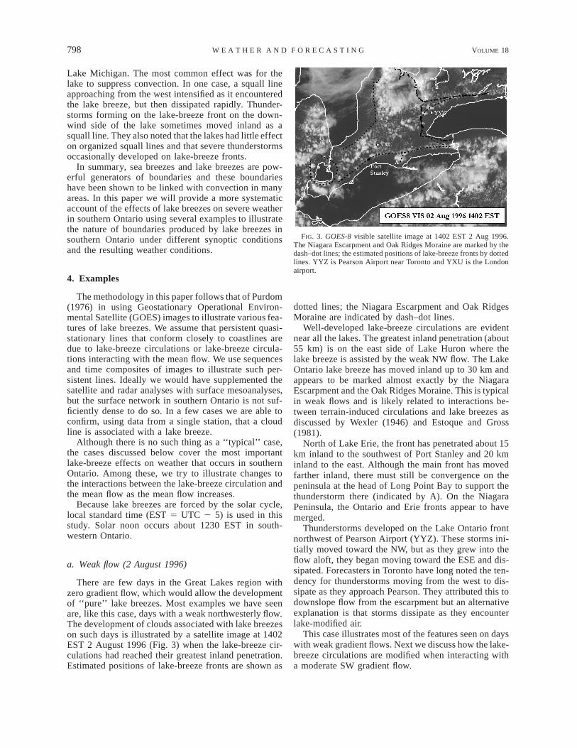
FIG. 12. Surface map at 1200 UTC (0700 EST) 12 Jul 1994. Thismap was extracted from the archive at the Canadian MeteorologicalCentre. Frontal positions were added based on the NOAA NationalWeather Service daily weather map series.
FIG. 13. GOES-7 visible image at 1330 EST 12 Jul 1994.
the 21 July case with those of 31 May 1985, the dayof a major tornado outbreak in Ontario, Ohio, and Penn-sylvania. There is a remarkable similarity of cloud pat-terns on the two days: explosive convection in the north,seemingly fed by an inverted-Y structure of lower levelclouds, and the beginnings of deep convection in Ohioextending into Lake Erie. The similarity in the cloudstructure suggests that boundary layer mesoscale pro-cesses played a similar role on both days. It is alsoplausible that lake breezes played a role in suppressingtornadoes to the north of Lake Erie and hence may inpart determine where tornadoes are likely to form insouthern Ontario. We will expand on this theme in sec-tion 5 where we look at the spatial distribution of tor-nado touchdown points in southern Ontario.
d. Moderate WSW flow (12 July 1994)
When the surface winds become more westerly, thearea of interest shifts toward the London area, as in thecase discussed by King (1996) previously. A low pres-sure center (Fig. 12) north of Lake Huron was movingtoward Quebec and a weak cold front was sinking slow-ly southward across the Great Lakes. The upper flowwas westerly at all levels.
A thin layer of stratocumulus (tops about 1000 mabove ground, estimated from radiosonde and satellitedata) covered most of southwestern Ontario and lowerMichigan. As the morning progressed, the clouds inMichigan became banded in a NNE–SSW orientation.
One of the bands became enhanced as it reached thesouthern end of Lake Huron at 1200 EST. At the sametime, a band of clouds was moving inland from LakeErie. By 1330 EST (Fig. 13), the Erie line was ap-proaching the Huron line and a large thunderstorm haddeveloped just NE of London (YXU) on the Huron line.The first radar echo appeared at 1310 EST and echotops had reached 12 km by 1320 EST. The coldest
GOES-7 cloud-top temperature dropped from 38C at1300 EST to 2508C at 1430 EST. The data from theLondon airport indicated a lake-breeze passage at about1600 EST as the winds shifted from westerly to south-erly and the temperature dropped from 278 to 238C.
Over a 6-h period, the western end of the band re-mained fixed while the eastern end rotated southwardslightly. After 1900 EST, the whole line began to moveslowly southward across Lake Erie, presumably as theErie lake breeze weakened.
Severe weather occurred in the form of strong winds,heavy rain, and golfball-sized hail. The maximum re-corded rainfall was 104 mm about 30 km southeast ofLondon. London reported thunder continuously for 9 h(with two short gaps) during this event.
According to the 0700 EST sounding at White Lake,Michigan (DTX), the convective temperature necessaryto break a sharp capping inversion was 308C. High tem-peratures in southern Ontario reached 278–288C. Theonly convection to occur was with the lake-breeze merg-er, suggesting that lake breezes provided sufficient mois-ture convergence or lift or both to break the inversion,even though temperatures did not appear to have reachedthe convective temperature.
The interaction of convergence lines in the Londonarea appears to be the most repeatable lake-breeze in-teraction, occurring several times per year. Similarevents happened on two other occasions in July 1994.Another similar case occurred near Komoka, Ontario,just west of London during ELBOW 1997 (King et al.1999) when thunderstorms continually redeveloped atthe merger point of two lines for about 2 h.
e. Light to moderate NNW flow (14 August 1993)
The most common surface wind direction in southernOntario in the summer is NW (Comer and McKendry1993). In this section, we briefly discuss convectionpatterns in such cases. When the surface flow is fromthe NW, most significant convection is in southeastern

804 VOLUME 18W E A T H E R A N D F O R E C A S T I N G
FIG. 14. GOES-7 visible image at 1330 EST 14 Aug 1993. Thecold frontal position is based on the daily weather map series.
FIG. 15. Touchdown points of confirmed and probable tornadoesfrom 1917 to 1992 during the afternoon (1200–2000 EST). Thedashed lines are the convergence lines noted on 31 Jul 1994 (Fig.5).
Ontario. A visible satellite image (Fig. 14) shows thesituation at 1330 EST on 14 August 1993, a day witha light NW flow. The lake-breeze fronts are close toshore on the north coasts of both Lakes Erie and Ontarioas one would expect with an offshore flow (Estoque1962).
The Niagara Escarpment defines the western side ofthe Georgian Bay ‘‘shadow,’’ and frequently showersand thunderstorms develop along this line in a NW flow.East of the Georgian Bay, there is a line about 30 kminland and a line with deeper convection farther inlandalong the western edge of the Algonquin Uplands.
Areas along the north shore of Lake Ontario east ofToronto experience little severe weather when winds arefrom the southwest. However, severe weather can occurin a NW flow due to interactions with the Lake Ontariofront. On this day heavy rain, large hail, and damagingwinds occurred, but only east of the intersection of theGeorgian Bay line with the Ontario front.
Most of southwestern Ontario is downwind of LakeHuron in a NW flow and convection is suppressed there.However, deep convection occasionally occurs on theLake Erie front in a northwest flow. An interesting phe-nomenon can occur near Lake St. Clair in NW flowsdue to interactions between lake breezes from LakesHuron and St. Clair. A convergence line along the Mich-igan side of Lake Huron sometimes intersects with theLake St. Clair lake breeze resulting in enhanced con-vection. King et al. (1996) suggested that small non-supercell tornadoes (Brady and Szoke 1989; Wakimotoand Wilson 1989) might form on lake-breeze shearzones in such cases. In this case a funnel cloud formedat the location indicated in Fig. 14. Sills (1998) inves-tigated this event and found that a landspout tornadohad occurred. Daggupaty (2001) studied lake-breeze in-teractions on this day using a boundary layer forecastmodel.
5. Tornado climatology
We have noted several cases of severe weather as-sociated with lake-breeze interactions. KLM96 dem-onstrated a link between lake breezes and the tornadoclimatology of southern Ontario. The ideas first pre-sented there will be developed further in this section.We will also use the 21 July 1994 case above as aconceptual model to explain the location of major tor-nado outbreaks in southwestern Ontario.
The Canadian tornado database was assembled byNewark (1984) and currently covers the period from1917 to 1992. It classifies events as confirmed, probable,or possible tornadoes based on a number of criteria. Inthis study only events in the confirmed and probablecategories are used; a few of the probable events thatappear to have been derechoes were also omitted. Wehave further restricted the data to afternoons (1200–2000 EST) from April to September when lake breezesare most likely to occur.
Touchdown points for confirmed and probable warmseason afternoon tornadoes are shown in Fig. 15. Al-though there are differences in how the tornado data arecollected, we have plotted adjacent U.S. data for com-parison.
The greatest density of tornado touchdowns appearsto be in southwest lower Michigan, extending into west-ern Essex County in Ontario. On the U.S. side of LakeErie, the distribution of touchdown points is fairly uni-form and extends right to the shoreline. In contrast, onthe Ontario side of Lake Erie there is a marked variationin tornado distribution. West of Port Stanley there is aconcentration of events, including several F2 tornadoesand one F3, right along the shoreline. East of Port Stan-ley, there has never been an F2 or stronger tornado eventand the few weak events there are clustered along theLong Point Bay line. For one of these events (17 June
OCTOBER 2003 805K I N G E T A L .
FIG. 16. Distribution of tornado touchdown points in the interlakeregion between Lakes Erie and Huron. The dashed line is the 30%probability of lake-breeze occurrence line from Sills (1998). Thelegend gives the classification of the tornadoes.
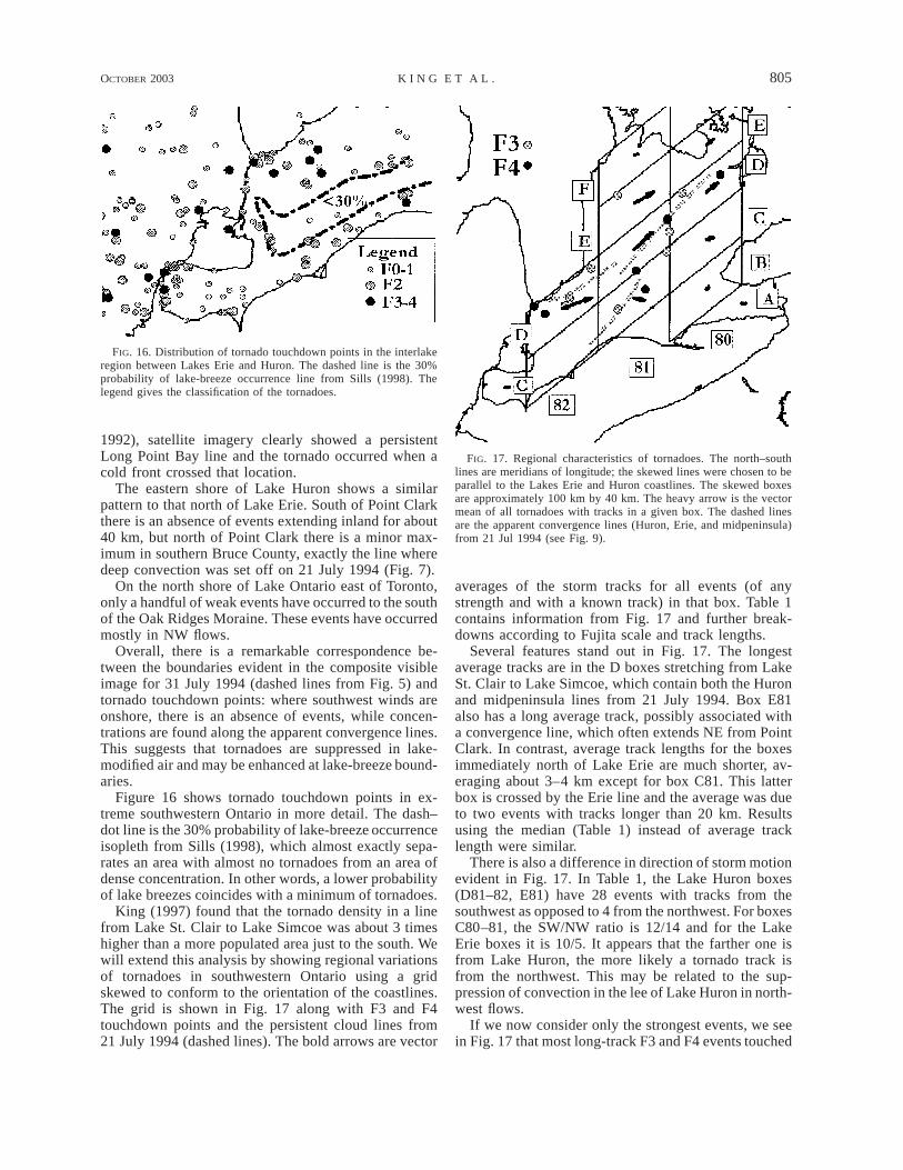
FIG. 17. Regional characteristics of tornadoes. The north–southlines are meridians of longitude; the skewed lines were chosen to beparallel to the Lakes Erie and Huron coastlines. The skewed boxesare approximately 100 km by 40 km. The heavy arrow is the vectormean of all tornadoes with tracks in a given box. The dashed linesare the apparent convergence lines (Huron, Erie, and midpeninsula)from 21 Jul 1994 (see Fig. 9).
1992), satellite imagery clearly showed a persistentLong Point Bay line and the tornado occurred when acold front crossed that location.
The eastern shore of Lake Huron shows a similarpattern to that north of Lake Erie. South of Point Clarkthere is an absence of events extending inland for about40 km, but north of Point Clark there is a minor max-imum in southern Bruce County, exactly the line wheredeep convection was set off on 21 July 1994 (Fig. 7).
On the north shore of Lake Ontario east of Toronto,only a handful of weak events have occurred to the southof the Oak Ridges Moraine. These events have occurredmostly in NW flows.
Overall, there is a remarkable correspondence be-tween the boundaries evident in the composite visibleimage for 31 July 1994 (dashed lines from Fig. 5) andtornado touchdown points: where southwest winds areonshore, there is an absence of events, while concen-trations are found along the apparent convergence lines.This suggests that tornadoes are suppressed in lake-modified air and may be enhanced at lake-breeze bound-aries.
Figure 16 shows tornado touchdown points in ex-treme southwestern Ontario in more detail. The dash–dot line is the 30% probability of lake-breeze occurrenceisopleth from Sills (1998), which almost exactly sepa-rates an area with almost no tornadoes from an area ofdense concentration. In other words, a lower probabilityof lake breezes coincides with a minimum of tornadoes.
King (1997) found that the tornado density in a linefrom Lake St. Clair to Lake Simcoe was about 3 timeshigher than a more populated area just to the south. Wewill extend this analysis by showing regional variationsof tornadoes in southwestern Ontario using a gridskewed to conform to the orientation of the coastlines.The grid is shown in Fig. 17 along with F3 and F4touchdown points and the persistent cloud lines from21 July 1994 (dashed lines). The bold arrows are vector
averages of the storm tracks for all events (of anystrength and with a known track) in that box. Table 1contains information from Fig. 17 and further break-downs according to Fujita scale and track lengths.
Several features stand out in Fig. 17. The longestaverage tracks are in the D boxes stretching from LakeSt. Clair to Lake Simcoe, which contain both the Huronand midpeninsula lines from 21 July 1994. Box E81also has a long average track, possibly associated witha convergence line, which often extends NE from PointClark. In contrast, average track lengths for the boxesimmediately north of Lake Erie are much shorter, av-eraging about 3–4 km except for box C81. This latterbox is crossed by the Erie line and the average was dueto two events with tracks longer than 20 km. Resultsusing the median (Table 1) instead of average tracklength were similar.
There is also a difference in direction of storm motionevident in Fig. 17. In Table 1, the Lake Huron boxes(D81–82, E81) have 28 events with tracks from thesouthwest as opposed to 4 from the northwest. For boxesC80–81, the SW/NW ratio is 12/14 and for the LakeErie boxes it is 10/5. It appears that the farther one isfrom Lake Huron, the more likely a tornado track isfrom the northwest. This may be related to the sup-pression of convection in the lee of Lake Huron in north-west flows.
If we now consider only the strongest events, we seein Fig. 17 that most long-track F3 and F4 events touched

806 VOLUME 18W E A T H E R A N D F O R E C A S T I N G
TABLE 1. Statistics for tornadoes by F category for grid boxes in Fig. 14.
Region F0 F1 F2 F3 F4 TotalWithtrack
Avg directionand track
length (km) SW/NW
Medianlength(km)
No. withtrack
.10 km
No. withtrack
.20 km
A80B81B80C83C82C81
51
12823
001502
100212
000003
000101
61
1316
311
514607
270/3.3230/1.0243/4.0270/5.1
0280/12.2
4/10/02/24/20/04/3
312.63.604.3
101102
000002
C80D82D81D80E81E80F81
14477235
9663201
4326101
0421100
0221000
27191918
637
201214
7423
257/8.2250/34.1226/27.1230/16.5240/24.2230/10.0240/3.2
8/1111/112/33/45/00/22/1
7.114.28.6
12.115.67.83.7
6772310
3642100
down near the 21 July 1994 lines. In fact, all occurredwithin 20 km of these lines; for F3 tornadoes the averagedistance was 10 km and for F4 tornadoes it was 7 km.Markowski et al. (1998) showed that 70% of tornadoesduring the Verification of the Origin of Rotation in Tor-nadoes Experiment (VORTEX-95) occurred within 30km of a low-level boundary. The close correspondencebetween tornado touchdowns in southern Ontario alonglines where we have frequently seen lake-breeze con-vergence lines suggests that similar processes may beat work here.
6. Discussion and conclusions
We have demonstrated characteristic cloud patterns,apparently related to lake-breeze circulations, which of-ten occur in southwestern Ontario and have shown pat-terns in tornado touchdowns that have intriguing sim-ilarities. Because of lack of data we are unable to makea definite causal connection.
Wilson and Schreiber (1986) found that almost 80%of convective storms in Colorado formed on preexistingboundaries and that many of these boundaries were dueto topography. Since lake breezes generate boundariessimilar to the patterns we see in tornado touchdowns,we suspect that a large portion of the severe thunder-storms, including tornadic storms, in southern Ontarioform on lake-breeze boundaries. Most of these cases areexamples of mesoscale circulations triggering events setup by larger-scale processes, as discussed by Doswell(1987).
Doppler radar research in the 1970s showed that tor-nadoes were normally associated with mesocyclone orsupercell thunderstorms. In the late 1980s, Brady andSzoke (1989) and Wakimoto and Wilson (1989) docu-mented cases in which tornadoes formed from nonsu-percell thunderstorms (called landspouts). Both pro-cesses seem to be important in Ontario.
Long-track storms, which are most likely supercells,occur preferentially along the Lake St. Clair to LakeSimcoe corridor. We propose the 21 July 1994 case as
a model to explain this pattern. On such days a patternof merging lake breezes forms ahead of an approachingcold front. The lake-breeze circulation could play tworoles by increasing moisture convergence and increasinglow-level shear, both of which are important in tornadodevelopment. If the environmental conditions were oth-erwise favorable for the development of supercells andsubsequently tornadoes, the lake-breeze circulationsmay provide the trigger.
Somewhat contrary to expectations, events near LakeErie tend to have shorter tracks and more variable di-rections of travel than events in the Lake St. Clair toLake Simcoe corridor. Sills and King (2000) docu-mented an apparent landspout in this region and listedseveral events that also appear to have been landspouts.Since long-track events are confined mainly to the LakeSt. Clair to Lake Simcoe corridor, many of the eventsfarther south may have been landspouts. Lake-breezeboundaries would provide a favorable environment byincreasing moisture and low-level vorticity.
The evidence presented here strongly suggests that insouthern Ontario lake breezes may provide low-levelboundaries on which tornadoes may form and that the21 July 1994 case can be used as a model to explainmajor tornado outbreaks in southern Ontario. The syn-optic situation that favors tornado outbreaks in south-western Ontario is a southwesterly flow ahead of astrong cold front. Clear skies are generally needed aheadof the cold front to enhance buoyant energy. This, ofcourse, is also the recipe for lake-breeze convergencelines. When the cold front encounters the convergencelines, the additional moisture convergence and low-levelvorticity may provide a trigger for tornado formation.
We feel that we have provided a good case for a linkbetween lake breezes and tornadoes but the lack of datahas made confirmation difficult. ELBOW 1997 (Kinget al. 1999) was conceived to provide such confirmationbut was limited by resources. ELBOW 2001 (Sills etal. 2002) was conducted in the summer of 2001 em-ploying Doppler radar, research aircraft, a more exten-sive surface network, and chase teams. Data from this

OCTOBER 2003 807K I N G E T A L .
project will be used to improve our understanding ofinteractions between lake-breeze fronts and synoptic-scale weather features and their role in severe weatherin southern Ontario.
Acknowledgments. Alejandro Aldunate was for manyyears a stalwart in satellite meteorology in Canada, sup-porting both operational meteorology and research pro-jects, including this work. This paper is dedicated to hismemory. We also wish to acknowledge the support offorecasters at the Regional Centre, Toronto. Brian Clarkand Bill Chang provided computer support. Cathy Banicprovided encouragement. The reviewers made manysuggestions that substantially improved this paper.
REFERENCES
Arritt, R. W., 1993: Effects of the large-scale flow on characteristicfeatures of the sea breeze. J. Appl. Meteor., 32, 116–125.
Benoit, R., M. Desgagne, P. Pellerin, S. Pellerin, Y. Chartier, and S.Desjardins, 1997: The Canadian MC2: A semi-Lagrangian, semi-implicit wideband atmospheric model suited for finescale processstudies and simulation. Mon. Wea. Rev., 125, 2382–2415.
Brady, R. H., and E. J. Szoke, 1989: A case study of nonmesocyclonetornado development in northeast Colorado: Similarities to wa-terspout formation. Mon. Wea. Rev., 117, 843–856.
Burrows, W. R., 1991: Objective guidance for 0–24-hour and 24–48-hour mesoscale forecasts of lake-effect snow using CART.Wea. Forecasting, 6, 357–378.
Byers, H. R., and H. R. Rodebush, 1948: Causes of thunderstormsof the Florida peninsula. J. Meteor., 5, 275–280.
Chandik, J. F., and W. A. Lyons, 1971: Thunderstorms and the lakebreeze front. Proc. Seventh Conf. on Severe Storms, Kansas City,MO, Amer. Meteor. Soc., 218–225.
Clodman, S., and W. Chisholm, 1994: High lightning flash densitystorms in the southern Great Lakes region. Natl. Wea. Dig., 19,34–44.
——, and ——, 1996: Lightning flash climatology in the southernGreat Lakes region. Atmos.–Ocean, 31, 481–499.
Comer, N. T., and I. G. McKendry, 1993: Observations and numericalmodeling of Lake Ontario lake breezes. Atmos.–Ocean, 31, 481–499.
Daggupaty, S. M., 2001: A case study of the simultaneous devel-opment of multiple lake-breeze fronts with a boundary layerforecast model. J. Appl. Meteor., 40, 289–311.
Doswell, C. A., III, 1987: The distinction between large-scale andmesoscale contribution to severe convection: A case study ex-ample. Wea. Forecasting, 2, 3–16.
Estoque, M. A., 1962: The sea breeze as a function of the prevailingsynoptic situation. J. Atmos. Sci., 19, 244–250.
——, 1981: Further studies of a lake breeze. Part I: Observationalstudy. Mon. Wea. Rev., 109, 611–618.
——, and J. M. Gross, 1981: Further studies of a lake breeze. PartII: Theoretical study. Mon. Wea. Rev., 109, 619–634.
Finkele, K., J. M. Hacker, H. Kraus, and R. A. D. Byron-Scott, 1995:A complete sea-breeze circulation cell derived from aircraft ob-servations. Bound.-Layer Meteor., 73, 299–317.
King, P., 1996: A long-lasting squall line induced by interacting lakebreezes. Preprints, 18th Conf. on Severe Local Storms, San Fran-cisco, CA, Amer. Meteor. Soc., 764–767.
——, 1997: On the absence of population bias in the tornado cli-matology of southwestern Ontario. Wea. Forecasting, 12, 939–946.
——, M. J. Leduc, and B. P. Murphy, 1996: The climatology oftornadoes in southern Ontario: Possible effects of lake breezes.Preprints, 18th Conf. on Severe Local Storms, San Francisco,CA, Amer. Meteor. Soc., 627–630.
——, and Coauthors, 1999: ELBOW: An experiment to study theEffects of Lake Breezes On Weather in southern Ontario. CMOSBull. SCMO, 27, 35–41.
Leduc, M., B. Murphy, and P. Joe, 1993: The structure and evolutionof the 28 August 1990 tornado-producing supercell in south-western Ontario. Preprints, 17th Conf. on Severe Local Storms,St. Louis, MO, Amer. Meteor. Soc., 164–167.
Lyons, W. A., 1971: Low level divergence and subsidence over theGreat Lakes in summer. Proc. 14th Conf. on Great Lakes Re-search, Toronto, ON, Canada, Association for Great Lakes Re-search, 467–487.
Markowski, P. M., E. N. Rasmussen, and J. M. Straka, 1998: Theoccurrence of tornadoes in supercells interacting with boundariesduring VORTEX-95. Wea. Forecasting, 13, 852–859.
Murphy, B. P., 1991: Tornado and flash flood in southwestern Ontarioon 31 May 1991. Ontario Region Tech. Note ORTN-91-3, 8 pp.[Available from Library, Meteorological Service of Canada,4905 Dufferin St., Toronto, ON M3H 5T4, Canada.]
Newark, M. J., 1984: Canadian tornadoes, 1950–1979. Atmos.–Ocean, 22, 343–353.
Pielke, R. A., 1974: A three-dimensional numerical model of the seabreezes over south Florida. Mon. Wea. Rev., 102, 115–138.
——, 1984: Mesoscale Meteorological Modeling. Academic Press,612 pp.
Purdom, J. F. W., 1976: Some uses of high-resolution GOES imageryin the mesoscale forecasting of convection and its behavior. Mon.Wea. Rev., 104, 1474–1483.
Qiu, X., 2002: High-resolution mesoscale meteorological modellingin southern Ontario. Ph.D. thesis, York University, 226 pp.
Savijarvi, H., and M. Alestalo, 1988: The sea breeze over a lake orgulf as the function of the prevailing flow. Beitr. Phys. Atmos.,61, 98–104.
Shenfeld, L., and F. D. Thompson, 1962: The thunderstorm of August9, 1961 at Hamilton, Ontario, Canada. Meteorological BranchCIR 3683, TEC-417, Department of Transport, 24 pp. [Availablefrom Library, Meteorological Service of Canada, 4905 DufferinSt., Toronto, ON M3H 5T4, Canada.]
Sills, D. M. L., 1998: Lake and land breezes in southwestern Ontario:Observations, analyses and numerical modelling. Ph.D. thesis,York University, 338 pp.
——, and P. W. S. King, 1998: The 1997 ELBOW project: Highresolution modeling of lake breezes in a pre-storm environment.Preprints, 19th Conf. on Severe Local Storms, Minneapolis, MN,Amer. Meteor. Soc., 23–26.
——, and ——, 2000: Landspouts at lake breeze fronts in southernOntario. Preprints, 20th Conf. on Severe Local Storms, Orlando,FL, Amer. Meteor. Soc., 243–246.
——, P. A. Taylor, and J. R. Salmon, 1994: Southern Ontario oxidantstudy—Meteorological measurements. Final Data Rep., YorkUniversity, 87 pp.
——, P. Taylor, P. King, W. Hocking, and I. Nichols, 2002: ELBOW2001—Studying the relationship between lake breezes and se-vere weather: Project overview and preliminary results. Pre-prints, 21th Conf. on Severe Local Storms, San Antonio, TX,Amer. Meteor. Soc., 611–614.
Simpson, J. E., 1994: Sea Breeze and Local Wind. Cambridge Uni-versity Press, 234 pp.
Wakimoto, R. M., and J. W. Wilson, 1989: Non-supercell tornadoes.Mon. Wea. Rev., 117, 1113–1140.
Wexler, R., 1946: Theory and observations of land and sea breezes.Bull. Amer. Meteor. Soc., 27, 272–287.
Wilson, J. W., and W. E. Schreiber, 1986: Initiation of convectivestorms at radar-observed boundary-layer convergence lines.Mon. Wea. Rev., 114, 2516–2536.