Kort, J.W., de & Y. Raczynski-Henk, 2014: The Fossa Corbulonis between the Rhine and Meuse estuaries...
23
1 23 Water History ISSN 1877-7236 Water Hist DOI 10.1007/s12685-014-0097-3 The Fossa Corbulonis between the Rhine and Meuse estuaries in the Western Netherlands Jan-Willem de Kort & Yannick Raczynski-Henk
-
Upload
cultureelerfgoed -
Category
Documents
-
view
0 -
download
0
Transcript of Kort, J.W., de & Y. Raczynski-Henk, 2014: The Fossa Corbulonis between the Rhine and Meuse estuaries...

1 23
Water History ISSN 1877-7236 Water HistDOI 10.1007/s12685-014-0097-3
The Fossa Corbulonis between the Rhineand Meuse estuaries in the WesternNetherlands
Jan-Willem de Kort & YannickRaczynski-Henk

1 23
Your article is protected by copyright and all
rights are held exclusively by Springer Science
+Business Media Dordrecht. This e-offprint
is for personal use only and shall not be self-
archived in electronic repositories. If you wish
to self-archive your article, please use the
accepted manuscript version for posting on
your own website. You may further deposit
the accepted manuscript version in any
repository, provided it is only made publicly
available 12 months after official publication
or later and provided acknowledgement is
given to the original source of publication
and a link is inserted to the published article
on Springer's website. The link must be
accompanied by the following text: "The final
publication is available at link.springer.com”.

The Fossa Corbulonis between the Rhine and Meuseestuaries in the Western Netherlands
Jan-Willem de Kort • Yannick Raczynski-Henk
Received: 29 January 2013 / Accepted: 22 January 2014� Springer Science+Business Media Dordrecht 2014
Abstract A few classical sources mention the construction of a canal by the Roman
general Corbulo between the estuaries of the rivers Rhine and Meuse in the Netherlands
around 50 AD; the Fossa Corbulonis. The location of this feature has been subject to
speculation for a long time, but in recent years, various archaeological investigations have
established the presence of a canal just behind the beach barrier, roughly between the
current towns of Leiden and Naaldwijk. Furthermore, dendrochronological and C14 dates
support the identification of this canal as the canal dug under orders of general Corbulo.
The various research campaigns have shown that the canal is only partially artificial.
Certain parts of its course have been established by connecting existing waterways, thus
negating the need for manual labour. Roughly in the middle of the trajectory, indirect
evidence for the presence of a dam and a possible portage have been found, indicating an
understanding of water management on the part of the Romans.
Keywords Roman limes � Canals � Transport � Water management
Introduction
When the Romans ventured into the northwest of Europe under the leadership of Julius
Caesar and his successors, they must have been taken aback by the landscape they faced
upon entering the lands of the Chauci and the Frisians in what are now the Netherlands.
The enormous morass, crisscrossed by a staggering number of streams, will have put the
J.-W. de Kort (&)Cultural Heritage Agency, Smallepad 5, 3811 MG Amersfoort, The Netherlandse-mail: [email protected]
Y. Raczynski-Henk (&)Ex-Situ Silex, Vrijheidslaan 646, 2321 DV Leiden, The Netherlandse-mail: [email protected]
123
Water HistDOI 10.1007/s12685-014-0097-3
Author's personal copy
prowess of the Roman engineers to the test. Still, they set forth to organize the area like
they were used to by building roads, fortifications and even a few towns.
The nature of the landscape in the Netherlands also forced the Romans to take up water
management to a certain degree, by fortifying existing streams and rivers and building
dams, but also by constructing canals. Only two are known by name in the Netherlands.
Firstly, the Fossa Drusiana, which is mentioned by Suetonius (Vita divi Claudii 1.2) and
Tacitus (Ann 2: 8). Both authors refer to the construction of a canal under the command of
general Nero Claudius Drusus in 12 BC, but the exact geographical location of the canal is
unknown. The second canal is the Fossa Corbulonis, which will be discussed in detail
below. It is very likely however, that there would have been more, possibly smaller or
shorter canals the existence of which was never mentioned by the Classical authors and
which are extremely difficult to find.
This paper discusses the investigation of the Fossa Corbulonis, of which the (general)
location has been discovered and which has been subject to a considerable number of
archaeological investigations by augering, remote sensing and excavation. We present a
synthesis of the research conducted in the last decades, with a special focus on the town of
Leidschendam-Voorburg, situated between Leiden and The Hague, where the majority of
fieldwork has taken place, but this paper will show that this is largely due to contextual
circumstances.
The various excavations and other investigations from the last decades were interesting,
but the different projects were all relatively small in scale, thus yielding results that often
appear to have only fairly local significance and the resulting data were published in
varying forms of completeness. The results of the 2004 and especially 2006 excavations
gave grounds to a reassessment of all the available data in order to generate an up to date
synthesis about the Fossa Corbulonis.
The first archaeological clues for the presence of a man made canal, tentatively sus-
pected to be the Fossa Corbulonis, date to the early 1960s near the Roman fort of Matilo
(Leiden). Some indirect clues for the presence of a Roman canal were reported near the fort
(Bogaers 1962), but convincing evidence for the fact that the Fossa Corbulonis actually
existed was not unearthed until 1989.
The paucity of physical evidence for the canal is largely due to its rather elusive nature.
While it is more than 30 km long, the width is only a few metres. The only information
about the trajectory was the reference to the Rhine and the Meuse estuaries. Despite its
length, the canal is therefore a relatively small archaeological feature to find.
A further complication is the fact that the canal is probably only partially man-made.
Rather than digging the entire stretch, Corbulo’s engineers connected stretches of natural
waterways to form a continuous canal. Even the man-made sections are probably at least in
part formed by re-excavating natural channels. It is no coincidence that the majority of
sightings of the canal are located in the area of Leidschendam, where the canal was dug
into the underlying peat, making it relatively easy to distinguish from natural channels.
Historical evidence
Classical sources
The Fossa Corbulonis is mentioned in only two (remaining) classical sources: the Annals
by Publius Cornelius Tacitus (Ann 11: 18–20) and the Historia Romana by Lucius Cassius
Dio (Hist Rom LXI 61 30: 4–6). Tacitus and Dio probably based their stories on the
J.-W. de Kort, Y. Raczynski-Henk
123
Author's personal copy
memoires of general Gnaeus Domitius Corbulo and the History of the German Wars by
Pliny the Elder,1 both lost to posterity. In the Annals, Tacitus writes that Corbulo becomes
the new legate for Germania Inferior in 47 AD and pacifies the province, which at that time
is in considerable upheaval due to plundering bands of Chauci, using the lands of the Frisii
north of the Rhine as their base. Corbulo seeks out and defeats the pirates with the help of
the Fleet of the Rhine and has their leader Gannascus, a Cananefate, executed. He also
orders the construction of a fortification in the heart of Frisian territory (probably Flevum,
near present day Velsen) to maintain control of the area. The Chauci are outraged by the
execution of Gannascus and the situation threatens to escalate into full scale war.
Emperor Claudius orders Corbulo to withdraw his troops to the left bank of the Rhine,
possibly because he was busy planning his invasion of Britannia and did not wish to risk
the possibility of war on two fronts, or perhaps he was jealous of the military success of his
general. Obediently, Corbulo beat the retreat and subsequently decided to occupy his
troops by having them dig a canal with a length of 23.000 passus. The canal was intended
to connect the estuaries of the Meuse and Rhine, so as to avoid the dangers of the North
Sea. Even though Corbulo was not allowed to wage war, Claudius awarded him with a
triumph in Rome for his troubles.
Cassius Dio’s depiction of the events is essentially the same, except that Dio is of the
opinion that the canal was constructed after Claudius awards Corbulo his triumph and
reinstates him as general of the army. Dio also mentions another reason for the con-
struction of the canal: ‘to prevent the rivers from flowing back land inwards and causing
floods, due to the tidal activities of the ocean’.2
The canal was constructed in, or within a few years from 47 AD. Corbulo’s predecessor
Quintus Sanquinius Maximus dies in 47, thus opening a position as legate of Germania
Inferior, which was subsequently awarded to Corbulo.
Modern sources
The exact location of the Fossa Corbulonis has been subject to debate for centuries. In the
past, the canal has been identified as the river Lek, a channel in the Rhine-system on the
border between the present-day provinces of Gelderland and Utrecht in the centre of the
Netherlands. Even a stretch of the river Waal between the modern cities of Nijmegen and
Rossum has been suggested (Hermans 1839). However, since the beginning of the twen-
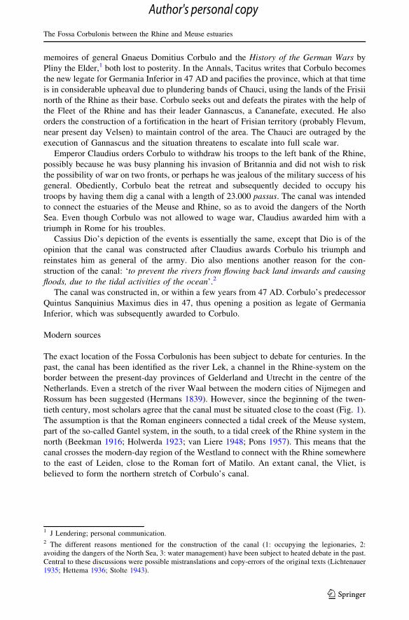
tieth century, most scholars agree that the canal must be situated close to the coast (Fig. 1).
The assumption is that the Roman engineers connected a tidal creek of the Meuse system,
part of the so-called Gantel system, in the south, to a tidal creek of the Rhine system in the
north (Beekman 1916; Holwerda 1923; van Liere 1948; Pons 1957). This means that the
canal crosses the modern-day region of the Westland to connect with the Rhine somewhere
to the east of Leiden, close to the Roman fort of Matilo. An extant canal, the Vliet, is
believed to form the northern stretch of Corbulo’s canal.
1 J Lendering; personal communication.2 The different reasons mentioned for the construction of the canal (1: occupying the legionaries, 2:avoiding the dangers of the North Sea, 3: water management) have been subject to heated debate in the past.Central to these discussions were possible mistranslations and copy-errors of the original texts (Lichtenauer1935; Hettema 1936; Stolte 1943).
The Fossa Corbulonis between the Rhine and Meuse estuaries
123
Author's personal copy
Archaeological evidence 1989–1999
Fieldwork
In 1989, a chapter of the Netherlands’ Amateur Archaeological Society (AWN) worked
together with the Netherlands’ Cultural Heritage Agency (RCE) to dig a number of test
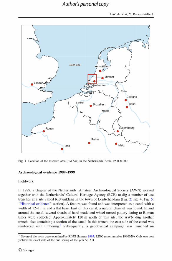
trenches at a site called Rietvinklaan in the town of Leidschendam (Fig. 2: site 4; Fig. 5:
‘‘Historical evidence’’ section). A feature was found and was interpreted as a canal with a
width of 12–13 m and a flat base. East of this canal, a natural channel was found. In and
around the canal, several shards of hand made and wheel-turned pottery dating to Roman
times were collected. Approximately 120 m north of this site, the AWN dug another
trench, also containing a section of the canal. In this trench, the east side of the canal was
reinforced with timbering.3 Subsequently, a geophysical campaign was launched on
3 Seven of the posts were examined by RING (Jansma 1995; RING report number 1990029). Only one postyielded the exact date of the cut, spring of the year 50 AD.
Fig. 1 Location of the research area (red box) in the Netherlands. Scale 1:5.000.000
J.-W. de Kort, Y. Raczynski-Henk
123
Author's personal copy

several sites in Leidschendam in 1990, but it proved virtually impossible to distinguish
between natural channels and possible man-made features based on the resistivity-mea-
surements alone (Hessing 1991; van Veen and Lenselink 1990).
In 1991 the RCE attempted to trace the route of the canal by means of test trenches but
they found that the trajectory of the canal did not follow a straight line. However, due to
very wet circumstances, the observations were severely impaired by flooded trenches and
collapsed sections. The sections, such as they were, mainly revealed part of the western
bank of the canal. No evidence for reinforcements was found (Fig. 2: sites 7, 8 and 9).
A possible portage
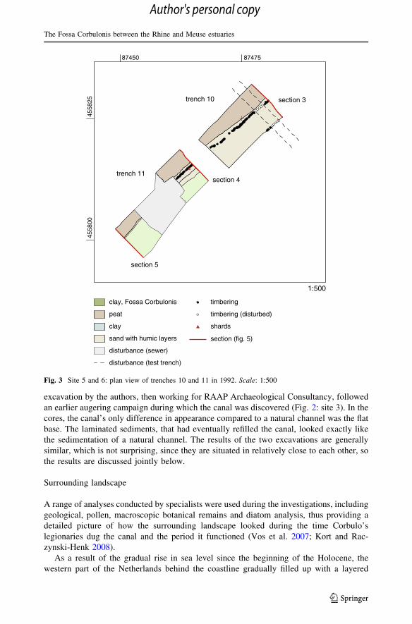
Test trenches by the RCE in 1992 revealed a striking constriction in the canal. The width of
the canal decreases to only 4.5 m. Above this narrow section, a layer of laminated sand
was interpreted as evidence for a post-Roman, natural channel. In a later phase of the
campaign, a large section of the canal was excavated (Figs. 3, 5: ‘‘Archaeological evidence
1989–1999’’, ‘‘Archaeological evidence 2004–2006’’, ‘‘Discussion’’ sections). The narrow
part of the canal is reinforced with timbering on both banks over a length of approximately
thirty metres (Hessing 1993). The wood used in the timbering could be identified as
Quercus, Fraxinus and Alnus. A single post, collected from the test trenches was dated
through dendrochronology to 48 AD plus a maximum of 3 years (RING report number
1992039).4 A further ten posts from the later excavation were subject to dendrochronology
(RING report number 1995028) and were all dated to the spring of 50 AD (Visser 2006).
The southern part of trench 11, where the reinforcement of the banks is lacking,
shows the canal to widen to more than 6.5 m. Unfortunately, local circumstances pro-
hibited a complete excavation of the entire constricted part of the canal, but based on the
southern approach and its similarity to later, historic parallels, the constriction is inter-
preted as the entrance to a portage (Daams and Kort 1988). These were common in the
coastal area of the Netherlands up to the 19th century, where water management
catchments caused variable water tables in adjacent streams, whether natural or man-
made. Because of the paucity of evidence, it cannot be excluded however, that this
feature could be interpreted as the entry to a lock or even a secondary canal. It may
actually be technically difficult to haul a flat bottomed boat over a portage without
breaking it.
In 1993, a pond was constructed at the Schoorwijck care centre in Leidschendam. The
digging exposed the western bank of the canal (Fig. 2: site 10), the southernmost obser-
vation, before the canal presumably veers off towards the southeast and continues its route
in the course of an older, natural channel.
The last observations from the 1990s date to 1996 and 1999. The 1996 investigations
revealed a feature that was assumed to be the canal or possibly a reused natural channel
(Fig. 2: site 12; Fig. 5: Sect. 12), but 14C dates of wood found in the feature suggest that it
dates to the Late Iron Age (van Heeringen 1997). Excavations in 1999 at roughly the same
location appear to corroborate this (de Jonge 2000).
4 These reports are available online: http://dendro.dans.knaw.nl (Jansma et al. 2012).
The Fossa Corbulonis between the Rhine and Meuse estuaries
123
Author's personal copy

Archaeological evidence 2004-2006
Fieldwork
After a few years of relative silence, two new investigations were launched into the Fossa
Corbulonis. In 2004, the local AWN chapter excavated the northernmost of the sites
discussed here (Fig. 2: site 1), exposing the canal again (Vos et al. 2007). In 2006, an
111111111
222222222333333333
444444444
555555555666666666777777777
888888888
999999999
111111111111111111
101010101010101010
121212121212121212
research location
tidal creek
Fossa Corbulonis
beach barrier and low dunes
beach plain (covered by peat)
floodplain
peat area
455
456
8878
1:15.000
Fig. 2 The area of Leidschendam with the route of the canal and the research locations. See Table 1 forexplanation and sources. Scale 1:15.000
J.-W. de Kort, Y. Raczynski-Henk
123
Author's personal copy
excavation by the authors, then working for RAAP Archaeological Consultancy, followed
an earlier augering campaign during which the canal was discovered (Fig. 2: site 3). In the
cores, the canal’s only difference in appearance compared to a natural channel was the flat
base. The laminated sediments, that had eventually refilled the canal, looked exactly like
the sedimentation of a natural channel. The results of the two excavations are generally
similar, which is not surprising, since they are situated in relatively close to each other, so
the results are discussed jointly below.
Surrounding landscape
A range of analyses conducted by specialists were used during the investigations, including
geological, pollen, macroscopic botanical remains and diatom analysis, thus providing a
detailed picture of how the surrounding landscape looked during the time Corbulo’s
legionaries dug the canal and the period it functioned (Vos et al. 2007; Kort and Rac-
zynski-Henk 2008).
As a result of the gradual rise in sea level since the beginning of the Holocene, the
western part of the Netherlands behind the coastline gradually filled up with a layered
87475
52855400855 4
87450
trench 10
trench 11
peat
clay, Fossa Corbulonis
clay
sand with humic layers
disturbance (sewer)
disturbance (test trench)
timbering
timbering (disturbed)
shards
1:500
section 3
section 4
section 5
section (fig. 5)
Fig. 3 Site 5 and 6: plan view of trenches 10 and 11 in 1992. Scale: 1:500
The Fossa Corbulonis between the Rhine and Meuse estuaries
123
Author's personal copy

sequence of clay deposits transported westward by fluvial processes and peat deposits,
growing locally under the influence of ground water tables pushed ever higher by the rising
sea (Berendsen 2008). Towards the Roman era, the coast in the research area consisted of a
more or less continuous beach barrier, covered by dunes. This limited marine influence on
the hinterland, thus enabling the growth of considerable peat beds (Theunissen et al. 2011).
From the Late Iron Age onwards, the water table rose to an extent that small streams began
to bisect this peatland that covered most of the hinterland behind the coastal zone. Towards
the first century AD, the influence of the sea increased in the form of openings in the beach
barrier and a tidal creek system cutting into the peatland from the southwest and depositing
clay (de Groot et al. 2011). This is the so-called Gantel system which has been partially
integrated into the Fossa Corbulonis. Vegetation was of a relatively open type and was
occasionally subject to flooding by brackish water. Diatoms, foraminifera, pollen and seeds
from various species of plants (Salicornia sp., Aster tripolium, Triglochin maritima, Bol-
boschoenus maritimus, Atriplex littoralis) indicate temporal brackish conditions in an
otherwise predominantly freshwater environment. Some evidence of agriculture on the
nearby beach barrier has been found (Vos et al. 2007).
Landscape setting
The results of the 2004 and 2006 investigations were similar in terms of the setting of the
canal. The canal runs parallel to the beach barrier that lies at a distance of several dozens of
metres to the west of it. To the east of the canal, evidence for a natural channel was found.
The activity if this tidal creek can be dated to after the beginning of the fourth century BC.5
A thin layer of clay overlying the levee and the infill of the channel was date ante quem to
between 32 BC and 126 AD (Kort and Raczynski-Henk 2008).6 Stratigraphically, the canal
cuts into the deposits belonging to and overlying the channel, so presumably the creek was
inactive by the time of the canal’s construction.
The canal was cut into the peat deposits with relatively steep sides and a flat base,
whereby the engineers took care not to breach the sands of the beach barrier which
continues underneath the peat deposits (Vos et al. 2007; Kort and Raczynski-Henk 2008).
It appears that the location of the canal was selected to ensure the presence of enough peat
to enable the engineers to dig the canal without disrupting the underlying sediments.
Sedimentation of the canal
The sediments that ultimately filled the canal were studied in great detail in 2004 and 2006.
The lower part of the sediments consists of clay with fine layers of sand, indicative of gradual
and continuous sedimentation without anthropogenic interference like dredging. The absence
of gyttja-like sediments at the base of the deposits suggests that there was never any stagnancy
and that the current must have been strong enough to clear away any microscopic botanical
5 This date was obtained from a peat sample taken from peat deposits under the levee of this channel. UtcNr 14751: 2,286 ± 39 BP, giving a calibrated range of 403–207 BC. All samples are calibrated with2-sigma standard deviation using the Oxcal 4.1, IntCal09-curve.6 A bone sample collected from the top of the clay layer overlying the levee. Utc Nr 14675: 1,946 ± 35 BP.
J.-W. de Kort, Y. Raczynski-Henk
123
Author's personal copy
remains, yet not so strong as to also erode the clay deposits. This process may have occurred
over a period of several decades.7 The density of the sandy laminations decreases towards the
top canal fill, culminating in a layer of clayey peat, consistent with a fining upward sequence.
At this point, the canal was certainly no longer navigable.
An older canal
The 2004 excavations showed no evidence of dredging or re-cutting of the canal. The most
surprising result of the 2006 campaign was therefore the discovery of a second, older phase
of the canal. The infill of this older phase contained a few shards of wheel-turned Roman
pottery, unfortunately too generic to be useful for dating. After this phase, during which the
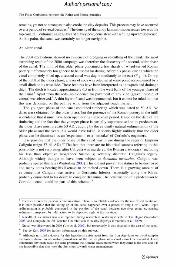
canal completely silted up, a second canal was dug immediately to the east (Fig. 4). On top
of the infill of the older phase, a layer of sods was piled up at some point accompanied by a
small ditch on its west side. These features have been interpreted as a towpath and drainage
ditch. The ditch is located approximately 6.5 m from the west bank of the younger phase of
the canal.8 Apart from the sods, no evidence for pavement of any kind (gravel, rubble, et
cetera) was observed.9 A thin layer of sand was documented, but it cannot be ruled out that
this was deposited on the path by wind from the adjacent beach barrier.
The youngest phase of the canal contained timbering which was dated to 50 AD. No
dates were obtained for the older phase, but the presence of the Roman pottery in the infill
is evidence that it must have been open during the Roman period. Based on the date of the
timbering and the fact that the younger phase is partially superimposed on its predecessor,
the older phase must predate 50 AD. Judging by the evidently natural sedimentation of the
older phase and the years this would have taken, it seems highly unlikely that the older
phase can be dismissed as an ‘experiment’ or a ‘mistake’ of Corbulo’s engineers.
It is possible that the older phase of the canal was in use during the reign of Emperor
Caligula (reign 37–41 AD).10 The fact that there are no historical sources referring to this
possibility is not surprising: after Caligula was murdered, the Roman aristocracy (including
his less than objective biographer Suetonius) severely distorted Caligula’s legacy.
Although widely thought to have been subject to damnatio memoriae, Caligula was
probably spared this fate (Winterling 2003). This did not prevent his statues to be destroyed
and many coins bearing his likeness to be melted down. There is a growing amount of
evidence that Caligula was active in Germania Inferior, especially along the Rhine,
probably connected to his desire to conquer Britannia. The construction of a predecessor to
Corbulo’s canal could be part of this scheme.11
7 P Vos en H Weerts; personal communication. There is no reliable evidence for the rate of sedimentation.It is quite possible that the silting up of the canal happened over a period of only 1 or 2 years. Rapidsedimentation is probably connected to the position of the canal between two river estuaries, causingsediments transported by tidal action to be deposited right at this location.8 A width of six metres was also reported during research at Wateringse Veld in The Hague (Waasdorp2003) and alongside the Sir Winston Churchilllaan in nearby Rijswijk (Dorenbos et al. 2009).9 Gravel was discovered in 2006 (Vos et al. 2007), but remarkably it was situated to the east of the canal.10 See de Kort 2009 for further information on this subject.11 Although no solid evidence for this hypothesis exists apart from the Iron Age dates on wood samplesmentioned above, an alternative providence of the earlier phase of a canal cannot be excluded. Localinhabitants obviously faced the same problems the Romans encountered when they came to the area and it isnot impossible that they took the first steps towards water management.
The Fossa Corbulonis between the Rhine and Meuse estuaries
123
Author's personal copy

Timbering in the canal
Both in 2004 and 2006, timbering was found against the east bank of the canal, consisting
of pointed oak posts. Based on the shape of the wood, the posts were probably cut from
small trees of local provenance, presumably the beach barrier just west of the canal (van
Rijn 2006). One post from the 2004 trench was dated and yielded a date of spring or
summer 50 AD (Hanraets 2004). Four posts were dated in 2006, giving two dates in spring
or summer of 50 AD and two dates in the spring of 50 AD (Hanraets 2006). The steep and
sharply cut banks in the area of the timbering indicate that they were installed during the
construction of the canal, rather than during subsequent repairs.12
Obsolescence
So far it has proven impossible to obtain a convincing date for the moment the canal fell
out of use. A 14C obtained from a bone fragment in the top of the clayey infill of the canal
gives a range of 39 BC to 242 AD and is therefore of little use.13 The peat overlying the
infill was dated between 259 and 541 AD, which is most likely far too old.14 The canal was
probably navigable for several decades and an end date most likely lies somewhere
between 100 and 150 AD (Vos et al. 2007). This means the canal was already obsolete by
12 Contrary to Brandenburgh and Hessing (2005) who state that the canal was constructed in 47 AD andsubsequently repaired in 49 AD with the use of timbering.13 UtC13890: 1,900 ± 60 BP.14 UtC 13858: 1,693 ± 50 BP.
-3
0
-1
-2
-4
Afstand tot nulpunt in meters
-3
0
-1
-2
-4
sand, disturbance and/or recent fill sand
clay, towpath
clay, drainage ditch
clay, Fossa Corbulonis
timbering
Roman shard
peat
sand
clay
m NAP
m NAP
Fig. 4 Site 3: north section of trench 1 in 2006. Scale: 1:150
J.-W. de Kort, Y. Raczynski-Henk
123
Author's personal copy
the time the stone phase of the civitas Forum Hadriani (Voorburg) was initiated,15 but it
may have served as an important gateway during the earliest phases of settlement there
(Fig. 6). The presence of numerous archaeological sites along the southern leg of the canal
suggests that the section south of Forum Hadriani may have been navigable considerably
longer (Waasdorp 2006).
Two fragments of wood from the ditch and the path were dated to between the end of
the first and the beginning of the third century AD, which is too broad to use for an end
date for the canal, but it does fit the estimate given above.16
Discussion
Physical properties of the canal
The 1989–2006 campaigns show that (at least in the Leidschendam area) the Fossa Cor-
bulonis was cut into the peat and ran parallel to the beach barrier situated several dozens of
metres to the west (Fig. 2). On average, the width of the canal varies between approxi-
mately 12–15 m and the bottom lies between 2.2 and 3.5 m below NAP (Amsterdam
Ordnance Datum) (Table 1). Interestingly, the depth relative to NAP increases with the
lateral distance from the proposed portage. In a few locations, the old surface of the Roman
era was preserved, which allows for an estimate of the average canal depth of circa 1.4 m.17
The banks of the canal usually slope at a rather flat angle, with the exception of the
locations where they were reinforced with timbering, but the interface between the peat
and the clay deposits marking the canal are always very sharply defined. The base of the
canal is generally completely flat. This, together with the properties of the laminated
clayey sediments in the canal, suggest not only a relatively low current, but is also a further
indication of the absence of repairs and/or dredging of the canal. The peat overlies sandy
coastal deposits, but these were never affected by the construction of the canal, even
though sometimes only a very thin layer of peat is preserved between the bottom of the
canal and these sandy deposits. This indicates that the Roman engineers deliberately
avoided hitting these layers, presumably to prevent water seepage, allowing the diggers to
work in dry, or rather less wet circumstances, as the later excavators found out to their
dismay. It appears that the Roman engineers preferred the relative density and firmness of
the peat over sandy deposits, which makes sense when digging in a waterlogged envi-
ronment such as Zuid-Holland, whether in Roman times or in the present day. On the
western side of the canal, a single indication for the presence of a possible towpath and
drainage ditch was found.
15 The southern part of the canal has been (kept) open for a longer period of time, as indicated by the recentdiscovery of a dock at Forum Hadriani (Voorburg). Two construction phases have been identified: around159 and 218 AD.16 Wood from the ditch alongside the towpath: UtC 14713: 1,833 ± 29 BP; wood from the surface of thetowpath: UtC 14674: 1,876 ± 34 BP.17 The compaction of peat however can be considerable. Drainage of the land and loading by naturaldeposits and, more recently, with sand for urban development, make it difficult to give good estimates.Because of that, the original depth may have been greater. Even the longitudinal form of the bottom of thecanal may be very different.
The Fossa Corbulonis between the Rhine and Meuse estuaries
123
Author's personal copy

Ta
ble
1P
roper
ties
of
the
can
alat
the
var
ious
rese
arch
site
s(F
ig.
2),
ran
ged
from
no
rth
toso
uth
Sit
en
r.(i
nF
ig.
2)
Fig
.5
sect
ion
nr.
Tre
nch
Sec
tio
nM
inim
alw
idth
(m)
Bas
eo
fca
nal
(m.
bel
ow
NA
P)
min
imal
dep
th(m
)T
imber
ing
Ro
man
surf
ace
inta
ctS
ou
rce
11
1N
14
.5-
3.5
2E
ast
Yes
Vo
set
al.
(20
07)
2–
9–
13
––
Eas
tY
esH
essi
ng
(19
90)
3–
1N
10
-3
.17
/-3
.08
1.5
Eas
tY
esd
ean
dR
aczy
nsk
i-H
enk
(20
08)
42
4N
12
-2
.51
.3N
on
eY
esH
essi
ng
(19
90)
53
10
N[
2.7
5–
0.8
Both
No
Hes
sin
g(1
99
3)
5–
XS
4.6
-3
.21
Both
No
Hes
sin
g(1
99
3)
64
11
-II
N[
5.5
0–
0.9
Both
No
Hes
sin
g(1
99
3)
65
11
-IS
[5
.80
-2
.81
1N
on
eN
oH
essi
ng
(19
93)
76
7-I
N1
4-
2.6
51
.1N
on
eN
oH
essi
ng
(19
92)
77
7-I
IN
12
.5-
2.9
1.3
No
ne
No
Hes
sin
g(1
99
2)
98
5N
12
.5-
2.3
1.2
No
ne
No
Hes
sin
g(1
99
2)
99
4N
[9
.50
-2
.21
.25
No
ne
No
Hes
sin
g(1
99
2)
10
––
––
––
––
ob
serv
atio
nat
Sch
oo
rwij
ck
11
10
3N
8-
4.8
82
.1N
on
eP
robab
leG
riffi
oen
and
Ho
og
end
ijk
(20
11)
11
11
4S
8-
4.8
82
.1N
on
eP
robab
leG
riffi
oen
and
Ho
og
end
ijk
(20
11)
12
12
1N
18
-3
0.7
5N
on
eN
ov
anH
eeri
ng
en(1
99
7)
J.-W. de Kort, Y. Raczynski-Henk
123
Author's personal copy
Portage
The proposed portage is a remarkable feature. By constructing one or more dams in the canal,
differences in water level, but also a constant water level could be guaranteed. This would also
help in preventing the canal from silting up. Of course, the same effect can be realised by
building one or more locks. Remarkably, sandy deposits were found at the top of the canal fill of
the canal, where elsewhere, finer grained, clayey deposits are the norm (Fig. 5: ‘‘Archaeological
evidence 1989–1999’’, ‘‘Archaeological evidence 2004–2006’’, ‘‘Discussion’’ sections). This
could indicate that one of the possible dams broke suddenly and with considerable force.
As is mentioned before, it is hard to estimate the original depth of the base of the canal
due to subsidence of the peat. The differences in depth nevertheless are remarkable. In the
1991 trench no 11 the base of the canal was found to be at 2.81 m—NAP (Table 1; Fig. 2:
site 6). In the 1989 trench no 4 the base was measured at 2,50 m—NAP (Table 1; Fig. 2:
site 4). These two sites are located immediately south and north of the assumed dam in the
canal. Towards the north, the depth of the canal relative to NAP increases. The north-
ernmost trench, dating to 2004 gives a depth of 3.50 m—NAP for the base of the canal
(Table 1; Fig. 2: site 1). In the opposite direction from the possible dam, the southernmost
observation of the canal, trench 4 from 1991, is shallower at 2,20 m—NAP, supporting the
theory that a difference in water tables had to be overcome (Table 1; Fig. 2: site 9). Even
though the bottom of the canal at site 11 was measured at 4.88 m—NAP (Table 1; Fig. 2:
site 11), this is probably caused by the fact that the canal opened into a natural, presumably
deeper creek (Griffioen and Hoogendijk 2011).
If this is the case, the Roman engineers hydraulic understanding is impressive. One way
to attest the presence of the proposed dam in the canal would be to conduct an extensive
augering campaign between sites 4 and 5. If the canal ends at a dam, the peat deposits in
which the canal has been dug should still be present at the location of the dam.
Dating of the canal
Based on historical sources, it has traditionally been assumed that the Fossa Corbulonis
was constructed in or just after 47 AD. The dendrochronology dates on several timbers
from the canal range between 46 and 50 AD, but they should not be interpreted as the
cutting date of the trees they come from, since in several cases an unknown portion of the
sap-wood is missing (Table 2). A closer study of the tree rings suggests that all the timbers
sampled come from trees cut down in the spring of 50 AD (Visser 2006; RING report
numbers 1990029, 1992039, 1995028, 2004047 en 2006085).18 Re-examination of the
classical sources shows that this date fits well with the writings of Tacitus and Cassius Dio.
Cassius Dio writes that the canal was constructed during Corbulo’s second period of
command of the army. Governorship was awarded for a period of 36 months, so this
matches exactly with a date of 47 AD plus 3 years.
The investigations of 2006 have shown that the canal was dug in (at least) two phases.
As a result of rapid sedimentation in the canal, it was necessary to recut (a section of) the
canal. This second phase was dated to 50 AD. Other investigations have not shown evi-
dence for a second phase, nor for the presence of a towpath. One of the reasons for this is
18 Spring is not the best time of the year to cut timber. Vitruvius writes that the preferred time forloggingstarts in August but never in springtime (Vitruvius, de Architectura, Liber II, caput 9, 1). This couldimply that the timber used in the construction of the canal derived locally, otherwise they would have bettertransported timber. Investigation of wood samples by Van Rijn (2006) supports this suggestion.
The Fossa Corbulonis between the Rhine and Meuse estuaries
123
Author's personal copy

1
0
-1
-2
-3
-2
-3
1
0
-1
0
-1
-3
-2
1
-2.5
-3.5
0.5
-0.5
-1.5
0.5
-0.5
-1.5
-2.5
-3.5
1
0
-1
-2
-3
1
0
-1
-2
-3
-5
-4
-2
-3
-5
-6
-2
-3
-4
-4
-3
-2
0
-1
1
543
6
7
98
10
12
11
m NAP
m NAP
m NAP m NAP m NAP
m NAP
m NAP
m NAP m NAP
m NAPm NAP
-1m NAP
-3
0
-1
-2
2
-2
-3
Fig. 5 For legend see Fig. 4. Simplified north sections of the research sites from Fig. 2 and Table 1. Insome cases only south sections were available. These were mirrored for easy comparison. Scale 1: 250
J.-W. de Kort, Y. Raczynski-Henk
123
Author's personal copy

that most trenches were only extended to 1 of 2 m beyond the sides of the canal, whereas
the towpath was constructed approximately six meters from the bank.
It has also been shown that the canal was not constructed in a straight line, so it is
possible that different phases of the canal were found during the earlier investigations but
mistaken for the same one each time. The different phases do not necessarily overlap
physically, as was the case in the single occasion when two phases were distinguished.
Also, the choice of digging a new canal next to the old one may not have been the best one
for the entire canal. We do not know why the Roman engineers did not simply choose to
re-excavate the existing canal and they may have done so in other sections.
Route of the canal
Based on the information at hand, a reconstruction of the location of the Fossa Corbulonis
can be postulated although several sections of the canal have thus far eluded discovery and
are reconstructed on the basis of circumstantial evidence (Fig. 6). From Matilo, just east of
present day Leiden, the canal follows the route of the extant Rijn-Schie canal. The Rijn-
Schie canal connects with another modern day canal, the Vliet. The Fossa Corbulonis is
thought to lie in the same location as the Vliet. It is uncertain whether the Vliet, which is
Late Medieval in origin, was cut at exactly the same location of Corbulo’s canal, The latter
may have followed a natural waterway in this part of the area, which makes it difficult to
identify. It is also unknown whether any kind of waterway, natural or anthropogenic, was
visible in the time the Vliet was cut.
It is certain that the canal was entirely man-made in the Leidschendam area, cut into the
peat beds between a natural creek and the beach barrier. This is also the only part of its
entire length where the number and density of sightings allows for a relatively detailed and
reliable reconstruction of the route (Figs. 2, 6). New research in 2011 (Griffioen and
Hoogendijk 2011) suggests that towards the south, the canal merges into a natural channel
and in relative obscurity somewhere between site 10 and 11 (Fig. 2).
Where the canal continues towards the Meuse estuary is still very uncertain. There are
two possible variants for this southern stretch. One possibility is that the canal follows one
of the creeks of the Gantel system, which opens into the Meuse estuary north of Naaldwijk,
but an alternative route is postulated towards the south of Naaldwijk along the current
Table 2 The dates obtained from the various sites (Fig. 2)
Site nr.(Fig. 2)
Datedmaterial
Method Context Number ofsamples
ID Date
1 Bone AMS Top infill 1 UtC13890 1900 ± 60 BP
1 Peat AMS Peat overlying infill 1 UtC 13858 1693 ± 50 BP
3 Wood AMS Ditch above olderphase
1 UtC 14713 1833 ± 29 BP
3 Wood AMS Towpath aboveolder pase
1 UtC 14674 1876 ± 34 BP
5 Wood Dendro Timbering 1 RING nr. 1992039 48 ? max.3
5 Wood Dendro Timbering 10 RING nr. 1995028 Spring 50 AD
4 Wood Dendro Timbering 1 RING nr. 1990029 Spring 50 AD
3 Wood Dendro Timbering 3 RING nr. 2006085 Spring 50 AD
1 Wood Dendro Timbering 1 RING nr. 2004047 Spring 50 AD
The Fossa Corbulonis between the Rhine and Meuse estuaries
123
Author's personal copy

Middelbroekweg and into the Meuse (Fig. 6). In 1997 the discovery of four Roman
milestones in Wateringse Veld (The Hague) was headline news in the Netherlands. The
milestones were discovered next to a Roman road and drainage ditch along the western
bank of a natural channel (Waasdorp 2006). This reminds of the situation in Leidschen-
dam, where the youngest phase of the canal was accompanied by a towpath and drainage
MatiloMatiloMatiloMatiloMatiloMatiloMatiloMatiloMatilo
Praetorium AgrippinaePraetorium AgrippinaePraetorium AgrippinaePraetorium AgrippinaePraetorium AgrippinaePraetorium AgrippinaePraetorium AgrippinaePraetorium AgrippinaePraetorium Agrippinae
RhineNorth Sea
NaaldwijkNaaldwijkNaaldwijkNaaldwijkNaaldwijkNaaldwijkNaaldwijkNaaldwijkNaaldwijk
Forum HadrianiForum HadrianiForum HadrianiForum HadrianiForum HadrianiForum HadrianiForum HadrianiForum HadrianiForum Hadriani
Wateringse veldWateringse veldWateringse veldWateringse veldWateringse veldWateringse veldWateringse veldWateringse veldWateringse veld
Sir W. ChurchilllaanSir W. ChurchilllaanSir W. ChurchilllaanSir W. ChurchilllaanSir W. ChurchilllaanSir W. ChurchilllaanSir W. ChurchilllaanSir W. ChurchilllaanSir W. Churchilllaan
GantelGantelGantelGantelGantelGantelGantelGantelGantel
Meuse
074064
054
090807
beach barrier and low dunes
beach plain
peat area
water
tidal creek
roadfigure 2
Forum Hadriani
auxiliary fort
probable auxiliary fortflood plain
vicus
probable naval station
milestone
Fossa Corbulonis
1:200.000
Fig. 6 Reconstruction of the location of the Fossa Corbulonis. Map after Vos et al. (2011), archaeologicalsites after Waasdorp (2006). Scale 1:200.000
J.-W. de Kort, Y. Raczynski-Henk
123
Author's personal copy

ditch on its western bank. The discovery of a bronze plaque suggesting the presence of a
naval station in Naaldwijk could also be an indication that the Fossa Corbulonis connects
to the Meuse here, rather than further to the west (Derks 2008).
Function of the canal
From an archaeological perspective it is difficult to discuss the first of the three options
mentioned by Dio for the construction of the canal: to keep the troops busy. It was not
uncommon for Roman generals to make their soldiers do heavy labour to keep them from
getting bored and out of trouble (Faulkner 2008),19 but it is impossible to support or
dismiss this theory based on the archaeological evidence at hand. This is clearly more a
matter for historians to debate over.
The suggestion that the canal was possibly used as an instrument for water management
is interesting and supported by indirect evidence in the form of a possible portage or lock.
It is important however, to distinguish between two different forms of water management
relevant to this paper. Dio specifically states the canal is intended ‘to prevent the rivers
from flowing back land inwards and causing floods, due to the tidal activities of the ocean’.
This is water management in its strict sense; the canal apparently serves as a kind of
pressure vent, diverting water backing up in the Rhine and Meuse away from low lying
areas. The presence of laminated sediments in the canal are indicative of to it being subject
to tidal action, but the amount of water pushed upstream during tidal activity seem to
considerably supersede the the capacity of the canal. Conversely, the canal may have
served as a means to drain the marshes on either side, thus enabling the local inhabitants to
farm the area and live there.
The possible portage in the middle of the canal is a more indirect, passive way of water
management. The engineers mapping the route of the canal would have come across the
boundary between two drainage basins with differing water tables and provided for an
interruption, a dam in the canal to prevent the upper drainage basin from draining into the
lower one leading to possible disastrous consequences. The portage was then constructed
to haul boats from one leg of the canal into the other.
This automatically leads to the last option provided by the classical sources, that
Corbulo had the canal dug to enable the transport of goods and people between the Meuse
and the Rhine without having to face the dangers of the sea. Both the towpath and the
portage strongly support this theory and the nature of the landscape in this part of the
Netherlands in the first century AD makes any type of transport by water far easier than
across the land.
No evidence for any sort of vessel has been found in connection to the canal, but in
Rhine channels at Zwammerdam, Woerden and De Meern, both towards the east, several
boats of a type that was probably widely used in Northwest Europe in that time have been
found. The length of the boats varies, but they have a flat bottom and straight sides. De
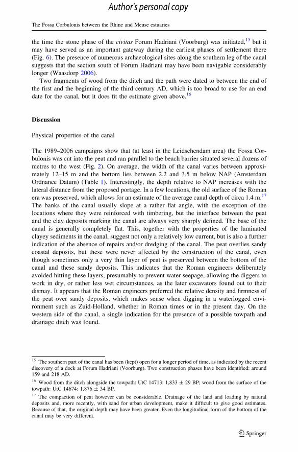
Meern 1, found and salvaged in 2003 (Fig. 7) in a highly publicised excavation (de Kam
et al. 2007) was 25 metres long and had a mast. These ships could sail, but were probably
towed most of the time. Although De Meern 1 was made from local oak (Jansma 2007),
several of these ships are built from oak from (Southern) Germany. It has been suggested
that merchants would have the ship built along the Upper Rhine and load it with cargo, sail
it down the river using the natural current, sell their wares along the way and eventually
19 Even without the threat of boredom, the Roman legionaries traditionally doubled as a workforce(Goldsworthy 2003).
The Fossa Corbulonis between the Rhine and Meuse estuaries
123
Author's personal copy

sell the wood from the boats as timber for construction. They would then make their way
back home by other means and repeat the cycle. Not only does the local provenance of the
timber used for De Meern 1 contradicts this suggestion, the use and repair of De Meern 1
for several decades also tells a different story (Jansma 2007).
Woerden 7, a patrol boat of the Roman army, but similar in construction to the cargo
ships, was made of two sets of oak wood, the largest part from Germany in the Aachen—
Trier region and a smaller portion from oak originating from the Lower Rhine in the
Netherlands, suggesting the boat was built in Germany and repaired in the Netherlands
later during its use (Blom et al. 2008).
Conclusion
Classical sources mention a Roman canal between the estuaries of the Rhine and the
Meuse. The presence of such a canal was established archaeologically and dating evidence
generally corroborates the attribution to general Corbulo, mentioned by Tacitus and Dio.
Investigation of the canal is difficult, since it is partially constructed by connecting
existing, natural waterways. This makes detection of the feature difficult, since the coastal
area of the Netherlands is littered with ancient waterways from throughout the Holocene.
Distinguishing the canal from the surrounding channels is problematic, especially since it
often actually is a natural channel or, as it is probably the case in the southern stretch of its
route, was cut into deposits belonging to a former tidal creek. Since the canal silted up
gradually, its infill looks exactly like that of a natural channel. It is no coincidence that the
majority of reliable sightings hail from a stretch of the canal in the town of Leidschendam.
In this area, the canal was dug into peat deposits, making it easy to distinguish not only the
clayey infill, but also to recognise the flat bottom of the canal, clearly distinguishing it from
from a natural channel, which would have a more bowl-shaped outline.
The route of the canal is incompletely established. In the northern part, it is impossible
to test, since it is believed that the route coincides with extant canals?, whereas the
southern leg is believed to follow the course of a former tidal creek. Some clues have been
found in Rijswijk and The Hague, but this requires further investigation. The middle part of
the route is fairly well established by all the investigations in the Leidschendam area. It is
clear that the Roman engineers strayed from their traditional penchant for straight lines in
the planning of the canal’s route. This is certainly in part due to the marshy, wet landscape
in the area, which simply rendered such a strategy overly complicated, but it can also be
attributed to the desire to avoid unnecessary work by linking up existing channels.
The construction of the canal is fairly simple. It is anywhere between 4.5 and 15 m
wide, with sloping sides and a flat base. The depth is approximately 1.5–2 m deep. In
several places, fortification of the banks of the canal have been found in the form of
timbering, generally made of oak stakes produced locally. At the Rietvinklaan site, a
towpath with adjacent drainage ditch was found, mirrored by the discovery of a natural
channel, possibly part of the canal, with evidence of a road further to the south. Roughly in
the middle of the route of the canal, there is some evidence for the presence of a dam and a
portage for hauling vessels. This was possibly constructed on the watershed of the Meuse
and Rhine flood basins, because of differing water tables, as evidenced by the fact that the
depth of the base of the canal relative to sea level differs on both sides of the dam. Two
adjacent channels were discovered at the Rietvinklaan, suggesting a reconstruction of the
canal, relatively quickly after its initial construction. It is unclear whether the second phase
J.-W. de Kort, Y. Raczynski-Henk
123
Author's personal copy
of the canal is a local phenomenon or whether this is the case over a greater length.
Absence of similar observations in other sites may be the result of research strategies.
Dates from dendrochronological samples confirm the second phase of construction of
the canal in, or shortly after 50 AD, which is consistent with the second tour of command
of general Corbulo. There is no certainty until when the canal was in use. Evidence from
various investigations suggest that the canal would have filled up with sediments due to its
connection to two tidal rivers, but sedimentation rates are not certain and can vary greatly.
Dates from radiometric samples vary widely and are therefore unreliable to establish a
terminus ante quem. It is generally thought that the canal remained in use until approxi-
mately the middle of the second century AD, possibly longer for the southern part.
The main function of the canal was probably a vector for the transport of goods and
people without having to venture on to the North Sea, which was too dangerous for the flat
bottomed transport boats designed for use on rivers and canals. The dam in the canal
suggests that the Romans were at least acutely aware of the importance of water man-
agement, since they recognised the difference between the flood basins of the two rivers
connected by the canal. Whether the canal actually played an active role in diverting water
from the rivers to prevent floods in case of extreme high tides or storm is a different matter.
Compared to the rivers Meuse and Rhine, the canal seems rather puny. It may have
functioned in the other direction, however, draining the marshes to make them more
hospitable.
The Fossa Corbulonis fits into a much larger network of natural and man-made (or at
least altered) waterways and roads. In this respect, it is interesting to note that in the
Roman era, the large inlets characterising the coast of the south-western corner of the
Netherlands did not yet exist, except for the estuary of the Scheldt (de Groot et al. 2011).
The situation was therefore similar to the area between the Meuse and the Rhine Rivers.
This could imply that the Fossa Corbulonis is only the northern leg of a longer system, also
connecting the Meuse and the Scheldt rivers (de Bruin et al. 2012). No convincing evi-
dence for such a canal, either in historic sources or in archaeological research has ever been
found, but if transport of heavy goods is easier on water than it is overland, especially in
Fig. 7 A reconstruction of De Meern 1. Similar boats will have been used to travel up and down the FossaCorbulonis. Photograph: Ton Penders (Cultural Heritage Agency of the Netherlands)
The Fossa Corbulonis between the Rhine and Meuse estuaries
123
Author's personal copy
the absence of good roads, it is an interesting possibility, assuming that transport by sea
was an undesirable option.
References
Beekman AA (1916) De ‘‘Fossa Corbulonis’’. Tijdschr K Ned Aardrijkskd Genoot 33:813–826Berendsen HJA (2008) Landschappelijk Nederland, AssenBlom E, Vorst Y, Vos WK (2008) Een Romeinse platbodem. Opgravingsverslag van het Romeinse schip
gevonden op de Nieuwe Markt te Woerden. In: Blom E, Vos WK (ed) Woerden–Hoochwoert. Deopgravingen 2002–2004 in het Romeinse castellum Laurium, de vicus en van het schip de ‘Woerden7’. Amersfoort, Leiden
Bogaers JW (1962) De Fossa Corbulonis, AmersfoortBrandenburgh CR, Hessing WAM (2005) Matilo-Rodenburg-Roomburg; De Roomburgerpolder: van
Romeins castellum tot moderne woonwijk. Bodemschatten en Bouwgeheimen 1, LeidenDaams FHCM, Kort JD de (1988) Over, door en om de Leytsche Dam : geschiedenis van een gouden
gemeente, Leidschendamde Bruin J, Besuijen GPA, Siemons HAR, van Zoolingen RJ (2012) Goedereede-Oude Oosdijk. Een
Havenplaats uit de Romeinse tijd, Leidende Groot T, Vos P, Weerts H, de Kort JW, van Doesburg J, Lauwerier R, Brinkkemper O (2011) Toelichting
op de kaart van 100 n.Chr. In: Vos PC, Bazelmans J, Weerts HJT, van der Meulen MJ (eds) Atlas vanNederland in het Holoceen. Landschap en bewoning vanaf de Laatste IJstijd tot nu. Uitgeverij BertBakker, Amsterdam
Derks T (2008) Inscripties op Brons. In: Feijst L van der, Bruin J de, Blom E De nederzetting te NaaldwijkII; Terug naar de sporen van Holwerda. ADC Monogr 4, Amersfoort
Dorenbos O, Holthausen O, Koot JM (2009) Langs de Sir Winston Churchilllaan in Rijswijk; Archeologischonderzoek naar aanleding van de toevallige vondst van een Romeinse mijlpaal. Rijswijkse ArcheolRapp 22, Rijswijk
Faulkner N (2008) Rome: empire of the eagles. Routledge, LondonGoldsworthy A (2003) The complete roman army. Thames and Hudson, LondonGriffioen A, Hoogendijk T (2011) Archeologische begeleiding met aansluitende opgraving op het Damplein
te Leidschendam. Hollandia reeks, ZaandijkHanraets AEM (2004) Rapportage daterend onderzoek. Lokatie en object: Leidschendam, Voorburg,
beschoeiing. RING Rapp 2004 -047, AmersfoortHanraets AEM (2006) Uitslag dateringsonderzoek Leidschendam-Voorburg, Rietvinklaan 5 (gracht van
Corbulo). RING Rapp 2006-085, AmersfoortHermans CR (1839) Betoog dat er uit de Commentarii de bello Gallico van Julius Caesar volstrekt geen
bewijs kan worden getrokken, als of die Veldheer of zijne Krijgsoversten in Noord-Nederland oorlogzouden hebben gevoerd.’s Hertogenbosch
Heeringen RM van (1997) Leidschendam: Verlengde Landscheidingsweg. Archeol kron Holl 1996 IIZuidholl 29/6: 406
Hessing WAM (1990) Leidschendam: Rietvink. Archeol kron Holl 1989 II Zuidholl 22/6: 342–343Hessing WAM (1991) Leidschendam: Rietvink. Archeol kron Holl 1990 II Zuidholl 23/6: 344–345Hessing WAM (1992) Leidschendam: Rietvinkpolder. Archeol kron Holl 1991 II Zuidholl 24/6: 366–367Hessing WAM (1993) Leidschendam: Rietvink. (ed) Archeol kron Holl 1992 II Zuidholl 25/6: 336–338Hettema H (1936) De gracht van Corbulo. Bijdragen Vaderlandsche Geschied Oudheidkd VII,’s-Grav-
enhage: 80–86Holwerda JW (1923) Arentsburg, een Romeinsch militair vlootstation bij Voorburg, LeidenJansma E (1995) RemembeRINGs: the development and application of local and regional tree-ring chro-
nologies of oak for the purposes of archaeological and historical research in the Netherlands. Dis-sertation, University of Amsterdam
Jansma E (2007) Jaarringonderzoek van het scheepshout en meubelonderdelen: bouwtechnische aspecten,datering en herkomst van het hout. In: Jansma E, Morel JMAW (ed) Een Romeinse Rijnaak, gevondenin Utrecht-De Meern. Resultaten van het onderzoek naar de platbodem ‘De Meern 1’. RapportageArcheologische Monumentenzorg 144, Amersfoort
Jansma E, van Lanen RJ, Brewer PW, Kramer R (2012) The DCCD: a digital data infrastructure for tree-ringresearch. Dendrochronologia 30:249–251
J.-W. de Kort, Y. Raczynski-Henk
123
Author's personal copy

Jonge W de (2000) Leidschendam-Voorburg: Gracht van Corbulo. Archeol kron Holl 1999 II Zuidholl 32/6:342–343
Kam, R de, Graafstal E, Wynia H (2007) Utrecht. Leidse Rijn, Time Team. In: Archeol kron Prov Utrecht2004–2005: 114–120
Kort JW de (2009) Het kanaal van Corbulo. In: Hirschel RM (ed) Forum Hadriani; Romeinse stad achter deLimes, Voorburg
Kort JW de, Raczynski-Henk Y (2008) Plangebied Rietvinklaan 5, gemeente Leidschendam-Voorburg;archeologisch vooronderzoek: een bureau- en inventariserend veldonderzoek proefsleuven. RAAP-rapp 1428, Amsterdam
Lichtenauer WF (1935) De gracht van Corbulo. Tijdschr Geschied 50, Assen: 167–173Liere WJ van (1948) De Bodemgesteldheid van het Westland. Bodemkarter Ned 54.6’s-GravenhagePons LJ (1957) De geologie, de bodemvorming en de waterstaatkundige ontwikkeling van het Land van
Maas en Waal en een gedeelte van het Rijk van Nijmegen. Dissertation, Wageningen UniversityRijn P van (2006) Houtonderzoek aan zeven palen van de Gracht van Corbulo. BIAX-rapp 178, ZaandamStolte BH (1943) De Fossa Corbulonis. Tijdschr Geschied 58, Assen: 216–223Theunissen L, Vos P, Weerts H, Bazelmans J, Lauwerier R, Brinkkemper O (2011) Toelichting op de kaart
van 500 v.Chr. In: Vos PC, Bazelmans J, Weerts HJT, Meulen MJ van der (ed) Atlas van Nederland inhet Holoceen. Landschap en bewoning vanaf de Laatste IJstijd tot nu, Amsterdam
van Veen MMA, Lenselink G (1990) Gracht van Corbulo. Rijksdienst voor het Oudheidkundig Bode-monderzoek, Amersfoort
Visser RM (2006) De Romeinse houtvoorziening in het gebied van de Nedergermaanse Limes. Een his-torisch en dendrochronologisch perspectief. MA-dissertation, VU University Amsterdam
Vos PC, Bakels C, Kuijper W, Bunnik F, Deunhouwer P, Jonge W de, Wolf H de (2007) Geo-lands-chappelijk onderzoek bij het waarderend archeologische onderzoeksproject met betrekking tot deCorbulo-grachtafzettingen aan de Veursestraatweg 118 te Leidschendam (opgegraven in mei 2004).TNO-rapp 2007-U-R0199/B, Utrecht
Vos PC, Bazelmans J, Weerts HJT, van der Meulen MJ (eds) (2011) Atlas van Nederland in het Holoceen.Landschap en bewoning vanaf de Laatste IJstijd tot nu. Uitgeverij Bert Bakker, Amsterdam
Waasdorp JA (2003) III M.P. naar M.A.C. Romeinse mijlpalen en wegen. Haagse Oudheidkd ber 8Waasdorp JA (2006) Romeinse infrastructuur. De ontsluiting van het Cananefaatse gebied. In: de Jonge W,
Bazelmans JGA, de Jager DH (eds) Forum Hadriani. Van Romeinse Stad tot Monument, Utrecht,pp 117–130
Winterling A (2003) Caligula—Een biografie. Schilt, Amsterdam
Jan-Willem de Kort graduated as a palaeobotanical archaeologist from Leiden University, specialising inpalynologic investigation of late prehistoric burial mounds. He has led numerous archaeological projects inboth the Holocene coastal area and the Pleistocene coversand region, including the excavation of the FossaCorbulonis in 2006. He currently works as a field archaeologist for the Cultural Heritage Agency of theNetherlands.
Yannick Raczynski-Henk graduated as a Palaeolithic archaeologist from Leiden University but hissubsequent career focused mainly on the Holocene coastal area of the Netherlands, providing him withextensive knowledge of the geomorphological and archaeological history of the area and of the toolsavailable to examine them. Apart from his work on Holocene coastal deposits, Yannick also co-directsinvestigations into the Middle Palaeolithic archaeology of the Pleistocene loess area in the south of theNetherlands and he is part of an international team working on the Middle Palaeolithic of the RhazdanGorge in Armenia.
The Fossa Corbulonis between the Rhine and Meuse estuaries
123
Author's personal copy


![Churchill R[1].V., Brown J.W., Verhey R.F. Complex variables ...](https://static.fdokumen.com/doc/165x107/632179b9537c10e83802abe7/churchill-r1v-brown-jw-verhey-rf-complex-variables-.jpg)