Koppers (Newport, DE) - Records Collections
181
Koppers (Newport, DE) erfund Site National Remedy Review Board Presentation U.S. EPA (Region III) May 12, 2004 Washington, D.C. Matthew T. Mellon
-
Upload
khangminh22 -
Category
Documents
-
view
3 -
download
0
Transcript of Koppers (Newport, DE) - Records Collections

Koppers (Newport, DE)erfund Site
National Remedy ReviewBoard Presentation
U.S. EPA (Region III)
May 12, 2004Washington, D.C.
Matthew T. Mellon
NOTE:
> This presentation provides detailsregarding EPA's Draft PRAP, and istherefore:
Deliberative / Enforcement Confidential / PFE
R R 3 I 5 5 5 5

Organization of Presentation•IBI ^BMBBHH
> Introduction> Part I: Koppers Site Background> Part II: Risk Characterization> Part III: Evaluation of Alternatives
Note: slides are numbered in lower-right
A R 3 1 5 5 5 6

Introduction
> EPA's Preferred Alternative: CompleteConsolidation (with barrier wall and impermeable cap)• Driven by Ecological Risk• Protective of Human Health and Environment• Mirrors PRP Pref. Alt. with the addition of:
• Actively addressing NAPL and High TPAH in Lower HR• Passive NAPL Recovery in Containment Area
> Special Issues• Comprises 1/2 of one of the largest
of habitat in northern Delaware - StaleHigh ecological value; potential
PR0l
U R 3 I 5 5 5 7

s n o !A t t o i


Site Background
Parti
UJo
ftR3!5560

Where is it?
> Switch to Adobe Acrobat for:• Site Location. Site Map and Layout
t>X
% V?^W7 a*£.
\>—" <?PART I: KOPPERS SITE BACKGROUND ^i. pRo^^ 8
ftR3!556l
SE

What was it?•••
> Creosote wood treating operationsconducted from 1929 - 1971 (42 yrs.)
> Approx. 1,000,000 gallons creosote storedon-site at any time
> Operations began 75 years ago> Operations ended over 30 years 990
> PRPs are Beazer East, Inc. afid(owner of the property)
PART I: KOPPERS SITE BACKGROUND
A R 3 I 5 5 6 2

Process Area
'2s3%&&£siPS?^^^

Overview of Site
A R 2 ! 5561*


What is it now?l HI
> Over 300 acres in size> Old field / grass & Shrub (~ 163 acres upland)
> Forested areas, forested wetlands> Non-tidal and tidal freshwater wetlands
(> 1 37 acres)
> Potential for endangeredBald eagle on adjacent B+C Islfrnd
PART I: KOPPERS SITE BACKGROUND -. t PRO\ v- 13
A R 3 I 5 5 6 6

Drip Track Area

Drip Track
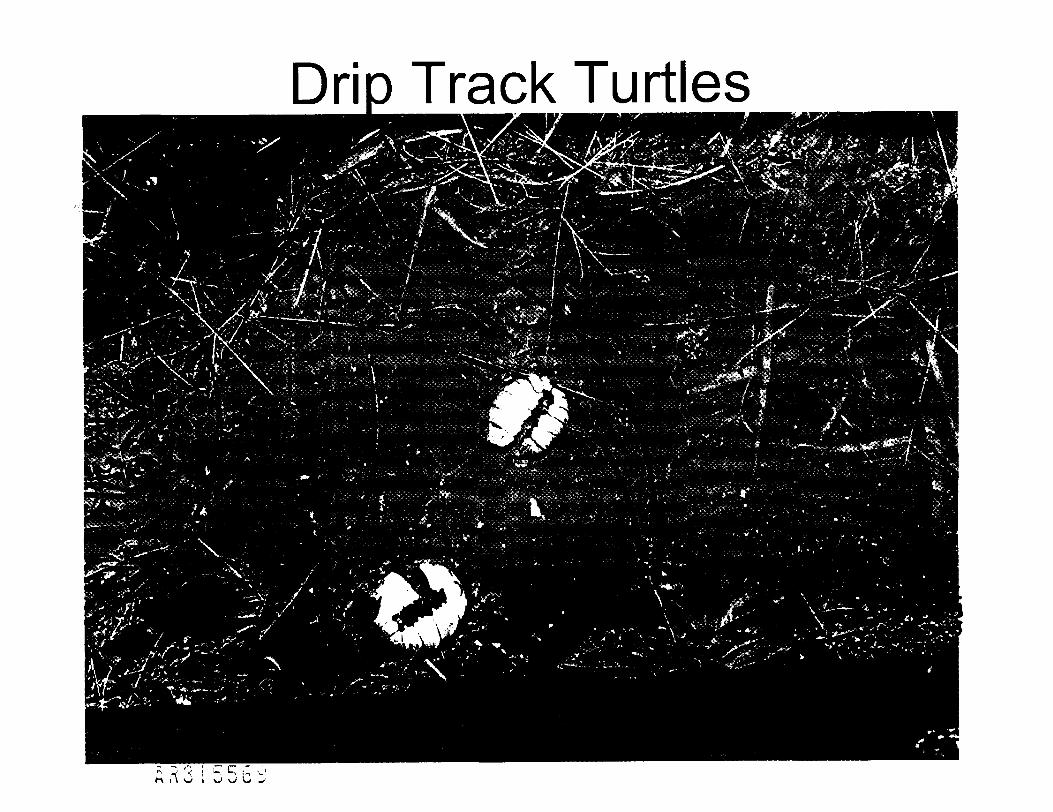
Drio Track Turtl

Fire Pond

Hershey Run (lower)

Lower and Upper Hershey RunLower HR
19


Forested Wetlands

South Ponds and Marsh

SouthPondsArea

Geological Perspective
> Switch to Adobe Acrobat• Geological cross-section
PART I: KOPPERS SITE BACKGROUND "•<• PRCNV~ 26
A R 3 I 5 5 7 9

Nature and Extent ofContamination
> Soil• Creosote extensive in upland surface soils
> Sediment• Creosote constituents (Total PAHs)• Metals (not site-related)• PCBs (not site-related; fish
> Ground water / NAPL• Creosote constituents. BTEX , PCP, Dioxins, Pesticid%
<p|5i
PART I: KOPPERS SITE BACKGROUND * '^L pnrrt 27
6 R 3 I 5 5 8 0

BTEX
> BTEX N.D. or low total BTEX (<1 mg/kg) in the soil andsediment samples• Except six surficial (0.0 to 0.5 feet) samples from Fire Pond and
South Pond areas ranging from 1.0 mg/kg to 41.4 mg/kg• And seven near surface (0.0 to 1.0 or 2.0 feet) samples (same
areas), ranging from 1.2 mg/kg to 311 mg/kg (K Area)• Similar holds for subsurface samples
> Highest total BTEX and other VOCs (i.e., > 100 pg/L)detected at MW-2A and MW-2S
_vs• Wells near a former LIST _ •• MW-2A had free NAPL present
> Low levels of BTEX and other VOCs (i;found in several wells around Process
PART I: KOPPERS SITE BACKGROUND ~v. PR0\*-~ 28
A R 3 I 5 5 8 I

Pesticides, PCBs, Metals
> Highest in sediment. 1.2 mg/kg 4-4' DDT (South Pond)• 0.40 mg/kg methoxychlor (Hershey Run marsh). OFF-SITE: 24 mg/kg 4-4' DDT (Christina River,
upstream from Site)> Total PCBs ranged from N.D. to 1.1 mg/kg
(Hershey Run marsh)• Highest: 1.3 mg/kg (also Christina River..jdjD&te^e/r|
from Site) v
> Zinc (worst, and indicative of suite of metals f Eind)
• 5.2 mg/kg in Process Area 5 ^9tK^ %• 8,770 mg/kg in Hershey Run marsh?.
PART I: KOPPERS SITE BACKGROUND ^ PRCf^" 29
A R 3 I 5 5 8 2

Dioxins, PCP
> Dioxins. PCDDs/PCDFs identified in HHRA (1999) as potential
COCs• It was later determined that database errors
misrepresented concentrations• Once lab spikes removed, PCDDs/PCDFs are not
COCs - levels drop to background• HHRA scenario attributing risk to dioxins^ctl&9
recalculated -^
> PCP - N.D. to 2 |jg/L (phenols) ojftsiwith NAPL present S\
PART I: KOPPERS SITE BACKGROUND '-.<. ppo\*-- so
A R 3 I 5 5 8 3

Total PAHs in Soil
Summary of Detected Total PAH Concentrations in Soils (mg/kg)
AreaProcess/Drip Track AreaWood Storage AreaFire Pond AreaSouth Ponds AreaK AreaRemaining UplandsHershey Run Drainage AreaCentral Drainage Area
Frequency ofDetections
39/6231/4714/2010/165/5
24/4711/217/18
Minimum0.490.140.310.0770.340.520.120.14
Maximum8,9385,6051,6472,83054,0396,309498
10,027
Average945224257390
171204054
2,273
PART I: KOPPERS SITE BACKGROUND
A R 3 1 5 5 8 1 *
31

Total PAHs in Sediment
Summary of Detected Total PAH Concentrations in Sediments (mg/kg]
AreaFire Pond AreaSouth Ponds AreaKAreaRemaining UplandsHershey Run Drainage AreaCentral Drainage Area
Frequency ofDetections
22/2211/112124/4
59/6266/87
Minimum28679
5,4110.101.1
0.19
Maximum50,014106,1208,578135
13,25116,670
[ '
Average6,92423,8266,994
47495888
PART I: KOPPERS SITE BACKGROUND
A R 3 I 5 5 8 5
32

Nature and Extent ofContamination
> Creosote is the most extensivecontaminant at Site
> Switch to PRPs' 3-D visualization• Subsurface NAPL-contaminated areas
(modeled from boring logs)• South Pond focus• Fire Pond focus
PART I: KOPPERS SITE BACKGROUND . ppo 33
a R 3 i 5 5 8 6

Risk Characterization
Part II
3)\UJ
A R 3 I 5 5 8 7

Human Health Risk•*
• ••••M
> Human Health Risk Assessmentperformed by PRP Contractor with EPAOversight (1999)
> In accordance with EPA Guidance> Multiple exposure scenarios
^fx O^»-
> Industrial future use assumed
PARTN: RISK CHARACTERIZATION PRQ 35
A R 3 I 5 5 8 8

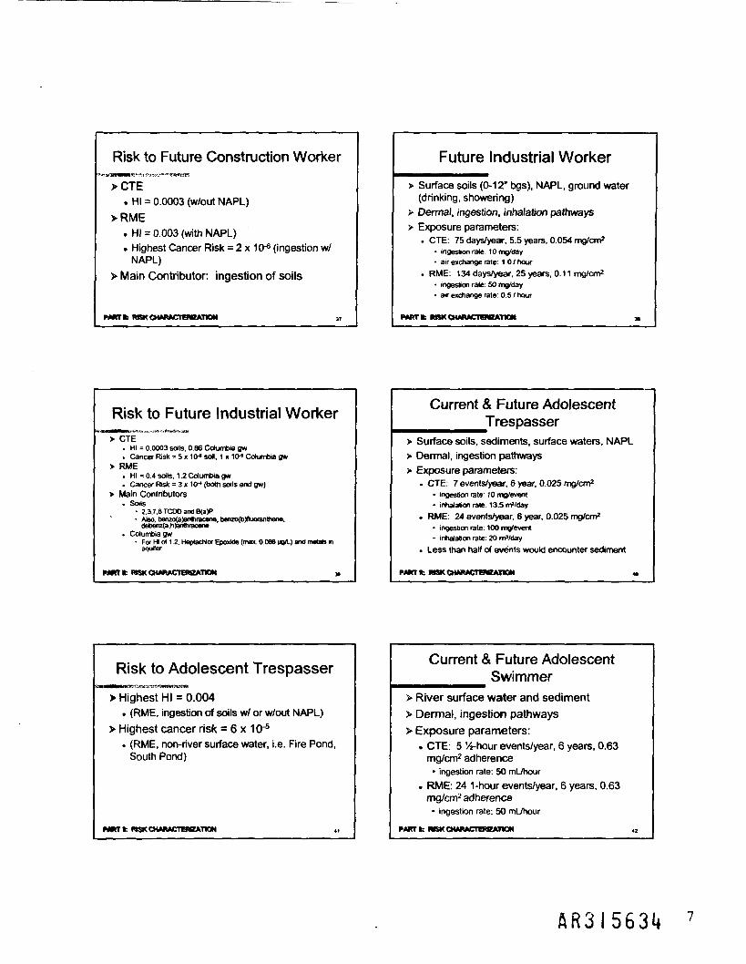
Future Construction Worker
> Surface and subsurface soils (0-18' bgs)> Dermal, ingestion, inhalation pathways> Exposure parameters:
• CTE: 40 days/year, 1 year, 0.054 mg/cm2
• ingestion rate: 10 mg/day• inhalation rate: 13.5 m3/day
• RME: 120 days/year, 1 year, Q£!1«c
• ingestion rate: 50 mg/day• inhalation rate: 20 m3/day
PART II: RISK CHARACTERIZATION ' PRCfl 36
A R 3 I 5 5 8 9

Risk to Future Construction Worker^mmmmm
>CTE. HI = 0.0003 (w/out NAPL)
>RME. HI = 0.003 (with NAPL)
• Highest Cancer Risk = 2 x 10'6 (ingestion w/NAPL)
> Main Contributor: ingestion
^^^^PARTH; RISK CHARACTERIZATION pRc 37
& R 3 1 5 5 9 0

Future Industrial Worker
> Surface soils (0-12" bgs), NAPL, ground water(drinking, showering)
> Dermal, ingestion, inhalation pathways> Exposure parameters:
• CTE: 75 days/year, 5.5 years, 0.054 mg/cm2
• ingestion rate: 10 mg/day%- tO Sjj,
• air exchange rate: 1.0 / hour -^ '
• RME: 134 days/year, 25 years, 0.1• ingestion rate: 50 mg/day• air exchange rate: 0.5 / hour
PART II: MSK CHARACTERIZATION '^L PRO^ 38
A R 3 J 5 5 9 I

Risk to Future Industrial Worker
> CTE. HI = 0.0003 soils, 0.86 Columbia gw• Cancer Risk = 5 x 10~6 soil, 1 x 10~5 Columbia gw
> RME• HI = 0.4 soils, 1.2 Columbia gw• Cancer Risk = 3 x 10'4 (both soils and gw)
> Main Contributors• Soils
• 2,3,7,8 TCDD and B(a)P• Also, benzo(a)anthracene, benzo(b)fluoranthen^^
debenz(a,h)anthracene• Columbia gw
• For HI of 1.2, Heptachlor Epoxide (max. O.OfJ> |jaquifer O
> xPARTN: RISK CHARACTERIZATION *L ppd\ ° sg
A R 3 I 5 5 9 2

Current & Future AdolescentTrespasser
> Surface soils, sediments, surface waters, NAPL> Dermal, ingestion pathways> Exposure parameters:
• CTE: 7 events/year, 6 year, 0.025 mg/cm2
• ingestion rate: 1 0 mg/event• inhalation rate: 13.5 m3/day
. RME: 24 events/year, 6 year, 0.025• ingestion rate: 1 00 mg/event />>• inhalation rate: 20 m3/day
• Less than half of events would encd§,nte
PARTN: RISK CHARACTERIZATION . ppo 40
fiR3i5593

Risk to Adolescent Trespasser
> Highest HI = 0.004• (RME, ingestion of soils w/ or w/out NAPL)
> Highest cancer risk = 6 x 10'5
• (RME, non-river surface water, i.e. Fire Pond,South Pond)
w)PARTN: RISK CHARACTERIZATION *i. PRQ^ "
AR315591*

Current & Future AdolescentSwimmer
> River surface water and sediment> Dermal, ingestion pathways> Exposure parameters:
• CTE: 5 1/4-hour events/year, 6 years, 0.63mg/cm2 adherence• ingestion rate: 50 mL/hour
• RME: 24 1-hour events/year,mg/cm2 adherence• ingestion rate: 50 mL/hour
PARTH: RISK CHARACTERIZATION
H R 3 I 5 5 9 5

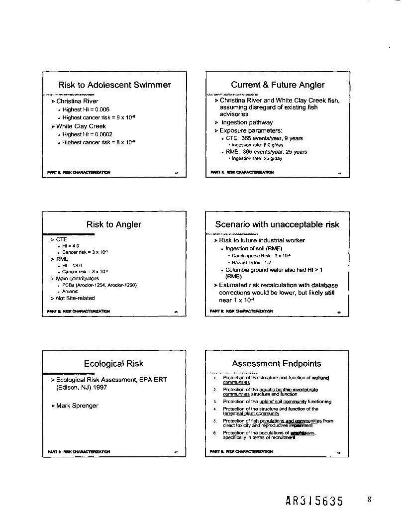
Risk to Adolescent Swimmer
> Christina River. Highest HI = 0.006• Highest cancer risk = 9 x 10~8
> White Clay Creek. Highest HI = 0.0002. Highest cancer risk = 8 x 10'9
PARTN: RISK CHARACTERIZATION pRo 43
&R315596

Current & Future Angler•••••••••
> Christina River and White Clay Creek fish,assuming disregard of existing fishadvisories
> Ingestion pathway> Exposure parameters:
• CTE: 365 events/year, 9 years• ingestion rate: 8.0 g/day
RME: 365 events/year, 25 years'• ingestion rate: 25 g/day
PARTH; RISK CHARACTERIZATION ppo 44
AR3 15597
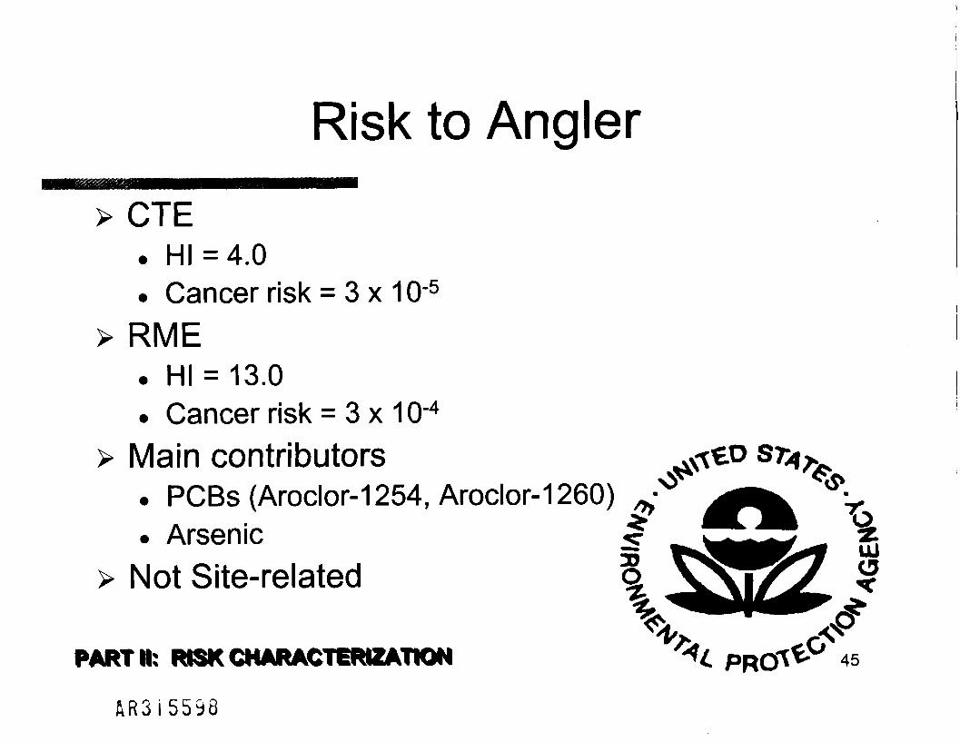
Risk to Angler
> CTE. HI =4.0• Cancer risk = 3 x 10'5
> RME. HI = 13.0• Cancer risk = 3 x 10"4
> Main contributors. PCBs (Aroclor-1254, Aroclor-1260)• Arsenic
> Not Site-related
PART* RISK CHARACTERIZATION '*<. pncftV 45
A R 3 I 5 5 9 8
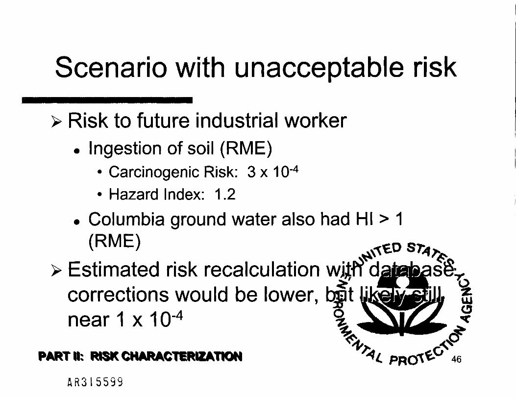
Scenario with unacceptable riskI^HMHMH^^MIMMMH
> Risk to future industrial worker. Ingestion of soil (RME)
• Carcinogenic Risk: 3 x 1Q-4
• Hazard Index: 1.2
• Columbia ground water also had HI > 1
tO S7^> Estimated risk recalculation wjjn
corrections would be lower, bjrt {jnear 1 x 10"4
PARTH: RISK CHARACTERIZATION . PRQ 46
A R 3 I 5 5 9 9
Ecological Risk
> Ecological Risk Assessment, EPA ERT(Edison, NJ) 1997
> Mark Sprenger
PART* RISK CHARACTERIZATION i. 47
& R 3 I 5 6 0 0

Assessment Endpoints1 . Protection of the structure and function of wetland
communities
2. Protection of the aquatic benthic invertebratecommunities structure and function
3. Protection of the upland soil community functioning
4. Protection of the structure and function of theterrestrial plant community
5. Protection of fish populations and comrouftllresdirect toxicity and reproductive impaingjeht
6. Protection of the populations ofspecifically in terms of recruitment
PARTH: RISK CHARACTERIZATION PRO 48
A R 3 i 5 6 0 i
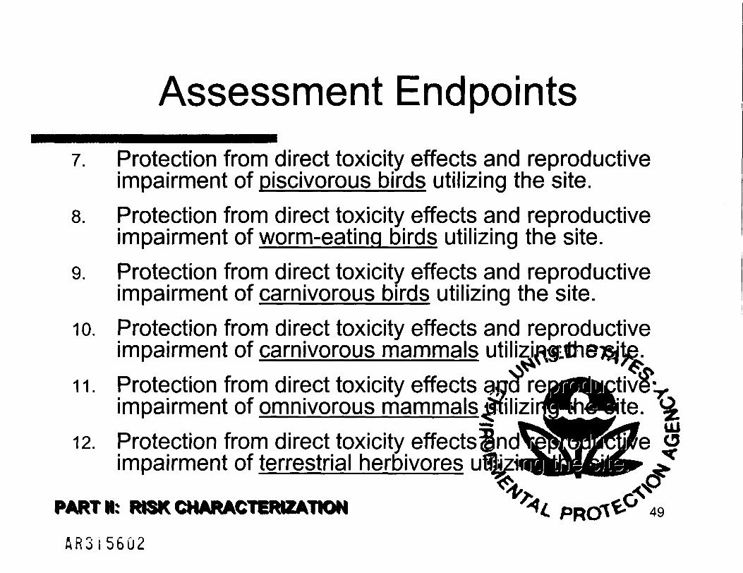
Assessment Endpoints
7. Protection from direct toxicity effects and reproductiveimpairment of piscivorous birds utilizing the site.
8. Protection from direct toxicity effects and reproductiveimpairment of worm-eating birds utilizing the site.
9. Protection from direct toxicity effects and reproductiveimpairment of carnivorous birds utilizing the site.
10. Protection from direct toxicity effects and reproductiveimpairment of carnivorous mammals utilizjj
11. Protection from direct toxicity effects gjjqimpairment of omnivorous mammalsffiilizir 'h^Bite.
12. Protection from direct toxicity effects^ndi pJJJrcfi eimpairment of terrestrial herbivores ul
PART IK RISK CHARACTERIZATION -14 PRCy
A R 3 1 5 6 Q 2

Data Used(Multiple Lines of Evidence)
^sjMjaMUlilMWjSlliMSISISSf^ttltiiiSI^
> Sediment Toxicity Tests - sedimentmortality - two species
> Field Benthic Community Survey> Field Plant Survey> Soil Toxicity Test - earthworms
j> Fish and Amphibian Embryo te«srelied upon)
PARTH; RISK CHARACTERIZATION L " so
A R 3 I 5 6 0 3

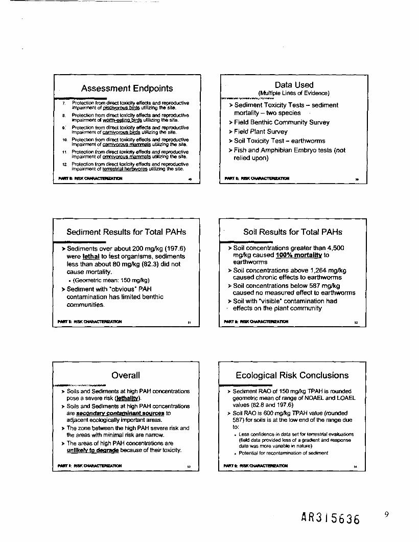
Sediment Results for Total PAHsmm^mmmmmm^mmmmm
> Sediments over about 200 mg/kg (197.6)were lethal to test organisms, sedimentsless than about 80 mg/kg (82.3) did notcause mortality.. (Geometric mean: 150 mg/kg)
> Sediment with "obvious" PAHcontamination has limited benjhiccommunities.
PARTN: RISK CHARACTERIZATION . p p - 51fiR3i560i*

Soil Results for Total PAHs
> Soil concentrations greater than 4,500mg/kg caused 100% mortality toearthworms
> Soil concentrations above 1,264 mg/kgcaused chronic effects to earthworms
> Soil concentrations below 587caused no measured effect to^
> Soil with "visible" contamination•
effects on the plant communr
PARTN: RISK CHARACTERIZATION '^L. pnrftV 52
A R 3 I 5 6 G 5

Overall
> Soils and Sediments at high PAH concentrationspose a severe risk (lethality).
> Soils and Sediments at high PAH concentrationsare secondary contaminant sources toadjacent ecologically important areas.
> The zone between the high PAH severe risk andthe areas with minimal risk are narroj 4^•
> The areas of high PAH concentrationsunlikely to degrade because of fie
PART* RISK CHARACTERIZATION
A R 3 I 5 6 0 6

Ecological Risk Conclusions
> Sediment RAO of 150 mg/kg TPAH is roundedgeometric mean of range of NOAEL and LOAELvalues (82.8 and 197.6)
> Soil RAO is 600 mg/kg TPAH value (rounded587) for soils is at the low end of the range dueto:. Less confidence in data set for terrestrjgj vmjawfeg,
(field data provided less of a gradienfoanddata was more variable in nature) s" fsj HFxf uj
• Potential for recontamination of
PART* RISK CHARACTERIZATION ^L Pnrftt-" 54
A R 3 I 5 6 Q 7

Risk Apples and Oranges
> Site areas having both ecological andhuman health risks were compared
> Geographical comparison of risk indicatesthat ecological risk cleanup goalsprotective for human health risks as well
> Notes:• Eco-risk: TPAH Human Health:• TPAH is always greater than cPAH or B(a)geqfi
given sample
PART* RISK CHARACTERIZATION -t PRO^ 55
A R 3 I 5 6 U 8

Cleanup Goalsmurnrn
> Cleanup goals based on eco-riskassessment conclusions:. SOIL: 600 mg/kg TPAH. SEDIMENT: 150 mg/kg TPAH
> Sensitivity analysis• Sharp gradation noted in reports;
maps showed little difference uji:ng
PARTN: RISK CHARACTERIZATION PRO 56
A R 3 I 5 6 0 9

Risk Conclusions
> Switch to Adobe Acrobat• Soil areas warranting remediation. Subsurface NAPL areas• Sediment areas warranting remediation
PART 8: RISK CHARACTERIZATION ->c PROA*-' 57
A R 3 I 5 6 I O

Evaluation ofAlternatives
Part III
& R 3 I 5 6 I I

Future Land Use••BBB
> In FS, future use assumed industrial> PRPs and DelDOT approached EPA
about reuse as wetlands bank> EPA / DNREC / PRP / DelDOT developed
new Preferred Alternative
PARTM: EVALUATION OF ALTERNATIVES ^ pnrrt " 59
A R 3 I 5 6 I 2

Remedial Action Objectives^^^^^^m^^^^m
1. Prevent current or future direct contact withcontaminated soils and sediments that wouldresult in unacceptable levels of risk toecological receptors by reducing levels ofTPAH concentrations to below 150 mg/kg insediment and 600 mg/kg in soil (150 mg/kg insoil that is to be converted to wetlands);
2. Prevent unacceptable human hto contaminated ground water;
3. Minimize the on-goingwater from the presence of NAremoval and/or containment;
PARTW: EVALUATION OF ALTERNATIVES PRO

RAOs (cont'd.)
4. Prevent any direct contact threat to an adult orchild trespasser and to an industrial worker;
5. Prevent the construction of residentialbuildings (which are currently prohibited bylocal zoning) in order to protect potential futureresidents from contact with contaminated soiland/or ground water;
6. Maximize the area of uplandavailable for various re-use optionwetlands banking by DelDOT) 9
PART HI: EVALUATION OF ALTERNATIVES . pRC 61
& R 3 I 5 6 U

FS Evaluated NumerousTechnologies
> Monitored natural recovery / attenuation> Containment
• Cover in place• Consolidation on-site• Sheet piling / barrier walls
> Stabilization / Solidification> In-situ thermally-enhanced extraction^TOf^^> On-/Off-site ex-situ thermal> Off-site incineration
Off-site disposal (Canada)
PARTM: EVALUATION OF ALTERNATIVES -><. PRO\V- &
A R 3 I 5 6 I 5

Alternatives in FS & PRAPAlternatives
FS Est. PRAP Est.
FS
1
2
3
4a
4b
5
6a
6b
6c
6d
7a
7b
8a
8b
9
10
10Mod
(M)
$0.0
$11.9
$32.7
$36.5
$34.7
$70.5
$36.7
$37.7
$116.0
$117.0
$73.5
$142.0
$278.0
$185.0
$243.0
$30.6
$32.7
PRAP
1
2
3
5
4
(M)
$0.0
$17.6
$42.0
$191.4
$48.2
Description
No Action
Partial Cover-in -place (PRAP requires 2 ft. of cover vs. just 1 ft. in FS)
Shallow excavation, on-site consolidation
Partial Consolidation (PRAP requires 2 ft. of excavation and cover vs. just 1 ft. in FS)
Shallow excavation, on-site consolidation + active NAPL recovery
In-situ S/S (NAPL) + on-site consolidation (shallow excavation)
Deeper excavation, consolidation, passive NAPL recovery + on-site consolidation
Deeper excavation, consolidation, active NAPL recovery + on-site consolidation
Deeper excavation, consolidation, passive NAPL recovery + off-site disposal
Deeper excavation, consolidation, active NAPL recovery + off-site disposal
In-situ S/S (NAPL) + on-site consolidation vV\^^ ** 'A >*
In-situ S/S (NAPL) + off-site disposal (Canada) ^J _ <$*
In-situ steam (NAPL) + off-site incineration ffy ^^^r^^^^^ ~f~.
Treatment (in-situ steam + off-site Low Temperature^JIermal Des^p^ r • ^^B \^
Complete excavation with off-site off-site Low Temp^f ture T^^^Q^^^^^B^y0^P" ^=
Consolidation + on-site landfill (not including Lower gshey Ri ^ ^ | ^f ^y ^jf
Complete Consolidation (Alt. 10 + excavation/ consejgatio^^^J^pMMBJ ffsMjj dpassive NAPL recovery inside containment area^QpkSM]) ^^^^" ^^
PART HI: EVALUATION OF ALTERNATIVES
A R 3 I 5 6 I 6

Alternative 2Partial Cover-in-place ($17.6 M)
> Soils• 2 feet cover
> Subsurface NAPL / Ground water• Sheetpile at Fire Pond and South Pond only• Monitored Natural Attenuation of ground water
> Sediments• Tidal Wetlands (Hershey Run and marsh near South Pond)
• Monitored Natural Recovery• Fire Pond - sediment cap• South Ponds - sediment cap• K Area - sediment cap
(Switch to Adobe Acrobat)^
\PART*: EVALUATION OF ALTERNATIVES
R R 3 I 5 6 I 7

Alternative 3Partial Consolidation ($42.0 M)^^^^^^^^m^m
> Soils• 2 feet excavation and cover
> Subsurface NAPL / Ground water• Sheetpile at Fire Pond and South Pond only• Monitored Natural Attenuation of ground water
> Sediments• Rechannelize Upper Hershey Run• Tidal Wetlands (Hershey Run and marsh near South Pond)
• 2 feet excavation and cover• Fire Pond - sediment cap• South Ponds - sediment cap• K Area - sediment cap
(Switch to Adobe Acrobat)^
PART IN: EVALUATION OF ALTERNATIVES -u. pp0iv- 65
A R 3 I 5 6 1 8

Alternative 4Complete Consolidation ($48.2 M)
> Soils• Excavation and consolidation of TPAH > 600 mg/kg
> Subsurface NAPL / Ground water• Subsurface Barrier Wall around containment area• Passive NAPL Recovery to reduce volume of NAPL inside• (Natural attenuation of any residuals in ground water)
> Sediments• Fire Pond - to be contained inside of• Rechannelize Upper Hershey Run
Excavation and consolidation of all remaininfl>sediwetland soils with TPAH > 150 mg/kg
(Switch to Adobe Acrobat)^
PART Ml: EVALUATION OP ALTERNATIVES "U Porrt^ 66
A R 3 I 5 6 1 9

Alternative 5Treatment ($191.4M)••MMH
> Surface Soils (without subsurface NAPL)• Excavation and off-site LTTD of soils where TPAH > 600 mg/kg
> Subsurface NAPL / Ground water• Sheetpile around Fire Pond and South Ponds areas• Thermally-enhanced (steam) in-situ extraction of NAPL• Natural attenuation of any residuals in ground water
> Sediments• Fire Pond - to be contained inside of• Rechannelize Upper Hershey Run
Excavation and off-site LTTD of all remainind?sediiJ.I i -i 'J.I T*P^ A i i _ ji f f\ II *^5wetland soils with TPAH > 150 mg/kg 5
(Switch to Adobe Acrobat)**
PARTM: EVALUATION OF ALTERNATIVES . PRC 67
A R 3 I 5 6 2 0
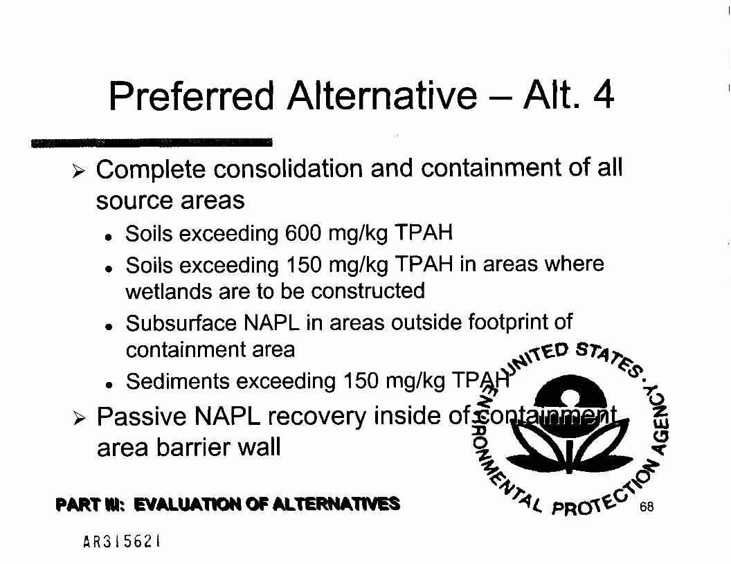
Preferred Alternative - Alt. 4
> Complete consolidation and containment of allsource areas• Soils exceeding 600 mg/kg TPAH• Soils exceeding 150 mg/kg TPAH in areas where
wetlands are to be constructed• Subsurface NAPL in areas outside footprint of
containment area• Sediments exceeding 150 mg/kg TP^fl
> Passive NAPL recovery insidearea barrier wall
PART Ml: EVALUATION OF ALTERNATIVES '*<, pncrt 68
A R 3 I 5 6 2 I

Preferred Alternative (cont'd.)•• • •• l ^^H^Hl
> Institutional controls• To prevent residential construction in future• To prevent exposure to ground water (GMZ)• To ensure protectiveness of remedy
• Prevent damage to containment area• Prevent draw-down of ground water or NAPL
> Create wetlands instead of backfilling• Remedy saves cost of backfilling, instead^©a^5jfl
wetlands in excavated areas (in exces^W tnose needed)
• State interested in creating wetlandgfarjjthose required or created by remedg
PARTM: EVALUATION OF ALTERNATIVES . ppc 69
ftR3!5622

Differences between PRP and EPAPreferred Alternatives
•BBBBB B BBBBBBH
> EPA Preferred Alternative (PRAP Alt. 4, $48.2M)is identical to PRP Preferred Alternative (FS Alt.10, $32.7M) with the addition of:• NAPL / principal threat source areas in Lower
Hershey Run consolidated (+ ~ $6.5M)• Passive NAPL Recovery Trenches (from FS) inside of
barrier wall surrounding containment areat(-t.t• Resultant increase in A&E and Contii denc^ftMts
Total difference: ~ $15.2M
PART M: EVALUATION OF ALTERNATIVES ^ PRO\^ 70
A R 3 1 5 6 2 3

Benefits of Preferred Alternative
> Addresses risks present in all Site media> Addresses all source areas, stopping
current releases and minimizing potentialfor future releases
> Minimizes potential for downwardmigration of NAPL into Potomac
> Provides for maximumreuse options• Switch to Adobe Acrobat for
PARTM: EVALUATION OF ALTERNATIVES P R C - 71
A R 3 I 5 6 2 1 *

Benefits (cont'd.)
> EPA Region Ill's Preferred Alternative:• Meets ARARs; provides for Overall Protection
of Human Health and Environment• Balances protectiveness and cost (is over
$200 million less costly than other FS alts.)• Minimizes disturbances to surrounding
community• Minimizes disturbance to CIBA lan• Has support of State agenciesj• Provides flexibility for future
End of slides.
Thank you. • PRC 72
A R 3 I 5 & 2 5

EPA Contacts
> Matthew Mellon, Remedial Project Manager(215) 814-3168; [email protected]
A R 3 I 5 6 2 6

To stay informed...
U.S. EPA Region III:
http://www.epa.gov/reg3hwmd/
(215)814-3168^ Sr
End of slides.
Thank you for coming. ' £ pROl^* 74
A R 3 I 5 6 2 7

Koppers (Newport, DE)Superfund Site
National Remedy ReviewBoard Presentation
U.S. EPA (Region III)May 12. 2004Washington, D.C.
Matthew T. Mellon
NOTE:
> This presentation provides detailsregarding EPA's Draft PRAP, and istherefore:
Deliberative / Enforcement Confidential / PFE
Organization of Presentation
> Introduction> Part I: Koppers Site Background> Part II: Risk Characterization> Part III: Evaluation of Alternatives
Not*: sides are numbered in tower-right
Introduction
> EPA's Preferred Alternative CompleteConsolidation (with barrier wall and impermeable cap). Driven by Ecological Risk. Protective of Human Health and Environment. Mirrors PRP Pref. AH. with the addition of:
• Actively addressing NAPL and Wsh TPAH in Lower HR• Passive NAPL Recovery in Containment Area
> Special Issues. Comprises V4 of one of the largest continuous blocks
of habitat in northern Delaware - State Interest. High ecological value; potential endangered species
A R 3 1 5 6 2 8

9Ne Background
Parti
Where is it?
> Switch to Adobe Acrobat for:• Site Location• Site Map and Layout
PART k KOPPERS STTC BACKGROUND
What was it?
> Creosote wood treating operationsconducted from 1929 - 1971 (42
> Approx. 1,000,000 gallons creosote storedon-site at any time •
> Operations began 75 years ago> Operations ended over 30 years ago
> PRPs are Beazer East, Inc. and DuPpnt(owner of the property)
NUWkMOPPBtt SITE BACKGROUND ,
Process Area
Overview of Site
A R 3 I 5 6 2 9

What is it now?
> Over 300 acres in size> Old field / grass & Shrub (- 163 acres upland)> Forested areas, forested wetlands> Non-tidal and tidal freshwater wetlands
(> 137 acres)
> Potential for endangered species. Bald eagle on adjacent B+C Island
wwr fc HOPPERS sire BACKGROUND
Drip Track Area
Drip Track Turtles
Hershey Run (lower)
A R 3 I 5 6 3 0

Lower and Upper Hershey Run
Forested Wetlands South Ponds and Marsh

SouthPondsArea
Geological Perspective
> Switch to Adobe Acrobat• Geological cross-section
P*RT t KOPPERS are BACKGROUND
Nature and Extent ofContamination
>Soil• Creosote extensive in upland surface soils
> Sediment. Creosote constituents (Total PAHs)• Metals (not site-related). PCBs (not site-related; fish advisory since '96)
> Ground water / NAPL• Creosote constituents. BTEX, PCP, Dioxins, Pesticides
PART k KOPPERS SITE BACKGROUND 27
BTEX
> BTEX N.D. or low total BTEX (<1 mg/kg) in the soil andsediment samples. Except six surfioal (0.0 to 0.5 feet) samples from Fire Pond and
South Pond areas ranging from 1.0 mg/kg to 41.4 mg/kg. And seven near surface (0.0 to 1.0 or 2.0 feet) samples (same
areas), ranging from 12 mg/kg to 311 mg/kg (K Area). Similar holds for subsurface samples
> Highest total BTEX and other VOCs (i.e.. > 100 ug/L)detected at MW-2A and MW-2S. Wells near a former UST. MW-2A had free NAPL present
> Low levels of BTEX and other VOCs (i.e.. < 50 ug/L)found in several wells around Process Area
PART t KOPPERS SITE BACKGROUND a
Pesticides, PCBs, Metals
> Highest in sediment. 1.2 mg/kg 4-41 DDT (South Pond). 0.40 mg/kg methoxychlor (Hershey Run marsh). OFF-SITE: 24 mg/kg 4-4'DDT (Christina River,
upstream from Site)> Total PCBs ranged from N.D. to 1.1 mg/kg
(Hershey Run marsh). Highest: 1.3 mg/kg (also Christina River, upstream
from Site)> Zinc (worst, and indicative of suite of metals found)
t 5.2 mg/kg in Process Area. 8,770 mg/kg in Hershey Run marsh
PART k KOPP6RS Sfie BACKGROUND
Dioxins, PCP
> Dioxins. PCDDs/PCDFs identified in HHRA (1999) as potential
COCs. K was later determined that database errors
misrepresented concentrations. Once lab spikes removed, PCDDs/PCDFs are not
COCs - levers drop to background. HHRA scenario attributing risk to dioxins may be
recalculated
> PCP - N.D. to 2 ug/L (phenols) outside of wellswith NAPL present
PMCTl: KOPPERS SITE BACKGROUND »
A R 3 I 5 6 3 2

Total PAHs in Soil
PART t KOPPERS SITE BACKGROUND
Total PAHs in Sediment
PART fc KOPPERS SITE BACKGROUND
Nature and Extent ofContamination
> Creosote is the most extensivecontaminant at Site
> Switch to PRPs' 3-D visualization. Subsurface NAPL-contaminated areas
(modeled from boring logs)• South Pond focus• Fire Pond focus
P#RT fc KOPPERS STTE BACKGROUND
Risk Characterizationpan
Human Health Risk
> Human Health Risk Assessmentperformed by PRP Contractor with EPAOversight (1999)
> In accordance with EPA Guidance> Multiple exposure scenarios> Industrial future use assumed
PART* RISK CHARACTERIZATION
Future Construction Worker
> Surface and subsurface soils (0-18' bgs)> Dermal, ingestion, inhalation pathways> Exposure parameters:
. CTE: 40 days/year, 1 year, 0.054 mg/cm2
• ingestion rate: 10 mg/day• inhalation rate: 13.5 rrWday
. RME: 120 days/year, 1 year, 0.11 mg/cm2
• ingestion rate: 50 mg/day• inhalation rate: 20 rrtVday
PART I; MSK CHARACTERIZATION
A R 3 J 5 6 3 3
Risk to Future Construction Worker
>CTE. HI = 0.0003 (w/out NAPL)
>RME. HI = 0.003 (with NAPL). Highest Cancer Risk = 2 x 10⁻⁶ (ingestion w/
NAPL)
> Main Contributor: ingestion of soils
PART* RRKOMRACTEROATION
Future Industrial Worker
> Surface soils (0-12" bgs), NAPL, ground water(drinking, showering)
> Dermal, ingestion, inhalation pathways> Exposure parameters:
. CTE: 75 days/year, 5.5 years, 0.054 mg/cm2
• ingestion rate: 10 mg/day• air exchange rate: 1 0 / hour
. RME: 134 days/year, 25 years, 0.11 mg/cm2
• ingestion rate: 50 mg/day• air exchange rate: 0.5 / hour
PARTI: RRKCHARACTSWEATION
Risk to Future Industrial Worker> CTE
. HI = 0 0003 soils, 0.86 Columbia gw
. Cancer Risk = 5 x 10* soil. 1 x 10* Columbia gw> RME
. HI =0.4 soils. 1.2 Columbia gw
. CancerRsk = 3x 10--(bothsoilsandgw)> Main Contributors
. Soils• 2.3.7.8 TCOO and B<a)P• Also. benzo(a)antiracene. benzo(rj)fluoranthene.
debanz(a,h)anlhracene. Columbia gw
• ForHol 1 2. HeptacNor Epoxkte (m« 0 066 MB*!-) OTd m«tab riaquifer
PARTI: RRKCHARACTERKATIOM
Current & Future AdolescentTrespasser
> Surface soils, sediments, surface waters, NAPL> Dermal, ingestion pathways> Exposure parameters:
. CTE: 7 events/year, 6 year, 0.025 mg/cm2
• ingeston rate: 10 mg/event• inhalation rate: 135 mVday
. RME: 24 events/year, 6 year, 0.025 mg/cm2
• ingeslion rate: 100 mg/event• inhalation rate: 20 rrWday
. Less than half of events would encounter sediment
PART It RRKCHMWCTEROATION «,
Risk to Adolescent Trespasser
> Highest HI = 0.004. (RME, ingestion of soils w/ or w/out NAPL)
> Highest cancer risk = 6 x 10'5
. (RME, non-river surface water, i.e. Fire Pond,South Pond)
PMKTfc RRK CHARACTERIZATION
Current & Future AdolescentSwimmer
> River surface water and sediment
> Dermal, ingestion pathways
> Exposure parameters:. CTE: 5 Vi-hour events/year, 6 years, 0.63
mg/cm2 adherence• ingestion rate: 50 mL/hour
. RME: 24 1-hour events/year, 6 years, 0.63mg/cm2 adherence• ingestion rate: 50 mL/hour
PART I: RRKCHARACTEMZATION
A R 3 I 5 6 3 U .
Risk to Adolescent Swimmer
> Christina River. Highest HI = 0.006
. Highest cancer risk = 9 x 10"8
> White Clay Creek. Highest HI = 0.0002
. Highest cancer risk = 8 x 10"B
PARTI: RBKCHARACTERIZATION
Current & Future Angler
> Christina River and White Clay Creek fish,assuming disregard of existing fishadvisories
> Ingestion pathway> Exposure parameters:
. CTE: 365 events/year, 9 years• ingestion rate: 8.0 g/day
• RME: 365 events/year, 25 years• ingestion rate: 25 g/day
PARTI: RBK CHARACTERIZATION »
Risk to Angler
>CTE. HI = 4.0. Cancer risk = 3 x 10"5
> RME. Hl= 13.0. Cancer risk = 3 x 10-*
> Main contributors. PCBs (Arodor-1254, Aroclor-1260). Arsenic
> Not Site-related
PART I: RISK CHARACTERIZATION
Scenario with unacceptable risk
> Risk to future industrial worker. Ingestion of soil (RME)
• Carcinogenic Risk: 3 x 10-»• Hazard Index: 1.2
. Columbia ground water also had HI > 1(RME)
> Estimated risk recalculation with databasecorrections would be lower, but likely stillnear 1 x 10⁻⁴
PARTI; RISK CHARACTERIZATION «
Ecological Risk
> Ecological Risk Assessment, EPA ERT(Edison, NJ) 1997
> Mark Sprenger
PANT I: RBK CHARACTERIZATION
1.
2.
3
4
5.
Assessment EndpointsProtection of the structure and function of wetlandcommunitiesProtection of the aauatic benthic invertebratecommunities structure and function
Protection of the upland soil community functioning
Protection of the structure and function of theterrestrial plant community
Protection of fish populations and communities fromdirect toxicity and reproductive impairment
6 Protection of the populations of HfsHteans.specifically in terms of recruitment
PARTI: RBK CHARACTERIZATION „
A R 3 I 5 6 3 5 8
Assessment Endpoints
7. Protection from direct toxicity effects and reproductiveimpairment of piscivorous birds utilizing the site.
8. Protection from direct toxicity effects and reproductiveimpairment of womveatino birds utilizing the site.
B Protection from direct toxicity effects and reproductiveimpairment of carnivorous birds utilizing the site.
10. Protection from direct toxicity effects and reproductiveimpairment of carnivorous mammals utilizing the site.
11. Protection from direct toxicity effects and reproductiveimpairment of omnivorous mammals utilizing the site.
12. Protection from direct toxicity effects and reproductiveimpairment of terrestrial herbivores utilizing the site.
PART ft RBK CHARACTERIZATION a
Data Used(Multiple Lines of Evidence)
> Sediment Toxicity Tests - sedimentmortality - two species
> Field Benthic Community Survey> Field Plant Survey> Soil Toxicity Test - earthworms> Fish and Amphibian Embryo tests (not
relied upon)
PARTI: RBK CHARACTERIZATION
Sediment Results for Total PAHs
> Sediments over about 200 mg/kg (197.6)were lethal to test organisms, sedimentsless than about 80 mg/kg (82.3) did notcause mortality.. (Geometric mean: 150 mg/kg)
> Sediment with "obvious" PAHcontamination has limited benthiccommunities.
PMtTfc PJSKCHARACTERBATION
Soil Results for Total PAHs
> Soil concentrations greater than 4,500mg/kg caused 100% mortality toearthworms
> Soil concentrations above 1,264 mg/kgcaused chronic effects to earthworms
> Soil concentrations below 587 mg/kgcaused no measured effect to earthworms
> Soil with "visible" contamination had• effects on the plant community
PART I: RBK CHARACTERKATMN H
Overall
> Soils and Sediments at high PAH concentrationspose a severe risk (lethality!.
> Soils and Sediments at high PAH concentrationsare secondary contaminant sources toadjacent ecologically important areas.
> The zone between the high PAH severe risk andthe areas with minimal risk are narrow.
> The areas of high PAH concentrations areunlikely to degrade because of their toxicity.
PARTI: RBK CHARACTERIZATION a
Ecological Risk Conclusions
> Sediment RAO of 150 mg/kg TPAH is roundedgeometric mean of range of NOAEL and LOAELvalues (82.8 and 197.6)
> Soil RAO is 600 mg/kg TPAH value (rounded587) for soils is at the low end of the range dueto:. Less confidence in data set for terrestrial evaluations
(field data provided less of a gradient and responsedata was more variable in nature)
. Potential for recontamination of sediment
PARTI: RBK CHARACTERIZATION 54
A R 3 I 5 6 3 6

Risk Apples and Oranges
> Site areas having both ecological andhuman health risks were compared
> Geographical comparison of risk indicatesthat ecological risk cleanup goalsprotective for human health risks as well
> Notes:. Eco-risk: TPAH Human Health: B{a)P, cPAH. TPAH is always greater than cPAH or B(a)P equivalence for any
given sample
PARTfc RBK CHARACTERIZATION »
Cleanup Goals
> Cleanup goals based on eco-riskassessment conclusions:. SOIL: 600 mg/kg TPAH. SEDIMENT: 150 mg/kg TPAH
> Sensitivity analysis. Sharp gradation noted in reports; PRPs own
maps showed little difference using higher #s
PARTI: RBK CHARACTERIZATION
Risk Conclusions
> Switch to Adobe Acrobat• Soil areas warranting remediation. Subsurface NAPL areas. Sediment areas warranting remediation
PART fc RBK CMARACTERKATION
Evaluation ofAlternatives
Part 11
Future Land Use-:-S1!.;1;-^S»t*.'M'*:"."fs -.flJMF.Mi.--i,. .'X if»
> In FS, future use assumed industrial> PRPs and DelDOT approached EPA
about reuse as wetlands bank> EPA / DNREC / PRP / DelDOT developed
new Preferred Alternative
PART*: EVALUATION OF ALTERNATIVES
Remedial Action Objectives
1. Prevent current or future direct contact withcontaminated soils and sediments that wouldresult in unacceptable levels of risk toecological receptors by reducing levels ofTPAH concentrations to below 150 mg/kg insediment and 600 mg/kg in soil (150 mg/kg insoil that is to be converted to wetlands);
2. Prevent unacceptable human health risks dueto contaminated ground water;
3 Minimize the on-going contamination of groundwater from the presence of NAPL throughremoval and/or containment;
PARTH: EVALUATION OF ALTERNATIVES w
A R 3 1 5 6 3 7 10

RAOs (cont'd.)
4. Prevent any direct contact threat to an adult orchild trespasser and to an industrial worker,
5. Prevent the construction of residentialbuildings (which are currently prohibited bylocal zoning) in order to protect potential futureresidents from contact with contaminated soiland/or ground water,
6. Maximize the area of upland and wetlandavailable for various re-use options (e.g.wetlands banking by DelDOT)
PART* EVALUATION OF ALTERNATNES g,
FS Evaluated NumerousTechnologies
> Monitored natural recovery / attenuation> Containment
« Cover in place• Consolidation on-site• Sheet piling / barrier walls
> Stabilization / Solidification> In-situ thermally-enhanced extraction (TIO)> OrWOff-site ex-situ thermal desorptton> Off-site incineration> Off-site disposal (Canada)
PART K EVALUATION OF ALTERNATIVES
Alternatives in FS & PRAP
PACT* EVALUATION OF ALTERNATMES
Alternative 2Partial Cover-in-place ($17.6 M)
> Soils. 2 feet cover
> Subsurface NAPL / Ground water. Sheetpile at Fire Pond and South Pond only' Monitored Natural Attenuation of ground water
> Sediments. Tidal WeUands (Hershey Run and marsh near South Pond)
• Monitored Natural Recovery. Fire Pond - sediment cap> South Ponds - sediment cap• K Area - sediment cap
(Switch to Adobe Acrobat)
PART* EVALUATION OF ALTERNATIVES
Alternative 3Partial Consolidation ($42.0 M)
> Soils. 2 feet excavation and cover
> Subsurface NAPL / Ground water. Sheetpile at Fire Pond and South Pond only. Monitored Natural Attenuation of ground water
> Sediments. RechanneKze Upper Hershey Run. Tidal WeUands {Hershey Run and marsh near South Pond)
• 2 feet excavation and cover. Fire Pond - sediment cap. South Ponds - sediment cap. K Area - sediment cap
Switch to Adobe Acrobat)
PMff ft EVALUATION OF ALTERNATNES
Alternative 4Complete Consolidation ($48.2 M)
> Soils• Excavation and consolidation of TPAH > €00 mgykg
> Subsurface NAPL / Ground water. Subsurface Barrier Wall around containment area• Passive NAPL Recovery to reduce volume of NAPL inside. (Natural attenuation of any residuals in ground water)
> Sediments• Fire Pond - to be contained inside of consolidation area• Rechannelize Upper Hershey Run> Excavation and consolidation of all remaining sediment or
wetland soils with TPAH > 150 mg/Vg(Switch to Adobe Acrobat)
PART ft EVALUATION OF ALTERNATIVES
A R 3 I 5 6 3 8 11

Alternative 5Treatment ($191.4
> Surface Soils (without subsurface NAPL). Excavation and off-site LTTD of soils where TPAH > 600 mg/Kg
> Subsurface NAPL / Ground water. Sheetpile around Fire Pond and South Ponds areas. Thermally-enhanced (steam) in-situ extraction of NAPL. Natural attenuation of any residuals in ground water
> Sediments. Fire Pond - to be contained inside of consolidation area. Rechannelize Upper Hershey Run. Excavation and off-site LTTD of all remaining sediment or
wetland soils with TPAH > 150 mg/kg(Switch to Adobe Acrobat)
PART* EVALUATION OF ALTERNATIVES s,
Preferred Alternative - Alt. 4
> Complete consolidation and containment of allsource areas. Soils exceeding 600 mg/kg TPAH
• Soils exceeding 150 mg/kg TPAH in areas wherewetlands are to be constructed
. Subsurface NAPL in areas outside footprint ofcontainment area
. Sediments exceeding 150 mg/kg TPAH
> Passive NAPL recovery inside of containmentarea barrier wall
PART* EVALUATION OF ALTERNATIVES
Preferred Alternative (cont'd.)
> Institutional controls. To prevent residential construction in future. To prevent exposure to ground water (GMZ). To ensure prolectrveness of remedy
' Prevent damage to containment area• Prevent draw-down of ground water or NAPL
> Create wetlands instead of backfilling. Remedy saves cost of backfilling, instead creating
wetlands in excavated areas (in excess of thoseneeded)
. State interested in creating wetlands far in excess ofthose required or created by remedy
PART * EVALUATION OF ALTERNATIVES a
Differences between PRP and EPAPreferred Alternatives
> EPA Preferred Alternative (PRAP Alt. 4, $48.2M)is identical to PRP Preferred Alternative (FS Alt.10, $32.7M) with the addition of:. NAPL / principal threat source areas in Lower
Hershey Run consolidated (+ - $6.5M). Passive NAPL Recovery Trenches (from FS) inside of
barrier wall surrounding containment area(+ - J4.5M)• Resultant increase in A&E and Contingency Costs
(+ - $4.2M). Total difference: -S15.2M
PART •-. EVALUATION OF ALTERNATNES *>
Benefits of Preferred Alternativeae#»i«s s it etifl-sts SS«;*K **SS tia *
> Addresses risks present in all Site media> Addresses all source areas, stopping
current releases and minimizing potentialfor future releases
> Minimizes potential for downwardmigration of NAPL into Potomac
> Provides for maximum flexibility for futurereuse options. Switch to Adobe Acrobat for Wetlands Bank
PART * EVALUATION OF ALTERNATIVES ;,
Benefits (cont'd.)
> EPA Region Ill's Preferred Alternative:. Meets ARARs, provides for Overall Protection
of Human Health and Environment. Balances protectiveness and cost (is over
$200 million less costly than other FS alts.). Minimizes disturbances to surrounding
community• Minimizes disturbance to CIBA plant• Has support of State agencies. Provides flexibility for future reuse by State
Endofslidtt
Tbuikyou.
A R 3 I 5 6 3 9 12

EPA ContactsH»J:
> Matthew Mellon, Remedial Project Manager(215) 814-3168; [email protected]
To stay informed...
U.S. EPA Region III:
http://www.epa.gov/reg3hwmd/
mellon. [email protected]
(215)814-3168
End or slides
TtMk Jim hr
A R 3 1 5 6 1 4 U 13

Randy Sturgeon To: OSWER OSRTI RRBcc: Matthew Mellon/R3/USEPA/US@fEPA, Patricia-C
04/19/2004 01:54 PM Miller/R3/USEPA/US@EPA, Peter Ludzia/R3/USEPA/US, MarkSprenger/ERT/R2/USEPA/US@EPA, SteveElls/DC/USEPAAJS@EPA, Leah Evison/DC/USEPA/US@EPA
Subject: Additional Koppers information which may be helpful for your review
Below is some additional information, that we met to include in the package, about alternatives that wereevaluated in the FS, but were not included in the draft PRAP. AJso included is some further informationabout the PRPs1 preferred alternative.
Other Alternatives evaluated that were not included in the PRAP
1. Similar to EPA's preferred alternative with in-situ Solidification/Stabilization to address the uplandNAPL areas instead of Sheetpile containment and NAPL recovery ($75.0 M).
2. Off-site disposal (landfill in Canada) of excavated soil and sediment (such that no landfill would benecessary), passive NAPL recovery ($118.0 M)
3. Off-site disposal (landfill in Canada) of excavated soil and sediment (such that no landfill would benecessary), in-situ Solidification/Stabilization of subsurface NAPL ($143.0 M )
4. Excavation of all contaminated soil and sediment with on-site low-temp thermal desorption($244.0 M)
5. Off-site disposal (incineration in the US) of shallow excavated soil and sediment (such that nolandfill would be necessary); steam injection at all subsurface NAPL areas ($280.0 M)
PRPs' Preferred Alternative - additional information
PRP's preferred alternative ($33.5 M): EPA's preferred alternative is the PRP's preferred alternative withthe following modifications: 1) passive NAPL recovery (additional -$4.5 M) and 2) excavate andconsolidate sediments from lower Hershey Run (nearer White Clay Creek) as opposed to MNR for thisarea (additional -$6.5). The rest of the cost differential is due to contingencies, etc.
Randy
NATIONAL REMEDY REVIEW BOARD
KOPPERS (NEWPORT PLANT) CO., INC.SUPERFUND SITE
EPA ID # DED980552244
NEWPORT, DELAWARE
April 2004
Matthew T. MellonRemedial Project Manager
U.S. Environmental Protection AgencyRegion III - Philadelphia, Pennsylvania

UNITED STATES ENVIRONMENTAL PROTECTION AGENCYREGION III
1650 Arch StreetPhiladelphia, Pennsylvania 19103-2029
SUBJECT: Former Koppers (Newport Plant) Co., Inc.Superfund Site (Newport, DE)EPA ID # DED980552244
ENFORCEMENT CONFIDENTIAL
FROM: Matthew T. MellonRemedial Project Manager (RPM)[email protected] ; mailcode 3HS23
TO: EPA National Remedy Review Board (NRRB) members
April 15,2004
Enclosed please find information provided to conduct your review of the KoppersSuperfund Site. The proposed remedy would be the first and final remedy for the site. The siteis the former location of a creosote wood treatment facility. The account number for the reviewis:2004-T-03W-302DD2C-03CCOOO-033C.
The Former Koppers (Newport Plant) Superfund Site ("Koppers") is comprised ofapproximately 300 acres (approximately 160 acres are upland areas and approximately 140 acresare wetlands) and is located in the northern part of New Castle County, Delaware, southwest ofthe Town of Newport and northwest of the Route 1-95 and Route 141 interchange (see Figure 1in the enclosed draft Proposed Plan).
The primary material used in the wood-treatment processes was a creosote/coal tarsolution, which was used to preserve railroad ties, telephone poles, and other wood products.Although to a much smaller degree, pentachlorophenol (PCP) was also used to treat the wood.Throughout a large area of the Site (approximately two-thirds of the operations area), an array ofrailroad tracks provided for the movement of wood and materials to and from the Site. Based onavailable records, former Site areas where creosote handling occurred included the Process Areaand Drip Track Area (see Figure 2 in the enclosed draft Proposed Plan).
Located in the northwestern portion of the Site, the Process Area was utilized for theapplication of wood preservatives and contained various wood-treatment equipment andassociated structures. This area also provided storage for approximately 1,000,000 gallons ofcreosote and other process-related materials. The treatment consisted of heating andpressurizing tanks filled with creosote and wood, forcing the creosote into the wood. Aftertreatment, the freshly-treated wood products were temporarily allowed to cure and drip dry in theDrip Track Area prior to transfer to the Wood Storage Area. The Fire Pond was created as asource of water for fire-fighting purposes.
Customer Service Hotline: 1-800-438-2474

ENFORCEMENT CONFIDENTIALPage 2
Beazer (the successor corporation to Koppers) and DuPont (the current land owner)conducted the RI/FS with EPA oversight. EPA prepared the Ecological Risk Assessment.
As described in greater detail in the enclosed draft Proposed Plan, ecological risks werefound to be quite significant at the Site, particularly the risks associated with contaminatedsediments in the benthic, aquatic and wetland environments. Significant ecological risk toreceptors in upland soils was also found in the site-specific Ecological Risk Assessment (ERA),which included toxicity testing using sediments and soils collected on-site. Human health risksfrom the Site were found to be associated with the potential future use of contaminated shallowground water. The potential risk to trespassers (e.g., hunters, anglers, boaters) due to exposure tofree-phase NAPL in on-site sediments may have been somewhat underestimated, as the extent ofNAPL contamination was not clear until 2002 and the Human Health Risk Assessment (HHRA)was completed in 1999. Nonetheless, it appears that ecological risks at this Site are verysignificant, with complete mortality observed in samples of both sediment and soils from areasof the Site. In addition, the U.S. Fish and Wildlife Service has conducted fish sampling andanalysis that revealed a 50% incidence of liver cancer in certain fish collected on-site in 2002.Based on the results of the ERA, EPA is proposing the following cleanup criteria to protecthuman health and the environment: 150 mg/kg total PAHs (TPAH) in sediment and 600 mg/kgTPAH in soils (although 150 mg/kg TPAH will apply for soils in upland areas that will beconverted to wetlands).
The following alternatives were evaluated in the draft Proposed Plan for the cleanup ofthe Site (with the total present worth cost for each listed):
• Alternative 1 - NO ACTION $0
• Alternative 2 - PARTIAL COVER-IN-PLACE $ 17,645,436
Covering upland soils; Sediment cap in Fire Pond, South Pond and K Pond;Sheetpile and NAPL collection at Fire Pond and South Pond; Monitored NaturalRecovery (MNR) in Hershey Run and adjacent wetlands; Monitored NaturalAttenuation of ground water contamination
• Alternative 3 - PARTIAL CONSOLIDATION $41,954,307
Excavate, consolidate and cap shallow (2 ft. bgs.) soils and shallow (2 ft. bgs.)tidal sediments; Cap Fire, K and South Ponds; Sheetpile and NAPL collection atFire (including nearby wetlands) and South Ponds; Rechannelization of HersheyRun; Wetlands mitigation; Monitored Natural Attenuation of ground watercontamination
Alternative 4 - COMPLETE CONSOLIDATION $48,156,101
Excavate, consolidate and cap all contaminated soils and sediments; Subsurfaceground water barrier wall around consolidation area(s) with passive NAPLrecovery; Excavation of NAPL-contaminated aquifer material outside of
A R 3 l 5 6 i * l *

ENFORCEMENT CONFIDENTIALPage 3
consolidation areas; Rechannelization of Hershey Run; Wetlands mitigation;Monitored Natural Attenuation of ground water contamination
• Alternative 5 - TREATMENT S191,432,080
In-situ steam-enhanced extraction of subsurface NAPL; excavation and off-sitetreatment of sediments and certain soils using LTTD; Wetland restoration;Monitored Natural Attenuation of ground water contamination
EPA's preferred alternative, Alternative 4 - "Complete Consolidation", wouldrechannelize Hershey Run, construct a subsurface barrier wall to contain NAPL around the worstof the subsurface NAPL contamination (including under the wetlands near the Fire Pone), andconsolidate all sediment and soil exceeding the cleanup criteria into a capped containment areaconstructed within the footprint of the barrier wall. In addition, passive NAPL recovery wouldsignificantly reduce the volume of NAPL in the ground at the Site, thereby reducing the risks ofdownward migration of NAPL from the shallow Columbia Aquifer into the deeper PotomacAquifer and of recontamination of wetlands. Alternative 4 meets the threshold criteria of overallprotection to human health and the environment and compliance with ARARs. EPA's preferredalternative offers the following advantages:
1) it will be protective of both human health and the environment in the least amount oftime;
2) of those alternatives that are protective, it is among the least costly of the alternatives;
3) compared to Alternatives 2 and 5, it would have significantly less impact to thecommunity during installation;
4) it provides for the maximum flexibility in the reuse of the site; the State has expresseda desire to create a wetland bank to provide compensation for lost wetlands due tohighway construction;
5) it is substantially easier to implement than the other alternatives; and
6) it provides a cost-effective cleanup plan
Overall, based on the information currently available, EPA (the lead agency) believesAlternative 4 provides the best balance of tradeoffs among the other alternatives with respect tothe balancing and modifying criteria. EPA's preferred alternative would satisfy the statutoryrequirements of CERCLA §121(b) by being protective of human health and the environment;complying with ARARs; being cost-effective; utilizing permanent solutions and alternativetreatment technologies to the maximum extent practicable; and satisfying the preference fortreatment as a principal element.
The main source of information that is being provided to the NRRB in this package is adetailed draft Proposed Remedial Action Plan (PRAP). The PRAP is a draft and can bemodified to address Board concerns. The PRAP includes detailed cost estimates, an ARARstable, and figures. The draft PRAP has been reviewed by the State. The State has expressed
A R 3 I 5 6 I 4 5

ENFORCEMENT CONFIDENTIALPage 4
support for the Preferred Alternative because it allows the maximum flexibility desired by theState for the beneficial reuse of the property. A series of additional figures have been attached tothis memo in order to provide the Board with photographs depicting the various areas of interestat the Site.
The Region looks forward to receiving the Board's comments.
A R 3 l 5 6 l * 6

Koppers (Newport, DE) Superfund SiteApril 2004
NRRB PackagePhotograph Plate 1
O A view of the Koppers Site during the peak of operations (1950s - 1960s), lookingwest toward Bread and Cheese Island.
O An aerial view of the Koppers Site in 1937.
A R 3 I 5 6 U

Koppers (Newport, DE) Superfund SiteApril 2004
NRRB PackagePhotograph Plate 2
O Lower Hershey Run, just before it flows into White Clay Creek (to the right)
O This sheen develops whenever free NAPL is released from Hershey Run sediments.
A R 3 1 5 6 U 8

Koppers (Newport, DE) Superfund SiteApril 2004
NRRB PackagePhotograph Plate 3
O A 50% incidence of liver cancer was found in fish from Hershey Run in 2002.
O Ecological risks at the Site arise from PAHs in soil and sediment, and free NAPL.

SuperfuPropose
DRAFT April 15,2004
\
Koppers Co., Inc. (Newport Plant) Superfund SiteNewport, Delaware June XX, 2004
Dates to Remember:
June XX to July XX, 2004,Public comment period on clean-up options in Proposed Plan.
June 30, 2004Public meeting at the NewportPublic Library, Newport, DE7:00 pm
EPA Announces Clean-Up Plan
The U.S. Environmental Protection Agency ("EPA") is issuingthis Proposed Remedial Action Plan ("Proposed Plan") topresent EPA's Preferred Remedial Alternative for cleaning upthe contaminated soils and sediments and addressingcontaminated ground water at the Koppers Co., Inc. (NewportPlant) Superfund Site ("Koppers" or "Site") located inNewport, New Castle County, Delaware. The Site is along theAmtrak Northeast Corridor railroad, across White Clay Creekfrom Churchman's Marsh and next door to Ciba SpecialtyChemical's (CibaSC's) Newport Plant (see Figure 1). EPA isrequesting public comments on EPA's preferred alternativeand the other alternatives for remediation of the contaminantspresent at the Site. The Proposed Plan also contains a glossary of terms that may be unfamiliarto the general public. The terms in bold print in the text are available in the glossary at the backof the Proposed Plan.
The preferred alternative addresses contamination from the operation of the former Kopperswood-treating plant which resulted in significant creosote contamination in Hershey Run, innumerous wetland areas at the Site, in upland soils and in ground water (Figures 2-5 show areasneeding cleanup). EPA's goals for this cleanup include protecting human health and theenvironment and allowing for the maximum beneficial reuse of the land consistent with the goals
of State and local officials and the owner of the Site._ The preferred alternative consists of consolidating all
contaminated soils and sediments into two on-sitelandfills or containment areas, restoring and creatingwetlands, collecting non-aqueous phase liquid (NAPL)contamination in the ground water and long-termmonitoring of the ground water. The landfills would belocated in the areas of worst NAPL contamination andwould include ground water barrier walls and collectionsystems to prevent the further migration of the NAPLcontamination. One containment area would extend intothe Hershey Run marsh, encompassing a portion of theexisting channel and thereby requiring that part of the
INSIDE:
EPA Announces Clean-Up Plan 1Site Background and History 3Site Characteristics 4Summary of Site Risks UScope and Role 20Remedial Action Objectives 22Summary of Alternatives 22Evaluation of Alternatives 30Preferred Alternative 37Community Participation 38Glossary 40
A R 3 I 5 6 5 G

Koppers (Newport) Proposed Plan Enforcement confidential DRAFT 4/15/04
upper reach of Hershey Run be rechannelized. Wetlands would be created to replace any thatare filled in as part of the landfill construction. Approximately one and one-half miles ofHershey Run woulife||e dr«te^ alc||g with apEf^ximately 4 acres of wetlands. Soils fromapproximately 39 ^ew)fffip^Bids^«uld be ex flvated with wetlands being created in some ofthese areas. Smalla ajpoflfi|of ||p|L exrlt ui ier several of the wetland areas that requirecleanup. The NAI^Hat^a^(offid% ^Kcava^fi, to the maximum extent practicable, when thewetlands are cleaned up.
Site studies have shown the ground water contamination is closely associated with NAPLcontamination and has not migrated far. By containing and/or removing the NAPLcontamination, ground water threats would be eliminated or significantly reduced and remainlocalized to the Site. New monitoring wells would be installed to augment the existingmonitoring network. Although no contamination has been found in the Potomac aquifer, severalnew wells would be installed into the Potomac Aquifer in order to more closely monitor it.Ground water monitoring, just outside the containment areas, and sediment monitoring would beconducted to ensure the effectiveness of the barrier walls and landfill cap.
Finally, legal restrictions called "institutional controls" would be implemented to ensurethat any future land use would not compromise the landfills, the barrier system, or themonitoring well network, and would prevent the installation of drinking water wells on theproperty. The end result would be that the maximum area of the property could be put tobeneficial use even as long-term monitoring takes place. EPA believes that the preferredalternative is the best alternative for addressing the entire Site.
This Proposed Plan summarizes information found in the Administrative Record whichcontains the Remedial Investigation, Risk Assessments, Feasibility Study, and otherinformation which was used to develop the preferred alternative. If more in-depth information isneeded, these documents can be referenced directly. EPA encourages the public to review thesedocuments in order to gain a more comprehensive understanding of the Site and the Superfundactivities that have been conducted there. The locations of the Administrative Record file for theSite and the address to send comments to regarding this Plan are given at the end of thisProposed Plan.
After the public comment period has ended and the comments received during the commentperiod have been reviewed and carefully considered, EPA, in consultation with the DelawareDepartment of Natural Resources and Environmental Control ("DNREC"), will select a finalremedy for the Site. The final remedy will be described in a Record of Decision ("ROD").The public's comments will be incorporated into a Responsiveness Summary contained in theROD for the Site. Based on new information and/or comments received, the remedy selected inthe ROD may be different from the preferred alternative identified here.
The Proposed Plan is being issued as part of EPA's public participation requirements underSection 117(a) of the Comprehensive Environmental Response, Compensation, andLiability Act of 1980, as amended ("CERCLA") and Section 300.430(f)(2) of the NationalOil & Hazardous Substance Contingency Plan (NCP).
A R 3 I 5 6 5 !

Koppers (Newport) Proposed Plan
Site Background and History
The Former Kopapproximately 300JDelaware, southwiinterchange (Figur
Enforcement confidential DRAFT 4/15/04
ite ("Koppers") is comprised ofem part of New Castle County, in the State ofnorthwest of the Route 1-95 and Route 141rdered by high-speed railroad lines. Beyond
the rail lines are a former municipal sewage treatment facility, an industrial property, and aresidential area. To the east, the Site is bordered by the former DuPont Holly Run Plant and theChristina River. To the south and west, the Site is bordered by White Clay Creek and HersheyRun, respectively. To the west of the Site, across Hershey Run, lies the Bread and Cheese Islandproperty.
This Site was proposed to the National Priorities List ("NPL"), which is a listing of the nation'smost serious uncontrolled or abandoned hazardous waste sites, on October 26,1989. The Sitewas formally added to the NPL on August 30,1990, making it eligible for Federal cleanupfunds.
In 1929, a group of parcels comprising the Site was conveyed by Laynman and Wright to theDelaware Wood Preserving Company, which began conducting conducted wood-treatmentoperations on the property. In 1931, the Site was sold to Century Wood Preserving Company(Century). Four years later, in 1935, the Wood Preserving Company acquired the property andall associated stock from Century. Through liquidation of the Wood Preserving Company,Koppers Company acquired the Site in 1940, and reorganized in 1944 into Koppers Company,Inc. (Koppers). Koppers then continued wood-treatment operations at the Site until 1971 whenthe property was sold to DuPont. The Site has remained largely inactive since operations ceasedin 1971.
From 1974 to 1977, the New Castle County Department of Public Works leased the northern partof the Site, and then built and operated a wastewater treatment facility to temporarily maintainthe County's wastewater treatment capabilities until permanent facilities were built, hi 1977, theCounty sold the building to DuPont and discontinued wastewater treatment operations.
The primary material used in the wood-treatment processes was a creosote/coal tar solution,which was used to preserve railroad ties, telephone poles, and other wood products (this istypical of the type of wood-treating used today for railroad ties and telephone poles). Althoughto a much smaller degree, pentachlorophenol (PCP) was also used to treat the wood. Throughouta large area of the Site (approximately two-thirds of the operations area), an array of railroadtracks provided for the movement of wood and materials to and from the Site. Based onavailable records, former Site areas where creosote handling occurred included the Process Areaand Drip Track Area (Figure 2).
Located in the northwestern portion of the Site, the Process Area was utilized for the applicationof wood preservatives and contained various wood-treatment equipment and associatedstructures. This area also provided storage for approximately 1,000,000 gallons of creosote andother process-related materials. The treatment consisted of heating and pressurizing tanks filledwith creosote and wood, forcing the creosote into the wood. After treatment, the freshly-treatedwood products were temporarily allowed to cure and drip dry in the Drip Track Area prior to
A R 3 1 5 6 5 2

Koppers (Newport) Proposed Plan Enforcement confidential DRAFT 4/15/04
transfer to the Wood Storage Area. The Fire Pond was created as a source of water for fire-fighting purposes.
The Site was i d e n t e f c s j w a ^ d o u A v a s t e site in 1979. Following multiplesubsequent investifltyslHfSiMift d|ppbsq|to the NPL in 1989, and formally listed onAugust 30, 1990. ^p91fB%:||( [s||cess|f corporation to Koppers) and DuPont (thecurrent land owner) signed an agreement to conduct the RI/FS.
Site Characteristics
Physical Structures
Existing facilities/structures and other physical features at the Site include one warehousebuilding (constructed by the New Castle Department of Public Works), a paved access road, andsecondary roads providing access to overhead power lines that traverse the Site. With theexception of some remaining railroad ties and other associated debris, the railroad lines oncepresent at the Site no longer exist.
Access to the Site is restricted through the use of 24-hour security-guarded gates at the CibaSpecialty Chemicals Newport Facility, fencing, and posting. Natural barriers, such as theChristina River, White Clay Creek, and Hershey Run, and the surrounding marshes and wetlandsalso limit access to the Site, as does the high-speed Amtrak rail line to the north. However, signsof trespass, including spent shot gun shells, numerous hunting blinds and well-worn foot paths,have been found.
Habitat
Approximately 160 acres are upland areas and approximately 136 acres are wetlands. Grassesand shrubby vegetation dominate the northern half of the Site. The majority of the southern halfconsists of tidal wetlands, but forested areas occur in the southern uplands and along theupland/wetland boundary. Non-tidal wetlands include isolated shallow bowls with emergentvegetation, wetland shrub and forest areas nearer to the tidal wetlands, as well as deeper man-made ponds. The wetland cover types include freshwater tidal marsh (115 acres), non-tidalemergent wetlands (11 acres), non-tidal forested wetlands (9 acres), and non-tidal scrub/shrubwetlands (one acre). Presently, three ponds are located within the Site. A Fire Pond is located inthe northwest comer and two ponds are located in the southern-central portion in an area calledthe South Ponds Area.
Tidal wetlands at the Site individually drain into Hershey Run, White Clay Creek and theChristina River. Hershey Run drains into White Clay Creek, which then flows into the ChristinaRiver. White Clay Creek is Delaware's only "National Wild and Scenic River," a designationwhich is administered by the National Park Service (NPS) under the authority of the Wild andScenic Rivers Act of 1968. The final reach of White Clay Creek, from the southern boundary ofUnited Water Delaware Corporation's property to the confluence with the Christina River, is thenearest and adjacent section of stream to hold this designation. EPA will work in consultationwith the NPS in order to ensure that cleanup work at the Site does not negatively affect thisreach.
A R 3 I 5 6 5 3

Koppers (Newport) Proposed Plan Enforcement confidential DRAFT 4/15/04
Several plants which occur on Delaware's Rare Native Vascular Plant List exist at the Site.These plants included swamp white oak, sessile leaved tick-trefoil, swamp milkweed, and closedgentian. These plaitt^e iMJhfd gl^^lljpgd^jttie state level. On a global level, each of theplants are ranked a^emr«^por^ft. (pithepite level, the sessile leaved tick-trefoil and theswamp milkweed a% jP°lPKp effiwit|f"^nepta^e' but have not been verified for more than 15years. While it is i^pnp^te%twttr^s^)lant^ill be impacted by the remedy, this will beevaluated in further detail during design work. The Site may contain suitable habitat for the bogturtle, a federally endangered species. A survey to determine whether or not it is present will beconducted during the RD. The State has recently reported that a bald eagle was observed nestingon Bread and Cheese Island, adjacent to the Site.
Upland terrestrial habitats cover more than half of the Site, primarily in the northern and easternportions. Three different upland cover types have been identified and mapped. These cover typestotal approximately 163 acres, including upland herbaceous "old field" (87 acres), uplandscrub/shrub (14 acres), and upland forest (62 acres).
The survey of.upland vegetation was conducted at 13 on-site locations (six field, five forestlocations) and two off-site locations at Churchman's Island and Bread and Cheese Island (onefield, one forest location).
In the upland field areas, Arrowwopd (Viburnum sp.) seedlings were the most common of 31herbaceous species on-site, with Japanese honeysuckle (Lonicerajaponicd) and severalgoldenrod species (Solidago sp.) also prevalent. The off-site ground cover was similar, withJapanese honeysuckle and goldenrod being the predominant species. Green ash (Fraxinuspennsylvanica) and multiflora rose (Rosa multiflora) were the most prevalent shrubs on-site.Off-site shrubs consisted primarily of multiflora rose, with blackberry (Rubus allegheniensis)and arrowwood less common.
The vegetation survey data indicated that on-site and off-site forested areas had similar speciesassemblages. Five of the twelve most common genera were identified both on and off the Site,and included black cherry (Prunus serotind), green ash, and red maple (Acer rubrum). Sweetgum(Liquidambar styraciflua) and sassafras (Sassafras albidum) were also common off-sitevegetation.
Wildlife surveys were conducted at nine on-site locations (three forest, six field locations) andnine off-site locations (five forest, four field locations). Species of reptiles observed in theupland fields included black rat snake (Elaphe obsoletd) and eastern box turtle (TerrapeneCarolina). Bird species included starling (Sturnus vulgaris), grackle (Quiscalus quiscula),American robin (Turdus migratorius), bobwhite (Colinus virginianus), chipping sparrow(Spizella passerina), red-tailed hawk (Buteojamaicensis), and American kestrel (Falcosparverius). Similar forest species were spring peeper (Hyla crucifer), brown thrasher(Toxostoma rufum), tufted titmouse (Parus bicolor), blue jay (Cyanocitta cristata), rufous-sidedtownee (Pipilo erythrophthalmus), downy woodpecker (Picoides pubescens), and great-homedowl (Bubo virginianus).
A variety of mammals were observed at the terrestrial habitat survey locations, and tracks wereevident in roadways near upland forests and fields. Species included opossum (Didelphismarsupialis), white-tail deer (Odocoileus virginianus), raccoon (Procyon lotor), white-footed
A R 3 I 5 6 5 1 *

Koppers (Newport) Proposed Plan Enforcement confidential DRAFT 4/15/04
mouse, shrews (Sorex sp.), and red fox (Vulpes fulva). Fox and cottontail rabbits (Sylvilagusfloridanus) and their young were seen in on-site upland fields. Rabbits were particularlycommon, with 10 tffi^sefpriunngBpe ppp|Bflftf observations. Deer and their young weremore common in fffe^d|frejp \ p|jdcl|ij±s (jfarmo/a monax) and their burrows were alsofound on-site.
Both aquatic and wetland habitat! were identified at the Site. Aquatic habitats consist of on-siteopen water ponds, and downgradient tidal drainageways and streams. On-site aquatic habitatsconsist of the Fire Pond, the northernmost pond in the South Ponds Area, and two ponds (K Areaand the southern pond in the South Ponds Area). These ponds collectively represent less than 6.5acres. Downgradient aquatic habitats consist of the freshwater tidal drainageways in the marshesthat form the southern and western portions of the Site, and several freshwater tidal streams andmarshes (e.g., Christina River and Churchman's Marsh, White Clay Creek, Hershey Run andMarsh).
Delineated jurisdictional wetlands were observed to include tidal and non-tidal wetlands.Wetlands cover approximately 136 acres, or 45 percent of the Site, and dominate the southernand western portions. Non-tidal wetlands occur in the southern portion of the Site, the SouthPonds Area, K Area, Fire Pond Area, and approximately 15 smaller disjunct non-tidal wetlandsoccupy low-lying areas in the uplands of the Process and Wood Storage Areas. Tidal wetlandsinclude marshes and drainageways along the southern portion of the Site. The wetland covertypes include freshwater tidal marsh (115 acres), non-tidal emergent wetlands (11 acres), non-tidal forested wetlands (9 acres), and non-tidal scrub/shrub wetlands (1 acre).
Wetland vegetation surveys conducted as part of the Phase I and Phase n RI included 7 on-sitetidal marsh locations and 11 off-site tidal marsh locations. Vegetation in the on-site tidalmarshes (East, East Central, Central, West Central and Hershey Run marshes) consisted of 23species. The most common species included spotted touch-me-not (Impatiens capensis), halberd-leaved tearthumb (Polygonum arifolium), and wild rice (Zizania aquatica), with no singledominant species. In contrast, the vegetative community of the off-site reference area tidal marsh(located near the center of Churchman's Marsh) was composed entirely of spatterdock (Nupharadvena).
In the non-tidal wetlands, Red maple was the most prevalent high-canopy species in wetlandforests, with green ash and silver maple (Acer saccharinum) also common. Southern arrowwood(Viburnum dentatum) was the most prevalent of the six understory tree species. Because of thedensity of the canopy and the slightly shorter understory tree cover, a woody shrub layer was notobserved in the wetland forests. Arrowwood seedlings were the most common species in groundcover, followed by clearweed (Pilea pumila), trumpet-creeper (Campsis radicans), and seedlingsof canopy species (green ash, silver maple). Herbaceous and shrubby wetland areas (referred toas wetland fields) were dominated by buttonbush (Cephalanthus occidentalis), which constitutedmore than half of the shrubby vegetation in the plots. Other woody vegetation included willows(Salix sp.), common elderberry (Sambucus canadensis), and arrowwood. Herbaceous vegetationconsisted of 50 species, with long-bristled smartweed (Polygonum cespitosum) twice as commonas any other species.
Fish were surveyed at three on-site locations (Hershey Run, East Central Drainage Area andWest Central Drainage Area) and two off-site locations (Churchman's Marsh and White Clay
A R 3 J 5 5 5 5

Koppers (Newport) Proposed Plan Enforcement confidential DRAFT 4/15/04
Creek). The species observed included those typical of tidal/non-tidal habitats. Dominant speciesin on-site and off-site habitats included American eel (Anguilla rostrata), banded killifish(Fundulus diaphatm^csau^Sypr^^ ctjjgg&faffil killifish.
Wildlife was survejfedjit fNts^ttA' AptlkncMocations (five marsh and three drainagewaylocations), 14 off-s^ftaij|i |aio"n^a^ 7 onf$ite non-tidal wetland locations (two emergent,four forested, and one scrub/shrub location). Wildlife observed in non-tidal wetlands included avariety of reptiles and amphibians species Amphibians observed included American toads (Bufoamericanus) and various frogs. Tadpoles were observed in ponds and puddles. Reptiles observedincluded the eastern box turtle, spotted turtle (Clemmys guttata), and snapping turtle (Chelydraserpentina).
Species observed in the on-site tidal marshes included snapping turtles, eastern painted turtles(Chrysemys picta), red-winged blackbirds (Agelaius phoeniceus), marsh wrens (Cistothoruspalustris), osprey (Pandion haliaetus), waterfowl (i.e., egrets, herons, ducks, and sandpipers),muskrat (Ondatra zibethicas), and beaver (Castor canadensis). Evidence of breeding activity(either nests, eggs, pregnant females, or young) was observed for many species. Red-wingedblackbird and marsh wren nests were common in all marshes. A barn swallow (Hirundo rustica)colony was located beneath the 1-95 overpass of the Christina River. Young-of-the-yearsnapping turtles, eastern painted turtles, and American toad, were also observed on-site. Anactive beaver dam was observed near the southern end of Hershey Run.
Species observed on-site and off-site were similar. The majority of differences in speciesabundance between on-site and off-site stations appeared to be related to the greater open-waterarea present off-site. Piscivorous species that prefer open water, such as the double-crestedcormorant (Phalacrocorax auritus), common tern (Sterna hirundo), osprey, and white pelicans(Pelecanus erythrorhynchos), were either seen exclusively or more often in the off-site marsharea than on-site. Conversely, wading species, such as the great blue heron (Adrea herodias),great egret (Casmerodius albus), and snowy egret (Egretta thula), were more often seen on-site,particularly in the Hershey Run area.
Geology
Fill is the uppermost unit encountered in the uplands area, and varies in thickness from 0 toapproximately 9 feet with greater thicknesses observed in the Process Area and Fire Pond Area.The fill is composed primarily of silts with lesser amounts of sands, gravels, and clays, hiaddition, the fill contains various anthropogenic materials including stone fill; brick and concretefragments; asphalt pavement; railroad tie pieces; coal and ash debris; and wood, steel, and irondebris. In the former production areas of the Site, NAPL is present within the fill, primarily inthe form of dry weathered creosote.
Fluvial Quaternary (Recent) sediments overlie much, if not all, of the unconsolidated ColumbiaFormation (Pleistocene). The Quaternary (Recent) sediments are generally comprised of siltswith lesser amounts of sand, gravel, and clay as well as organic matter in the form of roots, peat,reeds, and other organic debris. These deposits range in thickness from 0 to upwards ofapproximately 10 to 15 feet and generally decrease in thickness near drainage areas. Holocenedeposits are present in drainageways and marsh areas and consist of silty clay with lesseramounts of fine sand and thicknesses ranging from 0 to 6 feet. In the marsh areas a gray clay is
A R 3 i 5 o 5 6

Koppers (Newport) Proposed Plan Enforcement confidential DRAFT 4/15/04
present which is described as a drier and firmer clay at depth. This clay unit ranges in depth from1 to 4 feet below ground surface (bgs), and its thickness ranges from 2 to 5 feet. This "marshclay" is present in f^t 95«ejE£nt ^he^pi^g^lhich went below 2 feet or more in depth in themarsh areas. For t|| l|bbpj|P IW%ra||d t^wS*1 the gray clay layer, the thickness rangedfrom approximatel^ 1m 3JWJT ''fflw1 ^^LSw1ickness of approximately 2 feet. The marshclay is apparently aHpnt rJtlo^sKtio^s ff He||hey Run, or may be present at depths greaterthan that to which probes were advanced.
The Columbia Formation is composed of primarily silty sands and gravels with seams and thinbeds (up to 2 feet in thickness) of silts. The Columbia Formation was encountered in thicknessesranging from 0 feet to approximately 20 to 25 feet, and is generally thicker near the Process Areaand Drip Track Area.
The Potomac Formation is composed of silts and clays interlayered with medium to fine sands.At the Site, a low-permeability layer is typically observed at the top of this unit and can varyfrom a clay to a clayey silt or clayey sand. There are no known areas of direct recharge from theColumbia to the lower Potomac at the Site. The Potomac Formation is distinguished from theColumbia Formation by smaller grain sizes and the presence of the low-permeability clay layerat the contact with the Columbia Formation. Where the entire thickness of the fine-grained unitsat the top of the Potomac were encountered, the thickness ranged from 1.3 to 5 feet in the sevenborings. The fine-grained unit acts a low-permeability capillary barrier retarding or preventingthe downward movement of NAPL between the Columbia and Potomac Formation.
Hvdrogeology:
During high tides, ground water in the Columbia and Fill water table aquifer appears to berecharged by surface water in the West Central Drainageway and Hershey Run, and during lowtides ground water in the water table aquifer appears to discharge to the West CentralDrainageway and Hershey Run. Horizontal hydraulic conductivities measured in the water tableaquifer ranged from 2 x 10"' to 4 x 10"4 cm/sec.
Using the highest horizontal hydraulic gradient observed in the water table aquifer (0.013 ft/ft),the mean hydraulic conductivity (3.2 x 102 cm/sec), and an assumed effective porosity of 0.3, anaverage linear groundwater flow velocity of approximately 4 feet/day was calculated.
No drinking water wells are located within the Site boundaries.
Investigation Summary
An extensive remedial field investigation was conducted in three primary phases between 1994and 1997, involving the collection and analysis of a substantial number of groundwater, surfacewater, soils, sediments, air, and biota samples. The purpose of the Phase I field program, whichwas conducted from June 1994 through September 1995, was to characterize soil, groundwater,sediment, surface water, air, and ecological and cultural resources to evaluate the overallenvironmental quality at the Process Area, Drip Track Area, Wood Storage Area, Fire PondArea, K Area, South Ponds Area, wetlands, and upland areas (Figure 2). The purpose of thePhase II field program, which was conducted from February through October 1996, was tocollect additional data on the lateral and vertical extent of contamination in soil, delineate

Koppers (Newport) Proposed Plan Enforcement confidential DRAFT 4/15/04
surficial and subsurface areas containing NAPL, assess upgradient groundwater quality, andevaluate the hydrogeological characteristics and geology of the Columbia Aquifer. The purposeof the Phase III fie^^gmpH^hi^wajppi^ptd from September 1996 to January 1997, wasto collect additionJp& ejf||gicf|jiskjpsessment (ERA), including toxicity andbioaccumulation
A soil investigation was performed in which more than 700 soil samples were collected fromover 500 locations across the Site. Observations were made of historical deposits of creosote-based non-aqueous-phase liquid (NAPL) material (typical of former wood-treating operations atthe Site) in surface and subsurface soils. The NAPLs were encountered in various physicalstates at the Site.
Sediment investigations were also performed in the wetlands, ponds and riverine environmentssurrounding the Site. Approximately 500 sediment samples were collected from these areas andseveral off-site reference areas to characterize the nature and extent of NAPL and othercontamination.
Hydrogeologic investigations were also performed at the Site. Twenty-six monitoring wellswere installed to characterize groundwater conditions and an additional 22 nearby residential andcommercial water-supply wells were sampled. Approximately 300 groundwater samples werecollected in 5 sampling events, and analyzed for the presence of polycyclic aromatichydrocarbons (PAHs), volatile organic compounds (VOCs), semivolatile organic compounds(SVOCs), pesticides, polychlorinated biphenyls (PCBs), metals, and dioxin/furans.
A surface water investigation was performed that involved the collection of approximately 180surface water samples under a variety of conditions from nearly 50 on- and off-site locations tocharacterize local and regional water quality.
On-site observations and analytical measurements were made as part of an ecologicalinvestigation to characterize the diverse variety of plant and animal communities observed at theSite and to provide data necessary for completion of the human and ecological risk assessmentsfor the Site. Included in these efforts was a comprehensive delineation of wetlands, extensiveon- and off-site vegetative and wildlife surveys, and surveys of macroinvertebrate and fishpopulations. Laboratory tests were conducted on upland and aquatic critters to measure thetoxicity of the contamination present at the Site.
Ambient air quality was measured at 32 sampling locations across the Site during an airinvestigation.
A number of other field efforts were undertaken to identify the potential presence ofunderground piping and storage tanks. In addition, Phase LA and IB Cultural ResourcesSurveys were conducted to identify areas of potential archeological significance. A study wasconducted in December 2002 to investigate the presence or absence of a clayey silt layerbetween the Columbia and the Potomac aquifers and to further characterize the location ofNAPL. An additional sediment/soil study in the Hershey Run and the West Central DrainageAreas was conducted in December 2002 and January 2003 to investigate the nature and extent ofvisible staining and PAHs at select sample locations.
A R 3 i 5 6 5 3

Koppers (Newport) Proposed Plan Enforcement confidential DRAFT 4/15/04
A number of ecological studies were conducted during the RI, including terrestrial vegetationand wildlife surveys, soil and benthic macroinvertebrate surveys, and wetland vegetation andfish surveys. Othep^dieapin|ludi|M to [t>|Sfi|8ies, were conducted as part of the ecologicalrisk assessment thalfisT
Nature and Extent
The primary objective of the RI was to determine the nature and extent of contamination presentat the Site and to determine what harm the contamination is or could cause to human health orthe environment. A number of types of contaminants were found at the Site, including PAHs,BTEX (benzene, toluene, ethylbenzene, and xylenes), other VOCs, SVOCs, pesticides, PCBs,metals, and dioxin/furans.
The extent of NAPL in surface soil, subsurface soil, and sediments was evaluated basedprimarily on visual observations recorded during the completion of approximately 240 soilborings and collection of over 150 sediment samples. Deposits of NAPL were observed insurficial soils of the Upland Area, primarily in the Process, Drip Track, and Wood Storage Areas(Figure 3). Other smaller deposits were observed along the access road leading to the southwestcomer of the uplands and in the South Ponds and K Areas. In surface soils of these areas, NAPLwas found in a dry weathered form, typical of creosote and tar-like material that has beensignificantly weathered and dried over time. As a result, the material appeared to be immobileand it possessed little detectable odor. This dried weathered creosote looks similar to old roofingshingles or old roofing tar. The thickness of the larger deposits ranged from less than 6 inches toapproximately 3 feet.
Approximately 11 zones of NAPL were found in subsurface soils (Figure 4). These subsurfaceNAPL zones occur under portions of the Process Area, Drip Track Area, Wood Storage Area,and Fire Pond. Smaller zones are located near the South Ponds Area and K Area. NAPL insubsurface soils was observed primarily in a dry weathered form or as immobile discontinuousblobs and small, thin seams. Although seams of NAPL-saturated soils were observed under theProcess Area and Fire Pond, the zones did not appear to be continuous or interconnected. Basedon the subsurface NAPL delineation methods presented in the RI, the areal extent of theindividual NAPL zones ranged from approximately 2,400 square feet to 69,600 square feet(approximately 1.5 acres). Collectively, the subsurface NAPL zones sum to an areal extent ofapproximately 6.4 acres, and the volume of NAPL-containing material below the water tablewithin the Columbia Formation is estimated to be approximately 82,000 cubic yards (cy).Ground water analytical data have shown that the creosote NAPL constituents are not migratingin ground water. This is consistent with the low solubilities of creosote and PAHs. Whereconstituents have been detected, borings have shown that NAPL is present in very closeproximity, which suggests a "halo-like" plume of dissolved phase contaminants, as has beendescribed elsewhere (An Illustrated Handbook ofDNAPL Transport and Fate in the Subsurface,www.environment-agency.gov.uk; R&D Publication 133). The plume exists in ground wateronly very near the NAPL itself, and is quickly attenuated in only a short distance.
In surficial sediment (0-12 inches), NAPL was observed at numerous sampling locations,including samples from the Hershey Run Drainage Area and samples from the West CentralDrainage Area (Figure 5). In subsurface sediments (below 12 inches), NAPL was observed atdepths greater than 6 feet, but generally not throughout the whole depth of the sample.
A R 3 J 5 6 5 9

Koppers (Newport) Proposed Plan Enforcement confidential DRAFT 4/15/04
However, at location HRD-7R (Hershey Run, between the Fire Pond and power lines) NAPLwas identified throughout the full length of the sediment core. More recent sampling, involvingmany transects thr<ffi^pu|pBighe>^un |(| ^Mphi that NAPL or highly contaminated sedimentis present throughqltlBB Vyjperjln oflfhe Hafehey Run channel at the Site.
For example, in th||ppe |jf t% |pnk^p^iersr% Run in the vicinity of the Fire Pond, as well asbetween Hershey Run and the railroad tracks, there appears to be a large volume of NAPL in thesubsurface that flows into surface water and sediments, even over thirty years since wood-treating operations at the Site ceased. In the channel of Hershey Run itself, NAPL has beenobserved streaming upward out of the sediments underfoot as a brown liquid, then spreading outas a significant surface layer of NAPL that covers the width of the stream, moving up- ordownstream depending on the tide. The oily sheen on the water was observed as far back as1980 (see Trip Report, 1980, in the Administrative Record), suggesting that NAPL at the Sitehas remained mobile in the subsurface for many decades, and has been migrating to surfacewater for at least 24 years. State officials informed EPA that in the mid-1990s they witnessedNAPL streaming out of the banks of the Site into Hershey Run, just from the pressure of theirweight (pers. comm.). This NAPL presents a hazard to ecological receptors (such as fish, waterfowl, etc. which could be exposed to the material when sediment is disturbed), and has thepotential to migrate off-site via the surface water. It may also present a hazard to individualswading in the stream (e.g., hunters, anglers and trespassers). Recent surveys offish tissue inHershey Run conducted by USFWS and the State have shown unusually high rates of livercancer in fish (approximately 50% incidence infundulus), along with higher than usualconcentrations of PAHs in the fish, although this data has not been confirmed in follow-upstudies. During these sampling events, USFWS also observed the release of NAPL fromHershey Run sediments as described above (see reference, USFWS Memo to EPA, 2004).
Summary of Site Risks
Human Health Risk Evaluation
A Baseline Risk Assessment was conducted in order to determine the current and potentialfuture effects (if no cleanup actions were taken at the Site) of contaminants in sediments, soilsand ground water on human health and the environment. The current and potential future landuse plays a key role when EPA determines the exposure scenarios to be evaluated in the BaselineRisk Assessment. Although historically used for industrial purposes and currently zoned asindustrial, the Site is currently not in use other than as wildlife habitat. The adjacent properties(the former DuPont Holly Run plant and the existing Ciba Specialy Chemicals facility) haveboth been used for industrial purposes throughout the history of the Site. Therefore in regard tohuman health, EPA evaluated the potential risks associated with industrial use of the Site,construction workers, anglers, adolescent swimmers and adolescent trespassers. EPA does notbelieve the Site could reasonably be used for residential purposes because of the difficulty ofaccess (through an active chemical plant) and the isolation of the property (surrounded byrailroad tracks [Amtrak's Northeast Corridor line], water, and the active facility).
11 A R 3 I 5 6 6 U

Koppers (Newport) Proposed Plan Enforcement confidential DRAFT 4/15/04
WHATtS lUUR HElLTii&ISil AND HOW IS IT CALCULATED?
Superfund humari'nealtff risTc assessment estimates the "baseline risk." This is an estimate ofhe likelihood of health problems occurring if no cleanup action were taken at a site. EPA;onsider two types of risk: cancer risk and non-cancer risk. The likelihood of any kind of;ancer resulting from a Superfund site is generally expresses as an upper bound probability; forsxample, a "1 in 10,000 chance." In other words, for every 10,000 people that could beexposed, one extra cancer may occur as a result of exposure to site contaminants. An extra,ancer case means that one more person could get cancer than would normally be expected torom all other causes. For non-cancer health effects, EPA calculates a "hazard index." The keyconcept here is that a "threshold level" (measured usually as a hazard index of less than 1):xists below which non-cancer health effects are no longer predicted.
four-step process is used to estimate the baseline risk at a Superfund site:
Step 1: Analyze ContaminationStep 2: Estimate ExposureStep 3: Assess Potential Health DangersStep 4: Characterize Site Risk
n Step 1, EPA looks at the concentrations of contaminants found at a site as well as past>cientific studies on the effects these contaminants have had on people (or animals, whenluman studies are unavailable). Comparisons between site-specific concentrations andconcentrations reported in past studies enables EPA to determine which contaminants are mostikely to pose the greatest threat to human health.
n Step 2, EPA considers the different ways that people might be exposed to the contaminantsdentified in Step 1, the concentrations that people might be exposed to, and the potentialfrequency and duration of exposure. Using this information, EPA calculates the "reasonablenaximum exposure" (RME) scenario, which portrays the highest level of human exposure that:ould reasonably be expected to occur.
[n Step 3, EPA uses the information from Step 2 combined with information on the toxicity ofsach chemical to assess potential health risks.
In Step 4, EPA determines whether site risks are great enough to potentially cause healthproblems for people at or near the Superfund site. The results of the three previous steps arecombined, evaluated and summarized. EPA adds up the potential risks from the individual:ontaminants and exposure pathways and calculates a total site risk.
12 A R 3 J 5 6 6

Koppers (Newport) Proposed Plan Enforcement confidential DRAFT 4/15/04
Specifically, the Baseline Risk Assessment considered the hazards from potential exposure tocontamination if an industrial facility were to be built at the Site. Potential effects wereevaluated from the JKder |femges|ten ai§e<%BBBts and soils, ingestion of ground watercontaminated with&epog"c^pt^tttsMenri£pcontact with Site sediments, soils and groundwater, and the inha&tilp (HKwon^ttttirrrorfiground water were it to be used.
For carcinogenic risks, the Human Health Risk Assessment (1999) found that the risk for anindustrial worker under the Reasonable Maximum Exposure (RME) scenario was 3x10"* forsoils, with or without NAPL present—the only value in the Risk Assessment calculated aboveEPA's generally acceptable risk range of 1 x 10"4 to 1 x 10"6. The majority of the risk was causedby the incidental ingestion of soil under the RME scenario. The contaminants that contributedthe most to the risk were 2,3,7,8-TCDD equivalents [NOTE: database errors overestimatingTCDD were found and corrected after the completion of the HHRA, and would have greatlyreduced the risk attributed to TCDD equivalents] and benzo(a)pyrene, with the PAHsbenzo(a)anthracene, benzo(b)fluoranthene, and dibenz(a,h)anthracene also contributing.Scenarios evaluating exposure to ground water did not result in carcinogenic risk outside of theacceptable range.
For non-carcinogenic risks, the potential future industrial worker scenario under RME conditionsproduced a Hazard Index (HI) of 1.2 when the dermal, ingestion, and inhalation pathways weresummed. (The corresponding potential cancer risk was 6 x 10'5.) The HI exceedance of 1.0 wascaused by contamination in Columbia Aquifer ground water, with heptachlor epoxide [NOTE:this area was used for agriculture in the past, and this is a common pesticide, perhaps also usedfor mosquito control] contributing the majority of the risk through dermal exposure. For theingestion pathway, which contributed 0.52 of the HI of 1.2, antimony, iron and manganesecontribute the most to the HI, despite being present at only slightly elevated levels whencompared to upgradient wells. If exposure to ground water were eliminated, the HI would be0.05 for soils. There were no soil or sediment scenarios that resulted in a Hazard Index greaterthan unity (1.0). There was no risk found, nor any contamination detected, in the PotomacAquifer wells at the Site.
Ecological Risk Evaluation
Like a Human Health Risk Assessment (HHRA), an Ecological Risk Assessment (ERA) servesto evaluate the potential for risks due to exposure to site contaminants specific to ecologicalreceptors (such as fish, frogs, worms, insects and plants). Because the exposure pathways are sodrastically different for, and even between, ecological receptors, an ERA is necessarilysomewhat complicated. For example, some insects would only be exposed to site contaminantsthat occur in sediment, and then only for the portion of their life span that is spent in contact withsediments (that is, before they emerge from the water and begin to fly). Certain crustaceans mayspend their entire lives in contact with sediments. Both of these examples would be constantlyexposed to water around those sediments. Similarly, earthworms would spend their lives indirect contact with soils. Frogs spend their lives alternating between both sediments and soils.Fish in water, or birds, frogs, and mammals on land may be at risk of exposure to sitecontaminants that are accumulated by the lower trophic level organisms (such as the worms insoil and the insects in sediment), and then consumed and accumulated further as those organismsare eaten by the higher trophic level predators. As the accumulating contaminants are passed upthe food chain in this way, they may be concentrated.
13 & R 3 i 5 b 6 2

Koppers (Newport) Proposed Plan Enforcement confidential DRAFT 4/15/04
In order to determin|yhe QftteDtial fer sit^pecifi^risks across numerous exposure pathways,including the poterfia^^rp^iccplula|#)n, SllERA began with a screening level effort. Sitechemistry data werSc&pBrfiofc^nnjBiks aid values obtained from a literature review ofstudies for specific^OTtarffln^ts^^^hjiave sipwn a toxic response in receptors similar tothose likely found atuie Sue. Trfbse contaminants that exceeded the determined screening levelshave the potential for causing risk and were evaluated further, as described in the followingsection.
An assessment endpoint is a valued ecological entity to be protected. Several assessmentendpoints were selected to assess risk to ecological receptors at this site. Measurement endpointsare those things measured, modeled and/or evaluated during the risk assessment to determine ifthe assessment endpoints are at risk. Some assessment endpoints have more than onemeasurement endpoint. For assessment endpoints with multiple measurement endpoints, aweight-of-evidence approach was used which allows the results all of the measurementendpoints to be synthesized into a single conclusion. A weight-of-evidence evaluation impliesthat there are multiple lines-of-evidence, but that not all lines-of-evidence have equal strength.For this site's ecological risk assessment, the lines-of-evidence (in order of increasing relativestrength) and their respective measurement endpoints are described below.
For assessment endpoint 1, protection of the structure and function of wetland communities,there were four lines of evidence.
1) comparison of the sediment concentration to literature-based effects levels2) toxicity test results3) evaluation of the benthic macroinvertebrate population/community structure4) vegetation surveys
For assessment endpoint 2, protection of the aquatic benthic invertebrate communities structureand function, there were three lines of evidence.
1) comparison of the sediment concentration to literature-based effects levels2) toxicity test results3) evaluation of the benthic macroinvertebrate population/community structure
For assessment endpoint 3, protection of the upland soil community functioning, there werethree lines of evidence.
1) comparison of the sediment concentration to literature-based effects levels2) toxicity test results3) plant community surveys
For assessment endpoint 4, protection of the structure and function of the terrestrial plantcommunity there was one line of evidence.
1) plant community surveys
14 A R 3 I 5 6 6 3

Koppers (Newport) Proposed Plan Enforcement confidential DRAFT 4/1 5/04
For assessment endpoint 5, protection offish populations and communities from direct toxicityand reproductive iI^ffirm^^JierWerey|ip,rJi| of evidence.
^on to literature-based effects levels
4) potential indirect effects based on benthic macroinvertebrate toxicity tests
For assessment endpoint 6, protection of the populations of amphibians, specifically in terms ofrecruitment, there was one line of evidence.
1) toxicity tests
For assessment endpoint 7, protection from direct toxicity effects and reproductive impairmentof piscivorous birds utilizing the site, there was one line of evidence.
1) food chain exposure model
For assessment endpoint 8, protection from direct toxicity effects and reproductive impairmentof worm-eating birds utilizing the site, there was one line of evidence.
1) food chain exposure model
For assessment endpoint 9, protection from direct toxicity effects and reproductive impairmentof carnivorous birds utilizing the site, there was one line of evidence.
1) food chain exposure model
For assessment endpoint 10, protection from direct toxicity effects and reproductive impairmentof carnivorous mammals utilizing the site, there was one line of evidence.
1) food chain exposure model
For assessment endpoint 1 1 , protection from direct toxicity effects and reproductive impairmentof omnivorous mammals utilizing the site, there was one line of evidence.
1 ) food chain exposure model
For assessment endpoint 12, protection from direct toxicity effects and reproductive impairmentof terrestrial herbivores utilizing the site, there was one line of evidence.
1) food chain exposure model
Greater details of the methods and results of these evaluations (particularly regarding literaturereviews, community surveys, assumptions and sources of uncertainty) can be found in the FinalEcological Risk Assessment for the Site, available in the Administrative Record (EPA, 1997). Asummary detailing the site-specific toxicity test results is presented below.
15

Koppers (Newport) Proposed Plan Enforcement confidential DRAFT 4/15/04
To evaluate the structure and function of the benthic community and the structure and functionof the wetland conHM^tyIa|sessmgit endfxiMto^ and 2), 14-day solid-phase toxicity tests wereconducted using thMa™pr|po^//^^//apz/e'^^pLnd the midge, Chironomus tentans, as indicatororganisms. The toflcup tagBromyp inKmaBon on the toxicity of sediment to representativefreshwater inverteMM^spK^kt^ay Botentffily inhabit the wetland areas of the site.
Although the assessment of wetland community structure and function cannot be directlyevaluated through effects on benthic invertebrates, indirect effects on the wetland communitydue to toxic effects on benthic invertebrates may be readily apparent. For example, if nutrientcycling in the wetland was hampered because of the removal of benthic invertebrates thatoccupy key feeding guilds (such as shredders) or because of the removal of a key species thatfunctions as a shredder, the wetland structure and function would be altered.
Benthic community evaluations were also conducted based on the field benthic survey data thatwere collected for purposes of the remedial investigation.
Sediment and water contaminant concentrations were compared with literature values of knowntoxic response on benthic invertebrates for each contaminant of concern. Vegetation surveysthat were conducted during the remedial investigation were evaluated to determine potentialeffects of contaminants on wetland plants.
Sediments sampled at the former Koppers Company Inc. site that were used in the toxicitytesting evaluations had a total PAH concentration ranging from 0.744 to 8,277 mg/kg. Othersamples that were not included in the toxicity evaluations had higher total PAH concentrations.
Based on the results of the Hyalella azteca and Chironomus tentans toxicity tests, it appears thatthe structure and function of the wetland communities (assessment endpoint 1) onsite maypotentially be at risk. Tidal sediments sampled at locations in Hershey Run (sample 18060) andnear the South Ponds (sample 1 805 1 ) induced significant mortality in the midge tests. Non-tidalsediment sampled from the Fire Pond area (sample 18010) also induced significant mortality.Sublethal growth effects were observed in the samples from the Fire Pond area (samples 18003,18008, and 18009), and from the off-site Beck's Pond (sample 18068). The survival and growthendpoints observed in these tests were correlated with measured contaminant concentrations inthe sediment matrix. Chironomid survival was negatively correlated with total PAHconcentrations but with no other measured contaminant levels. Chironomid growth wassignificantly negatively correlated with aluminum, cadmium, chromium, copper, iron, mercury,nickel, silver, thallium, and zinc. The metals were collocated, however, so no judgment could bemade as to which one(s) may be driving the correlation. From the toxicity data, NOAEL andLOAEL contaminant levels were determined for all measured contaminants in each toxicity testsample. A comparison between the NOAEL and LOAEL levels was made to assess the potentialof adverse effect. If the NOAEL level of a given contaminant exceeded the level of thatcontaminant in the LOAEL sediment sample, that contaminant was determined to be anon-threat across the concentration gradient measured in the toxicity test. Using this method forthe chironomid test, PAHs were determined to be the only compounds that could produce theobserved toxicity.
Similar to the results observed in the midge toxicity tests, significant mortality was alsoobserved in the tidal sediment samples from Hershey Run (sample 1 8060) and the South Ponds
16A R 3 J 5 6 6 5

Koppers (Newport) Proposed Plan Enforcement confidential DRAFT 4/15/04
area (sample 18051) in the amphipod test. Non-tidal sediment sampled from the Fire Pond area(sample 18010) als^^du£^sign^zanLmprta|i^, with sublethal effects on growth in samplesin samples from thn^fe w l BW111 les n|i>8, and 18009), and from the off-site Beck'sPond (sample 1 ^«). Vbfinvi^RJBd jHfevthjibndpoints were then correlated with known totalPAH and metal cofipPraEfik JpHBk lurvi^il was significantly negatively correlated withtotal PAH concentration. There were no significant correlations between the amphipod growthendpoint and any measured contaminant concentrations. From the toxicity data, NOAEL andLOAEL contaminant levels were determined for all measured contaminants in each toxicity testsample. A comparison between the NOAEL and LOAEL levels was made to assess the potentialof adverse effect. If the NOAEL level of a given contaminant exceeded the level of thatcontaminant in the LOAEL sediment sample, that contaminant was determined to be anon-threat across the concentration gradient measured in the toxicity test. Using this method forthe amphipod test, PAHs were determined to be the only compounds that could produce theobserved toxicity.
Maximum sediment contaminant concentrations having no effect in terms of survival or growthon either testing organism (NOAELs taken from the site specific toxicity tests was determined tobe 82.87 mg/kg TPAH for both test species. The LOAEL for both test organisms was 197.6mg/kg TPAH. In summary the benthic community in the wetlands (assessment endpoint 2) is atrisk in areas having total contaminant concentrations analogous to those measured in samples18060, 18051, 18003, 18008, 18009, and 18068.
Because the observed toxicity to benthic invertebrates appears to be driven by PAHs, it does notappear that other contaminants of concern that were generated in the screening-level riskassessment are having quantifiable risks to benthic invertebrates. While numerous metalspresent in tidal sediments appear to contribute to ecological risk at the Site, their respectiveeffects could not be discerned from that caused by the high concentrations of PAHs present. Forthe most part, the locations at which high levels of metals were found are co-located with knownlocations of high PAH concentrations.
To evaluate the potential effects of site contaminants on the structure and function of the soilcommunity (assessment endpoint 3), 7, 14, and 28-day solid-phase toxicity tests were conductedwith the earthworm, Eisenia foetida. The toxicity tests provided information on the toxicity ofsoil contaminants to this and potentially other soil invertebrate species found onsite. In addition,the bioaccumulation potential of site contaminants was assessed by analyzing all survivingearthworms for contaminants of concern present in their tissues. Earthworms are important inprocessing organic matter by feeding on dead and decaying plant and animal remains. They alsofeed on free-living soil microflora and fauna including protozoa, rotifers, nematodes, bacteria,and fungi.
Earthworm survival was negatively affected in the SB206C sample treatment (taken from theupland area near the drip track and eastern boundary of the Site), with complete mortalityoccurring by day 7 of the 28 day test. Survival in all other soil samples was greater than 94percent. Growth was significantly lower in the SB215AB sample (taken from thewestern/middle portion of the upland wood storage yard, close to its southern edge). Earthwormsurvival was significantly negatively correlated with total PAH concentration, antimony, arsenic,copper, iron, lead, mercury, nickel, and zinc. There were no correlations between the growthendpoint and the measured contaminant concentrations.
17 A R 3 I 5 6 6 6

Koppers (Newport) Proposed Plan Enforcement confidential DRAFT 4/15/04
From the toxicity data, PAHs were determined to be the only compounds that could produce theobserved toxicity.
The mortality obse§ej*nj| B||| saniple Md the sub-lethal growth effects observed in theSB215AB sample « prlpl^iamyc^e p the fflgh levels of PAH contamination observed inboth of those samples, although Some evmence aoes suggest metals toxicity (i.e. from thecorrelations) as outlined in the literature review discussed in the ERA. The NOAEL for totalPAH concentration was determined to be 587 mg/kg (which was the highest NOAEL found forPAHs and earthworms).
In summary, the invertebrate community in the upland area is at risk in areas having total PAHand metal concentrations higher than those measured in sample SB206C.
Soil contaminant concentrations were compared with literature values of known toxic responsefor each contaminant of concern.
For assessment endpoint 4, protection of the structure and function of the terrestrial plantcommunity, vegetation surveys conducted during the remedial investigation showed negatvieeffects of contaminants on upland plants, particularly in areas where visible contamination wasfound.
Fish that utilize the site can be impacted by contaminants in two ways: 1) short-term toxicity tolarvae and juveniles utilizing the site, and 2) long-term reproductive effects on organismsexposed to contaminants as larvae or juveniles. For assessment endpoint 5, the protection offishpopulations and communities from direct toxicity and reproductive impairment, levels ofcontaminants were measured in sediments were compared to levels documented (in literature) tocause adverse impacts in fish. In addition, the short-term toxicity of Site contaminants toembryos of the salt marsh killifish (Fundulus heteroclitus) was assessed in a 10-day solid-phasesediment toxicity test. The bioaccumulation potential of each contaminant was assessed througha review of the fish tissue data that were collected at the Site. Also, indirect effects on fishpopulations were inferred through the Hyalella azteca and Chironomus tentans toxicity tests(discussed above), as benthic macroinvertebrates comprise a large percentage of predatory fishforage.
A food chain exposure model evaluated the potential toxic effects of contaminants of concern onfish that may live in site waterways. Ingestion of contaminated forage, water, and incidentalingestion of contaminated sediment were the exposure pathways modeled. The food chainmodel fit for the white perch found risk associated with total low and high molecular weightPAHs, PCBs, and chromium in Hershey Run, the Central Drainage Area, and the West CentralDrainage Area.
Results of the fish toxicity tests showed that non-tidal sediment samples from the Fire Pond area(samples 18009 and 18010) caused complete mortality of the developing fish embryos.Sediment sample 18008 was taken from the the Fire Pond as well, and also produced a negativeeffect in terms of mortality in the embryos. The effects observed in sample 18008 were of amuch lower magnitude than that observed in the other two samples. There appeared to be noeffect in either sample 18003 from the Fire Pond area or from sample 18068, taken from the off-
18A R 3 1 5 6 6 7

Koppers (Newport) Proposed Plan Enforcement confidential DRAFT 4/15/04
site Beck's Pond. Mortality was correlated with known contaminant concentrations. Nosignificant correlations betoken fisJ^urvjxal amyevel of measured contaminants were found.
Maximum sedimeAcmtApfetmJ|ertfiliodBhaving no effect on fish embryos (NOAELs) interms of survival a^pfesOTtffl^r^n^feR^. PAHs were determined to be the only compoundsthat could produce tne observe! TOxicuy. A NOAEL for total PAH concentration was calculatedat 33.5 mg/kg, based upon sublethal effects. In summary, the fish community in site waterwaysmay at risk in areas having total PAH and metal concentrations analogous to those measured insamples 18008,18009, and 18010 (all taken from the Fire Pond area). PAHs appeared to theprimary contaminant of concern based on calculations presented in the ERA.
The results of the benthic macroinvertebrate toxicity tests (as discussed for assessment endpoints2 and 3) indicate the possibility of indirect effects on fish populations based on decreased foodavailability in contaminated areas due to direct toxicity of the sediments to the benthicinvertebrate populations.
Because of their complex life histories, amphibians that utilize the site can be impacted bycontaminants in several different ways. Several amphibian species that may be indigenous to theformer Koppers Company, Inc. site may use site ponds for reproduction. Embryos, larvae, andjuveniles growing in these breeding ponds may be exposed to short-term toxicity due to theircontact with contaminants in the most sensitive developmental stages of the life cycle. For theevaluation of assessment endpoint 6 (protection of the populations of amphibians, specifically interms of recruitment), a 10-day solid-phase toxicity test was conducted to assess the impacts ofsite contaminants on developing amphibian embryos.
Food chain accumulation studies were selected to evaluate risk to avian species that utilize thesite as a feeding area. Selected measurement endpoint receptor species were the northernharrier, American robin, American woodcock, and snowy egret. Appropriate forage specieswere identified for the above receptors, collected, and analyzed. Dietary exposure of receptors tocontaminants was quantified and compared to existing toxicity data for these, or other closelyrelated species. A potential for risk was found to arise from exposure to metals in the foodchains for fish-eating, worm-eating, and carnivorous birds (assessment endpoints 7, 8 and 9), andPAHs in worm-eating birds (assessment endpoint 8).
Food chain accumulation studies were selected to evaluate risk to mammalian species that utilizethe site and adjacent areas. The mink was used as a model for piscivorous species, the raccoonfor omnivorous mammalian species, the short-tailed shrew for insectivorous mammalian species,and the vole for herbivorous mammalian species. Appropriate forage species were identified forthe above receptors, collected, and analyzed. A potential for risk was found to arise fromexposure to PCBs, certain metals and PAHs for carnivorous and omnivorous mammals(assessment endpoints 10 and 11), and from PAHs and certain metals for herbivourous mammals(assessment endpoint 12).
In summary, it is concluded that PAHs and zinc do pose ecological risks at the Site. Othercontaminants at the Site may also present ecological risks to specific receptors but the risk issubstantially less than the risk posed by PAHs and zinc. In general the aquatic assessmentendpoints were more sensitive than the terrestrial assessment endpoints with respect to thecalculated NOAEL and LOAEL levels. For the aquatic assessment endpoints the NOAEL was
19A R 3 i 5 6 6 8

Koppers (Newport) Proposed Plan Enforcement confidential DRAFT 4/15/04
calculated to be 82.8 mg/kg total PAHs and the LOAEL was calculated to be 197.6 mg/kg. TheNOAEL for zinc fojy,be aQuatic assj^smettLendMints was determined to be 2,000 mg/kg, thougha LOAEL could nc^b^le^rS^edPlForpie putfe terrestrial assessment endpoints the NOAELwas determined to |e HimjKg AtfcA^, wffi a LOAEL of 1,264 mg/kg.
Analyses of risk based upon the rood chain accumulation models indicated that the potential forecological risk exists for a group of the contaminants found at the site, including arsenic, lead,chromium, zinc, PAHs and PCBs . However, none of the food chain model risk calculationsindicated that potential ecological risks to the assessment endpoints exist above LOAEL levels.
Based on the results of the risk assessment, EPA has determined that for this Site, a sedimentcleanup criteria of 150 mg/kg TPAH (between the NOAEL of 83 and the LOAEL of 198) and asoil cleanup criteria of 600 mg/kg TPAH (between the NOAEL of 587 and the LOAEL of 1,264)are the appropriate levels to provide protection to the environment. In addition, by comparingmaps of TPAH values to those of benzo(a)pyrene equivalences ("B(a)P equivalence"), it hasbeen determined that these cleanup criteria will also be protective of human health for potentialfuture industrial workers and trespassers.
The 150 mg/kg TPAH value for sediments and seasonally flooded soil is the rounded offgeometric mean of the range of the NOAEL and LOAEL values (82.8 and 197.6). The 600mg/kg TPAH value (rounded 587) for soils is at the low end of the range because there was lessconfidence in the data set for the terrestrial evaluations (the field data provided less of a gradientand the response data was more variable in nature). In addition, if the soil contamination wasleft at much higher levels than in the sediments, there would remain a potential forrecontamination. Finally, it was believed in a practical sense that the lines delineating andvolumes of soil between the 600 and 1200 values were not significantly different given the waythe contamination was distributed (that is, that there was a very sharp distinction between nearlyno contamination present and very high contamination present).
Summary
It is EPA's current judgment that the Preferred Alternative identified in the Proposed Plan, orone of the other active measures considered in the Proposed Plan, is necessary to protect publichealth or welfare or the environment from actual or threatened releases of hazardous substancesinto the environment.
Scope and Role
The actions proposed by EPA in this document constitute a comprehensive approach foraddressing all of the environmental problems at the Site. The actions proposed at this time areexpected to be the final actions that will be necessary to completely address the risks from thecontamination at the Site. There have been no previous cleanup efforts at the Site by EPA or theState.
The proposed cleanup addresses areas where contamination is just above the cleanup criteria toareas where contamination is so high and prevalent that it is visible and flows freely as a separate
20 A R 3 1 5 6 6 9

Koppers (Newport) Proposed Plan Enforcement confidential DRAFT 4/15/04
phase. One concept that often plays an important role when EPA determines how to addresscontamination at a&Kpr^ffii^te ^itf16 ffliff&ftf' "principal threats." EPA characterizes wasteon-site as either pr|jpial ffir^m wjPft orjpw threat waste. The concept of principal threatwaste and low levAn«aM^CTe, JQlv aliitfed ||r EPA in the NCP, is applied on a site-specificbasis when charactl|| glolKeJnalriA "Sop-ce material" is defined as material that includesor contains hazardous substancesTpolmtants, or contaminants that acts as a reservoir formigration of contamination to ground water, to surface water, to air, or that acts as a source fordirect exposure. Source materials are considered to be principal threat wastes when they containhigh concentrations of toxic compounds (e.g., several orders of magnitude above levels thatallow for unrestricted use and unlimited exposure) or are highly mobile and generally cannot bereliably contained.
From the results of the RI/FS for the Koppers Site, EPA considers the NAPL in the shallow andsubsurface soils and sediments to be principal threat waste because it is source material thatcontains hazardous substances, pollutants, or contaminants that act as a reservoir for themigration of contamination to surface water and/or ground water.
Section 300.430(a)(l)(iii) of the NCP states that "EPA expects to use treatment to address theprincipal threats posed by a site, wherever practicable," that "EPA expects to use engineeringcontrols, such as containment, for waste that poses a relatively low, long-term threat or wheretreatment is impracticable," and that "EPA expects to use a combination of methods, asappropriate, to achieve protection of human health and the environment." It also states that"EPA expects to use institutional controls...to supplement engineering controls as appropriate...,"and that institutional controls may be used "where necessary, as a component of the completedremedy." However, the NCP also states that institutional controls "shall not substitute for activeresponse measures...as the sole remedy unless such active measures are determined not to bepracticable..." After giving careful consideration to the expectations in the NCP regardingprinciple threat waste and to the nine criteria in the NCP which EPA is required to use toevaluate various possible remedial alternatives, EPA is proposing an alternative that usescontainment rather than treatment to address principle threat waste. The range of alternativesincludes a treatment alternative. EPA's rationale for proposing a containment remedy isdiscussed in detail in later sections of this Proposed Plan.
In regard to ground water, the NCP describes EPA's expectation to return contaminated groundwater to its beneficial use, which in this case would be to a condition that would allowingdrinking. However, EPA's experience with cleaning up ground water that contains NAPL is thatit is very difficult to clean up to such a degree as to allow drinking. As described above, theground water contamination at this Site is found in close proximity to NAPL in the aquifer.While technologies are available to remove significant amounts of NAPL, EPA can notguarantee that any available technologies would completely remove all NAPL, especially sincefinding every occurrence of NAPL at a Site like this is nearly impossible. As a result, EPA'sexpectation is not to return the ground water to its beneficial use, but to come as close aspossible.
21

Koppers (Newport) Proposed Plan Enforcement confidential DRAFT 4/15/04
Remedial Action Objectives
The remedial actioSjiecS5iRj^ fdlKe*Sle are as follows:
1. Prevent curren¥orpu!l|e flrel|ci|tact Itth contaminated soils and sediments that wouldresult in unacceptable levels oirisk to ecological receptors by reducing levels of TPAHconcentrations to below 150 mg/kg in sediment and 600 mg/kg in soil (150 mg/kg in soilthat is to be converted to wetlands);
2. Prevent unacceptable human health risks due to contaminated ground water;
3. Minimize the on-going contamination of ground water from the presence of NAPLthrough removal and/or containment;
4. Prevent any direct contact threat to an adult or child trespasser and to an industrialworker;
5. Prevent the construction of residential buildings (which are currently prohibited by localzoning) in order to protect potential future residents from contact with contaminated soiland/or ground water;
6. Maximize the area of upland and wetland available for various re-use options'
Summary of Alternatives
During the feasibility study, various alternatives to clean up the contamination at the Site weredeveloped. EPA evaluated a number of alternatives, including the range of alternativesdescribed in detail below, in order to determine which clean-up method would be best. EPA'spreferred alternative is Alternative 4 (see below). Further information can be obtained from theAdministrative Record.
The alternatives describe possible actions to address contamination in the following areas:1) upland soils, 2) Hershey Run, 3) the Fire Pond, 4) the South Pond area (the non-tidal SouthPond itself and the tidal West Central Drainage area), 5) the K Pond area and 6) ground water.(See Figure 2.)
Each alternative, except the "no action" alternative, contain some common elements that wereconsidered in the evaluation process. The common elements include:
'Re-use options that have been brought to EPA's attention recently include the possibilityof using this Site to construct wetlands to mitigate wetland losses from highway construction inthe area. For example, the State of Delaware is planning to widen 1-95 where it crossesChurchman's Marsh very close to the Site which would require wetland mitigation. There arealso other highway projects in the area that the State is considering that would require wetlandmitigation. Considering the ecological setting of the Site, its size and extremely limited access,EPA considers the Site to be very suitable for such reuse once the Site has been remediated.
22 A R 3 1 5 6 7

Koppers (Newport) Proposed Plan Enforcement confidential DRAFT 4/15/04
Ground Water: Due to the presence of NAPL, EPA is not certain it can return the ground waterto its beneficial usej^e., ic^^kina^/at^MU^^, However, since many of the alternativesalso include some Blfef I^JV' t]|%vaP IR56015 contammati°n m the dissolved phase toattenuate. Each al£n|BvliKfudKAoiW^in£f dissolved phase contamination in both theColumbia and Potcfbrc aAuvs ||ml|uj| a tirft as contaminant levels fall below levels EPAdetermines are safeuT drink (approximately 20 wells -10 in the Columbia and 10 in the Potomacaquifer). Although no creosote contamination was found in the Potomac aquifer during the RI,monitoring is necessary to ensure that contamination does not spread into the Potomac sincemobile dense NAPL (or DNAPL) was found in the Columbia aquifer. Several new Potomacaquifer wells would be installed closer to the processing areas to aid in this monitoring. UntilEPA determines that the ground water is safe to drink, DNREC would create a ground watermanagement zone that would include the Site and enough adjacent areas such that pumpingwells could not draw contamination from the Site, either laterally or downward into thePotomac. Also, an evaluation would be conducted to ensure that NAPL has not migrated alongthe ballast of the Amtrak railroad line along the northern boundary of the Site.
Land-use restrictions: Land-use restrictions or institutional controls would be used 1) to ensurethat the land was not used for residential purposes or other purposes that would cause a risk tohuman health due to any contamination that would remain on-site after the cleanup wascomplete, and 2) to ensure that any activities that may take place on the Site after cleanup do notinterfere with any components of the remedy and are conducted in a manner to protect the healthof future construction workers. These institutional controls could include such things as deednotices, requirements that workers who might come into contact with any remainingcontamination on-site. The institutional controls may include restrictions which will operate as acovenant running with the land burdening the property such as: a) activity restrictions(limitations on activities and use which may be conducted on the property, i.e. only thoseactivities which do not interfere with the ongoing protectiveness and effectiveness of theRemedial Action); b) restrictions on the disturbance of the soil (limitations on activities thatcould cause interference with or disturbance of the Remedial Action, disturbance of surface soilsor protective site features, or a risk of soil erosion or exposure to remaining contamination,especially in the containment area); and c) ground water restrictions (limitations on activitieswould use ground water or cause a change in hydraulic conditions that could interfere with theongoing protectiveness and effectiveness of the Remedial Action).
Note that the total present worth cost for each alternative was calculated using a 7% discountrate and an O&M period of 30 years.
Alternative 1 No Action
Capital Cost: $0Annual O&M Costs: $0Total Present Worth Cost: $0
Under this alternative, no remedial measures would be implemented at the Site to preventexposure to the sediments, soil, NAPL and ground water contamination. The "no action"alternative is included because the National Contingency Plan (NCP) requires that a "no action"alternative be developed as a baseline for evaluating other remedial alternatives.
23 A R 3 1 5 6 7 2

Koppers (Newport) Proposed Plan Enforcement confidential DRAFT 4/15/04
Alternative 2 Covering upland soils; Sediment cap in Fire Pond, South Pond and K Pond;Sheetpile and NAPLsjjdlegjgaiat FJJ£ f^^^^^ut^ Pond; Monitored Natural Recovery(MNR) in HersheyK^^^^acm^veK^d^Konitored Natural Attenuation of ground watercontamination "
Capital Cost:Annual O&M Costs:Total O&M Costs:Total Present Worth Cost:
63f,3l$ 150,190$ 1,863,858$ 17,645,436
hi addition to the common elements described above, Alternative 2 includes the remedialmeasures detailed below, according to media. See Figure 6 for the further details.
Soils
In order to protect trespassers and ecological receptors from contaminated soils, this alternativeincludes the installation of a soil cover on top of the existing grade. This cover would consist ofa geotextile layer followed by a 2-foot soil cover, including a burrow-inhibiting layer of stone,installed over upland surficial soils (0-24 inch layer) containing visual NAPL or total PAHconcentrations greater than 600 mg/kg. Approximately 125,000 cubic yards of cover materialswould be placed over a total of 39 acres. (See Figure 6.)
Sediments
In order to protect trespassers and ecological receptors from contaminated sediments, thisalternative includes the installation of a two foot reactive (sorbent) cap over sediments in the FirePond, South Ponds, and K Area (totaling approximately 0.7 acres). This cap will be constructed(from bottom to top) of geotextile, approximately one foot of sorbent material (e.g., a mixture ofclay, anthracite, and soil that significantly retards potential movement of contaminants throughthe cap), and 1 ft of sand. This alternative also includes monitored natural recovery of sedimentsin Hershey Run, Hershey Run Marsh, and the West Central Marsh Drainage. (See Figure 6.)
Ground Water
To prevent future releases of NAPL to surface water and sediments that could cause risks totrespassers and ecological receptors, Alternative 2 includes the installation of approximately1,000 and 1,100 ft of sealed steel sheetpile walls at the South Ponds and Fire Pond, respectively.This sheetpile would be keyed into the low permeability, fine-grained layer underlying the Siteat depths ranging from approximately 15 to 30 ft below ground surface (bgs). Shallow hydraulicgates would be incorporated into the top of the walls of the sheetpiling to allow ground water toflow through the upper portions of the aquifer (thus preventing the build up of hydraulic headbehind the wall) while NAPL is retained below. In addition, this alternative includes monitoringand passively removing NAPL from interceptor trenches installed behind the sheetpile walls,with the collected NAPL to be disposed of or incinerated off-site.
Alternative 3 Excavate, consolidate and cap shallow soils and shallow tidal sediments; CapFire, K and South Ponds; Sheetpile and NAPL collection at Fire (including nearby wetlands)
24 A R 3 1 5 6 7 3

Koppers (Newport) Proposed Plan Enforcement confidential DRAFT 4/15/04
and South Ponds; Rechannelization of Hershey Run; Wetlands mitigation; Monitored NaturalAttenuation oferouadwateuGOntaminati,
Capital Cost:Annual O&M CostTotal O&M Costs: ,62Total Present Worth Cost: $ 41,954,307
In addition to the common elements described above, Alternative 3 includes the remedialmeasures detailed below, according to media. See Figures 7 and 8 for the further details.
Soils
In order to protect trespassers and ecological receptors from contaminated soils, this alternativeincludes the excavation of upland surficial soils containing visual NAPL or total PAHconcentrations greater than 600 mg/kg to a depth of two feet bgs, followed by consolidation inan on-site containment area (approximately 115,000 cubic yards of surficial soils would beremoved over an approximately 35-acre area into a 4-acre containment area in either the formerProcess area or Drip Track area) which would then be capped with a geomembrane (seeFigure 7). The excavated areas would be filled with clean soil to restore the grade. In areas thatthe soil at two feet bgs still remained above the soil cleanup criteria of 600 ppm TPAH, ageotextile layer would be placed to separate the contaminated soil from the clean soil.
Sediments
In order to protect trespassers and ecological receptors from contaminated sediments, thisalternative includes the installation of a cap over sediments in the Fire Pond, South Pond, and KArea as described in Alternative 2.
In addition, Alternative 3 would include the relocation of the channel of the upper portion ofHershey Run, as depicted in Figure 8, so that the new channel would bypass the NAPL-impactedarea to the west of the Fire Pond which would be contained using sheetpile (described below).To create the new channel (approximately 800 feet long and 0.8 acre in size), this alternativewould require the removal of approximately 6,500 cubic yards of marsh sediment which wouldbe deposited behind the sheetpile to fill the currently existing channel. The new channel wouldbe constructed in such a way as to maximize habitat and control erosion. Additional clean fillwould be required within the sheetpile area to bring the grade to the top of the sheetpile (set atapproximately six-foot elevation or high high tide). EPA expects that this area would remain awetland, although non-tidal.
While the added containment area would enclose the majority of the NAPL underneath HersheyRun and adjacent wetlands, it would not contain all of the NAPL. Therefore, to prevent anyNAPL migration to the surface in this area where it could present a risk to trespassers andecological receptors, the portions of existing Hershey Run that would be outside the containmentarea yet, due the geometry, not be part of the new channel, would be capped with one foot ofreactive cap material and one foot of sediments.
25

Koppers (Newport) Proposed Plan Enforcement confidential DRAFT 4/15/04
In the remainder of the Hershey Run channel (the lower portion) and marsh and the West CentralDrainage Areas, sucfoial s^^ent&^itbjg^hfeMfiper 1 foot bgs) containing PAHs greater than150 mg/kg would nieifcaKtep thjpffcro famgjprotection for trespassers and ecologicalreceptors. This exfv£fo(^ffurj||| s< if$nenf| is expected to generate 23,000 cubic yards overan area of nine acr
Where contamination exists below 1 foot bgs, an additional 1 foot of sediment would beexcavated and a cap installed. Installation of a cap would inhibit the migration or erosion ofPAH-contaminated materials which could recontaminate the wetlands or migrate off-site. Thecap constructed in the channel portion of the drainage areas would consist of 0.5 ft of reactivematerial, on top of which would be placed 1.5 ft of sand, geotextile, and 0.5 ft of armor stone,respectively. The marsh area cap would be of similar construction, however, 0.5 ft of soil wouldbe placed on top of the sand, instead of the geotextile and armor stone, as erosional forces areexpected to be less outside the channel in the marsh areas. The additional excavation needed toaccommodate the cap is expected to generate 25,000 cubic yards over an area of 6.2 acres.Sediment monitoring would be conducted in wetlands with caps to verify that the contaminatedmaterials remain isolated. Monitoring would also take place where any wetlands were disturbedto ensure that restoration activities were successful.
If any wetlands are lost within the containment area, this alternative would, to comply withEPA's Wetlands Policy, include creating replacement wetlands commensurate with the acreageof wetlands filled at the Site (at a minimum ratio of 1:1).
Overall, approximately 55,000 cy sediments (including about 15% added volume due tostabilization to improve soil properties to support a cap) would be added to the landfill areacreated with consolidated upland surface soils.
Ground Water
To prevent future releases of NAPL to surface water and sediments where it could cause risks totrespassers and ecological receptors, this alternative includes sheetpile wall installations at theFire and South Ponds as described in Alternative 2. However, in Alternative 3 an additional 600feet of sealed steel sheetpile would be installed at the Fire Pond to contain subsurface NAPLextending from the Fire Pond underneath wetlands across Hershey Run from the pond (SeeFigure 8). The sheetpile in the marsh would be set at or above the high high-tide elevation topreclude consistent surface water inundation treated off-site.
Alternative 4 Excavate, consolidate and cap all contaminated soils and sediments; Subsurfaceground water barrier wall around consolidation area(s) with passive NAPL recovery;Excavation of NAPL-contaminated aquifer material outside of consolidation areas;Rechannelization of Hershey Run; Wetlands mitigation; Monitored Natural Attenuation ofground water contamination
Capital Cost: $ 45,257,125Annual O&M Costs: $ 233,600Total O&M Costs: $ 2,898,976Total Present Worth Cost: $ 48,156,101
26 A R 3 I 5 6 7 5

Koppers (Newport) Proposed Plan Enforcement confidential DRAFT 4/15/04
hi addition to the common elements described above, Alternative 4 includes the remedialmeasures detailed b|k>w, i^K^n^> "lit - lpFiS^6 9 for the further details. [NOTE: costestimate does NOWr^idf^-o J^tely'$85b(U)00 for optional additional wetlandsdevelopment.]
Soils
hi order to protect trespassers and ecological receptors from contaminated soils, soil would beexcavated as in Alternative 3 (soil with visible NAPL or TPAH above 600 mg/kg). hi addition,excavation would continue in these areas until the TPAH concentration was 150 mg/kg or below,with excavation depths potentially reaching as deep as 25 feet bgs. Instead of backfilling theseareas, the areas would be graded appropriately and wetlands would be created. An estimated180,000 cubic yards of soil would be excavated and consolidated into two on-site landfills. Thelocation of the landfills would coincide with the areas of upland that have the greatest amount ofNAPL in soil and the ground water, thus reducing the amount of excavation required andallowing the landfills and the NAPL recovery areas (described below) to be located together.The two landfills would cover approximately 38 acres (approximately the same as 35 footballfields) and would be used to contain all contaminated material excavated as part of thisalternative. This alternative would allow for the cover material (over the geomembrane) to comefrom areas of the Site with clean soil. This fits with the one possible reuse of the Site - wetlandcreation - since extra excavation would be required to create the wetlands. The cost estimate forthis alternative assumes that the cover material is coming from the Site.
Sediments
hi order to protect trespassers and ecological receptors from contaminated sediments, thisalternative would involve the complete excavation (and consolidation into on-site landfills) ofcontaminated sediments (containing TPAH above 150 mg/kg) in the Fire Pond, South Pond, KArea, West Central Drainage area, lower Hershey Run and the marsh adjacent to the upperportion of Hershey Run. The depth of excavation ranges from 0 to 13 feet with an average of 2-4 feet. Restoration activities would take place as appropriate to provide suitable ecologicalhabitat. Only minor backfilling, if at all, may be required, thereby increasing the diversity of thewetland types.
As in Alternative 3, this alternative would involve the rechannelization of upper Hershey Run toallow that the installation of sheetpile and passive NAPL recovery (see below). Any wetlandacreage that was lost, would be replaced at the Site. It is estimated that a total of approximately80,000 cubic yards of stabilized sediments would be added to the consolidation area (includes a15% increase in volume for stabilization to improve soil/sediment properties to support a cap).
Ground Water
To prevent future releases of NAPL to surface water and sediments that could cause risks totrespassers and ecological receptors as well as to control the source of ground watercontamination thus maximizing the opportunity for monitored natural attenuation to work, thisalternative includes the sheetpile and passive NAPL collection in the area of the Fire Pond as in
27 A R 3 1 5 6 7 6
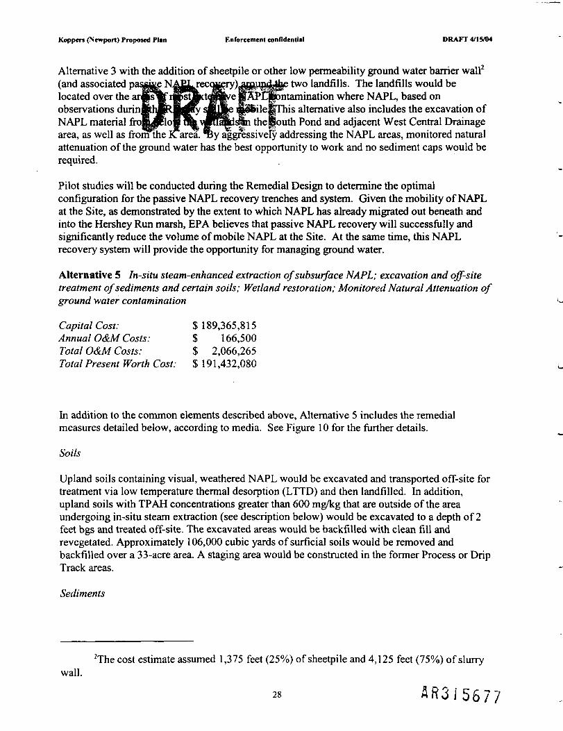
Koppers (Newport) Proposed Plan Enforcement confidential DRAFT 4/15/04
Alternative 3 with the addition of sheetpile or other low permeability ground water barrier wall2
(and associated paSgKg N-4ftfcreC(^ry)j|p"Bd||| two landfills. The landfills would belocated over the aHpsW 4pt^te|iive IpPContamination where NAPL, based onobservations durinflthHElttHry Sjgyj|e i»H>ileferhis alternative also includes the excavation ofNAPL material frofiypHopt^A^Mawls%i thelfouth Pond and adjacent West Central Drainagearea, as well as from the Karea. %y aggressively addressing the NAPL areas, monitored naturalattenuation of the ground water has the best opportunity to work and no sediment caps would berequired.
Pilot studies will be conducted during the Remedial Design to determine the optimalconfiguration for the passive NAPL recovery trenches and system. Given the mobility of NAPLat the Site, as demonstrated by the extent to which NAPL has already migrated out beneath andinto the Hershey Run marsh, EPA believes that passive NAPL recovery will successfully andsignificantly reduce the volume of mobile NAPL at the Site. At the same time, this NAPLrecovery system will provide the opportunity for managing ground water.
Alternative 5 In-situ steam-enhanced extraction of subsurface NAPL; excavation and off-sitetreatment of sediments and certain soils; Wetland restoration; Monitored Natural Attenuation ofground water contamination
Capital Cost: $ 189,365,815Annual O&M Costs: $ 166,500Total O&M Costs: $ 2,066,265Total Present Worth Cost: $ 191,432,080
hi addition to the common elements described above, Alternative 5 includes the remedialmeasures detailed below, according to media. See Figure 10 for the further details.
Soils
Upland soils containing visual, weathered NAPL would be excavated and transported off-site fortreatment via low temperature thermal desorption (LTTD) and then landfilled. In addition,upland soils with TPAH concentrations greater than 600 mg/kg that are outside of the areaundergoing in-situ steam extraction (see description below) would be excavated to a depth of 2feet bgs and treated off-site. The excavated areas would be backfilled with clean fill andrevegetated. Approximately 106,000 cubic yards of surficial soils would be removed andbackfilled over a 33-acre area. A staging area would be constructed in the former Process or DripTrack areas.
Sediments
2The cost estimate assumed 1,375 feet (25%) of sheetpile and 4,125 feet (75%) of slurrywall.
28 A R 3 I 5 6 7 7

Koppers (Newport) Proposed Plan Enforcement confidential DRAFT 4/15/04
The sediments in the Fire Pond, South Ponds, and K Area would be addressed as part of the in-situ steam injectioa^thesuMurfa^NAJ^axeajgsee below).
As described in Al»rnHi\»^[hefeAr ttBlioiM)f Hershey Run would be rechannelized so thatthe new channel w^w^)la^^hM^X>IMmpa^ed area adjacent to the Fire Pond (which wouldbe addressed througnm-situ steam injection, as described above). Although the NAPL wouldeventually be addressed by the in-situ steam extraction, the rechannelization and sheetpile wouldbe necessary to prevent Hershey Run from becoming an infinite heat sink substantiallyincreasing fuel costs and likely preventing the appropriate temperature increase.
All surface and subsurface sediments containing PAHs greater than 150 mg/kg would beexcavated from the lower portion of Hershey Run, Hershey Run Marsh to the west of theproposed sheeting, and the West Central Drainage Area waterway and marsh, with removaldepths up to 13 feet.
Ground Water
To prevent future releases of NAPL to surface water and sediments where it could cause risks totrespassers and ecological receptors, as well as to control the source of ground watercontamination, thus maximizing the opportunity for monitored natural attenuation to work,NAPL contamination would be addressed through in-situ steam extraction. In-situ steaminjection, also known as thermally-enhanced in-situ extraction (steam) or dynamic undergroundstripping (DUS), would be used to remove subsurface NAPL at all upland areas and subsurfaceNAPL beneath the Fire Pond and South Ponds.
In-situ steam injection would require steam to be generated at the surface and injected into arraysof injection wells in an effort to heat the subsurface NAPL zones and recover NAPL. Duringsteam injection, some of the NAPL constituents would distill or volatilize, become more mobile,and could then be removed via extraction wells. Due to the high heat and oxygen introduced inthe steam, some NAPL would be destroyed through physical and chemical degradation. Theinjection and extraction wells would be spaced according to the depth of the impacted zones,which may range from approximately 5 to 15 feet bgs. Because of the shallow depth of the targetzone, the soil surface would have to be covered, perhaps with asphalt, to prevent steam fromventing at the surface. Steam, liquid, and noncondensible gases would be removed from theground and captured in a recovery system, where fluid separation and treatment technologieswould be required. Recovered NAPL would be retained in storage tanks prior to transport andoff-site incineration. Three-phase resistance heating may be used as a complement to in-situsteam injection in an effort to heat low-permeability soil zones within the target areas. As part ofthe pre-design investigation, an extensive pilot study would first be required to develop processcontrol parameters.
Infrastructure would be constructed at the Site including an electrical supply grid, steam boilers,boiler fuel supply such as propane or natural gas injection and extraction wells, steamconveyance piping, recovered fluids conveyance piping, and a sufficient network of roads toaccess all of the treatment areas. The fluid separation system would separate vapors, liquids, andNAPL. A vapor treatment system would be designed and constructed to treat recovered vaporsprior to discharge to the atmosphere. A water treatment system would be designed andconstructed to treat recovered liquid prior to discharge.
29 a .-\ /-, . f— ^ -- ,.1 5 t > 7 t j

Koppers (Newport) Proposed Plan Enforcement confidential DRAFT 4/1 SAM
Evaluation of Al
hi this section, EP^eW^|tfihemfci^es i| detail to determine which EPA believes wouldbe the most effectr&0r adinmilncKols of (JERCLA, and in particular, achieving theremedial action objectives Tor tn*Site. EPA uses nine criteria to evaluate different clean-upalternatives individually and against each other in order to select a remedy. Below is adescription of each of the nine criteria set forth in the NCP, 40 C.F.R. § 300.430(e)(9). Thesenine criteria can be categorized into three groups: threshold criteria, primary balancing criteria,and modifying criteria.
Threshold Criteria:
1. Overall Protection of Human Health and the Environment addresses whether a remedyprovides adequate protection to human health and the environment and describes howrisks are eliminated, reduced, or controlled through treatment, engineering controls, orinstitutional controls.
2. Compliance with Applicable or Relevant and Appropriate Requirements (ARARs)addresses whether a remedy will meet all of the applicable or relevant and appropriaterequirements of environmental statutes, regulations, and/or whether there are grounds forinvoking a waiver.
Primary Balancing Criteria:
3. Long-term Effectiveness refers to the ability of a remedy to maintain reliable protectionof human health and the environment over time once cleanup goals are achieved.
4. Reduction of Toxicity, Mobility, or Volume through Treatment addresses the degree towhich alternatives will reduce the toxicity, mobility, or volume of the contaminantscausing Site risks through treatment.
5. Short-term Effectiveness addresses the period of time needed to achieve protection andany adverse impacts on human health and environment that may be posed during theconstruction and implementation period until cleanup goals are achieved.
6. Implementability addresses the technical and administrative feasibility of a remedy,including the availability of materials and services needed to implement a particularoption.
7. Cost includes estimated capital and operation and maintenance costs, usually combinedas the present worth cost.
Modifying Criteria:
8. State Acceptance indicates whether, based on its review of backup documents and theProposed Plan, the State concurs with, opposes, or has no comment on the preferredalternative.
A R 3 J 5 6 7 3

Koppers (Newport) Proposed Plan Enforcement confidential DRAFT 4/15/04
9. Community Acceptance will be assessed in the Record of Decision following a review ofpublic comp|nts r|fi|i ed o^the^gp^g^Plan and supporting documents included inthe Adminii
Overall ProtectiofUPHifhlklflBntt aid th^Environment
A primary requirement of CERCLA is that the selected remedial action be protective of humanhealth and the environment. An alternative is protective if it reduces current and potential futurerisks associated with each exposure pathway at a Site to acceptable levels.
The "no action" alternative (Alternative 1) does not meet this threshold criterion for severalreasons. Without any active remediation at the Site, a number of risks (both current andpotential) would remain, including: 1) risks would remain for potential future industrial orconstruction workers from exposure to both soil and ground water; 2) current risks would remainto ecological receptors in aquatic areas such as the Fire and South Ponds, the K Area, HersheyRun and associated wetlands and in upland soil areas; 3) potential future risks to ecologicalreceptors could increase if the Site were developed to increase wetland acreage; and 4) while notreadily quantifiable, risks to trespassers would remain from exposure to NAPL that can bereleased while wading in sediments in Hershey Run. Since the "no action" alternative does notmeet this threshold criterion, it will not be considered any further.
Each of the other alternatives (Alternatives 2, 3, 4, and 5) meet this criterion to varying degreesand in widely varying time frames. Alternatives 2, 3,4, and 5 may all eventually achieve andmaintain protection of human health and the environment through isolation; removal; naturalrecovery of impacted sediment; natural attenuation of contaminated ground water; andinstitutional controls. However, EPA does not believe that Alternative 2 would be protective inHershey Run because, like the "no action" alternative, it would not address NAPL and PAHs inthe sediments of Lower Hershey Run. EPA does not believe that natural recovery could reducethe risks posed by the sediments in Lower Hershey Run within a reasonable amount of time.
The institutional controls in each alternative can help provide protection of human health byensuring future activities at the Site are conducted in a manner to protect workers. Each of thealternatives would protect upland critters. Alternatives 2 and 3 would provide a clean "livinglayer" of soil by either covering soil contamination with clean soil (Alternative 2) or byremoving and replacing the top layer of soil (Alternative 3). Alternative 4 would address risksfrom upland soil by removing all soil that is above the site-specific soil cleanup criteria of600 mg/kg with replacement (whole or partial) possibly occurring depending on the type ofhabitat desired. Alternative 5 addresses these risks by removing contamination through acombination of excavation (when weathered NAPL is visible) and removal and/or destruction ofcontaminants through in-situ steam extraction.
Aquatic receptors would be protected in a variety of ways. Alternative 2 would involvesediment caps in the Fire Pond, South Pond, and K Area to prevent receptors from coming intocontact with contamination. Sheetpile would be installed at the Fire Pond and the South Pond,along with passive NAPL collection, to prevent NAPL migration to water bodies to mitigate anon-going source of contamination to the water bodies and to give monitored natural recovery(MNR) of to address sediment contamination in Hershey Run and adjacent wetlands and in theWest Central Drainage area. EPA does not believe that MNR would address risks in these areas,
31 A R 3 I 5 6 8 U
Koppers (Newport) Proposed Plan Enforcement confidential DRAFT 4/15/04
especially in any reasonable time frame. Since these contaminants are from a wood-treatingoperation with a gojl^f pE|^mting4yodegcadaUMp biodegradation within the water body (one ofthe MNR processellrfny apfow rjfeT A very substantial flooding event may benecessary to reduc&sjl l^PHs °f|e the sources have been cut off, but such anevent would only rgp tr»afct^^ptfibff-sili, relocating the problem.
Alternative 3 would also involve sediment caps in the Fire Pond, South Pond, and K Area toprevent receptors from coming into contact with contamination, hi addition, aquatic risk inHershey Run and the adjacent marsh and the West Central Drainage area would be addressed byexcavating the top 2 feet with a reactive cap placed in areas where elevated levels ofcontamination remained below. Sheetpile would also be installed at the Fire Pond (althoughover a greater area to enclose more NAPL, but resulting in the need to rechannelize HersheyRun) and the South Pond, along with passive NAPL collection, in order to prevent NAPLmigration to water bodies and to mitigate an on-going source of contamination to the waterbodies.
Alternative 4 would address risks to aquatic receptors by aggressively excavating all sedimentabove the site-specific cleanup criteria of 150 mg/kg TPAH in the South Pond, K Area, HersheyRun and adjacent marsh and the West Central drainage area. Risks in the Fire Pond would beaddressed by filling the Fire Pond as part of the consolidation of contaminated soils andsediments.
Alternative 5 would address risks to aquatic receptors by removing and/or destroying subsurfacecontamination using in-situ steam extraction, and by removing all contaminated sediments fortreatment off-site.
For human health risks due to ground water, each alternative would initially address risksthrough the creation of a ground water management zone by the State of Delaware that wouldprevent any drinking water wells from being installed. Each alternative would includemonitoring until the ground water is safe to drink (which for Alternatives 2 and 3 couldpractically be forever). Alternatives 2, 3 and 4 would control NAPL with the use of groundwater barrier walls creating areas that would not be cleaned up and would rely solely on theground water management zone. Additionally, Alternative 4 would excavate NAPL foundoutside of the consolidation areas. Alternative 5 would aggressively address NAPL with in-situsteam extraction followed by monitored natural attenuation to finish the cleanup.
In terms of comparison, EPA believes Alternatives 4 and 5 provide the highest degree of overallprotection of human health and the environment since they provide the most aggressive cleanupand rely the least on monitored natural recovery (for sediments) or monitored natural attenuation(for ground water). Alternative 3 provides a greater degree of protection compared toAlternative 2 since it provides for a greater degree of capture of NAPL at the Fire Pond/HersheyRun area and relies less on monitored natural recovery for the sediments in lower Hershey Runand the West Central Drainage area.
Compliance with Applicable or Relevant and Appropriate Requirements (ARARs)
Any clean-up alternative considered by EPA must comply with all applicable or relevant andappropriate federal and state environmental requirements. Applicable requirements are those
32 A R 3 1 5 6 8

Koppers (Newport) Proposed Plan Enforcement confidential DRAFT 4/15/04
substantive environmental standards, requirements, criteria, or limitations promulgated underfederal or state lawJ&at are |||plly/applicable Jgj| Remedial Action to be implemented at thesite. Relevant andmatapfaMK<jlmen^\s,vm'ile not being directly applicable, addressproblems or situatiHisjpiffii^ptlj^&ilayilthAe encountered at the site that their use is well-suited to the partic|japi;itJ| l|pi Jfieclid f|f Dec! ion, EPA may waive an ARAR under certainconditions. EPA is not waiving any ARA*Rs in the remediation of this Site.
Alternatives 2, 3,4 and 5 each meet this threshold criterion. Some of the major ARARs for theSite include:
1. State and Federal water and air discharge requirements - Air emissions for anyexcavation or on-site treatment; water discharge or re-injection for de-watering duringconstruction activities and for ground water collected in the recovery of NAPL.
2. State Water Quality Standards - As of the writing of this draft [April 12, 2004], EPA hasnot yet received a list of State ARARs identifying state water quality standards. Once theARARs are received, EPA will work with the State to identify any specific relevantstandards.
3. National Historic Preservation Act - Due to the long industrial and prior history of thisSite, additional cultural resources survey must be conducted prior to the beginning of anyremedial action. If cultural resources are found that are on, or eligible for, the NationalRegister of Historic Places and would be impacted by the clean-up, including beingcovered by a cap or disturbed by excavation, mitigation activities may be required.
4. RCRA Hazardous Waste Disposal regulations - Since creosote is a listed waste, off-sitedisposal costs would be high. All creosote ultimately stored on-site would beconsolidated within an "area of contamination" thus not triggering RCRA's "land-ban"regulations.
5. Ground water regulations (Maximum Contaminant Levels or MCLs and non-zeroMaximum Contaminant Level Goals or MCLGs) - The shallow ground water at theSite is a Class 2B aquifer meaning that it is a potential source of drinking water. Asdiscussed previously, EPA does not believe it can guarantee that the ground water can bereturned to drinking water quality because of the presence of NAPL. However, EPAdoes believe that MCLs (or non-zero MCLGs) can be attained for those contaminants forwhich they exist (especially because much of the Site does not have MCL exceedances).The MCLs are for contaminants that are more readily attenuated. The NAPL alsocontains compounds for which MCLs do not exist and which do not as readily attenuateto safe levels (e.g., larger PAH molecules). Section 300.430(f)(5)(iii)(A) of the NCPstates that performance (for example, attainment of ARARs) shall be measured atappropriate locations in the ground water, surface water, etc. The preamble to the NCPexplains that for ground water, remediation levels should generally be attainedthroughout the contaminated plume or at and beyond the edge of a waste managementarea when waste is left in place (55 FR 8753). The general boundary of the upland areasrepresent the boundary of the "waste management area" (area to be contained orotherwise remediated in each of the alternatives) for this Site. Since there are no MCL or
33 A R 3 S 5 6 8 2

Koppers (Newport) Proposed Plan Enforcement confidential DRAFT 4/15/04
non-zero MCLG exceedances beyond the waste management area at this time and sinceeach altemaU^g w |j^Prev^t su^Er^£ |ccurring, each alternative meets theseARARs.
Long-Term Effi
The evaluation of alternatives under this criterion considers the ability of an alternative tomaintain protection of human health and the environment over time. The evaluation takes intoaccount the residual risk remaining from untreated waste at the conclusion of remedial activitiesas well as the adequacy and reliability of containment systems and institutional controls.
Since any containment system requires on-going operations and maintenance (O&M),Alternative 5, which includes in-situ treatment and excavation and off-site disposal, offers thehighest degree of long-term protection because it would permanently remove contaminants fromthe Site. The alternatives that include containment on-site do offer various degrees of long-termeffectiveness, especially if O&M procedures and institutional controls are adequately adhered toin perpetuity. Of the on-site containment alternatives, Alternative 4 offers the highest degree oflong-term effectiveness and permanence because all of the contamination is consolidated intotwo areas where as Alternatives 2 and 3 leave more contamination in the wetland areas and relyon sediment caps to prevent recontamination. hi addition, the inclusion in Alternative 4 ofNAPL recovery from within the containment area would provide a very high degree of long-termeffectiveness and permanence by removing NAPL that otherwise that may have the potential toflow downward into the Potomac. Alternatives 2 and 3 would be more susceptible to wastebeing exposed during severe storm or other erosional events compared to Alternative 4.
Reduction in Toxicity, Mobility, or Volume Through Treatment
This evaluation criterion addresses the statutory preference for selecting remedial actions thatemploy treatment technologies that permanently and significantly reduce the toxicity, mobility,or volume of the hazardous substances as their principal element.
Alternative 5, by including in-situ extraction of subsurface NAPL would provide the highestdegree of reduction in the toxicity, mobility or volume. The steam injection would destroy somecontamination and would remove a majority from the environment, to be disposed of off-site.
The other alternatives would include sheetpiling and passive recovery (with off-site treatmentand disposal) of NAPL (with Alternative 4 offering the most extensive recovery) that wouldprovide for a reduction of the volume and mobility of NAPL.
Short-Term Effectiveness
This evaluation criterion addresses the effects of the alternative during the construction andimplementation phase until remedial action objectives are met. It considers risk to thecommunity and on-site workers and available mitigation measures, as well as the time frame forthe attainment of the response objectives.
Construction of a soil cover or engineered cap alone would involve the delivery of a significantamount of clean soil, creating risks due to traffic through the small town of Newport and the
34A R 3 i 5 6 8 3

Koppers (Newport) Proposed Plan Enforcement confidential DRAFT 4/15/04
Ciba Specialty Chemicals facility. This would be minimized by avoiding or minimizing theneed for imported filL andjfepugh Ihe useujf JlajuDien and a zero-tolerance policy on speeding, , , , . P"«slk HEP"*;. di» » ' • ' " "***•*by the truck dnveryi I jb f| f->
The use of erosion p & o n u m e h of me alternatives would minimize the potential forany release of contaminated sediment or Soil to Hershey Run and White Clay Creek duringconstruction. There is a chance for an air release of dust and contamination during excavationand when stock-piled material is stabilized or graded (a common element to several alternatives),but this can be monitored and controlled. Dust will have to be controlled during construction forany of the alternatives.
The time that it will take to construct the remedy for any given alternative could be considered asthe time it will take for that remedy to be protective. Therefore, the remedy with either the leastdisturbance to the Site or the remedy with the shortest construction period required wouldqualify as the most effective in the short-term.
Construction of the remedies in Alternatives 2, 3 and 4 could be completed in just a few years,although the natural recovery of sediments called for in Alternatives 2 and 3 could take decades.Alternative 5 could take several years to construct, as well as several years of operation of the in-situ extraction system. Following that, natural attenuation process could take decades to reducethe concentrations of the residual contaminants expected to be left behind in the subsurface.
Only Alternative 4 provides the combination of a short construction period that will becompletely protective at its end, taking only approximately 3 years from start to finish.
Implementability
The evaluation of alternatives under this criterion considers the technical and administrativefeasibility of implementing an alternative and the availability of services and materials requiredduring implementation.
Each of the alternatives is implementable and the services and materials required for eachalternative are readily available. However, some are more difficult than others.
Alternatives 2 and 5 would be among the most difficult to implement since they would requirethe use of thousands of truck trips. This truck traffic would have to pass through an operatingchemical plant, then through a small town. The added traffic burden to both the plant and thetown is likely to meet some resistance, in addition to posing safety hazards for both.
Alternatives 3 and 4 use simple construction techniques that are well understood, and wouldrequire the minimum truck traffic of all of the alternatives. Alternative 4 has the added benefitof localizing the construction of containment systems into a single area, rather than thewidespread construction of caps and covers included in Alternative 3. hi addition, bothAlternatives 3 and 4 would excavate sediments in Hershey Run. However, Alternative 3 alsoproposes to construct caps where contaminant extends to depth. Alternative 4 does not requirethis additional step, but instead simply increases the depth of excavation.
35

Koppers (Newport) Proposed Plan Enforcement confidential DRAFT 4/15/04
Alternative 5 utilizes complex technology that is not widely regarded as proven, and is by nomeans simple, hi jtion^a grea;UleaL^ecp^nent that would have to be brought in,Alternative 5 woul^^iffWm^gnf^^uc^re to be built at the Site, as well as includeincreased risks of Jr r&eM^Mf httllierfl&atift steam or contaminants.
Each of the alternatives (besides *no action") requires construction within a floodplain, whichpresents several difficulties. First, steps must be taken during construction to make sure that, forexample, soil or sediment is not washed downstream if an extreme storm event occurs duringconstruction. Second, due to the flood plain regulations, the cap or cover design for theconsolidation area would have to minimize and/or mitigate the effects to the flood plain causedby raising the elevation of the plant site.
hi addition, each of the alternatives requires actions to be taken in the wetlands on-site.Numerous difficulties are presented when working in a wetland, specifically related to theprevalence of soft ground and the added difficulty of de-watering all excavated or dredgedmaterials. However, these difficulties are neither unique nor insurmountable.
Cost
The table below summarizes the capital, annual operation and maintenance (O&M), and totalpresent worth costs for all of the alternatives. The total present worth is based on an O&M timeperiod of 30 years for the cap or cover and the NAPL recovery systems. A discount rate of 7%was used on the present worth calculation.
RemedialAlternative
2
3
4
5
Description
PARTIALCOVER-IN-PLACE
PARTIALCONSOLIDATION
COMPLETECONSOLIDATION
TREATMENT: in-situextraction; off-site LTTD
Capital Cost
$15,631,388
$40,330,114
$45,257,125
$189,365,815
Operation &Maintenance
Cost
$1,863,858
$1,624,193
$2,898,976(see note)
$2,066,265
TotalPresent
Worth (5%,30Yrs)
$17,645,436
$41,954,307
$48,156,101
$191,432,080
(NOTE: The operations and maintenance costs appear high for Alternative 4 due to the inclusionin that alternative of extensive efforts to passively recovery NAPL, and the exclusion of theoperating costs associated with recovering and treating NAPL from the O&M of the far morecostly Alternative 5. Under the preferred alternative, NAPL recovery would be expected to taperoff, which would reduce O&M costs. Alternatives 2 and 3 do not include aggressive efforts torecover NAPL.)
Several points stand out when evaluating the costs. First, there is a large increase in costbetween Alternatives 2-4 and Alternative 5. Alternatives 2 through 4 are containment remedies.Alternative 5 has been included as representative of a treatment remedy - other treatment
36 A R 3 i 5 6 8 5

Koppers (Newport) Proposed Plan Enforcement confidential DRAFT 4/15/04
remedies were considered in detail in the FS. Some treatment remedies were less costly (i.e.,ion) and others were more costly (i.e., in-
situ t h e r m a l l y - e n h a | ^ e p o i : s u p u r f a N A P L combined with excavation and off-siteincineration of soilnarA s||| n^^fepKii«irrMely $280 million). Second, the preferredalternative, AlternaujF4, p^prpSmt^ $6.Snillion more costly than Alternative 3. For thismoderate increase in cost, Alterrrltive 4 provides for one of the highest degrees of protectivenessin the least amount of time using simple and proven technologies. Alternative 4 has the addedbenefit of returning the majority of the Site - everything outside of the consolidation area - tounencumbered beneficial reuse, while at the same time simplifying operations and maintenancerequirements.
Alternative 4 also provides for the greatest reduction of risk in Hershey Run sediments, incomparison to Alternatives 2 and 3. Leaving all or some of the contaminated sediments orNAPL in place in Hershey Run would rely on natural recovery over a very long period of time(as in Alternative 2) or would change the ongoing actual risk to receptors to a risk of NAPLbreakthrough and recontamination, either through subsurface flow or through erosive andscouring events (as in Alternative 3). hi Alternative 2, risk reduction would occur only veryslowly, over hundreds and perhaps thousands of years. Under Alternative 4, nearly all risks tohuman health and ecological receptors are expected to have been mitigated once construction ofthe remedy is completed. It is further anticipated that any residual risks will continue todiminish as natural attenuation proceeds on a more reasonable time frame.
State Acceptance
The State of Delaware Department of Natural Resources and Environmental Control (DNREC)has reviewed and commented on this Proposed Plan. DNREC's acceptance of the preferredalternative will be fully evaluated after the public comment period and will be described in theRecord of Decision. The State has expressed a strong interest in providing for a maximum areaof reusable land at the Site, potentially for the creation of wetlands.
Community Acceptance
Community acceptance of the preferred alternative will be evaluated after the public commentperiod ends and will be described in the Record of Decision.
Preferred Alternative3
3Some modifications may be made during the Remedial Design phase that, depending onreuse and varying stakeholder involvement, would result in more extensive excavation to allowadditional wetland creation (e.g., to create wetlands as a planned future use of the Site).However, such actions and associated costs would not be required by EPA as part of the remedyitself. EPA is willing to work with stakeholders to accommodate additional Site activitiesprovided that those activities continue to provide for the overall protectiveness of human healthand the environment.
37 & R 3 » 5 6 8 o

Koppers (Newport) Proposed Plan Enforcement confidential DRAFT 4/15/04
Based on the comparison of the nine criteria summarized previously for each of the alternativesin this Proposed Pl^^PA^preferji|d al||gia^ s Alternative 4 - "complete consolidation."The total present 4iri|tfc§ otePA% preferre^lternative is $48,000,000.
As with each of thwBrnn^w (flEnenhpi the Rio action" alternative), EPA's preferredalternative meets themresnola cmeria oroveralf protection to human health and theenvironment, and compliance with ARARs. Although each of the alternatives meets most, if notall, of the Remedial Action Objectives discussed above, EPA's preferred alternative offers thefollowing advantages:
1) it will be completely protective of both human health and the environment in the leastamount of time; it is among the least costly of the alternatives;
2)compared to Alternatives 2 and 5, it would have significantly less impact to thecommunity during installation; and
3) it provides for the maximum flexibility in the reuse of the site for any purpose, asdetermined by state and local authorities, without any reduction in protectiveness.
4) it is substantially easier to implement than the other alternatives;
5) it provides a cost-effective cleanup plan
Overall, based on the information currently available, EPA (the lead agency) believesAlternative 4 provides the best balance of tradeoffs among the other alternatives with respect tothe balancing and modifying criteria. EPA's preferred alternative would satisfy the statutoryrequirements of CERCLA §121(b) by being protective of human health and the environment;complying with ARARs; being cost-effective; utilizing permanent solutions and alternativetreatment technologies to the maximum extent practicable; and satisfying the preference fortreatment as a principal element. EPA's preferred alternative could be modified or changed inresponse to public comment or new information.
Community Participation
This Proposed Plan is being distributed to solicit public comment on the appropriate cleanupaction for the Site. EPA relies on public input so that the remedy selected for each SuperfundSite addresses the concerns of the local community. EPA is providing a 30-day public commentperiod beginning on June XX, 2004 and ending on July XX, 2004, to encourage publicparticipation in the selection process. EPA will conduct a public meeting during the commentperiod in order to present the Proposed Plan and supporting information, answer questions, andaccept both oral and written comments from the public. The public meeting will be held on
, 2004 at the , Newport, DE at 7:00 PM.
EPA will summarize and respond to comments received at the public meeting and writtencomments post-marked by August 14, 2003 in the Responsiveness Summary section of theRecord of Decision, which documents EPA's final selection for cleanup. To obtain additionalinformation relating to this Proposed Plan, please contact either of the following EPArepresentatives:
38A R 3 1 5 6 8 7

Koppers (Newport) Proposed Plan Enforcement confidential DRAFT 4/1 SAM
Larry Johnson (3HS43)Community InvolvementU.S. EPA - Regioi'1650 Arch StreetPhiladelphia, PAPhone: 215-814-3Z
Matthew T. Mellon (3HS23)Remedial Project ManagerU.S. EPA - Region m1650 Arch StreetPhiladelphia, PA 19103Phone:215-814-3168
The detailed Administrative Record can be examined at the following locations:
Kirkwood Public Library6000 Kirkwood HighwayWilmington, DE 19801
Delaware Department of NaturalResources & Environmental ControlSuperfund Branch391 Lukens DriveNew Castle, DEI 9720(302) 395-2622
US EPA Region m1650 Arch StreetPhiladelphia, PA 19103
39A R 3 J 5 6 8 3

Koppers (Newport) Proposed Plan Enforcement confidential DRAFT 4/15/04
Sa'let&s of 04/12/2004 draft)
Administrative Record -^PllMifficlaltsompflation of documents, data, reports, and otherinformation that is considered important to the status of, and decisions made, relative to aSuperfund Site. The record is placed in the information repository to allow public access to thematerial.
Administrative Order on Consent (AOC): A legal agreement between EPA and potentiallyresponsible parties (PRPs) whereby PRPs agree to perform or pay for a RemedialInvestigation/Feasibility Study at a Superfund site.
Administrative Record File: An official compilation of documents, data, reports and otherinformation that form the basis of response actions selected for a Superfund site. The record isplaced in the information repository to allow public access to the material.
Area of attainment: The area over which ground water cleanup levels must be met. This areagenerally encompasses the area outside the boundary of any waste or contaminated soil managedin place and up to the boundary of the ground water contaminant plume.
Applicable or Relevant and Appropriate Requirements (ARARs): The federal and staterequirements or criteria with which a selected remedy must comply.
Aquifer: A layer of rock or soil that can supply usable quantities of ground water to wells andsprings. Aquifers can be a source of drinking water and provide water for other uses as well.
Baseline Risk Assessment ("BRA"): - The BRA is an essential component of the RemedialInvestigation Report. This portion of the RI evaluates the carcinogenic and non-carcinogenicrisks presented by the contaminants at the Site. Risk is calculated both for current uses andpotential future uses of the property by a defined population i.e. on and offsite residents,trespassers, etc.
Carcinogen: - A cancer-causing agent.
CFR:- The Code of Federal Regulations. For example, the citation 40 CFR 260 means Title 40of the Code of Federal Regulations, Part 260.Comprehensive Environmental Response. Compensation, and Liability Act (CERCLA): Afederal law passed in 1980 and modified in 1986 by the Superfund Amendments andPreauthorization Act. The Act created a Trust Fund, known as Superfund, to investigate andclean up abandoned or uncontrolled hazardous waste sites.
Consent Decree: A legal agreement between EPA and potentially responsible parties (PRPs)which is entered by, and enforceable by, a court.Deminimus Settlement:- Potentially Responsible Parties which have contributed relativelysmall quantity of waste to the Site contamination may pay an up-front settlement to be releasedvia agreement with EPA from future costs related to the Site clean-up.
40 A R 3 i 5 6 8 3

Koppers (Newport) Proposed Plan Enforcement confidential DRAFT 4/15/04
Ecological RecepTO^BPagAdMy afti^e tint may be exposed to hazardous substances.
Feasibility Study (FS): A report that identifies and evaluates alternatives for addressing thecontamination that presents unacceptable risks at a Superfund site. The report includesdevelopment of engineering drawings and specifications for a site cleanup, as well as any pre-design studies.
Ground Water: The water beneath the earth's surface that flows through the soil and rockopenings and often serves as a source of drinking water.
Hazard Index (HI): A numeric representation of non-cancer risk. A HI exceeding one (1) isconsidered an unacceptable non-cancer risk.
in situ: In the original place, e.g., treatment in place.
Institutional Controls: Non-engineered instruments such as administrative and/or legalcontrols that minimize the potential for human exposure to contamination by limiting land orresource use.
Hazard Quotient ("HQ"): - a numeric representation of non-carcinogenic risk, or toxicequivalency. A HQ exceeding one (1) is considered an unacceptable non-carcinogenic risk.
Information Repository - A location where documents and data related to the Superfundproject are placed by EPA to allow the public access to the material.
Leachate: A contaminated liquid that results when water trickles through waste materials andcollects components of those wastes. Leaching may cause hazardous substances to enter soil,surface water or ground water.
Lithologic Unit: A rock or soil formation.
Maximum Contaminant Levels (MCLs): Enforceable standards for public drinking watersupplies under the Safe Drinking Water Act. These standards apply to specific contaminantswhich EPA has determined have an adverse effect on human health above certain levels.
Maximum Contaminant Level Goals (MCLGs): Nonenforceable health-based goals fordrinking water that are established at levels at which no known or anticipated adverse humanhealth effects occur.
National Oil and Hazardous Substances Pollution Contingency Plan (NCP): The federalregulation that provides the organizational structure and procedures for preparing for andresponding to discharges of oil and releases of hazardous substances, pollutants andcontaminants.
41 A R 3 i 5 6 9 u

Koppers (Newport) Proposed Plan Enforcement confidential DRAFT 4/15/04
National PrioritieKLft (ljwf: jP%'s fefe°f fie nation's top priority hazardous waste sites thatare eligible to rece&JM£raipo|llJ^pr response under CERCLA.
Operable Unit (OU): The work done at Superfund sites may be divided into smallermanageable phases called operable units.
Organic Compound; A chemical comprised primarily of carbon and hydrogen.
Potentially Responsible Parties ("PRPs"): - An individual or company (such as a facilityowner or operator, or a transporter or generator of hazardous substances) who may be legallyresponsible for the clean up of hazardous substances at a Superfund Site. Whenever possible,EPA requires PRPs, through administrative and legal actions, to clean up hazardous waste sitesthey have contaminated.
Principal Threat;- Principal threat source materials are defined as contaminated basinsediments and subsurface basin soils which pose an unacceptable risk of cancer due totheoretical exposure to radiological contaminants to a future industrial worker equal to or greaterthan one chance out of a thousand.
Pathways: Routes which contaminates may follow as they move by gravity or ground waterflow.
ppb: - Parts per Billion. Five parts per billion is a fractional representation of 5 parts in 1 billionparts. For solids, ppb is a fraction based on weight, for example 5 pounds of a contaminant in abillion pounds (500,000 tons) of soil. For liquids ppb is based on volume, for example 5tablespoons of a contaminant in a billion tablespoons (3,906,250 gallons) of water. A ppb is amuch smaller quantity than a ppm.
ppm: - Parts per Million. Five ppm is a fractional representation of 5 parts in 1 million.
RCRA (Resource Conservation and Recovery Act):- A federal law that established aregulatory system to track hazardous substances from the time of generation to disposal. Thelaw requires safe and secure procedures to be used in treating, transporting, storing anddisposing of hazardous substances.
Record of Decision ("ROD"): A legal document that describes the remedial actions selectedfor a Superfund Site, why certain remedial actions were chosen as opposed to others, how muchthey will cost. It summarizes the results of the Remedial Investigation/Feasibility Studyreports and the comments received during the comment period for the Proposed Plan.
Remedial Action (RA): The actual construction or implementation phase of a Superfund Clean-up following a Remedial Design (RD).
Remedial Design: (RD) A phase of remedial action that follows the Remedial Investigation/
42 A R 3 I 5 6 9

Koppers (Newport) Proposed Plan Enforcement confidential DRAFT 4/15/04
Remedial InvestiJroffi Afii^ApWy' tfeich Mentifies the nature and extent of contamination1 • «^»^^— • """"""^KEa™"fiSt •EMBHl file __!& ^° tSB** SK&
at a Superfund sitfjfajp fif^^th^Hlps |jr the Valuation of environmental and human healthrisks posed by the
Remedial Investigation and Feasibility Study ("RI/FS"); A report composed of twoscientific studies, the RI and the FS. The RI is the study to determine the nature and extent ofcontaminants present at a Site and the problems caused by their release. The FS is conducted todevelop and evaluate options for the cleanup of a Site.
Removal Action (RA): Action taken to stop an imminent danger or threat to human health orthe environment.
Resource Conservation and Recovery Act (RCRA): A federal law that established aregulatory system to track hazardous substances from the time of generation to disposal. Thelaw requires safe and secure procedures to be used in treating, transporting, storing anddisposing of hazardous substances.
Reference Dose ("RfD") - RfDs are estimates of threshold: esposures less than the Rfd are notexpected to cause adverse effects even if exposures continue for a lifetime in the most sensitivepopulations.
Scientific Notation - hi dealing with particularly large or small numbers, scientists andengineers have developed a "short hand" means of expressing numerical values. For example,1,000,000 can be written as 1 x 10⁶ and 1/1,000,000 can be written as 1 x W6.
Semivolatile Organic Compound: An organic compound that, at a relatively lowtemperature, fluctuates between a vapor state (a gas) and a liquid state.
Superfund: The common name used for CERCLA.
Sediments: Soils, sand and minerals washed from land into water.
Seeps: Areas where water or leachate drains from the earth, often forming the source of asmall, trickling stream.
TBC: "To Be Considered" - If not legally Applicable or Relevant and AppropriateRequirement (ARAR) it is nevertheless useful information to be considered in developingremedial alternatives.
Vadose Zone: The soil above water table.
Volatile Organic Compound (VOC): An organic compound that readily evaporates(volatilizes) under atmospheric conditions.
Volatilization: The transition of a chemical from a liquid state to a gaseous state.
43 A R 3 I 5 6 9 2

Koppers (Newport) Proposed Plan
Water table: Thewater is referred t
Enforcement confidential DRAFT 4/15/04
jtJS*
fthgsoil where free standing water exists. This
44 A R 3 i 5 6 9 3

TABLE
CO
C/l
APPLICABLE OR RELEVANT AND APPROPRIATE REQUIREMENTSAND TO BE CONSIDERED MATERIAL (TBCs)
KOPPERS (NEWPORT) SITE
(ARARs)
ARARorTBC
1. CHEMICAL SPECIFIC
A. Water
1 . Safe Drinking WaterAct
a. MaximumContaminant LevelGoals (MCLGs)
b. MaximumContaminant Levels(MCLs)
2. Health EffectsAssessment
Legal Citation
42U.S.C. §300fetseg.
40C.F.R5 141.50-51
40C.F.RS 141.11-12
ARARClass
Relevant andAppropriate
Relevant andAppropriate
To beConsidered
Requirement Synopsis
Non-enforceable health goals for public water supplies. The NCPrequires that non-zero MCLGs shall be attained by remedialactions for ground water that is a current or potential source ofdrinking water, where the MCLGs are relevant and appropriateunder the circumstances of the release.
Enforceable standards for public drinking water supply systems(with at least fifteen service connections or used by at least 25persons). The NCP requires that MCLs, for those contaminantswhose MCLG is zero, shall be attained by remedial actions forground water that is a current or potential source of drinking water,where the MCLs are relevant and appropriate under thecircumstances of the release.
Non-enforceable toxicity data for specific chemicals for use in publichealth assessments. Also "to be considered" are CarcinogenicPotency Factors and Reference Doses provided in the SuperfundPublic Health Evaluation Manual.
Applicability toSelected Remedy
The containment of NAPL and NAPL-contaminated soilsand sediments will allow for natural attenuation process towork in the Columbia aquifers. It is expected thatattenuation processes will be able to restore impactedground water outside of the containment area oncecontainment is complete. There is no known contaminationin the Potomac Aquifer.
A State Ground Water Management Zone (GMZ) will beextended to encompass the Site in order to prevent the useof and exposure to Columbia ground water.
To be considered where remedial action addresses risk-based criteria or when setting clean-up standards for theprotection of human health.
Area ofConcern
GW
GW
Site-wide

ARAR or TBC
7. DelawareComprehensive Water
Resources ManagementCommittee Reports,December 1 3, 1 983
8. Clean Water Act
9. Delaware SurfaceWater QualityStandards as amended,Feb. 26, 1 993
B. Air
1 . Clean Air Act
a. National EmissionsStandards forHazardous AirPollutants
2. Delaware Ambient AirQuality Standards
C. Miscellaneous
II. LOCATION SPECIFIC
1 . Coastal ZoneManagement Act of1972;Coastal Zone Act
ReauthorizationAmendments of 1 990
Legal Citation
Clean Water Act, Section303
Sections 3, 4, 5, 6, 8, 9,10, 11. 1, 1 1.2, 11.3,11.4, 11.6, 12
42U.S.CS740I
40C.F.RPart6l
Title 7, Delaware Code, Ch60, Regulation 3,Section 6003
I6U.S.C. 1451 etseg.15C.F.R. Part 9315
ARARClass
To BeConsidered
Relevant andAppropriate
Applicable
Relevant andAppropriate
Applicable
Applicable
Requirement Synopsis
The reports were adopted as policy by the DNREC Secretary.Among these reports is the Groundwater Quality ManagementReport, July 1 983, which provided Delaware with a number oftools for dealing with ground-water contamination.
Water quality criteria set at levels to protect human health for waterand fish ingestion and protection of aquatic life in streams, lakes,and rivers.
* NPDES discharge for GW management from trenches?
Criteria are provided to maintain surface water for streams, lakes,rivers, and standing water in wetlands of satisfactory qualityconsistent with public health and recreational purposes, thepropagation and protection of fish and aquatic life, and otherbeneficial uses of water.
Standards promulgated for air emissions from specific sourcecategories. Not applicable but may be relevant and appropriate foremissions from air strippers at Superfund sites.
Establishes ambient air quality standards.
Requires that Federal agencies conducting or supporting activitiesdirectly affecting the coastal zone, conduct or support thoseactivities in a manner that is consistent with the approvedappropriate State coastal zone management program. (SeeDelaware's Comprehensive Update and Routine ProgramImplementation. March 1 993)
Applicability toSelected Remedy
To be considered for ground water monitoring.
To be considered for ground water management if asurface water discharge will be required.
To be considered for storm water management if a surfacewater discharge will be required.
1 . Any surface water discharge must meet these levels ifmore stringent than federal regulations.
TWO* ii no trenittcoi ayiteui expected? not ft trcnmcntremedy.
Flllhf ****** ffQM ^ff^ftamHtff
Relevant and appropriate for potential odors and emissionsresulting from excavation.
* EmJutatt bom excavation*? (PAHs, odors, etc.)
Applicable for nntpnti*! releases from air stripping ofground water, eumtton work, or other remediafaclions.
On-site remedial actions are required to be consistent, tothe maximum extent practicable, with Delaware's coastalzone management program. EPA must notify Delaware ofits determination that the actions are consistent to themaximum extent practicable.
Area ofConcern
GW
HersheyRun, GW
HersheyRun
Uplands
Uplands
Site-wide
A R 3 I 5 6 9 5

ARAR or TBC
2. The Archaeologicaland HistoricalPreservation Act of1974
3. Protection ofFloodplains
4. Protection of Wetlands
5. Delaware Coastal ZoneAct, 7 Delaware CodeChapter 70; CoastalZone Act Regulations,6/9/93
6. Delaware WetlandsRegulations RevisedJune 29, 1984
7. Delaware RegulationsGoverning the Use ofSubaqueous Lands,amended September 2,
1992
8. Delaware ExecutiveOrder 56 onFreshwater Wetlands(1988)
9. Governor's RoundtableReport on FreshwaterWetlands H 989)
Legal Citation
I6U.S.C§469
40 C.F.R. Part 6, AppendixA
40 C.F.R. Part 6, AppendixA
7 Delaware Code Sections7003, 7004
Sections 1 ,2 ,7
Sections 1,3,4
ARARClass
Applicable
Applicable
Applicable
To BeConsidered
Applicable
Applicable
To BeConsidered
To BeConsidered
Requirement Synopsis
Requirements relating to potential loss or destruction of significantscientific, historical, or archaeological data
• Guttural Resource Surveys conducted » put of RI have kfcntffledmultiple sites that will require additional surveying and possiblemitigation work.
Sets forth EPA policy for carrying out provisions of ExecutiveOrder 1 1 988 (Floodplain Management) which requires actions toavoid adverse effects, minimize potential harm, and restore andpreserve natural and beneficial values.
Sets forth EPA policy for carrying out provisions of ExecutiveOrder 1 1 990 (Protection of Wetlands) which requires actions toavoid adverse effects, minimize potential harm, and restore andpreserve natural and beneficial values.
Controls the location, extent, and type of industrial development inDelaware's coastal areas.
Requires activities that may adversely affect wetlands in Delawareto be permitted. Permits must be approved by the county ormunicipality having jurisdiction.
Requires activities that affect public or private subaqueous lands inthe State be permitted.
General policy to minimize the adverse effects to freshwaterwetlands.
General policy to minimize the adverse effects to freshwaterwetlands.
Applicability toSelected Remedy
Cultural Resource Surveys conducted as part of the RIhave identified multiple archeological and historicalresources to date. The preferred alternative has thepotential for disturbing archeological resources. Furtheraction will be taken to identify the potentially affectedresources and action will be taken to mitigate any adverseeffects on those resources that would result fromconstruction.
Applicable since much of the remedial action will take placewithin the 500-year floodplain. Due to the encroachmentof the containment area into tidal wetlands, wetlands willbe constructed on site to mitigate the loss of volume insidea floodplain.
Applicable since the construction of the containment areawill affect wetlands.
Will be considered for consistency since the remedialaction involves substantial aquatic habitat and is located inDelaware's coastal area although not in the defined coastalzone of this statute.
•Wort b the denned coutal zone?
Any substative requirements shall be met since wetlandswill be destroyed and replaced in the Hershey Run marsh;and dredged (or excavated) and restored in the wetlandsnear the South Ponds. Since all of the wetland orremediation is considered "on-site", no permit will beobtained.
Any substantive requirements shall be met since theremediation involves dredging of Hershey Run. However,no permit shall be obtained.
To be considered for wetland remediation and restoration.
To be considered for wetland remediation and restoration.
Area ofConcern
Site-wide
Site-wide
Wetlands
ALL
Wetlands
Wetlands
Wetlands
Wetlands
A R 3 I 5 6 9 6

ARAR or TBC
10. GroundWaterProtectionStrategy of 1984
III. ACTION SPECIFIC
A. Miscellaneous
1 . Council onEnvironmental Quality
2. Delaware RegulationsGoverning HazardousSubstance Cleanup, 1/93
B. Water
1 . Clean Water Act(CWA); NationalPollutant DischargeElimination SystemRequirements
2. General PretreatmentRegulations
3. Section 1 0 of the Riverand Harbors Act
4. State of DelawareRegulations Governingthe Construction ofWater Wells,Ianuarv20. 1987
Legal Citation
EPA 440/6-84-002
40 C.F.R. 1500.2(0
Section 9
40 C.F.R. Part 122-125
40 C.F.R Part 403
33 U.S.C. Section 40333 C.F.R. Part 320-330
Sections 3, 4, 5, 6, 7, 8, 9,10
ARARClass
To beConsidered
Relevant andAppropriate
Relevant andAppropriate
Applicable
Applicable
Applicable
Applicable
Requirement Synopsis
Identifies ground water quality to be achieved during remedialactions based on aquifer characteristics and use.
Requires use of all practicable means, consistent with therequirements of NE.PA to restore and enhance the quality of thehuman environment and avoid or minimize any possibe adverseeffects upon the quality of the human environment.
Establishes clean-up criteria for hazardous waste sites. Onlycriteria considered relevant and appropriate are for ground waterand soil ( 1 x 1 O"5; Hazard Index of I ; or natural background ifhigher).
Enforceable standards for all discharges to waters of the UnitedStates.
Standards for discharge to POTW.
Permitting requirements for dredging.
Contain requirements governing the location, design, installation,use, disinfection, modification, repair, and abandonment of all wellsand associated pumping equipment.
Applicability toSelected Remedy
The EPA aquifer classification will be taken intoconsideration during design and implementation of theremedy.
4>Tncrc wube no treatment, but natural flHtP' Hnfl Thfli'Mrestore areas where residuals may be left in place.
Institutional controls shall be added to the Site to makesure the restored wetlands remain wildlife habitat.
The cleanup criteria for the Site, though derived from theresults of the Ecological Risk Assessment, are protective ofHuman Health as well.
(RELATE 1 50/600 mg/kg TPAH to B(a)P equivalenceciting calculation of 1 4.6 mg/kg B(a)P pure to anindustrial worker equal to 1 OE-05)
Discharge limits shall be met for any on-site discharges tosurface water including treated ground water (if necessary)and wastewater from dewatering dredge material. Onlysubstantive requirements shall be met and no permit shallbe obtained.
Applicable should the extracted ground water, treatedground water, or wastewater from dredge material bedischarged to a POTW.
The stream and wetland dredging will comply to anysubstantive requirements, but no permit will be obtained.
Installation of any monitoring and recovery wells and theabandonment of wells shall meet all substantiverequirements.
Area ofConcern
GW
Wetlands
Uplands,GW
WetlandsGW
WetlandsGW
Wetlands
Site-wide
A R 3 i 5 6 9 7

ARAR or TBC
5. Delaware WaterQualitv Standards, asamended, February 26,1993
6. Delaware River BasinCommission (DRBC)Water Quality
7. Delaware RegulationsGoverning theAllocation of WaterMarch 1 , 1 987
8. State of DelawareGroundwaterManagement PlanNovember 1, 1987
9. Delaware RegulationsGoverning Control ofWater Pollution,amended 6/23/83
C. Air
'E. Sediments/Solids
1 . Delaware Sediment andStormwater RegulationsJanuary 23, 1991
F. Waste Handling andDisposal
1 . RCRA Subtitle DLandfill Regulations
3. Delaware RegulationsGoverning HazardousWaste
Legal Citation
Sections 3-6, 8-10, 11.1,11.2, 11.3, 11.4, 11.6, 12
DRBC Ground WaterProtected Area Regulation,No. 4, 6(f), 9, 10; WaterCode of the Basin, Sections2.20.4, 2.50.2
Sections 1 , 3, 5.05
Section 7, 8, 9, 10, II, 12,13
Section 3, 6, 9, 10, 11, 15
40 C.F.R. 258.60(a)
SEE BELOWF.5, F.7.F.9, F.1I.F.I3,F.15.F.I7
ARARClass
Applicable
Applicable
Applicable
To BeConsidered
Applicable
Applicable
Relevant andAppropriate
SEEBELOW
Requirement Synopsis
Standards are established in order to regulate the discharge intostate waters in order to maintain the integrity of the water.
nopncajMe o CuScnHigaig giuuniwuer mu may ueeQ ire&imeni.*May be Relevant ancTAppropriate if no discharge.
Regulate restoration, enhancement, and preservation of waters inthe Delaware River basin.
Contain information pertaining to water allocation permits andcriteria for their approval.
Policy for ground-water management.
Contain water quality regulations for the discharging into surfaceand ground water.
Establishes a statewide sediment and Stormwater managementprogram.
Closure requirements for RCRA subtitle D landfills.
Delaware Regulations Governing Hazardous Waste Part 261define "hazardous waste". The regulations listed below apply to thehandling of such hazardous waste.
Applicability toSelected Remedy
Applicable should the ground water management systeminvolve discharge to surface water.
Applicable if remedial action involves discharge of> 50,000 gallons/day average over any month or awithdrawal of ground water of 1 00,000 gallons/day ormore average over any month.
May be applicable for the ground water managementsystem.No permit required.
To be considered in setting the ground water managementzone.
Applicable for potential discharge of treated ground waterinto surface water. Also applicable for potential stormwater runoff into Hershey Run, White Clay Creek or theChristina River.
A Stormwater and sediment management plan consistentwith Delaware requirements must be approved by EPAonly before construction disturbing over 5,000 square feetof land can begin.
Provides some technical requirements for the cap for thecontainment area.
SEE BELOW
Area ofConcern
HersheyRun, GW
HersheyRun, GW
HersheyRun, GW
GW
SurfaceWaters,GW
Site-wide
Uplands
SEEBELOW
A R 3 i b b 9 8

ARAR or TBC
4. Resource Conservationand Recovery Act of1 976; Hazardous andSolid WasteAmendments of 1 984
5. Standards Applicableto Generators ofHazardous Waste
6. Standards Applicableto Generators ofHazardous Waste
7. Standardsfor Owners andOperators ofHazardous WasteTreatment, Storage,and DisposalFacilities (TSDF)
8. Standardsfor Owners andOperators ofHazardous WasteTreatment, Storage,and DisposalFacilities (TSDF)
9. RCRA Requirementsfor Use and
Management ofContainers
1 0. RCRA Requirementsfor Use and
Management ofContainers
Legal Citation
SEE BELOWF.6, F.8, F.IO, F.I 2, F.I 4,F.I 6, F.I 8
Federal regulations wouldnot apply for thoseregulations which Delawarehas the authority from EPAto administer.
Delaware RegulationsGoverning HazardousWaste, Part 262. 10-58
EPA Regulations,40 C.F.R Part 262. 10-58
Delaware RegulationsGoverning HazardousWaste, Part 264(40 C.F.R Part 264)
EPA Regulations,40 C.F.R Part 264
Delaware RegulationsGoverning HazardousWaste, Part 264. 170- 178
EPA Regulations,40 C.F.R Part 264. 170-178
ARARClass
SEEBELOW
Applicable
Applicable
Applicable
Applicable
Applicable
Applicable
Requirement Synopsis
Regulates the management of hazardous waste, to ensure the safe'disposal of wastes, and to provide for resource recovery from theenvironment by controlling hazardous wastes "from cradle to grave."
Establishes standards for generators of hazardous wastes includingwaste determination manifests and pre-transport requirements.
Appues to onimmrn creosote JVU-T, tor on-ue ireuuieni orrecycling?
Establishes standards for generators of hazardous wastes includingwaste determination manifests and pre-transport requirements.
Regulations for owners and operators of TSDFs which defineacceptable management of hazardous wastes.
Regulations for owners and operators of TSDFs which defineacceptable management of hazardous wastes.
Requirements for storage of hazardous waste in storage containers.
Requirements for storage of hazardous waste in storage containers.
Applicability toSelected Remedy
SEE BELOW
Applicable to operator(s) of the NAPL recovery andground water management systems because the wastes tobe recovered are a RCRA-hazardous waste.
*rWlt«iu Bnnlba InlW J>M|UMI iintta If -mm ItMM • nrnIVnapt appnu 10 Dtt Coiuuu mm n we nan a pre-discharge treatment system?
Applicable to operator(s) of the NAPL recovery andground water management systems because the wastes toBe recovered are a RCRA-hazardous waste.
Applies to onsite recovery and treatment systems whichhandle hazardous waste
*W1 recover NAPL on-ttte, bat wfl treat NAPL oi-Hte.
Applies to onsite recovery and treatment systems whichhandle hazardous waste
*W1 recover NAPL on-dte, bat wB treat NAPL off-toe.
Applicable for temporary storage containers and on-sitetreatment systems.
Applicable for temporary storage containers and on-sitetreatment systems.
Area ofConcern
SEEBELOW
Site-wide
Site-wide
Site-wide
Site-wide
Site-wide
Site-wide
L

ARAR or TBC
1 1 . RCRA Requirementsfor Tanks Systems
12. RCRA Requirementsfor Tanks Systems
1 3. The Hazardous WastePermit Program
1 4. The Hazardous WastePermit Program
1 5. Identification andListing of HazardousWastes
1 6. Identification andListing of HazardousWastes
1 7. RCRA Land DisposalRestrictions
18. RCRA Land DisposalRestrictions
Legal Citation
Delaware RegulationsGoverning HazardousWaste, Part 264. 190- 199
EPA Regulations,40 C.F.R Part 264. 190-199
Delaware RegulationsGoverning HazardousWaste, Part 122
EPA Regulations,40 C.F.R. Part 122
Delaware RegulationsGoverning HazardousWastes, ('art 261
EPA Regulations,40 C.F.R. Part 261
Delaware RegulationGoverning HazardousWaste, Part 268
EPA Regulations,40 C.F.R. Part 268
ARARClass
Applicable
Applicable
Applicable
Applicable
Applicable
Applicable
Applicable
Applicable
Requirement Synopsis
Requirements for storage or treatment of hazardous waste in tank'systems.
Requirements for storage or treatment of hazardous waste in tanksystems.
Requires a permit for the treatment, storage, or disposal of anyhazardous waste as identified or listed in Part 26 1 .
Requires a permit for the treatment, storage, or disposal of anyhazardous waste as identified or listed in Part 26 1 .
Identifies solid wastes which are regulated as hazardous wastes.
Identifies solid wastes which are regulated as hazardous wastes.
Restrictions on land disposal of hazardous wastes.
Restrictions on land disposal of hazardous wastes.
Applicability toSelected Remedy
Only applicable for onsite treatment systems andtemporary storage tanks containing hazardous wastes.
Only applicable for onsite treatment systems andtemporary storage tanks containing hazardous wastes.
Any substative requirements will be met.But no permit will be obtained
Any substative requirements will be met.But no permit will be obtained
Use to determine which materials to be disposed of arehazardous wastes.
Use to determine which materials to be disposed of arehazardous wastes.
Applies to consolidation of waste which is hazardous fromacross the Site. (EPA has herein designated thecontainment areas as Areas of Contamination.)
Applies to consolidation of waste which is hazardous fromacross the Site. (EPA has herein designated thecontainment areas as Areas of Contamination.)
Area ofConcern
Site- wide
Site- wide
Site-wide
Site- wide
Site-wide
Site-wide
Site-wide
Site-wide
AKARs forFor dredging/excavation/rechannelization - Section 10 of Rivers & Harbors Act. The dredged/excavated will be disposed at an approved facility or put into containment cell, so Sec 404 CWA for placement of material doesn't apply. Anydewatering from dredging operation would apply under Section 404.
Section 10 of the Rivers and Harbors Act of 1899 requires authorization from the Secretary of the Army, acting through the Corps of Engineers, for the construction of any structure in or over any navigable water of the United States.Structures or work outside the limits defined for navigable waters of the United States require a Section 10 permit if the structure or work affects the course, location, or condition of the water body. The law applies to any dredging ordisposal of dredged materials, excavation, filling, rechannelization, or any other modification of a navigable water of the United States, and applies to all structures, from the smallest floating dock to the largest commercial undertaking. Itfurther includes, without limitation, any wharf, dolphin, weir, boom breakwater, jetty, groin, bank protection (e.g. riprap, revetment, bulkhead), mooring structures such as pilings, aerial or subaqueous power transmission lines, intake oroutfall pipes, permanently moored floating vessel, tunnel, artificial canal, boat ramp, aids to navigation, and any other permanent, or semi-permanent obstacle or obstruction.
Section 404 of the Clean Water Act requires authorization from the Secretary of the Army, acting through the Corps of Engineers, for the discharge of dredged or fill material into all waters of the United States, including wetlands, bothadjacent and isolated. Discharges of fill material generally include, without limitation: placement of fill that is necessary for the construction of any structure, or impoundment requiring rock, sand, dirt, or other material for its construction;site-development fills for recreational, industrial, commercial, residential, and other uses; causeways or road fills; dams and dikes; artificial islands; property protection or reclamation devices such as riprap, groins, seawalls, breakwaters,and revetments; beach nourishment; levees; fill for intake and outfall pipes and subaqueous utility lines; fill associated with the creation of ponds; and any other work involving the discharge of fill or dredged material. A Corps permit isrequired whether the work is permanent or temporary. Examples of temporary discharges include dewatering of dredged material prior to final disposal, and temporary fills Tor access roadways, cofferdams, storage and work areas.
NEED SOMETHING FOR WILD AND SCENIC RIVERS (National Park Service administers these).
R R 3 1 5 7 0 0

FORMER KOPPERS CO., INC. (NEWPORT PLANT)PRAP ALTERNATIVE 2
COST ESTIMATE
EstimatedItem Description Quantity Units Unit Price Cost
1233a.3b.4
4a.
4b.4c.4d.
4e.4f.
4g.4e.4f.55a.
5b.5c.67899a.
10/Oa.10b.lOc.lOd.1112
131414a.15
1617
Capital CostsPre-Design InvestigationMobilization/DemobilizationSite Preparation
ClearingErosion/Sedimentation Control
Surface Cover InstallationGrading for 14" of fill (PRP: 31,400 CY;$111,470)STONE Placement/Grading (4 inches) * (PRP:none)Topsoil/Seeding (PRP: 30,100 CY)GeotextileBackfill Materials cost (14 inches) (PRP:31,400 CY; $1,124,120)STONE Materials cost {4 inches)Topsoil/Seeding (6 inches) Materials cost(PRP: 30,1 00 CY)Wetland Hydric Soils (6 inches)Wetland Planting
Pond Sediment Cap Installation (0.7 Acres)Geotextile1-foot Organo-Clay Layer (30:70, organo-clay:soil)1 -foot Sand Layer
Sheetpile Installation (2,090 LF)Miscellaneous Site RestorationMiscellaneous Waste DisposalNAPL Monitoring
NAPL Monitoring WellsGroundwater MNA (initial Evaluation & WellInstallation)
Natural Attenuation ModelingGroundwater Monitoring WellsGroundwater SamplingReport
IndirectsArchaeological Evaluations
Operations and Maintenance (O&M) CostsSite inspections (30 yrs)NAPL Monitoring (30 yrs)
NAPL Transport and Disposal (30 yrs)Groundwater Monitored Natural Attenuation (30HR and WCDB Monitored Natural Recovery (30yrs)Wetland Monitoring (5 yrs)
11
391
39
73,265
20,91230,100
39
73,26541,856
30,1001,3001.60
0.70
1,1651.165
62,70011
6
12081
521
LSLS
AcresLS
Acres
CY
CYCY
Acres
CYCY
CYCY
Acres
Acres
CYCYSFLSLS
Well
ModelWell
EventsReportWeeks
LS
$300,000$100,000
$5,600$20.000
$4
$4$4
$2,200
$36$36
$56$95
$15,000
$2,220
$445$30$22
$20,000$600,000
$3,000
$50,000$3,000
$25,000$50,000$20,500
$130.000Subtotal:
Administration and Engineering (15%):
11
221
11.60
Contingency (20%):Total Capital Costs:
AnnualAnnual
GAL/YRAnnual
AnnualAcres/YR
$667$500
23$1,667
$333$5,000
Subtotal:
Total Present Worth O&M Cost:I
Total Estimated Cost for AMiANtnfliwA O*
Total Rounded Cost for Alternative 2:
$300,000$100,000
$218,400$20,000
$293,060
$83,648$120,400$85,800
$2,637,540$1,506,816
$1,685,600$123,500$24,000
$1,554
$518,425$34,950
$1,379,400$20,000
$600,000
$18,000
$50,000$60,000
$200,000$50,000
$1,066.000$130,000
$11,327,093$1,699,064$2,605,231
$15,631,388
$20,010$15,000$15.180$50.010
$9.990$40.000
$150,190
$1,863,858
*17 646 436
$17,650,000
33"
CO
cn
CD

FORMER KOPPERS CO., INC. (NEWPORT PLANT)PRAP ALTERNATIVE 3
COST ESTIMATEEstimated
Item Item Description Quantity Unit Unit Price Cost
1233a3b44a4b
4c4c1
4c24c34e4f
55a
5b5c
5d5e5f5g
677a7b7c7d7e
7f88a
8b
8c
8d99a9b9b19b29c
9c19c29c39c49d
9d19d29d39d49e1010a10b1111a
Capital CostsPre-Design InvestigationMobilization/DemobilizationSite Preparation
ClearingErosion/Sedimentation Control
Remove/Replace Surface SoilsSoil Removal (PRP: 57,000 CY)GeotextileBackfill Placement/Grading (14inches) 1 foot excavation (PRP:28,510 CY; $1,042,041)4" Stone Borrow BarrierBackfill Estimated @ 40% forExcavation to 2'Topsoil/Seeding (6 inches)Wetland Hydric Soils (6 inches)Wetland Planting
Pond Organo-Clay Cap Installation (0.7Acres)
Geotextile1-foot Organo-Clay Layer (30:70,organo-clay:soil)1 -foot Sand LayerSoil Under Fire Pond Cap (averagedepth 3')4" Stone Borrow BarrierBackfill for 2' Cover Pond Cap (14")Topsoil over Pond Cap 6"
Sheetpile Installation (2,700 LF x 30'deep = 81 000 SF)Upper Hershey Run Rechannelization
Excavation over 0,8 acres6-inch Sand Backfill in New ChannelGeotextile6-inch Stone Backfill in New ChannelBackfill Existing ChannelWetland Restoration in ExistingChannel
Soil Cover Behind Sheetpile WallGeotextileBackfill Placement/Grading (spoilfrom new channel)Backfill Placement/Grading (newbackfill)Compensatory Wetland Creation(1.5:1)
Surficial Sediment RemovalTotal RemovalSediment Backfill (8.9 acres)Marsh 6-inch Hydric Soil (5.4 Acres)Wet/and Plantings (5.4 Acres)
In Channel Sediment Cap (4 Acres)16-inch Organo-Clay Layer (30:70,organ<>clay:soiT)18-inch SandGeotextile6-inch Stone (8-inch dia.)
Marsh Sediment Cap (2.2 Acres)6-inch Organo-Clay Layer (30:70.organo-clay:soil)18-inch sand6-inch Hydric SoilWetland PlantingWater Treatment
On-Site Consolidation (7.1 Acres)Grading/CompactionPlacement of Materials
.ow-Permeability Vegetative CoverHDPEGeomembrane Liner (40 mu)
11
35.31
115,00035
66,51418,788
22,80827,210
1,3002
0.7
1,1651,165
3,388752
1,505707
81,000
6,5006450.8
6456,100
0.8
4
6,500
7,100
6.3
48,00018,6444,356
5
3,2259,680
43,225
1,8005,3001,800
7.61
11,455119,695
7.17.1
LSLS
AcresLS
CYAcres
CYCY
CYCYCY
Acres
Acres
CYCY
CYCYCYCY
SF
CYCY
AcresCYCY
Acres
Acres
CY
CY
Acres
CYCYCY
Acres
CYCY
AcresCY
CYCYCY
AcresLS
CYCY
AcresAcres
$400,000$100,000
$5,670$20,000
$8$2,220
$37$74
$37$56$95
$15,000
$2,220
$445$30
$37$74$37$56
$22
$145$65
$2,550$74
$170
$15,000
$2,220
$60
$38
$45,000
$100$57$92
$15,000
$445$30
$2,220$77
$445$65$92
$15,000$500.000
$6$7
$25.700
$400.000$100,000
$200,151$20,000
$920,000$78,366
$2,461,018$1,390,312
$843,896$1,523,760
$123,500$24.000
$1,554
$518,425$34,950
$125,356$55,648$55,685$39,592
$1,782,000
$942.500$41,925$2,040
$47,730$1,037,000
$12,000
$9,324
$390,000
$269,800
$283,500
$4,800,000$1,062,708
$400,752$81,000
$1,435,125$290,400
$8,880$248,325
$801,000$344,500$165,600$114.000$500,000
$68.730$837.865
$182.470
CO
cn-^jCD

FORMER KOPPERS CO., INC. (NEWPORT PLANT)PRAP ALTERNATIVE 3
COST ESTIMATE11b11c11d12131414a
1515a15b15c15d1616a16b16c16d16e16f1718
192020a
2121a21b21c
2223
Geocomposile Drainage Layer6-inch Backfill6-inch Topsoil/Seeding
Miscellaneous Site RestorationMiscellaneous Waste DisposalNAPL Monitoring
NAPL Monitoring WellsGroundwater MNA (Inilial Evaluation &Well Installation)
Natural Altenuation ModelinGroundwater Monitoring WellsGroundwater SamplingReport
Passive NAPL RecoveryPilot StudiesNAPL Recovery TrenchesNAPL Recovery WellsOil Separator UnitsProtective Housings (sheds)NAPL Storage Tanks
IndirectsArchaelogical Evaluations
75,7005,700
11
6
120
81
121212667
701
AcresCYCYLSLS
Well
ModelWells
EventsReport
AreaTrench
WellUnit
ShedTank
WeeksLS
$41,385$30$61
$20,000$600,000
$3,000
$50,000$3,000
$25,000$50,000
$5,000$20,000$3,000
$20,000$10,000
$5,000$20,540
$350,000Subtotal:
Administration and Engineering (15%):
Operations and Maintenance (O&M) CostsSite Inspections (30 yrs)NAPL Monitoring (30 yrs)NAPL Treatment and Disposal (30 YrslPassive NAPL Recovery and Disposal(30 pro)Oil Separator Unit Maintenance (30Manual Balling (30 Yrs)NAPL Disposal (30 Yrs)Groundwater Monitored NaturalAttenuation (30 yrs)Wetland Maintenance (30 yrs)O&M TOTAL
11
32
11
35
121.7
AnnualAnnual
GAL / YR
AnnualAnnual
GAL/YR
AnnualAcres / Yr
Contingency (20%);Total Capital Costs:
$1,000$500
$1
$1,000$2,000$1,250
$1,667$5,000
Subtotal:
Total Present Worth O&M Cost:
Total Estimated Cost for Alternative 4:
Total Rounded Cost for Alternative 4:
$293,834$171,000$347,700
20000$600,000
$18,000
$50,00060000
200000$50,000
$60,000240000
$36,000$120,000$60,000$35,000
$1,437,800$350,000
$29,224,721$4,383,708$6,721,686
$40,330,114
$30,000$15,000
$960
$30,000$60,000$43,750
$50,010$108,500$338,220
$1,624,193
$41,954,307
$41,950,000
CO
en
CO
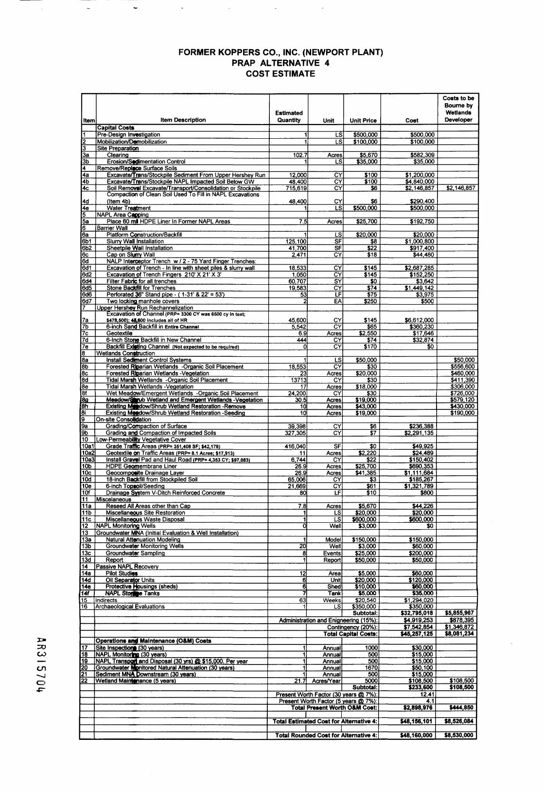
FORMER KOPPERS CO., INC. (NEWPORT PLANT)PRAP ALTERNATIVE 4
COST ESTIMATE
CO
cn^jCD
Item
1233a3b44a4b4c
4d4e55a66a6b16b26c6d6d16d26d46d56d66d77
7a7b7c7d7e88a8b8c8d8e8f3fl8h8i99a9b1010a110a210a310b10c10d10e10f1111a11b11c121313a13b13c13d1414a14d14e14f1516
171819202122
Item DescriptionCapital CostsPre-Design InvestigationMobilization/DemobilizationSite Preparation
ClearingErosion/Sedimentation Control
D /HI lahjk f* f £* •!KciDOvcf KC[HI ce ounace oonsExcavate/ 'nans/Stockpile Sediment From Upper Hershey RunExcavate/Trans/Stockpile NAPL Impacted Soil Below GWSoil Removal Excavate/Transport/Consolidation or StockpileCompaction of Clean Soil Used To Fill in NAPL Excavations(Item 4b)Water Treatment
NAPL Area CappingPlace 60 ml HOPE Liner In Former NAPL Areas
Barrier WallPlatform Construction/BackfillSlurry Wall InstallationSheetpile Wall InstallationCap on Slurry WallNALP Interceptor Trench w / 2 - 75 Yard Finger Trenches:Excavation of Trench - In line with sheet piles & slurry wallExcavation of Trench Fingers 210' X 21' X 3'Filter Fabric for all trenchesStone Backfill for TrenchesPerforated 36" Stand pipe - ( 1-31' & 22' = 53')Two locking manhole covers
Upper Hershey Run RechannelizationExcavation of Channel (PRP= 3300 CY was esoo cy in text;$478,500); 48,600 includes all of HR6-inch Sand Backfill in Entire ChannelGeotextile6-Inch Stone Backfill in New ChannelBackfill Existing Channel (Not expected to be required)
Wetlands ConstructionInstall Sediment Control SystemsForested Riparian Wetlands -Organic Soil PlacementForested Riparian Wetlands -VegetationTidal Marsh Wetlands -Organic Soil PlacementTidal Marsh Wetlands -VegetationWet Meadow/Emergent Wetlands -Organic Soil PlacementMeadow/Shrub Wetland and Emergent Wetlands -VeaetationExisting Mibdow/Shrub Wetland Restoration -RemoveExisting Meadow/Shrub Wetland Restoration -Seeding
On-site ConsolidationGrading/Compaction of SurfaceGrading and Compaction of Impacted Soils
Low-Permeability Vegetative CoverGrade Traffic Areas <PRP= 351,408 SF; $42,178)Geotextile on Traffic Areas IPRP= 8.1 Acres; $17.913>Install Gravel Pad and Haul Road (PRP= 4,353 CY; $97,083)HOPE Geomembrane LinerGeocomposfte Drainage Layer18-inch Backfill from Stockpiled Soil6-inch Topsoil/SeedingDrainage System V-Ditch Reinforced Concrete
MiscelaneousReseed All Areas other than CapMiscellaneous Site RestorationMiscellaneous Waste Disposal
NAPL Monitoring WellsGroundwater MNA (Initial Evaluation & Well Installation)
Natural Attenuation ModelingGroundwater Monitoring WellsGroundwater SamplingReport
Passive NAPL RecoveryPilot StudiesOil Separator UnitsProtective Housings (sheds)NAPL StoflUe Tanks
ndirectsArchaeological Evaluations
Operations anj Maintenance (O&M) CostsSite Inspection! (30 years)MAPL Monitorina (30 years)NAPL Transport and Disposal (30 vrs) Gk $15.000. Per yearGroundwater Monitored Natural Attenuation (30 years)Sediment MNA Downstream (30 years)Wetland Maintenance (5 years)
EstimatedQuantity
11
102.71
12.00048,400
715,619
48,4001
7.5
1125.10041,7002,471
18,5331,050
60.70719,583
532
45,6005,542
6.9444
0
118.553
2313713
1724,200
30.51010
39.398327.305
416.04011
6,74426.926.9
65,00621.669
80
7.8110
12081
12667
631
Unit
LSLS
AcresLS
CYCYCY
CYLS
Acres
LSSFSFCY
CYCYSYCYLFEA
CYCY
AcresCYCY
LSCY
AcresCY
AcresCY
AcresAcresAcres
CYCY
SFAcres
CYAcresAcres
CYCYLF
AcresLSLS
Well
ModelWell
EventsReport
AreaUnit
ShedTank
WeeksLS
Unit Price
$500,000$100.000
$5.670$35.000
$100$100
$6
$6$500.000
$25.700
$20.000$8
$22$18
$145$145
$0$74$75
$250
$145$65
$2.550$74
$170
$50.000$30
$20.000$30
$18,000$30
$19.000143.0001119,000
$6$7
$0$2.220
$22$25.700$41.385
$3$61$10
$5.670$20.000
$600.000$3,000
$150.000$3,000
$25.000$50.000
$5.000! 20.000! 11 0.000$5,000
$20,540$350.000Subtotal:
Administration and Enigneering (15%):
11111
21.7
Contingency (20%):Total Capital Costs:
AnnualAnnualAnnualAnnualAnnual
Acres/Year
1000500500
1670500
5000Subtotal:
Present Worth Factor (30 years @ 7%):Present Worth Factor (5 years @ 7%):
Total Present Worth O&M Cost:
Total Estimated Cost for Alternative 4:
Total Rounded Cost for Alternative 4:
Cost
$500,000$100,000
$582.309$35,000
$1,200,000$4.840.000$2.146.857
$290.400$500.000
$192,750
$20,000$1,000.800
$917.400$44,480
$2.687.285$152,250
$3.642$1.449.142
$3,975$500
$6.612.000$360.230$17,646$32,874
$0
$236.388$2.291.135
$49.925$24.489
$150.402$690.353
$1.111.684$185.267
$1.321.789$800
$44.226$20.000
$600.000$0
$150.000$60,000
$200,000$50.000
$60.000$120.000160,000$35,000
$1 .294,020$350.000
$32,795,018$4.919.253$7.542.854
$45,257,125
! 30.000! 11 5.000S15.0001150.100M5.000
M 08.500! 233,600
12.414.1
$2.898,976
$48,156,101
$48,160,000
Costs to beBourne byWetlandsDeveloper
$2.146,857
$50,000$556.600$460,000$411.390$306.000: 726,000! 1579.1 20$430.000$190.000
$5,855,967$878.395
! 1.346.87218,081,234
! 11 08.500$108,500
$444,850
$8,526,084
$8,530,000

FORMER KOPPERS CO., INC. (NEWPORT PLANT)PRAP ALTERNATIVE 5
COST ESTIMATE
CO
cn—jCDcn
EstimatedItem Item Description Quantity Unit Unit Price Cost
1233a.3b.44a.4b.4c.4d.4e.4f.4g.
4h.4i.4j.4k.566a6b.6c.6d.6e.
6f.77a.
7b.
7c.
7d.88a.8b.8c.8d.8e.99a.9b.9c.10lOa.lOb.1112131414a.
1515a.15b.15c.15d.1617
1819
2021
Capital CostsPre-Design InvestigationMobilization/DemobilizationSite Preparation
ClearingErosion/Sedimentation Control
Remove/Replace Surface SoilsSoil RemovalGeotextileBackfill Placement/Grading (6Topsoil/Seeding (6 inches)Wetland Hydric Soils (6 inches)Wetland Planting1-foot Sand Over Pond (0.7Acres)Soil Under Fire Pond Cap (averagedepth 3')4" Stone Borrow BarrierBackfill for 2' Cover Pond Cap (14")Topsoil/Seeding over Pond Cap 6"
Sheetpile Installation (2.700 LF)Upper Hershey Run Rechannnlization
Excavation over 0.8 acres6-inch Sand Backfill in New ChannelGeoteotile6-inch Stone Backfill in NewBackfill Existing ChannelWetland Restoration in ExistingChannel
Soil Cover Behind Sheetpile WallGeotextileBackfill Placement/Grading (spoilfrom new channel)Backfill Placement/Grading (newbackfill)Compensatory Wetland Creation(1.5:1)
Surficial Sediment RemovalTotal RemovalSediment Backfill (15.1 acres)Marsh 6-inch Hydric Soil (7.6 Acres)Wetland PlantingJ»ater Treatment
In-slu Steam InjectionPilot StudyAsphalt CoverTreatment
Offofte Disposal (LTTD)Soil Disposal (LTTD)Sediment Disposal (LTTD)
NAPE IncinerationMiscellaneous Site RestorationMiscellaneous Waste DisposalNAPL Monitoring
NAPL Monitoring WellsGroundwater MNA (Initial Evaluation &Wefl Installation)Natural Attenuation Modeling .
Groundwater Monitoring WellsGroundwater SamplingReport
IndirectsArcheological Evaluations
11
331
106,00033
2450023,200
1,3001.60
1,165
3388752
1505807
81,000
65006450.80645
6,100
0.80
4.20
6,500
7,100
6.30
67,00060,8696,131
7.601
1111
280,000
73,500101,43030,800
11
52
12081
1001
ESES
AcresLS
CYAcres
CYCYCY
AcresCY
CYCYCYCYSF
CYCY
AcresCYCY
Acres
Acres
CY
CY
Acres
CYCYCY
AcresES
AcresLSLSCY
TonsTonsGAL
LSES
Well
ModelWell
EventsReportWeeks
ES
$300,000$200,000
$5,670$20.000
$6$2,220
$37$56$95
$15,000$30
$37$74$37$56$22
$145$65
$2,550$74
$170
$15,000
$2,220
$60
$38
$45,000
$110$57$92
$15.000$750,000
$1,000,000$3.000,000
$200
$300$300
$1$20,000
$600.000
$3.000
$50,000$3.000
$25.000$50.000$20.540
$350.000Subtotal:
Administration and Engineering (15%)!
Operations and Maintenance (O&M) CostsSite-Inspections (30 yrs)NAML Monitoring (30 yrs)Groandwater Monitored NaturalAttenuation (30 yrs)Welpnd Maintenance (5 yrs)
11
116.30
AnnualAnnual
AnnualAcres
Contingency (20%):Total Capital Costs:
$667$500
$1.667$5.000
Subtotal:Present Worth Factor (30 years @ 7%):Present Worth Factor (5 years @ 7%):
Total Present Worth O&M Cost:I
Total Estimated Cost for Alternative 5:I
Total Rounded Cost for Alternative 5:
$300,000$200.000
$187,110$20,000
$636.000$73,260
$906,500$1,299,200
$123,500$24,000$34,950
$125,356$55,648$55,685$45,192
$1,782,000
$942,500$41,925$2,040
$47,730$1,037,000
$12,000
$9,324
$390,000
$269,800
$283,500
$7,370,000$3.469.533
$564.052$114,000$750,000
$1,000.000$3.000.000
$56.000.000
$22,050,000$30,429.000
$30.800$20.000
$600,000
$156,000
$50,000$60,000
$200,000$50,000
$2.054,000$350,000
$137,221,605$20,583,241$31,560,969
$189,365,815
$20.000$15.000
$50.000$81,500
$166,50012.41
4.1$2,066,265
$191,432,080
$191,000,000

FORMER KOPPERS ./ COMPANY,JNC. SITE /
MAP SOURCEUNITED STATES GEOLOGICAL SURVEY7.5 MINUTE TOPOGRAPHIC QUADRANGLESERIES'NEWARK EAST, DE-(1993) AND•WILMINGTON SOUTH DE-NJ" (1993)
2000
APPROXIMATE SCALE IN FEET
PENN
2000
A I \ J i <J i U u
FORMER KOPPERS COMPANY, INC. NEWPORT SITENEWPORT, DELAWARE
PROPOSED PLAN OF REMEDIAL ACTION
SITE LOCATION MAP
U.S. EPA Region IIIPhiladelphia, PA
FIGURE
1

PROCESS AREADRIP TRACK AREA
2} WOOD STORAGE AREA• ^
3) ORE POND AREA*~s
4) SOUTH PONDS AREA
K AREA
6) REMAINING UPLANDS*~S
7) HERSHEY RUN DRAINAGE AREA«_x
8) CENTRAL DRAINAGE AREAh_^
gTE BOUNDARY
\ICTIANOS BOUNDARY
NOTES:
1. ALL "AREA" BOUNDARIES AREAPPROXIMATE.
2. MAPPING BASED ON DATA PROVIDED BYWOODWARD-CLYDE, APRIL, 1997.
500'
GRAPHIC SCALE
10001
FORMER KOPPERS COMPANY, INC. NEWPORT SITENEWPORT, DELAWARE
PROPOSED PLAN OF REMEDIAL ACTION
SITE PLAN
U.S. EPA Region IIIPhiladelphia, PA
FIGURE

LEGEND:
SITE BOUNDARY
WETLANDS BOUNDARY
APPROXIMATE EXTENT OFSURFICIAL SOIL CONTAININGGREATER THAN 600 mg/kgTOTAL PAHs
NOTES:
1. MAPPING BASED ON DATA PROVIDED BYWOODWARD-CLYDE. APRIL. 1997.
2. APPROXIMATE EXTENT OF SOILCONTAINING GREATER THAN 600 MG/KGTOTAL PAHs DEFINED BY ANALYTICALRESULTS AND VISUAL OBSERVATIONS OFNAPL IN THE TOP 1-FOOT DEPTH INTERVAL
1000*
FORMER KOPPERS COMPANY, INC. NEWPORT SITENEWPORT, DELAWARE
PROPOSED PLAN OF REMEDIAL ACTION
SURFICIAL SOIL CONTAININGGREATER THAN 600 MG/KG
TOTAL PAHsU.S. EPA Region IIIPhiladelphia, PA
FIGURE

LEGEND:
SITE BOUNDARY
WETLANDS BOUNDARY
^H EXTENT OF SUBSURFACE^^ NAPL IN VADOSE ZONE
(1- TO 10-FEET BGS)
EXTENT OF SUBSURFACE^=^ NAPL IN SATURATED ZONE
(10 FEET BGS TO TOP OFFINE-GRAINED LAYER)
NOTES:
1. MAPPING BASED ON DATA PROVIDED BYWOODWARD-CLYDE. APRIL. 1997.
2. EXTENT OF SUBSURFACE NAPL DETERMINEDUSING SITE DATA AND MVS SOFTWARE.
1000'
X.
A R 3 I 5 7 Q 9
FORMER KOPPERS COMPANY, INC. NEWPORT SITENEWPORT, DELAWARE
PROPOSED PLAN OF REMEDIAL ACTION
EXTENT OF SUBSURFACE NAPL
\ U'Sl EPA Re9'on m
Philadelphia, PA
FIGURE

MtrtraV
11-
r1213
10
8
f
^ \ ir U\\ \JI«Estimated Surface and Subsurface Sediment VolumesWeet Central Drainage Ana
Area Length (ft) Wkflh (n)1234567
Total
385 20310 20605 101» 10185 10
SedimentArea ((t3)
7,7006,2006,0501.9001.85037.70041.200
103,000
Hershey Run SedimentArea 1
«7a91011
Total
HeraheyArea
1213141516
Total
.enjth (H) Area (ec)1196 1.81782 1.19770 1.19569 1.111042 1.02699 121
7.53
Run Marsh SedtaMArea (ac)
1480.331.792-223529.33
Area (It3)79.10051.70052.1004850044.30052.600
328.000
uttArea (It7)64,30014.20078.00096.600154,000
407,000
PotentialRemoval Depth (ft
3262722
PotentialRemoval Depth (ft)
4212134
PotentialRemoval Depth (ft)
271131
SurficialVolume (cy)
2902302207069
1.4001.5003,800
SurfictalVolume (cy)
2.9001.9001.9001.8001.8001,900
12,000
SurficialVdume (cy)
2.400530
2.9003.6005.700
15,100
TotalVokirrwKcy)
8804601,301)140480
2,80?3. WC
9.100
TotalVolume (cy)
12.0003.8001,9003.60021.0007.800
50,100
Tot*Volume (cy)
4,8003,70032.60011,0*05.700
57,200
Notes:Sediment Criterion -150 moAfl Total PAHArea delineators are based on total PAH cone ntratora
200 200 Feet
SouthPonds
Sample Summary• Probe NAPL Present• Probe No NAPL Presente Sample Exceeding Criteriae Sample Not Exceeding Criteria
Churchman'sMarsh
r l fRG I r. 7 I 11M n o i o / i u
ee
West Central
Area
Sample Nomenclature:
SD-##-HR Hershey Run Sediment
SD-##-HRM Hershey Run Marsh SedimentSample (from drainage channels)
SL-##-HRM Hershey Run Marsh Soil Sample
SD-##-WC West Central Marsh SedimentSample (from channel or drainage way)
SD-##-WCM West Central Marsh SedimentSample (outside of drainage ways)
FORMER KOPPERS COMPANY, INC. NEWPORT SITENEWPORT, DELAWARE
PROPOSED PLAN OF REMEDIAL ACTION
HERSHEY RUN MARSH AND WESTCENTRAL MARSH VOLUME
JJ> U.S. EPA Region IIIcv Philadelphia, PAFIGURE

-NAPL MONITORED AND PASSIVELYREMOVED BEHIND SHEET PILEWALL FROM SATURATED NAPLZONE AND INCINERATED OFFSITE
POWER \LINES -S \
K AREASEDIMENT
.•WALLjFROM SATURAZONE AND INCINERATED IDFFSt
WEST CENTRADRAINAGE AR
\ \ .CENAL/ /\ \DRAINAG
Churchman'sMarsh
LEGEND:
SITE BOUNDARY
WETLANDS BOUNDARY
SHEETPILE
SEDIMENT TO BE CAPPED
SURFACE SOIL COVERED
WITH GEOTEXTILE AND 2
FEET OF SOIL
MONITORED NATURAL
RECOVERY OF SEDIMENTS
SATURATED ZONE NAPLAREA
1. MAPPING BASED ON DATA PROVIDEDBY WOODWARD-CLYDE. APRIL, 1997.
1000'
FORMER KOPPERS COMPANY, INC. NEWPORT SITENEWPORT, DELAWARE
PROPOSED PLAN OF REMEDIAL ACTION
ALTERNATIVE 2
\ \
* U.S. EPA Region IIIPhiladelphia, PA
FIGURE

WEST CENTRADRAINAGE
LEGEND:
SITE BOUNDARY
WETLANDS BOUNDARY
SHEET PILE
ONSITE CONSOLIDATIONAREA
POND SEDIMENT TO BECAPPED
GEOTEXTILE WITH SOILCOVER
SURFACE SOILEXCAVATION/BACKFILLAREA
SATURATED ZONENAPL AREA. PASSIVENAPL RECOVERY
12 INCH REMOVAL/FILL
18 INCH REMOVAL/F1LL
24 INCH REMOVAL/CAP
30 INCH REMOVAL/CAP
1. MAPPING BASED ON DATA PROVIDEDBY WOODWARD-CLYDE, APRIL, 1997.
500'
GRAPHIC SCALE
1000'
FORMER KOPPERS COMPANY, INC. NEWPORT SITENEWPORT, DELAWARE
PROPOSED PLAN OF REMEDIAL ACTION
ALTERNATIVE 3
i U.S. EPA Region IIIPhiladelphia, PA
FIGURE

NEW CHANNEL TO BECONSTRUCTED INMARSH AREA
HYDRIC SOIL (6")
EXISTING CHANNELAND MARSH AREATO BE BACKFILLED
EXISTING GRADE-FIRE POND TOBE CAPPED
r-2' REMOVAL/BACKFILL AREA
TOPSOIL (6")
SANDBACKFILL SAND LAYER
' - //\/1' REACTIVE SOIL LAYER<
1' REMOVAL/BACKFILL AREA
ATIVEMATERIAL/POTENTIAL
NAPLBARRIER WALL(30' DEPTH)
SAND BACKFILL
NATIVE MATERIAL
100 200 300 400 500 600 700 800 900
NOTE:1. VERTICAL EXAGGERATIONUSED FOR ILLUSTRATION(N.T.S.).
80' 160'
APPROXIMATE GRAPHIC SCALE
1000
LEGEND:
_._ SITE BOUNDARY
WETLANDS BOUNDARY
„ SHEET PILE
ONSITE CONSOLIDATIONAREA
POND SEDIMENT TO BECAPPED
GEOTEXTILE WITH SOILCOVER
SURFACE SOILEXCAVATION/BACKFILLAREA
SATURATED ZONE NAPLAREA
12 INCH REMOVAL/FILL
18 INCH REMOVAL/FILL
24 INCH REMOVAL/FILL
30 INCH REMOVAL/CAP
NOTE:
1. MAPPING BASED ON DATA PROVIDEDBY WOODWARD-CLYDE. APRIL, 1997.
200*
GRAPHIC SCALE
400'
FORMER KOPPERS COMPANY, INC. NEWPORT SITENEWPORT, DELAWARE
PROPOSED PLAN OF REMEDIAL ACTION
CONCEPTUAL CROSS-SECTIONFOR RECHANNELIZATION
g\ U.S. EPA Region III&J Philadelphia, PA
FIGURE
8
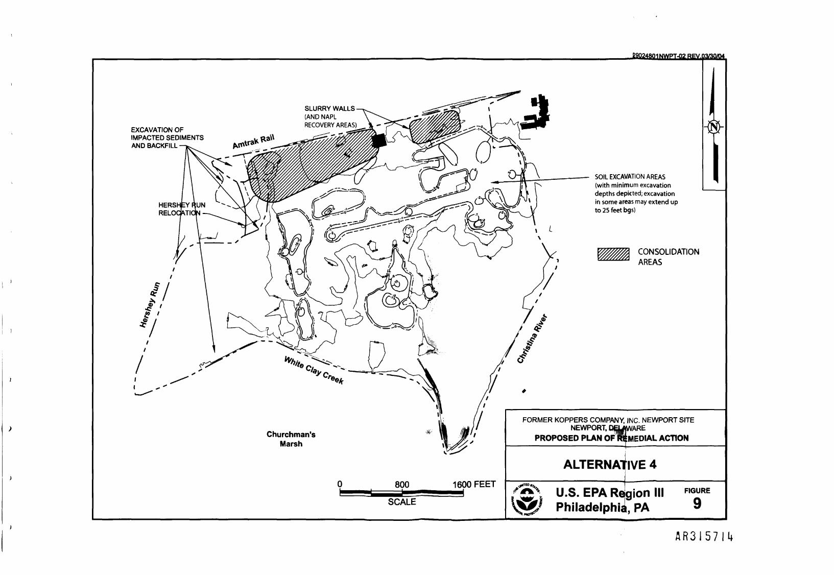
-19024801NWPT-02 REV.03/30/D4
EXCAVATION OFIMPACTED SEDIMENTSAND BACKFILL -
SLURRY WALLS(AND NAPLRECOVERY AREAS)
Churchman'sMarsh
800aS -
SCALE
1600 FEET
SOIL EXCAVATION AREAS(with minimum excavationdepths depicted; excavationin some areas may extend upto 25 feet bgs)
CONSOLIDATION
AREAS
FORMER KOPPERS COMPANY, INC. NEWPORT SITENEWPORT, ENajjWARE
PROPOSED PLAN OF REMEDIAL ACTION
ALTERNATIVE 4
U.S. EPA RdgionPhiladelphia, PA
FIGURE
9
A R 3 I 5 7 I I *

LEGEND:
—._ SITE BOUNDARY
WETLANDS BOUNDARY
---- SHEET PILE
POND SEDIMENT
GEOTEXTILE WITH SOIL COVER
SURFACE SOILEXCAVATION /BACKFILL AREA
IN-SITU STEAMINJECTION AREA
1' DEPTH REMOVALAND BACKFILL
2' DEPTH REMOVALAND BACKFILL
3' DEPTH REMOVALAND BACKFILL
4' DEPTH REMOVALAND BACKFILL
6' DEPTH REMOVALAND BACKFILL
7' DEPTH REMOVALAND BACKFILL
11" DEPTH REMOVALAND BACKFILL
13' DEPTH REMOVALAND BACKFILL
FORMER KOPPERS COMPANY, INC. NEWPORT SITENEWPORT, DELAWARE
PROPOSED PLAN OF REMEDIAL ACTION
NOTES:
1. MAPPING BASED ON DATA PROVIDED BY WOODWARD-CLYDE. APRIL. 1997.
ALTERNATIVE 5
'C i U>S> EPA Re9'on
Philadelphia, PA
FIGURE
10
CSTAG SITE BRIEFING
FOR THE
FORMER KOPPERS (NEWPORT PLANT) SITENEWPORT, DELAWARE
MEETING: May 12-13, 2004
A R 3 I 5 7 I 6

CSTAG SITE BRIEFING - Koppers (Newport, DE)May 2004
SITE BACKGROUND
The Former Koppers (Newport Plant) Co., Inc. Superfund Site is over 300 acres in size, and is located onthe edge of the town of Newport, Delaware. The site is comprised of 160 upland acres and approximately136 acres of wetlands. Grasses and shrubby vegetation dominate the northern half of the Site. Themajority of the southern half consists of tidal wetlands, but forested areas occur in the southern uplandsand along the upland/wetland boundary.
Ecological risk has been found to be very significant at the Site, particularly in aquatic and wetlandhabitats. As discussed in greater detail in this package, significant mortality was encountered in site-specific toxicity tests performed using contaminated soils and sediments from the Site.
For detailed Site information, including background, history, nature and extent of contamination, anddetailed risk information, please refer to the appropriate sections in the Draft Proposed Remedial ActionPlan (PRAP) included in this package.
RISK MANAGEMENT PRINCIPLES
1. Control Sources Early.
A. Briefly identify all significant continuing sources of sediment contamination at the site.For each continuing source, briefly indicate source control actions being taken or to betaken, the expected time to complete these actions, who will undertake them, and howcontinuing sources are being monitored.
The continuing source of the PAHs and NAPL contamination of the sediments is the ongoingdischarge of liquid creosote in the vicinity of the Fire Pond and the South Ponds to the HersheyRun channel and Western Central Marsh sediments, respectively. In addition, creosote NAPLexists in sediments throughout the Hershey Run channel downstream of the Fire Pond area(Lower Hershey Run). The final remedy proposed for the contaminated sediments is to cease thiscontinuing discharge through the construction of a subsurface barrier wall around the large area ofthe worst subsurface NAPL contamination, with passive NAPL recovery to be conducted usingtrenches inside of the barrier wall. In addition, the Preferred Alternative will then consolidate all ofthe contaminated material (to the extent practicable) outside of the barrier wall into a containmentarea with an impermeable cap, covering the foot print of the area encompassed by the barrierwall. In this manner, all sources of sediment contamination will be completely contained, withconstruction expected to be complete in approximately 2-3 construction seasons (2-3 years).Construction of the remedy will be undertaken by the Potentially Responsible Parties (PRPs) forthe Site, with oversight by EPA and the State. Once the remedy is complete, NAPL recovery andground water and sediment monitoring will be conducted to ensure the effectiveness of the barrierwall.
B. Where there is uncertainty about the timing or effectiveness of source control actions,briefly indicate (1) how the potential for recontamination-has been considered in theselection or development of the proposed sediment remedy, and (2) whether theproposed sediment remedy is expected to be beneficial if source control is noteffective or not complete by the time the proposed sediment remedy is planned to beimplemented.
Under the proposed Preferred Alternative, there is a very low degree of uncertainty regardingtiming or effectiveness. While the exact distribution of NAPL in the subsurface is often somewhatuncertain, the nature of creosote NAPL is such that containment is both simple to achieve andeffective.
A R 3 I 5 7 I 7

CSTAG SITE BRIEFING - Koppers (Newport, DE)May 2004
(1) In order to prevent the recontamination of sediments, the consolidation of contaminatedsediments will not occur until after the subsurface barrier wall, which will provide source control, iscompleted in the vicinity of the wetlands. Delineation of subsurface NAPL will be conductedduring the Remedial Design phase, in order to determine the optimal location and configuration ofthe subsurface barrier wall. Following installation of the barrier wall, consolidation ofcontaminated soils and sediments outside of the barrier wall will begin. Excavation for thisconsolidation is relatively simple, in that creosote NAPL is easily identified both visually and byodor; post-excavation cleanup levels will be confirmed through analysis.
(2) Since the proposed sediment remedy is to consolidate contaminated sediments into acontainment area located inside of the barrier wall, the sediment remedy necessarily follows theimplementation of source control in the construction sequence. Therefore, the proposed sedimentremedy of consolidation and containment is expected to be effective and beneficial because itrequires that source control be implemented first.
2. Involve the Community Early and Often.
A. Briefly describe the role of the community in the RI/FS or EE/CA and the mechanismsthat were used to solicit effective involvement of a variety of community members insediment-related issues.
Community involvement, while a priority for this site, has not revealed a high degree of communityinterest to date. Most recently, a fact sheet summarizing the Remedial Investigation and informingthe public about the soon-upcoming comment period and Proposed Plan was distributed duringthe week of August 18,2003. Numerous meetings have been held through the past year,coordinating the involvement and interests of various stake holders at the site. Local and Stateofficials have been kept informed of progress at the Site. The Wilmington News Journal, anewspaper with state-wide daily distribution, has reported on matters that have included mentionof the Site several times in the past year. During the upcoming public comment period, a publicmeeting will be held to explain contamination and remediation issues at the site, the process forinvestigating contamination, risk, evaluating remedial options, and selecting effective remedies, aswell as to introduce and explain EPA's preferred alternative for the remediation of the Site. Inaddition, EPA will be taking verbal and written comments submitted by the public about the PRAP.
B. Briefly describe how local societal and cultural practices were considered in (1) thehuman health risk assessment (e.g., local recreational use of the water body, localfishing practices) and (2) the selection or development of the proposed remedy (e.g.,current and future uses of the water body).
Societal and cultural practices have been considered in a number of ways in the human healthrisk assessment, ecological risk assessment, and in the feasibility study.
(1.) A human health risk assessment has been completed for the site assessing both current andfuture risk scenarios at the Site. These included assessing risk to trespassers crossing throughthe Site wetlands, and also involved collecting fish tissue samples to address issues concerningthe potential consumption of fish (even though there was and still remains an existing advisory onfish consumption in the area of the Site due to widespread PCB contamination in the ChristinaRiver). The Ecological Risk Assessment attempted to determine impacts to the soil and sedimentcommunities and the potential for impacts that would cascade up the food chain. Thecontaminants of concern, PAHs, are not "bio-accumulators" and are thus not expected to pose arisk to fish consumption across the bay for recreational or subsistence uses (as investigated in thefish tissue analysis).
A R 3 I 5 7 I 8

CSTAG SITE BRIEFING - Koppers (Newport, DE)May 2004
(2.) In the development of the proposed remedy, evidence suggesting the presence of boats,hunters, and anglers in Hershey Run was considered in weighing the benefits of excavating andconsolidating sediments from the Lower Hershey Run channel against the costs, both monetaryand ecological, in obtaining access for the excavation of these sediments by traversing anexpanse of relatively unaffected wetlands. In addition, the expected continued recreational use ofthe adjacent waterways was also considered. In the proposed remedy, no contamination will beleft in the sediments of the Hershey Run channel (or in the surrounding marsh), and thus there willno longer exist the risks of exposure or of releasing creosote NAPL or contaminated sedimentsfrom the Site by the potential disturbance of wading hunters or anglers, or by prop wash fromboats.
C. Briefly describe the major ways the proposed sediment remedy is expected to affectthe local community during remedy implementation.
Implementation of any remediation at the Site could have some effect on the local community. IfSite sediments were dredged/excavated and treated off-site, a very significant number of truckswould have to transport that waste through the adjacent chemical plant, and then through localroads. In addition, members of the local community that use boats on the Christina River or WhiteClay Creek, will certainly notice any dredging activities at the Site, and possibly raise concerns asto the potential sediment or contaminant load to the river and potential impacts to recreationalfishing or hunting (several duck blinds have been noted in the area). Measures that will be takento prevent impacts to off-site waterways will be clearly communicated to the local communityduring the upcoming public comment period. Although the proposed remedy will result in a short-term disruption to Hershey Run, it is the best remedy in that it will result in the fewest impacts tothe surrounding community while providing the most effective reduction of risk to the aquatic andwetland habitats. In addition, the proposed remedy has the lowest risk that contamination couldbe later released from the Site.
D. What is the expected level of community support for the proposed sediment remedy?Briefly identify any aspects that are expected to be of great concern and how theexpected concerns have been addressed or considered.
Community involvement has been a priority at this Site, but there has not been any significantevidence of community interest seen to date. Whether that will remain the case, or whether theapparent lack of interest is simply due to the fact that the Proposed Plan has not yet beenreleased, EPA will continue to coordinate the public outreach effort, including public meetings andfact sheets, with state and local officials.
3. Coordinate with States, Local Governments, Tribes, and Natural Resource Trustees.
A. Briefly describe the major sediment-related issues in which State and localgovernments have been involved at the site. Briefly identify any aspects that areexpected to be of great concern and how the expected concern has been addressed orconsidered.
EPA has closely coordinated efforts at the Site with State officials, and has met with Sitestakeholders on numerous occasions throughout the past year, exchanging information andseeking input on the alternatives for clean-up of the Site, as well as (in recent months) on EPA'spreferred alternative. As a direct result of these meetings, the PRPs for the Site created andsubmitted an addendum to the Feasibility Study (FS) outlining a new alternative that became thebasis for EPA's proposed remedy. Under this new alternative, a maximum acreage of newwetlands would be created in the existing uplands of the Site for wetlands banking purposes,
4
A R 3 I 5 7 I 9

CSTAG SITE BRIEFING - Koppers (Newport, DE)May 2004
specifically intended to provide wetlands to mitigate upcoming highway and other roadwork byDelware DOT (DelDOT) in the area. The State has expressed support for aggressiveconsolidation in order to minimize the possibility that recontamination could occur in eitherexisting, restored or created wetlands at the Site.
B. For sites that include water bodies where Total Maximum Daily Loads (TMDLs) arebeing or have been developed, briefly describe the coordination efforts with the Stateand with EPA's water program. Identify any aspects of the TMDL that were consideredin selection of the proposed remedy.
TMDLs have been developed for zinc in the Christina River, which is adjacent to the Site. Whilezinc is present in the sediments of Hershey Run, no activities conducted at the Site involved theuse of zinc. The zinc in the Hershey Run sediments is thought to have been deposited by tidaltransport upstream. The ecological risk assessment found that zinc is likely contributing someecological risk at the Site, but that additional risk was not quantifiable due to the high levels ofPAHs consistently present. Where sediments will be excavated and consolidated because of highlevels of PAHs, zinc that is also present will be contained along with those sediments. Measuresthat will be taken to prevent the liberation of any PAH-contaminated sediment in the water columnto adjacent waterways will also prevent zinc-contaminated sediment from escaping from the Site.The proposed remedy, in consolidating and containing the PAH-contaminated sediment, has theadded benefit of also containing zinc which is co-located in some of those sediments.
C. If there are Tribal interests at the site, briefly identify any aspects of the proposedsediment remedy that are expected to be of great concern and how the expectedconcern has been addressed or considered.
There are currently no known Tribal interests at this Site.
D. If there are Natural Resource Trustee interests at the site, briefly identify the majorareas of coordination related to the sediment response action. Are Trustee restorationactivities expected concurrent with or following the Superfund action?
Meetings were held with Site stakeholders, including representatives of the Natural ResourceTrustees, on numerous occasions throughout the RI and FS process, particularly in the past year.The U.S. Fish and Wildlife Service has conducted fish tissue sampling in Hershey Run and WhiteClay Creek as a part of an ongoing Natural Resource Damages Assessment and part of a localwatershed study. It is expected that the Trustees will remain closely involved with the remediationof the Site, however, it is not clear at this time as to whether Trustee restoration activies will occurconcurrently with the Remedial Action at the Site.
4. Develop and Refine a Conceptual Site Model that Considers Sediment Stability.
A. Attach a copy of the conceptual site model (e.g, one or more diagrams or charts, notnumerical models) for sediment which identifies contaminant sources, contaminants ofconcern, affected media, existing and potential exposure pathways, and human andecological receptors that may be threatened.
Several figures have been developed for this site to illustrate the conceptual site model, and canbe found in the draft PRAP included in this package.
B. Identify the natural and man-made disruptive forces that were considered and how theywere considered when evaluating sediment alternatives. Where appropriate, identifythe intensities or recurrence intervals of the forces, e.g. hurricane rating, flood
5
A R 3 I 5 7 2 0
CSTAG SITE BRIEFING - Koppers (Newport, DE)May 2004
recurrence interval and briefly explain why these intensities or recurrence intervalswere chosen.
The potential for disturbance of and subsequent exposure to the deeper, more contaminatedsediments is high, due to the shallow depth (approximately 0-6 ft) of the overlying water. Activitieswhich could disturb sediments include:
• bioturbation from benthic macroinvertebrates• anthropogenic disturbance from wading, paddles, boats running aground or boat props• the twice-daily flushing of the tide, including the complete reversal of flow associated with
the incoming tide• heavy storms and extreme tidal events, and• annual ice movement during the spring thaw.
As described in the Remediation Investigation Report (BBL, 2002) a sediment settling studyconducted with sediments from the site indicated that a large fraction of the suspended sedimentsdid not settle out of the water within a 10 day period. After the water column was treated withflocculent to chemically enhance settlement, clear water samples were collected and analyzed forPAHs. Results of the analysis indicated that PAHs in the water column exceeded secondaryacute and chronic water quality concentrations. This contaminant release would not be containedwith silt curtains. As a result, this information will be considered further during the RemedialDesign in order to best prevent releases from the Site during construction. The RemedialInvestigation also included a study of sediment depositional rates, and found that from 1/3 to 1/2of an inch of sediment may be deposited per year. However, a visit to the Site quickly reveals thatNAPL in Lower Hershey Run that is already below a foot to several feet of sediment is easily andquickly released through the simple disturbance of wading in the stream. In addition, the wetlandscould not be accurately described as a strictly depositional environment. The proposed remedy isthe best alternative for addressing the risk associated with these disruptive forces, in that allcontaminated sediments will be consolidated into a containment area where none of thesedisruptive forces will be able to disturb them.
5. Use an Iterative Approach in a Risk-Based Framework.
A. Briefly describe the major ways in which an iterative approach was used at the site.(We define "iterative approach" broadly to include approaches that incorporate testingof hypotheses and conclusions and foster re-evaluation as new information isgathered.)
An iterative approach has been used throughout the project to evaluate human and ecologicalrisks including:
• 1995 Phase I RI (with screening level ecological risk assessment)• 1996 Phase II sampling for RI, Human Health and Ecological Risk Assessments• 1997 Ecological Risk Assessment• 2001 Final Ecological Risk Assessment• 2002 - 2003 Supplemental sampling for investigation of NAPL and PAH contamination in the
Hershey Run channel, marsh, and in the Western Central Marsh (as well as NAPL in subsurface)
In 1995 and 1996 the Remedial Investigation conducted sampling to evaluate the extent ofpotential sediment contamination. Samples were collected for numerous contaminants, includingPAH, VOCs, and metals.
In 1996 and 1997 an Ecological Risk Assessment was conducted. The study included further6
A R 3 1 5 7 2 I
CSTAG SITE BRIEFING - Koppers (Newport, DE)May 2004
sediment sampling, chemical and toxicological analyses and comparison to additional sedimentquality guidelines, a benthic population survey, and laboratory toxicity tests with benthic andpelagic species.
In 2002, supplemental sampling was conducted to further evaluate the extent of NAPL and PAHcontamination in the wetlands on-site.
The results of the Human Health Risk Assessment indicated that exposure to the contaminants atthe Site, specifically in ground water, poses unacceptable risks to future industrial workers.Further evaluation of human health risks has been limited, as the ecological risks appear to bedriving clean up goals for the sediments. Cleanup goals, determined with the ERA for the Site,specify 150 mg/kg Total PAHs for sediments (and 600 mg/kg for soils).
B. Briefly describe any early or interim actions planned or implemented at the site thataddress threats from contaminated sediment.
Signs warn potential trespassers of the contamination, though vandalism and trespassing havebeen an ongoing problem.
C. If the proposed sediment remedy will be implemented in phases or is part of a largerphased approach to the site as a whole, briefly describe the phases.
EPA's Preferred Alternative, outlined in the attached draft Proposed Plan, addresses allcontamination at the Site in a final comprehensive remedy.
6. Carefully Evaluate the Assumptions and Uncertainties Associated with Site CharacterizationData and Site Models.
A. Briefly identify the most important continuing uncertainties associated with sitecharacterization data and, where applicable, with qualitative or quantitative models,including input parameters, which were important (1) to the human health and ecologicalrisk assessments and (2) to the evaluation of potential sediment remedies. Briefly explainhow those uncertainties were accounted for (e.g., use of sensitivity analyses or reasonableconservative assumptions.)
Several uncertainties associated with the site characterization are important to the riskassessment and evaluation of potential remedies. These include:• Potential transport of NAPL and associated contaminants from the shallow aquifer to the
deeper groundwater (though this has little bearing on sediments);• Risk impacts from direct exposure to the NAPL in soils or sediments;• Risk impacts from metals which may co-occur with the PAHs (e.g., zinc) could not be fully
determined - only unbounded NOAELs were developed;• Fate and transport and risk impacts of contaminants sorbed to suspended sediments, and any
potential impact to off-site waterways; and,• The precise delineation of contamination in soils and sediments, given the large scale of the
Site, was deferred to the Design stage.
EPA's Preferred Alternative easily accounts for these various sources of uncertainty in that allcontamination would be consolidated and contained, thereby mitigating risks and minimizing therisk of recontamination. In addition, because creosote contamination is relatively easily identifiedby visual inspection and by odor, the typically difficult task of delineating subsurface NAPL isgreatly simplified through the bulk excavation and consolidation of contaminated materials.

CSTAG SITE BRIEFING - Koppers (Newport, DE)May 2004
B. Identify any computer models used in the assessment of the site or evaluation ofsediment alternatives. For each model or model group, indicate whether the model ormodel application was peer-reviewed and if so, briefly indicate whether that review wasinternal or external to EPA.
Three-dimensional models of the Site were created (using Mining Visualization System, or "MVS")to portray the stratigraphy, ground water, surface water and location of subsurface NAPLdistributions. In addition, the 3-D models were used to portray the extent of PAH contamination insediments on Site, particularly to ascertain the distribution of the contamination between channelsand their associated floodplain/marsh deposits. The visualizations were crucial in determining theextent to which NAPL had migrated out beneath the wetlands and channel. These models will bepresented as part of the NRRB presentation for the Site.
7. Select Site-specific, Project-specific, and Sediment-specific Risk Management Approaches thatwill Achieve Risk-based Goals.
A. Briefly list all risk management approaches or alternatives that were evaluated forremediation of contaminated sediment at the site. Where this list does not include someform of each of the three major sediment cleanup methods (i.e., capping, monitored naturalrecovery, dredging, and/or combinations of these), briefly explain why the method was notappropriate for evaluation.
Monitored natural recovery, capping and excavation were all considered for the cleanup ofsediments at the Site. Wood treatment operations at the Site ceased over 30 years ago, butNAPL remains mobile and is easily disturbed in sediments at the Site. Consequently, monitorednatural recovery is not an appropriate option for the cleanup of sediments because risk can not beexpected to be reduced in a reasonable amount of time (as it has not reduced in over 30 yearsalready), even after the implmentation of source control measures to cease the ongoing release ofsubsurface NAPL.
Capping was evaluated in detail, but was not chosen because it would increase operations andmaintenance costs and would still leave the risk of disturbing contaminated sediments through thedisruptive forces outlined in response to Question 4. In addition, capping would first require theexcavation of nearly all of the contaminated sediments in order to accommodate the cap; in mostareas, only 1-2 feet of sediment need to be excavated, but 2 feet would have to be excavated inorder to place a 2-foot cap in their place.
Complete excavation and consolidation of contaminated sediments was chosen because thisremedy provides the highest assurance of containment by removing the affected sediments fromareas in which they would be subject to the aforementioned disruptive forces. In this way, risk willbe reduced in the shortest possible time, and with the highest degree of confidence and long-termeffectiveness.
B. Briefly outline the proposed sediment remedy for the site and how it relates to any othersediment operable units at the site.
EPA's Preferred Alternative for the remediation of NAPL and PAH contaminated sediments at theSite is to excavate those sediments, stabilize them if necessary, and place them in an on-siteconsolidation area, enclosed by a subsurface barrier wall and covered with an impermeable cap.
8. Ensure that Sediment Cleanup Levels are Clearly Tied to Risk Management Goals.
8
A R 3 J 5 7 2 3

CSTAG SITE BRIEFING - Koppers (Newport, DE)May 2004
Briefly summarize the risks associated with contaminated sediment that were identified inthe human health and ecological risk assessments.
Human Health Risks:The Human Health Risk Assessment (HHRA) for the Site did not find significant risk totrespassers associated with sediments at the Site. However, the HHRA was limited in that it didnot provide a risk assessment for direct exposure to the tar NAPLs in the shallow sediments, or fordirect exposure to suspended contaminants. The gross extent and amount of NAPL in thesediments was not clear in the analytical results obtained for the Site in the mid-1990s. Not until2002 was it clear just how widespread the distribution of mobile NAPL was throughout HersheyRun and beneath the surrounding marsh.
Ecological Risks:An ecological risk assessment was conducted to evaluate exposure to both soils and sedimentsfrom the Site. Sediment cleanup objectives have been set at 150 mg/kg total PAHs (TPAH)based on observed impacts to benthic and aquatic organisms. A weight of evidence approachwas used, with many lines of evidence in support of these goals. The specific details are providedin the Ecological Risk section of the attached draft Proposed Plan.
Based on the lines of evidence, there is sufficient information to conclude that the assessmentendpoints listed in the PRAP are at risk from site related contaminants in the sediments and soils.
A. What remedial action objectives (RAOs) or removal objectives were developed toaddress these risks?
Remedial action objectives of 150 mg/kg total PAHs for sediments and 600 mg/kg for soil (150mg/kg where soils will be converted to wetlands) were developed based on the ecological risks.These values appear to be protective of human health exposures as well, based on thecomparison of TPAH and benzo(a)pyrene equivalence risk-based exceedances on a map.
B. Briefly describe the sediment cleanup and action levels, including how they werederived and how they relate to the RAOs or removal objectives.
As described iri greater detail in the attached draft PRAP, EPA has determined that for this Site,based on the results of the risk assessment, a sediment cleanup criteria of 150 mg/kg TPAH(between the NOAEL of 83 and the LOAEL of 198) and a soil cleanup criteria of 600 mg/kg TPAH(between the NOAEL of 587 and the LOAEL of 1,264) are the appropriate levels to provideprotection to the environment. In addition, by comparing maps of TPAH values to those ofbenzo(a)pyrene equivalences ("B(a)P equivalence"), it has been determined that these cleanupcriteria will also be protective of human health for potential future industrial workers andtrespassers. These sediment and soil cleanup criteria represent the RAOs for sediment and soilat the Site.
The 150 mg/kg TPAH value for sediments and seasonally flooded soil is the rounded offgeometric mean of the range of the NOAEL and LOAEL values (82.8 and 197.6). The 600 mg/kgTPAH value (rounded 587) for soils is at the low end of the range because there was lessconfidence in the data set for the terrestrial evaluations (the field data provided less of a gradientand the response data was more variable in nature). In addition, if the soil contamination was leftat much higher levels than in the sediments, there would remain a potential for recontamination.Finally, it was believed in a practical sense that the lines delineating and volumes of soil betweenthe 600 and 1200 values were not significantly different given the way the contamination wasdistributed (that is, that there was a very sharp distinction between nearly no contaminationpresent and very high contamination present).
9
A R 3 I 5 7 2 I *

CSTAG SITE BRIEFING - Koppers (Newport, DE)May 2004
9. Maximize the Effectiveness of Institutional Controls and Recognize their Limitations.
A. Briefly list any institutional controls that are part of the proposed sediment remedy.Describe any plans to maximize their effectiveness (e.g., public education regardingfish consumption advisories).
Under the proposed remedy, the contaminated sediment will be excavated and consolidated intoan on-site containment area. The only Institutional Controls (ICs) that will be required will pertainto the integrity and effectiveness of the containment area; no restrictions are anticipated forHershey Run at the Site once construction of the new channel is complete. Operations andMaintenance (O&M) will include measures to ensure that the new channel remains stable.
B. Briefly describe any plans for on-going monitoring and gathering of information at thesite which may indicate the effectiveness of institutional controls.
Monitoring of the Site will include inspections of the vegetation, wetlands, and the cap over thecontainment area. During inspections of the containment area, it will be determined if the ICs areeffectively protecting the integrity of the cap and containment area.
10. Design Remedies to Minimize Short-term Risks While Achieving Long-Term Protection.
Briefly list the cleanup methods or natural processes to be used to achieve long-termprotection at the site, the length of time expected to achieve RAOs or removal objectives,and how short-term risks of implementing those methods are minimized. Remedy-specificexamples are listed below:
For in-situ capping, list: 1) the physical, chemical, and biological processes that are mostimportant to cap design to ensure long-term protection at this site, and 2) measures thatwill be required to minimize contaminant releases during cap placement, and 3) monitoringof the cap to ensure protectiveness.
For monitored natural recovery, list: 1) the major physical, chemical, and/or biologicalprocesses that will be relied upon to achieve and maintain long-term protection at the site,and 2) any measures that will be required to minimize risks during the recovery period.
For dredging, briefly describe the measures that will be required to minimize releases andshort-term risks during dredging, treatment (if any), and transport. If on-site disposal isplanned, briefly describe the disposal unit and monitoring that will be required to assessprotectiveness.
Briefly list the major expected effects of the proposed remedy on societal and culturalpractices and how this was considered in remedy selection.
The cleanup method that will be implemented to achieve long-term protection at the Site will bethe excavation of sediments with TPAH concentrations exceeding the RAO of 150 mg/kg, followedby consolidation in a containment area that will be covered with an impermeable cap andsurrounded by a subsurface barrier wall. The on-site containment area will be constructed in sucha way as to completely isolate the contaminated sediments. Where the containment area willencompass subsurface NAPL that exists beneath the stream and wetlands, the existing channelwill be rerouted to avoid the containment area. The barrier wall in the wetlands will likely becomprised of sheetpile, with the final determination to be made during the Remedial Design.
10
A R 3 I 5 7 2 5
CSTAG SITE BRIEFING - Koppers (Newport, DE)May 2004
In addition to the subsurface barrier wall, passive NAPL recovery will be used to reduce thevolume of NAPL inside of the containment area. Monitoring to be conducted will include anetwork of sentinel wells located outside of the perimeter of the containment area. These wellswill provide information to assess the effectiveness of the barrier wall in preventing contaminantsfrom migrating into existing or future wetlands. The integrity and function of the cap will bemonitored as well, through O&M procedures that will continue indefinitely.
11. Monitor During and After Sediment Remediation to Assess and Document RemedyEffectiveness.
A. Briefly describe the type of monitoring that will be required to assess contaminantreleases during remedy implementation (i.e., during dredging, during cap placement, orduring the recovery period in the case of monitored natural recovery.)
B. For each medium that has a cleanup level or remedial action objective listed in theanswer to #8A above, briefly describe the type of monitoring (including physical,biological, and chemical monitoring) that will be required to determine whether thelevels and objectives are met, and whether sufficient baseline data are available.Where they are not, briefly indicate plans for additional data collection prior toimplementation of the remedy.
C. Briefly indicate other plans for long term monitoring (e.g., monitoring of long-termsuccess of source control measures, effects of disruptive events, migration of buriedcontaminants, cap integrity)
A. During the implementation of the remedy, extensive measures will have to be taken to isolateHershey Run from tidal influence, prevent contaminated sediments, NAPL or dredge water fromescaping Hershey Run, and to divert surface water drainage which would otherwise enter HersheyRun from upstream. While the specific measures that will be required will be determined duringthe Remedial Design, these measures may include large berms to isolate Hershey Run fromWhite Clay Creek, oil booms to surround dredging operations, settling basins, silt curtains andfiltration to the extent necessary.
B. Once construction is complete, all sediments outside of the containment area will be expectedto meet the cleanup criteria (150 mg/kg TPAH). If there exists any undetected residual levels ofTPAH in sediments following cleanup, it can be reasonably expected that natural attenuationprocesses would mitigate these minor hotspots, since source areas will have been controlled.
C. Long term ground water monitoring will be conducted to ensure that the subsurface barrier wallis effectively containing NAPL at the Site, preventing creosote constituents from migrating intoexisting or created wetlands adjacent to the containment area. In addition, periodic monitoring willbe conducted to ensure the success of mitigated wetlands, the integrity of the impermeable cap,and the condition of sediments in the remediated wetlands and channel.
11
A R 3 1 5 7 2 6

Transmitted via Electronic Mail and Federal Express
March 31,2004
Matthew T. MellonRemedial Project Manager (RPM)U.S. EPA Region ffl (MaUcode 3HS23)1650 Arch StreetPhiladelphia, PA 19103-2029
RE: Comments For Inclusion In NRRB PackageFormer Koppers Co. Inc. Newport Site, Newport, Delaware
Dear Mr. Mellon:
This letter presents joint comments of Beazer East, Inc. (Beazer) and E.I. du Pont de Nemours andCompany (DuPont) for consideration by the U. S. Environmental Protection Agency's (USEPA's)National Remedy Review Board (NRRB) at its review of the remedy proposed for the Former KoppersCompany Newport, Delaware Site (Site) scheduled for May 10, 2004. Based on our discussions withUSEPA, we understand the NRRB will be reviewing the selection of potential variations of Alternative10 as the preferred remedy. Please note that neither Beazer nor DuPont have been provided withinformation as to the specific nature and extent of those variations being recommended by USEPA, whencompared to the scope of Alternative 10 proposed in the Addendum to the Feasibility Study Report (TRC,October 2003). Consequently, while this letter expresses our general support for Alternative 10, it isdifficult for us to cite specific arguments regarding USEPA's recommended variations, when these arenot known.
Based on a review of the wide body of information available on the Site, both Beazer and DuPont supportthe selection of Alternative 10 as the preferred remedial alternative. Alternative 10 represents a remedythat satisfies applicable public health and environmental protection objectives and provides an importantlink between the selected remedy and stakeholder needs related to future land use. Our support ispredicated on a number of significant assumptions that are discussed in this letter, including the final useof the site for wetlands banking by other parties and that the projected costs of remediation are realisticand accurate based on currently known site conditions. For example, should the final land use for the sitenot involve a scenario incorporating wetlands banking, alterations or contingent approaches to Alternative10 may be desirable to accommodate such changes.
It should be noted that Alternative 10, in its present configuration, was developed at USEPA's request toaccommodate wetlands banking for the Delaware Department of Transportation (DelDOT). In the eventthat the land use is modified (i.e., DelDOT does not desire the site for wetlands banking), such extensiveupland excavation is not necessary to achieve the Site Remedial Action Objectives (RAOs), and Beazershould not be required to implement a remedy and incur associated costs to support a future Site-use thatno longer applies. Beazer is in the process of purchasing the site from DuPont and plans to implement theremedy by itself. Toward this end, Beazer and DuPont do hereby respectfully request that USEPA andNRRB include a certain amount of design flexibility with respect to final land use when structuring theROD.
&R315727

Matthew MellonMarch 31,2004
Page 2 of 9
The remainder of the letter is organized as follows:
• Background - This section discusses the rationale leading to development and selection ofAlternative 10 in the FS.
• Key USEPA Technical Issues - This section outlines a series of technical arguments related tokey issues that have been a continuing topic of discussion between USEPA and the PRPs sincethe original FS was issued, and which may represent USEPA-recommended variations toAlternative 10 to which Beazer and DuPont take exception.
• Other Technical Considerations - This section lists site-specific areas of technical uncertaintythat require refinement prior to the completion of the Remedial Design (RD), but should beconsidered when selecting a site remedy and drafting the Proposed Remedial Action Plan (PRAP)and Record of Decision (ROD).
• Concluding Remarks - This section summarizes our requests of USEPA and NRRB.
Background
The Draft Final FS Report for the Site was submitted to the USEPA in April 2003. The following media-specific RAOs were established for the site.
Sediment RAOs• Minimize the potential for ecological exposure to sediment containing greater than 150 mg/kg
total PAHs, to the extent practicable.• Minimize disturbance to the existing wetland plant community, to the extent practicable.
Soil RAOs• Minimize the potential for ecological exposure to soil containing greater than 600 mg/kg total
PAHs, defined by analytical results and visual observations of NAPL located at or near the soilsurface (i.e., top 1 ft).
• Minimize disturbance to the existing terrestrial plant community.• Minimize the potential for future exposure of industrial workers to surface soils containing NAPL
or other COCs, to the extent practicable.
NAPL RAOs• Minimize potential exposure of human receptors to groundwater containing NAPL-related
constituents, to the extent practicable.• Control NAPL migration off Site through transport via groundwater and/or discharge to surface
water.• Reduce NAPL present as continuing source to groundwater that is associated with potential
adverse human health risk, to the extent practicable.• Minimize the potential to impact the Potomac aquifer.
The majority of the RAOs for sediment and soils were developed based on the results of the ecologicalrisk assessment. However, it should be noted that the NAPL RAOs were added by USEPA, even thoughno data exist that suggest that these RAOs are not currently being achieved at the site.
Based on these RAOs, nine remedial alternatives and several variations of these alternatives weredeveloped and evaluated in the FS, leading to a recommendation of Alternative 4a, which included thefollowing primary components:
U:CSC<M \NRRB 105041550.rtf
A R 3 1 5 7 2 8

Matthew MellonMarch 31,2004
Page 3 of 9
• Removal of soils and sediments from across the Site (an estimated 112,000 cy impacted abovecriteria) as necessary to achieve the RAOs;
• Consolidation of excavated soil and sediment into one on-site consolidation area;• Installation of engineered covers over the Fire Pond, South Pond and K Area;• Installation of subsurface barrier walls downgradient of the Fire Pond and South Pond Areas;• Rechannelization of the upper reach of Hershey Run;• Passive NAPL recovery in upland areas, if practicable.
The total estimated cost of Alternative 4a, including long-term operation and maintenance, was $36.5million.
Subsequent to submittal of the FS, interest in the site as a wetlands bank began to take hold to serve theneeds of the State of Delaware and other local stakeholders for mitigation offsets. The demand forwetlands offsets is increasing in the Christina River watershed as construction projects and other activitiesthat impact or destroy wetlands habitat continue to be pursued. Of primary note is the planned expansionof Interstate 95 in the immediate vicinity of the Site, which will impact wetlands in the Churchman'sMarsh area. DelDOT has expressed in writing both a need for wetlands offsets and a determination thatthe Site is suitable for creating a local wetlands bank to provide these offsets.
In response to this land use interest, Beazer and DuPont presented an integrated site remediation andwetlands development concept to the USEPA, the State of Delaware, and other stakeholders and involvedcontractors on September 4,2003. As a result, USEPA requested that Beazer prepare an addendum to theoriginal FS to provide for a more complete evaluation of the integrated approach. The purpose of theAddendum to the Feasibility Study Report (TRC, October 2003) was to present and comparativelyevaluate this additional remedial alternative for the Site in conjunction with the nine alternatives of theoriginal FS. The new alternative was developed to maximize reuse of the Site to promote both theUSEPA's Superfund Revitalization Initiative and the needs of various governmental and privatestakeholders. Implementation of Alternative 10, as presented in the Addendum to the Feasibility Study,would create approximately 59 acres of new, diverse wetland areas. Because access constraints limitfuture industrial or commercial development options for the Site, jurisdictional wetlands were considereda viable future land use for the property.
Alternative 10, referred to as the Site Redevelopment Alternative, would achieve the integration ofwetlands creation with the excavation of soil and sediment across broad areas of the Site. Surface andsubsurface soils within the planned wetland areas would be excavated to an appropriate depth forwetlands construction, or deeper if necessary to achieve the required soil cleanup levels. The areasdesignated for the creation of new wetlands are primarily those areas south of the former process area thatwere historically cleared and utilized for the storage of treated and untreated wood products.Consideration would be given to the maintenance of the remaining forested upland areas for ecologicaldiversity and continuity with existing wetland areas. To promote the concept of a land use drivenscenario, the following goals were considered in the Addendum to the Feasibility Study:
Sediment• Maximize the areal extent of newly-created permanent wetlands
Soil• Achieve a balance between the areal extent of a viable terrestrial habitat and the development of,
newly-created wetlands.
U:\CSC04\NRRBI05041550.rtf
A R 3 I 5 7 2 9

Matthew MellonMarch 31, 2004
Page 4 of9
Alternative 10 consists of the following primary components:
• Removal of soils and sediments from across the Site (an estimated 864,000 cy of impacted andunimpacted material) as necessary to achieve the RAOs and support wetland creation;
• Consolidation of excavated soil and sediment into two on-site consolidation areas;• Installation of a subsurface barrier wall around the consolidation areas;• Creation of approximately 59 acres of wetlands, and restoration of an additional 10 acres of
wetlands;• Rechannelization of the upper reach of Hershey Run; and• Monitored natural recovery in the lower reaches of Hershey Run.
The primary differences between Alternative 4A and 10 include:
• Approximately 864,000 cubic yards (cy) of soil and sediment are proposed for excavation underAlternative 10, compared to approximately 112,000 cubic yards under Alternative 4A, adifference of approximately 752,000 cy. For Alternative 10, 327300 cubic yards would beplaced in the consolidation areas, 423300 cubic yards of soil would be stockpiled for potentialfuture use offsite and 113,400 cubic yards used on-site as backfill/cover. While RAOs would besubstantively achieved through implementation of both alternatives, the increased removalvolume associated with Alternative 10 is necessary only to support site use as a wetlands bank. Itshould be furthermore noted, that the relative amounts of soil to be pbced in the consolidationarea and the amount to be stockpiled are approximations at this stage, and would need to berefined by more field data collection during the Remedial Design Process.
• Alternative 4A proposed the removal and capping/covering of surficial sediments in LowerHershey Run, while Alternative 10 proposes monitored natural recovery (MNR). As described inmore detail below, the proposed change to MNR in Alternative 10 is supported by: 1) continuedreduction in surficial sediment PAH concentrations (following source control implementation)due to PAH weathering and clean sediment deposition (PAH burial); and 2) recognition thatwetland banking is a primary driver of Alternative 10, and removal of sediment from LowerHershey Run would result in significant wetland and aquatic habitat destruction that will notlikely be necessary once the PAH sources to Hershey Run are mitigated.
• The on-site consolidation area proposed for Alternative 10 has been relocated to the most highlyimpacted area of the site, and expanded to accommodate the larger volume of removed soil.Similar to Alternative 4A, on-site consolidation avoids the operational, security and risk issuesassociated with off-site transport of thousands of truckloads of impacted material through theadjacent, operating Ciba facility and along public roadways.
• Passive NAPL collection was a recommended component of Alternative 4A, but not Alternative10. Passive NAPL collection was not specified in Alternative 10, because: 1) most of lie areaconsidered for passive NAPL collection in Alternative 4A would be excavated in Alternative 10,and placed in the onsite consolidation area; 2) attempts at recovering NAPL on-site in the pasthave been largely unsuccessful; and 3) the subsurface control barrier proposed to be constructedaround the on-site consolidation area would contain any NAPL within the containment area.
U:KSC04 \NRRB105041550rtf
A R 3 I 5 7 3 0

Matthew MellonMarch 31,2004
Page 5 of 9
• The estimated cost to implement Alternative 4A is $36.5 million. The estimated cost toimplement Alternative 10 is $33.5 million without wetland construction costs and $38.5 millionwith wetland construction costs. If costs to remove/cap sediments in Lower Hershey Run andpassive NAPL collection (consistent with that described as components of Alternative 4A) wereadded to Alternative 10, the estimated cost would be approximately $44 million.
Kev USEPA Technical Issues
Three key technical issues have arisen out of USEPA's review of the Addendum to the Feasibility StudyReport:
1. Remediation of the Lower Reaches of Hershey Run;2. NAPL Recovery; and3. Target Soil Excavation Volumes Appropriate for Different End Uses of the Property
These issues, and our recommendations for resolving them, are discussed in detail below.
1. Remediation of the Lower Reaches of Hershey Run: Alternative 10, as formulated andrecommended in the Addendum to the Feasibility Study Report, does not include activeremediation of these sediments, but rather relies on source elimination, monitored naturalattenuation, and clean sediment deposition to reduce the concentration of PAHs in the upper footof sediment over time. Any active remediation, such as capping or excavation, would beinherently invasive and likely to cause greater environmental impact than leaving the material inplace. In the short term, sediment removal would destroy a significant portion of the Hershey Runbenthic community, which was shown during the RI to have a high level of species richness (i.e.,greater than 15 taxa). Adverse environmental impacts would also occur due to constructiondisturbance in both the creek bed and adjacent areas for the purposes of building access roads,with the associated damage to existing wetlands. Under Alternative 10, improvements would beachieved without the associated short-term increases in risk. Additionally, a period of recoverywould be required for the ecosystems in the area to reestablish themselves under a sedimentremoval alternative. Within this same period of time, the natural processes active in the lowerHershey Run would also result in a long-term reduction in risk under Alternative 10, asconstituent levels would continue to decrease as existing sources of NAPL in the upper reaches ofHershey Run are removed or controlled.
The presence of NAPL noted during the investigation was generally limited to the centerline ofthe channel in the lower portion of Hershey Run and the majority of NAPL observations weredeeper than the 0- to 6- inch depth interval. Geochronologic-dating information collected fromthe Hershey Run Drainage Area indicates that deposition of new material is occurring at a ratebetween 0.24 and 0.36 inches per year. As such, the drainage basin is considered to be a netsediment deposition area, with clean sediment (assuming upland source control is completed asindicated in Alternative 10) gradually providing a cover for impacted sediments (Section 3.4,Remedial Investigation, BBL Inc., 2003). hi addition to the deposition of new material, theweathering of existing PAHs in sediments (Appendix C of the FS Report) would also continue toreduce concentrations over time.
Considering the points noted above, Beazer and DuPont believe that future improvementsassociated with source removal and natural recovery should be monitored and better quantified
U:\CSC04\NRRB105041550.rtf
( \ R 3 l 5 7 3 l

Matthew MellonMarch 31,2004
Page 6 of9
before considering a removal and/or capping remedy in Lower Hershey Run. USEPA guidancerecognizes the need for monitoring, especially after significant source control measures have beenimplemented, to document effectiveness and/or determine if future action is warranted. As notedpreviously, PAH concentration profiles in the lower portion of the run indicated that the highesttotal PAH concentrations are found at depths greater than 6 inches in 70% of the cores wherePAHs were detected. This supports the existing evidence that weathering and materia 1 depositionare already acting to reduce PAH concentrations in surface sediments. These processes would befurther enhanced through the effective control of upstream sources included in Alternative 10 andcould be documented through monitoring.
For the reasons stated above, we respectfully request that the NRRB not include any activesediment remediation in the lower reaches of Hershey Run.
2. NAPL Recovery: As discussed in the RI, NAPL in the subsurface soils occurs in zones typicallyassociated with the historic site operations. Within these zones, NAPL was reported to occureither as discontinuous layers of potentially mobile liquid up to a few inches thick, as blebs thatare not mobile, and as dry weathered seams that represent the residual, non-mobile phase. It isvery difficult under these conditions to remove even the mobile portion of the NAPL. Because theproduct occurs in thin discontinuous layers, it migrates very slowly, if at all, and would notreadily enter a collection well or trench. Only two Site monitoring wells (i.e., MW-2 and MW-8)historically had NAPL accumulations that would indicate the potential presence of free-phaseNAPL. Apparent NAPL thickness measured at these monitoring wells were approximately one totwo feet during RI activities in 1996. NAPL bail-down tests performed at these monitoring wellsin 1996 indicated that the NAPL thickness slowly recovered to its initial thickness. Subsequenttesting at these monitoring wells in 2003 to support preparation of the FS, however, indicatedNAPL thicknesses less than 0.01 feet. With such changes in NAPL thickness over time, thesedata are not encouraging regarding the practicability of removing significant quantities of NAPL.
The need for NAPL removal via pumping was not included in the development of Alternative 10because we believe that this alternative includes sufficient provisions to remove NAPL andachieve NAPL RAOs. For example, Alternative 10 includes construction of a barrier wall aroundthe consolidation areas to contain and mitigate the potential migration of NAPLs. Theapplication of barrier walls to isolate NAPL is a proven technology that has been instituted at anumber of sites as a source control measure. Furthermore, during implementation of Alternative10, much of the areas where evidence of NAPL was noted is proposed to be excavated andconsolidated in on-site containment areas. The proposed on-site containment areas will bestrategically located to provide a cover within those former process areas where NAPL has beenhistorically observed in upland areas. During soil removal activities proposed in Alternative 10(to allow for construction of the wetlands), the excavated subsurface NAPL will be stabilized, ifnecessary, prior to placement in the consolidation areas. The consolidation areas will also becovered with a low-permeability liner, restricting the movement of water through the unit. Thiswill further serve to contain the NAPL soils, and limit the mobility of any free-phase NAPL, ifpresent. Given the redundant source containment measures included in Alternative 10, it isapparent that NAPL removal would not be needed to achieve RAOs.
Before NAPL removal is incorporated into any remedy, its feasibility and effectiveness should befurther evaluated. As discussed above, effective recovery of significant quantities of NAPL maynot be practicable or necessary. We recommend, therefore, that if the need for NAPL recovery is
U: VCSC04\NRRB105041550.rtf
A R 3 I 5 7 3 2

Matthew MellonMarch 31,2004
Page 7 of9
being considered, a NAPL removal pilot test be conducted prior to incorporating NAPL removalinto the remedy. This pilot testing could be done in parallel with the remedial design process, andthe soil containment area design could allow for the inclusion of NAPL removal systems shouldthe pilot testing establish its feasibility and effectiveness
Therefore, we respectfully request that the NRRB not specify that NAPL removal be required. Inthe event we are required to consider NAPL removal, we request that implementation be subjectto further evaluation of its technical feasibility and cost-effectiveness.
3. Target Soil Excavation Volumes Appropriate for Different End Uses of the Property: Asdiscussed above, there s a large difference between the volume of excavated soil needed toachieve RAOs in Alternative 4a and the volume of soil needed to create 59 acres of wetlandssolely for wetlands banking purposes in Alternative 10. This discrepancy arises from the differentfinal land uses assumed when developing these alternatives. As noted previously, large quantitiesof soil have been proposed under Alternative 10 to support wetland construction, not for thereduction or mitigation of potential site risks. If the final use of the site is not designated forwetland banking purposes, then Beazer and DuPont should not be required to implement andincur costs for such an extensive soil excavation program. Any remedy selected by EPA,however, should provide flexibility in the amount of soil that is removed for accommodatingfuture land uses to allow for the optimization of the wetlands during the design process.
An underlying feature recognized throughout the development of Alternative 10 is the fullyintegrated nature of the environmental remediation and wetlands banking components. Forexample, the excavation of a large portion of the site for wetlands development is coincident withlocations where elevated soil PAH concentrations and subsurface NAPL have been previouslyobserved. Other synergistic outcomes include the additional isolation of the NAPL areas affordedby a thicker cap of clean soils excavated from the newly-created wetland areas, as well as theelimination of the need for an extensive amount of clean backfill in soil excavation areas that willnow be converted to wetlands. The potential to satisfy remediation-related wetlands mitigationneeds within the site boundaries represents another unique feature of the integrated project.
Any variation to Alternative 10 runs the risk of destroying the remedial and future land usesynergies. Concepts such as the construction of a water supply reservoir on the site in place ofthe wetlands bank have no synergy with the remedial program, would eliminate many of thegreatest benefits of Alternative 10, and are simply not sufficiently credible from animplementation standpoint to justify the delays in remedy implementation that would result fromeven the introduction of this concept to the stakeholders and the public. In many respects, thefundamental nature of Alternative 10 would be challenged by the elimination of the wetlandsbank.
Since Alternative 10 was developed to support wetland banking as an end-use for the property,Beazer and DuPont request that the EPA and NRRB recognize this end-use and recommend thatthe amount of soil removal required to accommodate wetlands, which far exceeds that necessaryto protect the public health and environment, be determined during the remedial design process.
U:VCSC04 \NRRB 105041550.rtf
A R 3 i 5 7 3 3

Matthew MellonMarch 31,2004
Page 8 of9
Other Technical Considerations
We recognize the significant complexities that may arise during the implementation ofAlternative 10. To fairly evaluate this remedial alternative, a number of technical and site-specific assumptions were made that may affect the remedy and cost. To maintain flexibility, webelieve it is important to recognize some of these issues during the final review of the remedy bythe NRRB and have outlined these below.
1. Potential for Changed Site Conditions- the FS assumes significant pre-design investigations,including an archaeological site evaluation, evaluation of barrier wall geotechnical profiles, andpotential further refinement of NAPL distribution. These evaluations may alter the currentunderstanding of the site and affect the selection of specific remediation techniques in an area ormedia. For example if the geotechnical profile for the containment wall indicates more difficultconditions than are currently projected, the use of additional reaches of sheet-piling may bewarranted that may substantially increase project costs. Such a condition may require areevaluation of the location and length of the barrier walls. In summary, the extent of theremediation areas is subject to change, and is best specified during the RD stage.
2. RCRA CERCLA Waiver - Alternative 10 has been developed, costed and recommended byBeazer and DuPont, based on the assumption that: 1) the site, including the areas which willcontain the consolidation areas, is designated an AOC; and 2) soil stockpiled for future offsite usewould be deemed non-hazardous. Recognition of these points by the EPA and the NRRB areconsidered paramount to the implementability this Alternative.
3. Phased Approach to Remediation- The flexibility of applying phased approaches to remediationprojects at Superfund sites is well documented. Should the timing of specific project needschange and conditions warrant, it may prove beneficial to approach the final remediation in aphased approach. For example, the installation of the barrier walls could be completed first, aswell as the first stage of the construction of the consolidation areas, followed by other remedialcomponents. Alternatively, the wetlands could be constructed in a phased manner over a periodof time. This could be accomplished through a number of regulatory mechanisms such as anInterim Action ROD or through an Operable Unit (OU) conceptual approach. While Beazer andDuPont have not considered such approaches at this time, we would like to reserve the right toreview these approaches prior to the selection of the final ROD. Therefore, we request that theNRRB consider the potential merits of such approaches during its review.
Concluding Remarks
In summary, both Beazer and DuPont support the selection of Alternative 10 as the preferred remedialalternative because it will satisfy applicable human health and environmental protection objectives for thesite, and it also provides an important link with other stakeholder needs through consideration of abeneficial future site use. Alternative 10, as proposed in the Addendum to the Feasibility Study Reportserves the needs of both multiple public agencies and private entities. Few CERCLA sites have as muchpotential to be held up as a prime example of the successful implementation of USEPA's SuperfundRevitalization Initiative, but only if the original Alternative 10 concept is maintained.
Nonetheless, Beazer and DuPont are concerned that the final land use for the Site has not been specified ,yet the assumed future use significantly influences the volume of soil proposed for removal in the
U:CSC04\N RRBI05041550.rtf

Matthew MellonMarch 31.2004
Page 9 of 9
recommended remedy. Unless final land use for the Site is specified, it docs not make sense to specifysoil excavation volumes. Based on this, and on the additional technical considerations discussed above.we respectfully request lhat USEPA and NRRB:
• select Alternative 10 with an identified land use as a wetland bank but retain flexibility whendescribing the upland excavation activities proposed for the site, so that the amount of soilremoval required to accommodate wetlands can be determined during the Remedial Designprocess;
• recommend monitored natural recovery (MNR), rather than sediment excavation and/or cappingfor the lower reaches of Hershey Run. Lower Hershey Run is an excellent candidate for MNR,following completion of the upland source control activities; and
• not include any NAPL removal requirements in the recommended remedy. If the NRRB feelsstrongly about NAPL removal, it should be incorporated as a pilot test, to be followed by full-scale implementation only if proven to be effective.
We sincerely appreciate this opportunity to submit our comments to the NRRB. Please do not hesitate tocontact the undersigned with any questions or requests for additional information.
Sincerely,
Jane Patarcity Maryann NicholsonProgram Manager Project DirectorBeazer bast DuPoni412-208-8813 302-992-694!
cc: Randy Sturgeon, USEPA
A R 3 I 5 7 3 5