Joint Core Strategy - East Hampshire District Local Plan
140
Adopted June 2014 East Hampshire District Local Plan: Joint Core Strategy Working in Partnership
-
Upload
khangminh22 -
Category
Documents
-
view
1 -
download
0
Transcript of Joint Core Strategy - East Hampshire District Local Plan

Adopted June 2014
East Hampshire District Local Plan: Joint Core Strategy
Working in Partnership


EAST HAMPSHIRE DISTRICT LOCAL PLAN: JOINT CORE STRATEGY
Adopted by East Hampshire District Council - 8 May 2014 and by the South Downs National Park Authority - 26 June 2014

Foreword East Hampshire is a very special, beautiful place for all who live and work here and we want to keep it this way for generations to come. To help manage the future of the area, East Hampshire District Council and the South Downs National Park Authority have set out planning policies for 17 years. Our future plans address the needs for employment, housing, community facilities and other forms of development whilst ensuring the quality of our natural and built environment is conserved and enhanced, especially in the National Park. This document – the Local Plan: Joint Core Strategy – sets out how the Council and the National Park Authority propose to meet this challenge. In drawing up the Local Plan: Joint Core Strategy, East Hampshire District Council and the South Downs National Park Authority have worked closely with partner organisations and with local communities and agencies. We also asked you for your views about the future of the area throughout the preparation process. Many of you responded and we have looked at various ways of meeting the local needs that you identified, along with the national requirements with which we have to comply. We have come up with a Local Plan: Joint Core Strategy that we hope sets out a vision and policies for the future of the district that reflect your own aspirations.
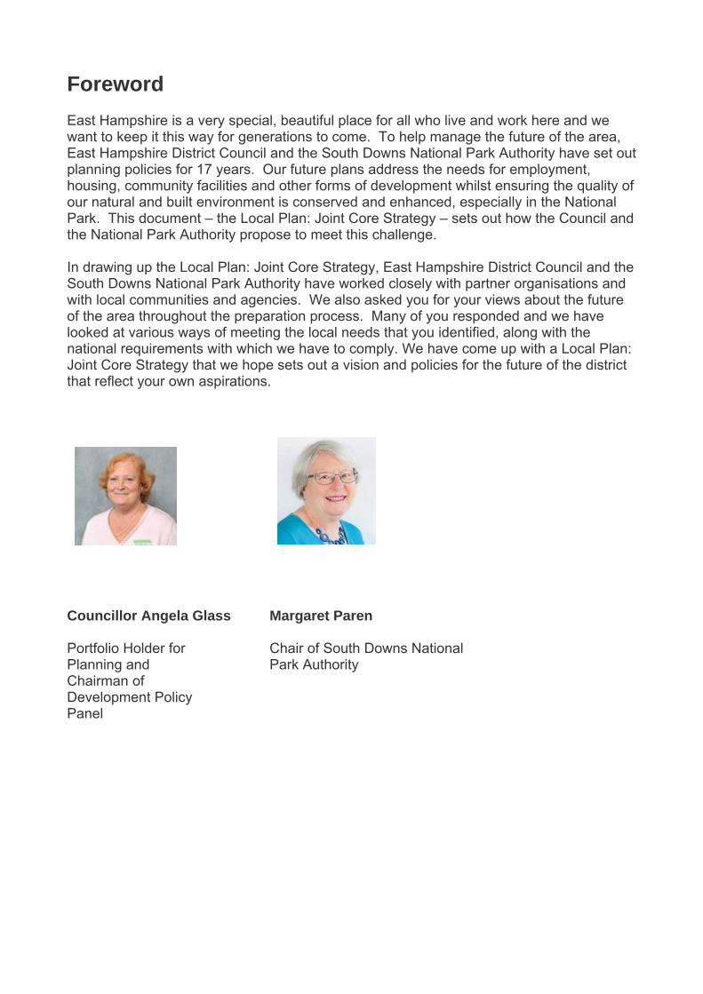
Councillor Angela Glass Portfolio Holder for Planning and Chairman of Development Policy Panel
Margaret Paren Chair of South Downs National Park Authority


5
East Hampshire District Local Plan: Joint Core Strategy Contents
Foreword Page No. 1. Introduction 7 2. A Profile of East Hampshire 10 3. Spatial Vision and Objectives 15 4. Spatial Strategy 23 CP1 - Presumption in favour of sustainable development 23 CP2 - Spatial Strategy 24 5. Sustainable Economic Development 29
Employment land CP3- New employment provision 30 CP4 - Existing employment land 32 CP5 - Employment and workforce skills 33 Rural enterprise CP6 - Rural economy and enterprise 34 Town centres and retail CP7 - New retail provision 36 CP8 - Town and village facilities and services 37 Tourism CP9 – Tourism 39
6. Sustainable Communities 41
Housing CP10 - Spatial strategy for housing 41 CP11 - Housing tenure, type and mix 43
CP12 - Housing and extra care provision for the elderly 44 CP13 - Affordable housing on residential development sites 45 CP14 - Affordable housing for rural communities 47 CP15 - Gypsies, travellers and travelling showpeople 49 Community Facilities CP16 - Protection and provision of social infrastructure 50 Open Space, Sport and Recreation
CP17 - Protection of open space, sport and recreation and built facilities 52 CP18 - Provision of open space, sport and recreation and built facilities 53
7. Natural and Built Environment 55 Protecting important countryside resources
CP19 - Development in the countryside 55 CP20 – Landscape 56 CP21 – Biodiversity 58 CP22 - Internationally designated sites 59 CP23 - Gaps between settlements 60
Protecting the wider environment – climate change CP24 - Sustainable construction 62 CP25 - Flood Risk 64 CP26 - Water resources/water quality 66 CP27 – Pollution 68
Green Infrastructure CP28 - Green Infrastructure 70
The Built Environment CP29 – Design 71

6
CP30 - Historic Environment 71 8. Transport and Access 75 CP31 - Transport 75 9. Whitehill & Bordon 82
CSWB1 - Strategic allocation 87 CSWB2 - Sustainable economic development 90 CSWB3 - The new town centre 91 CSWB4 – Housing 92 CSWB5 – Design 93 CSWB6 - Sustainable construction 94 CSWB7 – Waste 95 CSWB8 - Sustainable water management 96 CSWB9 – Biodiversity 97 CSWB10 - Green infrastructure 98 CSWB11 - New roads and traffic management on the A325 99 CSWB12 - Pedestrian and cycle routes 99 CSWB13 - Public transport 100 CSWB14 - Travel plans 101 CSWB15 - Local transport network improvements 101 CSWB16 - Travel monitoring 101 CSWB17 - Car parking 101 CSWB18 - Low carbon vehicles 102
10. Infrastructure, Implementation and Monitoring 103 CP32 – Infrastructure 103 Glossary 105
Appendices 111 1. List of Saved Local Plan Policies Replaced by the Core Strategy 111 2. Housing Land Supply Table and Housing Trajectory 113 3. Employment Land Supply Table 115 4. Monitoring Table 117
Maps
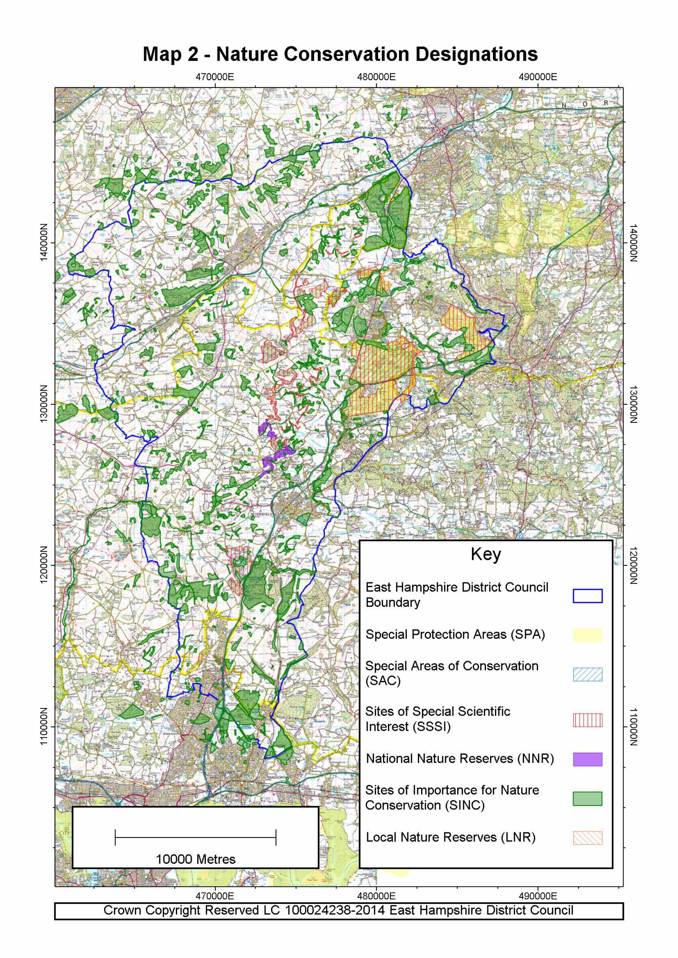
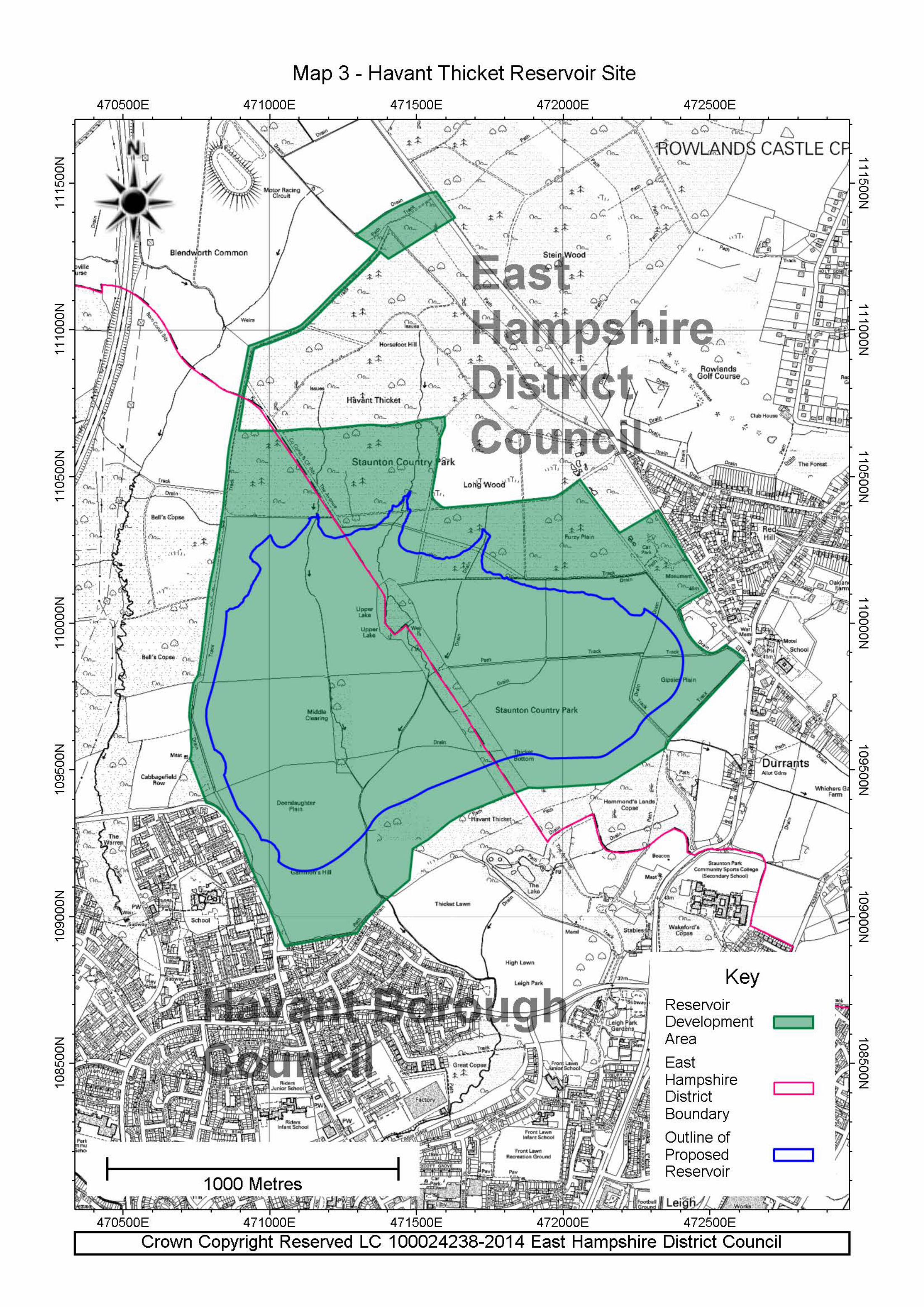
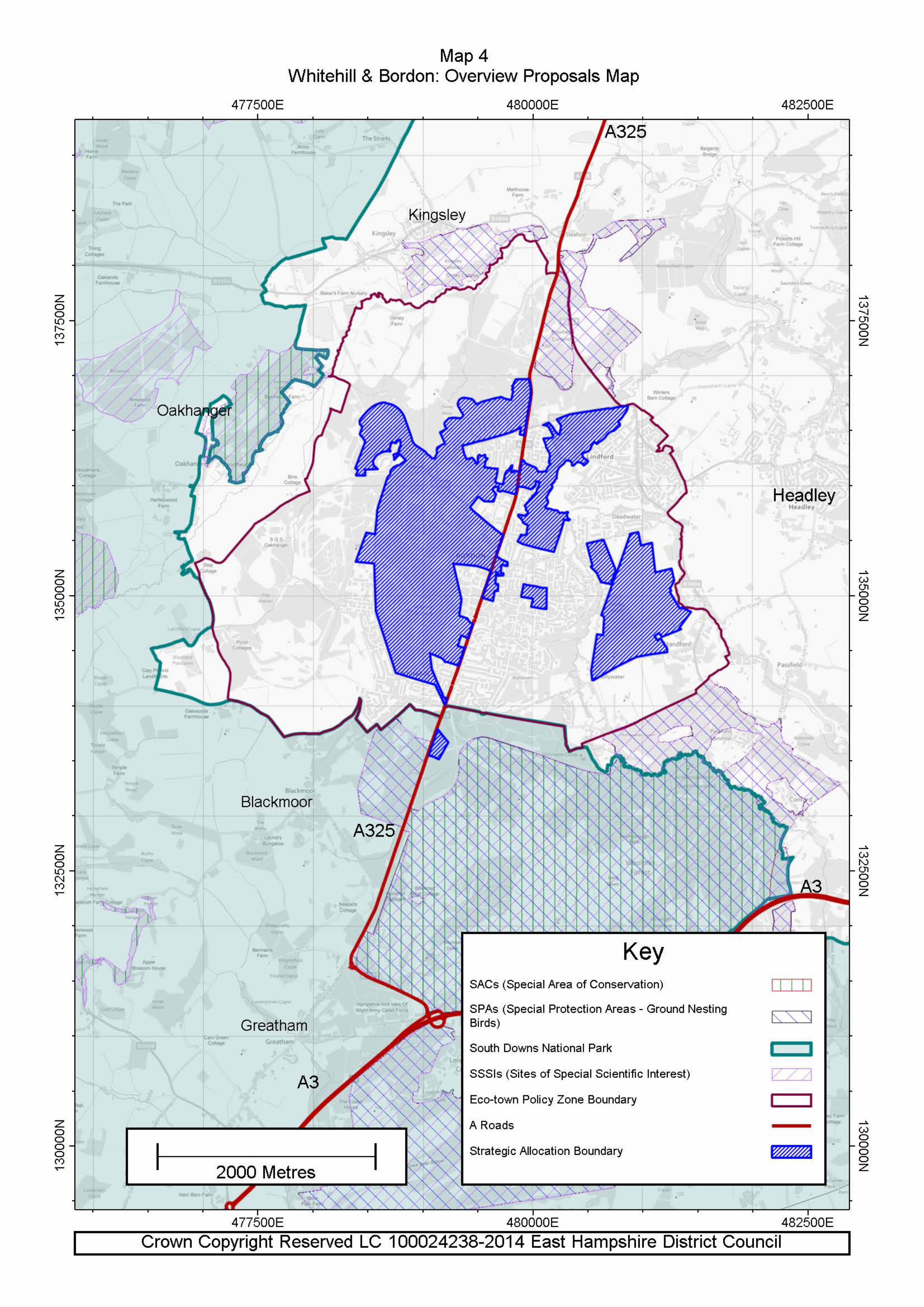
Map 1 – Key Diagram 131 Map 2 – Nature Conservation Designations 132 Map 3 – Havant Thicket Reservoir 133 Map 4 – Whitehill & Bordon Overview Proposals Map 134
Map 5 – Whitehill & Bordon Strategic Allocation – Broad identification of the 135 location of uses and illustrative site areas
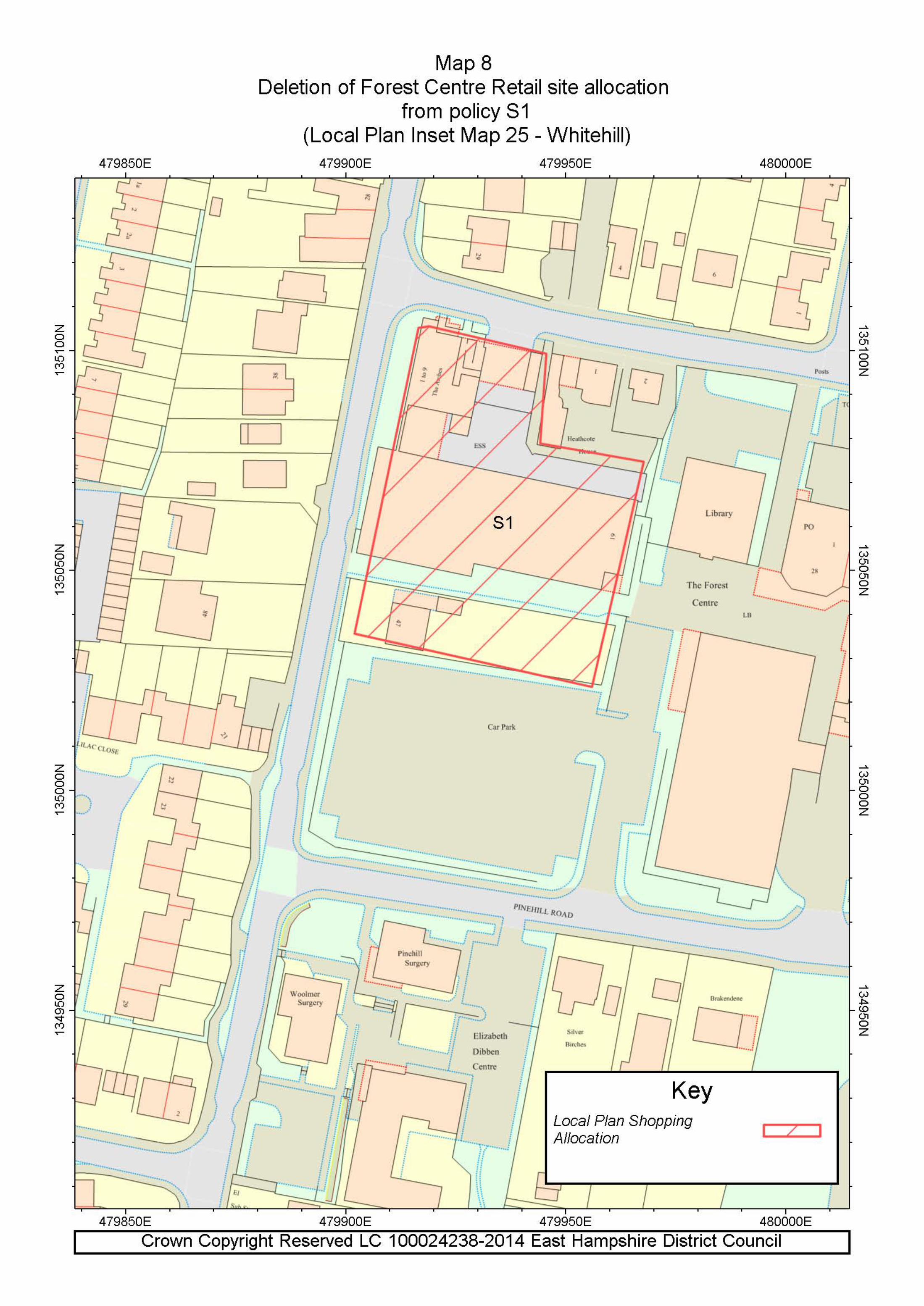
Maps 6-8 showing amendments to East Hampshire District Local Plan: 136 Second Review Proposals Maps
7
1. Introduction 1.1 East Hampshire is a desirable place to live and work with its historic market towns,
attractive villages and countryside. The District Council and South Downs National Park Authority share the desire to sustain this into the future, whilst realising the area is evolving and that it is essential to balance economic and social needs with the need to protect the environment
1.2 The Council and the South Downs National Park Authority have important roles to play in
making sure there are sufficient houses, jobs, shops and businesses, health facilities and recreational opportunities. The Council and National Park Authority can also influence some of the other issues which impact on people’s lives such as crime and disorder, transport, green issues and the availability of key worker housing near hospitals, schools and old people’s homes. In particular the regeneration of MoD and local authority land at Whitehill & Bordon will provide the opportunity to create an eco-town.
1.3 The Council and National Park Authority are doing this by preparing the Local Plan: Joint
Core Strategy which will be the first part of the new Local Plan which together with a Local Plan: Allocations will make up the overall new Local Plan for the area outside the National Park. The new Local Plan will look at how East Hampshire may change in the future to continue to meet the needs of the local population and over time it will replace the Local Plan (2006). Within the National Park the Local Plan: Joint Core Strategy will be superceded by the South Downs National Park Local Plan.
1.4 The purpose of the Local Plan: Joint Core Strategy is to provide a policy framework that
plans for new development to deliver the vision that has been developed alongside the Sustainable Community Strategy1 By 2028, East Hampshire will be a better place where people live, work and build businesses in safe, attractive and prosperous towns and villages. They will have good access to a range of housing, jobs, leisure and community facilities, and enjoy a high quality built, historic and natural environment. They will live and work in a way that respects resources and protects and enhances the District’s natural environment.
Your views have been important 1.5 When preparing the new documents, the Council and National Park Authority have taken
into account the views of the local community, not only those who live in the area but also those who work and spend time in East Hampshire.
The Local Plan: Joint Core Strategy 1.6 The Local Plan: Joint Core Strategy is a long-term document that will shape and guide
development in East Hampshire to 2028. Being spatial2, the Joint Core Strategy reflects other strategies and policies of the area and addresses where necessary other issues such as healthcare priorities, education and economic development.
1.7 The Local Plan: Joint Core Strategy takes a broad look at the future of places in East
Hampshire and considers where changes should be made. It does not identify where
1 Sustainable Community Strategy 2008-2028 2 Definition of Spatial Planning: Planning which goes beyond traditional land uses to integrate policies for the development and use of land and other policies and programmes which influence the nature of places and how they function. They will include policies which impact on land use (e.g. by influencing the demands on or needs for development) but which are not capable of being delivered solely or mainly through the grant or refusal of planning permission and which may be implemented by other means (Planning Advisory Service).

8
specific development sites should be located, as these will be identified in the next part of the new Local Plan once the Joint Core Strategy has been approved by the Government.
1.8 When starting to identify planning issues for East Hampshire all the requirements at
government, regional, county and District level were taken into account. These needed to be followed as they set the scene for the decisions that had to be made. At that time the South Downs National Park had not been established although much of the area was already contained in the Area of Outstanding Natural Beauty.
1.9 Government. National planning guidance is produced by the government and covers a wide
range of topics. This guidance can be found on the Communities and Local Government website: www.communities.gov.uk
1.10 South East Plan3. The Government Office for the South East produced the South East
Plan, a framework for the region as a whole, including the number of houses and employment areas that need to be built from 2006 to 2028. Its policies guided the initial work on the Local Plan: Joint Core Strategy. The Government has subsequently revoked the South East Plan.
1.11 Partnership for Urban South Hampshire (PUSH)4. Part of East Hampshire lies within the
South Hampshire sub-region which extends from Southampton in the west to Havant in the east. PUSH is a partnership of 11 local authorities which have joined to work together to develop a strategy for growth. Parts of the southern parishes of Horndean, Clanfield and Rowlands Castle are included in the sub-region. It is intended that Southampton and Portsmouth will be the main focus for investment and development as these areas provide major employment, retail, leisure, entertainment, higher education and cultural centres for the sub-region.
1.12 South Downs National Park Authority (SDNPA). The South Downs National Park
Authority took on its full responsibilities on 1 April 2011. The SDNPA is the organisation responsible for promoting the purposes of the National Park and the interests of the people who live and work within it. Throughout the work on the Local Plan: Joint Core Strategy East Hampshire has worked closely together with officers and members of the new National Park to ensure that these purposes and interests are addressed.
1.13 The East Hampshire Community Partnership5. This is an umbrella body of organisations
from the public, private, voluntary and community sectors who work together to plan for the long-term needs of East Hampshire and deliver projects to improve the quality of life in our area. The partnership prepared a new Sustainable Community Strategy 2008 – 2028 which sets out the shared aims and commitments that all local organisations should work towards in the future. The Local Plan: Joint Core Strategy and the Sustainable Community Strategy were prepared through joint and co-ordinated processes and share a joint vision. The Local Plan: Joint Core Strategy will help to deliver the spatial elements of the Sustainable Community Strategy.
Earlier consultations 1.14 Leading up to this adopted Local Plan: Joint Core Strategy a substantial evidence base was
established and consultation was undertaken throughout the process. The issues and options for consultation were set out in the following separate papers:
Environment Housing Economy
3 The South East Plan - Regional Spatial Strategy for the South East, Government Office for the South East, May 2009 4 PUSH website: http://www.push.gov.uk/ 5 East Hampshire Community Partnership website: http://www.easthampshirecommunitypartnership.org/

9
Transport Healthy Living Where New Development Should Go The Whitehill/Bordon Opportunity.
The Issues and Options stage was followed by the Core Strategy: Preferred Policies document that set out the main issues to be included in the various policy areas.
1.15 Both consultations generated a large response. The comments received were taken into
account in preparing the pre-submission document. A variety of meetings, workshops and exhibitions took place during the earlier consultation periods.
1.16 Other key stakeholders and interested organisations have also been involved and their
views and expertise have been noted in various assessments on such topics as housing and employment needs, sports and recreation, flood risk and habitats regulations. All of these studies are referenced throughout the Local Plan: Joint Core Strategy and available for public scrutiny and can be seen on the District Council’s website.
1.17 The teams across the District preparing town and parish plans have also fed their ideas into
the Local Plan: Joint Core Strategy. Some of this work was at an early stage so some of the proposals will need to be incorporated into future parts of the new Local Plan.
1.18 The Local Plan: Joint Core Strategy sets out a profile of the District; the spatial vision; a
series of objectives designed to achieve the vision; core delivery policies; an infrastructure policy and a monitoring framework which set out how the spatial strategy will be delivered. A Sustainable Appraisal (SA), incorporating the Strategic Environmental Assessment (SEA), to integrate social, environmental and economic considerations, and a Habitat Regulations Assessment (HRA) have been taken into account in the preparation of the Local Plan: Joint Core Strategy. It is important that the Local Plan: Joint Core Strategy is read as a whole, it is the consideration of all the policies of the Local Plan: Joint Core Strategy that will deliver the vision for the future of East Hampshire.
1.19 Other parts of the new Local Plan, will take the lead from the Local Plan: Joint Core
Strategy to ensure they are in conformity with its vision, spatial strategy and policies. The next part of the new Local Plan: Allocations will include details of proposed land use designations and more detailed development management policies.
1. 20 Appendix 1 identifies those ‘saved’ policies of the Local Plan (2006) that this Local Plan:
Joint Core Strategy replaces.
10
2. A profile of East Hampshire 2.1 East Hampshire is an exceptionally attractive part of southern England. It is a popular place
in which to live, work or visit with historic market towns and attractive villages set in beautiful countryside with rich biodiversity most of which is internationally or nationally protected. The buildings, open spaces and particularly the landscape, all contribute to the special character of the area. Together, they provide a rich heritage that adds to the quality of life for residents and people who work here, and attracts visitors and tourists.
2.2 Land will be needed to meet the needs of local people in the future. This is for new homes,
jobs, shops, community facilities and open space. For example, there are not enough homes in East Hampshire to meet future needs. This is because the number of households will continue to grow even though the population of East Hampshire will not go up rapidly.
2.3 The Council and National Park Authority must try to meet the development needs and the
wishes of local people. Many people are also concerned with the impact that new development has on the character of their communities. The Council and National Park Authority must respect that view and protect the environment and natural resources for current and future generations. Achieving this balance is the essence of sustainable development.
2.4 The Sustainability Appraisal, Council Strategy and the Sustainable Community Strategy all
identify a number of key issues that will affect East Hampshire over the next few years. These need to be taken into account in this spatial plan as do the major environmental constraints including the areas internationally protected for their wildlife and the South Downs National Park.
Key Issues and Challenges
2.5 The Local Plan: Joint Core Strategy must provide a response to the key issues and challenges facing the District. These are set out below.
Sustainable Economic Development A net loss of some 3,500 jobs6 in all sectors between 2006 and 2009, with particular
reductions in manufacturing, banking, finance and insurance related jobs. mismatch in the local economy between jobs available (around 43,000 mainly lower
skilled) and a more highly qualified and professional resident workforce (around 55,000) High levels of out commuting and the associated impact on availability of higher level
skills locally. Transport and infrastructural difficulties partly due to the rural nature of the District. Dependency on the public sector and other service sectors, with the threat of potential
job losses in the future. An ageing population that can impact on the local workforce, including a lack of
managers for businesses. Difficulty in retaining skilled and talented young people. Low level of skills and these do
not meet the needs of the local economy. The lack of accessible vocational provision within the District results in a significant outflow to surrounding areas.
6 EHDC Skills Audit
11
Constrained development options across the District combined with a policy focus on protecting the environment and local countryside.
Loss of employment land to housing which is considered more economically viable. Town and village centres need to remain attractive and enable people to enjoy quality
lifestyles. With the designation of the South Downs National Park, more visitors may come to the
area as the profile of the area is raised. Additional tourism can bring pressure on the local environment but properly managed, tourism can provide the opportunity to contribute sustainably to the local economy.
Rural enterprise needs to benefit from diversification of activities on farms and support
for landowners and rural services. Sustainable Communities Providing for housing development in an area of high constraint. High average house prices (20% higher than the regional average7) and an
unfavourable ratio of house prices to gross incomes (twelve times the average annual salary in 20108) create affordability problems for local people, first time buyers and essential key workers, especially in rural areas.
There is a deficit in affordable housing supply and the current completion rate is below
the annual level required to address the deficit (in May 2014 there were 1,920 households on Hampshire Home Choice, registered for property in the EHDC area). Provision of affordable housing in rural areas is particularly problematic.
An ageing population that has specific housing requirements. The ageing population has long term implications for health care needs, housing mix
and other social services. Many people in rural areas find it difficult to access healthcare facilities and transport
costs of providing services in these areas are high. The locally identified pockets of deprivation need to be addressed. Access to recreation, leisure and cultural facilities needs to be improved. Perception of crime is worse than actual occurrence. There are a significant number of adults who have poor literacy and numeracy and
there is a shortage of vocational training. Natural and Built Environment The National Park covers 57% of the District. Much of the remaining countryside is
unspoilt and locally distinctive. This limits development potential but also provides a substantial quiet recreational, tourism and heritage resource and contributes to the local economy by attracting visitors and tourists. Noise and light pollution contribute to a loss of tranquillity in the National Park. Measures are needed to reduce their impact.
7 Based on data of 429 sales from the land registry, compiled by BBC news, 2010. 8 ONS 2010
12
There are a number of priority habitats of nature conservation importance and a variety of protected species in East Hampshire. Areas of local value outside the designated sites also need to be recognised and protected. The fragmentation of habitats is reducing their potential to support wildlife. The potential conflict between protecting the Wealden Heath (Phase II) SPA and providing homes needs to be resolved. Climate change will affect biodiversity through changing habitats.
The open areas that separate towns and villages contribute to their character and
identity and should be protected. There is a need to conserve and enhance the historic and cultural heritage for future
generations as it is an essential part of what makes the District a distinct place. The likely effects of climate change will include heavier rainfall in winter increasing
hazards from fluvial flooding and the number of properties that are at risk from flooding will go up. Surface water flooding will get worse as a result of more frequent storms. Low river flows will occur because of drier summers.
Over 80% of the District is underlain by a principal aquifer and 40% within a
Groundwater Source Protection Zone which provides specific drivers to ensure groundwater quality is protected.
Government policy requires new development to promote sustainable construction,
energy and water conservation and renewable energy. Renewable energy generation could pose environmental challenges.
Transport and access High car ownership reflects the rural nature of much of the District with heavy traffic on
the roads resulting in localised congestion. Of particular concern is the volume and speed of traffic using rural lanes which detracts
from the tranquillity of rural areas, and can conflict with other recreational users. Traffic is likely to be the major source of air pollution in the District. Development has
the potential to make congestion worse and therefore reduce air quality, especially along the A325 and A3.
People in outlying areas must have access to jobs, shops, hospitals and other services
and facilities to avoid being isolated. However, providing public and community transport is a problem in rural areas.
The four parts of the Plan Area 2.6 The Plan Area falls into four distinct areas, each of which face different issues and
challenges.
South Downs National Park 2.7 In preparing the Local Plan: Joint Core Strategy jointly full account has been taken of
Section 62 of the Environment Act 1995. This places a duty on National Parks and any other relevant authority to have regard to National Park purposes in undertaking their statutory duties. The two main purposes (Section 61) are:
(i) to conserve and enhance the natural beauty, wildlife and cultural heritage of the National Park; and
(ii) to promote opportunities for the understanding and enjoyment of the special qualities of the National Park by the public.

13
2.8 In addition, the National Park Authority has a duty to foster the social and economic well-being of communities within the National Park. This duty also been taken into account in this Local Plan: Joint Core Strategy.
2.9 A key challenge in the National Park is to determine the role of the larger settlements within
it which could potentially change following the designation of the National Park in 2010. These are:
Petersfield - an important historic market town with a main line railway station providing
a centre for shopping, services and facilities, as well as employment opportunities for the local community and residents from surrounding villages and hamlets. The natural beauty of the countryside provides an important attractive rural setting to the town.
Liss - a large village with a mainline railway station and most of the key services
including employment and a reasonable range of local shops and services meeting many of the day-to-day requirements of residents in both Liss and surrounding smaller villages and hamlets. The attraction of the village is the way that it merges into the surrounding countryside.
Whitehill & Bordon 2.10 Whitehill & Bordon is the second largest town in the District. It has a range of services
generally spread throughout the town but they are poor for a town of its size. The town is very different to the traditional market towns in the surrounding locality as it has been home to the Military for nearly 110 years. In 2011 the Ministry of Defence confirmed its intention to relocate the bulk of its training activities currently carried out at the Bordon Garrison.
The main issues currently facing the town include: Approximately 1,500 jobs will have been lost (including about 580 jobs as at September
2013) in recent years since the MoD’s decision to relocate from Bordon Garrison resulting in a reduction in spending power and impacting on local firms who rely on the MoD for business;
There is a lack of investment in good value commercial premises and high quality
sustainable employment sites especially for small/medium sized businesses;
The poor range of shops means that people are spending their money elsewhere. The existing retail centres include the Forest Centre and the group of shops at Chalet Hill/High Street. The Forest Centre looks dated, has high rents, no means of expansion and lacks a sense of place or civic focus;
The town lacks detached properties and is perceived as a town for starter and more
affordable family homes. About 65% of homes are within the lowest council tax bands (A,B,C);
The town is surrounded by land of high ecological quality; some heathland is of
international importance;
Air quality issues are apparent along the A325 corridor;
The size and range of facilities (such as community, health, sports and leisure) in Whitehill & Bordon are limited;
In general, Whitehill & Bordon residents are less qualified; this is partly due to the lack
of further education and training facilities and difficulties people without cars have in accessing educational establishments elsewhere;
The withdrawal of the armed forces will impact on already falling school rolls;

14
65% of residents currently commute out of town mainly to Surrey and the Blackwater
Valley. 2.11 The withdrawal of the Bordon Garrison exposes the town to the severe risk of negative
economic and social consequences particularly if there is no comprehensive strategy in place.
North of the South Downs National Park 2.12 The part of the District to the north of the National Park is focused on the important market
town of Alton, and a number of large villages (principally Liphook, Four Marks and Grayshott) with a varying range of services and community facilities. These settlements need to enhance their roles as sustainable communities providing commercial and community uses for the wider area.
2.13 Further development in these settlements should take into account their relationship with
the South Downs National Park. The scale of new development should also be such that it complements the need for Whitehill & Bordon to regenerate and attract new investment including the provision of employment, a range of services and housing to ensure its viability as a strategic development area.
Southern Parishes 2.14 The southern parishes of the District based on the main built-up areas of Horndean,
Clanfield and Rowlands Castle lies within the area designated in the former South East Plan as the ‘South Hampshire sub-region’. For this area the Partnership for Urban South Hampshire (PUSH) continues to aim to deliver a strategy for economic-led growth over the plan period, making South Hampshire more prosperous, attractive and sustainable and offering a better quality of life. East Hampshire District Council is a member of PUSH.
2.15 The three settlements are outside but close to the boundary of the National Park. The main
challenge for this area is to create sustainable communities and ensure that, whilst being a part of an area focused on economic growth, the character and distinctiveness of the natural and built environments of these settlements are protected.
Relationship with surrounding areas 2.16 The District is not self-contained. What happens in the District affects the adjoining areas
and vice versa. The large South Hampshire conurbation to the south and larger centres such as Basingstoke, the Blackwater Valley, Guildford and London to the north offer wider employment, shopping, social and cultural facilities; but can add to housing, traffic and other pressures on the Plan Area. The opening of the Hindhead Improvement in 2011 has added to these pressures on the settlements in the A3 corridor.
2.17 The West of Waterlooville Major Development Area to the south of the District is helping to
meet some of the housing and community needs in that part of East Hampshire but the potential impact on transport and other infrastructure is being carefully monitored.
2.18 Residents of the District and beyond can enjoy the special qualities of the South Downs
National Park, but developments in the remainder of the District can affect the National Park’s sensitive environment. Some sites adjoining the edge of the National Park are important to its setting.
2.19 The relationships with the adjoining areas have been key considerations in drawing up the
Local Plan: Joint Core Strategy and will need to be given proper attention in its implementation. Close working relationships with other local authorities and partners will continue to be essential.
15
3. Spatial vision and objectives
Spatial vision 3.1 The spatial vision is a brief description of how East Hampshire will change. The Local Plan:
Joint Core Strategy must contain a spatial vision of what the District should be like by 2028. The research undertaken for the Sustainable Community Strategy and the Local Plan: Joint Core Strategy helped to identify a list of the things that matter most to the quality of life of people in East Hampshire. Using this list, and taking into account all the issues and challenges set out earlier, the Council and the National Park Authority have produced an overall spatial vision for the Core Strategy.
Over the next 20 years East Hampshire will experience major changes that are unique to the district. The new South Downs National Park, covering 57% of the district, including Petersfield, will ensure that the natural beauty, biodiversity and cultural heritage of the area is conserved and enhanced. It will also offer potential opportunities in terms of recreation and tourism related activities.
Just beyond the National Park plans for an Eco-town at Whitehill & Bordon including 4,000 new homes (2,725 in the plan period) and an aspirational target of 5,500 new jobs (3,700 in the plan period) will be in place. The regeneration of the town will include a new town centre, new businesses, community facilities, improvements to public transport, new open spaces and an increase in biodiversity to enable more sustainable living.
In the north Alton's market town role will be strengthened with more housing, employment, retailing and improved facilities.
The three southern parishes will be influenced by the proposed regeneration and economic growth in the South Hampshire sub-region centred on Portsmouth and Southampton.
These four distinct areas of the District will be carefully managed to achieve sustainable communities within a high quality natural and built environment. The district’s rich biodiversity, historic environment and diverse countryside and landscape will be conserved and enhanced. Within this context local people will be able to live in affordable homes. The rural nature of the district suggests there will be continued reliance on the car; a key aim will therefore be to create sustainable working and living environments.
3.2 Sustainable communities in East Hampshire will balance the Social, Economic and Environmental needs of the area. The following section sets out the detailed issues and objectives that the Local Plan: Joint Core Strategy policies, together with the work of colleagues throughout the Council and other partners will seek to deliver to create sustainable communities.
3.3 Local Plan: Joint Core Strategy objectives have been developed to underpin the implementation of the East Hampshire spatial vision. They take into account the vision, key issues in the District, national planning guidance, the Sustainable Community Strategy, the Council Strategy, other Council and South Downs National Park strategies and consultation responses.

16
Sustainable Economic Development Objectives
1) To maintain a sustainable, buoyant local economy designed to provide jobs to meet residents needs and improve the quality of life in East Hampshire, but always within the constraints of the local environment;
2) To plan for the District’s town and village centres to provide a range of facilities and
services that meet the needs of local communities;
3) To maximise the value of sustainable tourism whilst minimising environmental impacts and acknowledging that within the National Park tourism will be subordinate to the protection of the natural beauty, wildlife and cultural heritage of the area.
3.4 The District’s economy will meet the employment needs of both residents and businesses
of East Hampshire. A wider base of employment types will increase the availability and choice of modern business premises, allowing new smaller businesses to set up providing opportunities for better paid jobs for local residents. This will help to address the mismatch that exists between employment opportunities and the skills of the workforce.
3.5 There will be improved infrastructure and local services for businesses and their
employees, allowing local businesses to thrive with better employment prospects for local people. As a result fewer residents will need to work outside the District. This will be achieved in ways that complement and enhance the special qualities of the District’s environment, particularly the National Park, and without putting unacceptable pressures on the local housing market.
3.6 Economic development will build on the strengths of the District with Alton, Petersfield,
Horndean and Whitehill & Bordon providing the main bases for industrial development. Alton, Petersfield and Whitehill & Bordon, along with a number of smaller centres will provide the focus for retail and service based employment. These centres will be reinforced to strengthen these sectors, particularly at Whitehill & Bordon. The National Park and rural areas will be fulfilling their potential for sustainable rural businesses.
3.7 There will be new educational opportunities to meet the challenges faced in skills
deprivation, leading to an increase in the number of qualified people. Young people, the disadvantaged, women and others returning to work will find training, apprenticeships and employment, while more part-time work will be identified for the elderly.
3.8 The main towns and villages will remain the focus for tourism and recreational facilities. In
the countryside any tourism or recreational development will be sustainable, small scale and done sensitively to protect the character of the landscape and provide opportunities for its enhancement, especially that of the South Downs National Park and areas around the international wildlife sites. Opportunities will be taken for suitable diversification within the National Park.
Sustainable Communities
Objectives
4) To plan for sufficient land to be available for 10,060 homes (including 2,725 at Whitehill & Bordon) to be built in the District in the period 2011-2028. Within the National Park development should be focused on local needs.
17
5) To make the most efficient use of land and the existing housing stock so that everyone has the opportunity to live in a decent, sustainably constructed and affordable home, which is capable of being adapted to changing personal needs;
6) To promote safe, sustainable communities by ensuring an appropriate housing mix, taking
account of the needs of identified groups in various settlements, and utilising good quality design to reflect town and village design statements and the characteristics of individual settlements;
7) To provide the opportunities for a high quality of life for everyone, enhance the well-being of
people and reduce inequalities in health;
8) To improve access to all facilities and services particularly in rural areas;
9) To promote opportunities for vocational training;
10) To design development that reduces the opportunities for crime and anti-social behaviour and the fear of crime;
11) To provide and retain a range of high quality open space, sport and recreational facilities;
12) To actively encourage people to make healthy lifestyle choices including opportunities to
increase the level of physical activity and participation in sports and recreation;
13) To promote multi-functional and cost effective green infrastructure in urban and rural areas including closer working with rural enterprises, farming and forestry.
3.9 A range of housing types, tenures and sizes, both open market and affordable, will be
available for local people. Opportunities for local people to find affordable living accommodation will be maximised, although it has to be recognised that this is also an area where people from outside the District want to live and work. The emphasis, however, will be helping to reduce the migration of young people and families away from the District.
3.10 Within the South Downs National Park housing provision will be restricted to that needed to serve its communities.
3.11 The provision around the District of sheltered housing, 'extra care' housing and nursing
homes will reflect the increasing number of elderly residents. Existing homes will be adapted to older people’s needs enabling them to be able to retain their independence for longer.
3.12 Different people, irrespective of age, disability or where they live, will have opportunities to
take part in leisure activities by having access to open space, sport, recreational and cultural activities. Links between villages and towns into the countryside will also be strengthened. People will have the opportunity to lead a long and healthy life with little variation in the health of residents across the District.
3.13 Development will help to encourage young people to stay in the District through measures
to encourage entry into vocational jobs or apprenticeships. 3.14 Low levels of crime and anti-social behaviour will make East Hampshire a very safe place
and most people will feel safe going out after dark, including younger and older people.

18
Natural and Built Environment
Objectives
14) To make best use of land in sustainable settlements to minimise the impact of development upon the countryside;
15) To ensure that any decisions or activities relating to land within, or affecting the setting of,
the South Downs National Park meet the relevant National Park purposes as set out in statute;
16) To conserve and enhance landscape quality, distinctiveness and character in the wider
landscape;
17) To conserve and enhance designated sites and natural habitats whist creating networks of habitats and wildlife corridors to encourage adaptation to climate change;
18) To conserve and enhance the District’s attractive built and historic environment, including
heritage sites, conservation areas, listed buildings, archaeological sites and important open areas and the settings of these assets;
19) To plan for new development to be built to a high quality that promotes the use of sustainable resources in developments, in particular to minimise waste, increase energy efficiency in new and existing developments and to maximise the proportion of energy generated from renewable sources within environmental constraints;
20) To protect and enhance water quality, water supply, groundwater and minimise the risk of
flooding in the District;
21) To prevent development resulting in unacceptable levels of air, noise, land, light or other pollution and to ensure that new development is adequately protected against such pollution;
22) To address the causes of climate change and ensure that the District is able to adapt to it
within environmental constraints. 3.15 Central to the Local Plan: Joint Core Strategy is the need to provide protection and
enhancement to the built and natural environment, in particular the internationally and nationally protected wildlife habitats and nationally important heritage sites, and to ensure that the beauty, wildlife and cultural heritage of the South Downs National Park are conserved and enhanced.
3.16 Development within the South Downs National Park will be focused on that needed for the
economic and social wellbeing of the National Park’s communities, including housing for local needs. Proposals for major development will be subject to rigorous examination and will only be favourably considered if they do not conflict with the purposes of the National Park and comply with all the requirements within national planning policy. The National Park will also be protected from cumulative small scale changes, or development affecting its setting, that could harm its special qualities.
3.17 New development will protect and where possible enhance biodiversity by considering, in
particular, the impact of any change on the designated sites but also the many other sites which are of local value for wildlife.
3.18 New areas for informal recreation will be provided as alternatives to the heathland sites
which are part of the internationally designated Special Protection Area (SPA) in the north eastern area of the District. The rare species of bird on this particularly important heathland
19
will be protected from the recreational pressure from residents of any new housing in the Whitehill & Bordon, Liphook, Liss, Headley and Grayshott areas.
3.19 Wildlife sites will be extended and linked to create large, functional areas or networks which
will allow wildlife to flourish and adapt to the threat of climate change. Developers will be expected to incorporate appropriate landscaping and also enhance links between existing habitats, including the enhancement of wildlife corridors and the restoration of key lost habitats such as heathland and water meadows.
3.20 Community and Parish landscape character assessments will be used to protect the important characteristics for each landscape type in the District.
3.21 The gaps which separate towns and villages and contribute to their character and identity
will be protected. 3.22 New development will be high quality design, imaginative whilst conserving and enhancing
the historic environment. The conservation and enhancement of the historic environment will help ensure that the character and distinctiveness of towns and villages is retained, the contribution of the historic environment to quality of life maintained and the economic benefits of attractive places realised. The design and layout of new development will have a positive impact upon the character of the area creating a distinctive identity or sense of place that respects and enhances local character. This will help to create attractive places that are valued by local people.
3.23 Measures to mitigate and adapt to climate change will be in place. Development will avoid
areas of flood risk and will not increase the risk of flooding elsewhere. Where practical these risks will be reduced. Development will avoid areas within Groundwater Source Protection Zones where there may be a risk to the quality of the groundwater source or a risk to its ability to maintain a public water supply. The quality and quantity of water in rivers and other watercourses will be protected and enhanced where possible. More efficient use will be made of water resources.
3.24 New technologies will help to reduce carbon emissions from new and existing development. New buildings will perform well in energy and water efficiency and renewable energy generation and other sustainable factors, such as materials, recycling facilities, cycle spaces, home offices, waste and ecology.
Transport and access
Objectives
23) To reduce the need to travel, particularly by car, through careful planning of development and the location of services, whilst recognising that the car will remain part of the mix of transport modes, particularly for those in the rural areas;
24) To improve accessibility to all services, particularly for those who may need them most, but
are least able to access them;
25) To increase the use of public and community transport, cycling and walking where travel remains necessary.
3.25 Access to facilities in more rural areas will be improved, within financial limitations,
particularly in evenings and at weekends, through better community transport, more flexible and more frequent taxi-bus services and other services that respond to demand. Non-transport improvements will include increased provision of services directly to residents, for example more local outpatient/testing clinics.

20
3.26 New development will be integrated with transport networks which will be more joined-up to provide more sustainable transport choices for commuting and recreation and to encourage sustainable tourism. Whitehill & Bordon will have particularly high standards of sustainable travel through an integrated package of transport measures. Overall, congestion and pollution will be minimised and tranquillity will be improved.
3.27 Development resulting in a lot of new journeys will be located near existing centres to
reduce the need to travel and increase the scope for shared and multi-purpose trips. New development ‘travel plans’ will encourage the use of public transport services and provide facilities for pedestrians and cyclists.
3.28 The level of parking provided with new housing will vary to reflect expected car ownership,
accessibility to facilities and availability of public transport. This will help to alleviate on-street parking problems.
Whitehill & Bordon The Eco-town Vision
3.29 The vision for the Whitehill & Bordon Eco-town will put the outstanding natural environment
at the heart of the regeneration. 3.30 The ‘Eco-town Vision’9 means that new facilities, leisure opportunities, jobs, education,
infrastructure and housing will be provided to enhance this unique area and create a model sustainable community that is recognised locally, regionally and nationally.
3.31 The Vision is to:
create an attractive town where people want to live, work, shop and play with excellent facilities, leisure opportunities, jobs, training opportunities and a balanced mix of housing.
regenerate and improve the built environment in the town so that it complements the
superb surrounding landscape, whilst protecting the town’s heritage.
use innovative, modern, environmentally-friendly design, incorporating eco homes and modern methods of construction.
ensure that the town is regenerated in a way that encourages and enables us to live
and work in ways that does not damage the natural resources upon which our society and economy depends.
encourage ‘One Planet’ living (living within the planet’s means) and encourage local
food production and ‘grow your own’.
create a town centre that is pedestrian friendly and is well-connected to residential, employment and leisure areas.
ensure there is accessible green space and attractive town squares.
encourage investment by businesses and industries and will particularly seek out those
that share our vision of a sustainable, prosperous, environmentally-friendly community.
9 Eco-town Vision Eco-town Revised Bid, Whitehill-Bordon Opportunity Eco-town, East Hampshire District Council, September 2008

21
enhance and promote public transport so that it is easier to travel around the town and to other towns and cities.
create a town where regeneration and ongoing management is designed with people
and nature as our priority.
Objectives for Whitehill & Bordon 3.32 Local Plan: Joint Core Strategy objectives have been developed to underpin the strategy
that will enable East Hampshire to realise its overall spatial vision and deliver the Green Town Vision for Whitehill & Bordon: WB1 To encourage investment by those businesses and industries which share the vision of a sustainable, environmentally-friendly community and particularly those within local grown markets; WB2 To improve the image and competitiveness of the town by encouraging the development of sustainable schemes to create a low carbon community; WB3 To provide an attractive and thriving town centre with a mix of uses including community facilities; WB4 To increase local jobs, minimising the need to travel outside the town to work and supporting walking, cycling and public transport over the car; WB5 To provide access to new higher education and training facilities and to improve the quality, standards and facilities of schools throughout the community; WB6 To encourage provision of a wide mix of quality low carbon housing to rebalance the socio-economic profile of the town; WB7 To rebalance the housing mix of the town to meet the needs of residents and a new workforce; WB8 To improve access to services and facilities within the wider area, particularly the hinterland villages and invest in public transport and improved cycle/pedestrian links; WB9 To continue to investigate the potential for a rail link from Whitehill & Bordon to the rail network; WB10 To protect and enhance the landscape setting of the town including the extensive areas of land with landscape and environmental designations of international, national and local importance; WB11 To avoid and mitigate against any potential impacts on the integrity of the designated sites nearby (see WB10); WB12 To provide areas of green infrastructure, and networks or corridors of natural habitat throughout the town for people and wildlife; WB13 To ensure that development takes place within the environmental capacity of the town and of the surrounding countryside, especially the rural roads and the sunken lanes; WB14 To monitor and reduce the carbon footprint of the whole town by facilitating environmentally sustainable design and planning; WB15 To create an attractive built environment with a distinctive character and to ensure that the development achieves the highest standards of sustainability and design;
22
WB16 To improve the sustainability and attractiveness of the existing built up area; WB17 To achieve water neutrality in all development areas and monitor the hydrological and hydro-geological regimes to ensure no adverse impact on the nearby European Designated sites; WB18 To deliver a net gain in biodiversity within all development by ensuring opportunities to secure biodiversity improvements are built in the design and planning process at all stages.
3.33 The Local Plan: Joint Core Strategy Objectives set out above provide the overall context for
the policies of the Core Strategy. Each of the policies has a positive impact on one or more objective. Overall the Local Plan: Joint Core Strategy must be read as a whole. All of the policies of the Local Plan: Joint Core Strategy contribute to establishing the mechanisms for all the Objectives to be met during the plan period.
3.34 The Council and National Park Authority working with other partners will plan to create sustainable communities within the District so that by 2028, East Hampshire will provide an environment in which people with a direct interest in its future – residents, businesses, workers and visitors - can prosper. The District’s towns and larger villages will be the main focus for new development. Future development will maximise their potential but will also respect and enhance the characteristics that make them and the surrounding countryside unique.
3.35 Town and village centres will have different roles depending on their size, but they will all
retain an important part in the life of their communities. They will also be at the heart of a thriving, well-connected network of smaller villages and hamlets in the countryside. These centres, many of which are steeped in history, will be protected and enhanced.
3.36 The links with the adjoining areas, including the major conurbations in South Hampshire
and the Blackwater Valley, will be managed to maximise access to jobs and facilities to provide opportunities for fulfilling lives while respecting the different attributes of the different areas, and protecting the countryside, especially the South Downs National Park.
23
4. Spatial Strategy 4.1 The Spatial Strategy is central to achieving the vision and key objectives of the Local Plan:
Joint Core Strategy. There are four key considerations that underpin its proposals. They are the need to: achieve sustainable development;
protect East Hampshire’s high quality built and natural environment, including
conserving and enhancing the natural beauty, wildlife and cultural heritage of the South Downs National Park;
ensure that local economic, housing and social needs are addressed; and
ensure that the future scale of development takes account of East Hampshire’s regional
and sub-regional context, the opportunities for the regeneration of Whitehill & Bordon and the opportunities for the promotion of the understanding and enjoyment of the National Park’s special qualities.
CP1 PRESUMPTION IN FAVOUR OF SUSTAINABLE DEVELOPMENT
When considering development proposals the Council and National Park Authority will take a positive approach that reflects the presumption in favour of sustainable development contained in the National Planning Policy Framework (NPPF). They will always work proactively with applicants jointly to find solutions which mean that proposals can be approved wherever possible, and to secure development that improves the economic, social and environmental conditions in the area. Planning applications that accord with the policies in this Local Plan (and, where relevant, with policies in neighbourhood plans) will be approved without delay, unless material considerations indicate otherwise. Where there are no policies relevant to the application or relevant policies are out of date at the time of making the decision then the Council and National Park Authority will grant permission unless material considerations indicate otherwise – taking into account whether:
Any adverse impacts of granting permission would significantly and
demonstrably outweigh the benefits, when assessed against the policies in the National Planning Policy Framework taken as a whole; or
Specific policies in that Framework indicate that development should be
restricted.10 4.2 Sustainable development is a key theme of the Council’s sustainable community strategy
as well as national planning policy guidance. Development needs to be distributed in a sustainable way and an effective tool for measuring this is via a settlement hierarchy. A settlement hierarchy is essentially classifying a list of towns, villages and hamlets to identify their role in meeting the housing, economic and service needs of the local communities using some form of criteria. In the case of East Hampshire, the criteria used include the availability of, and ease of, access to facilities and services while being aware of
10 For example, those policies relating to sites protected under the Birds and Habitats Directives (see paragraph 119 of NPPF) and/or designated as Sites of Special Scientific Interest; land designated as Green Belt, Local Green Space, an Area of Outstanding Natural Beauty, Heritage Coast or within a National Park (or the Broads Authority); designated heritage

24
environmental constraints. An analysis of the facilities and accessibility of towns and villages in the District is set out in the background paper for settlement hierarchy.
4.3 A hierarchy based on these factors provides a framework for focusing future levels of
development. The hierarchy can group together similar settlements. It does not follow that all the settlements in each group will accommodate the same levels of development - that will depend on constraints to development and appropriate sites being available – but it is a key guide.
4.4 The South Downs National Park, unlike many others, includes towns and large villages as
well as open countryside. Many other urban areas are adjacent to the National Park boundary where particular sensitivities will need to be managed. Development in the District will need to ensure that the South Downs National Park purposes and duty are taken fully into account.
CP2 SPATIAL STRATEGY New development growth in the period up to 2028 will be directed to the most sustainable and accessible locations in the District in accordance with the Spatial Strategy shown on the Key Diagram. The Council and National Park Authority will promote and secure sustainable development to maintain the vitality and viability of existing communities, to meet the need for new resource efficient housing and economic growth that is supported by necessary infrastructure and to ensure the protection and the enhancement of the built and natural environment in particular the protection of the special qualities of the South Downs National Park which is fundamental to the Local Plan: Joint Core Strategy. New development must fully acknowledge the constraints and opportunities of the South Downs National Park and the form, scale and location of development must ensure that the duty and purposes of the National Park are delivered. In particular, major new development will only be considered if it supports National Park purposes. The Spatial Strategy identifies four distinct areas of the District: South Downs National Park Whitehill & Bordon North of the South Downs National Park Southern Parishes New development will make the best use of previously developed land and buildings within existing built-up areas. Provision is made for a minimum increase of 10,060 new dwellings in the period 2011-2028. 2,725 of these new dwellings are part of the development of a new Eco-town at Whitehill & Bordon over the Plan period with the remainder for up to 4,000 in total to be planned beyond the Plan period. The detailed distribution of housing numbers is set out in Policies CP8 and CSWB4. Provision is made for about 21.5ha of additional employment land which includes about 9.5ha (gross) as part of the development of a new Eco-town at Whitehill & Bordon which will provide approximately 3,700 new jobs within the Plan period.
4.5 A sustainable hierarchy of settlements is set out below based upon the accessibility of
settlements, the availability of a broad range of facilities, their economic role, and the environmental constraints to development. Development in all settlements will have to be consistent with maintaining and enhancing their character.
25
4.6 Level 1 Market Towns are the most sustainable locations for most new development in
terms of access to local services and facilities. Within environmental constraints, they will continue to offer the widest range of shopping and to be main destinations for social, leisure, entertainment, cultural, commercial and economic activity, serving wide catchment areas. Small, independent traders will continue to thrive, contributing to a strong sense of place.
4.7 Level 2 Large Local Service Centres have a range of services and are suitable locations to
accommodate new development. Their role will be maintained to ensure they continue to serve a wider, rural hinterland with vibrant centres and a range of local services. They will complement the market towns by providing for main convenience food shopping and a reasonable range of other shops and other services.
4.8 Level 3 Small Local Service Centres have a more limited range of services but are suitable
locations to accommodate some new development. These centres will have different roles depending on their size, but they will all play an important part in the life of their communities. They will be maintained to ensure that they provide basic food and grocery shopping, supported by a limited choice and range of other shops plus a range of non-retail services and community uses. Modest development to meet local needs for housing, employment, community services and infrastructure will secure their continuing vitality and ensure thriving communities.
4.9 Level 4 Other settlements with a settlement policy boundary have a limited range of local
services and may be appropriate for some further small scale local development. 4.10 Level 5 Rural villages considered as being in the countryside with limited access to facilities
and workplaces and new development limited to that which is appropriate to rural areas (see Policy CP3).
4.11 The majority of development will be focused in or adjoining the most sustainable towns and
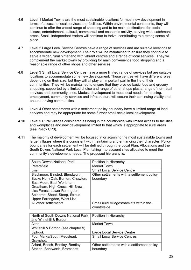
larger villages where it is consistent with maintaining and enhancing their character. Policy boundaries for each settlement will be defined through the Local Plan: Allocations and the South Downs National Park Local Plan taking into account sites allocated to meet the community’s development needs. The proposed hierarchy is:
South Downs National Park Position in Hierarchy Petersfield Market Town Liss Small Local Service Centre Blackmoor, Binsted, Blendworth, Bucks Horn Oak, Buriton, Chawton, East Meon, East Worldham, Greatham, High Cross, Hill Brow, Liss Forest, Lower Farringdon, Selborne, Sheet, Steep, Stroud, Upper Farringdon, West Liss
Other settlements with a settlement policy boundary
All other settlements Small rural villages/hamlets within the countryside
North of South Downs National Park and Whitehill & Bordon
Position in Hierarchy
Alton Market Town Whitehill & Bordon (see chapter 9) Liphook Large Local Service Centre Four Marks/South Medstead, Grayshott
Small Local Service Centres
Arford, Beech, Bentley, Bentley Station, Bentworth, Bramshott,
Other settlements with a settlement policy boundary

26
Griggs Green, Headley, Headley Down, Holt Pound, Holybourne, Kingsley, Lindford, Medstead village, Passfield Common, Ropley, Ropley Dean, Upper Froyle All other settlements Small rural villages/hamlets within the
countryside
Southern Parishes Position in Hierarchy Horndean, Large Local Service Centre Clanfield, Rowlands Castle Small Local Service Centre Catherington, Lovedean
Other settlements with a settlement policy boundary
All other settlements Small rural villages/hamlets within the countryside
South Downs National Park
4.12 Development within the South Downs National Park will be restricted to that which meets
the National Park purposes and duty and will be focused on local needs. The UK Government Vision and Circular 2010 on National Parks explicitly states that National Parks are not suitable locations for unrestricted housing. Housing built within the South Downs National Park must be focused on proven local need and should usually be small in scale and of a high standard of design in terms of sustainability and appropriateness to its context.
4.13 The market town of Petersfield will retain its current role as a main centre for facilities and
services although this may change to meet the challenges of becoming a sustainable hub at the heart of the National Park. Constraints on its growth include views from and to the surrounding hills and the need for any growth to support National Park purposes and its duty towards the local community (where this does not conflict with its purposes).
4.14 Although Liss will be an important transport hub within the South Downs National Park, its
growth will be constrained by its inclusion within the National Park and by its proximity to the internationally protected Wealden Heaths SPA. Whitehill & Bordon
4.15 In the area to the north of the South Downs National Park future development will be
focused mainly on Whitehill & Bordon. The closure of the Bordon Garrison will leave around 570 acres (about 230 hectares) of vacant brownfield and greenfield land in the town which can be released for civilian use. It brings a real prospect of regenerating the town, including the building of a new town centre, new businesses, community facilities, improvements to public transport, new open spaces and an increase in biodiversity to create a more sustainable settlement. The town can respond to the challenge of climate change, the need for more homes, and the need for more sustainable living in an innovative and ground-breaking way.
4.16 However, it needs to be borne in mind that the town lies on the edge of the South Downs
National Park and is bounded by areas of environmental designations of European, national and local significance.
4.17 Chapter 9 sets out the specific policies relating to the regeneration of the town.
North of the South Downs National Park 4.18 Alton (market town) and Liphook (large local service centre) will also be focuses for further
development in this part of the District. The market town of Alton will retain its current roles
27
as a main centre for facilities and services though its roles will change to meet the challenges of the town becoming a gateway to the South Downs National Park. The market town feel and scale should be retained. Constraints on building at Alton include the need to retain the undeveloped hillsides that are important in the wider landscape. New development in Liphook will have to respect its strong historic core, proximity to internationally protected wildlife sites and views from and to the National Park.
4.19 Development in Four Marks/South Medstead and Grayshott (small local service centres)
will be primarily that to achieve sustainable communities. The quantity and type will reflect their respective roles, distinct character and development constraints. Four Marks lies close to the boundary of the National Park. Development potential in Grayshott will be affected by its proximity to the internationally protected Wealden Heaths SPA.
4.20 The scale of development in the National Park and the area to the north of the National
Park should not undermine the need for significant new housing, jobs and retail development to be attracted to Whitehill & Bordon together with the need for new social and physical infrastructure. Development in the other defined villages (Level 4) will be limited to minor infilling and redevelopment, or that which is necessary to meet specific local needs.
Southern Parishes
4.21 The strategy for development, in the part of the District within the South Hampshire Sub-
region is influenced by the strategy developed by the PUSH local authorities. The main focus will be on Horndean, the large local service centre. Clanfield and Rowlands Castle, the small local service centres, may accommodate some development, but the quantity and type of future development will reflect their respective roles, distinct character, and development constraints. New development in all three settlements will have to respect their proximity to the South Downs National Park in particular views from and to the surrounding hills.
General 4.22 The spatial strategy will make services and facilities available in the most accessible
locations and to serve affordable housing. The market towns (Level 1) and local service centres (Levels 2 and 3) are distributed around the District. As such the more rural villages with policy boundaries (Level 4) and without (Level 5) will have reasonable access to one or more of these centres for at least their daily needs. Where appropriate these rural villages will be able to accommodate development to meet local needs. This will also help to safeguard the rural economy.
4.23 The settlement hierarchy background paper identifies the services and facilities available in
the towns and villages of East Hampshire. This provides a guide to determining which of these should have a Settlement Policy Boundary (SPB) within which development will be permitted subject to environmental constraints and satisfying the usual policies, for example access, traffic generation, design, impact on neighbouring properties and overlooking.
4.24 The settlement hierarchy has been developed based on the market towns and the main
larger villages that have been categorised as local service centres. These centres are distributed around the District with good access to them and will serve smaller villages within their catchments with most of their daily needs.
4.25 The Level 4 villages provide a limited range of local services and may be appropriate for
limited local development. These villages have been defined previously through Local Plans as ‘built-up areas’ primarily because of the nature and extent of built development suggests potential for some further small scale development within them provided it is consistent with maintaining and enhancing their character. Most have access to local facilities and workplaces. Additional housing infill within Settlement Policy Boundaries can
28
be beneficial where it should support local services, such as schools or shops. New business development can also help to maintain sustainability in these villages.
4.26 The Commission for Architecture and the Built Environment (CABE) reviewed11 the
evidence base for the settlement hierarchy focusing on the key issues and themes of the Matthew Taylor Report12, namely sustainability, affordable housing and economic viability. The review concludes that the identification of a settlement hierarchy is central to a spatial approach to planning rural areas. The range of factors used in the study are regarded as sound for the Local Plan: Joint Core Strategy but could eventually be supplemented by others: widening the range of services considered quality of services vulnerability of services need for additional services functional relationship of services
4.27 This approach will move the focus of the settlement hierarchy towards one that addresses the more specific needs of individual communities. It will enable it to become a more proactive tool for community engagement and support. A checklist of the key criteria that may affect a rural settlement’s sustainability is provided. This will be used to assess the need for growth of particular settlements during the preparation of the Local Plan: Allocations and Neighbourhood Plans.
Where else to look?
Background paper for settlement hierarchy (Spring 2008) provides the evidence base for supporting and justifying the spatial strategy for the location of new development in East Hampshire. Living Working Countryside: the Taylor Review of Rural Economy and Affordable Housing (July 2008) is a review undertaken on behalf of the Government on how land use and planning can better support rural business and deliver affordable housing. http://www.communities.gov.uk/publications/planningandbuilding/livingworkingcountryside
11 Rural Settlement Hierarchy Commentary available on EHDC website 12 Living Working Countryside: the Taylor Review of Rural Economy and Affordable Housing.

29
5. Sustainable Economic Development
Introduction 5.1 Economic development has a key role to play in the achievement of sustainable
development. There is a need to create a balanced sustainable economy in towns, villages and the countryside. The vision indicates that people in East Hampshire will have good access to a range of jobs and will live and work in a way that respects resources and protects and enhances the District’s natural environment.
5.2 The economic character of the District is similar to the rest of Hampshire and the South
East region. However, local economic activity operates within a rural setting of high environmental quality, a large part of which is within the South Downs National Park. Within the National Park, there is a need to nurture businesses that contribute directly and indirectly to the two purposes of the National Park designation and satisfy the duty to foster the social and economic well-being of communities within it.13
5.3 A key part of the Council’s strategy for economic development is the regeneration of
Whitehill & Bordon, following the loss of 1,500 jobs (including about 580 jobs as at September 2013) and spending power when the military vacate the town. The aim is to build a new sustainable mixed economy, with the aspiration to provide some 5,500 new jobs through the provision of new industrial and business premises and a new town centre (see Chapter 9 for details). The potential for developing an education and learning campus at Whitehill & Bordon is identified as a catalyst for achieving the employment step change planned for the Eco-town.
5.4 There is an equal challenge for individual businesses throughout the District to improve
their sustainability, reduce their carbon footprint and lessen their impact on the environment e.g. by reducing car travel through car sharing, home working, use of local services and suppliers, purchasing local foods, conserving energy, minimising waste and reducing water consumption.
5.5 In spite of the issues and challenges raised above (see also Chapter 2 Paragraph 2.5), the
District has achieved economic success in an area of high environmental quality (held in high regard by businesses and residents).There are also opportunities for the District to build and capitalise on its strengths, in particular through the scale of new jobs predicted at the Whitehill & Bordon Eco-town and the importance of the Eco-town ‘brand’ and through the South Downs National Park, which will boost the tourism sector.
5.6 The strategy for achieving sustainable economic development is to:
create a local framework for business success and investment, to include: employment land provision, premises, electronic communications infrastructure, efficient transport and skills;
optimise the economic opportunities presented by the regeneration of Whitehill &
Bordon and plan for economic development elsewhere in the District to positively complement the viability of the Whitehill & Bordon development;
build upon the clusters of high quality advanced manufacturing and service industry
(namely smaller firms in precision engineering, electronics, business services and software) and realise the full potential of opportunities available through the emerging low carbon economy;
ensure the economic impact is taken into consideration when dealing with development
proposals;
13 See paragraphs 2.7 and 2.8

30
sustain and enhance retail provision in the District’s centres; ensure that the market towns remain important employment centres; ensure that villages with settlement policy boundaries contribute to local economic
success, especially in support of the rural economy; sustain and enhance tourism provision; nurture businesses within the South Downs National Park that contribute directly and
indirectly to the achievement of National Park purposes and provide services for local people and visitors;
encourage home working; and promote sustainable business practices amongst the businesses of the District,
especially a reduction in car, energy and resource use.
5.7 The Council has commissioned a number of studies which have helped to determine its approach to economic development, including a Skills Audit14 and research studies into the employment needs and floorspace requirements for East Hampshire. It also conducted a business survey, consulted the business community during the Core Strategy Preferred Policies and held interviews with major employers in the District. This evidence provides a broad picture of the current local economy and the basis for the policies to meet local employment needs of residents and businesses.
5.8 The economic strategy of the Local Plan blends the major focus of the economically driven
regeneration of Whitehill & Bordon Eco-town with the provision of new employment land in the main centres of Alton, Petersfield and Horndean, support for small and rural enterprises, promotion of the tourism offer, particularly in association with the National Park and improvement to skills and employability. To retain the highly skilled workforce within the district higher quality jobs are needed. A learning campus in Whitehill & Bordon will improve skills to support the planned regeneration. Broadband improvements and small business support will help develop the tourist offer and the many specialist small companies which characterise the district’s economy. The policies of the Local Plan give some emphasis to the provision of land for traditional employment uses (B Class Uses). Other uses such as care facilities, hotels and retail are increasingly making a positive contribution to job creation and these will be encouraged in accordance with the other policies of the Local Plan.
CP3 NEW EMPLOYMENT PROVISION The Policy for employment provision and distribution in the District is to provide land for employment use in the main settlements in the District in the period up to 2028 as follows: a) About 9.5ha of land for employment use in Whitehill & Bordon (see Policy CSWB2
for details). b) About 7ha of employment land in Alton. c) About 3ha of employment land in Petersfield. d) About 2ha of land in Horndean for industrial (B2) and business use (B1).
14 East Hampshire Skills Audit, June 2010; and East Hampshire District Council Employment Land Review Update May 2013

31
5.9 Planning needs to respond to market conditions and also protect and maintain a good supply of appropriate sites and premises for all kinds of businesses in order to encourage economic growth. The failure to provide suitable employment land (in terms of quality and quantity) to meet business requirements could: lead to the relocation of businesses resulting in loss of jobs; limit business growth and development and as a result, have a negative impact on job
creation and retention; and deter inward investment and risk East Hampshire becoming a dormitory area.
5.10 The Employment Floorspace Needs Study 2008 has been updated by the Employment
Land Review (ELR) Update May 2013, which assesses employment land and floorspace requirements for the district up to 2028. The study concludes that there is a modest requirement for additional land, mainly for industrial use, and recommends that any new site allocations outside of Whitehill & Bordon be distributed among the most sustainable and commercially viable settlements of Alton, Petersfield and Horndean.
5.11 In terms of office use, the ELR Update Study indicated a surplus of available land over the
plan period to meet identified need. However, office job growth is predicted to increase and the study highlighted various ways in which office provision in the district could be improved, such as through the upgrading or redevelopment of existing sites to provide more modern premises. Additionally, feedback from business surveys highlighted a desire for a new start-up enterprise centre in the district that could offer high quality modern premises at competitive prices. This type of facility would help to encourage and retain indigenous business growth and would ideally be located in settlements with the strongest office market demand, such as Alton or Petersfield, or as part of the regeneration of Whitehill & Bordon.
5.12 The regeneration of Whitehill & Bordon is a key part of the Council’s strategy for economic
development. The aim is to build a new sustainable mixed economy, by providing an aspirational target of 5,500 new jobs through the provision of new industrial and business premises and a new town centre (see Chapter 9 for details). Around 9.5ha of land is to be provided within the Plan Period up to 2028, with an eventual total of 12.3ha to be provided by 2036. This will form a significant proportion of the district’s future employment land supply and the town has the potential to become one of East Hampshire’s main employment locations.
5.13 Feedback from recent business surveys indicates that several businesses wish to expand
and others want to relocate into, or set up in, East Hampshire, especially in Alton, Petersfield and Horndean. Local businesses cited a number of advantages of the district as a business location such as good access and transport infrastructure and a high quality environment, but lack of suitable sites for expansion was seen as a barrier to growth and development.
5.14 The ELR Update Study included an assessment of previous local plan allocated sites. Of
these, only a small number remain undeveloped, including Buckmore Farm in Petersfield and the former OSU site in Liphook. Two of the sites are proposed to be de-allocated due to their unsuitable locations as per the recommendations of the 2008 study:
Former Lord Mayor Treloar Hospital site, Alton Keyline Builders Merchant site, Rowlands Castle
These sites are therefore deleted from policy IB1 and relevant Inset Maps of the East Hampshire District Local Plan: Second Review as set out in Maps 6-8.
5.15 Alton is one of East Hampshire’s strongest market locations but has a limited amount of
available new employment land. Most of the existing employment sites, including a previous local plan allocation at Waterbrook Estate, are fully built-out with little room for expansion. The allocation of 7ha of additional land in Alton follows the recommendation of the ELR Update Study to increase employment provision within the town. This will ensure

32
that it maintains its important economic role and offers choice and flexibility for firms to expand.
5.16 Petersfield is also an important employment location enhanced by its market town status
and good transport links. There is limited new employment land available beyond the development of Buckmore Farm, therefore in order for the town to maintain its economic role, there is a need for new sites to be allocated. The provision of about 3 hectares of new employment land along with the regeneration of existing employment sites will provide flexibility and choice for business while respecting the town’s location within the South Downs National Park and having regard to its statutory purposes.15 The new employment land allocations will be made in the emerging Neighbourhood Plan for Petersfield.
5.17 In the south of the District, the ELR Update Study recognises Horndean as an area of
moderate market demand with good access to the A3 and recommends it as an appropriate location to accommodate some additional employment land. The allocation of 2ha of additional land in Horndean will help towards meeting the overall demand for employment land in the district and will also meet the requirement for additional land for the PUSH area as identified in the South Hampshire Strategy.
CP4 EXISTING EMPLOYMENT LAND The use of employment land for alternative uses will be permitted where the site can be shown to be no longer suitable for employment use of some form and the alternative use is in conformity and consistent with other policies and strategies of the Local Plan: Joint Core Strategy. Where development is proposed which would result in loss of an existing industrial or business site, a planning obligation may be negotiated with the applicant to offset the loss of employment on the site and mitigate the economic impact.
5.18 The NPPF recognises one of the key roles of local authorities as contributing to building a
strong economy by ensuring that sufficient land of the right type is available in the right places to support growth and innovation.
5.19 Major employers identified infrastructure as key to business growth and development.
There is, therefore, a need to maintain a good supply of appropriate sites and premises for all kinds of businesses (both in the short term and long term) in order to encourage economic growth.
5.20 The ELR Update Study surveyed existing employment sites and concluded that the majority
of sites appeared to be performing well. The study states that these sites should be safeguarded for employment use to continue to play an important role in accommodating East Hampshire’s business activity. A good geographical spread and variety of sites offers choice to businesses depending on their needs, e.g. small size and low priced premises for start-up businesses. The study recommends encouraging improvement of existing sites where possible to achieve more efficient use of land and help meet future growth requirements of businesses.
5.21 At the same time, it is appropriate to allow for alternative uses on sites that are shown to be
no longer suitable for employment use. This approach accords with the NPPF, which discourages the long term protection of employment sites where there is no reasonable prospect of it being used for that purpose. Where development is proposed which would result in loss of an existing industrial or business site, a planning obligation may be negotiated with the applicant to offset the loss of employment on the site and mitigate the
East Hampshire District Council Employment Land Review Update, May 2013 South Hampshire Strategy (PUSH), October 2012
33
economic impact. Such provision could, for example, include contributions to facilitate the provision of an enterprise centre or managed workspace or a contribution to a local employment scheme.
5.22 The Local Plan: Joint Core Strategy has provided for the future requirements of different
land uses, including for example, employment, housing, retail and community use. The retention of existing employment sites that are well located and otherwise well suited to employment use is an integral part of the economic strategy. The retention of these sites will, therefore, continue to support both the economic and spatial objectives of the Local Plan: Joint Core Strategy in towns, villages and the countryside. Alternative uses on employment land should only be considered where justified. Details setting out the requirements necessary to show a site is no longer fit for purpose will be included in the Local Plan: Allocations . It is also important that existing sites are renovated or redeveloped for employment use to ensure that an adequate supply of modern business premises is available.
CP5 EMPLOYMENT AND WORKFORCE SKILLS
Planning permission will be granted for development that: a) improves workforce skills and employability; b) promotes and supports skills and employment provision in existing
business clusters and high growth sectors; c) secures local skills and training provision and employment on
significant development, particularly with regard to construction skills and employment;
d) addresses barriers to employment for the unemployed people of East Hampshire.
5.23 The Sustainable Community Strategy identifies the need to increase the level of skills in the
local workforce. The business community also recognises that improving access to training and the development of business skills are drivers for achieving a prosperous economy. Skill levels are, therefore, an important factor if productivity is to be raised without undue impact on sustainability.
5.24 The Skills Audit identified a number of strengths in the local workforce, including that,
overall, education attainment across the District is strong. However, it acknowledged that these strengths are set against a number of underlying weaknesses including, the need to travel for vocational education and training and pockets where skills attainment is low, in particular within Whitehill & Bordon.
5.25 These weaknesses have led to issues and challenges in recruitment, in particular, lack of
basic or the right skills and quantity and quality of workforce. The recommendations of the Skills Audit identify how the policy will narrow the skills gap and enable the workforce to become more employable locally. It recommended a number of initiatives to improve the provision of education and training and to improve access to such provision.
5.26 In addition to the initiatives in the action plan, the study proposes a multi-faceted education
and learning centre, linked to a business park and bringing together, schools, vocational training and higher education. There is potential to deliver these facilities by taking advantage of the opportunities arising from future development at Whitehill & Bordon (see Chapter 9).
5.27 The Council and National Park Authority will work with the relevant stakeholders (Education
Authority, local colleges, business organisations and businesses) to provide relevant training facilities to improve workforce skills and address barriers to employment. Where appropriate planning obligations will be sought on development proposals to promote workforce skills and employability.
34
Where else to look? East Hampshire Employment Floorspace Needs Study 2008 . East Hampshire Skills Audit, June 2010 assesses current and future needs and creates a skills and employability action plan for the area. East Hampshire District Council Employment Land Review Update, May 2013
Rural enterprise CP6 RURAL ECONOMY AND ENTERPRISE Development will be permitted: a) For farm diversification schemes and enterprises that help maintain the viability
of farm businesses engaged in sustainable land management, including: local food processing; countryside pursuits; farm shops selling local produce; tourism facilities, visitor attractions and visitor accommodation; equine enterprises and green technologies.
b) For the conversion of rural buildings for appropriate uses, including:
affordable housing; commercial use; tourism facilities and accommodation; community use; general residential use, where appropriate and where assessment shows
that the use for the above purposes is not possible or is unsuited. c) For the reasonable extension of existing firms in the countryside and new small-
scale employment uses within the settlement policy boundaries of rural settlements.
d) Within the South Downs National Park, for businesses that contribute to
conserving and enhancing its natural beauty, promote opportunities for the understanding and the enjoyment of its qualities, improving the viability of traditional rural businesses, and/or providing local services for local people.
Provided that they do not harm the character of the site or its surroundings or do not adversely affect natural beauty, wildlife, cultural heritage and opportunities for recreation.
5.28 The rural economy and enterprise strategy is to retain and enhance both established and
new businesses and rural enterprises subject to their being consistent in scale and environmental impact with their location. As a part of this strategy priority will also be given to: working with others to retain, develop and promote rural enterprise, in particular that
associated with agriculture, horticulture and forestry infrastructure that can support local products and local markets;
developing markets for sustainably produced local, land-based products, including local
foods sold through local outlets, and wood products;

35
developing initiatives that help nurture markets and business enterprise in rural skills including traditional building skills; and
promoting understanding by the local community of the needs of rural enterprise; and
enabling residential development essential to maintain a rural workforce, including
agricultural workers’ dwellings and rural affordable housing where there is an established local need (see Chapter 5 Housing).
5.29 Business and enterprise in the rural parts of East Hampshire make an important
contribution to the overall economic success of the District and contribute to the sustainability of the environment that is so highly valued by residents and visitors. This economic activity falls into several linked components, including farming and forestry, tourism, rural and village businesses (many located in redundant agricultural buildings) and an infrastructure of community services and affordable housing.
5.30 85% of East Hampshire is open countryside. 57% is within the South Downs National Park.
Agriculture and other land-based activities employ about 2% of the local workforce and directly affect the character of the District. The challenge is to ensure that rural enterprise can prosper to the benefit of the countryside. Rural villages have also been losing facilities and businesses, such as local shops and post offices.
5.31 Within the South Downs National Park, there is a recognised need to encourage a
sustainable economy that is linked either directly or indirectly to the conservation and enhancement of natural beauty, wildlife and cultural heritage and/or to the promotion of opportunities for the quiet enjoyment of the National Park16. The challenge is to achieve the two purposes for the National Park while fostering the social and economic well-being of the local communities.
5.32 There is in many cases a lack of understanding of the needs of rural enterprise. A District
Council organised farming workshop held in 2009 identified a number of issues facing the farming community. The key issues for the Local Plan: Joint Core Strategy were:
the non-farming community do not understand the needs of farming; accessibility and highway issues are often used against diversification proposals;
more flexibility is required when considering diversification proposals (particularly in
terms of appropriate uses and new development);
the lack of affordable rural housing and difficulties for young people/farm workers in finding suitable accommodation; and
equestrian uses are often contentious but offer diversification opportunities.
5.33 According to the Rural Coalition17, creating and maintaining sustainable rural economies is
critical to supporting the sustainable and vibrant rural communities. It adds that there is a need for a more balanced approach to achieving social, economic and environmental well-being in rural communities.
5.34 With changes in agricultural policy, farmers are increasingly looking to diversify into other
activities than purely agriculture. Examples of diversification include the processing of farm produce, farmshops and tourist accommodation.
16 South Downs Management Plan: http://www.southdownsonline.org/protecting/rte.asp?id=7 17 Rural Coalition’s The Rural Challenge, Achieving sustainable rural communities. 2010: http://ruralcommunities.gov.uk/wp-content/uploads/2010/08/RuralCoalitionWEB_MH.pdf
36
5.35 Evidence from rural-based businesses, property agents and developers support the view that for many rural businesses, growth is regarded as being stunted by a lack of appropriate premises and extremely limited scope for expanding or modernising existing premises. Businesses would like to have more scope to convert disused or redundant farm buildings into offices and light industrial to provide low cost premises or offices for start-up businesses (incubation centre). This would provide extra income for the rural business and at the same time cater for new businesses that can’t afford expensive rent elsewhere.
5.36 Where conversion is appropriate, consideration should be given to commercial or
community re-use or, where appropriate and where assessments show that the use for other purposes is not possible or is not suitable, to residential conversion.
5.37 However, there will need to be a particularly sensitive approach in the South Downs
National Park to strike the right balance between maintaining its beauty, facilitating its enjoyment while sustaining local communities and businesses. Within the National Park the main purpose is to conserve and enhance the natural beauty, wildlife and cultural heritage of the area. Should conflict emerge between public enjoyment and conservation, the Sandford Principle18 will apply.
5.38 Further work will be carried out on the issues arising from the provision of employment
floorspace in rural areas and the results will be used to prepare more detailed policies for inclusion in development plan documents to follow.
Where else to look? South Downs Management Plan 2008-2013, published in 2008, sets out 10 Ambitions that support the Vision and Aims of the Plan. Each Ambition has measurable targets and specific policies. http://www.southdownsonline.org/protecting/rte.asp?id=103 Rural Coalition’s The Rural Challenge, Achieving sustainable rural communities for the 21st century (2010) presents a shared policy agenda for rural communities, and its overriding objective is to help achieve a positive, lasting legacy of sustainable rural communities http://ruralcommunities.gov.uk/wp-content/uploads/2010/08/RuralCoalitionWEB_MH.pdf
Town centres and retail
CP7 NEW RETAIL PROVISION Provision will be made for a limited amount of additional retail floorspace in the town centres of Alton and Petersfield. There is scope for up to 23,000 square metres (gross) retail floorspace in a new town centre at Whitehill & Bordon out of which up to 16,000 square metres (gross) could come forward in the Plan Period (for more details see Policy CSWB3). Small scale retail development opportunities will be allowed for in the other centres.
5.39 The District currently has two main centres, Alton and Petersfield and a number of smaller
centres at Whitehill & Bordon (see chapter 9), Liphook, Grayshott, Horndean, Clanfield, Liss and Four Marks. These centres have different roles depending on their size, but they all play an important part in the life of their communities. The challenge will be to protect and enhance these centres, many of which have a historic core, in a changing retail and leisure market.
18 Sandford Principle - “Where irreconcilable conflicts exist between conservation and public enjoyment, then conservation interest should take priority”
37
5.40 The retail study19 analysed the potential for new retail development in the District. It
indicated limited potential for convenience goods sales floorspace within the District up to 2026. Expenditure available in the District at 2028 could support about 3,000 sq m net (4,200 sq m gross) of new foodstore floorspace.
5.41 A significant amount of money spent on comparison goods (clothes, shoes etc) is spent
outside the District. Capacity projections suggest there is scope in the District for development of about 14,000 sq m net (18,600 sq m gross) of these types of shop up to 2028.
5.42 Alton and Petersfield have a reasonable range and quality of comparison shopping. In
Alton, the study identified a need for 1,070 sqm net (1,530 sqm gross) of convenience space and 4,400 sqm net (5,850 sq m gross) comparison space by 2026. Permissions for two new foodstores (Tesco, Mill Lane, 6,100 sqm gross, May 2011; Waitrose, Station Road, 3,151 sqm gross, April 2011); will more than meet this convenience shortfall. An updated Petersfield Retail Study (NLP, 2012) identified a need for 1,366 sqm net of convenience floorspace and 1,608 sqm of comparison floorspace beyond existing commitments.
5.43 In view of the historic quality of both of the town centres of Alton and Petersfield and the
latter’s location within the South Downs National Park, it is likely that only a relatively small proportion of the potential additional comparison floorspace, based on the anticipated expenditure available, will be realised. If land can be assembled, opportunities will be supported that bring forward additional retail floorspace within the environmental constraints of these historic centres. Any new retail allocations for Petersfield will be made in the emerging Neighbourhood Plan.
5.44 Government guidance is that retail needs surveys should be undertaken on a regular basis
as future expenditure patterns are difficult to predict. These surveys will be commissioned at appropriate times during the plan period.
CP8 TOWN AND VILLAGE FACILITIES AND SERVICES The vitality and viability of the District’s centres will be maintained and improved according to the role of the various centres set out in the hierarchy of centres set out below: Town centres - Alton, Petersfield and Whitehill & Bordon District centre - Liphook Local centres - Clanfield, Four Marks, Grayshott, Horndean, Liss and Forest
Centre, Whitehill & Bordon Local parades and small local centres Proposals for new retail, leisure, entertainment and cultural facilities in the centres set out above will be permitted provided that the proposal:
a) sustains and enhances the range and quality of provision, and the vitality and viability of the centre;
b) is in keeping with the scale and character of the centre; c) would not harm the function of the centre, particularly its shopping function;
and d) is readily accessible by bicycle and on foot.
5.45 The District’s centres are an important focus for residents and visitors alike. They provide
not only shopping facilities but many other services, such as finance, leisure, community and business support.
19 East Hampshire Town Centres, Retail and Leisure Study, 2007

38
5.46 The function of the individual centres will be dependant upon their role in the hierarchy of
centres above. The function of individual centres will be as follows:
Alton and Petersfield will retain their current roles as Town Centres and should be maintained and enhanced. They are, and should continue to function as the main comparison shopping centres and main destination for leisure, entertainment and cultural activities. They should act as principal centres in the District.
Whitehill & Bordon – land is allocated for a new town centre. The town centre will
have the same role and function in the hierarchy as Alton and Petersfield (see Policy CSWB3 for details)
Liphook should be designated as a District Centre. It should complement town centres
by providing for main and bulk convenience food shopping and a reasonable range of comparison shopping and other services. Its role should be sustained to ensure it provides an appropriate range of facilities and services.
The Local Centres at Clanfield, Four Marks, Grayshott, Horndean, Liss and Forest
Centre, Whitehill & Bordon should be sustained to ensure they provide basic food and grocery shopping, supported by a choice and range of comparison shops selling lower order comparison goods and a range of non-retail services and community uses. Opportunities for small scale (infill) development to provide additional shop premises may be appropriate in these centres, other than at the Forest Centre.
Local parades and small local centres should continue to be maintained and protected,
to ensure all residents have access to a basic range of small shops and services. Core facilities should include convenience stores, post office, newsagent and pharmacy.
5.47 The Council’s retail study20 identifies how the role of these different towns and villages will
contribute to the overall vision for the area. These continue as in the existing Local Plan other than Liphook being re-designated as a District centre (from a local centre).
5.48 The Forest Centre, Whitehill & Bordon was designated as a District centre and High
Street/Chalet Hill, Whitehill & Bordon as a local centre. The development of the new town centre will include High Street/Chalet Hill and will also mean that the Forest Centre will take on a lesser role in the hierarchy (see Chapter 9). Policies aimed at protecting town, district and local centre boundaries and primary shopping areas are saved in the East Hampshire District local Plan; Second Review. These will be reviewed and re-defined in the Local Plan: Allocations document.
5.49 The Forest Centre retail allocation has been developed and should be deleted from Policy
S1 and relevant Inset Map of the East Hampshire District Local Plan: Second Review as set out in Maps 6-8.
Where else to look? East Hampshire Town Centres, Retail and Leisure Study, 2007
20 East Hampshire Town Centres, Retail and Leisure Study, 2007

39
Tourism
CP9 TOURISM New development will be permitted: a) for new tourism facilities, visitor attractions and visitor accommodation i. in towns and villages; and ii. in the countryside through the re-use of suitable rural buildings or as part of farm
or rural business diversification, particularly where these would also benefit local communities and support the local economy; and
b) where it retains and enhances existing tourism facilities, visitor attractions and
visitor accommodation. Within the South Downs National Park tourism developments will only be permitted where it supports the achievement of National Park purposes and duty1. 1 See paragraphs 2.7 and 2.8
5.50 East Hampshire is an attractive place for visitors with beautiful countryside, attractive
market towns and villages and a number of facilities aimed at tourists. With the designation of 57% of the District as a National Park, more visitors may come to the area.
5.51 Tourism is an important part of the local economy. It is estimated that tourism in the District
has a turnover of over £150 million21 a year making it an important part of the local economy. As well as spending money at tourist attractions and on accommodation, visitors use other businesses such as shops, restaurants and pubs. The provision of the appropriate facilities will benefit residents as well as visitors.
5.52 But it is also important to realise that too many visitors may change the character of the
area. Too many tourists could lead to overcrowding in some popular locations, more traffic and a degrading of the landscape. The challenge will be to maintain and enhance the role of tourism in the District, whilst managing its impact in a sustainable manner.
5.53 The strategy for tourism in East Hampshire is therefore:
to encourage staying visitors who will contribute to the local economy through the development, protection and enhancement of the area’s present assets, rather than the introduction of major new activities or the large-scale expansion of existing facilities.
adopting measures within the District which would relieve tourist pressures on the most
sensitive areas of the South Downs National Park or which would protect and enhance vulnerable habitats and landscapes. This will include encouraging appropriate tourist developments in the parts of the District outside the National Park.
adopting measures within the District which would relieve tourist pressures on the
international wildlife sites. 5.54 The location of tourism facilities should be on the most sustainable sites. These are
identified in the spatial strategy as the main towns. However, there must be the flexibility outside the main towns to enable appropriate development that will benefit the rural economy and communities, particularly where the business is viewed as a community asset (see Policy CP6). An example would be where developing visitor accommodation in a rural pub would safeguard the viability of the business for the benefit of the local community.
21 Tourism Economic Impact Assessment, Tourism South East, 2008
40
5.55 In the countryside any tourism development should be small scale and reflect the sensitivity
of the location. Within the National Park it must conserve and enhance the natural beauty, wildlife and cultural heritage of the area and, should conflict emerge between recreational tourism and conservation, the Sandford Principle22 will apply.
22 Sandford Principle - “Where irreconcilable conflicts exist between conservation and public enjoyment, then conservation interest should take priority”

41
6. Sustainable Communities 6.1 Throughout East Hampshire everyone has a right to live in a decent home in a community
where they want to live. Equally there is a need to ensure that people’s quality of life can be enhanced by providing access to the right community facilities and services. The vision recognises this and states that people should “have good access to a range of housing, jobs, leisure and community facilities…”. In trying to create sustainable communities it is important to ensure that key issues of provision, affordability, choice and need are carefully balanced.
6.2 The Spatial Strategy (Policy CP2) sets out the basis to provide the necessary housing and
community facilities across the District, whilst indicating that future development will be focused mainly on Whitehill & Bordon. It also indicates that the provision of development should ensure the protection and the enhancement of the built and natural environment in particular the protection of the special qualities of the South Downs National Park.
Housing 6.3 Access to a decent home and a choice of housing are fundamental to the quality of life for
people in East Hampshire. 6.4 The population, not just in East Hampshire, but across the country is steadily increasing
and in the future more homes than ever will be needed to accommodate this trend. 6.5 In addition, the price of housing in East Hampshire means that a significant proportion of
households are excluded from the open housing market.
CP10 SPATIAL STRATEGY FOR HOUSING Provision is made for a minimum increase of 10,060 dwellings in the period 2011 to 2028 by means of : 1. completion of existing permissions and allocations, 2. development within the defined settlement policy boundaries of towns and villages where it is consistent with maintaining and enhancing their character and quality of life, 3. the Strategic Allocation at Whitehill & Bordon of 2,725 new dwellings over the Plan period and the remainder of the 4,000 in total beyond the Plan period (see Policy CSWB4), and 4. the allocation of sites at the most sustainable settlements to provide:
a minimum of 700 dwellings at Alton and Horndean and Petersfield; a minimum of 200 dwellings at Clanfield; a minimum of 175 dwellings at both Liphook and Four Marks/South
Medstead; a minimum of 150 dwellings at both Liss and Rowlands Castle; a minimum of 150 dwellings at other villages outside the National Park; a minimum of 100 dwellings at other villages in the National Park.
Sites will be identified through the Local Plan: Allocations, SDNP Local Plan or Neighbourhood Plans and settlement policy boundaries adjusted accordingly. Housing should be accommodated through development and redevelopment opportunities within existing settlement policy boundaries in the first instance. In addition to sites allocated to meet the housing numbers set out above, and development in accordance with Policies CP14 and CP19, housing and other small scale development outside settlement policy boundaries will only be permitted where it:
meets a community need or realises local community aspirations;

42
reinforces a settlement’s role and function; cannot be accommodated within the built up area; and has been identified in an adopted Neighbourhood Plan or has clear
community support as demonstrated through a process which has been agreed by the Local Planning Authority in consultation with the Parish or Town Council.
Within the South Downs National Park any housing provision should meet the needs of local communities in the National Park. Housing Requirement and Distribution
6.6 A five year supply of land for housing needs to be provided. Planned provision must be
made for a period of at least 15 years from the adoption of the Local Plan: Joint Core Strategy. Specific sites need to be identified for the first five years and, where possible, for years 6-10 and 11-15. Housing provision has therefore been made for the period to 2028.
6.7 A Strategic Housing Market Assessment (SHMA) has been carried out as required by the
NPPF (Paragraph 159). The purpose of the SHMA is to objectively assess needs for market and affordable housing in the housing market area as defined in the NPPF (Paragraph 47). The East Hampshire Strategic Housing Market Assessment and Local Housing Requirement Study 2013 provides evidence on the housing market within East Hampshire and assesses how much housing is needed to support the current and future population of the District over the Plan Period. The objectively assessed housing requirement for the District is 10,060 dwellings.
6.8 A number of sources of housing provision will contribute to meeting the total housing
requirement as set out in the table below:
Summary of District Housing figures (At April 2013):
East Hampshire District No. of dwellings Plan Requirement 2011 – 2028 10,060 Housing Completions 2011/12 & 2012/13 676 Large Sites with Permission 1372 Small Sites with Permission 393 Large Urban Potential 313 Small site Windfalls 1314 Reserve/Baseline Sites without Permission 275 Whitehill & Bordon Strategic Allocation 2,725 New allocations 3,200 Total provision 2011-2028 10,268
Note: a more detailed breakdown of housing supply and a housing trajectory is set out in Appendix 2.
6.9 The housing figures set out in the table above include completions for 2011/12 and
2012/13. The figures include existing large and small sites with planning permission, large urban potential sites identified through the SHLAA and an allowance for windfalls. Reserve sites from the adopted Local Plan in the South Hampshire part of the District have been released by the Council and have been included as part of the land supply. Where they have planning permission they are included as commitments.
43
6.10 In the Central Hampshire part of the District the sites at Brislands Lane, Four Marks and Lowsley Farm, Liphook now have planning permission. The remaining reserve sites in the Central Hampshire area are within the SDNP. Policy CP10 states that housing provision in the SDNP is restricted to that to serve its communities and not for unrestricted housing to meet general housing targets. The allocation of housing sites to meet this new strategy needs to be determined through the South Downs National Park Local Plan or a Neighbourhood Plan.
6.11 A Strategic Housing Land Availability Assessment (SHLAA) has been prepared and has
informed the housing delivery in this strategy. 6.12 Sites will be allocated in the Local Plan: Allocations and South Downs National Park Local
Plan or through neighbourhood plans to meet the housing requirements set out in Policy CP10.
6.13 The distribution of housing on new allocated sites follows in principle the approach defined
in the Spatial Strategy (Policy CP2). The most sustainable settlements have been identified in the work on the settlement hierarchy.
6.14 Development will be focused mainly on a new strategic development area at Whitehill &
Bordon, which has a total capacity of 4,000 homes of which up to 2,275 homes will be delivered over the Plan period and the remainder are scheduled to be delivered by 2034/35. The Whitehill & Bordon development, whilst providing for the housing requirements and wider social and economic requirements of the town, will meet some of the housing need and demand arising from the wider area (see Policy CSWB4).
6.15 The Council is fully committed to the successful development of Whitehill & Bordon. Any
proposal which undermines this would be contrary to the Local Plan: Joint Core Strategy and could have adverse implications for the successful implementation of this sustainable brownfield development project.
6.16 Within the South Downs National Park, housing provision will be restricted to that needed to
serve its communities. The National Park Circular states that “The Government recognises that the National Parks are not suitable locations for unrestricted housing and does not therefore provide general housing targets for them. The expectation is that new housing will be focused on meeting affordable housing requirements, supporting local employment opportunities and key services”.
CP11 HOUSING TENURE, TYPE AND MIX To address housing requirements and to help to create sustainable communities new residential development will be required to: a) maximise the delivery of affordable housing; b) provide a range of dwelling tenures, types and sizes to meet housing needs; c) provide housing that meets a range of community requirements, including
retirement, extra care housing and other housing for the elderly. Those with special or supported needs and people wishing to build their own homes; and
d) meet Lifetime Homes Standard as appropriate. The Council and National Park Authority will seek to maintain a range of dwelling sizes in the settlements and countryside to meet housing needs. This will include the protection of areas of special housing character in settlements and applying restrictions on the size of replacement dwellings and extensions to existing dwellings in the countryside.

44
Within the South Downs National Park housing provision will be focused on the tenure, type and mix needed to serve local communities in the Park.
(see Policy CSWB4 for specific proposals for Whitehill & Bordon)
CP12 HOUSING AND EXTRA CARE PROVISION FOR THE ELDERLY
The Council and the National Park Authority will through the allocation of sufficient sites and/or the granting of planning permission provide for housing and extra care accommodation, including Continuing Care Retirement Communities and Retirement Villages, to meet the needs of the ageing population within the District provided that the proposed sites and development are in locations to suit the needs of the elderly.
6.17 Housing needs have been assessed through the East Hampshire Strategic Housing Market
and Local Housing Requirements Study 2013. 6.18 The provision of affordable housing to meet a pressing need in the District is a priority for
the Council and National Park. 6.19 The largest increase in households is expected to be for one or two person households, the
majority of this increase arises from elderly households. 6.20 Provision should be made in new housing developments, sheltered housing and extra care
housing to support older people living in their homes. With an ageing population it is particularly important to accommodate the needs of the elderly with suitably designed accommodation within an environment that provides an appropriate level of care. Traditionally older persons housing has been aimed at a particular stage in an older person’s life, e.g. Care Homes and Sheltered housing. Continuing Care Retirement Communities and Retirement Villages provide housing models that can support older peoples’ housing needs through a range of stages of later life. This will have a positive impact on sustainability as people become part of the place and are able to contribute to the longer term sustainability of the local community. When the elderly move to specialised accommodation it frequently results in larger houses being released for families. The wide range of care provided in such Communities provides additional and varied employment in the District. Having regard to the demographic forecasts for the increase in the ageing population, with their particular needs, it will also be necessary to allocate sites in locations usually within or adjoining existing settlements and which are suitable to meet the needs of the elderly in the Local Plan: Allocations, South Downs National Park Local Plan or a Neighbourhood Plan.
6.21 The SHMA recognises that you cannot just presume that smaller households need smaller
houses, because there is not a clear link between household size and the demand for house type and size.
6.22 Rather, therefore, than being prescriptive about the size and type of homes in the Local
Plan: Joint Core Strategy, the actual types and sizes should be outlined in the Local Plan: Allocations, South Downs National Park Local Plan or SPD, as appropriate, and subject to: an up to date assessment of household profile, market demand and housing need for
specific areas; how it will contribute to the mix of the surrounding community; and the size and type of site.
Such an approach to house size and type would also ensure that the demand for
accommodation for particular groups, such as the elderly, is delivered. 6.23 When assessing development proposals within the smaller villages, attention will be paid to
the need for the provision of smaller homes. However, this will be supported by design

45
policies to ensure that higher-density development does not adversely impact on the character of individual villages.
6.24 Linked to the above is the trend of replacing and extending homes in the countryside. This
creates larger and larger properties which could ultimately result in a limited choice of house types in the countryside. Restrictions will, therefore, be applied on the size of replacement dwellings and extensions to existing dwellings in the countryside to ensure that the existing variety is not diminished.
6.25 Within the District there are certain streets and areas which have been developed at a low
density and provide substantial homes set in large plots, often with mature trees around them. They have a special character which should be protected from further intensification of development or change of use in order to retain the important contribution which they make both to the variety of the housing stock and the street scene. The designation and the consideration of additional areas will be implemented through Local or Neighbourhood Plans.
6.26 Within the South Downs National Park housing provision will be restricted to the tenure,
type and mix needed to serve local communities in the National Park. In addition to its two main purposes23, the National Park has a duty in pursuing the purposes to foster the social and economic well-being of communities within it. The National Park Circular24 indicates that the expectation is that new housing will be focused on meeting affordable housing requirements, supporting local employment opportunities and key services. Development in villages and settlements with boundaries may provide for some market housing, but in the general context of meeting primarily local housing needs, while also avoiding village ‘cramming’ to ensure the character and landscape contribution of the village/settlement is conserved and enhanced.
CP13 AFFORDABLE HOUSING ON RESIDENTIAL DEVELOPMENT SITES
In order to meet affordable housing needs, all residential development, which results in 1 or more additional dwellings (net), should contribute towards the provision of affordable housing. New residential development will be required to: a) provide affordable housing to meet a range of requirements of the local
community, including the elderly and those with special or supported needs; and b) provide a range of affordable housing types and sizes. The target is for 40% of all new dwellings to be provided as affordable housing. In Whitehill & Bordon the target will be 35% (see Policy CSWB4). Affordable housing will normally be provided on-site. On smaller sites (4 dwellings or less (net)), where on-site provision is likely to be unsuitable, a financial contribution or off-site provision will be required. The target number and tenure split of affordable housing will be negotiated on a site-by-site basis, depending on individual site circumstances (e.g. development viability, site surroundings) and affordable housing needs. The type and size of dwellings, in terms of bedroom numbers, habitable rooms or floorspace will be determined on a site-by-site basis using the most appropriate basis that helps deliver the type and size of affordable units needed, as identified by the Council.
23 See paragraphs 2.74 and 2.75 for description of purposes and duty of National Park Authorities. 24 English National Parks and the Broads. UK Government Vision and Circular 2010.

46
The affordable housing should be fully integrated within the residential development by being dispersed amongst, and indistinguishable from, the market housing. It should be spread randomly throughout the development and be genuinely ‘pepper-potted’ and not in blocks. In the South Downs National Park new residential development will be required to maintain a focus on affordable housing provision, and any affordable housing provided should meet the needs of the local communities in the National Park area. The affordable housing provision will be secured by a planning obligation/legal agreement.
6.27 A robust affordable housing policy is required in order to ensure the development of
balanced and integrated communities and to deliver good quality, affordable housing for local people for present and future generations. The SHMA identifies a high level of affordable housing need.
6.28 The Council has carried out extensive research into affordable housing provision,
particularly with respect to issues of economic viability25. The affordable housing policies seek to make best use of the opportunities for affordable housing provision arising as part of the general housing development that takes place. This is tempered by the findings of the research and the understanding that this can only be achieved where it is economically viable to do so.
6.29 The Viability Study has suggested that 40% of affordable housing can be justified on the
basis of economic viability in the District. There would need to be justification to impose a higher quota than 40%. However, in some areas this may be feasible given the level of housing need and the limited opportunities for delivering affordable housing.
6.30 The target is therefore set at 40%; in Whitehill & Bordon the target will be 35% (see Policy
CSWB4). On certain sites a greater percentage may be imposed, with negotiations on a site by site basis. The Policy allows flexibility to consider site specific factors, including market changes, viability and what is right for the community. If a developer is proposing a lower target than 40% then they will need to clearly demonstrate to the planning authority why such a variation is necessary. Independent third party valuation expertise will be requested at the developer’s expense.
6.31 Affordable housing will be measured in terms of the number of affordable homes provided
as a proportion of total site numbers. However, in order to meet the identified housing need, the appropriate amount will be determined by using an appropriate measure, on a site by site basis. In particular, unit sizes should be proportionate to the unit sizes across the site or to meet a specific housing need, whichever is the most appropriate based on site circumstances, as determined by the planning authority.
6.32 The identified high levels of need for affordable housing make it imperative that smaller
sites provide for affordable housing. This approach was supported by the findings of the viability study. The threshold at which affordable housing should be provided on site is therefore set at 5 dwellings or above and a contribution will be required below that.
6.33 The application of the quota often results in the provision of a fractional part of a unit, which
can be a sensitive viability issue on small sites, depending on whether the fraction is rounded up or down. Where the application of the 40% target results in the requirement for part of a dwelling to be provided, a contribution equivalent to that part will, therefore, be required.
6.34 Details of the working of the contribution scheme and related matters will be set out in a
supporting Supplementary Planning Document.
25 Viability Study, June 2013.
47
6.35 It is considered that the provision of rented and intermediate housing on a site will allow for
a mix of different income groups to reside within affordable housing schemes. However, the Policy also needs to ensure that the planning authority can be flexible, particularly when dealing with small sites or where it is appropriate to consider other site specific factors, including market changes, viability and what is right for the community. In reaching any decision the planning authority will bear in mind the identified high level of need for rented housing which is affordable.
6.36 The policy seeks to ensure that the affordable housing is dispersed amongst the market
housing and is to be genuinely ‘pepper-potted’ and not in blocks. Due to maintenance and management arrangements it may be acceptable to develop small clusters of up to three affordable homes but the clusters should be dispersed and indistinguishable from the market housing.
6.37 The general criteria for determining the size and type of affordable homes will be set out in
SPD for particular locations. This would allow for the flexibility needed. The Council will set out the size and type of affordable housing likely to be needed on specific sites through the Local Plan: Allocations or a development brief SPD. This would allow the use of the most up to date information.
6.38 The people expressing a need to live in the settlement will need to show that they:
a. are unable to afford open market housing which is for rent or sale within the settlement; and
b. are closely connected or have previously been closely connected to the settlement through work or residence; or
c. have immediate family (parents, grandparents, adult children or siblings) who live in the settlement; or
d. need to move to a particular settlement where failure to meet that need would cause hardship to themselves or to others; or
e. have a real need to live in the settlement to support or be supported by a member of family ordinarily resident in the settlement
6.39 In the South Downs National Park affordable housing provision should meet the needs of
local communities in the National Park area. The Circular for National Parks indicates that National Parks should maintain a focus on affordable housing and to work with local authorities and other agencies to ensure that the needs of local communities are met and the affordable housing remains so in the longer term.
CP14 AFFORDABLE HOUSING FOR RURAL COMMUNITIES Outside settlement policy boundaries, residential development will only be permitted if: a) it provides affordable housing for local people who are unable to obtain
accommodation on the open market; b) there is a proven local affordable housing need; c) the need cannot be met within the settlement to which that need relates; d) the settlement provides a range of local services and facilities, or has
accessibility to larger settlements nearby which provide a wider range of services and facilities;
e) the site is modest in scale and relates well, in terms of location and in size, to the
existing settlement;
48
f) it provides dwellings which will be available as affordable housing for local
people in perpetuity; and g) within the South Downs National Park, there is no conflict with National Park
purposes.
In order to meet identified affordable housing needs the Local Planning Authorities may allocate sites specifically for affordable housing at those settlements with a settlement policy boundary that have a specific local need.
For those settlements with a settlement policy boundary, an element of market housing (which should normally be low cost market housing, such as starter homes) may be permitted, but will make up no more than 30% of the total dwellings on the site. The intention on such sites is to maximise the percentage of affordable housing provided. For sites adjacent to other settlements, the development will be required to provide 100% affordable housing, unless exceptional circumstances can be proven.
6.40 New residential development is not normally permitted outside of settlement policy boundaries and very limited residential development takes place within the rural settlements. This can lead to specific problems of housing affordability in rural areas and generally results in low levels of affordable housing provision in such areas.
6.41 Rural exception policies, which provide 100% affordable housing, are well established and
such a policy has been applied in previous Local Plans. Policy CP14 enables further housing to come forward where a proven affordable housing need is identified in settlements with a settlement policy boundary. The policy allows for a proportion of market housing to be included for those settlements with a settlement policy boundary to assist in bringing these sites forward.
6.42 At the smaller settlements without a settlement policy boundary Policy CP14 provides for
exceptions to normal policy in order to bring forward affordable housing where a need is proven. It is unlikely that allowing some market housing on sites brought forward through this exception element of this Policy would facilitate the provision of significant additional affordable housing to meet local needs. However, there may be circumstances where an element of market housing could bring forward a site which would otherwise not be possible, for example where there are unusually high development costs. In such cases independent third party valuation expertise will be requested at the developer’s expense in order to justify such an exception.
6.43 A different approach may also be required if the necessary level of affordable housing is to
be provided for local people, particularly in the smaller settlements, where opportunities for housing development are very limited. In order to help meet local affordable housing need, it is considered that it may be appropriate to allocate sites for affordable housing. The same criteria will apply as for those settlements with a settlement policy boundary.
6.44 New small scale housing development may, therefore, be permitted outside of settlement
policy boundaries of settlements and in those settlements without a defined settlement boundary, where it meets an identified local affordable housing need. Potential sites may be identified through Village Plans and through discussions with parish councils and local communities. Allocated affordable housing sites will be designated through the Local Plan: Allocations, South Downs National Park Local Plan or Neighbourhood Plans.
6.45 The people expressing a need to live in the settlement will need to show that they:
a) are unable to afford open market housing which is for rent or sale within the settlement; and

49
b) are closely connected or have previously been closely connected to the settlement through work or residence; or c) have immediate family (parents, adult children or siblings) who live in the settlement; or d) need to move to a particular settlement where failure to meet that need would cause hardship to themselves or to others; or e) have a real need to live in the settlement to support or be supported by a member of family ordinarily resident in the settlement.
6.46 Applicants will be required to enter into a Section 106 Obligation or other legal agreement
to ensure that all dwellings permitted as part of the scheme provide affordable housing for local people in perpetuity.
6.47 The Circular for National Parks indicates that National Parks should maintain a focus on
affordable housing and to work with local authorities and other agencies to ensure that the needs of local communities are met and the affordable housing remains so in the longer term. Within the South Downs National Park therefore, the low cost market housing element should only be permitted to meet the proven need of the local communities in the National Park. It may be necessary to ensure, through a legal agreement, that the low cost market housing remains so in perpetuity.
CP15 GYPSIES, TRAVELLERS AND TRAVELLING SHOWPEOPLE
Planning permission for permanent and transit sites for Gypsies, Travellers and Travelling Showpeople will be granted if the site: a) meets a need as identified by the local planning authority’s accommodation
assessment; b) is located conveniently for access to schools, medical services and other
community facilities; c) has adequate provision for access, parking, turning and servicing; d) is capable of accommodating the number of caravans/mobile homes proposed; e) can be adequately screened or landscaped to blend the site into its
surroundings; f) is capable of being provided with essential services and does not put undue
pressure on local infrastructure and services; and g) in addition for transit sites, is accessible to the main transport routes through the
District. Provision will be made within the Local Plan: Allocations and the South Downs National Park Local Plan for permanent and transit pitches for Gypsy and Travellers and plots for Travelling Showpeople.
In allocating sites within that part of East Hampshire outside of the South Downs National Park, the Council will: (a) seek to provide additional accommodation capacity as recommended by the Travellers Accommodation Assessment for Hampshire 2013:
i. 22 permanent pitches for Gypsies and Travellers within the Plan period, and located within that part of East Hampshire north of the National Park;
ii. 2 pitches on sites providing temporary short-term accommodation for Travellers in transit, within or outside East Hampshire and as early as possible within the Plan period;
iii. at least 6 plots for Travelling Showpeople on sites within or outside East Hampshire and as early as possible within the Plan period.
(b) use the criteria used to determine proposals for planning permission, together with other relevant issues including the decision-taking matters set out in Government policy, to determine whether a site is suitable and available.

50
In allocating sites within the South Downs National Park, the Park Authority will: (a) seek to provide additional accommodation capacity as recommended by the Travellers Accommodation Assessment for Hampshire 2013 and in line with other assessment evidence for West and East Sussex: (b) use the criteria used to determine proposals for planning permission, together with other relevant issues including the decision-taking matters set out in Government policy, to determine whether a site is suitable and available.
6.48 Government policy indicates that councils should assess and meet gypsy, traveller and
travelling showpeople’s housing needs in the same way as other housing needs, including providing land for sites.
6.49 Without adequate sites this group has to resort to unauthorised sites which may result in
problems with local communities. It also makes it more difficult for them to access local services and facilities. Evidence to inform the preparation of the Local Plan: Joint Core Strategy has been provided by the independent Travellers Accommodation Assessment for Hampshire 2013.
6.50 The local planning authorities will continue to work collaboratively with neighbouring local
planning authorities to understand the accommodation needs over the lifespan of the development plan and maintain an evidence base to plan positively and manage development.
6.51 A criteria-based policy is required to ensure that in the determination of planning applications, the provision of gypsy, traveller and travelling show people accommodation is located in a sustainable manner. In applying the policy, the extent to which a traditional lifestyle and a settled base can contribute to sustainable development will be considered. In addition, sites for mixed residential and business uses (e.g. storage of equipment for travelling showpeople) will be considered where appropriate.
Where else to look? Planning Policy for Traveller Site (GLC, March 2012) http://www.communities.gov.uk/publications/planningpolicyfortravellersites Travellers Accommodation Assessment for Hampshire (Forest Bus Limited, April 2013)
Community Facilities
CP16 PROTECTION AND PROVISION OF SOCIAL INFRASTRUCTURE Development proposing the change of use or loss of premises or land currently or last used for community facilities26, public services, leisure and cultural uses will only be permitted where both the following criteria are met: a) the facility is no longer required and alternative facilities are easily accessible for
the community they are intended to serve; and b) it can be demonstrated through a rigorous marketing exercise that the use is no
longer viable, that all reasonable efforts have been made to retain it and that
26 See definition of community facilities in the Glossary

51
there is no alternative use that would provide a beneficial facility to the local community.
Proposals for new and improved community facilities, public services, leisure and cultural uses that result in improvements to meeting the needs of the district will be supported. Such facilities will be required to be easily accessible to all sectors of the community and, in rural areas where public transport may be poor, support will be given to innovative schemes that seek to improve local delivery of services. The provision or improvement of facilities and services, required as a result of new development will be secured through developer contributions either through S106 or the Community Infrastructure Levy (CIL) mechanisms.
6.52 The Government is aiming to create strong, vibrant and healthy communities with
accessible local services that reflect community needs and support well-being. To achieve this, local authorities should deliver the right community facilities, schools, hospitals and services to meet local needs.
6.53 There are a number of key challenges for the District in striving to provide people with
somewhere where they can live and enjoy a safe and healthy life. As well as providing opportunities for maintaining a healthy lifestyle, the Local Plan: Joint Core Strategy plans for people to have access to the facilities and services they need both now and as they grow older. East Hampshire is comparatively affluent and the people who live here are generally very healthy with most indicators being better than the England or South East averages. The number of older people in the population is increasing and in the coming years their changing needs must be planned for.
6.54 East Hampshire has the market towns of Alton and Petersfield that provide centres for the
provision of services and facilities. However, in addition there are significant rural areas in the District that present difficulties and challenges in terms of service delivery and accessibility. The ability of local people to reach the services that they require will need to take account of this. Although other settlements such as Horndean, Liphook and Whitehill & Bordon are also well placed to provide facilities, the more rural communities must not be neglected. It will be necessary to look at new and innovative ways that services may be provided to meet their needs. In addition, the trend of an ageing population in East Hampshire will also require special attention. The needs of the old, while also not overlooking the young, will provide a challenge for the future delivery of all services and facilities.
6.55 Changing lifestyle trends of people will also need to be taken into account. For example,
predicted rises in alcoholism and obesity will make different demands on healthcare provision.
Table CP16 –Examples of Facilities and Services Community Facilities Public Services Leisure and Cultural Uses Community Buildings Education Establishments Museums Meeting Halls Training Centres Galleries Pavilions Health Care Facilities Public Houses Changing Rooms Citizens Advice Bureaux Night Clubs Youth Clubs Job Centres Sport and Leisure Facilities Social Clubs GP Surgeries Public Toilets Dentists Places of worship Clinics Crèches Libraries Day Nurseries Local Government Offices Post Offices Emergency Services Theatres

52
6.56 As well as providing new facilities it is equally important to try and protect existing facilities and to retain them wherever possible. In this respect where the loss or change of use of a facility is proposed it will be necessary to comply with both criteria of the policy.
6.57 For this reason a rigorous marketing exercise will be required in order to demonstrate that
all attempts to retain the community use have been undertaken. Proposals seeking the loss or re-use of such facilities will be required to show that the land or building has been marketed for a period of at least 12 months. The marketing should explore all alternative community uses; be realistic, appropriate and genuine; and a record of all marketing should be submitted with the application proposal. As a minimum this record should include the following:
i. Confirmation by the marketing agent on headed company paper that the premises
were appropriately and extensively marketed for the required length of time as set out by the Council;
ii. Dated photographs of marketing board(s) on the premises of an appropriate quality, size, scale, location and number during this time;
iii. An enquiry log showing the number of enquiries, their nature, how they were followed up and why they were unsuccessful;
iv. A copy of all advertisements in the local press and relevant trade journals (spread at appropriate time intervals throughout the marketing period);
v. Evidence of any other forms of marketing (for example via the internet). 6.58 Where the proposal relates to a significant facility, the marketing process may need to be
extended. The advice of the Council should therefore be sought prior to the commencement of any marketing exercise to ascertain the period and extent of marketing required and to discuss the extent of alternative uses that should be explored. Where the proposal relates to a facility within the Whitehill & Bordon Strategic Allocation, the advice of the Council should be sought as to the level of evidence required to demonstrate that the social infrastructure is no longer required or viable, and/or there is no easily accessible alternative use that would provide a beneficial facility to the local community.
Where else to look? CAMRA (campaign for Real Ale) Public House Viability Test: In relation to public houses this provides useful guidance when preparing a viability statement. http://www.camra.org.uk/page.aspx?o=182043
Open Space, Sport and Recreation
CP17 PROTECTION OF OPEN SPACE, SPORT AND RECREATION AND BUILT FACILITIES Development that results in the loss of a sport, recreation or play facility will only be permitted where it can be demonstrated that: a) there is a surplus of provision according to the local open space and built
facilities standards; or b) alternative facilities of equal or better quality and quantity can be provided in an
equally accessible location.
53
CP18 PROVISION OF OPEN SPACE, SPORT AND RECREATION AND BUILT FACILITIES All new residential developments will provide, as a minimum standard, the equivalent of 3.45 ha of public open space per 1,000 population to serve the needs generated by the new development. Contributions to built facility provision will also be required to meet various standards depending on the facility being provided. Standards for both open space and built facilities are set out in the East Hampshire PPG17 Open Space, Sport and Recreation study (including built facilities) 2008 (or the most up to date similar survey). Improvements will be made to enhance recreation, play, sports and built facilities within communities and throughout the district. Opportunities to improve physical fitness and well being will be enhanced by the provision of accessible green spaces in towns and villages and encouraging opportunities for walking and cycling wherever possible. The improvement of open space, sport and recreation facilities, including built facilities, will be implemented in the following way: a) new sites (with the exception of those to be provided within the Whitehill &
Bordon Strategic Allocation) will be allocated either through the Local Plan: Allocations , the South Downs National Park Local Plan or neighbourhood plans;
b) all new residential development will be required to make provision for public open
space that is designed to a high standard and is ‘fit for purpose’, either through on-site provision or by financial contribution to enhance or create off-site provision and management of open space (based on the minimum requirement of 3.45 ha per 1,000 population);
c) provision will be secured through developer contributions through S106 or the
Community Infrastructure Levy (CIL) mechanisms; d) where any deficiency in a particular category of open space in an area exists, the
Council and National Park Authority will seek to offset this deficiency by seeking to secure a higher provision of this particular category of open space for the benefit of the community although the overall requirement of 3.45 ha per 1,000 population will remain;
e) well designed high quality play spaces for children and young people will be
supported; f) informal recreation will be encouraged by the implementation of green
infrastructure opportunities in towns and villages.
6.59 Open space contributes not just to the provision of open space itself but also in the way it can be of benefit to people’s health and quality of life. Improvements to people’s general day-to-day living can be made in many ways from the allocation of allotments to meet local needs to the identification of a green infrastructure network for the District that can bring opportunities to improve fitness and general well-being. A strategy of protection and provision is therefore needed for the existing facilities and the opportunities that the District can provide in terms of its wealth of beautiful countryside.
6.60 Open space provides opportunities for recreation and healthy lifestyles for people who live
and work in the District as well as visitors. Provision of recreation and open space is strongly supported by Government guidance which advises that local open space
54
standards should be developed and only under specific circumstances may existing open space, sports and recreational buildings and land, including playing fields, be lost27.
6.61 Although the District is generally very well supplied with green space, the quality and
accessibility does vary. Maintenance of play facilities and other forms of open space can bring its own difficulties while other facilities, such as leisure centres and tennis courts, may have undergone recent refurbishment and investment but still be in a poor state of repair. The challenge for the future is to protect our existing open spaces and built facilities and also improve the quality and accessibility of many of them. In addition, as new development proposals are considered, there will be a need to provide new open spaces and built facilities to meet the changing and growing demands of the population.
Where else to look? Sport England website - www.sportengland.org Open Space, Sports and Recreation Study (2008)
27 National Planning Policy Framework, paragraph 74.

55
7. Natural and Built Environment
7.1 In trying to create sustainable communities it is imperative that the Council and the National Park Authority continue to protect and enhance the District’s high quality natural and built environment. The protection and enhancement of the District’s countryside, landscape and biodiversity, along with high quality design and the protection and enhancement of its cultural heritage are all key essential issues which need to be met.
Protecting important countryside resources
7.2 The main challenges for the District in terms of the natural and built environment are:
to conserve, protect and enhance the natural beauty and wildlife of the South Downs National Park and the international and national protected wildlife sites
and to protect: the character and beauty of the countryside the diversity and qualities of its landscape, heritage and wildlife the wealth of its natural resources
7.3 The need to protect, conserve and enhance the natural environment is supported by the
Government White Paper ‘The Natural Choice: securing the value of nature’. The White Paper states “…that people cannot flourish without the benefits and services our natural environment provides”.
CP19 DEVELOPMENT IN THE COUNTRYSIDE The approach to sustainable development in the countryside, defined as the area outside settlement policy boundaries, is to operate a policy of general restraint in order to protect the countryside for its own sake. The only development allowed in the countryside will be that with a genuine and proven need for a countryside location, such as that necessary for farming, forestry, or other rural enterprises (see Policy CP6). Within the South Downs National Park the pursuit of National Park purposes will be paramount.
7.4 The countryside (the area outside of settlement policy boundaries as defined on the Proposals Map) needs to be protected for the sake of its intrinsic character and beauty, the diversity and qualities of its landscapes, heritage and wildlife, the wealth of its natural resources and to ensure it may be enjoyed by all.
7.5 At the same time, the countryside is under great pressure to meet a range of demands.
Farming has a key influence on the landscape. Farm diversification and the reasonable expansion of existing rural businesses needs to be supported to help sustain agricultural enterprise and to maximise opportunities to strengthen the rural economy (see also Policy CP6).
7.6 It is therefore recognised that some development can take place which is beneficial to the
countryside and the people that live and work there. The emphasis in the Local Plan: Joint Core Strategy is therefore to allow development in the countryside where it can be demonstrated that a countryside location is both necessary and justified. Such an approach will preclude development for which a rural location is not essential. Inappropriate types and scales of development will not be permitted in order to maintain the landscape character and quality of the countryside. The countryside will continue to be protected for its intrinsic value. Even so, it is possible to maximise opportunities to strengthen the rural economy by encouraging uses related to the land, including appropriate forms of agriculture, forestry and green tourism.

56
7.7 Large swathes of the District’s countryside form part of the MoD’s training estate, and as such, it is recognised that the continued use of this land for a wide range of uses to meet operational requirements is in the national interest.
CP20 LANDSCAPE The special characteristics of the district’s natural environment will be conserved and enhanced. New development will be required to: a) conserve and enhance the natural beauty, tranquillity, wildlife and cultural
heritage of the South Downs National Park and its setting, and promote the opportunities for the understanding and enjoyment of its special qualities, and be in accordance with the ambitions within the emerging South Downs Management Plan;
b) protect and enhance local distinctiveness sense of place and tranquility by
applying the principles set out in the district’s Landscape Character Assessments, including the Community/Parish Landscape Character Assessments;
c) protect and enhance settlements in the wider landscape, land at the urban edge
and green corridors extending into settlements; d) protect and enhance natural and historic features which contribute to the
distinctive character of the district’s landscape, such as trees, woodlands, hedgerows, soils, rivers, river corridors, ditches, ponds, ancient sunken lanes, ancient tracks, rural buildings and open areas;
e) incorporate appropriate new planting to enhance the landscape setting of the
new development which uses local materials, native species and enhances biodiversity;
f) maintain, manage and enhance the green infrastructure networks (see Policy
CP28 Green Infrastructure). Priority will be given to working with landowners and others in order to ensure that land management practices improve public access to the countryside, conserve and enhance valued landscapes of major importance for wild flora and fauna, and restore landscapes where valued features have been lost or degraded.
7.8 The District is rightly proud of the character and attractive appearance of the countryside and its protection is essential. The distinct and varied landscape provides a very attractive rural setting that defines the whole area, providing opportunities for agriculture, forestry, recreation and tourism and supporting rural communities and economies.
7.9 Most of the District lies within the National Park. The National Parks are designated under
the National Parks and Access to the Countryside Act 1949 by Natural England. National Park status gives national recognition to the special importance of the area and offers the highest level of protection. National Parks are also designated for the opportunities they provide to understand and enjoy the special qualities of the area.
7.10 The natural beauty, wildlife and cultural heritage of National Parks should be conserved
and enhanced and opportunities to understand and enjoy their special qualities should be promoted. Major developments should not take place within the South Downs National Park except in exceptional circumstances. All such developments will be subject to the most rigorous examination and must be demonstrated to be in accordance with the National Parks purposes.

57
7.11 Development will not be permitted if it is unsustainable and fails to protect the special character of the landscape; accordingly the emphasis will be on small-scale proposals which are sustainable in terms of location and construction. Affordable housing schemes, and other proposals aimed at benefiting the economic and social well-being of the National Park communities, will be encouraged as long as they do not compromise the natural beauty or special qualities of the National Park.
7.12 The policies of this Local Plan: Joint Core Strategy seek to support the advice and
ambitions of the South Downs Partnership Management Plan 2014-2019, which was published in 2013. The South Downs National Park Authority will work together with the Council, other, adjoining local authorities and landowners, towards forming future strategies for this very special and sensitive area.
7.13 Much of the remaining countryside beyond the boundaries of the National Park is unspoilt
and any new development should not harm this. A Landscape Character Assessment (2006), covering the District, and supporting Community/Parish Landscape Assessments identify the distinctive features and character of the East Hampshire countryside and aim to ensure their retention and, where possible, enhancement.
Where else to look? East Hampshire Landscape Character Assessment (2006) is a comprehensive assessment of all aspects of the landscape character of the District. South Downs Management Plan 2008-2013, published in 2008, sets out 10 Ambitions that support the Vision and Aims of the Plan. Each Ambition has measurable targets and specific policies. http://www.southdownsonline.org/protecting/rte.asp?id=103 Hamsphire Historic Environment Record is the database for the historic environment http://www3.hants.gov.uk/landscape-and-heritage/historic-environment/historic-buildings-register.htm The Government White Paper ‘The Natural Choice: securing the value of nature’ sets out proposals for valuing nature to enhance our environment, economic growth and personal wellbeing. http://www.archive.defra.gov.uk/environment/natural/documents/newp-white-paper-110607.pdf

58
CP21 BIODIVERSITY Development proposals must maintain, enhance and protect the District’s biodiversity and its surrounding environment. New development will be required to: a) maintain, enhance and protect district wide biodiversity, in particular the nature
conservation designations (see Map 2).
i) Special Protection Areas (SPA), Special Areas of Conservation (SAC) and Ramsar (International); ii) Sites of Special Scientific Interest (SSSI) and National Nature Reserves (National); iii) Sites of Importance for Nature Conservation (SINC) (Hampshire) and Local Nature Reserves (LNR).
b) extend specific protection to, and encourage enhancement of, other sites and
features which are of local value for wildlife, for example important trees, rivers, river corridors and hedgerows, but which are not included in designated sites.
c) contribute towards maintaining a district–wide network of local wildlife sites,
wildlife corridors and stepping stones between designated sites and other areas of biodiversity value or natural green space. This will help to prevent the fragmentation of existing habitats and allow species to respond to the impacts of climate change by making provision for habitat adaptation and species migration. This is supported by Policy CP28 (Green Infrastructure) and the District’s Green Infrastructure work.
d) ensure wildlife enhancements are incorporated into the design to achieve a net
gain in biodiversity by designing in wildlife and by ensuring that any adverse impacts are avoided where possible or, if unavoidable, they are appropriately mitigated for, with compensatory measures only used as a last resort.
e) protect and, where appropriate, strengthen populations of protected species; f) protect and enhance open spaces in accordance with the District’s ‘Open Space,
Sports and Built Facilities Study’, Policy CP17 (Protection of open space, sport & recreation) and Policy CP28 (Green Infrastructure). The provision of open space should be in advance of the relevant new developments being occupied.
7.14 Sites of biodiversity value in East Hampshire range from those covered by international
legislation to sites of more local importance. The international designations are collectively called ‘Natura 2000’ sites (see Policy CP22).
7.15 There are currently 15 SSSIs in the District; they are recognised nationally for their flora
and fauna, geological or landform features. East Hampshire’s SSSIs amount to 2705 hectares, 97.3% of which is in a ‘favourable’ or ‘unfavourable recovering’ condition. The LNRs are habitats (276 hectares) of local or regional significance that make a useful contribution both to nature conservation and the opportunity for the community to see and learn about wildlife. There are also 561 SINCs which are locally identified as having county-wide status (6,116 hectares).
7.16 All public bodies must have regard to the conservation of biodiversity. The Council and the
National Park Authority carry out their planning function with due regard to the National Environment and Rural Communities Act 2006, Countryside and Rights of Way Act 2000 and Wildlife and Countryside Act 1981. Meeting new development needs while protecting and, where possible, enhancing biodiversity is a major challenge for the Joint Core
59
Strategy. It is important to ensure that development does not cause harm to the designated sites, whilst seeking to safeguard the many other sites which are of local value for wildlife. For example, hedgerows, road verges, river valleys and farmland act as wildlife corridors and these habitats, as well as gardens and open spaces in built-up areas, all form an essential part of the overall wildlife diversity of the District.
7.17 A healthy diversity of species across the District should also be ensured. Although the
District has a large number of protected habitats, they are mostly small and fragmented. Isolated nature reserves and other protected sites are unlikely to sustain wildlife in the longer term, especially as the climate changes. Wildlife needs large, functional areas or networks which give it room to adapt to events like climate change so sites will need to be extended and linked if wildlife is to flourish.
7.18 New development can present risks in further fragmenting habitats but it can also offer
opportunities from sensitively located, landscaped and designed development to enhance links between existing habitats. This can be by appropriate landscaping and habitat creation such as enhancing wildlife corridors and restoring key lost habitats including heathland and water meadows.
7.19 By working with other partners’ measures to secure enhancement, restoration and creation
of biodiversity, including measures to adapt to the consequence of climate change can be taken. This will assist in achieving national, county and local biodiversity targets as set out in the Hampshire County, the East Hampshire and Local Biodiversity Action Plans. These measures will include developing public understanding of biodiversity including enabling public access to designated sites, where feasible, for the purpose of interpretation and understanding but without harm to nature conservation interests. Any measures taken will also support an ongoing programme of survey of habitats and species, and designation of Sites of Importance for Nature Conservation (SINCs).
7.20 The has produced a Green Infrastructure Study (2011) and a Green Infrastructure Strategy (2011 - 2028) for the District. The Council and the National Park Authority will also be encouraging sustainable design of new developments which include enhancement of biodiversity.
CP22 INTERNATIONALLY DESIGNATED SITES Any new housing that is proposed to be located within 400m of the boundary of the Wealden Heaths Phase II SPA will be required to undertake a project-specific Habitats Regulations Assessment (HRA). This must form a part of the planning application process to demonstrate that either no adverse effect on the ecological integrity of the SPA will occur or that adequate measures will be put in place to avoid or (as a secondary solution) adequately mitigate any adverse effects. Such measures must be agreed with Natural England and the planning authority. In order to undertake such an assessment, it is likely that information on the distribution of birds for which the SPA is designated would be required.
To help protect the Solent SPA, SAC and Ramsar sites along the coast, the Council will work with local authorities to monitor the progress of ongoing assessments and recreational management studies being undertaken by the Solent Forum on these sites. Planning permission will only be granted for development that responds to the emerging evidence from the Solent Disturbance and Mitigation Project, the published recommendations, and future related research.
7.21 Internationally important sites include SACs and SPAs within the District. They include the Wealden Heaths Phase II SPA and the Thursley, Hankley and Frensham Commons SPA which are protected for their birdlife, the latter lies just beyond the north eastern boundary of the District. There are four Special Areas of Conservation (SAC) which are protected for

60
their habitats – Woolmer Forest, Shortheath Common, East Hampshire Hangers and Butser Hill. These international designations are collectively called ‘Natura 2000’ sites.
7.22 Specific and stringent tests within the Conservation of Habitats and Species Regulations
2010 are in place in respect of ‘Natura 2000’ sites. Any development proposed within the District that might cause harm to these sites must be avoided. The tests ensure that it is most unlikely that harmful development would be acceptable. It will only be approved if there are no alternative solutions, if there are imperative reasons of overriding public interest for the development and if the overall coherence of the network of international sites is maintained.
7.23 The Local Plan: Joint Core Strategy includes sufficient safeguards for the ‘Natura 2000’
sites. A full Appropriate Assessment in accordance with the Habitats Regulations has been prepared28. An Appropriate Assessment has also been carried out for Whitehill & Bordon29. The Council has also produced a Green Infrastructure Study and Green Infrastructure Strategy, which includes opportunities for potential new areas for natural green space.
7.24 Evidence collated for the Local Plan: Joint Core Strategy’s Habitats Regulations
Assessment has shown that the Council is able to define a policy that recommends that any new housing located within 400 metres of the Wealden Heaths Phase II SPA will be required to carry out a project-specific HRA as part of the planning application process. Other housing proposals capable of affecting the SPA will be considered on a case-by-case basis as to whether a project-specific HRA is required (this should be assessed at the HRA Screening Assessment stage). The requirement is likely to vary depending on the size of the site, the ‘in combination’ effects and its distance from the SPA. Advice on this should be sought from Natural England at the earliest opportunity.
7.25 In general, the Council and the National Park Authority will endeavour to locate
development more than 500m from Special Areas of Conservation (SAC) as recommended in the Local Plan: Joint Core Strategy’s Habitats Regulations Assessment. However, this is not an exclusion or ‘no build’ zone and development proposals for sites within 500m may be considered if it can be demonstrated that effects on the sites are unlikely to be significant.
7.26 The Council and National Park Authority will continue to engage with other South
Hampshire authorities, Natural England and the Environment Agency to reduce the impact of recreational pressures from new housing on the coastal ‘Natura 2000’ sites.
CP23 GAPS BETWEEN SETTLEMENTS The generally open and undeveloped nature of the following gaps between settlements will be protected to help prevent coalescence and retain their separate identity: Alton/Chawton Alton/Holybourne Bordon /Lindford Lindford/Headley Headley/Arford Headley/Headley Down Arford/Headley Down Headley Down/Grayshott Liss/Liss Forest Liss/Hill Brow Petersfield/Steep Petersfield/Sheet Clanfield/Old Clanfield Horndean/Catherington/Clanfield Horndean/Blendworth Rowlands Castle/Havant
Development will only be permitted within gaps if:
a) it would not undermine the physical and/or visual separation of settlements;
28 Habitats Regulations Assessment, Scott Wilson 2011 29 Habitats Regulations Assessment for Whitehill Bordon, UE Associates 2011

61
b) it would not compromise the integrity of the gap, either individually or
cumulatively with other existing or proposed development; and
c) it cannot be located elsewhere. 7.27 The principle of a gap policy is well established in development plans in East Hampshire,
dating back to the South and Mid Hampshire Structure Plans (1988 and 1989), the Hampshire County Structure Plan (1994) and the Hampshire County Structure Plan 1996 - 2011 (Review). These structure plans and District local plans have sought to safeguard those gaps between settlements which contribute to giving these towns and villages their identity.
7.28 In many parts of East Hampshire the towns and villages are located relatively close
together. Retaining the separate identity of each settlement has been a long-term goal of planning strategy and this approach is highly valued by local people. The gaps have helped guide where new urban development should be built and ensured the maintenance of open land between settlements. They have prevented settlements merging into one and losing their identity. Whilst the level of protection afforded by gaps has not been as strong as in areas designated as Green Belt, they have been important in decisions on individual planning applications.
7.29 The gaps have not been defined for the express purpose of protecting the countryside
(Policy CP19) or landscape (Policy CP20), but rather as a planning tool designed to shape the patterns of towns and villages. A clear break between settlements helps to maintain a “sense of place” for residents of, and visitors to, the communities on either side of the gaps. When passing from place to place (by all forms of transport) these gaps give a recognisable structure to a group of settlements, establishing in travellers’ minds that they have left one settlement before they arrive somewhere else.
7.30 Small scale developments, such as agricultural buildings and stables, that are in keeping
with the rural nature of the gaps, are not ruled out, providing they are appropriately sited and designed to minimise impact on the openness of the gap and subject to other planning policies. Gaps have another positive aspect - the open land adjacent to urban areas can be used for recreation and other green infrastructure purposes.
7.31 It is recognised that the merging of villages comes about through a gradual process, so
while one development of a particular site may not in itself result in merger, it may be a contributory factor. Precedents could easily be set for this, and therefore the gaps have always been seen as having a long-term importance. Their continuing value as open and predominately undeveloped countryside depends on retaining them and enhancing their character.
7.32 The Council has attached considerable importance to the continued existence of gaps, and
the National Park Authority intends to continue to do so: they command considerable public support, and the case for them remains valid. There has been no significant change in circumstances since they were first included in the development plan.
7.33 The precise boundaries for the gaps will be identified in future Local Plans. An assessment
of existing local plan gaps and other gaps proposed through consultations, resulting in one proposed new gap, has been prepared for the Local Plan: Joint Core Strategy. East Hampshire District Council’s Green Infrastructure Study and Green Infrastructure Strategy also support the concept of gaps which help provide necessary green spaces between towns and villages.
Where else to look? Background paper on Gaps between Settlements, September 2011
62
Green Infrastructure Study for East Hampshire District Council, UE Associates, August 2011 East Hampshire Green Infrastructure Strategy 2011 - 2028, Environment X Change 2013
Protecting the wider environment - climate change
7.34 It is generally accepted that climate change is a real issue. Research shows that the South East will have hotter, drier summers and warmer, wetter winters. Changes in rainfall patterns and increased storminess are expected. Climate change may have impacts such as on the building infrastructure and on groundwater flooding. The gradual increase in temperature and extremes of weather is likely to influence the way people live, as well as impact on the local economy. It will also affect eco-systems, the plants and animals which depend on them and the overall appearance of the landscape. It is less clear at present how the farmed landscape, local economy and recreational use of the District will be affected. The Council and the National Park Authority are taking a ‘precautionary approach’ and will seek to address issues relating to the adaption to, and mitigation of, climate change.
7.35 It is therefore essential to address these needs, where possible, through the spatial
planning process. Developments should be planned to minimise future vulnerability in a changing climate and with both mitigation and adaption in mind. There is also a given need for the sustainable management of natural resources. In providing for new homes, jobs and infrastructure, local planning can help shape and design places with lower carbon emissions, less reliance on water, planning for waste provision and planning for greater resilience to climate change and in turn allowing for the sustainable management of natural resources.
7.36 The key areas identified at the local level where the planning process can influence are:
Sustainable construction, including renewable energy Flood risk management Water resources and water quality Air quality/pollution Green infrastructure Sustainable transport
These key areas are elaborated upon below except for sustainable transport which is
discussed in the transport chapter.
CP24 SUSTAINABLE CONSTRUCTION Planning permission will be granted for development1 which on completion: a) meets the following minimum Code for Sustainable Home threshold level, and
equivalents for non-residential development (unless proven to be financially or technically unviable), as set out below:
All residential
development achieves at least the following level
of the Code for Sustainable Homes and
meets the minimum carbon compliance
standards set out under
All multi-residential and non-residential developments with a floor space of over 500 m² must
achieve at least the following BREEAM3 standards`
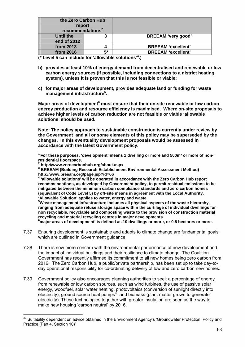
63
the Zero Carbon Hub report
recommendations2 Until the end of 2012
3 BREEAM ‘very good’
from 2013 4 BREEAM ‘excellent’ from 2016 5* BREEAM ‘excellent’
(* Level 5 can include for ‘allowable solutions’4.)
b) provides at least 10% of energy demand from decentralised and renewable or low carbon energy sources (if possible, including connections to a district heating system), unless it is proven that this is not feasible or viable;
c) for major areas of development, provides adequate land or funding for waste management infrastructure5.
Major areas of development6 must ensure that their on-site renewable or low carbon energy production and resource efficiency is maximised. Where on-site proposals to achieve higher levels of carbon reduction are not feasible or viable ‘allowable solutions’ should be used.
Note: The policy approach to sustainable construction is currently under review by the Government and all or some elements of this policy may be superseded by the changes. In this eventuality development proposals would be assessed in accordance with the latest Government policy.
1 For these purposes, ‘development’ means 1 dwelling or more and 500m² or more of non-residential floorspace. 2 http://www.zerocarbonhub.org/about.aspx 3 BREEAM (Building Research Establishment Environmental Assessment Method) http://www.breeam.org/page.jsp?id=66 4 ‘allowable solutions’ will be operated in accordance with the Zero Carbon Hub report recommendations, as developed by Government policy, to permit residual emissions to be mitigated between the minimum carbon compliance standards and zero carbon homes (equivalent of Code Level 5) by off-site means in agreement with the Local Authority. ‘Allowable Solution’ applies to water, energy and waste. 5Waste management infrastructure includes all physical aspects of the waste hierarchy, ranging from adequate refuse storage space within the curtilage of individual dwellings for non recyclable, recyclable and composting waste to the provision of construction material recycling and material recycling centres in major developments 6major areas of development’ is defined as 10 dwellings or more, or 0.5 hectares or more.
7.37 Ensuring development is sustainable and adapts to climate change are fundamental goals
which are outlined in Government guidance. 7.38 There is now more concern with the environmental performance of new development and
the impact of individual buildings and their resilience to climate change. The Coalition Government has recently affirmed its commitment to all new homes being zero carbon from 2016. The Zero Carbon Hub, a public/private partnership, has been set up to take day-to-day operational responsibility for co-ordinating delivery of low and zero carbon new homes.
7.39 Government policy also encourages planning authorities to seek a percentage of energy
from renewable or low carbon sources, such as wind turbines, the use of passive solar energy, woodfuel, solar water heating, photovoltaics (conversion of sunlight directly into electricity), ground source heat pumps30 and biomass (plant matter grown to generate electricity). These technologies together with greater insulation are seen as the way to make new housing ‘carbon neutral’ by 2016.
30 Suitability dependent on advice obtained in the Environment Agency’s ‘Groundwater Protection: Policy and Practice (Part 4, Section 10)’
64
7.40 The Code for Sustainable Homes sets out national standards for sustainable design and
construction of new homes. Its introduction has enabled planning policy to align with its different levels and enabled a wider understanding and acceptance of sustainable construction. There are six levels of the Code; at each level there are minimum standards. It includes standards for energy and water efficiency (see Policy CP26) and also other sustainability factors, such as materials, recycling, cycle spaces, home offices, waste and ecology.
7.41 Higher standards of sustainable construction aligned to the Code for Sustainable Homes
have been devised in the Partnership for Urban South Hampshire (PUSH) ‘Sustainable Development Policy Framework’31. It has been developed jointly by all of the PUSH authorities, forming a common approach. The targets in the policy framework set out a timetable for reaching the government target of zero carbon homes by 2016. These have been set in the context of the impact that climate change will have on the area and the progress being made by the development industry in creating lower carbon products. However, it has been found during recent Core Strategy examinations that this timetable is unrealistic. The Council has therefore revised its timetable.
7.42 In some instances sustainable construction may not be viable or suitable, for example, in a
conservation area. In these circumstances, a more flexible approach will be taken and the developer will need to justify why sustainable measures cannot be met.
7.43 Proposals for renewable energy developments will be considered on their merits and
consideration will be given to whether their scale, form, design and materials are sympathetic with the surrounding landscape or built environment, and whether they would impact on the local community, economy, nature conservation and historical interests.
Where else to look? Code for Sustainable Homes provides guidance on national standards http://www.planningportal.gov.uk/uploads/code_for_sust_homes.pdf together with the Technical Guide http://www.communities.gov.uk/publications/planningandbuilding/codeguide Non-residential buildings are currently assessed using BREEAM http://www.bre.co.uk/page.jsp?id=829 Zero Carbon Hubs definition of ‘Allowable Solutions for Tomorrow’s New Homes’ http://www.zerocarbonhub.org/definition.aspx?page=9
CP25 FLOOD RISK Development in areas at risk of flooding, now and in the future, as identified on the latest Environment Agency flood risk maps and the Council’s Strategic Flood Risk Assessment will be permitted provided that: a) it meets the sequential and exception test (where required) as outlined in
Government guidance; b) a site–specific flood risk assessment demonstrates that the development,
including the access, will be safe without increasing flooding elsewhere, and where possible, will reduce flood risk overall;
31 See Partnership for Urban South Hampshire: Report to Joint Committee 18th March 2008

65
c) the scheme incorporates flood protection, flood resilience and resistance measures appropriate to the character and biodiversity of the area and the specific requirements of the site;
d) appropriate flood warning and evacuation plans are in place; and e) new site drainage systems are designed taking account of events which exceed
the normal design standard. All development will be required to ensure that there is no net increase in surface water run off. Priority will be given to incorporating SUDs (Sustainable Drainage Systems) to manage surface water drainage, unless it can be demonstrated that SUDs are not appropriate. Where SUDs are provided, arrangements must be put in place for their whole life management and maintenance. Specific areas in the District, which overlay the Chalk geology, can be prone to groundwater flooding as shown on the Council’s Strategic Flood Risk Assessment maps. Rivers in East Hampshire which are sourced in the chalk area are the River Meon, River Wey and Lavant Stream, and thus groundwater fed. Development should be avoided in areas at risk from, susceptible to, or have a history of groundwater flooding. If this is not possible then the development should be designed to incorporate flood resistance and resilience measures.
7.44 Government guidance outlines the increasing risk of flooding due to the potential effects of climate change.
7.45 Flood risk is an important issue for the District. The main areas subject to flood risk are
identified in East Hampshire District Council’s Strategic Flood Risk Assessment (SFRA) and the Environment Agency’s flood risk maps. The SFRA is further supported by the South Hampshire SFRA 2007.
7.46 The flood risk maps within the SFRA identify the areas of flood risk including groundwater
flooding. The maps enable the sequential test to be applied and so steer the broad locations for development away from areas at risk of flooding and so minimise the risk to people and property.
7.47 Flood risk assessments prepared for individual sites will consider flood risk, surface water
run-off issues and the potential for sustainable drainage systems to minimise flood risk. Any development within areas of flood risk will require flood management, mitigation measures and demonstrate that the development is safe from flooding.
Where else to look? The East Hampshire Strategic Flood Risk Assessment (SFRA) (2008) provides an overview of the methodology, assumptions, uncertainties, tasks undertaken and the links to the wider sustainability appraisal process. It provides policy recommendations and guidance for the application of the Sequential Test, the preparation of flood risk assessments and the use of sustainable drainage systems, within the District council's administrative boundary. South Hampshire Strategic Flood Risk Assessment (2007) http://www.portsmouth.gov.uk/living/13539.html

66
CP26 WATER RESOURCES/WATER QUALITY Development will be required to protect the quality and quantity of water, and make efficient use of water. Development will be permitted provided that: a) it protects and enhances the quality and quantity of groundwater, surface water
features and controls aquatic pollution to help to achieve the requirements of the European Water Framework Directive;
b) it has an adequate means of water supply (even in a drought), sufficient foul and
surface water drainage and adequate sewage treatment capacity. Development must be phased to take into account the timing of any water and/or wastewater infrastructure required which must be in place prior to the occupation of development. The developer must show that additional provision or improvement of local infrastructure is required and demonstrate that adequate funding is available for that infrastructure in advance of development taking place;
c) demand management technologies are incorporated to meet the appropriate
levels of the Code for Sustainable Homes as set out in Policy CP24. Development within Groundwater Source Protection Zones will only be permitted provided that it has no adverse impact on the quality of the groundwater source or a risk to its ability to maintain a public water supply. Proposals by service providers for the delivery of wastewater services to meet the needs generated by new development and by existing communities will be encouraged and/or permitted, subject to other relevant policies. The Council and National Park Authority have a duty to take account of the Water Framework Directive (WFD) objectives. Any development which will impact on a known water body will be required to seek out opportunities to introduce mitigation and enhancement measures to help ensure the objectives of the WFD are met. The site identified for the Havant Thicket reservoir will be safeguarded from development (see Map 3).
7.48 The water supply in East Hampshire is a precious resource and it is imperative that it is
safeguarded during development. National and regional policy fully supports this stance and there is now the European Water Framework Directive32 which looks at delivering a better water environment. The Council and the National Park, along with others, plays a role in meeting the Water Framework Directive objectives and future development needs to be planned carefully so that it does not result in further pressure on the water environment.
7.49 To help assess the status of the water environment in Hampshire, the Partnership for
Urban South Hampshire carried out an Integrated Water Management Strategy33 in 2008 which covered South Hampshire. For the rest of the County, Hampshire County Council carried out a draft Water Study in 200934. However, this document is awaiting review and currently remains in draft format. An Outline and a Detailed Water Cycle Study has been carried out for Whitehill Bordon (see Policy CSWB8).
Water resources
7.50 The chalk aquifer dominates the freshwater environment of the District and its water resources are already fully committed to water supply. A twin-track approach of demand management and water resource development is required. East Hampshire recognises the importance of implementing this approach by promoting efficient use of existing water
32 http://www.environment-agency.gov.uk/research/planning/33362.aspx 33 http://www.push.gov.uk/090301_-_iwms_revised_final.pdf 34 HCC Water Resources and Wastewater Management in Hampshire to 2026, Atkins (September 2009)
67
resources, while recognising the development of new water resources, such as the Havant Thicket Winter Storage Reservoir. This reservoir will not only provide further water resources but will provide a real opportunity to create a natural and sustainable recreational attraction. The timescale for the provision of the Havant Thicket Winter Storage Reservoir is uncertain and will depend on future regional forecasts of demand for water. The timescales will be reviewed in 2020.
7.51 In light of further supporting the twin-track approach, the Environment Agency has
demonstrated that it is possible to achieve Level 3 of the Code for Sustainable Homes (105 litres per head/day) in a new building at low cost35.
7.52 The Code for Sustainable Homes has minimum requirements for water efficiency for all of
its six levels. The higher levels of the Code to be a requirement of Policy CP24 would automatically set higher standards for water efficiency reflecting the fact that the south east is a region of serious water stress. The Environment Agency has recently updated its Catchment Abstraction Management Strategies (CAMS) and they are now called Abstraction Licensing Strategies (ALS). The relevant ALS for East Hampshire District are the East Hampshire Abstraction Licensing Strategy (March 2013) and the Wey Catchment Abstraction Licensing Strategy (December 2012). The findings are the same that abstraction licences will not be increased and all future development will need to be within the current resources. Demand management technologies should therefore be incorporated into new development to ensure the security of supply. This approach is also supported in the findings of the Habitats Regulations Assessment of the Local Plan: Joint Core Strategy.
Water quality 7.53 New infrastructure has to meet strict standards set by the Environment Agency and reflects
the view taken by Ofwat ‘that water and sewerage companies should seek finance through developer contributions’. Infrastructure required for new development should be phased, timed and funded in advance of that development taking place and in some circumstances that may make it necessary for developers to carry out studies on the existing infrastructure and examine options. In order to avoid placing excessive demands upon any overburdened systems, housing development will be directed initially towards those catchments that still have capacity.
Groundwater protection 7.54 Protection should be given to groundwater which is vital for drinking water and maintaining
the flow of the watercourses within the District. The Council and National Park Authority will consult with the Environment Agency on proposals for residential, industrial or commercial development which may pose a threat to groundwater resources. The Environment Agency’s “Groundwater Protection: Policy and Practice (GP3)”36 provides further guidance and is therefore not duplicated in the Local Plan: Joint Core Strategy. The Environment Agency’s website also holds information on the location and designation of Groundwater Source Protection Zones37.
Where else to look? An introduction to the Water Framework Directive – Environment Agency The European Water Framework Directive came into force in December 2000 and became part of UK law in December 2003. It gives us an opportunity to plan and deliver a better water environment, focussing on ecology. http://www.environment-agency.gov.uk/research/planning/33362.aspx South Hampshire: Integrated Water Management Strategy, Partnership for Urban South Hampshire (PUSH), December 2008
35 WRc Report UC7231 September 2006 36 http://www.environment-agency.gov.uk/research/library/publications/40741.aspx 37 http://www.environment-agency.gov.uk/homeandleisure/37833.aspx

68
http://www.push.gov.uk/090301_-_iwms_revised_final.pdf
CP27 POLLUTION Development must not result in pollution which prejudices the health and safety of communities and their environments. Developments that may cause pollution, and developments sensitive to pollution, will only be permitted if they are appropriately separated and designed to remove the risk of unacceptable impacts. Engineering or administrative controls may be required to provide sufficient protection to focus on reducing pollution at source. Development which includes a lighting scheme will not be permitted unless the minimum amount of lighting necessary to achieve its purpose is proposed. Glare and light spillage from the site must be minimised. In determining an application, consideration will be given to the aesthetic effect of the light produced and to its effect on local residents, vehicle users, pedestrians and the visibility and appreciation of the night sky. Development will not be permitted if it would have an unacceptable effect on the amenity of the occupiers of neighbouring properties through loss of privacy or through excessive overshadowing. Any development which is likely to lead to a significant effect on an internationally designated site is required to undertake an appropriate assessment under the Habitats Regulations. As part of any mitigation/avoidance package any impacts on air quality will require a regime for continued air quality monitoring to be set up before the introduction of any mitigation measures, and thereafter maintained.
7.55 Pollution has an impact upon human health and amenity. Specific areas for concern are
unpleasant emissions such as smoke, gases, odour, heat, radon and vibration; noise; land contamination; air quality on European sites; light pollution; and privacy and daylight. Research has shown that levels of land contamination, air quality and excessive noise for example, can impact upon human health but may also impact upon the natural environment. In addition, evidence shows that significant community dissatisfaction can result where developments fail to consider localised impacts that can seriously affect the amenity of an area and the general wellbeing of residents.
7.56 Meeting air quality targets for nitrogen dioxide emissions will pose a huge challenge in East
Hampshire, particularly for developments that threaten changes in road traffic generation, road speeds or the numbers of heavy goods vehicles. Also of concern are odours from commercial food outlets, industrial and agricultural processes, and these applications require an assessment of the potential impacts.
7.57 To avoid potential impacts of new development and increased traffic levels on
internationally designated nature conservation sites Policy CP22 seeks to ensure that adequate measures are in place to avoid or mitigate any potential adverse effects. One form of avoidance is that the Council will need to explore with other local authorities (e.g. Waverley Borough Council) a framework for undertaking air quality monitoring along the main roads that traverse the Wealden Heaths. The monitoring is required before and after the introduction of sustainable transport measures, such that further measures can be devised if air quality does not improve. The monitoring also forms part of the avoidance/mitigation package set out for the development at Whitehill & Bordon (see Policy CSWB9).
69
7.58 The Local Plan: Joint Core Strategy transport policies seek to reduce the use of the private car and encourage other initiatives to minimise the impact of air pollution. They identify the need to demonstrate that alternatives to the car are encouraged in new developments.
7.59 Within East Hampshire, developments resulting in the generation of significant outdoor
noise or evening and late-night entertainment noise pose the most significant challenge to protecting neighbour amenity, wildlife and the character of the countryside. The Council’s environmental health strategies are focused on the control of noise at source. An assessment of the impact of noisy developments and locating sensitive developments close to existing sources of noise will be required.
7.60 East Hampshire has significant areas of highly-valued open land with exceptionally low
levels of ambient noise and the Council seeks to protect the tranquillity of such areas, especially those within the South Downs National Park.
7.61 DEFRA, the Department for the Environment, Food and Rural Affairs, has commissioned
noise mapping around Rowlands Castle and the Clanfield/Horndean area. It is expected that action plans to reduce environmental noise will be developed. Development will need to support and be compatible with these plans. CPRE have tranquillity maps covering the South East of England and set out the value of, and threats to, tranquillity.38
7.62 The District contains numerous sites which may be subject to historic contamination and
which may present a potential risk to human health. For proposed development on or adjacent to land suspected of being affected by contamination, risks posed to end users will be required to be appropriately investigated and if necessary remediated so as to comply with current UK industry good practice. The standard of remediation shall take full account of the development’s intended use(s) and be to a level which ensures the future safe use of the land with respect to human health, groundwater and the wider environment. Where there is no evidence to the contrary, the possibility of contamination will be assumed when concerning applications in relation to land on or adjacent to previous industrial use or where proposed uses are considered that are particularly sensitive to contamination e.g. housing, schools, allotments, hospitals, children’s playing areas.
7.63 It shall remain the responsibility of the developer to identify land affected by contamination
and to ensure that such land is remediated to secure a safe development. 7.64 The District also has a number of major aquifers that are particularly sensitive to
contamination. Protection of these aquifers is a priority (see Policy CP26).
7.65 Artificial lighting, in particular from sports pitch floodlights but also other buildings, has been recognised as disturbing to some residents, wildlife and the character of the countryside. Where there are low levels of existing artificial lighting, controls on new lighting schemes is likely to be particularly important.
Green Infrastructure 7.66 The green infrastructure is the managed natural environment within rural and urban
settings. The benefits of these spaces for the economy, local people and wildlife must be recognised as more than just a precious local resource. East Hampshire and other partners define green infrastructure as a ‘holistic approach to viewing the natural environment which acknowledges the multiple benefits and vital functions it provides for the economy, wildlife, local people and communities alike’39. It will be important, both now and in the future, to understand this wider view of our open spaces and the links between them both to the wider landscape and East Hampshire’s towns and villages.
38 http://www.cpre.co.uk/library/results/tranquillity?month=0&year=0&keyword=&offer=false&format=&type=&orderby=title&campaign=&topic=93&page=6 39 Towards a Green Infrastructure Strategy for South Hampshire: Advice to PUSH (July 2008).
70
CP28 GREEN INFRASTRUCTURE Development will be permitted provided that it maintains, manages and enhances the network of new and existing green infrastructure. Development will need to take forward the objectives and priorities presented in the District’s Green Infrastructure Study and Strategy, the South Hampshire Green Infrastructure Strategy and its Implementation Framework and the avoidance and mitigation measures set out in the Joint Core Strategy’s Habitats Regulations Assessment. Account will also need to be taken of other relevant joint core strategy policies such as landscape, historic environment, biodiversity, flood risk and design. New green infrastructure must be provided either through on-site provision or financial contributions. The size of contribution will be linked to the scale of the development and the resulting new green infrastructure must be located as close as possible to the development it is intended to serve.
7.67 The Government White Paper ‘The Natural Choice: securing the value of nature’ and the
National Planning Policy Framework both identify the need for core strategies to address the issue of green infrastructure. Increasingly green infrastructure is being recognised for its value to natural resources and biodiversity, as well as the opportunities that it can offer for a higher quality of life through design and recreation.
7.68 The Partnership for Urban South Hampshire (PUSH) has developed a Strategy for Green
Infrastructure (June 2010). Given the importance of green infrastructure now and in the future the Council and National Park Authority not only feels it is appropriate to include a policy in the Local Plan: Joint Core Strategy. As an initial step the Council produced a Green Infrastructure Study in 2011. This is now complemented by the District’s Green Infrastructure Strategy (2011 – 2028).
Where else to look? The Partnership for Urban South Hampshire (PUSH) has developed a Strategy for Green Infrastructure (June 2010). http://www.push.gov.uk/push_gi_strategy_adopted_june_10-2.pdf Green Infrastructure Study for East Hampshire District Council (UE Associates, August 2011) Natural England’s Framework for Green Infrastructure for the South East (2009) http://www.gos.gov.uk/497648/docs/171301/SEGIFramework.finaljul09.pdf The Partnership of Urban South Hampshire (PUSH) Green Infrastructure Implementation Framework (October 2012) http://www.push.gov/push_green_infrastructure_implementation_framework__october _2012_.pdf East Hampshire Green Infrastructure Strategy 2011 - 2028 (Environment X Change, 2013) Hamsphire Historic Environment Record is the database for the historic environment http://www3.hants.gov.uk/landscape-and-heritage/historic-environment/historic-buildings-register.htm
71
Built Environment
CP29 DESIGN
The District’s built environment must be of an exemplary standard and highly appealing in terms of visual appearance. All new development will be required to respect the character, identity and context of the district’s towns, villages and countryside and must help to create places where people want to live, work and visit. New development will be required to:
a) seek exemplary standards of design and architecture with a high quality external
appearance that respect the area’s particular characteristics; b) take particular account of the setting and context of the South Downs National
Park where relevant, be in accordance with the National Park purposes and duty if in the National Park and take account of these purposes and duty where the National Park’s setting is affected;
c) reflect national policies in respect of design, landscape, townscape and historic
heritage; d) ensure that the layout and design of development contributes to local
distinctiveness and sense of place, and is appropriate and sympathetic to its setting in terms of its scale, height, massing and density, and its relationship to adjoining buildings, spaces around buildings and landscape features;
e) ensure that development makes a positive contribution to the overall appearance
of the area by the use of good quality materials of appropriate scale, profile, finish, colour and proven weathering ability;
f) make provision for waste and recycling bin storage and collection within the site; g) be designed to the Lifetime Homes Standard as appropriate; h) take account of local town and village design statements, neighbourhood plans
that identify local character and distinctiveness and the design elements of parish and town plans and conservation area appraisals;
i) be accessible to all and designed to minimise opportunities for crime and anti-
social behaviour without diminishing the high quality of the overall appearance; j) embrace new technologies as a considered part of the design and in a way which
takes account of the broader impact on the locality; k) provide car parking in a way that secures a high quality environment and is
conveniently located, within curtilage wherever possible, taking account of relatively high levels of car ownership where necessary.
7.69 East Hampshire is a desirable place in which to live with outstanding historic market towns
and attractive villages in delightful countryside including 57 % of the District that lies in the South Downs National Park. The buildings, open spaces and landscape all contribute to the character of the area. Throughout the District there are more than 1,600 listed buildings (buildings of special architectural or historic interest), 43 conservation areas (areas of architectural or historic interest), 98 scheduled ancient monuments, and 5 nationally recognised parks and gardens which are registered for special protection. In addition, non-designated assets and features help to shape the distinctiveness throughout

72
the district. It all adds up to a rich heritage for people who live and work here, and also attracts many tourists and visitors.
7.70 New development will make a positive contribution to the appearance of our towns and
villages and to quality of life. Design and layout should take account of neighbouring buildings as well as the surrounding area. New development can be striking but must respect or enhance local character and be appropriate to its context. It is vital that design goes beyond the focus of the individual development and also takes account of sense of place, safety and security. It may therefore be helpful to use national and local guidance to help with this process.
7.71 Government guidance calls for good design that ensures attractive, usable and durable
places. It is important to plan positively to achieve high quality and inclusive design for all development, including individual buildings, public and private spaces as well as wider area development schemes. Design which fails to take the opportunity for improving the character and quality of an area and the way it functions should not be accepted.
7.72 Local authorities should aim to create a good quality built environment that facilitates social
interaction and inclusive communities. Plans which create or enhance a distinctive character and support a sense of local pride and civic identity should, therefore, be looked at positively.
7.73 In addition, the Commission for Architecture and the Built Environment (CABE), now
incorporated into the Design Council, has produced a Building for Life standard that sets out 20 criteria for achieving good design. This provides a useful guide for developers on the standards that are now expected and what factors are considered when assessing design. The criteria are not exhaustive nor meant to be regarded as providing a ceiling to innovation. Rather they are seen as helping to provide a framework for assessment that may be of assistance in meeting the requirements of the policy.
7.74 Policies are required to achieve high quality in new development and at the same time to
protect and enhance existing historic character. Only the best exemplary design that respects and enhances the special qualities of our towns, villages and countryside will be acceptable. Future developments must be fit for purpose for many years and meet the changing circumstances and needs of everyone. This will be a key challenge for all development in the District. Due to the importance of the historic environment within the District this is considered separately in this section.
7.75 The main settlements of Alton, Petersfield, Horndean, Liphook and Whitehill & Bordon
provide opportunities for encouraging new high-quality and imaginative designs. In addition, high quality design which retains and complements their overall character will be required in the smaller rural villages. The close relationship between new development, existing features and open spaces will be given priority in all future proposals for the District.
7.76 Local input in any development is, of course, crucial and that is why town and village
design statements are so important. Putting up new buildings alongside something much older can sometimes be contentious, so it is important to be aware of any local special features of particular merit and to relate any proposals to the context of the site. The design of new buildings should be woven into the fabric of the living and working community.
7.77 There is a growing recognition that design affects people’s lives. Health can be a good
example of this. Well-designed buildings with good use of open space, for example, can encourage healthy lifestyles with scope for walking, cycling, and other leisure pursuits that may help to prevent problems such as obesity. This approach has to be applauded but should not overshadow the need to secure good architectural and landscape design for buildings and spaces. In addition, with an ageing population it is particularly important to

73
accommodate the needs of the elderly. Providing homes built to Lifetime Homes Standards40 will help to achieve this.
7.78 In recent years, parking provision in new housing developments in East Hampshire has not
always been adequate. It has not always been located so that it is convenient for residents. Poor on-street parking has resulted, causing major problems and detracting from the overall character of the development.
7.79 Car parking spaces should be an integral part of the layout and design of the new dwelling.
Care is required to ensure that parking is convenient, easy to use and well located to overcome the problems arising from haphazard on-street parking. Spaces should be situated within the curtilage of individual plots, within garages or car ports either integral or set back from the road. Parking for flats should be located adjacent to the building where it can enjoy natural surveillance from the occupiers of nearby dwellings. Arrangements need to be made for the parking of cycles within individual residential curtilages where these exist or in communal facilities for apartments.
CP30 HISTORIC ENVIRONMENT Development proposals must conserve and, where possible, enhance the District’s historic environment. All new development will be required to: a) conserve and enhance the cultural heritage of the South Downs National Park if
in the National Park and take account of this cultural heritage where the National Park’s setting is affected;
b) reflect national policies in respect of design, landscape, townscape and historic
heritage; c) conserve, enhance, maintain and manage the district’s heritage assets and their
setting including listed buildings, conservation areas, Scheduled Ancient Monuments, archaeological sites and Historic Parks and Gardens;
d) ensure that the development makes a positive contribution to the overall
appearance of the local area including the use of good quality materials of appropriate scale, profile, finish, colour and proven weathering ability;
e) take account of local conservation area appraisals and town and village design
statements where they exist. 7.80 The historic environment is made up of individual buildings, groups of buildings,
conservation areas, historic parks and gardens, archaeological sites and other features, both designated and un-designated, that are important to the overall character of the countryside, towns and villages. East Hampshire has a rich and diverse historic environment which is an important asset. It is also part of the wider environment which draws people to the area either to live, visit or for investment. It is important to recognise that this environment is sensitive to change and requires protection. The challenge for the District is managing changes so that it continues to meet the needs of the future population, while protecting the historic environment.
7.81 Government guidance states that the historic environment and its heritage assets should be
conserved and enjoyed for the quality of life they bring to this and future generations. Imaginative policies can help to reduce threats to the historic environment and contribute to the fabric of the community and its local distinctiveness. The historic environment provides
40 Lifetime Home Revised Criteria July 2010. www.lifetimehomes.org.uk

74
an irreplaceable record of our cultural heritage, adds to the quality of life by enhancing the local scene and sustains the sense of local distinctiveness that is such an important aspect of the character and appearance of towns, villages and countryside. The inclusion of heritage within Green Infrastructure is an important contribution to this. In addition, it can also be of immense importance for leisure and recreation. The Council and National Park Authority recognise the need to continue to embrace change through sensitive adaptation and new development. This must be based on a full understanding of the significance of and impact on the heritage assets, both currently known and potential, and historic environment of the place. Where development will result in the removal or alteration of an heritage asset, this should be recorded and the results made available to the community. The results should make a positive contribution to the public understanding of the historic environment, local distinctiveness and its contribution to the fabric of the community.
Where else to look? The Planning (Listed Buildings and Conservation Areas) Act 1990 provides legislative background for listed buildings. http://www.legislation.gov.uk/ukpga/1990/9/contents Hamsphire Historic Environment Record is the database for the historic environment http://www3.hants.gov.uk/landscape-and-heritage/historic-environment/historic-buildings-register.htm Building in Context: New Development in Historic Areas (CABE/EH): this is a training programme that gives decision makers the tools to recognise how projects can respond well to their surroundings. http://www.building-in-context.org/publications.html Streets for All: South East: this manual provides practical guidance and is aimed at all those involved in managing, designing or maintaining the public realm. http://www.helm.org.uk/server/show/category.19643 Moving towards Excellence in Urban Design & Conservation (2003) CABE/EH: planning guidance ensuring that new building and refurbishment enhances the public realm. http://www.cabe.org.uk/publications/moving-towards-excellence-in-urban-design-and-conservation The heritage pages of the East Hampshire District Council website also provide helpful information on listed buildings and conservation areas.

75
8. Transport and access
CP31 TRANSPORT Through implementation of the Hampshire Local Transport Plan (2011 – 2031), the fullest possible use of sustainable modes of transport (including cycling, walking and public and community transport) and reduced dependence on the private car will be encouraged. Development proposals will include a range of mitigating measures and, where appropriate, will be required to: a) enhance the quality, viability, availability, accessibility and frequency of public
transport and alternative community transport provision, especially in rural areas, to ensure that those without access to a private car have access to services and facilities necessary for their well-being;
b) protect and provide safe and convenient cycle and pedestrian links that integrate
with existing cycle and pedestrian networks, such as the South Downs Way and Shipwrights Way, and reflect the amenity and rural character of the area;
c) ensure that highway design and associated signing meets the needs of vehicular
traffic and the need for safety whilst also placing a high priority on meeting the needs of pedestrians, cyclists and public transport users and without detriment to the quality of the environment;
d) plan for new highway infrastructure that will reduce congestion, improve highway
safety, increase accessibility to the District’s town and district centres and enhance economic prosperity of the District;
e) improve access to rail stations at Rowlands Castle, Petersfield, Liss, Liphook,
Alton and Bentley Station by sustainable modes of transport and, where appropriate, provide additional car and cycle parking at rail stations;
f) provide adequate, convenient and secure vehicle and cycle parking in
accordance with adopted standards; g) ensure that the type and volume of traffic generated would not harm the
countryside or the rural character of local roads; h) protect sunken and rural/green lanes so that their convenience and safety are
enhanced for their users, and their ecological, landscape and recreational value are enhanced;
i) improve access for people with impaired mobility to all forms of transport and to
all developments to which the public will reasonably expect to have access; and j) produce and implement transport assessments and travel plans for proposals
that are likely to have significant transport implications; k) include measures, to be funded by the developer, that address the impact of the
new development so as to ensure the continued safe and efficient operation of the strategic and local road networks.
New development should be located and designed to reduce the need to travel. Development that is likely to generate a significant number of additional vehicular movements will normally be expected to be located near existing centres and supportive infrastructure.

76
A high quality transport system will be required as part of the growth proposed in Whitehill & Bordon. Proposals for new development in the town must improve transport links from the surrounding settlements to the town, and within the town, providing opportunities to reduce reliance on the private car and encourage other modes. Financial contributions will be sought from developments towards the implementation of identified transport infrastructure schemes, having regard to the costs of those schemes and the likely availability of public funding.
Local Transport Plan (LTP)41 8.1 Hampshire County Council is the Highway Authority for most of the roads in East
Hampshire with the Highways Agency being responsible for the A3/A3(M). The LTP (2011-2031), prepared by the County Council, contains a long-term strategy and a short-term implementation plan, which taken together provide the transport policy context for the Core Strategy. The strategy sets out the priorities and policy objectives for transport in Hampshire as a whole to 2031. This is complemented by three local area strategies. The three-year implementation plan sets out which schemes and interventions will be progressed to March 2014. The strategy sets out three priorities:
(i) To support economic growth by ensuring the safety, soundness and efficiency of the
transport network in Hampshire (ii) To provide a safe, well-maintained, and more resilient road network in Hampshire as
the basic transport infrastructure of the county on which all forms of transport directly or indirectly depend, and the key to continued casualty reduction.
(iii) To manage traffic to maximise the efficiency of existing network capacity, improving journey time reliability and reducing emissions and thereby supporting the efficient and sustainable movement of people and goods;
8.2 These three priorities are supplemented by 14 policy objectives which aim to:
- Improve road safety - Manage parking - Support use of new transport technologies - Grow bus travel - Support community transport provision - Improve rail services and facilities at stations - Provide home-to-school transport - Improve co-ordination and integration between travel modes - Apply ‘Manual for Streets’ design principles, to support a better balance between
traffic and community life in towns and residential areas - Improve air quality - Reduce the need to travel - Promote walking and cycling to provide a healthy alternative to the car for short local
journeys - Develop Bus Rapid Transit and high quality public transport in South Hampshire, to
reduce car dependence and improve journey time reliability - Outline and implement a long-term transport strategy to enable sustainable
development in major growth areas 8.3 The LTP recognises that funding is limited and priority will be given to measures that deal
with the most severe problems and give the greatest benefit to the largest number of people.
41 http://www3.hants.gov.uk/transport/local-transport-plan.htm

77
8.4 Of the three local area strategies, two relate to East Hampshire. The South Hampshire area strategy covers Horndean, Clanfield and Rowlands Castle and the Central Hampshire and New Forest local area strategy covers the rest of the District.
8.5 The South Hampshire area strategy was developed jointly by the three Transport for South
Hampshire (TfSH) Local Transport Authorities. The long term strategy contains 14 policies for transport that cover the 11 local authorities in the sub-region. These policies aim to support economic growth, improve journey time reliability (including access to international gateways), improve the quality of public transport and sustainable transport modes, improve integration of transport and land-use planning, develop the role of waterborne transport and improve air quality.
8.6 The long-term strategy for Central Hampshire and the New Forest includes:
Seeking to manage impacts of traffic and travel on National Parks; Protecting quality of life in villages and rural areas; Tackling rural accessibility problems by improving community transport and other on-
demand services, as well as non-transport improvements such as increasing services direct to residents;
Improving access within the market towns by all modes of transport; Managing traffic in the smaller settlements; Improving access to the countryside; Reducing sign clutter in the settlements and rural roads; and Developing sustainable transport measures to support the Whitehill Bordon Eco-Town.
8.7 In seeking to achieve the priorities in the LTP the County and District Councils and the
National Park Authority will work with partners to seek to maintain and improve transport infrastructure at the strategic and local level. Measures will be supported that: improve the strategic rail and highway networks, and access to those networks; manage on-street parking and traffic management, through traffic regulation; improve pedestrian and road safety, including by ensuring new development accords
with Government and Highway Authority design guidance related to road safety; promote integrated transport; improve access to town and village centres, taking into account the recommendations
of proposed Town Access Plans and District Statements. These will include improvement of routes for walking, cycling and public transport, the effective management of car parking and, where these approaches are not appropriate, carefully planned additions to public car parking spaces; and
help tackle rural accessibility problems by non-transport improvements such as increasing services direct to residents and the provision of broadband to more isolated parts of the District.
8.8 The Council and the National Park Authority will promote safer access and sustainable
forms of transport to and within East Hampshire and the South Downs National Park for enjoyment, health and well-being including through: Promotion of train and bus access to the District and National Park; Support for the development of joined-up routes for non-motorised transport such as
the Shipwrights Way; and Improvements to make existing paths, tracks and roads more user-friendly.
Whitehill & Bordon
8.9 The Transport Strategy for Whitehill & Bordon outlines the principles of the multi-modal transport system which will support the delivery of the Eco-town. It has been developed from a series of supporting strategies, studies and evidence, and fully aligns with current local and national planning policy, seeking to:

78
“Achieve sustainable growth in the long term by delivering an integrated low carbon transport system that will be at the forefront of innovative thinking, providing high-quality, affordable and deliverable alternatives to the private car, managing transport demand and maximising the use of existing assets to become an example for modern day sustainable living.”
8.10 The Strategy sets out three key principles:
Reducing the Need to Travel outside the town – By providing the appropriate jobs and facilities within the town itself, travel to surrounding towns and service centres can be significantly replaced by more local journeys, and trip lengths reduced.
Managing Car Demand within and outside of the town – While acknowledging that the car will play an important role in the operation of the future town, pro-active management of car trips within and external to the town can minimise the negative impacts of car travel, and appropriately mitigate adverse implications of car use.
Enabling Sustainable Transport for all trips – Transport within the town will be re-prioritised away from the car and high quality public transport systems and walking and cycling routes will be provided to enable easy and safe access to school.
8.11 In addition to the requirements for Eco-towns set out in the Eco-towns PPS, Whitehill &
Bordon seeks to be a modern example of sustainable development, particularly in relation to transport. Existing travel patterns in Whitehill & Bordon show the dominance of the private car for local access and access to employment. There is, however, significant potential in Whitehill & Bordon with the planned creation of significant new jobs and the delivery of a new Town Centre to create a significant shift on travel patterns.
8.12 Development at Whitehill & Bordon will aim to achieve a significant reduction in the
proportion of trips being made by private car, aiming to achieve a maximum of 50% of all trips within the town being undertaken by private car. In the longer term, the Whitehill & Bordon project will seek to achieve even higher standards of sustainable travel through the continued role out of an integrated package of transport measures.
8.13 Development at Whitehill & Bordon will be supported by the implementation of a Freight
Strategy which ensures that the necessary delivery of goods and services required by the town is pro-actively managed, whilst delivering measures and initiatives to reduce negative impacts of larger vehicles using local roads.
Public and community transport 8.14 Given the financial cuts and the consequent reductions being made to contracted bus
services, improvements to bus services away from the core (commercial) network are unlikely. Where possible existing bus services should be preserved and their potential maximised through altering frequencies and timings so that they best serve the needs of the communities.
8.15 There is scope to develop community transport which can help to meet travel needs that
cannot be readily met by conventional passenger transport. This can include new transport initiatives such as community minibuses, the demand-responsive Call and Go, Wheels to Work and taxi sharing schemes. Should local Post Offices become rural banks, it is important to co-ordinate transport between local shops/post offices and to enable young people to visit towns and youth centres, sports clubs etc. The financial cuts also raise issues regarding the long-term funding of community transport by the public sector.

79
Walking and cycling 8.16 Walking and cycling need to be promoted as a means of access to jobs, facilities and
services but also as a recreational opportunity with a positive impact on physical and mental health (see Policy CP18).
8.17 East Hampshire District’s Cycle Plan 200542 identifies the existing and proposed cycle
routes for the District. Parts of the network have been implemented where funding has become available, which in some cases has made it appear disjointed. To achieve any significant increase in cycling there must be an interconnected network of safe and efficient cycle routes around the towns and villages supported by high standard, safe, cycle parking. Work is currently underway in conjunction with the Hampshire Action Team to deliver the missing links. This may include the conversion of footpaths to allow cyclists to use them; as a result, separate networks will once again be connected with one another.
Facilities at rail stations 8.18 There may be a case for increased parking provision and facilities for all travel modes at
rail stations, and Stagecoach and South West Trains are already working to maximise existing car parking provision. The impact of any additional parking at stations would have to be carefully assessed. Appropriate measures such as integration, cross-ticketing, marketing and information improvements will also be considered as part of station travel plans.
Access to the countryside 8.19 Within the Hampshire Countryside Access Plan43, the local area plans identify the main
issues and suggest what should be done to improve access to the countryside in particular areas. The local area plans for the Forest of Bere, Hampshire Downs and South Downs cover East Hampshire. They provide an opportunity to review the countryside access network and decide priorities for improvement by the County and District Councils and others.
Traffic management measures 8.20 Notwithstanding the above it is recognised that the car will remain part of the mix of
transport modes for many people, particularly for those in the rural areas. There is some local congestion at peak times. Also of particular concern is the volume and speed of traffic using rural roads with residents of many villages concerned about the loss of rural tranquillity. In some areas there is also ‘rat running’ along local roads to avoid congestion on main routes. Where resources allow, projects will be encouraged that reduce the dominance of traffic and thus enhance the quality of life.
8.21 The special character and appearance of the rural area and its villages, particularly within
the National Park, will need to be considered when looking at the design of traffic management measures. The rural roads in the District need to be made safer for all users, introducing Shared Space concepts44 to ensure that drivers are fully aware of other users. Speed limits need to be reduced; steps need to be taken to prevent ‘rat running’ on inappropriate roads such as the network of ancient sunken lanes in the District, and Sat-Nav information systems need to be changed to show the correct grade of road for a
42 http://www.easthants.gov.uk/ehdc/formsfordownload.nsf/0/85B506C24E7D817880256F A40054A2DA/$File/EH+CYCLE+PLAN.pdf 43 http://www3.hants.gov.uk/countryside/access-plans.htm 44 Shared Space removes the traditional segregation of motor vehicles, pedestrians and other road users. Conventional road priority management systems and devices such as kerbs, lines, signs and signals are replaced with an integrated, people-oriented understanding of public space, such that walking, cycling, shopping and driving cars become integrated activities.

80
particular journey. HGV drivers using unsuitable roads is an issue for many villages in the District. Sat-Navs have dedicated lorry routing software; if at all possible, HGV drivers will be encouraged to use this. At the same time, road signage should be reduced to that which is essential to ensure road safety. This will improve the recreational use of rural lanes by walkers and cyclists which is particularly important within the South Downs National Park.
8.22 The District Council and the National Park Authority will continue to be involved in
discussions with the Highways Agency on options for the improvement of the Ham Barn Roundabout on the A3. Full consideration will be given to the potential impact of any proposed improvement scheme on local communities and the conservation and enhancement of the natural beauty, wildlife and cultural heritage of the National Park.
Non-transport solutions 8.23 In meeting the needs of rural communities, transport is only part of the picture. Accessibility
issues can be addressed through many non-transport solutions, for example retaining and enhancing local services and facilities, home deliveries, making use of modern information systems and co-ordinating appointments and visits with community transport provision. There are other measures that are also appropriate, such as the provision of local e-offices; the need for developers to include home offices/studies in new residential developments; the wider availability of high speed broadband or wi-fi and the greater awareness of MATISSE opportunities45. The Hampshire Rural Pathfinder programme has identified initiatives such as those within rural areas which seek to ease travel demands through the retention or improvement of local facilities and services.
8.24 Recognising that a degree of private car usage will be unavoidable, a network of charging
points for electric and alternatively powered vehicles will be sought across the district to encourage the use of low emission vehicles.
Parking 8.25 Deciding the amount of parking to be provided with new development is a difficult issue.
Government guidance encourages a reduction in car parking for most types of land use. However, in East Hampshire high levels of car ownership and limited public transport, combined with the rural character of the area, mean that a reduction in parking capacity or further discouragement of parking, would not necessarily discourage car use. The Council and the National Park Authority are able to set their own parking standards and thresholds for transport assessments and site travel plans; these will be determined through a Supplementary Planning Document for the area outside the National Park. No decision has yet been made on how such matters will be addressed within the National Park.
Transport contributions 8.26 Working in partnership with Hampshire County Council, the District Council aims to use the
transport contributions it collects on schemes under Policy CP32 to help mitigate the likely effects of increased levels of trip generation by addressing accessibility, road safety, air quality and traffic congestion.
Transport assessments and travel plans 8.27 A key aim of the Local Plan: Joint Core Strategy is to concentrate development at
sustainable locations so that it best serves, or is served by, existing homes, jobs and
45 MATISSE (Mobile And Teleworking Initiative for a Smarter South East) seeks to encourage the adoption of smarter working practices, facilitate productive networking and the spreading of good practice within business, government as well as within the service provider community. http://www.ehampshire.org/welcome_to_the_matisse_smarter-working_initiative_/c-82.html

81
services and minimises the need to travel by car. New development must seek solutions to reducing travel demand and car trips through transport assessments and travel plans. The emphasis has to be enhancing and providing facilities to support and find alternative travel by means other than the car.
8.28 Development which is likely to result in a lot of new journeys will be located near existing
centres. This will help reduce the need to travel and also to increase the scope for car sharing. The quality of accessibility within the development and to other facilities is also a crucial factor in reducing car use.
Where else to look? The Hampshire Local Transport Plan Strategy (2011–2031) contains a long-term ‘Strategy’ (2011-2031) and a short-term ‘Implementation Plan’ (2011-2014). It shows how transport improvements contribute to wider outcomes and sets out a vision for the transport network. http://www3.hants.gov.uk/transport/local-transport-plan.htm
82
9. Whitehill & Bordon
A Profile of Whitehill & Bordon 9.1 Whitehill & Bordon is set within a landscape of heathland, woodland rivers, streams and
ponds. It lies on the edge of the South Downs National Park and is bounded by areas of environmental designations of European, national and local significance (Special Protection Areas (SPAs), Special Area of Conservation (SACs), Sites of Special Scientific Interest (SSSIs) and Sites of Importance for Nature Conservation (SINCs).
9.2 The town is very different to the traditional market towns in the surrounding locality such as
Alton and Petersfield as, historically, it was formed as an Army camp on a former toll road. The area became a centre of military importance in 1863 when the War Office purchased 1,600 acres of training land. The army has been at Bordon Camp since 1901. The town effectively grew up to service the needs of the military bases.
9.3 Unlike many other Hampshire towns, Whitehill & Bordon lacks a historic town centre and
instead grew in a piecemeal fashion with small scale Edwardian ribbon development of shops and homes along the route of the A325, Chalet Hill and Liphook Road. Rapid expansion followed in the 1960/1970s when a series of residential estates grew up on both sides of the A325. A new shopping and community centre was created off Forest Road.
9.4 The A325 road runs north to south and bisects the town; additionally the main London to
Portsmouth A3 trunk road passes nearby and the Hindhead Tunnel is now open and will improve road access to London.
9.5 Whitehill & Bordon is linked by rail-bus to Farnham and Haslemere which provides public
transport access to two lines, the Alton service and the Portsmouth service, both of which offer direct services to London in about an hour. Most rail commuters however use Liphook and Liss rail stations.
An Opportunity 9.6 In anticipation of the Defence Training Review (DTR)46, a great deal of technical work and
public consultation has been carried out over the past seven years. This was originally led by the Whitehill & Bordon Opportunity Group, a partnership of local authorities, landowners and government agencies who have been working together to make the project a success. Background evidence was provided by GVA. The Group drew up a Green Town Vision47 and commissioned consultants AECOM to prepare a masterplan working with the local community.
9.7 The regeneration of the MoD and local authority land can make an important contribution to
the development of new technologies and practices and put Whitehill & Bordon on the map as an example of a modern sustainable 21st century town. Most importantly it provides the chance to work with local people to meet their needs and to put in place the facilities that are lacking today.
9.8 The community-led project is now managed by a Delivery Board, a partnership of the local
authorities and landowners, and a cascade of local stakeholders and theme groups who sit underneath that board and report to it.
46http://webarchive.nationalarchives.gov.uk/+/mod.uk/defenceinternet/aboutdefence/whatwedo/trainingandexercises/dttcp/ 47 Green Town Vision: Update, East Hampshire District Council, August 2008.

83
The Masterplan 9.9 In 2008 AECOM was commissioned to undertake a masterplan to create a framework for
development and a strategy that will bring better facilities and a larger and more sustainable community over the next 20 years. Part of the vision relates to encouraging lifestyles that respect the environment while improving the image and competitiveness of the town. A key challenge is to improve the social and economic profile of the town and achieve a greater mix of housing. Work was completed in late 2009. In December 2010 East Hampshire District Council adopted the masterplan as a material consideration.
9.10 Between late 2009 and June 2013 a series of studies have been initiated. All the studies
are available on the www.whitehillbordon.com website. These studies form an evidence base which supports the masterplan findings and were used to revise the development masterplan. Public consultation was carried out in the autumn 2010 and 2011. The revised Whitehill & Bordon Framework Masterplan (May 2012) has been adopted by the Council.
Eco-Town Status
9.11 In 2009 the town was identified by the Department of Communities and Local Government
as a potential location for an Eco-town. Although it is not a freestanding town, nor will it deliver 5,500 dwellings, the Government recognised that there was an opportunity at Whitehill & Bordon to reflect the Eco-town concept, much of which was included in the Green Town Vision and the more recent Eco-town Vision48. It provides the chance to completely rethink how transport, employment, retail and other services are provided as well as providing new homes to exemplary standards.
9.12 This identification as an Eco-town brought with it a sustainability and viability assessment
which confirmed that an innovative mixed use development was feasible within the town. The designation has brought with it to date over £12M of seed-corn funding which has been and is being expended on early infrastructure and community projects, a detailed masterplan as well as a series of studies which have interrogated the potential of the development.
9.13 The Whitehill & Bordon Strategic Allocation covers about 340 ha within which land is
identified for up to 4000 dwellings and associated infrastructure as illustratively shown on the Proposals Map and defined in the Strategic Allocation Policies CSWB1 Strategic Allocation, CSWB3 The New Town Centre, CSWB9 Biodiversity and CSWB11 New Roads and Traffic Management on the A325. These four policies relate specifically to the Strategic Allocation area as identified on Map 4.
9.14 Map 5: Strategic Allocation Proposals Map demonstrates how the Eco-town Vision could be
delivered within the allocated land. The Plan illustrates the spatial distribution of the principal land uses of the Strategic Allocation as tested in the masterplan and evidence base studies. It is intended to be a flexible framework and would not prevent modifying site specific land use if further evidence comes forward or when the next stages of the Local Plan are prepared.
Minerals and Waste Plan 9.15 The Hampshire Minerals and Waste Plan was adopted by the Hampshire Authorities in
October 2013. The plan includes Policy 15: (Safeguarding – mineral resources) which includes a reference to Whitehill & Bordon in terms of mineral safeguarding due to the known mineral resources located in the area identified for development. The Plan does not
48 Eco-town Revised Bid, Whitehill-Bordon Opportunity Eco-town, East Hampshire District Council, September 2008

84
allocate Whitehill & Bordon for mineral extraction but safeguards the mineral resources from sterilisation in line with the National Planning Policy. Policy 15 supports the prior extraction of mineral resources as part of the delivery of Whitehill & Bordon but only where it does not impede the development and phasing.
Key Challenges and Opportunities for Whitehill & Bordon
Sustainable Economic Development 9.16 Economic development has a key role to play in the regeneration of Whitehill & Bordon
town. The key driver of regeneration is the loss of jobs and spend associated with the military vacating the sites and the need to take this opportunity to build a new sustainable mixed economy.
9.17 With the expansion of the town it will become the largest community within the District.
Listed are some of the challenges and opportunities:
There is a need for a mix of businesses so that the town is not so reliant on one sector or company;
Land for industry/business use tends to lose out to housing; Businesses require supporting infrastructure including an improved education system,
high capacity digital services and diverse housing; There is a low level of skills. School leavers and adult residents are less qualified than
their counterparts in the rest of the District. The level of graduates is low. There is limited ICT infrastructure for next generation services and limited social and post 16 educational facilities.
The Town Centre 9.18 A new town centre is regarded as one of the main priorities for the town. The perceived
profile of the town needs to be raised to attract quality retailers.
Homes 9.19 The MoD’s departure from the town will release land that will provide an opportunity to meet
housing needs. The main issues are as follows:
Whitehill & Bordon has a young population with a high proportion of children and fewer elderly residents than average;
There is a community aspiration for the introduction of larger units and ‘executive
homes’ to redress the balance and provide greater choice at the top end of the housing range;
About 20% of households rent their homes; this attracts low income earners and has
created an imbalance in the social and economic mix in the existing population.
Climate Change
9.20 As an Eco-town, Whitehill & Bordon has the chance to lead the way in adapting and mitigating against climate change. There are significant economic and employment advantages to be gained from the emerging low carbon economy. Whitehill & Bordon has the opportunity to become a centre of excellence for renewable and low carbon industries. Some of the key issues are set out below:
The environmental performance of many buildings in Whitehill & Bordon is poor;
85
Estimated annual consumption is similar to other settlements of the same size; There are no major power generation facilities in Whitehill & Bordon, but there is some
use of small scale renewables, including woodfuel and photovoltaics in domestic properties and schools.
Natural and Built Environment 9.21 There is concern that development cannot take place without unacceptable damage to
important nature conservation sites. The opposite view is that the attractive local environment, if carefully managed, can be the centrepiece of any future development. The key issues to consider are:
The town is surrounded by land of high ecological quality. Most heathland is of
international importance (Special Protection Areas and Special Areas of Conservation); the town also contains sites of national and local importance which could be affected by new development. The need to protect and enhance these areas will influence the scale and type of new development. The SPAs and SACs are vulnerable to impacts associated with housing development; non-residential development would be more acceptable on land adjacent to the SPAs;
The avoidance of impacts and mitigation measures to protect sites of ecological
importance are the key to expanding the town in a sustainable manner. Areas of new alternative open space for informal recreation will be required both within and on the edge of the town;
The South Downs National Park lies immediately to the south and about 1 km to the
west of the town. It creates the opportunity for the town to be a gateway to the National Park providing services and facilities for visitors coming to enjoy the natural beauty and wildlife of the area. The potential impact of development in the town on the setting of the National Park could affect the future scale and location of development;
A number of archaeological sites of national importance lie within and close to the town,
including on MoD, County Council and District Council owned land. Development in the town should avoid impacts to these historic features, although it could positively contribute to the green infrastructure network;
Air quality issues along the A325 corridor need to be addressed; There are several distinctive civic and military buildings or features of interest within the
town with potential to be retained or re-used. They are not statutorily protected. They provide an opportunity to draw on the contribution made by the historic environment to the sense of place and local character of the settlement.
Green Infrastructure 9.22
A number of green tongues and blue corridors in public ownership bisect the town, including the Wey Valley, Deadwater Valley, Hogmoor Inclosure and Bordon Inclosure; these sites are to be protected and included in the Green Grid;
The Green Grid should consist of a network of greenspaces which link to the wider
Green Loop of other well managed high quality spaces; There is a gap between Whitehill & Bordon and Lindford which should be integrated into
the Green Grid and Green Loop.

86
Healthy Living (Community facilities and services) 9.23 The built and natural environments are important components in improving the health and
well being of the local community. Well designed development and good town planning can also contribute to promoting and supporting healthier and more active living and reduce health inequalities.
The lack of public playing fields and children’s play space is made worse by flooding
problems and a lack of changing rooms and car parking; Sports facilities are undersupplied within the town with the majority of existing facilities
belonging to the MoD. Public access is limited e.g. the MoD swimming pool, Bordon and Oakhanger Sports Club.
At present the MoD military police support the civilian police within the town. There will be
a need as the town expands for policing to expand to suit a larger town with a larger town centre and a more vibrant economy;
Many of the areas used as informal open space are important environmental sites;
The current provision of doctors and dentists will not meet the demands of the existing and
new population in the long term. There is no emergency dentist practice in the town and access to the nearest hospital for emergency and acute/specialists are in Basingstoke, Guildford and Portsmouth.
Education 9.24
The shortage of pre-school places, sixth form, further education and higher education provision in the town need to be addressed;
The impact of the withdrawal of the armed forces on already falling school rolls will need
to be addressed.
Infrastructure
9.25
Surface water run-off from new development should match or improve the existing situation on-site;
A new on-site foul water treatment works is likely to be required to serve development
options above about 1,000 dwellings;
A detailed water cycle study49 has shown that a number of options are available which enable water neutrality to be achieved;
Additional dwellings will require major off-site electricity reinforcement works;
Major off-site reinforcement of gas services is likely to be required.
Transport 9.26
Improvements are required in bus-based and non-car alternative transport to improve
49 Detailed Water Cycle Study, Peter Brett Associates, July 2011

87
access to a range of facilities, services and rail stations;
There is concern from local residents about the increase in traffic rat-running through the town and surrounding villages;
The Hindhead Tunnel should improve road access to the town;
The nearest railway stations are at Liphook, Haslemere and Liss to the south-east/south
and Alton, Bentley and Farnham to the north-west/north, both providing access to London Waterloo. The feasibility of rail links to London was investigated and would need to be kept under review.
Commercial Viability 9.27
Regeneration of the town will be market driven and a strong market for new housing will need to lead the town’s expansion;
New housing near the town centre and within walking distance of shops and leisure
facilities will be vital in creating sufficient demand to sustain new commercial development;
A consolidated, conspicuous town centre is needed, offering a strong anchor store and
other large units to attract a wider range of retailers;
Being remote from London and lacking public transport options and a rail station, the future market for offices in the town without regeneration is likely to be restricted to existing local occupiers or those who specifically seek to be in the area;
Phasing of housing and commercial and retail floorspace needs to be carefully co-
ordinated;
Initial phases of all new development will need to be of high quality and visually attractive in order to set a precedent for future development;
Co-ordinated and pro-active marketing of site availability will be key to raising the profile
and attractiveness of the town to the market and the development opportunities it affords.
9.28 The Army will pull out of Bordon in 2015 and the town will change forever. The strategic
allocation at Whitehill & Bordon plans positively for that change by blending social, environmental and economic interests to create a sustainable community based on green aspirations. The Whitehill & Bordon Eco-town will bring a new market identity; a new and accessible town centre; new recreation opportunities; new education opportunities to raise achievement; new jobs in which to fulfil achievement; and new homes for local people and the wider area. All to be provided within this unique high quality environment.
POLICY CSWB1 STRATEGIC ALLOCATION
Land at Whitehill & Bordon is identified as a strategic allocation for future development as shown on the key diagram and on the Proposals Map.
New development will be designed to create a green town that responds to the challenges of climate change, in an innovative and responsive way. It will be an exemplar of a modern sustainable community in terms of places of work, schools, travel planning, promoting and supporting healthier lifestyles, provision of local services and sustainable use of resources.
Proposals for new development within the strategic allocation must:
88
a) lnclude sustainable development principles;
b) Provide up to 2,725 new homes over the Plan period and phased delivery of up to 4,000 new homes, employment provision (about 5,500 new jobs), a new town centre (with up to 23,000 sqm of retail floorspace). This development will be provided at a balanced rate to ensure that housing and employment are available together to reduce the instances of in and out commuting;
c) Provide supporting social and physical infrastructure , including a range of convenience and comparison shopping, health, community and leisure facilities centred around a new town centre and new neighbourhoods, together with appropriate education provision for pre-school, primary and secondary and adult education required as a result of the development to attract families and businesses to the area; allow people to work from home, to reduce leakage of expenditure and to reduce levels of out-commuting;
d) Be carried out in a comprehensive manner in line with the Infrastructure and Delivery Plan that sets out how the rate of development will be linked to the respective phases of the development; and ensure that the necessary infrastructure, required as a result of development has been secured and delivered in parallel with the new developments;
e) Improve transport links from the surrounding settlements to the town, and within the town, providing opportunities to reduce reliance on the private car and encourage other modes including any necessary mitigation measures required as a result of development, to be funded by the developer, to ensure the continued safe and efficient operation of the strategic and local road networks;
f) Maximise the opportunities from being a gateway to the adjoining South Downs National Park;
g) Take account of the settlement policy boundary which defines the edge of the built-up area within which development will be allowed, provided it complies with the principles of development set out in this chapter and with the rest of the policies in the Development Plan;
h) Take account of the Eco-town Policy Zone (see Map 4) which shows the area within which Eco-town standards will be applied and where Eco-town support funds may be available for retrofitting of existing housing stock and for infrastructure improvements.
9.29 The Government recognises that there is an exciting opportunity at Whitehill & Bordon to
create a more sustainable settlement and this was reflected in the decision to make it one of the UK’s first Eco–towns. It has attracted funding and investment and has given the town a new sense of purpose.
9.30 The South East Plan50 contained a specific policy for the town where new development was
proposed as a Strategic Development Area. There is still a need to provide strategic polices to set out a framework for development. Policy CSWB1 reflects the aims of the Eco-Town Vision and the principles of the policy in the former South East Plan.
9.31 The South East Plan stated that up to 5,500 dwellings should be delivered as part of a
regeneration strategy although this figure should be regarded as indicative. The final figure could not be known until further work, such as a transport study and more work on the Habitats Regulations Assessment (HRA)51, had been completed.
50 The South East Plan - Regional Spatial Strategy for the South East, Government Office for the South East, May 2009 51 HRA report, Habitats Regulations Assessment for Whitehill Bordon Draft Framework Eco-town masterplan (June 2010), UE Associates, November 2011

89
9.32 The HRA work has been completed along with further studies (on transport, economy, energy, water and the town centre). The outcome of the studies show that up to 4,000 homes could be provided without significant impact to the environment, provided that appropriate avoidance and mitigation measures are put in place. The 4,000 dwellings are in addition to those provided through existing completions, existing commitments on large sites and small urban potential (see Appendix 2). The Council has listened to local people and proposes a range of housing that allows a relatively high proportion of larger properties to meet local needs.
9.33 The focus of the new community will be the new town centre which will provide a range of
employment opportunities, community, health, retail, and leisure and sports facilities, civic space and housing. The Forest Centre is proposed as a Mixed Use Neighbourhood Centre. The development of the new town centre will mean that the Forest Centre will take on a lesser role as a ‘local centre’ in the retail hierarchy (Policy CP8). Local centres will provide local facilities and help to provide a focus for a network of distinct neighbourhoods.
9.34 Appropriate education provision required as a result of development will meet all the
required pre-school, primary, secondary and adult educational needs on-site. This could provide extra curricular activities, family learning, specialist services, skills training and sports facilities that will be available for community use out-of-hours. Such facilities would help the town to invest in the development of the skills of residents and the local workforce and act as a driver for businesses and people to live, work and invest in the area. A range of health care facilities will also be provided.
9.35 In order to create an inclusive and coherent community, a range of social infrastructure will
be required, including a range of health care facilities, community centres/meeting halls and heritage centre/museum.
9.36 Provision will also be made for young people including a range of youth facilities. 9.37 An Infrastructure and Delivery Plan for Whitehill & Bordon Eco-town will set out the main
items of social and physical infrastructure, and identifies who will be expected to deliver it and by when. An interim statement and infrastructure schedule for the district wide IDP has been prepared. It will be kept under review and require updating as further evidence comes forward to ensure that the Local Plan is viable and deliverable.
9.38 Contributions will be required from the developers to mitigate the impacts of the
development including the increases in population. 9.39 The phasing of the housing development will be coordinated with the rate of infrastructure
delivery. 9.40 In order to demonstrate that the scheme is both viable and deliverable, a high level viability
assessment52 has been undertaken. On the basis of the assumptions adopted, the development appraisal of the baseline scenario shows that the current masterplan proposals have the potential to be viable, generating a positive NPV or residual land value in line with what a reasonable land owner might expect to see at this stage in the planning programme. The Viability Assessment tested a number of scenarios and demonstrates that the scale of development and infrastructure required will require public sector investment support to improve the viability of the proposals and secure commercial interest. This is not unusual for the scale of the strategic allocation in the economic and financial climate in which the Local Plan: Joint Core Strategy is being brought forward. The Viability Assessment will be kept under review and any consequential amendments to Whitehill & Bordon IDP, supporting documents will be accommodated within the flexibility offered by the Local Plan: JCS policies.
52 Viability Assessment of Whitehill & Bordon Eco-town Masterplan (June 2012)
90
9.41 A partnership of the local authorities and landowners has been established, named the
Delivery Board, it is supported by themed groups which sit underneath that board and report to it. The strategy will rely upon working with a (or a number of) delivery partner(s) who will bring development expertise and investment. Almost all of the land is within public ownership. The intention is to set up a special purpose vehicle where development assets can be pooled alongside a community trust which may take on longer term responsibilities for energy management, green space management and public transport. This would be an on-going trust or charitable foundation able to ensure the provision of facilities and infrastructure into the future.
POLICY CSWB2 SUSTAINABLE ECONOMIC DEVELOPMENT Development Proposals must: a) Take into account Policies CP3 to CP9 in the Local Plan: Joint Core Strategy
which set out the approach to achieving sustainable economic development; b) Help to make the town an attractive and vibrant place with a clear economic
function that provides an exceptional quality of life;
c) Submit an economic strategy at the time of a planning application for the new development to show how access to work opportunities will be achieved. The strategy should also set out facilities to support job creation in the town and as a minimum there should be access to one employment opportunity per new dwelling that is easily reached by walking, cycling and/or public transport;
d) Encourage the development of a high quality skilled local workforce with easy
access to a range of good local employment opportunities to reduce out-commuting and to economically link the surrounding villages with Whitehill & Bordon.
Land is broadly indentified at three sites for employment use as illustratively shown on the Proposals Map on a total area of 12.3 ha (gross) of employment land, out of which about 9.5ha (gross) will be delivered in the Plan Period.
The sites are at:
Louisburg Barracks (northern half 7.94 ha gross)
Viking Park (4.09 ha gross)
Quebec Barracks. (a small portion to meet the onsite housing provision) (0.25 ha gross)
Development will also be permitted on a variety of sites and premises within the town. Small/medium sized business premises for high tech, innovative companies will be provided in town centre locations and residential areas. Such uses will be encouraged to cluster together in an eco-business park for green technologies. Investment will be encouraged by those businesses which share the vision.
9.42 When the MoD leaves the town, the loss of jobs will have a significant impact on the local economy. However there are opportunities which should be taken to re-brand the town and to create an environment that is conducive to sustainable economic development. There are significant economic and employment advantages to be gained from the emerging low carbon economy. Whitehill & Bordon has the opportunity to become a centre for excellence for renewable and low carbon industries.

91
9.43 Whitehill & Bordon is currently the second largest town in East Hampshire but with the Eco-town expansion it will become the largest community within the District. The town has a strategic location and around 2.7 million people live within 1 hour journey time. An expanded town with a wide catchment area will attract new businesses.
9.44 The Whitehill & Bordon Eco-town, Economic Development and Employment Strategy53 and
Inward Investment Strategy54 sets out a framework for the town’s future economic growth. The town can become a focus for investment introducing a new purpose and transforming Whitehill & Bordon into an exemplar Eco-town. The aim is to build a local mixed and sustainable economy and also make the Eco-town an exceptional and well regarded location within reach of a sub regional community of around 230,000 people.
9.45 It is expected that there will be around £1.5 billion invested in the town by 2036. The
strategy seeks to ensure that the community will get maximum benefit from this investment. The overall requirement is to create a thriving sustainable economy that meets the needs of the whole community – while respecting and protecting its attractive natural environment.
9.46 Local Plan: Joint Core Strategy Policies link the construction of houses to jobs, encourage
business support hubs within neighbourhood centres (as well as within the town centre), support improved access and public transport, encourage tourism and visitor facilities (the South Downs National Park abuts the town) and look at ways that local food can be marketed, processed and sold locally.
9.47 An aspirational target of 5,500 jobs will be created as identified in the Masterplan requiring
the creation/allocation of a total of 84,000 sqm of floorspace (including the town centre). This aspirational target of 5,500 jobs will provide one job per new home and will replace the jobs lost through the closure of the garrison. A wider range of employment land must be available to provide high quality business space and modern business premises. Business development will be supported by four principal sources of employment land:
Re-use of former MoD Buildings Establishing new eco-business parks Town centre employment, including public sector services Home working (supported by local skills centre/business support unit).
9.48 The withdrawal of the MoD will occur over a short period of time, whilst major
redevelopment will be longer term. Careful programming and phasing of the release of land for employment will be necessary to mitigate the impact of the loss of jobs associated with the MoD and to keep in step with the provision of new housing.
POLICY CSWB3 THE NEW TOWN CENTRE Land is broadly identified for a new town centre as illustratively shown on the Proposals Map. The town centre will be in the same category as Petersfield and Alton in terms of its role and function in the retail hierarchy for the District. It will comprise a major retailer which will be located at its heart together with other large units to attract more quality retailers. There is scope for 16,000 sqm gross retail floorspace in a new town centre at Whitehill & Bordon (in the Plan period).
53 Economic Development and Employment Strategy, Whitehill Bordon Eco-town Team, June 2011 54 Whitehill & Bordon Inward Investment Strategy, Whitehill & Bordon Eco-town Team, March 2013
92
Proposals for new shops, recreation and leisure, entertainment, cultural facilities, offices and commercial developments, and high density housing (above shops) will be allowed in the town centre provided the proposed development: a) sustains and enhances the range and quality of provision, including uses that
contribute to the evening economy;
b) improves the vitality and viability of the town centre;
c) helps to create a sense of place through high quality layout and design and contributes to a built form that is in synergy with quality open spaces, civic or town squares;
d) provides landscaping, street furniture, and public art, where appropriate, that is
an integral part of the design of the new town centre;
e) provides footpaths and cycleways that link the town centre to the rest of the town, on both sides of the A325 that are proportionate to the scale of the proposals.
9.49 The town has a reasonable provision of convenience shops (e.g. supermarkets,
newsagents) but a poor supply of comparison shops (e.g. clothing, household goods) for a town of its size. Residents travel elsewhere to do their comparison shopping and have expressed a desire for a new town centre with additional shops. There are opportunities to make the town a more sustainable community with a wider range of shops and leisure facilities that people want to improve their quality of life.
9.50 The perceived profile of the town needs to be raised to attract quality retailers. The new
town centre is designated as a ‘town centre’ in the retail hierarchy (Policy CP8). The development of the new town centre will mean that the Forest Centre will take on a lesser role as a ‘local centre’ in the retail hierarchy (Policy CP8).
POLICY CSWB4 HOUSING The target in Whitehill & Bordon is for 35 % of all new dwellings to be provided as affordable housing subject to individual site circumstances (eg. Development viability, site surroundings). Residential proposals must include a mix of housing types, with a proportion of family homes (3, 4 and 5 bedrooms) and executive homes that will help to correct the town’s current housing imbalance.
9.51 Land is broadly identified for up to 4,000 dwellings (excluding Class C2 development) as
illustratively shown on the Proposal Map. The early work on the potential development opportunities at Whitehill & Bordon examined four options - 2,000, 4,000, 5,500 and 8,000 dwellings. The lowest option was not considered to be viable. It would not bring forward the new shops, jobs, leisure facilities and the new town centre. The highest option (8,000 dwellings) would adversely affect the important nature conservation designations.
9.52 The South East Plan included a housing allocation for Whitehill & Bordon of up to 5,500
homes. It stated that the final figure will be determined following further studies. 9.53 The Habitats Regulations Assessment (HRA) included an assessment of the quantity and
quality of SANGs (Suitable Alternative Natural Greenspaces) and concluded that the proposed SANGs in the draft Masterplan can accommodate phases 1 and 2 of the proposed development which delivers 4,000 new homes, based on locally-derived assessment criteria and the Thames Basin Heath's standard55 for the provision of SANGs (8 hectares per 1,000 head of population).
55 Thames Basin Heath’s Standard for provision of SANGs Visitor Access Patterns on the Thames Basin Heaths. A Report to English Nature, Liley D, Jackson D & Underhill-Day J, 2006b.
93
9.54 The Transport Assessment (TA)56 concluded that, in traffic terms, there are no overall
show-stoppers to the development coming forward, but there are a number of impacts of the development which will need to be mitigated. Further work, following the TA, produced engineering solutions for possible improvements at each of 13 junctions in the town and the wider area, which would be sufficient to mitigate the impact of 4,000 dwellings.
9.55 The Preferred Policies document57 suggested 5,300 dwellings phased over a 20 year
period. The Council has listened to local views and has taken into account the conclusions of the further studies and proposes to reduce the figure to up to 4,000 dwellings. There may be occasions when unidentified sites (windfalls) come forward in the town, however, the Council will monitor housing development closely to ensure that it does not reach a limit that starts to undermine the avoidance and mitigation strategy to protect the Special Protection Areas and Special Areas of Conservation.
9.56 Meeting housing needs is fundamental to securing a sustainable future for the town. There
is a need to provide sufficient housing to meet the needs of the whole community, including the young and elderly, to improve affordability and widen opportunities.
9.57 In comparison to the District, Whitehill & Bordon lacks detached properties reinforcing the
perception of Whitehill & Bordon as a starter home or more affordable family housing location. New housing provision should meet the needs of the younger population that is currently residing in the area or may be attracted to the area, but also through the provision of detached or executive homes provide for the full range of new households which will be attracted to the area through employment opportunities generated by the creation of new jobs. The provision of larger homes will also help to re-balance the population profile of the town and create a more varied and sustainable community.
9.58 In Whitehill & Bordon a substantial scale of new housing is being proposed, therefore, a
higher level than 35% affordable housing could adversely alter the balance between market and affordable housing in the town. In addition, 35% meets the policy targets and is a sufficient provision of affordable housing for the Whitehill & Bordon settlement.
9.59 With a long-term build programme and public sector land ownership, Whitehill & Bordon
provides an opportunity to deliver self-build, custom build homes or use of an alternative housing delivery model e.g. community land trusts. Such approaches alongside the conventional housing delivery models will be encouraged within the Whitehill & Bordon Strategy Allocation.
POLICY CSWB5 DESIGN In additon to the criteria set out in Policies CP29 and CP30 new development should: a) demonstrate an integrated approach to sustainable design to achieve the policy
requirements on energy, water, transport, green infrastructure and biodiversity; b) be in accordance with the character area design codes, design guidance, the
neighbourhood quality charter and Town Design Statement; c) where opportunities arise, for example in the new town centre, incorporate taller
landmark or locally distinctive ex-military buildings into the overall design to create an identity to the town and the overall development area.
56 Transport Assessment - Key Findings Report, Whitehill Bordon Eco-town Evidence Base, Amey, September 2011 57 East Hampshire Core Strategy Preferred Policies Document, East Hampshire District Council, November 2009

94
POLICY CSWB6 SUSTAINABLE CONSTRUCTION Proposals should, where technically or financially viable, demonstrate best practice, innovation and higher levels than those outlined in policy CP24 whilst at the same time being in accordance with wider national government policy on sustainable construction. The carbon footprint of the whole town will not exceed the carbon footprint of the existing settlement. This will include the provision of localised energy centres and help the Eco-town to de-carbonise the energy infrastructure by employing such solutions as biomass and energy from waste systems, decentralised heat and power networks and smart grids All new development must comply with the District’s Sustainable Construction policy (CP24). In addition, development proposals must (unless proven to be financially or technically unviable): a) Connect to any District heating systems, or have the infrastructure to connect if
this is not yet installed. Developments which are not connecting to the district system should provide reasons for this and provide alternative low carbon heating solutions;
b) Ensure that the orientation of new homes is maximised to make use of solar
power at the domestic and neighbourhood level in conjunction with incentives, such as the Feed-in-Tariffs (FITs)58 and Green Deal59.
Proposals for new development or refurbishment, including infrastructure, will be required to outline how sustainability will be delivered during construction and future maintenance. Supporting evidence will need to address: c) The reduction of carbon dioxide and other greenhouse gas emissions, both in
manufacture, construction, delivery and in the location and mode of travel of the workforce;
d) How pollution and waste is to be minimised; e) Life Cycle (Whole Life) Costings; and f) the effective use of resources. In particular, the reduction of demolition or
construction waste to landfill, the re-use of buildings, recycling of materials and reduction in water use.
The use of factory assembly and modern methods of construction will be encouraged, particularly if these methods can be shown to have a positive impact on the local economy by bringing in new skills and manufacturing processes to the Eco-town.
9.60 All new development will contribute to the aim of achieving carbon neutrality for the Eco-town by 2036. Investment in construction and infrastructure is a major contributor to the success of the overall sustainable ambitions for the Eco-town. It is expected that best practice will develop and construction techniques will improve over time. The Council wish to see these best practices and improvements coming forward in the Eco-town as soon as possible.
58 Feed-in tariffs: The Feed-in Tariffs (FITs) scheme was introduced on 1 April 2010, under powers in the Energy Act 2008, and work with the Renewable Heat Incentives, Department of Energy and Climate Change, March 2011. 59 The Green Deal – A summary of Government’s proposals, Department of Energy and Climate Change, 2010.
95
9.61 Proposals should, where technically or financially viable, demonstrate best practice
innovation and higher levels than those outlined in policy CP24 whilst at the same time being in accordance with wider national government policy on sustainable construction. There is a wealth of guidance and information available, for example, the Constructing Excellence’s Sustainability Checklist provides ideas about practical measures to make proposals more sustainable.
9.62 The level of detail required in the Life Cycle (Whole Life) Carbon and Costing would vary
with the nature of the application with a high level assessment required at the outline planning stages. The purpose should be to ensure that the future long term maintenance costs are considered at planning and design stages. It would ensure that low carbon standards and technology used could be sustained long term.
9.63 An Energy Feasibility Study for Whitehill & Bordon (LDA, 2011) examined a number of
renewable and low carbon energy opportunities linked to the masterplan. Further work, in consultation with stakeholders, alongside the Feasibility Study examined the potential of creating an energy management company.
9.64 A number of further approaches were explored with stakeholder input. These were:
District heating Biomass and energy from waste Wind Hydro Solar, and Heat pumps.
9.65 The Study found that the case for hydro, wind and solar farms was found to be marginal
within the policy zone boundary, either due to land take or energy generation potential. However, opportunities do exist to explore these with ‘allowable solutions’ in conjunction with neighbouring land owners. A passive approach to reducing energy demand by use of energy efficient fabric and building services is preferred. Any sustainable energy provision should consider how existing communities could benefit from individual or communal systems.
Where else to look? Constructing Excellence’s Sustainability Checklist provides ideas about practical measures to make projects more sustainable. Details can be found at: http://www.ukswedensustainability.org/checklist.jsp
POLICY CSWB7 WASTE Planning applications should include a sustainable waste and resource plan covering both domestic and non-domestic waste. The plan should consider: a) The use of arboricultural arisings and farm waste as biomass fuel;
b) The use of locally generated waste as part of the energy solution for the town;
c) Composting schemes;
d) Using organic waste for anaerobic digestion.
9.66 This policy should be read in conjunction with Policy CP27 (Pollution) which set out the
approach to managing waste across East Hampshire.
96
POLICY CSWB8 SUSTAINABLE WATER MANAGEMENT All development will be required to contribute to the overall Eco-town target of achieving water neutrality (no net increase in water abstraction or carbon emissions as a result of the Eco-town). Development must be designed and delivered to limit the impact of new development on water resources, water quality and quantity. Innovative and sustainable water management systems must be used to help to achieve a ‘water neutral’ status.
All buildings will be equipped with water efficiency measures to achieve Level 5/6 of the Code for Sustainable Homes specifically for water. Development must be phased to take account of the timing of water and/or sewerage infrastructure to support the Eco-town. All necessary infrastructure provision and water quality improvements must be funded and in place in advance of development taking place. Development proposals for Whitehill & Bordon must comply with the district-wide Policy CP23 ‘Flood Risk’. Where appropriate, Sustainable Drainage Systems (SUDS) must be provided which are fully integrated into the network of multi-functional green spaces, help to enhance local biodiversity, provide open space, and offer flood risk and water quality benefits.
9.67 Water is a finite resource and it is imperative that it is safeguarded during development.
The Eco-town provides the opportunity to produce and test innovative means of water resource management. A Detailed Water Cycle Study has been prepared by Peter Brett Associates LLP (2011) to support the potential development of the proposed Eco-town at Whitehill & Bordon.
9.68 The study has identified that there are sufficient water resources in the locality of the Eco-
town which can sustain the increased development by utilising an innovative and sustainable water management system to achieve a ‘water neutral’ status.
9.69 There is an ongoing and increasing need to appraise, manage and reduce flood risk. Policy
CP25 sets out a distinctive approach in addressing flood risk management in East Hampshire, including Whitehill & Bordon.
9.70 The East Hampshire District Council Strategic Flood Risk Assessment (SFRA) 2008 and
the Environment Agency’s flood risk maps identify the areas of flood risk around Whitehill & Bordon. The maps enable the sequential test to be applied and so steer the broad locations of development away from areas at risk of flooding and so minimise the risk to lives and property.
9.71 For individual sites flood risk assessments will need to be prepared to consider flood risk,
surface water run-off and sustainable drainage systems to minimise flood risk. Evidence prepared for the Whitehill & Bordon Eco-town including an Outline Water Cycle Study (Halcrow 2009) and the Detailed Water Cycle Study (Peter Brett Associates LLP 2011) have considered flood risk and surface water management issues which would need to be incorporated and considered in any associated flood risk assessments.
9.72 Green Infrastructure Strategy (Halcrow 2011) has also been produced for Whitehill &
Bordon, in conjunction with the Detailed Water Cycle Study. Information on the suitability, design and appropriateness of different types of SUDS has been considered and will form part of the overall design of the Whitehill & Bordon masterplan.

97
Where else to look? Code for Sustainable Homes http://www.communities.gov.uk/planningandbuilding/sustainability/codesustainablehomes/
POLICY CSWB9 BIODIVERSITY Development proposals must protect and enhance the biodiversity of Whitehill & Bordon and the surrounding environment (see Policies CP19 and CP20). Development at Whitehill & Bordon will be guided by its Habitats Regulations Assessment, Green Infrastructure Strategy and Local Biodiversity Action Plan. All development must show a net gain in biodiversity, secure existing and create new wildlife habitats supported by long term management plans and show that there are no adverse significant effects on the integrity of any European designated site. The Whitehill & Bordon Habitats Regulations Assessment, Green Infrastructure Strategy and Local Biodiversity Action Plan includes approaches for monitoring, conserving and enhancing biodiversity. Planning applications will support and apply these documents on a site-by-site basis. No part of the Whitehill & Bordon development will be permitted within 400 metres of the Wealden Heaths Phase II SPA. Proposed employment development at Louisburg Barracks, which falls within the 400 metre zone, would be permitted if adequate measures have been put in place to avoid or mitigate any potential adverse impacts on the SPA. Such measures must be agreed with Natural England and the planning authority. Where avoidance and mitigation, as required in the Habitats Regulations Assessment, takes the form of provision of a Suitable Alternative Natural Greenspace (SANG), a minimum requirement of 8 hectares of land should be provided per 1,000 new occupants (after discounting to account for the existing ecological value of sites and for current access and capacity within reasonable access of the new dwellings). Provision is made in the masterplan for approximately 127 hectares of SANGs and 30 hectares of SANG network. Integrated Access Management provision should be delivered throughout the local European designated sites and other greenspaces, such as SANGs over a period of time as determined by Natural England and the planning authority, but not less than 80 years. This should include an approach that allows the delivery of self-sustaining management and monitoring regimes.
9.73 The Whitehill & Bordon Habitats Regulations Assessment (UE Associates 2011) (HRA)
follows an interim assessment published in November 2009. The earlier document sought to assess the 2009 version of the draft masterplan. Further iterations of the HRA will be required right through to the decisions on planning applications.
9.74 The Whitehill & Bordon HRA has been prepared in accordance with European and national
planning legislation. Along with an accompanying Land Management report60 and SANG Design and Delivery plan it provides sufficient avoidance and mitigation measures which have been incorporated into the masterplan to address the potential adverse impacts on the designated sites without undermining the delivery of growth in the town.61
60 Land Management Report, Habitats Regulations Assessment for Whitehill Bordon Draft Framework Eco-town masterplan (June 2010), UE Associates, July 2011 61 SANG Design and Delivery Plan, Halcrow, October 2012

98
9.75 The Eco-town’s high level objectives will go a long way to reducing impacts on the integrity
of the local European Designated Sites, such as reduced car use and providing SANGs as alternative places for people to recreate.
POLICY CSWB10 GREEN INFRASTRUCTURE New and existing greenspaces will be part of a well managed, high quality, green infrastructure network, which is linked to the wider countryside for the benefit of communities and wildlife (see also Policy CP28). Land is broadly identified for greenspace as illustratively shown on the Proposals Map. Development will need to maintain and manage the network of new green infrastructure and where appropriate, the enhancement of existing green infrastructure and seek to accord with the Whitehill & Bordon Green Infrastructure Strategy and Habitats Regulations Assessment. The implementation of green infrastructure must be in advance of occupation which is in line with the phased delivery of the Strategic Allocation.
9.76 East Hampshire District Council and the South Downs National Park have produced a
Green Infrastructure Study which forms part of the background evidence to the Local Plan: Joint Core Strategy62 (see Policy CP28). A more detailed Green Infrastructure Strategy (Halcrow 2011) has been produced for Whitehill & Bordon which specifically informs the masterplan.
9.77 The Green Infrastructure Strategy provides an implementation plan to support the revision
of the masterplan, expressing the need to install green infrastructure in advance of development, which ultimately responds to the development.
9.78 The ‘Green Loop’ at Whitehill & Bordon will be a major element of green infrastructure
within the town. This primary network will provide all the necessary connections for people and wildlife to use and enjoy greenspaces both within the town and surrounding countryside. Development will commit to supporting the delivery and management of the ‘Green Loop’. The Core SANGS namely Hogmoor Inclosure, Bordon Inclosure and Standford Grange Farm will also be part of the local Green Grid and wider green infrastructure network.
9.79 There should be a range of green infrastructure which can serve a range of functions. The
network will comprise of areas such as public parks, gardens, amenity space, sports grounds, playing fields, open spaces, semi-natural areas including woods and heaths, green corridors including rivers, cycleways and rights of way, allotments, green streets and green roofs.
9.80 Community allotments or commercial gardens will allow the production of local food. The
green spaces will enhance the spatial qualities of the area, will improve biodiversity, meet the needs of the new community and improve public access to the countryside. Some areas will be multi-functional – accessible for play and recreation, walking or cycling safely and support wildlife and flood management.
9.81 Wildlife corridors and enhancements to buildings for wildlife will make the town more
permeable for wildlife. Some areas of importance to biodiversity may need to be more restricted in terms of public access as part of the management regime.
62 Green Infrastructure Study for East Hampshire District Council, UE Associates, August 2011

99
TRANSPORT, ACCESS AND MOVEMENT POLICIES (see also Policy CP31)
POLICY CSWB11 NEW ROADS AND TRAFFIC MANAGEMENT ON THE A325 Development proposals will deliver: a) the construction of an Inner Relief Road through the new development area to
provide access to the development sites and to enable the redesign of the A325 which will enhance the town centre area;
b) a scheme of traffic management works on the existing A325 corridor; c) a network of interconnecting streets to ensure that the development areas are accessible and to reduce the distance needed to travel within the town to key destinations by walking, cycling and by car.
9.82 The Inner Relief Road will be designed as a ‘Street’ and will incorporate ‘Manual for
Streets63’ design principles to ensure that whilst allowing for vehicular movement, the street positively provides for other highway users, providing a safe and attractive street environment. The routing of the inner relief road shown in Proposals Map 5 remains indicative at this time and will be subject to further ongoing work.
9.83 Traffic management works will be required on the existing A325 corridor to reduce the
speed and dominance of the existing through traffic within the new town centre, and to provide a quality place to enable free-flow of movement by all modes to and within the Town Centre, reducing severance.
9.84 The Transport Assessment64 recommended that streets should be designed to maximise
opportunities for walking and cycling and should follow the design principles of ‘Manual for Streets’, including Home-Zone principles and areas of ‘Car-Free’ and ‘Car Reduced’ development where high-quality sustainable transport alternatives are provided. The internal highway layout would need to ensure that the layout of carriageways, footways and crossing facilities support the intended aspirations of the development in terms of connectivity and accessibility.
POLICY CSWB12 PEDESTRIAN AND CYCLE ROUTES Development proposals will provide: a) A comprehensive network (Green Grid) of well signed walking and cycling routes
separated from the road where possible, in and around the town and linking to other destinations. Proposals must include safe, convenient and attractive travel options for non-car modes of travel from the home to the town’s facilities, schools, service and employment areas;
b) High quality cycle parking facilities within its neighbourhood centres, the town centre, at employment locations and within each residential area.
63 Manual for Streets, Department for Transport, March 2007 - http://www.communities.gov.uk/publications/planningandbuilding/manualforstreets 64 Transport Assessment, Whitehill & Bordon Eco-town Evidence Base, Amey, September 2011 and GRIP 3 Study, Hampshire County Council, Halcrow, June 2012

100
9.85 The delivery of the Green Grid will be phased with development to ensure that opportunities
to walk and cycle within Whitehill & Bordon are delivered from the first stages of development and that these provide a genuine alternative to the private car. Longer-distance connections from Whitehill & Bordon to the surrounding villages will also be provided.
9.86 To further develop the emerging Transport Strategy, a Walking and Cycling Strategy65 has
been prepared. High-quality and attractive cycle parking facilities will be provided from the first stages of development to ensure that cycling is an attractive form of travel within Whitehill & Bordon.
POLICY CSWB13 PUBLIC TRANSPORT Development proposals will deliver: a) a high-quality, frequent, modern and attractive public transport system,
comprising a ‘three-tiered’ bus system offering town-wide services, local services and strategic services to key destinations;
b) high-quality bus infrastructure throughout the development;
c) a Transport Hub within the new town centre to provide a focal point for all town travel information and services. Neighbourhoods will include ‘Sub-Hubs’ to act as local information points.
9.87 The three-tiered bus service will be implemented from the early stages of development.
High quality bus routes will serve three levels of passenger usage:
a. Local level – connecting local villages through Whitehill & Bordon (medium distance, stops in village centres)
b. Town level – connecting facilities within Whitehill & Bordon (short distance, frequent stops within the town)
c. Strategic level – connecting through Whitehill & Bordon to large towns (longer distance routes, infrequent stops)
9.88 The frequency and capacity of the service will increase as demand within the town grows.
The service will provide an attractive alternative to travel by the private car for local and longer distance journeys. It will provide frequent and reliable connections to the rail network. Smart Ticketing will be provided across the town’s transport systems to provide for a seamless transition between mode and hassle-free travel.
9.89 A high-quality bus infrastructure will be provided throughout the development including public transport priority measures and modern and attractive environmentally friendly bus stops and bus shelters which offer excellent travel information systems, including the provision of Real Time Passenger Information, located within 400m of each home.
9.90 Rail Feasibility Studies66 have assessed the socio-economic business case for a direct rail connection to the town, and concluded that only the Heavy Rail route from Whitehill & Bordon to Bentley (operating as a ‘through’ service to London Waterloo). The GRIP 3 study concluded that a rail link does not currently provide sufficient value for money and is unlikely to be delivered but its potential viability will be kept under review.
65 Walking and Cycling Strategy Hampshire County Council, September 2012 66 Whitehill Bordon Rail Study Options Selection Report, Hampshire County Council, Halcrow, February 2011
101
9.91 The Transport Hub located within the new town centre will act as a transport interchange and to provide a focal point for all town travel information and services. The development areas will include a series of well located ‘Sub-Hubs’ to act as local information points close to the town’s population.
POLICY CSWB14 TRAVEL PLANS Development proposals will ensure the implementation of a Town-wide Travel Plan which provides an innovative and comprehensive balanced package of measures to encourage smarter travel choices to be made and to maximise opportunities for sustainable travel. The Town-wide Travel Plan will be supported by individual Travel Plans for significant travel generators within the town, including major employers, retailers and schools.
9.92 The Town-wide Travel Plan67 will be implemented before the development begins and will provide measures including personalised travel planning, cycle hire schemes, car clubs, information about vehicles with alternative fuels, quality travel information systems, measures to promote home-working and marketing and promotion campaigns.
POLICY CSWB15 LOCAL TRANSPORT NETWORK IMPROVEMENTS Development proposals must include targeted improvements to the local transport network. The targeted improvements will be phased with development and shall include engineering measures within local villages and on key routes to discourage inappropriate traffic usage.
9.93 Targeted improvements will focus on the management and efficiency of the local network. Proposals must ensure that there are no significant detrimental impacts on the safety, capacity, and operation of the local network. Intelligent signal improvements will bring about better management of the transport network and safety improvements that will reduce the risk of accidents and provide for all modes of travel to safely use the transport network.
POLICY CSWB16 TRAVEL MONITORING Development at Whitehill & Bordon will include the implementation of an ongoing comprehensive Travel Monitoring Strategy from the first phases of development to ensure that the level, nature and impact of travel generated by the town is closely monitored to allow any detrimental transport impacts of the development to be identified, assessed and mitigated.
9.94 For details on the ongoing Travel Monitoring Strategy, see page 37 of the Emerging
Transport Strategy, Hampshire County Council, September 2011. The Whitehill & Bordon HRA identified that a framework to undertake air quality monitoring would need to be set up with other relevant local authorities. This would include long term monitoring of the main roads that fall within 200m of the Wealden Heaths SPA. If air quality was found not to improve then further measures would need to be devised to protect air quality. This further supports Policy CP27 ‘Pollution’.
POLICY CSWB17 CAR PARKING Development proposals will provide car parking in accordance with the Car Parking Strategy for Whitehill & Bordon. The strategy balances the need for car parking with the need to promote sustainable transport.
67 Whitehill Bordon Framework Travel Plan, Hampshire County Council, June 2011

102
9.95 Car parking management measures will be implemented from the early stages of development to ensure that parking facilities are well managed, and that the detrimental impact of informal car parking is reduced, allowing for the safe and efficient operation of the transport network68.
POLICY CSWB18 LOW CARBON VEHICLES Development proposals will promote the use of low-carbon vehicles, including electric vehicles and other alternative low-carbon fuel technology, to reduce the carbon emissions resulting from the development. The development will promote and deliver the necessary infrastructure to support electric vehicles and alternative fuel travel.
68 Car Parking Strategy, Hampshire County Council, September 2012
103
10. Infrastructure, implementation and monitoring
CP32 INFRASTRUCTURE Where the provision or improvement of infrastructure is necessary, to meet community or environmental needs associated with new development or to mitigate the impact of development on the environment, such works or facilities should be provided either on or off-site, or the payment of financial contributions will be required through planning obligations and/or the Community Infrastructure Levy (CIL) to ensure that all such development makes an appropriate and reasonable contribution to the costs of provision. The provision of infrastructure will be linked directly to the phasing of development to ensure that planned infrastructure is delivered in a timely fashion. This infrastructure will be co-ordinated and delivered in partnership with developers, public agencies, such as Hampshire County Council, and other authorities. Infrastructure requirements in order to meet the growth proposals contained in this Local Plan: Joint Core Strategy are set out in the Infrastructure Delivery Plan.
Infrastructure 10.1 Fully operational, well-planned and well-maintained infrastructure is crucial to the planning
of the well-being of any society now and into the future. Infrastructure ranges from the roads, railways and cycle paths that criss-cross the District to the pipes below ground that provide us with water, gas and telecommunications. Social infrastructure is also important and includes a wide range of activities and facilities that support a community, including community centres, and organisations such as residents’ associations and mother and toddler groups (see Policy CP16), whilst green infrastructure encompasses everything from parks and open spaces to allotments and green roofs (see Policy CP28).
10.2 The provision of infrastructure is a crucial element in achieving the implementation of the
policies and proposals in the Local Plan: Joint Core Strategy. The role of the Local Plan: Joint Core Strategy is to provide a clear and robust framework for development in order that investment and action can be co-ordinated and geared to efficient and effective delivery of necessary infrastructure.
10.3 The Council and National Park Authority have identified the key infrastructure requirements
with its partners and relevant bodies, including Hampshire County Council and utility companies. Evidence of need is set out in the Infrastructure Delivery Plan that will be reviewed as necessary. Communities will play an important role in this process, and will be able to contribute both to the identification of infrastructure need and to spending priorities, particularly when the Council introduces a Community Infrastructure Levy.
10.4 Where infrastructure is required to support development, it must be fully funded, and, where
appropriate, implemented in advance of development taking place. Phasing of implementation may be necessary in certain circumstances. The exact delivery mechanism will depend on whether funding due to be provided through planning obligations, in certain site specific instances, or through a charge under the Community Infrastructure Levy. The Council and National Park Authority expects to introduce a levy in the early part of the plan period, following the preparation of a robust evidence base and consultation with the public and infrastructure providers.
Implementation 10.5 The timely and successful delivery of the proposals in the Local Plan: Joint Core Strategy is
essential if its overall objectives are to be achieved.

104
10.6 The implementation of these objectives and policies cannot be achieved solely through the use of Council and National Park Authority powers and resources. Its success depends on partnership working with a range of public, private and voluntary bodies and the local community, such as Hampshire County Council, developers and the NHS.
Monitoring 10.7 It is important that there are adequate processes to monitor infrastructure and the
implementation of the Local Plan: Joint Core Strategy. It is essential to check that the infrastructure is being delivered and that the Local Plan: Joint Core Strategy is being implemented satisfactorily. The main way to check the implementation of the Local Plan: Joint Core Strategy is through the production of a Monitoring Report. This is a key component of the local plan process. This will enable flexibility to update and amend the Local Plan: Joint Core Strategy as necessary.
10.8 Housing delivery is afforded high priority by the Government and will be a key component
of monitoring the implementation of the Local Plan. The annual housing trajectories will show the expected housing delivery over the plan period.
10.9 Monitoring of the Local Plan: Joint Core Strategy will focus on the achievement of the
objectives and policies of the Local Plan: Joint Core Strategy and subsequent Local Development Documents. Where practicable, targets relating to the implementation of policies will be established and progress towards achieving these targets will be measured using indicators (see Appendix 4 which provides the starting point for the development of a SMART monitoring approach for the Local Plan: Joint Core Strategy).
105
GLOSSARY Affordable housing: Social rented, affordable rented and intermediate housing, provided to eligible households whose needs are not met by the market. Eligibility is determined with regard to local incomes and local house prices. Affordable housing should include provisions to remain at an affordable price for future eligible households or for the subsidy to be recycled for alternative affordable housing provision. Social rented housing is owned by local authorities and private registered providers (as defined in section 80 of the Housing and Regeneration Act 2008), for which guideline target rents are determined through the national rent regime. It may also be owned by other persons and provided under equivalent rental arrangements to the above, as agreed with the local authority or with the Homes and Communities Agency. Affordable rented housing is let by local authorities or private registered providers of social housing to households who are eligible for social rented housing. Affordable Rent is subject to rent controls that require a rent of no more than 80%of the local market rent (including service charges, where applicable). Intermediate housing is homes for sale and rent provided at a cost above social rent, but below market levels subject to the criteria in the Affordable Housing definition above. These can include shared equity (shared ownership and equity loans), other low cost homes for sale and intermediate rent, but not affordable rented housing. Homes that do not meet the above definition of affordable housing, such as “low cost market” housing, may not be considered as affordable housing for planning purposes. Annual Monitoring Report: the annual monitoring report will assess the implementation of the Local Development Scheme and the extent to which policies in Local Development Documents and policies are being successfully implemented. B Class Uses: Specific uses defined by the Town and Country Planning (Use Classes) Order 1987 (as amended): B1 Business: Offices (other than those that fall within A2), research and development of products and processes, light industry appropriate in a residential area. B2 General Industrial: Use for industrial process other than one falling within class B1 (excluding incineration purposes, chemical treatment or landfill or hazardous waste). B8 Storage or distribution: This class includes open air storage. Biodiversity: the range and diversity of life (including plants, animals and micro-organisms), ecosystems and ecological processes. Brownfield Land/Sites: previously developed land. Land or sites containing permanent structures and associated development, such as car parking, which can be redeveloped for other uses. Code for Sustainable Homes: a framework that measures the environmental sustainability performance of new homes against a range of criteria and standards. Community Facilities: facilities that provide for the health and well-being, social, educational, spiritual, recreational, leisure and cultural needs of the community.
106
Community Strategy: local authorities are required by the Local Government Act 2000 to prepare these, with the aim of improving the social, environmental and economic well being of their areas. Through the Community Strategy, authorities are expected to co-ordinate the actions of local public, private, voluntary and community sectors. Responsibility for producing Community Strategies may be passed to Local Strategic Partnerships, which include local authority representatives. Core Strategy: sets out the long-term spatial vision for the local planning authority area, the spatial objectives and strategic policies to deliver that vision. The Core Strategy will have the status of a Development Plan Document. Development Plan Documents (DPD): spatial planning documents that are subject to independent examination. They can include a Core Strategy, Site Specific Allocations of land and Area Action Plans (where needed). They will all be shown geographically on an adopted proposals map. Individual Development Plan Documents or parts of a document can be reviewed independently from other Development Plan Documents. Each authority must set out the programme for preparing its Development Plan Documents in the Local Development Scheme. Environmental Impact Assessment (EIA): a process whereby information about the environmental effects of a project are collected, by the developers or others, and take into account by the local planning authority in determining planning applications. Project types that should be subject to an EIA are listed in the Town and Country Planning (Environmental Impact Assessment) Regulations 1999. Evidence Base: a collective term for the series of documents, studies, reports and community feedback used to support the Local Plan. Heritage Asset: A building, monument, site, place, area or landscape identified as having a degree of significance meriting consideration in planning decisions, because of its heritage interest. Heritage asset includes designated heritage assets and assets identified by the local planning authority (including local listing). Historic Environment: All aspects of the environment resulting from the interaction between people and places through time, including all surviving physical remains of past human activity whether visible, buried or submerged, and landscaped and planted or managed flora. Historic Environment Record: Information services that seek to provide access to comprehensive and dynamic resources relating to the historic environment of a defined geographical area for public benefit and use. Issues and Options: produced during the early production stage of the preparation of Development Plan Documents and may be issued for consultation to meet the requirements of Regulation 19 of the 2012 Regulations (previously Regulation 25 of the 2004 Regulations). Green Infrastructure: includes a network of multi functional natural and semi-natural areas that enhance quality of life, personal health and community well-being and help facilitate travel, green tourism and adaptation to climate change. Habitats Regulations Assessment (HRA): European Habitats Directive that requires ‘appropriate assessment’ of plans and project that are, either alone or in combination with other plans and projects, likely to have a significant impact on national and international designated sites.
107
Housing Market Assessment: see ‘Strategic Housing Market Assessment’ (SHMA). Key Diagram: authorities may wish to use a key diagram to illustrate broad locations of future development. Life Cycle (Whole Life) Costings: life cycle costs are those associated directly with constructing and operating the building; while whole life costs include other costs such as land, income from the building and support costs associated with the activity within the building. Local Development Document (LDD): the collective term in the Act for Development Plan Documents and Supplementary Planning Documents. Local Plan: Joint Core Strategy: the Development Plan Document that sets out the spatial vision and objectives of East Hampshire District up to 2028, with the strategic policies necessary to deliver that vision. Local Development Scheme (LDS): sets out the programme for preparing Local Development Documents. Local Strategic Partnership (LSP): partnerships of stakeholders who develop ways of involving local people in shaping the future of their neighbourhood in how services are provided. They are often single non-statutory, multi-agency bodies which aim to bring together locally the public, private, community and voluntary sectors. National Park: an area designated under the national Parks and Access to the Countryside Act 1949 (as amended). The statutory purpose of a National Park are conservation of the natural beauty of the countryside and the promotion of its public enjoyment. National Planning Policy Framework (NPPF): sets out the Government’s economic, environmental and social planning policies. It provides a framework within which local people and Councils can produce their own distinctive local and neighbourhood plans to reflect the needs and priorities of local communities. Proposals Map: the adopted proposals map illustrates on a base map (reproduced from, or based upon a map base to a registered scale) all the policies contained in Development Plan Documents, together with any saved policies. It must be revised as each new Development Plan Document is adopted, and it should always reflect the up-to-date planning strategy for the area. Proposals for changes to the adopted proposals map accompany submitted development plan documents in the form of a submission proposals map. Partnership for Urban South Hampshire (PUSH): sub regional partnership of 11 local authorities from the New Forest in the west to Havant in the east, set up to co-ordinate economic development, transport, housing and environmental policy in South Hampshire. Regional Spatial Strategy (RSS): sets out the region’s policies in relation to the development and use of land and forms part of the development plan for local planning authorities. Planning Policy Statement 11 ‘Regional Spatial Strategies’ provided detailed guidance on the function and preparation of Regional Spatial Strategies. The South East Plan was this region’s RSS and was partially revoked on 25 March 2013.
108
The Regulations: Town and Country Planning (Local Development) (England) Regulations 2004, now replaced with the Town and Country Planning (Local Planning) (England) Regulations 2012. Rural exceptions sites: small sites within and adjoining existing villages that would not otherwise be released for housing, which may be developed specifically for affordable housing to meet local needs. Saved policies or plans: existing adopted development plans are saved for three years from the date of commencement of the Act. Any policies in old style development plans adopted after commencement of the Act will become saved policies for three years from their adoption or approval. The Local Development Scheme should explain the authority’s approach to saved policies. Site Allocations: allocations of sites for specific or mixed uses or development to be contained in Development Plan Documents. Policies will identify any specific requirements for individual proposals. South East Plan: the regional spatial strategy for south east England that included policies up to 2026. The South East Plan was partially revoked on 25 March 2013. Spatial Planning: spatial planning goes beyond traditional land use planning and brings together and integrates policies and programmes which influence the nature of places and how they function. Statement of Community Involvement (SCI): sets out the standards which authorities will achieve with regard to involving local communities in the preparation of local development documents and development control decisions. The statement of community Involvement is not a development plan document but is subject to independent examination. Strategic Environmental Assessment (SEA): a generic term used to describe environmental assessment as applied to policies, plans and programmes. The European ‘SEA Directive’ (2001/42/EC) requires a formal ‘environmental assessment of certain plans and programmes, including those in the field of planning and land use’. Strategic Food Risk Assessment (SFRA): should be carried out by the local planning authority to inform the preparation of its Local Development Documents (LDDs) having regard to catchment-wide flooding issues that affect the area. Policies in LDDs should set out the requirements for the site – specific Flood Risk Assessments to be carried out by developers and submitted with planning applications in areas of flood risk identified in the plan. Strategic Housing Land Availability Assessment (SHLAA): assessment of land available for potential future housing development required by Government planning policy. Strategic Housing Market Assessment (SHMA): report considering the different amounts and types of housing required in response to predicted population change and economic growth and anticipated affordable housing requirements of specific groups.

109
Supplementary Plan Documents (SPD): provide supplementary information in respect of the policies in Development Plan Documents. They do not form part of the Development Plan and are not subject to independent examination. Sustainability Appraisal (SA): tool for appraising policies to ensure they reflect sustainable development objectives (i.e. social, environmental and economic factors) and required in the Act to be undertaken for all local development documents. Sustainable Community Strategy (SCS): local authorities are required by the Local Government Act 2000 to prepare these, with aim of improving the social, environmental and economic well being of their areas. Through the Community Strategy, authorities are expected to co-ordinate the actions of local public, private, voluntary and community sectors. Responsibility for producing Community Strategies may be passed to Local Strategic Partnerships, which include local authority representatives. Sustainable Drainage Systems (SUDS): an alternative approach to improving the sustainable management of water for a site, by managing rainwater runoff from buildings and hardstandings. A benefit of the system is to reduce the quantity and rate of surface water flow, running directly to rivers via stormwater networks. Town and Village Design Statements: these are documents produced by local communities to identify character and set out design guidance to help guide new development. They are not about whether development should take place; that is the role of the LDF. Water Framework Directive: this European Directive, together with emerging River Basin Management Plans, looks at integrated management of water resources, taking account of abstraction, water quality and flooding. Zero Carbon Development: a development that achieves zero net CO2 emissions from energy use on the sites, measured on an annual basis.

110

111
APPENDIX 1
List of Saved Local Plan Polices Replaced by the East Hampshire District Local Plan: Joint Core Strategy
This schedule identifies policies in the adopted East Hampshire District Local Plan: Second Review March 2006 which are entirely replaced by policies in the adopted East Hampshire District Local Plan: Joint Core Strategy. Local Plan: Second Review policies not identified in this schedule will continue in operation alongside the Local Plan: Joint Core Strategy policies, until such time as they are replaced by new policy and/or guidance in subsequent documents. EHDLP2 POLICY NO.
DESCRIPTION REPLACEMENT POLICIES
GS1 Sustainable Development CP2 Spatial strategy GS2 Location of Development CP2 Spatial strategy GS3 Protecting the Countryside CP19 Development in the
countryside GS4
Making the Most of Existing Infrastructure, Services and Facilities
CP32 Infrastructure
C1 Areas of Outstanding Natural Beauty
CP20 Landscape
C2 Nature Conservation Deleted C3 Nature Conservation CP21 Biodiversity C4 Nature Conservation CP21 Biodiversity C5 Local Landscape Features CP20 Landscape C7
Water Resources CP26 Water resources/ Water quality
C8 Flood Protection Deleted C9 River Corridors CP20 Landscape C10 Protection of Agricultural Land Deleted C11 Gaps between Settlements CP23 Gaps between settlements HE1 Design CP29 Design T1 General Policy: Land Use and
Transport CP31 Transport
T6 Access for people with Impaired Mobility
CP31 Transport
T9 Highway Issues – New Development
CP31 Transport
T10 Highway Issues – New Development
CP31 Transport
T12 Parking Standards CP31 Transport E1 Conservation of Energy CP24 Sustainable construction P1 Unpleasant Emissions Deleted P2 Unpleasant Emissions Deleted P3 Noise Pollution Deleted P4 Noise Pollution Deleted P5 Light Pollution CP27 Pollution P6 Privacy and Daylight CP27 Pollution H4 Creating a Mix of Housing Types,
Sizes and Tenures CP11 Housing tenure, type and mix

112
H5 Higher Densities of Residential Development
CP29 Design
H11 Affordable Housing within Settlement Policy Boundaries
CP13 Affordable housing on residential development sites
H12 Affordable Housing outside Settlement Policy Boundaries
CP14 Affordable housing for rural communities
H18 Accommodation for Gypsies CP15 Gypsies, Travellers & Travelling Showpeople
H19 Travelling Showpeople
Deleted
TC1 Development in Town and Village Centres
CP8 Town and village facilities and services
S1 Retail Allocations CP7 New retail provision and CSWB3 The new town centre
HC1 Protection of Existing Facilities and Services
CP16 Protection & provision of social infrastructure
U12 Reservoir CP26 Water resources/ water quality
R2 Protection of Open Space CP17 Protection of open space, sport & recreation & built facilities
R3 Public Open Space Requirements CP18 Provision of open space, sport & recreation & built facilities

113
APPENDIX 2 - HOUSING LAND SUPPLY (2013) TABLE AND TRAJECTORY
Completions 2011/12 to 2012/13
Large Site Planning Permissions *
Small Site Planning Permissions **
Large Urban Potential ***
Windfalls ****
Baseline & Reserve Sites Without Planning Permission
Total Completions, Commitments and Windfalls
Whitehill & Bordon Strategic Allocation
New Allocated Sites
Total 2011 to 2028
North of SDNP Alton 157 325 55 108 236 150 1031 700 1731Liphook 98 425 23 0 69 0 615 175 790
Four Marks/S Medstead 102 110 37 0 76 0 325 175 500Grayshott 3 0 17 0 35 0 55 0 55Villages 31 21 63 74 208 0 397 150 547Whitehill & Bordon Policy Zone 40 13 36 0 121 0 210 2725 2935Sub total 431 894 230 182 745 150 2632 2725 1200 6557 SDNP Petersfield 76 31 39 30 105 0 281 700 981Liss 14 9 32 0 81 0 136 150 286Villages 43 20 54 58 188 0 363 100 463Sub total 133 60 124 88 374 0 779 0 950 1729 South Horndean 37 158 31 0 133 125 484 700 1184Clanfield 72 221 6 0 24 0 323 200 523
Rowlands Castle 3 39 2 43 38 0 125 150 275Sub total 112 418 39 43 195 125 932 0 1050 1982 Total 676 1372 393 313 1314 275 4343 2725 3200 10268
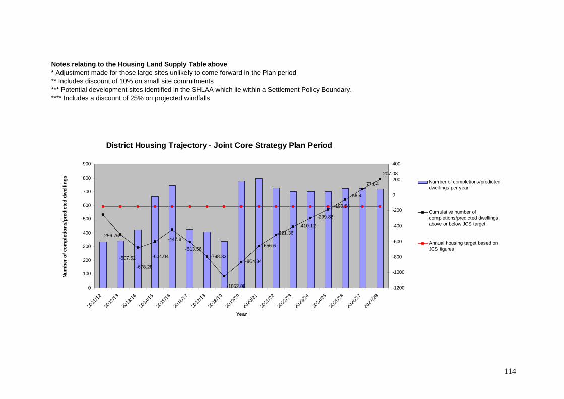
114
Notes relating to the Housing Land Supply Table above * Adjustment made for those large sites unlikely to come forward in the Plan period ** Includes discount of 10% on small site commitments *** Potential development sites identified in the SHLAA which lie within a Settlement Policy Boundary. **** Includes a discount of 25% on projected windfalls
District Housing Trajectory - Joint Core Strategy Plan Period
-798.32
-656.6
77.84
-56.4
-256.76
-507.52
-678.28
-604.04
-447.8
-613.56
-1052.08
-864.84
-521.36-410.12
-299.88
-190.64
207.08
0
100
200
300
400
500
600
700
800
900
2011
/12
2012
/13
2013
/14
2014
/15
2015
/16
2016
/17
2017
/18
2018
/19
2019
/20
2020
/21
2021
/22
2022
/23
2023
/24
2024
/25
2025
/26
2026
/27
2027
/28
Year
Nu
mb
er o
f co
mp
leti
on
s/p
red
icte
d d
wel
lin
gs
-1200
-1000
-800
-600
-400
-200
0
200
400
Number of completions/predicteddwellings per year
Cumulative number ofcompletions/predicted dwellingsabove or below JCS target
Annual housing target based onJCS figures

115
APPENDIX 3 EMPLOYMENT LAND SUPPLY (APRIL 2013)
District Note: all figures are square metres of floorspace
a. Employment provision completions 2011/2012 & 2012/2013
b. Commitments (sites with planning permission and local plan allocated sites without pp* - April 2013)
JCS Allocations (21.5ha x 3,500 square metres per hectare)
Provision 2011 - 2028
B1 Business 2063 13,338 15,401 B2 Manufacturing 49 471 520 B8 Warehousing 220 550 770 Mixed 4813 10,052 75,250 90,115 Total 7145 24,411 75,250 106,806
*Note: Figures do not include the former Lord Mayor Treloar Hospital, Alton and Keyline Builders Merchants, Rowlands Castle Local Plan Allocations which are designated for deletion in the JCS.

116
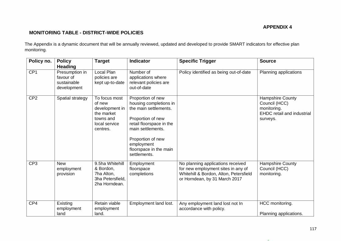
117
APPENDIX 4 MONITORING TABLE - DISTRICT-WIDE POLICIES
The Appendix is a dynamic document that will be annually reviewed, updated and developed to provide SMART indicators for effective plan monitoring.
Policy no. Policy Heading
Target Indicator Specific Trigger Source
CP1 Presumption in favour of sustainable development
Local Plan policies are kept up-to-date
Number of applications where relevant policies are out-of-date
Policy identified as being out-of-date Planning applications
CP2 Spatial strategy To focus most of new development in the market towns and local service centres.
Proportion of new housing completions in the main settlements. Proportion of new retail floorspace in the main settlements. Proportion of new employment floorspace in the main settlements.
Hampshire County Council (HCC) monitoring. EHDC retail and industrial surveys.
CP3 New employment provision
9.5ha Whitehill & Bordon, 7ha Alton, 3ha Petersfield, 2ha Horndean.
Employment floorspace completions
No planning applications received for new employment sites in any of Whitehill & Bordon, Alton, Petersfield or Horndean, by 31 March 2017
Hampshire County Council (HCC) monitoring.
CP4 Existing employment land
Retain viable employment land.
Employment land lost. Any employment land lost not In accordance with policy.
HCC monitoring. Planning applications.

118
CP5 Employment and workforce skills
Improve employment and workforce skills
Training facilities in place to improve workforce skills and address barriers to employment
No planning obligations seeking to promote workforce skills and employability per annum.
Planning applications
CP6 Rural economy and enterprise
Maintain and enhance rural enterprise.
Change in the number of rural businesses. New industrial/ business floorspace in rural areas.
No employment sites/premises permitted in rural locations per annum.
HCC monitoring.
CP7 New retail provision
Provide for retail need.
Amount of completed retail, office and leisure development in town and village centres.
No planning applications received for new retail provision in Alton and Petersfield, by 31 March 2017
HCC monitoring.
CP8 Town and village facilities and services
Maintain and enhance the vitality and viability of town and village centres.
Amount of completed retail, office and leisure development in town and village centres. Same split by centre. Vacancy rate of shops by settlement.
Any loss of retail provision in town and village centres. Vacancy rates in town and village centres are more than 8% per annum. Any permissions contrary to Policy CP6 (i.e. outside of town centre)
HCC monitoring. EHDC retail surveys.
CP9 Tourism Retention, improvement and provision of tourism facilities.
Change in the number of tourist facilities, pubs, hotel beds, etc
No tourist facilities permitted (across the District) per annum.
HCC monitoring. Planning applications.
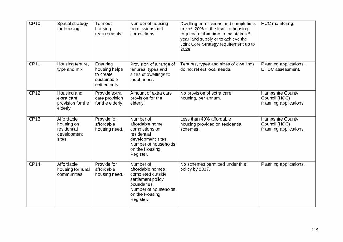
119
CP10 Spatial strategy for housing
To meet housing requirements.
Number of housing permissions and completions
Dwelling permissions and completions are +/- 20% of the level of housing required at that time to maintain a 5 year land supply or to achieve the Joint Core Strategy requirement up to 2028.
HCC monitoring.
CP11 Housing tenure, type and mix
Ensuring housing helps to create sustainable settlements.
Provision of a range of tenures, types and sizes of dwellings to meet needs.
Tenures, types and sizes of dwellings do not reflect local needs.
Planning applications, EHDC assessment.
CP12 Housing and extra care provision for the elderly
Provide extra care provision for the elderly
Amount of extra care provision for the elderly.
No provision of extra care housing, per annum.
Hampshire County Council (HCC) Planning applications
CP13 Affordable housing on residential development sites
Provide for affordable housing need.
Number of affordable home completions on residential development sites. Number of households on the Housing Register.
Less than 40% affordable housing provided on residential schemes.
Hampshire County Council (HCC) Planning applications.
CP14 Affordable housing for rural communities
Provide for affordable housing need.
Number of affordable homes completed outside settlement policy boundaries. Number of households on the Housing Register.
No schemes permitted under this policy by 2017.
Planning applications.
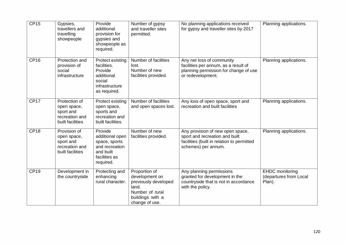
120
CP15 Gypsies, travellers and travelling showpeople
Provide additional provision for gypsies and showpeople as required.
Number of gypsy and traveller sites permitted.
No planning applications received for gypsy and traveller sites by 2017
Planning applications.
CP16 Protection and provision of social infrastructure
Protect existingfacilities. Provide additional social infrastructure as required.
Number of facilities lost. Number of new facilities provided.
Any net loss of community facilities per annum, as a result of planning permission for change of use or redevelopment.
Planning applications.
CP17 Protection of open space, sport and recreation and built facilities
Protect existing open space, sports and recreation and built facilities.
Number of facilities and open spaces lost.
Any loss of open space, sport and recreation and built facilities
Planning applications.
CP18 Provision of open space, sport and recreation and built facilities
Provide additional open space, sports and recreation and built facilities as required.
Number of new facilities provided.
Any provision of new open space, sport and recreation and built facilities (built in relation to permitted schemes) per annum.
Planning applications.
CP19 Development in the countryside
Protecting and enhancing rural character.
Proportion of development on previously developed land. Number of rural buildings with a change of use.
Any planning permissions granted for development in the countryside that is not in accordance with the policy.
EHDC monitoring (departures from Local Plan).

121
CP20 Landscape Protect and enhance landscape.
Number of new Town and Village Design Statements.
EHDC monitoring.
CP21 Biodiversity Protect and enhance biodiversity.
Changes of biodiversity importance. SSSI (Sites of Special Scientific Interest) condition.
Any loss of protected sites. Planning applications. HBIC monitoring. Natural England monitoring.
CP22 Internationally designated sites
Protect internationally designated sites.
Number of houses permitted within 400 metres of Special Protection Area.
Any new dwellings permitted within 400m of Wealden Heaths Phase II SPA.
Appropriate Assessment for planning applications. Natural England/EHDC monitoring.
CP23 Gaps between settlements
Maintain the integrity of the local gaps.
Amount of development permitted in each gap.
Any new development permitted in a local gap.
EHDC monitoring.
CP24 Sustainable construction
Ensure development is sustainable and adapts to climate change.
Renewable energy generation by installed capacity. Proportion of development at each level of the Code for Sustainable Homes (CfSH). Proportion of development at each BREEAM level.
Any planning permissions granted for developments that do not meet CfSH/BREEAM standards as identified in policy CP22.
Planning applications.
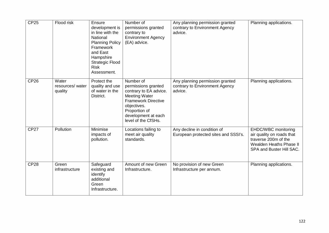
122
CP25 Flood risk Ensure development is in line with the National Planning Policy Framework and East Hampshire Strategic Flood Risk Assessment.
Number of permissions granted contrary to Environment Agency (EA) advice.
Any planning permission granted contrary to Environment Agency advice.
Planning applications.
CP26 Water resources/ water quality
Protect the quality and use of water in the District.
Number of permissions granted contrary to EA advice. Meeting Water Framework Directive objectives. Proportion of development at each level of the CfSHs.
Any planning permission granted contrary to Environment Agency advice.
Planning applications.
CP27 Pollution Minimise impacts of pollution.
Locations failing to meet air quality standards.
Any decline in condition of European protected sites and SSSI’s.
EHDC/WBC monitoring air quality on roads that traverse 200m of the Wealden Heaths Phase II SPA and Buster Hill SAC.
CP28 Green infrastructure
Safeguard existing and identify additional Green Infrastructure.
Amount of new Green Infrastructure.
No provision of new Green Infrastructure per annum.
Planning applications.
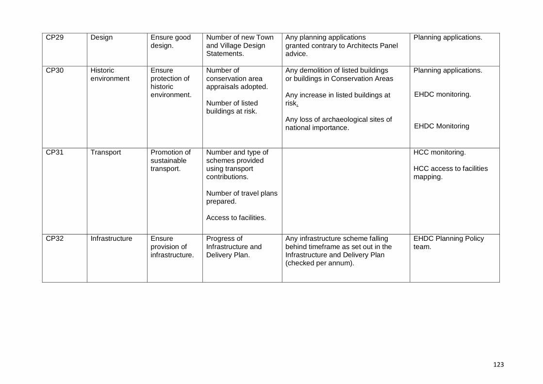
123
CP29 Design Ensure good design.
Number of new Town and Village Design Statements.
Any planning applications granted contrary to Architects Panel advice.
Planning applications.
CP30 Historic environment
Ensure protection of historic environment.
Number of conservation area appraisals adopted. Number of listed buildings at risk.
Any demolition of listed buildings or buildings in Conservation Areas Any increase in listed buildings at risk. Any loss of archaeological sites of national importance.
Planning applications.
EHDC monitoring.
EHDC Monitoring
CP31 Transport Promotion of sustainable transport.
Number and type of schemes provided using transport contributions. Number of travel plans prepared. Access to facilities.
HCC monitoring. HCC access to facilities mapping.
CP32 Infrastructure Ensure provision of infrastructure.
Progress of Infrastructure and Delivery Plan.
Any infrastructure scheme falling behind timeframe as set out in the Infrastructure and Delivery Plan (checked per annum).
EHDC Planning Policy team.
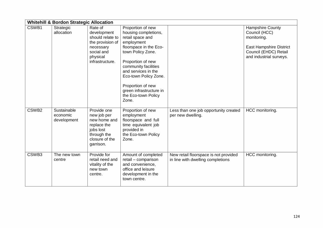
124
Whitehill & Bordon Strategic Allocation CSWB1 Strategic
allocation Rate of development should relate to the provision of necessary social and physical infrastructure.
Proportion of new housing completions, retail space and employment floorspace in the Eco- town Policy Zone. Proportion of new community facilities and services in the Eco-town Policy Zone. Proportion of new green infrastructure in the Eco-town Policy Zone.
Hampshire County Council (HCC) monitoring. East Hampshire District Council (EHDC) Retail and industrial surveys.
CSWB2 Sustainable economic development
Provide one new job per new home and replace the jobs lost through the closure of the garrison.
Proportion of new employment floorspace and full time equivalent job provided in the Eco-town Policy Zone.
Less than one job opportunity created per new dwelling.
HCC monitoring.
CSWB3 The new town centre
Provide for retail need and vitality of the new town centre.
Amount of completed retail – comparison and convenience, office and leisure development in the town centre.
New retail floorspace is not provided in line with dwelling completions
HCC monitoring.
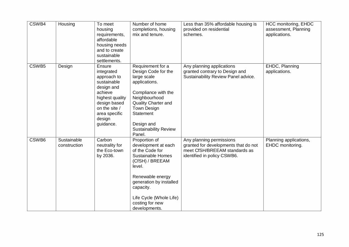
125
CSWB4 Housing To meet housing requirements, affordable housing needs and to create sustainable settlements.
Number of home completions, housing mix and tenure.
Less than 35% affordable housing is provided on residential schemes.
HCC monitoring, EHDC assessment, Planning applications.
CSWB5 Design Ensure integrated approach to sustainable design and achieve highest quality design based on the site / area specific design guidance.
Requirement for a Design Code for the large scale applications. Compliance with the Neighbourhood Quality Charter and Town Design Statement Design and Sustainability Review Panel.
Any planning applications granted contrary to Design and Sustainability Review Panel advice.
EHDC, Planning applications.
CSWB6 Sustainable construction
Carbon neutrality for the Eco-town by 2036.
Proportion of development at each of the Code for Sustainable Homes (CfSH) / BREEAM level. Renewable energy generation by installed capacity. Life Cycle (Whole Life) costing for new developments.
Any planning permissions granted for developments that do not meet CfSH/BREEAM standards as identified in policy CSWB6.
Planning applications, EHDC monitoring.
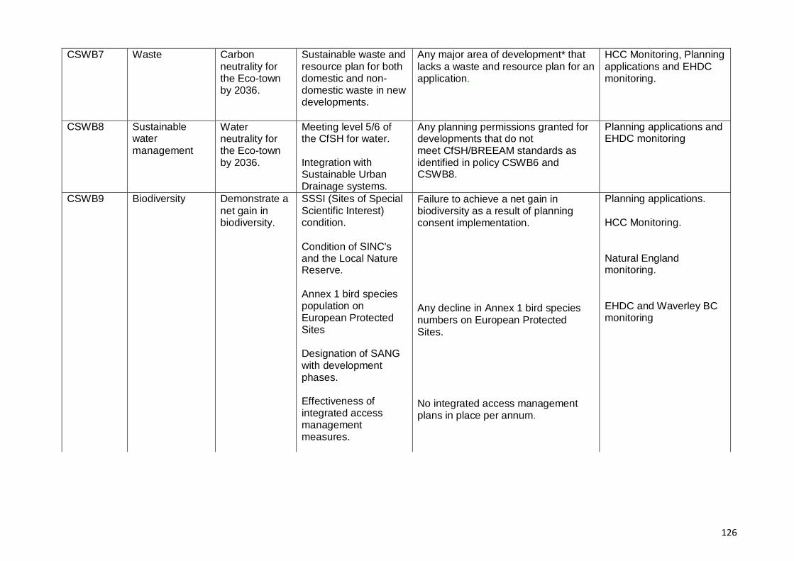
126
CSWB7 Waste Carbon neutrality for the Eco-town by 2036.
Sustainable waste and resource plan for both domestic and non- domestic waste in new developments.
Any major area of development* that lacks a waste and resource plan for an application.
HCC Monitoring, Planning applications and EHDC monitoring.
CSWB8 Sustainable water management
Water neutrality for the Eco-town by 2036.
Meeting level 5/6 of the CfSH for water. Integration with Sustainable Urban Drainage systems.
Any planning permissions granted for developments that do not meet CfSH/BREEAM standards as identified in policy CSWB6 and CSWB8.
Planning applications and EHDC monitoring
CSWB9 Biodiversity Demonstrate a net gain in biodiversity.
SSSI (Sites of Special Scientific Interest) condition. Condition of SINC's and the Local Nature Reserve. Annex 1 bird species population on European Protected Sites Designation of SANG with development phases. Effectiveness of integrated access management measures.
Failure to achieve a net gain in biodiversity as a result of planning consent implementation.
Any decline in Annex 1 bird species numbers on European Protected Sites.
No integrated access management plans in place per annum.
Planning applications. HCC Monitoring.
Natural England monitoring. EHDC and Waverley BC monitoring
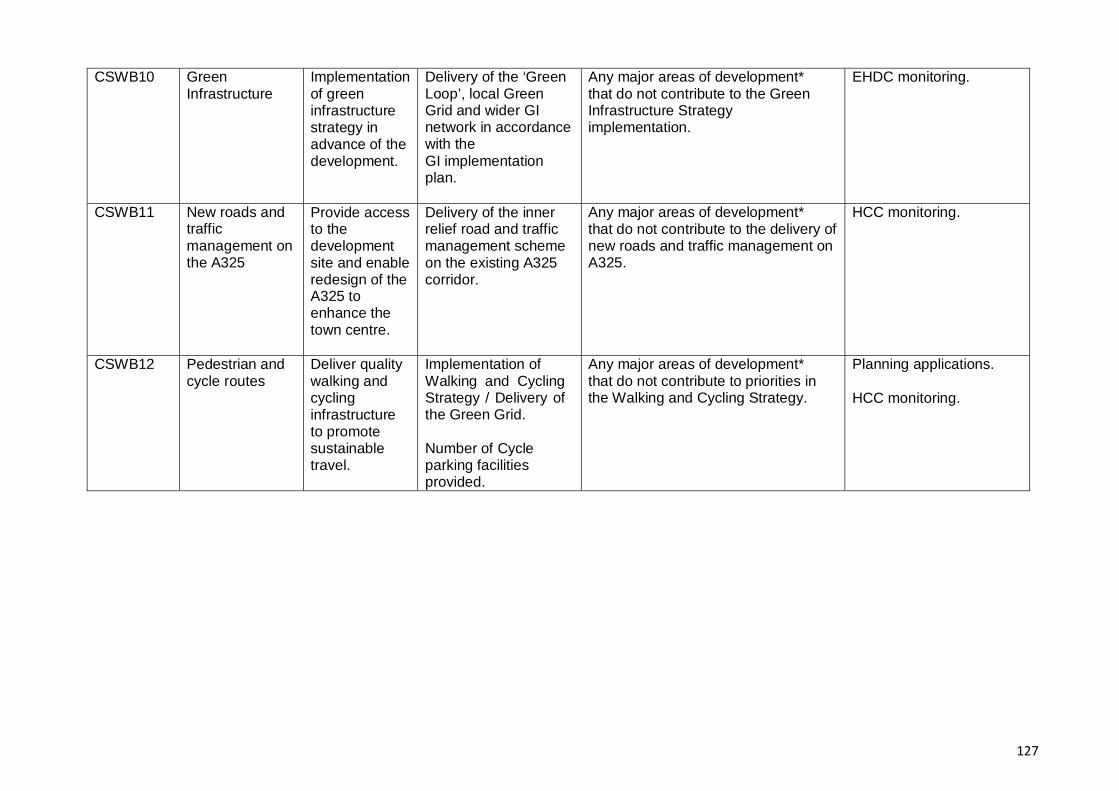
127
CSWB10 Green Infrastructure
Implementationof green infrastructure strategy in advance of the development.
Delivery of the ‘Green Loop’, local Green Grid and wider GI network in accordance with the GI implementation plan.
Any major areas of development* that do not contribute to the Green Infrastructure Strategy implementation.
EHDC monitoring.
CSWB11 New roads and traffic management on the A325
Provide access to the development site and enable redesign of the A325 to enhance the town centre.
Delivery of the inner relief road and traffic management scheme on the existing A325 corridor.
Any major areas of development* that do not contribute to the delivery of new roads and traffic management on A325.
HCC monitoring.
CSWB12 Pedestrian and cycle routes
Deliver quality walking and cycling infrastructure to promote sustainable travel.
Implementation of Walking and Cycling Strategy / Delivery of the Green Grid. Number of Cycle parking facilities provided.
Any major areas of development* that do not contribute to priorities in the Walking and Cycling Strategy.
Planning applications. HCC monitoring.

128
CSWB13 Public transport Promotion of sustainable transport.
Number and type of schemes provided using transport contributions. Delivery of the public transport network. Public Transport Patronage / satisfaction surveys. Completion of rail feasibility studies. Provision of Transport hub. Delivery of high quality bus infrastructure provided throughout the development.
Any major areas of development* that do not contribute to local priorities for public transport.
HCC monitoring. HCC access to facilities mapping.
CSWB14 Travel plans Implementationof a town wide travel plan.
Number of travel plans prepared for individual planning applications in accordance with the town wide plan.
Any planning permission granted for development that results in a significant level of traffic generation and where no travel plan is in place.
Planning applications. HCC monitoring. Travel Plan Monitoring.
CSWB15 Local transport network improvements
Targeted improvements with each phase of the development to minimise impact on the local villages, network and improve travel behaviour.
Delivery of local transport network improvements.
Any major areas of development* that do not contribute to targeted improvements to the local transport network.
HCC monitoring. Travel Plan Monitoring.

129
CSWB16 Travel monitoring
Implementationof comprehensive Travel Monitoring Strategy.
Travel Behaviour by mode and travel frequency / total travel demand.
Air Quality Monitoring reports.
Any major areas of development* that do not commit to the arrangements set out in the Travel Monitoring Strategy.
HCC monitoring.
EHDC Monitoring.
Whitehill Bordon Travel Census / Travel Plan surveys. Traffic Flow Monitoring.
CSWB17 Car parking Balancing the need for car parking with the sustainable transport.
Adoption of a Car Parking Strategy for individual site planning applications.
Any major areas of development* that do not provide parking in accordance with the Car Parking Strategy for Whitehill & Bordon.
Planning applications, EHDC monitoring.
CSWB18 Low carbon vehicles
Promote the use of low- carbon vehicles ion the Eco-town.
Number of electric charging points delivered. Number of low carbon emission vehicle registrations in the town.
Any major areas of development* that do not promote low carbon vehicles in line with priorities in the Emerging Transport Strategy.
HCC , EHDC monitoring. DfT (DVLA) statistics.
Note:
Major development: Erection of 10 or more dwellings or site area of 0.5 ha or more In other cases where the floorspace to be created is more than 1,000m², or the site are a is 1 ha or more.

130

A3
A272
A32
A31
A339
A31
A32
A32
5
A272A272
A3A
3(M
)
B3006
B2070
B2146
B219
9
B3004 B
3349
B2149
B3002
B2070
B3004 A3
A3
B3006
This map has been produced by East Hampshire District Council, using information
supplied by E.S.R. Ltd, Byfleet, Surrey
A32
5
SheetSteep
HillBrow
Liphook
High Cross
East Meon
Newton Valence
Selborne
Blackmoor
Binsted
Beech
Bentworth
Medstead
UpperFroyle
Holybourne
Bentley
Buck'sHorn Oak
ALTON
East Worldham
RopleyRopley Dean
FourMarks
Lindford
Kingsley
Clan�eld
Catherington
Blendworth
Lovedean
RowlandsCastle
Buriton
HORNDEAN
Grayshott
Lower Farringdon
Chawton Headley
West LissLiss
BORDON
PETERSFIELD
Greatham
WHITEHILL
HeadleyDown
Stroud
Liss Forest
Bramshott
Griggs Green
Upper Farringdon Pass�eldCommon
Holt Pond
Arford
to Winchester
to Winchester
to Basingstoketo Farnham
to Guil
dford
to Midhurst
to Chichester
to Portsmouth
to London
HASLEMERE
Bentley Station
HAVANT
Whitehill Bordon Strategic Development Area (Eco-Town)
Market Towns
Large local service centres
Small local service centres
Settlement gap
Other settlements with a settlement policy boundary
Employment allocation
Housing allocation
National Park
South Hampshire Sub-region(PUSH)
Motorway/Trunk road
Railway
East Hampshire District Local Plan: Joint Core StrategyMap 1 - Key Diagram
Map Not To Scale