Archaeology in Hampshire
53
Archaeology in Hampshire Annual Report 2010
-
Upload
khangminh22 -
Category
Documents
-
view
3 -
download
0
Transcript of Archaeology in Hampshire

Archaeology in
Hampshire
Annual Report 2010

2
INTRODUCTION
Welcome to the Annual Report of Archaeology in Hampshire for 2010. Up until 2003 Hampshire County
Council published an Annual Report of Archaeology in Hampshire. The first volume was published in 1977
(for the year 1976) and for over a quarter of a century it proved to be a valuable resource bringing together in
summary fashion archaeological work carried out in a particular year, whether it was by professional
organization, academic institution or local society. The report ensured that knowledge of such work was easily
and conveniently available to all interested parties. The final report of this ‘first series’ was published in 2004
(for 2003). Following a hiatus of several years, The Hampshire Field Club (HFC) was invited to produce a new
series of reports and began with a round-up of the ‘missing’ years. These can be downloaded from the
Hampshire Field Club website. From 2008 the report has been published annually and copies are available for
download from the HFC website.
Developments in technology have forced a re-think about the most efficient way to go about the publication
of interim statements and it was decided that an electronic format (i.e. a PDF document) provided a convenient
and cost-effective solution. It also offers the option of printing only what is required.
The structure and content of the report
The report is organized by District and then alphabetically by location. Individual entries consist of a location
that includes a grid reference. This is followed by an identifier, usually a Site UID, which links it to a record
held in The Archaeology and Historic Buildings Record (AHBR) database for Hampshire. The records for
Southampton, Portsmouth and Winchester have also provided information about work carried out in these cities
and identifiers that relate to their respective databases are given. It is through the identifier that further
information about a particular project can be acquired.
In addition to archaeological fieldwork the report includes records of building surveys. Survey projects that
encompass large numbers of sites, for example by the Hampshire and Wight Trust for Maritime Archaeology or
Berkshire Archaeological Surveys are also included.
HAMPSHIRE COUNTY COUNCIL MUSEUM'S SERVICE IDENTIFICATIONS
Hampshire County Council Museum’s Service have for many years offered an identification service for the
general public and a list of finds from the various museums in the county is included in the Annual Report.
THE PORTABLE ANTIQUITIES SCHEME (PAS)
A number of local societies already publish a selection of the finds recorded on the PAS database for their
county. Rob Webley, the Finds Liaison Officer for Hampshire, has kindly agreed to compile a selection for
2010 showcasing some of the most interesting and important finds. These range in date from prehistory through
to late medieval times and include a variety of different materials.
ACKNOWLEDGEMENTS
The data for each year was assembled and edited by Nick Stoodley, but it would not have been possible to
produce this work without the assistance of numerous individuals and organizations. Hampshire County
Council and the Hampshire Field Club are acknowledged for financial assistance. I am particularly indebted to
the Archaeology staff at the Environment Department (HCC), especially David Hopkins, Alex Godden,
Charlotte Malone and Thomas Sunley, for providing information from the AHBR database, in addition to proof
reading and other assistance during the preparation of the report. I am grateful to the various archaeological
organisations, both amateur and professional who have provided information (in no particular order): Ingrid
Peckham (Southampton City Council), and Dr Andy Russel (Southampton City Council Archaeology Unit),
Jennifer Macey (Portsmouth City Council), Tracy Mathews (Winchester Museums Service), Dave Allen
(Hampshire County Council: Basing House, and list of identifications from the county museums), Amanda
Clarke (University of Reading: Silchester), Dr Simon Roffey (University of Winchester: St Mary Magdalen
Leper Hospital), Edward Roberts, Julie Gardiner (Wessex Archaeology), Cynthia Poole (Cholderton Estate)
Mark Peryer (Basingstoke Archaeological and Historical Society), Tiziana Vitali (Pre-Construct Archaeology),
Martin Wilson (Souterrain Archaeological Services), Dick Selwood, Chris Sellen and Don Bryan (WARG, St
Cross), Steve Preston (Thames Valley Archaeological Services), Diana King (Foundations Archaeology), Ross
Turle (Winchester Museums Services), Melissa Melikian (AOC Archaeology Group) and Jon Murray
(Archaeological Solutions). Finally, thanks have to be extended to Rob Webley for bringing together so
admirably the selections of PAS finds.
3
CONTENTS
Archaeology in Hampshire 4
Finds reported to the Portable Antiquities Scheme 41
Hampshire County Museums Service identifications 53
Email contact for editor: [email protected]
Front cover Post-medieval coin hoard from Bishops Waltham

4
BASINGSTOKE AND DEANE
Church Oakley
The Well House, Rectory Road (NGR 456720 150400) (Site UID: TBA) Building recording
Wessex Archaeology was commissioned to carry out an assessment of the Well House prior to its extension and
redevelopment. The building lies within Church Oakley Conservation Area (designated 1976) and is a Grade II
listed building. A search of the relevant historic maps, plans and documents combined with a visual examination
has enabled the production of phased floor plans of the house indicating several phases of alteration and
adaptation. A description of the main rooms of the property accompanied by digital images highlights the
surviving historic features present.
The story of the Well House is one of continuous change and adaptation. Few historical sources exist for the
building prior to the 19th
century, although records indicating a charge on the property date from c. 1700 and the
building is first depicted on maps dating from the late 18th
century. The property was initially constructed as a
humble, two-and-a-half bay, timber framed cottage with thatched roof during the late 16th
or 17th
century and the
lobby entrance plan form is typical of buildings of this date in Hampshire. During the later 17th
- 18th
centuries
the building was extended to the east and a rear stair turret added in order to access a new attic floor created
within the roofspace. Subsequently the building was gentrified with the addition of a brick frontage and tile roof.
At some stage during the early-mid-19th
century, four windows on the front elevation were replaced with the
present large horizontal sashes. Records from the mid-19th
century onwards indicate that the property was
operating as a shop which continued until the late 1930s. During this time the property expanded and adapted to
take on numerous roles including that of bakery, grocers, coal merchant, post office and telephone exchange. In
addition to the growth of outbuildings to the rear of the property, during the late 19th
- early 20th
centuries the
building was substantially extended to the rear. Following the end of the lease in 1937, the property reverted to a
private house. More change and adaptation followed as the numerous small outbuildings to the rear were swept
away and the building became known as the Well House. The final expansion phase occurred 1968-1972 when a
single storey extension was added to the south-eastern corner.
Hannington
Hannington BTS,Ccottington’s Hill (SU 452740 156820) (Site UID: TBA) Watching brief
Wessex Archaeology carried out a watching brief at the Hannington Broadcasting Transmission Station.
Previous work, undertaken by the Winchester Museum Service in 1999, uncovered three earthworks that did not
appear on 19th
- and early 20th
-century maps of the site, but which were considered to be of medieval and post-
medieval date. The recent watching brief recorded and excavated two curvilinear ditches, which produced
pottery of c. 13th
- 15th
-century date.
Kingsclere
The Old Mill (SU 52398 58727) (Site UID: 62025) Watching brief
John Moore Heritage Services carried out observations which revealed structures associated with an earlier
phase of the building and the possible orientation of the earlier millstream property.
North Waltham
Land to the south-west of North Waltham (SU 56020 45850) (Site UID: 38029) Fieldwalking
The fieldwalking was undertaken by Basingstoke Archaeological and Historical Society (BAHS) alongside a
series of cropmarks. The site has been interpreted as small Romano-British farmsted on the basis of the finds
that were recovered (pottery, roof tile, brick, flint and burnt flint). Additional details about this, and the
following two BAHS projects, will be provided in due course.
South of Dean Heath Copse (SU 57550 47420) (Site UID: 37863) Fieldwalking
A banjo enclosure identified from air photograph, in proximity to those at Site UID‟s 38026 (see Annual Report
for 2008) & 54272, was the subject of a BAHS fieldwalking project (Dummer Lane 2).
South of Dean Heath Copse (SU 57340 47280) (Site UID: 54272) Fieldwalking
A banjo enclosure identified from air photograph, in proximity to those at Site UID‟s 38026 (see Annual Report
for 2008) & 37863, was the subject of a BAHS fieldwalking project (Dummer Lane 1).

5
Old Basing and Lychpit
West Gatehouse, Basing House (SU 66177 52550) (Site UID: TBA) Excavation
Further work on the west gatehouse to the bailey was carried out by Hampshire Museum‟s Service (Fig. 1).
Limited excavation took place to facilitate the construction of a new footbridge, which will form part of the
discovery trail from Garrison Gate onto the bailey terrace at Basing.
The most significant trench cut a section into the ditch between the bridge abutments, encountering a flat
solid chalk base at a depth of 1.4m. This was surprisingly clear of primary silts and the first layer of significance
was a jumble of brick rubble and mortar which presumably relates to the „destruction phase‟ of October 1645
and later (Fig. 2). In among this material was the skeleton of a small dog, but other finds were few.
Fig. 1 View of excavation on the west side of the bridge (Photograph: Hampshire County Council)
On the west side of the bridge a clear foundation trench cut into the chalk, but on the east side the „outlining‟
excavation of a century ago interfered with the upper levels and the backfill contained a significant quantity of
Victorian and Edwardian broken bottle glass; work in this area was limited.
The brown silts of the upper fill clearly „flowed down‟ over the broken sub-structure of the bridge into the
ditch, suggesting that the destruction and abandonment of this route-way took place fairly rapidly after the fall
of the house to Cromwell‟s army.
A small number of finds were made near the Great Barn during construction work, and the most striking was
an iron musket rest. There were hopes that the exposure of sphagnum peat and recovery of a birch post stump
might throw some light on the early environmental history of the area. The material was examined by Mike
Allen, but it was found to have little significance without the benefit of considerable further work, which was
not possible in the circumstances.

6
Fig. 2 Section through the ditch to the natural (Photograph: Hampshire County Council)
Milkingpen Lane, Roundhead Cottage (SU 667 532) (Site UID: TBA) Dendrochronology
Despite its name, this is a very substantial timber-framed house of four almost equal bays. It is currently of two
and a half storeys, but attic rooms appear to have been inserted at a later date. The timber is all of large scantling
and good quality. The roof comprises queen strut trusses with side purlins clasped between undiminished
principle rafters and collars. There are curved windbraces. The walling is framed with two square panels per
floor, and there are curved braces between the posts and wall plates. The plan is of the „hearth passage‟ type.
The hall is located in the two central bays with the chimney stack backing on to the cross passage. The layout of
the first floor reflects that of the ground floor, with a principal chamber directly above the hall. There is no
indication that the roof was not built as a single phase, and the early collar is considered to be a re-used or
stockpiled timber. Dating was commissioned by the Hampshire and Isle of Wight Community Foundation.
Felling dates: Winter 1506/7 and Winter 1550/1
Total (6/7). Collar 1506(50C); Purlins 1512(h/s), 1550(33C); Post 1476(+35NM to h/s); Wallplate 1520; Tie
1520(h/s). Site Masters 1362-1506 obr01 (t= 9.7 HANTS02, 7.8 HEMINGTN, 7.7 REIGPRY); 1362-1550
RONDHD1 (t= 9.2 gho1, 9.1 STRETFM, 8.6 HANTS02).
Tadley
Hatch Cottage (SU 597 602) (Site UID: TBA) Dendrochronology
This is a 3-bay cruck cottage with a central open hall that has an inserted chimney at the assumed low end. The
hall rafters are heavily sooted as are those of what is probably the kitchen/service bay. The crucks are presently
of type-W and appear always to have been so. The assumed kitchen/service bay has a modern ceiling; the hall
bay has a spine beam with axial joists and is of 17th
-century form; and the assumed parlour bay has broad, axial
joists consistent with a 15th
or early 16th
-century date. There appeared to be a number of re-used timbers within
the frame but datable timbers were difficult to find. Those that did date yielded inconsistent dates. The dated
axial joist was lodged above the tie beams on either side of the assumed parlour bay, and the dated stud was
pegged to a mid-rail but halved cross and nailed to the wall plate above. Clearly these timbers could belong to a
second phase. The tie beam, however, was integral to a cruck truss and thus would appear to belong to a primary
phase. The most probable conclusion is that the house was built between 1496 and 1528 (the date of the tie
7
beam) and that the dated stud and ceiling joist belong to a later phase of work. Dating was commissioned by the
Hampshire and Isle of Wight Community Foundation.
a) Tie to south end truss Felling date range: 1496-1528
b) Stud in east wall Felling date range: after 1539
c) Floor joist, south bay Felling date range: 1568–1599
a) Tie 1487(h/s). b) 1530. c) 1567(9). Site Masters 1396-1487 htc01 (t= 6.4 SWANINN, 6.3 CASTLBRDG,
6.1 BURGCLER2); 1446-1530 htc04 (5.9 HARCHRCH, 5.9 CHAPELFM, 5.8 VANN); 1426-1567 htc06 (t=
6.4 PRBRIGHT, 6.3 MOTISFNT, 6.2 TUDORCT1).
Winslade
Barn at Hackwood Farm (SU 66998 49777) (Site UID: 2871) Dendrochronology & survey
The dating analysis was carried out by Tree Ring Services and established that there were three precise felling
dates: two from 1747 and one from 1748, from which it can be postulated that the barn was constructed in AD
1747 or soon after.
The building is a timber framed L-shaped structure of two periods, the earlier (north-south) block of six bays
with aisles, with a later unit built into the west side (south end), of eight bays with aisles. The older wing has old
tile roofing, 1/2 hipped, with cantilevered hipped roofs above the entrance (third bay from the north). The truss
has struts to the upper purlins, arched and straight braces to tie beams, the frame resting on brick base walls
(also dividing the aisles); weather boarded walls, with the lower part in red brick. The larger (east-west) unit is
a taller queen post truss, with a corrugated iron roof, with hipped tiled sections above the cantilevered entrances
(at the second and third bays) and red brick walling in header bond.
EAST HANTS
Alton
Rear of 10-22 Kings Road (SU 70970 39100) (Site UID: 17109) Watching brief
The observations were carried out by Thames Valley Archaeological Services. No archaeological evidence was
found. Previously in 1956 (confirmed 1968) a Roman coin of Claudius II (268-269 AD) was discovered in the
garden at Halterworth (Alton Museum Accession No. 1956, 41).
Treloar College (SU 72846 40951; 73010 40820 ) (Site UID: 61251 & 61252) Evaluation excavation &
watching brief
Wessex Archaeology was commissioned to carry out a field evaluation during initial site investigations at
Treloar College, Alton. The site is adjacent to an Area of High Archaeological Potential and an Area of
Archaeological Potential as designated by the Historic Rural Settlements Project. Close to the site are a number
of archaeological finds spots of prehistoric flint work and pottery and the Scheduled Monument of Cuckoos
Corner Roman site lies 1km to the east. This programme of archaeological fieldwork comprised the machine
excavation of 20 trenches.
Prehistoric archaeological features comprised two small Late Bronze Age/Early Iron Age rubbish pits
containing pottery dated to 1100-400 BC. In addition, numerous residual Late Neolithic/Early Bronze Age
worked flints were recovered from the overlying topsoil and subsoil. Four Romano-British ditches were aligned
with existing field systems suggesting that a fossilised Roman landscape may have directly influenced the
current field patterns. The presence of Bronze Age features on the eastern fringes of the site is significant,
although given that the area immediately east has been subject to previous development, the recovery of further
settlement remains is unlikely.
The subsequent watching brief in the area of the two pits identified no indication of further prehistoric
activity, other than worked and burnt flint retrieved from topsoil and subsoil layers. The continued alignment
and Romano-British date of the easternmost ditch were confirmed.
Buriton
Bottom Cottage (SU 71806 18034) (Site UID: 62822) Building recording
A Building survey was carried out by C. Healey as part of an undergraduate dissertation for Southampton
University. The building was originally utilised as an Inn, but was converted into a dwelling at an unknown
date remaining in the possession of the brewery. The cottage was purchased by the Bonham Carter estate in
1904, to accommodate the game keeper.

8
It was documented in 1773 in the will of Isaac Long and the design is typically Georgian, with two main
rooms downstairs, an out shut scullery and two rooms on the ground floor. Two rooms make up the first floor,
and the attic contained a further two rooms. The building also has a cellar.
Colemore and Priors Dean
Windmill Farm, Colemore (SU 70653 29942) (Site UID: 61309) Geophysical survey
Resistivity and magnetometer surveys targeted an area where Roman pottery and artefacts were discovered after
ploughing. The work built upon the geophysical results obtained by Liss Archaeological Group in 2009. A
number of anomalies were identified.
Kingsley
Grooms Farm Settlement (SU 81265 38884) (Site UID: 62417) Excavation
Wessex Archaeology was commissioned to undertake a programme of archaeological strip, map and record
excavation in advance of sand extraction. The site covered approximately 1.3ha. A small assemblage of residual
Mesolithic flints and a scatter of Middle to Late Bronze Age/Early Iron Age features, including pits, a post-hole,
and a continuation of a field system with a possible track way, identified in a previous excavation, were
recorded. A curvilinear gully and a single pit have been attributed to the Iron Age, as has a large erosion feature
in the west of the extension area, and this activity appears to be peripheral to the occupation of similarly dated
features identified to the north. The truncated remains of a single-chambered, twin-flue kiln, typical of the
Romano-British Alice Holt pottery industry (dated to the late 3rd
- 4th
centuries), was recorded in the south of the
site, associated with pits, post-holes and an east-west aligned ditch.
Also of possible potential significance was a series of erosion features that post-date the activity associated
with Romano-British pottery production. At the base of two coombe-like features in the east and west of the
site, a charcoal-rich horizon, probably deriving from kiln waste, was sealed by numerous colluvial deposits.
These erosion features may have been caused by deforestation resulting from the intensification of the Alice
Holt industry which reached its peak in the mid to late 4th
century.
EASTLEIGH
Hedge End
Kings Copse Primary School (SU 49340 12100) (Site UID: 60983) Evaluation excavation &
geophysical survey
A geophysical survey and subsequent trial trenching were carried out by Allen Archaeology Limited in advance
of a residential development. The geophysical survey identified evidence for significant modern disturbance and
possible ephemeral linear features. The subsequent trial trenching, comprising six 40m long trenches, identified
evidence for significant truncation of the site, probably during construction of the school and playing fields. The
only features exposed were a number of recent land drains and a single ditch terminus backfilled with modern
material.
FAREHAM
Fareham
Red Barn Community Primary School (SU 61013 06012) (Site UID: 63040) Watching brief
Archaeology South East carried out the work. Although no archaeological features or deposits were recorded,
sedimentary sequences were uncovered that relate to both temperate and cold stage depositional environments,
which suggest a wider potential for Palaeolithic archaeology to the north of the site.
Hamble
Holy Hill Hard (SU 48854 07622) (Site UID: 62793) Topographic survey & fieldwalk
The University of Southampton undertook the project. An 1867 Map shows a bank built in a straight line, which
may have been used as a wharf. A bank revetment was recorded: a slightly curved line of stout posts up to one
meter high that show an attempt to reinforce the embankment. A wall 10.5m in length was also identified, but
collapsed blocks at the eastern end suggest that it was originally longer c. 12m. It is 2.6m wide at its west edge
9
and 1.5m wide at the eastern edge. The blocks are clearly re-used and no mortar was used in the construction of
the wall.
GOSPORT
Gosport
Fort Monkton, Glacis (SZ 61240 97978) (Site UID: 62830) Evaluation
Southampton City Council Archaeology Unit carried out the work. It was determined that the glacis was
constructed in three phases by depositing dumps of locally derived material. In the first phase the glacis seems
to have been fairly level, but then dropped steeply to level out again. The steep slope could have given cover to
attackers and in the second phase the surface of the glacis was raised to give a wider level area adjacent to the
fort. In phase three the slope was almost entirely removed.
Haslar boat shed (SZ 62051 99061) (Site UID: 61602) Building recording
LP Archaeology surveyed the boat shed (Building 66) at the JSASTC site. At yet there are no further details.
Haslar Road (SZ 62026 99047) (Site UID: 61600) Watching brief
The observations were carried out by LP Archaeology. The remains of brick drains and a possible concrete
foundation were found that probably belonged to a building shown on Ordnance Survey mapping. In addition,
the remains of a light railway, brick drains and evidence that the land had been levelled in the late 18th
century,
were uncovered. The railway tracks probably belonged to the transverse rail system used to transport boats
between the slipway and boat shed.
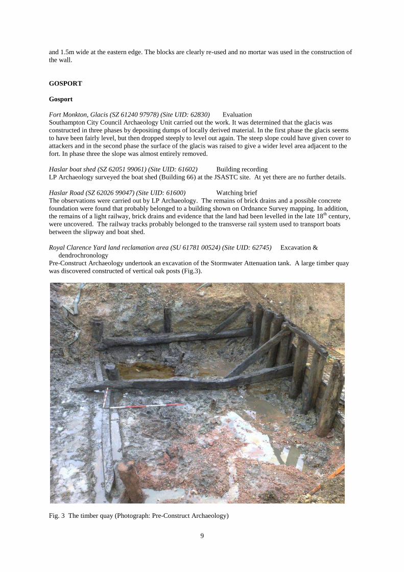
Royal Clarence Yard land reclamation area (SU 61781 00524) (Site UID: 62745) Excavation &
dendrochronology
Pre-Construct Archaeology undertook an excavation of the Stormwater Attenuation tank. A large timber quay
was discovered constructed of vertical oak posts (Fig.3).
Fig. 3 The timber quay (Photograph: Pre-Construct Archaeology)

10
The structure was part of the historic waterfront that existed prior to the expansion of the yard into Portsmouth
harbour. The robustly built quay consisted of manually sawn plank sheathing fastened to uprights with large
iron spikes slightly countersunk. The planking was closely set on edge with no visible sapwood, but varied in
sizes suggesting that it derived from leftovers from a nearby dockyard. About 1.6m down the frontage a
thickened wale timber could be seen secured to uprights with iron spikes and in one case an oak tree nail. The
structure would have gone down another 1m at least: enough depth to accommodate large coastal and short sea
trading vessels. Traces of the tarring of one of these crafts was found in irregular spreads of tar found adhering
to the upper edge of the wale, which would have acted as a ledge to catch droplets. Dendrochronological dating
proved inconclusive.
Fig. 4 The timber lining of the reservoir (Photograph: Pre-Construct Archaeology)
Two large circular brick features, one on a north-south alignment and the other on a north-west to south-east
alignment were identified. These carried fresh water from the reservoir situated to the north-west of the victuling
yard (Fig. 4). A circular brick well was positioned where the two crossed. Another silted up brick culvert was
recorded in the north-east area of the Attenuation Tank excavation area, and appears to have been used for
transporting foul water into the channel.
Royal Clarence Yard land reclamation area (SU 61781 00524) (Site UID: 62746) Excavation
A second excavation of the Stormwater Attenuation tank was carried out by Pre-Construct Archaeology. In the
north-east corner of the pumping station a 20th
-century structure designed to secure the re-deposited ground of
the late 18th
century was uncovered. The structure was observed as the top of a vertically driven pile with an iron
tip on the end, 2.7m in length by 0.33m wide and 0.1m thick. The stake had a 30mm hole in it, which was not
used to attach it to other timbers thus suggesting an earlier use. A circular iron and concrete feature was
uncovered in the pipe trench to the south of the pumping station, which is believed to have been part of the
railway station added in 1850. It had a central rotating hub with extending iron spokes that were attached to an
outer ring and may have acted as a turntable for rolling stock loading and unloading at the wharfs. A red brick
wall uncovered in the pipe trench connecting to the north side of the pumping station and running to the outflow
valve is identified as a 19th
- 20th
-century reinforcement of the sea wall.

11
Royal Clarence Yard, Phase N, Gosport (SU 61760 00580) (Hampshire Museum Service Accession number
A.2000.41) Evaluation
An evaluation, comprising seven trenches, was conducted by Pre-Construct Archaeology Ltd at Phase N of the
site in advance of development of the land into residential property. The investigation revealed 20th
-century
made ground overlying natural stratigraphy. Trenches towards the south of the study area revealed a large cut
for a modern ceramic drain pipe and probable associated activity, and the concrete slab foundation of a range of
buildings along the western boundary of the study area. The latter is likely to represent the footprint of a garage
fully demolished in 1999.
HART
Odiham
23 High Street, Odiham (SU 74315 51060) (Site UID: 62806) Evaluation excavation
The work was undertaken by Thames Valley Archaeological Services and several gullies, a pit and a post-hole
were investigated. One gulley produced Late Iron Age pottery, while a further three of a shallower and
narrower nature are thought to date between the Roman and early medieval period. The end of a gully terminal
was also discovered that contained 14 sherds of early Roman pottery of an Alice Holt/Surrey grey ware type.
The pit and post-hole both produced Anglo-Saxon pottery, while the bottom of the latter produced a large
amount of charcoal.
Heckfield
Heckfield Place (SU 73183 61044) (Site UID: 62838) Watching brief
Souterrain Archaeological Services Ltd (Martin Wilson) carried out the observations which recorded three crude
land drains filled with broken hand-made brick and tile fragments. Set about 4.5m apart they are aligned east-
north-east / west-south-west and probably functioned as drains to take rain water away from the building. One
of the drains led to a brick lined soakaway which was c.1.2m in diameter and at a distance of c.9.5m from the
house. Most of the bricks with mortar had clearly been used, and were similar to those in the stableblock. The
land drain rubble also contained floor and tile fragments, along with pieces of moulded pan tiles of a type not
previously found at Heckfield Place. A large pit, probably of sub-circular shape but of unknown function and
date, was partially exposed.
Heckfield Place (SU 73202 61059) (Site UID: 4054) Building recording
The survey was by Martin Wilson. The building was constructed by John Lefevre, who purchased the land in
1785, and was completed in 1790, with two wings being added in 1818. The cellar consists of two barrel
vaulted cells situated directly beneath the north-east corner of the mansion house with three smaller barrel
vaulted cells to the west and south-west. The larger cells possibly represent the earliest phase of building. They
are symmetrical in form and are 7.45m by 3.45min in size. At an unknown date the roof structure of one of these
cells was reinforced with three brick arched ribs - two of which extended to ground level as internal partitions.
The three smaller cells were built later in a single episode. It is thought that the two larger cells relate to the
original 18th
-century mansion house, with the other vault appended afterwards.
Hartley Wespall
Church of St Mary the Blessed Virgin (SU 697 583) (Site UID: TBA) Dendrochronology
The nave of this church is a timber-framed, unaisled structure of three bays. The main posts, west wall and roof
remain intact. The north and south walls have been rebuilt except for the original doors with two-centred heads.
The posts are moulded with turned caps and bases. The crown-post roof has cusped braces to the collar purlin
and cusped and arched scissor braces. This is unique in Hampshire where carpentry is generally plain and may
be associated with the fact that the lord of the manor in the early 14th
century was Bishop of Bath and Wells
(where carpentry was often more elaborate). The church is illustrated in Mercer, E 'English Vernacular Houses'
p.163. Dating was commissioned by the Hampshire Buildings Survey Group.
Felling date range: 1335-1364
Total (2/4). Wallplate 1320(h/s); Rafter 1326(h/s. Site Master 1272–1326 HARTWPCH (t= 9.2 HANTS02, 8.4
NCADBRY3, 7.8 SOMRST04).

12
Hartley Court, Stables (SU 696 584) (Site UID: TBA) Dendrochronology
Felling date range: 1610-1614
These fine riding stables, formerly belonging to a demolished country house, have brick walls and a clay tile
roof. They are approximately 21m in length and are divided into five bays at ground-floor level and six roof
trusses. The trusses mainly comprise queen posts supporting side purlins – but without collar beams, although
there is one queen-strut truss. There are stable doors on the ground floor and ventilation slits for the hayloft
above. Although somewhat altered, there is evidence of a hay-drop in the loft floor and drainage channels on
the ground floor. Dating was commissioned by the Hampshire Buildings Survey Group.
Total (1/7). Tie 1604(h/s+20mm NM). Site Master 1530-1604 wes01 (t= 5.4 WHTOWR7, 5.1 MASTERAL, 5.1
STNSTJN3).
NEW FOREST
Burley
Holmsley Lodge & Shrike Cottage (SU 422135 100960) (Site UID: TBA) Building recording
Wessex Archaeology carried out a programme of historic building recording in advance of redevelopment
works at Holmsley Lodge, which comprises a detached Edwardian property approximately 40m to the south-
east of Shrike Cottage and a group of outbuildings. A study of the available sources indicates that Holmsley
Lodge existed from the early 17th
century, although the building is first depicted cartographically in the 18th
century depicting two buildings. At some point during the early or mid-19th
century, Holmsley Lodge appears to
have been rebuilt. In the Manuscript Reports on the Keepers Lodges of the New Forest, dated c.1853, it is
described as ‘in a high and exposed location, built of brick…and contains 3 rooms on the ground floor, 2
pantrys and…4 rooms above…all in good repair.‟ The present Lodge was rebuilt in its current location in 1909,
in much grander style than the building which preceded it.
A study of the fabric suggests that the present house was constructed during the early 20th
century with a two-
storey extension at the south-eastern end of the property and small single-storey flat roof extension on the
western corner added during the 1930s. A double garage was added to the east of the building during the late
1960s/early 1970s. Despite the extension, care has been taken to match the form and materials of the original
construction, although with slight noticeable differences.
With the exception of the late 20th
-century finishes, the interior of the property has undergone little change in
the last hundred years, with no apparent space consolidation and the retention of the vast majority of its original
fixtures and fittings including fireplaces, doors and fitted cupboards. The fitted kitchen and present decoration
within the property suggests that it was last updated in the late 1960s/early 1970s.
Shrike Cottage forms the eastern corner of the collection of what are principally outbuildings arranged
around a central courtyard that once belonged to the adjacent Holmsley Lodge. A study of detailed maps dating
from 1869-1909 show an irregular arrangement of outbuildings in this area which seem to have been upgraded
when the Lodge was rebuilt in 1909. A map dated 1961 reveals that the outbuildings present in 1909 had mostly
been replaced with the present courtyard arrangement.
A study of the fabric of Shrike Cottage, and two of the outbuildings, suggested an early 20th
-century date of
construction with no evidence to suggest any re-use of earlier building(s). A third outbuilding appears to be of
earlier 18th
- 19th
-century construction being a survivor of the irregular arrangement.
Shrike Cottage appears to have been constructed in two phases with the main three-bay cottage erected
during the early 20th
century. This was followed by the flat-roofed kitchen extension, which was most probably
added post WWII, but before 1961 when it first appears on the Ordnance Survey map.
Lymington and Pennington
House on the Quay (SZ 32759 95597) (Site UID: 12,084) Building recording
The survey was carried out by Wiltshire Buildings Record, but at present there are no additional details.
PORTSMOUTH
Eastney
Ferry Road, Institute of Marine Sciences (SZ 6844899890) (Site UID: 2010/567) Watching brief
Southampton Archaeology Unit undertook observations on a site that lay near the north end of Eastney Spit and
extends across the west side of the entrance to Langstone Harbour. The natural was shingle. Remains of the

13
coastguard station, built by 1870, consisted of a soil makeup and a bricklined pit. The base of the pit was filled
with oyster shells, peg tiles and limestone fragments. Its position coincided with a structure (Coastguard Watch
House) on the 1898 OS map.
North End
London Road/ Heathfield Road, the Lanyard Public House, land to the rear (former Baptist, church) (NGR
464852,102010) (Site UID: TBA) Watching brief
Wessex Archaeology carried out observations on land to the rear of the Lanyard public house. Two possible pits
and a slot that may pre-date the construction of Victorian buildings on the site were recorded. However, the
general absence of earlier material, specifically medieval artefacts, appears to confirm that this area lay well
beyond the limits of the original core settlement of Portsmouth and was not incorporated until the urban
expansion of the 19th
century.
Paulsgrove
King Richard School (NGR 462930 105880) (Site UID: TBA) Geophysical survey
A detailed gradiometer survey was conducted by Wessex Archaeology over land at the school, as part of an
ongoing programme of archaeological investigation. The site falls within a school playing field bounded by
Allaway Avenue to the north and a railway line to the south. The survey area sloped gently downwards from
north to south and a number of low topographic features are evident, particularly a large bank at the south-
western corner of the survey area. Portsmouth harbour lies a short distance to the south.
The gradiometer survey has identified several anomalies of possible archaeological interest, although a
strongly varying magnetic background was observed across the site. This irregular background, most likely a
result of landscaping and modern usage, has complicated the interpretation. The conclusions are therefore more
tentative than would normally be the case.
Most notable of these anomalies is a sinusoidal response similar in form to military trenching, although this
interpretation is offered very speculatively. A linear anomaly and weaker linear trends on similar alignments
may indicate the presence of former fields and possible ridge and furrow cultivation.
Regions of increased magnetic response probably indicate varying land use, and perhaps define former
enclosures or fields. Topographic features noted in a previous desk-based assessment appear to correlate with
the above anomalies and regions.
A group of responses at the south-eastern extent of the survey area may be of archaeological interest, as is
another response towards the south-western extent, although it is equally likely that these are chance alignments.
Elsewhere, apparently randomly-distributed ferrous responses appear throughout the data; they are more
densely packed in some places. Several anomalies can be correlated with equipment associated with the current
use of the site as a sports field. A modern service trench extends from the western boundary towards the centre
of the survey area, where it terminates.
Portchester
202 – 204 Castle Street (SU 62302 04721) (Site UID: TBA) Watching brief
A watching brief was undertaken by Allen Archaeology Ltd during excavations for a new swimming pool in the
rear garden of a property close to the Roman and medieval defended enclosure. The groundworks exposed a
subsoil horizon containing post-medieval material and a single residual fragment of medieval floor or hearth
tile.
Portsmouth
Grand Parade (SU 6313 9230) (Site UID: TBA) Informal record
Repaving works by COLAS on the corner of Grand Parade in the south-east corner of „Old Portsmouth‟ resulted
in the discovery of a stone tunnel (Fig. 5 a&b). Although the tunnel was backfilled soon after it was found, one
of the contractor‟s team took photographs on his digital camera and these have been passed to Portsmouth City
Council‟s Archaeological Advisor. Only the tunnel roof was visible, it was mostly made of stone rubble, but
some parts were capped by stone slabs. The tunnel appears to be very similar to an east-west tunnel revealed in
Russel Fox‟s excavation on Cathedral Green some 75m to the west. That tunnel was 1.6m high and 900mm
wide. If both tunnels were projected they would meet to the rear of the Saluting Battery. Their purpose and date
are not known.

14
Fig 5 a&b Tunnel revealed during repaving work on the corner of Grand Parade (Photograph: Portsmouth City
Council)
Pembroke Path (SZ6330099150) (Site UID: 2010/407) Watching brief
A watching brief was carried out by Southampton Archaeology Unit along the south eastern defences of
Portsmouth, between Pembroke Road and Grand Parade. The works impinged on the King‟s Bastion a
scheduled monument. A possible ancient shore line was identified about 160m north of the modern beach. A
number of stone walls may have been parts of the medieval Domus Dei Hospital or its post-medieval successor,
the Governor‟s House. A number of 19th
-century probable military structures were encountered along the foot of
the Long Curtain rampart, and part of the remains of the 20th
-century Drill Hall built in the King‟s Bastion were
found.
Portsmouth Historic Dockyard, Mary Rose New Museum (SU 62850 00650) (Portsmouth Museum Accession
number 2008/323) Watching brief
Following the 2008 monitoring of geotechnical pits, Pre-Construct Archaeology Ltd carried out a watching brief
on the initial phase of enabling ground work prior to the construction of a new museum to house the preserved
remains of Henry VIII‟s flagship. This year‟s investigation focused on the 1803 Dry Dock no. 3 and the
immediate surrounding area. Previously unknown elements of the construction of the Dry Dock were revealed
helping to further our understanding of the construction methods employed in the building of the structure.
These included parts of the buttress system supporting the dock, the outer edge of the dock wall, the
construction cut for the dock, and backfilling material. During the investigation various large stone-built dock-
side structures, both contemporary with, and post-dating the Dry Dock itself, were revealed, along with a stone-
built drainage culvert that may pre-date the structure. Remains of early 20th
-century brick walls, possibly
associated with either the now demolished Trafalgar building or an earlier 20th
-century building that was on the
same site, were also revealed in the south-eastern corner of the site. Work is still ongoing.
St. Helen's Parade (SZ 6539 9832) (Site UID: 2010/464 12) Evaluation
The work by Southern Archaeological Services prior to redevelopment showed that the site had been subject to
much disturbance in the mid to late 19th
century when the area was developed with large seaside houses. The
natural was clay over sand and shingle.
Trafalgar Gate Link Road (SU 642013) (Site UID: 2010/311) Watching brief
Archaeology South-East observed the construction of a new road link to the east of the dockyard. It crossed the
line of early 19th
-century developments to house dockyard workers that were cleared in the post-war period. The
ground had been built up in the post war period and none of the housing was exposed.
Treadgold Industrial Heritage Museum (NGR 463394 100363) (Site UID: TBA) Watching brief
Wessex Archaeology carried out observations during geotechnical investigations in the basement and ground
floor of the museum. Nine hand dug pits were archaeologically monitored, three in the basement and six on the
ground floor. No significant artefactual remains were recorded during the watching brief, but several
foundations were recorded which may relate to the 18th
-century development of the site.
15
RUSHMOOR
Aldershot
Evelyn Woods Road, Project Allenby/Connaught, Tournai Hall (NGR 487540 152965) (Site UID: TBA)
Building recording
Wessex Archaeology was commissioned to carry out the survey of Tournai Hall at New Normandy Barracks.
The building was selected for survey on architectural merit as well as being a representative example of its type.
It is the last of four original Officer‟s Mess buildings which were originally constructed within the North Camp
as part of its reconstruction in 1890-95.
A study of the available historical documents indicates that the building formed part of the original
permanent late 19th
-century barracks and originally functioned as an Officer‟s mess, then a Sergeant‟s mess,
before becoming a Defence Dental Agency in the late 20th
century. Recently the ground floor of the building
was operating as general offices. Tournai Hall is due to be demolished as part of the overall
replacement/refurbishment of buildings at the camp.
Tournai Hall comprises a substantial late Victorian brick building, which displays a high quality of build and
finish. The survey revealed that, with the exception of the large rear kitchen block, which was demolished in
recent years, the room arrangements appear to remain unaltered from the original floor plan. Despite some
modern finishes, most of the original decorative architectural features have remained within the building.
Officers & Senior Ranks Garrison Mess (NGR 487428 152901) (Site UID: TBA) Watching brief
Wessex Archaeology undertook an archaeological watching brief. The work comprised the monitoring of the
strip foundation trenches for a single mess building and the excavation of associated service trenches. A made
ground deposit was evident throughout the area and overlay the natural geology.
No archaeological features, deposits or finds were encountered. The variation in the depth of the made
ground deposit recorded, confirms the extensive building and reorganisation known to have taken place across
large areas of the camp since its construction in the mid 19th
century, and suggests extensive earthmoving and
ground levelling has taken place within the site itself.
Farnborough
Marrowbrook Lane, the former Queen’s Head public house, (NGR TBC) (Site UID: TBA) Excavation
Excavation by Thames Valley Archaeological Services, prior to re-development of the site, identified medieval
pits and boundary ditches along with early post-medieval features containing pottery production waste and the
remnants of a kiln. The site lies in a part of Hampshire which, along with adjacent areas of Surrey, is noted for
the production of „Border Ware‟ pottery in post-medieval times. However, although pottery was undoubtedly
produced at the site in both the 16th
and 18th
-19th
centuries, the kiln structure here was almost certainly for the
production of brick or tile (tile wasters were found in its stokehole), although of course it could have been used
for pottery as well. Its last firing was archaeomagnetically dated to between 1820–1850; no kiln is noted on the
1841 tithe map, and although that need not be decisive evidence that it had gone by then, it is plausible.
SOUTHAMPTON
Bitterne
119a, Bitterne Road West, Manor Service Station (SU 4376 1337) (SOU 1529) Watching brief &
excavation
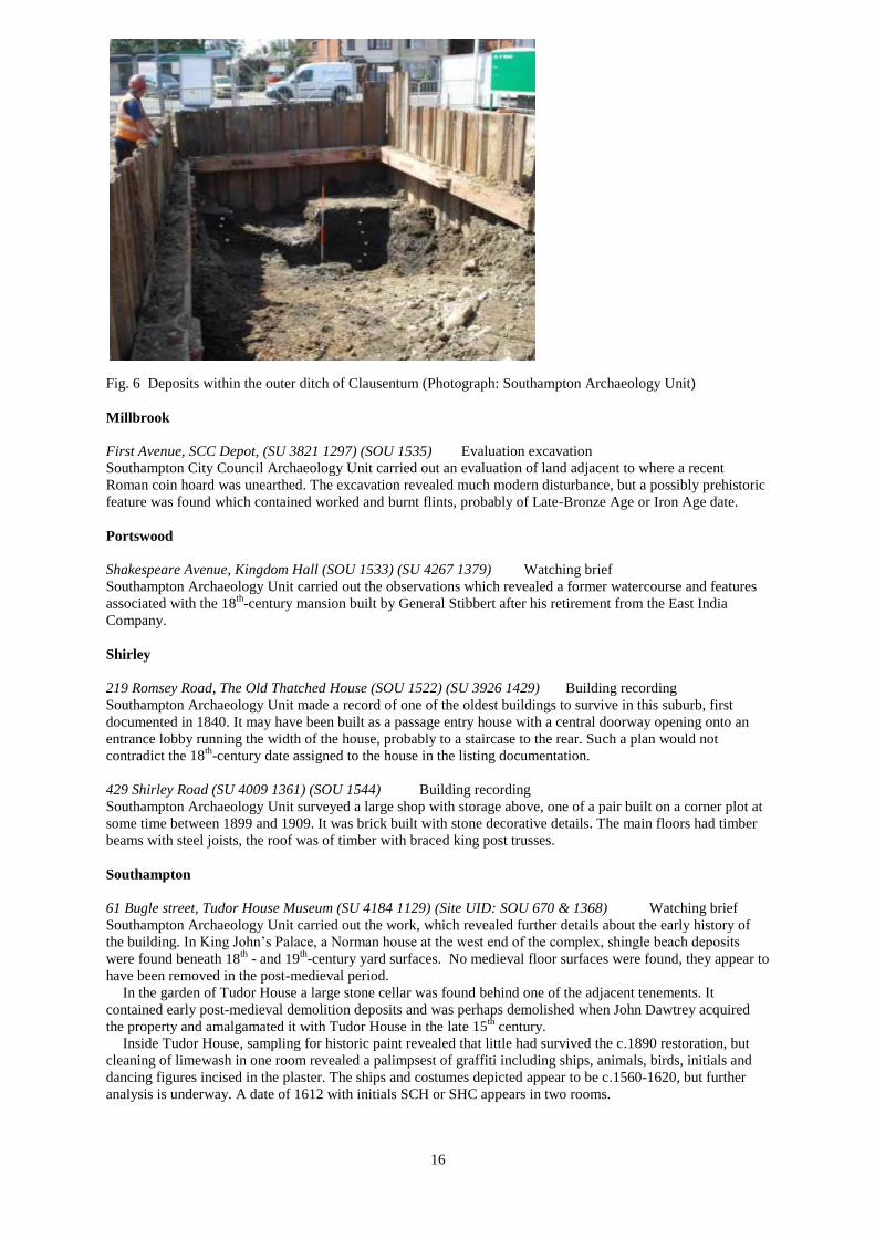
Southampton Archaeology Unit observed work on the site that lies on the outer ditch of the Roman settlement
(Clausentum). Observation and excavation revealed natural deposits of River Terrace gravel above London Clay
(Fig. 6). These were cut by the outer Roman defence ditch. Only the east side of the ditch was within the trench,
and the ditch was more than 4m wide by more than 1m deep. The ditch was much shallower than expected and
although joining the tidal river Itchen at both ends, would not have been filled at high tide. The ditch appears to
have remained open until the late 19th
century at which point it was backfilled and the area developed for
housing.
16
Fig. 6 Deposits within the outer ditch of Clausentum (Photograph: Southampton Archaeology Unit)
Millbrook
First Avenue, SCC Depot, (SU 3821 1297) (SOU 1535) Evaluation excavation
Southampton City Council Archaeology Unit carried out an evaluation of land adjacent to where a recent
Roman coin hoard was unearthed. The excavation revealed much modern disturbance, but a possibly prehistoric
feature was found which contained worked and burnt flints, probably of Late-Bronze Age or Iron Age date.
Portswood
Shakespeare Avenue, Kingdom Hall (SOU 1533) (SU 4267 1379) Watching brief
Southampton Archaeology Unit carried out the observations which revealed a former watercourse and features
associated with the 18th
-century mansion built by General Stibbert after his retirement from the East India
Company.
Shirley
219 Romsey Road, The Old Thatched House (SOU 1522) (SU 3926 1429) Building recording
Southampton Archaeology Unit made a record of one of the oldest buildings to survive in this suburb, first
documented in 1840. It may have been built as a passage entry house with a central doorway opening onto an
entrance lobby running the width of the house, probably to a staircase to the rear. Such a plan would not
contradict the 18th
-century date assigned to the house in the listing documentation.
429 Shirley Road (SU 4009 1361) (SOU 1544) Building recording
Southampton Archaeology Unit surveyed a large shop with storage above, one of a pair built on a corner plot at
some time between 1899 and 1909. It was brick built with stone decorative details. The main floors had timber
beams with steel joists, the roof was of timber with braced king post trusses.
Southampton
61 Bugle street, Tudor House Museum (SU 4184 1129) (Site UID: SOU 670 & 1368) Watching brief
Southampton Archaeology Unit carried out the work, which revealed further details about the early history of
the building. In King John‟s Palace, a Norman house at the west end of the complex, shingle beach deposits
were found beneath 18th
- and 19th
-century yard surfaces. No medieval floor surfaces were found, they appear to
have been removed in the post-medieval period.
In the garden of Tudor House a large stone cellar was found behind one of the adjacent tenements. It
contained early post-medieval demolition deposits and was perhaps demolished when John Dawtrey acquired
the property and amalgamated it with Tudor House in the late 15th
century.
Inside Tudor House, sampling for historic paint revealed that little had survived the c.1890 restoration, but
cleaning of limewash in one room revealed a palimpsest of graffiti including ships, animals, birds, initials and
dancing figures incised in the plaster. The ships and costumes depicted appear to be c.1560-1620, but further
analysis is underway. A date of 1612 with initials SCH or SHC appears in two rooms.

17
138 – 140 Burgess Road, Gate Public House (SU 4262 1557) (SOU 1530) Building recording
The survey was by Southampton Archaeology Unit. The 1846 Royal Engineers‟ map shows that there has been
a public house, known as the Well Hung Gate, on the east side of the site since at least that time. It is probable
that the oldest surviving part of the building was the same structure. The west side was a separate property in
1846. There were several periods of extension and alteration, particularly when the two properties were united,
which probably occurred in 1925. This phase of investment coincided with the growth in motor travel (Burgess
Road was an east-west route to the north of the Southampton peninsula), and the establishment of the University
nearby.
168 Burgess Road, Crown and Sceptre Public House (SU 4271 1557) (SOU 1531) Building recording
Southampton Archaeology Unit made a record of the building. There had been a beer house on the site since at
least the 1870s. The property was acquired by the Strong‟s Brewery of Romsey in the late 1920s and it was
rebuilt in their “mock Tudor” house style in 1930. The architect was Newby Vincent of Southampton and the
builder Jukes and Son. It was almost certainly intended to provide hotel accommodation as well as being a
public house. The exterior was well preserved, but the arrangement of the bars had been radically altered,
probably in the 1970s. The original small bars, catering for different classes of clientele, had been opened up
into one large open-plan bar.
Burgoyne Road, Eastpoint Centre (SU 4713 1156) (SOU 1521) Evaluation & watching brief
Southampton Archaeology Unit was responsible for the work. A number of Bronze Age burial mounds lie in the
vicinity of the site, and it was close to the Roman road from Southampton to Chichester. The work revealed nine
probable prehistoric features, marked by charcoal, burnt flints, and flint flakes. One feature was radiocarbon
dated to 160BC to 60AD at the 95% probability.
72-4 Canal Walk (SU 4216 1147) (SOU 1482) Excavation
Southampton Archaeology Unit excavated the presumed berm between the east medieval town wall and its
associated ditch. The space was mostly filled by a sloping rampart of soil and brickearth, sealing a number of
features containing Anglo-Norman pottery. The medieval town wall lay just west of the trench, in the centre of
the rampart. This may reflect the original form, but elsewhere no rampart survives outside the town walls. The
foundation of a large semi-circular stone tower was found cutting into the sloping rampart, showing it was an
addition to the wall. The tower had been completely robbed and only stone chips and mortar fragments
remained. In the early 19th
century the area was developed with cheap housing and a number of yard surfaces
and cess pits were found.
30-32 Carlton Road (SU 441790 113042) (Site UID: 1539) Watching brief
Southern Archaeological Services carried out the observations during groundworks and recorded up to 2.6m of
Modern disturbance above natural gravel. The work ceased when the foundation design was altered from
trenching to piling because of the collapse of the trenches in the northern part of the site. A drain trench that had
to be excavated on the line of the foundations was also recorded. No finds were recovered from the site.
Derby Road, Maytree School (SU 427128) (SOU 1534) Watching brief
Southampton Archaeology Unit undertook observations at a site that lay between the Saxon town of Hamwic
and the medieval grange farm at Northam, but no archaeologically significant deposits were observed. A large
amount of rubble and mid 20th
-century domestic objects was probably the remains of terrace houses destroyed in
the Blitz. The terrace included a corner shop and an advertising sign for De Reszke cigarettes was recovered
(Fig 7).
Fig. 7 Advertising
signs for De Reszke
cigarettes
(Photograph:
Southampton
Archaeology Unit)

18
Guildhall Square, Above Bar (SU41921223) (SOU 1517) Watching brief
Southampton Archaeology Unit completed observations at Guildhall Square and the adjacent streets. The works
recovered a small amount of residual late prehistoric finds, but the area appears to have first been settled in the
Middle Saxon period. Features included a number of pits, with imported pottery, and evidence of a field system
with parallel ditches. A Middle Saxon bronze pin had previously been found on a site to the south. A single
medieval feature was found, suggesting that the medieval leper hospital of Mary Magdalene lay elsewhere,
although the leper hospital garden may have occupied part of the site. In the post-medieval period the east part
of the site was developed for housing and quarry pits dug for the extraction of brickearth covered much of the
area.
Havelock Road and West Park Road (SU 4165 1226) (SOU 1524) Watching brief
The observations were by Southampton Archaeology Unit. The works ran from Southampton Civic Centre,
along to the new “Gantry” development site off Blechynden Terrace and a post-medieval soil layer and
evidence for 19th
-century gravel digging were identified.
34 – 35 High Street, Dolphin Hotel (SU 4208 1135) (SOU 1519) Building recording
Southampton Archaeology Unit undertook the survey of the hotel first mentioned in 1520. The modern property
was occupied by two capital tenements in the 15th
century; the southern property appears to be the original
Dolphin. Stone-built basements probably date from this period, as does a fragment of stone walling from the
northern tenement. This had diamond-mullioned windows on each floor and a fragment of a moulded door
jamb. A timber-framed range to the rear of the south tenement was also probably of late-medieval or early-post-
medieval date. The Dolphin‟s street frontage was rebuilt as a coaching inn in the late 18th
century, with further
rebuilding to the rear in the early 19th
century. The Dolphin was an important centre of Southampton‟s social,
economic and political life in the late 18th
and early 19th
centuries and is reflected in the number, size and
quality of large function rooms in both parts of the property.
High Street, west of Holyrood Church (SU 4200 1099) (SOU 1474) Excavation
Southampton Archaeology Unit carried out the work revealing a late Saxon feature which incorporated a sherd
of Roman colour coated pottery. The 18th
- 19th
-century lead water main was also encountered.
Lansdowne Hill, Castle Chambers (SU 4188 1143) (SOU 1528) Watching brief
Southampton Archaeology Unit observed work on a site that lay within the precinct of the medieval castle. A
gravel layer beneath the site may have been natural River Terrace gravel or part of the castle mound. A brick
wall and deposits butting it dated to the post-medieval period. They contained residual high medieval pottery
and a large block of limestone, likely to have been part of the castle. Perhaps they were a part of the Marquis of
Lansdowne‟s gothic castle built in the early 19th
century.
Oxford Street, Mountbatten Centre (SU 441926 112185) (Site UID: SOU 1461) Watching brief
Southern Archaeological Services carried out the observation on an exploratory pit for a pile position, the
excavation of some of the pile caps and ground beam trenches and a service trench. The work recorded six
contexts over the site, consisting of rubble infill, buried topsoils, and natural brickearth. No archaeological
features were observed, as the site was found to be heavily disturbed by Modern building activity. One sherd of
Post-Mediaeval pottery was recovered.
74 St Anne's Road (SU 444595 110893) (Site UID: 1527) Watching brief
The observations were carried out by Southern Archaeological Services during groundworks and recorded
modern topsoil above natural gravel and sand. Several modern features associated with the pre-existing mid-
19th
-century villa were observed. No finds were recovered.
76 St Mary Street (SU 442497 111963) (Site UID: SOU 1542) Building recording
Wessex Archaeology was appointed to carry out a programme of historic building recording on the well-
preserved Victorian hall (St Mary‟s Hall) with second floor gallery at 76 St Mary Street, where a new
development will involve internal alterations in addition to a programme of refurbishment.
The building appears to have had a number of different uses over the years. A study of the available sources
indicates that St Mary‟s Hall was opened as a lodge hall of the adjoining Kingsland Tavern in 1884 functioning
as a meeting place for a variety of Friendly Societies, which had formerly met in the tavern.
Despite the popularity of the new facility, by 1886 the landlord decided to expel the societies in favour of
opening a music hall named St Mary’s Hall of Varieties. It is likely that a stage and the present second floor
gallery were added at this time. This venture also seems to have been short-lived and after lying empty for a
short time the building re-opened in January 1889 as Southampton‟s first public library, which was relocated to

19
larger premises in 1893. The trade directories of the time indicate that the building remained vacant for the next
ten years, with the exception of a brief period in 1899 when it was occupied by the Social Democratic
Federation - an early socialist political party.
By 1905, it is likely that the building operated as a Temperance Hall before becoming (in 1908) the home of
the Southampton Holiness Mission, the first branch of this charismatic religious organisation outside of London.
A new staircase and access onto Johnson Street was probably created at this time, establishing the arrangement
of St Mary‟s Hall that can be seen today. The Hall appears to have remained as a church of the Holiness Mission
until the late 20th
century. Following a brief period in use as a martial arts venue, the building has lain empty for
the last two decades.
Sea City Museum, Civic Centre (SU 4175 1229) (SOU 1523) Evaluation
Southampton Archaeology Unit conducted an evaluation at the site of the proposed Sea City Museum, in the
Marlands Fields, which take their name from a medieval leper hospital. The area had been extensively quarried
for gravel during the mid-19th
century and subsequently backfilled and landscaped.
Westgate Street, Tudor Merchants’ Hall (SU 4179 1120) (SOU 1495) Excavation & dendrochronology
Early post-medieval records show that this area behind the town walls was garden in the late 15th
and early 16th
centuries. The Hall, formerly located in St Michael‟s Square, was moved to the present site in 1634 and became
a warehouse. Excavation inside the building by Southampton Archaeology Unit revealed large dumps of 17th
-
century rubbish, with imported pottery and a touchstone for checking the purity of gold. The warehouse was
originally provided with a brick-paved floor. This was renewed and patched throughout the life of the building.
One area of the floor was heavily impregnated with salt, which has had a detrimental effect on the nearby stone
town wall.
Tudor Merchants‟ Hall is a fine, two-storey building of five bays with a single large hall on the first floor.
The roof is an early example of clasped side-purlin form and is fully wind-braced with large, curved braces. The
internal trusses have a single 'crown struts' between tie beam and collar beam and arched braces between tie
beams and principal posts. The early floor beam is considered to be a re-used or stockpiled timber. This 15th
-
century timber framed building originally stood in St Michael's Square. The first documentary reference to the
building is in the Steward‟s Accounts of 1428-9 which refer to a lease of „a tenement over the fish market‟ that
had been running for a number of years. By 1634 the building was very dilapidated and was sold to a prominent
burgess, Alderman Edward Exton, for 20 marks. He dismantled it and re-erected it as a warehouse on its present
site against the walls of the Westgate. The building continued to be leased out as a warehouse until the early 20th
century when it became an archaeological store. It was restored in 1973/74 by Southampton City Council.
Southampton Archaeology commissioned the dating.
a) Floor beams Felling date: Spring 1396
b) First floor timbers Felling date range: after 1417
a) Floor beams 1378(7), 1389(h/s), 1393(7), 1395(21¼C). b) Posts 1378(h/s), 1383, 1408(h/s). Site Master
1272-1408 TUDORMH1 (t= 8.9 ANGLIA03, 8.3 EASTMID, 8.0 HANTS02).
Yeovil Chase, Harefield Junior School (SU 4582 1359) (SOU 1536) Building record
Southampton City Council Archaeology Unit made a record of the 1957 junior school prior to its demolition.
The school was designed by the Borough architect, and the main contractors were AJ Dunning & Son (Weyhill).
The construction used brick-clad reinforced concrete frames.
Swaythling
100-102 High Road, Swaythling (SU 443731 115761) (Site UID: 1541) Watching brief
Context One Archaeological Services carried out the works which revealed a simple sequence of modern made
ground directly overlying the natural, across the extents of the site. The only feature observed during the
monitoring of development groundworks was a brick lined well that is likely to be contemporary with the 19th
-
century buildings that fronted High Road.
TEST VALLEY
Amport
The Cholderton Estate, Laundry Field (SU 23558 41980) (Site UID: 62409) Excavation
Following the discovery of a hoard of three bronze palstaves and three looped socketed axes during 2007
(Treasure case 2007/TO704), a small scale investigation was undertaken by The Quarley Down Environs

20
Project in the Laundry Field at the request of the landowner, Henry Edmunds, to try and establish the context of
the finds. The site is situated on the Cholderton Estate at the west end of the parish of Amport, within a
kilometre of the county boundary with Wiltshire. It lies on a south facing slope of a dry valley that runs from
below Quarley hillfort on the east to the Bourne valley on the west and contains two groups of Bronze Age
barrows, one of these forming a row along the southern edge of the Laundry Field. Part of a prehistoric field
system has also been plotted from aerial photos, which forms part of a more extensive system running up to
Quarley hillfort (Palmer 1984, see also Site UID: 33015). The bedrock here is chalk but the surface disrupted by
periglacial freeze-thaw and with a hint of a Clay-with-flints capping now ploughed out. The ploughsoil is a silty
clay containing a high density of flints and flint gravel.
Excavation has continued since the winter of 2007/8 until 2011, and the intention is to complete the
excavations in 2011. The initial trench (1) was located purely to investigate the location in which the hoard had
been found. At the same time fieldwalking and geophysics (Brooks 2008) established the presence of more
intense evidence of occupation immediately to the south. Subsequent trenches expanded in this direction to
investigate the settlement area and an area totalling 470m² has been excavated.
The geophysics survey suggested the presence of an oval enclosure with a discontinuous boundary and a
number of anomalies within the interior, some of which were interpreted as a possible circular structure. In the
light of the excavation there has been some reassessment of the shape of the enclosure and what is represented
by the anomalies.
Fig. 7 The northern boundary feature F176, looking west (Photograph: Quarley Down Ancient Environs
Project)
The initial area of excavation (trench 1) in 2007 revealed an area of tree root hollows and a large tree throw
sealed by a layer of flint gravel together with a few post-holes and a pit concentrated in the southern area of the
trench. A small trench (trench 2) excavated to test the geophysics evidence revealed a line of small hollows,
which were interpreted as tree root holes representing a hedge line enclosing the settlement. This has been
revised following the opening of a larger area (trenches 3 & 6) which encompassed trench 2.
The pattern that became apparent as a result of the larger area exposed was of a broad hollow F176 (Fig. 7)
aligned west-south-west east-north-east across the northern half of the trench with a slightly higher area to the
north containing a couple of large tree throws but otherwise devoid of features. To the south of this linear
feature was a concentration of pits and small post-holes cutting through further tree root hollows. All features
were sealed by layer of flint gravel (181), which had accumulated most thickly over F176.
The tree roots and F176 represent the earliest phase of activity. No artefactual or dating material was found
in the fills of these features, but the few relationships observed to post-holes showed the tree root hollows were
21
always earlier than the anthropogenic features. The linear
feature F176 was c. 4-5m wide and has been provisionally
interpreted as a field lynchet with the higher positive area to
the north and the negative area to the south. In this hollow a
continuous line of large tree throws and root hollows was
exposed, with shallower areas of rooting between. This would
suggest that the lynchet had started to form before the trees
grew, although it could be argued that the mature trees were
left uncleared on the field boundary and the rooting was
responsible for the hollow. The three main tree hollows / tree
throws along this boundary are large covering areas 3-4m
wide with shallower rooting continuing in the intervening
area.
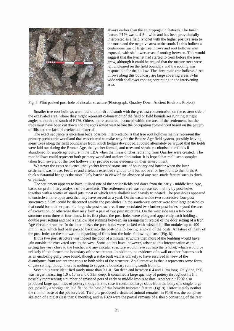
Fig. 8 Flint packed post-hole of circular structure (Photograph: Quarley Down Ancient Environs Project)
Smaller tree root hollows were found to north and south with the greatest concentration on the eastern side of
the excavated area, where they might represent colonisation of the field or field boundaries running at right
angles to north and south of F176. Others, more scattered, occurred within the area of the settlement, but the
trees must have been cut down and the roots rotted well before the occupation commenced based on the pattern
of fills and the lack of artefactual material.
The exact sequence is uncertain but a possible interpretation is that tree root hollows mainly represent the
primary prehistoric woodland that was cleared to make way for the Bronze Age field system, possibly leaving
some trees along the field boundaries from which hedges developed. It could alternately be argued that the fields
were laid out during the Bronze Age, the lynchet formed, and trees and shrubs recolonised the fields if
abandoned for arable agriculture in the LBA when the linear ditches radiating from Quarley were created. The
root hollows could represent both primary woodland and recolonisation. It is hoped that molluscan samples
taken from several of the root hollows may provide some evidence on their environment.
Whatever the exact sequence, the lynchet formed some sort of boundary and barrier when the later
settlement was in use. Features and artefacts extended right up to it but not over or beyond it to the north. A
thick substantial hedge is the most likely barrier in view of the absence of any man-made feature such as ditch
or palisade.
The settlement appears to have utilised one of the earlier fields and dates from the early - middle Iron Age,
based on preliminary analysis of the artefacts. The settlement area was represented mainly by post-holes
together with a scatter of small pits, most of which were shallow and heavily truncated. The post-holes appeared
to encircle a more open area that may have served as a yard. On the eastern side two successive four-post
structures c.2.5m² could be discerned amidst the post-holes. In the south-west corner were four large post-holes
that could form either part of a large six-post structure, if one postulated two further post-holes beyond the area
of excavation, or otherwise they may form a pair of two post structures. On the west side was a two post
structure recut three or four times. In its first phase the post-holes were elongated apparently each holding a
double post setting and had a shallow slot running between, an arrangement typical of the door setting of a Iron
Age circular structure. In the later phases the post-holes were packed with substantial flint nodules up to 400
mm in size, which had been packed back into the post-hole following removal of the posts. A feature of many of
the post-holes on the site was the repacking of flints into the holes following disuse (Fig. 8).
If this two post structure was indeed the door of a circular structure then most of the building would have
lain outside the excavated area to the west. Some doubts have, however, arisen to this interpretation as the
setting lies very close to the lynchet and any circular structure would have cut into the lynchet, which would be
unlikely if this formed the boundary of the settlement. In addition, no evidence of a wall or other features such
as an enclosing gully were found, though a stake built wall is unlikely to have survived in view of the
disturbance from ancient tree roots to both sides of the structure. An alternative is that it represents some form
of gate setting, though there is nothing to suggest a boundary running south from it.
Seven pits were identified rarely more than 0.1-0.15m deep and between 0.4 and 1.0m long. Only one, F90,
was larger measuring 1.0 x 1.4m and 0.35m deep. It contained a large quantity of pottery throughout its fill,
possibly representing a number of smashed pots of early or middle Iron Age date. Another pit F202 also
produced large quantities of pottery though in this case it contained large slabs from the body of a single large
pot, possibly a storage jar, laid flat on the base of this heavily truncated feature (Fig. 9). Unfortunately neither
the rim nor base of the pot survived. Two pits produced articulated animal remains: in F148 was the complete
skeleton of a piglet (less than 6 months), and in F320 were the partial remains of a sheep consisting of the rear

22
legs, a font leg and part of the vertebral column. It
seems likely the rest of the animal had been truncated
by ploughing. A small oval pit F212 was packed full of
burnt flint and sandstone blocks, though no in situ
burning was present nor any charcoal or ash in the fill.
A tip of burnt flint was found also in F35, but in this
case it was small shattered fragments, apparently the
residue from quenching heated flints. Amongst this flint
was a small bone with a line incised around each end.
Finally pit F194, produced a range of objects fitted into
a small area: parts of two sarsen saddle querns, a
sandstone hone, a tiny fragment of bronze and a clay
spindle whorl, in addition to some large sherds of
pottery.
Fig. 9 Partial pot on a pit base (Photograph: Quarley Down Ancient Environs
Project)
In summary the excavations have shown a sequence starting with primary woodland, followed by the
formation of a field system and arable agriculture during the Bronze Age. Between these, clearance of the
woodland must have taken place and activity during the Neolithic and Bronze Age is attested by numerous
struck flints. Also during this phase the ritual funerary landscape developed in the valley. In the late Bronze Age
the bronze hoard was probably deposited, perhaps buried at the edge of the field as the fields fell into disuse or
became pasture, at the time when the linear ditches were being constructed from Quarley. The small settlement
was founded probably during the early Iron Age making use of one of the old fields to define its limits. The size
of the site and density of structures and occupation material suggest this was a small farmstead probably
representing a single extended family. The recutting of features indicates that it may have lasted a couple of
generations and some of the pottery suggests it may have continued into the middle Iron Age. Following
abandonment of the settlement, the area was probably once more given over to arable agriculture, as the
truncation of features must have occurred before a horizon of gravel formed over the site. This gravel layer,
thickest over the field lynchet, but also covering many of the features though thinning to the south, must have
formed as a result of earthworm sorting during a long period of pasture possibly from the late Iron Age or
Roman period through to the 19th
century when the local downland was broken up and given over to arable once
again.
Woodland survey. Three woods were surveyed with the aim being to fill in the gaps where air photography and
fieldwalking are unable to be applied. The surveys were carried out under the supervision of Mark Peryer by
members of the Quarley Down Ancient Environs Research Group and Basingstoke Archaeological & Historical
Society. The report is by Peter Stone and Cynthia Poole.
The Circular Wood, Quarley Down Farm (SU 240417) (Site UID: TBA)
The wood was recorded on the Quarley Parish Tithe map of 1840 as a new plantation. The survey revealed that
the wood is demarcated by a ditch and bank, which is associated with a bank running through the line of trees
along the ridge to the west. This bank marked the original boundary of the fields to the north and north-west of
the wood and is likely to represent the enclosure of the downland during the 19th
century; the field and woodland
banks probably being contemporary. The wood bank is characterised along its length by mature oak, beech and
ash trees with an estimated age range of about 100 to 250 years. In contrast, the interior supports much younger
trees, including a scattering of yew and accords with early air photographs that show the wood had been cleared
of trees over three quarters of the interior in the early 20th
century.
The interior produced over 40 bowl-shaped earthworks, each with an average diameter of about 7.25m and an
average area of about 41m². They each have an external bank and a central depression up to 1m deep. Four of
them that are located on the north-eastern periphery, each contain a beech tree that is estimated to be 70 years
old. Interestingly, the features are mostly concentrated in a broad arc situated to the west and north of the wood,
which has left a triangular-shaped area c. 0.55 hectare on the east clear of earthworks. A comparison of these
earthworks with lye pits in Savernake Forest (Bathe & Greenaway 2007) suggests that they may be have been
related to an increase in the wool industry during the 18th
and 19th
century.
Windy Dido (SU 250 426) (Site UID: TBA)
Windy Dido is situated to the south of Cholderton Hill, about 1.25km north-east of the Circular Wood and about
250m east of Barrow Field. It covers about 11.74ha and was referred to on the Amport Tithe Map of 1839. It has

23
been described as „native semi-natural woodland‟, while the name „Dido‟ apparently refers to any plantation of
trees that acts as a windbreak for shooting.
The main funnel shaped wood is bounded on the north by an extended narrow strip, separated by a track
which joins with that on the south-west side. This forms a separate plantation creating a hangar of trees to act as
a windbreak. Two „ancient beech‟ trees and the presence of dog‟s mercury support the conclusion that it is
„Ancient Woodland.‟ A beech tree located on the northern boundary of the wood has been estimated to be of
about 124 years, while its unusual appearance may be due to coppicing. The wood contains many regenerating
tree species with ash, yew and hazel dominant. Game butts and seed hoppers make plain its use during the 19th
and early 20th
century for sporting activities.
Two lengths of ditch and bank lying about 25m apart in the south-east sector of the wood were surveyed:
each was c.0.5m deep, but they have varying lengths of 30m and 19m. To the north two circular features were
found, one of which may be a barrow, although neither was conclusively identified as such.
Quarley Park Wood (SU 236 410) (Site UID: TBA)
This woodland covers an area of about 8ha and is near-rectangular in shape bounded by a track on its western
side. It comprises diversified woodland that includes large beech, ash and oak, patches of mature hawthorn and
blackthorn and fairly extensive open areas. The presence of Dog‟s Mercury and Early Dog-violet has been taken
to indicate „Ancient Woodland‟, although this has yet to be confirmed.
The boundary ditch runs parallel to the track (and the county boundary) on the west and was measured over
about 135m where it was found to have a depth of about 0.50m and a width of 2.4m at the south-east, widening
to about 3.5m at its north-western end. It does not however enclose the whole wood, suggesting it relates to
general field enclosure rather than the wood.
The survey mapped two prominent features, one of which appears to coincide with the gas pipeline that cut
across the wood. Further to the north the survey identified a deep curving ditch feature about 80m in length by
4.5m to 5.0m wide and c. 0.75m deep. This is probably the sunken feature marked on the OS map. A number of
other features in the south-east corner included a linear feature which may be as long as 180m and a circular
feature c. 6.5m diameter by 0.65m deep.
References
Bathe, G & Greenaway, D 2007 A Lye Pit in Savernake WANHM 100, 207-10.
Brooks, I 2008 The Laundry, Cholderton Estate Geophysical Survey EAS Client Report 2008/01 Unpub.
Palmer, R 1984 Danebury: an Iron Age hillfort in Hampshire An aerial photographic interpretation of its
environs RCHM (England) Supplementary Series 6.
Andover
Land at Picket Twenty (Area H) (SU 39000 45500) (Site UID: 60761) Evaluation excavation
Wessex Archaeology carried out the work. No archaeological finds or features were found in the area
designated for development. In the eastern part of the site, which is to be excluded from development, there is a
small group of ring ditches that represent the ploughed out remains of Bronze Age barrows.
Land at Picket Twenty (Area J) (SU 39240 45454) (Site UID 63041) Evaluation excavation
The work was by Wessex Archaeology and a single pit, possible an isolated post-hole, was uncovered during the
evaluation. Other features were mainly tree-throws. The limited finds included burnt flint, fired clay and a small
sherd of Romano-British pottery (Samian ware).
Land at Picket Twenty (Area K) (SU 38814 45139) (Site UID 63043) Geophysical survey
The survey was carried out by GBS. Although anomolies were recorded an evaluation yielded no archaeological
evidence.
Land at Picket Twenty (Area L) (SU 38918 45172) (Site UID 63044) Geophysical survey
The survey was carried out by GBS. Although anomolies were recorded an evaluation yielded no archaeological
evidence.
East Tytherley
East Tytherley Manor House (SU 29324 28966) (Site UID: 62292) Watching brief
The work at this designated Scheduled Ancient Monument was carried out by Wessex Archaeology. During the
observations, layers of post-medieval made ground were encountered within the depth required for the
development, thus indicating the depth of overburden that appears to lie above the archaeological horizon. The

24
overburden may represent imported material used to landscape the area, and as such appears to form a protective
cover over the former Manor House site. The presence of ironworking slag, medieval roof tile and dressed
stone, although residual within the overburden, may indicate the potential presence of in situ deposits associated
with the Manor House at a greater depth than revealed by the test pits.
Mottisfont
Mottisfont Tythe Barn, Hampshire (SU 325 268) (Site UID: TBA) Building recording
The following is by Martin Wilson and summarises the detail in the following reports:
Mottisfont Tythe Barn, Mottisfont Hampshire (SU 325 268), Historic Building Record, 2009-2010, by Wilson,
M, Souterrain Project No. SOU10/059, November 2010; Mottisfont Tythe Barn, Mottisfont Hampshire, SU 325
268, ‘As found’ Photographic Record, by Wilson, M & Planas, M, Souterrain, Archaeological Services Ltd
Report, May 2007. The reports give a descriptive and illustrative account of archaeological observations during
the work, provide an analysis of the former agricultural building, and looks at its historic context. It
compliments an earlier photographic record of the building made of the 20th
-century village hall prior to its
conversion.
The former village hall at Mottisfont, a Grade II Listed building, was adapted from a medieval barn
sometime during the early 20th
century (Fig. 10). Between 2009 and 2010 it was converted to a house. The
original timber-framed barn, a five bay structure, was placed within the date range 1400 and 1480 by Mr.
Edward Roberts, based upon the „fan truss‟ (i.e. out-curving braces from above the collar) at the east end (Fig.
11), a hallmark period feature of the mid 15th
century, and a type which has been dated many times in
Hampshire.
Fig 10 Mottisfont barn facing south-east (Photograph: Souterrain Archaeology)
The surviving medieval timber building comprises five of the original six cross frames (except for an upper
section of the east end), and a significant part of the roof frame, including curving wind-braces. An unusual
feature is that all cross frames are faced up to the west, whereas customarily, they are faced up to the wagon
entrance of a barn (i.e. a central bay). Another uncommon feature is the threaded purlin which is usually found
only in houses; Hampshire examples of these being one at Overton dated to the 1430s, and another at King's
Somborne, dated to 1504.

25
The modern conversion work revealed that the barn had previously undergone a great many alterations in the
18th
century, or even the 19th
century, at which time it belonged to the Rector of Mottisfont. The more obvious
of these changes being the lower halves of the north (long) and west elevations which were replaced by brick or
cob walls, and the half-hipped roof which was originally gabled. Mortise and peg-hole evidence in the south
elevation showed that the long elevations were originally mid-railed, with a central stud between each bay and
down-swinging tension braces. None of the building‟s wall plates are likely to be in their original positions, if
they are at all original. Indeed, there was sufficient evidence to demonstrate that the structure was dismantled
from its original site (unknown) and re-built on the present site in the 18th
century. The main indicator of a re-
build is the two sets of carpenters‟ Roman numerals, which are found side-by-side throughout the roof structure
and cross-frames. The earliest set, which most certainly date to the fabrication of the 15th
-century building,
consist of long rough score marks, while the second set are shorter, neatly chiselled numerals with v-shaped
profile, common in 18th
- and 19th
-century carpentry. There would be no reason to re-number the timbers unless
the building was to be dismantled and reassembled.
Fig. 11 „Fan truss‟ of the east elevation (Photograph: Souterrain Archaeology)
The evidence also suggests that the structure was re-sited on a smaller footprint than that for which it was
designed, the south side of the west end bay being fore-shortened as a result. The wind brace mortises in the
west bay, unlike their counterparts elsewhere in the roof structure, which are well-carpentered and tightly fitting,
were roughly widened to enable re-jigging during re-erection. Interestingly, ground-works beneath the two
easternmost bays revealed made-up ground, up to c.0.6m in thickness, which consisted of a large quantity of
decorative rubble masonry which is likely to have originally derived from the priory of Mottisfont, which was
suppressed in 1536 during the Dissolution and converted to a mansion house shortly afterwards. Archaeological
observations concluded that it was doubtful that the barn had been „jacked-up‟ to accommodate new
foundations.
The medieval timber framework of the barn, exposed and restored during the work, has become a key
feature of the new house design.
Romsey Extra
Abbey Water (NGR 435124 121147) (Site UID: 62021) Watching brief
Wessex Archaeology carried out the observations during works to replace a retaining wall forming the southern
side of Abbey Water. Abbey Water, running from east to west, lies to the south of Romsey Abbey, in an area of

26
high archaeological potential. Evidence for the development of the Abbey suggests that its historic foundation as
a Nunnery by Edward the Elder in the early 10th
century may have followed earlier ecclesiastical use of the
Abbey site as indicated by structural remains and, immediately north of Abbey Water, burials. It has also been
suggested that Abbey Water, a mill leat that diverted water from the course of the „Shitlake‟ stream, may follow
the southern extent of the late Saxon Abbey precinct.
The works comprised the removal of the existing retaining wall forming the southern side of Abbey Water
and its replacement on a new foundation. This involved the excavation of a trench 69m in length and up to
1.70m deep, formed in stages prior to the construction of the replacement wall. The watching brief identified
evidence for archaeological features, deposits and finds surviving behind the existing retaining wall and below
the adjacent road. Of primary interest was the presence of a number of graves. Although it was not possible to
investigate the graves fully, and no clear dating evidence was recovered, they may be associated with the burials
previously recorded to the north of Abbey Water which have been assigned a broad middle to late Saxon date. If
so, the course of Abbey Water may not represent the southern extent of the late Saxon Abbey precinct, as
previously suggested.
No direct evidence for the medieval channel „Shitlake‟ was noted during the watching brief. A possible
channel, indicated by the presence of alluvial deposits, was noted towards the eastern end of the trench however,
c. 5m west of the point at which the existing course of Abbey Water turns from north-south to run east-west.
Broadlands House (SU 35443 20370) (Site UID: 62021) Watching brief
Nexus Heritage undertook the work. The pit for a biomass boiler revealed the remains of a brick built structure
interpreted as an outhouse or garden building, while the service trench produced evidence for walls and floors
and a brick building which has been identified as part of a kitchen range. The two structures can be identified on
OS maps 1865, 1895 and 1908.
Former Romsey Carpets Building (SU 35143 21048) (Site UID: 63013) Building recording,
excavation & watching brief
This programme of work was undertaken by Context One Archaeology. This building is one of the few historic
buildings on Newton lane that survived the extensive re-development in the 1950s and 60s. The building was
constructed between 1895 and 1909 and was originally part of three structures that formed a range of structures
around a cattle market. The building was probably purpose built by the market. Ground floor: the surviving
external door in the centre of the building is a stable door which suggests that the building was used to house
animals. The first floor was probably used as a hay loft, with original access gained through the external first
floor doors, or one of four internal hatches. As the sole surviving structure associated with the Romsey cattle
market, the building serves as a visible link to a formerly important aspect of the economy in Romsey in the late
19th
and early 20th
century.
Three late 19th
-century pits were uncovered to the west of the building and extend under the existing
building. They are likely to represent a phase of use immediately prior to its construction. The contents of the
pits include domestic waste, and building rubble.
19-21 Middlebridge Street (SU 351 209) (Site UID: TBA) Dendrochronology
This is a 4-bay, continuously-jettied town house, gabled at both ends. There are three rooms on each floor. One
end room comprises two bays with a central truss that lacks principal posts. The clasped-purlin roof and small-
panel framing is typical for the date but the minimal and virtually straight bracing is very unusual. The roof is
unsooted so the brick chimney is likely to be an original feature although it probably heated only the central
room. Conversion, probably in the early 17th
century, involved the introduction of a lobby entry with back-to-
back fireplace and lateral bracing on the first floor. Dating was commissioned by the owner, with assistance
from the Hampshire Buildings Survey Group.
Felling date: Winter 1523/4
Total (5/7). Posts 1503(h/s), 1518(17+4NM), 1523(14C); Ties 1509(h/s+7NM), 1519(11). Site Master 1426-
1523 TCROMSEY (t= 11.0 MOTISFNT, 10.0 HANTS02, 10.0 SOUTH).
WINCHESTER DISTRICT
Bishops Waltham
15 Folly Field, Bishops Waltham (SU 5553 1729) (Site Code: WINCM: AY429) Watching brief
Southampton Archaeology Unit undertook a watching brief on ground works for new houses and identified a
shallow pit, possibly of later prehistoric date, later prehistoric flint tools and flakes together with an early-
27
middle Saxon pit or ditch containing crushed ironstone, which may be associated with smelting activity in the
vicinity.
Boarhunt
Fort Nelson, (SU 6093 0710) (Site Code: TBA) Geophysical & topographical survey & evaluation
excavation
ArchaeoPhysica, on behalf of Gifford Consulting, undertook the surveys on land to the east of Fort Nelson in
connection with proposals to build new visitor and parking facilities at The Royal Armouries museum. Fort
Nelson is a Scheduled Monument and a Grade 1 Listed Building and part of Portsmouth defensive forts line
established in the 2nd
half of the 19th
century.
The topographic survey revealed a number of distinct hut platforms thought to date from WWI and signs that
a large excavation at the east end of the site may once have been a reservoir, although this may not have been its
original or final function. The geophysical survey contributed both to the understanding of the hut platforms and
also the understanding of the wider site including a number of buried services that seem likely to include the
original water and electricity supplies to the fort.
Pre-Construct Archaeology (Site Code: EWC 2008.65) undertook the evaluation in the fort. The underlying
geology was revealed to be weathered upper chalk sealed by a subsoil and modern topsoil. No archaeological
activity predating the 19th
century was discovered during the evaluation. In the south-eastern portion of the site
however, a deep linear cut lined on both sides with red brick walls was recorded as extending into both the
northern and southern limits of excavation. The demolition material situated within this feature suggested that it
was backfilled during the late 19th
century, and that the structure itself was likely to be contemporary with the
Fort, possibly a tunnel or a sunken thoroughfare. Towards the centre of the site shallow linear cuts containing
backfilled demolition material were observed and interpreted as foundation trenches for the army issue building
erected outside of the Fort during WWI. Following the demolition of this building and the removal of the
shallow foundations, the footing trenches were subsequently backfilled with demolition material, presumably
from the building itself. Work will continue in 2011.
Chilcomb
Alresford Road, St Mary Magdalen Leper Hospital (SU5056 2959) (EWC TBA) Excavation
Work in 2010 continued in the area to the north of the medieval chapel. A number of burials were identified in
this area and C14 dates for one burial, which presented evidence for leprosy (SK9), gave a date of cal AD 980-
1060AD (65% probability). This burial was therefore of some significance in that it presented the possibility of
a Pre-Conquest burial (with SK8 another possibility). A further sample from SK 9 corroborated these findings in
presenting a cal AD 890-1040 (95% probability and 90% within AD 940-1040) with a clear spike in the area of
AD 970-1030.
The south aisle of the medieval infirmary was uncovered which included evidence for partitioned cells with
individual hearths. An attached building was also excavated to the south of the infirmary which was likely to
have been the original master's accommodation. Underlying the earliest phases of the medieval infirmary was a
large cellared structure. It is thought that this structure, the burials and a masonry structure underlying the later
medieval chapel (excavated in 2008), represent possible pre-Norman occupation.
Curdridge
Canoe at Shawfords Lake (SU SU 52080 11810) (Site UID: 18,095) Dendrochronology
A `dug-out' canoe was found in 1888 and is now in the Tudor House Museum, Southampton. It was 13ft 6
inches (4.12m) long, 2ft 6 inches (6.71m) wide and had sides between 3-6inches (7.6-15.2cm) remaining.
It was discovered at the junction of the Curdridge creek and the river (Hamble). At the time of discovery it was
believed to be prehistoric but a dendrochronological analysis, carried out by Nigel Nayling of Lampeter
University, has determined that the most likely date for the manufacture of the logboat is the late 7th
or early 8th
century AD, based on the felling range of the tree.
Compton and Shawford
Bushfield Camp, Land at (NGR 446970 127190) Geophysical survey & evaluation
A detailed gradiometer survey was conducted over land at Bushfield Camp. The site occupies the flank of a
ridge 2.5km south-west of Winchester. A previous desk-based assessment indicated a high potential for
archaeology from the Bronze Age to the end of the Roman period, with other periods also represented.
28
Bushfield Camp itself is a former military base commissioned during WWII and which fell out of use in the
1970s; many of the buildings have been demolished, although a few derelict structures remain.
Notable amongst the anomalies detected was a system of apparent defensive or training trenches towards the
eastern extent of the survey area, along with numerous other responses due to demolished or extant structures.
These anomalies are generally concentrated within the central portion of the Camp, although a number are
visible to the east and the west.
To the east, a rectilinear field system of uncertain date has been identified, with several possible spurs.
Similar ditch-like responses appear to the west of the Camp. Elsewhere, isolated linear and sub-linear anomalies
may be of archaeological interest.
Twenty six evaluation trenches showed a good correlation between the geophysical survey and the
archaeology encountered, which was generally relatively sparse and relates to late prehistoric and Romano-
British field systems. A series of Romano-British enclosures in the eastern part of the site appeared to be aligned
with the Roman road now followed by the St Cross Road to the east. A more intensive area of activity was
found in the far south-eastern part of the site where a number of pits and a small gully was identified. These
could not be directly dated, but are likely to be prehistoric. An isolated cremation burial was found in the
western part of the site and was left in situ. A number of undated features were also encountered, predominantly
isolated post-holes.
Compton Street, Martins Close (SU 4627 2591) (Site Code: WINCM: AY 389) Watching brief
AOC Archaeology undertook observations on a programme of ground reduction and foundation trenching at
Martins Close and Old Orchard, Compton. During the course of the work an undisturbed sequence of soil
horizons was identified across the full area of the site overlying natural chalk. No finds or features of
archaeological significance were observed
Dean
Franklin Farmhouse (SU 570 204) (Site UID: TBA) Dendrochronology
The main body of the house was described in 2009, further samples being taken in 2010. A single purlin from
the „old house‟ has now been dated, and although this should not be taken to date the whole range, it is in the
expected date-range. The north-west cross-wing has two dated timbers with earthwood/sapwood boundaries
some 11 years apart.
a) „Old House‟Felling date range: 1433-65
b) North-west cross-wing Felling date range: 1521-53
a) Purlin 1424(h/s). Site Master 1377-1424 ffd20 (t= 6.6 LONDON, 6.5 GEORGE, 6.3 PENSFORD). b) mid-
rail 1503(h/s); ceiling beam 1520(6). Site Master 1398-1520 FRANKLN2 (t= 8.7 ASHLEY1, 7.5 CHARLWD2,
7.1 HANTS02).
Itchen Abbas
Lone Farm (SU 528 343) (Site Code:TBA) Geophysical & topographic survey & test pitting
A programme of archaeological investigations was undertaken by Southampton University during the summer
of 2010, to the north of the Scheduled site (Roman Villa). Additional details will be provided in due course.
Lone Farm (SU 453333 134185) (Site UID: TBA) Building recording & watching brief
Wessex Archaeology was commissioned to carry out a programme of historic building recording prior to the
demolition of one of the timber framed barns, and a watching brief during subsequent groundworks. The
collection of five farm buildings of different ages, types and materials surrounds a central courtyard on three
sides. Although not statutorily listed or situated within a conservation area, the L-shaped arrangement of two
timber-framed barns linked by a cattle shelter, is considered to have historic merit as the buildings contain
timber framing with queen-struts in the Northern barn, uninterrupted roof lines and some broad-lap tarred
weatherboarding.
A search of the available historic documents provided very little information with the exception of mapping
evidence. This revealed that a building on the site of the Southern Barn was present on the 1839 Tithe map. The
adjoining Cattle Shelter and Northern Barn were constructed sometime between 1839 and 1870 as part of a
general expansion of Lone Farm. As part of the final stage of 19th
-century expansion, a pair of farm workers
cottages was constructed between 1870 and 1897. Between 1910 and 1965 Lone Farm changed dramatically to
accommodate a shift in emphasis towards cattle farming. The 19th
-century buildings on the north-eastern side of
the courtyard were swept away to be replaced by the present concrete and steel modern cattle shelter and Dutch
Barn for the storage of hay and straw. The buildings to the south-west and north-west of the courtyard remained
but were adapted with the conversion of part of the Northern Barn into a cattle shelter and the reconstruction of
large parts of the Southern Barn.

29
The earliest available information relating to Lone Farm suggests that it was a minor concern established
following enclosure of the downland in the early 19th
century and conversion of the land from sheep pasture to
grain-producing fields. Although featured on the 1839 Itchen Abbas tithe map, Lone Farm is not mentioned in
the accompanying apportionment, neither does it feature in any of the censuses from 1841-1911, or any of the
trade directories. The most likely reason is that it was always an outpost of the nearby Itchen Down Farm, a fact
which is confirmed in sale particulars for The Grange Estate dating from 1932.
Archaeological remains of national importance dating to the prehistoric and Romano-British periods lie
within close proximity to the Site, to the north-west and north. These comprise a Romano-British villa, two
Bronze Age barrows and a prehistoric Banjo-type enclosure.
An archaeological watching brief was maintained on the site during all groundworks, which consisted of the
excavation of a number of pits and trenches prior to the installation of septic tanks and a field drainage system
immediately to the south-east of the farm buildings. Within the farmyard itself, the ground level was reduced
within the courtyard and inside the barns.
The only feature identified comprised the flint footings representing the corner of a post-medieval wall
although it was not possible to ascertain whether the wall was part of a building or was free-standing.
Sunnybank (NGR 453640 132920) (Site UID: TBA) Evaluation excavation
Wessex Archaeology was commissioned to carry out the work on land which lies immediately south of a Late
Roman and Anglo-Saxon cemetery. Four trenches were opened and revealed archaeological features of Bronze
Age, Romano-British and Anglo-Saxon date. A possible Bronze Age pond barrow nearly 30m in diameter was
partially excavated. Three north-south aligned inhumation graves, one containing a cremation vessel, and all
almost certainly of Romano-British date, were found close to the western side of the barrow. Three cut features
inside the western edge of the barrow were all filled with coarse chalk rubble but it is not clear if they were of a
funerary nature. A post-hole was recorded nearby. One definite and two possible inhumation graves, all
probably aligned east-west were recorded close to the southern side of the barrow. A possible a cess pit
contained a sherd of Romano-British pottery in its upper fill.
The results of the evaluation demonstrate that there are well preserved and significant archaeological remains
on the Site that include human remains and a probable Bronze Age pond barrow. The results should be viewed
in the context of previous archaeological discoveries to the north of the site that include a penannular ditch of
Neolithic date and an extensive cemetery containing burials of Late Romano-British and Anglo-Saxon date.
Taken together, these monuments represent a long-lived funerary and ritual landscape that appears to survive
largely intact.
Martyr Worthy
Chilland Lane, Chilland Mill (SU 5232 3257) (EWC: TBA) Building recording
The work was carried out by Archaeological Solutions Ltd. The analysis revealed that the original late 18th
-
century mill comprised two distinct elements; the mill range, constructed with a robust roof, and an attached
granary cross-wing to the north, which was formerly timber-faced on the east. In the early 19th
century a second
attached granary was constructed to the south. Refurbishment in the late 20th
century has replaced much of the
original flooring, while most of the original windows have been refurbished, utilising older material. The mill
machinery noted on the listing has been removed. The roof structure survives in good condition, comprising
elements identifiable as Baltic softwood.
New Alresford
43 West Street, New Alresford (SU 58699 32575) (Site UID: TBA) Excavation & watching brief
The work on land to the rear of No. 43 was commissioned by Michael Heaton Heritage Consultants on behalf of
Covemile Ltd and carried out by Foundations Archaeology. The excavation area comprised a 403m² strip of
land on a north-northwest to south-southeast alignment.
The archaeological works revealed evidence for Medieval activity in the form of numerous small pits and
post-holes. A cluster of small pits and post-holes, ranging from 0.m to 1.3m in diameter and up to 0.4m in depth,
was located in the north-west corner of the site, on an alignment broadly parallel to West Street. Two further
clusters were grouped in linear arrangements parallel to one another on a north-northwest to south-southeast
alignment, perpendicular to the course of West Street and separated by a gap of approximately 5m. Analysis of
the pottery assemblage is ongoing, but preliminary assessment suggests an almost exclusively Medieval date.
Other artefactual material associated with the pits and post-holes includes a small quantity of animal bone and
CBM. Some modern truncation of the excavation area was evident, most notably in the form of a former air-raid
shelter; most of this truncation, however, was located in the centre of the excavation area where the density of
archaeological features was otherwise low.

30
The linear nature of the groups of features suggests that they form the remnants of medieval property
boundaries relating to burgage plots fronting West Street. The lack of structural deposits indicates that the
excavation area is located within what comprised the open land within the plot, with any contemporary
structures located to the north-northwest fronting West Street. This interpretation is supported by the results of
an excavation carried out at the adjoining site of No 47 West Street by Oxford Archaeology in 2006 which
revealed a large number of post-holes and pits defining the boundaries of three burgage plots relating to the
alignment of West Street.
Further post-excavation work is ongoing and will include detailed pottery analysis and a comparison of the
data from the site to that obtained from the excavation at No 47 West Street.
Otterbourne
Kiln Lane, Manor House Barn, Otterbourne Manor (SU 4644 2240) (Site Code: WINCM: AY442) Watching
brief
The work was monitored by Neville Hall (independent archaeological contractor). Modern made ground
deposits were identified, decreasing in depth towards the moat, which contained an assemblage of residual late
18th
- 19th
-century pottery and fragments of 14th
- 15th
-century ridge and peg tile, together with an architectural
ashlar block, probably originally from the earlier medieval manor house. Low brick walls and areas of brick and
flint paving formed a garden feature with steps leading down to the moat, probably dating to the mid 20th
century.
Soberton
Cole Hill, Maypole Cottage, Soberton (SU 609 162) (Site Code: TBA) Excavation
An inhumation burial was disturbed during groundworks for the construction of new stables / outbuildings at the
site. Limited excavation was carried out by the Archaeological Officer of Winchester City Council in
conjunction with Police Specialists which confirmed that the find was archaeological in nature.
The burial was roughly aligned east-west and was likely an older individual, probably male. A single sherd of
pottery recovered from the grave fill is of Early-Middle Saxon date. No further archaeological remains were
observed in the vicinity and the burial was left in situ, with landscaping works altered to preserve the find.
Twyford
The Bourne, Bournefields (SU 4859 2509) (Site Code: WINCM: AY422) Evaluation excavation
Wessex Archaeology excavated a trial trench in connection with development proposals. A single east-west
aligned grave was identified in the southern part of the site. No direct dating evidence was recovered, but the fill
of the grave and the condition of the bone suggests a medieval or earlier date. It is possible that the grave may
be related to an Anglo-Saxon cemetery that lies to the south-west, but it is equally possible that it may be a
discrete burial within a dispersed funerary landscape. Further archaeological work is due to be undertaken on
the site.
West Meon
Westbury Cottage, Westbury (SU 6572 2427) (Site Code: TBA) Watching brief
Development Archaeology Services undertook a watching brief during the construction of a new driveway.
A north-south orientated linear ditch was identified and although no direct dating evidence was located, a
possible prehistoric date was suggested, the ditch being linked to a nearby Bronze Age settlement site identified
in 1969 and subsequently excavated in 1970-1.
Winchester
13 City Road (SU 47950 2988) (Site Code: WINCM: AY 454) Evaluation excavation
The work was undertaken by Wessex Archaeology. The c. 220m² site is proposed for commercial and
residential development and currently comprises a small yard/garden area. A test pit toward the extreme west
end of the site contained part of what appeared to be a Late Bronze Age/Early Iron Age defensive ditch, aligned
south-west to north-east with a suggestion of a further feature exposed within the far south-west corner of the
test pit. The ditch yielded a small quantity of finds including animal bone, pottery of Late Bronze Age/Early
Iron Age date and a fragment of human bone of potential Romano-British date from well sealed contexts below
post-medieval infilling/levelling. Three very regular and shallow pits/post-holes cut into the latest redeposited
chalk levelling layer contained post-medieval/modern artefacts.

31
The site incorporates a scheduled monument, „Hermit‟s Tower‟, that comprises the remains of the Roman,
Saxon and medieval city defences. It was originally postulated that earlier, prehistoric, defence system(s) would
have been removed by the medieval period. However, the results of the evaluation indicate that a late prehistoric
defensive boundary ditch does survive that correlates with previously exposed parts of the defensive ditch at
Oram‟s Arbour and Sussex Street.
Fig 12 Cripstead Lane: plan of features (Drawing: Souterrain Archaeology)
16A City Road (SU 4793 2992) (Site Code: WINCM: AY 439) Excavation
An excavation was carried by Allen Archaeology Limited in advance of the redevelopment of the site. The
development area was situated immediately to the north of the later prehistoric Oram‟s Arbour, and the defences
of the Roman and medieval town, with an extensive Roman cemetery immediately to the north. Previous
evaluation had identified the potential for medieval activity on the site.

32
There had been significant truncation caused by modern services across much of the site, although there was
better preservation towards the northern Swan Lane frontage. The excavations identified a number of Roman
ditches running parallel to Swan Lane, one of which contained frequent stone, CBM and painted plaster,
indicating a high status building in the vicinity of the site. Two neonate burials were also recovered and were
radiocarbon dated to the mid 2nd
to mid 4th
century AD. Nails from one of the burials suggest it was buried in a
wooden coffin.
Late Saxon activity was defined by two pits containing small quantities of pottery, and largely truncated by
medieval and post-medieval pits. A medieval trackway also ran across the northern part of the site on an east-
west alignment and may be a precursor to Swan Lane.
33 Cripstead Lane, St Cross (SU 4761 2805) (Site Code: WINCM: AY430) Watching brief
Souterrain Archaeological Services monitored the work and the following is a summary of: Wilson, M
„Archaeological Recording at 33 Cripstead Lane, St Cross, Winchester Hampshire (NGR 447616 128052)‟,
Souterrain Archaeological Services Ltd, Project No.SOU10/146, September 2010.
An undisturbed sequence of layers and features that dated from the High Medieval period through to the mid
20th
century was discovered during the preparation of a building plot at No.33 Cripstead Lane. Just 11% of the
620m2 development site was excavated for the foundations of the new building. Notably, the results of the
archaeological investigation, which is about 1.3km south of the city centre, represent the largest single body of
excavated data of the medieval period so far from the St Cross district.
The archaeology augments the sparse history of Cripstead Lane which is known from documentary sources.
The thoroughfare is known to have been in existence for at least 800 years, taking its name from Crepestre Mill
and Creprestre Meadow, both of which were situated on the west side of the River Itchen. The first element of
the name is thought to be from Old English crēopere, meaning „cripple‟, while the second being from Old
English trēo for „tree‟ (Biddle, 1976). The lane was probably the main access route to Crepestre Mill from the
„king‟s highway‟ between Winchester and Southampton (now St Cross Road). The mill is known to have been
rented from the bishop from at least 1208-09, until it ceased to operate in c.1277-8 (ibid.), and the meadow is
known to have been administered by Wolvesey Palace in the late 13th
century (Keane 1985). The 19th
-century
report of William Tite suggests that the land was most likely held on lease from the Hospital of St Cross (HRO
1).
Sixteen medieval archaeological features were revealed, which reflect two discernible episodes of land-use:
the 13th
century, when seven substantial pits were dug, and the late medieval to early post-medieval period
(c.14th
to late 15th
century), which was marked by the construction of a series of ditches, gullies, and a cobbled
surface (Fig. 12).
The pits were gradually in-filled with domestic waste in the latter half of the 13th
century. Three of them,
super-imposed to some extent and sharing the same alignment, may have been cess pits. They were sub-
rectangular in plan with steep sides (Fig. 13) and were filled with deposits of dark greyish brown gritty loam
(domestic waste), frequently interleaved with lenses of orange-brown clay or sandy clay, denoting a series of
events over a period of time; the clay and sand having been used to cover up detritus, seal in odours and keep
away flies.
Fig. 13 Cripstead Lane: section through medieval pits 23, 25 & 26 (Drawing: Souterrain Archaeology)

33
Two narrow, shaft-like pits ([61] and [79]; Fig.
14) were probably wells; they remained un-bottomed
at the formation level for the new building, which
was 32.76m AOD and 32.41m AOD, respectively,
c.2.1m below the existing ground level. A third
steep-sided pit [40], partially excavated on the north-
east edge of the new building foundation was also a
possible well (Fig. 12). The fill of each well shaft
was indicative of domestic waste - dark grey silty
loam with abundant small fragments of burnt
firewood, broken pottery and animal bones
(sheep/goat, pig and ox/cow). Soil samples revealed
further evidence of medieval diet, in the form of
charred cereal grains, mainly Triticum sp. (wheat,
likely emmer or spelt wheat), but also Hordeum sp.
(barley). A few abraded sherds of residual domestic
Saxon pottery heralds former occupation in the
vicinity of the site.
The back-filling of the wells is thought to have
been a single rapid event, indicated by steep tip-
lines; and since few of the medieval pottery sherds
recovered were abraded, it is thought likely that the
material was derived from nearby middens.
As with the 13th
-century pits, the orientation of
the late medieval linear features differs from the
general trend of property boundaries adjoining
Cripstead Lane known since the 18th
century.
Fig. 14 Possible medieval well
(Photograph: Souterrain Archaeology)
Some of the ditches appear to have been either property or land-use divisions, in particular [53] and [50], where
a re-affirmation of a boundary was apparent. Part of a cobbled surface (82), with a shallow drainage channel
[86] running through it, in the north-east part of the site, was probably the internal surface of an outbuilding,
dated to the late 14th
to 15th
century.
A change in land-use occurred in the late medieval/early post-medieval period, when the ground was
levelled, possibly for domestic cultivation. This was discernible by an undulating layer of dark grey-brown
sandy soil up to 0.26m in thickness, sealing many features (Fig.3/0, (44)), which contained abundant charcoal
and oyster shells. The upper site stratigraphy corresponds to a period of over two hundred years when the site
was the garden of a public house.
References
Biddle, M (ed) 1976 Winchester in the Early Middle Ages. An edition and discussion of The Winton
Domesday, Oxford.
HRO 1, (Hampshire Record Office) 111M94W/T2/26/2, report of William Tite Esq.,1853-4, St Cross Hospital,
Properties on Lease.
Keane, D 1985 Survey of Medieval Winchester, Oxford.
Francis Gardens, land at (SU 4866 3117) (Site Code: WINCML AY424) Excavation
Wessex Archaeology was commissioned to undertake the programme of work. Following evaluation two areas
were identified as requiring further archaeological mitigation. Features were revealed dating to the Prehistoric,
Romano-British, Early/Middle Saxon and medieval/post-medieval periods. Residual worked flint artefacts, most
notably an Upper Palaeolithic „pick‟, retrieved from a natural depression and a small pit and a segmented
narrow field/land boundary of possible Iron Age date were recorded.
Romano-British features included a V-shaped ditch and associated remnant metalled surfaces, two small pits
and a post-hole. The metalled remnant surfaces of well sorted flint are possibly the remains of the Roman road
leading out of the Winchester North Gate toward Silchester, with its V-shaped roadside ditch. Residual
Romano-British artefacts were also retrieved from Saxon sunken-featured buildings and included bronze coins
dating to the 3rd
and 4th
centuries, tegula/roofing tile fragments, pottery sherds and a set of bronze tweezers.
Early-middle Saxon features comprised six sunken-featured buildings, each yielding an array of artefacts
such as glass beads, quernstones, annular loomweights, a shale spindle whorl, bone pins and a knife handle.

34
Two early/middle Saxon rectangular houses defined by post-holes were also recorded. The northernmost
structure appeared to be of a single phase whilst the southernmost revealed more complex/multiple phases of
construction and included a number of associated internal pits, one of which contained a possible ceramic kiln
lining. Both buildings yielded a small quantity of pottery dating to the 5th
-6th
century, animal bone and burnt
flint.
A series of parallel field boundary ditches identified in the evaluation contained residual late prehistoric
struck flint and pottery. Further investigation confirmed that these were of medieval/post medieval date.
Hyde Abbey (SU 448265 130123) (Site Code: WINCM: AY417) Watching brief
Souterrain Archaeological Services Ltd undertook this programme of work which revealed evidence of Saxon
and Medieval occupation. The following is by Martin Wilson and is a summary of: Wilson, W „Archaeological
Watching Brief at 8 Alswitha Terrace, King Alfred Place, Winchester‟ (NGR 448265, 130123), Souterrain
Project No. SOU09/140, October 2009.
Fig. 15 Plan of archaeological features at 8 Alswitha Terrace, Hyde, Winchester (Drawing: Souterrain
Archaeology)

35
Medieval remains
The foundations of a stone wall understood to have belonged to the inner north wall of the cloister of Hyde
Abbey were found in the back garden of No 8 Alswitha Terrace (Fig. 15). Other features included a chalk
foundation layer, seemingly for a floor, and a foundation trench. A near-complete fragment of green-glazed
floor-tile was found face upwards (but not in situ) on the chalk layer having been disturbed by the laying of a
19th
-century sewage pipe.
The discoveries were made when two parallel strip foundation trenches were dug by ground-workers for a
rear extension to the house. The trenches, north-south aligned and 4m apart, crossed the projected line of the
north side of the cloister. The medieval wall was c.0.46m in width and aligned east-north-east / west-south-west,
and had been cut through by a 19th
-century pipe trench.
Fig. 16 Ashlar blocks from the cloister wall (Photograph: Souterrain Archaeology)
In Trench 1 (11m long x 0.7m wide), on the east side of the site, ground-workers removed three in situ blocks of
fine-grained ashlar (Fig. 16) from the north face of the wall, with a course thickness of 0.158m. The wall was
encountered 1.3m below ground level. Interestingly, no dressed stone survived in abbey church which lies about
45m to the east-north-east (pers. comm. G. Scobie). Due to the instability of the trench sides it was not possible
to further examine the feature. In Trench 2 (c.4.4 x 0.7m), to the west (Fig. 17), a further extent of the wall
foundation was exposed and removed during the works. A lower sequence of rubble layers (8 to 13) were
understood to pertain to the demolition of the abbey in the 16th
century, while the upper deposits were presumed
to relate to the 18th
-century county gaol (the Bridewell), which was built at this location, and demolished in the
next century. There was no suggestion of corresponding demolition layers in Trench 1.
Saxon deposits
North of the medieval wall in Trench 1 was a „horizon‟ of chalk and flint, reached at a depth of c.1m, which is
thought to have been either a make-up layer of the floor of the abbey, or a layer that pre-dates the abbey. The
surface appeared to have been trampled, containing impressed pieces of limestone, fragments of slate and oyster
shells. Significantly, two sherds of unglazed late Saxon domestic coarse-ware pottery were recovered from
c.0.10m below this surface; also on the same plane. One piece dates to the 10th
-11th
centuries, the other, a
diagnostically later fabric, is perhaps 11th
century. Their un-abraded condition suggests that waste deposits (e.g.
from a pit) of a Pre-conquest settlement were disturbed during the building of the abbey. It is a locality which is
understood to have been north of the main Saxon settlement of Winchester. Notably, no finds of late Saxon
pottery were made during the excavation of the abbey church.
Bearing in mind that one has to be circumspect when interpreting stratigraphy from what are in effect „key-
holes‟, the results of the watching brief demonstrate the potential for the survival of extensive medieval deposits
and features that appear to have suffered little from 19th
-century development (including the construction of
Alswitha Terrace).

36
Fig. 17 Section 2, medieval and post-medieval stratigraphy (Drawing: Souterrain Archaeology)
Lanham, Lane, Gemini House (SU 45746 30573) (Site UID: 61515) Excavation
A burial was disturbed during the excavation of a small trench for the foundations of a garden wall. A skull,
cervical vertebrae and the upper parts of the humerus and scapular were exposed. The burial appeared to be
articulated and in a supine position with the skull facing left. The orientation was approximately south-east /
north-west. The size of the individual, in combination with a lack of dental attrition, suggests that it was a young
adult. The ground surface had been terraced, so it is probable that the original burial was much deeper. No
dating evidence was found, however the proximity of Roman material (see Monuid 27271) may suggest a date
in the Romano-British period. A loose tooth (molar) was taken for dating.
Northbrook Avenue, Former Milesdown Children’s Home (SU4895 2930) (Site Code: WINCM:
AY415) Excavation & watching brief
Following an earlier evaluation which identified a single inhumation burial and post-medieval deposits, an
excavation and watching brief were carried out by Thames Valley Archaeological Services in late 2009 and
early 2010. Evaluation (in 2009) revealed an undated inhumation burial and subsequently excavation and a
watching brief (2009–10) were undertaken by Thames Valley Archaeological Services. A late Neolithic pit
containing Grooved Ware pottery was the earliest feature discovered. Several early post-medieval features were
also revealed including pits and a wall foundation, but of more interest was a large ditch, aligned initially north-
south, then making one abrupt right-angled turn to the east and one of 450, to the south-east. It was between 4.8–
5.2m wide and 1.76m deep, with a 450 inner slope and about a 30
0 slope on the outward face. Although a few
sherds of medieval pottery and a flint flake were found in the lower fills, these seem to be residual and the ditch
may have been dug and filled in the 17th
or 18th
century (based on finds of clay pipes and manganese glazed
ware pottery). The dating, however, relies on a very small amount of material and is by no means precise. The
ditch, cut through chalk, was also initially filled mainly with chalk rubble and chalky silt, which suggests the
original upcast bank (on the south and west side of the ditch, i.e. towards the town) was deliberately slighted,
perhaps not long after construction. The ditch‟s shape in plan suggests that this was a military work, and the
most likely context would be as a previously unknown Civil War redoubt covering the eastern approach to the
town above the Itchen river crossing. After the slighting of the bank, the ditch fill may have settled over time
and remained a visible hollow until finally backfilled and levelled in the 19th
century. While a late 18th
- or early
19th
-century origin (French Revolutionary and Napoleonic Wars) is not ruled out, Winchester played a much
larger role in the Civil War than it would have done in defending against French invasion, so the earlier period
seems a more appropriate context for a defensive work.
Further human burials were revealed in the watching brief, including at least five individuals. The remains
cannot be dated but one was orientated north-south, indicating a non-Christian rite and therefore probably a
Saxon or earlier date for that one at least. All were adult males who had led active lives. One had survived the
amputation of his right hand, and two had suffered weapon injuries. Saxon and medieval burials have previously
been discovered on St Giles‟ Hill and it is likely that these are of similar date.

37
St Cross Hospital, Brethren's Hall (SU 475 277) (Site UID: TBA) Dendrochronology
The hall appears on stylistic grounds (window tracery, sculptural detail) to have been first built in the late 1360s
by the Master of St Cross, John of Edington, as his accommodation. It was remodelled in the 1440s by Cardinal
Henry Beaufort, who founded a new charitable institution called the Almshouse of Noble Poverty, intended to
run as a parallel to the first 12th
-century hospital. Beaufort seems to have intended that hereafter the former
Master‟s hall should be the brethren‟s hall for his new foundation. The building appears to have been reroofed
as part of these alterations to the building. The trusses are supported on corbels in the form of angels bearing
(alternately) the king‟s arms and those of the cardinal. The roof is in four bays, that over the cross-passage being
shorter than the others. There are two tiers of tenoned-purlins; each tier being fully wind-braced. The arched-
brace collar trusses, in which tie beams are dispensed with, are in one sense typical of Hampshire‟s 8mid 15th
-
century hall roofs and yet superior to most, if not all of them, in their richness of decoration. Dating was
commissioned by the Hampshire Buildings Survey Group.
Felling date range: 1434-1462 (1437-1451 OxCal)
Total (3/7). Principal rafters 1420(h/s), 1425(h/s+6NM); Arch brace 1422(h/s). Site Master 1357-1425
STCROSS (t= 6.3 HANTS02, 6.1 MDM9, 5.8 GODBEGOT).
St Cross Hospital (SU 475 277) (Site UID: TBA) Excavation & geophysics
Report by Chris Sellen and Don Bryan
Excavations by WARG (Winchester Archaeological Rescue Group) in the field immediately south of the
Hospital of St. Cross were begun in 2007. In the four seasons of excavation some 20 trenches have been
excavated following archival and geophysical research. In the three seasons prior to 2010, the south range was
uncovered, confirming it was identical in plan to the west range, and it was also established that the Lockburn
(the medieval drainage channel) extended along the southern edge of the demolished range. Other work done in
these seasons included a section across a 2.5m deep boundary ditch that was found to cut a pit of Anglo-Saxon
origin. This is likely to have been the boundary ditch of the de Blois foundation in the 12th
century. The other
feature explored was the „water feature‟, a rectangular ditch in which water flowed at one time, but had
subsequently been used to deposit some of the demolition debris from the south range and some of the building
rubble created when work was carried out to “improve” the church in the 19th
century. The aim in 2010 was to
further explore some of these features, in particular the boundary ditch and the extension of the Lockburn, and
to tidy up some of the unfinished excavations from previous years.
A geophysical survey conducted in 2008 was extended in 2010. The most exciting result was clear evidence
that the outline of significant buildings in the Bowling Green area immediately east of the Hospital extended
south into the Brothers‟ graveyard. Other features, less clear but likely to belong to related structures, were
found in the Masters‟ garden. Excavation at some future date is planned.
To complement the earlier work on the boundary ditch, a further section was opened on the southern-most
section, an east-west orientation immediately adjacent to the cricket pitch (trench 17). This revealed a multi-
phase ditch of comparable depth to the earlier one. A non-diagnostic sherd was the only artefact, but a sheep
skull was found comparable to the three retrieved from the earlier section excavation (trench 10). These skulls
were smaller than most modern sheep and seemed to be “Soay” type, a species bred in the Iron Age.
Radiocarbon dates are currently being determined and may provide further dating evidence for this ditch.
The „water feature‟, a sizeable rectangular feature (perhaps a carp pond) with water flowing through it from
the Lockburn was investigated. The feature is now substantially filled with building rubble from the South range
demolition and work on the church; the Lockburn flow is now diverted into a stream. In 2010 excavation aimed
to explore this earlier phase (trench 13). The uncovered drain was shown to be a 15th
-century stone-lined
conduit, i.e. dating from the period of the construction of the Beaufort almshouses. Although originally open, it
was roofed with brick arching, probably in the 18th
century (Fig. 18). At some point this drain section, some
27.3m in length, was abandoned but not before work was carried out to extend the medieval conduit towards the
water feature. This extension was of degraded greensand stone with no foundation and is probably of 19th
-
century date.
Two test pits (trenches 14 & 15) were excavated to establish evidence about areas that had not been
examined. Trench 14 was in the middle of the water feature and revealed evidence of ploughing at some point
with a layer below of hard packed flint. Trench 15, outside the water feature, unexpectedly revealed the
skeletons of two infants. No artefacts were found and, in the absence of C14 dating, they cannot be dated. They
were left in situ. The south-west corner of the water feature was dug (trench 16) and revealed a poorly defined
ditch section on the south side.

38
Fig. 18 15th
-century stone-lined conduit (Photograph: WARG)
Trench 19 was opened up to establish if there was a track way on the low bank which appeared to run parallel
with the water feature on its south side. Layers of compressed chalk lay just below the surface and appeared to
lie across the low bank. The section was extended to the south to help clarify the stratigraphy and a flint wall
was encountered, which on further excavation, appeared to belong to a small building of unknown date (Fig.19).
It was, however, roofed (as evidenced by slate roof-tile debris) which indicates a date not earlier than the mid
19th
century. The roof appeared to be supported by posts set into slots within the interior of the structure and has
been interpreted as a probable animal pen.
A pottery specialist (Steve Taylor) from the University of Southampton has examined the pottery sherds from
the various trenches. The range of dates extends from Roman, through Saxon to later medieval and post-
medieval.
St Peter’s Street, St Peter’s Roman Catholic Church (SU 4810 2970) (Site Code: WINCM: AY 436)
Evaluation excavation
Wessex Archaeology undertook a small scale investigation in connection with proposals to replace the existing
parish hall on the site. The work identified a short stretch of medieval wall to the west of the Parish Centre. The
wall, aligned east-west was located c.1.0m below the present ground surface and was constructed of flint and
limestone, with a chalk rubble core, set in a yellow mortar. The quality and substantial nature of the wall are
suggestive of a building of relatively high status.
Stratified deposits were identified to the east of the building at c.1.5m below the current ground surface. It is
considered that these deposits may comprise the upper fills of pitting activity in this part of the site.
Artefactual and environmental material, typical of that found in Winchester, was also recovered during the
evaluation.
18 St Thomas Street (NGR 447946 129308) (Site UID: TBA) Evaluation
Wessex Archaeology was commissioned to carry out the evaluation in connection with a proposal to erect a two
storey building to provide a ground level car port and residential accommodation above.

39
The site is in the south-eastern part of the historic core of the Winchester. A single test pit was excavated. It
revealed no archaeological features, although a gravel layer likely to represent the uppermost archaeological
horizon was encountered from 1.85m (43.15m above OD) below ground level. Above this, thick deposits of
garden soil of probably later medieval and certainly post-medieval date were identified, consistent with previous
investigations nearby. Archaeological features and deposits of Romano-British, Saxon and medieval date are
very likely to survive within the site; however the evaluation has indicated that these lie at a depth of more than
2m below ground level. The archaeological resource appears to be well-preserved and survives without having
suffered significant previous impacts.
Fig. 19 Flint-walled building (Photograph: WARG)
Wharf Hill, Former cow house, Wharf Farm (SU 4855 2879) (Site Code: WINCM: AY 438)
Building recording & evaluation
The survey of a former cow house at Wharf Farm was undertaken by Wessex Archaeology. The building lies
within a sub-rectangular parcel of land to the south of Winchester city centre, which is due to be redeveloped.
The building was most likely constructed in the 18th
century as part of a complex of warehouses, stables and
a malthouse together known as Blackbridge Wharf. Following the disuse of the Itchen Navigation in the early
1860s the site was taken over by Hiram Spencer, becoming the Wharf Dairy. With minor adaptations and some
consolidation of earlier structures the footprint of the existing buildings on the site appears to have remained
relatively constant into the early 20th
century. However, in response to changes in the law with regard to food
hygiene and the arrival of a new tenant at the dairy, a purpose-built cowhouse was erected in the early 1930s.
The building was constructed by retaining the rear and side walls of two of the earlier warehouse units with the
addition of a new front elevation, roof and partition walls to create the present structure. Two small pigsties
were most likely added to the southern elevation during WWII. Subsequent to the closure of Wharf Dairy in the
late 1960s the cowhouse was adapted with the addition of large garage doors and the removal of internal
features to form a boat store with garages/storerooms to the north.
An evaluation and borehole investigation was undertaken to investigate any possible existing remains of the
wharf/immediate pre-wharf remains with the borehole investigation directed towards identifying potential for
pre-wharf remains in potentially waterlogged deposits. The only in situ archaeological deposit encountered was

40
the remains of a flint gravel surface/hard standing probably associated with Blackbridge Wharf. No structural
elements associated with the Wharf or Navigation were found.
Evidence provided by the borehole samples indicates the presence of a thin peat and alluvial layer which pre-
dates the Wharf construction. The presence of a buried soil beneath what may be Late Glacial deposits is
potentially of significance.
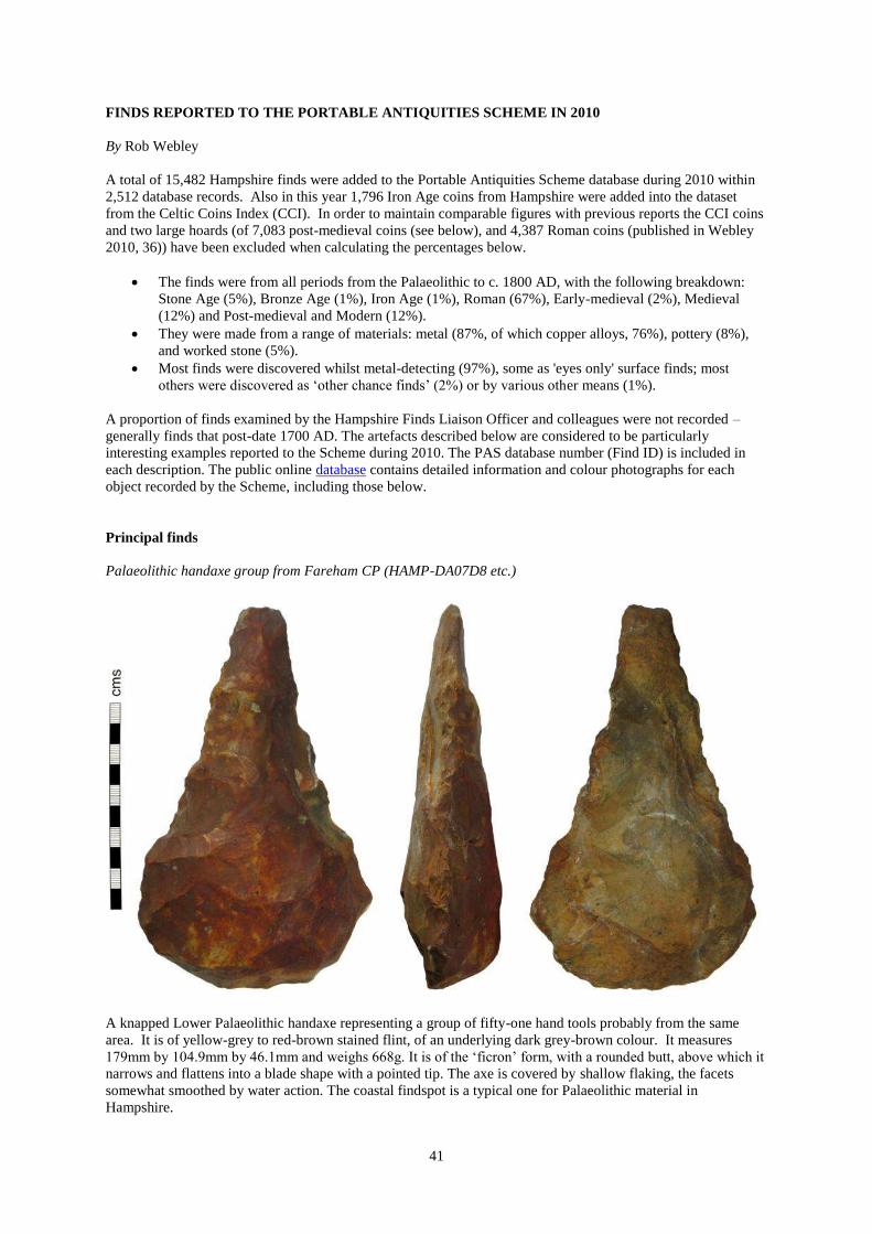
41
FINDS REPORTED TO THE PORTABLE ANTIQUITIES SCHEME IN 2010
By Rob Webley
A total of 15,482 Hampshire finds were added to the Portable Antiquities Scheme database during 2010 within
2,512 database records. Also in this year 1,796 Iron Age coins from Hampshire were added into the dataset
from the Celtic Coins Index (CCI). In order to maintain comparable figures with previous reports the CCI coins
and two large hoards (of 7,083 post-medieval coins (see below), and 4,387 Roman coins (published in Webley
2010, 36)) have been excluded when calculating the percentages below.
The finds were from all periods from the Palaeolithic to c. 1800 AD, with the following breakdown:
Stone Age (5%), Bronze Age (1%), Iron Age (1%), Roman (67%), Early-medieval (2%), Medieval
(12%) and Post-medieval and Modern (12%).
They were made from a range of materials: metal (87%, of which copper alloys, 76%), pottery (8%),
and worked stone (5%).
Most finds were discovered whilst metal-detecting (97%), some as 'eyes only' surface finds; most
others were discovered as „other chance finds‟ (2%) or by various other means (1%).
A proportion of finds examined by the Hampshire Finds Liaison Officer and colleagues were not recorded –
generally finds that post-date 1700 AD. The artefacts described below are considered to be particularly
interesting examples reported to the Scheme during 2010. The PAS database number (Find ID) is included in
each description. The public online database contains detailed information and colour photographs for each
object recorded by the Scheme, including those below.
Principal finds
Palaeolithic handaxe group from Fareham CP (HAMP-DA07D8 etc.)
A knapped Lower Palaeolithic handaxe representing a group of fifty-one hand tools probably from the same
area. It is of yellow-grey to red-brown stained flint, of an underlying dark grey-brown colour. It measures
179mm by 104.9mm by 46.1mm and weighs 668g. It is of the „ficron‟ form, with a rounded butt, above which it
narrows and flattens into a blade shape with a pointed tip. The axe is covered by shallow flaking, the facets
somewhat smoothed by water action. The coastal findspot is a typical one for Palaeolithic material in
Hampshire.

42
Bronze Age scabbard chape from Quarley CP (HAMP-095061)
This Late Bronze Age scabbard terminal measures 35.7mm by 36.9mm by 12.5mm and weighs 25.32g. Such
cast copper-alloy chapes are described as being „bag shaped‟, with a U-shaped top, and sides that flare to a
curved base. The thickened top is slightly damaged, while the base, also thickened, has a central flattening
possibly due to wear. The faces are both decorated with three punched ring-and-dot motifs in an arc aligned
with the curved base, most perforated at the centre. A couple of these chapes are listed in O'Connor (1980, 190-
191; ref. 161); a less elaborate example has been recorded on the PAS database (ref. NARC-5DEF37). These
„bag shaped‟ chapes are associated with the innovative metalwork of the 'Carp's Tongue complex' of south-east
England and date to the Ewart Park metalworking phase (9th
century BC).
Iron Age brooch from Wonston CP (HAMP-7EA4C1)
A cast copper-alloy La Tène I one-piece brooch with unusual coral inlay. The spring and catch-plate are
missing; the surviving section measures 29.8mm by 9.4mm by 6.1mm and weighs 5.9g. The front of the wide,
rounded bow is moulded; a rounded hollow occupies most of its length and width. The orangey coral inlaid
within the hollow has been cracked in three places. This brooch dates from the Middle Iron Age (5th
/4th
century
BC).

43
Roman coin from Buriton CP (HAMP-F9B448)
This corroded copper-alloy semis of Nero (AD 54-68) measures up to 21.4mm in diameter by 2.7mm thick and
weighs 4.98g. The obverse shows the emperor‟s head facing right, possibly with a globe at the tip of his
shoulder, a characteristic of the coins struck at Lyon. The reverse depicts the female personification of Rome
seated left holding out a wreath with her right hand. This small early imperial denomination rarely reaches
Britannia; this example of c. AD 66 is the first recorded for Hampshire on the PAS database. Furthermore, the
obverse inscription, which includes the Julio-Claudian „GERM[anicus]‟ title, is not recorded for this type in the
main reference work (cf. R.I.C. vol. I, 182; ref. 550).
Roman knife from Hursley CP (HAMP-7A27F3)
This cast copper-alloy zoomorphic knife handle measures 53.7mm by 11.4mm by 12.6mm and weighs 25.96g.
It is cylindrical with a terminal in the form of a probable feline head, possibly a leopard‟s. It flattens at the other
end to take an iron blade which is now missing. The animal terminal has moulded ears, brow ridges and snout,
and is decorated with ring-and-dot marks in evenly spaced longitudinal rows, giving the effect of spots. Beyond
a moulded collar that separates it from the terminal, the handle is decorated in rectangular zones themselves
subdivided by incised satire crosses. In the triangles thus created are punched crescents in alternating opposing
fields. This is a finely decorated example of a type found in the north-west provinces (Kaufmann-Heinimann
1977); Manning‟s Type 1c (1985, 110/Plate 53; ref. Q3) dating to the 1st or 2nd century AD.
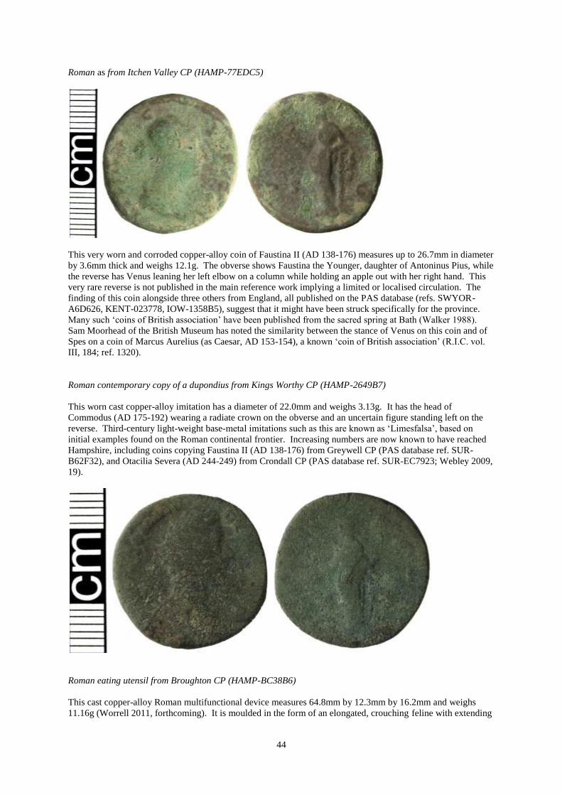
44
Roman as from Itchen Valley CP (HAMP-77EDC5)
This very worn and corroded copper-alloy coin of Faustina II (AD 138-176) measures up to 26.7mm in diameter
by 3.6mm thick and weighs 12.1g. The obverse shows Faustina the Younger, daughter of Antoninus Pius, while
the reverse has Venus leaning her left elbow on a column while holding an apple out with her right hand. This
very rare reverse is not published in the main reference work implying a limited or localised circulation. The
finding of this coin alongside three others from England, all published on the PAS database (refs. SWYOR-
A6D626, KENT-023778, IOW-1358B5), suggest that it might have been struck specifically for the province.
Many such „coins of British association‟ have been published from the sacred spring at Bath (Walker 1988).
Sam Moorhead of the British Museum has noted the similarity between the stance of Venus on this coin and of
Spes on a coin of Marcus Aurelius (as Caesar, AD 153-154), a known „coin of British association‟ (R.I.C. vol.
III, 184; ref. 1320).
Roman contemporary copy of a dupondius from Kings Worthy CP (HAMP-2649B7)
This worn cast copper-alloy imitation has a diameter of 22.0mm and weighs 3.13g. It has the head of
Commodus (AD 175-192) wearing a radiate crown on the obverse and an uncertain figure standing left on the
reverse. Third-century light-weight base-metal imitations such as this are known as „Limesfalsa‟, based on
initial examples found on the Roman continental frontier. Increasing numbers are now known to have reached
Hampshire, including coins copying Faustina II (AD 138-176) from Greywell CP (PAS database ref. SUR-
B62F32), and Otacilia Severa (AD 244-249) from Crondall CP (PAS database ref. SUR-EC7923; Webley 2009,
19).
Roman eating utensil from Broughton CP (HAMP-BC38B6)
This cast copper-alloy Roman multifunctional device measures 64.8mm by 12.3mm by 16.2mm and weighs
11.16g (Worrell 2011, forthcoming). It is moulded in the form of an elongated, crouching feline with extending

45
forepaws. At the other end it terminates in a wide crescent, one half of which is split and pierced to hold an iron
implement, possibly a spike for extracting flesh from crustaceans. On the lower surface, at the beginning of the
crescent terminal, is a double perforated lug, around which a probable iron blade would have hinged; it would
have folded underneath the handle in a wide groove when not in use. Within the forepaws there would have
been a hinged spoon, known from other examples. The form of the handle can be classified as Sherlock's (1976,
250) Type B and dated to the 2nd
or 3rd
century AD. Recently Sherlock (2007) had collated seven such handles;
PAS data has now doubled the corpus of these Roman „Swiss Army knives‟.
Roman vessel lid from Bighton CP (HAMP-258E52)
This cast copper-alloy lid measures 37.4mm by 36.2mm and weighs 25.35g. It is D-shaped in plan, with the
straight side angled upwards in profile to fit against with the vessel‟s rim, probably a jug‟s. The pierced thumb
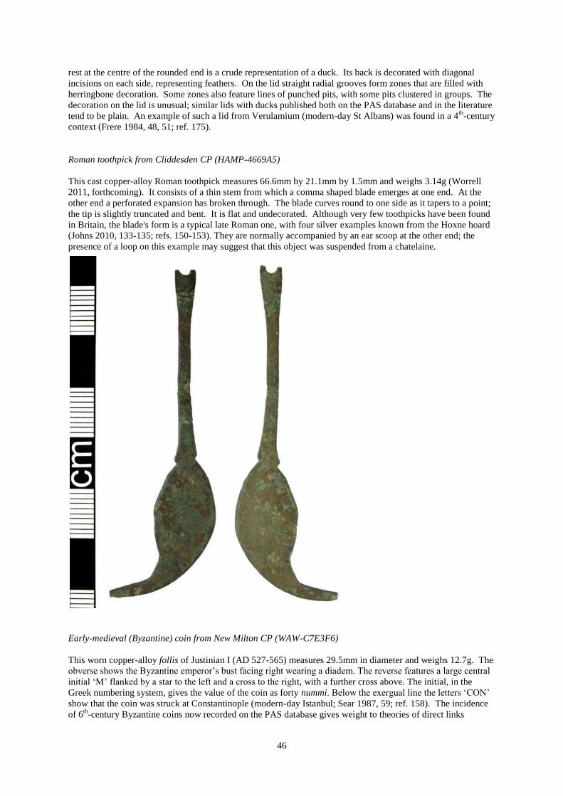
46
rest at the centre of the rounded end is a crude representation of a duck. Its back is decorated with diagonal
incisions on each side, representing feathers. On the lid straight radial grooves form zones that are filled with
herringbone decoration. Some zones also feature lines of punched pits, with some pits clustered in groups. The
decoration on the lid is unusual; similar lids with ducks published both on the PAS database and in the literature
tend to be plain. An example of such a lid from Verulamium (modern-day St Albans) was found in a 4th
-century
context (Frere 1984, 48, 51; ref. 175).
Roman toothpick from Cliddesden CP (HAMP-4669A5)
This cast copper-alloy Roman toothpick measures 66.6mm by 21.1mm by 1.5mm and weighs 3.14g (Worrell
2011, forthcoming). It consists of a thin stem from which a comma shaped blade emerges at one end. At the
other end a perforated expansion has broken through. The blade curves round to one side as it tapers to a point;
the tip is slightly truncated and bent. It is flat and undecorated. Although very few toothpicks have been found
in Britain, the blade's form is a typical late Roman one, with four silver examples known from the Hoxne hoard
(Johns 2010, 133-135; refs. 150-153). They are normally accompanied by an ear scoop at the other end; the
presence of a loop on this example may suggest that this object was suspended from a chatelaine.
Early-medieval (Byzantine) coin from New Milton CP (WAW-C7E3F6)
This worn copper-alloy follis of Justinian I (AD 527-565) measures 29.5mm in diameter and weighs 12.7g. The
obverse shows the Byzantine emperor‟s bust facing right wearing a diadem. The reverse features a large central
initial „M‟ flanked by a star to the left and a cross to the right, with a further cross above. The initial, in the
Greek numbering system, gives the value of the coin as forty nummi. Below the exergual line the letters „CON‟
show that the coin was struck at Constantinople (modern-day Istanbul; Sear 1987, 59; ref. 158). The incidence
of 6th
-century Byzantine coins now recorded on the PAS database gives weight to theories of direct links

47
between western Britain and the eastern Mediterranean (Naylor et al. 2008, 321-322); Moorhead (2009, 266)
suggests that Hampshire and the Isle of Wight perhaps forms the western boundary of such trade.
Late Early-medieval strap-end from Bishops Waltham CP (HAMP-7C2996)
This 11th
- or 12th
-century cast copper-alloy strap-end measures 33.2mm by 10.6mm by 4.1mm and weighs
4.54g. It has a wedge-shaped attachment end, split to accommodate the strap which would have been held in
place by an iron rivet. A waisted central section below is moulded on the front in the form of a beast's head with
a prominent brow ridge and snout below; the eyes are formed by curved removals to the sides. Emerging from
the beast's mouth is a tongue terminal with cusped edges on all three sides, perhaps representing flames. The
attachment end and terminal are of similar sizes; both are decorated with incised lines, longitudinal and
diverging diagonals respectively. Such decoration can be seen as devolved Ringerike style. The strap-end
broadly fits into Thomas' (2004, 4-5) Class G, but its interest derives from its similarity to a strap-end recorded
from Wonston CP (PAS database ref. HAMP-3731A7) implying a local variant. In turn, these are similar in
form to a contemporary mount from Headbourne Worthy CP held by Winchester Museums Service (ARCH
4892).
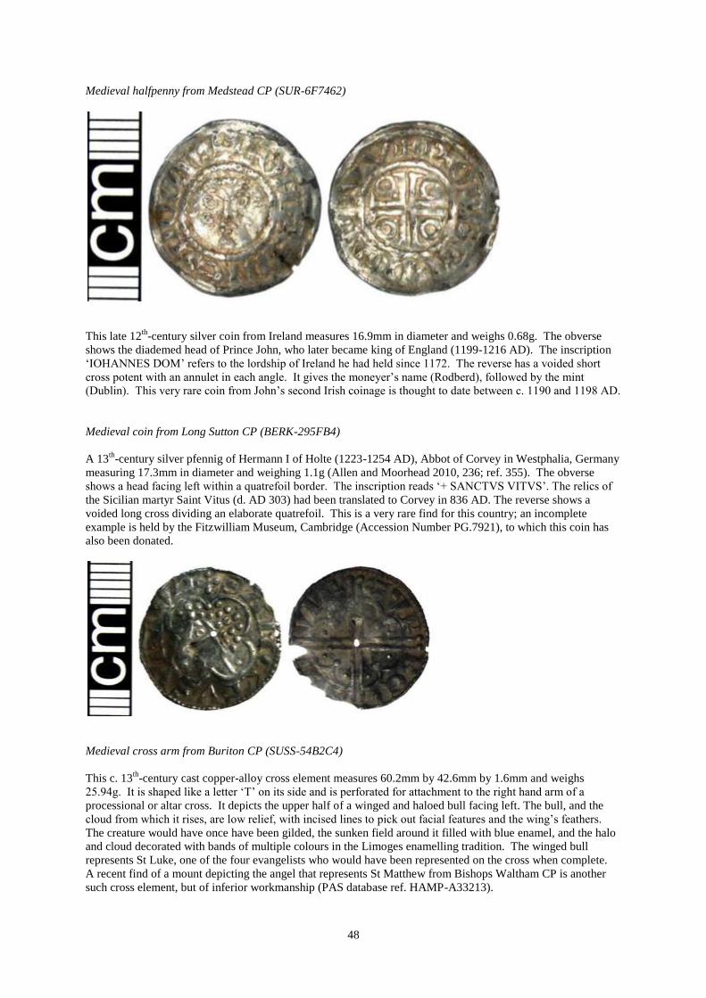
48
Medieval halfpenny from Medstead CP (SUR-6F7462)
This late 12th
-century silver coin from Ireland measures 16.9mm in diameter and weighs 0.68g. The obverse
shows the diademed head of Prince John, who later became king of England (1199-1216 AD). The inscription
„IOHANNES DOM‟ refers to the lordship of Ireland he had held since 1172. The reverse has a voided short
cross potent with an annulet in each angle. It gives the moneyer‟s name (Rodberd), followed by the mint
(Dublin). This very rare coin from John‟s second Irish coinage is thought to date between c. 1190 and 1198 AD.
Medieval coin from Long Sutton CP (BERK-295FB4)
A 13th
-century silver pfennig of Hermann I of Holte (1223-1254 AD), Abbot of Corvey in Westphalia, Germany
measuring 17.3mm in diameter and weighing 1.1g (Allen and Moorhead 2010, 236; ref. 355). The obverse
shows a head facing left within a quatrefoil border. The inscription reads „+ SANCTVS VITVS‟. The relics of
the Sicilian martyr Saint Vitus (d. AD 303) had been translated to Corvey in 836 AD. The reverse shows a
voided long cross dividing an elaborate quatrefoil. This is a very rare find for this country; an incomplete
example is held by the Fitzwilliam Museum, Cambridge (Accession Number PG.7921), to which this coin has
also been donated.
Medieval cross arm from Buriton CP (SUSS-54B2C4)
This c. 13th
-century cast copper-alloy cross element measures 60.2mm by 42.6mm by 1.6mm and weighs
25.94g. It is shaped like a letter „T‟ on its side and is perforated for attachment to the right hand arm of a
processional or altar cross. It depicts the upper half of a winged and haloed bull facing left. The bull, and the
cloud from which it rises, are low relief, with incised lines to pick out facial features and the wing‟s feathers.
The creature would have once have been gilded, the sunken field around it filled with blue enamel, and the halo
and cloud decorated with bands of multiple colours in the Limoges enamelling tradition. The winged bull
represents St Luke, one of the four evangelists who would have been represented on the cross when complete.
A recent find of a mount depicting the angel that represents St Matthew from Bishops Waltham CP is another
such cross element, but of inferior workmanship (PAS database ref. HAMP-A33213).

49
Medieval coin hoard from Bramdean CP (HAMP-A76663 / 2010 T452)
A group of twelve medieval silver pennies and cut halfpennies of Henry III (1216-1272 AD) and Alexander III
of Scotland (1241-1286 AD) of the voided long cross and contemporary long cross and stars types, respectively.
They vary from poor to fine condition and have a total face value of ten and a half pence. The coins of Henry
III are: one penny of type 3ab1; two cut halfpennies and three pennies of type 3b; one penny of type 3bc; two
pennies of type 3c (all 1248-1250 AD) and one penny of type 5b2 (1250-1256 AD). The coins of Alexander III
are: one cut halfpenny and one penny, both of types III/IV of his first coinage. The group is likely to have been
deposited in the mid 1250s probably as a lost or buried purse; no container has been recovered. The hoard is
being acquired by Winchester Museums Service.

50
Medieval pendant from Broughton CP (WILT-3D44D4 / 2010 T88)
This 15th
-century silver-gilt object measures 21.4mm in diameter by up to 8.2mm thick and weighs 10.75g. It is
circular with a missing suspension loop and resulting scar. A disc, finely decorated on both faces, is held within
a raised double border of a ring with square projections beyond; a twisted rope-effect rib runs around the
circumference of the pendant. One surface bears the face of Christ with features picked out by fine incisions,
and four zones of cross-hatching around. The other surface depicts the lamb and flag (the Agnus Dei) on a
cross-hatched ground. This devotional pendant is being acquired by Hampshire County Museums Service.
Medieval coin from Abbotts Ann CP (HAMP-FEE0E5 / 2011 T142)
This slightly clipped gold coin of Henry VII (1485-1509 AD) measures 37.3mm in diameter by 1.6mm thick
and weighs 5.07g. The denomination is known as an angel as the obverse depicts the archangel St Michael
spearing a dragon. The reverse shows a ship with a cross on its mast, to its left Henry‟s initial „h‟, and to the
right a Tudor rose. The reverse inscription, „IHC AUTE[M] TRANSIENS PER MEDIU[M] I[L]LORU[M
IBAT]', is a slightly truncated version of Luke, chapter 4, verse 30, translated as „but Jesus, passing through the
midst of them went on his way‟. A rare coin, this is the first angel of Henry VII to have been recorded on the
PAS database. Six months after, a second angel, this one of Henry VI, second reign (1470-1471 AD), was
found in the vicinity; the group has been put through the Treasure process.

51
Post-medieval jetton group from Abbotts Ann CP (HAMP-FDB3A4)
A group of ten post-medieval Nuremberg copper-alloy jettons all of the 'Rose / orb' type probably deposited in
the early 17th century all in the same hole; no traces of a container have been discovered. They can be divided
into groups, firstly chronological: three unsigned jettons possibly attributable to the early Schultes dynasty (c.
1553 - c. 1603 AD), seven jettons of Hans Krauwinckel II (fl. 1586-1635 AD). The second sorting is by size:
four jettons c. 23mm in diameter (the three unsigned examples and one of Hans Krauwinckel II - Mitchiner
1509 var.), six jettons c. 20/21mm in diameter (the remaining six examples of Hans Krauwinckel II). Within this
latter are two sets of three jettons of the same type (Mitchiner 1539 and 1571ff.). This is a rare discovery of a
group of jettons which helps illuminate how they were used in sets and the level of mixing between makers and
types that occurred.
Post-medieval coin hoard from Bishops Waltham CP (HAMP-E4E185)
A group found under a cellar floor totalling 7,083 French billion (copper with some silver) 30 denier pieces all
dated 1711 and with the mintmark for Lyon. These coins of Louis XIV (1643-1715 AD) have back-to back „L‟s

52
on the obverse and a reverse cross with lis in the angles. Because this cross design was similar to that worn by
the royal military, these coins were known as „mousquetaires‟. This denomination was struck at Lyon and at
Metz between 1709 and 1714 for export to the French colonies (Canada and Louisiana). This hoard has suffered
significantly from corrosion, with many coins concreted together. The consistent wear patterns within a sample
of 700 coins studied revealed that probably the same dies were used to produce these coins. Their apparent
uniformity, however, is belied by variations in the diameters and weights of the coins, with a number of very
small examples in particular. This size variation, along with a number of cut, stamped, and blank flans, would
seem to suggest that this hoard was the output of a counterfeiting operation. In the 18th
century counterfeiting in
France was rife, with some examples known of the production of fake 30 denier pieces (Pilon 2008, 54).
Acknowledgements
I am very grateful to Laura Burnett for her help and advice in preparing this round-up. The line drawings are by
Alan Cracknell. All images are copyright of Winchester Museums Service/PAS.
References
Allen, M & Moorhead, S (eds) 2010 Coin Register 2010, British Numismatic Journal 80 207-237.
Frere, S 1984 Verulamium Excavations, Volume III, Oxford.
Johns, C 2010 The Hoxne Late Roman Treasure: Gold Jewellery and Silver Plate, London
Kaufmann-Heinimann, A 1977 Römische Bronzestatuetten aus Augst und Kaiseraugst, Mainz.
Manning, W H 1985 Catalogue of the Romano-British Iron Tools, Fittings and Weapons in the British
Museum, London.
Mattingly, H & Sydenham, E A 1930 The Roman Imperial Coinage Vol. III, London.
Mitchiner, M 1988 Jetons, medalets and tokens Volume 1: the Medieval period and Nuremberg, London
Moorhead, S 2009 Early Byzantine copper coins found in Britain: a review in light of new finds recorded
with the Portable Antiquities Scheme, in Tekin, O (ed.) Ancient History, Numismatics and Epigraphy in the
Mediterranean World. Studies in memory of Clemens E. Bosch and Sabahat Atlan and in honour of
Nezahat BaydurI, Istanbul, 263-274.
Naylor, J, Leahy, K and Egan, G (eds) 2008 Medieval Britain and Ireland, 2007 – Portable
Antiquities Scheme, Medieval Archaeology 52 316-334.
O‟Connor, T 1980 Cross-channel Relations in the later Bronze Age, Oxford.
Pilon, F 2008 La fabrication de fausses pièces de 30 deniers dites “mousquetaires” à Mardore (Rhône),
Cahiers Numismatiques 175 49-57.
Sear, D R 1987 Byzantine coins and their values, London.
Sherlock, D 1976 Roman folding spoons, Transactions of the London and Middlesex Archaeological
Society 27 250-255.
Sherlock, D 2007 A Roman folding spoon from Wallsend, Archaeologia Aeliana 36 363-365.
Sutherland, C H V & Carson, R A G 1984 The Roman Imperial Coinage Vol. I, London.
Thomas, G 2004 Late Anglo-Saxon and Viking-Age strap-ends 750-1100 pt II, Finds Research Group
Datasheet 33.
Walker, D 1988 Roman coins from the sacred spring at Bath, Oxford.
Webley, R 2009 Archaeology in Hampshire – Annual Report for 2007 – The Portable Antiquities
Scheme: http://www.fieldclub.hants.org.uk/hampshire-archaeology-report-2007.pdf, 16-25.
Webley, R 2010 Archaeology in Hampshire – Annual Report for 2008 – The Portable Antiquities
Scheme: http://www.fieldclub.hants.org.uk/hampshire-archaeology-report-2008-pas.pdf, 34-45.
Worrell, S 2011 (forthcoming) Roman Britain in 2010, II. Finds reported under the Portable Antiquities
Scheme, Britannia 42.

53
HAMPSHIRE COUNTY MUSEUMS SERVICE 2010
By Dave Allen
A selection of the items relevant to the County of Hampshire brought to the Hampshire County Museums
Service in 2010 by the general public for identification.
Abbreviations
ESLEM Eastleigh Museum BSKWM BasingstokeWillis Museum
WINCH Winchester Chilcomb House
Warsash area. WINCH 3318
The 'John Sharpe' collection of 51 palaeolithic handaxes. Exact provenances unknown,
Returned to owner
Botley and Hedge End,especially Dowds Farm. ESLEM 998
Field-walked flints. Items of Palaeoloithic, Mesolithic, Neolithic and Bronze Age date noted, particularly a
Neolithic arrowhead. Found by J Butcher, Identified R Banbury, returned to owner.
Wooodmancott. BSKWM 1967A
Medieval iron horseshoe (14th - 15th century) found while beating by Mr L Farley. Donated.