Young, 'Five Notes on Nineteenth-Century Cornish Changelings'
Upload
khangminh22Category
view
0download
0
CORNISHARCHAEOLOGY
52 HENDHYSCANS KERNOW 2013
EDITORS
GRAEME KIRKHAM AND PETER ROSE
(Published 2014)
i-vi Prelims.indd 1 01/12/2014 11:14
© COPYRIGHT CORNWALL ARCHAEOLOGICAL SOCIETY 2014
No part of this volume may be reproduced without permission of the Society and the relevant author(s)
ISSN 0070 024X
Typesetting, printing and binding by 4word Ltd, Bristol
i-vi Prelims.indd 2 01/12/2014 11:14

Contents
The evaluation of a multi-period prehistoric site and fogou at Boden Vean, 1St Anthony-in-Meneage, Cornwall, 2003JAMES GOSSIP
Excavations at Scarcewater Tip, Pennance, St Stephen-in-Brannel 99ANDY M JONES and SEAN TAYLOR
Archaeological excavations at Bosiliack, Madron, Cornwall 135ANDY M JONES
Kingswood round: an enclosure at Kingswood Farm, Cardinham, Cornwall 171MARK BORLASE
Discoveries along the North Land’s End pipeline 197ANNA LAWSON-JONES
Castle-an-Dinas, St Columb Major: a new survey 223SHARON SOUTAR
Roman amphorae in Iron Age Cornwall: pre-Roman, Roman or post-Roman? 233A P FITZPATRICK
A Late Roman 1 amphora recovered off Cawsand, Plymouth Sound 239MARIA DUGGAN
Tintagel Castle: recent work 247CARL M THORPE
Recent work in Cornwall, 2012 257
i-vi Prelims.indd 3 01/12/2014 11:14

i-vi Prelims.indd 4 01/12/2014 11:14

Contributors
Mark Borlase Tawnamoor, Cardinham PL30 4AL. Email: [email protected]
Maria Duggan School of History, Classics and Archaeology, Armstrong Building, Newcastle University, NE1 7RU. Email: [email protected]
A P Fitzpatrick School of Archaeology and Ancient History, University of Leicester, University Road, Leicester LE1 7RH. Email: [email protected]
James Gossip Cornwall Archaeological Unit, Cornwall Council. Fal Building, New County Hall, Truro TR1 3AY. Email: [email protected]
Andy Jones Cornwall Archaeological Unit, Cornwall Council. Fal Building, New County Hall, Truro TR1 3AY. Email: [email protected]
Anna Lawson-Jones Cornwall Archaeological Unit, Cornwall Council. Fal Building, New County Hall, Truro TR1 3AY. Email: [email protected]
Sharon Soutar English Heritage, The Engine House, Fire Fly Avenue, Swindon SN2 2EH. Email: [email protected]
Sean Taylor Cornwall Archaeological Unit, Cornwall Council. Fal Building, New County Hall, Truro TR1 3AY. Email: [email protected]
Carl Thorpe Cornwall Archaeological Unit, Cornwall Council. Fal Building, New County Hall, Truro TR1 3AY. Email: [email protected]
i-vi Prelims.indd 5 01/12/2014 11:14

i-vi Prelims.indd 6 01/12/2014 11:14
1
Cornish Archaeology 52, 2013, 1–98
The evaluation of a multi-period prehistoric site and fogou at Boden Vean, St Anthony-
in-Meneage, Cornwall, 2003JAMES GOSSIP
with contributions from christopher bronk ramsey, sarnia butcher, gordon cook, vanessa fell, rowena gale, derek hamilton, fraser hunter, charles johns, julie jones, anna lawson-jones,
janice light, neil linford, ray mcbride, dawn mclaren, henrietta quinnell, richard reece, roger taylor and carl thorpe
During 2003 the Historic Environment Service, Cornwall County Council, carried out an archaeological evaluation of the site of a fogou near Boden Vean, St Anthony-in-Meneage, which had been rediscovered in 1991. In one trench a Middle Bronze Age structure was uncovered which contained fragments of a very large Trevisker ware vessel, while the fogou and surrounding enclosure produced a significant collection of Early Iron Age pottery of the Plain Jar Group, with radiocarbon dates suggesting construction around 400 cal BC. Late Iron Age and Romano-British pottery indicated re-use of the site in the early centuries AD, and an important collection of post-Roman Gwithian Style pottery showed that occupation continued until the sixth century AD.
flat stone that now appears to block the eastern end of the passage.
The site continued to be known locally through the twentieth century. According to Cornwall Archaeological Society member Margaret Hunt, a tunnel was found during hedging, and filled in (pers comm to Cornwall Committee for Rescue Archaeology, Cornwall Historic Environment Record (HER) PRN 24875). Mr Tony Williams, who farmed at Boden until 1984, reported that a chamber had been discovered around the 1920s by his uncle, although he did not enter it (Rose and Preston-Jones 1991). Whether this refers to the earth-cut tunnel or the stone-lined fogou is unclear; either way it seems that both the earth-cut tunnel and the stone-lined fogou had been lost or deliberately ‘closed’ by the middle of the twentieth century.
‘At Bodean Veor, in the Parish of St Anthony, is an artificial cave, of about thirty yards in length. It is merely an excavation of the earth, without any stone for walls or roof, four or five feet under ground. Its situation, on the highest part of the hill, suggests the idea of some military works near it – but none at present are discoverable.’
Reverend Richard Polwhele, 1803
A fogou, or underground tunnel, has been documented in the Boden area since the early nineteenth century when it was recorded by Richard Polwhele, the vicar of Manaccan and St Anthony. Despite apparent observations by later writers it is not clear whether they actually visited the tunnel or only repeated or embellished Polwhele’s original account. The exception may be Henderson, who noted that ‘the entrance is now covered by a large stone’ (Henderson 1912); possibly he saw the large,
001-098_Cornwall 52.indd 1 01/12/2014 11:31
JAMES GOSSIP
2
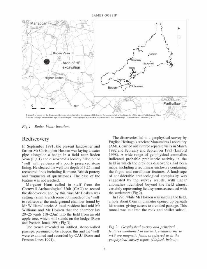
RediscoveryIn September 1991, the present landowner and farmer Mr Christopher Hosken was laying a water pipe alongside a hedge in a field near Boden Vean (Fig 1) and discovered a loosely filled pit or ‘well’ with evidence of a poorly preserved stone lining. He cleared the well to a depth of 3.25m and recovered finds including Romano-British pottery and fragments of quernstones. The base of the feature was not reached.
Margaret Hunt called in staff from the Cornwall Archaeological Unit (CAU) to record the discoveries, and by this time Mr Hosken was cutting a small trench some 30m south of the ‘well’ to rediscover the underground chamber found by Mr Williams’ uncle. A local resident had told Mr Williams and Mr Hosken that the chamber lay 20–25 yards (18–23m) into the field from an old apple tree, which still stands on the hedge (Rose and Preston-Jones 1991; Fig 3).
The trench revealed an infilled, stone-walled passage, presumed to be a fogou; this and the ‘well’ were examined and recorded by CAU (Rose and Preston-Jones 1991).
The discoveries led to a geophysical survey by English Heritage’s Ancient Monuments Laboratory (AML), carried out in three separate visits in March 1992 and February and September 1993 (Linford 1998). A wide range of geophysical anomalies indicated probable prehistoric activity in the field in which the previous discoveries had been made, including a rectilinear enclosure containing the fogou and curvilinear features. A landscape of considerable archaeological complexity was suggested by the survey results, with linear anomalies identified beyond the field almost certainly representing field systems associated with the settlement (Fig 2).
In 1996, while Mr Hosken was sanding the field, a hole about 0.6m in diameter opened up beneath his tractor, giving access to a voided passage. This tunnel was cut into the rock and shillet subsoil
Helston
St Keverne
Fig 1 Boden Vean: location.
Fig 2 Geophysical survey and principal features mentioned in the text. Features m1 to m19 are magnetic features referred to in the geophysical survey report (Linford, below).
001-098_Cornwall 52.indd 2 01/12/2014 11:31
a multi-period prehistoric site and fogou at boden vean
3
001-098_Cornwall 52.indd 3 01/12/2014 11:32

JAMES GOSSIP
4
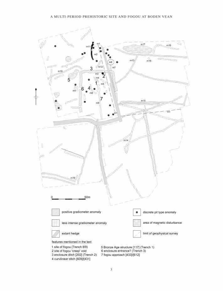
Fig 3 Trench location, field-walking grid and principal geophysical anomalies.
001-098_Cornwall 52.indd 4 01/12/2014 11:32
a multi-period prehistoric site and fogou at boden vean
5
and was approximately 5m long; it lay within one of the ‘void’ areas identified by micro-gravity survey. Just below the hole, at the base of a ramp of collapsed soil, a ‘pillar’ of stones was visible, possibly supporting the roof of the tunnel. The ‘artificial cave’ recorded by Polwhele clearly did not refer to the stone-lined fogou passage since it was ‘without any stone for walls or roof’ (Polwhele 1816, 129), but more probably related to this earth-cut tunnel. Anecdotal evidence suggests that within living memory the tunnel ran as far as the modern field boundary but was blocked by a farmer to prevent access by children (Chris Hosken, pers comm).
A small field-walking project was carried out by Cornwall Archaeological Society in 2002 (Table 7).
The projectFurther work at the site, in 2003, was initiated by the Historic Environment Service (HES), Cornwall County Council (now Cornwall Archaeological Unit), at the request of Mr Hosken, and included initial field-walking by A-level students from Truro College in the north and west parts of the fogou field (Fig 3).
Following consultation with English Heritage, a project was agreed to record and safeguard the open fogou. This included a Ground Penetrating Radar (GPR) survey by the AML and a programme of evaluation trenching to better understand the fogou and its context and to guide future management of this important monument.
Subsequent to the 2003 programme, work has included excavation of the trench 1 Bronze Age structure by Cornwall Archaeological Society in 2008 and further work at the fogou carried out by Meneage Archaeology Group. These elements will be reported on separately (Gossip, in prep.).
Location and settingTopography
The site (at SW 7685 2405) lies on a slight southerly slope below the summit of a gentle hill at a height of 70m above sea level (OD), some 300m to the west of the settlement of Boden Vean, 1 km south of Manaccan on the Lizard peninsula
(Fig 1). The surrounding landscape is one of undulating farmland and steep-sided lanes and from the field itself there are commanding views in many directions. To the north east Falmouth Bay and St Anthony Head are clearly visible, while due south west the barrows of Goonhilly Downs can be discerned on the horizon. The land rises to the south where the Bronze Age barrow known as Roskruge Beacon sits on the summit of a hill.
Geology and soils
The underlying geology is mapped as a 300m wide east-west band of Devonian Conglomerate; on the northern side is Crush Breccia (Meneage Crush Zone) or Roseland Breccia Formation and to the south a band of Portscatho Formation conglomerate (Geological Survey of Great Britain 1975, Sheet 359).
The soils are described as fine loamy soils over stony clay subsoil (weathered bedrock), known locally as ‘shillet’ (Soil Survey of England and Wales 1983, Sheet 5).
Historic backgroundThe settlement of Boden is first recorded in Domesday Book in 1086 as Boten (Gover 1948, 542; Thorne and Thorne 1979), possibly derived from the Cornish place-name elements bod, ‘dwelling’, and onnen, ‘ash trees’ (Padel 1985, 23, 174). Two settlements must have been in existence by 1419 when Bodenbyghan (Little Boden) was recorded (Gover 1948, 542). This would have been in contrast with Boden Veor (Great Boden), also known as Higher Boden, but it is unclear which settlement was the site of the original Boden. The fogou is named through historic association with the farm holding of Boden Vean, although all early references name it after Boden Veor.
The historic landscape around Boden is characterised as Anciently Enclosed Land (AEL), defined as the long-established agricultural heartland of Cornwall, with farming settlements documented before the seventeenth century AD (Cornwall County Council 1996). The field boundaries are stone-faced earth banks (Cornish hedges) and it can be seen that the eastern hedge of the fogou field is superimposed on the bank of the Iron Age enclosure. In addition to the enclosure at Boden there is another on the slope to the south at
001-098_Cornwall 52.indd 5 01/12/2014 11:32

JAMES GOSSIP
6
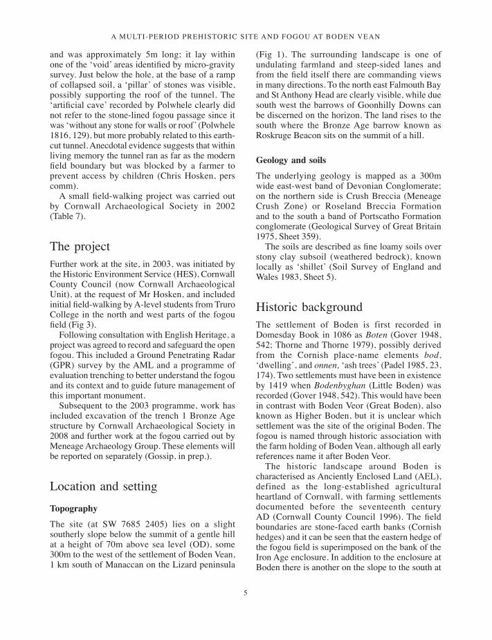
Fig 4 Trench plan showing principal features.
Higher Boden; late prehistoric enclosures of this sort are very characteristic of AEL (ibid).
MethodologyThe fieldwork took place in autumn 2003. Seven trenches were positioned to target anomalies
identified by geophysical survey (Figs 2 and 3). In each of these topsoil layers were stripped by a mechanical digger under archaeological supervision. Excavation subsequently proceeded by hand and recording was carried out according to standard HES procedures.
Assisting the HES archaeologists were the landowner and his family, local people, Cornwall
001-098_Cornwall 52.indd 6 01/12/2014 11:32
a multi-period prehistoric site and fogou at boden vean
7
Archaeological Society volunteers and students from Truro College. Three local schools carried out field-walking of ploughed land immediately surrounding the site. Despite inclement weather an open day was well-attended, giving local people the opportunity to view the finds and excavated features.
Consolidation works were carried out after the excavations had taken place to make the open section of tunnel safe and the open hole was covered with a large steel plate containing an access hatch.
The programme of archiving and assessment was recorded in the archive summary report and assessment report (Gossip 2004; Gossip and Johns 2005).
Excavation resultsCut features are shown in square brackets [ ], deposits in rounded brackets ( ).
All radiocarbon dates in this report are given at 95 per cent probability unless otherwise specified.
The Bronze Age structure
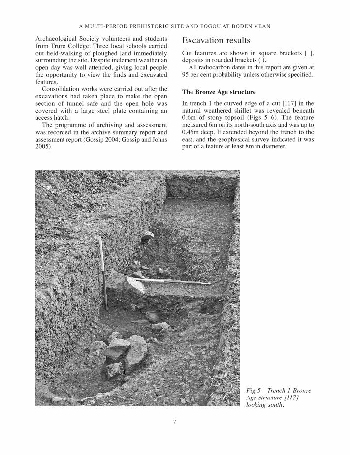
In trench 1 the curved edge of a cut [117] in the natural weathered shillet was revealed beneath 0.6m of stony topsoil (Figs 5–6). The feature measured 6m on its north-south axis and was up to 0.46m deep. It extended beyond the trench to the east, and the geophysical survey indicated it was part of a feature at least 8m in diameter.
Fig 5 Trench 1 Bronze Age structure [117] looking south.
001-098_Cornwall 52.indd 7 01/12/2014 11:32
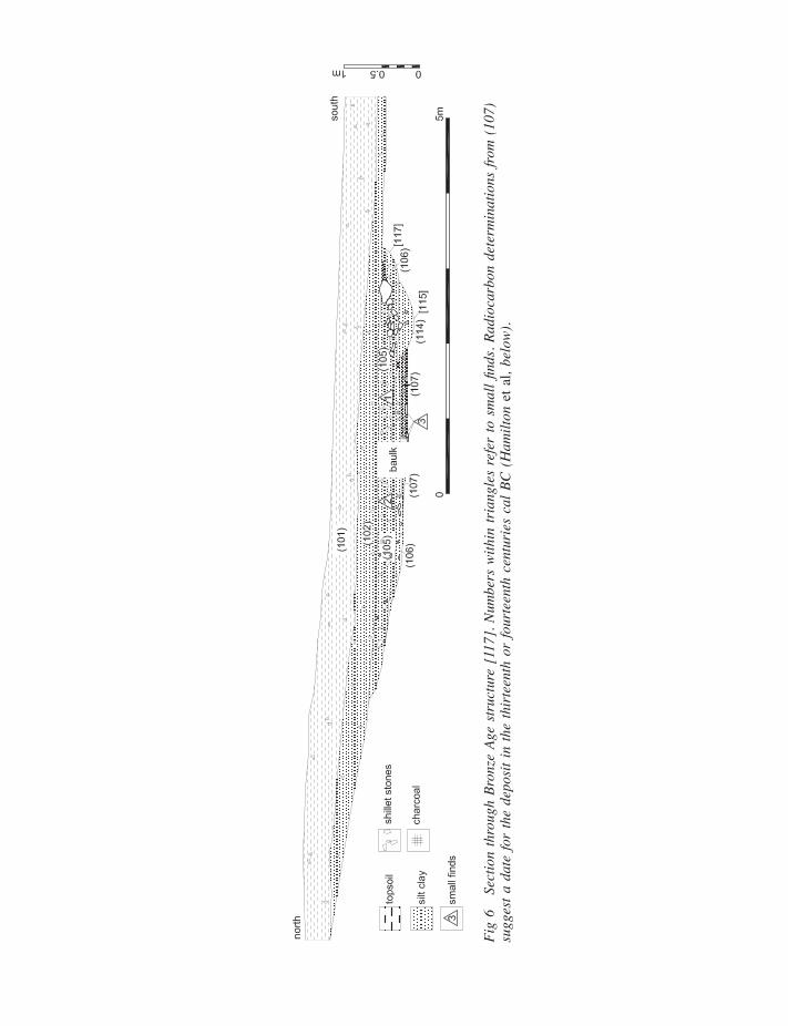
Fig
6 Se
ctio
n th
roug
h Br
onze
Age
str
uctu
re [
117]
. Num
bers
with
in tr
iang
les
refe
r to
sm
all fi
nds.
Radi
ocar
bon
dete
rmin
atio
ns fr
om (
107)
su
gges
t a d
ate
for
the
depo
sit i
n th
e th
irte
enth
or
four
teen
th c
entu
ries
cal
BC
(H
amilt
on e
t al,
belo
w).
001-098_Cornwall 52.indd 8 01/12/2014 11:32
a multi-period prehistoric site and fogou at boden vean
9
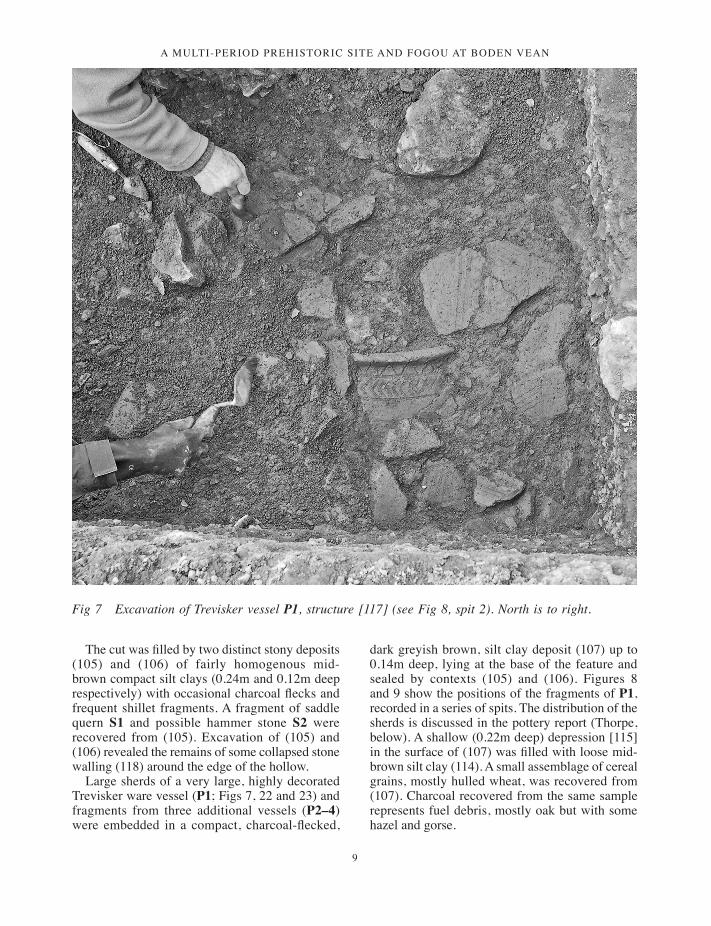
Fig 7 Excavation of Trevisker vessel P1, structure [117] (see Fig 8, spit 2). North is to right.
The cut was filled by two distinct stony deposits (105) and (106) of fairly homogenous mid-brown compact silt clays (0.24m and 0.12m deep respectively) with occasional charcoal flecks and frequent shillet fragments. A fragment of saddle quern S1 and possible hammer stone S2 were recovered from (105). Excavation of (105) and (106) revealed the remains of some collapsed stone walling (118) around the edge of the hollow.
Large sherds of a very large, highly decorated Trevisker ware vessel (P1; Figs 7, 22 and 23) and fragments from three additional vessels (P2–4) were embedded in a compact, charcoal-flecked,
dark greyish brown, silt clay deposit (107) up to 0.14m deep, lying at the base of the feature and sealed by contexts (105) and (106). Figures 8 and 9 show the positions of the fragments of P1, recorded in a series of spits. The distribution of the sherds is discussed in the pottery report (Thorpe, below). A shallow (0.22m deep) depression [115] in the surface of (107) was filled with loose mid-brown silt clay (114). A small assemblage of cereal grains, mostly hulled wheat, was recovered from (107). Charcoal recovered from the same sample represents fuel debris, mostly oak but with some hazel and gorse.
001-098_Cornwall 52.indd 9 01/12/2014 11:32
JAMES GOSSIP
10
Carbonised residue adhering to the inside of vessel P1 produced a radiocarbon determination of 3005 ±35 BP, 1370–1120 cal BC (SUERC-6170) and charcoal samples from (107) provided consistent radiocarbon dates, 3085 ±30 BP, 1430–1260 cal BC (OxA-14517) and 3055 ±35 BP, 1420–1210 cal BC (SUERC-6169).
Early Iron Age activity
The enclosure and related activity
Trench 2 was positioned in order to investigate the northern side of the enclosure ditch [202] close to the fogou (Figs 3, 4 and 10). The ditch proved to be 3m wide and cut more than 1.85m deep into
the subsoil and shillet ‘natural’, approximately 2.5m deep from the present ground level (Fig 10); it was not excavated to its full depth for safety reasons.
Fourteen well-stratified fills were recorded, all fairly homogenous mid-brown silt clays. The uppermost deposits, (207), (200) and (208), filled almost half of the excavated feature (cumulatively 0.83 deep). These fills may indicate the later backfilling of the upper part of the ditch through intensive ploughing. The lower fills were more varied suggesting erosion of the shillet edges, gradual silting, refuse dumping and deliberate backfilling. The interface between deposits (201), (212), (215) and underlying layer (204) could indicate a re-cut of the ditch. Environmental
Fig 8 Trench 1, southern part of Bronze Age structure [117] showing the distribution of vessel P1, excavated in a series of 5 spits; spits 2–3, upper spits.
001-098_Cornwall 52.indd 10 01/12/2014 11:32

a multi-period prehistoric site and fogou at boden vean
11
samples taken from ditch fill (203) contained limpet shells (Light, below).
Twenty-six sherds of Plain Jar Group pottery of the Early Iron Age were recovered from the enclosure ditch in this trench, including P17 and P18 recovered from charcoal-rich silty clay (201). Charcoal from (201) provided radiocarbon dates suggesting a terminus ante quem of around 400 cal BC for the construction of the enclosure ditch, 2272 ±28 BP, 400–210 cal BC (OxA-14521) and 2350 ±35 BP, 510–380 cal BC (SUERC-6173).
The nature of activity within the enclosure during this period is unclear, although the ceramic assemblage and radiocarbon determinations clearly suggest occupation at the end of the Early Iron Age. The interior of the enclosure was investigated by trenches 4 and 5 (which were amalgamated and are subsequently referred to as trench 4), trench 6 which
targeted a curvilinear and a linear anomaly leading south away from the fogou, and trench 7 which investigated the continuation of the linear anomaly close to the southern boundary of the site (Figs 3 and 4). This linear anomaly [433], [612] and [705] is discussed below in the trench 8/9 (fogou) results.
Feature 408, a curving arc of 13 stones, many very large (up to 0.5m long, 0.45m wide and 0.38m high), was revealed at the western end of trench 4, close to its junction with trench 3 (Figs 11 and 12). The stones, which appeared to have been laid directly on the natural surface, did not retain material and their function remains unclear. A post-Roman date for this feature is possible as, although it is undated, it is sealed by layer (405) which contained Gwithian Style pottery. Accumulated against the stone alignment were charcoal-rich deposits (415) and (417).
Fig 9 Trench 1, southern part of Bronze Age structure [117] showing the distribution of vessel P1, excavated in a series of 5 spits; spits 4–5, lower spits.
001-098_Cornwall 52.indd 11 01/12/2014 11:32

JAMES GOSSIP
12
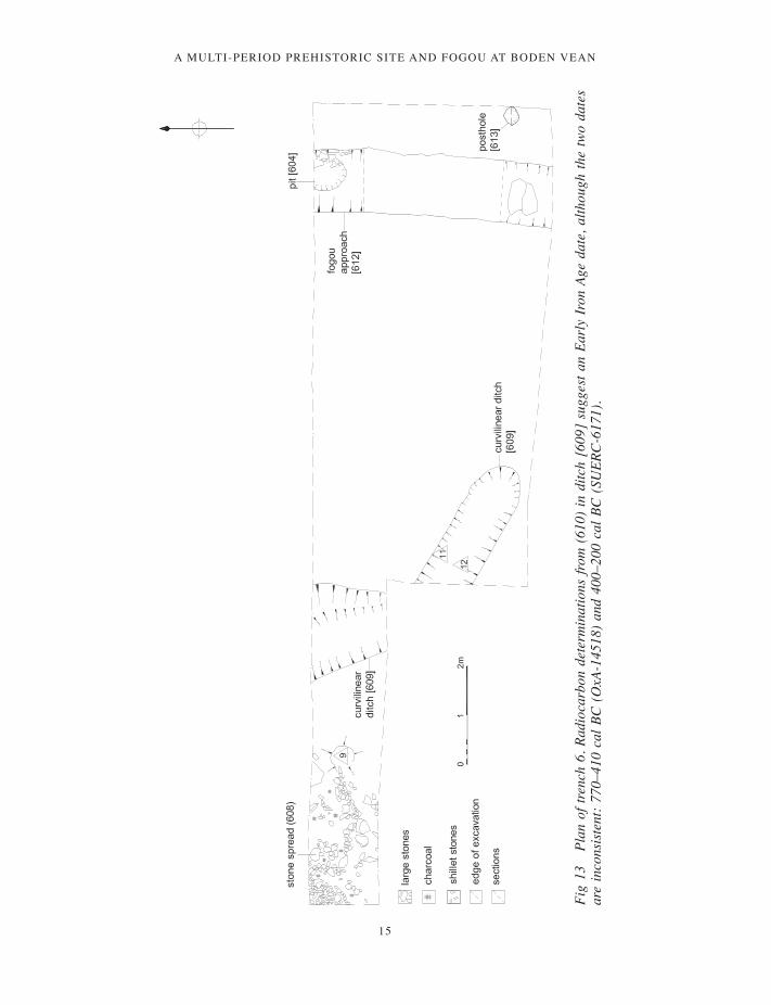
Other features included stone rubble spread (608) (Fig 13) and metalled surface (442) (Fig 12), both potentially associated with ditch [431] / [609]. Rubble spread (608) was revealed at the western end of trench 6 and comprised a scatter of small broken stones 1.8m long by 1.2m wide and up to 0.25m deep; some of the stones appeared to have been fractured by heat or fire. A layer of densely packed small pebbles formed a very hard, compacted surface 0.65m wide (442) on the eastern side of ditch [431].
Also recorded in trench 4 was cut [445], a ditch aligned north-south between enclosure ditch [315] and stones 408. The ditch was 1m wide with concave sides but was not fully excavated. Just to the west of cut [433] was an irregular cut [412] / [435], a stone-lined depression with concave sides up to 0.35m deep, crossing the trench from north to south and 0.65m-1m wide. Two fills were evident, an upper deposit (406), a mid-brown silty
clay 0.25m thick, sealing the basal deposits (411), a soft, dark brown silt 0.1m thick. A circular cut [416] was recorded projecting from the southern section of trench 4, cut into (406) and filled by (413), a black, charcoal-rich silt 0.08m thick which in turn sealed (414), a dark brown silty clay 0.05m thick. Also cut into deposit (406) was pit [434], a sub-circular cut 0.5m in diameter and 0.25m deep lined with upright stones (425) and filled by dark brown silty clay (426). Features [412] / [435], [416] and [434] all produced material suitable for radiocarbon dating. The chronological model suggests that [416] and [412] date to the fourth century cal BC, with stone-lined pit [434] being inserted in the third century cal BC (Fig 38).
Ditch [431] / [609], visible in both trenches 4 and 6, was curvilinear in plan with a steep, near vertical profile, 0.6–0.7m deep, and a flat base, filled by deposits (432) and (430) (in trench 4) and (606) and (610) (in trench 6) (Figs 13 and 15). Basal fills
Fig 10 Section through enclosure ditch [202]. Radiocarbon determinations from (201) give a terminus ante quem for the digging of the ditch at around 400 cal BC (Hamilton et al, below).
001-098_Cornwall 52.indd 12 01/12/2014 11:32

a multi-period prehistoric site and fogou at boden vean
13
Fig
11
Plan
of t
renc
h 4
(wes
t) an
d tre
nch
3.
001-098_Cornwall 52.indd 13 01/12/2014 11:32

JAMES GOSSIP
14
Fig
12
Plan
of t
renc
h 4
(cen
tre a
nd e
ast).
Rad
ioca
rbon
det
erm
inat
ions
from
ditc
h [4
31],
fill (
411)
in [
412]
, fill
(414
) in
pit
[416
] an
d (4
25)
in p
it [4
34]
are
cons
iste
nt w
ith a
n Ea
rly
Iron
Age
dat
e fo
r ac
tivity
insi
de th
e en
clos
ure,
pro
babl
y in
the
four
th c
entu
ry c
al B
C
(Ham
ilton
et a
l, be
low
).
001-098_Cornwall 52.indd 14 01/12/2014 11:32
a multi-period prehistoric site and fogou at boden vean
15
sections
Fig
13
Plan
of t
renc
h 6.
Rad
ioca
rbon
det
erm
inat
ions
from
(61
0) in
ditc
h [6
09]
sugg
est a
n Ea
rly
Iron
Age
dat
e, a
lthou
gh th
e tw
o da
tes
are
inco
nsis
tent
: 77
0–41
0 ca
l BC
(O
xA-1
4518
) an
d 40
0–20
0 ca
l BC
(SU
ERC
-617
1).
001-098_Cornwall 52.indd 15 01/12/2014 11:32

JAMES GOSSIP
16
Fig 14 Section through stone-lined pit [434]. The deposit (426) gave radiocarbon determinations of 400–210 cal BC (OxA-14523) and 400–200 cal BC (SUERC-6178).
Fig 15 Section through curvilinear ditch [431]. Deposit (432) gave a radiocarbon determination of 770–400 cal BC (OxA-14520), although the feature is probably to be dated by a slightly later date from [609] (Fig 13), which continues [431] to the south.
(432) and (610) (0.26m and 0.2m deep) were mid-greyish brown silt clays with occasional charcoal flecks, and appeared to be a mixture of deliberately discarded material and erosion of the ditch edges. In addition to charcoal a small quantity of black slag-like material or burnt clay was recovered from this deposit but was not analysed. The upper fills (430) and (606) were very different, consisting of dark greyish-brown loose silt clay up to 0.4m deep with very frequent charcoal flecks, burnt roundwood pieces and small fragments of burnt bone. Fifty-nine Plain Jar Group (PJG) sherds were recovered from the fills of ditch [609], including P10 and P11. A further 16 PJG sherds, including P12–15, were found in layer (605) over [609] and there were 15 PJG sherds from [431], including P16. (A Gwithian Style platter, P52, in ditch [431] is thought to be intrusive.)
Two postholes, [436] and [428] were identified in trench 4 (Fig 12). Posthole [436], (which contained Early Iron Age pottery, was 0.8m in diameter and 0.27m deep, with a large packing stone resting against its eastern edge and a post-pipe 0.25m wide by 0.4m deep cut into its base. Posthole [428] was
0.6m in diameter by 0.25m deep and lined with several large packing stones. The function of these postholes was unclear as neither was associated with a confirmed structure.
Three ceramic beads, SF5, SF9 and SF10 were recovered respectively from deposit (405) over stones 408 (probably a residual context), from rubble spread (608) and from fill (606) in ditch [609] (Quinnell, below; Fig 31).
Bayesian chronological modelling (Hamilton et al, below) suggests that the use of the enclosure in the first millennium BC ended in either the middle decades of the fourth century cal BC (365–330 cal BC at 27 per cent probability) or in the latter part of the third century cal BC (270–205 cal BC at 41 per cent). Since South Western Decorated ware is absent from the assemblage the earlier date is the more likely (Quinnell, below).
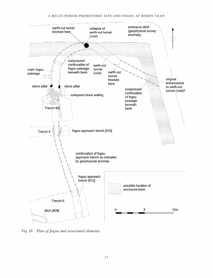
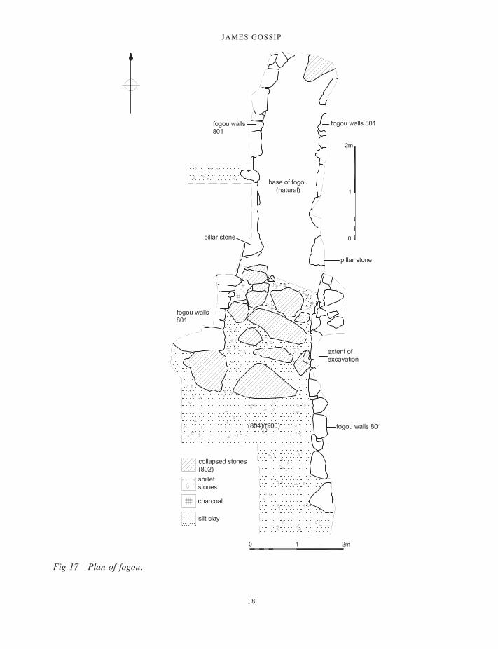
The fogou
The excavated extent of the fogou in trenches 8 and 9 indicated a structure 9.8m long with walls surviving to a maximum height of 1.5m (Figs
001-098_Cornwall 52.indd 16 01/12/2014 11:32
a multi-period prehistoric site and fogou at boden vean
17
Fig 16 Plan of fogou and associated elements.
001-098_Cornwall 52.indd 17 01/12/2014 11:32
JAMES GOSSIP
18
Fig 17 Plan of fogou.
001-098_Cornwall 52.indd 18 01/12/2014 11:32

a multi-period prehistoric site and fogou at boden vean
19
Fig 19 Western elevation of fogou, northern part of passage.
Fig 18 Section through fogou at constriction in passage. A series of radiocarbon determinations from (806) provides a terminus ante quem for construction of the fogou of 420–350 cal BC (SUERC-6168).
16–21). An unlined and unroofed vertical-sided trench extended to the south of the main passage (recorded in trenches 4, 6 and 7) and probably formed an approach to the fogou (Fig 16). The width of the main passage at its southern end was 1.9m, narrowing at a point where two vertical pillars 0.6m high (supporting corbelled wall stones) formed a ‘bottle-neck’, at which point the passage narrowed to 1.2m in width (Figs 17 and 18). The northern part of the passage was 4.5m long at which point it began to curve towards the
east (Fig 17). This was the limit of excavation but if continued it is likely to have joined the earth-cut tunnel to the north east. An alternative would be the continuation of the passage to the north to exit into the enclosure ditch, as at Halligye (Startin 2009–10, 137, fig 9). However, it is clear from the curve in the end of visible end of the passage that this is unlikely.
The section of fogou south of the bottle-neck was 5.4m long. The walls did not survive to their full height on the eastern side and had evidently
001-098_Cornwall 52.indd 19 01/12/2014 11:32
JAMES GOSSIP
20
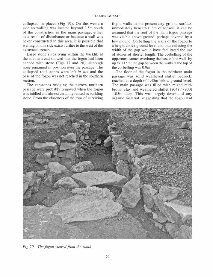
collapsed in places (Fig 19). On the western side no walling was located beyond 2.5m south of the constriction in the main passage, either as a result of disturbance or because a wall was never constructed in this area. It is possible that walling on this side exists further to the west of the excavated trench.
Large stone slabs lying within the backfill at the southern end showed that the fogou had been capped with stone (Figs 17 and 20), although none remained in position over the passage. The collapsed roof stones were left in situ and the base of the fogou was not reached in the southern section.
The capstones bridging the narrow northern passage were probably removed when the fogou was infilled and almost certainly reused as building stone. From the closeness of the tops of surviving
fogou walls to the present-day ground surface, immediately beneath 0.3m of topsoil, it can be assumed that the roof of the main fogou passage was visible above ground, perhaps covered by a low mound. Corbelling the walls of the fogou to a height above ground level and thus reducing the width of the gap would have facilitated the use of stones of shorter length. The corbelling of the uppermost stones overhung the base of the walls by up to 0.15m; the gap between the walls at the top of the corbelling was 0.9m.
The floor of the fogou in the northern main passage was solid weathered shillet bedrock, reached at a depth of 1.45m below ground level. The main passage was filled with mixed mid-brown clay and weathered shillet (804) / (900) 1.05m deep. This was largely devoid of any organic material, suggesting that the fogou had
Fig 20 The fogou viewed from the south.
001-098_Cornwall 52.indd 20 01/12/2014 11:32

a multi-period prehistoric site and fogou at boden vean
21
been deliberately backfilled in more or less a single event during antiquity.
Below this backfill were layers of silty clay and stone including a basal deposit of very dark greyish-brown silt clay with frequent charcoal flecks and burnt bone fragments, (806) / (807). This deposit was up to 0.1m deep and lay directly on the natural stone floor of the fogou (809) which in places comprised looser weathered shillet (810). There was limited evidence that the base of the fogou had silted-up slowly, although above (806) / (807) was a layer of dark greyish-brown silt clay 0.1m deep (805), which appeared to have accumulated more gradually, perhaps during the final uses of the fogou (Fig 18). The southern part
of the passage contained the same backfill. These basal deposits produced exclusively Early Iron Age PJG ceramics including P5–P9 (all from (806) in addition to stone finds S3, cobble muller; S4, part of a cobble whetstone and, from (805), S5, a pebble polishing stone with a high sheen deposited against the western stone upright ‘pillar’ of wall 801. None of the artefacts were significantly fragmented or abraded and are likely to indicate a deliberate covering of the floor prior to closure with further backfilling. The basal fills were relatively soft and uncompacted with little sign of erosion, suggesting that they were covered with the main backfilling episode shortly after creation. This process has been recorded in a number of
Fig 21 Section through fogou ‘approach’ [433] (trench 4).
001-098_Cornwall 52.indd 21 01/12/2014 11:32

JAMES GOSSIP
22
Scottish souterrains such as Dalladies and Newmill (Watkins 1978–80a, 136; 1978–80b, 177–9). Two small beads recovered from deposit (806), one of dark blue glass and one of amber, are of Iron Age date (McLaren and Hunter, below).
Carbonised residues from pottery recovered from (806) gave radiocarbon dates 2205 ±37 BP, 390–170 cal BC (OxA-14486) and 2261 ±28 BP, 400–200 cal BC (OxA-14514). Charcoal samples from (806) produced determinations of 2425 ±29 BP, 750–400 cal BC (OxA-14515), 2462 ±29 BP, 770–400 cal BC (OxA-14516) and 2335 ±35 BP, 420–370 cal BC (SUERC 6168). The Bayesian chronological model suggests construction of the fogou before 420–350 cal BC (94 per cent probability) (Hamilton et al, below).
Beyond the southern extent of the stone walls a vertical-sided trench 1.4m deep below ground level (cut 0.9m into natural) and 0.75m wide had been dug through the bedrock. This feature extended southwards across the interior of the enclosure and was visible in trenches 4, 6 and 7 as [433], [612] and [705] respectively (Figs 3, 4, 12, 13 and 21). Fills within the trench indicated episodes of gradual soil accumulation and deliberate backfilling. In trench 4 (Figs 12 and 21) the top edge of this feature was lined with stones (410) and sealed by deposit (401) which yielded saddle quern fragment S8, part of a muller S9, and a worked cobble S10. Three fills were recorded: (422) a mid-brown loose silt clay 0.3m deep, (423) a loose stony brown silt clay 0.37m deep and (424) a loose, stony silt clay 0.3m deep. Two sherds of Early Iron Age pottery and whetstones S6 and S7 were recovered from (423). In trench 6 a pit [604] had been cut into (602), the fill of [612], 0.7m in diameter and filled by (603), comprising charcoal-rich, dark brown silty clay. The same ditch was recorded in trench 7 as ditch [705]. Here the profile was more concave and about 1m wide, again filled with three deposits; the uppermost (702) was a mid-brown silt clay 0.28 deep, (704) was a very similar but stonier deposit 0.32m deep, and the basal fill (703) was a dark, sticky, stony silt clay 0.18m deep.
Geophysical survey suggests that the trench continued to the southern edge of the enclosure (Fig 2). At its northern end it is likely that this trench connected with the stone-walled elements of the fogou and provided an open approach towards the southern entrance into the enclosure. Alternatively the trench could represent an unfinished extension of the fogou or could have been lined and roofed
with timber; timber-lined souterrains having been identified in Ireland (Clinton 2001, 10–11) and Scotland (Watkins 1978–80a, 135, 141). The function of the stone edging (410) is unclear. It is possible that it acted as a visual definition of the trench cut, or even as seating for a timber covering.
It seems most likely that the stone-built elements of the fogou thus recorded were constructed in a single phase. The ‘approach’ trench to the south and the earth-cut ‘void’ passage beyond the north-eastern end were either built at the same time or during the life and use of the fogou. The stony silt clays (806), (805), (807) in the base of the fogou are likely to have accumulated towards the end of its use; finds from these deposits and the simple stratigraphy indicated that the deposits accumulated over a relatively short period. It is possible that the floor had been kept clean and that these deposits represent the final stages in the use of the fogou before it was filled in a more-or-less single, deliberate event. At this point the capping stones may have been levered from the roof of the fogou or collapsed within it, and deposit (804) / (900), perhaps material from the enclosure bank, was tipped inside to fill the space between the walls.
Despite missing stones from the side walls of the fogou, particularly at its southern end, there was no evidence of additional voids or creeps leading from the main passage, although the section between its northern end and the earth-cut tunnel remains unexplored.
It is likely that the stone walls of the fogou were built within a construction cut, although the evaluation trench did not extend far enough to reveal this. A similar construction technique was identified at Carn Euny, Sancreed (Christie 1978), and Halligye, Mawgan-in-Meneage (Startin 2009–10), and it is reasonable to infer that the same method was used at Boden. The junction between the stone-walled northern passage and the earth-cut tunnel was not exposed, but it is likely that at some point (either as part of the original phase or at a later date) a form of stone doorway existed to join the two elements. Lintelled ‘doorways’ can be seen at Boleigh, St Buryan, and Treveneague, St Hilary, connecting stone passages to earth or rab-cut sections (Cooke 1993, 82–9, 142–7).
Building stone for the fogou was not locally available in the field, but was imported from nearby, perhaps quarried from a rocky outcrop. The nearest source of stone would have been from
001-098_Cornwall 52.indd 22 01/12/2014 11:32
a multi-period prehistoric site and fogou at boden vean
23
the valley floor below but the basic rock type used is gabbro, an igneous rock, the main exposure of which is on Crousa Downs approximately 2 km to the south of Boden, where it would have been relatively easy to obtain from boulders lying on the surface (Peter Ealey, pers comm). This stone was clearly selected both for its practical attributes (size and shape) and for aesthetic reasons (shape and colour).
The earth-cut tunnel
The void is an earth-cut subterranean passage which was traceable for some 4m to the south east, at which point it is blocked by a large killas stone. The void also extends a little way to the west and stonework suggests that a collapsed wall may be present. It is likely that in its original form the passage connected with the stone-built elements of the fogou to the west. Like the construction trench for the stone section of the fogou it is cut through the shillet bedrock. Today it has a height of up to 1m from floor to roof and a width of about 0.8m, but much of it is filled with collapsed subsoil, reducing the height to 0.4m. The present-day hole through which the void was first discovered is obviously not its original entrance, and it is possible that the tunnel once extended as far as the enclosure ditch on its eastern side, as indicated by the geophysical survey, and may also extend to the north west. If this is the case, then the earth-cut passage may also have connected with the open enclosure ditch to the north of the fogou, as did the original entrance at Halligye (Startin 2009–10, 134).
The relationship between enclosure and fogou
The geophysical survey showed the enclosure to be sub-rectangular in plan, measuring approximately 75m by 50m (as enclosed by the ditches) and enclosing an area of 0.4 ha. In trenches 2 and 3 the enclosure ditch was 3–4m wide and 1.85m deep. The linear anomaly representing the eastern side of the enclosure runs parallel and immediately adjacent to the present hedge, and it would appear that this hedge, and that forming the southern extent of the field, was built above the remains of the enclosure rampart or bank. The main fogou passage is situated almost centrally at the northern end of the enclosure, very close to the enclosure ditch, with the earth-cut tunnel running away to the east. Comparison of the site plans with the
geophysical survey suggest that the northern end of the main passage and part of the earth-cut tunnel ran beneath the rampart. It is possible that the main passage opened into the northern ditch and the earth-cut tunnel into the eastern ditch. The fogou approach trench runs southwards from the fogou to the southern extent of the enclosure, effectively dividing the enclosure in two.
Late Iron Age and Romano-British activity
Although a break in continuity is suggested by the absence of South Western Decorated ware, pottery recovered from a range of features, and charcoal deposits representing burnt firewood and food remains, suggest permanent or semi-permanent occupation in or around the enclosure in the Late Iron Age and Roman period.
The presence or continued use of field systems is indicated by ditch [120] in trench 1 (Fig 4), a shallow concave cut 1.6m wide by 0.35m deep, filled by (112) a dark brown silt clay which produced Cordoned ware pottery P19 consistent with Late Iron Age or early Romano-British activity, potentially up to the mid-second century AD.
Another small ditch, [305] in trench 3 (Fig 11), contained Late Iron Age pottery, with at least 15 vessels represented. This ditch, 1.2m wide and 0.4m deep, just outside and parallel to the enclosure ditch, contained a dark greyish brown silt clay fill with sherds of Type C, D, J and G jars (including P20–P24) consistent with a first-century BC to mid-first-century AD date. This feature also contained a small pebble burnisher, S16.
Also just outside the enclosure ditch a possible posthole [308] was recorded, 0.82m in diameter by 0.35m deep with large packing stones. The fill contained second phase Cordoned ware dating to the first or mid-second century AD.
Trench 3 (Fig 11) was positioned to investigate a possible entrance on the western side of the enclosure indicated by the geophysical survey at a point where the enclosure ditch [315] was 4m wide. Stratigraphy was complex in this trench; the entrance was not found and only the later ditch deposits were investigated. These included spreads of stone (316), probably derived from collapse of the enclosure bank, and backfill and erosion deposits (310), (312) and (313) relating to the final uses of the enclosure as well as disturbance by later ploughing. These dark brown silts are the
001-098_Cornwall 52.indd 23 01/12/2014 11:32
JAMES GOSSIP
24
latest fills of the ditch and can be dated, from the latest finds, to the fourth or even the fifth centuries AD. However, there are also residual finds from the second to third centuries, suggesting that there should be evidence for features and activity of this date elsewhere on the site (Quinnell, below).
Three Roman coins recovered from outside the enclosure by metal detectorists are further evidence of Romano-British occupation (Reece, below) and beyond the enclosure to the north and north east numerous geophysical anomalies could indicate more extensive Romano-British settlement, including a possible dwelling (Linford 1998, 193; below): the somewhat oval anomaly m8 (Fig 2) could be consistent with the form of a Romano-British building. Close to this feature, and perhaps associated, is the ‘well’ discovered in 1991.
The ‘well’ (SW 76846 24077) was discovered in the course of cutting a water-pipe trench, in September 1991. It was dug out to depth of 2.4m below the ground level by Mr Hosken, the fill consisting mostly of stones, and later excavated to a depth of 3.25m although it could be seen to extend for at least 1m below this (Rose and Preston-Jones 1991).
The upper 0.75m of the feature had been destroyed by the pipe trench but a stretch of corbelled walling, two or three courses high, survived on its western face and there was a slight trace of walling on its eastern side. Below this the pit was unlined, cutting through the shillet subsoil and bedrock. At 0.25m below the corbelling the shaft had a diameter of 1m, widening out to 1.2m at a depth of 1m, from which point the sides descended vertically (ibid).
The upper part of the fill was a mix of soil and stones, the lower part consisting increasingly of stones with little soil. Finds comprised 53 sherds, consisting of a mixture of second phase Cordoned ware and Romano-British sherds, including P26 to P31, considered likely to have been deposited in the later second century AD. The assemblage also included a possible Dressel 2–4 amphora sherd dating from the later first century BC to the mid-second century AD (Quinnell, below; McBride, below).
An interesting collection of stone objects was also recovered, all exhibiting indications of deliberate breakage: these were parts of upper rotary querns S18 and S19; part of a lower rotary quern S19, part of a saddle quern or mortar S20,
cobble whetstone S21 and probable hammer stone S22, all likely to have been deposited in the mid- to late second century AD.
Post-Roman activity
Post-Roman activity within the enclosure was illustrated by the recovery of Gwithian Style ceramics, with at least 22 vessels represented. The most distinctive form was the platter (Fig 30). Most of the material came from the uppermost fills of enclosure ditch [315] – (314) and (303) – in trench 3, but there were also finds from trench 4, some probably associated with a curvilinear alignment of stones 408. Although this is a significant group of finds the nature of the contextual evidence means that the character of the post-Roman activity remains obscure.
A late fill from the ditch provided two statistically inconsistent radiocarbon measurements. The earlier of these, 2269 ±27 BP, 400–210 cal BC (OxA-14519), from charcoal, is clearly residual. The other, from carbonised residue on a Gwithian Style platter, provided a determination of 1417 ±29 BP, cal AD 590–670 (OxA-14560). This ceramic style appears to have been in use broadly in the sixth century and early seventh centuries AD (Quinnell, below).
Stratigraphic comparison between trenches
The seven trenches revealed relatively simple stratigraphy across the interior of the enclosure and in the area of the Bronze Age structure (trench 1). The topsoil was between 0.15m and 0.3m deep overlying a layer of stony clay silt (206) up to 0.3m deep. This is probably a relict ploughsoil lying directly above the ‘natural’ subsoil, and appears to seal all archaeological features.
Excavated features were on the whole discrete cuts into the ‘natural’ filled with one or more deposits, either as a result of natural erosion, deliberate backfilling or both. The identification of common horizons between trenches was problematic. Deposits (421) in trench 4 and (605) in trench 6 appear to represent the same layer of accumulated soil above the backfilled trench [433] / [609] to the south of the fogou passage. This layer is represented to the west as (429) but was not recorded in trench 3, where it had probably become incorporated into (303), above the latest fills of the enclosure ditch.
001-098_Cornwall 52.indd 24 01/12/2014 11:32

a multi-period prehistoric site and fogou at boden vean
25
Table 1 Copper alloy artefacts
No. Identity Comment
(606) SF11 Tapering curved strip With bone and charcoal(606) SF12 1 piece of curved wire With charcoal in the attached soil(606) 1012 4 pieces of curved wire(606) – 1 piece of curved wire(606) <1012> [431] Two copper alloy rod fragmentsTr 3 unstratified Waste metal Analysed by XRF and XRDTr 8 (804) Sheet fragment(405) Tiny fragments
There was no evidence for the survival of an internal bank to the enclosure ditch, and it can be assumed that remnants of this were ploughed out. The composition of the bank must have been spoil arising from the digging of the ditch, and it is this material which appears to comprise the infill of the fogou main passage (804) / (900).
Copper alloy objectsVanessa Fell, Sarnia Butcher and Henrietta Quinnell
This section is supported by a detailed archive report prepared by the first author. The seven items (Table 1) were X-rayed prior to assessment and subsequently investigated principally to clarify their identity. One item was analysed by X-ray fluorescence (XRF) and X-ray diffraction (XRD). None of the copper alloy artefacts is illustrated.
(606) SF11 from Early Iron Age gully/ditch [609] Tapering curved strip, length 22mm, plus detached fragments of corrosion products, and small fragments of bone and charcoal. Rectangular section, 5.5 × 2.5mm. The copper alloy is well-patinated. Initially recorded as a brooch.
It is difficult to suggest what sort of object this piece may belong to. Although the main strip might be seen as part of a brooch the shape of the (broken) curved end seems to rule this out. If it were the ‘head’ it could not hold or form part of a spring, nor join any usual type of crossbar; and, if it were the ‘foot’, it could not function as part of a catch for a pin.
(606) from sample <1012>, Early Iron Age gully/ditch [609] Four pieces of curved wire, with
diameter 2.3–2.4mm. Well-patinated but corroded at the ends. Presumably these joined together, with the other two pieces from this context, to make a ring or loop.
Put together the fragments form an incomplete ring whose diameter would be very approximately 35mm. Two of the pieces have ends which, although obscured by corrosion, might possibly show the beginnings of a knobbed or curved terminal. Although there is therefore a suggestion that the object may be a penannular brooch this is unlikely due to the early date of this deposit, apparently in the fourth or third centuries BC (Hamilton et al, below). Penannular brooches occur in British contexts from the first century BC onwards; types with simple wire rings are particularly common in the first century AD. Mount Batten (Cunliffe 1988) has the largest collection of first millennium BC copper alloy artefacts in Devon and Cornwall and gives some indication of the forms likely to be in circulation in the Early Iron Age.
(606) SF 12 from Early Iron Age gully/ditch [609] Single piece of curved wire, diameter 2.3mm, well-patinated. May join (606) 1012.
(606) from Early Iron Age gully/ditch [609] Single piece of curved wire, diameter 2–2.8mm, flattened oval section but very corroded. Presumably this joined with SF12 and finds from <1012>, above.
Tr 3 unstratified Fragment of waste metal of knobbly appearance, length 24.4mm. The surface layers are powdery black with green beneath. One surface has traces of a vesicular deposit. Analysis of the corroded surface by X-ray fluorescence indicated only copper. Analysis of the black deposit on the surface by X-ray diffraction determined tenorite (CuO) and some cassiterite (SnO2).
001-098_Cornwall 52.indd 25 01/12/2014 11:32
JAMES GOSSIP
26
The appearance suggests that this is waste metal from manufacture, or a melted artefact which has some fuel ash slag attached. Analysis of the corroded surface layers (and therefore not a precise result) suggests this was a copper alloy. The tenorite is a high temperature oxidation product (rather than a corrosion product) which supports the suggestion for manufacturing waste or a remelting artefact.
Given the range of finds from trench 3 this fragment could be of any date from the Early Iron Age onward.
Tr 8 (804) Upper fill in fogou Fragment of sheet, bent, 51.5 × 33 × 1mm. There are traces of mineralised plant macrofossils in the corrosion layers.
Thin metal plate with parallel edges; the width, if complete, is 33mm. One end is diagonal and the other rectangular but both appear to be broken; the maximum existing length is 51.5 mm. It is irregularly bent and the surface shows faint patterns apparently due to corrosion.
Presumably this was part of a decorative (?) plate attached to leather or some other support as it seems insufficiently robust to form a complete object.
(405) layer sealing stones 408 SF4 Probably associated with Gwithian Style ceramics Several tiny fragments, totally corroded.
Sample <1012>, context (606), fill of rock-cut ditch [431]. Copper alloy rod fragments. Two small circular-sectioned rod fragments, probably from a pin. Two brooch (?) fragments are recorded from this ditch fill, and these may be further pieces of the same item. The alloy type was determined (by surface X-ray fluorescence) to be bronze with a trace of arsenic. (1) Length 3.5mm, width 2.3mm, thickness 2mm; (2) length 2mm, width 1.5mm, thickness 1.5mm.
The Roman coinsRichard Reece
Three coins were found by metal detectorists, working in transects across the field surrounding the fogou. The identifiers of the coins representing the site code and the field-walking grid square in
which they were recovered are represented thus: <BF03 N10> (Fig 3). The coins have been identified but no further analysis has been undertaken.
Sestertius, AD 96–160
A sestertius of the period AD 96 to 160. The portrait is probably that of Hadrian, AD 117 to 138. The reverse shows a standing figure facing left but is otherwise uncertain. <BF03 N10>.
As, AD 43–160
Although this coin is very heavily corroded, there is a head showing. It is an As (middle denomination) with a date between AD 43 and 160. The reverse may be an ordinary standing figure, perhaps with an altar (Domitian or Hadrian, AD 81 to 138). The other way up it could be seen as a typical Minerva with spear and shield which would make it a copy of a coin of Claudius I (AD 43–64) which would help to account for the very thin and irregular flan. <BF03 D7>.
Barbarous radiate, AD 275–290
A barbarous radiate struck between AD 275 and 290 probably copying a regular coin of Victorinus or Tetricus I (268–273). The reverse is corroded and uncertain. <BF03 M8>.
The potteryHenrietta Quinnell with assistance from Carl Thorpe and petrographic comment by Roger Taylor
The structure in trench 1 produced Trevisker ceramics of the Middle Bronze Age with, just possibly, a redeposited Early Neolithic vessel. Fogou contexts contained only Early Iron Age material while those in the enclosure contained Early Iron Age, Late Iron Age Cordoned ware, some Romano-British ceramics and a distinctive group of post-Roman Gwithian Style material.
Abrasion
The following system, broadly based on that set out by Sorenson (1996) is used.
Very fresh 1; freshly brokenFresh 1/2; colour of core slightly patinated
001-098_Cornwall 52.indd 26 01/12/2014 11:32
a multi-period prehistoric site and fogou at boden vean
27
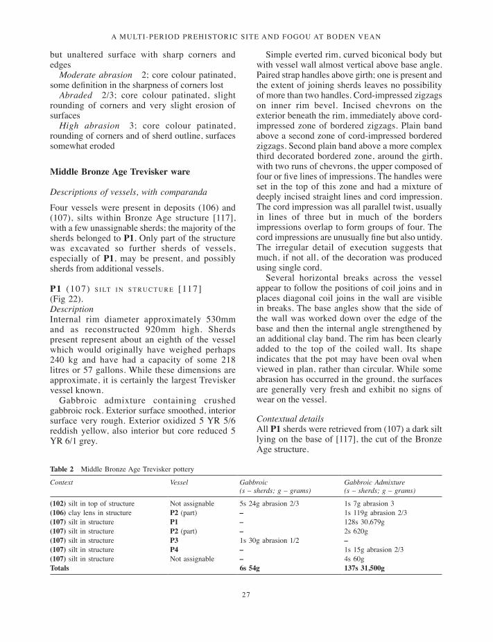
Table 2 Middle Bronze Age Trevisker pottery
Context Vessel Gabbroic (s – sherds; g – grams)
Gabbroic Admixture (s – sherds; g – grams)
(102) silt in top of structure Not assignable 5s 24g abrasion 2/3 1s 7g abrasion 3(106) clay lens in structure P2 (part) – 1s 119g abrasion 2/3(107) silt in structure P1 – 128s 30,679g(107) silt in structure P2 (part) – 2s 620g(107) silt in structure P3 1s 30g abrasion 1/2 –(107) silt in structure P4 – 1s 15g abrasion 2/3(107) silt in structure Not assignable – 4s 60gTotals 6s 54g 137s 31,500g
but unaltered surface with sharp corners and edges
Moderate abrasion 2; core colour patinated, some definition in the sharpness of corners lost
Abraded 2/3; core colour patinated, slight rounding of corners and very slight erosion of surfaces
High abrasion 3; core colour patinated, rounding of corners and of sherd outline, surfaces somewhat eroded
Middle Bronze Age Trevisker ware
Descriptions of vessels, with comparanda
Four vessels were present in deposits (106) and (107), silts within Bronze Age structure [117], with a few unassignable sherds; the majority of the sherds belonged to P1. Only part of the structure was excavated so further sherds of vessels, especially of P1, may be present, and possibly sherds from additional vessels.
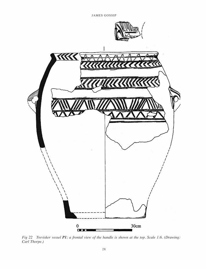
P1 (107) s i lt i n s t r u c t u r e [117] (Fig 22).DescriptionInternal rim diameter approximately 530mm and as reconstructed 920mm high. Sherds present represent about an eighth of the vessel which would originally have weighed perhaps 240 kg and have had a capacity of some 218 litres or 57 gallons. While these dimensions are approximate, it is certainly the largest Trevisker vessel known.
Gabbroic admixture containing crushed gabbroic rock. Exterior surface smoothed, interior surface very rough. Exterior oxidized 5 YR 5/6 reddish yellow, also interior but core reduced 5 YR 6/1 grey.
Simple everted rim, curved biconical body but with vessel wall almost vertical above base angle. Paired strap handles above girth; one is present and the extent of joining sherds leaves no possibility of more than two handles. Cord-impressed zigzags on inner rim bevel. Incised chevrons on the exterior beneath the rim, immediately above cord-impressed zone of bordered zigzags. Plain band above a second zone of cord-impressed bordered zigzags. Second plain band above a more complex third decorated bordered zone, around the girth, with two runs of chevrons, the upper composed of four or five lines of impressions. The handles were set in the top of this zone and had a mixture of deeply incised straight lines and cord impression. The cord impression was all parallel twist, usually in lines of three but in much of the borders impressions overlap to form groups of four. The cord impressions are unusually fine but also untidy. The irregular detail of execution suggests that much, if not all, of the decoration was produced using single cord.
Several horizontal breaks across the vessel appear to follow the positions of coil joins and in places diagonal coil joins in the wall are visible in breaks. The base angles show that the side of the wall was worked down over the edge of the base and then the internal angle strengthened by an additional clay band. The rim has been clearly added to the top of the coiled wall. Its shape indicates that the pot may have been oval when viewed in plan, rather than circular. While some abrasion has occurred in the ground, the surfaces are generally very fresh and exhibit no signs of wear on the vessel.
Contextual detailsAll P1 sherds were retrieved from (107) a dark silt lying on the base of [117], the cut of the Bronze Age structure.
001-098_Cornwall 52.indd 27 01/12/2014 11:32
JAMES GOSSIP
28
Fig 22 Trevisker vessel P1; a frontal view of the handle is shown at the top. Scale 1:6. (Drawing: Carl Thorpe.)
001-098_Cornwall 52.indd 28 01/12/2014 11:32

a multi-period prehistoric site and fogou at boden vean
29
ComparandaThe vessel, while unusually large, belongs in Parker Pearson’s (1990) Style 1, broadly equivalent to ApSimon and Greenfield’s (1972) style 1 and Patchett’s (1946) Groups B and F. While the diameter is at the larger end of the range for Parker Pearson style 1 vessels, none of the vessels recorded by him (ibid, fig 1) are much over 500mm in height. The style 1 vessels would have been used for storage. The use of incision and cord impression together has not so far been recorded nor have the three complex decorative zones separated by plain bands. The closest comparanda are provided by vessels from barrows at Bosvargus (Patchett 1946, fig 10, F10) and Chapel Carn Brea (Patchett 1950, fig 2, D2). Both these barrows, in St Just in Penwith, were the sites of early excavations but recent reviews of radiocarbon dating indicate that Cornish barrow deposits generally were confined to the Early Bronze Age before around 1500 BC (Jones 2005, 37). Both the Bosvargus and the Chapel Carn Brea vessels are roughly half the size of P1 and their decoration is simpler, although arranged in zones, and, in the case of Chapel Carn Brea, combines impressed cord with impressions. Nothing comparable is recorded from a domestic context although it is possible that some sherds from the hut circles at Kynance Gate on the Lizard (Thomas 1960) may come from vessels approaching P1 in size. A sherd from probably the largest Trevisker vessel otherwise recorded comes from the hut circle at Poldowrian, St Keverne (Smith and Harris 1982, fig 23, no 92), with an internal diameter of 450mm and external cord-impressed cordons. It would be reasonable for very large gabbroic storage jars to occur on the Lizard, close to the sources of gabbroic clay. The similarities with the Early Bronze Age vessels from Bosvargus and Chapel Carn Brea can be explained on the assumption that Trevisker ceramics were made in much the same styles in both the Early and Middle Bronze Ages, a view generally supported by recent studies (Parker Pearson 1990; Woodward and Cane 1991).
P2 (106) c l ay l e n s a n d (107) s i lt i n s t r u c t u r e [117] (Fig 24).DescriptionSimple everted rim, internal diameter 370mm, Gabbroic admixture fabric with crushed serpentinite. Oxidised throughout 5YR 6/6 reddish yellow. Well smoothed surface. Row of large regular finger-tip / nail depressions around
neck with below two incised zigzags in alternate directions and a double row of smaller finger impressions below these. Contextual detailsOne rim sherd came from (106) and another and a body sherd from (107). These had very abraded edges (2–2/3) although the surfaces were fresher. It is possible that they were redeposited with the material infilling the structure, rather than forming part of the structured deposit with P1. ComparandaNo comparanda for this vessel or its decoration are known from barrows but vessels with a similar profile which combine incised and finger-tip decoration occur on settlement sites (Trevisker: ApSimon and Greenfield 1972, fig 15, no 15; Trethellan Farm: Woodward and Cane 1991, fig 43, P19, fig 44, P22, fig 46, P36), although no precise parallel for the arrangement of the decoration is known.
P3 (107) s i lt i n s t r u c t u r e [117] (fig 24).DescriptionSimple vessel with curved wall, internal diameter 85mm. Gabbroic without additions. Surface roughly smoothed. Reduced throughout 5YR 4/1 dark grey. One small circular boss survives; there could have been two, three or four originally.
Contextual detailsOne side of the sherd and edges are fresh 1/2 but the other is abrasion 2. Recovered from (107) silt in Bronze Age structure.
ComparandaFor the Bronze Age the vessel may be considered as a miniature, smaller than the range of Trevisker vessels (Parker Pearson 1990, fig 1). The closest comparanda are vessels KK and LL from Trelowthas barrow, Probus (Quinnell, forthcoming). These have paired bosses, straight sides and flat bottoms and are respectively 75mm and 100mm in internal diameter. They were deposited in a cist within a barrow with an associated radiocarbon date which calibrates to 1895–1630 BC at two sigma (AA-29734). All miniature vessels known from Cornwall belong to the Early as opposed to the Middle Bronze Age. The curved vessel wall of P3, however, suggests that the base was round bottomed. It is just possible that it represents a small Early Neolithic
001-098_Cornwall 52.indd 29 01/12/2014 11:32

JAMES GOSSIP
30
simple bossed cup (for example, Carn Brea: Smith 1981 figs 69, 70). The fabric compares much more closely with much of the Carn Brea gabbroic material than with Trevisker gabbroic wares and, importantly, although the outer surface is not obviously burnished, a black area survives, comparable to that of ‘black paint’ on some of the Carn Brea vessels (ibid, 170); such paint is not known from Trevisker vessels. If P3 is Early Neolithic, it may either derive from a pit of that date in the immediate vicinity of the structure, a possibility which the lithic assemblage allows, or it may have been brought in from elsewhere, as a find of some recognised antiquity, for inclusion in the structured deposit ‘closing’ the feature.
P4 (107) s i lt i n s t r u c t u r e [117] (Fig 24). Description Body sherd from large vessel with lines of three and four parallel twist cord-impressed lines respectively. Gabbroic admixture with crushed gabbroic rock. Smoothed exterior surface 5YR 3/4 reddish brown, interior surface 5YR 6/1 grey and very worn. Exterior fresh but interior may be broken through across whole of sherd. It is just possible that P4 is a fragment of P1 but the pattern of its cord impressions makes it more likely to be a separate vessel.
fabrics P1, P2 and P4 were of gabbroic admixture fabric, a distinctive fabric used for Trevisker pottery in which materials of non-gabbroic character were added to gabbroic clay (Parker Pearson 1990; Quinnell 1998–9). The additional material in P1 and P4 was crushed gabbroic rock, in P2 crushed serpentinite. P3 was gabbroic without admixture (see Petrography, below). The components of all the vessels derive from the area of the Lizard gabbro. There has been discussion in the past about the likelihood of clay being transported from the Lizard for potting (for example, ApSimon and Greenfield 1972, 355) but Parker Pearson stated clearly (1990, 19), on the evidence then available, that all the components known at that time in gabbroic admixtures occurred in the immediate vicinity of gabbroic clay. Recently, however, part of a Trevisker assemblage from Tremough, Penryn, has been shown to contain hornfels from the immediate locality of the site, material which does not occur in the area of the gabbro: this appears to
demonstrate the transport of gabbro clay over at least 15 km and its mixing with local inclusions (Quinnell 2009–10). In addition, recent assessment of the Trevisker assemblage from Gwithian (Quinnell 2004a; Quinnell and Thorpe 2007) has shown the presence on this site of unfired gabbroic clay probably brought in for local potting, adding an extra strand of complexity. These comments are relevant because the extraordinary weight of P1, around 240 kg, and its soft fabric, would suggest on-site local potting. It is quite possible that clay, perhaps with gabbro rock fragments already mixed in, was transported to be manufactured close to the site where it was presumably used and finally deposited.
datingDetails of relevant radiocarbon dates are discussed elsewhere (Hamilton et al, below). There were some problems with the two determinations from residue on P1. Overall the posterior density modelling indicates that P1 was last used during the period 1400–1190 cal BC (95 per cent probability) and this dating would be broadly appropriate for the end of use of the structure. Modelling for the deposit containing the pottery and associated with the end of the structure indicates a date between 1530–1300 cal BC and 1390–870 cal BC (both 95 per cent probability). This means that the structure is broadly contemporary with the other two houses in Cornwall with multiple dates: Trethellan, Newquay, fifteenth to thirteenth centuries BC (Nowakowski 1991, 101), and Trevilson, near Mitchell (Jones and Taylor 2004, 92), where a roundhouse was built during the fourteenth or thirteenth centuries BC and abandoned by the eleventh.
th e d e p o s i t i o n o f P1 s h e r d s (Fig 23)with Carl Thorpe
The sherds were deposited in a compact group, only partly excavated, with none occurring to the north of the cross baulk. For the sake of clarity and to allow for the illustration of all sherds, these are illustrated in a series of spits, 2–5 (Figs 8 and 9), but these are not a true representation of the horizontal distribution of sherds. In reality it was only possible to define two distinct layers, with sherd distribution as described below. They were buried in a layer of clay which contained concentrations of charcoal flecks which in places adhered to sherd
001-098_Cornwall 52.indd 30 01/12/2014 11:32

a multi-period prehistoric site and fogou at boden vean
31
Fig 23 Vessel P1 showing positions of significant joining sherds, marked with their recorded numbers. (Drawing: Carl Thorpe.)
001-098_Cornwall 52.indd 31 01/12/2014 11:32

JAMES GOSSIP
32
Fig
24
Mid
dle
Bron
ze A
ge T
revi
sker
war
e, s
truc
ture
[11
7]. S
cale
1:3
. (D
raw
ing:
Car
l Tho
rpe.
)
001-098_Cornwall 52.indd 32 01/12/2014 11:32

a multi-period prehistoric site and fogou at boden vean
33
surfaces. Sherd condition varies greatly. Sides buried uppermost and edges where not protected are generally abraded whereas undersides are fresh, the difference due to percolating ground water and bioturbation. Where protected, edges appear as though freshly broken, but some unprotected edges had become so worn that breaks will no longer join. Overall about one eighth of the vessel is present but there are significant differences in representation of the upper, decorated, and lower, plain, parts. Approximately a quarter of the former is present with about half the circumference of the rim, but only about a sixteenth of the lower plain parts and base angle. There were no sherds of the base, as opposed to base angle, present.
Close study of large-scale site plans and photographs provides a good understanding of the way in which sherds were deposited and the vessel broken. In Figure 23 the positions of significant joining sherds are marked with their recorded numbers. Most of the joining sherds appear to have broken up in the ground and to have been deposited initially as large sherds, described as sherd blocks. These sherd blocks were set in two distinct layers which have become squashed together and covered about 1m of ground, slightly larger than the size of the original vessel. The arrangement of the sherds in these layers replicated their arrangement in the vessel. The cracking up of the sherd blocks, with considerable displacement around the stones in the infill, suggests pressure caused by heavy trampling, perhaps even dancing, immediately after the sherds were covered.
The large rim sherd block in the upper layer, including sherds 60 to 75, 13, 14, 16, and 12, had been deposited with the rim due north. The greatest depth of the pot is represented on the left of the block, running down well into the plain zone and covering about 0.5m on the ground. The break on the left represents one of the original breaks on the vessel. A scatter of plain sherds occurs across the 0.5m to the south, all apparently buried with external surfaces uppermost. The plain sherds ended with part of the base angle, sherds 36/49 deposited as a sherd block with the exterior upwards. Beyond these was a single stray decorated sherd 40.
The lower level consisted of a block of sherds 10, 11, 44, 45–8, deposited with the rim to the west, at 90 degrees to the upper group. The right hand edge of this block is the other side of the major pot break present in the upper group. It is
probable that this block represents two big sherds, broken before deposition but placed together again in the ground. The first block runs up to the rim (53 to 10), the second block only contains girth sherds; the vertical break comes between 45 and 46. The west end of the sherd block with rim 10 overlaid sherd 53. Sherd 53 had been broken off from the lower edge of the block, from 44, and placed upside down beneath the edge of the rim, so that the decoration, now on the under side, runs directly in an eastward direction. A further four sherds, two decorated and two plain, were also deposited upside down in the level around the main sherd block. To the south was a block of base angle sherds 64/65 placed interior upwards. These base sherds which form the south end of the layer are placed with top to the north, unlike the rim sherd block.
Lugs were probably represented in both layers. Sherd 3 with a lug scar was placed in the top layer, in the north east of the deposit; actual lug sherds may survive beyond the baulk. Joining sherds of a lug 55/73 were found in the lower block. Sherds 3 and 55/73 do not join.
Both layers therefore contained rims, decorated sherds, plain body sherds and base angles placed in their sequence around the vessel, and both probably contained parts of lugs. The decorated sherds in the lower level were placed at 90° to those in the upper, facing north rather than west. The lower level also contained at its base selected sherds placed with decoration down and a base angle block inner side up.
These distinctive aspects of sherd deposition, together with uneven representation of different vessel parts, demonstrate that the deposit is deliberate and structured and cannot result from any form of accidental deposition or dumping.
Joining sherds in sherd blocks indicate that some half of the perimeter of the vessel is present. The two main sherd blocks are separated by a heavy line on Figure 23 which represents the apparent initial line of breakage. If so the whole vessel may initially have been broken into four segments and this may have included the base. The base angle breaks indicate that the base was broken across still joined to the angle sherds and subsequently broken away. On one group of base angle sherds the adjoining section of base was snapped by being pushed upwards but the other group show force exerted in the opposite direction. Along both sides of the major break lines sherds show refiring
001-098_Cornwall 52.indd 33 01/12/2014 11:32
JAMES GOSSIP
34
by oxidization along the broken edges (dotted on Figure 23). It is possible that this may have related to the use of fire and water in initial breakage; there are no detectable impact marks from the use of hammer stones. However, the oxidization across the breaks is on average 5mm deep and suggests that the large pieces were placed in a fire after breakage. The interior shows patchy areas of reduction and blackening, some of which may be due to refiring. The major sherd blocks were subsequently broken along the lines of coil joins – the horizontal breaks indicated on Figure 23. Many of these breaks may have happened through pressure after deposition. However, the break between 10/11 and 44/48 appears to have occurred before deposition, with sherds placed in the ground in position after breakage and the removal of the rim beyond sherd 10; it is difficult to envisage any other process which would have removed the rim about 46/48. Today sherds can be easily broken, with as much pressure as is needed to break a thick biscuit, but some of the vessel softness is due to long burial in damp conditions.
co m m e n t o n t h e br o n z e ag e p o t t e ry The comparanda both for the large and decorated P1 and the miniature P3, if this is not redeposited Neolithic, come from barrow contexts which can be assigned to the Early Bronze Age and where deposition is undeniably related to ceremonial activity. Barrow deposition does not appear to survive in Cornwall into the Middle Bronze Age nor do roundhouses appear to be constructed before this period. The choice of vessels deposited at Boden may represent an extreme example of the selection of vessels for structured deposits linked to acts of closure, using vessels of types previously considered appropriate for barrow deposition.
With regard to the understanding of Trevisker ceramics, there have now been some three decades of debate about typological development (summarised in Woodward and Cane 1991, 122–7) in which the chronological relevance of modes of decoration, incision and cord impression, have been pivotal. Cord impression was initially regarded as later than incision but the general current view (Parker Pearson 1995) is that decorative style and the shapes of vessels related to function and probably changed little during the currency of Trevisker wares during the second millennium BC. At Boden there are unusual links between the two principal decorative modes, both on the same vessel
P1 and on vessels within the same context, which support the synchronicity of decorative styles. It is quite definite that the parts of the unusually large P1 were deliberately deposited, probably after deliberate breakage, and this deposition forms one of the clearest acts of structured deposition so far known for the Cornish Bronze Age. P1 must have functioned as a storage vessel: its poor manufacture made it unsuitable for holding liquids and grain is the most probable stored commodity. The small amount of residue on a couple of sherds could have derived from the refiring episode referred to above. Was its breakage and deposition linked to that of saddle quern fragment S1, also found in deposits over the structure, and do the two together point to the importance of grain for the subsistence of those using the structure?
Later pottery
Fabrics: Early Iron Age to Gwithian Style
Ga.1 Gabbroic. Early Iron Age. Generally open and poorly made, with smoothed rather than burnished surfaces on both interior and exterior. Mostly reduced 5YR 4/1 dark grey but some sherds oxidized generally 5YR 6/6 reddish yellow.
Ga.2 Well-made gabbroic. Later Iron Age until second century AD. Compact well made fabric frequently with burnish on exterior. Mixture of oxidized 5 YR 5/6 yellowish red and reduced 5 YR 4/1 dark grey.
Ga.3 Standard gabbroic. Roman period, but can not be clearly distinguished in body sherds. Smoothed surfaces, general trend towards oxidization 5 YR 5/6 yellowish red.
Ga.4 Gwithian Style gabbroic. Poorly made with smoothed surfaces but distinctively highly fired. Generally oxidized but 5YR 5/6 yellowish red.
Gra Granitic Derived. Early Iron Age only. Compact fabric but with smoothed rather than burnished surfaces. Mostly reduced 5YR 4/1 dark grey.
Comment Extensive petrographic study (below), including thin-sections, confirmed that the gabbroic fabrics were sourced from Lizard clay but failed to find any differences that could be
001-098_Cornwall 52.indd 34 01/12/2014 11:32

a multi-period prehistoric site and fogou at boden vean
35
related to chronology. The Granitic Derived fabric was sourced to weathered granite deposits, most probably from around the edge of the Carnmenellis granite.
Early Iron Age
fo r mA minimum of 23 vessels appear to be represented. The most common form is a jar with a carinated shoulder which occurs in variety of sizes. The neck is shallow and concave with the rim either out-turned or vertical. Such carinated jars occur on a number of Cornish sites: Carn Euny (Elsdon 1978 Type Po.2); Gurnard’s Head (Gordon 1940); Halligye fogou (Elsdon and Quinnell 2009–10); Bodrifty (Dudley 1956); Trevelgue Head (Quinnell
2011) and Trenowah, St Austell (Quinnell 2008a). All these sites appear to continue in use until the Middle Iron Age and therefore the form is likely to have been present in the preceding end of the Early Iron Age.
In the recent study of material from Trevelgue Head (Quinnell 2011), Iron Age ceramics have been classified by an extension of the system introduced for the major collection from Danebury in Hampshire (Cunliffe 1984b; Cunliffe and Poole 1991) and now being extended for other sites such as South Cadbury (Woodward 2000). The carinated jars are the enumerated variety JB2.4, where J indicates the class (jars), B indicates the type of jar, 2 indicates the broad form and 4 the variety. The JB2.4 classification is used here, but with the clear understanding that the variety may need further subdivision when more examples are
Table 3 Early Iron Age pottery
Context Ga.1 Granitic
Sherds Wt Abrasion Sherds Wt Abrasion
(806) on fogou floor 29 362 2 0 0(805) fill above (806) in fogou P5–8 47 844 1/2–2 0 0
(807) fill above (806) in fogou P9 5 101 1/2–2 0 0(900) upper fogou fill 4 53 2 0 0Fogou unstratified 1 22 2 0 0(610) on base of gully [609] 1 34 2 0 0(606) above (610) in gully [609] P10–11 (Note 1) 39 1080 1/2–2 19 130 1/2 (605) over gully [609] P12–15 14 665 1/2–2 2 64 1/2 (607) over rubble spread (608) (Note 2) 3 58 2/3 0 0(430) in gully [431] (=[609]) P16 (Note 3) 13 241 1/2–3 0 0(432) in gully [431] 2 5 2 0 0(414) in pit [416] predating [412] 2 27 1/2–2 0 0(411) in depression [412] 7 172 1/2–2 0 0(406) over (411) 2 25 2 0 0(401) fill [402]/[410] 9 120 2 0 0(418) as [410] 2 18 2 0 0(423) in fogou approach cut [433] 2 47 2 0 0(437) in posthole [436] 11 86 2 0 0(441) over surface [442] 6 28 2–3 0 0(400)/(407) cleaning W end 18 144 2–3 0 0Tr 4 unstratified 2 9 2–3 0 0(204) low in enclosure ditch [202] P17–18 15 839 1/2–2 0 0(201) above (204) in enclosure ditch [202] 5 87 2 0 0(203) above (201) in enclosure ditch [202] 2 46 2–2/3 0 0(200) top of enclosure ditch [202] (Note 4) 4 138 2–2/3 0 0Unstratified in field with fogou 1 8 2/3 0 0Totals 246 5259 21 194
Note 1: includes ceramic disc from (606), SF10, described in text under Ceramic ‘pot lid’. Note 2: not included, amphora sherd, 67g, abrasion 2, described under Amphora. Note 3: not included, P52, intrusive Gwithian platter, described under Post-Roman Gwithian Style. Note 4: includes well-made gabbroic sherd, 1g, abrasion 2, but not non-local sherd, 18g, abrasion 2/3, described under Amphora.
001-098_Cornwall 52.indd 35 01/12/2014 11:32

JAMES GOSSIP
36
Fig
25
Earl
y Ir
on A
ge p
otte
ry, P
lain
Jar
Gro
up. P
5–P9
fogo
u; P
11, f
ogou
app
roac
h tre
nch
[609
]. Sc
ale
1:3.
(D
raw
ing:
Car
l Tho
rpe.
)
001-098_Cornwall 52.indd 36 01/12/2014 11:32
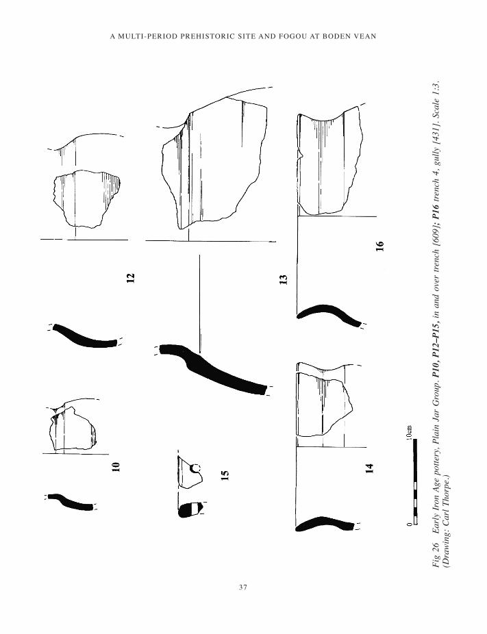
a multi-period prehistoric site and fogou at boden vean
37
Fig
26
Earl
y Ir
on A
ge p
otte
ry, P
lain
Jar
Gro
up. P
10, P
12–P
15, i
n an
d ov
er tr
ench
[60
9];
P16
trenc
h 4,
gul
ly [
431]
. Sca
le 1
:3.
(Dra
win
g: C
arl T
horp
e.)
001-098_Cornwall 52.indd 37 01/12/2014 11:32
JAMES GOSSIP
38
available for study. There are 12 examples of JB2.4 at Boden (P7, P8, P10, P11, P12–14, and P16; Fig 25), of which P10 is in Granitic Derived fabric and the remainder gabbroic, Ga.1. Internal neck diameters range from 70mm to 170mm.
There is a single example of a large jar with everted rim (P5) (Fig 25), and five examples of smaller jars with simple everted rims (P6), of which two are Granitic Derived. These jars occur in association with the JB2.4 form at Carn Euny (Types Po.1, Po.1a, Po.3), Halligye and Trevelgue, and alone at St Michael’s Mount (Quinnell 2000) and Boleigh (Quinnell 2000–1). They have not yet been included in the overall ceramic classification because at Boden, at Trevelgue and Halligye they are insufficiently complete.
In the study of the Trevelgue material it is proposed that assemblages with JB2.4 jars and jars similar to Boden P5 and P6 and to the Carn Euny range should be referred to as the ‘Plain Jar Group’ (PJG). It is hoped that this term will come into general use for assemblages which are now becoming distinctively recognizable and which appear to immediately precede South Western Decorated (SWD) material of the Middle Iron Age. The use of this term precludes the necessity of including ‘Early Iron Age’ in the description. All the sites referred to above have assemblages which contain PJG forms.
The handled jar P17 (Fig 27) has no close parallels but Gurnard’s Head no 7 (Gordon 1940, fig 8) may come from a broadly similar vessel. The handle P9 (Fig 25) should probably also be placed within PJG. Similar handles occur in the Formative Phase of SWD ware at Trevelgue Head (Quinnell 2011) where the argument is made that handles generally are a feature of the end of PJG and of this earliest phase of SWD.
The decoration on P8 may link it to the ‘Transitional’ phase at the end of PJG (Quinnell 2011), with broad parallels at Carn Euny and Gurnard’s Head. Finally, the scrap of protruding vessel foot from (437) (not illustrated) has broad parallels with P32, from midden 2, Formative SWD at Trevelgue Head, with fig 55, no 46 from Carn Euny (Elsdon 1978), and with P67 at Halligye (Elsdon and Quinnell 2009–10). Overall these features of the Boden assemblage place it at the end of PJG at a time when some features found in the Formative Style in SWD were already in use.
fa b r i cMost of the PJG material, 246 sherds, 92 per cent on sherds but 96.5 per cent on weight, was gabbroic and Ga.1; only 21 sherds, 8 per cent on sherds but 3.5 per cent on weight, were Granitic Derived. Ga.1 was a poorly finished gabbroic fabric, matched by much of the material used at Halligye. All the identifiable gabbroic vessels were in this fabric, and well-made gabbroic occurred only as a single sherd in (200); at Trevelgue well-made gabbroic fabric was used for 10 per cent of the assemblage of this date. Halligye and Boden together indicate a tendency to use poorly made fabrics close to the source of gabbroic material, a tendency demonstrated in the subsequent Middle Iron Age enclosures at Gear and Caervallack in the Helford River area (Quinnell 2008b). The coarse Early Iron Age gabbroic fabric, distinguished by inclusions up to 3mm in size, used at Trevelgue in both PJG and earlier groups, was not identified at either Halligye or Boden.
On the limited data currently available, granitic fabrics were more extensively used with PJG assemblages than at other times during the first millennium BC, accounting for 30 per cent of the vessels identified at Trevelgue and 85 per cent at Carn Euny (data summarized in Quinnell 2011). However none of the PJG group at Halligye appears to have been other than gabbroic, although a few sherds of Middle Iron Age SWD were granitic (Elsdon and Quinnell 2009–10). The choice of fabrics used was obviously a complex factor, governed by practices and traditions not now retrievable.
dat i n gConsideration of chronology must take into account the absence of SWD ware. Recent work on the assemblage at Trevelgue Head cliff castle, supported by a series of radiocarbon determinations and posterior density modelling, indicates that the earliest form of this ware, the Formative Style, came into use during the fourth century BC, and that the subsequent Accomplished and Standard Styles, which together mark the general prevalence of SWD ware in Cornwall, were present from around 320–270 cal BC (Quinnell 2011). This dating is in broad accord with other recent work in Cornwall. The general currency of South Western Decorated ware is likely to have been from around 300 BC, rather than the fourth century dating previously suggested (Quinnell 1986, 113).
001-098_Cornwall 52.indd 38 01/12/2014 11:32

a multi-period prehistoric site and fogou at boden vean
39
Occurrences of the fourth-century Formative Style are comparatively uncommon.
Posterior density modelling for the Boden dates indicates a terminus ante quem for the digging of the enclosure ditch of around 400 cal BC. The curvilinear ditch [431] / [609] is placed at 400–340 cal BC (51 per cent probability) or 320–220 cal BC (44 per cent probability). The earlier range must be considered more likely. The dated sequence of features in trench 4 provides a date for the earliest [416] of 420–350 cal BC, with the subsequent [412] dating to the fourth century BC and the latest [425] to the third. This latest date appears problematic, unless of course the site continued in
use with no pottery deposited. The construction of the fogou is dated to before 420–350 cal BC (94 per cent probability); the 280–260 cal BC (one per cent probability) can be safely discounted. Activity in the enclosure began 470–370 cal BC (five per cent probability), most probably in the decades around 400 BC, 425–390 cal BC (68 per cent probability). However, an alternative model allows the start to be set at around 530–400 cal BC). The use of the enclosure ended during the Iron Age, for which samples were dated, either 365–330 cal BC (27 per cent probability) or 270–205 cal BC (41 per cent probability). The lack of South Western Decorated ware suggests that the later, and
Fig 27 P17 and P18, Plain Jar Group ceramics, enclosure ditch [202]. Scale 1:3. (Drawing: Carl Thorpe.)
001-098_Cornwall 52.indd 39 01/12/2014 11:32
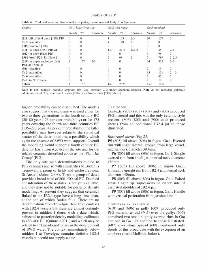
JAMES GOSSIP
40
higher, probability can be discounted. The models also suggest that the enclosure was used either for two to three generations in the fourth century BC (30–80 years: 26 per cent probability) or for 175 years covering the fourth and third centuries BC (135–220 years: 42 per cent probability); the latter possibility may however relate to the statistical scatter of the determinations, a possibility which again the absence of SWD ware supports. Overall the modelling would support a fourth century BC date for Early Iron Age use of the site and for the related ceramics described above as the ‘Plain Jar Group’ (PJG).
The only site with determinations related to PJG ceramics and so with similarities to Boden is Trenowah, a group of fields and enclosures near St Austell (Johns 2008). There a group of dates provide a broad band of 800–400 cal BC. Detailed consideration of these dates is not yet available, and they may not be suitable for posterior density modelling. At present they suggest that ceramics linked to the JB2.4 type have a long time-span, at the end of which Boden falls. There are no determinations from Trevelgue Head from contexts with JB2.4 vessels but these are almost certainly present in midden 1 there, with a date which, subjected to posterior density modelling, calibrates to 480–400 BC (Quinnell 2011) and which may be related to a ‘Transitional’ phase in the development of SWD ware. The context immediately below midden 1 at Trevelgue contains definite JB2.4 vessels but could not supply a date.
th e f o g o uContexts (806) (805) (807) and (900) produced PJG material and this was the only ceramic style present. (806) (805) and (900) each produced sherds from an additional JB2.4 jar to those illustrated.
Illustrated sherds (Fig 25)P5 (805) fill above (806) in fogou. Ga.1. Everted rim with slight internal groove, from large vessel, internal neck diameter 390mm.
P6 (805) fill above (806) in fogou. Ga.1. Simple everted rim from small jar, internal neck diameter 150mm.
P7 (805) fill above (806) in fogou. Ga.1. Unusually upright rim from JB2.4 jar, internal neck diameter 140mm.
P8 (805) fill above (806) in fogou. Ga.1. Paired small finger tip impressions on either side of carinated shoulder of JB2.4 jar.
P9 (807) fill above (806) in fogou. Ga.1. Handle with vertical perforation from jar shoulder.
co n t e x t s i n t r e n c h 6(610) and (606) in gully [609] produced only PJG material as did (605) over the gully; (606) contained two small slightly everted rims in Gra and one in Ga.1 in addition to those illustrated. (607) over stone spread (608) contained only sherds of this broad date with the exception of an amphora sherd (McBride, below).
Table 4 Cordoned ware and Romano-British pottery; some residual Early Iron Age ware
Context Ga.1 Early Iron Age Ga.2 well-made Ga.3 standard
Sherds Wt Abrasion Sherds Wt Abrasion Sherds Wt Abrasion
(119) fill of field ditch [120] P19 0 0 1 133 2/3 10 157 2Tr 2 unstratified 0 0 4 170 2 0 0(309) posthole [308] 0 0 3 13 2 0 0(311) in ditch [305] P20–24 0 0 139 2214 1/2–2 3 45 2/3(602) in ditch [612] P25 0 0 0 0 3 96 21991 ‘well’ P26–31 (Note 1) 0 0 2 98 2 51 789 2–2/3(310) in upper enclosure ditch P32–34 (Note 2)
1 157 2/3 0 0 64 535 2–3
(301) cleaning 0 0 0 0 2 15 2Tr 3 unstratified 0 0 0 0 15 151 2 – 3 Tr 6 unstratified 0 0 0 0 2 45 2Field to N of fogou 0 0 0 0 2 18 2Totals 1 157 149 2628 152 1851
Note 1: not included, possible amphora rim, 22g, abrasion 2/3; under Amphora (below). Note 2: not included, gabbroic admixture sherd, 21g, abrasion 3, under (310) in enclosure ditch [315] (above).
001-098_Cornwall 52.indd 40 01/12/2014 11:32

a multi-period prehistoric site and fogou at boden vean
41
Fig
28
Potte
ry fr
om L
ate
Iron
Age
and
Rom
ano-
Briti
sh c
onte
xts.
P19,
ditc
h [1
20];
P20
–P24
, ditc
h [3
05];
P25
, ditc
h [6
12].
P20
is
resi
dual
Pla
in J
ar G
roup
. Sca
le 1
:3. (
Dra
win
g: C
arl T
horp
e.)
001-098_Cornwall 52.indd 41 01/12/2014 11:32
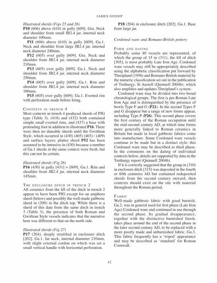
JAMES GOSSIP
42
Illustrated sherds (Figs 25 and 26)P10 (606) above (610) in gully [609]. Gra. Neck and shoulder from small JB2.4 jar, internal neck diameter 100mm.
P11 (606) above (610) in gully [609]. Ga.1. Neck and shoulder from large JB2.4 jar, internal neck diameter 240mm.
P12 (605) over gully [609]. Gra. Neck and shoulder from JB2.4 jar, internal neck diameter 210mm.
P13 (605) over gully [609]. Ga.1. Neck and shoulder from JB2.4 jar, internal neck diameter 250mm.
P14 (605) over gully [609]. Ga.1. Rim and shoulder from JB2.4 jar, internal neck diameter 160mm.
P15 (605) over gully [609]. Ga.1. Everted rim with perforation made before firing.
co n t e x t s i n t r e n c h 4Most contexts in trench 4 produced sherds of PJG type (Table 3). (418) and (432) both contained simple small everted rims, and (437) a base with protruding foot in addition to illustrated P16. There were then no dateable sherds until the Gwithian Style, which occurred in (430) (405) (403) / (409) and surface layers; platter sherd P52 has been assumed to be intrusive in (430) because a number of Ga.1 sherds in the same context were fresh, but this can not be certain.
Illustrated sherds (Fig 26)P16 (430) in gully [431] = [609]. Ga.1. Rim and shoulder from JB2.4 jar, internal neck diameter 145mm.
th e e n c l o s u r e d i t c h i n t r e n c h 2All ceramics from the fill of the ditch in trench 2 appear to have been PJG except for an amphora sherd (below) and possibly the well-made gabbroic sherd in (200) in the ditch top. While there is a sherd of this date from the same ditch in trench 3 (Table 3), the presence of both Roman and Gwithian Style vessels indicates that the narrative here was different to that on the north side.
Illustrated sherds (Fig 27)P17 (204), deeply stratified in enclosure ditch [202]. Ga.1. Jar neck, internal diameter 210mm, with slight external cordon on which was set a small vertical handle with horizontal perforation.
P18 (204) in enclosure ditch [202]. Ga.1. Base from large jar.
Cordoned ware and Romano-British pottery
fo r m a n d d at i n gProbably some 40 vessels are represented, of which the group of 15 in (311), the fill of ditch [305], is most probably Late Iron Age. Cordoned ware vessels may still be appropriately described using the alphabetic classification put forward by Threipland (1956) and Romano-British material by the numeric classification set out in the publication of Trethurgy, St Austell (Quinnell 2004b), which also amplifies and updates Threipland’s system.
Cordoned ware may be divided into two broad chronological groups. The first is pre-Roman Late Iron Age and is distinguished by the presence of bowls Type F and G (P21). In the second Types F and G disappear but a range of new forms appear, including Type P (P26). This second phase covers the first century of the Roman occupation until the mid-second century AD, at which time forms more generally linked to Roman ceramics in Britain but made in local gabbroic fabrics come into manufacture. Some Cordoned ware vessels continue to be made but in a distinct style; this Cordoned ware may be described as third phase. In the comments on the dating of individual contexts below, details are supported by data in the Trethurgy report (Quinnell 2004b).
If it is correctly suggested that the group in (310) in enclosure ditch [315] was deposited in the fourth or fifth centuries AD but contained redeposited sherds from the second century onward, then contexts should exist on the site with material throughout the Roman period.
fa b r i cWell-made gabbroic fabric with good burnish, Ga.2, was in general used for first phase (Late Iron Age) Cordoned ware and continued in use through the second phase. Its gradual disappearance, together with the distinctive burnished finish, takes place around the end of the second phase in the later second century AD, to be replaced with a more poorly made and unburnished fabric, Ga.3. This fabric frequently has a ‘wiped’ appearance and may be described as ‘standard’ for Roman Cornwall.
001-098_Cornwall 52.indd 42 01/12/2014 11:32

a multi-period prehistoric site and fogou at boden vean
43
(119) i n f i e l d d i t c h [120]The burnished Ga.2 fabric of lid P19 strongly indicates that this belongs to one of the first two Cordoned ware phases. Lids are present at St Mawgan-in-Pydar, the site on which Threipland’s typology is based (1956, fig 30), and occur at other sites such as Carvossa (Carlyon 1987, fig 3, no 101, fig 4, no 140).
Illustrated sherds (Fig 28)P19 (119) fill of field ditch [120]. Ga.2. Lid with raised edge, with possible swelling indicating presence of a handle.
(311) i n d i t c h [305](311) contains parts of six Type C bowls without handles, of two Type D jars, two Type J jars and several cordoned girth sherds, in addition to the illustrated vessels. The presence of the JB2.4 jar P20 indicates some residuality but the remainder of the group is of first phase Cordoned ware Types of which majority appear fresh. This could date anywhere through the first century BC until a date
some time around the mid-first century AD. The presence of P21, part of a Type G bowl, is the distinctive factor in dating.
Illustrated sherds (Fig 28)P20 (311) in ditch [305]. Ga.2. Neck and shoulder of JB2.4 jar, internal neck diameter 105mm, residual.
P21 (311) in ditch [305]. Ga.2. Lower body of Type G vessel.
P22 (311) in ditch [305]. Ga.2. Type C bowl, internal rim diameter 135mm, one vertically perforated handle set on rim survives with scar of second opposite.
P23 (311) in ditch [305]. Ga.2. Upper part of Type H jar, internal rim diameter 160mm.
P24 (311) in ditch [305]. Ga.2. Neck and shoulder of Type J jar, internal neck diameter 210mm.
(309) i n p o s t h o l e [308]This contains two small Type O rims in well-made Ga.2 fabric. Type O is one of the distinctive vessel forms of second phase Cordoned ware.
Fig 29 Cordoned ware and Romano-British pottery. P26–P31 finds from 1991 ‘well’ ; P32–P34, enclosure ditch [315]. Scale 1:4. (Drawing: Carl Thorpe.)
001-098_Cornwall 52.indd 43 01/12/2014 11:32
JAMES GOSSIP
44
(602) i n d i t c h [612]The only distinctive piece P25 has no precise parallels, no other examples of a Type H jar with a handle being known. The use of standard gabbroic fabric Ga.3 means the date is not closely definable. This context is the only one in trench 6 for which the ceramics are not Early Iron Age.
Illustrated sherds (Fig 28)P25 (602) in ditch [612]. Ga.3. Part of Type H rim with stub of rectangular handle.
1991 ‘w e l l’This feature contained a mixture of second phase Cordoned ware and Romano-British sherds. P26, Type P, and P27, Type C, are in well-made gabbroic fabric and are likely to belong to the earlier group. P28, Type H/Type 12, in standard gabbroic Ga.3, could date anywhere from the mid-second century onward (Quinnell 2004b, 118). P29, Type 11 in Ga.3, probably dates from the mid-second to the mid-third century AD (ibid, 118). P30, the double-handled jar Type 26 in Ga.3, has its best comparanda in a range from Carvossa (Carlyon 1987, fig 3, no 91, fig 6, nos 171, 172, 175) which extend from the late first to the late third century; the fabric of P30 probably indicates a date after the mid-second century. For P31, Type 9 in Ga.3, the limited comparisons available (Quinnell 2004b, 117) provide comparanda from the third and fourth centuries. All these enumerated vessels were abrasion 2. If it is assumed that they were deposited as a group, or at much the same period, this is most likely to be sometime in the mid- to late second century to account for the use
of well-made gabbroic fabric in P26 and P27 but this assumes that P31 has a longer date range than previously demonstrable.
Illustrated sherds (Fig 29)P26 1991 ‘well’. Ga.2. Rim of Type P jar, slight external grooving, internal rim diameter 210mm.
P27 1991 ‘well’. Ga.2. Rim of Type C bowl with horizontal perforated handle.
P28 1991 ‘well’. Ga.3. Rim of Type H jar, internal neck diameter 225mm.
P29 1991 ‘well’. Ga.3. Rim of Type 11 jar, internal neck diameter 180mm.
P30 1991 ‘well’. Ga.3. Rim and neck of Type 26 jar, internal neck diameter 160mm.
P31 1991 ‘well’. Ga.3. Upper part of Type 9 jar, internal neck diameter 210mm.
(310) i n e n c l o s u r e d i t c h [315](310) contained a mixture of material including an example of a JB2.4 jar (as P13) and a sherd of Bronze Age gabbroic admixture. Romano-British sherds, apart from those illustrated, comprised parts of rims from three Type 4 jars, mid-second to fifth centuries, a Type 16 girth sherd from a storage jar, third to fifth centuries, a small upright rim and two rod handles which can not be closely dated. P32, Type 8 but a very small example so not typical, should be third or fourth century, P33, Type 19 but a small fragment, should date to the later second century (Quinnell 2004b, 121) while P34, Type 21, is likely to be third or fourth century. The enumerated vessels are abrasion 2 but many of the other pieces are 2/3 or 3. Given the wide range of dates including Bronze Age and Early Iron Age,
Table 5 Post-Roman Gwithian Style pottery
Context Ga.2 well-made Ga.3 standard Ga.4 Gwithian Style
Sherds Wt Abrasion Sherds Wt Abrasion Sherds Wt Abrasion
(314) in upper enclosure ditch P35–49
0 0 44 565 2–2/3 74 1082 2
(303) in top of enclosure ditch P50–51
1 19 3 17 155 3 14 185 2
(430) in gully [431] intrusive P52 0 0 0 0 1 34 1/2 (405) soil over stones (408) P53 0 0 28 347 2 1 13 2(403)/(409) over (408) 0 0 0 0 21 128 2–3(420) ploughsoil P54 0 0 5 32 2 – 3 1 37 2Tr 4 unstratified P55 0 0 0 0 1 17 2(600) topsoil (Note 1) 0 0 0 0 1 14 2Totals 1 19 94 1099 114 1510
Note 1: grass-marked sherd
001-098_Cornwall 52.indd 44 01/12/2014 11:32

a multi-period prehistoric site and fogou at boden vean
45
the deposit has the appearance of redeposition, with material collected and dumped, an event which, from the latest material it contains, should be fourth or even fifth centuries.
Illustrated sherds (Fig 29)P32 (310) in upper part of enclosure ditch. Ga.3. Small Type 8 bowl, internal rim diameter 100mm.
P33 (310) in upper part of enclosure ditch. Ga.3. Small piece of Type 19 bowl rim, internal diameter 190mm.
P34 (310) in upper part of enclosure ditch. Ga.3. Upper part of Type 21 bowl, internal diameter 120mm.
Post-Roman Gwithian Style
fo r mBoden is the first site for which a major group of ceramics is published as Gwithian Style. At least 22 vessels are present. Gwithian Style ceramics were identified at Gwithian during the 1950s (Thomas 1958, 21–3; 1968) and were revisited as part of the assessment of that site archive (Thomas et al 2004; Thorpe and Thomas 2007). In a recent review in advance of this publication, Thomas (2005) has identified a further four sites with ceramics of this Style and initial scanning of the assemblages at Carngoon Bank, Landewednack (McAvoy 1980), and Goldherring, Sancreed (Guthrie 1969), suggests that quite a range of material is present. A recent discussion of the style has been presented by Thorpe (2011). Definitive comment will have to await the full publication of Gwithian but it is becoming apparent that a wide range of forms may be involved.
The most distinctive form is the platter (P35–41, 52, 53, 55) (Fig 30), which, unlike later examples, is not grass-marked. There are a total of 12 platters (two not illustrated). By comparison with later grass-marked platters, these tend to be small, here between 150mm and 300mm in diameter. A number of the bases are sanded, with impressions showing that these had been left to dry on sanded surfaces. This appears to be typical of Gwithian Style platters. The low side walls may be wavy-topped because of finger tipping on the rim and may have finger tip or other impressions on their exteriors. These platters have so far been identified at Gwithian, at Goldherring (Guthrie 1969, fig 15, nos 5–8), Carngoon Bank (McAvoy 1980, fig
18, nos 49–50, 52–4) and Halligye (Elsdon and Quinnell 2009–10, figs 11 and 12, P73a, P82a, P82b).
There are a series of seven different bowls in addition to P42, an abraded example of a third- to fifth-century Romano-British Type 22. P43 and P45 are lumpy and irregular versions of Type 22, possibly paralleled by nos 62–3 at Carngoon Bank (McAvoy 1980, fig 18). P44 has a distinctive wide everted rim; a possible parallel occurs at Goldherring (Guthrie 1969, fig 13, no 18). P46 is a simple bowl with out-turned rim paralleled at Goldherring (ibid, fig 13, no 26). P47 with grooving below the rim has no identified comparanda. P50 is a simple large bowl with a rounded rim, broadly similar to nos 65, 66, fig 18, from Carngoon Bank. P54 is a very simple shape.
P48 and P51 are jars. P48 is thick and lumpy with a simple out-turned rim. P50 has a flat-topped rim, probably paralleled by no 26, fig 16 at Carngoon Bank. The lid P49 has not so far been identified in the Gwithian Style but suggests that the use of lids continued a practice which had commenced at the end of the Early Iron Age.
Forms from the Gwithian Style not present are jars with concave rims which appear to be frequent at Gwithian (Thomas et al 2004) and occur at Halligye (Elsdon and Quinnell 2009–10). There are no examples of stamps which have been identified at Gwithian, Halligye and Carngoon Bank (Thomas 2005).
The platters appear to represent a complete break with earlier ceramics styles and to be a local invention. Their introduction is surely linked to a change in eating and cooking practices. The other forms represent a mixture of survivals from the Late Roman repertoire and introductions, some of which may have been influenced by post-Roman imported wares. The potential range of forms is quite considerable, indicating a period of ceramic experimentation between the continuation of Late Roman forms – basically the Type 22 bowl, the Type 4 cooking pot and Type 16 storage jars – and the restricted range of straight-sided cooking pot and platter which becomes standard with the introduction of grass-marked ceramics, probably during the seventh century.
dat i n gA single radiocarbon determination (OxA-14560) of cal AD 590–670 (95 per cent probability) was obtained from residue on platter P41. A series of
001-098_Cornwall 52.indd 45 01/12/2014 11:32
JAMES GOSSIP
46
three initial dates from Layer C at Gwithian, in which the Gwithian Style was the predominant ceramic, provided rather earlier dates: these calibrated to AD 550–650 (OxA-14528), from a sanded base appropriate to the Style, AD 420–600 (OxA-14529) and AD 540–660 (SUERC-6158) (Thomas and Thorpe 2007; Hamilton et al 2007). Thomas’s (2005) most recent assessment of dating for the Style is that it was present in West Penwith and Kerrier by AD 500 and continued until AD 600 or a little later; this is based on a broad consideration of associations with post-Roman imported wares. The Style is restricted to western Cornwall, not occurring at Tintagel or at Trethurgy, both sites likely to have been occupied into the sixth century and, in the latter case, still using simple Romano-British ceramic forms (Quinnell 2004b, 240). In recent work a slightly longer date range is suggested, from the sixth to the later seventh century (Thorpe 2011, 154). More precise dating, and understanding of the Style as a whole, awaits the full publication of Gwithian. At present it appears reasonable to suggest that the Style was broadly of the sixth and seventh centuries.
fa b r i c sThe gabbroic fabric Ga.4, characteristically highly fired but otherwise poorly made, was used for all the forms, although it is less pronounced among the platters. It is very similar to the highly fired fabrics noted at Gwithian (Thomas et al 2004) and at Halligye. All Gwithian Style material identified so far is of gabbroic fabric although it is possible that granitic vessels remain to be identified in Scilly (Thomas 2005).
(314) u p p e r f i l l o f e n c l o s u r e d i t c h [315](314) contained sherds from another two platters apart from those illustrated and some residual Ga.3 pieces, generally abrasion 2/3, including a Type O and two Type D rims. This assemblage is the largest Gwithian Style group on the site with a minimum of 16 vessels. The residual second century AD material and P42, the late Roman Type 22 bowl, abrasion 2/3, make it possible that (314) is a second layer, in addition to (310) but from a different source, which was derived from clearing deposits from the interior and using them to infill the ditch.
Illustrated sherds (Fig 30)P35 (314) upper fill in enclosure ditch [315]. Ga.4. Platter with finger tip depressions on exterior vessel wall. Sanded base. External basal diameter 240mm.
P36 (314) in upper enclosure ditch [315]. Ga.4. Plain platter. Sanded base. External basal diameter 195mm.
P37 (314) in upper enclosure ditch [315]. Ga.4. Platter with finger tip depressions on exterior vessel wall. Sanded base. External basal diameter 240mm.
P38 (314) in upper enclosure ditch [315]. Ga.4. Platter with finger tip depressions on exterior vessel wall. Sanded base. External basal diameter 300mm.
P39 (314) in upper enclosure ditch [315]. Ga.4. Platter with finger tip depressions on exterior vessel wall. External basal diameter 150mm.
P40 (314) in upper enclosure ditch [315]. Ga.4. Platter with top of rim modelled to produce wavy vessel wall on which paired circular impressions central to higher points. External basal diameter 225mm.
P41 (314) in upper enclosure ditch [315]. Ga.4. Plain platter. External basal diameter 200mm. OxA-14560 cal AD 590 – 670 (95% probability) on residue.
P42 (314) in upper enclosure ditch [315]. Ga.3. Rim of Type 22 bowl, abrasion 2/3. Internal rim diameter 210mm.
P43 (314) in upper enclosure ditch [315]. Ga.4. Thick and lumpy version of Type 22 bowl with slight interior groove. Internal rim diameter 220mm.
P44 (314) in upper enclosure ditch [315]. Ga.4. Bowl with wide out-turned rim, internal diameter 210mm. Noticeably high-fired, good burnish survives beneath rim. Another sherd in (303).
P45 (314) in upper enclosure ditch [315]. Ga.4. Lumpy, poorly modelled bowl, internal rim diameter 180mm; everted rim of triangular section with broad groove beneath.
P46 (314) in upper enclosure ditch [315]. Ga.4. Simple bowl, internal rim diameter 270mm, short rim sharply everted.
P47 (314) in upper enclosure ditch [315]. Ga.4. Bowl, sharply everted rim forms lid seating, grooves on exterior. Internal rim diameter 180mm. Very highly fired.
P48 (314) in upper enclosure ditch [315]. Ga.4. Thick jar rim, everted and rounded, internal diameter 180mm.
001-098_Cornwall 52.indd 46 01/12/2014 11:32

a multi-period prehistoric site and fogou at boden vean
47
P49 (314) in upper enclosure ditch [315]. Ga.4. Simple lid, diameter 150mm.
(303) i n to p o f e n c l o s u r e d i t c h [315](303) contains part of a Late Iron Age Type C vessel in well-made Ga.2 fabric, abrasion 3 in addition to the pieces illustrated.
Illustrated sherds (Fig 30)P50 (303) in top of enclosure ditch [315]. Ga.4.Vertical rounded rim from simple straight-sided bowl, internal diameter 210mm.
P51 (303) in top of enclosure ditch [315]. Ga.4. Flat-topped rim with external expansion, rim top burnished.
(430) i n g u l ly [431]This feature also contains Early Iron Age PJG material and, although P52 is tentatively considered intrusive, relationships may be reversed and the feature may be of Gwithian Style date.
Illustrated sherd (Fig 30)P52 (430) intrusive in gully [431]. Ga.4. Platter with finger-tip or finger nail impressions around rim top giving wavy outline to vessel wall. External basal diameter 270mm.
(405) a n d (403) / (409) o v e r s to n e s 408The ascription of the featureless sherds to a period is very uncertain and all could be of Gwithian Style date.
Illustrated sherd (Fig 30)P53 (405) soil over stones 408. Ga.4. Plain platter. External basal diameter 165mm.
(420) p l o u g h s o i l
Illustrated sherd (Fig 30)P54 (420) ploughsoil. Ga.4. Small jar with curved sides. Highly fired. Exterior reduced and burnished with reduction spreading over interior of rim. Internal rim diameter 120mm.
tr e n c h 4 u n s t r at i f i e d
Illustrated sherd (Fig 30)P55 Tr 4 unstratified. Ga.4. Platter, finger-tip impressions around rim top giving wavy outline to vessel wall; single circular stamp surviving on the
exterior probably one of a series on each protrusion on vessel wall. External base diameter 250mm.
ea r ly m e d i e va l gr a s s-m a r k e d s h e r dA single gabbroic body sherd from (600) topsoil has grass marking on the exterior and some plant grass inclusions in the fabric (R Taylor, microscopic examination).
Petrography
Roger Taylor
tr e v i s k e r Sherds from the four Trevisker vessels P1–4 were examined under the binocular microscope and a sample from each thin-sectioned (TS1–4). The results from thin-section examination confirmed binocular study. Each vessel comprised gabbroic fabric; to this crushed gabbroic rock was added to P1 (TS1) and P4 (TS4), and crushed serpentinite to P3 (TS3). The description of P1 TS1 is given below; the others are included in the archive. The components in all the samples examined come from the Lizard gabbro or its immediate vicinity.
Trevisker P1 TS1 Feldspar – plagioclase, calcic andesine, sub-angular variably seriticised grains, 0.1–2.75mm. Amphibole – greyish green in sherd, grains variable in thin-section from brown to greyish green and some colourless fibrous aggregates; angular to sub-angular commonly elongated grains 0.1–2mm, up to 3.5mm in gabbroic fragments. Rock fragments – gabbroic fragments of slightly altered plagioclase, and greenish brown amphibole with remnants of pyroxene, sub-angular fragments, 4–5mm. Quartz – some angular grains 0.1–0.3mm, one fine-grained sutured quartzitic grain 0.5mm. Magnetite – black sub-angular grains, 0.05–0.25mm; also present in some of the gabbroic fragments. Matrix – all the mineral components are common in the matrix in grains sizes less than 0.1mm together with a few muscovite laths.
Comment A gabbroic admixture fabric with coarse gabbroic rock fragments in which the feldspar is relatively unaltered, an added component of the temper. A microscopic scan of other sherds of this vessel detected no other additions than gabbroic rock.
001-098_Cornwall 52.indd 47 01/12/2014 11:32

JAMES GOSSIP
48
Fig 30 Gwithian Style post-Roman pottery: platters (P35–P41, P52, P53, P55); bowls (P42–P47, P50); jars (P48, P51, P54); lid (P49). Scale 1:4. (Drawing: Carl Thorpe.)
001-098_Cornwall 52.indd 48 01/12/2014 11:32
a multi-period prehistoric site and fogou at boden vean
49
ea r ly ir o n ag e to gw i t h i a n st y l eGranitic Derived. A selection of Early Iron Age sherds were examined under the binocular microscope and two were thin-sectioned (TS7–8). All samples showed similar petrography with components derived from granite. The fabric may be described as granitic derived as the amounts of minerals present did not correspond to those in the parent granite, quartz especially being poorly represented. The immediate source was probably clayey weathered granite or head within or very close to the margins of granite, for which the Carnmenellis Granite, 5 km to the north across the Helford River, is the most likely source. The description of TS7 is given below.
Early Iron Age Granitic Derived TS 7 (606). Feldspar – perthitic orthoclase, angular ragged grains containing many inclusions, a few fragments show Carlsbad twinning; the feldspar is probably weathered, grain sizes 0.1–2.75mm. Quartz – angular grains, some composite, some slightly strained, 0.1–3.5mm. Tourmaline – golden yellow/blue to colourless pleochroic angular grains, 0.1–1mm. Rock fragments – angular fragments of fine-grained granite and tourmaline aplite with an internal grain size of 0.2mm, fragments 0.5–3mm: some composite quartz/feldspar grains are derived from coarser granite. Mica – very weakly pleochroic pale brown laths probably originally biotite bleached by weathering, 0.1–1.2mm: a few grains 0.2–1.5mm are pleochroic very dark brown to mid-brown, some are partially bleached. Matrix – the matrix contains abundant angular grains less than 0.1mm of all the larger components: muscovite laths are particularly common.
Gabbroic. A selection of sherds of Early Iron Age Ga.1, Late Iron Age to Early Roman well-made Ga.2, standard Roman Ga.3 and the gabbroic used for the Gwithian Style Ga.4 were examined under the binocular microscope and two representative sherds of each thin-sectioned (TS5–6, 9–14). This study was intended to demonstrate any chronological differences in gabbroic fabrics. All were consistent in their components and no useful variation over time could be detected. All are likely to have originated on the Lizard gabbro. TS5 Early Iron Age is given below as a typical description. Some others contained limonite, from surface deposits over gabbro, and occasional small gabbroic rock fragments: no chronological pattern could be discerned from these additional inclusions.
Early Iron Age Gabbro Ga.1 TS5 (805). Feldspar – plagioclase, mainly heavily altered/seriticised, some less altered grains showing twinning 0.1–3mm. Amphibole – colourless and greyish green aggregates and single grains, 0.1–2.1mm. Magnetite – black angular grains, 0.1–0.3mm. Quartz – sparse angular grains, 0.1–0.2mm. Matrix – the main mineral components are present in the matrix in grain sizes less than 0.1mm.
Amphorae and non-local sherds
Ray McBride
1991 ‘w e l l’ Handle sherd; 20g. Worn handle sherd of an amphora of Italian origin. Green augite is clearly visible under x20 magnification, which is a distinctive inclusion within the fabric of wine amphorae manufactured in the Campanian, Latium and Etruria regions of Italy. The sherd seems to have been from the end of a handle, close to where it joins with the base of the neck, but it is too small to be assigned to a type. There are three common types in this fabric which reached Britain: Dressel 1A and 1B (Peacock and Williams, Classes 3 and 4), which date from c 130 BC until the end of the first century BC, and Dressel 2–4 (Peacock and Williams, Class 10), which dates from the later first century BC to the mid-second century (Peacock and Williams 1991). If a pre-conquest date is excluded, then this sherd represents an unusual occurrence of a Dressel 2–4, a type of amphora generally found on Roman military sites or in the larger urban settlements.
(200) i n to p o f e n c l o s u r e d i t c h [20] Body sherd; 18g. A non-diagnostic, worn body sherd of a coarse ware vessel probably of Roman date. Probably a sherd from near the base of a storage jar of uncertain origin.
(607) o v e r s to n e s (608)Body sherd; 67g. A much worn amphora sherd of Spanish origin. The fabric compares well with a sample of Peacock and Williams Class 17 amphora, produced in the Cadiz region of Spain from the late first century BC to the early second century AD.
Ceramic beads
There are three beads all made of compact gabbroic fabric; SF5 and 9 have a noticeably asymmetrical
001-098_Cornwall 52.indd 49 01/12/2014 11:32
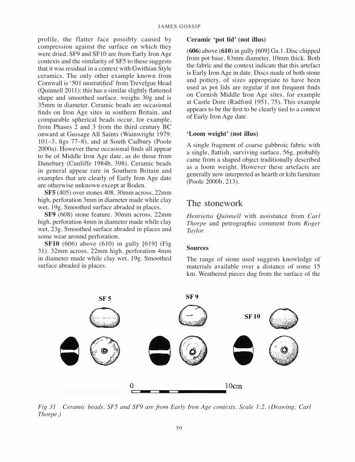
JAMES GOSSIP
50
profile, the flatter face possibly caused by compression against the surface on which they were dried. SF9 and SF10 are from Early Iron Age contexts and the similarity of SF5 to these suggests that it was residual in a context with Gwithian Style ceramics. The only other example known from Cornwall is ‘501 unstratified’ from Trevelgue Head (Quinnell 2011); this has a similar slightly flattened shape and smoothed surface, weighs 30g and is 35mm in diameter. Ceramic beads are occasional finds on Iron Age sites in southern Britain, and comparable spherical beads occur, for example, from Phases 2 and 3 from the third century BC onward at Gussage All Saints (Wainwright 1979, 101–3, figs 77–8), and at South Cadbury (Poole 2000a). However these occasional finds all appear to be of Middle Iron Age date, as do those from Danebury (Cunliffe 1984b, 398). Ceramic beads in general appear rare in Southern Britain and examples that are clearly of Early Iron Age date are otherwise unknown except at Boden.
SF5 (405) over stones 408. 30mm across, 22mm high, perforation 3mm in diameter made while clay wet, 19g. Smoothed surface abraded in places.
SF9 (608) stone feature. 30mm across, 22mm high, perforation 4mm in diameter made while clay wet, 23g. Smoothed surface abraded in places and some wear around perforation.
SF10 (606) above (610) in gully [619] (Fig 31). 32mm across, 22mm high, perforation 4mm in diameter made while clay wet, 19g. Smoothed surface abraded in places.
Ceramic ‘pot lid’ (not illus)
(606) above (610) in gully [609] Ga.1. Disc chipped from pot base, 83mm diameter, 10mm thick. Both the fabric and the context indicate that this artefact is Early Iron Age in date. Discs made of both stone and pottery, of sizes appropriate to have been used as pot lids are regular if not frequent finds on Cornish Middle Iron Age sites, for example at Castle Dore (Radford 1951, 75). This example appears to be the first to be clearly tied to a context of Early Iron Age date.
‘Loom weight’ (not illus)
A single fragment of coarse gabbroic fabric with a single, flattish, surviving surface, 56g, probably came from a shaped object traditionally described as a loom weight. However these artefacts are generally now interpreted as hearth or kiln furniture (Poole 2000b, 213).
The stonework Henrietta Quinnell with assistance from Carl Thorpe and petrographic comment from Roger Taylor
Sources
The range of stone used suggests knowledge of materials available over a distance of some 15 km. Weathered pieces dug from the surface of the
Fig 31 Ceramic beads. SF5 and SF9 are from Early Iron Age contexts. Scale 1:2. (Drawing: Carl Thorpe.)
001-098_Cornwall 52.indd 50 01/12/2014 11:32

a multi-period prehistoric site and fogou at boden vean
51
gabbro outcrop 3 km or more to the south of the site were used in the Middle Bronze Age (S1, Fig 32; S2). S8, the third surface gabbro piece, from Early Iron Age context (410) (Fig 33), could, from its context, have been Middle Bronze Age and re-used. Early Iron Age contexts include S3, a cobble of Tregonning greisen probably from a beach on the west of the Lizard, and S6, hornfels from the same broad area. Contexts of this date have beach cobbles of greywacke sandstone from within about 3 km of the site (S4, S7, S10, S11, S13) and S14 surface greywacke sandstone from within a similar distance. S5 in the fogou is radiolarian chert, most probably from a beach on the west of the Lizard. S9 is surface greisen from the Wendron area of Carnmenellis some 10 km to the north west. S12 and S15 are of surface fragments of volcanic material local to the site. S16, from Late Iron Age (305), is from a raised beach deposit from the local coast.
The collection from the late second-century well infill has S17 and S19 of Tregonning Hill greisen which was regularly used for querns during the Roman period (Quinnell and Watts 2004). The third rotary quern fragment S18 is greisen from Carnmenellis; use of this greisen source during the Roman period has now been demonstrated by artefacts from Tremough (Quinnell 2007, 88). S20 is granite from Carnmenellis, 5 km away across the Helford river. The other artefacts from the ‘well’ were S21 of greywacke sandstone and S22, a gabbro beach cobble which could have been sourced within a few kilometres. The two artefacts which may relate to Gwithian Style ceramics S23 and S24 are both greywacke beach cobbles (Fig 36).
Artefact types
Middle Bronze Age S1 is a fragment of saddle quern of a type well known from sites such as Trethellan (Nowakowski 1991, figs 59–60); S8, if the suggestion of redeposition is accepted, may also represent a quern of this date. Saddle querns continued through the Early Iron Age, although no published comparanda is available from Cornwall; rotary querns do not appear to have been introduced until the Middle Iron Age in south-west Britain (Watts 2003 and for South Cadbury in Somerset, Bellamy 2000). Saddle querns were subsequently used alongside rotary querns until at least the sixth century AD (Quinnell and Watts 2004) which explains S20 from the later second
century ‘well’ deposit in association with rotary fragments S17–19. The rocks selected, gabbro for S1 and S8, granite for S20 and greisens for rotary querns S17–19, have textures which provide some ‘bite’ on the grinding surface which is necessary for efficient working, and were obviously sought out over some distance. The mullers used with saddle querns are represented by S3 and S9 from Early Iron Age contexts and demonstrate the selection of similar rock to the querns, as both are of greisen. The third muller S24 associated with Gwithian Style pottery is assumed to be of the same date as the ceramics; it makes use of a greywacke beach cobble which is naturally flawed to produce a surface with ‘bite’ and has been worn down until it was virtually unusable.
Upper rotary quern fragments S17 and S18 at around 300mm in diameter are small in size. The majority of Cornish rotary querns vary in diameter between 290mm and 480mm (Watts 2003). Smaller diameter querns have been found, for example, at Carn Euny (300mm, Christie 1978, 389, fig 49.8), Castle Gotha (320mm, Saunders and Harris 1982, fig 9, no 4) and Carngoon Bank (300mm, McAvoy 1980, fig 24, no 5). These are Iron Age or Roman period in date. The tendency was for querns to become larger in diameter in the Roman period so the small size may indicate a tradition stretching back into the Iron Age. However S17 in particular appears to have had a long use before its suggested deposition in the later second century AD and could easily have originated in the Later Iron Age. S17 and S18 basically conform to Curwen’s (1937) Wessex type quern, with a hopper and handle hole in the side; the persistence of Iron Age forms of quern into the Roman period appears to be well demonstrated in Cornwall (Watts 2003).
Fig 32 S1, fragment of saddle quern from Middle Bronze Age structure. Scale 1:3. (Drawing: Carl Thorpe.)
001-098_Cornwall 52.indd 51 01/12/2014 11:32

JAMES GOSSIP
52
Whetstones S4, S7, S21 and S23 make use of local greywacke beach cobbles while S6 is a hornfels cobble from the west side of the Lizard; these come from Early Iron Age, second century AD and Gwithian Style contexts. The last of these, S23, is notable for its heavy use, almost square cross-section and the presence of grooves. Whetstones such as S23 are a major feature of the artefact assemblages from Layers C to A at Gwithian, associated with Gwithian Style through to bar-lug ceramics (Nowakowski 2004, appendix 4) and also at Mawgan Porth (Bruce-Mitford 1997, 84) associated with bar-lug. The two rubbing stones S5 and S16 make use of very fine-grained rock and had probably been used on soft materials such as leather; they might better be described as slickstones. Coarser rubbing stones which form a regular feature on Cornish sites from the Middle Bronze Age onward are not present, but this may be because of small assemblage size. S11, S12 and S15, from Early Iron Age contexts, have all been perforated and may have served as weights; S12 and S15 make use of surface fragments of soft volcanic rock. S11 is of greywacke sandstone and has also been rough-trimmed to serve as a ‘potlid’. The larger ‘potlid’ S13 is also of greywacke sandstone. Worked stone pot-lids occur regularly but not frequently in Iron Age contexts (Quinnell 2004, 6.5). S22, a gabbro rock cobble found in the ‘well’ has been used as a pestle. Finally S10, a greywacke sandstone cobble with a notch worked in its side from an Early Iron Age context, may be a net sinker or other fishing weight. This interpretation relies on recent use of similar artefacts from Cornwall observed by Carl Thorpe (pers comm) and from Brittany by the author (Quinnell 2004b, 142); a range of North American material was published by Rau (1884). The connection with fishing, if correct, serves as a reminder that the site, little over 1 km from Gillan Harbour, may have made substantial use of marine resources.
Breakage and deposition
Careful study of the artefacts has established that some appear to have been deliberately broken as their fractures do not relate to weaknesses in the rock which would have occasioned breakage during use. Deliberate breakage occurs only on items related to cereal processing. The absence of impact fractures, which would have occurred had objects been broken up by bashing with large
hammer stones, suggests that much of this breakage may have been brought about by hurling against hard surfaces. Some breakage could have occurred accidentally if objects were dropped from a height, but rock quality indicates that the force necessary for breakage was greater than casual dropping produces. S1, the Middle Bronze Age saddle quern fragment, is of soft rock which could have been accidentally broken. The Early Iron Age muller S3 and saddle quern S8 have deliberate fractures and come from the fogou and the fogou approach. The remaining stone artefacts are from the ‘well’, rotary quern fragments S17–19, saddle quern S20 and pestle S22.
It may be presumed that items deliberately broken were also deliberately deposited. This presumption is supported by the artefacts from the ‘well’: five out of six of these were deliberately broken and deposited in conjunction with larger-than-average sherds. It may be significant that the other two deliberately broken items were deposited within the fogou and the fogou approach, contexts on which ritualised behaviour may have focussed. The most notable item of structured deposition was found complete, the small polishing stone S5 of shiny black radiolarian chert found placed against one of the fogou uprights.
Recent studies are beginning to focus on the symbolic meaning of querns and cereal processing equipment among later prehistoric communities and the consequent ways in which these artefacts may have been deliberately broken and deposited. It is suggested that symbolical links can be made between querns as transformers of raw materials into usable products and agricultural, human and building life cycles (Hill 1995, 131; Poole 1995, 262; Bellamy 2000, 314; Watts 2012). These ideas have been developed by Sue Watts in doctoral research at the University of Exeter.
Descriptions of artefacts
Middle Bronze Age structure
S1 (105) sf1 s to n y f i l l i n s t r u c t u r e (Fig 32).
Fragment of saddle quern, 60mm thick, surviving dimensions 85 × 80mm, upper surface worn slightly concave, possible trimming around edge. Gabbro rock, weathered so not a beach cobble but probably taken from the surface of
001-098_Cornwall 52.indd 52 01/12/2014 11:32
a multi-period prehistoric site and fogou at boden vean
53
the gabbro outcrop. The soft condition due to weathering means it is not possible to say whether the object has been deliberately broken.
S2 (105) sf2 s to n y f i l l i n s t r u c t u r e (n o t i l l u s) .
Part of large rounded weathered fragment of gabbro rock, somewhat foliated, possibly used as hammer stone, surviving dimensions 180 × 135 × 100mm. Excavated from surface of gabbro outcrop area.
Fogou infill, Early Iron Age
S3 (806) p r i m a ry f i l l (Fig 33).End of large cobble muller, one side worn flat
and very slightly convex, surviving dimensions 130 × 130 × 63mm thick; impact marks from use have formed flattening of edges. The cobble is of Tregonning greisen probably collected from a beach on the north west of the Lizard. The rock is tough, suggesting that the object has been deliberately broken.
S4 (806) p r i m a ry f i l l (n o t i l l u s) .Part of cobble whetstone, surviving dimensions
100 × 45 × 23mm. Fine grained greywacke sandstone, Gramscatho Formation. Broken on plane of natural weakness.
S5 (805) sf15 f i l l a b o v e (806) r e s t i n g a g a i n s t o n e o f t h e u p r i g h t s (Fig 33).
Pebble polishing stone, 67 × 50 × 18mm, surface naturally glossy but made more so by use on the broader long edge. Beach pebble of black radiolarian chert with narrow quartz veins. Cherts of this kind are associated with the pillow lavas of Mullion Island on the west side of the Lizard although there may be similar cherts at Nelly’s Cove near Porthallow on the east.
Fogou approach trench [433], Early Iron Age
S6 (423) m a i n f i l l o f [433] (Fig 33).Whetstone using elongated cobble, 130 × 27 ×
15mm, two adjacent facets worn smooth and glossy on one face, upper end (as illustrated) has patch of abrasion. Fine grained metasedimentary rock with quartz and some orientated chlorite/biotite, possibly a hornfels derived from the margins of the Tregonning-Godolphin Granite.
S7 (423) m a i n f i l l o f (433) (n o t i l l u s) .Slightly water worn cobble, 110 × 67 × 23mm,
one surface worn flat from use as whetstone with slight grooves in different directions. Fine grained greywacke sandstone Gramscatho Formation.
S8 (410) sf15 l i n e a r s e t t i n g o f s to n e s (Fig 33).
Fragment of saddle quern, one surface worn and slightly concave, minimum surviving dimensions 130 × 100 × 80mm thick. Of gabbro rock, with moderate weathering which has affected the survival of the worked surface. Rock dug out from gabbro outcrop area and sufficiently tough to have been deliberately broken.
S9 (401) l i n e a r s e t t i n g o f s to n e s (Fig 33).
Part of muller using greisen surface fragment, one surface worn flat and slightly convex, no indications of dressing, surviving dimensions 80 × 65 × 58mm thick. Quartz mica tourmaline greisen from the surface on the east side of the Carnmenellis granite.
S10 (401) l i n e a r s e t t i n g o f s to n e s (Fig 33).
Tabular cobble with notch rough worked in one side, 88 × 54 × 8mm thick. Net sinker? Medium grained greywacke Gramscatho Formation sandstone.
Cut [412], Early Iron Age
S11 (411) f i l l i n [412] (Fig 33).Weight, possibly re-used as pot lid. Tabular
cobble with irregular hole worked through from both sides; marks of small point clearly visible around outer edges of hole, but inner side much worn. Coarse dressing around outside has not been worn. Fine grained greywacke sandstone, Gramscatho Formation.
Ditch [609], Early Iron Age
S12 (606) m a i n f i l l o f [609] (Fig 33).?Weight with irregular hour-glass perforation,
broken, surviving dimensions 60 × 26 × 12mm. Possible subsequent damage on end. Tabular, surface volcanic fragment, probably from a source local to the site.
001-098_Cornwall 52.indd 53 01/12/2014 11:32
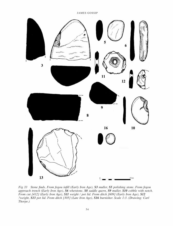
JAMES GOSSIP
54
Fig 33 Stone finds. From fogou infill (Early Iron Age), S3 muller, S5 polishing stone. From fogou approach trench (Early Iron Age), S6 whetstone, S8 saddle quern, S9 muller, S10 cobble with notch. From cut [412] (Early Iron Age), S11 weight / pot lid. From ditch [609] (Early Iron Age), S12 ?weight, S13 pot lid. From ditch [305] (Late Iron Age), S16 burnisher. Scale 1:3. (Drawing: Carl Thorpe.)
001-098_Cornwall 52.indd 54 01/12/2014 11:32
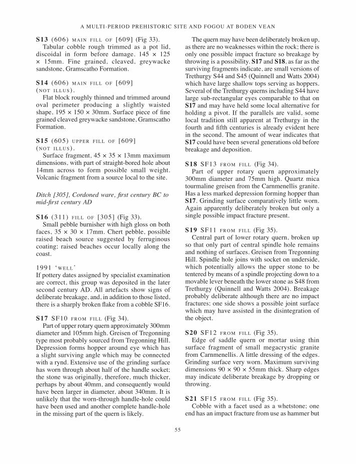
a multi-period prehistoric site and fogou at boden vean
55
S13 (606) m a i n f i l l o f [609] (Fig 33).Tabular cobble rough trimmed as a pot lid,
discoidal in form before damage. 145 × 125 × 15mm. Fine grained, cleaved, greywacke sandstone, Gramscatho Formation.
S14 (606) m a i n f i l l o f [609] (n o t i l l u s) .
Flat block roughly thinned and trimmed around oval perimeter producing a slightly waisted shape, 195 × 150 × 30mm. Surface piece of fine grained cleaved greywacke sandstone, Gramscatho Formation.
S15 (605) u p p e r f i l l o f [609] (n o t i l l u s) .
Surface fragment, 45 × 35 × 13mm maximum dimensions, with part of straight-bored hole about 14mm across to form possible small weight. Volcanic fragment from a source local to the site.
Ditch [305], Cordoned ware, first century BC to mid-first century AD
S16 (311) f i l l o f [305] (Fig 33).Small pebble burnisher with high gloss on both
faces, 35 × 30 × 17mm. Chert pebble, possible raised beach source suggested by ferruginous coating; raised beaches occur locally along the coast.
1991 ‘w e l l’If pottery dates assigned by specialist examination are correct, this group was deposited in the later second century AD. All artefacts show signs of deliberate breakage, and, in addition to those listed, there is a sharply broken flake from a cobble SF16.
S17 sf10 f r o m f i l l (Fig 34).Part of upper rotary quern approximately 300mm
diameter and 105mm high. Greisen of Tregonning type most probably sourced from Tregonning Hill. Depression forms hopper around eye which has a slight surviving angle which may be connected with a rynd. Extensive use of the grinding surface has worn through about half of the handle socket; the stone was originally, therefore, much thicker, perhaps by about 40mm, and consequently would have been larger in diameter, about 340mm. It is unlikely that the worn-through handle-hole could have been used and another complete handle-hole in the missing part of the quern is likely.
The quern may have been deliberately broken up, as there are no weaknesses within the rock; there is only one possible impact fracture so breakage by throwing is a possibility. S17 and S18, as far as the surviving fragments indicate, are small versions of Trethurgy S44 and S45 (Quinnell and Watts 2004) which have large shallow tops serving as hoppers. Several of the Trethurgy querns including S44 have large sub-rectangular eyes comparable to that on S17 and may have held some local alternative for holding a pivot. If the parallels are valid, some local tradition still apparent at Trethurgy in the fourth and fifth centuries is already evident here in the second. The amount of wear indicates that S17 could have been several generations old before breakage and deposition.
S18 sf13 f r o m f i l l (Fig 34).Part of upper rotary quern approximately
300mm diameter and 75mm high. Quartz mica tourmaline greisen from the Carnmenellis granite. Has a less marked depression forming hopper than S17. Grinding surface comparatively little worn. Again apparently deliberately broken but only a single possible impact fracture present.
S19 sf11 f r o m f i l l (Fig 35).Central part of lower rotary quern, broken up
so that only part of central spindle hole remains and nothing of surfaces. Greisen from Tregonning Hill. Spindle hole joins with socket on underside, which potentially allows the upper stone to be tentered by means of a spindle projecting down to a movable lever beneath the lower stone as S48 from Trethurgy (Quinnell and Watts 2004). Breakage probably deliberate although there are no impact fractures; one side shows a possible joint surface which may have assisted in the disintegration of the object.
S20 sf12 f r o m f i l l (Fig 35).Edge of saddle quern or mortar using thin
surface fragment of small megacrystic granite from Carnmenellis. A little dressing of the edges. Grinding surface very worn. Maximum surviving dimensions 90 × 90 × 55mm thick. Sharp edges may indicate deliberate breakage by dropping or throwing.
S21 sf15 f r o m f i l l (Fig 35).Cobble with a facet used as a whetstone; one
end has an impact fracture from use as hammer but
001-098_Cornwall 52.indd 55 01/12/2014 11:32
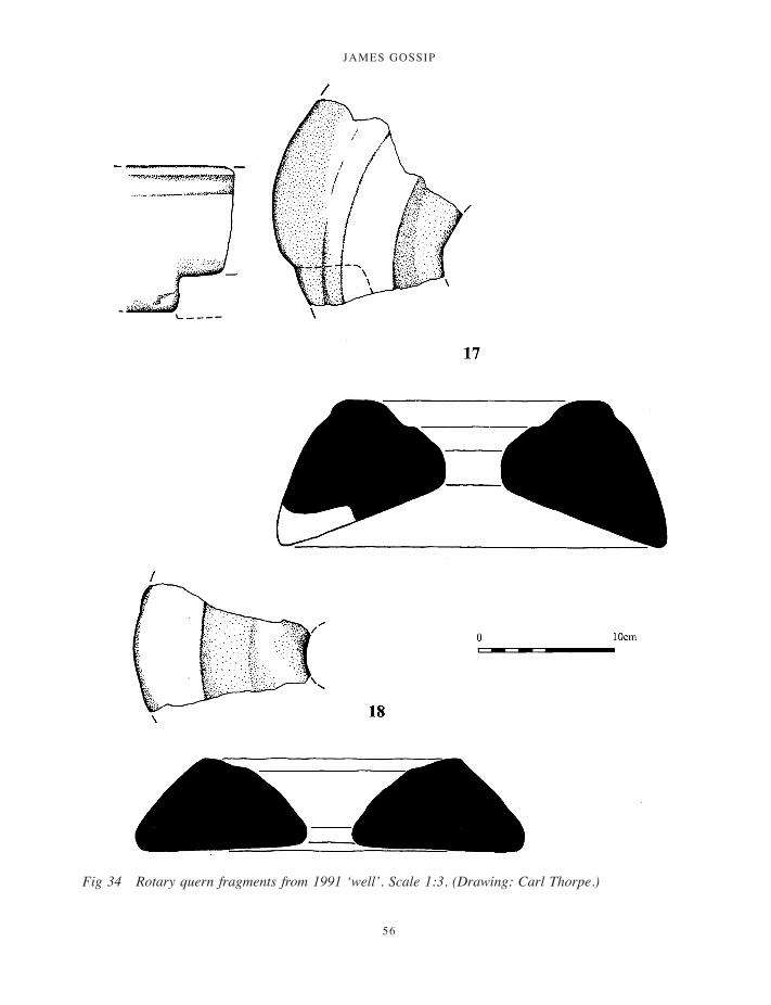
JAMES GOSSIP
56
Fig 34 Rotary quern fragments from 1991 ‘well’. Scale 1:3. (Drawing: Carl Thorpe.)
001-098_Cornwall 52.indd 56 01/12/2014 11:32

a multi-period prehistoric site and fogou at boden vean
57
other damage is recent. Fine grained greywacke sandstone in which thin quartz veins cause facets, Gramscatho Formation. 170+ × 55 × 37mm.
S22 sf14 f r o m f i l l (Fig 35).Elongated cobble of striking black and white
colouring; abraded end indicates use as a pestle or hammer stone. Deliberate sharp fracture across centre. Sheared gabbro cobble from beaches around Lizard. Surviving dimensions 125 × 68 × 50mm.
Associated with Gwithian Style ceramics in upper ditch
S23 i n d i t c h l ay e r (314) (Fig 36).Whetstone using slightly waterworn elongated
cobble; facets worn smooth and glossy on all sides, especially along edge. Groups of deep grooves from sharpening of points. Fine grained greywacke
sandstone, Gramscatho Formation. Sharply broken across, also blow has caused damage to one end. Surviving maximum dimensions 154 × 48 × 24mm.
S24 sf6 f r o m (303) s o i l i n e n t r a n c e (Fig 36).
Flake from large cobble heavily used as muller with convex surface, apparent scratches due to deformation flaws in rock. Hard fine grained greywacke sandstone Gramscatho Formation. 150 × 142 × 42mm.
‘Slingstones’ and unused pebbles and cobbles
A total of 24 pebbles between 30 and 50mm but generally about 40mm in length may have been slingstones (Table 6). Their average weight is 45g. The groups of two or three from specific contexts appear to have been found close together. However, there are a few pebbles both smaller and
Fig 35 S19–S22 from 1991 ‘well’; S19, rotary quern; S20, saddle quern or mortar; S21, whetstone; S22, pestle. Scale 1:3. (Drawing: Carl Thorpe.)
001-098_Cornwall 52.indd 57 01/12/2014 11:32
JAMES GOSSIP
58
larger in size, some from the same contexts as the suggested slingstones. Overall, together with the beach pebbles and cobbles described above, they indicate considerable use of seaside deposits which occur some 2 km east of the site.
Non-ceramic beads and other items Dawn McLaren and Fraser Hunter
Glass bead. Globular translucent dark blue glass bead, D-sectioned, with a perforation 3.5mm deep. One side has a protrusion where it was detached from a larger blob during manufacture. It is very worn on the ends and circumference, implying lengthy use in a necklace rather than as a pendant.
This bead falls into Guido’s (1978, 70) group 7 (iv). Such beads are a long-lived type, starting in the later first millennium BC and continuing throughout the first millennium AD. This is a particularly early example: the context suggests an Early-Middle Iron Age date (connected with the use of the fogou, with a terminus post quem of 420–350 cal BC for its construction). Depth 9.5mm, height 7mm. Sample <1018>, context (806), from layer above floor in fogou.
Amber bead of Beck and Shennan’s group 1B (1991, 53): D-sectioned, rather irregular annular bead with narrow cylindrical central perforation (depth 1mm). Their survey suggests the type is undiagnostic, but the context suggests a late fifth- to fourth-century BC date. One edge was damaged
Table 6 Findspots and numbers of possible slingstones
Context Date Nos Context Date Nos
(200) top of enclosure ditch Early Iron Age 1 (430) in gully [431] Early Iron Age 1Tr 2 unstratified – 1 Tr 4 unstratified – 3(306) in gully [307] Uncertain 1 (606) in gully [609] Early Iron Age 2Tr 3 unstratified – 1 (610) in gully [609] Early Iron Age 1(403) over stones (408) Gwithian Style 3 (804) fogou infill Early Iron Age 2(406) over (411) in cut [412] Early Iron Age 1 Tr 8 unstratified – 1(411) in cut [412] Early Iron Age 3 (904) fogou infill Early Iron Age 3
Fig 36 S23–S24 associated with Gwithian Style ceramics in upper fill of enclosure ditch. S23, whetstone; S24, muller. Scale 1:3. (Drawing: Carl Thorpe.)
001-098_Cornwall 52.indd 58 01/12/2014 11:32

a multi-period prehistoric site and fogou at boden vean
59
in antiquity; a light brown patina covers all the surfaces. Length 6.5mm, width 5mm, thickness 4 mm, mass 0.08 g. Sample <1018>, context (806), from layer above floor in fogou.
Glass fragments. Two fragments of light-blue glass; no indication of their original form. Measures 5mm × 4.5mm × 3.5 mm and 3.5mm × 2.5mm × 2.5 mm; mass 0.1g. Sample <1019>, context (107), associated with the Bronze Age structure.
Discussion
Neither bead is chronologically diagnostic in itself, but they are consistent with the late fifth- to fourth-century BC date suggested for occupation of the fogou. They are an important discovery, as it is unusual to get beads in secure, well-dated contexts, and even rarer to get dates so early in the Iron Age for these types. Both show signs of prolonged use: the glass bead is worn while the amber bead continued in use after the edge had partly broken.
Iron Age amber has seen rather limited study. This appears to be the first certain Iron Age amber bead from Cornwall, but there are examples from elsewhere (for example, the East Yorkshire cemeteries and a promontory fort at Caeru, Henllan, Cardiganshire: Stead 1991, 93, 224, fig.69; Stead 1965, 65; Savory 1976, 72–3). It is an indicator of exotic contacts: the ultimate source was the Baltic, but the more immediate source may well be pieces washed onto the eastern coastline of Britain.
Small dark-blue translucent beads are a long-lived and common find on settlement sites in Cornwall as elsewhere, but there are no comparably early local examples. Two similar beads and one opaque blue example come from fourth-century AD and later contexts at Trethurgy round (Price 2004, 89). A similar bead, perhaps of Roman date, came from the Goldherring settlement (Guthrie 1969, 27). Other Cornish examples of Guido type 7(iv) of Iron Age to Roman date come from
Halangy Down, St Mary’s, Isles of Scilly (Ashbee 1996, 72, no.2, fig 34.1), Nornour, Isles of Scilly, and St Mawgan-in-Pydar (Guido 1978, 169), while closely-similar type 6(iv) annular beads are known from Iron Age or Roman contexts at Castle Dore, Fowey, and Kynance Gate, Mullion (Guido 1978, 155). Although these beads are more common from the Later Iron Age onwards, several earlier examples may be cited. There is one of third- to first-century BC date from Meare, Somerset (Gray 1966, 290–1), while several were found at Danebury (Henderson 1984, 396–8; Cunliffe 1984a, 197), from ceramic phases 4 and 7, dating to 450–400 cal BC and 300–100/50 cal BC.
Two small unidentified fragments of light-blue glass were found in association with a possible Bronze Age structure. Although Bronze Age glass of similar colour has been found elsewhere, such as Stockbridge, Hampshire (Guido 1978, 20) and Hauterive-Champréveyres, Switzerland (Henderson 1988, 441, pl 1), the fragments in this case are too small and abraded to confirm their date or origin without further scientific analysis of their composition. Early glass is known from Cornwall: an imported Mediterranean oblong glass bead was recovered during the excavation of a Bronze Age cremation burial at Boscregan, St Just-in-Penwith (Borlase 1879, pl 16, no. 3).
The flintAnna Lawson-Jones
The assemblage comprised 127 pieces of flint and chert: 93 were collected during field-walking in 2002, 18 during the 2003 field-walking exercise and 16 from the 2003 excavation. A detailed assessment was carried out but no further analysis was recommended. None of the material is illustrated. Table 7 shows a simplified breakdown of the assemblage in terms of location, source and material.
Table 7 Summary of flints
Complete pebbles Primary (50–100% cortex)
Secondary (1–50% cortex)
Tertiary (no cortex)
Cores (% cortex not recorded)
Abraded / battered
Burnt Waste (not used)
1991 collection 0 5 2 2 0 0 1 02002 field-walking 33 58 23 9 3 17 11 142003 excavation 5 11 2 1 2 1 2 32003 field-walking 0 (not collected?) 5 8 5 0 3 0 3Totals 38 79 35 17 5 21 14 20
001-098_Cornwall 52.indd 59 01/12/2014 11:32

JAMES GOSSIP
60
The assemblage was not the result of selective collection and a number of non-utilised flint and chert pebbles were collected. Some of these can be disregarded as later agricultural additions but others are likely to represent part of the archaeological assemblage.
The assemblage is diverse in terms of sources of raw material, date, levels of abrasion and burning and types of use or activity reflected; it includes indistinguishable lumps, waste pieces and much finer specialised tools. Very little of the material was found in close association with related or contemporary contexts with the exception of single split chert pebble from roundhouse fill (107) in trench 1 although this is not diagnostically Bronze Age. A visually distinctive notched blade was also collected from trench 1 but this was unstratified. All other pieces appeared to be residual and redeposited in later deposits. Trench 3 produced five pieces, probably reflecting the larger area of excavation rather than a limited concentration of lithic activity in comparison with trench 1. Of these, two were burnt and two were complete pebbles, found in the uppermost enclosure ditch fill (310). One of the pebbles could perhaps be sling shot, on the basis of size and shape. The third flint from (310), again considered residual on the basis of context, is a comparatively large ovate knife worked on a primary pebble flake. The two remaining pieces are burnt. One is blistered and unstratified, but the remaining one is a split pebble (probable engraver tool). None of the pieces from trench 3 are diagnostically Bronze Age, although they would not be out of place in such a context (with the exception of the probable late Neolithic knife). Deposits (403) and (407) in trench 4 produced two pieces: a complete, small unmodified pebble, and a burin removal possibly utilised in its unmodified form as a borer, possibly a redeposited Bronze Age flint. Trench 6 produced two pieces of probable Bronze Age origin; an unstratified nodular core, with post-core (presumably Bronze Age) re-use as a steep edged scraper. It is not a classifiable form and as such is not diagnostic in terms of date (although its nodular source gives an earlier Neolithic date for its primary use). The second piece, a split pebble scraper with abrupt, unsystematic retouch, came from context (605), the upper fill of a curvilinear ditch [609], dated to the Iron Age. Five pieces were recovered from trench 8 including two complete and one split pebble which were found in the main fill (804) of the fogou.
Sealed below this was fill (805) which produced a single, battered split chopper-like knife made on a probable oval shaped uniformly flat pebble. It has undergone heavy use, which has left the piece with a very crushed and blunted appearance along the length of its working edge. The remaining, unstratified piece has had a burin removal and appears to form a fine engraver (with very limited use wear). The excavated material clearly shows that during later re-use of the site residual flint was disturbed, exposed and occasionally reused.
Overall, a variety of utilised tools is present, but they represented a small percentage of the total assemblage. A number of the pieces had seen clear use but little in the way of deliberate modification. Where retouch was noted, it varied between very fine, small-scale modification to comparatively rough execution. This is primarily a reflection of date and contemporary tool type/reduction procedures.
The potential date for the assemblage ranges from the Mesolithic through to the Bronze Age. Elements of Neolithic material came from the broadly identified ‘concentrations’ of material around field-walking grid squares D2, B5, C5 and D5. Material that was Bronze Age in character was marginally more recognisable within squares B1, B2 and B3 (Fig 3).
Core rejuvenation pieces found in grid squares A5, C2 and C6 (Fig 3) are more strongly suggestive of a Neolithic rather than Bronze Age date. Although rejuvenation pieces are found throughout the Mesolithic and Neolithic periods, the three examples from Boden were not typically Mesolithic in character. Rejuvenation pieces can also be a more frequent element within pebble-based industries as knappers tried to maximise pebble core use, but again are less frequent within Bronze Age assemblages.
The vast majority of the assemblage consists of pebble material, primarily flint (rather than chert). The worked nodular material clearly indicates an earlier Neolithic presence. A small number of finely worked and retouched blades and bladelets, and many which have been broken, and the lack of specialised blade cores, tranchet flakes, microliths or microburins (the resultant waste from microlith production) implies that this material is either very early Neolithic or, if Mesolithic, is only peripheral to more intensive activity that would be suggested by a fuller range of material. The relative lack of burnt pieces may suggest that the focus for earlier domestic activity is further away.
001-098_Cornwall 52.indd 60 01/12/2014 11:32

a multi-period prehistoric site and fogou at boden vean
61
A good proportion of the assemblage consists of flakes and broad (or flake-like) blades, plus occasional flake cores. Some of these pieces may be Neolithic but much of it is considered to be generally Bronze Age in date, although very little of it is diagnostically so (with the exception of a thumb-nail scraper). The relative lack of closely associated Bronze Age domestic flint work is not an unusual feature.
In terms of types of activity represented by the assemblage, it is clear that raw material derived from primary or secondary beach sources, and that core preparation, core reduction and tool production took place on site. Tool types varied from the finely worked to the spontaneously produced and included scrapers, knives, engravers, awls/points, denticulated pieces and waste (reflective primarily of production but also of breakage (and burning)). These pieces reflect activities focussed around a domestic or peripherally domestic setting. No ‘special’ pieces with an obviously more ritual than domestic association were identified. Similarly no arrowheads or other particularly conspicuous examples of fine workmanship were identified within the collection.
To summarise, this collection reflects a typically mixed, plough-dispersed assemblage found within a field that has undergone soil improvement in the form of beach sand introduction and which consequently included beach pebbles. The date range is broad, from the Mesolithic/Early Neolithic to the Bronze Age. Few of the pieces are diagnostic, but the use of nodular material does indicate a definite Early Neolithic date. Some limited evidence for the re-use of artefacts was recorded. Minor concentrations of material were noted in the two field walking exercises, but none were sufficiently concentrated or diagnostic in terms of date to allow specific interpretation or identify focuses of activity. The slight slope of the field in conjunction with ploughing will have had an affect on the movement of material within the plough-soil, although this was probably minimal.
Environmental reportsThe limpet shells
Jan Light
A small deposit of limpet shells was retrieved from context (203) within the enclosure ditch [202] (Fig
10). These were assessed but no further analysis was recommended.
Description
A sample comprised two complete limpet shells and partial shells and fragments representing probably no more than ten further individuals. The shells were all of the genus Patella but it was not possible to say with certainty whether they were all the common limpet P. vulgata which inhabits all levels of the shore, or whether either of the two species which have more restricted distributions were present. Patella depressa is a low-spired species which is most frequent at midshore level and P. ulyssiponensis is a species of the lower shore and permanently submerged pools across the littoral zone. The shells and fragments in the sample were all from small, low-spired individuals and the impression gained is that both P. vulgata and P. ulyssiponensis may have been present.
The shells were in poor condition: they were chalky and their mode of fracture was annular. This is typical in limpets where the shell material has been weakened. This very corroded condition was consistent with the level of preservation which is observed in shells that have been sealed in acidic soils. A number of the shells lacked their apex. Holed shells are a recurring feature at archaeological sites where molluscs are retrieved and the perforations can be ascribed to a wide variety of natural and unnatural processes. In nearly all instances of holed limpet shells where the apical region is missing leaving an oval ‘collar’ of shell, the process of breakage is natural in that fracture has occurred along the weaker growth lines of the shell.
In addition to Patella, amongst the small fragments and associated soil there were two corroded basal whorl fragments of the common dog whelk, Nucella lapillus, and a worn specimen of the land snail, Aegopinella nitidula.
Significance
The limpet shell assemblage was probably food waste dumped into the open ditch as discarded rubbish. On stratigraphic evidence this occurred in the Early Iron Age or soon afterwards.
001-098_Cornwall 52.indd 61 01/12/2014 11:32
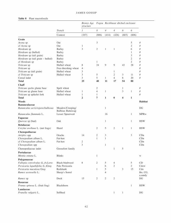
JAMES GOSSIP
62
Table 8 Plant macrofossils
Bronze Age structure
Fogou Rectilinear ditched enclosure
Trench 1 8 4 4 6 6
Context (107) (806) (414) (426) (603) (606)
GrainAvena sp Oat 3 5 #cf Avena sp Oat 1 2 #Hordeum sp Barley 3 2 1 1 6 #Hordeum sp (hulled) Barley 1 #Hordeum sp (tail grain) Barley 3 #Hordeum sp (tail grain – hulled) Barley 2 #cf Hordeum sp Barley 1 2 #Triticum sp Hulled wheat 8 24 9 9 43 28 #Triticum sp Free-threshing wheat 4 #Triticum sp (tail grain) Hulled wheat 3 1 #cf Triticum sp Hulled wheat 3 5 2 3 11 #Cereal indet 3 5 1 4 8 20 #Total 25 40 11 17 54 80ChaffTriticum spelta glume base Spelt wheat 2 1 #Triticum sp glume base Hulled wheat 1 4 1 3 1 #Triticum sp spikelet fork Hulled wheat 1 1 #Total 2 7 1 0 4 1Weeds Habitat RanunculaceaeRanunculus acris/repens/bulbosus Meadow/Creeping/
Bulbous Buttercup1 DG
Ranunculus flammula L. Lesser Spearwort 16 1 MPRwFagaceaeQuercus sp (bud) Oak 1 1 HSWBetulaceaeCorylus avellana L. (nut frags) Hazel 2 5 2 1 1 HSWChenopodiaceaeAtriplex spp Orache 14 2 3 3 CDnChenopodium album L. Fat-hen 1 1 CDncf Chenopodium album L. Fat-hen 2 CDnChenopodium spp 3 1 CDnChenopodiaceae indet Goosefoot family 1 5PortulaceaeMontia ontana L. Blinks 1 wPolygonaceaeFallopia convolvulus (L.)A.Love Black-bindweed 8 2 5 4 5 CDPersicaria lapathifolia (L.)Gray Pale Persicaria 6 2 2 CdowPersicaria maculosa Gray Redshank 1 5 3 15 CdoRumex acetosella L. Sheep’s Sorrel 4 Ho, CG,
a,sandyRumex sp Dock 15 2 2 2 DGRosaceaePrunus spinosa L. (fruit frag) Blackthorn 1 HSWLamiaceaePrunella vulgaris L. Selfheal 1 1 DG
001-098_Cornwall 52.indd 62 01/12/2014 11:32
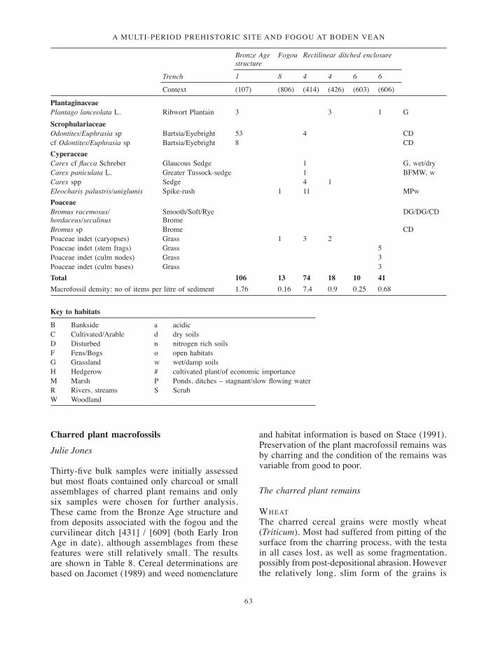
a multi-period prehistoric site and fogou at boden vean
63
Charred plant macrofossils
Julie Jones
Thirty-five bulk samples were initially assessed but most floats contained only charcoal or small assemblages of charred plant remains and only six samples were chosen for further analysis. These came from the Bronze Age structure and from deposits associated with the fogou and the curvilinear ditch [431] / [609] (both Early Iron Age in date), although assemblages from these features were still relatively small. The results are shown in Table 8. Cereal determinations are based on Jacomet (1989) and weed nomenclature
and habitat information is based on Stace (1991). Preservation of the plant macrofossil remains was by charring and the condition of the remains was variable from good to poor.
The charred plant remains
wh e atThe charred cereal grains were mostly wheat (Triticum). Most had suffered from pitting of the surface from the charring process, with the testa in all cases lost, as well as some fragmentation, possibly from post-depositional abrasion. However the relatively long, slim form of the grains is
Bronze Age structure
Fogou Rectilinear ditched enclosure
Trench 1 8 4 4 6 6
Context (107) (806) (414) (426) (603) (606)
PlantaginaceaePlantago lanceolata L. Ribwort Plantain 3 3 1 GScrophulariaceaeOdontites/Euphrasia sp Bartsia/Eyebright 53 4 CDcf Odontites/Euphrasia sp Bartsia/Eyebright 8 CDCyperaceaeCarex cf flacca Schreber Glaucous Sedge 1 G, wet/dryCarex paniculata L. Greater Tussock-sedge 1 BFMW, wCarex spp Sedge 4 1Eleocharis palustris/uniglumis Spike-rush 1 11 MPwPoaceaeBromus racemosus/hordaceus/secalinus
Smooth/Soft/Rye Brome
DG/DG/CD
Bromus sp Brome CDPoaceae indet (caryopses) Grass 1 3 2Poaceae indet (stem frags) Grass 5Poaceae indet (culm nodes) Grass 3Poaceae indet (culm bases) Grass 3Total 106 13 74 18 10 41Macrofossil density: no of items per litre of sediment 1.76 0.16 7.4 0.9 0.25 0.68
Key to habitats
B Bankside a acidicC Cultivated/Arable d dry soilsD Disturbed n nitrogen rich soilsF Fens/Bogs o open habitatsG Grassland w wet/damp soilsH Hedgerow # cultivated plant/of economic importanceM Marsh P Ponds, ditches – stagnant/slow flowing waterR Rivers, streams S ScrubW Woodland
001-098_Cornwall 52.indd 63 01/12/2014 11:32

JAMES GOSSIP
64
characteristic of a glumed wheat, possibly emmer (Triticum dicoccum) or spelt (Triticum spelta). Unfortunately in most samples wheat chaff was poorly preserved although in two samples Triticum spelta glume bases showing characteristic keel and surface striations confirmed the presence of spelt. Charcoal-rich silt clay deposit (107) within the Bronze Age roundhouse included a small assemblage of cereal grains. These were mostly hulled wheat, a single spikelet fork and glume base confirming this although unfortunately they were not well enough preserved to confirm if this was emmer or spelt. In addition to hulled wheat grains there were four shorter, more rounded grains, typical of free-threshing wheat. Wheat grains were also from the base of the fogou in deposit (806), while the largest deposit was recovered from the charcoal-rich fill (606) from ditch [609]. Also of note were the large quantities of wheat grain from deposit (603), the fill of pit [604].
ba r l e y a n d o at sBoth barley (Hordeum) and oats (Avena) formed a minor component of the assemblages. Single barley grains were recovered from (414) and (426) (pit fills within the rectilinear enclosure), two grains from fogou deposit (806) and numerous grains from (606). Barley was also recovered from (107), the Bronze Age structure. The barley was generally in poor condition with much of the grain surface lost during charring although in several instances evidence of the fused lemma and palaea suggest that hulled barley was present. Oats only occurred in a few samples, but no oat floret bases were found to suggest whether these were cultivated or wild.
ar a b l e w e e d sA range of arable weeds occurred in all samples; again these were in fair to poor condition, a fine covering of sediment in some cases obscuring surface patterning. The charring process also appears to have affected preservation of some taxa. Some of the Chenopodiaceae (Goosefoot family) seeds appeared to have swollen and split with much of the testa lost making identification to species impossible.
However, many of the Chenopodiaceae family occur in cultivated and disturbed ground and like many of the other taxa present in most samples are commonly recovered in association with charred cereal remains. Species such as orache (Atriplex), bartsia /eyebright (Odontites /Euphrasia), black
bindweed (Fallopia convolvulus) and pale persicaria (Persicaria lapathifolia) would have occurred as impurities in fields where crops were being grown and been gathered at harvest. Most of these weeds do not have any specific soil preferences and could have occurred locally. Taxa such as selfheal (Prunella vulgaris), ribwort plantain (Plantago lanceolata) and grasses (Poaceae) may suggest field margins more akin to grassland habitats or have come from adjacent pasture.
A further small group included taxa typical of wetland habitats, including spike-rush (Eleocharis palustris/uniglumis), blinks (Montia fontana) and glaucous sedge (Carex flacca). Both redshank (Persicaria maculosa) and pale persicaria (Persicaria lapathifolia), while typical of bare and cultivated ground, often occur in close association with water margins. It may be possible that these grew on ditched field margins where water levels remained high and have been gathered with the crops at harvest, or they may have been gathered as flooring material, subsequently discarded onto the hearth where they became charred.
ot h e r s p e c i e sA final group of woody plants includes hazel (Corylus avellana), sloe (Prunus spinosa) and oak (Quercus) buds, which were likely to have originated from wood collected for the hearth. The charcoal analysis (Gale, below) suggested much of the charcoal was probably residues or dumps of domestic hearth debris, gathered from a range of species, although both hazel and sloe may be the remains of food waste.
di s c u s s i o n Although the features produced fairly limited assemblages of charred plant remains it was hoped that the results would add to the fairly limited knowledge of crop husbandry in the south west, particularly Cornwall and Devon, where despite large scale sampling and sieving programmes, little data has been recovered (Campbell and Straker 2003).
The charred macrofossil density at Boden was calculated by determining the number of items per litre of sediment sampled (Table 8). Concentrations were generally low with 1.76 for the feature (context (107)) from the Bronze Age structure, 0.16 for the fogou structure (806), and 0.25 to 7.4 for contexts (414), (426), (603) and (606) from the
001-098_Cornwall 52.indd 64 01/12/2014 11:32

a multi-period prehistoric site and fogou at boden vean
65
Iron Age curvilinear ditch. Campbell and Straker (2003) calculate that during the prehistoric period the average density for most sites falls between 0.1 and 39, but with the majority producing below 1 item per litre.
Although macrofossil density was fairly low, it was clear from the limited evidence that crops of hulled wheat and barley were being consumed during the Bronze Age, with spelt wheat definitely present from the Early Iron Age phase. There is also the possibility of free-threshing wheat from the Bronze Age structure. While the charred remains from the Bronze Age phase can be more directly linked with domestic activities within the structure, the later features associated with the enclosure and fogou structure were secondary contexts. It was therefore difficult to be specific about the origin of material from these contexts and the possibility of mixing of deposits from different sources needs to be considered.
Apart from the cereal remains many of the remaining plant taxa were weeds of cultivation or disturbed soils and commonly occur as arable weeds. These would have been collected with the crops at harvest and with the occasional chaff fragments also present may have been deposited as burnt crop cleaning waste. It is difficult to suggest crop husbandry practices from the arable weed assemblages, as many of the taxa recovered can occur on a wide range of soil types but the fact that a similar range of weeds occurred through all the periods investigated may suggest that cultivation was local and crop processing activities occurred on the site. Many of the weed seeds were small and would have been retained as part of the sieving process carried out to retrieve cleaned grain; this waste material then finding its way onto the hearth, perhaps as tinder or from floor sweepings.
The small suite of wetland indicators suggests that perhaps some more marginal ground was at times cultivated or perhaps that some field margins were ditched, producing ‘wet boundaries’ which would have supported those species typically associated with wet ground. Wetland plants, like sedges and rushes, were also collected as flooring and roofing material, so this may have been the origin of these plants. Other wild species collected possibly to supplement the diet include hazel and sloe, although these may have come from wood collected for the hearth.
The geophysical survey indicated that the site lay within a landscape of field systems and associated features (Linford, below). This supports the view that crops were cultivated in fields close to these features and that local crop processing for consumption of the local inhabitants occurred.Comparison with other sitesA number of Bronze Age sites in Cornwall have also produced evidence for charred plant remains. At Trethellan Farm cereal cultivation appeared to have been primarily naked barley, with emmer, some oats and occasional Celtic bean (Straker 1991). Like Boden, the Trethellan settlement was close to a contemporary field system, so it is likely that crops were locally cultivated.
Samples taken from postholes of the Middle Bronze Age roundhouse at Trevilson produced small assemblages of wheat, barley and oat grains associated with arable weeds (Jones and Taylor 2004). A shallow scoop in the interior of the roundhouse produced a float estimated to be 90 per cent Celtic bean (Vicia faba) fragments. Small charred assemblages from charcoal rich layers interpreted as evidence of abandonment activity included barley with some wheat and oat present, arable weeds, but no cereal chaff.
At Callestick, north west of Truro, a Late Bronze Age circular structure produced scarce crop remains including evidence for barley and hulled wheat with occasional arable weeds such as field madder (Sherardia arvensis) and vetch (Vicia) with grassland and grassy heath taxa ribwort plantain and heath-grass (Danthonia decumbens). The limited evidence for crop processing here supports the interpretation that this structure may not have had a primarily domestic function (Gilbert and Straker 1998–9, 38–40).
The only comparable Early Iron Age context at present in Cornwall that has produced macrofossil material is pit [345] at Trenowah which produced wheat grain suggesting that some arable farming had been taking place (J Jones 2008).
There are no other comparable Early Iron Age sites excavated in Cornwall, although there are Romano-British examples at Penhale, Reawla, and Pollamounter which show evidence for arable cultivation during the third to fourth centuries AD (Scaife 1998–9; Appleton-Fox 1992; Jones and Taylor 2004).
001-098_Cornwall 52.indd 65 01/12/2014 11:32

JAMES GOSSIP
66
The charcoal
Rowena Gale
Following the assessment of 33 samples of charcoal, 10 were selected for full analysis and selection of suitable material for radiocarbon dating. In general, the preservation of environmental material at the site seems to have been very poor, with sparse remains of plant macrofossils and little evidence of pollen. The charcoal, although degraded, appears to have had a better survival rate. Evidence of woodland vegetation therefore relied heavily on the charcoal analysis, which was undertaken to obtain data on the character of local woodland, the use of woodland resources and temporal differences in the selection of fuel woods.
Methodology
Bulk soil samples were processed by flotation and sieving using a 250 and 500 micron meshes. The resulting floats and residues were scanned under low magnification and the charcoal separated from plant macrofossils. Intact segments of narrow
roundwood were infrequent. Charcoal fragments measuring >2mm in radial cross-section were considered for species identification.
The charcoal was mostly poorly preserved and rather friable. The samples were prepared for examination using standard methods (Gale and Cutler 2000). The anatomical structures were examined using incident light on a Nikon Labophot-2 compound microscope at magnifications up to x400 and matched to prepared reference slides of modern wood. When possible, the maturity of the wood was assessed (i.e. heartwood/sapwood) and stem diameters and the number of growth rings were recorded. It should be noted that charred stems may be reduced in volume by up to 40 per cent (see for example Gale 2009–10, 210).
Results
Classification follows that of Flora Europaea (Tutin, Heywood et al 1964–80). Group names are given when anatomical differences between related genera are too slight to allow secure identification to genus level. These include members of the
Table 9 Charcoal
Context Alnus Betula Corylus Fraxinus Ilex Pomoid-eae Prunus Quercus Salix/ Populus
Sambucus Ulex/ Cytisus
Bronze Age(107) – fill of Bronze Age structure [117]
– – 3 – – – – 29h,2s – – 1
Iron Age(606) – fill of ditch [609]
– – 10r – – 2 – 34h,1r,38s – – 2
(610) – basal fill of ditch [609]
– – – – – – 1 5h,2r,17s – – –
(806) – silt below (805) between fogou ‘gateway’
1 – 7 – – – – 1h,1s 2 – –
(201) – fill of enclosure ditch [202]
– – 7 – – 27 2 34h,3r,3s – 1 –
(300) – fill around stones (300)
– – – – 15 1 1 4h,6r,8s – – 21r
(309) – posthole [308] – – 5 – – – – 3h,1r,1s – – –(432) – primary fill of ditch [431]
2 2 10 1 – – – 3h,3r,1s – – –
(426) – fill of stone lined pit [434]
– – 10r – – – – 21h,2s – – 2
Date unknown(603) – fill of pit [604] – – 4 – – 1 – 49h,12s – – –
Key: h = heartwood; r = roundwood (diameter <20mm); s = sapwood (diameter unknown)The number of fragments identified is indicated
001-098_Cornwall 52.indd 66 01/12/2014 11:32
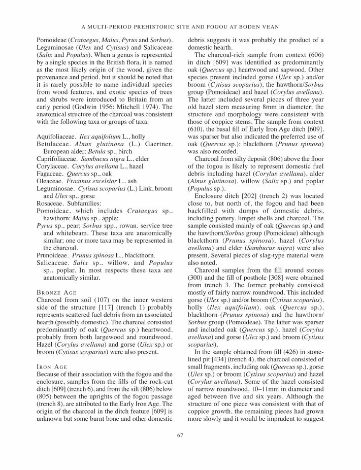
a multi-period prehistoric site and fogou at boden vean
67
Pomoideae (Crataegus, Malus, Pyrus and Sorbus), Leguminosae (Ulex and Cytisus) and Salicaceae (Salix and Populus). When a genus is represented by a single species in the British flora, it is named as the most likely origin of the wood, given the provenance and period, but it should be noted that it is rarely possible to name individual species from wood features, and exotic species of trees and shrubs were introduced to Britain from an early period (Godwin 1956; Mitchell 1974). The anatomical structure of the charcoal was consistent with the following taxa or groups of taxa:
Aquifoliaceae. Ilex aquifolium L., hollyBetulaceae. Alnus glutinosa (L.) Gaertner,
European alder; Betula sp., birchCaprifoliaceae. Sambucus nigra L., elderCorylaceae. Corylus avellana L., hazelFagaceae. Quercus sp., oakOleaceae. Fraxinus excelsior L., ashLeguminosae. Cytisus scoparius (L.) Link, broom
and Ulex sp., gorse Rosaceae. Subfamilies:Pomoideae, which includes Crataegus sp.,
hawthorn; Malus sp., apple;Pyrus sp., pear; Sorbus spp., rowan, service tree
and whitebeam. These taxa are anatomically similar; one or more taxa may be represented in the charcoal.
Prunoideae. Prunus spinosa L., blackthorn. Salicaceae. Salix sp., willow, and Populus
sp., poplar. In most respects these taxa are anatomically similar.
br o n z e ag eCharcoal from soil (107) on the inner western side of the structure [117] (trench 1) probably represents scattered fuel debris from an associated hearth (possibly domestic). The charcoal consisted predominantly of oak (Quercus sp.) heartwood, probably from both largewood and roundwood. Hazel (Corylus avellana) and gorse (Ulex sp.) or broom (Cytisus scoparius) were also present.
ir o n ag e Because of their association with the fogou and the enclosure, samples from the fills of the rock-cut ditch [609] (trench 6), and from the silt (806) below (805) between the uprights of the fogou passage (trench 8), are attributed to the Early Iron Age. The origin of the charcoal in the ditch feature [609] is unknown but some burnt bone and other domestic
debris suggests it was probably the product of a domestic hearth.
The charcoal-rich sample from context (606) in ditch [609] was identified as predominantly oak (Quercus sp.) heartwood and sapwood. Other species present included gorse (Ulex sp.) and/or broom (Cytisus scoparius), the hawthorn/Sorbus group (Pomoideae) and hazel (Corylus avellana). The latter included several pieces of three year old hazel stem measuring 8mm in diameter; the structure and morphology were consistent with those of coppice stems. The sample from context (610), the basal fill of Early Iron Age ditch [609], was sparser but also indicated the preferred use of oak (Quercus sp.); blackthorn (Prunus spinosa) was also recorded.
Charcoal from silty deposit (806) above the floor of the fogou is likely to represent domestic fuel debris including hazel (Corylus avellana), alder (Alnus glutinosa), willow (Salix sp.) and poplar (Populus sp.).
Enclosure ditch [202] (trench 2) was located close to, but north of, the fogou and had been backfilled with dumps of domestic debris, including pottery, limpet shells and charcoal. The sample consisted mainly of oak (Quercus sp.) and the hawthorn/Sorbus group (Pomoideae) although blackthorn (Prunus spinosa), hazel (Corylus avellana) and elder (Sambucus nigra) were also present. Several pieces of slag-type material were also noted.
Charcoal samples from the fill around stones (300) and the fill of posthole [308] were obtained from trench 3. The former probably consisted mostly of fairly narrow roundwood. This included gorse (Ulex sp.) and/or broom (Cytisus scoparius), holly (Ilex aquifolium), oak (Quercus sp.), blackthorn (Prunus spinosa) and the hawthorn/Sorbus group (Pomoideae). The latter was sparser and included oak (Quercus sp.), hazel (Corylus avellana) and gorse (Ulex sp.) and broom (Cytisus scoparius).
In the sample obtained from fill (426) in stone-lined pit [434] (trench 4), the charcoal consisted of small fragments, including oak (Quercus sp.), gorse (Ulex sp.) or broom (Cytisus scoparius) and hazel (Corylus avellana). Some of the hazel consisted of narrow roundwood, 10–11mm in diameter and aged between five and six years. Although the structure of one piece was consistent with that of coppice growth, the remaining pieces had grown more slowly and it would be imprudent to suggest
001-098_Cornwall 52.indd 67 01/12/2014 11:32

JAMES GOSSIP
68
the use of managed woodland based on such slim evidence. It was not clear whether the charcoal had been placed in the pit for a purpose or represented subsequent backfill. There was no evidence of in situ burning. The infrequent presence of charred cereal grain and grassland weeds suggests later infill with domestic debris.
Identifiable charcoal from the sample collected from (432), the fill of curvilinear anomaly [431] in trench 4, was fairly sparse but included oak (Quercus sp.), hazel (Corylus avellana) and birch (Betula sp.). A quantity of black bubbly industrial residue material was also present.
un d at e d s a m p l eA sample from fill (603), from small rubble-filled pit [604] in trench 6, was identified as predominantly oak (Quercus sp.) but also hazel (Corylus avellana) and the hawthorn/Sorbus group (Pomoideae). This activity is likely to have taken place during the Iron Age use of the enclosure.
Discussion
Environmental conditions comprising acid and well-drained soils were not conducive to the preservation of organic material and few of the bulk samples collected produced suitable material for identification. The charcoal was very degraded and, although sometimes abundant, the quantity of material of suitable size and condition to merit examination was usually insignificant. Pollen and charred plant remains were particularly poor. The assemblage of 10 charcoal samples selected for full analysis represents occupation of the site from the Bronze Age and Early Iron Age.
The samples were obtained from trenches 1, 2, 3, 4, 6 and 8, mostly from infill material in ditches and pits associated with the Bronze Age structure and the Iron Age enclosure and fogou. Since the charcoal was frequently mixed with domestic rubbish (pottery and occasionally charred cereal grain), it has been interpreted as domestic fuel debris. There was little evidence to indicate on-site industrial activity. The samples from the floor inside the Bronze Age structure (107) and floor deposit (806) within the fogou can thus be more certainly ascribed as from domestic hearths.
The charcoal analysis indicates the predominant and consistent use of oak (Quercus sp.) throughout all periods investigated. Hazel (Corylus avellana) also occurred fairly frequently. In addition, fuel
appears to have gathered sporadically from a fairly wide range of taxa, including alder (Alnus glutinosa), birch (Betula sp.), ash (Fraxinus excelsior), holly (Ilex aquifolium), the hawthorn/Sorbus group (Pomoideae), blackthorn (Prunus spinosa), willow (Salix sp.) and/or poplar (Populus sp.), elder (Sambucus nigra) and gorse (Ulex sp.) and/or broom (Cytisus scoparius).
en v i r o n m e n ta l e v i d e n c eToday sessile oak typically dominates most woodland, sometimes with hazel and holly as understorey (Marren 1992) but in the past the character of local woodland would have been influenced by soil type and moisture content, and aspect.
At Boden there appears to have been a diverse range of arboreal species, suggesting that fairly varied topographical and environmental conditions existed in the locality. It is difficult to assess the likely pattern of species distribution in the landscape using archaeological remains such as fuel debris, since its selection would have been biased in favour of function. High calorie wood, such as oak, would clearly have been preferable to poorer quality fuel, for example willow or poplar. The high ratio of oak in the charcoal, however, does conform to the present day dominance of oak in the environment and it is probable that the character of the woodland was similar in the prehistoric period. Alders and willows would have colonized damper soils or boggy land, whereas scrubby species such as gorse, blackthorn, hawthorn and other shrubs including elder would have grown on dryer, open ground. It could be anticipated that in the more exposed situations, woodland would have been windswept and stunted with high forest only occurring in sheltered valleys and creeks.
Fast-grown hazel stems, consistent with those of coppice growth, were noted in two Iron Age samples. It would be necessary, however, to examine a much greater quantity of roundwood to provide convincing evidence of coppicing, since the material examined could have originated from hazel bushes growing in optimal conditions rather than in managed woodland. It may be significant that Cornish woodlands were managed from ancient times to provide firewood and pit-props for tin-mining (Marren 1992).
Comparable sites on the Lizard peninsula are sparse. Two adjacent sites located to the west of Boden at Caervallack and Gear Farm have been
001-098_Cornwall 52.indd 68 01/12/2014 11:32

a multi-period prehistoric site and fogou at boden vean
69
dated to the Late Neolithic, Iron Age and Romano-British periods (Edwards and Kirkham 2008). Charcoal obtained from ditches, pits and an Iron Age hearth (probably mainly from domestic fuel) indicated the predominant use of oak (Quercus sp.), with less frequent use of alder (Alnus glutinosa), birch (Betula sp.), hazel (Corylus avellana), holly (Ilex aquifolium), blackthorn (Prunus spinosa), the hawthorn/Sorbus group (Pomoideae) and gorse (Ulex sp.) and/or broom (Cytisus scoparius). These results correlate closely to those from Boden.
co n c l u s i o nThe analysis of charcoal from spent fuel deposits from features dating from the Bronze Age and the Early Iron Age indicated a consistent bias towards oak (Quercus sp.), supplemented with other species listed above. It is probable that the emphasis on oak reflects its ready availability close to the site. These results conform to the dominance of oak in the present day landscape on the Lizard peninsula.
There was slight but unconfirmed evidence to suggest the use of managed woodland in the Early Iron Age.
Radiocarbon datingDerek Hamilton, Christopher Bronk Ramsey, Gordon Cook, James Gossip and Charles Johns
Twenty-four samples were submitted for radiocarbon dating from Boden fogou in 2005. The samples comprised both charcoal (16 samples) and carbonised residues on pottery (8 samples). Four of these had insufficient carbon to be measured (3 residues and 1 charcoal), and so the final number of radiocarbon determinations from the site is 22 (including two replicate measurements).
Eight samples were processed at the Scottish Universities Research and Reactor Centre in East Kilbride, and measured by Accelerator Mass
Table 10 Radiocarbon dating results
Laboratory Number
Sample ID Material δ 13C (‰)
Radiocarbon age (BP)
Calibrated date (95% confidence)
OxA-14567 BF03 (107) 3/73 carbonised residue –23.4 2277 ±33 400–210 cal BCOxA-14517 BF03 (107) <1019> charcoal, Ulex/Cytisus –25.7 3085 ±30 1430–1260 cal
BCSUERC-6169 BF03 (107) <1036> charcoal, Corylus avellana, roundwood –25.7 3055 ±35 1420–1210 cal
BCSUERC-6170 BF03 (107) 3/26 carbonised residue –22.7 3005 ±35 1370–1120 cal
BCOxA-14521 BF03 (201) <1035>a charcoal, Pomoideae –25.3 2272 ±28 400–210 cal BCSUERC-6173 BF03 (201) <1035>b charcoal, Pomoideae –26.9 2350 ±35 510–380 cal BCOxA-14519 BF03 (314) <1021>a charcoal, Corylus avellana –24.6 2269 ±27 400–210 cal BCOxA-14560 BF03/GS (314) carbonised residue –25.6 1417 ±29 cal AD 590–670OxA-14522 BF03 (411) <1024>a charcoal, Quercus, roundwood –24.5 2240 ±28 400–200 cal BCSUERC-6177 BF03 (411) <1024>b charcoal, Corylus avellana –24.7 2190 ±35 390–160 cal BCSUERC-6172 BF03 (414) <1021>b charcoal, Corylus avellana, roundwood –25.4 2315 ±35 410–260 cal BCOxA-14523 BF03 (426) <1006>a charcoal, Ulex –23.6 2253 ±28 400–210 cal BCSUERC-6178 BF03 (426) <1006>b charcoal, Corylus avellana –25.9 2255 ±35 400–200 cal BCOxA-14520 BF03 (432) <1009>a charcoal, Alnus –25.1 2459 ±28 770–400 cal BC
BF03 (432) <1009>b charcoal, Alnus failedOxA-14518 BF03 (610) <1015>a charcoal, Quercus, roundwood –22.8 2463 ±28 770–410 cal BCSUERC-6171 BF03 (610) <1015>b charcoal, Quercus, sapwood –25.3 2265 ±35 400–200 cal BCOxA-14486 BF03 (806) <1018>c carbonised residue –25.3 2205 ±37 390–170 cal BCOxA-14487 BF03 (806) <1018>a carbonised residue –26.4 2144 ±36 360–50 cal BCOxA-14514 BF03 (806) <1018>g charcoal, Corylus avellana –25.7 2261 ±28 400–200 cal BCOxA-14515 BF03 (806) <1018>f charcoal, Quercus, roundwood –24.3 2425 ±29 750–400 cal BCOxA-14516 BF03 (806) <1018>f charcoal, Quercus, roundwood –24.8 2462 ±29 770–400 cal BCSUERC-6168 BF03 (806) <1018>e carbonised residue –25.3 2335 ±35 420–370 cal BC
BF03 (806) <1018>d carbonised residue failedBF03 (806) <1018>b carbonised residue failedBF03 (806) <217> carbonised residue failed
001-098_Cornwall 52.indd 69 01/12/2014 11:32
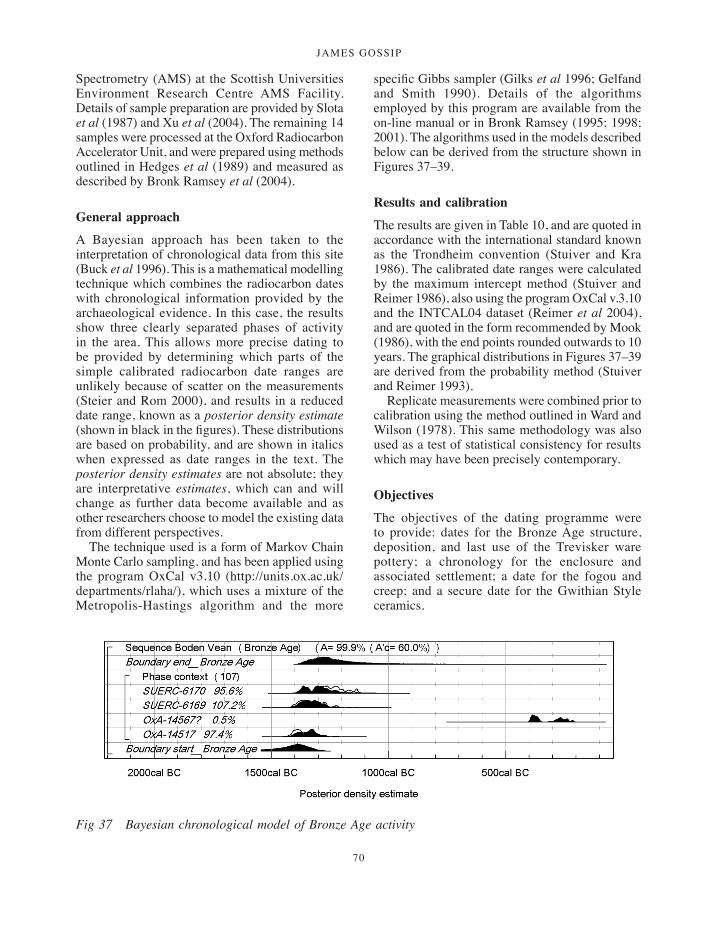
JAMES GOSSIP
70
Spectrometry (AMS) at the Scottish Universities Environment Research Centre AMS Facility. Details of sample preparation are provided by Slota et al (1987) and Xu et al (2004). The remaining 14 samples were processed at the Oxford Radiocarbon Accelerator Unit, and were prepared using methods outlined in Hedges et al (1989) and measured as described by Bronk Ramsey et al (2004).
General approach
A Bayesian approach has been taken to the interpretation of chronological data from this site (Buck et al 1996). This is a mathematical modelling technique which combines the radiocarbon dates with chronological information provided by the archaeological evidence. In this case, the results show three clearly separated phases of activity in the area. This allows more precise dating to be provided by determining which parts of the simple calibrated radiocarbon date ranges are unlikely because of scatter on the measurements (Steier and Rom 2000), and results in a reduced date range, known as a posterior density estimate (shown in black in the figures). These distributions are based on probability, and are shown in italics when expressed as date ranges in the text. The posterior density estimates are not absolute; they are interpretative estimates, which can and will change as further data become available and as other researchers choose to model the existing data from different perspectives.
The technique used is a form of Markov Chain Monte Carlo sampling, and has been applied using the program OxCal v3.10 (http://units.ox.ac.uk/departments/rlaha/), which uses a mixture of the Metropolis-Hastings algorithm and the more
specific Gibbs sampler (Gilks et al 1996; Gelfand and Smith 1990). Details of the algorithms employed by this program are available from the on-line manual or in Bronk Ramsey (1995; 1998; 2001). The algorithms used in the models described below can be derived from the structure shown in Figures 37–39.
Results and calibration
The results are given in Table 10, and are quoted in accordance with the international standard known as the Trondheim convention (Stuiver and Kra 1986). The calibrated date ranges were calculated by the maximum intercept method (Stuiver and Reimer 1986), also using the program OxCal v.3.10 and the INTCAL04 dataset (Reimer et al 2004), and are quoted in the form recommended by Mook (1986), with the end points rounded outwards to 10 years. The graphical distributions in Figures 37–39 are derived from the probability method (Stuiver and Reimer 1993).
Replicate measurements were combined prior to calibration using the method outlined in Ward and Wilson (1978). This same methodology was also used as a test of statistical consistency for results which may have been precisely contemporary.
Objectives
The objectives of the dating programme were to provide: dates for the Bronze Age structure, deposition, and last use of the Trevisker ware pottery; a chronology for the enclosure and associated settlement; a date for the fogou and creep; and a secure date for the Gwithian Style ceramics.
Fig 37 Bayesian chronological model of Bronze Age activity
001-098_Cornwall 52.indd 70 01/12/2014 11:32

a multi-period prehistoric site and fogou at boden vean
71
Fig 38 Bayesian chronological model of Iron Age activity.
Fig 39 Bayesian chronological model of Post-Roman activity.
001-098_Cornwall 52.indd 71 01/12/2014 11:32

JAMES GOSSIP
72
Sampling
The initial step in sample selection was to identify non-residual short-lived material (Ashmore 1999). All samples were either charcoal from short-lived species, or internal carbonised residues that are thought to be the direct result of food preparation.
None of the carbonised residues were thought to be residual because the residues remained intact and the sherds were fresh. Similarly, all the charcoal samples dated appeared to represent single-episode dumps of freshly charred material in the context from which they were recovered. The exception is the charcoal from context (806), which appeared to be a trampled primary silt associated with the use-life of the fogou. It should be noted that from the mixed derivation of this deposit it was attempted to date six carbonised residues in addition to the two charcoal fragments; however, three of the carbonised residues failed.
Analysis and interpretation
The radiocarbon results show three episodic phases of activity at the site. The chronological models for these episodes are shown in Figures 37–39.
A note on the Bayesian modelling diagrams (Figs 37–39)
The model structure is exactly defined by the square brackets and OxCal keywords at the left of the diagram. The distributions in outline represent the calibration of each result by the probability method (Stuiver and Reimer 1993). The solid distributions are posterior density estimates for the calendar date for each sample.
Bronze Age activity
Three samples were measured from the lower fill of the Bronze Age structure which contained Trevisker pottery. Unfortunately, the two radiocarbon measurements on the carbonised residues adhering to the interior surface of sherds from vessel P1 were not statistically consistent (T’=229.5, v=1, T’(5%)=3.8; Ward and Wilson 1978). It should be noted that OxA-14567 had an extremely low carbon content, and was pre-treated using 1M HCl for 1 hour at room temperature. The other sherd from this vessel (SUERC-6170) contained more carbon and was pre-treated using 1M HCl
for 3–4 hours at 80º C. It appears that in this case, the latter treatment was better able to remove the surrounding soil contaminates. However, three of the four measurements are statistically consistent from this deposit (T’=3.0, v=2, T’(5 per cent)=6.0), and suggest that it dates to between 1530–1300 cal BC (start_Bronze Age) and 1390–870 cal BC (end_Bronze Age), probably in the thirteenth and fourteenth centuries cal BC (Fig 37).
The Trevisker ware vessel (P1) was probably last used in 1400–1190 cal BC (SUERC-6170).
Iron Age activity
The chronological model for the activity within the Iron Age enclosure is shown in Figure 38. Two samples were dated from a single context (201) in the enclosure ditch. The measurements on these separate fragments of Pomoideae charcoal were statistically consistent (T’=3.0, v=1, T’(5%)=3.8). Context (201) was a charcoal-rich dumped deposit well-stratified within the sequence of ditch fills. It provides a terminus ante quem for the digging of the enclosure ditch at around 400 cal BC (Fig 38).
Three samples were dated from a curvilinear ditch ([431] and [609]) within the main enclosure. Two samples from context (610) in trench 6, provided measurements that are not statistically consistent (T’=19.4, v=1, T’(5%)=3.8). The single measurement from context (432), within trench 4, was also not statistically consistent with those from context (610) (T’=23.5, v=2, T’(5%)=6.0). This deposit appears to be charred material dumped in the base of the cut, and contexts (610) and (432) appear to be equivalent basal deposits of the same feature, based on spatial analysis and the physical character of the two deposits. Because of this archaeological interpretation of the taphonomy of the dated material, the best estimate for the construction of the ditch is probably provided by the latest dated material in the ditch (SUERC-6171), with date ranges of either 400–340 cal BC (at 51 per cent probability) or 320–220 cal BC (at 44 per cent probability).
Trench 4 contained a stratigraphic sequence of three contexts with dateable material. Contexts (414) and (411) appear to be single-episode charcoal-rich dumps forming the primary fills of cuts [416] and [412], respectively. The fill (426) of the stone-lined pit [434] / (425) is the latest of the sequence.
The chronological model suggests that cut [416] dates to 420–350 cal BC (SUERC-6172). Cut
001-098_Cornwall 52.indd 72 01/12/2014 11:32
a multi-period prehistoric site and fogou at boden vean
73
[412] probably also dates to the fourth century cal BC, and the stone-lined pit probably dates to the third century cal BC (Fig 38).
Turning to the fogou, one deposit (806) was dated. This was the silty layer that directly overlaid the natural weathered bedrock. Five samples were dated (three carbonised residues and two charcoal) from this context. Two measurements on a single fragment of charcoal are statistically consistent (T’=0.8, v=1, T’(5%)=3.0). The measurements on all five samples from the context are not, however, consistent (T’=72.9, v=4, T’(5 per cent)=9.5), suggesting that the deposit contains material of a range of actual ages.
The determinations on the carbonised residues are also not statistically consistent (T’=15.2, v=2, T’(5 per cent)=6.0), suggesting that context (806) accumulated over a period of time. Because the pot sherds were physically fresh and had well-preserved residues, and because residual charcoal has been identified elsewhere within this dating programme, charcoal sample BF03 (806) <1018>f has been excluded from this model. The earliest sample, therefore, dated from the fogou is probably carbonised residue <1018>e (SUERC-6168). This provides a terminus ante quem for the fogou’s construction of 420–350 cal BC (94 per cent probability) or 280–260 cal BC (1 per cent probability). Figure 38 shows that the fogou’s primary use is likely to be confined to the fourth century cal BC. It should be noted that if sample <1018>f is not excluded from the model, it is more likely that the fogou’s construction falls earlier, in the fifth century cal BC.
The chronological model for activity in the enclosure suggests that activity within began in 470–370 cal BC (Fig 38; start_enclosure), probably in the decades around 400 cal BC (425–390 cal BC; 68 per cent probability). Again, if charcoal sample <1018>f from the fogou is not excluded, this activity is likely to have started earlier in 530–400 cal BC (alternative model not shown). Activity in the enclosure ended in 380–160 cal BC (Fig 38; end_enclosure), probably either the middle decades of the fourth century cal BC (365–330 cal BC at 27 per cent probability) or in the latter part of the third century cal BC (270–205 cal BC at 41 per cent).
The enclosure was probably used for 5–275 years (95 per cent probability); however the distribution of this span is strongly bi-modal. The enclosure was either used for 2–3 generations in the fourth century cal BC (30–80 years; 26 per cent probability), or
continued into the third century cal BC and was used for around 175 years (135–220 years; 42 per cent probability). There were an insufficient number of radiocarbon dates to determine between these two possibilities, although the consistency of the measurements suggested that the latter possibility may be an artefact of statistical scatter.
Post-Roman activity
A late fill from the enclosure ditch, context (314), provided two statistically inconsistent radiocarbon measurements (T’=456.8; v=1; T’(5%)=3.8). The earlier of these was undoubtedly residual from the initial use of the enclosure. The other, a carbonised residue adhering to the interior surface of a Gwithian Style platter, provided a radiocarbon date of cal AD 590–670 (95 per cent confidence; OxA-14560).
Geophysical surveyNeil Linford
This section provides a review of the geophysical data for the site, discussed in the light of the excavation results. The full geophysical survey report is deposited with the site archive and the results have also been published elsewhere (Linford 1998; 2004).
Methods
Figure 40 illustrates the geophysical survey areas. An initial magnetic survey of the field containing the fogou (squares 1–14) was carried out in March 1992. A second visit in February 1993 extended the survey through squares 15–56. In September 1993 a microgravity survey was conducted, together with earth resistance and electromagnetic surveys. Finally a Ground Penetrating Radar (GPR) survey was carried out in squares 8, 9, 11 and 12) prior to the HES evaluation in October 2003.
Results
Topsoil Magnetic Susceptibility
Results from the topsoil magnetic susceptibility data (Fig 41) demonstrated the strongly enhanced nature of the iron-rich soils that have developed
001-098_Cornwall 52.indd 73 01/12/2014 11:32
JAMES GOSSIP
74
Fig 40 Geophysical survey area.
over this site. The range of values reflected the underlying igneous geology but two distinct areas of concentrated high readings were found; the first in squares 6, 9 and 12 in the field containing the fogou, and the second in the field to the east in the centre of squares 24, 25, 28 and 29. Given the wide range of archaeological activity revealed over the entire survey area it was difficult to identify a group of anomalies specifically associated with either of the two concentrations of high topsoil
magnetic susceptibility readings. However, the enhanced readings found in the field containing the fogou correlated well with the enclosure ditch revealed by the magnetic survey.
Magnetic data
There was little modern interference beyond a scatter of intense responses caused by near-surface ferrous material and a negative linear anomaly m1
001-098_Cornwall 52.indd 74 01/12/2014 11:32

a multi-period prehistoric site and fogou at boden vean
75
(Fig 2) associated with the buried plastic water supply pipe.
The most striking archaeological anomalies were the palimpsest of strong linear ditch-type responses occurring throughout the entire survey area forming a complex network of field enclosures and track ways (Fig 2). A single rectilinear anomaly m3 surrounded the location of the fogou m4, continuing beneath the modern field boundary into squares 19, 23 and 27. Anomaly m3 most probably represented an enclosure surrounding the fogou, with the southern circuit of the ditch presumably underlying the modern field boundary. Square 8 revealed a break in m3 that may have indicated a former entrance and there was some evidence of associated activity m5 beyond the enclosure immediately west of this gap. There was another possible entrance gap in the north-west corner of the enclosure.
The interior of the enclosure was of particular interest due to the discovery of the fogou
and contained a wealth of significant positive anomalies. These could be divided into those of a discrete nature, indicative of buried pits, and a cluster of fragmented ditch-type segments m6 immediately south and east of the excavated fogou m4. The data was not sufficiently clear to determine whether the latter were caused by the same feature.
A number of curious negative responses were associated with m3, both south of the enclosure and, in the case of m7, as an independent anomaly which extended north beyond the north-east corner into square 19. These anomalies could not be explained by the negative response to be expected immediately north of the main positive signal from gradiometer data collected over buried ditches at this latitude. It is possible that they represented the location of a magnetic ‘void’ caused by the presence of material with a lower susceptibility than that of the surrounding subsoil.
Fig 41 Magnetic susceptibility results.
001-098_Cornwall 52.indd 75 01/12/2014 11:32
JAMES GOSSIP
76
The relationship between m7 and the oval anomaly m8 was again difficult to ascertain. However, it seems that m8 represented the location of a ditch or gully surrounding a former domestic dwelling with a scatter of attendant pit-type anomalies. At Reawla, Gwinear (Bartlett 1978), similar results were found to be an Iron Age dwelling (Appleton-Fox 1992).
Interpretation of the data surrounding the fogou was hampered by its fragmented nature and the interjection of the weak linear anomaly m9 bisecting the enclosure. Excavation proved that m9 was part of an approach trench leading directly to the mouth of the fogou.
Immediately west of the enclosure a broad positive ditch-type anomaly m10 respected the north-west corner of m3 and then ran to the edge of the survey area through squares 4 and 5. This area was complicated by an amorphous mass of positive readings in square 5 bounded by m10 to the north which were later found to correlate with a more distinct GPR anomaly which proved to be the Bronze Age structure in trench 1. Activity throughout squares 1–14, excluding the interior of the enclosure, continued as a scatter of subtle linear anomalies, discrete pit-type responses and areas of magnetic disturbance which defied a greater degree of interpretation. Of particular note were the two intense positive anomalies m11 and m12 defined largely within square 6; the former seemed to contain a two discrete pit-type responses.
A more complete network of linear anomalies was identified east of the enclosure in squares 15–47. To the north of this area the group m13 appeared to represent the course of former field boundaries, respecting the location of m3 in square 23. Further south a similar group m14 had a weaker magnitude of response than m13. These latter anomalies were obscured by a network of more intense double-ditched anomalies m15, probably representing the course of two removed field boundaries which converged in square 34. Unfortunately, the course of the southern branch of this anomaly lay parallel to the north-south orientation of the magnetometer traverses and it appeared that the position of the sample points degraded the clarity of the latter response. An additional group of more subtle anomalies m16 was visible in squares 21–22, which may possibly have related to an earlier enclosure cut through by m13. Two significant discrete anomalies m17 and m18 were located immediately west of m16 within
an area of magnetic disturbance immediately north of m13; anomaly m17 was of particular interest due to both the magnitude (>60nT) and characteristic nature of its response, indicating that it may have been caused by a hearth.
The gradiometer response throughout this area contained a degree of background ‘noise’ caused by the underlying geology which led to the high values of topsoil magnetic susceptibility developed over the site. The geology of the region is recognized to be highly variable (Flett 1946) and it is possible that many of the more extraordinary magnetic anomalies arose from this origin.
Data from squares 48–56 was again dominated by an assemblage of intense linear anomalies m19 that appeared to converge with the enclosure immediately north of square 50. The branch of m19 to the west was formed from two parallel ditch-type anomalies 3m apart, most likely to represent a removed field boundary. Again the incomplete nature of the more subtle linear anomalies to the north of this area hampered a more detailed interpretation.
Earth resistance data
Data from the earth resistance survey (squares 5–6, 8–9, 11–12) was disappointing due to the failure of the technique to replicate the majority of the significant anomalies revealed by the gradiometer with only anomalies m1 (the modern pipe trench) and m11 from the magnetic survey corroborated by the earth resistance data. Over the fogou itself, an isolated low resistance linear anomaly extended north-east for approximately 10m. The dimensions of this anomaly far exceeded those of the hand-excavated trench opened by Mr Hosken in September 1991 (Rose and Preston-Jones 1991) and it is conceivable that this low resistance anomaly was related to the course of the buried fogou but at odds with the stone construction of the feature. This may be a very near surface ‘paradoxical anomaly’ (Scollar et al 1990, 350–1) or a response to moisture retentive material infilled along a collapsed section of the fogou.
Electromagnetic data
The electromagnetic data showed a much closer correlation to the anomalies identified by the magnetic survey than to either of the earth resistance plots. In particular, the horizontal
001-098_Cornwall 52.indd 76 01/12/2014 11:32

a multi-period prehistoric site and fogou at boden vean
77
conductivity data depicted both the enclosure ditch north of the excavation and the amorphous area of high magnetic susceptibility immediately south-east, both absent from the resistivity results; a most peculiar result given the reciprocal relationship between resistance and conductivity.
Further analysis of the conductivity survey suggested that the quadrature phase data represents a palimpsest of the reciprocal of the earth resistance values superimposed upon the anomalies from the magnetic survey.
Microgravity survey
The microgravity data was collected over the partially excavated fogou in square 9 (Fig 42). The residual data contained three anomalous areas of interest; two negative towards the east of the square, G1 and G2, and a more central positive response G3 trending north east close to the partially excavated fogou, corresponding with a linear low resistance ditch-type response in the earth resistance data and an amorphous area of low conductivity/susceptibility within the electromagnetic data.
Fig 42 Graphical summary of GPR and microgravity.
001-098_Cornwall 52.indd 77 01/12/2014 11:32

JAMES GOSSIP
78
The negative gravity anomalies G1 and G2 most likely represented a subsurface depletion in density, proved as surviving void features when a hole in the ground leading to an underground passage opened in July 1996 above the location of G2. The proximity of G3 to the location of the excavated fogou suggests a direct relationship to this feature, possibly indicative of a partial collapse of the structure. The precise nature of G1 has not been established through excavation but may well represent an extension of the fogou structure.
Ground Penetrating Radar
Although subdued, the response to GPR survey over the site produced an acceptable degree of penetration to a depth of approximately 2m. It is possible that both the original earth resistance survey and the GPR survey were adversely affected by extreme soil moisture conditions as both techniques, to a certain degree, rely on a contrast in soil moisture. However, trial 30m GPR profiles with both 225 MHz and 450MHz antennas, conducted immediately south of the collapsed passage way, successfully identified anomalies associated with the visible void features (Fig 42). The 225MHz centre frequency antenna defined both the ‘roof’ of the void (approximately 0.8m from the ground surface) and the floor of the structure (approximately 1.7m from the ground surface) due to the greater penetration depth afforded by the lower frequency antenna. Additional anomalies found approximately 10m west of the visible collapse correspond with the known location of the previously excavated fogou remains and a possible second passage way or creep 10m further to the east again.
Following the trial GPR profiles a detailed survey of a 60m × 60m area was conducted using the 225MHz centre frequency antenna to produce the amplitude time slices. The near surface time slices (0 to 16ns) provide evidence for a number of anomalies due to recent features, such as the surface plough patterns GPR 1 and the agricultural water main GPR 2 running along the east edge of the survey grid. An amorphous area of high magnitude reflections following the course of the water main to the south may well indicate water leaking from this supply into the pipe trench.
High amplitude reflections are also recorded over the known location of the excavated fogou GPR 3 and the collapsed passage way GPR 4.
Other identified features include the location of an anomaly associated with the enclosure ditch GPR 5 presenting a more complete anomaly that correlates directly with the magnetic response to this feature from the original survey. While the initial GPR reflections from the enclosure ditch appear to originate from a depth of approximately 0.8m the later time slice data suggests a response from a greater depth in excess of 1.5m.
Of greater interest is the high amplitude reflection GPR 6 found along the course of the enclosure ditch in the vicinity of the postulated entrance to the enclosure suggested by the magnetic data. Anomaly GPR 6 is apparently circular in shape with a diameter of approximately 5m and could represent a more substantial stone-built structure possibly associated with an additional pair of responses GPR 7 at a similar depth immediately east of the proposed entrance to the enclosure. These responses occur in approximately the location of trench 3 and the trench 4 extension to the east, and could correspond with both a wide section of the enclosure ditch in this area ([315]) along with external ditch [305], in addition to the curving stone alignment 408.
The GPR survey has provided additional information to complement the previous geophysical results from the site. The anomaly at GPR 3, over the location of the excavated portion of the fogou, suggests a north-south orientated feature approximately 3m wide sloping from the north for a length of approximately 10m. The deepest reflection from GPR 3 occurs in the final time slice (42 to 44ns) at the southern extent of the structure, although there is some suggestion of an additional, perhaps partially collapsed, passage way GPR 8 extending from the south. This anomaly appears to correspond with the line of the loosely-filled fogou approach trench [433] / [612]. An additional, curvilinear response GPR 9 follows a similar north-south orientation parallel to the axis of GPR 3 but the GPR data does not show any direct association between the two anomalies. It is likely that GPR 9 represents curvilinear ditch [431] / [609].
To the north of GPR 3 there is evidence for a right–angled passageway heading east towards the location of the current collapse (tunnel void) at GPR 4. This concurs with visual evidence viewed from the ground surface into the void that suggests a curved passage way heading south west towards GPR 3 and south east following the course
001-098_Cornwall 52.indd 78 01/12/2014 11:32
a multi-period prehistoric site and fogou at boden vean
79
of the anomaly suggested by GPR 4 towards the field boundary to the east (Fig 42). The GPR data also supports the continuation of GPR 4 north beyond the current open void terminating at the confluence between GPR 4 and the north circuit of the enclosure ditch GPR 5.
One final area where the GPR data suggests added complexity over the original geophysical survey results is found at GPR 10, previously identified as an area of amorphous magnetic disturbance but suggested by the GPR survey to be deeper and more complex and later revealed to be the remains of the Bronze Age structure excavated in trench 1.
Comparison of the GPR survey with the previous geophysical data sets
As noted above, the original earth resistance survey produced disappointing results and failed to identify any significant anomalies, perhaps as a result of excessive soil moisture conditions. A far greater degree of success was achieved through magnetic survey with a wealth of significant anomalies, including the response due to the rectilinear enclosure ditch, being recorded.
The GPR survey improved upon the results of the earth resistance survey and has replicated many of the anomalies identified within the original magnetic data. Many of the magnetic anomalies have been replicated by GPR reflections from a more considerable depth. While this may indeed reflect the geophysical response to the varying physical contrast of the features with depth, it is possible that, in part, these represent partially collapsed passageways or chambers. In this case, the lower lying base of the feature is likely to be composed of the collapsed wall stones or roofing lintels of the fogou, resulting in a detectable GPR reflection. Closer to the surface enhanced magnetic topsoil will have accumulated in the depression created by the collapse, producing the near-surface magnetic anomalies recorded by the fluxgate gradiometer survey.
Comparison between the GPR data and the void type anomalies identified by the microgravity survey (microgravity anomalies G1, G2 and G3 on Fig 42) shows some areas of corresponding data, the negative microgravity response G2 proven by the partial collapse of the void in July 1996 in the location of anomaly GPR4. The positive gravity response G3, interpreted as buried stone work, is
found slightly to the west of GPR3 (close to the known location of the partially excavated fogou) and may not necessarily be directly associated with the excavated remains of the fogou. No significant GPR response was found to correspond with the location of G1, a negative void-type microgravity anomaly located immediately north of the enclosure ditch.
An isovolume plot of the GPR data collected over the fogou (accessible in the site archive) showed high amplitude reflections revealing the main passageway of the fogou GPR3 heading north where it meets the possible second passageway GPR4 in the vicinity of both the original microgravity anomaly G2 and the later partial collapse. The enclosure ditch GPR5 also produced a high amplitude reflection to the north.
Conclusion
The combination of geophysical survey methods applied to the suspected fogou site at Boden revealed a complex distribution of archaeological activity confused by the highly variable nature of the local geology. The results revealed the presence of an enclosure surrounding the location of the suspected fogou while the application of both microgravity and Ground Penetrating Radar techniques corroborated the interpretation of the partially excavated stone lined passageway as a collapsed portion of a fogou prior to the excavation. The geophysical data informed the location of trenches for the subsequent excavation and mitigated the Health and Safety risks associated with working close to a known void structure.
In particular, the extent of the passageways to the north of the excavated fogou, discovered through the partial surface collapse, has been clarified through the GPR survey results. This data suggested a central, stone-lined chamber approximately 3m wide following a north-south orientation parallel to the rectilinear enclosure ditch for a length of at least 10m, subsequently corroborated by excavation. To the north of the central fogou chamber there is evidence for a right-angled passageway, sloping gently upwards to the east towards the location of the observed surface collapse. At this latter point the GPR survey has revealed an additional passageway approximately 12m in length running on an approximately north-west to south-east alignment which may extend
001-098_Cornwall 52.indd 79 01/12/2014 11:32

JAMES GOSSIP
80
towards both the enclosure ditch to the north and to the present day field boundary to the east.The GPR survey also suggests the presence of a more substantial structure to the west in the vicinity of the postulated entranceway through the enclosure, as interpreted from the magnetic data. An area of amorphous magnetic disturbance found beyond the north-west corner of the enclosure reveals a more complex structure of subsurface GPR reflectors that was subsequently proved through excavation to be a significant Bronze Age structure.
DiscussionA number of significant results have emerged from the project at Boden. Overall the evaluation trenches revealed evidence of intermittent activity starting in the Middle Bronze Age (c 1400 cal BC) and again in the later Early Iron Age (c 400 cal BC), the Romano-British period (first to second centuries AD), and finally in the sixth and seventh centuries AD, while the flint assemblage also indicates possible Mesolithic and Neolithic activity in the area. The geophysical surveys suggest that the excavated features represent only a small part of a complex, long-lived landscape which is likely to contain more extensive settlement remains from each of these periods.
Although there are now many examples of Middle Bronze Age sunken-floored roundhouses in lowland Cornwall the discovery of the example at Boden extends the distribution of this regionally distinctive type onto the Lizard peninsula, where previously recorded Bronze Age structures have been upstanding hut circles of more upland type (for example, Poldowrian, St Keverne: Smith and Harris 1982). Full excavation of the Boden structure in 2008 proved it to be a sunken-floored roundhouse comparable with other examples of similar date in Cornwall (Gossip and Jones 2008). It is particularly remarkable for the deposition of an exceptionally large Trevisker vessel.
Evaluation of the fogou structure has given a clearer idea of its layout and components, and helped explore its relationship with the adjacent subterranean void. Excavation of the principal stone-lined passage and entrance was a rare opportunity to explore this type of monument and provided evidence for deliberate closure in antiquity and the structured deposition of artefacts.
Scientific dating suggests an Early Iron Age date for the construction of the fogou, reinforcing the chronological evidence from other sites such as Carn Euny and Halligye (Christie 1978; Startin 2009–10). The fogou has both similarities and differences with other Cornish examples; for example the targeted evaluation of geophysical anomalies revealed an approach trench with no clear parallels at other fogou sites. Results from the wide variety of geophysical techniques suggest that the fogou is part of a more complex site than is presently visible.
Evaluation of the fogou, rectilinear enclosure ditch, ‘well’ structure and other features within the enclosure produced an important assemblage of Plain Jar Group ceramics (PJG), indicating Early Iron Age use of the site, with the dating being further refined by a series of radiocarbon determinations. This provides an early date for a ‘round’ type enclosure, although it is uncertain how the enclosure was being used at this time. Currently, the artefactual evidence – the absence of South Western Decorated ware – suggests that the initial use of the enclosure and fogou was short-lived. There is evidence for renewed activity at the end of the Iron Age, through the Romano-British period and beyond as indicated by the range of artefacts, settlement evidence and geophysical anomalies suggesting the layout of field systems. In the sixth century continued use of the site is shown by the presence of Gwithian Style pottery, an important assemblage which is one of few well-dated and published examples.
The Bronze Age structure
Trench 1 revealed part of a sunken-featured roundhouse, a type of structure recently summarised by Jones and Quinnell (2011, 217–21). The trench was positioned to evaluate a geophysical anomaly of a type often associated with these structures. Similar anomalies to the south west may indicate additional Bronze Age structures (Fig 2). The partial excavation of the Bronze Age structure in trench 1 revealed sherds from a very remarkable Middle Bronze Age vessel, with no known comparanda in terms of size or decoration. Radiocarbon dates suggest that the vessel was last used 1400–1190 cal BC (SUERC-6170) when it was deliberately broken and laid out on the base of the structure, probably as part of a ritual act. The ritual nature of closure is typical of domestic house structures
001-098_Cornwall 52.indd 80 01/12/2014 11:32
a multi-period prehistoric site and fogou at boden vean
81
of this period. Environmental evidence in the form of cereals recovered from the structure supports the notion of a settled Bronze Age community and shows that land was being cultivated and wheat and barley consumed at this time.
A number of excavated settlement sites around the coast of the Lizard peninsula have been dated to the Middle Bronze Age. These include Kynance Gate (Thomas 1960) and Poldowrian (Smith and Harris 1982), although the house structures at these sites vary greatly from the sunken hollow structure at Boden.
Morphologically the Boden structure can be compared with Cornish Bronze Age roundhouses such as those excavated at Trethellan Farm (Newquay), Callestick (Perranzabuloe), Trevilson (St Newlyn East) and Scarcewater (St Stephen-in-Brannel) (Nowakowski 1991, 14–103; Jones 1998–9, 43; Jones and Taylor 2004, 104; Jones and Taylor 2010). These structures are typically circular earth-cut hollows of varying depth, in some cases surrounded by stones acting as a wall or kerb. They also tend to contain postholes cut into the base of the hollow to support the roof and / or entrance structures, in addition to features such as hearths and storage pits. While no such features were evident at Boden in 2003, subsequent excavation by Cornwall Archaeological Society in 2008 revealed a series of postholes cut into the floor of the structure and a central hearth, indicating a primary domestic function (Gossip, in prep).
The excavated roundhouse at Boden proved to be 10m in diameter, cut into the gentle south-facing slope and containing deposits up to 0.8m in depth with areas of clay floor preserved where baked by proximity to the hearth. More stones were recovered from the edge of the cut indicating a collapsed wall at least around the northern edge of the structure. The base of the roundhouse had 15 postholes cut into it, including some double post arrangements suggesting maintenance or rebuilding over a period of time. The bowl-shaped central hearth had been filled with heated stones before the final backfilling episode took place, at which time the main spread of artefacts seems to have been deposited in the basal fill. The majority of finds were retrieved from this basal deposit, although there was also a general scatter of material through subsequent layers, suggesting the continued infilling of the structure over time, perhaps even its use as a midden. Around 600 artefacts were recovered from the roundhouse.
Many more sherds belonging to the large Trevisker ware vessel (P1) seemed to be present, perhaps representing deliberate destruction and deposition of the entire pot. Many of Cornwall’s Bronze Age roundhouses display signs of ‘ritual abandonment’ a final event marked by elaborate patterns of ‘closure’ (Nowakowski 1991, 92, 208–9; Jones 1998–9, 49; Nowakowski 2001; 2011; A M Jones 2008) recognised at sites such as Trethellan, Callestick and Trevilson (Nowakowski 1991 14–103; Jones 1998–9, 43; Jones and Taylor 2004, 104).
The fragments of decorated pottery lying on the base of the Boden structure conform to this model. They were deposited as part of a single episode of backfill spread across the majority of the roundhouse floor sealing the structure and its contents, reflecting a complex process of ritual abandonment. The breaking up of the sherd blocks may be suggestive of ritual activity, such as dancing, immediately after the sherds were buried (Thorpe, above). Many more sherds of this vessel and others were recovered during the Cornwall Archaeological Society excavations in 2008 (Gossip, in prep) and analysis of these may shed additional light on the manner of their deposition.
Vessel P1 displays a number of unusual attributes, particularly its large size (perhaps at least 0.92m high) and unparalleled decoration (a combination of cord-impressed chevrons and incised lines). It has been calculated that the vessel had a capacity of 218 litres, although it is not known what it might have contained. The storage of a valuable commodity, perhaps grain or other foodstuff, or perhaps salt, is a possibility. An alternative possibility is that the vessel was never intended to hold anything: it would have been a significant and impressive showpiece and its fundamental use may have been in acts of ceremony.
Also found in this deposit were sherds from a miniature Trevisker vessel (P3). The comparanda for both P1 and P3 come from barrow contexts which can be assigned to the Early Bronze Age and where deposition was related to ceremonial activity. The later date of the Boden deposit and its structured nature suggest a continued tradition of certain types of vessel being more appropriate for special deposition which was then linked to rituals of closure. Links between Early Bronze Age barrows and Middle Bronze Age houses have been commented on by Jones (2008).
001-098_Cornwall 52.indd 81 01/12/2014 11:32

JAMES GOSSIP
82
Environment and land use
Recent reviews of palaeoenvironmental studies in west Cornwall summarise the evidence for vegetation and provide a useful context for Boden (Straker 2011a; 2011b). Pollen and plant macrofossil analyses of buried soils in particular suggest the domination of a heathland landscape inland on the Lizard. At Trelan, Caern Dhu and Higher Polcoverack analysis of pre-barrow soils produced evidence for grassy heathland, alongside hazel and heathers (Straker 2011b, 70–71; Harris 1983). Contrasting with this, pollen cores from a coastal valley location at Porthleven have produced Bronze Age dates for a wetland landscape dominated by alder carr, with oak and hazel woodland on the drier slopes of the valley inland. Similar deposits have been located at Gunwalloe. The nearby sites of Gear and Caervallack, also in a lowland farming context, provide another range of evidence for the early environment on the Lizard which can be enhanced by the evidence from Boden (Edwards and Kirkham 2008, 94). Excavated sites such as Trethellan (Straker 1991, 169), Tremough (Gossip and Jones 2007), Trevilson (Jones and Taylor 2004, 97) and Stencoose (Straker 2000–1, 76), have produced results consistent with those from Boden, for the Bronze Age, Iron Age and Roman periods.
In addition to oak and hazel woodland, alders and willows would have grown on damper soils, while gorse, blackthorn, hawthorn, elder and other shrubs would be present on drier, more open ground. It appears that at Boden all of these species were used for fuel, with a particular emphasis on oak (Gale, above). There is some evidence of fast-grown hazel from Iron Age contexts which could be an indicator of coppice growth and managed woodland (Gale, above). The coppicing of oak is suggested by evidence from Romano-British contexts at Gear and may also have been a feature of Iron Age woodland management (Edwards and Kirkham 2008, 94). Hazel rods were certainly used at other settlements such as Trethellan Farm (in the Bronze Age) as a material for stakes and hurdled screens and wicker work (Nowakowski 1991, 183).
Despite large-scale sampling programmes comparatively little data has been recovered from sites in Cornwall and crop husbandry regimes in the south west generally are still not fully understood (Campbell and Straker 2003). Even the small numbers of ecofacts collected from
Boden help to supplement this incomplete picture; macrofossil analysis suggests that crops of hulled wheat and barley were being consumed during the Bronze Age and there is also the possibility of free-threshing wheat from the Bronze Age structure (Jones, above). Spelt wheat was present in the Early Iron Age phase. Evidence from this date is at present rare in Cornwall, with the only other example being a tiny amount of indeterminate wheat from Trenowah, St Austell (J Jones 2008).
Studies of Romano-British sites also show similarities with Boden. Excavations at Reawla, Gwinear (Straker 1992, 90–1), and Pollamounter, St Newlyn East (Jones and Taylor 2004; Gale 2004, 87), have shown the use of wheat, barley and oats and evidence for the exploitation of heathland species such as heather and gorse. At Gear, gorse was also an important and possibly managed resource for fuel and other uses (Edwards and Kirkham 2008, 94).
The upland fields and tenements farmed by Cornwall’s prehistoric communities have long been recognised and extensively surveyed, as for example on Bodmin Moor (Johnson and Rose 1994). Evidence for the layout and character and extent of fields in lowland Cornwall is very limited at present, although in recent years geophysical survey and large-scale open area excavation have begun to identify lowland field systems.
So far in Cornwall there is no direct evidence for ditched field systems in the Bronze Age and, as ditches appear to be associated with the Early Iron Age enclosure, this also seems to be the case at Boden. Bronze Age field systems appear to be defined by banks and lynchets, as at Gwithian, Trethellan and Bossiney (Jones and Quinnell 2011, 221).
The geophysical survey suggests a pattern of cultivated fields surrounding the settlement which may have been used by Iron Age, Romano-British and post-Roman farmers, a feature recognised as common to many enclosures of Iron Age or Romano-British origin (Johnson and Rose 1982). At Boden, geophysical survey outside the Early Iron Age enclosure has identified a number of linear and curvilinear anomalies generally radiating away from the enclosure and probably forming small, mainly rectilinear fields. The anomalies clearly show a multi-phase field pattern and as such it is not possible to establish field size. Two of these anomalies were tested in trenches 1 and 2, and proved to be shallow, narrow ditches, almost
001-098_Cornwall 52.indd 82 01/12/2014 11:32

a multi-period prehistoric site and fogou at boden vean
83
certainly the boundaries of fields associated with probable Romano-British activity (Cordoned ware pottery was recovered from ditch [120] in trench 1). Other geophysical anomalies may relate to settlement outside the enclosure; the oval nature of anomaly m8 suggesting that it could be a Romano-British house (Linford 1998, 193–4).
Early and Later Iron Age field systems have been identified at Trenowah (Johns 2008), while recent excavations at Tremough revealed a series of rectangular plots, identified as part of a ‘ladder’ type field system, probably established during the Iron Age. Their use probably continued into the Romano-British period, at which point they became associated with ditched enclosures (Gossip and Jones 2009–10). Recent large-scale open area excavations at the Richard Lander School development near Truro revealed limited field system patterns dating to the Late Iron Age (Gossip, forthcoming).
At Penhale Round, Fraddon, a complex of probable Romano-British ditches formed part of a multi-phase prehistoric landscape providing comparison with the pattern of contemporary land division outside the enclosure at Boden (Nowakowski 1998, 32–55). Cropmark patterns of boundaries associated with enclosures are generally not very complete, so evidence of the multi-phase fields at Boden is very tantalising, suggesting that complete and extensive patterns could be detected if geophysical survey was extended at this and similar sites.
At present the evidence suggests that small fields close to settlements were predominantly used for the grazing of animals (Straker 2011, 180). As grain quantities are small the fields at Boden are likely to have been as important for livestock as crops. Although the faunal record from archaeological sites in Cornwall, including Boden, is particularly poor due to the acidic nature of the majority of soils, the range of animals represented by faunal remains at the Bronze Age site at Trethellan and the Romano-British site at Atlantic Road, Newquay, including cattle, sheep / goat and pig, is probably similar to that of Boden (Nowakowski 1991, 192–3; Ingrem, forthcoming).
The enclosure and beyond
Enclosed settlements, commonly known as ‘rounds’, are now known to have dominated the Cornish landscape in the latter stages of the first
millennium BC and the first few centuries AD, surviving as extant earthworks, as enclosures fossilised by current field boundaries and as cropmark sites (Johnson and Rose 1982; Quinnell 1986). They are not necessarily sited for reasons relating to defensive strength, and are more likely to occur on hillslopes than hilltops (Quinnell 2004b, 211–3). Work by the National Mapping Programme has identified over 2000 such sites which, in places, have a density of two per square kilometre (Quinnell 2004b, 211; Young 2006; Andrew Young, pers comm). Boden itself is a component in a pattern of later prehistoric settlements, the nearest being just 185m to the south, to the west of Higher Boden, a circular ‘camp’ approximately 85m in diameter recorded by Charles Henderson, with its western edge preserved today by a modern hedge (Henderson 1916, 148). It is intriguing to consider the relationship between these two enclosures with conspicuously different shapes, and whether they were contemporary.
Rounds and round-like enclosures can exhibit great variety in size and shape, from as small as 25m in diameter, often oval or roughly circular but also frequently rectilinear. The enclosure at Boden is roughly rectangular in plan, slightly wider at its southern end, and has an area (enclosed by its ditches) of 0.4 ha (0.98 acres); within the banks it would have measured approximately 68m by 44m, making an enclosed area of about 0.3 ha. This makes it a little larger than Trethurgy, where the banks contained an area of 58m by 48m, or just over 0.2 ha. At 3m wide and 1.85m deep the enclosing ditch at Boden is fairly typical of the range for rounds (Lawson-Jones and Kirkham 2009–10, 220, for examples), although a little more substantial than Trethurgy (0.8–1.5m deep: Quinnell 2004b, 16–17).
Although only a comparatively small number of rounds have been excavated it has been established that some have origins in the Later Iron Age period, such as Threemilestone, Kenwyn (Schwieso 1976), Penhale, Fraddon (Nowakowski and Johns, forthcoming), and perhaps Carvossa, Probus (Carlyon 1987; Quinnell 1986, 121). Some are exclusively later, such as Trethurgy, the only round to have seen total excavation, which was established in the second century AD, illustrating this form extending well into the Romano-British period (Quinnell 2004b), and use also continued into the post-Roman period. The results from Boden have been important in providing an Early
001-098_Cornwall 52.indd 83 01/12/2014 11:32
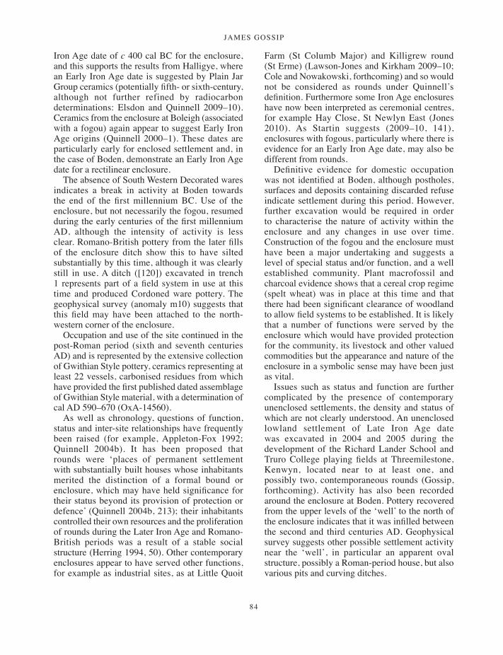
JAMES GOSSIP
84
Iron Age date of c 400 cal BC for the enclosure, and this supports the results from Halligye, where an Early Iron Age date is suggested by Plain Jar Group ceramics (potentially fifth- or sixth-century, although not further refined by radiocarbon determinations: Elsdon and Quinnell 2009–10). Ceramics from the enclosure at Boleigh (associated with a fogou) again appear to suggest Early Iron Age origins (Quinnell 2000–1). These dates are particularly early for enclosed settlement and, in the case of Boden, demonstrate an Early Iron Age date for a rectilinear enclosure.
The absence of South Western Decorated wares indicates a break in activity at Boden towards the end of the first millennium BC. Use of the enclosure, but not necessarily the fogou, resumed during the early centuries of the first millennium AD, although the intensity of activity is less clear. Romano-British pottery from the later fills of the enclosure ditch show this to have silted substantially by this time, although it was clearly still in use. A ditch ([120]) excavated in trench 1 represents part of a field system in use at this time and produced Cordoned ware pottery. The geophysical survey (anomaly m10) suggests that this field may have been attached to the north-western corner of the enclosure.
Occupation and use of the site continued in the post-Roman period (sixth and seventh centuries AD) and is represented by the extensive collection of Gwithian Style pottery, ceramics representing at least 22 vessels, carbonised residues from which have provided the first published dated assemblage of Gwithian Style material, with a determination of cal AD 590–670 (OxA-14560).
As well as chronology, questions of function, status and inter-site relationships have frequently been raised (for example, Appleton-Fox 1992; Quinnell 2004b). It has been proposed that rounds were ‘places of permanent settlement with substantially built houses whose inhabitants merited the distinction of a formal bound or enclosure, which may have held significance for their status beyond its provision of protection or defence’ (Quinnell 2004b, 213); their inhabitants controlled their own resources and the proliferation of rounds during the Later Iron Age and Romano-British periods was a result of a stable social structure (Herring 1994, 50). Other contemporary enclosures appear to have served other functions, for example as industrial sites, as at Little Quoit
Farm (St Columb Major) and Killigrew round (St Erme) (Lawson-Jones and Kirkham 2009–10; Cole and Nowakowski, forthcoming) and so would not be considered as rounds under Quinnell’s definition. Furthermore some Iron Age enclosures have now been interpreted as ceremonial centres, for example Hay Close, St Newlyn East (Jones 2010). As Startin suggests (2009–10, 141), enclosures with fogous, particularly where there is evidence for an Early Iron Age date, may also be different from rounds.
Definitive evidence for domestic occupation was not identified at Boden, although postholes, surfaces and deposits containing discarded refuse indicate settlement during this period. However, further excavation would be required in order to characterise the nature of activity within the enclosure and any changes in use over time. Construction of the fogou and the enclosure must have been a major undertaking and suggests a level of special status and/or function, and a well established community. Plant macrofossil and charcoal evidence shows that a cereal crop regime (spelt wheat) was in place at this time and that there had been significant clearance of woodland to allow field systems to be established. It is likely that a number of functions were served by the enclosure which would have provided protection for the community, its livestock and other valued commodities but the appearance and nature of the enclosure in a symbolic sense may have been just as vital.
Issues such as status and function are further complicated by the presence of contemporary unenclosed settlements, the density and status of which are not clearly understood. An unenclosed lowland settlement of Late Iron Age date was excavated in 2004 and 2005 during the development of the Richard Lander School and Truro College playing fields at Threemilestone, Kenwyn, located near to at least one, and possibly two, contemporaneous rounds (Gossip, forthcoming). Activity has also been recorded around the enclosure at Boden. Pottery recovered from the upper levels of the ‘well’ to the north of the enclosure indicates that it was infilled between the second and third centuries AD. Geophysical survey suggests other possible settlement activity near the ‘well’, in particular an apparent oval structure, possibly a Roman-period house, but also various pits and curving ditches.
001-098_Cornwall 52.indd 84 01/12/2014 11:32

a multi-period prehistoric site and fogou at boden vean
85
Fogous
The word fogou is derived from the Cornish word for cave, ogo (Padel 1985), and refers to man-made subterranean tunnels dating to the Iron Age and Romano-British period which although unique to Cornwall have similarities with Breton, Scottish and Irish souterrains.
The earliest known reference to a fogou is by John Norden who marked Pendeen Vau on his map of Cornwall in 1593 (Cooke 1993, 92). In 1702 William Hals recorded that Royalists took refuge at Boleigh fogou during the Civil War (ibid, 82), and later in the eighteenth century the fogous at Boleigh, Pendeen Vau and Higher Bodinar were explored and recorded by William Borlase (ibid, 82, 92, 132).
In 1803 Reverend Richard Polwhele was the first to record the fogou at Boden. In the same year he had entered the long passage at Halligye through a hole in its roof (the ‘antiquarian hole’), stating that it ‘contained urns’, and visited the ‘Piskey Hall’ at Trewardreva on the north side of the Helford estuary. Others such as the Reverend Buller, Henry Crozier, and most notably J T Blight continued to explore fogous in the latter half of the nineteenth century, producing the first measured plans and engravings of these enigmatic structures (Cooke 1993, 27). All that survives of the once impressive fogou at Castallack are the drawings and engravings of Blight. Later investigators include W C Borlase who first excavated the fogou at Carn Euny and created a record of Higher Bodinar before the fogou was destroyed. Charles Henderson continued the work of recording and planning fogous into the first half of the twentieth century (ibid, 31). Clark (1961) and more recently Maclean (1992) and Cooke (1993) have provided modern discussions. Only six fogous have been investigated using modern techniques: Carn Euny (Christie 1978), Boleigh (Young 2000–1), Halligye (Startin 2009–10), Boden and, to a lesser extent, Treveneague (Young 2000–1); and the fogou at Penhale round, subject to emergency recording in 2006 (Hood 2007).
The number of confirmed extant fogous in Cornwall is a matter of debate since it can be argued that some have been wrongly classified as such by past observers. In places it has been problematic distinguishing fogous from earlier entrance graves or from later hulls and crows, post-medieval storage structures often built into walls
or partly subterranean (Tangye 1973, 40; Cooke 1993, 37). Many more potential or alleged fogous have been recorded as a result of field names or anecdotal evidence. Recent writers have claimed the existence of 11 confirmed fogous (Cooke 1993), with the discovery of the fogous at Boden, Peninnis and Penhale round raising this total to 14. Many more are likely to have existed and await discovery – the recent appearance of a void in a field to the west of the Pixie’s Hall (Trewardreva) may indicate the earth-cut section of a fogou similar to Boden (site visit by Ann Preston-Jones, March 2000).
Fogous are known at Boden, Halligye (Mawgan-in-Meneage), Carn Euny (Sancreed), Boleigh (St Buryan), Pendeen (St Just), Trewardreva (Constantine); Lower Boscaswell (St Just), and Chysauster (Gulval) (Cooke 1993, 53, 64, 82, 91, 108, 113, 121). Two fogous, at Higher Bodinar, Sancreed, and Castallack, Paul, are now destroyed but have detailed antiquarian records (ibid, 132, 139). At Treveneague, St Hilary (ibid, 143), the location of the ‘lost’ fogou was identified by geophysical survey and excavation of a small trench across the top of the fogou confirmed that the roof capstones are still in place. The entrance to this fogou remains blocked (Young 2000–1).
A suggested above-ground fogou at Porthmeor, Zennor, and perhaps also Bosullow Trehyllys, Madron, courtyard house settlement is possibly an adaptation of a curving long room, but may have its origins in the same tradition as the fogou (Cooke 1993, 100, 164).
Until recently, known fogous were confined to a distinct region comprising the Land’s End and Lizard peninsulas, but in 2001 a fogou was uncovered at Peninnis on St Mary’s, Isles of Scilly (Ratcliffe and Johns 2003, 11), and in 2006 another was discovered during a watching brief at Penhale round, St Enoder, in mid-Cornwall (Fig 43; Hood 2007).
Generally all confirmed fogous conform more or less to a particular morphology and character: they are all of dry stone-walled construction, usually corbelled, but may contain earth or rock cut elements. The main passage and wider entrance passage at Boden appear to have been constructed within a cut, lined with large stones which were sourced locally and laid in roughly horizontal courses. These include at least two fragments of gabbroic rock, quartzite ‘spars’ (schists of the Meneage Crush Zone) and rounded beach pebbles.
001-098_Cornwall 52.indd 85 01/12/2014 11:32

JAMES GOSSIP
86
Since alternative building stone is available closer to the site it seems that in this instance stone was chosen primarily for its appearance or for symbolic reasons.
The upper courses of the main passage are slightly corbelled, presumably to reduce the width at the top of the structure for the length of available roofing stones (or timbers), and this is particularly evident above the two upright stones where the wider entrance passage narrows. All known fogous are subterranean structures, but parts or the majority of them may be visible above ground (for example at Halligye, Carn Euny, Boleigh, Trewardreva). This is likely to have been the case at Boden in its original state. Surviving examples are roofed with stone slabs (the most impressive
being Halligye), but some may have had some roofing slabs removed, or have collapsed, may never have been roofed at all, or may have been roofed over with timber. Large stones in the fill of the wider entrance passage at Boden may have collapsed from upper courses or were used as roof slabs.
As at Boden, fogous contain at least one linear (or curvilinear) walled passage, and some have side chambers or ‘creep’ passages (for example Carn Euny, Halligye, Pendeen Vau) which have been described as miniature versions of the long passages ‘and rising up from it to exit at ground level’ (Cooke 1993, 33), but there is clearly considerable variation. At Halligye the original entrance from the outer enclosure ditch takes
Fig 43 Distribution of fogous in Cornwall.
001-098_Cornwall 52.indd 86 01/12/2014 11:32

a multi-period prehistoric site and fogou at boden vean
87
the form of a low lintelled opening described as a ‘creep doorway’ with a similar arrangement on the interior of the structure (Startin 2009–10, 136). There is wide variety in the form and orientation of main passages, side passages and creeps: at Boden it appears that the void is part of an earth-cut side passage, possibly with some stone elements, veering south east from the northern end of the main north-south passage, now blocked by stone but possibly once extending into the enclosure ditch to the east. The eastern end of the passage, where it is blocked with stone, could be described as a creep. At Pendeen the main roofed passage is north-south, changing to north-west to south-east, with a ‘rab’ cut side passage aligned north-east to south-west (Cooke 1993, 92–97), while at Boleigh the main passage is curvilinear from south-west to north-east, with a short stone-lined side passage (and blocked creep entrance to the west) (Cooke 1993, 89). At Halligye the main internal entrance passage narrows to the northern entrance creep passage (similar in some respects to the narrowing of the passage at Boden) and is aligned north-north-west to south-south-east, but from this the much longer and more substantial secondary passage curves away towards the south. At the very end of this is a rock cut ‘southern creep’ aligned east-west (Startin 2009–10, 130). Other side structures are very distinctive, the most notable being the corbelled round chamber at Carn Euny, on the north-western side of the main north east to south west passage. Here too is a low creep passage and exit to ground level at the south-western end of the main passage (Cooke 1993, 72). Shared fogou characteristics are outlined in Table 11.
With the notable exceptions of Carn Euny and Halligye there is some similarity in dimension. The main passage at Boden (approximately 10m long) is similar in length to passages at Boleigh, Treveneague, Porthmeor and Higher Bodinar, and wall heights and passage widths are reasonably uniform (Cooke 1993, 86, 144, 101, 137).
The southern end of the main passage at Boden is marked by two upright stones forming a sort of doorway, at which point the passage widens. Although the upright posts seem to be a feature unique to Boden the narrowing of passages is apparently an important element of Halligye (Startin 2009–10, 127–43) and probably Castallack (Cooke 193, 141). An entrance into the fogou from the enclosure at Boden is less well preserved as a result of collapse and it is clearly harder to define
its original appearance. The southern end of the straight passage at Halligye showed a similar disturbance as a result of stone robbing, although it is thought that this was the likely exit to the settlement (Startin 2009–10, 132). Within the wider passage at Boden large collapsed roof or upper wall stones were recorded, and to the south again, was a long north-south trench [433] cut into the natural subsoil, thought to be an approach to the fogou. Recent work by Meneage Archaeology Group has confirmed that this trench is connected to the southern end of the stone-built section of the fogou (Meneage Archaeology Group site notes). This 0.9m high and 0.75m wide earth-cut trench would have provided a very restricted access, opening out into the wider entrance passage. Low or narrow creep entrances are evident at Halligye (Startin 2009–10, 134), Pendeen Vau (Cooke 1993, 97), Carn Euny (Christie 1978, 331) and probably Treveneague (Cooke 1993, 144–5) highlighting the restricted nature of fogou entrances.
Fogous are, almost without exception, associated with contemporary enclosures or courtyard house settlements, although the latter would appear to be contemporary with later fogou phases, for example at Carn Euny (Christie 1978). The earlier settlement phases at Carn Euny, those associated with the earliest fogou construction, are not fully understood. Excavations at Halligye provided an understanding of the layout of the fogou and its relationship with the enclosure. Startin (2009–10, 136) established that an original northern creep formed an entrance into an enclosure ditch once surrounding the high point of a north-facing slope, At Boleigh, Treveneague and the recently discovered fogou at Penhale, fogou structures are also clearly located within enclosed settlements (Young 2000–1, 129–45; Cooke 1993, 143; Hood 2007). The question as to why some enclosed settlement sites contain fogous while others do not has been explored by Startin, and may be related to matters of discovery, special status or chronology (2009–10, 140–1). It is notable that both Halligye and Boden have particularly early origins in the Early Iron Age; fogous may have been constructed over a short period and therefore not be present on many later settlement sites. Cooke (1993) has made the point that we should not assume that enclosed sites are necessarily settlements, and this point has been reinforced by recent interpretations that some Iron Age enclosures are ceremonial sites (Jones 2010).
001-098_Cornwall 52.indd 87 01/12/2014 11:32
JAMES GOSSIP
88
Modern evidence suggests an Early Iron Age date for the construction of fogous. Boden has provided secure dates for final use of the fogou in the fifth-fourth centuries BC (a radiocarbon determination provided a terminus ante quem for the fogou’s construction of 420–350 cal BC (94 per cent probability), consistent with those for the first phase of construction at Carn Euny (Christie 1978, 331), but probably a little later than those at Halligye, where pottery suggests construction in the sixth or fifth centuries BC (Elsdon and Quinnell 2009–10). At Boleigh, too, construction may have commenced in the sixth or fifth centuries BC, although these dates are less stratigraphically secure (Young 2000–1, 138, 143).
Function
Three basic functions have been suggested and explored for the Cornish fogou, as places of storage, refuge or ceremony (Maclean 1992 31–64; Christie 1978, 332; Cooke 1993, 267). Startin further suggests that access may have been an important function of fogous (2009–10, 142). Despite the efforts of writers to establish a single primary function it remains a possibility that all of these practical needs of Iron Age communities were served by the fogou. Storage of food stocks, whether for animal or human consumption would have been of utmost importance, and probably necessitated the practice of ceremonies and rituals in order to ensure food preservation and thus the survival and prosperity of the community.
Structures with perhaps a primary function of food storage or even refuge may not necessarily have been viewed in a purely utilitarian light (Rose 2000–1, 116); these structures probably having significant symbolic meaning as a result of the ‘special commodities’ placed within their care (Quinnell 1986, 119). The currently accepted interpretation of Scottish souterrains, particularly those of southern Pictland, as grain storage vaults has not diminished the likelihood of their association with ceremony or ritual. It is thought that the souterrains, if originally made water-tight, would have served as suitable spaces in which to store grain away from vermin and risk from fire with large storage capacities for communities largely involved in arable production (Watkins 1984, 73; Armit 1999, 582). While food storage may have been the primary function of these structures it is probable that their construction and use was linked to ritual practices surrounding cycles of food production and storage (Armit 1999, 583). As that writer concludes, ‘it is likely that nothing within Iron Age society was entirely devoid of a ritual or symbolic dimension’ (ibid).
Other evidence for the subterranean storage of foodstuffs has been put forward. Ash pits recorded by Polwhele (1816, 129) at Trewardreva have been suggested as being for the preservation of gulls’ eggs, as demonstrated by the islanders of St Kilda (Fox 1964), and it has been shown that certain foodstuffs, particularly dairy products and beer last particularly well in the dark, cool, atmosphere of the fogou (Maclean 1992, 47). The prevalence of hulls close to Cornish farms for the storage of dairy
Table 11 Comparison of fogou characteristics
Site Max Length (m)
Max Height (m)
Approximate max width (m)
Creep/side passage
Earth-cut elements?
Passage restriction
Assumed date
Orientation Phases
Boden 9.8? 1.5 1.9 Y Y Y EIA N-S 1?Carn Euny 20 1.82 1.98 Y Y Y EIA NE-SW 3Halligye 27 1.8 1.65 Y Y Y EIA NE-SW 2Boleigh 10.8 1.95 1.0 Y N Y EIA NE-SW ?Trewardreva 7.9 1.8 1.8 N N N IA NE-SW ?Pendeen 17.1 1.49 1.5 N Y Y IA/RB NW-SE ?Chysauster ? ? ? ? ? ? IA/RB NE-SW ?Lower Boscaswell 6.1? 1.8 1.49 Y N ? IA/RB WNW-ESE ?Higher Bodinnar 9.0? ? ? ? ? N? IA/RB NE-SW ?Castallack 6.0? 1.05 1.2 Y Y Y IA/RB NE-SW ?Treveneague 10.2 1.4 1.2 Y Y Y IA? ENE-WSW ?Porthmeor 13 1.36 1.82 N N N IA/RB NE-S ?Penhale round approx10 approx 2 3 N N N E-W ?
001-098_Cornwall 52.indd 88 01/12/2014 11:32

a multi-period prehistoric site and fogou at boden vean
89
and other products, in use from the post-medieval period up to the present day (Tangye 1973, 38), is testament to the usefulness of dark, stone-lined and semi-subterranean structures. That fogous are thought of today as particularly damp places has caused some writers to preclude them as places in which to store foods such as cereal surplus (Maclean 1992, 44–7). However, it is likely that they were better maintained during the time of their use, and they may have been far drier than they appear today and could even have been waterproofed, perhaps by filling joints between roof stones with clay, although there is no direct evidence for this. Another commodity of great value to local communities would have been tin. This material would certainly have required safe storage and fogous would have been the ideal place for this, although both Halligye and Boden are located well away from areas of tin production. Perhaps the clearest argument against the suitability of fogous as places to store food or other commodities is the inaccessibility of many fogou passages. This is clearly a deliberate feature of fogou design, as seen at Boden (southern entrance from fogou approach [433]), the side passage at Pendeen Vau (Cooke 1993, 97), and the creep entrances and restricted doorways at Halligye (Startin 2009–10, 134), and would make the storage of large quantities of produce impractical.
The usefulness of a fogou as a refuge in times of attack is open to debate. Some fogous lack a double entrance, and even without this feature it is easy to see that they would only serve to trap those seeking refuge below ground. This is an argument that has been used for the Scottish souterrains (Welfare 1984, 318). Since it has been argued that most, if not all fogous would have been visible to some extent from the ground above then they would not have protected the whereabouts of those under siege. However, if they were solely to provide refuge from raiding parties for short periods of time then they would have provided adequate protection (Maclean 1992, 51–58), and are likely to have been easy to disguise amongst the clutter and structures of settlement. Other examples such as Halligye and probably Boden do have an entrance within the enclosure and an ‘exit’ into the enclosure ditch; although the restricted passages at both would not allow for rapid escape they would make it easier to prevent intruders from gaining access. At Boden the extension of the earth-cut tunnel, or ‘creep’ as far as the enclosure ditch to the east of the Cornish
hedge has not been proven, but the geophysical survey and comparison with other sites would suggest that it is likely. The earth-cut approach trench connecting to the stone-built section of the fogou is an element without parallel in other known fogous; it is possible that this entrance was specifically designed to aid concealment. The restricted access of their passages could therefore be seen as a design feature consistent with both a refuge function and for the storage of valuables during raids (Startin 2009–10). As Rose (2000–1) points out, ‘refuge and ritual [or storage] should not be seen as mutually exclusive interpretations’ and each or all of these may have been the functions of some or all of the known fogous at particular times during their use.
Writers have also observed a number of points possibly pointing to a ritual function for fogous, including the evidence for structured deposition and deliberate closure, inferences from folklore, modern perceptions and comparisons with the monumentality of a parish church. At Boden the role of ritual in the use of the fogou is suggested by structured deposition and infilling in the main passage, by its overall layout, in particular the remarkable 40m long approach trench, and perhaps by the selection of stones for its construction.
The deliberate closure of fogou passages could be seen as a ritual act. The main passage at Boden had been infilled in what was more or less a single event, probably at the same time as disturbance to its southern entrance, and almost certainly carried out in the Iron Age. Although the earth-cut passage does not seem to have been filled in the same way it is possible that either end of this passage was sealed at this time. The most obvious evidence for structured deposits in the Iron Age features at Boden are the basal silts within the fogou which produced a range of Plain Jar Group ceramics, stone finds including the pebble polishing stone S5 placed against the western stone upright ‘pillar’ of wall where the width of the passage narrows, and two small beads, one of dark blue glass and one of amber. These finds may have been specially selected for inclusion in a deposit which represented the end of use of the fogou, marking a final ritual act at the time of closure. If this was a deliberate act of closure the event must not only have required huge physical effort to remove the capstone roof and to backfill with soil but must also have had a profound impact and held great importance to
001-098_Cornwall 52.indd 89 01/12/2014 11:32
JAMES GOSSIP
90
the community who deemed it necessary. Acts of closure as part of a ritual tradition could possibly therefore have survived into the Iron Age from the Bronze Age. In addition to Boden, deliberate infilling has been identified at Carn Euny, Halligye and Penhale Round where the careful backfilling of passages could indicate a process of ritual closure (Christie 1978, 332; Cooke 1993, 53, 64; Hood 2007), although this does not necessarily signify a primary ritual function for the structure itself. The very deliberate nature of ‘closure’, is also a phenomenon recognised at Scottish souterrain sites such as Dalladies, Newmill and Cyderhall (Watkins 1978–80a, 122–64; and 1978–80b, 165–208; Pollock 1992, 153). At Longforgan the stone roof had been very carefully removed and the passage filled in a ‘single continuous operation’ (Wainwright 1954–56, 62). It is not clear whether the fogou approach at Boden continued to function after the infilling of the main fogou passage, although the presence of pottery (P25) other than Early Iron Age suggests that this linear trench may have stayed open following the closure of the stone-built sections of the fogou.
It is easy for modern perceptions to influence considerations of fogou function. The modern mind might sense that fogous often lack the design features that make them unmistakeably ‘ritual’ although the corbelled round chamber at Carn Euny is an obvious exception (Rose 2000–1, 116). The monumental nature of fogou architecture has led some writers to draw analogies between fogous and the Iron Age communities which built them and the significance of the medieval parish church to its parishioners, particularly in terms of the local investment of effort, skill and curation (Christie 1978, 332–3).
Fogous have been woven into folklore and popular mythology and this clearly influences the modern perception of fogous as places of ritual. Pendeen Vau is traditionally thought to run deep under the sea and be ‘the haunt of some terrible spirit’ (Blight 1876, 165) known as the ‘Spirit of the Vow’ (Rose 2000–1, 109) and the fogou at Boleigh was believed to be the inhabited by evil spirits where mothers would caution their unruly children with the threat of being ‘taken down to the Fuggo, and leave them there for the Bucca-boo’ (Bottrell 1873, 28). They are the dwelling places of ‘ugly spriggans’ (Higher Bodinar, known locally as ‘The Giant’s Holt’) and the hiding places of buried treasure (Carn Euny) and are often linked
with tales of supernatural presence (Boleigh and Trewardreva) (Cooke 1993, 217–20, 309–11).
The physical attributes of fogous that influenced how they were portrayed in folklore may also have been the elements which shaped how they were used and perceived in ritual and ceremony. Restricted access and the restrictions often built into passages – their small lintelled ‘doorways’, bottlenecks and ‘creep’ passages, as demonstrated at Boden, Halligye, Carn Euny and others – support the notion of fogous as ‘secret’ places, to be visited perhaps only by those that were powerful, initiated, invited, or sacred in order to engage in spiritual ceremonies or, detached from the world above, to commune with the world of spirits below. The long approach trench at Boden, ultimately leading people underground and into the main fogou passage, could be seen as a design feature that reinforces a ritual function for the structure. As with other suggested functions, further evidence would be required in order to confirm fogous as places of ritual activity.
Structured deposition and the ‘well’
Boden contributes three primary examples to the growing body of evidence for structured deposition in Cornwall. This report has already discussed the Bronze Age structure, where the selective and very deliberate deposition of unusual pottery was very evident prior to closure of the structure, and the fogou, where items also appear to have been deposited before the main fogou passage was infilled. The ‘well’ at Boden contained a mix of Romano-British sherds, an amphora sherd of Italian origin and a collection of deliberately broken stone objects including upper and lower parts of rotary querns, part of a saddle quern or mortar, a whetstone and a hammer stone.
The special treatment of everyday objects has been recognised on many sites of Iron Age and Romano-British date and is seen to have been particularly prevalent in the pits of Iron Age Wessex (Hill 1995). Structured deposition in Romano-British settlements is thought to indicate the survival of local practices throughout the Roman period (Clarke 1997, 80; Richardson 1997, 88). The deliberate selection and placement of artefacts is therefore accepted as commonplace in Iron Age contexts (Hill 1995), and the continuance of long-held ritualised practice from the Bronze Age and into the early centuries AD is likely.
001-098_Cornwall 52.indd 90 01/12/2014 11:32
a multi-period prehistoric site and fogou at boden vean
91
Pits and shafts have been recognised as marking spatial and conceptual boundaries (such as enclosure entrances) and making divisions within social, physical space and temporal space. Ritualised ‘rubbish’ has been specially selected for deposition in these contexts. The deposition of a saddle quern, water-worn stones, pottery and an iron ring in a pit at Trethurgy and a complete and broken saddle quern and other stone tools in an Early Iron Age pit at Trenowah are possible structured deposits relating to foundation deposits (Quinnell 2004b, 237; Quinnell 2008a). A pit containing pottery and burnt bone was found close to the enclosure ditch at Pollamounter, a Romano-British site (Jones and Taylor 2004) and two were located near to the upper edge of the Romano-British field system at Stencoose apparently the focus for deliberate deposition of ceramics, perhaps marking the boundary to a field system and emphasising ownership of the enclosure in a symbolic way. A pit thought to mark the same alignment as the field system ditches had also been filled with a large number of pottery sherds and other discarded everyday objects, supporting the notion of deliberate deposition (Jones 2000–1, 84).
Other structured deposits have been identified at Trethurgy, where an unusual deposit including large amounts of imported or exotic material, a stone bowl and quern was seen in association with Structure G, a possible shrine (Quinnell 2004b, 236–7). Also at Trethurgy a pit which had a close spatial relationship with a suspected granary, and a hearth-pit also contained apparently deliberately selected and buried material (ibid, 237). The stone weight recovered from a posthole at Tremough may indicate a deliberate deposit marking the end of use of the House (Gossip and Jones 2009–10). A pit just outside the Romano-British enclosure at Tremough contained a carefully laid out assemblage (all external surfaces facing up) of deliberately broken pottery and is evidently structured. The special nature of deposits such as this, like those within the Boden ‘well’ could have been linked to ideas associated with the marking of boundaries, or the protection of activities or practices. Perhaps the deliberate inclusion of broken querns in the ‘well’ acts as a symbolic reference to the importance of cereal production and processing. In Iron Age Wessex, deliberately broken, decorated pottery has been recognised as being selected for deposition at spatial and conceptual boundaries, such as enclosure entrances
(Hill 1995). Or perhaps there was an increasing need to justify ownership (Bradley 2005, 169), a need expressed in the ritualized deposition of everyday artefacts with metaphorical links to agriculture and the production of food. The selection of domestic items should not be taken to imply mundanity. In prehistoric communities even everyday actions could have symbolic meaning, where the sacred need not be distinct from the profane in terms of either the content or location of deposits (Hill 1995).
The ‘well’ (described above under Late Iron Age and Romano-British activity) is located 20m to the north of the enclosure and the relationship between them is not known, although it is possible that, together with the fogou, they represent part of a single complex, the use of which may have influenced both the siting of the ‘well’ and the structured, perhaps ritualised nature of its backfill deposits. At Bosence, St Erth, there is a much clearer link between a ritual shaft and an enclosure. Here a pit or well in the corner of a rectangular enclosure measured 36 feet (11m) deep with a diameter of 30 inches (0.75m). The contents included a pewter patera dedicated to Mars, a lead jug (of third- to fourth-century date), a stone weight, a ‘small millstone’ (probably a quern), a patera with two handles, fragments of horns, bones, half-burnt sticks and pieces of leather (Borlase 1769, 316–7; Page 1924, 8). The unusual nature of artefacts contained within the shaft strongly suggests a religious function and may indicate that the enclosure acted as a religious shrine. Further excavation of the Boden pit or shaft is required for a true understanding of its function.
Outside Cornwall, where conditions for preservation have been more favourable, significant deposits of animal bones have been recorded in similar contexts (Merrifield 1987, 37–40) perhaps incorporated into features as part of a feasting ceremony (Fitzpatrick 1997, 78–9). Unfortunately faunal remains rarely survive in Cornwall and such evidence has not survived at Boden.
Site intervisibility
The site at Boden lies just below the summit of a gentle hill at a height of 70m above sea level. The panoramic view from the site includes a number of known prehistoric monuments, particularly those close in date with the Bronze Age structure. To the north much of the distant landscape is hidden by the
001-098_Cornwall 52.indd 91 01/12/2014 11:32
JAMES GOSSIP
92
summit of the hill, but there are commanding views of the countryside to the south, east and west and to sites on the horizon where the land rises up to its highest points on the Lizard peninsula. Due south east the skyline is clearly punctuated by Roskruge Beacon, a Bronze Age barrow prominently located at 114m above sea level, below which are two probable enclosures of prehistoric date. More distant views to the south west show the ridge of the Goonhilly Downs plateau, with several barrows just discernible including the Dry Tree barrow which lies at 112m above sea level.
Today the line of sight to the north is blocked by the modern hedge at the north end of the field. If this were removed the distant granite ridge would just be visible above the brow of the hill, comprising the prominent hills of Godolphin, Tregonning, Carn Brea, Carmenellis, Carn Marth and possibly Nancrossa and Trannack Downs. A slightly elevated position (possible from the hedge to the east of the field, and therefore from the enclosure bank when it was extant) affords clear views to the north east, overlooking Falmouth Bay to the prominent headlands of St Anthony Head and Zone Point.
It is possible that the visibility of important sites was a factor in the positioning of the Bronze Age structure and the Iron Age enclosure and fogou; almost certainly monuments in the landscape acted as focal points and places of memory, with acquired cultural significance. The affinity between the natural landscape and prehistoric settlements has been discussed at length (for example, Tilley 1994) and examples of site intervisibility and the importance of hills and outcrops have been noticed elsewhere in Cornwall, particularly ‘ritual’ sites where monuments reference particular places in the landscape (Cole and Jones 2002–3, 136–7). The natural landscape is likely to have had greater significance to prehistoric societies, who will have drawn less distinct divisions between their natural and cultural worlds than is the case in modern western cultures. For Bronze Age and Iron Age communities at Boden the landscape surrounding them would have been seen as a world created by their gods, where distinctive natural features would have been directly associated with ancestors and memory, places of creation and communication with other worlds (Tilley 1999, 59, 117, 204). Although a comprehensive study has not taken place it is interesting to note that similar long-distance views are possible towards upland areas
prolific in both natural features and prehistoric monuments from the fogous at Halligye, Trewardreva, Carn Euny, Chysauster, and Pendeen. More detailed observations from these sites may indicate that important places in the landscape were visible from all known fogous.
Project archive
Artefacts and environmental material retrieved during the excavations, together with site documentation, specialists reports, drawings and photographs are housed at the Royal Cornwall Museum, River Street, Truro, TR1 2SJ. The museum accession number is 2005.23.
Acknowledgements
The project and publication of this report were funded by English Heritage (EH). Encouragement and support were provided throughout by Fachtna McAvoy and Helen Keeley, EH Project Assurance Officers, and thanks also go to Ian Morrison, EH Inspector of Ancient Monuments, who provided decisive initial support. I am grateful to Charles Johns, Fachtna McAvoy, Henrietta Quinnell and Peter Rose for their invaluable and constructive comments on the report.
The land at Boden is owned and farmed by Chris Hosken and without him the site would not have come to light. He and his sons James and Edward proved themselves dedicated assistants throughout the excavations and the author is indebted to Chris’s continued enthusiasm and passion for the site
Thanks are also extended to the many specialists whose work has contributed to this report, to Vanessa Straker for advice on environmental sampling strategy and to Gianna Ayalla and Heather Tinsley for pollen and soil geomorphology sampling.
Within the Historic Environment Service, the project manager was Charles Johns. Dick Cole produced the project design and the fieldwork was carried out by the author with assistance from Matt Mossop; administrative support and guidance was provided by Peter Rose.
All other help came from members of Cornwall Archaeological Society and local people to whom the author is hugely grateful. Special mention is given to Sally Ealey who carried out the thankless task of processing the environmental samples and
001-098_Cornwall 52.indd 92 01/12/2014 11:32
a multi-period prehistoric site and fogou at boden vean
93
also to Ava Dingwall, Tony Fraser, Rob Hewitt, James Hosken, Edward Hosken, Jean Hughes, Margaret Hunt, Pam Lee, Lynette Millward, Konstanze Rahn, Meg Reed, Norman Reed, Adrian Rodda, Ryan Smith, Mick Triplett and Christine Wilson. Thanks also go to Truro College students Andrew Harris, James Puttock, Doug Smith, Sarah McNaughton and Becky Wilson who helped with excavation and field-walking under the direction of Caradoc Peters and Hilary Orange. Field-walking was also carried out by children from Garras, St Martin and Manaccan primary schools with help from their teachers and parents under the direction of Anna Tyacke, Finds Liaison Officer with the Portable Antiquities Scheme.
Henrietta Quinnell’s acknowledgements
I am indebted to Sue Watts for discussion on the Boden stonework, especially the querns.
Neil Linford’s acknowledgements
It was a great pleasure to return to Boden to conduct the GPR survey and once again share the enthusiasm that the landowner, Chris Hosken, has continued to show for the site since his initial rediscovery of the fogou in 1991. I am also indebted to Mark Cole (English Heritage) and Ian Bishop (Golders Associates) who conducted the initial geophysical surveys at the site together with the kind field assistance of Margaret Hunt, a local enthusiast of the site who would not let us be put off by inclement weather. The 2003 GPR survey could not have been conducted without the assistance of Louise Martin (English Heritage), to whom I also offer my thanks.
ReferencesAppleton-Fox, N, 1992. Excavations at a Romano-
British round: Reawla, Gwinear, Cornwall, Cornish Archaeol, 31, 69–126
ApSimon, A M, and Greenfield, E, 1972. The excavation of the Bronze Age and Iron Age settlement at Trevisker round, St Eval, Cornwall, Proc Prehist Soc, 38, 302–81
Armit, I, 1999. The abandonment of souterrains: evolution, catastrophe or dislocation?, Proc Soc Ant Scot, 129, 577–96
Ashbee, P, 1996. Halangy Down, St Mary’s, Isles of Scilly: excavations 1964–1977, Cornish Archaeol, 35, 5–201
Ashmore, P, 1999. Radiocarbon dating: avoiding errors by avoiding mixed samples, Antiquity, 73, 124–30
Barrett, J C, Freeman, P M W, and Woodward, A, 2000. Cadbury Castle, Somerset: the later prehistoric and early historic archaeology, English Heritage Arch Repts, 20, London
Bartlett, A D H, 1978. Report on the magnetometer survey at Reawla, Gwinear, Cornwall, AM Lab Rep (old ser), 2565
Beck, C, and Shennan, S, 1991. Amber in prehistoric Britain, Oxbow monogr, 8, Oxford
Bellamy, P S, 2000. Querns, spatial analysis of the stone artefacts of all later prehistoric periods, in Barrett et al 2000, 206–11, 313–5
Blight, J T, 1876. A week at the Land’s End, TruroBorlase, W, 1769. Antiquities historical and monumental
of the county of Cornwall, LondonBorlase, W C, 1879. Archaeological discoveries in the
parishes of St Just-in-Penwith and Sennen, Jnl Roy Inst Cornwall, 21, 190–212
Bottrell, W, 1873. Traditions and hearthside stories of west Cornwall, 2nd series, Penzance
Bradley, R, 2005. Ritual and domestic life in prehistoric Europe, London
British Geological Survey, 1974. The Lizard, England and Wales, Drift, Sheet 359, 1:50,000 scale
Bronk Ramsey, C, 1995. Radiocarbon calibration and analysis of stratigraphy: the OxCal program, Radiocarbon, 37, 425–30
Bronk Ramsey, C, 1998. Probability and dating, Radiocarbon, 40, 461–74
Bronk Ramsey, C, 2001. Development of the radiocarbon calibration program OxCal, Radiocarbon, 43, 355–63
Bronk Ramsey, C, Higham, T, and Leach, P, 2004. Towards high precision AMS: progress and limitations, Radiocarbon, 46(1), 17–24
Bruce-Mitford, R, 1997. Mawgan Porth: a settlement of the late Saxon period on the north Cornish coast, excavations 1949–52, 1954, and 1974, English Heritage Arch Repts, 13, London
Buck, C E, Cavanagh, W G, and Litton, C D, 1996. Bayesian approach to interpreting archaeological data, Chichester
Campbell, G, and Straker, V, 2003. Prehistoric crop husbandry and plant use in southern England: development and regionality, in Proceedings of the archaeological sciences conference, University of Bristol 1999, K A Robson Brown, ed, Brit Arch Repts, Int Ser, 1111, Oxford, 14–30
Carlyon, P M, 1987. Finds from the earthwork at Carvossa, Probus, Cornish Archaeol, 26, 103–44
Christie, P M, 1978. The excavation of an Iron Age souterrain and settlement, Carn Euny, Sancreed, Cornwall, Proc Prehist Soc, 44, 309–434
Clark, E V, 1961. Cornish fogous, London
001-098_Cornwall 52.indd 93 01/12/2014 11:32

JAMES GOSSIP
94
Clarke, S, 1997. Abandonment, rubbish disposal and ‘special’ deposits at Newstead, in Meadows et al 1997, 71–83
Clinton, M, 2001. The souterrains of Ireland, BrayCole, R, and Jones, A M, 2002–3. Journeys to the Rock:
archaeological investigations at Tregarrick Farm, Roche, Cornwall, Cornish Archaeol, 41–42, 107–43
Cole, R, and Nowakowski, J, forthcoming. Excavations at Killigrew: an Iron Age and Romano-British industrial site on the Trispen by-pass, Cornwall, 1996, Cornish Archaeol
Cooke, I M, 1993. Mother and sun, the Cornish fogou, Penzance
Cornwall County Council, 1996. Cornwall Landscape Assesssment, 1994, Truro
Crofts, C B, 1954–5. Maen Castle, Sennen: the excavation of an Early Iron Age promontory fort, Proc West Cornwall Field Club, 1, 3, 98–115
Cunliffe, B, 1984a. Danebury: an Iron Age hillfort in Hampshire. Vol 1 The excavations 1969–1978: the finds, CBA Res Repts, 52, London
Cunliffe, B, 1984b. Danebury: an Iron Age hillfort in Hampshire. Vol 2 The excavations 1969–1978: the finds, CBA Res Repts, 52, London
Cunliffe, B, 1988. Mount Batten, Plymouth: a prehistoric and Roman port, Oxford Univ Comm Archaeol monogr, 26, Oxford
Cunliffe, B, 1991. Iron Age communities in Britain, London (3rd edn)
Cunliffe, B, and Poole, C, 1991. Danebury, an Iron Age hillfort in Hampshire. Vol 5 The excavations 1979–1988: the finds, CBA Res Repts, 73, London
Curwen, E C, 1937. Querns, Antiquity, 11, 133–50Dudley, D, 1956. An excavation at Bodrifty, Mulfra,
Penzance, Arch Jnl, 113, 1–32Dudley, D, 1968. Excavations on Nor’nour in the Isles
of Scilly, 1962–6, Arch Jnl, 124, 1–64Edwards, K, and Kirkham, G, 2008. Time Team
excavations at Gear and Caervallack, 2001, Cornish Archaeol, 47, 49–100
Elsdon, S M, 1978. The pottery, in Christie 1978, 396–423
Fitzpatrick, A, 1997. Everyday life in Iron Age Wessex, in Reconstructing Iron Age societies, A Gwilt and C Haselgrove, eds, Oxbow monogr, 71, Oxford, 73–86
Flett, J S, 1946. Geology of the Lizard and Meneage, V, London (2nd edn)
Fox, A, 1964. South-west England, Newton AbbotGale, R, 2004. Charcoal analysis, in Jones and Taylor
2004, 81–9Gale, R, 2009–10. Charcoal, in Lawson-Jones and
Kirkham, 210–6 Gale, R, and Cutler, D, 2000. Plants in archaeology,
KewGelfand, A E, and Smith, A F M, 1990. Sampling
approaches to calculating marginal densities, J American Statistical Assoc, 85, 398–409
Gilbert, P, and Straker, V, 1998–9. Assessment of the charred plant macrofossils, in Jones 1998–9, 38–40
Gilks, W R, Richardson, S, and Spiegelhalther, D J, 1996. Markov Chain Monte Carlo in practice, London
Godwin, H, 1956. The history of the British flora, Cambridge
Gordon, A S R , 1940. The excavation of Gurnard’s Head, an Iron Age cliff castle in western Cornwall, Arch Jnl, 97, 96–111
Gossip, J, 2004. Boden Vean, St Anthony-in-Meneage, Cornwall. Archaeological evaluation: archive summary, Truro (Historic Environment Service, Cornwall County Council)
Gossip, J, forthcoming. Excavations at the Richard Lander School development, Threemilestone, Cornwall
Gossip, J, in prep. Excavations at Boden roundhouse: Cornwall Archaeological Society excavation 2008, Cornish Archaeol
Gossip, J, and Johns, C, 2005. Boden Vean, St Anthony-in-Meneage, Cornwall, assessment and updated project design, Truro (Historic Environment Service, Cornwall County Council)
Gossip, J, and Jones, A M, 2007. Archaeological investigations of a later prehistoric and a Romano-British landscape at Tremough, Penryn, Cornwall, Brit Arch Repts, Brit Ser, 443, Oxford
Gossip, J, and Jones, A M, 2008. A Bronze Age roundhouse at Carnon Gate, Feock, Cornish Archaeol, 47, 131–45
Gossip, J, and Jones, A M, 2009–10. Excavations at Tremough, Cornwall, Cornish Archaeol, 48–49, 1–66
Gover, J E B, 1948. The place-names of Cornwall, unpublished typescript (copy in Courtney Library, Royal Institution of Cornwall, Truro)
Guido, M, 1968. The glass beads from Nor’nour, Isles of Scilly, in Dudley 1968, 26–7
Guido, M, 1978. The glass beads of the prehistoric and Roman periods in Britain and Ireland, Soc Antiq London, Rep Res Comm, 35, London
Gray, H St G, 1966. The Meare Lake Village, vol III, Taunton
Guthrie, A, 1969. Excavation of a settlement at Goldherring, Sancreed, 1958–1961, Cornish Archaeol, 8, 5–39
Hals, W, 1702. Compleat history of Cornwall, general and parochial, ms held at the Royal Institution of Cornwall, Truro
Hamilton, D, Marshall, P, Roberts, H M, Bronk Ramsey, C, and Cook, G, 2007. Appendix 1 Gwithian: scientific dating, in Nowakowski et al 2007, 61–70
Harris, D, 1983. Excavation of a barrow(?) at Higher Polcoverack, St Keverne, Cornish Archaeol, 22, 93–8
Hedges, R E M, Bronk Ramsey, C, and Housley, R A, 1989. The Oxford Accelerator Mass Spectrometry facility: technical developments in routine dating, Archaeometry, 31, 99–113
001-098_Cornwall 52.indd 94 01/12/2014 11:32

a multi-period prehistoric site and fogou at boden vean
95
Henderson, C, 1912. Parochial antiquities, vol 1, ms held at the RIC, Truro
Henderson, C, 1916. Parochial antiquities, vol 2, ms held at the RIC, Truro
Henderson, J, 1984. Beads of glass, in Cunliffe 1984b, 396–8
Henderson, J, 1988. Glass production and Bronze Age Europe, Antiquity, 62, 435–51
Herring 1994. The cliff castles and hillforts of West Penwith in the light of recent work at Maen Castle and Treryn Dinas, Cornish Archaeol, 33, 40–56
Hill, J D, 1995. Ritual and rubbish in the Iron Age of Wessex, Brit Arch Repts, Brit Ser, 242, Oxford
Hood, A, 2007. Penhale Round, Fraddon, Cornwall: archaeological excavation post-excavation assessment, Swindon (Foundations Archaeology)
Ingrem, C, forthcoming. The faunal remains, in A Reynolds, Excavations at Atlantic Road, Newquay, Cornish Archaeol
Jacomet, S, 1989. Prähistorische Getreidefunde: a guide to the identification of prehistoric barley and wheat finds, Basel
Johns, C, 2008. The excavation of a multi-period archaeological landscape at Trenowah, St Austell, Cornwall, 1997, Cornish Archaeol, 47, 1–48
Johnson, N, and Rose, P, 1982. Defended settlement in Cornwall – an illustrated discussion, in The Romano-British countryside, D Miles, ed, Brit Arch Repts, Brit Ser, 103, Oxford, 151–208
Johnson, N, and Rose, P, 1994. Bodmin Moor: an archaeological survey, volume 1: the human landscape to c 1800, London, English Heritage
Jones, A M, 1998–9. The excavation of a Later Bronze Age structure at Callestick, Cornish Archaeol, 37–8, 5–55
Jones, A M, 2000–1. The excavation of a multi-period site at Stencoose, Cornwall, Cornish Archaeol, 39–40, 45–94
Jones, A M, 2005. Cornish Bronze Age ceremonial landscapes c 2500–1500 BC, Brit Arch Repts, Brit Ser, 394, Oxford
Jones, A M, 2008. Houses for the dead and cairns for the living: a reconsideration of the Early to Middle Bronze Age transition in south-west England, Oxford J Archaeol, 27, 153–74
Jones, A M, 2010. Misplaced monuments? A review of ceremony and monumentality in first millenium BC Cornwall, Oxford J Archaeol, 29, 2, 203–28
Jones, A M, and Quinnell, H, 2011. The Neolithic and Bronze Age in Cornwall, c 4000 cal BC to c 1000 cal BC: an overview of recent developments, Cornish Archaeol, 50, 197–230
Jones, A M, and Taylor, S E, 2004. What lies beneath…St Newlyn East and Mitchell, Truro (Cornwall County Council)
Jones, A M, and Taylor, S R, 2010. Scarcewater, Pennance, Cornwall: archaeological excavation of a
Bronze Age and Roman landscape, Brit Arch Repts, Brit Ser, 516, Oxford
Jones, J, 2008. Plant macrofossils, in Johns 2008, 33–7Lawson-Jones, A, and Kirkham, G, 2009–10. Smithing
in the round: excavations at Little Quoit Farm, St Columb Major, Cornwall, Cornish Archaeol, 48–49, 173–226
Linford, N T, 1998. Geophysical survey at Boden Vean, Cornwall, including an assessment of the microgravity technique for the location of suspected archaeological void features, Archaeometry, 40, 187–216
Linford, N, 2004. Boden Vean, St Anthony in Meneage, Cornwall: report on geophysical survey, October 2003, English Heritage, CfA Rep Ser, 11/2004
Maclean, R, 1992. The fogou: an investigation of function, Cornish Archaeol, 31, 41–64
Marren, P, 1992. The wild woods: a regional guide to Britain’s ancient woodland, Newton Abbott
McAvoy, F, 1980. The excavation of a multi-period site at Carngoon Bank, Lizard, Cornish Archaeol, 19, 31–62
Meadows, K, Lemke, C, and Heron, J, eds, 1997. TRAC 96. Proceedings of the sixth annual theoretical Roman archaeology conference, Sheffield 1996, Oxford
Merrifield, R, 1987. The archaeology of ritual and magic, London
Mitchell, A, 1974. A field guide to the trees of Britain and Northern Europe, London
Mook, W G, 1986. Business meeting: recommendations/resolutions adopted by the twelfth International Radiocarbon Conference, Radiocarbon, 28, 799
Nicholas, E M, 1968. Crows in Cornish hedges in the Pendeen area, Cornish Archaeol, 7, 68–72
Nowakowski, J A, 1991. Trethellan Farm, Newquay: excavation of a lowland Bronze Age settlement and Iron Age cemetery, Cornish Archaeol, 30, 5–242
Nowakowski, J A, 1998. The A30 Project, Cornwall – archaeological investigation along the route of the Indian Queens bypass 1992–1994: assessment and updated project design, Volume II, Truro (Cornwall Archaeological Unit)
Nowakowski, J A, 2001. Leaving home in the Cornish Bronze Age: insights into the planned abandonment process, in Bronze Age landscapes, tradition and transformation, J Bruck, ed, Oxford, 139–48
Nowakowski, J A, 2004. Archaeology beneath the towans. Excavations at Gwithian, Cornwall, 1949–1969. Updated project design for assessment, analysis and publication, Truro (Historic Environment Service, Cornwall County Council)
Nowakowski, J A, 2007. Excavation of a Bronze Age landscape and post-Roman industrial settlement 1953–1961, Gwithian, Cornwall. Assessments of key datasets 2003–2006, Truro (Historic Environment Service, Cornwall County Council)
Nowakowski, J A, 2011. Telling tales from the roundhouse. Researching Bronze Age buildings in
001-098_Cornwall 52.indd 95 01/12/2014 11:32

JAMES GOSSIP
96
Cornwall, in Recent archaeological work in south-western Britain, papers in honour of Henrietta Quinnell, S Pearce, ed, Brit Arch Repts, Brit Ser, 548, Oxford, 101–19
Nowakowski, J A, in prep. Early Bronze Age ceremony and burial in the lowlands: the excavation of Trelowthas barrow, Probus, Cornwall, 1995
Nowakowski, J A, and Johns, C, forthcoming. Bypassing Indian Queens. Archaeological excavations 1992–1994: investigating prehistoric and Romano-British settlement and landscapes in Cornwall
Nowakowski, J A, Quinnell, H, Sturgess, J, Thomas, C, and Thorpe, C, 2007. Return to Gwithian: shifting the sands of time, Cornish Archaeol, 46, 13–67
Nowakowski, J A, and Quinnnell, H, 2011. Trevelgue Head, Cornwall: the importance of C K Croft Andrew’s 1939 excavations for prehistoric and Roman Cornwall, Truro (Cornwall Council)
Page, W, 1924. A history of the county of Cornwall, London
Padel, O J, 1985. Cornish place-name elements, Nottingham (English Place-Name Society)
Parker-Pearson, M, 1990. The production and distribution of Bronze Age pottery in south-west Britain, Cornish Archaeol, 29, 5–32
Parker-Pearson, M, 1995. Southwestern Bronze Age pottery, in Unbaked Urns of Rudely Shape: essays on British and Irish pottery for Ian Longworth, I Kinnes and G Varnell, eds, Oxford, 89–100
Patchett, F M, 1946. Cornish Bronze Age pottery, Arch Jnl, 101, 17–49
Patchett, F M, 1950. Cornish Bronze Age pottery, pt 2, Arch Jnl, 107, 44–65
Patchett, F M, 1954–5. The pottery from Maen Castle, in Crofts, 109–15
Peacock, D P S, and Williams, D F, 1991. Amphorae and the Roman economy: an introductory guide, London
Polwhele, R, 1803. The history of Cornwall, LondonPolwhele, R 1816. The history of Cornwall, vol. 1,
London (reprint)Pollock, R W, 1992. The excavation of a souterrain and
roundhouse at Cyderhall, Sutherland, Proc Soc Ant Scot, 122, 149–60
Poole, C, 1995. Pits and propitiation, in Danebury. An Iron Age hillfort in Hampshire. Vol 6 A hillfort community in perspective, B Cunliffe, CBA Res Rept, 102, London, 249–75
Poole, C, 2000a. Clay beads, in Barrett et al 2000, 188Poole, C, 2000b. Structural materials, in Barrett et al
2000, 212–3Price, J, 2004. Romano-British and early post-Roman
glass vessels and objects, in Quinnell 2004b, 85–92Quinnell, H, 1986. Cornwall during the Iron Age and the
Roman period, Cornish Archaeol, 25, 111–34Quinnell, H, 1998–9. Bronze Age pottery, in Jones
1998–9, 19–26
Quinnell, H, 2000. First millennium BC and Roman period ceramics, in P Herring, St Michael’s Mount: report on archaeological work 1995–1997, Truro (Cornwall County Council), 38–46
Quinnell, H, 2000–1. Pottery and stone artefacts, in Young 2001–2, 139–44
Quinnell, H, 2004a. Assessment of the prehistoric and Roman period pottery, in Nowakowski 2004, 149–64
Quinnell, H, 2004b. Trethurgy. Excavations at Trethurgy Round, St Austell: community and status in Roman and post-Roman Cornwall, Truro (Cornwall County Council)
Quinnell, H, 2007. Stonework, in Gossip and Jones, 81–8
Quinnell, H, 2008a. The prehistoric pottery, in Johns 2008, 19–27
Quinnell, H, 2008b. The pottery from the Time Team excavations, in Edwards and Kirkham, 77–87
Quinnell, H, 2009–10. The prehistoric, Roman and early medieval pottery, in Gossip and Jones, 31–59
Quinnell, H, 2011. The pottery, in Nowakowski and Quinnell 2011, 144–208
Quinnell, H, forthcoming. The pottery, in Nowakowski, in prep
Quinnell, H, and Elsdon, S, 2009–10. The finds from Halligye fogou, Cornish Archaeol, 48–49, 145–72
Quinnell, H, and Taylor R, 1998–9. Stone artefacts, in Jones, 26–36
Quinnell, H, and Thorpe, C, 2007. Bronze Age material culture, in Nowakowski et al 2007, 33–7
Quinnell, H, and Watts, S, 2004. Rotary querns, in Quinnell 2004b, 14–51
Radford, C A R, 1951. Report on the excavations at Castle Dore, Jnl Roy Inst Cornwall, ns, 1, Appendix
Ratcliffe, J, and Johns, C, 2003. Scilly’s archaeological heritage, Chacewater (Twelveheads Press)
Rau, C, 1884. Prehistoric fishing in Europe and North America, Washington DC (Smithsonian Institute)
Reimer, P J, Baillie, M G L, Bard, E, Bayliss, A, Beck, J W, Bertrand, C J H, Blackwell, P G, Buck, C E, Burr, G S, Cutler, K B, Damon, P E, Edwards, R L, Fairbanks, R G, Friedrich, M, Guilderson, T P, Hogg, A G, Hughen, K A, Kromer, B, McCormac, G, Manning, S, Bronk Ramsey, C, Reimer, R W, Remmele, S, Southon, J R, Stuiver, M, Talamo, S, Taylor, F W, van der Plicht, J, and Weyhenmeyer, C E, 2004. IntCal04 Terrestrial radiocarbon age calibration, 0–26 Cal Kyr BP, Radiocarbon, 46, 1029–58
Richardson, J E, 1997. Economy and ritual: the use of animal bone in the interpretation of the Iron Age to Roman cultural transition, in Meadows et al 1997, 73–81
Rose, P, 2000–2001. Shadows in the imagination: encounters with caves in Cornwall, Cornish Archaeol, 39–40, 95–128
Rose, P, and Preston-Jones, A, 1991. Boden, St Anthony (SW7684 2404): report of site visit and survey,
001-098_Cornwall 52.indd 96 01/12/2014 11:32

a multi-period prehistoric site and fogou at boden vean
97
September 1991, unpublished report, Truro (Cornwall Archaeological Unit)
Saunders, A, and Harris, D, 1982. Excavations at Castle Gotha, St Austell, Cornish Archaeol, 21, 109–53
Savory, H N, 1976. Guide catalogue of the early Iron Age collection, Cardiff
Scaife, R G, 1998–9. The charred seed remains, in D A Johnston, C Moore, and P Fasham, Excavations at Penhale Round, Fraddon, Cornwall 1995/6, Cornish Archaeol, 37–8, 94–100
Scollar, I, Tabbagh, A, Hesse, A, and Herzog, I, 1990. Archaeological prospecting and remote sensing: vol 2, Topics in remote sensing, Cambridge
Schwieso, J, 1976. Excavations at Threemilestone round, Kenwyn, Truro, Cornish Archaeol, 15, 51–67
Slota, Jr P J, Jull, A J T, Linick, T W, and Toolin, L J, 1987. Preparation of small samples for 14C accelerator targets by catalytic reduction of CO, Radiocarbon, 29, 303–6
Smith, G, and Harris, D, 1982. The excavation of Mesolithic, Neolithic and Bronze Age settlements at Poldowrian, St Keverne, 1980, Cornish Archaeol, 21, 23–66
Smith, G, 1984. Excavations on Goonhilly Down, The Lizard, 1981, Cornish Archaeol, 23, 3–46
Smith, G, 1996. Archaeology and environment of a Bronze Age cairn and prehistoric and Romano-British field system at Chysauster, Gulval, near Penzance, Cornwall, Proc Prehist Soc, 62, 167–220
Smith, I F, 1981. The Neolithic pottery, in R J Mercer, Excavations at Carn Brea, Illogan, Cornwall 1970–73, Cornish Archaeol, 20, 161–79
Soil Survey of England and Wales, 1983. Soils of England and Wales, Sheet 5, South West England 1:250,000 scale.
Sorenson, M-L S, 1996. Sherds and pot groups as keys to site formation process, in S Needham and T Spence, Refuse and disposal at Area 16 East, Runnymede, London (British Museum Press), 61–74
Stace, C, 1991. New flora of the British Isles, Cambridge Startin, B, 2009–10. Halligye fogou: excavations
1980-82, Cornish Archaeol, 48–49, 127–43Stead, I M, 1965. The La Tène cultures of Eastern
Yorkshire, YorkStead, I M, 1991. Iron Age cemeteries in East Yorkshire,
English Heritage Arch Repts, 22, LondonSteier, P, and Rom, W, 2000. The use of Bayesian
statistics for 14C dates of chronologically ordered samples: a critical analysis, Radiocarbon, 42, 183–98
Straker, V, 1991. Charred plant macrofossils, in Nowakowski 1991, 162–79
Straker, V, 1992. Charred plant macrofossils, in Appleton-Fox 1992, 89–92
Straker, V, 2000–1. Assessment of charred plant macrofossils from bulk samples, in Jones 2000–1, 75–8
Straker, V, 2011a. Science and archaeology, Cornish Archaeol, 50, 175–86
Straker, V, 2011b. Past environments in west Cornwall: a review of the palaeoenvironmental literature, in P Dudley, Goon, hal, cliff and croft: the archaeology and landscape history of west Cornwall’s rough ground, Truro (Cornwall Council), 66–72
Stuiver, M, and Kra, R S, 1986. Editorial comment, Radiocarbon, 28(2B), ii
Stuiver, M, and Reimer, P J, 1986. A computer program for radiocarbon age calculation, Radiocarbon, 28, 1022–30
Stuiver, M, and Reimer, P J, 1993. Extended 14C data base and revised CALIB 3.0 14C age calibration program, Radiocarbon, 35, 215–30
Tangye, M, 1973. Hulls in Cornwall: a survey and discussion, Cornish Archaeol, 12, 31–52
Thomas, C, 1958. Gwithian. Ten years’ work, GwithianThomas, C, 1968. Grass-marked pottery in Cornwall, in
Studies in Ancient Europe: essays presented to Stuart Piggott, J M Coles and D D A Simpson, eds, Leicester, 311–32
Thomas, C, 2005. Archaeology beneath the Towans: excavations at Gwithian 1949–1963. Background paper no 3: an interim assessment of post-400, pre-1200, native pottery and Mediterranean and Gaulish imported wares in Cornwall and Scilly, privately produced memorandum
Thomas, C, Thorpe, C, and Quinnell, H, 2004. Gwithian: post-Roman pottery – initial appraisal, in Nowakowski 2007, vol 2, 139–44
Thomas, C, and Thorpe, C, 2007. Post-Roman material culture, in Nowakowski et al 2007, 44–9
Thomas, I, 1960. The excavations at Kynance Gate 1953–1960, The Lizard, I, 4, 5–16
Thorne, C, and Thorne, F, 1979. Domesday Book, Cornwall, Chichester
Thorpe, C, 2011. The early medieval native pottery of Cornwall, AD c 400–1066, in Recent archaeological work in south-western Britain: papers in honour of Henrietta Quinnell, S Pearce, ed, Brit Arch Repts, Brit Ser, 548, Oxford, 151–8
Threipland, L M, 1956. An excavation at St Mawgan-in-Pyder, North Cornwall, Arch Jnl, 113, 33–81
Tilley, C, 1994. A phenomenology of landscape, OxfordTilley, C, 1999. Metaphor and material culture, OxfordTutin, T G, Heywood, V H, Burgess, N A, Valentine, D
H, and Moore, D M, eds, 1964–80. Flora Europaea, 1–5, Cambridge
Wainwright, F T, 1954–56. A souterrain at Longforgan in Perthshire, Proc Soc Ant Scot, 88, 57–64
Wainwright G, ed, 1979. Gussage All Saints: an Iron Age settlement in Dorset, London
Ward, G K, and Wilson, S R, 1978. Procedures for comparing and combining radiocarbon age determinations: a critique, Archaeometry, 20 (1), 19–31
001-098_Cornwall 52.indd 97 01/12/2014 11:32

JAMES GOSSIP
98
Watkins, T, 1978–1980a. Excavation of an Iron Age open settlement at Dalladies, Kincardineshire, Proc Soc Ant Scot, 110, 122–64
Watkins, T, 1978–1980b. Excavation of a settlement and souterrain at Newmill, near Bankfoot, Perthshire, Proc Soc Ant Scot, 110, 165–208
Watts, S, 2003. The form and function of querns and mortars in Iron Age and Roman Cornwall, unpublished BA dissertation, Univ Exeter
Watts, S, 2012. The structured deposition of querns. The context of use and deposition of querns in the south west of England from the Neolithic to the Iron Age, unpublished PhD Thesis, Univ Exeter
Welfare, H, 1984. The southern souterrains, in Between and beyond the walls: essays on the prehistory and
history of north Britain in honour of George Jobey, R Miket and C Burgess, eds, Edinburgh, 305–16
Woodward, A, and Cane, C, 1991. The Bronze Age pottery, in Nowakowski 1991, 103–31
Woodward, A, 2000. The late Bronze Age and Iron Age ceramic type series, in Barrett et al 2000, 325–46
Young, A, 2000–1. Time Team at Boleigh fogou, St Buryan, Cornish Archaeol, 39–40, 129–45
Young, A, 2006. The National Mapping Programme in Cornwall, Cornish Archaeol, 45, 109–16
Xu, S, Anderson, R, Bryant, C, Cook, G T, Dougans, A, Freeman, S, Naysmith, P, Schnabel, C, and Scott, E M, 2004. Capabilities of the new SUERC 5MV AMS facility for 14C dating, Radiocarbon, 46, 59–64
This paper is published with a grant from English Heritage
001-098_Cornwall 52.indd 98 01/12/2014 11:32
99
Cornish Archaeology 52, 2013, 99–133
Excavations at Scarcewater Tip, Pennance, St Stephen-in-Brannel
ANDY M JONES AND SEAN R TAYLOR
In 2004 a large-scale excavation covering some 30 ha was undertaken at the site of Imerys Minerals’ Scarcewater tip, St Stephen-in-Brannel. The archaeological investigations focused on three roundhouses and a ploughed-down barrow of Middle Bronze Age date, together with a range of structures and pits, an enclosed Late Bronze Age roundhouse and pits, an Iron Age cairn and Romano-British settlement and funerary activity. The excavations demonstrated shifting settlement and changes to the character of settlement and ceremony over a period spanning the Bronze Age to the Romano-British period (c 1500 cal BC – AD 410).
This paper presents a summary of the major findings from the project, namely the Middle and Late Bronze Age settlements, an Iron Age ceremonial site and the Romano-British burials.
In 2004 the Projects team of the Historic Environment Service, Cornwall County Council, was funded by Imerys Minerals Ltd to undertake archaeological recording at Scarcewater, Pennance, St Stephen-in-Brannel (centred on SW 928 540), in advance of the construction of a new tip for waste from the china-clay industry (Fig 1). The programme included archaeological assessment, geophysical survey, evaluation and a watching brief. Some of the sites investigated during the evaluation were removed from the development area, but all 30 ha of land included in the final footprint of the tip were subject to a controlled soil strip.
The methodologies for the archaeological recording, specialist reports and full stratigraphic description of all the excavated sites have been published elsewhere (Jones and Taylor 2010). This paper summarises the results from the key sites, namely a Middle Bronze Age settlement, a Late Bronze Age settlement, Iron Age ceremonial activity and Romano-British burials (Fig 2).
Scarcewater tip is located 2 km north west of the village of St Stephen-in-Brannel at approximately
80m to 110m OD, above the medieval settlement of Pennance. It is located on the southern end of a prominent north-south ridge between the valleys of the Tresillian River to the west and the Fal to the east. The project area is south-facing, affording wide-ranging views over much of central Cornwall, particularly into the valley of the Fal.
The eastern two-thirds of the site is characterised as Anciently Enclosed Land (Cornwall County Council 1996). This is farmland that has been enclosed since at least the seventeenth century but probably from the medieval period. The land within the project area is associated with three medieval settlements, Pennance, Meledor, and Tresweeta. Pennance is first mentioned in 1288 (Institute of Cornish Studies place-name index). The name derives from the Cornish elements pen and nans, literally ‘head of the valley’ (Padel 1985, 182), an accurate topographical description of the location of the farmstead.
The higher, western part of the site was Recently Enclosed Land, historically used for rough pasture, as shown by the 1840 St Stephen-in-Brannel tithe survey, and subsequently enclosed in straight-sided
099-134_Jones&Taylor.indd 99 01/12/2014 11:42
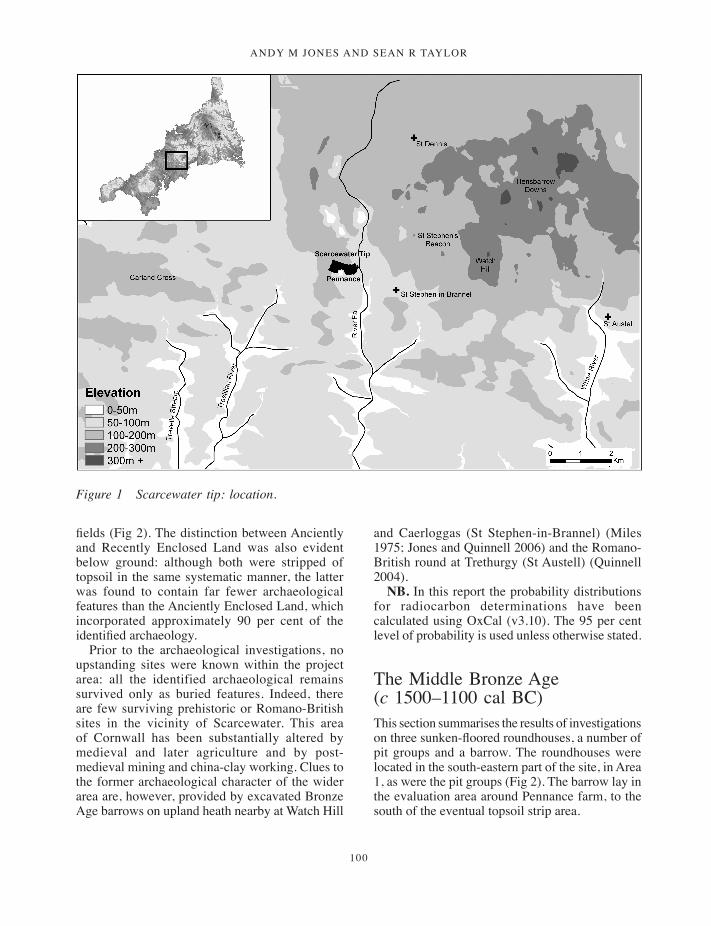
ANDY M JONES AND SEAN R TAYLOR
100
fields (Fig 2). The distinction between Anciently and Recently Enclosed Land was also evident below ground: although both were stripped of topsoil in the same systematic manner, the latter was found to contain far fewer archaeological features than the Anciently Enclosed Land, which incorporated approximately 90 per cent of the identified archaeology.
Prior to the archaeological investigations, no upstanding sites were known within the project area: all the identified archaeological remains survived only as buried features. Indeed, there are few surviving prehistoric or Romano-British sites in the vicinity of Scarcewater. This area of Cornwall has been substantially altered by medieval and later agriculture and by post-medieval mining and china-clay working. Clues to the former archaeological character of the wider area are, however, provided by excavated Bronze Age barrows on upland heath nearby at Watch Hill
and Caerloggas (St Stephen-in-Brannel) (Miles 1975; Jones and Quinnell 2006) and the Romano-British round at Trethurgy (St Austell) (Quinnell 2004).
NB. In this report the probability distributions for radiocarbon determinations have been calculated using OxCal (v3.10). The 95 per cent level of probability is used unless otherwise stated.
The Middle Bronze Age (c 1500–1100 cal BC)This section summarises the results of investigations on three sunken-floored roundhouses, a number of pit groups and a barrow. The roundhouses were located in the south-eastern part of the site, in Area 1, as were the pit groups (Fig 2). The barrow lay in the evaluation area around Pennance farm, to the south of the eventual topsoil strip area.
Figure 1 Scarcewater tip: location.
099-134_Jones&Taylor.indd 100 01/12/2014 11:42
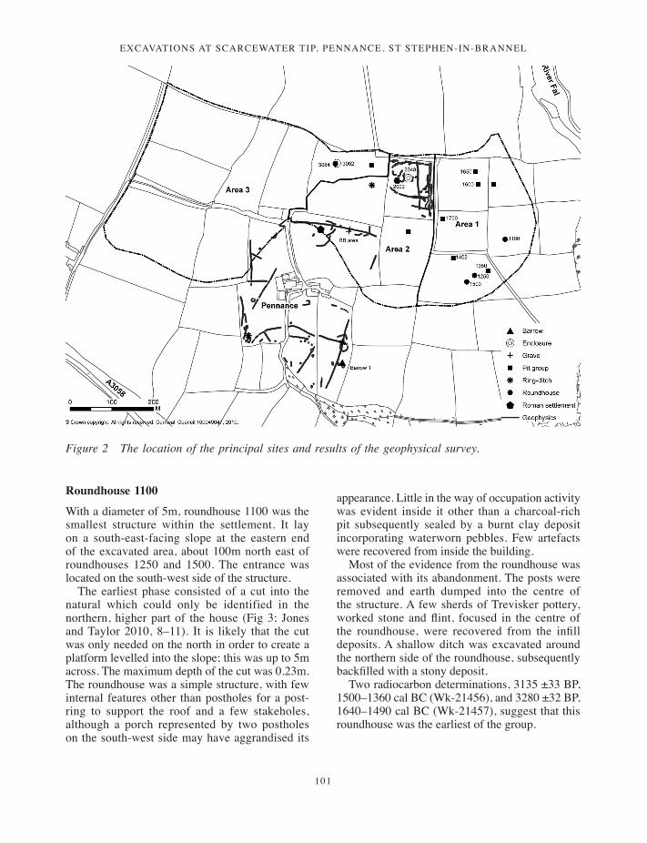
Excavations at scarcEwatEr tip, pEnnancE, st stEphEn-in-BrannEl
101
Roundhouse 1100
With a diameter of 5m, roundhouse 1100 was the smallest structure within the settlement. It lay on a south-east-facing slope at the eastern end of the excavated area, about 100m north east of roundhouses 1250 and 1500. The entrance was located on the south-west side of the structure.
The earliest phase consisted of a cut into the natural which could only be identified in the northern, higher part of the house (Fig 3; Jones and Taylor 2010, 8–11). It is likely that the cut was only needed on the north in order to create a platform levelled into the slope; this was up to 5m across. The maximum depth of the cut was 0.23m. The roundhouse was a simple structure, with few internal features other than postholes for a post-ring to support the roof and a few stakeholes, although a porch represented by two postholes on the south-west side may have aggrandised its
appearance. Little in the way of occupation activity was evident inside it other than a charcoal-rich pit subsequently sealed by a burnt clay deposit incorporating waterworn pebbles. Few artefacts were recovered from inside the building.
Most of the evidence from the roundhouse was associated with its abandonment. The posts were removed and earth dumped into the centre of the structure. A few sherds of Trevisker pottery, worked stone and flint, focused in the centre of the roundhouse, were recovered from the infill deposits. A shallow ditch was excavated around the northern side of the roundhouse, subsequently backfilled with a stony deposit.
Two radiocarbon determinations, 3135 ±33 BP, 1500–1360 cal BC (Wk-21456), and 3280 ±32 BP, 1640–1490 cal BC (Wk-21457), suggest that this roundhouse was the earliest of the group.
Figure 2 The location of the principal sites and results of the geophysical survey.
099-134_Jones&Taylor.indd 101 01/12/2014 11:42
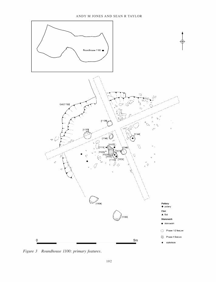
ANDY M JONES AND SEAN R TAYLOR
102
Figure 3 Roundhouse 1100: primary features.
099-134_Jones&Taylor.indd 102 01/12/2014 11:42
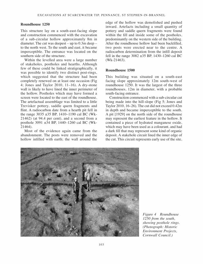
Excavations at scarcEwatEr tip, pEnnancE, st stEphEn-in-BrannEl
103
Roundhouse 1250
This structure lay on a south-east-facing slope and construction commenced with the excavation of a sub-circular hollow approximately 8m in diameter. The cut was deepest – up to 0.3m deep – to the north west. To the south and east, it became imperceptible. The entrance was located on the southern side of the structure.
Within the levelled area were a large number of stakeholes, postholes and hearths. Although few of these could be linked stratigraphically, it was possible to identify two distinct post-rings, which suggested that the structure had been completely renewed on at least one occasion (Fig 4; Jones and Taylor 2010, 11–16). A dry-stone wall is likely to have lined the inner perimeter of the hollow. Postholes which may have formed a screen were located to the east of the roundhouse. The artefactual assemblage was limited to a little Trevisker pottery, saddle quern fragments and flint. A radiocarbon date from a hearth pit fell in the range 3035 ±35 BP, 1410–1190 cal BC (Wk-21462) (at 94.4 per cent), and a second from a posthole 3091 ±34 BP, 1440–1260 cal BC (Wk-21464).
Most of the evidence again came from the abandonment. The posts were removed and the hollow infilled with earth; the wall around the
edge of the hollow was demolished and pushed inward. Artefacts including a small quantity of pottery and saddle quern fragments were found within the fill and inside some of the postholes, predominantly on the western side of the building. After the roundhouse hollow had been backfilled, two posts were erected near to the centre. A radiocarbon determination from the infill deposit fell in the range 3082 ±35 BP, 1430–1260 cal BC (Wk-21463).
Roundhouse 1500
This building was situated on a south-east facing slope approximately 12m south-west of roundhouse 1250. It was the largest of the three roundhouses, 12m in diameter, with a probable south-facing entrance.
Construction commenced with a sub-circular cut being made into the hill-slope (Fig 5; Jones and Taylor 2010, 16–26). The cut did not exceed 0.42m in depth and became imperceptible to the south. A pit [1929] on the north side of the roundhouse may represent the earliest feature in the hollow. It contained a piece of hydrated manganese oxide, which may have been used as a colourant, and had a dark fill that may represent some kind of organic deposit. A stakehole circuit lined the inner edge of the cut. This circuit represents early use of the site,
Figure 4 Roundhouse 1250 from the south, showing posthole rings. (Photograph: Historic Environment Projects, Cornwall Council.)
099-134_Jones&Taylor.indd 103 01/12/2014 11:42

ANDY M JONES AND SEAN R TAYLOR
104
Figure 5 Roundhouse 1500, early features.
099-134_Jones&Taylor.indd 104 01/12/2014 11:42
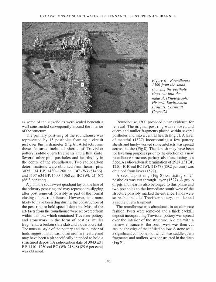
Excavations at scarcEwatEr tip, pEnnancE, st stEphEn-in-BrannEl
105
as some of the stakeholes were sealed beneath a wall constructed subsequently around the interior of the structure.
The primary post-ring of the roundhouse was represented by 15 postholes forming a circuit just over 8m in diameter (Fig 6). Artefacts from these features included sherds of Trevisker pottery, saddle quern fragments and a flint knife. Several other pits, postholes and hearths lay in the centre of the roundhouse. Two radiocarbon determinations were obtained from hearth pits: 3075 ±34 BP, 1430–1260 cal BC (Wk-21466), and 3137 ±34 BP, 1500–1360 cal BC (Wk-21467) (86.3 per cent).
A pit in the south-west quadrant lay on the line of the primary post-ring and may represent re-digging after post removal, possibly as part of the formal closing of the roundhouse. However, it is more likely to have been dug during the construction of the post-ring to hold special deposits. Most of the artefacts from the roundhouse were recovered from within this pit, which contained Trevisker pottery and stonework in the form of pestles, muller fragments, a broken slate slab and a quartz crystal. The unusual style of the pottery and the number of finds suggest that it was not an ordinary feature and may have been a pit specifically intended to hold a structured deposit. A radiocarbon date of 3043 ±31 BP, 1410–1250 cal BC (Wk-21848) (89.6 per cent) was obtained.
Roundhouse 1500 provided clear evidence for renewal. The original post-ring was removed and quern and muller fragments placed within several postholes and into a central hearth (Fig 7). A layer of material (1527) incorporating a few pottery sherds and finely-worked stone artefacts was spread across the site (Fig 8). The deposit may have been for levelling purposes prior to the erection of a new roundhouse structure, perhaps also functioning as a floor. A radiocarbon determination of 2927 ±31 BP, 1220–1010 cal BC (Wk-21847) (89.2 per cent) was obtained from layer (1527).
A second post-ring (Fig 8) consisting of 24 postholes was cut through layer (1527). A group of pits and hearths also belonged to this phase and two postholes to the immediate south west of the structure possibly marked the entrance. Finds were scarce but included Trevisker pottery, a muller and a saddle quern fragment.
The roundhouse was abandoned in an elaborate fashion. Posts were removed and a thick backfill deposit incorporating Trevisker pottery was spread over the interior of the structure. A ditch with a narrow entrance to the south-west was then cut around the edge of the infilled hollow. A stone wall, a significant component of which was saddle quern fragments and mullers, was constructed in the ditch (Fig 9).
Figure 6 Roundhouse 1500 from the south, showing the posthole rings cut into the natural. (Photograph: Historic Environment Projects, Cornwall Council.)
099-134_Jones&Taylor.indd 105 01/12/2014 11:42

ANDY M JONES AND SEAN R TAYLOR
106
Pit group 1350
This group was located 25m east of roundhouse 1250 and consisted of nine pits and stakeholes (Fig 2; Jones and Taylor 2010, 26–8). None of the features could be linked with each other stratigraphically and no overall form could be discerned. A small amount of pottery was recovered and one of the pits gave a radiocarbon date of 3094 ±35 BP, 1440–1260 cal BC (Wk-21459) on oak sapwood charcoal. Another was found to contain a truncated probable Trevisker vessel that contained a deposit of cremated bone, probably human (Fig 11). A sample of the bone gave a date of 3191 ±41 BP, 1540–1390 cal BC (Wk-21461) (94.2 per cent).
Pit group 1402
This group was located a short distance north west of roundhouses 1250 and 1500 (Fig 2). None of the 16 pits or postholes in the group could be related stratigraphically. Two oval pits appeared to form a central focus and the arrangement of these within a group of postholes suggests a possible sub-rectangular structure measuring approximately 6m by 2m (Jones and Taylor 2010, fig 21). One of the postholes produced Trevisker pottery and flint and one of the central pits contained a saddle quern fragment.
Pit group 1600
The group was located towards the northern side of Area 1, close to another pit group 1650 (Fig 2). It comprised ten postholes and stakeholes, with two central pits (Jones and Taylor 2010, 28–30). These features produced sherds of Bronze Age pottery and worked stone objects, which included a large saddle quern and mullers (Fig 12). The group had been severely truncated but if the features represent the remains of a structure, it must have been oval or rectangular and 7m long and 4m wide. A determination of 3092 ±32 BP, 1440–1290 cal BC (Wk-21448) (94.2 per cent) was obtained from a hearth-pit.
Pit group 1650
Pit group 1650 was located about 25m north of group 1600 and comprised seven truncated pits and / or postholes (Fig 2; Jones and Taylor 2010, 31–2). Within the group were a number of pits, some of which displayed evidence of burning and may have functioned as hearths. The finds from these pits included pottery, flint and worked stone. Several of the postholes may have formed a sub-rectangular structure. However, other features also identified as postholes did not appear to relate to this layout. Radiocarbon determinations of 3106 ±32 BP, 1450–1290 cal BC (Wk-21452) and
Figure 7 The worked stone in the central hearth of roundhouse 1500. (Photograph: Historic Environment Projects, Cornwall Council.)
099-134_Jones&Taylor.indd 106 01/12/2014 11:42
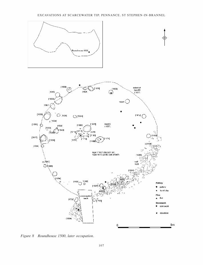
Excavations at scarcEwatEr tip, pEnnancE, st stEphEn-in-BrannEl
107
Figure 8 Roundhouse 1500, later occupation.
099-134_Jones&Taylor.indd 107 01/12/2014 11:42

ANDY M JONES AND SEAN R TAYLOR
108
3092 ±32 BP, 1440–1290 cal BC (Wk-21453) (94.2 per cent) were obtained from two of the features.
Pit group 1700
This group was located close to the west side of Area 1 and comprised four pits or postholes (Fig
2; Jones and Taylor 2010, 31). All were less than 0.15m deep and under 1m long. None of the features could be linked stratigraphically and no certain structural form could be discerned: the features could represent a truncated sub-rectangular structure but could also simply have been a cluster of pits and a hearth. One pit displayed evidence
Figure 9 Roundhouse 1500 showing post-occupation walling. (Photograph: Historic Environment Projects, Cornwall Council.)
Figure 10 The joining muller fragments from roundhouses 1250 and 1500. (Photograph: Historic Environment Projects, Cornwall Council.)
099-134_Jones&Taylor.indd 108 01/12/2014 11:42
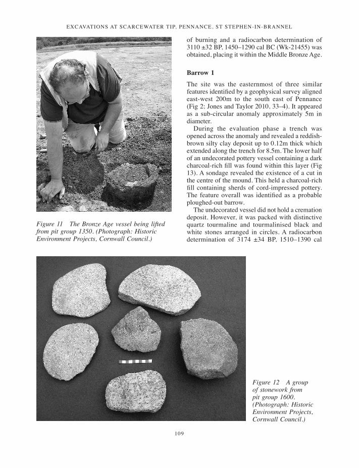
Excavations at scarcEwatEr tip, pEnnancE, st stEphEn-in-BrannEl
109
of burning and a radiocarbon determination of 3110 ±32 BP, 1450–1290 cal BC (Wk-21455) was obtained, placing it within the Middle Bronze Age.
Barrow 1
The site was the easternmost of three similar features identified by a geophysical survey aligned east-west 200m to the south east of Pennance (Fig 2; Jones and Taylor 2010, 33–4). It appeared as a sub-circular anomaly approximately 5m in diameter.
During the evaluation phase a trench was opened across the anomaly and revealed a reddish-brown silty clay deposit up to 0.12m thick which extended along the trench for 8.5m. The lower half of an undecorated pottery vessel containing a dark charcoal-rich fill was found within this layer (Fig 13). A sondage revealed the existence of a cut in the centre of the mound. This held a charcoal-rich fill containing sherds of cord-impressed pottery. The feature overall was identified as a probable ploughed-out barrow.
The undecorated vessel did not hold a cremation deposit. However, it was packed with distinctive quartz tourmaline and tourmalinised black and white stones arranged in circles. A radiocarbon determination of 3174 ±34 BP, 1510–1390 cal
Figure 11 The Bronze Age vessel being lifted from pit group 1350. (Photograph: Historic Environment Projects, Cornwall Council.)
Figure 12 A group of stonework from pit group 1600. (Photograph: Historic Environment Projects, Cornwall Council.)
099-134_Jones&Taylor.indd 109 01/12/2014 11:42
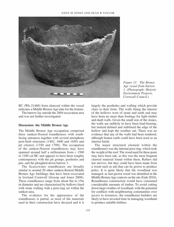
ANDY M JONES AND SEAN R TAYLOR
110
BC (Wk-21460) from charcoal within the vessel indicates a Middle Bronze Age date for the feature.
The barrow lay outside the 2004 excavation area and was not further investigated.
Discussion: the Middle Bronze Age
The Middle Bronze Age occupation comprised three sunken-floored roundhouses with south-facing entrances together with several amorphous post-built structures (1402, 1600 and 1650) and pit clusters (1350 and 1700). The occupation of the sunken-floored roundhouses may have spanned around half a millennium from c 1500 to 1100 cal BC and appears to have been roughly contemporary with the pit groups, postholes and pits, and the ploughed-down barrow 1.
The Scarcewater roundhouses are broadly similar to around 20 other sunken-floored Middle Bronze Age buildings that have been excavated in lowland Cornwall (Gossip and Jones 2008). These roundhouses range from about 8m to 15m in diameter and are characterised by hollows lined with stone walling with a post-ring set within the sunken area.
The evidence for the appearance of the roundhouses is partial, as most of the materials used in their construction have decayed and it is
largely the postholes and walling which provide clues to their form. The walls lining the interior of the hollows were of stone and earth and may have been no more than footings for light timber and daub walls. Given the small size of the stones, the walls are unlikely to have been load-bearing, but instead defined and stabilised the edge of the hollow and kept the weather out. There was no evidence that any of the walls had been rendered, although beaten earth could have been used as an interior finish.
The major structural element within the roundhouses was the internal post-ring, which took the weight of the roof. The wood used for these posts may have been oak, as this was the most frequent charred material found within them. Rafters did not survive, but they could have been made from a wood such as ash that can be grown to produce poles. It is quite likely that the woodland was managed, as fast-grown wood was identified in the Middle Bronze Age contexts on the site (Gale 2010). Roundhouse construction would have consumed considerable amounts of timber. To avoid cutting down large swathes of woodland, with the potential for conflicts with neighbouring communities over access to resources, the roundhouse builders are likely to have invested time in managing woodland to produce suitable timbers.
Figure 13 The Bronze Age vessel from barrow 1. (Photograph: Historic Environment Projects, Cornwall Council.)
099-134_Jones&Taylor.indd 110 01/12/2014 11:42
Excavations at scarcEwatEr tip, pEnnancE, st stEphEn-in-BrannEl
111
The roof would have been finished with a weatherproof thatch and, given that the houses were located in sight and easy walking distance of a river, reeds may have been used. Reed-beds may also have been a managed resource with reeds grown to create long stalks.
The three Scarcewater roundhouses were arranged in a north east – south west alignment on the lower part of the south and south-east facing hillslope overlooking the Fal valley (Fig 2). They were located near to pit group 1350 and below other pit and posthole groups. Some of these groups are likely to have formed amorphous structures, possibly related to agricultural tasks. Some cultivation may have taken place in the vicinity. Bronze Age settlements across the south west have produced evidence for a range of field systems, which include cultivation terraces and stone walls (Fleming 1988; Johnson and Rose 1994, 59–74; Nowakowski et al 2007). It is probable that barriers of some form would have been needed to manage the movement of animals. However, none of the ditches investigated at Scarcewater could be dated to this period so it is uncertain whether the roundhouses were associated with a field system.
The smallest and simplest roundhouse, 1100, was located at the north-east end, the middle-sized roundhouse 1250 in the centre, and the largest and most complex roundhouse 1500 to the south west. The spacing between the roundhouses was uneven; roundhouses 1100 and 1250 were approximately 100m apart, whereas the larger roundhouses 1250 and 1500 were only about 12m apart. This might suggest that the inhabitants of roundhouses 1250 and 1500 had a closer relationship to one another other than with the occupants of roundhouse 1100, which may in any case been earlier than the others. A degree of overlapping contemporaneity between roundhouses 1250 and 1500 is supported by the finding of two conjoining pieces of muller within the infill deposits of both houses (Fig 10).
All three roundhouses appear to have been multi-phased, although the degree of re-building differed, ranging from the sealing of an earlier pit in roundhouse 1100, to the replacement of the post-ring in 1250 and the construction of a completely new structure over the hollow of roundhouse 1500. Beyond the post-rings and central hearths, evidence for architectural features was slight and there was little to suggest internal subdivision of space. The large posts on the southern side of roundhouse 1100 probably supported a porched
entrance; a setting of postholes outside roundhouse 1250 might have formed a screened area to one side of the entrance.
Assigning functions to the roundhouses is difficult because there was little evidence for occupation, either in terms of artefacts or occupation surfaces. Roundhouses 1100 and 1250 did not contain much pottery and although roundhouse 1500 contained rather more, most of it was from a single pit. A greater amount of stonework was recovered, suggestive of grinding activity, although there were very small quantities of charred cereals (Jones 2010).
Similarly, there was little evidence for floors or occupation surfaces, beyond layer (1527) within roundhouse 1500, and even this was probably deposited to seal the earlier structure in the hollow. The paucity of evidence might imply that the buildings were kept clean or perhaps had rushes on their floors to reduce problems of dampness. An anthropological parallel for this is provided by the Salish Indians of Canada, whose sunken-floored dwellings, although warm, were never watertight (Jenness 1977, 91–3). Alternatively, it is possible that the paucity of occupation evidence is because they were occupied seasonally.
If the Scarcewater roundhouses were all occupied at one time there could have been a small community of perhaps 10 to 20 people. However, estimating population based on house size is problematic, as the numbers of people inhabiting a structure can change over time and norms vary between cultures (Moore 1986, 92–8; Waterson 1997, ch 7). Nonetheless, the number of roundhouses at Scarcewater indicates a small community, far smaller than has been suggested for the much larger upland roundhouse settlement on Leskernick (Altarnun) (Bender et al 2007, 198) and with fewer people than might have lived at Trethellan (Newquay) (Nowakowski 1991).
It is possible that the differing sizes of the roundhouses could have been related to the social standing of their occupants (Moore 1986, ch 6; Waterson 1997, ch 3). The largest roundhouse, 1500, certainly produced most of the artefacts and was associated with the most elaborate foundation and abandonment rituals. It is possible that it had been inhabited by higher-status individuals or was used for communal events. The ceramic assemblage from this roundhouse, with its lack of close parallels, suggests some special use (Quinnell 2010, 101). However, even here most of
099-134_Jones&Taylor.indd 111 01/12/2014 11:42
ANDY M JONES AND SEAN R TAYLOR
112
the artefacts are associated with one pit and were probably deposited as part of a ritualised event.
The construction and use of houses is often marked by ritualised actions (Turton 1978; Merrifield 1987; 116–21) and some communities consider houses to be tied to the lives of their inhabitants (Waterson 1997, ch 6). The recognition of this phenomenon has informed archaeological interpretations which suggest that the abandonment of houses may sometimes have been related to the death of occupants (Bradley 2005, 51; Brück 2001). This approach may be useful to the study of the roundhouses at Scarcewater, with the form of each of the structures providing a glimpse of particular events that are likely to have been associated with their construction, renewal and abandonment.
The construction of the Scarcewater roundhouses probably commenced with the selection of a favourable site. It is possible that this process was deliberated over because, as at other Middle Bronze Age settlements in Britain and Cornwall (Bradley 2005, 56; ApSimon and Greenfield 1972; Nowakowski 1991), there was no evidence for earlier roundhouses in the vicinity, implying that a new settlement site was being established.
After the location for the roundhouse was chosen the house-hollow was excavated and timbers and other building materials brought to the site. However, it is unlikely that the choice of building materials was altogether functional and it is probable that certain materials perceived to hold ‘magical’ properties were selected for use in the construction of buildings (Townend 2007). The desire to use particular materials in houses and other construction projects is illustrated by numerous anthropological studies (Turton 1978; Malinowski 1922, ch 4; Helms 1988, 111–30). It is possible that the post-ring timbers themselves could have been considered to have housed spirits (Waterson 1997). There could also have been a shared underlying cosmology between free-standing timber circles that were used for ceremonial purposes and the enclosed post-ring located within the heart of the roundhouse (Gossip and Jones 2007, 37–9). This link is indicated by the similar plans and south to south-east alignments that are common to both forms.
Given the labour involved, the construction process may have been staged and punctuated by ritual acts and, as payment, the feeding of the participants or other forms of reciprocity. Anthropological evidence indicates that haste
to complete the job is often less important than ensuring that social bonds are maintained and the spirits, gods, or ancestors properly placated to enable the success of the project (Malinowski 1922, ch 6; Turton 1978; Waterson 1997, ch 6).
Most of these events are undetectable; roundhouse 1500, however, did contain two features which could have held foundation offerings. Pit [1929] was located on the north side of the roundhouse and was sealed beneath the wall which lined the interior of the roundhouse hollow. This feature must have been dug very early in the ‘life’ of the structure. It was found to contain a dark deposit which may have represented an organic offering or even a body-stain. The pit is likely to have been contemporary with a stake-ring, which encircled the house-hollow.
The demarcation of the roundhouse hollow with a stake-ring may have its origins with earlier round barrows. Stake-rings were commonly used to encircle barrows, and there are several Cornish examples, such as at Tregulland (Treneglos) (Ashbee 1958). It is possible the stake-ring at Scarcewater could have closed off the hollow until the appropriate rituals were undertaken, after which building could commence.
A second pit [1901], radiocarbon dated to 3043 ±31 BP, 1410–1250 cal BC (Wk-21848) (89.6 per cent), was found in the south-west quadrant of roundhouse 1500. This pit is likely to have been dug at the same time as the main post-ring was erected, although it could also have been excavated to hold a ‘closure’ deposit when the post-ring was being taken down. It was found to contain an assemblage of ‘curated sherds’ of pottery and other objects, which included rubbing stones and a spearhead-shaped quartz crystal. This deposit incorporated the largest ceramic assemblage from the site. These fragmented artefacts may have been heirlooms which carried particular memories of people and places, gathered together to form a foundation deposit.
Thus, following the excavation of the hollow for the roundhouse, its builders may have marked the space for the building with a stake-ring and undertaken the deposition of what appears to be a primary foundation offering within pit [1929], located directly opposite the entrance. This pit and the stake-ring were then covered over by the wall which lined the inside edge of the hollow. Given the narrow space between the edges of hollow, the wall and the post-ring, it is likely that the wall was
099-134_Jones&Taylor.indd 112 01/12/2014 11:42
Excavations at scarcEwatEr tip, pEnnancE, st stEphEn-in-BrannEl
113
constructed before the erection of the post-ring. It is possible that, at the start of or during this process, pit [1901] was dug and a collection of curated items buried inside it. This pit was probably located just to the left of the doorway.
These actions are paralleled by finds made at other roundhouses. Evidence for foundation deposits was recovered from excavations at Leskernick, on Bodmin Moor, for example, where a pit was located close to the eastern wall of house 1 (Bender et al 2007, 163). The location of pit [1929] in roundhouse 1500 may also have highlighted the importance of the rear of the house and in doing so is perhaps comparable to the large back-stones at Leskernick which emphasised the symbolic significance of that part of the house (ibid, 143).
Similarly, the location of pit [1901], to the left of the entrance, has similarities with features in other Cornish roundhouses. At Trethellan, a pit holding worked stone objects and pottery was found in house 2001 in a very similar position to pit [1901] (Nowakowski 1991). Comparisons can also be made with a roundhouse at Callestick, where sherds from a vessel were placed behind the wall to the left of the doorway (Jones 1998–9).
The location of pits within roundhouse 1500 also has parallels with some older monuments. A position equivalent to that of pit [1929], for example, was marked by orthostats in several of the region’s cairns; two of the ring-cairns on Stannon Down (St Breward) and the Watch Hill barrow had large stones in their northern perimeters (Jones 2004–5; Miles 1975). Pit [1901] was located in the south-west quadrant of roundhouse 1500 and the southern side of barrows was frequently associated with the deposition of artefacts and other activities (Bradley 1998, 153–5).
The deposits in pits in the primary phase of roundhouse 1500 also have similarities with earlier activities. The placing of pottery sherds and other objects such as those found in pit [1901] is comparable with practises associated with Early Bronze Age ceremonial sites: fragmented objects, such as the Food Vessel urn sherds which were placed into the ditch of the nearby Watch Hill barrow, were often deposited within barrows (Miles 1975; Jones 2005, ch 5). The process of selecting curated objects was therefore a long-established tradition which may have influenced the kinds of offering that were appropriate as foundation deposits within roundhouses.
The radiocarbon determinations indicate that the Scarcewater settlement was occupied for up to three or four centuries. Over this period the structures would have required routine maintenance such as re-thatching and more substantial but less frequent repairs such as the replacement of posts. Therefore, renewal might be required for structural reasons, such as the decay of timbers, and a decision made to continue the structure rather than to abandon it. Less predictably, more formal ritualised activity may have been required when an ill-fated event occurred, such as the death of an occupant. Some such events may have resulted in a decision to abandon a roundhouse, whereas others may have prompted a ritualised renewal. These differing responses can be seen at Scarcewater.
Indications of renewal or more formal ritualised activity were rather limited in roundhouse 1100, but some evidence is provided by the water-worn pebbles which had been selectively brought inside the house and used to seal the top of an earlier central pit. This action would have marked the location of the pit and symbolically blocked further access to it.
In roundhouse 1250 there were a large number of internal features, including up to three post-ring circuits (Fig 4). Although there were no stratigraphic relationships between the post-rings, it seems unlikely that they were all contemporary, as the close spacing of posts would have made movement inside the structure difficult. Instead, it seems probable that the building had been renewed on at least one occasion. Although this activity may have been carried out with due ceremony, any ritualised elements have left little trace in the archaeological record, as, for example, in the form of offerings in pits. However, it is possible that some of the artefacts discussed below, recovered from structural post-sockets, were deposited as part of re-building.
Roundhouse 1500 provides clear evidence for renewal. Here, the original post-ring was removed and worked stone deposited in several of the post-sockets and a hearth. Layer (1527) was then spread across the interior of the site. This layer may have also acted as a floor for the succeeding roundhouse. It included a few sherds of pottery and finely-worked stone artefacts and it is possible that these objects were incorporated within the layer as a result of midden material from preceding occupation being used. Some of the finer stone objects, however, could have been more formally deposited into the roundhouse.
099-134_Jones&Taylor.indd 113 01/12/2014 11:42
ANDY M JONES AND SEAN R TAYLOR
114
Following the insertion of the floor, a new post-ring was erected and at least two hearth-pits were used. This type of re-building is paralleled by roundhouses at Trethellan, which were renewed in a comparable manner (Nowakowski 1991).
Elsewhere in southern Britain, it has been argued that Middle Bronze Age settlements may have been short-lived. Brück (2001) has highlighted the paucity of evidence for the renewal of Middle Bronze Age roundhouses in Wessex, and that later settlements were not re-built on the same sites. Communities in Wessex may therefore have only occupied places for short periods. However, in other areas settlements may have been inhabited differently. For example, on Bodmin Moor, extensive settlements such as Leskernick (Johnson and Rose 1994, 58) could suggest either that there were large communities on the moors or that particular places were inhabited for extended periods. Radiocarbon determinations are few, but those from Leskernick (Bender et al 2007, 88–9) could support a model of long-term occupation, with new roundhouses being constructed and others abandoned (ibid, 200). On Dartmoor, Butler (1997, 137–8) has agued that on abandonment houses were sometimes converted into cairns and a similar suggestion has been made for some of the roundhouses at Leskernick (Bender et al 2007). Upland settlements might have comprised an assortment of houses occupied by the living and others abandoned, with some of the older roundhouses deliberately being made to resemble cairns, whereas others could have slowly decayed until the walls fell in and they took on the appearance of cairns.
Evidence from the Cornish lowlands suggests that settlements were much smaller than some of their upland counterparts. The largest known example, at Trethellan, consisted of seven roundhouses (Nowakowski 1991) but more typically lowland settlements consist of one to three dwelllings accompanied by other non-residential structures (for example, ApSimon and Greenfield 1972). This might imply a short durée for lowland Cornish settlements, comparable to those in Wessex. The Scarcewater settlement may fit this pattern; however, the evidence suggests greater complexity, with similarities and contrasts between when and how the three roundhouses were used and abandoned. Some roundhouses may have lasted a decade or so but others could have been occupied for considerably longer.
The radiocarbon dating suggests that the smallest roundhouse 1100 may have been built a little earlier than roundhouses 1250 and 1500. Roundhouse 1100 probably had a relatively short occupation in the period around 1500 cal BC, as indicated by the two radiocarbon determinations 3135 ±33 BP, 1500–1360 cal BC (Wk-21456) (85.8 per cent), and 3280 ±32 BP, 1640–1490 cal BC (Wk-21457) (93.3 per cent). After probably less than a century, a process of decommissioning began. This appears to have begun with the destruction of the superstructure, and it could also have involved the burning of a post that had been cut into the central stone-capped pit. This was followed by the spreading of infill layers across the interior of the structure, so that the former floor level was covered over. Other than the concentration of artefacts in the centre of the hollow, there was little evidence for the structured deposition of artefacts within the site. A ring-gully was then dug around the northern half of the house site, which was back-filled with a stony deposit. This would have created a site resembling a ring-cairn. Similar features have been encountered elsewhere in Cornwall, for example at Callestick (Perranzabuloe), where quartz blocks were set around the edge of the infilled hollow (Jones 1998–9), and, at a larger scale, at roundhouse 1500 at Scarcewater. Given the small size of roundhouse 1100 and the lack of subsequent large-scale monumentalisation, there is little to suggest that these events occurred over a great length of time.
At roundhouse 1250, occupation in the period between 1450 and 1250 cal BC is indicated by three radiocarbon determinations: 3035 ±35 BP, 1410–1190 cal BC (Wk-21462) (94.4 per cent), 3082 ±35 BP, 1430–1260 cal BC (Wk-21463), 3091 ±34 BP, 1440–1260 cal BC (Wk-21464). The abandonment sequence commenced in a similar manner to the pattern found within roundhouse 1100: the posts were removed and the hollow infilled. However, in this instance, pottery, worked stone and quern fragments were placed within several of the postholes, mostly located in the western side of the building. The perimeter wall was then demolished and pushed inside the hollow and infill material spread across the interior. A few artefacts, comprising pottery and worked stone were recovered from the infill layer. Again, there is little to suggest that the artefacts within these infill layers had been deposited with any deliberation. However, it is possible that this material had been
099-134_Jones&Taylor.indd 114 01/12/2014 11:42
Excavations at scarcEwatEr tip, pEnnancE, st stEphEn-in-BrannEl
115
generated by occupants of the house and had been stockpiled prior to its use in the backfilling of the hollow. This indicates that there may have been a degree overlap in the occupation of the structures. Once the roundhouse hollow had been fully backfilled, two posts were then erected in the centre of the infilled hollow. In this way, the site was marked, possibly also with a small mound. This may have drawn upon older traditions of marking barrows and cairns with posts, as at Colliford site CRIVA and Stannon site 2 (Griffith 1984; Jones 2004–5). Just as posts at barrows may have marked the passing of the dead (Harding and Healy 2007, 211), so those at roundhouse 1250 may have marked the ‘deceased’ house. Again, the abandonment process need not have taken long, although it is likely that the infilling deposit needed time to settle before the posts could be erected within it. The newly transformed site would have been a visually distinctive ‘monument’.
With an occupation potentially spanning the centuries between c 1500 and 1100 cal BC, the largest, roundhouse 1500, was the longest in use and the last to be abandoned. Roundhouse 1500 was also associated with the creation of the most elaborate post-occupation structure. Although the final abandonment phase cannot be precisely dated, a radiocarbon determination from layer (1527) of 2927 ±31 BP, 1220–1010 cal BC (Wk-21847) (89.2 per cent), indicates that it happened some three centuries or more after the construction phase, towards the end of the Middle Bronze Age, and that it was one of the last events to occur within the settlement. Again, the structural posts were removed from the interior. However, unlike the closure of the preceding structure, there was little evidence for any artefacts being placed within postholes, although a muller was deposited into the central hearth (Fig 7). The entire interior of the structure was filled with a substantial deposit. The infill layer contained a handful of artefacts, mostly in the form of abraded sherds of Trevisker pottery and mullers, which may have been generated over the period that the roundhouse had been occupied.
A shallow trench was excavated around the site and a wall set within it. This wall contained a number of quern fragments and rubbing stones, which may have been associated with domestic activities within the roundhouse. The construction of the wall would again have created a site which looked like a ring-cairn. This new site would have
appeared quite monumental, and in common with the earlier barrows it may have been designed to mark a specific place in the landscape.
The abandonment sequences of the Scarcewater roundhouses are comparable to one another and analogies can be made with other lowland sunken-floored roundhouses across Cornwall. The destruction of the superstructure followed by infilling of the roundhouse hollow is a pattern which is repeated throughout the Middle Bronze Age from c 1500 cal BC to 1000 cal BC and is found at the larger settlements such as Trethellan down to isolated buildings such as Callestick (Nowakowski 2001; Jones 1998–9). However, the abandonment sequences at the three Scarcewater roundhouses demonstrate that no two houses were left in entirely the same manner, or had similar final appearances. Instead there was a loosely defined repertoire of possible actions associated with abandonment, which could be chosen each time a roundhouse come to the end of its ‘life’. The choices that were undertaken would have ‘personalised’ the process and in some instances may have been memorialised by the production of a new monument over the roundhouse site.
It is possible that was there was some continuity in traditions, and the abandonment practises which have been found within lowland Cornish roundhouses can be argued to have drawn upon Early Bronze Age practises (Jones 2008a; forthcoming b). Indeed, there are several comparisons between the way Cornish barrows were used and the processes by which lowland roundhouses were abandoned. Parallels can, for example be made between the ways that human bone was treated. Although no human remains were recovered from inside the Scarcewater roundhouses, cremated bone was found in a vessel which had been buried in a pit near the settlement and the foundation pit [1929] in roundhouse 1500 was large enough to have held a crouched inhumation. Scarcewater’s acidic soils, however, would have destroyed any unburnt bone.
Human bone is often found in Bronze Age settlements in southern Britain (Brück 1995; Ladle and Woodward 2009, 66), and where conditions have allowed, both inhumation and cremation burials have been found within or near to Cornish Middle Bronze Age roundhouses and settlements. For example, an inhumation burial was found within one of the roundhouses at Trethellan and at Gwithian cremated remains were found within field
099-134_Jones&Taylor.indd 115 01/12/2014 11:42
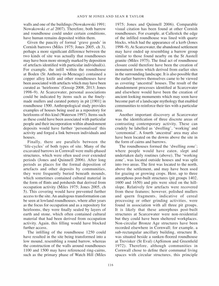
ANDY M JONES AND SEAN R TAYLOR
116
walls and one of the buildings (Nowakowski 1991; Nowakowski et al 2007). Therefore, both barrow and roundhouse could under certain conditions, have human remains deposited within them.
Given the paucity of formal ‘grave goods’ in Cornish barrows (Miles 1975; Jones 2005, ch 3), perhaps a more significant difference between the two kinds of site was actually that roundhouses may have been more strongly marked by deposition of artefacts identified with particular individual(s). For example, the infill within the roundhouse at Boden (St Anthony-in-Meneage) contained a copper alloy knife and other roundhouses have been associated with artefacts which may have been curated as ‘heirlooms’ (Gossip 2008, 2013; Jones 1998–9). At Scarcewater, personal associations could be indicated by items such as the finely-made mullers and curated pottery in pit [1901] in roundhouse 1500. Anthropological study provides examples of houses being used as a repository for heirlooms of this kind (Waterson 1997). Items such as these could have been associated with particular people and their incorporation within abandonment deposits would have further ‘personalised’ this activity and forged a link between individuals and houses.
Finally, there are parallels between the ‘life-cycles’ of both types of site. Many of the excavated barrows in Cornwall were multi-phased structures, which were often used over extended periods (Jones and Quinnell 2006). After long periods as places for the formal deposition of artefacts and other deposits by communities, they were frequently buried beneath mounds, which sometimes contained cultural material in the form of flints and potsherds that derived from occupation activity (Miles 1975; Jones 2005, ch 5). This covering would have prevented further access to the site. An analogous transformation can be seen at lowland roundhouses, where after years as the focus for occupation and as a repository for heirlooms, they were finally sealed by layers of earth and stone, which often contained cultural material that had been derived from occupation activity. Again, this filling would have blocked further access.
The infilling of the roundhouse 1250 could have resulted in the site being transformed into a low mound, resembling a round barrow, whereas the construction of the walls around roundhouses 1100 and 1500 may have referenced ring-cairns, such as the primary phase of Watch Hill (Miles
1975; Jones and Quinnell 2006). Comparable visual citation has been found at other Cornish roundhouses. For example, at Callestick the edge of the infilled roundhouse was lined with quartz blocks, which had the appearance of a kerb (Jones 1998–9). At Scarcewater, the abandoned settlement may have ended up resembling a barrow group similar to those found nearby on the St Austell granite (Miles 1975). The final act of roundhouse closure could therefore have been the creation of monument forms which derived from earlier sites in the surrounding landscape. It is also possible that the earlier barrows themselves came to be viewed as covering ‘ancestral’ houses. The result of the abandonment processes identified at Scarcewater and elsewhere would have been the creation of ancient-looking monuments which may soon have become part of a landscape mythology that enabled communities to reinforce their ties with a particular area.
Another important discovery at Scarcewater was the identification of three discrete areas of contrasting contemporary activity. These can crudely be labelled as ‘dwelling’, ‘working’ and ‘ceremonial’. A fourth ‘ancestral’ area may also have been located on the downs above the site in the form of cairns and barrows.
The roundhouses formed the ‘dwelling zone’; where people would have eaten, slept and undertaken daily routines (above). The ‘working zone’, was located outside houses and was split into two areas. The first was located to the north, above the settlement, and may have been used for grazing or growing crops. Here, up to three amorphous post-built structures (pit groups 1402, 1600 and 1650) and pits were sited on the hill-slope. Relatively few artefacts were recovered from these features; however, polished mullers and quern fragments, indicative of cereal processing or other grinding activities, were found in association with all three pit groups. It is likely that these amorphous post-built structures at Scarcewater were non-residential but they could have been sheltered workplaces. Non-circular Bronze Age structures have been recorded elsewhere in Cornwall; for example, a sub-rectangular ancillary building, structure B, was situated beside a sunken-floored roundhouse at Trevisker (St Eval) (ApSimon and Greenfield 1972). Therefore, although communities in Cornwall chose to define their communal living spaces with circular structures, this principle
099-134_Jones&Taylor.indd 116 01/12/2014 11:42

Excavations at scarcEwatEr tip, pEnnancE, st stEphEn-in-BrannEl
117
was not always applied to non-domestic, task-centred buildings. There appears to have been less focus upon formal ritualised activity, such as the deposition of artefacts in this zone, although there was some evidence for lower-key abandonment of these structures, including selective deposition of the quern fragments into cut features that were found in the centres of pit groups 1402 and 1600.
Pit group 1350 formed a second working area, located in the space between roundhouses 1100 and 1250. The pits in the group did not form a coherent pattern and were largely devoid of artefacts or charred plant remains, so specific activities associated with them cannot be identified. However, the lack of evidence for structures in this area suggests that the character of activity here differed from elsewhere in the settlement. As described above, one of the pits contained a vessel, which held cremated bone. The discovery of cremated bone within this area was unique on the site. In addition to its open character, this deposit makes it stand out from the other areas and shows the inter-related nature of ritual activities across the site.
A ‘ceremonial zone’ may have been situated to the south-west of the settlement on a lower-lying terrace above the river valley, represented by a number of ploughed-down mounds with diameters of less than 10m. Small barrows dating to the latter part of second millennium cal BC have been recorded elsewhere in southern England (Quinnell 1997; Bradley and Fraser 2010), although currently the only barrow dated to the Middle Bronze Age in Cornwall is that at Constantine Island (St Merryn) (Jones 2008b). The evaluation excavation at Scarcewater was too limited to establish whether any burials were present. However, the character of at least one mound, barrow 1, was confirmed. Although no burial was found inside the urn recovered from it, the distinctive banded stones arranged within it suggest a ritualised act of deposition. As at Stannon and Callestick (Jones 2008a), therefore, a formal ceremonial area may have been set aside from but in sight of the settlement, with the mounds being overlooked by the living.
The fourth, ‘ancestral’ zone may have been located on the uplands above the settlement area, where barrows and cairns crowned the hills and ridge tops (Miles 1975). During the Middle Bronze Age this area is likely to have been open rough
ground used for grazing. It seems unlikely that prominent Early Bronze Age barrows, such as those overlooking Scarcewater, ceased to feature or failed to exert an influence over subsequent generations. However, this need not equate to a straightforward continuity of belief, more that barrows continued to be ‘significant’ places. This could have occurred through stories which mythologised earlier barrows, ensuring that they remained within the social memory of the community.
People would have begun and ended their day in their roundhouses and engaged in domestic tasks within the confines of the roundhouse. During the day, the settlement’s inhabitants would have moved between the roundhouses and the surrounding pastures and arable fields and probably undertook many of the day’s tasks in the ancillary structures or in the open air. At other times they must have walked to the river to collect water and to obtain local clays for pottery or cobbles for use as querns and mullers. Other tasks would have involved seeking surface granite for querns, or the gathering of wood from the surrounding woodland for use as firewood and building materials. Sometimes, larger formal assemblies may have taken place at monuments such as barrow 1 to the south-west of the roundhouses. Occasionally, people may have moved their animals into the uplands, which by this time were probably largely open rough ground and a valuable source of grazing, thereby encountering their ancestors’ monuments.
It is, however, unlikely that there was a rigid separation of these four zones, as it is evident that practises which took place at the roundhouses were related to those which were found at the barrows and some evidence of more formal ritual activity was also found in the ‘working zone’. This is suggested by the deposition of finely-worked stonework assemblages from roundhouse 1500 and pit groups 1600 and 1650 and by the use of distinctive stones, for example, to seal the central pit in roundhouse 1100 and within the vessel from barrow 1.
It is also unlikely that meanings associated with the zones were unchanging and it is probable that they were open for periodic renegotiation. Actions at the various sites could have resulted in challenges to the established order and transformations; in particular, the final abandonment of the sunken-floored roundhouses would have radically changed the experience of the landscape.
099-134_Jones&Taylor.indd 117 01/12/2014 11:42

ANDY M JONES AND SEAN R TAYLOR
118
The Late Bronze Age (c 1100–800 cal BC)Late Bronze Age activity is represented by a palisade enclosure 3002 with a post-built roundhouse 3084 within it, together with a small group of pits, some of which were situated inside the enclosure and others beyond it.
Enclosure 3002
Enclosure 3002 was located high on the hillslope in the north-eastern part of Area 2 (Fig 2). It was defined by a narrow slot which encircled approximately three-quarters of an ellipse, approximately 17m across, open to the west (Fig 14). The eastern side was cut by a later, although probably prehistoric, field ditch [3072]. The enclosure, if squared off between the two terminals, covered an area of 260 sq m. An entrance 1.33m wide was located in the south-eastern corner. The slot was between 0.2m and 0.4m deep, deeper in the higher part of the site to the north, and the cut was narrow, just 0.4m wide. The terminals, both at the western ends and at the entrance, were well-defined. It seems likely that the slot originally held split timbers or posts forming a palisade. Charcoal from the main fill of the enclosure slot provided a radiocarbon determination of 2825 ±34 BP, 1090–890 cal BC (Wk-21465) (94.2 per cent).
Roundhouse 3084
This timber structure was a simple post-built building with a porch on its south-eastern side (Fig 14). There were few stratigraphic relationships and as a result of later truncation the overall plan of the building was poorly preserved.
There was evidence for part of a post-setting, up to approximately 9m in diameter. However, there were many ‘missing’ postholes and the plan was not fully established. Only in its south-east quadrant did the post-setting survive in any detail. There, parts of what may have been two post-arcs could be seen. The postholes in these were 0.25–0.7m in diameter and up to 0.3m deep. This might suggest that substantial posts had been put in place to ensure that the entrance was well-defined. A group of pits and postholes, some of which are also likely to be related to the post-ring of the roundhouse, was situated in the north-western part of the enclosure.
A post-built porch extended from the south-east side of the house, towards the entrance into enclosure 3002. This had two parallel rows of three postholes which formed an entrance approximately 1m wide. A small number of features including a hearth were found inside the roundhouse. Finds were infrequent from the postholes but a pit inside the post-ring contained an assemblage of Late Bronze Age Plain Ware pottery. Radiocarbon dates of 2847 ±33 BP, 1120–920 cal BC (Wk-21449) and 2871 ±32 BP, 1130–920 cal BC (Wk-21450) (93.2 per cent) were obtained from the structure.
A group of five pits (not illustrated) was identified 75m east of roundhouse 3048. These were all circular, measuring 0.7m or less in diameter and under 0.25m deep. The majority of the finds were from a single pit and included sherds of Late Bronze Age Plain Ware, quartz, a flint blade and a whetstone fragment. A radiocarbon date of 2762 ±31 BP, 1000–830 cal BC (Wk-21851) was obtained from one of the pits.
Discussion: the Late Bronze Age
Until quite recently, evidence for the Late Bronze Age in Cornwall has largely, although not entirely, been limited to the discovery of metalwork (for example, Pearce 1983, 163; Miles et al 1977). Evidence for later Bronze Age roundhouses was confined to the primary phase of the settlement at Bodrifty (Madron) and those at Nornour (Isles of Scilly) (Dudley 1956; Butcher 1978, 33).
However, as a result of radiocarbon dating and recent archaeological excavation, this picture is being revised. In the uplands, it is quite possible that later Bronze Age activity occurred within previously occupied areas. The re-occupation of earlier Bronze Age sites has been indicated by the discovery of later Bronze Age – Iron Age pottery in older roundhouses at Bosiliack (Madron) (Jones and Quinnell 2011) and by the radiocarbon dating of Leskernick roundhouses 1 and 23 to the later Bronze Age (Bender et al 2007, 88–9). New evidence is also emerging in lowland Cornwall, where four Late Bronze Age post-ring roundhouses were found at Threemilestone, near Truro (Gossip, forthcoming). As at Scarcewater, this settlement was only identified through large-scale excavation. It is therefore probable that Late Bronze Age settlements were as widespread across the south-west peninsula as those of Middle Bronze Age date, but that the form they take makes them less easy to identify.
099-134_Jones&Taylor.indd 118 01/12/2014 11:42
Excavations at scarcEwatEr tip, pEnnancE, st stEphEn-in-BrannEl
119
Figu
re 1
4 La
te B
ronz
e Ag
e en
clos
ure
3002
and
rou
ndho
use
3084
.
099-134_Jones&Taylor.indd 119 01/12/2014 11:42
ANDY M JONES AND SEAN R TAYLOR
120
The Late Bronze Age settlement at Scarcewater dated to the centuries either side of 1000 cal BC and comprised roundhouse 3084, a single post-ring building with a central hearth and a porch, which was partially enclosed by a penannular palisade, together with a small number of pits. It is uncertain how long the Middle Bronze Age roundhouses had been abandoned before the new settlement was constructed although it is perhaps unlikely that occupation followed directly.
The radiocarbon determinations – 2847 ±33 BP, 1120–920 cal BC (Wk-21449) and 2871 ±32 BP, 1130–920 cal BC (Wk-21450) (93.3 per cent) from the roundhouse, 2825 ±34 BP, 1090–890 cal BC (Wk-21465) (94.2 per cent) from the palisade slot – indicate that the two elements were contemporary with one another. The radiocarbon determination 2762 ±31 BP, 1000–830 cal BC (Wk-21851) from a pit suggests that activity associated with it was a little later than the main settlement, although it is possible that they overlap.
This small settlement was located close to the top of the hill. It was sited in an area which we assume had been upland pasture during the Middle Bronze Age. The choice of location marked a major shift in the locale for occupation, which might imply a respect for earlier features. There were also significant changes in architectural and ceramic styles, from ones which were of an essentially local character to much less regionally distinctive forms.
The post-ring form of the roundhouse (as opposed to the hollow-set form) is typical of Late Bronze Age roundhouses across southern Britain (Gingell 1992, 10; Moore and Jennings 1992). Given their distribution, it seems probable that this type of roundhouse spread into Cornwall from the east in the later Bronze Age. Similarly, although porched Bronze Age roundhouses are rare in lowland Cornwall (Jones 1998–9), they are well documented elsewhere in southern Britain, with examples at Black Patch in Sussex and Down Farm in Dorset (Drewett 1982; Barrett et al 1991, 188). Parker Pearson and Richards (1994) have argued that the porch was a symbolic focus of the later Bronze Age roundhouse and have drawn attention to the structuring of space through screens and formal entrances, with areas being set aside for occupation and large-scale feasting. Faunal remains associated with feasting have not survived in the archaeological record in Cornwall.
The palisade enclosure 3002 has no immediate parallels in a later Bronze Age Cornish context. However, examples of first millennium cal BC enclosure-set roundhouses are known from elsewhere across England and Wales (Jones and Bond 1980; Manby et al 2003, 68; Kelly 1988). Although the size and form of these enclosures varies greatly, it is significant that from c 1000 cal BC people chose to surround some of their houses with screens, banks and ditches. The Scarcewater palisade was fairly insubstantial and unlikely to have been defensive as, unless the enclosure was built up against dense vegetation (for example, gorse scrub), it was open to the west; together with the porch, its purpose may have been more closely related to structuring a formal approach to the roundhouse.
The entrances into both the enclosure and the roundhouse faced south east. This marked a shift away from the southern orientation of the earlier Middle Bronze Age roundhouses, although this south-eastern alignment is in keeping with that frequently (but not universally) found for doorways across southern Britain throughout much of the first millennium cal BC (Parker Pearson 1996; Fitzpatrick 1997; Ladle and Woodward 2009, 372–3). This may again suggest a move towards participating in a more widely-held cosmology with origins probably outside the region, although, as will be discussed below, this orientation could also have been tied to local landscape cosmology. The ceramic assemblage could also be said to reflect a less regionally distinctive trend, as the Late Bronze Age features were not associated with the long-lived regional Trevisker ware found with the earlier roundhouses, but rather with simpler, undecorated carinated vessels of a type that occurs widely beyond Cornwall.
The poor level of preservation does not permit detailed consideration of the roundhouse’s occupation or abandonment. However, the abandonment process does not appear to have been as complex as during the Middle Bronze Age; there does not, for example seem to have been an attempt to remodel the roundhouse as a mound or cairn. Nonetheless, there is evidence for the non-random placing of artefacts into postholes. As at other southern British roundhouses dating to the first millennium cal BC, there appears to have been a concentration of artefacts within postholes along the southern side of the structure (Parker Pearson 1996). This pattern could have been produced
099-134_Jones&Taylor.indd 120 01/12/2014 11:42

Excavations at scarcEwatEr tip, pEnnancE, st stEphEn-in-BrannEl
121
during the occupation process by the structuring of daily tasks in accord with a wider ‘sunwise’ cosmology, so that pottery and stonework ended up in the southern ‘light’ part of the roundhouse, rather than in the ‘dark’ half where people slept (ibid). However, as Webley (2007) has argued, most artefacts within roundhouses of this period were deposited into post-sockets and pits during the abandonment process, rather than during their occupation. Therefore, if the north-west – south-east axis of the building was considered cosmologically significant, then it may have been reinforced during the rituals that governed the abandonment process.
The abandonment of traditional architecture in the form of hollow-set houses, and of ceramic styles and established rituals suggests a degree of social change, whereby existing community structures broke down and new social formations were established which were perhaps eager to draw upon ideas from outside. Helms (1988, ch 4) has argued that, at certain times, foreign ideas, people and objects, especially those that are valued or have symbolic capital, can be valued over the insular, and it is possible that this occurred in the Cornish later Bronze Age.
However, although there may have been a switch from localised traditions to more widely found practises during the later Bronze Age at Scarcewater, it is also probable that some local traditions continued into the later Bronze Age. Evidence for continuity can be seen in the excavation of small pits which were found to contain Bronze Age Plain Ware pottery. Comparable pits filled with Trevisker Ware were an established feature of the Middle Bronze Age at Scarcewater.
The Late Bronze Age finds from the pits at Scarcewater may have derived from episodes of ritualised deposition. Support for this is provided by a number of other later Bronze Age sites that have been discovered in Cornwall. Several metalwork-related finds have come from comparable pits. For example at the Richard Lander site in Truro, part of a sword mould was found with pottery in a pit (Gossip, forthcoming) and a hoard of Late Bronze Age axes was found inside an urn in a pit at Mylor (Ratcliffe and Marley 2009). At Viaduct Farm, Higher Roseworthy, socketed axes were found within a stone-covered pit (Cornish 1880–1, 75). The finds from Scarcewater and elsewhere in the county suggest that the long-established tradition
of burying objects in pits continued into the Late Bronze Age.
The choice of location for roundhouse 3084 could reflect a local landscape cosmology. Although the south-east entrance orientation is common to many roundhouses in southern England, it is noteworthy that roundhouse 3084 faced onto the abandoned Middle Bronze Age settlement. By the time roundhouse 3084 was constructed, the abandoned, now ‘barrow-like’ roundhouses may have been seen as ‘ancestral’ sites. The location and orientation of roundhouse 3084 could be perceived as an attempt to simultaneously both refer to and distance the ‘ancestral settlement’. This may indicate a continuing pattern of separating the houses of the living from those of the dead, a practise that had been established much earlier in the Bronze Age.
If this were the case, it may be significant that the palisade surrounded the part of the roundhouse that faced onto the older houses. This screen acted both as a barrier, concealing the roundhouse from the ‘ancestral settlement’, and at the same time created a grand façade in front of the roundhouse. This pattern of movement may have reminded people of their place in the order of things, the position of those who lived on the hill and their right to be there in relation to an established, timeless ‘ancestral’ past. This explanation need not be divorced from Parker Pearson’s (1996) ‘sunwise’ model, as a local landscape narrative of ‘ancestral’ places could have been reinforced by cosmological beliefs involving the movement of the sun across the sky. In this way the established order may have been both inscribed upon the earth and marked in the sky.
The Iron Age (c 800–350 cal BC)Two features, enclosure 2048 and cairn 2002, were assigned to the Iron Age; both were located close to the end of a north-south ridge, in Area 2.
Enclosure 2048
The geophysical survey identified a D-shaped or oval enclosure with cairn 2002 at its western end (Fig 15). Excavation revealed that the enclosure ditch had a maximum depth of 0.11m and confirmed that the survival of the ditch was segmented: the interruptions shown by the geophysical survey
099-134_Jones&Taylor.indd 121 01/12/2014 11:42
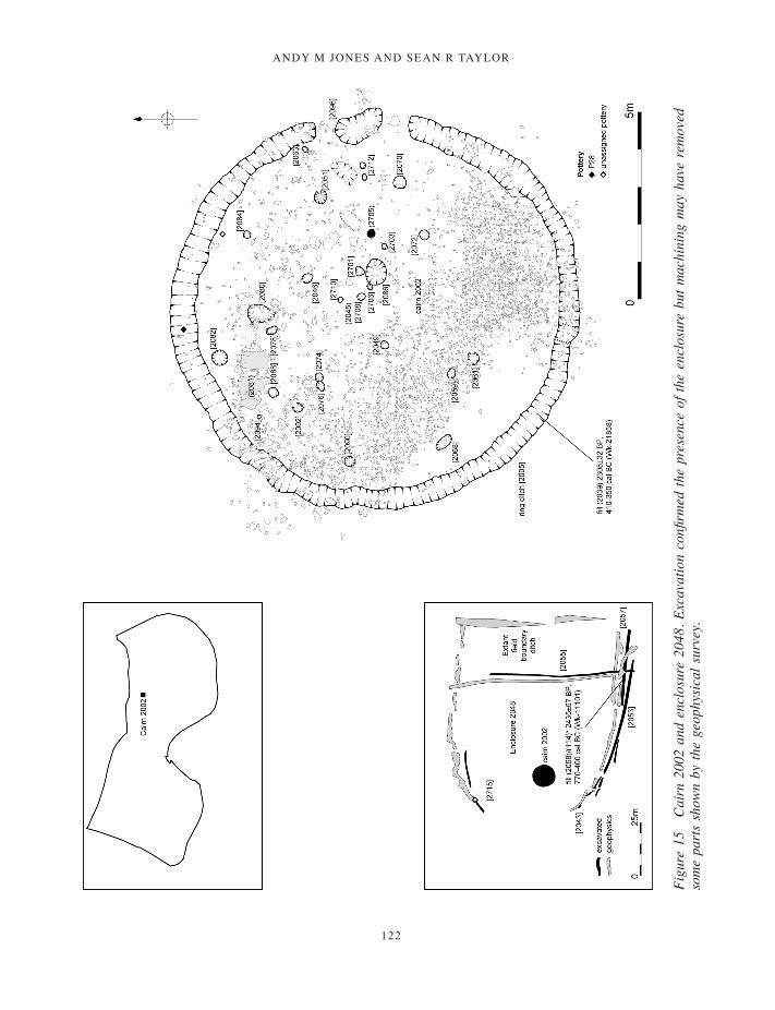
ANDY M JONES AND SEAN R TAYLOR
122
Figu
re 1
5 C
airn
200
2 an
d en
clos
ure
2048
. Exc
avat
ion
confi
rmed
the
pres
ence
of t
he e
nclo
sure
but
mac
hini
ng m
ay h
ave
rem
oved
so
me
part
s sh
own
by th
e ge
ophy
sica
l sur
vey.
099-134_Jones&Taylor.indd 122 01/12/2014 11:42
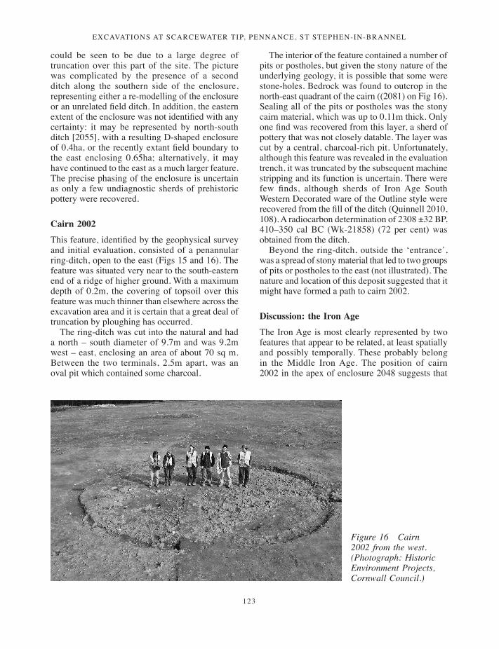
Excavations at scarcEwatEr tip, pEnnancE, st stEphEn-in-BrannEl
123
could be seen to be due to a large degree of truncation over this part of the site. The picture was complicated by the presence of a second ditch along the southern side of the enclosure, representing either a re-modelling of the enclosure or an unrelated field ditch. In addition, the eastern extent of the enclosure was not identified with any certainty: it may be represented by north-south ditch [2055], with a resulting D-shaped enclosure of 0.4ha, or the recently extant field boundary to the east enclosing 0.65ha; alternatively, it may have continued to the east as a much larger feature. The precise phasing of the enclosure is uncertain as only a few undiagnostic sherds of prehistoric pottery were recovered.
Cairn 2002
This feature, identified by the geophysical survey and initial evaluation, consisted of a penannular ring-ditch, open to the east (Figs 15 and 16). The feature was situated very near to the south-eastern end of a ridge of higher ground. With a maximum depth of 0.2m, the covering of topsoil over this feature was much thinner than elsewhere across the excavation area and it is certain that a great deal of truncation by ploughing has occurred.
The ring-ditch was cut into the natural and had a north – south diameter of 9.7m and was 9.2m west – east, enclosing an area of about 70 sq m. Between the two terminals, 2.5m apart, was an oval pit which contained some charcoal.
The interior of the feature contained a number of pits or postholes, but given the stony nature of the underlying geology, it is possible that some were stone-holes. Bedrock was found to outcrop in the north-east quadrant of the cairn ((2081) on Fig 16). Sealing all of the pits or postholes was the stony cairn material, which was up to 0.11m thick. Only one find was recovered from this layer, a sherd of pottery that was not closely datable. The layer was cut by a central, charcoal-rich pit. Unfortunately, although this feature was revealed in the evaluation trench, it was truncated by the subsequent machine stripping and its function is uncertain. There were few finds, although sherds of Iron Age South Western Decorated ware of the Outline style were recovered from the fill of the ditch (Quinnell 2010, 108). A radiocarbon determination of 2308 ±32 BP, 410–350 cal BC (Wk-21858) (72 per cent) was obtained from the ditch.
Beyond the ring-ditch, outside the ‘entrance’, was a spread of stony material that led to two groups of pits or postholes to the east (not illustrated). The nature and location of this deposit suggested that it might have formed a path to cairn 2002.
Discussion: the Iron Age
The Iron Age is most clearly represented by two features that appear to be related, at least spatially and possibly temporally. These probably belong in the Middle Iron Age. The position of cairn 2002 in the apex of enclosure 2048 suggests that
Figure 16 Cairn 2002 from the west. (Photograph: Historic Environment Projects, Cornwall Council.)
099-134_Jones&Taylor.indd 123 01/12/2014 11:42

ANDY M JONES AND SEAN R TAYLOR
124
the two are both components of the same cultural landscape or that the enclosure respected the cairn.
Even allowing for truncation, the ditch of enclosure 2048 was shallow. However, it was possible to suggest that the truncation was responsible for the ‘segmentation’ of the ditch and that originally it was continuous. It seems probable that the enclosure was associated with settlement activity, perhaps with the control of animals, and may have formed part of a wider bounded landscape (Jones and Taylor 2010).
Cairn 2002 was an unusual site which most closely resembled a moderately-sized ditched cairn of Early Bronze Age date. However, the dating evidence proved otherwise. The pottery assemblage from cairn 2002 was small but made up entirely of South Western Decorated ware of the Outline style. This style is the earliest of the type, appearing in probably the later fourth century cal BC, although it continued to be made throughout the currency of the ware. The radiocarbon determination of 410–350 cal BC (78.2 per cent) (Wk-21458) is appropriate.
The site is therefore Iron Age, creating a problem of interpretation: an Iron Age cairn would be unusual and the feature could instead be interpreted as an Iron Age ‘domestic’ roundhouse. The argument against this lies in the paucity of evidence for structural or associated settlement-related activity. Additionally, cairn 2002 did not contain a hearth and, unlike roundhouse 3084, the floor was jagged and stony and contained several in situ boulders. The floor would have been uncomfortable to kneel or sit upon. Furthermore, there was a lack of domestic debris, and the pits or postholes within the ring-ditch did not form a post-ring. The seemingly random placing of the cut features within the cairn suggests repeated visits, more consistent with ritual activity than with domestic functions.
Such ritual would have taken place before the mound was erected. The spread of stony cairn material across the interior of the ring-ditch also suggests that the site was abandoned with a degree of formality and that an attempt had been made to monumentalise it. It is therefore unlikely that the structure was a ‘domestic’ building, and instead it may have been an Iron Age hilltop shrine or ring-barrow. Iron Age circular shrines containing pits have been found elsewhere, as at Hayling Island in Hampshire, and other shrines within larger enclosures are known from other parts of Britain
(Woodward 1992, 20–22, 34). However, cairn 2002 does not closely resemble these sites.
Until recently, there has been comparatively little evidence in Cornwall for ceremonial activity during the first millennium cal BC. Some recent excavations in the county, however, suggest that the cairn was part of a later prehistoric tradition of monument building related to wider practises found around the western Atlantic region (Jones 2010). Within Cornwall the closest parallel to cairn 2002 is perhaps provided by a stone ‘platform’ which covered an outcrop recorded on a pipeline between Padstow and Harlyn in north Cornwall (Jones and Quinnell 2014, 102–5). Because of its morphology and the presence of flint upon the platform it was thought likely that the feature would date to the Early Bronze Age; however, a pit beside the outcrop gave a radiocarbon determination which fell between 400 and 200 cal BC. It is just possible that the site was Iron Age in date and similar to cairn 2002. Beyond Cornwall, low cairns of Later Bronze Age – Iron Age date situated within a field system have been excavated at Dainton, Devon. Several of these cairns were associated with fragments of burnt bone, pottery and bronze metalwork mould fragments dating to the tenth century BC (Silvester 1980; Smith and Humble 1986). The very limited available evidence suggests that in the south-west peninsula, small-scale ceremonial monuments constructed near to settled areas persisted into, or were re-introduced in, the first millennium cal BC (Jones 2008a).
A number of unusual henge-like enclosures of varying size have recently been uncovered in Cornwall, at Tremough (Penryn), Hay Close (St Newlyn East) and Camelford (Lanteglos-by-Camelford) (Jones 2010; forthcoming a). It has been argued elsewhere (Jones 2010) that these sites were inspired through contact with the eastern seaboard of Ireland, where broadly contemporary but even larger complexes, which include henge-like monuments, are found. This evidence suggests that circular enclosures, which drew on Irish monument forms, were constructed during the Iron Age in Cornwall. Cairn 2002 may also have parallels with ring-barrows, another monument-type found in Ireland which is known to have continued into the Iron Age (Cooney and Grogan 1999, 199). Comparable sites to cairn 2002 include ring-barrows such as ‘Dathi’s Mound’ (Co Roscommon) and Cruachain (Co Offaly) (Raftery 1997, 189; Waddell 1987). These sites often take
099-134_Jones&Taylor.indd 124 01/12/2014 11:42

Excavations at scarcEwatEr tip, pEnnancE, st stEphEn-in-BrannEl
125
the form of annular or penannular ring-ditches with external banks and internal pits, frequently containing cremations. Iron Age artefacts have been recovered from many sites (Cooney and Grogan 1999, 199) and radiocarbon determinations from the ring-barrow known as ‘Dathi’s Mound’ gave dates from the late first millennium BC (Waddell 1987), comparable with that from cairn 2002. Cairn 2002 certainly shares some aspects with these features and the site may well, therefore, be a truncated ring-barrow.
Although, no human remains were recovered from cairn 2002 it is probable that any cremations or inhumation would have been removed through truncation; it is also possible that the central feature identified in the top of the cairn material but not fully explored represented the surviving base of such a deposit.
Taken together, these elements suggest that it is at least possible that contacts around the Atlantic seaboard resulted in the spread of monument forms and traditions that contrast with those to the east in southern Britain (Jones 2010).
Romano-British period (AD 43–410)The evidence for Romano-British activity comprised pits and ditches associated with an extensive multi-phased field system, two or, more probably, three burials and some possible buildings. The potential settlement-related features were located in the southern part of the project area near to Pennance farmstead and have been described fully elsewhere (Jones and Taylor 2010, 85–7); the discussion here is limited to the burials, which were located 40-50m to the east of the Romano-British settlement focus.
The burials
At Scarcewater, two certain burials, cist [2150], inhumation burial [2315] and one possible inhumation burial [2153] were excavated. Because of the acidic soil conditions, the physical character of the human remains associated with the burials is mostly inferred (although a body-stain was found within [2315]) and the character of possible burial [2153] is unknown. Because of this, detailed discussion will be confined to the two certain burials. Both are discussed in relation to four
criteria: form, position, alignment and position of body.
Cist [2150]
Cist [2150] was sub-rectangular in plan, 2m long, 0.88m wide and 0.24m deep (Figs 17 and 18). The stones forming the cist were set into sockets along the north, east, and south edges of the cut. To the west, a number of sockets that would have held similar sized stones suggested that the western end of the grave had also been stone-lined but had been disturbed. A stone found on top of the cist may have come from one of these sockets. A sherd of Romano-British pottery from a flat, grooved-rim bowl of the third to fourth centuries AD was found in the lining of the cist.
The base of the cist was formed by the natural clay. Above this layer at the eastern end, and within gaps between the stones, the cist was partially lined with clay. A small iron cleat was recovered from the bottom of the cist. It is thought that this derived from a wooden object buried with the body; although it is possible that it came from an item of clothing or a shoe.
Pollen from the cist indicated a predominantly open local landscape (Fyfe 2010) and the burial may have been located on the margins of a field.
Fo r mA cist discovered by workmen in 1885 in Ladock parish offers some comparisons with that at Scarcewater. The site, at Little Trendeal, is only 3.7 km to the west south west and, like Scarcewater, is situated close to the upper reaches of a river which is navigable in its lower parts. However, the Ladock site was not adequately recorded and from the few facts known no date can be assigned to it with certainty. Whimster (1981, II, 273) assigns it to the Iron Age, grouping it within the south-western cist inhumations. It was described as consisting of ‘a single cover stone and single stones for each of the sides. Additional small stones placed on and around the cist’. This contrasts with the Scarcewater cist, which was built of multiple stones with no evidence for a cover. At 1.05m by 0.6m the Trendeal cist was also much smaller than that at Scarcewater and this may imply a crouched or flexed inhumation that would indeed suggest an Iron Age date. The orientation was reported to have been north-south, by contrast with the Scarcewater cist which is aligned east-west.
099-134_Jones&Taylor.indd 125 01/12/2014 11:42

ANDY M JONES AND SEAN R TAYLOR
126
Figu
re 1
7 Th
e Ro
man
o-Br
itish
bur
ials
.
099-134_Jones&Taylor.indd 126 01/12/2014 11:42

Excavations at scarcEwatEr tip, pEnnancE, st stEphEn-in-BrannEl
127
Most dated cists of the Roman period belong to the fourth century AD or later (Philpott 1991, 62). The burials of children have been found in this type of grave (ibid, 64), However, the size of the Scarcewater cist would have made it large enough for an adult inhumation.
Po s i t i o nThe cist lay between two parallel linear features ([2179] and [2181]), possibly marking a Roman-period trackway (Jones and Taylor 2010, fig 37). It was placed within a field defined by ditch [2185] to the north, outside the area of settlement.
Al i g n m e n tThe cist was aligned east-west, if the deeper stone-lined end is taken to be that used for the head. However, if the cleat described below came from a shoe or boot, then the body may have been buried west-east.
gr Av e g o o d sThe presence of a cleat within an area interpreted as occupied by the body cavity at the eastern end
of the cist, and therefore probably somewhere on the upper body, suggests that the body may have been buried adorned in some way. The size of the cleat suggests that it would have held two thick pieces of material together, possibly components of a wooden object.
The potsherd found in the cist lining, comes from a Type 21 bowl with a date currently ranging through the third and fourth centuries AD (Quinnell 2004, 123). Its presence within the lining of the cist strongly suggests that it is not intrusive and it is likely to be contemporary with the construction of the cist.
Inhumation [2315]
Located approximately 5m north east of cist [2150] (Fig 19). The east-south-east – west-north-west alignment of the grave followed that of a silted ditch [2185], of Late Iron Age – early Roman date. This suggests that although the ditch had silted up, it or an associated bank remained a recognisable landscape feature. The fact that the inhumation cut the ditch suggests that it is likely to belong to the later part of the Roman period. The skeletal remains had completely decayed, leaving only a body-stain. The body-stain showed the chest, abdomen, pelvis, legs, and feet clearly; the full length of the arms could not be distinguished from the torso and the head was either missing or the body had been buried with the neck bent and the head resting upon the chest rather than being fully extended.
Hobnails were found around the feet, indicating the presence of three hobnailed shoes. Two of these appeared to have been buried with the soles up, indicating that the body, if it had been wearing them, may have been buried face down. A third shoe over the ankle area appeared to have been buried sole down. A copper-alloy brooch was recovered from the southern shoulder.
Fo r m The grave took the form of a deep, vertical-sided cut. The cut was rectangular, measuring 2m long and 0.65m wide at the top and 1.4m long by 0.48m wide at the base; it was 0.96m deep. The depth of the grave may also indicate a later date since it has been inferred that the greater survival of inhumations from the Late Roman period is indicative of deeper burials at this period (Taylor 2001, 120).
Figure 18 Cist [2150] excavated. (Photograph: Historic Environment Projects, Cornwall Council.)
099-134_Jones&Taylor.indd 127 01/12/2014 11:42

ANDY M JONES AND SEAN R TAYLOR
128
Po s i t i o n o F g r Av eThe grave was cut into the side of a field ditch belonging to a field system of Late Iron Age – early Roman date associated with a settlement of similar origins. The inhumation lay to the north of the area of settlement. Many rural settlements elsewhere in Britain have single or group burials in ditches on the edges of the settlement, especially in the corners of fields.
Al i g n m e n tNorth-south oriented graves are often taken to indicate a pagan burial; as opposed to an east-west orientation which can suggest a Christian one. Discussion of the possible date of inhumation [2315] cannot with certainty be based on its almost west-east orientation because it also follows the line of a field boundary, presumed to be extant at the time of burial. At Poundbury in Dorset the majority of the grave alignments follow the surrounding enclosure ditches rather than the cardinal points of the compass (Farwell and Molleson 1993, 229). This may, of course, simply indicate that the enclosures were laid out close to the cardinal points to accommodate the ‘correct’ alignment of the burials. The head was placed at the western end as is traditional with Christian burial. However, there is evidence that the east-west orientation of burials
pre-dates the arrival of Christianity, perhaps being linked to the cult of Sol Invictus (White 2007, 92) or eastern mystery religions in general (Taylor 2001, 110). Within this period selection of alignment may have been based on a variety of criteria. A small rural cemetery dating to the early third century AD at Foxton, Cambridgeshire, for example, was found to contain eight deep inhumations in which men were buried west-east and women east-west (Taylor 2001, 131). Overall, it is clear that there were regionally diverse burial rite traditions during this period (Philpott 1991, 1).
Po s i t i o n A n d At t i t u d e o F b o d yAlthough no skeletal remains survived it was possible to conclude that the body was buried in a prone position (that is face down) because of the attitude of the hobnails located around the feet of the body-stain. These were found head uppermost, indicating the shoes were sole side uppermost. The body was extended, a custom that became universal from the mid second century AD in known burials (Philpott 1991, 53). However, prone burials are rare in large urban Roman cemeteries such as those at Poundbury (Farwell and Molleson 1993, 222). There a small number of prone burials were interspersed with the supine majority and no significance could be attached to the position.
Figure 19 Inhumation [2315], showing the body-stain of the legs and feet to the left. (Photograph: Historic Environment Projects, Cornwall Council.)
099-134_Jones&Taylor.indd 128 01/12/2014 11:42

Excavations at scarcEwatEr tip, pEnnancE, st stEphEn-in-BrannEl
129
The torso stain extended to the western extent of the grave cut, leaving no room for the head. This would suggest decapitation prior to burial. This is a relatively common custom with Roman burials, and there is evidence from Harlyn Bay of three decapitated burials from the Iron Age cist cemetery (Whimster 1981, II, 281–3), suggesting that this tradition pre-dated any Roman influence. The survival of the body-stain may indicate that the burial was not coffined: the body would have decayed before a coffin and would not then have left a body-shaped stain in the base of the grave.
Mutilation may be an older custom not recognised earlier due to lower visibility of the rural poor in death, perhaps due to shallower graves in the period before deep inhumations. Decapitations are more common in rural areas and may reflect a need to release the spirit of the dead. These bodies are usually otherwise normally buried (Taylor 2001, 123). The possibility that the body was decapitated may provide us with an additional clue to date: it has been noted that decapitated bodies in Roman Britain are almost always of fourth century date (Philpott 1991, 53).
gr Av e g o o d sThe presence of footwear, as indicated by the hobnails, is a common occurrence in Roman inhumations, particularly in rural cemeteries (Taylor 2001, 112). It has been suggested that the dead may have needed a pair of boots for the journey to the underworld (Salway 1993, 520). Evidence from a building containing a furnace at a cemetery outside Cirencester suggests footwear or just hobnails may have been manufactured especially for funerals (ibid.). The extra shoe may represent an additional burial within the grave but there are examples of extra footwear being placed within a grave, for example at Poundbury where one burial had an extra pair of boots beneath the arms (Taylor 2001, 121). The brooch may have fastened a shroud, a Christian tradition, or everyday clothes. The south-western T-shaped group, to which the brooch belongs, is thought likely to originate in the late first century and continue development into the early second century AD (Butcher 2010), although in Cornwall, some examples may have been preserved and deposited later (Butcher 2004, 71). On the assumption that the body was prone, the brooch fastened a garment on the left shoulder. However, a Christian burial would not normally be buried with grave goods or boots, which would
suggest a pagan rite (ibid, 111). Nonetheless, a later date would be consistent with the grave being cut into a silted up ditch of Late Iron Age or early Roman-period date.
Possible inhumation [2153]
Immediately to the west of cist [2150], on the same alignment as inhumation [2315] to the north east, was a sub-rectangular pit of similar dimensions in plan to [2315]. It was 2.11m long, 0.75m wide and up to 0.98m deep. The two long sides were steeply cut but the ends had a more gradual slope; the base was undulating. The fill contained frequent lumps of natural clay, suggesting that the pit had been backfilled soon after being dug. No finds were recovered from the feature and its identification as a possible grave rests upon its position and alignment close to the two known burials.
Discussion: the burial of the dead in Roman Cornwall
The excavations at Scarcewater revealed valuable information about burial activity during the Roman period (Jones and Taylor 2010, 89–92). In particular, the presence of the burials at Scarcewater close to a settlement area links the living with the dead and is currently unparalleled in Cornwall.
The discovery of at least two burials of the Roman period represents a major advance in our understanding of the treatment of the dead in south-western Britain at this time. In Cornwall the evidence for later Iron Age and Romano-British burial practises is complicated by the fact that human remains do not usually survive in the county’s acidic soils unless they have been cremated. This means that usually the only graves that can be readily distinguished are stone-lined cists or those which are located in a known burial site.
The available evidence for Cornwall is almost polarised: the Late Iron Age is represented by a relatively large number of burials from a quite small number of cemeteries whereas the Roman period is almost devoid of evidence. Inhumation is the only archaeologically visible method of disposal of the dead known from the Late Iron Age. In this period, the cist inhumation is the most widely observed practise, as at Harlyn Bay (St Merryn) (Bullen 1912; Whimster 1977) and Trevone (Padstow) (Dudley and Jope 1965). At the latter site a
099-134_Jones&Taylor.indd 129 01/12/2014 11:42
ANDY M JONES AND SEAN R TAYLOR
130
slate-lined cist was found to contain two brooches dating to the early second century cal BC. Unlined graves containing crouched inhumations were found at Trethellan (Nowakowski 1991).
The introduction of cremation burial to Cornwall during the Roman period has been inferred from three finds in recent years. A recent discovery at Tregony (Cuby) provided proof of the introduction of Roman cremation practises into Cornwall. The burnt bones of an elderly woman were found inside two pottery vessels deposited in a small rectangular ditched enclosure on the outskirts of the settlement. A radiocarbon date of 1679 ±34 BP, cal AD 250–430 (Wk-19958) was obtained on the cremated bone (Taylor 2012).
Burnt human bone was recovered from an occupation spread at Duckpool (Morwenstow): two conjoining pieces of mandible were found in a deposit dated by Roman coins to the 340s-360s AD (Ratcliffe 1995). It was unclear whether these remains were burnt as a result of cremation or the accidental burning of re-deposited material. Intriguing finds of carbonised human bone were also made during excavations at Tintagel Castle (Tintagel), with fragments coming from several contexts, one of which has been radiocarbon dated to the early post-Roman period (cal AD 410–535, UB883). It seems likely that the fragments derive from an earlier phase of occupation on the site, assigned to the third or fourth centuries AD. Analyses of the bone lent weight to the theory that the fragments represent deliberate cremation rather than accidental burning (Barrowman et al 2007, 52; 55; 312; 329). It is certainly possible that the remains from Tintagel and Duckpool represent Romano-British cremation practises but the evidence is far from conclusive.
Although Tregony remains the only securely dated cremation from Cornwall, circumstantial evidence suggests that it was not unique. An urn from Penquite (probably Golant) described and illustrated by Borlase (1872, 288) is likely to have contained cremated remains. Although its context is unknown, the function was almost certain: domestic vessels of this type would not survive intact unless buried deliberately and the most likely reason for this is to hold, or accompany, human burials. Other possible urned cremations dating to this period in Cornwall have been recorded at Kerris Vean (Paul) and Calvadnack (Wendron) (Borlase 1872), and at St Clare (Penzance) (Anon 1887), none of which survive.
Elsewhere, inhumation appears to replace cremation in Roman Britain from the mid second century, becoming almost universal by the fourth (Philpott 1991, 53; Taylor 2001, 109). This is a more complex issue in rural areas where the continuation of Iron Age customs of inhumation, usually crouched, blurs the chronology of the two rites (ibid). This has been noted in the territory of the Durotriges (Dorset and Somerset) (Philpott 1991, 54). However, the evidence from Cornwall for inhumation during the Roman period has hitherto been scanty. A burial ground at Trevone was identified in the nineteenth century (Anon 1849; Trollope 1860) and consisted of unlined graves aligned north-south below a series of slate-lined graves aligned east-west. A Roman fibula brooch of the third or fourth century AD was recovered from one of the earlier series of graves and a piece of Samian ware was found nearby. The burial ground lies in a field adjacent to the Iron Age cist referred to above, perhaps indicating the continued use of the cemetery from the Later Iron Age through to the Romano-British period. However, other than this site, no Roman-period inhumations had been identified in Cornwall prior to the investigations at Scarcewater, and none had previously been recorded using modern archaeological techniques.
Drawing major conclusions on the basis of two confirmed burials is unwise. However, we can surmise that both the inhumation and the cist burial date to the later Roman period. The inhumation displays a number of features that suggest pagan beliefs were held by the bereaved. At Poundbury burials featuring mutilations, the wearing of shoes and the presence of artefacts in general, are confined to areas outside the Christian cemetery (Taylor 2001, 121). The cist is aligned east-west, an axis which is associated with sunrise and sunset, representing beliefs introduced from the eastern Roman Empire from the second century AD onwards (White 2007, 92). Indeed, the rite of inhumation rather than cremation is itself thought to represent shifting views of the afterlife in Roman society.
It is likely that these beliefs influenced the people who constructed the cist since in a rural area it would hardly be necessary to outwardly conform in such matters unless such belief was accepted by the inhabitants. This may raise more questions about the method by which these beliefs were spread in rural parts of the Empire. It is not suggested that
099-134_Jones&Taylor.indd 130 01/12/2014 11:42

Excavations at scarcEwatEr tip, pEnnancE, st stEphEn-in-BrannEl
131
Christianity was the eastern religion involved as there is little evidence for it in Cornwall at this time, although it may have exerted an influence, especially given its emergence as the official religion of the Empire in the first half of the fourth century AD. However, the means by which religion ‘trickled’ down from the Roman hierarchy are not understood. If the cist represents a Christian burial it would provide the first evidence for Christianity in Cornwall, pre-dating the earliest post-Roman Christian burials by over a century (for example, Nowakowski and Thomas 1992).
ConclusionThe archaeological excavations at Scarcewater were hugely significant because the large extent of the area investigated moved beyond the confines of an individual site. The work provided an unparalleled insight into changing patterns of occupation over a span of several millennia.
In addition to the identification of new site types, such as the Late Bronze Age palisade enclosure and the Iron Age cairn, the investigation of the area has resulted in a much greater understanding of how space was articulated during certain periods of time.
In particular, the investigation of Middle Bronze Age activity has been important to our understanding of how roundhouses, ancillary buildings and ceremonial sites were related, and how activity associated with them cross-referred between site types and across the wider landscape. Further information was gleaned about how the Middle Bronze Age settlement developed and how the individual structures were used and abandoned.
Likewise, the excavations revealed significant new evidence concerning the character of occupation in the Romano-British period. The excavated features included an extensive multi-phased field system and importantly burials, which are rarely identified in Cornwall. These were found to have been located at the margins of the enclosed area, thereby providing the first evidence in Cornwall for where the Romano-British dead were placed in relation to the living.
Acknowledgements
The authors would like to thank: Imerys Mineral Ltd for funding the excavation, archiving and
final publication. Within Historic Environment (Projects) the authors would like to thank Bryn Tapper for producing Figure 1, Graeme Kirkham and Peter Rose for their comments on the text. We would also like to thank the many people who worked on the excavations in 2004.
The Ordnance Survey mapping is provided by Cornwall Council under licence from the Ordnance Survey in order to fulfil its public function to disseminate information to a wider audience. Persons viewing this statement should contact the Ordnance Survey where they wish to licence Ordnance Survey mapping for their own use. Cornwall Council Licence no 100049047 2009.
The artefacts from the project and the paper archive will be deposited with the Royal Cornwall Museum. The accession number is TRURI: 2007.32.
ReferencesAnon, 1849. J Brit Archaeol Assoc, 4, 394Anon, 1887. Meetings of the Society, reports and
transactions, Penzance Nat Hist Antiq Soc, ns, 2, 282–99
ApSimon, A M, and Greenfield, E, 1972. The excavation of the Bronze Age and Iron Age settlement at Trevisker round, St Eval, Cornwall, Proc Prehist Soc, 38, 302–81
Ashbee, P, 1958. The excavation of the Tregulland barrow, Treneglos parish, Cornwall, Antiq Jnl, 38, 174–96
Barrett, J, Bradley, R, and Green, M, 1991. Landscape, monuments and society: the prehistory of Cranborne Chase, Cambridge
Bender, B, Hamilton, S, and Tilley, C, 2007. Stone worlds: narrative and reflexivity in landscape archaeology, Walnut Creek
Borlase, W C, 1872. Naenia Cornubiae. A descriptive essay, illustrative of the sepulchres and funeral customs of the early inhabitants of the county of Cornwall, London
Bradley, R, 1998. The significance of monuments: on the shaping of human experience in Neolithic and Bronze Age Europe, London
Bradley, R, 2005. Ritual and domestic life in prehistoric Europe, London
Bradley, R, and Fraser, E, 2010. Bronze Age barrows on the heathlands of southern England; construction, forms and interpretation, Oxford J Arch, 29, 15–34
Brück, J, 1995. A place for the dead: the role of human remains in Late Bronze Age Britain, Proc Prehist Soc, 61, 245–78
Brück, J, ed, 2001. Bronze Age landscapes: tradition and transformation, Oxford
099-134_Jones&Taylor.indd 131 01/12/2014 11:42
ANDY M JONES AND SEAN R TAYLOR
132
Brück, J, 2001. Body metaphors and technologies of transformation in the English Middle and Late Bronze Age, in Brück, ed, 2001, 149–60
Bullen, R A, 1912. Harlyn Bay and the discoveries of its prehistoric remains, Padstow (3rd edn).
Butcher, S, 1978. Excavations at Nornour, Isles of Scilly, 1969–73: the pre-Roman settlement, Cornish Archaeol, 17, 29–112
Butcher, S, 2004. Brooches, in Quinnell 2004, 70–2Butcher, S, 2010. Roman period brooch, in Jones and
Taylor 2010, 133Butler, J, 1997. Dartmoor atlas of antiquities, volume
5, TivertonCooney, G, and Grogan, E, 1999. Irish prehistory, a
social perspective, DublinCornish, T, 1880–81. Bronze celts, Penzance Nat Hist
Antiq Soc, 74–6Cornwall County Council, 1996. Cornwall: a landscape
assessment 1994, Truro (Landscape Design Associates in association with Cornwall Archaeological Unit)
Drewett, P, 1982. Later Bronze Age downland economy and excavations at Blackpatch, East Sussex, Proc Prehist Soc, 48, 321–400
Dudley, D, 1955–6. Recent work in Cornish archaeology, Proc West Cornwall Field Club, ns, 1, 4, 147–52
Dudley, D, 1956. An excavation at Bodrifty, Mulfra, near Penzance, Arch Jnl, 113, 1–32
Dudley, D, and Jope, E, 1965. An Iron Age cist burial with two brooches from Trevone, north Cornwall, Cornish Archaeol, 4, 18–23
Farwell, D, and Molleson, T, 1993. Excavations at Poundbury 1966–80, volume II: the cemeteries, Dorchester
Fitzpatrick, A, 1997. Everyday life in Iron Age Wessex, in A Gwilt and C Haselgrove, eds, Reconstructing Iron Age societies: new approaches to the British Iron Ages, Oxford, 73–86
Fleming, A, 1988. The Dartmoor reaves, LondonFyfe, R, 2010. Pollen, in Jones and Taylor 2010,
153–4Gale, R, 2010. Charcoal, in Jones and Taylor 2010,
149–52Gingell, C, 1992. The Marlborough Downs: a later
Bronze Age landscape and its origins, DevizesGossip, J, 2008. Excavations at Boden Vean, Manaccan
2008, CBA Archaeology South-West, 22, 29–31Gossip, J, 2013. The evaluation of a multi-period
prehistoric site and fogou at Boden Vean, St Anthony-in-Meneage, 2003, Cornish Archaeol, 52, 1–98
Gossip, J, forthcoming. Life outside the round: Bronze Age and Iron Age settlement at Higher Besore and Truro College, Threemilestone, Truro, Cornish Archaeol
Gossip, J, and Jones, A M, 2007. Archaeological investigations of a later prehistoric and a Romano-British landscape at Tremough, Penryn, Cornwall, Brit Arch Repts, Brit Ser, 443, Oxford
Gossip, J, and Jones A M, 2008. A Bronze Age roundhouse at Carnon Gate, Feock, Cornish Archaeol, 47, 131–45
Griffith, F M, 1984. Archaeological investigations at Colliford reservoir, Bodmin Moor, 1977–78, Cornish Archaeol, 23, 47–140
Harding, J, and Healy, F, 2007. The Raunds project: a Neolithic and Bronze Age landscape in Northamptonshire, London
Helms, M, 1988. Ulysses’ sail: an ethnographic odyssey of power, knowledge, and geographical distance, Princeton
Hertz, R, 2009. Death and the right hand, London (1st pub 1960)
Jenness, D, 1977. The Indians of Canada, Toronto (1st pub 1932)
Johnson, N, and Rose, P, 1994. Bodmin Moor, an archaeological survey: volume 1, the human landscape to c 1800, London
Jones, A M, 1998–9. The excavation of a Later Bronze Age structure at Callestick, Cornish Archaeol, 37–8, 5–55
Jones, A M, 2004–5. Settlement and ceremony; archaeological investigations at Stannon Down, St Breward, Cornwall, Cornish Archaeol, 43–4, 1–141
Jones, A M, 2005. Cornish Bronze Age ceremonial landscapes c.2500–1500 BC, Brit Arch Repts, Brit Ser, 394, Oxford
Jones, A M, 2008a. Houses for the dead and cairns for the living: a reconsideration of the Early to Middle Bronze Age transition in south-west England, Oxford J Arch, 27, 153–74
Jones, A M, 2008b. Excavation of a barrow on Constantine Island, St Merryn, Cornwall, Cornish Archaeol, 47, 101–130
Jones, A M, 2010. Misplaced monuments?: a review of ceremony and monumentality in first millennium cal BC Cornwall, Oxford J Arch, 29, 203–28
Jones, A M, forthcoming a. Hay Close, St Newlyn East: excavations by the Cornwall Archaeological Society, 2007, Cornish Archaeol
Jones, A M, forthcoming b. Ritual, rubbish or everyday life? Evidence from a Middle Bronze Age settlement in mid Cornwall, Arch Jnl
Jones, A M, and Quinnell, H, 2006. Redating the Watch Hill barrow, Arch Jnl, 163, 42–66
Jones, A M, and Quinnell, H, 2011. Bosiliack: a later prehistoric settlement in Penwith, Cornwall, Arch Jour, 168, 96–132
Jones, A M, and Quinnell, H, 2014. Lines of investigation along the north Cornish coast, Brit Arch Repts, Brit Ser, 594, Oxford
Jones, A M and Taylor, S R, 2010. Scarcewater, Pennance, Cornwall, archaeological excavation of a Bronze Age and Roman landscape, Brit Arch Repts, Brit Ser, 516, Oxford
099-134_Jones&Taylor.indd 132 01/12/2014 11:42
Excavations at scarcEwatEr tip, pEnnancE, st stEphEn-in-BrannEl
133
Jones, J, 2010. Plant remains, in Jones and Taylor 2010, 142–9
Jones, M, and Bond, D, 1980. Later Bronze Age settlement at Mucking, Essex, in J Barrett and R Bradley, eds, Settlement and society in the later British Bronze Age, Brit Arch Repts, Brit Ser, 83, Oxford, 471–82
Kelly, R S, 1988. Two late prehistoric circular enclosures near Harlech, Gwynedd, Proc Prehist Soc, 54, 101–51
Ladle, L, and Woodward, A, 2009. Excavations at Bestwall quarry, Wareham, 1992–2005, volume 1: the prehistoric landscape, Dorchester
Malinowski, B, 1922. Argonauts of the western Pacific: an account of native enterprise and adventure in the archipelagos of Melanesian New Guinea, London
Manby, T, Moorhouse, S, and Ottaway, P, 2003. The archaeology of Yorkshire, an assessment at the beginning of the 21st century, Huddersfield
Merrifield, R, 1987. The archaeology of ritual and magic, London
Miles, H, 1975. Barrows on the St. Austell granite, Cornish Archaeol, 14, 5–81
Miles, H, Davey, U, Harris, D, Hooper, S, Moreton, P, Padel, O, and Staines, S, 1977. Excavations at Killibury hillfort, Egloshayle 1975–6, Cornish Archaeol, 16, 89–121
Moore, H, 1986. Space, text and gender: an anthropological study of the Marakwet of Kenya, Cambridge
Moore, J, and Jennings, D, 1992. Reading Business Park: a Bronze Age landscape, Oxford
Nowakowski, J, 1991. Trethellan Farm, Newquay: the excavation of a lowland Bronze Age settlement and Iron Age cemetery, Cornish Archaeol, 30, 5–242
Nowakowski, J, 2001. Leaving home in the Cornish Bronze Age: insights into the planned abandonment process, in Brück, ed, 2001, 139–48
Nowakowski, J, Quinnell, H, Sturgess, H, Thomas, C, and Thorpe, C, 2007. Return to Gwithian: shifting the sands of time, Cornish Archaeol, 46, 13–76
Nowakowski, J, and Thomas, C, 1992. Grave news from Tintagel, Truro
Padel, O J, 1985. Cornish place-name elements, Nottingham
Parker Pearson, M, 1996. Food, fertility and front doors, in T Champion and J Collis, eds, The Iron Age in Britain and Ireland: recent trends, Sheffield, 117–32
Parker Pearson, M, and Richards C, 1994. Architecture and order: spatial representation and archaeology, in M Parker Pearson and C Richards, eds, Architecture and order: approaches to social space, London, 38–72
Pearce, S, 1983. The Bronze Age metalwork of south western Britain, Brit Arch Repts, Brit Ser, 120, Oxford
Philpott, R, 1991. Burial practices in Roman Britain: a survey of grave treatment and furnishing AD 43–410, Brit Arch Repts, Brit Ser, 219, Oxford
Quinnell, H. 1997. Excavations of an Exmoor barrow and ring cairn, Proc Devon Archaeol Soc, 55, 1–38
Quinnell, H, 2004. Excavations at Trethurgy round, St Austell: community and status in Roman and post-Roman Cornwall, Truro (Cornwall County Council)
Quinnell, H, 2010. Prehistoric and Roman pottery, in Jones and Taylor 2010, 93–113
Raftery, B, 1997. Pagan Celtic Ireland: the enigma of the Iron Age, London
Ratcliffe, J, 1995. Duckpool, Morwenstow: a Romano-British and early medieval industrial site and harbour, Cornish Archaeol, 34, 81–171
Ratcliffe, L, and Marley, J, 2009. The Mylor axe hoard, CBA Archaeology South West, 23, 13–14
Salway, P, 1993. A history of Roman Britain, OxfordSilvester, R, 1980. The prehistoric open settlement at
Dainton, Proc Devon Archaeol Soc, 38, 17–48Smith, G, and Humble, J, 1986. Excavation at the
Late Bronze Age and Early Iron Age settlement and field system at Dainton, south Devon, 1986. Central Excavation Unit site 414, a preliminary report, unpublished report
Taylor, A, 2001. Burial practice in early England, Stroud
Taylor, S R, 2005. Scarcewater Tip archaeological mitigation: archive report, Truro (Historic Environment Service, Cornwall County Council)
Taylor, S R, 2012. Excavation of a Roman and post-Roman site at Penlee House, Tregony: a cremation and other burning issues, Cornish Archaeol, 51, 125–64
Townend, S, 2007. What have reconstructed roundhouses ever done for us?, Proc Prehist Soc, 73, 97–111
Trollope, E, 1860. Roman remains in the vicinity of Padstow, Cornwall, Arch Jnl, 17, 311–6
Turton, A, 1978. Architectural and political space in Thailand, in G Milner, ed, Natural symbols in south east Asia, London, 113–32
Waddell, J, 1987. Excavation at ‘Dathi’s Mound’, Rathcroghan, Co. Roscommon, Jnl Irish Archaeol, 4, 23–36
Waterson, R, 1997. The living house: an anthropology of architecture in south-east Asia, London
Webley, L, 2007. Using and abandoning roundhouses: a re-interpretation of the evidence from Late Bronze Age – Early Iron Age southern England, Oxford J Arch, 26, 2, 127–44
Whimster, R, 1977. Harlyn Bay: the excavations 1900–1905, in light of recent research, Cornish Archaeol, 16, 60–88
Whimster, R, 1981. Burial practices in Iron Age Britain; a discussion and gazetteer of the evidence c. 700 BC - AD 43, Brit Arch Repts, Brit Ser, 90, Oxford (2 vols)
White, R, 2007. Britannia Prima: Britain’s last Roman province, Stroud
Woodward, A, 1992. Shrines and sacrifice, London
099-134_Jones&Taylor.indd 133 01/12/2014 11:42

099-134_Jones&Taylor.indd 134 01/12/2014 11:42
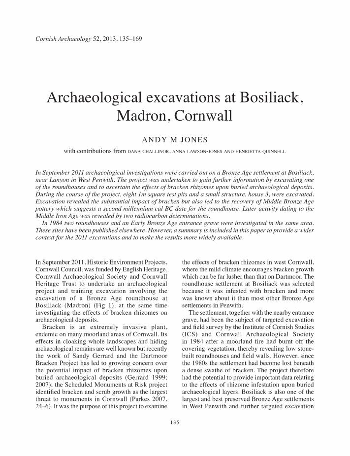
135
Cornish Archaeology 52, 2013, 135–169
Archaeological excavations at Bosiliack, Madron, Cornwall
ANDY M JONESwith contributions from dana challinor, anna lawson-jones and henrietta quinnell
In September 2011 archaeological investigations were carried out on a Bronze Age settlement at Bosiliack, near Lanyon in West Penwith. The project was undertaken to gain further information by excavating one of the roundhouses and to ascertain the effects of bracken rhizomes upon buried archaeological deposits. During the course of the project, eight 1m square test pits and a small structure, house 3, were excavated. Excavation revealed the substantial impact of bracken but also led to the recovery of Middle Bronze Age pottery which suggests a second millennium cal BC date for the roundhouse. Later activity dating to the Middle Iron Age was revealed by two radiocarbon determinations.
In 1984 two roundhouses and an Early Bronze Age entrance grave were investigated in the same area. These sites have been published elsewhere. However, a summary is included in this paper to provide a wider context for the 2011 excavations and to make the results more widely available.
In September 2011, Historic Environment Projects, Cornwall Council, was funded by English Heritage, Cornwall Archaeological Society and Cornwall Heritage Trust to undertake an archaeological project and training excavation involving the excavation of a Bronze Age roundhouse at Bosiliack (Madron) (Fig 1), at the same time investigating the effects of bracken rhizomes on archaeological deposits.
Bracken is an extremely invasive plant, endemic on many moorland areas of Cornwall. Its effects in cloaking whole landscapes and hiding archaeological remains are well known but recently the work of Sandy Gerrard and the Dartmoor Bracken Project has led to growing concern over the potential impact of bracken rhizomes upon buried archaeological deposits (Gerrard 1999; 2007); the Scheduled Monuments at Risk project identified bracken and scrub growth as the largest threat to monuments in Cornwall (Parkes 2007, 24–6). It was the purpose of this project to examine
the effects of bracken rhizomes in west Cornwall, where the mild climate encourages bracken growth which can be far lusher than that on Dartmoor. The roundhouse settlement at Bosiliack was selected because it was infested with bracken and more was known about it than most other Bronze Age settlements in Penwith.
The settlement, together with the nearby entrance grave, had been the subject of targeted excavation and field survey by the Institute of Cornish Studies (ICS) and Cornwall Archaeological Society in 1984 after a moorland fire had burnt off the covering vegetation, thereby revealing low stone-built roundhouses and field walls. However, since the 1980s the settlement had become lost beneath a dense swathe of bracken. The project therefore had the potential to provide important data relating to the effects of rhizome infestation upon buried archaeological layers. Bosiliack is also one of the largest and best preserved Bronze Age settlements in West Penwith and further targeted excavation
135-170_Jones.indd 135 08/12/2014 09:57
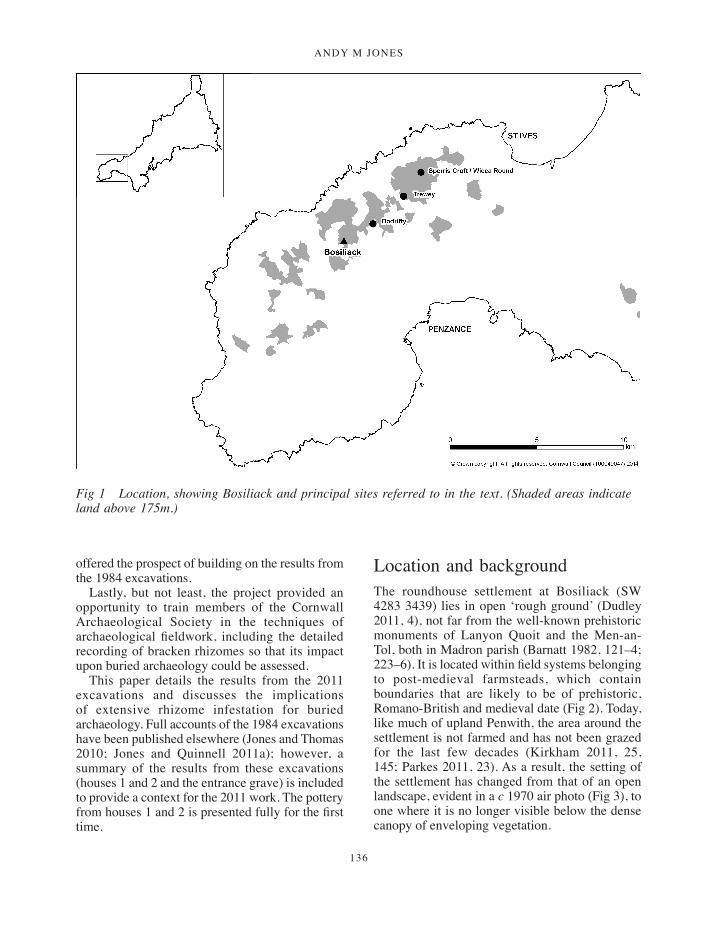
ANDY M JONES
136
offered the prospect of building on the results from the 1984 excavations.
Lastly, but not least, the project provided an opportunity to train members of the Cornwall Archaeological Society in the techniques of archaeological fieldwork, including the detailed recording of bracken rhizomes so that its impact upon buried archaeology could be assessed.
This paper details the results from the 2011 excavations and discusses the implications of extensive rhizome infestation for buried archaeology. Full accounts of the 1984 excavations have been published elsewhere (Jones and Thomas 2010; Jones and Quinnell 2011a); however, a summary of the results from these excavations (houses 1 and 2 and the entrance grave) is included to provide a context for the 2011 work. The pottery from houses 1 and 2 is presented fully for the first time.
Location and backgroundThe roundhouse settlement at Bosiliack (SW 4283 3439) lies in open ‘rough ground’ (Dudley 2011, 4), not far from the well-known prehistoric monuments of Lanyon Quoit and the Men-an-Tol, both in Madron parish (Barnatt 1982, 121–4; 223–6). It is located within field systems belonging to post-medieval farmsteads, which contain boundaries that are likely to be of prehistoric, Romano-British and medieval date (Fig 2). Today, like much of upland Penwith, the area around the settlement is not farmed and has not been grazed for the last few decades (Kirkham 2011, 25, 145; Parkes 2011, 23). As a result, the setting of the settlement has changed from that of an open landscape, evident in a c 1970 air photo (Fig 3), to one where it is no longer visible below the dense canopy of enveloping vegetation.
Fig 1 Location, showing Bosiliack and principal sites referred to in the text. (Shaded areas indicate land above 175m.)
135-170_Jones.indd 136 08/12/2014 09:57

ArchAeologicAl excAvAtions At BosiliAck, MAdron, cornwAll
137
Fig 2 Map showing location of the Bosiliack roundhouse settlement, the entrance grave and surrounding field systems. Heavy lines indicate boundaries altered or added in the medieval/post-medieval periods. Close-set lines indicate cultivation ridges. (Based on the 1984 survey by ICS.)
135-170_Jones.indd 137 08/12/2014 09:57
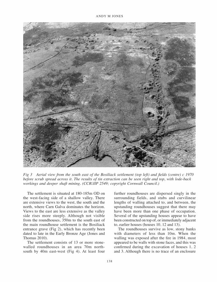
ANDY M JONES
138
The settlement is situated at 180-185m OD on the west-facing side of a shallow valley. There are extensive views to the west, the south and the north, where Carn Galva dominates the horizon. Views to the east are less extensive as the valley side rises more steeply. Although not visible from the roundhouses, 350m to the south east of the main roundhouse settlement is the Bosiliack entrance grave (Fig 2), which has recently been dated to late in the Early Bronze Age (Jones and Thomas 2010).
The settlement consists of 13 or more stone-walled roundhouses in an area 70m north-south by 40m east-west (Fig 4). At least four
further roundhouses are dispersed singly in the surrounding fields, and stubs and curvilinear lengths of walling attached to, and between, the upstanding roundhouses suggest that there may have been more than one phase of occupation. Several of the upstanding houses appear to have been constructed on top of, or immediately adjacent to, earlier houses (houses 10, 12 and 13).
The roundhouses survive as low, stony banks with diameters of less than 10m. When the walling was exposed after the fire in 1984, most appeared to be walls with stone faces, and this was confirmed during the excavation of houses 1, 2 and 3. Although there is no trace of an enclosure
Fig 3 Aerial view from the south east of the Bosiliack settlement (top left) and fields (centre) c 1970 before scrub spread across it. The results of tin extraction can be seen right and top, with lode-back workings and deeper shaft mining. (CCR/JIP 2549; copyright Cornwall Council.)
135-170_Jones.indd 138 08/12/2014 09:57

ArchAeologicAl excAvAtions At BosiliAck, MAdron, cornwAll
139
wall, most of the roundhouses seem to be sited in a roughly oval arrangement, formed by two parallel arcs, with an open space around 15m to 20m wide in the middle of the settlement (Fig 4). This may have acted as a communal space. Some of the houses seem to be paired (for example, houses 1 and 2 and 9 and 10), although it is uncertain whether these pairings represent contemporary buildings or sequential construction. However, it is possible that not all the buildings were domestic and some may have been dwellings with attached non-residential structures.
To the north and east of the roundhouse settlement, the 1984 field survey recorded field systems covering approximately 45 ha (Fig 2), comprising lengths of boulder walling, lynchetted field boundaries and occasional clearance cairns. Much of this is likely to be broadly contemporary with the roundhouse settlement (see house 3, below), and it appears to be part of a much more extensive pattern continuing to the south east which was recorded from aerial photographs by the National Mapping Programme (Cornwall Historic Environment Record). Other parts of the field system may be of later prehistoric or Romano-British date and a Romano-British courtyard house is recorded to the east of the field system. Some elements are more likely to be associated with the medieval and post-medieval settlements of Bosiliack, situated approximately 700m south east of the roundhouse settlement, or Lanyon, 400m to the south west. Medieval or later reuse of the fields is suggested by areas of cultivation ridges.
Parts of the area have certainly seen considerable disturbance through post-medieval mining and prospecting, and during the course of the excavation of house 3 damage to archaeological features was found both to the roundhouse and to an adjacent field-wall. Figure 3 shows the lines of tin lodes worked by lode-back pits and deeper shafts. There are also traces of streamworks in the valley west of the roundhouse settlement. The surrounding area was worked by numerous small mines before the nineteenth century, including ‘a Tynne-Worke called Basilsacke’ in the late sixteenth century. These became incorporated in Ding Dong mine, which closed in 1877 (Historic Environment Record PRN 33477). The Greenburrow pumping engine house, a well known Penwith landmark, lies 400m north east of the Bosiliack entrance grave, and the area falls within the Cornish Mining World Heritage Site (St Just Mining District).
Archaeological recordingA summary of the 1984 fieldwork
The fieldwork in 1984 followed a fire which had blazed across the moorland and exposed a large number of archaeological features. Prior to the excavations, a detailed 1:200 survey of the roundhouses within the main settlement area and a 1:1000 survey of the surrounding field systems and clearance cairns and a small chambered tomb or entrance grave were made by the Institute of Cornish Studies. In 1984 excavations of two roundhouses and the entrance grave were carried out by staff from the Institute of Cornish Studies, the Cornwall Committee for Rescue Archaeology and volunteers under the direction of Charles Thomas and Jeanette Ratcliffe. The project aimed to obtain information about the date of the roundhouses, and establish the relationship between the settlement and the entrance grave (Jones and Thomas 2010; Jones and Quinnell 2011a).
The excavations were highly significant because the entrance grave at Bosiliack was the first to have its chamber excavated under modern conditions. Similarly, although a number of Bronze Age roundhouse settlements had previously been excavated in Penwith (Dudley 1941; 1956; 1957), none were closely dated. Indeed, in contrast to lowland Middle Bronze Age hollow-set roundhouses, which now have a large number of secure radiocarbon dates associated with them (Jones and Taylor 2010, 160), upland roundhouses as a whole are poorly dated in Cornwall and currently the only other stone-walled roundhouses with associated radiocarbon determinations are those at Leskernick (Altarnun) on Bodmin Moor (Bender et al 2007, 88–9).
The entrance grave
The entrance grave is located to the south east of the roundhouse settlement, just outside the eastern extent of the prehistoric field system. It has a diameter of approximately 5m, with a chamber which extends east-south-east to west-north-west from an entrance in the south east (Fig 13).
Excavation revealed that the entrance grave was constructed upon an old land surface. The cairn comprised medium-sized boulders around the outside, which were placed to support the large kerbstones which defined the perimeter of the
135-170_Jones.indd 139 08/12/2014 09:57

ANDY M JONES
140
Fig 4 Plan of the Bosiliack Bronze Age settlement area, showing locations of excavations and the test pit transect. (Based on the 1984 survey by ICS.)
135-170_Jones.indd 140 08/12/2014 09:57

ArchAeologicAl excAvAtions At BosiliAck, MAdron, cornwAll
141
monument. No artefacts were directly associated with the construction of the cairn. However, some worked flints of probable Late Neolithic or Early Bronze Age date were found within and beneath the body of the cairn (Jones and Thomas 2010).
The chamber was small, measuring approximately 3m long by 0.6m wide, and became narrower towards the entrance, which had been slightly off-set to the south east of the main body of the chamber. None of the capstones remained in situ; but a displaced capstone was found on the body of the cairn south west of the chamber. Fortunately, the chamber was undisturbed and the primary deposit on the floor of the central part of the chamber comprised cremated human bone, charcoal, pebbles and sherds from plain ceramic vessels. Analysis of the burial deposit suggested that just one individual was interred within the tomb (Jones and Thomas 2010) and two near-identical radiocarbon dates obtained on the cremated bone, 3320 ±35 BP (SUERC-15589) and 3305 ±35 BP (SUERC-15590), both calibrating to 1680 to 1500 cal BC, support this. The burial was sealed by soil containing pebbles and flints. The entrance to the chamber had been blocked by two upright granite slabs, separated by an infilling of beach pebbles that had been placed between them.
The entrance grave is located just to the north of an east-west alignment of boulders marking the upper edges of a terrace or lynchet (Fig 14). This feature was covered by a deposit of dark earth which may have been a cultivation soil (Jones and Thomas 2010). Artefacts from this layer included an unidentifiable piece of corroded copper alloy, flints and a sherd of pottery which appeared to be of the same fabric as those found in the chamber. However, the relationship between the entrance grave and the field system was not established.
Houses 1 and 2
Houses 1 and 2 are located in the central part of the settlement, within the eastern arc of the roundhouses. A north east to south west transect was laid out across the centres of the two adjoining houses, and the area to the north of this line was excavated (Fig 15). The excavated area was wedge-shaped in plan, and approximately 17.8m long by 4.9m wide at its western end and 5.5m wide at its eastern. Neither structure was entirely excavated. The walling around the houses was left in situ,
and the excavation area excluded the entrances to the houses, although it was evident that they face south.
The excavations revealed that houses 1 and 2 were conjoining stone-walled structures, with internal diameters of less than 6m. The walling round the roundhouses was double-skinned, with large granite stones sandwiching rubble and earth cores. Natural boulders or grounders were also incorporated into the walls of the houses. The relationship between the walling of the two structures suggested that the smaller house 2 was earlier than house 1.
The earliest features in both structures were the redeposited granite subsoil or ‘rab’ floors; a partial rab floor was also found in house 3 (below). Both roundhouses contained a range of internal features. In house 1 there were four hearths. The radiocarbon dating of the hearths, 3010 ±30BP, 1384–1130 cal BC (SUERC-29275), 2275 ±30BP, 401–210 cal BC (SUERC-29276), 2240 ±30BP, 390–206 cal BC (SUERC-29277), and 2415 ±30BP, 746–399 cal BC (SUERC-29278) suggests that the structure is likely to have been used, at least periodically, over a considerable period of time, from the second half of the second millennium cal BC to the third century cal BC. One of the later hearths had been built up against the back wall of the structure (Jones and Quinnell 2011a). Given its close proximity to the wall, it could not have been used while there was still a roof on the house. This suggests that for a time the roundhouse site was used as an open shelter. In addition to the radiocarbon dating, later occupation within house 1 was also indicated by the recovery of Iron Age pottery from upper layers within it (Jones and Quinnell 2011a).
In house 1 there was evidence for a post-ring, although it is unclear where in this long period of activity the post-ring belongs. House 2 also seemed to have contained a post-ring, but no hearth was uncovered. However, a much smaller internal area was excavated than in house 1. A number of other cut features were recorded (Figs 15 and 16), but it is uncertain whether these represent internal divisions or were internal drainage gullies as were found within the Stannon Down (St Breward) roundhouses or the Shaugh Moor house 19 on Dartmoor (Mercer 1970; Wainwright and Smith 1980). Two identical radiocarbon determinations from house 2, 2900 ±30BP, 1211–1001 cal BC (SUERC-29274) and 2900 ±30BP, 1211–1001 cal BC (SUERC-29279), suggest that the two
135-170_Jones.indd 141 08/12/2014 09:57
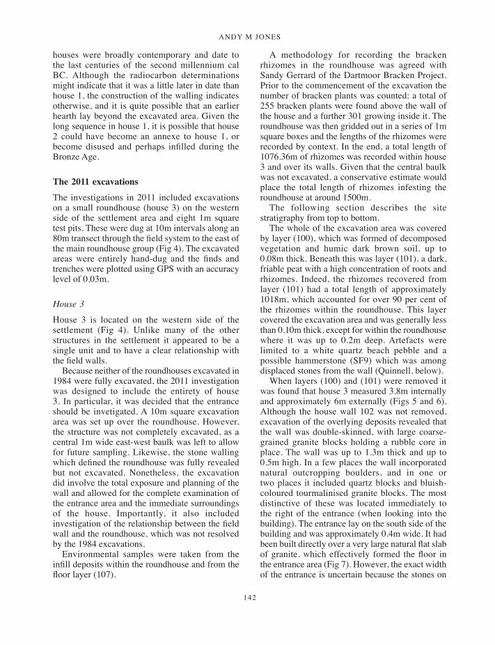
ANDY M JONES
142
houses were broadly contemporary and date to the last centuries of the second millennium cal BC. Although the radiocarbon determinations might indicate that it was a little later in date than house 1, the construction of the walling indicates otherwise, and it is quite possible that an earlier hearth lay beyond the excavated area. Given the long sequence in house 1, it is possible that house 2 could have become an annexe to house 1, or become disused and perhaps infilled during the Bronze Age.
The 2011 excavations
The investigations in 2011 included excavations on a small roundhouse (house 3) on the western side of the settlement area and eight 1m square test pits. These were dug at 10m intervals along an 80m transect through the field system to the east of the main roundhouse group (Fig 4). The excavated areas were entirely hand-dug and the finds and trenches were plotted using GPS with an accuracy level of 0.03m.
House 3
House 3 is located on the western side of the settlement (Fig 4). Unlike many of the other structures in the settlement it appeared to be a single unit and to have a clear relationship with the field walls.
Because neither of the roundhouses excavated in 1984 were fully excavated, the 2011 investigation was designed to include the entirety of house 3. In particular, it was decided that the entrance should be invetigated. A 10m square excavation area was set up over the roundhouse. However, the structure was not completely excavated, as a central 1m wide east-west baulk was left to allow for future sampling. Likewise, the stone walling which defined the roundhouse was fully revealed but not excavated. Nonetheless, the excavation did involve the total exposure and planning of the wall and allowed for the complete examination of the entrance area and the immediate surroundings of the house. Importantly, it also included investigation of the relationship between the field wall and the roundhouse, which was not resolved by the 1984 excavations.
Environmental samples were taken from the infill deposits within the roundhouse and from the floor layer (107).
A methodology for recording the bracken rhizomes in the roundhouse was agreed with Sandy Gerrard of the Dartmoor Bracken Project. Prior to the commencement of the excavation the number of bracken plants was counted: a total of 255 bracken plants were found above the wall of the house and a further 301 growing inside it. The roundhouse was then gridded out in a series of 1m square boxes and the lengths of the rhizomes were recorded by context. In the end, a total length of 1076.36m of rhizomes was recorded within house 3 and over its walls. Given that the central baulk was not excavated, a conservative estimate would place the total length of rhizomes infesting the roundhouse at around 1500m.
The following section describes the site stratigraphy from top to bottom.
The whole of the excavation area was covered by layer (100), which was formed of decomposed vegetation and humic dark brown soil, up to 0.08m thick. Beneath this was layer (101), a dark, friable peat with a high concentration of roots and rhizomes. Indeed, the rhizomes recovered from layer (101) had a total length of approximately 1018m, which accounted for over 90 per cent of the rhizomes within the roundhouse. This layer covered the excavation area and was generally less than 0.10m thick, except for within the roundhouse where it was up to 0.2m deep. Artefacts were limited to a white quartz beach pebble and a possible hammerstone (SF9) which was among displaced stones from the wall (Quinnell, below).
When layers (100) and (101) were removed it was found that house 3 measured 3.8m internally and approximately 6m externally (Figs 5 and 6). Although the house wall 102 was not removed, excavation of the overlying deposits revealed that the wall was double-skinned, with large coarse-grained granite blocks holding a rubble core in place. The wall was up to 1.3m thick and up to 0.5m high. In a few places the wall incorporated natural outcropping boulders, and in one or two places it included quartz blocks and bluish-coloured tourmalinised granite blocks. The most distinctive of these was located immediately to the right of the entrance (when looking into the building). The entrance lay on the south side of the building and was approximately 0.4m wide. It had been built directly over a very large natural flat slab of granite, which effectively formed the floor in the entrance area (Fig 7). However, the exact width of the entrance is uncertain because the stones on
135-170_Jones.indd 142 08/12/2014 09:57
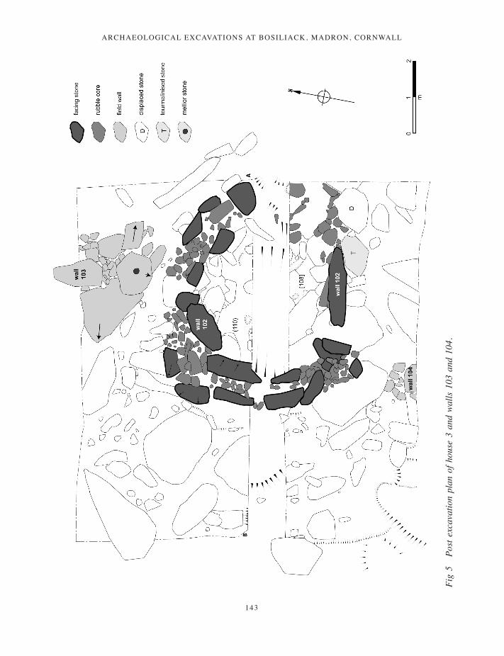
ArchAeologicAl excAvAtions At BosiliAck, MAdron, cornwAll
143
Fig
5 Po
st e
xcav
atio
n pl
an o
f hou
se 3
and
wal
ls 1
03 a
nd 1
04.
135-170_Jones.indd 143 08/12/2014 09:57
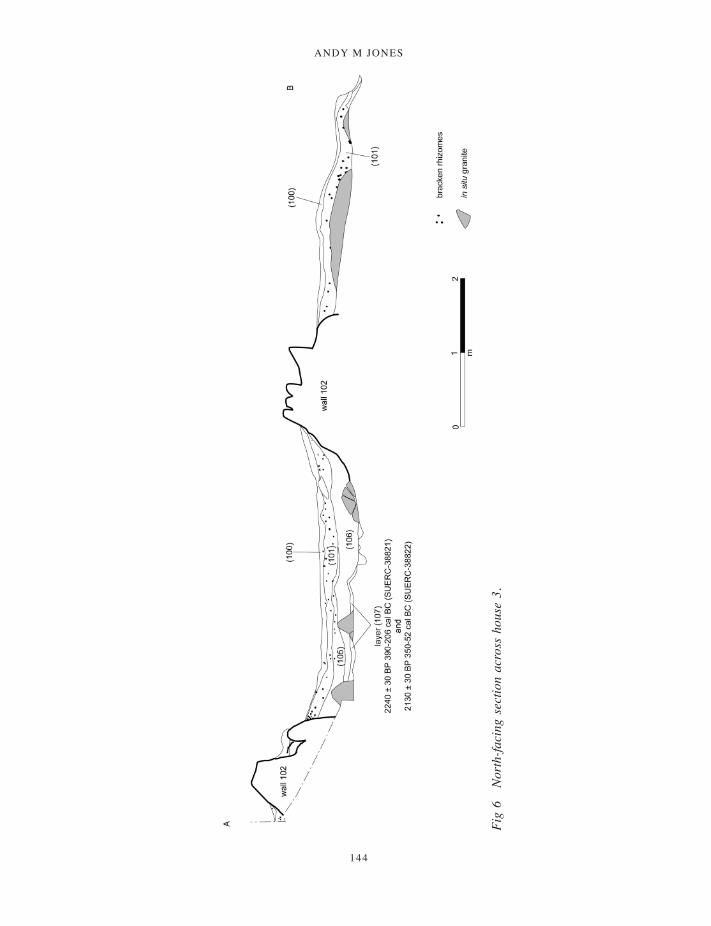
ANDY M JONES
144
Fig
6 N
orth
-faci
ng s
ectio
n ac
ross
hou
se 3
.
135-170_Jones.indd 144 08/12/2014 09:57
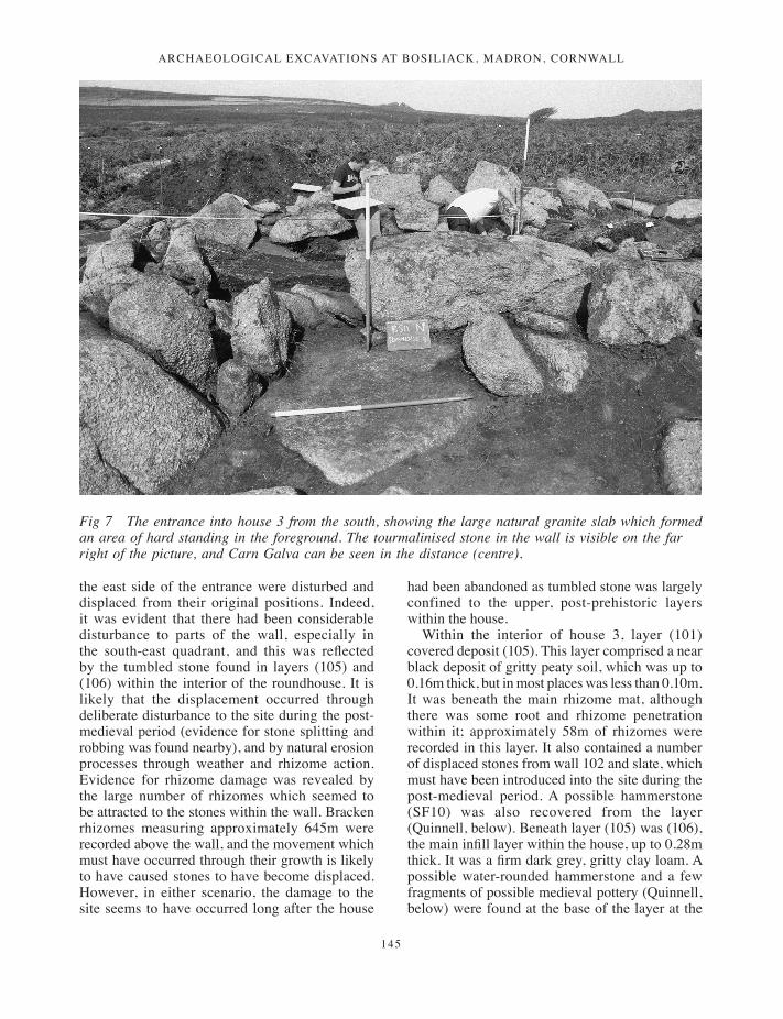
ArchAeologicAl excAvAtions At BosiliAck, MAdron, cornwAll
145
the east side of the entrance were disturbed and displaced from their original positions. Indeed, it was evident that there had been considerable disturbance to parts of the wall, especially in the south-east quadrant, and this was reflected by the tumbled stone found in layers (105) and (106) within the interior of the roundhouse. It is likely that the displacement occurred through deliberate disturbance to the site during the post-medieval period (evidence for stone splitting and robbing was found nearby), and by natural erosion processes through weather and rhizome action. Evidence for rhizome damage was revealed by the large number of rhizomes which seemed to be attracted to the stones within the wall. Bracken rhizomes measuring approximately 645m were recorded above the wall, and the movement which must have occurred through their growth is likely to have caused stones to have become displaced. However, in either scenario, the damage to the site seems to have occurred long after the house
had been abandoned as tumbled stone was largely confined to the upper, post-prehistoric layers within the house.
Within the interior of house 3, layer (101) covered deposit (105). This layer comprised a near black deposit of gritty peaty soil, which was up to 0.16m thick, but in most places was less than 0.10m. It was beneath the main rhizome mat, although there was some root and rhizome penetration within it; approximately 58m of rhizomes were recorded in this layer. It also contained a number of displaced stones from wall 102 and slate, which must have been introduced into the site during the post-medieval period. A possible hammerstone (SF10) was also recovered from the layer (Quinnell, below). Beneath layer (105) was (106), the main infill layer within the house, up to 0.28m thick. It was a firm dark grey, gritty clay loam. A possible water-rounded hammerstone and a few fragments of possible medieval pottery (Quinnell, below) were found at the base of the layer at the
Fig 7 The entrance into house 3 from the south, showing the large natural granite slab which formed an area of hard standing in the foreground. The tourmalinised stone in the wall is visible on the far right of the picture, and Carn Galva can be seen in the distance (centre).
135-170_Jones.indd 145 08/12/2014 09:57

ANDY M JONES
146
junction with (107). However, it was evident that the layer had been disturbed as there were traces of animal burrowing; further fragments of slate were recovered from it that are likely to be of post-medieval date.
Layer (107) represented a redeposited rab floor. It consisted of a gritty, grey compact clay loam, from the top of which charcoal and a few sherds of Middle Bronze Age pottery and a quartz beach pebble were recovered (Quinnell, below). The layer was less than 0.05m thick and discontinuous, indicating some degree of disturbance, and there was evidence for animal burrowing. No traces of bracken rhizomes were found, although previous infestations may have occurred. In places natural granite stones protruded through the surviving floor layer, which resulted in the floor of the structure being very uneven. It is unlikely that there had ever been a floor layer in the entrance area, where the large natural granite slab formed a flat surface. Two radiocarbon determinations were obtained on
charcoal from layer (107): 2240 ±30BP, 390–206 cal BC (SUERC-38821), and 2130 ±30BP, 350–52 cal BC (SUERC-38822). These dates belong to a later Iron Age phase of activity which was not associated with any diagnostic finds. It is possible that the interior of the house had been kept clean and that the charcoal was associated with a last use of the site.
Only one internal feature was found, gully [108], which cut layer (107) in the south-east quadrant of the roundhouse. It was U-shaped in section and measured 0.2m wide by 0.08m deep. Its full length was not established as it disappeared under the central baulk after 0.4m. It was filled by (109), a deposit of dark grey gritty clay loam. The function of this feature is uncertain, although similar gullies were recorded in houses 1 and 2 (Jones and Quinnell 2011a).
Below layer (107) was the natural granitic subsoil or ‘rab’ (110). This did not cover the entirety of the structure as natural granite blocks
Fig 8 Roundhouse 3 from the north, showing the wall construction comprising large facing stones and smaller stones in the core (note post-medieval mellior stone in the foreground).
135-170_Jones.indd 146 08/12/2014 09:57

ArchAeologicAl excAvAtions At BosiliAck, MAdron, cornwAll
147
protruded through the subsoil. In the area of the roundhouse, the rab was mid-brown, rather than the yellowish colour found elsewhere (see test pits, below). This difference may have been because the ground conditions were very wet in this part of the site or because the roundhouse had been sited in an area where the granite was outcropping at the surface and consequently the rab was less well developed.
Outside the roundhouse, two features were identified. Field wall 103, to the north of house 3 (Fig 5), was built of large granite blocks up to 1.2m across, with small stones between them. The wall was up to 1.5m wide. It was not excavated but clearance around the southern end of the wall revealed that it stopped short of house 3, and there was a gap of 0.3m between them. Although it is possible that the wall was robbed to build the house, it is perhaps more probable that the field wall respected the edge of the roundhouse. Damage to wall 103 was revealed by evidence for stone splitting and by the discovery of a drilled hole in one of the larger blocks within the wall (Fig 8), probably for use as a mellior stone [central pivot] for a horse whim (Herring et al 2008, 20–1). Given the amount of evidence for mining in the vicinity,
it is likely that this occurred during the nineteenth century.
A second wall, 104, was located to the south of the roundhouse (Fig 5). It was only just caught in the excavation area and was poorly preserved, being comprised of small granite stones. It is likely to be part of the same boundary as wall 103. There was a gap of 0.8m between the end of the wall 104 and house 3 and this again suggests that the wall of the roundhouse was respected by the field wall.
Beyond these features, most of the excavated area was found to come very quickly down upon the granite bedrock and it seems that house 3 had been carefully sited at a place where the granite outcropped at surface. This finding might suggest that there was considerably more outcropping granite at surface in the Bronze Age and has implications for how the land around the settlement may have been used at that time.
The bracken test pits
Eight 1m square test pits were excavated at 10m intervals along an 80m north-south transect through the settlement and the prehistoric field system, where the bracken was densest (Fig 4).
Fig 9 Test pit 1, showing the dense rhizome mat.
135-170_Jones.indd 147 08/12/2014 09:57

ANDY M JONES
148
The methodology for the test pits followed that of the Dartmoor Bracken Project’s rapid assessment technique (Gerrard 2011) and further onsite guidance was provided by Gordon Fisher and Janet Daynes who are closely involved with the Dartmoor Bracken Project. The area of the test pit was defined and the bracken stipes counted, so that the numbers of plants were identified. The pits were then excavated in spits within context and the length of rhizome within each spit was measured. The test pits were taken down to 0.05m below the level of the last recorded rhizome, which in most cases involved excavation into the natural rab subsoil. The test pits ranged in depth from 0.1m to 0.45m; although the average depth was approximately 0.3m. All four sections within each of the test pits were recorded so that the level of maximum rhizome activity could be determined. Bedrock was encountered at a shallow depth in several of the test pits.
The numbers of bracken plants ranged from 15 to 56 per test pit and an overall length of
633.09m of rhizomes was recorded. An average of 79m of rhizomes was recovered from each test pit, although in one case a length of 103.3m was recorded within a single pit (Jones 2012).
Where outcropping granite was absent, four layers were consistently recorded within the test pits. These will be described from top to bottom. The uppermost deposit was layer (1). This was a loose peaty deposit, which was largely comprised of decaying vegetation. Typically it was up to 0.05m thick, although in some areas, where outcropping granite was more prevalent it became thicker. Rhizomes tended to be less prevalent in this layer, except in those sections where the deposit was thickest. Layer (2) was a dark grey-brown, firm peaty soil, typically 0.1m to 0.2m thick. It was rooty and was also the layer where most of the bracken rhizomes were recorded (Fig 9). Layer (3) was a dark grey, gritty peat soil. Where present, this layer was approximately 0.05m to 0.1m thick. Rhizomes were found in this layer, especially in the upper part of the horizon, close to the junction with
Fig 10 Test pit 3, north-facing section showing depth of rhizome penetration. The picture shows that in this test pit the rhizomes are prominently located in the top 0.2m, layer (2). However, significant numbers occur at greater depth below the stone (centre) and extend into layer (3), an older land surface.
135-170_Jones.indd 148 08/12/2014 09:57
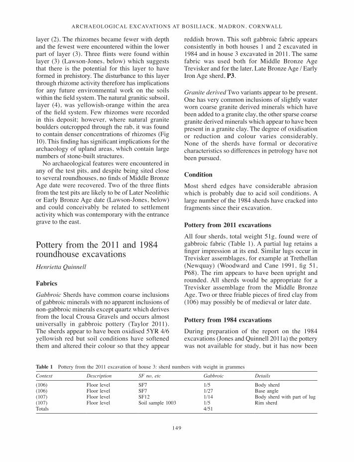
ArchAeologicAl excAvAtions At BosiliAck, MAdron, cornwAll
149
layer (2). The rhizomes became fewer with depth and the fewest were encountered within the lower part of layer (3). Three flints were found within layer (3) (Lawson-Jones, below) which suggests that there is the potential for this layer to have formed in prehistory. The disturbance to this layer through rhizome activity therefore has implications for any future environmental work on the soils within the field system. The natural granitic subsoil, layer (4), was yellowish-orange within the area of the field system. Few rhizomes were recorded in this deposit; however, where natural granite boulders outcropped through the rab, it was found to contain denser concentrations of rhizomes (Fig 10). This finding has significant implications for the archaeology of upland areas, which contain large numbers of stone-built structures.
No archaeological features were encountered in any of the test pits, and despite being sited close to several roundhouses, no finds of Middle Bronze Age date were recovered. Two of the three flints from the test pits are likely to be of Later Neolithic or Early Bronze Age date (Lawson-Jones, below) and could conceivably be related to settlement activity which was contemporary with the entrance grave to the east.
Pottery from the 2011 and 1984 roundhouse excavations Henrietta Quinnell
Fabrics
Gabbroic Sherds have common coarse inclusions of gabbroic minerals with no apparent inclusions of non-gabbroic minerals except quartz which derives from the local Crousa Gravels and occurs almost universally in gabbroic pottery (Taylor 2011). The sherds appear to have been oxidised 5YR 4/6 yellowish red but soil conditions have softened them and altered their colour so that they appear
reddish brown. This soft gabbroic fabric appears consistently in both houses 1 and 2 excavated in 1984 and in house 3 excavated in 2011. The same fabric was used both for Middle Bronze Age Trevisker and for the later, Late Bronze Age / Early Iron Age sherd, P3.
Granite derived Two variants appear to be present. One has very common inclusions of slightly water worn coarse granite derived minerals which have been added to a granite clay, the other sparse coarse granite derived minerals which appear to have been present in a granite clay. The degree of oxidisation or reduction and colour varies considerably. None of the sherds have formal or decorative characteristics so differences in petrology have not been pursued.
Condition
Most sherd edges have considerable abrasion which is probably due to acid soil conditions. A large number of the 1984 sherds have cracked into fragments since their excavation.
Pottery from 2011 excavations
All four sherds, total weight 51g, found were of gabbroic fabric (Table 1). A partial lug retains a finger impression at its end. Similar lugs occur in Trevisker assemblages, for example at Trethellan (Newquay) (Woodward and Cane 1991, fig 51, P68). The rim appears to have been upright and rounded. All sherds would be appropriate for a Trevisker assemblage from the Middle Bronze Age. Two or three friable pieces of fired clay from (106) may possibly be of medieval or later date.
Pottery from 1984 excavations
During preparation of the report on the 1984 excavations (Jones and Quinnell 2011a) the pottery was not available for study, but it has now been
Table 1 Pottery from the 2011 excavation of house 3: sherd numbers with weight in grammes
Context Description SF no, etc Gabbroic Details
(106) Floor level SF7 1/5 Body sherd (106) Floor level SF7 1/27 Base angle (107) Floor level SF12 1/14 Body sherd with part of lug(107) Floor level Soil sample 1003 1/5 Rim sherd Totals 4/51
135-170_Jones.indd 149 08/12/2014 09:57

ANDY M JONES
150
examined and the results have been incorporated here.
The assemblage consisted of 92 sherds, 13 from contexts within house 1, 37 from within house 2, and 42 from contexts overlying or outside the houses. The majority of the assemblage is gabbroic, with the fabric indistinguishable from that of the sherds from the 2011 excavations, but some sherds both from house 1 and from contexts overlying the site are granite derived (Table 2). Many of the sherds were drawn at the time of excavation and three are reproduced here (Fig 11, 1–3).
Middle Bronze Age Trevisker
P1 F78 (48) fill of hearth pit [47] house 1; associated with a radiocarbon determination (SUERC-29275), calibrating to 1384–1130 cal BC. Gabbroic.
P2 F57 (16) fill of hearth pit [15] house 2; associated with a determination (SUERC-29274) calibrating to 1211–1001 cal BC. Gabbroic.
These sherds both have incised geometric decoration and a small round lug. P2 was found with a group of sherds which include several with an irregular flat-topped rim which may be from the same vessel. The probable difference in date of deposition
indicated by the radiocarbon determinations is not significant as all recent work on Trevisker ceramics demonstrates very long usage of styles and decoration (for example, Woodward and Cane 1991, 122–3; Quinnell 2012). The similarities between the sherds may well reflect continuing factors influencing choice of ceramic forms in the community using the site over several centuries. There appear to be no close comparanda for P1-2, on which very small lugs are associated with incised geometric designs. Lugs on Trevisker pottery, normally situated on the girth at the base of a zone of decoration, come in a variety of different shapes, perforate or imperforate but are at least twice the size of these examples (Woodward and Cane 1991, figs 41–51; ApSimon and Greenfield 1972, figs 14, 18). However, some of the vessels from the Trelowthas barrow (Probus) have lugs of this size associated with cord-impressed decoration (Quinnell, personal knowledge; Nowakowski 2007, 106–10). The records had suggested the possible presence of broad flat cordons but examination of the sherds shows that no cordons were present and the horizontal scars left by some sherds splitting along the weaknesses of overlapping coils were misinterpreted.
Most Middle Bronze Age sites with Trevisker pottery tend to date from the fifteenth to the thirteenth centuries cal BC, for example Trethellan
Table 2 Pottery from the 1984 excavations: sherd numbers with weight in grammes
Context Description Gabbroic Granite derived Comment
House 1(43) Rab floor 2/8 1/3 Includes short upright rim (48) Fill of hearth pit [47] 3/58 Includes illustrated sherds P1 and P3
(50) Fill of ? posthole [49] 1/17(14) ‘Occupation layer’ 1/3 5/19
Total 6/69 7/39 Total 13/108
House 2(11) Top of ‘occupation layer’ 4/9(11) Sealing or ‘occupation layer’ 14/33 Includes flat-topped rim and sherd
with tip of incised chevron(20) Fill of slot [19] 1/4 (16) Fill of hearth pit [15] 18/245 P2 and flat-topped rim sherds
possibly from the same vessel
Total 37/291
General(4) Bottom of covering level over site 27/180 4/11(8a) Leached top of rab 8 in south east of site 1/4 (8) Top of (probably rab) subsoil outside the
houses9/96 1/3
Total 37/280 5/14 42/294
Totals 80/640 12/53 92/693
135-170_Jones.indd 150 08/12/2014 09:57
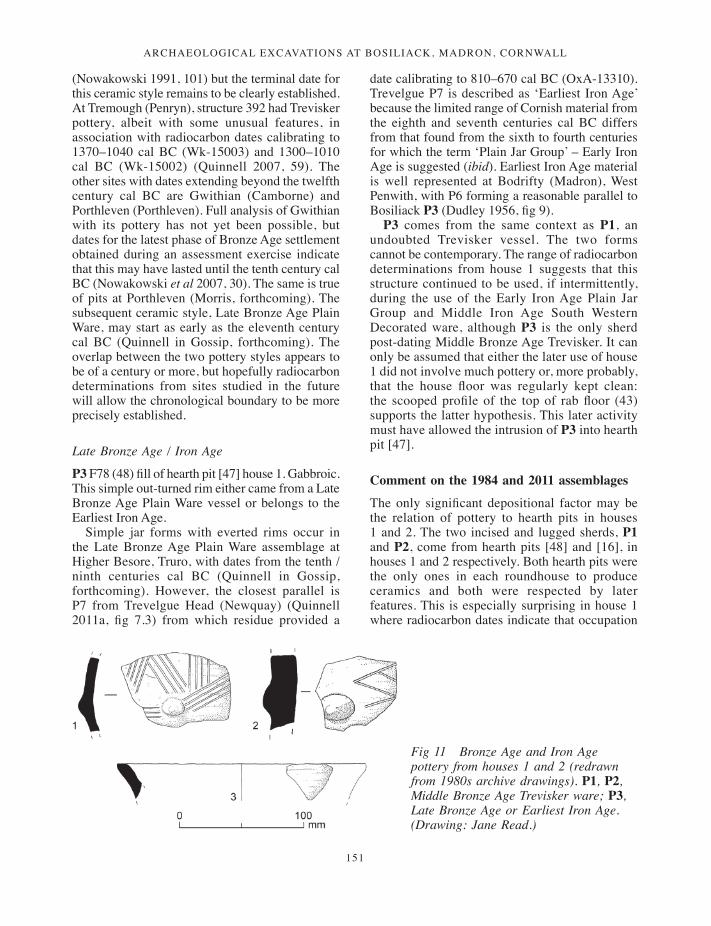
ArchAeologicAl excAvAtions At BosiliAck, MAdron, cornwAll
151
(Nowakowski 1991, 101) but the terminal date for this ceramic style remains to be clearly established. At Tremough (Penryn), structure 392 had Trevisker pottery, albeit with some unusual features, in association with radiocarbon dates calibrating to 1370–1040 cal BC (Wk-15003) and 1300–1010 cal BC (Wk-15002) (Quinnell 2007, 59). The other sites with dates extending beyond the twelfth century cal BC are Gwithian (Camborne) and Porthleven (Porthleven). Full analysis of Gwithian with its pottery has not yet been possible, but dates for the latest phase of Bronze Age settlement obtained during an assessment exercise indicate that this may have lasted until the tenth century cal BC (Nowakowski et al 2007, 30). The same is true of pits at Porthleven (Morris, forthcoming). The subsequent ceramic style, Late Bronze Age Plain Ware, may start as early as the eleventh century cal BC (Quinnell in Gossip, forthcoming). The overlap between the two pottery styles appears to be of a century or more, but hopefully radiocarbon determinations from sites studied in the future will allow the chronological boundary to be more precisely established.
Late Bronze Age / Iron Age
P3 F78 (48) fill of hearth pit [47] house 1. Gabbroic. This simple out-turned rim either came from a Late Bronze Age Plain Ware vessel or belongs to the Earliest Iron Age.
Simple jar forms with everted rims occur in the Late Bronze Age Plain Ware assemblage at Higher Besore, Truro, with dates from the tenth / ninth centuries cal BC (Quinnell in Gossip, forthcoming). However, the closest parallel is P7 from Trevelgue Head (Newquay) (Quinnell 2011a, fig 7.3) from which residue provided a
date calibrating to 810–670 cal BC (OxA-13310). Trevelgue P7 is described as ‘Earliest Iron Age’ because the limited range of Cornish material from the eighth and seventh centuries cal BC differs from that found from the sixth to fourth centuries for which the term ‘Plain Jar Group’ – Early Iron Age is suggested (ibid). Earliest Iron Age material is well represented at Bodrifty (Madron), West Penwith, with P6 forming a reasonable parallel to Bosiliack P3 (Dudley 1956, fig 9).
P3 comes from the same context as P1, an undoubted Trevisker vessel. The two forms cannot be contemporary. The range of radiocarbon determinations from house 1 suggests that this structure continued to be used, if intermittently, during the use of the Early Iron Age Plain Jar Group and Middle Iron Age South Western Decorated ware, although P3 is the only sherd post-dating Middle Bronze Age Trevisker. It can only be assumed that either the later use of house 1 did not involve much pottery or, more probably, that the house floor was regularly kept clean: the scooped profile of the top of rab floor (43) supports the latter hypothesis. This later activity must have allowed the intrusion of P3 into hearth pit [47].
Comment on the 1984 and 2011 assemblages
The only significant depositional factor may be the relation of pottery to hearth pits in houses 1 and 2. The two incised and lugged sherds, P1 and P2, come from hearth pits [48] and [16], in houses 1 and 2 respectively. Both hearth pits were the only ones in each roundhouse to produce ceramics and both were respected by later features. This is especially surprising in house 1 where radiocarbon dates indicate that occupation
Fig 11 Bronze Age and Iron Age pottery from houses 1 and 2 (redrawn from 1980s archive drawings). P1, P2, Middle Bronze Age Trevisker ware; P3, Late Bronze Age or Earliest Iron Age. (Drawing: Jane Read.)
135-170_Jones.indd 151 08/12/2014 09:57
ANDY M JONES
152
continued, if intermittently, into the Middle Iron Age. The presence of P1 and P2 in hearth pits, the latter accompanied by the largest group of stratified sherds located, may indicate an act of significant deposition rather than random disposal of rubbish.
The largest and most extensively excavated of the Bronze Age West Penwith settlements, Bodrifty, now appears, pace the report written more than 50 years ago, as an essentially Middle Bronze Age settlement, which continued in use through the Late Bronze Age until the Iron Age, and probably to some extent into the Roman period (Dudley 1956, fig 9; Harrad 2003). The few pottery sherds found at Trewey (Zennor) (Dudley 1941, fig 9) can now be clearly identified from the published illustrations as of Middle Bronze Age Trevisker style, but these came from only one of the three roundhouses excavated and need not preclude later activity. Neither the Bodrifty nor Trewey finds have been examined during the present study but Harrad’s (2003) work makes it clear that Middle Bronze Age fabrics at Bodrifty included both gabbroic and granite derived fabrics. Rapid reassessment of the ceramics from Dudley’s limited excavation at Wicca Round (Zennor) (1957, 81 and plate 4) shows definite Middle Bronze Age Trevisker ware, but of gabbroic admixture fabric; that is, gabbroic clays to which other materials have been added. This is the most common fabric of the Cornish Middle Bronze Age. At Wicca there are also probable Late Bronze Age - Early Iron Age sherds in granite derived fabrics and a few well-made gabbroic sherds which are almost certainly Middle Iron Age. The nearby site at Sperris Croft (Towednack) produced few sherds (ibid, 80). These have also been reassessed. They are made of soft gabbroic fabric uniformly reduced and are most probably of the Late Bronze Age or Early Iron Age; while featureless, the gabbroic fabric differs from that at Bosiliack or Sperris.
The data from Bosiliack, especially from house 1 with its long life, indicate strongly that the surviving sherds do not provide a chronological biography of the settlement. House 1 produced fewer sherds than house 2 but these were in both gabbroic and granitic derived fabrics. The larger group from house 2 has much more the appearance of a single closed group. For house 3 the pottery would be entirely consistent with a Middle Bronze Age date. However, the radiocarbon determinations make it clear that the house was also used in the Middle Iron Age. It does seem rather unlikely that
Middle Bronze Age sherds would have survived so well had use of the house been continuous between the two periods and the data perhaps indicate that some houses at Bosiliack were used very intermittently. Two of the three houses excavated at Bosiliack now have radiocarbon determinations for the Middle Iron Age, but no pottery of that date. The Middle Iron Age is a period at which pottery appears to have been in frequent use and was also well made and so survives well. The absence of Middle Iron Age ceramics highlights the fact that ceramics may not record the whole biography of use of any structure.
The Bosiliack roundhouses demonstrate ceramic variety, a variety which is matched by the differences in fabrics and dates of the material found at the four settlements in West Penwith excavated by Dudley. These may all date initially to the Middle Bronze Age and had varied amounts of use during the first millennium cal BC, with even some use into the Roman period. Across Cornwall, and indeed Devon, assemblages from the Late Bronze Age and the Earliest Iron Age are rare in comparison with those from the preceding Middle Bronze Age and the succeeding Early and Middle Iron Ages (Quinnell 2011b), and societies who made little use of pottery may be inferred for the period between c 1000 and 600 cal BC. The gap between the radiocarbon determinations from house 3 and the date of the pottery coincides with the Late Bronze Age and Early Iron Age scarcity of ceramics. Yet in West Penwith four out of the five roundhouse settlements excavated – all except Trewey – have produced evidence for activity during these centuries. Bearing in mind the comments made above about ceramics not reflecting the full biography of structures and settlements, the history of use of the settlements excavated by Dudley is only partially understood and would very probably be drastically revised by new work supported by an extensive programme of radiocarbon dating.
Stonework from the 2011 excavationsHenrietta Quinnell
There are three possible hammerstones. SF10 (105), 70 × 65 × 35mm, appears to have traces of hammerstone use across most of its surface. SF8
135-170_Jones.indd 152 08/12/2014 09:57

ArchAeologicAl excAvAtions At BosiliAck, MAdron, cornwAll
153
(106), 70 × 50 × 45mm has fewer traces and retains part of a waterworn surface. SF9 (101), 60 × 60 × 35mm, has a few possible hammerstone use marks. All three are of fine-grained granite with narrow quartz veining. A small, slightly waterworn cobble of tourmalinised vein breccia comes from wall 103 and may have been a curio selected for its black shiny surface: it is abraded as though through much handling. SF5 from (106) contains some fragments of slate, one of which appears to have been trimmed, possibly for use as a roof slate. This is presumably medieval or later and brought into the area from further east in Cornwall. Petrographic identifications have been provided by Dr Roger Taylor.
Two white quartz beach pebbles come from (101) and (107). A similar pebble F4 came from the base of topsoil in 1984. Similar white pebbles are frequent finds on Bronze Age funerary sites (Miles 1975, 41) and have been noted occasionally on later sites, for example the cliff castle at Trevelgue Head, Newquay (Quinnell and Taylor 2011, 261).
The small quantity of worked stone is consistent with the results from the excavation of house 1 and 2 (Jones and Quinnell 2011a), where only a few pieces of undiagnostic slate were recorded.
The flintAnna Lawson-Jones
Six pieces of flint were recorded in 2011, three from test pits, one unstratified from house 5, one within house 3 and one next to it. The six pieces of flint recovered were all from locally obtained, beach-derived pebble flint (Table 3). Flint and chert can form up to 50 per cent of most Cornish beaches (Rogers 1923, 45). Colouring often varies hugely, but in this instance is dominated by pale grey material, much of which is flecked or mottled with cream. Faulting can occur quite frequently in Cornish pebble flint, but this is not always severe and was quite often worked around or ignored rather than abandoned, although this assemblage does include one apparently abandoned piece (SF5). Interestingly, this piece would have made a good heavy-duty scraper for use on wood. It has a bulbous, largely corticated dorsal face, making it comfortable to hold, with a good flat under-surface defined by markedly long, steep, sharp edges.
As with many Cornish collections, more than half of this small group has retained its original pebble cortex (SF2, SF3, SF5 and SF11). This is largely a reflection of the small size of the raw material and often the need to maximise its use. The retained cortex on some pieces forms a natural backing (for example, SF3 and SF5), allowing a better grip (particularly for tasks such as cutting and scraping meat). It also provides a safer, less sharp hold allowing greater hand-held pressure to be used. This may well have been a factor in the formation of SF3, which combines use of both the corticated and the opposing backed edge to make an easy to hold engraver-like tool.
To aid the initial working of small cores it is not unusual to see evidence for anvil use in Cornish assemblages. Knight (1991, 57–80) has looked at the use of anvils during preliminary reduction of pebbles, and found it to be a particularly good way of using smaller sized pebble flint. One piece in this assemblage, SF11, was clearly produced using an anvil, which left tell-tale signs in the form of crushed distal damage. This long, thick cortical flake is likely to have been the initial removal from a pebble. Very slight damage towards the end of one edge may indicate very light cutting use wear, not possible to confirm macroscopically.
The use of both hard and soft hammers can be seen in this assemblage. Hard hammers (hammerstones) have been used in the production of most of these pieces, but clear use of a soft (bone, wood or antler) hammer can be seen in SF1 and SF4. Piece SF1 is a thinning flake, removed from a larger tool during its final shaping. At this stage in the manufacture of a larger tool, a soft hammer can remove thinner, smaller, better controlled flakes, reducing the risk of breaking or misshaping the tool. SF4 is a triangular piece, removed (probably by hard hammer) from an apparently large, well formed, soft hammered flake, which could pre-date the Middle Bronze Age roundhouses.
Both SF1 and SF4 are made on visually distinctive flint. One (SF4) is strikingly dark and the other (SF1) is uniformly pale, with no mottling at all. Both are made on markedly fine-grained flint, contrasting with the other pieces which are mottled, grainier and variably faulted. It would seem that tools requiring greater care in their production were made on ‘better’ quality material. Neither piece retains any cortex, making categorical raw material sourcing difficult, but there is no clear evidence to suggest a non-pebble source.
135-170_Jones.indd 153 08/12/2014 09:57
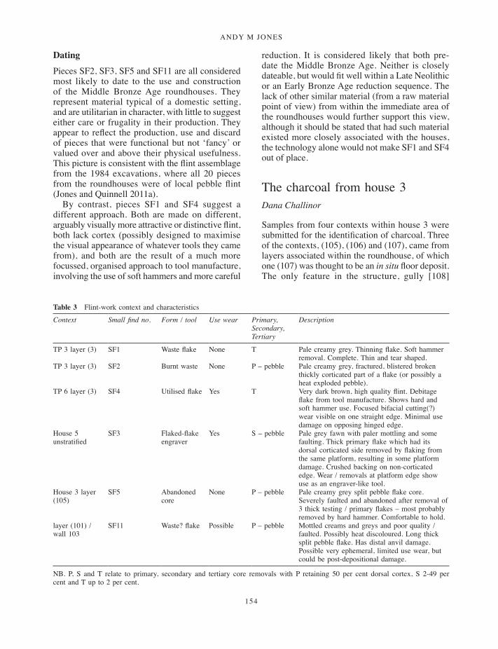
ANDY M JONES
154
Dating
Pieces SF2, SF3, SF5 and SF11 are all considered most likely to date to the use and construction of the Middle Bronze Age roundhouses. They represent material typical of a domestic setting, and are utilitarian in character, with little to suggest either care or frugality in their production. They appear to reflect the production, use and discard of pieces that were functional but not ‘fancy’ or valued over and above their physical usefulness. This picture is consistent with the flint assemblage from the 1984 excavations, where all 20 pieces from the roundhouses were of local pebble flint (Jones and Quinnell 2011a).
By contrast, pieces SF1 and SF4 suggest a different approach. Both are made on different, arguably visually more attractive or distinctive flint, both lack cortex (possibly designed to maximise the visual appearance of whatever tools they came from), and both are the result of a much more focussed, organised approach to tool manufacture, involving the use of soft hammers and more careful
reduction. It is considered likely that both pre-date the Middle Bronze Age. Neither is closely dateable, but would fit well within a Late Neolithic or an Early Bronze Age reduction sequence. The lack of other similar material (from a raw material point of view) from within the immediate area of the roundhouses would further support this view, although it should be stated that had such material existed more closely associated with the houses, the technology alone would not make SF1 and SF4 out of place.
The charcoal from house 3Dana Challinor
Samples from four contexts within house 3 were submitted for the identification of charcoal. Three of the contexts, (105), (106) and (107), came from layers associated within the roundhouse, of which one (107) was thought to be an in situ floor deposit. The only feature in the structure, gully [108]
Table 3 Flint-work context and characteristics
Context Small find no. Form / tool Use wear Primary, Secondary, Tertiary
Description
TP 3 layer (3) SF1 Waste flake None T Pale creamy grey. Thinning flake. Soft hammer removal. Complete. Thin and tear shaped.
TP 3 layer (3) SF2 Burnt waste None P – pebble Pale creamy grey, fractured, blistered broken thickly corticated part of a flake (or possibly a heat exploded pebble).
TP 6 layer (3) SF4 Utilised flake Yes T Very dark brown, high quality flint. Debitage flake from tool manufacture. Shows hard and soft hammer use. Focused bifacial cutting(?) wear visible on one straight edge. Minimal use damage on opposing hinged edge.
House 5 unstratified
SF3 Flaked-flake engraver
Yes S – pebble Pale grey fawn with paler mottling and some faulting. Thick primary flake which had its dorsal corticated side removed by flaking from the same platform, resulting in some platform damage. Crushed backing on non-corticated edge. Wear / removals at platform edge show use as an engraver-like tool.
House 3 layer (105)
SF5 Abandoned core
None P – pebble Pale creamy grey split pebble flake core. Severely faulted and abandoned after removal of 3 thick testing / primary flakes – most probably removed by hard hammer. Comfortable to hold.
layer (101) / wall 103
SF11 Waste? flake Possible P – pebble Mottled creams and greys and poor quality / faulted. Possibly heat discoloured. Long thick split pebble flake. Has distal anvil damage. Possible very ephemeral, limited use wear, but could be post-depositional damage.
NB. P, S and T relate to primary, secondary and tertiary core removals with P retaining 50 per cent dorsal cortex, S 2-49 per cent and T up to 2 per cent.
135-170_Jones.indd 154 08/12/2014 09:57
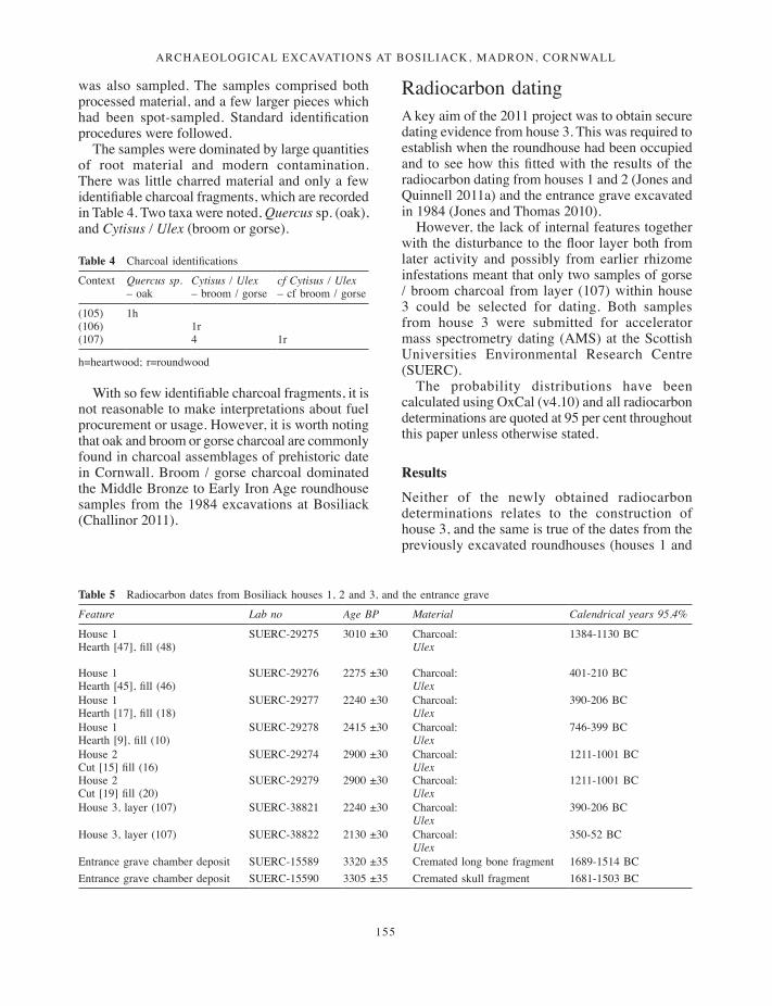
ArchAeologicAl excAvAtions At BosiliAck, MAdron, cornwAll
155
was also sampled. The samples comprised both processed material, and a few larger pieces which had been spot-sampled. Standard identification procedures were followed.
The samples were dominated by large quantities of root material and modern contamination. There was little charred material and only a few identifiable charcoal fragments, which are recorded in Table 4. Two taxa were noted, Quercus sp. (oak), and Cytisus / Ulex (broom or gorse).
With so few identifiable charcoal fragments, it is not reasonable to make interpretations about fuel procurement or usage. However, it is worth noting that oak and broom or gorse charcoal are commonly found in charcoal assemblages of prehistoric date in Cornwall. Broom / gorse charcoal dominated the Middle Bronze to Early Iron Age roundhouse samples from the 1984 excavations at Bosiliack (Challinor 2011).
Radiocarbon datingA key aim of the 2011 project was to obtain secure dating evidence from house 3. This was required to establish when the roundhouse had been occupied and to see how this fitted with the results of the radiocarbon dating from houses 1 and 2 (Jones and Quinnell 2011a) and the entrance grave excavated in 1984 (Jones and Thomas 2010).
However, the lack of internal features together with the disturbance to the floor layer both from later activity and possibly from earlier rhizome infestations meant that only two samples of gorse / broom charcoal from layer (107) within house 3 could be selected for dating. Both samples from house 3 were submitted for accelerator mass spectrometry dating (AMS) at the Scottish Universities Environmental Research Centre (SUERC).
The probability distributions have been calculated using OxCal (v4.10) and all radiocarbon determinations are quoted at 95 per cent throughout this paper unless otherwise stated.
Results
Neither of the newly obtained radiocarbon determinations relates to the construction of house 3, and the same is true of the dates from the previously excavated roundhouses (houses 1 and
Table 4 Charcoal identifications
Context Quercus sp. – oak
Cytisus / Ulex – broom / gorse
cf Cytisus / Ulex – cf broom / gorse
(105) 1h(106) 1r(107) 4 1r
h=heartwood; r=roundwood
Table 5 Radiocarbon dates from Bosiliack houses 1, 2 and 3, and the entrance grave
Feature Lab no Age BP Material Calendrical years 95.4%
House 1Hearth [47], fill (48)
SUERC-29275 3010 ±30 Charcoal: Ulex
1384-1130 BC
House 1Hearth [45], fill (46)
SUERC-29276 2275 ±30 Charcoal: Ulex
401-210 BC
House 1Hearth [17], fill (18)
SUERC-29277 2240 ±30 Charcoal:Ulex
390-206 BC
House 1Hearth [9], fill (10)
SUERC-29278 2415 ±30 Charcoal: Ulex
746-399 BC
House 2Cut [15] fill (16)
SUERC-29274 2900 ±30 Charcoal: Ulex
1211-1001 BC
House 2Cut [19] fill (20)
SUERC-29279 2900 ±30 Charcoal: Ulex
1211-1001 BC
House 3, layer (107) SUERC-38821 2240 ±30 Charcoal: Ulex
390-206 BC
House 3, layer (107) SUERC-38822 2130 ±30 Charcoal: Ulex
350-52 BC
Entrance grave chamber deposit SUERC-15589 3320 ±35 Cremated long bone fragment 1689-1514 BCEntrance grave chamber deposit SUERC-15590 3305 ±35 Cremated skull fragment 1681-1503 BC
135-170_Jones.indd 155 08/12/2014 09:57

ANDY M JONES
156
2). Unfortunately, the lack of internal features, paucity of evidence for stratigraphical complexity, and disturbance to the interior of the roundhouse meant that the determinations only relate to a single horizon of activity within the building. It is therefore not possible to identify a comparable chronology to that developed for houses 1 and 2 (Jones and Quinnell 2011a).
The determinations from house 3 were from the floor layer (107) and they fall in the second half of the first millennium cal BC. They point to activity in the roundhouse occurring between c 400 and 100 cal BC. This is clearly later than the Middle Bronze Age determinations from houses 1 and 2 (Fig 16); however, the Middle Bronze Age pottery recovered from house 3 is likely to be contemporary with the dates from houses 1 and 2 (Quinnell, above).
The determinations from house 3 did, however, overlap with the two latest dates from hearth pits inside house 1. This would suggest that like house 1, house 3 had been reused in the Middle to later Iron Age.
DiscussionDetailed discussions of the results from the 1984 excavations have appeared elsewhere (Jones and Thomas 2010; Jones and Quinnell 2011a). The following discussion will therefore commence with a discussion on the impact of the bracken, before presenting the results from the 2011 excavations within a chronological landscape synthesis which incorporates the results from the earlier fieldwork.
Bracken recording and impact
One of the major aims of the project was to investigate the effects of bracken rhizomes upon the archaeological deposits at Bosiliack. Damage to archaeological sites through rhizome activity has already been established in Scotland (Rees and Miles 1999) and in the south-west region: the excavation of a roundhouse at Teigncombe on Dartmoor has revealed the pernicious impact of
Fig 12 Radiocarbon determinations from the 1984 and 2011 excavations.
135-170_Jones.indd 156 08/12/2014 09:57

ArchAeologicAl excAvAtions At BosiliAck, MAdron, cornwAll
157
bracken upon important archaeological deposits (Gerrard 1999; 2007). Recording took place at house 3 to see what impact the rhizomes had made upon the structure, and test pits were excavated to the east of the roundhouses to establish how much disturbance had occurred to the soils within the field system.
House 3
The investigation of house 3 revealed a relatively simple structure, which lacked evidence for the structural complexity of house 1 and house 2 (Jones and Quinnell 2011a). This may have been due to its small size, or to its original function. However, despite its limited extent, 556 bracken plants were counted over the area of house 3 and a total length of 1076m of rhizomes recorded from the investigated portion. Allowing for the unexcavated baulks, an overall figure of 1500m may be estimated. Of the recorded total, around 431m came from the six metre-square boxes within the roundhouse, giving an average of 72m per square metre. This is less than the Teigncombe roundhouse where 116.6m per square metre was recorded (Gerrard 2008, 7), although it is approximately the same density as the test pits in the field system.
Around 90 per cent of the rhizomes within the roundhouse were recorded in the top 0.10m of the infilling material, where they formed a horizontal mat. This means that the current infestation is causing the greatest damage to shallower deposits and is having comparatively little impact on deeper in situ archaeological layers within the roundhouse. This appears to be broadly similar to the results from other roundhouse excavations in West Penwith, where the position of the bracken mat has been recorded in section drawings, for example at Trewey (Dudley 1941, fig 5) and Bodrifty (Dudley 1956, figs 3, 5 and 18). Although this may suggest that rhizome damage was confined to the upper part of the stratigraphy, it is however, likely that other bracken infestations will have occurred in the past, and as excavations at Teigncombe have revealed, this may have done much to compromise the stratigraphical integrity of the structure (Gerrard 2008, 23). However, the past presence of bracken at deeper levels could not be demonstrated at Bosiliack and the potential damage caused by any such earlier infestation has to be considered with the damage also caused by animal burrowing, post-medieval disturbance and possibly the roots
of other types of vegetation. Despite all this, a complex history of occupation was revealed.
Rhizome activity was not merely confined to the interior of the roundhouse; rhizomes were also evident around and over wall 102. A further 645m came from the 18 metre squares above this walling; this gives an average of 36m of rhizomes per square metre. The density is less than that of the interior, but the walls were not excavated, which means that any rhizomes between the stones within the walling were not recorded; also, the preservation of older rhizomes on the wall is unlikely to have been as good as inside the building. The intensive infestation is very likely to have destabilised wall stones by forcing stones apart, and in one case a bracken rhizome was observed to pass through and split a fault in one of the granite stones within the wall. Rhizome damage to stone-built sites has been demonstrated in Scotland (Rees and Miles 1999, 11–15) and this picture has been confirmed at house 3. This means that stone structures, such as roundhouse walls, field walls and small cairns are vulnerable to rhizome infestation.
Test pits
Damage to older soil horizons by rhizome activity was dramatically revealed by the test pitting. A total of 307 bracken plants was recorded within the eight 1m square test pits, and these in turn had produced approximately 633m of rhizomes. On average most of the test pits contained around 70m of rhizomes, although test pit 3 contained over 100m. Interestingly, this figure is higher than the field system at Teigncombe, where an average of 43.16m was recorded (Gerrard 2008, 7). The recording of the test pit sections revealed that most of the rhizomes were found in the top 0.3m of the soil profile, where a horizontal mat was formed. Within this zone there was significant disturbance to the soil profile. It was also observed that the densest concentrations were found in stonier areas. Again, it could be argued that the damage was limited to the upper part of the soil profile. However, a significant number were found at the junction between more recent soils and what is thought to be the start of an older, possibly prehistoric soil horizon. Damage by rhizomes to this layer has negative consequences for any future palaeoenvironmental recording of the soil within the field system and, as was noted with regard to house 3, earlier infestations could have occurred.
135-170_Jones.indd 157 08/12/2014 09:57
ANDY M JONES
158
SummaryIn summary, the bracken recording programme demonstrated that bracken infestation is making a major impact on upstanding prehistoric stone walls and buried archaeological remains at Bosiliack. The level of impact appears to be broadly comparable with what has been found at Teigncombe on Dartmoor (Gerrard 2007; 2008).
In particular it is evident there was a considerable degree of disturbance within and to the walling of the structure, which reflects the bracken plant’s impact on stony features (Rees and Miles 1999, 13). This means that stony features (for example, walls and cairns) are vulnerable to damage from rhizome infestation, as are any stone structures or features that they may conceal, such as cists.
A greater density of rhizomes was recorded within the roundhouse, although deeper archaeological deposits do not appear to be at so much risk, as for the most part the rhizome mat was found to be concentrated in the top 0.10m of the roundhouse, and within the top 0.1m-0.3m of the test pits. However, shallower deposits, such as buried soils associated with old land surfaces are at risk. This is of particular concern for moorland areas, such as Penwith where archaeological features do not tend to be deep or well-sealed.
The Early Bronze Age (c 2500–1500 cal BC)The date for the construction of the roundhouses and field system is uncertain; the available radiocarbon determinations place activity in houses 1 and 2 between 1300 and 1100 cal BC and the pottery from house 3 is indicative of a date in the same period. Although the construction date of the settlement is uncertain, it seems likely on current evidence for roundhouse building in Cornwall that the Bosiliack roundhouses date to the middle centuries of the second millennium cal BC (Bender et al 2007, 88–9, Jones and Taylor 2010, 158–9). Evidence for activity pre-dating the roundhouses takes two forms, artefactual and monumental.
The only artefactual evidence indicative of earlier activity close to the settlement area comes in the form of a small number of flints from the test pits, which may date to the later Neolithic and Early Bronze Age periods. Likewise, the flint assemblage from around the Bosiliack entrance grave also suggests a later Neolithic or Early Bronze Age occupation in the wider vicinity (Jones and Thomas 2010). The flints may represent activities
which were associated with a less permanent, non-settled occupation, which appears to be typical of the south-west region until the middle centuries of the second millennium cal BC (Jones and Quinnell 2011b).
Large numbers of prehistoric ceremonial monuments are found on the surrounding hills and downs. These include the Nine Maidens stone circle (Madron), Neolithic chambered tombs such as Lanyon Quoit, and especially Early Bronze Age barrows, for example those at Boskednan (Madron) which lie on the higher ground to north of the roundhouse settlement. The nearest ceremonial monument to the settlement is the entrance grave located 350m to the south east of the main group of roundhouses.
Entrance graves are comprised of a simple undifferentiated chamber capped by flat slabs, set within mounds which are usually between 6m and 12m in diameter, although some are larger. Several, such as Bosiliack, have mounds retained by large kerb stones. There are around 13 entrance graves in Penwith and around 90 have been identified in Scilly (Jones et al 2012, 66). However, unlike the Scillonian entrance graves, which are frequently grouped in cemeteries (Ashbee 1974, 74–7), those in Penwith are usually found singly.
By contrast with the surrounding cairns and barrows, the entrance grave at Bosiliack was sited in a comparatively low-lying position and did not have any prominence in the wider landscape. It was also located close to the edge of a terrace or lynchet which is likely to have been formed by prehistoric agricultural activity. This proximity to settlement activity contrasts with the location of many other ceremonial sites in the area, which are found on higher ground, and it is also unusual in being out of sight of Carn Galva (Jones, in preparation). Nonetheless, the low-key setting is comparable with the other Penwith entrance graves, which often lie within or close to areas which were enclosed in prehistory (Jones and Thomas 2010). It is therefore likely that during the second millennium cal BC some communities in Penwith chose to mark the areas that they inhabited with small tombs.
Two radiocarbon determinations on cremated human remains within the entrance grave fell in the period between 1690 and 1500 cal BC which means that the chamber was used and closed towards the end of the Early Bronze Age; an Early Bronze Age date is also supported by the artefacts from excavated examples (Jones and
135-170_Jones.indd 158 08/12/2014 09:57

ArchAeologicAl excAvAtions At BosiliAck, MAdron, cornwAll
159
Thomas 2010). Comparable small megalithic monuments are found around the fringes of the Atlantic region. These include the Tramore tombs in County Waterford, wedge tombs in the south west of Ireland radiocarbon dated to the latter part of the third millennium cal BC (Schulting et al 2008), and the small tombs at Clava, Bargrennan and Cairnderry in Scotland (Bradley 2000, 160; Cummings and Fowler 2007, 165–7), which have radiocarbon determinations within the early second millennium cal BC. It has been argued elsewhere that the coastal distibution of these small Bronze Age megaliths may suggest that communities in west Cornwall were in contact with other coastal communities along the Atlantic façade and that the similarities in monument types arose through the exchange of ideas (Jones and Thomas 2010).
Unfortunately, as the Bosiliack entrance grave was located just beyond the northern edge of the terrace or lynchet, there was no stratigraphical relationship between the features. This meant
that it was not possible to determine whether any part of the local landscape had become enclosed by the time that the tomb was constructed. Some elements of the field system may pre-date the roundhouses: the investigated terrace near to the entrance grave produced a sherd of pottery which was very similar to the vessels from the tomb (Jones and Thomas 2010). It is also possible that some of the fields may have been falling out of use when the settlement was built. However, much of the prehistoric field system appears to relate to the roundhouse settlement (below). It is also possible that the pottery in the terrace was residual and the field system was laid out to respect the entrance grave.
Although the date for the construction of the houses remains uncertain, radiocarbon determinations from occupation of the three excavated roundhouses place them later than the entrance grave. Even if activity in houses 1, 2 and 3 began earlier than c 1300 cal BC, it is unlikely,
Fig 13 Bosiliack entrance grave after excavation in 1984, viewed from the south east, with entrance blocking in place.
135-170_Jones.indd 159 08/12/2014 09:57
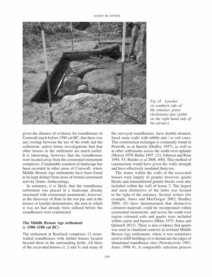
ANDY M JONES
160
given the absence of evidence for roundhouses in Cornwall much before 1500 cal BC, that there was any overlap between the use of the tomb and the settlement, unless future investigations find that other houses in the settlement are much earlier. It is interesting, however, that the roundhouses were located away from the ceremonial monument complexes. Comparable zonation of landscape has been recorded in other areas of Cornwall, where Middle Bronze Age settlements have been found to be kept distinct from areas of formal ceremonial activity (Jones, forthcoming).
In summary, it is likely that the roundhouse settlement was placed in a landscape already structured with ceremonial monuments; however, as the discovery of flints in the test pits and in the terrace or lynchet demonstrates, the area in which it was set had already been utilised before the roundhouses were constructed.
The Middle Bronze Age settlement (c 1500–1100 cal BC)
The settlement at Bosiliack comprises 13 stone-walled roundhouses with further houses located beyond them in the surrounding fields. All three of the excavated houses (1, 2 and 3), and many of
the surveyed roundhouses, have double-skinned, faced stone walls with rubble and / or soil cores. This construction technique is commonly found in Penwith, as at Sperris (Dudley 1957), as well as at other settlements across the south-west uplands (Mercer 1970; Butler 1997, 121; Johnson and Rose 1994, 53; Bender et al 2008, 400). This method of construction would have given the walls strength and have effectively insulated them too.
The stones within the walls of the excavated houses were largely of granite; however, quartz blocks and tourmalinised granite blocks were also included within the wall of house 3. The largest and most distinctive of the latter was located to the right of the entrance. Several writers (for example, Jones and MacGregor 2002; Bradley 2000, 45) have demonstrated that distinctive coloured materials could be incorporated within ceremonial monuments, and across the south-west region coloured soils and quartz were included within cairns and barrows (Miles 1975; Jones and Quinnell 2012). There is also evidence that quartz was used in ritualised contexts in lowland Middle Bronze Age settlements, where it was sometimes used to infill buildings or to demarcate the edges of abandoned roundhouse sites (Nowakowski 1991; Jones 1998–9). A comparable selection process
Fig 14 Lynchet on southern side of the entrance grave (kerbstones just visible on the right hand side of the picture).
135-170_Jones.indd 160 08/12/2014 09:57
ArchAeologicAl excAvAtions At BosiliAck, MAdron, cornwAll
161
may have determined the stones incorporated within the wall of house 3.
The floor in house 3 was made up of redeposited natural rab subsoil and a large granite slab. The rab floor, which was poorly-preserved in house 3, was paralleled in both house 1 and house 2 (Jones and Quinnell 2011a). Rab floors are also regularly found in roundhouses across the uplands of Cornwall, with examples being identified at Bodrifty (Dudley 1956), and at Stannon Down (Jones 2004–5) and Rough Tor (Thompson and Birbeck 2009–10) on Bodmin Moor. The houses at Trewey and Sperris (Dudley 1941; 1957) also appear to have had rab floors. Although these were identified by the excavator as being in situ natural subsoil, it is likely that they too were laid floors comprising redeposited rab. Provided it is kept dry, rab is a good, compact floor material which can easily be kept clean, and it is likely that most excavated houses situated on granite had them. Unfortunately, the survival of the floor layer in house 3 was very patchy. This poor level of preservation could have been caused by wear and tear, but it is perhaps more likely to have occurred during post Bronze Age disturbance to the roundhouse, through Iron Age occupation, animal and rhizome and root activity, and perhaps also by post-medieval miners, when they were robbing stone from the adjacent walls.
House 3 contained few internal features and there was no identified hearth. The lack of a post-ring was unsurprising given the structure’s small diameter. Posts would not have been necessary to support the roof and there are numerous examples of Bronze Age houses which do not have internal post-rings; for example, Heatree hut circle 2 (Quinnell 1991) and Stannon Down site 3 (Jones 2004–5). By contrast, Bosiliack houses 1 and 2, in common with many Bronze Age roundhouses in the south west, contained post-rings, as well as hearths. The contrast in construction techniques may have been linked to the size of the buildings or their functions. However, the apparent absence of a post-ring within house 3 may be explained by the fact that a large part of the floor was made up of a slab of natural granite, and any posts would have sat upon it, with any wedging stones lost through subsequent soil disturbance.
The three excavated roundhouses at Bosiliack have been shown to have complex histories. Although the construction phase was not dated, Middle Bronze Age pottery was recovered
from the floor layer of house 3 (Quinnell, above) and further Bronze Age ceramics and radiocarbon determinations of 1384–1130 cal BC (SUERC-29275), 1211–1001 cal BC (SUERC-29274) and 1211–1001 cal BC (SUERC-29279) were obtained from houses 1 and 2. The earliest dated occupation within houses 1 and 2 therefore falls in the period c 1300 and 1100 cal BC. However, earlier hearths could have lain under the central baulk within house 3 or outside the excavated transect across houses 1 and 2. The length of occupation of the unexcavated houses is unknown, although it appears that some of them (houses 10, 12 and 13) were constructed within the ruins of earlier structures. It is therefore possible that the roundhouses could have been constructed before c 1300 cal BC, or that other houses in the settlement pre-dated them, although on the basis of what is currently known, probably not before the middle of the second millennium cal BC.
House 3 was situated over a place where the granite outcropped at surface, and a large part of the floor area was formed by a natural slab; this was found in the area of the entrance and extended within and beyond the structure. It may have formed a convenient area of hard standing for the occupants. Natural grounders were also found within the walls of house 1 and house 2. Large boulders were also incorporated within excavated houses at Sperris and Wicca (Dudley 1957) in Penwith, and at Leskernick on Bodmin Moor, where the excavators suggested that large in situ stones were deliberately incorporated into the backs of houses for cosmological reasons (Bender et al 2007, 120). Grounders are also frequently incorporated within upland cairns in the south west, and it has been argued that their inclusion within houses may reflect an earlier ritual tradition (Jones 2008). It is possible that the permanency of the architecture and its links with earlier ritual traditions may have made the roundhouses markers of the ties between particular people and places in the landscape (Jones and Quinnell 2011a).
There is a growing understanding that during the middle of the second millennium cal BC ritualised activities were often found on settlement sites and became embedded within the routines of daily life (for example, Bradley 2005). In particular, the ritualised abandonment of Middle Bronze Age roundhouses has been recognised and it has been suggested that, like people, houses may have been conceived as having ‘life-spans’; their demise was,
135-170_Jones.indd 161 08/12/2014 09:57

ANDY M JONES
162
Fig 15 Post excavation plan showing houses 1 and 2.
135-170_Jones.indd 162 08/12/2014 09:57

ArchAeologicAl excAvAtions At BosiliAck, MAdron, cornwAll
163
in common with that of their occupants, marked with rites. In the south west, planned abandonment has been most clearly demonstrated at lowland settlements, where rituals involving the infilling of roundhouse hollows and their transformation into barrow-like sites has been identified (Jones, forthcoming). Comparable activity may have occurred at upland roundhouses, and it has been argued that on abandonment some upland houses were converted into cairns (Butler 1997, 137–8). Evidence for this has been found at Bellever on Dartmoor, where excavations revealed a post-abandonment cairn within a roundhouse (Marchand and Hughes 2012). However, at Bosiliack none of the three excavated houses revealed any trace of deliberate abandonment. Instead, stone-walled upland houses may have been built with a very long life span envisaged, and formal abandonment may have been a rare event.
The houses at Bosiliack were unenclosed but set out in a roughly oval arrangement around an open central space. This could have been a communal space such as a yard. However, and in common with most of the houses in the settlement, house 3, and houses 1 and 2, had entrances which opened towards the south, not onto the central space. This orientation is frequent in Bronze Age roundhouses across the south west (Dudley 1956; 1957; Mercer 1970; Smith and Harris 1982; Butler
1997, 96) and across southern Britain generally (Drewett 1982; Ladle and Woodward 2009, 365). The consistent doorway alignment could indicate belief in a widely-held cosmology (Parker Pearson 1996). However, several houses at Bosiliack had entrances which faced in different directions, and the southernmost roundhouse, house 8 had a north-facing entrance which looked into the settlement and towards Carn Galva. This suggests that local cosmologies and traditions may have been an important factor in house orientation.
The excavated houses at Bosiliack were located within an extensive field system (Figs 2 and 3). Second millennium cal BC Bronze Age settlements across Britain have been found in association with large-scale field systems (Yates 2007, 110–1; Ladle and Woodward 2010, 358–62), and the south west has produced evidence for a range of enclosures and field systems, including cultivation terraces and accreted and co-axial field systems defined by stone walls and banks (Johnson and Rose 1994, 59–74; Nowakowski et al 2007; Herring 2008). Although secure dating is scarce, environmental evidence from the south west indicates an expansion of farming during the middle centuries of the second millennium cal BC (Wilkinson and Straker 2008), and this is also suggested by a pair of unpublished radiocarbon dates from peat beneath field boundaries at
Fig 16 Archaeological features cutting rab floor in house 2, looking north west.
135-170_Jones.indd 163 08/12/2014 09:57
ANDY M JONES
164
Stannon Down, on Bodmin Moor, 1780–1520 cal BC (GU-5172) and 1700–1490 cal BC (GU-5170) (Ratcliffe 2011).
The adjacent field walls at Bosiliack were similar to Bronze Age walls investigated on Bodmin Moor (Jones 2004–5). Rather than the neat construction of many of the Dartmoor reaves (Fleming 1988, 85), large boulders appear to have been strung out in a rough line and smaller stones dumped between them.
Although roundhouses and field systems are often found in close proximity to one another (for example, Fleming 1988, 87), actual contemporaneity has seldom been demonstrated. At Bosiliack, some of the roundhouses look as though they might abut the boundary walls (for example, house 11 and house 8) (Fig 4). However, the excavation of house 3 revealed that there was a small gap between the wall of the house and the western boundary. Although it is possible that the builders had removed stones from the boundary for use in the construction of house 3, it seems more likely that the boundary and the house are contemporary with one another, or the wall respected the position of the house and was slightly later. It should be remembered here that we are dealing with an active landscape which was in use for, and may have changed over, some thousand years.
It is evident that Bosiliack, along with the other surviving Bronze Age settlements in Penwith, such as Sperris, Trewey and Wicca Round, all lie upon the higher ground. They are located above the more sheltered valley areas where settlements of medieval origin are found, such as Boskednan and Boswarthen a little to the north east and south east of Bosiliack. Excavations across the Cornish lowlands have revealed extensive evidence for Bronze Age settlement which now only survives below ground (Jones and Quinnell 2011b). Lowland Bronze Age settlements such as Trevisker and Trethellan (ApSimon and Greenfield 1972; Nowakowski 1991) have produced large quantities of artefacts and are thought to have been inhabited all year round. It is probable that comparable Bronze Age settlements were also located in the lower-lying parts of West Penwith, although they have not survived later reorganisations of the land, and that there were close relationships between the upland and lowland settlements. On the face of it, places such as Bosiliack and Trewey, with their extensive and well-developed field systems,
give the impression that they are the equivalent of what one might expect to have existed on the lower ground, and represent the upper edge of permanent settlement. On the other hand, it is possible that they were seasonally occupied by people from the lowlands. If groups were only seasonally occupying Bosiliack, they would have carried fewer objects and would have taken unbroken items away with them when they left. This might account for the general paucity of artefacts from many upland settlements.
Establishing the function of the houses and the economy for the Bosiliack settlement is difficult. In the case of house 3 the floor was poorly-preserved and the interior deposits were badly disturbed. The excavated portions of houses 1 and 2 revealed several phases of activity and a large number of features; however, these did not contain much evidence for any activities. The post-rings and hearths inside houses 1 and 2 suggest that they were dwellings (Jones and Quinnell 2011a) and it is likely that house 3 was also a dwelling. Bulk sampling for data such as charred cereal grains was not carried out in 1984, and the environmental samples from the 2011 excavations did not produce many charred plant remains. However, the charcoal assemblages from all three roundhouses contained gorse / broom, which may indicate a lack of access to high-quality firewood, such as oak, which is commonly found in lowland roundhouse hearths. The vegetation represented by the charcoal is perhaps consistent with upland areas seasonally used for the grazing of cattle and sheep.
It seems likely that, as in other parts of Britain, the establishment of field systems was connected to the formal demarcation of areas for animal grazing (Yates 2007, 120). Although no faunal remains were recovered from Bosiliack, evidence for livestock has been revealed at several sites in the south west; animal footprints, including those of cattle, were recorded at Shaugh Moor on Dartmoor (Smith et al 1981) and the identification of ruminant dairy lipids in Bronze Age vessels from the south west also suggests the importance of animals to farming (Copley et al 2005). Furthermore, in contrast with excavated lowland roundhouses (Nowakowski 1991), no querns or rubbing stones were recovered from the three houses investigated at Bosiliack (Quinnell, above). This might imply that processed grain was brought to the site, perhaps during shorter periods of occupation when animals were grazing in upland pastures.
135-170_Jones.indd 164 08/12/2014 09:57

ArchAeologicAl excAvAtions At BosiliAck, MAdron, cornwAll
165
The first millennium cal BC (c 1000–100 cal BC)
The excavations within house 3 and house 1 revealed evidence for subsequent Iron Age reuse of the structures. This implies that other unexcavated houses within the settlement are likely to have witnessed periods of reoccupation.
The earliest evidence for reoccupation of the settlement at Bosiliack was found in house 1, where pottery (P3) and the radiocarbon determination from hearth [9], 2415 ±30BP, 746–399 cal BC (SUERC-29278), indicates activity within the roundhouse during the earlier first millennium cal BC, several centuries after the house was constructed.
There is more evidence for a second episode of Middle Iron Age activity, indicated by the two radiocarbon determinations from layer (107) in house 3, 390–206 cal BC (SUERC-38821) and 350–52 cal BC (SUERC-38822), and by the dates from hearths in house 1: hearth [45] was dated to 401–210 cal BC (SUERC-29276) and hearth [17] to 390–206 cal BC (SUERC-29277). The latter date is identical to the earlier determination from layer (107) in house 3. This evidence indicates a phase of activity between c 400 and 100 cal BC within the settlement. It also demonstrates a type of occupation in which the use of ceramics was unimportant.
This pattern of reuse is of interest because on other upland areas in the south west such as Dartmoor and Bodmin Moor, identified Iron Age settlements are few and far between (Quinnell 1994; Johnson and Rose 1994, 74–5). Excavations at Gold Park on Dartmoor revealed that some roundhouses continued to be constructed during the Iron Age (Gibson 1992), and excavation of Bronze Age houses across the south west has revealed subsequent phases of occupation. On Dartmoor, Late Bronze Age or Iron Age ceramics have been found within roundhouses at Foales Arrishes (Radford 1952) and Shaugh Moor (Wainwright and Smith 1980). At Kestor the large roundhouse inside a pound was found to contain Iron Age pottery (Fox 1954, 48–9) and recent study of the ceramics by Henrietta Quinnell has revealed that the assemblage includes both Bronze Age Trevisker ware and Early Iron Age pottery; however, radiocarbon dating of ironworking debris from Kestor shows this to be of early post-Roman date (Peter Crew, pers comm to Henrietta Quinnell). Hut 2 at Dean Moor (Fox 1957) produced iron slag
which could be Iron Age. Recent excavations of a roundhouse at Teigncombe showed early Iron Age pottery associated with reuse of a Bronze Age roundhouse (Gerrard and Quinnell 2002). In addition to artefacts, radiocarbon determinations from Shaugh Moor house 19 and structure 804 demonstrated occupations of the later Bronze Age and Early Iron Age periods (Wainwright and Smith 1980). This widespread evidence suggests that on Dartmoor, roundhouses of Bronze Age origin were often reoccupied in the Iron Age. Here it is worth emphasising that the great majority of data on Dartmoor roundhouses comes from antiquarian work: now that absence or scarcity of ceramics can be seen to be a first millennium BC trait, the extent of contemporary activity has almost certainly been underestimated.
A similar pattern seems to be emerging on Bodmin Moor. Early Iron Age pottery and a Middle Iron Age blue bead were recovered from a roundhouse at Garrow Tor (Silvester 1979; Henrietta Quinnell, pers comm) and at Stannon Down a post-built structure within a Bronze Age ring cairn was dated by pottery and radiocarbon determinations to the Middle Iron Age (Jones 2004–5). In addition, the radiocarbon dating of Leskernick roundhouses 1 and 23 (Bender et al 2007, 88–9) has also revealed evidence for Iron Age activity. These latter sites are significant, like Bosiliack house 3, because they demonstrate the later reuse of buildings where finds are absent. These cases raise the problems of the identification of Iron Age activity in upland areas, where occupation may mostly have been confined to the reoccupation of older sites or the construction of ephemeral wooden structures.
The Penwith moors are lower-lying and much more favourable for occupation than either Bodmin Moor or Dartmoor. Indeed, despite the lack of recent settlement investigation, reassessment of older excavation archives has revealed that first millennium cal BC reoccupation of Bronze Age roundhouses appears to have been a frequent occurrence (Jones and Quinnell 2011a; Quinnell, above). At Bodrifty nine roundhouses within a settlement were investigated (Dudley 1956) and, as at Bosiliack, some of these houses stood over ruins of older roundhouses. Several contained multiple hearths and Middle Bronze Age pottery was recovered. However, several roundhouses contained Late Bronze Age and Iron Age artefacts. Unfortunately, the settlement was excavated
135-170_Jones.indd 165 08/12/2014 09:57

ANDY M JONES
166
before radiocarbon dating was widely applied to settlement sites; however, no definite break in the use of Bodrifty can be seen in the ceramic record. Similarly, the ceramics from Dudley’s excavation at Wicca Round (Quinnell, above) shows Middle Bronze Age Trevisker ware, as well as probable Late Bronze Age – Early Iron Age pottery and a few sherds of probable Middle Iron Age. The nearby roundhouse settlement at Sperris Croft produced a few sherds of pottery that are most probably of Late Bronze Age – Early Iron Age date (Jones and Quinnell 2011a). It is quite likely that all of the settlements in Penwith excavated in the 1950s which were initially dated to the Middle Bronze Age had varied amounts of reuse during the first millennium cal BC, and this is also likely to be true for the unexcavated settlements.
At Bosiliack, the first millennium cal BC radiocarbon determinations from house 1 and house 3, and the small amount of Iron Age pottery from within house 1, suggest that at least two of the buildings in the settlement had complex histories of reuse. However, it is not possible to say whether there was continued, if intermittent, use of the roundhouses, or if the settlement had been completely abandoned for generations before people returned and made use of the ruins.
Interestingly, the gorse / broom charcoal from house 3 is indicative of heathland conditions and this was also suggested by the charcoal assemblage from house 1 (Jones and Quinnell 2011a). The heathland conditions might suggest that houses were being (re)occupied as part of a system of upland transhumance. It is plausible that many upland roundhouses in the south west were occupied on a seasonal basis, as part of a system of transhumance (Herring 2008). It is possible that the houses at Kestor and Dean Moor on Dartmoor (Fox 1954; 1957) were places where people grazed their animals and possibly worked locally available iron ore. The evidence from the settlement at Bosiliack is consistent with periodic reuse, with the occupation in houses 1 and 3 representing seasonal re-occupation of an older Bronze Age roundhouse. By contrast, the more extensive evidence for Iron Age activity at Bodrifty suggests that it had periods of permanent reoccupation; the quantities of Middle Iron Age and later ceramics at Bodrifty suggest that activities here were of a different kind to those at the other West Penwith settlements. There is likely to have been a complex and regionally variable relationship between
permanent settlements, the use of tracts of upland grazing and the reuse, or continued use, of older settlements. It is currently uncertain whether there was straightforward continuity from the Bronze Age, with ongoing rights to grazing handed down over the generations, or whether large-scale reorganization occurred (Herring 2008).
The widespread reuse of Bronze Age roundhouses raises the question as to whether old buildings were used because they were convenient places of shelter or because as ‘ancestral dwellings’ they helped reaffirm tenure and rights to particular tracts of land. There is plenty of evidence for structures and places being reused throughout prehistory and the Iron Age (Barrett 1999; Hingley 2009). Much of this reuse may have been linked with a desire to create or maintain links with the past, particular places, and people, given the commonly found associations between individuals and houses (La Roy Ladurie 2002, 24–52). However, this did not mean that claims were based on actual ‘history’ or that the past was not manipulated to support fictional or mythologised claims to land ownership. At Bosiliack, the ancient roundhouses may have been used by people who continued to seasonally graze their cattle on land which had been handed down to them through the generations, or because reorganization of the land required ‘ownership’ of land to be asserted through the re-occupation of ‘ancestral dwellings’.
Conclusion: the future past
From the foregoing discussion it is evident that the Bronze Age settlement was used and thought about in different ways throughout prehistory. Sometimes buildings were dwelt in whereas at others they were left as empty shells. Some showed evidence for being rebuilt or reused long after the original occupants had left. A recurring pattern of reuse of monuments, structures and places throughout the prehistoric and earlier medieval periods is found across Britain (for example, Bradley 2002, chapter 3; Williams 1998), and may represent a desire to make a link with the past, or an attempt to control it.
However, in the periods since the Iron Age there is less evidence for the ways that people have engaged with the settlement at Bosiliack. Folklore and superstition may have discouraged medieval farmers from destroying the roundhouses (Dudley 2011, 155); on the other hand, the location of the settlement within fairly marginal land may have
135-170_Jones.indd 166 08/12/2014 09:57
ArchAeologicAl excAvAtions At BosiliAck, MAdron, cornwAll
167
meant that the amount of physical labour needed to clear the area of substantial amounts of stone was not considered worthwhile. However, as elsewhere in Penwith (Kirkham 2011, 24; 2012), during the nineteenth century any lingering superstitions about the site appear to have diminished and the stones within the field walls, and probably the roundhouses too, were deemed a resource for use in structures associated with mining. This is indicated by the attempted conversion of one of the field wall stones into a mellior stone and possibly by the disturbance to wall 102 around house 3, and the roof slate fragments from inside house 3 as well.
More recently attitudes to the historic environment have changed and the large number of prehistoric sites which are found across the uplands of the south west and Penwith are now valued as an important asset in their own right. It is therefore, as Graeme Kirkham (2011, 87–8) points out, deeply ironic that, at a time when there is a growing awareness of the importance of upstanding archaeological sites, extremely valuable below-ground remains are being damaged through the infestation of the moors and upland areas by uncontrolled bracken. The recording of bracken rhizomes undertaken as part of the Bosiliack project, as well as others on Dartmoor and in Scotland (Gerrard 1999; Rees and Mills 1999), has clearly demonstrated the damaging effects of rhizomes upon buried archaeological layers and especially structures.
Today then, we are faced with the choice about the way that archaeological sites on the Penwith moors are managed: to do nothing will eventually lead to an equal or greater loss of information than occurred in the post-medieval period whereas, by contrast, careful management, including the control or removal of bracken, should ensure that both upstanding remains and below-ground layers survive for future recording, as well as making the above-ground remains more visible and accessible.
At the time of writing, and as a direct result of the Society’s excavations, the settlement has been Scheduled and management to control scrub and bracken growth has already been initiated through a Higher Level Stewardship agreement.
Acknowledgements
The author would like to thank English Heritage, the Cornwall Archaeological Society, and the Cornwall
Heritage Trust for funding the Bosiliack project. I would also like to thank the owners, the Bolitho Estate, for permission to excavate the roundhouse, and their tenant Stephen Bone. Chris Fry from Penwith Access and Rights of Way cleared the site before work began. Sandy Gerrard, Janet Daynes and Gordon Fisher of the Dartmoor Bracken project advised on the bracken investigation and Charles Thomas and Tony Blackman gave their support throughout the project.
Within HE Projects, I would like to thank Ann Preston-Jones and Ann Reynolds for their assistance with the development of the project and Pete Dudley, Sean Taylor, Graeme Kirkham and Jane Marley for onsite supervision of volunteers. Thanks are also due to Les Dodd and Phil Hills for organising the survey. Thanks are also owed to Ann Preston-Jones for commenting on the report.
The excavation team was Linda Barrow, Maria Gardiner, Barbara Gordon, Pam McInally, Ailsa Johnson, Spencer Johnson, Sally Oakley, Jo Pye, Stella Redgrave, Thomas Rose-Jones, Barbara Sanders, George Scott, Adam Sharpe, Sandra Thomas, Phil Tizzard, Jack Weir, Chris Verran, Kim Williams and Paul Young. Dave Giddings of Cornwall Archaeological Society assisted with tours of the site on the open day.
I would also like to thank Jane Read and Sean Taylor for producing the illustrations. The project archive will be deposited at Penlee House Gallery and Museum, Penzance.
ReferencesApSimon, A, and Greenfield, E, 1972. The excavation of
the Bronze Age and Iron Age settlement at Trevisker Round, St Eval, Cornwall, Proc Prehist Soc, 38, 302–81
Ashbee, P, 1974. Ancient Scilly, from the first farmers to the early Christians, Newton Abbot
Barnatt, J, 1982. Prehistoric Cornwall - the ceremonial monuments, Wellinborough
Barrett, J, 1999. The mythical landscapes of the British Iron Age, in Archaeologies of landscape, W Ashmore and A B Knapp, eds, Oxford, 253–68
Bender, B, Hamilton, S, and Tilley, C, 2007. Stone worlds: narrative and reflexivity in landscape archaeology, Walnut Creek
Bradley, R, 2000. The good stones; a new investigation of the Clava cairns, Edinburgh
Bradley, R, 2002. The past in prehistoric societies, London
Bradley, R. 2005 Ritual and domestic life in prehistoric Europe, London
135-170_Jones.indd 167 08/12/2014 09:57

ANDY M JONES
168
Butler, J, 1997. Dartmoor atlas of antiquities, volume 5 – the second millennium BC, Tiverton
Challinor, D, 2011. The charcoal, in Jones and Quinnell 2011a, 111–2
Copley, M, Berstan, R, Dudd, S, Aillud, S, Mukherjee, A, Straker, V, Payne, S, and Evershed, R, 2005. Processing of milk products in pottery vessels through British prehistory, Antiquity, 306, 895–908
Cummings, V, and Fowler, C, 2007. From cairn to cemetery; an archaeological investigation of the chambered cairns and Early Bronze Age mortuary deposits at Cairnderry and Bargrennan White cairn, south-west Scotland, Brit Arch Repts, Brit Ser, 434, Oxford
Drewett, P L, 1982. Later Bronze Age downland economy and excavations at Blackpatch, East Sussex, Proc Prehist Soc, 48, 321–400
Dudley, D, 1941. A Late Bronze Age settlement on Trewey Downs, Zennor, Arch Jnl, 98, 105–30
Dudley, D, 1956. An excavation at Bodrifty, Mulfra, near Penzance, Arch Jnl, 113, 1–32
Dudley, D, 1957. Late Bronze Age and Early Iron Age settlements in Sperris Croft and Wicca Round, J Roy Inst Cornwall, 3, 414–50
Dudley, P, 2011. Goon, hal, cliff and croft, the archaeology and landscape history of west Cornwall’s rough ground, Truro (Cornwall Council)
Fleming, A, 1988. The Dartmoor reaves, investigating prehistoric land divisions, London
Fox, A, 1954. Excavations at Kestor, an Early Iron Age settlement near Chagford, Devon, Trans Devonshire Assoc, 86, 21–62
Fox, A, 1957. Excavations on Dean Moor in the Avon Valley 1954–1956. The late Bronze Age settlement, Trans Devonshire Assoc, 89, 18–77
Gerrard, S, 1999. Dartmoor bracken and archaeology project interim report for the 1999 season, privately published
Gerrard, S, 2007. Dartmoor bracken and archaeology project interim report for the 2007 season, privately published
Gerrard, S, 2008. Dartmoor bracken and archaeology project interim report for the 2008 season, privately published
Gerrard, S, 2011. Bracken rhizome recording and assessment manual, privately published
Gerrard, S, and Quinnell, H, 2002. Dartmoor bracken and archaeology project interim report for the 2002 season, privately published
Gibson, A, 1992. The excavation of an Iron Age settlement at Gold Park, Dartmoor, Proc Devon Archaeol Soc, 50, 19–47
Gossip, J, forthcoming. Life outside the round - Bronze Age and Iron Age settlement at Higher Besore and Truro College, Threemilestone, Truro, Cornish Archaeol
Harrad, L, 2003. The production and trade of prehistoric ceramic in Cornwall, unpublished PhD thesis, Univ Oxford
Herring, P, 2008. Commons, communities and fields in prehistoric Cornwall, in Recent approaches to the archaeology of land allotment, A Chadwick, ed, Brit Arch Repts, Int Ser, 1875, Oxford, 70–95
Herring, P, Sharpe, A, Smith, J R, and Colom, G, 2008. Bodmin Moor: an archaeological survey, volume 2: the industrial and post-medieval landscapes, Swindon (English Heritage)
Hingley, R, 2009. Esoteric knowledge, ancient bronze artefacts from Iron Age contexts, Proc Prehist Soc, 75, 143–66
Johnson, N, and Rose, P, 1994. Bodmin Moor: an archaeological survey, volume 1: the human landscape to c 1800, London (English Heritage)
Jones, A, and MacGregor, G, 2002. Colouring the past, Oxford
Jones, A M, 1998–9. The excavation of a later Bronze Age structure at Callestick, Cornish Archaeol, 37–8, 5–55
Jones, A M, 2004–5. Settlement and ceremony; archaeological investigations at Stannon Down, St Breward, Cornwall, Cornish Archaeol, 43–44, 1–140
Jones, A M, 2008. Houses for the dead and cairns for the living: a reconsideration of the Early to Middle Bronze Age transition in south-west England, Oxford J Archaeol, 27, 153–74
Jones, A M, 2012. Archaeological excavations at Bosiliack, Madron, Cornwall, Truro (Historic Environment Projects, Cornwall Council)
Jones, A M, forthcoming. Ritual, rubbish or everyday life? Evidence from a Middle Bronze Age settlement in mid Cornwall, Arch Jnl
Jones, A M, in preparation. CAS excavations at Carn Galva and Bosporthennis in 2009, Cornish Archaeol
Jones, A M, Breen, E, Camidge, K, Charman, D, Fyfe, R, Garrow, D, Johns, C, Kirk, T, Mills, S, Mulville, J, Pannett, A, Quinnell, H, Rainbird, P, Roberts, H M, Robinson, G, Sawyer, K, Sturt, F, and Scaife, R, 2012. Neolithic and Early Bronze Age, in Scilly historic environment research framework - resource assessment, C Johns, ed, Truro (Historic Environment Projects, Cornwall Council)
Jones, A M, and Quinnell, H, 2011a. Bosiliack: a later prehistoric settlement in Penwith, Cornwall, Arch Jnl, 168, 96–132
Jones, A M, and Quinnell, H, 2011b. The Neolithic and Bronze Age periods in Cornwall, c 4000 cal BC to c 1000 cal BC: an overview of recent developments, Cornish Archaeol, 50, 197–229
Jones, A M, and Quinnell, H, 2012. Monuments and images: new views of well-known sites, Cornish Archaeol, 51, 201–8
Jones, A M, and Taylor, S R, 2010. Scarcewater, Pennance, Cornwall, archaeological excavation of a Bronze Age and Roman landscape, Brit Arch Repts, Brit Ser, 516, Oxford
135-170_Jones.indd 168 08/12/2014 09:57
ArchAeologicAl excAvAtions At BosiliAck, MAdron, cornwAll
169
Jones, A M, and Thomas, A C, 2010. Bosiliack and a reconsideration of entrance graves, Proc Prehist Soc, 76, 271–96
Kirkham, G, 2011. Managing the historic environment on west Cornwall’s rough ground, Truro (Cornwall Council)
Kirkham, G, 2012 ‘Rip it up and spread it over the field’: post-medieval agriculture and the destruction of monuments, a case study from Cornwall, Landscapes, 13, 1–20.
Knight, J, 1991. Technological analysis of the anvil (bipolar) technique, Lithics, 12, 57–80
Ladle, L, and Woodward, A, 2009. Excavations at Bestwall Quarry, Wareham, 1992–2005, volume 1: the prehistoric landscape, Dorchester
La Roy Ladurie, E, 2002. Montaillou: Cathars and Catholics in a French village 1294–1324, London
Marchand, J, and Hughes, S, 2012. Bronze Age Bellever, settling Dartmoor in the 2nd millennium BC, Curr Archaeol, 266, 36–41
Mercer, R, 1970. The excavation of a Bronze Age hut-circle settlement, Stannon Down, St Breward, Cornwall, Cornish Archaeol, 9, 17–46
Miles, H, 1975. Barrows on the St Austell granite, Cornwall, Cornish Archaeol, 14, 5–81
Morris, B, forthcoming. The excavation of a pit group with Trevisker ceramics at Porthleven, Cornish Archaeol
Nowakowski, J, 1991. Trethellan Farm, Newquay: the excavation of a lowland Bronze Age settlement and Iron Age cemetery, Cornish Archaeol, 30, 5–242
Nowakowski, J, 2007. Digging deeper into barrow ditches, in Beyond the grave: new perspectives on barrows, J Last, ed, Oxford, 91–112
Nowakowski, J, Quinnell, H, Sturgess, J, Thomas, C, and Thorpe, C, 2007. Return to Gwithian: shifting the sands of time, Cornish Archaeol, 46, 13–76
Nowakowski, J, and Quinnell, H, 2011. Trevelgue Head, Cornwall: the importance of CK Croft Andrew’s 1939 excavations for prehistoric and Roman Cornwall, Truro (Cornwall Council)
Parker Pearson, M, 1996. Food, fertility and front doors, in The Iron Age in Britain and Ireland: recent trends, T Champion and J Collis, eds, Sheffield, 117–32
Parkes, C, 2007. Scheduled monuments at risk, Cornwall, Truro (Historic Environment Service, Cornwall County Council)
Parkes, C, 2011. Lanyon Farm, Madron, Cornwall: archaeological management assessment, Truro (Historic Environment Projects, Cornwall Council)
Quinnell, H, 1991. The late Mrs Minter’s excavation of hut circles at Heatree, Manaton in 1968, Proc Devon Archaeol Soc, 49, 1–24
Quinnell, H, 1994. Becoming marginal? Dartmoor in later prehistory, Proc Devon Archaeol Soc, 52, 75–84
Quinnell, H, 2007. Prehistoric, Roman and early medieval pottery in Archaeological investigations of
a later prehistoric and a Romano-British landscape at Tremough, Penryn, Cornwall, J Gossip and A M Jones, Brit Arch Repts, Brit Ser, 443, Oxford, 51–78
Quinnell, H, 2011a. The pottery, in Nowakowski and Quinnell 2011, 144–208
Quinnell, H, 2011b. A summary of Cornish ceramics in the first millennium BC, Cornish Archaeol, 50, 231–40
Quinnell, H, 2012. Trevisker pottery: some recent studies, in Reflections on the past, essays in honour of Frances Lynch, W Britnell, ed, Bangor, 146–71
Quinnell, H, and Taylor, R, 2011. Stonework, in Nowakowski and Quinnell 2011, 257–79
Radford, R, 1952. Prehistoric settlements on Dartmoor and the Cornish moors, Proc Prehist Soc, 18, 55–84
Ratcliffe, J, 2011. The De Lank to Lowermoor water main, Bodmin Moor, Cornwall, archaeological recording in 1991, Truro (Historic Environment Projects, Cornwall Council)
Rees, T, and Mills, C, 1999. Bracken and archaeology, Edinburgh
Rogers, W, 1923. The shingles and sands of Cornwall, Royal Cornwall Polytechnic Society, 45–50
Schulting, R, Sheridan, A, Clarke, S, and Bronk Ramsey, C, 2008. Largantea and the dating of Irish Wedge tombs, Jour Irish Arch, 17, 1–18
Silvester, R J, 1979. The relationship of first millennium settlement to the upland areas of the south west, Proc Devon Archaeol Soc, 37, 176–90
Smith, G, and Harris D, 1982. The excavation of Mesolithic, Neolithic and Bronze Age settlements at Poldowrian, St Keverne, 1980, Cornish Archaeol, 21, 23–62
Smith, K, Coppen, J, Wainwright, G, and Beckett, S, 1981. The Shaugh Moor project: third report – settlement and environmental conditions, Proc Prehist Soc, 47, 205–74
Taylor, R, 2011. Petrography of gabbroic fabrics, in Nowakowski and Quinnell 2011, 149–51
Thompson, S, and Birbeck, V, 2009–10. A Time Team evaluation at Roughtor, Bodmin Moor, Cornwall, Cornish Archaeol, 48–49, 265–70
Wainwright, G J, and Smith, K, 1980. The Shaugh Moor project: second report – the enclosure, Proc Prehist Soc, 46, 65–122
Wilkinson, K, and Straker, V, 2008. Neolithic and Early Bronze Age environmental background, in The archaeology of south west England, South West Archaeological Research Framework; resource assessment and research agenda, C J, Webster, ed, Taunton (Somerset County Council), 64–73
Williams, H, 1998. Monuments in the past in Anglo-Saxon England, World Archaeol, 30, 90–108
Woodward, A, and Cane, C, 1991. The Bronze Age pottery, in Nowakowski 1991, 103–31
Yates, D, 2007. Land, power and prestige: Bronze Age field systems in southern England, Oxford
135-170_Jones.indd 169 08/12/2014 09:57

135-170_Jones.indd 170 08/12/2014 09:57
171
Cornish Archaeology 52, 2013, 171–195
Kingswood round: findings from a study of an enclosure at Kingswood Farm,
Cardinham, CornwallMARK BORLASE
Evaluation of a round at Kingswood Farm included geophysical survey, fieldwalking and excavation trenches. A section was cut across the enclosure ditch and in the interior two structural phases were identified. These were dated to the Iron Age by two radiocarbon determinations and South Western Decorated pottery. The excavations covered 30 square metres, less than one per cent of the area of the round. Surface finds provided evidence for lead smelting but it is not known if this was contemporary with the round. The geophysical survey identified a second possible enclosure for which a Middle or Late Neolithic date is suggested by surface finds of flints.
The enclosure at Kingswood Farm was first identified in 1973; it was recorded for the Ordnance Survey by former CAS President Martin Fletcher and is described as a ‘round’ (Cornwall Historic Environment Record PRN 2974). Cornish rounds are enclosed settlements of varying size and character, with a date range from the fourth or third century BC to the post-Roman period. Trethurgy round, St Austell, is the only example totally excavated (Quinnell 2004), but a number of other rounds have been partially investigated (Nowakowski 2011, 251–5). Although the consummate excavation at Trethurgy delivered a huge amount of information on Cornish rounds, there is still much to be learnt about different types of rounds and about rounds in different areas of Cornwall, together with their socio-economic position. In this respect Kingswood, being the most easterly round so far investigated, has helped extend our general understanding of these enclosures.
The research was undertaken as an undergraduate dissertation for the University of Bristol. The
fieldwork comprised an earthwork survey, a magnetometer and resistivity survey of the round and adjacent fields and fieldwalking. Finally, four evaluation trenches were opened in order to obtain dating material and further explore the character of the round.
Location and settingThe round (at grid reference SX 1077 6631) lies equidistant from the north and south coasts, in a rich ecotone between the uplands of Bodmin Moor to the east and the wooded valleys of the River Fowey catchment. It is located within a field pattern of medieval origin associated with the settlement of Kingswood, first recorded c 1240 (Gover 1948), which lies just 200m to the north west. The field pattern today is much the same as that shown on the late seventeenth-century Lanhydrock Atlas (Holden et al 2010, 344, 354), although the round itself is beyond the mapped area. At that time the holding was called Kingswood Hills. Immediately
171-196_Borlase.indd 171 01/12/2014 11:51
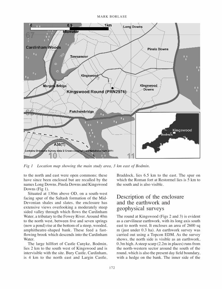
MARK BORLASE
172
to the north and east were open commons; these have since been enclosed but are recalled by the names Long Downs, Pinsla Downs and Kingswood Downs (Fig 1).
Situated at 130m above OD, on a south-west facing spur of the Saltash formation of the Mid-Devonian shales and slates, the enclosure has extensive views overlooking a moderately steep sided valley through which flows the Cardinham Water, a tributary to the Fowey River. Around 40m to the north west, between five and seven springs (now a pond) rise at the bottom of a steep, wooded, amphitheatre-shaped bank. These feed a fast-flowing brook which descends into the Cardinham Water.
The large hillfort of Castle Canyke, Bodmin, lies 2 km to the south west of Kingswood and is intervisible with the site. Bury Castle, Cardinham, is 4 km to the north east and Largin Castle,
Braddock, lies 6.5 km to the east. The spur on which the Roman fort at Restormel lies is 5 km to the south and is also visible.
Description of the enclosure and the earthwork and geophysical surveys The round at Kingswood (Figs 2 and 3) is evident as a curvilinear earthwork, with its long axis south east to north west. It encloses an area of 2600 sq m (just under 0.3 ha). An earthwork survey was carried out using a Topcon EDM. As the survey shows, the north side is visible as an earthwork, 0.3m high. A steep scarp (2.2m in places) runs from the north-western sector around the south of the round, which is also the present day field boundary, with a hedge on the bank. The inner side of the
Fig 1 Location map showing the main study area, 3 km east of Bodmin.
171-196_Borlase.indd 172 01/12/2014 11:51
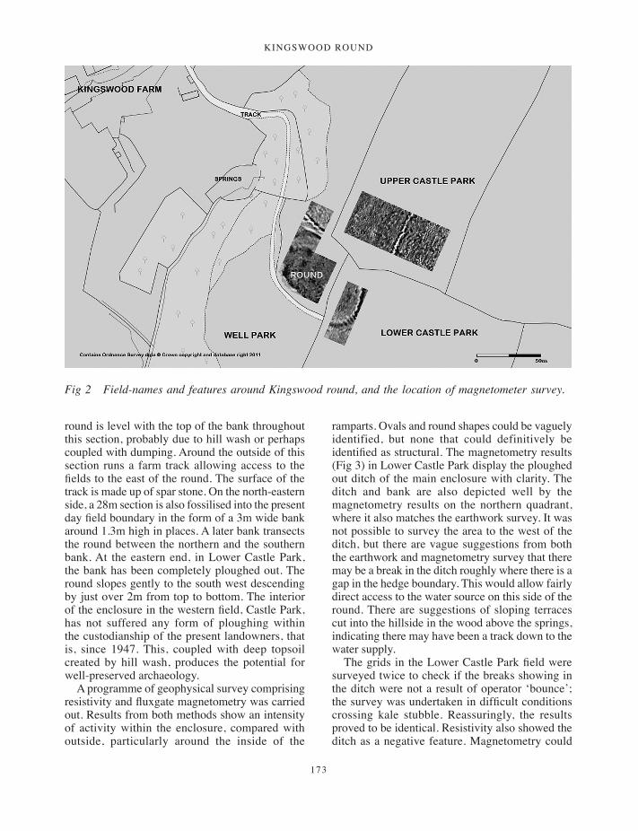
Kingswood round
173
round is level with the top of the bank throughout this section, probably due to hill wash or perhaps coupled with dumping. Around the outside of this section runs a farm track allowing access to the fields to the east of the round. The surface of the track is made up of spar stone. On the north-eastern side, a 28m section is also fossilised into the present day field boundary in the form of a 3m wide bank around 1.3m high in places. A later bank transects the round between the northern and the southern bank. At the eastern end, in Lower Castle Park, the bank has been completely ploughed out. The round slopes gently to the south west descending by just over 2m from top to bottom. The interior of the enclosure in the western field, Castle Park, has not suffered any form of ploughing within the custodianship of the present landowners, that is, since 1947. This, coupled with deep topsoil created by hill wash, produces the potential for well-preserved archaeology.
A programme of geophysical survey comprising resistivity and fluxgate magnetometry was carried out. Results from both methods show an intensity of activity within the enclosure, compared with outside, particularly around the inside of the
ramparts. Ovals and round shapes could be vaguely identified, but none that could definitively be identified as structural. The magnetometry results (Fig 3) in Lower Castle Park display the ploughed out ditch of the main enclosure with clarity. The ditch and bank are also depicted well by the magnetometry results on the northern quadrant, where it also matches the earthwork survey. It was not possible to survey the area to the west of the ditch, but there are vague suggestions from both the earthwork and magnetometry survey that there may be a break in the ditch roughly where there is a gap in the hedge boundary. This would allow fairly direct access to the water source on this side of the round. There are suggestions of sloping terraces cut into the hillside in the wood above the springs, indicating there may have been a track down to the water supply.
The grids in the Lower Castle Park field were surveyed twice to check if the breaks showing in the ditch were not a result of operator ‘bounce’; the survey was undertaken in difficult conditions crossing kale stubble. Reassuringly, the results proved to be identical. Resistivity also showed the ditch as a negative feature. Magnetometry could
Fig 2 Field-names and features around Kingswood round, and the location of magnetometer survey.
171-196_Borlase.indd 173 01/12/2014 11:51

MARK BORLASE
174
Fig 3 Combined earthwork survey and magnetometry results with trench positions. (Geophysics: M Wright.)
171-196_Borlase.indd 174 01/12/2014 11:51
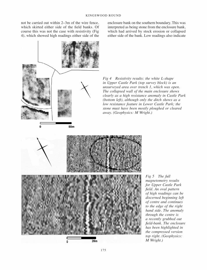
Kingswood round
175
not be carried out within 2–3m of the wire fence, which skirted either side of the field banks. Of course this was not the case with resistivity (Fig 4), which showed high readings either side of the
enclosure bank on the southern boundary. This was interpreted as being stone from the enclosure bank, which had arrived by stock erosion or collapsed either side of the bank. Low readings also indicate
Fig 4 Resistivity results: the white L-shape in Upper Castle Park (top survey block) is an unsurveyed area over trench 1, which was open. The collapsed wall of the main enclosure shows clearly as a high resistance anomaly in Castle Park (bottom left), although only the ditch shows as a low resistance feature in Lower Castle Park; the stone must have been mostly ploughed or cleared away. (Geophysics: M Wright.)
Fig 5 The full magnetometry results for Upper Castle Park field. An oval pattern of high readings can be discerned beginning left of centre and continues to the edge of the right hand side. The anomaly through the centre is a recently grubbed out field-bank. The enclosure has been highlighted in the compressed version top right. (Geophysics: M Wright.)
171-196_Borlase.indd 175 01/12/2014 11:51
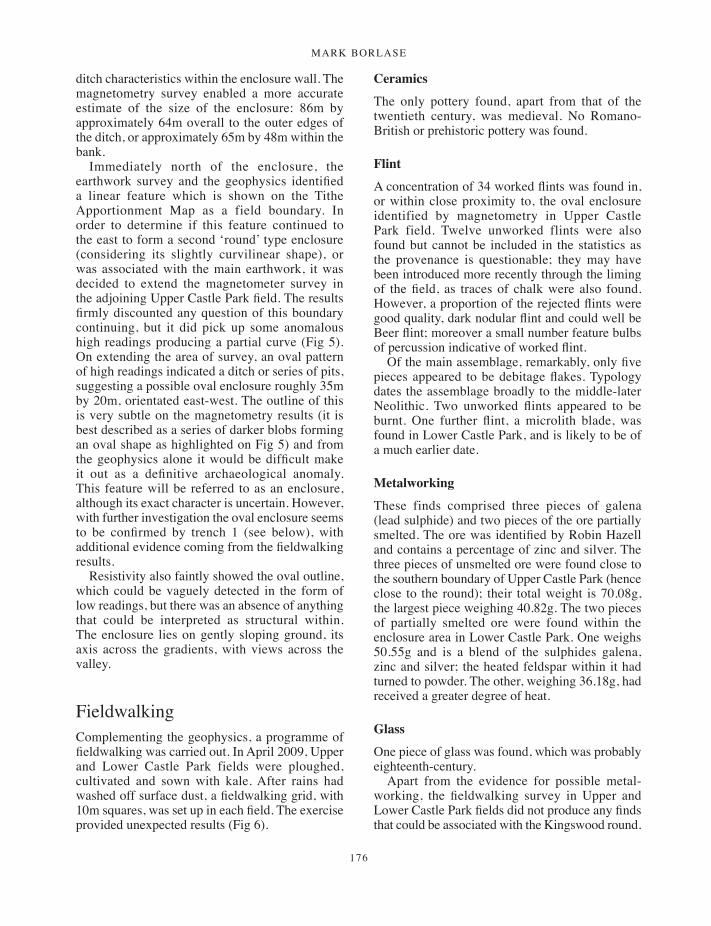
MARK BORLASE
176
ditch characteristics within the enclosure wall. The magnetometry survey enabled a more accurate estimate of the size of the enclosure: 86m by approximately 64m overall to the outer edges of the ditch, or approximately 65m by 48m within the bank.
Immediately north of the enclosure, the earthwork survey and the geophysics identified a linear feature which is shown on the Tithe Apportionment Map as a field boundary. In order to determine if this feature continued to the east to form a second ‘round’ type enclosure (considering its slightly curvilinear shape), or was associated with the main earthwork, it was decided to extend the magnetometer survey in the adjoining Upper Castle Park field. The results firmly discounted any question of this boundary continuing, but it did pick up some anomalous high readings producing a partial curve (Fig 5). On extending the area of survey, an oval pattern of high readings indicated a ditch or series of pits, suggesting a possible oval enclosure roughly 35m by 20m, orientated east-west. The outline of this is very subtle on the magnetometry results (it is best described as a series of darker blobs forming an oval shape as highlighted on Fig 5) and from the geophysics alone it would be difficult make it out as a definitive archaeological anomaly. This feature will be referred to as an enclosure, although its exact character is uncertain. However, with further investigation the oval enclosure seems to be confirmed by trench 1 (see below), with additional evidence coming from the fieldwalking results.
Resistivity also faintly showed the oval outline, which could be vaguely detected in the form of low readings, but there was an absence of anything that could be interpreted as structural within. The enclosure lies on gently sloping ground, its axis across the gradients, with views across the valley.
FieldwalkingComplementing the geophysics, a programme of fieldwalking was carried out. In April 2009, Upper and Lower Castle Park fields were ploughed, cultivated and sown with kale. After rains had washed off surface dust, a fieldwalking grid, with 10m squares, was set up in each field. The exercise provided unexpected results (Fig 6).
Ceramics
The only pottery found, apart from that of the twentieth century, was medieval. No Romano-British or prehistoric pottery was found.
Flint
A concentration of 34 worked flints was found in, or within close proximity to, the oval enclosure identified by magnetometry in Upper Castle Park field. Twelve unworked flints were also found but cannot be included in the statistics as the provenance is questionable; they may have been introduced more recently through the liming of the field, as traces of chalk were also found. However, a proportion of the rejected flints were good quality, dark nodular flint and could well be Beer flint; moreover a small number feature bulbs of percussion indicative of worked flint.
Of the main assemblage, remarkably, only five pieces appeared to be debitage flakes. Typology dates the assemblage broadly to the middle-later Neolithic. Two unworked flints appeared to be burnt. One further flint, a microlith blade, was found in Lower Castle Park, and is likely to be of a much earlier date.
Metalworking
These finds comprised three pieces of galena (lead sulphide) and two pieces of the ore partially smelted. The ore was identified by Robin Hazell and contains a percentage of zinc and silver. The three pieces of unsmelted ore were found close to the southern boundary of Upper Castle Park (hence close to the round); their total weight is 70.08g, the largest piece weighing 40.82g. The two pieces of partially smelted ore were found within the enclosure area in Lower Castle Park. One weighs 50.55g and is a blend of the sulphides galena, zinc and silver; the heated feldspar within it had turned to powder. The other, weighing 36.18g, had received a greater degree of heat.
Glass
One piece of glass was found, which was probably eighteenth-century.
Apart from the evidence for possible metal-working, the fieldwalking survey in Upper and Lower Castle Park fields did not produce any finds that could be associated with the Kingswood round.
171-196_Borlase.indd 176 01/12/2014 11:51
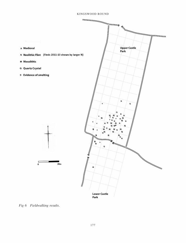
Kingswood round
177
Fig 6 Fieldwalking results.
171-196_Borlase.indd 177 01/12/2014 11:51

MARK BORLASE
178
ExcavationMethodology
In consideration of the deep topsoil and hill wash over much of the site, a mini digger with a toothless bucket was employed, under supervision, to remove the overburden from all trenches with the exception of trench 1. A total of 40 litres of samples were taken from gullies, ditches and postholes for potential palaeo-environmental study or radiocarbon dating. The spoil heaps were organised so that any finds within them could be traced to sectors of the trench and contexts. A metal detector was used regularly to locate any metal finds. A reflexive approach to excavation was carried out on the site; excavator’s views and general impressions were recorded on context sheets.
Upper Castle Park Field
Trench 1 (SX 1085 6630) was opened in March 2009 to investigate the possible oval enclosure in Upper Castle Park field. It was important to know whether this feature and the main enclosure were associated. A 2m by 1m trench was placed at right angles to the curvilinear outline of the oval, over a high magnetic anomaly. After removing topsoil
and shallow overburden, a bank comprising small stone and clayey material was revealed and an outer ditch. The bank measured 1m wide and 0.2m high, the ditch 0.8m wide and 0.7m deep from the present surface level and cut 0.35m into the subsoil. The height from bottom of the ditch to top of bank is 0.4m. There was slight evidence that the bank (Fig 7) may have been revetted as there were three larger stones lining its base. The bank appears from the excavation to be fragmentary, but because of the size of the trench and the nature of the stratigraphy it was not possible to establish whether this reflected the original form or resulted from truncation through later ploughing. However, whatever the cause, the interrupted character of the bank is also suggested by the geophysical survey. The ditch fill had lenses of soil on the lower sides indicating natural collapse. No artefacts were found, but two samples of charcoal were recovered, one from the inner bank area and one from near the bottom of the ditch. At this point, with no dating evidence to aid the interpretation of the nature or purpose of this site, it remained a mystery as to whether there was an association with the main enclosure. It was not until the field was later ploughed that the fieldwalking exercise shed light on the nature of this enclosure.
Fig 7 Trench 1 bank and ditch; the bank is under the north pointer.
171-196_Borlase.indd 178 01/12/2014 11:51

Kingswood round
179
The ditch and bank of the round
A 1m by 4m trench (trench 4) was excavated to determine the nature of the main enclosure ditch (Fig 8). As it was realised the depth would go well beyond 1m, the north half of the length was left at around 1m depth and an adjacent 1m by 2m extension was excavated to the east side of it, which continued to the ditch bottom, so as to diagonally stagger the deepest sections for safety. The ditch cut was 1.92m deep (2.1m from the present land surface) and 2.9m wide. The inner side was steeper than the outer side and slightly concave down to a square profiled bottom. Although the bottom of the ditch cut showed slight evidence of re-cutting, there was no evidence in the stratigraphy to suggest this.
The most notable feature of the trench was its horizontal stratigraphy, suggesting that it had been filled with deliberate attention to levelling. This included a layer of quartz spar stone (4–05) and two layers of burning in situ, (4–03) and (4–08). The horizontal layer of spar stone (4–05) spread 1.5m across the ditch, to be replaced by a horizontal layer of burnt clay with charcoal (indicating burning in situ), which started beneath the spar layer, merging with it, then continuing to the outer face of the ditch. The layer of spar stone
probably originated from the bank revetment. There was little firm evidence remaining of the bank itself and a section across any remains of the bank was not undertaken. Another horizontal level, 0.1m thick, again of charcoal, burnt soil and clay (4–08), formed the division to a 0.45m thick orange layer of fine material (4–09). This fill had a high clay content, interspersed with sporadic pieces of charcoal and areas of burnt clay. The slate increased in density towards the bottom of the ditch. The primary fill (4–10) was around 0.2m deep, a loose deposit of randomly orientated slate of various sizes. There were few finds from the ditch; just a piece of decorated lead and a square headed nail, both from (4–07).
The proliferation of spar stone suggests that the bank may have been faced with the material, creating a striking effect. A proportion of this stone (around 20 per cent), with one particularly large spar stone, still lined what was thought to be the base of the bank side. Furthermore, the high percentage of spar lying below the outer bank of the southern boundary supports this theory, although it could alternatively be the result of later track filling.
Trench 3 was opened to investigate the inside of the enclosure bank. The trench was not finished
Fig 9 Key to plans and sections.
Fig 8 Trench 4. The enclosure ditch.
171-196_Borlase.indd 179 01/12/2014 11:51
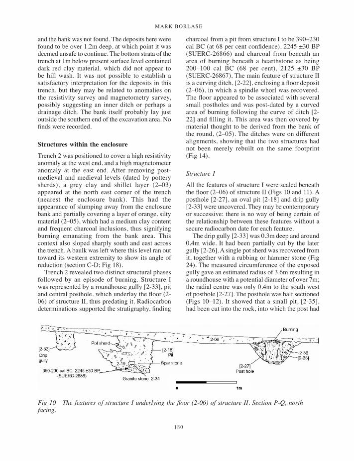
MARK BORLASE
180
and the bank was not found. The deposits here were found to be over 1.2m deep, at which point it was deemed unsafe to continue. The bottom strata of the trench at 1m below present surface level contained dark red clay material, which did not appear to be hill wash. It was not possible to establish a satisfactory interpretation for the deposits in this trench, but they may be related to anomalies on the resistivity survey and magnetometry survey, possibly suggesting an inner ditch or perhaps a drainage ditch. The bank itself probably lay just outside the southern end of the excavation area. No finds were recorded.
Structures within the enclosure
Trench 2 was positioned to cover a high resistivity anomaly at the west end, and a high magnetometer anomaly at the east end. After removing post-medieval and medieval levels (dated by pottery sherds), a grey clay and shillet layer (2–03) appeared at the north east corner of the trench (nearest the enclosure bank). This had the appearance of slumping away from the enclosure bank and partially covering a layer of orange, silty material (2–05), which had a medium clay content and frequent charcoal inclusions, thus signifying burning emanating from the bank area. This context also sloped sharply south and east across the trench. A baulk was left where this level ran out toward its western extremity to show its angle of reduction (section C-D; Fig 18).
Trench 2 revealed two distinct structural phases followed by an episode of burning. Structure I was represented by a roundhouse gully [2-33], pit and central posthole, which underlay the floor (2-06) of structure II, thus predating it. Radiocarbon determinations supported the stratigraphy, finding
charcoal from a pit from structure I to be 390–230 cal BC (at 68 per cent confidence), 2245 ±30 BP (SUERC-26866) and charcoal from beneath an area of burning beneath a hearthstone as being 200–100 cal BC (68 per cent), 2125 ±30 BP (SUERC-26867). The main feature of structure II is a curving ditch, [2-22], enclosing a floor deposit (2–06), in which a spindle whorl was recovered. The floor appeared to be associated with several small postholes and was post-dated by a curved area of burning following the curve of ditch [2-22] and filling it. This area was then covered by material thought to be derived from the bank of the round, (2–05). The ditches were on different alignments, showing that the two structures had not been merely rebuilt on the same footprint (Fig 14).
Structure I
All the features of structure I were sealed beneath the floor (2–06) of structure II (Figs 10 and 11). A posthole [2-27], an oval pit [2-18] and drip gully [2-33] were uncovered. They may be contemporary or successive; there is no way of being certain of the relationship between these features without a secure radiocarbon date for each feature.
The drip gully [2-33] was 0.3m deep and around 0.4m wide. It had been partially cut by the later gully [2-26]. A single pot sherd was recovered from it, together with a rubbing or hammer stone (Fig 24). The measured circumference of the exposed gully gave an estimated radius of 3.6m resulting in a roundhouse with a potential diameter of over 7m; the radial centre was only 0.4m to the south west of posthole [2-27]. The posthole was half sectioned (Figs 10–12). It showed that a small pit, [2-35], had been cut into the rock, into which the post had
Fig 10 The features of structure I underlying the floor (2-06) of structure II. Section P-Q, north facing.
171-196_Borlase.indd 180 01/12/2014 11:51

Kingswood round
181
been placed, and clay and stone had been packed around. The sub-circular post pipe was around 0.17m in diameter and 0.35m deep. Two packing slates were still in situ. There was evidence of considerable burning from the top 7mm of pipe fill, which contained orange burnt earth and charcoal. A small amount of this occurred sporadically in the lower fill, which was of fine dark silt down to the bedrock. Charcoal was recovered from the packing
and a soil sample taken. The posthole is 3.5m from the drip gully [2-33] and the features are probably associated. Pit [2-18] (Fig 13), 0.6m by 0.46m, was cut into rock at its lower levels and contained a fill of earth and slate, with occasional charcoal inclusion. An undiagnostic sherd was found 0.3m below the floor level. Near the 0.64m deep base was a granite block (2-34) measuring 0.13m by 0.1m by 40mm, together with a single pure white
Fig 11 Structure I; gully, posthole and pit.
171-196_Borlase.indd 181 01/12/2014 11:51
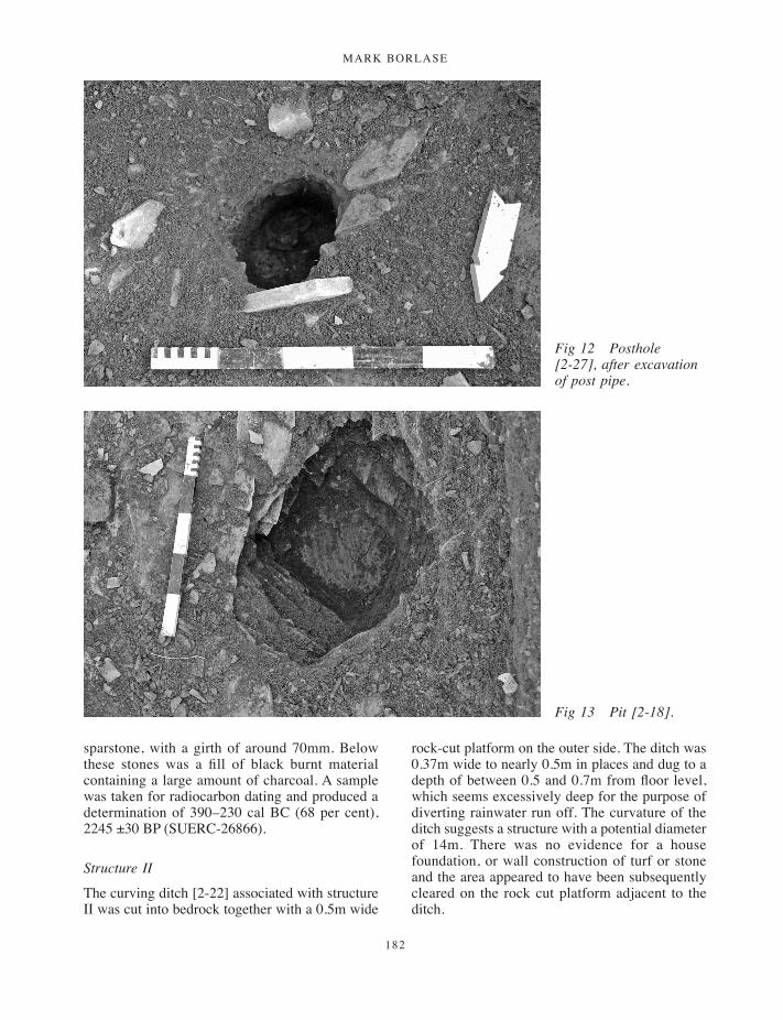
MARK BORLASE
182
sparstone, with a girth of around 70mm. Below these stones was a fill of black burnt material containing a large amount of charcoal. A sample was taken for radiocarbon dating and produced a determination of 390–230 cal BC (68 per cent), 2245 ±30 BP (SUERC-26866).
Structure II
The curving ditch [2-22] associated with structure II was cut into bedrock together with a 0.5m wide
rock-cut platform on the outer side. The ditch was 0.37m wide to nearly 0.5m in places and dug to a depth of between 0.5 and 0.7m from floor level, which seems excessively deep for the purpose of diverting rainwater run off. The curvature of the ditch suggests a structure with a potential diameter of 14m. There was no evidence for a house foundation, or wall construction of turf or stone and the area appeared to have been subsequently cleared on the rock cut platform adjacent to the ditch.
Fig 12 Posthole [2-27], after excavation of post pipe.
Fig 13 Pit [2-18].
171-196_Borlase.indd 182 01/12/2014 11:51
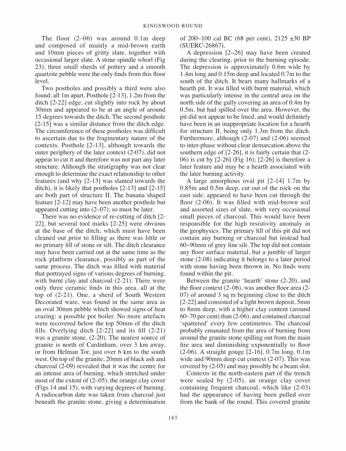
Kingswood round
183
The floor (2–06) was around 0.1m deep and composed of mainly a mid-brown earth and 10mm pieces of gritty slate, together with occasional larger slate. A stone spindle whorl (Fig 23), three small sherds of pottery and a smooth quartzite pebble were the only finds from this floor level.
Two postholes and possibly a third were also found, all 1m apart. Posthole [2-13], 1.2m from the ditch [2-22] edge, cut slightly into rock by about 30mm and appeared to be at an angle of around 15 degrees towards the ditch. The second posthole [2-15] was a similar distance from the ditch edge. The circumference of these postholes was difficult to ascertain due to the fragmentary nature of the contexts. Posthole [2-13], although towards the outer periphery of the later context (2-07), did not appear to cut it and therefore was not part any later structure. Although the stratigraphy was not clear enough to determine the exact relationship to other features (and why [2-13] was slanted towards the ditch), it is likely that postholes [2-13] and [2-15] are both part of structure II. The banana shaped feature [2-12] may have been another posthole but appeared cutting into (2–07), so must be later.
There was no evidence of re-cutting of ditch [2-22], but several tool marks [2-25] were obvious at the base of the ditch, which must have been cleaned out prior to filling as there was little or no primary fill of stone or silt. The ditch clearance may have been carried out at the same time as the rock platform clearance, possibly as part of the same process. The ditch was filled with material that portrayed signs of various degrees of burning, with burnt clay and charcoal (2-21). There were only three ceramic finds in this area, all at the top of (2-21). One, a sherd of South Western Decorated ware, was found in the same area as an oval 30mm pebble which showed signs of heat crazing; a possible pot boiler. No more artefacts were recovered below the top 50mm of the ditch fills. Overlying ditch [2-22] and its fill (2-21) was a granite stone, (2-20). The nearest source of granite is north of Cardinham, over 3 km away, or from Helman Tor, just over 6 km to the south west. On top of the granite, 20mm of black ash and charcoal (2-09) revealed that it was the centre for an intense area of burning, which stretched under most of the extent of (2–05), the orange clay cover (Figs 14 and 15), with varying degrees of burning. A radiocarbon date was taken from charcoal just beneath the granite stone, giving a determination
of 200–100 cal BC (68 per cent), 2125 ±30 BP (SUERC-26867).
A depression [2–26] may have been created during the clearing, prior to the burning episode. The depression is approximately 0.6m wide by 1.4m long and 0.15m deep and located 0.7m to the south of the ditch. It bears many hallmarks of a hearth pit. It was filled with burnt material, which was particularly intense in the central area on the north side of the gully covering an area of 0.4m by 0.5m, but had spilled over the area. However, the pit did not appear to be lined, and would definitely have been in an inappropriate location for a hearth for structure II, being only 1.3m from the ditch. Furthermore, although (2-07) and (2-06) seemed to inter-phase without clear demarcation above the southern edge of [2-26], it is fairly certain that (2-06) is cut by [2-26] (Fig 16); [2-26] is therefore a later feature and may be a hearth associated with the later burning activity.
A large amorphous oval pit [2-14] 1.7m by 0.85m and 0.5m deep, cut out of the rock on the east side, appeared to have been cut through the floor (2-06). It was filled with mid-brown soil and assorted sizes of slate, with very occasional small pieces of charcoal. This would have been responsible for the high resistivity anomaly in the geophysics. The primary fill of this pit did not contain any burning or charcoal but instead had 60–90mm of grey fine silt. The top did not contain any floor surface material, but a jumble of larger stone (2-08) indicating it belongs to a later period with stone having been thrown in. No finds were found within the pit.
Between the granite ‘hearth’ stone (2-20), and the floor context (2–06), was another floor area (2-07) of around 3 sq m beginning close to the ditch [2-22] and consisted of a light brown deposit, 5mm to 8mm deep, with a higher clay content (around 60–70 per cent) than (2-06), and contained charcoal ‘spattered’ every few centimetres. The charcoal probably emanated from the area of burning from around the granite stone spilling out from the main fire area and diminishing exponentially to floor (2-06). A straight gouge [2-16], 0.7m long, 0.1m wide and 90mm deep cut context (2-07). This was covered by (2-05) and may possibly be a beam slot.
Contexts in the north-eastern part of the trench were sealed by (2-05), an orange clay cover containing frequent charcoal, which like (2-03) had the appearance of having been pulled over from the bank of the round. This covered granite
171-196_Borlase.indd 183 01/12/2014 11:51
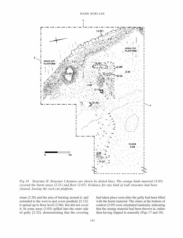
MARK BORLASE
184
stone (2-20) and the area of burning around it, and extended to the west to just cover posthole [2-13]; it spread up to floor level (2-06), but did not cover it. In some areas (2-05) spilled into the outer side of gully [2-22], demonstrating that the covering
had taken place soon after the gully had been filled with the burnt material. The slates at the bottom of context (2-05) were orientated randomly, indicating that the orange material had been thrown in, rather than having slipped in naturally (Figs 17 and 18).
Fig 14 Structure II. Structure I features are shown by dotted lines. The orange bank material (2-05) covered the burnt areas (2-21) and floor (2-07). Evidence for any kind of wall structure had been cleared, leaving the rock-cut platform.
171-196_Borlase.indd 184 01/12/2014 11:51
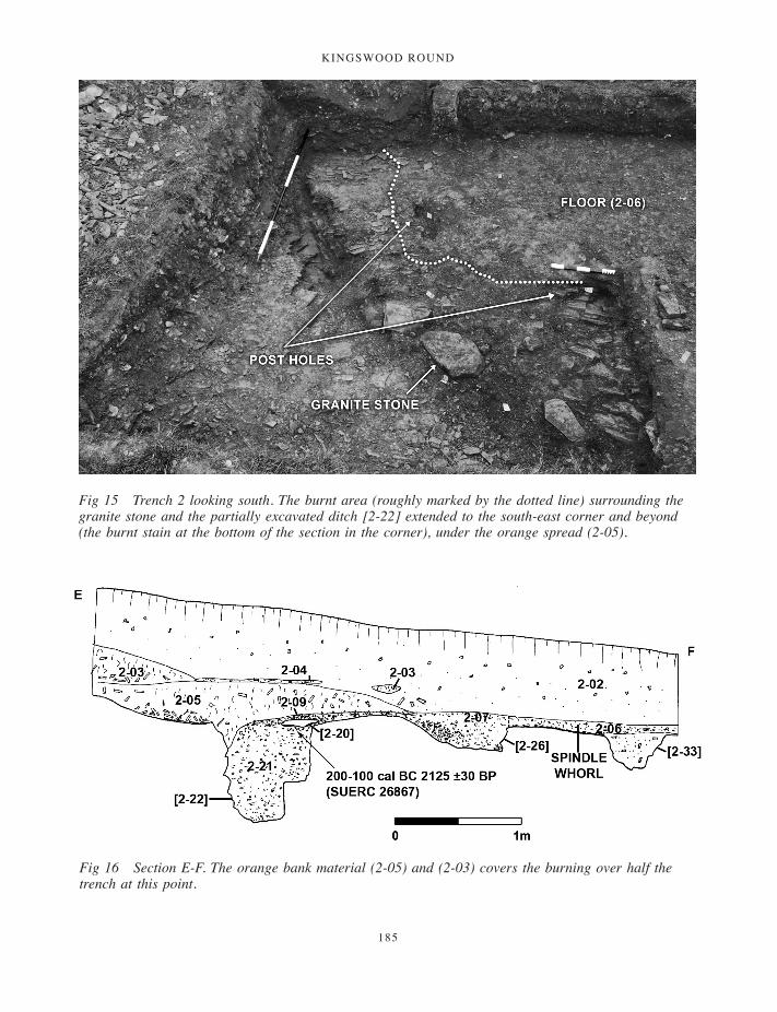
Kingswood round
185
Fig 15 Trench 2 looking south. The burnt area (roughly marked by the dotted line) surrounding the granite stone and the partially excavated ditch [2-22] extended to the south-east corner and beyond (the burnt stain at the bottom of the section in the corner), under the orange spread (2-05).
Fig 16 Section E-F. The orange bank material (2-05) and (2-03) covers the burning over half the trench at this point.
171-196_Borlase.indd 185 01/12/2014 11:51
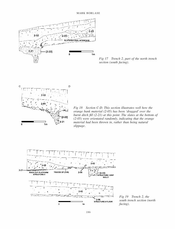
MARK BORLASE
186
Fig 17 Trench 2, part of the north trench section (south facing).
Fig 18 Section C-D. This section illustrates well how the orange bank material (2-05) has been ‘dragged’ over the burnt ditch fill (2-21) at this point. The slates at the bottom of (2-05) were orientated randomly, indicating that the orange material had been thrown in, rather than being natural slippage.
Fig 19 Trench 2, the south trench section (north facing).
171-196_Borlase.indd 186 01/12/2014 11:51
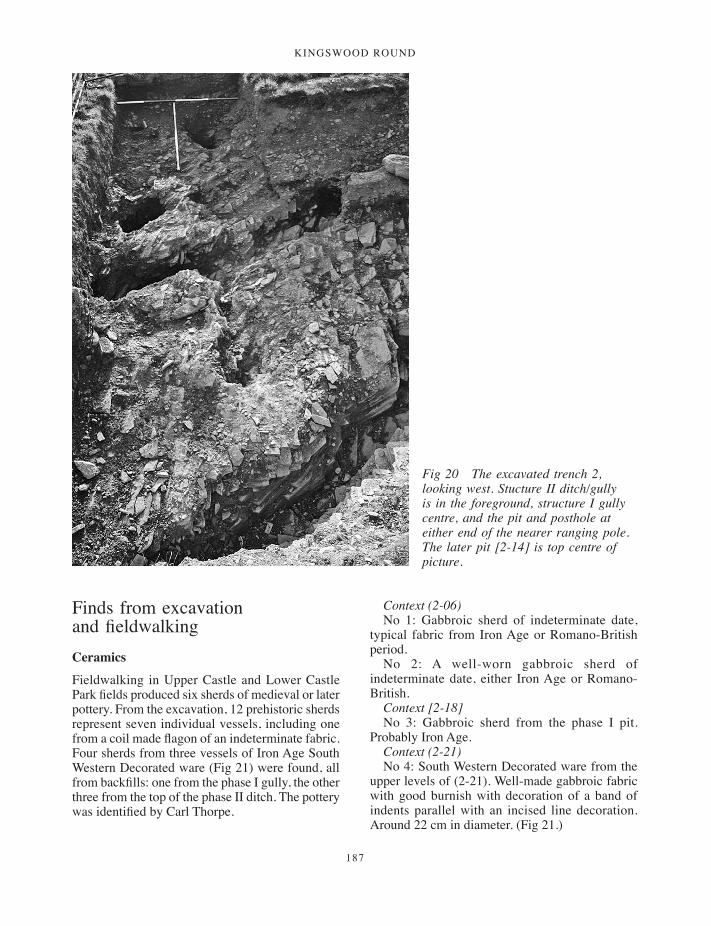
Kingswood round
187
Fig 20 The excavated trench 2, looking west. Stucture II ditch/gully is in the foreground, structure I gully centre, and the pit and posthole at either end of the nearer ranging pole. The later pit [2-14] is top centre of picture.
Finds from excavation and fieldwalking Ceramics
Fieldwalking in Upper Castle and Lower Castle Park fields produced six sherds of medieval or later pottery. From the excavation, 12 prehistoric sherds represent seven individual vessels, including one from a coil made flagon of an indeterminate fabric. Four sherds from three vessels of Iron Age South Western Decorated ware (Fig 21) were found, all from backfills: one from the phase I gully, the other three from the top of the phase II ditch. The pottery was identified by Carl Thorpe.
Context (2-06) No 1: Gabbroic sherd of indeterminate date,
typical fabric from Iron Age or Romano-British period.
No 2: A well-worn gabbroic sherd of indeterminate date, either Iron Age or Romano-British.
Context [2-18] No 3: Gabbroic sherd from the phase I pit.
Probably Iron Age. Context (2-21) No 4: South Western Decorated ware from the
upper levels of (2-21). Well-made gabbroic fabric with good burnish with decoration of a band of indents parallel with an incised line decoration. Around 22 cm in diameter. (Fig 21.)
171-196_Borlase.indd 187 01/12/2014 11:51

MARK BORLASE
188
No 5: South Western Decorated ware, gabbroic, two sherds of a 12-13cm diameter straight sided plain jar. Part of the base survives, which in-turns without a foot ring.
No 6: Top of gully fill. Indeterminate fabric, small sherd, possible flagon base.
Context (2-33) No 7: Small sherd from a South Western
Decorated pot around 12cm in diameter. Incised line decoration. Well-made gabbroic fabric.
Lithics
Ninety-one per cent of the flint assemblage was derived from fieldwalking, which produced a large proportion of imported nodular flints. One Mesolithic microlith (17mm by 5mm) was found in Lower Castle Park. This was most probably a casual loss during non-intensive use of the general area. A blade and a flake were found in the spoil from the upper levels of trench 2 and a possible blade from trench 4 (it was uncertain whether this came from this trench and has not been included in the table).
The 34 remaining flints were found in close proximity to, or within the confines of, the oval anomaly suggested by geophysical survey. These
included a transverse arrowhead, three further probable transverse arrowheads and an unusually large proportion of tools (Fig 22) or retouched flakes, but only four waste flakes. Worthy of note is the exceptional quality of flint. A high ratio (26:8 of the pieces) show characteristics of good quality nodular type flint, as opposed to lower quality beach pebble flint from more local sources, such as St Austell Bay (Quinnell 2004, 153). Ten further unworked flints were found but cannot be included in the statistics as the provenance is questionable; they may have been introduced with liming processes using chalk.
1. A tranchet derivative arrowhead. Tip broken and corner; fine quality, mid-grey flint. Closely resembles one found on the surface of a ploughed-over barrow (SX 1760 6320) in south-east Cornwall (Keene 1999, 31, no. 3).
2. Large knife/end scraper for right-handed use. Steep retouch on end and down 75 per cent of side. Cortex on opposite side; good quality nodular flint.
3. Large discoidal knife. Snapped longitudinally recently (crisp edge), dark good quality nodular flint.
4. Thumb scraper. Retouch around whole of semi-circle; white streaks, may attribute this to beach pebble.
5. Chisel-ended scraper with very fine retouch across straight edge and up one side, small area of cortex on opposite side; speckled colour, thus may be pebble derived.
6. Multi-tool. Tip of awl broken off, bifacial retouch to produce notched blade on side; good quality dark flint.
7. Blade with retouch full length of side, cortex on opposite side and end; dark quality flint.
8. Scraper with retouch on full length of outer edge and some on centre of inner edge, some cortex on top; good quality dark grey flint.
An approximate period for the assemblage can be assumed from the transverse ‘tranchet’ type arrowhead no 1, and also three other probable arrowheads of the same type in the assemblage. These are generally considered to belong broadly to the middle to later Neolithic (Malone 2001, 220; Green 1980, 100–116). The remaining assemblage also fits well with this period, the thumb scrapers being small types (Josh Pollard, pers comm; Malone 2001, 226).
Table 1 Ceramic finds from the excavation, with sherd numbers and weight (grammes) by context and fabric
Context Gabbroic South Western Decorated
Gabbroic fabric of indeterminate Iron Age or Romano-British period
(2-06) 3s/10.6g(2-18) 1s/16.8g(2-21) 3s/66.8g 6s/53.2g(2-33) 1s/4.4g
Mean sherd weight 17.8g 8.06gTotals 4s/71.2g 10s/80.6gVessel numbers 3 4
Fig 21 South Western Decorated ware, sherd no. 4 from fill (2-21) in ditch [2-22]. Scale 1:3. (Drawing: M Borlase.)
171-196_Borlase.indd 188 01/12/2014 11:51

Kingswood round
189
Stone artefacts
One slate spindle whorl (Fig 23) was found in the floor of structure II. As only nine were recovered from the whole of Trethurgy, this was either a lucky find or represents a greater number at Kingswood, which in turn may imply an emphasis on sheep farming.
A granite rubber (Fig 24), of a size that fits neatly into the palm of the hand, was recovered from the gully of the phase I house. The broad end is heavily pecked, but the underside is smooth. It may have doubled as a hammer stone.
Six pebbles were found, all probably beach derived as opposed to riverine, being uniform in shape. One quartzite and one 20mm dark pebble
Fig 22 Flints from the Upper Castle Park enclosure. Scale 1:2. (Drawing: M Borlase.)
Table 2 Summary of flint finds
Upper Castle Park enclosure area
Spoil of Kingswood round excavation
Lower Castle Park
Transverse arrowheads 4Thumb scrapers 6Scrapers 4Blades / knives 8Multi tools/awl 2Fabricator 3Flakes /retouched flint 5 2Burnt flint 2Mesolithic blade 1Total assemblage 34 2 1
171-196_Borlase.indd 189 01/12/2014 11:51

MARK BORLASE
190
had a highly polished appearance and may have been gaming pieces; another had a crazed texture indicating use as a pot boiler. Three more were of quartzite; one of these had a heat fracture. A notched slate or chock was also recovered.
Metal
A 60mm by 50mm piece of decorated lead from the enclosure ditch was recovered from the spoil of context (4-07). The hatching decoration may attribute it to the Roman period (Carl Thorpe, pers comm). A square-headed nail (18mm by 15mm head) was also recovered from this context. Another badly corroded iron artefact (35mm long by 15mm) was recovered from the spoil heap of trench 2, which was derived from an Iron Age (or Roman-period) context.
Evidence for metalworking comes from three pieces of galena ore and two pieces of partially smelted galena weighing a total of 157g. The three pieces of ore (described under fieldwalking) were found at the southern end of Upper Castle Park. The two pieces of heated ore, total weight 70.8g, were found within the enclosure area of Lower Castle Park field. Evidence for galena sulphide veins in the locality comes from Hurstocks mine (Cornwall Historic Environment Record PRN
12192), also known as Wheal Glynn, 1 km to the north of Kingswood, where the ore was extracted for lead and silver in the mid-twentieth century.
Radiocarbon datingTwo wet-sieved samples of charcoal were submitted for radiocarbon determinations (Table 3). Small roundwood oak was identified from both samples and sent to the Scottish Universities Environmental Research Centre for dating. The first was from the deposit beneath the granite stone in the pit of the phase I structure, which had been sealed by the phase II floor and is arguably one of the earliest features. It should therefore give a terminus ante quem for the pit. The second was taken from beneath the re-located hearthstone above the phase II ditch or gully, and should give a date for when the burning event took place.
DiscussionMiddle to Late Neolithic
The magnetometry undertaken during the investigation of the Iron Age round unexpectedly revealed the presence of another possible enclosure,
Fig 23 Spindle whorl from the floor of structure II. Scale 1:2. (Drawing: M Borlase.)
Fig 24 Granite rubber and hammer stone from structure I gully [2-33]. Scale 1:3. (Drawing: M Borlase.)
171-196_Borlase.indd 190 01/12/2014 11:51
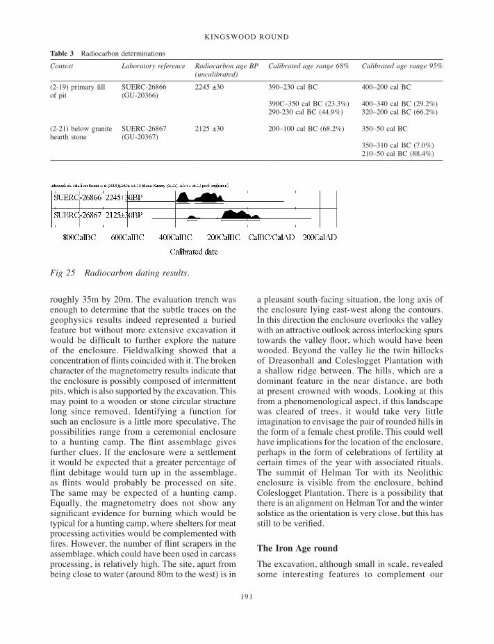
Kingswood round
191
roughly 35m by 20m. The evaluation trench was enough to determine that the subtle traces on the geophysics results indeed represented a buried feature but without more extensive excavation it would be difficult to further explore the nature of the enclosure. Fieldwalking showed that a concentration of flints coincided with it. The broken character of the magnetometry results indicate that the enclosure is possibly composed of intermittent pits, which is also supported by the excavation. This may point to a wooden or stone circular structure long since removed. Identifying a function for such an enclosure is a little more speculative. The possibilities range from a ceremonial enclosure to a hunting camp. The flint assemblage gives further clues. If the enclosure were a settlement it would be expected that a greater percentage of flint debitage would turn up in the assemblage, as flints would probably be processed on site. The same may be expected of a hunting camp. Equally, the magnetometry does not show any significant evidence for burning which would be typical for a hunting camp, where shelters for meat processing activities would be complemented with fires. However, the number of flint scrapers in the assemblage, which could have been used in carcass processing, is relatively high. The site, apart from being close to water (around 80m to the west) is in
a pleasant south-facing situation, the long axis of the enclosure lying east-west along the contours. In this direction the enclosure overlooks the valley with an attractive outlook across interlocking spurs towards the valley floor, which would have been wooded. Beyond the valley lie the twin hillocks of Dreasonball and Coleslogget Plantation with a shallow ridge between. The hills, which are a dominant feature in the near distance, are both at present crowned with woods. Looking at this from a phenomenological aspect, if this landscape was cleared of trees, it would take very little imagination to envisage the pair of rounded hills in the form of a female chest profile. This could well have implications for the location of the enclosure, perhaps in the form of celebrations of fertility at certain times of the year with associated rituals. The summit of Helman Tor with its Neolithic enclosure is visible from the enclosure, behind Coleslogget Plantation. There is a possibility that there is an alignment on Helman Tor and the winter solstice as the orientation is very close, but this has still to be verified.
The Iron Age round
The excavation, although small in scale, revealed some interesting features to complement our
Table 3 Radiocarbon determinations
Context Laboratory reference Radiocarbon age BP (uncalibrated)
Calibrated age range 68% Calibrated age range 95%
(2-19) primary fill of pit
SUERC-26866 (GU-20366)
2245 ±30 390–230 cal BC
390C–350 cal BC (23.3%)290-230 cal BC (44.9%)
400–200 cal BC
400–340 cal BC (29.2%)320–200 cal BC (66.2%)
(2-21) below granite hearth stone
SUERC-26867 (GU-20367)
2125 ±30 200–100 cal BC (68.2%) 350–50 cal BC
350–310 cal BC (7.0%)210–50 cal BC (88.4%)
Fig 25 Radiocarbon dating results.
171-196_Borlase.indd 191 01/12/2014 11:51

MARK BORLASE
192
knowledge of rounds. The radiocarbon dating proved to be a valuable exercise for several reasons; the earlier of the two radiocarbon determinations, of the fourth or third century BC, confirms Kingswood Round to be an early example for a round. As no Early Age Plain Jar Group (PJG) pottery was identified, a third-century date is the more likely, as analysis of the sequence at Trevelgue cliff castle, Newquay, suggests that the main styles of South Western Decorated run from the third to first centuries BC (Quinnell 2011a, 144–4, 176; and 2011b, 235–7). The dates from Kingswood are consistent with this chronology. On the basis of the present evidence, the second date is likely to be second-century BC or earlier, as the finds did not include Cordoned ware (which would have suggested a first-century BC or later date; Quinnell 2011b). Further excavation at Kingswood might of course change the picture; the excavated contexts produced a paucity of finds compared with, for example, the midden and backfill deposits at Reawla, Gwinear (Appleton-Fox 1992) and Trethurgy (Quinnell 2004). A compilation of occupation dates for excavated rounds (Quinnell 2004, 212) shows that other sites date to the Iron Age (for example, Threemilestone, Kenwyn; Schwieso 1976) but their dating is tentative, being based only on the presence of South Western Decorated ware (Quinnell 2004, 213). In this respect Kingswood’s firm dating aids the chronological sequencing for rounds. Round-like enclosures now appear to have their origins in the Early Iron Age: the 1980s excavation of Halligye fogou, Mawgan-in-Meneage (Startin 2009), showed that the enclosure was associated with PJG pottery, and on that basis a fifth- or sixth-century date was suggested. PJG pottery was also recovered from the enclosure and fogou at Boden, St Anthony-in-Meneage (Gossip 2013, this volume), which is dated, by a series of radiocarbon determinations, slightly earlier than Kingswood to around 400 cal BC.
The round at Kingswood can be regarded as small to middling in comparison with other rounds and similar enclosures, both in terms of its area and the depth of its ditch. Enclosing around 0.26 ha it is a little larger than Trethurgy, for example, which is about 0.2 ha (Quinnell 2004). Some enclosures are substantially larger, such as Carvossa (Probus) or Carloggas (Mawgan-in-Pydar), but these should probably be regarded as a different class of site (Quinnell 2004, 214). The enclosure ditch, nearly
3m wide and cut 1.8m below subsoil into rock, was deep in comparison with some rounds, though smaller than others. Threemilestone, a smaller enclosure, had a double ditch, the inner one being of a similar depth at 1.5m deep and just over 3m wide, although the outer ditch was 0.9m deep (Schwieso 1976); the single ditch at Shortlanesend, Kenwyn, was 1.4m deep and 3m wide (Harris 1980); the phase 7.4 univallate ditch, c 100BC, at Penhale, Fraddon (Nowakowski 1998; Johnson et al 1998–9) was up to 2.3m deep in places. The ditch of the pre-round enclosure at Trethurgy (Quinnell 2004, 10–13) was 0.5m to 0.75m deep and 1.5m to 2.5m wide, whilst the ditch of the round itself varied between 0.8m and 1.5m in depth with a width of 3–5 m (ibid, 17). At Middle Amble, St Kew, the Romano-British enclosure ditch of the 0.12 ha enclosure was nearly 2m deep (Borlase and Wright, forthcoming) but this enclosure may have had a ceremonial function. Although not massive, the ditch and bank at Kingswood would nevertheless have been impressive, particularly if the bank were faced with white spar stone, and would have been a considerable investment in labour as well as a symbol of status that stood out and made its mark on the landscape.
The striking feature of the Kingswood round was the deliberate filling of the enclosure ditch, with close to horizontal layers over its width. This seems to be unparalleled and is so far unexplained. These characteristics may or may not cover a moderate length of the ditch. A piece of decorated lead of probable Roman date was found in the middle fills of the ditch, indicating that at least this part of the ditch filling may have occurred in the Romano-British period. As the southern and north-east boundary remains fossilised in the present field layout, it may be presumed these lengths remained fairly intact throughout the medieval period.
In trench 2, the depth of the structure II ditch (0.5–0.6m) would seem excessive for merely drainage of roof rainwater run off. Being square in profile also adds to its greater capacity, although the shape was probably dictated by the direction of the rock strata fracture. There is no direct evidence to reveal why it should be this depth. The answer may lie in its close proximity to the enclosure bank: perhaps silt and debris constantly washed down from the bank so a deeper ditch was required. Drainage ditches with a similar depth to that at Kingswood appear to be relatively uncommon in Cornwall. However, house 4 at the Richard Lander
171-196_Borlase.indd 192 01/12/2014 11:51
Kingswood round
193
School excavation, near Truro (Gossip 2005), had an outer ring ditch up to 0.7m deep, within which was a very slight concentric gully surrounding a ring of postholes; the slight inner gully is thought to have taken the timber wall of the roundhouse, whilst the outer ditch enclosed the house and provided drainage. At Reawla the ring gully for house D was 0.65m deep (Appleton-Fox 1992, 75); another ditch, 0.4m deep, thought to be a drainage ditch running along the inner face of the rampart, passed close by it at a tangent. Just possibly, ditches [2-33] and [2-22] at Kingswood represent a similar arrangement. However, although the trench was small and there were some difficulties in the interpretation of some individual features, the stratigraphy was clear enough to confirm that the ditches belonged to separate phases. The structure II floor (2-06) sealed the pit, drip gully and posthole of the phase I structure, spreading onto the rock cut platform [2-23]; the spindle whorl (suggesting domestic activity) was found in the floor outside the phase I structure footprint, and stake holes show that there was a structure between the outer ditch and earlier, phase I gully. Interpretation was hindered by the absence of a hearth associated with either structure. Although a burnt area in gully [2-26] might be a hearth, it is close to ditch [2-22] and probably post-dates structure II. However, further hearths associated with the structures may well lie just outside the excavation area. At Threemilestone and Reawla there was a lack of internal features, including hearths so there is little to compare with; oval houses at Trethurgy did contain internal features, but of course are much later. Without further investigation these questions have to remain an area of speculation.
As at Threemilestone and Reawla, there is no evidence of walling in the form of stone or turf structures or robber cuts; at Kingswood this seems significant as there is a depth of stratigraphy and topsoil and the site has not been affected by modern ploughing. There were only two stones, either side of the granite stone (2-20), which could have been useful as building stone and these were not in situ. It can only be deduced therefore, that any wall foundation had been systematically cleared, or the house was purely constructed of wood, which would seem unusual. Between the natural stone grooves of the rock platform, near the south section, were remaining pockets of the floor material (2-06) (Fig 19), suggesting that it had been cleared away above. The indications
are that the area of burning, focusing around what was probably a relocated granite hearthstone, may have been intentionally cleared for that purpose. The burnt soil and clay around and underneath the granite stone (at least 1m around) and overlapping the ditch, suggests that the burning was carried out in situ. The magnetometry survey results show that the area of burning extends south east, beyond the excavated area of trench 2, for about 4m. The filling of the phase II ditch with the burnt material, after it was initially cleaned out, suggests that the last phase of the structure may have seen a deliberate clearance, conjecturally as an act of closure. The subsequent covering of the area of burning activity with nearby bank material took place shortly after, as there is no intermediate deposit between the layer of burning and the orange bank material. The extensive quantity of burnt material uncovered suggests that this was more than just the combustible material from one house, but there was no evidence of burnt bone or industrial activity. The magnetometry survey shows that although there are other anomalies with similar characteristics on the site, the area around trench 2 is, perhaps, the most intense. A conclusive interpretation for this phenomenon could not be found. However, although no indication was found from the excavation for metalworking, there were surface finds of partially smelted galena within the bounds of the enclosure area in Lower Castle Park and ore near the enclosure in Upper Castle Park. Although it is unsafe to make this more than just conjectural, it must be mentioned that some of the high readings on the magnetometry results indicating burning, may possibly be as a result of metalworking activity. Metalworking is known at a number of sites in Cornwall; at a small scale at Reawla, for example, but extensively at Killigrew near St Erme, and at Little Quoit Farm near St Columb (Appleton-Fox 1992; Cole and Nowakowski, forthcoming; Lawson-Jones and Kirkham 2009–10). At Duckpool, Morwenstow, there was evidence for the working of lead and pewter from the third century AD (Ratcliffe 1995, 161). Given the relatively close proximity to sources of galena and the finds of partially smelted lead, also the decorated piece of sheet lead found in trench 4, an argument could be made for smelting of non-ferrous metal at Kingswood at some stage as a specialist activity.
In structure I there was a possible act of closure: the granite block, quartz spar stone and burning
171-196_Borlase.indd 193 01/12/2014 11:51

MARK BORLASE
194
in pit [2-18] was probably a ritual deposition. Pits within Cornish Iron Age roundhouses are uncommon. A pit within a ring ditch at the Camelford School excavations (Jones and Taylor 2008) was covered by a large holed slate, but this site was interpreted as a ceremonial enclosure.
Landscape context
Kingswood round lies on a south-facing slope in a relatively fertile area, this quickly receding to the north east as it rises to the relatively inhospitable expanse of Bodmin Moor. It is likely that in the later Iron Age the area was comparatively well occupied, as Iron Age and Romano-British settlements seem to form a ring around Bodmin Moor (Johnson and Rose 1994, 75–6). The higher ground does not seem to have been permanently settled at this time and these communities, possibly including Kingswood round, would have used the higher ground as seasonal grazing, including transhumance. Pasture is likely to have been important and at Kingswood round the spindle whorl is evidence for the farming of sheep. The round probably had access to resources similar to those available to medieval Kingswood, such as enclosed fields in the vicinity of the settlement, rough ground for grazing on the surrounding downs and woodlands in the valleys to the west and south, managed for fuel and timber. It is also possible that the inhabitants exploited mineral resources. Galena sulphide veins are known at Hurstocks mine or Wheal Glynn, 1 km to the north of Kingswood, where the ore was mined for lead and silver in the mid-nineteenth century. The partially smelted ore found in fieldwalking over the round may have initially been extracted from this source and processed in the Iron Age, although there was no further evidence from the excavation to confirm this. Kingswood may also have been well placed for links to the wider world, with the north-south route using the Fowey and Camel corridor a little to the west, and closer still, an east-west route running below the southern edge of Bodmin Moor. This can be seen on Figure 1, running from Margate Bridge through Tawnamoor and between Long Downs and Pinsla Downs. In medieval times this is likely to have been the route between Bodmin and St Neot, and beyond, and could also have been a significant route in prehistory, as to the west it leads towards Castle Canyke hillfort.
Although none have been dated by excavation, hillforts in the area are likely to be broadly contemporary with Kingswood round. Castle Canyke, an 8 ha bivallate hillfort (SX 085 668), lies 2 km to the west and is intervisible; it may be fairly safe to assume that during at least part of the occupation period of Kingswood round, Castle Canyke would have played an integral role in the daily domestic, commercial and social lives of the occupants. A magnetometry survey of the interior shows signs of settlement (Bartlett 1985). Other hillforts in the area may also have formed the wider social context for Kingswood: Bury Castle, Cardinham, 4 km to the north east, marking the edge of Bodmin Moor; Largin Castle, 6.5 km to the east, dominating the River Fowey valley; and further enclosures such as Dunmere, Penhargard Castle and Pencarrow to the north west in the River Camel watershed.
There are likely to have been other rounds in the general vicinity of Kingswood, but none have yet been confirmed nearby. The Cardinham parish tithe survey revealed three fields with the name Round Park, one on Kingswood Farm and two at Tawnamoor, all within 0.7 km of the Kingswood enclosure. These are Tithe Apportionment field numbers 2031 at Kingswood and fields 1934 (SX 1051 6674) and field 1925 (SX 1055 6660) at Tawnamoor. The last field, not recorded in the Cornwall HER, is only 30m obliquely across the lane from field 1934; accordingly it may well be named after the same feature. A fluxgate gradiometer survey was conducted on field 1926 between the two fields with ‘Round’ connotations on the premise that there may be a link; however, no features were identified that would suggest a round. Another site, 1 km west of Kingswood (at SX 0945 6622), showing quite clearly as a round feature on an aerial photograph, was selected for further scrutiny with fluxgate gradiometry. Although a round shadow was visible in the results, interpretation remained inconclusive.
Without more chronological knowledge of the hillforts and other round sites, it is difficult to assess just how they fitted in contextually with the Kingswood settlement and we can only surmise on the nature of the society that inhabited the round enclosures. A pastoral economy, based principally on cattle and wool from sheep farming, was probably the basis for wealth, and grazing rights may have been controlled or mediated through a centre such as Castle Canyke, perhaps through an
171-196_Borlase.indd 194 01/12/2014 11:51

Kingswood round
195
upper stratum of society. This system probably continued unhindered into the Roman period. The round would have represented a landholding community of local importance, which may have had smaller, unenclosed farmsteads within its estate.
Acknowledgements
The author would like to thank Colin Dyer and his family of Kingswood for their consent to carry out the project and their help and interest. Gratitude is extended to Malcolm Wright for the geophysics, Carl Thorpe for looking at the artefacts and Professor Gordon Cook of SUERC for the radiocarbon dating, also to Kyle Borlase for help with the graphics, Robin Hazell (retired ground water consultant, geologist and author of Life on the Rocks) for identifying the ore and geological information, and Peter Rose for reviewing and suggesting numerous amendments. The site archive is held by the author at Tawnamoor, Cardinham.
References Appleton-Fox, N, 1992. Excavations at a Romano-
British round; Reawla, Gwinear, Cornwall, Cornish Archaeol, 31, 69–123
Bartlett, A, 1985. Magnetometer survey at Castle Canyke, Bodmin, Ancient Monuments Laboratory Reports, London (English Heritage)
Borlase, M, and Wright, M, forthcoming. A Romano-British settlement at Middle Amble Farm, St Kew, Cornish Archaeol
Cole, D, and Nowakowski, J, forthcoming. Excavations at Killigrew: an Iron Age and Romano-British industrial site on the Trispen bypass, Cornwall, 1996, Cornish Archaeol
Gossip, J, 2005. Richard Lander School Development, Threemilestone, Cornwall. Archaeological recording areas A-K; archive report, Truro (Historic Environment Service, Cornwall County Council)
Gossip, J, 2013 [this volume]. The evaluation of a multi-period prehistoric site at Boden, St Anthony-in-Meneage, Cornish Archaeol, 52, 1–98
Gover, J B, 1948. The place-names of Cornwall, unpublished typescript (copy deposited in Courtney Library, Royal Institution of Cornwall, Truro)
Green, S, 1980. Flint arrowheads of the British Isles, British Arch Repts, Brit Ser, 75, Oxford
Harris, D, 1980. Excavation of a Romano-British round at Shortlanesend, Kenwyn, Truro, Cornish Archaeol, 19, 63–75
Holden, P, Herring, P, and Padel, O J, 2010. The Lanhydrock Atlas, Fowey (Cornwall Editions Limited)
Johnson, D, Moore, C, and Fasham, P, 1998–9. Excavations at Penhale Round, Fraddon, Cornwall, 1995/1996, Cornish Archaeol, 37–8, 72–120
Johnson, N D, and Rose, P, 1994. Bodmin Moor: an archaeological survey. Vol I: the human landscape to c 1800, London (English Heritage)
Jones, A M, and Taylor, S R, 2008. Camelford School excavations – summer 2008 – Iron Age activity revealed, Council for British Archaeology South-West, 22, December, 29–41
Keene, B, 1999. A gazetteer of flint arrowheads from south-west Britain, Devon Archaeol Soc, Occas Pap, 19
Lawson-Jones, A, and Kirkham, G, 2009–10. Smithing in the round: excavations at Little Quoit Farm, St Columb Major, Cornwall, Cornish Archaeol, 48–49, 173–226
Malone, C, 2001. Neolithic Britain and Ireland, StroudNowakowski, J, 1998. A30 Project, Cornwall –
archaeological investigations along the route of the Indian Queens Bypass 1992–1994. Assessment and updated project design, Volume 2, Truro (Cornwall Archaeological Unit)
Nowakowski, J, 2011. Appraising the bigger picture – Cornish Iron Age and Romano-British lives and settlements 25 years on, Cornish Archaeol, 50, 241–61
Quinnell, H, 2004. Excavations at Trethurgy Round, St Austell: community and status in Roman and post-Roman Cornwall, Truro (Cornwall County Council)
Quinnell, H, 2011a. The pottery, in Trevelgue Head, Cornwall: the importance of C K C Andrew’s 1939 excavations for prehistoric and Roman Cornwall, J A Nowakowski and H Quinnell, Truro (Cornwall Council), 144–208
Quinnell, H, 2011b. A summary of Cornish ceramics in the first millennium BC, Cornish Archaeol, 50, 231–40
Ratcliffe, J, 1995. Duckpool, Morwenstow: a Romano-British and early medieval industrial site and harbour, Cornish Archaeol, 34, 81–171
Schwieso, J, 1976. Excavations at Threemilestone Round, Kenwyn, Truro, Cornish Archaeol, 15, 51–67
Startin, B, 2009. Halligye fogou: excavations 1980–82, Cornish Archaeol, 48–49, 127–71
171-196_Borlase.indd 195 01/12/2014 11:51

171-196_Borlase.indd 196 01/12/2014 11:51
197
Cornish Archaeology 52, 2013, 197–222
Discoveries along the North Land’s End pipeline
ANNA LAWSON-JONESwith contributions from jens andersen, david dungworth, rowena gale, graeme kirkham,
henrietta quinnell and adam sharpe
Archaeological monitoring during the construction of a pipeline running from Lower Boscaswell, near Pendeen, to south of the town of St Just revealed a significant series of archaeological finds, features and sites. Two substantial scatters of Mesolithic and later flintwork were found in the northern half of the pipeline and a small but diagnostic assemblage of stratified Bronze Age lithic material was excavated in the central part near Kenidjack. A Romano-British site with quantities of tin slag – the first securely dated evidence of tin smelting at this period – was found near Botallack Head and has been radiocarbon dated to the third to fourth centuries AD.
Cornwall County Council Historic Environment Service (HES) (now Cornwall Archaeological Unit, Cornwall Council) was commissioned by South West Water to undertake archaeological mitigation of the impact of the construction of a sewage transfer pipeline running from just west of Lower Boscaswell to south south west of St Just (SW 3763 3484 – SW 3635 3060) (Figs 1 and 2). The route was 6.5 km long and passed through 57 fields. Fieldwork took place from May to July 2005.
The programme of archaeological recording followed an initial assessment (Taylor 2004). A controlled topsoil strip was carried out in five areas considered to be of high archaeological potential. A watching brief was undertaken on topsoil stripping along the remainder of the pipeline route, which was generally 8–10m wide. A series of archaeological finds and features were discovered, including substantial scatters of prehistoric flint, a Beaker-period burnt mound (Jones and Quinnell 2006), a Romano-British metalworking site and a variety of mining-related features. Numerous
ditches, boundaries and other landscape features dating to the medieval and post-medieval periods were investigated, together with sporadic pits and postholes. The project archive report (Lawson-Jones et al 2007) describes and briefly discusses the significance of these results and provides additional details of finds assemblages. This report presents analyses of the flintwork and pottery recovered along the pipeline and describes the Romano-British metalworking site at Botallack.
In this report archaeological deposits and layers are identified by round brackets – for example, (6) – and cut features such as pits, postholes and ditches within square brackets, [5]. Radiocarbon dates have been calibrated with Ox-Cal v3.10 and are expressed at the 95 per cent confidence level unless otherwise stated.
The lithic assemblageThe pipeline project produced a total of 1293 pieces of flint, recovered from 26 of the 57 fields.
197-222_Lawson-Jones.indd 197 01/12/2014 11:54

ANNA LAWSON-JONES
198
Fig 1 Location and the route of the northern portion of the North Land’s End pipeline.
197-222_Lawson-Jones.indd 198 01/12/2014 11:54
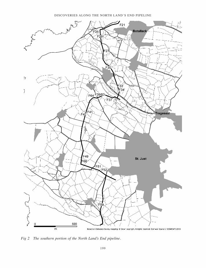
Discoveries along the north lanD’s enD pipeline
199
Fig 2 The southern portion of the North Land’s End pipeline.
197-222_Lawson-Jones.indd 199 01/12/2014 11:54

ANNA LAWSON-JONES
200
The flint from each field was counted, individually listed and described. Twenty one fields produced fewer than ten pieces each, although six of these clearly represent outliers from the two major foci of material which occurred in fields 14, 16 and 17 (763 pieces) and fields 25 and 26 (393). A smaller assemblage (58 pieces) came from a buried ditch in field 34. Selected pieces have been illustrated (Fig 3) and these are indicated in bold in the following text (for example, L1, L2).
Raw material
More than 98 per cent of the assemblage is composed of flint derived from local beach pebbles. The proportion of chert is tiny and probably reflects the natural ratio of flint to chert found on local beaches. The pebble flint varies markedly in colour and quality, with the predominant range of colours being a mottled grey of variable tone, plus occasional dull green, brown, orange and near black. Few complete pebbles are included within the assemblage, possibly suggesting that testing of flint prior to transportation to site was routinely practised.
The very occasional pieces of nodular flint recorded came from further away. In Cornwall, most use of nodular flint is indicative of earlier Neolithic exchange (Healy 1985, Mercer 1986). In fact, the movement of particularly sought-after flint and chert would seem to extend back into the later Mesolithic (Palmer 1970; Jacobi 1979). The nearest mainland sources for good quality, dark nodular flint are in Devon at Beer Head (Tingle 1998) and other sources discussed by Newberry (2002). Some of the latter are markedly closer to Penwith than Beer Head.
Where reference is made to primary, secondary and tertiary flakes, primary refers to those with 50 per cent or more surviving cortex, secondary refers to less than 50 per cent, and tertiary pieces have no surviving cortex.
The main flint scatters
The two major scatters in fields 14, 16 and 17 and fields 25 and 26 were of mixed date, spanning the Mesolithic through to the Bronze Age. Diagnostically, Mesolithic material represented the largest element in both scatters.
The majority of this assemblage displays patination to a varying degree, ranging from
incipient discolouration through to an all-over pale blue surface covering. Although levels of patination are not indicative of date as a whole, all of the most densely patinated pieces are Mesolithic. However, some classic Mesolithic forms, including microliths, show almost no patination.
Other surface alteration includes the dense, white, granular calcination caused by intense heating (Donahue and Burroni 2004). Variable forms of heat alteration were recorded, ranging from a slight crazing of hairline fractures through to substantially blistered, thickly calcined, fractured pieces. Approximately 8 per cent of the Mesolithic assemblage shows alteration through heating. The use of heat to treat flint prior to working is known to maximize control over knapped modification and may have economised on raw material use (Pannett 2011). This has been recorded elsewhere, for example in Northumberland, where an area study identified a large and diversely dated assemblage which showed a similar bias towards the Mesolithic in the ratio of heated to non-heated flint (Waddington 1999, 81, 104).
Variable levels of abrasion were noted, including a general slight but all-over wear associated with much of the assemblage and heavy all-over wear associated with pieces subject to depositional surface exposure and disturbance. In addition, focused, use-related wear was noted along the working edges of more heavily utilised tool forms, primarily the knives and scrapers but also on some miscellaneous retouched and non-retouched flakes. In contrast, occasional pieces were notably fresher, suggesting the presence of sealed and undisturbed contexts. Most breakages could be categorised as resulting from accidental damage during production or use, with deliberate breaks reflecting the dominant technology (as, for example, in the production of microliths). Other breakages are associated with either later prehistoric re-use of pieces and unintentional post-depositional disturbance (for example, from ploughing or topsoil stripping).
Many of the primary and markedly secondary pebble flakes display quite pronounced bulbs, occasionally with clear radiating ripples indicative of hard-hammer removal. There are too many large flakes for the number of large flake-producing cores found. This strongly suggests that much of this waste material is the result of primary knapping and initial core preparation. Many of the primary flakes from both the major scatters could be of any
197-222_Lawson-Jones.indd 200 01/12/2014 11:54

Discoveries along the north lanD’s enD pipeline
201
date, but since these same areas produced dense scatters of Mesolithic material, it is likely that a significant proportion dates to that period.
In addition to this bulky material, there are occasional pieces of cortical waste that have been so finely removed that they give the impression of selected pebbles having been ‘peeled’. These are Mesolithic and represent the preparation of selected pebbles for the production of more specific core forms. Their relative rarity in this assemblage coincides with the comparative paucity of classically diagnostic, highly distinctive core forms such as pyramidal and bipolar blade producing cores.
There are few heavily retouched pieces present within either the earlier or the later material. Where retouch is present it is frequently limited in extent and apparently focused on function (for instance, L22, L33, L41) rather than a combination of function and aesthetic appearance, which could be suggested for L8, L13, L40 and L42. Linked to this idea of the aesthetic appearance of certain pieces overriding function alone is the sometimes strikingly characteristic striped or ribbed appearance of some Mesolithic material, in particular some of the specialised blade and bladelet cores (for example, L1 and L2). These pieces, in conjunction with the linearity of many of the smaller, specialised blade and bladelet-based tools give an immediate visual impression of being part of a deliberate and clearly defined cultural package.
The assemblage from fields 14, 16 and 17
Fields 14, 16 and 17, located to the west of Trewellard (centred at SW 36663 33635), produced the largest flint scatter, totalling 763 pieces. Field 17 drops north towards field 14 on a gently undulating north-facing slope, 90–100m above sea level. The steep, rocky coast lies nearby to the west. No springs or streams are shown on current mapping in the immediate vicinity of this scatter.
The vast majority of flint from this scatter was unstratified, indicating that disturbance to the underlying archaeology had occurred prior to topsoil stripping, probably through past cultivation. Occasional pieces of residual flint were excavated from contexts of later date. The assemblage is mixed but primarily Mesolithic, with some limited Neolithic and Bronze Age elements. There was a general Mesolithic distribution, plus
a Neolithic element to the north in field 14 (and 13), and a Bronze Age presence in the southern portion of field 14 and in fields 16 and 17. This chronologically mixed scatter was identified over a north – south portion of the pipeline some 350m long; however, the extent of the spread of flint outside the pipeline corridor is unknown.
Field 13 (to the north) and fields 18 to 21 (to the south) also produced flints, but in no instance exceeding nine pieces per field.
The assemblage from fields 25, 26 and 27
Fields 25, 26 and 27, to the west of Botallack (centred at SW 36419 32758), produced the second largest worked flint scatter of 402 pieces. Field 27 drops down gently northwards towards field 25, approximately 95–110m above sea level). There are no springs or streams in the immediate vicinity, and the steep rocky coast lies to the west.
The majority of the material is again Mesolithic, but there is also a component of a transitional and more fully Neolithic date. Again, the chronological distribution across the area is not entirely clear but there seems to be a similar general presence of Mesolithic material with a Neolithic element focussed particularly in field 26 and the southern part of field 25. Fields immediately to the north did not produce any flint, indicating a sharp cut-off defining the northern edge of the scatter; field 27 to the south produced only nine flints. The scatter as a whole probably had a north to south range of about 150–200m. Again, its extent beyond the pipeline corridor is unknown.
All of the flint from this scatter was unstratified and came from the top or plough soil. The underlying subsoil was not removed from the pipeline corridor and perhaps as a result no features were recorded from these three fields. Since all of the flint was unstratified, this scatter is discussed as a whole, in general chronological terms.
The Mesolithic assemblage in fields 14, 16 and 17 and 25, 26 and 27
For both scatters the Mesolithic material consists of a broad range of primarily later Mesolithic forms (c 7500–4000 cal BC) together with an obliquely blunted range dating to approximately 9000–7500 cal BC. Later Mesolithic sites are more frequently identified than earlier Mesolithic sites (Jacobi 1979; Wymer 1977) and these are
197-222_Lawson-Jones.indd 201 01/12/2014 11:54
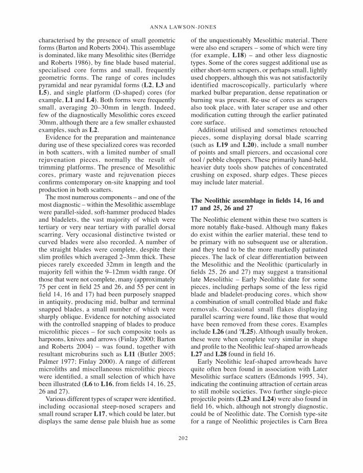
ANNA LAWSON-JONES
202
characterised by the presence of small geometric forms (Barton and Roberts 2004). This assemblage is dominated, like many Mesolithic sites (Berridge and Roberts 1986), by fine blade based material, specialised core forms and small, frequently geometric forms. The range of cores includes pyramidal and near pyramidal forms (L2, L3 and L5), and single platform (D-shaped) cores (for example, L1 and L4). Both forms were frequently small, averaging 20–30mm in length. Indeed, few of the diagnostically Mesolithic cores exceed 30mm, although there are a few smaller exhausted examples, such as L2.
Evidence for the preparation and maintenance during use of these specialized cores was recorded in both scatters, with a limited number of small rejuvenation pieces, normally the result of trimming platforms. The presence of Mesolithic cores, primary waste and rejuvenation pieces confirms contemporary on-site knapping and tool production in both scatters.
The most numerous components – and one of the most diagnostic – within the Mesolithic assemblage were parallel-sided, soft-hammer produced blades and bladelets, the vast majority of which were tertiary or very near tertiary with parallel dorsal scarring. Very occasional distinctive twisted or curved blades were also recorded. A number of the straight blades were complete, despite their slim profiles which averaged 2–3mm thick. These pieces rarely exceeded 32mm in length and the majority fell within the 9–12mm width range. Of those that were not complete, many (approximately 75 per cent in field 25 and 26, and 55 per cent in field 14, 16 and 17) had been purposely snapped in antiquity, producing mid, bulbar and terminal snapped blades, a small number of which were sharply oblique. Evidence for notching associated with the controlled snapping of blades to produce microlithic pieces – for such composite tools as harpoons, knives and arrows (Finlay 2000; Barton and Roberts 2004) – was found, together with resultant microburins such as L11 (Butler 2005; Palmer 1977; Finlay 2000). A range of different microliths and miscellaneous microlithic pieces were identified, a small selection of which have been illustrated (L6 to L16, from fields 14, 16, 25, 26 and 27).
Various different types of scraper were identified, including occasional steep-nosed scrapers and small round scraper L17, which could be later, but displays the same dense pale bluish hue as some
of the unquestionably Mesolithic material. There were also end scrapers – some of which were tiny (for example, L18) – and other less diagnostic types. Some of the cores suggest additional use as either short-term scrapers, or perhaps small, lightly used choppers, although this was not satisfactorily identified macroscopically, particularly where marked bulbar preparation, dense repatination or burning was present. Re-use of cores as scrapers also took place, with later scraper use and other modification cutting through the earlier patinated core surface.
Additional utilised and sometimes retouched pieces, some displaying dorsal blade scarring (such as L19 and L20), include a small number of points and small piercers, and occasional core tool / pebble choppers. These primarily hand-held, heavier duty tools show patches of concentrated crushing on exposed, sharp edges. These pieces may include later material.
The Neolithic assemblage in fields 14, 16 and 17 and 25, 26 and 27
The Neolithic element within these two scatters is more notably flake-based. Although many flakes do exist within the earlier material, these tend to be primary with no subsequent use or alteration, and they tend to be the more markedly patinated pieces. The lack of clear differentiation between the Mesolithic and the Neolithic (particularly in fields 25, 26 and 27) may suggest a transitional late Mesolithic – Early Neolithic date for some pieces, including perhaps some of the less rigid blade and bladelet-producing cores, which show a combination of small controlled blade and flake removals. Occasional small flakes displaying parallel scarring were found, like those that would have been removed from these cores. Examples include L26 (and ?L25). Although usually broken, these were when complete very similar in shape and profile to the Neolithic leaf-shaped arrowheads L27 and L28 found in field 16.
Early Neolithic leaf-shaped arrowheads have quite often been found in association with Later Mesolithic surface scatters (Edmonds 1995, 34), indicating the continuing attraction of certain areas to still mobile societies. Two further single-piece projectile points (L23 and L24) were also found in field 16, which, although not strongly diagnostic, could be of Neolithic date. The Cornish type-site for a range of Neolithic projectiles is Carn Brea
197-222_Lawson-Jones.indd 202 01/12/2014 11:54

Discoveries along the north lanD’s enD pipeline
203
(Saville 1981), located only some 40 km east of these assemblages.
More clearly of Neolithic date were some of the larger, well-formed flakes and the cores that produced them. The cores tended to be of the multi-platform variety and were almost invariably larger on abandonment than their Mesolithic predecessors, which would have produced more pieces (although smaller and of different uses) than these later cores. Identified within the scatter were a number of core rejuvenation flakes. These post-date the Mesolithic period.
The levels of retouch seen within the scatter as a whole is fairly limited, but there are exceptions. Field 14 produced several retouched knives and pieces of knives which had then seen subsequent reuse and / or retouch overlying earlier edges; for example, L32. This field also produced a large end scraper and other scraper forms and knives, plus a number of large, well-formed, sometimes retouched flakes (for instance, L30 and L31). A similar range of larger, retouched Late Neolithic or Early Bronze Age pieces came from field 16 (L33, L34, L36, L37 and L38). As Edmonds (1995, 122) points out, distinguishing some tool types between these two periods can be difficult ‘when the same patterns of procurement, core preparation and reduction were in practise’. The retouch recorded includes backing modification to facilitate handling and hafting, as well as retouch to strengthen and maintain sharp cutting edges.
Field 25 produced a classically retouched, end and side scraper (32mm by 25mm) from what could have been a nodular core (L42). The use of nodular flint in Cornwall is indicative of importation via trade or exchange and is accepted as a Neolithic trait. Although notoriously dangerous to assume a nodular source on the basis of very dark colour and faultless quality, piece L42 was strikingly different to the other flint from fields 25, 26 and 27. A similarly-sized (34mm) denticulated flake, occasional other miscellaneously worked or used flakes of 30–44mm length, plus a few small retouched pieces from these fields were also made on notably dark flint, possibly nodular, and are of Neolithic character.
Finally, there is some evidence for the re-use of previously worked flint. This is seen at its clearest where the levels of patination vary markedly on a single piece. In some cases subsequent reuse amounted to little more than breakage to attain a sharp edge, but in others later retouch of an
existent piece was recorded. In general, the later use appears fresh in comparison to the more heavily patinated, or in some cases more heavily abraded underlying flint. This has proved difficult to quantify in field 14, 16, 17 because of the known Bronze Age activity in the immediate area, but in field 25, 26, 27 evidence of reuse has been taken to indicate a broadly Neolithic date (L21 and L22).
The Bronze Age assemblage in fields 14, 16 and 17
Some limited Bronze Age activity was identified within the field 14, 16 and 17 scatter, most obviously by the presence of a thumbnail scraper, plus larger flakes and flake producing cores, and no obviously contemporary rejuvenation pieces. This material is not strikingly diagnostic and may not extend into the northern part of field 14, but does seem to occur sporadically within the southern part of field 14 and in fields 16 and 17. No features clearly contemporary with these Late Neolithic/Bronze Age pieces of flint were identified, possibly because they were masked, disturbed or removed during subsequent Romano-British activity.
Cores interpreted as Bronze Age tend, like the Neolithic examples, to be larger, multi-platformed and produced flakes, although there are occasional broad blade removal scars, indicative, for example, of the production of knives. The slightly less regular, sometimes untidy appearance of some of these cores, and possibly their larger size at abandonment, could imply a Middle Bronze Age or later presence within the assemblage. A small number of naturally faulted, distinctive pieces found in the southern part of field 14 could relate to this period, too, perhaps reflecting less careful selection of non-faulted raw material for knapping.
In field 16 the reuse of large, heavily patinated pieces was recorded, including a later blade core worked on a large white flake and a flake core worked on a former large blade core. These two large, previously worked and heavily patinated pieces, in conjunction with occasional other large, notably patinated but well-formed flakes from field 16, may attest to a markedly earlier, possibly Palaeolithic presence along the route of the pipeline. This may include some of the few chert pieces, for example L29. The presence of cores on earlier worked material, including flakes, has been recognized elsewhere as a Bronze Age trait (Edmonds 1995, 176; Brown 1991, 123).
197-222_Lawson-Jones.indd 203 01/12/2014 11:54
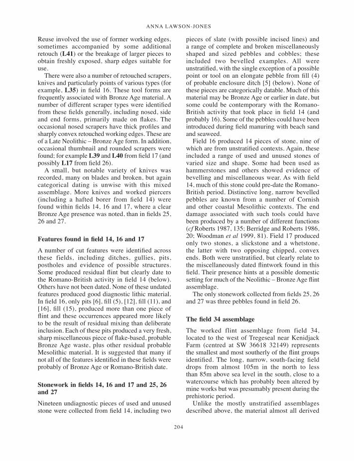
ANNA LAWSON-JONES
204
Reuse involved the use of former working edges, sometimes accompanied by some additional retouch (L41) or the breakage of larger pieces to obtain freshly exposed, sharp edges suitable for use.
There were also a number of retouched scrapers, knives and particularly points of various types (for example, L35) in field 16. These tool forms are frequently associated with Bronze Age material. A number of different scraper types were identified from these fields generally, including nosed, side and end forms, primarily made on flakes. The occasional nosed scrapers have thick profiles and sharply convex retouched working edges. These are of a Late Neolithic – Bronze Age form. In addition, occasional thumbnail and rounded scrapers were found; for example L39 and L40 from field 17 (and possibly L17 from field 26).
A small, but notable variety of knives was recorded, many on blades and broken, but again categorical dating is unwise with this mixed assemblage. More knives and worked piercers (including a hafted borer from field 14) were found within fields 14, 16 and 17, where a clear Bronze Age presence was noted, than in fields 25, 26 and 27.
Features found in field 14, 16 and 17
A number of cut features were identified across these fields, including ditches, gullies, pits, postholes and evidence of possible structures. Some produced residual flint but clearly date to the Romano-British activity in field 14 (below). Others have not been dated. None of these undated features produced good diagnostic lithic material. In field 16, only pits [6], fill (5), [12], fill (11), and [16], fill (15), produced more than one piece of flint and these occurrences appeared more likely to be the result of residual mixing than deliberate inclusion. Each of these pits produced a very fresh, sharp miscellaneous piece of flake-based, probable Bronze Age waste, plus other residual probable Mesolithic material. It is suggested that many if not all of the features identified in these fields were probably of Bronze Age or Romano-British date.
Stonework in fields 14, 16 and 17 and 25, 26 and 27
Nineteen undiagnostic pieces of used and unused stone were collected from field 14, including two
pieces of slate (with possible incised lines) and a range of complete and broken miscellaneously shaped and sized pebbles and cobbles; these included two bevelled examples. All were unstratified, with the single exception of a possible point or tool on an elongate pebble from fill (4) of probable enclosure ditch [5] (below). None of these pieces are categorically datable. Much of this material may be Bronze Age or earlier in date, but some could be contemporary with the Romano-British activity that took place in field 14 (and probably 16). Some of the pebbles could have been introduced during field manuring with beach sand and seaweed.
Field 16 produced 14 pieces of stone, nine of which are from unstratified contexts. Again, these included a range of used and unused stones of varied size and shape. Some had been used as hammerstones and others showed evidence of bevelling and miscellaneous wear. As with field 14, much of this stone could pre-date the Romano-British period. Distinctive long, narrow bevelled pebbles are known from a number of Cornish and other coastal Mesolithic contexts. The end damage associated with such tools could have been produced by a number of different functions (cf Roberts 1987, 135; Berridge and Roberts 1986, 20; Woodman et al 1999, 81). Field 17 produced only two stones, a slickstone and a whetstone, the latter with two opposing chipped, convex ends. Both were unstratified, but clearly relate to the miscellaneously dated flintwork found in this field. Their presence hints at a possible domestic setting for much of the Neolithic – Bronze Age flint assemblage.
The only stonework collected from fields 25, 26 and 27 was three pebbles found in field 26.
The field 34 assemblage
The worked flint assemblage from field 34, located to the west of Tregeseal near Kenidjack Farm (centred at SW 36618 32149) represents the smallest and most southerly of the flint groups identified. The long, narrow, south-facing field drops from almost 105m in the north to less than 85m above sea level in the south, close to a watercourse which has probably been altered by mine works but was presumably present during the prehistoric period.
Unlike the mostly unstratified assemblages described above, the material almost all derived
197-222_Lawson-Jones.indd 204 01/12/2014 11:54
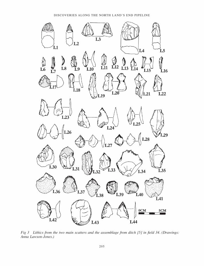
Discoveries along the north lanD’s enD pipeline
205
Fig 3 Lithics from the two main scatters and the assemblage from ditch [5] in field 34. (Drawings: Anna Lawson-Jones.)
197-222_Lawson-Jones.indd 205 01/12/2014 11:54
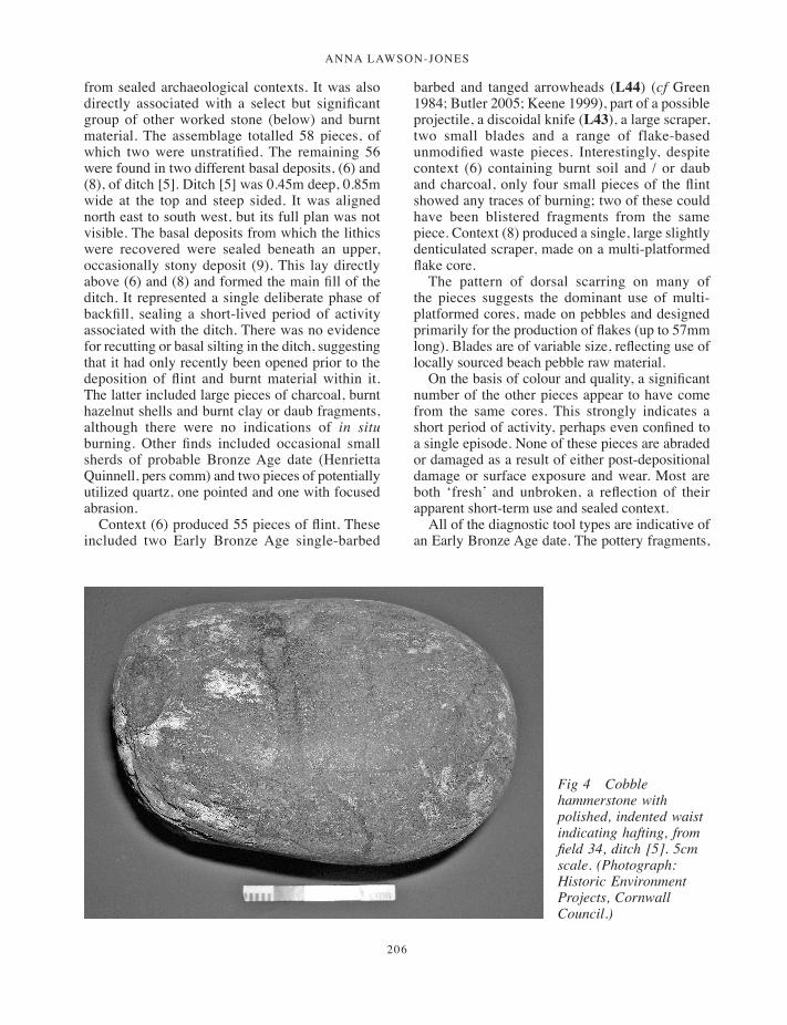
ANNA LAWSON-JONES
206
from sealed archaeological contexts. It was also directly associated with a select but significant group of other worked stone (below) and burnt material. The assemblage totalled 58 pieces, of which two were unstratified. The remaining 56 were found in two different basal deposits, (6) and (8), of ditch [5]. Ditch [5] was 0.45m deep, 0.85m wide at the top and steep sided. It was aligned north east to south west, but its full plan was not visible. The basal deposits from which the lithics were recovered were sealed beneath an upper, occasionally stony deposit (9). This lay directly above (6) and (8) and formed the main fill of the ditch. It represented a single deliberate phase of backfill, sealing a short-lived period of activity associated with the ditch. There was no evidence for recutting or basal silting in the ditch, suggesting that it had only recently been opened prior to the deposition of flint and burnt material within it. The latter included large pieces of charcoal, burnt hazelnut shells and burnt clay or daub fragments, although there were no indications of in situ burning. Other finds included occasional small sherds of probable Bronze Age date (Henrietta Quinnell, pers comm) and two pieces of potentially utilized quartz, one pointed and one with focused abrasion.
Context (6) produced 55 pieces of flint. These included two Early Bronze Age single-barbed
barbed and tanged arrowheads (L44) (cf Green 1984; Butler 2005; Keene 1999), part of a possible projectile, a discoidal knife (L43), a large scraper, two small blades and a range of flake-based unmodified waste pieces. Interestingly, despite context (6) containing burnt soil and / or daub and charcoal, only four small pieces of the flint showed any traces of burning; two of these could have been blistered fragments from the same piece. Context (8) produced a single, large slightly denticulated scraper, made on a multi-platformed flake core.
The pattern of dorsal scarring on many of the pieces suggests the dominant use of multi-platformed cores, made on pebbles and designed primarily for the production of flakes (up to 57mm long). Blades are of variable size, reflecting use of locally sourced beach pebble raw material.
On the basis of colour and quality, a significant number of the other pieces appear to have come from the same cores. This strongly indicates a short period of activity, perhaps even confined to a single episode. None of these pieces are abraded or damaged as a result of either post-depositional damage or surface exposure and wear. Most are both ‘fresh’ and unbroken, a reflection of their apparent short-term use and sealed context.
All of the diagnostic tool types are indicative of an Early Bronze Age date. The pottery fragments,
Fig 4 Cobble hammerstone with polished, indented waist indicating hafting, from field 34, ditch [5]. 5cm scale. (Photograph: Historic Environment Projects, Cornwall Council.)
197-222_Lawson-Jones.indd 206 01/12/2014 11:54
Discoveries along the north lanD’s enD pipeline
207
although unfortunately not strongly diagnostic, date to between the Late Neolithic and the Middle Bronze Age, complementing the lithic evidence (Henrietta Quinnell, pers comm).
Stonework from field 34
In addition to the flint recovered from ditch [5], a small range of stonework was collected from the basal deposit (6). This included a narrow, elongate pebble with a flaked or utilized end and a flake removed from a previously utilized large pebble or cobble with a smoothed or polished surface. This probably represents accidental detachment during use, although its inclusion within this deposit may not be fortuitous.
Most diagnostic of this stonework was a single, complete cobble (Fig 4) from basal fill (6), showing pock-marking associated with hammering or pounding at one end, slight surface smoothing at the opposite end, and a narrow, sunken abraded or polished band encircling the girth. This banding separates the two differently treated surface areas. It seems likely that the band reflects prepared hafting. Similar tools found elsewhere are thought to have been associated with Early or Middle Bronze Age metalworking (Craddock and Craddock 1996). The discovery of this piece, in association with an apparently related flint assemblage, is of some importance.
Summary
This group of material from ditch [5] in field 34 is significant because it consists of a discrete assemblage, sealed within an undisturbed context. Only a small proportion of the ditch was excavated, suggesting that we may have only part of a larger assemblage. The concentration of flint, burnt material and stone artefacts, including finely worked arrowheads, plus a knife and two scrapers and a highly distinctive cobble pounder, might suggest the deliberate selection and deposition of artefacts. It is possible that much of the lithic material was made (note the probable origin of several pieces from the same cores) and used during a single event for a specific function, which, on the basis of the pounder, could have been associated with the new and probably ritualised technology associated with early metalworking. The arrowheads, knife and scrapers could have been associated with the procurement and preparation
of food. Burnt hazelnut shells indicate that food was being eaten, probably in association with this activity, although no animal bone survived.
Flint from other fields
In addition to the discrete scatters or concentrations of material described above, a number of other fields along the pipeline also produced flint (fields 1, 3–4, 7, 9, 13, 18–21, 30, 33, 37, 39/63, 41–42, 49, 51–52 and 59) (Table 1). All of these pieces are residual and unstratified, with the exception of one piece from a burnt stone and charcoal mound (102) in field 4 (Jones and Quinnell 2006). Some of these small additional collections (all fewer than ten pieces) may have been extensions of the denser, focused scatters discussed above. Most of the material is not diagnostic, the majority of it falling into a broadly later prehistoric date, ranging from the Early or Middle Neolithic through to the Middle Bronze Age.
Fields producing flint spatially linked to the main field 14, 16 and 17 scatter included 13, 18, 19, 20 and 21. Chronological differences were identified within them, suggesting that we have either a string of small, short-lived sites or that the pipeline crossed the periphery of larger sites, perhaps both. Field 13 produced a single platformed flake core, an unretouched but utilized knife on a flake and a miscellaneous, unworked range of other flakes (averaging 33mm in length and extending up to 53mm for a split flint pebble). Field 18 produced similarly flake-based material, including an undiagnostic flake core, a probable thinning flake, a knife or scraper on a reused piece, a notably black, possibly nodular, crushed and retouched piece and a possibly notched split pebble, in addition to other miscellaneous flakes. These have a slightly smaller average length of about 26mm. Both of these fields have produced Late Neolithic – Bronze Age material.
Field 19 produced a thumb scraper, a broken end scraper, an abandoned opposed platform flake core, a multi-platform (short flake producing) core, a notched piece and a further scraper with slight glossing. Much – if not the entirety – of this material is Bronze Age.
Field 20 contained a small mixed assemblage, including a single Mesolithic bladelet section, a thick chert flake and a long irregular shaped flake with bilateral use wear. Field 21 contained nothing but flake-based, unmodified waste. This material
197-222_Lawson-Jones.indd 207 01/12/2014 11:54

ANNA LAWSON-JONES
208
Tabl
e 1
Ana
lysi
s by
field
of l
ithic
ass
embl
age
Fiel
d N
o
Form
13
47
913
1416
1718
1920
2125
2627
3033
3437
3941
4249
5152
5966
Tota
l
Pebb
le/tr
ied
pebb
le2
22
44
11
13
11
123
Cor
e =
blad
e pr
od.
1428
16
52
56C
ore
= fla
ke p
rod.
11
45
11
23
11
20C
ore=
flak
e/bl
ade
prod
.13
61
424
Cor
e to
ol1
116
46
129
Flak
e =
clea
r/hea
vy u
se1
15
712
12
24
21
38Fl
ake
= us
ed?/
brok
en2
31
4510
011
11
412
36
33
112
11
318
Bla
de =
cle
ar/h
eavy
use
915
31
101
39B
lade
= u
sed?
/bro
ken
3299
126
221
118
2Fl
ake/
blad
e= u
sed
311
31
119
Flak
e/bl
ade
= us
ed?/
not u
sed
2518
11
1811
11
76R
euse
d pi
ece
210
11
11
218
Mis
cella
neou
s -
used
87
42
11
31
128
Mis
cella
neou
s -
ret
ouch
ed9
172
42
34D
entic
ulat
ed2
22
17
Rej
uven
atio
n pi
ece
812
1211
11
45M
icro
lith
812
211
134
Mic
robu
rin8
71
189
43K
nife
11
1314
35
11
11
41K
nife
/ sc
rape
r2
25
110
Scra
per
1111
33
105
11
45Pr
ojec
tile
51
39
Bur
in1
43
8Po
int /
aw
l / p
ierc
er8
142
133
11
42C
hip
/ deb
itage
2630
31
110
133
105
TOTA
L3
46
11
927
345
139
97
57
285
108
94
158
11
11
41
21
112
93
197-222_Lawson-Jones.indd 208 01/12/2014 11:54
Discoveries along the north lanD’s enD pipeline
209
again falls into a broad later prehistoric category.All of the remaining assemblages were small,
essentially mixed and undiagnostic. From north to south along the pipeline the following can be said. Field 1 produced a probable Mesolithic bladelet among other pieces. Field 4 produced two flint pebbles and three pieces of waste (all unstratified), plus a core-tool with crushed, probable heavy duty scraper use visible around the nose-like platform. The core removals are steep and hinged, forming a denticulated, slightly frill-like 45-degree angle working edge running around the platform. This is Bronze Age in character and represents a probable heavy duty hand-held scraper or possibly a chopping tool. Field 7 produced a single probable Bronze Age chert knife.
Fields 30 and 33 produced chunky, flake-based material, including a long, dark narrow engraver, and field 37 a notably dark, broken retouched knife fragment. The material from these three fields is all of Late Neolithic – Bronze Age date. Field 39 produced a very late looking, potentially Late Bronze Age piece. Field 49 produced a heat-damaged unclassifiable flake core, a core rejuvenation piece, and two backed, retouched and utilized pieces, one of which is a broken knife fragment. Field 51 produced a single burnt round scraper and field 52 two flake pieces from the same core (one showing use-wear). Field 59 produced a classic cutting flake of Neolithic date, and field 66 an unused Portland chert flake, again potentially Neolithic.
Illustrated pieces
(Fig 3) All unstratified unless otherwise stated.
Earlier cores
L1 D-shaped bladelet core (field 14); L2 exhausted pyramidal bladelet core (field 14); L3 D-shaped bladelet core (field 25); L4 pyramidal bladelet core (field 26); L5 opposed platform core (field 26).
Microlithic pieces
L6 to L9 representative sample (all field 14); L10 piercer / projectile (?) and L11 microburin (field 16); L12 to L14 microliths, including a crescentic and a geometric form (field 25); L15 notched piece (field 26); L16 microlith (field 27).
Larger tools
L17 round scraper (field 26); L18 end scraper (field 25); L19 knife blade (field 16); L20 notched blade (field 16); L21 burin with later reuse (field 25); L22 utilized broken blade with later reuse - retouch (field 26).
Projectiles
L23 triangular arrowhead (field 16 (11); L24 triangular arrowhead (thick) (field 17); L25 tanged arrowhead? (field 26); L26 leaf-shaped arrowhead (?) (field 16); L27 to L28 leaf-shaped arrowheads (field 16).
Neolithic and Bronze Age tools
L29 larger, utilized/retouched chert piece (field 14); L30 to L31 knife (field 14); L32 reused knife (field 14); L33 borer (field 14); L34 large denticulated flake (field 16); L35 borer (field 16).
Scrapers
L36 pointed knife/scraper (field 16); L37 side and end scraper (field 16); L38 pointed scraper (field 16); L39 thumbnail scraper (field 17); L40 round scraper (field 17); L41 reused denticulated scraper (field 17); L42 side and end scraper (field 25).
Field 34 selected pieces
L43 discoidal knife flake (field 34, (6)); L44 barbed and tanged arrowhead (field 34, (6)).
A Romano-British metalworking siteDuring the pipeline work traces of Romano-British metalworking activity were identified in fields 14 and 16 (centred at SW 36655 33762) (Fig 5). The sites identified lay on the western flank of a shallow valley descending towards the coast approximately south to north, a little over 300m from the top of the coastal slope at Botallack Head. The bedrock geology in the adjacent area is complex, with the site itself lying on hornfelsed slate and siltstone of the Mylor Slate formation but with the Land’s End granite just to the east and localised greenstone intrusions immediately to the west (digital data, British Geological Survey).
197-222_Lawson-Jones.indd 209 01/12/2014 11:54

ANNA LAWSON-JONES
210
A dense scatter of earlier and unrelated worked flint was found in the same fields (above) and as a result many of the later features were found to contain residual flint.
(NB. Context number series for both these fields start at 1.)
Field 14
Ditch [5] in field 14 (not to be confused with ditch [5] in field 34, described above) was the most significant feature in the field and was recorded over a distance of 40m. It was slightly sinuous in form with one major change of direction, but it is unclear whether it represents a field boundary, an enclosure of some type or some other form of landscape division (Fig 5). The northernmost part of the ditch turned north east at a point where it was becoming increasingly truncated and shallow (as did other features in the vicinity) to the north of east – west ditch [22] (below).
The ditch [5] measured up to 0.95m wide and 0.4m deep. Seven slots 0.5–1m wide were initially dug across it and these were subsequently linked to create a fully excavated length of about 20m between slots 1 and 7 (Fig 5). Three fills were recorded: upper fill (3), main fill (4) and basal fill (37). Fill (3) produced an unrelated residual flint. Fill (4) was a variable but charcoal-rich deposit, which produced a small quantity of tin slag (Andersen, below; Dungworth, below) and other magnetic waste (probably the result of iron-rich impurities), plus a small number of Romano-British sherds (from beneath charcoal in slot 2). Four 10 litre soil samples were taken from the lower part of context (4), close to its junction with basal deposit (37).
The samples contained 691g of tin slag, 604g of industrial debris, probably including furnace lining fragments (Adam Sharpe, pers comm), and 45g of magnetic material which was initially identified as hammerscale, although this could be the result of ore impurities. This relatively small sample was taken from a much larger but unquantified deposit of industrial waste, which also included large amounts of charcoal. The recorded industrial material should be seen as an important indicator of the type of activity taking place in the vicinity rather than quantifying it.
The large quantity of charcoal within this fill may imply rapid infilling, perhaps a single episode of dumping. Analysis of the charcoal
from the ditch revealed that it consisted of narrow roundwood, mainly oak but also hazel, holly, the hawthorn/Sorbus group and birch (Gale, below). Small pieces of loose unidentified bark were also present. The assemblage was suggestive of the exploitation of managed coppiced woodland sources. A radiocarbon determination of 1730 ±43 BP, cal AD 210–420 (Wk-19381) was obtained from Pomoideae charcoal obtained from fill (4). This determination is consistent with the Romano-British pottery recovered (Quinnell, below). Scanning of the residues from context (4) samples with a magnet produced small amounts of magnetic material, possibly hammerscale, suggesting the smithing of iron, or, in this instance, more probably a product of working iron-rich tin ores.
A range of other features were investigated in field 14. Two short linear features aligned south west – north east were identified to the north west and south east of the enclosure ditch. The northern one (35) was ill-defined and truncated, with only a thin skim of its basal fill surviving. The southern linear feature [6] was better defined and two slots were excavated across it. It was 8.3m long, up to 0.66m wide and 0.13m deep and contained a single fill (7) which contained both a small quantity of tin slag and occasional charcoal. This could imply that feature [6] is of Romano-British date and contemporary with ditch [5], since no finds of a later date were found during its excavation. By association (appearance, size and alignment) feature (35) is also likely to be contemporary.
South east of ditch [5] and linear pit [6] was a small post-built structure 40 (Figs 5 and 6). This was approximately 3.5m long by 2.5m wide and of simple construction, made up of six postholes forming a sub-oval. The postholes – [10], [12], 14], [16], [18] and [20] – had diameters ranging from 0.45m to 0.65m and were about 0.3m deep with steeply concave profiles. Posthole [10] had an elongate plan (possibly the result of post removal), while the others were near circular. All the postholes contained single fills and posthole [14] produced the only finds, three probably residual pieces of worked flint.
No evidence was found for any additional stone or turf walling or stakehole supports linking the posts, and no internal surfacing or other cut features were identified. This lack of internal detail is likely to be the result of truncation. The entrance to the structure could only be inferred from the wider spacing of posts [16] and [18] on its north-western
197-222_Lawson-Jones.indd 210 01/12/2014 11:54
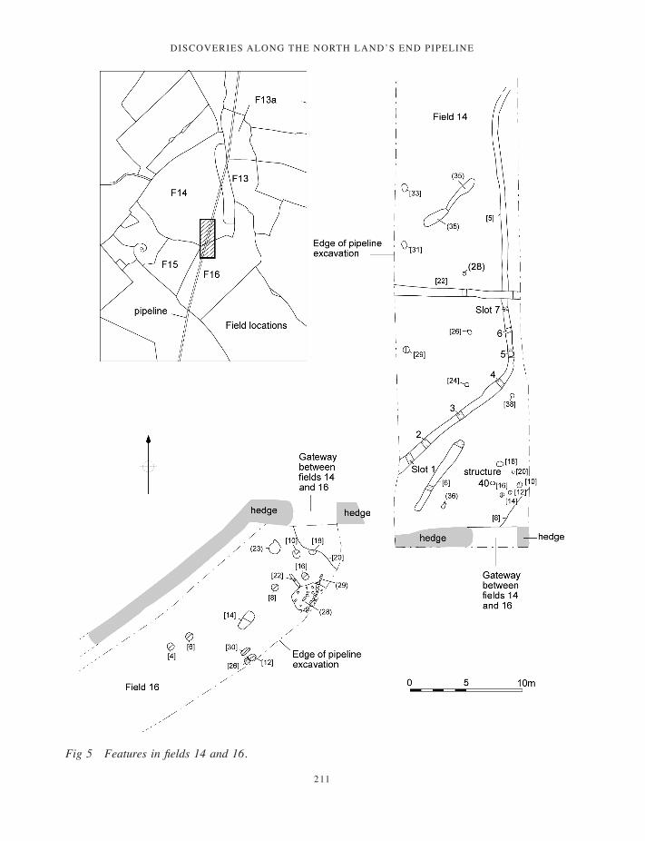
Discoveries along the north lanD’s enD pipeline
211
Fig 5 Features in fields 14 and 16.
197-222_Lawson-Jones.indd 211 01/12/2014 11:54
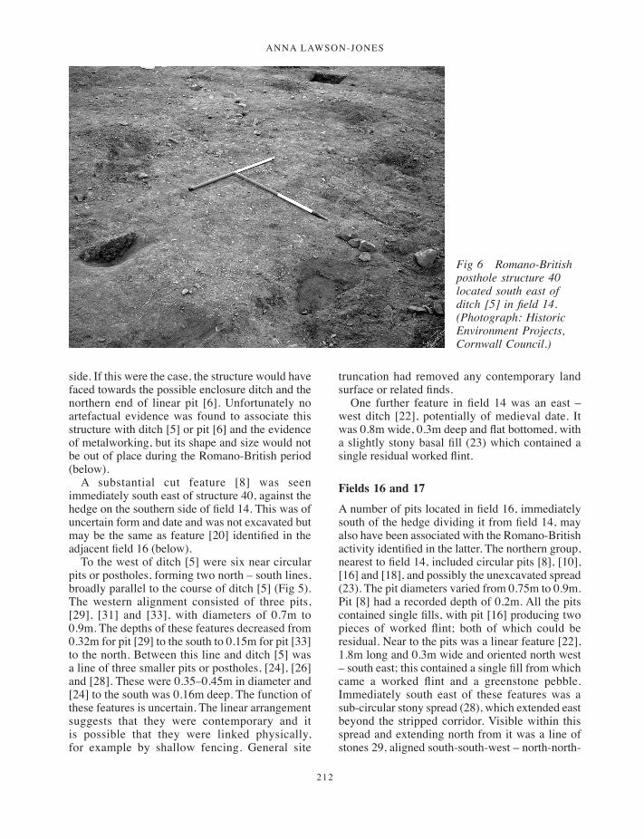
ANNA LAWSON-JONES
212
side. If this were the case, the structure would have faced towards the possible enclosure ditch and the northern end of linear pit [6]. Unfortunately no artefactual evidence was found to associate this structure with ditch [5] or pit [6] and the evidence of metalworking, but its shape and size would not be out of place during the Romano-British period (below).
A substantial cut feature [8] was seen immediately south east of structure 40, against the hedge on the southern side of field 14. This was of uncertain form and date and was not excavated but may be the same as feature [20] identified in the adjacent field 16 (below).
To the west of ditch [5] were six near circular pits or postholes, forming two north – south lines, broadly parallel to the course of ditch [5] (Fig 5). The western alignment consisted of three pits, [29], [31] and [33], with diameters of 0.7m to 0.9m. The depths of these features decreased from 0.32m for pit [29] to the south to 0.15m for pit [33] to the north. Between this line and ditch [5] was a line of three smaller pits or postholes, [24], [26] and [28]. These were 0.35–0.45m in diameter and [24] to the south was 0.16m deep. The function of these features is uncertain. The linear arrangement suggests that they were contemporary and it is possible that they were linked physically, for example by shallow fencing. General site
truncation had removed any contemporary land surface or related finds.
One further feature in field 14 was an east – west ditch [22], potentially of medieval date. It was 0.8m wide, 0.3m deep and flat bottomed, with a slightly stony basal fill (23) which contained a single residual worked flint.
Fields 16 and 17
A number of pits located in field 16, immediately south of the hedge dividing it from field 14, may also have been associated with the Romano-British activity identified in the latter. The northern group, nearest to field 14, included circular pits [8], [10], [16] and [18], and possibly the unexcavated spread (23). The pit diameters varied from 0.75m to 0.9m. Pit [8] had a recorded depth of 0.2m. All the pits contained single fills, with pit [16] producing two pieces of worked flint; both of which could be residual. Near to the pits was a linear feature [22], 1.8m long and 0.3m wide and oriented north west – south east; this contained a single fill from which came a worked flint and a greenstone pebble. Immediately south east of these features was a sub-circular stony spread (28), which extended east beyond the stripped corridor. Visible within this spread and extending north from it was a line of stones 29, aligned south-south-west – north-north-
Fig 6 Romano-British posthole structure 40 located south east of ditch [5] in field 14. (Photograph: Historic Environment Projects, Cornwall Council.)
197-222_Lawson-Jones.indd 212 01/12/2014 11:54
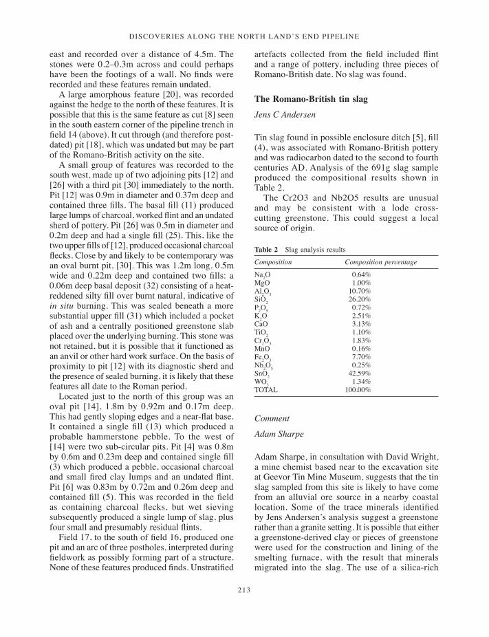
Discoveries along the north lanD’s enD pipeline
213
east and recorded over a distance of 4.5m. The stones were 0.2–0.3m across and could perhaps have been the footings of a wall. No finds were recorded and these features remain undated.
A large amorphous feature [20], was recorded against the hedge to the north of these features. It is possible that this is the same feature as cut [8] seen in the south eastern corner of the pipeline trench in field 14 (above). It cut through (and therefore post-dated) pit [18], which was undated but may be part of the Romano-British activity on the site.
A small group of features was recorded to the south west, made up of two adjoining pits [12] and [26] with a third pit [30] immediately to the north. Pit [12] was 0.9m in diameter and 0.37m deep and contained three fills. The basal fill (11) produced large lumps of charcoal, worked flint and an undated sherd of pottery. Pit [26] was 0.5m in diameter and 0.2m deep and had a single fill (25). This, like the two upper fills of [12], produced occasional charcoal flecks. Close by and likely to be contemporary was an oval burnt pit, [30]. This was 1.2m long, 0.5m wide and 0.22m deep and contained two fills: a 0.06m deep basal deposit (32) consisting of a heat-reddened silty fill over burnt natural, indicative of in situ burning. This was sealed beneath a more substantial upper fill (31) which included a pocket of ash and a centrally positioned greenstone slab placed over the underlying burning. This stone was not retained, but it is possible that it functioned as an anvil or other hard work surface. On the basis of proximity to pit [12] with its diagnostic sherd and the presence of sealed burning, it is likely that these features all date to the Roman period.
Located just to the north of this group was an oval pit [14], 1.8m by 0.92m and 0.17m deep. This had gently sloping edges and a near-flat base. It contained a single fill (13) which produced a probable hammerstone pebble. To the west of [14] were two sub-circular pits. Pit [4] was 0.8m by 0.6m and 0.23m deep and contained single fill (3) which produced a pebble, occasional charcoal and small fired clay lumps and an undated flint. Pit [6] was 0.83m by 0.72m and 0.26m deep and contained fill (5). This was recorded in the field as containing charcoal flecks, but wet sieving subsequently produced a single lump of slag, plus four small and presumably residual flints.
Field 17, to the south of field 16, produced one pit and an arc of three postholes, interpreted during fieldwork as possibly forming part of a structure. None of these features produced finds. Unstratified
artefacts collected from the field included flint and a range of pottery, including three pieces of Romano-British date. No slag was found.
The Romano-British tin slag
Jens C Andersen
Tin slag found in possible enclosure ditch [5], fill (4), was associated with Romano-British pottery and was radiocarbon dated to the second to fourth centuries AD. Analysis of the 691g slag sample produced the compositional results shown in Table 2.
The Cr2O3 and Nb2O5 results are unusual and may be consistent with a lode cross-cutting greenstone. This could suggest a local source of origin.
Comment
Adam Sharpe
Adam Sharpe, in consultation with David Wright, a mine chemist based near to the excavation site at Geevor Tin Mine Museum, suggests that the tin slag sampled from this site is likely to have come from an alluvial ore source in a nearby coastal location. Some of the trace minerals identified by Jens Andersen’s analysis suggest a greenstone rather than a granite setting. It is possible that either a greenstone-derived clay or pieces of greenstone were used for the construction and lining of the smelting furnace, with the result that minerals migrated into the slag. The use of a silica-rich
Table 2 Slag analysis results
Composition Composition percentage
Na2O 0.64%MgO 1.00%Al2O3 10.70%SiO2 26.20%P2O5 0.72%K2O 2.51%CaO 3.13%TiO2 1.10%Cr2O3 1.83%MnO 0.16%Fe2O3 7.70%Nb2O5 0.25%SnO2 42.59%WO3 1.34%TOTAL 100.00%
197-222_Lawson-Jones.indd 213 01/12/2014 11:54

ANNA LAWSON-JONES
214
stone would have promoted the formation of a free-flowing siliceous slag which would have readily trapped tin as a silicate (hence the near 50 per cent content of tin in the sample analysed).
Examination of samples of tin slag from St Just
David Dungworth
Three samples of slag from excavations at Botallack, St Just, were submitted for examination. The samples were recovered from environmental soil samples taken from Roman-period contexts in fill (4) of ditch [5] in field 14.
The slag in the samples is all small (typically less than 1 cu cm), black, and shows varying degrees of flow. The slags resemble the ‘irregular rod-shaped tap-slag’ from the smelting site at Crift Farm (between Bodmin and Lostwithiel), which was in use c AD 1200 (Malham et al 2002). The aim of the examination of the St Just slags was to determine whether the slags were associated with tin working and whether they were primary (smelting) or secondary (melting) slags.
The three samples were cut, mounted in epoxy resin and polished. The samples were examined using an optical microscope and a scanning electron microscope. Areas of each sample were analysed using an energy dispersive spectrometer attached to the scanning electron microscope.
The slags contained numerous droplets (<1mm) of metal in a glassy matrix; there were very few crystalline phases present in any of the samples (cf Malham et al 2002, 87). Samples 1 and 3 (Table 5) contained small quantities of a calcium-aluminium-silicate (similar to anorthite, CaAl2Si2O8) and sample 3 (area 2) also contained very small
quantities of leucite (KAlSi2O6). In addition, most samples contained small quantities of partially reacted silica. SEM-EDS analysis showed that the metal droplets were tin with minor amounts of iron and copper (Table 4). The tin droplets contained very low concentrations of iron and no tin-iron intermetallics (hardhead) were visible (cf Malham et al 2002, 87).
The slag matrices of the samples contained a wide range of oxides (Table 5). The presence of some relatively rare oxides (for example tungsten, W) suggests that this was a smelting slag rather than a slag generated during tin melting, as these rare oxides are often associated with tin ores (Ineson 1989).
The tin smelting slags from St Just contained substantial proportions of tin oxide and were produced during smelting which, by modern standards, would not have been particularly efficient. The St Just samples, however, are not much less efficient when compared to other analysed prehistoric and historic tin slags (Table 5).
Conclusion
The examination and analysis (Tables 3–5) of three samples of slag from a site near Botallack Head, St Just, shows that they were tin smelting slags. Ancient sources suggest that the south west was an important supplier of tin in the first millennium BC. However, there is very little archaeological evidence for tin smelting until the second millennium AD (Tylecote 1986, 43; Miles 1975; Gerrard 2000).
The available data on tin-smelting slag composition prior to the eighteenth century (Table 5) shows that traditional tin smelting was a relatively inefficient operation. The tin-smelting slags contain substantial proportions of tin oxide which would have reduced the yield of tin from the ore. This situation, however, seems to have been tolerated for two reasons. First and foremost, the tin ores of Cornwall were abundant and very rich and the loss of a proportion of tin in the slag
Table 3 Chemical composition (weight %) of various crystalline phases in slag samples 1 and 3
1.1 1.2 1.3 3.1 3.2 3.3
Na2O 2.1 1.6 2.0 1.5 0.2 1.7MgO <0.1 <0.1 <0.1 <0.1 <0.1 <0.1Al2O3 31.6 31.3 31.4 32.6 23.6 31.2SiO2 48.4 48.3 48.6 46.8 54.1 48.5P2O5 0.1 0.2 0.1 <0.1 <0.1 <0.1K2O 2.1 2.6 2.2 1.5 20.8 2.8CaO 13.5 13.4 13.5 15.6 0.3 13.6TiO2 0.2 0.2 0.2 0.2 0.1 0.2MnO <0.1 <0.1 <0.1 <0.1 <0.1 <0.1FeO 0.1 0.1 0.1 0.2 0.1 0.1SnO 1.6 2.2 1.6 1.3 0.8 1.7
Table 4 Composition (weight %) of tin droplets in the slag
Sample 1 2 3
Sn 99.8 99.8 100Fe 0.18 0.05 <0.05Cu <0.1 0.13 <0.1
197-222_Lawson-Jones.indd 214 01/12/2014 11:54
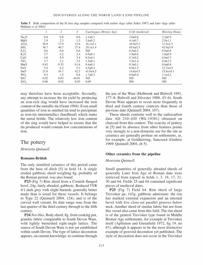
Discoveries along the north lanD’s enD pipeline
215
may therefore have been acceptable. Secondly, any attempt to increase the tin yield by producing an iron-rich slag would have increased the iron content of the metallic tin (Grant 1994). Even small quantities of iron in smelted tin tend to precipitate as iron-tin intermetallics (hardhead) which make the metal brittle. The relatively low iron content of the slag would have helped to ensure that the tin produced would contain low concentrations of iron.
The pottery Henrietta Quinnell
Romano-British
The only stratified ceramics of this period came from the base of ditch [5] in field 14. A single eroded gabbroic sherd weighing 6g, probably of the Roman period, was also found.
P23 (Fig 7) Rim sherd from a Cornish flanged bowl, 24g, fairly abraded, gabbroic. Reduced 5YR 4/1 dark grey with slight burnish, generally better made than is usual for these vessels. It belongs to Type 22 (Quinnell 2004, 124), and is of the curved wall variant. Its date range runs from the last quarter of the third century through to the fifth century.
P24 Not illus. Body sherd, 8g, from cooking pot, granitic fabric comparable to South Devon Ware, with lightly burnished right-angle lattice. The source of South Devon Ware is not yet established within south Devon. The type of lattice decoration appears, on current knowledge, to continue through
the use of the Ware (Holbrook and Bidwell 1991, 177–8; Bidwell and Silvester 1988, 43–6). South Devon Ware appears to occur more frequently in third and fourth century contexts than those of previous date (Quinnell 2004, 107).
These sherds conform well to the radiocarbon date AD 210–420 (Wk-19381) obtained on charcoal from this context. The scarcity of pottery in [5] and its absence from other features points very strongly to a non-domestic use for the site as ceramics are generally profuse on settlements, as, for example, at Goldherring, Sancreed (Guthrie 1969; Quinnell 2004, ch 5).
Other ceramics from the pipeline
Henrietta Quinnell
Small quantities of generally abraded sherds of generally Later Iron Age or Roman date were retrieved from topsoil in fields 1, 3, 16, 17, 21, 30 and 64. Fields 25 and 64 contained significant pieces of medieval dates.
P25 (Fig 7) Field 64. Rim sherd of large Trevisker jar, 143g, gabbroic admixture: the rim has marked external expansion and an internal bevel with five close-set parallel grooves below neck. Another sherd of similar fabric but not from this vessel also came from this field. The rim sherd is of the general Trevisker type found in Middle Bronze Age settlements, for example at Trevisker itself (ApSimon and Greenfield 1972, fig 19, no 67), although it appears to be the most distinctive example of grooved decoration yet published. The style of decoration does not occur in the Trevisker
Table 5 Bulk composition of the St Just slag samples compared with earlier slags (after Salter 1997) and later slags (after Malham et al 2002)
1 2 3 Caerloggas (Bronze Age) Crift (medieval) Blowing House
Na2O 0.8 0.8 0.6 1.1±0.1 3.0±0.8 2.2±0.5MgO 1.9 2.3 1.5 2.6±0.2 4.1±0.7 2.9±1.1Al2O3 20.9 17.9 12.6 16.1±5.1 16.9±5.2 11.5±2.3SiO2 36.7 40.7 27.4 29.1±1.4 45.6±5.5 42.9±5.9P2O5 0.6 0.8 0.6 ND 0.5±0.2 0.9±0.8K2O 3.7 4.2 2.4 0.9±0.1 1.9±0.6 1.8±0.9CaO 4.0 5.9 3.4 0.5±0.1 0.7±0.2 0.9±0.7TiO2 2.7 2.1 2.5 1.5±0.1 3.5±1.4 4.9±3.5MnO 0.43 0.35 0.14 0.4±0.1 0.3±0.1 0.6±0.8FeO 5.4 6.2 5.3 4.5±0.4 6.9±1.2 12.7±4.4SnO 21.9 16.7 42.3 41.0±4.5 14.6±4.5 15.8±10.1WO3 0.5 1.5 0.8 1.7±0.3 0.8±0.4 2.1±4.2SrO 0.02 0.03 <0.01 ND ND NDZrO2 0.06 0.02 0.03 0.09 ND ND
197-222_Lawson-Jones.indd 215 01/12/2014 11:54

ANNA LAWSON-JONES
216
range found in Early Bronze Age barrows (Patchett 1944; 1950).
P26 (Fig 7) Field 25. Seven conjoining sherds, 135g, from a thick version of Gwithian Style platter in gabbroic fabric. Gwithian Style platters are not grass-marked, preceding the introduction of dried grass as an aid to pottery manufacture. The broader Gwithian Style includes a range of bowls and jars. A group of vessels of this style has recently been studied from Boden Vean, St Anthony in Meneage, with a radiocarbon determination of cal AD 590–670 (OxA-14560) obtained from residue on a Gwithian Style platter (Quinnell 2013: this volume). Current studies on the post-Roman ceramic sequence at Gwithian itself suggest a date range from the late fifth to the late seventh centuries AD (Thorpe and Thomas 2007), a phase between the latest vessels in Romano-British styles and the introduction
of Grass-Marked wares. All examples currently known are in gabbroic fabrics.
Charcoal Rowena Gale
This report presents the analysis of charcoal (fuel debris) recovered from ditch [5], fill (4), in field 14. Species identification was undertaken to obtain environmental data, indicate the types of wood selected for use as fuel and to isolate suitable material for radiocarbon dating.
Methods
The processed soil samples were mostly charcoal-rich and it was necessary to sub-sample the largest:
Fig 7 Selected sherds from fields 14, 64 and 25. (Drawings: Carl Thorpe.)
197-222_Lawson-Jones.indd 216 01/12/2014 11:54

Discoveries along the north lanD’s enD pipeline
217
25 per cent sub-samples were examined from two of the four soil samples. The charcoal was generally well-preserved and many samples included intact pieces of narrow roundwood.
The samples were prepared using standard methods (Gale and Cutler 2000). Anatomical structures were examined using incident light on a Nikon Labophot-2 compound microscope at magnifications up to x 400 and matched to prepared reference slides of modern wood. When possible, the maturity of the wood was assessed (heartwood or sapwood) and stem diameters recorded. It should be noted that during the charring process wood may be reduced in volume by up to 40 per cent.
Results
The taxa identified are presented in Table 6. Classification follows that of Flora Europaea (Tutin et al 1964–80). Group names are given when anatomical differences between related genera are too slight to allow secure identification to genus level. These include members of the Pomoideae (Crataegus, Malus, Pyrus and Sorbus), Leguminosae (Ulex and Cytisus) and Salicaceae (Salix and Populus). When a genus is represented by a single species in the British flora, it is named as the most likely origin of the wood, given the provenance and period, but it should be noted that it is rarely possible to name individual species from wood features and exotic species of trees and shrubs were introduced to Britain from an early period (Godwin 1956; Mitchell 1974). The anatomical structure of the charcoal was consistent with the following taxa or groups of taxa:
Betulaceae. Betula sp., birchCorylaceae. Corylus avellana L., hazelFagaceae. Quercus sp., oakOleaceae. Fraxinus excelsior L., ashLeguminosae. Cytisus scoparius (L.) Link, broom
or Ulex sp., gorse
Rosaceae. Subfamilies:Pomoideae, which includes Crataegus sp.,
hawthorn; Malus sp., apple; Pyrus sp., pear; Sorbus spp., rowan, service tree and whitebeam. These taxa are anatomically similar; one or more taxa may be represented in the charcoal.
Prunoideae. Prunus spinosa L., blackthorn.Salicaceae. Salix sp., willow, and Populus
sp., poplar. In most respects these taxa are anatomically similar.
Romano-British period: field 14
Four soil samples were obtained from the backfill of ditch [5] (slots 2 to 5), which also contained pottery and smelting slag. These samples were particularly abundant and consisted of narrow roundwood, mainly oak (Quercus sp.) but also hazel (Corylus avellana), holly (Ilex aquifolium), the hawthorn/ Sorbus group (Pomoideae) and birch (Betula sp.). Small pieces of loose (unidentified) bark were also present. The oak roundwood ranged in diameter from 5mm to 30mm (to 60mm) and in age from <8 to 20+ years, and although growth rates were rather variable, some pieces included annual increments up to 5mm in width.
Discussion
The current report investigates the selection and use of fuel woods from the charcoal-rich fill of Romano-British enclosure ditch [5] in field 14, which also contained tin slag. The charcoal deposits were interpreted as fuel debris.
Deposits in ditch-fill (4) from enclosure ditch [5], demonstrated the selective use of oak roundwood. Other species, including hazel, holly, the hawthorn group and birch, were used comparatively infrequently. Since tin slag also occurred in this context, it is quite likely that the charcoal originated from metalworking debris. Fuel for metalworking would essentially have
Table 6 Charcoal analysis results
Sample Context Description Betula Corylus Ilex Pomoideae Quercus
9 (4) Enclosure ditch [5], slot 2 – 5r – – 2h, 3r10 Enclosure ditch [5], slot 3 – 3 3 – 79r11 Enclosure ditch [5], slot 4 – 6 2 3 81r, 2s12 Enclosure ditch [5], slot 5 1 10 1 2r 83r, 2s
Key: h = heartwood; r = narrow roundwood (diameter <30mm); s = sapwood (diameter unknown). The number of fragments identified is indicated.
197-222_Lawson-Jones.indd 217 01/12/2014 11:54
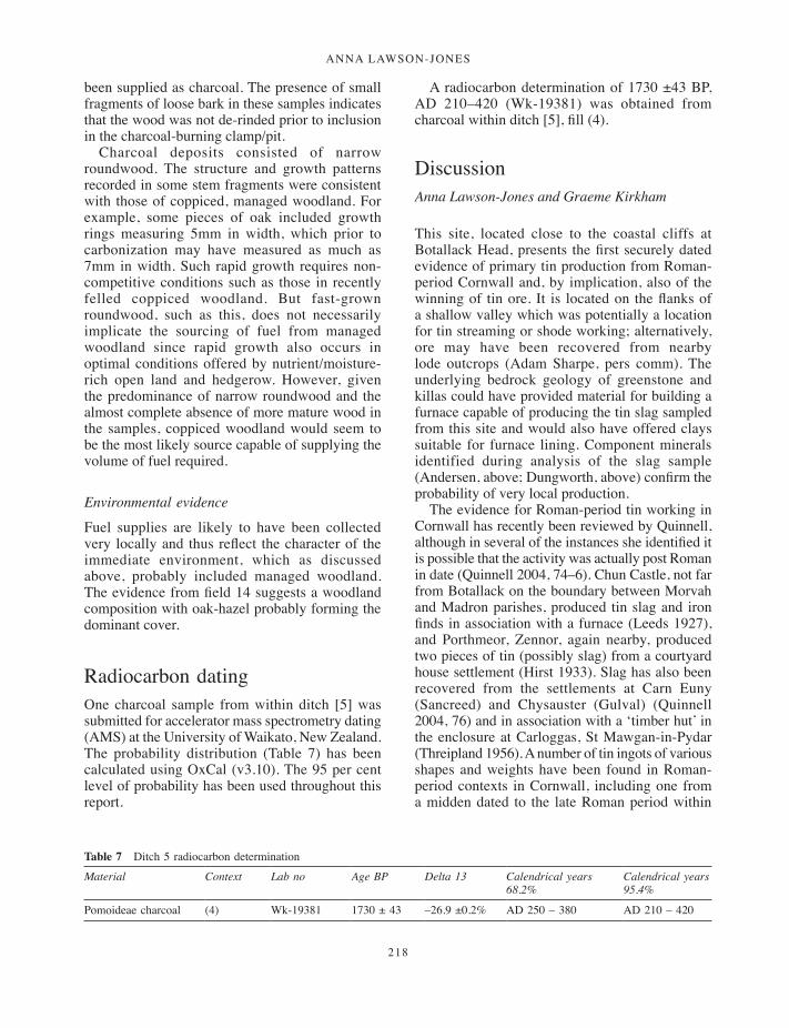
ANNA LAWSON-JONES
218
been supplied as charcoal. The presence of small fragments of loose bark in these samples indicates that the wood was not de-rinded prior to inclusion in the charcoal-burning clamp/pit.
Charcoal deposits consisted of narrow roundwood. The structure and growth patterns recorded in some stem fragments were consistent with those of coppiced, managed woodland. For example, some pieces of oak included growth rings measuring 5mm in width, which prior to carbonization may have measured as much as 7mm in width. Such rapid growth requires non-competitive conditions such as those in recently felled coppiced woodland. But fast-grown roundwood, such as this, does not necessarily implicate the sourcing of fuel from managed woodland since rapid growth also occurs in optimal conditions offered by nutrient/moisture-rich open land and hedgerow. However, given the predominance of narrow roundwood and the almost complete absence of more mature wood in the samples, coppiced woodland would seem to be the most likely source capable of supplying the volume of fuel required.
Environmental evidence
Fuel supplies are likely to have been collected very locally and thus reflect the character of the immediate environment, which as discussed above, probably included managed woodland. The evidence from field 14 suggests a woodland composition with oak-hazel probably forming the dominant cover.
Radiocarbon datingOne charcoal sample from within ditch [5] was submitted for accelerator mass spectrometry dating (AMS) at the University of Waikato, New Zealand. The probability distribution (Table 7) has been calculated using OxCal (v3.10). The 95 per cent level of probability has been used throughout this report.
A radiocarbon determination of 1730 ±43 BP, AD 210–420 (Wk-19381) was obtained from charcoal within ditch [5], fill (4).
DiscussionAnna Lawson-Jones and Graeme Kirkham
This site, located close to the coastal cliffs at Botallack Head, presents the first securely dated evidence of primary tin production from Roman-period Cornwall and, by implication, also of the winning of tin ore. It is located on the flanks of a shallow valley which was potentially a location for tin streaming or shode working; alternatively, ore may have been recovered from nearby lode outcrops (Adam Sharpe, pers comm). The underlying bedrock geology of greenstone and killas could have provided material for building a furnace capable of producing the tin slag sampled from this site and would also have offered clays suitable for furnace lining. Component minerals identified during analysis of the slag sample (Andersen, above; Dungworth, above) confirm the probability of very local production.
The evidence for Roman-period tin working in Cornwall has recently been reviewed by Quinnell, although in several of the instances she identified it is possible that the activity was actually post Roman in date (Quinnell 2004, 74–6). Chun Castle, not far from Botallack on the boundary between Morvah and Madron parishes, produced tin slag and iron finds in association with a furnace (Leeds 1927), and Porthmeor, Zennor, again nearby, produced two pieces of tin (possibly slag) from a courtyard house settlement (Hirst 1933). Slag has also been recovered from the settlements at Carn Euny (Sancreed) and Chysauster (Gulval) (Quinnell 2004, 76) and in association with a ‘timber hut’ in the enclosure at Carloggas, St Mawgan-in-Pydar (Threipland 1956). A number of tin ingots of various shapes and weights have been found in Roman-period contexts in Cornwall, including one from a midden dated to the late Roman period within
Table 7 Ditch 5 radiocarbon determination
Material Context Lab no Age BP Delta 13 Calendrical years 68.2%
Calendrical years 95.4%
Pomoideae charcoal (4) Wk-19381 1730 ± 43 –26.9 ±0.2% AD 250 – 380 AD 210 – 420
197-222_Lawson-Jones.indd 218 01/12/2014 11:54

Discoveries along the north lanD’s enD pipeline
219
Trethurgy (Quinnell 2004, 74–6). Some, at least, of the ‘Jews’ houses’ reported in antiquarian accounts – for example, one described at Ballowall, St Just-in-Penwith, by W C Borlase (1879) – are likely to represent smelting sites of the Roman period. Local production of tin artefacts during this period is confirmed by a pair of stone moulds for late Roman tin or ‘pewter’ dishes from St Just (Brown 1970). The participation of Cornish tin in international trade networks during later prehistory has often been assumed but has now been demonstrated by recent work in Denmark. Tin forming part of the fabric of the iconic Gundestrup cauldron, found in Denmark in the nineteenth century but probably manufactured in central Europe in the first to fourth century AD, has been shown to derive from Cornish sources (Nielsen et al 2005).
The apparently deliberate infilling of ditch [5] with debris associated with metalworking may represent the marking of a significant boundary with a selected, ‘meaningful’ deposit. In this instance the metalworking waste was deposited into an apparently open ditch, since there was no evidence for the re-cutting of an existing ditch fill prior to the deposit. Other Romano-British sites in Cornwall have provided instances of the deliberate backfilling of enclosure and field ditches and adjacent pits with ‘significant’ deposits (Jones 2000–1, 84–5; Jones and Taylor 2004, 116). At Little Quoit Farm, St Columb Major, ironworking waste was deposited into a pit dug into the fill of an earlier ditch at a date broadly contemporary with the activity at the Botallack site (Lawson-Jones and Kirkham 2009–10).
In addition to ditch [5] there were a series of other features which may have been contemporary, including pits, ditches and a structure. Only a few of these produced finds which suggested that they were associated with the tin-working activity. The fill of shallow linear feature [6] located just to the east of ditch [5] incorporated both a piece of slag and some charcoal. Just to the south, in field 16, pit [6] produced charcoal flecks and a small quantity of slag, and pit [12] revealed significant amounts of charcoal and a Romano-British sherd. Pit [30] offered evidence of in situ burning overlaid by a greenstone slab, possibly used as a working surface in some industrial activity, and an ash deposit.
All of these features can reasonably be interpreted as contemporary with Romano-British activity on the site. Their arrangement on the site plan suggests that some other features are likely
to date to this period. For example, in field 16 the position of pit [26] in relation to adjoining pits [12] and [30] suggests contemporaneity, as does the proximity of pit [6] to pit [4] (which contained pieces of burnt clay and charcoal). Since most of the features dated to the Romano-British period (via stratigraphically or diagnostically dated material, or by implication on the basis of arrangement or proximity) are essentially indistinguishable from the other, undated features, it is tempting to suggest that further features in the area are potentially of Romano-British date. Certainly none of these undated features produced material implying a link with the earlier multi-period flint scatter.
Post-built structure 40 was located close to the Romano-British metalworking waste in ditch [5], although no stratigraphic or artefactual association was identified. Although rather smaller than most excavated Romano-British structures (Quinnell 2004), its sub-oval shape is comparable with other small buildings of the period. Its relatively small size may imply that the posts represented an internal ring of support posts rather than an external ‘wall’. Perhaps the closest parallel is the recently excavated (and better preserved) structure 338 at Tremough, Penryn (Gossip and Jones 2009–10). This oval building was represented by a complex pattern of intercutting features and postholes forming a structure measuring 8m by 6.7m. As with the Botallack Head building, structure 338 was built entirely of timber, with an entrance between two wider-spaced postholes; unlike the Botallack Head structure, these were situated on the southern side of the building.
An oval Romano-British structure found at Carngoon Bank, Landewednack, measured 7m by 6m and was made up of pits and stakeholes surrounded by an outer gully (McAvoy 1980). Another structure associated with salt-making, at Trebarveth, St Keverne, measured 5.5m by 4m (Peacock 1969) and an oval stone-walled building 8m by 5m is known from Porth Godrevy, Gwithian (Fowler 1962). At Little Quoit Farm, St Columb Major, two sub-circular hollows with extensive evidence of iron smithing were dated to the Romano-British period and were of similar size to the Botallack Head building but provided no evidence for structures (Lawson-Jones and Kirkham 2009–10).
Given the significance which has been attributed to Cornwall’s tin resources from later prehistory into the Roman period (for example, Haverfield
197-222_Lawson-Jones.indd 219 01/12/2014 11:54
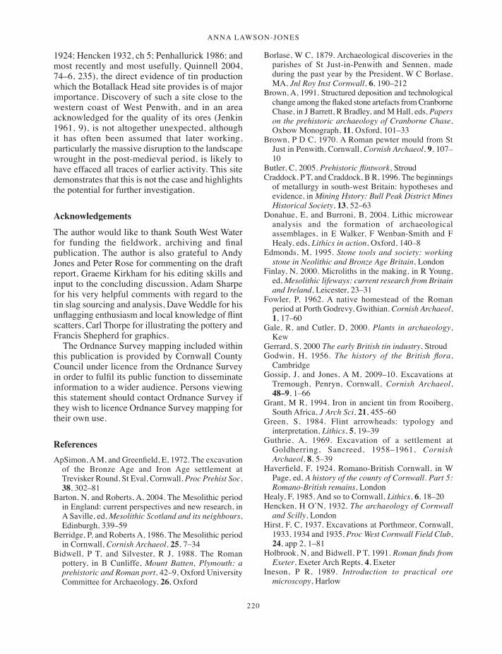
ANNA LAWSON-JONES
220
1924; Hencken 1932, ch 5; Penhallurick 1986; and most recently and most usefully, Quinnell 2004, 74–6, 235), the direct evidence of tin production which the Botallack Head site provides is of major importance. Discovery of such a site close to the western coast of West Penwith, and in an area acknowledged for the quality of its ores (Jenkin 1961, 9), is not altogether unexpected, although it has often been assumed that later working, particularly the massive disruption to the landscape wrought in the post-medieval period, is likely to have effaced all traces of earlier activity. This site demonstrates that this is not the case and highlights the potential for further investigation.
Acknowledgements
The author would like to thank South West Water for funding the fieldwork, archiving and final publication. The author is also grateful to Andy Jones and Peter Rose for commenting on the draft report, Graeme Kirkham for his editing skills and input to the concluding discussion, Adam Sharpe for his very helpful comments with regard to the tin slag sourcing and analysis, Dave Weddle for his unflagging enthusiasm and local knowledge of flint scatters, Carl Thorpe for illustrating the pottery and Francis Shepherd for graphics.
The Ordnance Survey mapping included within this publication is provided by Cornwall County Council under licence from the Ordnance Survey in order to fulfil its public function to disseminate information to a wider audience. Persons viewing this statement should contact Ordnance Survey if they wish to licence Ordnance Survey mapping for their own use.
ReferencesApSimon, A M, and Greenfield, E, 1972. The excavation
of the Bronze Age and Iron Age settlement at Trevisker Round, St Eval, Cornwall, Proc Prehist Soc, 38, 302–81
Barton, N, and Roberts, A, 2004. The Mesolithic period in England: current perspectives and new research, in A Saville, ed, Mesolithic Scotland and its neighbours, Edinburgh, 339–59
Berridge, P, and Roberts A, 1986. The Mesolithic period in Cornwall, Cornish Archaeol, 25, 7–34
Bidwell, P T, and Silvester, R J, 1988. The Roman pottery, in B Cunliffe, Mount Batten, Plymouth: a prehistoric and Roman port, 42–9, Oxford University Committee for Archaeology, 26, Oxford
Borlase, W C, 1879. Archaeological discoveries in the parishes of St Just-in-Penwith and Sennen, made during the past year by the President, W C Borlase, MA, Jnl Roy Inst Cornwall, 6, 190–212
Brown, A, 1991. Structured deposition and technological change among the flaked stone artefacts from Cranborne Chase, in J Barrett, R Bradley, and M Hall, eds, Papers on the prehistoric archaeology of Cranborne Chase, Oxbow Monograph, 11, Oxford, 101–33
Brown, P D C, 1970. A Roman pewter mould from St Just in Penwith, Cornwall, Cornish Archaeol, 9, 107–10
Butler, C, 2005. Prehistoric flintwork, StroudCraddock, P T, and Craddock, B R, 1996. The beginnings
of metallurgy in south-west Britain: hypotheses and evidence, in Mining Hstory: Bull Peak District Mines Historical Society, 13, 52–63
Donahue, E, and Burroni, B, 2004. Lithic microwear analysis and the formation of archaeological assemblages, in E Walker, F Wenban-Smith and F Healy, eds, Lithics in action, Oxford, 140–8
Edmonds, M, 1995. Stone tools and society: working stone in Neolithic and Bronze Age Britain, London
Finlay, N, 2000. Microliths in the making, in R Young, ed, Mesolithic lifeways: current research from Britain and Ireland, Leicester, 23–31
Fowler, P, 1962. A native homestead of the Roman period at Porth Godrevy, Gwithian. Cornish Archaeol, 1, 17–60
Gale, R, and Cutler, D, 2000. Plants in archaeology, Kew
Gerrard, S, 2000 The early British tin industry, StroudGodwin, H, 1956. The history of the British flora,
CambridgeGossip, J, and Jones, A M, 2009–10. Excavations at
Tremough, Penryn, Cornwall, Cornish Archaeol, 48–9, 1–66
Grant, M R, 1994. Iron in ancient tin from Rooiberg, South Africa, J Arch Sci, 21, 455–60
Green, S, 1984. Flint arrowheads: typology and interpretation, Lithics, 5, 19–39
Guthrie, A, 1969. Excavation of a settlement at Goldherring, Sancreed, 1958–1961, Cornish Archaeol, 8, 5–39
Haverfield, F, 1924. Romano-British Cornwall, in W Page, ed, A history of the county of Cornwall. Part 5: Romano-British remains, London
Healy, F, 1985. And so to Cornwall, Lithics, 6, 18–20Hencken, H O’N, 1932. The archaeology of Cornwall
and Scilly, LondonHirst, F, C, 1937. Excavations at Porthmeor, Cornwall,
1933, 1934 and 1935, Proc West Cornwall Field Club, 24, app 2, 1–81
Holbrook, N, and Bidwell, P T, 1991. Roman finds from Exeter, Exeter Arch Repts, 4, Exeter
Ineson, P R, 1989. Introduction to practical ore microscopy, Harlow
197-222_Lawson-Jones.indd 220 01/12/2014 11:54
Discoveries along the north lanD’s enD pipeline
221
Jacobi, R M, 1979. Early Flandrian hunters in the south west, Proc Devon Archaeol Soc, 37, 48–93
Jenkin, A K H, 1961. Mines and miners of Cornwall, 1: around St Ives, Truro (Truro Bookshop)
Jones, A M, 2000–1. The excavation of a multi-period site at Stencoose, Cornish Archaeol, 39–40, 45–94
Jones, A M, and Quinnell, H, 2006. Cornish Beakers: new discoveries and perspectives, Cornish Archaeol, 45, 31–67
Jones, A M, and Taylor, S, 2004. What lies beneath . . . St Newlyn East and Mitchell: archaeological investigations 2001, Truro (Historic Environment Service, Cornwall County Council)
Keene, B, 1999. A gazetteer of flint arrowheads from south-west Britain, Devon Archaeol Soc, Occ Pap, 19, Exeter
Lawson-Jones, A, Jones, A M, and Sharpe, A, 2007. North Land’s End SWW sewage transfer main, Cornwall: archaeological recording, Truro (Historic Environment Service, Cornwall County Council)
Lawson-Jones, A, and Kirkham, G, 2009–10. Smithing in the round: excavations at Little Quoit Farm, St Columb Major, Cornwall, Cornish Archaeol, 48–9, 173–226
Leeds, E T, 1927. Excavations at Chun Castle in Penwith, Cornwall, Archaeologia, 76, 205–40
McAvoy, F, 1980. The excavation of a multi-period site at Carngoon Bank, Lizard, Cornish Archaeol, 19, 31–62
Malham, A, Aylett, J, Higgs, E, and McDonnell, J G, 2002. Tin smelting slags from Crift Farm, Cornwall, and the effect of changing technology on slag composition, Historical Metallurgy, 36, 84–94
Mercer, R J, 1986. The Neolithic in Cornwall, Cornish Archaeol, 25, 35–81
Miles, H, 1975. Barrows on the St Austell granite, Cornish Archaeol, 14, 5–81
Mitchell, A, 1974. A field guide to the trees of Britain and Northern Europe, London
Newberry, J, 2002. Inland flint in prehistoric Devon: sources, tool-making quality and use, Proc Devon Archaeol Soc, 60, 1–37
Nielsen, S, Andersen, J H, Baker, J A, Christensen, C, Glastrup, J, Grootes, P M, Hüls, M, Jouttijärvi, A, Larsen, E B, Madsen, H B, Müller, K, Nadeau, M-J, Röhrs, S, Stege, H, Stos, A, and Waight, T E, 2005. The Gundestrup cauldron. New scientific and technical investigations, Acta Archaeologica, 76, 2, 1–58
Palmer, S, 1970. The Stone Age industry of the Isle of Portland, Dorset, and the utilisation of Portland Chert as artefact material in southern England, Proc Prehist Soc, 36, 82–115
Palmer, S, 1977. Mesolithic cultures of Britain, PoolePannett, A, 2011. Burning issues: fire and the
manufacture of stone tools in Neolithic Britain, in A Saville, ed, Flint and stone in the Neolithic
period, Neolithic Studies Group Seminar Papers, 11, 247–55
Patchett, F, 1944. Cornish Bronze Age pottery, Arch Jnl, 101, 17–49
Patchett, F, 1950. Cornish Bronze Age pottery, part 2, Arch Jnl, 107, 44–65
Peacock, D P S, 1969. A Romano-British salt working site at Trebarveth, St Keverne, Cornish Archaeol, 8, 47–65
Penhallurick, R, D, 1986. Tin in antiquity, London (Institute of Metals)
Quinnell, H, 2004. Trethurgy. Excavations at Trethurgy round, St Austell: community and status in Roman and post-Roman Cornwall, Truro (Historic Environment Service, Cornwall County Council)
Quinnell, H, 2013 [this volume]. The pottery, in J Gossip, The evaluation of a multi-period prehistoric site and fogou at Boden Vean, St Anthony-in-Meneage, Cornwall, 2003, Cornish Archaeol, 52, 26–49
Roberts, A J, 1987. Late Mesolithic occupation of the Cornish coast at Gwithian: preliminary results, in P Rowley-Conwy, M Zvelebil and H P Blankholm, eds, Mesolithic northwest Europe: recent trends, Sheffield, 131–7
Salter, C, 1997. A note on the tin slags from Caerloggas Down, Cornwall, and Upper Merrivale blowing house, Devon, in P Budd and D Gale, eds, Prehistoric extractive metallurgy in Cornwall, Truro (Cornwall Archaeological Unit), 45–50
Saville, A, 1981. The flint and chert artefacts, 101–52, in R Mercer, Excavations at Carn Brea, Illogan, Cornwall, 1970–73 – a Neolithic fortified complex of the third millennium bc, Cornish Archaeol, 20, 1–204
Taylor, S, 2004. Lower Boscaswell to Cot Valley Sewage Treatment Works, St Just, Cornwall: archaeological assessment, Truro (Historic Environment Service, Cornwall County Council)
Thorpe, C, and Thomas, C, 2007. Post-Roman material culture, 44–8, in J Nowakowski, H Quinnell, J Sturgess, C Thomas and C Thorpe, Return to Gwithian: shifting the sands of time, Cornish Archaeol, 46, 13–76
Threipland, L M, 1956. An excavation at St Mawgan-in-Pyder, north Cornwall, Arch Jnl, 93, 33–81
Tingle, M, 1998. The prehistory of Beer Head: field survey and excavations at an isolated flint source on the south Devon coast, Brit Arch Repts, Brit Ser, 270, Oxford
Tutin, T G, Heywood, V H N, Burges, A, Valentine, D H, Walters, S M, and Webb, D A, 1964–80. Flora Europaea, 1–5, Cambridge
Tylecote, R F, 1986. The prehistory of metallurgy in the British Isles, London (Institute of Metals)
Waddington, C, 1999. A landscape archaeological study of the Mesolithic-Neolithic in the Millfield Basin, Northumberland, Brit Arch Repts, Brit Ser, 291, Oxford
197-222_Lawson-Jones.indd 221 01/12/2014 11:54

ANNA LAWSON-JONES
222
Woodman, P C, Anderson, E, and Finlay, N, 1999. Excavations at Ferriter’s Cove, 1983–95: last foragers, first farmers in the Dingle peninsula, Dublin
Wymer, J, 1977. Gazetteer of Mesolithic sites in England and Wales, York
197-222_Lawson-Jones.indd 222 01/12/2014 11:54

223
Cornish Archaeology 52, 2013, 223–231
Castle-an-Dinas, St Columb Major: a new survey
SHARON SOUTAR
In the spring of 2011 English Heritage’s Archaeological Survey and Investigation team carried out a detailed analytical survey of Castle-an-Dinas, an Iron Age hillfort located in the parish of St Columb Major in mid-Cornwall (Bishop 2011). The hillfort is a Scheduled Monument (National Heritage List number 1006713). The survey was undertaken at the invitation of the Cornwall Heritage Trust, which owns the site, and facilitated by the Historic Environment team at Cornwall Council. The project provided a useful training opportunity for two students on the English Heritage Professional Placement in Conservation (EPPIC) scheme.
Castle-an-Dinas crowns the summit of Castle Downs, a rounded hill that rises to nearly 215m within the rolling plateau of the central ‘Cornish Killas’ landscape character area (Countryside Agency 1999, 180). A granite outcrop underlies the western side of the hill but the geology is mostly Devonian slates of the Meadfoot Beds series (Davison 1935; Wailes 1963, 52). In views out from the site the St Breock Downs form the near horizon 5.5 km to the north and the slightly larger granite summit of Belowda Beacon is about 2.5 km to the east, with glimpses of Bodmin Moor and Helman Tor beyond. The massive mountains of waste material from extensive china clay workings, known locally as the ‘Cornish Alps’, dominate the skyline of the Hensbarrow Downs 5 km to the south across Goss Moor. The landscape is more open to the west and on a clear day patches of brilliant blue sea can be seen off the north Cornish coast.
Previous archaeological investigations comprised a measured survey by Samuel Lysons
(1814), small-scale excavations and a measured survey in the 1960s by the late Bernard Wailes (1963; 1964; 1965), a magnetometry survey of part of the interior (Cripps 2004) and very limited excavation ahead of conservation work (Preston-Jones 1994). In the early twentieth century the hilltop was mined for wolfram and the history of this operation has been recorded by Brooks (2001); the surviving traces of mining activity have recently been surveyed by Buck and Thomas (2012).
The earthworksCastle-an-Dinas comprises four concentric circuits of ramparts that enclose a roughly circular area of 1.65 ha. The hachured survey produced by the investigation (Fig 1) shows that enclosure of the hilltop was undertaken in several phases but provides no support for speculation that part of the earthworks represents an early Neolithic causewayed enclosure (cf Cornwall and Scilly Historic Environment Record (HER) PRN 21602). Within the enclosure are the remains of at least one heavily damaged probable Bronze Age barrow and a post-medieval quarry. A second possible barrow is suggested by an amorphous group of mounds and hollows measuring about 17m in diameter. The location of these features immediately south west of the quarry, the lack of finds from the two pits excavated by Borlase (1871, 19), and the presence of two large stones all suggest that Wailes was probably correct in his interpretation of these features as quarry spoil (1963, 54). Another
223-232_Soutar.indd 223 01/12/2014 11:55

sharon soutar
224
possible barrow is located to the south east of the hillfort (at SW 9469 6218). An oblong depression observed in its summit early in the twentieth century suggests that it had been excavated although apparently without record (Henderson 1916–1917, 13). It has since been smoothed over by ploughing. Other features in the interior include
a pond of uncertain date on the northern side – both Hals and Tonkin mentioned a pool within the hillfort about 1700 (de Dunstanville 1811, 342–3n) – and, against the inner face of the inner rampart in the north-eastern quadrant, an area of disturbance representing an infilled ventilation shaft of the wolfram mine (Buck and Thomas 2012).
Fig 1 The analytical earthwork survey, shown reduced from the original scale. (© English Heritage.)
223-232_Soutar.indd 224 01/12/2014 11:55

Castle-an-Dinas, st Columb major
225
Rampart 1 of the hillfort, the innermost circuit, comprises a bank and flanking outer ditch. Changes in gradient on the exterior face emphasise the junction between the dumped bank material and the cut of the ditch, especially where this extends through the granite along the western side. Some slippage in the bank material has produced a shallow skirt along the interior face but in places there is more of a step or low terrace, especially along the eastern side, perhaps suggesting an earlier phase of construction. Slight changes in the depth of the ditch are usually associated with corresponding changes in the height of the bank where various erosion scars cut through.
A gap defines the original entrance to the south west, with low in-turned banks on either side that are both topped with small mounds. Two low narrow banks reduce the width of the entrance. A more recent entrance has been cut completely through rampart 1 on the eastern side with a corresponding causeway constructed across the ditch. Immediately to the north is a platform apparently constructed by pushing out material from the top of the bank. A second identical platform is located 58m to the south and is topped with broken concrete blocks. Both supported an aerial ropeway or ‘blondin’ for the early twentieth-century mining operation (Buck and Thomas 2012, fig 23).
Rampart 2 is arguably the most altered of the earthwork circuits. Survival of the outer ditch is fragmentary and shallow while the bank clearly comprises several distinct sections of different physical character. Much of this circuit is on a scale just below that of rampart 1. Several sections, however, exhibit a different morphology. They comprise lower and narrower banks that are not quite aligned on the more massive earthworks of most of the circuit. This is particularly marked to the north north west, where a 50m stretch of lesser bank meets what looks like the bull-nosed terminal of the larger bank, apparently aligned slightly more to the north. Visitor and animal erosion may be contributing to the lack of chronological clarity in these earthworks. The original entrance is to the south west and two low, narrow banks, remarkably similar to those in rampart 1 but each flanked uphill by a shallow ditch, reduce its width. A short section of rampart 2 on the south-east side was re-built during erosion repairs in 2009 (Preston-Jones and Stanley, 2011, 11).
Rampart 3 is the slightest of the three circuits and defines an area about 220m across. Over most of
the circuit it takes the form of a low bank which is most evident downslope, especially on the northern side of the hillfort (Figs 2, 3 and 5). It is flanked by a shallow outer ditch and in places a very slight narrow outer counterscarp bank survives. Although heavily eroded where footpaths and trackways have cut across it, the only real break or entrance is to the south west, where a broad gap separates the two terminals.
Rampart 4 is the outermost circuit, comprising bank, ditch and counterscarp bank. In places along the outer side, especially to the south, the ditch face is almost vertical and clearly cut into the rock. The outline of the counterscarp bank has been artificially straightened by ploughing beyond the fence-line and the surface is much stonier, probably deriving from field clearance. Two piles of concrete and stone rubble, which are becoming overgrown, are located just outside the hillfort and a small pile of rubble overlies the counterscarp bank on the eastern side of the original entrance. The entrance is again in the south west and a low, narrow bank, similar to those observed across the original entrances in ramparts 1 and 2, extends from the north-western side but is flanked by an outer shallow ditch. There are several additional cuts through this circuit, which are now used for access.
DiscussionThe barrows are the earliest signs of monumental activity on the hilltop. They form part of a much wider ceremonial landscape of the late Neolithic and early Bronze Age in this part of Cornwall, together with standing stones and barrows on the St Breock Downs to the north and ceremonial features recently discovered along the new route of the A30 to the south (Clark and Foreman 2009). It has been suggested that the late Neolithic hengiform pit circle at Royalton, just 1 km to the south of the hillfort, references the hilltop on which Castle-an-Dinas sits (ibid, 31). This elevated natural place may have formed a focal point in the landscape on and around which monuments were deliberately located. Each individual site probably marks a significant place that was visited repeatedly and modified at different times over generations, with barrows being constructed over some of these ceremonial sites in the Early Bronze Age (Jones 2005, 28).
223-232_Soutar.indd 225 01/12/2014 11:55
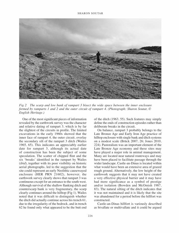
sharon soutar
226
One of the most significant pieces of information revealed by the earthwork survey was the character and relative dating of rampart 3, which is by far the slightest of the circuits in profile. The limited excavations in the early 1960s showed that the inner face of rampart 4, the outer circuit, overlay the secondary silt of the rampart 3 ditch (Wailes 1965, 65). This indicates an appreciably earlier date for rampart 3, although its actual date of construction has been the subject of some speculation. The scatter of chipped flint and the six ‘breaks’ identified in the rampart by Wailes (ibid), together with its poor visibility on historic aerial photographs, led to the suggestion that the site could represent an early Neolithic causewayed enclosure (HER PRN 21602), however, the earthwork survey clearly shows that rampart 3 was continuous except for an entrance to the south west. Although survival of the shallow flanking ditch and counterscarp bank is very fragmentary, the scarp clearly continues around the hilltop (Fig 1). Wailes noted that it was difficult to distinguish whether the ditch did actually continue across his trench 61, due to the irregularity of the bedrock, and in trench 62 he found only what appeared to be the butt end
of the ditch (1963, 55). Such features may simply define the ends of construction episodes rather than deliberate breaks in the circuit.
On balance, rampart 3 probably belongs to the Late Bronze Age and Early Iron Age practice of hilltop enclosure with single bank and ditch systems on a modest scale (Brück 2007, 26; Jones 2010, 224). Pastoralism was an important element of the Late Bronze Age economy and these sites may have played a major role in animal management. Many are located near natural routeways and may have been placed to facilitate passage through the wider landscape. Castle-an-Dinas is located within what would have been an extensive area of grazed rough ground. Alternatively, the low height of the earthwork suggests that it may not have created a very effective physical barrier and it may have had more significance as a symbol of prestige and/or isolation (Bowden and McOmish 1987, 83). The natural silting of the ditch indicates that it was not maintained and it is likely that the site was abandoned for a period before the hillfort was constructed.
Castle-an-Dinas hillfort is variously described as bivallate or multivallate and it could be argued
Fig 2 The scarp and low bank of rampart 3 bisect the wide space between the inner enclosure formed by ramparts 1 and 2 and the outer circuit of rampart 4. (Photograph: Sharon Soutar, © English Heritage.)
223-232_Soutar.indd 226 01/12/2014 11:55
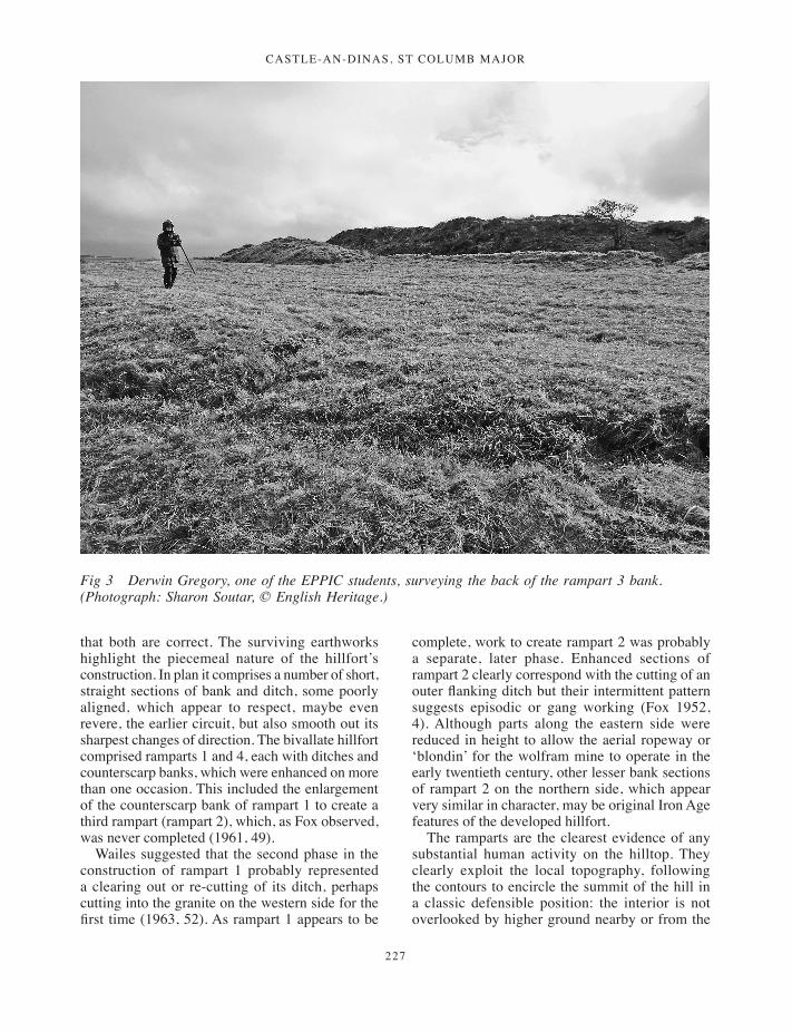
Castle-an-Dinas, st Columb major
227
that both are correct. The surviving earthworks highlight the piecemeal nature of the hillfort’s construction. In plan it comprises a number of short, straight sections of bank and ditch, some poorly aligned, which appear to respect, maybe even revere, the earlier circuit, but also smooth out its sharpest changes of direction. The bivallate hillfort comprised ramparts 1 and 4, each with ditches and counterscarp banks, which were enhanced on more than one occasion. This included the enlargement of the counterscarp bank of rampart 1 to create a third rampart (rampart 2), which, as Fox observed, was never completed (1961, 49).
Wailes suggested that the second phase in the construction of rampart 1 probably represented a clearing out or re-cutting of its ditch, perhaps cutting into the granite on the western side for the first time (1963, 52). As rampart 1 appears to be
complete, work to create rampart 2 was probably a separate, later phase. Enhanced sections of rampart 2 clearly correspond with the cutting of an outer flanking ditch but their intermittent pattern suggests episodic or gang working (Fox 1952, 4). Although parts along the eastern side were reduced in height to allow the aerial ropeway or ‘blondin’ for the wolfram mine to operate in the early twentieth century, other lesser bank sections of rampart 2 on the northern side, which appear very similar in character, may be original Iron Age features of the developed hillfort.
The ramparts are the clearest evidence of any substantial human activity on the hilltop. They clearly exploit the local topography, following the contours to encircle the summit of the hill in a classic defensible position: the interior is not overlooked by higher ground nearby or from the
Fig 3 Derwin Gregory, one of the EPPIC students, surveying the back of the rampart 3 bank. (Photograph: Sharon Soutar, © English Heritage.)
223-232_Soutar.indd 227 01/12/2014 11:55
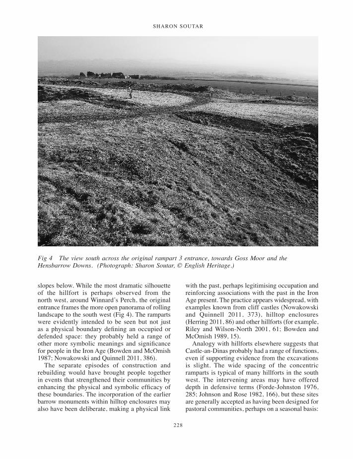
sharon soutar
228
slopes below. While the most dramatic silhouette of the hillfort is perhaps observed from the north west, around Winnard’s Perch, the original entrance frames the more open panorama of rolling landscape to the south west (Fig 4). The ramparts were evidently intended to be seen but not just as a physical boundary defining an occupied or defended space: they probably held a range of other more symbolic meanings and significance for people in the Iron Age (Bowden and McOmish 1987; Nowakowski and Quinnell 2011, 386).
The separate episodes of construction and rebuilding would have brought people together in events that strengthened their communities by enhancing the physical and symbolic efficacy of these boundaries. The incorporation of the earlier barrow monuments within hilltop enclosures may also have been deliberate, making a physical link
with the past, perhaps legitimising occupation and reinforcing associations with the past in the Iron Age present. The practice appears widespread, with examples known from cliff castles (Nowakowski and Quinnell 2011, 373), hilltop enclosures (Herring 2011, 86) and other hillforts (for example, Riley and Wilson-North 2001, 61; Bowden and McOmish 1989, 15).
Analogy with hillforts elsewhere suggests that Castle-an-Dinas probably had a range of functions, even if supporting evidence from the excavations is slight. The wide spacing of the concentric ramparts is typical of many hillforts in the south west. The intervening areas may have offered depth in defensive terms (Forde-Johnston 1976, 285; Johnson and Rose 1982, 166), but these sites are generally accepted as having been designed for pastoral communities, perhaps on a seasonal basis:
Fig 4 The view south across the original rampart 3 entrance, towards Goss Moor and the Hensbarrow Downs. (Photograph: Sharon Soutar, © English Heritage.)
223-232_Soutar.indd 228 01/12/2014 11:55

Castle-an-Dinas, st Columb major
229
the inner enclosure formed the main inhabited area and the outer enclosures were for corralling livestock (Cunliffe 2005, 283). Fox suggested that they were mostly for cattle (1952, 18) but sheep are better suited to upland grazing (Quinnell 1986, 117). It is also possible that the space between ramparts 2 and 4 was intended to have a further rampart or ramparts built on it (Mark Bowden, pers comm).
Like many hillforts, Castle-an-Dinas is located in an ecologically liminal zone: it lies on the watershed of rivers linking it with both coastlines and within a large area of rough ground that includes the boggy moorland basin of Goss Moor and its rich mineral deposits. The exploitation of these various resources probably added to the hillfort’s significance. One of its functions may have been as a place to negotiate and regulate access to them, although whether as the centre of a discrete territory, as suggested for West Penwith (Herring 1994, 47), or as a defined ‘neutral’ place where different communities could safely come
together is yet to be established. Perhaps both were true at different points in time.
Wailes’ limited excavations of Castle-an-Dinas suggest a single short-lived occupation phase (1963, 55). Only the slightest suggestions of circular hut platforms can be traced as earthworks on the south-facing slope of the interior. One is scorched black and perhaps owes its presence more to its role as host of the annual midsummer bonfire. The few sherds of pottery from Castle-an-Dinas are generally accepted as South Western Decorated ware, which was common in Cornwall from the late fourth to first centuries BC (Nowakowski and Quinnell 2011, 353).
The original entrance is typical of hillforts in Cornwall. The gaps in each rampart are relatively broad but are aligned to the south west, with stone kerbed in-turns on the inner circuit. Hillfort entrances have traditionally been seen as the weakest defensive point and therefore subject to more rebuilding and modification. However, more recent interpretive work explores a wider range
Fig 5 Castle-an-Dinas from the north west. The variability in the earthworks of rampart 2 in this quadrant is very clear, as is the success of the Cornwall Heritage Trust vegetation management regime on the site. (Photograph: Historic Environment, Cornwall Council: F100-26; October 2010.)
223-232_Soutar.indd 229 01/12/2014 11:55
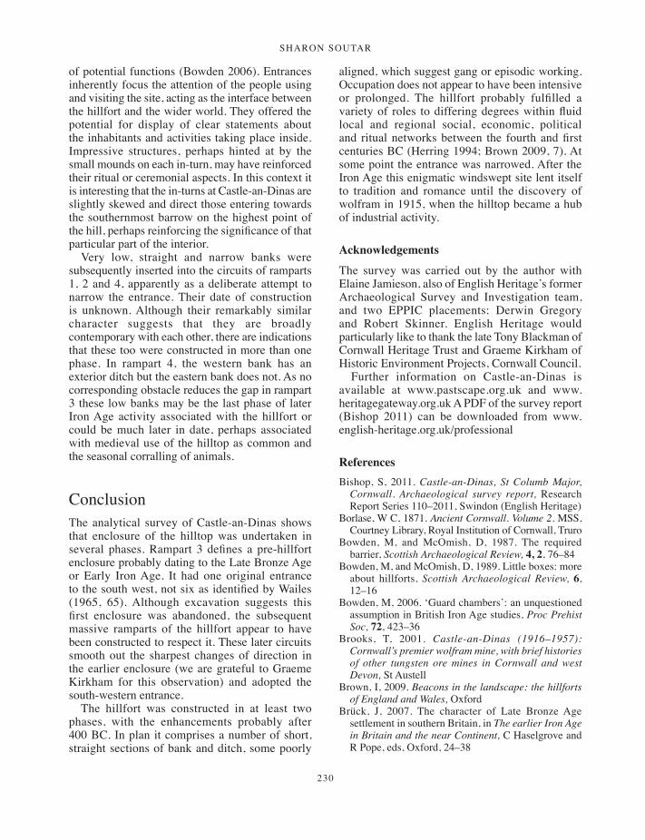
sharon soutar
230
of potential functions (Bowden 2006). Entrances inherently focus the attention of the people using and visiting the site, acting as the interface between the hillfort and the wider world. They offered the potential for display of clear statements about the inhabitants and activities taking place inside. Impressive structures, perhaps hinted at by the small mounds on each in-turn, may have reinforced their ritual or ceremonial aspects. In this context it is interesting that the in-turns at Castle-an-Dinas are slightly skewed and direct those entering towards the southernmost barrow on the highest point of the hill, perhaps reinforcing the significance of that particular part of the interior.
Very low, straight and narrow banks were subsequently inserted into the circuits of ramparts 1, 2 and 4, apparently as a deliberate attempt to narrow the entrance. Their date of construction is unknown. Although their remarkably similar character suggests that they are broadly contemporary with each other, there are indications that these too were constructed in more than one phase. In rampart 4, the western bank has an exterior ditch but the eastern bank does not. As no corresponding obstacle reduces the gap in rampart 3 these low banks may be the last phase of later Iron Age activity associated with the hillfort or could be much later in date, perhaps associated with medieval use of the hilltop as common and the seasonal corralling of animals.
ConclusionThe analytical survey of Castle-an-Dinas shows that enclosure of the hilltop was undertaken in several phases. Rampart 3 defines a pre-hillfort enclosure probably dating to the Late Bronze Age or Early Iron Age. It had one original entrance to the south west, not six as identified by Wailes (1965, 65). Although excavation suggests this first enclosure was abandoned, the subsequent massive ramparts of the hillfort appear to have been constructed to respect it. These later circuits smooth out the sharpest changes of direction in the earlier enclosure (we are grateful to Graeme Kirkham for this observation) and adopted the south-western entrance.
The hillfort was constructed in at least two phases, with the enhancements probably after 400 BC. In plan it comprises a number of short, straight sections of bank and ditch, some poorly
aligned, which suggest gang or episodic working. Occupation does not appear to have been intensive or prolonged. The hillfort probably fulfilled a variety of roles to differing degrees within fluid local and regional social, economic, political and ritual networks between the fourth and first centuries BC (Herring 1994; Brown 2009, 7). At some point the entrance was narrowed. After the Iron Age this enigmatic windswept site lent itself to tradition and romance until the discovery of wolfram in 1915, when the hilltop became a hub of industrial activity.
Acknowledgements
The survey was carried out by the author with Elaine Jamieson, also of English Heritage’s former Archaeological Survey and Investigation team, and two EPPIC placements: Derwin Gregory and Robert Skinner. English Heritage would particularly like to thank the late Tony Blackman of Cornwall Heritage Trust and Graeme Kirkham of Historic Environment Projects, Cornwall Council.
Further information on Castle-an-Dinas is available at www.pastscape.org.uk and www.heritagegateway.org.uk A PDF of the survey report (Bishop 2011) can be downloaded from www.english-heritage.org.uk/professional
ReferencesBishop, S, 2011. Castle-an-Dinas, St Columb Major,
Cornwall. Archaeological survey report, Research Report Series 110–2011, Swindon (English Heritage)
Borlase, W C, 1871. Ancient Cornwall. Volume 2. MSS, Courtney Library, Royal Institution of Cornwall, Truro
Bowden, M, and McOmish, D, 1987. The required barrier, Scottish Archaeological Review, 4, 2, 76–84
Bowden, M, and McOmish, D, 1989. Little boxes: more about hillforts, Scottish Archaeological Review, 6, 12–16
Bowden, M, 2006. ‘Guard chambers’: an unquestioned assumption in British Iron Age studies, Proc Prehist Soc, 72, 423–36
Brooks, T, 2001. Castle-an-Dinas (1916–1957): Cornwall’s premier wolfram mine, with brief histories of other tungsten ore mines in Cornwall and west Devon, St Austell
Brown, I, 2009. Beacons in the landscape: the hillforts of England and Wales, Oxford
Brück, J, 2007. The character of Late Bronze Age settlement in southern Britain, in The earlier Iron Age in Britain and the near Continent, C Haselgrove and R Pope, eds, Oxford, 24–38
223-232_Soutar.indd 230 01/12/2014 11:55

Castle-an-Dinas, st Columb major
231
Buck, C, and Thomas, N, 2012. Castle-an-Dinas mine, St Columb Major, Cornwall: archaeological assessment, Truro (Historic Environment Projects, Cornwall Council)
Clarke, P, and Foreman, S, 2009. The archaeology of the A30 Bodmin to Indian Queens road scheme, Oxford (Oxford Archaeology) [online at: http://library.thehumanjourney.net/438/ Accessed 4 October 2011]
Countryside Agency 1999. Countryside Character, Volume 8: South West. Character Area 152: Cornish killas, Cheltenham (Countryside Agency)
Cripps, L J, 2004. Castle-an-Dinas, St Columb Major, Cornwall: magnetometry survey. Durham (Department of Archaeology, University of Durham)
Cunliffe, B, 2005. Iron Age communities in Britain: an account of England, Scotland and Wales from the seventh century BC until the Roman conquest, London (4th edn)
Davison, E H, 1935. The geology of Castle-an-Dinas wolfram mine, Cornwall, Economic Geology, 30, 689–94
de Dunstanville, F, ed, 1811. Carew’s survey of Cornwall; to which are added notes illustrative of its history and antiquities by the late Thomas Tonkin esq, London
Forde-Johnston, J, 1976. Hillforts of the Iron Age in England and Wales: a summary of the surface evidence, Liverpool
Fox, A 1952. Hill-slope forts and related works in south western England and south Wales, Arch Jnl, 109, 1–22
Fox, A, 1961. South western hillforts, in Problems of the Iron Age in southern Britain, S S Frere, ed, Institute of Archaeology Occ Pap, 11, London (University of London Institute of Archaeology), 35–60
Henderson, C, 1916–1917. Notes on Pydar and Powder Hundreds. MSS, Courtney Library, Royal Institution of Cornwall, Truro, 13–15
Herring, P, 1994. The cliff castles and hillforts of West Penwith in the light of recent work at Maen Castle and Treryn Dinas, Cornish Archaeol, 33, 40–56
Herring, P, 2011. Hilltop enclosures, in P Dudley, Goon, hal, cliff and croft: the archaeology and landscape
of west Cornwall’s rough ground, Truro (Historic Environment, Cornwall Council)
Johnson, N, and Rose, P, 1982. Defended settlement in Cornwall: an illustrated discussion, in The Romano-British countryside: studies in rural settlement and economy, D Miles, ed, Brit Arch Repts, Brit Ser, 103 (i), 151–207
Jones, A M, 2005. Cornish Bronze Age ceremonial landscapes c. 2500–1500 BC, Brit Arch Repts, Brit Ser, 394, Oxford
Jones, A M, 2010. Misplaced monuments? A review of ceremony and monumentality in first millennium cal BC Cornwall, Oxford J Archaeol, 29, 2, 203–28
Lysons, D, and Lysons, S, 1814. Magna Britannia: being a concise topographical account of the several counties of Great Britain. Volume the third containing Cornwall, London
Nowakowski, J A, and Quinnell, H, 2011. Trevelgue Head, Cornwall: the importance of C K Croft Andrew’s 1939 excavations for prehistoric and Roman Cornwall, Truro (Historic Environment, Cornwall Council)
Preston-Jones, A, 1994. Management work at Castle-an-Dinas, St Columb Major, Cornwall, Truro (Cornwall Archaeological Unit)
Preston-Jones, A, and Stanley, J, 2011. Castle-an-Dinas, St Columb Major, Cornwall: management and interpretation works, Truro (Historic Environment, Cornwall Council)
Quinnell, H, 1986. Cornwall during the Iron Age and Roman period, Cornish Archaeol, 25, 111–34
Riley, H, and Wilson-North, R, 2001. The field archaeology of Exmoor, Swindon (English Heritage)
Wailes, B, 1963. Excavations at Castle-an-Dinas, St Columb Major: interim report, Cornish Archaeol, 2, 51–5
Wailes, B, 1964. Castle-an-Dinas, St Columb Major, Cornish Archaeol, 3, 85
Wailes, B, 1965. Castle-an-Dinas, St Columb Major, Cornish Archaeol, 4, 65
223-232_Soutar.indd 231 01/12/2014 11:55

223-232_Soutar.indd 232 01/12/2014 11:55

233
Cornish Archaeology 52, 2013, 233–238
Roman amphorae in Iron Age Cornwall: pre-Roman, Roman or post-Roman?
A P FITZPATRICK
The evidence for the importation of Roman amphorae into Iron Age Cornwall is reviewed. Certain finds have been used to provide support for an Iron Age tin trade but only the finds from Threemilestone and Carn Euny can be shown to have been certainly imported at this time.
Roman amphorae suggested to have been imported into Cornwall during the Iron Age have been reported from six sites: Carn Euny, Castle Dore, Gear, The Rumps, Threemilestone and Trethurgy (Fig 1). All these finds have been proposed as certainly or possibly of Dressel 1 type, the form of Italian wine amphorae found most widely in western Europe, including Britain, in the later second and first centuries BC (Tchernia 1983; 1986; Fitzpatrick 2003; Carver 2001; Loughton 2003; Poux 2004). As such, the finds from Cornwall might be welcomed as evidence of rewards deriving from a trade in tin in the later Iron Age (cf Penhallurick 1986, 139–47). However, a re-appraisal of this evidence, briefly reviewed by site below, has shown that there are few typologically diagnostic sherds and that the stratigraphic context of some of them is not clear.
Carn Euny
Two fragments of Dressel 1, perhaps from different vessels, were found in the excavation of the settlement and souterrain at Carn Euny, Sancreed. The fragments were described as a body sherd and a part of a base (Christie 1978, 396, 403, fig 55, 22; Williams 1978) and suggested to be from the earlier variety of the Dressel 1, the 1A, which dates to the later second and first centuries BC (Peacock and Williams 1986, 86–8; Poux 2004, 48–50).
Doubt has been expressed as to whether the base fragment provided sufficient evidence to allow attribution to a particular variety of Dressel 1 (Fitzpatrick 1985a, 323, no 1), but examination of the sherds in the Royal Cornwall Museum, Truro, showed that the one described as a body sherd (no F765) is actually part of a rim of Dressel 1A type (Fig 2). On this basis this find may be accepted as Iron Age, probably dating to the second half of the second century or the first half of the first century BC.
Castle Dore
In their reconsideration of the chronology of the hillfort at Castle Dore, Henrietta Quinnell and Daphne Harris suggested that some amphorae from the site were Iron Age imports (1985, 130). Sherds in an Italian fabric were suggested to come from either a Dressel 1 or Dressel 2–4. The date range for these types mainly covers the second century BC to the first century AD. A single sherd in a Catalonian fabric, from north-east Spain, was considered to be from a Pascual 1 type of late first century BC or early first century AD date. Examination of this sherd in the Royal Cornwall Museum, Truro, shows that it is from the neck of the amphora and so cannot be attributed to type with certainty as it has become progressively more clear that later amphorae such as the Dressel 2–4,
233-238_Fitzpatrick.indd 233 01/12/2014 11:56

a p fitzpatrick
234
were also made in this Catalonian fabric (Sealey 1985, 36–7, 41–2, 45, 138–9).
Although the earlier Pascual 1 type is more frequent in Britain than the Dressel 2–4 (Miró 1988, mapa 6–7), the Dressel 2–4 was imported occasionally into Iron Age Britain and, more frequently, Roman Britain, including Roman Exeter (Holbrook and Bidwell 1991; Holbrook 1992, 56–62; Revilla and Carerras 1993; Fitzpatrick 2003, 14). A sherd of a Catalonian amphora that cannot be attributed to type is also known from Hormer Lane, Seaton, Devon (P Weddell, pers comm).
In view of the discovery of a possible flagon of early Romano-British date at Castle Dore (Quinnell and Harris 1985, 130), it is possible that all the Roman pottery at Castle Dore is broadly contemporary, perhaps having arrived during the conquest of Cornwall (cf Hartgroves and Smith 2008).
Gear
Two sherds of an Italian amphora, probably from its shoulder or neck, were found in an Iron Age ring gully (703) in the hillfort. The sherds could be from either a Dressel 1 or 2–4 form but on the basis of the pottery from the trench it is likely that the vessel was an Iron Age import (Edwards and Kirkham 2008, 66, 82, 86).
The Rumps
A fragment of rim and handle was described (but not illustrated) by Christopher Hawkes in an appendix to the second interim report on the excavations at The Rumps cliff castle (Hawkes 1966). The piece was found in what was described as late slip into the ditch of the middle rampart of the cliff castle (Brooks 1966, 7; 1974, 12, 29). Hawkes described the piece as having the handle
Fig 1 Sites at which finds of Roman amphora have been suggested to date to the Iron Age.
233-238_Fitzpatrick.indd 234 01/12/2014 11:57
Roman amphoRae in iRon age CoRnwall
235
of a Dressel 1 (which had been trimmed) and the rim of a Dressel 2–4. Unable to identify both these characteristics in a type of amphora then known, but noting parallels in Dressel 1 from Ventimiglia, Italy, he suggested that it might be a rare or even hybrid form of mid-first century BC date. The find from The Rumps was not illustrated in the final excavation report (Brooks 1974) and cannot now be traced.
Hawkes preferred a date for the amphora in the Iron Age, in part because types of Romano-British date were better known at that time. That situation has changed and while the possibility of a rare hybrid form cannot be excluded, Dressel 1A vessels that match Hawkes’s description quite well have been found subsequently in England (for example, Fitzpatrick 2003, fig 12, 1).
However, the description of the find from The Rumps can now also be seen to be compatible with later types of amphorae. These include second-third century AD Italian varieties of Dressel 2–4. These vessels combine a simple beaded or almond-profiled rim with simple handles that do not have the figure-of-eight section previously considered to be typical of the type (Arthur and Williams 1992). Isolated finds of this variety have sometimes been confused with the earlier Dressel 1 (Rigby 1988; Arthur and Williams 1992; Fitzpatrick 2003, 21). Although it has been suggested that amphorae of Romano-British date are virtually absent from Cornwall (Thomas 1981, 18), there are a number of stratified finds – for example, from sites such as Castle Gotha (Saunders and Harris 1982, 143, no 88) and Trethurgy (Quinnell 2004, 101–2) – and there seems little reason to doubt that some older finds such as those from St Minver (Kent 1859; Trollope 1860) are genuine Romano-British introductions.
The outer rampart at The Rumps has been suggested to be post-Roman in date and Hawkes acknowledged the possibility that the amphora from it might be of this date, drawing the analogy with a find from Chun Castle and commenting ‘regrettably enough, however, neither piece [The Rumps and Chun Castle] lends itself to a positive statement of date without alternative, which even might (just possibly) be post-Roman’ (1966, 10). The find from Chun Castle has since been shown to be post-Roman (cf Thomas 1981, 11), while the description of the find from The Rumps could also been seen as compatible with north African spatheion type cylindrical amphorae of fourth-fifth century AD date (for example, Keay types 25–6;
Keay 1984), which are increasingly well attested in continental Europe (for instance Martin-Kilcher 1993, 448–9, fig 200, 12–13). The type and date of the vessel from The Rumps cannot therefore now be determined and it cannot be confidently regarded as an Iron Age import.
Threemilestone
The complete rim of a Dressel 1A and two sherds from another amphora were found in the southern terminal of a ditch around house 3 in an open settlement. A radiocarbon date suggests that the finds were deposited in the first half of the first century BC (Pitts 2005; A Jones, pers comm; Gossip, forthcoming).
Trethurgy
A single sherd from an Italian amphora from the round at Trethurgy was initially considered to be from a Dressel 1, possibly 1A, vessel (Cunliffe 1982, 63; Fitzpatrick 1985a, 323, no. 2; Quinnell and Harris 1985, 130). Although there is some evidence for an earlier phase of activity at the site, the principal occupation started in the mid-second century AD, well after the manufacture and export of Dressel 1 had ceased (Quinnell 1986, 126–7; 2004, 101, 166).
Examination of the sherd, which is from a post-Roman context, shows that it is a typologically undiagnostic body sherd that could as well be from a Dressel 2–4 as a Dressel 1, and so contemporary with the other Romano-British imports at the site; these include Dressel 20 amphorae that contained Spanish olive oil (Quinnell 2004, 101–2).
Discussion
As it has become progressively more apparent that different varieties of amphorae were made in the same region at different times, it has also become clear that less confidence can be placed on the fabric of an amphora sherd as indicator of its form or its date. A reassessment of the Italian amphorae from Cornwall suggested to be of Iron Age date illustrates this point.
The Castle Dore finds might be early Romano-British introductions, the Trethurgy finds could be Iron Age or Romano-British in date, and the type and date of the piece from The Rumps is uncertain. The latter piece could have been Iron Age in date
233-238_Fitzpatrick.indd 235 01/12/2014 11:57

a p fitzpatrick
236
but a post-Roman date cannot be excluded. It may also be suspected that amphorae were regularly, if not frequently, imported into Cornwall through the Romano-British period.
However, the identification of one of the sherds from Carn Euny as being from the rim of a Dressel 1A form provides the first secure attribution to an early variety of Italian wine amphorae in Iron Age Cornwall and the subsequent find of one, probably two, Dressel 1A vessels at Threemilestone confirms this (Fig 3). The Gear finds, although typologically undiagnostic, seem likely to be Iron Age in date.
The relatively low number of amphorae of Iron Age date in Cornwall is in stark contrast to the number of post-Roman amphorae (for example, Tomber and Williams 1986; Thomas 1988; Fulford 1989; Bowman 1996; Barrowman et al 2007, 329–33). However, post-Roman amphorae remain rare finds in Armorica (Giot and Querré 1985) and the contrast between the two regions in the Iron Age also seems complete. In Armorica, Dressel 1 are comparatively abundant and later types such as the Pascual l and Dressel 2–4 made in Catalonia and
in Italy are also well-represented (Galliou 1982; 1984; 1987).
Although André Tchernia suggested that the Iron Age Dressel 1 in south-west Britain indicated a trade with Rome in Cornish tin (Tchernia 1983, 96–7), this proposal has been considered unlikely because the nature and scale of the Roman economy would not have required such a direct link (Fitzpatrick 1989, 39–40). Similarly, Patrick Galliou was unwilling to correlate the much larger number of
Fig 3 Distribution of Dressel 1A amphorae in Britain. Filled circles: certain. Open circles: possible. 1 – Carn Euny. 2 – Threemilestone.
Fig 2 Dressel 1A rim from Carn Euny. (Drawing: Ken Lymer, Wessex Archaeology.)
0 100 mm50
765
233-238_Fitzpatrick.indd 236 01/12/2014 11:57
Roman amphoRae in iRon age CoRnwall
237
Dressel 1 amphorae in Armorica with any trade in Armorican tin (cf Galliou 1984, 29). The proposed Christian associations of post-Roman amphorae in Cornwall and the suggestion of direct contact with the Mediterranean (for example, Fulford 1989) has meant that these later finds have not generally been associated with a trade in tin.
As less certainty can be attached to the proposed Iron Age dates of some of the Italian amphorae in Cornwall, so too does the confidence with which they might be seen to provide otherwise welcome evidence for a trade in tin from Cornwall during the Iron Age (for example, Penhallurick 1986, 139–47; Hawkes 1984). This does not mean, though, that all the finds should be discounted – Holbrook has suggested a tin trade in the Roman period on the basis of evidence that is also uneven (Holbrook 2001) – or that the significance of coastal and cross-Channel contacts (for instance Cunliffe 1983; 1988; 1990; Cunliffe and de Jersey 1997; Fitzpatrick 1985b; Fox 1995) or the distribution of gabbroic pottery (Peacock 1968; Harrad 2004) should be underestimated. As the Bryher, Isles of Scilly, burial (Johns 2002–3) demonstrates, Cornwall and the south west had wide-ranging connections in the Late Iron Age.
AcknowledgmentsI should like to thank the late Dr Patricia Christie, the late Daphne Harris, the late Professor Christopher Hawkes, Dr Andy Jones, Graeme Kirkham, Jane Marley, Professor Charles Thomas, the late Roger Penhallurick and Henrietta Quinnell for their help at various times during the preparation of this note.
ReferencesArthur, P A, and Williams, D F, 1992. Campanian wine,
Roman Britain and the third century AD, J Roman Archaeol, 5, 250–60
Barrowman, R C, Batey, C E, and Morris, C D, 2007. Excavations at Tintagel Castle, Cornwall, 1990–1999, Repts Res Committee Soc Antiq London, 74, London
Bowman, A, 1996. Post-Roman imports in Britain and Ireland: a maritime perspective, in K R Dark, ed, External contacts and the economy of late Roman and post-Roman Britain, Woodbridge, 97–108
Brooks, R T, 1966. The Rumps, St Minver: second interim report on the 1965 season, Cornish Archaeol, 5, 4–10
Brooks, R T, 1974. The excavation of The Rumps cliff castle, St Minver, Cornwall, Cornish Archaeol, 13, 5–50
Carver, E, 2001. The visibility of imported wine and its associated accoutrements in Later Iron Age Britain, Brit Arch Repts, Brit Ser, 325, Oxford
Christie, P M L, 1978. The excavation of an Iron Age souterrain and settlement at Carn Euny, Sancreed, Cornwall, Proc Prehist Soc, 44, 309–433
Cunliffe, B, 1982. Britain, the Venetii and beyond, Oxford J Archaeol, 1, 39–68
Cunliffe, B, 1983. Ictis: is it here?, Oxford J Archaeol, 2, 123–6
Cunliffe, B, 1988. Mount Batten, Plymouth. A prehistoric and Roman port, Oxford Univ Committee Archaeol Monogr, 26, Oxford
Cunliffe, B, 1990. Social and economic contacts between western France and Britain in the Early and Middle La Tène period, in J. L’Helgouach, ed, La Bretagne et l’Europe préhistoriques, Rev Archéologique de l’Ouest, Supplément 2, Rennes, 245–51
Cunliffe, B, 2004. Britain and the Continent: networks of interaction, in M Todd, ed, A companion to Roman Britain, Oxford, 1–11
Edwards, K, and Kirkham, G, 2008. Gear and Caervallack, St Martin-in-Meneage: excavations by Time Team, 2001, Cornish Archaeol, 47, 49–100
Fitzpatrick, A P, 1985a. The distribution of Dressel 1 amphorae in north-west Europe, Oxford J Archaeol, 4, 305–40
Fitzpatrick, A P, 1985b. The Iron Age glass bracelets from Castle Dore, Cornish Archaeol, 24, 133–40
Fitzpatrick, A P, 1989. The uses of Roman Imperialism by the Celtic Barbarians in the Later Republic, in J C Barrett, A P Fitzpatrick and L Macinnes, eds, Barbarians and Romans in north-west Europe from the Late Republic to Late Antiquity, Brit Arch Repts, Int Ser, 471, Oxford, 27–54
Fitzpatrick, A P, 2003. Roman amphorae in later Iron Age Britain, in J Plouviez, ed, Amphorae in Britain and the western Empire, Oxford, J Roman Pottery Stud, 10, 10–25
Fox, A, 1995. Tin ingots from Bigbury Bay, south Devon, Proc Devon Arch Soc, 53, 11–23
Fulford, M G, 1989. Byzantium and Britain: a Mediterranean perspective on post-Roman Mediterranean imports in western Britain and Ireland, Med Arch, 33, 1–6
Galliou, P, 1982. Corpus des amphores découvertes dans l’ouest de la France. Vol I: Les amphores tardo-républicaines découvertes dans l’ouest de la France et les importations de vins italiens à la fin de l’âge du fer, Archéologie en Bretagne, supp 4, Brest
Galliou, P, 1984. Days of wine and roses: early Armorica and the Atlantic wine trade, in Macready and Thompson, eds, 1984, 24–36
Galliou, P, 1987. Les amphores Pascual 1 et le commerce atlantique au 1er siècle avant notre ère, in C Bémont, C Delplace, B Fischer, K Gruel, C Peyre and J-C
233-238_Fitzpatrick.indd 237 01/12/2014 11:57
a p fitzpatrick
238
Richard, eds, Mélanges offerts au Docteur J.-B. Colbert de Beaulieu, Paris, 379–88
Giot, P-R, and Querré, G, 1985. Le tesson d’amphore B2 de l’Ile Lavret (Bréhat, Côtes-du-Nord) et le problème des importations, Rev Archéol de l’Ouest, 2, 95–100
Gossip, J, forthcoming. Life outside the round: Bronze Age and Iron Age settlement at Higher Besore and Truro College, Threemilestone, Truro, Cornish Archaeol
Harrad, L, 2004. Gabbroic clay sources in Cornwall: a petrographic study of prehistoric pottery and clay samples, Oxford J Archaeol, 23, 271–86
Hartgroves, S, and Smith, J, 2008. A second Roman fort in Cornwall, Britannia, 39, 237–9
Hawkes, C F C, 1966. Appendix 1, in Brooks 1966, 9–10Hawkes, C F C, 1984. Ictis disentangled, and the British
tin trade, Oxford J Archaeology, 3, 211–33Henderson, J, 1985. The glass from Castle Dore:
archaeological and chemical significance, Cornish Archaeol, 24, 141–7
Holbrook, N, 2001. Coastal trade around the south-west peninsula of Britain in the later Roman period: a summary of the evidence, Devon Archaeol Soc Proc, 59, 149–58
Holbrook, N, and Bidwell, P T, 1991. Roman finds from Exeter, Exeter Archaeol Rep, 4, Exeter
Holbrook, N, and Bidwell, P T, 1992. Roman pottery from Exeter 1980–1990, J Roman Pottery Stud, 5, 35–80
Johns, C, 2002–3. An Iron Age sword and mirror cist burial from Hillside Farm, Bryher, Isles of Scilly, Cornish Archaeol, 41–42, 1–79
Keay, S J, 1984. Late Roman amphorae in the western Mediterranean. A typological and economic study: the Catalan evidence, Brit Arch Repts, Int Ser, 196, Oxford.
Kent, T, 1859. Antiquities in the neighbourhood of Padstow, Rept Roy Inst Cornwall, 40, 24–5
Loughton, M E, 2003. The distribution of Republican amphorae in France, Oxford J Archaeol, 22, 177–207
Macready, S, and Thompson, F H, eds, 1984. Cross-Channel trade between Britain and Gaul in the pre-Roman Iron Age, Soc Antiq London Occas Paper, ns, 4, London
Martin Kilcher, S, 1994. Die römischen Amphoren aus Augst und Kaiseraugst: ein Beiträg zur römischen Handels- und Kulturgeschichte, 2: Die Amphore für Wein, Fischsauce, südfrüchte (Gruppen 2–24) und Gesamtauswertung, Forschungen in Augst 7/2, Augst
Miró, J, 1988. La producción de anforas romana en Catalunya: un estudio sobre el comercio del vino de la Tarraconense (siglos I a.C. - I d.C.), Brit Arch Repts, Int Ser, 473, Oxford
Peacock, D P S, 1969. A contribution to the study of Glastonbury Ware from south-western Britain, Antiq Jnl, 49, 49–61
Peacock, D P S, 1971. Roman amphorae in pre-Roman Britain, in M Jesson and D Hill, eds, The Iron Age
and its hillforts, Southampton Univ Monogr Ser, 1, Southampton, 161–88
Peacock, D P S, 1984. Amphorae in Iron Age Britain: a reassessment, in Macready and Thompson, eds, 1984, 37–42
Peacock, D P S, and Williams, D F, 1986. Amphorae and the Roman economy: an introductory guide, London
Penhallurick, R D, 1986. Tin in antiquity: its mining and trade throughout the ancient world with particular reference to Cornwall, London
Pitts, M, 2005. Ancient houses in Cornwall, British Archaeology, 80 (January-February), 8
Poux, M, 2004. L’âge du vin. Rites de boisson, festins et libations en Gaule indépendante, Protohistoire européenne, 8, Montagnac
Quinnell, H, 1986. Cornwall during the Iron Age and Roman period, Cornish Archaeol, 25, 111–34
Quinnell, H, 2004. Trethurgy. Excavations at Trethurgy round, St Austell: community and status in Roman and post-Roman Cornwall, Truro (Cornwall County Council)
Quinnell, H, and Harris, D, 1985. Castle Dore: the chronology reconsidered, Cornish Archaeol, 24, 123–32
Revilla, V, and Montfort, C, 1993. El vino de la Tarraconense en Britannia, Münstersche Beiträge zur Antiken Handelsgeschichte, 12(2), 53–92
Rigby, V, 1988. A Roman amphora sherd from the Beadlam Roman villa, North Yorkshire, in J Price, P Wilson, with C S Briggs and S J Hardman, eds, Recent research in Roman Yorkshire. Studies in honour of Mary Kitson Clark (Mrs Dervas Chitty), Brit Arch Repts, Brit Ser, 193, Oxford, 313–32
Saunders, A, and Harris, D, 1982. Excavation at Castle Gotha, St Austell, Cornish Archaeol, 21, 109–53
Sealey, P R, 1985. Amphoras from the 1985 excavations at Colchester Sheepen, Brit Arch Repts, Brit Ser, 142, Oxford
Tchernia, A, 1983. Italian wine in Gaul at the end of the Republic, in P D A Garnsey, K Hopkins and C R Whittaker, eds, Trade in the ancient economy, London, 87–104
Tchernia, A, 1986. Le vin d’italie romaine – essai d’histoire économique d’après les amphores, Bibliothèque des Écoles françaises d’Athènes et de Rome, 261, Rome and Athens
Thomas, C, 1981. A provisional list of imported pottery in post-Roman western Britain and Ireland, Inst Cornish Studies Spec Rept, 7, Truro
Thomas, C, 1988. The context of Tintagel: a new model for the diffusion of post-Roman Mediterranean imports, Cornish Archaeol, 27, 1988, 7–25
Tomber, R, and Williams, D, 1986. Late Roman amphorae in Britain, J Roman Pott Stud, 1, 42–54
Trollope, E, 1860. Roman remains in the vicinity of Padstow, Cornwall, Archaeol J, 17, 311–6
Williams, D F, 1978. Petrological analysis of the pottery, in Christie 1978, 405–6
233-238_Fitzpatrick.indd 238 01/12/2014 11:57

239
Cornish Archaeology 52, 2013, 239–245
A Late Roman 1 amphora recovered off Cawsand, Plymouth Sound
MARiA DuggAnwith a contribution by steve hill
This report presents a previously unpublished amphora that was discovered by a diver off Cawsand in Plymouth Sound in the early 1970s. Although brought to the attention of Plymouth City Museum at the time and recognised as a possible post-Roman import, the vessel was not included in subsequent catalogues of pottery imported to early medieval sites in Britain and Ireland. A full description of the vessel is presented to allow a close identification of type and date. Analysis of traces of residue on the interior of the fragment using photoacoustic spectroscopy suggests potential contents.
The presence of imported pottery of Mediterranean origin has been recognised at sites of early medieval date in Britain since C A Ralegh Radford’s report of excavations at Tintagel, Cornwall (Radford 1956). Since then, increasing discoveries of this pottery in western Britain and ireland have been catalogued and mapped, and models of importation and distribution have been developed (Thomas 1959; 1981; Fulford 1989; Campbell 2007). Most recently Ewan Campbell’s major synthesis of imported pottery suggested a regular system of importation via Atlantic channels operating between c AD 475 and 550 (Campbell 2007). Despite the long history of this research, however, the overall quantities represented remain relatively modest, with fewer than 300 amphorae reported in Britain and ireland (Campbell 2007). Amphorae, used to transport commodities such as wine or olive oil, are more common than tablewares, with the Late Roman 1 and Late Roman 2 amphorae of east Mediterranean origin being the most frequently identified at post-Roman sites in western Britain.
Background to the discoveryThis upper part of a ceramic vessel was recovered by Mr Terry Bruce, a former police officer and sports diver of Plymouth, Devon in the early 1970s while diving off Cawsand in Plymouth Sound. The precise location has not been disclosed to the author. it was found buried upright with the rim of the neck showing above the seabed. After brushing the surrounding sand away Mr Bruce lifted the vessel by its handles. it was easily recovered and without any obvious resistance, but Mr Bruce notes that as he did not dig any further into the sand it is not certain that the lower portion of the vessel was not left beneath the seabed. The artefact appeared to be an isolated find, although Mr Bruce did not investigate the location beyond a brief examination of the surrounding sea-floor.
At the time of discovery the vessel was shown to the curator of the Plymouth City Museum and Art gallery, Mr James Barber, who examined, drew and photographed the object; the location of the drawings and photographs is currently unknown. At this point it was tentatively identified as being an amphora of probable Mediterranean
239-246_Duggan.indd 239 01/12/2014 11:58

maria duggan
240
origin and potentially dating from the fifth to the seventh century AD. Mr Barber commented on the amphora to Mr Bruce in a letter dated 17 August 1973: ‘Alas!, in spite of discussing it with many knowledgeable people, i am still unable to state categorically its age or origin. A Mediterranean place of manufacture seems, however, likely; and certain details – like the fluting of the body, and the way the handles are attached to the body – suggest a relationship to the amphorae of the Dark Ages (c 5th–7th Centuries AD).’
The amphora was returned to Mr Bruce and remains in his possession. in 2012 the amphora was brought to the attention of Mr Peter Holt as part of the SHiPS (Shipwrecks and History in Plymouth Sound) Project, a wide ranging study of the maritime history of Plymouth, and was displayed on the project website (www.promare.co.uk/ships; SHiPS Project 2012, amphora 12A10).
Although the vessel was recognised in 1973 as an amphora of possible Late Antique date, it was not published and was not included in the subsequent catalogues of Mediterranean pottery imported to early medieval Britain and ireland (Thomas 1981; Campbell 2007). At the time of its discovery Charles Thomas was conducting research on these imports but it seems that he was made never made aware of this particular artefact.
The amphora The surviving portion of the amphora comprises the rim, handles and upper body (Figs 1 and 3). There is some marine encrustation on the upper part of the neck and the underside of one handle, but overall the condition of the amphora is very good. The colour is variable; the exterior surface is light brown-grey with darker grey patches (varying between Munsell colours light grey, 5YR 7/1 and pale yellow, 5Y 8/2) but is noticeably more orange-brown toward the rim and paler on the body below the handles. This colour difference on the vessel and the marine growth suggests that the amphora was, at least for some time, buried upright (in the position in which it was discovered) with the upper portion partially exposed. it was not possible to make a fresh break, but the fabric has a hard, sandy feel and a buff colour (Munsell colour is grey, 5Y 5/1) and appears to contain moderate, fine, rounded black sand and angular white grains (possibly limestone) with some fine red rock fragments and rare sub-angular quartz. More detailed macroscopic examination of the fabric from a fresh break would enable a better identification of inclusions and might suggest a potential origin for the vessel. nevertheless, the amphora can be clearly identified as the upper part of a Late Roman 1 amphora (LRA1), previously classified as Bii (Thomas 1959) in older British reports and elsewhere Class 44 (Peacock and Williams 1986).
50mm0
Fig 1 The Late Roman 1 amphora fragment from Plymouth Sound. (Drawing: Maria Duggan.)
239-246_Duggan.indd 240 01/12/2014 11:58
A LAte RomAn 1 AmphoRA RecoveRed off cAwsAnd, pLymouth sound
241
The weight of the surviving portion is 1398g with a height of 154mm. The diameter of the body at its widest point is 228 mm while the diameter of the rim is 97mm (exterior) and 77mm (interior). The neck is 110mm high with an internal diameter of 101mm at the junction of the neck and body. At the shoulder the wall thickness is 10mm, but elsewhere is 6–7mm. The two grooved and slightly twisted handles, as typical for LRA1, measure up to 35mm wide by 29mm deep and join the neck high up just under the rim. There are traces of horizontal ribbing on the exterior of the body, starting just below the point where the handles are attached. The interior surface also has grooves typical of this type of amphora (Williams 2005, 159). There are no painted markings (dipinti) on the outside of the amphora and no graffiti (present on a number of the amphorae from Bantham: Reed et al 2011, 103–4).
Patches of a reddish-brown residue (Munsell colour 2.5YR 6/3) are concentrated on the lower portion of the interior walls on one side of the vessel. Chemical analysis of this residue was carried out at Plymouth university and is discussed below.
Late Roman 1 amphorae (LRA1)The Late Roman 1 amphora (LRA1) was produced between the fourth and seventh centuries in the east Mediterranean. Production has been identified at a number of sites in the north-east Mediterranean, principally Cilicia / north Syria and Cyprus (Pieri 2005, 80–1; Williams 2005, 160–1). it is not thought to have been imported to Roman Britain and its presence at sites in western Britain is taken to represent post-Roman importation between the later fifth century and mid-sixth century (Campbell 2007). it is the most common east Mediterranean amphora imported to sites in the west Mediterranean, marking a general expansion of trade from the east by the later fifth century (Reynolds 2010). in general the LRA1 is cylindrical with a cylindrical neck, curved, rounded handles and a rounded base (university of Southampton 2005). The walls are relatively thin and there is ribbing or ridging across all or part of the body. However, there is considerable variation in these features as the form evolves over time. More recent publications on imported amphorae in Britain (specifically Campbell 2007) have followed Riley’s classification of east
Mediterranean amphorae – that is, Late Roman Amphorae 1–7 – which is now in common use in the Mediterranean (Riley 1979). However, more detailed sub-divisions of these types have not been used, reflecting difficulties with the material recovered in Britain: typically sherds are small and abraded and often there are no diagnostic sherds such as rims or handles. The Cawsand amphora therefore presents an opportunity for a more specific typological identification.
The evolving typology of late Roman east Mediterranean amphorae was refined by Dominique Pieri’s study of imports to France (Pieri 2005). Pieri divided the LRA1 into LRA1A and LRA1B (the latter of which was subdivided into LRA1Bi and LRABii) and also identified small versions of the form (Pieri 2005). unfortunately the bottom of the Cawsand vessel was not recovered and it is therefore not certain whether the vessel was pear-shaped, as with LRA1A, or more cylindrical, as with later versions. nevertheless, the combination of twisted, grooved handles and a fairly wide mouth indicates a late fifth or early sixth century date (Pieri 2005; university of Southampton 2005). Pieri notes that the external diameter of the mouth of LRA1A is more constricted at 5–7cm while LRA1B is wider at 10–12.5cm (Pieri 2005, 70–5). Overall, the Cawsand amphora would seem to match more closely to Pieri’s sub-type LRA1Bi.
Pieri dates the transition between LRA1A and LRA1B to the late fifth and early sixth centuries AD and LRA1B from the sixth to the mid-seventh century. A late fifth-century or earlier-sixth century date for this amphora would be a good fit for this amphora, which matches very well with the established date for imports to post-Roman Britain. The form also compares closely with an illustrated LRA1 from Bantham (Bidwell et al 2011, 95, fig 14: 1).
Potential contentsThe issue of the commodities stored and transported within imported amphorae has been of considerable interest, although the topic has not been fully resolved. Wine and olive oil have typically been viewed as the most likely products imported to Britain (Campbell 2007, 24). Specific amphora types cannot be easily matched to specific products, as amphora forms were imitated and vessels could be reused, as suggested by the slate
239-246_Duggan.indd 241 01/12/2014 11:58

maria duggan
242
amphora stoppers found at Tintagel (Barrowman et al 2007, 317–8). Both wine and oil have been suggested as potential contents for LRA1, although wine is increasingly seen as the more likely (Pieri 2005, 84–85; Bidwell et al 2011, 131). Chemical analyses of Late Roman amphorae have been conducted at Tintagel, although the results have not been very conclusive and it is not clear that any LRA1 sherds from the site have ever been tested (Hartgroves and Walker 1988, 26; Batey et al 1993, 61; Campbell 2007; Barrowman et al 2007, 256–7). A recent study of the contents of Late Roman amphorae imported to italy concluded that of seven LRA1 analysed, all had resin coatings and five produced traces that could be related to wine, although indications of subsequent re-use were also identified (Pecci et al 2010). Resin or pitch coatings, intended to prevent wine seeping through the vessel walls, have been observed on LRA1 elsewhere in the Mediterranean (Williams 2005, 161).
Amphora residue sample 12A10
Steve Hill (School of Geography, Earth and Environmental Sciences, Plymouth University)
Analysis of the residue observed on the interior surface of the Cawsand amphora was carried out at Plymouth university using photoacoustic spectroscopy, a method based on the absorption of modulated infrared light leading to the local warming of the absorbing gas. The generated pressure waves are detected by a pressure detector (that is, a microphone) producing a signal proportional to the absorption (Hill 2013). Photoacoustic spectroscopy was used as a scanning technique to characterise the sample against library materials at Plymouth university, although it would require authenticated standards for a fully validated comparison. Mass spectrometry would have been more robust, but would have required more work and increased costs.
The uncarbonised parts appear to be a clear red resin under the microscope. The sample responded well with the photoacoustic cell and produced a good spectrum with some phenolic activity but interestingly no traces of triglycerides. The latter would be present in olive oil. There is also some unsaturation. Tartaric acid is the usual signature for wine as it occurs in all grapes; tartaric acid was identified in the sample. The best fit for the
spectroscopic information would therefore be wine. if the resin was hydrocarbon based, it would have absorbed some of the contents in transit and this might explain this result. Ascorbic acid residues can be found in white wine but not in red, although this might not necessarily survive in ancient white wine samples. The absence of ascorbic acid in the sample possibly suggests red wine.
The identification of wine as the likely product contained in this vessel matches well with our understanding of this type of amphora, although, as noted, this may not have been the original contents.
Discussionno sites with imported early medieval pottery have been identified to date on the Rame Peninsula, on which Cawsand is located, but it is tempting to see this amphora as signalling imported material arriving in this area, or otherwise the shipping of goods across Plymouth Sound. The closest sites with early medieval imported pottery are Looe island (Cornwall) to the west, and to the east, across Plymouth Sound and into Devon, the coastal sites of Mothecombe and Bantham (Fig 2).
Campbell (after Olson 1989) notes that the imported pottery at Looe island might be linked to the presence of an early monastery, but overall argues against a direct link between imported pottery and early medieval religious settlements (Campbell 2007, 122). Mothecombe and Bantham in Devon have generally been regarded as seasonal trading points or ‘beach markets’. However, following recently published excavations at Bantham the site has now been interpreted as a possible port with a resident population (Reed et al 2011, 132). Excavations at Mothecombe revealed the foundations of two large, successive structures, suggesting sustained settlement associated with the consumption of imported commodities (Agate et al 2012).
As noted, the main types of amphorae imported to post-Roman Britain were LRA1 and LRA2 amphorae (the latter formerly known as Bi). The pattern of imports to western Britain has been identified as distinctive, especially in relation to contemporary sites in the western Mediterranean, due to the high proportion of LRA2 (Reynolds 2010, 106–7). LRA2 is the most commonly identified amphora at Tintagel (Barrowman et al 2007), although LRA1 is the most common overall
239-246_Duggan.indd 242 01/12/2014 11:58

A LAte RomAn 1 AmphoRA RecoveRed off cAwsAnd, pLymouth sound
243
for sites in Britain. LRA1 was the most common amphora recovered at High Peak (Rainbird et al 2013) and Mothecombe (Agate et al 2012) and provided by far the biggest proportion from Bantham (Bidwell et al 2011). As such, the discovery of a LRA1 of this date in waters close to the south Devon coast would certainly be exceptional in its discovery, but not unusual in its type. Further analysis might suggest specific patterns of importation heading east from Plymouth Sound. The single sherd of amphora recovered as a surface find at Looe Island was identified as LRA2 (Thomas 1981; Todd 1983). The recovery of forty tin ingots of possible early medieval date from the sea off Mothecombe provides a potential precedent for marine discoveries connected to these exchange systems (Fox 1995, 21–22).
Much remains to be understood about the specific mechanisms of shipments reaching south-west Britain. Although the ceramic vessels originate in the Mediterranean, it seems likely that amphorae were redistributed after their primary importation,
possibly linked to local political dynamics. in addition, recent findings suggest a more complex picture for the arrival of Mediterranean pottery than previously recognised. Rather than reflecting direct links to the east Mediterranean, this pottery might indicate that south-west Britain was tied into trade networks operating along the Atlantic seaboard. Recent research at the site of Vigo in north-west Spain has produced large quantities of imported Mediterranean pottery, of which LRA1 is the most common imported amphora from the mid-fifth century (Fernández Fernández 2010, 234–5).
Although the Cawsand amphora was not recovered from a firm archaeological context, it fits extremely well with the chronology and pattern of material recovered from local sites with early medieval imported pottery. As such, it seems reasonable to consider the vessel as a potentially genuine post-Roman import, rather than an ‘antiquarian’ object that ended up in a marine context. This cannot be proven and the specific circumstances of its deposition remain unclear, but
Fig 2 Selected sites with imported post-Roman ceramics in east Cornwall and Devon
239-246_Duggan.indd 243 01/12/2014 11:58

maria duggan
244
it does seem reasonable to consider it as potentially another example of east Mediterranean pottery imported to early medieval Britain.
AcknowledgementsWith grateful thanks to Peter Holt, Project Manager for the SHiPS Project, for all his assistance, Fiona Pitt, curator at Plymouth City Museum, Professor Steve Hill of Plymouth university, Professor Sam Turner, Dr Mark Jackson and Dr James gerrard of Newcastle University, and to the original finder, Terry Bruce, for his help and hospitality.
ReferencesAgate, A, Duggan, M, Roskams, S, and Turner, S, 2012.
Early medieval settlement at Mothecombe, Devon: the interaction of local, regional and long-distance dynamics, Arch Jnl, 169, 343–94
Barrowman, R C, Batey, C E, and Morris, C D, 2007. Excavations at Tintagel Castle, Cornwall, 1990–1999, London
Batey, C, Sharpe, A, and Thorpe, C, 1993. Tintagel Castle: archaeological investigation of the Steps area 1989 and 1990, Cornish Archaeol, 32, 47–66
Bidwell, P, Croom, A T, and McBride, R, 2011. The pottery assemblage, in Reed et al 2011, 93–117
Campbell, E, 2007. Continental and Mediterranean imports to Atlantic Britain and Ireland, AD 400–800, CBA Res Repts, 157, York
Fernández Fernández, A, 2010. Rías Baixas and Vigo (Vicus Eleni), in C Carreras, and R Morais, eds,
The western Roman Atlantic façade. A study of the economy and trade in the Mar Exterior from the Republic to the Principate, Brit Arch Repts, int Ser, 2162, Oxford, 229–37
Fulford, M g, 1989. Byzantium and Britain: a Mediterranean perspective on post-Roman Mediterranean imports in Western Britain and ireland, Med Arch, 33, 1–6
Fox, A, 1995. Tin ingots from Bigbury Bay, south Devon, Proc Devon Arch Soc, 53, 11–23
Hartgroves, S, and Walker, R, 1988. Excavations in the Lower Ward, Tintagel Castle, 1986, Cornish Stud, 16, 9–30
Hill, S, 2013. Amphora residue sample 12A10 (unpublished report for SHiPS project)
Olson, L, 1989. Early monasteries in Cornwall, Woodbridge
Peacock, D P S, and Williams, D F, 1986. Amphorae and the Roman economy: an introductory guide, London
Pecci, A, Salvini, L, and Cantini, F, 2010. Residue analysis of some Late Roman amphora coming from the excavations in the historical centre of Florence, in S Menchelli, S Santoro, M Pasquinucci and g guiducci, eds, LRCW3 Late Roman coarse wares, cooking wares and amphorae in the Mediterranean. Archaeology and archaeometry. Comparison between western and eastern Mediterranean. Volume I, Brit Arch Repts, int Ser, 2185, Oxford, 363–367
Pieri, D, 2005. Le commerce du vin oriental à l’Époque Byzantine (Ve–VIIe siècles): le témoignage des amphores en Gaule, Beyrouth
Radford, C A R, 1956. imported pottery found at Tintagel, Cornwall, in D Harden, ed, Dark Age Britain. Studies presented to E T Leeds, London, 59–70
Fig 3 The amphora. (Photograph: Maria Duggan.)
239-246_Duggan.indd 244 01/12/2014 11:58
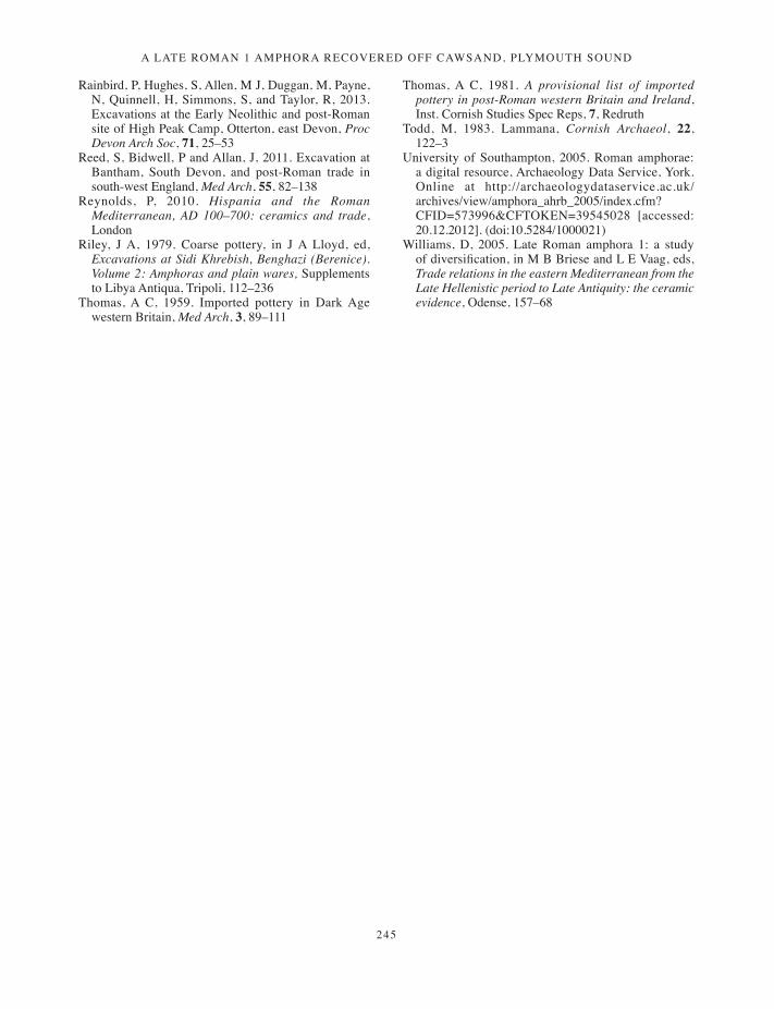
A LAte RomAn 1 AmphoRA RecoveRed off cAwsAnd, pLymouth sound
245
Rainbird, P, Hughes, S, Allen, M J, Duggan, M, Payne, n, Quinnell, H, Simmons, S, and Taylor, R, 2013. Excavations at the Early neolithic and post-Roman site of High Peak Camp, Otterton, east Devon, Proc Devon Arch Soc, 71, 25–53
Reed, S, Bidwell, P and Allan, J, 2011. Excavation at Bantham, South Devon, and post-Roman trade in south-west England, Med Arch, 55, 82–138
Reynolds, P, 2010. Hispania and the Roman Mediterranean, AD 100–700: ceramics and trade, London
Riley, J A, 1979. Coarse pottery, in J A Lloyd, ed, Excavations at Sidi Khrebish, Benghazi (Berenice). Volume 2: Amphoras and plain wares, Supplements to Libya Antiqua, Tripoli, 112–236
Thomas, A C, 1959. imported pottery in Dark Age western Britain, Med Arch, 3, 89–111
Thomas, A C, 1981. A provisional list of imported pottery in post-Roman western Britain and Ireland, inst. Cornish Studies Spec Reps, 7, Redruth
Todd, M, 1983. Lammana, Cornish Archaeol, 22, 122–3
university of Southampton, 2005. Roman amphorae: a digital resource, Archaeology Data Service, York. Online at http://archaeologydataservice.ac.uk/archives/view/amphora_ahrb_2005/index.cfm? CFiD=573996&CFTOKEn=39545028 [accessed: 20.12.2012]. (doi:10.5284/1000021)
Williams, D, 2005. Late Roman amphora 1: a study of diversification, in M B Briese and L E Vaag, eds, Trade relations in the eastern Mediterranean from the Late Hellenistic period to Late Antiquity: the ceramic evidence, Odense, 157–68
239-246_Duggan.indd 245 01/12/2014 11:58

239-246_Duggan.indd 246 01/12/2014 11:58

247
Cornish Archaeology 52, 2013, 247–256
Tintagel Castle: recent workCARL M THORPE
Archaeological monitoring in 2006 and 2007 for English Heritage on the east side of Tintagel Island identified further examples of post-Roman terraces. Walling, presumably for buildings, was also found on some terraces, together with sherds of post-Roman imported pottery of fifth- to seventh-century date. A path surviving as a slight earthwork may be the post-Roman access to the landing place at the Iron Gate.
In 2006 and 2007 Cornwall County Council Historic Environment Service (now Historic Environment (Projects), Cornwall Council) conducted two watching briefs on Tintagel Island for English Heritage, one during the construction of fencing down to the Iron Gate, the second during paving works at the information hut, north of the Inner Ward. The results of these watching briefs gave great insight into the archaeological potential of areas of Tintagel Island that had not previously been examined and helped to further emphasise the remarkable nature of the post-Roman occupation, indicating how extensive it was, being spread over the entire headland (Thorpe 2007; 2008).
Tintagel Castle (Fig 1), which is owned by the Duchy of Cornwall, is a Scheduled Monument in the guardianship of English Heritage. Tintagel is the site of a late Roman settlement of the fourth and fifth centuries AD; a major fortified citadel with trading links to the Mediterranean in the post-Roman period of the fifth to seventh centuries; and a castle of the thirteenth century. The site was already a ruin by the late sixteenth century. From the castle, a path runs down to the principal landing place on the Island, a natural quay defended by a medieval wall, known as the Iron Gate (Thomas 1993; Barrowman et al 2007).
Background: past workTintagel Island, being an important early medieval site as well as a medieval castle, has received much archaeological attention. Interventions with most significance for the current study are briefly noted below.
Cliff fall, 1918
This occurred on the Island on the cliff edge below the Inner Ward of the castle (Fig 2). Over 40 artefacts were collected from the beach and found to be all of post-Roman date consisting of all classes of imported wares and animal bone. This suggested the existence of earlier occupation on levels lying beneath the current castle walls. This material was examined and described in 1988 (Thomas and Thorpe 1988).
Radford’s excavations, 1933–1939
Work was undertaken under the direction of C A Ralegh Radford when the site was taken under government care. Excavation revealed numerous structures on both the mainland and the Island, and Radford was the first to identify them as belonging to the post-Roman period, although at this time the site was interpreted as a Celtic monastery. Sites relevant to the current work are site Z (two small holes dug just outside the northern side of the
247-256_Thorpe.indd 247 01/12/2014 11:59
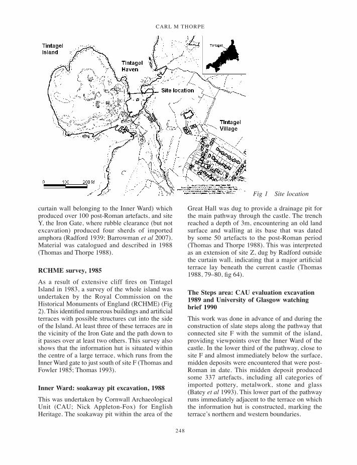
carl m thorpe
248
curtain wall belonging to the Inner Ward) which produced over 100 post-Roman artefacts, and site Y, the Iron Gate, where rubble clearance (but not excavation) produced four sherds of imported amphora (Radford 1939; Barrowman et al 2007). Material was catalogued and described in 1988 (Thomas and Thorpe 1988).
RCHME survey, 1985
As a result of extensive cliff fires on Tintagel Island in 1983, a survey of the whole island was undertaken by the Royal Commission on the Historical Monuments of England (RCHME) (Fig 2). This identified numerous buildings and artificial terraces with possible structures cut into the side of the Island. At least three of these terraces are in the vicinity of the Iron Gate and the path down to it passes over at least two others. This survey also shows that the information hut is situated within the centre of a large terrace, which runs from the Inner Ward gate to just south of site F (Thomas and Fowler 1985; Thomas 1993).
Inner Ward: soakaway pit excavation, 1988
This was undertaken by Cornwall Archaeological Unit (CAU; Nick Appleton-Fox) for English Heritage. The soakaway pit within the area of the
Great Hall was dug to provide a drainage pit for the main pathway through the castle. The trench reached a depth of 3m, encountering an old land surface and walling at its base that was dated by some 50 artefacts to the post-Roman period (Thomas and Thorpe 1988). This was interpreted as an extension of site Z, dug by Radford outside the curtain wall, indicating that a major artificial terrace lay beneath the current castle (Thomas 1988, 79–80, fig 64).
The Steps area: CAU evaluation excavation 1989 and University of Glasgow watching brief 1990
This work was done in advance of and during the construction of slate steps along the pathway that connected site F with the summit of the island, providing viewpoints over the Inner Ward of the castle. In the lower third of the pathway, close to site F and almost immediately below the surface, midden deposits were encountered that were post-Roman in date. This midden deposit produced some 337 artefacts, including all categories of imported pottery, metalwork, stone and glass (Batey et al 1993). This lower part of the pathway runs immediately adjacent to the terrace on which the information hut is constructed, marking the terrace’s northern and western boundaries.
Fig 1 Site location
247-256_Thorpe.indd 248 01/12/2014 11:59
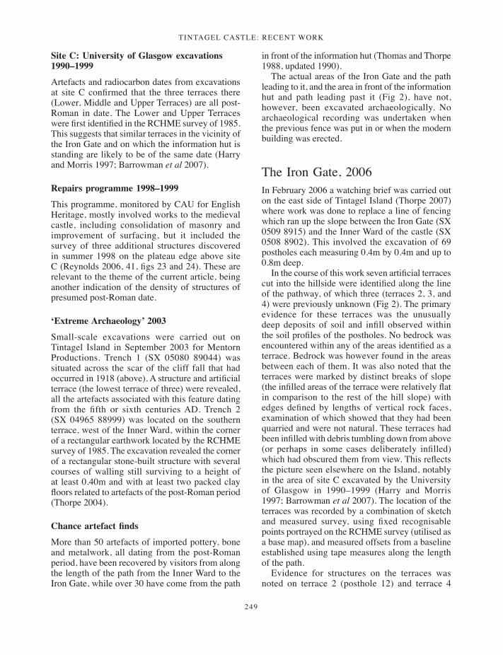
TinTagel CasTle: reCenT work
249
Site C: University of Glasgow excavations 1990–1999
Artefacts and radiocarbon dates from excavations at site C confirmed that the three terraces there (Lower, Middle and Upper Terraces) are all post-Roman in date. The Lower and Upper Terraces were first identified in the RCHME survey of 1985. This suggests that similar terraces in the vicinity of the Iron Gate and on which the information hut is standing are likely to be of the same date (Harry and Morris 1997; Barrowman et al 2007).
Repairs programme 1998–1999
This programme, monitored by CAU for English Heritage, mostly involved works to the medieval castle, including consolidation of masonry and improvement of surfacing, but it included the survey of three additional structures discovered in summer 1998 on the plateau edge above site C (Reynolds 2006, 41, figs 23 and 24). These are relevant to the theme of the current article, being another indication of the density of structures of presumed post-Roman date.
‘Extreme Archaeology’ 2003
Small-scale excavations were carried out on Tintagel Island in September 2003 for Mentorn Productions. Trench 1 (SX 05080 89044) was situated across the scar of the cliff fall that had occurred in 1918 (above). A structure and artificial terrace (the lowest terrace of three) were revealed, all the artefacts associated with this feature dating from the fifth or sixth centuries AD. Trench 2 (SX 04965 88999) was located on the southern terrace, west of the Inner Ward, within the corner of a rectangular earthwork located by the RCHME survey of 1985. The excavation revealed the corner of a rectangular stone-built structure with several courses of walling still surviving to a height of at least 0.40m and with at least two packed clay floors related to artefacts of the post-Roman period (Thorpe 2004).
Chance artefact finds
More than 50 artefacts of imported pottery, bone and metalwork, all dating from the post-Roman period, have been recovered by visitors from along the length of the path from the Inner Ward to the Iron Gate, while over 30 have come from the path
in front of the information hut (Thomas and Thorpe 1988, updated 1990).
The actual areas of the Iron Gate and the path leading to it, and the area in front of the information hut and path leading past it (Fig 2), have not, however, been excavated archaeologically. No archaeological recording was undertaken when the previous fence was put in or when the modern building was erected.
The Iron Gate, 2006In February 2006 a watching brief was carried out on the east side of Tintagel Island (Thorpe 2007) where work was done to replace a line of fencing which ran up the slope between the Iron Gate (SX 0509 8915) and the Inner Ward of the castle (SX 0508 8902). This involved the excavation of 69 postholes each measuring 0.4m by 0.4m and up to 0.8m deep.
In the course of this work seven artificial terraces cut into the hillside were identified along the line of the pathway, of which three (terraces 2, 3, and 4) were previously unknown (Fig 2). The primary evidence for these terraces was the unusually deep deposits of soil and infill observed within the soil profiles of the postholes. No bedrock was encountered within any of the areas identified as a terrace. Bedrock was however found in the areas between each of them. It was also noted that the terraces were marked by distinct breaks of slope (the infilled areas of the terrace were relatively flat in comparison to the rest of the hill slope) with edges defined by lengths of vertical rock faces, examination of which showed that they had been quarried and were not natural. These terraces had been infilled with debris tumbling down from above (or perhaps in some cases deliberately infilled) which had obscured them from view. This reflects the picture seen elsewhere on the Island, notably in the area of site C excavated by the University of Glasgow in 1990–1999 (Harry and Morris 1997; Barrowman et al 2007). The location of the terraces was recorded by a combination of sketch and measured survey, using fixed recognisable points portrayed on the RCHME survey (utilised as a base map), and measured offsets from a baseline established using tape measures along the length of the path.
Evidence for structures on the terraces was noted on terrace 2 (posthole 12) and terrace 4
247-256_Thorpe.indd 249 01/12/2014 11:59

carl m thorpe
250
Fig 2 Interpretive map showing newly identified terraces. (Based on RCHME survey 1985.)
247-256_Thorpe.indd 250 01/12/2014 11:59

TinTagel CasTle: reCenT work
251
(posthole 33). This consisted of several courses of walling constructed of flat shillet blocks laid upon each other with no evidence for mortar bonding the stones together. Unfortunately, because of the limited view afforded by the nature of the excavation, it was not possible to determine the width of these walls or the form of the buildings. However, this walling is very similar to the post-Roman structures found during excavations on the terraces of Site C (Harry and Morris 1997; Barrowman et al 2007).
Forty-two sherds of post-Roman imported Mediterranean pottery (Table 1) were recovered from the postholes cut on these terraces for the new fence, consisting of amphorae of varying categories (Bi, Bii, Biv and Bv), coarsewares and the fine table wares known as African Red Slipped Ware (ARSW) and Phocean Red Slipped Ware (PRSW), the combined suite of which suggests that these terraces were occupied from the period around AD 550. Of interest is the occurrence of a small quantity of Romano-British native ware.
Table 1 Tintagel Iron Gate. Finds summary.
Post-Roman pottery
Class Bi1 Amphora 15Class Bii Amphora 12Class Biv Amphora 3Class Bv Amphora 2Phocaean Red Slipped Ware (PRSW) 1African Red Slipped Ware (ARSW) 2Post-Roman Imported Coarseware Fabric 1 2Post-Roman Imported Coarseware Fabric 2 1Post-Roman Imported Coarseware Fabric 3 1Post-Roman Imported Coarseware Fabric 9 1Post-Roman Imported Coarseware Fabric 21 2
Total post-Roman sherds 42
Other finds
Romano-British native ware, Granitic fabric 3Cornish medieval coarseware (Bunnings Park / Stuffle ware)
1
Animal bone 20Limpet shell 1
Total, all finds 67
(Coarseware fabrics 1, 2, 3, 9 and 21 are described in Thorpe 2007; Thomas and Thorpe, in prep.)
Fig 3 The dashed line marks the original course of a path between the Iron Gate and the Inner Ward, truncated by the 1918 cliff fall.
247-256_Thorpe.indd 251 01/12/2014 11:59

carl m thorpe
252
Although possibly of late Roman date (third to fourth centuries AD), recent work has demonstrated continuation of use of this pottery well into the fifth and sixth centuries (Thorpe 2011, 151).
There was no evidence for any of the terraces having been utilised during the medieval period.
Fieldwork for this project took place in February when vegetation was low and sparse and this, combined with the effect of low winter sunshine, enabled a further discovery when looking at the site from Barras Nose across Tintagel Haven. It was noticed that there was a break in slope running diagonally up the hillside from the landing place of the Iron Gate towards the Inner Ward situated approximately 5m below and roughly parallel with the current pathway. This ran from the southern side of terrace 4 uphill under terraces 5 and 6 before disappearing, having been cut and removed by the north-western side of the 1918 cliff fall. A closer examination on the Island itself revealed that this was a linear flat-bottomed notch cut into the hillside, in places up to 2m wide. This appears to have been the line of a path or hollow way (much reduced by erosion) connecting the landing place at the Iron Gate to the heart of the Island (Figs 2 and 3).
The information hut, 2007In February 2007 a watching brief was carried out in front of the information hut (Fig 2) on the east side of Tintagel Island (SX 0508 8902) where English Heritage replaced an area of worn turf with pitched stone paving. The work involved the reduction of the ground level by some 0.2m to a depth sufficient to accommodate the pitched slates (Thorpe 2008).
In the course of this work a further three artificial terraces cut into the hillside were identified, with the information hut being sited on the largest. The other two, not affected by the current works, were observed on the hill slope above (Fig 2, terraces 8, 9 and 10).
Evidence was recorded for a building (possibly a rectangular range of buildings) constructed upon the terrace to the east of the information hut (Figs 4, 5, and 6). This consisted of the fragmentary western wall of the building, oriented north-north-west – south-south-east. This walling, up to 0.13m high, was constructed of flat shillet blocks laid
upon each other. It appears to have been a double-faced wall roughly 1m wide, of which only two courses survived. There was no evidence for any lime mortar bonding the stones together; however, the core between the two rows of stones had been filled by compacted clay from which post-Roman ceramics were obtained.
This wall continued beyond the area excavated towards the south east. A placement of large stones was observed exposed on the west side of the pathway, running towards the medieval Inner Ward. This alignment could be traced for a distance of just over 5m. At a point approximately 1.5m from the southern end of this line there appeared to be a cross wall some 0.4m wide and protruding 0.8m into the pathway at right angles to the main alignment (Fig 5).
The southern end of this building is possibly marked by a right-angled cut within the northern edge of a large expanse of flat bedrock exposed within the pathway at a point some 2.5m north of the gateway to the Inner Ward.
The interior of the building and the eastern wall probably lay within the course of the pathway and they have been seriously eroded as a result. This would account for the large number of artefacts that have been recovered from the path in this area.
The walling uncovered appears to be part of a range of buildings running from north west to south east along the length of the terrace (Fig 5). This cell-like arrangement of conjoined buildings is seen elsewhere on the island (at sites B, C, and F, for examples nearby; Barrowman et al 2007). This walling was very similar in nature to some of the structures found on the Lower Terrace of site C during excavations there (Harry and Morris 1997; Barrowman et al 2007) which belonged to the post-Roman period.
Sixty-seven sherds of post-Roman imported Mediterranean pottery (Table 2) were recovered from the site of the building, consisting of amphorae of varying categories (Bi, Bii, Biv and Bv), accompanied by the fine table wares ARSW, and PRSW, suggesting that the building and terrace were occupied from the mid-sixth to seventh centuries AD.
There was again no evidence for the terraces having been utilised during the medieval period. The only medieval material was recovered from topsoil and tip lines infilling parts of the terrace.
247-256_Thorpe.indd 252 01/12/2014 11:59
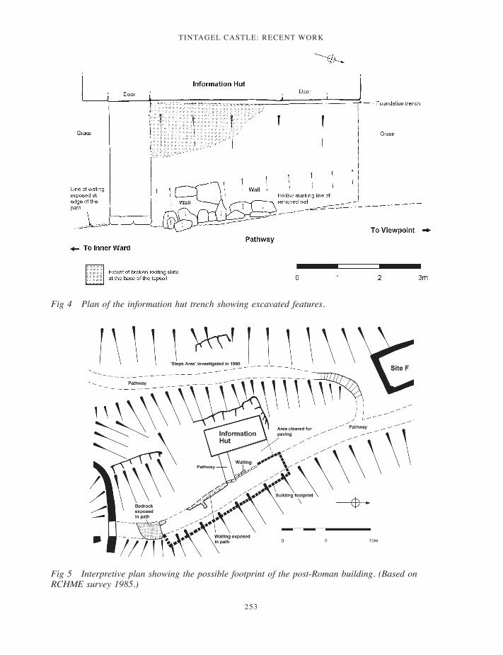
TinTagel CasTle: reCenT work
253
Fig 4 Plan of the information hut trench showing excavated features.
Fig 5 Interpretive plan showing the possible footprint of the post-Roman building. (Based on RCHME survey 1985.)
247-256_Thorpe.indd 253 01/12/2014 11:59
carl m thorpe
254
DiscussionThese projects have given a great insight into the archaeological potential of this area of Tintagel Island.
The Iron Gate, utilised as a landing place for ships during the medieval period, may also have been the position of a landing place during the earlier post-Roman occupation of the site, as suggested by Thomas (1993, 43). This idea is now strongly supported by the discovery of the possible route for the original access path up from the Iron Gate to the centre of the settlement. This route clearly pre-dates the 1918 cliff fall (Figs 2 and 3) and its course appears to ignore the location of the gateway within the medieval curtain wall of the Inner Ward, instead heading directly towards the position of the post-Roman terrace known to lie beneath the Great Hall (Thomas 1988; Thorpe 2004). This suggests that this route may actually be the line of the earlier post-Roman pathway up from the landing place into the heart of the citadel.
Ten artificial terraces that had been cut into the side of the hill were recognised. Evidence for structures built onto these terraces was noted on terrace 2 (posthole 12), terrace 4 (posthole 33) and in front of the information hut. Some of these buildings form complex ranges. All the artefacts recovered were post-Roman ceramics, mostly imported Mediterranean wares although some local native ware was present. The imported Mediterranean
material is known to date to the fifth to seventh centuries from work done in the Mediterranean, especially at Carthage (Fulford and Peacock 1984), with importation into Britain thought to have centred around AD 475 to 550 (Thomas 1993; Campbell 2007). Work on the Lower Terrace, site C, indicated that the terraces with associated structures and features exhibited two main phases of occupation, the first dated to cal AD 415–535, the second to cal AD 560–670 (Harry and Morris 1997), with most of the stone walling being associated with the latter. The radiocarbon dates also suggest that importation of Mediterranean ceramics continued into the seventh century (Barrowman et al 2007). It is thus most likely that the new terraces identified belong to these periods.
At Tintagel the fragmentary remains of well over 100 amphorae of all types, a similar number of fine table ware vessels and numerous coarseware vessels have been recovered in excavations since the 1930s. This almost certainly indicates a trade involving many repeated voyages between the fifth and seventh centuries AD. Each shipment was probably heterogeneous in character, with cargo being picked up at more than one port in the eastern Mediterranean and North Africa. It is clear that the amphorae were imported for their contents, most probably olive oil and wine. The trade would not, of course, have been one way but it is uncertain what would have been exchanged, although tin is the most likely candidate (Wooding 1996; Campbell 2007). The fact that Tintagel was at the end of this complex trade route suggests that the occupants wielded tremendous influence during the fifth to seventh centuries AD. Current thinking is that the site represents a high status royal citadel, a centre for tribute gathering, distribution and trade (Thomas 1993, Barrowman et al 2007).
The extraordinary nature of the post-Roman occupation of Tintagel has been further emphasised by these projects, demonstrating the great extent and density of post-Roman occupation: structural elements and sherds of Mediterranean imported ware have been found in almost every area examined over the entire headland, using all available land surfaces. This must surely be one of the largest post-Roman citadels identified in Britain, playing a prominent part in the economy of the western Atlantic seaboard at that time.
The only evidence for the medieval occupation of the Island in the course of these projects was from postholes immediately below the curtain wall
Table 2 Tintagel information hut. Finds summary table.
Post-Roman pottery
Class Bi Amphora 34Class Bii Amphora 21Class Biv Amphora 3Class Bv Amphora 4Phocaean Red Slipped Ware (PRSW) 1African Red Slipped Ware (ARSW) 2Post-Roman Imported Coarseware Fabric 1 2
Total post-Roman sherds 67
Other finds
Cornish medieval coarseware (Bunnings Park / Stuffle ware)
1
Water-rounded pebbles 13Worked stone 1Animal bone 10Burnt clay / daub 3
Total, all finds 95
(Coarseware fabric 1 is described in Thorpe 2007; Thomas and Thorpe, in prep.)
247-256_Thorpe.indd 254 01/12/2014 11:59

TinTagel CasTle: reCenT work
255
of the castle itself (postholes 64 and 65) and from within the topsoil in front of the information hut. This consisted of a couple of sherds of Lostwithiel Type ware (formerly known as Bunnings Park/Stuffle ware) of the thirteenth century AD (Allan et al, forthcoming), animal bones and some broken roofing slates, a few bearing traces of white lime mortar on their surfaces (not collected). Examination of the ceramic evidence from previous work at Tintagel has suggested that the main medieval occupation was only over a short period, perhaps no more than 50 years (O’Mahoney 1989; Thomas 1993).
Acknowledgements
The programme of archaeological recording was commissioned by English Heritage. We would like to thank Richard Baker (Estates Team West Territory, English Heritage) for his help and support during the course of both of these projects. Many thanks also go to George Climo and Sons, the contractor for the site works, without whose help, co-operation and enthusiasm the work would not have been completed.
Within the Historic Environment Service, fieldwork was carried out by Carl Thorpe and the project manager was Nigel Thomas.
The two HE projects covered by this report are Tintagel, The Iron Gate, project number 2006016, site code TIG06, and Tintagel, Information Hut, project number 2007024, site code TIH07. The artefacts and site archive will be deposited with the Royal Cornwall Museum.
ReferencesAllan, J, Taylor, R T, and Hughes, M J, forthcoming.
The pottery sampling project, in Gossip, forthcomingBarrowman, R C, Batey , C E, and Morris, C D, 2007.
Excavations at Tintagel Castle, Cornwall, 1990–1999, Soc Antiq London, Repts Res Ctte, 74, London
Batey, C, Sharpe, A, and Thorpe, C M, 1993. Tintagel Castle: archaeological investigation of the Steps area 1989 and 1990, Cornish Archaeol, 32, 47–66
Campbell, E, 2007. Continental and Mediterranean imports to Atlantic Britain and Ireland, AD 400–800, CBA Res Rep, 157, London
Fulford, M G, and Peacock, D P S, 1984. Excavations at Carthage: the British mission. Vol. 1: The Avenue du President Habib Bourguiba Salammbo. Part 2 The pottery and other ceramic objects from the sites, Sheffield
Gossip, J, forthcoming. On the waterfront – excavations at Quay Street, Lostwithiel, Cornwall, 2002, Cornish Archaeol
Harry, R, and Morris, C D, 1997. Excavations on the Lower Terrace, Site C, Tintagel Island 1990–4, Antiq Jnl, 77, 1–143
O’Mahoney, C, 1989. The medieval pottery from Tintagel Castle, Inst Cornish Stud Spec Rept, 8, Redruth
Radford, C A R, 1939. Tintagel Castle, Cornwall, Ministry of Works official guide, London (2nd edn)
Reynolds, A, 2006. Repairs to Tintagel Castle, Cornwall. Archaeological recording, Truro (Historic Environment Service, Cornwall County Council)
Thomas, A C, 1988. The context of Tintagel: a new model for the diffusion of post-Roman Mediterranean imports, Cornish Archaeol, 27, 7–26
Thomas, A C, 1993. Tintagel, Arthur and archaeology, London
Thomas, A C, and Fowler, P J, 1985. Tintagel: a new survey of the Island, Annual Review 1984–85, London
Fig 6 Information hut trench showing wall, context [6], looking north west.
247-256_Thorpe.indd 255 01/12/2014 11:59
carl m thorpe
256
(Royal Commission on the Historical Monuments of England), 16–22
Thomas, A C, and Thorpe, C M, 1988. Catalogue of all non-medieval finds from Tintagel, Tintagel Project 2, Inst Cornish Stud, Redruth
Thomas, A C, and Thorpe, C M, in preparation. The imported Mediterranean coarsewares from Tintagel
Thorpe, C, 2004. ‘Extreme Archaeology.’ An excavation at Tintagel, Cornwall – archaeological finds report, Truro (Historic Environment Service, Cornwall County Council)
Thorpe, C, 2007. The Iron Gate, Tintagel Castle, Cornwall. Fence replacement works – archaeological watching brief, Truro (Historic Environment Service, Cornwall County Council)
Thorpe, C, 2008. The Information Hut, Tintagel Castle, paving work – archaeological watching brief, Truro (Historic Environment Service, Cornwall County Council)
Thorpe, C, 2011. The early medieval native pottery of Cornwall (c 400–1066), in Recent archaeological work in south-western Britain. Papers in honour of Henrietta Quinnell, S Pearce, ed, Brit Arch Repts, Brit Ser, 548, Oxford, 151–8
Wooding, J M, 1996. Communication and commerce along the western sea lanes AD 400–800, Brit Arch Repts, Int Ser, 654, Oxford
247-256_Thorpe.indd 256 01/12/2014 11:59
257
Cornish Archaeology 52, 2013, 257–266
Recent work in Cornwall, 2012
Historic Environment Projects, Cornwall Council
Rediscovering Carwynnen Quoit, Camborne
The Sustainable Trust commissioned Historic Environment Projects to develop a community archaeology project around the restoration of Carwynnen Quoit, which lies 3 km south of Camborne on the Treslothan estate. This ancient site is one of Cornwall’s lesser known cromlechs or quoits, and the monument has lain in a ruinous condition since its collapse in the mid-1960s. In 2012 two linked projects took place. In July numerous test pits were excavated across the field where the quoit lies, the results from which helped develop the field strategy for the work which took place in September.
Following the memorable removal and unpicking of the heap of fallen stones by a massive crane in early September, a large excavation trench was opened up in the location where the heap had lain. Over a three-week period the large volunteer team uncovered the original footprint of the monument. This was an exceptionally well-preserved stone pavement which extended well beyond the protective shelter of the capstone. The socket holes for the three uprights were discovered as well as more than 100 flints and 20 pieces of Early Neolithic pottery. Later Bronze Age pottery and flint were also found and reveal a long history
of use. The footings of early field walls were also found. Future work involves laser scanning the stones and another excavation. (Final restoration of the monument took place in June 2014. Up-to-date details are available on the project facebook page and at the website www.giantsquoit.org.)• Project director (HE Projects): Jacky
Nowakowski. Community archaeologist: James Gossip, with help from HE Projects colleagues Anna Lawson-Jones and Carl Thorpe. Post-fieldwork finds assessments by Colin Bristow, Henrietta Quinnell, Wendy Carruthers and Dana Challinor. The project team of some 40 volunteers includes many members of Cornwall Archaeological Society, Lizard Area Network and Meneage Archaeology Group, as well as Truro College archaeology students.
Unlocking our coastal heritage
Unlocking our Coastal Heritage was a project developed by the Rural Development Agency and delivered by the National Trust which focused on monuments along the South West Coast Path. HE Projects carried out investigations on the following sites as part of the initiative.
Crane Castle, Illogan
Working with volunteers, Historic Environment Projects carried out a small-scale excavation of Crane Castle, a poorly preserved coastal
257-266_Recent Work.indd 257 01/12/2014 12:01
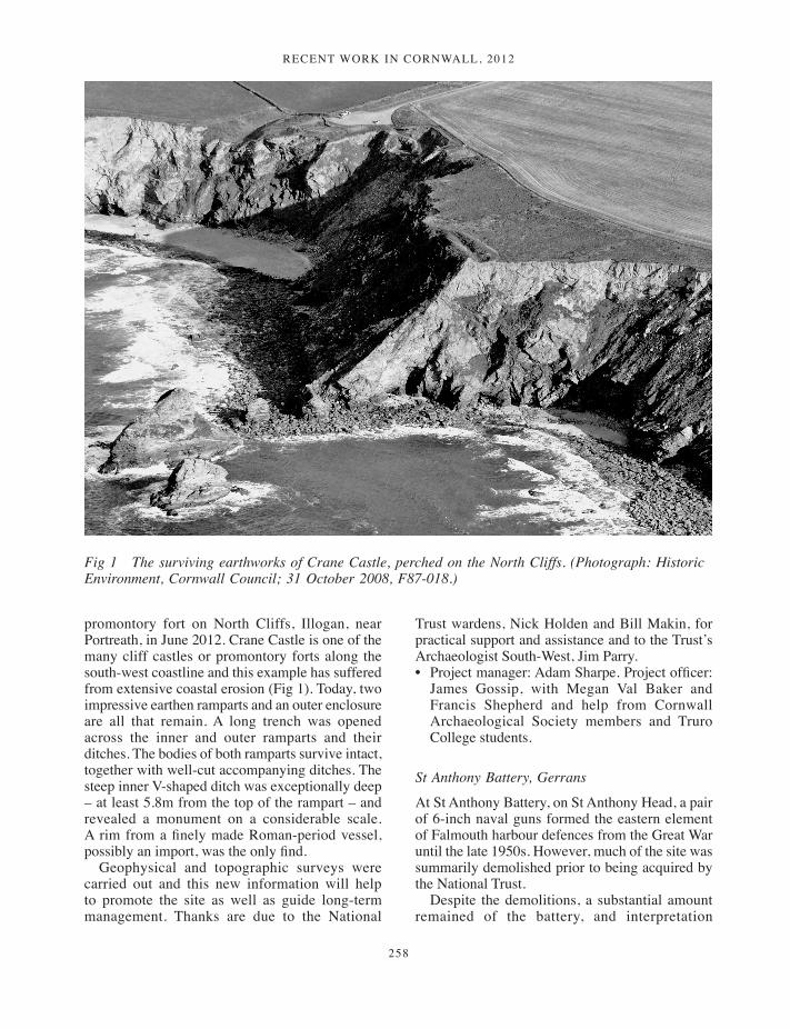
Recent woRk in coRnwall, 2012
258
promontory fort on North Cliffs, Illogan, near Portreath, in June 2012. Crane Castle is one of the many cliff castles or promontory forts along the south-west coastline and this example has suffered from extensive coastal erosion (Fig 1). Today, two impressive earthen ramparts and an outer enclosure are all that remain. A long trench was opened across the inner and outer ramparts and their ditches. The bodies of both ramparts survive intact, together with well-cut accompanying ditches. The steep inner V-shaped ditch was exceptionally deep – at least 5.8m from the top of the rampart – and revealed a monument on a considerable scale. A rim from a finely made Roman-period vessel, possibly an import, was the only find.
Geophysical and topographic surveys were carried out and this new information will help to promote the site as well as guide long-term management. Thanks are due to the National
Trust wardens, Nick Holden and Bill Makin, for practical support and assistance and to the Trust’s Archaeologist South-West, Jim Parry.• Project manager: Adam Sharpe. Project officer:
James Gossip, with Megan Val Baker and Francis Shepherd and help from Cornwall Archaeological Society members and Truro College students.
St Anthony Battery, Gerrans
At St Anthony Battery, on St Anthony Head, a pair of 6-inch naval guns formed the eastern element of Falmouth harbour defences from the Great War until the late 1950s. However, much of the site was summarily demolished prior to being acquired by the National Trust.
Despite the demolitions, a substantial amount remained of the battery, and interpretation
Fig 1 The surviving earthworks of Crane Castle, perched on the North Cliffs. (Photograph: Historic Environment, Cornwall Council; 31 October 2008, F87-018.)
257-266_Recent Work.indd 258 01/12/2014 12:01

Recent woRk in coRnwall, 2012
259
panels had been prepared by the National Trust in conjunction with the last battery commander. However, the gun pits at the heart of the site had been infilled with rubble. To enhance interpretation, material infilling the eastern gun pit was removed. A watching brief was carried out during this operation and a measured survey made of the exposed features. These included the gun mount, communications and power cables, cartridge and shell lockers and the hoists communicating with the magazine beneath the gun pits, together with the remains of supports for an anti-strafing canopy and evidence for a number of otherwise unrecorded modifications to the site.• Project officer: Sean Taylor.
Godrevy barrow, Gwithian
In September 2012 Historic Environment Projects, with help from Cornwall Archaeological Society members, revisited Godrevy Barrow at Gwithian in west Cornwall. Partially excavated by Charles Thomas in the 1950s, Godrevy barrow has long intrigued with its complex history of activities (as suggested by finds) extending from the Mesolithic to the post-Roman period. However, the site has never been fully published. The 1950s archive was assessed and new information captured through topographical and geophysical surveys and a small-scale excavation.
Open sections of the original excavation trench were cut back and the layered make-up of the barrow mound exposed. The old land surface, a dark soil horizon, sealed by the mound was sampled for soils and snails. A new small cutting was made high up in the mound and a small deposit of cremated bone discovered under a layer of slates alongside four sherds of Romano-British pottery. The bone (identified as human) has been radiocarbon dated to the Middle Bronze Age.
Many visitors to the excavation (many of them local walkers) were unaware of the barrow and this work has promoted awareness of the richness of Cornwall’s coastal heritage. New information about the Godrevy barrow will be presented in an on-site interpretation panel in the near future. Thanks for practical support and assistance to the National Trust wardens Nick Holden and Bill Makin and the Trust’s Archaeologist South-West, Jim Parry.• Project manager: Jacky Nowakowski. Project
officer: James Gossip, with Anna Lawson-Jones,
Megan Val Baker and Francis Shepherd and help from Cornwall Archaeological Society stalwarts Adrian Rodda, Chris Verran, Chris Wilson and Fiona Fleming.
St Catherine’s Point and Covington Wood, Fowey
The National Trust commissioned a project to carry out an archaeological survey of multi-period earthworks and structures on the headland. The survey mapped the remains from several periods of human activity, including an Iron Age promontory fort, medieval chapel and Henrician fort, as well as the nineteenth-century Rashleigh mausoleum and WWII gun emplacements.• Project manager: James Gossip.
Wheal Call, Kenidjack, St Just-in-Penwith
Although never one of the most successful tin mines in the St Just mining district, Wheal Call is undoubtedly one of the more spectacularly sited, occupying an area at the seaward end of the Kenidjack valley. Both mining and tin dressing are known to have been carried out in this area for centuries, but the site is dominated by remains of the mine which operated during the later nineteenth century. These have survived not only the depredations of stone robbers and the effects of time, but also a massive flood following a particularly cold winter at the end of the nineteenth century. Historic Environment Projects undertook a survey of the surviving elements of the site, including the remaining standing buildings, dressing floors, leats and roadways (Fig 2). More detailed recording focused on a substantial retaining wall adjacent to the stream where an initial area of masonry collapse threatened to spread unchecked, leading to the loss of this significant element of the site.• Project officer: Adam Sharpe.
Wheal Rose Stamps, St Just, and Porthmeor Stamps, Zennor
Elements of two water-powered tin stamping complexes owned by the National Trust were selected for inclusion in the Unlocking the Coastal Heritage project, on the basis of their accessibility and significance. Preliminary surveys were carried out at both sites by Historic Environment Projects.
257-266_Recent Work.indd 259 01/12/2014 12:01
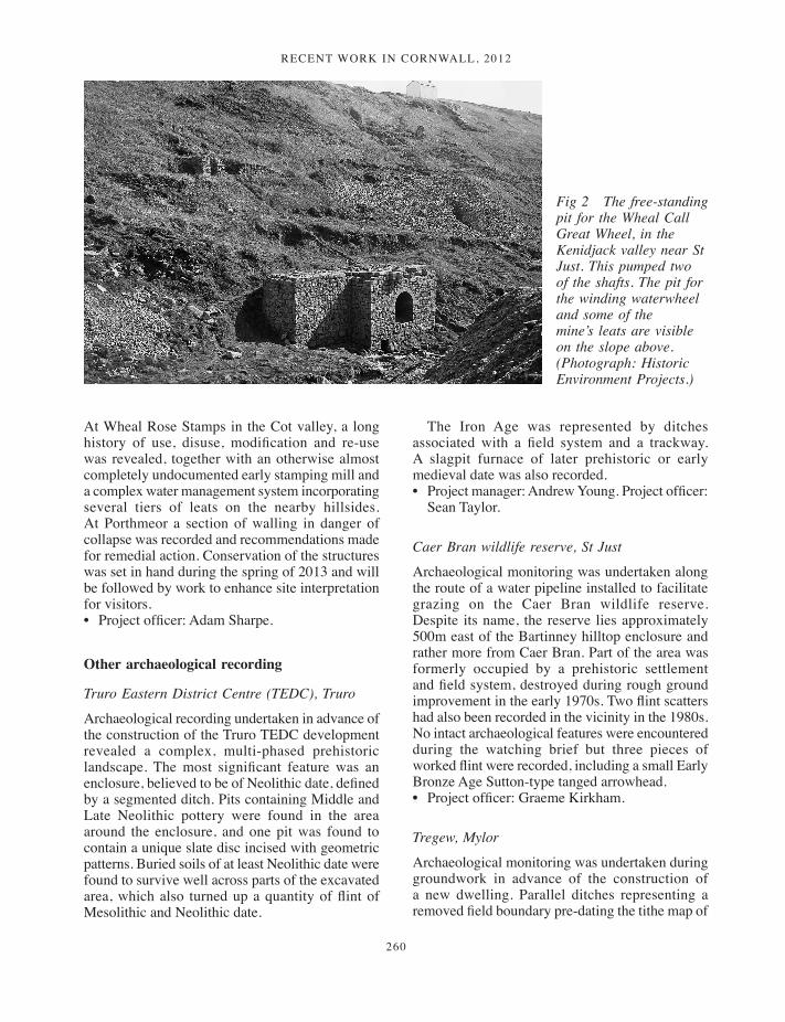
Recent woRk in coRnwall, 2012
260
At Wheal Rose Stamps in the Cot valley, a long history of use, disuse, modification and re-use was revealed, together with an otherwise almost completely undocumented early stamping mill and a complex water management system incorporating several tiers of leats on the nearby hillsides. At Porthmeor a section of walling in danger of collapse was recorded and recommendations made for remedial action. Conservation of the structures was set in hand during the spring of 2013 and will be followed by work to enhance site interpretation for visitors. • Project officer: Adam Sharpe.
Other archaeological recording
Truro Eastern District Centre (TEDC), Truro
Archaeological recording undertaken in advance of the construction of the Truro TEDC development revealed a complex, multi-phased prehistoric landscape. The most significant feature was an enclosure, believed to be of Neolithic date, defined by a segmented ditch. Pits containing Middle and Late Neolithic pottery were found in the area around the enclosure, and one pit was found to contain a unique slate disc incised with geometric patterns. Buried soils of at least Neolithic date were found to survive well across parts of the excavated area, which also turned up a quantity of flint of Mesolithic and Neolithic date.
The Iron Age was represented by ditches associated with a field system and a trackway. A slagpit furnace of later prehistoric or early medieval date was also recorded.• Project manager: Andrew Young. Project officer:
Sean Taylor.
Caer Bran wildlife reserve, St Just
Archaeological monitoring was undertaken along the route of a water pipeline installed to facilitate grazing on the Caer Bran wildlife reserve. Despite its name, the reserve lies approximately 500m east of the Bartinney hilltop enclosure and rather more from Caer Bran. Part of the area was formerly occupied by a prehistoric settlement and field system, destroyed during rough ground improvement in the early 1970s. Two flint scatters had also been recorded in the vicinity in the 1980s. No intact archaeological features were encountered during the watching brief but three pieces of worked flint were recorded, including a small Early Bronze Age Sutton-type tanged arrowhead. • Project officer: Graeme Kirkham.
Tregew, Mylor
Archaeological monitoring was undertaken during groundwork in advance of the construction of a new dwelling. Parallel ditches representing a removed field boundary pre-dating the tithe map of
Fig 2 The free-standing pit for the Wheal Call Great Wheel, in the Kenidjack valley near St Just. This pumped two of the shafts. The pit for the winding waterwheel and some of the mine’s leats are visible on the slope above. (Photograph: Historic Environment Projects.)
257-266_Recent Work.indd 260 01/12/2014 12:01
Recent woRk in coRnwall, 2012
261
c 1840 were recorded and a small quantity of flint and ceramics from medieval to modern recovered from the ploughsoil. • Project officer: Carl Thorpe.
Gorran Haven multi-use trail, St Goran
Archaeological monitoring was undertaken along the route of the Gorran Haven multi-use trail. The majority of the scheme did not involve penetration of the ground surface to depths at which archaeological features were revealed, but where this did occur a number of features were identified, the majority of which were field divisions of medieval and post-medieval date. Finds were sparse, but an inscribed slate bearing the traces of at least four arcs of circles was found. The slate had been re-used as roofing material, probably in the late medieval or early post-medieval period, and the markings probably date to the medieval period.• Project officer: Sean Taylor.
Manor Tannery, Grampound
Building recording and a series of archaeological watching briefs were undertaken on the site of Manor Tannery in Grampound in advance of a new housing development. The building record included all of the tannery buildings within the main complex located in the northern part of the site, including three Grade II Listed structures, and a single structure in the southern half of the site which was marked for demolition. No clearly prehistoric features or artefacts were uncovered during the watching briefs and the majority of features identified related to probable field boundaries dating from the medieval to the post-medieval period. However, a scatter of undated charcoal-filled pits, some of them possibly tree bowls, was uncovered across the site, with one group forming an L-shape. The origin and function of these pits is unclear.• Project manager: Nigel Thomas. Project officers:
Jo Sturgess, Carl Thorpe, Graeme Kirkham, Sean Taylor.
Westcotts Quay, St Ives
Archaeological recording was undertaken during the redevelopment of a former day care centre site at Westcotts Quay in the medieval core of St Ives. Walling was uncovered, probably belonging to
cottages shown on the 1st edition Ordnance Survey 25in to 1 mile map of c 1880. No earlier remains were identified.• Project officer: Carl Thorpe
Chymder Farm, Cury
Archaeological monitoring in advance of the creation of a new campsite was carried out during the excavation of service trenches, an area for a septic tank and an associated drain. The works revealed features which indicated the presence of prehistoric occupation. A substantial ditch was found matching the position of a cropmark forming part of a prehistoric field system plotted from air photographs. A nearby pit or posthole contained a sherd of prehistoric pottery. A second ditch is also likely to be associated with prehistoric activity but no dating evidence was retrieved to confirm this.• Project officer: Jo Sturgess.
Assessment and survey
Castle-an-Dinas mine, St Columb Major
Castle-an-Dinas is renowned for its Scheduled prehistoric hillfort [this volume]. However, Castle-an-Dinas mine was the most significant twentieth-century wolfram mine in Cornwall, if not in south-west England, and the country’s main tungsten producer during World War II. Following closure and removal of the majority of the associated machinery, the mine’s remaining buildings have lain derelict and the workings have become covered in vegetation. The former mine site is subject to a Higher Level Stewardship agreement with Natural England who commissioned an archaeological assessment of the remains. The project concluded that the surviving features represent an important record of a late but significant chapter of Cornish mining and of the mining technologies used in Cornwall in the early to mid twentieth century.• Project officers: Colin Buck and Nigel Thomas.
Renewable energy assessment projects 2011–13
Few people living in Cornwall can have failed to note the proliferation of wind turbines and solar farms in the past few years. Historic Environment Projects has been working with Cornwall Council and English Heritage to develop methodologies
257-266_Recent Work.indd 261 01/12/2014 12:01
Recent woRk in coRnwall, 2012
262
to assess the potential impacts of these new technologies on the archaeological landscape and to provide objective assessments to clients, planners and English Heritage on a case-by-case basis.
The physical footprint of an individual wind turbine is usually limited and potential impacts relating from construction activities can be assessed through a combination of desk based assessment, site walkover and geophysics. However, determining possible impacts on the landscape settings of (in particular) designated monuments and buildings has required the development of a new methodology. This combines digital terrain mapping, to determine potential intervisibility of proposed sites with historic features, and landscape survey to assess the sensitivity of features to visual intrusion within their wider landscape settings.
Some designated structures such as Listed milestones, churchyard crosses or tomb slabs clearly have relatively limited settings. Others such as church towers and spires, barrow cemeteries or hillforts were intended to be visually dominant features within the landscapes which surrounded them, while many parks and gardens and major houses incorporate designed views extending across the countryside. Given that medium to large wind turbines in elevated locations may be visible for many kilometres around their sites, it is clearly important that their impacts on such key components of the landscape are identified and assessed. Historic Environment Projects has carried out around 50 such projects to date, and is now able to apply the assessment methodology to other potentially intrusive modern developments, as required.• Project manager: Adam Sharpe.
Building recording projects
Helland House, Mabe
Proposals to extend Helland House and to renovate and convert an outbuilding to residential use resulted in building recording and an archaeological watching brief being carried out. The site lies adjacent to an extant early Christian lann enclosure. The farmhouse appears to have been largely rebuilt in the eighteenth century (although an older wing survives to the rear), and the gardens to the front were probably laid out at about this time. An
adjacent cottage is also likely to be of eighteenth-century date. Details were also recorded of historic farm buildings, including mid nineteenth-century granite-built piggeries and former bee boles built into an earlier farmyard wall.
The watching brief revealed very shallow soil depths beneath current surfaces. The recording suggests that when the current buildings were constructed considerable reduction of levels occurred, which has largely destroyed traces of earlier activity. • Project officers: Nigel Thomas and Carl Thorpe.
Carmears tramway, Luxulyan valley
The Luxulyan valley lies to the north east of St Austell. The valley is dominated by the spectacular Treffry viaduct, which carries a leat from one side of the valley to the other and also supported a mineral tramway. The tramway was linked by an incline to a canal basin, which in turn gave access to the south coast. The valley forms an important part of the Cornwall and West Devon Mining Landscape World Heritage Site. Following principles set out in a Conservation Management Plan, part of the Carmears tramway was cleared of silt and debris to display the former course of the rails. These works revealed the survival of the granite setts and some of the iron chairs which formerly supported the rails and even some sections of rail (Fig 3). It is now very rare to find parts of rails still affixed to granite setts. Those in place in the Luxulyan valley are probably the best surviving examples of an early method of railway track fixing. The work undertaken now presents the tramway as a far more historically ‘readable’ site. • Project officer: Nigel Thomas.
Draynes bridge, St Neot and St Cleer
The bridge is a four-span granite bridge carrying a minor road over the River Fowey in south-east Cornwall. The bridge is Listed at Grade II and proposals for bridge strengthening prompted a programme of historic building recording both before and during the works.
Although a bridge existed here in earlier centuries the present structure was built in 1876, as commemorated by prominent date stones on each parapet. The bridge has spans carried on quarried granite lintels linking the abutments and cutwaters. This form of bridge construction is commonly
257-266_Recent Work.indd 262 01/12/2014 12:01

Recent woRk in coRnwall, 2012
263
encountered in Cornwall, although examples of multi-span bridges on larger rivers are relatively rare. Examination revealed that the bridge contains elements that pre-date 1876, particularly granite lintels in the easternmost span.
The St Cleer tithe map of c 1840 shows a ford running across the Fowey to the south of the present bridge site, with a packhorse bridge or footbridge also spanning the river. An embankment running alongside the western approach to the present bridge in St Neot parish appears to be a remnant of the earlier bridge causeway.• Project officer: Nigel Thomas.
New Mills, St Stephen-by-Launceston
Plans to convert a former corn mill at New Mills to residential use prompted a study of the historical development of the site. The place-name of New Mills is first documented in the fifteenth century and a mill was mapped here on the St Stephen-by-Launceston tithe map of 1839. Later mapping
indicates that the plan of the mill has altered and the physical structure also offers evidence of a major rebuild, including windows and doors with brick arches and jambs. Timberwork from an earlier mill building has been reused as lintels above the present doorways and windows. The surviving waterwheel was manufactured locally and has a date of 1905, the probable date of the mill’s redevelopment. The group of buildings (including the mill, its adjoining shippons and barn and a separate pigsty), appear to represent an Edwardian phase of redevelopment of the New Mills farmstead.• Project officer: Nigel Thomas.
Isles of Scilly
The first two stages of the Scilly Historic Environment Research Framework (SHERF), the Resource Assessment and Research Agenda, were completed in December 2012. SHERF was funded by English Heritage with contributions from the Isles of Scilly AONB Unit, the Council of the Isles
Fig 3 Granite setts, chairs and rails revealed by recent work on the Carmears tramway in the Luxulyan valley. (Photograph: Graeme Kirkham.)
257-266_Recent Work.indd 263 01/12/2014 12:01
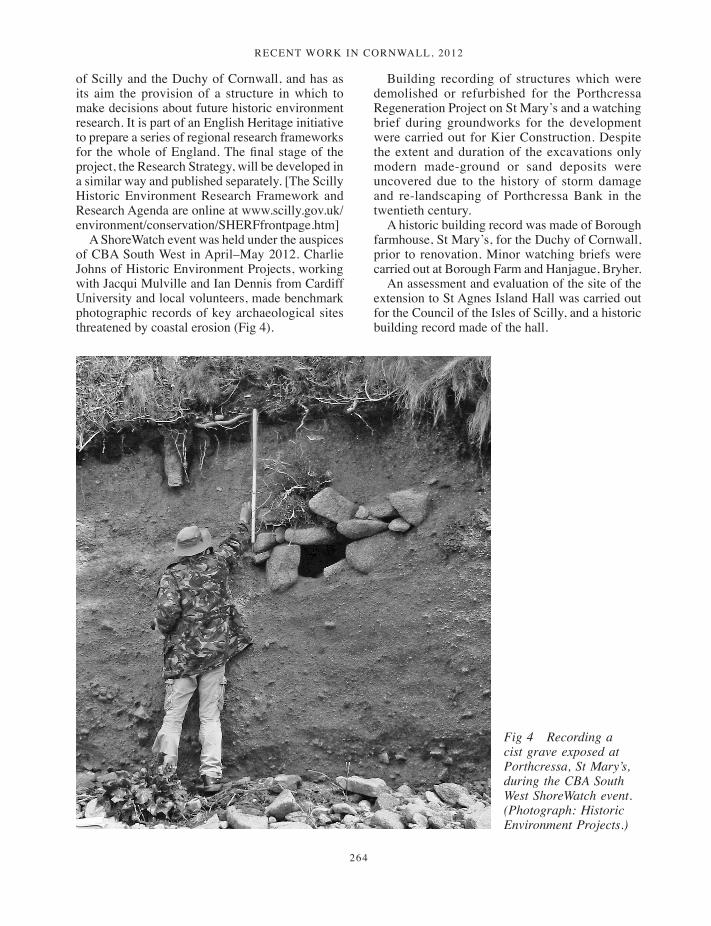
Recent woRk in coRnwall, 2012
264
of Scilly and the Duchy of Cornwall, and has as its aim the provision of a structure in which to make decisions about future historic environment research. It is part of an English Heritage initiative to prepare a series of regional research frameworks for the whole of England. The final stage of the project, the Research Strategy, will be developed in a similar way and published separately. [The Scilly Historic Environment Research Framework and Research Agenda are online at www.scilly.gov.uk/environment/conservation/SHERFfrontpage.htm]
A ShoreWatch event was held under the auspices of CBA South West in April–May 2012. Charlie Johns of Historic Environment Projects, working with Jacqui Mulville and Ian Dennis from Cardiff University and local volunteers, made benchmark photographic records of key archaeological sites threatened by coastal erosion (Fig 4).
Building recording of structures which were demolished or refurbished for the Porthcressa Regeneration Project on St Mary’s and a watching brief during groundworks for the development were carried out for Kier Construction. Despite the extent and duration of the excavations only modern made-ground or sand deposits were uncovered due to the history of storm damage and re-landscaping of Porthcressa Bank in the twentieth century.
A historic building record was made of Borough farmhouse, St Mary’s, for the Duchy of Cornwall, prior to renovation. Minor watching briefs were carried out at Borough Farm and Hanjague, Bryher.
An assessment and evaluation of the site of the extension to St Agnes Island Hall was carried out for the Council of the Isles of Scilly, and a historic building record made of the hall.
Fig 4 Recording a cist grave exposed at Porthcressa, St Mary’s, during the CBA South West ShoreWatch event. (Photograph: Historic Environment Projects.)
257-266_Recent Work.indd 264 01/12/2014 12:01
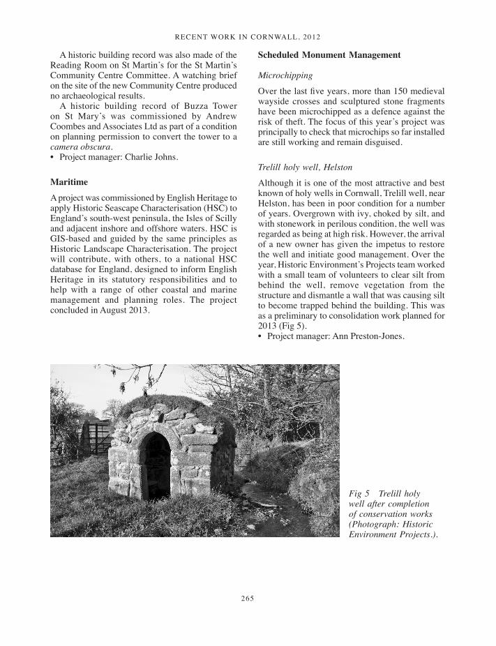
Recent woRk in coRnwall, 2012
265
A historic building record was also made of the Reading Room on St Martin’s for the St Martin’s Community Centre Committee. A watching brief on the site of the new Community Centre produced no archaeological results.
A historic building record of Buzza Tower on St Mary’s was commissioned by Andrew Coombes and Associates Ltd as part of a condition on planning permission to convert the tower to a camera obscura.• Project manager: Charlie Johns.
Maritime
A project was commissioned by English Heritage to apply Historic Seascape Characterisation (HSC) to England’s south-west peninsula, the Isles of Scilly and adjacent inshore and offshore waters. HSC is GIS-based and guided by the same principles as Historic Landscape Characterisation. The project will contribute, with others, to a national HSC database for England, designed to inform English Heritage in its statutory responsibilities and to help with a range of other coastal and marine management and planning roles. The project concluded in August 2013.
Scheduled Monument Management
Microchipping
Over the last five years, more than 150 medieval wayside crosses and sculptured stone fragments have been microchipped as a defence against the risk of theft. The focus of this year’s project was principally to check that microchips so far installed are still working and remain disguised.
Trelill holy well, Helston
Although it is one of the most attractive and best known of holy wells in Cornwall, Trelill well, near Helston, has been in poor condition for a number of years. Overgrown with ivy, choked by silt, and with stonework in perilous condition, the well was regarded as being at high risk. However, the arrival of a new owner has given the impetus to restore the well and initiate good management. Over the year, Historic Environment’s Projects team worked with a small team of volunteers to clear silt from behind the well, remove vegetation from the structure and dismantle a wall that was causing silt to become trapped behind the building. This was as a preliminary to consolidation work planned for 2013 (Fig 5). • Project manager: Ann Preston-Jones.
Fig 5 Trelill holy well after completion of conservation works (Photograph: Historic Environment Projects.).
257-266_Recent Work.indd 265 01/12/2014 12:01
Recent woRk in coRnwall, 2012
266
Industrial heritage
Caradon Hill Area Heritage Project
Work for the Caradon Hill Area Heritage Project continued into its third year and included work on the more significant industrial archaeological remains of South Caradon mine. Works also continued at Rule’s pumping engine house, the adjacent winding engine house loadings, and the former rotary winding engine chimney. In addition, the former tramway tunnel at this complex was excavated and opened up for public access. To the west, nearer the core of the mine, Sump’s pumping engine house was partially rebuilt, and the rest of the building conserved. The adjacent Sump’s winding engine house and loadings were conserved, as well as the nearby capstan chimney.• Project manager: Colin Buck.
Taylors and Davy’s Shaft engine houses, Consolidated Mines
Although the number of mines tried in Cornwall probably runs into thousands, only a handful achieved spectacular success, one of these being the (Gwennap) Consolidated Mines. With the neighbouring United Mines, Gwennap became one of the richest areas anywhere on earth during the eighteenth and early nineteenth centuries. Across Cornwall, however, mine buildings were often recycled for building stone when they became redundant. A handful of those overlooking what is now the moonscape of the Wheal Maid valley did survive, however, and, following the acquisition
of this spectacularly blighted but historically important landscape by Gwennap Parish Council, a Higher Level Stewardship scheme has allowed their conservation. Historic Environment Projects undertook a preliminary survey of the engine houses at Taylor’s Shaft and at the nearby Davy’s Shaft.• Project manager: Adam Sharpe.
John Moore Heritage ServicesMoreton House, Nettles Hill, Redruth
Building recording was carried out at Moreton House, Redruth, Cornwall (NGR SW 6975 4280). The structure is located in the Cornish Mining World Heritage Site and has important historical associations with Richard Trevithick junior.
The house was a product of one major phase of building in the mid to late eighteenth century. Although certain period features have been lost, such as windows, doors and staircases, it is apparent that some areas, especially in the ground floor hall, porch and flanking parlours, do contain some original features. The bay windows probably represent early examples of this type of feature and certainly pre-date the period from 1870 when such features became widespread in Victorian architecture. Additions along the rear were probably added between 1841 and 1879. Architecturally, the pointed Gothic arches of the extension make it likely that it was added either in the Regency or early Victorian periods. • Project manager: David Gilbert. Project officer:
Stephen Yeates.
257-266_Recent Work.indd 266 01/12/2014 12:01
Copyright © 2022 FDOKUMEN