Mancos Archaeology
22
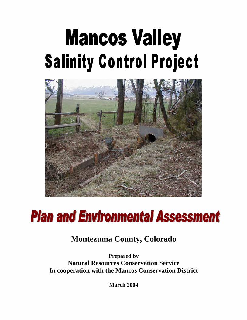
Montezuma County, Colorado Prepared by Natural Resources Conservation Service In cooperation with the Mancos Conservation District March 2004
-
Upload
independent -
Category
Documents
-
view
0 -
download
0
Transcript of Mancos Archaeology
Montezuma County, Colorado
Prepared by Natural Resources Conservation Service
In cooperation with the Mancos Conservation District
March 2004
Mancos Valley Page 2
PLAN AND ENVIRONMENTAL ASSESSMENT
IRRIGATION IMPROVEMENTS
MANCOS VALLEY SALINITY CONTROL STUDY
MONTEZUMA COUNTY, COLORADO
Prepared by Natural Resources Conservation Service
Lakewood, Colorado
The U.S. Department of Agriculture (USDA) prohibits discrimination in all its programs and activities on the basis of race, color, national origin, sex, religion, age, disability, political beliefs, sexual orientation, or marital or family status. (Not all prohibited bases apply to all programs.) Persons with disabilities who require alternative means for communication of program information (Braille, large print, audiotape, etc.) should contact USDA’s TARGET Center at (202) 720-2600 (voice and TDD). To file a complaint of discrimination, write USDA, Director, Office of Civil Rights, Room 326-W Whitten Building, 1400 Independence Avenue SW, Washington DC 20250-9410, or call (202) 720-5964 (voice and TDD). USDA is an equal opportunity provider and employer.
Mancos Valley Page 74
Cultural Resources
Cultural Resource Overview and Recommendations: Mancos Valley Salinity Control Project, Montezuma County, Colorado
By Lawrence E. Moore Archeological Contractor
Natural Resources Conservation Service 655 Parfet Street, Rm. E200C Lakewood, CO 80215-5517
May 12, 2003
Mancos Valley Page 75
Abstract This report is a cultural resource overview for the Mancos Valley Salinity Control project that is contemplated for private lands within the Mancos Valley of Montezuma County, Colorado. The purpose of the overview is to identify known cultural resources that may be impacted by irrigation ditch improvements that may be implemented by the USDA’s Natural Resources Conservation Service (NRCS). Additionally, this report offers recommendations on managing resources identified and for further work. This information will be useful for NRCS planners and those who may implement the project. The Mancos valley contains and is surrounded by significant cultural resources dating to prehistoric and historic eras. The most notable site in the area is Mesa Verde National Park, a World Heritage Site. The study area itself contains 120 known archeological sites that represent both prehistoric and historic usage of the area. Of these, four are on the National Register of Historic Places (NRHP). Another three are eligible to the NRHP. Additionally, three sites are on the Colorado State Register of Historic Places. Several sites are close to or may have been impacted by ditch systems. There is a high probability of impacting cultural resources during irrigation improvements. It is recommended that a cultural resource inventory be done followed by monitoring while new ditches are installed. Ongoing concerns include the possibility that irrigation improvements may cut across or through significant sites, sites that may need stabilization, encountering unmarked burials, and determining if the ditches themselves are important cultural resources. Introduction This section is a cultural resource overview for the Mancos Valley Salinity Control project that is contemplated for non-federal lands in the Mancos Valley of Montezuma County, Colorado. The purpose of the overview is to identify known cultural resources that may be impacted by irrigation ditch improvements planned by the United States Department of Agriculture, Natural Resources Conservation Service (NRCS). Secondly, it predicts that additional resources will be found during project implementation. Additionally, this report offers recommendations on managing resources identified and for further work. This information will be useful for NRCS planners and those who may implement the project. Two authorities pertain to cultural resource concerns. The first is the National Historic Preservation Act of 1966 (NHPA) that established a comprehensive program to preserve the cultural and historic resources of the Nation. Section 106 of the act requires federal agencies to consider the effects of their actions on these resources. The National Environmental Policy Act of 1969 (NEPA) is the second authority. Title 1 Section 101(b)(4) states that one purpose of the act is to preserve important historic, cultural, and natural aspects of our national
Mancos Valley Page 76
heritage. The State Level Agreement (SLA) between NRCS and the Colorado Office of Archaeology and Historic Preservation (OAHP) integrates NRCS projects into the Section 106 process. Additionally, the role of OAHP is to review Section 106 projects. An addendum to the Programmatic Agreement specifically discusses determinations of no effect and exempt undertakings related to irrigation projects. The two authorities are independent but can be integrated and coordinated into one cultural resource compliance process. Other authorities that may apply include Colorado CRS 24-80-401 (Historical, Prehistorical, and Archaeological Resources Act) and Colorado CRS 24-80-1301 (Unmarked Human Graves Act). If the project includes lands owned by the state, county, city, town, district, or any subdivision of the state then consultation with OAHP is needed. Additionally, if unmarked human graves are encountered then the Unmarked Human Graves act may apply. NRCS is incorporating NEPA, 40 CFR Parts 1500-1508, into the process and is considering air, noise, and scenic qualities within the scope of work. Survey for cultural resources will be phased. The consideration of this report is to identify known resources within the Area of Proposed Effect (APE) and to predict the presence of additional resources based on an understanding of the regional resource base. Mitigation is outlined in the Memorandum of Understanding.
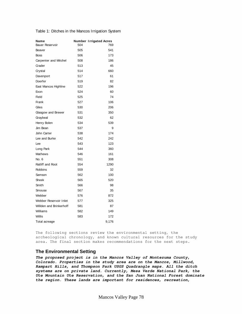
Area of Consideration and Possible Impacts The Mancos Valley contains and is surrounded by significant cultural resources dating to prehistoric and historic eras. This area has a long history of archaeological research and this review is selective in the resources used; there has been no attempt at summarizing all the regional research. The study area includes a large part of the Mancos USGS quadrangle map with adjacent areas on the Millwood, Rampart Hills, and Thompson Park maps. The lands under consideration are cropland. Table 1 lists the ditches that may be improved. In total, the existing irrigation system extends about 104 miles and contains 34 earthen ditch system that supply water to about 9,176 acres of crops. At this time the specific ditches and locations of the new pipe system have not been determined. Most if not all of the existing system is under consideration to be improved. In general, the goal is to place the new pipe system within the current ditch right-of-ways. Currently, the ditches are open surface systems controlled by gates. A Gravity Pressure System is the proposed pipeline for installation. This requires installing a pressure pipeline that would supply water to sprinkler systems that irrigate cropland. Additionally, new on-farm sprinkler systems may be installed on some farms. Improving water supply to farmland will result in less ditch seepage and deep percolation. These improvements will reduce salt loading into the Mancos River, and eventually, the Colorado River, which is the overall goal (Soil Conservation Service 1984). Possible impacts to cultural resources during pipeline installation will come from subsurface soil disturbances (below plow zone or depth of prior disturbance). Excavation below subsoil may impact cultural resources by cutting into archeological deposits of artifacts and features. In addition, some or all of the ditches may qualify as historic engineering features themselves. Modifications to these ditches could be considered an adverse impact. Existing ditches may have also cut through other prehistoric or historic archeological
Mancos Valley Page 77
sites. Pipeline installation may impact these previously impacted sites. The sprinkler systems are categorically exempt from Section 106 review per the programmatic agreements. As mentioned, the Mancos Valley contains and is surrounded by significant cultural resources dating to prehistoric and historic eras. The most notable site in the area is Mesa Verde National Park, a World Heritage Site. The study area itself contains 120 known archeological sites that represent both prehistoric and historic usage of the area. Of these, four are on the National Register of Historic Places (NRHP). Another three are eligible to the NRHP. Additionally, three sites are on the Colorado State Register of Historic Places. Several sites are close to or may have been impacted by ditch systems. High probability exists for impacting cultural resources during irrigation improvements. It is recommended that a cultural resource inventory be done followed by monitoring while new pipelines are installed. Ongoing concerns include the possibility that irrigation improvements may cut across or through significant sites, or sites may need stabilization. Others are the possibility of encountering unmarked burials; and determining if the historic ditches themselves are important cultural resources.
Mancos Valley Page 78
Table 1: Ditches in the Mancos Irrigation System Name Number Irrigated Acres Bauer Reservoir 504 769
Beaver 505 541
Boss 506 173
Carpenter and Mitchel 508 186
Crader 513 45
Crystal 514 660
Davenport 517 61
Doerfer 519 82
East Mancos Highline 522 196
Exon 524 60
Field 525 74
Frank 527 106
Giles 530 206
Glasgow and Brewer 531 350
Graybeal 532 62
Henry Bolen 534 539
Jim Bean 537 9
John Carter 538 174
Lee and Burke 542 242
Lee 543 123
Long Park 544 360
Mathews 546 161
No. 6 551 308
Ratliff and Root 554 1290
Robbins 559 32
Samson 562 100
Sheek 565 520
Smith 566 98
Smouse 567 35
Webber 576 872
Webber Reservoir Inlet 577 325
Willden and Brinkerhoff 581 87
Williams 582 149
Willis 583 172
Total acreage 9,176
The following sections review the environmental setting, the archeological chronology, and known cultural resources for the study area. The final section makes recommendations for the next steps.
The Environmental Setting The proposed project is in the Mancos Valley of Montezuma County, Colorado. Properties in the study area are on the Mancos, Millwood, Rampart Hills, and Thompson Park USGS Quadrangle maps. All the ditch systems are on private land. Currently, Mesa Verde National Park, the Ute Mountain Ute Reservation, and the San Juan National Forest dominate the region. These lands are important for residences, recreation,
Mancos Valley Page 79
water, fish and wildlife, timber, grazing, minerals and other light industry. Mancos is the main town in the area and US Highway 160 and County Road 184 (Weber Road) are the main access roads. Major landmarks include Mesa Verde Plateau, Weber Mountain, Menefee Mountain, and Flint Rock Point. Important water systems include Mancos River, Mud Creek, Weber Creek, and Chicken Creek. Several reservoirs are north of Mancos. Elevations range from 6600 to 7200 feet above sea level. Numerous gravel pits are in the area and three cemeteries are along Weber road, south of Mancos. Also, north of town is an old railroad grade for the Rio Grande and Southern Rail Road, built in 1891.
Geologically, the shales of the Mancos formation, a marine formation, underlie most of the Mancos valley. The Mesa Verde Group of three formations overlies the Mancos to the east, west and on Weber Mountain. On the north is an outcrop of Dakota Formation that underlies the Mancos. Geographic landforms in the valley include terraces and floodplains, alluvial fans, and hillsides and escarpments (Soil Conservation Service 1984, Natural Resources Conservation Service n. d.). The general soil units of the study area include the Lillings-Ramper-Fluvents, Wetherill-Pulpit-Gladel, Granath-Ilex-Ormiston, and Sideshow-Zigzag units. Soils on floodplains, stream terraces, and alluvial fans are the Lillings-Ramper-Fluvents unit. These soils have alluvium and mixed parent materials and they are very deep. Soils on hills and mesas include the Wetherill-Pulpit-Gladel and Granath-Ilex-Ormiston units. These soils developed as eolian and residuum deposits from sandstones or sandstones and shale. These soils are deep, except for Gladel that is shallow. The Sideshow-Zigzag unit is found on hills, ridges, alluvial fans, and knobs. The parent material is alluvium and residuum from shale. The Sideshow soil is deep and the Zigzag soil is shallow with shale at 6 to 20 inches (Natural Resources Conservation Service n. d.). The valley is primarily farmland. Irrigated crops include alfalfa and small grains. Dryland farming crops are pinto beans and winter wheat. Vegetation on non-farmed lands is sagebrush, pinyon pine, Utah juniper, and Gamble oak scrubland. Major animals currently and in historic times include small mammals, coyotes, antelope, bighorn sheep, elk, mule deer, and wild turkeys. The climate is semi-arid, and average annual precipitation is 10 to 15 inches at Cortez. Late summer rains and snowfall provide most of the moisture.
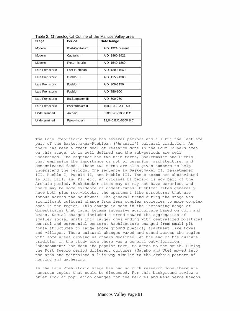
Archeological Chronology The following is a chronological summary of the Mancos area (Table 2). The prehistory section takes its lead from the context volume for the Southern Colorado River (Lipe et al 1999). The Modern Stage is used here, but it has not been fully integrated into the local archeological literature (Moore 2002). Additionally, the Southern Colorado River context volume divides the study area into smaller units because there has been enough research done in the Four Corners region to make more refined analyses and comparisons. A Delores Unit is defined that includes the middle portion of the Delores River and the upper part of the Mancos River. Therefore, the Mancos valley is part of the Delores Unit for the context volume’s purposes. Other units adjacent to the Delores one include the Monument-McElmo, Mesa Verde-Mancos, and La
Mancos Valley Page 80
Plata units. As this study area is at the southeastern end of the Delores unit the possibility that it blends into the Mesa Verde-Mancos unit is considered. While other Colorado context areas have well defined Paleo-Indian and Archaic stages this study area does not. Instead, these terms are used for sub-periods. The authors of the Southern Colorado River context volume (Lipe et al 1999) believe that there is not enough information to define the early stages in southwestern Colorado. In addition, there appears to be little difference between the two early periods except in the form of artifact types. The later portion of the Paleo-Indian period appears Archaic mostly because this region is part of an intermountain Paleo-Indian life-way that is somewhat unique in Western North America (Frison 1992; Pitblado 1998). In other Colorado context areas the Paleo-Indian life-way was a subsistence strategy based on the hunting of large game (bison, mammoth) with some supplemental foods coming from plants and small animals, and, the Archaic life-way was a broad based subsistence pattern wherein a variety of foods were used. In this study area, the later half of the Paleo-Indian period was a life-way pattern that was Archaic not the traditional Paleo-Indian. But, the artifact types are Paleo-Indian in style. Angostura and Great Basin stemmed points are found from this part of the period. A year round habitation cycle is suggested for the Southern Colorado Rocky Mountains, nomadic mobility was bounded (not far ranging), and there was a focus on local stone raw materials, mainly quartzite. The early portion of the Paleo-Indian period has Folsom points and may suggest a more typical Paleo-Indian pattern. The Archaic period reflects a broad spectrum hunting and gathering way of life. Plant processing is also more evident as grinding stones are more frequently found when compared to earlier times. Sites dating to the Paleo-Indian and Archaic periods are rare in the Four Corners area but are found occasionally. Usually they are found as surface finds on steep terrain. Outside this study area but in the nearby Rampart Hills there are several Archaic open camps and isolated finds (5MT.9476, 5MT.9479-9483, 5MT.9485, 5MT.9487-9488, and 5MT.9638-9643). In the study area these sites are likely to be buried in the valley floor, as the soils are deep. Sites from these periods will usually be considered significant unless they have been heavily disturbed.
Mancos Valley Page 81
Table 2: Chronological Outline of the Mancos Valley area. Stage Period Date Range
Modern Post-Capitalism A.D. 1921-present
Modern Capitalism A.D. 1860-1921
Modern Proto-historic A.D. 1540-1860
Late Prehistoric Post Puebloan A.D. 1300-1540
Late Prehistoric Pueblo III A.D. 1150-1300
Late Prehistoric Pueblo II A.D. 900-1150
Late Prehistoric Pueblo I A.D. 750-900
Late Prehistoric Basketmaker III A.D. 500-750
Late Prehistoric Basketmaker II 1000 B.C.- A.D. 500
Undetermined Archaic 5500 B.C.-1000 B.C.
Undetermined Paleo-Indian 12,040 B.C.-5500 B.C.
The Late Prehistoric Stage has several periods and all but the last are part of the Basketmaker-Puebloan (“Anasazi”) cultural tradition. As there has been a great deal of research done in the Four Corners area on this stage, it is well defined and the sub-periods are well understood. The sequence has two main terms, Basketmaker and Pueblo, that emphasize the importance or not of ceramics, architecture, and domesticated foods. These two terms are also given numbers to help understand the periods. The sequence is Basketmaker II, Basketmaker III, Pueblo I, Pueblo II, and Pueblo III. These terms are abbreviated as BII, BIII, and PI, etc. An original BI period is now part of the Archaic period. Basketmaker sites may or may not have ceramics, and, there may be some evidence of domesticates. Puebloan sites generally have both plus room-blocks, the apartment like structures that are famous across the Southwest. The general trend during the stage was significant cultural change from less complex societies to more complex ones in the region. This change is seen in the increasing usage of domesticates that later became intensive agriculture based on corn and beans. Social changes included a trend toward the aggregation of smaller social units into larger ones ending with centralized political control and ceremonial centers. Architecture changed from small pit house structures to large above ground pueblos, apartment like towns and villages. These cultural changes waxed and waned across the region with some areas growing as others declined. At the end of the cultural tradition in the study area there was a general out-migration, ‘abandonment’ has been the popular term, to areas to the south. During the Post Pueblo period different cultures (Navaho and Ute) moved into the area and maintained a life-way similar to the Archaic pattern of hunting and gathering. As the Late Prehistoric stage has had so much research done there are numerous topics that could be discussed. For this background review a brief look at population changes for the Delores and Mesa Verde-Mancos
Mancos Valley Page 82
units is useful as they may help in predicting the amount and quality of sites to be encountered. Table 3 provides population estimates for various date ranges. Lipe et al. (1999: 189, 235, 264, and 325-326) provided population estimates for each of the units during the BIII and PI periods at years A. D. 560, 680, 800, 860, and 920. For the PII and PIII periods, estimates were made for the whole study area, all units combined, and over certain time blocks. The Delores and Mesa Verde-Mancos unit data has been extracted from the total population estimates based on the percentage of sites represented for each unit per period. For example, Lipe et al. reported that the Delores Unit contained 4.76 percent of all known PII sites in their study area. Also, they provided conservative and liberal population estimates for their whole study area. The conservative numbers are used here. So, the Colorado portion of the Four Corners area had, conservatively, a population of 1,680 people during the A. D. 880-920 time range. Therefore, approximately 80 people lived in the Delores unit during those years (4.76 percent of 1680 is 80). For the PIII period the Delores unit contained 4.2 percent of the known sites, so that number was used to calculate the estimate. For the Mesa Verde-Mancos unit the PII number was 46.06 percent and the PIII percentage was 28. These calculations are rough estimates and do not consider site size, number of room blocks, or size of rooms. Lipe et al. (1999: 264) also provided useful cautions on using these numbers. For comparative purposes, Montezuma County had populations of 3,058 in 1900, and, 16,510 in 1980. In 1980 the Delores and Mancos subdivisions of the county had 1,865 and 1,785 people respectively (Soil Conservation Service 1984). Thus, there are times in the prehistoric past when the populations of the Delores and Mesa Verde-Mancos units were greater than they have been in historic decades or even today. From these estimates the population growth (decline) rate can also be estimated (Table 4). The growth rate was calculated by taking the change in population for each block of time and using the differential as a percentage of the base population and adjusted to annual rates of change. For example, in the Delores unit the growth rate for the A. D. 680 to 800 era is 0.832. The population went from 250 to 500 people over 120 years. The gross change is 250 people at a rate of 2.08 persons per year (250/120 = 2.08). The number 2.08 expressed as a percentage of the starting population of 250 is 0.832, the growth rate for that range of dates. Growth rates vary over time as Table 4 shows. The growth rate can be compared to the Rate of Natural Increase (RNI), another theoretical construct. A normal, healthy population will have a RNI of 1 percent. RNI is the excess of births over deaths and does not include other factors such as in- or out-migration, environmental change, or social variables. RNI can vary but rarely more than 1 percent. According to the Population Reference Bureau (www.prb.org) in 2002 the world average RNI was 1.3. Less developed nations were at 1.6; more developed nations were at 0.1; and North America was at 0.6. Negative growth rates indicate a population in decline. The carrying capacity of the environment has been over stressed, people moved out, and/or they had more deaths than births. Growth rates at or near 0 indicate a population stressing the carrying capacity of its environment. Rates that are 2 or more points above or below 1 generally indicate migration in or out of a region. These statements
Mancos Valley Page 83
are descriptive and reasons for decline, stagnation or rapid growth would need to be postulated through some theoretical model. The growth rates in Table 4 provide some interesting patterns for the Delores and Mesa Verde-Mancos units over time. For the years A.D. 560 to 1000 each unit seems to have had its own pattern of growth, migration and decline. The Delores unit starts with a near zero population that then became an average rate up until 800-860 when there was a large in-migration. Next, there was a decline during 860-960, possibly from a modest out-migration. This was followed by an era of average growth, 960-1000. The Mesa Verde-Mancos unit started with a few more people and had an average growth rate from A. D. 560 to 860. Then there was a decline for 40 years until 920-960 when there was an extremely large in-migration. The in-migration slowed down to a modest growth rate during 960-1000. From 1000 to 1320 the two units were synchronized with an era of 80 years of carrying capacity stress (1000-1080), then a return to a normal growth pattern (1080-1160), followed by 120 years of stress (1160-1800), and then a decline (1280-1320). This last decline is associated with the well-known ‘abandonment’ of the greater Mesa Verde area in the late 13th century and was likely a slow out-migration. The years 860-920 were also possibly a time of abandonment of both units, particularly in the Delores unit. These numbers suggest that the study area should have a significant number of PI sites compared to other time periods, as it seems to have had the largest population during the stage. Also, if the Mancos valley portion of the Delores unit blended into the Mesa Verde-Mancos unit then the south end of the valley could have a high concentration of PII sites, as well.
Table 3: Population estimates for the Delores and Mesa Verde-Mancos units at designated times.
(Source: Lipe et al. 1999: 189, 235, 264, and 325-326) Period Year(s) A. D. Delores Unit
Est. Population Mesa Verde-Mancos Unit Est. Population
BIII 560 0 people >250 people
BIII 680 >250 500 PI 800 500 1000 PI 860 3000 1500 PII 920 >250 >250 PII 920-960 160 1550 PII 960-1000 234 2270 PII 1000-1040 254 2458 PII 1040-1080 272 2630 PII 1080-1120 419 4057 PII-PIII 1120-1160 577 5587 PIII 1160-1200 583 3887 PIII 1200-1240 579 3860 PIII 1240-1280 579 3860 PIII-Post P 1280-1320 290 1937
Mancos Valley Page 84
Table 4: Growth Rates in the Delores and Mesa Verde-Mancos units at designated times. Period Year(s) A. D. Delores Unit
% change/year Mesa Verde-Mancos Unit % change/year
BIII 560-680 Not meaning full 0.832
BIII-PI 680-800 0.832 0.833 PI 800-860 8.320 0.833 PI-PII 860-920 -1.526 -1.388 PII 920-960 -0.900 13.000 PII 960-1000 1.150 3.411 PII 1000-1040 0.213 0.207 PII 1040-1080 0.177 0.175 PII 1080-1120 1.35 1.356 PII-PIII 1120-1160 0.942 0.942 PIII 1160-1200 0.020 -0.894 PIII 1200-1240 -0.002 -0.017 PIII 1240-1280 0.000 0.000 PIII-Post P 1280-1320 -1.247 -1.245
The Modern Stage is divided into three periods: the Proto-historic, Capitalism, and Post-Capitalism. The Proto-historic period represents the years when European influences entered into the region but American Indian tribes still controlled much of the land. In general, this area was Navaho and Ute territory during the period. European influences include: Spanish traders and military expeditions from New Mexico in the seventeenth and eighteenth centuries, and, American fur trappers exploring most of the region in the early half of the nineteenth century (Carson 1998; Sanchez 1997; West 1998). It may seem inconsistent to separate the Post Pueblo and Proto-historic periods as both had Navaho and Ute peoples living in the area. The change is based on a hypothesized subsistence and settlement pattern change. The presence of Europeans in the region is a significant difference, specifically in that they introduced horses. As Navaho and Ute peoples adopted horses their cultural patterns changed. Pedestrian hunter-gatherers have significantly different subsistence and settlement patterns than do mounted hunter-gatherers (Binford 2001). The Navaho are one of the groups that lived in the region during the Post Pueblo period. They also occupied the Four Corners area of Colorado at the beginning of the Proto-historic period when the Spanish first settled into the Rio Grande valley. This tribe is an Apachean speaking group related to Jicarilla, Mescalero, Lipan, and several others. The origin of this group is not well understood but they appear to have been in the Four Corners region for several centuries. Among Anthropologists a debate has been ongoing regarding how long the Navaho have been in the region, and, what route was taken for their initial entry into it. Apacheans are related to the Athabaskan language stock with a homeland in Alberta and British Columbia, Canada. The Apacheans migrated south and occupied large portions of the plains and southwest. Some argue that the migration route was down the plains and then west across the greater Southwest. Others believe that an intermountain route was taken. A third view would be a blend of the two; there are so many Apachean tribes that a single route is unlikely. Again, when these migrations occurred is debated and opinions range from 500 years ago to 1500 years ago (Towner 1996). The Navaho currently have a large
Mancos Valley Page 85
reservation in northern Arizona, southern Utah, and northwestern New Mexico. The Ute are another group that historically lived within the Mancos region. This wide ranging ethnic group was made up of several bands that historically lived in Colorado, northern New Mexico, and eastern Utah (Simmons 2000). Linguistically, the Ute are closely related to the Southern Paiute of southern Utah and Nevada. They are also part of a broader Shoshonean or Numic language group that includes the Shoshoni, Comanche, Northern Paiute, Western Paiute, Bannock, Lemhi, Goshute, and, distantly, the Hopi. Similar to the Apachean question, the prehistory of the Numic peoples is a matter of some controversy. The general consensus is that the Numic groups have an origin to the west of the historic Ute territory. Exactly where this original homeland was is debated; it possibly was in the central Great Basin or southern or far-western part of it. From this original home land Numic bands spread out to occupy most of the interior of the western United States. When this ‘Numic Spread’ occurred is also debated. Some place it as far back as 3500 years ago; others place it to about 1000 years ago. The essays in Madsen and Rhode 1994 summarize these debates very well. The Ute Mountain Ute reservation is adjacent to the Mancos Valley. The Capitalism period is characterized by the capital goods industries that drove the Colorado economy in the later half of the nineteenth century, mining, ranching, logging, and agriculture (West 1998). The history of the Mancos area iterates these main themes. The Post Capitalist period reflects the economy’s shift away from capital goods towards information control and knowledge based labor. Knowledge-based workers are generally in service sectors that provide specialized services such as accounting, legal consultation, and scientific studies. For the Mancos area this is reflected by the focus on recreation and land management. Today, the Mancos area is a rural community whose few residents enjoy the amenities of Durango and Mesa Verde. Proto-historic sites will be rare and hard to distinguish from the Post Puebloan period. Sites dating to the last two periods will be numerous and will reflect mining, ranching, recreation, and support functions such as utilities and transportation. In summary, sites dating to all periods are likely to be present in the Mancos Valley. The changing population and subsistence patterns suggest that rates of material culture accumulation waxed and waned over time. The peak accumulation periods were the PI, PII, PII, Capitalism, and Post Capitalism ones, as these are the more sedentary periods. Periods when nomadic patterns were the norm (Paleoindian, Archaic, Post-Pueblo, and Proto-historic) are represented by sparser accumulations. Irrigation in the Mancos Valley The Mancos Valley has a long and interesting history (Freeman 1958). Spaniard Don Juan Maria de Rivera marched through the valley in 1765, having come from New Mexico. His party named most of the streams and landmarks of the area. The Rio Mancos was named at that time after an accident left a man crippled. It means the Crippled One. Later, in 1776, Father Escalante came through the valley and may have camped there.
Mancos Valley Page 86
Prospectors who had come to work the mines within the La Plata Mountains claimed the first homesteads in 1874. They returned to the valley in 1875 and worked their claims, growing grains, potatoes, and gardens. They brought in the first cattle herds and the valley was cattle country for many years. In 1881 the town of Mancos was laid out and lots were developed. In 1885 there were numerous businesses, including a shoemaker, a blacksmith, a bank, a grocery store, a general merchandise store, a hotel, two saloons, and a post office. The railroad was built through town in 1891. Throughout the early history of the area sawmills, gristmills and dairys filled out the local businesses. Farming soon became a major industry as irrigation was implemented. The first ditch seems to have been the Brewer-Glasgo, built in 1878. Frank Hallford organized the Crystal Creek Ditch Company in 1881. South of town the Webber community of Mormons built several ditches and reservoirs in the early 1880s. This included the Webber Ditch, Webber Ditch No. 2, and reservoirs south and northeast of Mancos. In 1904 the Summit Irrigation and Reservoir Company developed ditches and reservoirs north of town combining the Joe Moore Reservoir, Pruett Reservoir, Turkey Creek ditch, and Lost Canyon water rights. In 1902 the Weber Reservoir, on the Middle Mancos, was enlarged. The Bauer Reservoir #2 was built in 1902-3. Water from the Bauer Lake was fed to farms in 1907. In 1908 the Summit Reservoir was raised higher due to excessive rains. Also, in 1910, the Upper Bauer and Webber reservoirs were enlarged. And in 1911 the Crystal Creek Water Company was organized to bring water from Crystal creek to new farms on Grand View Mesa. Dry farming “above the ditches” started in earnest in 1906. For the town of Mancos water issues were very important. Fires in 1901 forced a discussion about a pressure water system for Mancos. In April 1902, there was an additional move to get a pressure water system. On March 3, 1903, the town voted to build the pressure water system, but nothing was done. In February 1904 the town board again voted to build a water works system for Mancos. Finally, it was completed August 1904. At that time old muddy ditches that serviced homes were abandoned. A Water Conservancy District to help valley farmers was discussed in August 1935. In 1938 the Mancos Water Conservancy District was informally set up and Jackson Gulch was chosen as the site for another reservoir. The plan was approved with WPA funding in 1940. At that time the Mancos Valley Conservancy District was formed. Construction at Jackson Dam was started in 1944 and finished in 1949. Prior Archeological and Historical Research within the Mancos Salinity Control Area Previous archeological studies within the Mancos valley have generally been targeted at understanding the interesting Anasazi (or ancestral Puebloans) that intensively used the region and at satisfying Cultural Resource Management requirements. Numerous cultural resource inventories have been done for various timber sales, land exchanges, pipelines, and other land developments. A file search at OAHP came up with many sites and reports. Important large projects include those listed in Table 5. Few local historical studies have been done. Freeman (1958) wrote a history of Montezuma County and Head (1986) did a history of banking in the county. Additionally, students from Fort Lewis Collage have done
Mancos Valley Page 87
some oral history in the area. Two studies on local water developments and salinity issues have been done (Butler 1994; Stene 1994); both are available in the Denver Public library for local use only. Historic preservation efforts in the vicinity include Mesa Verde National Park that it is a World Heritage Site. There are several buildings in and around the historic town of Mancos that are on the NRHP or on the Colorado State Register of Historic Places (Bauer Bank building, Bauer House, Mancos Opera House, Wrightsman House & Hotel, and the Mancos High School). One site on the state register (Bement site, 5MT.4388) is also owned by the Archaeological Conservancy, a non-profit organization devoted to preserving sites. The Rio Grande Southern Rail Road crosses the study area; some segments of it have been deemed eligible to the NRHP. North of the study area is the Lost Creek Archeological District in the San Juan National Forest. And, two other historic sites have been designated as eligible to the NRHP (5MT.10969 and 5MT.13799).
Mancos Valley Page 88
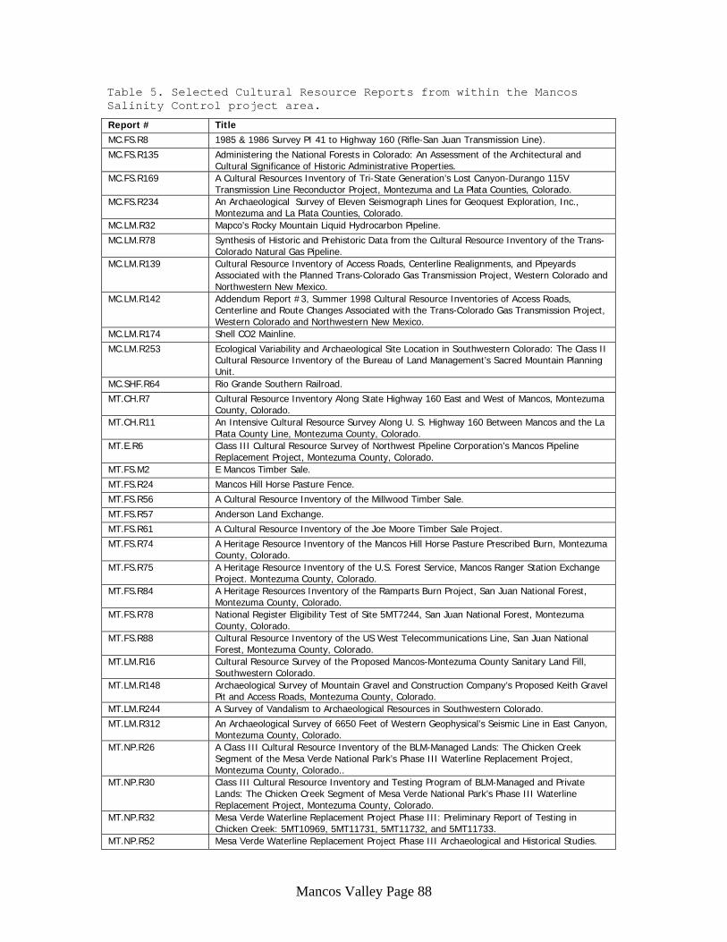
Table 5. Selected Cultural Resource Reports from within the Mancos Salinity Control project area.
Report # Title MC.FS.R8 1985 & 1986 Survey PI 41 to Highway 160 (Rifle-San Juan Transmission Line).
MC.FS.R135 Administering the National Forests in Colorado: An Assessment of the Architectural and Cultural Significance of Historic Administrative Properties.
MC.FS.R169 A Cultural Resources Inventory of Tri-State Generation’s Lost Canyon-Durango 115V Transmission Line Reconductor Project, Montezuma and La Plata Counties, Colorado.
MC.FS.R234 An Archaeological Survey of Eleven Seismograph Lines for Geoquest Exploration, Inc., Montezuma and La Plata Counties, Colorado.
MC.LM.R32 Mapco’s Rocky Mountain Liquid Hydrocarbon Pipeline.
MC.LM.R78 Synthesis of Historic and Prehistoric Data from the Cultural Resource Inventory of the Trans-Colorado Natural Gas Pipeline.
MC.LM.R139 Cultural Resource Inventory of Access Roads, Centerline Realignments, and Pipeyards Associated with the Planned Trans-Colorado Gas Transmission Project, Western Colorado and Northwestern New Mexico.
MC.LM.R142 Addendum Report #3, Summer 1998 Cultural Resource Inventories of Access Roads, Centerline and Route Changes Associated with the Trans-Colorado Gas Transmission Project, Western Colorado and Northwestern New Mexico.
MC.LM.R174 Shell CO2 Mainline.
MC.LM.R253 Ecological Variability and Archaeological Site Location in Southwestern Colorado: The Class II Cultural Resource Inventory of the Bureau of Land Management’s Sacred Mountain Planning Unit.
MC.SHF.R64 Rio Grande Southern Railroad.
MT.CH.R7 Cultural Resource Inventory Along State Highway 160 East and West of Mancos, Montezuma County, Colorado.
MT.CH.R11 An Intensive Cultural Resource Survey Along U. S. Highway 160 Between Mancos and the La Plata County Line, Montezuma County, Colorado.
MT.E.R6 Class III Cultural Resource Survey of Northwest Pipeline Corporation’s Mancos Pipeline Replacement Project, Montezuma County, Colorado.
MT.FS.M2 E Mancos Timber Sale.
MT.FS.R24 Mancos Hill Horse Pasture Fence.
MT.FS.R56 A Cultural Resource Inventory of the Millwood Timber Sale.
MT.FS.R57 Anderson Land Exchange.
MT.FS.R61 A Cultural Resource Inventory of the Joe Moore Timber Sale Project.
MT.FS.R74 A Heritage Resource Inventory of the Mancos Hill Horse Pasture Prescribed Burn, Montezuma County, Colorado.
MT.FS.R75 A Heritage Resource Inventory of the U.S. Forest Service, Mancos Ranger Station Exchange Project. Montezuma County, Colorado.
MT.FS.R84 A Heritage Resources Inventory of the Ramparts Burn Project, San Juan National Forest, Montezuma County, Colorado.
MT.FS.R78 National Register Eligibility Test of Site 5MT7244, San Juan National Forest, Montezuma County, Colorado.
MT.FS.R88 Cultural Resource Inventory of the US West Telecommunications Line, San Juan National Forest, Montezuma County, Colorado.
MT.LM.R16 Cultural Resource Survey of the Proposed Mancos-Montezuma County Sanitary Land Fill, Southwestern Colorado.
MT.LM.R148 Archaeological Survey of Mountain Gravel and Construction Company’s Proposed Keith Gravel Pit and Access Roads, Montezuma County, Colorado.
MT.LM.R244 A Survey of Vandalism to Archaeological Resources in Southwestern Colorado.
MT.LM.R312 An Archaeological Survey of 6650 Feet of Western Geophysical’s Seismic Line in East Canyon, Montezuma County, Colorado.
MT.NP.R26 A Class III Cultural Resource Inventory of the BLM-Managed Lands: The Chicken Creek Segment of the Mesa Verde National Park’s Phase III Waterline Replacement Project, Montezuma County, Colorado..
MT.NP.R30 Class III Cultural Resource Inventory and Testing Program of BLM-Managed and Private Lands: The Chicken Creek Segment of Mesa Verde National Park’s Phase III Waterline Replacement Project, Montezuma County, Colorado.
MT.NP.R32 Mesa Verde Waterline Replacement Project Phase III: Preliminary Report of Testing in Chicken Creek: 5MT10969, 5MT11731, 5MT11732, and 5MT11733.
MT.NP.R52 Mesa Verde Waterline Replacement Project Phase III Archaeological and Historical Studies.
Mancos Valley Page 89
List of Known Sites in the Study Area Table 6 lists the sites that are in the Mancos study area. These sites are located in the same Township and Range Sections as an existing ditch. At this time the exact location of the new pipe system layout is not known but it will be laid within existing ditches or run close to them. Some ditches have been documented using GPS technology. Table 6 also indicates if a known site is adjacent to or has been impacted by a ditch based on a comparison of mapped ditch locations to archeological site maps at OAHP. A more refined assessment and comparison of site and ditch locations will have to be done at a later phase and in the field. The sites on the list are identified by site number, location, and type (P = prehistoric, H = historic). A comment is made about each site and the National Register of Historic Places (NRHP) classification is given, if known. Isolated finds are shown as IF in the comment box and they are, by definition, not eligible to the NRHP. The sites are listed in numerical order based on the site numbers. The number is a code, 5MT###. Colorado has the code number 5 and Montezuma County is MT; Mesa Verde National Park is MV. The number after is a running total that started at zero. There are 120 sites in the study area. Of these, 83 are prehistoric, 34 are historic, one has both variables, and two are indeterminate as to general age. Of the 84 prehistoric sites 24 have enough data to assign a period. Noting that some sites have more than one period present, the following periods are represented: 1 Archaic site, 0 BI sites, 9 BIII sites, 12 PI sites, 10 PII sites, 2 PIII sites, and 1 Post-Puebloan or Proto-historic site. All of the historic European American sites date to the Capitalism and Post-Capitalism periods. Two ditches that are part of the Mancos irrigation system have already been recorded. The Weber Reservoir Inlet Ditch (5MT.11643) and the Long Park Ditch (5MT.11644) were recorded by Alpine Archaeological Consultants in 1991. Neither one has been evaluated in relation to the NRHP. Two other ditches have also been recorded from the Mancos area. The Jackson Gulch Inlet Canal (5MT.11645) was reported by Alpine in 1991. It was revisited by La Plata Archaeological Consultants in 1994 and classified as not eligible to the NRHP (MT.FS.R57). This ditch seems to be on the north end of Jackson reservoir. The Turkey Creek Ditch (5MT.13802) was reported by Alpine in 2000 (MT.FS.R88) and classified as not eligible to the NRHP. The Colorado Engineering Context volume (King 1984) provides information and guidance on evaluating irrigation ditches. In summary, the Paleo-Indian and Archaic periods are poorly represented in the Mancos study area. If these types of sites are encountered they will be buried in the deep soils and will likely be considered significant resources because they are rare. Sites from the BIII period are higher than expected, so the Mancos valley may have been used more than the Delores valley during that period; this would be an interesting topic to archaeologists as it may change their understanding of the period. Therefore, sites from this period would be significant due to the possibility that they could help refine current knowledge. Sites from the PI and PII period are predictably well represented. The high number of PII sites does suggest that the Mancos valley blends into the Mesa Verde-Mancos unit. PIII sites seem to be
Mancos Valley Page 90
underrepresented in the study area. This may be a settlement pattern issue as many sites from this era are in the Lost Canyon District. Post Puebloan and Proto-historic sites are rare in the area; any found would be significant resources. Historic American sites are common and several are significant due to their architectural or social associations. These observations are not intended to convey the idea that every site is significant. A conservative approach is to view every site as potentially eligible to the NRHP and evaluate it downward from there, as needed. After the evaluation process many sites will not qualify as eligible to the NRHP. As the list below shows many sites are isolated finds or lack the integrity to be considered NRHP eligible. Those sites that are more substantial and have some resemblance of integrity need to be assessed against the ideas and research questions expressed in the appropriate context volumes (Lipe et al. 1999; Buckles and Buckles 1984; King 1984)
Table 6: List of Sites in the Mancos Study Area.
Note: Table 6 contains confidential site location information and is not available for public review.
Consultation Data was received from OAHP on March 24 and May 7, 2003. Agreements with Ute Mountain Ute and Southern Ute require notice of Ute cultural items.
Recommendation and Ongoing Concerns It is recommended that an on-site cultural resource inventory be done. This inventory should be limited to those areas where new excavating will be done and any place that subsoil is to be disturbed. The ditches themselves can be recorded as sites, as they likely meet the age requirement of being historic structures. This study will also evaluate for NRHP purposes any and all sites encountered, including sites that have been previously recorded. The inventory will also need support from the ditch companies, particularly in notifying landowners and maintaining public relations while the fieldwork is in progress. Following the inventory a monitoring phase should be implemented by having an archeologist observe the excavation of the new ditches. If additional cultural materials are discovered then there are options to consider. First, the materials will need to be evaluated against the NHRP criteria where they may be dismissed as not eligible or determined to be potentially eligible. The potentially eligible sites can be handled in various ways. One would be to realign a specific new ditch to avoid these new cultural materials. Alternatively, an archeological data recovery effort can be done to mitigate the adverse effect of placing the new ditch through the cultural materials. Several ongoing concerns include the possibility that irrigation improvements may cut across or through significant sites, sites that may need stabilization, encountering unmarked burials, and determining if the ditches themselves are important cultural resources.
Mancos Valley Page 91
One concern is that the ditches may have cut through earlier prehistoric or historic sites. While these are impacts that happened in the past, future changes to the ditches may exacerbate these impacts and lead to additional deterioration of significant sites. Some effort at stabilizing these sites may be needed. For example, if ditches have cut through room-blocks, kivas, or other pit features then there may be a need to stabilize them from erosion. Another option would be to mitigate the problem through archeological excavation. As with any ground disturbing endeavor, the possibility of encountering burials is present. Such features pose numerous problems when found that generally lead to construction delays. For example, in Virginia a church expansion was stopped twice (each for two weeks) when burials were encountered and needed excavation. This impromptu project dominated the time of a staff archeologist for the next year (Moore, Owsley, and Sandness 1995). If burials are found they can be avoided. If the path of the pipeline cannot be rerouted around burials then the local sheriff and coroner, and the State Archeologist will need to be contacted and involved. Finally, the ditches themselves may be cultural resources if they are 50 years old or more. It appears that many ditches will meet this requirement. As such they need to be recorded and evaluated for NRHP purposes. A context volume on historic engineering structures has been provided by the Colorado Historical Society (King 1984) to assist in this regard. Once the new pipeline is installed the old ditches may be abandoned. This is likely to end in their deterioration and leveling through natural processes. The public may be concerned about this and one way to offset the loss is to produce a brochure on the history of irrigation in the Mancos valley. The brochure can be made available to the public through local museums and libraries.
Alternatives Currently the intent is to install the new pipeline adjacent to the existing ditches. A possible alternative is to run the pipeline down the ditches themselves, thereby reducing the volume of subsoil that may be disturbed. The ditches would be impacted but they may not need to be left intact.
References Cited Binford, Lewis R. 2001 Constructing Frames of Reference: An Analytical Method for Archaeological Theory Building Using Hunter-Gatherer and Environmental Data Sets. University of California Press, Berkeley, CA. Buckles, William G., and Nancy B. Buckles 1984 Colorado Historic Archaeology Context. Colorado Historical Society, Denver, CO.
Mancos Valley Page 92
Butler, Peter 1994 A Comparison of Policies for Controlling Irrigation-Induced Salinity in Southwestern Colorado. Ph.d Dissertation, University of Michigan. Carson, Phil Across the Northern Frontier: Spanish Explorations in Colorado. Johnson Books, Boulder, CO. Freeman, Ira S. 1958 A History of Montezuma County, Colorado: Land of Promise and Fulfillment. Johnson Books, Boulder, CO. Frison, George C. 1992 The Foothills-Mountains and the Open Plains: the Dichotomy in Paleoindian Subsistence Strategies Between Two Ecosystems. In Ice Age Hunters of the Rockies, edited by D. J. Stanford and J. S. Day, pp. 323-342. University of Colorado Press, Niwot, CO. Head, June 1986 One Hundred Years of Banking in Montezuma County. First National Bank, Cortez, CO. King, Joseph E. 1984 Colorado Engineering Context. Colorado Historical Society, Denver, CO. Lipe, William D., Mark D. Varien, and Richard H. Wilshsen 1999 Colorado Prehistory: A Context for the Southern Colorado River Basin. Colorado Council of Professional Archaeologists, Denver, CO. Madsen, David B., and David Rhode (eds.) 1994 Across the West: Human Population Movement and the Expansion of the Numa. University of Utah Press, Salt Lake City, UT. Moore, Lawrence E. Prehistoric Sites and Settlement Patterns in the Ken-Caryl Valley, Jefferson County, Colorado. Southwestern Lore 68(1): 1-22. Moore, Lawrence E., Douglas W. Owsley and Karin L. Sandness. 1995 Military and Civilian Burials from Centreville, Virginia. Quarterly Bulletin of the Archeological Society of Virginia 50(4): 27-45. National Cooperative Soil Survey N.D. Soil Survey of Cortez Area, Colorado. Parts of Dolores and Montezuma Counties. Draft manuscript, USDA, Natural Resources Conservation Service, Lakewood, CO. Pitblado, Bonnie L. 1998 Peak to Peak in Paleoindian Time: Occupation of Southwest Colorado. Plains Anthropologist 43(166):333-348. Sanchez, Joseph P. 1997 Explorers, Traders, and Slavers: Forging the Old Spanish Trail, 1678-1850. The University of Utah Press, Salt Lake City, UT.
Mancos Valley Page 93
Simmons, Virginia McConnell. 2000 The Ute Indians of Utah, Colorado and New Mexico. University Press of Colorado, Boulder, CO. Sims, Marsha Mancos Watershed Project: Cultural Resources Inventory. Draft report, Natural Resources Conservation Service, Lakewood, CO. Soil Conservation Service 1984 Irrigation Improvements: Mancos Valley Salinity Control Study, Colorado River Salinity Control Program. USDA, Soil Conservation Service, Denver, CO. Stene, Eric A. 1994 The Mancos Project. Bureau of Reclamation History Program, Denver, CO. Towner, R. H. (editor) 1996 The Archaeology of Navaho Origins. University of Utah Press, Salt Lake City, UT. West, Elliot The Contested Plains: Indians, Gold Seekers, and the Rush to Colorado. University Press of Kansas, Lawrence, KS.