Rhynie Current Archaeology
8
THE UK’S BEST SELLING ARCHAEOLOGY MAGAZINE April 2014 Issue 289 | £4.30 current Issue 289 | April 2014 www.archaeology.co.uk Happisburgh footprints | Maryport | Rhynie | Thornborough henges | Gossenstein Happisburgh footprints | Maryport | Rhynie | Thornborough henges | Gossenstein The earliest human footsteps in Europe Foundations of the church? The fate of Maryport’s Roman altars Excavating the royal site at Rhynie Excavating the royal site at Rhynie Issue 289 First impressions Pictish se a t o f power
Transcript of Rhynie Current Archaeology

T h e U K ’ s b e s T s e l l i n g a r c h a e o l o g y m a g a z i n e
april 2014 issue 289 | £4.30currentissue 289 | a
pril 2014
www.archaeology.co.uk
happisburgh footprints | m
aryport | rhynie | Thornborough henges | gossenstein
happisburgh footprints | m
aryport | rhynie | Thornborough henges | gossenstein
current archaeology
The earliest human footsteps in europe
Foundations of the church?The fate of maryport’s roman altars
excavating the royal site at rhynieexcavating the royal site at rhynie
issue 289 First impressions
Pictish seat of power

rhynie Pictish royal centre
below A site fit for a king? Excavations at Rhynie – home to the strikingly decorated Craw Stane – have revealed new clues to the evolution of social hierarchies in Pictland.
inset A Pict depicted: the ‘Rhynie Man’ was discovered by chance by Aberdeenshire farmers ploughing a field outside Rhynie village.
On 10 March 1978, Aberdeenshire farmers Kevin and Gavin Alston unexpectedly encoun-tered a Pict in their fields at Rhynie. While out ploughing, they came across a man with a
fearsome set of teeth, shouldering an axe. This extraordinary individual was carved into a large stone slab in the distinctive style of art executed by Pictish communities inhabiting eastern and northern Scotland in the Iron Age and Early Medieval period (see box on p.25).
Just over a month later, the same field yielded another stone, smaller this time but also embel-lished with Pictish motifs, including a beast, a comb, and a fragment of a mirror. Remarkable
‘A very royal place’The village of Rhynie in north-east Scotland is renowned for its impressive concentration of Pictish symbol stones. Now research at the site is uncovering a vivid picture of long-distance luxury trade and the transformation of tribes into kingdoms – as well as shedding new light on the shadowy world of the Picts. Gordon noble and Meggen Gondek explain.
Rhynie and the Picts
pho
to: C
athy
Mac
Iver
pho
to: A
berd
eens
hire
Cou
ncil
Arch
aeol
ogy
Serv
ice
| Issue 289 www.archaeology.co.uk | current archaeology| Issue 289 23
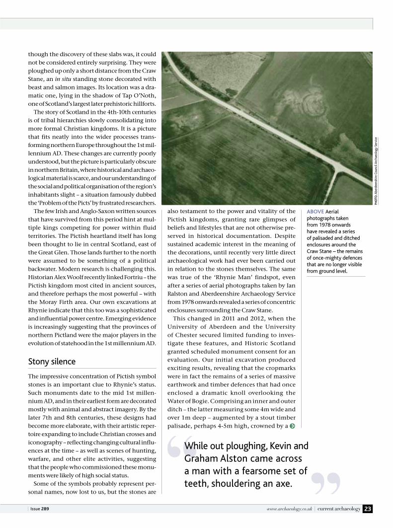
though the discovery of these slabs was, it could not be considered entirely surprising. They were ploughed up only a short distance from the Craw Stane, an in situ standing stone decorated with beast and salmon images. Its location was a dra-matic one, lying in the shadow of Tap O’Noth, one of Scotland’s largest later prehistoric hillforts.
The story of Scotland in the 4th-10th centuries is of tribal hierarchies slowly consolidating into more formal Christian kingdoms. It is a picture that fits neatly into the wider processes trans-forming northern Europe throughout the 1st mil-lennium AD. These changes are currently poorly understood, but the picture is particularly obscure in northern Britain, where historical and archaeo-logical material is scarce, and our understanding of the social and political organisation of the region’s inhabitants slight – a situation famously dubbed the ‘Problem of the Picts’ by frustrated researchers.
The few Irish and Anglo-Saxon written sources that have survived from this period hint at mul-tiple kings competing for power within fluid territories. The Pictish heartland itself has long been thought to lie in central Scotland, east of the Great Glen. Those lands further to the north were assumed to be something of a political backwater. Modern research is challenging this. Historian Alex Woolf recently linked Fortriu – the Pictish kingdom most cited in ancient sources, and therefore perhaps the most powerful – with the Moray Firth area. Our own excavations at Rhynie indicate that this too was a sophisticated and influential power centre. Emerging evidence is increasingly suggesting that the provinces of northern Pictland were the major players in the evolution of statehood in the 1st millennium AD.
Stony silence
The impressive concentration of Pictish symbol stones is an important clue to Rhynie’s status. Such monuments date to the mid 1st millen-nium AD, and in their earliest form are decorated mostly with animal and abstract imagery. By the later 7th and 8th centuries, these designs had become more elaborate, with their artistic reper-toire expanding to include Christian crosses and iconography – reflecting changing cultural influ-ences at the time – as well as scenes of hunting, warfare, and other elite activities, suggesting that the people who commissioned these monu-ments were likely of high social status.
Some of the symbols probably represent per-sonal names, now lost to us, but the stones are
also testament to the power and vitality of the Pictish kingdoms, granting rare glimpses of beliefs and lifestyles that are not otherwise pre-served in historical documentation. Despite sustained academic interest in the meaning of the decorations, until recently very little direct archaeological work had ever been carried out in relation to the stones themselves. The same was true of the ‘Rhynie Man’ findspot, even after a series of aerial photographs taken by Ian Ralston and Aberdeenshire Archaeology Service from 1978 onwards revealed a series of concentric enclosures surrounding the Craw Stane.
This changed in 2011 and 2012, when the University of Aberdeen and the University of Chester secured limited funding to inves-tigate these features, and Historic Scotland granted scheduled monument consent for an evaluation. Our initial excavation produced exciting results, revealing that the cropmarks were in fact the remains of a series of massive earthwork and timber defences that had once enclosed a dramatic knoll overlooking the Water of Bogie. Comprising an inner and outer ditch – the latter measuring some 4m wide and over 1m deep – augmented by a stout timber palisade, perhaps 4-5m high, crowned by a
above Aerial photographs taken from 1978 onwards have revealed a series of palisaded and ditched enclosures around the Craw Stane – the remains of once-mighty defences that are no longer visible from ground level.
pho
to: A
berd
eens
hire
Cou
ncil
Arch
aeol
ogy
Serv
ice
While out ploughing, Kevin and Graham Alston came across a man with a fearsome set of teeth, shouldering an axe.

left Taken during the 2012 excavation, these photographs show the great inner and outer ditches that once surrounded Rhynie. There was also a palisade and post setting (above).
current archaeology | www.archaeology.co.uk
rhynie Pictish royal centre
24 april 2014 |
at very high-status, often royal, centres. Their presence at Rhynie indicates that it too was the home of influential people – not least when you consider that these items must have been brought consider-able distances to reach our site, which lies
more than 40km from the coast.In the summer of 2012, we returned
to Rhynie to continue the ‘strip, map, and sample’ strategy that had proved
so effective the year before. This time we set out to investigate what lay inside the enclosed area. Our new trench duly revealed the presence of various buildings, including a substantial rect-angular structure measuring at least 9m by 5m, built from squared timbers. This may not have
wall-walk, the scale of these fortifications was truly monumental.
Such impressive defences were not the only hint that this was an important place – despite the relative brevity of settlement here (from c.AD 450-550), as indicated by Bayesian modelling of radiocarbon dates (see CA 259). Rhynie’s status was further underlined by a rich array of finds recovered from a destruction level in the outer ditch. These included bronze pins for which the best parallels seem to be toilet implements found in 5th- and 6th-century Anglo-Saxon graves, as well as a fragment of a glass drinking vessel from western France. There were also sherds from a dis-tinctive type of eastern Mediterranean amphora, previously unattested in eastern Britain. These modest scraps point to 6th-century trading con-tacts with the Byzantine Empire, most likely via western Scotland.
The amphorae fragments are the first to be identified in Pictland – indeed, the amphorae are the northernmost examples known in Europe – and at sites in western Britain and Ireland these luxury, imported goods are generally only found
below Digging beside the Craw Stane in 2011.

above This Late Roman amphora handle was part of a large storage vessel imported from the eastern Mediterranean. The sherds excavated at Rhynie are the northernmost examples known in Europe, and point to long-distance trade contacts.
Ritual Rhynie
What, then, can Rhynie tell us about the Picts and the emergence of early northern European kingdoms? To answer this question, it is worth widening our scope to include the archaeology of kingship at other high-status sites, not just in other parts of Scotland, but in Britain, Ireland, and Scandinavia. Rhynie’s elaborate timber palisade is currently unique in Pictland, for example, as is its association with post- and perhaps plank-built buildings. There are, though, parallels with simi-larly low-lying, palisaded ‘palace’ sites in what was the Anglo-Saxon kingdom of Northumbria, such as at Yeavering in Northumberland and Doon Hill in East Lothian (CA 72). Apparent similari-ties with Anglo-Saxon royal architecture should not lead us to assume that Rhynie was a palace of similar character to Yeavering: our site is earlier in date, and many of its distinctive features, such as the symbol stones and the imported goods, are unique in this combination.
www.archaeology.co.uk | current archaeology 25| Issue 289
been the largest building on the site, however: our trench also uncovered a series of plank slots that would have supported the walls of a struc-ture measuring more than 20m in length – the longest slot extended beyond the limits of the trench – suggesting a truly grand building, per-haps a timber hall. This imposing structure was complemented by post and beam settings found near the Craw Stane, which formed part of an elaborate approach arcing towards the monu-ment from the outer ditch. Our findings strongly suggest that the Craw Stane was also an element of this impressive entranceway.
Sections cut across the palisade shed further light on the sturdy defences that formed the site’s outer perimeter: in places their foundations sur-vived to a depth of up to 1.5m, with impressions of the large split planks set within them (prob-ably oak, according to charcoal analysis) still clearly visible. As in 2011, the ditch yielded fur-ther high-status finds, including more amphorae sherds and fragments of imported glass, as well as evidence that metalworking was taking place on the site. Among the moulds we found was the complete valve of one used to make small Type H brooches – typically found in both Ireland and Pictish areas elsewhere. There were also crucible fragments and, most excitingly, Scotland’s only known surviving Early Medieval set of metal-working tongs. Yet even this spectacular dis-covery was not the star find of the season – that accolade goes to a remarkable iron axe-headed pin, with a design similar to the thin-shafted axe carried by the Rhynie Man, but embellished by a spiral attached to the butt of the axe blade.
These findings must go some way towards explaining how Rhynie got its name – it derives from the Brittonic word rhynnoid, meaning ‘a very royal place’. It is becoming increasingly apparent that this is a very fitting moniker for the remarkable site we are beginning to uncover.
Unpicking the pictsOf all the peoples of Early Medieval Europe, the Picts are among the most mysterious.
Made up of a number of tribes that inhabited northern and eastern Scotland, they
were described by the Romans as fearsome fighters, while their elaborately decorated
symbol stones suggest a sophisticated artistic culture. But with almost no trace of their
language surviving today beyond a small number of Latin and ogham inscriptions on
memorial stones, and a scatter of placenames, they remain a shadowy presence. We
do not even know what they called themselves – picti was a nickname given by their
Roman enemies, meaning ‘the painted people’, perhaps referring to tattoos.
While archaeological evidence is gradually increasing our understanding of
Pictish material culture, our only written perspectives are those of outsiders: the
earliest sources are Roman, and a limited history from the 6th century onwards
can be pieced together using Irish sources, Early Medieval saints’ lives, and the
Venerable Bede’s Ecclesiastical History. It is Bede who tells us how the burgeoning
kingdom of Northumbria had come to dominate much of southern Scotland,
including parts of Pictland, but a decisive victory by the Picts at the battle of Dun
Nechtain in AD 685 ended their
overlordship. By the end of
the first millennium AD,
however, the Picts had
virtually disappeared,
their territories
seemingly merging with
those belonging to the
Gaelic kingdom of
Dál Riata to form Alba,
the basis of what would
ultimately become modern
Scotland.
pho
to: K
im T
rayn
or

current archaeology | www.archaeology.co.uk
rhynie Pictish royal centre
26 april 2014 |
for sacrificing cattle. It may be that Pictish leaders at Rhynie were also religious figures officiating over a cult where conducting animal sacrifice was an important element of pre-Christian kingship.
There are more parallels to be drawn in our site’s re-use of an existing prehistoric landscape, lying as it does in the shadow of the dramatic hillfort of Tap O’Noth. The Yeavering palace complex was also located in the close vicinity of a major Iron Age fort at Yeavering Bell, and the documented Pictish royal centre at Forteviot (CA 231) was found to be associated with a major cemetery whose ori-gins stretch back into prehistory. Rhynie also lies close to funerary features. Antiquarian accounts record that two carved monuments were found during the construction of a turnpike road out-side the modern village in 1836, beside which an unspecified quantity of human remains were reportedly found. Then, over 150 years later, aerial reconnaissance by Moira Greig of Aberdeenshire Archaeology Service noted cropmarks denoting two large, square enclosures in the field opposite. Measuring 16m and 20m in diameter, these are similar in form to an enclosure identified inside the Early Medieval cemetery at Forteviot.
Funerary finds
These fields, together with land immediately to the south of the village, formed the focus of our most recent field season in 2013. The latter area produced traces of what appears to have been an
Could Rhynie’s proliferation of carved stone monuments indicate an important ritual dimen-sion to the site? This would find parallels at contemporary high-status sites in Scandinavia, where halls and trading sites are often found in close juxtaposition to places of assembly, sacrifice, and cult. There, the emergence of new types of political authority appears to have been rooted in the evolution of a new religious authority, where access to the world of the gods was key. The Rhynie Man carries a special axe-hammer, which elsewhere has been interpreted as an implement
above A wide range of metal artefacts were found at Rhynie, including the only surviving set of Early Medieval metalworking tongs known in Scotland (at the top), and a striking pin shaped like an axe-hammer (centre left).
iMa
Ge:
Uni
vers
ity o
f Abe
rdee
n
left The axe-hammer pin (top) found at Rhynie – and X-rayed by Aberdeen Medical School (bottoM) – shows striking similarities to a tool carried by the Rhynie Man (below).
iMa
Ges
: Uni
vers
ity o
f Abe
rdee
n / A
berd
eens
hire
Cou
ncil
Arch
aeol
ogy
Serv
ice

www.archaeology.co.uk | current archaeology
dissolved, leaving only a stain in the bottom of the grave. Closer examination of these marks revealed the reason for their contrasting fates: this individual had been buried in a wooden coffin. But who were these people? The prox-imity of their barrows to the Craw Stane settle-ment strongly suggests that these were figures of importance, and enhances our view of
27| Issue 289
Early Medieval cemetery, possibly contemporary with the high-status settlement excavated at the Craw Stane. In addition to the two square enclo-sures spotted by Moira Greig in the 1990s, we found two square barrows – the most diagnostic of Early Medieval burial traditions in Pictland – measuring no more than 5m across. They con-sisted of shallow ditches with gaps at each corner, which would have defined a low central mound that had since been truncated by ploughing. In the centre of each barrow was a grave.
Unlike Anglo-Saxon areas to the south, the tradition in Early Medieval Scotland was largely for burials to be unfurnished, so we were not surprised to find that the barrows did not con-tain rich grave assemblages. There was one treasure to examine, however: the remains of one of the first (albeit partially) preserved Picts known from north-east Scotland. Bone survival is extremely rare in this region, thanks to the highly acidic local soils, but the fact that this individual had been laid to rest in a cist made from split sandstone slabs proved a stroke of good fortune for us. The collapsed capstone had helped to preserve some of the skeleton, allowing us to recover fragments of the legs, pelvis, and jawbone. Future research will reveal whether preservation is sufficient to enable us to find out more about when this individual lived and where they grew up, using radio-carbon and stable isotope techniques.
Time had been less kind to the occupant of the other barrow: their remains had completely
above Meggen Gondek leads a site tour at Rhynie, overlooked by Tap O’Noth. below Grave finds: during the most-recent excavations, the team investigated two square barrows, one of which contained a cist burial.
pho
to: H
ayle
y Ke
ane
Kite
PH
OTO
: Osk
ar S
vein
bjar
nars
on

the rhynie communityOne of the most rewarding aspects of working in and around Rhynie has been the
opportunity to engage with the local community. Our 2013 season saw hundreds of
people come to visit the excavation, while our site blog received over 3,000 hits over
a two-week period. This enthusiasm made our job of communicating the importance
of the site infinitely easier – and led to the development of innovative ideas, including
a ‘Pictish café’ organised by local resident Daisy Williamson. This housed displays of
posters and finds from the excavation, and also formed the focus of daily site-tours.
Artist Debbi Beeson also attracted visitors with her ‘souvenir exchange’, where people
could bring items of historical and social interest to exchange for Rhynie Man T-shirts,
sweets, and Pictish tattoos. The community input to the project was incredible – on
one day, an entire primary school came to dig with us – and shows the real appetite
among local groups and the wider
public for learning about the past. Local
photographer Hayley Keane also recorded
many of the community initiatives
through her striking photographs.
current archaeology | www.archaeology.co.uk
rhynie Pictish royal centre
28 april 2014 |
occupation phase at all. Instead, could their purpose have been more oriented towards the ritual rather than the domestic sphere? It may be that these features were linked to the barrow burials, perhaps performing a role in funerary gatherings and feasts. It is hoped that dating evidence and further post-excavation analysis will reveal their chronology and further clues to their function.
Landscape of kings
Thanks to recent research, it is becoming increas-ingly clear that the 5th and 6th centuries AD mark the beginning of the development of land-scapes and architecture connected to kingship in Pictland. An important series of new excava-tions on hillforts across north-east Scotland and beyond has demonstrated that a range of forts of varying size and character were being built at this time, with a particular concentration of this activity beginning in c.AD 500, gradu-ally petering out over subsequent centuries and ceasing altogether in around AD 900.
A picture of political organisation is starting to emerge, with smaller sites and kingdoms being replaced by more consolidated powers, and larger sites (such as the promontory fort at Burghead on the Moray coast) emerging as pre-eminent in par-ticular regions. As the first fully timber construction to be identified and dated to this period, Rhynie promises to add much to our understanding of this process, and goes some way towards making the Picts a little less problematic.
Rhynie as being more of a ‘landscape of power’ than a series of individual sites.
The mysterious square enclosures that were identified near the cemetery could also have been part of this picture: the presence of ring ditches and postholes inside both might appear to imply an association with earlier settlement on the site, but it is clear that the enclosures post-date at least some of this activity, and indeed may not be contemporary with the Ca
below The Craw Stane by moonlight.
pho
to: H
ayle
y Ke
ane
To find out more about research at Rhynie, visit the project blog at www.reaparch.blogspot.co.uk. Thanks to our funders, the British Academy, Historic Scotland, the Society of Antiquaries of Scotland, the Carnegie Trust, and the Royal Archaeological Institute, and to the Rhynie community.
fUrther info
above Finds displays at the ‘Pictish café’, and Debbi Beeson’s Rhynie Man T-shirt design.
pho
to: H
ayle
y Ke
ane