
Investigating the Submerged Prehistory of the Eastern Adriatic: progress and prospects
17
An offprint from Submerged Prehistory Edited by Jonathan Benjamin Clive Bonsall Catriona Pickard Anders Fischer Oxbow Books 2011 ISBN 978-1-84217-418-0 is digital offprint belongs to the publishers, Oxbow Books, and it is their copyright. is content may not be published on the World Wide Web until April 2014 (three years from publication), unless the site is a limited access intranet (password protected) and may not be re-published without permission. If you have queries about this please contact the editorial department ([email protected]). Submerged Prehistory may be purchased directly from http://www.oxbowbooks.com
-
Upload
independent -
Category
Documents
-
view
2 -
download
0
Transcript of Investigating the Submerged Prehistory of the Eastern Adriatic: progress and prospects

An o�print from
Submerged Prehistory
Edited by
Jonathan BenjaminClive Bonsall
Catriona PickardAnders Fischer
Oxbow Books 2011ISBN 978-1-84217-418-0
�is digital o�print belongs to the publishers, Oxbow Books, and it is their copyright.
�is content may not be published on the World Wide Web until April 2014 (three years from publication),unless the site is a limited access intranet (password protected) and may not be re-published without permission.If you have queries about this please contact the editorial department ([email protected]).
Submerged Prehistory may be purchased directly from http://www.oxbowbooks.com

Contents
The Editors .........................................................................................................................................................................viiList of Contributors ...........................................................................................................................................................viiiPreface (The Editors) ............................................................................................................................................................xii
1. Ertebølle Canoes and Paddles from the Submerged Habitation Site of Tybrind Vig, Denmark ...................................1 (Søren H. Andersen)
2. The Excavation of a Mesolithic Double Burial from Tybrind Vig, Denmark .............................................................15 (Otto Uldum)
3. Mesolithic Hunter-Fishers in a Changing World: a case study of submerged sites on the Jäckelberg, Wismar Bay, northeastern Germany ..........................................................................................................................21 (Harald Lübke, Ulrich Schmölcke and Franz Tauber)
4. The Unappreciated Cultural Landscape: indications of submerged Mesolithic settlement along the Norwegian southern coast ..........................................................................................................................38 (Pål Nymoen and Birgitte Skar)
5. How Wet Can It Get? – approaches to submerged prehistoric sites and landscapes on the Dutch continental shelf .........................................................................................................................................................55 (Hans Peeters)
6. Seabed Prehistory: investigating palaeolandsurfaces with Palaeolithic remains from the southern North Sea .............65 (Louise Tizzard, Paul A. Baggaley and Antony J. Firth)
7. Experiencing Change on the Prehistoric Shores of Northsealand: an anthropological perspective on Early Holocene sea-level rise .................................................................................................................................75 (Jim Leary)
8. Submerged Landscape Excavations in the Solent, Southern Britain: climate change and cultural development .........85 (Garry Momber)
9. Submarine Neolithic Stone Rows near Carnac (Morbihan), France: preliminary results from acoustic and underwater survey ...............................................................................................................................................99 (Serge Cassen, Agnès Baltzer, André Lorin, Jérôme Fournier and Dominique Sellier)
10. The Middle Palaeolithic Underwater Site of La Mondrée, Normandy, France .........................................................111 (Dominique Cliquet, Sylvie Coutard, Martine Clet, Jean Allix, Bernadette Tessier, Frank Lelong, Agnès Baltzer, Yann Mear, Emmanuel Poizot, Patrick Auguste, Philippe Alix, Jean Olive and Joë Guesnon)
11. Investigating Submerged Archaeological Landscapes: a research strategy illustrated with case studies from Ireland and Newfoundland, Canada ................................................................................................................129 (Kieran Westley, Trevor Bell, Ruth Plets and Rory Quinn)

12. Submerged Prehistory in the Americas .....................................................................................................................145 (Michael K. Faught and Amy E. Gusick)
13. Underwater Investigations in Northwest Russia: lacustrine archaeology of Neolithic pile dwellings ........................158 (Andrey Mazurkevich and Ekaterina Dolbunova)
14. A Late Neolithic Fishing Fence in Lake Arendsee, Sachsen-Anhalt, Germany .........................................................173 (Rosemarie Leineweber, Harald Lübke, Monika Hellmund, Hans-Jürgen Döhle and Stefanie Klooß)
15. A Palaeolithic Wooden Point from Ljubljansko Barje, Slovenia ...............................................................................186 (Andrej Gaspari, Miran Erič and Boštjan Odar)
16. Investigating the Submerged Prehistory of the Eastern Adriatic: progress and prospects .........................................193 (Jonathan Benjamin, Luka Bekić, Darko Komšo, Ida Koncani Uhač and Clive Bonsall)
17. The Pavlopetri Underwater Archaeology Project: investigating an ancient submerged town ....................................207 (Jon C. Henderson, Chrysanthi Gallou, Nicholas C. Flemming and Elias Spondylis)
18. Submerged Sites and Drowned Topographies along the Anatolian Coasts: an overview ...........................................219 (Mehmet Özdoğan)
19. Palaeoecology of the Submerged Prehistoric Settlements in Sozopol Harbour, Bulgaria ...........................................230 (Mariana Filipova-Marinova, Liviu Giosan, Hristina Angelova, Anton Preisinger, Danail Pavlov and Stoyan Vergiev)
20. Was the Black Sea Catastrophically Flooded during the Holocene? – geological evidence and archaeological impacts .......................................................................................................................................245 (Valentina Yanko-Hombach, Peta Mudie and Allan S. Gilbert)
21. Underwater Investigations at the Early Sites of Aspros and Nissi Beach on Cyprus .................................................263 (Albert Ammerman, Duncan Howitt Marshall, Jonathan Benjamin and Tim Turnbull)
22. Submerged Neolithic Settlements off the Carmel Coast, Israel: cultural and environmental insights .......................272 (Ehud Galili and Baruch Rosen)
23. Research Infrastructure for Systematic Study of the Prehistoric Archaeology of the European Submerged Continental Shelf .....................................................................................................................................................287 (Nicholas C. Flemming)
24. Stone Age on the Continental Shelf: an eroding resource ........................................................................................298 (Anders Fischer)
25. Continental Shelf Archaeology: where next? ............................................................................................................311 (Geoffrey N. Bailey)
26. Epilogue ...................................................................................................................................................................332 (Anders Fischer, Jonathan Benjamin, Catriona Pickard and Clive Bonsall)
16
Investigating the Submerged Prehistory of the Eastern Adriatic: progress and prospects
Jonathan Benjamin, Luka Bekić, Darko Komšo, Ida Koncani Uhač and Clive Bonsall
In this paper we assess the potential for the survival and investigation of submerged prehistoric sites and cultural landscapes in the eastern Adriatic. We review previous underwater prehistoric fi nds from the region and evaluate their signifi cance. Most of these fi nds were made in shallow water close inshore and likely date to the Neolithic–Early Bronze Age. We discuss the reasons for this pattern and for the concentration of fi nds along the Istrian and Dalmatian coasts. Th e prospects for fi nding submerged sites belonging to earlier periods of prehistory are discussed, with emphasis on the crucial period between 7000 and 5500 cal BC during which farming and herding supplanted hunting, fi shing, and gathering as the dominant modes of subsistence. Against this background, we present a research design for a multidisciplinary study of submerged landscapes around one of the larger islands of the Zadar archipelago. It is suggested that some important questions of the processes and timing of the transition to farming around the Adriatic Basin may only be answered through the investigation of the continental shelf, and that such research can also contribute to a better understanding of Holocene sea-level and coastal change.
Keywords: eastern Adriatic, sea-level rise, submerged cultural landscapes, Mesolithic–Neolithic transition
Introduction
Underwater archaeological investigations along the eastern Adriatic coast traditionally have focused on Classical, maritime, and shipwreck archaeology (cf. Jurišić 2000; Radić Rossi et al. 2008; Bekić 2009a). However, the region has a rich prehistory and studies of post-glacial sea-level change and shoreline displacement suggest there is potential for the discovery of underwater prehistoric sites dating back to the Early Holocene or even the Late Pleistocene, at locations and depths that are accessible to archaeological divers. Since relative sea level along the eastern Adriatic rim is higher today than at any stage of
prehistory, many low-lying coastal sites must have been transgressed. Dalmatia, in particular, with its varied coastal landscape comprising thousands of islands, protected embayments, straits and, importantly, submarine caves, is a region of high potential for underwater site discovery. In this paper we review past research into the submerged prehistory of the eastern Adriatic Sea, reporting on some previously unpublished fi nds. We also discuss the prospects for future research aimed at recovering new evidence from the seabed that could revolutionize our understanding of some of the key events in the prehistory of the region, such as the introduction and spread of farming.

Jonathan Benjamin, Luka Bekič, Darko Komšo, Ida Koncani Uhač and Clive Bonsall194
Previous fi nds
At least eight submerged sites or localities with prehistoric artefacts have been reported along the eastern Adriatic coast between Piran in Slovenia and Makarska in Croatia (Fig. 16.1).
Punta PiranTh e only well-documented prehistoric fi nd from the Slovenian sector of the Adriatic Sea was a single chert artefact recovered from the seabed
at 26 m depth in front of the headland of Punta Piran (Fig. 16.1). It was found in 2005 during an underwater survey directed by Jonathan Benjamin (Benjamin 2007; Benjamin and Bonsall 2009a). Th e artefact, described as a small bifacial dagger or ‘fi xed blade’ knife (Fig. 16.2), compares closely in form and raw material to northern Italian Chalcolithic and Bavarian Final Neolithic examples, and probably originated in the northeast Italian Pre-Alpine region. Th e depth at which the artefact was found suggests it was not in a primary context, or was lost at sea during its time of use (for discussion, see Benjamin and Bonsall 2009b).
Zambratija Cove, SavudrijaIn September 2008, the Archaeological Museum of Istria (Pula) began an underwater rescue project around the Bay of Zambratija in northwestern Istria, not far from Savudrija (Fig. 16.1; Koncani Uhač 2009). While excavation of a shipwreck was in progress along the southern shore of the bay (Fig. 16.3), a survey of the northern shore was conducted. It was here that wooden remains were observed (Fig. 16.4). In places the timbers protruded from the sandy seabed sediments, forming a more-or-less circular pattern.
Figure 16.1: Locations of underwater prehistoric fi nds from the eastern Adriatic. 1 Punta Piran, 2 Zambratija Cove, 3 Veštar Bay, 4 Cap Gale, 5 Veruda Bay, 6 Oruda, 7 Stipanac, 8 Baška Voda (SRTM digital elevation data, after Jarvis et al. 2008)
Figure 16.2: Punta Piran, Slovenia. Th e bifacial dagger blade found during underwater survey in 2005 (Photo: J. Benjamin)

195Investigating the Submerged Prehistory of the Eastern Adriatic
A 2 × 1 m test-pit was excavated where the wood remains were most densely concentrated. Th e seabed in this area is composed of sand and seagrass and the top of a round wooden post was visible at an absolute depth of 2.36 m. After removal of the seabed sediments with a hand-held water dredge, a 5 cm thick layer of grey mud containing traces of burning was encountered; the top of the wooden post also exhibited signs of burning. Pottery sherds and animal bones were found in this grey mud layer. Below the grey mud was a 0.54 m thick layer of fi ne, compact, darker grey mud with numerous sherds of prehistoric pottery and bones of cattle, small game, and fi sh. Within this layer four vertically placed posts, with two posts lying diagonally between them, were documented. Underneath the posts, at an absolute depth of 3.09 m, horizontally aligned timbers – thought to be the remains of a house fl oor – were uncovered. Since the fi eld research was time restricted, the excavation was suspended at this point and the site protected with geotextile in accordance with standard archaeological practice. Th e archaeological materials recovered were sent for specialist analyses, and samples of bone and wood were taken for 14C dating. Underwater survey revealed a total of 34 wooden posts over an area of approximately 6500 m². The archaeological remains occur between 2.4 m and 3.1 m absolute depth. Preliminary analysis of the pottery suggests the site belongs broadly to the time-range from the Middle Neolithic to the Early Bronze Age. Th e discovery of the site at Zambratija raises questions about the human consequences of the Holocene marine transgression in the eastern Adriatic. Was the transgression the primary reason for the abandonment of the site? Was the site built directly adjacent to the shore, or even partially (or entirely) above water? Or was the site located some distance from the actual shore
during its occupation? Further investigations at Zambratija Cove, and research into regional sea-level change are needed if these questions are to be answered.
Veštar BayVeštar is a large bay with a fl at, shallow bottom just a few metres deep (Fig. 16.1). Previous underwater fi nds from the bay include Roman, Medieval, and Post-Medieval artefacts, and the remains of a Roman stone-built breakwater (Bekić 2001, 2009b), although prehistoric sites are known from the surrounding area (Bekić 1996; Komšo 2008). Underwater surveys directed by Luka Bekić between 2000 and 2009 recovered fi ve pieces of chert from the seabed, from a zone extending for about a hundred metres along the southern shore of the bay. No prehistoric pottery was found in this area, although local informants have reported fi nding more chert – including a distinctive red-brown variety (see below) – on the adjacent beach. Th e chert pieces (Fig. 16.5) were found at absolute depths of between 1.5 m and 2.5 m; three were found directly on the seabed, and the other two in loose sediment just below the seafl oor. Th e condition of some of the chert pieces and the contexts in which they occurred suggest they were not in a primary position. A preliminary analysis (by Darko Komšo) suggests that at least one of the chert pieces is an artefact (Fig. 16.5, 3). Th is is a fragment of a bladelet with abrupt retouch along one lateral edge and traces of ‘sickle gloss’ along the opposing edge. Similar fi nds are known from Neolithic and Copper Age sites (Chalcolithic, also known as Eneolithic) in the region (cf. Codacci 2002; Komšo 2004; Forenbaher and Nikitović 2007; Komšo et al. 2009). None of the other four chert pieces shows clear signs of working. Th e largest piece (Fig. 16.5, 1) – a
Figure 16.3: Zambratija Cove. Th e submerged prehistoric site is located in the northern part of the bay (Photo: J. Benjamin)

Jonathan Benjamin, Luka Bekič, Darko Komšo, Ida Koncani Uhač and Clive Bonsall196
Figure 16.4: Images of the prehistoric site in Zambratija Cove and examples of pottery from the grey mud layer (Photos: I. Koncani Uhač)

197Investigating the Submerged Prehistory of the Eastern Adriatic
fragment of a nodule with pale-brown ‘chalky’ cortex – exhibits a number of mechanical fractures, although none of these is necessarily man made. Th e material is dark red to brown in colour, and of high quality. No outcrops of this type of chert are known from Istria (cf. Pellegatti 2009), and it is almost certainly from an exogenous source, most likely northern Italy (Scaglia Rossa or Scaglia Variegata). Th e second largest piece (not illustrated) is probably the same type of chert, but is heavily burnt with thermal fracture scars. Unlike the fi rst three pieces described, the remaining two (Fig. 16.5, 2, 4) show signs of water abrasion suggesting long exposure to wave action. Th e larger of these is also probably non-local chert, but from an unknown source. Superfi cially it resembles a core fragment, although the degree of abrasion makes it diffi cult to tell if this is an artefact or an unworked nodule fractured by natural processes. Th e presence of three chert objects from (apparently) non-local sources raises the question of how they reached Veštar Bay. Were they brought there by prehistoric people, e.g. as raw material, or were they ballast stones from ships entering the bay?
Cape Gale near Peroj, IstriaIn 2004 a small-scale survey was conducted along the coast of Cape Gale near Peroj (Fig. 16.1). Th is led to the recovery of a large chipped stone assemblage. Initially, material was collected on the gravel beach. During subsequent surveys, however, it was observed that at low tide numerous stone, pottery, and faunal remains could be found on the seabed at depths of up to 50 cm. In spite of these observations, no underwater survey has yet been undertaken, and the extent of the submerged part of the site is still unknown. A total of c. 500 chert and other stone tools were collected, among which are ground-edge tools, and numerous chipped stone tools and debitage. Th ey include arrowheads, end-scrapers, piercers, and prismatic blades. Although the pottery from the site is very eroded and fragmented, ‘brushed decoration’ is still visible on the surface of some sherds. Th e chipped stone tools and pottery can be dated typologically to the period from the Late Neolithic to the Early Bronze Age. Th e evidence points to the existence at Cape Gale of at least a partially submerged prehistoric site.
Veruda Bay, PulaVeruda bay (Fig. 16.1) is a narrow inlet about 2 km long, which separates the town of Pula from the southernmost part of Istria. Th e bay is generally less than 2 m deep and, being surrounded by hills, is relatively sheltered from winds from most directions. During the 1980s the Marina Veruda was built in several phases along more or less the entire eastern shore of the bay. Construction of the marina required deepening of the harbour. Soft sediments dredged up from the seabed over an area c. 250 × 100 m in the inner part of the bay were deposited on land at the head of the bay. A diverse assemblage of prehistoric and Roman pottery sherds, stone artefacts, and animal bones was later recovered from this redeposited material, and presented to the Archaeological Museum of Istria in Pula (Mihovilić 1992). Among the lithics are two polished axe-heads made from volcanic rocks (one complete, the other a proximal fragment of a shaft-hole axe) and chipped stone artefacts made from local (central Istrian) dark grey to black chert, including side- and end-scrapers, piercers, backed tools, a bifacial leaf-shaped point (interpreted as a spearhead or dagger blade), and long prismatic blades. Although likely a mixed assemblage, the lithic artefacts were compared to those from Neolithic–Early Bronze Age sites in the northern Adriatic region by Mihovilić (1992: 87–8), while Bernadini et al. (2009) attributed the shaft-hole axe more precisely to the Copper Age.
Figure 16.5: Lithic material recovered from Veštar Bay (Photo: L. Bekić)

Jonathan Benjamin, Luka Bekič, Darko Komšo, Ida Koncani Uhač and Clive Bonsall198
OrudaTo the south of the small island of Oruda (Fig. 16.1) west of Lošinj, there is an islet, called Palacol. During the investigation of a Post-Medieval wooden shipwreck in the summer of 2010 pottery sherds were discovered at a depth of c. 5 m. Th e location of the shipwreck is c. 100 m south of Oruda and c. 50 m north of an unnamed rock protruding from the sea. About a dozen of the sherds (Fig. 16.6) are thought to be of a prehistoric origin, and therefore unrelated to the shipwreck. Most of the ceramics were found directly on the seabed, and were abraded owing to the strong currents at this location. Th ey are hand made, unevenly fi red, with crushed calcite temper. Th ree sherds are from vessels with a wide, rounded body, a horizontal, nearly straight, cylindrical neck, and a very slightly everted rim (Fig. 16.6, 1, 3) or non-everted, straight rim (Fig. 16.6, 4). One potsherd (not illustrated) has no calcite temper, but is also likely to be prehistoric. None of the sherds bears traces of ornamentation. Typologically, the sherds are typical of the Copper Age in the
Istria and Kvarner regions. Th e best-preserved piece (Fig. 16.6, 1) was excavated with a dredge from underneath the shipwreck – an indication that there may be other well-preserved artefacts in the seabed sediments. Some 30 m to the west of the shipwreck a linear stone feature, approximately 10 m in length, protrudes from the sandy seabed. Given its depth below sea level this is also likely to be prehistoric, perhaps the remains of a wall or causeway between Oruda and the rock to the south.
Zadar–Šibenik (Stipanac)Brusić (1977) reported the fi rst underwater fi nds of prehistoric artefacts along the east Adriatic coast in a publication that focused primarily on later material. He described the results of underwater surveys along the coast between Zadar and Šibenik in central Dalmatia (Fig. 16.1). Prehistoric pottery and chipped stone artefacts were recovered from the seabed, usually in close proximity to islets just off shore, although few details of the fi nds or their contexts are
Figure 16.6: Prehistoric ceramics found near Oruda (Photo: L. Bekić)

199Investigating the Submerged Prehistory of the Eastern Adriatic
available. A series of chert artefacts found on the seabed near Stipanac islet were identifi ed by Brusić (1977) as ‘Palaeolithic’, and more precisely by Malez (1979) as ‘Mousterian’. However, these chronological interpretations cannot be verifi ed on the basis of the published descriptions or illustrations (Fig. 16.7).
Baška VodaIn 2002 non-archaeological divers recovered a small group of lithics from the seabed near the Dalmatian coastal town of Baška Voda (Fig. 16.1). Th e objects were discovered when eff orts to dislodge a boat that had run aground in the harbour resulted in a ‘trench’ some 30–40 cm deep in the seabed. Th e fi nd spot was recorded as approximately 50 m from the shore (now a harbour wall), roughly in the centre of the harbour. Th e lithics are reported to have been found at a depth of c. 5–6 m (T. Jurišić, pers. comm. 2009), but no information is available on their geological context – thus, it is not known if, prior to disturbance, they lay in the reworked sediment on the seabed or were stratifi ed in an older, pre-transgression deposit. Th ey were reportedly found together as a group, and show no signs of natural abrasion caused by stream or wave action. Whilst this might suggest they were in situ or had not moved far from their original place of deposition, it does not exclude the possibility that they were redeposited in containing sediments during harbour construction or operations. Another possibility is that the lithics were intentionally deposited in the sea, either as refuse or as a ritual act. Some sherds of Roman pottery were also found in the vicinity, but where these occurred in relation to the lithics and whether they were deposited at the same time, which would imply secondary deposition of all the material, is not known. Of the six lithic pieces recovered, fi ve are now housed in a private collection in Baška Voda, where they were examined and photographed by Jonathan Benjamin (Fig. 16.8). Th ey comprise two prismatic blades, an amorphous core, a fragment of a ground-edge implement, and an unworked chert ‘chunk’. Th e longer blade (Fig. 16.8, 1a–d) is c. 19 cm long, tapers to a point, and is made of reddish-brown chert. Th ere is light retouch along the distal half of one edge, resulting in a slightly denticulated edge outline. Both lateral edges show slight rounding probably caused by use or hafting since the dorsal ridges are sharp. Th is piece may have served as a knife
blade. Th e shorter of the two blades (Fig. 16.8, 3a–b) is made of a fi ne-grained siliceous rock (tentatively identifi ed as quartzite). Th e dorsal ridges are sharp but both lateral edges are rounded, probably by use. Th e ground-edge tool (Fig. 16.8, 2a–c) is a fragment of an axe-head made from grey-brown chert. Th e core (Fig. 16.8, 4a–c) is an irregular fragment of yellowish-brown chert, exhibiting scars left by several fl ake removals. Th e date of the lithic fi nds from Baška Voda harbour is uncertain, but the prismatic blades and the ground-edge tool can be paralleled in Neolithic or Chalcolithic sites along the east
Figure 16.7: Lithic artefacts from the seabed near Stipanac islet, central Dalmatia (After Brusić 1977: fi g. 15)

Jonathan Benjamin, Luka Bekič, Darko Komšo, Ida Koncani Uhač and Clive Bonsall200
Adriatic seaboard (cf. Mihovilić 1992; Čečuk and Radić 2005; Marijanović 2005; Brusić 2008).
Research in prospect
Th e preceding review of underwater prehistoric fi nds from the eastern Adriatic shows that most
discoveries have been made in fairly shallow water (<5 m deep) close to shore. To a large extent this refl ects circumstances of discovery. Th e fi nds in Veruda Bay and Baška Voda were accidental discoveries during harbour construction or operations, while those in Zambratija Cove and Veštar Bay were made during underwater fi eldwork that was directed initially at maritime features or deliberately focused on the nearshore zone. What little evidence is available pertaining to the age of the fi nds suggests most belong to the time range from the Late Neolithic to the Early Bronze Age. A growing body of evidence shows that the pattern of sea-level change in the Adriatic over the past 10,000 years has resulted from the interplay of eustatic, glacio-hydro-isostatic and tectonic factors, with isostatic and tectonic eff ects being variable across the region. Consequently, sea-level curves constructed for diff erent parts of the coastline diff er in detail (Lambeck et al. 2004). Th e sea-level data for the eastern Adriatic from Trieste Bay to Dalmatia (Antonioli et al. 2007; Faivre et al., in press) suggest that relative sea level rose from about ₋10 m to ₋4 m during the Late Neolithic to Early Bronze Age, c. 5000–1800 cal BC (Fig. 16.9). Th is should be treated as a rough estimation, since the tectonic contribution to relative sea-level change may not have been uniform along the northeast Adriatic coast, or through time. Prehistoric people would have located their settlements above the contemporaneous sea level – at elevations beyond the reach of storm waves, at least. In sheltered locations along the east Adriatic coast, the diff erence in height between mean sea level and shore-related settlements could have been as little as 1.5 m. Taking this into consideration, the depths at which known or suspected Late Neolithic–EBA sites have been found are consistent with the sea-level estimates.
Underwater archaeology and the ‘neolithization’ of the eastern AdriaticThe Adriatic rim is acknowledged to have been an important conduit in the spread of farming through the Mediterranean and into neighbouring regions of Europe, but how and when this agricultural expansion occurred is contentious. Th e scarcity of Late Mesolithic sites in the region, and the radiocarbon gap that has been observed in some caves sites between the Late Mesolithic and Early Neolithic (cf. Biagi
Figure 16.8: Lithic artefacts from Baška Voda. 1a–d retouched chert blade, 2a–c ground-edge tool fragment, 3a–b quartzite blade, 4a–c chert core (Photos: J. Benjamin)

201Investigating the Submerged Prehistory of the Eastern Adriatic
et al. 1993; Mlekuž et al. 2008), have led some authors to suggest that demographic expansion of farming populations from the Aegean or southern Balkans was the dominant mechanism, with adoption of agricultural practices by local (Mesolithic) hunter-gatherers playing only a minor role. A popular theory envisages pioneer leapfrog colonization along the coast and subsequent infi ltration of the hinterland (Forenbaher and Miracle 2005). Current ideas about the origins of the Neolithic of the eastern Adriatic littoral inevitably derive from land-based research. However, the spread of farming through the region took place when sea level was signifi cantly lower than today; hence the coastal margins of the landscape occupied by the fi rst farmers and their Mesolithic predecessors are now largely submerged. Any detailed invest-igation of these submerged landscapes requires underwater exploration, and there are two important questions with a critical bearing on current perceptions of the transition to farming in the Adriatic region, which will only be adequately addressed through underwater archaeology:
1. Were Late Mesolithic and Early Neolithic populations concentrated along the now submerged coastline?
2. What role did seafaring and coastal resources play in the lives of the last hunter-gatherers and fi rst farmers of the region?
Establishing research priorities: where to look?Th e critical period is between 7000 and 5500 cal BC. Sites with Impressed Ware pottery
and evidence of stockraising and/or cultivation are found in northwest Greece and western Albania before 6000 cal BC (Sordinas 1967, 1969; Schuldenrein 1998). Permanent farming settlements were established in the Zadar region of Croatia by 5900 cal BC (Moore et al. 2007, in press), although Neolithic sites are not known from the Trieste Bay area at the head of the Adriatic before c. 5600 cal BC (Biagi et al. 2008; Mlekuž et al. 2008). Data for the northeast Adriatic (Fig. 16.9) suggest that relative sea level rose from c. ₋27 to ₋13.5 m between 7000 and 5500 cal BC. Th is serves as a rough guide to the possible locations of shore-related sites belonging to the Final Mesolithic to Early Neolithic time range, and provides a benchmark for future underwater surveys. Such depths are accessible to archaeological divers using standard scuba equipment and compressed air. Post-transgression sedimentation will also impact on the prospects for underwater site discovery. Rivers draining the Trieste Flysch, which comprises interbedded sandstones and marlstones of Eocene age, have deposited large amounts of sediment in the northern Adriatic basin and, locally, along the northern coast of Istria, sedimentation rates during the Holocene have been quite high. Th e average rate of sediment accumulation in Piran Bay has been estimated at 3 mm/year (Ogrinc et al. 2005) and similar rates may apply in the inner bays of Koper and Trieste. It follows that any shore-related sites in these areas dating to the
Figure 16.9: Predicted Holocene sea-level curve for Brijuni, northwest Croatia, in relation to the regional archaeological chronology. Th e solid line represents the eustatic change (After Antonioli et al. 2007). Th e dashed line is ‘corrected’ for tectonic subsidence averaging 0.6 mm/year, as estimated by Faivre et al. (in press) for the period 4–2 cal ka BP. EN Early Neolithic, MN Middle Neolithic, FN Final Neolithic, EBA Early Bronze Age, RSL relative sea-level. Th e altitudinal positions of the submerged Zambratija prehistoric site and Y-Cave are marked on the ‘corrected’ curve (Drawing: C. Bonsall)

Jonathan Benjamin, Luka Bekič, Darko Komšo, Ida Koncani Uhač and Clive Bonsall202
Mesolithic and Neolithic might be quite deeply buried. South of Piran, however, along the Istrian and Dalmatian coasts, which are underlain by mainly carbonate rocks, sedimentation rates are generally much lower. It follows that the prospects for identifying archaeological fi nds or features on or just below the seabed are signifi cantly better – it is hardly a coincidence that nearly all the prehistoric underwater fi nds to date have come from this part of the Adriatic.
Focus on the Zadar ArchipelagoAny study of a submerged landscape should be preceded by familiarization with the geology and geomorphology of the region, together with a review of the existing archaeological and ethnographic data (for discussion, see Benjamin 2010). Th e region between Zadar and Šibenik on the Dalmatian mainland has some important Stone Age sites (Chapman et al. 1996; Forenbaher and Miracle 2005; Komšo 2006). Th e Zadar archipelago with its hundreds of islands and islets created by the post-glacial marine transgression, therefore, seems an obvious place to begin the search for submerged shore-related sites belonging to the Mesolithic–Neolithic transition period. At 45 km long and 124 km2 in area, Dugi Otok (Long Island) is one of the larger islands in the archipelago. During the Last Glacial Maximum c. 20 ka BP, when sea level stood at c. ₋120 m (Fairbanks 1989; Blanchon and Shaw 1995), Dugi Otok was a ridge of high ground at the eastern edge of the now submerged Adriatic Plain. It became an island c. 12,000 BP/11,900 cal BC during the post-glacial marine transgression, evolving into its present form as sea level continued to rise during the Holocene. Th e island has not been intensively researched archaeologically, but land-based reconnaissance surveys mainly in the 1960s and 1970s produced archaeological fi nds of various periods, some claimed to date back to the Palaeolithic (Batović 1993). A small test excavation in Vlakno Cave uncovered evidence for the exploitation of marine resources (shellfi sh, crab, fi sh and octopus) during the Early Mesolithic, c. 10,000–9000 cal BC (Brusić 2005; Komšo 2006). Dugi Otok is a promising target for underwater survey, because it has:
1. A settlement record extending back more than 11,000 years.
2. A karstic landscape rich in caves, including several known undersea caves.
3. A coastline with localized low wave energy en-viron ments (straits and protected embay ments) and generally low seabed sedimentation rates, which increase the likelihood of under water archaeological preservation and discovery.
4. A productive marine environment that has been exploited since at least the beginning of the Holocene.
Of the undersea caves recorded around the island, Y-Cave near Brbišica Cove (Fig. 16.10) is the best documented. Geological divers conducted a survey of the cave, noting its potential for prehistoric human habitation (Juračić et al. 2002). The cave entrance is c. 6 m high, and the presence of speleothems (calcium carbonate deposits formed by the action of water) suggests the former existence of a freshwater spring within the cave. Fine sediments cover the cave fl oor, which suggests minimal disturbance by wave and current action; and there is an absence of rock debris that could impede archaeological investigation. Moreover, the orientation of the main passage is similar to that of nearby Vlakno Cave (see above). Given its depth (12 m) below sea level, Y-Cave is unlikely to have been transgressed until after 5500 cal BC, and so would have been available for human use during the Mesolithic and, possibly, well into the Neolithic. Prehistoric peoples often made use of caves for economic or ritual purposes whilst living in open-air settlements (for discussion, see Tolan-Smith and Bonsall 1997). Any study of the submerged prehistory of Dugi Otok, therefore, needs to include systematic surveys of palaeotopographic features within protected embayments, straits, and around river mouths
Figure 16.10: Th e ‘daylight zone’ inside Y-Cave, Dugi Otok. Th e cave entrance is c. 6 m high. Submerged sea caves are abundant along the Dalmatian coast and represent a potentially important archaeological resource (Photo: J. Benjamin)
203Investigating the Submerged Prehistory of the Eastern Adriatic
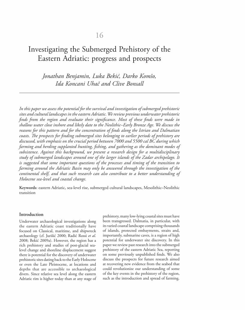
and promontories where open-air residential sites, fi shing camps, and fi xed installations might have been located prior to submergence. Telašćica is a large inlet at the southeast end of Dugi Otok, with numerous small bays, headlands, and islands (Fig. 16.11). Sea-level rise data suggest the inlet came into being in the Late Glacial and evolved through the Holocene as sea level continued to rise. Th e inlet has several characteristics that make it attractive for underwater archaeological exploration aimed at identifying submerged Mesolithic and Neolithic sites. Th ese include: (i) evolving shorelines and sheltered marine environments that would have been accessible from the Upper Palaeolithic onwards; (ii) localized areas of fertile soils in close proximity to the shoreline; (iii) a known concentration of prehistoric sites at the head of the inlet (cf. Batović 1993); (iv) numerous low wave energy environments with high archaeological preservation potential; and (v) water depths that are easily accessible to archaeological divers.
Research strategy and methodologyA systematic study of the submerged prehistory of Dugi Otok would include the following elements (cf. Benjamin 2010; see also Lübke et al. and Westley et al., this volume):
• review and assessment of previous research (desk study);
• familiarization with the regional geology, geomorphology, and hydrology;
• ethnographic survey;• mapping of the palaeolandscape and evaluating
its archaeological potential;• palaeoenvironmental sampling;• archaeological testing.
Several authors have stressed the importance of using underwater archaeology to supplement the (often eroded and weathered) record from adjacent terrestrial sites (e.g. Wilkinson and Murphy 1986). It follows that an integrated approach is desirable, in which the submerged landscape research is preceded by an assessment of the land-based evidence. Field inspection of adjacent terrestrial sites, including topographic surveys where these have not already been done, might aid interpretation of the submerged landscape. On Dugi Otok, for example, an assessment of the topographic setting and archaeological evidence from Vlakno Cave should precede any archaeological investigation of the submerged Y-Cave. Research by Fischer (1993, 1995) in the western Baltic has demonstrated the value of ethnographic research in helping to identify submerged prehistoric sites (for further
Figure 16.11: Southeast-facing oblique satellite image showing the sheltered environments of Telašćica Inlet on Dugi Otok. Left: generalized bathymetry. Th e inlet is approximately 8 km long (Image © Google Earth)
Jonathan Benjamin, Luka Bekič, Darko Komšo, Ida Koncani Uhač and Clive Bonsall204
discussion see Benjamin 2010). Ethnographic interviews with local fi sherman on Dugi Otok, especially those elderly residents who practised traditional fi shing methods before electricity and refrigeration were introduced to the island around 1960, are an essential prerequisite for any study of the submerged prehistory of the island. Th e information gained regarding the species of fi sh and shellfi sh targeted, the capture and processing methods employed, and the locations where particular activities were carried out can inform the interpretation of previous archaeological fi nds as well as underwater survey strategy. Mapping of submerged landscapes can be done at different scales and resolutions, with variable cost implications. One approach would be to use the available (consumer grade) bathymetric charts for the waters around Dugi Otok to provide basic, low-resolution data on the topography of the broader palaeolandscape, followed by higher resolution studies of smaller areas like Telašćica inlet and the environs of Y-cave, with the standard bathymetric data being supplemented by more sophisticated sonar or marine-based LiDAR surveys. Bathymetric data alone, however, can fail to detect small-scale landscape features, such as palaeochannels, especially where these are infi lled with marine sediments. Therefore, we would advocate the use of sub-bottom profi ling (where cost-eff ective) and/or corer/auger sampling in order to provide geotechnical data and ‘fi ne-tune’ palaeotopographic reconstructions. Th e resulting palaeolandscape record could then be used to create a map of ‘archaeological potential’ highlighting topographic features that may have been used by prehistoric people for settlement or subsistence-related activities, combined with an assessment of the potential for archaeological preservation. Once the baseline data have been col-lected and analyzed, focused sampling for palaeoenvironmental and archaeological evidence would be conducted in high-priority locations. Palaeoenvironmental sampling would be aimed at identifying biogenic or fossiliferous deposits (e.g. shell beds), and collecting samples for radiocarbon and environmental analysis. In caves, augering can also help to determine the extent of roof collapse, the likelihood of archaeological discovery based on sedimentation type, and the presence of deposits likely to contain cultural materials. Th e data recovered may also contribute
to regional reconstructions of sea-level change and coastal environments. Archaeological testing, which is partly dependent on water depth and time constraints associated with scuba diving, may encompass a variety of standard underwater methods ranging from simple hand fanning (where seabed sediments are thin) to (manual or dredge-assisted) test-pitting.
Conclusions
Large areas around the Adriatic Basin that were once settled by prehistoric populations have been submerged as a result of sea-level rise since the Last Glacial Maximum. Th is chapter has reviewed the current state of research into the submerged prehistory of the eastern Adriatic and outlined the potential for larger-scale studies aimed at addressing major research questions. At least eight submerged sites or localities with prehistoric artefacts have been reported along the east Adriatic coast between Piran in Slovenia and Makarska in Croatia. In most cases the fi nds were made close to shore in water less than 5 m deep. Several sites contained pottery and stone artefacts that indicate a Late Neolithic to Bronze Age date, and it is likely the sites were located on or near the coast at the time of their occupation. One site, Zambratija Cove in Istria, has well-preserved structural remains and organic materials that off er the possibility of high-resolution radiocarbon (and perhaps dendrochonological) dating. In turn, precise dating of (potentially) shore-related sites like Zambratija, would contribute to a better understanding of relative sea-level change and shoreline displacement during the Holocene. Shore-related sites belonging to earlier prehistoric periods would lie at greater sea depths. On present evidence relative sea level rose from c. ₋27 to ₋13.5 m during the period between 7000 and 5500 cal BC, corresponding to the Final Mesolithic and Early Neolithic, and such depths are accessible with standard scuba equipment and compressed air. Th e transition from Mesolithic to Neolithic is a crucial but under-researched period in the prehistory of the eastern Adriatic, and there are important issues relating to the origins and spread of farming in the region that can only be addressed through submerged cultural landscape studies. We have presented a research design for one such study focused on Dugi Otok, a large island in the outer Zadar archipelago in northern Dalmatia.

205Investigating the Submerged Prehistory of the Eastern Adriatic
By drawing attention to extant underwater prehistoric fi nds and the prospects for more extensive and systematic underwater research and site discovery along the Istrian and Dalmatian coasts, we hope to have demonstrated that the eastern Adriatic has considerable potential for the survival and investigation of submerged cultural landscapes. We suggest the archaeological exploration of these palaeolandscapes should be given a high priority, since it could have a profound impact on our understanding of the prehistory of the Adriatic basin and, by extension, the wider Mediterranean.
Acknowledgements
We thank Krunoslav Zubčić for information about the material at Baška Voda, Smiljan Gluščević for the information relating to Y-Cave, Andrej Gaspari and Matija Črešnar for their help in the fi eld in Slovenia (and beyond), Fabrizio Antonioli for information about Holocene sea-levels, and Stašo Forenbaher for informative discussions about the neolithization of the eastern Adriatic. We are grateful to Toni Jurišić and Miroslav Katić for permission to photograph and publish the material in the Baška Voda collection, and to Igor Mihajlović for permission to photograph and publish fi nds from his underwater excavation near Oruda. Barbara Olujić and Lara Day Benjamin are thanked for their help with translations, and Andrew Bicket for GIS support. We also thank three anonymous peer reviewers for their constructive comments on a previous version of this chapter.
References
Antonioli, F., Anzidei, M., Lambeck, K., Auriemma, R., Gaddi, D., Furlani, S., Orru, P., Solinas, E., Gaspari, A., Karinja, S., Kovačić, V. and Surace, L. 2007. Sea-level change during the Holocene in Sardinia and in the northeastern Adriatic (central Mediterranean Sea) from archaeological and geomorphological data. Quaternary Science Reviews 26: 2463–2486.
Batović, S. 1993. O Prapovijesti Dugoga Otoka. Zadarska Smotra. Matica Hrvatska Ogranak U Zadru Godina XLII, Broj 1–2: 99–158.
Bekić, L. 1996. Sustav gradina na rovinjskom području. Histria Archaeologica 27: 19–92.
Bekić, L. 2001. Rimski i bizantski novac iz Veštra. Vjesnik Arheološkog Muzeja u Zagrebu 34: 169–180.
Bekić, L. (ed.) 2009a. Jurišićev Zbornik. Zbornik Radova u Znak Sjećanja na Marija Jurišića
[Festschrift for Mario Jurišić]. Zagreb, Croatian Conservation Institute.
Bekić, L. 2009b. Stručno izvješće o arheološkom istraživanju nalazišta Rovinj–Veštar 2009.g [Expert report on archaeological research at the site of Rovinj–Veštar 2009]. Unpublished fi eld report on fi le at the Croatian Ministry of Culture, Zagreb.
Benjamin, J. 2007. Th e Submerged Prehistory of Europe: A Methodological Approach to Underwater Site Discovery with Special Reference to the Mesolithic and Neolithic of the Eastern Adriatic. Unpublished PhD thesis, University of Edinburgh.
Benjamin, J. 2010. Submerged prehistoric landscapes and underwater site discovery: reevaluating the ‘Danish model’ for international practice. Journal of Island and Coastal Archaeology 5: 253–270.
Benjamin, J. and Bonsall, C. 2009a. An underwater archaeological survey in the northern Adriatic Sea. International Journal of Nautical Archaeology 38: 163–172.
Benjamin, J. and Bonsall, C. 2009b. Th e prehistoric chert dagger from Piran, Slovenia: an underwater fi nd from the northern Adriatic. Arheološki vestnik 60: 57–64.
Bernardini, F., De Min, A., Demarchi, G., Montagnari Kokelj, E., Velušček, A. and Komšo, D. 2009. Shaft-hole axes from Slovenia and north-western Croatia: a fi rst archaeometric study on artefacts manufactured from meta-dolerites. Archaeometry 51: 894–912.
Biagi, P., Starnini, E. and Voytek, B. A. 1993. Th e Late Mesolithic and Early Neolithic settlement of northern Italy: recent considerations. Poročilo o Raziskovanju Paleolita, Neolita in Eneolita v Sloveniji 21: 45–67.
Biagi, P., Starnini, E. and Voytek, B. A. 2008. Th e Mesolithic–Neolithic transition in the Trieste Karst (north-eastern Italy) as seen from the excavations at the Edera Cave. In Bonsall, C., Boroneant, V. and Radovanovic, I. (eds) Th e Iron Gates in Prehistory: New Perspectives. BAR International Series 1893. Oxford, Archaeopress: 251–260.
Blanchon, P. and Shaw, J. 1995. Reef drowning during the Last Glaciation: evidence for catastrophic sea-level rise and ice sheet collapse. Geology 23: 4–8.
Brusić, Z. 1977. Prehistorijski podmorski nalazi na području južne Liburnije. Radovi Centra Jugoslavenske Akademije Znanosti i Umjetnosti u Zadru.Sv 24: 53–60.
Brusić, Z. 2005. Pećina Vlakno [Vlakno Cave]. Hrvatski Arheološki Godišnjak 1(2004): 197–199.
Brusić, Z. 2008. Pokrovnik, Naselje iz Neolitika. Šibenik, Muzej grada Šibenika.
Čečuk, B. and Radić, D. 2005. Vela Spila, A Stratifi ed Prehistoric Site. Vela Luka – Island of Korčula (Croatia). Vela Luka, Centar za kulturu ‘Vela Luka’.
Chapman, J. C., Shiel, R. and Batović, S. 1996. Th e Changing Face of Dalmatia: Archaeological and Ecological Studies in a Mediterranean Landscape. London, Society of Antiquaries.

Jonathan Benjamin, Luka Bekič, Darko Komšo, Ida Koncani Uhač and Clive Bonsall206
Codacci, G. 2002. Il sito neolitico di Vižula: Analisi tipologica dell’industria litica. Histria Archaeologica 33: 143–194. Pula.
Fairbanks, R. G. 1989. A 17,000-year glacio-eustatic sea level record: infl uence of glacial melting rates on the Younger Dryas event and deep-ocean circulation. Nature 342: 637–642.
Faivre, S., Fouache, E., Ghilardi, M., Antonioli, F., Furlani, S. and Kovačić, V. In press. Relative sea level change in western Istria (Croatia) during the last millennium. Quaternary International. Available online 11 June 2010.
Fischer, A. 1993. Stenalderbopladser i Smålands-farvandet. En teori afprøvet ved dykkerbesigtigelse [Stone Age Settlements in the Småland Bight. A Th eory Tested by Diving]. Copenhagen, Skov- og Naturstyrelsen.
Fischer, A. 1995. An entrance to the Mesolithic world below the ocean. Status of ten years’ work on the Danish sea fl oor. In Fischer, A. (ed.) Man and Sea in the Mesolithic. Coastal Settlement Above and Below Present Sea Level. Oxford, Oxbow: 371–384.
Forenbaher, S. and Miracle, P. 2005. Th e spread of farming in the eastern Adriatic. Antiquity, 79: 514–528.
Forenbaher, S. and Nikitović, D. 2007. Neolitičke izrađevine od cijepanog kamena iz Vele peći kod Vrane (Istra). Histria Archaeologica 38–39: 5–35.
Jarvis A., Reuter, H. I., Nelson, A. and Guevara, E. 2008. Hole-fi lled seamless SRTM data V4, International Centre for Tropical Agriculture (CIAT), http://srtm.csi.cgiar.org
Juračić M., Bakran-Petricioli T. and Petricioli, D. 2002. Cessation of karstification due to the sea-level rise? Case study of the Y-cave, Dugi Otok, Croatia. In Gabrovšek F. (ed.) Evolution of Karst: From Prekarst to Cessation. Proceedings of the International Symposium; 2002 Sep 17–21; Postojna, Slovenija. Ljubljana, Založba ZRC: 319–326.
Jurišić, M. 2000. Ancient Shipwrecks of the Adriatic. BAR International Series 828. Oxford, Archaeopress.
Komšo, D. 2004. Vrčevan – nalazište na otvorenom iz razdoblja ranog neolitika, Histria Archaeologica 35: 5–30.
Komšo, D. 2006. Mezolitik u hrvatskoj [The Mesolithic in Croatia]. Opvscula Archaeologica 30: 55–92.
Komšo, D. 2008. Limski kanal. Hrvatski Arheoloki Godišnjak 4(2007): 264–268.
Komšo, D., Andreasen, N. H. and Forenbaher, S. 2009. Les premiers agriculteurs, pasteurs et pêcheurs en Istrie (Croatie) à travers les industries lithiques. In Kourtessi-Philippakis, G. (ed.) La Préhistoire du Sud-Est Européen: Traditions et Innovations. Paris, Association Pierre Belon: 125–143.
Koncani Uhač, I. 2009. Podvodna arheološka istraživanja u uvali Zambratija, Histria Antiqua 17: 263–268.
Lambeck, K., Antonioli, F., Purcello, A. and Silenzi, S. 2004. Sea-level change along the Italian coast
for the past 10,000 yr. Quaternary Science Reviews 23: 1567–1598.
Malez, M. 1979. Nalazišta paleolitskog i mezolitskog doba u Hrvatskoj. In Basler, Đ. (ed.) Praistorija Jugoslavenskih Zemalja Paleolit i Mezolit. Sarajevo, Centar za balkanološka ispitivanja: 227–276.
Marijanović, B. 2005. Gudnja – Višeslojno Prapovijesno Nalazište. Dubrovnik, Dubrovački muzeji.
Mihovilić, K. 1992. Bay of Veruda – Pula. Site of stone objects. Poročilo o Raziskovanju Paleolita, Neolita in Eneolita v Sloveniji 20: 87–93.
Mlekuž, D., Budja, M., Payton, R. W. and Bonsall, C. 2008. ‘Mind the gap’. Caves, radiocarbon sequences, and the Mesolithic–Neolithic transition in Europe – lessons from the Mala Triglavca rockshelter site. Geoarchaeology: An International journal 23: 398–416.
Moore, A., Menđušić, M., Smith, J. and Podrug, E. 2007. Project ‘Early Farming in Dalmatia’: Danilo Bitinj 2004–2005. Vjesnik Arheološkog Muzeja u Zagrebu 40: 15–24.
Moore, A., Menđušić, M., Podrug, E. and Zaninović, J. In press. Th e inception of farming as a transforming process: initial results from new excavations at Danilo and Pokrovnik in Dalmatia. In Borić, D. and Gurova, M. (eds) Identities of the Early Neolithic Balkans. Oxford, Oxbow.
Ogrinc, N., Fontolan, G., Faganeli, J. and Covelli, S. 2005. Carbon and nitrogen isotope compositions of organic matter in coastal marine sediments (the Gulf of Trieste, N Adriatic Sea): indicators of sources and preservation. Marine Chemistry 95: 163–181.
Pellegatti, P. 2009. Hunter-gatherers of the Istrian Peninsula: the value of lithic raw material analysis to study small-scale colonization processes, In McCartan, S., Schulting, R., Warren, G. and Woodman, P. (eds) Mesolithic Horizons: Papers Presented at the Seventh International Conference on the Mesolithic in Europe, Belfast 2005. Volume 1. Oxford, Oxbow: 45–52.
Radić Rossi, I., Gaspari, A. and Pydyn, A. (eds) 2008. Proceedings of the 13th Annual Meeting of the European Association of Archaeologists (Zadar, Croatia, 18–23 September 2007). Session: Underwater Archaeology. Zagreb, Hrvatsko arheološko društvo.
Schuldenrein, J. 1998. Konispol Cave, southern Albania, and correlations with other Aegean caves occupied in the late Quaternary. Geoarchaeology: An International Journal 13: 501–526.
Sordinas, A. 1967. Radiocarbon dates from Corfu, Greece. Antiquity 51: 64.
Sordinas, A. 1969. Investigations of the prehistory of Corfu during 1964–1966. Balkan Studies 10: 393–424.
Tolan-Smith, C. and Bonsall, C. (eds) 1997. Th e Human Use of Caves. BAR International Series 667. Oxford: Archaeopress.
Wilkinson, T. J. and Murphy, P. 1986. Archaeological survey of an intertidal zone: the submerged landscape of the Essex coast, England. Journal of Field Archaeology 13: 177–194.