Investigating biodiversity trajectories using scenarios – Lessons from two contrasting...
10
Investigating biodiversity trajectories using scenarios – Lessons from two contrasting agricultural landscapes Regina Lindborg a, b, * , Marie Stenseke c , Sara A.O. Cousins d , Jan Bengtsson e , Åke Berg f , Tomas Gustafsson f , N. Erik Sjo ¨ din e , Ove Eriksson g a Department of Systems Ecology, Stockholm University, SE-106 91 Stockholm, Sweden b Stockholm Resilience Centre, Stockholm University, SE-106 91 Stockholm, Sweden c Department of Human and Economic Geography, University of Gothenburg, Box 630, SE-405 30 Gothenburg, Sweden d Department of Physical Geography and Quaternary Geology, Stockholm University, SE-106 91 Stockholm, Sweden e Department of Ecology, SLU, Box 7044, S-750 07 Uppsala, Sweden f The Swedish Biodiversity Centre, SLU, Box 7007, S-750 07 Uppsala, Sweden g Department of Botany, Stockholm University, SE-106 91 Stockholm, Sweden article info Article history: Received 15 June 2009 Received in revised form 1 September 2009 Accepted 10 September 2009 Available online 22 October 2009 Keywords: Diversity Energy production Landscape perspective Landscape scenarios multifunctionality Nature conservation Recreation Sustainable management Sweden abstract Agriculture is the major land use at a global scale. In addition to food production, multifunctionality of landscapes, including values and ecosystem services like biodiversity, recreation and culture, is now focus for management. This study explores how a scenario approach, involving different stakeholders, may help to improve landscape management for biodiversity conservation. Local farmers and executives at the County Administrative Board were invited to discuss rural development and conditions for farmland biodiversity in two Swedish landscapes. The potential biodiversity for three future land use scenarios for the two landscapes was discussed: nature conservation, outdoor recreation and energy production, and compared with current and historical landscapes in each region. Analyses of habitat areas, connectedness and landscape diversity suggested that the energy and recreation scenarios had a negative impact on farmland biodiversity, whereas the nature conservation scenario, the current and historically reconstructed landscapes had a higher potential for biodiversity. The farmers appreciated the nature conservation scenario, but also the energy production scenario and they highlighted the need of increased subsidies for management of biodiversity. The farmers in the high production area were less interested in nature quality per se. The executives had similar opinions as the farmers, but disagreed on the advantages with energy production, as this would be in conflict with the high biodiversity and recreational values. The local physical and socio-economical conditions differ between landscapes and potentially shaped the stakeholders emotional attachment to the local envi- ronment, their opinions and decisions on how to manage the land. We stress the importance of incor- porating local knowledge, visions and regional prerequisites for different land uses in conservation, since site and landscape specific planning for biodiversity together with a flexible subsidy system are neces- sary to reach the conservation goals within EU. Ó 2009 Elsevier Ltd. All rights reserved. 1. Introduction Agriculture is the major land use at a global scale, though farmland landscape structure as well as agricultural management intensity have changed considerably in recent times (Foley et al., 2005; Rounsevell et al., 2006). Further changes are likely to occur worldwide as a result of increasing needs to produce food, fibre and energy due to an increasing human population. As a consequence, farm size will probably continue to increase into larger units, where small local farms that are not economically sustainable are partly incorporated in the larger farms. In addition to the main focus on food production and profitability in agricultural landscapes, visions of future landscapes include alternative conditions and trends (e.g. Nassauer et al., 2002; Santelmann et al., 2004). For instance, several ecosystem services, such as pollination, carbon sequestration, recreation and spiritual values, are currently becoming an inte- grated part of management of agricultural landscapes (Foley et al., 2005; Carpenter et al., 2006). In many parts of Europe, agricultural landscapes are acknowl- edged for their high biodiversity values associated with * Corresponding author at: Department of Systems Ecology, Stockholm Univer- sity, SE-106 91 Stockholm, Sweden. Tel.: þ46 8 16 4214. E-mail address: [email protected] (R. Lindborg). Contents lists available at ScienceDirect Journal of Environmental Management journal homepage: www.elsevier.com/locate/jenvman 0301-4797/$ – see front matter Ó 2009 Elsevier Ltd. All rights reserved. doi:10.1016/j.jenvman.2009.09.018 Journal of Environmental Management 91 (2009) 499–508
Transcript of Investigating biodiversity trajectories using scenarios – Lessons from two contrasting...
lable at ScienceDirect
Journal of Environmental Management 91 (2009) 499–508
Contents lists avai
Journal of Environmental Management
journal homepage: www.elsevier .com/locate/ jenvman
Investigating biodiversity trajectories using scenarios – Lessonsfrom two contrasting agricultural landscapes
Regina Lindborg a,b,*, Marie Stenseke c, Sara A.O. Cousins d, Jan Bengtsson e, Åke Berg f,Tomas Gustafsson f, N. Erik Sjodin e, Ove Eriksson g
a Department of Systems Ecology, Stockholm University, SE-106 91 Stockholm, Swedenb Stockholm Resilience Centre, Stockholm University, SE-106 91 Stockholm, Swedenc Department of Human and Economic Geography, University of Gothenburg, Box 630, SE-405 30 Gothenburg, Swedend Department of Physical Geography and Quaternary Geology, Stockholm University, SE-106 91 Stockholm, Swedene Department of Ecology, SLU, Box 7044, S-750 07 Uppsala, Swedenf The Swedish Biodiversity Centre, SLU, Box 7007, S-750 07 Uppsala, Swedeng Department of Botany, Stockholm University, SE-106 91 Stockholm, Sweden
a r t i c l e i n f o
Article history:Received 15 June 2009Received in revised form1 September 2009Accepted 10 September 2009Available online 22 October 2009
Keywords:DiversityEnergy productionLandscape perspectiveLandscape scenarios multifunctionalityNature conservationRecreationSustainable managementSweden
* Corresponding author at: Department of Systemssity, SE-106 91 Stockholm, Sweden. Tel.: þ46 8 16 42
E-mail address: [email protected] (R. Lindborg
0301-4797/$ – see front matter � 2009 Elsevier Ltd.doi:10.1016/j.jenvman.2009.09.018
a b s t r a c t
Agriculture is the major land use at a global scale. In addition to food production, multifunctionality oflandscapes, including values and ecosystem services like biodiversity, recreation and culture, is nowfocus for management. This study explores how a scenario approach, involving different stakeholders,may help to improve landscape management for biodiversity conservation. Local farmers and executivesat the County Administrative Board were invited to discuss rural development and conditions forfarmland biodiversity in two Swedish landscapes. The potential biodiversity for three future land usescenarios for the two landscapes was discussed: nature conservation, outdoor recreation and energyproduction, and compared with current and historical landscapes in each region.
Analyses of habitat areas, connectedness and landscape diversity suggested that the energy andrecreation scenarios had a negative impact on farmland biodiversity, whereas the nature conservationscenario, the current and historically reconstructed landscapes had a higher potential for biodiversity.The farmers appreciated the nature conservation scenario, but also the energy production scenario andthey highlighted the need of increased subsidies for management of biodiversity. The farmers in the highproduction area were less interested in nature quality per se. The executives had similar opinions as thefarmers, but disagreed on the advantages with energy production, as this would be in conflict with thehigh biodiversity and recreational values. The local physical and socio-economical conditions differbetween landscapes and potentially shaped the stakeholders emotional attachment to the local envi-ronment, their opinions and decisions on how to manage the land. We stress the importance of incor-porating local knowledge, visions and regional prerequisites for different land uses in conservation, sincesite and landscape specific planning for biodiversity together with a flexible subsidy system are neces-sary to reach the conservation goals within EU.
� 2009 Elsevier Ltd. All rights reserved.
1. Introduction
Agriculture is the major land use at a global scale, thoughfarmland landscape structure as well as agricultural managementintensity have changed considerably in recent times (Foley et al.,2005; Rounsevell et al., 2006). Further changes are likely to occurworldwide as a result of increasing needs to produce food, fibre andenergy due to an increasing human population. As a consequence,
Ecology, Stockholm Univer-14.
).
All rights reserved.
farm size will probably continue to increase into larger units, wheresmall local farms that are not economically sustainable are partlyincorporated in the larger farms. In addition to the main focus onfood production and profitability in agricultural landscapes, visionsof future landscapes include alternative conditions and trends (e.g.Nassauer et al., 2002; Santelmann et al., 2004). For instance, severalecosystem services, such as pollination, carbon sequestration,recreation and spiritual values, are currently becoming an inte-grated part of management of agricultural landscapes (Foley et al.,2005; Carpenter et al., 2006).
In many parts of Europe, agricultural landscapes are acknowl-edged for their high biodiversity values associated with

R. Lindborg et al. / Journal of Environmental Management 91 (2009) 499–508500
traditionally and extensively managed grasslands (Baudry, 2000;Eriksson et al., 2002; Benton et al., 2003). However, land use changeduring the last century has completely altered the traditionalmosaic rural landscape. Small-scale farming has been replaced byintensified and specialised agriculture with use of artificial fertil-izers, pesticides, simplified crop-rotations and large monoculturesor abandonment with changed management of many semi-naturalpastures and meadows. Continued intensification in combinationwith abandonment of less productive areas leads to further declinein species-rich semi-natural grasslands as well as lower landscapeheterogeneity (Benton et al., 2003). These habitats are the primaryfocus for many conservation programmes in these parts of Europe(Pain and Pienkowski, 1997; O’Riordan, 2000). A great challenge forrural landscape planners is to make it possible to combine severalinterests within the same landscape, e.g. outdoor recreation, effi-cient food production and maintenance of farmland biodiversity,and to deal with potential conflicts between these interests (Tressand Tress, 2003). In order to meet these different demands,a broader landscape perspective has to be considered, wheredifferent stakeholders can be involved in management planningand conservation (Fry, 2001; Lindborg et al., 2008). Differentlandscape issues have recently been brought up on the politicalagenda in Europe (Wascher, 2000), e.g. the development and rati-fication of the European Landscape Convention (Council of Europe,1998), where landscape values in a wider sense are emphasised.
Agricultural land use is largely affected by decisions made byfarmers, as an effect of market and policy. Thus, any attempt toassess agricultural land use change needs to incorporate goals andconstraints that affect farmers and their management strategies.Landscape planning in Europe, however, has so far had a top-downapproach (Primdahl et al., 2003; Berendse et al., 2004; Stenseke,2006), where stakeholders do not take part in the planning strat-egies. Therefore, a major challenge for landscape planners anddecision-makers is to identify and integrate the interests ofdifferent groups, especially at the local level. It is also important torecognise that farmers at a regional scale are operating withina broadly similar economic environment, but their decisions areaffected by their opinions and experiences, as well as by charac-teristics of the physical environment (Rounsevell et al., 2003).
One way to analyse and understand future development ofagricultural landscapes is to develop model scenarios based on boththe socio-economic and physical processes that are important foragricultural land use, landscape composition and biodiversity(Rounsevell et al., 2003, 2006). The scenario approach is widelyused in many sciences and for many different purposes, e.g. trendanalyses, forecasts, modelling, and sensitivity analyses (Tress andTress, 2003). Scenarios are not predictions, and they should ratherbe used to explore outcomes of alternative future developments.There is also an increasing interest in including the visual landscapein landscape policy decisions, management and monitoring.Landscape preference studies have to a large extent used photo-graphs, often viewing the landscape from a birds-eye perspective(e.g. Wherrett, 2000; Daniel and Meitner, 2001; Tress and Tress,2003). Despite criticism and limitations with such methods, theability of photographs to illustrate the multifunctionality of land-scapes and to communicate landscape changes is much better thanthat of two-dimensional maps or oral and written descriptions(Daniel and Meitner, 2001). Scenario visualisation by photorealisticdesign techniques has proven to be a helpful tool for researcherscommunicating proposed landscape changes with stakeholders(Tress and Tress, 2003) and to increase effectiveness of adaptive co-management (Wollenberg et al., 2000).
In this study, we use a scenario approach to explore differences inthe knowledge of and perspectives from local farmers and execu-tives in landscape management and biodiversity conservation. Two
agricultural landscapes in south-central Sweden were selected asstudy sites, in which we evaluated alternative future land usescenarios and their effects on potential biodiversity as well as thesocio-economical context. Specifically, we wanted to analysedifferences and similarities between the landscapes and how thesecan be related to management effects by i) comparing land use 100years ago with the present-day, ii) constructing three plausiblefuture scenarios with various foci on food and energy production,recreation and nature conservation, iii) discussing socio-economicaland biodiversity implications of the different scenarios, and iv)analysing how differences among local stakeholders influence theoutcome of landscape management and planning.
2. Material and methods
We examined two Swedish agricultural landscapes. They wereselected based on their differences in current landscape composi-tion (physical geography), land use and ownership structure. Ateach site, the land use change from historical to present-daylandscape was calculated using old cadastral maps. In each land-scape, the landscape view was manipulated by using photorealistictechniques, into three different landscape scenarios: Natureconservation scenario, Outdoor recreation scenario and Energyproduction scenario. The landscape scenarios were presented totwo groups of stakeholders at each site: local farmers and execu-tives at the County Administrative Boards.
2.1. Study landscapes
Both study cases were located in south-central Sweden, one inSodermanland (Selaon, 59�25’ N, 17�100 E) and one in Uppland(Hållnas, 60�320 N, 17�540 E). Selaon is an island situated in LakeMalaren, which is the third largest lake in Sweden, while Hållnas isa peninsula in the Southern Bothnian Sea, approximately 200 kmNorth of Selaon. There is a long tradition of agriculture in bothlandscapes, and the landscapes still contain fragments of managedsemi-natural grasslands (Cousins and Eriksson, 2002). Selaon isdominated by arable fields (c. 70%), some forest (c. 15%) and onlyfew semi-natural pastures (c. 2%). Hållnas is a more forested area (c.40%) with a more small-scaled mosaic of habitats than Selaon. Theamount of arable fields is c. 20% and the amount of semi-naturalpastures also some 20%. Parts of the investigated area in Hållnas area Natura 2000 area (Slada SE0210270). The historical remains likegrave fields, old settlements, rune stones are extensive in bothareas. Hållnas is also advertised as an area for recreation (http://www.hallnas.se). Selaon is situated within commuting distancesto larger cities, whereas Hållnas is more isolated from denselypopulated areas. The number of persons per square kilometre livingin Selaon (0.8) is higher compared to Hållnas (0.4). Within theanalysed area there are five farms in Selaon and 11 farms in Hållnas.A high number of farmers in an area often imply a more small-scaled mosaic landscape as the more intensified farms requirelarger areas and bigger machinery for profitability. There iscurrently no beef or dairy production in the investigated area inSelaon, but some farmers produce fodder (ley). In Hållnas there arecurrently four farmers holding livestock cattle.
2.2. Scenarios
We used scenarios to describe future-oriented landscapechanges and plausible developments were constructed based on thecurrent landscape composition at each site. These scenarios wereconstructed to stimulate discussions among stakeholders; discus-sions that could highlight differences between stakeholders andregions as well as conflicts between farmers and policy. This
R. Lindborg et al. / Journal of Environmental Management 91 (2009) 499–508 501
approach to scenario planning is different from the more commonlyused scenario planning approach where the stakeholders them-selves are involved in constructing the plausible scenarios. Insteadof using stakeholders, our scenarios were constructed by experts inecology, human geography, natural resource management andsociology. The assumptions underlying the scenarios are mainlypolitical and considered as plausible alternatives to a strong focus onfood production during the next 20 years (Buller et al., 2000).Swedish environmental goals for the agricultural landscape specif-ically aim at maintaining biodiversity, increase outdoor recreation,and increase production of renewable energy (Swedish Board ofAgriculture, 1999) as a complement to food production. The threealternative scenarios also represent alternative strategies forfarmers planning their future land use. The scenarios were (1) anagricultural landscape with high nature conservation and biodi-versity values (Nature conservation scenario), (2) an agriculturallandscape adapted for outdoor recreation (Outdoor recreationscenario), and (3) an agricultural landscape with increasedproduction of renewable energy (Energy production scenario). Noneof the scenarios are regarded as a more realistic future developmentthan the others, and thus they are not prognoses or predictions. Anoverview of the directions (increase, decrease or stable area) of theland use changes made for different scenarios is presented in Table 1.
2.3. Scenario visualisation
Oblique photographs were taken from a helicopter at approxi-mately 200 m height (Fig. 1). Position and angles are noted in Fig. 3.For each study landscape, one photograph was manipulated intoeach of the three scenarios and one historical landscape based onhistorical maps, in total four manipulated photographs for eachlandscape. The manipulation of the pictures was made in AdobePhotoshop 7.1 by changing current dominant land use into landuses representative of each scenario. Other oblique photographswere used to extract specific habitats and objects, and they wereapplied to the original photograph by layer-techniques (Fig. 1). Thephysical environment and present settlements constituted a base-line for the construction of the different scenarios, and these sitespecific patterns (e.g. farms, elevations, and valleys) provideda foundation for where to change land use in the scenarios, whichmade them geographically realistic.
2.4. Nature conservation scenario
In this scenario, areas with the highest farmland conservationvalue and biodiversity potential, e.g. semi-natural grasslands,marginal habitats (road verges and midfield islets) (Eriksson et al.,2002; Walker et al., 2004; Cousins, 2006; Lindborg et al., 2008),were increased in size and number. In contrast, the area of
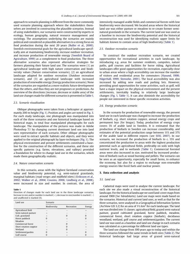
Table 1Direction of changes made for each land use in the three landscape scenarios.Increase in size and/or number is marked (þ), decrease in size/number is marked (�)and unaffected is marked (0).
Land use Scenario
Biodiversity Recreation Energy
Agricultural field � � þSemi-natural pasture þ � �Cult. grassland þ 0 0Horse paddock 0 þ 0Meadow þ � �Commercial forest � 0 þShort rotation coppice � 0 þWetland þ 0 �Settlement/garden 0 þ 0Golf course 0 þ 0
intensively managed arable fields and commercial forests with lowbiodiversity were decreased. We located areas where the historicalland use was either pasture or meadow to re-create former semi-natural grasslands in the scenario. The current land use was used asa baseline to increase the biodiversity potential and the historicalreconstruction was used for identifying realistic upper limits forhabitats known to contain areas of high biodiversity (Table 1).
2.5. Outdoor recreation scenario
To construct the outdoor recreation scenario, we createdopportunities for recreational activities in each landscape, byintroducing e.g. areas for summer residents, campsites, naturepaths, golf courses and facilities for horse riding. Agriculturallandscapes offer good opportunities for recreation, especially closeto urban areas where a high accessibility can increase the numberof visitors and residential areas for commuters (Hasund, 1998;Hagerhall, 1999; Stenseke, 2001). The local accessibility was alsoincreased by adding new roads and parking lots. However,providing good opportunities for some activities, such as golf, willhave a major impact on the physical environment and the presentsettlements, inevitably leading to relatively large landscapechanges (Fig. 1, Table 1). It can also diminish the accessibility forpeople not interested in these specific recreation activities.
2.6. Energy production scenario
In the scenario for production of renewable energy, the presentland use in each landscape was changed to increase the productionof biofuels, e.g. short rotation coppice, annual energy crops andpermanent leys (for biogas). Today, production of energy cropscovers 3% of arable land in Sweden. It is estimated that theproduction of biofuels in Sweden can increase considerably, andestimates of the potential production range between 11% and 37%of the arable land in different reports (see SOU, 2007). In ourscenario, we increased the production of biofuels to c. 15% andconcentrated the production to areas with the highest productionpotential such as agricultural fields, preferably on soils with highnutrient levels, and to wetlands (Table 1). Commercial forestedareas were also increased in size, motivated by increased produc-tion of biofuels such as wood burning and pellets. The scenario canbe seen as an opportunity, especially for small farms, to enhancethe economy, but also for a region to exchange non-renewableenergy sources like fossil fuels and nuclear power.
3. Data collection and analysis
3.1. Land use
Cadastral maps were used to analyse the current landscape. Foreach site we also made a visual reconstruction of the historicallandscape. For the historical landscape we used land-cover maps fromaround 1900 (Sw: haradskarta). Land use maps were made based onthe scenarios. Historical and current land uses, as well as that for thethree scenarios, were analysed in a Geographical Information System(ArcView GIS 3.2) for an area of 1½ km2 for each landscape. The landuse was divided into 11 classes: agricultural field, grazed semi-naturalpasture, grazed cultivated grassland, horse paddock, meadow,commercial forest, short rotation coppice (biofuels), deciduouswoodland, wetland, golf course and settlement/garden. The currentland use was used as a baseline and land use change in each scenariowas calculated as a percentage for different land use types.
The land use change from 100 years ago to today and within thethree scenarios followed the same trends in both sites (Table 2). Thehistorical landscape had large areas of grazed semi-natural
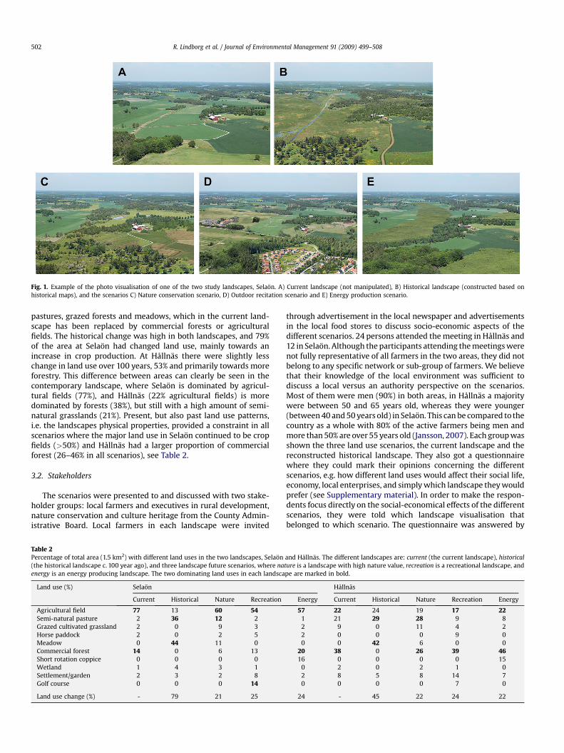
Fig. 1. Example of the photo visualisation of one of the two study landscapes, Selaon. A) Current landscape (not manipulated), B) Historical landscape (constructed based onhistorical maps), and the scenarios C) Nature conservation scenario, D) Outdoor recitation scenario and E) Energy production scenario.
R. Lindborg et al. / Journal of Environmental Management 91 (2009) 499–508502
pastures, grazed forests and meadows, which in the current land-scape has been replaced by commercial forests or agriculturalfields. The historical change was high in both landscapes, and 79%of the area at Selaon had changed land use, mainly towards anincrease in crop production. At Hållnas there were slightly lesschange in land use over 100 years, 53% and primarily towards moreforestry. This difference between areas can clearly be seen in thecontemporary landscape, where Selaon is dominated by agricul-tural fields (77%), and Hållnas (22% agricultural fields) is moredominated by forests (38%), but still with a high amount of semi-natural grasslands (21%). Present, but also past land use patterns,i.e. the landscapes physical properties, provided a constraint in allscenarios where the major land use in Selaon continued to be cropfields (>50%) and Hållnas had a larger proportion of commercialforest (26–46% in all scenarios), see Table 2.
3.2. Stakeholders
The scenarios were presented to and discussed with two stake-holder groups: local farmers and executives in rural development,nature conservation and culture heritage from the County Admin-istrative Board. Local farmers in each landscape were invited
Table 2Percentage of total area (1.5 km2) with different land uses in the two landscapes, Selaon(the historical landscape c. 100 year ago), and three landscape future scenarios, where naenergy is an energy producing landscape. The two dominating land uses in each landsca
Land use (%) Selaon
Current Historical Nature Recreation
Agricultural field 77 13 60 54Semi-natural pasture 2 36 12 2Grazed cultivated grassland 2 0 9 3Horse paddock 2 0 2 5Meadow 0 44 11 0Commercial forest 14 0 6 13Short rotation coppice 0 0 0 0Wetland 1 4 3 1Settlement/garden 2 3 2 8Golf course 0 0 0 14
Land use change (%) - 79 21 25
through advertisement in the local newspaper and advertisementsin the local food stores to discuss socio-economic aspects of thedifferent scenarios. 24 persons attended the meeting in Hållnas and12 in Selaon. Although the participants attending the meetings werenot fully representative of all farmers in the two areas, they did notbelong to any specific network or sub-group of farmers. We believethat their knowledge of the local environment was sufficient todiscuss a local versus an authority perspective on the scenarios.Most of them were men (90%) in both areas, in Hållnas a majoritywere between 50 and 65 years old, whereas they were younger(between 40 and 50 years old) in Selaon. This can be compared to thecountry as a whole with 80% of the active farmers being men andmore than 50% are over 55 years old (Jansson, 2007). Each group wasshown the three land use scenarios, the current landscape and thereconstructed historical landscape. They also got a questionnairewhere they could mark their opinions concerning the differentscenarios, e.g. how different land uses would affect their social life,economy, local enterprises, and simply which landscape they wouldprefer (see Supplementary material). In order to make the respon-dents focus directly on the social-economical effects of the differentscenarios, they were told which landscape visualisation thatbelonged to which scenario. The questionnaire was answered by
and Hållnas. The different landscapes are: current (the current landscape), historicalture is a landscape with high nature value, recreation is a recreational landscape, andpe are marked in bold.
Hållnas
Energy Current Historical Nature Recreation Energy
57 22 24 19 17 221 21 29 28 9 82 9 0 11 4 22 0 0 0 9 00 0 42 6 0 0
20 38 0 26 39 4616 0 0 0 0 15
0 2 0 2 1 02 8 5 8 14 70 0 0 0 7 0
24 - 45 22 24 22
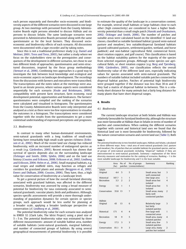
Table 3The potential biodiversity in two Swedish landscapes, Hållnas and Selaon, calculatedin three different ways: Area¼ total area of semi-natural grasslands (incl. pastureand meadow), No. of patches that are suitable habitats for grassland species, and no.of groups of semi-natural grasslands including ‘‘dispersal’’ habitats if they areinterconnected to semi-natural grasslands. Summary¼ explanation of the threediversity measures and motivation for the ranking of scenarios. Ranking¼ 1 is themost suitable landscape for biodiversity and 5 is the least suitable.
Area(ha)
No. ofpatches
No. of groups(connectedness)
Summary Ranking
SelaonOriginal 4.4 5 5 Small areas, but
well connected3
Historical 187.7 1 1 One large area 1Recreation 3.3 2 2 Small areas but
isolated4
Energy 1.6 1 1 Small areas butisolated
5
Conservation 35.8 13 7 Small areas, manyfairly wellconnected patches
2
HållnasOriginal 43 13 6 Relatively large
but fairlyisolated patches
3
Historical 171 4 4 Few large wellconnected areas
1
Recreation 18 9 5 Small area, manyisolated patches
4
Energy 17.3 3 3 Small area, fewisolated patches
5
Conservation 81.1 9 3 Large area, manypatches but isolated
2
R. Lindborg et al. / Journal of Environmental Management 91 (2009) 499–508 503
each person separately and thereafter socio-economic and biodi-versity aspects of the different scenarios were discussed in one largegroup. At two meetings with personnel from the County Adminis-trative Boards eight persons attended to discuss Hållnas and sixpersons to discuss Selaon. The same landscape scenarios werepresented to Administrative Boards personnel along with the samequestionnaire as for the local farmers. They discussed socio-economic and biodiversity effects of each scenario. All discussionswere documented with a tape-recorder and by taking notes.
Since this is not a traditional preference study (e.g. Daniel andMeitner, 2001; Tress and Tress, 2003), but rather a study where wefocus on the stakeholders view on the prerequisites and conse-quences of the development in different scenarios, we chose to usetwo different kinds of approaches, questionnaires and semi-struc-tured discussions, inspired by the focus group methodology(Stewart et al., 2006). Combining two approaches is a good way toinvestigate the link between local knowledge and ecological andsocio-economic aspects on landscape development. The recordingsfrom the discussions with farmers and executives were transcribed.The transcriptions and the notes taken at the meetings were ana-lysed in an iterate process, where various aspects were consideredsequentially for each scenario (Kvale and Brinkmann, 2009);compatibility with present farm structure, farm economy, ruraldevelopment potential, opportunities and hindrances. The farmers’questionnaires were compiled and the ranking of the scenarioswere calculated and visualised in histograms. The questionnairesfrom the County Administrative Boards were only interpreted andanalysed as a text as there were too few representatives to visualisethe outcomes in a histogram. The transcriptions were consideredtogether with the results from the questionnaires to get a morecontextual understanding of expressed perceptions and prognoses.
3.3. Biodiversity
In contrast to many other human-dominated environments,semi-natural grasslands with a long tradition of small-scalefarming have remarkably high small-scale species richness (Eriks-son et al., 2002). Much of the recent land use change has reducedbiodiversity, with an increased number of endangered species asa result (e.g. Gardenfors, 2005). Recent research has shown thatsurvival of species depends also on the surrounding landscape(Ockinger and Smith, 2006; Sjodin, 2006) and on the land usehistory (Cousins and Eriksson, 2008; Eriksson et al., 2002; Lindborgand Eriksson, 2004: Helm et al., 2006). Small marginal habitats, e.g.road verges and midfield islets, may function as refuges andcorridors for grassland plants and animals (Berggren et al., 2002;Ewers and Didham, 2006; Cousins, 2006). They have, thus, a highvalue for conservation of biodiversity at a landscape level.
To get a general picture of how the overall farmland diversity,associated with grassland habitats, was affected in the differentscenarios, biodiversity was assessed by using a broad measure ofpotential for biodiversity for taxa commonly associated to semi-natural grasslands; vascular plants, birds and pollinators. Although,species-specific assessments will provide a more thorough under-standing of population dynamics for certain species or speciesgroups, such approach would be less useful for planning ata broader scale, applying a broader landscape perspective onconservation (cf. Lindborg et al., 2008).
The potential biodiversity value for each scenario was analysedin IDRISI 32 (Clark Labs, The Idrisi Project) using a pixel size of5� 5 m. The potential biodiversity value was estimated by threedifferent measurements: amount of suitable habitat area, numberof suitable habitats (semi-natural grasslands, marginal habitats),and number of connected groups of habitats. By using severalgeographical measurements of potential biodiversity it is possible
to estimate the quality of the landscape in a conservation context.For example, several small habitats or large habitats close to eachother (high connectivity) are considered to have a higher biodi-versity potential than a small single patch (Hanski and Ovaskainen,2002; Ockinger and Smith, 2006). The number of patches andsuitable areas were calculated based on the identified 11 land useclasses, classified as suitable farmland habitat (grazed semi-naturalpasture and meadow), less suitable/dispersal farmland habitats(grazed cultivated pastures, settlement/garden, wetland, and horsepaddock) and non-habitat (agricultural field, commercial forest,short rotation coppice, and golf course). This classification is basedon the habitat suitability pattern for the majority of the speciesfrom selected organism groups. Although some species use agri-cultural fields, or short rotation coppice (e.g. Berg and Tjernberg,1996; Gardenfors, 2005), our classification reflects the overallbiodiversity value of the different land uses, especially indicatingvalues for species associated with semi-natural grasslands. Thenumbers of suitable habitat included suitable patches connected bydispersal habitat patches. Patches of potential high biodiversitywere grouped together if the distance was less than 30 m and ifthey had a matrix of dispersal habitat in-between. This is a rela-tively short distance for many animals but a fairly long distance formany plants that have short dispersal ranges.
4. Results
4.1. Biodiversity
The current landscape structure at both Selaon and Hållnas wasrelatively favourable for farmland biodiversity, although the structurewas more favourable at Hållnas than in Selaon in terms of number ofpatches and connectedness. When ranking the different scenariostogether with current and historical land uses we found that thehistorical land use is most favourable for biodiversity, followed bythe nature conservation scenario and current land use (Table 3). Both

R. Lindborg et al. / Journal of Environmental Management 91 (2009) 499–508504
the recreation and the energy producing scenario seemed to havenegative impact on the biodiversity potential in the landscapes.
4.2. Stakeholders
When analysing the questionnaires and the discussions, wecould identify some different views between farmers from Selaonand Hållnas; visualised in Fig. 2 where each column represents therelative importance of the factors (shown in legend) in eachscenario, corresponding to the questionnaire (see Supplementarymaterial). The Hållnas farmers appreciated the energy producingscenario, in contrast to farmers in Selaon, as it could improve farmeconomy. In Selaon, farmers were less interested in the natureconservation scenario, whereas at Hållnas they really appreciatedthis scenario that they associated with livestock grazing and highbiodiversity (today often accompanied with increased subsidies forenvironmental support).
The general opinion of County Administrative Boards at Selaonand Hållnas was that, particularly the nature conservationscenario, but also the current landscape pattern was most suitablefor biodiversity and animal husbandry, and these landscapes werealso considered beautiful. However, the nature conservationscenario was not considered beneficial for farm economy. Incontrast, the recreation scenario and energy producing scenariowould benefit local economy and make a more prosperous future,
Fig. 2. A summary interpretation of the questionnaire, answered by the stakeholders, A) Ha variety of factors (shown in legend) in each scenario. The factors are corresponding to themost desirable future scenario including all aspects of farming, Husbandry – possibilities fobiodiversity, Beauty – the beauty of the landscape, Vital countryside – a social value as percmanaged land and a belief in a prosperous future, and Development – the possibilities for e
especially in Hållnas with a more small-scaled farming anda remote location.
4.3. Nature conservation scenario
The nature conservation scenario was constructed to benefitbiodiversity, and our analyses suggested that it was very favourablefor farmland biodiversity (Table 3). The patches were large, morefrequent and in Hållnas also more connected, and only the histor-ical landscape proved to be better. The profitability for farmers inthis kind of landscape may, however, be low (see below) and hencealso the socio-economical sustainability.
Most farmers in Hållnas stated that an open and less forestedagricultural landscape is preferable and also of major importancefor the social well-being. However, keeping this landscape openand managed is difficult due to farm structure (mosaic landscapewith many landowners) and since livestock grazing is unprofitabletoday. Several farmers thought that to compete with moreproductive lowland areas, the subsidy system must acknowledgethat this kind of mosaic landscape is difficult to manage economi-cally, and requires more economical support. The nature conser-vation scenario was also appreciated by the County AdministrativeBoards, especially in Hållnas where several habitats of high natureconservation value are found in the current landscape. The CountyAdministrative Board concluded that nature reserves in the region
ållnas farmers, B) Selaon farmers. Each column represents the relative importance ofquestionnaire presented in the attachment. Legend clarification: Desirable future – ther husbandry, Economy – farm economy, Biodiversity – possibilities for maintenance ofeived by inhabitants, characterized by a critical number of inhabitants, the amount ofnterprising in the area.
R. Lindborg et al. / Journal of Environmental Management 91 (2009) 499–508 505
often coincided with areas of high cultural interest and they werevery positive to the reconstructed historical landscape.
The farmers on Selaon were not specifically interested in naturequality per se, but wanted their open and managed landscape toremain like today (Fig. 2). Many believed that animal husbandry, andhence the number of semi-natural grasslands will decrease due tochanges in the Common Agricultural Policy of EU (CAP) andincreasing prices on cereals, which are currently more profitable thanlivestock farming. The County Administrative Board concluded thatthe nature conservation scenario would increase farmland biodi-versity and make the landscape more beautiful. On the other hand, itwould probably not benefit the economic development of the area.
4.4. Outdoor recreation scenario
The biodiversity in both areas will probably be negativelyaffected by large scale recreation areas. The suitable habitat patchesare at risk of becoming more fragmented, smaller and more isolated(Table 3). Combining biodiversity conservation and recreationwithin these landscapes will require managing for species dispersalamong small and isolated farmland patches.
The managers at the County Administrative Boards at bothHållnas and Selaon thought that the recreation scenario benefittedthe economy in the regions, but the scenario was not consideredpositive for biodiversity or for animal husbandry. Several farmers inHållnas were less enthusiastic although it could increase theemployment opportunities and benefit the local economy.However, if present-day farms are turned into summerhouses itwill result in less income tax to the local authorities and most likelyalso decreased commercial and public services in the area whichwould have an negative impact on the local economy. Hållnas ismore remote and would require more permanent inhabitants in theregion to improve the economy in the area. Hållnas is alreadypromoted as an area for recreation. Farmers in Selaon had noted anincreasing amount of recreational activities in the area during thelast decades, such as horse riding and golf, and some farmers sellhunting licenses to tourists.
4.5. Energy producing scenario
A landscape with much biofuel production was least likely tosustain farmland biodiversity (Table 3). The patches of remaininggrassland will be relatively small, few and isolated. This kind oflandscape will also be more homogeneous with larger fields andmonocultures of coppiced woodland, potentially difficult for manyspecies to cross (Cousins, 2006; Sjodin et al., 2008). Combiningbiodiversity conservation and biofuel production within theselandscapes will require managing for species dispersal amongsmall and isolated patches.
Many of the farmers in Hållnas were positive about the energyproducing scenario (Fig. 2). Several initiatives have been taken toproduce biofuels like short rotation coppice and annual energycrops, and to produce wind energy. However, the mosaic landscapestructure causes problems as it is difficult to use large machinery.An enterprising spirit and willingness to collaborate with eachother was generally higher among farmers in Hållnas compared toSelaon. However, the County Administrative Board did not approveof renewable energy production in Hållnas, since recreation andconservation planning are considered more important in this area.Farmers in Selaon were in general not interested in converting tobiofuel production unless it became more profitable than ordinarycrops. Selaon County Administrative Board did not have anyobjections towards biofuel production as long as areas that arevaluable in terms of nature and culture are unaffected. Indeed thefarmers had applied for building wind power plants, to which
County Administrative Board at Selaon was more positive than atHållnas, as long as the 500 m buffer zone from settlements aroundwind power plants could be met.
Although farmers in Hållnas were more positive to biofuels,farmers in both landscapes considered economy as the most criticalissue. They all wanted to continue to be farmers as long as theeconomy was acceptable. In areas such as Selaon, with richer soilsand higher production, there is no urgent need to change to energyproduction since their current crop production is profitable. On theother hand, in low-production and geographically remote areas,like Hållnas, new initiatives, enterprises and collaboration toincrease the income of the farms are essential.
5. Discussion
Managing biodiversity at a landscape scale is difficult as speciesof different organism groups may react differently to changedlandscape structure and changed land use (Sjodin et al., 2008).Some species have narrow habitat requirements, e.g. plants havespecific requirements based on soil nutrients and moisture (e.g.Ellenberg et al., 1992; Hill and Carey, 1997), and a large proportionof the fauna in grasslands is specialised to feed on specific plants atleast during a part of their life-cycle e.g. butterflies, hoverflies, beesand beetles. An important aspect of altered land use is the change inlandscape structures. Many species may suffer from habitat frag-mentation and decreased connectivity between patches, leading toisolated populations for species with low dispersal abilities, likeplants (Lindborg and Eriksson, 2004), whereas other species likethe ortolan bunting (Emberiza hortulana) with good dispersalabilities prefer heterogeneous landscapes (Berg, 2008).
Although there are differences among species, there are somegeneral guidelines associated with landscape patterns that apply toa majority of species (Lindenmayer et al., 2008). For example, thelarger the area of a focal habitat the higher biodiversity potential inthat habitat, and the more connected the focal habitats are in thelandscape, the higher dispersal probability between patches andhence a higher potential for biodiversity (Hanski, 1999). However,the effect of number of focal patches on biodiversity is complex,and depends on the size of the patch and the connectivity betweenpatches (Ewers and Didham, 2006). To preserve biodiversity it hasto be measured and monitored, which is also difficult and timeconsuming. Hence, using quite coarse GIS measures can be useful,although they may overlook important effects on the biology ofsingle species. In our study we could distinguish some differencesin landscape pattern between scenarios that potentially affectfarmland diversity (Table 3, Figs. 3 and 4) (cf. Lindenmayer et al.,2008). The difficulties in interpreting landscape patterns are alsoexemplified in our study. For example, there is only one patch ofgrassland in both the historical landscape and the biofuel scenarioin Selaon, but the historical patch is more than 100 times bigger,thus enhancing biodiversity associated with grassland habitats.However, the effect of fragmentation caused by land use change isverified as negative for biodiversity associated with the fragmentedhabitats (Benton et al., 2003). It is important to acknowledge thatnegative effects on biodiversity may be associated with the recre-ation and the energy scenarios in this study, and this should beconsidered when evaluating the different values and services inplanning for multifunctional landscapes.
Our study shows that it is particularly important to look at thelocal prerequisites in the landscape when making conservation plans(see Folke et al., 1998), since many conditions differ between land-scapes. Furthermore, the historical land use is important for thecurrent biodiversity (e.g. Lindborg and Eriksson, 2004; Helm et al.,2006; Cousins, 2006) which also has an impact on present-daystakeholder opinions and their decisions on how to manage the land.
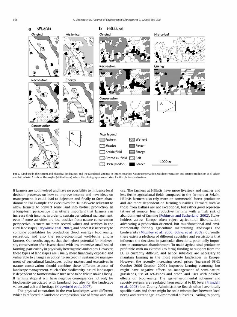
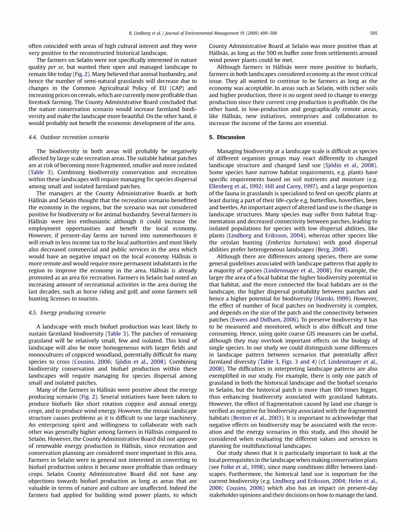
Fig. 3. Land use in the current and historical landscapes, and the calculated land use in three scenarios: Nature conservation, Outdoor recreation and Energy production at a) Selaonand b) Hållnas. A¼ show the angles (dotted lines) where the photographs were taken for the photo visualisation.
R. Lindborg et al. / Journal of Environmental Management 91 (2009) 499–508506
If farmers are not involved and have no possibility to influence localdecision processes on how to improve income and new ideas onmanagement, it could lead to dejection and finally to farm aban-donment. For example, the executives for Hållnas were reluctant toallow farmers to convert some land into biofuel production. Ina long-term perspective it is utterly important that farmers canincrease their income, in order to sustain agricultural management,even if some activities are less positive from nature conservationperspective. Farmers maintain several values and services in therural landscape (Krzywinski et al., 2007), and hence it is necessary tocombine possibilities for production (food, energy), biodiversity,recreation, and also the socio-economical well-being amongfarmers. Our results suggest that the highest potential for biodiver-sity conservation often is associated with low-intensive small-scaledfarming, particularly in physically heterogenic landscapes. However,these types of landscapes are usually more financially exposed andvulnerable to changes in policy. To succeed in sustainable manage-ment of agricultural landscapes, policy makers and executives innature conservation should combine these different aspects oflandscape management. Much of the biodiversity in rural landscapesis dependent on farmers who in turn need to be able to make a living.If farming stops it will have negative consequences not only forbiodiversity associated with farmland, but also for the landscapevalues and cultural heritage (Krzywinski et al., 2007).
The physical constraints in the two landscapes were different,which is reflected in landscape composition, size of farms and land
use. The farmers at Hållnas have more livestock and smaller andless fertile agricultural fields compared to the farmers at Selaon.Hållnas farmers also rely more on commercial forest productionand are more dependent on farming subsidies. Farmers such asthose from Hållnas are not exceptional, but rather good represen-tatives of remote, less productive farming with a high risk ofabandonment of farming (Robinson and Sutherland, 2002). Stake-holders across Europe often reject agricultural liberalisation,advocating a production-oriented, but multifunctional and envi-ronmentally friendly agriculture maintaining landscapes andbiodiversity (Mitchley et al., 2006; Soliva et al., 2008). Currently,there exists a plethora of different subsidies and restrictions thatinfluence the decisions in particular directions, potentially impor-tant to counteract abandonment. To make agricultural productionprofitable with no external (to farm) funding or support from theEU is currently difficult, and hence subsidies are necessary tomaintain farming in the most remote landscapes in Europe.However, the recently increasing cereal prices (increased 68.6%October 2006–October 2007) improves farming economy, butmight have negative effects on management of semi-naturalgrasslands, use of set-asides and other land uses with positiveeffects on biodiversity. The agri-environmental schemes andsubsidy systems are regulated from regional to EU level (Primdahlet al., 2003), but County Administrative Boards often have locallyspecific plans and there might be scale mismatches between localneeds and current agri-environmental subsidies, leading to poorly
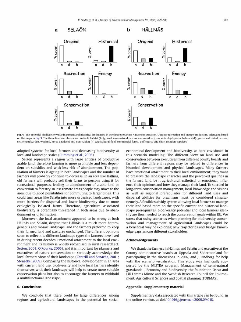
Fig. 4. The potential biodiversity value in current and historical landscapes, in the three scenarios: Nature conservation, Outdoor recreation and Energy production, calculated basedon the maps in Fig. 3. The three land use classes are: suitable habitat (h) (grazed semi-natural pasture and meadow), less suitable/dispersal habitats (d) (grazed cultivated pasture,settlement/garden, wetland, horse paddock) and non-habitat (n) (agricultural field, commercial forest, golf course and short rotation coppice).
R. Lindborg et al. / Journal of Environmental Management 91 (2009) 499–508 507
adopted systems for local farmers and decreasing biodiversity atlocal and landscape scales (Cumming et al., 2006).
Selaon represents a region with large entities of productivearable land, therefore farming is more profitable and less depen-dent on subsidies and with less risk of abandonment. The pop-ulation of farmers is ageing in both landscapes and the number offarmers will probably continue to decrease. In an area like Hållnas,old farmers will probably sell their farms to persons using it forrecreational purposes, leading to abandonment of arable land orconversion to forestry. In less remote areas people may move to thearea, due to good possibilities for commuting to larger cities. Thiscould turn areas like Selaon into more urbanised landscapes, withmore barriers for dispersal and lower biodiversity due to moreecologically isolated farms. Therefore, agriculture associatedbiodiversity is potentially threatened in both areas due to aban-donment or urbanisation.
Moreover, the local attachment appeared to be strong at bothHållnas and Selaon, despite that Hållnas is a much more hetero-geneous and mosaic landscape, and the farmers preferred to keeptheir farmed land and pastures unchanged. The different opinionsseem to reflect the different landscape types the farmers have livedin during recent decades. Emotional attachment to the local envi-ronment and its history is widely recognised in rural research (cf.Setten, 2001; O’Rourke, 2005), and it is important for planners andexecutives of nature conservation to seriously acknowledge thelocal farmers view of their landscape (Cantrill and Senacha, 2001;Stenseke, 2009). Comparing the historical development in an areawith current land use, biodiversity and how local farmers identifythemselves with their landscape will help to create more suitableconservation plans but also to encourage the farmers to withholda multifunctional landscape.
6. Conclusions
We conclude that there could be large differences amongregions and agricultural landscapes in the potential for social-
economical development and biodiversity, as here envisioned inthis scenario modelling. The different view on land use andconservation between executives from different county boards andfarmers from different regions may be related to differences inhistorical development and physical landscapes. Many farmershave emotional attachment to their local environment; they wantto preserve the landscape character and the perceived qualities inthe farmed land, be it agricultural, esthetical or emotional, influ-ence their opinions and how they manage their land. To succeed inlong-term conservation management, local knowledge and visionsas well as regional prerequisites for different land uses anddispersal abilities for organisms must be considered simulta-neously. A flexible subsidy system allowing local farmers to managetheir land based more on the specific current and historical land-scape prerequisites, biodiversity potential and local farmers iden-tify are thus needed to reach the conservation goals within EU. Westress that using scenarios when planning for biodiversity conser-vation and management of agricultural landscapes could bea beneficial way of exploring new trajectories and bridge knowl-edge gaps among different stakeholders.
Acknowledgements
We thank the farmers in Hållnas and Selaon and executive at theCounty administrative boards at Uppsala and Sodermanland forparticipating in the discussions in 2007, and J. Lindborg for helpwith the scenario visualisation. This study was financially sup-ported by the MISTRA program, Management of semi-naturalgrasslands – Economy and Biodiversity, the foundation Oscar andLili Lamms Minne and the Swedish Research Council for Environ-ment, Agricultural Sciences and Spatial planning (FORMAS).
Appendix. Supplementary material
Supplementary data associated with this article can be found, inthe online version, at doi:10.1016/j.jenvman.2009.09.018.
R. Lindborg et al. / Journal of Environmental Management 91 (2009) 499–508508
References
Baudry, J., 2000. A holistic landscape ecological study of the interactions betweenfarming activities and ecological patterns in Brittany, France. Landscape andUrban Planning 5, 119–128.
Benton, T.G., Vickery, J.A., Wilson, J.D., 2003. Farmland biodiversity: is habitatheterogeneity the key? Trends in Ecology and Evolution 18, 182–188.
Berendse, F., Chamberlan, D., Kleijn, D., Schekkerman, H., 2004. Declining biodi-versity in agricultural landscapes and the effectiveness of agri-environmentschemes. Ambio 33, 499–502.
Berg, Å, 2008. Habitat selection and reproductive success of Ortolan buntingsEmberiza hortulana on farmland in central Sweden – the importance of habitatheterogeneity. Ibis 150, 565–573.
Berg, Å., Tjernberg, M., 1996. Common and rare Swedish vertebrates – distributionand habitat preferences. Biodiversity and Conservation 5, 101–128.
Berggren, Å., Birath, B., Kindvall, O., 2002. Effect of corridors and habitat edges ondispersal behavior, movement rates, and movement angles in Roesel’s bush-cricket (Metrioptera roeseli). Conservation Biology 16, 1562–1569.
Buller, H., Wilson, G.A., Holl, A., 2000. Agri-environmental Policy in the EuropeanUnion. Ashgate, Aldershot.
Cantrill, J.G., Senacha, S.L., 2001. Using the ‘‘sense of self in place’’ construct in thecontext of environmental policymaking and landscape planning. EnvironmentalScience and Policy 4, 185–203.
Carpenter, S., et al., 2006. Millennium ecosystem assessment: research needs.Science 314, 257–258.
Council of Europe, 1998. The Challenges Facing European Society with the Approachof the Year 2000: Strategies for the Sustainable Development of Northern Statesin Europe. European Regional Planning 61. ISBN: 92-871-3728-5.
Cousins, S.A.O., 2006. Plant species richness in midfield islets and road verges – theeffect of landscape fragmentation. Biological Conservation 127, 500–509.
Cousins, S.A.O., Eriksson, O., 2002. The influence of management history and habitaton plant species richness in a rural hemiboreal landscape. Landscape Ecology17, 517–529.
Cousins, S.A.O., Eriksson, O., 2008. After the hotspots are gone: land use history andgrassland plant species diversity in a strongly transformed agricultural land-scape. Applied Vegetation Science. doi:10.3170/2008-7-18480.
Cumming, G.S., Cumming, D.H.M., Redman, C.L., 2006. Scale mismatches in social-ecological systems: causes, consequences, and solutions. Ecology and Society11, 14.
Daniel, T.C., Meitner, M.M., 2001. Representational validity of landscape visualiza-tions: the effects of graphical realism on perceived scenic beauty of forest vistas.Journal of Environmental Psychology 21, 61–72.
Ellenberg, H., Weber, H.E., Dull, R., Wirth, V., Werner, W., Plaulißen, D., 1992. Zei-gerwerte von Pflantzen in Mitteleuropa. Scripta Geobotanica 18, 1–248.
Eriksson, O., Cousins, S.A.O., Bruun, H.-H., 2002. Land-use history and fragmentationof traditionally managed grasslands in Scandinavia. Journal of VegetationScience 13, 743–748.
Ewers, R., Didham, R.K., 2006. Confounding factors in detection of species responsesto fragmentation. Biological Review 81, 117–142.
Foley, J.A., DeFries, R., Asner, G.P., Barford, C., Bonan, G., et al., 2005. Global conse-quences of land use. Science 309, 570–574.
Folke, C., Berkes, F., Colding, J., 1998. Management practices and social mechanismfor building resilience. In: Berkes, F., Folke, C. (Eds.), Linking Social–EcologicalSystems. Cambridge University Press, pp. 414–437.
Fry, G.L.A., 2001. Multifunctional landscapes – towards transdisciplinary research.Landscape and Urban Planning 57, 159–168.
Gardenfors, U., 2005. The 2005. Red List of Swedish Species. Artdatabanken,Uppsala.
Hagerhall, C., 1999. The experience of pastoral landscapes. Doctorial thesis. SverigesLantbruksuniversitet, Alnarp.
Hanski, I., 1999. Metapopulation Ecology. Oxford University Press, Oxford.Hanski, I., Ovaskainen, O., 2002. Extinction debt at extinction threshold. Conser-
vation Biology 16, 666–673.Hasund, K.-P., 1998. Valuable landscapes and reliable estimates. In: Dabbert, Dub-
gaars, Slangen, Whitby (Eds.), The Economics of Landscape and WildlifeConservation. CAB International Press, UK, p. xxx.
Helm, A., Hanski, I., Partel, M., 2006. Slow response of plant species richness tohabitat loss and fragmentation. Ecology Letters 9, 72–77.
Hill, M.O., Carey, P.D., 1997. Prediction of yield in the Rothamsed Park Grassexperiment by Ellenberg indicator values. Journal of Vegetation Science 4,579–586.
Jansson, K., 2007. Statistics Sweden (JO34: SM0601, 2007-05-02). AgriculturalHoldings and Holders in 2005. Swedish Board of Agriculture, Jonkoping.
Krzywinski, K., O’Connell, M., Kuster, H., 2007. Cultural Landscapes of Europe. Fieldsof Demeter, Haunts of Pan. Aschenbeck and Oeljeschlager, Wildeshausen.
Kvale, S., Brinkmann, S., 2009. InterViews: Learning the Craft of QualitativeResearch Interviewing, second ed. SAGE, Los Angeles.
Lindborg, R., Eriksson, O., 2004. Historical landscape connectivity affects presentplant species diversity. Ecology 85, 1840–1845.
Lindborg, R., Bengtsson, J., Berg, Å., Cousins, S.A.O., Eriksson, O., Gustafsson, T.,Hasund, K.-P., Lenoir, L., Pihlgren, A., Sjodin, E., Stenseke, M., 2008. A landscapeperspective on conservation of semi-natural grasslands. Agriculture, Ecosys-tems and Environment 125, 213–222.
Lindenmayer, D., Hobbs, R.J., Montague-Drake, R., et al., 2008. A checklist forecological management of landscapes for conservation. Ecology Letters 11,78–91.
Mitchley, J., Price, M.F., Tzanopoulos, J., 2006. Integrated futures for Europe’smountain regions: reconciling biodiversity conservation and human liveli-hoods. Journal of Mountain Science 3, 276–286.
Nassauer, J.I., Corry, R.C., Cruse, R.M., 2002. The landscape in 2025. Journal of Soiland Water Conservation 57, 44A–53A.
O’Riordan, T., 2000. Environmental Science for Environmental Management, seconded. Prentice-Hall, Harlow.
O’Rourke, E., 2005. Socio-natural interaction and landscape dynamics in the Burren,Ireland. Landscape and Urban Planning 70, 69–83.
Ockinger, E., Smith, H.G., 2006. Landscape composition and habitat area affectsbutterfly species richness in semi-natural grasslands. Oecologia 149, 526–534.
Pain, D.J., Pienkowski, M.W., 1997. Farming and Birds in Europe: The CommonAgricultural Policy and its Implications for Bird Conservation. Academic Press,Cambridge.
Primdahl, J., Peco, B., Schramek, J., Andersen, E., Onate, J.J., 2003. Environmentaleffects of Agri-environmental schemes in Western Europe. Journal of Envi-ronmental Management 67, 129–138.
Robinson, R.A., Sutherland, W.J., 2002. Post-war changes in arable farming andbiodiversity in Great Britain. Journal of Applied Ecology 39, 157–176.
Rounsevell, M.D.A., Annetts, J.E., Audsley, E., Mayrc, T., Reginster, I., 2003. Modellingthe spatial distribution of agricultural land use at the regional scale. Agriculture,Ecosystems and Environment 95, 465–479.
Rounsevell, M.D.A., Berry, P.M., Harrison, P.A., 2006. Future environmental changeimpacts on rural land use and biodiversity: a synthesis of the ACCELERATESproject. Environmental Science and Policy 9, 93–100.
Santelmann, M.V., White, D., Freemark, K., et al., 2004. Assessing alternative futuresfor agriculture in Iowa, USA. Landscape Ecology 19, 357–374.
Setten, G., 2001. Farmers, planners and the moral message of landscape and natureethics. Place and Environment 4, 220–225.
Sjodin, N.E., 2006. Pollinator diversity and grazing intensity in the landscape.Biodiversity and Conservation 16, 2103–2121.
Sjodin, N.E., Bengtsson, J., Ekbom, B., 2008. The influence of grazing intensity andlandscape composition on the diversity and abundance of flower-visitinginsects. Journal of Applied Ecology 45, 763–772.
Soliva, R., Rønningen, K., Bella, I., Bezak, P., Cooper, T., Flø, B.E., Marty, P., Potter, C.,2008. Envisioning upland futures: stakeholder responses to scenarios forEurope’s mountain landscapes. Journal of Rural Studies 24, 56–71.
SOU, 2007. Bioenergi från jordbruket – en vaxande resurs. Betankande av utred-ningen om jordbruket som bioenergiproducent (in Swedish) SOU 2007:36,Stockholm.
Stenseke, M., 2001. Landskapets varden. Lokala perspektiv och centrala utgång-spunkter. Om vagar till okad lokal delaktighet i bevarandeplaneringen. (inSwedish) Choros 2001:1, Kulturgeografiska institutionen, Handelshogskolan vidGoteborgs universitet.
Stenseke, M., 2006. Biodiversity and the local context. Linking semi-natural grass-land and their future use to social aspects. Environmental Science Policy 9,350–359.
Stenseke, M., 2009. Local participation in cultural landscape maintenance: lessonsfrom Sweden. Land Use Policy 26, 214–223.
Stewart, D.W., Shamdasani, P.N., Rook, D.W., 2006. Focus Groups: Theory andPractice, second ed. SAGE, London.
Swedish Board of Agriculture. 1999. Miljoeffekter i Sverige av EUs jordbrukspolitik(in Swedish) Rapport från projekt CAPS miljoeffekter. Rapport 1999:28. Jord-bruksverket, Jonkoping.
Tress, B., Tress, G., 2003. Scenario visualisation for participatory landscape planning– a study from Denmark. Landscape and Urban Planning 64, 161–178.
Walker, K.J., Stevens, P.A., Stevens, D.P., Mountford, O.J., Manchester, S.J., Pywell, R.F.,2004. The restoration and re-creation of species-rich lowland grassland on landformerly managed for intensive agriculture in the UK. Biological Conservation119, 1–18.
Wascher, D.M. (Ed.), 2000. The Face of Europe. Policy Perspectives for EuropeanLandscapes. European Centre for Nature Conservation, Tilburg ENCN TechnicalReport Series.
Wherrett, J.R., 2000. Creating landscape preference models using internet surveytechniques. Landscape Research 25, 79–96.
Wollenberg, E., Edmunds, D., Buck, L., 2000. Using scenarios to make decisionsabout the future: anticipatory learning for the adaptive co-management ofcommunity forests. Landscape and Urban Planning 47, 65–77.