Introduction to the Geography and History Curriculum
67
1 Introduction to the Geography and History Curriculum This Integrated Geography and History Curriculum for 3 rd year of E.S.O. is derived from the British National Curriculum and the Spanish Curriculum. The content of the entire curriculum for Geography and History is covered in the Integrated Curriculum for ESO 3 and ESO 4, so that students work on both subject areas throughout the whole Secondary stage. The philosophy of the Spanish education system concerning these subjects is maintained while the methodology draws heavily on the British National Curriculum Key Stage 3 Framework for teaching Geography and History. In some areas the order of teaching topics is flexible in order to allow the pupils to use English resources (books, websites etc) and to work within topic areas. The Qualifications and Curriculum Authority (QCA http://www.qca.org.uk/) has produced a series of detailed schemes of work for teaching Geography and History from 11-14 in accordance with the National Curriculum. There is now a large amount of resource materials based on these schemes, including textbooks and support materials from all the major publishers, web based resources and software. Information on some of these materials can be found in the section on teaching resources. In each section there are textbooks recommended for use, which in many cases compliment the lesson outlines provided. Teachers are strongly advised to read through the whole of this document before beginning to work on individual units in order to obtain a global view of the content and objectives involved in teaching History and Geography as part of the Integrated Curriculum.
-
Upload
khangminh22 -
Category
Documents
-
view
1 -
download
0
Transcript of Introduction to the Geography and History Curriculum

1
Introduction to the Geography and History Curriculum
This Integrated Geography and History Curriculum for 3rd
year of E.S.O. is derived from the British National Curriculum and the Spanish
Curriculum.
The content of the entire curriculum for Geography and History is covered in the Integrated Curriculum for ESO 3 and ESO 4, so that students work
on both subject areas throughout the whole Secondary stage.
The philosophy of the Spanish education system concerning these subjects is maintained while the methodology draws heavily on the British
National Curriculum Key Stage 3 Framework for teaching Geography and History.
In some areas the order of teaching topics is flexible in order to allow the pupils to use English resources (books, websites etc) and to work within
topic areas. The Qualifications and Curriculum Authority (QCA http://www.qca.org.uk/) has produced a series of detailed schemes of work for
teaching Geography and History from 11-14 in accordance with the National Curriculum. There is now a large amount of resource materials based
on these schemes, including textbooks and support materials from all the major publishers, web based resources and software. Information on some
of these materials can be found in the section on teaching resources.
In each section there are textbooks recommended for use, which in many cases compliment the lesson outlines provided.
Teachers are strongly advised to read through the whole of this document before beginning to work on individual units in order to obtain a global view of the
content and objectives involved in teaching History and Geography as part of the Integrated Curriculum.
2
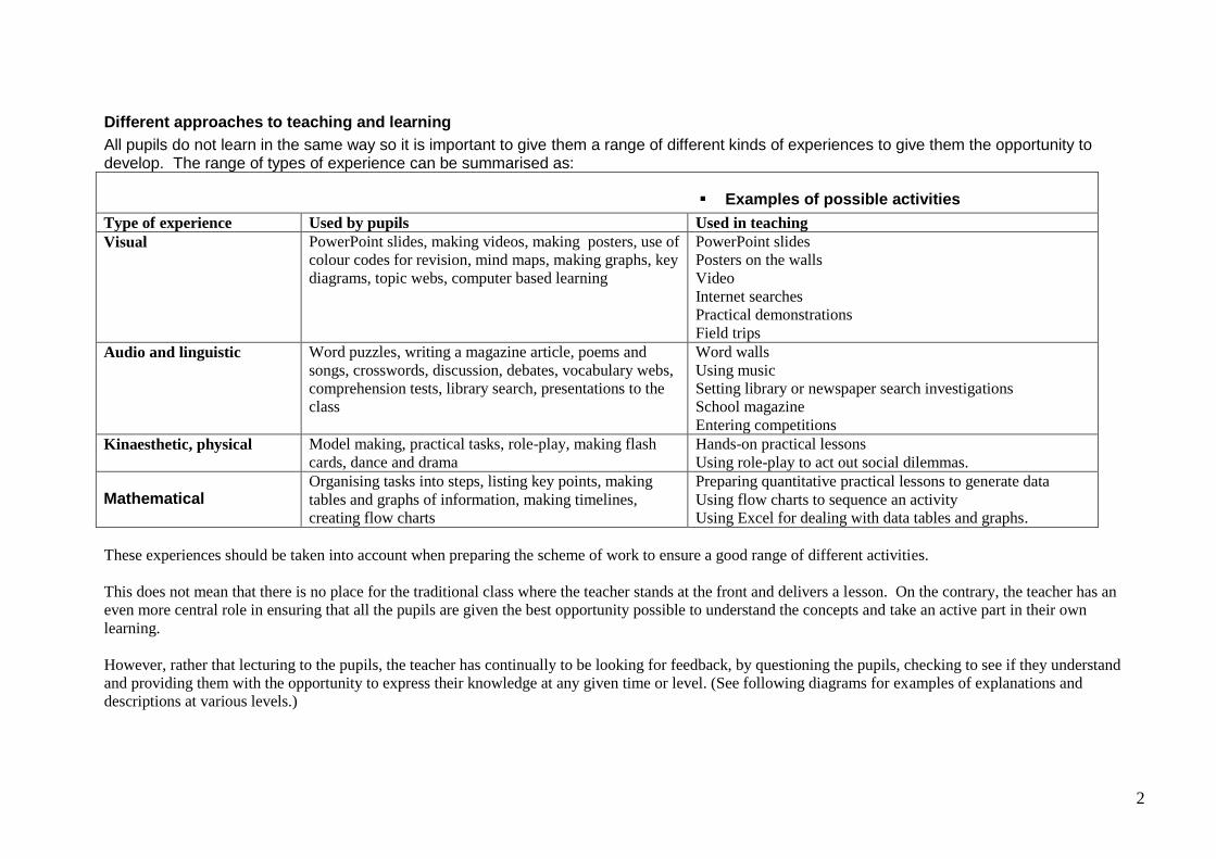
Different approaches to teaching and learning
All pupils do not learn in the same way so it is important to give them a range of different kinds of experiences to give them the opportunity to develop. The range of types of experience can be summarised as:
Examples of possible activities
Type of experience Used by pupils Used in teaching
Visual PowerPoint slides, making videos, making posters, use of
colour codes for revision, mind maps, making graphs, key
diagrams, topic webs, computer based learning
PowerPoint slides
Posters on the walls
Video
Internet searches
Practical demonstrations
Field trips
Audio and linguistic Word puzzles, writing a magazine article, poems and
songs, crosswords, discussion, debates, vocabulary webs,
comprehension tests, library search, presentations to the
class
Word walls
Using music
Setting library or newspaper search investigations
School magazine
Entering competitions
Kinaesthetic, physical Model making, practical tasks, role-play, making flash
cards, dance and drama
Hands-on practical lessons
Using role-play to act out social dilemmas.
Mathematical Organising tasks into steps, listing key points, making
tables and graphs of information, making timelines,
creating flow charts
Preparing quantitative practical lessons to generate data
Using flow charts to sequence an activity
Using Excel for dealing with data tables and graphs.
These experiences should be taken into account when preparing the scheme of work to ensure a good range of different activities.
This does not mean that there is no place for the traditional class where the teacher stands at the front and delivers a lesson. On the contrary, the teacher has an
even more central role in ensuring that all the pupils are given the best opportunity possible to understand the concepts and take an active part in their own
learning.
However, rather that lecturing to the pupils, the teacher has continually to be looking for feedback, by questioning the pupils, checking to see if they understand
and providing them with the opportunity to express their knowledge at any given time or level. (See following diagrams for examples of explanations and
descriptions at various levels.)
3
Teaching materials and resources
The course is designed so that teachers can choose which books and extra resource materials to use to best suit themselves and their pupils. As the methodology is
based on both the Spanish and British Curricula, there is no single ideal text to use, but some are recommended. However, a good deal of resource material
should be British. The British education system has five years of secondary education from Year 7 to Year 11, corresponding to the Spanish system as follows :
Year 7 (Key Stage 3) : 6º Primaria
Year 8 (Key Stage 3) : 1º ESO
Year 9 (Key Stage 3) : 2º ESO
Year 10 (Key Stage 4) : 3º ESO
Year 11 (Key Stage 4) : 4º ESO
Years 7 – 9 are known as “Key Stage 3” and are taught at secondary schools. In the integrated Curriculum some of the work for Year 7 will have been covered at
primary Year 6 but the curriculum has been designed to include the most important aspects of the National Curriculum for Key Stage 3 and some elements of KS4,
together with the Spanish Curriculum for 3rd year E.S.O. The suggested schemes of work are flexible, including extension activities that may be used if time
permits. Where appropriate, a curricular link with literacy or other relevant areas has also been suggested. References to books, websites and other resources are
included.
Creating resource banks
Creating resources will help teachers to provide pupils with suitable visual aids and adequate texts for classroom activities. These resources should be prepared in
advance. Organised planning and coordination among teachers from different departments could save both time and work. In addition, completed resources should
be adequately organised and stored for future use.
Suggestions for resource banks :
Scan and laminate illustrations from English or Spanish textbooks, reference books, magazines etc.
Print and laminate illustrations, graphs, photographs and simple texts from web sites. (see list)
Compile questionnaires based on texts, illustrations, maps, graphs, artwork etc.
Design simple posters with step-by-step explanations about how to carry out a report, investigation project, presentation etc.
4
Cross-curricular links and Inter-Departmental Coordination
Close coordination between different departments involved in teaching the Integrated Curriculum is essential in order to avoid too much repetition where a topic is
included in, for example, both science and geography. The content covered by one subject teacher should be complemented, where appropriate, by another.
Coordination is particularly important between the English department and the others involved in the Integrated Curriculum in order to reinforce the vocabulary
and language skills necessary to reach a full understanding of and participation in the topics covered in the suggested schemes of work. Where appropriate, it has
been suggested that teachers coordinate for these purposes. A specific reference has also been made where reinforcement could be done in a literacy class with the
English teacher (LL), or “Literacy Link.” Links to other subjects have also been identified: AL – Art Link and SL – Science Link.
Language for learning
In order to avoid slowing pupils’ progress in History or Geography due to difficulties with reading or writing, the vocabulary and
structural/functional language may be revised or reinforced as part of a literacy lesson where appropriate. Teachers should introduce new items of
vocabulary carefully, giving the pupils the opportunity to articulate them before using them in written work.
A strong visual element should be introduced and capitalised on through the use of illustrations, diagrams, ICT etc. Specifying the vocabulary and type of language
used for a particular unit of work allows the pupils to refer back to this in books, charts and other visual aids as well as making good use of the glossaries provided
in some of the recommended resources.
The main language for each unit of work is briefly outlined at the start of each unit. These outlines are not, however, exhaustive, but rather intended to serve as a
guide for teachers as to the kind of input that may be necessary when teaching these topics.
5
Geography Curriculum for 3º ESO.
The Geography Curriculum for 3º E.S.O. is divided into six main sections as follows:
Introduction Topic and Sample Lesson
Topic One: World Ecosystems-Natural Environments
Topic Two: Economic Activities-Primary and Secondary
Topic Three: A Fast Changing World-Tertiary and Quaternary Economic Activities
Topic Four: Settlement and Urbanisation
Topic Five: Development, Trade and Aid
Methodology
A major aim of this integrated Curriculum is to encourage an imaginative approach to geography teaching. Not only do our pupils need to learn facts but also
to take an interest in their surroundings and in the variety of human and physical conditions on the earth.
Pupils need to be encouraged to develop a sense of wonder at the world around them. They also need to develop an informed concern about the quality of the
environment and the future of the human habitat. In doing so, they will also develop a sense of responsibility for the care of the earth and its people.
The use of investigation and enquiry
As well as teaching geography as a factual subject, the skills of investigation and enquiry should also be developed. Geography offers the pupils the opportunity to:
Investigate a wide range of places and environments around the world
Investigate how places and environments are interdependent
Carry out geographical enquiry, including identifying questions and developing their own opinions
Carry out geographical enquiries, both inside and outside the classroom.
Use a range of investigative and problem-solving skills and resources, including different types of maps, atlases, ICT images, etc
Key Aspects Pupils will learn how to:
Ask geographical questions
Analyse evidence and draw conclusions
Use appropriate geographical vocabulary
Use atlases/globes/maps
Use and complete vocabulary webs
Draw maps, plans and diagrams
Experience decision-making
Use secondary evidence
6
Language Skills
Speaking and listening- through the activities pupils could:
Identify the main points of a task, text...
Listen for a specific purpose, note the main points and consider their relevance
Discuss and respond to initial ideas and information, carry out tasks and refine ideas
Reading - through these activities pupils could:
Follow the sequence of actions, processes or ideas being discussed
Undertake independent research using knowledge of how texts, databases, etc are organised and on appropriate reading strategies
Writing - through these activities pupils could:
Group sentences into paragraphs and form well-developed essays
Properly introduce, develop and conclude pieces of writing
Use proper punctuation
**The specific language and vocabulary relating to each topic is included in the "Language for Learning" section in the schemes of work.
Schemes of Work
Each section has been designed as a scheme of work including the following aspects:
H: The suggested timing of the lesson, usually one or two hours.
In the same column there may also be information as to the importance of the lesson:
Core means it is an essential part of this Integrated Curriculum
Extension means if you have time you might like to do it, but it is included to provide more practice or give more depth to a topic
There has been a huge amount of content to include and teachers should be aware that they will need to use their discretion when delivering the content, giving
some topics more emphasis than others, as covering everything included in the detailed outline would prove extremely difficult.
Cross Curricular Links: These are sections that are studied or can be reinforced in other areas of the curriculum. Teachers are encouraged to co-ordinate with
link teachers early on in the course in the following areas:
LL: Literacy Link
HL: History Link (The historical aspects of this material will be studied in greater detail in the History section of this course).
SL: Science (This material may be covered in Science).
AL: Art Link (This material may be covered in Art).
Lesson Outline: this is not a lesson plan, but there are suggestions for presenting the topics in each lesson.
Activities/Assessment Criteria: these are suggestions for student activities and assessment opportunities that may arise in each lesson
Lesson Outcomes: an outline of the learning expectations for the pupils from that lesson
Resources: suggestions for useful resources, which are needed or would be of help for that lesson
The first topic is intended to serve as an introduction and includes ready-made worksheets, which may be photocopied for use in class.
7
Introduction Topic: Is there a relationship between nature and society?
(Includes a sample lesson)
Some points in this topic may have been covered in 1º and 2º ESO.
The idea of this introduction topic is:
- to revise previous knowledge
to introduce a deductive approach towards Geography and
to show teachers how resources can be used.
Assumed knowledge and skills from previous years:
1.That the world´s population is unevenly distributed
2.That there is a strong migratory movement towards developed countries.
3.Use of map skills to recognise important situational facts related to population.
4.Identification of environmental problems that occur in each continent.
Knowledge and understanding of the relationship between the natural environment and human beings.
Pupils will learn to :
Understand the relationship between nature and human activity.
Explain why human settlement depends less on nature than it did before.
Explain why population density varies within a same country.
Compare population pyramids of two different countries (UK and a LEDC)
Identify reasons for population increase.
Language for Learning
Through the activities in this topic pupils will be able to understand, use and spell correctly words relating to:
Population: Distribution, habitable, wealthy, growing population, birth rate, death rate, crowded, population explosion.
Environment: industrial, communication link, water supply, dairy products, fossil fuels, coastal plains, steep slopes, extreme climates, poor soils.

8
Key geographical questions on the Topic:
- How is the world´s population distributed?
- Why are some areas more populated than others?
- Do physical features affect human settlement?
- Do we depend on nature as much as before?
- Can humans control nature ?
h
Lesson Outline
Activities/
Assessment Criteria
Lesson Outcomes
Resources
2 Core
1 Core
Is there a relationship between nature
and society?
Can relief and climate affect human life?
Introduction: questions to “think about.”
Explain briefly how relief and climate affect
human settlement and economic
development.
Discuss how physical features can affect
population: mountains, valleys, sea,
rivers, plains.
Why are some areas more populated than
others?
Explain other reasons for population
increase: birth rate, religion.
Does human settlement depend on nature
as much as it did before?
Look at a physical map and a
population map and discuss
reasons for population density.
Draw up a list of factors that
affect population positively and
negatively. (Sample lesson)
Cut into pieces of paper, place
in an envelope. Ask children to
order them.
Use an Internet link to
understand the “population
explosion”. (Sample lesson)
By observing photographs
compare population density and
discuss reasons. (Sample
Understand how nature can
influence the distribution of
population and human beings can
change natural environments.
To be able to contrast and
understand different population
patterns.
To be able to discuss birth rate
policies over the world.
To be aware of the effect
population is having on the
environment.
Use world population maps.
http://sedac.ciesin.columbia.edu/gpw/
Letts-GCSE.Geography-Questions and
answers (Population). (Sample lesson)
“Geography Matters 1”-Teachers
Resources-People Everywhere.Heineman
(Sample lesson)
www.historycentral.com/NationbyNation/
Spain/population.html
“Geography homework for KS3” (chapter
5,Population) Heineman
http://www-popexpo.ined.fr/eMain.html
(Sample lesson)
GCSE Geography (section8, Population
9
Discuss today´s urbanization, modern
tourism and whether man can control
nature.
lesson). CGP
(Sample lesson)
http://www.geointeractive.co.uk/contribu
tion/wordfiles/Bi-
polar%20analysis%20of%20photos.doc
“Geography Matters 1”-Teachers
Resources-People Everywhere. Heineman
(Sample lesson)
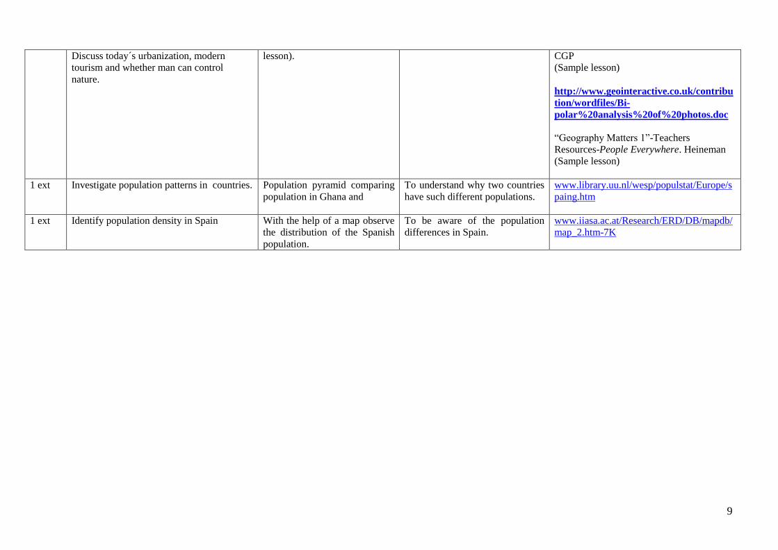
1 ext Investigate population patterns in countries. Population pyramid comparing
population in Ghana and
To understand why two countries
have such different populations.
www.library.uu.nl/wesp/populstat/Europe/s
paing.htm
1 ext Identify population density in Spain With the help of a map observe
the distribution of the Spanish
population.
To be aware of the population
differences in Spain.
www.iiasa.ac.at/Research/ERD/DB/mapdb/
map_2.htm-7K
10
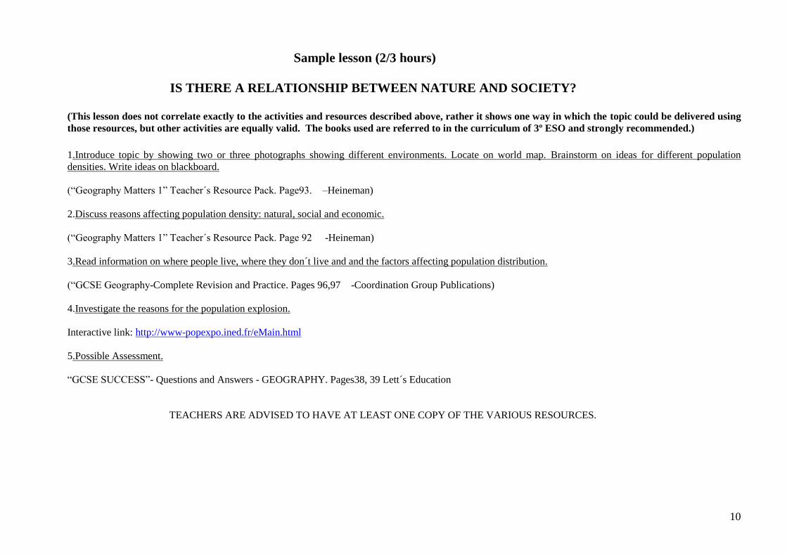
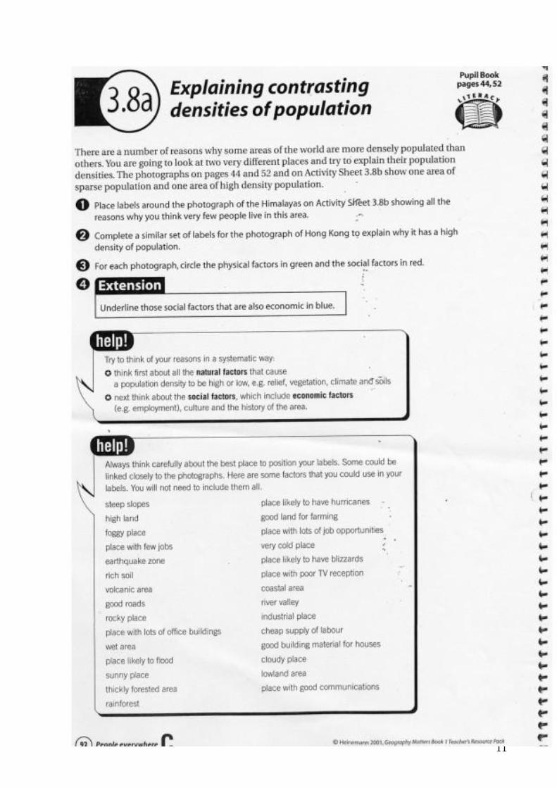
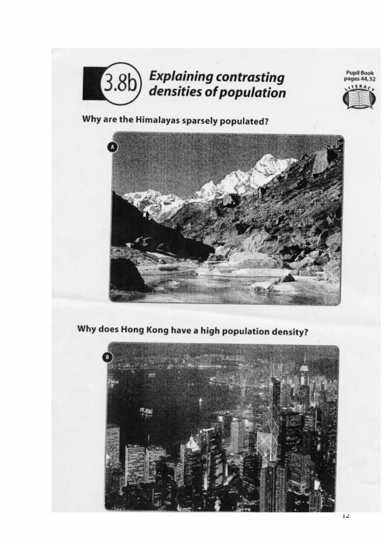
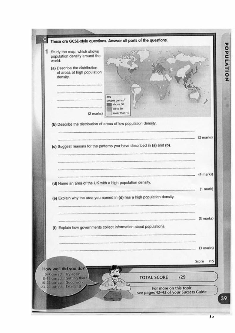
Sample lesson (2/3 hours)
IS THERE A RELATIONSHIP BETWEEN NATURE AND SOCIETY?
(This lesson does not correlate exactly to the activities and resources described above, rather it shows one way in which the topic could be delivered using
those resources, but other activities are equally valid. The books used are referred to in the curriculum of 3º ESO and strongly recommended.)
1.Introduce topic by showing two or three photographs showing different environments. Locate on world map. Brainstorm on ideas for different population
densities. Write ideas on blackboard.
(“Geography Matters 1” Teacher´s Resource Pack. Page93. –Heineman)
2.Discuss reasons affecting population density: natural, social and economic.
(“Geography Matters 1” Teacher´s Resource Pack. Page 92 -Heineman)
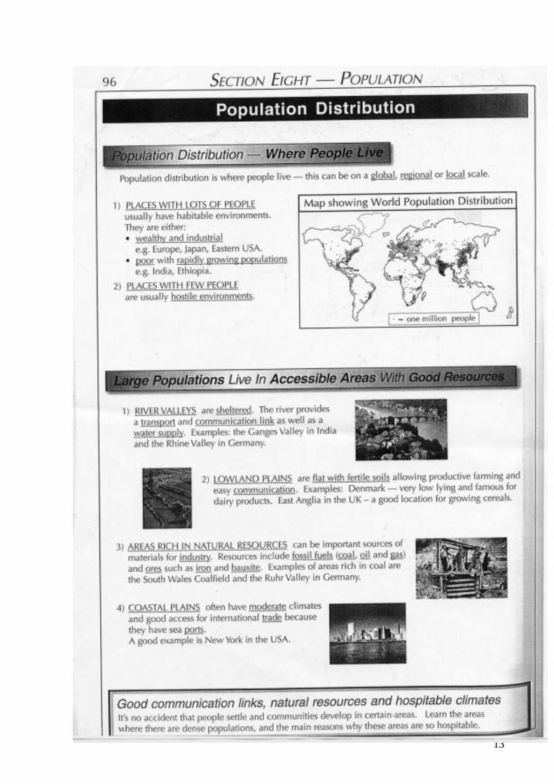
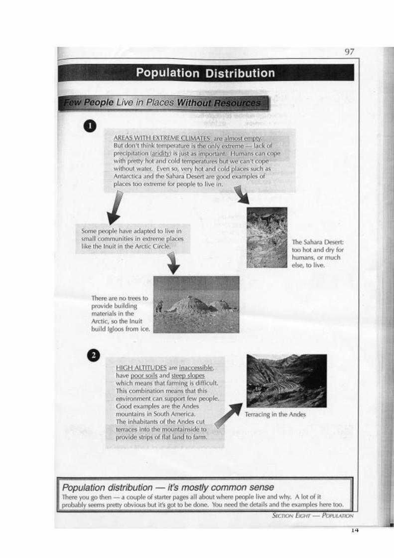
3.Read information on where people live, where they don´t live and and the factors affecting population distribution.
(“GCSE Geography-Complete Revision and Practice. Pages 96,97 -Coordination Group Publications)
4.Investigate the reasons for the population explosion.
Interactive link: http://www-popexpo.ined.fr/eMain.html
5.Possible Assessment.
“GCSE SUCCESS”- Questions and Answers - GEOGRAPHY. Pages38, 39 Lett´s Education
TEACHERS ARE ADVISED TO HAVE AT LEAST ONE COPY OF THE VARIOUS RESOURCES.
11
12
13
14

15
16
17
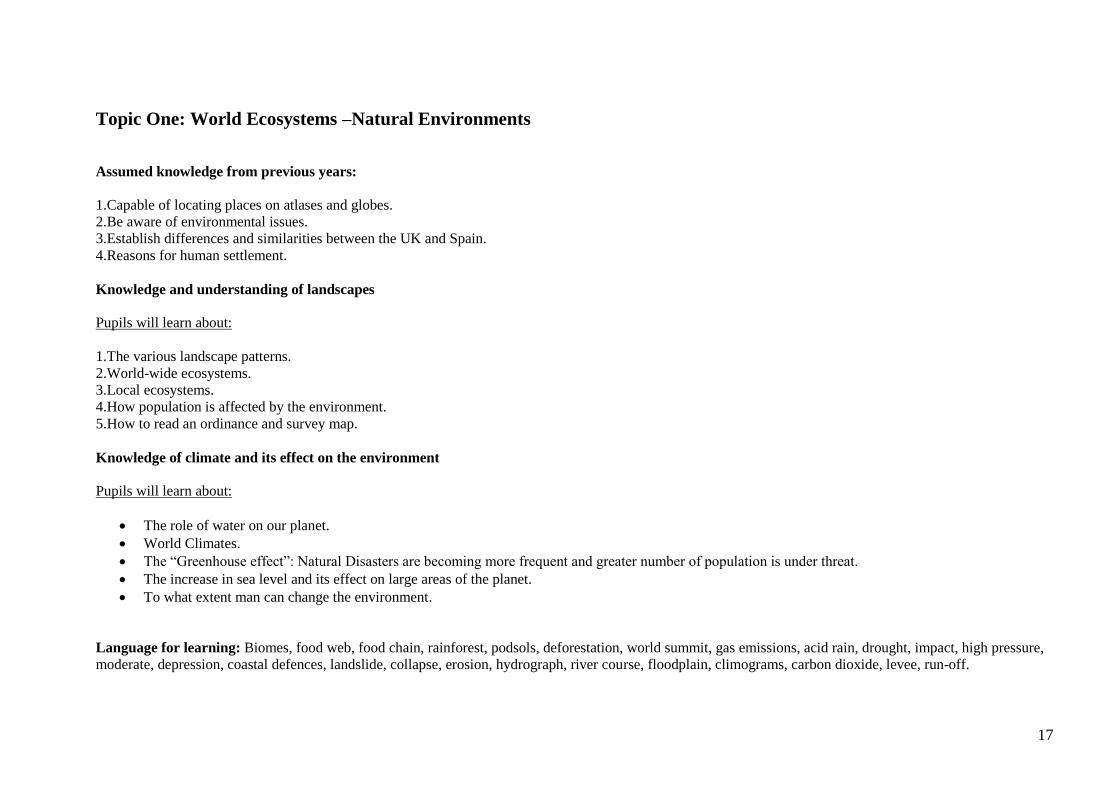
Topic One: World Ecosystems –Natural Environments
Assumed knowledge from previous years:
1.Capable of locating places on atlases and globes.
2.Be aware of environmental issues.
3.Establish differences and similarities between the UK and Spain.
4.Reasons for human settlement.
Knowledge and understanding of landscapes
Pupils will learn about:
1.The various landscape patterns.
2.World-wide ecosystems.
3.Local ecosystems.
4.How population is affected by the environment.
5.How to read an ordinance and survey map.
Knowledge of climate and its effect on the environment
Pupils will learn about:
The role of water on our planet.
World Climates.
The “Greenhouse effect”: Natural Disasters are becoming more frequent and greater number of population is under threat.
The increase in sea level and its effect on large areas of the planet.
To what extent man can change the environment.
Language for learning: Biomes, food web, food chain, rainforest, podsols, deforestation, world summit, gas emissions, acid rain, drought, impact, high pressure,
moderate, depression, coastal defences, landslide, collapse, erosion, hydrograph, river course, floodplain, climograms, carbon dioxide, levee, run-off.
18
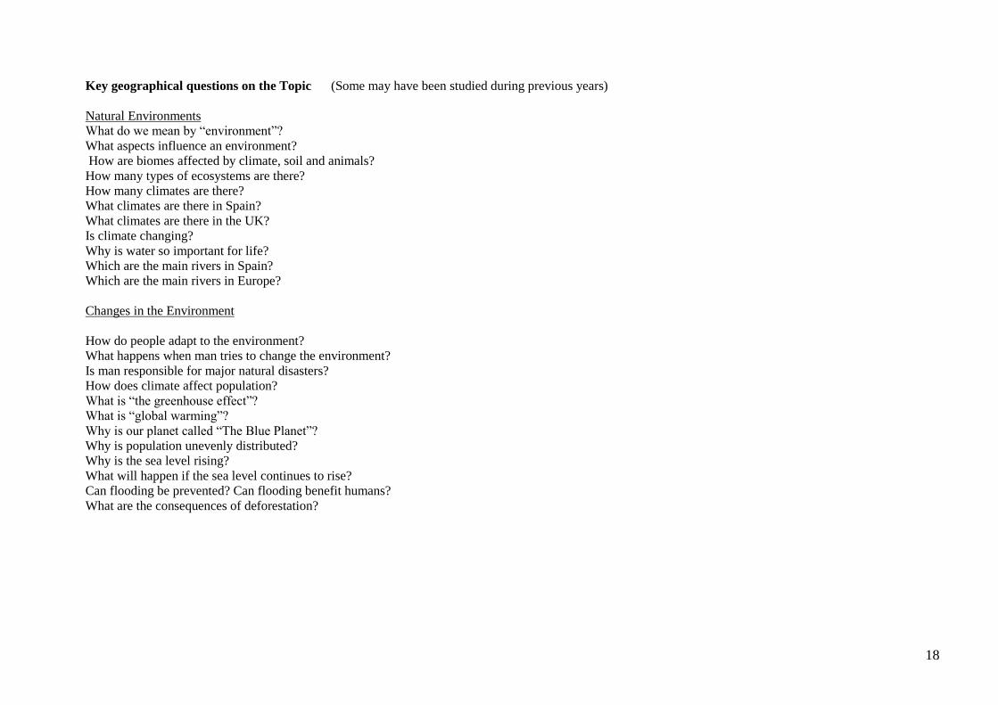
Key geographical questions on the Topic (Some may have been studied during previous years)
Natural Environments
What do we mean by “environment”?
What aspects influence an environment?
How are biomes affected by climate, soil and animals?
How many types of ecosystems are there?
How many climates are there?
What climates are there in Spain?
What climates are there in the UK?
Is climate changing?
Why is water so important for life?
Which are the main rivers in Spain?
Which are the main rivers in Europe?
Changes in the Environment
How do people adapt to the environment?
What happens when man tries to change the environment?
Is man responsible for major natural disasters?
How does climate affect population?
What is “the greenhouse effect”?
What is “global warming”?
Why is our planet called “The Blue Planet”?
Why is population unevenly distributed?
Why is the sea level rising?
What will happen if the sea level continues to rise?
Can flooding be prevented? Can flooding benefit humans?
What are the consequences of deforestation?
19
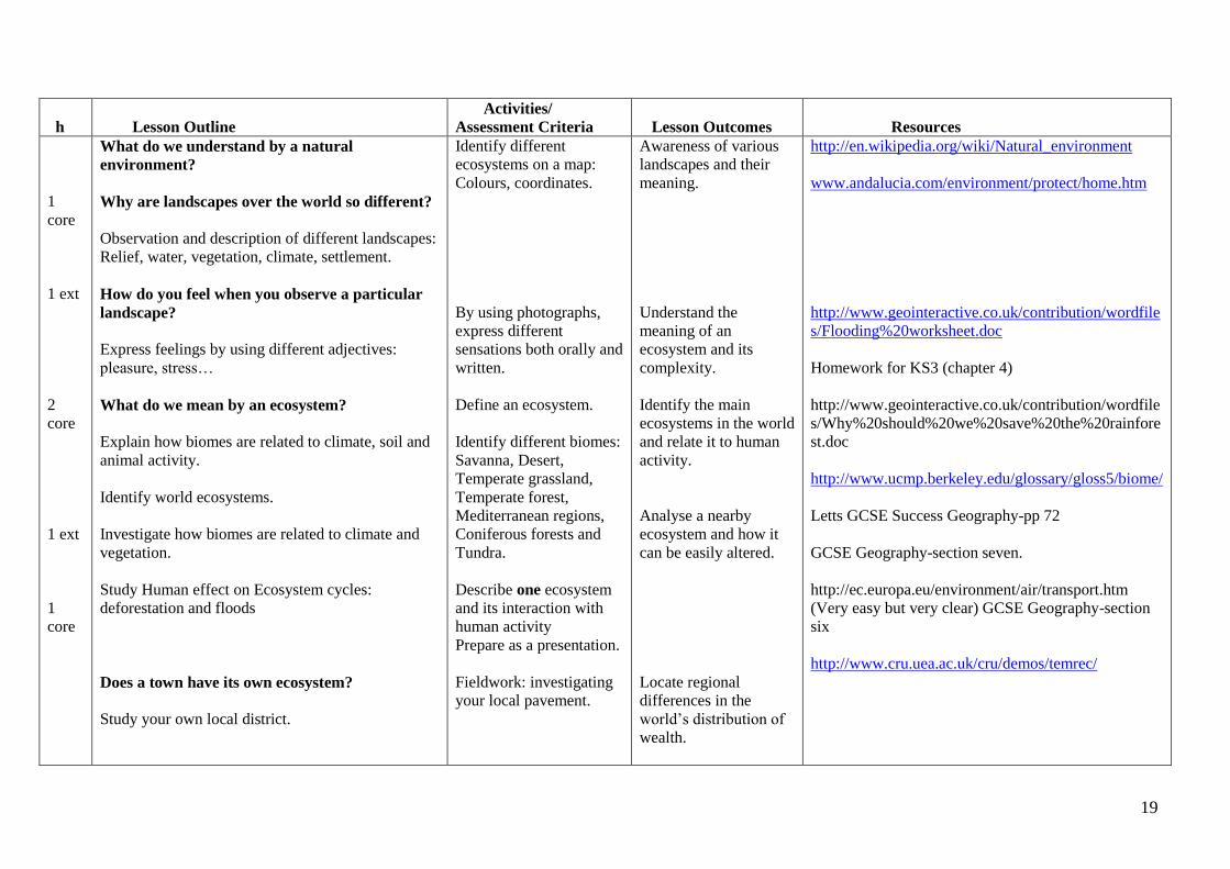
h
Lesson Outline
Activities/
Assessment Criteria
Lesson Outcomes
Resources
1
core
1 ext
2
core
1 ext
1
core
What do we understand by a natural
environment?
Why are landscapes over the world so different?
Observation and description of different landscapes:
Relief, water, vegetation, climate, settlement.
How do you feel when you observe a particular
landscape?
Express feelings by using different adjectives:
pleasure, stress…
What do we mean by an ecosystem?
Explain how biomes are related to climate, soil and
animal activity.
Identify world ecosystems.
Investigate how biomes are related to climate and
vegetation.
Study Human effect on Ecosystem cycles:
deforestation and floods
Does a town have its own ecosystem?
Study your own local district.
Identify different
ecosystems on a map:
Colours, coordinates.
By using photographs,
express different
sensations both orally and
written.
Define an ecosystem.
Identify different biomes:
Savanna, Desert,
Temperate grassland,
Temperate forest,
Mediterranean regions,
Coniferous forests and
Tundra.
Describe one ecosystem
and its interaction with
human activity
Prepare as a presentation.
Fieldwork: investigating
your local pavement.
Awareness of various
landscapes and their
meaning.
Understand the
meaning of an
ecosystem and its
complexity.
Identify the main
ecosystems in the world
and relate it to human
activity.
Analyse a nearby
ecosystem and how it
can be easily altered.
Locate regional
differences in the
world’s distribution of
wealth.
http://en.wikipedia.org/wiki/Natural_environment
www.andalucia.com/environment/protect/home.htm
http://www.geointeractive.co.uk/contribution/wordfile
s/Flooding%20worksheet.doc
Homework for KS3 (chapter 4)
http://www.geointeractive.co.uk/contribution/wordfile
s/Why%20should%20we%20save%20the%20rainfore
st.doc
http://www.ucmp.berkeley.edu/glossary/gloss5/biome/
Letts GCSE Success Geography-pp 72
GCSE Geography-section seven.
http://ec.europa.eu/environment/air/transport.htm
(Very easy but very clear) GCSE Geography-section
six
http://www.cru.uea.ac.uk/cru/demos/temrec/
20
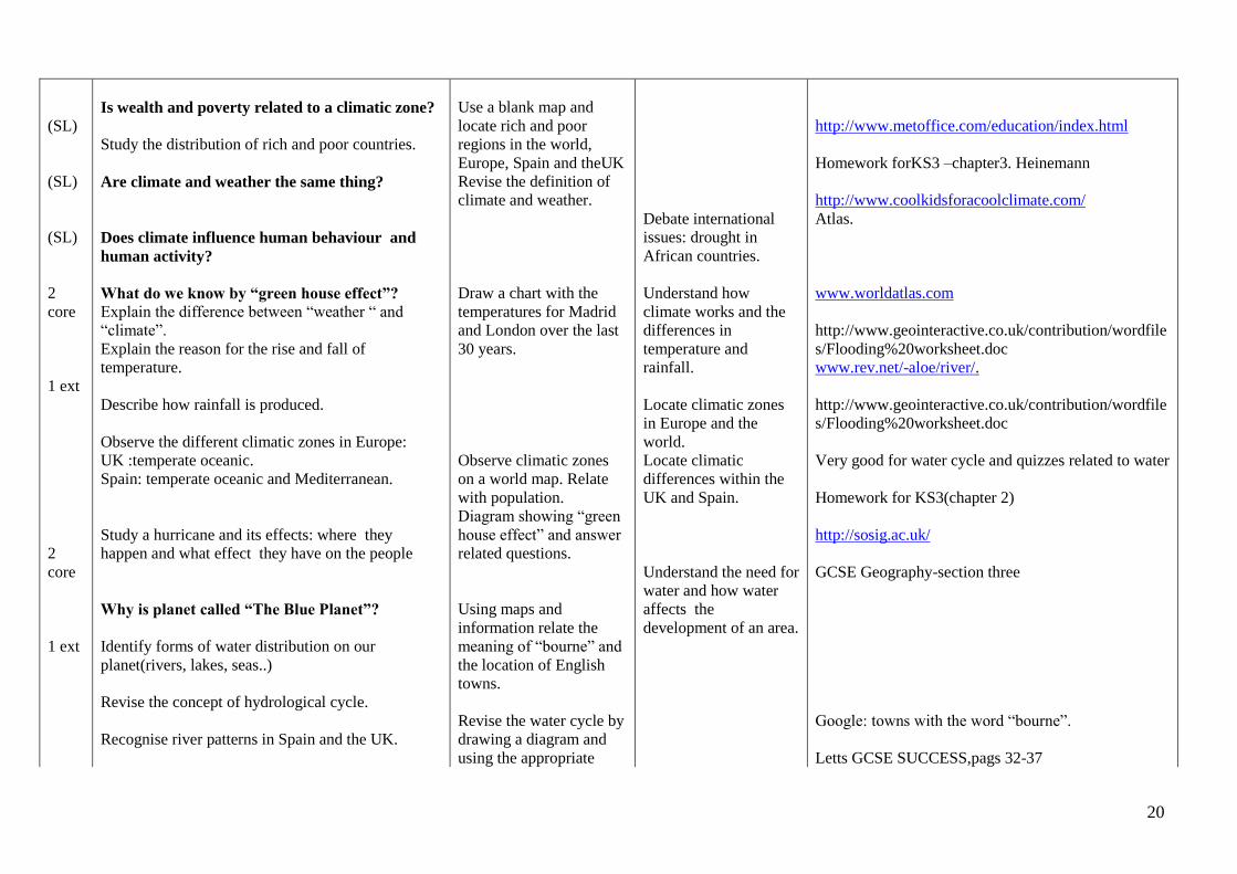
(SL)
(SL)
(SL)
2
core
1 ext
2
core
1 ext
Is wealth and poverty related to a climatic zone?
Study the distribution of rich and poor countries.
Are climate and weather the same thing?
Does climate influence human behaviour and
human activity?
What do we know by “green house effect”?
Explain the difference between “weather “ and
“climate”.
Explain the reason for the rise and fall of
temperature.
Describe how rainfall is produced.
Observe the different climatic zones in Europe:
UK :temperate oceanic.
Spain: temperate oceanic and Mediterranean.
Study a hurricane and its effects: where they
happen and what effect they have on the people
Why is planet called “The Blue Planet”?
Identify forms of water distribution on our
planet(rivers, lakes, seas..)
Revise the concept of hydrological cycle.
Recognise river patterns in Spain and the UK.
Use a blank map and
locate rich and poor
regions in the world,
Europe, Spain and theUK
Revise the definition of
climate and weather.
Draw a chart with the
temperatures for Madrid
and London over the last
30 years.
Observe climatic zones
on a world map. Relate
with population.
Diagram showing “green
house effect” and answer
related questions.
Using maps and
information relate the
meaning of “bourne” and
the location of English
towns.
Revise the water cycle by
drawing a diagram and
using the appropriate
Debate international
issues: drought in
African countries.
Understand how
climate works and the
differences in
temperature and
rainfall.
Locate climatic zones
in Europe and the
world.
Locate climatic
differences within the
UK and Spain.
Understand the need for
water and how water
affects the
development of an area.
http://www.metoffice.com/education/index.html
Homework forKS3 –chapter3. Heinemann
http://www.coolkidsforacoolclimate.com/
Atlas.
www.worldatlas.com
http://www.geointeractive.co.uk/contribution/wordfile
s/Flooding%20worksheet.doc
www.rev.net/-aloe/river/.
http://www.geointeractive.co.uk/contribution/wordfile
s/Flooding%20worksheet.doc
Very good for water cycle and quizzes related to water
Homework for KS3(chapter 2)
http://sosig.ac.uk/
GCSE Geography-section three
Google: towns with the word “bourne”.
Letts GCSE SUCCESS,pags 32-37
21
.
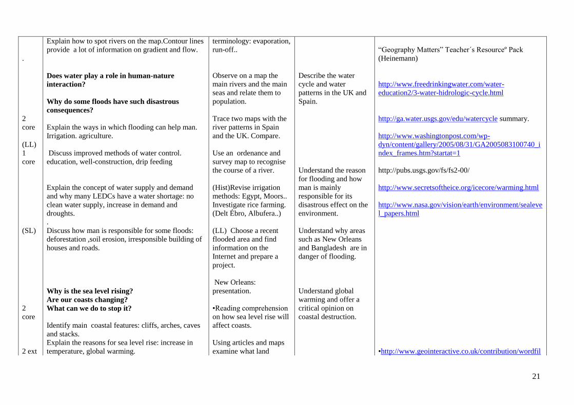
Explain how to spot rivers on the map.Contour lines
provide a lot of information on gradient and flow.
terminology: evaporation,
run-off..
“Geography Matters” Teacher´s Resourceº Pack
(Heinemann)
2
core
(LL)
1
core
(SL)
2
core
2 ext
Does water play a role in human-nature
interaction?
Why do some floods have such disastrous
consequences?
Explain the ways in which flooding can help man.
Irrigation. agriculture.
Discuss improved methods of water control.
education, well-construction, drip feeding
Explain the concept of water supply and demand
and why many LEDCs have a water shortage: no
clean water supply, increase in demand and
droughts.
.
Discuss how man is responsible for some floods:
deforestation ,soil erosion, irresponsible building of
houses and roads.
Why is the sea level rising?
Are our coasts changing?
What can we do to stop it?
Identify main coastal features: cliffs, arches, caves
and stacks.
Explain the reasons for sea level rise: increase in
temperature, global warming.
Observe on a map the
main rivers and the main
seas and relate them to
population.
Trace two maps with the
river patterns in Spain
and the UK. Compare.
Use an ordenance and
survey map to recognise
the course of a river.
(Hist)Revise irrigation
methods: Egypt, Moors..
Investigate rice farming.
(Delt Ébro, Albufera..)
(LL) Choose a recent
flooded area and find
information on the
Internet and prepare a
project.
New Orleans:
presentation.
•Reading comprehension
on how sea level rise will
affect coasts.
Using articles and maps
examine what land
Describe the water
cycle and water
patterns in the UK and
Spain.
Understand the reason
for flooding and how
man is mainly
responsible for its
disastrous effect on the
environment.
Understand why areas
such as New Orleans
and Bangladesh are in
danger of flooding.
Understand global
warming and offer a
critical opinion on
coastal destruction.
http://www.freedrinkingwater.com/water-
education2/3-water-hidrologic-cycle.html
http://ga.water.usgs.gov/edu/watercycle summary.
http://www.washingtonpost.com/wp-
dyn/content/gallery/2005/08/31/GA2005083100740_i
ndex_frames.htm?startat=1
http://pubs.usgs.gov/fs/fs2-00/
http://www.secretsoftheice.org/icecore/warming.html
http://www.nasa.gov/vision/earth/environment/sealeve
l_papers.html
•http://www.geointeractive.co.uk/contribution/wordfil
22
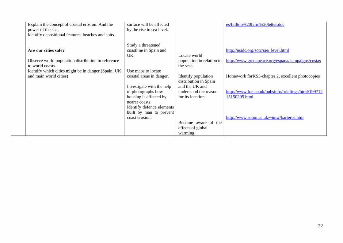
Explain the concept of coastal erosion. And the
power of the sea.
Identify depositional features: beaches and spits..
surface will be affected
by the rise in sea level.
es/hilltop%20farm%20letter.doc
Are our cities safe?
Observe world population distribution in reference
to world coasts.
Identify which cities might be in danger.(Spain, UK
and main world cities)
Study a threatened
coastline in Spain and
UK.
Use maps to locate
coastal areas in danger.
Investigate with the help
of photographs how
housing is affected by
nearer coasts.
Identify defence elements
built by man to prevent
coast erosion.
Locate world
population in relation to
the seas.
Identify population
distribution in Spain
and the UK and
understand the reason
for its location.
Become aware of the
effects of global
warming.
http://nsidc.org/sotc/sea_level.html
http://www.greenpeace.org/espana/campaigns/costas
Homework forKS3-chapter 2, excellent photocopies
http://www.foe.co.uk/pubsinfo/briefings/html/199712
15150205.html
http://www.soton.ac.uk/~imw/barteros.htm
23
Topic Two: Economic Activities –Primary and Secondary Assumed knowledge and skills from previous years:
1.Knowledge concerning the nature of economic activities.
2.Identify and define productive resources and economic features.
3.Explain which are the main problems and challenges of today’s economy.
4.Select and use appropiate techniques to present evidence.
5.Understanding of patterns and processes through texts, graphs and maps on world economy.
6.Classification of companies depending on the activity (industrial, commercial and services)
7.Classification and distribution of means of production.
8.Understanding of social changes throughout history and the reasons why these take place.
Knowledge and understanding of economic activities.
Pupils will learn about:
The role of services in today’s world.
Different types of economic activities.
Relation of economic wealth to different activities.
The changes in employment.
Why farming is important.
Different types of agricultural landscapes.
Different kinds of farming.
The development of GMFs.
The farming of alternative types of food: organic food.
Fishing patterns in the world.
Fish farming.
Greenhouse farming.
Types of industry and their location.
What we need energy for.
Where we get energy from: renewable, non renewable.
The effect of progress on the environment.

24
Language for learning
Through the activities in this topic pupils will be able to understand, use and spell correctly words relating to:
Economic activities: food processing, manufacturing, input, output, labour supply, skilled labour force, fishing, inshore fishing, over-exploitation, conservation,
recycling, sustainable, producer services, consumer services.
Farming: arable, pastoral, forestry, GMFs, organic food, deep-sea fishing, inshore fishing, crops, cattle, breeds,
Industry: raw materials, source and supply, fossil fuels, government policies, coal, iron ore, chemical plants, capital, markets, investment, exports, imports.
Key Geographical questions on the Topic
What are economic activities?
How many types of economic activities are there?
Why is employment changing?
What is the EEC and how does it affect national economies?
Why is farming so different?
What factors influence farming?
How is farming distibuted in Spain?
How is farming distributed in the UK?
How many different kinds of meat are there?
Why has fishing become such a controversial issue?
Is fish farming a sustainable alternative?
Why has green house farming become so popular in Spain?
How is industry classified?
Where is industry located?
Where is energy produced?
Which countries use most energy?
How can the environment be saved from pollution?
25
h
Lesson Outline
Activities/
Assessment Criteria
Lesson Outcomes
Resources
1 core
1-core
1-core
What is an economic activity?
Define types and classification of an
economic activity: Primary, Secondary,
Tertiary and Quaternary.
Have new technologies had an effect
on changing economic activities?
Observe the distribution of economic
activities in the world.
Relate wealth to economic ativity.
Study economic distribution in Spain
and the Uk.
Is employment changing?
Explain basic vocabulary: mining,
manufacturing, leisure, and
biotechnology, quarrying etc.
Differentiate Industry from
Employment.
History of the EEC
Organise jumbled
economic activities into
four columns.
Draw diagram showing
how economic activities
have changed over the
past.
Locate on a map the areas
where an economic
activity is predominant
and discuss if it is related
to wealth.
List and discuss different
jobs and their relation to
economic activities.
Identify all the countries
in the European union on
a map.
Identify the different
types of economic
activity and explain
why their importance in
world economy is
changing.
To understand why
employment has
changed so much.
To understand the
reason for regional
prosperity and how it
applies in the UK and
Spain.
Have a sense of
belonging to a
European identity.
Letts-GCS-Geography-Questions and Answers(pp 54-55)
GCSE Geography (pp 142).CGP.
http://www.anti-slaverysociety.addr.com/toc.htm
Homework KS3.Heineman.(chapter7)
World Maps
http://www.geointeractive.co.uk/contribution/consearchbytopic.htm
http://www.infoplease.com/ce6/history/A0817889.html
http://www.bbc.co.uk/schools/gcsebitesize/sosteacher/history/41349.sht
ml

26
(LL)
1 ext
Child labour: a fact in the 21st century.
Read text: “Nike as an
employer” and answer
questions)
An awareness and
critical attitude towards
child labour.
http://www.unicef.org/protection/index_childlabour.html
2 core
An example of a Primary Economic
activity.
Why is farming so important?
Where does food come from?
Discuss the origin of the food we eat
and how the increase in population
results in a greater demand for food.
Why are agricultural landscapes so
different?
Study the fields(shape, size,boundaries),
Crop system(single crop, varied, dry,
irrigated),
Type of farming -Intensive
farming/extensive,
Settlement(scattered, concentrated).
Study maps that indicate
world farming
distribution.
Study maps to locate
fishing and ca.ttle areas in
the world .
Provide employment
distribution graphs and
answer given questions.
•Consider what events are
dangerous for farming.
With the help of
photographs , ask
students to describe the
agricultural landscape
they see.
To be aware of the need
for farming in the
world.
Show a critical attitude
towards social
injustice: excess of
food in some countries,
hunger in others.
Compare farming in
Spain and the Uk and
compare regional
differences in each
country.
Understand different
agricultural landscapes.
Show a critical attitude
towards labour
employed in
agriculture:
immigration,
prospects..
GCSE Geography-Complete revision an practice –section 10
GCSE Success-questions and answers (Letts)
http://www.bbc.co.uk/schools/gcsebitesize/geography/economic/agricult
ureglobaleconomyrev2.shtml
http://www.tintometer.com/MILK_QUALITY.HTM
•http://www.geointeractive.co.uk/contribution/wordfiles/Taboo%20cards
%20farming
http://www.disknet.com/indiana_biolab/farms.htm
http://library.thinkquest.org/org/03/01272/id25.htm
http://www.wn.com/Farming
http://www.geointeractive.co.uk/contribution/wordfiles/Farming%20typ
e%20definition
http://cgi.wn.com/?template=worldphotos%2Findexsearchvera.txt&actio
n=search&first=0&SearchString=topic:africa1%20and%20topic:food&
mode=bool&x=14&y=7
27
1-core
2-core
How are farms classified
Investigate farm classification
according to: Produce:
arable,pastoral,mixed,market-
gardening.
Input : intensive, extensive.
Purpose : subsistence and commercial.
Why does a farmer have to make
decisions?
What do you need to become a
farmer?
Analyse the factors affecting farming:
Physical –climate, relief, soil,
temperature, seasons...
Human-labour, market, money, quotas,
CAP,.
How are farming patterns
distributed?
Identify main farming patterns in the
world: types of farming and population
working in primary economic activities.
Use maps to identify
farming patterns in the
UK and Spain.
•Ask students to adopt the
role of a farmer and to
argue the choice he/she
has made.
•Locate a farming area
and understand the type
of farming adopted.
List human factors
affecting farming
Learn from the teacher
what CAP is and how it
affects agricultural
policies..
To value an economic
activity essential for the
survival of mankind.
Understand how
mechanization has
affected the number of
people working in
agriculture.
Contrast agricultural
landscapes and
understand their
relationship with
human and physical
factors.
To be aware of the
population working in
agriculture and be able
to argue why it is very
much undervalued.
http://www.worldofstock.com/search_pages/cattle_farm.php
http://www.s-
cool.co.uk/topic_principles.asp?loc=pr&topic_id=8&subject_id=20
•http://www.geointeractive.co.uk/contribution/wordfiles/What%20type
%20of%20farmer%20am%20I.doc
http://agriculture.einnews.com/news/Spain-Pork
•http://www.geointeractive.co.uk/contribution/wordfiles/Why%20should
%20we%20save%20the%20rainforest.doc
http://www.geointeractive.co.uk/contribution/wordfiles/Taboo%20cards
%20farming.doc
http://www.geography.learnontheinternet.co.uk/links-f-g.html
http://www.design-technology.info/foodsubsite/default.htm
1 core
Where does meat come from?
Identify types of pastoral farming:
cattle, sheep, goat, poultry, pig, ostrich..
Study the main cattle producing areas in
the world.
(LL)Cultural
investigation. Choose
countries over the world
and establish which kind
of meat they eat (or their
staple diet ).
To identify economies
dependent on meat
market.
http://www.schoolhistory.co.uk/gcselinks/industrialrevolution/agricultur
e_worksheets.shtml
28
Our seas : a wonderful source of
protein.
Which are the main fishing areas in
the world?
Identify main fishing areas and analyse
production methods used by the fishing
Industry : traditional and industrial.
Why has fishing become such a
controversial industry?
Do the same for different
regions in Spain,
including fish.
Use Internet to study
menus .Trace the origin
of the ingredients.
Draw a map of the main
fishing areas in the world.
Investigate which
countries consume most
fish: locate them.
Locate main fishing ports
in Spain.
Scan the media and
gather information on
news referring to fishing.
Analyse the information.
To respect alternative
eating habits :
vegetarians.
Adopt a critical attitude
towards an excess of
protein in modern diets.
To be aware of the over
exploitation our seas
are suffering.
Adopt a critical attitude
towards fishing
restrictions and how it
affects employment.
http://www.ices.dk/marineworld/bw.asp
http://www.fao.org/documents/show_cdr.asp?url_file=/docrep/W9900E/
w9900e02.htm
http://www.fishreports.net/deep-sea-fishing.php
http://www.panda.org/about_wwf/what_we_do/marine/our_solutions/sus
tainable_fishing/index.cfm
http://www.nmm.ac.uk/
http://www.panda.org/about_wwf/what_we_do/marine/our_solutions/sus
tainable_fishing/index.cfm
2 core
Describe different types of industrial
fishing : deep-sea fishing ,inshore –
fishing.
Ask students to create a
survey and then use it to
find out what fish is eaten
in their communities,
how much fish they eat
Locate main fishing
areas in the world.
29
1 ext
Explain the result of over-exploitation.
Discuss the concept of National Waters.
,where the fish comes
from , size...
Locate fishing ports in
Spain ,UK ,and Europe.
To value the food we
eat.
2 ext
1 ext
Do you eat organic food?
Is your pop-corn genetically
modified?
Explain the meaning of organic food
and its growing importance in consumer
shopping.
Study how vegetables are modified
genetically.
Investigate the use of organic and
genetically modified food.
Why is Spanish Farming changing so
quickly ?
Investigate greenhouse farming in the
South of Spain : tomatoes,
strawberries. North of Spain : kiwis.
Ask students to locate
where they can buy
organic food and
understand the difference
in quality
and price.
Draw a list of GMP and
bring to class .
Survey at school to find
out who eats organic
food or GMP.
Locate on a map main
greenhouse farming areas
in Spain and what they
produce.
Use photographs and ICT
to describe green house
farming in the South of
Spain.
Be aware of alternative
growing methods.
Argue the pros and
cons of organic
farming.
Discuss the advantages
of GMP.
Understand the
economic and social
situation of certain
regions of Spain where
green house farming
has developed.
http://www.farmtrails.org.uk/rushall
http://www.bbc.co.uk/schools/gcsebitesize/biology/livingthingsenviron
ment/4foodandsustainabilityrev5.shtml
http://www.atmosphere.mpg.de/enid/26m.html
http://www.guardian.co.uk/spain/article/0,,1574648,00.html
30
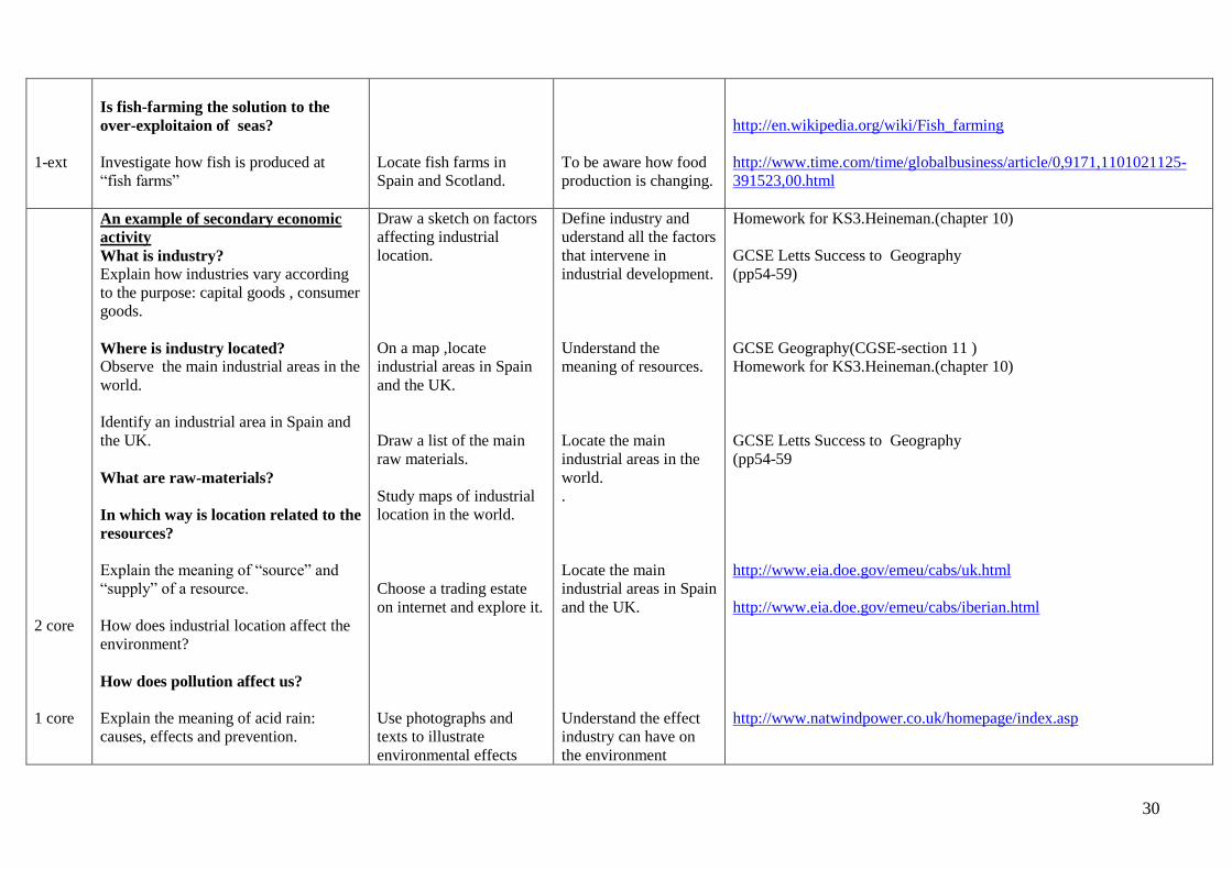
1-ext
Is fish-farming the solution to the
over-exploitaion of seas?
Investigate how fish is produced at
“fish farms”
Locate fish farms in
Spain and Scotland.
To be aware how food
production is changing.
http://en.wikipedia.org/wiki/Fish_farming
http://www.time.com/time/globalbusiness/article/0,9171,1101021125-
391523,00.html
2 core
1 core
An example of secondary economic
activity
What is industry?
Explain how industries vary according
to the purpose: capital goods , consumer
goods.
Where is industry located?
Observe the main industrial areas in the
world.
Identify an industrial area in Spain and
the UK.
What are raw-materials?
In which way is location related to the
resources?
Explain the meaning of “source” and
“supply” of a resource.
How does industrial location affect the
environment?
How does pollution affect us?
Explain the meaning of acid rain:
causes, effects and prevention.
Draw a sketch on factors
affecting industrial
location.
On a map ,locate
industrial areas in Spain
and the UK.
Draw a list of the main
raw materials.
Study maps of industrial
location in the world.
Choose a trading estate
on internet and explore it.
Use photographs and
texts to illustrate
environmental effects
Define industry and
uderstand all the factors
that intervene in
industrial development.
Understand the
meaning of resources.
Locate the main
industrial areas in the
world.
.
Locate the main
industrial areas in Spain
and the UK.
Understand the effect
industry can have on
the environment
Homework for KS3.Heineman.(chapter 10)
GCSE Letts Success to Geography
(pp54-59)
GCSE Geography(CGSE-section 11 )
Homework for KS3.Heineman.(chapter 10)
GCSE Letts Success to Geography
(pp54-59
http://www.eia.doe.gov/emeu/cabs/uk.html
http://www.eia.doe.gov/emeu/cabs/iberian.html
http://www.natwindpower.co.uk/homepage/index.asp
31
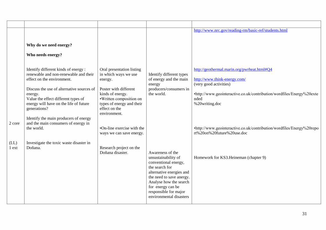
2 core
(LL)
1 ext
Why do we need energy?
Who needs energy?
C
Identify different kinds of energy :
renewable and non-renewable and their
effect on the environment.
Discuss the use of alternative sources of
energy.
Value the effect different types of
energy will have on the life of future
generations?
Identify the main producers of energy
and the main consumers of energy in
the world.
Investigate the toxic waste disaster in
Doñana.
Oral presentation listing
in which ways we use
energy.
Poster with different
kinds of energy.
•Written composition on
types of energy and their
effect on the
environment.
•On-line exercise with the
ways we can save energy.
Research project on the
Doñana disaster.
Identify different types
of energy and the main
energy
producers/consumers in
the world.
Awareness of the
unsustainability of
conventional energy,
the search for
alternative energies and
the need to save anergy.
Analyse how the search
for energy can be
responsible for major
environmental disasters
http://www.nrc.gov/reading-rm/basic-ref/students.html
http://geothermal.marin.org/pwrheat.html#Q4
http://www.think-energy.com/
(very good activities)
•http://www.geointeractive.co.uk/contribution/wordfiles/Energy%20exte
nded
%20writing.doc
•http://www.geointeractive.co.uk/contribution/wordfiles/Energy%20repo
rt%20on%20future%20use.doc
Homework for KS3.Heineman (chapter 9)
32
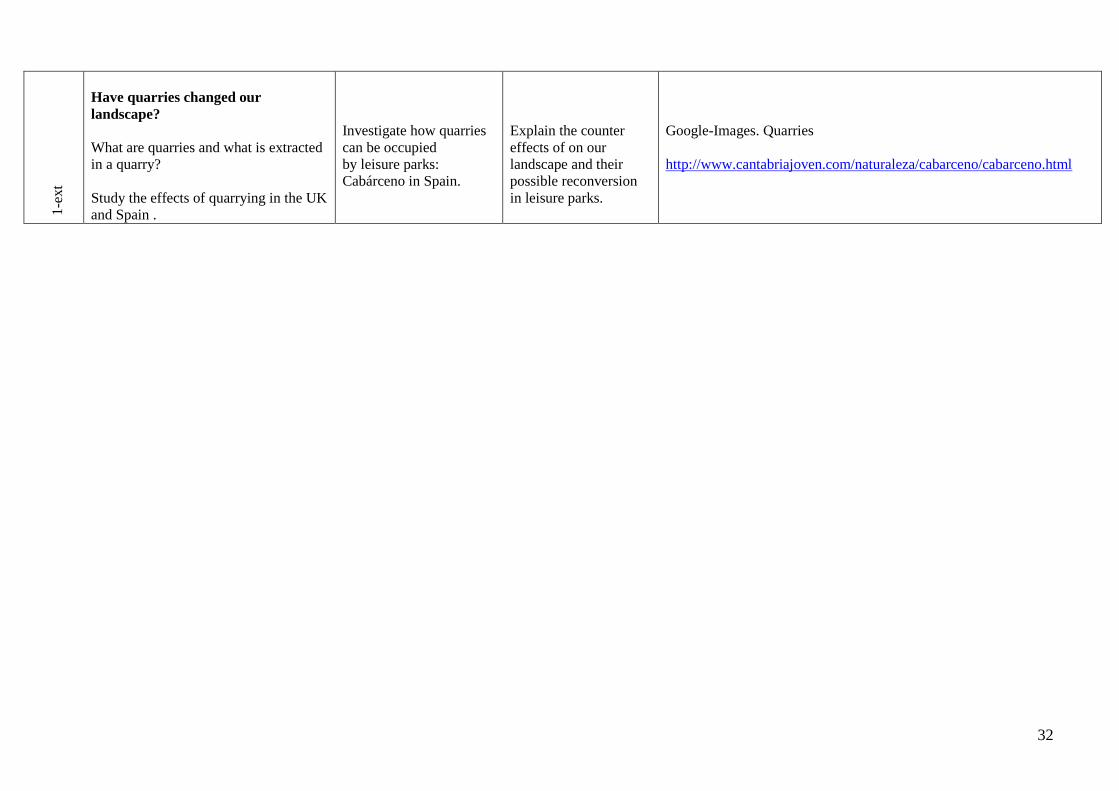
1-e
xt
Have quarries changed our
landscape?
What are quarries and what is extracted
in a quarry?
Study the effects of quarrying in the UK
and Spain .
Investigate how quarries
can be occupied
by leisure parks:
Cabárceno in Spain.
Explain the counter
effects of on our
landscape and their
possible reconversion
in leisure parks.
Google-Images. Quarries
http://www.cantabriajoven.com/naturaleza/cabarceno/cabarceno.html
33
Topic Three: A Fast Changing World: Tertiary and Quaternary Economic Activities.
Assumed knowledge from previous years.
1.Knowledge concerning the nature of economic activities.
2.Identify and define productive resources and economic features.
3.Explain which are the main problems and challenges of today´s economy.
4.Select and use appropiate techniques to present evidence.
5.Understanding of patterns and processes through texts, graphs and maps on world economy.
6.Classification of companies depending on the activity (industrial, commercial and services)
7.Classification and distribution of means of production.
8.Understanding of social changes throughout history and the reasons why these take place.
Knowledge and understanding of rapidly improving services and scientific research:
Pupils will:
Learn about the role of services in today’s world.
Appreciate the establishment of the welfare state.
Describe shopping facilities in their area.
Explain why better transport has changed industrial location.
Understand the importance of tourism in many countries.
Recognise the main problems tourism has created.
Explore an alternative “eco-tourism “.
Explore the possibilities of modern scientific research.
Language for Learning
Through the activities in this topic the pupils will be able to understand, use and spell correctly words relating to:
Services: range, teaching, nursing, retailing, civil service, research, healthcare, national health, banking, research, skilled workers, insurance, high-tech companies,
social services.
Economy: economic growth, forecast, labour, investment, enterprise zones, incentives, high unemployment, full employment, “Silicon valley”, “Silicon Glen”,
transaction, consumers, cash dispenser, branch teller, customers, deposits, printed statements.
34
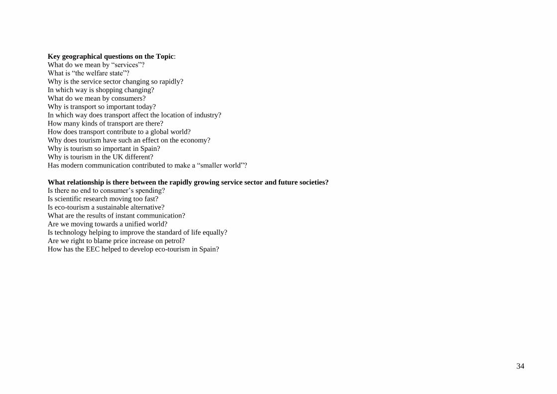
Key geographical questions on the Topic:
What do we mean by “services”?
What is “the welfare state”?
Why is the service sector changing so rapidly?
In which way is shopping changing?
What do we mean by consumers?
Why is transport so important today?
In which way does transport affect the location of industry?
How many kinds of transport are there?
How does transport contribute to a global world?
Why does tourism have such an effect on the economy?
Why is tourism so important in Spain?
Why is tourism in the UK different?
Has modern communication contributed to make a “smaller world”?
What relationship is there between the rapidly growing service sector and future societies?
Is there no end to consumer’s spending?
Is scientific research moving too fast?
Is eco-tourism a sustainable alternative?
What are the results of instant communication?
Are we moving towards a unified world?
Is technology helping to improve the standard of life equally?
Are we right to blame price increase on petrol?
How has the EEC helped to develop eco-tourism in Spain?
35
h Lesson Outline Activities/
Assessment Criteria
Lesson Outcomes Resources
1 core
1- 1 core
2-core
An example of a Tertiary
economic activity.
Why are services so important
today?
Describe types of services:
banking, shops, nursing.
Explain Economic and social
indicators (PIB, IDH)
Explain “National Health”.
Have cash machines changed
our lives?
Is the concept of “shopping”
changing?
Discuss today’s shopping habits.
The use of Internet to shop.
Awareness of new shopping
complexes.
Why is transport so important?
How does transport contribute
to a global world?
Relate transport and industrial
location.
Draw two lists on
services: state provided
and private. Discuss what
use is made of them.
Homework: local field
work on cash dispensers.
Investigate how new ways
of banking have changed
people’s lives.
Debate shopping habits.
“Where, How often?”
Draw a Venn diagram to
illustrate shops at a
shopping centre.
Study a transport map for
the UK and Spain.
Compare them.
Identify different types of
transport: car, train, lorry,
Understand the concept of
welfare – state.
Be aware of the great
social differences between
rich and poor countries
Understanding of modern
banking.
Reflect on consumption
and have a critical opinion
on our “developed world”
shopping habits
and their implications.
Understand the
importance of transport in
its contribution to global
economy.
Achieve a critical
approach towards
http://www.bbc.co.uk/schools/gcsebitesize/geography/economic/indu
stryrev6.shtml
http://www.highwire.org.uk/showcase/sc_04_05/pm_brit/pm1_brit/w
eb%20pages/shopint.html
Chapter seven. Geography Homework for KS3 (Heineman)
http://www.geography.learnontheinternet.co.uk/topics/hierarchy.html
http://www.standards.dfes.gov.uk/schemes2/secondary_geography/?v
iew=ge
http://geography.about.com/library/faq/blqzlargemalls.htm
http://www.geointeractive.co.uk/contribution/consearchby topic.htm
http://images.google.es/images?q=shopping
http://www.bbc.co.uk/schools/gcsebitesize/ict/implications/1lifestyler
ev6.shtml
http://www.traffordcentre.co.uk/default.asp?id=23
http://www.avenidam40.com/mainsite/mall/mall_items.aspx?
http://images.google.es/images?q=transport&svnum
Maps indicating transport grids.
36
1-core
2-core
Locate transport grid in the UK
and Spain.
Discuss the advantages and
disadvantages of various types of
transport. (Speed, safety,
infrastructure, price, capacity,
ICT)
Can transport affect the
environment?
Investigate the building of a major
motorway.
Why does the cost of petrol
affect consumers?
Tourism is big business. Why is
it such an important economic
sector?
Explain the reason for the
existence of tourism: holidays,
transport development, ageing
population, increased standard of
life.
Investigate who travels, where to,
when....
bus, plane, and ship.
Discuss whether transport
affects location as much
as it did before.
Study a transport grid of
Spain, the UK and a third
country.
Gather information on the
construction of a major
motorway. Encourage a
debate –for and against.
Trace the origin of the
fuel various means of
transport use.
Discuss how transport is
not always polluting.
Use adverts to determine
which are popular holiday
destinations.
Study photographs on
holiday destinations.
environmentally harmful
forms of transport.
Recognise different
transport grids.
Develop a critical
approach towards
environmentally harmful
forms of transport.
Locate transport grid in
the UK and Spain.
Understand the
importance of tourism for
national economies, in
particular Spain.
Understand the large
workforce employed in
tourism.
http://www.highwire.org.uk/showcase/
http://www.spartacus.schoolnet.co.uk/REVgeography.htm
http://www.geographyfieldwork.com/GeographyVocabularyGCSEIn
dustry.htm
http://people.hofstra.edu/geotrans/
http://www.schoolhistory.co.uk/revision/transport.shtml
GCSE –section eleven (CGP Complete Revision and Practice)
http://images.google.es/images
http://www.bbc.co.uk/schools/gcsebitesize/geography/urbanrural/urb
anissues
pp 60&62 Letts GCSE SUCCESS Geography.-Questions and
Answers.
Section 12 GCSE Geography –Complete Revision and Guide.(CGP)
Any Travel agency web page.
http://www.questconnect.org/sa_photo_n_brazil.htm
http://images.google.es/images?q=tourism.package
http://images.google.es/images?q=tourism.package+tours&svnum
http://www.pilotguides.com/tv_shows/globe_trekker/shows/europe/n
orthern_spain.

37
1-core
2-core
1-ext
Identify jobs and economic
activities related to tourism.
Study tourism in Spain: main
world destination-Give reasons
for such a rapid development.
Discuss advantages and
disadvantages.
Tourism in Britain is different:
London and Edinburgh take it all.
What effect does tourism have
on the environment?
What do we mean by
ecotourism?
Investigate the result of mass
tourism on the environment by
looking at photographs on the
Mediterranean coast.
Are National Parks the
solution?
Explain why the ecotourism
option is beneficial. Choose an
Project on how tourist
locations looked 50 years
ago.
Survey: Where have you
been on holiday? Present
findings.
Gather information on
“illegal” touristic
developments Make a
poster
and discuss in class.
Choose an exotic holiday
destination and report how
you would spend your
time there.
Study map showing
(GNP) distribution. Play a
game which encourages
ecotourism.
Use ICT to find
information on National
Develop a critical attitude
towards non-sustainable
tourism.
Be aware of tourist
development in Spain and
how it ought to be made
sustainable”.
Offer alternative ways of
spending a holidays.
Argue the advantages and
disadvantages of mass
tourism.
http://www.avro.co.uk/cheap_flights_costa_del_sol.htm?
http://www.hoteltravel.com/tangent/082005/tangent_3rd_article.htm
http://www.waikato.ac.nz/wfass/subjects/geography/
http://www.spain.info/TourSpain/Costas%20y%20Playas/Playas/K/A
W/0/Levante?
http://www.geographypages.co.uk/trav.htm
http://www.londontown.com/
http://www.bbc.co.uk/schools/gcsebitesize/geography/tourism/touris
mattractions
http://www.qca.org.uk/geography/innovating/key3/geography_plus/ci
tizenship.htm
http://www.geointeractive.co.uk/contribution/consearchbytopic.htm
http://www.geographyfieldwork.com/GeographyVocabularyGCSEIn
dustry.htm
http://images.google.es/images?q=ecotourism

38
example: “Leader” program in
Spain.
An example of quaternary
activity.
Is technology moving too fast?
Discuss how research,
biotechnology and
communications have changed the
world.
Understand the meaning of
“globalisation”.
Explain how computers and
television have helped towards
globalisation.
Investigate who has access to
them and how they have
benefited the world.
What are the economical
consequences of globalisation?
Understand the terms:
decentralization, cost reduction,
automatisation, and loss of non-
qualified jobs.
Parks in Spain and the UK
Project on Silicon Valley
(USA)
Draw up a list of
discoveries made over the
last ten years.
List different ways of
transmitting information.
Debate on the ethics of
medical development.
Debate: Has technology
made a fairer world?
Survey on students and
their access to ICT:
mobiles and internet.
Investigate the work of
“charity” organisations.
To develop a critical
approach towards current
issues: medical
experiments in the
LEDCs, the use of
Internet.
Awareness of a globalized
world without frontiers.
http://www.el-mundo.es/sudinero/noticias/act-49-5.html
http://www.tutor2u.net/economics/content/topics/trade/globalisation.
htm
http://www.bbc.co.uk/schools/gcsebitesize/ict/
http://www.geography.org.uk/projects/pilotgcse/resources/peopleasco
nsumers/whatawaste/
http://www.bbc.co.uk/schools/gcsebitesize/geography/economic/glob
alisationrev2.shtml
http://www.bananalink.org.uk/
http://www.geointeractive.co.uk/contribution/consearchbytopic.htm

39
Topic Four: Settlements and Urbanisation.
Assumed knowledge and skills from previous years:
1. Use maps and graphs to get information and draw conclusions
2. Interpret different types of graphs and describe what they show
3. Recognise relationships between human beings and the world in which they live
4. Describe the national, international and global contexts of places studied
5. Select and use secondary sources of evidence, including the Internet
6. Apply the concepts of overpopulation and migration on different scales
Geographical enquiry and skills:
Pupils will:
Ask geographical questions
Suggest investigation sequences
Collect/record/present evidence
Analyse evidence and draw conclusions
Appreciate values and attitudes
Draw maps, plans and graphs
Communicate, including using ICT
Knowledge and understanding of places
Pupils will:
Locate places and environments
Describe scale contexts
Describe and explain physical and human features
Investigate changes in places

40
Knowledge and understanding of patterns and processes
Explored through:
Settlement
Economic activity
Language for Learning
Through the activities in this unit pupils will be able to understand, use and spell correctly words relating to:
Settlement, e.g. settlement function, settlement hierarchy, sphere of influence, out-of-town development, aspect, central business district (CBD), dry point
settlement, green belt, inner city, morphology, rural, rural-urban fringe, shanty town, site, sphere of influence, sprawl, urban, urban zone, urbanisation, and wet
point settlement
Key Geographical questions in the unit
What is a settlement?
When and how did settlements originate?
What are the reasons why the original population of a settlement chose to locate the settlement there?
What are the site factors?
What types of settlements exist?
How do settlements develop?
What is a settlement function?
What is a settlement’s sphere of influence (or catchment area)?
How can settlements be arranged in rank order?
What is urbanisation?
How will the cities of tomorrow differ from those of today?
What are the characteristics of a city?
What are urban land-use models?
What is the land-use model for LEDCs?
What are some MEDC urban issues?
What problems do LEDC’s cities face?
41
Hours Lesson Outline Activities/
Assessment Criteria
Lesson Outcomes Resources
1 Core What is a settlement?
Review the term settlement.
When and how did settlements
originate?
Review nomadic and sedentary
lifestyles: transition from hunting and
gathering to farming and
stockbreeding. Agricultural
Revolution.
Identify and list the main reasons for
the origins of settlements.
Power Point Presentation: Urban
Growth in Britain
Understand the concept of
settlement and its origins.
http://www.geointeractive.co.uk/contributi
on/ppfiles/urban%20growth
2 Core
LL
What are the reasons why the
original population of a settlement
chose to locate the settlement there?
Explain the concepts “site” and
“situation”.
What are the site factors?
Explain how water supply, relief, fuel,
soil, defence, transport, building
materials, resources, dry land, and
crossing point were (and are)
considered for locating a settlement.
Analyse site factors for any settlement.
Look at any Ordnance Survey Map to
find clues as to why a location was
chosen for a settlement.
Worksheet "Where would you build
your house'"
"Wanted: a place to live and exercise"
Write an essay: "Roman Settlement
Mind Movie"
Understand the importance of site
and situation in the location of
settlements.
Ordnance Survey Maps.
http://www.geointeractive.co.uk/contributi
on/wordfiles/Where%20would%20you%2
0not%20build%20a%20house.doc
http://www.geointeractive.co.uk/contributi
on/ppfiles/settlement%20advert.ppt
http://www.geointeractive.co.uk/contributi
on/wordfiles/Roman%20Settlement%20Mi
nd%20Movie.doc
1 Core What types of settlements exist?
Introduce the two types of settlements:
rural (concentrated and dispersed) and
urban.
Discuss population trends in MEDCs
and LEDCs in terms of rural and urban
population
Identify different types of settlements
on a map, then draw a map illustrating
the different types of settlements.
Settlement patterns handout and
exercise.
The world's largest city worksheet.
Understand the concepts rural and
urban settlements and their main
characteristics.
http://www.ordnancesurvey.co.uk/oswebsit
e/education
http://www.geointeractive.co.uk/contributi
on/wordfiles/settlement%20patterns.doc
http://www.geointeractive.co.uk/contribution/wordfiles/True%20or%20False%20rich%20poor%20starter.doc
http://www.geointeractive.co.uk/contribution/wordfiles/True%20or%20False%20rich%20poor%20starter.doc

42
http://www.geointeractive.co.uk/contributi
on/wordfiles/World%27s%20largest%20ci
ties.doc
2 Core How do settlements develop?
Explain settlement shapes and
patterns. (Linear, dispersed, nucleated
and planned.)
Demonstrate geographical reasons for
these patterns (relief, resources, natural
hazards, etc.)
Explain that settlements may contain a
mixture of these patterns.
Make a diagram illustrating the types
of settlements patterns, which also
demonstrates possible geographical
explanations for that pattern.
Settlement activity worksheets
Understand and identify settlement
patterns applying geographical
knowledge.
http://www.geointeractive.co.uk/contributi
on/wordfiles/Settlement%20Activity%20%
20Worksheet.doc
1 Core What is a settlement function? Explain that a settlement’s functions
are its economic and social activities:
(residential, administrative, industrial,
commercial, services, tourism)
Discuss possible reasons why these
functions change over time.
Write a short report about how a
settlement’s functions changed. For
example, you can talk about how an
agricultural village became a
commuter or dormitory settlement, or
how a fishing village became a tourist
site for leisure and recreation, etc.
Function Introduction 1
Function Worksheet 1
Function Worksheet 2
Function Worksheet 3
Function Worksheet 4
Understand what settlement
functions are and how they may
change over the years.
http://www.geointeractive.co.uk/contributi
on/wordfiles/Settlement%20function%201.
doc
http://www.geointeractive.co.uk/contributi
on/wordfiles/Settlement%20function%202.
doc
http://www.geointeractive.co.uk/contributi
on/wordfiles/Settlement%20function%203.
doc
http://www.geointeractive.co.uk/contributi
on/wordfiles/Settlement%20function%204.
doc
http://www.geointeractive.co.uk/contributi
on/wordfiles/Settlement%20function%205.
doc
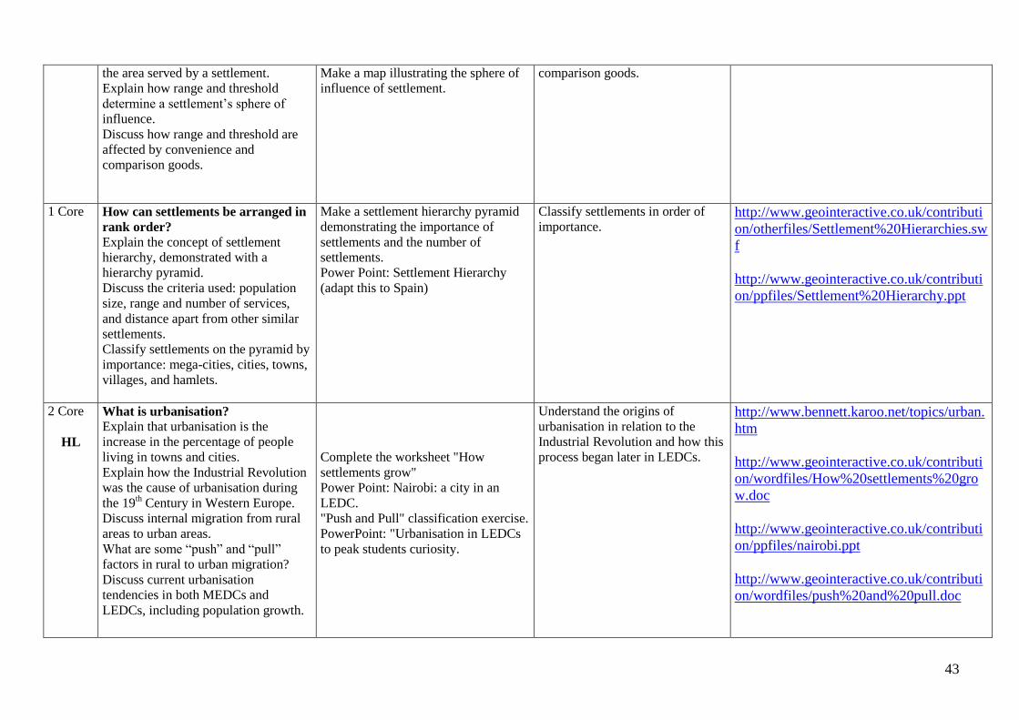
2 Core What is a settlement’s sphere of
influence (or catchment area)?
Explain that the sphere of influence is
Make a comparative table of types of
businesses and the range and threshold
of each.
Understand the concepts of sphere
of influence, range, threshold,
convenience goods, and
http://www.scalloway.org.uk/sett10.htm
43
the area served by a settlement.
Explain how range and threshold
determine a settlement’s sphere of
influence.
Discuss how range and threshold are
affected by convenience and
comparison goods.
Make a map illustrating the sphere of
influence of settlement.
comparison goods.
1 Core How can settlements be arranged in
rank order?
Explain the concept of settlement
hierarchy, demonstrated with a
hierarchy pyramid.
Discuss the criteria used: population
size, range and number of services,
and distance apart from other similar
settlements.
Classify settlements on the pyramid by
importance: mega-cities, cities, towns,
villages, and hamlets.
Make a settlement hierarchy pyramid
demonstrating the importance of
settlements and the number of
settlements.
Power Point: Settlement Hierarchy
(adapt this to Spain)
Classify settlements in order of
importance. http://www.geointeractive.co.uk/contributi
on/otherfiles/Settlement%20Hierarchies.sw
f
http://www.geointeractive.co.uk/contributi
on/ppfiles/Settlement%20Hierarchy.ppt
2 Core
HL
What is urbanisation?
Explain that urbanisation is the
increase in the percentage of people
living in towns and cities.
Explain how the Industrial Revolution
was the cause of urbanisation during
the 19th Century in Western Europe.
Discuss internal migration from rural
areas to urban areas.
What are some “push” and “pull”
factors in rural to urban migration?
Discuss current urbanisation
tendencies in both MEDCs and
LEDCs, including population growth.
Complete the worksheet "How
settlements grow"
Power Point: Nairobi: a city in an
LEDC.
"Push and Pull" classification exercise.
PowerPoint: "Urbanisation in LEDCs
to peak students curiosity.
Understand the origins of
urbanisation in relation to the
Industrial Revolution and how this
process began later in LEDCs.
http://www.bennett.karoo.net/topics/urban.
htm
http://www.geointeractive.co.uk/contributi
on/wordfiles/How%20settlements%20gro
w.doc
http://www.geointeractive.co.uk/contributi
on/ppfiles/nairobi.ppt
http://www.geointeractive.co.uk/contributi
on/wordfiles/push%20and%20pull.doc
44
http://www.geointeractive.co.uk/contributi
on/ppfiles/Urbanisation%20LEDC%20qui
z.ppt
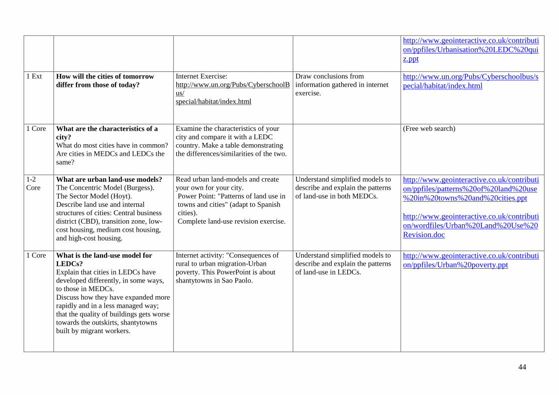
1 Ext How will the cities of tomorrow
differ from those of today?
Internet Exercise:
http://www.un.org/Pubs/CyberschoolB
us/
special/habitat/index.html
Draw conclusions from
information gathered in internet
exercise.
http://www.un.org/Pubs/Cyberschoolbus/s
pecial/habitat/index.html
1 Core What are the characteristics of a
city?
What do most cities have in common?
Are cities in MEDCs and LEDCs the
same?
Examine the characteristics of your
city and compare it with a LEDC
country. Make a table demonstrating
the differences/similarities of the two.
(Free web search)
1-2
Core What are urban land-use models?
The Concentric Model (Burgess).
The Sector Model (Hoyt).
Describe land use and internal
structures of cities: Central business
district (CBD), transition zone, low-
cost housing, medium cost housing,
and high-cost housing.
Read urban land-models and create
your own for your city.
Power Point: "Patterns of land use in
towns and cities" (adapt to Spanish
cities).
Complete land-use revision exercise.
Understand simplified models to
describe and explain the patterns
of land-use in both MEDCs.
http://www.geointeractive.co.uk/contributi
on/ppfiles/patterns%20of%20land%20use
%20in%20towns%20and%20cities.ppt
http://www.geointeractive.co.uk/contributi
on/wordfiles/Urban%20Land%20Use%20
Revision.doc
1 Core What is the land-use model for
LEDCs?
Explain that cities in LEDCs have
developed differently, in some ways,
to those in MEDCs.
Discuss how they have expanded more
rapidly and in a less managed way;
that the quality of buildings gets worse
towards the outskirts, shantytowns
built by migrant workers.
Internet activity: "Consequences of
rural to urban migration-Urban
poverty. This PowerPoint is about
shantytowns in Sao Paolo.
Understand simplified models to
describe and explain the patterns
of land-use in LEDCs.
http://www.geointeractive.co.uk/contributi
on/ppfiles/Urban%20poverty.ppt
45
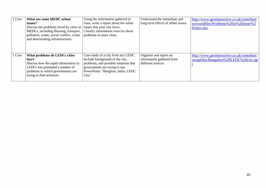
1 Core What are some MEDC urban
issues?
Discuss the problems faced by cities in
MEDCs, including Housing, transport,
pollution, waste, social conflict, crime
and deteriorating infrastructures.
Using the information gathered in
class, write a report about the urban
issues that your city faces.
Classify information exercise about
problems in inner cities.
Understand the immediate and
long-term effects of urban issues. http://www.geointeractive.co.uk/contributi
on/wordfiles/Problems%20in%20inner%2
0cities.doc
1 Core What problems do LEDCs cities
face?
Discuss how the rapid urbanisation in
LEDCs has presented a number of
problems to which governments are
trying to find solutions.
Case study of a city from any LEDC.
Include background of the city,
problems, and possible solutions that
governments are trying to use.
PowerPoint: "Banglore, India: LEDC
City"
Organise and report on
information gathered from
different sources.
http://www.geointeractive.co.uk/contributi
on/ppfiles/Bangalore%20LEDC%20city.pp
t

46
Topic Five: Development, Trade, and Aid
Assumed knowledge and skills from previous years:
7. Use maps and graphs to get information and draw conclusions
8. Interpret different types of graphs and describe what they show
9. Recognise relationships between human beings and the world in which they live
10. Describe the national, international and global contexts of places studied.
11. Select and use secondary sources of evidence, including the Internet
12. Apply the concepts of overpopulation and migration on different scales
Geographical enquiry and skills:
Pupils will:
Ask geographical questions
Suggest investigation sequences
Collect/record/present evidence
Analyse evidence and draw conclusions
Appreciate values and attitudes
Draw maps, plans and graphs
Communicate, including using ICT
Knowledge and understanding of places
Pupils will:
Locate places and environments
Describe scale contexts
Describe and explain physical and human features
Investigate changes in places

47
Knowledge and understanding of patterns and processes
Explored through:
Development
Economic activity
Trade
Aid
Language for Learning
Through the activities in this unit pupils will be able to understand, use and spell correctly words relating to:
Standard of living, quality of life, MEDC, NIC, LEDC, development indicators, GNP, GDP, income, adult literacy, imports, exports, employment
structure, poverty, life expectancy, infant mortality, people per doctor, calorific intake, population indicators, HDI (human development
index),physical factors: climate, relief, water supply, ecosystems, natural resources; human factors: colonialism, civil war, debt, health and disease.
Balance of trade, balance of trade surplus, balance of trade deficit, World Trade Organisation, tariffs, quotas, fair trade, TNCs (transnational
corporations), donors, recipients, types of aid, conditional aid, emergency aid, long-term aid, multilateral aid, tied aid, NGO (non-governmental
organisation. Appropriate development.
Key Geographical questions in the unit
What is development?
Classifying levels of development: LEDCs, NICs, and MEDCs
How is development measured?
Why are some countries more developed than others?
What does international trade have to do with development?
What is the World Trade Organisation?
How can we change things in LEDCs?
Can a company be richer than an entire country? (Transnational Corporations and Globalisation).
What can MEDCs do to help?
Why doesn't aid benefit the poor?
Why are LEDCs in debt?
What is appropriate development?
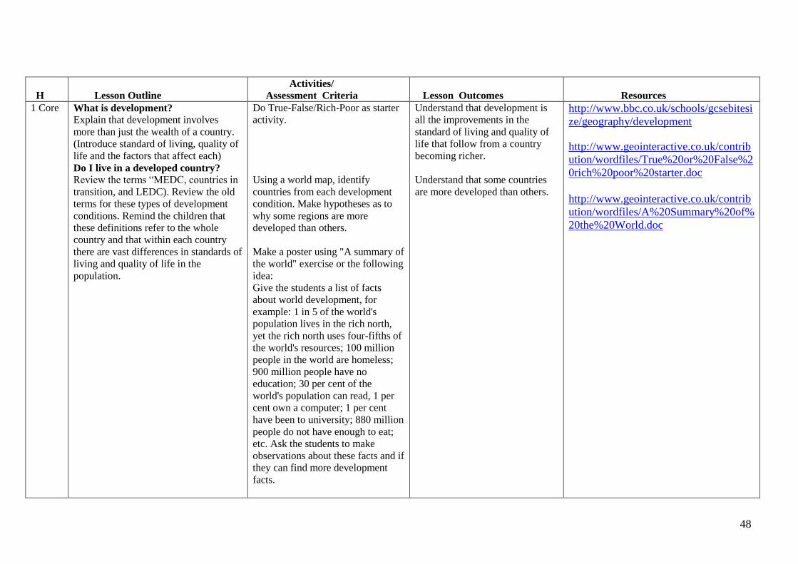
48
H
Lesson Outline
Activities/
Assessment Criteria
Lesson Outcomes
Resources
1 Core What is development?
Explain that development involves
more than just the wealth of a country.
(Introduce standard of living, quality of
life and the factors that affect each)
Do I live in a developed country?
Review the terms “MEDC, countries in
transition, and LEDC). Review the old
terms for these types of development
conditions. Remind the children that
these definitions refer to the whole
country and that within each country
there are vast differences in standards of
living and quality of life in the
population.
Do True-False/Rich-Poor as starter
activity.
Using a world map, identify
countries from each development
condition. Make hypotheses as to
why some regions are more
developed than others.
Make a poster using "A summary of
the world" exercise or the following
idea:
Give the students a list of facts
about world development, for
example: 1 in 5 of the world's
population lives in the rich north,
yet the rich north uses four-fifths of
the world's resources; 100 million
people in the world are homeless;
900 million people have no
education; 30 per cent of the
world's population can read, 1 per
cent own a computer; 1 per cent
have been to university; 880 million
people do not have enough to eat;
etc. Ask the students to make
observations about these facts and if
they can find more development
facts.
Understand that development is
all the improvements in the
standard of living and quality of
life that follow from a country
becoming richer.
Understand that some countries
are more developed than others.
http://www.bbc.co.uk/schools/gcsebitesi
ze/geography/development
http://www.geointeractive.co.uk/contrib
ution/wordfiles/True%20or%20False%2
0rich%20poor%20starter.doc
http://www.geointeractive.co.uk/contrib
ution/wordfiles/A%20Summary%20of%
20the%20World.doc
http://www.geointeractive.co.uk/contribution/wordfiles/True%20or%20False%20rich%20poor%20starter.doc
http://www.geointeractive.co.uk/contribution/wordfiles/True%20or%20False%20rich%20poor%20starter.doc
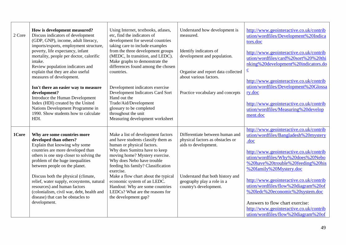
49
2 Core
How is development measured? Discuss indicators of development
(GDP, GNP), income, adult literacy,
imports/exports, employment structure,
poverty, life expectancy, infant
mortality, people per doctor, calorific
intake.
Review population indicators and
explain that they are also useful
measures of development.
Isn't there an easier way to measure
development? Introduce the Human Development
Index (HDI) created by the United
Nations Development Programme in
1990. Show students how to calculate
HDI.
Using Internet, textbooks, atlases,
etc, find the indicators of
development for several countries
taking care to include examples
from the three development groups
(MEDC, In transition, and LEDC).
Make graphs to demonstrate the
differences found among the chosen
countries.
Development indicators exercise
Development Indicators Card Sort
Hand out the
Trade/Aid/Development
glossary to be completed
throughout the unit
Measuring development worksheet
Understand how development is
measured.
Identify indicators of
development and population.
Organise and report data collected
about various factors.
Practice vocabulary and concepts
http://www.geointeractive.co.uk/contrib
ution/wordfiles/Development%20Indica
tors.doc
http://www.geointeractive.co.uk/contrib
ution/wordfiles/card%20sort%20%20thi
nking%20development%20indicators.do
c
http://www.geointeractive.co.uk/contrib
ution/wordfiles/Development%20Glossa
ry.doc
http://www.geointeractive.co.uk/contrib
ution/wordfiles/Measuring%20develop
ment.doc
1Core
Why are some countries more
developed than others? Explain that knowing why some
countries are more developed than
others is one step closer to solving the
problem of the huge inequalities
between people on the planet.
Discuss both the physical (climate,
relief, water supply, ecosystems, natural
resources) and human factors
(colonialism, civil war, debt, health and
disease) that can be obstacles to
development.
Make a list of development factors
and have students classify them as
human or physical factors.
Why does Sumitra have to keep
moving home? Mystery exercise.
Why does Nebo have trouble
feeding his family? Classification
exercise.
Make a flow chart about the typical
economic system of an LEDC.
Handout: Why are some countries
LEDCs? What are the reasons for
the development gap?
Differentiate between human and
physical factors as obstacles or
aids to development.
Understand that both history and
geography play a role in a
country's development.
http://www.geointeractive.co.uk/contrib
ution/wordfiles/Bangladesh%20mystery
.doc
http://www.geointeractive.co.uk/contrib
ution/wordfiles/Why%20does%20Nebo
%20have%20trouble%20feeding%20his
%20family%20Mystery.doc
http://www.geointeractive.co.uk/contrib
ution/wordfiles/flow%20diagram%20of
%20ledc%20economic%20system.doc
Answers to flow chart exercise:
http://www.geointeractive.co.uk/contrib
ution/wordfiles/flow%20diagram%20of

50
%20ledc%20economic%20system%20a
nswers.doc
http://www.geointeractive.co.uk/contrib
ution/wordfiles/whydiddevelopmentgap
grow.doc
2 Core What does international trade have to
do with development?
Explain that international trade makes
the countries of the world
interdependent. Countries have become
reliant on other countries, so that the
success of one country affects the
success of other countries.
(Imports, exports, balance of trade,
balance of trade surplus and deficit).
What is the WTO World Trade
Organisation)?
Explain the aims of the WTO, such as
promotion of world trade and reduction
of barriers to trade such as the tariffs
and quotas.
Explain the concept of fair trade.
Have students find news articles
about protests surrounding WTO
meetings and have them discover
why people think that international
trade is damaging LEDCs and that
more should be done to protect
them from the negative effects of
globalisation.
Make graphs using the handout:
"How are Kenya and the UK
linked?
Complete the "Trade and
Development” worksheet (you must
adapt this exercise to information
the students can obtain from
different sources instead of the
textbook for which it has been
designed).
Recognise the significance of
social protest.
Show an understanding of current
global economic imbalances.
Understand the concept of fair
trade and its importance to
LEDCs.
Construct different types of
graphs.
http://www.geointeractive.co.uk/contrib
ution/wordfiles/UK%20and%20Kenya
%20links.doc
http://www.geointeractive.co.uk/contrib
ution/wordfiles/Trade%20and%20Devel
opment.doc
1-2
Core
How can we change things in
LEDCs? Introduce the concept of Fair Trade as a
method of helping LEDCs make more
money from their exports.
Play one of the many "Fair Trade
Games" available from the NGOs.
Do the Fair-trade worksheet web-
quest
Understand the difficulties faced
by LEDCs in the global economy. http://www.fairtrade.org.uk/
http://www.oxfam.org.uk/
http://www.geointeractive.co.uk/contrib
ution/wordfiles/Fairtrade.doc

51
1 Core Can a company be richer than an
entire country? Define the concept of TNCs
(transnational corporations) and explain
that the revenue of some TNCs is
greater than the entire GDP of some
LEDCs. (Keep in mind why TNCs build
factories in LEDCs, what happens to the
profits made from LEDCs, and why
TNCs are being forced to do more to
help countries where they are found.)
List the advantages and
disadvantages of TNCs.
"TNCs/MNCs: a way to develop":
worksheet in preparation for debate
NICs and TNCs worksheet in
preparation for debate.
Have a debate about TNCs.
Understand the concept of TNCs. http://www.geointeractive.co.uk/contrib
ution/wordfiles/TNCs%20and%20Globa
lisation.doc
http://www.geointeractive.co.uk/contrib
ution/wordfiles/What%20is%20a%20NI
C.doc
1 Core
LL
What can MEDCs do to help?
Introduce the concept of aid as the
transfer of resources from a MEDC to a
LEDC. It includes money, equipment,
food, training, skilled people and loans.
Talk about donors and recipients.
Explain the different types of aid
(conditional, emergency, long-term,
multilateral, bilateral, tied, NGO).
Research and write a report about
the work of an NGO such as
Oxfam, Caritas, Christian Aid, the
Peace Corps, etc.
Understand the role of
governments and NGOs in
providing aid to LEDCs and areas
suffering emergencies.
http://www.oxfam.org.uk/

52
1 Core Why does aid not benefit the poor? Examine the problems faced by
countries that receive aid.
Why are LEDCs in Debt?
Describe how some countries have
debts that are less than their GNP and
will eventually be able to pay the debt
off but that others have debts that are
much higher than their GNP and debt is
difficult to pay off.
Tell the students about the organisation
Jubilee 2000 that has been set up to
campaign against debt.
What is appropriate development?
Discuss conditions to be followed for
aid to be effective.
Do the Tanzania- Trick or Treat?
Exercise with the students in
preparation for the next exercise
Make a list of possible aid and have
the students classify the items as
appropriate or inappropriate types
of aid and justifying their answers.
Understand the importance of
channelling resources properly to
solve a problem such as
development.
http://www.geointeractive.co.uk/contrib
ution/wordfiles/Aid%20inTanzania.doc
1 Ext
LL
Development Assessment: How do
the effects of a hurricane affect
people in MEDCs compared to
LEDCs?
Sample GCSE question about a
natural disaster in an MEDC and an
LEDC.
GCSE exam skills. http://www.geointeractive.co.uk/contrib
ution/wordfiles/LEDC_MEDC%20struc
tured%20answer.doc
53
APPENDIX
BOOKS
Two possible textbooks:
"New Key Geography for GCSE" (Nelson Thornes - David Vaugh and Tony Bushell).
Letts Educational Key Stage 3 Geography Classbook.
ISBN: 1-84085-420-0
(www.letts-education.com)
This textbook could be used for more than one year in ESO levels. It includes all the information covered in KS3.
"GCSE Geography-Complete Revision and Practice" (Coordination Group Publications)
Collins GCSE Exam Practice Series. Geography.
(http://www.collinseducation.com)
ISBN: 0-00-719493-5
Exam Practice.
Heinemann Geography Homework for KS3
(www.heinemann.co.uk)
ISBN: 0-435-35263-6
Practical photocopiable exercises.
Heinemann Geography Matters Teacher's Resource Pack.
(www.heinemann.co.uk)
ISBN:0435-35590-0
Useful worksheets:
54
Letts Key Stage 3 Revise KS· Geography.
ISBN: 1-84315-273-8
(www.letts-education.com).
Great as a reference for preparing classes, notebooks and student review.
Letts GCSE Geography in a Week.
ISBN: 1-84315-462-5
(www.letts-education.com)
Revision book.
Letts GCSE Success Visual Revision Guide.
(www.letts-education.com).
ISBN: 1-84085-600-9
Revision book with nice graphics.
Letts GCSE Success Visual Revision Guide.
(www.letts-education.com).
ISBN: 1-84315-231-2
Practice GCSE exams.
Letts GCSE Exam Secrets: Geography.
(www.letts-education.com).
ISBN: 1-84315-597-4
Full mock exams and questions.
WEBSITES
GENERAL RESOURCES:
http://www.geointeractive.co.uk/contribution
Teacher resource exchange page. This is a great site with ready-made activities included in this scheme of work.
55
http://www.bbc.co.uk/schools
see secondary geography section.
http://face-online.org.uk
see geography section for teaching resources.
http://geoexplorer.co.uk
website with atlas and topographical maps.
http://www.geography.about.com
geographical information page.
http://www.enchantedlearning.com
subscription site, but includes free sample materials.
http://www.geography.learnontheinternet.co.uk
many great links to resources, schemes of work, etc.
http://www.geography.org.uk
Geographical organisation website.
http://www.geographypages.co.uk
many links and resources, including interactive whiteboard lessons.
http://www.geographyshop.org.uk
Geographical Association's shop for materials.
http://www.geoworld.co.uk/
Exercises for the KS3 scheme of work.
http://www.geography-site.co.uk/
resources for students and teachers.
56
http://www.georesources.co.uk/
http://www.juicygeography.co.uk
Games, virtual landscapes, teacher resources
http://www.digitalgeography.co.uk
See "teaching resources" section at the bottom right hand side of the page.
http://www.qca.org.uk/geography
UK government official geography schemes
http://www.standards.dfes.gov.uk/schemes2/secondary_geography/?view=get
UK standards site
http://www.rgs.org
Royal Geographical Society Home Page
http://www.scalloway.org.uk
Standard grade geography...useful classroom resource links.
http://www.school-portal.co.uk/GroupHomepage.asp?GroupID=12426
This is a high school Web Page, which features physical geography in animation.
http://www.s-cool.co.uk
Revision page.
http://www.sln.org.uk
Site which leads to many more.
http://www.statistics.gov.uk
UK national statistics page.

57
http://www.taw.org.uk/demo/geography/index.htm
There is a range of resources divided into primary and secondary materials.
http://www.un.org
UN website.
http://www.learngeography.net
Geography resource site for teachers and students.
http://www.grahamrussell.net
Geography links at different levels.
http://www.globalgang.org.uk/
Christian Aid webpage.
http://www.stats4schools.gov.uk/
Many lesson ideas.
http://www.sosig.ac.uk/education/
Social Science information gateway.
http://www.sln.org.uk/geography/7-11wl.htm
Thousands of resources.
http://www.cee.org.uk/
Council for Environmental Education, sustainable development.
58
Bands of Attainment ESO 3º
Teachers should aim to give every pupil the opportunity to experience success in learning and to achieve as high a standard as possible. The Integrated Curriculum
programme of study sets out what most pupils should be taught. However, teachers should teach knowledge, skills and understanding in ways that suit their pupils’
abilities. This may mean choosing knowledge, skills and understanding from earlier or later stages so that individual pupils can make progress and show what they
can achieve.
Band 1
Band 1
Pupils show their knowledge, skills and understanding in studies of a range of places and environments both locally and globally. They recognise and describe
some geographical patterns. They recognise and describe some physical and human processes. They understand how these can change the features of places, and
how these changes affect the lives of people living there. They understand that people can both improve and damage the environment. They show a basic
understanding of both social and political organisation. They employ skills and use sources of evidence to respond to some geographical questions. They are able
to offer reasons for some of their observations and give their own opinion. They have an adequate range of vocabulary, which they can use to communicate
findings and opinions.
Band 2
Pupils show their knowledge, skills and understanding in studies of a range of places and environments at more than one scale and in different parts of the world.
They recognise and describe geographical patterns and appreciate the importance of wider geographical location in understanding places. They recognise and
describe physical and human processes. They understand how these can change the features of places, and how these changes affect the lives of people living
there. They understand how people can both improve and damage the environment. They explain their own views and are able to recognise the views that other
people hold about environmental change.
They are developing a deeper understanding of both social and political organisation. They draw on their knowledge and understanding and are able to use primary
and secondary sources of evidence to suggest and respond to a range of geographical questions. Their range of vocabulary is more than adequate to communicate
their findings and opinions.
Band 1 30% pupils will not have made so much progress and will have reached or may be struggling at this level.
Band 2 60% pupils will have reached this level.
Band 3 10% pupils will have progressed further and will have reached at least this level.
59
Band 3
Pupils show their knowledge, skills and understanding in studies of a wide range of places and environments at various scales, from local to global, and in different
parts of the world. They describe thoroughly, explain and analyse a range of physical and human processes and recognise that these interact to produce the
distinctive characteristics of places. They describe in some detail, ways in which physical and human processes create geographical patterns and lead to changes in
places. They appreciate the many relationships that make places dependent on each other. They appreciate that different values and attitudes, including their own,
result in different approaches that have different effects on people and places. Drawing on their knowledge and understanding, they suggest relevant geographical
questions. They select a range of skills and sources of evidence from the programme of study and use them effectively in their investigations. They demonstrate a
wide range of vocabulary and are able to use it effectively in order to present explanations and record findings.
60
History Curriculum: 3º E.S.O.
The History Curriculum for 3º E.S.O. is divided into 12 main sections as follows:
Modern Age
1. Introductory Topic: The Modern Age; America before 1492.
2. The birth of Modern States and the discovery of America
3. Renaissance; Reformation and Counter reformation.
4. The Modern State: strong and weak monarchs; Economy and Society.
5. The Baroque and the “Siglo de Oro” (Spanish Golden Era).
Enlightment and Revolution
6. Enlightment and Revolution: an overview.
7. Revolution in England.
8. Revolution in the Americas.
9. Revolution in France.
10. The Industrial Revolution; Empire and Slavery.
11. Crisis of the Old Regime: Spain.
12. 19th century Art and Culture.
Methodology.
A major aim of the Integrated Curriculum is to develop an imaginative approach to teaching History. Not only do our students need to learn historical facts but
also show their understanding by making connections between events and changes in the different periods and areas studied.
Pupils need to be encouraged to evaluate and use sources of information to analyse the past and explain how it can be represented and interpreted in different
ways.
61
Using a variety of textbooks selectively in the classroom is advisable if we are to have some help in terms of maps, graphs and a selection of texts translated
into the students working language. Due to the fact that some books are difficult to find, there will be a reference section in the appendix at the end of this
document with books and webpages of interest.
Knowledge, skills and understanding
Chronological understanding
1) Pupils should be taught to recognise and make appropriate use of dates, vocabulary and conventions that describe historical periods and the
passing of time.
Knowledge and understanding of events, people and changes in the past
2) Pupils should be taught:
a. To describe and analyse the relationships between the characteristic features of the periods and societies studied including the experiences and
range of ideas, beliefs and attitudes of men, women and children in the past
b. About the social, cultural, religious and ethnic diversity of the societies studied, in Britain, in Spain and the wider world
c. To analyse and explain the reasons for, and results of, the historical events, situations and changes in the periods studied
d. To identify trends, both within and across different periods, and links between local, British, European and World history
e. To consider the significance of the main events, people and changes studied.
Historical interpretation
3) Pupils should be shown:
a. How and why historical events, people, situations and changes have been interpreted in different ways
b. To evaluate interpretations.
62
Historical enquiry
4) Pupils should be shown how to:
a. Identify, select and use a range of appropriate sources of information including oral accounts, documents, printed sources, the media, artefacts,
pictures, photographs, music, museums, buildings and sites, and ICT-based sources as a basis for independent historical enquiries
b. Evaluate the sources used, select and record information relevant to the enquiry and reach conclusions.
Organisation and communication
5) Pupils should be shown how to:
a. Recall, prioritise and select historical information.
b. Accurately select and use chronological conventions and historical vocabulary appropriate to the periods studied to organise historical information.
c. Communicate their knowledge and understanding of history, using a range of techniques, including spoken language, structured narratives,
substantiated explanations and the use of ICT.
Links
Where topics arise which may be covered also in other subject areas, these are indicated as follows:
LL – Literacty Link
AL – Art Link
SL - Science Link

63
Topic One: Introductory Topic:
The Modern Age – America before 1492
Assumed knowledge and skills from previous years:
1/ Main characteristics of old civilizations in the World.
2/ Main characteristics of Europe in the Middle Ages.
3/ Use of map skills and timelines.
4/ Vocabulary skills to generate new definitions and understand new historical concepts.
Knowledge and understanding of the Modern Age and the Mayan, Incan and Aztec civilizations.
Pupils will:
Identify the basic features of the Modern World.
Identify the main features of the civilizations existing in America before 1492.
Be aware of cultural changes in Europe and America as a result of the development in society, technology, culture and so on.
Develop their map and vocabulary skills applied to historical knowledge.
Feel interest in knowing and enjoying our historical and cultural heritage both in European and American terms.
Language for learning
Through the activities in this unit students will be able to understand, use and spell correctly the following words:
New situations and other civilizations: Aztec, Mayan, Inca, bankruptcy, governing techniques (bureaucracy), bureaucratic states, Columbian, conquest,
governments, gunpowder weapons, horse cavalry, maritime, ship-building, printing, Protestantism, Roman Catholic Church, state administration, taxation,
Western and Eastern Hemispheres, Renaissance, Reformation and Counter Reformation.

64
Key historical questions on the unit
What do we mean by Modern Age?
What are the chronological and geographical limits of the Modern World?
What are the major developments and changes in the Modern Era?
How important was its contribution to art, culture and science?
What are the origins of the Modern Era?
What was the importance of Constantinople?
How and where did the European nations expand?
How was the Modern World organised?
What were the most important civilizations in America?
What degree of evolution did they have?
How important were their contributions to art, culture and science?
65
H
Lesson outline Activities/
Assesment
criteria
Lesson outcome
Resources
1 hour
Whole
year
project
LL
INTRODUCTORY TOPIC
What is the Modern Age?
Using some important words and a text introduce
students to the most important features of this new
period.
Provide students with some of the most important
facts randomly.
Analyse words to be included in a historical
vocabulary of the students’ own. Students are
expected to produce a dictionary with historical
words be them abstract or simpler, to help them
use the appropriate terms.
Identify words
related to the
Modern Era.
Complete a
definition of this
period
Sequence a series of
events in
chronological order.
Look up words and
note down any
important
information.
Show an understanding of
the new features of this
period.
Show a basic
understanding of the most
important facts in Europe
just before 1492
A Historical Dictionary
Project, created by every
single student.
http://www.fordham.edu/halsall/mod/modsbook.
html
http://www.mrdowling.com/704renaissance.html
http://www.bbc.co.uk/history/
66
H
Lesson outline Activities/
Assesment
criteria
Lesson outcome
Resources
2 hs
What was America like before 1492?
Show the location of the Aztec and Inca Empires
and that of the Mayan civilization.
Summarize the key features of their social,
economic, cultural and ritual characteristics.
This is an interesting lesson in terms of revision;
especially because of their being civilizations
similar to Ancient ones in Europe; that is
civilizations without the iron technology or even
the use of wheel transport.
Provide and elicit questions to compare these
civilizations to Ancient European ones.
Locate and colour a
blank map of
America.
Complete some
texts with essential
information of the
three cultures.
Search, organise and
show photographs
from holiday
brochures or the
internet of Central
and South American
archaeological sites.
Identify the major cultures
in America before 1492.
Identify the key cultural
and historical
characteristics of these
civilizations.
Recognise and appreciate
the cultural heritage of the
civilizations.
http://www.pbs.org/opb/conquistadors/home.htm

67