Integrated Groundwater Resources Management Using the DPSIR Approach in a GIS Environment: A Case...
26
Water 2014, 6, 1043-1068; doi:10.3390/w6041043 water ISSN 2073-4441 www.mdpi.com/journal/water Article Integrated Groundwater Resources Management Using the DPSIR Approach in a GIS Environment: A Case Study from the Gallikos River Basin, North Greece Christos Mattas 1 , Konstantinos S. Voudouris 1, * and Andreas Panagopoulos 2 1 Laboratory of Engineering Geology & Hydrogeology, Department of Geology, Aristotle University, Thessaloniki GR 54124, Greece; E-Mail: [email protected] 2 Hellenic Agricultural Organisation, Land Reclamation Institute, Sindos 57400, Greece; E-Mail: [email protected] * Author to whom correspondence should be addressed; E-Mail: [email protected]; Tel.: +30-231-099-8519. Received: 23 December 2013; in revised form: 27 March 2014 / Accepted: 1 April 2014 / Published: 24 April 2014 Abstract: The Gallikos River basin is located in the northern part of Greece, and the coastal section is part of a deltaic system. The basin has been influenced by anthropogenic activities during the last decades, leading to continuous water resource degradation. The holistic approach of the Driver-Pressure-State-Impact-Response (DPSIR) framework was applied in order to investigate the main causes and origins of pressures and to optimize the measures for sustainable management of water resources. The major driving forces that affect the Gallikos River basin are urbanization, intensive agriculture, industry and the regional development strategy. The main pressures on water resources are the overexploitation of aquifers, water quality degradation, and decrease of river discharge. Recommended responses were based on the Water Framework Directive (WFD) 2000/60/EC, and sum up to rationalization of water resources, land use management and appropriate utilization of waste, especially so effluent. The application of the DPSIR analysis in this paper links the socioeconomic drivers to the water resource pressures, the responses based on the WFD and the national legislation and is as a useful tool for land-use planning and decision making in the area of water protection. OPEN ACCESS
Transcript of Integrated Groundwater Resources Management Using the DPSIR Approach in a GIS Environment: A Case...
Water 2014, 6, 1043-1068; doi:10.3390/w6041043
water ISSN 2073-4441
www.mdpi.com/journal/water
Article
Integrated Groundwater Resources Management Using the DPSIR Approach in a GIS Environment: A Case Study from the Gallikos River Basin, North Greece
Christos Mattas 1, Konstantinos S. Voudouris 1,* and Andreas Panagopoulos 2
1 Laboratory of Engineering Geology & Hydrogeology, Department of Geology,
Aristotle University, Thessaloniki GR 54124, Greece; E-Mail: [email protected] 2 Hellenic Agricultural Organisation, Land Reclamation Institute, Sindos 57400, Greece;
E-Mail: [email protected]
* Author to whom correspondence should be addressed; E-Mail: [email protected];
Tel.: +30-231-099-8519.
Received: 23 December 2013; in revised form: 27 March 2014 / Accepted: 1 April 2014 /
Published: 24 April 2014
Abstract: The Gallikos River basin is located in the northern part of Greece, and the
coastal section is part of a deltaic system. The basin has been influenced by anthropogenic
activities during the last decades, leading to continuous water resource degradation. The
holistic approach of the Driver-Pressure-State-Impact-Response (DPSIR) framework was
applied in order to investigate the main causes and origins of pressures and to optimize the
measures for sustainable management of water resources. The major driving forces that
affect the Gallikos River basin are urbanization, intensive agriculture, industry and the
regional development strategy. The main pressures on water resources are the
overexploitation of aquifers, water quality degradation, and decrease of river discharge.
Recommended responses were based on the Water Framework Directive (WFD)
2000/60/EC, and sum up to rationalization of water resources, land use management and
appropriate utilization of waste, especially so effluent. The application of the DPSIR
analysis in this paper links the socioeconomic drivers to the water resource pressures, the
responses based on the WFD and the national legislation and is as a useful tool for land-use
planning and decision making in the area of water protection.
OPEN ACCESS
Water 2014, 6 1044
Keywords: DPSIR model; Aquifer systems; Groundwater management; Water resources;
Gallikos River basin; Greece
1. Introduction
Several changes are noted at the European river basins, especially their coastal parts, due to land use
alterations, urbanization, shrinkage of estuarine zones etc [1]. These changes are attributed
predominantly to human activities in conjunction with poor management practices, which have caused
numerous negative consequences such as development of deficient water balance and reduction of
groundwater resources, water resource quality degradation [2], groundwater head decline, saline water
intrusion along coastal areas and surface and ground water quality deterioration [3,4].
The Water Framework Directive (WFD) 2000/60/EC clearly sets the basis and principles for
effective protection of groundwater, internal, transitional and coastal waters at the river basin scale.
Several techniques and methodologies have been proposed for the optimization of water resource
management at this scale, and the Driver-Pressure-State-Impact-Response (DPSIR) methodology [5] is
one of the methods that is being extensively applied in the framework of integrated water resource
management [6–8].
In this paper the DPSIR technique is applied in a geographic information system (GIS) environment
aiming at contributing to the optimization of water resources management of Gallikos River basin and
developing a useful tool for local authorities, stakeholders and the regional water authority that is by
law responsible for setting up the regional water resources policy. Through its application it also aims
at proposing a suite of measures and actions towards rational development and sustainable
management of the water resources. The selection of the GIS environment ensures that the results of
the DPSIR analysis will be presented in a dynamic context that will be easily modified, as new data
will be added and the comparison or change over the oldest data will be simple.
A preceding hydrogeological survey enabled, amongst other things, identification of the aquifer
units that exist within the river basin and an estimation of their exploitable resources. This was the first
attempt to study the water resources of the basin based on systematic measurements at specified time
intervals. Monitoring points of the network had an adequate spatial distribution that sufficiently
covered the entire basin. In a consequent phase, water demands per use were calculated and a thorough
assessment of the quantity and chemical quality of water resources was performed. At the time that the
fieldwork was conducted, the research team was in continuous communication with the
farmers/breeders of the area and had established sincere cooperation. Most of the farmers were willing
to assist with the monitoring network operation, in contrast to some local authorities that exhibited
strong reservations to any cooperation on the assessment of environmental parameters. Based on these
results, the DPSIR technique was applied and actions for measures for the sustainable management of
the river basin’s water resources were proposed. The presentation of the proposed approach serves as a
demonstration of the applicability of the proposed methodology in other basins, opting for efficient and
effective data analysis that leads to reliable, easy and precise water resource management practiced
with the help of a dynamic and versatile tool.
Water 2014, 6 1045
2. Materials and Methods
2.1. Regional Setting
The Gallikos River is located in northern Greece and flows across the Prefectures of Kilkis and
Thessaloniki before discharging into the Gulf of Thermaikos, northern Aegean Sea. The hydrological
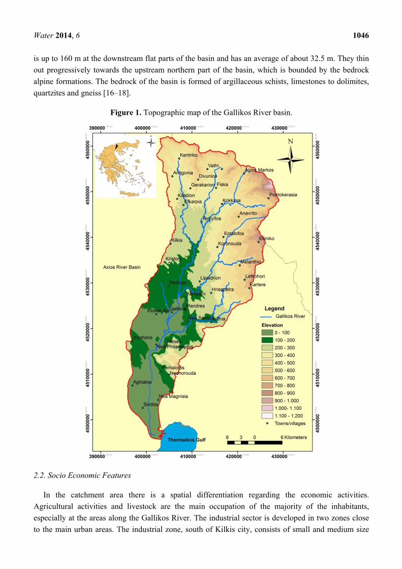
basin was delineated using ArcView GIS (Figure 1) and it was measured at approximately 1050 km2.
Most of the area lays at elevations of lower than 600 m whilst in the northeast its watershed boundary
reaches an altitude of 1180 m. The mean altitude was calculated at 308.5 m. The coastal part of this
basin forms part of an extensive estuarine system that has an extension of 428 km2. The sediment
discharges of Gallikos, Axios, Aliakmon and Loudias rivers have resulted in the addition of a coastal
plain that covers an area of 1500 km2 [9].
The Gallikos River is of high importance due to the proximity of the basin to Thessaloniki, the
second largest city of Greece. The total length of the river is about 73 km. It is characterized by
shallow water depths, the gradient of which is, of course, relatively high. Consequently, the river flow
characteristics resemble both a river and a torrent. This may also be concluded by the seasonality and
peak discharge events that characterize its flow regime. Maximum discharges occur during summer
and have been estimated at 700 m3/s [10]. The predominant flow direction is from NNE towards SSW
and the basin comprises four sub-basins that are discharged by the four main tributaries of the river.
The high density of the basin’s hydrologic network suggests a high runoff percentage compared to
infiltration, which essentially suggests that the geological formations of the basin are impervious.
The mean annual precipitation and temperature over the basin is about 480 mm and 16.5 °C
respectively [10] and the mean annual surface runoff is about 45 × 106 m3 as measured at its exit at
Nea Philadelphia monitoring station over the period of 2005–2006. Although the flow of the Gallikos
River is seasonal, at Nea Philadelphia the river exhibits a permanent flow, except for very dry years.
According to Poulos and Chronis [11], the annual load of suspended solids is 4 t/km2 and the annual
load of diluted solids is 0.51 × 10³ t/km2. A denudation rate of 320 m3/km2 has been estimated by
Eumorphopoulos [12].
The vertical continental moves to which the wider region has been subjected during the recent
geological times, along with the considerable sedimentation processes of the rivers Axios, Aliakmonas,
Gallikos and Loudias, have resulted in the rapid withdrawal of the sea and the creation of new land
thereby delimiting the Gulf of Thermaikos [13]. Based on existing data, Konstandinidis [10] also
suggests withdrawal of the sea in favor of the land during historical times and up to date.
Geodetic surveys carried out at the coastal part of the basin (Kalochori) over the period of
1992–1998 reveal subsidence phenomena in the order of 2.8–5 cm/year and an overall subsidence of
2.5 m for a time period of thirty years [9]. These phenomena are attributed to overpumping of
groundwater and to the ongoing compaction and solidification of the contemporary loose silty-clay
deposits and the quick sand phenomenon that occur along the coastal environment of the
system [14,15].
Geologically, the Gallikos basin is filled with Quaternary and Tertiary sediments. Quaternary
sediments consist of fluviolacustrine deposits, whereas Tertiary sediments essentially are comprised of
Neogene marls. The total thickness of these deposits, which form the main aquifer system of the basin,
Water 2014, 6 1046
is up to 160 m at the downstream flat parts of the basin and has an average of about 32.5 m. They thin
out progressively towards the upstream northern part of the basin, which is bounded by the bedrock
alpine formations. The bedrock of the basin is formed of argillaceous schists, limestones to dolimites,
quartzites and gneiss [16–18].
Figure 1. Topographic map of the Gallikos River basin.
2.2. Socio Economic Features
In the catchment area there is a spatial differentiation regarding the economic activities.
Agricultural activities and livestock are the main occupation of the majority of the inhabitants,
especially at the areas along the Gallikos River. The industrial sector is developed in two zones close
to the main urban areas. The industrial zone, south of Kilkis city, consists of small and medium size
Water 2014, 6 1047
enterprises, while the industrial zone of Sindos town consists of large-scale enterprises since it is part
of the industrial zone of the broader metropolitan area of Thessaloniki. The areas of service provision,
transport and trade are also developed near major urban areas. A domestic effluent treatment plant
operates in the areas of Sindos (Figure 1) and Kilkis. Despite the existence of the aforementioned
operating treatment plants, the Gallikos River still remains receptor of untreated sewages from small
size settlements that are located along the riverbed. The river is also affected by agricultural and
industrial effluents.
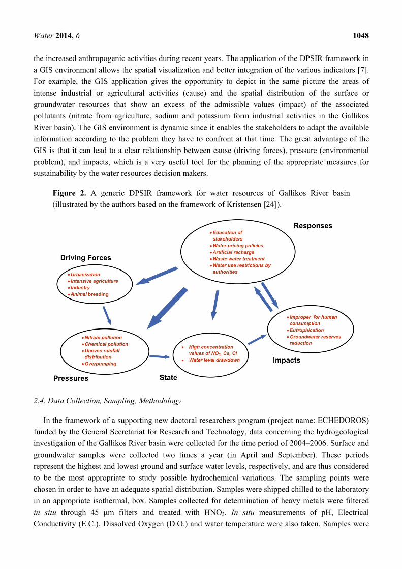
2.3. DPSIR Analysis Approach
The widely used Driver-Pressure-State-Impact-Response (DPSIR) analytical framework has been
adapted to the definitions given in Groundwater Risk Assessment; Technical report developed on the
basis of the Guidance Document 2004, No. 3 [19]; as follows:
− Driver: An anthropogenic activity that may have an environmental effect. Drivers produce a
series of pressures and are quantified by aggregated data, e.g., population density, hectares of
irrigated land, industrial units etc.
− Pressure: The direct effect of the driver. Pressures form the manifestation of the effects the
Driving Forces have on the water bodies. Pressures degrade the State of water bodies and have
an Impact on them as well as on humans. Increased irrigation-industrial-domestic demands,
precipitation decrease, point or non-point source pollution could be considered as pressures.
− State: The condition of the water body resulting from both natural and anthropogenic factors
(e.g. chemical or ecological characteristics, water quantity, etc.).
− Impact: The effect upon human well being.
− Response: The measures taken to improve the state of the water body.
The DPSIR framework for Gallikos river basin is illustratively and briefly presented in Figure 2.
Despite having been frequently employed in the environmental domain, DPSIR has been criticized for
several shortcomings [20,21]. The main criticism is that the framework creates stable indicators and
cannot take into account the dynamics of the system. Another criticism related to the aforementioned is
that the framework cannot capture trends, but it analyses them by repeating the same indicators at
regular intervals [20,22]. Finally critics argue that it suggests linear unidirectional causal chains of
environmental problems and that it provides unclear cause-effect relationships of complex
environmental problems [20,22]. The response to criticism is that the focus should be on the links
between the nodes of DPSIR by applying specific socio-economic and natural science based models so
as to understand the cause-effect dynamics [20,23].
The implementation of the DPSIR framework in a GIS for the Gallikos River basin is based on
water resource quality and quantity data. The selected key indicators for the monitoring of the water
resources quality are some easily measured physicochemical parameters. These parameters are related
to the anthropogenic activities that are in accordance with the socio-economic processes in the area.
The changes in measured quantity parameters such as groundwater level or river discharge can be
attributed to climate changes in a long-term examination or to anthropogenic activities in a short-term
examination. For the Gallikos River basin, the recorded changes in quantity parameters are in line with
Water 2014, 6 1048
the increased anthropogenic activities during recent years. The application of the DPSIR framework in
a GIS environment allows the spatial visualization and better integration of the various indicators [7].
For example, the GIS application gives the opportunity to depict in the same picture the areas of
intense industrial or agricultural activities (cause) and the spatial distribution of the surface or
groundwater resources that show an excess of the admissible values (impact) of the associated
pollutants (nitrate from agriculture, sodium and potassium form industrial activities in the Gallikos
River basin). The GIS environment is dynamic since it enables the stakeholders to adapt the available
information according to the problem they have to confront at that time. The great advantage of the
GIS is that it can lead to a clear relationship between cause (driving forces), pressure (environmental
problem), and impacts, which is a very useful tool for the planning of the appropriate measures for
sustainability by the water resources decision makers.
Figure 2. A generic DPSIR framework for water resources of Gallikos River basin
(illustrated by the authors based on the framework of Kristensen [24]).
2.4. Data Collection, Sampling, Methodology
In the framework of a supporting new doctoral researchers program (project name: ECHEDOROS)
funded by the General Secretariat for Research and Technology, data concerning the hydrogeological
investigation of the Gallikos River basin were collected for the time period of 2004–2006. Surface and
groundwater samples were collected two times a year (in April and September). These periods
represent the highest and lowest ground and surface water levels, respectively, and are thus considered
to be the most appropriate to study possible hydrochemical variations. The sampling points were
chosen in order to have an adequate spatial distribution. Samples were shipped chilled to the laboratory
in an appropriate isothermal, box. Samples collected for determination of heavy metals were filtered
in situ through 45 μm filters and treated with HNO3. In situ measurements of pH, Electrical
Conductivity (E.C.), Dissolved Oxygen (D.O.) and water temperature were also taken. Samples were
Water 2014, 6 1049
analyzed in the Laboratory of the Land Reclamation Institute (National Agricultural Research
Foundation, Thessaloniki, Greece), and the following parameters were determined: Ca, Mg, Na, K, Cl,
NO3, ΝΟ2, SO4, Β, HCO3, Fe, Mn, Cu, Pb, Cd, Zn. Meteorological data were derived from the existing
operating meteorological stations. In addition, the Laboratory of Engineering Geology and
Hydrogeology, installed three extra rain gauges to complete the network. River discharge
measurements were carried out at regular intervals at the upper part of the basin, near the Nea
Philadelphia village. Data concerning cultivated land in the region were obtained from the appropriate
local authorities.
Evaluation of hydrochemical results, i.e., water quality examination, was performed in line with the
WFD principles and the methodological approach adopted by Greece in the characterization of
groundwater bodies [25], where in absence of specific ecological indices and/or threshold values, the
maximum admissible concentrations (MAC) for water intended for human consumption have been
adopted. This approach, which is also adopted by other Member States, is justified by the fact that in
most of the basins a multitude of water uses occurs, amongst which domestic use is considered the
most sensitive due to the final receptor. In fact, based on the adopted methodology, as a threshold of
75% of the MAC value is adopted n an attempt to set strict environmental quality criteria and also to
account for the lack of comprehensive modeling tools that influence projections of future evolution of
water quality. With regards to surface water bodies, the same principles were applied, with the
exception of NO3 concentrations, whereby the threshold concentration of 15 mg/L was adopted. This is
75% of 20 mg/L, which is one of the concentration levels above which eutrophication phenomena
occur. This particular concentration refers to wintertime average values. According to other
researchers, this value should be decreased to 10 mg/L. This approach is also incorporated in the
national water resources management plans and is also followed by several Member States in the
framework of the Nitrates Directive. In principle, characterization in the framework of aforementioned
approach is based on the P90 values, except for the cases where data are too sparse or inadequate to
perform such an analysis. In such cases, the median or mean approach is preferred. This is especially
the case for surface waters for which winter-time average values are not readily available.
Prior to all the aforementioned works that were carried out, all the available data from the databases
of local authorities, public services and relevant references had been collected. The evaluation of these
data was used to identify the “driving forces” and “pressures” of the Gallikos River basin. Data
obtained from the above-described monitoring program were used to illustrate the “state” of the water
resources. From the analysis of the three first parameters of the DPSIR methodology it is possible to
identify the “impacts” and to propose a “response” to the appropriate set of measurements for water
resources management in accordance with the WDF.
3. Results
3.1. Driving Forces
Urbanization, intensive agriculture, industry—especially along the coastal part of the basin—and to
a minor extent animal breeding along the mountainous region, form the main driving forces of the
Water 2014, 6 1050
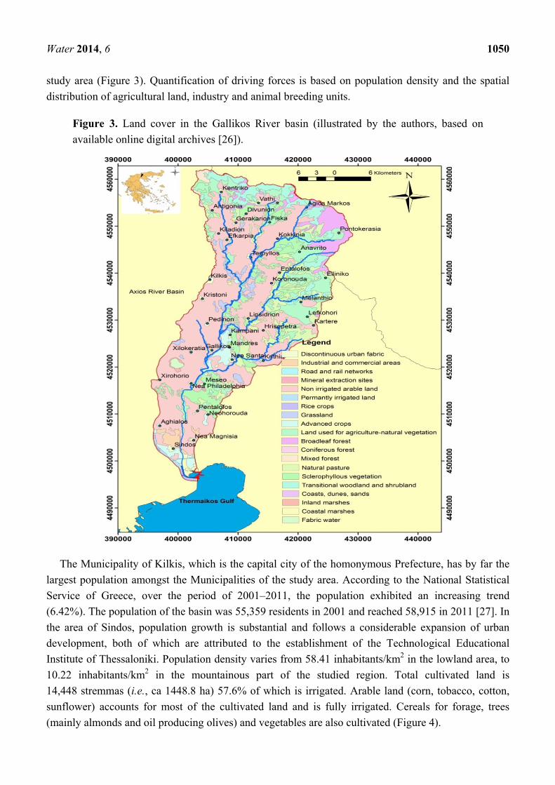
study area (Figure 3). Quantification of driving forces is based on population density and the spatial
distribution of agricultural land, industry and animal breeding units.
Figure 3. Land cover in the Gallikos River basin (illustrated by the authors, based on
available online digital archives [26]).
The Municipality of Kilkis, which is the capital city of the homonymous Prefecture, has by far the
largest population amongst the Municipalities of the study area. According to the National Statistical
Service of Greece, over the period of 2001–2011, the population exhibited an increasing trend
(6.42%). The population of the basin was 55,359 residents in 2001 and reached 58,915 in 2011 [27]. In
the area of Sindos, population growth is substantial and follows a considerable expansion of urban
development, both of which are attributed to the establishment of the Technological Educational
Institute of Thessaloniki. Population density varies from 58.41 inhabitants/km2 in the lowland area, to
10.22 inhabitants/km2 in the mountainous part of the studied region. Total cultivated land is
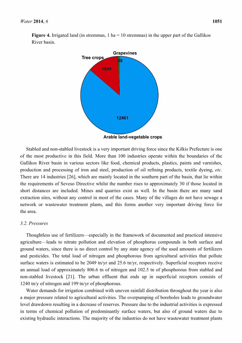
14,448 stremmas (i.e., ca 1448.8 ha) 57.6% of which is irrigated. Arable land (corn, tobacco, cotton,
sunflower) accounts for most of the cultivated land and is fully irrigated. Cereals for forage, trees
(mainly almonds and oil producing olives) and vegetables are also cultivated (Figure 4).
Water 2014, 6 1051
Figure 4. Irrigated land (in stremmas, 1 ha = 10 stremmas) in the upper part of the Gallikos
River basin.
Stabled and non-stabled livestock is a very important driving force since the Kilkis Prefecture is one
of the most productive in this field. More than 100 industries operate within the boundaries of the
Gallikos River basin in various sectors like food, chemical products, plastics, paints and varnishes,
production and processing of iron and steel, production of oil refining products, textile dyeing, etc.
There are 14 industries [26], which are mainly located in the southern part of the basin, that lie within
the requirements of Seveso Directive whilst the number rises to approximately 30 if those located in
short distances are included. Mines and quarries exist as well. In the basin there are many sand
extraction sites, without any control in most of the cases. Many of the villages do not have sewage a
network or wastewater treatment plants, and this forms another very important driving force for
the area.
3.2. Pressures
Thoughtless use of fertilizers—especially in the framework of documented and practiced intensive
agriculture—leads to nitrate pollution and elevation of phosphorus compounds in both surface and
ground waters, since there is no direct control by any state agency of the used amounts of fertilizers
and pesticides. The total load of nitrogen and phosphorous from agricultural activities that pollute
surface waters is estimated to be 2049 tn/yr and 25.6 tn/yr, respectively. Superficial receptors receive
an annual load of approximately 806.6 tn of nitrogen and 102.5 tn of phosphorous from stabled and
non-stabled livestock [21]. The urban effluent that ends up in superficial receptors consists of
1240 tn/y of nitrogen and 199 tn/yr of phosphorous.
Water demands for irrigation combined with uneven rainfall distribution throughout the year is also
a major pressure related to agricultural activities. The overpumping of boreholes leads to groundwater
level drawdown resulting in a decrease of reserves. Pressure due to the industrial activities is expressed
in terms of chemical pollution of predominantly surface waters, but also of ground waters due to
existing hydraulic interactions. The majority of the industries do not have wastewater treatment plants
Water 2014, 6 1052
and the river and aquifers are the direct receptors of their effluents. However, industries are not wide
spread within the study area. They are mainly located at the south part of the basin and the area near
the city of Kilkis. The most important identified pollutants in this area were Na+ and Cl− ions from the
textile dyeing industries.
3.3. State
The current state of surface and ground water is based on sampling, groundwater level
measurements, surface water discharge measurements and chemical analyses and is discussed in
details by Mattas et al. [28,29]. A brief description of the surface and ground water state is provided in
the following paragraphs.
3.3.1. Surface Water Quality
The water quality of the Gallikos River is influenced by the geological structure, agricultural
activities as well as the untreated waste effluent that is discharged from the city of Kilkis and of
numerous villages and industrial units spread along the river basin. Hydrochemical data from
49 samples were used in order to assess the water quality (Table 1) and estimate the nutrient inputs
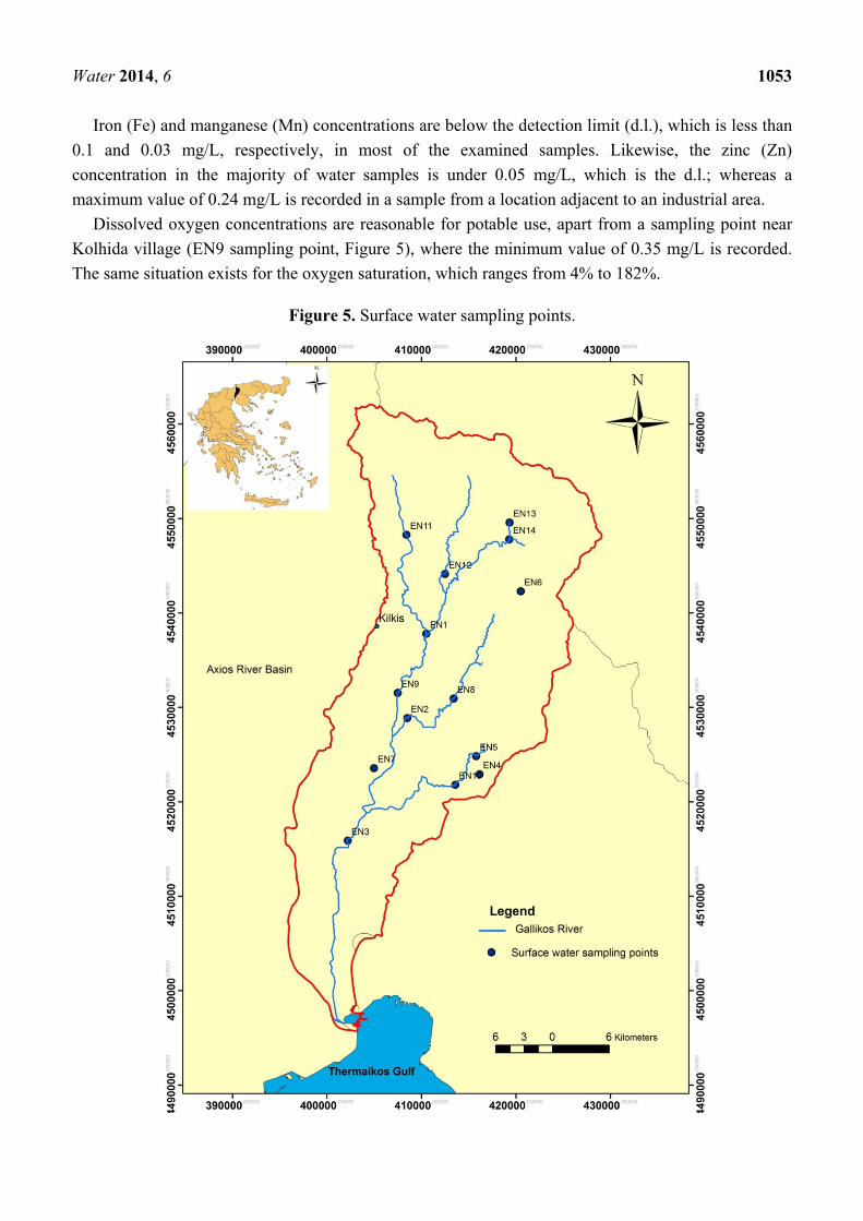
from the river to the Thermaikos Gulf. Aforementioned samples were collected from fourteen sites
(Figure 5) of the hydrographic network during the period of 2004–2005. Four sampling campaigns
were conducted for the wet (April–May) and dry periods (September–October). Dry period sampling
was not always possible, since some of them had already dried out.
Table 1. Summary statistics for concentrations of surface water samples.
Parameters Minimum Maximum Mean value Standard deviation
pH 7.42 9.01 8.21 0.39 E.C. (μS/cm at 25 °C) 210.0 1760.0 768.0 313.0
T (°C) 6.2 26.0 14.17 5.92 Ca2+ (mg/L) 24.0 136.3 72.11 23.12 Mg2+ (mg/L) 18.0 68.0 38.93 11.79 Na+ (mg/L) 17.0 220.0 50.0 40.0 K+ (mg/L) 2.0 16.0 4.86 2.85
HCO3− (mg/L) 214.0 536.8 329.88 69.42
Cl− (mg/L) 17.8 332.4 67.81 74.47 SO4
2− (mg/L) 11.1 135.6 51.65 30.92 NO3
− (mg/L) 0.5 28.55 10.03 7.04
Surface water temperature ranges from 6.2 to 26 °C, depending on atmospheric temperature
fluctuations. Electrical conductivity ranges between 210 and 1760 μS/cm; the highest values are
recorded at the Nea Philadelphia sampling point and are attributed to anthropogenic pollution. In
general, the composition of the surface water for cations is Ca2+ > Mg2+ > Na+ > K+. The composition
of the surface water for anions is HCO3− > Cl− or SO4
2− > NO3−.
Water 2014, 6 1053
Iron (Fe) and manganese (Mn) concentrations are below the detection limit (d.l.), which is less than
0.1 and 0.03 mg/L, respectively, in most of the examined samples. Likewise, the zinc (Zn)
concentration in the majority of water samples is under 0.05 mg/L, which is the d.l.; whereas a
maximum value of 0.24 mg/L is recorded in a sample from a location adjacent to an industrial area.
Dissolved oxygen concentrations are reasonable for potable use, apart from a sampling point near
Kolhida village (EN9 sampling point, Figure 5), where the minimum value of 0.35 mg/L is recorded.
The same situation exists for the oxygen saturation, which ranges from 4% to 182%.
Figure 5. Surface water sampling points.
Water 2014, 6 1054
Oxygen content of the surface water depends mainly on the surface water temperature, but is also
highly dependable on its pollution loads. Significant temporal and spatial variations of the chemical
oxygen demand COD (from 0 to 87.1 mg/L) are noted, the highest values are recorded in the Nea
Philadelphia area (EN3 sampling point). The majority of the samples have biochemical oxygen
demand (BOD5) values under d.l., which is 2.4–3 mg/L, depending on the sample quantity. Higher
values (8 mg/L) are recorded at a sampling point near Kolhida village (EN9). In general, as river
discharge decreases, both BOD5 and COD values increase.
River water seepage is known to considerably contribute to groundwater recharge of aquifers of the
Gallikos River basin. Thus, surface water quality affects groundwater quality of the aquifer system that
is formed in the basin, which is the main source of potable water [29]. Eutrophication has been
recorded in the Thermaikos Gulf, and this is the major problem that requires management action [6].
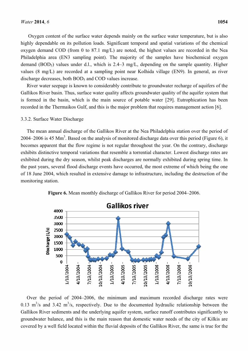
3.3.2. Surface Water Discharge
The mean annual discharge of the Gallikos River at the Nea Philadelphia station over the period of
2004–2006 is 45 Mm3. Based on the analysis of monitored discharge data over this period (Figure 6), it
becomes apparent that the flow regime is not regular throughout the year. On the contrary, discharge
exhibits distinctive temporal variations that resemble a torrential character. Lowest discharge rates are
exhibited during the dry season, whilst peak discharges are normally exhibited during spring time. In
the past years, several flood discharge events have occurred, the most extreme of which being the one
of 18 June 2004, which resulted in extensive damage to infrastructure, including the destruction of the
monitoring station.
Figure 6. Mean monthly discharge of Gallikos River for period 2004–2006.
Over the period of 2004–2006, the minimum and maximum recorded discharge rates were
0.13 m3/s and 3.42 m3/s, respectively. Due to the documented hydraulic relationship between the
Gallikos River sediments and the underlying aquifer system, surface runoff contributes significantly to
groundwater balance, and this is the main reason that domestic water needs of the city of Kilkis are
covered by a well field located within the fluvial deposits of the Gallikos River, the same is true for the
Water 2014, 6 1055
well field that operated until recently for the domestic needs of the metropolitan area of Thessaloniki.
Part of the summer-time base flow is used for the irrigation of cultivations along the river course.
Numerous springs of low potential emerge that discharge from the weathered zone of the crystalline
rocks. Average discharge rates of these springs range between 5 and 30 m3/day, according to a recent
study conducted in the region [30]. Several springs emerge at the contact of the karstified limestones
with the crystalline rocks, and according to the same study estimated discharge averages to 0.5–3 m3/h.
Spring water serves as a means for partial coverage of local domestic and animal breeding needs.
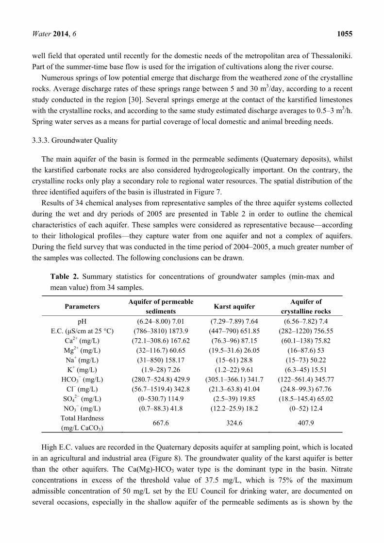
3.3.3. Groundwater Quality
The main aquifer of the basin is formed in the permeable sediments (Quaternary deposits), whilst
the karstified carbonate rocks are also considered hydrogeologically important. On the contrary, the
crystalline rocks only play a secondary role to regional water resources. The spatial distribution of the
three identified aquifers of the basin is illustrated in Figure 7.
Results of 34 chemical analyses from representative samples of the three aquifer systems collected
during the wet and dry periods of 2005 are presented in Table 2 in order to outline the chemical
characteristics of each aquifer. These samples were considered as representative because—according
to their lithological profiles—they capture water from one aquifer and not a complex of aquifers.
During the field survey that was conducted in the time period of 2004–2005, a much greater number of
the samples was collected. The following conclusions can be drawn.
Table 2. Summary statistics for concentrations of groundwater samples (min-max and
mean value) from 34 samples.
Parameters Aquifer of permeable
sediments Karst aquifer
Aquifer of crystalline rocks
pH (6.24–8.00) 7.01 (7.29–7.89) 7.64 (6.56–7.82) 7.4 E.C. (μS/cm at 25 °C) (786–3810) 1873.9 (447–790) 651.85 (282–1220) 756.55
Ca2+ (mg/L) (72.1–308.6) 167.62 (76.3–96) 87.15 (60.1–138) 75.82 Mg2+ (mg/L) (32–116.7) 60.65 (19.5–31.6) 26.05 (16–87.6) 53 Na+ (mg/L) (31–850) 158.17 (15–61) 28.8 (15–73) 50.22 K+ (mg/L) (1.9–28) 7.26 (1.2–22) 9.61 (6.3–45) 15.51
HCO3− (mg/L) (280.7–524.8) 429.9 (305.1–366.1) 341.7 (122–561.4) 345.77
Cl− (mg/L) (56.7–1519.4) 342.8 (21.3–63.8) 41.04 (24.8–99.3) 67.76 SO4
2− (mg/L) (0–530.7) 114.9 (2.5–39) 19.85 (18.5–145.4) 65.02 NO3
− (mg/L) (0.7–88.3) 41.8 (12.2–25.9) 18.2 (0–52) 12.4 Total Hardness (mg/L CaCO3)
667.6 324.6 407.9
High E.C. values are recorded in the Quaternary deposits aquifer at sampling point, which is located
in an agricultural and industrial area (Figure 8). The groundwater quality of the karst aquifer is better
than the other aquifers. The Ca(Mg)-HCO3 water type is the dominant type in the basin. Νitrate
concentrations in excess of the threshold value of 37.5 mg/L, which is 75% of the maximum
admissible concentration of 50 mg/L set by the EU Council for drinking water, are documented on
several occasions, especially in the shallow aquifer of the permeable sediments as is shown by the
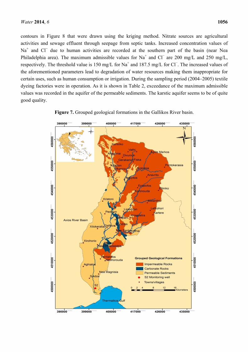
Water 2014, 6 1056
contours in Figure 8 that were drawn using the kriging method. Nitrate sources are agricultural
activities and sewage effluent through seepage from septic tanks. Increased concentration values of
Na+ and Cl− due to human activities are recorded at the southern part of the basin (near Nea
Philadelphia area). The maximum admissible values for Na+ and Cl− are 200 mg/L and 250 mg/L,
respectively. The threshold value is 150 mg/L for Na+ and 187.5 mg/L for Cl−. The increased values of
the aforementioned parameters lead to degradation of water resources making them inappropriate for
certain uses, such as human consumption or irrigation. During the sampling period (2004–2005) textile
dyeing factories were in operation. As it is shown in Table 2, exceedance of the maximum admissible
values was recorded in the aquifer of the permeable sediments. The karstic aquifer seems to be of quite
good quality.
Figure 7. Grouped geological formations in the Gallikos River basin.
Water 2014, 6 1057
Figure 8. Spatial distribution of electrical conductivity, nitrates, sodium and chloride for
the upper part of the Gallikos River basin.
Water 2014, 6 1058
Groundwater is characterized by relatively low heavy metal concentrations. High concentrations of
Fe and Mn are recorded in the crystalline rocks and are attributed to the lithological composition of the
area. In some cases the values are over the maximum acceptable limit for drinking water, making the
treatment of the water with the appropriate filters obligatory for the local authorities in order to meet
the domestic needs.
The values of Dissolved Oxygen (D.O.) and Oxygen Saturation (%), which were determined in situ,
are obviously lower than in surface water, and in general, they decrease proportionally to the distance
of the wells from the river course. It is therefore suggested that [25] the uncontrollable discharge of
untreated domestic and industrial effluent into the river leads to groundwater quality deterioration due
to infiltration of water of the Gallikos River basin into the aquifer systems.
3.3.4. Groundwater Resources
According to the available data from the field survey that was carried out during the time period
2004–2006 for the upper part of the Gallikos River basin (from the mountainous area to Nea
Philadelphia village) the general characteristics of the main aquifers are described below:
(1) Permeable Sediments Aquifer
The alluvial aquifer, defined by permeable sediments is being exploited through numerous shallow
boreholes and large diameter wells that have been constructed along the courses of the Gallikos River
and its tributaries in order to cover irrigation demands and the domestic needs of the city of Kilkis. The
preference of that particular zone lays on the deposition of essentially coarse fluvial deposits along the
river courses, namely intercalations of sands, gravels, pebbles and clays. On the one hand, these
deposits favor infiltration of precipitation and deep percolation of river water and on the other hand,
they are characterized by high water storage capacities (high storativitiy) and ease of groundwater
withdrawal (high transmissivity).
In hydrologically dry years, many of these boreholes become dry over the peak water demand
irrigation period. Groundwater level fluctuation between the dry (October) and the wet period (April)
of the hydrologic year 2004 was 0.08 to 3.41 m. Similarly, for the year 2005, groundwater level
fluctuation between the dry and the wet period was 0.13 to 8.84 m. The continuous groundwater water
level decline causes major problems for the financial sustainability of the farmers, because it
deteriorates the amount of their production, it restricts the type of crop that they can cultivate and
forces them to spend money to ensure new water resources, mainly by drilling new boreholes, which is
linked with considerable costs.
A well field for domestic water supplies to the metropolitan area of Thessaloniki exists at the area
of Sindos and has a nominal operation capacity of about 10.5 × 10⁶ m3/year. Nowadays it acts as an
auxiliary reserve. Since pumping was discontinued from this well field in the year 2004, a considerable
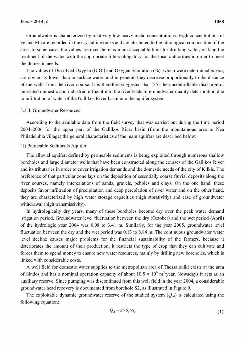
groundwater head recovery is documented from borehole S2, as illustrated in Figure 9.
The exploitable dynamic groundwater reserve of the studied system (Qed) is calculated using the
following equation:
ed y dQ A S l= × × (1)
Water 2014, 6 1059
where, A = effective area of groundwater recharge (km2); Sy = specific yield; ld = average water level
decline (m) in dry period.
In the loose quaternary deposits aquifer that has an areal extent of 345 km2, the mean annual
groundwater level fluctuation is 1.15 m (from April 2004 to April 2005 a decline trend is observed).
Assuming an average value of specific yield Sy = 0.09 [26,28], Equation (1) yields the annually exploitable groundwater reserves: 6 2 3 3
ed 345 10 m 0.09 1.15 m 35 707 500 m 35.7 MmQ = × × × = =, , .
Figure 9. Groundwater level fluctuation in the S2 monitoring well located in the Sindos
area. Values represent absolute elevation relative to the mean sea level.
It should be mentioned that according to other studies the estimation of the annually exploitable
groundwater reserves varies in respect to the available data and other assumptions. Kalousi [30]
estimated the reserves to be approximately 4.4 × 10⁶ m3 for a different time period and different active
area but did not take into consideration the area of the Gallikos River bank deposits.
(2) Karstic Aquifer
It is characterized by considerable resources and the production rate of the wells ranges between
40 and 90 m3/h and the average value is 60 m3/h. In the year 2004, groundwater level fluctuation
between the dry and the wet period was 0.18 to 5.95 m. In the year 2005 groundwater level fluctuation
between the dry and the wet period was 1.20 to 4.03 m. The effective recharge area of the karst system
was 22 km2. The average annual groundwater head decline is 1.88 m (from April 2004 to April 2005)
and assuming an average specific yield value Sy = 0.1 [31,32], the annually exploitable groundwater reserves were estimated to be (Equation 1): 6 2 3 3
ed 22 10 m 0.1 1.88 m 4136 000 m 4.13 MmQ = × × × = =, , .
The need to conserve the reserves of this aquifer is very important since it is the main supplier of
water intended for human consumption.
(3) Aquifer of the Crystalline Rocks
The crystalline rocks that form the bedrock of the basin are normally classified as impermeable.
Limited water reserves exist predominantly due to the secondary porosity of the weathered zone of
these rocks. A limited number of large diameter wells and boreholes have been constructed to meet
water demands mainly of the hilly and mountainous zones of the basin.
Water 2014, 6 1060
In the year 2004 groundwater level fluctuation between the dry and the wet period was
1.22 to 2.54 m. In the year 2005 groundwater level fluctuation between the dry and the wet period
was 0.30 to 3.21 m. The effective recharge area was 505 km2 and the average annual groundwater
head decline was 1m (April 2004 to April 2005). Assuming an average specific yield value
Sy = 0.04 [26,28], the annually exploitable groundwater reserves were estimated to be (Equation 1): 6 2 3 3
ed 505 10 m 0.04 1 m 20 200 000 m 20.2 MmQ = × × × = =, , .
The estimation of the reserves of the crystalline rock aquifer poses significant error possibility,
since the hydrogeological behavior and hydraulic characteristics of these rocks differ from place to
place and the aquifers are of local interest. Table 3 lists the main hydrogeological characteristics of the
identified aquifers of the Gallikos River basin.
Table 3. Hydrogeological characteristics of the Gallikos River basin aquifers. (A = effective
area, Dav = average thickness, T = average transmissivity, K = average hydraulic
conductivity, Sy = specific yield, Qed = exploitable dynamic groundwater reserves).
Aquifer Geological formations Hydraulic characteristics
Permeable sediments aquifer Alluvial deposits; Sand-gravel-clay
A = 345 km2 Dav = 33 m K = 2.4 × 10⁻⁴ m/s T = 4 × 10⁻³ m2/s Sy = 0.09 Qed = 54.33 Mm3/year
Karstic aquifer Carbonate rocks
A = 22 km2 Dav = 76 m K = 2.4 × 10⁻³ m/s T = 2 × 10⁻¹ m2/s Sy = 0.1 Qed = 4.79 Mm3/year
Crystalline rocks aquifer Crystalline rocks;
Schists, quartzites, gneiss
A = 505 km2 Dav = 230 m K = 4.8 × 10⁻⁶ m/s T = 4 × 10⁻⁴ m2/s Sy = 0.04 Qed = 26.05 Mm3/year
(4) Treated Domestic Effluent
The domestic effluent treatment plant of the metropolitan area of Thessaloniki operates in the area
of Sindos and processes on average 200,000 m3 of effluent daily. Normally, processed water is
discharged to the sea (Gulf of Thermaikos) through a submerged pipeline. In addition a treatment plant
that handles the industrial effluent of the adjacent industrial zone of Thessaloniki exists, and treated
water is discharged to the sea via an open gravitational canal.
Long-term experiments have been conducted in the area, followed by extensive feasibility studies
on the potential to utilize the treated domestic effluent of Thessaloniki to cover part of the irrigation
needs of the homonymous basin where some 100,000 ha are being cultivated. The results of the
Water 2014, 6 1061
long-term experiments clearly suggest that rational and controlled application of this valuable resource
would alleviate the water shortage problem leading to excellent results regarding crop yields [33].
In addition it would lead to the actual utilization of a considerable volume of essentially usable
water, whilst in parallel it would be beneficial to the plants due to the rich content in nutrients and the
growers due to the reduced requirements for fertilization. Indeed, over the summer of 2007 the severe
drought conditions that led to prolonged water shortage over the plant growing period were
successfully faced with the systematic and carefully controlled use of this resource in irrigation.
3.4. Impacts
Impacts are essentially focused on the well-being of humans. Within the study area, water is mainly
used for domestic needs and for animal breeding and agriculture, the latter being by far the biggest
consumer. Intensive and thoughtless fertilization results in aquifer pollution and renders groundwater
improper for human consumption. Several municipalities already suffer from this effect, especially
south of Kilkis and north of Nea Philadelphia according to primary data that were collected by the
authors. Another side effect of the intensive agricultural practices is the overpumping that has as a
result the reduction of the reserves. An increase of the karstic aquifer exploitation has been recorded in
the recent years in order to cover the human consumption needs of the settlements that are located in
the flat area. In other cases, such as in municipal compartments at the N-NE part of the basin
(e.g., villages of Antigonia, Vathi, Pontokerasia, Terpillos), groundwater is improper for human
consumption due to elevated concentrations of Fe and Mn that are attributed to the geological structure
of the region. Although in the framework of the management by local authorities the water is treated
using the appropriate filters, it is not always possible to achieve the desired effect. Hence according to
residents, the water is sometimes slightly colored, has a faint smell or sometimes stains household
items. In some cases treatment is not possible and water transfer takes place between the villages via a
local network.
Shifting from rain-fed to irrigated farming will increase irrigation water demands, part of which are
currently met by surface water from the Gallikos River, although this might lead to increased pollution
incidents. Groundwater overpumping in recent years has led to river water drying, as reported in
newspaper articles and posts on the internet. Abandonment of water consuming-crops and the use of
efficient irrigation methods, such as drip irrigation, can lead to considerable reduction of groundwater
abstractions for irrigation purposes that account for the highest percentage of used water resources.
Utilization of treated waste effluent can contribute significantly to the reduction of groundwater use.
Uncontrolled disposal of industrial effluent in conjunction with discharge of treated domestic
effluent from the Sindos plant into the Gallikos River is bound to worsen eutrophication of the Gulf
of Thermaikos.
3.5. Responses
Education of farmers on the implementation of European Laws and Directives on environmental
protection and water resource management is a major issue. The importance of integrated water
resources management is emphasized in the European Water Framework Directive (2000/60/EC),
which, amongst other things, promotes new opportunities and view points for the sustainable
Water 2014, 6 1062
management of water resources. A major objective is to reach a good quantitative and chemical status
of groundwater within 15 years from implementation. In response to this directive, Greek authorities
have taken suitable initiatives to harmonize the Greek water policy [34]. It is pointed out that Greece is
ranked among the last countries in relation to the implementation of the directive and is quite behind
schedule compared to other European countries [35].
A comprehensive Code for Good Agricultural Practice (COGAP) has been compiled on the basis of
the elaborated action plan for the wider study region. It addresses the effective reduction of nitrate
groundwater pollution of agricultural origin through reduction and appropriate application of
fertilization. This Code [36], includes specific rules and instructions for the periods of time during
which fertilization should not be applied, on the application methodologies and doses at which
fertilizers should be applied depending on the soil type and conditions, and also on the crop and the
irrigation method adopted. Moreover, it informs about specific fertilization plans per plot and crop,
taking into account, amongst other things, nitrate background concentrations in the groundwater [37].
COGAP also informs about the use of logbooks for fertilizer handling and application and also for
land management. In parallel, set-aside and crop rotation practices are proposed. As clearly examined
and suggested in the action plan compiled for the vulnerable area of the Imathia Prefecture, which is
located in Central Macedonia Region, proposed fertilization schemes may lead to a 30%–40% or even
higher reduction in the applied fertilizers per year, whilst at the same time maintaining maximum crop
yields [38]. It therefore follows that environmentally friendly policies and measures do not necessarily
imply economic destruction of farmers, or at least shrinkage of their income. On the contrary, presented
data suggests that environmentally friendly policies may also result in the increase of the farmers’
income by cutting down their operational costs. In the study area, the proposed fertilization as
calculated in the framework of the compiled action plan varies from 30 to 340 kg/ha/year, with an
average of 167 kg/ha/year, i.e., a reduction from 62.5% to 3%, or 22% on average, depending on crop
type and soil conditions, compared to the discussed required amounts of nitrogen fertilization.
The idea of reduction and appropriate application of fertilization sounds good in theory, but if it is
not accompanied by financial incentives that will ensure the income of the farmers, such as subsidies,
then it cannot be realistic. In this sense, experience from other parts of the country where a reward
scheme with a strong financial element was applied, has shown quite promising results: fertilizer
application was reduced up to 40% or even 50% and yields were maintained at high levels. It has to be
stressed that in those occasions appropriate fertilization doses and application methods were dictated to
participating farmers. A specific legislative framework exists for the protection of the coastal estuarine
part of the basin. According to the Joint Ministerial Decision 14874/3291 [39], the areas of Gallikos
estuary and the Kalochori lagoon were designated as ecological important areas to be protected.
The Thessaloniki water supply and sewerage company S.A. (E.Y.A.Th., Thessaloniki, Greece) has
undertaken a major project supervised and funded by the Greek Ministry of Environment, Physical
Planning and Public Works to assess the impact of groundwater artificial recharge by means of
injection of treated domestic effluent into a confined aquifer via deep boreholes at the area of
Sindos [40]. Recycled water potentially represents one important portion of the water resources for
covering the increased water demands in the basin. The reuse of treated waste will be diverted for
artificial recharge and recovered to be used for irrigation or industrial use.
Water 2014, 6 1063
Furthermore, groundwater artificial recharge using the large volumes of winter-time runoff that are
currently being discharged to the sea, is a well-documented method to initially delay aquifer mining
and progressively achieve its replenishment and restoration.
Replacement of obsolete domestic water networks in order to reduce current losses, utilization of
the mountainous zone springs, and informative campaigns to sensitize citizens to rational water use are
only some extra measures in the framework of rational and sustainable management of water resources
at the basin scale. Last year, the Greek State proceeded in licensing rights for existing water use, even
for boreholes operating illegally. As part of this procedure the installation of flow meters will become
mandatory. Depending on the registered crop, a maximum amount of water for irrigation will be
allowed. Water pricing is a key issue in protection and restoration of water resources. Appointment and
operation of landfill sites and appropriate waste effluent treatment and utilization instead of simple
discharge into the local rivers and torrents would also contribute to groundwater quality restoration.
It is very important that the authorities and stakeholders that are involved in water resources
management have clear responsibilities without overlaps that lead to an increased complexity of the
decision system. It is also of major importance that the authorities—especially local authorities that are
directly involved in the issue—have the power and the ability to control the implementation of the
decisions and to impose penalties when violations are detected. Unfortunately, until recently, local
authorities did not have this ability, and regional actors showed great reluctance in enforcing
established regulations and acts regarding water resources management and environmental protection.
4. Discussion and Conclusions
In the case of the Gallikos River basin, application of DPSIR enabled the identification of the main
driving forces and their direct effects on the studied system, it allowed a facilitated linkage of these
with the state of the system and the identified impacts, thus in the end making it possible to suggest
easier, comprehensive and focused measures in the framework of rehabilitation and protection of the
system. There are two main issues to be addressed. The first is the degradation of the quality of water
resources due to the untreated waste disposal and nitrate pollution resulting from anthropogenic
activities. The second issue is in regard to the groundwater reserve reduction due to overpumping in
order to cover the demands of any kind of activity (domestic, industrial, agricultural) in the basin. The
water resource degradation has impacts on human well-being. The insufficient presence of state or
regional control mechanisms and the lack of available data, as there is no network for systematic water
resource measurements, have led to an ineffective and late response of the authorities. In current days
things are worsening in this direction. The poor economic conditions of Greece do not favor efforts in
the direction of protection and restoration of the environment, since priorities have changed and such
efforts are considered a “luxury’’. Despite the difficulties, some of the following actions are proposed.
Some of these actions have already been implemented but they need to be implemented in a more
systematic way:
(a) Programmed–precision irrigation, which will both reduce the volume of water thoughtlessly
used for agriculture whilst at the same time optimally covering the irrigation demands. Appropriate
irrigation water pricing policies, which are in-line with the guidelines set by the Water Framework
Directive. Further reduction could be achieved through crop restructuring patterns in the framework of
Water 2014, 6 1064
the new Common Agricultural Policy (CAP), opting for less water-consuming crops that at the same
time present a high added value to the producers, accompanied by subsidies that will cover the cost for
the substitution of the crops and probably the income losses of the farmers.
(b) Optimized fertilization based on detailed knowledge of the soil characteristics and the crop
needs may also dramatically reduce the pollutant loads whilst at the same time improving the
competitiveness of the crop production through reduced production costs. To this end, a Code for
Good Agricultural Practice (COGAP) has been compiled and specific fertilization plans have
been issued.
(c) Improved management of livestock units shall only benefit the environment and the annual
turnover from this activity. Proper management of manure and its subsequent utilization as a fertilizer
will minimize health risks to the livestock, improve their breeding conditions and hence improve the
turnover of the breeding units, minimize potential point pollution to the water receptors of the basin
and cut down on the fertilization costs of crops in the region.
(d) Appropriate treatment and management of livestock breeding, industrial and domestic effluent
can also turn into an asset for the region, both in terms of water resources and also nutrient source for
agriculture, whilst in parallel safeguarding the environment. Dramatic improvement in the operation of
the existing effluent treatment plants that operate in the region has been achieved over the past decade
to ensure that such point pollution sources are progressively eliminated. Reuse of treated domestic
effluent is has proven to be a viable solution to crop irrigation in the region, capable of addressing
prolonged droughts whist also partially accounting for the nutrient needs of the plants. Hence, such
practices are nowadays promoted through the regional government and are well-governed by
legislative acts.
(e) Progressive abandonment of uncontrolled landfills to properly managed domestic waste sites
is also under way in the region, thus reducing the number of potential point pollution sources of
domestic origin.
It is important that these actions are realistic, since they do not always increase costs, but some of
them are a matter of proper management and policy drawing. Many of the proposed action have been
adopted by the Greek state and some have been adapted from European policies.
Rationalization of water and land use through the above discussed suite of measures has already
been applied in the region exhibiting signs of recovery of the system in terms of quality and quantity
characteristics. Signs are more apparent so far in the soil resources of the region based the systematic
surveys carried out in the framework of the Nitrates Directive implementation in the region. The
extensive depression cone and salinization fronts documented at the southern margins of the basin as a
result of groundwater over-exploitation are not yet recovered. This phenomenon evolved over a long
period of time and, based on international experience, will take several decades to be restored.
Undoubtedly, some of the impacts of the miss-management are non-reversible, such as the extensive
subsidence along the coastal zone; however it is imperative and feasible that it be avoided that the
phenomenon evolves further.
Identification of key drivers and pressures to the studied basin enables structuring and adoption of
the appropriate measures towards alleviation of the impacts it suffers, and overall protection of the
studied system. The proposed suite of measures is not only seen as a means to protect the system and
Water 2014, 6 1065
attempt to restore it to its prior good state, but also as a guarding shield in the direction of preparedness
and adaptation to climate changes.
DPSIR technique in a GIS environment is a valuable tool that contributes to the integrated appraisal
of environmental and socio-economic pressures and their effects on the water resources at the basin
scale. It provides a common basis of understanding and encoding of valuable information that can be
easily conceived and reviewed in the framework of strategic planning and evaluation. This way, it
enables direct correlation to adjacent basins, or comparative studies of the same basin at various points
in time, whilst at the same time contributing to effectively designing and implementing site and
problem specific measures towards protection and restoration of a given hydrogeological environment.
Acknowledgments
The authors would like to thank the Greek Ministry of Development, since part of this work (for the
upper part of Gallikos River basin) was elaborated in the framework of a research project funded by
the Directorate General for Research and Technology that belongs to the aforementioned Ministry.
Furthermore, the authors greatly appreciate the careful revisions of three anonymous referees.
Author Contributions
Christos Mattas collected the data and applied the methodology in collaboration with the other
authors. He also constructed the maps in geographic information system (GIS) environment.
Konstantinos Voudouris proposed the conceptual framework of the paper and evaluated the data. He
also checked the results and enhanced the writings of the paper in collaboration with
Andreas Panagopoulos.
Conflicts of Interest
The authors declare no conflict of interest.
References
1. United Nations Educational, Scientific and Cultural Organization (UNESCO). Summary and
Recommendations of the International Conference on World Water Resources at the Beginning of
the 21st Century “Water: A Looming Crisis”; UNESCO: Paris, France, 1998.
2. Meybeck, M. Riverine quality at the Anthropocene: Propositions for global space and time
analysis, illustrated by the Seine River. Aquat. Sci. 2002, 64, 376–393.
3. Daskalaki, P.; Voudouris, K. Groundwater quality of porous aquifers in Greece: A synoptic
review. Environ. Geol. 2008, 54, 505–513.
4. Gaaloul, N.; Pliakas, F.; Kallioras, A.; Schuth, C.; Marinos, P. Simulation of seawater intrusion in
coastal aquifers: Forty five-years exploitation in an eastern coast aquifer in NE Tunisia.
Open Hydrol. J. 2012, 6, 31–44.
5. European Environmental Agency (EEA). The DPSIR framework used by the EEA.
Available online: http://glossary.eea.europa.eu//terminology/sitesearch?term=DPSIR (accessed on
1 April 2014).
Water 2014, 6 1066
6. Karageorgis, A.P.; Skourtos, M.S.; Kapsimalis, V.; Kontogianni, A.D.; Skoulikidis, N.T.;
Pagou, K.; Nikolaidis, N.P. An integrated approach to watershed management within the DPSIR
framework: Axios river catchment and Thermaikos Gulf. Reg. Environ. Chang. 2005, 5, 138–160.
7. Mourão, I.; Caeiro, S.M.H.; Ramos, T.B.; Painho M. Application of the DPSIR model to the Sado
Estuary in a GIS context—Social and Economical Pressures. In Proceedings of the 7th Conference
on Geographic Information Science (AGILE 2004), Crete, Greece, 29 April–1 May 2004;
Toppen, F., Prastacos, P., Eds.; Crete University Press: Crete, Greece, 2004; pp. 391–402.
8. Kagalou, I.; Leonardos, I.; Anastasiadou, C.; Neofytou, C. The DPSIR approach for an integrated
river management framework. A preliminary application on a Mediterranean site (Kalamas
river-NW Greece). Water Resour. Manag. 2012, 26, 1677–1692.
9. Poulos, S.; Papadopoulos, A.; Collins, M.B. Deltaic progradation in Thermaikos Bay, Northern
Greece and its Socio-Economical Implications. Ocean Coast. Manag. 1994, 22, 229–247.
10. Konstantinidis, K.A. Land Reclamation Project of the Plain of Thessaloniki; Geotechnical
Chamber of Greece: Thessaloniki, Greece, 1989. (In Greek)
11. Poulos, S.; Chronis, G. The importance of the Greek river systems in the evolution of the Greek
coastline. In Transformations and Evolution of the Mediterranean Coastline; Special No. 18,
CIESM Science Series No. 3; Briand, F., Maldolado, A., Eds.; Bulletin de l’ Institut
Oceanographique; Albert Ier, Monaco, 1997; pp. 75–96.
12. Eumorphopoulos, L. Verandermingen des Golfes von Thessaloniki. Geogr. Elv. 1964, 19, 269–277.
(In German)
13. Mitsopoulos, M. Geological and paleontological study of the meta-tertiary deposits of
Thessaloniki plain. Lectureship Thesis, Aristotle University, Thessaloniki, Greece, 1938.
14. Dimopoulos, G. Investigation of the conditions generating soil settlements in the Sindos-Kalochori
area of Thessaloniki. In Proceedings of the 7th Hellenic Conference on Hydrogeology, Athens,
Greece, 5–6 October 2005. (In Greek)
15. Lambrakis, N.; Voudouris, K.; Tiniakos, L.; Kallergis, G. Impacts of drought and overpumping on
the Quaternary aquifers of the Glafkos basin (Patras region, Greece). Environ. Geol. 1997, 29,
209–216.
16. Mercier, J. Etude geologique des zones internes des Hellenides en Macedoine centrale (Grèce).
Ann. Geol. Pays Hell. 1968, 20, 1–792. (In French)
17. Kockel F.; Ioannides K. Geological Map of Greece, Kilkis Sheet (Scale 1:50000); Institute of
Geology and Mineral Exploration: Athens, Greece, 1979. (In Greek)
18. Stais, A. Evolution Geodynamique des Basins Mesozoiques Vardariens: Domains de Peoniaset d’
Almopias. Ph.D. Thesis, University de Lille, Lille, France, 1993. (In French)
19. European Commission. Common implementation strategy for the Water Framework Directive
(2000/60 EC); Groundwater Risk Assessment; Technical report developed on the basis of the
Guidance Document 2004. Available online: http://www.eurogeologists.de/images/content/
panels_of_experts/hydrogeology/081F8d01.pdf (accessed on 1 April 2014).
20. Song, X.; Frostell, B. The DPSIR framework and a pressure-oriented water quality monitoring
approach to ecological river restoration. Water 2012, 4, 670–682.
Water 2014, 6 1067
21. Rekolainen, S.; Kamari, J.; Hiltunen, M.; Saloranta, T.M. A conceptual framework for identifying
the need and role of models in the implementation of the Water Framework Directive. Int. J. River
Basin Manag. 2003, 1, 347–352.
22. Carr, E.; Wingard, P.; Yorty, S.; Thompson, M.; Jensen, N.; Roberson, J. Applying DPSIR to
sustainable development. Int. J. Sustain. Dev. World Ecol. 2007, 14, 543–555.
23. Karageorgis, A.; Kapsimalis, V.; Kontogianni, A.; Skourtos, M.; Turner, K.; Salomons, W.
Impact of 100-year human interventions on the Deltaic Coastal Zone of the Inner Thermaikos
Gulf (Greece): A DPSIR framework analysis. Environ. Manag. 2006, 38, 304–315.
24. Kristensen, P. The DPSIR Framework. In Proceedings of the Workshop on a Comprehensive/
Detailed Assessment of the Vulnerability of Water Resources to Environmental Change in Africa
Using River Basin Approach, UNEP Headquarters, Nairobi, Kenya, 27–29 September 2004.
25. Panagopoulos, A.; Kassapi, A.; Arampatzis, G.; Perleros, B.; Drakopoulou, S.; Tziritis, E.;
Chrysafi, A.; Vrouhakis, I. Assessment of chemical and quantitative status of groundwater
systems in Pinios hydrological basin-Greece. In Proceedings of the International Conference
“Protection Restoration of the environment XI”, Thessaloniki, Greece, 3–6 July 2012.
26. Institute for the Management of Information Systems of the “Athena” Research and Innovation
Center in Information, Communication and Knowledge Technologies, geodata.gov.gr. Available
online: http://www.geodata.gov.gr/geodata/index.php?option=com_sobi2&sobi2Task=sobi2Details
&catid=16&sobi2Id=54&Itemid= (assessed on 16 December 2013).
27. Ministry of Environment, Energy & Climate Change. Strategic study of Environmental Impacts.
Water District of Central Macedonia (GR10), 2014. Available online: http://wfd.opengov.gr/
index.php?option=com_content&task=view&id=110&Itemid=18 (assessed on 1 April 2014).
(In Greek)
28. Mattas, C.; Soulios, G.; Dimopoulos, G.; Diamantis, J.; Panagopoulos, A.; Voudouris, K.
Groundwater quality in Gallikos basin, Prefecture of Kilkis. In Proceedings of the 7th Hellenic
Conference on Hydrogeology, Athens, Greece, 5–6 October 2005. (In Greek)
29. Mattas, C.; Soulios, G.; Panagopoulos, A.; Voudouris, K.; Panoras, A. Hydrochemical characteristics
of the Gallikos river water, Prefecture of Kilkis, Greece. Glob. Nest 2007, 9, 251–258.
30. Kalousi, E. Rational Water Resources Management Study of the Prefecture of Kilkis; Institute of
Geology and Mineral Exploration: Athens, Greece, 2002. (In Greek)
31. Kruseman, G.P.; de Ridder, N.A. Analysis and Evaluation of Pumping Test Data,
2nd ed.; International Institute for Land Reclamation and Improvement: Wageningen,
The Netherlands, 1990.
32. Driscoll, F.G. Groundwater and Wells, 2nd ed.; Johnson Screens: Saint Paul, MN, USA, 1986.
33. Panoras, A.; Ilias, A. Assessing the suitability of Thessaloniki reclaimed municipal wastewater for
irrigation. Agric. Eng. 2003, 5–6, 139–142.
34. Protection and management of waters-Harmonization with 2000/60/EC of the European
Parliament and the European Council of 23rd October 2000. Law 3199/2003. Official
Government Gazette 280Αʹ/9-12-2003, Athens, Greece, 4281–4228.
35. Mimikou, M.A. Water resources in Greece: Present and future. Glob. Nest J. 2005, 7, 313–322.
Water 2014, 6 1068
36. Measures of and conditions for water protection from nitrate pollution from activity of
agricultural origin. Joint Ministerial Decision 16190/1335/97. Official Government Gazette
519 Bʹ/25-6-1997, Athens, Greece, 5913–5920.
37. Voudouris, K.; Panagopoulos, A.; Koumantakis, J. Nitrate pollution in the coastal aquifer system
of the Korinthos Prefecture (Greece). Glob. Nest 2004, 6, 31–38.
38. Karyotis, T.; Panagopoulos, A.; Alexiou, J.; Kalfountzos, D.; Pateras, D.; Argyropoulos, G.;
Panoras, A. Nitrates pollution in a vulnerable zone of Greece. Commun. Biometry Crop Sci. 2006,
1, 72–78.
39. Measures for the protection of the wetland of Aliki Kitrous, the lower part and Delta of rivers
Aliakmon, Loudias, Axios, Gallikos, of the Kalochori lagoon and their broader area. Joint
Ministerial Desicion 14874/3291/98. Official Government Gazette 687 Bʹ/6-7-1998, Athens,
Greece, 7453–7446.
40. Tsourlos, P.; Vargemezis, G.; Voudouris, K.; Spachos, T.; Stampolidis, A. Monitoring recycled
water injection into a confined aquifer in Sindos (Thessaloniki) using electrical resistivity
tomography (ERT): Installation and preliminary results. In Bulletin of the Geological Society of
Greece, Proceedings of the 11th International Congress, Athens, Greece, 23 May 2007.
© 2014 by the authors; licensee MDPI, Basel, Switzerland. This article is an open access article
distributed under the terms and conditions of the Creative Commons Attribution license
(http://creativecommons.org/licenses/by/3.0/).


![“Yunanistan” [Greece]](https://static.fdokumen.com/doc/165x107/63250e4a85efe380f30680d9/yunanistan-greece.jpg)